pakistan water and power development authority … · the water and power development authority...
TRANSCRIPT

PAKISTAN WATER AND POWER DEVELOPMENT AUTHORITY
(April 2011)


April 2011
www.wapda.gov.pk


PREFACE Energy and water are the prime movers of human life. Though deficient in oil and gas, Pakistan has abundant water and other energy sources like hydel power, coal, wind and solar power.
The country situated between the Arabian Sea and the Himalayas, Hindukush and Karakoram Ranges has great political, economic and strategic importance. The total primary energy use in Pakistan amounted to 60 million tons of oil equivalent (mtoe) in 2006-07. The annual growth of primary energy supplies and their per capita availability during the last 10 years has increased by nearly 50%. The per capita availability now stands at 0.372 toe which is very low compared to 8 toe for USA for example.
The World Bank estimates that worldwide electricity production in percentage for coal is 40, gas 19, nuclear 16, hydro 16 and oil 7. Pakistan meets its energy requirement around 41% by indigenous gas, 19% by oil, and 37% by hydro electricity. Coal and nuclear contribution to energy supply is limited to 0.16% and 2.84% respectively with a vast potential for growth.
The Water and Power Development Authority (WAPDA) is vigorously carrying out feasibility studies and engineering designs for various hydropower projects with accumulative generation capacity of more than 25000 MW. Most of these studies are at an advance stage of completion. After the completion of these projects the installed capacity would rise to around 42000 MW by the end of the year 2020. Pakistan has been blessed with ample water resources but could store only 13% of the annual flow of its rivers. The storage is fast depleting due to sedimentation. In contrast US has developed 497% storage capacity of annual flow of River Colorado; Egypt possesses 281% of River Nile and India 35% on Sutlej-Bias Basin. All these statistics warrant construction of number of reservoirs to enhance availability of water which stands at 1070 cubic meter per capita. Anything below 1000 cubic meter tantamounts to a crisis situation. The hydropower potential in Pakistan is over 100,000 MW with identified sites of 55000 MW. Currently, studies under way include Diamer Basha (4500 MW), Bunji (7100 MW) and Kohala (1100 MW) amongst many others.
Pakistan with 185 billion tons of coal reserves, the fourth largest in the world, is under utilizing this resource. In the overall energy mix, the share of coal power is only 7% as compared to world average of 40%. Coal is the main source for producing cheaper electricity and the Government has decided to enhance the share of coal in the overall energy mix of upto 18% in 2030. The Government is striving hard to minimize the gap between consumption and generation of electricity at affordable rate.
The Government Power Policies of 1995 and 2002 have encouraged many private sector foreign and local investment through the Independent Power Producers (IPPs).
Muhammad Imtiaz Tajwar
Secretary WAPDA

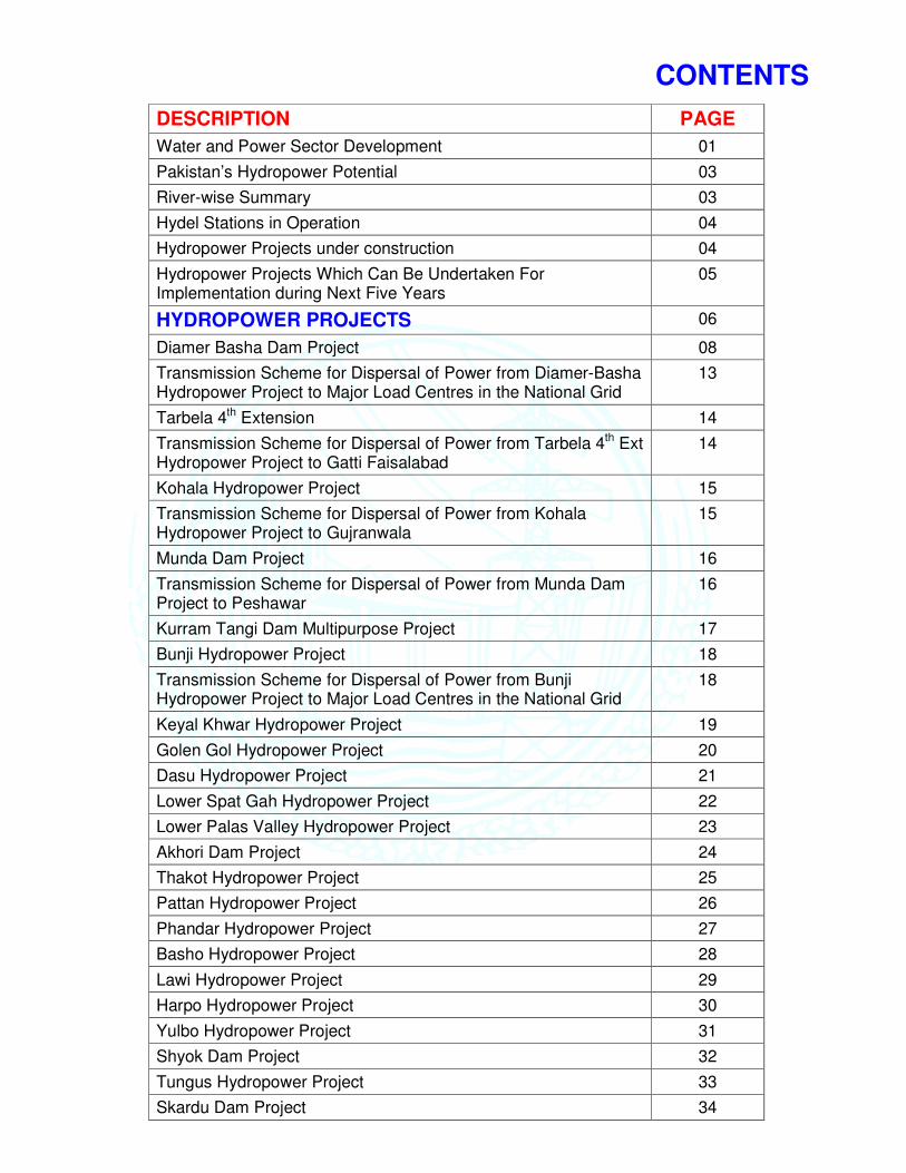
CONTENTS
DESCRIPTION PAGE
Water and Power Sector Development 01
Pakistan’s Hydropower Potential 03
River-wise Summary 03
Hydel Stations in Operation 04
Hydropower Projects under construction 04
Hydropower Projects Which Can Be Undertaken For Implementation during Next Five Years
05
HYDROPOWER PROJECTS 06
Diamer Basha Dam Project 08
Transmission Scheme for Dispersal of Power from Diamer-Basha Hydropower Project to Major Load Centres in the National Grid
13
Tarbela 4th Extension 14
Transmission Scheme for Dispersal of Power from Tarbela 4th Ext Hydropower Project to Gatti Faisalabad
14
Kohala Hydropower Project 15
Transmission Scheme for Dispersal of Power from Kohala Hydropower Project to Gujranwala
15
Munda Dam Project 16
Transmission Scheme for Dispersal of Power from Munda Dam Project to Peshawar
16
Kurram Tangi Dam Multipurpose Project 17
Bunji Hydropower Project 18
Transmission Scheme for Dispersal of Power from Bunji Hydropower Project to Major Load Centres in the National Grid
18
Keyal Khwar Hydropower Project 19
Golen Gol Hydropower Project 20
Dasu Hydropower Project 21
Lower Spat Gah Hydropower Project 22
Lower Palas Valley Hydropower Project 23
Akhori Dam Project 24
Thakot Hydropower Project 25
Pattan Hydropower Project 26
Phandar Hydropower Project 27
Basho Hydropower Project 28
Lawi Hydropower Project 29
Harpo Hydropower Project 30
Yulbo Hydropower Project 31
Shyok Dam Project 32
Tungus Hydropower Project 33
Skardu Dam Project 34

DESCRIPTION PAGE
Dudhnial Hydropower Project 35
Suki Kinari Hydropower Project 36
Trappi Hydropower Project 37
Matiltan Hydropower Project 38
Mahl Hydropower Project 39
Gulpur Hydropower Project 40
Kotli Hydropower Project 41
Transmission Scheme for dispersal of power from Neelum-Jhelum Hydroelectric Project to 500 kV Gakhar Grid Gujranwala
42
Ultra Mega Power Project/Park 43
Repair & Maintenance/Rehabilitation of Mangla, Tarbela & Warsak Hydel Power Stations
44
REGIONAL DAMS 47
Winder Dam Project 48
Darawat Dam Project 49
Ghabir Dam Project 50
Tank Zam Dam Project 51
Naulong Dam Project 52
Hingol Dam Project 53
Garuk Dam Project 54
Pelar Dam Project 55
Nai Gaj Dam Project 56
Bara Multipurpose Dam Project 57
Daraban Dam Project 58
Papin Dam Project 59
Sukleji Dam Project 60
Treatment of Effluent Water of RBOD (Pilot Project) 61
Canal Lining 62
Implementation Schedule/Financing Requirements 63
Existing Installed Generation Capacity 63
Peak Demand Projections (2009-2030) 64
Demand Forecast (2009-2030) 64

1
WATER AND POWER SECTOR DEVELOPMENT
� Irrigated agriculture is the backbone of Pakistan's economy. The agriculture sector is the major user of water and its consumption will continue to dominate the water requirements. Direct rainfall contributes less than 15 percent of the water supplied to the crops. The major user of water for irrigation is the Indus Basin Irrigation System. About 105 Million Acres Feet (MAF) out of 155 MAF of surface water is being diverted annually for irrigation while around 48 MAF is pumped from groundwater.
� Pakistan has a total 196.72 MA area out of that 72.70 is cultivable. The cultivated area (Irrigated & Barani) has come to 52.31 MA, whereas 47.62 MA is area under all sort of irrigation sources. (27 MA is the area under canal irrigation).
� With large cultivable land base of 77 Million Acres (MA) of which only 27 MA are canal commanded, Pakistan still has the additional potential of bringing about 20.39 MA of virgin land under irrigation.
� With increased population, Pakistan is fast heading towards a situation of water shortage Per capita surface water availability was 5260 cubic meters in 1951when population was 34 million, which reduced to 1038 cubic meter in 2010 when the estimated population is 172 million. The minimum water requirement to being a "water short country "is 1,000 cubic meters. In the year 2012, Pakistan will have reached the stage of" acute water shortage"
� According to the 1960 Indus Water Treaty, signed between India and Pakistan with the good offices of World / Bank, India was allowed exclusive rights to use waters of Ravi, Sutlej and Beas rivers, whereas the waters of Western Rivers, Indus, Jhelum and Chenab were assigned to Pakistan. Under the 1960 Treaty, the Indus Basin Replacement Works comprising two major dams, 5 barrages and 8 link canals were constructed to alleviate the problems. However, due to excessive sediment inflows in the river water, all the three storages (Tarbela, Mangla, Chashma) are rapidly loosing their capacities. By the year 2025, these storages would loose 37% (6.27 MAF) of their capacity, which virtually means loss of one mega storage project.
� An annual average of over 35.2 MAF escapes below Kotri varying from 9 MAF to 92 MAF. However this surplus water in the river system is available in about 70-100 days of summer only. To save and utilize available water, construction of additional storage facilities is essential for sustainable irrigated agriculture, which supports about 70% of the population of Pakistan.
� National demand of electricity has been and would keep on growing rapidly. Based on the present generation capacity, the hydel:thermal mix in the country is 34:66, which is almost the reverse of an ideal hydel - thermal mix, which should be 70:30 for overall economic development of the Pakistan. Though induction of thermal generation initially helped in overcoming load shedding, it resulted in substantial increase in power tariff. Therefore, a sizeable injection of cheap hydropower through multipurpose storages is a viable option to keep the cost of electricity within affordable limits.
� To facilitate the process of economic development and to ensure greater social stabilization in Pakistan, it is imperative that employment creation and poverty reduction issues are addressed on priority. Additional water storages and power generation would form the basis of this strategy during the next decade.
� At present the rated electric power generating capacity in Pakistan is only 18000 MW with the demand growing at 10% annually. The average per capita consumption is only 482 units. Power shortage in the industrial, agricultural and domestic sectors has been evident for the past few years with the shortage assuming critical proportions last year. The water shortage is even more acute. To feed a population of nearly 172 million people, existing water storage capacity of 15 Million Acre Feet (MAF) needs to be tripled

2
in the years ahead so that the remaining 20 million acres of cultivable land can be brought under plough. Water conservation and increased water productivity must also be encouraged.
� It is an economically unsustainable fact that the total water storages capacity in the country is only 15 MAF representing 13% of the total annual flows of 136 MAF. Countries in Asia, Africa and the Americas have a storage capacity many times greater. To address this problem the Government of Pakistan (GoP) is developing feasibility and detailed engineering studies for nearly 20 MAF of water storage and 25,000 MW of hydel power. This is apart from thermal power being developed by the private sector, Independent Power Producers (IPPs) and the Government.
� To achieve the above objectives the GoP through WAPDA and the private sector plans to concentrate on the following water and power projects in the next few years: (i) Construction of large dams including Diamer-Basha Dam for Public/Private Partnership (ii) Construction of Hydropower Projects (iii) Construction of Medium/ Small Water Storage Dams (iv) Construction of Canals (v) Construction of Transmission Lines for dispersal of Power from Hydropower Project to Load Centres of National Grid. These projects would create additional water storages, generate cheap indigenously developed electricity and prevent flood damages. All these measures would also ensure food security, employment generation and above all poverty alleviation.
EXISTING INSTALLED GENERATION CAPACITY
WAPDA Hydro
6444 MW
(35%)
GENCOs
4829 MW
(27%)
IPPs (incl.
Nuclear)
6609 MW
(36%)
Rental
285 MW
(2%)
ELECTRICITY GENERATION BY FUEL
Gas
29%Others
2%
Oil
35%
Hydro
35%

3
SUMMARY OF HYDROPOWER POTENTIAL (RIVERWISE)
Sr. No. River/ Tributary Power (MW)
A Hydropower Projects above 50 MW
1 Indus River 38608
2 Tributaries of Indus in Gilgit-Baltistan 1698
3 Tributaries of Indus in Khyber-Pakhtunkhwa 4028
Sub Total (1-3) 44334
4 Jhelum River 4341
5 Kunhar River 1455
6 Neelum River & its Tributaries 1769
7 Poonch River 462
Sub Total (4-7) 8027
8 Swat River & its Tributaries 2297
9 Chitral River & its Tributaries 2285
Sub Total (8-9) 4582
Total A 56943
B. Hydropower Projects below 50 MW
1 On Tributaries 1591
2 On Canals 674
Total B 2265
TOTAL (A+B) 59208

4
HYDEL STATIONS IN OPERATION
HYDROPOWER PROJECTS UNDER CONSTRUCTION
Sr # Name of Project PC-I Cost
(Rs. Billion) Hydropower
(MW) Progress/ Completion
1. Mangla Dam Raising Mirpur, AJK
62.558 Addl 644 GWh Substantially completed
2. Gomal Zam Dam, South Waziristan Agency
12.829 17.4 68.5%
Oct 2011
3. Satpara Dam Skardu
4.806 17.36 92%
Nov 2011
4. KHAN KHWAR Besham, KPK
5.363 72
Substantially Completed Feb 2011
Generation started from Unit 1&2
5 DUBER KHWAR Kohistan, KPK
9.754 130 77%
Dec 2011
6. ALLAI KHWAR – Battagram, KPK
8.578 121 63%
Feb 2012
7. JINNAH HYDROPOWER, Jinnah Barrage
7.680 96 95.5%
June 2011
8. NEELUM JHELUM Neelum, AJK
130 969 21%
Oct 2015
Total 241.159 1422.76
S# ProjectStorage Capacity
(MAF)
Installed Capacity
(MW)
Energy Generation
(GWh)
Commercial Operation
Date
1 Tarbela 6.78 3478 14937 1977 -93
2 Mangla 4.46 1000 4687 1967 -94
3 Warsak RoR* 243 1050 1960 -81
4 Ghazi Barotha RoR* 1450 6574 2003 -04
5 Chashma Low Head 0.37 184 987 2001
6 Rasul RoR* 22 37 1952
7 Dargai RoR* 20 146 1952
8 Malakand RoR* 20 0 1938 -52
9 Nandipur RoR* 14 29 1963
10 Chichoki Mallian RoR* 13.2 20 1959
11 Shadiwal RoR* 13.5 44 1961
12 Others RoR* 6 29
TOTAL 11.61 6464 28536

5
HYDROPOWER PROJECTS WHICH CAN BE UNDERTAKEN FOR IMPLEMENTATION DURING NEXT FIVE YEARS
S# Project River Location Capacity
(MW) Storage (MAF)
Estimated Cost (US$ Million)
Earliest Project
Initiation
1. Diamer Basha Indus GB 4500 8.1 11178 2011
2. Kurram Tangi Kurram FATA/KP
K 84 1.2 700 2011
3. Golen Gol Chitral KPK 106 RoR 130 2011
4. Tarbela 4th Ext. Indus KPK 1350 - 826 2011
5. Munda Swat FATA/ KPK
740 1.3 1401 2012
6. Kohala Jhelum AJK 1100 RoR 2400 2012
7. Bunji Indus GB 7100 RoR 6838 2012
8. Dasu Indus KPK 4320 1.15 7807 2014
9. Others (Bara, Tank Zam Matiltan & Palas Valley etc.)
KPK/GB/
AJK 1500 RoR 2011-2015
10. Patan Indus KPK 2800 - 6000 2018
Total ~ 24,330 23.75

6
HYDROPOWER PROJECTS 1. Diamer Basha Dam Project
2. Transmission Scheme for Dispersal of Power from Diamer-Basha Hydropower Project to Major Load Centres in the National Grid
3. Tarbela 4th Extension
4. Transmission Scheme for Dispersal of Power from Tarbela 4th Extension Hydropower Project to Gatti Faisalabad
5. Kohala Hydropower Project
6. Transmission Scheme for Dispersal of Power from Kohala Hydropower Project to Gujranwala
7. Munda Dam Project
8. Transmission Scheme for Dispersal of Power from Munda Dam Project to Peshawar
9. Kurram Tangi Dam Multipurpose Project
10. Bunji Hydropower Project
11. Transmission Scheme for Dispersal of Power from Bunji Hydropower Project to Major Load Centres in the National Grid
12. Keyal Khwar Hydropower Project
13. Golen Gol Hydropower Project
14. Dasu Hydropower Project
15. Transmission Scheme for Dispersal of Power from Dasu Hydropower Project to Major Load Centres in the National Grid
16. Lower Spat Gah Hydropower Project
17. Lower Palas Valley Hydropower Project
18. Akhori Dam Project
19. Thakot Hydropower Project
20. Pattan Hydropower Project
21. Phandar Hydropower Project
22. Basho Hydropower Project
23. Lawi Hydropower Project
24. Harpo Hydropower Project
25. Yulbo Hydropower Project
26. Suki Kinari Hydropower Project
27. Shyok Dam Project
28. Trappi Hydropower Project
29. Matiltan Hydropower Project
30. Mahl Hydropower Project
31. Gulpur Hydropower Project
32. Kotli Hydropower Project
33. Transmission Scheme for Dispersal of Power from Neelum-Jhelum Hydropower Project to Rawat & Gujranwala
34. Ultra Mega Power Project/Park
35. Rehabilitation of Tarbela, Mangla & Warsak Hydel Power Stations

7
REGIONAL DAMS
36. Winder Dam Project
37. Darawat Dam Project
38. Ghabir Dam Project
39. Tank Zam Dam Project
40. Naulong Dam Project
41. Hingol Dam Project
42. Garuk Dam Project
43. Pelar Dam Project
44. Nai Gaj Dam Project
45. Bara Multipurpose Dam Project
46. Daraban Dam Project
47. Papin Dam Project
48. Sukleji Dam Project

8
DIAMER BASHA DAM PROJECT
GENERAL
Government of Pakistan decided to construct 5 multi-purpose storages in the country during next 10 -12 years. Diamer Basha Dam Project will be undertaken in the first phase. President of Pakistan performed the groundbreaking ceremony of the project. Detailed engineering design of the dam and allied structures is completed and tender documents are ready. Project work is divided into five lots, which would be implemented by contractors through international competitive bidding. THE PROJECT
The project is located on Indus River, about 315 km upstream of Tarbela Dam, 165 km downstream of the Gilgit-Baltistan capital Gilgit and 40 km downstream of Chilas (refer location map). The proposed dam would have a maximum height of 272 m, and impound a reservoir of about 8.1million acre feet (MAF), with live storage of more than 6.4 MAF. Mean annual discharge of Indus River at the site is 50 MAF. Thus the dam will impound 15% of the annual river flow. The dam project would cover an area of 110 km2 and extend 100 km upstream of the dam site upto Raikot Bridge on Karakoram Highway (KKH).
The dam is located at the boundary of Gilgit-Baltistan (GB) and Khyber Pakhtunkhwa (KPK) in such a way that the right abutment and the right Power House is in GB while the left bank of the dam and the left Power House is in Khyber Pakhtunkhwa. WAPDA offices and Colony including that of the Consultants shall be in the Thor Nallah Valley in GB while the Contractor’s Camp and fabrication yard and workshop shall be in Khyber Pakhtunkhwa
NEED OF THE PROJECT
Agriculture is the backbone of Pakistan’s economy. Pakistan today is among one of the World’s fastest growing population, now estimated as over 150 million. Due to lack of large river regulation capability through sizeable storages, the country is already facing serious shortages in food grains. Given the present trend, Pakistan could soon become one of the food deficit countries in the near future. Therefore, there is a dire need to build storages for augmenting agriculture production. Tarbela, Mangla and Chashma reservoirs have already lost about 5.3 MAF due to sedimentation. It is estimated that by year 2016, this loss would increase to 6.6 MAF, almost equal to the original combined capacity of Mangla and Chashma reservoirs. Due to complete stoppage of any sizable multi-purpose storage development after commissioning of Tarbela Dam in 1976, sustainability of existing irrigated agriculture of Pakistan is in serious jeopardy.
DAMSITE AREA

9
The present demand of electricity in country is above 17,000 MW, which is estimated to cross 30,000 MW by the year 2017. A large-scale injection of power thus becomes inevitable. Hydropower will provide the required electricity at affordable price. Contribution of 4500 MW power from Diamer Basha Dam will go a long way in alleviating this situation.
Main Features � Main Dam
Maximum Height 272 m Type Roller Compacted Concrete (RCC)
� Diversion System 2 No. Diversion tunnels 1 No. Diversion channel Upstream and Downstream Cofferdams
� Reservoir Level 1160 m Gross capacity 8.1 MAF (10.0 BCM) Live capacity 6.4 MAF (7.9 BCM) Min. operation level EI.1060 m
� Power House(s) 2 Total installed capacity 4500 MW Location and type Two, one each under the right and left abutment No. of units 12 each of 375 MW Average generation 19000 Gwh/year
� PC-I approved cost Rs.894,257 million (US$ 11.17 Billion)
� E.I.R.R. (Base Case) 15.3% � Benefit / Cost Ratio (Discount Rate 12%)
1.43
� F.I.R.R. 8.04%
PROJECT BENEFITS • Availability of about 6.4 MAF annual surface water storage for supplementing irrigation supplies during
low flow periods • Harnessing of renewable source of clean and cheap energy through installed capacity of 4500 MW • Average Annual Generation 19000 GWh • Extend Life of Tarbela reservoir by blocking the sediments • Additional Annual Generation at Tarbela 1111GWh • Reduction of dependence on thermal power, thus saving foreign exchange • Employment opportunity, particularly to the locals, during the construction and operation • Creation of massive infrastructure leading to overall socio-economic uplift of the area and standard of
living of people • The Project will pay back its cost in 8 years • Annual Earning of Rs.232.8 Billion.
FINANCIAL BENEFITS • Financial Benefits of electricity produced – US$ 1.9 Billion (19 Billion units x 10 cents) • Financial Benefits of water stored – US$ 0.660 Billion • Savings in Foreign Exchange of Equivalent electricity on imported oil - US$ 2.85 Billion • Carbon Credit Benefits – US$ 0.300 Billion
ENVIRONMENT AND CULTURAL HERITAGE IMPACT ASSESSMENT
• No. of villages affected 31 • No. of houses affected 3037 • Population affected 28,650 • Agricultural land submerged 2660 acres • Area to be affected 37419 acres • Length of KKH submerged 100 km • Pre-historic rock carvings 33000

10
RESETTLEMENTACTION PLAN
The Income level in the project areas is extremely low. The Resettlement Action Plan envisages poverty alleviation. The compensation to be paid for involuntary resettlement would include prescribed possible entitlement as applicable in legislation. Affectees would be resettled in 9 model villages in the close vicinity, with better living condition. Their means of livelihood would be ensured. Affectees would be provided 5 Marla plots free of cost in developed model villages with all civic amenities and also 6 Kanal agricultural land for cultivation on payment. The total cost of PC-I (Part-I) Land Acquisition & Resettlement is estimated Rs.60 billion. Estimated Resettlement plan cost is Rs.12.245 billion. In order to resolve the issue of Resettlement/Land Acquisition, Prime Minister of Pakistan constituted Ministerial Committee, wherein Chief Minister Gilgit Baltistan was an observer and this committee unanimously approved Rs. 40 billion as Land Acquisition charges, agreed by all the stake holders. Council of Common Interests (CCI) under the chairmanship of Prime Minister has approved this project in its meeting held on July 18, 2010. ENVIRONMENTAL MANAGEMENT PLAN Environment Management Plan has been prepared. The Plan provides the possible environment impacts measures for the mitigation and monitoring. The estimated cost for the Environmental Management Plan is about 853.96 million.
GEOLOGY, LAND AND SOILS
o Reservoir Impounding o Construction of dams and appurtenant Structures o Temporary camps o Dumping of soil or waste
CLIMATE AND AIR
o Change of local climate through Air pollution
• WATER
o Over use of nullahs for water supply o Over exploitation of springs o Pollution of surface water o Contamination of Indus water due to mixing of sewage. Sewage treatment plants
• FLORA AND FAUNA
o Loss/degradation of natural plants o Threats to wildlife
• FORESTATION AND FISH STOCK
Due to the construction of the Project over 50,000 trees would be lost. The trees are to be planted on 1:3 ratio for preservation and improvement of ecosystem. The cost of compensation for the lost trees and planting the new trees and is estimated at about US$ 7 million.
o Anticipated damage to fish stocks due to discharge of effluent in river water o Two fish hatcheries shall be built for fish culture
• ROCK CARVINGS
o Protection of damage to rock carvings at the dam site and in the quarry areas. o Physical relocation of most important rock carving objects, where feasible; o Documentation of all important rock carving objects; o Production of replicas of carvings for exhibition; o Establishment of Gilgit-Baltistan Rock Carvings Exhibition Centre. o Special Project to preserve Rock Carving under the guidance of Dr. Harald Hauptmann in
association with Rogers Kolachi Khan & Associates (The Cultural Heritage & Development Consultants)
o

11
Project Implementation
Implementation of the dam appurtenant structures shall be through international competitive bidding comprising of the following five lots:-
o Rs. in Million
Sr. No. Description of work Local Foreign
Total Cost
Const. Period (Yrs.)
1. Contract Lot-1 (Concrete Dam and Related Structures including Diversion Tunnels and Permanent Access Bridge)
87680 58480 146160 9
2. Contract Lot-2 (Underground Works and Related Structures (Left and Right Banks)
40960 13840 54800 6.4
3. Contract Lot-3 (Hydro-Mechanical Equipment and Hydraulic Steel Structures )
3360 30400 33760 8
4. Contract Lot-4 (Power Plant Generation Equipment (Left and Right Bank)
8240 74160 82400 7
5. Contract Lot-5 (Electrical High Voltage Equipment and Power Plant Electrical Equipment (Left and Right Bank).
8720 76320 85040 7
Year wise phasing of Project Cost
Period
Financial Phasing (US $ in Million)
Total LCC FCC
I. Pre Construction
2009-10 317.30 317.00 -
2010-11 460.47 341.74 118.73
Sub Total-I 777.77 659.04 118.73
II. Construction
2011-12 380.18 299.03 81.15
2012-13 689.40 511.11 178.29
2013-14 1056.89 542.75 514.14
2014-15 1211.23 676.84 534.39
2015-16 1463.71 808.26 655.45
2016-17 1603.29 935.90 667.39
2017-18 1398.67 933.54 465.13
2018-19 1104.50 828.44 276.06
2019-20 1088.06 879.61 208.45
Sub Total-II 9995.93 6415.48 3580.45
III. Post Construction
2020-21 404.54 191.91 212.63
IV. Total (I+II+III) 11178.24 7266.43 3911.81
12
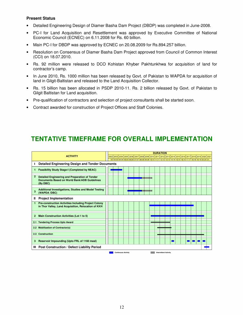
Present Status
• Detailed Engineering Design of Diamer Basha Dam Project (DBDP) was completed in June-2008.
• PC-I for Land Acquisition and Resettlement was approved by Executive Committee of National Economic Council (ECNEC) on 6.11.2008 for Rs. 60 billion.
• Main PC-I for DBDP was approved by ECNEC on 20.08.2009 for Rs.894.257 billion.
• Resolution on Consensus of Diamer Basha Dam Project approved from Council of Common Interest (CCI) on 18.07.2010.
• Rs. 92 million were released to DCO Kohistan Khyber Pakhtunkhwa for acquisition of land for contractor’s camp.
• In June 2010, Rs. 1000 million has been released by Govt. of Pakistan to WAPDA for acquisition of land in Gilgit-Baltistan and released to the Land Acquisition Collector.
• Rs. 15 billion has been allocated in PSDP 2010-11. Rs. 2 billion released by Govt. of Pakistan to Gilgit Baltistan for Land acquisition.
• Pre-qualification of contractors and selection of project consultants shall be started soon.
• Contract awarded for construction of Project Offices and Staff Colonies.
TENTATIVE TIMEFRAME FOR OVERALL IMPLEMENTATION
2002 2003 2004 2005 2006 2007 2008 2009 2010 2011 2012 2013 2014 2015 2016 2017 2018 2019 2020 2021
I
II
III
Continuous Activity Intermittent Activity
Detailed Engineering Design and Tender Documents
Project Implementation
1
2
3
2.2
2.1
2
Pre-construction Activities Including Project Colony in Thor Valley, Land Acquisition, Relocation of KKH
1
Tendering Process Upto Award
Construction 2.3
Additional Investigations, Studies and Model Testing (WAPDA /DBC)
Main Construction Activities (Lot 1 to 5)
Feasibility Study Stage-I (Completed by NEAC)
Detailed Engineering and Preparation of Tender Documents Based on World Bank/ADB Guidelines (By DBC)
Mobilization of Contractor(s)
Reservoir Impounding (Upto FRL of 1160 masl)3
Post Construction / Defect Liability Period
14-15
ACTIVITYDURATION
10-11 11-12 12-13 13-1406-07 07-08 08-09 09-1002-03 03-04 04-05 05-06 19-20 20-2115-16 16-17 17-18 18-19

13
PROJECT LAYOUT
TRANSMISSION SCHEME FOR DISPERSAL OF POWER FROM DIAMER BASHA DAM PROJECT
Diamer Basha Dam Hydro Power Project (HPP) has a generation capacity of 4500 MW and it is expected to be commissioned by year 2018-19. The location of Diamer Basha HPP is on Indus River, 315 km upstream of Tarbela Dam. The 765 kV HVAC Transmission Scheme for Dispersal of Power from Diamer Basha HPP to the major load centers in the National Grid is envisaged as under:
• 765 kV Transmission Lines from Basha HPP to a newly proposed 765 kV Substation at Gujar Khan (3x407 km)
• 765 kV Transmission Lines from Gujar Khan to a newly proposed 765 kV Substation at Lahore (2x260 km)
• In & Out of 500 kV Rewat – Gujranwala Transmission Line at Gujar Khan
• A new 765 kV Substation at Gujar Khan
• A new 765 kV Substation at Lahore
The contract for feasibility study for evacuation of power from Northern Areas has been awarded to JV comprising of P.B. (UK), Teshmont (Canada) and Mirza Associate Pakistan on 26.06.2009.

14
TARBELA 4TH EXTENSION PROJECT LOCATION Tarbela Dam
Existing Installed Capacity
3478 MW
SALIENT FEATURES
Tunnel-4 (Already constructed) • Purpose Irrigation • Type Concrete/Steel Lined • Diameter 45 ft to 36 ft • Length 2997 ft
Dam (Already constructed) • Height 485 ft (147.82 m) • Length 9000 ft (27434 m)
Spillway (Already constructed) • 4th Extension estimated
Installed Capacity 1350 MW
• Estimated Project Cost US$ 908 Million
PRESENT STATUS � The revised PC-II of the subject project stands approved by Central Development Working
Party (CDWP) on 08.06.2010. � Contract Agreement duly approved by World Bank signed on 10th June 2010 with JV of Mott
MacDonald – UK and Coyne et Billier – France now called as the “Tarbela 4 Consultants JV”. � Design work on various component of the project in progress. � Geological Survey, Drilling & Investigation Works in progress at site. � Contract signed with the member of Panel of Experts and International Review Consultants. � Feasibility Report submitted by the Consultants and circulated to all POE members on 24.12.2010. � Consultants/World Bank Experts have explored the possibility to generate 1350 MW with two
turbines. � Completion of the Consultancy Services expected by September, 2011.
TRANSMISSION SCHEME FOR DISPERSAL OF POWER
FROM TARBELA 4TH EXTENSION HYDROPOWER PROJECT
Tarbela 4th Extension Hydropower Project has a generation capacity of 1350 MW and it is expected to be commissioned in six years. The location of Tarbela 4th Extension Hydropower Project is on Indus River present Tarbela Dam’s already constructed 4th tunnel. The 500 kV Transmission Scheme for Dispersal of Power from Tarbela 4th Extension Hydropower Project to Faisalabad the major load centers in the National Grid is envisaged as under:
• 500 kV Transmission Lines from Tarbela 4th Extension Hydropower Project to Faisalabad.
The estimated cost of the above Power Dispersal Scheme for Tarbela 4th Extension Hydropower Project is about US$ 150 million.

15
R A I N K O T
P O W E R H O U S E
KUNHAR R
IVER
JAN
DA
RB
AIN
N.
JHELUM
7 5 7
Z A M IN A B A D
K O H A L A B R I D G E
B A R S A L A
9 6 7
D O P A T T A
1 6 8 5
RIVER
RO
AD
1 7 2 5
M A J H O I
G A R H I
T H O T H A
7 6 9
C H A T T IA N I N T A K E R IV E R
JHELUM
RO
AD
D H A L
R A N J K O TN U L L A H
M U Z A F F A R A B A D
3 0 8 6
2 9 1 5
3 1 8 2
N A U S A D D A
D A M &
JHELUM RIVER
N E E L U M R I V E R
KOHALA HYDROPOWER PROJECT
LOCATION The project is located in Muzaffarabad District, Azad
Jammu & Kashmir. The dam site is proposed just upstream of Domel on Jhelum River, 30 km and 174 km from Muzaffarabad and Islamabad, respectively and powerhouse is located 7 km upstream from Kohala Bridge.
SALIENT FEATURES
Installed Capacity 1100 MW
Gross Head 320 m
Design Discharge 425 m3/sec
Mean Annual Energy 4800 Gwh
No. & Type of Turbines 4 (Francis)
Type of Dam RCC
Height of Dam 57 m
Head race Tunnel length 17760 m
Total Base Cost US$ 2155 Million
EIRR 19.9%
Benefit Cost Ratio 1.83
Estimated construction period 6 Years
PRESENT STATUS
• Final feasibility study of the project has been completed in December, 2008 and Detailed
Engineering Design and Tender Documents in November 2009.
• Private Power Infrastructure Board (PPIB) has issued LOI to China International Water and Electric
Power Company (CWE) on 15.01.2009.
• The project is now being dealt by PPIB
Transmission Scheme for Dispersal of Power from Kohala Hydropower Project to Gujranwala – Estimated Cost of US$ 130 million.

16
MUNDA DAM MULTIPURPOSE PROJECT
LOCATION
This project is proposed to be constructed on Swat River about 5 Km upstream of Munda Head Works in Mohmand Agency (FATA), Khyber Pakhtunkhwa.
KABUL R
IVER
CANAL
KABUL RIVER
PESHAWAR
BARA
TARUJABBA
RIV
ER
PABBI
KABUL RIVER
CHARSADDA
RIVER
NOWSHERA
TO ISLAMABAD
RISALPURCANTONMENT
UTMANZAI
SHERPAO
MUNDA DAM SITE
PIN
JK
OR
A
RIV
ER
MALAKAND
CHAKDARA SWAT RIVER
SW
AT C
AN
AL
UPPER
SWAT RIVER
LOWER SWAT CANAL
AMBAHAR RIVER
NAGUMAN RIVER
ABA
ZAI R
IVER
DOABA CANAL
Left Bank
Command Area
RIGHT BANK
COMMAND AREA
SHAH ALAM
ADEZAI RIVER
SHABQADAR
KH
IALI R
IVE
R
N
MUNDA DAM PROJECT
OBJECTIVES
i. Power Generation ii. Flood Control iii. Irrigation
SALIENT FEATURES
Type of Dam Concrete Faced Rock fill Dam
Height of Dam 698.820 Ft.
Gross Storage 1.290 MAF
Live Storage 0.676 MAF
Dead Storage 0.314 MAF
Flood Storage 0.081 MAF
Power Houses Installed Capacity 740 MW (Annual Energy 2407 GWh)
Command Area 16940 Acres
Left Bank Culturable Command Area 10057 Acres
Project Cost Rs 119 Billion (US$ 1401 Million)
EIRR 13.2%
Construction Period 7 Years
PRESENT STATUS
• Feasibility completed in March 2000.
• Revised PC-II for Detailed Engineering Design and Tender Documents amounting to Rs.652.000 million approved by CDWP in its meeting held on October 11, 2008.
• Expression of Interest (EOI) for short listing of Consultants for Detailed Engineering Design and Preparation of Tender Documents received from Nine (09) local and foreign consulting firms, out of them five JVs are short listed.
• Request for Proposal (RFP) issued to invite Technical and Financial Proposals from short listed Consultants on May 16, 2011.
Transmission Scheme for Dispersal of Power from Munda Dam Project to Peshawar – Estimated Cost of US$ 22 million.

17
KURRAM TANGI DAM MULTIPURPOSE PROJECT
Location
The proposed project site is located across Kurram river in North Wazirstan Agency about 22 KM up-stream of Kurram Garhi Head works and 32 KM North of Bannu City in Khyber Pakhtunkhwa.
Salient Features
• Dam Height 322 ft
• Gross Storage 1.20 MAF-1.48 BCM
• Live Storage 0.90 MAF-1.11 BCM
• Power Houses (5 Nos) 83.4 MW (350 GWh)
• Command Area 3,62,380 ACRES (including new area of 84,380 Acres)
• Supplementing existing System of
Civil & Marwat Canals
277,500 Acres
Project Benefits • Irrigated Agriculture Development
• Hydropower generation
• Socio-economic uplift of the area.
• Employment opportunities during the construction and maintenance of the Project.
• Development of Fisheries. PC-II Cost Rs.125.60 Million
Approving Authority Approved by ECNEC on 25.02. 2005
PC-I Cost Rs. 59 Billion
(Equivalent to US$ 700 Million)
Consultants M/s Pakistan Engineering Services (PES) JV appointed as Consultants for the preparation of feasibility and Detailed Engineering Design of the project.
Present Status
• Feasibility study, Detailed Engineering Design and Tender Documents completed in March, 2005 and redesigned for elevated height in 2007.
• Project Director appointed for construction of the Project.
• M/s MMP-PES JV has been approved as Consultant for supervision of construction work.
• Expression of Interest (EOI) pre-qualification of Contractors received on February 28, 2011 and under evaluation.

18
BUNJI HYDROPOWER PROJECT
LOCATION
The project is located on Indus River near Gilgit.
Power House and Dam sites are 560 km &
610 km, respectively from Islamabad.
SALIENT FEATURES Installed Capacity 7100 MW
Gross Head 445 m
Design Discharge 1900 m3/sec
Mean Annual Energy 24088 GWh
No. & Type of Turbine 20 (Francis)
Type of Dam Gravity RCC
Height of Dam 190 m
Headrace Tunnels 5 No (7.8 km long)
Estimated Project Cost US$ 6.8 Billion
Estimated construction period 9 Years
PRESENT STATUS
� Hydro Planning Organization in association with short term consultants finalized the Pre-Feasibility report in March 2005.
� Draft Feasibility Report was submitted by the Consultants on March 31, 2009.
� Draft detailed design report and Draft tender documents of different lots have been submitted by the Consultants, which are under review by different quarters. In the mean time field investigation are going on till the finalization of detailed design.
� Chairman ECNEC has accorded anticipatory approval to incur an expenditure of Rs.859.908 million on Bunji Hydropower Project upto 30.06.2011.
Transmission Scheme for Dispersal of Power from Bunji Hydropower Project to Major Load Centres in the National Grid – Estimated Cost of US$ 1.6 billion.
BUNJI
Pressure Tunnels (6.3 km each)
HANUCHAL
SASSI
SHENGUS
1.7 km
74 - 35 74 - 40 74 - 45 74 - 50
35 -
50
35 -
45
35
- 4
0
SKARDU 140 km
GILGIT 83 km
INDUS RIVER
INDUS RIVER
INDUS RIVER
GILGIT RIVER
BUNJI Bridge
Partab Bridge
Alam Bridge
R. P
indi 560 k
mG
ilgit 5
0 k
m
Skardu Road
KK
H
SAI NALA
Tailrace
HURBAN
SUMARI
GILGLEBURI GERI
ACHHU
SHAH BTOT
KHAND JATORIKOI MRANGMAL
TULCH
KISNARDAR
JAWARI
BALACHI
SKARDU ROAD
INDUS RIVER
JUCHI
PAHARI GHUND
SARKUND
HOS DAS
JAGLOTBARMASMANOT
BARGIN
DAMOT
BURCH
SHUTA
PARRI
MIAR DAS
Yellbow/Yulbo
Jun Nala
1 k
m
0.0
0
3 k
m
2 k
m
4 k
m
5 k
m
6 k
m
7 k
m
7.5
km
SCALE
CHRUKO NALLAH
MOUSKEN NALLAH
BUNJI HYDROPOWER PROJECTPROJECT LAYOUT

19
KEYAL KHWAR HYDROPOWER PROJECT
LOCATION
The project is located in the Khyber Pakhtunkhwa Province of Pakistan on Keyal Khwar in Kohistan
District. The project is accessible by road and is at a distance of 310 km from Islamabad. Keyal
Khwar is the right bank tributary of Indus River.
SALIENT FEATURES
Installed Capacity 122 MW
Gross Head 732 m
Design Discharge 22 m3/sec
Mean Annual Energy 426 GWh
No. & Type of Turbine 2, Pelton
Type of Dam Concrete gravity
Height of Dam 42.5
Estimated Project Cost 180 million EURO
EIRR 15.50%
PRESENT STATUS
• Feasibility Report completed in October, 2007.
• Loan Project Agreement Euro 79 Million between GOP and KfW of Germany signed on November 11, 2008 for implementation of the Project. Supplementary Loan Agreement Euro 20 Million signed on 11-04-2009.
• M/s Lahmeyer Germany as Lead Firm in association with M/s NDC and EASE PAK (JV) engaged as consultants.
• Inception report received on 4.10.2010 and circulated to WAPDA formations for comments.

20
GOLEN GOL HYDROPOWER PROJECT
LOCATION
The project is located on Golen Gol Nullah,
a tributary of Mastuj River, 25 Km from
Chitral Town in Khyber Pakhtunkhwa. The
project is about 550 km from Islamabad.
SALIENT FEATURES
Installed Capacity (MW) 106
Gross Head 435
Design Discharge (m3/sec) 30
Mean Annual Energy (GWh) 436
No. & type of Turbine 3, Pelton
Estimated Project Cost (Mill. US$)
130
Implementation Period (Months) 48
PRESENT STATUS
� Feasibility Study completed by HEPO/GTZ in 1997 is updated in 2005. � Study for Detailed Design and preparation of Tender Documents completed by a joint
venture of PES, FICHTNER, Engineering Associates. � Construction of O&M WAPDA Staff Colony is in progress and will be completed in 2011. � Lot-2 & Lot-3.1 Civil Works & Power house, the contract has been awarded to M/s
SAMBU, agreement signed and the contractor is being mobilized. � Pre-qualification of contractor for Lot-3.2 E&M Works has been finalized and tender
documents issued to the contractor and last date of submission is extended upto 31.03.2011.
� Pre-qualification documents of firms for Lot-4 Transmission Line have been vetted by the Donors and Tender will be floated shortly.
� M/s Mott McDonald has been appointed consultants for construction supervision. � Cost of Works has been agreed by the following donors:
- Saudi Development Fund for Civil Works (US$ 40 Million) - Kuwait Development Fund for E&M Works (US$ 37 Million) - OPEC for Transmission Lines (US$ 30 Million)

21
DASU HYDROPOWER PROJECT
LOCATION
Dasu hydropower project is a run of river
scheme 7 km upstream of Dasu village on Indus
River, 74 km downstream of Diamer Basha Dam
and 345 km from Islamabad.
SALIENT FEATURES
1 River Indus 2 Capacity (MW) 4320 3 Annual Energy (GWh) 21300 4 Gross Head (m) 210 5 Design Discharge (m3/s) 2600 6 Dam Height (m) 233 above bed rock 7 Type of Dam Roller Compacted Concrete 8 Gross Storage Capacity (MAF) 1.15 9 Power Tunnel (Km) 3.1 (average) 10 Powerhouse Type Underground 11 Type of Turbines Vertical Francis 12 No. of Units 8 13 Dam Crest Level 957 14 Normal Reservoir Level (m) 950 15 Spillway Crest (m) 930 16 Tail Water Level (m) 738 17 Total Base Cost (Million US$) 5206 18 Detailed Design study period 18-months 19 Estimated Construction period (years) 8
PRESENT STATUS • The Feasibility Study of the Project completed on 28th February, 2009 by a Joint Venture of M/s
NESPAK (Lead Firm), ACE, MWH and COLENCO in association with Binnie & Partners.
• World Bank offered financing for Detailed Engineering Design and Tender Documents and Project Construction if project would be developed in stages. WAPDA accepted the proposal of World Bank on 15.04.2010.
• The World Bank Mission asked WAPDA to consider the possibility of staged/phased construction of the project.
• The funding US$ 4.5 million from WCAP for Detailed Engineering Design and Preparation of Tender Documents was approved by Steering Committee on WCAP in its meeting held on 13.04.2010.
• Prequalification of Firms/JVs has been completed.
• Technical and Financial Proposals submitted by the three Pre-qualified JVs are under evaluation.

22
3000
2500
2000
2000
2500
2500
2000
2000
3000
BAJA
NAL
A
DOGAH
BAJA KUNDAIR
KHEL BAIK MOSE
GOSHALI
DASU
SACHOI
THOKI
GUJAR BANDA
3000
2500
1500
2000
1000
1000
1000
1500
2000
2500
3000
3000
2500
300
0
250
0
200
0
2000
2000
2000
1500
1500
3000
2500
2000
2000
KH
EL
BA
IK N
AL
A
BAK N
ALA
SPAT GAH
JHUL NALA
JALKOT NALA
INDUS RIVER
LOWERGABARBAND GAH
INTAKE
DAMFSL 1510m.
PROPOSED ACCESS ROADSPAT GAH
LOWER SPAT GAH HYDROPOWER PROJECT
LAYOUT PLAN
LEGEND
RIVER
NULLAH
HEADRACE TUNNEL
ROAD (KKH)
SURGE TANK
POWER HOUSE
VILLAGE
GA
B
AR
BA
ND
GA H
HEADRACE TUNNEL
12.5 Km, 5.5 m Ų
LOWER SPAT GAH HYDROPOWER PROJECT
LOCATION
Spat Gah is the left bank tributary of Indus
River with its confluence 8 km downstream of
Dasu town in Kohistan District, Khyber
Pakhtunkhawa. The project layout has been
planned on the right bank with powerhouse 7 km
from Dasu and 345 km from Islamabad.
SALIENT FEATURES
Installed Capacity 496 MW
Gross Height 745 m
Design Discharge 81 m3/sec
Mean Annual Energy 2106 GWh
No. & Type of Turbine 3, Pelton
Type or Dam CFRD
Height of Dam 57 m
Headrace Tunnel 12.5 km
Pressure Shaft 1143 m
Construction Period 5 Year
Estimated Project Cost US$ 697 Million
EIRR 18.4%
FIRR 13.5%
PRESENT STATUS
� The feasibility report has been prepared by a Joint Venture: ILF (Germany), Poyry
(Austria) and ACE (Pakistan) and report has been finalized in June 2010.
� WAPDA Authority in its meeting on 31.08.2010 has decided to implement Lower Palas
Hydropower Project in Public private Partnership (PPP) mode. Govt. of Khyber
Pakhtunkhwa has authorized WAPDA to develop the project on PPP mode.

23
SARCHOY
PALAS VALLEY
BASIC HEALTH UNIT
KALYAR
KUZ PARO
KKH
KAYAL KHWAR
ACCESS ROAD
CHOR NALA
SHARIAL
SH
AR
IAL N
ALA
HEADRACE TUNNEL
2000
2500
3000
2000
2500
250
0
250
0
300
0
300
0
250
0
200
0
200
0
250
0
2500
2000
1500
1500
1000
15
00
2000
1000
2000
15
00
2000
25
00
3000
1000
1500
2500
3000
2500
1500
LOWER PALAS VALLEY HYDROPOWER PROJECT
LAYOUT PLAN
18.5 Km, 6.0 m Ų
LEGEND
RIVER
NULLAH
HEADRACE TUNNEL
ROAD (KKH)SHILKAN
ABAD
NALA
INDUS
RIVER
SURGE TANK
POWER HOUSE
FSL 1495 m.a.s.l.
DAM
VILLAGE
LOWER PALAS VALLEY HYDROPOWER PROJECT
LOCATION
Palas valley (Chor nullah) is the left bank
tributary of Indus River with its confluence 12
km upstream of Patan in Kohistan District,
Khyber Pakhtunkhawa. The project layout has
been planned on the left bank with powerhouse,
2 km from Patan and 310 km from Islamabad.
SALIENT FEATURES
Installed Capacity 665 MW
Gross Head 805 m
Design Discharge 101 m3/sec
Mean Annual Energy 2635 GWh
No. & Type of Turbine 3, Pelton
Type or Dam CFRD
Height of Dam 55 m
Headrace Tunnel 18.5 km
Pressure Shaft 1200 m
Construction Period 5 Year
Estimated Project Cost US$ 763 Million
EIRR 20.8%
FIRR 15.6%
PRESENT STATUS
� The feasibility report has been prepared by a Joint Venture: ILF (Germany), Poyry (Austria) and ACE (Pakistan) and report has been finalized in June 2010.
� The detailed engineering design and tender documents would take 24 months.
� WAPDA Authority in its meeting on 31.08.2010 has decided to implement Lower Palas Hydropower Project in Public private Partnership (PPP) mode. Govt. of Khyber Pakhtunkhwa has authorized WAPDA to develop the project on PPP mode.

24
AKHORI DAM PROJECT LOCATION
Akhori Dam site is located near Akhori Village across Nandna Kas, a small tributary of Haro River in Attock District of Punjab, Akhori Reservoir is an off-channel storage, which will draw water from Siran Pocket of Tarbela Reservoir through conveyance channel.
OBJECTIVES
(i) Storage of water for: • Supplementing Indus Basin Irrigation
System and • Power Generation
SALIENT FEATURES
Main Dam
Dam Type Earth & Rock fill Height 400 feet Gross Storage 7.6 MAF Live Storage 6.00 MAF
Saddle Dam
Height 213 feet Length 4.78 Miles
Conveyance Channel
Conveyance Channel Length 23 Miles (37 Km) Conveyance Channel Capacity 60,000 Cusecs Bed Width 249.3ft (76 m) Depth 32.8ft (10 m)
Installed Capacity
Hydel Power Potential 600 MW (2155 GWh/Annum)
Environmental and Resettlement
• No of Affectees 55800
• No of Houses 9270
• Land Submergence 65976 Acres
• Estimated Cost US$ 4.4 Billion
• Construction Period 5 Years
PRESENT STATUS
• Feasibility Study Report completed on Jan. 26, 2006.
• PC-II for Detailed Engineering Design and Tender Documents of the Project amounting to Rs. 818.00 Million submitted on June 23, 2006 for approval of ECNEC which is awaited.
• PC-I for land acquisition and resettlement of affectees under approval of ECNEC.
• Pre-qualification of consultants for detailed engineering design completed.
• RFP for inviting financial and technical proposals of Consultants for detailed engineering design in progress.

25
THAKOT HYDROPOWER PROJECT
LOCATION
Thakot dam site is located in a narrow section of Indus River, about 3 km downstream of Besham. Distance from Islamabad is about 240 km.
SALIENT FEATURES
Installed Capacity 2800 MW
Gross Head 138 m
Design Discharge 2900 m3/sec
No. & Type of Turbines 8, Francis
Mean Annual Energy 14095 Gwh
Height of Dam 60 m
Tunnel Length 19.8 km
Estimated Project Cost US$ 6 Billion
Study period 24 months
PRESENT STATUS
� Identified by MONENCO in “Inventory and Ranking Study” in November 1984 and
reviewed by Hydro Planning Organization(HPO), WAPDA
� PC-II preparation of Feasibility Study has been approved by the Planning
Commission.

26
PATAN HYDROPOWER PROJECT LOCATION
Patan dam site is located on the Indus River
about 4 km upstream of village Patan
downstream of Keyal Khwar. The power house
(underground) is situated on the left bank 8 km
upstream of Besham and 275 km from
Islamabad.
SALIENT FEATURES
Installed Capacity 2800 MW
Gross Head 150 m
Design Discharge 2600 m3/sec
No. & Type of Turbines 8, Francis
Mean Annual Energy 15230 Gwh
Height of Dam 104 m
Tunnel Length 18.0 km
Estimated Project Cost US$ 6 Billion
Study period 24 month
PRESENT STATUS
� Identified by MONENCO in “Inventory and Ranking Study” in November 1984 and reviewed by Hydro Planning Organization, WAPDA.
� Capacity reviewed and updated by HPO.
� PC-II for Feasibility Study has been approved by CDWP on 17.09.2009.
� Preparation of RFP documents have been prepared.

27
PHANDAR HYDROPOWER PROJECT
LOCATION
The project area is located between Phandar
Lake and Chhashi Gol, near the Chhashi
village on the right side of Ghizar River in
Ghizar District of Northern Areas. Phandar
Lake is located about 160 km north-west of
Gilgit town and 772 km north of Islamabad.
SALIENT FEATURES
Installed Capacity 80 MW
Gross Head 237 m
Design Discharge 40 m3/sec
Mean Annual Energy 350 GWh
No. & Types of Turbine 4, Pelton
Estimated Project Cost US $ 70 Mill
Study Period (months) 18 Months
Implementation Construction Period 48 Months
PRESENT STATUS
• Feasibility was completed by HPO, WAPDA with GTZ of Germany under Technical Assistance Program in 2003.
• Consultancy Contract Agreement has been signed between WAPDA & PHC on 22.10.2010.
• Consultancy Contract Agreement by WAPDA and Phandar Hydro Consultants (PHC) has been signed on 22.10.2010.
• Consultants for Detailed Engineering Design and preparation of tender documents have
been mobilized on 1st November 2010.
• Inception report has been submitted to WAPDA on 9th February 2011.
• The report has been circulated to different WAPDA formations for comments.
• M/s Afd has been requested for a soft loan of US$ 75Mill for implementation/construction of
project. The cost includes environmental mitigation and transmission line.
• Preparation of Detailed Engineering Design and Tender Documents is in progress and will be completed in May 2012.

28
BASHO HYDROPOWER PROJECT
LOCATION
The proposed scheme is identified along the Basho
Nala (Lungma), a left tributary of Indus River. The
confluence of Basho Nala with Indus River is
located about 40 km downstream of north-west of
Skardu town and 704 km north-east of Islamabad.
SALIENT FEATURES
Installed Capacity 28 MW
Gross Head 949 m
Design Discharge 3.5 m3/sec
-Mean Annual Energy 135 GWh
No. & Type of Turbine 3, Pelton
Type of Weir
Length of Penstock
Tyrolean Weir
4478 m
Estimated Project Cost US$ 45 Million
Study Period for updation/review
of Feasibility Study
7 Months
Implementation Construction Period 48 Months
PRESENT STATUS • Feasibility report was completed by HEPO (WAPDA) with technical collaboration of GTZ of
Germany.
• M/s. Afd have informed that Afd headquarter has accepted the request to finance the updation of feasibility study from grant. Selection of Consultants will be started soon.
• The study period is 6 Months only. Phase-II is consisting of Detailed Engineering Design
study and implementation of the project.

29
LAWI HYDROPOWER PROJECT
LOCATION
The project area is located on the right bank of
Shishi River, a left tributary of Chitral River. The
project involves diversion of Shishi River into
Chitral River. The Project is about 350 km from
Islamabad.
SALIENT FEATURES
Installed Capacity (MW) 70 MW
Gross Head (m) 413 m
Design Discharge 20 m3/sec
Mean Annual Energy 303 Mil. KWh
No. & Type of Turbine 3 (Pelton)
Project Base Cost US$ 120 Mill
EIRR 18.51%
Implementation Period 4 Years
PRESENT STATUS
� The Feasibility Study of Lawi HPP was completed in April 2009.
� A presentation was made to Governor KPK and Chief Minister KPK on projects being handled by WAPDA in the Province of KPK. Development of Lawi on PPP mode was discussed in Length.
� Government of KPK decided to take-up Lawi HPP from own resources and asked WAPDA to provide feasibility study free of cost.
� Now WAPDA Authority has handed over the Feasibility Report to Govt. of KPK without any cost on dated 08.12.2010. Govt. of KPK will decide the commencement date of Lawi HPP.
30
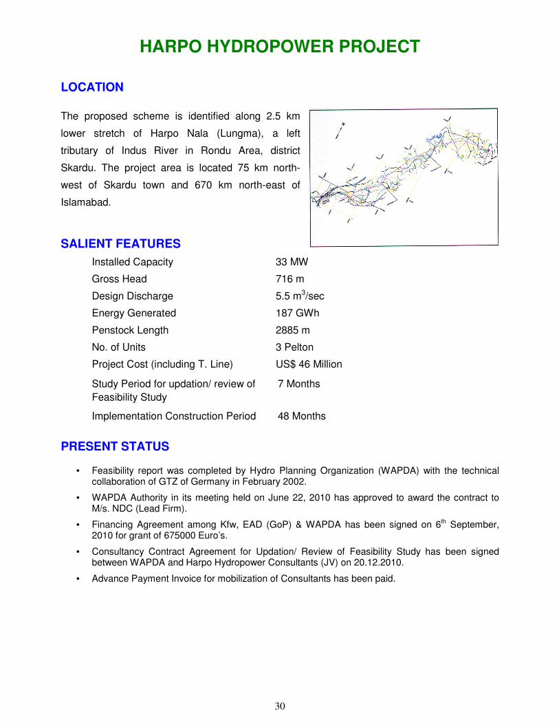
HARPO HYDROPOWER PROJECT
LOCATION
The proposed scheme is identified along 2.5 km
lower stretch of Harpo Nala (Lungma), a left
tributary of Indus River in Rondu Area, district
Skardu. The project area is located 75 km north-
west of Skardu town and 670 km north-east of
Islamabad.
SALIENT FEATURES
Installed Capacity 33 MW
Gross Head 716 m
Design Discharge 5.5 m3/sec
Energy Generated 187 GWh
Penstock Length 2885 m
No. of Units 3 Pelton
Project Cost (including T. Line) US$ 46 Million
Study Period for updation/ review of 7 Months
Feasibility Study
Implementation Construction Period 48 Months
PRESENT STATUS
• Feasibility report was completed by Hydro Planning Organization (WAPDA) with the technical collaboration of GTZ of Germany in February 2002.
• WAPDA Authority in its meeting held on June 22, 2010 has approved to award the contract to M/s. NDC (Lead Firm).
• Financing Agreement among Kfw, EAD (GoP) & WAPDA has been signed on 6th September, 2010 for grant of 675000 Euro’s.
• Consultancy Contract Agreement for Updation/ Review of Feasibility Study has been signed between WAPDA and Harpo Hydropower Consultants (JV) on 20.12.2010.
• Advance Payment Invoice for mobilization of Consultants has been paid.

31
YULBO HYDROPOWER PROJECT
LOCATION
The dam site is to be located on Indus River 6 km upstream of Silbo and Yulbo villages and the powerhouse is some 9 km upstream of village Shengus in Skardu District (Tehsil Dambudas). LAYOUT The dam axis is located some 1 Km downstream of the Astak Nala 92 Km downstream of Skardu Town. The river is about 80 m wise at this site. The headrace tunnels would be about 12 km on the right bank of Indus river. The powerhouse would be underground approximately 7 km downstream of Chutran village.
SALIENT FEATURES
• Generation Capacity 2800 MW • Drainage Area 114,200 Km2 • Average Flow 990 m3/s • Dam Height 140 m • Head Water Level 1920 m • Tail Water Level 1796 m • Length of Power Tunnel 12.1 km • Gross Head 238 m • Net Head 211 m • Design Discharge 1500 m3/s • Annual Energy 11400 GWh • Plant Factor 45.8%
PRESENT STATUS
• Desk Study and field reconnaissance initiated.
• The project is identified by MECO under CIDA grant during 1984 for a capacity of 710
MW.
• The capacity has been upgraded 2800 MW by HPO, WAPDA.

32
SHYOK (YUGO) HYDROPOWER PROJECT
LOCATION
The dam site is to be located on Shyok River near Yugo village, 60 km from Skardu city.
The powerhouse site is located just downstream of Dam.
SALIENT FEATURES
• Generation Capacity 520 MW
• Average Flow 365 m3/s
• Dam Height 165 m
• Head Water Level 2590 m
• Tail Water Level 2440 m
• Length of Power Tunnel 1.0 km
• Gross Head 150 m
• Net Head 146 m
• Design Discharge 500 m3/s
• Mean Annual Energy 2080 GWh
• Plant Factor 45.6%
PRESENT STATUS
• The project is identified by MECO under CIDA grant during 1984.
• The capacity has been studied by HPO, WAPDA.

33
TUNGUS HYDROPOWER PROJECT
LOCATION
The dam site is to be located on Indus River 2 km upstream of Tangus village and 53 km
downstream of Skardu city. The powerhouse site is located 6 km upstream of Dambudas
and 65 km downstream of Skardu.
LAYOUT
The dam near Tangus village would divert Indus river flows on the left bank. The
headrace would be about 11 km long and powerhouse would be underground near
Skoyo village, 5 km downstream of Tormic nullah.
SALIENT FEATURES
• Generation Capacity 2200 MW
• Drainage Area 113,000 km2
• Average Flow 962 m3/s
• Dam Height 127 m
• Head Water Level 2110 m
• Tail Water Level 1920 m
• Length of Power Tunnel 11.3 km
• Gross Head 190 m
• Net Head 170 m
• Design Discharge 1500 m3/s
• Mean Annual Energy 8800 GWh
• Plant Factor 46.4%
PRESENT STATUS
• The project was identified by MECO under CIDA grant during 1984 for a
capacity of 685 MW.
• The capacity has been upgraded to 2200 MW by HPO, WAPDA.

34
SKARDU DAM PROEJCT
LOCATION Skardu Dam site is located on Indus river, 35 Km downstream of the Skardu city and 5 km downstream of Ayub Bridge.
SALIENT FEATURES River Indus
Generation Capacity 1600 MW
Distance from mouth 2550 Km
Dam height 230 m
Head Water Level 2260 m
Tail Water Level 2134 m
Live Storage 7.50 MAF
Dead Storage 5.0 MAF
Average Flow 951 m3/s
Mean Annual Energy 9300 Gwh
PRESENT STATUS � The Project is identified for storage during inventory and ranking study of major hydropower
projects carried out by MECO under CIDA grant in 1984.

35
DUDHNIAL HYDROPOWER PROJECT LOCATION
The project is located on the right bank of
Neelum river, 103 km north east of Muzaffarabad
in AJK. Dam site is to be located 2 km upstream
of Dudhnial village and Powerhouse near
Dowarian village 63 km upstream of N.J. HPP
Dam site. The project area is accessible from
Muzaffarabad, through truckable road, 240 km
from Islamabad.
SALIENT FEATURES
Installed Capacity (MW) 960
Net Head (m) 368
Design Discharge (m3/sec) 300
Mean Annual Energy (GWh) 5425
No. & Type of Turbine 4 francis
Height of Dam (m) 210
Headrace tunnel length (km) 9.3
Reservoir length (km) 38
Tentative Live Storage (MAF) 1.0
PRESENT STATUS
� The project was initially conceived in early 80’s. Hydro Planning Organization studied the
project to generate 960 MW in addition to live storage 1 MAF.
� PC-II Proforma for Pre-feasibility study has been submitted to the Ministry of Water &
Power for approval.

36
SUKI KINARI HYDROPOWER PROJECT LOCATION
The Suki Kinari hydropower project is
located in KHYBER
PAKHTOONKHWA on Kunhar River
with a dam 10 km upstream of Kaghan,
a 21.4 km long headrace tunnel and an
underground power station near Paras
village.
SALIENT FEATURES
� Installed Capacity 840 MW (4 × 210 MW, Pelton Wheel) � Estimated Annual Energy 2958.1 GWh � Plant Factor 40.2% � Type Run-of-River � Net Head 823.5 meters � Tunnel length 21.4 km � Construction Period 6 years � Estimated Cost US $ 1138.93 million (2008 level) � Proposed Interconnection 500 kV line to Neelum Jhelum (85 km)
BACKGROUND Letter of Interest (LOI) was issued by PPIB on 15-11-2005 under the 2002 Power Generation Policy to a private power company, M/s SK Hydro (Pvt.) Ltd. for the development of the project. The company hired Mott McDonald as consultant for conducting the feasibility study of the project. A Panel of Experts monitored the feasibility study as per the requirements of the 2002 Policy. The Feasibility Study was completed in March 2008 and has been subsequently approved by the PPIB. PRESENT STATUS
� The tariff approved by NEPRA on 18-11-2008
� The Generation License is under process in NEPRA
� LOS issuance is in process in PPIB

37
TRAPPI HYDROPOWER PROJECT
LOCATION
The project area is located on the Sirran River near Trappi Village. The Project is 18 km from Mansehra in Khyber Pakhtoonkhwa Province and about 160 km from Islamabad.
SALIENT FEATURES
Installed capacity 30 MW
Mean Annual Energy 212.7 GWh
Dam height 140 m
Dam Crest 450 m
Reservoir Maximum Operating Level
2600 ft
Live Storage 200,000 Acre-ft
Pressure pipe/tunnel 1500 m
Design discharge 25 m 3/s
Maximum gross head 168 m
Plant factor 80.9%
PRESENT STATUS
� Project identified by Hydro Planning Organization, WAPDA.
� PC-II for preparation of feasibility study is in process of approval from WAPDA.

38
MATILTAN HYDROPOWER PROJECT
LOCATION The Matiltan hydropower project is located on Ushu River (tributary of Swat River) with its project structures at a distance between 8 km and 15 km from Kalam.
SALIENT FEATURES
� Installed Capacity 84 MW (3 × 28 MW, Francis turbines) � Firm Capacity 19 MW � Estimated Annual Energy 346 GWh � Plant Factor 47% � Type Run-of-River � Gross Head 201 meters � Tunnel length 6.5 km � Construction Period 4 years � Estimated Cost US $ 133 million (2002 level) � Proposed Interconnection 132 kV line to Madyan Grid Station (110 km)
BACKGROUND Feasibility Study of the project was carried out under the supervision of SHYDO by Sir William Halcrow & Partners Ltd. UK in 1996. LOS for developing the project in the private sector was issued by the Government of KHYBER PAKHTOONKHWA on 17-07-1996 under the 1995 Hydel Policy. It was originally valid upto 16.01.98 and was extended from time to time and as per last extension, it was valid until December 31, 2002 and its validity has now expired. The original LOS was issued to M/s Sachal Engineering who later entered into partnership with M/s Synergic Hydro Asia and proposed to develop the project with their collaboration. However, the project development could not be started mainly because the up-front tariff offered by GOP in the 1995 Hydel Policy was withdrawn in 1997 and subsequent tariff negotiations failed to reach a satisfactory conclusion. CURRENT STATUS
� The foreign partners ( M/s Synergic Energy) of the sponsors have withdrawn and it does not seem likely that they would be able to implement the project because of lack of expertise/resources. However, the sponsors have not withdrawn their right to develop the project.
� WAPDA was offered to implement the project with the collaboration of the Govt. of Khyber
Pakhtoonkhwa. However, the Govt. of Khyber Pakhtoonkhwa will negotiate with the sponsors for an amicable solution for implementation of the project.

39
MAHL HYDROPOWER PROEJCT
LOCATION Mahl is a run of river hydropower project proposed on Jhelum River from 4 to 5 km upstream of Mahl River confluence with the Jhelum River upto tail water level of Kohala Hydropower Project. The access road to Dam and Powerhouse sites is available from Rawalpindi to Tain Dhel Kot through Lehtrar Road or from Rawalpindi to Murree to Kohala to Project Area along Jhelum River. The Project site is 100 km from Rawalpindi.
The salient features of Mahl Project by WAPDA-GTZ are:
• Project Location 340 55’ N, 730 34, E
• Normal reservoir level 557 masl
• Tail water level 504 masl
• Rated discharge 550 m3/s
• Gross head 53 m
• Net head 52 m
• Rated capacity 245 MW (Revised to 600 MW)
• Dam height 75 m
• Diversion tunnel 2 No. 14.2 m dia and 950 m length
• Bottom outlet 10 No. 13 m x 12 m
• Design flood 33,200 m3/s
PRESENT STATUS • The proposed Mahl Hydropower Propjet was originally offered by Private Power
Infrastructure Board (PPIB) in 2005 to China International Water and Electric Corporation (CWE) and no response was received. It was thereafter transferred to Govt. of AJK for implementation of Project through public private partnership. The Govt. of AJK on 16.9.2009 and in April 2010 requested WAPDA to execute a MOU to implement the Project as a joint venture on terms mutually agreed upon. AJK Govt. has requested WAPDA to prepare feasibility and detailed engineering of this project.
• WAPDA Authority accorded approval for taking up project implementation under Public
Private Partnership mode after completing all the codel formalities with Government of Pakistan and Government of AJK.

40
GULPUR HYDROPOWER PROJECT
LOCATION Gulpur-AJK.
SALIENT FEATURES
River Poonch
Power 100 MW
Energy 475 GWh
ENVIRONMENTAL IMPACT
� No adverse environmental impact

41
KOTLI HYDROPOWER PROJECT
LOCATION
The project is located on Punch River near Kotli in AJK. The project area is accessible
from along Punch River Mangla Dam and from Muzaffarabad via Bagh.
FEATURES
Installed Capacity 100 MW
Gross Head 10 m
Design Discharge 135 m3/sec
Mean Annual Energy 465 million KWh
BENEFITS Cheaper power to National Grid
ENVIRONMENTAL IMPACT
� No adverse environmental impact
� Run of River project

42
TRANSMISSION SCHEME FOR DISPERSAL OF POWER FROM NEELUM-JHELUM HYDROELECTRIC PROJECT
Neelum-Jhelum Hydroelectric Project has a generation capacity of 969 MW and it is expected to be commissioned by year 2016. The location of Neelum-Jhelum Hydroelectric Project is on Neelum River. The 500 kV Transmission Scheme for Dispersal of Power from Neelum-Jhelum Hydroelectric Project to Gujranwala the major load centers in the National Grid is envisaged as under:
• 500 kV Transmission Lines from Neelum-Jhelum Hydroelectric Project to 500 kV Ghakkar Grid Station, Gujranwala
The estimated cost of the above Power Dispersal Scheme for Neelum-Jhelum Hydroelectric Project is about US$ 225 million.

43
ULTRA MEGA POWER PROJECT/PARK
� Ultra Mega Power Project is aimed to generate Power through Private Entrepreneurs by imported Coal, Synthetic Gas, LNG & other fuel sources. The desired infrastructure will be developed by GoP through WAPDA where as the power plants will be installed by Private Entrepreneur. The Power will be dispersed through National Transmission and Despatch Company (NTDC).
� GoP may undertake detailed consultation process with various stakeholders
� Large scale capacity additions needed to address the country’s poverty alleviation agenda
� Economies of scale and competitive bidding expected to benefit consumers through lower tariffs
� GoP may stipulate use of supercritical technology because it results in lower carbon emissions
� Coastal area of Pakistan near Karachi will be selected for the first UMPP to be awarded in near future. The Power will be dispersed through National Transmission and Despatch Company (NTDC).
� Project will sell competitively-priced power and provide affordable energy to consumers
� Growth in port and power transmission capacity will further create infrastructure and employment opportunity for the country
� GoP may make a comprehensive assessment of Pakistan’s future energy needs and alternatives for energy supply. Access to electricity is essential for reduction in poverty and improved health, education and economic development

44
REHABILITATION OF MANGLA HYDEL POWER STATION
Mangla Dam Project completed in 1967 is located on River Jhelum at about 120 Km from Capital Islamabad. The Power House was completed in four stages, the initial phase comprising of four units of 100 MW each was completed in 1967~1969. The first extension of Units 5~6 (2X100 MW) was completed in 1974 while second extension comprising units 7~8(2X100 MW) was completed in 1981. The project attained its maximum capacity of 1000MW with the final extension of units 9&10(2X100 MW) in 1993-94. During high reservoir level period, Mangla is able to generate 1150 MW against the rated capacity of 1000MW due to permissible over loading of 15%.
Since the reservoir capacity had reduced to 4.674 MAF from 5.88 MAF due to sediment deposition, raising of Mangla Dam by 30 ft. was taken in hand which has now completed. The Project will provide additional water storage of 2.88 MAF, increase water head by 30 ft and power generation of 644 GWh per annum and further flood alleviation. In the light of increase in aforesaid parameters, WAPDA intends to carry out a Feasibility Study for Up-gradation & Refurbishment of the old Generating Units and Allied Equipment of Mangla Power Station to ensure their optimized, reliable and sustainable operation in the Post Raised Mangla Dam Scenario. Electrical & Mechanical Equipment of the existing units after having spent 30 years or more of their useful lives have deteriorated due to aging effects resulting in reduction of efficiency and dependability. The intended Feasibility Study is aimed to assess the present operating conditions of existing Civil Structures & Plant Machinery, Study of various options of Refurbishment of Electrical & Mechanical Equipment and to recommend the most viable option for Up-gradation / Refurbishment of Power House Generating Units for achieving optimum benefits as a result of enhanced water availability and increased head after Mangla Dam Raising. Total cost of the Project is roughly estimated to be US $ 300 to 500 Million. However, better Cost Estimation of the project will be available after completion of the above study. USAID and JICA have shown interest to finance the subject Project.
PRESENT STATUS
i) Seven Consulting Firms / JVs were short-listed on the basis of their EOIs, invited by WAPDA for the above Task. Requests for Proposals (RFP) were issued to short-listed Consulting Firms / JVs on 05-12-2009 with last date of submission as 17-02-2010. Six Consulting Firms/JVs submitted their Proposals within due date. Initial Technical Evaluation of the Proposals were carried out and sent to Standing Committee. Authority considered the final evaluation report of the Standing Committee in its meeting on 10th November, 2010 and accorded approval for the technical ranking.
ii) Financial Proposal was opened on 06-12-2010. Evaluation of the Proposal is in progress.

45
REHABILITATION OF TARBELA HYDEL POWER STATION
WAPDA operates Tarbela Hydroelectric Power Station having total installed capacity of 3478 MW from 14 Generating Units installed on three Power Tunnels. The plant is capable to deliver upto 3700 MW during high flow months of summer but sometimes fails to reach its maximum capacity due to the several reasons e.g. Generator windings for Units 1, 3 & 4 (175 MW each) have developed problems due to aging; there is shortage of essential spare parts for extensive maintenance of Generating Units, and maintenance skills are deficient due to lack of training.
An assistance agreement for implementation of Emergency Supplemental Funding has been concurred between Government of Pakistan through Ministry of Water & Power and USAID. The Implementation Letter (IL) dated January 13, 2010 commits an amount of US$16.5 million for carrying out a program to support the Project Funding which will be provided through Fixed Price Reimbursement Agreement (FPRA) signed with WAPDA. The activity is estimated to be completed within 24 months (Completion date: 31-12-2011).
Accordingly, WAPDA has planned to implement Repair & Maintenance program which includes replacement of old Class-B Winding of Generators 1, 3 & 4 etc. with the latest Class-F Winding which will enhance output of these machines under overload conditions by about 85 MW and additional energy generation of 192 GWh per year. Reliability of the Power Plant is also likely to increase due to replacement/upgradation of some old systems. The work is in progress for rehabilitation of Tarbela Hydel Power Station with help of USAID.

46
REHABILITATION OF WARSAK HYDEL POWER STATION Warsak Hydel Power Station is located on River Kabul at 30 KM in North – West of Peshawar. The Project was completed under Colombo Plan under two phases and financed by Canadian government. The first phase completed in 1960 consisted of construction of Dam, irrigation tunnels and installation of four power generating units, each of 40 MW capacity with 132 KV transmission system which was completed in 1960. Two additional generating units each of 41.48 MW capacity were added in 1980-81 in the second phase. The total installed capacity of the station thus became nearly 243 MW.
WAPDA intends to carry out a Feasibility Study for Rehabilitation, Up-gradation & Modernization of Electrical & Mechanical Equipment of Warsak Hydroelectric Power Station to ensure its reliable and sustainable operation at the total installed capacity of 243 MW. The Electrical & Mechanical Equipment of the existing units having spent 50 years (Units 1~4) and 30 years (Units 5~6) of their useful lives, have deteriorated due to aging effects resulting in reduction of reliability and dependability.
The intended Feasibility Study is aimed to study and determine viable solutions and required Works for Rehabilitation, Up-gradation and Modernization of old E&M Equipment, recommend necessary remedial measures to overcome the defects in Civil Structures and to carry out Sedimentation Management Studies. Further, preparation of Detail Design, Tender Documents and PC-I for Warsak Rehabilitation Project (Phase-II) will also be a part of the required Consultancy Services. WAPDA approached Canadian High Commission Islamabad through EAD to seek Financial Assistance from CIDA as was done earlier for the first phase of Warsak Rehabilitation Project (1996~2006). But CIDA showed inability to provide any funding for the proposed Rehabilitation scheme. WAPDA then requested EAD on 22.12.2009 to approach JICA, KFW, ADB, IDB or any other Financing Agency to provide Funds for the Subject Project.
Economic Affairs Division has forwarded above request of WAPDA to Asian Development Bank. In response ADB demanded a Concept Note of the Project from WAPDA which has been provided. Approximate cost of the Project is US $ 200 to 300 Million.
PRESENT STATUS i) Seven Consulting Firms / Joint Ventures were short-listed on the basis of their EOIs, invited by
WAPDA for the above Task. Request for Proposals (RFP) were issued to short-listed Consulting Firms / JVs on 23-01-2010 with last date of submission as 17th February, 2010. Four Consulting Firms / JVs have submitted their Proposals within due date. Initial technical evaluation of these proposals was carried out and sent to Standing Committee on 24-06-2010 for Review and arranging approval of Authority for the Technical Ranking and opening of Financial Proposal. Authority considered the final evaluation report of the Standing Committee in its meeting on 10th November, 2010 and accorded approval for the technical ranking.
ii) Financial Proposal was opened on 06-12-2010. Evaluation is in progress.

47
REGIONAL DAMS
32 SMALL/MEDIUM DAMS IN PAKISTAN PHASE-I – (2009-2013)
BALOCHISTAN • Winder Dam – (0.3 MW) US$ 146 M • Naulong Dam – (4.4 MW) US$ 376 M • Hingol Dam – (3.5 MW) US$ 311 M • Garuk Dam – (0.3 MW) US$ 21 M • Pelar Dam – (0.3 MW) US$ 20 M
Khyber Pakhtunkhwa • Daraban Zam Dam – (0.75 MW) US$ 69 M • Tank Zam Dam – (25.5 MW) US$ 234 M • Bara Dam – (5.8 MW) US$ 167 M
SINDH • Nai Gaj Dam – (4.2 MW) US$ 331 M • Darawat Dam – (0.45 MW) US$ 213 M
PUNJAB • Ghabir Dam – (0.15 MW) US$ 120 M • Papin Dam – (0.2 MW) US$ 101 M
Phase-I – Estimated Cost = US$ 2109 Million
PHASE-II – (2010-2014) BALOCHISTAN
• Sukleji Dam • Basol Dam • Badinzai Dam
KHYBER PAKHTOONKHWA • Chaudwan Zam Dam • Sheikh Haider Dam • Chashmai Akor Dam • Chowkas Dam • Totakan Dam • Kuhai Dam
SINDH • Salari Dam • Nali Dam • Khenji Dam • Naing Dam • Sita Dam Project • Upper Makhi Dam
PUNJAB • Kot Fateh Dam • Mujahid Dam • Lawa Dam • Mohra Shera Dam • Jamalwal Dam
Phase-II – Estimated Cost = US$ 477 Million
US$ = Rs.85

48
WINDER DAM PROJECT
LOCATION Across Winder River about 100 Km from Karachi in District Lasbela, Balochistan.
SALIENT FEATURES
Type of the Dam Earth Core Rockfill Dam (ECRD)
Height of Dam 102 FT
Length of Dam 1696 FT
Gross Storage 36,484 AF
Mean Annual Runoff 40,365 AF
Culturable Command Area 10,000 Acres
Cropped Area 20,000 Acres
Cropping Intensity 200%
Hydropower Generation 300 KW
Construction Period 03 Years
Cost of the Project Rs.12.412 Billion
EIRR 12.41%
CURRENT STATUS
• The Project was approved by ECNEC in its meeting held on September 3, 2009.
• Ground Breaking Ceremony was graced by the President of Pakistan on January 1, 2010.
• Revised PC-1 amounting to Rs. 12.412 Billion cleared by CDWP in its meeting held on June 29, 2010
• Letter of Acceptance issued to Techno Engineering-RSWI JV on February 15, 2010.
• The contractor is being mobilized.

49
DARWAT DAM PROJECT
LOCATION It is located near village Jhangri, District Jamshoro, about 20 kms from Super Highway (Lower Kohistan).
SALIENT FEATURES Height of Dam 118 FT Gross Storage 121,790 AF Live Storage 87,264 AF Cultivable Command Area 25,000 Acres Cropped Area 50,000 Acres Cropping Intensity 200% Hydropower Generation 450 MW Cost of the Project Rs.18.085 Billion EIRR 15.89 %
STATUS
• PC-I amounting to Rs. 3.175 Billion approved by ECNEC in its meeting held on September 3, 2009. • Revised PC-1 amounting to Rs. 18.085 Billion cleared by CDWP in its meeting held on June 29,
2010 for approval of ECNEC • Ground Breaking Ceremony was graced by the President of Pakistan on January 2, 2010.
• Letter of Acceptance issued to M/s Sinohydro-MAJ JV on February 15, 2010.
• The Contractor mobilized to site w.e.f June 30, 2010.
• Contractor started construction of site camps, soil investigations. Completed the topographic survey of Dam Axis, Spillway and the topographic survey of command area.

50
GHABIR DAM PROJECT
LOCATION The Ghabir Dam project is proposed across the Ghabir River, a tributary of Soan River, little upstream of confluence of Ghabir River and Churi Khas a tributary of Ghabir River. It is located 9 km from village Danda Shah Bilawal and about 60 km from Talagang Mianwali Road.
SALIENT FEATURES Type of Dam Earth Core Rock fill Dam Height of Dam 138 FT Length of Dam 3,117 FT Catchment Area 161 Sq. Miles Mean Annual Flow 38,428 AF Gross Storage Capacity 66,200 AF Live storage Capacity 26,000 AF Reservoir Area 1,544 Acres Spillway Design Flood 47,675 Cusecs Cultivable Command Area 15,000 Acres Cropped Area 30,000 Acres Cropping Intensity 200% Power Generation 150 KW Cost of the Project Rs.10.184 Billion EIRR 13.60%
STATUS
• The Project was approved by ECNEC on Sept. 03, 2009.
• Ground Breaking graced by the President of Pakistan on January 21, 2010.
• Revised PC-I amounting to Rs. 10.184 billion cleared by CDWP in its meeting held on June 29, 2010 approval of ECNEC.
• Bids for construction opened on January 05, 2010. Five Firms submitted bids (M/s.Sinohydro-MAJ JV, M/s.Dongfang Electric Corporation-Technical Associates-Habib Construction JV, M/s.Xinjiang Beixin-Matracon JV, M/s.NEIE-LAC-JV, M/s.CWE).
• Letter of acceptance issued to M/s Dong Fang-Technical Assiciates and Habib Construction JV at a contract price of Rs.6.048 billion.
• The Contract agreement is in process for signing.
• The Contractor is being mobilized.

51
TANK
CHAISAN
KACH
TARI
RAGHZA
RAILWAY T
RACK
SHAHBAZ
CENTRAL WAZIRISTAN ROAD(EXISTING ROAD)
DISTY NO. 7
DISTY NO. 6
DISTY NO. 5
DISTY NO. 4
DISTY NO. 1
MINOR
DIS
TY
NO
. 2
RESERVOIR
MANZAI POWER HOUSE
TUNNEL-I
KHIRGI
KHIRGI POWER HOUSE
TUNNEL-II
MANZAI
BAJAR KILI
KILI GULAN
TOTOR
BALOCH
TANK ZAM DAM
TO D. I.K
HAN
CHINA
KAHU
RANWAL
JANDOLA
TO BUNNU
TANK ZAM RIVER
COMMAND AREA(AREA= 70,000 ACRES)
MAIN CANAL
TANK
CHAISAN
KACH
TARI
RAGHZA
TANK
CHAISAN
KACH
TARI
RAGHZA
RAILWAY T
RACK
SHAHBAZ
CENTRAL WAZIRISTAN ROAD(EXISTING ROAD)
RAILWAY T
RACK
SHAHBAZ
CENTRAL WAZIRISTAN ROAD(EXISTING ROAD)
DISTY NO. 7
DISTY NO. 6
DISTY NO. 5
DISTY NO. 4
DISTY NO. 1
DISTY NO. 7
DISTY NO. 6
DISTY NO. 5
DISTY NO. 4
DISTY NO. 1
MINOR
MINOR
DIS
TY
NO
. 2
DIS
TY
NO
. 2
RESERVOIR
MANZAI POWER HOUSE
RESERVOIR
MANZAI POWER HOUSE
TUNNEL-I
KHIRGI
KHIRGI POWER HOUSE
TUNNEL-II
MANZAI
BAJAR KILI
KILI GULAN
TOTOR
BALOCH
TANK ZAM DAM
TO D. I.K
HAN
CHINA
KAHU
RANWAL
JANDOLA
TO BUNNU
TUNNEL-I
KHIRGI
KHIRGI POWER HOUSE
TUNNEL-II
MANZAI
BAJAR KILI
KILI GULAN
TOTOR
BALOCH
TANK ZAM DAM
TO D. I.K
HAN
CHINA
KAHU
RANWAL
JANDOLA
TO BUNNU
TANK ZAM RIVER
COMMAND AREA(AREA= 70,000 ACRES)
MAIN CANAL
TANK ZAM RIVER
COMMAND AREA(AREA= 70,000 ACRES)
MAIN CANAL
TANK ZAM DAM PROJECT
The proposed Tank Zam Dam is situated across Tank Zam River near Hinis Tangi about 30 miles from D.I. Khan of North West Frontier Province (Khyber Pakhtunkhwa).
Objectives Socio-Economic uplift of the remote areas and women emancipation. Benefits Storage of flood water for: • Irrigated agriculture development with high efficiency irrigation system for optimal use of
land and water resources. • Hydro power generation. • Flood mitigation. • Fisheries development. • Recreation.
Main Dam
• Height of Dam 292 FT
• Gross Storage 345,000 AF
• Live Storage 289,000 AF
• Cultivable Command Area 35,000 Acres
• Cropped Area 70,000 Acres
• Cropping Intensity 200%
• Hydropower Generation 25.5 MW
• Cost of the Project Rs. 19.90 Billion
• EIRR 14.03 %
CURRENT STATUS
• On the desire of Govt. of Khyber Pakhtunkhwa the project has been taken in Phase-I.
• WAPDA initiated Detailed Engineering Design and Tender Documents.
• PC-I prepared and under review for finalization.

52
NAULONG STORAGE DAM PROJECT
LOCATION
The proposed Naulong Storage Dam Project is located on Mula river at Sunt about 30 Kms from Gandawa City in Tehsil and District Jhal Magsi of Balochistan.
OBJECTIVES
i. Irrigation of 34,000 acres of land. ii. Hydropower Generation. iii. Flood Mitigation.
SALIENT FEATURES
Dam Type Earth fill
Dam Height 186 Ft.
Gross Storage 242,452 AF
Live Storage 200,000 AF
Command Area 47,000 Acres
Cropped Area 94,000 Acres
Cropping Intensity 200%
Power 4.4 MW
Annual Energy 26.6 GWh
Cost of the Project Rs.31.962 Billion
EIRR 12.2%
CURRENT STATUS
• The Project was approved by ECNEC in its meeting held on September 3, 2009. • Revised PC-1 amounting to Rs. 31.962 Billion cleared by CDWP in its meeting held on
June 29, 2010 for approval of ECNEC. • Tenders for construction received and opened on April 17, 2010. • Evaluation of Technical and Financial proposals in process.

53
HINGOL DAM PROJECT
SALIENT FEATURES
– Dam Type Central Core Zoned Dam
– Maximum Height / Length 179 ft / 2,500 ft
– Gross Storage 1,405,000 AF
– Cultureable Command Area 80,000 Acres
– Cropped Area 160,000 Acres
– Cropping Intensity 200%
– Installed capacity 3.5 MW
– Estimated Cost Rs.26.463 Billion
– EIRR 16.37%
CURRENT STATUS
• PC-I Proforma (New Site) cleared by CDWP in its meeting held on November 19, 2009 and cleared for approval of ECNEC.
• Detailed Engineering Design and Tender Documents of the New Site is in progress Studies of the Project (New Site) in progress, to be completed by January 2011.
• Construction bids invited on July 11, 2011.
LOCATION
The dam site is located in District Lasbela across Hingol river in Balochistan Province at a distance of 260 Kms North West of Karachi and about 16 Kms North of Bridge across Hingol River on Makran Coastal Highway.
OBJECTIVES
- Irrigation of 100,000 acres of Balochistan.
- Hydropower generation of 3.5 MW.

54
GARUK DAM PROJECT
LOCATION The dam is located about 47 KM South East of Kharan Town across Garuk River.
SALIENT FEATURES Type of Dam Earth Core Rockfill Height of Dam 184 ft Length of Dam 2323 ft Reservoir Capacity 50,695 AF Cultivable Command Area 13000 Acres Cropped Area 26,000 Acres Cropping Intensity 200% Cost of the Project Rs1.790 Billion EIRR 12.50%
STATUS
• PC-I amounting to Rs. 1.790 Billion approved by ECNEC in its meeting held on September 3, 2009.
• Tenders for construction invited on August 17, 2011.

55
PELAR DAM PROJECT
LOCATION The dam is located About 160 KM from Awaran Town in District Awaran.
SALIENT FEATURES Type of Dam Concrete Gravity Height of Dam 132 ft Reservoir Capacity 66,900 AF Cultivable Command Area 8,000 Acres Cropped Area 16,000 Acres Cropping Intensity 200% Power Generation 300 KW Cost of the Project Rs.1.692 Billion EIRR 14.18%
STATUS
• PC-I amounting to Rs. 1.692 Billion approved by ECNEC in its meeting held on September 3, 2009.
• Tenders for construction invited on August 24, 2011.

56
NAI GAJ DAM PROJECT LOCATION The Nai Gaj Dam Project is envisaged to
be located on Gaj River about
0.5 miles west of Gaj Inspection Bunglaw
in district Dadu of Sindh Province.
SALIENT FEATURES
Dam Type Earth Core Rock Fill Dam
Height of Dam 194 ft
Gross Storage Capacity 300,000 AF
Dead Storage Capacity 140,000 AF
Live Storage Capacity 160,000 AF
Culturable Command Area 40,000 Acres
Cropped Area 80,000 Acres
Cropping Intensity 200%
Installed Capacity 4.2 MW
Estimated Cost Rs.28.153 Billion
EIRR 13.18%
CURRENT STATUS
• PC-I amounting to Rs. 16.924 Billion approved by ECNEC in its meeting held on September 3, 2009.
• Revised PC-1 amounting to Rs. 28.153 Billion submitted to Ministry of Water & Power for arranging approval of ECNEC
• Letter of Acceptance issued to NEIE-SMADB-LILLY-RMS JV on 13 January, 2011.

57
BARA DAM PROJECT
1. Location The proposed dam is located across Bara River at the confluence of Mastura River in Khyber Agency, FATA, KHYBER PAKHTUNKHWA
.
2. Objectives of the Project
iv. Assured irrigation supplies to the existing irrigation schemes.
v. Hydropower generation
vi. Water supply.
vii. Socio-economic uplift
viii. Women emancipation.
SALIENT FEATURES
Type Earth core Rock fill Height of Dam 302 Ft Length of Dam 1477 Ft Gross storage Capacity 85,363Acres ft Reservoir Capacity 85363 AF Command Area 41,729 Acres Cropped Area 83,498 Acres Cropping Intensity 200% Power 5.8 MW Cost of the Project Rs.14.208 Billion EIRR 15.25%
CURRENT STATUS
• The Project was approved by ECNEC in its meeting held on September 3, 2009. • Updated PC-1 amounting to Rs. 5.828 Billion prepared and under Review for approval of
ECNEC • Tenders for construction invited on July 27, 2011.

58
DARABAN DAM PROJECT
LOCATION The dam is located on Khora River near existing Zam Burg Tower, 69 KM South West of D.I Khan.
SALIENT FEATURES
Type of Dam Earth Core Rock fill
Height of Dam 154 FT
Length of Dam 1426 FT
Catchment Area 410 Sq. Miles
Mean Annual Flow 50,274 AF
Gross Storage 69,739 Acres
Cultivable Command Area 15,000 Acres
Cropped Area 30,000 Acres
Cropping Intensity 200%
Cost of the Project Rs.5.828 Billion
EIRR 12.7%
STATUS
• The Project was approved by ECNEC in its meeting held on September 3, 2009.
• Updated PC-1 amounting to Rs. 5.828 Billion prepared and under Review for approval of ECNEC
• Tenders for construction received on July 20, 2010.
• M/s. DESCON Engineering submitted the bid. Evaluation of bid is under process.

59
PAPIN DAM PROJECT
LOCATION The dam is located on Wadala Kas at a distance of about 22 KM on Rawat Dhudhial road in District Rawalpindi.
SALIENT FEATURES Type of Dam Concrete Gravity
Height of Dam 105 FT
Length of Dam 460 FT
Catchment Area 417 Sq. Km
Mean Annual Flow 136,426 AF
Gross Storage Capacity 89,600 AF
Live Storage 48,600 AF
Reservoir Area 2,790 Acres
Design Flood 46,900 Cusecs
Cultivable Command Area 18,000 Acres
Cropped Area 36,000 Acres
Cropping Intensity 200%
Installed Capacity 200 KW
Cost of the Project Rs.8.609 Billion
EIRR 19.95%
STATUS – PC-I approved by ECNEC on September 3, 2009. Updated PC-I amounting to Rs. 8.609
Billion submitted to Ministry of Water & Power for approval of ECNEC.
– Tenders for construction invited on July 20, 2011.

60
SUKLEJI DAM PROJECT
Location
The proposed Dam is located across Sukleji river about 7 Km west of Shoran, Tehsil Sunny of Bolan District in Kachhi Plain of Balochistan
Salient Features
� Dam Height
� Dame Length
� Gross Storage Capacity
� Canal Capacity
� Command Area
� Power Generation
110 ft
1466 ft
42,000 AF
70 Cusecs
12000 Acres
100/150 KW
Status
� PC-II Proforma (Rs. 38.603 million) for Feasibility Study, Detailed Engineering Design & Tender Documents was approved by DDWP on Oct. 10, 2005.
� Inception report received from the Consultants in August 2006.
� The Consultants concluded that the dam at site A is not technically feasible and recommended to carryout the studies at site X.
� PC-II for carrying out the studies at Site C is under preparation.
� Consultants M/s. BARQAAB along with WAPDA Engineers visited the site on June 10-14, 2008 and will submit their report on Site-C shortly.

61
TREATMENT OF EFFLUENT WATER OF RBOD (PILOT PROJECT)
• WAPDA in line with the directives of the President of Pakistan in October 2009, engaged M/s
EASE-PAK Consultants to carryout the detailed feasibility study with a completion period of six months.
• The Consultants have submitted the draft feasibility study which is under review with WAPDA.
• The initial findings are:
• The project is technically feasible, economically viable and environment friendly.
• In-situ analysis of effluent through Prototype plant is planned to authenticate the exact quantity of recoverable salts.
• The Prototype laboratory plant has been shifted from USA and is functioning on Site since 15th May, 2010.
• The RBOD effluent must be used as such or after treatment for drinking, agriculture, fishery or other economical uses.
• The excess quantity of Parameters like calcium carbonate, magnesium make effluent harder which is hazardous for irrigation. After Treatment, excess quantity of calcium carbonate and magnesium shall be removed.
FLOWS AND QUALITY IN RBOD (RD + 93 MNV DRAIN)
SEASON FLOWS (cfs) Total Dissolved Solids
(PPM) Sodium Adsorption
Ratio (SAR) Residual sodium Carbonate (RSC)
Kharif 1145 690 – 1900 6-9 0 Rabi 198 1910 – 8360 7-16 0
Useable Flows = 28% (376 cfs) Marginal Flows = 23% (309 cfs) Hazardous Flows = 49% (658 cfs) Treatment Plants to be Installed = 5 Nos. (40 cfs each)
Benefits of Pilot Project
• 40 cfs of water after treatment will irrigate upto 10,000 acres of barren land • Project Base Cost. = Rs.3891 M • Project Revenues (Annual) = Rs. 644 M • Project O&M Cost (Annual) = Rs. 237 M • Project Life = 30 years • Benefit Cost Ratio = 1.18:1 • EIRR = 15.06 %
Total Project:
• Total additional water available after treatment 985,000 AF • Additional area to be irrigated 350,000 Acres • Net annual benefits (Revenue) Rs13.227 Billion • Cost of one plant of 40 cfs (Pilot Project) Rs2 Billion/US$ 24 Million • Cost of five plants of 40 cfs each Rs10 Billion/US 120 Million
This project is submitted for the US Assistance under FODP for 05 Plants of 40 cfs for treatment of effluent water for drinking, agriculture, fishing and other economic uses.

62
CANAL LINING
Canals / Distributaries Lining – 11% lined (5100 km out of 46,400 km length) Proposed Lining of Canals (Sindh)
– Rohri Canal - 335 km 16500 Cusec – Dadu Canal - 212 km 5738 Cusec – Rice Canal - 132 km 13770 Cusec
Benefits
� Saving of 2881 cusecs (5700 AF per day) can irrigate an additional area of 0.492 MA � Agriculture benefits of Rs11.305 billion per year from saving of canal water seepage � Reduction in water-logging � Increase in yields and increase in conveyance efficiency � Provision of extra jobs and contribution to enhancing per capita income.
COST / BENEFITS OF THE PROJECT
CANALS \ CCA (M Acres)
LENGTH MILES
DISCHARGE CUSEC
SAVINGS CUSEC
ADDITIONAL AREA ACRES
ADDITIONAL BENEFITS Rs M/Year
Cost of Lining (Rs. In Billion)
ROHRI CANAL / 2.46 208.0 16,500 1736 520,800 9912 135
DADU CANAL / 0.48 131.5 13,600 755 226,499 5104 65
RICE CANAL / 0.47 82.0 5,600 777 39,072 354 52
TOTAL / 3.41 421.5
648.5 km 35,700 3,268*
786,371 HEIS (1,258,193)
15,370** 252***
* 9.1% of total discharge **Rs768 billion in 50 years life ***Rs 388.6 M / km
STATUS
• A team of M/s Huesker Germany, headed by Mr. Christoph Hessing arrived in Pakistan on April 14,2010 and visited Sukkur Barrage and three canals on April 15-16,2010.
• M/s. Huesker Germany confirmed after site visit that lining under flowing water is technically feasible using Incomat material.
• Pilot Project of 5km length at Rohri Canal from rd 135 to RD 150 (26 miles d/s of Sukkar Barrage) to be implemented before taking up entire project.
• M/s. Huesker have agreed to take-up pilot project and start the work within two months time.
• PC-I for Pilot project is to be completed by June 30, 2010 costing Rs.2,413 million for 5 km.
• Pilot Project to be implemented in 9 months.
• Cost of Pilot Project = Rs2.5 Billion / US$ 30 Million • Cost of Total Project = Rs252 Billion/ US$ 3,000 Million Total = Rs.254.5 Billion/US$ 3,030 Million
Pilot Project/Main Project in submitted for German Assistance in the field of Lining of Canal and Transfer of technology of the production/local manufacturing of INCOMAT Material produced by M/s HUESKER Germany

63
1US $ = 80 Rs.
Sr. #
Sta
tus
ProjectCapacity
(MW)
Reservoir
Capacity
(MAF)
2008-09 2009-10 2010-11 2011-12 2012-13 2013-14 2014-15 2015-16 2016-17 2017-18 2018-19 2019-20 2020-21 2021-22 2022-23 2023-24 2024-25 2025-26 2026-27 2027-28 2028-29 2029-30Project Cost
(Rs. Million)
2675 3465 1600 652
1675 1790 464
3032 4300 1296 499
240 400 300
5250 9415 15932 18045 19674 22631 23718 15691
240 49920 47040 64080 76240 79120 88400 89360 65680 37280 32080 32400
2121 4453 3306 2574
10201 21117 13671 8504
17440 21600 11280 6080
7200 7200 14400 14400 14400 14400
17240 17240 34480 34480 34480 34480
459 331 1083 1918 3060 2990 1809
1120 1680 1680 1120
640 1280 1280
720 1440 1440
58 59 845 1643 2351 1659 455
31200 62400 62400 93600 124800 124800 62400 62400
54704 54704 82056 109408 109408 54704 54704 27352
26400 26400 52800 52800 52800 52800
4912 4912 9824 9824 9824 9824
5336 5336 10672 10672 10672 10672
72000 96000 96000 96000 72000 48000
72000 96000 96000 96000 72000 48000
21600 28800 36000 36000 21600
81000 108000 108000 108000 81000 54000
50400 67200 67200 67200 50400 33600
99000 132000 132000 132000 99000 66000
36000 48000 60000 60000 36000
36111 12558 80996 107285 146837 146179 197722 287151 279331 300464 286648 313184 340400 382400 304424 354600 340800 389400 364800 328200 313200 209400 135600 5621579
28
ImplementationROR* Run of RiverFeasibility Study
ROR
0.67
0.06
6.00
ROR
ROR
0.06
0.16
ROR
0.70
ROR
Total
240000
1600
144000
540000
336000
5.00
1.00
0.12
0.05
22 Pattan
ROR
ROR
6.50
ROR
ROR
ROR
ROR
ROR
49120
53360
480000
480000
660000
24 Dudhnial
25
5.50
11650
5600
3200
3600
7070
624000
547040
264000
940
130356
661840
12454
53493
56400
72000
172400
3 Duber Khwar
8392
3929
9127
ROR
ROR
ROR
IMPLEMENTATION SCHEDULE / FINANCING REQUIREMENTS (Rs. in million)
1 Allai Khwaar
2 Khan Khwar
122
80
28
33
Golen Gol
8
740
1100
960
Kurram Tangi
9 Tarbela 4th Ext.
12 Keyal Khwar
70
4 Jinnah
5 Neelum Jhelum
6 Diamer Basha
7
10 Munda
11 Kohala
18 Bunji
13 Phandar
14 Basho
15 Harpo
16 Lawi
17 Dasu
26 Tungas
27 Skardu
4320
23 Thakot
Yulbo
19 Akhori
20 Lower Spat gah
21 Palas Valley
969
4500
106
83
121
72
130
96
Fu
ture
Pro
jec
ts
7100
600
496
665
2800
2800
Yugo
Detailed Design &
Tender Documents
Pre - Construction
Activities
800
HYDROPOWER PROJECTS UNDER CONSTRUCTION, READY FOR IMPLEMENTATION, UNDER STUDY AND FUTURE PROJECTS
3000
2200
520
Un
de
r C
on
str
uc
tio
nR
ea
dy
fo
r
Imp
lem
en
tati
oU
nd
er
Stu
dy
EXISTING INSTALLED GENERATION CAPACITY
Type of Generation Installed Capacity
(MW)
Derated/ Dependable
Capacity (MW)
Availability (MW)
Summer Winter
WAPDA Hydro 6444 6444 6250 2300
GENCOs 4829 3580 2780 3222
IPPs (incl Nuclear) 7911 7695 5750 6900
Rental 62 60 60 60
Total 19246 17779 14840 12482
MAXIMUM ELECTRICITY SHORTAGES
SUMMER 5022 MW
WINTER 2469 MW

64
PEAK DEMAND PROJECTIONS* (WHOLE COUNTRY)
2009–2030
113695
80566
54359
36217
2447420594
106565
76200
52909
33028
1947717008
0
20000
40000
60000
80000
100000
120000
2009 2010 2015 2020 2025 2030
Years
MW
Demand Supply
*Projected demand includes captive power also. Average growth rate is expected to be about 8%
DEMAND FORECAST (2009 - 2030)
MW
Fiscal Years 2009 2010 2015 2016 2020 2025 2030
Net Dependable Capability
MW 17008 19477 33028 36560 52909 76200 106565
Growth Rate 9% 15% 9% 11% 10% 8% 8%
Peak Demand
MW 20594 24474 36217 40555 54359 80566 113695
Growth Rate 7% 9% 8% 8% 9% 8% 7%
Surplus/ Deficits -3586 -2876 324 1147 4066 4031 5087