pacific spirit regional park management plan
TRANSCRIPT

~~reater Vancouver Regional DistrictW ;330 Kingsway, Burnaby, B. c., Canada V5H 4GB
GVRD Parks - West AreaPhone (604) 224.5739
Fax (604) 224.584]
ft FteldOffice:4915West16thAvenue.Vancouver,B.C.\,1 "''''''-
Pacific S iritRegi ParkManagement Plan
RJi Greater Vancouver~ RegionalDistrictParks~ r'"!( p;~. a":". ~ 0'". r"':"', ,.. ,... '.' ..,.'-., :, ""'. .~..~:
V~t~ ~ Ai\Lti UUi'~Afil

Pacific S iritRegio ParkManagement Plan
November, 1991
Prepared byGVRD Parks - West Area
Adopted byGVRD Board of DirectorsOctober 30, 1991
fll/7 .
L!/ GreaterVancouverRegionalDistrictParks4330 Kingsway, Burnab~ British Columbia, Canada V5H 4GBTelephone: 432-6350 PS68-91- 1

1Jf7-:'
: GreaterVancouver RegionaLDistrict. , 4330 Kingsway, Bumaby. British Columbia. Canada V5H 4GB
Parks Department
Telephone (604) 432-6350
Fax (604) 432-6296
Dear Park Visitor:
~ Pacific SDirit Re~ional Park - Management Plan
The Park Management Plan was adopted by the GVRD Board of Directors on 30October 1991. On behalf of the GVRD Park Committee I am pleased to conveythis document to you. The Plan outlines the policy framework for planningand operation of the Park.
There have been thousands of hours of public time contributed to thiscollaborative effort. We look forward to your continuing support as GVRDimplements the Plan over the next five years. Implementing the many actionitems contained in the Plan will help assure that this magnificent Park servesits visitors well, while it natural features are carefully protected.
GVRD operates a system ofMainland residents. I hopeRegional Parks.",, .
. I
Yours truly,
Regional Parks for the benefit of all Loweryou take the opportunity to enjoy all your
: fln A .
. /jl;fV' --:-?///'Mayor Lou Se~ChairpersonGVRD Park Committee

PACIFIC SPIRIT REGIONAL PARK
MANAGEMENT PLAN
Table of ContentsPAGE
1.0 PLAN lllGHLIGHTS 1
2.0 IN'IRODUCTION2.1 Plan Purpose2.2 Planning Process
333
6678
3.0 ROLEOFTHEPARK3.1 Regional Context3.2 Conservation Objective3.3 Recreation Objective
4.0 BIOPHYSICAL FEATURES4.1 Topography4.2 Drainage4.3 Soils4.4 Vegetation4.5 Wildlife
101010111216
5.0 mSTORIC BACKGROUND5.1 General5.2 Musqueam Land Claim
171718
6.0 POLICY PROGRAM DIRECTION6.1 General6.2 Zoning ---
6.3 Park. Amenity Sites
20202022
7.0 NATURALRESOURCE MANAGEMENT7.1 Ecological Reserve7.2 Heronry7.3 Canyons and Foreshore Slopes7.4 Camosun Bog7.5 Aspen Grove7.6 Streams, Musqueam and Cutthroat Creeks7.7 Fraser River Marsh7.8 Beach Area7.9 Upland Forested Area7. 10 Forest Edge7.11 Wildlife Habitat7.12 Butterfly Habitat7.13 Special Plants and Natural Resources
2626272829313233353839424345

Table of Contents cont'd
8.0 RECREATIONOPPORTUNITIESAND MANAGEMENf8.1 Walking/Hiking/Jogging8.2 Walking with Dogs8.3 Horseback Riding8.4 Mountain Biking8.5 Beach Activities and Swimming8.6 Other Activities
9.0 VISITOR FACnJTIES AND SERVICES9.1 Roads9.2 Parking9.3 Trails9.4 Beach and Foreshore9.5 Park Information and Orientation9.6 Picnic Areas9.7 Group Campground9.8 Park Service Yard9.9 Park Centre9.10 Interpretation and Education9.11 Volunteers in Parks9.12 Revenue Proposals9.13 Park Boundaries and Rights-of-Way9.14 Interface with University of British Columbia
10.0 DEVELOPMENTPROGRAM10.1 Past Developments (1989/90)10.2 Proposed Park Development -
Shon-term (1 - 5 years)10.3 Summary of Park Development Program
APPENDICESi) Planning Process and - Schedulei i) Task Forces - Terms of Referencei i i) Questionnaires and Resultsi v) List of Wildlife Speciesv) Wreck Beach TaskForce - Summary of Issues
and Recommendations
BIBLIOGRAPHY (Selected)
ACKNOWLEDGEMENTS
PAGE
47474748495153
555557586670717475757778798081
838384
89
89909397
103107
121
124

Table of Contents cont'd
List of Maps PAGE
List of Tables PAGE
Figure 1 Regional Context Map 5
Figure 2 Point Grey Peninsula 9
Figure 3 Vegetation Composite Map - North 14
Figure 4 Vegetation Composite Map - South 15
Figure 5 Park Zones 23
Figure 6 Historic Disturbances 37
Figure 7 Trail Plan 60
Figure 8 Trail Standards 62
Table 1 Vegetation Associations 13
Table 2 Summary of Zones 24
Table 3 Park Amenity Sites 25

- 1 -
1.0 PLAN HIGHLIGHTS
Plan Purpose:
. The Management Plan is a guide by which GVRD Parks manages the
resources and activities within Pacific Spirit Regional Park.
Planning Process:
. The Plan was developed through a broad public planning process. A
high level of public participation was achieved through Park visitor
surveys, questionnaires at open houses and public meetings. Three
workshops, and two task forces, concentrated on specific issues.
Role of the Park:
. Pacific Spirit is classified a Multiple-Purpose Park, intended to suppona
wide variety of recreation activities and user groups within its diverse
landscape of ocean beach, Fraser River Estuary, and upland forest.
. It is one of the most interesting Regional Parks in terms of
interpretation, education, research, and multiple activities.
. Pacific Spirit is the third largest Regional Park and receives the third
highest visitations in the regional park system.
Conservation Objective:
. The conservation objective is to retain the Park's regionally
significant features in as natural a state as possible as a benefit to the
environment and for recreational enjoyment, educational andscientific benefits.
Recreation Objective:
. The recreation objective is to encourage and develop resource-based
recreation in harmony with the natural environment.
History:
The Plan summarizes the interesting history of land disturbance
which has contributed to the Park's vegetation diversity.
Policy Program Direction:
. GVRD is committed to sustaining the forest and foreshore ecology in as
natural a state as possible.
. The management intent is to preserve the Park's significant natural
features, and to conserve the Park's natural resources for the public's
.
enjoyment, by promoting use of the Park in harmony with the naturalenvironment.
To accomplish this management objective, a zoning framework for the Park

-2 -
. has been developed and future Park amenity sites have been identified.
The Park zoning framework proposes seven zone classifications which
are:
1. Environmental Protection Zone
2. Environmental Restoration Zone
3. Buffer Zone
4. Forest Recreation Zone
5. Forest Edge Zone6. Beach Zone
7. Park Amenities Zone
. Each zone identifies the management intent, permitted visitor use,
level and nature of resource management to be carried out, and the
facilities or amenities permitted.
. Park amenities will be minimal, located on the periphery of the forest
and on previously impacted areas. Ten possible sites are identified.
Natural Resource Management:
. Management actions being implemented or planned for the future are
outlined for the Park's natural resources.
. The most sensitive natural resources are the ecological reserve, the
heronry, canyons and foreshore slopes, Camosun Bog. the aspen
grove, Musqueam and Cutthroat creeks, and the Fraser estuary marsh.
Recreation Opportunities and Management:
. Management actions being implemented, or that are planned for
various recreational opponunities. include the establishment of
pedestrian-only and multi-purpose trails for cyclists. hikers and
horseback riding.
. Management of Wreck Beach and "clothing optional" boundaries on
the foreshore are identified.
Visitor Facilities and Services:
Discussion of visitor facilities and services includes trail standards,
maintenance and upgrading; emergency needs and use on the beach
and foreshore area; provision of picnic areas and future group
campgrounds; plans for a Park Centre and interpr.etation and
education programs; and the Volunte.ers-in-Parks (VIP) program.
Development Program:
. The proposed Park development program for the shon term (1-5
years) is outlined, including discussion of past developments.
.

- 3 -
2.0 INTRODUCTION
2...l PI an Purpose
The Management Plan is a document that guides the Greater Vancouver
Regional District's (GVRD) Parks Department in managing the resources
and activies within Pacific Spirit Regional Park. It expresses GVRD Parks
Policy. It is also a public document informing the public of the unique
features and opponunities which are available to be enjoyed as well as
reasons for the degree of resource protection within the Park.
The Plan outlines the role and purpose of the Park within the Greater
Vancouver Regional Parks system. It defines the policies and directions
for development and resourc;e management envisaged over the long term.
It also provides shon-term (5-year) direction and action for visitor use.
Park development. programs. operations and maintenance.
The Plan is a framework within which subsequent management. detailed
planning and implementation will take place.
u Planninl: Process
In 1980 the GVRD prepared a repon for the Minister of Lands, Parks and
Housing. The repon. A Regional Park for the Endowment Lands was
developed with significant public input and considerable help from
interest groups, especially the Endowment Lands Regional Par~
Committee. The 1980 Repon forms much of the basis of the Management
Plan. The area was dedicated as a Park in April 1989 and work on the
Management Plan staned in February 1990.
The Management Plan was developed through an open planning process
with the public and with detailed input from a number of interest groups
and individuals. The process focussed discussions and analyses on
problems to be resolved and resources and opponunities to be protected
or enhanced. A high level of public panicipation was achieved through
Park visitor surveys. questionnaires at open houses and public meetings.
three workshops and two task forces concentrating on specific issues.

-4 -
Key steps in the public consultation process were: (see Appendix i for
process and schedule)
1. Starting the process with an Open House to present background
information and have the public assist in setting objectives.
statement of principles. process guidelines. starting premises. and
begin listing issues.
2. Meetings and discussions with various interest groups to determine
their needs and concerns and provide them with an understanding
of GVRD'spolicies. management and philosophy.
3. Three workshops to draft the type. character and degree of resource
protection for the Park. This resulted in a zoning framework.
4. A Trail Task Force to assist in defining multiple versus single
(pedestrian) trail-use and standards.
5. A Task Force on the Foreshore Unit of the Park to resolve issues
specific to Wreck Beach.
6. A newsletter sent out every three months to keep individuals
informed on the planning process and the schedule of open houses
and public meetings.
7. Two public meetings to present information and to obtain direct
input from the public by way of questions and answers periods. and
through questionnaires.

MjGREATERVANCOUVERREGIONAL DISTRICT PARKS
lions Bay
tN 0
0
Pacific SpiritRegional Park
Strait of Georgia
111
tangley
* GVRDHead Office
0 S 10. '--'--r---; White Rock ~ ~MPBELL
~ALLEY
d Abbotsford
Scale In kllometres imAlDERGROVE~LAKE . (>
Regional Context Map Figure 1

f4 . 6 - -
3.0 ROLE OF THE PARK
lJ Re~ional . Context
Pacific Spirit Regional Park (pSRP), officially dedicated 23 April 1989, is
one of sixteen Regional Parks in the GVRD. It is located on Point Grey
within Electoral Area A (University Endowment Lands, UEL).
The well-forested parklands surround the University of British Columbia
and borders on residential areas of the City of Vancouver, and VEL, and
the Musqueam Indian Reserve. The Park's south western boundary is the
Fraser River North Arm, and its north west edge is on the Strait of Georgia
(Pacific Ocean).
The Park's 763 hectares (1,885 acres) is the third largest Regional Park,
after Lynn Headwaters and Belcarra. Pacific Spirit contributes
significantly to the green spaces of the Greater Vancouver metropolitan
area. It provides a variety of recreation opponunities within easy access
to the 1.5 million residents of the Lower Mainland. 1989 visitor use
estimates for Pacific Spirit exceeded 300,000 visitors. This makes it the
third highest visited park in the Regional Park system after Capilano and
Be1carra. It is therefore imponant to manage the recreational use in
harmony with the natural resources.
Within the GVRD's system of Regional Parks, Pacific Spirit is classified as
a multiple-purpose park (Greater Vancouver Regional District 1985). It is
intended to suppon a wide variety of recreation activities and user groups
within its diverse landscape of ocean beach, Fraser River Estuary and
upland forest. Its biophysical diversity and history of land use makes
Pacific Spirit one of the most interesting Regional Parks for
interpretation, education, research, and multiple activities.

- 7 -
u Conservation Objective
Pacific Spirit Regional Park contains a number of environmentally
sensitive areas which suppon rare plants and animal species. Examples
of these significant natural features are listed below and funher detailed
in Section 7.0.
. An Ecological Reserve, one of 132 in British Columbia, was dedicated
by provincial legislation prior to the area being established as a
Park.
. A Heronry, the largest in British Columbia, suppons over 100
nesting pairs of Great Blue Heron.
. Camosun Bog is the oldest Sphagnum bog in the Lower Mainland. It
was fonned after the retreat of the rast glacier, some 10,000 years
ago.
. Small streams drain the upland forest and flow to the Nonh Ann of
the Fraser River, suppon resident cutthroat trout. The lower section
of Musqueam Creek (outside the Park) is one of the last salmon
streams in the City of Vancouver. The headwaters of this stream
originate in the Park.
. The marsh area on the Fraser River is a depleted resource within the
Fraser's estuary. This is imponant fish and wildlife habitat.
. Ocean beach, rocky in places, adds diversity to the Park environment
and is a unique wilderness setting minutes from downtown
Vancouver.
The forested area of the Park combines fine examples of early
successional alder and aspen stands with well-established second-
growth conifers. Remnants of old-growth Douglas fir forest exist in
cenain areas of the foreshore. Often referred to as an "urban
forest ", the forested area is subject to the many impacts of urban
development and use.

- 8 -
In keeping with the GVRD Parks mandate the conservation objective is to
retain these regionally significant features in a natural state as possible
as a benefit to the environment and for recreational enjoyment,
educational and scientific benefits.
:u Recreation Obiective
The main recreation pursuits in this multiple purpose Park are walking.
jogging. cycling and horseback riding on approximately 50 kilometers of
existing trails. The combination of a complex of trail network. heavy use
and environmental sensitive areas provides a management challenge
that will be on-going as detailed resolution is implemented.
A second major component. although far more seasonal than trail use. is
beach use and recreation opportunities afforded by the secluded natural
state of the foreshore. Much of the Park foreshore has a "clothing
optional" status. Known as Wreck Beach. it has its own unique social
character and management concerns.
Park interpretation and education are activities that fit well with the
environmental diversity and conservation mandate of the Park.. Pacific
Spirit Regional Park will. in the long term. play an important role within
the GVRD Park System in terms of park interpretation. awareness. and
environmental education.
In keeping with GVRD Park policy. the recreation objective is to
encourage and develop resource-based recreation in harmony with the
natural environment. GVRD is committed to working with user and
interest groups to ensure safe. enjoyable use of the Park.

G8Jn5!.:J(S86~'uosdll.J041.ll.JOJ::/)
elnsu!UadhaJD~U!OdalUuo>tH1dleUO!Catt~!J!dS:>u!:>edlOuone:>ol
009~.,,
OOZ~00£1
,00t>
0
~31V:JS0
N..
.U~
000t>I
OOOZ
-6-

- 10 -
4.0 BIOPHYSICAL FEATURES
The following description of topography drainage, soils and vegetation
are summarized from Rida (1988).
i...1 Topo~raphy
Pacific Spirit Regional Park is located on a gently rounded. undulating
plateau which attains its maximum elevation of about 130 metres (425
feet) above sea level approximately along University Boulevard. The land
slopes gradually down to the north to about 61 metres (200 feet) above sea
level and to the south to about 49 metres (160 feet), where it comes to an
abrupt edge with the formation of steep cliffs and gullies. The slope over
most of the Park is gentle, averaging five to ten percent, with up to
fifteen percent in a few places.
1..2 Draina~e
The Park receives about 1,257.7 millimetres (49.5 inches) of rain
annually, and what is not absorbed by vegetation or the soil results in
surface run-off. Three creeks running north-south in shallow
depressions drain the southern portion of the Park, and three deeply
eroded ravines which bisect the peninsula north of Chancellor
Boulevard, cutting approximately 750 metres (2,461 feet) in a south-
easterly direction inland. drain the northern portion of the upland
forest. Surface run-off fluctuates quite drastically. Often, there is not
enough surface run-off to keep the streams flowing year-round. The
creeks are therefo.re seasonal and dry up in summer months when
rainfall is low. The northern ravines are deeply incised due to high flows
of run-off during winter rainstorms. indicating a limited capacity for
groundwater storage in this area.

- 11 -
u s..oils
The parent soil of the Park is a relatively thin layer of glacial and manne
sands and gravels, from 0.3 to 1.5 meters (one to five feet) thick,
overlying a thick, hard, compact and highly impermeable layer of glacio-
marine till. Three different types of soils have developed from the parent
material, largely as a result of variations in drainage and topography
(which affects drainage). Soils of the Podzolic Order, the most common on
the Park, have developed where drainage is generally good, in coarse-
textured., sandy parent material which drains well. These podzols are
highly leached, since minerals and organic matter have been removed by
water percolating through the soil. These soils are acidic, and support
coniferous or mixed coniferous-deciduous forests. Soils of the Gleysolic
Order have formed in flat areas, seepage areas, or depressions which are
poorly drained with a nearly impervious underlay. This results in a
seasonally fluctuating, perched water table and saturated soil. Thus, these
soils indicate seepage and wet spots, common in the southern ponions of
the Park. With less leaching than podzols, gelysols have a higher content
of organic matter and higher fertility than podzolic soils. Western red
cedar, Sitka spruce and skunk cabbage are common on, but not
exclusively limited to, gleysolic soils. Red alder and vine maple are alsofound.
Organic soils make up the third type of soil found on the Park, consisting.
mainly (at least thirty percent) of unleached organic matter such as
black muck and fibrous peat. These soils are found in two places,
Camosun Bog, and an area due southeast of the golf course. Drainage in
these depressions is poor and the water table remains at or near the
surface for most of the year, limiting organic matter decomposition and
resulting in high acidity. Only plants which can tolerate such wet,
organically rich and acidic conditions can grow on these soils, such as
shore pine, Labrador tea, spirea, blueberry, and Sphagnum moss. In some
parts of Camosun Bog, Sphagnum moss has decayed over thousands of
years to produce an organic layer up to 7.6 metres (twenty five feet) deep
(Pearson 1983).

- 12 -
4.4 Ve~etation
The vegetation of Pacific Spirit Regional Park is one of its most attractive
features. Rather than being composed of a single vegetation association.
the Park has a diversity of vegetation types that provides numerous
habitat types for wildlife, aesthetic diversity, and a variety of forest
settings for recreational and educational experiences. One of the most
imponant factors which has determined the present character of the
Park forest is its history of site disturbance and land uses, in conjunction
with the natural effects on plant distribution, such as climate,
topography, soil moisture, and soil type. What was once a relatively
uniform climax coniferous forest composed of mature Douglas-fir,
western hemlock, and western red cedar, with some Sitka spruce and
grand fir, is now a mosaic of vegetation communities, with many more
tree and shrub species, that reflect past disturbances to the forest, and
represent communities in various stages of natural succession. The Park
now contains small, abandoned pasture land, deciduous forest, mixed
coniferous-deciduous forest, young and mature coniferous forest, as well
as a peat bog.
The most recent and comprehensive survey of vegetation types within
the Park (excluding the foreshore) was carried out in 1983 - 1984 and
documented by Thompson (1985). Twenty different vegetation
associations were' delineated, based on distinctive combinations of trees
and/or shrub and herb species and associated soil and site characteristics.
These are listed in Table 1 and shown on Figures 3 and 4.

Association
I23456789
10I I121314
151617181920
TABLE I
Ve~etation Associations of Pacific SDirit Re~ional Park <Thompson. 1985)
~
Hardhack - Salmonberry - FireweedRed Alder - SalmonberryBitter Cherry - Willow - Trailing BlackberryBigleaf Maple - Spiny Wood FernCascara - Mountain Ash - Deer FernVine Maple - Red ElderberryRed Alder - Western Red Cedar - Red HuckleberryDouglas-fir - Bracken - Stokesiella oregana*Douglas-fir - Salal - Plag'iothecium undulatumWestern hemlock - Mniu)" glabrescensWestern Red Cedar - English HoIlyWestern hemlock - Douglas-fir - Stokesiella praelongaWestern Red Cedar - Western hemlock - Sitka Spruce
. Pacific Crabapple - Hardhack - False Lily-of-the- VaIley -Skunk Cabbage
Shore Pine - White Birch - Western hemlock - SalalWestern hemlock - SalmonberryWestern hemlock - Red Huckleberry - Plagiothecium undulatumWestern hemlock - Salal - Labrador TeaPond AssociationSalal - Labrador Tea - Bracken - False Lily-of-the-Valley
'" Scientific names are used for mosses.
Area (ha) Percent
30.9 4.374.6 10.220.9 2.927.7 3.8
4.6 0.697.5 13.4
109.7 15.05.9 0.8
135.9 18.6 .......62.1 8.5 w46.6 6.423.4 3.268.4 9.4
1.0 O.I0.9 O.I6.4 0.9
11.2 1.50.8 0.10.9 0.1
u....!U 0,03
729.6 100.0

--
£aJn5!~(SB6~'UOSdWOlUWOJ~)
000£1.:1Iw
000l:OOO~&
0
j31'1::>50
I
009,00,"
Hl~ON-d\fW311S0dWO~N011\f13D3A

V8Jn6!.:J(S86~'uosdw04..LWOJ.:J)
000£L:II
W
000l:...
OOO~&
0
t31\f~S0 00900t>
.~""~
'~'-,-->;~.1
-'!
-':~-
.,'c,j
i
"
Hlnos-d\1W31tSOdfl\JO:>NOI1'd13~3A
-ST-

- 16 -
4~ Wildlife
The extensive biophysical diversity of the Park contributes to a diversity
of wildlife species in the Park. The most recent and comprehensive
species list and distribution mapping was completed by David M.G. Newell
in 1983. The list contains 113 bird species, 33 mammals, 6 amphibians, and
4 reptiles. See Appendix iv for complete list. More detailed wildlife
information is given in Section 7.11.
J
..-----.--.-

- 17 -
5.0 HISTORIC BACKGROUND
.iJ General History
The Colonial Government recognized the Point Grey Peninsula as
strategically imponant for defence purposes. Military use of the area
continued past World War II.
By 1865 the monetary value of Point Grey timber was recognized.
Essentially all of today's Park was selectively logged, which was typical of
the pre-steam era. Many trees were left standing which accounts for
some of the larger trees found in the Park today. The use of log chutes
over the Point Grey cliffs caused additional erosion o'f these unstable
slopes, as logs were moved to the water's edge and onto sawmills in
Burrard Inlet.
Logging continued into the early 20th century. From 1912 to 1923 the
Provincial Forest Branch issued 65 timber sale licenses for today's Park
area. The Forest Branch was not concerned with re-establishing a new
forest crop as many logged areas were designated for residential
development, but it was concerned with keeping slash to a minimum to
prevent forest fires.
Many loggers were squatters, living illegally on Point Grey government
lands. One temporary, small scale dairy farm was established and this
formed the grass opening known as the Plains of Abraham.
By the 1930's residents in the vicinity of the Endowment Lands began to
use the area for recreational purposes: scout groups camped in the woods
and horseback riders travelled over the old skid trails. In the early 1950's
the area between Chancellor Boulevard and Spanish Banks was cleared
for a new subdivision but this was never built. With rapid loss of urban
green spaces. many people began to feel very strongly about the
preservation of these forests which had been left to regenerate by
chance. By 1989, the long battle of preserving the Endowment Lands
natural resources was finally won and the area was officially designated a
regional park under the GVRD (Kahrer 1991. unpublished).

- 18 -
i..2 MusQuearn Land Claim
The Musqueam Band has a land claim against a]] of the parkland. This is
one of the many land claims the Federal and Provincial Governments
have to deal with. A court order states that the transfer of the UEL to
GVRD for park purposes does not prejudice the Musqueam's land claim.
The GVRD keeps the Musqueam Band informed of all Park development.

-61

- 20 -
6.0 POLICY PROGRAM DIRECTION
u General
Since the GVRD acquired the Endowment Lands as Pacific Spirit Regional
Park, most Park users and participants in the planning process have
argued for environmental preservation and conservation, wanting very
little change to the urban forest.
GVRD is committed to sustaining the forest and foreshore ecology in as
natural a state as possible. It is recognized that the area can not be
classified as "wilderness". It has been highly impacted in the past and
may be further impacted by the pressures of recreation demand.
Therefore, the natural resources and recreation activities must be
managed.
The management intent is to preserve the Park's significant natural and
cultural features, and to conserve the natural resources for public
enjoyment by promoting use of the Park in harmony with the natural
environment. To this end, a zoning framework for the Park has been
developed and future Park amenity sites have been identified. Amenities
will be minimal, located on the periphery of the forest and on previously
impacted areas.
Q.2 Zonin&
The Park zoning framework will assist in achieving the following
management goals:. preserve unique natural and cultural areas
protect and, where necessary, restore significant natural features
sustain diversity and visual attractiveness of the forest and
foreshore
provide safe recreational use of the Park
accommodate Park amenities to serve the Regional Park user
.
.

- 21 -
Seven zones have been established and comprise the following areas
(See Figure 5):
1. Environmental Protection Zone
Provides highest level of protection for the following areas:
. Ecological Reserve
. Heronry
. Canyon slopes north of Chancellor Boulevard
. Steep slopes surrounding the foreshore
. Fraser River marsh (from the Booming Ground Trail)
to the Park boundary at the Musqueam Reserve)
2. Environmental Restoration Zone
Preserves and allows restoration of the following areas:. Camosun Bog
Aspen Grove
Stream beds and edges
Fraser River marsh (from
from the Fraser Historic
the Booming Ground Trial to the trail
Monument)
.
.
.
3. Buffer Zone
Provides protective edges around upland areas designated
Environmental Protection or Restoration Zones (minimum width 75
metres) and includes the Fraser River marsh from the Fraser
Historic Monument Trail to the breakwater on the Fraser River
Nonh Arm.
4. Forest Recreation Zone
Allows recreation in harmony with the natural resources and
includes the major forested area of the Park containing the trail
network, which provides various recreation opponunities.
5. Forest Edge Zone
Provides safe, aesthetic interface with urban development and
includes all the forest edge of the Park interfacing with streets,
housing and other urban development.

-22 -
6. Beach Zone
Allows safe. environmentally sound beach activity in a natural
setting. It includes the rock and sand area contained between high
water mark and the toe of the foreshore slopes, extending from the
~ark boundary at Spanish Banks West around to the breakwater on
the Fraser River North Arm.
7. Park Amenities Zone
Accommodates Park development of visitor facilities and amenities
on previously impacted or environmentally altered sites.
Table 2. Summary of Zone Use and Management. defines the intent of the
seven zones and indicates the visitor use, resource management and
facilities permitted for each zone.
u Park Amenity Sites
Ten sites. previously impacted or environmentally altered. have been
selected where various Park amenities could be located. These are listed
in Table 3.

0
NW
MusaUEAM
INDIAN
RESERVE
""'~"'",...,..
log Bbomlng ."
Ground Trail "
I~;~ Environmental
Environmental ProtectionZoneRestorationZone
SCALE
0 300 600 melres, , ,0 1000 2000 feel
Figure 5

ZONE
EnvironmentalProtection
EnvironmentalReStoration
Buffer Area
ForestRecreation
Forest Edge
Beach
ParkAmenities
INTENT
lIighest level ofpreservation
Preserve or restore
significant naturalfeatures
Transition between
areas requiring highlevel of preservationand areas supportingrecreation.
Recreation in harmonywith natural resources
Safe, aestheticinterface with urban
development.
Safe, environmentally
sound beach activity
in a natural setting
To accommodate parkdcvelopment of visitorfacilities
TABLE 2
SUMMARY OF ZONE USE AND MANAGEMENT
VISITOR USE RESOURCE MANAGEMENT
Strictly controlled.
Access prohibited
e~cept for approved
research projects andinterpretation
programs.
To ensure preservation ofnatural features and
processes, e~cept for fire,erosion and dangerous trees.Unofficial trails to berehabilitated.
Limited to on.lrail use.Education and
interpretation isprimary use.
To ensure preservation ofnatural features andrestore to natural
characteristics onlyafter euensive research
and approved restorationguidelines. Unofficial trailsto be rehabilitated.
Limited to trails
passing throughthis zone!
I
Forest Management toensure thick impenitrableunderstory. Unofficialtrails to be rehabilitated.
Extensive trail (day)use for walking,jogging, cycling,horseback riding, andinterpretive progr ams.
Maintain and restore
present character of mi~ed
forest. Management
activities are visuallyinsignificant.
High use along forestinterfacing with 'Slreets.
Maintenance to enhance
positive elements of thepark, such as views and
urban streets capes, but
should appear natural.
High use, primarilysunbathing and someswimming.
Preserve and enhancenatural elements, such assand beach and intertidalarea.
High use areas forpicnic group camping,Park Centre, etc.
Confine to previouslyimpacted sites.
FACILITIES
None, e~cept forpedestrian trailsto accessbeach zone.
None, eHeptfor trails and
interpretive signs.
None, except
for existing trails.
Trailheads, multipleand single anduse trails,directional and
interpretive signage.
Trailhead
development.
shoulder parking(as required) andperimeter trail.
Trailhead
development; mayinclude sanitaryfacilities.
Roads, parking lots,
picnic areas, group
campground. ParkCentre, maintenance
yard, other public scrv ices.
PARK AREA
. EcologicalReserve
. Heronry
. Canyon Slopes. Steep slopes onforeshore
. Fraser River
. marsh (east end)
. Camosun Bog
. Aspen Grove. Stream beds and
edges.. Fraser River
marsh (east end)
. Protective edgesaround Env iron.
mental Protectionand RestorationZones
. Fraser River
marsh (west end).
"~
Major forested
area containingtrail net work.
Forested edgeinterfacing with
streets, housing,etc.
Area between highwater' mark and toe
of slope from Parkboundary (Acadia
end) to break water.
Previously
impacted or
environmentallyaltered sitcs.

- 25-
TABLE3
PARK ArvfENITY SITES
fu..k Amenity s.i.W Possible Amenities a1 E.a.d1 £i1.c
Site #1 Clay mound north of 16th Permanent ParkAve. at Cleveland Way Centre and offices(adjacent to temporaryVisitor Centre)
Site #2 GVWD Reservoir . Landscape to blend into naturalsurrounding and leave as openspace for special events. Tennis courts. Board games (eg. shuffleboard)
Site #3 Clay fill area on the edge . Initially landing site for treeof Camosun Bog extraction from Bog.. Main entrance to Bog with
parking/drop off area, toiletsand pICnIC tables
Site #4 Open grass area, which is Picnic area or primitive groupthe remains of old Clinton camping area for organizationsStables such as Scouts, Guides, etc.
Site #5 Old Highways construction Major trailhead entrance withyard nonh of SW Marine parking, horse unloading area,almost opposite Kullahun toilet facilities and trailheadDrive signage
Site #6 Triangular piece of land Open grass area - lease to VELnonh of old Chancellor Administration for CommunityBoulevard Park.
Site #7 Open grass area known as Picnic area or primitive group"Plains of Abraham". Old camping area for organizationssite of Stuan farmstead such as Scouts, Guides, etc.
Site #8 Young Alder stand nonh Arboretum or possible groupof University Hill picnic area or group campgroundElementary School
Site #9 Existing mowed grass area Small pICnIC areaalong NW Marine Drive
Site #10 Existing parking lot and Picnic area and visitor amenitiesmowed grass area opposite that could take advantage of theTotem Residence parking and services (water,
sewer, etc.) available in the area

- 26 -
7.0 NATURAL RESOURCE MANAGEMENT
1..1 Ecolo~icaI Reserve
The 89.45-hectare (221-acre) Ecological Reserve was established by
Provincial Order in Council 3828. 19 December 1975. It is part of a system
of worldwide ecological reserves and is one of 132 in British Columbia.
Management of the Reserve is unique. With the transfer of lands from
the Crown. GVRD was also granted administration and management
responsi b ili ties.
The purpose of this Ecological Reserve (#74) is the preservation of
second-growth forest ecosystems in a location of high demand by
university educators and researchers. Originally herons used to nest in
the Ecological Reserve. but have since moved to another location within
the Park.
The Ecological Reserve is
Zone to ensure the highest
therefore strictly controlled.
required for research and
placed in the Park's
level of preservation.
Special use pennits
educational projects.
Environmental Protection
Access to the area is
issued by GVRD will be
Two Wardens will be appointed to monitor the Ecological Reserve. Signs
have been posted around the boundary. Jump Trail. which was
constructed across the west comer of the Reserve. has now been closed.
Unofficial trails in the area will be closed and allowed to rehabilitate
naturally.
A number of interest groups. supponed by the UBC Technical Committee.
have requested that the Ecological Reserve be named the "Frank Buck
Ecological Reserve". Frank Buck was a professor at UBC from 1920 to 1949.
He had many interests. especially relating to the plants and landscaping,
and left his mark on the UBC Campus landscape. An area around the
Ecological Reserve was once named Frank Buck Memorial Park. but the-
park was never officially dedicated and the area is now pan of Pacific
Spirit Regional Park. GVRD will funher investigate the naming of the
Ecological Reserve.

Action
1.2.
- 27 -
. Comply with the Ecological Reserve Act
consult with B.C. Parks on management
Manage the Ecological Reserve, post andand close all trails.
Monitor use and special research and educational
projects in the Ecological Reserve. Special use permit
applications will be available from GVRD Parks, West
Area office or GVRD Head Office in Burnaby.
Make interpretation and awareness of the Ecological
Reserve part of Pacific Spirit Regional Park
Interpretive programs, but will be conducted off-site
or along the edges of the Ecological Reserve.
.guidelines and
strategies.
maintain signs
.
.
Heronry
A large nesting colony of Great Blue Herons (Arden herodius) exists just
west of Imperial Road. Up to 150 nesting pairs have been recorded in this
area. This is the largest heronry in B.C. A larger one, with up to 300
nesting pairs, exists in Point Robens, Washington.
The Canadian Wildlife Service (CWS) has been studying this colony since
1977. At that time the birds were nesting in the Ecological Reserve, but
they moved to their present location in 1979. Since 1983. annual testing
of eggs for dioxin, and other chlorinated hydrocarbon residues, and
closer monitoring of the nests have taken place. Dioxin levels have
increased over the years, which indicates the food chain is being
contaminated. The herons mainly feed in the Fraser River Nonh Arm
and on the tidal flats at Iona Island. Additional studies indicate that
overflights of aircraft. especially helicopters, are disturbing the nesting
birds. GVRD and CWS will discuss this problem with Transpon Canada.
The colony is comparatively stable, producing approximately 1.8 - 2.7
fledglings per active nest per year. CWS staff consider that 2.0 fledglings
per nest are required to sustain the colony in the long term. The birds
may abandon their nest if disturbed. Abandonment of nests is most likely
to occur during egg laying and incubation (early March to late May) and

- 28 -
could have a disastrous effect on the colony's sustainability. If
continually disturbed the birds may move to a new site. To have the colony
move from the Park to an unprotected area could have disastrous effects.
The forested area containing the colony is therefore zoned
Environmental Protection to ensure the highest level of protection.
Access to the area will be strictly controlled and only allowed by Special
Use Permit issued by GVRD, or by being accompanied by a Park
Interpreter or Canadian Wildlife Service staff.
Action:
. Strictly control entry and use of the Heron nesting area,
using patrols as necessary and especially during March
through May.
Ensure that awareness of the sensitivity of the heronry
are part of the Park's interpretation programs.
Assist the Canadian Wildlife Service in monitoring
programs and research projects regarding the heronry.
Liaise. with Transport Canada concerning overflights ofaircraft.
.
.
.
u Canyons and Foreshore Slopes
The. canyons nonh of Chancellor-Boulevard and the steep slopes around
the Park Foreshore are significant geological formations, but are highly
susceptible to erosion. Many factors, such as disturbance of natural
drainage/seepage patterns. removal of vegetative cover, human activity,
etc., contribute to erosion on these slopes. The highest level of
environmental protection is therefore given to these areas by placing
them under the Environmental Protection Zone.
Vegetation on the slopes is important to control erosion. To ensure a
vegetative cover is maintained, slopes will be planted with a variety of
indigenous species and successional forest growth will be encouraged.
However, trees posing a danger to trail users or that are about to topple
and pull the embankments will be cut to a safe height.

-29 -
Protection of the forest from fire is imponant. No fires on the beach will
be allowed and. in the long term. fire hydrants could be added to the UBC
system along Marine Drive to provide a water supply for fire fighting
along the foreshore slopes. To assist in protecting the canyon areas, fire
routes on Salish and Pioneer Trails will be established (see Section 9.3
Trails).
Natural factors can also cause erosion. Evidence exists of trees blowing
down and their roots pulling out large sections of the slope. Wave action
erodes the toe of the slopes around the foreshore. In places, erosion
control measures will have to take place to protect facilities at the top of
the slopes. Several studies concerning foreshore erosion have been
conducted. Prior to any work taking place these studies must be reviewed.
updated and an acceptable course of action established. The public.
especially beach users, must be kept informed and have input to any
course of action.
Action:
. Consult with UBC Campus Planning and other agencies
concerned with slope erosion on the foreshore.
Evaluate erosion control measures when initiated by other
agencies. Evaluation and any course of action will be
determined with full public participation.
Monitor canyon and foreshore slope for impacts
visitors and, where necessary, scatter trails will
.
. by park
be closed
. and rehabilitated by forest underplanting.
Work with the Wreck Beach Preservation Society (WBPS)and beach users to ensure Park users become aware of the
importance of slope stability.
Develop a program of planting slopes with indigenous
species, as part of the Park maintenance procedure.
Investigate the feasibility, including costs and cost
sharing, of additional fire hydrants along Marine Drive
and in the long term install hydrants to assist in fire
fighting on foreshore slopes.
.

- 30 -
1.4 Camosun Bo~
An area of approximately 15 hectares (36 acres) to the east of Imperial
Road is all that remains of Camosun Bog. It is the oldest bog in the Lower
Mainland. It started from a sedge marsh after the last Ice Age 10,000
years ago and evolved into a bog some 2,000 years ago.
It is a unique example of a bog within a forest within a city. It has been
adversely impacted by urban development. Construction of streets,
houses' and storm sewer lines have lowered the Bog's natural water levels,
especially in summer (piteau 1990). Filling the edges of the Bog has not
only reduced its original size, but has added unwanted nutrients. Drying
of the Bog and the addition of nutrients have allowed hemlock trees and
other non-bog plants to grow and shade out the bog species. The Bog
cannot sustain itself under present conditions (Pearson 1985).
GVRD is committed to trying to restore Camosun Bog. Technical
information is provided by the DBC Technical Committee and by various
studies on the Bog. The Vancouver Natural History Society (VHNS) is
providing base-line data and monitoring and has received Environmental
Partners funding to assist in restoration work.
The following actions have already been completed:
Hydrological engineering studies with recommendations on water
levels and nutrient changes.
Experimental water retention structures have been constructed.
Non-bog shrubs and small trees have been removed by hand during
the last two summers.
Over 150 large hemlock trees, 6" to 18" diameter, were removed by
helicopter in January 1991.
Drive-in access off Imperial Road and walk-in access off the end of
Camosun Street at 19th. Avenue have been developed.
A trail has been constructed through the Bog to connect these two
access points.
Ongoing water sampling for levels and nutrients.
Baseline data gathering and monitoring any changes..
- 31 -
If the Bog plants, especially the growth of Sph agn urn moss, responds
positively to these restoration treatments. more of this work will be done.
Camosun Bog has been placed in the Environmental Restoration Zone
with the intent to conserve and restore this significant natural heritage.
Restoration will continue under technically sound restoration guidelines
along with extensive research and monitoring. and only if positive
results are being achieved.
The Bog has high educational and interpretive values. A number of
public tours and school programs have been successfully conducted and
these programs will expand. Protection of the Bog will be achieved by
limiting use to pedestrians only. allowed only on designated trails and" in
places. raised boardwalks. Self-guided interpretive information will also
be developed.
Action:
. VNHS will continue to provide baseline and monitoring da ta.
UBC Technical Committee will continue to provide technical
information and advise on the restoration process.
Undertake the necessary steps to provide sufficient
summertime water levels for bog survival and restoration.
.
.
.
Should it prove impossible to provide such water levels, the
bog restoration and interpretive programs should bereconsidered.
Develop an interpretive trail through the Bog. All bog trails
should be provided with boardwalks to prevent further
damage to the spongy soils and delicate vegetation.
Develop the Bog entrance off Imperial Road to provide a
controlled vehicular loop road, toilet facility, informational
and interpretive signage, and up to six picnic tables. These
facilities should not be fully developed until the boardwalks
have been installed.

-32 -
1.5. Aspen Grove
Along Top Trail near Imperial Drive there is a grove of trembling aspen
(P opulus tremuloidesl. This species is native, although rare, to the Fraser
Valley. There are not many specimens remaining in the Lower Mainland,
most having been removed during the development of farmland along
the Fraser River (Thompson 1985).
The aspen grove adds diversity and interest to the forest. Since aspen is
an early successional species it will, in the long term, be shaded out and
taken over by later successional species, unless managed. In 1983, a pilot
project to manage the grove was implemented. Some competing red alder
was removed and a few aspen trees were cut down to encourage vigorous
root suckers to sprout.
The aspen grove is placed in the Environmental Restoration Zone. UBC
Forestry Depanment will assist in providing restoration guidelines to
ensure this rare grove is retained.
Action:
. Work with UBC Forestry Department to establish
restoration guidelines and a work program to restore and
manage the aspen grove.
Feature the aspen grove as part of the Park's interpretive
programs.
u Streams. MusQueam and Cutthroat Creeks
A number of small streams flow through Pacific Spirit Regional Park.
They provide environmental diversity and visual interest. Two of these
streams, Musqueam Creek and Cutthroat Creek, are imponant fish habitat.
Musqueam Creek flows from the Greater Vancouver Water District's
(GVWD) Sasamat Reservoir south through the Park. The creek is
culverted under S.W. Marine Drive, flows through Vancouver's Musqueam
Park and through the Musqueam Indian Reserve. It empties into the
Fraser River North Arm. The section below S.W. Marine Drive is one of

-33 -
the last salmon-bearing streams in the City of Vancouver and contains
important spawning and rearing habitat. Similar habitat exists above the
S.W. Marine Drive culvert, but the culvert is a barrier to sea-run fish.
The Federal Salmon Enhancement Program (SEP) is working with the
Musqueam Indian Band and a number of schools in the area to enhance
fish habitat and increase fish returns to Musqueam Creek.
Both Musqueam and Cutthroat Creeks contain resident cutthroat trout
(Oncorhynchus clarki) in pools upstream of S.W. Marine Drive. Sections
of these streams often dry up in summer. The pools become warm and
stagnant, low in oxygen and low in food for the resident fish. Yet the
cutthroat trout manage to survive in this harsh environment (Dr Tom
Northcote, UBC. personal communications 1989).
The UBC Resource Management Department has studied fish in these two
streams over a number of years. GVRD Parks is working with UBC and
other agencies to try to enhance the fish habitat in both streams (Fauch
1990). Thus streams are placed in the Environmental Enhancement Zone
to protect and enhance them as important natural features of the Park.
To further protect the streams, the stream corridors are placed in the
Buffer Zone. Riding mountain bikes in the sensitive stream areas has
caused damage in the form of eroding stream banks and silting stream
beds. This must be stopped. To a far lesser degree, dogs playing in the
streams have also caused damage to the fish habitat. All Park users will
be encouraged to stay on designated trails. This is especially important
when people are crossing streams or in the vicinity of these fish-bearing
streams. With stream corridors in the Buffer Zone, a protective strip of
forest will buffer the streams from the recreational use permitted in the
Forest Recreation Zone. which contains the majority of recreation trails.
Action:
Work with Federal and Provincial fisheries agencies, UBC
Resource Management, and the Musqueam Indian Band in
an effort to protect, restore and enhance the fish habitat
in the Musqueam and Cutthroat Creek systems.
n__- --- --

- 34 -
. Launch a user awareness program through signage,
pamphlets, interpretive programs, etc., promoting
recreation in harmony with the environment, and
including special emphasis on respecting the streamsfish habitat.
and
1.:1. Fraser River Marsh
The southwest boundary of the Park is the Fraser River North Arm, which
is administered by the North Fraser Harbour Commission (NFHC). The
Park boundary is the mean high-tide mark and therefore most of the
marsh is outside of the Park. However, since the park provides land
access to the marsh area and since, over the years the area has been well
used by th.e public, it is important that GVRD assist NFHC in managing this
area. This area is therefore considered in the Park Management Plan.
The Department of Fisheries and Oceans Canada has designated the marsh
as highly productive fish habitat. and raparian zone.
The Fraser River Estuary Management Program (FREMP) has designated
the marsh area "conservation" and beyond the marsh is designated
"industrial", which allows for the largest log boom storage area in North
America. The log storage area creates visual interest and emphasizes the
industrial use of the river, but it also has adverse impacts on the marsh
and parkland.
The Fraser River marsh is a scarce resource and must compete with
industry. urban development, and recreation along the river edge. It is a
fragile resource which can be easily destroyed with too much use. It
therefore requires a high level of protection. It is also visually
attractive, biologically interesting and a pleasant and tranquil place to
visit.
The marsh, from the Musqueam Reserve boundary to the Booming Ground
Trail, contains fine stands of rare cattails, Typha angustifolia. This
narrow-leaf cattail is commonly found in eastern Canada but is an
unusual find on the West Coast. To protect these resources, this area of

-35 -
the marsh is designated Environmental Protection Zone within the Park
zoning framework. The area between the Booming Ground Trail and the
trail from the Fraser Historic Monument is be zoned Environmental
Restoration Zone. The remainder of the marsh to the breakwater will be
designated Buffer Zone. This provides a high level of protection but also
allowing the traditional (clothing optional) use of the area up to the
Booming Ground Trail.
Action:
. Co-ordinate management and conservation roles with NFHC,
FREMP, Fisheries and other agencies having jurisdiction.
In the long term (beyond five years) GVRD should acquire
water lot leases to ensure the marsh area is part of the park.Consult with NFHC to have:
.
.1)
2 )
.
boom cables that are tied to trees in the park removed;
dolphins installed off marsh bench to stop grounding
of log booms; and
3) chip scows covered to stop blowing or spilling of wood
chips.
Coordinate with NFHC, FREMP and Fisheries to obtain
baseline data of the marsh area and establish a systematic
. monitoring program of the marsh.
Communicate and cooperate with WBPS, VNHS and other
groups or agencies wtro--have resource managementinterests in the marsh.
Monitor use impacts on the marsh and, if necessary,
modify the Zone boundaries to ensure protection of
specific features and values of the estuary marsh.
.
u Beach Area
The nonhwest boundary of the Park is the mean high-tide line on the
Strait of Georgia (Pacific Ocean). Below the high-tide line is under
Vancouver Pon Authority jurisdiction. The beach from the Park
boundary just east of Acadia parking lot to the Fraser River Nonh Arm
breakwater is designated Beach Zone within the Park zoning framework.

- 36 -
The intent of this zoning is to allow safe, environmentally sound beach
activities in this natural setting.
The backdrop to this beach is the well-forested slopes and cliffs of Point
Grey. This natural setting is unique in the Lower Mainland and must be
preserved. Several problems such as slope erosion, scatter trails, high
use, lack of sanitary facilities and water quality are addressed in other
sections of this Management Plan, but the resource management of the
area must strive to maintain the beach. area in as natural a state as
possible. This is consistent with the goals that the WBPS and many beach
users have had for the past thiny years.
In places the forested backdrop will be enhanced by planting indigenous
species, and successional forest growth will be encouraged. In other
areas toe and cliff erosion control may be required. Erosion control
measures must be as natural looking as possible and such work will only
be carried out after an approval process involving public panicipation.
In the past, rock groins and spoil material were placed to control toe
erosion. This is visually unacceptable to many beach users. Also in the
past, addition to the beach of sand dredged from the Fraser River has
helped control some toe erosion and has been an asset to beach use. The
Vancouver Parks Board would like to see this done again, so that sand can
be carried by ocean currents to replenish the beaches at Spanish Banks
and Jericho. Before any sand is placed on the beach, testing will be done
to ensure the sand is free of contaminants. Beach users will be kept
informed and have input to any course of action for sand placement.
GVRD is committed to providing safe, environmentally sound beach
activities in as natural a setting as possible given the pressures of the
urban setting. Much of this beach area is designated "clothing optional".
Refer to Section 8.5 for beach activities.

- 37 -
Action:
. Continue liaison and cooperation with WBPS and other
groups or agencies having resource management interests
or jurisdictions.
Review with full public participation any proposals for
erosion control, placement of sand on the beach or any
other proposal affecting on the natural setting of thebeach.
Investigate the possibility of adding sand to sections of
the rocky beach area. Determine costs of delivery and
source of material, ensuring it is contaminant-free.
Develop an operational plan for the Park's Foreshore Unit
(beach and marsh area) that will help protect the naturalassets of the foreshore.
In the long term (beyond five years), GVRD should
acquire water lot leases of the intertidal zone.
.
.
.
.

HISTORICAL DISTURBANCES
'.
1 Logged in the 1890' s
Clearcut. burned 1910
Selectively logged prior to 1930
Cleared, 1930
Dairy farm of 1930
Road right -of -way, 1930
Selectively logged in 1932
0
SCALE t0
.00 800 1200. . I M
-. FT32001600
(From Thompson. 1985)Figure6

-. 39 .
L9. Upland Forested Area
The major visual component of the Park is its forest. Even though the
Park is well forested today, this has not always been the case. The entire
upland forested area was logged at least once since the 1860's. Some areas
were clear-cut and some were selectively logged.
The red alder stands found on both sides of Chancellor Boulevard in the
northwest section of the Park are a result of those areas being totally
cleared as recently as 1951. The large coniferous trees found in the
Ecological Reserve are second growth, natural regeneration on an area
logged in the 1890's (See Figure 6).
The Park's history of site disturbances is one of the most imponant
factors affecting its plant distribution and therefore its forest diversity.
Today's Park forest is cenainly diverse. It has classic examples of early
successional red alder, examples of mixed, deciduous-coniferous stands
and well-established second-growth conifers. Remnants of old growth
Douglas-fir occur in cenain areas of the foreshore. Within this diverse
forest twenty vegetation associations have been defined and mapped
(Thompson 1985).
The present policy for all Regional Parks is to restrict vegetation
disturbance except for safety and erosion concerns. However, natural
change, or plant succession will occur, and it is likely that the vegetation
seen today may not be present in the future. Without any disturbance the
forest will eventually evolve into a west coast hemlock forest. However,
plant succession is a very slow process and it takes many, many years for
substantial changes in the forest to be observable. Pacific Spirit Regional
Park has a pleasing visual diversity and presents interesting
opportunities for interpreting successional stages. To maintain these
qualities the forest ecosystem will have to be managed.
Four areas along the foreshore have been managed for view purposes.
These are the Fraser Historic Site (overlooking Iona Island); a viewpoint
along Old Marine Drive; a view point from the David Lam Centre (UBC

-40 .
Botanical Gardens); and an area along N.W. Marine Drive (approximately
from the Historical Monument. east of Trail 3, to the open grass area, west
of Acadia parking lot). Vegetation management to provide pocket or
filtered views in these areas will continue.
, In the short term, the resource management objective is to conserve
forest ecosystems and current processes of natural succession. In the
long term, GVRD will assess several of its forested Regional Parks,
including Pacific Spirit, to determine forest management objectives.
Action:
. Continue to manage vegetation along forest edges and
for safe recreational use by cutting danger trees and
removing windfalls.
Assess leaving three to four metre upright stems of danger
trees to enhance wildlife habitat, specifically for wood.
trails
.
. peekers, chickadees and wrens.
Continue to manage four areas along the foreshore for
public view purposes, and monitor these areas for erosion.
Develop a forest management plan with public input by:
1. establishing a planning process;
. 2. conducting the necessary research;
3. developing forest management objectives and
implementation strategies.
.
7.10 Forest Ed ~e
Most of the Park boundary edges are well forested. Many areas along the
forested edge have been subject to dumping of debris, adversely impacted
by street work and general destruction of vegetation. This results in a
messy, unkept look and is also poor wildlife habitat. A gradual clean-up
and restoration of the forest edge is proposed. The intent is to retain. a
transition landscape between the urban scene and the forest as a way of
showing that the Park is. managed and respected.

.... _III-iIiiI
1iiiI..--'I('J..'".11111...;I.Il!llIIIiII ...II-
III,. I[iii'---..-.-.-IJIW~"t~III'.II-I."'"'.I..I:._.11,,-III.....
IIN-.-...-"".II..;-'"';"":"1
:~.."..-.~-.;..."IIIIL. .I:.
I.""..iiIi-.".iii..... "~......
"'t7.J" ...1.......-.".,....III....-iii.'....-.rill."",.IIIIOC.liliiii.m..IIJIIMIilI:<J~iiIII.
IIIIIM:m!"II''.Ib..:-"'" I.....OIl I
-"..,....~III...,.
"~..,"91IIiI"Gii".....II".:..
.11iil
nil (Il1o....:8.I'l1lir
._..I
""'IJ''JII---.~
-II,
.-Ii -..III..' .rII"IIII I..~I'i""NIi.II--III'.""Ja-.-""~I~-.
.II.Ih.~tT-
.-
=..'..~.,
.[8I.~--,..II!iI".~I11III.II
IIII;!.':..~OM"""..= ,,.:.~I-'GI"'."IIa-iII"~jl.,.~~_.-- ~iII.~...iii..,#..,<". ~.;".~-.,... ~
-H~-

- 42 -
The forest edge abuts residential properties along 5.6 kilometres of Park
boundary. It is illegal for individuals to cut Park trees, shrubs or
understory to enhance private property or views. It is also illegal to
dump household or garden debris on Park property. GVRD Parks staff
will only assess problems relating to danger trees, security concerns and
forest edge clean-up.
There are five schools that have a common boundary with the Park. In
these areas the forest is negatively impacted by scatter trails, which are
often unsightly with litter. GVRD is working with the schools to promote
environmental awareness and debris clean-up. Reforestation and, in
some instances, fencing trail access points may be required.
The Park's forest edge abuts 21.5 kilometres of road edge. Edges along
Chancellor, Blanca, and 16th Avenue are visually pleasing and easily
maintained. In places along S.W. Marine Drive there is too much grass
being maintained and wildflowers or more forest edge could be
encouraged. Forest edges along Imperial Road, Camosun Street, Crown
Street, and Old Marine Drive need to be cleaned up and improved visually
as well as made easier to maintain. However, it is important to obtain a
detailed plant inventory along these edges prior to this work proceeding.
Action:
. Program funds for a gradual clean-up and maintenance
program for the forest edge.
Encourage residents abutting or living close to the Park to
not dump garden refuse, etc. in the Park. Composting
information will be distributed, and a Park neighbour
campaign developed.
Work with the schools abutting or near the Park on
environmental awareness, litter clean-up, reforestation,
and closing scatter trails.Consult with volunteers and interest grou ps involved with
.
.
the Park-edge and trail-edge plant inventories, to ensure
that any Park edge improvements do not adversely impact
any rare or significant plants or plant communities.

-43 -
. Discuss with UBC Campus Planning any developments on
the campus or UBC Research area that could adversely
impact the forest edge (eg. Kaon Development).
Discuss with Ministry of Highways alternative road edge
maintenance practices to reduce the amount or grass cuttingin some areas.
.
7.11 Wildlife Habitat
The Park is home to many birds and mammals as well as a smaller number
of reptiles and amphibians. Several studies. mostly UBC graduate theses.
have been conducted penaining to the wildlife of the Park. Newell (1983)
completed a study of terrestrial venerbrates on the Endowment Lands for
GVRD and the UBC Technical Committee, listing the wildlife species
reponed in the forest from 1963 to 1983. See Appendix iv for complete
list.
The extensive forest edge of the Park contributes to species diversity as
does the biophysical diversity of the Park. The Fraser River estuary and
its associated tidal flats are productive feeding areas for many of the birds
of the Park. The upland streams. marshes and CamosUD Bog also
contribute to the food chain of the Park's wildlife by supponing large
year-round insect populations. The different forest types. funher
provide fruit. seeds. bulbs, decaying logs, dead trees and a variety of
vegetative cover types, providing a wide diversity in wildlife habitat.
Wildlife in the Park is often difficult to view for any length of time,
especially with the increase in recreational use of the forest. However, if
one knows the habitat preferences of various species one can often see a
variety of species. For instance, Pacific Tree Frogs and Common Garter
Snakes prefer low. damp areas and stream edges, as do the Common Snipe.
Killdeer and Belted Kingfisher. The Nonhwestem Ganer Snake and
Nonhwestem Chipmunk prefer drier. more open and sunnier areas.
Rufous Hummingbird also prefer more open areas, especially along the
powerlines. The brush kept trimmed under tbe powerlines provides
many flowering plants for hummingbirds and is therefore imponant

- 44 -
Evening Grosbeak and Red Crossbill prefer the denser coniferous forests
of the Ecological Reserve and east of UBC Research area. This also seems
to be prime habitat for coyote. Up to five coyotes have been seen at one
time in this area.
A subsequent publication by Newell (1984) states that Black-tailed Deer
were seen fairly regularly in small groups of two or three along paths
and forest edge south of 16th Avenue. But in recent years no such
sightings have been reponed. This is possibly due to too much
disturbance from the increase in human use and perhaps the dogs-off-
leash use. Good habitat in terms of cover and year-round food such as
Douglas-fir. cedar and salal is plentiful enough for deer to remain
permanently in the Park. if they were present. GVRD does not intend to
reintroduce deer to the Park.
Action:
. Enhance
powerline
wildlife habitat by maintaining forest edges,
edges and, . in places, forestrights-of-way, trail
. openings.
Encourage research projects that inventory wildlife
species and habitat, and enhance habitat with various
plants, if required.Continue with Park
education
habitat.progra ms
interpretation and environmentalthat feature wildlife and associated
.
Consider long term wildlife
with the forest management
implications
plan.
in conj unction
7.12 Butterfly Habitat
The biophysical diversity of the Park contributes to diversity in insect
species. As with other wildlife. insects have preferred habitats and often
very specific plants on which they feed.
Butterflies are probably the most easily seen and recognizable insect in
the Park. Their mobility and often striking colours attract attention.

-45 -
Unfonunately, the Lower Mainland has few species or individuals of
butterflies -and much of their habitat has been lost in the past 15 or so
years (Ashton 1989). Thus, it is imponant to maintain butterfly habitat in
the Park.
Adult butterflies which feed on flower nectar favour blackberries and
thistles. These plants occur along cenain trail and forest edges in the
Park and must be preserved.
Stinging nettles (Urtica) are food for the caterpillar stage of four species
of native butterflies, namely Satyr Angelwing, Milben's Tonoiseshell,
Red Admiral and Western Painted Lady.
Pussy willows (Salix spp.) often leak sap through wounds caused by
burrowing insects and attract butterflies that feed on sap, such as Satyr
Angelwing, the Mourning Cloak, Lorquin's Admiral, Red Admiral and the
rare California Tonoiseshell.
Trembling Aspen (Populus Tremuloides) is used by the adult Tiger
Swallowtail and by three native Lower Mainland butterfly species during
their caterpillar stage. They prefer saplings in a warm, sheltered,
isolated place. Proposed restoration of the aspen grove would provide
such habitat.
The rare and endangered Canadian butterfly, the Johnson's Hairstreak
Mitoura johnsoni feeds solely on the aerial shoots of Dwarf Mistletoe
Arceuthobium compylopodium, while in its caterpillar stage. Dwarf
Mistletoe is quite prevalent on many of the older hemlock trees in the
Park. A colony of Johnson's Hairstreak exists in the Park, but seems to be
in decline. Rare sightings of this butterfly (8 adults seen in 1989)
occurred in their preferred habitat along the powerline adjacent to
Imperial Trail (Asbton 1989).
GVRD recognizes the imponance of butterfly habitat and the interpretive
opponunities of butterfly sightings. Therefore, work with interest
groups and expen individuals will continue to safeguard such habitat.
..--- ..- ._u- ---.

- 46 -
Action:
. Assist with identification and inventory of butterfly
.habitat
Ensureplants.
that Park development. and maintenance does not
butterfly habitat.
and enhance butterfly habitat e.g., aspen grove.
the introduction of non-native plant species that
butterflies. No non-native plants which are
should be planted.
. damageRestore
Evaluate.attract
invasive
7.13 Special Plants and Natural Resources
As more areas within the Park are studied in detail, special, rare or
. endangered plant species are going to be identified. Detailed studies
within Camosun Bog have identified such species as Round-leaved
Sundew, Drosera rotundifolia an insectivorous plant; Arctic starflower,
Trientalis arctica a rare species in BC; and Cloudberry, Rubus
chamaemorus an arctic species relocated this far south by the last Ice
Age. All these species are special to the story of the Bog.
More recent finds of special plants have been made by avid nature lovers
visiting the Park. One of these is a colony Rattlesnake plantain Goodye ra
oblongifolia. . This orchid occurs in a number of places throughout the
Lower Mainland, but is rare in the Park. Also, a rare cattail, Typha
argustifolia, was an unexpected find in the Fraser River marsh area.
These special plants add to the interesting plant diversity within the Park
and have imponant interpretive values.
The trail-side plant inventories being conducted by the Volunteers-in-
Parks (VIP) may reveal more such special and interesting plants. Park
visitors need to be made aware that it is imponant to conserve these rare
and endangered species for future generations. Picking, cutting, or
destroying the vegetation of the Park in any way are prohibited. This
Park by-law also applies to picking of edible species. such as mushrooms,
fiddleheads, nettles, berries, etc.
n n--------

-47 -
Park visitors should enjoy the beauty plants offer in the Park, but leave
them for others to also enjoy.
Action:
. Compile an inventory of special, rare or endangered plant
species and map and record their locations. This
information will not be for publication.
Through interpretive programs and Park information
provide public awareness of the special plants and the
Park's natural resources and complex bio-diversity.
Coordinate training sessions with the VIPs and Park
maintenance staff so they are aware of the special plant
locations and are knowledgeable about these. special plants
they can help inform Park visitors.
Establish a monitoring program to ensure special plants
are not being damaged by recreational use.
Post special notices when certain edible plants, such as
mushrooms and fiddleheads, come into season to inform
the public that it is illegal, under GVRD bylaws, to collect
these plants.
so
.
.
.
.
m_.---...- ---_.-.- -- ..

- 48 -
8.0 RECREATION OPPORTUNITIES AND MANAGEMENT
8 1 W a lki n ~/Hik in gn 0 ~ ~i n ~
There are over 50 kilometres of trails in Pacific Spirit Regional Park.
which are suitable for' walking, hiking and jogging. All the trails will be
signed. Trail brochures and maps. available at various trail entrances
and the Park Centre. will assist the trail users to enjoy the Park.
There are approximately 15 kilometres of trail designated for pedestrian
use only. (See Section 9.3 for specific trails.) Trail designations may be
changed depending' upon environmental concerns and use patterns or
conflicts. To ensure the protection of the Park's natural resources, all
trail users must realize that it is imperative that they stay on designatedtrails.
Action:
. Sign and, if necessary, install baffle barriers at entrance
points to .. pedestrian only" trails.Monitor all trail use, especially ensuring multiple use
does not occur on .. pedestrian only" trails.Encourage trail users to be responsible and to apply peer
pressure to irresponsible park users.
Encourage walkers and others to join the VIP program, to
monitor and assist GVRD to provide safe, friendly trail use.
.
.
.
R..2Walking with Dogs
The forest is a pleasant place to walk one's dog and this use has taken
place for many yearS. Dogs have not been on leashes and have been
allowed to run relatively free.
GVRD accepts the present situation and will not enforce Regional Parks'
regulation that all dogs must be on a leash. So long as dog owners ensure
that their dogs are under control and are not a nuisance to other Park
users and wildlife. the status quo will remain. except in the Foreshore

-49 -
Unit of the Park. GVRD on-leash regulations will apply to the Foreshore
Unit of t.Qe Park because of the high use of the beach area and the
wildlife concerns in the marsh area. Provincial health regulations
prohibit dogs at swimming-beach areas. Voluntary participation and
compliance is requested in enforcing this regulation on the Foreshore
Unit. GVRD requests that dog owners at least keep their dogs on a leash
during summer months.
Dog owners are also requested to clean up after their dogs and remove
their dog's droppings from trail surfaces and the beach area.
Action:
. Monitor dog use of the Park and record conflicts between
dogs and other Park users or the natural resources,
especially wildlife, to determine future regulationdirection.
Encourage dog owners to be responsible for their dogs and
respectful. of other Park users, and the Park's wildlife.
Pro~ote an awareness and understanding of the
Provincial health regulations concerning dogs at
.
.
. swimming areas.
Enforce the on-leash regulation
areas and in Camosun Bog.
in the beach and marsh
B...J Horseback Ridin~
The Southlands area is well known for its horse population and its horse
riding interests. The Park is easily accessible from Southlands by a
riding trail that crosses S.W. Marine Drive at 41st Avenue. The UEL Trail
Riders Association built trails and posted signs in the forest before the
area became a Regional Park. Horseback riders have enjoyed riding in
the upland forest for many years.
GVRD suppons this recreational opponunity and has designated over 35
kilometres of trail as "multi-purpose" trails, to be shared by all Park
users. Therefore, trail eliquette is most imponanl.

~ - 50 -
The VEL Trail Riders Association has developed guidelines for trail use by
its members. These guidelines promote respect for other trail users, as
weJJ as sensitivity to environmental concerns. For example, they
advocate seasonal trail use for specific trails in environmentally
sensitive areas. GYRD has adopted many of these guidelines and is
extending them to other trail user groups.
Act ion
Continue liaison and cooperation with the VEL Trail Riders
Association.
Encourage and work with the Association in sponsoring
grants or "adopt-a-traW. programs for trail upgrading andmaintenance.
Sign trail system to ensure users understand trail
designations and use requirements.
Close trails on a seasonal basis if trail conditions are poor,
. causing a safety or environmental concern.
Encourage horse riders to join the VIP program to assist
GVRD in providing safe, friendly trail use in harmonywith the natural environment.
u Mountain Bikin~
Off-road cycling, sometimes called- mountain biking, is a relatively new
activity in the outdoor recreation scene. It is a growing sport and is not
without its growing pains. Off road cycling can. be damaging to the
environment depending upon terrain and vegetative cover. When
limited to trails, it may create conflicts with other users, but the activity
also provides healthy recreation, creating enjoyment for many.
Cycling on the upland forest trails has taken place for many years, and
this is an increasing trend. Cycling off the trails through the forest
understory has been happening over the last several years. This causes
adverse environmental impacts and if allowed to continue will destroy the
natural resources that make the Park so significant and enjoyable for
many.
_uu_-- -------------

- 51 -
Within the GVRD Regional Parks system. of sixteen parks, Pacific Spirit is
the only Park with an extensive network of trails. on relatively flat
ground, with good soils and forest cover. From this point of view it is one
of the best Parks in the system to provide the recreation opponunity of
off-road cycling which is a growing demand throughout the Region.
However, there are natural resources which must be protected and public
safety concerns which must be addressed. Therefore, if this recreation
opponunity is to continue, it must be strictly managed and regularly
reevaluated. A commitment to adequate staffing and patrolling will be
required.
Since this is a new management challenge for GVRD, the following
management direction and action will be taken:
The purpose of cycling in the Park is for access and a means of
enjoying the Park's natural resources.
Off-road cycling will only .take place on designated "multi purpose"
trails and not on any pedestrian only or seasonally closed trails.
GVRD may change trail designations with respect to off-road cycling
in an effon to maintain a high level of public safety and good
environmental management.
Cycling in the Park is not for racing, the thrill of speed or to seek
challenge riding.
Two years will be dedicated to working with Park cyclists to make
them aware of recreating in harmony with the Park environment.
Enforcement will be pan of the awareness program and cycling will
be closely monitored and continually reviewed.
After two years, the cycling activity in the Park will be fully
reviewed and if it is found that cycling can not be managed in
accord with the natural resources and other Park users. then
cycling will be limited to a few major trails through the Park and
perhaps even prohibited in some areas of the Park.
If cycling in the Park is a positive experience for all Park users.
then providing trails that offer more variety for cycling will be
considered. The Pacific Spirit Cycle Club has requested that they
build a challenge trail. This is considered premature prior to the two
year evaluation period.

- 52 -
Act ion :
Con tinue to work with the newly formed Pacific Spirit
. Cycling Club.
Encourage the growth of the Club and its participation in
assisting GVRD to upgrade and maintain trails and manage
cycling for the safety and enjoyment of all Park users.
Develop and implement an educational awareness program
for all Park cyclists promoting recreation in harmonywith the Park environment.
InstaH the required signs to designate all multi-use trails
and where required, install barriers to cyclists on
"pedestrian only" or "seasonally closed" trails.
Monitor trail use and, if necessary, change trail
designations to ensure a high level of public safety and
good environmental management.
Encourage all trail user groups and VIPs to increase peer
pressure on irresponsible trail users.
Use enforcement as part of the educational process and
increase enforcement after the first year.
.
.
.
.
~ Beach Activities and Swimmin~
The Foreshore Unit of Pacific Spirit Regional Park offers unique beach
activities and unsupervised swimming. Approximately 3 kilometres of
sand and rock beach, strewn with ocean washed logs, exists within a
natural setting slightly modified due to erosion control measures. A
further 3.6 kilometres of shoreline is estuary marsh, with pocket beaches
and wave-washed logs in a relatively pristine natural setting.
Most of the foreshore area has a "clothing optional" status. This clothing
optional area is known as Wreck Beach and has a social flavour unique in
the Lower Mainland. GVRD recognizes the historic use of Wreck Beach.
In 1983 the clothing optional boundaries were recognized as being from
the Mile Marker (wood bridge just west of Acadia parking lot) to the
Musqueam Reserve boundary.

-53 .
GVRD views the clothing optional boundaries to be from the Mile Marker
to the base of Booming Ground Trail (approximately 200m west of the
Musqueam Reserve boundary). This corresponds with the Environmental
Protection Zone at the marsh end, in which access to all Park visitors is
strictly controlled.
Since the foreshore was officially dedicated as pan of Pacific Spirit
Regional Park, GVRD has had concerns about some environmental and
operational aspects. To help address these issues GVRD formed a Task
Force with representation from the Wreck Beach Preservation Society
(WBPS), beach users and other groups interested or affected by foreshore
activities. The Task Force held six meetings from January to March 1991.
(See Appendix v for the Task Force's summary of issues and
recommendations)
Over the past few years, various authorities and many beach users have
become very concerned about anti-social behavior and illicit activities
taking place at Wreck Beach. The major concerns are over the sale of
illegal substances (drugs), the sale of alcohol in a public place and the
vending of food that may not meet health authority standards. GVRD will
continue to work with the WBPS, beach users and various agencies to
curb anti-social behavior and illegal activities (see Section 9.4). GVRD is
committed to making the beach a safe and enjoyable place for Park
visitors.
Most beach users suppon the foreshore being maintained in as natural a
state as possible. The addition of any Park amenities, with the exception
of more pump out toilets, would detract from the natural setting of the
beach and could lead to increased use of the area. Already there are many
summer days when the beach area is being over-used. Thus GVRD will
manage the beach with the minimum of amenities so as not to increase
the use of the area, and maintain it in as natural a state as possible.
Swimming often takes place in the ocean along this stretch of beach (and
to a limited extent in the Fraser River North Arm). Swimming is infomial
and "at your own risk". No lifeguards are on duty. GVRD is responsible
- 54 -
only for ensuring "no swimming" signs are posted when water quality
does not meet health standards for public swimming areas. GVRD will
continue to take water samples in high use areas and submit results to
Vancouver Health Department. who is responsible to advise GVRD when to
post "no swimming" signs.
It is a Provincial Health standard that dogs are prohibited on swimming
beaches. GVRD tries to comply with other agencies, so in time this will
apply to the beach area. In the short-term dogs should be on a leash
during the summer months and on a leash in the marsh area at all times.
because of wildlife concerns.
Action:
.Ensure the" clothing optional" boundaries are well signed.
Continue to take water samples, consult with Vancouver
Health Department and post" no swimming" signs when
water quality does not meet health standards for public
. swim ming areas.
Place notice signs of "No lifeguard on duty. Swim at yourown risk" .
Monitor dog use of the beach and marsh area and start
enforcing the on-leash regulation.
Continue liaison with WBPS, beach users and other
interest groups and agencies to ensure safe and enjoyablebeach use for all Park visitors.
8...{i OthC(r Activities
Many individuals, groups and organizations use the Park for a variety of
activities. Scouts have conducted night exercises and camping for many
years prior to the area becoming a Park. Orienteering is an activity that
extensively uses the whole Park. The orienteers produced a detailed map
of the Park. It shows almost every scatter trail and interesting features
such as fire rings. tree houses and play shelters.
Now that the area is a Park, GVRD requests that recreational activities are
in harmony with the Park environment. Organizations planning special

- 55 -
events such as fun runs. walk-a-thons. bike rallies. overnight camps. etc.
are required to contact the Park administration (West Area Office) at the
Park Visitor Centre to advise GVRD of their plan. If the activity is beyond
regular Park hours or regulations a Special Use Permit may be required.
This coordinating and approving role ensures that special activities do
not conflict with other Park users and that all safety issues have been
addressed. Often GVRD can assist in planning and organizing such
activities. Signs can be posted notifying Park users that an event is
taking place in a cenain area. . If a Special Use Permit is required. special
security measures need to be discussed. GVRD encourages open
communication between Park staff and Park users. The Park is for
everybody to enjoy. but with respect for the Park. other Park users and
everyone's personal safety.
Action:
. Coordinate with various users, groups and organizations
ensure their special needs and activities can be
accommodated in the Park without adversely affectingPark and other Park users.
to
the
. Ensure proper risk management procedures are followedto minimize safety and liability concerns.
. Use a registration/permit- system to coordinate and
manage organized group activities in the Park.

- 56 -
9.0 VISITOR FACILITIES AND SERVICES
2.l Roads
Three main roads, 16th Avenue, University Boulevard and Chancellor
Boulevard cut through the Park in an east-west direction. Marine Drive
circumnavigates the Park and separates the Foreshore Unit from the rest
of the Park as well as from the University of British Columbia (UBC).
Tbese roads are major access routes to UBC and are beavily travelled
during weekday rush bours, especially during university semesters from
September througb to May. Traffic travelling at bigh speeds causes a
safety bazard for Park visitors crossing these major routes.
Tbese roads are also the main access roads for the Park. Park
identification signs should be prominent along these roads and any Park
information or major trailheads along tbese routes should be emphasized
to encourage the travelling public to stop and investigate the Park.
UBC/UEL information is located at pull-outs along SW Marine Drive, 16th
Avenue and Chancellor Boulevard. Park information should be added to
these pull-out areas.
Imperial Road joining the 29th Avenue extension and Camosun Street are
the main nonh-south connectors linking 16th Avenue to 41st Avenue and
SW Marine Drive. Imperial Road splits Camosun Bog off from the rest of
the Park and is very close to the beron nesting area. However, since this
is an imponant nonh-south connector it should remain for vehicular
access, although speeds along this section should be reduced.
Blanca Street is also a major nonh-south connector, from 16th Avenue
nonh to University Boulevard (lOth Avenue) and Chancellor Boulevard
(4th Avenue), but only a small section (approximately 3 blocks) borders
on the Park.

- 57 -
Old Marine Drive is a section of road approximately 2.5 kilometres long.
B.C. Highways is in the process of de-gazetting and transferring
ownership to GVRD. Upon receiving this land, GVRD will block off the
west entrance and install a gate at the east. Creating a single gated
entry/exit will assist to control unauthorized dumping that happens
along this park edge. Gate opening and closing at times will still allow
daily parking along this road for visitor's using the foreshore.
GVRD is responsible for maintenance of road edges within the Park
boundaries along Chancellor and University Boulevards, and 16th
Avenue, west side of Blanca (from 12th Avenue to 16th Avenue), and
along the ocean side of Marine Drive from Acadia parking lot to the
western entrance to Old Marine Drive. B.C. Highways maintain within the
right of way of S.W. Marine Drive and the City of Vancouver maintains
the edges of Imperial and Camosun Street. Maintenance of the GVRD road
edges is presently done under contract.
Action:
. Consult with BC Highways and VEL Administration about
formalizing safe pedestrian cross-walks and placing more
Park identification signs on the four major Park accessroutes.. Consult with VBC and VEL Administration about placing
Park information at the three information pull-offs.
Consult with BC Highways and RCMP about reducing and
enforcing the speed limit along Imperial Road.
Consult various authorities about closing the east
entrance to Old Marine Drive and gating the west
entrance/exit.
.
.
. Consult with City of Vancouver. about placing a stop signat Camosun and 33rd Avenue.
Review maintenance procedures for road edges and
boulevards exploring reduced maintenance costs, but
achieving a well kept, park-like road edge as stated inSection 7.10.
.

-58 -
Consult. with other Agencies responsible for road edge
maintenance to achieve maintenance consistency and also
that needsaware of any significant plants or resource
special management and protection.
make them
u Parkin!:
Most parking for Park visitors is on-street parking. S.W. Marine Drive
and 16th Avenue have wide paved shoulders where parking is allowed.
The paved shoulders are also used by cyclists (mainly commuting to UBC)
causing some hazardous conflicts. These conflicts are reduced somewhat
along 16th Avenue as there is a paved bicycle path on the north side of
16th Avenue and could be further reduced by upgrading (and perhaps, in
the long term, paving) S.W. Marine Trail for safe bicycle use.
There. is a paved parking shoulder on the UBC side of Marine Drive, but
Park visitors have to compete for this. parking with UBC students. There
is no shoulder parking on N.W. Marine Drive, and sometimes overflow
parking from Spanish Banks encroaches onto park land or restricts
traffic flow in this area.
There is shoulder parking for about 30 cars on the north side of,
Chancellor Boulevard, opposite Eioneer Trail and shoulder parking on
Blanca Street. Motorists park on gravel shoulders on 29th Avenue and on
Old Marine Drive, but this parking should be better organized.
Within the Park there are three small parking lots, Acadia, Totem (Table
3, Site #10) and at the temporary Visitor Centre (Table 3, Site #1). In the
shon term these will be upgraded and better organized.
Five schools border the Park. Each have small parking lots. These lots
could perhaps be utilized during weekends when Park use is highest.
Many trails originate or pass close to these schools. In the long term,
when a group picnic area is developed at the site of the old Clinton Stables
(Table 3, Site #4), parking at the two schools along Camosun Street will
become imponant as there is no shoulder parking along Camosun.
u-

- 59 -
Utilizing parking on UBC Campus is also a possibility. especially on
weekends and during the summer. Integrating Park recreation
opponunities with Campus points of interest. such as the Botanical
Gardens. Nitobe Gardens. Rose Garden and Museum of Anthropology, could
encourage parking on Campus.
In the shon term (up to 5 years)~ parking for park visitors is adequate.
In the long term, utilizing parking at schools and on UBC Campus are
possibilities. Park: visitors will also be encouraged to travel to the Park
by transit or bicycle.
Action:
. Upgrade, control and improve parking at Acadia and Totem
parking lots and at the Park Visitor Centre.
Formalize shoulder parking along Old Marine Drive and29th Avenue.
Upgrade SW Marine Trail to a high standard for a multi-use trail.
Consult with schools, the Vancouver School Board, UBC
Campus Planning and Administration concerning utilizing
their parking areas.
Coordinate parking and, in certain places, better control
of parking, with UEL administration and BC Highways.
Consult with Vancouver Parks Board concerning the lack
of parking at the west end of Spanish Banks.
Add parking and transit information to park maps, noticesand brochures.
.
.
.
.
.
.
2..JTrails
Prior to the area becoming a Regional Park, approximately 50 kilometres
of trails and 6 kilometres of paved bicycle paths had been constructed.
Trail standards varied from narrow foot paths. such as Admiralty or Sword
Fern Trails, to seven or eight foot wide, well drained trails such as Salish.
Trail surfaces also varied from native soils to bark mulch (hog fuel) to
gravel. Many of the trails do not withstand heavy use, especially by
mountain bikes and horses in wet weather.

- 60 -
Two interest groups - the Endowment Lands Regional Park Committee
(now known as Friends of Pacific Spirit) and the VEL Trail Riders (a well
organized equestrian group from Southlands) were responsible for most
of the trail building. Their members were. most knowledgeable about the
trails and assisted GVRD in providing trail maps and advice on which
trails needed upgrading. They also suggested that trails not being used by
equestrians should also be off limits to cyclists. GVRD evaluated these
trails and began designating them as "pedestrian only" trails.
As pan of the Park's management planning process. a Trail Task Force
was formed to include these two interest groups and. others such as
cyclists and environmentalists. The following trail map (Figure 7) and
trail standards (Figure 8) resulted from much discussion and evaluation
by the Task Force. GVRD has adopted these. pending funher public
comment.
Thiny-four trails in the upland forest and seven trails in the foreshore
have been officially designated. Approximately thiny per cent (15
kilometres) of the trails are designated "pedestrian only". All the trails
on the foreshore are "pedestrian only" trails. along with the following
trails in the upland forest.
Nonh of Chancellor Boulevard:
Trail No.1
7
27
29
Admiralty
East Canyon
West Canyon
Chancellor
Between Chancellor and University Boulevard:
Trail No. 24 Sword Fern
Nonh of 16th Avenue:
Trail No. 13 Lily of the Valley
16 Newt Loop
20 Salal
26 Vine Maple

PACIFIC SPIRITREGIONAL PARK
Acadia Beach
TRAILS
1 Admirality2 Cleveland3 Clinton4 Coun<il5 Dee, fern6 Douglas Fi,7 Ea" Canyon8 Fairv""",9 Hemlock
10 Heron'11 Huckleberry12 Imperial13 Lilyof the Valley14 Long15 Nature16 Newt Loop17 Pio""",18 Powenine19 St. George,20 Salal21 Sali,h22 Sasamat23 Spani,h24 Sword Fern25 Top26 Vine Maple27 West Canyon28 S.W. Marine29 Chan<ello,30 Sherry Sakamoto31 Aim'32 Iron Knee33 Camo'un
'0;.' Gt<y
_Ann--"'. .:::
t"9"""""'9G<t>«nd,
~~
t"...
~t",.~
°"'l'~~
~ fII0
III ~.0.5 ~OlOlOM£11tE
'£'~!<l:~~:;'~i~...q,;11~T
FIGURE7 (revised)16 A'ugust 1994
m Infonnation I!I!] ToiletsPicnic Area ):) Tree Line rn HikingTrail..... .. Church
@ Telephone lID Viewpoint
CreeksBicyclePath - - - . School
Parking Cliffs
IQ] Bus StopDrinking [:;jJ Park Boundary
EnvironmentallySIva Mann Walk
[it] rnHorseback Ridin/. Water .'.; SensttIveParkland Cycling/Hiking rail -

- 62 -
South of 16th Avenue:
Trail No.4 Council, between Sasamat (9) and Salish (21) (On a
temporary basis, as this needs upgrading to be a safe
multi-purpose trail.)
Huckleberry, north of Sasamat (22)
Salish, from entrance at Camosun Street (and 41st
11
21
24
34
Avenue) to Clinton (3)
Sword Fern
All trails in Camosun Bog
There are approximately 35 kilometres of multi-purpose trails for
walkers, joggers, equestrians and cyclists to enjoy. This split in trail use
will be monitored over the years and adjusted, if need be, to reflect
environmental concerns, user safety, and/or changes in use patterns.
The following trails have been designated as fire access routes and are
part of the multi-purpose trail use system:
North of Chancellor Boulevard
Trail No.1 7
21
Pioneer
Salish
North of 16th Avenue
Trail No.1 0 Heron (also a maintenance access for Hydro)
South of 16th Avenue
Trail No. 12 Imperial (also a maintenance access for Hydro)
21 Salish (to south end of Clinton (3) then onto SW
Marine (28) to the trail entrance/exit at Camosun and
41st Ave.
As part of the Park's annual trail maintenance program, supplemented by
grant funding, the trails will be upgraded to reflect the suggested
standards shown (Figure 8). These standards show the maximum
dimensions for trail clearing and tread width. For variety and minimum
development purposes, some trails, especially in the foreshore area, will

- 63 -
Fire Access/I\lulti-usc Tn.ilTrail ~urracc: gravcl.Pitches and clilverts as reqllired,
BI idgcs wioe cnough 10act'OInlllodalc IIses,
Multi-use TrailTrail surface: nalivc soils, gravel or chipseal on steep slopes,Ditchcs and culvcrls as requirco,Bridges wide enollgh 10accommodatc uses,
~Plan View
-- ~Jill
-.....-----~1.£Jcl
PedestrianTrailTr:lil surfacc: native soils, gravel whcre we!.Ditches and clilverts as reqllireo,Bridges as required,
~
-"I
Bclail uf name at Entrance to Pedestrian Trailwith tilllber posts, namc sigllage anouse designalions,
Figure 8
- 64 -
not be to these maximum dimensions. However. risk management will
have to be considered for any trail not meeting the suggested standard.
Various trail surfaces will be used to provide variety. but more
imponantly for environmental reasons. Native soils surfaces can be left
in well drained. gently sloping areas. However, where native soil is quite
sandy and easily eroded on slopes. 'gravel (road mulch) will be used.
Keeping trails well drained by crowning, ditching and where necessary,
culvening is essential to stop trail deterioration through heavy use,
especially in wet weather conditions. In low, wet spots with organic soils
a filter cloth (geotextile) may be required before applying a gravel
surface.
In many places, sandy or organic soils have been loosened and eroded
away from around the base of trees, exposing tree roots. Damage to tree
roots in the long term will cause the death of these trees. Trails with
exposed tree roots should be gravelled. This may only be required in spots
and not along the entire trail length.
In the shon term (1 - 5 years), the following new trail construction is
proposed:
. A new "pedestrian only" trail to replace Old Wreck Beach Trail (Trail
7) which is being severely undercut by an adjacent stream.
. New "pedestrian only" trails in Camosun Bog. These will require
boardwalks to prevent damage by foot traffic to the organic soils and
fragile bog plants.
. A new "multi-purpose" trail on the east edge of Imperial Road to
reduce the potential hazards of vehicular traffic to Park users, along
this nonh-south connector.
. Consideration will be given to a nature trail loop and a wheelchair
accessible trail loop. Both would be in the vicinity of the temporary
Visitor Centre.

- 65 -
There are many unofficial (scatter) trails in the Park. Many of them lead
nowhere.' They should be closed off immediately and rehabilitated, either
naturally or by planting native forest plants. Scatter trails within
Environmental Protection Zones, the Environmental Restoration Zones
and Buffer Areas will be closed and rehabilitated. Scatter trails that do
lead somewhere, or provide a logical connection between official trails
will be evaluated and some may be designated as official trails.
VIPs and members of the newly formed Pacific Spirit Cycling Club have
staned a program of blocking off scatter trails and monitoring unofficial
trail use. It is imponant that Park visitors understand that staying on
designated trails is necessary to sustain the natural resources of the Park.
Action:
. Sign oCficial trails at trailheads and trail intersections.
Designate trail uses (multi purpose or pedestrian only) by
way oC maps and signage.
InstaH barrier (baffles) at entrance points to "pedestrian
.
.only" trails.
. Continue to upgrade trails to meet designated standards.
Upgrade Cire access routes to accommodate a small, Cour-
wheel drive truck with fire equipment trailer (presently
housed at UBC Fire Stati(JJ1). Priorities are SW Marine
Trail Crom Camosun Street to Salish Trail, Pioneer and
Salish Trails, both north oC Chancellor Boulevard.
Consult with user groups to encourage their assistance in
establishing trail maintenance priorities and trail
variety.
Liaise with volunteers concerning trail edge plant
inventory and the closing and rehabilitation of scatte~trails.
Encourage interest groups and organiza tions to sponsor
grants to. assist in implementing the Park trail program.
Continue to encourage Park users to stay on designated
trails and recreate in harmony with the environment.
.
.
.
.

-99-
-67 -
9.4 Beach and Foreshore
The Foreshore Unit of Pacific Spirit Regional Park extends from the Park
boundary just east of Acadia parking lot around to the Musqueam Reserve.
The upland boundary is Marine Driv~ which mostly interfaces with UBC
and with some residential areas along Northwest Marine Drive. Asdescribed in Section 8.5 the beach is known as Wreck Beach and is a
unique natural foreshore with "clothing optional" status.
To access the foreshore, parking is along Marine Drive, Old Marine Drive
and small parking lots at Totem and Acadia. During winter months these
parking areas are well used by UBC students. During the summer, beach
users fill all available spaces and on peak days overflow onto UBC
parking. There is no intention of increasing parking for the beach and
foreshore as an increase in use is not desirable. Bicycle racks are
provided at the top of Trail #6, Trail #3 and Acadia Jor those visitors
arriving by bicycle and wishing to use the foreshore.
There are seven official trails that lead down the steep slopes from
Marine Drive to the foreshore. These are:
1) Acadia, which is a short, gently sloping trail that also provides
service vehicle access to that end of the beach.
2) Trail #3, also known as Graham's Gully, which is steep in places.
3) Trail #4, behind UBe's Museum of Anthropology.
with high step risers in many places.
This is very steep
4) Trail #6, opposite UBC's gate 6. This is the most highly used trail. It
is quite steep and descends to almost opposite the Fraser River North
Ann breakwater which divides the ocean beach portion of the Park
from the river estuary and marsh area.
5) Trail #7 also known as Old Wreck Beach Trail, descends from Old
Marine Drive. This trail. is located adjacent to a stream and has

- 68 -
consequently been washed out.
away from the stream edge.
It is proposed to relocate this trail
6) Booming Ground Trail, which stans at the Fraser Historic Monument
and leads east along the top of the slope before descending steeply
down to the marsh. The steep section is not well constructed and
difficult to maintain.
7) An unnamed, recently constructed trail leads west from the Fraser
Historic Monument and ramps down at an easy grade to the marsh edge
and then connects along the base of the foreshore slope to Trail #7.
Another trail continues along the slope base to the base of Trail #6.
All these trails are designated "pedestrian only" trails, as the steep slopes
and sandy soils can only withstand foot traffic, and also make the trails
difficult to maintain. There are a number of scatter trails throughout the
foreshore slopes. Many of these add to slope erosion and should be closed
off. All scatter trails will be reviewed and a rehabilitation program
estab lished.
Toilet facilities are provided at the top of Acadia Trail, Trail #3. Trail #6
(top and base of trail) and Trail #7. All toilets at the top of trails are
rental pump-out units behind wood screens. These will be replaced with
the standard Park vault toilets. At the base of Trail 6 there are four toilets
on a 3,000 gallon holding tank, which is pumped out by barge at high
tides during the summer months. This type of facility will be added to the
base of Trail #3 and Trail #4. All toilets are well cleaned daily during the
high use summer months. In keeping with the natural setting of the
foreshore, no other facilities are proposed.
From a health, safety and fire protection concern, no fires are allowed on
the beach and no camping is allowed anywhere in the Park. There is no
drinking water at the beach and no supply of potable water is proposed.
This creates health concerns over food vending that may not meet
Vancouver Health Depanment's standards. In the shon term, all vendors
will be required to have a licence to sell goods on the beach and the
vending of foods will be increasingly monitored, with respect to Health
Department concerns.
- 69 -
Litter on the beach is often a problem, even though beach users have
traditionally carried litter to the top of the trails. GVRD supplies litter
bins at trailheads and collects the litter from these locations. Beach users
will be encouraged to continue to bring their litter to the top of the trails.
A system of issuing litter bags will be investigated.
GVRD, local authorities and beach users have become most concerned
about the anti-social behaviour especially the sale of drugs, that is taking
place on Wreck Beach, especially at the base of Trail #6. Over the years
pressure has built to construct a road along the beach from Acadia to Trail
#6 to allow easier access for police and emergency services. This would
be very costly and have devastating, irreversible impacts on the natural
setting of this unique area. Alternative strategies for policing and
emergencies must be found.
The Wreck Beach Task Force established during the planning process
recommends that all beach users work with GVRD and the other agencies
in a cooperative manner to deal with the policing and emergency issues.
(See Appendix v for Task Force issues and recommendations). An Action
Plan will be developed by establishing a Beach Liaison Committee.
Action:
. Name and sign all the trails in the Foreshore Unit as
"pedestrian only".
Post signs, notices and explanatory information concerning
the no fires, no camping and dogs-an-leash regulations.
Explain that no drinking water is available and encourage
litter collection of "pack-in/pack-out".
Provide fire-fighting tool stashes at strategic spots along the
beach for initial fire-fighting response.
Provide first-aid supplies and beach safety equipment.
Designate and train a beach first-aid crew (volunteers from
beach users) to respond to Emergency Health. Services and
Fire Department needs in initial emergency response.
Provide a pull-out at the top of Trail #6 for emergencyvehicles.
.
.
.
.
.

- 70 -
. Continue and improve working relationship with Coast Guard
Hovercraft operation and Police, Fire, EHS and GVRD.
Provide more Park staff patrols and increase their presence
on the beach.
Seek additional
.
. RCMP summertime staff specifically coverto
.the beach.
Establish a Beach Liaison Committee to include WBPS, other
beach users, UEL Ratepayers and GVRD. Consult with UBC
Security, RCMP and EHS as required.
Increase self-policing on the beach. With the WBPS, seek
voluntary compliance to beach rules and regulations.
Through the use of peer pressure, word of mouth,
newsletters and flyers, encourage beach users to be
responsible for their actions and use of the area.
Closely monitor the curbing of illegal activities and
returning the beach to a safe, user-friendly environment.
Work with vendors to move towards compliance with the
Provincial Health Act on what is acceptable to Vancouver
.
.
.
Health Officer.
2..5. Park Information and Orientation
At present there are four un-manned information kiosks in the Park that
display a Park trail map and other posted information. Three of these
kiosks were constructed by the VEL Trail Riders. prior to the area
becoming a Park. and are placed at:
. the trail entrance at S.W. Marine Drive and 41st Avenue
the entrance on 16th Avenue to Sasamat Reservoir.. the entrance to Admiralty and Spanish Trails. an area sometimes
referred to as "Doggie Park"
The fourth kiosk was installed by GVRD on the north side of 16th Avenue
by Cleveland Trail. which is also the entrance to the Temporary Visitor
Centre.

-71 -
.
The three older kiosks will be modified so that additional information can
be posted, and the trail maps will be updated. Additional kiosks will be
installed at:
the east entrance to Imperial Trail
the trail entrance opposite 33rd Avenue
the nonh side of Chancellor Boulevard at the entrance to East.Canyon Trail.
The toilet screens used at the Park's Foreshore Unit will continue to be
used for posting information to the Park visitor. All information kiosks
(and toilet screens) will display a Park trail map and Park rules and
regulations.
Additional trail maps will be posted at key trail intersections to help
orient trail users along the network of trails. At certain major trailheads
Park "information posts" will be installed for posting special notices and
flyers. Interest groups and Park users may use these "information posts"
for their own special notices, but such notices must first be approved for
posting. by GVRD West Area administration. Notices without a stamp of
approval will be removed by Park staff during their daily patrols of the
trail s .
All Park signs will be in accordance with the GVRD Parks' standards. . The
majority of signage is already in place. Additional signs highlighting
special or environmentally sensitive areas still need to be installed.
These signs should be small and unobtrusive in the natural setting, yet
legible. The signage program is aimed at the casual Park visitor who is
not familiar with the area. yet. it is important to strike a balance where
the everyday Park user does not feel that there are too many signs.
Action:
. Continue with Park sign age program.
Upgrade the three kiosks originally constructed
Trail Riders.
by VEL.
. Place three new kiosks as designated above.

- 72 -
Ensure all kiosks and toilet screens display Park trail map,
Park Rules and Regulations and emergency phonenumbers.
Install " information posts" at m aj 0r trailheads.
9.6 Picnic Areas
Picnic sites are a standard park facility which will be provided in all
Regional Parks. They are always well used and enjoyed by many Park
visitors, especially families.
Five Park amenity sites have been identified as possible picnic areas (see
Table 3, Section 6.3). These are:
1) Site #4 - an open grass area cleared in the 1930's when the Clinton
Stables occupied the site.
This site is easily accessed from opposite 33rd Avenue for servicing
and maintenance purposes (grass cutting, litter pick-up, etc.)
Picnickers would be encouraged to park at the north or south end of
St. George's Trail and walk or cycle into the. site. This site also has
good potential for a group picnic area.
2) Site #7 - an open grass area known as the "Plains of Abraham"
which was the site of the old Stuart farmstead.
This site will have easy access for servicing and maintenance once
Pioneer trail is upgraded to fire route/multi-purpose standard.
Picnickers would be encouraged to park on Chancellor Boulevard or
at Spanish Banks and walk or cycle into the site. This site also has
good potential for a group campground (See Section 9.7 following).
3) Site #8 - this site is proposed in the young alder stand north of
University Hill Elementary School.
The School is ideal for providing the parking requirements. Access
to the site would be down Salish Trail once it is upgraded to fire-

-73 -
Some alders would have to be removed to form openings for the picnic
tables. Other trees would be left to grow as shade trees. This area also
has -good potential for a group picnic area or group campground.
4) Site #9 - this large existing mowed-grass area is located on N.W.
Marine Drive, 500 - 600 metres west of Acadia parking lot.
Up to ten picnic tables could be placed along the lower tree edge
away from Marine Drive. A well-used. unofficial trail ramps gently
down to the beach towards Acadia parking lot and ends at another
grassed area that could also accommodate some picnic tables. This
area of foreshore is not in the "clothing optional" boundaries.
Parking for this picnic site will be difficult as Acadia parking lot is
usually used to capacity and there is no shoulder parking along this
section of Marine Drive.
5) Site #10 - this is a small, mowed-grass area with an existing parking
lot opposite UBC's Totem Residence.
The mowed-grass area contains some lovely large shade trees. Up to
ten picnic tables could be placed throughout this grass area. The
existing paved parking lot would have to be better controlled for-- .
Park visitor use as at present the parking lot is totally utilized by UBC
students. Even in the summer Totem Residence is often operational,
and this parking lot is close and convenient for the residence. The
scatter trail leading to the foreshore from this area should be closed
and rehabilitated as it is causing an erosion problem on the steep
foreshore slope.
A study of demand for picnic areas for large groups recently conducted
by GVRD, indicates there is a high demand for such areas throughout the
region. Sites #4 and #8 have been identified as having potential for
group picnic areas and will be held in reserve for future development as
funds become available.

- 74 -
Action:
.
In the short term (1 to 5 years), establish picnic areas at
Sites #4, #7, #9 and #10, consisting of mowed grass areas
with five to ten picnic tables fastened down on concrete
pads. Also provide well maintained litter containers.
Note, Site #7 will not be established until Pioneer trail is
upgraded to fire access standard.
In the short term, but as a lower priority, install Parkvault toilet units at Sites #4 and #7.
use of picnic areas.
long term, if demand warrants it, develop a picnic area
#8,. and develop a group picnic area at Site #4. If
warrants, Site #8 could also be a group picnic area.
2..1 Group Camp~round
GVRD recently conducted a demand study for group campgrounds. These
are areas within a natural setting that organized groups, such as Scouts,
Guides, Community Associations, etc., can book for an overnight camp out.
Facilities at group campgrounds can range from very primitive to a full
residential setting with cabins and central hall.
The demand study indicated a shonage of such facilities in close
proximity to highly urbanized areas throughout the Region. GVRD
presently operates two group camps, one at Campbell Valley and the other
at Deas Island, along with a residential camp at Capilano River. These are
we]] used and enjoyed by a variety of regional groups during the summermonths.
Scouts within the vicinity of Pacific Spirit have used the Park for
overnight exercises and camps for many years. Their request is for very
primitive facilities (no shelters or tent pads). Such overnight areas
should be localized so as to reduce environmental impact, and should be
easily accessible for security and maintenance purposes yet isolated
enough so as not to disturb neighbours or other Park users.
Sites #7 and #8 best meet these requirements and could, in the long term,
be developed into group campgrounds.
standard. Monitor. In the
at Site
demand

- 75 -
Action:
Accommodate Scouts and other' groups who may wish to
reserve a site for overnight use in the Park. In the short
term this can be done on a Special Use Permit basis and
using Site #7 on a trial basis.
Monitor and record the demand for overnight group
camping in Regional Parks and, specifically, requests for
overnight use in Pacific Spirit Regional Park.
In the long term, if demand warrants, designate Site #7 or
#8 as a group campground.
. 2 a Park Service Yard
The Park service yard is presently located at Chancellor Boulevard and
Acadia Street adjacent to the VEL Administration and service area. It
consists of an unfenced gravel area with a rental trailer (12' x 30') for
office. washrooms and work space. plus two small out buildings for dry
storage of flammables and tools.
GVRD is negotiating with VEL Administration for a pennanent location
within their service area. GVRD, proposes to construct a modular building
(24' x 40') for office. washroom. lunch room and some storage. with a
separate structure for covered work space and additional dry storage.
These structures would be housed in a fenced-off gravel yard.
approximately in the same location as the existing facilities.
Action
Provide a site plan for VEL Administration approval of the
proposed Park service yard, indicating function and
relationship to VEL service area.
Negotiate a long-term agreement with VEL Administration
for the required space for the. Park service yard to remain
in its approximate location in the existing VEL service
area.

-076-
. Build a suitable fenced-off Park service yard complete
with buildings for staff office, washrooms, lunch room,
covered work space and dry storage. The yard area must
be sufficient to accommodate Park vehicles (trucks,
tractor, etc.) tools and equipment and storage of materials
used on a regular basis.
~ Park Centre
At present the administrative headquaners for GVRD Parks West Area is
located in Pacific Spirit Regional Park. The West Area administers five
Regional Parks - Crippen (on Bowen Island); Capilano River and Lynn
Headwaters (both on the North Shore); lona Beach (in Richmond) and
Pacific Spirit.
The administrative headquarters is located in the temporary Visitor
Centre (modular unit building), north of 16th Avenue at Cleveland Trail.
In time, the permanent Park Centre, proposed at Site #1, adjacent to the
temporary Centre, will accommodate the West Area Park's administration
and other visitor services.
Park visitors can drop by the present temporary Visitor Centre during
regular office hours for Park and West Area information, and orientation
to Park trails. In summer, the Visitor Centre is open daily and some
interpretive displays and materials are provided. The Visitor Centre also
acts as a focus for interpretive programs. In time, these functions will
expand and be accommodated in the permanent Park Centre.
GVRD is presently initiating a public ° input process and fund-raising
strategy for the Park Centre. An information display will be prepared
and a public questionnaire designed to identify community needs. by the
various Park interest groups.
Preliminary thinking envisages three components for the Park Centre.
These are:'
1. An education component including an ecology laboratory, library, and
classrooril/lunchroom spaces. The education component could be funded

-77-
2.and managed separately with the suppon of a non-profit agency.
A public auditorium component including a multi-purpose
program/seminar/rental space, a display area, public washrooms
and other public suppon amenities.
A parks administration component incorporating offices, workspace
and storage for GVRD Parks West Area management activities.
3.
Action:
Compile preliminary public input from the questionnaire
to ensure there is public commitment to a Park Centre.
Ensure public participation concerning site and building
design, fundraising activities and management strategies.. .
Investigate the concept of a non-profit Cooperating
Association management team for the educational
component of this facility, assisting with planning, and
providing ongoing management direction.
Develop interpretive master plan for the Park including
the visitor services component of the Park Centre with
input from the public.
Build a Park Centre, providing there is positive public
support and capital and operating funds have been
identified.
9.10 Interpretation alli! Education
Interpretation programs have been offered to the public and to school
and community groups since 1985 (four years prior to the area being
dedicated a Park). Interpretation' programs enhance Park user's
experience and increase awareness, appreciation and understanding of
park resources and features. The primary intent is to promote attitudes of
responsible Park stewardship among users.
Presently, park interpretation programs are for all ages and focus on
developing awareness, appreciation, and understanding of special
natural features and processes characteristic of Pacific Spirit.
Environmental education programs are provided to school and

- 78 -
community groups on request. Interpretive displays are exhibited in the
temporary Visitor Centre during summer.
Interpretation programs and displays to date have mostly featured the
forest and Camosun Bog.
A major annual special event provides entertaining, hands-on
participation by Park users and community groups. The intent is to
provide public awareness of the Park's unique areas and management
Issues.
Action
Design interpretive programs to
and understanding of the many
features of Pacific Spirit.
enhance appreciation
regionally significant
Continue to offer an exciting variety of park
in Pacific Spirit and provide
the Regional Park system.
education programs for specific
ainterpretation programs
wider understanding of
Target environmental.areas of Park management concern.
Encourage park users tothe Park environment.
be sensitive. to and respectful of
9.11 Volunteers-in-Parks
Prior to the area becoming a Regional Park, many nearby residents were
frequent users of 'the existing trail network. The local community also
lobbied long and hard to have the area designated a Park. so when it
happened, GVRD had many Park supporters. To continue the community
involvement and to assist GVRD in patrolling such a large area and the
vast network of trails, the Volunteers-in-Parks (VIP) program was
developed.
VIPs assist GVRD in being the eyes and ears for the Park. They patrol
trails, provide maps and information to other Park users and report
existing and potential problems. New volunteer tasks include rare plant
inventories and trailside vegetation surveys, to identify significant plant
communities adjacent to trails before trail work begins. VIPs are also

-79 -
involved with closing off unofficial trails. VIPs submit monthly reports
to GVRD park staff which assist GVRD to understand what is happening
throughout the Park.
. The VIP program is very informal and is participant-directed.
Orientation sessions are held periodically for new VIPs. Organizational
and social sessions are held for regular members. Field trips are
scheduled to periodically orient VIPs to sensitive or environmentally
significant areas of the Park.
Action:
. Continue to encourage volunteer involvement in Pacific
Spirit through ongoing cooperative management of the
VIP program.
Provide materials or support
VIPs in specific tasks, such
by erecting simple barriers
vegetation.
Develop new opportunities for volunteer involvement and
learning as warranted by park management needs and
participant needs.
Develop and implement a system of volunteer appreciation
and continuing education.
. where necessary to assist
as managing unofficial trails
and planting native
.
.
9.12 Revenue Operations
Contract commercial ventures in Regional Parks have existed for a
number of years. A variety of services such as food concessions, building
rentals and movie productions are supported by the public and often
enhance Park visitors' experience. These types of rentals are successful
because of the proven public need and because of the way these contracts
area managed by GVRD. A 1989 GVRD Parks visitor survey concluded that
Park visitors rated the need for food services in some parks as the second
most frequent request, provided that there was a demonstrated public
need and that the concession did not detract from the visitor experience.
In addition to public need for concessions is the concept of a revenue
generation plan for the entire GVRD Parks. All park agencies (and other

- 80 -
public services as well) are under pressure to moderate costs because of
the heavy demand on the property tax payer for all purposes.
Generating park revenue by a variety of strategies will be investigated in
order to preserve tax funds for new land purchases. park development.
and essential services. Revenue generating proposals may therefore be
initiated by GVRD Parks or by outside interests.
GVRD Parks System Plan and Policies (Greater Vancouver Regional
District, 1985) provides direction in assessing proposals from private
enterprise and special interest groups. A decision tree for special
purpose projects on active and land-banked parkland provides an
evaluation procedure that makes the basis for decision clear to the public
and sponsors.
At Pacific Spirit various revenue proposals are beginning to emerge.
Being a relatively new Park with many management issues and concerns,
it is important that any revenue proposal have a strong demonstrated
need and substantial public support.
Action:
. GVRD is developing a system-wide policy with respect to
revenue proposals and will consider only those proposals
which are consistEnt with that policy.
Any proposal received wl1l be submitted to public reviewbefore a decision is reached.
Each proposal will be submitted for Park Committee
approval.
.
9.1~ Park Boundaries and Ri~hts-of-Way
The 1980 report, A Re~ional Park for the. Endowment Lands, recommended
a minimum Park boundary to provide a Park area of about 608 hectares
(1,520 acres). It also recommended approximately 73 hectares (180 acres)
of Crown Land outside the Park boundary be labelled "Reserve" and that
any use of the Reserve Lands be decided with input by GVRD, UBC, the City
of Vancouver, and local residents. Part of the Reserve Lands had been
identified for "good quality, reasonably priced housing" and "lower
density townhouses" in a 1977 UEL study.

- 81 -
Marine Drive Foreshore Park (Wreck Beach) was not included in the
minimum Park boundary. It was being managed by the Vancouver Parks
Board and the recommendation was that its management pass to GVRD in
the third year following dedication of the Regional Park.
In December 1988. Premier Vander Zalm announced the formation of a
Regional Park on the Endowment Lands. including Marine Drive
Foreshore Park and all the Reserve Lands (except for a small parcel on
Acadia Road. opposite University Hill High School. which is reserved for a
church).
The City of Vancouver also contributed land east of Camosun right-of-way
that forms part of Camosun Bog. The City land consisted of 54 separate
parcels with an estimated market value of over $7 million. No estimated
value was placed on the Crown Land.
Between December 1988 and April 1989 the entire Park area was legally
surveyed and a total of 763 hectares 0.885 acres) was granted in fee-
simple to GVRD Parks. The transfer agreement allowed a blanket
easement for all utilities and roads passing through the Park. GVRD has
negotiated rights-of-way for all the utilities. The negotiation was also an
opponunity to discuss maintenance practices under powerlines. etc.
GVRD has a commitment from the Ministry of Transportation and
Highways that the old road rights-of-way of Imperial Trail and Old Marine
Drive will be transferred to GVRD Parks.
Action:
. Continue to work with Highways and utility agencies to
ensure maintenance of rights-of-way are compatible withPark environment.
. Ensure Parks staff are familiar with all boundaries and
monitor for encroachments such as tree cutting and
. dumping of refuse.
Investigate increasing the Park boundarywater lots around the Park's foreshore.
to include the
- 82 -
9 14 Interface with the University of British Columbia
The Park surrounds DBC campus which has a population of over 35,000.
Most students commute through the Park and many of them recreate in
the Park. UBC Intramural Sports organizes events that often utilize the
Park. Students and professors conduct research in the Park and utilize
certain areas as outdoor laboratories.
Over the past year UBC has developed a Campus Master Plan. There are
many design issues to be addressed to ensure the appropriate transition
between the Park's natural forest and the Campus' urban landscape.
There are also a number of operational issues such as parking, pedestrian
access, etc. to be resolved to ensure coordination of public services.
The opportunity exists to coordinate activities proposed in the Park Centre
and the Museum of Natural History proposed for UBC. Other projects such
as the Incinerator Replacement, the TRIUMF-KAON project, and Hampton
Place development need input and coordination with the proponents,
GVRD, and the public, especially the Park users
Action:
. Work with UBC Campus Planning to
can enjoy the Park, and
problems are minimized,Continue to work with UBC Technical
populationinterface
ensure Campus
thatCampus/Park
. Committee to
coordinate research and technical information that assists
. in the resource management of the Park.
Ensure all UBC projects deemed to adversely impact the
Park environment will receive full public review,
coordinated by the proponent, to ensure. the public has
input to these projects.

- 83 -
1~ODEVELOPMENTPROGRAM
10.1 Past Developments (1989/90)
Since the area became a Regional Park in April 1989 the GVRD has
completed the following developments:
Site Services (electrical, telephone. water, sewer and gas) installed to
the temporary Visitor Centre and sized to accommodate the future
permanent Park Centre.
Temporary Visitor Centre. This building (2,400 sq. ft. modular units)
contains administration offices for the GVRD Parks West Area, public
washrooms, and a small multi-purpose space for meetings, visitor
information and interpretation programs.
Gravel parking areas - one in front of the temporary Visitor Centre
and one adjacent to 16th Avenue, just west of Cleveland Trail.
. Fire Hydrants installed along the south side of 16th Avenue to
provide better forest fire protection for this area.
. Fire-fighting equipment, which includes a small trailer outfitted for
initial response to forest fires.
. Toilet Facilities provided along the Foreshore Unit of the Park. This
includes temporary rental units behind screens at the top of Trail
#3, Trail #6, Old Wreck Beach Trail and at Acadia parking lot and four
permanent pump-out toilets at the base of Trail #6.
. Realignment of Swordfem Trail north of 16th Avenue due to impacts
from adjacent development of Hampton Place.
. Trail upgrading and improvments to approximately 10 kilometres of
trail; upgrading as a continuous maintenance practice.

- 84 -
.Camosun Bog Access - a controlled access road built to the edge of
the bog from Imperial Road, and a new trail constructed from this
access point through the Bog to 19th Avenue and Camosun Street.
Camosun Bog restoration started by hand removing non-bog plant
species, manipulating water levels and removing over 150 large
hemlock trees by helicopter. Monitoring changes to the Bog's water
levels, water nutrients, and plant growth will be an ongoing process.
. Vegetation management, for view purposes and erosion control,
along the Foreshore Unit of the Park. Specifically opposite the David
Lam Centre (UBC Botanical Gardens) and along Northwest Marine
Drive approximately from Trail.#3 to the open grass area west of
Acadia parking lot.
Signs. Over 320 signs installed for Park identification, regulationsand trail names and direction.
10.2 Proposed Park Development - Short term (1 - 5 Years)
.. Park Centre to include interpretive and educational facilities,
meeting space for public use and administration offices for GVRD
Parks West Area. The facility will be located on the clay mound
north of 16th Avenue (Table 3, Site #1).
. Main entrance area to Camosun Bog with parking/drop-off area,
interpretive displays, toilets and up to six picnic tables. It will be
located on the clay-fill area on the edge of Camosun Bog (Site #3).
. Picnic sites with five to ten tables and litter containers, to be located
in the open grass areas (Sites #4, #7, #9 and #10). If funding is
availabe, Old Clinton Stables (Site #4) will be developed into a group
picnic area, and Plains of Abraham (Site #7) will serve as a primitive
group camping area for organizations such as Scouts, Guides and
other community groups.

-85 -
. Toilet Facilities - plans include:
Installation of 3.000 gallon holding tank (pump out system) and
two units (similar to base of Trail #6) at the base of Trail #3 and
#4.
Replacing rental units with standard Park vault units at Acadia.
top of Trail #3. #6 and #7 (Old Wreck Beach Trail).
Installation of standard Park vault units at trail entrances off,
41st Avenue and off Chancellor Boulevard (opposite shoulder
parking area).
Installation of standard Park vault units at picnic sites at Old
Clinton Stables (Site #4) and Plains of Abraham (Site #7).
. Park Service Yard and Maintenance Building to include a modular
building of approximately 2.000 sq. ft. and a fenced service yard in
approximately the present location ~n conjunction with the UEL
Administration service area (at Chancellor and Acadia Street).
. Construction of New Trails - plans include:
To replace Trail #7 (Old Wreck Beach Trail). Once this new trail
is in place the existing trail will be closed off and rehabilitated.
Construction of boardwalks and additional trails and
interpretation loop in Camosun Bog.
Interpretation loop and wheelchair access loop in conjunction
with temporary Visitor Centre.
A new trail paralleling the east side of Imperial Road to make
this section of road safer for cyclists. pedestrians and
equestrians.

- 86 -
Parking Areas, upgrading and control
Pave Acadia parking lot and fonnalize with line painting.
Place control gates and barrier rail fenCing at Totem parking
lot (Site #10).
Place control gate and barriers on Old Marine Drive, define and
maintain parking on gravel shoulder.
Upgrade gravel shoulder and brush back forest edge along 29th
Avenue from Camosun Street west to Imperial Road.
. Resource Management
Most of the action items as listed under Section 7.0 Natural and
Cultural Resource Management will be undertaken over the next 5
years.
. Capital Maintenance
Continue with the Park signage Program and maintenance and
upgrading of existing -!fails.
Continue with forest edge cleanup, closing off scatter
(unofficial) trails and tree cutting for safety or erosion
concerns.
Maintain filtered or window views at the Simon Fraser Historic
Monument, the view point at the east end of Old Marine Drive,
opposite David Lam Centre and along Northwest Marine Drive.

- 87 -
10.3 Summary of Park DevelQpment Pro~ram
Past Developments (1989/90)
1. Site services (for Visitor Centre)
2. Temporary Visitor Centre
3. Fire hydrants at 16th Avenue
4. Toilet facilities
5.
6.
Trail work
Camosun Bog access (road and trail)
7. Camosun Bog restoration:
Water levels and monitoring nutrients
Large tree removal
Monitoring (from EnvironmentalPartners Fund)
8.
9.
Vegetation Management
Park Signs
10. Existing Maintenance Yard

- 88 -
Proposed Developments (Short-Term)
illm.:
1. Park Centre
2. Camosun Bog:
Trails and BoardwalksRestoration (water levels and(removal) of trees)Interp. signs & pamphletsMain entrance
3. Picnic SitesSites 4 and 7Sites 9 and 10
4. Toilet Facilities
Base of Trail #4Base of Trail #3Replace RentalsPark standard at 41st &Park standard at picnic
Chancellorareas
5. Park Service Yard and MaintenanceBuilding
6. New Trail Construction(Assisted by grant funding)
Replace Trail #7Interp. loop and wheelchair accessImperial Road Trail
7. Parking Areas (Upgrading & Control)
Pave AcadiaTotem (Gates and barriers)Old Marine Drive(gates & shoulders)
8. Resource Management
9. Trails (maintenance. signsclean up etc.)
Priorities
ll.W1
x
xX
X
X
XX
X
X
X
X
~
X
X
X
X
XX
XX
X
Ongoing
Ongoing
~
X
X

- 89 -
APPENDICES
PAGE
i) Planning Process and Schedule 90
ii) Task Forces - Terms of Reference 93
97i i i) Questionnaires and Results
i v ) List of Wildlife Species 103
v) Wreck Beach Task Force -Summary of Issues and Recommendations
107

Appendix i
Revised Schedulefor Planning Processfor Pacific Spirit Regional Park
A. Information Presentation & Informingthe Public Presentation to:
- WBPS- ELRPC- VNHS- Other(s). Open Houses- Special Events(Eco Fair 1990)
(PS Quest 1991)
April 1991
9 30
10
-golnglmonlhlv meetIngs
B. Issue Seoptng/Ranklng & SuggestedResolutions
- Workshops-- Trail Task Force- Foreshore(Wreck Beach)Task Force
C. Issue Resolution Review
- Steering Committee(GVRD Staff)- Public Meetings- Park Committee
D. Keeping the Public Informed- VIP Meetings- Newsletter- Temp. Visitor Center
E. UBC Liaison- Technical Committee 5
May June July Aug. Sept. Oct. Nov.
15
11-22
24
*
1126
19
Mar. Apr.
-,- -,- -,- -,-- 21\.(c
~23 13 14
24
**
*
30 29

- 91 - Appendix I Cantle
PacificSpiritRegionalParkManagementPlan
Toestablisha longtermmanagementplan(10to 15years)that:
1.Providesguidelinesfor park-resourceconservation
-developmentsand improvements-visitorservicesand interpretation-operationsandmaintenance
2.Estimatesfinancialandmanpowerneeds
3.Establishes-continuingpublicin-volvementto evaluateplanrefinementandachievements~.
Theplanningprocesswill start inspring1990andendin spring1991.
STATEMENTOFPRINCIPLES
1.GVROrecognizespublicinvolve-mentis essentialto theplanningprocessandguidelinedevelopment.
2.GVROis committedto thebroadest
possiblepublicinputprocessfromallregionalresidents.
3.AIIsectorsof thepublicwillbeencouragedto raiseissues,prefer-encesandproposalswhichwill becirculatedtoparticipantsbeforeanypolicyproposalsor changesaretakenforwardfor CommitteeandBoarddeci-sions.
4.GVROwillmaintainrecordsof
writtenpublicinputandquestionnairesandwill indicatehowthis inputis usedindecision-making.
OCESSGUIDELINES
5.AIIresponsibleexistingusesareconsideredbasicto thisplan buttheremustbe roomto discusschangesandguidelinesindefiningissuesandprospectivesolutions.
6.ThePlanwill bedevelopedwithinGVROmandateandrespectotheragenciesjurisdictions.
7.1tis theobligationofall participantsto accepttheplanningprocessas theprimarymeansto decisionmakingandadviseGVROif theyfeelthe processis beingcircumvented.
f:i::!!:.iii:ii:!i!.:!:jlii!!i:!I.:lli!:jj!~!i!::..ili:i!li!I:lj!:::i::!!:!!II!.ill:!i!~:iii.ii!:!i!:I:!I:!!1liil:i::]li:!:!ilill!:/:::!
1.GVROtakesleadershiproleandfacilitatesplanningprocess.
2.Workshops,taskforces,publicmeetingsare to facilitateconsensusbuilding.
3.Publicinputassistsdecisionmakingprocess,butGVROmakethe finaldecision.
4.Taskforceswill haveequitablerepresentationandcleartermsof reference,includingduration.
5.A spiritofcooperationis essentialto achievea commongoal.

- 92 -
'.STARTI NGF'FlEMISESq.
"r~~~~~~:t:I~fi~!;f.J/ '...'~i~~~~:~:~~:~1a~n(~meni..'.':reglJJation~.;:;( ;;;':;..;;.. .q./ :;;.'.' ; ;;;.~U.8.C.Botanical Garden view corridor. .......
:2.GVROParkspePartni~ntpfiilosophy.~N.W.tv1arine(). vegetationmanagement...
andmanagelllenfsty1e:: .;...'.;.:..:.:q .;u q;. ..;.'.;.. . .:. q . ;.. ..'.. < '.' .q
3.GVRD$taffioglevelsahdbUdget)..PHYSICAL DEVELOPMENT:..;..; ;;....
ISSUES ..PHYSICALDEVELOPMENT
1.Roads -Reviewfunctionof
-ImperialRoad-OldSW.MarineDrive
ECOLOGICALMANAGEMENTANDENHANCEMENT
1.Urbanforestmanagement-Establishobjectives-determinemanagementprescriptions2.Patklng- Ismorerequired?(IIso,where?)
-Reviews.w.MarineDriveparkingproposalforimpactedsite(oppositeKullahanDrive)
.2.Forestedgeinterfacewithurbandevelop-ment(houses,streets,schools,etc.)
3.TrallHeads-IdentifymajorandminorentryI
3:Wildemess'settingalongforeshore(no
points.Determinefacility/signagerequirements.viewsofbuildings,etc.)
4.Tralls-Determinesingleversusmultipleuse.Standards& Signagerequirements.
4.Aspengrovemanagement
5.Fishhabitatenhancement(pondsinstreams,etc.)5.PermanentVisitorCentre-Determine
function,size,style.6Wildlifehabitatenhancement(BitterCherrygrove,snags,etc.)6.ForestFlreProtecUon.Reviewneedfor
hydrantsalongImperialandSalishTrail.
7.ParkSanltaUonfacilities(size,location(s),maintenance,access,etc.)
7.Buttertlyhabitatenhancement(powerlineRightofWay,exoticplantings,etc.)
8.Plcnlc AreasGroupCamp-ground-Determineneed,sizeandlocation
a.Erosioncontrolmeasures-beach,cliffs,
canyons.
9.RevenueOpportunities
PUBLICPARTICIPATJON
ANDINPUTThereareanumberofwayslorpeopletobecomeinvolvedintheplan.
WorkshopS-Thepublicattendsround-tablediscussionstoassistdefiningandresolvingissues.Theprocessisconsensus-building.
Task FOrces-Representativesfromvariousrecreationorganizations,interestgroupsandenthusiasticindividualsformgroupstoreviewspecificissuesandmakerecommendationsforGVRDtobringforwardtothegeneralpublic.Equalrepresentationandteamworkisdesired.TermsofreferenceandfinitetimeframewouldbeestablishedbyGVRD.
Liaison COmmittee-Representativesofagencieshavingjurisdictionora directinterestintheParkto formacommitteetocoordinateinformation,actions,andpoliciesonvariousissuespertainingtotheParkManagementPlanandthisinformationiscommunicatedtotilegeneralpublic.
Sub-Committee- AcommitteeofselectedParkCommitteememberstoadvisetheParkCommitteeonvariousissuespertainingto theParkManagementPlan.
Thepublicwillbekeptinformedthroughopenhouses,on-sitemeetingsandthenewsletter8
fiIJIJGVRDPar1<s4330Klngsway,BurnabyB.C.VSH4G8 Phone:432.6350

- 93 - Appendix ii
TERMS OF REFERENCE FOR TRAIL MANAGEMENT TASK FORCEPACIFIC SPIRIT REGIONAL PARK
BACKGROUND
Trail development and use was well established in the forested area of theEndowment Lands prior to this area becoming a Regional Park.
Approximately 50 km of trails exist and are well used by horsemen, cyclists.joggers. dog walkers. and casual hikers. Some trails are too environmentallysensitive to accommodate all uses and in. some instances conflicts are apparent.
GVRD Parks will be completing a Park Management Plan for Pacific SpiritRegional Park in late 1990 or early 1991, with the objective of establishing along term plan (5 - 10 years) that provides guidelines for Park conservation.development, interpretation, and recreational use of the Park.
SCOPE OF WORK
The Task Force will assist GVRD Parks torecommendations for public review of the following:
evaluate and provide
1. Trail uses (single versus multiple, including fire access)2. Trail standards in accordance with uses. environmental sensitivity, and
maintenance budgets. .
3. Trail siina!:e requirements.4. Define major trail-heads (park entrance points) versus minor ones and
determine facilities and signage requirements at trail-heads.5. Access mana!!ement.
RESPONSIBILITIES
Task Force members will be advisory to GVRD West Area staff for a duration ofapproximately 3 months. Members are expected to attend approximately 6meetings.
The Task Force will be chaired by Gordon Smith. Park Planner. who willensure the Task Force work and recommendations are presented to the generalpublic and reflected in the Park Management Plan.

- 94 -
RlLW of Conduct
1. Task Forces will have equitablereference including duration.
representation and clear terms of
2. Task Forces are to facilitate consensus building.
3. A spirit of cooperation is essential to achieving a common goal.
4. GVRD takes leadership role and facilitates process.
5. Task Force members are to represent their organization's interestsresolving issues and to ensure that their organization is kept informed.
In
6. GVRD presentsCommittee.
information to the general public.. and GVRD Park

- 95 - Appendix ii Cont'd
TERMS OF REFERENCEFOR
FORESHORE UNIT TASK FORCEPACIFIC SPIRIT REGIONAL PARK
BACKGROUND
The Foreshore Unit within Pacific Spirit Regional Park is defined as the areaextending from Acadia parking lot to the Musqueam Indian Reserve. and fromthe mean high water mark to Marine Drive, or on the boundary with UBCwhere the Park does not meet Marine Drive.
The Foreshore UnIt, commonly know as Wreck Beach, has been known as a"clothing optional" beach since the early 1960's. In 1977 beach users realizedthat to keep the area in a natural state and retain the clothing optional status,beach users must organize.
The organization spearheaded by Judy Williams, took the form of variouscommittees, but. by 1980 became the Wreck Beach Preservation Society. Theirmandate has remained the same from inception to the present day, and is "topreserve the Wreck Beach area in as nearly natural a state as possible".
For over a decade the Wreck Beach area was leased from the Province to theVancouver Parks Board and was known as Foreshore Park. Administration ofthe area passed to GVRD Parks when the Foreshore became part of PacificSpirit Regional Park, officially dedicated 22 April 1989.
GVRD has undertaken a Management Plan for the Park to be completed in 1991.An Interim Management Program for the Foreshore. Unit of Pacific SpiritRegional Park was approved by the GVRD Park Committee in May 1990 to helpaddress seven specific issues (see attached).
These issues are:
A. Sanitary Facilities and Litter ControlB. SecurityC Emergency Services and Medical EvacuationD. ParkingE. VendorsF. Water QualityG. Clothing Optional Beach Status
SCOPE OF WORK
The Task Force will assist GVRD Parks staff to evaluate issues and formulaterecommendations to establish short term (5 year) operating and managementstrategies for Pacific Spirit Regional Park Foreshore Unit.

- 96 -
The following will be evaluated:
1. The above seven (7) issues as identified in the Interim ManagementProgram. and review Zoning as proposed at the 4 November 1990 PublicMeeting.Any other issues as deemed priority issues by the Task Force.GVRD:s mandate and responsibilities as related to the Foreshore and whataction can be taken.Other Agencies' mandates on the Foreshore and how GVRD works to resolveissues beyond GVRD's jurisdiction.Ongoing liaison after the Task Force work is complete.
2.3.
4.
5.
RESPONSIBILITIES
Task Force members will be advisory to GVRD West Area staff for a duration ofapproximately three months (January to March 1991). Members or theiralternate are expected to attend approximately five meetings.
The Task Force will be chaired by Bob Gibson. Administrator of Park Operationsand Construction, who will ensure the Task Force work and recommendationsare presented to the general public and reflected in the Park ManagementPlan. Use of an outside facilitator will be determined by the Task Force at theend of each meeting.
GVRD staff will formulate recommendations which will be subject to publicreview prior to the Park Committee for approval.
RULES OFCONDUcr
1. Task Forces are to facilitate consensus building.
2. Respect for others' differences, needs and expectations is required toprovide a spirit of cooperation which is essential to achieving a commongoal.
3. GVRD takes leadership role, facilitates process and Chairs the meeting.(An independent facilitator may be used from time to time.)
4. Task Force members are to represent their organization's interests inresolving issues and ensuring that their organization is kept informed.
5. GVRD staff will present recommendations to the general public by way ofPublic Meeting prior to taking recommendations to GVRD Park Committee.Any GVRD staff recommendations in conflict with Task Forcerecommendations will be flagged and justified.
6. All meetings will be open to the public (unless deemed otherwise by theTask Force). The public will have a passive role of no input orinterruptions during the meetings.
7. All meetings will be formalized by having an Agenda. They will be taperecorded and minutes of each meeting produced and accuracy approved atthe following meeting.

- ':11-
!Y- ," -
/- GreaterVancouver Regional District. 4330 Kingsway. Burnaby. British Columbia.Canada V5H4GB
'-"1-' I-' <;;;;, ,'"",,... ,,;
Parks Department
Telephone (604) 432-6350
PACIFIC SPIRIT REGIONAL PARK
QUESTIONNAIRE
As a beginning to the Park Management Planning process GVRD has listed anu mber of Principles. Guidelines. Givens and'issues, Please read these overcarefully, discuss them with Parks' staff and give us your input by answeringthe following questions: .
1. Do you agree with these Principles? Check one: Yes D NoD
Wha t other ones can you suggest?
2. Do you agree with these Guidelines? Check one: Yes D NoD
What other ones can you suggest?
3. Do you agree with these Givens? Check one: Yes D NoD
What other ones can you suggest?
4. Do you agree with these Issues? Check one: Yes D NoD
What other ones can you suggest?
GVRD has also defined a number of ways for you to become involved in theplanning process and for you to be kept informed.
Indicate your preferencehighest priority).
Involved by: WorkshopTask Force
Other (specify)
by prioritizing the following (one (n being the
0
0
0
- 98 -
Other (specify)
0000
Kept informed by: Open Houses
On-site meetings
Newsletters
Other information that will assist GVRD in future public participation.
1. In which Municipality do you live?
2. How did you hear about this Open House?
0 0 0 0 0
NewspaperGVRDNewsletter Poster
Word ofMouth
Other(specify)
3. Did you find this Open House informative? How could the Open House beim proved?
4. Other com ments?
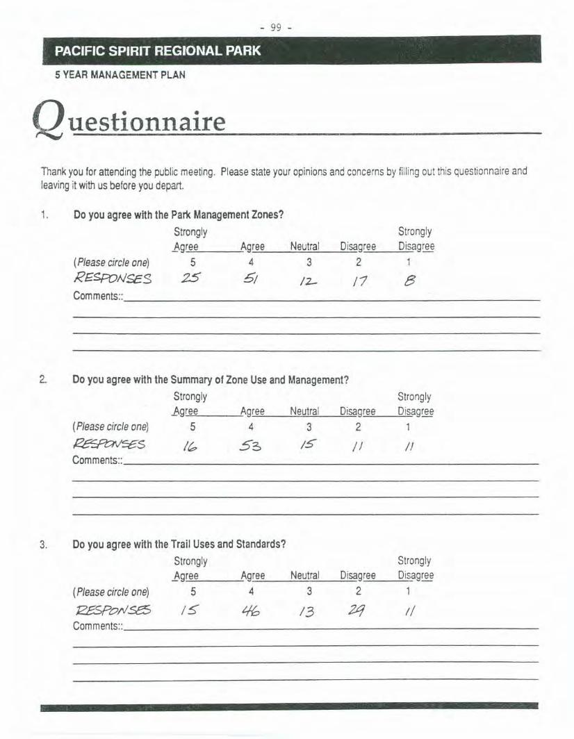
- 99 -,,',". ',.'" ".-', "': ' '
PAc:lFICSPIRIT REGIONAL PARK
5 YEARMANAGEMENTPLAN
QuestionnaireThankyouforattendingthepublicmeeting.Pleasestateyouropinionsandconcernsby fillingout thisquestionnaireandleavingit withusbeforeyoudepart.
1. DoyouagreewiththeParkManagementZones?Strongly Stronglyl,gree Agree Neutral Disagree Disagree
(Pleasecircleone) 5 4 3 2 1
REsroIJSES 25 5/ 12- /7 8Comments::
2. DoyouagreewiththeSummaryofZoneUseandManagement?Strongly Stronglyl,gree Agree Neutral Disagree Disagree
(Pleasecircleone) 5 4 3 2 1
!Z£SCt;:NSf;S / 5'6 15 II IIComments::
3. DoyouagreewiththeTrailUsesandStandards?Strongly Stronglyl,gree Agree Neutral Disagree Disagree
(Pleasecircleone) 5 4 3 2 1
1Z£Spol'lse5 IS: LIb 13 2q !/Comments::

#'
- 100 -
I~'~AClfIC"SPIRlt,'.;RE'GI()~AL',PA'RK'.I,')i%' ". ,',ii'" ..' .,"7',.."" ~", ' ':BO'
5 YEAR MANAGEMENT PLAN
4. Listany issuesyoufeelshouldbe immediatelyaddressed.
1.
2.3.4.5.
5. AV~ P'''--~=- --%.15'7.25 ~7.37{,S/3.~".qg 4(,.b~ ~
2,..1'1 10~.~2.
5.2.6
Rankthe importanceof thefollowingissuesona scaleof 1to 10(10beingthemostimportant).
0 Forestecologyandmanagement
0 Foreshoremanagement
0 Erosioncontrolmeasuresonbeach,cliffs&canyons0 FishandWildlifehabitatenhancement
0 Roadsandparking
0 Trailheadsandfacility/signagerequirements
0 Trailmaintenanceandupgrading0 PermanentVisitorCentre
0 Visitorfacilitiessuchastoilets,picnicareasandGroupCampGround
0 ForestFireprotection
Ie:.
c,(
6. Didyoufind thepublicmeetinguseful? Howcouldwe makeit better?Any othercomments?
III
PACIFIC SPIRITREGIONA'LPJ(Rk,~ . '. - '.' ,,' , .."
April 3/91 TOTAL RESPONSES ~~~
Questionnaire aboutWreck Beach
5 YEAR MANAGEMENT PLAN
Thankyoufor attendingthe publicmeetingof 24 March1991. Pleasestateyouropinionsandconcernsby completingand leavingthisquestionnairewithus BEFOREYOULEAVE.(ormail intoGVROParkspriorto 30 March1991).
1I. Which Municipality do you live in? VANCOUVER192;BURNABY19;RICHMOND8;MAPLERIDGE5:COOUITLAM4;
NORTHVAN6;NEWWESTMINISTER1;WESTVAN1; DELTA1:UEUPOINTGREY4;GREATERVANC.1;OTHER5 (includingonefromWinnipeg);NOANSWER6.
How often do you visit WreckBeach?2.
3. DoyouagreewiththefollowingParkManagementZoningof themarsharea?
a)ThemarshareabetweenBoomingGroundTrailandtheMusqueamReservebein theENVIRONMENTALPROTECTIONZONE?
Strongly .Strongly No
.t-gree Agree Neutral Disagree 'Disa~ Answer(Pleasecircleone) ~ 4 @ 3@ 2 @ 1 24 @b)ThemarshareabetweenBoomingGroundTrailandthebaseof thenewtrail fromtheHistoricMonu-mentsitebeintheENVIRONMENTALRESTORATIONZONE?
Strongly Strongly
_Agree Agree Neutral Disagree Disa~(Pleasecircleone) ~ 4 @ 3@ 2 @ 1~c)Therestof themarshareabein theBUFFERZONE?
Strongly
.t-gr~AgreeS@; 4~
NoAnswer
@)
(Pleasecircleone)Comments:
Strongly
Neutral Disagree Disa~@ 20 1\..!)
NoAnswer
@)
4. DoyouagreethattheCLOTHINGOPTIONALboundariesbefromtheMilemarker/bridge(approx.300m
fromtheParkboundaryat Acadia)to theBoomingGroundTrail(startof theEnvironmentalProtection
Zone)?
(Pleasecircleone)Comments:
StronglyAgree- S@
Strongly
Agree Neutral Disagree Disa~4 (35) 3(22) 2 (4) 1~
NoAnswer
@)

- .I.U~-, '
PACIFICSPIRIT REGIONAL PARK ' ", PAG"E:2 j'-, "." ' , '..;; ..' , .. ' '; ,. " ' :< '
5 YEARMANAGEMENTPLAN
5. Do you agree withminimumdevelopment (no drinkingwater, no concession buildings, etc.) but that more
toilet facilities are required?
StronglyAgree- s<§)(Pleasecircle one)
Comments:
StronglyAgree Neutral Disagree Disagree
4 @) 3(9 2 Q) 1 (3)
NoAnswer
W
DoyouagreethatsandshouldbeplacedonWreckBeach,providedit iscleananduncontaminated?
Strongly Strongly No}.gree Agree Neutral Disagree Disagree Answer
(Pleasecircleone), S@ 4 @ 3@ 2 @ 1 @ @IfYes,anypreferredlocation(s)Comments:
6.
7. The sale of food is controlled by the Provincial HealthAct. Whatsteps could GVRDand Vendors take to
help meet the regulations?
8. The Provincial Health Act states thatnodogsareallowedonpublicswimmingbeaches.Whatstepscanbe
takento helpmeettheregulations?
9. DoyouagreewiththeActionPlanforLawEnforcementandEmergencyServices(aswrittenin the Task
ForceSummary)?
Strongly StronglyAgree Agree Neutral Disagree Disagree
(Pleasecircleone) - ~ 4 @ 3@ 2 @ 1 @WhatotherissuesandrecommendationsshouldbeconsideredintheActionPlan?
1. Agree(#4)withsomeaspects
Disagree(#2)withothers-gavedetailedcomment.
NoAnswer
@
10. Didyoufindthepublicmeetinginformative?Comments:
Yes ~ No-CD-No
Answer@
Greater Vancouver Regional District Parks4330 Kingsway Burnaby, BC CANADA V5H 4GB Phone 432-6350
II
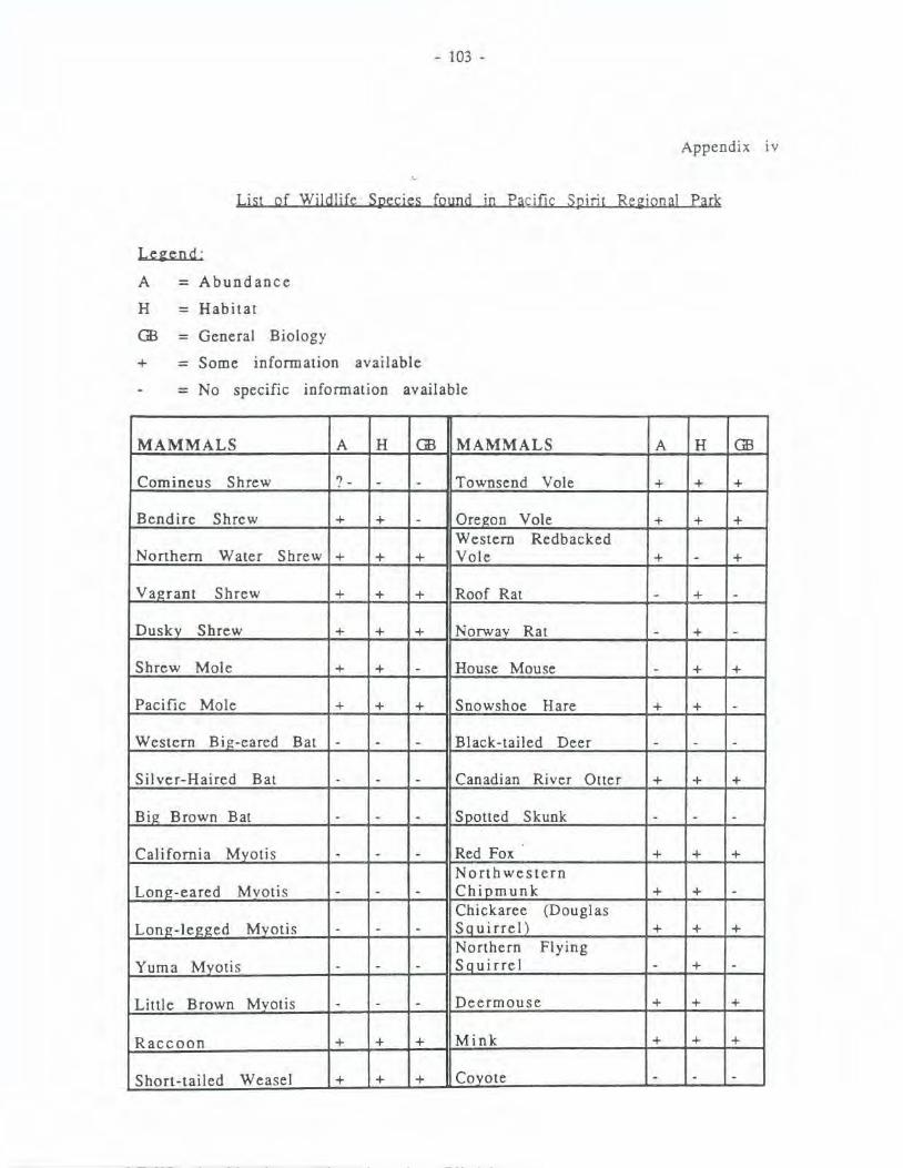
- 103 -
Appendix iv
List of Wildlife Species found in Pacific Spirit Regional Park
Le~end :
A
H
GB
= Abundance
= Habitat
+
= General Biology
= Some information available
= No specific information available
MAMMALS A H GB MAMMALS A H GB
Comineus Shrew ? - - - Townsend Vole + + +
Bendire Shrew + + - Oregon Vole + + +Western Redbacked
Northern Water Shrew + + + Vole + - +
Vagrant Shrew + + + Roof Rat - + -
Dusky Shrew + + + Norway Rat - + -Shrew Mole + + - House Mouse - + +
Pacific Mole + + + Snowshoe Hare + + -
Western Big-eared Bat - - - Black-tailed Deer - - -
Silver-Haired Bat - - - Canadian River Otter + + +
Big Brown Bat - - - Spotted Skunk - - -
California Myotis - - - Red Fox + + +Northwestern
Long-eared Myotis - - - Chipmunk + + -Chickaree (Douglas
Long-legged Myotis - - - Sauirrel) + + +Northern Flying
Yuma Mvotis - - - Squirrel - + -
Little Brown Mvotis - - - Deermouse + + +
Raccoon + + + Mink + + +
Short-tailed Weasel + + + Coyote - - -

- 104 -
APPENDIX iv CONTD
AMPHIBIANS AND A H GB AMPIBIANS AND A H GBREPTILES REPTILES
Northwestern GarterOre!!on Salamander + + - Snake - + -
Northern AlligatorWestern Toad - + + Lizard + + -
Pacific Tree Frog + + + Pacific Coast Newt - + +Red-backed
Red-legged Fro!! + + + Salamander - + +Western Terrestrial
Common Garter Snake - + + Garter Snake + + -
BIRDS BIRDS
Great Blue Heron'
Band-tailed Pigeon+ + + + + +
Canadian Goose + + + Rock Dove + + +
Mallard + + + Mourning Dove - + +
Shoveller + + - Screech Owl + + +
Turkev Vulture + - - Great Homed Owl + + +
Goshawk - + - Saw-whet Owl + + +
Sharp-shinned Hawk -+ + - Common Nighthawk - + +
Cooper's Hawk + + - Black Swift + - +
Red-tailed Hawk + + + - -Vaux's Swift + + +.
Rou!!h-Ie!!!!ed Hawk + + + Anna's Hummingbird - + +
Bald Eagle + + - Rufous Hummingbird + + +
Marsh Hawk + - - Belted Kingfisher + + +
Osprey + + - Common Flicker + + +
Pigeon Hawk + - + Pileated Woodpecker + + +Yellow-bellied
American Kestrel - + + Sapsucker + + +
Blue Grouse - + + Hairv Woodpecker + + +
Ruffed Grouse + + + Downv Woodpecker + + +

- 105 -
APPENDIX iv CONTD
BIRDS A H GB BIRDS A H GB
Rinsz-necked Pheasant + + - Eastern Kinszbird + + -
Killdeer + + + Western Kin!!bird - + -
common SniDe + + - Willow Flycatcher + + -
Spotted SandDiDer - - - DuskvFlvcatcher + + -Glaucus-wingedGull + + + Western FIvc atcher + + - .
Mew Gull + + + Hammond's Flycatcher + + -
Bonaparte's Gull + + + Western Wood Peewee + + -
Violet-£reen Swallow + + + Olive-sided Flycatcher + + +
Tree Swallow + + + Bohemian Waxwinlr + - +
Rouszh-win£ed Swallow + + + Cedar Waxwinsz + + +
Barn Swallow + + + Northern Shrike + + +
Cliff Swallow + + + Starling + + +
Purple Martin + - + Crested Mvnah + + +
Steller's Jay + + + Hutton's Vireo + + +
Common Raven + + + Solitary Vireo - + -
North western Crow + + + Red-eved Vireo + + -
Black-cappedChickadee + + + Warblinsz Vireo + + +Chestnut-backed Orange-crownedChickadee + + + Warbler + + -
common Bushtit + + + Yellow Warbler + + -Yellow-rumped
Red-breasted Nuthatch + + + Warbler + + -Black-throated Gray
Brown Creeper + + + Warbler - + +
House Wren - + + Townsend's Warbler + + +
MacGilliyrays'Winter Wren + + + Warbler + - -
BewiCk's Wren + + + Common Yellowthroat + + +
Long-billed MarshWren - + + Wilson's Warbler + + +

- 106 -
APPENDIX iv CONTD
BIRDS A H GB BIRDS A H GB
American Robin + + + Dark-eved Junco + + +White-crowned
Vari ed Thrush + + + Sparrow + + +Golden-crowned
Hermit Thrush + + + Sparrow + + -
Swainson's Thrush + + + Fox Sparrow + + -
Townsend's Solitaire - + + Lincoln's Sparrow + - -Golden-crownedKinsrlet + + - Sonsr Sparrow + - -Ruby-crownedKinsrlet + + + Western Meadowlark + - -
Red-wingedHouse Finch + + + Blackbird + + +
Pine Grosbeak + - - Brewer's Blackbird + + +Brown-headed
Common Redpoll + - - Cowbird + - +
Pine Siskin + + + Western Tanager + + -Black-headed
American Goldfinch + + + Grosbeak + + +
Red Crossbill + + - Evening Grosbeak + + -
Rufous-sided Towhee + + - Purnle Finch + + +
Savannah Sparrow + + -
- 107-APPENDIX y
WRECK BEACH TASK FORCESUMMARY OF
ISSUES &RECOMMENDATIONS
TOGVRDPARKSDEPARTMENT
ANDTHE PUBLIC (PUBLIC MEETING 24 MARCH 1991)
Pacific Spirit Regional Park Wreck Beach Foreshore

- 108 -
WRECK BEACH TASK FORCE -SUMMARY
TABLE OF CONTENTS
1. LAW ENFORCEMENT& EMERGENCYSERVICES
2. CLOTHINGOPTIONALBOUNDARIES
3. VENDING
4. POLLUTIONIHEALTH
5. AMENITIESIF ACILITIES
a ) PARKING
b) POTABLEWATER
c) TOILET FACILITIES
6. USES/ACTIVITIES
7. ENVIRONMENf
a) LCXJBOOMS
b) FOREST FIRE PROTECrION
c) CLEAN-UP OF FOREST AREA
8. EROSION 8
9. MARSH 9
10. VEGEfATION MANAGEMENT
~
1
2
3
4
5
5
5
6
6
7
7
7
7
10

- 109 -
Important Hj~hli ~hts
. Clothing optional boundaries are unchanged (with the possible exception
of the east end of marsh area)
The Beach is to be left in as natural a state as possible.. Minimum Park development
The Marsh is a special and fragile environment
Recognition that public safety issues must be dealt with
Establishment of Beach Liaison Committee and Action Plan Guidelines
.
.
.
L LAW ENFORCEMENT AND EMERGENCY SERVICES ACTION PLAN
The Task Force has listened to the presentation made by the agencies and
acknowledges that there are problems which must be dealt with, especially
regarding safety to the public (predominantly in the Trail #6 area).
The issue is how to provide emergency services and deal with the sale of illegal
substances without disrupting the natural environment and destroying thecharacter of the beach.
Specific Issues:
. Difficulty of access to the area -because of the steep terrain and erosIOn
problems.
. Difficulty of apprehension of drug dealers.
Inadequate parking on Marine Drive for police and emergency vehicles.
Inadequate staff for police. emergency and administrative agencies.
Recommendations:
Improve cooperation and coordination among agencies and beach users.Fonnation of a Beach Liaison Committee..Greater advantage should be taken of access from the water for emergency
services.
GVRD should consider its own hovercraft or amphibious-type craft.
Drug sweeps should begin early and continue throughout the season in
cooperation with the Vancouver Police Beach Patrol Squad.

- 110 -
. GVRD should request extra police and other staff for the summer months, as
they do in other Regional Parks.
and interest groups involved.
GVRD staff presence and visibility should be increased.
Education and peer pressure from beach users should be continued by
newsletters. flyers. and word of mouth.
Coordinated training exercises among fire department. coast guard. GVRD
staff. ERS. beach first aid volunteers and others.
The possibility of putting more sand on Acadia Beach should be explored.
This would enlarge the Acadia Beach area and encourage people to use it
rather than Trail #6. thus relieving some of the congestion at Trail #6. The
more people there are at Trail #6 the more likely it is that there will be a
problem.
More fire hydrants along Marine Drive.
Fire fighting tools and first aid supplies stashed at strategic spots along the
beach area for initial response.
This should be endorsed by other agencies
.
.
.
.
.
.
. Coordinate GVRD staff and Fisheries Officers regarding fires and other
problems on the beach during smelt season.
Monitoring:
Results should be assessed periodically and all the players involved should be
included in these assessments. (Assessments at end of each summer for the
next 5 years.)
Conclusions:
A determined effort on the part of all agencies and users to get the situation
under control, using the resources presently available. should be made. This
should be coordinated by the GVRD.
The primary goal is to maintain the beach character. incorporating the
natural beach environment without impeding tbe establisbed public access
and usage patterns.

- 111 -
2.. CLOTIffiNGOPTIONALBOUND~
Issues:
Nudity causes discomfort to some Park visitors.
Social tensions.. Social clashes to be minimized, yet protect the beach character.
Naturists do not condone anti-social behaviour (see WBPS newsletter).
Existing boundaries (Mile marker/foot bridge to Musqueam Reserve) have
been agreed upon by WBPS, RCMP and Attorney General's office since 1983.
East end of marsh to be placed in high environmental protection zone. This
limits use (whether clothed or not) and therefore limits boundary from
being Musqueam Reserve.
Earlier discussions re environmental
.
.
.
. issues recommended Logfrom
Booming. Ground Trail to Musqueam Reserve to be placed in Environmental
Protection Zone. (Environmentalists suggest larger area required in that
Zone.)
Recom menda tions:
West end boundary remains the same, i.e. Mile marker/foot bridge. (UEL
Ratepayer's representatives on record as opposed).
G VRD to determine area at marsh east end that will be placed in
Environmental Protection Zone and establish marsh base line data and
.
monitoring program to determine exact boundary of use.
1. VENDING
Issues:
WBPS and beach users do not want concession stands or concession
. buildings on Wreck Beach.
No potable water exists (and will not be supplied) to Foreshore.
Food vending must meet with Provincial Health regulations to protect the
public.
GVRD strategy
All vending is
licensing to be
.
must be to meet the Vancouver Health Dept. requirements.
controlled under GVRD Park regulations and may require
allowed to continue.

- 112 -
Recommendations:
Work towards compliance with the Health Act or what is acceptable toVancouver Health Officer.
. Summer 1991 continue with survey of vendors to help understand vendors
and beach users'.
. Seek voluntary cooperation from vendors in seeking a solution to Health
Act compliance.
~ POLLtITIONIHEAL TH
Issues:. Fraser River Nom Arm has poor water quality.
Sand dredged from: North Arm has been proven highly contaminated with
coliform bacteria.
Dog waste.
Toilet facilities inadequate to serve high visitor use.
Combined sanitary and storm drain may be causing a problem.
The Towers storm drain has been specifically flagged
contaminated with raw sewage. (Sewer line cracks because it is
the surface of Marine Drive where it crosses the storm drain.)
.
.
.
.
. as being
too close to
Recommendations:
. Continue to monitor water quality. GVRD presently takes samples in both
North Arm and ocean side and submits sample results to Vancouver Health
Dept. Vancouver Health Dept. advises GVRD when to post "no swimming"
signs. It is. up to the Vancouver Health Dept. whether they release
geometric mean sample results to the public (WBPS presently gets both
actual and geometric mean sample results, sent to Judy Williams).
Pressure UBC to fix the sewer line under Marine Drive where it crosses the
storm drain.
.
. Storm drains to be phased out in the long term.
If sand is to be placed on the Beach, contaminated sand is not acceptable.
RODAC standards are presently used, but perhaps higher standards are
required. This also applies to Point Grey Dump Site.

.
i.
- 113 -
It is a Provincial Health standard that dogs are prohibited at swimming
beaches. GVRD tries to comply with other agencies, so in time this may
at Wreck Beach (long term). In the short term dogs should be on a
during summer months.
pump-out toilets (see AMENITIES IFACILITIES - recommendations for
facilities) should help the problem of inadequate toilet facilities.
WBPS has agreed to continue their beach education program through
newsletters, flyers and word of mouth.
AMENITIESIF ACILITIES
a ) PARKING
Issues:
. Acadia end of Beach could handle more use but only if parking can be
upgraded or placed on Vancouver's Spanish Banks' west end.
Better parking could help spread usership over entire Foreshore.
Formalizing parking reduces environmental impact.
Emergency vehicle parking at top of Trail #6 too limited.
UBC concerned about beach users parking on campus and blocking
emergency vehicle access spots.
.
.
.
. UBC has only limited puking space available for beach users.
Parking lot has been eliminated posing a greater parking problem for
summer 1991. (New parking structure in this area is proposed. which
will help in the future.)
UBC's proposed increases in public parking rates are excessive.
More public transit along Marine Drive is required.
Recommendations:
. Pave Acadia Parking Lot.
City of Vancouver should provide more parking at West Spanish
Banks.
.
Old Marine Drive (Highways to turn this land
applyleash
. More
toilet
. Review parking along
over to GVRD shortly). Safety - speed bumps required along Old Marine DriVe.. Improve existing parking areas (but no increase in parking areas).

2.
Issues:...
- 114 -
. .Better parking at the top of Trail #6 for emergency vehicles.
UBC will supply map 'to GVRD re parking availability on campus.
Increase in parking fees should be reviewed.
.
.
b) POTABLEWATER
Issues:
. Easy access to potable water adds to problem of overnight camping and
would increase general use of the area.
Adverse environmental impact caused by installation of water lines.
Incremental development is not desirable - supplying water could lead
. to flush toilets, concession building, etc. Concession stands or
buildings are not wanted or needed on Wreck Beach.
.
.
Recommendations:
. No potable water to be supplied.
b) TOILET FAcn..ITIES
Issues:
. Toilet facilities inadequate to serve high visitor use.
Recommendations:. Expand existing pump-out toilet system.
Add two more toilets to existing holding tank at base of Trail #6.
Install two toilets with holding tank (same as Trail #6) at base of
Trail #4. (In long term - install same at base of Trail #3).
.
.
USESIACTIVITIES
Majority of Foreshore highly used.Certain areas over-used at certain times.
Undesirable uses/activities.
Low flying aircraft over the Foreshore is undesirable, particul,arly
helicopter and float plane flight paths which parallel the estuary.

- 115 -
. Small craft impacts.
water skiing and parasailing dangerous
often too many boats moving, anchored. or beached (often left
unattended)
engine oils/gas contaminate water
Recommendations:
. No camping.
No mountain bikes... No expansion of summer-time beach activities.
Low flying aircraft:
GVRD to liaise with Transpon Canada re helicopter and float plane
.
flight paths over the estuary
Interest groups can lobby Transpon Canada by way of letters of
complaint and/or give GVRD letters of suppon
Users can monitor and repon offenders to Transpon Canada (Call
276-6397). Small craft impacts
GVRD to liaise with Vancouver Pon Authority, Coast Guard,. RCMP
Marine Unit, and Nonh Fraser Harbour Commission
L ENVIRONMENTIENVIRONMENT AL ISSUES
a) LOG BOOMING TIE UPS/CHIP STORAGE
Issues:
. Log booms tied up with cables to trees in Park (cables damage trees
and cause a safety hazard where they cross trails).
Log booms grounding out on marsh (fish) habitat.
Wood chips blow off storage scows and contaminate recreational water
quality and beach.
Long-term objective of removal of log booms and scows (Moorage Site
#3)
.
.

8...
Issues:.
.
. 116 -
Recommendations:. GVRD to liaise with Nonh Fraser Harbour Commission on removal of
cables, additional dolphins to tie up booms, adherence to
provincial/federal legislation relating to water debris, etc. (e.g.
federal Fisheries Act, section on deleterious material).
b) FOREST FIRE PROTECTION
Issues:. Cliff.face vegetation, important erosion control
environment, must be protected in case of fire.
and natural/visual
Recommendations:. All agreed to fire hydrants on uplands side of Marine Drive.
Determine what hydrants exist and feasibility of extending UBC
line to where hydrants may be required.
GVRD liaise with UBC Fire Dept., UBC and other agencies.
water..
c) CLEAN-UP OF FOREST AREA
Issues:. Clean-up of forest area needed, particularly along the estuary trail.
Recommendations:. That GVRD implement a major clean-up program of the Foreshore
slopes and funds be allocated for an annual maintenance clean-up.
Highest priority should be given to the estuary trail.
EROSION
Major cliff erosion problems exist behind UBC President's house above Trail
#4, (west of BC Telephone towers). In addition, the gully east of Trail #3
(will impact NW Marine Drive in the near future and. needs urgent
attention)
Watering (at UBC President's House) must be controlled to comply with 1979
Cliff Erosion Task Force Committee recommendations.

n
- 117 -
. Some toe-of-slope erosion (extent needs to be identified).
Previous erosion control (rock groins and biD-engineering) not visually
natural. The over armament of the Trail #4 groins are particularly
.
. unsightly.
Buildings on ocean side of Marine Drive increases potential for erosIOn.
Potential impact of extension to Green College and other proposed Campus
development.
UBC not complying with 1979 <;:liff Erosion Task Force Committee
recommendations.
.
.
.' Additional sand or berm for toe erosion control could provide easier
pedestrian access and more useablebeach at high tides.
Recommendations:
. GVRD to liaise with UBC Campus planners. Seek compliance with 1979 Cliff
Erosion Task Force Committee recommendations.
More information required (perhaps study update to include hydrological
study required) and update on Wolf Bauer repon.
Public must be kept informed and have input to any study and erosion
control recommendations.
.
.
2.. MARSH
Issues:
. Rare plants (Typha angustifolia), especially east end of Marsh.
Fragile area - easily trampled.
Depleting Fraser River resource.
Productive fish and wildlife habitat.
Nice place to be (visually pleasing and tranquil)
Musqueam Indian Band exercise their native rights of hunting in marsh
.
.
.
.
.area.
.hunting (by Musqueam) poses a danger and safety problem to Park
visitors. Shots have been fired towards public use areas.
Marsh has high interpretation/education values.
pogs trampling marsh vegetation and chasing wildlife.
Log booms grounding at low tide impacts marsh and Foreshore.
Increased mountain biking due to trail improvements.
.
.
.

- 118 -
Recommendations:
.Park zoning to provide high environmental protection but recognize and
allow continued use, with monitoring.
Musqueam Reserve to Logging Boom Trail placed in Environmental
ProtectionZone. The rest of the marsh area placed in Buffer Zone.
Establish marsh baseline study (work with FREMP, Fisheries and UBC).
Improve water quality through inter-agency action and governing
legislation (e.g. Fisheries Act).
GVRD liaise with Musqueam Band and B.C. Fish and Wildlife (Wildlife Act)
about not shooting towards shore.
Limits of hunting area must be defined and safety to Park users reviewed.
More information required.
Dogs on leash in marsh area at all times due to wildlife concerns.
In the long term GVRD obtain water lot lease of marsh area.
.
.
.
.
.
.
.
10. VEGETATION MANAGEMENT
Issues:. Slope and cliff-face vegetation.
important erosion control and natural/visual environment.
trees on slopes falling and roots pulling out soil. causing erosion.
Viewing envelopes of filtered views at:
Fraser Historic Monument, overlooking Iona.
Viewpoint at east end of Old Marine Drive.
David Lam Centre (UBC Botanical Gardens).
.
.Historic Monument on NW Marine Drive.
NW Marine (approx. from Trail #3 to open grass area)..
Dangerous trees on trails.
Recommendations:
. Plant slopes with a variety of indigenous species and encourage
successional forest growth.
The five important viewing locations to be maintained as pocket and
filtered views.
.

- 119 -
. Danger trees and erosion causing trees will be cut in consultation.
whenever feasible, with user groups. In addition, where possible. leave
stem.12' to 15' .in place for wildlife habitat (Piliated woodpeckers) and leave
the rest of the tree to rot on the forest floor.
Letter of understanding required between GVRD and DBC concerning view.. policy.
GVRD's tree planting policy (plant 2 for every one removed) should be
continued, as a minimum requirement.

- 120 -
APPEND IX 1: Wreck Beach Task Force Members.
Wreck Beach Preservation Society:- Judy Williams, Chairman- Takis Elefinsiotis. Vice-Chairman- Vernon Hale- Chris Shelton- James Loewen- John Munro
Alternates:- Craig Wilson- Drake Barem- Dr. Bob Brubaker
UEL Ratepayers- Joan Sprague- Ben Moyls
Association:
Friends of Pacific Spirit:- Bowie Keefer- Ken Hewett- Tom Nichols (Alternate)
Vancouver Natura) History- Linda Kingston- Steve Partington (Alternate)
Society:
Fraser River Coalition:- June Binkert
Unaffiliated Member:- Alan Herbert
UBC, AMS Student Environment Centre:- Mary Jean O'Donnell
GVRD STAFF:- Bob Gibson, Chairperson- Mitch Sokalski, Area Superintendent- Dave Chater, Park Operations Supervisor- Gordon Smith, Park Planner- Susan Cawley, Recording Secretary
GVRD staff express their sincere thanks to Task Force Members for their
participation. Their time, interest and valuable input has resulted in a greater
understanding of the issues and resolutions for managing the Foreshore Unit
of Pacific Spirit Regional Park.

- 121 -
MANAGEMENT PLAN. BIBLIOGRAPHY (Selected)
SELECTED BIBLIOGRAPI-1Y
Archeo Tech Associates. 1989a. Proposed Relocation, Section of Sword FernTrail, Pacific Spirit Regional Park. Heritage ConservationAct/Archaeological Permit No. 1989-95. Letter/repoI1 to GVRD Parks,September 15, 1989.
Archeo Tech Associates. 1989b. Archaeological Inventory, Camosun BogRehabilitation Project, Pacific Spirit Regional park. Heritage ConservationAct/Archaeological Permit No. 1989-118. Letter/repoI1 to GVRD Parks,December 7, 1989.
Ashton, Roger. 1989. Encouraging Lower Mainland Butterflies.Vancouver Natural History Society, Vancouver, BC.
RepoI1 to the
Bakewell, David R. 1990. Evaluation of the Forest Edge Along Botindary BetweenU.B.Co's Hampton Place and Pacific Spirit Regional Park. Repon preparedfor the U.B.C. Real Estate Corporation and the Greater Vancouver RegionalDistrict Parks Depanment.
City of Vancouver Planning Department, 1989. Vancouver Views Study -Implementation. RepoI1 to City Council, Vancouver, B.C.
Comeau, M.A. 1983. Vegetation Classification and Ordination of Camosun Bog inthe University Endowment Lands. Report prepared for GVRD ParksDepanment, Vancouver, B.C.
Daust, Dave. 1990. The Camosun Bog Restoration Project Timber Extraction Phase.Repon prepared by the Forest Harvesting Group at the University ofBritish Columbia for GVRD Parks.
Fausch, Kun D. 1990. Management of Habitat in Musqueam Creek for Residentand Anadromous Salmonids. .Repon prepared for the Province of BritishColumbia, Ministry of Environment, Wildlife Branch, Victoria, b.C. and theGreater Vancouver Regional District, Burnaby, BC
Greater Vancouver Regional District. 1980. A Re~ional Park for the EndowmentLands. Prepared for the Minister of Lands, Parks and Housing. Vancouver,B.C.: GVRD Parks Department.
Greater Vancouver Regional District. 1985. Greater Vancouver. Regional Parks:System Plan and Policies. Draft repon. Reprinted April 1990.
Greater Vancouver Regional District and City of Vancouver. 1976. TheUniversity Endowment Lands: A Special Kind of Re~ional Park Vancouver,B.C.: GVRD.
Greater Vancouver Regional District Parks DepaI1ment. 1989.Vancouver Re~ional District Parks: 1989 Use Estimates.GVRD.
Greater
Burnaby, B.C.:

- 122 -
Klassen, Art. 1983. Survey of Educational and Research Use of the Univ«rsityEndowment Lands, technical paper #2, University Endowment LandslForestPark. Research. Vancouver, B.C.:U.B.C. Technical Committee on theEndowment Lands and Greater Vancouver Regional District ParksDepartment.
Neves, Rick. 1990. Pacific Spirit Regional Park Trail Inventory, January 31 toFebruary 28, 1990. Report to the Greater Vancouver Regional District ParksDepartment, Burnaby, B.C.
Newell, David, M.G. 1983. The Terrestrial Vertebrates of the UniversityEndowment Lands. Technical Paper #1. University EndowmentLandslForest Park Research. Vancouver, B.C.:U.B.C. Technical Committee onthe Endowment Lands and Greater Vancouver Regional District ParksDepartment. .
Newell, David, M.G. 1984. Amphibians. Reptiles and Mammals of the UniversitvEndowment Lands. Burnaby, B.C.:Greater Vancouver Regional DistrictParks Department.
Pearson, Audrey F. 1985. Ecolo~ of Camosun Bo~ and Recommendations forRestoration. Technical Paper #3, University Endowment LandslForest ParkResearch. Burnaby, B.C.:U.B.C. Technical Committee on the EndowmentLands and Greater Vancouver Regional District' Parks Department.
Piteau Associates. 1989. Hydrogeological Assessment of the Camosun Bog, PacificSpirit Regional Park, Vancouver, British Columbia: Phase 1. Report to ParksDepartment, Greater Vancouver Regional District, Burnaby, B.C.
Piteau Associates, 1991. Hydrogeological Assessment of the Camosun Bog, PacificSpirit Regional Park, Vancouver, British Columbia: Phase II. Report toParks Department, Greater Vancouver Regional District, Burnaby, B.C.
Rida, Carmen R. 1988. The PresCl"Vationof Urban Woodlands: A Case Study of theUniversity Endowment Lands, Vancouver, B.C. Master of Science Thesis,School of Community and Regional Planning, University of BritishColumbia.
Straley, Gerald B. and Harrison, Patrick R. An Illustrated Flora of the Univ~rsityEndowment Lands. A guide to the vascular plants. The Botanical Gardenand Department of Botany, University of British Columbia.
Swan Wooster Engineering Co. Ltd. 1979. Point Grey Erosion Control Master PlanProposal. Report to the University of British Columbia Marine ForeshoreDevelopment Committee, Vancouver, B.C.
Thompson, Grant A. 1985. Ve~etation Classification of the Endowment Lands.Technical Paper #4, University Endowment LandslForest Park Research.Burnaby. B.C.:U.B.C. Technical Committee on the Endowment Lands andGreater Vancouver Regional District Parks Department.
V.B.C. Technical Committee on the Endowment Lands, Camosun BogSubcommittee. 1989. Proposal fOT the Restoration of Carnosun Bog.prepared for GVRD Parks. June 7. 1989.
Report

- 123 -
DEL Study Team. 1977. 1977: The University Endowment Lands. Report of the1977 UEL Study Team. coordinated by Byron Olson. to the Minister ofEnvironment. Government of British Columbia. Vol. 1: Summary andRecommendations and Vol. 2: Appendices. Vancouver. B.C.:GreaterVancouver Regional District.
University of British Columbia Cliff Erosion Task Force. 1979. Point Grey CliffErosion Control. Report to the Board of Governors. University of BritishColumbia. Vancouver. B.C.
Watmough. Don and Audrey Pearson. 1990. Camosun BOi Summary ReportBurnaby. B.C.:Greater Vancouver Regional District Parks Department.
Wege. Rita. 1985. Forest Management Options for the Endowment Lands. Aninternal discussion paper prepared for the GVRD Parks Department.Burnaby. B.C.
Western Canada Hydraulic Laboratories Limited. 1975. Point Grey Cliff &Foreshore Study. Report to Vancouver Board of Parks and PublicRecreation. Vancouver, B.C.

- 124 -
ACKNOWLEDGEMENTS
GVRD Parks thanks the people and organizations who have devoted their time
and effon to help develop this management plan. The involvement of the
following in panicular is very much appreciated:
Interest Groups
Bicycle Association of B.C. (BABC)
Federation of B.C. Naturalists (FBCN)
. Fraser River Coalition (FRC)
Friends of Pacific Spirit Park
Pacific Spirit Cycling Club
Save Our Parks Association (SOPA)
Scouts Canada
Southlands Planning Comminee
UBC Intramural Spons
UBC Student Environment Committee
UBC Technical Committee
UEL Trail Riders
UEL Ratepayers Association
Vancouver ~atural History Society (VNHS)
Volunteers in Parks (VIPs)
Wreck Beach Preservation Society (WBPS)
A~encies
B.C. Ambulance Service (UBC Station)
Coast Guard Canada (Hovercraft Service)
Canadian Wildlife Service (CWS)
Depanment of Fisheries and Oceans (DFO)
Fire Depanment (UEL/UBC Station)
Ministry of Highways and Transponation
Royal Canadian Mounted Police (RCMP) (VEL Division)
UEL Administration
UBC Security and Parking
Vancouver City Health Depanment

- 125 -
Workshop Participants
Friends of Pacific Spirit
Tom Nichols
Jacquie Cronin (also VIP)
Ken Hewett
Wreck Beach Preservation Society
Judy Williams (also Fraser River Coalition)
Takis Elefsiniotis (also VIP)
Save Our Parkland Association
Wendy Turner
Dick Stace-Smith
UBC Student Environment Committee
Joanne Gislason
Vancouver Natural History Society
John Young
Terry Taylor (also VIP)
Frank Skelton (also VIP)
Erin Skelton (also VIP)
Fraser River Coalition
June Binkert
Federation of B.C. Naturalists
Lawrence Brown (also VIP)
Ben Brink
UEL Trail Riders
Maggie Cumming (also
Bernice Ramsay (also
Dayle Farenholtz
Margaret Young
Bicycle Association of B.C.
Dean McKay
Cyclists
Guy Mitchell
Scott Stuan
VIP)
VIP)
VIP Hikers/W alkers
Susanne Clouthier
David Wei
Susan Campbell

- 126 -
Scouts
Jim Hilton
Interest Indi viduals
George Ostray (area resident)
Michael Beaudry (area resident/writer)
John Ray (WC2, not official)
Len Ryan (with Vancouver Parks Board, rr.tired)
Trail Task. Force Members
(Chaired by Gordon Smith, GVRD Parks)
Friends of Pacific Spirit Regional Park
Tom Nichols
Jacquie Cronin
Ken Hewett
Marjorie Maddigan
Pacific Spirit Cycle Club
Graham Clark
Sheila Clark
Dean McKay
Guy Mitchell
Scott Stewart
Dan Royea
VEL Trail Riders
Maggie Cumming
Elsie Guglick
Bernice Ramsay
Margaret Young
Vancouver Natural History Society
Erin Skelton
Frank Skelton
Terry Taylor
V0 Iun teers- In -Parks
Susan Campbell
Terry Slack

- 127 -
Wreck Beach Preservation Society
Judy Williams
Takis Elefsiniotis
Marine Elger
us GiHus
James Loewen
John Munro
Nola Stewart
Craig Wilson
Unaffiliated
Ian Belcher
Pat Harrison
Gerry Thom son
Chris Shelton
Wreck Beach Task Force Members
(Chaired by Bob Gibson. GVRD Parks)
Wreck Beach Preservation Society
Judy Williams'"
Takis Elefsiniotis
Vernon Hale
James Loewen
John Munro
Alternates: Craig Wilson. Drake Barem. Dr. Bob Brubaker
UEL Ratepayers
Joan Sprague'"
Ben Moyls
Friends of Pacific Spirit
Bowie Keefer
Ken Hewett
Tom Nichols (Alternate)
Vancouver Natural History Society
Linda Kingston
Steve Partington (Alternate)

- 128 -
Fraser River Coalition
June Binkert.
Unaffiliated Members
Alan Herbert.
Chris Shelton.
UBC. AMS Student Environment Centre
Mary Jean O'Donnell
. Sub-committee members (Chaired by June Binkert)
The principal author Gordon Smith. Park Planner thanks the following
Parks. West Area staff for their assistance in producing the Management
Plan:
Mitch Sakal ski
Area Superintenden t
Sue Ellen Fast
Park Interpretation Specialist
Roger Bean
Park Operations Supervisor
Jan West
Secretary

Participating MunicipalitiesVillage of AnmoreVillage of BelcarraDistrict of BurnabyDistrict of CoquitlamDis trict of Delta
Village of Lions BayCity of New WestminsterCity of North VancouverCity of Port CoquitlamCity of Port MoodyDistrict of North Vancouver
Electoral Area A (University Endowment Lands)Electoral Area BElectoral AreaC (Bowen Island)
City of RichmondDis trict of SurreyCity of VancouverDistrict of West Vancouver
City of White RockLangley CityLangley TownshipDistrict of MatsquiDistrict of Maple Ridge
~ Greater VancouverRegional District Parks