p. v. narasimha rao kanthanapally sujala sravanthi...
TRANSCRIPT

IRRIGATION & CAD DEPARTMENTGovernment of Telangana
P. V. NARASIMHA RAO KANTHANAPALLY SUJALA SRAVANTHI PROJECTThupakulagudem village Eturnagaram Mandal Jayashankar Bhupalapally DistrictThupakulagudem village, Eturnagaram Mandal, Jayashankar Bhupalapally District
FINAL ENVIRONMENTAL IMPACT ASSESSMENT REPORT FOR ISSUE OF ENVIRONMENTAL CLEARANCE
Volume –I
Schedule 1 (c) of EIA Notification, 2006, Category – A, Project Cost: Rs. 2121 CroresStudy Period : July 2017 to March 2018; Command Area : 5 55 310 ha
The Chief EngineerI & CAD DepartmentKanthanpally Project
KC Colony, ChintagattuW l 506015
Study Period : July, 2017 to March, 2018; Command Area : 5, 55, 310 ha
Environmental Health & SafetyConsultants Pvt. Ltd
Bangalore, Karnataka(Accredited by QCI-NABET)
080 23012100
ConsultantsProject by
NABET/EIA/1518/SA024Warangal - 506015 080 - 23012100
NOVEMBER 2018
Document No. EHSC/I&CAD/KCC/ETR/2017-18/PVNRKSSP
NABET/EIA/1518/SA024

FINAL ENVIRONMENTAL IMPACT ASSESSMENT REPORT
Of
P V NARASIMHA RAO KANTHANAPALLY SUJALA
SRAVANTHI PROJECT
In
JAYASHANKAR BHUPALAPALLY DISTRICT, TELANGANA
Project By
CHIEF ENGINEER
IRRIGATION & CAD DEPT.,
K. C COLONY, CHINTAGATTU,
WARANGAL - 506015, TELANGANA.
Consultants
ENVIRONMENTAL HEALTH & SAFETY
CONSULTANTS PVT LTD
No.13/2, 1st Main Road, Industrial Town,
Near Fire Station, Rajajinagar
Bengaluru - 560 010, Karnataka
NABET/EIA/1518SA 024 Dated: 31.05.2017
1
NOVEMBER 2018
DOCUMENT NO. EHSC/I&CAD/KCC/ETR/2017-18/PVNRKSSP
P V Narasimha Rao Kanthanapally Sujala Sravanthi Project in Final EIA Report
Jayashankar Bhupalapally District, Telangana
I&CAD Department, Government of Telangana ii EHS Consultants Pvt Ltd, Bengaluru
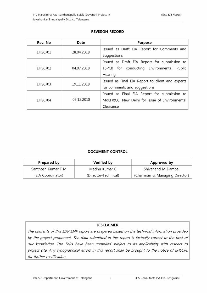
REVISION RECORD
Rev. No Date Purpose
EHSC/01 28.04.2018 Issued as Draft EIA Report for Comments and
Suggestions
EHSC/02 04.07.2018
Issued as Draft EIA Report for submission to
TSPCB for conducting Environmental Public
Hearing
EHSC/03 19.11.2018 Issued as Final EIA Report to client and experts
for comments and suggestions
EHSC/04 05.12.2018
Issued as Final EIA Report for submission to
MoEF&CC, New Delhi for issue of Environmental
Clearance
DOCUMENT CONTROL
Prepared by Verified by Approved by
Santhosh Kumar T M
(EIA Coordinator)
Madhu Kumar C
(Director-Technical)
Shivanand M Dambal
(Chairman & Managing Director)
DISCLAIMER
The contents of this EIA/ EMP report are prepared based on the technical information provided
by the project proponent. The data submitted in this report is factually correct to the best of
our knowledge. The ToRs have been complied subject to its applicability with respect to
project site. Any typographical errors in this report shall be brought to the notice of EHSCPL
for further rectification.

P V Narasimha Rao Kanthanapally Sujala Sravanthi Project in Final EIA Report
Jayashankar Bhupalapally District, Telangana
I&CAD Department, Government of Telangana iii EHS Consultants Pvt Ltd, Bengaluru

P V Narasimha Rao Kanthanapally Sujala Sravanthi Project in Final EIA Report
Jayashankar Bhupalapally District, Telangana
I&CAD Department, Government of Telangana iv EHS Consultants Pvt Ltd, Bengaluru

P V Narasimha Rao Kanthanapally Sujala Sravanthi Project in Final EIA Report
Jayashankar Bhupalapally District, Telangana
I&CAD Department, Government of Telangana v EHS Consultants Pvt Ltd, Bengaluru

P V Narasimha Rao Kanthanapally Sujala Sravanthi Project in Final EIA Report
Jayashankar Bhupalapally District, Telangana
I&CAD Department, Government of Telangana vi EHS Consultants Pvt Ltd, Bengaluru

P V Narasimha Rao Kanthanapally Sujala Sravanthi Project in Final EIA Report
Jayashankar Bhupalapally District, Telangana
I&CAD Department, Government of Telangana vii EHS Consultants Pvt Ltd, Bengaluru
PROJECT TEAM - IRRIGATION & CAD DEPARTMENT, GOVT. OF TELANGANA
Sl.No Name Designation
1. Shri. B Nagendra Rao Chief Engineer
2. Shri. A Sudhakar IFS (Retd.) Advisor to Hon'ble Minister of I&CAD,
Govt. of Telangana
3. Shri. A. Venkateshwar Rao Superintending Engineer
4. Shri. V Jagadeesh Executive Engineer
5. Shri. G Swamy Dy. Executive Engineer
6. Shri. L Samya Naik Asst. Executive Engineer
7. WAPCOS Ltd, New Delhi DPR Consultants

P V Narasimha Rao Kanthanapally Sujala Sravanthi Project in Final EIA Report
Jayashankar Bhupalapally District, Telangana
I&CAD Department, Government of Telangana viii EHS Consultants Pvt Ltd, Bengaluru

P V Narasimha Rao Kanthanapally Sujala Sravanthi Project in Final EIA Report
Jayashankar Bhupalapally District, Telangana
I&CAD Department, Government of Telangana ix EHS Consultants Pvt Ltd, Bengaluru

P V Narasimha Rao Kanthanapally Sujala Sravanthi Project in Final EIA Report
Jayashankar Bhupalapally District, Telangana
I&CAD Department, Government of Telangana x EHS Consultants Pvt Ltd, Bengaluru
ABBREVIATIONS
AAQM Ambient Air Quality Monitoring
ADVI Agricultural Drought Vulnerability Index
AIBP Accelerated Irrigation Benefit Programme
AIS & LUS All India Soil and Land Use Survey
APHA American Public Health Association
BIS Bureau of Indian Standards
BOD Biochemical Oxygen Demand
BPL Below Poverty Line
BSI Botanical Survey of India
CAD Command Area Development Plan
CADA Command Area Development Authority
CAT Catchment Area Treatment
CCA Cultivable Command Area
CGWB Central Ground Water Board
COD Chemical Oxygen Demand
CPCB Central Pollution Control Board
CRIDA Central Research Institute for Dryland Agriculture
CWC Central Water Commission
DAP Di-ammonium phosphate
dB(A) Decibels - A noise scale rating
DC Deputy Commissioner
DDP Dry land Development Programme
DG Diesel Generator
DPAP Drought Prone Area Programme
DRSM Dry rubble stone masonry
DWL Depth to Water Level
EAC Expert Appraisal Committee
E-FLOW Environmental/ecological flow
EFs Environmental Flows
EIA Environment Impact Assessment
EL Elevation
EMC Environmental Management Classes
EMP Environmental Management Plan
ENVIS Environmental Information System
EPA Environment Protection Agency

P V Narasimha Rao Kanthanapally Sujala Sravanthi Project in Final EIA Report
Jayashankar Bhupalapally District, Telangana
I&CAD Department, Government of Telangana xi EHS Consultants Pvt Ltd, Bengaluru
EPH Environmental Public Hearing
ERDAS Earth Resources Data Analysis System
ESZ Eco-sensitive Zone
FDC Flow Duration Curve
FRL Full Reservoir Level
FRLHT Foundation for Revitalisation of Local Health Traditions
FSD Full Supply Discharge
GCA Gross Cropped Area
GDP Gross Domestic Product
GEFC Global Environmental Flow Calculator
GEM Ground Water Estimation Committee methodology
GEM-97 Groundwater Estimation Methodology-97
GIS Geographical Information System
GoI Govt. of India
GoT Government of Telangana
GWDTA Godavari Water Disputes Tribunal Award
Ha Hectare
HFL High Flood Level
I&CAD Dept., Irrigation & CAD Department
ICRISAT The International Crops Research Institute for the Semi-Arid
Tropics
IMD Indian Meteorological Dept.,
IRS Indian Remote Sensing satellites
IUCN International Union for Conservation of Natural Resources
IWDP Integrated Watershed Development Programme
IWMI International Water Management Institute
JCRDLIS J. Chokka Rao Devadula Lift Irrigation Scheme
K Kelvin
LA Land Acquisition
LISS Linear Imaging Self-Scanning
LMD Lower Manair Dam
LMR Lower Manair Reservoir
M.CUM Million Cubic Meter
MoEF&CC Ministry of Environment, Forests and Climate Change
MW megawatt
NAAQ National Ambient Air Quality Standards

P V Narasimha Rao Kanthanapally Sujala Sravanthi Project in Final EIA Report
Jayashankar Bhupalapally District, Telangana
I&CAD Department, Government of Telangana xii EHS Consultants Pvt Ltd, Bengaluru
NBSS&LU National Bureau of Soil Survey and Land Use
NDMA National Disaster Management Authority
NGO Non Governmental Organization
NIDM National Institute for Disaster Management
NRSC National Remote Sensing Centre
NTFP Non Timber Forest Produce
NWDPRA National Watershed Development Project for Rain fed Areas
OFD On-farm Development Works
PAF Project Affected Family
PAP Project Affected Person
PDO Panchayath Development Officer
PDS Public Distribution System
PF Protected Forest
PHC Public Health Centre
PLDB Primary Land Development Bank
PM Particulate Matter
PPEs Personal Protective Equipments
PVNRKSSP P V Narasimha Rao Kanthanapally Sujala Sravanthi Project
PWD Public Works Dept.
R&R Rehabilitation and Resettlement
RET Rare, Endangered and Threatened
RF Reserve Forest
RFCTLARR Right to Fair Compensation and Transparency in Land
Acquisition, Rehabilitation and Resettlement
RL Reduced Level
RSPM Respirable Suspended Particulate Matter
SC Scheduled Caste
SCADA Supervisory control and data acquisition
SHG Self Help Group
SIA Social Impact Assessment
SoI Survey of India
SPF Standard Project Flood
SRSP Sri Ram Sagar Project
ST Scheduled Tribe
TFD Telangana Forest Dept.,
TMC Thousand Million Cubic Feet

P V Narasimha Rao Kanthanapally Sujala Sravanthi Project in Final EIA Report
Jayashankar Bhupalapally District, Telangana
I&CAD Department, Government of Telangana xiii EHS Consultants Pvt Ltd, Bengaluru
ToRs Terms of Reference
TSPCB Telangana State Pollution Control Board
TSTRANSCO Transmission Corporation of Telangana Limited
WHC Water Holding Capacity
WL(P)A Wildlife (Protection) Act
WLS Wildlife Sanctuary
WRD Water Resource Dept.,
WUA Water Users Association
ZSI Zoological Survey of India

P V Narasimha Rao Kanthanapally Sujala Sravanthi Project in Final EIA Report
Jayashankar Bhupalapally District, Telangana
I&CAD Department, Government of Telangana xiv EHS Consultants Pvt Ltd, Bengaluru
TABLE OF CONTENTS
Chapter 1. Introduction .................................................................................................................................... 1.1
1.1 Purpose of the report ........................................................................................................................... 1.1
1.2 Project Proponent ................................................................................................................................... 1.1
1.3 Brief Description of the Project and its Importance to the Region ................................ 1.2
1.4 Scope of EIA report ............................................................................................................................... 1.3
1.5 Components of EIA ................................................................................................................................ 1.3
1.6 Approach and Methodology ............................................................................................................. 1.4
Chapter 2. Project Description ...................................................................................................................... 2.1
2.1 Need for the project ............................................................................................................................. 2.1
2.1.1 Agro – climatic zones ................................................................................................................... 2.1
2.1.2 River Godavari .................................................................................................................................. 2.1
2.1.3 Erratic droughts in command area ........................................................................................ 2.5
2.1.4 Stabilization of existing irrigation schemes ........................................................................ 2.5
2.1.4.1 J Chokka Rao Devadula Lift Irrigation Scheme ........................................................ 2.5
2.1.4.2 Sri Ram Sagar Project Stage I and II ............................................................................. 2.7
2.1.5 Irrigation efficiency of JCRDLIS and SRSP Stage-I and II.......................................... 2.16
2.1.5.1 Irrigation efficiency of JCRDLIS ..................................................................................... 2.17
2.1.5.2 Irrigation efficiency of SRSP Stage-I and II ............................................................. 2.17
2.1.5.3 Proposed P V Narasimha Rao Kanthanapally Sujala Sravanthi Project ..... 2.18
2.2 Present proposal .................................................................................................................................. 2.18
2.2.1 Water availability ......................................................................................................................... 2.22
2.2.2 Environmental flow ..................................................................................................................... 2.24
2.2.3 Crop water requirement ........................................................................................................... 2.27
2.2.4 Command area ............................................................................................................................. 2.28
2.2.5 Proposed project component ................................................................................................ 2.29
2.2.5.1 Construction of barrage ................................................................................................... 2.29
2.2.5.2 Design flood at Thupakulagudem barrage site .................................................... 2.30
2.2.5.3 Sedimentation ....................................................................................................................... 2.31
2.2.5.4 Geological investigations ................................................................................................. 2.31
2.2.5.5 Technical specifications of Thupakulagudem barrage ....................................... 2.33
2.2.5.6 Construction planning ...................................................................................................... 2.37
2.2.5.7 Seismic analysis .................................................................................................................... 2.40
2.2.5.8 Power Requirement and electrical substation ....................................................... 2.40
2.2.6 Drinking water facilities ............................................................................................................ 2.40
2.2.6.1 Population projection and drinking water provision .......................................... 2.40
2.2.7 Natural Catastrophes in command area ........................................................................... 2.42

P V Narasimha Rao Kanthanapally Sujala Sravanthi Project in Final EIA Report
Jayashankar Bhupalapally District, Telangana
I&CAD Department, Government of Telangana xv EHS Consultants Pvt Ltd, Bengaluru
2.2.7.1 Floods ....................................................................................................................................... 2.42
2.2.7.2 Earthquake.............................................................................................................................. 2.42
2.2.7.3 Landslides ............................................................................................................................... 2.43
2.2.8 Land Requirement ....................................................................................................................... 2.43
2.2.9 Submergence of River bed area ........................................................................................... 2.43
2.2.10 Benefit cost ratio ....................................................................................................................... 2.43
Chapter 3. Baseline Environment Scenario .............................................................................................. 3.1
3.1 Environmental Settings ........................................................................................................................ 3.1
3.2 Physical Environment ............................................................................................................................ 3.1
3.2.1 Topography ....................................................................................................................................... 3.1
3.2.2 Climate & Meteorology ............................................................................................................... 3.1
3.2.3 Ambient Air Quality .................................................................................................................... 3.11
3.2.3.1 Results of Ambient Air Quality ..................................................................................... 3.14
3.2.4 Ambient Noise Levels ................................................................................................................ 3.17
3.2.4.1 Results of Ambient Noise Levels ................................................................................. 3.19
3.2.5 Hydrology Geology and Minerals ........................................................................................ 3.21
3.2.5.1 Location and accessibility ................................................................................................ 3.21
3.2.5.2 Command area of the project ...................................................................................... 3.22
3.2.5.3 Drainage .................................................................................................................................. 3.22
3.2.5.4 Geology ................................................................................................................................... 3.22
3.2.5.5 Structure .................................................................................................................................. 3.25
3.2.5.6 Geomorphology ................................................................................................................... 3.25
3.2.5.7 Mineral Resources ............................................................................................................... 3.25
3.2.5.8 Rainfall and climate ............................................................................................................ 3.25
3.2.5.9 Hydrogeology ....................................................................................................................... 3.26
3.2.5.10 Hydrogeological survey ................................................................................................. 3.26
3.2.5.11 Depth to Water level ...................................................................................................... 3.26
3.2.5.12 Water table elevation ..................................................................................................... 3.26
3.2.5.13 Water quality ...................................................................................................................... 3.32
3.2.5.14 Ground water resources ................................................................................................ 3.34
3.2.6 Surface and Ground Water Quality ..................................................................................... 3.36
3.2.6.1 Surface and Ground Water Quality Results ............................................................ 3.43
3.2.7 Soil Characteristics ...................................................................................................................... 3.45
3.2.7.1 Introduction ........................................................................................................................... 3.45
3.2.7.2 Agro-climatic zone ............................................................................................................. 3.45
3.2.7.3 Rivers......................................................................................................................................... 3.45
3.2.7.4 Agriculture .............................................................................................................................. 3.46

P V Narasimha Rao Kanthanapally Sujala Sravanthi Project in Final EIA Report
Jayashankar Bhupalapally District, Telangana
I&CAD Department, Government of Telangana xvi EHS Consultants Pvt Ltd, Bengaluru
3.2.7.5 Cropping pattern ................................................................................................................. 3.46
3.2.7.6 Soil types ................................................................................................................................. 3.47
3.2.7.7 Scope and Methodology ................................................................................................. 3.49
3.2.7.8 Soil analysis Results ........................................................................................................... 3.53
3.3 Land use assessment of study area ............................................................................................ 3.65
3.3.1 Introduction.................................................................................................................................... 3.65
3.3.2 Approach and methods ............................................................................................................ 3.66
3.3.3 Results and Observations ........................................................................................................ 3.67
3.3.3.1 Project location and Extent ............................................................................................ 3.67
3.3.3.2 Land Use and Land Cover ............................................................................................... 3.67
3.3.3.3 Soil type and Erosion classification ............................................................................ 3.70
3.3.3.4 Drainage and Watershed ................................................................................................. 3.71
3.4 Biological Environment ...................................................................................................................... 3.76
3.4.1 Description of Project Site & Study Area ........................................................................ 3.76
3.4.2 Eturnagaram Wildlife Sanctuary (WLS) .............................................................................. 3.78
3.4.3 Approach and Methodology .................................................................................................. 3.79
3.4.3.1 Methodology for Biodiversity assessment .............................................................. 3.79
3.4.3.2 Primary data - Flora and Fauna (Three seasons baseline data collection)
.................................................................................................................................................................... 3.80
3.4.3.3 Secondary data .................................................................................................................... 3.81
3.4.3.4 Details of sampling locations ........................................................................................ 3.85
3.4.4 Results and Discussion .............................................................................................................. 3.85
3.4.4.1 Near Proposed barrage .................................................................................................... 3.85
3.4.4.1.1 Flora ....................................................................................................................................... 3.85
3.4.4.1.2 Fauna ..................................................................................................................................... 3.92
3.4.4.2 Command area ..................................................................................................................... 3.99
3.4.4.2.1 Flora ....................................................................................................................................... 3.99
3.4.4.2.2 Fauna ................................................................................................................................... 3.104
3.4.4.3 Conclusion ............................................................................................................................ 3.111
3.4.4.4 Photographs ........................................................................................................................ 3.112
3.5 Aquatic Environment ........................................................................................................................ 3.114
3.5.1 Scope of work ............................................................................................................................. 3.114
3.5.2 Methodology ............................................................................................................................... 3.114
3.5.2.1 Hydrological studies ........................................................................................................ 3.114
3.5.2.2 Biological studies .............................................................................................................. 3.114
3.5.3 Results and discussions .......................................................................................................... 3.115
3.5.3.1 Limno-Chemistry ............................................................................................................... 3.115

P V Narasimha Rao Kanthanapally Sujala Sravanthi Project in Final EIA Report
Jayashankar Bhupalapally District, Telangana
I&CAD Department, Government of Telangana xvii EHS Consultants Pvt Ltd, Bengaluru
3.5.3.2 Plankton ................................................................................................................................. 3.119
3.5.3.3 Littoral Fauna ...................................................................................................................... 3.120
3.5.3.4 Fish and fisheries ............................................................................................................... 3.121
3.5.3.5 Summary ............................................................................................................................... 3.126
Chapter 4. Anticipated Impacts & Mitigation Measures .................................................................. 4.1
4.1 Impacts during construction phase ................................................................................................ 4.1
4.1.1 Air Environment............................................................................................................................... 4.1
4.1.1.1 Anticipated impacts .............................................................................................................. 4.1
4.1.1.2 Mitigation measures ............................................................................................................. 4.2
4.1.2 Noise Environment ........................................................................................................................ 4.5
4.1.2.1 Sources of noise pollution ................................................................................................. 4.5
4.1.2.2 Prediction of noise levels by using dhwaniPRO Noise Model .......................... 4.6
4.1.2.3 Mitigation Measures ............................................................................................................. 4.7
4.1.2.4 Vibration ..................................................................................................................................... 4.8
4.1.3 Water Environment ........................................................................................................................ 4.8
4.1.3.1 Sources of water pollution ................................................................................................ 4.8
4.1.3.2 Mitigation Measures ............................................................................................................. 4.9
4.1.4 Soil Environment ............................................................................................................................. 4.9
4.1.4.1 Sources of soil pollution ..................................................................................................... 4.9
4.1.4.2 Mitigation Measures .......................................................................................................... 4.10
4.1.5 Land use assessment ................................................................................................................. 4.10
4.1.5.1 Impacts ..................................................................................................................................... 4.10
4.1.5.2 Mitigation Measures .......................................................................................................... 4.11
4.1.6 Impact on Solid & Hazardous Environment ................................................................... 4.11
4.1.6.1 Impacts ..................................................................................................................................... 4.11
4.1.6.2 Mitigation Measures .......................................................................................................... 4.12
4.1.7 Impact on Hydrology & Geology ........................................................................................ 4.12
4.1.7.1 Impacts ..................................................................................................................................... 4.12
4.1.7.1 Mitigation measures .......................................................................................................... 4.13
4.1.8 Impact on Biological Environment ...................................................................................... 4.13
4.1.8.1 Impacts ..................................................................................................................................... 4.13
4.1.8.3 Mitigation Measures .......................................................................................................... 4.15
4.2 Impacts during Operation phase .................................................................................................. 4.16
4.2.2 Mitigation measures................................................................................................................... 4.17
4.3 Evaluation of Impacts ........................................................................................................................ 4.17
Chapter 5. Analysis of Alternatives ............................................................................................................. 5.1
Chapter 6. Environmental Monitoring Program .................................................................................... 6.1
P V Narasimha Rao Kanthanapally Sujala Sravanthi Project in Final EIA Report
Jayashankar Bhupalapally District, Telangana
I&CAD Department, Government of Telangana xviii EHS Consultants Pvt Ltd,
Bengaluru
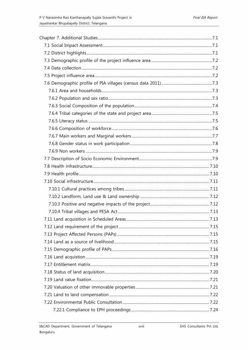
Chapter 7. Additional Studies ........................................................................................................................ 7.1
7.1 Social Impact Assessment ................................................................................................................... 7.1
7.2 District highlights .................................................................................................................................... 7.1
7.3 Demographic profile of the project influence area ................................................................ 7.2
7.4 Data collection ......................................................................................................................................... 7.2
7.5 Project influence area ........................................................................................................................... 7.2
7.6 Demographic profile of PIA villages (census data 2011) ..................................................... 7.3
7.6.1 Area and households .................................................................................................................... 7.3
7.6.2 Population and sex ratio ............................................................................................................. 7.3
7.6.3 Social Composition of the population.................................................................................. 7.4
7.6.4 Tribal categories of the state and project area ................................................................ 7.5
7.6.5 Literacy status .................................................................................................................................. 7.5
7.6.6 Composition of workforce .......................................................................................................... 7.6
7.6.7 Main workers and Marginal workers ..................................................................................... 7.7
7.6.8 Gender status in work participation ...................................................................................... 7.8
7.6.9 Non workers ..................................................................................................................................... 7.9
7.7 Description of Socio Economic Environment............................................................................. 7.9
7.8 Health infrastructure ........................................................................................................................... 7.10
7.9 Health profile ......................................................................................................................................... 7.10
7.10 Social infrastructure .......................................................................................................................... 7.11
7.10.1 Cultural practices among tribes ......................................................................................... 7.11
7.10.2 Landform, Land use & Land ownership ......................................................................... 7.12
7.10.3 Positive and negative impacts of the project .............................................................. 7.12
7.10.4 Tribal villages and PESA Act ................................................................................................ 7.13
7.11 Land acquisition in Scheduled Areas ....................................................................................... 7.13
7.12 Land requirement of the project ............................................................................................... 7.15
7.13 Project Affected Persons (PAPs) ................................................................................................. 7.15
7.14 Land as a source of livelihood .................................................................................................... 7.15
7.15 Demographic profile of PAPs ...................................................................................................... 7.16
7.16 Land acquistion .................................................................................................................................. 7.19
7.17 Entitlement matrix ............................................................................................................................. 7.19
7.18 Status of land acquisition .............................................................................................................. 7.20
7.19 Land value fixation............................................................................................................................ 7.21
7.20 Valuation of other immovable properties ............................................................................. 7.21
7.21 Land to land compensation ......................................................................................................... 7.22
7.22 Environmental Public Consultation ........................................................................................... 7.22
7.22.1 Compliance to EPH proceedings .................................................................................. 7.24

P V Narasimha Rao Kanthanapally Sujala Sravanthi Project in Final EIA Report
Jayashankar Bhupalapally District, Telangana
I&CAD Department, Government of Telangana xix EHS Consultants Pvt Ltd, Bengaluru
7.22 Risks and Hazards associated with the project ................................................................... 7.28
7.22.1 Risk and hazards due to structural components of the proposed project ... 7.29
7.22.2 Physical hazards ......................................................................................................................... 7.29
7.21.3 Chemical hazards ...................................................................................................................... 7.29
7.22.4 Biological hazards ..................................................................................................................... 7.29
7.22.5 Protective Systems ................................................................................................................... 7.29
7.22.6 Competent Person / Safety Engineer .............................................................................. 7.30
7.22.7 Access and Egress .................................................................................................................... 7.30
7.22.8 General Trenching and Excavation Rules ....................................................................... 7.30
7.22.9 Work at Height Hazards ........................................................................................................ 7.30
7.22.10 Construction machinery and tools hazards ................................................................ 7.31
Chapter 8. Project Benefits ............................................................................................................................. 8.1
Chapter 9. Environment Management Plan ............................................................................................ 9.1
9.1 Catchment Area Treatment (CAT) plan......................................................................................... 9.2
9.1.1 Strategy for Cropping Pattern .................................................................................................. 9.2
9.1.2 Scope for intensive cropping .................................................................................................... 9.2
9.1.3 Estimation of Soil Loss ................................................................................................................. 9.4
9.1.4 Erosion Index (EI30) Values on Storm Basis ....................................................................... 9.4
9.1.5 Soil Erodibility Factor (K) ............................................................................................................. 9.5
9.1.6 Nomograph Method ..................................................................................................................... 9.6
9.1.7 Determination of LS ...................................................................................................................... 9.6
9.1.8 Evaluation of Cropping Management Factor (C) ............................................................. 9.6
9.1.9 Evaluation of Support Practice Factor (P) ........................................................................... 9.7
9.1.10 Sedimentation Studies ............................................................................................................ 9.13
9.1.11 Sedimentation index ................................................................................................................ 9.14
9.1.12 Stream Flow and Suspended Sediment Load .............................................................. 9.14
9.1.13 Soil Erosion .................................................................................................................................. 9.14
9.1.14 Soil Conservation Practices .................................................................................................. 9.15
9.1.15 Soil Conservation Practices for Catchment Area Treatment ................................. 9.15
9.1.16 Reclamation of salt affected soils and management of saline and sodic soils
........................................................................................................................................................................ 9.21
9.2 Command area development plan .............................................................................................. 9.22
9.2.1 Communication network .......................................................................................................... 9.22
9.2.2 Water Users’ Association (WUA) .......................................................................................... 9.22
9.2.3 Training and Agriculture Extension Program.................................................................. 9.22
9.2.3.1 Technical Training ............................................................................................................... 9.23
9.2.3.2 Engineering Training .......................................................................................................... 9.23

P V Narasimha Rao Kanthanapally Sujala Sravanthi Project in Final EIA Report
Jayashankar Bhupalapally District, Telangana
I&CAD Department, Government of Telangana xx EHS Consultants Pvt Ltd, Bengaluru
9.2.3.3 Agronomical Training ........................................................................................................ 9.23
9.2.3.4 Mechanical Training ........................................................................................................... 9.24
9.3 Restoration of construction site .................................................................................................... 9.25
9.3.1 Conservation Plan for Schedule-I species ........................................................................ 9.25
9.4 Reservoir RIM treatment .................................................................................................................. 9.27
9.5 Fisheries Development Plan ............................................................................................................ 9.29
9.5.1 Migratory corridors and breeding locations ................................................................... 9.29
9.5.2 Enrichment of riverine fish fauna ......................................................................................... 9.31
9.5.3 Conservation, Management and Stocking ....................................................................... 9.33
9.5.4 Fresh water fish species in the light of the IUCN categorisation ......................... 9.34
9.5.5 Fishermen/fisherwomen co-oprative societies............................................................... 9.34
9.5.6 A matter of concern ................................................................................................................... 9.35
9.5.7 Rehabilitation of Endangered and Threatened fish species .................................... 9.40
9.5.8 Fisheries Conservation and Management Plan ............................................................. 9.41
9.5.9 Post project environmnetal monitoring ............................................................................ 9.41
9.6 Muck Disposal plan ............................................................................................................................ 9.43
9.7 Ground Water Management Plan ................................................................................................ 9.44
9.8 Public Health Delivery and Labor Management Plan ......................................................... 9.45
9.9 Sanitary and Solid Waste Management Plan ......................................................................... 9.46
9.10 Restoration of Quarry sites ........................................................................................................... 9.46
9.11 Local Area Development ................................................................................................................ 9.47
9.12 Energy conservation measures ................................................................................................... 9.48
9.13 Environmental Monitoring Programme .................................................................................. 9.49
9.14 Land Acquisition ................................................................................................................................ 9.50
9.15 Environmental safeguards ............................................................................................................. 9.51
9.16 Cost estimates for implementation of EMP .......................................................................... 9.52
Chapter 10. Summary and Conclusion ................................................................................................... 10.1
Chapter 11. Disclosure of Consultants ................................................................................................... 11.1
Chapter 12. Compliance to Terms of Reference ................................................................................ 12.1
Chapter 13. Photographs .............................................................................................................................. 13.1

P V Narasimha Rao Kanthanapally Sujala Sravanthi Project in Final EIA Report
Jayashankar Bhupalapally District, Telangana
I&CAD Department, Government of Telangana xxi EHS Consultants Pvt Ltd, Bengaluru
LIST OF TABLES
Table 1.1 Methodology adopted for preparation of EIA studies .................................................. 1.4
Table 2.1 Salient features of JCRDLIS project ........................................................................................ 2.6
Table 2.2 Irrigation potential of JCRDLIS project ................................................................................. 2.7
Table 2.3 Salient features of SRSP Stage - I project ........................................................................... 2.9
Table 2.4 Irrigation potential of SRSP project Stage-I .................................................................... 2.11
Table 2.5 Salient features of SRSP Stage - II project ...................................................................... 2.12
Table 2.6 Irrigation potential of SRSP Stage - II project (under Kakatiya Canal from km
284 to 346) .......................................................................................................................................................... 2.13
Table 2.7 Indicative values of the conveyance efficiency (ec) for adequately maintained
canals ..................................................................................................................................................................... 2.16
Table 2.8 Indicative values of the field application efficiency (ea) ............................................ 2.17
Table 2.9 Salient Features of the proposed PVNRKSSP ................................................................. 2.19
Table 2.10 Yields of various sub-basins and entitlements of Telangana/ Andhra Pradesh
at 75% dependability ...................................................................................................................................... 2.22
Table 2.11 Specific flows at Perur and adjoining sites on Godavari (ltrs/sec/sq.km) ....... 2.23
Table 2.12 Net availability of water at Thupakulagudem barrage site ................................... 2.23
Table 2.13 Default Environmental Management Classes ............................................................... 2.26
Table 2.14 Default Environmental Management Classes details with 17 percentage points
.................................................................................................................................................................................. 2.27
Table 2.15 Benefitting mandals ................................................................................................................. 2.28
Table 2.16 Salient features of the barrage ........................................................................................... 2.29
Table 2.17 Flood frequency analysis for different distributions and return periods ......... 2.30
Table 2.18 Regional geological set up of the area .......................................................................... 2.31
Table 2.19 Salient features of spillway radial gates ......................................................................... 2.33
Table 2.20 Salient features of under sluice radial gates ................................................................ 2.34
Table 2.21 Salient features of under sluice stoplogs ....................................................................... 2.35
Table 2.22 Salient features of spillway stoplogs ................................................................................ 2.36
Table 2.23 Quantities of major items of work involved in the construction ........................ 2.39
Table 2.24 Population projection and drinking water requirement ......................................... 2.41
Table 2.25 Details of land requirement ................................................................................................. 2.43
Table 2.26 Benefit-cost ratio ....................................................................................................................... 2.43
Table 3.1 Monthly meteorological data from the year 2006-2016 .............................................. 3.2
Table 3.2 Meteorological data collected at the project site for the study period ............... 3.6
Table 3.3 Details of AAQM parameters with analysis methodology ........................................ 3.11
Table 3.4 Details of Ambient Air Quality Monitoring Stations ................................................... 3.12
Table 3.5 Results of Particulate Matter (PM10) ................................................................................... 3.15

P V Narasimha Rao Kanthanapally Sujala Sravanthi Project in Final EIA Report
Jayashankar Bhupalapally District, Telangana
I&CAD Department, Government of Telangana xxii EHS Consultants Pvt Ltd, Bengaluru
Table 3.6 Results of Particulate Matter (PM2.5) ................................................................................... 3.15
Table 3.7 Results of Sulphur di-oxide (SO2) ......................................................................................... 3.15
Table 3.8 Results of Nitrogen di-oxide (NO2) ..................................................................................... 3.16
Table 3.9 Ambient Air Quality Index for dust ..................................................................................... 3.16
Table 3.10 Ambient Air Quality Index for gases ................................................................................ 3.16
Table 3.11 CPCB standards for noise levels ......................................................................................... 3.17
Table 3.12 Details of Noise Level Monitoring locations ................................................................ 3.17
Table 3.13 Results of Ambient Noise levels ......................................................................................... 3.20
Table 3.14 Geological succession of the study area ........................................................................ 3.25
Table 3.15 Details of water sampling locations ................................................................................. 3.32
Table 3.16 Details of wells inventoried .................................................................................................. 3.35
Table 3.17 Details of Water sampling locations ................................................................................ 3.36
Table 3.18 Details of soil sampling locations ...................................................................................... 3.49
Table 3.19 Concentration of phosphorous ........................................................................................... 3.60
Table 3.20 Textural classes of soil ............................................................................................................ 3.62
Table 3.21 Rating Chart for Soil Test values and their Nutrient Indices ................................ 3.64
Table 3.22 Land use and Land cover data of study area .............................................................. 3.67
Table 3.23 Soil types of study area .......................................................................................................... 3.71
Table 3.24 Details of the sampling locations ...................................................................................... 3.85
Table 3.25 Importance Value Index of dominant tree species. .................................................. 3.86
Table 3.26 Basal area of dominant tree species. ............................................................................... 3.86
Table 3.27 Girth class distribution of trees near proposed barrage site. ............................... 3.87
Table 3.28 Family-wise number of species recorded near proposed barrage site. .......... 3.90
Table 3.29 Family-wise occurrence (%) of avifaunal species recorded near propose
barrage. ................................................................................................................................................................. 3.95
Table 3.30 Girth class Distribution of trees in the command area ........................................... 3.99
Table 3.31 Family-wise number of species recorded in Command area. ............................ 3.101
Table 3.32 Family-wise occurrence (%) of avifaunal species recorded in the command.
area. ...................................................................................................................................................................... 3.107
Table 3.33 List of reptiles and mammals near the proposed lift point ................................ 3.110
Table 3.34 Checklist of the fish species recorded from the Godavari River (Project site &
its Vicinity) ......................................................................................................................................................... 3.123
Table 4.1 Results of Noise prediction model ......................................................................................... 4.6
Table 4.2 Criteria for evaluation of impacts ......................................................................................... 4.18
Table 4.3 Evaluation of Impacts ................................................................................................................. 4.19
Table 5.1 Details of alternatives for the proposed barrage ............................................................ 5.1
Table 6.1 Environmental Monitoring Program for Construction phase (2 years) ................. 6.1

P V Narasimha Rao Kanthanapally Sujala Sravanthi Project in Final EIA Report
Jayashankar Bhupalapally District, Telangana
I&CAD Department, Government of Telangana xxiii EHS Consultants Pvt Ltd,
Bengaluru
Table 6.2 Environmental Monitoring Program for Operation phase (3 years) ....................... 6.3
Table 7.1 List of villages and taluks covered for SIA study ............................................................. 7.3
Table 7.2 Area and households .................................................................................................................... 7.3
Table 7.3 Population and sex ratio ............................................................................................................. 7.4
Table 7.4 SC and ST population ................................................................................................................... 7.4
Table 7.5 Literacy status of the Project villages .................................................................................... 7.6
Table 7.6 Composition of work force in PIA villages ......................................................................... 7.6
Table 7.7 Occupational groups of main workers ................................................................................. 7.7
Table 7.8 Occupational groups of marginal workers ......................................................................... 7.7
Table 7.9 Gender participation among workers ................................................................................... 7.8
Table 7.10 Non working category ............................................................................................................... 7.9
Table 7.11 Health infrastructure ................................................................................................................ 7.10
Table 7.12 Land requirement for the project ...................................................................................... 7.15
Table 7.13 Demographic profile of PAPs .............................................................................................. 7.16
Table 7.14 Educational status of the people shows the following status .............................. 7.17
Table 7.15 Occupational status of PAPs ................................................................................................ 7.18
Table 7.16 Income groups of PAPs .......................................................................................................... 7.18
Table 7.17 Entitlement matrix ..................................................................................................................... 7.19
Table 7.18 Extent of land lost by PAPs .................................................................................................. 7.21
Table 7.19 Cost Estimates of land ............................................................................................................ 7.21
Table 7.20 Emergency contact numbers ............................................................................................... 7.32
Table 7.21 Emergency contact numbers of I&CAD, Government of Telangana ................ 7.32
Table 9.1 Sub catchment/Watershed and codification of PVN project ..................................... 9.8
Table 9.2 Showing the computed values of Factors of soil loss in PVNSSR ......................... 9.9
Table 9.3 Estimation of soil loss in Watersheds in PVNRKSSP ................................................... 9.10
Table 9.4 Specifications for gully plugs ................................................................................................. 9.16
Table 9.5 Soil conservation Measures and Practices Recommended for PVNRKSSP ....... 9.18
Table 9.6 Micro-watersheds of PVNRKSSP ........................................................................................... 9.19
Table 9.7 Cost Estimates as per Soil conservation treatments suggested ............................ 9.19
Table 9.8 Area and Cost Estimate for Catchment Area Treatment ........................................... 9.19
Table 9.9 Species recommended for plantation ................................................................................ 9.20
Table 9.10 Cost Estimate for Catchment Area Treatment ............................................................. 9.21
Table 9.11 Cost Estimate for Command Area Development Plan ............................................. 9.24
Table 9.12 Restoration activities near the proposed barrage ..................................................... 9.25
Table 9.13 Cost estimate for restoration of construction site ..................................................... 9.26
Table 9.14 Cost estimate for reservoir RIM treatment ................................................................... 9.28
Table 9.15 Cost estimate for implementation of fisheries management plan .................... 9.42

P V Narasimha Rao Kanthanapally Sujala Sravanthi Project in Final EIA Report
Jayashankar Bhupalapally District, Telangana
I&CAD Department, Government of Telangana xxiv EHS Consultants Pvt Ltd,
Bengaluru
Table 9.16 Muck disposal plan .................................................................................................................. 9.43
Table 9.17 Quantiication for volume of muck reused .................................................................... 9.43
Table 9.18 Cost estimate for Public health .......................................................................................... 9.45
Table 9.19 Cost estimate for Solid and hazardous waste management ................................ 9.46
Table 9.20 Cost estimate for Local Area Development .................................................................. 9.47
Table 9.21 Cost estimate for Energy Conservation Measures ..................................................... 9.48
Table 9.22 Cost estimate for Environmental Monitoring ............................................................... 9.49
Table 9.23 Cost estimate for land acquisition .................................................................................... 9.50
Table 9.24 Environmental safeguards during construction phase ............................................ 9.51
Table 9.25 Cost for Implementing Environmental Management Plan ..................................... 9.52
Table 9.26 Annual cost during operational phase during first three years (Recurring Cost)
.................................................................................................................................................................................. 9.52

P V Narasimha Rao Kanthanapally Sujala Sravanthi Project in Final EIA Report
Jayashankar Bhupalapally District, Telangana
I&CAD Department, Government of Telangana xxv EHS Consultants Pvt Ltd, Bengaluru
LIST OF FIGURES
Fig 2.1 Map showing Godavari basin and proposed project location ....................................... 2.3
Fig 2.2 Map showing Godavari basin, its sub-basins and project location ............................. 2.4
Fig 2.3 Location map of P V Narasimha Rao Kanthanapally Sujala Sravathi Project on SoI
toposheet ............................................................................................................................................................. 2.20
Fig 2.4 Google view showing proposed barrage and River Godavari ..................................... 2.21
Fig 2.5 Statistical data showing Mean Annual Runoff in Godavari River at Project site 2.25
Fig 2.6 Graph showing monthly distribution of flow at Godavari River at Project site .. 2.25
Fig 2.7 Graph showing Flow Duration Curve (FDC) with 17 fixed percentage points ..... 2.25
Fig 2.8 Graph showing Flow Duration Curve (FDC) with 17 fixed percentage points ..... 2.26
Fig 3.1 Wind rose diagram for the months July 2017 - September 2017 (Monsoon
season) ..................................................................................................................................................................... 3.7
Fig 3.2 Wind rose diagram for the months October 2017 - December 2017 (Post-
monsoon season) ................................................................................................................................................ 3.8
Fig 3.3 Wind rose diagram for the months January 2018 - March 2018 (Pre-monsoon
season) ..................................................................................................................................................................... 3.9
Fig 3.4 Wind rose diagram for the study period July 2017 – March 2018 (Study period)
.................................................................................................................................................................................. 3.10
Fig 3.5 Location of AAQM stations on study area map ................................................................. 3.13
Fig 3.6 Location map of noise monitoring locations on study area map ............................. 3.18
Fig 3.7 Map showing key cum location plan ...................................................................................... 3.23
Fig 3.8 Drainage map of the proposed project ................................................................................. 3.24
Fig 3.9 Hydrology map showing surface and ground water sampling locations .............. 3.27
Fig 3.10 Geology and structural map of the proposed project ................................................. 3.28
Fig 3.11 Elevation map of wells inventoried for the proposed project .................................. 3.29
Fig 3.12 Depth to water level map for the proposed project ..................................................... 3.30
Fig 3.13 Total depth range map for the proposed project .......................................................... 3.31
Fig 3.14 Surface Water Quality sampling locations ......................................................................... 3.41
Fig 3.15 Ground Water Quality sampling locations ......................................................................... 3.42
Fig 3.16 Types of soil in the study area ................................................................................................ 3.51
Fig 3.17 Soil sampling locations on study area map ...................................................................... 3.52
Fig 3.18 Satellite image showing the proposed barrage and command area .................... 3.68
Fig 3.19 DEM map showing the proposed barrage and command area .............................. 3.69
Fig 3.20 Land use/ Land cover map of study area ........................................................................... 3.72
Fig 3.21 Soil types in the study area ....................................................................................................... 3.73
Fig 3.22 Slope map of the study area .................................................................................................... 3.74
Fig 3.23 Drainage map in the study area ............................................................................................. 3.75

P V Narasimha Rao Kanthanapally Sujala Sravanthi Project in Final EIA Report
Jayashankar Bhupalapally District, Telangana
I&CAD Department, Government of Telangana xxvi EHS Consultants Pvt Ltd, Bengaluru
Fig 3.24 Command area map showing sampling locations ......................................................... 3.82
Fig 3.25 Map showing the upstream and downstream areas of River Godavari. .............. 3.83
Fig 3.26 Map showing forest area and water bodies within the study area. ....................... 3.84
Fig 3.27 Graph showing predominant avifaunal species recorded during the study. ..... 3.96
Fig 3.28 Graph showing predominant avifaunal species recorded during the study. ... 3.108
Fig 4.1 Isopleth drawn for PM without mitigation measures ......................................................... 4.4
Fig 4.2 Isopleth drawn for PM with mitigation measures ................................................................ 4.5
Fig 4.3 Isopleth drawn using dhwaniPRO software ............................................................................. 4.7
Fig 5.1 Map showing alternative sites for the proposed barrage ................................................ 5.2
Fig 9.1 Watersheds delineated in Warangal district ........................................................................... 9.9
Fig 9.2 Watersheds delineated in PVNKSSP ........................................................................................ 9.12

P V Narasimha Rao Kanthanapally Sujala Sravanthi Project in Final EIA Report
Jayashankar Bhupalapally District, Telangana
I&CAD Department, Government of Telangana xxiii EHS Consultants Pvt Ltd, Bengaluru
LIST OF ANNEXURES
Annexure-1 ToRs accorded by MoEF
Annexure-2 Administrative approval for the proposed project
Annexure-3 Environmental Clearance and CWC Clearance- JCR Devadula LIS
Annexure-4 JCR Devadula LIS – Technical details, Schematic diagrams & CWC Clearance
Annexure-5 Environmental Clearances- SRSP Stage I&II
Annexure-6 SRSP Stage I&II – Technical details & Schematic diagrams
Annexure-7 Performance evaluation of SRSP Stage-I and II publication
Annexure-8 Command Area map
Annexure-9 Monthly water availability at Thupakulagudem project site
Annexure-10 Benefitting Villages of existing JCRDLIS and SRSP Stage I&II
Annexure-11 Benefitting Villages of existing SRSP Stage I
Annexure-12 Benefitting Villages of existing SRSP Stage II
Annexure-13 FRL map of the proposed barrage
Annexure-14 Ambient Air Quality Modelling results
Annexure-15 Hydrology and geology - water quality analysis results, field photographs
and maps showing physico-chemical characteristics of water
Annexure-16 Surface and Ground water quality analysis results
Annexure-17 Soil Quality Analysis results
Annexure-18 Biological Environment
Annexure-19 Aquatic Ecology
Annexure-20 Socio-economic survey questionnaire
Annexure-21 Environmental Public Consultation proceedings

P V Narasimha Rao Kanthanapally Sujala Sravanthi Project in Final EIA Report
Jayashankar Bhupalapally District, Telangana
I&CAD Department, Government of Telangana 1.1 EHS Consultants Pvt Ltd, Bengaluru
Chapter 1. Introduction 1.1 Purpose of the report
Environmental Impact Assessment is one tool available with planners to harmonize
developmental activities with the environmental concerns. The objective of EIA is to
foresee the potential environmental problems that would arise out of a proposed
development and address them in the project's planning and design stage.
EIA integrates the environmental concerns in the developmental activities right at the
time of initiating for preparing the feasibility report. In doing so, it can enable the
integration of environmental concerns and mitigation measures in project development.
EIA can often prevent future liabilities or alterations in project design2
1.2 Project Proponent
.
Irrigation & CAD Department, Government of Telangana, is making every effort to
harness and utilize all the available water resources for benefitting of Agricultural sector,
Industrial Sector and also providing drinking water for overall development in the
process of achieving “Golden Telangana”. I&CAD Department is entrusted with Survey,
investigation, planning, designing, construction, maintenance and management of Major,
Medium & Minor Irrigation Projects including Lift Irrigation Schemes.
Jayashankar Bhupalapally District in the State of Telangana experiences a hot and dry
climate and covers a geographical area of 6,175 km2 with crop land and forest land
being dominant areas in the district. However, the irrigation depends on the rainfall and
climatic conditions in Eturnagaram Mandal. Agricultural Drought Vulnerability Index
(ADVI) as introduced by National Remote Sensing Centre is used to prioritize and
address the drought management and development activities. ADVI of the Eturnagaram
Mandal in Jayashankar Bhupalapally District belongs to vulnerable category showing
variability of detrended crop yields3
In this direction, I&CAD Department, Government of Telangana intends to give more
thrust to new areas of development such as participatory irrigation management,
encouragement to modern irrigation practices with higher duty of water, exploration of
new possibility of conjunctive use of water, advocating a holistic approach towards
agricultural farming practices for economic security to the farmer and using modern
technologies in survey and design of irrigation systems.
.
M/s Environmental Health & Safety Consultants Private Limited, Bengaluru is entrusted
by I&CAD Department, GoT, to carry out the Environmental Impact Assessment &
2http://envfor.nic.in/divisions/iass/eia/Chapter1.htm 3Drought Management Manual for Telangana State (2016), Dr.MCR HRD Institute of Telangana, Govt. of Telangana, Page 12&13.

P V Narasimha Rao Kanthanapally Sujala Sravanthi Project in Final EIA Report
Jayashankar Bhupalapally District, Telangana
I&CAD Department, Government of Telangana 1.2 EHS Consultants Pvt Ltd, Bengaluru
Environmental Management Plan studies for P V Narasimha Rao Kanthanapally Sujala
Sravanthi Project (PVNRKSSP). I&CAD Department, GoT is the employer and executing
agency for the project. The command area of the project is >50,000 ha and the
proposed project falls under schedule 1(c) of EIA Notification, 2006 and its subsequent
amendments on 14.08.2018, the proposed project is categorized as 'A' and requires
Environmental Clearance from MoEF&CC, GoI, New Delhi. In addition to this, the
proposed project attracts General Conditions of EIA notification, 2006 and its
subsequent amendments due to the presence of Eturnagaram Wildlife Sanctuary (WLS)
and Interstate boundary of Chattisgarh (2.5 Km) located within 10 Km radius of the
project component. However, no project components are located within the boundary
of Eturnagaram WLS. The Terms of References for the project has been accorded by
MoEF&CC, GoI, New Delhi vide letter No. J-12011/24/2010-IA-I dated 03.04.2017
(Annexure-1).
This EIA report presents baseline data collected for three season viz., July 2017 to March
2018 for physical, biological and socio-economic components of environment,
identification, prediction and evaluation of impacts based on the project activities and to
prepare Environmental Management Plan (EMP) for mitigation of adverse impacts due
to the proposed project.
1.3 Brief Description of the Project and its Importance to the
Region
The proposed scheme involves construction of 1,132 m long barrage near
Thupakulagudem village across River Godavari located 3 Km downstream of existing
J.Chokka Rao Devadula Lift Irrigation Scheme (JCRDLIS). The proposed project stabilizes
and provides irrigation facilities to existing 5,55,310 ha of command area belonging to J.
Chokka Rao Devadula LIS (2,51,310 ha) and Sri Ram Sagar Project (SRSP) - Stage I & II
(3,04,000 ha). 50 TMC of water will be utilized for stabilizing the existing command area
and 50 TMC of water will be utilized for drinking water purpose for enroute villages. The
command area is already benefitted by the existing irrigation facilities for the Khariff and
bi-seasonal crops and the proposed scheme facilitates irrigation also during Rabi
season. Total power required for the proposed project is 1.5 MW which is sourced from
Transmission Corporation of Telangana Limited (TSTRANSCO).
The project has been proposed by the I & CAD Department, Govt. of Telangana to
stabilize the existing JCRDLIS and SRSP - Stage I and II and provide irrigation facilities to
the areas of Eturnagaram Mandal, Jayashankar Bhupalapally District. This will provide
stability to agriculture and thus improving the per capita income and standard of living
of the people. Therefore, the need of the proposed scheme is of priority which could

P V Narasimha Rao Kanthanapally Sujala Sravanthi Project in Final EIA Report
Jayashankar Bhupalapally District, Telangana
I&CAD Department, Government of Telangana 1.3 EHS Consultants Pvt Ltd, Bengaluru
meet the demands of the farmers and shall also improve the Irrigation potential and
Socio-economic conditions of the region.
Government of Telangana has accorded administrative approval (Annexure - 2) for
PVNRKSSP vide order No. G.O.Ms.No.14 dated 13.02.2017 and the total cost of the
project is 2121 Crores.
The boundary of Eturnagaram Wildlife Sanctuary is located adjacent to the proposed
barrage. Reserve Forests namely; Nuguru RF and Perur RF is located at the close
proximity and 3 Km respectively from the proposed barrage. No project activities will be
carried out in the Eturnagaram WLS. Further, the construction of proposed barrage
across Godavari River does not involve any diversion of forest land. However, project
involves submergence area of 580.18 ha of river bed at FRL 77 m. Total of 674.18 ha of
land (94 ha of private land + 580.18 ha of river bed area) is required for the proposed
project.
1.4 Scope of EIA report
The present study includes detailed inventory of existing status of environment in the
Study area for various identified environmental components viz. air, noise, water, land,
biological and socio-economic aspects. Under the scope of EIA, the objective of the
study is:
• To assess the present status of air, noise, water, land, biological and socio-
economic components of the environment.
• To identify, predict and evaluate significant impacts due to project activities on
various environmental components during the Construction and Operational
stages of the project.
• To delineate proposed pollution control measures and accordingly formulating
Environmental Management Plan (EMP).
• To delineate post-project environmental monitoring programme to be
implemented by I & CAD Department, GoT.
1.5 Components of EIA
The sequence of EIA report follows generic structure of EIA/EMP report as specified in
EIA Notification, 2006 except Environmental cost benefit analysis since it was not
recommended by the EAC during scoping stage. The sequence of the EIA/EMP report is
as follows;
• Project Description
• Baseline Environmental Scenario

P V Narasimha Rao Kanthanapally Sujala Sravanthi Project in Final EIA Report
Jayashankar Bhupalapally District, Telangana
I&CAD Department, Government of Telangana 1.4 EHS Consultants Pvt Ltd, Bengaluru
• Anticipated Environmental Impacts and Mitigation Measures
• Analysis of Alternatives (Technology and Site)
• Environmental Monitoring Program
• Additional Studies - Public Consultation, Risk Assessment, Social Impact
Assessment for Land Acquisition
• Project Benefits
• Environmental Management Plan
• Summary & Conclusion
• Disclosure of Consultants engaged
1.6 Approach and Methodology
The EIA report has been prepared and presented as per requirements of the EIA,
Notification 2006 and its amendments of MoEF under the Environment (Protection) Act,
1986. The methodology adopted for preparation of EIA studies and to obtain
Environmental Clearance for the project is given below.
Table 1.1 Methodology adopted for preparation of EIA studies
Sl. No. Components Source
1 Secondary data collection
FAO publications
MoEF guidelines on EIA
Central Groundwater Board reports
Telangana State Natural Disaster
Monitoring centre reports
Survey of India toposheets
National Institute of Disaster
Management, GoI
Published literature
Geological Survey of India data
Indian Space Research Organization data
National Remote Sensing Centre data
Forest Dept., working plans
Indian Meteorological data
2 Primary data collection Methodology
2.1 Ambient Air Quality
Installation of weather monitoring
station
Selection of AAQM locations as per

P V Narasimha Rao Kanthanapally Sujala Sravanthi Project in Final EIA Report
Jayashankar Bhupalapally District, Telangana
I&CAD Department, Government of Telangana 1.5 EHS Consultants Pvt Ltd, Bengaluru
Sl. No. Components Source
BIS/CPCB guidelines
AAQM monitoring as per NAAQ
standards - 2009, CPCB, New Delhi
Interpretation of results as per AQI
Index, CPCB, New Delhi
2.2 Ambient Noise Level
Selection of Ambient Noise level
monitoring locations as per Protocol for
Ambient Noise Level Monitoring, CPCB,
New Delhi
Ambient Noise level monitoring
Interpretation of results as per Noise
(Regulation and Control) rules - 2000,
MoEF, GoI
2.3 Hydrology and Geology
Collection of the relevant data contained
in the EIA and EMP Reports, from the
reports and maps of Central Ground
Water Board (CGWB) Geological Survey
of India (GSI), other Institutions and
Departments.
Identify Inter- related and Inter –
dependent key factors that play vital
role in the occurrence of ground water
its quality and potential.
Identify surface water resources in the
project site and its catchment area.
Assess the ground water resource
potential in the catchment area of the
project site.
Bring out various events and processes
that comprise the project activity.
Identify the site specific environmental
issues and mitigation measures and
Compile a consolidated, comprehensive
and meaningful report of the Project site
and its catchment area.
2.4 Surface and Groundwater Quality Identification of sampling locations
Collection, preservation and

P V Narasimha Rao Kanthanapally Sujala Sravanthi Project in Final EIA Report
Jayashankar Bhupalapally District, Telangana
I&CAD Department, Government of Telangana 1.6 EHS Consultants Pvt Ltd, Bengaluru
Sl. No. Components Source
Transportation of samples as per CPCB
guidelines
Analysis of water samples as per BIS and
APHA guidelines
Interpretation of results as per CPCB and
BIS
2.5 Soil characteristics
Identification of Soil types, status, crops
and cropping pattern in the study area
Identification of soil sampling locations
based on geology and soil maps
Collection and analysis of soil samples,
manual of Food and Agricultural
Organization and Soil manual of
Department of Agriculture and co-
operation, Ministry of Agriculture, GoI.
Interpretation of results
2.6 Land use assessment
Processing of satellite imageries by
using ARC GIS 9.2 and ERDAS IMAGINE
9.1 tools for generation of various
thematic maps
Interpretation of thematic maps as per
NRSA guidelines
Practical Manual for hands on
training/experiential learning released
from UAS, Bengaluru, AISS & LU and
GSI.
2.7 Ecology and Biodiversity (Terrestrial)
Discussion with forest officials and local
people
Identification of sampling locations
Quadrate and line transact method for
collection of flora
Transact method for collection of fauna
and point count method for collection
of avi - fauna data
Identification of Conservation status of
flora and fauna by using IUCN, BSI and
wildlife schedules
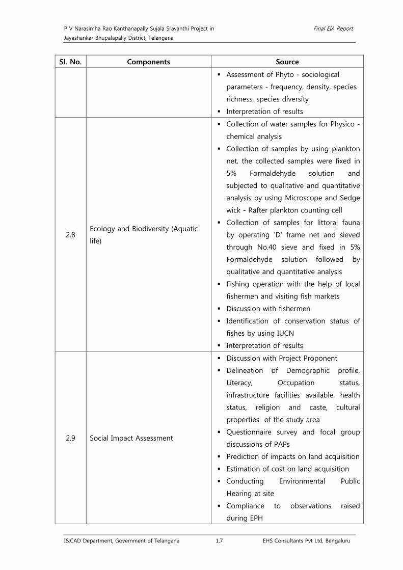
P V Narasimha Rao Kanthanapally Sujala Sravanthi Project in Final EIA Report
Jayashankar Bhupalapally District, Telangana
I&CAD Department, Government of Telangana 1.7 EHS Consultants Pvt Ltd, Bengaluru
Sl. No. Components Source
Assessment of Phyto - sociological
parameters - frequency, density, species
richness, species diversity
Interpretation of results
2.8 Ecology and Biodiversity (Aquatic
life)
Collection of water samples for Physico -
chemical analysis
Collection of samples by using plankton
net. the collected samples were fixed in
5% Formaldehyde solution and
subjected to qualitative and quantitative
analysis by using Microscope and Sedge
wick - Rafter plankton counting cell
Collection of samples for littoral fauna
by operating 'D' frame net and sieved
through No.40 sieve and fixed in 5%
Formaldehyde solution followed by
qualitative and quantitative analysis
Fishing operation with the help of local
fishermen and visiting fish markets
Discussion with fishermen
Identification of conservation status of
fishes by using IUCN
Interpretation of results
2.9 Social Impact Assessment
Discussion with Project Proponent
Delineation of Demographic profile,
Literacy, Occupation status,
infrastructure facilities available, health
status, religion and caste, cultural
properties of the study area
Questionnaire survey and focal group
discussions of PAPs
Prediction of impacts on land acquisition
Estimation of cost on land acquisition
Conducting Environmental Public
Hearing at site
Compliance to observations raised
during EPH

P V Narasimha Rao Kanthanapally Sujala Sravanthi Project in Final EIA Report
Jayashankar Bhupalapally District, Telangana
I&CAD Department, Government of Telangana 1.8 EHS Consultants Pvt Ltd, Bengaluru
Sl. No. Components Source
2.10 Risk Assessment and Hazard
Management
Identification of risk and hazards
associated with the project activities
during Construction and Operation
phase
3 Impact identification and prediction
Estimation of E-flow using Global
Environmental Flow Calculator model
developed by IWMI, Srilanka
Prediction of Impacts on Air quality by
using AERMOD tool
Prediction of Noise quality by using
dhwani pro model.
Estimation of soil loss and soil
erodability index by using Universal Soil
Loss Equation
Estimation of sediment index using
regression analysis
Evaluation of impacts by using Leopold
matrix method
4 Project benefits
Socio-economic benefits
Ecological benefits
Conjunctive use of surface and ground
water
Underground recharge
Enhanced agricultural productivity
5 Environmental Management Plan
EMP for Air, water, noise pollution, Soil
Conservation measures and CAT, CAD,
Muck Disposal, Fisheries conservation plan,
afforestation / greenery development plan,
R&R plan, Environmental Monitoring
programme, etc along with cost for
implementation of each EMP with specific
time frame and responsibility.
6 Environmental Public Hearing
Submission of Draft EIA report along with
Executive Summary in English and
Vernacular Language to State PCB,
Finalization of Date of EPH by RO, TSPCB
and DC, Paper Advertisements in National

P V Narasimha Rao Kanthanapally Sujala Sravanthi Project in Final EIA Report
Jayashankar Bhupalapally District, Telangana
I&CAD Department, Government of Telangana 1.9 EHS Consultants Pvt Ltd, Bengaluru
Sl. No. Components Source
and regional daily news papers, Local Paper
advertisements, preparation of presentation
of draft EIA report in local language,
Presentation to public regarding the
project in local language, Issue of
proceedings and video recording by state
PCB.
7 Issue of Environmental Clearance
Preparation of compliance to proceedings
of Environmental Public Hearing, finalizing
the final EIA report, uploading Final EIA
Report to MoEF website, circulation of
project documents to EAC members,
preparation of Final EIA presentation,
presentation to EAC, recommendation by
EAC, issue of EC by MoEF&CC.

P V Narasimha Rao Kanthanapally Sujala Sravanthi Project in Final EIA Report
Jayashankar Bhupalapally District, Telangana
I&CAD Department, Government of Telangana 2.1 EHS Consultants Pvt Ltd, Bengaluru
Chapter 2. Project Description 2.1 Need for the project
2.1.1 Agro – climatic zones
Telangana has been divided into 4
agro-climatic zones based on the
physiography, rainfall, soil types, crops,
cropping pattern, etc. Command area
lies in ‘Central Telangana Zone’4. The
project region experiences a hot
summer and general dryness except
South West Monsoon season with an
average annual rainfall of 1015.8 mm.
About 81 % of annual rainfall is received during South West monsoon season (June to
September). Some rainfall is received in the latter half of the summer season and in the post
monsoon season. The soil in the command area comprises of sandy loam and black cotton
soils5
2.1.2 River Godavari
. The common crops grown in this region includes Jowar, Paddy, Groundnut, pulses,
Chillies, etc.
The Godavari is the second largest basin and accounts for nearly 9.5% of the total
geographical area of the country. It extends over states of Maharashtra (48.7%), Andhra
Pradesh (23.7%), Chhattisgarh (12.4%) and Odisha (5.7%) in addition to smaller parts in
Madhya Pradesh (7.8%), Karnataka (1.4%) and Union territory of Puducherry (0.01%). It
extends over an area of 302065.10 Sq. km, with a maximum length and width of about 995
km and 583 km, respectively. The CWC reported area of the basin is 312812.0 Sq. km. The
basin falls in the Deccan Plateau lying between 73°24’ to 83°4’ east longitudes and 16°19’ to
22°34’ north latitudes. The basin is bounded on the north by the Mahadeo Hills, the Satmala
Hills, on the north-west by the Ajanta Range, on the west by the North Sahyadri range of the
Western Ghats, on the east and south-east by the Eastern Ghats and on the south by the
Balaghat Range.
The core components of the water network include the River Godavari, the largest of the
peninsular river and its principal tributaries finally draining into the Bay of Bengal. The River
Godavari is the biggest east-flowing rivers of the peninsular India and the second largest
4 Task Force Report, Agriculture challenges and way forward, Govt. of Telangana Agriculture and Cooperation Department, Page 5. 5 Working Plan for Warangal District (1991-92 to 2000-01), K Suresh Chander Rao, Working Plan Officer, Page 5&6.
Image source: Task Force Report, Agriculture challenges and way forward, Govt. of Telangana Agriculture and Cooperation Department, Pg5.

P V Narasimha Rao Kanthanapally Sujala Sravanthi Project in Final EIA Report
Jayashankar Bhupalapally District, Telangana
I&CAD Department, Government of Telangana 2.2 EHS Consultants Pvt Ltd, Bengaluru
river draining in India. Godavari River originates near Trimbakeshwar near disrtict Nashik,
northeast of Mumbai in the state of Maharashtra at an elevation of 1067 m and flows for a
length of about 1465 km, in a generally south-east direction before joining the Bay of
Bengal. It flows through the Eastern Ghats and emerges out of Polavaram into the plains. At
Dhawaleswaram the river divides into two branches, the Gautami and Vasishta. Between the
two lies the Godavari Central delta. The Pravara, the Manjra are the main tributaries joining
on the right bank of the river and the Purna, the Pranahita, the Indravati, the Sabari are the
main tributaries joining on the left bank6
The proposed project has been taken up as per GWDT award without any interstate aspects
and is located in the lower Godavari sub-basin.
.
6 Godavari basin status report (March 2014), Govt. of India Ministry of Water Resources, Page 15.

P V Narasimha Rao Kanthanapally Sujala Sravanthi Project in Final EIA Report
Jayashankar Bhupalapally District, Telangana
I&CAD Department, Government of Telangana 2.3 EHS Consultants Pvt Ltd, Bengaluru
Fig 2.1 Map showing Godavari basin and proposed project location7
7 Godavari Basin, V2.0, (2014), CWC and NRSC, Govt. of India, Ministry of water resources, Page 2

P V Narasimha Rao Kanthanapally Sujala Sravanthi Project in Final EIA Report
Jayashankar Bhupalapally District, Telangana
I&CAD Department, Government of Telangana 2.4 EHS Consultants Pvt Ltd, Bengaluru
Fig 2.2 Map showing Godavari basin, its sub-basins and project location

P V Narasimha Rao Kanthanapally Sujala Sravanthi Project in Final EIA Report
Jayashankar Bhupalapally District, Telangana
I&CAD Department, Government of Telangana 2.5 EHS Consultants Pvt Ltd, Bengaluru
2.1.3 Erratic droughts in command area
Droughts are common in the study
areas. The existing command areas of
the JCR Devadula LIS and SRSP Stage -
I&II is severely prone to erratic
droughts ranging from less vulnerable
to moderately vulnerable levels as per
Agricultural Drought Vulnerability Index
(ADVI) introduced by National Remote
Sensing Centre (NRSC). However the
proposed barrage site near
Thupakulagudem village, Eturnagaram
Mandal belongs to “Vulnerable” category as per NRSC8
Droughts are common in the study area. Severe droughts have occurred in 1970-72 and
1983-84 and during 1987-88 few parts of the district were partly affected by drought
.
9. The
irrigation depends on the rainfall and climatic conditions in Eturnagaram Mandal. Agricultural
Drought Vulnerability Index (ADVI) as introduced by National Remote Sensing Centre is used
to prioritize and address the drought management and development activities. ADVI of the
Eturnagaram Mandal in Jayashankar Bhupalapally District belongs to vulnerable category
showing variability of detrended crop yields10
2.1.4 Stabilization of existing irrigation schemes
. The people of this region depend on
agriculture and hence providing irrigation and stabilizing the agricultural production, provides
a much needed relief to the people. It improves the per capita income and standard of living
of the people. Further it utilizes the water and land resources and substantially improves GDP
contribution from agriculture. Therefore, stabilization of command areas of JCRDLIS and SRSP
has been need of the hour.
2.1.4.1 J Chokka Rao Devadula Lift Irrigation Scheme
J Chokka Rao Devadula Lift Irrigation Scheme (JCRDLIS) project involves lifting water from
River Godavari from an elevation of +71 m during monsoon season (June - December) near
Gangaram village upto an elevation of 470 m and conveyed through pressurized pipeline.
The water conductor system is integrated with eight existing balancing reservoirs and lift the
water to the desired elevation in 10 stages to irrigate a command area of 2,51,310 Ha
8 Drought Management Manual for Telangana State (2016), Dr.MCR HRD Institute of Telangana, Govt. of Telangana, 9 Working Plan for Warangal District (1991-92 to 2000-01), K Suresh Chander Rao, Working Plan Officer, Page 7. 10Drought Management Manual for Telangana State (2016), Dr.MCR HRD Institute of Telangana, Govt. of Telangana, Page 12&13.
Image source; Drought Management Manual for Telangana State (2016), Dr.MCR HRD Institute of Telangana, Govt. of Telangana

P V Narasimha Rao Kanthanapally Sujala Sravanthi Project in Final EIA Report
Jayashankar Bhupalapally District, Telangana
I&CAD Department, Government of Telangana 2.6 EHS Consultants Pvt Ltd, Bengaluru
involving the then Warangal, Karimnagar, Nalgonda and Medak Districts of Andhra Pradesh
from an Elevation +71 m. to +540 m by utilizing 38.18 TMC of water out of 467.24 TMC
water available at Intake point in the River Godavari. Pumping period proposed for 170 days
between late June/early July and end of November. Government of Telangana vides G.O.Rt.
No; 25, Dt: 21.01.2015 enhanced water allocation to 60 TMC. The total land requirement of
JCRDLIS project was 5,610 ha (inclusive of 344 ha of forest land) and involved no
displacement/ R&R activities. Forest Clearance for 344 ha of forest lands was issued on
14.09.2005. Environmental clearance for JCRDLIS project was issued by MoEF&CC, New Delhi
on 06.12.2005 (Annexure-3) and the technical details of the existing JCRDLIS project is
enclosed as Annexure-4.
Table 2.1 Salient features of JCRDLIS project
Utilization
Source Godavari River
Location Latitude 18°35'23.16"N, Longitude 80°21'0.16"E
Water to be lifted from River Godavari 38.182 TMC
Water for Agriculture usage (Govt.Memo No:
16444/WRG/2012-6,Dt: 28.03.2013) 35.34 TMC
Water for Non-Agriculture usage 2.842 TMC
Industrial usage 0.012 TMC
Drinking Water usage 2.830 TMC
Power Requirement (Ultimate) 484 MW
Project Cost (Estimated Cost) Rs. 6016 Crores
Revised Estimate Cost (TAC, CWC, Govt. of
India accorded clearance during
106th Meeting held on 16-09-2010)
Rs. 9427.73 Crores was sanctioned Vide G.O. Rt.
No: 606, (I&CAD), dt:16.09.2010.
Ayacut
Ayacut with lifted water through Canals 220048 ha
Ayacut with regenerated water 31262 ha
Source of Funding Central funding (AIBP): 25%, State funding: 75%
Physical Progress Phase-I Physically completed.
Phase-II Physically completed.
Phase-III-Package-I physically completed.

P V Narasimha Rao Kanthanapally Sujala Sravanthi Project in Final EIA Report
Jayashankar Bhupalapally District, Telangana
I&CAD Department, Government of Telangana 2.7 EHS Consultants Pvt Ltd, Bengaluru
Lat: 18°35'23.08"N, Long: 80°21'5.04"E Lat: 18°35'22.98"N, Long: 80°21'1.86"E
Lat: 18°35'25.25"N, Long: 80°21'3.26"E Lat: 18°35'23.01"N, Long: 80°21'3.49"E
JCR Devadula LIS Intake Pump House
Table 2.2 Irrigation potential of JCRDLIS project
Ayacut with
Gravity
Canals (ha)
Ayacut with
ground
generated
water (ha)
Total
Ayacut
(ha)
Phase-wise IP Contemplated (ha) IP Created
up to 2015
(Ha)
Balance IP
to be
created
(ha)
Phase-I Phase-II Phase-III Total
220048 31262 251310 49655 72544 97849 251310 42760 177288
During the course of time, there was a change in the course of River Godavari due to which
boulders and rocky strata exposed near the lift point of JCRDLIS causing reduction in water
availability which necessitates P V N Kanthanapally Sujala Sravanthi Project. The irrigation
potential created upto 2015 is 42,760 ha and in order to achieve the irrigation potential for
the balance command area of 177288 ha, the proposed project is essential. The CWC
Clearance and its schematic diagram of JCRDLIS are enclosed as Annexure 4.
2.1.4.2 Sri Ram Sagar Project Stage I and II
The Sri Ram Sagar Project (SRSP), formerly known as the Pochampadu irrigation project has
been built on Godavari River. Sriram Sagar Project involves two stages providing irrigation to
3,04,000 ha of land. This irrigation project is located at Pochampadu village in Nizamabad

P V Narasimha Rao Kanthanapally Sujala Sravanthi Project in Final EIA Report
Jayashankar Bhupalapally District, Telangana
I&CAD Department, Government of Telangana 2.8 EHS Consultants Pvt Ltd, Bengaluru
district of the then Andhra Pradesh (AP). This project has been built to utilize Godavari River
water for irrigation and drinking purposes in Telangana. The regions such as Nizamabad,
Adilabad, Karimnagar, and Warangal districts of the then state of Andhra Pradesh are
covered under this project. The SRSP dam comprises of concrete spillway sections with 42
gates with flanked non-overflow masonry and earthen embankment structures on either
sides. The reservoir has a water spread area of about 435 Million square meters (Msqm) at
the Full Reservoir Level (FRL) equal to 332.54 m. A flood flow canal (Kakatiya Canal) has been
built to utilize flood water and this water is stored in the Lower Manair Reservoir (LMR) which
is situated at a chainage of 146 km from the SRSP11
. The Environmental Clearance for SRSP
Stage I and II was obtained on 14.10.1980, 07.07.1995, 24.06.2002 and 14.05.2003
respectively. Copies of the same are enclosed as Annexure-5. The technical details of the
existing SRSP Stage – I&II project and its schematic diagrams are enclosed as Annexure 6.
Lower Manair Dam Sriram Sagar Dam
• Sri Ram Sagar Project Stage I
In 1951, the erstwhile Government of Hyderabad submitted a scheme to the Government of
India, Planning Commission with a dam proposal at Pochampadu on River Godavari and
dams on its tributaries namely the Kaddam and Manair Rivers. The Pochampadu site was
located a little below the entry Point of Godavari River into A.P. territory. Only Kaddam dam
was built. Pochampadu Project is taken up to provide irrigation facilities to the most
backward districts of Telangana Region viz. Nizamabad, Adilabad, Karimnagar, Warangal,
Nalgonda and Khammam districts. It is a multipurpose and composite (Earthern and
Masonry) dam constructed across Godavari River at Pochampadu (v), Balakonda Mandal of
Nizamabad district. The Pochampadu Project proposals were cleared in 1946 for a utilization
of 66 TMC of Godavari water. The Pochampadu Project is built with a gross storage of 112
TMC or 3171.90 M.cu.m. (82.1 TMC live storage or 2325 M.cum.) To irrigate initially 2, 31,000
ha of command area through 113 Kms long Kakathiya Canal. The dam was also meant for
generating (4*9 MW) 36MW power of which 3*9MW are already constructed and operational.
11 Performance evaluation of Sriram Sagar Irrigation Project (2013), C M Rao & R V Kale, Journal of IWRS, Page 2.

P V Narasimha Rao Kanthanapally Sujala Sravanthi Project in Final EIA Report
Jayashankar Bhupalapally District, Telangana
I&CAD Department, Government of Telangana 2.9 EHS Consultants Pvt Ltd, Bengaluru
The Pochampadu project was renamed as Sri Ram Sagar Project in 1982-84 and it was
formulated (a) to increase the command area from 0.231 M.ha to 0.392 M.ha command, and
supply water to Warangal town at Kakatiya canal Km 234 and (b) including two new canals
from Sri Ram Sagar Project viz. Saraswathi canal for serving an ayacut of 17,000 ha by linking
Sri Ram Sagar Project to Kaddam reservoir and Laxmi canal to serving 6400 ha ayacut.
Sriram Sagar Project Stage-I is a multipurpose project constructed across the Godavari River
near Pochampad (V) Balkonda (M) Nizamabad (District) during 1964. The project is
envisaged to irrigate an ayacut of 9, 68,640 Acres covering four Districts viz, Nizamabad,
Adilabad, Karimnagar and Warangal. Sriramasagar Project, Comprises the following:
• Sriramasagar Dam across Godavari River
• Lower Manair Dam across Manair River
Prof. G.V. Sudhakar Rao Lower Manair Dam was constructed on Manair River tributary of
River Godavari is situated in Karimnagar District of Telangana State. The dam is
commissioned during the year 1985.
Table 2.3 Salient features of SRSP Stage - I project
1. SRSP Dam, Pochampad
Source Godavari River at Pochampadu Village
Project Location Pochampad village, Balkonda Mandal, Nizamabad District
Foundation of Stones 26th July, 1963. Laid by the Late Prime Minister of India
Pandit. Jawaharlal Nehru
Purpose of Project Water supply/Power/ Multi-purpose/Irrigation
Completion of Project 1983
Latitude and Longitude 18°-58’N, 78°- 20’E
Gross storage 112 TMC (3172 M.Cum)
Catchment area 91751 Sq. Km (35425 Sqm)
Levels
Crest Level (1058 fts) 322.478 Mtrs
MDDL (1064 fts) 324.307 Mtrs
FRL (1091 fts) 332.537 Mtrs
MWL (1093 fts) 333.146 Mtrs
TBL (1108 fts) 337.718 Mtrs
First Filling (Year/Levels) (1983/1091 Fts) 332.537 Mtrs
Maximum height of the dam 38 Mtrs
Length of earth dam 14462.39 Mtrs
Length of Masonry Dam 957.53 Mtrs

P V Narasimha Rao Kanthanapally Sujala Sravanthi Project in Final EIA Report
Jayashankar Bhupalapally District, Telangana
I&CAD Department, Government of Telangana 2.10 EHS Consultants Pvt Ltd, Bengaluru
Area under submergence 453 Sq. Km
GATES Spillway River sluice
Numbers 42 6
Size 50’x33’ 8’ x 12’
Type Redial Vertical
Designed flood (100 yrs) 45,307 Cumecs (16 Lakh cusecs)
Capacity of Hydel Power House 36 Mega Watts (4x9 MW)
2. Lower Manair Dam
Location Alugunu (V), Karimnagar (D)
Latitude 180 - 24’ North
Longitude 790 -20’ East
River/ Basin Manair /Godavari
Catchment area 6648 Sq.Km.
Reservoir Data
MWL + 281.026M
FRL +280.416M
MDDL +276.0042M
Sill of Regulator + 266.700M
TBL + 284.378M
Capacity of the reservoir
Gross 24.034TMC
Live 21.938TMC
Height of dam above river
bed 26.882M – Earth Dam, 40.538 M- Masonry
Top width of dam 4.27 m
Length of dam
Gravity 10.10 Km.
Composite 0.641 Km.
Max. Flood discharge 5.00 Lakh Cusecs
Regulator sluices 4 vents of size 8’ ft X 18’ ft
Main canal
Length of Main canal (146.00 Km to 284Km) = 138Km
Distributaries 54 Nos
Maximum flood discharge 3.50 lakh cusec (computed)
Area irrigated
Command area (ha) 392000
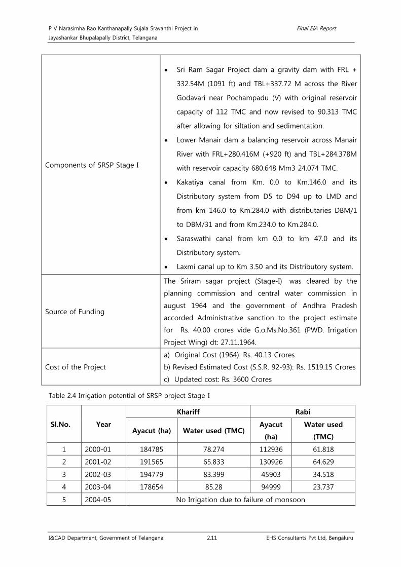
P V Narasimha Rao Kanthanapally Sujala Sravanthi Project in Final EIA Report
Jayashankar Bhupalapally District, Telangana
I&CAD Department, Government of Telangana 2.11 EHS Consultants Pvt Ltd, Bengaluru
Components of SRSP Stage I
• Sri Ram Sagar Project dam a gravity dam with FRL +
332.54M (1091 ft) and TBL+337.72 M across the River
Godavari near Pochampadu (V) with original reservoir
capacity of 112 TMC and now revised to 90.313 TMC
after allowing for siltation and sedimentation.
• Lower Manair dam a balancing reservoir across Manair
River with FRL+280.416M (+920 ft) and TBL+284.378M
with reservoir capacity 680.648 Mm3 24.074 TMC.
• Kakatiya canal from Km. 0.0 to Km.146.0 and its
Distributory system from D5 to D94 up to LMD and
from km 146.0 to Km.284.0 with distributaries DBM/1
to DBM/31 and from Km.234.0 to Km.284.0.
• Saraswathi canal from km 0.0 to km 47.0 and its
Distributory system.
• Laxmi canal up to Km 3.50 and its Distributory system.
Source of Funding
The Sriram sagar project (Stage-I) was cleared by the
planning commission and central water commission in
august 1964 and the government of Andhra Pradesh
accorded Administrative sanction to the project estimate
for Rs. 40.00 crores vide G.o.Ms.No.361 (PWD. Irrigation
Project Wing) dt: 27.11.1964.
Cost of the Project
a) Original Cost (1964): Rs. 40.13 Crores
b) Revised Estimated Cost (S.S.R. 92-93): Rs. 1519.15 Crores
c) Updated cost: Rs. 3600 Crores
Table 2.4 Irrigation potential of SRSP project Stage-I
Sl.No. Year
Khariff Rabi
Ayacut (ha) Water used (TMC) Ayacut
(ha)
Water used
(TMC)
1 2000-01 184785 78.274 112936 61.818
2 2001-02 191565 65.833 130926 64.629
3 2002-03 194779 83.399 45903 34.518
4 2003-04 178654 85.28 94999 23.737
5 2004-05 No Irrigation due to failure of monsoon

P V Narasimha Rao Kanthanapally Sujala Sravanthi Project in Final EIA Report
Jayashankar Bhupalapally District, Telangana
I&CAD Department, Government of Telangana 2.12 EHS Consultants Pvt Ltd, Bengaluru
Sl.No. Year
Khariff Rabi
Ayacut (ha) Water used (TMC) Ayacut
(ha)
Water used
(TMC)
6 2005-06 273655 71.86 316875* 62.66
7 2006-07 253744 70 334068* 74.19
8 2007-08 ** ** 337507* 76
9 2008-09 ** ** 307911* 61
10 2009-10 ** ** ** **
11 2010-11 242811 51.268 358956* 78.48
12 2011-12 283436 64.2 206389* 51
13 2012-13 ** ** 202342* 56.116
14 2013-14 327518* 61 323748* 60
15 2014-15 No Irrigation due to failure of monsoon
16 2015-16 No Irrigation due to failure of Monsoon
** No Irrigation during Khariff season due to failure of Monsoon
*Area proposed for Irrigation during Khariff and Rabi
• Sri Ram Sagar Project Stage II
Sri Rama Sagar Project Stage-II is envisaged from Km 284.000 to Km 346.000 of Kakatiya
Main Canal. The project envisages irrigation facility to an area of 1, 78,066 ha (4, 40,000 Ac.)
in the drought prone areas of Telangana region viz., Warangal, Khammam and Nalgonda
districts. Government has accorded administrative approval for the project estimates of
Rs.1043.14 Crores vide G.O.Ms.No.35, Dt: 27.02.2006 and approved under AIBP scheme at the
ratio of 1:3 Central and State Government Share.
Table 2.5 Salient features of SRSP Stage - II project
Source Sri Rama Sagar Project on Godavari River.
Location Pochampad (V), Balakonda (M), Nizamabad District
Latitude 16 55’N to 17 52’N
Longitude 75 15’E to 80 10’E
Components Canal and Distributory System.
Source of Funding Central Assistance (AIBP) and State Government in 1:3 proportions
Cost of the Project Rs: 1043.14 Cr
Budget for this year Rs: 40.00 Cr
Expenditure Incurred Rs: 944.22 Crores
Physical Progress Works currently under progress are: Package 52 : Lining Works
Package 53,54,55,58 : Earth Work and Structures

P V Narasimha Rao Kanthanapally Sujala Sravanthi Project in Final EIA Report
Jayashankar Bhupalapally District, Telangana
I&CAD Department, Government of Telangana 2.13 EHS Consultants Pvt Ltd, Bengaluru
Starting Location:
Village Illanda
Mandal Wardhannapet
District Warangal
Hydraulic Particulars @ Km 284.00 on Kakatiya Main Canal
Required Discharge 95.00 Cumecs (3355 Cusecs)
Design Dischargeb) 123.01 Cumecs (4344 Cusecs)
Bed Width 16.76 m
F.S.D. 4.34 m
F.B. 0.90 m
Side slopes 1 ½:1 / 2:1
Bed fall 1 in 9500
Value of ‘n 0.018
Velocity 1.216 m/sec
Top Width of Banks 7.750/4.00 m
Command area (ha) 178066
Intensity 109.00%
Table 2.6 Irrigation potential of SRSP Stage - II project (under Kakatiya Canal from km 284 to 346)
Distributory/
Package wise District
Name of the
Constituency
Name of the
Mandal
No. of
villages
covered
in
Mandal
Ayacut (ha)
DBM-54 Warangal Wardhannapet Wardhannapet 2 536
DBM-54 Warangal Wardhannapet Parvathagiri 3 3111
Wardhannapet Constituency 3647
DBM-54 Warangal Palakurthy
Rayaparthi 10 5411 DBM-55 Warangal Palakurthy
DBM-56 Warangal Palakurthy
DBM-57 Warangal Palakurthy
DBM-57 Warangal Palakurthy
Thorrur 23 10490 DBM-59 Warangal Palakurthy
DBM-60-Pkg-53 Warangal Palakurthy
DBM-61 Warangal Palakurthy
DBM-61 Warangal Palakurthy Kodakandla 9 2287
DBM-63 Warangal Palakurthy

P V Narasimha Rao Kanthanapally Sujala Sravanthi Project in Final EIA Report
Jayashankar Bhupalapally District, Telangana
I&CAD Department, Government of Telangana 2.14 EHS Consultants Pvt Ltd, Bengaluru
Distributory/
Package wise District
Name of the
Constituency
Name of the
Mandal
No. of
villages
covered
in
Mandal
Ayacut (ha)
DBM-65 Warangal Palakurthy
DBM-67 Warangal Palakurthy
DBM-69-Pkg-55 Warangal Palakurthy
Palakurthy Constituency 18187
DBM-60-Pkg-53 Warangal Dornakal Narsimhulapet 3 13063
DBM-69-Pkg-55 Warangal Dornakal
DBM-60-Pkg-53 Warangal Dornakal
Maripeda 2 9421 DBM-60-Pkg-54 Warangal Dornakal
DBM-69-Pkg-55 Warangal Dornakal
Dornakal Constituency 22484
Warangal district 44318
DBM-60-Pkg-53 Khammam Palair Thirumalayapalem 24 13682
DBM-60-Pkg-54 Khammam Palair
DBM-60-Pkg-54 Khammam Palair Kusumanchi 14 9489
DBM-60-Pkg-54 Khammam Palair Nelakondapally 3 1197
Palair Constituency 24369
DBM-60-Pkg-54 Khammam Khammam Khammam Rural 14 5101
Khammam Constituency 5101
DBM-60-Pkg-54 Khammam Madhira Mudigonda 3 987
Madhira Constituency 987
Khammam district 30457
DBM-69-Pkg-55 Nalgonda Thungathurthi Nuthankal 24 13144
DBM-71-Pkg-56 Nalgonda Thungathurthi
DBM-69-Pkg-55 Nalgonda Thungathurthi
Thungathurthy 25 12696 DBM-70 Nalgonda Thungathurthi
DBM-71-Pkg-56 Nalgonda Thungathurthi
DBM-69-Pkg-55 Nalgonda Thungathurthi
Thirumalagiri 10 2625
DBM-70 Nalgonda Thungathurthi
Tail End
Distributory - Thungathurthi
DBM-71-Pkg-56 Nalgonda Thungathurthi

P V Narasimha Rao Kanthanapally Sujala Sravanthi Project in Final EIA Report
Jayashankar Bhupalapally District, Telangana
I&CAD Department, Government of Telangana 2.15 EHS Consultants Pvt Ltd, Bengaluru
Distributory/
Package wise District
Name of the
Constituency
Name of the
Mandal
No. of
villages
covered
in
Mandal
Ayacut (ha)
DBM-70 Nalgonda Thungathurthi Jajireddy Gudem 17 9523
DBM-71-Pkg-56 Nalgonda Thungathurthi
Thungathurthi Constituency 38133
DBM-71-Pkg-56 Nalgonda Suryapet
Suryapet 14 5416 DBM-71-Pkg-57 Nalgonda Suryapet
DBM-71-Pkg-58 Nalgonda Suryapet
DBM-69-Pkg-55 Nalgonda Suryapet
Atmakur (S) 26 12116 DBM-71-Pkg-56 Nalgonda Suryapet
DBM-71-Pkg-57 Nalgonda Suryapet
DBM-71-Pkg-57 Nalgonda Suryapet Chivemula 25 8561
DBM-71-Pkg-58 Nalgonda Suryapet
DBM-71-Pkg-58 Nalgonda Suryapet Penpahad 15 5821
Suryapet Constituency 31915
DBM-71-Pkg-58 Nalgonda Kodad Munagala 9 3861
DBM-71-Pkg-57 Nalgonda Kodad
DBM-71-Pkg-56 Nalgonda Kodad
Mothey 21 10792 DBM-71-Pkg-57 Nalgonda Kodad
DBM-71-Pkg-58 Nalgonda Kodad
DBM-71-Pkg-57 Nalgonda Kodad Nadigudem 4 1479
Kodad Constituency 16133
DBM-71-Pkg-58 Nalgonda Huzur Nagar Garidepalli 2 87
Huzur Nagar Constituency 87
Nalgonda district 86268
Warangal 44318
Khammam 30457
Nalgonda 86268
Grand Total 161043
The ultimate average irrigation potential created under SRSP Stage-I between 2000-01 to
2015-16 is 236000 ha in Khariff season and 231000 ha during Rabi season against the total
command area of 392000 ha. Similarly, under SRSP Stage-II, the ultimate irrigation potential
created is 161043 ha against the contemplated 178066 ha. This is mainly because of erratic

P V Narasimha Rao Kanthanapally Sujala Sravanthi Project in Final EIA Report
Jayashankar Bhupalapally District, Telangana
I&CAD Department, Government of Telangana 2.16 EHS Consultants Pvt Ltd, Bengaluru
rainfall, severe droughts and change in cropping pattern by the farmers leading to failure of
water conveyance to tail end farmers. Hence, out of 570066 ha in both Stage-I and II, an area
of 304000 ha is suffering ayacut which need irrigation facilities through the proposed project.
The schematic diagram of SRSP is enclosed as Annexure-6.
2.1.5 Irrigation efficiency of JCRDLIS and SRSP Stage-I and II
"Irrigation efficiency is used to estimate the percentage of water utilized efficiently and the
percentage of water which is lost. In other words, not all the water taken from a source
reaches the root zone of the plants. Since, a part of the water is lost during transport
through the canals and in the fields. The remaining part is stored in the root zone and
eventually utilized by the plants. Therefore, only a part of the water is used efficiently, the
rest of the water is lost for the crops on the fields that were to be irrigated.
The scheme irrigation efficiency (e in %) is that part of the water pumped or diverted
through the scheme inlet which is used effectively by the plants.
The scheme irrigation efficiency can be sub-divided into:
The conveyance efficiency which represents the efficiency of water transport in canals, and
The field application efficiency which represents the efficiency of water application in the
field.
It is calculated by the given formula:
e (%)= ec x ea/100
Where,
e (%) = scheme irrigation efficiency,
ec (%) = conveyance efficiency
ea (%) = field application efficiency
The conveyance efficiency mainly depends on the length of the canals, the soil type or
permeability of the canal banks and the condition of the canals. In large irrigation schemes
such as the proposed project more water is lost compared to smaller schemes. The indicative
values for ec and ea is as given below;
Table 2.7 Indicative values of the conveyance efficiency (ec) for adequately maintained canals
Type of canal Earthen canals Lined canals
Soil type Sand Loam Clay -
Canal length - - - -
Long (> 2000 m) 60% 70% 80% 95%

P V Narasimha Rao Kanthanapally Sujala Sravanthi Project in Final EIA Report
Jayashankar Bhupalapally District, Telangana
I&CAD Department, Government of Telangana 2.17 EHS Consultants Pvt Ltd, Bengaluru
Type of canal Earthen canals Lined canals
Medium (200-2000 m) 70% 75% 85% 95%
Short (< 200 m) 80% 85% 90% 95%
Table 2.8 Indicative values of the field application efficiency (ea)
Irrigation methods Field application efficiency
Surface irrigation (border, furrow, basin) 60%
Sprinkler irrigation 75%
Drip irrigation 90%
A scheme irrigation efficiency of 50-60 % is good; 40 % is reasonable, while a scheme
Irrigation efficiency of 20-30 % is poor"12
2.1.5.1 Irrigation efficiency of JCRDLIS
.
Based on the above calculation, the irrigation efficiency of JCRDLIS in the existing irrigating
area is 57 % which appears to be good. In this project, only 17 % of area under
contemplated command is achieved. However, a balance area of 83 % is required to be
stabilized under the proposed project.
2.1.5.2 Irrigation efficiency of SRSP Stage-I and II
CWC in 2014 conducted performance evaluation studies of 131 completed major and
medium irrigation projects in India. Under the program, SRSP Stage-I project was also
reviewed. According to the studies, conveyance efficiency is 97.93 %, on farm application
efficiency is 57.28 % and overall efficiency of the project is 44.66 %13
In addition to this, a performance evaluation of the SRSP Stage-I and II project by
formulating a tri-seasonal optimization model using 44 years (1950-1993) of historical data
was conducted by C M Rao and R V Kale of National Institute of Technology, Jamshedpur
and NIH, Roorke in 2013. The studies indicate that the drinking water supply demands have
been met in all the 44 years. During this span, three irrigation releases for the Khariff season
and six irrigation releases for the Rabi season has given 33 years of satisfaction with 11
deficit years, which is said to be well within the 75% dependability condition. Hence, it is a
practicable case of optimal release combination. No irrigation release is assured during the
summer season. As the developed optimization model accounts for the whole command area
for simulation, further extension of area is not recommended.
which appears to be
nearly good as per FAO classification.
12 Annex I- Irrigation efficiencies (http://www.fao.org/docrep/t7202e/t7202e08.htm), FAO 13 http://www.cwc.nic.in/newsite/Documents/Performance_Evaluation_Studies.pdf

P V Narasimha Rao Kanthanapally Sujala Sravanthi Project in Final EIA Report
Jayashankar Bhupalapally District, Telangana
I&CAD Department, Government of Telangana 2.18 EHS Consultants Pvt Ltd, Bengaluru
Rabi crop is planned depending on the water availability status at each end of the Khariff
season. The computed optimal release combination (3, 6) obtained from the Linear
Programming model was again verified by the selected comparative indicators. For this
purpose, the annual water balance study was also performed and their cumulative values are
estimated for a period of 44 years. The relative irrigation supply with RIS = 1.00 for the
Khariff season indicates adequate supply of water and a value of (Relative Irrigation Supply)
RIS = 0.91 for the Rabi season indicates slightly inadequate supply of water from the
reservoir. Further, the Water Self-Sufficiency (WSS) value with WSS = 118.25 % indicating that
the SRSP reservoir is self-sufficient and does not need any other source of supply when (3, 6)
release pattern is adopted (Annexure 7)14
2.1.5.3 Proposed P V Narasimha Rao Kanthanapally Sujala Sravanthi Project
.
The proposed project aims at stabilizing the existing irrigation facilities of JCRDLIS and SRSP
Stage I & II schemes. At present, there is no barrage built downstream of the intake channel
and hence there is no pondage for drawing the water. Therefore, Telangana Government has
proposed to take up this flagship project, by proposing a barrage along River Godavari to
create a pondage with an operational pond level of 77 m downstream of the intake channel
of JCRDLIS and the proposed barrage will stabilize the existing command areas of 2,51,310
ha of Devadula Lift Irrigation Scheme and 3,04,000 ha of SRSP stages I & II. Further, the
project will also provide 50 TMC of drinking water facility to enroute cities, towns and
villages.
2.2 Present proposal
The project envisages construction of 1,132 m long barrage across Godavari River near
Thupakulagudem village, Eturnagaram Mandal, Jayashankar Bhupalapally district to raise the
water level in the River Godavari to stabilize the existing command areas of 5,55,310 ha of
Devadula LIS and Sri Ram Sagar Project Stage I and II. 50 TMC of water shall be utilized for
stabilizing the existing command area and 50 TMC of water shall be utilized for drinking
purpose by the villages in the enroute cities, towns and villages. There are no additional
infrastructures proposed in the existing command areas of the project. The command area is
already endowed by the existing irrigation facilities for the Khariff and bi-seasonal crops and
the proposed scheme also facilitates irrigation also during Rabi season.
The project site is approachable by road and the nearest village is Thupakulagudem at a
distance of 400 m. The nearest railway station is at Mancherial District at a distance of 106
km. The nearest airport is Hyderabad at a distance of 255 km. The National highway NH-202
passes through the project area and serves as important means of commuting. Command
14 Performance evaluation of Sriram Sagar Irrigation Project (2013), C M Rao & R V Kale, Journal of IWRS

P V Narasimha Rao Kanthanapally Sujala Sravanthi Project in Final EIA Report
Jayashankar Bhupalapally District, Telangana
I&CAD Department, Government of Telangana 2.19 EHS Consultants Pvt Ltd, Bengaluru
area map is enclosed as Annexure – 8. The salient features of the project along with
schematic diagram and location map is given below;
Table 2.9 Salient Features of the proposed PVNRKSSP
1 Name of the project P V Narasimha Rao Kanthanapally Sujala Sravanthi
Project
2 Type of project Stabilizing the existing command areas of JCRDLIS
(2,51,310 ha) and SRSP stage -I&II (3,04,000 ha) and
providing drinking water facilities to the en route
villages.
4 River Godavari
5 Latitude and Longitude of the
proposed barrage
• Left Bank Coordinates:
18° 35' 19.43" N, 80° 23' 49.13" E
• Right Bank Coordinates:
18° 35' 02.94" N, 80° 23' 14.46" E
6 Water Utilization 50 TMC for stabilizing the existing command areas
(JCRDLIS and SRSP Stage I & II) and 50 TMC of water
for drinking purpose for enroute villages.
7 Command Area 5,55,310 ha -
J. Chokka Rao Devadula LIS (2,51,310 ha);
Sri Ram Sagar Project (SRSP) - Stage I & II (3,04,000 ha).
8 Districts benefitted Jayashankar Bhupalapally, Warangal (Rural and Urban),
Nalgonda and Khammam
9 Cost of the Project Rs. 2,121 Crores
10 Land required for Project 94 ha of private/patta land
11 Forest Land requirement Nil
12 Submergence 580.18 ha of river bed area alongside River Godavari
near the proposed barrage at FRL: 77 m
13 R & R Nil
14 Power requirement 1.5 MW Source- TSTRANSCO
15 B.C Ratio 1.53

P V Narasimha Rao Kanthanapally Sujala Sravanthi Project in Final EIA Report
Jayashankar Bhupalapally District, Telangana
I&CAD Department, Government of Telangana 2.20 EHS Consultants Pvt Ltd, Bengaluru
Fig 2.3 Location map of P V Narasimha Rao Kanthanapally Sujala Sravathi Project on SoI toposheet

P V Narasimha Rao Kanthanapally Sujala Sravanthi Project in Final EIA Report
Jayashankar Bhupalapally District, Telangana
I&CAD Department, Government of Telangana 2.21 EHS Consultants Pvt Ltd, Bengaluru
Fig 2.4 Google view showing proposed barrage and River Godavari

P V Narasimha Rao Kanthanapally Sujala Sravanthi Project in Final EIA Report
Jayashankar Bhupalapally District, Telangana
I&CAD Department, Government of Telangana 2.22 EHS Consultants Pvt Ltd, Bengaluru
2.2.1 Water availability
As per the Godavari Water Disputes Tribunal Award (GWDTA), the total allocation of water in the Godavari River to the Telangana State and
Andhra Pradesh works out to be 1480 TMC. With a view to optimally utilize the water earmarked to projects in Telangana region, the Irrigation
& CAD Department prepared a comprehensive plan for irrigation development in the region, considering various factors such as;
• Shortfalls in the existing projects,
• Shortfalls at the site of ongoing project, and
• Reallocation and readjustment of water for the proposed projects.
The net availability of water to Telangana/Andhra Pradesh in the different sub basins of Godavari and at the project sites has been assessed
keeping in view GWDT allocation of water for the upstream states and is given in the table below.
Table 2.10 Yields of various sub-basins and entitlements of Telangana/ Andhra Pradesh at 75% dependability
Sl. No. Sub-basins Virgin Yield of sub-basins
Entitlement of
other states
Entitlement of
Telangana/AP
Contribution of
regeneration Total
MCM TMC TMC TMC TMC TMC
1 Penganga 3840.51 135.66 96.78 38.88 3.51 42.39
2 Wardha 4800.0 169.51 149.88 19.63 0 19.63
3 Pranahita 23633.3 834.60 561.58 273.02 10.38 283.40
4 Lower Godavari 6548.2 231.25 20.28 210.97 10.23 221.20
5 Indravati 20872.5 737.11 456.96 280.15 9.07 289.22
6 Sabari 11138.3 393.35 245.18 148.17 6.30 154.47
Total 70832.8 2501.48 1530.66 970.82 39.49 1010.31

P V Narasimha Rao Kanthanapally Sujala Sravanthi Project in Final EIA Report
Jayashankar Bhupalapally District, Telangana
I&CAD Department, Government of Telangana 2.23 EHS Consultants Pvt Ltd, Bengaluru
To assess the net availability of water at the project site, the flow data of CWC hydrological
observation namely Polavaram, Koida, Perur, Somanpally and Mancherial are used. The
consistency check has been carried out by specific flow analysis and results are as under.
Table 2.11 Specific flows at Perur and adjoining sites on Godavari (ltrs/sec/sq.km)
Name of the location Polavaram Koida Perur Somanpally Mancherial
June 849063 1054733 741896 70863 744961
July 6028669 6389981 4842500 492870 4762343
August 11797621 13331942 9577856 1310953 9535893
September 8466875 8628774 6919188 1303360 6624625
October 3510786 3685957 2685605 728491 2542218
November 917938 985203 692229 131444 648804
December 520585 571369 297399 57205 292174
January 368891 418548 194261 36305 180408
February 307902 367431 156317 33347 148778
March 262016 323890 111149 31618 107964
April 239875 271049 70361 17825 66069
May 225242 272569 63085 11180 53632
However, Perur G&D site maintained by Central Water Commission is very close to the
proposed barrage at Thupakulagudem (approximately 3 km upstream). Therefore, it is
decided to consider the data at Perur for assessing the net availability of water at the project
site taking into account the utilization under ongoing and planned projects as the existing
utilization is already reflected in the observed data at Perur. The net availability of water at
75% dependability (1534.4 TMC) at the proposed Thupakulagudem barrage Site has
accordingly been assessed considering the observed data for the period 1966-67 to 2012-13
of the CWC G&D Site at Perur on Godavari (Catchment Area: 2,68,000 Sq. Km) strictly
sticking to Godavari Water Dispute Tribunal Award (Annexure 9). The net water availability at
Thupakulagudem barrage site for the present purpose considering utilization under ongoing
and planned projects are as mentioned below.
Table 2.12 Net availability of water at Thupakulagudem barrage site
Units
75% dependable
flow at Perur
reduced pro rata
Utilization under
ongoing
projects
Utilization under
planned projects
Net Availability at
75%
dependability
MCM 43450.6 10312.9 21602.8 11535.0
TMC 1534.7 364.3 763.0 407.4*
* - Excluding water requirement of Kaleshwaram Lift Irrigation Scheme

P V Narasimha Rao Kanthanapally Sujala Sravanthi Project in Final EIA Report
Jayashankar Bhupalapally District, Telangana
I&CAD Department, Government of Telangana 2.24 EHS Consultants Pvt Ltd, Bengaluru
Out of 407.40 TMC of available water at the proposed barrage site at River Godavari, 180
TMC is allocated for Kaleshwaram Irrigation project (peddha), 4.5 TMC for Kaleshwaram LIS
(tank filling) and the proposed PVNRKSSP requires 100 TMC of water amounting to 284.5
TMC leaving 122.90 TMC of water downstream.
2.2.2 Environmental flow
Rivers, streams and wetlands need certain amounts of water to support healthy aquatic
ecosystems. The normal riverine flow is changed owing to construction of dams, water
abstractions. However, construction of barrage in this case may alter the natural flow of the
river. Hence, environmental flows are designed to mimic the natural condition of rivers along
with the timing and quality of the river water. Rivers naturally experiences periods where
there is low flow or no flow and on the contrast causes floods which can severely impair the
functioning of aquatic ecosystems. Therefore, environmental flow is an essential component
so as to maintain the ecological integrity of the river system and simultaneously providing
water for domestic supply, irrigation, industrial purposes, etc. Any alteration in the flow can
lead to depletion in water quality, establishment of invasive species and loss of biodiversity15
The Global Environmental Flow Calculator (GEFC) software developed by International Water
Management Institute (IWMI), Srilanka is utilised for desktop rapid assessment of
Environmental Flows (EFs). The calculator uses monthly time series flow conditions and its
corresponding Flow Duration Curve (FDC) – a cumulative distribution function of flows for EF
estimation
.
16. Further, FDC is represented by a table of flow values (percentiles) covering the
entire range of probabilities of occurrence. All FDCs in this study are represented by a table
of flows corresponding to the 17 fixed percentage points: 0.01, 0.1, 1, 5, 10, 20, 30, 40, 50,
60, 70, 80, 90, 95, 99, 99.9 and 99.99 percent. Further, six EMC’S namely A, B, C, D, E and F
indicating that the higher the EMC, the more water will need to be allocated for ecosystem
maintenance or conservation and more flow variability will need to be preserved17
15 Environmental Flows in India towards sustainable water management (2014), S.K Jain and P. Kumar, Hydrological Sciences, Journal, vol 59,
3-4, 751-769
. The e
flow details from the year 1901-2000 for the proposed project are as given below.
16 Environmental Flow Requirements: A Case study of River Sone (2014), D N Jha, A Alam, K D Joshi, CIFRI, Page 2 17 An Assessment of Environmental Flow requirements of Indian River Basins (2006), V. Smakhtin and M. Anputhas., page 15-18

P V Narasimha Rao Kanthanapally Sujala Sravanthi Project in Final EIA Report
Jayashankar Bhupalapally District, Telangana
I&CAD Department, Government of Telangana 2.25 EHS Consultants Pvt Ltd, Bengaluru
Fig 2.5 Statistical data showing Mean Annual Runoff in Godavari River at Project site
Fig 2.6 Graph showing monthly distribution of flow at Godavari River at Project site
Fig 2.7 Graph showing Flow Duration Curve (FDC) with 17 fixed percentage points

P V Narasimha Rao Kanthanapally Sujala Sravanthi Project in Final EIA Report
Jayashankar Bhupalapally District, Telangana
I&CAD Department, Government of Telangana 2.26 EHS Consultants Pvt Ltd, Bengaluru
Table 2.13 Default Environmental Management Classes
Default Environmental Management Classes %
Natural
A Natural Pristine condition or minor modification on In-stream
and Riparian Habitat 63.9
B Slightly Modified Largely Intact Biodiversity and Habitats despite water
resources development and/or Basin modifications 38.7
C Moderately Modified
The habitats and dynamics of the biota have been
disturbed, but basic ecosystem functions are still intact.
Some sensitive species are lost and/or reduced in extent.
Alien species present.
22.1
D Largely Modified
Large changes in natural habitat, biota and basic
ecosystem functions have occurred. A clearly lower than
expected species richness. Much lowered presence of
intolerant species. Alien species prevail.
12.3
E Seriously Modified
Habitat diversity and availability have declined. A
strikingly lower than expected species richness. Only
tolerant species remain. Indigenous species can no
longer breed. Alien species have invaded the ecosystem.
6.9
F Critically Modified
Modifications have reached a critical level and ecosystem
has been completely modified with almost total loss of
natural habitat and biota. In the worst case, the basic
ecosystem functions have been destroyed and the
changes are irreversible.
4
Fig 2.8 Graph showing Flow Duration Curve (FDC) with 17 fixed percentage points

P V Narasimha Rao Kanthanapally Sujala Sravanthi Project in Final EIA Report
Jayashankar Bhupalapally District, Telangana
I&CAD Department, Government of Telangana 2.27 EHS Consultants Pvt Ltd, Bengaluru
Table 2.14 Default Environmental Management Classes details with 17 percentage points
% REF A B C D E F
0.01 64606 56712 44092 34254 26738 15547 8734
0.1 56712 44092 34254 26738 15547 8734 4704
1 44092 34254 26738 15547 8734 4704 2591
5 34254 26738 15547 8734 4704 2591 1352
10 26738 15547 8734 4704 2591 1352 757
20 15547 8734 4704 2591 1352 757 454
30 8734 4704 2591 1352 757 454 253
40 4704 2591 1352 757 454 253 175
50 2591 1352 757 454 253 175 102
60 1352 757 454 253 175 102 64.2
70 757 454 253 175 102 64.2 63.6
80 454 253 175 102 64.2 63.6 63
90 253 175 102 64.2 63.6 63 62.4
95 175 102 64.2 63.6 63 62.4 61.9
99 102 64.2 63.6 63 62.4 61.9 61.3
99.9 64.2 63.6 63 62.4 61.9 61.3 60.8
99.99 63.6 63 62.4 61.9 61.3 60.8 60.2
The e-flow analysis shows that the proposed project involves minor modifications on riparian
vegetation, maintains intact biodiversity and habitats irrespective of construction of barrage
and basin modification and also shows that basic environmental functions area intact despite
the disturbance that will be caused due to the construction of barrage. Therefore, the
proposed project maintains the natural conditions (64 %) with slightly (40 %) and moderately
modified (22 %) environmental functions hereby supporting fair amount of aquatic biota in
River Godavari. As only minimal percentage (largely modified - 12.3 %, seriously modified 6.9
% and Critically modified state- 4 %) is observed from the analysis, the proposed project
does not have a major impact on the natural e flow and aquatic biota.
2.2.3 Crop water requirement
The command area is already being benefitted by the existing irrigation facilities (JCR
Devadula LIS and SRSP Stage I and II) for the Khariff and bi-seasonal crops and the
proposed scheme facilitates irrigation only during Rabi season. Therefore, out of 100 TMC of
water required for the proposed project, 50 TMC of water shall be utilized for stabilizing the
existing command areas during Rabi season when there is deficiency of water for irrigation.

P V Narasimha Rao Kanthanapally Sujala Sravanthi Project in Final EIA Report
Jayashankar Bhupalapally District, Telangana
I&CAD Department, Government of Telangana 2.28 EHS Consultants Pvt Ltd, Bengaluru
2.2.4 Command area
The command area of 5,55,310 ha includes all the benefitting villages falling under the
existing command areas of JCR DLIS and SRSP S-I & II. The benefitting villages are spread
across Jayashankar Bhupalapally, Nalgonda and Khammam Districts of Telangana. The
command area villages are deprived of irrigation only during Rabi season which shall be
made available by the proposed project.
Table 2.15 Benefitting mandals
Sl.No. Name of the
project No. of Districts No. of Mandals No. of villages
1 JCRDLIS 8 37 364
2 SRSP Stage-I 3 11 81
3 SRSP Stage-II 3 7 73
River Godavari
Lat: 18°35'20.61"N, Long: 80°23'30.42"E
Proposed barrage
Lat: 18°35'3.69"N, Long: 80°23'19.16"E
Command area
Lat: 17°44’53.5”N, Long: 79°16’31.6”E
Command area
Lat: 17°51’10.1”N, Long: 79°08’51.9”E
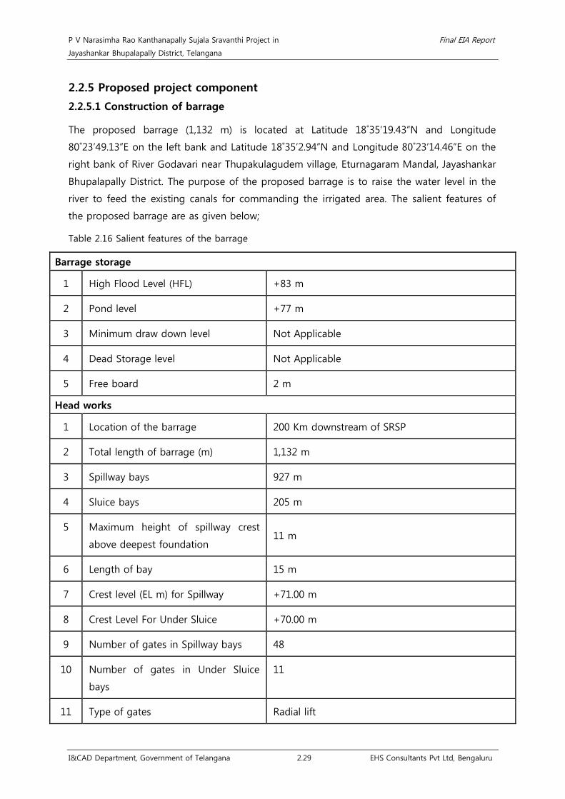
P V Narasimha Rao Kanthanapally Sujala Sravanthi Project in Final EIA Report
Jayashankar Bhupalapally District, Telangana
I&CAD Department, Government of Telangana 2.29 EHS Consultants Pvt Ltd, Bengaluru
2.2.5 Proposed project component
2.2.5.1 Construction of barrage
The proposed barrage (1,132 m) is located at Latitude 18˚35’19.43”N and Longitude
80˚23’49.13”E on the left bank and Latitude 18˚35’2.94”N and Longitude 80˚23’14.46”E on the
right bank of River Godavari near Thupakulagudem village, Eturnagaram Mandal, Jayashankar
Bhupalapally District. The purpose of the proposed barrage is to raise the water level in the
river to feed the existing canals for commanding the irrigated area. The salient features of
the proposed barrage are as given below;
Table 2.16 Salient features of the barrage
Barrage storage
1 High Flood Level (HFL) +83 m
2 Pond level +77 m
3 Minimum draw down level Not Applicable
4 Dead Storage level Not Applicable
5 Free board 2 m
Head works
1 Location of the barrage 200 Km downstream of SRSP
2 Total length of barrage (m) 1,132 m
3 Spillway bays 927 m
4 Sluice bays 205 m
5 Maximum height of spillway crest
above deepest foundation 11 m
6 Length of bay 15 m
7 Crest level (EL m) for Spillway +71.00 m
8 Crest Level For Under Sluice +70.00 m
9 Number of gates in Spillway bays 48
10 Number of gates in Under Sluice
bays
11
11 Type of gates Radial lift

P V Narasimha Rao Kanthanapally Sujala Sravanthi Project in Final EIA Report
Jayashankar Bhupalapally District, Telangana
I&CAD Department, Government of Telangana 2.30 EHS Consultants Pvt Ltd, Bengaluru
12 Size of gate for Spillways (m) 15 x 14
13 Size of gate for Under sluice (m) 15 x 15
14 Type of energy dissipation
arrangement
Hydraulic jump on cistern floor
15 Maximum discharging capacity
(Cumec)
8,50,000
16 Tail water (EL – M)
Maximum:
Minimum:
+87.25 m
+69.0 m
17 Under Sluice bays 11 Nos. on right side of barrage
2.2.5.2 Design flood at Thupakulagudem barrage site
The design flood for the barrage at Thupakulagudem, has been determined keeping in view
the criteria laid done in IS 6966 Part-I 1989 – “Hydraulic Design of Barrage and Weirs”.
According to this code the design flood for Barrages and Weirs should be 50 year flood.
However, in this particular case 100 year flood is proposed to be considered as design flood
for barrage. For, fixing the free board normally 500 year return period flood or Standard
Project Flood (SPF) as the case may be can be considered. Since the catchment area
intercepted by the barrage is quite large, it was decided to estimate the design flood by
resorting to frequency approach utilizing the annual peak discharge data readily available at
the CWC sites namely Polavaram, Koida, Perur, Somanpally and Mancherial on
Godavari/Tributaries of Godavari.
Frequency Analysis has been conducted using the data of the above mentioned sites and the
flood values against various return periods viz: 50, 100 and 500 years have been arrived at.
Before the annual peak data is subjected to frequency analysis as is customary Chi Square
Test/ Kolmogorov-Smirnov (K-S) tests on the data have been carried out to decide up on the
type of distribution to which the data fits. The software HYFA has been used for the study.
The results of the study are given in the table below.
Table 2.17 Flood frequency analysis for different distributions and return periods
Site Name Koida Pathagudem Mancherial Perur Polavaram
Catchment Area in Sq.Km 305460 40000 102900 268200 307800
Years of Data 29 47 48 47 47
Gumbel Type I 50 Year 68353.5 30870.6 25892.4 67155.0 66860.3

P V Narasimha Rao Kanthanapally Sujala Sravanthi Project in Final EIA Report
Jayashankar Bhupalapally District, Telangana
I&CAD Department, Government of Telangana 2.31 EHS Consultants Pvt Ltd, Bengaluru
Site Name Koida Pathagudem Mancherial Perur Polavaram
100 Year 77128.9 34380.5 29620.5 74918.8 74258.2
500 Year 93571.2 42491.4 38235.7 92859.9 91353.7
Log Normal 2-
Parameter
50 Year 70412.4 33321.6 32722.6 66040.4 63001.4
100 Year 79052.9 37824.6 40863.3 74187.9 69756.6
500 Year 99922.0 48886.8 64064.8 93884.4 85726.8
Log Normal 3-
Parameter
50 Year 68236.5 32821.2 30613.8 61284.5 58265.3 100 Year 75324.9 36907.0 35549.3 66461.7 62371.0
500 Year 91601.4 46680.8 47420.5 77689.1 71039.0
Pearson type - III 50 Year 69726.6 33561.6 31547.1 61758.3 58528.7
100 Year 77302.7 37809.0 36694.2 67068.2 62718.5
500 Year 94484.5 47654.9 48672.6 78543.1 71568.1
Log Pearson type -
III
50 Year 71480.0 33591.5 33053.6 64977.7 59884.2
100 Year 80014.5 38115.1 37723.6 71179.7 64057.3
500 Year 100217.0 49175.6 46649.0 84462.3 72329.9
2 Parameter
Gamma
50 Year 66277.0 30699.9 32472.4 63706.1 61008.8
100 Year 72523.8 33769.2 38299.9 69945.5 66312.2
500 Year 86344.2 40594.2 52146.8 83794.3 77969.1
Accepted values
50 Year 66277 30871 25892 63706 58265
100 Year 77129 34381 29621 74919 66312
500 Year 93571 42491 38236 92860 77969
The 100 year return period flood of say 85,000 cumecs is proposed to be adopted as the
design flood for the Thupakulagudem barrage. The 500 year flood of magnitude 1,02,000
cumecs is proposed to be considered for fixing the free board.
2.2.5.3 Sedimentation
As per DPR, the proposed structure at Thupakulagudem is only gated barrage, the chance of
facing any problem on account of sedimentation is quite remote and if at all encountered it
is going to be quite insignificant. Therefore, detailed sedimentation study is perhaps not
needed.
2.2.5.4 Geological investigations
William King (1872-1881) surveyed the entire Godavari valley and gave the comprehensive
geological account of the geology and structure. In the recent years, officers of geological
survey of India have systematically mapped the area on 1:63,360 scale. The geological details
of the barrage area is given below;
Table 2.18 Regional geological set up of the area
Age Stratigraphic unit Lithology
Upper Carboniferous Gondwana Super Chikiala formation Sandstones and

P V Narasimha Rao Kanthanapally Sujala Sravanthi Project in Final EIA Report
Jayashankar Bhupalapally District, Telangana
I&CAD Department, Government of Telangana 2.32 EHS Consultants Pvt Ltd, Bengaluru
Age Stratigraphic unit Lithology
to Permian Group Kota formation
Maleri formation
Kamthi formation
pebble beds.
Sandstone, limestone
& clays. Variegated
sandstone & clays.
Red, brown, yellow,
friable, soft
Upper Precambrian Sullavai Group Pakhal Group
Quartzose
Sandstones, grits and
pebble bed,
Quartzites, phyllites,
shales,
ARCHEAN ARCEANS Granites and Gneisses
The Godavari River bed at proposed barrage site is 950m wide. Here also the major part of
the lean discharge of the river flows through a narrow & deep gorge on the left abutment.
The left abutment rises steeply with 2 to 1 slope consisting of hard rock; the rest of the river
bed is generally plain without any exposure of rock and is deeply covered by sand. The
average river bed RL is 73.0m and the deepest is 63m. The right flank is also steeper slope
but comparatively gentler with left bank slope.
On the left bank about 150 m on either side of the axis on which Quartzo-schistic rock are
exposed, very close to the river, they are fine grained pinkish and dark greyish in colour,
striking in N-W and S-E direction and dip 15 to 250 towards N- E, i.e. towards left bank.
These quartzo-schistic rock are highly folded as compared to the 1st axis quartzo-schistic
dark grey in color.
The Godavari River is confined to flow through 400m wide channel in the lean season close
to the rocky left bank. The deepest channel is noted 9m depth during Hydrographical survey
(in the month of October) around the barrage axis, however this deepest point does not
occur across the axis but lies about 1000m upstream of it, in general 0.5m to 7m deep, water
depth observed, across the flowing channel .
After flow channel, in and around the barrage axis the river bed is plain gently sloping
(towards left bank) and consisting of medium to coarse grained sand. The sand cover is 3m
to 8.5m in thickness as revealed during the geo-technical investigation. The width of river
bed, (bank to bank) is about 950m.
Sub-surface exploration has revealed the occurrence of bed rock below the sand cover is
3.5m to 8.5m and the rock is dark grey schistic Quartzite or Quartzo-schistic rock, in the
center of the river bed, the rock is hard and massive, but highly fractured, with low core

P V Narasimha Rao Kanthanapally Sujala Sravanthi Project in Final EIA Report
Jayashankar Bhupalapally District, Telangana
I&CAD Department, Government of Telangana 2.33 EHS Consultants Pvt Ltd, Bengaluru
recovery noted in BHT-7 & 8, almost zero percent RQD, but rock is improved in the bore
hole no. BHT-9 & 10 in this reach of the river bed, the core recovery crossed 50% and in
BHT-10 the RQD is also noted as maximum as 65%, which is good to be tied up the barrage.
2.2.5.5 Technical specifications of Thupakulagudem barrage
• Spillway Radial Gates (Other Bays)
It is proposed to provide 48 sets of Radial Type gates of (15000*14000) mm for Spillways.
The gates shall be designed for height of 14 m. corresponding to Pond level and checked for
HFL in accordance with the provision contained in IS 4623-2000. Each gate shall be operated
with the help of downstream suspension Rope drum Hoist of 280 tons (Tentative) capacity.
The regulation of discharge from this gate has been envisaged. The skin plate shall consist of
stainless steel plate of minimum 12.0 mm thickness cladded through Mill Cladding Process.
Table 2.19 Salient features of spillway radial gates
Sl.No. Particulars Remarks
1 Deck Level EL 90.0 m
2 HFL EL 83.0 m
3 Pond Level EL 77.0 m
4 Crest Level El 71.0 m
5 Sill Level El 71.0 m
6 Top of opening EL 85.3 m
7 C. L. Trunnion EL 88.75 m
8 Clear Width of Opening 15.0 m
9 Radius of Gate up to inside of skin plate 22.0 m
10 Water Head on sill 14.0 m
11 Total No. of opening 48 Nos.
12 Total No. of gate required 48 Nos.
13 Types of gates proposed Radial Type Gates
14 Position of Skin plates and sealing Upstream
15 Skin Plate
Structure steel cladded with stainless
steel plate of 6mm thickness mill/
explosion cladded
16 Mode of operation
D/s suspension Rope drum hoist of
adequate capacity
17 Operation Regulation of discharge
18 Design Standard IS 4623, IS:800, IS 6938
19 Approximate Weight of Gate 190 tons

P V Narasimha Rao Kanthanapally Sujala Sravanthi Project in Final EIA Report
Jayashankar Bhupalapally District, Telangana
I&CAD Department, Government of Telangana 2.34 EHS Consultants Pvt Ltd, Bengaluru
Sl.No. Particulars Remarks
20 Approximate Weight of Embedded Parts 70 tons
21 Hoist Capacity 280 tons
22 Approximate Wt. of Hoist Bridge 30 tons
23 Approximate Wt. of Walkaway Bridge 7.5 tons
• Under Sluice Radial Gates
It is proposed to provide 11 sets of Radial Type gates of (15000*15000) mm for Spillways.
The gates shall be designed for un-balanced head of 15 m. corresponding to Pond Level and
checked for HFL in accordance with the provision contained in IS 4623-2000. Each gate shall
be operated with the help of downstream suspension Rope drum Hoist of 310 tons
(Tentative) capacity. The regulation of discharge from this gate has been envisaged. The skin
plate shall consist of stainless steel plate of minimum 12.0 mm thickness cladded through
Mill Cladding Process.
Table 2.20 Salient features of under sluice radial gates
Sl.No. Particulars Remarks
1 Deck Level EL 90.0 m
2 HFL EL 83.0 m
3 Pond Level EL 77.0 m
4 Crest Level El 71.0 m
5 Sill Level El 71.0 m
6 Top of opening EL 85.3 m
7 C. L. Trunnion EL 88.75 m
8 Clear Width of Opening 15.0 m
9 Radius of Gate up to inside of skin
plate 22.0 m
10 Water Head on sill 15.0 m
11 Total No. of opening 11 Nos.
12 Total No. of gate required 11 Nos.
13 Types of gates proposed Radial Type Gates
14 Position of Skin plates and sealing Upstream
15 Skin Plate
Structure steel cladded with
stainless steel plate of 6mm
thickness mill/ explosion cladded
16 Mode of operation
D/s suspension Rope drum hoist of
adequate capacity
17 Operation Regulation of discharge

P V Narasimha Rao Kanthanapally Sujala Sravanthi Project in Final EIA Report
Jayashankar Bhupalapally District, Telangana
I&CAD Department, Government of Telangana 2.35 EHS Consultants Pvt Ltd, Bengaluru
Sl.No. Particulars Remarks
18 Design Standard IS 4623, IS:800, IS 6938
19 Approximate Weight of Gate 200 tons
20 Approximate Weight of Embedded
Parts 73 tons
21 Hoist Capacity 310 tons
22 Approximate Wt. of Hoist Bridge 32 tons
23 Approximate Wt. of Walkaway Bridge 7.5 tons
• Under Sluice Stoplogs
It is proposed to provide two set of Sliding Type logs consisting of 12 equal size unit of
15000*1275 size i.e. eleven units as interchangeable units and the top units as non-
interchangeable unit for maintenance of under sluice Spillway gates. The stop logs shall be
designed for unbalanced head of 15.0 m corresponding to Pond Level and checked for HFL
in accordance with the provision contained in IS: 9349. The stop log shall have downstream
skin plate and sealing. Each stop logs shall be operated with the help of a lifting beam and
Gantry Crane of adequate capacity under balance head condition achieved with the help of a
pair of filling valve to be provided in the top unit or crack opening from the top of the
barrage.
Table 2.21 Salient features of under sluice stoplogs
Sl.No. Particulars Remarks
1 Deck Level EL 90.0 m
2 HFL EL 83.0 m
3 Pond Level EL 77.0 m
4 Crest Level EL 70.0 m
5 Sill Level EL 70.0 m
6 Clear Width of Opening 15.0 m
7 C/C of side seal 15.15 m
8 C/C of track plates 15.60 m
9 Total Height of stop log 15.3 m
10 Size of Each unit (15.15*1.275) m
11 Water Head on Sill 15.0 m
12 Total no. of opening 11 Nos.
13 Total No. of stop logs required
Two set consisting of eleven
interchangeable units and one
(Top) unit as non-interchangeable

P V Narasimha Rao Kanthanapally Sujala Sravanthi Project in Final EIA Report
Jayashankar Bhupalapally District, Telangana
I&CAD Department, Government of Telangana 2.36 EHS Consultants Pvt Ltd, Bengaluru
Sl.No. Particulars Remarks
14 Type of stop logs proposed Sliding type Gates
15 Position of Skin plates and sealing Downstream
16 Seals-Rubber IS:11855
17 Side Seal Music Note Type
18 Bottom Seal Wedge Type
19 Mode of Operation
Lifting Beam + Gantry Crane of
Adequate Capacity
20 Operation
balance head condition achieved
with the help of two filling valves
provided in top unit or crack
opening
21 Design Standard
IS 9349, IS 800, IS 698, IS 3177, IS
807
22 Approximate Weight of Stop Log Set 145 tons
23 Approximate Weight of Embedded
Parts 10 tons
24 Gantry Crane Hoist Capacity
(tentative) 40 tons
25 Lifting Beam 5 tons
26 Approximate wt. Gantry Girder Bridge 17 tons/bays
27 Rail for Gantry Crane (19 mts/bay) 2.85 tons/bay
• Spillway Stoplogs
It is proposed to provide five set of Sliding Type logs consisting of 11 equal size unit of
15000*1300 size i.e. ten units as interchangeable units and the top units as non-
interchangeable unit for maintenance of Spillway Stop logs. The stop logs shall be designed
for unbalanced head of 14.0 m corresponding to Pond Level and checked for HFL in
accordance with the provision contained in IS: 9349. The stop log shall have downstream
skin plate and sealing. Each stop logs shall be operated with the help of a lifting beam and
Gantry Crane of adequate capacity under balance head condition achieved with the help of a
pair of filling valve to be provided in the top unit or crack opening from the top of the
barrage.
Table 2.22 Salient features of spillway stoplogs
Sl.No. Particulars Remarks
1 Deck Level EL 90.0 m
2 HFL EL 83.0 m

P V Narasimha Rao Kanthanapally Sujala Sravanthi Project in Final EIA Report
Jayashankar Bhupalapally District, Telangana
I&CAD Department, Government of Telangana 2.37 EHS Consultants Pvt Ltd, Bengaluru
Sl.No. Particulars Remarks
3 Pond Level EL 77.0 m
4 Crest Level EL 71.0 m
5 Sill Level EL 71.0 m
6 Clear Width of Opening 15.0 m
7 C/C of side seal 15.15 m
8 C/C of track plates 15.60 m
9 Total Height of stop log 14.3 m
10 Size of Each unit (15.15*1.3) m
11 Water Head on Sill 14.0 m
12 Total no. of opening 48 Nos
13 Total No. of stop logs required Five set consisting of ten interchangeable units and
one (Top) unit as non interchangeable.
14 Type of stop logs proposed Sliding type Gates
15 Position of Skin plates and sealing Downstream
16 Seals-Rubber IS:11855
17 Side Seal Music Note Type
18 Bottom Seal Wedge Type
19 Mode of Operation Lifting Beam + Gantry Crane of Adequate Capacity
20 Operation
Balance head condition achieved with the help of
two filling valves provided in top unit or crack
opening
21 Design Standard IS 9349, IS 800, IS 698, IS 3177, IS 807
22 Approximate Weight of Stop Log Set 145 tons
23 Approximate Weight of Embedded
Parts 9 tons
24 Hoist Capacity (Tentaive) Gantry Crane of 40 tons
25 Lifting Beam 5 tons
26 Approximate wt. Gantry Girder Bridge 17 tons/bays
27 Rail for Gantry Crane (19 mts/bay) 2.85 tons/bay
2.2.5.6 Construction planning
The major component of the project is the proposed barrage. It is proposed to undertake
the construction work in two shifts for works to meet the construction schedule described
earlier. Mechanized equipment shall be needed to achieve the requisite progress in works.
The excavation & concreting has been planned from two shifts on both the flanks of the

P V Narasimha Rao Kanthanapally Sujala Sravanthi Project in Final EIA Report
Jayashankar Bhupalapally District, Telangana
I&CAD Department, Government of Telangana 2.38 EHS Consultants Pvt Ltd, Bengaluru
River Godavari for construction of barrage and intake works. The river has to be suitably
diverted to make the area dry for working in the river bed by laying suitable coffer dam in
all the three seasons.
The construction materials for the construction of the barrage include;
• Cement
• Bagged / bulk cement is available and will have to be transported from Warangal
for Thupakulagudem Barrage at a distance of about 148 Km distance.
• Fine Aggregate / Sand
• Fine to medium grained sand is available at a distance of about 10 km from the
work site of Barrage. Requisite quantity of sand can be stacked for batching and
mixing plants near barrage site and near both right and left bank.
• Coarse Aggregate for Concrete
• Coarse aggregate for concrete shall be obtained from crushing of the boulders
available in Kothagutta which is at a distance of 132 Km from the barrage site.
• Steel Reinforcement
• Steel reinforcement will have to be transported from Warangal to Barrage Site at a
distance of about 148 Km.
• Structural Steel for Gates/Stoplogs.
• Fabrication and supply of steel for gates, stoplogs, and other mechanical
equipment will be arranged from suitable workshops in the region and to be
transported from Warangal to Barrage is at a distance of about 148 Km distance.
• Fill Placement for Earth Dam / Coffer Dam
• Impervious material for core zone is available nearby on the right bank of River
Godavari. Semi impervious / pervious materials are also available on the flanks of
the River Godavari.
The infrastructural facilities for the proposed barrage include;
• Approach Roads
• About 1.0 Km long approach road has to be constructed connecting
Thupakulagudem Village to Barrage from existing road on the right bank of River
Godavari.
• Dumping Area / Spoil Tips

P V Narasimha Rao Kanthanapally Sujala Sravanthi Project in Final EIA Report
Jayashankar Bhupalapally District, Telangana
I&CAD Department, Government of Telangana 2.39 EHS Consultants Pvt Ltd, Bengaluru
• Most of excavated material from barrage may be utilized for construction of
Guide bunds and Tie bunds on left and right side of the barrage.
• Workshops / Temporary Sheds
• Workshops sheds are proposed to be set up near barrage on the right bank, for
repairs and assembly of machinery / equipments, gates, electro-mechanical
equipment etc.
• Residential Buildings:
• The following buildings are proposed to be constructed near barrage Complex on
right flank.
Permanent Quarters for operation and maintenance staff.
Temporary Labour colony to be set up by the Contactor for
Construction requirement.
Permanent Building / Residential Colony (Temporary) to cater to construction /
operation and maintenance requirements.
Table 2.23 Quantities of major items of work involved in the construction
Sl. No. Particulars Total Quantity (cum)
BARRAGE Thupakulagudem
1. Coffer Dam
a) Earth Work 664472
2. Barrage
a) Earth Work 2390445
b) Sheet Pile (Sq.mt.) 33557
c) Cement Concrete (M20) 54515
d) Cement Concrete (M25) 977353
e) Steel (M.T.) 47870
3. Abutment, Wing Wall and Flank Wall
a) Earth Work 214252
b) RCC (M20) 44289
c) Steel (M.T.) 1985
4. Upstream & Downstream Apron
a) CC M15 Bed blocks and Lean Concrete 274436
b) Loose Apron 118515
5. Guide Bunds

P V Narasimha Rao Kanthanapally Sujala Sravanthi Project in Final EIA Report
Jayashankar Bhupalapally District, Telangana
I&CAD Department, Government of Telangana 2.40 EHS Consultants Pvt Ltd, Bengaluru
Sl. No. Particulars Total Quantity (cum)
a) Earth Work 157730
b) Rough Stone Dry Packing for pitching 26945
c) Stone Apron 32191
d) CC Blocks 17131
e) Filter 12704
6. Tie Bund Right Flank & Left Flank
a) Earth Work in filling 9150
7. Road Bridge
a) R.C.C. M25 9935
b) Steel (M.T.) 1349
8. MS Radial Gates together with gantry crane and
a) Other Bays (Nos.) 48
b) Under Sluice (Nos.) 11
2.2.5.7 Seismic analysis
The barrage location is almost at the border of Zone II and Zone III. With the Project being
an important one, it is considered to be located in Zone III, even though it is on the fringe
of the Zone II. 2.2.5.8 Power Requirement and electrical substation
Power requirement during construction and operation phase of the barrage is 2 MW and 1.5
MW respectively and is sourced from TSTRANSCO.
2.2.6 Drinking water facilities
The proposed project involves supplying 50 TMC of water for drinking purpose for enroute
villages of the existing command areas of JCRDLIS and SRSP Stage I & II. All the villages
(Annexure 10, 11 & 12) falling under the existing command areas face an insufficient
drinking water facility which urges the need for the project. The list of the then districts of
Andhra Pradesh falling under the existing command areas to be benefitted with drinking
water facilities are enclosed as Annexure 10, 11 & 12.
2.2.6.1 Population projection and drinking water provision
Design of water supply and sanitation scheme is based on the projected population of a
particular city, estimated for the design period. Any underestimated value will make system
inadequate for the purpose intended; similarly overestimated value will make it costly.

P V Narasimha Rao Kanthanapally Sujala Sravanthi Project in Final EIA Report
Jayashankar Bhupalapally District, Telangana
I&CAD Department, Government of Telangana 2.41 EHS Consultants Pvt Ltd, Bengaluru
Changes in the population of the city over the years occur, and the system should be
designed taking into account of the population at the end of the design period.
For population projection Arithmetical Increase method is used. This method is suitable for
large and old city with considerable development. If it is used for small, average or
comparatively new cities, it will give lower population estimate than actual value. In this
method the average increase in population per decade is calculated from the past census
reports. This increase is added to the present population to find out the population of the
next decade. Thus, it is assumed that the population is increasing at constant rate. Hence,
dP/dt = C i.e., rate of change of population with respect to time is constant. Therefore,
Population after nth decade will be Pn= P + n.C
Where,
• Pn is the population
• ‘n’ decades and
• P is present population18
Table 2.24 Population projection and drinking water requirement
Sl.
No. District 2011* 2021 2031 2041 2051 2061 2071
1 Warangal 3512576 3779148 4045720 4312292 4578864 4845436 5112008
2 Nalgonda 3488809 3729636 3970463 4211290 4452117 4692944 4933771
3 Karimnagar 3776269 4060716 4345163 4629610 4914057 5198504 5482951
4 Medak 3033288 3396479 3759670 4122861 4486052 4849243 5212434
5 Nizamabad 2551335 2756985 2962635 3168285 3373935 3579585 3785235
6 Khammam 2797370 3015813 3234256 3452699 3671142 3889585 4108028
Total projected
population 19159647 20738777 22317907 23897037 25476167 27055297 28634427
Total water
requirement (MLD) 2586.55 2799.73 3012.92 3226.10 3439.28 3652.47 3865.65
Total water
requirement (MCM) 944.09 1021.90 1099.71 1177.53 1255.34 1333.15 1410.96
Total water
requirement (TMC) 33.34 36.08 38.83 41.58 44.33 47.07 49.82
Note: As per Central Public Health and Environmental Engineering Organization manual (1999), 135 lpcd was
considered for calculation. * - Census data, 2011
18 http://nptel.ac.in/courses/105105048/M5L5.pdf
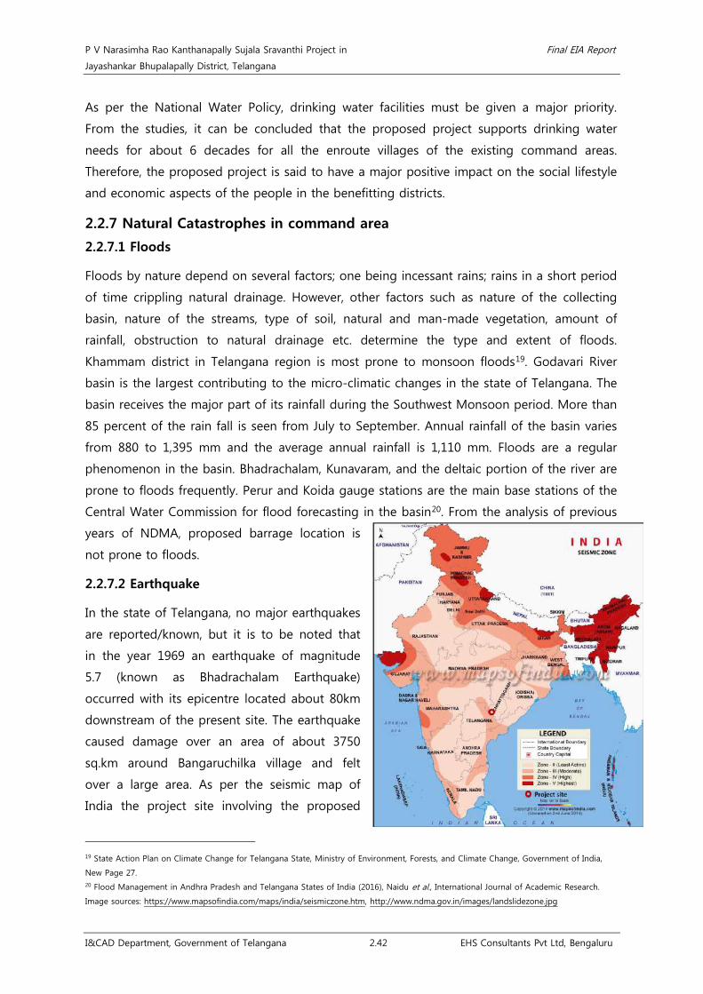
P V Narasimha Rao Kanthanapally Sujala Sravanthi Project in Final EIA Report
Jayashankar Bhupalapally District, Telangana
I&CAD Department, Government of Telangana 2.42 EHS Consultants Pvt Ltd, Bengaluru
As per the National Water Policy, drinking water facilities must be given a major priority.
From the studies, it can be concluded that the proposed project supports drinking water
needs for about 6 decades for all the enroute villages of the existing command areas.
Therefore, the proposed project is said to have a major positive impact on the social lifestyle
and economic aspects of the people in the benefitting districts.
2.2.7 Natural Catastrophes in command area
2.2.7.1 Floods
Floods by nature depend on several factors; one being incessant rains; rains in a short period
of time crippling natural drainage. However, other factors such as nature of the collecting
basin, nature of the streams, type of soil, natural and man-made vegetation, amount of
rainfall, obstruction to natural drainage etc. determine the type and extent of floods.
Khammam district in Telangana region is most prone to monsoon floods19. Godavari River
basin is the largest contributing to the micro-climatic changes in the state of Telangana. The
basin receives the major part of its rainfall during the Southwest Monsoon period. More than
85 percent of the rain fall is seen from July to September. Annual rainfall of the basin varies
from 880 to 1,395 mm and the average annual rainfall is 1,110 mm. Floods are a regular
phenomenon in the basin. Bhadrachalam, Kunavaram, and the deltaic portion of the river are
prone to floods frequently. Perur and Koida gauge stations are the main base stations of the
Central Water Commission for flood forecasting in the basin20
2.2.7.2 Earthquake
. From the analysis of previous
years of NDMA, proposed barrage location is
not prone to floods.
In the state of Telangana, no major earthquakes
are reported/known, but it is to be noted that
in the year 1969 an earthquake of magnitude
5.7 (known as Bhadrachalam Earthquake)
occurred with its epicentre located about 80km
downstream of the present site. The earthquake
caused damage over an area of about 3750
sq.km around Bangaruchilka village and felt
over a large area. As per the seismic map of
India the project site involving the proposed
19 State Action Plan on Climate Change for Telangana State, Ministry of Environment, Forests, and Climate Change, Government of India,
New Page 27. 20 Flood Management in Andhra Pradesh and Telangana States of India (2016), Naidu et al., International Journal of Academic Research.
Image sources: https://www.mapsofindia.com/maps/india/seismiczone.htm, http://www.ndma.gov.in/images/landslidezone.jpg
P V Narasimha Rao Kanthanapally Sujala Sravanthi Project in Final EIA Report
Jayashankar Bhupalapally District, Telangana
I&CAD Department, Government of Telangana 2.43 EHS Consultants Pvt Ltd, Bengaluru
barrage is in zone-III (Moderate Damage Risk Zone).
2.2.7.3 Landslides
From the landslide zone map given by NDMA, GoI, it is noted that Himalayas of Northwest
and Northeast India and the Western Ghats are two regions of high vulnerability and are
prone to landslides. The project site in Telangana state falls under “Very Low Hazard Zone”.
2.2.8 Land Requirement
The proposed project requires a total land of 674.18 ha including 94 ha of private (patta)
land for implementation of the project and 580.18 ha of river bed area (submergence area).
There is no submergence of private land and hence there is no R&R due to the project. The
required land will be acquired as per the Right to Fair Compensation and Transparency in
Land Acquisition Rehabilitation and Resettlement Act, 2015.
Table 2.25 Details of land requirement
Sl.No. Village Name District Taluk Private land
(ha)
1 Thupakulagudem
Jayashankar
Bhupalapally Warangal
65.87
2 Thimmaigudem 5.58
3 Venchepally -
4 Gangaram 12.96
5 Mukanuru 9.86
Total 94
2.2.9 Submergence of River bed area
The proposed project involves submergence of 580.18 ha of river bed area alongside River
Godavari near the proposed barrage at FRL of 77 m. The FRL map showing the submergence
area is enclosed as Annexure 13.
2.2.10 Benefit cost ratio
The benefit cost ratio has been worked out to be 1.53 which involves construction of barrage
and its components.
Table 2.26 Benefit-cost ratio
Description Rs. in lakh
A Construction of barrage across Godavari River
1 Barrage Spillway, Road bridge over Barrage 1284.68
2 Guide Bunds 25.62
3 Spillway Gates, Head regulator Gates 343.84

P V Narasimha Rao Kanthanapally Sujala Sravanthi Project in Final EIA Report
Jayashankar Bhupalapally District, Telangana
I&CAD Department, Government of Telangana 2.44 EHS Consultants Pvt Ltd, Bengaluru
Description Rs. in lakh
4 Coffer Dam 28.29
5 Head Regulator for power channel 66.19
6 Provision for Construction of Buildings for staff 10.03
7 Miscellaneous items 14.6
8 Provision for approach roads to barrage 1.20
Total 1774.45
B O&M works @ 0.1% per year for 3 years excluding coffer
dam 5.24
C
Provision for detailed investigation design, preparation of
drawings and estimates, LA proposals, sub-soil exploration
etc., for the scheme and fixing of boundary, chainage,
DCBM, HM, KM, stones, HP sign boards and gateway @
0.5%on Rs.1774.15 Crores
8.87
Total Contract value (A+B+C) 1788.56
D L.S. Provisions (Reimbursable)
1. Provision towards labour welfare cess @ 1.0% 17.88
2. Provision towards VAT @ 5% as per actual 89.41
3. Provision towards NAC @ 0.1% as per actual 1.79
4. Excise duty as per actual on 75% of machinery and labour @
13% on gates 33.52
5. towards Service tax as per actual on Engineering works @
4.12% on detailed investigation 0.37
6. Provision for instrumentation 14.01
E Other provisions
8. Photography, videography charges etc. 0.10
9. Stationery, Xerox, computer typing and preparation of tender
schedules 0.16
10. Provision for beautification and gardening with amenities 1.50
11. CC Operations @ 0.50% on ECV value 8.94
12. Consultancy charges for the services of GSI, for T.S. Genco for
vetting Electro Mechanical Components 8.20
13. Provision towards live model of projects 0.25
14. Provision towards model studies (to be included in
reimbursable items) 0.20
15. Provision towards amount payable to TSNPDCL for extension
of power supply 4.00

P V Narasimha Rao Kanthanapally Sujala Sravanthi Project in Final EIA Report
Jayashankar Bhupalapally District, Telangana
I&CAD Department, Government of Telangana 2.45 EHS Consultants Pvt Ltd, Bengaluru
Description Rs. in lakh
16. Provision towards power consumption charges during
maintenance period of 3 years (At 15000000/year) 4.50
17. Provision of wireless communication system and mobile /land
phone connections 0.06
18. Provision for Land Acquisition 45.00
19.
Provision towards net project value in respect of forest land
and for conducting DGPS survey, fixing of stones, vetting fee
to the forest department for forest land and other
miscellaneous unforeseen items
40.00
20. Provision for U/s over burden and D/s River training works 60.00
21. Miscellaneous items (Contingencies, Brochures, Inaugural
function etc.) 2.85
Sub-Total (D+E) 332.74
Total(A+B+C+D+E) 2121.3
1 Total Gross Receipts 137707
2 Total expenses 82923
3 Total Net Annual Benefits 241783
4 Annual cost 158512
Benefit Cost Ratio: Annual benefit/ Annual Cost 1.53

P V Narasimha Rao Kanthanapally Sujala Sravanthi Project in Final EIA Report
Jayashankar Bhupalapally District, Telangana
I&CAD Department, Government of Telangana 3.3 EHS Consultants Pvt Ltd, Bengaluru
Chapter 3. Baseline Environment Scenario 3.1 Environmental Settings
Environmental attributes describes the resources that can be found on the project site and
vicinity. It provides a framework for evaluating the project and will help in making the
decision as to whether the project is appropriate for the area in which it is proposed.
Collecting the baseline environmental status of the project area helps to predict the
magnitude of impacts that are likely to be caused due to the proposed project on different
environmental components. It also helps to identify critical environmental attributes required
to be monitored during and after the proposed project. The environmental settings w.r.t the
proposed PVNRKSSP is given below;
I. Near the proposed barrage
Location of the proposed barrage Thupakulagudem Village, Eturnagaram Mandal, Jayashankar
Bhupalapally District, Telangana
Distance of the village from the
proposed barrage 0.58 km
Rivers and streams River Godavari
Length of barrage 1132 m
Climate and meteorology
Maximum temperature : 43.7 oC
Minimum temperature : 12.8 oC
Average rainfall : 1015.8 mm
Agro-climatic zone Central and Southern Telangana zone
Type of land use and vegetation
pattern at the project site
Land: Forest lands on either sides of River Godavari.
Vegetation: Riparian vegetation
Nearest densly populated area Thupakulagudem village
Topography Deccan plateau – relatively mild to medium slopes
Soil type Alluvial soil, Red earths, Black soils, Forest soils
Biological resources at the project
site
Tectona grandis L.f., Terminalia alata Heyne ex Roth,
Barringtonia acutangula (L.) Gaertn., Pterocarpus indicus
Willd., Tamarindus indicus L., Ficus racemosa L., Ficus hispida
L. fil., etc.
Cultural resources at the project site Nil
Protected Area/Wildlife Sanctuaries/
Eco-sensitive areas/ Reserve Forest
The boundary of Eturnagaram WLS is adjacent to the project
location
Forest land required (ha) Nil
Upstream Project J Chokka Rao Devadula LIS at a distance of 6.2 Km (along

P V Narasimha Rao Kanthanapally Sujala Sravanthi Project in Final EIA Report
Jayashankar Bhupalapally District, Telangana
I&CAD Department, Government of Telangana 3.3 EHS Consultants Pvt Ltd, Bengaluru
the River)
Downstream project Dummagudem LIS at a distance of 105 Km (along the River)
Interstate Boundary Chattisgarh adjacent to the Project site
Nearest IMD Ramagundem, Peddapalli District, 93.5 Km
Nearest CWC station Perur, 6 Km (aerial distance)
Nearest Railway Station Warangal , 150 Km
Nearest Airport Hyderabad, 300 Km
Earthquake Zone Zone III
Toposheet Nos. E44I-6 (Old No. 65 B6)
Catchment area at barrage site 2,68,000 Sq.Km
75% annual net yield 407.4 TMC (11536 Mcm)
Nearest areas already subjected to
pollution Nil
II. Command area
Command Area 2,51,310 ha - Existing J. Chokka Rao Devadula LIS
3,04,000 ha - Existing Sriram Sagar Project (Stage I & II)
Districts benefitted Jayashankar Bhupalapally, Nalgonda, Khammam
Climate & Rainfall Hot and dry climate with an average annual rainfall ranges
from 751 mm to 1061 mm
Soil type Chalakas, Dubbas, Black soils, Red soils, Alkaline soils, alluvial
soils
Geology Sandstone, Breccia Conglomerate with few Clay Beds,
Siltstone, Carboniferous Clay, Limestone beds and Shale
Mineral resources Granite blocks
Biological resources in the command
area
Terminalia arjuna, Terminalia tomentosa, Tectona grandis,
Butea monospermia, Wrightia tinctoria, Cassia renigera,
Azadirachta indica, Choloroxylon swietenia, etc.
Reserve Forest within the study area Annaram RF, Nuguru RF, Perur RF, Nagaram RF,
Bangoranikonta RF, Marimalli PF

P V Narasimha Rao Kanthanapally Sujala Sravanthi Project in Final EIA Report
Jayashankar Bhupalapally District, Telangana
I&CAD Department, Government of Telangana 3.3 EHS Consultants Pvt Ltd, Bengaluru
In order to assess the baseline environmental status, 10 Km radius from the main project
components were considered. The construction activities will be restricted only to barrage
location and there is no new works envisaged in the command area. However, to understand
the baseline status, command area also considered for the study. The data was collected for
three seasons (July 2017 - March 2018). In addition to the baseline environmental
monitoring, field inspection in the study area, collection of primary and secondary
information for all the environmental components and discussions with the officials and local
public were conducted by the experts. The baseline environmental status presented below
comprises of;
• Physical Environment
• Land use assessment of study area
• Biological (Terrestrial) Environment
• Aquatic Environment
• Socio – economic Environment (Chapter 7)
3.2 Physical Environment
3.2.1 Topography
The proposed project is located in Deccan plateau of India. Topography is relatively mild to
medium slopes.
3.2.2 Climate & Meteorology
Air borne pollutants is dispersed by atmospheric motion. Knowledge of these motions, which
range in scale from turbulent diffusion to long-range transport by weather systems, is
essential to simulate such dispersion and quality of impacts of air pollution on the
environment. The purpose of EIA is to determine whether average concentrations are likely
to encounter at fixed locations (Known as the receptor), due to the given sources (locations
and rates of emission known) under idealized atmospheric conditions. The meteorological
data (monthly) obtained from the meteorological station Ramagundem, Telangana located at
a distance of 93.54 Km from the proposed barrage is as given below;

P V Narasimha Rao Kanthanapally Sujala Sravanthi Project in Final EIA Report
Jayashankar Bhupalapally District, Telangana
I&CAD Department, Government of Telangana 3.3 EHS Consultants Pvt Ltd, Bengaluru
Table 3.1 Monthly meteorological data from the year 2006-2016
Year Month
Temperature (0C)
Rainfall
(mm)
Mean Relative Humidity (%) Average
Wind
Speed
(Kmph)
Max Min 0830 Hrs IST 1730 Hrs IST
2006 1 30.9 13.9 0 77 41 1
2006 2 34.9 16.4 0 67 36 2
2006 3 34.9 22.1 43.5 70 47 4
2006 4 39 25.3 30.2 65 41 5
2006 5 39.5 27.3 55.4 64 45 5
2006 6 37.9 27.9 66.3 58 53 5
2006 7 32.4 25.6 178.8 75 68 4
2006 8 31.5 25.3 373.2 78 70 5
2006 9 32.7 24.5 381 84 75 3
2006 10 33 22.6 16.9 80 70 2
2006 11 30.4 19.2 52.7 88 73 2
2006 12 30.9 15.7 0 88 61 2
2007 1 31.3 14.9 0 83 52 2
2007 2 33.6 17.5 0 74 38 5
2007 3 36.9 21.5 0 65 39 6
2007 4 38.8 24.9 13.7 66 32 7
2007 5 42.2 28.4 31.3 48 59 5
2007 6 36.1 27.1 153.9 73 65 5
2007 7 33.6 25.8 67.8 78 70 4
2007 8 32.5 24.8 178.3 81 76 3
2007 9 32.3 24.3 274.1 84 61 3
2007 10 32.3 20.7 14.9 76 48 2
2007 11 31.6 16.2 0 73 47 1
2007 12 31.1 15.8 0 79 43 1
2008 1 31.2 15.1 2.3 78 46 3
2008 2 32.5 18.3 0.2 82 42 5
2008 3 35 21.1 123.3 70 40 4
2008 4 38.3 24.6 0.4 83 30 4
2008 5 42.2 27.7 6.4 41 51 3
2008 6 35.5 27 154.6 68 68 3
2008 7 32.8/ 25 160.3 81 77 2

P V Narasimha Rao Kanthanapally Sujala Sravanthi Project in Final EIA Report
Jayashankar Bhupalapally District, Telangana
I&CAD Department, Government of Telangana 3.3 EHS Consultants Pvt Ltd, Bengaluru
Year Month
Temperature (0C)
Rainfall
(mm)
Mean Relative Humidity (%) Average
Wind
Speed
(Kmph)
Max Min 0830 Hrs IST 1730 Hrs IST
2008 8 31.6 24.7 269.1 85 73 3
2008 9 32.8 24.3 226.2 82 58 2
2008 10 33.8 21.6 32.8 74 54 2
2008 11 32.1 18.3 2.8 69 44 3
2008 12 31.7 14.9 0 83 35 2
2009 1 32 16 0 85 33 3
2009 2 35.3 19.2 0 74 30 3
2009 3 37.1 20.9 6.5 65 29 4
2009 4 40.6 25.3 4.2 62 34 5
2009 5 42.2 28.1 80.1 56 46 5
2009 6 39.6 29.1 133.4 58 66 6
2009 7 32.8 25.5 199.8 79 64 4
2009 8 34.3 25.2 179 78 61 3
2009 9 34.7 25 75.4 78 51 2
2009 10 33.8 21 69.6 76 53 2
2009 11 32 19.4 124.8 76 48 3
2009 12 30.4 15.7 1.2 82 36 2
2010 1 30 14.1 4.5 76 34 2
2010 2 33.9 19.4 3.6 75 32 4
2010 3 38.7 29.6 0 65 26 5
2010 4 42.9 26.5 1 61 28 5
2010 5 42.8 28.8 12.9 56 45 6
2010 6 39.2 27.4 227.6 69 69 5
2010 7 32 25.4 459.9 84 70 3
2010 8 32.4 25.5 113.9 84 17 3
2010 9 32.2 24.7 339.9 84 74 3
2010 10 32.8 22.9 117.5 83 66 2
2010 11 32.1 21.9 29 84 64 2
2010 12 29.32 15.6 16.3 81 48 2
2011 1 30.4 13 0 78 28 2
2011 2 33.1 17.7 22 80 31 3
2011 3 36.6 20.8 1.4 74 33 3

P V Narasimha Rao Kanthanapally Sujala Sravanthi Project in Final EIA Report
Jayashankar Bhupalapally District, Telangana
I&CAD Department, Government of Telangana 3.3 EHS Consultants Pvt Ltd, Bengaluru
Year Month
Temperature (0C)
Rainfall
(mm)
Mean Relative Humidity (%) Average
Wind
Speed
(Kmph)
Max Min 0830 Hrs IST 1730 Hrs IST
2011 4 36.3 24.9 6 77 44 3
2011 5 41.5 28 16.5 60 40 4
2011 6 37.4 27.3 103.7 73 54 5
2011 7 33.1 25.2 217.3 81 73 3
2011 8 31.5 24.9 193.5 87 79 3
2011 9 32.3 24.5 124.9 85 75 2
2011 10 33.7 21.8 6.5 82 56 2
2011 11 32.9 17.5 0 76 42 1
2011 12 31.2 13.5 0 83 39 2
2012 1 30.3 16.4 2.8 82 39 2
2012 2 33.9 17.2 0 77 28 4
2012 3 38.7 19 0.6 68 20 4
2012 4 39.8 26.5 10.7 69 32 3
2012 5 43.7 28.5 1.2 48 21 6
2012 6 38.3 27.9 90.8 61 44 3
2012 7 31.9 24.7 403.9 82 69 5
2012 8 31.2 24.3 367.9 80 67 3
2012 9 32.4 24.6 164.6 80 70 3
2012 10 32.8 21.3 83.8 79 59 2
2012 11 30.8 18.4 22.4 82 57 2
2012 12 31.1 15.6 0 86 40 2
2013 1 31 16.7 0 82 44 2
2013 2 32.5 18.6 38.2 83 36 3
2013 3 36.4 21.4 0 72 30 4
2013 4 39.6 24.9 50 68 33 5
2013 5 43.4 29.2 16.2 55 26 6
2013 6 33.9 25.6 258.1 70 57 6
2013 7 30.7 24.3 491.9 78 69 5
2013 8 30.3 23.6 219 79 70 5
2013 9 32.8 23.8 140.1 78 65 4
2013 10 31.6 22.2 201.3 82 70 3
2013 11 30.1 17.3 0.2 78 52 3

P V Narasimha Rao Kanthanapally Sujala Sravanthi Project in Final EIA Report
Jayashankar Bhupalapally District, Telangana
I&CAD Department, Government of Telangana 3.3 EHS Consultants Pvt Ltd, Bengaluru
Year Month
Temperature (0C)
Rainfall
(mm)
Mean Relative Humidity (%) Average
Wind
Speed
(Kmph)
Max Min 0830 Hrs IST 1730 Hrs IST
2013 12 29.5 12.8 0 81 40 2
2014 1 30.2 15.3 0 82 39 2
2014 2 31.8 16.6 0.9 77 33 3
2014 3 33.8 21.4 76.1 75 37 5
2014 4 39.4 34.8 21 69 32 4
2014 5 40.3 26.7 58.5 63 30 4
2014 6 38.9 28.3 81 61 36 5
2014 7 32.8 25.3 196.2 74 62 5
2014 8 33.4 25.2 153.5 76 61 5
2014 9 32.5 24.3 231.3 78 62 3
2014 10 33.4 22.5 11.3 78 49 3
2014 11 31.8 17.7 2.5 83 49 1
2014 12 29.2 14 1.3 85 48 2
2015 1 29.2 14.6 63.8 87 45 2
2015 2 33.4 17 0 87 39 3
2015 3 35 21.9 41.2 81 47 4
2015 4 37.5 43.3 43.5 79 44 5
2015 5 42.6 28.2 5.2 63 37 5
2015 6 35.8 26.5 176.8 79 61 5
2015 7 35.1 26 182.2 73 60 4
2015 8 32.8 34.9 101.9 85 73 3
2015 9 33.6 24.3 167.3 86 69 3
2015 10 35.3 22.6 13 84 55 2
2015 11 33.1 19.6 0 82 46 2
2015 12 32.1 18.2 0 84 44 4
2016 1 31.1 15.3 5 86 38 3
2016 2 35.6 20.8 0 84 38 5
2016 3 38 23.5 22.6 78 37 5
2016 4 42.8 27.2 10 68 33 5
2016 5 43.4 27.8 33.5 57 36 6
2016 6 38.69 26.8 206.5 72 53 5
2016 7 32.6 25 372.6 83 73 4

P V Narasimha Rao Kanthanapally Sujala Sravanthi Project in Final EIA Report
Jayashankar Bhupalapally District, Telangana
I&CAD Department, Government of Telangana 3.3 EHS Consultants Pvt Ltd, Bengaluru
Year Month
Temperature (0C)
Rainfall
(mm)
Mean Relative Humidity (%) Average
Wind
Speed
(Kmph)
Max Min 0830 Hrs IST 1730 Hrs IST
2016 8 33.4 24.5 142.3 82 66 3
2016 9 31.2 23.9 219.8 42 25 2
2016 10 32 21 140 82 64 2
2016 11 31 16 0 81 49 2
2016 12 30 14.3 0 85 42 2
From the meteorological data collected for a decade (2006-16) from Ramagundem
meteorological station, the maximum temperature was recorded to be 43.70C in the month
of May 2012 and the minimum temperature was recorded to be 12.80C in the month of
December 2013. The average annual rainfall was recorded to be 1015.8 mm with the highest
rainfall of 491.9 mm recorded in the month of July 2013. Highest average annual wind speed
was recorded to be 7 kmph in the month of April 2007.
Similarly, meteorological data recorded from the meteorological station installed at the
project site shows a maximum temperature of 41 oC recorded during pre-monsoon season
and a minimum temperature of 12.4 oC recorded during post-monsoon season. From the
wind rose diagram Fig 3.4, it can be indicated that the prevailing wind direction during the
study period is from SE Direction. Wind rose diagram showing the wind speed during
different seasons are as given below;
Table 3.2 Meteorological data collected at the project site for the study period
Parameters
& range
Year Season Cloud
Clover Temp Rel.Humidity Pressure Speed Rainfall Radiation
YYYY - Oct oC % hPa km/h mm Wh/m2
Max
2017 Monsoon
8.0 37.7 98.2 996.8 10.8 40.7 1013.1
Min 1.8 23.6 35.3 983.7 0.1 0.0 0.0
Avg 7.5 29.8 67.4 991.0 3.0 0.2 208.8
Max
2017 Post
Monsoon
8.0 35.7 99.8 1006.2 9.0 25.8 938.6
Min 0.0 12.4 15.4 989.8 0.0 0.0 0.0
Avg 5.5 25.8 54.2 998.0 2.2 0.0 226.3
Max
2018 Pre
monsoon
8.0 41.0 96.4 1007.1 12.1 4.1 1050.1
Min 0.0 13.2 8.1 990.9 0.1 0.0 0.0
Avg 4.1 26.1 36.2 998.7 2.5 0.0 257.8

P V Narasimha Rao Kanthanapally Sujala Sravanthi Project in Final EIA Report
Jayashankar Bhupalapally District, Telangana
I&CAD Department, Government of Telangana 3.3 EHS Consultants Pvt Ltd, Bengaluru
Fig 3.1 Wind rose diagram for the months July 2017 - September 2017 (Monsoon season)

P V Narasimha Rao Kanthanapally Sujala Sravanthi Project in Final EIA Report
Jayashankar Bhupalapally District, Telangana
I&CAD Department, Government of Telangana 3.3 EHS Consultants Pvt Ltd, Bengaluru
Fig 3.2 Wind rose diagram for the months October 2017 - December 2017 (Post-monsoon
season)
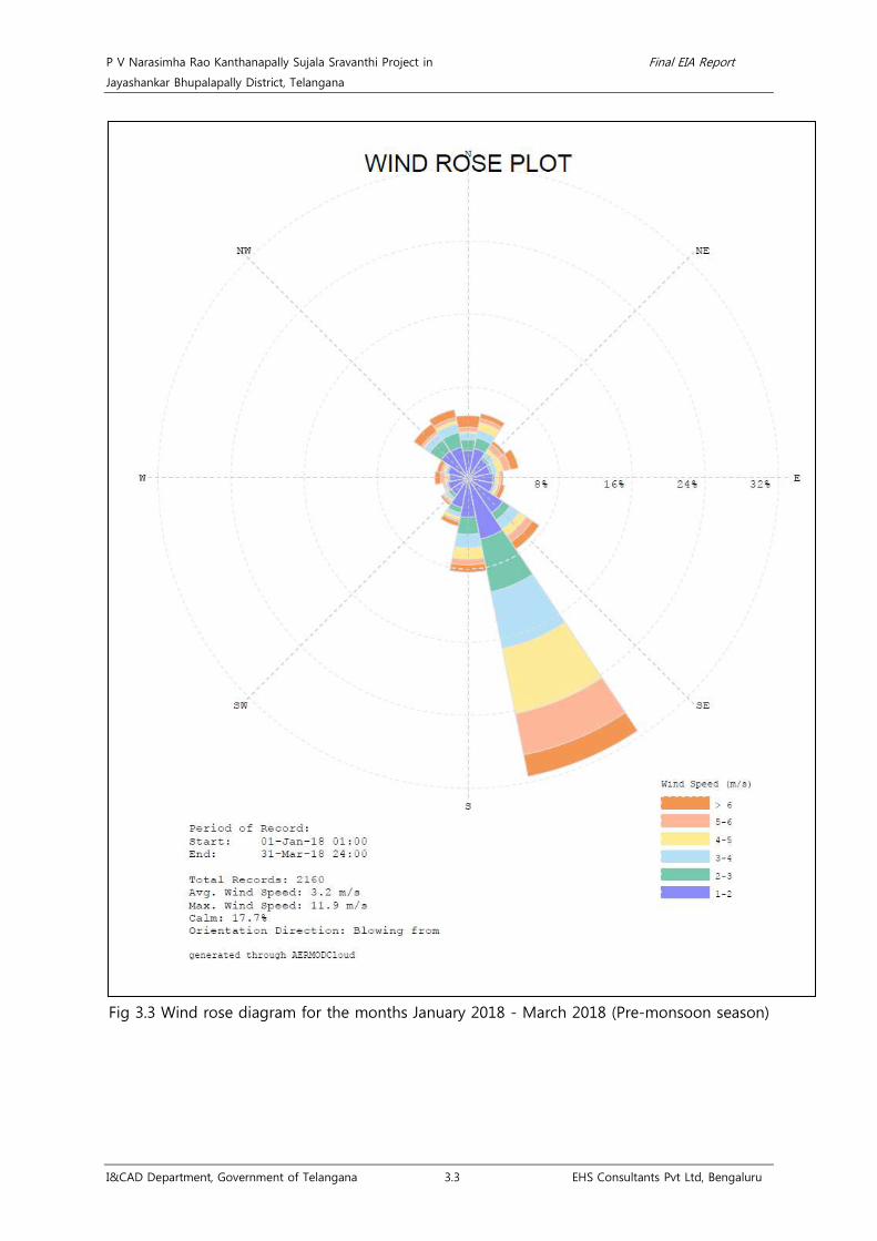
P V Narasimha Rao Kanthanapally Sujala Sravanthi Project in Final EIA Report
Jayashankar Bhupalapally District, Telangana
I&CAD Department, Government of Telangana 3.3 EHS Consultants Pvt Ltd, Bengaluru
Fig 3.3 Wind rose diagram for the months January 2018 - March 2018 (Pre-monsoon season)

P V Narasimha Rao Kanthanapally Sujala Sravanthi Project in Final EIA Report
Jayashankar Bhupalapally District, Telangana
I&CAD Department, Government of Telangana 3.3 EHS Consultants Pvt Ltd, Bengaluru
Fig 3.4 Wind rose diagram for the study period July 2017 – March 2018 (Study period)

P V Narasimha Rao Kanthanapally Sujala Sravanthi Project in Final EIA Report
Jayashankar Bhupalapally District, Telangana
I&CAD Department, Government of Telangana 3.3 EHS Consultants Pvt Ltd, Bengaluru
3.2.3 Ambient Air Quality
As per preliminary investigations, the ambient air quality in the study area is found to be
good, in the absence of industrial growth in the command area. MoEF guidelines21
• The stations were selected at a place where interferences are not present.
for
preparation of EIA studies for Irrigations projects do not mandate AAQM studies in the
absence of pollution sources. However, as part of the baseline data collection and in order to
understand the status of ambient air quality in the study area, six ambient air quality
monitoring stations were established and continuously monitored during the study period.
The criteria followed for selection of Ambient Air Quality Monitoring (AAQM) locations and
parameters monitored are given below;
• Height of the inlet was maintained at 3 ± 0.5 m above the ground.
• The sampler was kept more than 20 m away from trees.
• There was unrestricted airflow in three of four quadrants.
• The sampling stations selected were away from major pollution sources22
Air Quality Index for dust and gases were estimated using the formula;
.
• Ip = [{(IHI - ILO)/ (BHI -BLO)} * (Cp-BLO)] + ILO
• BHI = Breakpoint concentration greater or equal to given conc.
• BLO = Breakpoint concentration smaller or equal to given conc.
• IHI = AQI value corresponding to BHI
• ILO = AQI value corresponding to BLO
Table 3.3 Details of AAQM parameters with analysis methodology23
Pollutants
Frequency of
Monitoring
NAAQM
Standards, 2009 Unit Method of analysis
Dus
t PM10 Particulate matter Three month
during the
study period
for 24 Hrs at
all stations
100 µg/m3 Gravimetric
PM2.5 Particulate matter 60 µg/m3 Gravimetric
Gas
es SO2 Sulphur dioxide 80 µg/m3 Improved West and Geake
NO2 Nitrogen dioxide 80 µg/m3 Jacob & Hochheisser
modified method
21Draft Guidance Manual for Environment Impact Assessment & Clearance of River Valley projects, MoEF, GoI, 2011 22Methods for Measurement of Air Pollution (2005), Part 14 Guidelines for Planning the Sampling of Atmosphere, IS 5182 (Part 14): 2000. 23National Ambient Air Quality Standards - 2009, CPCB, New Delhi.
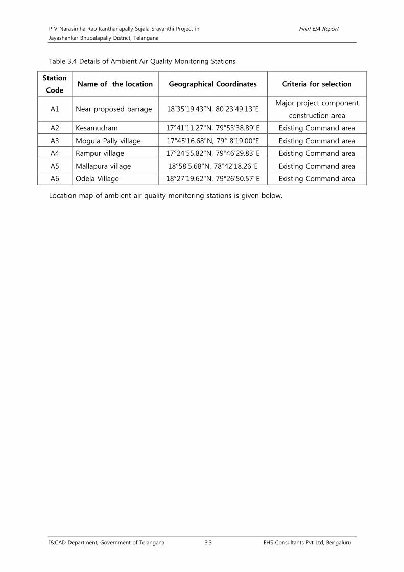
P V Narasimha Rao Kanthanapally Sujala Sravanthi Project in Final EIA Report
Jayashankar Bhupalapally District, Telangana
I&CAD Department, Government of Telangana 3.3 EHS Consultants Pvt Ltd, Bengaluru
Table 3.4 Details of Ambient Air Quality Monitoring Stations
Station
Code Name of the location Geographical Coordinates Criteria for selection
A1 Near proposed barrage 18˚35’19.43”N, 80˚23’49.13”E Major project component
construction area
A2 Kesamudram 17°41'11.27"N, 79°53'38.89"E Existing Command area
A3 Mogula Pally village 17°45'16.68"N, 79° 8'19.00"E Existing Command area
A4 Rampur village 17°24'55.82"N, 79°46'29.83"E Existing Command area
A5 Mallapura village 18°58'5.68"N, 78°42'18.26"E Existing Command area
A6 Odela Village 18°27'19.62"N, 79°26'50.57"E Existing Command area
Location map of ambient air quality monitoring stations is given below.

P V Narasimha Rao Kanthanapally Sujala Sravanthi Project in Final EIA Report
Jayashankar Bhupalapally District, Telangana
I&CAD Department, Government of Telangana 3.4 EHS Consultants Pvt Ltd, Bengaluru
Fig 3.5 Location of AAQM stations on study area map

P V Narasimha Rao Kanthanapally Sujala Sravanthi Project in Final EIA Report
Jayashankar Bhupalapally District, Telangana
I&CAD Department, Government of Telangana 3.14 EHS Consultants Pvt Ltd, Bengaluru
3.2.3.1 Results of Ambient Air Quality
Overall, Air quality index of the study area for gases and dust are found to be good and
satisfactory respectively. The results of individual parameters are discussed below and
enclosed as Annexure 14;
Particulate Matter <2.5µ &<10µ: The NAAQ standards fixed for PM10 is 100 µg/m3 and
PM2.5 is 60 µg/m3. PM is categorized by size and continues to be the fraction of air pollution
that is most reliably associated with human disease and excessive exposure to PM can cause
lung problems, breathing difficulties.24 The minimum and maximum level of Particulate
Matter <2.5µ recorded within the study area were in the range of 11 to 25 µg/m3. The
minimum and maximum level of Particulate Matter <10µ recorded within the study area
were in the range of 40 to 70 µg/m3. The 24 hourly average values of Particulate Matter
<2.5µ & Particulate Matter <10µ were compared with the national ambient air quality
standards and found that all sampling stations recorded values within the applicable limits
for all locations in study area. The use of generator sets is in the rural areas, where they are
utilized for the pumping water in the agricultural lands will be the major source of PM. The
other sources of particulate matter includes agricultural operations, industrial processes,
combustion of wood and fossil fuels, construction and demolition activities, and entrainment
of road dust into the air25
Sulfur Dioxide: Sulfur dioxide in atmosphere is significant because of its toxicity. Sulfur
dioxide is capable of producing illness and lung injury. Further it can combine with water in
the air to form toxic acid aerosols that can corrode metal surfaces, fabrics and the leaves of
plants. Sulfur dioxide is irritating to the eyes and respiratory system. The major health
concerns associated with exposure to high concentrations of SO2 include respiratory irritation and
dysfunction, and also aggravation of existing cardiovascular disease
.
26. The minimum and
maximum level of SO2 recorded within the study area was in the range of 3.89 µg/m3 to 5.64
µg/m3. The 24 hourly average values of SO2 were compared with the national ambient air
quality standards and it was found that all sampling stations recorded values much lower
than the applicable limit of 80 µg/m3. Motor vehicle emissions are the major source of SO227
Oxides of Nitrogen: Oxides of Nitrogen are also an inorganic gaseous pollutant like Sulfur
dioxide. Oxides of Nitrogen emissions are expected to be emitted wherever combustion at
high temperatures takes place. Nitrogen oxides are produced naturally by lightning, and also,
.
24https://link.springer.com/article/10.1007/s13181-011-0203-1 25 http://www.valleyair.org/air_quality_plans/AQ_plans_PM_sources.htm 26https://www.ncbi.nlm.nih.gov/pmc/articles/PMC5122104/ 27http://www.environment.gov.au/protection/publications/factsheet-sulfur-dioxide-so2

P V Narasimha Rao Kanthanapally Sujala Sravanthi Project in Final EIA Report
Jayashankar Bhupalapally District, Telangana
I&CAD Department, Government of Telangana 3.15 EHS Consultants Pvt Ltd, Bengaluru
to a small extent, by microbial processes in soils28
NO2 has inherent ability to produce deleterious effects by themselves like toxicity. It acts as
an asphyxiate when in concentrations great enough to reduce the normal oxygen supply
from the air. The minimum and maximum level of NOx recorded within the study area was in
the range of 9.52 µg/m3 to 34.82 µg/m3. The 24 hourly average values of NOx were
0compared with the national ambient air quality standards and it was found that all the
sampling stations recorded values much lower than the applicable limit of 80 µg/m3. The
major source of NOx includes high motor vehicle traffic
. Nitrous oxide and nitric acid mist are the
other important pollutants in the inorganic nitrogen group.
29
Table 3.5 Results of Particulate Matter (PM10)
.
LOCATION MAX MIN AVG SD GM PERCENTILE
98 85 50 35
A1 68 48 60.4 5.25 60.21 67.52 65.8 61 58.4
A2 69 40 57.3 9.26 56.59 70 67 60.5 51.05
A3 70 51 61.8 5.53 61.51 70 67.55 62.5 60
A4 65 47 56.9 5.14 56.69 65 62 56.5 55
A5 67 45 56.0 4.93 55.75 64.7 60.55 56.5 53.05
A6 66 44 58.0 5.76 57.71 65.08 63 60 57
Table 3.6 Results of Particulate Matter (PM2.5)
LOCATION MAX MIN AVG SD GM PERCENTILE
98 85 50 35
A1 23 13 18.2 2.39 18.09 22.52 20.40 18.00 17.40
A2 23 11 11.0 3.54 16.38 22.54 20.55 18.00 15.05
A3 25 14 18.8 3.00 18.60 24.08 22.00 19.00 18.00
A4 22 14 17.0 2.65 16.77 21.54 20.55 16.00 15.05
A5 23 13 16.3 2.35 16.14 22.54 17.55 16.00 15.00
A6 23 12 17.8 3.58 17.39 23.00 21.55 19.00 15.05
Table 3.7 Results of Sulphur di-oxide (SO2)
LOCATION MAX MIN AVG SD GM PERCENTILE
98 85 50 35
A1 5.43 4.16 4.73 0.37 4.72 5.43 5.14 4.76 4.60
28http://www.apis.ac.uk/overview/pollutants/overview_NOx.htm 29 http://www.icopal-noxite.co.uk/nox-problem/nox-pollution.aspx

P V Narasimha Rao Kanthanapally Sujala Sravanthi Project in Final EIA Report
Jayashankar Bhupalapally District, Telangana
I&CAD Department, Government of Telangana 3.16 EHS Consultants Pvt Ltd, Bengaluru
A2 5.32 3.96 4.78 0.40 4.76 5.39 5.16 4.71 4.51
A3 5.64 3.96 4.69 0.41 4.67 5.52 5.18 4.63 4.46
A4 5.06 3.96 4.69 0.41 5.05 6.10 5.28 5.02 4.98
A5 5.44 3.89 4.59 0.42 4.58 5.35 5.11 4.58 4.37
A6 5.44 4.28 4.86 0.33 4.85 5.41 5.24 4.87 4.71
Table 3.8 Results of Nitrogen di-oxide (NO2)
LOCATION MAX MIN AVG SD GM PERCENTILE
98 85 50 35
A1 33.14 20.68 29.49 3.47 29.28 33.05 32.40 31.16 28.50
A2 32.08 21.96 28.80 2.96 29.05 31.97 31.58 29.70 28.91
A3 34.82 22.86 29.73 3.89 29.47 34.56 33.30 30.20 28.78
A4 32.64 9.52 27.73 5.73 26.87 32.47 31.61 30.08 27.18
A5 32.14 21.98 28.43 3.38 28.22 32.00 30.94 30.08 29.57
A6 32.64 21.16 28.63 3.84 28.36 32.56 31.86 30.44 28.80
Table 3.9 Ambient Air Quality Index for dust
Location PM10,
µg/m3 AQI Remarks
PM2.5,
µg/m3 AQI Remarks
A1 67.52 67.52 Satisfactory 22.52 37.60 Good
A2 70 70 Satisfactory 22.54 37.64 Good
A3 70 70 Satisfactory 24.08 40.21 Good
A4 65 65 Satisfactory 21.54 35.97 Good
A5 64.7 64.7 Satisfactory 22.54 37.64 Good
A6 65.08 65.08 Satisfactory 23.00 38.41 Good
Table 3.10 Ambient Air Quality Index for gases30
Location
SO2,
µg/m3 AQI Remarks
NO2,
µg/m3 AQI Remarks
A1 5.43 6.78 Good 33.05 41.31 Good
A2 5.39 6.73 Good 31.97 39.96 Good
A3 5.52 6.9 Good 34.56 43.2 Good
A4 6.10 7.62 Good 32.47 40.58 Good
A5 5.35 6.68 Good 32.00 40.00 Good
A6 5.41 6.76 Good 32.56 40.7 Good
30National Air Quality Index, Control of Urban Pollution Sources Series, (2015), CUPC/82/2014-15, CPCB, New Delhi.
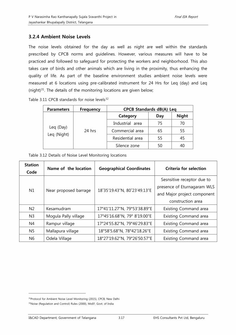
P V Narasimha Rao Kanthanapally Sujala Sravanthi Project in Final EIA Report
Jayashankar Bhupalapally District, Telangana
I&CAD Department, Government of Telangana 3.17 EHS Consultants Pvt Ltd, Bengaluru
3.2.4 Ambient Noise Levels
The noise levels obtained for the day as well as night are well within the standards
prescribed by CPCB norms and guidelines. However, various measures will have to be
practiced and followed to safeguard for protecting the workers and neighborhood. This also
takes care of birds and other animals which are living in the proximity, thus enhancing the
quality of life. As part of the baseline environment studies ambient noise levels were
measured at 6 locations using pre-calibrated instrument for 24 Hrs for Leq (day) and Leq
(night)31
Table 3.11 CPCB standards for noise levels
. The details of the monitoring locations are given below;
32
Parameters
Frequency CPCB Standards dB(A) Leq
Leq (Day)
Leq (Night) 24 hrs
Category Day Night
Industrial area 75 70
Commercial area 65 55
Residential area 55 45
Silence zone 50 40
Table 3.12 Details of Noise Level Monitoring locations
Station
Code Name of the location Geographical Coordinates Criteria for selection
N1 Near proposed barrage 18˚35’19.43”N, 80˚23’49.13”E
Sesnsitive receptor due to
presence of Eturnagaram WLS
and Major project component
construction area
N2 Kesamudram 17°41'11.27"N, 79°53'38.89"E Existing Command area
N3 Mogula Pally village 17°45'16.68"N, 79° 8'19.00"E Existing Command area
N4 Rampur village 17°24'55.82"N, 79°46'29.83"E Existing Command area
N5 Mallapura village 18°58'5.68"N, 78°42'18.26"E Existing Command area
N6 Odela Village 18°27'19.62"N, 79°26'50.57"E Existing Command area
31Protocol for Ambient Noise Level Monitoring (2015), CPCB, New Delhi 32Noise (Regulation and Control) Rules (2000), MoEF, Govt. of India

P V Narasimha Rao Kanthanapally Sujala Sravanthi Project in Final EIA Report
Jayashankar Bhupalapally District, Telangana
I&CAD Department, Government of Telangana 3.18 EHS Consultants Pvt Ltd, Bengaluru
Fig 3.6 Location map of noise monitoring locations on study area map

P V Narasimha Rao Kanthanapally Sujala Sravanthi Project in Final EIA Report
Jayashankar Bhupalapally District, Telangana
I&CAD Department, Government of Telangana 3.19 EHS Consultants Pvt Ltd, Bengaluru
3.2.4.1 Results of Ambient Noise Levels
The results of ambient noise levels were compared with Residential standards and results
reveal that, the noise levels in the study area ranging from 42.16 to 51.66 dB(A) for day time
and 34.48 to 37.4 dB(A) for night time. Overall, the noise levels in all the seasons were
observed to be well within the CPCB standards. Results of Ambient Noise Levels are given
below.
Monsoon season (July 2017- September 2017): During the monsoon season, the maximum
noise was measured at Rampura Village with a value of 53.58 dB(A) during day time, which is
reasonably close to the standards and of course well within the limits of 55 dB(A) as per
CPCB norms and the maximum noise was measured at Rampura Village with a value of 42.72
dB(A) during night time which is well within the limits of 45 dB(A).
Post-monsoon season (October 2017- December 2017): During the post-monsoon season,
the maximum noise was measured near the proposed barrage with a value of 47.8 dB(A)
during day time, which is reasonably close to the standards and of course well within the
limits of 55 dB(A) as per CPCB norms and the maximum noise was measured near the
proposed barrage with a value of 36.44 dB(A) during night time which is well within the
limits of 45 dB(A).
Pre-monsoon season (January 2018- March 2018): During the pre-monsoon season, the
maximum noise was measured at Mogula Pally Village with a value of 48.24 dB(A) during day
time, which is reasonably close to the standards and of course well within the limits of 55
dB(A) as per CPCB norms and the maximum noise was measured near the proposed barrage
with a value of 37.4 dB(A) during night time which is well within the limits of 45 dB(A).

P V Narasimha Rao Kanthanapally Sujala Sravanthi Project in Final EIA Report
Jayashankar Bhupalapally District, Telangana
I&CAD Department, Government of Telangana 3.20 EHS Consultants Pvt Ltd, Bengaluru
Table 3.13 Results of Ambient Noise levels
Seasons Monsoon season
(July 2017 - September 2017)
Post-monsoon season
(October 2017 - December 2017)
Pre-monsoon season
(January 2018 - March 2018) CPCB Standards
Locations Leq day dB(A) Leq night dB(A) Leq day dB(A) Leq night dB(A) Leq day dB(A) Leq night dB(A) Day
dB(A)
Night
dB(A)
Mogula Pally Village 50.38 39.34 46.22 35.68 48.24 37.2 55 45
Kesamudram 52.26 41.56 43.24 35.16 45.8 36.34 55 45
Rampura Village 53.58 42.72 42.82 36.26 43.72 34.48 55 45
Near Proposed Barrage 51.66 41.24 47.8 36.44 46.92 37.4 55 45
Mallapura Village 48.98 39.38 43.84 35.62 45.06 36.28 55 45
Odela Village 52.42 40.3 42.16 34.84 44.76 34.98 55 45

P V Narasimha Rao Kanthanapally Sujala Sravanthi Project in Final EIA Report
Jayashankar Bhupalapally District, Telangana
I&CAD Department, Government of Telangana 3.21 EHS Consultants Pvt Ltd, Bengaluru
3.2.5 Hydrology Geology and Minerals
In any given environment the occurrence and movement of ground water and its quality &
quantity is chiefly controlled and governed by many factors such as geographical set-up,
climate and rainfall conditions, hydrological features, topography, soil characteristics, the
nature and thickness of underlying rock formations and other related aspects that prevail in
an area. Therefore the study envisages indentifying the existing both surface & ground water
conditions comprising both quality and potential within the project site and its
neighborhood, relating the projected lift irrigation scheme activity, identifying the likely
impacts on surface and ground water resources and indicating mitigation measures.
Subsequently field investigation was carried out during the second week of January, 2018.
During the survey surface rock outcrops, geological cross sections in the Road, Nala Cuttings
and Dug wells were observed. Data available from the Irrigation Department and also from
IMD authorities has been collected. Inventory of wells representing the entire Command
area, Barrage site & Ten kilometer buffer zone was carried out. The chemical quality of
ground water was assessed by measuring the Specific Electrical Conductance (EC) using a
sensitive pocket type Electrical Conductivity meter. Hydrogeological data of about 30
Borewells was collected. Water levels were measured using an embossed steel measuring
tape from Dug wells and Electrical conductivity was recorded using EC meter.
Information already available and the data collected during the survey is collated and
analyzed to comprehend the overall groundwater situation in the area. An attempt is made
to predict the likely changes that could occur on account of the proposed PVNRKSSP and
certain mitigation measures have been indicated to avoid adverse effect on the Surface &
Groundwater environment.
3.2.5.1 Location and accessibility
The Project area is accessible by Road from Hyderabad at a distance of 319 Kms. After
travelling 165 Kms on NH-163 Warangal is reached where a diversion to north is to be taken
and travel further 112 Kms on N.H-202 to reach Eturnagaram. From Eturnagaram turn north
and take the road leading to Devadula and travel 40 Kms to reach Thupakulagudem. The
Barrage site is 2.2 Kms north east of Thupakulagudem village. The project site can also be
accessed from Jayashankar Bhupalapally. From Bhupalapally travel 92 Kms south east on NH
163 to reach Eturnagaram where a detour to north is to be taken and travel 4.0 Kms on
Devadula road to reach Thupakulagudem to reach the barrage site. The nearest Airport is
Rajiv Gandhi International Airport, Shamshabad at 350 Kms while Warangal Railway Station is
at a distance of 150 Kms.

P V Narasimha Rao Kanthanapally Sujala Sravanthi Project in Final EIA Report
Jayashankar Bhupalapally District, Telangana
I&CAD Department, Government of Telangana 3.22 EHS Consultants Pvt Ltd, Bengaluru
3.2.5.2 Command area of the project
The command area covering the parts of Karimnagar, Nizamabad, Medak, Nalgonda, Ranga
Reddy, Peddapalli, Khammam and Warangal Districts receives scanty rainfall and not evenly
distributed as the area falls over rain shadow zone. Warangal district experiences severe
drought and famine affecting the livelihood conditions of the people who depend chiefly on
agriculture. The soil is fertile and crops can be raised if irrigation facilities are provided as
such the present project proposals.
3.2.5.3 Drainage
The Project site and the command area form part of the Godavari River Basin. The proposed
project site is near Thupakulagudem Village. Nalla Vagu, Pattanilakanta Vagu, Modikunta
Vagu, Untimamidi Vagu, Shriramalu Vagu, Gorkalkanta Vagu, Dubba Vagu are draining in to
Kistapuram Vagu and Regma Vagu, Ippakanta Vagu, Lotipitagandla Vagu are draining to
Pairla Vagu. Both Kistapuram Vagu and Pairla Vagu are flowing southwest joining into
Godavari River in the study area along with the Mulkampally Vagu, Parikala Vagu is
culminating into Chitiyala Vagu which is flowing west to east and Pedda Vagu are the
streams joining to Godavari River. Laknavaram River is flowing east-west over southern part
of the proposed project area. All these are ephemeral which drain in to Godavari River.
Drainage pattern is observed to be dendritic to sub-dendritic with drainage density varying
between 0.71 Kms/ Sq. Kms. Dense drainage is observed in the Eastern and Western
portions of the command area while the Northern portion of the command area is
occupying sparse drainage. All the stream courses flow from higher reaches to lower levels
following topography. Drainage Map is enclosed.
3.2.5.4 Geology
The main rock type observed in the command area is Sandstone, Breccia, Conglomerate
along with few clay beds, Limestone beds of Chikiyala Formation and Sandstone, Siltstone,
Clay, Limestone beds of Kota formation belongs to Upper Gondwana Group of Meso-
proterozoic age and Sandstone of Albaka Formation belonging to Pakhal supergroup, Shale
of Lakkavaram Formation belonging to Mulugu group of Meso-proterozoic age along with
Unclassified of Sullavai Group of rocks.

P V Narasimha Rao Kanthanapally Sujala Sravanthi Project in Final EIA Report
Jayashankar Bhupalapally District, Telangana
I&CAD Department, Government of Telangana 3.23 EHS Consultants Pvt Ltd, Bengaluru
Fig 3.7 Map showing key cum location plan
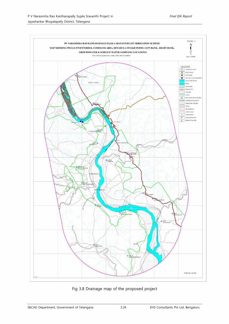
P V Narasimha Rao Kanthanapally Sujala Sravanthi Project in Final EIA Report
Jayashankar Bhupalapally District, Telangana
I&CAD Department, Government of Telangana 3.24 EHS Consultants Pvt Ltd, Bengaluru
Fig 3.8 Drainage map of the proposed project

P V Narasimha Rao Kanthanapally Sujala Sravanthi Project in Final EIA Report
Jayashankar Bhupalapally District, Telangana
I&CAD Department, Government of Telangana 3.25 EHS Consultants Pvt Ltd, Bengaluru
Table 3.14 Geological succession of the study area33
Rock type
Formation Group Super group Age
Sandstone, Breccia
Conglomerate with few
Clay Beds
Chikiyala
Formation Upper Gondwana
Group
Gondwana Super
Group
Cretaceous to
Permo
Carboniferous Sandstone, Siltstone,
Clay, Limestone beds
Kota
Formation
Unclassified - Sullavai Group - Neo-Proterozoic
Sandstone Albaka Formation - -
Meso-Proterozoic Shale
Laknavaram/
Tippapuram
Formation
Mulugu Group Pakhal Super Group
3.2.5.5 Structure
No major faults or any structural disturbances are observed in the project site area and
command area of the project excepting minor Fractures / lineaments. However, the streams
are flowing in fracture zones. Lineaments striking NE-SW along the streams are formed and
these act as conduits for the movement of surface and groundwater. The movement and
occurrence of groundwater is controlled by these structures and these have been marked in
the Geology & Structure Map.
3.2.5.6 Geomorphology
Geomorphology of the study area environs is Plateau dissected with valleys.
3.2.5.7 Mineral Resources
Granite Blocks - Granite is quarried for rough blocks of varying dimension stone in parts of
Jayashankar Bhupalapally District. Kataram and Mahadevpur is endowed with enormous high
grade Coal reserves useful thermal power stations.
3.2.5.8 Rainfall and climate
Jayashankar Bhupalapally District is drained by the River Godavari. The main streams draining
the district are Kistapuram Vagu, Pairla Vagu, Laknavaram Rover and their small tributaries
which are of ephemeral in nature draining into Godavari River. River Godavari enters the
district near Kaleshwaram village on the north-western portion and flows in south eastern
direction. Average rainfall of the district is 1015.8 mm. Climate varies from 12.8° C to 43.7° C.
33Geological Quadrangle Map (1984), Geological Survey of India, GoI

P V Narasimha Rao Kanthanapally Sujala Sravanthi Project in Final EIA Report
Jayashankar Bhupalapally District, Telangana
I&CAD Department, Government of Telangana 3.26 EHS Consultants Pvt Ltd, Bengaluru
Majority of the catchment area falls in the administrative region of Jayashankar Bhupalapally
District34
3.2.5.9 Hydrogeology
.
The study area and its environs in the 10.0 Kms buffer zone is underlain with Sandstone,
Breccia, Conglomerate with few clay beds and Limestone beds. These rocks are having of
primary to medium porosity. However, weathering, fractures, joints and fault zones act as
conduits for movement and storage of groundwater and yield water in abstraction structures.
The main source of recharge is precipitation. Groundwater occurs under phreatic conditions
in weathered zone and under semi-confined to confined conditions in joints and beddings of
carbonate rocks. Surface water occurrence is negligible and tanks were observed to be dry
during pre monsoon period. Alluvium is confined to major rivers with thickness ranging
between 3.0 to 8.0 mts.
Water table generally follows the topography of the study area and is at greater depths in
the water divide area and topographic heights but occurs at shallow depth in the valleys and
low lying terrain and therefore groundwater moves down and follows the gradient from the
higher to lower elevations i.e. from recharge area to discharge areas. The general flow
direction of groundwater in the study area is towards South.
3.2.5.10 Hydrogeological survey
Hydrogeological survey was carried out in the 10.0 Kms buffer zone of the proposed barrage
point of River Godavari and the total command area of the proposed project. 40 (23+17)
wells were inventoried for deciphering the groundwater regime. Water samples have been
collected from 17 borewells and 4 Surface water bodies representing the study area and
subjected to chemical analysis conforming to IS 10500:2012 (second revision) standards to
assess the quality. The aquifer performance test conducted by the CGWB authorities was
referred to and concluded the field data observed randomly during the field survey.
3.2.5.11 Depth to Water level
The depth to water level in the study area was measured wherever it was feasible and
recorded as reported during the field study. The depth to water level varied between 3.0 m
to 24.0 m. The deeper water levels observed i.e., 24.0 m was observed at Tekulagudem. The
depth to water level arrived corresponds to the well inventory data.
3.2.5.12 Water table elevation
Water table elevation in the study area ranges from less than 81 mts to more than 150 mts.
34 Groundwater Information Booklet of CGWB 2013, Khammam District, Telangana State

P V Narasimha Rao Kanthanapally Sujala Sravanthi Project in Final EIA Report
Jayashankar Bhupalapally District, Telangana
I&CAD Department, Government of Telangana 3.27 EHS Consultants Pvt Ltd, Bengaluru
Fig 3.9 Hydrology map showing surface and ground water sampling locations

P V Narasimha Rao Kanthanapally Sujala Sravanthi Project in Final EIA Report
Jayashankar Bhupalapally District, Telangana
I&CAD Department, Government of Telangana 3.28 EHS Consultants Pvt Ltd, Bengaluru
Fig 3.10 Geology and structural map of the proposed project

P V Narasimha Rao Kanthanapally Sujala Sravanthi Project in Final EIA Report
Jayashankar Bhupalapally District, Telangana
I&CAD Department, Government of Telangana 3.29 EHS Consultants Pvt Ltd, Bengaluru
Fig 3.11 Elevation map of wells inventoried for the proposed project

P V Narasimha Rao Kanthanapally Sujala Sravanthi Project in Final EIA Report
Jayashankar Bhupalapally District, Telangana
I&CAD Department, Government of Telangana 3.30 EHS Consultants Pvt Ltd, Bengaluru
Fig 3.12 Depth to water level map for the proposed project

P V Narasimha Rao Kanthanapally Sujala Sravanthi Project in Final EIA Report
Jayashankar Bhupalapally District, Telangana
I&CAD Department, Government of Telangana 3.31 EHS Consultants Pvt Ltd, Bengaluru
Fig 3.13 Total depth range map for the proposed project

P V Narasimha Rao Kanthanapally Sujala Sravanthi Project in Final EIA Report
Jayashankar Bhupalapally District, Telangana
I&CAD Department, Government of Telangana 3.32 EHS Consultants Pvt Ltd, Bengaluru
3.2.5.13 Water quality
A total of 21 representative samples (17 GW + 4 SW) have been collected from the study
area and subjected to water quality analysis as recommended by Std. IS 10500:2012 (Second
Revision) for drinking water standards. The result of the water quality and the field
photographs are enclosed as Annexure 15. In total the water quality in the study area is
potable except at outskirts of village Royyur.
Conductivity: Conductivity in the study area ranges from 99 µS/cm to 2,840 micro mhos/cm.
Conductivity having more than 2,840 µS/cm may be considered as either brackish or saline.
The conductivity more than the normal limits, highest at Tekulagudem with values 2,840
µS/cm.
Chloride: Chloride in water samples in the study area range from 7.77 mg/ltr to 422 mg/ltr
at Tekulagudem and this constituent is within the permissible limits of 1,000 mg/ltr over the
study area. The distribution of chloride is illustrated in figures in the next section.
Constituents like Nitrate and Fluoride levels are well within the permissible limits. The
Government and few social service organizations have installed mineral water plants in the
villages to supply safe water. The relevant quality maps are enclosed as Annexure 15.
Table 3.15 Details of water sampling locations
Sl.No. Village Name Geographical
coordinates
Type of
Well
Date of
Sampling
Criteria for
sampling
01 Forest Tanda N 18o 39’ 35.5’’
E 80o 20’ 35.1’’ GW 11-01-2018
Depth at water
level 23m-24m
bgl
02 Kotturu N 18o 37’ 06.5’’
E 80o 22’ 15.1’’ Govt. HP 11-01-2018
Depth at water
level 20m-22m
bgl
03 Tekulagudem N 18o 33’ 45.9’’
E 80o 24’ 18.1’’ Govt. HP 11-01-2018
Depth at water
level 23m-24m
bgl
04 Perur N 18o 32’ 00.2’’
E 80o 23’ 33.3’’ Govt. HP 11-01-2018
Depth at water
level 13m-14m
bgl
05 Krishnapuram N 18o 32’ 39.9’’
E 80o 25’ 16.0’’ Govt. HP 11-01-2018
Depth at water
level 4.9m-7.2m
bgl
06 Alli Ram Babu N 18o 29’ 02.2’’ Govt. HP 11-01-2018 Depth at water

P V Narasimha Rao Kanthanapally Sujala Sravanthi Project in Final EIA Report
Jayashankar Bhupalapally District, Telangana
I&CAD Department, Government of Telangana 3.33 EHS Consultants Pvt Ltd, Bengaluru
Sl.No. Village Name Geographical
coordinates
Type of
Well
Date of
Sampling
Criteria for
sampling
E 80o 26’ 59.1’’ level 0.0024m-
2.4m bgl
07 Gollagudem N 18o 28’ 32.5’’
E 80o 27’ 53.8’’ DW 11-01-2018
Depth at water
level 15m-17m
bgl
08 Sundariah
Colony
N 18o 27’ 13.0’’
E 80o 29’ 44.6’’
Govt.
BW- HP 11-01-2018
Depth at water
level 20m-22m
bgl
09 Nagaram N 18o 26’ 31.7’’
E 80o 28’ 42.8’’
Govt.
BW- HP 12-01-2018
Depth at water
level 13m-14m
bgl
10 Gugloth Saraiah N 18o 23’ 24.6’’
E 80o 25’ 33.4’’ Govt. HP 12-01-2018
Depth at water
level 9.7m-12m
bgl
11 Chelpaka N 18o 24’ 24.1’’
E 80o 22’ 21.8’’ BW 12-01-2018
Depth at water
level 4.9m-7.2m
bgl
12 Kantalapalle N 18o 27’ 15.2’’
E 80o 24’ 48.3’’ Govt. HP 12-01-2018
Depth at water
level 15m-17m
bgl
13 Dr. Venkatesh
RMP
N 18o 27’ 57.3’’
E 80o 22’ 29.4’’ Govt. HP 12-01-2018
Depth at water
level 18m-19m
bgl
14 Sri Poliah
Buttaigudem
N 18o 29’ 56.7’’
E 80o 21’ 13.7’’ BW 12-01-2018
Depth at water
level 20m-22m
bgl
15 Kannaipalli N 18o 31’ 22.9’’
E 80o 20’ 43.7’’ BW 12-01-2018
Depth at water
level 23m-24m
bgl
16 Devadula N 18o 33’ 30.8’’
E 80o 22’ 40.1’’ BW 12-01-2018
Depth at water
level 18m-19m
bgl
17 Mr. Kanta Rao N 18o 34’ 42.7’’
E 80o 23’ 05.7’’ BW 12-01-2018
Depth at water
level 0.0024m-
2.4m bgl

P V Narasimha Rao Kanthanapally Sujala Sravanthi Project in Final EIA Report
Jayashankar Bhupalapally District, Telangana
I&CAD Department, Government of Telangana 3.34 EHS Consultants Pvt Ltd, Bengaluru
Sl.No. Village Name Geographical
coordinates
Type of
Well
Date of
Sampling
Criteria for
sampling
18 Mukunur N 18o 36’ 09.4’’
E 80o 19’ 08.6’’ TW 12-01-2018
Depth at water
level 2.5 m-4.8m
bgl
19 Near Godavari
River
N 18o 36’ 06.9’’
E 80o 23’ 13.2’’ BW 12-01-2018
Depth at water
level 2.5 m-4.8m
bgl
20 Godavari River N 18o 34’ 58.9’’
E 80o 23’ 51.7’’ SW-1 13-01-2018
Zone of
influence, major
construction
activity
21 Krishnapuram
vagu
N 18o 32’ 20.5’’
E 80o 25’ 44.3’’ SW-2 13-01-2018
Representative
sample from
south eastern
portion from the
proposed barrage
22
Modikunta
Vagu Project
Stream
N 18o 28’ 06.9’’
E 80o 29’ 35.2’’ SW-3 13-01-2018
Representative
sample from
eastern portion
from the
proposed barrage
23 Tank Near
Mullikota
N 18o 24’ 28.7’’
E 80o 26’ 16.1’’ SW-4 13-01-2018
Representative
sample from
southern portion
from the
proposed barrage
3.2.5.14 Ground water resources
The resource estimation and categorization is to be carried out as per the recommendations
of Groundwater Estimation Methodology-97 (GEM-97) considering watershed as a unit.
Watershed and administrative boundaries do not match with the administrative boundaries.
As a result different parts of Mandals fall in different watersheds having different stages of
groundwater development and categorization. Pro-rata approach to consolidate the
watershed data into Mandal wise data gives only details on groundwater resource, draft and
additional irrigation potential. Pro-rata approach cannot be applied to Mandal, as a unit, as

P V Narasimha Rao Kanthanapally Sujala Sravanthi Project in Final EIA Report
Jayashankar Bhupalapally District, Telangana
I&CAD Department, Government of Telangana 3.35 EHS Consultants Pvt Ltd, Bengaluru
far as stage of development and categorization is concerned. However, average stage of
development is given to have an overall idea of the Mandal35
Groundwater resources and recharge assessment has been arrived taking in to consideration
of the monsoon and non-monsoon rainfall, command and non-command area, areas of
recharge and discharge, water table fluctuations, specific yield of rock formations/litho units
and normalized monsoon recharge. As the present project does not involve pumping of
groundwater the specific studies relating to aquifer parameters have not been carried out.
However, already published relevant data was consulted and prepared this report.
.
The already published data of CGWB in the form of Groundwater information Booklets for
the parts of Jayashankar Bhupalapally (erstwhile Khammam District) District covering the
subject area have been consulted and arrived at the conclusion. The Groundwater resource
for Khammam is categorized as over exploited area to the tune of 100% as per the
published data of CGWB-2013. This area requires serious formulation of artificial recharge
programmes and groundwater budgeting. The District as a whole comes under over
exploited stage of development.
Table 3.16 Details of wells inventoried
Sl.No. Village Name Geo coordinates Type of
Well Latitude Longitude
01 Annaram N 18o 39’ 07.0’’ E 80o 24’ 00.3’’ BW
02 Gangaram N 18o 33’ 23.3’’ E 80o 24’ 07.0’’ BW
03 Chandrupatla N 18o 32’ 59.0’’ E 80o 23’ 44.3’’ BW
04 Motla gudem N 18o 31’ 35.6’’ E 80o 23’ 14.9’’ BW
05 Kadekal N 18o 31’ 51.9’’ E 80o 25’ 45.8’’ BW
06 Teklabor N 18o 30’ 25.8’’ E 80o 23’ 21.8’’ BW
07 Dharmaram N 18o 30’ 21.0’’ E 80o 24’ 59.0’’ BW
08 Ayyavaripeta N 18o 29’ 23.8’’ E 80o 23’ 04.4’’ BW
09 Korakallu N 18o 29’ 30.3’’ E 80o 23’ 43.6’’ BW
10 Lingapeta N 18o 28’ 45.1’’ E 80o 24’ 26.4’’ BW
11 Sitanagaram N 18o 29’ 15.3’’ E 80o 25’ 16.9’’ BW
12 Arlagudem N 18o 28’ 34.8’’ E 80o 25’ 13.5’’ BW
13 Chinturu N 18o 28’ 23.1’’ E 80o 25’ 01.3’’ BW
14 Sriramanagaram N 18o 29’ 13.5’’ E 80o 27’ 42.3’’ BW
15 Virapuram N 18o 28’ 46.8’’ E 80o 28’ 41.4’’ BW
16 Pusuru N 18o 24’ 43.7’’ E 80o 28’ 27.3’’ BW
35 CGWG- Groundwater Information Booklet: Khammam District, Telangana 2013

P V Narasimha Rao Kanthanapally Sujala Sravanthi Project in Final EIA Report
Jayashankar Bhupalapally District, Telangana
I&CAD Department, Government of Telangana 3.36 EHS Consultants Pvt Ltd, Bengaluru
17 Muppanapalli N 18o 30’ 34.5’’ E 80o 21’ 28.9’’ BW
18 Gurirevala N 18o 31’ 42.6’’ E 80o 21’ 44.6’’ BW
19 Gangagudem N 18o 32’ 02.4’’ E 80o 21’ 18.1’’ BW
20 Lakshmipuram N 18o 32’ 54.4’’ E 80o 22’ 47.1’’ BW
21 Rajanapeta N 18o 33’ 04.9’’ E 80o 22’ 04.7’’ BW
22 Bhndarigudem N 18o 36’ 44.3’’ E 80o 19’ 16.0’’ BW
23 Kotta Tarlagur N 18o 36’ 48.7’’ E 80o 21’ 59.8’’ BW
3.2.6 Surface and Ground Water Quality
The resource estimation and categorization is to be carried out as per the recommendations
of Groundwater Estimation Methodology-97 (GEM-97) considering watershed as a unit.
Watershed and administrative boundaries do not match with the administrative boundaries.
As a result different parts of Mandal fall in different watersheds having different stages of
groundwater development and categorization. Pro-rata approach to consolidate the
watershed data into Mandal wise data gives only details on groundwater resource, draft and
additional irrigation potential. Pro-rata approach cannot be applied to Mandal, as a unit, as
far as stage of development and categorization is concerned. However, average stage of
development is given to have an overall idea of the Mandal36
Any effect on physical, chemical and biological properties of water has direct impact on the
quality of water
.
37
Table 3.17 Details of Water sampling locations
. The baseline status of water quality in the command area has been
established through the sampling and analysis of various water quality parameters. Water
samples were collected at 35 locations (10 Surface Water and 25 Ground Water) in the study
area during the study period (July 2017 - March 2018). The prime objective of the baseline
water quality study was to establish the existing water quality in the study area to evaluate
the anticipated impact of the proposed project on water quality and to suggest appropriate
mitigation measures for implementation. This will also be useful for assessing the conformity
to the standards of water quality during the construction and operation phase of the project.
The details of sampling locations are given below;
Sampling
Station
Code
Name of the sampling
station Geographical Coordinates Source Criteria for sampling
SW-1 Upstream of Godavari
River 18°36'3.17"N, 80°23'1.77"E
Surface
Water
Representative sample
near the proposed
36 CGWG- Groundwater Information Booklet: Khammam District, Telangana 2013 37Furhan,I., Ali,M., Salam, A., Khan,B.A,. Ahmad,S,. Quamar M and Omer, Kashif (2004), Seasonal variations of physico-chemical characteristics of river
Soan water at Dhoak, Pathan Bridge (Chakwal), Pakisthan, International J. of Agriculture and Biology, 6(1):89-92
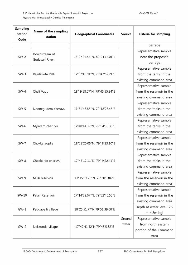
P V Narasimha Rao Kanthanapally Sujala Sravanthi Project in Final EIA Report
Jayashankar Bhupalapally District, Telangana
I&CAD Department, Government of Telangana 3.37 EHS Consultants Pvt Ltd, Bengaluru
Sampling
Station
Code
Name of the sampling
station Geographical Coordinates Source Criteria for sampling
barrage
SW-2 Downstream of
Godavari River 18°27'34.55"N, 80°24'14.01"E
Representative sample
near the proposed
barrage
SW-3 Rajulakota Palli 17°37'40.91"N, 79°47'52.21"E
Representative sample
from the tanks in the
existing command area
SW-4 Chali Vagu 18° 9'18.07"N, 79°45'55.84"E
Representative sample
from the reservoir in the
existing command area
SW-5 Noonegudem cheruvu 17°31'48.86"N, 79°18'23.45"E
Representative sample
from the tanks in the
existing command area
SW-6 Mylaram cheruvu 17°40'14.39"N, 79°34'38.33"E
Representative sample
from the tanks in the
existing command area
SW-7 Chokkaraoplle 18°23'20.05"N, 79° 8'13.10"E
Representative sample
from the reservoir in the
existing command area
SW-8 Chokkarao cheruvu 17°45'12.11"N, 79° 9'22.41"E
Representative sample
from the tanks in the
existing command area
SW-9 Musi reservoir 17°15'33.76"N, 79°30'0.84"E
Representative sample
from the reservoir in the
existing command area
SW-10 Palair Reservoir 17°14'22.07"N, 79°52'46.55"E
Representative sample
from the reservoir in the
existing command area
GW-1 Peddapalli village 18°25'51.77"N,79°51'39.00"E
Ground
water
Depth at water level 2.5
m-4.8m bgl
GW-2 Nekkonda village 17°47'41.42"N,79°48'5.32"E
Representative sample
from north eastern
portion of the Command
Area
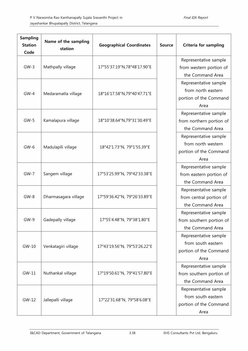
P V Narasimha Rao Kanthanapally Sujala Sravanthi Project in Final EIA Report
Jayashankar Bhupalapally District, Telangana
I&CAD Department, Government of Telangana 3.38 EHS Consultants Pvt Ltd, Bengaluru
Sampling
Station
Code
Name of the sampling
station Geographical Coordinates Source Criteria for sampling
GW-3 Mathpally village 17°55'37.19"N,78°48'17.90"E
Representative sample
from western portion of
the Command Area
GW-4 Medaramatla village 18°16'17.58"N,79°40'47.71"E
Representative sample
from north eastern
portion of the Command
Area
GW-5 Kamalapura village 18°10'38.64"N,79°31'30.49"E
Representative sample
from northern portion of
the Command Area
GW-6 Madulaplli village 18°42'1.73"N, 79°1'55.39"E
Representative sample
from north western
portion of the Command
Area
GW-7 Sangem village 17°53'25.99"N, 79°42'33.38"E
Representative sample
from eastern portion of
the Command Area
GW-8 Dharmasagara village 17°59'36.42"N, 79°26'33.89"E
Representative sample
from central portion of
the Command Area
GW-9 Gadepally village 17°55'4.48"N, 79°38'1.80"E
Representative sample
from southern portion of
the Command Area
GW-10 Venkatagiri village 17°43'19.56"N, 79°53'26.22"E
Representative sample
from south eastern
portion of the Command
Area
GW-11 Nuthankal village 17°19'50.61"N, 79°41'57.80"E
Representative sample
from southern portion of
the Command Area
GW-12 Jallepalli village 17°22'31.68"N, 79°58'6.08"E
Representative sample
from south eastern
portion of the Command
Area

P V Narasimha Rao Kanthanapally Sujala Sravanthi Project in Final EIA Report
Jayashankar Bhupalapally District, Telangana
I&CAD Department, Government of Telangana 3.39 EHS Consultants Pvt Ltd, Bengaluru
Sampling
Station
Code
Name of the sampling
station Geographical Coordinates Source Criteria for sampling
GW-13 Vastakondur 17°29'32.13"N, 79°21'12.01"E
Representative sample
from south western
portion of the Command
Area
GW-14 Gundala village 17°30'35.85"N, 79°17'39.98"E
Representative sample
from south western
portion of the Command
Area
GW-15 Neermala village 17°34'33.68"N, 79°15'12.77"E
Representative sample
from south western
portion of the Command
Area
GW-16 Aler village 17°38'26.33"N, 79° 2'35.08"E
Representative sample
from south western
portion of the Command
Area
GW-17 Salvapur village 17°48'58.19"N, 78°52'53.08"E
Representative sample
from western portion of
the Command Area
GW-18 Komuravelli village 17°55'51.93"N, 78°53'46.04"E
Representative sample
from western portion of
the Command Area
GW-19 Kootigal village 17°57'59.20"N, 79° 7'21.04"E
Representative sample
from western portion of
the Command Area
GW-20 Machupahad 17°52'3.23"N, 79°12'55.95"E
Representative sample
from western portion of
the Command Area
GW-21 Fathepuram village 17°53'45.27"N, 79°15'35.50"E
Representative sample
from western portion of
the Command Area
GW-22 Suryapet village 17° 8'8.70"N, 79°37'58.77"E
Representative sample
from southern portion of
the Command Area

P V Narasimha Rao Kanthanapally Sujala Sravanthi Project in Final EIA Report
Jayashankar Bhupalapally District, Telangana
I&CAD Department, Government of Telangana 3.40 EHS Consultants Pvt Ltd, Bengaluru
Sampling
Station
Code
Name of the sampling
station Geographical Coordinates Source Criteria for sampling
GW-23 Yerra Pahad village 17°22'1.32"N, 79°43'21.06"E
Representative sample
from southern portion of
the Command Area
GW-24 Mathpally village 17°55'37.19"N, 78°48'17.90"E
Representative sample
from western portion of
the Command Area
GW-25 Jallepalli village 17°22'31.68 "N, 79°58'6.08"E
Representative sample
from southern portion of
the Command Area
Surface and ground water samples were collected (grab sampling) at each location as per
CPCB guidelines38
38Guidelines for Water Quality Monitoring (2007), MINARS/27/2007-08, CPCB, New Delhi
. Surface water sample was collected from the River by using a weighted
bottle. Ground water samples from the production tube wells were collected after running
the well for about 5 minutes. Adequate parameter specific preservatives were added to the
samples and collected samples were brought to the laboratory by maintaining 4˚C in the ice
boxes. Separate sterilized bottles were used for collection of water samples for microbial
analysis. Surface and ground water quality analysis results are enclosed as Annexure 16.

P V Narasimha Rao Kanthanapally Sujala Sravanthi Project in Final EIA Report
Jayashankar Bhupalapally District, Telangana
I&CAD Department, Government of Telangana 3.41 EHS Consultants Pvt Ltd, Bengaluru
Fig 3.14 Surface Water Quality sampling locations

P V Narasimha Rao Kanthanapally Sujala Sravanthi Project in Final EIA Report
Jayashankar Bhupalapally District, Telangana
I&CAD Department, Government of Telangana 3.42 EHS Consultants Pvt Ltd, Bengaluru
Fig 3.15 Ground Water Quality sampling locations

P V Narasimha Rao Kanthanapally Sujala Sravanthi Project in Final EIA Report
Jayashankar Bhupalapally District, Telangana
I&CAD Department, Government of Telangana 3.43 EHS Consultants Pvt Ltd, Bengaluru
3.2.6.1 Surface and Ground Water Quality Results
• Monsoon season (July 2017 - September 2017)
Surface water results: pH was in the range of 7.02 - 8.14 at Rajulakota Palli and Chokkarao
cheruvu respectively. Total Hardness in the surface water was in the range of 58 mg/L - 244
mg/L at Mylaram cheruvu and Musi reservoir respectively, Dissolved oxygen was found to be
4 mg/L - 5.5 mg/L at Rajulakota Palli and Mylaram cheruvu respectively. Highest values of
conductivity and chloride were found to be 1021 µS/cm and 160.5 mg/L respectively at Musi
reservoir. Due to improper sanitation and utilization of River water for various domestic
purposes Total Coliform and E-coli was found at all locations in the range of 10-84
MPN/100ml and <1.8 MPN/100ml respectively which is due to the discharge of animal and
human waste directly into the water body.
Groundwater results: The ground water quality analysis results reveal that, the Total
Hardness was found to be in the range of 148 mg/L - 1080 mg/L at Vastakondur and
Gundala village respectively. Electrical Conductivity was found to be in the range of 616
µs/cm - 6280 µs/cm at Jallepalli village and Kamalapura village respectively. Total Coliform
was to be in the range of <1.8-2 MPN/100 ml at all locations. Sources of Total and E- Coli in
groundwater includes: Agricultural runoff, effluent from septic systems or sewage discharges
and infiltration of domestic or wild animal fecal matter39
• Post-monsoon season (October 2017 - December 2017)
.
Surface water results: pH was in the range of 6.91 - 7.9 at Chali Vagu Project and several
locations respectively. Total Hardness in the surface water was in the range of 46 mg/L - 590
mg/L at Chokkarao cheruvu and Chali Vagu respectively, Dissolved oxygen was found to be
4.4 mg/L - 5.7 mg/L at Chokkaraoplle and downstream of Godavari River respectively.
Highest values of conductivity and chloride were found to be 1800 µS/cm and 272.96 mg/L
respectively at Chali Vagu. Due to improper sanitation and utilization of river water for
various domestic purposes Total Coliform and E-coli was found at all locations in the range
of 4-120 MPN/100ml and <1.8-21 MPN/100ml respectively which is due to the discharge of
animal and human waste directly into the water body.
Groundwater results: The ground water quality analysis results reveal that, the Total
Hardness was found to be in the range of 102 mg/L - 874 mg/L at Gundala village and
Gadepally village respectively. Electrical Conductivity was found to be in the range of 328
µs/cm - 2530 µs/cm at Neermala village and Dharmasagara village respectively. Total Coliform
and E- coli was found to be <1.8-2 MPN/100ml at all locations. Sources of Total and E- Coli
39 British Columbia Ground Water Association. (2007). Total, Fecal and E. coli Bacteria in Groundwater. Water Stewardship Information Series.

P V Narasimha Rao Kanthanapally Sujala Sravanthi Project in Final EIA Report
Jayashankar Bhupalapally District, Telangana
I&CAD Department, Government of Telangana 3.44 EHS Consultants Pvt Ltd, Bengaluru
in groundwater includes: Agricultural runoff, effluent from septic systems or sewage
discharges and infiltration of domestic or wild animal fecal matter.
• Pre-monsoon season (January 2018 - March 2018)
Surface water results: pH was in the range of 7.13 - 9 at Chokkaraoplle and upstream of
Godavari River respectively. Total Hardness in the surface water was in the range of 72 mg/L
- 416 mg/L at Mylaram cheruvu and Musi reservoir respectively, Dissolved oxygen was found
to be 1.2 mg/L - 6 mg/L at Noonegudem cheruvu and upstream of Godavari River
respectively. Highest values of conductivity and chloride were found to be 2370 µS/cm and
404.98 mg/L respectively at Musi reservoir. Due to improper sanitation and utilization of river
water for various domestic purposes Total Coliform and E-coli was found at all locations in
the range of 12-3900 MPN/100ml and <1.8-550 MPN/100ml respectively.
Groundwater results: The ground water quality analysis results reveal that, the Total
Hardness was found to be in the range of 146 mg/L - 900 mg/L at Komuravelli village and
Medaramatla village respectively. Electrical Conductivity was found to be in the range of 716
µs/cm - 5950 µs/cm at Mathpally village and Kamalapura village respectively. Total Coliform
was to be in the range of <1.8-4 MPN/100ml at all locations. Sources of Total and E- Coli in
groundwater includes: Agricultural runoff, effluent from septic systems or sewage discharges
and infiltration of domestic or wild animal fecal matter.
From the baseline studies, the surface water samples and their criteria as per CPCB
Guidelines are as given below;
Sample
code Location
Water quality criteria
Monsoon
season
Post monsoon
season
Pre monsoon
season
SW-1 Upstream of Godavari River B B C
SW-2 Downstream of Godavari River B B C
SW-3 Rajulakota Palli D D D
SW-4 Chali Vagu Project B B C
SW-5 Noonegudem cheruvu D D E
SW-6 Mylaram cheruvu B B D
SW-7 Chokkaraopalle D D D
SW-8 Chokkarao cheruvu B B C
SW-9 Moosi reservoir E E C
SW-10 Palair Reservoir C C C
Note: A- Drinking Water Source without conventional Treatment but after disinfection
B- Outdoor Bathing (Organized).

P V Narasimha Rao Kanthanapally Sujala Sravanthi Project in Final EIA Report
Jayashankar Bhupalapally District, Telangana
I&CAD Department, Government of Telangana 3.45 EHS Consultants Pvt Ltd, Bengaluru
C- Drinking Water source with conventional treatment followed by disinfection
D- Propagation of wild life, fisheries.
E- Irrigation, industrial cooling, controlled waste Disposal.
From the table, it can be concluded that, out of 30 samples (inclusive of all seasons), 10
samples belongs to criteria ‘B’ (33.33%), 8 samples belongs to criteria ‘C’ (26.67%), 9 samples
belongs to criteria ‘D’ (30%) and 3 samples belongs to criteria ‘E’ (10%). Therefore, all the
water from the above locations is suitable for irrigation purposes.
3.2.7 Soil Characteristics
3.2.7.1 Introduction
The economy of Telangana is mainly driven by agriculture. About 73% of the population is
rural. The economy of the state is predominantly agrarian; agriculture contributes about 50%
of the state’s income and employs about 70% of the work force.
3.2.7.2 Agro-climatic zone
Jayashankar Bhupalapally District of Telangana State, belongs to Central Telangana Zone III.
The zone comprises of the districts of Medak, Warangal and Khammam. The zone covers an
area of 3.86 m. ha. The soils of the zone are mainly red sandy loams, very red soils and deep
black soils. The zone receives an annual normal rainfall of 996 (868—1124) mm. About 88.03
per cent of total rainfall is received during south west monsoon only. The net sown area is
l.25 m. ha. Of which, 0.51 m. ha is irrigated representing 40.68 per cent of the net sown area.
The principal crops grown in the zone are Paddy, Cotton, Red gram, Maize, Sugarcane, Black
gram and Green gram. It is the important Cotton growing zone of Telangana.
3.2.7.3 Rivers
The major rivers flowing in the district are Godavari and Krishna Basin. Important rivers of
India such as the Godavari, Krishna flow through the state, providing irrigation. Apart from
major rivers, there are small rivers like Tungabhadra, Bhima, Dindi, Kinnerasani, Manjeera,
Manair, Penganga, Pranahita, Peddavagu and Taliperu. There are many multi-state irrigation
projects in development, including Godavari River Basin Irrigation Projects and Nagarjuna
Sagar Dam, the world's highest masonry dam. The region is drained by two major rivers, with
about 79% of the Godavari River catchment area and about 69% of the Krishna River
catchment area, but most of the land is arid. Telangana is also drained by several minor
rivers such as the Bhima, the Maner, the Manjira and the Musi.

P V Narasimha Rao Kanthanapally Sujala Sravanthi Project in Final EIA Report
Jayashankar Bhupalapally District, Telangana
I&CAD Department, Government of Telangana 3.46 EHS Consultants Pvt Ltd, Bengaluru
3.2.7.4 Agriculture
The net sown area of the state is 40 % of the TGA, with a cropping intensity of 124 %. The
Net Irrigated Area (NIA) of the state is 1.88 M ha, which is 44.5 % of the net cropped area
and only 39 % of undivided Andhra Pradesh. Most of the irrigation is provided by wells, with
the area that is irrigated being nearly 72 % of the NIA. Development of irrigated agriculture
has played a major role in the economic growth and poverty alleviation through successive
plan periods. These can be achieved by expanding and improving the irrigation sector,
exploiting the considerable water resources, with which the state is blessed. Rice is major
food crop and staple food of the state. Other important crops are maize, tobacco, mango
and cotton. Agriculture has been the chief source of income for the state's economy. Agri
Export Zones for the Gherkins are proposed at Jayashankar Bhupalapally: Mangoes and
grapes in Hyderabad, Rangareddy, Medak, Mahabubnagar.
Eturnagaram Mandal of Jayashankar Bhupalapally district in Telangana is agriculturally
dominated as the occupation of about 80% of people is farming. Rain fed farming is
dependent on several factors ie.,the management of soils, crops, animals; use of package of
practices, farm techniques, farm machinery and agricultural implements, marketing, human
resources in a systematic way. To meet the burgeoning population’s food security, it is
planned to increase food production with an estimated average of 4 tons per hectare from
the present 1.5 tons per hectare. Due to the great dependence and pressure on land and
water resources, obviously, there will be an effect on soil properties and crop productivity. As
per some estimates, the soils have been degrading at the rate of one million a hectare per
year and 57% of geographical area is affected by various forms of degradation viz., water
and wind erosion, physical and chemical deterioration (NBSS & LUP 2014). According to
Telangana agriculture department, 8.3 lakh hectares are affected by salinity and alkalinity.
This is about 20 per cent of the total cultivated area in the state. Similarly depletion of
ground water levels has also been noticed at an alarming rate in recent times through the
rapid depletion of the ground water resources. In this context, it is a great challenge to the
scientific community, to evolve and develop appropriate strategies, to increase productivity
and production of food on a sustainable basis.
3.2.7.5 Cropping pattern
Many parts of the proposed project area often experiences shortfall in rains and at times
with shallow flow in the Godavari which directly affect the life style and economy of the
population, mainly on agriculture. However various Khariff and Rabi crops that can be raised
in the region by providing micro-irrigation facilities would not only boost production but
improve the socio-economic constituents of the area. The entire population in the proposed

P V Narasimha Rao Kanthanapally Sujala Sravanthi Project in Final EIA Report
Jayashankar Bhupalapally District, Telangana
I&CAD Department, Government of Telangana 3.47 EHS Consultants Pvt Ltd, Bengaluru
project area is depending on agriculture for livelihood and crops like cotton, chillies, banana,
paddy, maize, pulses, and vegetables etc., which are traditionally grown in the area.
Out of 12,834 km2 of geographical area, Gross Cropped Area is 62.88 lakh ha and Net
Cropped Area is 49.61 lakh ha. Out of which, Gross Irrigated Area accounts for 31.64 lakh ha
and Net Irrigated area is 22.55 lakh ha with a Cropping Intensity of 127 % and Irrigation
Intensity of 138 % area under rain fed agriculture works out to 63.6 %. Percent Area from
underground water is 84 %40
Zaid is a short duration summer cropping season beginning after harvesting of rabi crops.
The cultivation of watermelons, cucumbers, vegetables and fodder crops during this season
is done on valley lands. However, this type of distinction in the cropping season does not
exist in southern parts of the country. Here, the temperature is high enough to grow tropical
crops during any period in the year provided the soil moisture is available. Therefore, in this
region same crops can be grown thrice in an agricultural year provided there is sufficient soil
moisture.
. Main Crops grown in the state of Telangana are Paddy, Cotton,
Maize, Chilly, Green gram, Groundnut. There are three distinct crop seasons in the northern
and interior parts of country, namely kharif, rabi and zaid. The kharif season largely coincides
with Southwest Post-monsoon under which the cultivation of tropical crops such as rice,
cotton, jute, pulses and vegetables is possible. The Rabi season begins with the onset of
winter in October-November and ends in March-April. The low temperature conditions
during this season facilitate the cultivation of temperate and subtropical crops such as wheat,
gram and vegetables.
Crops grown in Kharif season: Cotton, Tobacco, Chilies, Paddy, Maize, Pulses, Green gram
Crops grown in Rabi season: Bengal gram
One season crop: Cotton
Commercial crops: Cotton, Chillies, etc.
Plantation: Banana, Natural vegetation,
Crops Raised Under Irrigated Condition: Maize, Cotton
3.2.7.6 Soil types
They belong to 3 orders, namely Inceptisols, Entisols and Vertisols. Of the total area of
Telangana, 27% is covered with Alfisols, 25% by Inceptisols, 16% by Entisols, 15% by
Vertisols, 8% by Ultisols, 5% by Aridisols and 1% by Mollisols. And about 4% includes rocky
lands, water-bodies and urban area. The Red soils developed are deep to very deep,
40 Directorate of Economics and Statistics: Statistical year book 2016

P V Narasimha Rao Kanthanapally Sujala Sravanthi Project in Final EIA Report
Jayashankar Bhupalapally District, Telangana
I&CAD Department, Government of Telangana 3.48 EHS Consultants Pvt Ltd, Bengaluru
excessively drained, loamy to gravelly clay soils with iron concretions and are moderately
Rapid Permeability granite is deep to very deep, well drained, clay loam with moderately
rapid permeability. Forest brown soils occurring in eastern parts of the district are deep, well
drained, loam to clay with moderate Permeability.
Soil types: Red earths, Black soils, Forest soils in and around Jayashankar Bhupalapally.
Various soil types abound, including chalkas, red sandy soils, dubbas, deep red loamy soils
and very deep black cotton soils. The soil texture varied from sandy loam to sandy clay loam
to clay loam in surface horizons and sandy clay loam to clay loam to clay in sub-surface
horizons. The Red soils developed on Granite occur in Thupakulagudem and are shallow to
moderately deep, well drained, loamy to clay soils with moderate to moderately slow
Permeability. The Red soils formed on kaolin limestone and white quartz is deep, well
drained, clay with low permeability.
The major soil forms found in the Jayashankar Bhupalapally district are red gravelly clay soil;
red clay soil; lateritic gravelly clay soil; lateritic clay soil; medium deep black soil; non-saline
and saline alluvo-colluvial soil; brown forest soil. The major minerals found in the district are
limestone; white quartz; kaolin; kyanite; manganese. Various soil types abound, including
chalkas, red sandy soils, dubbas, deep red loamy soils, and very deep black cotton soils that
facilitate planting mangoes, oranges and flowers.
• Acid Soils
These soils develop in humid and per-humid areas due to excessive leaching of cations with
high rainfall, resulting in lowering of pH and loss of soil fertility, and can be reclaimed by
addition of chemical amendments like lime. For assessing area under acid soils, soil maps of
different states on 1: 2,50,000 scale were digitized in the GIS format. The non-spatial
(attribute) data on pH values were linked to master soil layer to generate soil reaction. The
acidity map of India facilitates understanding of spatial distribution and pH status of soils in
different parts of India. Based on the range of pH values, the map has been reclassified as
strongly acidic (pH < 4.5); moderately acidic (pH 4.5–5.5); slightly acidic (pH 5.5–6.5) and
non-acidic (pH > 6.5). However, for the estimation of the degraded lands of India, only
strongly acidic - pH < 4.5 and moderately acidic – pH 4.5–5.5 soils have been considered.
Accordingly, area covered by acid soils having pH < 5.5. About 6.98 M ha are affected by
acid soils; which is about 9.4% of the total geographical area.
The Red soils on laterites, limestone and Kaolin are deep, are moderately well drained, clay
with slow permeability and is rich in bases (alkaline condition) and has a very high water
holding capacity. The soils in the PVNRKSSP area are mostly red soil, while the red and
mixed soils constitute only 20 percent, and are 30 to 60 cm deep, medium to heavy in
texture, with 45 to 55 per cent clay.

P V Narasimha Rao Kanthanapally Sujala Sravanthi Project in Final EIA Report
Jayashankar Bhupalapally District, Telangana
I&CAD Department, Government of Telangana 3.49 EHS Consultants Pvt Ltd, Bengaluru
3.2.7.7 Scope and Methodology
The EIA report shall identify the relevant environmental concerns and focus on the potential
impacts that may change due to the construction of the project. Based on the baseline data
collected for three seasons, the status of the existing environment in the area and capacity
to bear the impact on this is analysed. Based on the analysis, the mitigation measures for
minimizing the impact shall be suggested in the EIA/EMP.
A preliminary soil survey was conducted in the study area and soil sampling stations were
identified followed by a wide-ranging sampling programme undertaken during the 2017. Pre
and post-monsoon and monsoon season in the radius of 10 sq kms. Soil samples were
collected from different agricultural lands. A total of 15 sampling sites extended over
different villages, were identified during preliminary survey which are as given below. The
data provided here are for these stations which will be monitored during the construction
and post operational stages of the project.
Standard techniques of soil survey were used to obtain qualitative and quantitative data on
the soils. Various soil quality parameters viz., pH, electrical conductivity, chlorides, available
calcium and magnesium, phosphorus, exchangeable sodium and potassium, available
nitrogen etc., were determined employing standard methods of analyses and the results are
enclosed as Annexure 17.
Table 3.18 Details of soil sampling locations
Location
code Location Geographical coordinates Criteria for selection
S1 Near proposed
barrage
18˚35’19.43”N,
80˚23’49.13”E
Geology and soil types,
major construction area
S2 Kuravi 17°31'30.97"N, 80° 0'6.98"E Geology and soil types
S3 Girnibhavi 17°57'16.40"N,
79°47'46.67"E Geology and soil types
S4 Mogula Pally 18°19'8.69"N,
79°38'34.16"E Geology and soil types
S5 Velchal 18°25'6.14"N,
79°37'35.85"E Geology and soil types
S6 Bachannapet 17°47'25.36"N, 79°
2'29.21"E Geology and soil types
S7 Jangaon 17°43'11.74"N,
79°10'46.56"E Geology and soil types
S8 Chunchankota 17°52'38.02"N, Geology and soil types

P V Narasimha Rao Kanthanapally Sujala Sravanthi Project in Final EIA Report
Jayashankar Bhupalapally District, Telangana
I&CAD Department, Government of Telangana 3.50 EHS Consultants Pvt Ltd, Bengaluru
Location
code Location Geographical coordinates Criteria for selection
78°57'50.75"E
S9 Mallapur 18°58'10.87"N,
78°42'16.44"E Geology and soil types
S10 Dharur 18°45'53.40"N,
78°54'33.48"E Geology and soil types
S11 Peddapalli 18°37'2.32"N,
79°22'58.12"E Geology and soil types
S12 Aler 17°38'32.15"N, 79°
3'10.52"E Geology and soil types
S13 Bommannaplly 18°12'23.89"N,
79°14'19.75"E Geology and soil types
S14 Kudali 17°16'32.29"N,
79°48'48.46"E Geology and soil types
S15 Ailapuram 17°11'45.82"N,
79°37'57.93"E Geology and soil types

P V Narasimha Rao Kanthanapally Sujala Sravanthi Project in Final EIA Report
Jayashankar Bhupalapally District, Telangana
I&CAD Department, Government of Telangana 3.51 EHS Consultants Pvt Ltd, Bengaluru
Fig 3.16 Types of soil in the study area

P V Narasimha Rao Kanthanapally Sujala Sravanthi Project in Final EIA Report
Jayashankar Bhupalapally District, Telangana
I&CAD Department, Government of Telangana 3.52 EHS Consultants Pvt Ltd, Bengaluru
Fig 3.17 Soil sampling locations on study area map

P V Narasimha Rao Kanthanapally Sujala Sravanthi Project in Final EIA Report
Jayashankar Bhupalapally District, Telangana
I&CAD Department, Government of Telangana 3.53 EHS Consultants Pvt Ltd, Bengaluru
3.2.7.8 Soil analysis Results
• Soil pH
pH of soil is the measure of hydrogen ion activity and depends largely on the relative
amounts of the adsorbed hydrogen and other metallic ions present in the soils. pH of soil
mainly depends on the soil water ratio. pH of soil mainly depends on the soil water ratio.
From the results, it is seen that pH of the Soil samples in the study area ranged between
5.58 and 8.76. The lowest pH value of 5.58 was found in sample which belongs to an
agricultural land of Velchel in post-monsoon season and the maximum pH of 8.76 was
observed in Bacchannapet during monsoon month. In pre monsoon it is found in between
7.14 and 8.34 where as in monsoon the pH values are from 5.9 and 8.76. However, during
post monsoon the values are ranging from 5.58 to 8.71.
The results have shown that sampling areas come under all the 3 categories of Class-I, Class-
II and Class-III which clearly indicates that Soil samples are differently characterized. In the
study area, in post monsoon season, the soil sample of Mogulapally and Velchel are acidic in
nature, where as soil sample of Janagoan & Kudali are neutral (pH of 6.5 to 7.5) in nature.
The remaining Soil samples Near proposed barrage, Kuravi, Girnibhavi, Bachannapet,
Mallapura, Dharur, Peddapalli, Aleru, Bommannapalli, Ailapuram and Chunchankota of the
post-monsoon season. Soil samples are alkaline (pH >7.5) in nature. In case of Monsoon
season, soil samples of Kuravi, Mogulapally and Bommannapalli, pH values of < 6.5 are acidic
in nature, and this may be due to high amount of leaching which has led to the leach out of
exchangeable anions and are considered as acidic. Whereas monsoon season soil samples
Mallapura, Peddapalli, Kudali, and Ailapuram are neutral may be due to high amount of
leaching which has led to the leach out of exchangeable anions and are considered as
neutral. However, Soil samples of monsoon which are alkaline in nature are from agricultural
fields of villages near proposed barrage, Girnibhavi, Velchel, Bachannapet, Janagoan, Dharur,
Aleru and Chunchankota. In the case of pre-monsoon season soil sample of Mogulapally and
that of Kudali are neutral (pH between 6.5 and 7.5) in nature.
The remaining soil samples Near proposed barrage, Kuravi, Girnibhavi, Velchel, Bachannapet,
Janagoan, Mallapura, Dharur, Peddapalli, Aleru, Bommannapalli, Ailapuram and
Chunchankota of the pre-monsoon season are alkaline (pH >7.5) in nature.
Variation in pH values has an impact on survivability of soil flora and fauna. However some
species of plants may tolerate the pH fluctuations and it is essential to study the pH of the
soil in management practices, through which it gives the overall status of soil minerals to the
plants. In the study area most of the Soil samples were alkaline and few soil samples (8
samples) found to be neutral and 5 samples are acidic.

P V Narasimha Rao Kanthanapally Sujala Sravanthi Project in Final EIA Report
Jayashankar Bhupalapally District, Telangana
I&CAD Department, Government of Telangana 3.54 EHS Consultants Pvt Ltd, Bengaluru
It is observed that the pre and post monsoon soil samples are more prone to salinity than
the pre monsoon soil samples and the sub surface drainage has to develop during and after
monsoons.
• Electrical conductivity
The EC values of the soil samples varied from 27.4 μmhos/cm to 905 μmhos/cm. The highest
value of EC was observed in monsoon sample, which belongs to agricultural land of Jangoan
village whereas the lowest EC value of 27.04 μmhos/cm was noticed in the post-monsoon
soil sample which belongs to the Agricultural land in Jangoan village. The remaining Soil
samples of the three season soils have varying ranges in between the values of 27.4
μmhos/cm to 905 μmhos/cm.
Electrical conductivity, as the measure of current carrying capacity, gives a clear picture of
the amount of soluble salts present in the soil. It plays a major role in the salinity of soils.
There is a relation between electrical conductivity and salinity, lesser the EC value low will be
the salinity value of soil and vice-versa. The Electrical Conductivity values of the soil samples
vary from 27.04 to 905 µmhos/s, as shown below.
Sl.No. EC values (µmhos/cm) Pre monsoon Monsoon Post-monsoon
1 10 to 500 15 14 15
2 501 to 1000 0 1 0
3 1001 to 1500 0 0 0
4 1501 to 2000 and above 0 0 0
Electrical conductivity values within 800 μmhos/cm are considered as normal nature of soil,
and in the present study about 100 percent of the samples were observed to be in the
normal range in the pre and post-monsoon season soil samples. In the monsoon sample of
Mallapur EC value is 905 which is considered as critical for tolerant crops. While EC values
between 800 and 1600 are considered critical for tolerant crops, while EC values ranging
between 1600 and 2500 are considered critical for salt tolerant crops, only post-monsoon
season soil sample is considered as critical for salt tolerant crops and EC values more than
2500 are not considered safe for most of the crops. In the study area no samples have
crossed 1500, and therefore almost all the soil samples are found to be suitable for
agriculture.
• Colour
Soil colour is one of the visual judgment through which the soil type can be classified. The
soil colour may vary from region to region or spatially. Soil derives its colour from the source

P V Narasimha Rao Kanthanapally Sujala Sravanthi Project in Final EIA Report
Jayashankar Bhupalapally District, Telangana
I&CAD Department, Government of Telangana 3.55 EHS Consultants Pvt Ltd, Bengaluru
of the material. However, the colour may also vary due to, Soil forming process, Moisture
content and drainage and Nature and amount of organic matter.
• Mineral sources
In the study area, the soil sample has shown similarity in colour. Majority of the soils are
Brown to red; whereas about 10 percent of the samples were grey to brown. The colour of
samples indicated that majority of the samples belong to Red sandy loam to loamy sand
soils.
• Salinity
Based on the electrical conductivity of the soil, soil salinity can be classified into four classes:
CI water is considered as safe with without any salinity problems.
CII When used for irrigation, moderate leaching is required.
CIII and CIV cannot be used on soils with inadequate drainage, since salinity develops.
In the study area all 15 soil sample of pre and post monsoon samples come under the
category of Class-I, this indicates that the Soil samples are under low salinity. ie., soil samples
of Velchel, Girnibhavi and Kuravi, Bachannapet. Soil samples of Aleru, Dharur, Chunchankota
and Peddapalli drawn during monsoon months are having medium salinity. Whereas soil
sample from Mallapur is of high salinity during monsoon season samples indicating salt
encrustations on the surface soil which needs drainage to leach out salts.
Salt affected problems are commonly seen in arid and semi arid regions, in irrigation areas
and in the regions where the poor drainage and poor quality / contaminated water is being
used for irrigation. Saline soils are those, which dominated/appreciable quantities of soluble
salts to interfere growth and productivity of the crops. Generally, they are rich in neutral salts
including the salts of chlorides and sulphate of sodium, calcium and magnesium (excluding
Water class Electrical conductivity
(micromhos/cm) at 25˚C
Approximate salt
concentration
Class - I - Low
salinity 0 to 250 <0.16
Class - II - Medium
salinity 250 to 750 0.16 to 0.50
Class - III - High
salinity 750 to 2250 0.50 to 1.50
Class - IV - Very
High salinity 2250 to 5000 1.5 to 3

P V Narasimha Rao Kanthanapally Sujala Sravanthi Project in Final EIA Report
Jayashankar Bhupalapally District, Telangana
I&CAD Department, Government of Telangana 3.56 EHS Consultants Pvt Ltd, Bengaluru
gypsum) in excess quantities, enough to cause significant effect particularly on growth of the
crop plants. In these saturated soils the various soil characteristics such as the pH was
observed to be less than 8.5 mainly due to the presence of neutral salts, and the electrical
conductivity is more than 4.0 µmhos/cm (at 25̊ C) and the Exchangeable Sodium percentage
(ESP) is less than 15. Salinity is usually measured/expressed in terms of electrical conductivity
and expressed in micromhos/cm (at 25˚C).
• Exchangeable Calcium
The minimum concentration of Exchangeable Calcium was found to be 3.1 during monsoon
season in the soil sample at Kudali, while the maximum value of 52.2 was found during pre-
monsoon (expressed Ca as m eq/100g) in the sample near proposed barrage. There was
wide variation in the distribution of Exchangeable Calcium content in the study area.
• Exchangeable Magnesium
The minimum concentration of Exchangeable magnesium is found to be 1 m eq/100g in
Ailapuram of pre-monsoon which is, and similarly the maximum Exchangeable magnesium
value of 11 m eq/100g in Kuravi of post-monsoon agricultural land. The Exchangeable
magnesium value found ranged between 0.1 m eq/100g and 11 meq/100g.
• Organic Carbon
Soil resource is a major anchor to all the life beings, such as plants, animals and
microorganisms in various stages of decomposition process, which gives the end products in
the form of organic matter. The organic substances are a major determinant of soil structure,
moisture content, pH and the soil nutrient status of the topsoil. The importance of organic
matter in the soil is improved soil structure and fertility status of the soil, which differentiates
the soil and other non-fertile soils.
Percent Organic Carbon was found to be in the range of 0.12 to 0.72 and the minimum
value was observed in Dharur, Bommanapally belonging to pre-monsoon and in
Bachannapet during monsoon season. While the maximum percent Organic Carbon value of
0.72 was found in Peddapalli village during monsoon season, indicating variable organic
matter content and degradability rate. The percentage of organic matter varied spatially and
generally has a higher organic content in the case of thickly vegetated areas. The
requirement of optimum level of organic matter required by the plants slightly varies
between species, as it is not a single nutrient source required for all the plants and for all the
soils. The variation is also dependent on soil type, climate, existing plant and animal species.
Percentage organic carbon Rating
<0.40 Low
0.4 to 0.75 Medium

P V Narasimha Rao Kanthanapally Sujala Sravanthi Project in Final EIA Report
Jayashankar Bhupalapally District, Telangana
I&CAD Department, Government of Telangana 3.57 EHS Consultants Pvt Ltd, Bengaluru
>0.75 High
In the study area it was noticed that the percent organic carbon was found to be in different
ranges in all samples of post-monsoon season i.e., post-monsoon season Soil samples of
Soil sample have high organic carbon content due to the presence of thick vegetation. In the
monsoon season the following soil results have shown that the soil samples have low
organic carbon.
Whereas soil samples of Girnibhavi, Velchel, Dharuru, Peddapalli and Aleru are having
medium of organic content in the soil and only soil sample of Mallapur has high organic
content in the soil. In the case of post and pre-monsoon season soil samples, the organic
content is low in all cases.
The status of the monsoon season soil results are as follows with respect to organic carbon
Sl.No. Location code Location OC Status as Low/Medium/High
1 S1 Near proposed barrage Low
2 S2 Kuravi Low
3 S3 Girnibhavi Medium
4 S4 Mogula Pally Low
5 S5 Velchal Medium
6 S6 Bachannapet Low
7 S7 Jangaon Low
8 S8 Chunchankota Low
9 S9 Mallapur High
10 S10 Dharur Medium
11 S11 Peddapalli Medium
12 S12 Aler Medium
13 S13 Bommannaplly Low
14 S14 Kudali Low
15 S15 Ailapuram Low
Therefore most of the samples in the area appear to possess low to medium content of
percent organic carbon, which indicates that the farmer has to apply sufficient quantity of
green manure and farm yard manure to get higher yield of crops.
• Percent Organic Carbon
Percent Organic Carbon was found to be in the range of 0.12 to 0.72 and the minimum
value was observed in Dharur and Bommanapally belonging to pre-monsoon and in

P V Narasimha Rao Kanthanapally Sujala Sravanthi Project in Final EIA Report
Jayashankar Bhupalapally District, Telangana
I&CAD Department, Government of Telangana 3.58 EHS Consultants Pvt Ltd, Bengaluru
Bachannapet during monsoon season. While the maximum percent Organic Carbon value of
0.72 was found in Peddapalli village during monsoon season.
• Exchangeable Sodium
The exchangeable sodium content in the study area ranged between 1.37 to 197.52
mg/100gm as observed. The minimum Exchangeable sodium value of 1.37 mg/100gm was
observed in pre-monsoon Soil sample of Girnubhavi village and the maximum value was also
found in same village which belonged to post-monsoon.
Potassium (K) is the third most essential element required by most of the plants.
Simultaneously there is a negative effect at higher levels as it affects cell division, formation
of carbohydrates, activation of various enzymatic reactions, cell permeability, while it
improves resistance of some plants to some diseases. It also plays an important role in water
balancing of plants or regulation of osmosis. Generally it forms a most abundant metal
cation in plant cell (about 2 to 3 % by dry weight).
Deficient supply of (K) Less than 113 Kg/ha
Doubtful supply of (K) 113 to 280 Kg/ha
Adequate supply of (K) More than 280 Kg/ha
• Available Potassium
The available potassium values were found to be in a narrow range and ranged between
1.03 to 139.66 Kg/ha. The minimum potassium value was noticed in soil sample of
Bommanapally belonging to pre-monsoon, while the maximum value was found in post-
monsoon season at Girnabhavi village which is in the range of doubtful availability. All other
soil samples are of deficient level, thus the area by and large require supplementation of
potassic fertilizers to maintain the balanced requirement of nutrients’ to the crop lands.
• Available Nitrogen
The available nitrogen ranged between 38 to 480.65 Kg/ha and the minimum value was
found in pre monsoon season which belongs to Agricultural land at Aler and the maximum
value was observed in Dharur village which belonged agricultural land during monsoon
season.
Nitrogen is one among the four primary elements essential for the plant tissues. It is the
major component of proteins, nucleic acids and chlorophyll. The atmospheric nitrogen gets
trapped in the soil during electro and photo-chemical fixation and also by the action of
microorganisms. Soil nitrogen is made available through a process of mineralization. The
available nitrogen in soil exists in the form of both organic and inorganic forms. However,
relatively most of the nitrogen content in organic form is at the most about 90 per cent.

P V Narasimha Rao Kanthanapally Sujala Sravanthi Project in Final EIA Report
Jayashankar Bhupalapally District, Telangana
I&CAD Department, Government of Telangana 3.59 EHS Consultants Pvt Ltd, Bengaluru
Organic content present in the soil decaying by microbial activity, during process all the
organic nitrogen gets converted to ammonium, nitrates and nitrites. Nitrogen is having a
major role in maintaining the fertility of the soil and nitrogen content in almost all the soils
are observed to be very low and is found as nitrates, nitrite and ammonium. Plants are more
dependent upon nitrate nitrogen, during the aerobic conditions and ammonia nitrogen
during anaerobic conditions. Concentration of Ammonia Nitrogen in the soil is as given
below;
Sl. No Quantity of nitrogen Rating
1 < 272 Kg/ha Low
2 272 to 554 Kg/ha Medium
3 > 554 Kg/ha High
In the study area In the study area it was noticed that the availability of Nitrogen was found
to be low in all samples of pre-monsoon season except in Near proposed barrage site and
Chunchankota which are having medium level of Nitrogen availability (325.98 and 332.57
kgs/ha respectively. However, the monsoon season soil samples are also have low level of
Nitrogen availability and the following soil samples possessing the medium level of Nitrogen
availability. The details are:
Location code Sampled Village Availability of Nitrogen
Kg/Ha
S4 Mogulapally 280.48
S8 Chunchankota 374.25
S9 Mallapur 302.49
S10 Dharur 321.75
S11 Peddapalli 480.65
S12 Aleru 332.47
Soil moisture content is having a major contribution to vary the process and also one of the
important factors affecting nitrification. In water logged areas soil suppresses the process of
nitrification because of deficient oxygen. However it is totally different in the case of dry
soils. As in the case of present study area in the soils however, there will be enough moisture
for the process of bacterial metabolism and such soils possess higher rate of biosynthesis of
nitrogen which also contribute to fertility of the soil.
• Available Phosphorus
Phosphorus is the second most important micro nutrient available in the soil of the
biological systems which covers more than 1% of the dry organic weight. It is a major
content of nucleic acid, phospholipids and many phosphor related compounds. Similarly it is

P V Narasimha Rao Kanthanapally Sujala Sravanthi Project in Final EIA Report
Jayashankar Bhupalapally District, Telangana
I&CAD Department, Government of Telangana 3.60 EHS Consultants Pvt Ltd, Bengaluru
second most limiting factor often affecting plant growth. Chemically Phosphorus exists in the
form of both organic and inorganic forms. Generally plants depend on phosphorus in the
inorganic compounds especially in the form of phosphate ions. Whereas organic phosphates
are also important sources of phosphorus in all most all types of soils. However,
comparatively the phosphorus is required in small quantity, but it may be the most limiting
factor in the productivity of the plant. Therefore, ecologically it is more significant.
Table 3.19 Concentration of phosphorous
Sl.No. Grade Concentration(Kg/ha)
1 Low Phosphorus <12.4
2 Medium Phosphorus 12.4 to 22.4
3 Adequate Phosphorus > 22.4
4 Abundant Phosphorus Still higher
The available Phosphorus in the project area ranges from 51.09 to 1673.22 drawn from the
soil samples of pre-monsoon season. The Soil sample of Kuravi village and Velchel has
minimum value.
Soils of the study area showed maximum range of abundant range of phosphorous
availability in all the soil samples of monsoon, pre and post-monsoon season. In general, the
Soil sample showing lower levels of available phosphorus content have to be supplemented
by applying phosphorus rich fertilizers as required by a specific crop.
• Chlorides
The Chloride content of the soil is the measure of salinity of the soil. The Chloride content of
the soil ranged from 0.14 meq/l to 2.35 meq/l. The chloride content was taken as major
factor for the estimation of salinity of the soil samples. The maximum chloride content of
2.35 meq/l was observed in monsoon Sample of Bommanapally whereas, the lowest chloride
of 0.14 meq/L was observed in monsoon at Jangoan village.
• Particle size distribution
The soil particle size is major parameter and a relative proportion of the soil particles of
various sizes are an important physical parameter, which emphasizes the texture of soil of a
particular region. Larger particle size helps in providing the physical support to the plants,
while smaller particles encourage the soil to hold water and availability of nutrients.

P V Narasimha Rao Kanthanapally Sujala Sravanthi Project in Final EIA Report
Jayashankar Bhupalapally District, Telangana
I&CAD Department, Government of Telangana 3.61 EHS Consultants Pvt Ltd, Bengaluru
As per the International System of Classification, the range of the particle sizes in the soil is
as under:
Sl.No. Category Particle Size
1 Coarse sand 0.2 to 2.0 mm
2 Fine sand 0.02 to 0.2 mm
3 Silt 0.002 to 0.02 mm
4 Clay <0.002mm
• Sodium Absorption Ratio (SAR) and Percent Sodium
The Sodium Absorption Ratio ranged from 0.05 to 22.71. A minimum SAR value of 0.05 was
found in Mogulapally and Bommanapally of monsoon. The maximum SAR value was found
in post-monsoon season, which belonged Agricultural land of Girnibhavi village.
• Soil texture
Soil texture refers to the relative proportion of clay, silt and sand in a sample of soil. Based
on dominancy of the size fraction the soil texture can be classified as various types, such as
clay, sandy clay, silt clay etc, whereas the fine particle fraction of the soil is used to describe
as loam. Soil texture is an indicator parameter, through which the other soil properties can
be studied, but if used alone, it has limited predictive value; viz., ability of a soil to adsorb
cations from solution depends on the mineralogy of the clay fraction as well as on the
percentage of clay. It also depends on the amount and nature of the organic matter, the soil
holds. The permeability of soil to water depends on shape, mineral particles and organic
matter into structural units with pore spaces between them. Texture does however; indicate
the ease with which the application of the soil can be recommended. Higher content of clay
in soils are often described, as ‘heavy’ and sandy soils are known as ‘light’. But clay soils
retain more water against gravity and consequently warm up more slowly in spring.
Accordingly the soil texture of soils varied from sandy loam to loamy soils except for one soil
type exhibiting loamy character in the project area.
Accordingly the soil texture of post-monsoon season varied from sandy loam (Soil samples
S1, S2, S5, S6, S7, S8, S9 and S10) to loamy sand (Soil samples S3, S4, S11, S13, S14 and 15)
and loam in soil sample S12 of Aleru village. Textural classes are as follows:

P V Narasimha Rao Kanthanapally Sujala Sravanthi Project in Final EIA Report
Jayashankar Bhupalapally District, Telangana
I&CAD Department, Government of Telangana 3.62 EHS Consultants Pvt Ltd, Bengaluru
Table 3.20 Textural classes of soil
Sl. No. Location code Location
Texture Class
Sandy loam Loamy
sand Loam
1. S1 Near proposed barrage √
2 S2 Kuravi √
3 S3 Girnibhavi √
4. S4 Mogula Pally √
5. S5 Velchal √
6. S6 Bachannapet √
7 S7 Jangaon √
8 S8 Chunchankota √
9 S9 Mallapur √
10 S10 Dharur √
11 S11 Peddapalli √
12 S12 Aler √
13 S13 Bommannaplly √
14 S14 Kudali √
15 S15 Ailapuram √
• Water holding capacity (WHC)
Water holding capacity is the amount of water that can be retained by the soil when all the
pores in the soil have been filled with water; soil is saturated with water, accompanied by
very poor drainage. The water retained at zero bar tension, is rarely utilized by plants as it
reduces the respiration rate and creates anaerobic conditions for the roots. In the study area
the soil sample exhibited a significant correlation between the clay content and water
holding capacity. WHC was more in the surface soil layer where a greater accumulation of
organic matter, litter and root mass etc., existed. Thereby it supports rather stronger
influence of soil organic matter on water holding capacity of the soil.
Salinity causing factors
The various natural factors affecting salinity are meteorological, drainage pattern, agricultural
practices and soil characteristics
I. Climate: Climate is the most important factor responsible to change and formation of
saline soils in a specific region. They mainly occur in regions with arid and semi arid climate
as where low rainfall is formed to leach and transport the soluble salts formed during

P V Narasimha Rao Kanthanapally Sujala Sravanthi Project in Final EIA Report
Jayashankar Bhupalapally District, Telangana
I&CAD Department, Government of Telangana 3.63 EHS Consultants Pvt Ltd, Bengaluru
weathering. Arid climate is commonly characterized by maximum evaporation rates, which
leads to more and more concentration of salt in the soil surface. Whereas in the humid
regions the soluble salts formed due to weathering process are transported downwards to
the ground water regime, and, streams finally reach the oceans. Therefore saline soils are
non-existent in humid regions except when the soil has been subjected to seawater
inundation, as in river deltas and near the sea, where as in the arid regions, leaching and
transportation of salts will be very poor, unlike in the case of humid regions.
II. Controlled drainage: This is another important contributing factor for salinity, during
formation of saline soils, having a direct connection with the deeper ground water table or
low permeability of soils. The depth of the water table often depends upon the topography
of the land. In the case of arid regions of low rainfall area, the surface drainage ways are
poorly developed, and which leads to the drainage basins without outlets to permanent
streams. The salty drainage waters enter from the higher lands of the basin leading to
increase in the ground water level to the soil surface on the low lands.
III. Low permeability of soils: Poor drainage mainly causes an effect on the downward
movement of water. The low permeability of soil is mainly because of unfavorable soil
texture (very fine) or it could be also due to the presence of hard layers in the form of clay
pans, caliches layer or a silica hard pan, as a result of ploughing with heavy tillage
equipments.
IV. Water holding capacity: Water holding capacity is the amount of water that can be
retained by the soil when all the pores in the soil have been filled with water; soil is
saturated with water, accompanied by very poor drainage. The water retained at zero bar
tension, is rarely utilized by plants as it reduces the respiration rate and creates anaerobic
conditions for the roots.
In the study area the soil sample exhibited a significant correlation between the clay content
and water holding capacity. WHC was more in the surface soil layer where a greater
accumulation of organic matter, litter and root mass etc., existed. Thereby it supports rather
stronger influence of soil organic matter on water holding capacity of the soil. The water
holding capacity of the monsoon soils are 10.5% in Bachannapet village and 55.75% in Aleru
and the values for post monsoon season varies from 11.09% in Jangoan to 26.75% in Kudali.
However, in the pre monsoon season soil samples, the range is from 10.40% in
Bommannapalli and 26.35% in Chunchankota.
V. Irrigation practices: This is another important factor which has a bearing effect on salinity
of the region. Expansion of irrigation activities has become one of the key strategies to
achieving higher food production. In India the net irrigated area has increased from 20
million hectares (1950) to more than 45 million hectares, at present. This extended irrigation

P V Narasimha Rao Kanthanapally Sujala Sravanthi Project in Final EIA Report
Jayashankar Bhupalapally District, Telangana
I&CAD Department, Government of Telangana 3.64 EHS Consultants Pvt Ltd, Bengaluru
activities have been achieved through transported water. Irrigation practice also contributes
to improve the ground water table and when the ground water table is within 2 m of the
surface, it contributes significantly to increase in the salinity of the soil due to capillary rise of
water and its evaporation from the soil surface. In most of the canal irrigated areas, the
problems of salt accumulation is a matter of serious dimension.
VI. Fertility Status of soils: Based on the results and nutrient indices, it is possible to classify
nutrient status of the particular area and classify each nutrient level i.e., low, medium or high
based on a rating chart, which was made use of while rating the soil analysis results, as
follows:
Table 3.21 Rating Chart for Soil Test values and their Nutrient Indices
1. Soil pH
Acidity Neutral Alkaline
Range Below 6 6-8 Above 8
Soil Reaction Index I (2) II (28) III (15)
2. Electrical Conductivity
Normal Critical Injurious
Range (µmhos/cm) below 1000 1000-2000 above 2000
Salt index I (45) II (0) III (0)
3. Organic Carbon
Low Medium High
Range (%) Below 0.5 0.5-0.75 Above 0.75
Nutrient index I (44) II (1) III (0)
4. Available Phosphorus (By Bray’s method)
Low Medium High
Range (Kg/ha) Below 22 22-54 Above 54
Nutrient index I (0) II (0) III (45)
5. Available Potassium
Low Medium High
Range (Kg/ha) Below 123 123-296 Above 296
Nutrient index I (44) II (1) III (0)
6 Parameters for fertility status
Nutrient Index Range Remarks (OC, N, P, K)
I Below 1.67 Low
II 1.67-2.33 Medium
III Above 2.33 High

P V Narasimha Rao Kanthanapally Sujala Sravanthi Project in Final EIA Report
Jayashankar Bhupalapally District, Telangana
I&CAD Department, Government of Telangana 3.65 EHS Consultants Pvt Ltd, Bengaluru
OC – organic carbon; P - Available phosphorus; K - Available potash
The nutrient index values are evaluated for the Soil sample analyzed using the following
formula:
Nutrient index= [(1x No. of samples in low category) + (2 x No. Samples in medium
category) + (3 x No. of samples in high category)] / Total number of samples The values are:
Characteristics Nutrient index Remarks
Organic carbon (OC) 1.022 Low
Available Phosphorus (P) 3.0 High
Available potash (K) 0.688 Low
From the overall results of physico-chemical analysis of the soil samples, it is noticed that the
soil pH values range between 5.58 and 8.76 and most of the values belong to soil reaction
index II & III which shows that the soils of the study area are under the Neutral to alkaline
range. The electrical conductivity of the soil samples were observed to be in the range
between 27.4 and 905 µmhos/cm. Based on the rating chart of soil tests, all the soil samples
belong to normal i.e., salt index I. whereas organic carbon content of soil sample were
observed to range from 0.12 to 0.72 percent. As per the nutrient index, the organic carbon in
all soil samples was at low except for medium level in Peddapalli. However, most soil sample
are having low nutrient index and phosphorus has high nutrient index.
3.3 Land use assessment of study area
3.3.1 Introduction
Land is a limited resource having competing demands. The need to augment the food
production, infrastructure and industrial development has serious impacts on land use,
resulting in accelerated land degradation. Progress in science and technology has eased out
pressure on natural resources to some extent, but developmental projects have created an
imbalanced growth and exploitation of natural resources. Land conservation serves many
critical purposes in society. It provides open spaces, parks, and recreational spaces necessary
for many critical purposes in urban area. It protects agricultural lands and rural communities
from encroachment by development. It promotes biodiversity by preserving plant species
and habitat critical to wildlife species. It also maintains ecological processes and functions,
such as energy and nutrient flows, temperature and climate effects, renewal of soils,
ecologically important disturbance regimes such as floods and processing of the chemical,
biological and physical content of air, soils and waters.
Land use refers to a human activity for various category of uses carried out on land’ and
land cover refers to ‘natural vegetation, water bodies, rock/soil, artificial cover and others

P V Narasimha Rao Kanthanapally Sujala Sravanthi Project in Final EIA Report
Jayashankar Bhupalapally District, Telangana
I&CAD Department, Government of Telangana 3.66 EHS Consultants Pvt Ltd, Bengaluru
resulting from land transformations’. Land use is generally inferred based on the cover. The
spatial information on land use and their pattern of change are essential for planning,
management, industries, environmental studies, economic progress etc. Now, with the
growing population, and consequent pressure on land and increasing land degradation, the
need for optimum utilization of land assumes greater relevance. Land use inventories are
assuming increasing importance in various resource sectors like agricultural planning,
settlement and cadastral surveys, environmental studies and operations based on agro-
climatic zones. Information on land use cover permits a better understanding of land,
including grazing land, waste land, and surface water bodies etc., which are vital for
developmental planning.
3.3.2 Approach and methods
We obtained high resolution satellite imageries from National Remote Sensing Center (NRSC)
Hyderabad and then prepared land use maps for 10-km radius showing crop land, forest,
settlements, water bodies, vegetation etc. Geocoded False Colour Composite scene of IRS-IC
LISS III with PAN merged data on 1:10,000 scale coinciding with Survey of India (SOI) Topo
sheet is used to prepare various thematic maps and land use and land cover map to the
present study.
For the purpose of study of land use/land cover ARC GIS 9.2 and ERDAS IMAGINE 9.1 are
used for extracting the land use, land cover layers, from SOI toposheets and satellite
imageries. The land use/land cover classes include agriculture land forest, wetlands,
settlements, built-up land etc. This classification and methodology is performed based on the
standard methodology. The feature classes were identified based on the visual interpretation
of the satellite imagery coupled with field observations. These datasets were digitized and
analyzed to obtain land use/land cover statistics for the areas under each of these
categories.
The study has made use of various primary and secondary data. These include Survey of
India (SOI) topographic sheets of 1:50,000 scale and satellite image IRS P6 LISS III (PAN
merged) geocoded data of 1:10,000 scale for the year 2017. The Indian Remote Sensing
Satellite (IRS) data was visually and digitally interpreted by using the image interpretation
elements (such as tone, texture, shape, pattern, association etc.) and Arc GIS software was
used for processing, analysis and integration of spatial data to reach the objectives of the
study. Adequate field checks were made before finalization of the thematic maps.
All these thematic layers were scanned and vectorized using Geographical Information
System (GIS). The coverage created is edited to remove any possible errors. All the features
in the GIS coverages are assigned the attributes and GIS data base is created as per the
required objectives and the information needed to meet them. The coverages are projected

P V Narasimha Rao Kanthanapally Sujala Sravanthi Project in Final EIA Report
Jayashankar Bhupalapally District, Telangana
I&CAD Department, Government of Telangana 3.67 EHS Consultants Pvt Ltd, Bengaluru
to polyconic projection. The coverages created using digitizer will have digitizer units for its
tics. These values should be projected to real world using latitude and longitude information.
3.3.3 Results and Observations
3.3.3.1 Project location and Extent
The proposed project is located in Deccan plateau of India. The proposed project envisages
construction of 1132 m long barrage across Godavari River near Thupakulagudem, 3 km
downstream of existing J. Chokka Rao Devadula Life Irrigation scheme. The proposed project
will stabilize the existing Devadula LIS having command area of 2, 51,310 ha and also
provide irrigation facility for a command area of 3, 04,000 ha of Sriram Sagar Project. The
total land requirement is about 674.18 ha. Total submergence area is 580.18 ha which is in
the river bed only. The project is at a distance of 2.5 km from boundary of Chattisgarh state.
Topography is relatively mild to medium slopes. Five Reserved Forests and one protected
forest – Annaram R.F, Nuguru R.F, Perur R.F, Nagaram R.F, Bangoranikonta R.F and Marimalli
P.F – are falling under the project study area. The proposed Barrage is located at 80023’36” E
longitude and 18035’10” N latitude on Godavari near Thupakulagudem village, Eturnagaram
Mandal, Jayashankar Bhupalapally District. The region is subject to frequent drought and
famine, affecting the life and economic status of the population, which subsists mainly on
agriculture. The soil in this region is fertile which enables growth of food crops by providing
irrigation facilities.
3.3.3.2 Land Use and Land Cover
The results indicate that the buffer zone is dominated by crop lands followed by forest and
water bodies. It also includes built-up and scrub land. The ground truth survey revealed that
the major crops cultivated in the region are rice and cotton. The other crop includes maize,
sorghum, pulses, groundnut, green gram, red gram, bajra, and Bengal gram.
Table 3.22 Land use and Land cover data of study area
Sl. No. LULC Types Area (Sq. m.) Area (Sq. Km) Area (ha) Percentage (%)
1 Built-up 265166743.3 265.17 26517 2.10
2 Agriculture Plantation 23153908.01 23.15 2315 0.18
3 Crop Land 9814032977 9814.03 981403 77.62
4 Forest 1564881858 1564.88 156488 12.38
5 Land With & Without Scrub 48974943.93 48.97 4897 0.39
6 Scrub Forest 240607441.3 240.61 24061 1.90
7 Water bodies 687673385.1 687.67 68767 5.44
Total 12644491257 12644.49 1264449 100.00

P V Narasimha Rao Kanthanapally Sujala Sravanthi Project in Final EIA Report
Jayashankar Bhupalapally District, Telangana
I&CAD Department, Government of Telangana 3.68 EHS Consultants Pvt Ltd, Bengaluru
Fig 3.18 Satellite image showing the proposed barrage and command area

P V Narasimha Rao Kanthanapally Sujala Sravanthi Project in Final EIA Report
Jayashankar Bhupalapally District, Telangana
I&CAD Department, Government of Telangana 3.69 EHS Consultants Pvt Ltd, Bengaluru
Fig 3.19 DEM map showing the proposed barrage and command area

P V Narasimha Rao Kanthanapally Sujala Sravanthi Project in Final EIA Report
Jayashankar Bhupalapally District, Telangana
I&CAD Department, Government of Telangana 3.70 EHS Consultants Pvt Ltd, Bengaluru
Agricultural field with teak and paddy
17°54'46.47"N, 79°39'6.06"E
Cotton field
18° 5'19.71"N, 79°45'39.95"E
Eucalyptus Plantation
17°41'49.64"N, 79° 9'13.98"E
Raghunathpally RF
17°46'37.04"N, 79°16'22.71"E
Paddy field
17°33'14.42"N, 79°42'38.17"E
Pedda cheruvu
17°40'20.83"N, 79°45'47.47"E
3.3.3.3 Soil type and Erosion classification
The slope varies from nearly level to moderate slope and soil erosion varies from slight to moderate.
The major soil types are Vertisols followed by Inceptisols. Soils are classified as residual, transported
or organic, depending upon their origin.

P V Narasimha Rao Kanthanapally Sujala Sravanthi Project in Final EIA Report
Jayashankar Bhupalapally District, Telangana
I&CAD Department, Government of Telangana 3.71 EHS Consultants Pvt Ltd, Bengaluru
Table 3.23 Soil types of study area
Sl. No. Soil Types Area (Sq.m.) Area (Sq. Km.) Area in ha Percentage (%)
1 Entisols Soil 963062274.9 963.0622749 96306.23 7.62
2 Inceptisols Soil 4870956052 4870.956052 487095.61 38.52
3 Mollisols Soil 144228167.8 144.2281678 14422.82 1.14
4 Rockoutcrop 188377011.2 188.3770112 18837.70 1.49
5 Vertisols Soil 6403429359 6403.429359 640342.94 50.64
6 Water body 74322179.3 74.3221793 7432.22 0.59
Total 12644375044 12644.37504 1264437.50 100
On the basis of composition and physical characteristics, soil can be designated as clayey, loamy,
silty, sandy, gravelly or combinations thereof. Broadly, they are called fine-texture, medium-textured
or coarse-textured. Soils have characteristic hydrological properties, namely soil permeability and
porosity, which govern the surface run-off vis-à-vis subsurface infiltration. Soils can be grouped as
poorly drained, moderately drained, well drained and excessively drained. The coarse-textured soils,
owing to their larger grain size, are invariably better drained than the fine-textured soils, in which
infiltration of water is inhibited. Various soil types abound, including chalkas, red sandy soils, deep
red loamy soils and very deep black cotton soils. The soil texture varied from sandy loam to sandy
clay loam to clay loam in surface horizons and sandy clay loam to clay loam to clay in sub-surface
horizons.
3.3.3.4 Drainage and Watershed
The collective pattern of streams and their course constitutes drainage pattern. Factors like slope,
geological features, and topography are reflected in the drainage patterns of an area. The proposed
command area constitutes dendrite pattern of drainage system covering part of Warangal urban &
rural, Jangaon, Mahaboobabad, Khammam, Serape, Siddipet, Karimnagar and Jayashankar
Bhupalapally districts of Telangana.
Drainage density is dependent on factors like relief, rainfall intensity, and infiltration capacity of the
soil and vegetation cover. High drainage density is observed in parts of Jangaon and Mahabubabad,
Khammam district, because of more undulations. Drainage system of the study area falls under
Godavari basin.

P V Narasimha Rao Kanthanapally Sujala Sravanthi Project in Final EIA Report
Jayashankar Bhupalapally District, Telangana
I&CAD Department, Government of Telangana 3.72 EHS Consultants Pvt Ltd, Bengaluru
Fig 3.20 Land use/ Land cover map of study area
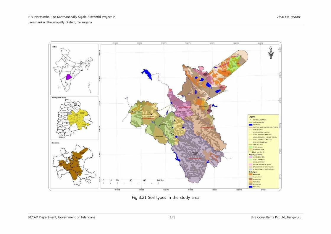
P V Narasimha Rao Kanthanapally Sujala Sravanthi Project in Final EIA Report
Jayashankar Bhupalapally District, Telangana
I&CAD Department, Government of Telangana 3.73 EHS Consultants Pvt Ltd, Bengaluru
Fig 3.21 Soil types in the study area

P V Narasimha Rao Kanthanapally Sujala Sravanthi Project in Final EIA Report
Jayashankar Bhupalapally District, Telangana
I&CAD Department, Government of Telangana 3.74 EHS Consultants Pvt Ltd, Bengaluru
Fig 3.22 Slope map of the study area

P V Narasimha Rao Kanthanapally Sujala Sravanthi Project in Final EIA Report
Jayashankar Bhupalapally District, Telangana
I&CAD Department, Government of Telangana 3.75 EHS Consultants Pvt Ltd, Bengaluru
Fig 3.23 Drainage map in the study area

P V Narasimha Rao Kanthanapally Sujala Sravanthi Project in Final EIA Report
Jayashankar Bhupalapally District, Telangana
I&CAD Department, Government of Telangana 76 EHS Consultants Pvt Ltd, Bengaluru
3.4 Biological Environment
3.4.1 Description of Project Site & Study Area
A. Project area (Near proposed barrage)
Location of the proposed barrage Thupakulagudem Village, Eturnagaram Mandal, Jayashankar
Bhupalapally District, Telangana
Rivers and streams River Godavari
Length of barrage 1132 m
Protected areas and ecologically
sensitive areas within 10 km radius
from the project site
Eturnagaram Wildlife Sanctuary - < 5 Km from the proposed
barrage
Soil type Alluvial soil
Submergence land (River portion) 580.18 ha
Existing plant species available
within the project site
Tectona grandis L.f., Terminalia alata Heyne ex Roth, Barringtonia
acutangula (L.) Gaertn., Pterocarpus indicus Willd., Tamarindus
indicus L., Ficus racemosa L., Ficus hispida L. fil., etc.
B. Command area
Command Area 2,51,310 ha - Existing J. Chokka Rao Devadula LIS
3,04,000 ha - Existing Sriram Sagar Project (Stage I & II)
Districts benefitted Jayashankar Bhupalapally, Nalgonda, Warangal (Rural & Urban) and
Khammam
Climate & Rainfall Central and Southern Telangana zone, hot and dry climate with an
average annual rainfall ranges from 751 mm to 1061 mm
Soil type Chalakas, Dubbas, Black soils, Red soils, Alkaline soils, alluvial soils
Vegetation in the command area
Terminalia arjuna (Roxb.) Wight & Arn., Terminalia tomentosa
(Roxb.) Wight & Arn., Tectona grandis L.f., Butea monosperma
(Lam.) Taub., Wrightia tinctoria, Cassia renigera, Azadirachta indica,
Choloroxylon swietenia, etc.
Reserve Forest within the study area
5 Reserved Forests and 1 Protected Forest;
• Annaram RF
• Nuguru RF
• Perur RF
• Nagaram RF
• Bangoranikonta RF
• Marimalli PF
Diversion of forest land Nil
Rivers and streams River Godavari
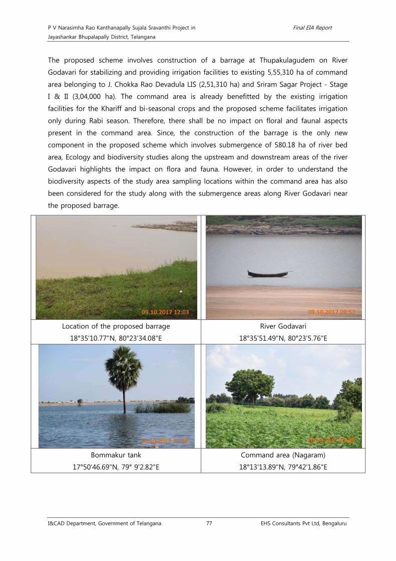
P V Narasimha Rao Kanthanapally Sujala Sravanthi Project in Final EIA Report
Jayashankar Bhupalapally District, Telangana
I&CAD Department, Government of Telangana 77 EHS Consultants Pvt Ltd, Bengaluru
The proposed scheme involves construction of a barrage at Thupakulagudem on River
Godavari for stabilizing and providing irrigation facilities to existing 5,55,310 ha of command
area belonging to J. Chokka Rao Devadula LIS (2,51,310 ha) and Sriram Sagar Project - Stage
I & II (3,04,000 ha). The command area is already benefitted by the existing irrigation
facilities for the Khariff and bi-seasonal crops and the proposed scheme facilitates irrigation
only during Rabi season. Therefore, there shall be no impact on floral and faunal aspects
present in the command area. Since, the construction of the barrage is the only new
component in the proposed scheme which involves submergence of 580.18 ha of river bed
area, Ecology and biodiversity studies along the upstream and downstream areas of the river
Godavari highlights the impact on flora and fauna. However, in order to understand the
biodiversity aspects of the study area sampling locations within the command area has also
been considered for the study along with the submergence areas along River Godavari near
the proposed barrage.
Location of the proposed barrage
18°35'10.77"N, 80°23'34.08"E
River Godavari
18°35'51.49"N, 80°23'5.76"E
Bommakur tank
17°50'46.69"N, 79° 9'2.82"E
Command area (Nagaram)
18°13'13.89"N, 79°42'1.86"E

P V Narasimha Rao Kanthanapally Sujala Sravanthi Project in Final EIA Report
Jayashankar Bhupalapally District, Telangana
I&CAD Department, Government of Telangana 78 EHS Consultants Pvt Ltd, Bengaluru
3.4.2 Eturnagaram Wildlife Sanctuary (WLS)
Eturnagaram WLS (80,600 ha) is located at the close proximity (< 5 Km) from the proposed
barrage in Eturnagaram village in Bhupalapally district of Telangana. According to Champion
and Seth classification (1968), the forest type in Eturnagaram WLS is Tropical Dry Deciduous
Forest with unique climbers and dominant tree species such as Tectona grandis, Terminalia
arjuna, Bambusa vulgaris, Madhuca sp., Terminalia sp. and Pterocarpus marsupium. A
perennial river known as “Dayyam Vagu” divides the sanctuary into almost two parts. Major
faunal attractions of this Sanctuary includes Tiger, Panther, Gaur, Sambar, Chital, Nilgiri Black
buck and reptiles such as Mugger crocodiles, Cobra, Python and Krait.

P V Narasimha Rao Kanthanapally Sujala Sravanthi Project in Final EIA Report
Jayashankar Bhupalapally District, Telangana
I&CAD Department, Government of Telangana 3.79 EHS Consultants Pvt Ltd, Bengaluru
3.4.3 Approach and Methodology
3.4.3.1 Methodology for Biodiversity assessment
Selection of sampling locations using Random
sampling method and belt transect method
Sampling by using random sampling method
within the command area of the proposed
project based on the prevailing land use pattern.
Sampling by using belt transect method along the
upstream and downstream regions of River Godavari
(near the proposed barrage) involving submergence.
Primary data collection
• Identification of floral and faunal species
• Phyto-sociological parameters for trees
• Diversity indices for trees
• Number/ occurrence of the faunal species, etc
Flora
Quadrate method (agricultural lands)
Trees – 100 m x 100 m
Shrubs & Herbs – 5 m x 5 m
Transect method (Riparian vegetation)
Upstream and downstream regions of River Godavari
Fauna
Transect method
Fauna – 1000 m
Butterflies – 1000 m
Point count method
Avi-fauna – 1000 m
Secondary data collection
Collection of data from various sources
such as Forest Working Plans, field guides,
published literatures, etc
Prediction of impacts and proposal of
proper mitigation measures

P V Narasimha Rao Kanthanapally Sujala Sravanthi Project in Final EIA Report
Jayashankar Bhupalapally District, Telangana
I&CAD Department, Government of Telangana 3.80 EHS Consultants Pvt Ltd, Bengaluru
3.4.3.2 Primary data - Flora and Fauna (Three seasons baseline data collection)
Sl.
No. Habitat Method
Size of the quadrate/ transect
(m) Number Time and duration of sampling
Flora (Command area)
1 Trees Quadrate method
(agricultural lands)
100 x 100 6 Monsoon season-September 2017,
Post-monsoon season-December 2017 and
Pre-monsoon season-March 2018
2 Shrubs 5 x 5 6
3 Herbs and Grass 5 x 5 6
Flora (Near proposed barrage)
1 Trees Transect method
(riparian vegetation)
Upstream and downstream
regions of River Godavari
involving submergence
-
Monsoon season-September 2017,
Post-monsoon season-December 2017 and
Pre-monsoon season-March 2018
2 Shrubs
3 Herbs and Grass
Fauna
1 Fauna Transect method 1000 7 Monsoon season-September 2017,
Post-monsoon season-December 2017 and
Pre-monsoon season-March 2018
2 Butterflies Transect method 1000 7
3 Avi-fauna Point count method -- 7
P V Narasimha Rao Kanthanapally Sujala Sravanthi Project in Final EIA Report
Jayashankar Bhupalapally District, Telangana
I&CAD Department, Government of Telangana 3.81 EHS Consultants Pvt Ltd, Bengaluru
3.4.3.3 Secondary data
Forest working plan of Warangal41, Khammam42 and Nalgonda43 divisions, Botanical Survey of
India44, Zoological Survey of India45, IUCN Red Data Book46, Wildlife Schedules of Wildlife
(Protection) Act, 197247, Book of Indian Birds48, ENVIS49, FRLHT50, Butterflies of India51, Reptiles
of India52, Andhra Pradesh Biodiversity Field Guide53, Trees of Hyderabad54, Handbook on Weed
identification55 and Common Dry land Trees of Karnataka56
will be used for identification and
validation of species. Identified species will be cross verified and confirmed with the Field Guides
and TFD records. Consultation with local people and respective Forest Divisions will also be
carried out during the site visit to understand the distribution and seasonality of herbs, shrubs,
climbers and fauna in the region. The unidentified species will be photographed and the
specimens will be collected and verified by using BSI, FRLHT, YETI, Digital flora of IISC data base
and will be cross checked with experts.
41 Working plan for Warangal District (1991-20001), K S Chander Rao, Vol 1. Telangana Forest Department. 42 Working plan for the forests of Bhadrachalam(N) division, Khammam Circle (2003-2013), K Eswarchand, Vol 1&2. GoAP Forest Department. 43 Working plan for the forests of Nalgonda Ditrict, (1994-2004), K Saradhi et al.,, Vol 1&2. GoAP Forest Department. 44 Botanical Survey of India (1990). Rare and endangered species of Indian flora and fauna. Botanical survey of India. DOI:
http//www.bsi.govi.in/accessed on 12.11.2017 45 Zoological Survey of India, 1915. Handbook and Pictorial guides. DOI: http://faunaofindia.nic.in/php/hpg_books_list.php accessed on 12.11.2017 46 IUCN Red Data Book, 2017. DOI: http://www.iucnredlist.org/ accessed on 12.11.2017 47 The Indian Wildlife (Protection) Act, 1972 (as amended upto 1993), accessed on http://envfor.nic.in/legis/wildlife/wildlife1.html 48 Salim Ali. (1983 & 2012). Book of Indian Birds (1st ed.). Mumbai, Maharashtra: Bombay Natural History Society 49 ENVIS, 2017. DOI: http://www.zsienvis.nic.in/index.aspx accessed on 12.11.2017 50 Foundation for Revitalisation of Local Health Traditions (FRLHT), 1991. DOI: http://envis.frlht.org/bot_search accessed on 12.11.2017 51 Singh, A. P. (2011). Butterflies of India (Vol. 1). New Delhi, Darya Ganji: Om Books International. 52 Daniel J.C., (2002). The Book of Indian Reptiles and Amphibians. Mumbai, Maharashtra: Bombay Natural History Society 53 Andhra Pradesh Biodiversity Field Guide, 2.16. Hyderabad, Andhra Pradesh: Andhra Pradesh State biodiversity Board. 54 Prasanna P. V., Reddy C. M., Ramana M. V., & P. Venu, (2012). Trees of Hyderabad a pictorial Guide. Kolkata, West Bengal: Botanical Survey of
India. 55 Naidu V.S.G.R. 2012, Hand Book on Weed Identification. Directorate of Weed Science Research, Jabalpur, India 56 Kavitha et al. 2012, Common Dry land Trees of Karnataka. Ashoka Trust for Research in Ecology and the Environment. India

P V Narasimha Rao Kanthanapally Sujala Sravanthi Project in Final EIA Report
Jayashankar Bhupalapally District, Telangana
I&CAD Department, Government of Telangana 3.82 EHS Consultants Pvt Ltd, Bengaluru
Fig 3.24 Command area map showing biological environment sampling locations

P V Narasimha Rao Kanthanapally Sujala Sravanthi Project in Final EIA Report
Jayashankar Bhupalapally District, Telangana
I&CAD Department, Government of Telangana 3.83 EHS Consultants Pvt Ltd, Bengaluru
Fig 3.25 Map showing the upstream and downstream areas of River Godavari.

P V Narasimha Rao Kanthanapally Sujala Sravanthi Project in Final EIA Report
Jayashankar Bhupalapally District, Telangana
I&CAD Department, Government of Telangana 3.84 EHS Consultants Pvt Ltd, Bengaluru
Fig 3.26 Map showing forest area and water bodies within the study area.

P V Narasimha Rao Kanthanapally Sujala Sravanthi Project in Final EIA Report
Jayashankar Bhupalapally District, Telangana
I&CAD Department, Government of Telangana 3.85 EHS Consultants Pvt Ltd, Bengaluru
3.4.3.4 Details of sampling locations
Table 3.24 Details of the sampling locations
Sl.
No Sampling location Geographical co-ordinates Criteria for sampling
A. Command area (Random sampling- quadrate method)
1 Nagaraam 18°13'16.40"N, 79°41'43.21"E Tank and agricultural land
2 Gopalpur 18° 6'30.23"N, 79°24'27.77"E Tank and agricultural land
3 Hanmanthapur 17°51'15.94"N, 79° 9'20.80"E Bommakuru dam and agricultural
land
4 Raghunathpally 17°45'47.43"N, 79°16'31.46"E Reserve Forest surrounded by
agricultural land
5 Ingurti 17°40'20.83"N, 79°45'47.47"E Reserve Forest and agricultural land
6 Mated 17°32'41.23"N, 79°42'2.78"E Tank and agricultural land
B. Upstream and downstream areas along River Godavari (Transect method)
1 Proposed barrage 18° 35' 10" N, 80° 23' 36" E Riparian areas along River Godavari
3.4.4 Results and Discussion
3.4.4.1 Near Proposed barrage
3.4.4.1.1 Flora
• Trees community
The proposed project involves construction of barrage near Thupakulagudem village of
Eturnagaram Mandal in Jayashankar Bhupalapally District. Therefore, belt transect method of 10
m width was used to assess the riparian floral composition along River Godavari (Upstream
and Downstream of both left bank and right bank) involving submergence, totally 4 transacts
were laid on both the banks of River Godavari. A total of 39 tree species (n=352) belonging to
21 families and 29 genera were recorded at the riparian stretch of both the banks of River
Godavari. Of which all are common to the region except Pterocarpus indicus, Calophyllum
inophyllum and Acacia nilotica which are considered as vulnerable and least concern category
respectively, as per IUCN Conservation status, 2018. Acacia nilotica (n=56) Pterocarpus indicus
(n= 46), followed by Ficus racemosa (n=32) and Terminalia alata (n=23) are the predominant
tree species recorded at the riparian stretch of Godavari River, near proposed barrage. The list
of tree species, along with RET/ IUCN status of the recorded tree species and their phyto-
sociological parameters are given as Annexure 18.

P V Narasimha Rao Kanthanapally Sujala Sravanthi Project in Final EIA Report
Jayashankar Bhupalapally District, Telangana
I&CAD Department, Government of Telangana 3.86 EHS Consultants Pvt Ltd, Bengaluru
The importance value index is used to determine the overall importance of the each species in
the community structure. Pterocarpus indicus is the most important species having an IVI of
46.48 followed by Acacia nilotica and Tamarindus indicus having IVI values of 31.55 and 23.37
respectively; Terminalia arjuna had the least IVI of 2.12. The IVI of dominant species is
tabulated below.
Table 3.25 Importance Value Index of dominant tree species.
Sl.No Scientific Name IVI
1 Pterocarpus indicus Willd. 46.48
2 Acacia nilotica (L.) Willd. ex Delile 31.55
3 Tamarindus indicus L. 23.37
4 Ficus racemosa L. 22.54
5 Terminalia alata Heyne ex Roth 15.10
6 Diospyros melanoxylon Roxb. 11.25
7 Tectona grandis L.f. 11.21
8 Ficus hispida L.f. 11.10
9 Boswellia serrata Triana & Planch. 9.21
10 Acacia leucocephala (Lam.) Link 8.31
The dominant tree species Pterocarpus indicus contributed basal area of 2.44 m2/ha followed
by Tamarindus indicus and Acacia nilotica having basal area of 1.34 m2/ha and 1.13 m2/ha
respectively. Out of Four sampled transects, Ficus racemosa and Holoptelea integrifloia are the
species recorded in three transects, hence the frequency of these species is 75 %. In addition
to this, diversity indices such as Shannon-Weiner diversity index and Simpson diversity index
were estimated to be 2.99 and 0.93.
Table 3.26 Basal area of dominant tree species.
Sl.No Scientific Name Basal area (m2/ha)
1 Pterocarpus indicus Willd. 2.44
2 Tamarindus indicus L. 1.34
3 Acacia nilotica (L.) Willd. ex Delile 1.13
4 Ficus racemosa L. 0.65
5 Terminalia alata Heyne ex Roth 0.55
6 Pterospermum acerifolium (L.) Willd. 0.24
7 Acacia leucocephala (Lam.)Link 0.20
8 Boswellia serrata Triana & Planch. 0.16
9 Diospyros melanoxylon Roxb. 0.13
10 Ficus hispida L.f. 0.12

P V Narasimha Rao Kanthanapally Sujala Sravanthi Project in Final EIA Report
Jayashankar Bhupalapally District, Telangana
I&CAD Department, Government of Telangana 3.87 EHS Consultants Pvt Ltd, Bengaluru
As shown in the below table the maximum number of stems falls under 30-60 cm girth class
(172 trees) which contribute to 48.86 % of the total population. The category of girth class in
which the second most maximum number of stems fall in is 60-90 cm girth class (75 trees)
which contributes to 21.31 % of the total individuals, followed by 90-120 cm girth class (40
trees) and 150-180 cm girth class (10 trees) contributing 11.36 % and 3.13 % respectively.
Table 3.27 Girth class distribution of trees near proposed barrage site.
Sl.No Girth class Number Percentage (%)
1 0-30 11 3.13
2 30-60 172 48.86
3 60-90 75 21.31
4 90-120 40 11.36
5 120-150 6 1.70
6 150-180 11 3.13
7 180-210 7 1.99
8 210-240 9 2.56
9 240-270 10 2.84
10 270-300 9 2.56
11 300-330 2 0.57
Total 352 100
Pterocarpus indicus Willd.
Upstream of River Godavari
18°36'9.06"N, 80°22'46.51"E
Xylia xylocarpa Roxb. Taub.
Upstream of River Godavari
18°36'9.97"N, 80°22'4.38"E

P V Narasimha Rao Kanthanapally Sujala Sravanthi Project in Final EIA Report
Jayashankar Bhupalapally District, Telangana
I&CAD Department, Government of Telangana 3.88 EHS Consultants Pvt Ltd, Bengaluru
Ficus hispida L.f.
Near the proposed barrage
18°35'7.37"N, 80°23'7.32"E
Ficus racemosa L.
Downstream of River Godavari
18°34'5.43"N, 80°23'18.14"E
Tamarindus indicus L.
Downstream of River Godavari
18°34'22.36"N, 80°23'19.01"E
Hardwickia binata Roxb.
Downstream of River Godavari
18°33'40.66"N, 80°23'7.85"E
Mitragyna parvifolia (Roxb.) Korth
Near the proposed barrage
18°35'7.37"N, 80°23'7.32"E
Diospyros melanoxylon Roxb.
Upstream of River Godavari
18°36'9.97"N, 80°22'4.38"E
• Herbs, shrubs and climbers community
Monsoon (July 2017): During Monsoon, a total of 93 species of herbs, shrubs and climbers
belonging to 34 families were recorded. Out of which, Family Asteraceae (n=15) and Poaceae
(n=8) are the dominant families. About 76 herbs belonging to 29 families, 64 genera, 10

P V Narasimha Rao Kanthanapally Sujala Sravanthi Project in Final EIA Report
Jayashankar Bhupalapally District, Telangana
I&CAD Department, Government of Telangana 3.89 EHS Consultants Pvt Ltd, Bengaluru
species of shrubs belonging to 9 families and 10 genera and 7 species of climbers belonging
to 5 families and 7 genera were recorded during the inventory. As per IUCN conservation
status, 2018; 13 species of herbs belongs to Least Concern category and no RET species were
recorded.
Post-Monsoon (October 2017): During Post-Monsoon season, a total of 48 species of herbs,
shrubs and climbers belonging to 25 families were recorded. Out of which, Poaceae (n=6) and
Fabaceae (n=4) are the dominant families. About 34 species of herbs belonging to 19 families
and 34 genera, 10 species of shrubs belonging to 9 families and 10 genera and 4 species of
climbers belonging to 4 families and 4 genera were recorded during the inventory. As per
IUCN conservation status, 2018; 7 species of herbs belongs to Least Concern category and no
RET species were recorded. During post monsoon season, species such as Xanthium
strumarium, Borreria hispida, Boerhavia diffusa and Sida acuta were found to be desiccated
due to loss of moisture content.
Pre-Monsoon (January 2018): During Pre-Monsoon season, a total of 77 species of herbs,
shrubs and climbers belonging to 26 families were recorded. Out of which, Asteraceae and
Poaceae are the dominant families having n=13 and n= 10 species respectively. About 62
species of herbs belonging to 22 families and 54 genera, 10 Species of shrubs belonging to 9
families and 10 genera and 5 species of climbers belonging to 3 families and 5 genera were
recorded during the inventory. 14 species of herbs belongs to Least Concern category as per
IUCN conservation status, 2018 and no RET species were recorded. Hemidesmus indicus and
Pergularia daemia are the two important medicinal climbers identified all along the riparian
stretches. Chrozophora rottileri, Chamaecrista pratensis and Vernonia cinerea are the dominant
herbs emerged all along the riparian stretch during Pre-Monsoon.

P V Narasimha Rao Kanthanapally Sujala Sravanthi Project in Final EIA Report
Jayashankar Bhupalapally District, Telangana
I&CAD Department, Government of Telangana 3.90 EHS Consultants Pvt Ltd, Bengaluru
Table 3.28 Family-wise number of species recorded near proposed barrage site.
Sl.No. Family Number
Total Monsoon Post Monsoon Pre Monsoon
1 Acanthaceae 2 - 1 3
2 Aizoaceae 1 1 1 3
3 Amaranthaceae 5 3 5 13
4 Apocynaceae 1 1 1 3
5 Asclepiadaceae 2 1 2 5
6 Asteraceae 15 3 13 31
7 Boraginaceae 1 - - 1
8 Caesalpiniaceae 4 2 4 10
9 Cleomaceae 2 - 1 3
10 Commelinaceae 1 1 - 2
11 Convolvulaceae 4 2 2 8
12 Cucurbitaceae 3 1 2 6
13 Cyperaceae 1 1 1 3
14 Euphorbiaceae 6 3 5 14
15 Fabaceae 6 4 8 18
16 Hypericaceae 1 - 1 2
17 Lamiaceae 4 2 3 9
18 Lythraceae 2 1 2 5
19 Malvaceae 3 3 1 7
20 Molluginaceae 1 - - 1
21 Nyctaginaceae 1 1 - 2
22 Papaveraceae 1 1 - 2
23 Phyllanthaceae 1 - 1 2
24 Plumbaginaceae 1 1 - 2
25 Poaceae 8 6 10 24
26 Rhamnaceae 2 2 2 6
27 Rubiaceae 4 2 2 8
28 Sapinadaceae 1 - - 1
29 Scrophulariaceae 2 - 2 4
30 Solanaceae 1 2 2 5
31 Stirculiaceae 1 1 - 2
32 Tiliaceae 3 2 2 7
33 Verbenaceae 1 1 2 4

P V Narasimha Rao Kanthanapally Sujala Sravanthi Project in Final EIA Report
Jayashankar Bhupalapally District, Telangana
I&CAD Department, Government of Telangana 3.91 EHS Consultants Pvt Ltd, Bengaluru
Sl.No. Family Number
Total Monsoon Post Monsoon Pre Monsoon
34 Zygophyllaceae 1 - 1 2
Total 93 48 77 218
Chromolaena odorata (L.) R.M.King & H.Rob.
Downstream of River Godavari
18°34'5.43"N, 80°23'18.14"E
Argemone Mexicana L.
Upstream of River Godavari
18°36'9.06"N, 80°22'46.51"E
Solanum xanthocarpum Schrader & Wendland
Upstream of River Godavari
18°36'9.06"N, 80°22'46.51"E
Citrullus colocynthis (L.) Schrader
Downstream of River Godavari
18°34'5.43"N, 80°23'18.14"E
Heliotropium indicum L.
Downstream of River Godavari
18°34'5.43"N, 80°23'18.14"E
Chrozophora rottleri (Geiseler) Spreng.
Upstream of River Godavari
18°36'9.06"N, 80°22'46.51"E

P V Narasimha Rao Kanthanapally Sujala Sravanthi Project in Final EIA Report
Jayashankar Bhupalapally District, Telangana
I&CAD Department, Government of Telangana 3.92 EHS Consultants Pvt Ltd, Bengaluru
Physalis minima L.
Upstream of River Godavari
18°36'9.06"N, 80°22'46.51"E
Sphaeranthus indicus Gaertn.
Upstream of River Godavari
18°36'9.06"N, 80°22'46.51"E
3.4.4.1.2 Fauna
Eturnagaram Wildlife Sanctuary is a well renowned eco-sensitive area and wildlife habitat
located at a distance of < 5 Km to the proposed Thupakulagudem barrage. The command
area of the proposed project is well irrigated with healthy vegetation and fresh water tanks
supporting various faunal and avifaunal species.
Monsoon season (July 2017): A total of 29 avifaunal species (n=111) was recorded during
monsoon season. Pied bush chat (n=29), Blue tailed bee-eater (n=18), Black headed cuckoo
shrike (n=15) and Purple rumped sunbird (n=6) were the predominant avifaunal species
recorded during the study. Black tailed godwit (n=1) and Jerdon's courser (n=1) are the
species belongs to near threatened and critically endangered category as per IUCN
conservation status, 2017 and Common Buzzard (n=1), Indian peafowl (n=1) and Jerdon's
courser (n=1) are the avifaunal species belonging to Schedule I of Wildlife (Protection) Act,
1972. All other species are common to region.
A total of 46 butterfly species (n=234) were recorded during the study and Plain tiger (n=38),
Cabbage white (n=26) and Blue tiger (n=26) were the predominant butterfly species recorded.
As per IUCN conservation status, 2018; Euploea core (n=18), Eurema brigitta (n=1) and Pontia
daplidicea (n=1) belongs to Least Concern category. Common Pierrot (n=1), Chocolate
albatross (n=2), Common gem (n=5) and Common gull (n=1), Great black vein (n=1), Malabar
blue (n=1), Common crow (n=18) and Striped blue crow (n=1) belongs to Schedule I, II and IV
of Wildlife (Protection) Act, 1972 respectively.
Post Monsoon season (October 2017): A total of 29 avifaunal species (n=172) were recorded
during post-monsoon season. Of which Blue-breasted flycatcher (n=39) and Red wattled
lapwing (n=23) is the predominant avifaunal species recorded during the study. Blue-breasted
flycatcher (n=39) is the only avifaunal species belonging to Near threatened category and rest
of the species belongs to Least Concern category of IUCN Conservation status, 2018 and all
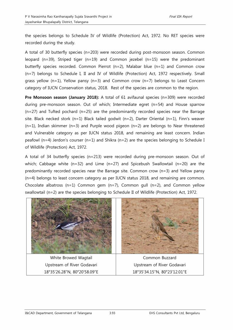
P V Narasimha Rao Kanthanapally Sujala Sravanthi Project in Final EIA Report
Jayashankar Bhupalapally District, Telangana
I&CAD Department, Government of Telangana 3.93 EHS Consultants Pvt Ltd, Bengaluru
the species belongs to Schedule IV of Wildlife (Protection) Act, 1972. No RET species were
recorded during the study.
A total of 30 butterfly species (n=203) were recorded during post-monsoon season. Common
leopard (n=39), Striped tiger (n=19) and Common jezebel (n=15) were the predominant
butterfly species recorded. Common Pierrot (n=2), Malabar blue (n=1) and Common crow
(n=7) belongs to Schedule I, II and IV of Wildlife (Protection) Act, 1972 respectively. Small
grass yellow (n=1), Yellow pansy (n=3) and Common crow (n=7) belongs to Least Concern
category of IUCN Conservation status, 2018. Rest of the species are common to the region.
Pre Monsoon season (January 2018): A total of 61 avifaunal species (n=309) were recorded
during pre-monsoon season. Out of which; Intermediate egret (n=54) and House sparrow
(n=27) and Tufted pochard (n=25) are the predominantly recorded species near the Barrage
site. Black necked stork (n=1) Black tailed godwit (n=2), Darter Oriental (n=1), Finn's weaver
(n=1), Indian skimmer (n=3) and Purple wood pigeon (n=2) are belongs to Near threatened
and Vulnerable category as per IUCN status 2018, and remaining are least concern. Indian
peafowl (n=4) Jerdon's courser (n=1) and Shikra (n=2) are the species belonging to Schedule I
of Wildlife (Protection) Act, 1972.
A total of 34 butterfly species (n=213) were recorded during pre-monsoon season. Out of
which; Cabbage white (n=32) and Lime (n=27) and Spicebush Swallowtail (n=20) are the
predominantly recorded species near the Barrage site. Common crow (n=3) and Yellow pansy
(n=4) belongs to least concern category as per IUCN status 2018, and remaining are common.
Chocolate albatross (n=1) Common gem (n=7), Common gull (n=2), and Common yellow
swallowtail (n=2) are the species belonging to Schedule II of Wildlife (Protection) Act, 1972.
White Browed Wagtail
Upstream of River Godavari
18°35'26.28"N, 80°20'58.09"E
Common Buzzard
Upstream of River Godavari
18°35'34.15"N, 80°23'12.01"E

P V Narasimha Rao Kanthanapally Sujala Sravanthi Project in Final EIA Report
Jayashankar Bhupalapally District, Telangana
I&CAD Department, Government of Telangana 3.94 EHS Consultants Pvt Ltd, Bengaluru
Pond Heron
Upstream of River Godavari
18°35'36.22"N, 80°23'20.46"E
Small Pratincole
Upstream of River Godavari
18°35'34.15"N, 80°23'12.01"E
Indian Robin
Upstream of River Godavari
18°35'26.28"N, 80°20'58.09"E
Little ringed plover
Upstream of River Godavari
18°35'29.61"N, 80°23'25.52"E
Mountain imperial pigeon
Upstream of River Godavari
18°36'8.12"N, 80°22'26.90"E
Spotted Owlet
Upstream of River Godavari
18°36'4.63"N, 80°21'54.07"E

P V Narasimha Rao Kanthanapally Sujala Sravanthi Project in Final EIA Report
Jayashankar Bhupalapally District, Telangana
I&CAD Department, Government of Telangana 3.95 EHS Consultants Pvt Ltd, Bengaluru
Table 3.29 Family-wise occurrence (%) of avifaunal species recorded near propose barrage.
Sl.No Family Occurrences (%)
1 Accipitridae (Eagles and kites) 1.18
2 Alcedinidae (Kingfishers) 0.68
3 Anatidae (Ducks, Geese and Swans) 4.22
4 Anhingidae (Darters and Snakebirds) 0.17
5 Apodidae (swifts) 17.74
6 Campephagidae (Minivets) 4.05
7 Charadriidae (Plovers and lapwings) 5.57
8 Ciconiidae (Storks) 0.68
9 Cisticolidae (Prinias and tailor birds) 0.34
10 Columbidae (Pigeons and doves) 4.39
11 Coraciidae (rollers) 0.17
12 Corvidae ( Crows, Ravens, Rooks, Jackdaws, Jays, Magpies and Treepies) 1.18
13 Cuculidae (Cuckoo, Koels, Malkohas and Coucals) 2.87
14 Dicruridae (Drongos) 1.86
15 Estrildidae (Munias) 0.68
16 Glareolidae (Pratincoles and coursers) 0.51
17 Gruidae (Cranes) 1.01
18 Hirundinidae (Swallows and Martins) 1.01
19 Laniidae (Shrikes) 1.01
20 Laridae (Gulls, Terns and Skimmers) 0.68
21 Leiothrichidae (Laughingthrushes) 1.52
22 Megalaimidae (Asian barbets) 0.17
23 Meropidae (Bee-eaters) 8.45
24 Motacillidae (Wagtails and pipits) 5.41
25 Muscicapidae (Robins, Flycatchers, Bluethroats, Bush Chats, Stonechats) 13.51
26 Nectariniidae (Sunbirds) 4.90
27 Parulidae (Warblers) 0.34
28 Passeridae (Sparrows) 4.90
29 Pelecanidae (Pelicans) 0.51
30 Phalacrocoracidae (Cormorants) 1.52
31 Phasianidae (Pheasants, Partridges, Jungle fowls, Chickens, Quails and Peafowls) 1.18
32 Phoenicopteridae (Flamingos) 0.84
33 Ploceidae (weavers or weaverbirds) 1.52
34 Podicipedidae (Grebe) 0.34
35 Psittacidae (Parakeets) 1.01
36 Pycnonotidae (Bulbuls) 1.18

P V Narasimha Rao Kanthanapally Sujala Sravanthi Project in Final EIA Report
Jayashankar Bhupalapally District, Telangana
I&CAD Department, Government of Telangana 3.96 EHS Consultants Pvt Ltd, Bengaluru
Sl.No Family Occurrences (%)
37 Recurvirostridae (Stilts) 0.17
38 Rhipiduridae (Fantails) 0.17
39 Scolopacida (Sandpipers) 0.84
40 Strigidae (Owls) 0.17
41 Sturnidae (Starlings) 0.68
42 Tephrodornithidae (Woodshrikes) 0.34
43 Threskiornithidae (Ibises) 0.34
Total 100.00
Fig 3.27 Graph showing predominant avifaunal species recorded during the study.

P V Narasimha Rao Kanthanapally Sujala Sravanthi Project in Final EIA Report
Jayashankar Bhupalapally District, Telangana
I&CAD Department, Government of Telangana 3.97 EHS Consultants Pvt Ltd, Bengaluru
Grass Yellow
Upstream of River Godavari
18°35'41.74"N, 80°22'42.72"E
Lemon Pansy
Upstream of River Godavari
18°35'41.74"N, 80°22'42.72"E
Tawny coster
Upstream of River Godavari
18°36'9.66"N, 80°22'42.48"E
Mottled Emigrant
Upstream of River Godavari
18°36'9.56"N, 80°22'44.48"E
Cabbage White
Downstream of River Godavari
18°34'4.86"N, 80°23'18.02"E
Common Crow
Downstream of River Godavari
18°34'4.86"N, 80°23'18.02"E

P V Narasimha Rao Kanthanapally Sujala Sravanthi Project in Final EIA Report
Jayashankar Bhupalapally District, Telangana
I&CAD Department, Government of Telangana 3.98 EHS Consultants Pvt Ltd, Bengaluru
Common Leopard
Upstream of River Godavari
18°36'9.66"N, 80°22'42.48"E
Crimson Rose
Upstream of River Godavari
18°36'9.66"N, 80°22'42.48"E
Striped Tiger
Downstream of River Godavari
18°34'4.86"N, 80°23'18.02"E
Blue Tiger
Downstream of River Godavari
18°34'4.86"N, 80°23'18.02"E
Plain Tiger
Downstream of River Godavari
18°34'4.86"N, 80°23'18.02"E
Lime Butterfly
Near the proposed barrage
18°35'8.86"N, 80°23'17.14"E
P V Narasimha Rao Kanthanapally Sujala Sravanthi Project in Final EIA Report
Jayashankar Bhupalapally District, Telangana
I&CAD Department, Government of Telangana 3.99 EHS Consultants Pvt Ltd, Bengaluru
3.4.4.2 Command area
3.4.4.2.1 Flora
• Tree community
The command area of the existing project includes the well irrigated lands of J. Chokka Rao
Devadula LIS and Sriram Sagar Project - Stage I & II. The existing command area is facilitated
with a number of good water tanks providing irrigation involving Khariff and bi-seasonal crops.
About 26 tree species (n=148) belonging to 14 families were recorded in the command area.
Azadirachta indica (n=59) followed by Tectona grandis (n=20) and Butea monosperma (n=14)
were the predominant tree species recorded in the command area. All the tree species
recorded were common to the region. The list of tree species along with their use is given as
Annexure 18.
Phyto-sociological features such as relative frequency, relative density, dominance and IVI of
the identified tree species were studied. Azadirachta indica (IVI-97.05) is the most widespread
species in the Command area followed by Butea monosperma (IVI-34.04), Borassus flabellifer
(IVI-30.91) and Tectona grandis (IVI-20.72).
Basal area of the recorded tree species greater than 0.10 cm2 was studied. Of which,
Azadirachta indica (3.97 cm2) had the highest Basal area followed by Borassus flabellifer (1.44
cm2), Butea monosperma (1.22 cm2) and Acacia nilotica (0.49 cm2) indicating the dominant
species with greater tree biomass. In addition to this, diversity indices such as Shannon-Weiner
diversity index and Simpson diversity index were estimated to be 2.30 and 0.80.
As shown in the below table, the maximum number of stems falls under the girth class of 30.1
to 60 cm (53 trees) which contributes to 35.81 % of the total individuals followed by the girth
class of 60.1 to 90 cm (31 trees) which contributes to 20.95% of the total individuals and girth
class of 0.00 to 30 cm (22 trees) contributing to 14.86 % of the total individuals.
Table 3.30 Girth class Distribution of trees in the command area
Sl.No. Girth class (cm) Number (n) Percentage (%)
1 0-30 22 14.86
2 30-60 53 35.81
3 60-90 31 20.95
4 90-120 19 12.84
5 120-150 13 8.78
6 150-180 9 6.08
7 180-210 1 0.68
Total 148 100

P V Narasimha Rao Kanthanapally Sujala Sravanthi Project in Final EIA Report
Jayashankar Bhupalapally District, Telangana
I&CAD Department, Government of Telangana 3.100 EHS Consultants Pvt Ltd, Bengaluru
Wrightia tinctoria
Bommakur Tank
17°51'15.94"N, 79° 9'20.80"E
Annona squamosa L.
Ghanpur tank
17°50'31.64"N, 79°21'6.93"E
Acacia nilotica (L.) Willd. ex Delile
Nagaram
18°13'16.40"N, 79°41'43.21"E
Borassus flabellifer L.
Near Raghunathpally RF
17°45'47.43"N, 79°16'31.46"E
• Herbs, Shrubs and Climbers community
Monsoon (July 2017): During Monsoon, a total of 106 species of herbs, shrubs and climbers
belonging to 34 families were recorded. Out of which, Family Poaceae (n=26) and Fabaceae
(n=10) are the dominant families. About 85 herbs belonging to 26 families, 13 species of
shrubs belonging to 9 families and 10 species of climbers belonging to 5 families were
recorded during the inventory. As per IUCN conservation status, 2018; 13 species of herbs
belongs to Least Concern category and no RET species were recorded.
Post-Monsoon (October 2017): During Post-Monsoon season, a total of 77 species of herbs,
shrubs and climbers belonging to 29 families were recorded. Out of which, Poaceae (n=15)
and Fabaceae (n=9) are the dominant families. About 57 species of herbs belonging to 21
families, 13 species of shrubs belonging to 9 families and 9 species of climbers belonging to 4
families were recorded during the inventory. As per IUCN conservation status, 2018; 9 species

P V Narasimha Rao Kanthanapally Sujala Sravanthi Project in Final EIA Report
Jayashankar Bhupalapally District, Telangana
I&CAD Department, Government of Telangana 3.101 EHS Consultants Pvt Ltd, Bengaluru
of herbs and 1 species of Climber belongs to Least Concern category and no RET species were
recorded.
Pre-Monsoon (January 2018): During Pre-Monsoon season, a total of 91 species of herbs,
shrubs and climbers belonging to 32 families were recorded. Out of which, Poaceae and
Fabaceae are the dominant families having n=18 and n= 10 species respectively. About 69
species of herbs belonging to 25 families and, 13 Species of shrubs belonging to 9 families
and 9 species of climbers belonging to 6 families were recorded during the inventory. 5
species of herbs and one species of Climber belongs to Least Concern category as per IUCN
conservation status, 2018 and no RET species were recorded.
Table 3.31 Family-wise number of species recorded in Command area.
Sl.No. Family Number
Total Monsoon Post Monsoon Pre Monsoon
1 Acanthaceae 1 - - 1
2 Amaranthaceae 4 5 4 13
3 Annonaceae 1 1 1 3
4 Asclepidaceae 1 3 2 6
5 Asteraceae 7 5 8 20
6 Boraginaceae - 1 1 2
7 Cannabaceae 1 - 1 2
8 Capparidaceae 2 2 2 6
9 Caryophyllaceae 1 1 1 3
10 Chenopodiaceae 1 1 1 3
11 Commelinaceae 3 2 3 8
12 Convolvulaceae 5 - 4 9
13 Cucurbitaceae 3 2 2 7
14 Cyperaceae 3 1 1 5
15 Euphorbiaceae 4 1 3 8
16 Fabaceae 10 9 10 29
17 Lamiaceae 2 3 2 7
18 Lilaceae 1 - 1 2
19 Malvaceae 11 10 9 30
20 Menispermaceae 1 - 1 2
21 Molluginaceae 1 1 - 2
22 Musaceae 1 1 1 3
23 Oxalidaceae - 1 - 1
24 Passifloraceae 1 1 1 3

P V Narasimha Rao Kanthanapally Sujala Sravanthi Project in Final EIA Report
Jayashankar Bhupalapally District, Telangana
I&CAD Department, Government of Telangana 3.102 EHS Consultants Pvt Ltd, Bengaluru
Sl.No. Family Number
Total Monsoon Post Monsoon Pre Monsoon
25 Pedaliaceae 1 1 1 3
26 Phyllanthaceae 2 2 2 6
27 Poaceae 26 15 18 59
28 Primulaceae 1 1 1 3
29 Rubiaceae 2 1 2 5
30 Rutaceae 1 1 1 3
31 Sapindaceae 1 - 1 2
32 Scrophulariaceae - 1 1 2
33 Solanaceae 2 1 2 5
34 Tiliaceae 2 1 - 3
35 Urticaceae - - 1 1
36 Verbenaceae 2 2 2 6
37 Zygophyllaceae 1 - - 1
Total 106 77 91 274

P V Narasimha Rao Kanthanapally Sujala Sravanthi Project in Final EIA Report
Jayashankar Bhupalapally District, Telangana
I&CAD Department, Government of Telangana 3.103 EHS Consultants Pvt Ltd, Bengaluru
Ipomea carnea Jace.
Ghanpur tank
17°50'31.64"N, 79°21'6.93"E
Calotropis gigantean (L.) W. T. Aiton
Bommakur Tank
17°51'15.94"N, 79° 9'20.80"E
Indoneesiella echioides (L.) Sreemadh.
Near Raghunathpally RF
17°45'47.43"N, 79°16'31.46"E
Ipomoea pes-tigridis L.
Near Raghunathpally RF
17°45'47.43"N, 79°16'31.46"E
Blainvillea acmella (L.) Philipson
Near Raghunathpally RF
17°45'47.43"N, 79°16'31.46"E
Digera arvensis Forsk.
Near Raghunathpally RF
17°45'47.43"N, 79°16'31.46"E

P V Narasimha Rao Kanthanapally Sujala Sravanthi Project in Final EIA Report
Jayashankar Bhupalapally District, Telangana
I&CAD Department, Government of Telangana 3.104 EHS Consultants Pvt Ltd, Bengaluru
Hemidesmus indicus (L.) R. Br.
Near Raghunathpally RF
17°45'47.43"N, 79°16'31.46"E
Sesbania sesban (L.)Merr.
Near Raghunathpally RF
17°45'47.43"N, 79°16'31.46"E
3.4.4.2.2 Fauna
Monsoon season (July 2017): A total of 61 avifaunal species (n=309) was recorded during
monsoon season. Intermediate egret (n=54), House sparrow (n=27), Tufted pochard (n=25)
and White wagtail (n=15) were the predominant avifaunal species recorded during the study.
Jerdon's courser (n=1), Black necked stork (n=1), Black tailed godwit (n=2), Darter Oriental
(n=1), Finn's weaver (n=1) and Purple wood pigeon (n=2) are the species belongs to critically
endangered and Near threatened category as per IUCN conservation status, 2018 and
Common Buzzard (n=1), Indian peafowl (n=1), Shikra (n=2) and Jerdon's courser (n=1) are the
avifaunal species belonging to Schedule I of Wildlife (Protection) Act, 1972. All other species
are common to region.
A total of 34 butterfly species (n=213) were recorded during the study and Cabbage butterfly
(n=32), Spicebush Swallowtail (n=20) and Lime butterfly (n=27) were the predominant butterfly
species recorded. As per IUCN conservation status, 2018; Common crow (n=3), and Yellow
pansy (n=4) belongs to Least Concern category. Chocolate albatross (n=1), Common gem
(n=7), Common gull (n=2) and Common yellow swallowtail (n=2) and Common crow (n=3)
belongs to Schedule II and IV of Wildlife (Protection) Act, 1972 respectively.
Post Monsoon season (October 2017): A total of 29 avifaunal species (n=124) were recorded
during post-monsoon season. Of which little cormorant (n=19) and House Swift (n=18) is the
predominant avifaunal species recorded during the study. All the species belongs to Least
Concern category of IUCN Conservation status, 2018 and all the species belongs to Schedule
IV of Wildlife (Protection) Act, 1972. No RET species were recorded during the study.
A total of 20 butterfly species (n=71) were recorded during post-monsoon season. House Swift
(n=12), Yellow pansy (n=11) and Common sailor (n=7) were the predominant butterfly species
recorded. Common crow (n=1) belongs to Schedule IV of Wildlife (Protection) Act, 1972.

P V Narasimha Rao Kanthanapally Sujala Sravanthi Project in Final EIA Report
Jayashankar Bhupalapally District, Telangana
I&CAD Department, Government of Telangana 3.105 EHS Consultants Pvt Ltd, Bengaluru
Common crow (n=1) and Yellow pansy (n=11) belongs to Least Concern category of IUCN
Conservation status, 2018. Rest of the species are common to the region.
Pre Monsoon season (January 2018): A total of 60 avifaunal species (n=180) were recorded
during pre-monsoon season. Out of which; Intermediate egret (n=38) and House sparrow
(n=30) and Tufted pochard (n=22) are the predominantly recorded species near the Barrage
site. Jerdon's courser (n=1), Black necked stork (n=1), Black tailed godwit (n=2), Darter Oriental
(n=1), Finn's weaver (n=1) and Purple wood pigeon (n=2) are belongs to near threatened and
Vulnerable category as per IUCN status 2018, and remaining are least concern. Indian peafowl
(n=4) Jerdon's courser (n=1) and Shikra (n=2) are the species belonging to Schedule I of
Wildlife (Protection) Act, 1972.
A total of 34 butterfly species (n=171) were recorded during pre-monsoon season. Out of
which; Cabbage white (n=24) and Spicebush Swallowtail (n=17) and Lime butterfly (n=15) are
the predominantly recorded species in Command area. Common crow (n=3) and Yellow pansy
(n=3) belongs to Least Concern category of IUCN Conservation status, 2018, and remaining
are common. Chocolate albatross (n=1) Common gem (n=6), Common gull (n=2), and
Common yellow swallowtail (n=2) and Common crow (n=3) are the species belonging to
Schedule II and IV of Wildlife (Protection) Act, 1972 respectively.
White throated Kingfisher
Pedda cheruvu
18°13'16.40"N, 79°41'43.21"E
Asian Open Billed Stork
Gopalpur
18° 6'30.23"N, 79°24'27.77"E

P V Narasimha Rao Kanthanapally Sujala Sravanthi Project in Final EIA Report
Jayashankar Bhupalapally District, Telangana
I&CAD Department, Government of Telangana 3.106 EHS Consultants Pvt Ltd, Bengaluru
Cattle Egret
Gopalpur
18° 6'30.23"N, 79°24'27.77"E
Common Myna
Gopalpur
18° 6'30.23"N, 79°24'27.77"E
Eurasian collared dove
Ingurti
17°40'20.83"N, 79°45'47.47"E
Black drongo
Gopalpur
18° 6'30.23"N, 79°24'27.77"E
Pied bushchat
Gopalpur
18° 6'30.23"N, 79°24'27.77"E
Greater Egret
Pedda cheruvu
18°13'16.40"N, 79°41'43.21"E

P V Narasimha Rao Kanthanapally Sujala Sravanthi Project in Final EIA Report
Jayashankar Bhupalapally District, Telangana
I&CAD Department, Government of Telangana 3.107 EHS Consultants Pvt Ltd, Bengaluru
Table 3.32 Family-wise occurrence (%) of avifaunal species recorded in the command. area.
Sl.No. Family Occurrence (%)
1 Accipitridae (Eagles and kites) 0.56
2 Alaudidae (Larks) 0.56
3 Alcedinidae (Kingfishers) 0.70
4 Anatidae ( Ducks, Geese and Swans) 6.56
5 Anhingidae (Darters and Snakebirds) 0.28
6 Apodidae (Swifts) 2.51
7 Ardeidae (Herons) 18.44
8 Campephagidae (Minivets) 1.40
9 Charadriidae (Plovers and lapwings) 2.51
10 Ciconiidae (Storks) 2.09
11 Cisticolidae (Prinias and tailor birds) 1.68
12 Columbidae (Pigeons and doves) 5.87
13 Corvidae ( Crows, Ravens, Rooks, Jackdaws, Jays, Magpies and Treepies) 1.82
14 Cuculidae (Cuckoo, Koels, Malkohas and Coucals) 3.07
15 Dicruridae (Drongos) 2.51
16 Estrildidae (Munias) 1.12
17 Glareolidae (Pratincoles and coursers) 0.28
18 Gruidae (Cranes) 1.54
19 Laniidae (Shrikes) 1.54
20 Laridae (Gulls, Terns and Skimmers) 1.26
21 Leiothrichidae (Laughingthrushes) 2.23
22 Meropidae (Bee-eaters) 4.33
23 Motacillidae (Wagtails and pipits) 5.17
24 Muscicapidae (Robins, Flycatchers, Bluethroats, Bush Chats, Stonechats) 2.37
25 Nectariniidae (Sunbirds) 4.75
26 Paridae (Tits) 0.28
27 Parulidae (Warblers) 0.98
28 Passeridae (Sparrows) 7.96
29 Phalacrocoracidae (Cormorants) 3.91
30 Phasianidae (Pheasants, Partridges, Junglefowl, Chickens, Old World quail
and Peafowl) 1.12
31 Phoenicopteridae (Flamingos) 1.40
32 Ploceidae (weavers or weaverbirds) 2.09
33 Podicipedidae (Grebe) 0.56
34 Psittacidae (Parakeets) 1.12
35 Pycnonotidae (Bulbuls) 0.84

P V Narasimha Rao Kanthanapally Sujala Sravanthi Project in Final EIA Report
Jayashankar Bhupalapally District, Telangana
I&CAD Department, Government of Telangana 3.108 EHS Consultants Pvt Ltd, Bengaluru
Sl.No. Family Occurrence (%)
36 Recurvirostridae (Stilts) 0.56
37 Rhipiduridae (Fantails) 0.28
38 Scolopacida (Sandpipers) 0.84
39 Sturnidae (Starlings) 1.54
40 Tephrodornithidae (Woodshrikes) 0.56
41 Threskiornithidae (Ibises) 0.84
Fig 3.28 Graph showing predominant avifaunal species recorded during the study.

P V Narasimha Rao Kanthanapally Sujala Sravanthi Project in Final EIA Report
Jayashankar Bhupalapally District, Telangana
I&CAD Department, Government of Telangana 3.109 EHS Consultants Pvt Ltd, Bengaluru
Common Gull
Bommakur Tank
17°51'15.94"N, 79° 9'20.80"E
Plain Tiger
Bommakur Tank
17°51'15.94"N, 79° 9'20.80"E
Lime butterfly
Ghanpur tank
17°50'31.64"N, 79°21'6.93"E
Indian Cupid
Gopalpur
18° 6'30.23"N, 79°24'27.77"E
Grass Yellow
Ingurti
17°40'20.83"N, 79°45'47.47"E
Mottled Emigrant
Pedda cheruvu
18°13'16.40"N, 79°41'43.21"E

P V Narasimha Rao Kanthanapally Sujala Sravanthi Project in Final EIA Report
Jayashankar Bhupalapally District, Telangana
I&CAD Department, Government of Telangana 3.110 EHS Consultants Pvt Ltd, Bengaluru
Dicsussion with Eturnagaram WLS officials, local people and shepherds expressed that, Cobra,
Sloth bear, wild boar; fox, wolf, porcupine, etc are the commonly found species in the study
area. Chital, Indian Giant squirrel and Nilgai were recorded in the study area near Ingurti due
to the presence of a Reserved Forest nearby. The list of mammals, reptiles and amphibians
recorded in the study area are given below. Of which, Black buck, Four horned antelope,
Indian wolf and Sloth bear belongs to Schedule -I of Wildlife (Protection) Act, 1972. As per
IUCN Conservation status, 3 vulnerable species (Four horned antelope, Sambar deer and Sloth
bear) and one near threatened species (Black buck) were recorded. Two amphibians namely
Duttaphrynus melanostictus and Bufo stomaticus were recorded near River Godavari.
Table 3.33 List of reptiles and mammals near the proposed lift point
Sl.No. Common Name Scientific Name Occurrence
IUCN
Conservation
Status (2018)
Wildlife
(Protection)
Act, 1972.
Schedule
Reptiles
1 Indian Cobra+ Naja naja (Linnaeus, 1758) - - II
2 Krait#
Bungarus caeruleus (Schneider,
1801)
- NA
II
3 Oriental Garden Lizard# Calotes versicolor (Daudin, 1802) 1 NA -
Mammals
1 Black Buck+
Antilope cervicapra
(Linnaeus, 1758) - NT I
2 Chital/Spotted deer* Axis axis (Erxleben, 1777) 1 LC III
3 Four horned antelope#
Tetracerus quadricornis (de
Blainville, 1816) - VU I
4 Indian Crested Porcupine+ Hystrix indica (Kerr, 1792) - LC IV
5 Indian Fox+ Vulpes bengalensis (Shaw, 1800) - LC II
6 Indian Giant Squirrel* Ratufa indica (Erxleben, 1777) 1 LC II
7 Indian Wolf+ Canis indica (Sykes, 1831) - NA I
8 Nilgai* Boselaphus tragocamelus (Pallas,
1766) 1 LC III
9 Rhesus Macaque#
Macaca mulatta (Zimmermann,
1780) - NT II
10 Sambar deer+ Rusa unicolor (Kerr, 1792) - VU III
11 Sloth Bear+ Melursus ursinus (Shaw, 1791) - VU I
12 Wild Boar+ Sus scrofa (Linnaeus, 1758) - LC III
Amphibians
1 Common Indian toad Duttaphrynus melanostictus 6 LC -
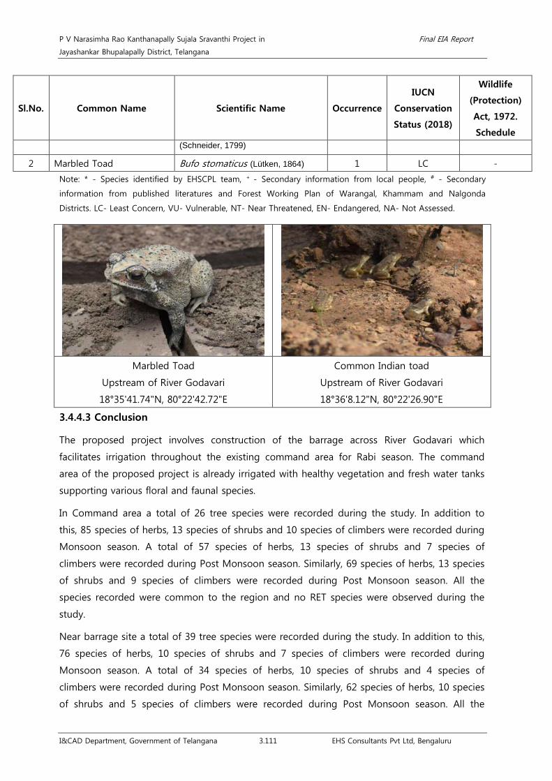
P V Narasimha Rao Kanthanapally Sujala Sravanthi Project in Final EIA Report
Jayashankar Bhupalapally District, Telangana
I&CAD Department, Government of Telangana 3.111 EHS Consultants Pvt Ltd, Bengaluru
Sl.No. Common Name Scientific Name Occurrence
IUCN
Conservation
Status (2018)
Wildlife
(Protection)
Act, 1972.
Schedule (Schneider, 1799)
2 Marbled Toad Bufo stomaticus (Lütken, 1864) 1 LC -
Note: * - Species identified by EHSCPL team, + - Secondary information from local people, # - Secondary
information from published literatures and Forest Working Plan of Warangal, Khammam and Nalgonda
Districts. LC- Least Concern, VU- Vulnerable, NT- Near Threatened, EN- Endangered, NA- Not Assessed.
Marbled Toad
Upstream of River Godavari
18°35'41.74"N, 80°22'42.72"E
Common Indian toad
Upstream of River Godavari
18°36'8.12"N, 80°22'26.90"E
3.4.4.3 Conclusion
The proposed project involves construction of the barrage across River Godavari which
facilitates irrigation throughout the existing command area for Rabi season. The command
area of the proposed project is already irrigated with healthy vegetation and fresh water tanks
supporting various floral and faunal species.
In Command area a total of 26 tree species were recorded during the study. In addition to
this, 85 species of herbs, 13 species of shrubs and 10 species of climbers were recorded during
Monsoon season. A total of 57 species of herbs, 13 species of shrubs and 7 species of
climbers were recorded during Post Monsoon season. Similarly, 69 species of herbs, 13 species
of shrubs and 9 species of climbers were recorded during Post Monsoon season. All the
species recorded were common to the region and no RET species were observed during the
study.
Near barrage site a total of 39 tree species were recorded during the study. In addition to this,
76 species of herbs, 10 species of shrubs and 7 species of climbers were recorded during
Monsoon season. A total of 34 species of herbs, 10 species of shrubs and 4 species of
climbers were recorded during Post Monsoon season. Similarly, 62 species of herbs, 10 species
of shrubs and 5 species of climbers were recorded during Post Monsoon season. All the

P V Narasimha Rao Kanthanapally Sujala Sravanthi Project in Final EIA Report
Jayashankar Bhupalapally District, Telangana
I&CAD Department, Government of Telangana 3.112 EHS Consultants Pvt Ltd, Bengaluru
species recorded were common to the region and no RET species were observed during the
study.
Similarly, in barrage site a total of 29 avifaunal species and 46 butterfly species were recorded
during monsoon season, 29 avifaunal species and 34 butterfly species were recorded during
Post monsoon season and 61 avifaunal species and 34 butterfly species were recorded during
the Pre monsoon season. Jerdon’s courser, Finn’s weaver, Purple wood pigeon, Black necked
stork, Black tailed godwit and Darter oriental are the avifaunal species belonging to Critically
Endangered, Vulnerable and Near Threatened category as per IUCN conservation status, 2018.
Common Buzzard, Indian peafowl, Shikra and Jerdon's courser are the avifaunal species
belonging to Schedule I of Wildlife (Protection) Act, 1972. Butterflies such as Common pierrot,
Blue pea, Common gull and Common crow are the only species belonging to Schedule I, II
and IV of Wildlife (Protection) Act, 1972. All other species are common to region.
Similarly, in Command area a total of 61 avifaunal species and 34 butterfly species were
recorded during monsoon season, 29 avifaunal species and 20 butterfly species were recorded
during Post monsoon season and 60 avifaunal species and 34 butterfly species were recorded
during the Pre monsoon season.
Mega faunal species such as sloth bear, wild boar, fox, barasingha, nilgai, sambar deer, jungle
cats etc are the commonly recorded species in the study area due to the presence of
Eturnagaram WLS nearby. As per IUCN Conservation status, 2018 two vulnerable species
namely, sambar deer and sloth bear were recorded. Of which, Sloth bear and Sambar Deer
belongs to Schedule-I and Schedule-III of Wildlife (Protection) Act, 1972 respectively. However,
no such mega faunal species were recorded during the study.
3.4.4.4 Photographs
Near Gopalpur
18° 6'30.23"N, 79°24'27.77"E
Near Bommakur Tank
17°51'15.94"N, 79° 9'20.80"E

P V Narasimha Rao Kanthanapally Sujala Sravanthi Project in Final EIA Report
Jayashankar Bhupalapally District, Telangana
I&CAD Department, Government of Telangana 3.113 EHS Consultants Pvt Ltd, Bengaluru
Near proposed barrage
18°35'24.09"N, 80°23'15.34"E
Near Bommakur Tank
17°51'15.94"N, 79° 9'20.80"E
Near Bommakur Tank
17°51'15.94"N, 79° 9'20.80"E
Upstream of River Godavari
18°35'36.29"N, 80°23'9.75"E
Near Raghunathpally RF
17°45'47.43"N, 79°16'31.46"E
Near Raghunathpally RF
17°45'47.43"N, 79°16'31.46"E
Field Visit

P V Narasimha Rao Kanthanapally Sujala Sravanthi Project in Final EIA Report
Jayashankar Bhupalapally District, Telangana
I&CAD Department, Government of Telangana 3.114 EHS Consultants Pvt Ltd, Bengaluru
3.5 Aquatic Environment
3.5.1 Scope of work
The Scope of Environmental Impact Assessment (EIA) studies with particular emphasis on the
Aquatic life –fish germplasm in particular, covers the following points:
• Physico – Chemical features of the river water samples.
• Assessment of plankton and litteral faunal elements.
• Survey of the Godavari River, in and around the project site to record the prevailing
aquatic life.
• To record, any rare endangered or threatened fish species in particular on the
commissioning of the project envisaged and to
• Suggest measures to protect and to facilitate fish conservation and also to carry-out
fisheries development programmes in the area.
3.5.2 Methodology
Taking note of the topography and the prevailing riverine conditions, at the site and
connected strategic points, sampling stations for carrying-out the limnological and Fisheries
investigations were fixed. The lotic water bogy at the site covered is around 1 to 4 Km wide.
3.5.2.1 Hydrological studies
• Water: The Physico – Chemical features of the surface water samples such as Ambient
and water temperature, colour, Odour, Turbidity, pH, dissolved oxygen, Free carbon-di-
oxide, free ammonia, total alkalinity, total Hardness, Phosphate, Nitrate, solocate, Iron,
Calcium, Potassium and specific conductivity were assessed in the field and the
laboratory by following the methods suggested by the American public Health
Association (APHA)
3.5.2.2 Biological studies
• Plankton: For the Assessment of the plankton biomass,100 its of the surface water
samples from representative portion of the river, in and around the project site was
strained through a plankton net made 21 nylobolt silk cloth (70 meshes*cm with
aperture size of 0.067 mm) in terms of catching efficiency of the phyto- and the
zooplankton constituents. The plankton samples collected were fixed in 5.0%
formaldehyde solution and subjected to both the qualitative and quantitative analysis
by utilizing a microscope and sedgewick Rafter plankton counting cell.

P V Narasimha Rao Kanthanapally Sujala Sravanthi Project in Final EIA Report
Jayashankar Bhupalapally District, Telangana
I&CAD Department, Government of Telangana 3.115 EHS Consultants Pvt Ltd, Bengaluru
• Littoral Fauna : The litteral organisms were collected by operating a ‘D’ frame net in
the shallow margical area of the River Godavari at the sites by covering a distance of
20 ft. The Collection was sieved through a no 40 sieve and the fauna obtained were
fixed in 5.0% formaldehyde Solution and subjected to detailed systematic analysis.
• Fish Species: Fisheries operations in the riverine sectors in and around the project site
were organised with the help of the local fisherman of the respective areas. Castnets
Gillnets, Uduvala ets of varied mesh sizes were employed for harvesting of the fish
specimens.
• Fisherman & Fisherwomen Cooperative Societies: Locals as also the migratory
fisherman are engaged in the fishing and marketing professions Fisherman belonging
to native and migrants formed the core group.
3.5.3 Results and discussions
3.5.3.1 Limno-Chemistry
Water: Water be it from a pond, tank, stream, river or reservoir, is an essential natural resource
for sustaining the life and the environment which most of us thought it to be available in
abundance and mere so, as a free GIFT of nature. Water constitutes around 70% of the body
weight of almost all living organism. Water a natural resource which has been in use since
centuries for multipurpose utilities viz drinking, domestic needs irrigation, industrial etc. Mainly
depends on its intrinsic quality hence it is of prime importance to have prior information on
the quality while planning any developmental projects. Good/ Quality resource depends upon
a large number of physic-chemical parameters and the impact, if any pollution load to be
assessed. These factors, particularly the pollution effects do influence the quality of the
medium warranting right decisions to be initiated before-hand. Scarcity of clean and potable
water has emerged in the recent past as one of the most serious developmental issue in good
many parts of the country.
It is stated that this mighty and one of the largest lotic water body in the country, always,
during the study period, presented, quite disappointingly, a very ‘grim’ picture since always
presented quite ‘low’ levels of water in flow-regime. Almost 80-90 percent of its fluviatile area
was always found exposed with dry bed and sand. The physico-chemical features of the
surface water samples of the River Godavari are as given below and annexed as Annexure 19;
• Colour and Odour
The river water was found to be clear, transparent and also odourless, at the project site, also
in the up and the downstream stretches.
• Air and water Temperature
P V Narasimha Rao Kanthanapally Sujala Sravanthi Project in Final EIA Report
Jayashankar Bhupalapally District, Telangana
I&CAD Department, Government of Telangana 3.116 EHS Consultants Pvt Ltd, Bengaluru
Of the physical features, in a given situation, heat and light are essential for photosynthetic
activities which depends on the latitude and the altitude, also on the depth of the water
column which was, as noted earlier, was always found to be in the range of 2 – ¾ ft.
Prevailing water temperature plays a significant role in water metabolism and in regulating
different physiological processes in living organisms, including fish germplasm. The rate of
decomposition of temperature releasing available nutrients into the water phase.
Air temperature values ranged between 24.20C to 33.20C and that of the medium was from
23.70C to 31.80C which lower than that of the former.
• Turbidity
A productive water body should be a little bit turbid. Normally, transparency gets decreased
during the monsoon season on account of inflow of water mass being leaded with dissolved
and suspended organic and inorganic particles which, subsequently, gets stabilized in post-
monsoon period. Turbidity due to organic and inorganic colloides is of paramount importance
as these, by virtue of their extensive surface area, coupled with electrical charge, keep nutrients
ions in water phase. Hence, clear water is as much undesirable as highly turbid water. In the
present study, the value recorded ranged from 1.02 to 36.8 NTU.
• pH
The hydrogen-ion concentration of natural waters is an important environmental factor, the
variations of which, among other causes, are linked with the species composition and life-
processes of aquatic floral and faunal communities inhabiting them. pH in the alkaline side of
neutrality ranging from 7.0 to 8.0 is ideally suited for sound productive norms. Acidic waters
with values below 6.5 and alkaline medium above 8.5 tend to bear ‘low’ productive status. The
river water studied with values ranging from 7.12 to 8.14 is well within the permissible limits.
• Dissolved Oxygen
Of all the dissolved gases, oxygen is the most important in natural waters for the life of the
fish species. The biotopes receive oxygen mainly through two sources – (i) by absorption from
the atmosphere at the surface and (ii) by photosynthetic activity of the chlorophyll bearing
organisms inhabiting. Oxygen consumption in a body of water occurs by the respiration of
animals and aquatic plants, as well as by the putrefaction of organic matter, also other causes.
The oxygen available in the medium at a given time is the balance of the above processes.
Ideally, the oxygen-producing and oxygen-consuming processes in natural waters should be
balanced so as to keep the dissolved oxygen concentration within a range congenial to all
floral and faunal elements alike. Oxygen regime when monitored over a period of time will
provide data on the nature of the medium and its productive potential.

P V Narasimha Rao Kanthanapally Sujala Sravanthi Project in Final EIA Report
Jayashankar Bhupalapally District, Telangana
I&CAD Department, Government of Telangana 3.117 EHS Consultants Pvt Ltd, Bengaluru
Oxygen profile in the River Godavari at the site value ranging between 4.3 and 6.3 mg/L was
moderate in nature.
• Free carbon-di-oxide
Though the Carbon-di-oxide is highly soluble in natural waters, it is a minor constituent of the
atmosphere and the atmosphere and maintains presence in equilibrium concentrations giving
acidic reactions in the medium. Its presence is noticed in surface and sub-surface waters,
mostly in monsoon due to rain and, generally, present all-through the year at the bottom with
more concentration during the active phase of degradation of bottom organic lead in summer.
Free Carbon-di-oxide value recorded ‘Below detection level to 1.76mg/l indicated that the
medium is free from pollution threat.
• Free Ammonia
Generally, in unpolluted waters ammonia and ammonium compounds occur relatively small
quantities, usually on the order of 1.0 mg/l or less. With the uptake of oxygen, as in pollution,
the concentration of ammonia may increase; Free Ammonia in concentrations over 2.5 mg/l in
neutral or alkaline waters is apt to be harmful to good many fresh waters species. The medium
at the sites sampled indicated ‘non-pollution’ feature the value ranging from ‘Below detection
level to 0.43 mg/l hence the desirable limit is close to 0.5mg/L
• Total Alkalinity
Alkalinity the acid combining capacity of natural waters is general is caused by carbonates and
bicarbonates of calcium and magnesium: With dissolved carbon-di-oxide the carbonate and
the bicarbonate form an equilibrium which is of prime importance for the productivity in a
given situations. Natural waters containing 40.0mg/l or more it are considered as more
productive. Waters with low alkalinity – less than 20.0 mg/l, have a low buffering capacity and
are Vulnerable to rapid fluctuations in pH, especially, during rainfall with Phyto-plankton
blooms which is directly harmful to fish life. The river studied indicated that it’s on the
‘ascending’ trend, the values ranged from 58 to 124.0 mg/L
• Total Hardness
An important parameter of the water quality be it is being used for domestic, agricultural or
industrial purposes. Hardness of the medium is the property attributed to the presence of
alkaline earth. Water can be classified into soft (<75.0 mg/l), moderately hard (75 – 150 mg/l),
Hard (150 – 300 mg/l) and very hard (>300 mg/l) based on hardness. The total hardness of
the surface water samples of the study area, recorded values ranging from 57.0 to 118.0 mg/l
indicating that the medium is soft to moderately hard. The analytical data indicates that 29%
of surface water samples are soft, 14% moderately hard, 50% hard and 7% very hard. The high
hardness may cause encrustation on water supply distribution systems. There is also some

P V Narasimha Rao Kanthanapally Sujala Sravanthi Project in Final EIA Report
Jayashankar Bhupalapally District, Telangana
I&CAD Department, Government of Telangana 3.118 EHS Consultants Pvt Ltd, Bengaluru
suggestive evidence that long term consumption of extremely ‘hard’ water might lead to an
increased incidence of urolithiasis, anencephaly, pre-natal mortality, some types of cancer and
cardio vascular disorders.
• Phosphate
The role and importance of phosphate in aquatic productivity has been recognized quite
adequately. A Concentration of 0.05 – 0.2 mg/l has been considered to be ‘quite favorable’
for medium to high level of productivity. Lack of phosphorus is often the chief cause of poor
productivity of waters. Excess of phosphate in open waters is a sign of heavy organic pollution.
The Nutrients status of Godavari River water studies at the sites with values of 0.35 mg/l
appears to be in the ‘optimum’ Level.
• Nitrate
Like, Phosphate, Nitrate also is a major constituent of protein occupying an important position
in the aquatic system. A concentration of 0.2 - 05 mg/l of inorganic nitrogen has been
recognized being favorable for medium to high levels of productivity norms. In the present
study, the values ranged from values ranging from BDL to 6.13 mg/l, appears to be on the
‘normal’ side.
• Silicate
In natural waters, silicon remains in silicate form which is reachable. Normally, silicate-silicon
(1-30 mg/l) remains in natural waters. At high temperature and pH, the solubility of silicate
greatly increases. As silica has been an important structural constituent of diatoms
(Bacillariophyceae), it is able to regulate their growth. In the Studies carried-out in the river
Godavari, the nutrient status of the river water studied recorded values ranging between BDL
to 10.83 mg/L.
• Iron
Iron is of particular interest because of its importance as a vital element in respiratory
pigments of many animals. The values recorded in the studies undertaken – BDL to 2.16mg/l
infers it being in ‘poor’ concentration and its role in the productivity of the medium appears
quite inadequate.
• Calcium
Calcium and Magnesium are the dominant cat-ions in the surface waters. The concentration of
calcium varies from a minimum of 8.0 mg/l to a maximum of 92.0 mg/l, with an average value
of 37.0 mg/l. Weathering and dissolution of calcium carbonate (CaCo3) - Limestone and
Dolomite and Calc-Silicate minerals are the most common source of calcium in the water
bodies. Calcium, the essential nutrient for the plant growth and in animals plays an important

P V Narasimha Rao Kanthanapally Sujala Sravanthi Project in Final EIA Report
Jayashankar Bhupalapally District, Telangana
I&CAD Department, Government of Telangana 3.119 EHS Consultants Pvt Ltd, Bengaluru
role on the development of bones, nervous system and cell structures. One possible adverse
effect from ingesting high concentrations of calcium for long periods may be an increased risk
of kidney stones. The values recoded in the present case are ranged between 9.6 to 21.6 mg/l,
falls within the maximum permissible limit of 200.00mg/L.
• Potassium
Potassium, in effect, is an important ingredient for all Algae and, under low concentrations, the
growth and photosynthesis of the algae is poor and respiration high. The values observed in
the studies carried- out in the River Godavari being in the range of 2.0 to 5.2 mg/l impacted,
negatively, on the over-all floral pattern of the river in general.
• Specific conductivity
Specific conductivity is an index of the amount of the water soluble salts present in the
medium. Measurements of dissolved salts in the medium indicate the total concentrations of
dissolved salts having wide bearing on the over-all productivity of the system. It provides also
symptoms of state of mineralization in any aquatic eco-system. Its values for fresh waters
range from 25.00 to 500.00 micro mhos/cm. In the present case, the value recorded ranged
from 158.1 to 351.0 micro mhos/cm, appears to be in the optimum level. In general, the
Godavari River water studied at the project site and related sites indicated ‘Alkaline character,
Optimum nutrient status and is free from any pollutional threats’.
3.5.3.2 Plankton
Plankton, constituted by Phyto-and Zooplankton is an important link in the food-chain for all
living organisms present in a water body and knowledge of its abundance might well indicate
the productive capacity of the biotope. Plankton samples were collected from the Godavari
River during the period of study – (August to December, 2017) and have been detailed in the
Annexure 19.
The plankton diversity and its richness represented by Phyto-and Zooplankton constituents,
particularly, in a lotic environment, depend, primarily, on the prevailing local conditions and
the seasons. Although, in the present instance, the studies carried out between August –
December, 2017 (monsoon, post monsoon and winter season), the situation in the river
Godavari, all along the sites covered in its stretch, were not in accordance with the natural
phenomena/phases likely to prevail. The river bed, during the period was always found dry
and exposed (90-95%) with dried-up bed, sandy beach like situation, dry spell etc. The stream
like fluviatile water body of this mighty river in the present context was highly disappointing
and frustrating too. The overall productivity in such situations will have a direct bearing,
particularly, on the piscine fauna present.

P V Narasimha Rao Kanthanapally Sujala Sravanthi Project in Final EIA Report
Jayashankar Bhupalapally District, Telangana
I&CAD Department, Government of Telangana 3.120 EHS Consultants Pvt Ltd, Bengaluru
The plankton constituents of the Godavari River, at the project site, upstream and downstream
sites sampled presented a ‘poor’ picture. It is also true to state that Pre-monsoon and
monsoon seasons could be categorized being ‘poor’ plankton production periods and the
studies carried out falls within the very seasons. As data indicates Phytoplankton, by species-
wise (and percentage (21-310 u/1 / 7.86-94.87%) dominated ever Zooplankton (4-258 u/1-
1.28-98.14%) and the miscellaneous group (2-14u/1-1.47-8.00%).
The Phytoplankton is represented by Anacystis cynea, Oscillatoria tenuis, Spirulina major,
Chlrogonium elongatum, Platydorina caudate, Schrooderia setigera, Coolastrum chodati,
Pachycladon umbrinus, Penium margaritaceum, Spirogyra varians, Radieflum conjunctivum,
Ulothrix zonata, Cladophora glomerata, Fragilaria capucina, Synedra ulna, Asterionella formesa,
Opephora martyi, Navicula radios and Denticula thermalis.
The Zooplankton is represented by Arcella mitrata, Brachienus calciflorus, Keratella quadrata,
Filinia lengiseta, Diaphnosoma brachyurum, Daphnia magna, Bypris subglobosa, Cyclops and
nauplius. The miscellaneous group is represented by Insect remains, Nematodes and
Vegetative remnants.
3.5.3.3 Littoral Fauna
An important biological component of a lotic and also a lentic water body is its faunal
representation which is quite adopted to face natural hazards such as sudden water gushing,
periodic floods of varied intensities, Flass-floods and rolling /dislodging actions of gravel,
stones, boulders etc. The qualitative faunistic elements Collected from the expressed dry bed
of the Godavari river during the period of the study at the project site/s and close by locations
of the riverine stretches are detailed in the Annexure 19, other than the Molluscan fauna no
other organisms could be encountered since the river in question hold very little water bearing
much shallowness.
The Molluscan fauna (dead specimens) collected belongs to order-Mesogastropoda- Bellamya
bengalensis, B. Crass & B. dissimilis, Pila glodosa, Gabbia stenothyroides, Digoniostoma
pulchella, Thiara (Thiara) scabra & T. (Melanoides) tuberculata; Order- Bassomatophora-
Lymnaea acuminate & L.lutoola, Indoplanorbis exustus & Gyraulus convexiusculus; Order-
unionida-Lamollidens corianus, L.marginalis & Parreysia corrugate & P. (Parrosia) corrugate-
sub-species Parreysia nagpoorensis and Order-Veneroida- Cerbicula striatella.
Pangasius pangasius – the only non predatory catfish could profitably used by introducing it in
different pockets/locations of the river Godavari where the Molluscan fauna is found
adequately as it forms the main food the Species. Also, species such as Rita pavimentata, R.
Gogra and Mystus vittaus could also be stocked along with P.pangasius. Bellamya bengalensis,

P V Narasimha Rao Kanthanapally Sujala Sravanthi Project in Final EIA Report
Jayashankar Bhupalapally District, Telangana
I&CAD Department, Government of Telangana 3.121 EHS Consultants Pvt Ltd, Bengaluru
Lamellidens marginalis, L.corianus and Pila globosa are favoured food by people from Bihar,
West Bengal and Mizoram.
3.5.3.4 Fish and fisheries
The first comprehensive publication to deal exclusively with the fishes of any Indian River
system, as a whole, is that of Francis Hamilton (1822) who described 269 species of fishes
found in the Ganga and its tributaries. Such a monographic treatment of any other Indian
River system did not come for another hundred and fifty years or more. David (1963)
published his investigations on the ‘fish and fisheries’ of the Godavari and the Krishna river
systems and listed 131 species of fish as occurring in the Krishna alone and as the records
indicate, including the studies carried – out in the recent past, the river Godavari found
harbouring 105 species (Annexure 19). The principal fish groups which support the commercial
fishery in particular of the Godavari River are Carps – Gibelion catla, Cirrhinus mirgala, Labeo
calbasu & Labeo fimbriatus, Catfish – Sperata aor, Sperata seenghala, Silenia children, Wallago
attu, Pangasius pangasius & Bagarius yarrelli. Indian Shad – Hilsa (Tenualesa) ilisha & Hisa
(Hilsa) kelee, Prawns – Macrobrachium malcolmsoni and Miscellaneous group- Wed fishes,
minor catfishes, Loaches etc.,
The fishing gears which are being employed in the river Godavari fall under two categories viz;
gill nets which also include ‘set gill nets, drift gill nets, drag gill nets (Bendu vala) and the
barrier gill net (Katu vala), seines which comprise share seine (Jarugu vala), large seine (Alivi
vala) and drag net (Konte vala). Cast nets are also employed for fishing. Gill net operations,
which constitute around 40% of the total fish yield. Bandu vala operations are confined to a
small section of the river around Dummagudem and Tekalagudem village. Alivi vala, a major
gear, next in importance only to gill nets, is mostly operated in areas devoid of any type of
obstructional disadvantage such as boulders etc.,
With all-out efforts by fishermen in the area, as observed and also based on the reports
available, total catches of commercial species of carps and catfishes have greatly decline.
Accompanied by decrease in total catches and catch per unit of effort, large-sized fishes have
greatly decreased in abundance, also reduction in average size fish has taken place.
Fish landed in different pockets of the riverine stretches, mostly, is marketed locally. Prawn –
M.malcolmsoni is, which fetches around Rs. 300-400 kg at the markets close – by are collected
by fish merchants57
• 57 Anon, 1972. Methodology for Pre-impoundment survey technique for Preparation of reservoirs for fish culture. CIFRI(ICAR),
Barrackpore (WB), India, Misc Contribution No.8:1-59
.
• American Public Health Association (APHA) 1985. Standard methods for the examination of water and waste water. Washington Ed
16:1268 pp,
• Anon, 2002. Freshwater and Marine Fishes of Karnataka. Sec Ad aqua, Cult :1-24

P V Narasimha Rao Kanthanapally Sujala Sravanthi Project in Final EIA Report
Jayashankar Bhupalapally District, Telangana
I&CAD Department, Government of Telangana 3.122 EHS Consultants Pvt Ltd, Bengaluru
• Anon. 2012. National Consultation on Alien Fish Species in Aqaculture and Aquarium trade : Issue and perspective. NBFGR (ICAR): 1
– 15.
• Babu, Ravi.B. and P. Padmavathi 2016. Interlinking of Krishna and Godavari rivers: An Ecological study, Internar.J.Fish & Aq studies.,
4(5) : 593 – 595.
• Bhaskaran, T.R 1947. A plea for water pollution research. Indian Med. Gaz 82:750
• Cairns D. 1941 N Z J sci Tech. 23 (2B) : 53 – 72.
• Chandrasekharaiah H N., H N., M.F Rahman and shyama Bhat Kolari. 2006 status of Riverine Fish Fauna in Karnataka. Proc.
Workshop Ichthyel. Biodiversity. Aq system, Karantaka : 18- 24.
• Chandrasekharaiah H N ., M F Rahman and S. L Raghavan. 2008 Fish germplasm inventory of Manjira and Karanja rivers. Fish
Chimes, 28 (6) : 24- 26
• David a. 1963. Studies on the fish and fisheries of the Godavari and the Krishna river systems. Part – 1. Proc Nat acad Sci., India,
33B (2)263 – 293
• David, A B.V Gocind, N.G.S.Rao and K.V. Rajagopal. 1967. Fish ‘seed’ resources of some rivers in south India. Indian J Fish., 14:54-85
• David A and M F Rahman 1978. Criteria for selection of Cultivable species of Fishes in India. Madras J. Fish., 8:27-40
• David L Buckmeir. 2008. Lift history and status of alligator Gar Atractasteus spatula with Recommendations for Management. Hearth
Hill Fish.sci., center Texas Parks wildlife Dept., Inl. Fish Divi Mountain Home Tx 78058
• Day, francis 1868. Observations on some Indian Fishes. Proc Zool. Sec, London : 580 – 585.
• Day, Francis. 1872. Monograph of Indian Cyprinidae., Part – VI. J Asiat.Sec Bengal., : 318 – 326
• Day, Francis. 1875 – 78 the Fishes of India: Being a Natural History of the Fishes Known to inhabit the seas and fresh water of India,
Burma and Eylen. London. Pp.778 – 995 Plates.
• Deelder S L 1958. J. Cens.Perm. int Explor Mer. 24(1) : 135- 146
• Dirza, Rodelfo et.al 2017 Proc Nat Acad.sci.
• Dahadrai, P V P Das and S R Verma (Eds). 1994. Threatened Fishes of India. Publ. Natural Conservator. 412p
• Fowler, G J 1939 Water Pollution Research. Curr.Sci., 8 : 1
• Freaf W E 1954 Colonial office Fishery Publication No 6
• Ganapathi S V and K H Alikunhi 1949 on the spawning of the Carps in south Indian rivers. Proc. Indian Sci congr, 36(3) : 160 – 161.
• Girija T 2007 Bharatada Nadigalu Niharika Publ Davanagare : 1-152
• Govind, B V M F Rahman and K V Rajagopal 1978 Occurence of elvers of Anguilla nebulosa (Gray & Hardw) in tunga river
Karnataka state sci & cult 329 – 330
• Govind B V 1984 Fisheries in Irrigation projects (Minor, Medium and Major), Problem, potential development and Management sev
seminar on Fresh water Fisheries and Rural Development : 47 – 52
• Hera, S L 1940 Dams and problems of migratory fishes. Curr Sci ., 9 406-407
• Hera, S L 1947 Construction of dams and rivers fisheries. J cent. Bd Irrig. 4:113-118
• Hera S L 1952. Control of Molluscan fauna through the culture of Pangasiun pangasius (Hamilton). Curr.Sci., 21(6) : 164—165
• Ibrahim K H 1961 jeur Bmbay nat. Hist sec., 58 (3) : 810 – 812
• Jayaram K C 1999 the Fresh water Fishes of Indian Region. Narendra Publ House Delhi – 110006, 551 p
• Jhingran, V G 1983 Fish and Fisheries of India . Hindusthan Publ. Corporation (India) Delhi – 110007.1 - 954
• Jun Ui. 1975 pollution’s High Price. ‘TIME’
• Laxmappa, B. And Ravinder Rao Bakshi. 2016 A checklist of Fishes of Krishna and Godavari rivers : An Ecological study. Internet. J.
Fish & Aq.studies : 4 (4) : 35 – 42.
• Lewe, R H. 1951. J. Con. Perm. Int. Explor. Mer., 17(3) ; 299 – 315
• Menon, A G K. 1969 Conservation of Ichthyefauna of India. Summer Institute., Cons Manag. Inl. Cap. Fish. Res., 57 (2) : 1 – 9
• Rahimulla, M., S Mahnood and S.A. Kabir. 1944 Proc Indian Acad sci., 19B(1) : 16-18
• Rahman, M F 1997. Enrichment of riverine fish fauna through transplantation of food and sport fishes. Fish Chimes 39-42
• Ramakrishnaiah, M 1987 a new bagrid fish of the Genus Mystus (Scopleli) from Kishna river system. MATSYA., 12 & 13 : 134- 143
• Sinha V R P and J W jenes. 1966 J Zeel Divi. 150 : 371 – 385
• Subba Rao N V 1989 Hand Book – Fresh water mollusc of India. Director, Zeel. Survey India Calcutta (WB). 1 – 289
• Syrski S 1876 On the organs of Reproduction and fecundation of fishes and especially of the Eels. Rept U S A Fish comm..
• Tesch, J.J 1928.J Cons Pers int Explor. 3 : 52 - 69
• Ward, Henry Baldwin and whipple Geerge Chandler. 1918. Fresh Water Biology. ED W T Edmendson New York. John Willey & Sons
Inc. London. – 1248
• Yazdani, G M 1992 Biodiversity of Fresh water fish fauna of Indian rivers with observations on threatened species. Proc J National
Symp. Envital Hydraulics Peens. 134 - 147

P V Narasimha Rao Kanthanapally Sujala Sravanthi Project in Final EIA Report
Jayashankar Bhupalapally District, Telangana
I&CAD Department, Government of Telangana 3.123 EHS Consultants Pvt Ltd, Bengaluru
A total of 105 species of fishes were recorded during the study the details are enclosed as
Annexure 19.
Table 3.34 Checklist of the fish species recorded from the Godavari River (Project site & its Vicinity)
Sl.No. Scientific name Vernacular name IUCN Red-
list 2018
1 Notopterus notopterus (Pallas, 1769) Mangali katti LC
2 Anguilla bengalensis (Gray, 1831) Malugu NT
3 Anguilla bicolour McClelland, 1844 Malugu NT
4 Hilsa (Tenualosa) ilisha (Hamilton) Polasa LC
5 Hilsa (Hilsa) kelee (Cuvier) Polasa LC
6 Hypothalichthys molitrix Valenciennes, 1842 Vendi-chapa LC
7 Salmophasia acinaces (Valenciennes, 1844) Chela LC
8 Salmophasia balookee (Sykes, 1839) Chela LC
9 Salmophasia novacula (Valenciennes, 1840) Chela Chela LC
10 Aspidoparia morar (Heckel, 1847) - LC
11 Barilius barila (Hamilton, 1822) Kodipe Kodipe LC
12 Barilius bendelisis (Hamilton, 2007) - LC
13 Chela cachius (Hamilton, 1812) Getchu VU
14 Chela (Chela) laubuca (Bleeker, 1959) Getchu VU
15 Esomus danrica (Hamilton, 1822) Asta-pakke LC
16 Devario aequipinnatus (McClelland, 1839) Nooltu LC
17 Danio devario (Hamilton, 1822) Nootlu LC
18 Dania rerio (Hamilton, 1822) Chintaku-parega LC
19 Rasbora daniconius (Hamilton, 1822) Katte-dodipe LC
20 Amblypharyngodon mola (Hamilton, 1822) Kodipe LC
21 Ctenopharyngodon idella (valenciennes, 1844) Gaddi-chepa NE
22 Cyprinus carpio Linnaeus, 1758 Bangaru-teega NE
23 Thynnichthys sandkhol (Sykes, 1859) - VU
24 Tor Khudree (Sykes, 1839) Aku-chepa EN
25 Neolissochilus hexagonolepis (McClelland, 1839) - NT
26 Osteobrama cunma (Day, 1888) Kagitum-paraka LC
27 Osteobrama peninsularis (Silas, 1952) Khira DD
28 Osteobrama vigorsii (Sykes, 1839) Khira LC
29 Rohtee ogilbii Sykes, 1839 Aku-chepa LC
30 Puntius amphibious (Valenciennes, 1842) Parka-chapa DD
31 Puntius chola (Hamilton, 1822) Pakki DD

P V Narasimha Rao Kanthanapally Sujala Sravanthi Project in Final EIA Report
Jayashankar Bhupalapally District, Telangana
I&CAD Department, Government of Telangana 3.124 EHS Consultants Pvt Ltd, Bengaluru
Sl.No. Scientific name Vernacular name IUCN Red-
list 2018
32 Puntius sophore (Hamilton, 1822) Budda-pakke LC
33 Pethia ticto (Hamilton, 1822) Budda-parke LC
34 Systomus sarana (Hamilton, 1822) Gende-paraka LC
35 Hypselobarbus kolus (Sykes, 1839) Nilusu Nilusu LC
36 Hypselobarbus pulchellus (Day, 1870) Parka LC
37 Osteochilichthys godavariensis - DD
38 Cirrhinus cirrhosus Aruza LC
39 Cirrhinus macrops Steindachner, - LC
40 Cirrhinus mrigala (Hamilton, 1822) Yerra mosu LC
41 Cirrhinus reba (Hamilton, 1822) Chittrai LC
42 Gibelion catla (Hamilton, 1822) Botcha LC
43 Labeo bata (Hamilton, 1822) Mosu LC
44 Labeo boga (Hamilton, 1822) Mosu LC
45 Labeo boggut (Sykes, 1839) Nusi-gadu LC
46 Labeo calbasu (Hamilton 1822) Kaki-paraka LC
47 Labeo dero (Hamilton, 1822) - LC
48 Labeo dyocheilus (McClelland, 1822) Paraka LC
49 Labeo fimbriatus (Bloch, 1795) - LC
50 Labeo gonius (Hamilton 1795) Paraka LC
51 Labeo pabgusia (Hamilton, 1822) Done cheap NT
52 Labeo porcellus (Heckel, 1844) Moyya LC
53 Labeo potail (Sykes, 1839) Baman-chapa EN
54 Labeo rohita (Hamilton, 1822) Seelavathi LC
55 Schismatorhnychus nukta Skyes, 1855 Mukkidi-chepa LC
56 Garra stenorhynchus (Jerdon, 1849) Banda pakiri LC
57 Garra mullya (Sykes, 1839) Banda pakiri LC
58 Oreonectes (Oreonectes) evazardi (Day) - LC
59 Rita bakaluae Bondu
60 Rita pavimentata (Valenciennes,) Bondu LC
61 Mystus cavasius (Hamilton, 1822) Muti-jella LC
62 Mystus vittatus (Bloch, 1794) Erra-jella LC
63 Hemibagrus maydelli (Rossel, 1964) Ponduga LC
64 Sperata aor (Hamilton, 1822) Mukul- jella LC
65 Sperata Seenghala (Sykes, 1839) Mukul- jella LC

P V Narasimha Rao Kanthanapally Sujala Sravanthi Project in Final EIA Report
Jayashankar Bhupalapally District, Telangana
I&CAD Department, Government of Telangana 3.125 EHS Consultants Pvt Ltd, Bengaluru
Sl.No. Scientific name Vernacular name IUCN Red-
list 2018
66 Ompak bimaculatus (Bloch, 1794) Bugga-dumma NT
67 Wallago attu (Bloch & Schneider, 1801) Valuga NT
68 Proeutropiichthyus taakre (Sykes,1839) Siriari-jella LC
69 Pachypterus khavalchor (kulkarni, 1952) Kocha-muthi-jella DD
70 Silonia childreni (Sykes, 1839) wan-jow EN
71 Bagarius yarrelli (sykes, 1875) Guddi chpa EN
72 Glyptothorax lonah (Sykes, 1839) - EN
73 Clarias batrachus Linnaeus Marpu LC
74 Clarias gariepinus (Burchell, 1822) Safrican marpu LC
75 Heteropneustes fossilis (Bloch) Ingilayee EN
76 Arius caelatus Valenciennes - LC
77 Xenontodon cancila (Hamilton, 1822) Vodla mukka LC
78 Hyporhamphus limbatus (Valenciennes, 1846) Konga mukku LC
79 Aplocheilus lineatus (Valenciennes, 1846) Minnow Chapa LC
80 Gambusia affinis (baird & Girard, 1853) Gambusia LC
81 Poecilia reticulata Peters, 1859 Guppi NE
82 Mastacembelus armatus (Lacepede, 1800) Konte-mukku LC
83 Chanda nama Hamilton, 1822 Akurati LC
84 Parambassis ranga (Hamilton, 1822) Sarawa LC
85 Etroplus suratensis (Bloch, 1790) Duvenna- chapa LC
86 Oreochromis mossambica (peters, 1852) Doobotcha NT
87 Parachaeturichthys polynema (Bleeker, 1874) - LC
88 Oxyurichthys microlepis (Bleeker, ) - LC
89 Oxyurichthys formosanus Nichols, - LC
90 Oxyurichthys tentaculosis ( Valenciennes, ) - LC
91 Chiramenu fluviatalis Rao - LC
92 Silhouetta indicus Rao, V.V. - LC
93 Gobiopsis macrostomus Steindachner, - LC
94 Glossogobius biocellatus Valenciennes, - LC
95 Glossogobius giuris (Hamilton, 1822) Isika-dondu LC
96 Bathygobius fuscus (Ruppell) - LC
97 Bathygobius osteicola (Chaudhuri) - LC
98 Stigmatogobius minima (Hora) - LC
99 Stigmatogobius sadanundio (Hamilton, 1822) - NE

P V Narasimha Rao Kanthanapally Sujala Sravanthi Project in Final EIA Report
Jayashankar Bhupalapally District, Telangana
I&CAD Department, Government of Telangana 3.126 EHS Consultants Pvt Ltd, Bengaluru
Sl.No. Scientific name Vernacular name IUCN Red-
list 2018
100 Anabas oligolepis Bleeker Goraka chapa DD
101 Anabas testudineus (Bloch, 1792) Goraka chapa DD
102 Channa marulius (Hamilton, 1822) Poo-meenu LC
103 Channa orientalis (Bloch,Scheneider, 1801) Guruja NE
104 Channa punctatus (Bloch, 1793) Burudamatta LC
105 Channa striatus (Bloch, 1793) Korra-meenu LC
NOTE:
• CR = CRITICALLY ENDANGERED: Taxon is Critically Endangered when it is facing an
extremely high risk of Extinction in the wild in the near future.
• EN = ENDANGERED: A Taxon is Endangered when it is not Critically Endangered when
it is not Critically Endangered or Endangered, but is facing a very high risk of Extinction
in the Near Future.
• VU = VULNERABLE: A Taxon is Vulnerable when it is Not Critically Endangered, but, is
facing high risk of Extinction in the wild in the Medium-term Future.
• LR = LOWER RISK: A Taxon is in low risk when it has been evaluated and does not
qualify for any of the Threatened Categories.
As per the field observations, out of 105 fish species, 6 fish species belongs to Endangered
category, 7 fish species belongs to Near Threatened category and 3 fish species belongs to
Vulnerable category as per IUCN red list, 2018 and rest of the species are common to the
region belonging to Least Concern category.
3.5.3.5 Summary
Limnological and fisheries investigations carried out in the river Godavari, in and around the
project site, indicate ‘optimum’ physico-chemical features of the medium to support and
sustain the aquatic life present.
The biological features constituted by phyto and zooplankton presented low values however.
Scores of planktivores fish species subsists on this food niche during their developmental
stages, as also, in their adult-hood.
Molluscan fauna represented by Gastropoda and Bivalves-in dead conditions were collected
from the exposed dry-bed of the riverine stretch studied. During the prime time, when the
river holds enough volume of water, efforts made to introduce the non-predatory catfish
Pangasius pangasius which feeds exclusively these molluscan species.

P V Narasimha Rao Kanthanapally Sujala Sravanthi Project in Final EIA Report
Jayashankar Bhupalapally District, Telangana
I&CAD Department, Government of Telangana 3.127 EHS Consultants Pvt Ltd, Bengaluru
Efforts are to be made to introduce the giant fresh water prawn- Macrobrachium malcolmaoni.
The seed is available in very large numbers naturally at downstream anicut across the river
Godavari at Rajahmundry (AP).
Although, the Godavari river is reported to harbour 131 fish species in its entire stretch, in the
studies carried out, 105 fish species have been listed warranting much more Ichthyological
studies to be carried-out.
Impact of the alien fish species such as the African highly predaceous catfish-Clarias
gariepinus, South America’s Oreochromis mossambica, alligator catfish- Atractesteus spatura
and serrasalmus natterari have already made their presence and impacts felt on the fish
germplasm indigenous to the system studied. Their absolute elimination from the river
Godavari has to be viewed with utmost seriousness and also urgency.
Conservation of certain fish species available only in the Krishna- Godavari Rivers has been
highlighted which should be accorded ‘top priority’ towards their conservation, along with
Bagarius yarrelli (the giant catfish which grows more than 100 kg) be viewed with at most
sincerity and seriousness.
A Monitoring cell be constituted to undertaken detailed Limnological and Fisheries
investigations in order to ‘Undertake conservation and development programmes in the said
riverine stretch, also in the impoundment slated to be formed shortly’ on the lines of the
Technical know-how available.
Field data collection
Ghanpur tank
17°50'31.64"N, 79°21'6.93"E

P V Narasimha Rao Kanthanapally Sujala Sravanthi Project in Final EIA Report
Jayashankar Bhupalapally District, Telangana
I&CAD Department, Government of Telangana 3.128 EHS Consultants Pvt Ltd, Bengaluru
Specimens found after fishing
Command area
18° 0'33.02"N, 79°35'49.10"E
Bagarius yarrelli, an endangered species found during the site visit
Downstream of River Godavari
18°34'14.90"N, 80°24'7.03"E

P V Narasimha Rao Kanthanapally Sujala Sravanthi Project in Final EIA Report
Jayashankar Bhupalapally District, Telangana
I&CAD Department, Government of Telangana 4.1 EHS Consultants Pvt Ltd, Bengaluru
Chapter 4. Anticipated Impacts & Mitigation Measures
Due to the activities of the project, there will be potential impacts on the environment of varying
magnitude. Most of the impacts are likely to occur during the construction phase of the project. The
following section reveals the prediction of impacts due to the project on the physical, biological and
social environment. Impacts have been assessed based on the information collected from the
primary and secondary data. Construction activities will be taken place for 2 years.
4.1 Impacts during construction phase
4.1.1 Air Environment
4.1.1.1 Anticipated impacts
The construction of the project is expected to complete by 2 years. The initial site clearing will be
followed by site preparation activities, which include;
• Grading
• Excavation of footings and foundations,
• Backfilling operations
Excavation work at site causes disturbance due to the emission of particulate matter in the
construction area. Fugitive dust emissions from the construction of the project will result from:
• Air pollution (dust) due to various construction activities, movement of vehicles will pose
health concerns to the construction work force in terms of respiratory problems.
• Dust entrained during site preparation and grading/excavation at the construction site
• Dust entrained during onsite travel on paved and unpaved surfaces
• Dust entrained during aggregate and soil loading and unloading operations and
• Wind erosion of areas disturbed during construction activities.
Combustion emissions during construction will result from:
• Exhaust from the Diesel construction equipment used for site preparation, grading,
excavation, trenching and construction of onsite structures.
• Exhaust from water trucks used to control construction dust emissions.
• Exhaust from Diesel-powered welding machines.
• Exhaust from pickup trucks and Diesel trucks used to transport workers and materials around
the construction site.

P V Narasimha Rao Kanthanapally Sujala Sravanthi Project in Final EIA Report
Jayashankar Bhupalapally District, Telangana
I&CAD Department, Government of Telangana 4.2 EHS Consultants Pvt Ltd, Bengaluru
• Fugitive emissions from various construction activities including blasting will pose health
concerns (respiratory problems) on the neighbouring village residents (Thupakulagudem).
• Exhaust from Diesel trucks used to deliver concrete, fuel, and construction supplies to the
construction site.
• Air quality of the region will also get affected due to the movement of vehicles to and from
the site carrying construction material brought by truck.
4.1.1.2 Mitigation measures
The following mitigation measures will be proposed to control exhaust emissions from the diesel
heavy equipment/transport vehicles and potential emissions of fugitive dust during construction of
the project:
• Unpaved roads and disturbed areas in the project construction site to be watered thrice a
day to prevent fugitive dust emissions. The frequency of watering can be reduced or
eliminated during periods of precipitation.
• The vehicle speed limit restricted to 15-20 kmph within the construction site.
• The construction site entrances posted with visible speed limit signs.
• PPEs like nose mask will be provided to the construction work force.
• Construction equipment vehicle tires inspected and washed as necessary to be cleaned free
of dirt prior to entering paved roadways.
• Gravel ramps of at least 20 feet in length provided at the tyre washing/cleaning station.
• Paved exits from the construction site to prevent track out to public roadways.
• Paved roads within the construction site swept at least once daily (or less during periods of
precipitation) on days when construction activity occurs to prevent the accumulation of dirt
and debris.
• Vehicles used to transport solid bulk material on public roadways and having the potential
to cause visible emissions to be provided with a cover, or the materials sufficiently wetted
and loaded onto the trucks in a manner to provide at least one foot of freeboard.
• Any construction vehicle not meeting the emission norms standards (PUC) not being allowed
within the construction site and emission certificate made mandatory for the same and this
is strictly enforced on the transport contractors to abide by the same.
• Water sprinkling (3 times a day) will be done in all the dust generating activities like site
clearing, levelling, excavation, material handling etc to suppress the dust.
• Errection of the barricades along the periphery of the construction sites.

P V Narasimha Rao Kanthanapally Sujala Sravanthi Project in Final EIA Report
Jayashankar Bhupalapally District, Telangana
I&CAD Department, Government of Telangana 4.3 EHS Consultants Pvt Ltd, Bengaluru
• Controlled blasting with water sprinkling will be adopted to suppress the dust generation.
• Vehicles delivering loose and fine materials like sand and fine aggregates covered by
tarpaulin sheets to reduce spills on roads so as to avoid fugitive emissions.
• DG sets engaged in the construction site equipped with suitable stack height.
• Monthly Ambient Air Quality Monitoring will be carried out to assess the pollution load
during construction phase.
• During excavation, regular water sprinkling will be undertaken to avoid fugitive dust.
There will not be any impacts anticipated during the operation phase of the project.
In order to assess the Ground Level Concentrations of emissions, air quality model was used to draw
the isopleths.
• Dispersion Model
Dispersion modelling requires an hourly data of wind speed and direction, and other meteorological
parameters. The EPA-approved AERMOD model user interface developed by M/s Envitrans
(AERMODcloud) is used to estimate ambient impacts from construction activities of the project. The
emission sources for the construction site are grouped into three categories:
• Area source: construction dust emissions.
• Line source: Exhaust emissions from moving vehicles inside the project site
• The study is carried out for the emission of Particulate matter with mitigation measures and
without mitigation measures.
The methodology utilized in this analysis is consistent with the general recommendations of the
AERMOD Model user’s guides for modeling emissions. Models are run with the regulatory default
option and hourly meteorological data processed in the AERMET program for use in AERMOD. The
isopleths drawn for PM10 with and without mitigation measures shows that the predicted GLC for
Particulate matter ranges from 48.5 µg/m3 - 1.0 µg/m3 (without mitigation measures); 31.7 µg/m3 -
0.08 µg/m3 (with mitigation measures) and the isopleths are as given below. The expected increase
in concentration will be (60.4 µg/m3 + 48.5 µg/m3) in the core area thereby causing discomfort in
breathing, eye and nose irritation to the labours. With the water sprinkling activity, covering of
vehicles delivering loose materials with tarpaulin sheets will reduce the GLC of particulate matter
from the project to 31.7 µg/m3. However the GL concentration in the study area will be in the range
of 19.77 µg/m3 to No effect zone.. GLC of 0.11 µg/m3, 0.4 µg/m3, 0.05 µg/m3 can be observed in the
Devadula, Thupakulagudem and Chandrupatla respectively.
As per the model isopleths (with mitigation), the maximum incremental concentration of 31.7 µg/m3
is expected in the core zone of the project, if the mitigation measures are implemented resulting in

P V Narasimha Rao Kanthanapally Sujala Sravanthi Project in Final EIA Report
Jayashankar Bhupalapally District, Telangana
I&CAD Department, Government of Telangana 4.4 EHS Consultants Pvt Ltd, Bengaluru
the total concentration of 92.1 µg/m3 within the standard of CPCB. This dust is expected to be
depositing on 3,42,300 trees (considering 700 trees / ha). However, this concentration does not
affect the transpiration of these trees. A M. Farmer (1993)58
argued that, trees shall have the
capacity to withstand the dust concentration in the range of 25-100 µg/m3. The Study area GLC
observed to be in the range of 13.02 µg/m3 to No effect, resulting in no damage to human health
of the neighboring population. GLC of 0.08 µg/m3, 0.32 µg/m3 and 0.03 µg/m3 can be observed in
the Devadula, Thupakulagudem and Chandrupatla respectively. Hence, this impact is very minimum.
Fig 4.1 Isopleth drawn for PM without mitigation measures
58 Andrew M. Farmer (1993), The Effects of Dust on vegetation - A Review, Environmental Pollution. 79, 63-75

P V Narasimha Rao Kanthanapally Sujala Sravanthi Project in Final EIA Report
Jayashankar Bhupalapally District, Telangana
I&CAD Department, Government of Telangana 4.5 EHS Consultants Pvt Ltd, Bengaluru
Fig 4.2 Isopleth drawn for PM with mitigation measures
4.1.2 Noise Environment
4.1.2.1 Sources of noise pollution
• During construction phase, various sources of noise pollution arise due to Concrete Batch
Plant, Crane, Generator, Tractor, Welder, Vibrating Hopper etc. This will increase ambient
noise levels (75-85 dB (A)) and causes discomfort in residents of Thupakulagudem village
located at 0.58 km.
• Other source of noise pollution includes movement of vehicles for unloading of construction
materials, fabrication, handling of equipments.
• Construction activities are expected to produce noise levels in the range of 80 – 95 dB (A).

P V Narasimha Rao Kanthanapally Sujala Sravanthi Project in Final EIA Report
Jayashankar Bhupalapally District, Telangana
I&CAD Department, Government of Telangana 4.6 EHS Consultants Pvt Ltd, Bengaluru
4.1.2.2 Prediction of noise levels by using dhwaniPRO Noise Model
dhwaniPRO noise model is developed to undertake construction, industrial and traffic noise
propagation. The model is used to predict the impact of noise on receptors from the noise
generation source. It is also used to predict impact due to group noise sources in the industrial
complex (multiple sound sources) and traffic59
For every one point source the nearest habitat area is considered as receptor. And the predicted
noise level at source and the predicted noise level at receptor site are as follows.
. Various noise source and receptors were considered
within 10 km radius of study area.
Table 4.1 Results of Noise prediction model
Sl.
No.
Name of The
source location
Name of the receptor
location
Model noise level
in dB(A) at
receptor
CPCB std
day time
in dB(A)
1 Barrage location
Within project site 32.35
55 Eturnagaram Wild life
sanctuary – ESZ boundary 25.74
Thupakulagudem village 19.93
Based on the model results, the noise levels at various sensitive receptors during construction
period will be within the CPCB standards. However, due to movement of vehicles and operation of
larger construction equipments, the increasing noise levels affect Thupakulagudem village (601
populations). Further, the increasing noise levels of about (85-90 dB(A)) due to drilling and blasting
will disturb the avi-fauna and faunal habitats residing in the buffer zone of the WLS upto 1 Km.
Continual exposure to increased noise levels will create mental stress in construction laborers and
villagers of Thupakulagudem.
59 Environmental Impact Assessment, A practical guide for Professional practice, 2016, A K A Rathi, PP110
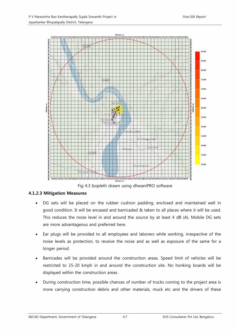
P V Narasimha Rao Kanthanapally Sujala Sravanthi Project in Final EIA Report
Jayashankar Bhupalapally District, Telangana
I&CAD Department, Government of Telangana 4.7 EHS Consultants Pvt Ltd, Bengaluru
Fig 4.3 Isopleth drawn using dhwaniPRO software
4.1.2.3 Mitigation Measures
• DG sets will be placed on the rubber cushion padding, enclosed and maintained well in
good condition. It will be encased and barricaded & taken to all places where it will be used.
This reduces the noise level in and around the source by at least 4 dB (A). Mobile DG sets
are more advantageous and preferred here.
• Ear plugs will be provided to all employees and laborers while working, irrespective of the
noise levels as protection, to receive the noise and as well as exposure of the same for a
longer period.
• Barricades will be provided around the construction areas. Speed limit of vehicles will be
restricted to 15-20 kmph in and around the construction site. No honking boards will be
displayed within the construction areas.
• During construction time, possible chances of number of trucks coming to the project area is
more carrying construction debris and other materials, muck etc and the drivers of these

P V Narasimha Rao Kanthanapally Sujala Sravanthi Project in Final EIA Report
Jayashankar Bhupalapally District, Telangana
I&CAD Department, Government of Telangana 4.8 EHS Consultants Pvt Ltd, Bengaluru
vehicles will be instructed with sign boards and not to use shrill horns for any purpose and
cover the material without any spillage.
• Silent Zone boards will be installed at all places where human activities are there along with
proper training to them to handle various equipments, tools and other related items.
• The noise levels will be monitored periodically (monthly) in the project area.
• Construction activities will be carried out only between 6 am to 6 pm and completely
suspended during night time to avoid psychological distress on people of Thupakulagudem
village and avifauna in the buffer zone.
• Supervisory staff will be advised to check and monitor to ensure the workers to follow all the
above said measures while at work.
4.1.2.4 Vibration
• Wherever the heavy equipments are used, which can generate vibration; rubber beadings
and proper support to the ground with thick blankets of rubber mats are preferred.
• The moving parts of the equipment will be greased well and covered by rubber sheets to
arrest the vibration.
• Controlled blasting will be employed during drilling and blasting to avoid vibrations which
can affect structures of Thupakulagudem village and burrow animals and reptiles.
4.1.3 Water Environment
4.1.3.1 Sources of water pollution
• Improper treatment of sewage from labour camps leads to infiltration into the subsurface
soil and finally affects the quality of ground water. Labour camp is expecting to generate 30
KLD of sewage (considering 75 lpcd for 400 labors) which is anticipated to pollute ground
water in an area of 2 ha from the source at 60-70 m bgl60
• Improper management of domestic solid waste from labour camps & dumping near water
bodies leads to surface water pollution.
. Further, the source of pollution is
at a distance of 500 m to the Thupakulagudem village. Hence, the chances of pollution to
drinking water will be nil.
• There will be creation of unaesthetic conditions in the site, attracts mosquitoes/flies, thereby
chances of deteriorating the health of the workers in unhygienic conditions and it also
affects people of Thupakulagudem village.
60 Ground water Pollution, Environment Agency, Bristol, England, 1-14 (http://ea-lit.freshwaterlife.org/archive/ealit:1635/OBJ/20000566.pdf)

P V Narasimha Rao Kanthanapally Sujala Sravanthi Project in Final EIA Report
Jayashankar Bhupalapally District, Telangana
I&CAD Department, Government of Telangana 4.9 EHS Consultants Pvt Ltd, Bengaluru
• Improper disposal of construction debris, used oil, diesel for DG sets, etc will result in
Godavari River water contamination leads to decrease in DO levels and morbidity of aquatic
life.
• Improper management of excavated earth (42,52,579.12 cum) and dumping of muck,
boulders into the nearby river will create turbidity of water and in turn affects river water
quality and aquatic life.
4.1.3.2 Mitigation Measures
• The sewage generated from the labor camps will be treated in mobile STP installed at site.
Solid waste from labour camps will be collected in different bins and handed over to nearby
municipal authorities.
• There will be no open discharge of sewage from labor camps and the labor camps will be
provided with sufficient bathrooms and toilets. Prevention of possible water logging areas
through soil filling. Periodical health check-ups (6 monthly once) will be conducted for labors
and also to Thupakulagudem village people.
• Construction debris will be reused at site; used oil generated from the DG sets will be stored
separately and handed over to TSPCB authorized recyclers. Further, the leakages of oil spills
from machinery shall be collected in leak proof barrels and then disposed off to TSPCB
authorized dealers.
• During construction of barrage, the river course and the point of contact will be provided
with sand bags and rock boulders.
• Implementing Muck Disposal Plan: Further excavated earth will be fully utilized for various
construction works such as inspection path, stabilization of embankment, land levelling.
4.1.4 Soil Environment
4.1.4.1 Sources of soil pollution
• Temporary loss of soil will be envisaged during the construction of temporary offices, labour
camps, haul roads, stockyards will be located on 26 ha of agriculture lands.
• Improper disposal of Solid waste generated from labour camp (180 Kgs/day) during
construction phase will create leaching problems thereby affecting soil biota and ground
water. Further, it also creates un-aesthetic conditions to Thupakulagudem village people.

P V Narasimha Rao Kanthanapally Sujala Sravanthi Project in Final EIA Report
Jayashankar Bhupalapally District, Telangana
I&CAD Department, Government of Telangana 4.10 EHS Consultants Pvt Ltd, Bengaluru
• Leakage of used oil from DG sets on the land will impact the soil biota. Oil spill affects
plants negatively by creating conditions which makes essential nutrients like nitrogen,
Oxygen etc needs for plant growth unavailable to them from the spilled affected soil61
4.1.4.2 Mitigation Measures
.
• Restoration of 26 ha of land utilized as construction site, temporary offices, workers camps,
stockyards will be undertaken soon after the completion of barrage construction.
• Scientific disposal of soild waste will be undertaken and handed over Eturnagaram Mandal
panchayat.
• Maintenance and period repairs of machineries will not be taken up in the project site
vicinity. Maintenance of DG sets will be done at the vendors place and will not take up near
project site.
• Storm water drainages and underground drainage of seepage water from construction area
will be provided with retention tanks to hold for at least 2 hours and periodic cleaning of silt
collected in the tanks.
4.1.5 Land use assessment
4.1.5.1 Impacts
• The construction of barrage across the river and submergence of 580.18 ha leads to
permanent change in land use.
• Present rain fed area will be converted into irrigated area. Hence, possibility of Salinization
will be expecting in an area of 830 ha62
• Providing irrigation, Tank filling and drinking water increases employment opportunities,
ground water recharge, enhances local biodiverisity and health benefits to the project
benefitting districts.
.
• Application of Inorganic fertilizers in the command area will impact on the intrinsic nutrient
availability of soil, soil biota, resulting to decline in productivity/yield of soil which in turn
changes the agricultural land use pattern in the command area.
• Disturbance to the natural flow of Godavari River is anticipated because of construction of
barrage.
61oyem, Isama Lawrence Rank, oyem, Isama Lawrence Effects of Crude Oil Spillage on Soil Physico-Chemical Properties in Ugborodo Community, Vol. 3,
Issue. 6, Nov - Dec. 2013 pp-3336-3342. 62 Drip Irrigation in Salt Affected Soil (2013), Blaine Hanson et al., University of California, p.58.

P V Narasimha Rao Kanthanapally Sujala Sravanthi Project in Final EIA Report
Jayashankar Bhupalapally District, Telangana
I&CAD Department, Government of Telangana 4.11 EHS Consultants Pvt Ltd, Bengaluru
• The present command of JCRDLIS and SRSP are suffering command area of existing
irrigation schemes and deprived of irrigation facilities and could not achieve the targets due
to scarce water availability. Drinking water demand is also not met.
4.1.5.2 Mitigation Measures
• Treatment of saline and sodic soils will be undertaken in consultation with Agricultural
Department.
• Agricultural training programmes will be conducted to the farmers in the command area in
association with agricultural department, Govt., of Telangana. Organic farming practices will
be promoted.
• To ensure natural flow of water, gated arrangements provision will be made.
• The proposed barrage in the scheme will stabilize the existing schemes there by change in
Land use pattern from rain fed to irrigated system. There is also provision of drinking water
supply (50 TMC) in the scheme.
4.1.6 Impact on Solid & Hazardous Environment
4.1.6.1 Impacts
• Solid Waste of 180 Kg/day (0.45 Kgs/day/person) will be generated from the labour colony
like kitchen waste, garbage, plastic waste, etc. Improper management of solid waste from the
labour colony & irregular practice in disposal of waste leads to spread of infectious diseases
and un-aesthetic condition.
• Improper storage of solid waste leads to leachate formation of 13.86 Cu.m/year63
• Indiscriminate plastic waste disposal on land makes the land infertile due to its impervious
nature and also affects wild animals of adjacent Eturnagaram WLS.
which will
affect the surface water quality and aquatic life.
• Improper management in storage of muck, excavated earth & Boulders will affect the natural
flow of water and will result in turbid condition (1 km u/s and d/s of barrage area) of
Godavari River affecting aquatic life. Sometimes muck moves along with the runoff creating
landslides which leads to sedimentation and also affects yields of neighboring farmers.
• 50 l/annum of used oil is anticipated from the DG Sets of capacity 2 x 500 KVA. Improper
storage and disposal affects surface water quality and aquatic life.
• 200 liters of paint is required during construction phase and the improper disposal of
containers affects surface water quality and aquatic life.
63 TNT Ibrahim et.al (2017), Estimation of leachate generation from MSW landfills in Selangor Asian Jounral of Microbiology, Biotechnology and Envi.
Sciences, Vol. 19 (1), 43-48

P V Narasimha Rao Kanthanapally Sujala Sravanthi Project in Final EIA Report
Jayashankar Bhupalapally District, Telangana
I&CAD Department, Government of Telangana 4.12 EHS Consultants Pvt Ltd, Bengaluru
• Welding electrodes and unused iron components including scrap of 105 tonnes (2% of total
steel requirement) is anticipated during construction activities. Improper handling of these
affects surface water quality and aquatic life.
4.1.6.2 Mitigation Measures
• Soild and hazardous wastes generated will be stored in the leak proof bins. Scientific
segregation of solid waste at site and regular disposal to Eturnagaram Mandal municipal
authority’s landfills. Storage area 5 m x 5 m will be covered with zinc sheets and the ground
will be covered with impervious layer to avoid leachate run off. Pest control will be done
periodically (quarterly once) in and around labour camps and project site office areas.
• Monthly surface water quality testing as per IS 10500 Drinking Water Quality Standards and
quarterly study of aquatic life. Cost has been worked out accordingly.
• Plastic waste will be segregated at source and handed over to TSPCB authorized recyclers.
• Water sprinkling will be done 3 times a day to avoid fugitive emissions and the excavated
earth and muck will be stored in designated areas at lower contours.
• Used oil generating from the DG sets and paint containers will be handed over to
authorized recyclers.
• Implementation of muck disposal plan.
• Generated muck from the project will be stored and covered with the green mesh in the
designated place along with construction of bunds around it and will be reused later.
• The leftovers of welding electrodes and iron components will be handed over to the nearby
engineering works centre so as to remould and reuse them for making other iron works.
4.1.7 Impact on Hydrology & Geology
4.1.7.1 Impacts
• Geological Environment: As the proposed project site i.e., Barrage is proposed over the
Godavari River the litho unit covering is Sandstone and Shale to store water for
strengthening the existing Devadula LIS upstream so that water is available continuously to
the project command area. As such there is no disturbance or alteration to the local
Geology.
• Seismic tectonics: Seismic activity with respect to the proposed barrage was studied at the
possibility during the post project scenario. It was observed that no major earth quakes
occurred in the region during the past 49 years. However, the recent recorded major earth
quake of magnitude 6.2 on Richter scale to the project site was in Ausa, Maharashtra during
1993. The seismic zoning map has been referred to know the zone in which the project site

P V Narasimha Rao Kanthanapally Sujala Sravanthi Project in Final EIA Report
Jayashankar Bhupalapally District, Telangana
I&CAD Department, Government of Telangana 4.13 EHS Consultants Pvt Ltd, Bengaluru
is located. The proposed project site is falling in Zone-III which has very moderate risk of
damage.
• Changes in hydraulic regime: During the construction phase, no severe affect on a water
availability and hydrology is anticipated. Based on the Detailed Project report of WAPCOS
Limited for I&CAD Telangana the required water of 100 TMC is available.
• Due to flooding, soil erosion and increasing sedimentation leads to submergence of adjacent
lands of 462 ha of villages Thupakulagudem, Gangaram, Thimmaigudem, Venchepally and
Mukunur and adjacent forest area.
• Impact on structural stability and breaching of barrage.
4.1.7.1 Mitigation measures
• The maximum flood recorded between 1966-2015 was in the year of 1986 with a discharge
of 62,889 cumecs with a water level of 87.42 m. Hence, the occurrence of flood is not
frequent. The gates will be operated during high flood season to release downstream.
However, suitable emergency action plan will be initiated to restore the area. In order to
avoid soil erosion and sedimentation, CAT plan will be implemented (Chapter-9).
• Sub-surface exploration has revealed the occurrence of bed rock below the sand cover is
3.5m to 8.5m and the rock is dark grey schistic Quartzite or Quartzo-schistic rock, in the
center of the river bed, the rock is hard and massive, but highly fractured, with low core
recovery noted as maximum as 65%, which is good to be tied up the barrage.
4.1.8 Impact on Biological Environment
4.1.8.1 Impacts
• Eturnagaram Wildlife Sanctuary is located at a close proximity from the proposed barrage
(<5 Km). However, no rare, threatened, endangered plant species were recorded during the
study and all the other species recorded were common to the region. Avifaunal species such
as Shikra, Jerdon’s courser, Indian peafowl, Common buzzard and Booted eagle; butterfly
namely Common pierrot and mammals such as Black buck, Four horned antelope, Indian
wolf and Sloth bear were recorded during the study in the project site as well as in the
command area which belongs to Schedule I of W(P)A, 1972.
• About 30 ha of land have been identified for carrying out construction activities close to the
River Godavari. Out of which, 26 ha are agricultural lands and remaining area is waste land
followed by riparian land. Totally, 800 trees of different girth size (<30 cm is 700 and >30
cm is 100) will be removed.
• The proposed project does not involve the diversion of forest land, hence there will be
minimum impact on the biological environment and there is no scope for forest clearance.

P V Narasimha Rao Kanthanapally Sujala Sravanthi Project in Final EIA Report
Jayashankar Bhupalapally District, Telangana
I&CAD Department, Government of Telangana 4.14 EHS Consultants Pvt Ltd, Bengaluru
• Emission of dust is expected during vehicular movements for transportation of construction
material or construction waste during construction phase which would reduce the
photosynthetic activity in plants by its deposition on the foliage.
• Mobilization of machineries and workers during construction phase will create disturbance to
the mega-faunal species/ wildlife due to the presence of Eturnagaram WLS.
• Construction activities will affect the aquatic biota of River Godavari upto 1 Km and reptiles
and burrow animals upto 1 Km due to vibrations generated from machineries and
disturbance in the river bed area
• Emission of dust is expected during vehicular movements for transportation of construction
material or during construction phase which would reduce the photosynthetic activity of 3,
42,300 trees plants by its deposition on the foliage.
• During the construction of barrage across Godavari River, fish species move towards certain
safe locations. However, minor impacts on fish species will be anticipated on either side of
the barrage upto 100 m.
• Construction activities will affect the aquatic biota of River Godavari due to vibrations
generated from machineries and disturbance in the river bed area.
• While undertaking the construction of the barrage across the River Godavari and related
components, controlled blasting and such; other measures are to be adopted. The extracted
produce-earth, muck, boulders, etc are normally dumped, as a routine practice in such
exercises very close to the lotic water bodies; result being the flow of water in the system
gets altered affecting the aquatic life-fish species present in their migration exercises for
feed, feeding, breeding and recruitment needs for sustenance and propagation.
• Fish species, as a result of certain changes in the environment at the site, may get locked-up
in water–holding pools where these strive to sustain their biological needs. Suggestions to
be incorporated have been listed in the Environmental Management Plan.
• There will not be any type of ‘Negative’ impact/s on the quality and status of the river water
during the operation phase.
• Since the present human settlement/ village is located close to the envisaged project site,
the quality of the river water getting affected causing medical problems could be in
marginal limits during the construction phase. However, the labour force and others being
assembled at the spot/locality in large numbers for the execution of the envisaged project
offers opportunities for the spread of communicable health disorders, the prevalence of
which may get affected/impacted for days to come.

P V Narasimha Rao Kanthanapally Sujala Sravanthi Project in Final EIA Report
Jayashankar Bhupalapally District, Telangana
I&CAD Department, Government of Telangana 4.15 EHS Consultants Pvt Ltd, Bengaluru
• While constructing the barrage and related facilities, considerable quantum of rocks,
boulders, earth, etc. being extracted which, as a normal/usual practice in such situations, are
dumped in close location. In order to prevent the sliding back into the water body affecting
normal flow regime, are to be secure appropriately quiet away from the river in particular.
Also, screens of desirable mesh–sizes depending upon the height and width etc to cover
advantage points are to be installed in order to maintain normal biological processes of
aquatic life fish species prevailing.
• There will not be any adverse impact/s on the aquatic life- fish species in particular habitat
in the biotope on the implementation of the suggestions made. Flow of river water, as
envisaged, to the riparian part of the lotic water body at the site will be maintained quite
adequately to keep the pools and such other water- holding facilities harbored with fish
species to sustain their biological needs.
4.1.8.3 Mitigation Measures
• Conservation plan for schedule I species will be implemented in the operation phase
(Chapter – 9).
• Restoration of vegetation will be carried out to compensate (26 ha) the land identified for
carrying out construction activities (Chapter – 9) as well as along the left and right bank of
the proposed barrage by carrying out plantations at the ratio of 1:3 so as to improve the
ecological environment.
• Periodic sprinkling of water (3 times a day) to the plants for alongside the access roads to
the construction site will reduce the deposition of dust on the foliage and thus retaining
their photosynthetic activities.
• Utilization of modern equipments during construction phase can produce less sound and
vibrations reducing the disturbances to the faunal species including avifauna and wildlife.
Construction activities shall be carried out only during the day time so as to reduce the
impacts on the nocturnal animals and other mega-faunal species.
• It is proposed to construct the temporary structure to arrest the flow by using rock boulders
to avoid turbidity of water and modern technology such as controlled blasting will be used
to minimise the vibrations not beyond 100 m.
• Screens of desirable mesh sizes depending upon the height and width to cover advantage
points will be installed in order to maintain normal biological processes of aquatic life and
fish species prevailing.

P V Narasimha Rao Kanthanapally Sujala Sravanthi Project in Final EIA Report
Jayashankar Bhupalapally District, Telangana
I&CAD Department, Government of Telangana 4.16 EHS Consultants Pvt Ltd, Bengaluru
• Appropriate measures will be taken with utmost caution and at desired levels to stall flow of
the medium suspecting to hold any harmful/un-hygienic extraneous content in order to
maintain the quality, potability and related nature of the lotic system.
• The people: work force, business establishments, etc. must shift away from their temporary
dwellings and commitment arrived at earlier itself i.e., prior to the establishment of the
project envisaged to minimize the spread of communicable health disorders.
• After the commissioning of the project, limnological and fisheries investigations need to be
organised for a period of 3-5 years (on quarterly basis) at least to assess the overall picture
on the physico-chemical features of the river water at the site and close-by areas, biological
aspects such as plankton biomass, benthic/littoral faunistic elements, aquatic vegetation,
exotic fish, if present so as to introduce corrective measures to sustain normal ecological
features and to introduce effective technical measures based on the data generated during
the course of the studies.
4.2 Impacts during Operation phase
• Failure of this project would result in socio-economic sufferings, no assured water for
agriculture and farmers would largely experience drought like situations to a greater extent.
• No severe affect on a water availability and hydrology is expected in the downstream areas
due to construction of barrage. 100 TMC of water for the proposed project is available and
the clearance has been sought. In addition to this, water flows will not be affected as Maner,
Pranahita and Indravathi are major contributors to River Godavari.
• Construction of barrage will affect the migratory paths of aquatic fauna of River Godavari
leading to depletion of fish population.
• Pollution by pesticides used for crop protection results in surface water pollution affecting
aquatic ecosystem.
• Salinization of irrigated land, pollution by pesticides used for crop protection affects the crop
yield
• Abstraction of 100 TMC of water will reduce the water availability in the river causing
impacts on fish germplasm (aquatic life).
• As the agricultural practices flourish with availability of water, usage of pesticides and
application of fertilizers will naturally increase which leads to soil quality deterioration.
• The recharge to aquifer will be boosted once extensive agriculture is practiced a portion of
water will be infiltrated in to ground recharging the aquifers. In addition to this, artificial

P V Narasimha Rao Kanthanapally Sujala Sravanthi Project in Final EIA Report
Jayashankar Bhupalapally District, Telangana
I&CAD Department, Government of Telangana 4.17 EHS Consultants Pvt Ltd, Bengaluru
recharge of the aquifers by construction of suitable harvesting structures like farm ponds,
nala bunds, check dams and also desilting of tanks.
• As the drawal of water is minimized, the water table will rise and many of the borewell will
yield substantial water.
• During the operation phase, no medical/health problems to the residents and the migrant
labour, business force on contract for the envisaged project work could be forecast now.
4.2.2 Mitigation measures
• The project has been planned due to persistent demands of local people keeping in view of
water availability at Godavari River. As such, failure will not be anticipated due to water
availability.
• Special Land Acquisition Officers for this project will be engaged to resolve the matters
related to land acquisitions and compensations.
• Restrictions on time, method and rate of application of fertilizers and pesticides will be
imposed to avoid surface run-off and leaching on to the groundwater regime.
• Organic farming related agricultural extension activities will be undertaken with the support
of Agriculture Dept., to ensure optimal use of Fertilizers and Pesticides in the command area
so as to minimize the impact on aquatic ecosystem.
• Reclamation of salt affected soils and optimum use of pesticides will be encouraged to
reduce the impacts.
• The construction of barrage does not affect the migratory paths of the fishes as the sluice
gates of the barrage provide an access for the fishes to cross the barrier.
• Minimum environmental flow (e-flow) will be maintained during lean season and as per the
Global Environmental Flow Calculator Model (GEFC) results reveal that, 64% of the river
condition will be maintained 'natural', 39% with slightly modified condition and there will be
minimum seriously modified (7%) and critically modified condition (4%).
• Desired medical facilities are to be organised to meet any emergency.
4.3 Evaluation of Impacts
Matrix method was used to identify interactions between various project activities and
environmental parameters and components. Later, a weightage of 1-10 will be given to the impacts
based on the significance of the impacts. The impacts are quantified ‘with’ and ‘without’ EMP.
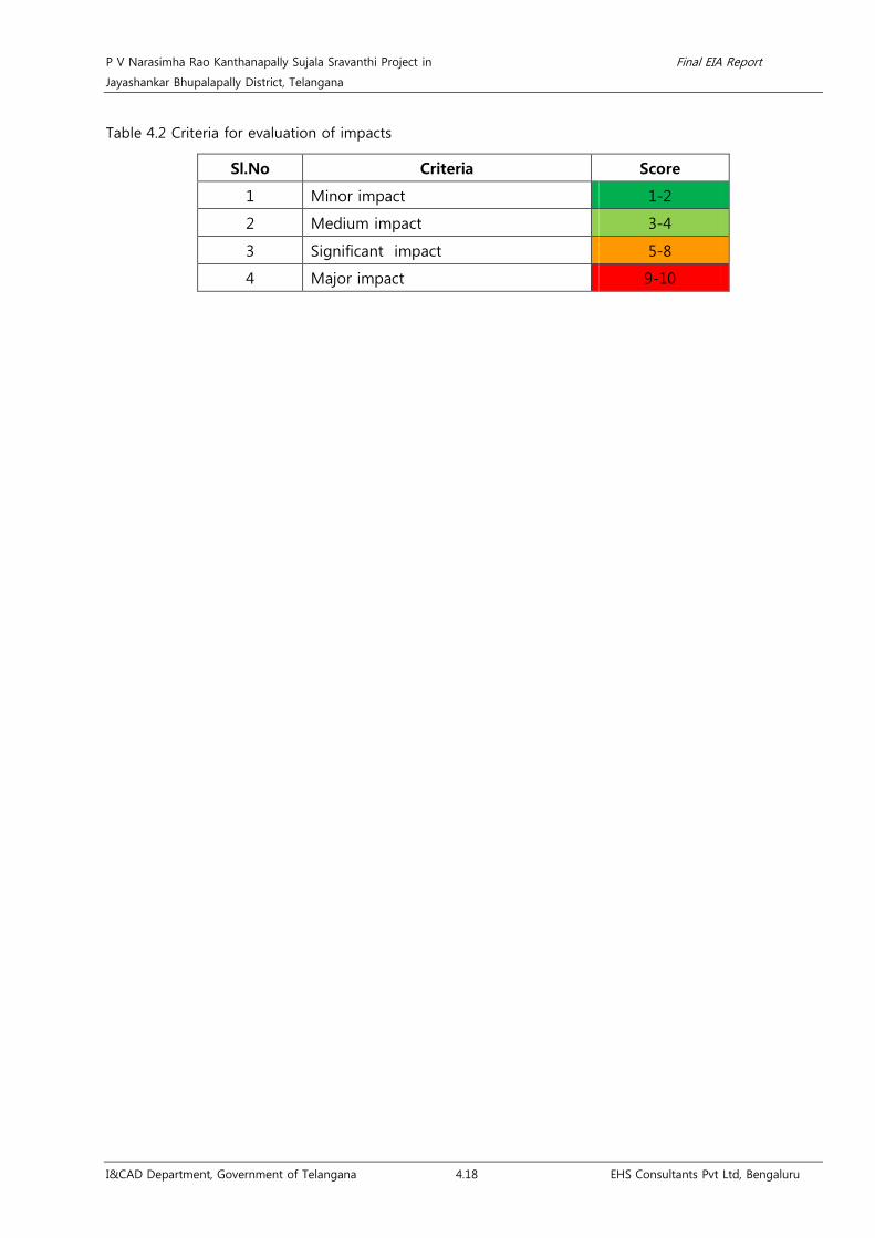
P V Narasimha Rao Kanthanapally Sujala Sravanthi Project in Final EIA Report
Jayashankar Bhupalapally District, Telangana
I&CAD Department, Government of Telangana 4.18 EHS Consultants Pvt Ltd, Bengaluru
Table 4.2 Criteria for evaluation of impacts
Sl.No Criteria Score
1 Minor impact 1-2
2 Medium impact 3-4
3 Significant impact 5-8
4 Major impact 9-10

P V Narasimha Rao Kanthanapally Sujala Sravanthi Project in Final EIA Report
Jayashankar Bhupalapally District, Telangana
I&CAD Department, Government of Telangana 4.19 EHS Consultants Pvt Ltd, Bengaluru
Table 4.3 Evaluation of Impacts
Sl.
No. Environmental Attributes Project Activities
Nature of Impacts
Mag
nitu
de
Rev
ersible
Irre
vers
ible
Long
Ter
m
Short T
erm
Direc
t
Indirec
t
Positiv
e
Neg
ativ
e
Witho
ut E
MP
With
EMP
A. Construction Phase
1. Impacts on Air Environment
1 Increase in dust concentration
Construction equipments, Operation of
DG sets. M 3 1
Excavation H 10 4
Rate of transpiration of trees L 4 1
2 Fugitive Emissions from various sources
Vehicular movement H 10 4
Loading and dislodging, Use of sand, fine
aggregates M 6 4
Batching plant M 7 3
Improper Storage of muck H 9 6
3 Increase in SO2, PM, NOx
Vehicular movement M 6 3
Operation of DG sets M 6 3
Fuel Combustion in equipments and
Vehicles M 5 4
Burning of fuels from construction
workers M 5 3

P V Narasimha Rao Kanthanapally Sujala Sravanthi Project in Final EIA Report
Jayashankar Bhupalapally District, Telangana
I&CAD Department, Government of Telangana 4.20 EHS Consultants Pvt Ltd, Bengaluru
Sl.
No. Environmental Attributes Project Activities
Nature of Impacts
Mag
nitu
de
Rev
ersible
Irre
vers
ible
Long
Ter
m
Short T
erm
Direc
t
Indirec
t
Positiv
e
Neg
ativ
e
Witho
ut E
MP
With
EMP
4 Impact on Human Health Emission of Dust particles M 7 4
2. Impact on Noise Environment
1 Increase Noise Level
Movement of vehicles M 6 4
Operation of D.G sets L 4 1
Movement of vehicles carrying raw
materials M 6 4
3. Impacts on Water Environment
1 Eutrophication Sewage from labor camp H 10 2
2 Change in River Water Quality
Construction of proposed barrage M 8 2
Diversion of river water H 10 2
Decomposition of sediments and
deposition of organic matter M 6 2
Washing of equipments L 4 2
Disposal of construction debris, used oil,
diesel for DG sets M 6 2
Muck disposal M 7 2
3 Change in ground water quality Sewage from labor camp M 7 2
4 Impact on human health Unaesthetic conditions & water logging M 6 2

P V Narasimha Rao Kanthanapally Sujala Sravanthi Project in Final EIA Report
Jayashankar Bhupalapally District, Telangana
I&CAD Department, Government of Telangana 4.21 EHS Consultants Pvt Ltd, Bengaluru
Sl.
No. Environmental Attributes Project Activities
Nature of Impacts
Mag
nitu
de
Rev
ersible
Irre
vers
ible
Long
Ter
m
Short T
erm
Direc
t
Indirec
t
Positiv
e
Neg
ativ
e
Witho
ut E
MP
With
EMP
5 Sedimentation Movement of Muck along with Runoff M 7 2
4. Impacts on Land Environment
1 Land
Construction of proposed barrage M 7 4
Excavation for proposed barrage H 10 4
Vehicular movement M 3 1
2 Change in Topography Submergence H 10 7
3 Change in natural flow of water Storage of excavated earth and Boulders H 10 7
4 Loss of Productive Soil
Construction site, temporary offices,
workers camps, stockyards M 7 4
Construction of Haul roads L 4 2
Excavation for proposed barrage H 10 2
5 Compaction of Soil
Site Clearance L 4 2
Movement of vehicles L 4 2
6 Contamination of Soil
Machinery and operation of the Diesel
Generator Sets M 5 2
Labor camps/ Improper practices in
disposal of waste M 5 2
5. Impact on Soil Environment

P V Narasimha Rao Kanthanapally Sujala Sravanthi Project in Final EIA Report
Jayashankar Bhupalapally District, Telangana
I&CAD Department, Government of Telangana 4.22 EHS Consultants Pvt Ltd, Bengaluru
Sl.
No. Environmental Attributes Project Activities
Nature of Impacts
Mag
nitu
de
Rev
ersible
Irre
vers
ible
Long
Ter
m
Short T
erm
Direc
t
Indirec
t
Positiv
e
Neg
ativ
e
Witho
ut E
MP
With
EMP
1 Soil pollution
Temporary loss of soil may be envisaged
during the construction phase M 4 2
Leaching of solid waste generated from
labour camps H 9 4
Leakage of used oil from DG sets on the
land H 9 6
Improper handling of excavated earth H 10 4
6. Impact due to Solid and Hazardous environment
1 Land pollution
Improper maintenance and storage of
excavated earth, dumping of muck,
boulders, etc and oil from DG sets into
the river affects natural flow regime
H 10 6
Improper management of domestic solid
waste from labour camps and dumping
near water
M 7 4
Impact on wildlife M 7 2
Paint and iron remains H 9 6
7. Impact on Biological Environment

P V Narasimha Rao Kanthanapally Sujala Sravanthi Project in Final EIA Report
Jayashankar Bhupalapally District, Telangana
I&CAD Department, Government of Telangana 4.23 EHS Consultants Pvt Ltd, Bengaluru
Sl.
No. Environmental Attributes Project Activities
Nature of Impacts
Mag
nitu
de
Rev
ersible
Irre
vers
ible
Long
Ter
m
Short T
erm
Direc
t
Indirec
t
Positiv
e
Neg
ativ
e
Witho
ut E
MP
With
EMP
1 Pressure on existing natural resources Immigration of labour population L 4 1
2 Pressure on biodiversity of Eturnagaram
WLS Construction activities L 4 2
3.
Reduced Photosynthetic activity, Wilting
of plants Transportation of construction materials M 4 2
Site Clearance M 4 2
4 Impacts on Fishes and Aquatic
Ecosystem
Changes in the physical environment at
the site H 9 6
Change in quality of River water H 4 2
Increase in turbidity of water due to
Washing of machineries M 4 2
Sewage from labour camp H 6 4
Entering of Boulders to river H 10 6
Dumping of extracted produce-earth,
muck, boulders, etc H 10 6
5 Schedule I species in the study area Construction activities M 6 2
6 Nearby agro-ecosystems Construction activities H 9 6
7 Forest land No diversion of forest land H 9 1
8. Impact on hydrology and geology

P V Narasimha Rao Kanthanapally Sujala Sravanthi Project in Final EIA Report
Jayashankar Bhupalapally District, Telangana
I&CAD Department, Government of Telangana 4.24 EHS Consultants Pvt Ltd, Bengaluru
Sl.
No. Environmental Attributes Project Activities
Nature of Impacts
Mag
nitu
de
Rev
ersible
Irre
vers
ible
Long
Ter
m
Short T
erm
Direc
t
Indirec
t
Positiv
e
Neg
ativ
e
Witho
ut E
MP
With
EMP
1 Geological Environment Construction of barrage L 4 2
2 Seismic tectonics Construction of barrage L 3 1
3 Changes in hydraulic regime Water availability due to construction of
barrage L 3 1
9. Impact on Socio-economic Environment
1 Land acquisition Affecting livelihood H 10 7
2 Impact on Human Health Due to water/air borne diseases, traffic
movement H 9 4
B. Operation Phase
1 Impacts on Land Environment
Application of natural fertilizers and
pesticides H 9 4
Salinity of irrigated land M 4 2
Solid and hazardous waste generated
during operation phase is negligible. M 5 3
2 Land use
Rain fed area is converted into irrigated
area H 9 3
Ground water recharge M 5 2
Enhances local biodiversity H 9 1

P V Narasimha Rao Kanthanapally Sujala Sravanthi Project in Final EIA Report
Jayashankar Bhupalapally District, Telangana
I&CAD Department, Government of Telangana 4.25 EHS Consultants Pvt Ltd, Bengaluru
Sl.
No. Environmental Attributes Project Activities
Nature of Impacts
Mag
nitu
de
Rev
ersible
Irre
vers
ible
Long
Ter
m
Short T
erm
Direc
t
Indirec
t
Positiv
e
Neg
ativ
e
Witho
ut E
MP
With
EMP
Increase in employment opportunities H 10 1
3 Impact on water environment Application of fertilizers and pesticides M 7 4
4 Impact on Aquatic life Construction of barrage H 9 4
5 Impact due to project failure Land acquisition and lack of Power
supply H 9 4

P V Narasimha Rao Kanthanapally Sujala Sravanthi Project in Final EIA Report
Jayashankar Bhupalapally District, Telangana
I&CAD Department, Government of Telangana 5.1 EHS Consultants Pvt Ltd, Bengaluru
Chapter 5. Analysis of Alternatives
The alternative alignments study was carried out and suitable location for barrage was
proposed based on the factors like less damage to the environment, less forest area
requirement, less land acquisition, techno-economic considerations etc. Based on the
reconnaissance survey, environment considerations and detailed hydrological studies the final
alternative intake site and the corresponding water conductor alignments have been
finalized. Geological Investigation study was carried out for the barrage. The merits and
demerits of the barrage alternative have been studied in detail.
Proposed Barrage: Two alternative alignments were considered for construction of the
barrage. The comparison of alternatives with respect to environment is discussed below:
Table 5.1 Details of alternatives for the proposed barrage
Sl.No. Components Alternative Alignment I
(Kanthanapally site)
Alternative Alignment II
(Thupakulagudem site)
1 Location
Barrage Alignment-I is 17 km
downstream of the existing
Devadula project intake. Pond
level is at 85.0 m.
Godavari River at this site
flows through a narrow gorge.
The proposed barrage alignment
is 3 km downstream of the
existing Devadula project intake.
Pond level is at 77.0 m.
Godavari River at this site flows
through a narrow gorge.
2 Latitude and Longitude 180 27’ 40.22’’ N,
800 24’ 35.24’’ E
180 35’ 10’’ N,
800 23’ 36’’ E
3 Submergence
At the proposed pond level,
there will be submergence of
about 4 villages fully and
11 villages partially.
At the proposed pond level,
there is no land submergence.
Only river portion of about
580.18 ha of river bed area will
be submerged.
4 Land Acquisition
As major part of barrage
alignment rests on the river
bed, the acquisition of land for
construction of barrage is
7789.42 ha of land.
As major part of barrage
alignment rests on the river bed,
the acquisition of land for
construction of barrage is 94 ha.
In view of the above reasons and Geo-technical considerations, the Alternative alignment -II
is proposed as barrage axis for Thupakulagudem.

P V Narasimha Rao Kanthanapally Sujala Sravanthi Project in Final EIA Report
Jayashankar Bhupalapally District, Telangana
I&CAD Department, Government of Telangana 5.2 EHS Consultants Pvt Ltd, Bengaluru
Fig 5.1 Map showing alternative sites for the proposed barrage

P V Narasimha Rao Kanthanapally Sujala Sravanthi Project in Final EIA Report
Jayashankar Bhupalapally District, Telangana
I&CAD Department, Government of Telangana 6.1 EHS Consultants Pvt Ltd, Bengaluru
Chapter 6. Environmental Monitoring Program
The purpose of the monitoring programme is to ensure that the objectives of the project are achieved through the mitigation measures and
result in desired benefits to environment and local population of the region. To ensure the effective implementation of the EMP, it is essential
to carryout environment monitoring programmers given below.
Table 6.1 Environmental Monitoring Program for Construction phase (2 years)
Environmental
Parameters Parameters to be Monitored
Frequency of
Monitoring Locations Responsibility
Estimated
Cost in Rs.
Surface water
quality of
Godavari River
pH, Temperature, EC, TDS
Alkalinity, TH, DO, BOD, COD,
NO3, PO4, Cl, SO4, Na, K, Ca,
Mg, Silica, Oil & grease and
Total Coliform
Monthly once
Near Proposed Barrage Site,
Downstream and Upstream
of Godavari River
(3 Nos.)
Irrigation & CAD
Department Govt.
of Telangana
19,560/-
Ground water
quality
pH, Temperature, EC, TDS
Alkalinity, TH,NO3, PO4, Cl,
SO4, Na, K, Ca, Mg, Silica, Oil
& grease &Total Coliform
Monthly once Near Labour Camp
(1 No.)
Irrigation & CAD
Department Govt.
of Telangana
4,670/-
Soil Quality
pH, EC, Mg, Ca, Alkalinity, Cl,
Na, K, Organic Carbon, PO4,
SAR, N and Salinity
Monthly once Near Proposed Barrage
(1 No.)
Irrigation & CAD
Department Govt.
of Telangana
5,470/-
Air Quality PM10, PM2.5, NO2 and SO2 Monthly once Near Proposed Barrage (1
No.)
Irrigation & CAD
Department Govt.
of Telangana
10,500/-

P V Narasimha Rao Kanthanapally Sujala Sravanthi Project in Final EIA Report
Jayashankar Bhupalapally District, Telangana
I&CAD Department, Government of Telangana 6.2 EHS Consultants Pvt Ltd, Bengaluru
Environmental
Parameters Parameters to be Monitored
Frequency of
Monitoring Locations Responsibility
Estimated
Cost in Rs.
Noise Levels Leq Day, Leq Night in dB(A)
Monthly once
until completion
of construction
works
Near Proposed Barrage
(1 No)
Irrigation & CAD
Department Govt.
of Telangana
7,000/-
Sub-Total / month 47,200/-
Sub-Total A - For 24 months 11,32,800/-
Aquatic life Limnological and biological
studies
Six monthly once
until completion
Near Proposed Barrage
(1 No.)
Irrigation & CAD
Department Govt.
of Telangana
1,00,000/-
Health check ups
Spirometry, Pulse Oxymetry,
Blood Test, Lung Function Test,
Eye test, Physical fitness tests
Six monthly once
until completion Labor camps (1 No.)
Irrigation & CAD
Department Govt.
of Telangana
1,50,000/-
Sub-Total / 6 months 2,50,000/-
Sub-Total B - For 24 months 10,00,000/-
Total (A+B) 21,32,800/-

P V Narasimha Rao Kanthanapally Sujala Sravanthi Project in Final EIA Report
Jayashankar Bhupalapally District, Telangana
I&CAD Department, Government of Telangana 6.3 EHS Consultants Pvt Ltd, Bengaluru
Table 6.2 Environmental Monitoring Program for Operation phase (3 years)
Environmental
Parameters
Parameters to
be Monitored
Frequency of
Monitoring Locations Responsibility
Estimated
Cost in Rs.
Surface water
quality of
Godavari River
pH,
Temperature, EC,
TDS, Alkalinity,
TH, DO, BOD,
COD, NO3, PO4,
Cl, SO4, Na, K,
Ca, Mg, Silica,
Oil & grease, &
Total Coliform
Quarterly once
Near
Proposed
Barrage Site,
Downstream
and Upstream
of Barrage
(3 Nos.)
Irrigation &
CAD
Department
Govt. of
Telangana
19,560/-
Soil Quality
pH, EC, Mg, Ca,
Alkalinity, Cl, Na,
K, Organic
Carbon, PO4,
SAR, N and
Salinity
Quarterly once
Near Barrage
Site
(1 No.)
Irrigation &
CAD
Department
Govt. of
Telangana
5,470/-
Sub-Total /3 months once 25,030/-
Sub-Total A-for 3 years 3,00,360/-
Aquatic life
Limnological
and biological
studies
6 Monthly
once for 3
years
Near
Proposed
Barrage
Site
(1 No.)
Irrigation & CAD
Department Govt.
of Telangana
1,00,000/-
Sub-Total /6 months once 1,00,000/-
Sub-Total B-for 3 years 6,00,000/-
Total (A+B) 9,00,360/-

P V Narasimha Rao Kanthanapally Sujala Sravanthi Project in Final EIA Report
Jayashankar Bhupalapally District, Telangana
I&CAD Department, Government of Telangana 7.1 EHS Consultants Pvt Ltd, Bengaluru
Chapter 7. Additional Studies 7.1 Social Impact Assessment
The idea of utilizing Godavari water to irrigate the water deficit and drought prone areas in
the Telangana state was a long cherished dream gaining momentum subsequent to the
formation of the new State. The general scarcity of water midst the large-scale canal
irrigation development in neighbouring areas has further added to the long persisting
demand of the local farmers for a reliable source of irrigation supply. P.V.Narasimha Rao
Kanthanapally Sujala Sravanthi Project (PVNRKSSP) envisages construction of 1,132 meter
long barrage across Godavari River near Thupakulagudem village, 3 km downstream of
existing J.Chokka Rao Devadula Lift Irrigation Scheme. This is expected to stabilize existing
scheme having command area of 2,51,310 ha and provide irrigation facility to a command
area of 3,04,000 ha, besides providing 50TMC of drinking water to the enroute villages. Total
land required for the project is 674.18 ha out of which 580.18 ha of river bed area and 94 ha
of private land.
7.2 District highlights
• Jayashankar Bhupalapally District, with population of about 6.2 lakh is Telangana’s 9th
least populous district. There are 12 sub districts in the district, among them Ghanpur
station is the most populous sub district with population of about 92000 and Tadavi
is the least populous sub district with population of about 23000.
• The district is home to about 6.2 lakh people, among them about 3.1 lakh (50%) are
male and about 3.1 lakh (50%) are female. 67% of the whole population are from
general caste, 19% are from schedule caste and 14% are schedule tribes. Child (aged
under 6 years) population of Jayashankar Bhupalapally district is 9%, among them
52% are boys and 48% are girls. There are about 1.6 lakh households in the district
with an average 4 persons per family.
• In the district, nearly 88% (about 5.5 lakh) of the population lives in rural areas and
remaining 12% (about 73 thousand) live in the urban areas.
• Hindus contribute 96% of the total population followed by Muslims (3%). Female Sex
ratio per 1000 male in Hindus are 1003 in Muslims are 995.
• As of 2011 census there are 1003 females per 1000 male in the district. Sex ratio in
general caste is 1003, in schedule caste is 980 and in schedule tribe is 1031. There
are 932 girls under 6 years of age per 1000 boys of the same age in the district.
P V Narasimha Rao Kanthanapally Sujala Sravanthi Project in Final EIA Report
Jayashankar Bhupalapally District, Telangana
I&CAD Department, Government of Telangana 7.2 EHS Consultants Pvt Ltd, Bengaluru
• Total about 3.5 lakh people in the district are literate, among them about 2 lakh are
male and about 1.5 lakh are female. Literacy rate (children under 6 are excluded) is
62% with 71% male and 52% female literates.
• The district has 53% (about 3.3 lakh) population engaged in either main or marginal
works. 56% male and 49% female population are working population. 51% of total
male population is main (full time) workers and 6% are marginal (part time) workers.
For women 39% of total female population is Main and 10% are marginal workers.
7.3 Demographic profile of the project influence area
The brief socio-economic profile of the Study area villages is given in the following sub-
sections.
7.4 Data collection
The social profile of the project influence area was established through primary survey
conducted in the area and secondary data. Socio-Economic survey was carried out on the
PIA villages during December 2017–January 2018 and since the land to be acquired is
nonresidential agricultural areas and hence titleholders were not available for responding.
Some of them are living in faraway places and the survey team could not meet them. But
maximum care was taken to meet the titleholders in person and interview them using the
survey form attached (Annexure 20) and extract primary details. Besides this, all available
secondary data sources including census survey data were analyzed to assess the socio
economic, cultural and health status of the people living in these villages and those affected
by the project, as discussed below.
• District Census Handbook, 2011- series30, part XII B
• Official Websites of Jayashankar Bhupalapally District and Departments
• Jayashankar Bhupalapally -Know your district published by Government of Telangana
Planning Department, December, 2016.
• Demographic and Health Profile of Telangana state published by Indian Institute of
Health and Family Welfare in November, 2015.
• Tribes of Telangana by Dr.Dyavanapalli Satyanarayana.
7.5 Project influence area
Project Impact Villages includes 5 villages – Thupakulagudem and Gangaram, of
Kannaigudem, Thimmaigudem, Venchepally and Mukanuru of Palimela Mandal in
Jayashankar Bhupalapally district were the PIA villages, as detailed in the Table 7.1 below.
The people of these villages are directly impacted by the project due to land acquisition.

P V Narasimha Rao Kanthanapally Sujala Sravanthi Project in Final EIA Report
Jayashankar Bhupalapally District, Telangana
I&CAD Department, Government of Telangana 7.3 EHS Consultants Pvt Ltd, Bengaluru
These 5 villages are Scheduled tribe dominant areas but are not classified under “Scheduled
areas”.
Table 7.1 List of villages and taluks covered for SIA study
Sl.No. District Mandal Village Name
1
Jayashankar
Bhupalapally
Kannaigudem Thupakulagudem
2 Palimela Thimmaigudem
3 Palimela Venchepally
4 Kannaigudem Gangaram
5 Palimela Mukanuru
7.6 Demographic profile of PIA villages (census data 2011)
Demographic picture of the Project villages based on Census data 2011 was initially
attempted as discussed below
7.6.1 Area and households
Total area of these 5 villages is 3667 ha and there are 473 houses there, as detailed in the
Table 7.2.
Table 7.2 Area and households
Name of the village Area in Hectares Total Households
Thupakulagudem 255 176
Gangaram 180 45
Venchepalle 133 69
Muknur 2,928 122
Thimmatigudem 171 61
Total 3667 473
The total land area of villages and number of houses there gives the clue that on an average
there is 7.8 ha of land per family, which also means that most of the land is agricultural land
with few settlements in these villages.
7.6.2 Population and sex ratio
Total Population of these five villages together is 1852 and the sex ratio is 1049 for adults
and 1056 among under five children, which is in favour of females. The sex ratio is defined
as the number of females per 1,000 males in the population. This ratio for the State is 988
according to 2011 Census.

P V Narasimha Rao Kanthanapally Sujala Sravanthi Project in Final EIA Report
Jayashankar Bhupalapally District, Telangana
I&CAD Department, Government of Telangana 7.4 EHS Consultants Pvt Ltd, Bengaluru
Table 7.3 Population and sex ratio
Name of the
village
Total
Population
Total
male
Total
female
adult
sex
ratio
Child
(0-6) Male Female
child
sex
ratio
Thupakulagudem 601 277 324 1170 58 27 31 1148
Gangaram 160 86 74 860 16 10 6 600
Venchepalle 252 123 129 1049 27 12 15 1250
Muknur 640 324 316 975 55 29 26 897
Thimmaigudem 199 94 105 1117 27 11 16 1455
Total 1852 904 948 1049 183 89 94 1056
There is variation among these villages as shown In Table 7.3. Gangaram village have the
lowest sex ratio of 860 among adults and 600 among children. Thupakulagudem shows the
highest ratio of 1170 among adults. Generally the picture is better compared to the state
average.
7.6.3 Social Composition of the population
As per 2011 Census, Telangana is the only south Indian state with tribal population of 9.34
percent out of its total population. The population consists of 15.45% scheduled castes,
9.34% scheduled tribes and others.
The villages under project implementation are Tribal areas with 81.2 % of tribes among total
population. SC population is 9.3 percent and this status varies from village to village as
detailed in the Table 7.4.
Table 7.4 SC and ST population
Name of the
village
Total
Population
Total SC
Population
SC
% Male Female
Total ST
Population ST% Male Female
Thupakulagudem 601 75 12.5 33 42 481 80.0 228 253
Gangaram 160 2 1.3 1 1 155 96.5 83 72
Venchepalle 252 9 3.6 6 3 228 90.5 109 119
Muknur 640 84 13.1 46 38 443 69.2 224 219
Thimmatigudem 199 3 1.5 2 1 196 98.5 92 104
Total 1852 173 9.3 88 85 1503 81.2 736 767
As per the data these are mostly Tribal villages and in Thimmatigudem village, 98.5 percent
of the population belongs to ST category.

P V Narasimha Rao Kanthanapally Sujala Sravanthi Project in Final EIA Report
Jayashankar Bhupalapally District, Telangana
I&CAD Department, Government of Telangana 7.5 EHS Consultants Pvt Ltd, Bengaluru
7.6.4 Tribal categories of the state and project area
Following 9 were declared as Scheduled Tribes in Telangana State under the Constitution
(Scheduled Tribes) Order, 1950 (Published in the Gazette of India, New Delhi, dated
September 6, 1950) with the assent of the President of India.
1. Andh
2. Bhil
3. Chenchu or Chenchwar.
4. Gond (including Naikpod and Raj Gond).
5. Hill Reddis or KondaReddis.
6. Kolam (including Mannarvarlu).
7. Koya (including BhineKoya and RaiKoya).
8. Pardhan.
9. Thoti.
In Karimnagar, Warangal and Khammam districts which constitute Jayashankar Bhupalapally
District, the main Tribes are Koyas and Konda Reddis. Koyas live in symbiosis with Konda
Reddis in the hilly and river interacts of Koya land. They are as a whole more progressive
than other tribal groups in the field of economic activity.
Konda Reddy tribes are recognized as Primitive Tribal Group and they are divided into
exogamous septs for regulating matrimonial relations. Like other Telugu speaking people
their surnames are pre-fixed to individual names.
7.6.5 Literacy status
A literate is a person above 7 years of age, capable to read and write in any one language
and literacy rate is the percentages of literates in the total population excluding those below
7 yrs. Telangana State have a literacy rate of 66.54% as per 2011 census. Male literacy is
75.04% and female literacy is 57.99%. Tribal literacy status general is 49.79% with female
literacy status as 39.54% and male literacy status as 59.93%. The data from the Project
villages shows an average literacy rate of 46.8% with a male literacy rate of 57% and female
literacy rate of 43% which is very much in tune with the tribal statistics. Village wise details
are furnished in Table 7.5.

P V Narasimha Rao Kanthanapally Sujala Sravanthi Project in Final EIA Report
Jayashankar Bhupalapally District, Telangana
I&CAD Department, Government of Telangana 7.6 EHS Consultants Pvt Ltd, Bengaluru
Table 7.5 Literacy status of the Project villages
Name of the
village
Total
Population
Total
Literates % Male % Female %
Thupakulagudem 601 315 52.4 180 57.1 135 42.9
Gangaram 160 79 49.4 54 68.4 25 31.6
Venchepalle 252 75 29.8 44 58.7 31 41.3
Muknur 640 334 52.2 181 54.2 153 45.8
Thimmatigudem 199 63 31.7 35 55.6 28 44.4
Total 1852 866 46.8 494 57.0 372 43.0
7.6.6 Composition of workforce
Workforce means persons engaged in any economically gainful activity and Work
participation rate is the percentage of economically gainful active persons to total
population. The economy of Telangana is mainly driven by agriculture especially in the rural
areas which constitute 73% of the population .In the economy of the state, agriculture
contributes about 50% of the state’s income and about 70% of the work force. Since
agriculture is the main activity, it has close links with the development in other sectors for
overall economic progress of the state. Achieving faster agricultural growth is hence
important for increasing food production to meet the demands of increasing population as
well as for providing rural employment.
In the Project influence villages, the work participation rate, on an average, is 63% with
Muknur village showing the lowest WPR of 51% and Gangaram village the highest of 80%.
Main workers constitute very low percentage ranging from zero percent in Venchepalle
village to 90% in Thupakulagudem village. Hence marginal workers with seasonal
employments are common in these tribal villages. Details are shown in Table No 7.6.
Table 7.6 Composition of work force in PIA villages
Village Name Total
Population
Total
workers %
Main
workers %
Marginal
workers %
Thupakulagudem 601 446 74.2 402 90.1 44 9.9
Gangaram 160 128 80.0 8 6.3 120 93.8
Venchepalle 252 150 59.5 0 0.0 150 100.0
Muknur 640 327 51.1 7 2.1 320 97.9
Thimmatigudem 199 115 57.8 2 1.7 113 98.3
Total 1852 1166 63.0 419 35.9 747 64.1

P V Narasimha Rao Kanthanapally Sujala Sravanthi Project in Final EIA Report
Jayashankar Bhupalapally District, Telangana
I&CAD Department, Government of Telangana 7.7 EHS Consultants Pvt Ltd, Bengaluru
7.6.7 Main workers and Marginal workers
Main Workers are persons engaged in any economically gainful activity for 183 days or more
in a year. As per 2011 Census, In Telangana state, there are 137.20 lakh main workers, of
which 22.42 lakhs belong to scheduled castes and 14.58 lakhs belongs to scheduled tribes.
Marginal workers are persons engaged in any economically gainful activity for less than 183
days. As per 2011, Census there are 26.22 lakh marginal workers, of which 4.96 lakhs belong
to scheduled castes and 2.93 Lakhs belongs to scheduled tribes. As detailed earlier, the main
occupants of these villages are tribal people who do seasonal employment. Some depends
on forest goods also.
Main workers as well as marginal workers are engaged in various activities as cultivators,
Agricultural labourers, Household workers, and in other works are furnished in the Tables 7.7
& 7.8 below.
Table 7.7 Occupational groups of main workers
Village Name Main workers Cultivators Agricultural
labourers
HH
workers
Other
workers
Thupakulagudem 402 158 214 3 27
Gangaram 8 3 1 0 4
Venchepalle 0 0 0 0 0
Muknur 7 0 5 0 2
Thimmatigudem 2 0 2 0 0
Total 419 161 222 3 33
Percentage 35.9 38.4 53.0 0.7 7.9
Marginal workers are more in these villages and a good number of them are engaged in
agricultural operations. Cultivators are few but agricultural labourers are more. Details are
furnished in Table 7.7.
Table 7.8 Occupational groups of marginal workers
Village Name Marginal
Workers Cultivators
Agricultural
Labourers
Household
Industries
Other
Workers
Thupakulagudem 44 1 13 0 30
Gangaram 120 74 37 1 8
Venchepalle 150 0 146 0 4
Muknur 320 3 260 29 28
Thimmatigudem 113 5 98 7 3
Total 747 83 554 37 73

P V Narasimha Rao Kanthanapally Sujala Sravanthi Project in Final EIA Report
Jayashankar Bhupalapally District, Telangana
I&CAD Department, Government of Telangana 7.8 EHS Consultants Pvt Ltd, Bengaluru
Percentage 64.1 11.1 74.2 5.0 9.8
• Cultivators are those engaged in cultivation of various crops on their own land as
employer or worker. Total number of cultivators in the State, as per 2011 census is
31.51 lakhs. In the Project villages 38.4% of the main workers and 11.1% of the
marginal workers are cultivators.
• Agricultural labourers are those working in another person’s land for wages in cash
or kind. Total number of agricultural labourers as per Census 2011 in the State is
59.15 lakhs. 53% of the main workers and 74.2% of the marginal workers in the
Project villages are agricultural labourers.
• Household industry relates to production, processing, servicing, repairing or making
and selling of goods. In the state, there are 7.77 lakh persons engaged in household
industry. In the Project villages only 0.7% of the main workers and 5% of the
marginal workers are in Household industries.
• Other worker is those persons engaged in the activities other than cultivation,
agricultural labour and household industry. There are as many as 64.99 lakh other
workers in the State. In the Project villages 7.9 % of the main workers and 9.8% of
the marginal workers are engaged in other works
7.6.8 Gender status in work participation
When the gender status of the working categories are analyzed, surprisingly women
participation is not far behind, but very close to their counter parts as shown in the Table
7.9.
Table 7.9 Gender participation among workers
Village Name Main Workers Marginal workers
persons Male Female Persons Male Female
Thupakulagudem 402 203 199 44 17 27
Gangaram 8 4 4 120 64 56
Venchepalle 0 0 0 150 84 66
Muknur 7 3 4 320 164 156
Thimmaigudem 2 1 1 113 53 60
Total 419 211 208 747 382 365
Percentage 35.9% 50.4 49.6 64.1% 51.1 48.9

P V Narasimha Rao Kanthanapally Sujala Sravanthi Project in Final EIA Report
Jayashankar Bhupalapally District, Telangana
I&CAD Department, Government of Telangana 7.9 EHS Consultants Pvt Ltd, Bengaluru
As shown above, among the Main workers 49.6% are women and among the marginal
workers 48.9% are women who is more or less on equal grounds. This mean that women
also take equal role to shoulder the responsibilities to earn their livelihood.
7.6.9 Non workers
Non worker is a person without any gainful activity. In Telangana state, there are 186.62 lakh
non workers as per 2011 Census. In the Project villages, 37 percent of the population is non-
workers and among them 20.2% are women and 16.8% are men. This is the dependent class
and also includes children, students, house wives, aged and sick persons who will have to
depend on the earning members for their needs. Table 7.10 below gives the village wise
details.
Table 7.10 Non working category
Village Name Total Population Non-Working Population
Total Male Female
Thupakulagudem 601 155 57 98
Gangaram 160 32 18 14
Venchepalle 252 102 39 63
Muknur 640 313 157 156
Thimmatigudem 199 84 40 44
Total 1852 686 311 375
Percentage - 37.0 16.8 20.2
7.7 Description of Socio Economic Environment
In the field of economic activity among the tribal groups, Koyas as a whole are more
progressive than other tribal groups. They initiated plough cultivation in the tract. Both Koyas
and Konda Reddis produce same food stuffs and they exchange certain house-hold articles,
and agricultural implements through Barter system. Some Koyas work as Blacksmiths and
furnish the Konda Reddis with iron implements and some Konda Reddis manufacture baskets
and winnowing fans and supply to Koyas. Koyas characteristic settlement is groups of
hamlets scattered over the village land at places convenient for cultivation of their fields and
seldom are the houses concentrated in a large compact village.
Konda Reddis are shifting cultivatiors and largely depend on flora and fauna of forest for
their livelihood. They eat variety of tubers, roots, leaves, wild fruits etc., They collect and sell
non timber forest produce like tamarind, adda leaves, myrobolan, broom sticks etc., to
supplement their meagre income. They cultivate largely jowar, which is their staple food.
They also grow chodi, red gram, bajra, beans, paddy and pulses.

P V Narasimha Rao Kanthanapally Sujala Sravanthi Project in Final EIA Report
Jayashankar Bhupalapally District, Telangana
I&CAD Department, Government of Telangana 7.10 EHS Consultants Pvt Ltd, Bengaluru
7.8 Health infrastructure
Health infrastructure available in the district is mainly obtained from Government sources. As
per the data in Planning Department reports (2016), following infrastructure is available for
the people in the District. Several Private hospitals also are available, but details were not
available for reference.
Table 7.11 Health infrastructure
SL No Infrastructure available –District level Numbers
1 Allopathic Hospitals (Govt)
A Health Sub-Centers 179
B Primary Health Centers 25
C Community Health Centers 4
2 Ayurveda Hospitals (incl. Dispensaries) 10
3 Homeopathic Hospitals (incl. Dispensaries) 5
4 Unani Hospitals (incl. Dispensaries) 4
5 Doctors in all Hospitals 51
6 Beds in all Hospitals 332
A survey conducted by Health and Family Welfare dept shows that 86.3% of the villages in
Telangana state have Sub Health care facilities within 3 Km radius and 64.6% have Primary
health Care facilities within 10 Km radius. There are several Private Hospitals operating in the
area but details of the same are not available.
7.9 Health profile
Over the years the health profile of the people have improved substantially and some of the
recent highlights are furnished below
• Birth rate as per 2013 statistics is 17.4 per 1000 population
• Death rate declined to 7.3 per 1000 population
• Maternal Mortality Rate(MMR) is 92 per one lakh births while all India MMR is
167/100000 births
• Infant Mortality Rate (IMR) is 39 per 1000 live births.
• Institutional deliveries are universal in Telangana state
• In terms of full immunization coverage to children below 24 months Telangana could
achieve only 47.5% which is far behind Kerala (82%)

P V Narasimha Rao Kanthanapally Sujala Sravanthi Project in Final EIA Report
Jayashankar Bhupalapally District, Telangana
I&CAD Department, Government of Telangana 7.11 EHS Consultants Pvt Ltd, Bengaluru
• Nutritional Status of less than 5 year age group is not credible as 30percent of
suffering from malnutrition. Many of them are anemic (71%).
• Among women below 50 years 58% are anemic. 62% of the pregnant women too are
anemic which will impact the new born badly.
• Life style diseases among adults (blood sugar level, hypertension) are on the increase,
especially in urban areas.
7.10 Social infrastructure
In the proximity of the project site, educational, religious and transportation facilities are
available. The habitants have a good transportation facility as they are accessible easily.
The project is approachable by land at a distance of 400 m from Thupakulagudem village
and National High way (NH-202) at a distance of 200 m. Minor roads are connected to the
villages within the project area. Road head: Eturnagaram (27 km)
• The nearest railway station is at Warangal at a distance of 107 km.
• The nearest airport is Hyderabad at a distance of 255 km.
7.10.1 Cultural practices among tribes
Tribes of Telangana are known for cultural diversity which is to be preserved for the
sustainable wellbeing of whole mankind. Their social cultural practices and religious are
unique not only from Non-Tribals but also from tribe to tribe. They are symbiotic in nature.
Tribal dances of Lambada, Gonds, Koyas etc., and their festivals like Sammaka-Saralamma
fair, Nagoba fair, Gandhari fair, Salesvaram-Loddi fairs are attracting lakhs of people not only
from tribal stock but Non-Tribals too. Hence there is an urgent need to take measures to
preserve the tribal cultural diversity by giving fillip to Tribal Research Institutes/Schools/Tribal
Artists to propogate their cultural performances. The Governments have to promote tribal
tourism as it was already proposed by the expert committee some three decades back there
is an urgent need to preserve and promote their diversified cultures by giving
encouragement to tribal tourism and tribal arts like dances, songs, embroidery and paintings.
Governments have to see that the projects like Indira Sagar (Polavaram) and Kawal Tiger
Reserve would not replace their traditional habitations whose cultural diversity is supposed
to be protected to assure sustainable diversity / living of mankind in general and Telangana
in particular.

P V Narasimha Rao Kanthanapally Sujala Sravanthi Project in Final EIA Report
Jayashankar Bhupalapally District, Telangana
I&CAD Department, Government of Telangana 7.12 EHS Consultants Pvt Ltd, Bengaluru
7.10.2 Landform, Land use & Land ownership
The proposed project envisages lifting of water from Godavari will stabilize the command
area of 251310 ha existing under Devadula Lift Irrigation Scheme and SRSP Stages I & II of
command area of 3,04,000 ha. These are mostly agricultural area under cultivation.
7.10.3 Positive and negative impacts of the project
• Demand-Supply Gap- out of 7,75,21,000 ha of cultivable land in Telangana state, only
30 -35 % is irrigated and hence fully utilized. This project will help to increase in the
irrigated areas, leading to higher productivity and better yield. This will help to
reduce the demand- supply gap
• Imports Vs Indigenous Production- The project leads to enhancement of indigenous
food grain production snowballing the local production which in turn will lead to
export excess food grains adding to more income. This will have a favorable impact
on domestic and export markets.
• Employment Generation- The implementation of Irrigation scheme will create
employment opportunities in the project area. The employment is associated with
improved farming practices as well as the construction of the irrigation scheme.
Temporary labour (about 400) will be hired during construction of barrage. With this
irrigation project, additional farm labour would also be required which in turn will
result in higher cropping intensity by providing employment opportunities to local
people within and outside the vicinity of the project area.
• Population Projection-Influx of about 400 labours will be there during construction
phase of the project. This labour will be hired from local villages
• The negative impact of the project is that some land owners will lose their land for
construction of the project which in turn will impact their livelihood. This will be
compensated providing compensation vide LA rules applicable in the State. For the
loss of land, “Land for land” compensation will be considered for people who wish to
pursue their agricultural occupations
• Land acquisition of 94 Ha of Private land will be done for the implementation of the
project. This will affect 236 families in terms of livelihood. Compensation will be
provided as per RTFC&LARR act, 2013 and a cost of 2.53 crores is ear marked for the
purpose as part of Land Acquisition Rehabilitation and Resettlement Plan.
• Construction workers are exposed to poor living conditions at the site resulting
health concerns. Labour camps will be provided with all the basic arrangements viz.,

P V Narasimha Rao Kanthanapally Sujala Sravanthi Project in Final EIA Report
Jayashankar Bhupalapally District, Telangana
I&CAD Department, Government of Telangana 7.13 EHS Consultants Pvt Ltd, Bengaluru
sanitation arrangements, drinking water supply, occupational health centre, rest
rooms, and canteen facilities. Budget of 10.25 Lakhs is earmarked for the same.
• The command area is deprived of water availability which is affecting yield/
productivity. Providing assured water supply by constructing barrage near
Thupakulagudem village across Godavari River, meeting the irrigation potential area
of 5.55 Lakh ha and 50 TMC of drinking water supply to enroute villages.
7.10.4 Tribal villages and PESA Act
Some Tribal villages are in scheduled area such hence PESA Act (The Provisions of the
Panchayats (Extension to Scheduled Areas) Act) 1996 is applicable here. The key objectives of
the PESA Act are to ensure local governance with participatory democracy to make the gram
sabha the fulcrum of all activities, and safeguard and preserve the traditions and customs of
tribal communities.
7.11 Land acquisition in Scheduled Areas
Section 41 of the Right to Fair Compensation and Transparency in Land Acquisition,
Rehabilitation and Resettlement Act, 2013 (LARR 2013) provides for consent of Gram Sabhas
before the process of land acquisition in Scheduled areas. Section 41 and 42 also provide
certain protections to Scheduled areas, in case the land acquisition is unavoidable, as listed
below.
• As far as possible, no acquisition of land shall be made in the Scheduled Areas.
Where such acquisition does take place it shall be done only as a demonstrable last
resort.
• Prior consent of the concerned Gram Sabha or the Panchayats or the autonomous
District Councils, shall be obtained, in all cases of land acquisition in such areas.
Consent of the Panchayats or the Autonomous Districts Councils shall be obtained in
cases where the Gram Sabha does not exist or has not been constituted.
• In case of a project involving land acquisition and involuntary displacement of the
Scheduled Castes or the Scheduled Tribes families, a Development Plan shall be
prepared, in specified form with details of procedure for settling land rights due, but
not settled and restoring titles of the Scheduled Tribes as well as the Scheduled
Castes on the alienated land by undertaking a special drive together with land
acquisition.
• The Development Plan shall also contain a programme for development of alternate
fuel, fodder and, non-timber forest produce resources on non-forest lands within a

P V Narasimha Rao Kanthanapally Sujala Sravanthi Project in Final EIA Report
Jayashankar Bhupalapally District, Telangana
I&CAD Department, Government of Telangana 7.14 EHS Consultants Pvt Ltd, Bengaluru
period of five years, sufficient to meet the requirements of tribal communities as well
as the Scheduled Castes.
• In case of land being acquired from members of the Scheduled Castes or the
Scheduled Tribes, at least one-third of the compensation amount due shall be paid
to the affected families initially as first installment and the rest shall be paid after
taking over of the possession of the land.
• The affected families of the Scheduled Tribes shall be resettled preferably in the same
Scheduled Area in a compact block so that they can retain their ethnic, linguistic and
cultural identity.
• The resettlement areas predominantly inhabited by the Scheduled Castes and the
Scheduled Tribes shall get land, to such extent as may be decided by the appropriate
Government free of cost for community and social gatherings.
• Any alienation of tribal lands or lands belonging to members of the Scheduled Castes
in disregard of the laws and regulations for the time being in force shall be treated
as null and void, and in the case of acquisition of such lands, the rehabilitation and
resettlement benefits shall be made available to the original tribal land owners or
land owners belonging to the Scheduled Castes.
• The affected Scheduled Tribes, other traditional forest dwellers and the Scheduled
Castes having fishing rights in a river or pond or dam in the affected area shall be
given fishing rights in the reservoir area of the irrigation or hydel projects.
• Where the affected families belonging to the Scheduled Castes and the Scheduled
Tribes are relocated outside of the district, then, they shall be paid an additional
twenty-five per cent, rehabilitation and resettlement benefits to which they are
entitled in monetary terms along with a one-time entitlement of fifty thousand
rupees.
• All benefits, including the reservation benefits available to the Scheduled Tribes and
the Scheduled Castes in the affected areas shall continue in the resettlement area.
• Whenever the affected families belonging to the ST in the Scheduled Areas are
relocated outside those areas, all the statutory safeguards, entitlements and benefits
being enjoyed by them under this Act shall be extended to the new area.
• Where the community rights have been settled under the provisions of the
Scheduled Tribes the same shall be quantified in monetary amount and be paid to
the individual concerned who has been displaced due to the acquisition of land in
proportion with his share in such community rights."

P V Narasimha Rao Kanthanapally Sujala Sravanthi Project in Final EIA Report
Jayashankar Bhupalapally District, Telangana
I&CAD Department, Government of Telangana 7.15 EHS Consultants Pvt Ltd, Bengaluru
7.12 Land requirement of the project
The land requirement for the Project is 674.18 ha, out of which 94 ha is Private/Patta land
with around 300 owners and 580.18 ha is river portion. Details are furnished below.
Table 7.12 Land requirement for the project
Sl.No. Village Name District Taluk Private land
(ha)
1 Thupakulagudem
Jayashankar
Bhupalapally Warangal
65.87
2 Thimmaigudem 5.58
3 Venchepally -
4 Gangaram 12.96
5 Mukanuru 9.86
Total 94
7.13 Project Affected Persons (PAPs)
Project affected persons (PAPs) are those lost their land due to land acquisition for the
project. To study the impact on the socio economic profile of these people and families were
assessed through social surveys and consultations in the area. The socio economic profile of
the PAPs were analysed further to assess the positive and negative impacts on them, so as
to suggest appropriate mitigative measurers. Out of 300 titleholders, only 121 families could
be accessed. Though they own these agricultural farms none of them are staying there. So
there are only Project Affected persons (PAPs) and no Project Displaced Persons (PDPs).
Hence 100% survey could not be done among them, but the sample accessed gives a
representative picture of the PAPs.
7.14 Land as a source of livelihood
Majority of the PAPs are farmers and these agricultural lands are their chief source of
livelihood. None of them are staying in these lands and hence there are no buildings. The
only structures seen are some bore wells dug for the purpose of irrigating the land. Water
scarcity is a main issue faced by the farmers here and agriculture is a dwindling business
depending on the rains which is very scarce. Hence all of them, except a few, welcomed this
irrigation Project, even if they lose their land. They hope to do better cultivation in their
remaining land, once irrigation facilities are operational. Those who opposed the Project is
not happy about losing the land as they cannot live without farming in these lands and
wanted “land to land “compensation. Others are happy to give the land for the project
taking monetary compensation and many of them who are losing more land would like to

P V Narasimha Rao Kanthanapally Sujala Sravanthi Project in Final EIA Report
Jayashankar Bhupalapally District, Telangana
I&CAD Department, Government of Telangana 7.16 EHS Consultants Pvt Ltd, Bengaluru
have a ‘land to land compensation offer or allocation of cultivable land in the vicinity, as
agriculture is their only source of subsistence.
7.15 Demographic profile of PAPs
Demographic profile of the project affected families as found in the social survey is
summarized below
Table 7.13 Demographic profile of PAPs
Details Number Remarks/ Percentage
Title holders covered for the survey 121/300 40.33%
Total Population 437 3 to 4 members /family
No of male members 250 57.20%
No of female members 186 42.56%
Sex ratio - 744
Religious categories
Hindu 119 98.35%
Christian 2 1.65%
SC 31 25.62%
ST 85 70.25%
OBC 5 4.13%
Higher castes 0 0
Age groups
Below- 7yrs 17 3.89%
7 to 18 yrs 79 18.70%
19 to 30 yrs 122 27.92%
31 to 50 yrs 112 25.63%
51 to 60yrs 72 16.48%
61 to 80 yrs 35 8%
above 80yrs 0 0%
As shown in the Table 7.13 above only 40% of the Project impacted families could be
covered under the primary survey in the area, and the remaining were not available for
responding. As these impacted areas are agricultural land belonging mostly to Scheduled
caste and Scheduled tribe families who are staying in distant hamlets, most of them were
not available for the survey.
Demographic details of the families show an average of 3 to 4 members in each family. Sex
ratio is 744 females against 1000 males only which may not be representative of the area.

P V Narasimha Rao Kanthanapally Sujala Sravanthi Project in Final EIA Report
Jayashankar Bhupalapally District, Telangana
I&CAD Department, Government of Telangana 7.17 EHS Consultants Pvt Ltd, Bengaluru
Since the land acquisition for the canal portion etc is linear the population features may not
be represented accurately and hence such variations are seen. But unless cross verification is
done, this cannot be conclusively finalized.
Religion and caste of the PAPs shows that 98 .4 % are Hindus and the rest Christians. No
Muslim families are reported here. Caste wise classification shows that 70% are Scheduled
tribes and 25% are Scheduled castes. The remaining are OBC categories and there are no
upper casts reported.
Age group clusters are 22.6% are children below 18 years of age, 53.55% belongs to the age
category of 19 to 50 years, the most productive earning groups and 24.48% belongs to age
category 51 t 80 years who are elderly people. And there are none above 80 years.
Table 7.14 Educational status of the people shows the following status
Educational status No.s Percentage
Illiterate 161 38.3
Literate 27 6.4
Primary 25 6.0
Middle school 29 6.9
High school 31 7.4
SSLC pass 52 12.4
PUC 50 11.9
Graduation 38 9.0
Post graduate 7 1.7
Professional 0 0.0
Diploma 0 0.0
Others 0 0.0
As shown in Table 7.14, 38.3 % of the people are illiterates and 6.4% are literates.20.3% of
the persons attended primary to 10th standard classes. 12.4% passed SSLC and 11.9% passed
PUC.10.7 % are graduates and Post graduates. There are no technically or professionally
qualified people in these villages.
Occupational status as shown in Table 7.15 shows that only 47.6 % of the population is
working and among the non- workers 27.64 % are house wives and 24.76 % are students.
Among the working categories, 94 % are Farmers and the remaining works as labourers,
teacher and in Private jobs.

P V Narasimha Rao Kanthanapally Sujala Sravanthi Project in Final EIA Report
Jayashankar Bhupalapally District, Telangana
I&CAD Department, Government of Telangana 7.18 EHS Consultants Pvt Ltd, Bengaluru
Table 7.15 Occupational status of PAPs
Occupation Nos. Percentage
Farmer 186 44.71
Petty shop owner 0 0.00
Labourer 3 0.72
Teacher 3 0.72
Government job 3 0.72
Pvt Job 3 0.72
Professional 0 0.00
Retired employees 0 0.00
House wife 115 27.64
Student 103 24.76
Business men 0 0.00
Others 0 0.00
It is clear from the above Table that agriculture is the main occupation of the People. So this
project is a boon and a bane to the people. Boon in the sense that they can irrigate their
agricultural lands when the project materializes and bane as they will lose the land fully or
partially for the project. Many of the people in the impacted area commented that “We are
depending on our land for livelihood. If we lose this land it will impact our livelihood”. So
adequate measures are required to compensate such livelihood issues of the people
impacted.
Income of these PAPs was assessed and the following results obtained. 41.2 % gets 15000 to
20000 annually, 16% gets below that and remaining above. None of them have income
above 50000/- Details are furnished in Table No 7.16.
Table 7.16 Income groups of PAPs
Income groups Numbers Percentage
Less than Rs 5000 0 0.0
Rs 5000 to 10000 0 0.0
Rs 10000 to 15000 19 16.0
Rs 15000 to 20000 49 41.2
Rs 20000 to30000 25 21.0
Rs 30000 to 40000 22 18.5
Rs 40000 to 50000 2 1.7
More than Rs 50000 2 1.7

P V Narasimha Rao Kanthanapally Sujala Sravanthi Project in Final EIA Report
Jayashankar Bhupalapally District, Telangana
I&CAD Department, Government of Telangana 7.19 EHS Consultants Pvt Ltd, Bengaluru
If these figures represent them truly all of them comes under the poverty lane without
adequate means of living. But these figures may not be correct too as often the correct
income is not furnished by people of will report only the income of the head of the family
alone and that too from the main income source.
7.16 Land acquistion
The land requirement for the Project is 674.18 Ha, out of which 94 Ha is Private land with
around 300 owners and 580.18 Ha is river portion.
7.17 Entitlement matrix
Land acquisition will be done on the basis of The Right to Fair Compensation and
Transparency in Land Acquisition, Rehabilitation and Resettlement Act (RTFCTLARR), 2013,
issued by Govt of India. RFCTLARR 2014 rules specify a higher compensation to the land,
based on the prevalent market value, a multiplying factor (ranging from 1-2) and a 100%
solatium. Compensation was paid to the affected parties as per the Entitlement matrix below
Table 7.17 Entitlement matrix
Sl.
No.
Component of
Compensation
Provision of for determination of value of land as per
RTFCTLARR Rules 2014
1 Market value of land
Whichever of the following is higher:
Market value, if any, specified in the Indian Stamp Act,
1889 for the registration of sale deeds or agreements to sell
in the area where the land is situated; or
The average sale price for similar type of land situated in
the nearest village or nearest vicinity area; or
Consented amount of compensation as agreed in case of
acquisition of lands for private companies or for public
private partnership project.
2
Factor by which the
market value is to be
multiplied
In case of rural areas (other than Scheduled Areas) a
multiplication factor of 1.25 will be applied
In case of Scheduled (Tribal) Areas, a multiplication factor
of 1.50 will be applied
In case of urban areas, a multiplication factor of 1.00 will
be applied.
3
Value of assets
attached to land or
building
--
A Market value of the The Collector shall use the services of a competent engineer

P V Narasimha Rao Kanthanapally Sujala Sravanthi Project in Final EIA Report
Jayashankar Bhupalapally District, Telangana
I&CAD Department, Government of Telangana 7.20 EHS Consultants Pvt Ltd, Bengaluru
building and other
immovable property
or assets attached to
the land or building
that is to be
acquired
to fix up the value
B
Damage sustained to
standing trees and
plats
For fruit bearing trees, the value of compensation per
tree will be determined from time to time by the
Horticulture Department based on the species of tree
For non-fruit bearing trees, the value of compensation
will be determined by the Forest Department
C Damage sustained to
standing crops
For standing crops, the compensation will be determined
by the Agricultural Officer on a case by case basis
4
Solatium
The solatium shall be equivalent to one hundred percent
of the market value of the land mentioned against serial
number 1 multiplied by the relevant factor mentioned
against serial number 2 plus the value of assets attached to
land or building mentioned against serial number 4A, 4B
and 4C.
6
Total Compensation
The total compensation = Market value of land mentioned
against serial number 1 X relevant factor mentioned against
serial number 2 + Value of assets as mentioned against
serial number 3 + Solatium mentioned against serial number
4
7.18 Status of land acquisition
Land acquisition for the Project is completed in one village viz Thupakulagudem village
which fulfills 70% of the land requirement. Remaining 30 % of the land is spread across 4
villages and the acquisition process is progressing.
The proposed project requires 94 ha of private/patta land and remaining 580.18 ha required
is of river portion. Of which, land of 176.24 Ac is acquired from Thupakulagudem village.
The loss of land incurred by the 236 PAPs in Thupakulagudem was further analyzed to see
the extent of loss incurred by each family and the details are summarized in Table 7.19.

P V Narasimha Rao Kanthanapally Sujala Sravanthi Project in Final EIA Report
Jayashankar Bhupalapally District, Telangana
I&CAD Department, Government of Telangana 7.21 EHS Consultants Pvt Ltd, Bengaluru
Table 7.18 Extent of land lost by PAPs
Extent of land No of PAPs Percentage
Less than one acre 156 66
1 to 2 acre 31 13
2 to 3 acre 7 3
3 to 4 acre 7 3
4 to 5 acre 2 1
5 to 6 acre 3 1
temple land 1 0
Govt land occupied 29 12
156 persons (66%) loses less than one acre of land from among these 236 PAPs. 31 persons
(13%) loose one to 2 acre and the remaining 19 Persons (8%) lose 2 to 6 acres. The total
extent of land here is 176 Ac 24 Gts and out of this 33 Acre and 18 guntas is Government
land occupied by 29 families. Remaining 143acre and 16 Guntas is Private land owned by
207 PAPs.
7.19 Land value fixation
The District Collector fixes up the market value of the land in each village considering the
land transactions in the area for the last three years and on mutual discussion with the land
owners. Realistic cost estimation can be done only on the basis of this. But to work out
rough estimation of the cost, the market value of the land estimated by the Irrigation
Department (8,64,500/- per ha) is considered and worked out as shown in Table 7.20
Table 7.19 Cost Estimates of land
Total land
required for
the project
(ha)
Compensation already paid as
per LA, 1894
Balance land to be acquired
as per RFC&TLA, 2013
Extent
(ha) Amount in Crores
Extent
(ha) Amount in Crores
94 65 18.03 29 2.53
7.20 Valuation of other immovable properties
• For the purpose of determining the value of trees and plants attached to the land
acquired, the collector can use the services of experienced persons in the field of
agriculture, forestry, horticulture, sericulture, or any other field, as may be considered
necessary by him.

P V Narasimha Rao Kanthanapally Sujala Sravanthi Project in Final EIA Report
Jayashankar Bhupalapally District, Telangana
I&CAD Department, Government of Telangana 7.22 EHS Consultants Pvt Ltd, Bengaluru
• For the purpose of assessing the value of the standing crops damaged during the
process of land acquisition, may use the services of experienced persons in the field
of agriculture as may be considered necessary by him.
• The Collector having determined the total compensation to be paid, shall, to arrive at
the final award, impose a 'Solatium,' amount equivalent to one hundred per cent of
the compensation amount. Solatium amount shall be in addition to the compensation
payable to any person whose land has been acquired.
• The Collector shall issue individual awards detailing the particulars of compensation
payable and the details of payment of the compensation as specified in the First
Schedule.
• In addition to the market value of the land provided, the Collector shall, in every case
award an amount calculated at the rate of twelve percent per annum on such market
value for the period commencing on and from the date of the publication of the L.A
notification, in respect of such and, till the date of the award of the Collector or the
date of taking in possession of the land, whichever is earlier.
7.21 Land to land compensation
As per the provisions of the LARR act land for land compensation is an option to those who
lose their agriculture land, especially when they belong to the SC/ST community as state in
the Act quoted below. “In the irrigation projects as far as possible and in lieu of the
compensation to be paid for the land acquired, each agricultural family owning land in the
affected area and whose land has been acquired or lost or who has, as a consequence of the
acquisition or loss of land been reduced to the status of a marginal farmer or landless shall
be allotted ,in the name of each person included in the records of rights with regard to the
affected family , a minimum of one acre land in the command area of the project for which
is land is acquired. Provided that in every project those persons losing land and belonging to
the scheduled caste or scheduled tribe will be provided land equivalent to land acquired or
two and a one half acre land whichever is lower”.
Land for land option as a compensation for the loss of land which is the main source of their
livelihood is a requirement in this ST-SC predominant back ward areas, which Government
will have to provide in this project too. Since no residential properties are impacted no R&R
packages are required.
7.22 Environmental Public Consultation
As per ToRs, Telangana State Pollution Control Board has conducted Environmental Public
Consultation at Zilla Parishad High School, Eturnagaram, Jayashankar Bhupalapally District on

P V Narasimha Rao Kanthanapally Sujala Sravanthi Project in Final EIA Report
Jayashankar Bhupalapally District, Telangana
I&CAD Department, Government of Telangana 7.23 EHS Consultants Pvt Ltd, Bengaluru
27.09.2018. The proceedings of the Environmental Public Hearing are given as Annexure 21.
Compliance to public hearing proceedings is given below;

P V Narasimha Rao Kanthanapally Sujala Sravanthi Project in Final EIA Report
Jayashankar Bhupalapally District, Telangana
I&CAD Department, Government of Telangana 7.24 EHS Consultants Pvt Ltd, Bengaluru
EPH at Zilla Parishad High School, Eturnagaram, Jayashankar Bhupalapally District
7.22.1 Compliance to EPH proceedings
Sl.No. Observations Compliance
1
Shri. B Mallaiah, Superintending Engineer
(Retd.), Hanumakonda has expressed the
following;
i. He welcomed the project and suggested to
increase the water sprinkling frequency to
reduce fugitive dust emissions.
ii. While construction of embankment, water
sprinkling shall be carried out to reduce the
dust emissions.
iii. Speed limit restrictions to maintain in the
construction area and over taking of vehicle
should be avoided in the interest of
villagers safety and traffic management.
iv. He suggested implementing the CAT plan,
CAD plan, plantation, Sanitation
arrangements for the labourers.
v. He suggested that this project is very much
Positive response. All the suggestions will
be incorporated in the project.

P V Narasimha Rao Kanthanapally Sujala Sravanthi Project in Final EIA Report
Jayashankar Bhupalapally District, Telangana
I&CAD Department, Government of Telangana 7.25 EHS Consultants Pvt Ltd, Bengaluru
Sl.No. Observations Compliance
necessary as SRSP project storage capacity
has been reducing and hence couldn’t
supply the water to the complete ayacut as
planned earlier. Hence, by implementing
this project, judicious use of water allocated
for the state shall be ensured in the
command area.
2
Shri. Ponnala Ramaiah, Chief engineer
(Retd.), Warangal has expressed the following
i. He welcomed the project in view of non-
submergence of villages and no forest land
involved in the project.
ii. All the mitigation measures and
environment management plan stated in
the EIA/EMP report shall be implemented
in right spirit.
Positive response. All the suggestions will
be incorporated in the project.
3
Shri. K Prakashchary, Executive Engineer
(Retd.) and Researcher on Irrigation.
Warangal has expressed the following;
i. He welcomed the project in the view of
good project design which does not
involve any submergence of villages, no
rehabilitation and resettlement and no
forest land requirement for the project.
ii. He also stated that due to the gated
arrangements for the barrage, there are no
chances of siltation
iii. He stated that, SRSP project storage
capacity has reduced due to siltation and
hence this project is technically feasible to
cater the existing command area irrigation
needs.
iv. The Godavari basin has variation in rainfall
pattern and hence this project is necessary
and beneficial to cater the irrigation and
drinking water needs.
Positive response.
P V Narasimha Rao Kanthanapally Sujala Sravanthi Project in Final EIA Report
Jayashankar Bhupalapally District, Telangana
I&CAD Department, Government of Telangana 7.26 EHS Consultants Pvt Ltd, Bengaluru
Sl.No. Observations Compliance
4
Shri. B Yalla Reddy, Chief Engineer (Retd.),
Hanumakonda has expressed the following;
i. He welcomed the project in view of no
forest land involved in the project.
ii. All the mitigation measures and
environmental management plan stated in
the EIA/EMP report shall be implemented
in right spirit.
Positive response. All the suggestions will
be incorporated in the project.
5
Shri. Dhavaleshwara Rao, Executive Engineer
(Retd.), Warangal has expressed the Following
i. He welcomed the project and he
suggested looking into the issues of Fish
migration, increase in Carbon dioxide,
sedimentation and soil erosion.
ii. He Suggested mitigation of water logging
issues in the upstream area.
iii. He stated that this project is harmless to
environment and with the implementation
of this project, flora and fauna will be
benefited by large due to water availability.
Positive response. Shri. B Nagendra Rao,
Chief Engineer, Kanthanapally project, also
clarified that during monsoon season;
barrage gates will be kept open and
during lean season and sluice gates will
be kept open for release of water
downstream. Environmental flows will be
maintained or ensure downstream aquatic
flora fauna are protected. Fish culture /
aquaculture are part of the project plan to
ensure fisheries conservation and
management.
6
Shri. Damodar Reddy, Superintending
Engineer (Retd.), Warangal has expressed the
following;
i. He welcomed the project and he stated
that this project does not pose any impacts
and further enhances the positive benefits
to the region in terms of water availability.
Positive response
7
Shri. Nagaraju, Thupakulagudem (V) has
expressed the following;
i. Other villages might have benefitted from
the project but not their village. Earlier
officers promised us with jobs and double
bed room houses but nothing happened
till now.
ii. He stated that some of them had received
compensation whereas few people had not
Shri. B Nagendra Rao, Chief Engineer,
Kanthanapally project, clarified that
Thupakulagudem is one of the benefited
village under this project and
compensation for land acquisition will be
provided as per the Right to Fair
Compensation and Transparency in Land
Acquisition, Rehabilitation and
Resettlement Act, 2013 and Telangana

P V Narasimha Rao Kanthanapally Sujala Sravanthi Project in Final EIA Report
Jayashankar Bhupalapally District, Telangana
I&CAD Department, Government of Telangana 7.27 EHS Consultants Pvt Ltd, Bengaluru
Sl.No. Observations Compliance
received any compensation and requested
to settle the compensation issues at the
earliest.
state rules 2014.
8
Shri. S. Chandramouli, Chief Engineer, (Retd.),
Warangal has expressed the following;
i. He stated that, this project has larger
positive benefits to the environment and to
the farmers.
ii. He stated that, Godavari river water shall be
utilized for the benefit of local people.
iii. He stated that, by stabilizing the command
area of the project, socio-economic
conditions of the farmers and the region
will be improved.
iv. He urged that, water retention in the soil
will improve the fertility status of the soil.
v. Unlike factories and industries, this project
has no negative impact on environment,
local people, flora and fauna.
Positive response.
9
Shri. G Devdas, Hanumakonda has expressed
the following;
i. He welcomed the project and informed that
there are no negative impacts from the
project.
ii. He suggested installing the sewage
treatment facilities during construction
phase in the labour camps and strict
implementation of mitigation measures and
EMP as stated in the EIA/EMP report.
iii. He suggested focusing on the periodical
water sprinkling to be undertaken to avoid
fugitive dust emissions due to movement of
vehicles carrying construction materials.
Positive response. The sewage generated
from the labor camps will be treated in
mobile STP installed at site. Solid waste
from labour camps will be collected in
different bins and handed over to nearby
municipal authorities. All the environment
mitigation and management measures will
be implemented to make the project
environment friendly. Water sprinkling will
be carried out thrice a day in the unpaved
roads and disturbed areas in the project
construction site so as to reduce the
fugitive dust emissions due to movement
of vehicles and the private land required
for the dumping yard will be provided
with protection measures to ensure no
pollution.

P V Narasimha Rao Kanthanapally Sujala Sravanthi Project in Final EIA Report
Jayashankar Bhupalapally District, Telangana
I&CAD Department, Government of Telangana 7.28 EHS Consultants Pvt Ltd, Bengaluru
Sl.No. Observations Compliance
10
Shri. D. Sambaiah, Chief Engineer (Retd.),
Warangal has expressed the following;
i. He welcomed the project and stated that
this project will help in improving the
agricultural yield.
ii. He also stated that, this project will have
substantial positive benefits on
environment, flora and fauna, fisheries, etc.
iii. He requested the Collector to support the
project for early implementation.
Positive response.
11
Shri. Ratnam, Ex-Sarpanch, Thupakulagudem
(V) has expressed the following;
i. He stated that, many more people of
Thupakulagudem Village shall present in
this type of meetings.
ii. He stated that, the assurance given by the
Government during land acquisition shall be
fulfilled at the earliest.
iii. He also sought clarification from the project
authorities on whether any other project is
being planned in this region in the acquired
land.
Shri. B Nagendra Rao, Chief Engineer,
Kanthanapally project, informed that the
compensation for land acquisition will be
provided as per the Right to Fair
Compensation and Transparency in Land
Acquisition, Rehabilitation and
Resettlement Act, 2013 and Telangana
state rules 2014. It was also clarified that
no other project is proposed in the region
except the present project and hence the
farmers need not worry on this aspect.
7.22 Risks and Hazards associated with the project
It is the major construction activity that includes majority of work of excavation, followed by
construction of barrage. All activity will be coordinated in staggered manner and in sync. All
activities are hazardous in nature due to major construction having inherent risk.
Catastrophic events like cloud bursts and flash floods, earthquake or any act of god, arson,
sabotage, etc which is beyond control of I & CAD Department, GoT, management shall be in
the purview of District administration to control and mitigate. They will assess and appraise
the offsite DMP prepared by I & CAD Department, GoT and hence take lead at times with
discretion. Under NDMA 2007 guideline district authority shall be well equipped to deal with
aforesaid eventualities, they mobilize resources and enact all stakeholders to perform with
due diligence. In project when conceived and technically through w.r.t statutory clearance
subsequent activity in field work will be planned and arranged. In the irrigation project major
activities excavation and construction of the proposed barrage for stabilizing and providing

P V Narasimha Rao Kanthanapally Sujala Sravanthi Project in Final EIA Report
Jayashankar Bhupalapally District, Telangana
I&CAD Department, Government of Telangana 7.29 EHS Consultants Pvt Ltd, Bengaluru
drinking water for en route villages of the existing command areas of JCRDLIS and SRSP
Stage I and II.
Towards hazard mapping in this project, summarily following hazards are being identified;
7.22.1 Risk and hazards due to structural components of the proposed
project
Heavy rainfall/ flash floods leading to flooding of 462 Ha in the project area. Automated
gates (SCADA) will be installed for release of water to downstream.
7.22.2 Physical hazards
Exposure to strong and continuous noise in work areas (emanating from compressors,
pneumatic hammers, vibrators, and similar sources) Exposure to various environmental
factors, extreme heat or cold, strong solar radiation, heat-load, drying, excessive moisture
content, increased or reduced environmental air-pressure, etc. Blasting will also cause an
impact on nearest Thupakulagudem village. For which controlled blasting will be employed
so as to reduce the impact on villagers.
7.21.3 Chemical hazards
Potential hazard of being exposed to noxious dust when staying on the work site. Dermatitis
caused by contact with irritating and allergenic materials (e.g.–cement dust). While visiting
the work site an engineer may be exposed to hazards created by other workers for example:
exposure to organic solvents, thinners and paint removers when at the same time a paint job
is being performed at the site.
7.22.4 Biological hazards
There are no specific biological hazards, except potential exposure to infectious diseases, like
influenza, as a result of close contact with construction workers that contracted such
diseases; or development of dermatitis and irritation as a result of drinking polluted water at
the site, contact with allergenic vegetation or with insects (inc. wasps and bees), snakes and
similar creatures located on the work site.
7.22.5 Protective Systems
There are different types of protective systems. Sloping involves cutting back the trench wall
at an angle inclined away from the excavation. Shoring requires installing aluminium
hydraulic or other types of supports to prevent soil movement and cave ins. Shielding
protects workers by using trench boxes or other types of supports to prevent soil cave ins.
Designing a protective system can be complex because to consider many factors: soil
classification, depth of cut, water content of soil, changes due to weather or climate,

P V Narasimha Rao Kanthanapally Sujala Sravanthi Project in Final EIA Report
Jayashankar Bhupalapally District, Telangana
I&CAD Department, Government of Telangana 7.30 EHS Consultants Pvt Ltd, Bengaluru
surcharge loads (eg., spoil, other materials to be used in the trench) and other operations in
the vicinity.
7.22.6 Competent Person / Safety Engineer
As per standards require that trenches be inspected daily and as conditions change by a
competent person prior to worker entry to ensure elimination of excavation hazards. A
competent person is an individual who is capable of identifying existing and predictable
hazards or working conditions that are hazardous, unsanitary or dangerous to
employees/labors and who are authorized to take prompt corrective measures to eliminate
or control these hazards and conditions.
7.22.7 Access and Egress
It requires safe access and egress to all excavations, including ladders, steps, ramps, or other
safe means of exit for employees working in trench excavations 4 feet (1.22 meters) or
deeper. These devices must be located within 25 feet (7.6 meters).
7.22.8 General Trenching and Excavation Rules
• Keep heavy equipment away from trench edges.
• Keep surcharge loads at least 2 feet (0.6 meters) from trench edges.
• Know where underground utilities are located.
• Test for low oxygen, hazardous fumes and toxic gases.
• Inspect trenches at the start of each shift.
• Inspect trenches following a rainstorm.
• Do not work under raised loads.
7.22.9 Work at Height Hazards
Cranes are remarkable and invaluable tools for hoisting and carrying, but they are heavily
represented in the industrial injury and fatality statistics. Most of them occur in the
construction industry. Crane fatalities occur in the construction industry. An identified five
crane-related hazards:
• Overturning of a crane or the structural failure of its parts
• Dropping of the suspended load
• Electrocution
• Trapping of people and
• Accidents during erection and dismantling as well as loading and unloading.
P V Narasimha Rao Kanthanapally Sujala Sravanthi Project in Final EIA Report
Jayashankar Bhupalapally District, Telangana
I&CAD Department, Government of Telangana 7.31 EHS Consultants Pvt Ltd, Bengaluru
The causes of different crane failures have been infers that the overturning of a crane or
parts of it occur due to overloading, differential settlement of the crane support or
foundation, operating on slope (for mobile cranes) and/or operating method. It has been
reported that basic causes of dropping the load are overloading and improper maintenance
of the crane and its parts. Finding also infers that electrocution and trapping are caused due
to lack of communications between the operator, slingers and flagman/supervisor whereas
erection and dismantling injuries are caused by unsafe work practice of erectors and lack of
supervision.
7.22.10 Construction machinery and tools hazards
Of all the construction industry fatalities may also occur with construction machinery The
types of machinery involved in accidents include excavators and shovels, earthmoving
equipment (i.e. crawler tractors and bulldozers, scrapers and graders), dumpers and dump
trucks, forklift trucks, road rollers and lorries. Accidents in construction machinery usage
occur in one of the following modes;
• Workers being run-over or struck by machinery moving forward or reversing;
• Collision between machinery or with fixed objects such as false works or scaffoldings;
Overturning of machinery while in operation; and Workers falling from machinery.
• These accidents are caused by the following major factors:
• Failure of machinery- inoperative back-up alarms, brake failures, etc
• Over turning of crane or its failure will cause fatality. Overloading of cranes will be
avoided. Trained crane operator will be deployed.
• Inadequate site planning resulting in poor visibility, inadequate man oeuvre space,
inadequate signboards and poor site traffic control;
• Lack of supervision and training of workers and operators; and Construction noise
that masks the sound of back-up alarms and the sound of plant.
• It is also observed that in some of event in accidents the primary external factor was
hand-held tools as sorted construction tools in descending order of hazard, viz: (1)
Knife; (2) Hammer, sledge hammer, etc., (3) Grinding/cutting machine; (4)
Jackhammer; (5) Drill; (6) Manual saw; (7) Crowbar, spit, etc.; (8) Tools for screwing; (9)
Welding equipment – gas; (10) Axe; (11) Spade/excavation tools; (12) Gripping,
holding, pinching, pulling tools; (13) Chainsaw; (14) Nail gun; (15) Compass saw, hole
saw, etc.; (16) Welding equipment–electrical; (17) Circular saw; (18) Cutting tools; and
(19) Other tools. Use of construction tools cause injuries and fatalities to workers by
the following ways;
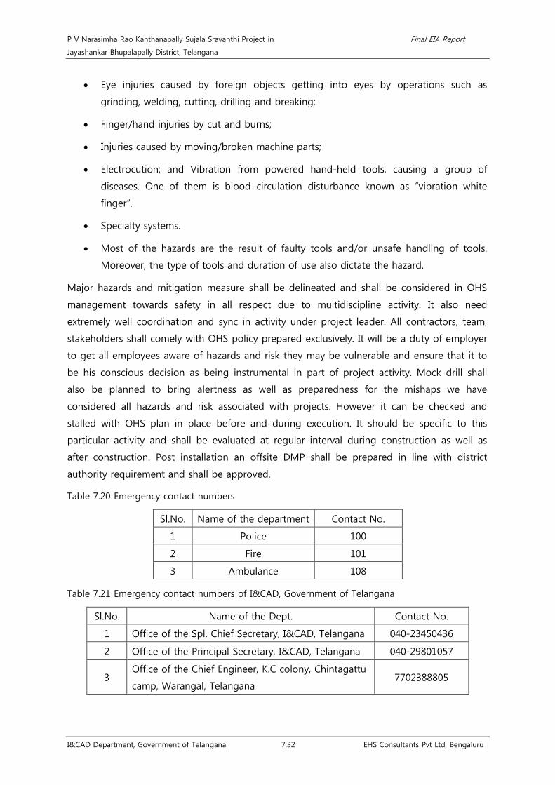
P V Narasimha Rao Kanthanapally Sujala Sravanthi Project in Final EIA Report
Jayashankar Bhupalapally District, Telangana
I&CAD Department, Government of Telangana 7.32 EHS Consultants Pvt Ltd, Bengaluru
• Eye injuries caused by foreign objects getting into eyes by operations such as
grinding, welding, cutting, drilling and breaking;
• Finger/hand injuries by cut and burns;
• Injuries caused by moving/broken machine parts;
• Electrocution; and Vibration from powered hand-held tools, causing a group of
diseases. One of them is blood circulation disturbance known as “vibration white
finger”.
• Specialty systems.
• Most of the hazards are the result of faulty tools and/or unsafe handling of tools.
Moreover, the type of tools and duration of use also dictate the hazard.
Major hazards and mitigation measure shall be delineated and shall be considered in OHS
management towards safety in all respect due to multidiscipline activity. It also need
extremely well coordination and sync in activity under project leader. All contractors, team,
stakeholders shall comely with OHS policy prepared exclusively. It will be a duty of employer
to get all employees aware of hazards and risk they may be vulnerable and ensure that it to
be his conscious decision as being instrumental in part of project activity. Mock drill shall
also be planned to bring alertness as well as preparedness for the mishaps we have
considered all hazards and risk associated with projects. However it can be checked and
stalled with OHS plan in place before and during execution. It should be specific to this
particular activity and shall be evaluated at regular interval during construction as well as
after construction. Post installation an offsite DMP shall be prepared in line with district
authority requirement and shall be approved.
Table 7.20 Emergency contact numbers
Sl.No. Name of the department Contact No.
1 Police 100
2 Fire 101
3 Ambulance 108
Table 7.21 Emergency contact numbers of I&CAD, Government of Telangana
Sl.No. Name of the Dept. Contact No.
1 Office of the Spl. Chief Secretary, I&CAD, Telangana 040-23450436
2 Office of the Principal Secretary, I&CAD, Telangana 040-29801057
3 Office of the Chief Engineer, K.C colony, Chintagattu
camp, Warangal, Telangana 7702388805

P V Narasimha Rao Kanthanapally Sujala Sravanthi Project in Final EIA Report
Jayashankar Bhupalapally District, Telangana
I&CAD Department, Government of Telangana 8.1 EHS Consultants Pvt Ltd, Bengaluru
Chapter 8. Project Benefits
The PVNRKSSP is proposed to provide economically viable and socially acceptable irrigation
practices for the command area. Irrigation is important to the health of the agricultural
industry. Improving the viability of individual farming and increasing the efficiency and
economic stability of the command area and also contributing to the economic and social
objectives of the Telangana State are the expected outcomes of the proposed scheme. Some
of the important project benefits are given below:
Ecological benefits:
• No forest land required for implementation of the scheme.
• The project involves felling of 800 trees. The restoration activities involving plantation
of tree species in the ratio of 1:3 along the left and right bank side of the proposed
barrage and the restoration of construction site will be carried out to improve the
ecological activities of faunal species.
• Construction of barrage across River Godavari acts as a reservoir thereby supporting
proliferation of fish species.
Techno-economical benefits:
• Existing irrigation schemes will be stabilized by providing assured water for irrigation.
• Providing Drinking water is essential as per National Water Policy, 2012. In this
direction, this project aims at providing drinking water to a large no. of villages,
which has lot socio-economic concern.
• Agricultural linkages will be considerably improved.
• The project improves total farm output and hence raises farm income.
• Project improves yields through reduced crop loss due to erratic, unreliable or
insufficient rainfall.
• Extensive agricultural production supplies raw materials to the nearby small scale
industries thereby increasing the economy in the region.
Social benefits:
• Health benefits to the people towards use of safe drinking water.
• Altogether, 518 villages will be benefitted directly under the scheme.
• Direct employment opportunities for 400 members (50 Technical and 350
construction laborers) will be provided during construction phase. Further, indirectly
labor opportunities will be substantially improved since larger area will be brought

P V Narasimha Rao Kanthanapally Sujala Sravanthi Project in Final EIA Report
Jayashankar Bhupalapally District, Telangana
I&CAD Department, Government of Telangana 8.2 EHS Consultants Pvt Ltd, Bengaluru
under irrigation. It improves fodder crops and in turn dairy farming in the command
area.
• The project requires a total land of 674.18 ha, of which, 94 ha of private/patta land
and 580.18 ha of river bed area alongside River Godavari near the proposed barrage
for implementation of the scheme and does not envisage rehabilitation and
resettlement.

P V Narasimha Rao Kanthanapally Sujala Sravanthi Project in Final EIA Report
Jayashankar Bhupalapally District, Telangana
I&CAD Department, Government of Telangana 9.1 EHS Consultants Pvt Ltd, Bengaluru
Chapter 9. Environment Management Plan
EMP provides a delivery mechanism to address the adverse environmental impacts of a
project during its execution, to enhance project benefits, and to introduce standards of
good practice to be adopted for all project related work64
Integrated approach during project planning, design, construction and operation work
acts as a better tool for implementation of Environmental Management Plan. The EMP
measures include mitigation or enhancement measures as appropriate to the nature of
impacts and are explained in the following sections. These include:
.
• Catchment area treatment plan
• Command area development
• Green belt development
• Reservoir Rim treatment
• Fisheries conservation and management plan
• Muck disposal plan
• Restoration of quarry sites and landscaping
• Groundwater management plan
• Public health delivery system and provision of drinking water supply to local
community
• Sanitation and Solid Waste Management Plan in labour camps
• Local Area Development Plan
• Environmental Safeguards during construction activities
• Environmental monitoring programme
64 https://www.adb.org/sites/default/files/institutional-document/33739/files/environment-safeguards-goodpractices-
sourcebook-draft.pdf

P V Narasimha Rao Kanthanapally Sujala Sravanthi Project in Final EIA Report
Jayashankar Bhupalapally District, Telangana
I&CAD Department, Government of Telangana 9.2 EHS Consultants Pvt Ltd, Bengaluru
9.1 Catchment Area Treatment (CAT) plan
9.1.1 Strategy for Cropping Pattern
Cropping patterns and land use is governed by;
I. Topography
II. Climate
III. Soils
IV. Food habits of the people
The annual rain fed crops, such as Paddy, Maize, cotton, sugarcane and pulses constitute the
major crops in the area. Important irrigated crops are Cotton and maize. The farmers are
more enthusiastic in the irrigated area to go for improved, high yielding and commercial
crops. Generally the irrigated farmers take risks in following package of practices and also its
management.
Avenues to increase the crop productions: It is clear from the above discussion that the
scope for bringing in additional land under net sown area in India is limited. There is, thus,
an urgent need to evolve and adopt land-saving Technologies. Such technologies can be
classified under two heads – those which raise the yield of any particular crop per unit area
of land and those which increase the total output per unit area of land from all crops grown
over one agricultural year by increasing land-use Intensity. The advantage of the latter kind
of technology is that along with increasing output from limited land, it also increases the
demand for labour significantly. For a land scarce but labour abundant country like India, a
high cropping intensity is desirable not only for fuller. The population pressure needs
doubling of food production and the avenues for increasing production are:
• Through adoption of recommended technologies in full.
• Increasing the cropping intensities
• Inter and mixed cropping practices to achieve higher land equivalent ratios (LER)
9.1.2 Scope for intensive cropping
There is good scope for inter-cropping, which is now practiced. For e.g., Ginger, turmeric and
chillies can be raised as an intercrop. Seasonal leguminous crops, such as pulses, soybean
etc., can also be raised as an intercrop with many agricultural crops & horticultural
trees/plants. The practice of relay cropping was in vogue in the past in some areas, it is,
however, possible to cultivate lentil or pea etc., as relay cropping. Various forms of multiple
cropping can be practiced, depending on whether the land available is irrigated, rain fed,
lowland, upland etc.

P V Narasimha Rao Kanthanapally Sujala Sravanthi Project in Final EIA Report
Jayashankar Bhupalapally District, Telangana
I&CAD Department, Government of Telangana 9.3 EHS Consultants Pvt Ltd, Bengaluru
• Intensive Farming Systems
Since agricultural land is shrinking with growth of population and development the size of
the holding also gets reduced, it has become essential to adopt intensive farming systems to
increase the productivity. Various forms of agro-forestry based farming systems are feasible
in the study area. Such a farming system may include silvi-pastoral, horti-pastoral, agri-horti-
pastoral; land-livestock based farming systems, etc. An integrated approach to farming
systems through scientific management of land and water on the principles of watershed
management is also feasible.
• Multilayer Cropping
Various forms of multi-layer cropping, particularly in respect of horticulture and plantation
crops, can be developed and practiced as a measure of intensive farming. A few examples of
such feasible multi-layer cropping are:
• Ginger, turmeric and chilies as intercrops.
• Papaya/lime-pineapple/ginger
• Banana-cucumber-cowpea.
Agriculture in the area is primarily rain fed; watershed wise activities are required for
sustainable development of land and water. Integrated development on watershed basis
paves way for holistic improvement of the entire area. Conservation of surface soil and
erosion control measures paves scope for preserving the surface soil fertility and also
facilitates in impounding run off in the form of farm ponds, Nala bund, check dam and other
suitable harvesting structures are helpful in providing protective irrigations in times of long
dry spells. Watershed management is important in this regard. It would be evident from the
preceding discussions, that there is ample scope for diversification of cropping systems and
patterns with immense potentialities to increase agricultural production. However, on farm
research, effective extension activities and appropriate public policies which continuously
back-up the agricultural production systems should be adopted. Similarly, certain
infrastructural facilities will have to be catered following intensive cropping. These include
rural storage structures, regulated market, effective institutional credit, timely supply of other
inputs etc, In the case of horticultural crops, crop wise associations have to be made and to
link up with processing plants and markets etc., so that the community at large is benefitted.
Among various natural resources, soil is one of the most vital components, on which living
beings depend for shelter and food security. During the management of soil resources it is
important to understand the soil type, its distribution, and their characteristics which are a
pre-requisite for appropriate land use practices, based on the suitability of soil for various

P V Narasimha Rao Kanthanapally Sujala Sravanthi Project in Final EIA Report
Jayashankar Bhupalapally District, Telangana
I&CAD Department, Government of Telangana 9.4 EHS Consultants Pvt Ltd, Bengaluru
applications. Reclamation of degraded soil also needs to be undertaken during the
conservation process.
9.1.3 Estimation of Soil Loss
A number of methods for assessing soil loss have been developed. They range from simple,
qualitative models to elaborate watershed simulations. Qualitative models rely on subjective
evaluation of a series of criteria. Watershed simulation models are often very theoretical.
Several empirical models also are available and most models are best suited for estimating
erosion from very large areas (more than 1 sq mile) and lack precision for use on small sites
such as construction sites. The universal soil loss equation (USLE) is given by,
A = RKLSCP --------- Eqn (1)
Where,
A = is computed Soil loss per unit area expressed in the units selected for K and for the
period selected for R. In practice, these are usually so selected that they compute A in m
tons /ha/year, but other units can be selected.
R = the Rainfall erosivity, is the number of rainfall erosion index units for a particular
location.
K = the Soil erodability is the soil loss rate per erosion index unit for a specified soil as
measured on a unit plot , which is defined as 21.13 mtr (72.6 ft)length of uniform 9 percent
of slope continuously in cleaned tilled fallow.
L = The Slope Length factor, is the ratio of soil loss from the field slope length to that from
21.13 mtr (72,6 ft) under identical conditions.
S = the slope steepness factor, is the ratio of soil loss from field slope gradient to that from
a 9 percent of slope under otherwise identical conditions.
C = the Cover and management factor is the ratio of soil loss from an area with specified
cover and management to that from an identical area in tilled continuous fallow.
P = the support practice factor, is the ratio of soil loss with a support practice like
contouring, strip cropping or terracing to that with straight row farming up and down the
slope.
9.1.4 Erosion Index (EI30) Values on Storm Basis
The rainfall erosion index R is a measure of the erosive force and intensity of rain in a
normal year. The two components of the factor are the total energy E and the maximum 30-
minutes intensity (I30) for all the storms in an area during an average year. Values of R have
been computed for the various regions in India and abroad from rainfall records and

P V Narasimha Rao Kanthanapally Sujala Sravanthi Project in Final EIA Report
Jayashankar Bhupalapally District, Telangana
I&CAD Department, Government of Telangana 9.5 EHS Consultants Pvt Ltd, Bengaluru
probability statistics, and hence R should not be considered as a precise factor for any given
year or location.
The energy of the rainstorm is a function of the amount of rain and all the storms
component intensities. Median raindrop size increases with the rain intensity and terminal
velocities of free falling water drops increases with increased drop size. Since the energy of
the given mass in motion is proportional to velocity-squared, the rainfall energy is directly
related to rain intensity. The relationship in metric units is expressed by the equation, where
KE is the kinetic energy in meter tones / ha-cm and is the rainfall intensity in cm /hr.
The index values (EI30), for each storm was determined. The product term EI was expressed
as:
EI30 = (KE x I30) / 100 ----------- Equation (1)
Where EI30 = Erosion Index
KE is Kinetic Energy of the storm
I30 = maximum 30 minutes Rainfall intensity of the storm
For computing Kinetic Energy of Rain storm the equation proposed by Wishmeier (1959) is
KE=916+331 log I -------------------Equation (2)
Where KE = Kinetic Energy of the storm in foot tons per acre inch and
I = Rainfall intensity in inch per hour
The Equation (2) has been modified into metric units by Wishmeier & Mannering (1965) and
Ranganath, et al., (1970) the equation in metric units is:
KE = 210.3 + 89 log I ---------- Eqn (3)
Where,
EI30 is the erosion index
KE is the total storm kinetic energy in tonnes – m/ha
I30 is the maximum 30 minutes intensity of rainstorm.
The monthly, seasonal and yearly EI values will be determined by adding the storm EI values
for that length of period.
9.1.5 Soil Erodibility Factor (K)
The soil erodability factor K is a measure of the susceptibility of soil particle detachment and
transport by rainfall and runoff. Texture is the principal factor affecting K, but structure,
organic matter and permeability also contribute K values ranging from 0.45 to 0.59.

P V Narasimha Rao Kanthanapally Sujala Sravanthi Project in Final EIA Report
Jayashankar Bhupalapally District, Telangana
I&CAD Department, Government of Telangana 9.6 EHS Consultants Pvt Ltd, Bengaluru
9.1.6 Nomograph Method
The United States Department of Agriculture (1978) has suggested a Nomograph and the
following equation for the determination of soil erodability for soils containing less than 70%
silt and very fine sand:
100K = 2.1M1.14 x 10-4 (12-a) +3.25 (b-2) +2.5(c-3) -------- Eqn (4)
Where, K is the soil erodability factor,
M is the particle size parameter which is equal to: (percent silt + very fine sand) / (100%
clay),
‘a’ is the percentage of organic matter content,
‘b’ is the soil structure and
‘c’ is the profile permeability class.
The preferred method for determining K values is the nomograph method. Use of the
nomograph requires a particle size. The Soil sample code collected from the field were
characterizes carefully for estimating, the K values.
9.1.7 Determination of LS
Since the LS factor has a considerable effect on predicted erosion, care in figuring values for
the factor is warranted. In particular, results of the soil loss calculation will be more accurate
if the USLE is individually applied to portions of a site with similar slopes (similar gradient
and length) and summing the individual soil loss estimates. Slope gradient is the field or
segment slopes, usually expressed as percentage. The topographic component, LS, was
evaluated by using the contour length method for large watersheds.
LS was calculated base on the following equation
LS = (L)m / 22.1(0.065 + 0.0454S + 0.0065 S2) --------- Eqn (5)
Where,
LS = Average length slope component
L = Slope length in meters
S = Average watershed slope in percent and
m = Exponent (m= 0.2 if slope < 1%)
9.1.8 Evaluation of Cropping Management Factor (C)
The cover factor C is defined as the ratio of soil loss from land under specified crop or
mulch conditions to the corresponding loss from tilled, bare soil. In the USLE, the C factor

P V Narasimha Rao Kanthanapally Sujala Sravanthi Project in Final EIA Report
Jayashankar Bhupalapally District, Telangana
I&CAD Department, Government of Telangana 9.7 EHS Consultants Pvt Ltd, Bengaluru
reduces the soil loss estimate according to the effectiveness of vegetation and mulch at
preventing detachment and transport of soil particles. On activity sites, recommended control
practices include the seeding of grasses and the use of mulches. These measures are often
considered “temporary” -they are designed to control erosion primarily during the activity
period. Permanent landscaping may be added later, or temporary erosion control plants may
be left as a permanent cover. Any product that reduces the amount of soil exposed to
raindrop impact will reduce erosion.
The cropping management factor, C is computed as follows:
C= Σn Ci Ai / A ------- Eqn (6)
Where,
C is the cropping management factor for the watershed
Ci is the cropping management factor for crop i,
Ai is the drainage basin area growing crop i with a particular management level,
n is the number of land use areas in the watershed, and
A is total watershed area.
9.1.9 Evaluation of Support Practice Factor (P)
The erosion control practice factor P is defined as the ratio of soil loss with a given surface
condition to soil loss with up and down hill plowing. Practices that reduce the velocity of
runoff and the tendency of runoff to flow directly down slope reduce the P factor. In
agricultural uses of the USLE, P is used to describe plowing and tillage practices. In activity
site applications, P reflects the roughening of the soil surface by tractor treads or by rough
grading. In computing the P factor, land cover conditions are considered depending upon
the cultivated and uncultivated area of the watershed. In addition, slope is also considered as
a key factor in assigning the value. For the study area, a P factor considered is 0.6 for
terraced agricultural land having slope less than 2% and for the rest of the land having a
slope more than 2%, a value of 0.5 is assigned.
The soil loss estimated for the watershed covering under PVN project
Total Nos.: 7 sub-watersheds (27 Micro-watersheds). The soil loss estimated for the
watershed covering under water re-circulation and sustainability project of P V Narasimha
Rao Kanthanapally Sujala Sravanthi Project; Jayashankar Bhupalapally District is tabulated in
the Table below. Table indicating Sub catchment/Watershed and codification of the P V
Narasimha Rao Kanthanapally Sujala Sravanthi Project (PVNRKSSP) Jayashankar Bhupalapally
District; Telangana State

P V Narasimha Rao Kanthanapally Sujala Sravanthi Project in Final EIA Report
Jayashankar Bhupalapally District, Telangana
I&CAD Department, Government of Telangana 9.8 EHS Consultants Pvt Ltd, Bengaluru
Table 9.1 Sub catchment/Watershed and codification of PVN project
Region Basin Catchment Sub-
catchment
Watershed
Name
Sub-
Watershed
Code
Micro
watershed
Code
Bay of
Bengal
(4)
Godavari
(4E)
Godavari delta with
confluence of Indravati
4E1C 4E1C8
4E1C8K
4E1C8K1
4E1C8K2
4E1C8K3
4E1C8K4
4E1C8K5
4E1C8K6
4E1C8m
4E1C8m1
4E1C8m2
4E1C8m3
4E1G 4E1G8
4E1G8g
4E1G8g1
4E1G8g2
4E1G8g3
4E1G8g4
4E1G8h
4E1G8h1
4E1G8h2
4E1G8h3
4E1G8h4
4E1G8h5
4E1G8J 4E1G8J1
4E1G8m
4E1G8m1
4E1G8m2
4E1G8m3
4E1G8m4
4E1G8n
4E1G8n1
4E1G8n2
4E1G8n3
4E1G8n5
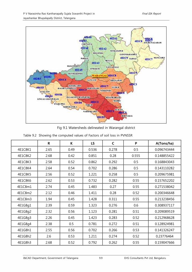
P V Narasimha Rao Kanthanapally Sujala Sravanthi Project in Final EIA Report
Jayashankar Bhupalapally District, Telangana
I&CAD Department, Government of Telangana 9.9 EHS Consultants Pvt Ltd, Bengaluru
Fig 9.1 Watersheds delineated in Warangal district
Table 9.2 Showing the computed values of Factors of soil loss in PVNSSR
R K LS C P A(Tons/ha)
4E1C8K1 2.65 0.49 0.536 0.278 0.5 0.096743444
4E1C8K2 2.68 0.42 0.851 0.28 0.555 0.148855422
4E1C8K3 2.58 0.52 0.862 0.292 0.5 0.168843043
4E1C8K4 2.64 0.54 0.702 0.286 0.5 0.143110282
4E1C8K5 2.56 0.52 1.221 0.258 0.5 0.209675981
4E1C8K6 2.62 0.53 0.732 0.282 0.55 0.157652202
4E1C8m1 2.74 0.45 1.483 0.27 0.55 0.271538042
4E1C8m2 2.12 0.46 1.411 0.28 0.52 0.200346648
4E1C8m3 1.94 0.45 1.428 0.311 0.55 0.213238456
4E1G8g1 2.39 0.59 1.323 0.276 0.6 0.308937117
4E1G8g2 2.32 0.56 1.123 0.281 0.51 0.209089519
4E1G8g3 2.26 0.45 1.423 0.283 0.52 0.212968628
4E1G8g4 2.38 0.5 0.781 0.272 0.51 0.128924981
4E1G8h1 2.55 0.56 0.702 0.266 0.53 0.141326247
4E1G8h2 2.6 0.53 1.211 0.274 0.52 0.23776464
4E1G8h3 2.68 0.52 0.792 0.262 0.55 0.159047666

P V Narasimha Rao Kanthanapally Sujala Sravanthi Project in Final EIA Report
Jayashankar Bhupalapally District, Telangana
I&CAD Department, Government of Telangana 9.10 EHS Consultants Pvt Ltd, Bengaluru
R K LS C P A(Tons/ha)
4E1G8h4 2.56 0.48 1.33 0.28 0.55 0.251682816
4E1G8h5 2.48 0.51 0.892 0.29 0.5 0.163589232
4E1G8J1 1.82 0.47 1.478 0.322 0.55 0.223904201
4E1G8m1 2.48 0.51 0.882 0.29 0.5 0.161755272
4E1G8m2 2.45 0.51 0.732 0.282 0.55 0.141859733
4E1G8m3 2.31 0.45 1.43 0.283 0.52 0.218751133
4E1G8m4 2.41 0.53 0.732 0.282 0.55 0.145015956
4E1G8n1 2.11 0.51 0.892 0.29 0.5 0.139182774
4E1G8n2 2.26 0.45 1.42 0.283 0.52 0.212519642
4E1G8n3 2.12 0.53 0.732 0.282 0.55 0.127565904
4E1G8n5 2.48 0.51 0.89 0.29 0.5 0.16322244
Table 9.3 Estimation of soil loss in Watersheds in PVNRKSSP
R K LS A (Tons/ha)
4E1C8K1 2.65 0.49 0.536 7.19
4E1C8K2 2.68 0.42 0.851 6.44
4E1C8K3 2.58 0.52 0.862 6.85
4E1C8K4 2.64 0.54 0.702 6.99
4E1C8K5 2.56 0.52 1.221 7.75
4E1C8K6 2.62 0.53 0.732 6.45
4E1C8m1 2.74 0.45 1.483 6.73
4E1C8m2 2.12 0.46 1.411 6.87
4E1C8m3 1.94 0.45 1.428 5.85
4E1G8g1 2.39 0.59 1.323 6.04
4E1G8g2 2.32 0.56 1.123 6.98
4E1G8g3 2.26 0.45 1.423 6.80
4E1G8g4 2.38 0.5 0.781 7.21
4E1G8h1 2.55 0.56 0.702 7.09
4E1G8h2 2.6 0.53 1.211 7.02
4E1G8h3 2.68 0.52 0.792 6.94
4E1G8h4 2.56 0.48 1.33 6.49
4E1G8h5 2.48 0.51 0.892 6.90
4E1G8J1 1.82 0.47 1.478 5.65
4E1G8m1 2.48 0.51 0.882 6.90
4E1G8m2 2.45 0.51 0.732 6.45

P V Narasimha Rao Kanthanapally Sujala Sravanthi Project in Final EIA Report
Jayashankar Bhupalapally District, Telangana
I&CAD Department, Government of Telangana 9.11 EHS Consultants Pvt Ltd, Bengaluru
R K LS A (Tons/ha)
4E1G8m3 2.31 0.45 1.43 6.80
4E1G8m4 2.41 0.53 0.732 6.45
4E1G8n1 2.11 0.51 0.892 6.90
4E1G8n2 2.26 0.45 1.42 6.80
4E1G8n3 2.12 0.53 0.732 6.45
4E1G8n5 2.48 0.51 0.89 6.90
Estimated potential soil erodability is 6.74, which is less than 8 and therefore it is inferred
that this is a moderately erodible land.

P V Narasimha Rao Kanthanapally Sujala Sravanthi Project in Final EIA Report
Jayashankar Bhupalapally District, Telangana
I&CAD Department, Government of Telangana 9.12 EHS Consultants Pvt Ltd, Bengaluru
Fig 9.2 Watersheds delineated in PVNKSSP

P V Narasimha Rao Kanthanapally Sujala Sravanthi Project in Final EIA Report
Jayashankar Bhupalapally District, Telangana
I&CAD Department, Government of Telangana 9.13 EHS Consultants Pvt Ltd, Bengaluru
9.1.10 Sedimentation Studies
Erosion, transportation and deposition of sediments are natural processes controlled by
geological, climatic, physical, vegetative and other related conditions all through the
geological times. However, during the present century, because of deforestation and
urbanization the rate of transport of sediments from the watersheds and siltation pose
substantial environmental problems and before equilibrium conditions are reached,
additional problems are likely to arise.
One of the major problems noticed in agricultural watersheds is that the crop productivity
reduces to zero or becomes uneconomical, because of soil erosion. There are many theories
which can be used to evaluate sediment movements in rivers. It is essential that functional
relationship between various physical, geomorphic and sediment related parameters are
developed, such that the magnitude of sediment eroded from watershed can be estimated.
The increase in sediment yield from the watershed will have an impact on the watershed
itself and on the river system and associated reservoirs. The impact of eroded soil on natural
system is varied and widespread. The sediment particulates eroded from the watershed move
in the downstream directly and in the process influence the drainage channels, flood plains,
river beds, wetlands and lakes.
The key factors which affect the sediment yield from drainage basin are:
• Hydrology: Rainfall and runoff
• Catchment characteristics: Size of the catchment, slope of the catchment and length
of the overland flow.
• Soil characteristics: Soil erodability, soil transportability, soil texture and structure.
• Nature of drainage network and drainage density.
• Land use cover: Plant canopy, mulches and plant residues.
• Management practices: Tillage, soil conservation structures, terraces, diversions and
bunds.
Of all the factors listed above rainfall and runoff provide the basic energy input to drive the
erosion process. Steepness of slope plays an important role in the process of erosion. Soil
properties such as soil texture, structure and the land cover, i.e., plant residue, mulches etc
have a major role in erosion process.
At the outset, it is clear that, the process of sedimentation is a matter of serious concern in
irrigation projects, because it reduces the storage capacity, water supply capability, power
generation, discharge control etc of reservoirs, rivers/catchments. The erosion of the
catchments changes the ground water regime and results in lowering of water table in some

P V Narasimha Rao Kanthanapally Sujala Sravanthi Project in Final EIA Report
Jayashankar Bhupalapally District, Telangana
I&CAD Department, Government of Telangana 9.14 EHS Consultants Pvt Ltd, Bengaluru
places and rise at the formation of arid zone and marshes respectively. The fertility of the
soil, its chemical composition also changes due to catchment erosion.
9.1.11 Sedimentation index
An estimate of sediment index must be developed to provide a basis for comparison with
management induced sediment yield predictions. The best source of this information is
actual long term real data of sediment yield. Another possible source is data from similar or
related watersheds.
9.1.12 Stream Flow and Suspended Sediment Load
Although there is a definite variation in sediment transport rate in a natural stream at a
particular location, still there exists a good relationship between the sediment load of the
stream and certain hydro- morphological factors. The factors which are considered important
in estimating sediment yield of a catchment are drainage area, annual water discharge, relief
ratio, mean stream length and total stream length etc.
Regression analysis was carried out to know the relation between discharges and sediment
load in PVNRKSSP area. The relationship has been found to be,
Y=7.47*10-6 x+3401.28, with r=0.97
Where, Y= suspended sediment load in tones/year
X=stream flow in m3/year (post-monsoon flow only).
9.1.13 Soil Erosion
Soil erosion is the removal of surface material by wind or water. When raindrop falls on a
soil surface, the soil particle are splashed and, higher is the velocity of impact, greater is the
amount of soil splashed. Drop impact is more effective when a thin film of water covers the
soil surface and the maximum dispersion of soil particles occur when the depth of water is
about the same as diameter of raindrop. The detached soil particles are then carried further
either by runoff or wind. This whole process is known as erosion. Soil conservation practices
shall be on the basis of the following inventories,
• Extent of the soil and nutrient losses and sediment transports in various
environments.
• Land use/Land Cover details, provides basis for implementation of different soil
conservation measures on soil losses and sediment yields.
• A better understanding of the soil erosion processes the dynamic and relative
importance of the single processes and their interactions.
P V Narasimha Rao Kanthanapally Sujala Sravanthi Project in Final EIA Report
Jayashankar Bhupalapally District, Telangana
I&CAD Department, Government of Telangana 9.15 EHS Consultants Pvt Ltd, Bengaluru
9.1.14 Soil Conservation Practices
Soil and Water are the two most important Natural resources which have a direct bearing on
agricultural production. These resources have to be used judiciously to obtain optimum of
yield of crops. Therefore utmost care has to be exercised in management of these resources,
not only to prevent soil degradation but also to improve the productivity of the soil for
sustained agricultural development. Measures to conserve soil in-situ, allow more infiltrations
opportunity time for rain water and safe disposal of runoff water from arable lands are of
prime concern in rain fed areas, since they directly affect soil erosion rates and consequent
crop productivity. The recommended soil and moisture conservation measures for Hilly zone
are as follows:
• Contour bunds with waste weirs.
• Graded bunds/Graded border strips.
• Zing terraces with raised waste weirs.
• Diversion Drains/Water ways.
• Reducing wind erosion of soil by growing wind breaks (vegetation cover).
• Gully plugging.
• In over-grazed land silvi pastoral systems, which in irrigated land yield enough green
fodder to cattle population.
• Grazing animals should be kept in stalls.
• Agro forestry and Agro horticulture systems to meet various needs of farmers, crop
residue of this adds to the soil and increases carbon content and biotic activity.
• Harvesting of runoff and impounding through appropriate structures.
• Drainage line treatments to improve the flow and avoid nala course clogging.
• Barrage
9.1.15 Soil Conservation Practices for Catchment Area Treatment
All India Soil Survey & Land Use Planning (AISS&LUP), Ministry of Agriculture, Govt of India
have made inventory of soil resources in the catchments of major Reservoirs and prepared
priority fixation soil survey and categorized into severe, medium and low priority areas for
treatment and micro catchments contributing high sediments are included for soil
conservation treatments which include treatment holistically to arrest the sediments flow
into Nala, Rivulet and Rivers and onward deposition in the major Reservoirs. Adoption of
appropriate soil and water conservation practices is considered to be the only way of

P V Narasimha Rao Kanthanapally Sujala Sravanthi Project in Final EIA Report
Jayashankar Bhupalapally District, Telangana
I&CAD Department, Government of Telangana 9.16 EHS Consultants Pvt Ltd, Bengaluru
conserving and improving land resources and environment. Large scale soil and water
conservation activity in India began in 1934. Realizing the importance of soil conservation,
the state government had formulated scheme as early as in 1942. As per the estimates of
state government, about 27.06 lakh ha of arable land in the state needs protection. As per
the estimates of state government, about arable land in the state needs protection. Out of
the 62.88 lakh hectares of cultivable area in the state, 35 lakh hectares (55.65%) needs soil
conservation measures.
Telangana is a pioneer State in implementing watershed programmes. Rain fed area accounts
for about 63.6%. Various conservation measures were undertaken to combat soil erosion
through model watersheds, district level macro watershed programs, DPAP, DDP, IWDP,
WGDP, RVP, NWDPRA and more recently from April 2008 Integrated Watershed
Development Programme (IWMP).A state level perspective and Strategic Plan (SPSP) is
prepared for the state and entire area (62.88 lakh ha) is contemplated to be treated by the
end of XIV th plan period, on 90:10 ratio between centre and state by implementing Prime
Ministers Krishi Sinchayee Yojan (PMKSY) to provide twin benefits of ”Har Khet Ko Pani and
More crops per Drop” of rain water.
In the district of Jayashankar Bhupalapally already good amount of area is being treated
under soil conservation and the entire catchment has to be treated to protect the rain fed
area by implementing appropriate catchment area protection works.
Some of the methods suggested for soil conservation for P V Narasimha Rao Kanthanapally
Sujala Sravanthi Project (PVNRKSSP) area and other details are provided below:
• Gully plugging
This prevents the eroding and down-cutting of gully beds headwords while they encourage
the deposition of silt load and create a micro-environment for the establishment of
vegetative covers. Gully plugs act as grade stabilization structures. The specifications for gully
plug are as follows.
Table 9.4 Specifications for gully plugs
Slope of
gully bed
(off)
Width of gully
bed (m) Location
Type of gully
plug
Vertical interval
(m)
Upto 4.5 Gully bed Brush wood Upto 3
4.5 – 10.5 Gully bed & ride
branch Earthen 2.25 to 3.0

P V Narasimha Rao Kanthanapally Sujala Sravanthi Project in Final EIA Report
Jayashankar Bhupalapally District, Telangana
I&CAD Department, Government of Telangana 9.17 EHS Consultants Pvt Ltd, Bengaluru
Slope of
gully bed
(off)
Width of gully
bed (m) Location
Type of gully
plug
Vertical interval
(m)
0-5%
7.5 to 15.0
At the
confluence of
two gullies
Sand bags 2.25 to 3.0
10-20%
Upto 4.5 Gully bed Brush wood Upto 3.0
4.5 to 6.0 Gully bed Earthen and
side branch Bet 1.5 to 3.0
The gullies would be treated with engineering/mechanical as well as vegetative methods.
Check dams are recommended for some areas to promote growth of vegetation that will
consequently lead to the stabilization of the slopes area and prevent further deepening of
gullies and consequent erosion. For controlling the gullies, the erosive velocities are reduced
by flattening out the steep gradient of the gully. This is achieved by constructing a series of
check dam which transform the longitudinal gradient into a series of steps with low risers
and long flat treads. Different types of check dams would be required for different conditions
comprising different materials, depending upon the site conditions and by using the locally
available materials. This is often the most acceptable soil conservation measures that can
easily establish and should form a dense thicket near the ground level when planted in close
vicinity. The following materials are recommended for the purpose.
• Brushwood check dam
• Dry rubble stone masonry (DRSM)
• Check dams with stones available at the site
• Combination of DRSM and crate works – for moderate to deep gullies with locally
available stones at sites
The advantage of brushwood check dams is that they are quick and easy to construct and
are inexpensive as they are constructed by using readily available materials at the site. In
addition to the vegetative measures used for stabilization of gullies, temporary or permanent
mechanical measures are used as supplementary measures to prevent the washing away of
young plantations by large volume of runoff. The gullies get stabilized over a period of time
with the establishment of vegetative cover. With passage of time mechanical structures
weaken and vegetative measures get strengthened.
The drainage basin of the river, usually referred to as catchment area needs some kind of
treatment in the overall interest of the development of the area extending along the river
with a view to improve land management through biological and engineering measures, with

P V Narasimha Rao Kanthanapally Sujala Sravanthi Project in Final EIA Report
Jayashankar Bhupalapally District, Telangana
I&CAD Department, Government of Telangana 9.18 EHS Consultants Pvt Ltd, Bengaluru
the objective of arresting soil erosion and improve its vegetation, and control over grazing
by cattle.
The catchment area treatment involves intensive and highly technical measures, which
require the expertise of technical skill. The watershed committees have to be constituted at
the panchayat level in the Panchayats covered in the proposed project areas of The water re-
circulation and sustainability project of P V Narasimha Rao Kanthanapally Sujala Sravanthi
Project (PVNRKSSP) spread over in the jurisdiction of Jayashankar Bhupalapally District with
the objective of an integrated approach involving multi disciplinary experts dealing with
forest, agriculture, horticulture, watershed, sociologists, besides local panchayat members and
community members. The area under each watershed has been planned on the basis of
Landuse / land cover and topographic conditions. The total area proposed for treatment is
85000 ha, in the water re-circulation and sustainability project of P V Narasimha Rao
Kanthanapally Sujala Sravanthi Project (PVNRKSSP).
• Soil Conservation Practices
For the plain regions, Watershed Development programmes are implemented, Telangana,
Development wing in Telangana, and CRIDA and ICRISAT has suggested the following soil
conservation practices. The most important practice among those mentioned below, is
contour and broad based bunding.
Table 9.5 Soil conservation Measures and Practices Recommended for PVNRKSSP
Sl.
No.
Type of soil
conservation Practices recommended
1 Contour bunds with
open ends <750mm Rain fall, Red soils areas; slopes of 1-6%
2
Zing terraces with raised
waste weirs(15 to 23
cms)
Red soils(Medium and Deep)
Rain fall 600-750 mm
Land slopes, 1-5 %
Infiltration rate >6 mm h‾⅓
3 Water ways Surplus storm water due to high intensity rains
4 Compartment bunds For medium Black soils
5 Broad Bed and Furrow Deep black soil, with rain fall upto 750 mm
6 Land leveling Low (bottom) flat deep areas leveled.
Bench terraces are also leveled by cut and fill.
7 Check dams/Nala
bunds/Percolation tanks
Gully sites having restricted width and considerable
depth, all types of soils.
Gullies with low permeability stable beds.

P V Narasimha Rao Kanthanapally Sujala Sravanthi Project in Final EIA Report
Jayashankar Bhupalapally District, Telangana
I&CAD Department, Government of Telangana 9.19 EHS Consultants Pvt Ltd, Bengaluru
Sl.
No.
Type of soil
conservation Practices recommended
Rain fall of 600-1200 mm
8
Farm ponds
Areas with high intensity rains.
Low permeability locations
9 Plantations Horticulture and timber value seedlings as block
plantations.
Table 9.6 Micro-watersheds of PVNRKSSP
Watershed
area
in Ha
Treatable
Area
Area
already
Treated
(ha)
Area proposed
for treatment
(ha)
No. of.
Check
dams (ha)
Contour
bunding/Bench
terracing (ha)
Farm
forestry
(ha)
85000 85000 10000 75000 750 25000 15000
Table 9.7 Cost Estimates as per Soil conservation treatments suggested
Area to Treated
(ha)
No. of
Check
dams (ha)
Cost
(Rs.
Lakhs)*
Contour
bunding/Bench
terracing (ha)
Cost (Rs.
Lakhs)**
Plantations
(Agro Horti
5000 ha
+25000 ha
of Agro-
forestry)
(ha)
Cost (Rs.
Lakhs)***
85000 750 3750 42500 6375 1750+3750 15625
Total (Rs.Lakhs) 15625 Lakhs
*Cost of each check dam being Rs.5.00 Lakhs
**Cost of bench terrace construction/Bunding is Rs. 15,000/ha
***Cost for Agro Horticulture is Rs. 35000/ha.
****Cost for Agro forestry is Rs. 15000/ha
Total cost for catchment area treatment is = 15625 Lakhs
Table 9.8 Area and Cost Estimate for Catchment Area Treatment
Year Physical (ha) Financial Outlay (Rs. In Lakhs)
2018-19 17000 3125
2019-20 17000 3125

P V Narasimha Rao Kanthanapally Sujala Sravanthi Project in Final EIA Report
Jayashankar Bhupalapally District, Telangana
I&CAD Department, Government of Telangana 9.20 EHS Consultants Pvt Ltd, Bengaluru
Year Physical (ha) Financial Outlay (Rs. In Lakhs)
2020-21 17000 3125
2021-22 17000 3125
2022-23 17000 3125
Total 85000 15625
Table 9.9 Species recommended for plantation
Sl. No Botanical Names Common name Family Uses Height (m)
1 Annona squamosa Sitaphalamu Annonaceae Fruiting 7
2 Artocarpus heterophyllus Panasa Moraceae Fruiting 12
3 Azadirachta indica Vepachettu Fabaceae Fruiting 12
4 Cassine glauca Beera Celastraceae Medicinal 5
5 Ficus amplissima Gardabhaande Moraceae Fodder 11
6 Ficus bengalensis Bhandiramu Moraceae Medicinal 15
7 Ficus glomerata Attimanu Moraceae Fruiting 20
8 Ficus racemosa Atthichettu Moraceae Fruiting 9
9 Ficus religiosa Arasum Moraceae Food, Medicinal 18
10 Gliricidia sepium Madri Fabaceae Manure 7
11 Holoptelea integrifolia Naali Ulmaceae Medicinal 25
12 Madhuca indica Mahua Sapotaceae Fruiting 8
13 Madhuca longifolia Adaviyippa Sapotaceae Medicinal 15
14 Mangifera indica Amramu Anacardiaceae Fruiting 12
15 Manilkara zapota Sapota Sapotaceae Fruiting 12
16 Michelia champaca Campakamu Magnoliaceae Flowering 13
17 Millingtonia hortensis Aakaashamalle Bignoniaceae Flowering 20
18 Pithecellobium dulce Seemachinduga Fabaceae Fruiting 12
19 Pongamia pinnata Kaadepathige Leguminosae Flowering 10
20 Premna tomentosa Kampugumadu Verbenaceae Medicinal 4
21 Psydrax dicoccos Nalla balasu Rubiaceae Medicinal 4
22 Semecarpus anacardium Bhallaathakai Anacardiaceae Food, Medicinal 15
23 Shorea roxburghii Himsra Dipterocarpaceae Fodder 15
24 Simarouba glauca Paradise-tree Simaroubaceae Fruiting 13
25 Strychnos potatorum Andugu Loganiaceae Medicinal 12
26 Syzygium cumini Jambu Myrtacecae Fruiting 15
27 Tamarindus indica Aamlika Fabaceae Fruiting 18
28 Terminalia bellirica Vibhitakamu Combretaceae Medicinal 20

P V Narasimha Rao Kanthanapally Sujala Sravanthi Project in Final EIA Report
Jayashankar Bhupalapally District, Telangana
I&CAD Department, Government of Telangana 9.21 EHS Consultants Pvt Ltd, Bengaluru
Sl. No Botanical Names Common name Family Uses Height (m)
29 Terminalia chebula Alsikaayi Combretaceae Medicinal 12
30 Terminalia paniculata Chirimanu Combretaceae Medicinal 35
31 Wrightia tinctoria Akupala Apocynaceae Medicinal 8
9.1.16 Reclamation of salt affected soils and management of saline and sodic
soils
• The land should be level or contour farmed so that the surface of the soil will be
soaked uniformly by water
• Selection of crops or crop varieties that have higher tolerances for salt or sodium
• Use of special planting procedure that minimizes salt accumulation around the seed
otherwise lowers Germination percentage.
• Use of the appropriate irrigation method for the root characteristics of the crop
• Use of sloping beds and other special land preparation procedures and tillage
methods to provide a low salt environment
• Use of canal or surface irrigation water to dilute the salts and to leach out the salts
from the root zone for good germination.
• Application of amendments such as manure, compost, etc. for improving soil
structure and tilt. Conservation tillage to incorporate crop residues will help create
drainage.
• Deep ploughing of soil to break up sodic and other hardpans or other impervious
layers to provide internal drainage.
• Use of chemical amendments as described.
• Good, sound agronomic farming practices and careful need based fertilizer
management.
Table 9.10 Cost Estimate for Catchment Area Treatment
Sl.
No. Item Time period Cost in Rs.
Implementing
agency
1
Soil conservation measures
and implementation of CAT
plan for 3 years
During
operation
phase
156,25,00,000/- I&CAD Dept., &
Forest Dept., and
Agriculture Dept.,
GoT 2 Reclamation of affected soil
for 3800 Ha 1,90,00,000/-
Total 158,15,00,000/-
P V Narasimha Rao Kanthanapally Sujala Sravanthi Project in Final EIA Report
Jayashankar Bhupalapally District, Telangana
I&CAD Department, Government of Telangana 9.22 EHS Consultants Pvt Ltd, Bengaluru
9.2 Command area development plan
9.2.1 Communication network
Improved communications in and around command area is necessary for integrated
development of the project. These are described as under:
(a) Ayacut Roads: These are required within the Command Area for transport of inputs and
produce.
(b) Link Roads: These are necessary to connect the command area to ayacut roads. These
also include improvement and reconstruction of existing roads to bring them to project
standards.
(c) Transmittal of messages from command areas: A radio/telegraph/telephone network in
the command areas is necessary to quickly convey messages, concerning rainfall, demand for
canal waters, regulation orders, stage
9.2.2 Water Users’ Association (WUA)
The modern irrigation management aims at high efficiency of water conveyance and
appropriate methods of water application, through participatory irrigation management at
each stage of irrigation development. In Telangana, it is essential to promote and implement
the theme of participatory irrigation management in all the Irrigation projects through
formation of Water Users’ Association.
Since the proposed project benefits the existing command areas of JCRDLIS and SRSP Stage
I&II Water user’s association has been formed in the command area and hence there is no
scope for formation of new WUA’s.
9.2.3 Training and Agriculture Extension Program
It is important to disseminate information about new technologies so that the farmer is able
to make use of the latest agricultural developments. There also exists a gap between
research findings and the needs of farmers. For technology to be successful, it is important
that it should serve a useful purpose to the end user. The institution that bridges the gap
between farmers and agricultural research scientists is the Agricultural Extension Service.
This service works through an Agricultural Research System in the States. Agriculture is a lot
more than mere cultivation. Agriculture today is a science that is based on continuing
research and a solid foundation of proven data. The more the growers know, the better they
cultivate; the more people they can feed, the healthier populations become. There is need to
provide farmers training with advanced Agronomy solutions for raising yields, cutting costs
and improving quality. In the Training centers experts share knowledge with the farmers.

P V Narasimha Rao Kanthanapally Sujala Sravanthi Project in Final EIA Report
Jayashankar Bhupalapally District, Telangana
I&CAD Department, Government of Telangana 9.23 EHS Consultants Pvt Ltd, Bengaluru
Hence it is proposed that in the project a training centre to be established to train the
stakeholders and line departments/extension workers. The basic infrastructure like building
for training class will be provided by Govt. of Telangana and the trainers and faculty will be
Experts from Drip Industry. A curriculum prepared based on the farmers requirement is given
below.
9.2.3.1 Technical Training
• Introduction to drip Irrigation - Basic drip agronomy and advantages of drip
irrigation, Drip irrigation Components, Fertigation and how to Fertigate, Crop wise
water requirement and irrigation scheduling
• Maintenance of Drip Irrigation system and chemical treatments (acid ,Chlorination)
• Field visit and practical demonstration on system maintenance
• Crop wise drip protocols & crop production technology with drip irrigation
9.2.3.2 Engineering Training
• Training in Rotation of crops.
• Training in maintenance of Drip system.
• Training in maintenance of Records & Financial aspects.
• Training in Conducting Election of WUA.
• Farmers Interaction with Agricultural department.
• Training in Women’s role in Participatory Irrigation management.
• Training on Social behaviour.
9.2.3.3 Agronomical Training
• Training and guidance in Selection of proper plant materials
• Training and guidance in adopting suitable cropping pattern to suit drip irrigation
system.
• Training and guidance in Irrigation scheduling through drip Irrigation
• Training and guidance in Fertigation application and scheduling through drip
irrigation
• Training and guidance in Selection of proper fertilizers to enhance productivity.
• Training and guidance in Plant protection practices.
• Training and guidance in Best Management Practices.

P V Narasimha Rao Kanthanapally Sujala Sravanthi Project in Final EIA Report
Jayashankar Bhupalapally District, Telangana
I&CAD Department, Government of Telangana 9.24 EHS Consultants Pvt Ltd, Bengaluru
• Training and guidance in Harvesting
• Training and guidance in Post-Harvest Practices.
• Training and guidance in export packing practices.
• Training and guidance by crop experts in specialized Crops.
• Arranging farmer’s field days.
• Arranging farmer’s field visits.
• Sharing farmer’s experiences.
• Exposure Visits to Progressive Farmers.
9.2.3.4 Mechanical Training
• Training in maintenance aspects of pumping unit.
• Training in maintenance of Centrifugal pumps, Engines and motors.
• Training in installation and adjustments of pumps.
Table 9.11 Cost Estimate for Command Area Development Plan
Sl. No. Item Time period Cost in Rs. Implementing
agency
1 Awareness and training for
agriculture extension
During
operation phase 70,00,000/-
Irrigation and CAD
Dept., and Agriculture
Dept., Telangana
Total 70,00,000/-

P V Narasimha Rao Kanthanapally Sujala Sravanthi Project in Final EIA Report
Jayashankar Bhupalapally District, Telangana
I&CAD Department, Government of Telangana 9.25 EHS Consultants Pvt Ltd, Bengaluru
9.3 Restoration of construction site
About 800 tree species shall be removed during construction of proposed barrage near
Thupakulagudem village, restoration of construction site involving plantation of tree species
in the ratio of 1:3 along the left and right bank side of the proposed barrage shall be carried
out. The restoration activities shall improve the ecological activities of faunal species. Since,
the proposed barrage is the only new project component restoration activities shall be
focused near the proposed barrage. The restoration activities shall be handed over to the
Forest and Agriculture Department, Government of Telangana in order to obtain sustainable
results. List of species proposed for plantation given in Table 9.9.
Table 9.12 Restoration activities near the proposed barrage
Area proposed for
restoration activities
No. of
saplings
Source for
saplings Time period
Implementing
agency
Left and right banks of
the proposed barrage 400
Warangal FD
Nursery
After completion of
site works
I&CAD Dept., GoT
and Telangana
Forest Department
Restoration of 26 Ha
of land to be utilized
for construction
activities
2000
Total 2400
9.3.1 Conservation Plan for Schedule-I species
As per the baseline survey, avifaunal species such as Shikra, Jerdon’s courser, Indian peafowl,
Common buzzard and Booted eagle; butterfly namely Common pierrot and mammals such
as Black buck, Four horned antelope, Indian wolf and Sloth bear were recorded during the
study in the project site as well as in the command area which belongs to Schedule I of
W(P)A, 1972.. Hence, the conservation plan for these species is as follows;
• Protecting all the above species from unlawful killing, including poisoning, shooting,
persecution and unsustainable exploitation by construction labours and project
authorities.
• Construction near Eturnagaram WLS will be undertaken under the supervision of
Telangana Forest Dept.,
• Protecting and/or appropriately managing important sites especially where Schedule
species are reported and all migration bottlenecks.
• Raising awareness about the importance of Schedule I species (Shikra, Jerdon’s
courser, Indian peafowl, Common buzzard and Booted eagle; butterfly namely

P V Narasimha Rao Kanthanapally Sujala Sravanthi Project in Final EIA Report
Jayashankar Bhupalapally District, Telangana
I&CAD Department, Government of Telangana 9.26 EHS Consultants Pvt Ltd, Bengaluru
Common pierrot, Black buck, Four horned antelope, Indian wolf and Sloth bear), birds
of prey, their current plight and the threats that they face, and the measures that
need to be taken to conserve them to project authorities and labours by experts in
the relevant field.
• Construction during night time will be suspended to ensure no disturbance to
nocturnal animals and other mega-faunal species.
Table 9.13 Cost estimate for restoration of construction site
Sl.
No. Item Time period Particulars Cost in Rs.
Implementing
agency
1
Plantation along the left
and right banks of the
proposed barrage During
construction
Phase
400 saplings X Rs.
250/- 1,00,000/-
I&CADD, Govt. of
Telangana and
Telangana Forest
Department
2
Restoration of 26 Ha of
land to be utilized for
construction activities
2000 saplings x Rs.
250/- 5,00,000/-
3 Plantation maintenance for
3 years During
operation Phase
Lumpsum 6,00,000/-
4 Conservation of Schedule
– I species Lumpsum 2,00,000/-
Total 14,00,000/-

P V Narasimha Rao Kanthanapally Sujala Sravanthi Project in Final EIA Report
Jayashankar Bhupalapally District, Telangana
I&CAD Department, Government of Telangana 9.27 EHS Consultants Pvt Ltd, Bengaluru
9.4 Reservoir RIM treatment
Reservoir RIM treatment plan is formulated to mitigate the geo-environmental hazards in the
project areas especially reservoir. Geo-environment hazards may be defined as those extreme
events induced by geological setup of the region, which exceed the tolerable magnitude
within or beyond certain time limits, make adjustment difficult, result in catastrophic losses of
property, income and lives. In any development project, planning of geo-environment hazard
is as important as the construction of the project structures. Therefore, the main objectives
behind the Reservoir RIM Treatment action plan is to check the sedimentation in the
reservoir caused by the loose debris on critical slopes, landslides and for stabilizing the
foundations of the dwelling structures along the Reservoir Rim in due course of time65
Aims and objectives of Reservoir RIM Treatment Plan is to check sedimentation in the
reservoir, and therefore to mitigate the effects of debris flows on extreme slopes, extreme
events such as landslides. In general the aims and objectives for Reservoir Rim Treatment
Plan are as follows:
.
• To prevent land degradation / soil erosion
• To prevent the structure / settlements from subsidence and to provide stability
• To augment the life on the reservoir by reducing siltation
• To stabilize the landslides and landslip zones around the reservoir.
• Generally the mitigation measures include:
• Filling and compacting the fill in all open cracks and crevices with cemented spray
and other compact materials.
• The impact of landslide on the project could be managed by arresting the potential
landslides zones through suitable engineering treatments, afforestation etc.
• Landslide Control with Coir-Geotextile.
• Biological measures including vegetation cover
The proposed scheme involves construction of barrage across River Godavari in order to
store water and utilize it during the Rabi season. However, the scheme involves submergence
of only river bed area (FRL +77 m) with slope ranging from 0%-10.16% and 10.17%-21.03%
and the either sides of the proposed barrage is covered with forest areas with a slope range
of 21.04%-34.7% on left bank and 34.71%-56.07% on the right bank of the river. The
elevation along the right bank is quite high with rocky strata and the forest vegetation is
65 Reservoir Rim Treatment Plan (2011), Environmental Management Plan, http://apspcb.org.in

P V Narasimha Rao Kanthanapally Sujala Sravanthi Project in Final EIA Report
Jayashankar Bhupalapally District, Telangana
I&CAD Department, Government of Telangana 9.28 EHS Consultants Pvt Ltd, Bengaluru
observed on either sides of the project component. These characteristics acts as natural
mitigatory measures and avoids sedimentation and landslides. Therefore, the Reservoir RIM
Treatment for the proposed project includes only maintenance of the existing environmental
components during the construction phase and the implementation of vegetation cover
along the left and right bank of the proposed barrage is already covered in Restoration of
vegetation section given below;
Table 9.14 Cost estimate for reservoir RIM treatment
Sl. No. Items Time period Cost in Rs Implementing
agency
1 Maintenance of barrage and
sedimentation prevention
During
operation phase 10,00,000/-
I&CAD Dept., GoT
Total 10,00,000/-
18°35'26.75"N, 80°23'14.67"E 18°35'26.75"N, 80°23'14.67"E
Vegetation cover on the left bank of the proposed barrage
18°35'29.09"N, 80°23'41.96"E 18°35'29.09"N, 80°23'41.96"E
Rocky strata and vegetation cover on the right bank of the proposed barrage

P V Narasimha Rao Kanthanapally Sujala Sravanthi Project in Final EIA Report
Jayashankar Bhupalapally District, Telangana
I&CAD Department, Government of Telangana 9.29 EHS Consultants Pvt Ltd, Bengaluru
9.5 Fisheries Development Plan
9.5.1 Migratory corridors and breeding locations
With the productive agricultural innovation and rapid industrialization of India and
implementation of several important programmes, several river systems have been
developed by establishing dams and barrages to cater to the agricultural/horticultural needs,
floods controls, navigation, hydel-power generation etc. As time advances, to satiate the
respective needs, more and more such structures will be commissioned. The river valley
projects, in reality, interfere with the riverine environment, inevitably affecting the fishery
resources of the concerned lotic water body. The effects of the interference may be
beneficial, indifferent or harmful depending upon the particular situation and fish species
harboured in such environment. Effects of dams/ barrages on fish population can be
categorised under two ‘heading – Viz: Obstructional and Ecological. Dams weirs and barrages
act as physical barrages to migration, tending to prevent access of the fish to their usual
compatible breeding, rearing and feeding grounds. The denials/prevention of such
endeavours in its life span may result in permanent and irreversible reduction of its stock
ranging from lowering the levels of abundance to absolute extermination.
The ecological changes brought about by river valley developmental programmes adversely
affect both the migratory and the non migratory fish species. Consequent substantial
morpho-ecological changes occur in the creation of an impoundment, substantial morpho-
ecological changes occur in the original lotic water body, both above and below the
dam/barrage site. These include conversion of the fluviatile system into water body of slow
manoeuvred discharge characteristics and radical transformation of long- established ties
and inter-relationships amongst the biotal faunal elements. Fluviatile biocoenosas are
replaced by new ones; some species shift to new spawning and migration range;
anadromous fish tend to settle down; local stocks of fish form; inter-specific biological
differentiation of fish occurs and egg laying substrate change. Other substitutions also occur
such as inundation of spawning or ineffective spawning of good many important fish species.
Considerable reduction of flow in the residual rivers tailing below the dam/ barrage,
significantly alters the ecology of the spawning grounds, which may, even dry up, Reduction
of water levels in the residual rivers results in formation of shallow areas which impede or
even movements. In instances where dams, Weirs, barrages are constructed in estuarine eco-
system due to reduction and salinity regimes of brackish waters/estuaries and of current
velocities as also directions at the mouths of the rivers. The latters essentially constitutes the
directive factors for migration of fish species – both the anadromous as also the
catqdromous varieties resulting in unsuccessful migration at even total failure of runs.
P V Narasimha Rao Kanthanapally Sujala Sravanthi Project in Final EIA Report
Jayashankar Bhupalapally District, Telangana
I&CAD Department, Government of Telangana 9.30 EHS Consultants Pvt Ltd, Bengaluru
Effects of barrages on fisheries are not always deleterious. The construction of a barrage
across a river, results in creation of a reservoir which makes available an expansive water
area for production and exploitation of varieties of fish suitable for such environments.
Wherever barrages are constructed in regions beyond the areas of naturals occurrence of
economics species, whether migratory or non migratory habits, or located far above the
routes of migration of anadromous or datadromous fish, the effects of such constructions
are of no consequences to fisheries.
From the point of view of migratory habits, fish species lodged in the Indian Rivers may be
classified as (i) Resident species, which prefers to remain confined within the local territories
(Puntius, Labeo, Cirrhinus, Notopterus, Channa, Carra mastacembelus, Mystus etc) (ii) short-
distance migrants – Bagarius, Mahseer etc and (iii) long-distance migrants – Hilsa and
Anguilla spp.)
The fish species of the Godavari river comes under ‘Resident and short-distance migratory’
ones. The Long-distance migratory fish which been recorded from the River Godavari are the
fresh water Eel – Anguilla bengalensis and A. bicolour.
Earlier workers (Ichthyologists), based on the collection of large number of levers of A.
Nebulous measuring 152 mm in long that Nizamsagar dam in the river Godavari, around 725
km from the sea, opined that these, probably, breed in fresh waters (Rahimulla et. al. , 1994).
Later researches, however, disproved this assumption based on the monthly growth rate of
elvers (Pantulu, 1956) and regykar migration of elvers recorded at different upstream
stretches of the river Godavari (Ibrahim, 1961). In the river Bann, Northern Ireland, elvers
were caught almost at regular intensities; the chief factor for their migration is attributable to
the river discharge into the estuary, as also, on the abundance of the elvers present at the
time (Lowe, 1951). Further, the rugged Eels are quite capable of climbing vertical walls
provided the surface is damp enough, over-coming walls/falls including vertical walls of 25 m
(Frost, 1954) and negotiable the highest and steepest waterfalls in the country, and even
travel across land in heavy rains or if the grass is wet with dew. The recording of the species
in the Krishna River, the Tungabhadra reservoir/river and at Tunga River in Karnataka, located
close-by, evokes interest from ichthyological considerations and calls for undertaking in
depth studies on the subjects.
In India, Several fish passes were constructed without due regards to the effective
performance of the species that might makes use of them. These fish passes have proved
unsuccessful. These, in effect, serve as ‘traps’ for fishes rather than facilitate their migration.
Lack of knowledge of the fish behaviour and leaping capacities of the migratory fish,
combines with exorbitant cost of fish passes have prevented the construction of right type of
fish passes.

P V Narasimha Rao Kanthanapally Sujala Sravanthi Project in Final EIA Report
Jayashankar Bhupalapally District, Telangana
I&CAD Department, Government of Telangana 9.31 EHS Consultants Pvt Ltd, Bengaluru
A major threat faced by the mainstream Rivers is the prevention to the fish stocks from
ascending to the upstream stretches and also to descend to the lower reaches for
sustainable needs. Every care should hence be taken by the Authorities concerned to allow a
minimum of 4ft of water column in the lower stretch of the river below the dam during the
lean season in order to secure the fish species present; else, large scale fish mortality occurs
which effects the entire stock. It is to be noted that by man-induced destructive means or by
predation, once a species becomes EXTINCT, it is LOST to the society together with its
potential contribution towards sustainable development. The precautionary PRINCIPLE hence
is an important part of the rationale for sound CONSERVATION principles.
9.5.2 Enrichment of riverine fish fauna
The richness of the wide spectrum of native flora and fauna in the lotic and lentic water
bodies is governed by their zoogeographical locations. Majority of the fluviatile systems in
the country, based on such precise identities, inherently do not harbor the fast-growing fish
species of commercial importance. Thus, in order to enrich the fish fauna of the systems and
also to augment considerable fish production from such resources, efforts to transplant
several native as well as the exotic fish species, from one river to the other or from river to
the impounded waters such as tanks, natural – and manmade lakes are in practice. Often,
selected fish of economic importance are transplanted from one river to the other. Farm –
grown fish fingerlings of the Indian major carp, Gibelion catla, Labeo rohita and Cirrhinus
mirgala and the exotic carp, Cyprinus caris, Ctenopharyngodon idella, Hypophthalmichtya
moltrix are also stocked in both the lentic and lotic water bodies so as to improve the stock,
better utilization of the fish feed available and to retard the extinction of native fish species.
To a large extent, it is quite possible to enhance the productivity of a water mass by
introducing and acclimatization process through supplanting a more viable and valuable
commercially important fish species into the biotope which uses the same feed web as the
less valuable members of the fauna indigenous to the system. This leads to establishment
new food – niches resulting, considerably, in high fish yield. Transplantation of indigenous –
and the exotic fish species in the state, however, appears, not so common. Proper attention
in this sphere has to be directed by transplanting fast – growing compatible fish species,
Sport-fish and the non-predatory catfish Pangasius pangasius after studying the
environmental ad zoogeographical distribution patterns of each. On the lines of stocking of
fish fingerlings of commercially importance in certain water sheets, be they thanks or
reservoirs, the Department of fisheries in the state of Telangana and also the project
proponent could explore the possibility of stocking such fish components, in good many
lotic water bodies too which, profitably, boost the fish production facilitating scores of
fishermen/ fisherwomen engaged in the profession since decades to ekk-out their livelihood
honorably. It is quite knowledgeable, particularly for the persons in the Department of

P V Narasimha Rao Kanthanapally Sujala Sravanthi Project in Final EIA Report
Jayashankar Bhupalapally District, Telangana
I&CAD Department, Government of Telangana 9.32 EHS Consultants Pvt Ltd, Bengaluru
Fisheries and the like that ‘no class of workers in the country and elsewhere too, earn their
livelihood at greater risk and hardship than do the fishermen/fisherwomen. Depending
entirely for their earnings on conditions in the various markets and such other outlets and
with no guaranteed income, on many occasions, their living in recent years has been the
most precious. Facing the searching sun, rains, chill, wind and rough rivers, reservoirs and
also marine environment, they do not complain however. Bad weather which damages their
fishing gears and prevents them from earning a single rupee, quite often, is accepted bravely
as a part of the business. It is, therefore, our humble submission is to look – into their
problem=ms for the production of enough fish wealth through the transplantation of
commercially important fish fingerlings in the River Godavari and other lotic water systems of
the state of Telangana. The positive steps in this regard will definitely help the scores of
fisher folk of the State to shape their, inclusively of their families, to ekk – out their livelihood
honorably.
As a recourse to this very ‘Objective’, around 10 lakhs of fish fingerlings of every 75 mm in
length, comprised of Catla – Gibelion catla, ROHU – Labeo rohita and MRIGAL – Cirrhinus
mirgala be introduced annually accounting to be 40% Catla, 30% Rohu and 30% Mrigal in
the Godavari River, above the dam and, in the reservoir to be established around 5 lakhs fish
fingerlings be introduced. Studies in widely-separated regions of the world have revealed a
constant pattern in the productivity cycle of reservoirs. Immediately after filling, there is an
initial period of high productivity accompanied by steep increases in the fish food reserves
on the account of fertilising action of the submerged vegetation, decay products from the
forest and increase soil substratum. This initial spurt of high productivity last for a few years
and the only obvious way to take advantage of this initial phase of high productivity is to
stock large quantities of fish of desirable species during first year of filling since the
indigenous fish stocks present in area would not be numerically adequate, to populate and
exploit the food resources of the enormously–increased area. The survival rate of the
generation of first year of filling exceeds ten-folds and sometimes hundred- folds that of the
fry of merging rivers and the generation of the first year forms a robust basis for fishing for
many years to come. The fish seed stocking in the river Godavari and the reservoir complex
to be commissioned need to be implemented annually to ensure supply of fish stocks to the
scares of fishermen depending upon the profession since long.
Departmental fish farms located at Khammam, Nizambad, Warangal, Adilabad and
Karimnagar could be approached to affect the supply. A formal letter with the request to
supply the seed required to be addressed to the Departmental Officers based at these fish
farms in the State of Telangana be addressed by about March – April each year with the
request to affect the supply of the stock as requested by around September – October of
the every year.

P V Narasimha Rao Kanthanapally Sujala Sravanthi Project in Final EIA Report
Jayashankar Bhupalapally District, Telangana
I&CAD Department, Government of Telangana 9.33 EHS Consultants Pvt Ltd, Bengaluru
In the Godavari River, above the dam and, in the reservoir to be established around 5 lakhs
fish fingerlings be introduced. Studies in widely-separated regions of the world have revealed
a constant pattern in the productivity cycle of reservoirs. Immediately after filling, there is an
initial period of high productivity accompanied by a steep increases in the fish food reserves
on the account of fertilising action of the submerged vegetation, decay products from the
forest and increase soil substratum. This initial spurt of high productivity last for a few years
and the only obvious way to take advantage of this initial phase of high productivity is to
stock large quantities of fish of desirable species during first year of filling since the
indigenous fish stocks present in area would not be numerically adequate, to populate and
exploit the food resources of the enormously–increased area. The survival rate of the
generation of first year of filling exceeds ten-folds and sometimes hundred- folds that of the
fry of merging rivers and the generation of the first year forms a robust basis for fishing for
many years to come. The fish seed stocking in the River Godavari and the reservoir complex
to be commissioned need to be implemented annually to ensure supply of fish stocks to the
scares of fishermen depending upon the profession since long.
9.5.3 Conservation, Management and Stocking
Protection to breeders migrating upstream into the river above during monsoon months is
to be afforded to by ‘Legislation’. If a reservoir is tax to be enriched by the fast – growing
commercially important fish species during the major part of the year, proper protective
measures are to be provided. No Closed season for migrating fish or protection to
congregation centers spots below dam reservoir is being practiced endangering complete
depletion of the fishery wealth from such stretches close to dam, barrages and weirs. Fish
species migrating upstream for spawning are indiscriminately captured without any remorse.
The process depletes the fish life in such Impoundments – presents and the one to be
commissioned shortly.
The development of ‘intensive fish management’ is impossible at the present day without the
artificial culture of food fishes. River systems are also ‘farmed’ and their fisheries can be
categorised under ‘CULTURE FISHERIES’. In fact, it is here that ‘Culture and capture’ fishery
techniques join hands. Extensive stocking with fast growing carps can solve the problems of
low production in lotic biotopes to a very great extent. Such stockings, perhaps, by well –
grown fingerlings is, normally, not being practiced and, also, has not received due attention
still. Major and other economic fish species should be encouraged to spawn above or in the
rivers as artificial stockings by fingerlings produced elsewhere is a costly affair.
P V Narasimha Rao Kanthanapally Sujala Sravanthi Project in Final EIA Report
Jayashankar Bhupalapally District, Telangana
I&CAD Department, Government of Telangana 9.34 EHS Consultants Pvt Ltd, Bengaluru
9.5.4 Fresh water fish species in the light of the IUCN categorisation
Fresh water fish species, in effect, are a poorly studied group since the data on their
occurrence, distribution, population, dynamics and threats, to a considerable extent, is
somewhat incomplete. Threats to the indigenous fresh water fish species in particular are
mostly physical in nature, such as degradation of their habitats, fragmentation, pollution,
poisoning, pesticide impact, destructive fishing methods and related human interferences.
Trade also is an important destructive contributing factor, especially, from the Private
Aquarium agencies in threatening majority of fish taxa preset in the lotic and the lentic water
bodies in the country, in general.
The International Union for conservation of Nature and Natural Resources – IUCN, the world
scientific body/ institution for the ‘Conservation of the Animals and Plants, have published
lists of the species of fish, Amphibians, birds, reptiles and mammals (Faunal elements)
considered to be Globally under Endangered, Threatened or Rare categories in their Red
data book, 2017, a follow up of such an exercise formulated earlier in the year 1994. At that
time (1994) as a follow-up, ‘Conservation Assessment of Management Plan’ workshop was
organised from 22nd to 26th September, 1997 at Lucknow (UP) for 329 taxa of fresh water fish
species of India” to ‘critically assess their respective Status in the wild’. The workshop was
hosted by the National Bureau of Fish Genetic (NBFGR), Indian council of Agricultural
research; Technical calibration was from Zoological Survey of India (ZSI), Central Inland
Fisheries Research Institute (CFTRI) and National Research Centre on Cold Water Fisheries
(NRCCWF). Approximately 50% of all Indian fresh water fishes were assessed at the workshop
referred and discussed extensively on the check-list of the Indian Fresh Water Fishes
prepared by NBFGR, Lucknow containing 650 fish species and sub-species. The check – list
was scrutinized at the workshop and only these fish species/ sub-species that were known to
have occurred or currently present in the country were evaluated.
The CAMP process methodology adopted for ‘Rapid Assessment’ of taxa in the wild proved
quite effective which has been, technically and scientifically, recognized by the IUCN
specialists group, Governmental & Non-Governmental institutions, Conservation Action Plan
and Policy makers all over the world. The guidelines incorporated in the said report have
been adopted while listing – out the fish species under particular ‘status’ in the studies
carried-out in the Godavari River in the recent past.
9.5.5 Fishermen/fisherwomen co-oprative societies
The Telangana state situated in the Central stretch of the seaboard of the Indian Peninsula
command an area 114800 sq.km. with nine districts – Adilabad, Karimnagar, Khammam,
Mahabubnagar, Nalgonda, Nizamabad, Rangareddy, Sangarareddy and Warangal. The River

P V Narasimha Rao Kanthanapally Sujala Sravanthi Project in Final EIA Report
Jayashankar Bhupalapally District, Telangana
I&CAD Department, Government of Telangana 9.35 EHS Consultants Pvt Ltd, Bengaluru
Godavari, in effects, flows close to Nizamabad, Adilabad, Karimnagar and Warangal districts
in the state. The rivers and canals commands a length of 1808 km, the tanks – 4324 nos.
with water spread area of 2,62,187.55 Ha (departmental tanks), 19,476 tanks with water
spread area of 1,55,408.69 Ha and the reservoirs numbering 74 with their total water spread
area accounting to 1,77,607.60 Ha.
While the Fishermen cooperative societies in the state of Telangana commands a
membership of 2,86,844 nos. coming under 3513 societies, the fisherwomen societies,
numbering 437, commands a total strength of 20,420 members. There are also district
Fishermen cooperative societies numbering 10 with membership strength of 2736. While the
total fishermen/fisherwomen population in the state accounts to be 19,04,281 nos. active
fishermen/ fisherwomen are only around 3,07,234 nos. There are, likely to be functional in
the state, 55 fish markets and 244 community halls
The department of fisheries in the State Telangana leases – out water bodies for the
development of fisheries, stocking o fish seed, harvesting and marketing.
The Government of Telangana, through the Department of fisheries, has undertaken welfare
schemes towards Group Accident Insurance Scheme to fishermen/fisherwomen and ex-
gratia-payments to the needy ones; also relief – cum – savings scheme is provided;
assistance towards construction of houses to fishermen/fisherwomen and many more welfare
schemes are being implemented to the deserving fisher folk by the Government through the
Department of Fisheries and the Fishermen/ Fisherwomen cooperative societies.
The State Government, through the Department of fisheries, also undertake Extension
Programme such as (i) conducting awareness programmes to Fishermen/ Fisherwomen, Fish
farmers, entrepreneurs and stake holders; organizes capacity building programmes to field
functionaries to transfer the fish and fisheries knowledge to the fish farmers, fishermen/
fisherwomen. Also arranges field visits to educate the farmers, fishermen and fisherwomen
Also organize state/ National level workshops, seminars, field trips in coordination with other
fisheries related organizations such as KVK, ATMA, NGOs etc.,
9.5.6 A matter of concern
Perhaps no other area of aquatic ecology a serious and mere inter-disciplinary approach
than the stream/ river ecology. Geology, Geomorphology, Fluid mechanisms, Hydrology,
Biochemistry, nutrient dynamics, microbiology, botany, invertebrate zoology, fish and fish
biology, food-web analysis, bio-production and bio-monitoring are but a few of the
disciplines from which stream/ river ecology has drawn scientists, Government agencies,
Resource managers and also General public to assemble on a common platform.
Consequently, the above institutions and the individuals have felt keenly about the ‘Status’ of

P V Narasimha Rao Kanthanapally Sujala Sravanthi Project in Final EIA Report
Jayashankar Bhupalapally District, Telangana
I&CAD Department, Government of Telangana 9.36 EHS Consultants Pvt Ltd, Bengaluru
streams/river ecology as an integrative science that can help societies and the like around
the glove grappling with the environmental degradation of their water resources. Indeed,
streams and rivers are fundamental to the human, floral and faunal part of the ‘Biodiversity’
existence, on compatible and supportive grounds and many institutions and user groups
have come to a common platform to protect these unique habitats that are so vital to global
biodiversity and its sustainability. Needless, to add, of-late, the lotic and the lentic water
bodies, all over the areas of their existence, have, ecologically experienced many instances of
advancing degradations prompting research, have, ecologically experienced many instances
of advancing degradation prompting research, methodologies coupled with feasible
technologies in order to put them again on the right tracts adhering to the quality and
hygiene standards.
In order to maintain desirable ecological/biological parameters, as also, the aquatic life
present in the Godavari River at the site and elsewhere too, attention is drawn to the
following points for achieving long-term benefits.
1. Prevention of flow of domestic and industrial pollutants into the Godavari River: The
human population explosion and the rapid industrialization in the country have resulted in
the generation, correspondingly, of greater volume of domestic sewage and industrial
wastes. These being discharged, indiscriminately, into the rivers, streams, lakes, tanks and
other inland water bodies, alter, Physically, Chemically and Biological quality of waters by the
addition of substance or a mixture of these which interfere by the use of medium by
creating a condition known as POLLUTION. Pollution is an act akin the murder, charged the
Government Environmental Officer, who argued that the Tax-payers money should not used
to bail-out an Industrial polluter (Jun Ui, 1920). Besides, flow of municipal and industrial
wastes, domestic sewage all the time and the extensive use of pesticides and related
ingredients for greater yield of crops and protection of food grains and their entry
subsequently during monsoon season into the river streams and such other water masses
also cause pollution of both the water and the soil. Also clean drinking water is an essential
human and other form of lives requisite for sustenance of life/ lives. Clean water is also a
sino qua non for the development of fishery resources. With the country’s rapidly growing
population, accompanied by increasing hazards of domestic and industrial pollution to the
inland waters of the country, scientists, as also, the man on the street, envisage a severe and
rapid degradation of water quality unless concrete steps are taken to immediately abate
pollution. The western countries have oblate, exercised deep concern both about air and
aquatic pollutions and are adopting stringent measures to maintain their environment clean.
As the human population rises and industrialization increases, water requirement rapidly
approach the limits of available supply and in a short time, exceed the supply in most cases.
This is how the present aquatic pollution in the country has come to be localized at

P V Narasimha Rao Kanthanapally Sujala Sravanthi Project in Final EIA Report
Jayashankar Bhupalapally District, Telangana
I&CAD Department, Government of Telangana 9.37 EHS Consultants Pvt Ltd, Bengaluru
particular stretches of the different river systems of the country. Should the water quality of
the Indian rivers and streams, in general, get degraded beyond certain limits, the situation
may go out of control, which, may not get degraded beyond certain limits, the situation may
go out of control, which, may not adversely affect all uses water is put-to, such as domestic,
agriculture, aquaculture, industrial, recreational, aesthetic, navigational and power generation
etc., but the entire aquatic system may be thrown out of gear and may head towards a
severe biological imbalance. The latter, if it happens, would be an Ecological disaster.
The waters of the River Godavari and its tributaries are utilized for very many purposes all
along the courses in which these traverses. Mostly, the medium is used for community water
supply, irrigation, industrial water supply, bathing of humans/cattle, washings of cloths and
as a recipient of industrial effluents and domestic sewage. Pollution of the river water takes
place to a varying degree, on the manner of transport of the waste generated in liquid or
solid format, whether it is directly discharged or indirectly. Sewage containing oxidizable
organic matter, when discharged into the river, decomposes through the activity of micro –
organism and exert a greater demand on the DO in the medium. Depending upon the
degree of self-purification in such a situation in a biotope, the residual pollutant either
diminishes or remains constant. Godavari River, in effect is no exception to Indian Rivers in
being ‘polluted’, especially, when its waters are rich used for cash and agri based crops
cultivation; also for industrial uses. Studies carried-out of the River Godavari at Rajahmundry
during sixteen on the discharge of effluent of Andhra Paper mills, indicated, over-all,
degrading water quality and also of biological faunal elements.
Every water body affirms certain inbuilt capacity of ‘self-purification’ and ‘self-cleaning’ within
which, it is perfectly capable of cleaning itself. However, over-increasing population, land-
usage, industrialization etc., are causing increased water pollution and thus, the amount of
polluted water discharge in the systems are constantly exceeding their self – purification
capabilities and, being so, the external purification process cannot effect treatment of the
water entirely. Caution should be exercised to release only the treated waters into the rivers
and such other water sheets.
2. Over-fishing problems: All animals produce a greater number of offspring’s than would be
necessary to perpetuate themselves as these entire have a natural tendency, based in-built
capacity and genetical capabilities, to increase their respective population. In fact, of course,
no single kind of animal has the world to itself and its rate of increase is modified, very
much, by the presence of other compatible and complimentary inhabitants in nature. Most
of these merely compete for food, water, breeding grounds and the like that makes life
possible. There are no animals existing that are free from adversaries or competitors and, as
a rule, in fact, normally, the population of any kind of animal is in equilibrium, at any given

P V Narasimha Rao Kanthanapally Sujala Sravanthi Project in Final EIA Report
Jayashankar Bhupalapally District, Telangana
I&CAD Department, Government of Telangana 9.38 EHS Consultants Pvt Ltd, Bengaluru
time. But when the enemies, need-based or selfish, are so powerful that there is a decrease
each year of the number of specimens reaching ‘maturity’, then, the stock is threatened with
destruction.
Fish like all other animals, show a natural tendency to increase in numbers and some species
produce as much as 10,00,000 eggs at each spawning. Bur life is very dangerous for fish,
particularly when young and in certain instances, as much as around 99.99% of the eggs may
perish, due mainly to pollutional or ecological imbalances. Amongst the many animals which
are the enemies of fish, is the fisherman himself. Although, in oceans and such other
expansive water areas, he may only be a slight nuisance to the fish and its habitat; in small
and larger fluviatile and impounds water bodies, he is, often the ‘worst’ enemy who can
destroy at will, the entire stock. If one is a good fisherman – an autodidact - , he will farm
the stock by taking a rational yield only so that his supply of the fish lasts for days to come.
And, if he is bad professional, he will grab all he can get, and, if there are many others like
him, they will, amongst themselves, ever-fish the stock, result being, ultimately, the natural or
even the ‘farmed’ ones gets harvested faster that it can hardly be replenished by natural
production. If persisted to continue in this format, rapidly, the numbers gets reduced and
may, in extreme cases, the entire stock gets destroyed.
Over-fishing may be brought about simply by fishing se intensively that not enough
numbers are left to produce young ones to make good the loss or it may be caused by
exploiting the available stock of all sizes by unsuitable, unethical and most unscientific
methods like poisoning, dynamics, operation of small-method notes etc. So that a large
proportion of young specimens – juveniles – are taken out which have not yet had time to
reproduce themselves. This is ‘precisely’ what is being done by the local- and the migratory
fishermen at the site/s studied and also in close – by the locations of the River Godavari. In
such instances, as soon as the power of reproduction of the stock is reduced, it deduces as
an act of over-fishing. Farming of fish in nature (Fish Sanctuaries) other than the fish farms, is
possible for long-term gains. Nevertheless, it can be done as in fish sanctuaries located
across many rivers in the country, though, of course, the results are slower to get recognition
and appreciation for the over-all benefits of the society at large. For this very reason
however if for no other, there is nearby, always, intense opposition to any scheme to save
the stock by declaring the “Breeding season as closed season” to facilitate fish to breed and
to improve its stock. This opposition, unfortunately, invariably, comes from the fishermen
themselves and such as the losses, fish merchants, fish contractors directly concerned in the
fishery and is the reflection of their own ignorance, conservation aptitude and also inability
to look into the future.

P V Narasimha Rao Kanthanapally Sujala Sravanthi Project in Final EIA Report
Jayashankar Bhupalapally District, Telangana
I&CAD Department, Government of Telangana 9.39 EHS Consultants Pvt Ltd, Bengaluru
In order to derive lift-long benefits, one has Martin H.Fisher (1879-1962) puts “Just go into
the partnership with the nature, she does more than half the work and asks none of the fee”.
The exotic fish species Oreochromis mossambica (South America) and Claries gariepinus
(Africa) are recognized the world-ever as ‘Flag-ship’ species in aquatic ecosystems due to
their destructive efficiency in establishing themselves in the most shortest possible time ever.
Their total extermination becomes a very serious challenge, especially, in larger water bodies
where these are already well-established. The species have been recorded/reported to occur
in the River Godavari in different areas, all along its course. Their inadvertent/accidental entry
in majority of the water bodies in the country and the very serious influence – Negative – on
the piscine – and also other faunal elements is very well documented. Very serious and
concrete efforts are to be made for their total annihilation in order to secure all other fish
species present in the lotic and lentic water sheets. The species may be a cause for good
many aquatic organisms loss where these have been recorded. It is on record that
unequivocal scientific evidence exists to prove the ill-effects of culture of alien fish species
on the aquatic biodiversity of a given systems. It is to be noted that “once a species
becomes EXTINCT, it is LOST to the society together with its potential contribution towards
sustainable development”. As Gerald Durrel aptly states that” I believe that the world is a
poor place for each species that we lose. Extinction is not just a moral issue, involving
responsibility for the loss of an individual species; each represents a loss of unique genetic
material; The unfettered proliferation of the African catfish – Clarias gariepinus (1770 mm –
59.00 kg) in particular, has undoubtedly, exerted immense pressure on the native/indigenous
fish germplasm, result being their depletion majority of the biotopes where these are
present.
3. Occurrence and proliferation of Alien fish species:
As if the devastating ill-effects of the fish species detailed just earlier is to enough, there are
reports on the occurrence of Alligator catfish – Atractosteus spatula (Deccan chronicle,
August 06, 2016) that the species has established in the Telangana and Andhra Pradesh
water bodies. The species is the largest one in Texas (North America), considered as a threat
to sport fish in the United States of America. The species has been recorded in ponds, rivers
and other natural water bodies located in the states Telangana and Andhra Pradesh. Its
source supply and clandestine entry into the Krishna is from Aquarium Outlets based in the
states Telangana and Andhra Pradesh. Urgently preventive measures to check its established
in the water areas observed is to be taken at the earliest before the species create
insurmountable problems in the days to come.
One of the most dreaded fish in the world, the red-bellied PIRANHA, Serrasalmus natterari
has been recorded from the Godavari River, Andhra Pradesh. The species is a native of rivers

P V Narasimha Rao Kanthanapally Sujala Sravanthi Project in Final EIA Report
Jayashankar Bhupalapally District, Telangana
I&CAD Department, Government of Telangana 9.40 EHS Consultants Pvt Ltd, Bengaluru
traversing through South American Nations like Argentina, Brazil and Venezuela. The fish was
first recorded from the Dowleswaram barrage in Rajahmundry, and Akividu, west Godavari. In
view of the linking of the Krishna and the Godavari Rivers in the recent pasts, fisherman in
Guntur district’s Tadepalli village located on the banks of the River Krishna is worries-lot. The
species has been observed near the Prakasam barrage.
9.5.7 Rehabilitation of Endangered and Threatened fish species
Dr. Rodolfo Dirzo et. al. (Proc. NAT. Acad. Sci., July 2017), have published an article stating
that the “Sixth mass extinction of life on Earth is unfolding more quickly than feared”.
Over30% of animals – fish, birds, amphibians and reptiles are declining alarmingly, both, in
range and population. The man-induced processes are also contributing towards this
annihilation of fish germplasm in particular from our good many water bodies. On an
average, two vertebrate species disappear every year. Tropical regions have seen the highest
number of declining species. As many as half of the number of animals that once shared our
planet are no longer here – a loss, as a ‘massive erosion of the greatest biological diversity in
the history of the Earth’. The main drivers of wild-life decline are habitat loss, over-
fishing/consumption, degradation/pollution, invasive species, disease, as also, illegal activities.
The massive loss of our fish populations from our Rivers, reservoirs, tanks, etc., compared to
sixtees/seventees, reflects our total lack of ‘EMPATHY towards these, who, incidentally, are
our companions since origin.
Are we justified in assuming that the impact of the un-checked, un-controlled onslaught on
the fish germplasm indigenous, also, the economic carps introduced for production and
economic gains may not be so devastating? The introduction of exotic fish species, Cyprinus
carpio, Hypophthalmichthys molitrix, Aristichthys nobilis, Oreochromis mossambica, O.nilotica
and Clarias gariepinus have left irreparable devastating impact on all aquatic life-particularly-
the fish germplasm. Has not man’s observation period- brief, incidental, or long-term, on the
negative impact of these forces been ‘very casual’ to the knowledge data from all-over the
world available on the subject. In studying the vastly scientific literature available, it
becomes clear that, though there is one of comparative quietude and slow-change.
While a great deal of work has been done on the subject, much remains yet to be
accomplished. Problems which appeared to be relatively simple, gather greater complexity
and knowledge progresses, but, with patient work seemingly insurmountable obstacles, can
be surpassed/over-come. “Advance in Science comes by “laying brick upon brick, not by the
sudden erection of fairy palaces”.
According to the International Union for Conservation of Nature and Natural Resources
(IUCN), fish species have been categorized as Extinct, Critically Endangered and Endangered,
Vulnerable and at Lower Risk. To categorize the fish from the inland water bodies of the

P V Narasimha Rao Kanthanapally Sujala Sravanthi Project in Final EIA Report
Jayashankar Bhupalapally District, Telangana
I&CAD Department, Government of Telangana 9.41 EHS Consultants Pvt Ltd, Bengaluru
State of Telangana according to the IUCN standards, long term studies are required to be
carried out for a period of 5-10 years covering all the major resources. However, based on
the observations carried out and the literature available, a list of ‘threatened fish species’ is
documented here. It could, however, be stated that, till date, it appears, no efforts have been
made to ‘rehabilitate these threatened fish species’ in the State and elsewhere too in the
country. The Godavari River, as published records indicate, harbors, around 105 fish species,
of which, to begin with, if the following ones are collected from the River Godavari, also its
tributaries located in the State and taken care of in certain fish farms for further growth,
development, breeding and transplanted in the lotic/lentic water bodies, it will be a ‘yeeman’
service from the concerned towards the laudable efforts, which, warrants immediate
attention, interest and execution.
Fish seeking rehabilitation and conservation measures:
Tor Khudree, Neolissochilus hexagonolepis, Systomus sarana, Hypselobarbus kolus,
Hypselobarbus pulchellus, Cirrhinus cirrhosus, Labeo bata, Labeo calbasu, Labeo fimbriatus,
Schismatorhynchus (Nukta) Nukta, Hemibagrus maydelli, Sperata aor, Sperata Seenghala,
Ompok bimaculatus, Wallago attu, Proeutropiichthys taakre, Silonia childreni, Bagarius
yarrelli, Glyptothorax lonah, Channa marulius and Channa striatus
The Research Institutes (Govt. of India/ ICAR), Department of Fisheries and such other
Research and Development Establishments could be roped in for the implementation of the
submission made.
9.5.8 Fisheries Conservation and Management Plan
The over-all activities of the PNVRKSSP across the Godavari River, at the site in particular,
involve the construction of a barrage, intake water distribution components and related
other facilities. The mitigation measures to be accessed to ward off unpalatable/hindering
impacts, if any, during the ‘construction and Operation’ phases have been detailed in the
following format. It is to be considered, however, that the ‘potential’ impacts scripted earlier,
are just the ‘predicted’ ones considering the ‘Mitigation‘ measures to be adopted to assess, if
any, the ‘Negative’ influences while undertaking construction of all the components
connected with the envisaged project.
9.5.9 Post project environmnetal monitoring
• A ‘Monitoring Cell’ will be constituted with representatives from fish and fisheries
disciplines to oversee/guide for the effective implementation of the suggestions
made.

P V Narasimha Rao Kanthanapally Sujala Sravanthi Project in Final EIA Report
Jayashankar Bhupalapally District, Telangana
I&CAD Department, Government of Telangana 9.42 EHS Consultants Pvt Ltd, Bengaluru
• The limnological and fisheries investigations be organised on quarterly-basis for a
period of 3-5 years to assess the ecological changes, if any, in order to introduce
desired measures for overall sustainable development and processes of the aquatic
life-fish species in particular-prevailing based on the scientific know-how available.
Towards development of indegenous, endangered, vulnerable and near threatened fish fauna
in the Godavari riverine system, proper attention has to be directed towards large sized fish
species, sport fish, cold water fish, after studying the environmental factors and
zoogeographical distribution pattern of each species. These species will be released into the
Godavari River at the barrage site for propagation of fisheries.
Table 9.15 Cost estimate for implementation of fisheries management plan
Sl. No. Items Time period Cost in Rs Implementing
agency
1 Cost of sluice gates for fish
movement During construction
Cost included in
DPR
Department of
Fisheries and
I&CAD Dept., GoT
2 Stocking of fingerlings (5,00,000)
During operation
25,00,000/-
3 Miscellaneous (transportation,
research and training) 2,50,000/-
4 Establishment of Fisheries
Monitoring Cell During operation --
Total 27,50,000/-

P V Narasimha Rao Kanthanapally Sujala Sravanthi Project in Final EIA Report
Jayashankar Bhupalapally District, Telangana
I&CAD Department, Government of Telangana 9.43 EHS Consultants Pvt Ltd, Bengaluru
9.6 Muck Disposal plan
All the muck and boulders generated (42,52,579 cum) from the project activities will be
reused for covering the project components after construction phase along the foundation
of the barrage and the details are given below;
Table 9.16 Muck disposal plan
Sl.No Project activity Type of
excavation
Volume of
excavation
in Cum.
Implementing
agency
1 Coffer dam Underground 664472
I&CAD Dept.,
GoT
2 Barrage Underground 2390445
3 Abutment, Wing wall and Flank Wall Underground 214252
4 Guide bunds Underground 157730
5 Excavation for foundation Underground 21000
6 Residential Building Underground 14855
Total Excavated earth 3272754
1 Excavation for foundation in
ordinary rock Underground 478088.96
2 Excavation for foundation in Hard
rock Underground 501436.16
Total Boulders 979525.12
The muck generated will be completely reused for filling of tie bunds and guide bunds of
left and right flanks, cut-off trenches, service paths etc., and the boulders shall be reused for
slope protection and remaining will be handed over to rock crushers in consultation with
TSPCB the details of muck required for each activity is given below:
Table 9.17 Quantiication for volume of muck reused
Total muck
generated
Cum.
Earthworks in filling
Guide bunds
& tie bunds
Cum.
Service paths
Cum.
Cut-off
trenches
Cum.
Restoration of 26 Ha of
land identified for
construction activities
Cum.
32,72,754 6,54,550.8 6,54,550.8 11,45,464 8,18,188.5

P V Narasimha Rao Kanthanapally Sujala Sravanthi Project in Final EIA Report
Jayashankar Bhupalapally District, Telangana
I&CAD Department, Government of Telangana 9.44 EHS Consultants Pvt Ltd, Bengaluru
9.7 Ground Water Management Plan
It is proposed to stabilize the existing Devadula LIS & SRSP Stage-I and II and also filling of
tanks by rejuvenating them by way of desilting the water holding capacity of tanks
considerably increase. As such water budgeting for command area is essential for increased
agricultural practices. Considerable recharge to groundwater takes place due to increased
agricultural practices and also quality deterioration is expected.
Regular monitoring & recording of groundwater levels in the command and downstream
area is suggested with piezometers installed in consultation with State Groundwater
Authority, Telangana after the completion of project while in operation. The cost for the
same has been included in Environmental monitoring programme. Conjunctive use of surface
and ground water will be followed to conserve surface water.

P V Narasimha Rao Kanthanapally Sujala Sravanthi Project in Final EIA Report
Jayashankar Bhupalapally District, Telangana
I&CAD Department, Government of Telangana 9.45 EHS Consultants Pvt Ltd, Bengaluru
9.8 Public Health Delivery and Labor Management Plan
A periodical health checkup (once in 6 months) is proposed for construction labors. District
Health Hospital of Jayashankar Bhupalapally will be consulted and necessary arrangements
will be done to consult the Hospital.
Table 9.18 Cost estimate for Public health
Sl.
No. Items Cost (Rs.) Time period
Implementing
agency
1 Periodical health check up for labors 1,00,000/-
Construction
phase
I&CAD Dept.,
Health Dept.,
& Education
Dept., GoT
2 Medical facility in case on emergency 75,000/-
3 Personal Protected Equipments 1,50,000/-
4
Maintenance in prevention of water
logging areas to prevent rise of
water borne diseases
2,00,000/-
5 Creches for labor’s Children 5,00,000/-
Total 10,25,000/-

P V Narasimha Rao Kanthanapally Sujala Sravanthi Project in Final EIA Report
Jayashankar Bhupalapally District, Telangana
I&CAD Department, Government of Telangana 9.46 EHS Consultants Pvt Ltd, Bengaluru
9.9 Sanitary and Solid Waste Management Plan
The project authority shall be responsible for the implementation of solid waste management
at the labour colony. Considering a total number of workers staying in the labour colony as
400, adequate facilities for the collection, conveyance of and disposal solid waste will be
developed.
• 20 Number Toilets & 15 bathrooms will be provided to maintain hygiene
condition and avoid open defecation in the labour colony
• Provide effective sewerage system with mobile STP.
• Carry out pest control in different areas regularly.
• Total quantity of waste generated from the proposed project will be 56 kg/day.
• Source and type of solid waste: kitchen waste, garbage, plastic, Organic & Inorganic
waste will be separated at the source itself.
• Solid waste generated at the labor camps will be collected in different colour coded
bins and the recyclable waste will be handed over to the Municipal authority.
• Dispose of the garbage on regular basis with respected colour coding Bins.
• Maintenance of clean and hygienic condition around the Drinking water tanks
Table 9.19 Cost estimate for Solid and hazardous waste management
Sl. No. Items Cost (Rs.) Time period Implementing
agency
1
Solid waste bins with concrete shed
and storage facilities (zinc sheets and
impervious layer)
1,00,000/-
Construction
phase
I&CAD Dept.,
GoT 2
Hazardous waste collection drums
/barrels with shed and storage
facilities (zinc sheets and impervious
layer)
1,00,000/-
3 Mobile STP’s and pest control 5,00,000/-
Total 7,00,000/-
9.10 Restoration of Quarry sites
All the construction materials required for the construction activities will be sources from the
Government approved quarries.

P V Narasimha Rao Kanthanapally Sujala Sravanthi Project in Final EIA Report
Jayashankar Bhupalapally District, Telangana
I&CAD Department, Government of Telangana 9.47 EHS Consultants Pvt Ltd, Bengaluru
9.11 Local Area Development
Local area development plan is proposed to extend benefits to affected villages and also to
residents of villages covering under project study area. Aspects like improving educational
facilities, Health care and medical facilities, folk and art, culture etc., will be covered under
LAD.
Table 9.20 Cost estimate for Local Area Development
Sl. No. Items Cost (Rs.) Time period Implementing
agency
1 Upgradation of existing schools by
providing furnitures 10,00,000/-
Operation
phase
I & CAD
Department
and Education
Dept.,
Telangana
2 Identification of folk, art and cultural
activities 10,00,000/-
3 Smart classes 10,00,000/-
5
Up gradation of Primary health
centres (10 nos. in Eturnagaram
Mandal)
10,00,000/-
Total 40,00,000/-

P V Narasimha Rao Kanthanapally Sujala Sravanthi Project in Final EIA Report
Jayashankar Bhupalapally District, Telangana
I&CAD Department, Government of Telangana 9.48 EHS Consultants Pvt Ltd, Bengaluru
9.12 Energy conservation measures
Project requires 484 MW (JCRDLIS only) for pumping the water. As part of utilization of solar
energy, provision for harnessing 20 MW through installation of solar panels will be
undertaken with the support / subsidy of GoI and TSREDCO. MOU will be entered with
private agencies to encourage canal top solar projects in JCRDLIS and SRSP Stage- I and II:
Table 9.21 Cost estimate for Energy Conservation Measures
Sl. No. Items Cost (Rs.) Time period Implementing
agency
1 Solar energy conservation
(20 MW) 65,00,000/-
Operation
phase
I & CAD
department,
Telangana Total 65,00,000/-

P V Narasimha Rao Kanthanapally Sujala Sravanthi Project in Final EIA Report
Jayashankar Bhupalapally District, Telangana
I&CAD Department, Government of Telangana 9.49 EHS Consultants Pvt Ltd, Bengaluru
9.13 Environmental Monitoring Programme
Table 9.22 Cost estimate for Environmental Monitoring
Sl. No. Items Cost (Rs.) Time period Implementing agency
1 Environmental monitoring
programme
21,32,800/- Construction
phase I & CAD department,
Telangana 2 9,00,360/-. Operation
Phase
Total 30,33,160/-
Detailed Environmental monitoring programme cost for construction and operation phase is
provided in Chapter-6.

P V Narasimha Rao Kanthanapally Sujala Sravanthi Project in Final EIA Report
Jayashankar Bhupalapally District, Telangana
I&CAD Department, Government of Telangana 9.50 EHS Consultants Pvt Ltd, Bengaluru
9.14 Land Acquisition
The project do not envisages rehabilitation and resettlement. The project requires 674.18 Ha
of land for various construction activities. Out of which, 94 ha of private land is required for
the project. Out of which, 65 ha is already acquired and remaining 29 ha has to be acquired.
The land will be acquired as per the provisions of RFC&TLA, 2015. The estimated cost for
land acquisition is given below.
Table 9.23 Cost estimate for land acquisition
Sl. No. Items Cost (Rs.) Time period Implementing agency
1 Land acquisition cost 2,53,03,915/- Construction
phase
I & CAD department,
Telangana Total 2,53,03,915/-
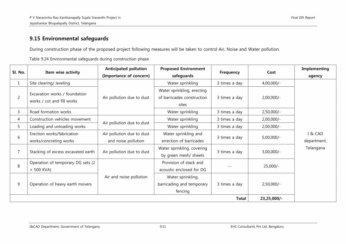
P V Narasimha Rao Kanthanapally Sujala Sravanthi Project in Final EIA Report
Jayashankar Bhupalapally District, Telangana
I&CAD Department, Government of Telangana 9.51 EHS Consultants Pvt Ltd, Bengaluru
9.15 Environmental safeguards
During construction phase of the proposed project following measures will be taken to control Air, Noise and Water pollution.
Table 9.24 Environmental safeguards during construction phase
Sl. No. Item wise activity Anticipated pollution
(Importance of concern)
Proposed Environment
safeguards Frequency Cost
Implementing
agency
1 Site clearing/ leveling
Air pollution due to dust
Water sprinkling 3 times a day 4,00,000/-
I & CAD
department,
Telangana
2 Excavation works / foundation
works / cut and fill works
Water sprinkling, erecting
of barricades construction
sites
3 times a day 2,00,000/-
3 Road formation works Water sprinkling 3 times a day 2,50,000/-
4 Construction vehicles movement Air pollution due to dust
Water sprinkling 3 times a day 2,00,000/-
5 Loading and unloading works Water sprinkling 3 times a day 2,00,000/-
6 Erection works/fabrication
works/concreting works
Air pollution due to dust
and noise pollution
Water sprinkling and
errection of barricades 3 times a day 5,00,000/-
7 Stacking of excess excavated earth Air pollution due to dust Water sprinkling, covering
by green mesh/ sheets 3 times a day 3,00,000/-
8 Operation of temporary DG sets (2
× 500 KVA)
Air and noise pollution
Provision of stack and
acoustic enclosed for DG -- 25,000/-
9 Operation of heavy earth movers
Water sprinkling,
barricading and temporary
fencing
3 times a day 2,50,000/-
Total 23,25,000/-

P V Narasimha Rao Kanthanapally Sujala Sravanthi Project in Final EIA Report
Jayashankar Bhupalapally District, Telangana
I&CAD Department, Government of Telangana 9.52 EHS Consultants Pvt Ltd, Bengaluru
9.16 Cost estimates for implementation of EMP
The total amount to be spent for implementation of Environmental Management Plan
(EMP) is as follows.
Table 9.25 Cost for Implementing Environmental Management Plan
Sl. No. Particulars Cost in Rs.
A. Construction Phase
1 Environmental safeguard measures to control
air, noise and water pollution
23,25,000/-
2 Land acquisition 2,53,03,915/-
3 Restoration of construction site (Green belt
development) 6,00,000/-
4 Public health delivery system 10,25,000/-
5 Sanitation and Solid waste management plan 7,00,000/-
6 Environmental monitoring programme 21,32,800/-
Total 320,86,715/-
B. Operation Phase
1 Catchment area treatment plan 158,15,00,000/-
2 Command area development 70,00,000/-
3 Local area development plan 40,00,000/-
4 Restoration of construction site (Green belt
development)*
8,00,000/-
5 Fisheries conservation and management plan 27,50,000/-
6 Environmental monitoring programme* 9,00,360/-
7 Reservoir RIM Treatment 10,00,000/-
8 Energy conservation measures 65,00,000/-
Total 160,44,50,360/-
*Details of recurring cost for the operation phase is given below
Table 9.26 Annual cost during operational phase during first three years (Recurring Cost)
Sl.No. Particulars Cost (Rs./-) Remarks
Environmental monitoring programme
1 Surface Water Quality Monitoring
of River Godavari 2,34,720/-
Rs 19,560/- for quarterly
once for 3 years
2 Soil Quality Monitoring 65,640/- Rs 5,470/- for quarterly once
for 3 years
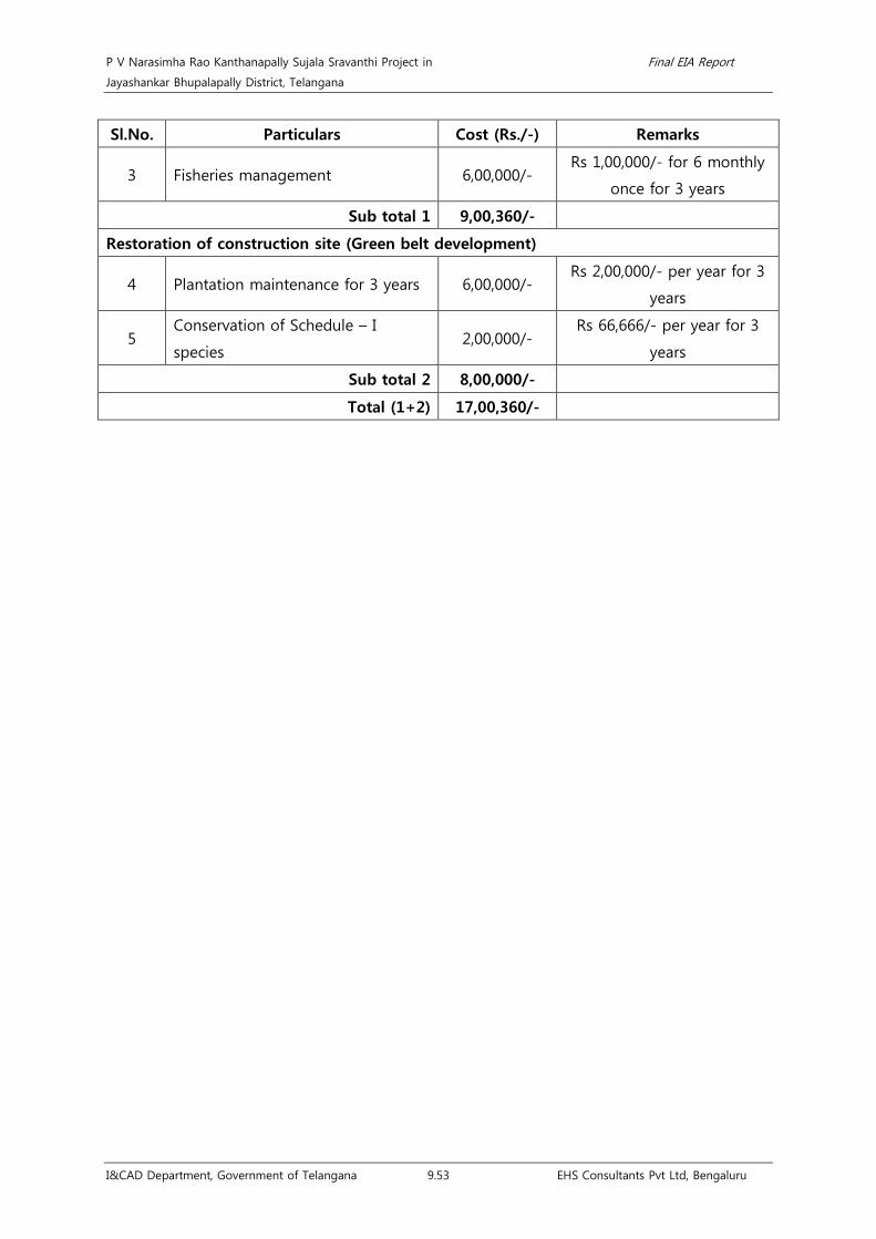
P V Narasimha Rao Kanthanapally Sujala Sravanthi Project in Final EIA Report
Jayashankar Bhupalapally District, Telangana
I&CAD Department, Government of Telangana 9.53 EHS Consultants Pvt Ltd, Bengaluru
Sl.No. Particulars Cost (Rs./-) Remarks
3 Fisheries management 6,00,000/- Rs 1,00,000/- for 6 monthly
once for 3 years
Sub total 1 9,00,360/-
Restoration of construction site (Green belt development)
4 Plantation maintenance for 3 years 6,00,000/- Rs 2,00,000/- per year for 3
years
5 Conservation of Schedule – I
species 2,00,000/-
Rs 66,666/- per year for 3
years
Sub total 2 8,00,000/-
Total (1+2) 17,00,360/-

P V Narasimha Rao Kanthanapally Sujala Sravanthi Project in Final EIA Report
Jayashankar Bhupalapally District, Telangana
I&CAD Department, Government of Telangana 10.1 EHS Consultants Pvt Ltd, Bengaluru
Chapter 10. Summary and Conclusion
• The proposed PVNRKSSP involves construction of 1,132 m long barrage near
Thupakulagudem village across River Godavari located 3 Km downstream of existing
J.Chokka Rao Devadula Lift Irrigation Scheme (JCRDLIS).
• The proposed project stabilizes and provides irrigation facilities to existing 5,55,310
ha of command area belonging to J. Chokka Rao Devadula LIS (2,51,310 ha) and Sri
Ram Sagar Project (SRSP) - Stage I & II (3,04,000 ha).
• 50 TMC of water will be utilized for stabilizing the existing command area and 50
TMC of water will be utilized for drinking water purpose for enroute villages.
• The command area is already benefitted by the existing irrigation facilities for the
Khariff and bi-seasonal crops and the proposed scheme facilitates irrigation only
during Rabi season.
• The boundary of Eturnagaram Wildlife Sanctuary is located at the close proximity
from the proposed barrage. However, no project activities will be carried out in the
Eturnagaram WLS.
• The construction of proposed barrage across Godavari River does not involve any
diversion of forest land.
• The proposed project involves submergence of 580.18 ha of river bed area alongside
River Godavari near the proposed barrage at an FRL of 77 m.
• The proposed project requires a total land of 674.18 ha, of which, 94 ha of private
land for implementation of the project. The land required is only for construction of
the proposed barrage and submergence of river bed area and there is no R&R due
to the project.
• BC Ratio of the proposed project is 1.53.
• Air pollution: The expected increase in concentration in the core area causes
discomfort in breathing, eye and nose irritation to the labours.
• Noise pollution: The movement of vehicles and operation of larger construction
equipments increases the noise levels which affect Thupakulagudem village. Further,
the increasing noise levels generated due to drilling and blasting will disturb the avi-
fauna and faunal habitats residing in the buffer zone of the WLS upto 1 Km.
Continual exposure to increased noise levels will create mental stress in construction
laborers and villagers of Thupakulagudem.

P V Narasimha Rao Kanthanapally Sujala Sravanthi Project in Final EIA Report
Jayashankar Bhupalapally District, Telangana
I&CAD Department, Government of Telangana 10.2 EHS Consultants Pvt Ltd, Bengaluru
• Water pollution: Improper treatment of sewage from labour camps, improper
management of domestic solid waste from labour camps & dumping, creation of
unaesthetic conditions in the site, improper disposal of construction debris, used oil,
diesel for DG sets, improper management of excavated earth and dumping of muck,
boulders, etc leads to deteriorating health of the workers, decrease in DO levels of
river water and morbidity of aquatic life create turbidity of water.
• Soil pollution: Improper disposal of Solid waste generated from labour camp, leakage
of used oil from DG sets, Oil spill, etc will create leaching problems, affects soil biota
and ground water.
• Land use impact: The construction of barrage across the river and submergence of
580.18 ha leads to permanent change in land use.
• Impact due to solid and hazardous waste: Improper management and storage of
solid waste from the labour colony & irregular practice in disposal of waste leads to
spread of infectious diseases and un-aesthetic condition and affects the surface water
quality and aquatic life.
• Biological Environment: Removal of 800 trees, reduction of the photosynthetic activity
in plants by its deposition on the foliage, disturbances due to mobilization of
machineries and workers, noise and vibration generated due to construction activities,
are the major sources of impacts on terrestrial and aquatic biological environment.
• No rare, threatened, endangered plant species were recorded during the study.
Avifaunal species such as Shikra, Jerdon’s courser, Indian peafowl, Common buzzard
and Booted eagle; butterfly namely Common pierrot and mammals such as Black
buck, Four horned antelope, Indian wolf and Sloth bear were recorded during the
study in the project site as well as in the command area which belongs to Schedule I
of W(P)A, 1972. Implementation of conservation plan for the above species will be
carried out as part of EMP.
• Environmental Monitoring is proposed during the construction and operation phase
of the project. Rs. 21,32,800/- was estimated for environmental monitoring during
construction phase (24 months) and Rs. 9,00,360/- is estimated for operation phase
(36 months) of the project.
• The only negative impact is that 94 ha of private land will be acquired for the project
construction purposes. Land acquisition will have to be done as per the Right to Fair
Compensation and Transparency in Land Acquisition, Rehabilitation and Resettlement
(Compensation, Rehabilitation and Resettlement, Development Plan) Rules, 2015
published in the Govt. of India Gazette on 18th December, 2015.

P V Narasimha Rao Kanthanapally Sujala Sravanthi Project in Final EIA Report
Jayashankar Bhupalapally District, Telangana
I&CAD Department, Government of Telangana 10.3 EHS Consultants Pvt Ltd, Bengaluru
• Direct employment opportunities for 400 people (50 Technical and 350 construction
laborers) for the construction of proposed barrage.
• Effective EMP is proposed to mitigate the impacts during construction and operation
phase of the project on various environmental components such as air, water, noise,
soil, solid and hazardous waste, biological and social environment.
• Catchment area treatment plan, command area development plan, restoration of
construction site, muck disposal plan and fisheries development plan is also proposed
for implementation.
• Overall, the project will have minor impacts during construction phase but the project
will bring substantial improvement on the social environment and economical
aspects.

P V Narasimha Rao Kanthanapally Sujala Sravanthi Project in Final EIA Report
Jayashankar Bhupalapally District, Telangana
I&CAD Department, Government of Telangana 11.1 EHS Consultants Pvt Ltd, Bengaluru
Chapter 11. Disclosure of Consultants
M/s Environmental Health and Safety Consultants Pvt. Ltd is located at Rajajinagar, Bengaluru
have been involved in obtaining environment clearances for various developmental projects
from the Ministry of Environment, Forests& Climate Change (MoEF), New Delhi since 2002.
In accordance with the orders and notifications of the MoEF, Govt. of India, the organization
is ISO 9001:2015 certified and accredited as 'A' category organization from National
Accreditation Board for Education and Training (NABET) in eight sectors viz., River valley,
Hydel, Drainage and Irrigation projects, Thermal Power plant, Metallurgical industries,
Distilleries, Sugar industry, Highways, Building and large construction projects and Townships
and area development projects.
The company comprises of highly dynamic and well qualified team of Environmental
Engineers and subject experts, both in-house and empanelled in various fields such as
Ecology and Biodiversity, Socio-economics, Soil Conservation, Land Use studies, Hydrology,
Geology, Risk Assessments, etc.
The organization has state of art in-house environmental laboratories at Bengaluru and
Belagavi capable of conducting all types of sampling and analysis related to Air, Water, Noise
and Soil. Bengaluru laboratory is accredited by National Accreditation Board for Testing and
Calibration Laboratories (NABL) for 419 parameters and recognized from MoEF under the
E(P) Act, 1986 and also certified for ISO 9001:2015, 14001:2015 and OHSAS 18000:2007.
Whereas, the Belagavi Laboratory is recognized from MoEF under the E (P) Act, 1986.

P V Narasimha Rao Kanthanapally Sujala Sravanthi Project in Final EIA Report
Jayashankar Bhupalapally District, Telangana
I&CAD Department, Government of Telangana 12.1 EHS Consultants Pvt Ltd, Bengaluru
Chapter 12. Compliance to Terms of Reference
Sl. No. TORs Compliance with respect to
Final EIA Report
1. Scope of EIA
The EIA Report should identify the relevant environmental
concerns and focus on potential impacts that may change
due to the construction of proposed project. Based on the
baseline data collected for three (3) seasons (pre-monsoon,
Monsoon and Winter seasons), the status of the existing
environment in the area and capacity to bear the impact on
this should be analyzed. Based on this analysis, the
mitigation measures for minimizing the impact shall be
suggested in the EIA/EMP study.
Baseline data used in this report
were collected for 3 seasons (July
2017 – March 2018) for
preparation of EIA report. Details
of baseline data are furnished in
Chapter - 3.
Based on this the impacts are
identified and mitigation
measures are suggested in
Chapter-4.
2. Details of the Project and Site
General introduction about the proposed project. The proposed project stabilizes
and provides irrigation facilities to
existing 5,55,310 ha of command
area belonging to J. Chokka Rao
Devadula LIS (2,51,310 ha) and Sri
Ram Sagar Project (SRSP) - Stage
I & II (3,04,000 ha). Described in
Section 1.3 of Chapter 1 in Page
1.2
Details of project and site giving L-sections of all u/s and
d/s projects of River with all relevant maps and figures.
Connect such information as to establish the total length of
interference of Natural River and the committed
unrestricted release from the site of diversion into the main
river.
The details are given in Section
2.1.4 & 2.1.5 of Chapter 2 in Page
2.5 & 2.16
A map of boundary of the project site giving details of
protected areas in the vicinity of project location.
The detailed map showing the
project site boundary and
protected areas is given as Fig 2.3
of Chapter 2 in Page 2.20
Location details on a map of the project area with contours
indicating main project features. The project layout shall be
superimposed on a contour map of ground elevation
Location map and map of the
project area with contours
indicating main project features is

P V Narasimha Rao Kanthanapally Sujala Sravanthi Project in Final EIA Report
Jayashankar Bhupalapally District, Telangana
I&CAD Department, Government of Telangana 12.2 EHS Consultants Pvt Ltd, Bengaluru
Sl. No. TORs Compliance with respect to
Final EIA Report
showing main project features (viz. location of dam, Head
works, main canal, branch canals, quarrying etc.) shall be
depicted in a scaled map.
given as Fig 2.3 of Chapter 2 in
Page 2.20
Layout details and map of the project along with contours
with project components clearly marked with proper scale
maps of at least 1:50,000 scale and printed at least on A3
scale for clarity
Existence of National Park, Sanctuary, Biosphere Reserve
etc. in the study area, if any, should be detailed and
presented on a map with distinct distances from the project
components
The detailed map showing the
Eturnagaram WLS is given as
Fig 3.25 of Chapter 3 in Page
3.83
Drainage pattern and map of the river catchment up to the
proposed project site.
The map showing drainage
pattern and river catchment is
given as Fig 3.23 of Chapter 3 in
Page 3.75
Delineation of critically degraded areas in the directly
draining catchment on the basis of silts Yield Index as per
the methodology of All India Soil and Land Use Survey of
India.
The details are given in Section
9.1 of Chapter 9 in Page 9.1
Soil characteristics and map of the project area.
The soil characteristics are
described in Section 3.2.7 of
Chapter 3 in Page 3.45 and the
soil map is given as Fig 3.16 of
Section 3.2.7 in Page 3.51
Geological and Seismo-tectonic details and maps of the
area surrounding the proposed project site showing
location of dam site and powerhouse site.
The details of geological
investigations and seismic
analysis is given in Section 2.2.5.4
& 2.2.5.7 of Chapter 2 in Page
2.31 & 2.40 respectively
Remote Sensing studies, interpretation of satellite imagery,
topographic sheets along with ground verification shall be
used to develop the land use/land cover pattern of the
study using overlaying mapping techniques viz. Geographic
Information System (GIS), False Color Composite (FCC)
generated from satellite data of project area
The maps generated from
satellite data of the project area
are given as Fig 3.8-3.13 & 3.18-
23 of Chapter 3 in Page 3.24-3.31
& 3.68-3.75

P V Narasimha Rao Kanthanapally Sujala Sravanthi Project in Final EIA Report
Jayashankar Bhupalapally District, Telangana
I&CAD Department, Government of Telangana 12.3 EHS Consultants Pvt Ltd, Bengaluru
Sl. No. TORs Compliance with respect to
Final EIA Report
Land details including forests, private and other land. The proposed project involves
submergence of 580.18 ha of
river bed area and 94 Ha of
private land. The details are
enclosed in Section 3.3.3.2 of
Chapter 3 in Page 3.67.
Demarcation of snow fed and rain fed areas for a realistic
estimate of the water availability
The whole region is coming
under rainfed area.
3 Description of Environment and Baseline Data
To know the present status of environment in the area,
baseline data with respect to environmental components
air, water, noise, soil, land and biology & biodiversity
(flora & fauna), wildlife, socioeconomic status etc. should
be collected within 10 km radius of the main
components of the project/site i.e. dam site and power
house site. The air quality and noise are to be monitored
at such locations which are environmentally &
ecologically more sensitive in the study area. The
baseline studies should be collected for 3 seasons (Pre
Monsoon, Monsoon and Post-monsoon). Flora-Fauna in
the catchment and command area should be
documented.
The study area should comprise of the following:
• Catchment area up to dam site
• Submergence area
• Project area or the direct impact area should
comprise of area falling within 10 Km radius from the
periphery of the reservoir, land coming under
submergence and area downstream of dam up to the
point where Tail Race Tunnel (TRT) meets the river.
• Downstream upto 10km from tip of Tail Race
Tunnel (TRT)
Description of the study area and
study period is given in Chapter
2. The base line data with respect
to environmental components air,
water, noise, soil, land and
biology & biodiversity (flora &
fauna), wildlife, socioeconomic
status etc. are collected within 10
km radius from the proposed
barrage and enclosed in Chapter
3.
4 Details of Methodology
• The methodology followed for collection of base
line data along with details of number of samples
The methodology involved in the
selection of sampling sites is

P V Narasimha Rao Kanthanapally Sujala Sravanthi Project in Final EIA Report
Jayashankar Bhupalapally District, Telangana
I&CAD Department, Government of Telangana 12.4 EHS Consultants Pvt Ltd, Bengaluru
Sl. No. TORs Compliance with respect to
Final EIA Report
and their locations in the map should be included.
• Study area should be demarcated properly on the
appropriate scale map.
• Sampling sites should be depicted on map for each
parameter with proper legends.
• For Forest Classification, Champion and Seth (1968)
methodology should be followed.
given as section AAQM-3.2.3 in
Page 3.11, Noise-3.2.4 in Page
3.17, Hydrology & Geology-
3.2.5.1 in Page 3.21, Water
quality-3.2.6 in Page 3.36, Soil-
3.2.7.7 in Page 3.49, Land use-
3.3.2 in Page 3.66, Biological
environment-3.4.3 in Page 3.79,
Aquatic environment-3.5.2 in
Page 3.114 of Chapter 3
5 Methodology for Collection of Biodiversity Data
The number of sampling locations should be adequate to
get a reasonable idea of the diversity and other attributes
of flora and fauna. The guiding principles should be the
size of the study area (larger area should have larger
number of sampling locations) and inherent diversity at the
location, as known from secondary sources (e.g. eastern
Himalayan and low altitude sites should have a larger
number of sampling locations owing to higher diversity).
Sampling locations are adequate
in number to get a reasonable
idea of diversity and other
attributes of flora and fauna and
mentioned in section 3.4.3 of
Chapter 3 in Page 3.79
The entire area should be divided in grids of 5km X 5km
preferably on a GIS domain. There after 25% of the grids
should be randomly selected for sampling of which half
should be in the directly affected area (grids including
project components such as reservoir, dam, powerhouse,
tunnel, canal etc.) and the remaining in the rest of the area
(areas of influence in 10 km radius form project
components). At such chosen location, the size and number
of sampling units (e.g. quadrates in case of flora/transects
in case of fauna) must be decided by species area curves
and the details of the same (graphs and cumulative number
of species in a tabulated form) should be provided in the
EIA report. Some of the grids on the edges may not be
completely overlapping with the study area boundaries.
However these should be counted and considered for
selecting 25% of the grids. The number of grids to be
The details of size and number of
sampling units are described in
Section 3.4.3 of Chapter 3 in Page
3.79

P V Narasimha Rao Kanthanapally Sujala Sravanthi Project in Final EIA Report
Jayashankar Bhupalapally District, Telangana
I&CAD Department, Government of Telangana 12.5 EHS Consultants Pvt Ltd, Bengaluru
Sl. No. TORs Compliance with respect to
Final EIA Report
surveyed may come out as a decimal number (i.e. it has an
integral and a fractional part) which should be rounded to
the next whole number.
The conventional sampling is likely to miss the presence of
rare, endangered and threatened (R.E.T.) species since they
often occur in low densities and in case of faunal species
are usually secretive in behavior. Reaching the conclusion
about the absence of such species in the study area based
on such methodology is misleading. It is very important to
document the status of such species owing to their high
conservation value. Hence likely presence of such species
should be ascertained from secondary sources by a proper
literature survey for the said area including referring to field
guides which are now available for many taxonomic groups
in India. Even literature from studies/surveys in the larger
landscapes which include the study area for the concerned
project must be referred to, since most species from
adjoining catchments is likely to be present in the
catchments in question. In fact such literature form the
entire state can be referred to. Once a listing of possible
R.E.T. species form the said area is developed, species
specific methodologies should be adopted to ascertain
their presence in the study area which would be far more
conclusive as compared to the conventional sampling. If
the need be, modern methods like camera trapping can be
resorted to, particularly for areas in the eastern Himalayas
and for secretive/nocturnal species. A detailed listing of the
literature referred to, for developing lists of R.E.T. species
should be provided in the ElA reports
In Command area a total of 26
tree species were recorded during
the study. In addition to this, 85
species of herbs, 13 species of
shrubs and 10 species of climbers
were recorded during Monsoon
season. A total of 57 species of
herbs, 13 species of shrubs and 7
species of climbers were recorded
during Post Monsoon season.
Similarly, 69 species of herbs, 13
species of shrubs and 9 species
of climbers were recorded during
Post Monsoon season. All the
species recorded were common
to the region and no RET species
were observed during the study.
Near barrage site a total of 39
tree species were recorded during
the study. In addition to this, 76
species of herbs, 10 species of
shrubs and 7 species of climbers
were recorded during Monsoon
season. A total of 34 species of
herbs, 10 species of shrubs and 4
species of climbers were recorded
during Post Monsoon season.
Similarly, 62 species of herbs, 10
species of shrubs and 5 species
of climbers were recorded during
Post Monsoon season. All the
species recorded were common

P V Narasimha Rao Kanthanapally Sujala Sravanthi Project in Final EIA Report
Jayashankar Bhupalapally District, Telangana
I&CAD Department, Government of Telangana 12.6 EHS Consultants Pvt Ltd, Bengaluru
Sl. No. TORs Compliance with respect to
Final EIA Report
to the region and no RET species
were observed during the study.
The details are enclosed in
Section 3.4.4 of Chapter 3 in Page
3.85
The RET species referred to in this point should include
species listed in Schedule I and II of Wildlife (Protection)
Act, 1972 and those listed in the red data books (BSI, ZSI
and IUCN)
No RET species were recorded in
the study area during the study
period. the details of Scheduled
species are given in Section 3.4.4
of Chapter 3 in Page 3.85
6 Components of EIA study
Various aspects to be studied and provided in the EIA/EMP report are as follows:
A Physical and Chemical Environment
Geological & Geophysical Aspects and Seismo- Tectonics: Details of geological &
geophysical aspects and seismo
tectonics are given in Section
2.2.5.4 & 2.2.5.7 of Chapter 2 in
Page 2.31 & 2.40
Physical geography, Topography, Regional Geological
aspects and structure of the Catchment.
The details are given in Section
2.2.5.4, 2.2.5.7 & 3.2.1 of Chapter
2 & 3 in Page 2.31, 2.40 & 3.1
Tectonics, seismicity and history of past earthquakes in the
area. A site specific study of the earthquake parameters
will be done. The results of the site-specific earthquake
design shall be sent for approval of the NCSDP (National
committee of Seismic Design Parameters, Central water
commission, New Delhi for large dams.
The details are given in Section
2.2.7 of Chapter 2 in Page 2.42
Landslide zone or area prone to landslide existing in the
study area should be examined.
Presence of important economic mineral deposit, if any, The details are enclosed in
Section 3.2.5.7 of Chapter 3 in
Page 3.25
Justification for location & execution of the project in
relation to structural components (dam height)
Justification for location &
execution of the project in
relation to structural components

P V Narasimha Rao Kanthanapally Sujala Sravanthi Project in Final EIA Report
Jayashankar Bhupalapally District, Telangana
I&CAD Department, Government of Telangana 12.7 EHS Consultants Pvt Ltd, Bengaluru
Sl. No. TORs Compliance with respect to
Final EIA Report
are given in Section 2.2 of
Chapter 2 & 5 in Page 2.18 & 5.1
Impact of project on geological environment. Barrage is proposed over the
Godavari River the litho unit
covering is Sandstone and Shale
to store water for strengthening
the existing Devadula LIS
upstream so that water is
available continuously to the
project command area. As such
there is no disturbance or
alteration to the local Geology.
The details are furnished in
Section 4.1.7 of Chapter 4 in
Page 4.12
Meteorology, Air and Noise
Meteorology (viz. Temperature, Relative humidity, wind
speed/direction etc.) to be collected from nearest IMD
station.
Temperature, Relative humidity,
wind speed/direction etc. are
collected from nearest IMD
station in Ramagundem. Details
are furnished in Section 3.2.2 &
3.2.3 of Chapter 3 in Page 3.1-
3.11
Ambient Air Quality with parameters viz. Suspended
Particulate Matter (SPM), Respirable Suspended Particulate
Matter (RSPM), i.e., particulate matters <10 microns,
Sulphur dioxide (S02) and Oxides of Nitrogen (NO x) in the
study area at 6 Locations.
Details of Ambient Air Quality are
discussed in Section 3.2.3, Table
3.5-3.8 of Chapter 3 in Page 3.15-
3.16
Existing Noise Levels and traffic density in the study area at
6 Locations.
Details of Ambient Noise Levels
are discussed in Table 3.13 of
Chapter 3 in Page 3.20
Soil Characteristics
Soil classification, physical parameters (viz., texture, Porosity,
Bulk Density and water holding capacity) and chemical
parameters (viz. pH, electrical conductivity, magnesium,
Details of Soil Quality are
discussed in Section 3.2.7 of
Chapter 3 in Page 3.45

P V Narasimha Rao Kanthanapally Sujala Sravanthi Project in Final EIA Report
Jayashankar Bhupalapally District, Telangana
I&CAD Department, Government of Telangana 12.8 EHS Consultants Pvt Ltd, Bengaluru
Sl. No. TORs Compliance with respect to
Final EIA Report
calcium, total alkalinity, chlorides, sodium, potassium,
organic carbon, available potassium, available phosphorus,
SAR, nitrogen and salinity, etc.) 6 locations
Remote Sensing and GIS Studies
Generation of thematic maps viz, slope map, drainage map,
soil map, land use and land cover map, etc. Based on these,
thematic maps, an erosion intensity map should be
prepared.
Slope (Relief) map, drainage map,
soil map, land use and land cover
map, etc. are given as Fig 3.8-
3.13 & 3.18-23 of Chapter 3 in
Page 3.24-3.31 & 3.68-3.75
New configuration map to be given in the EIA report No change in configuration.
Water Quality
History of the ground water table fluctuation in the study
area.
The details of ground water table
in the study area is furnished in
Section 3.2.5 of Chapter 3 in Page
3.21
Water Quality for both surface water and ground water for
[i] Physical parameters (PH, Temperature, Electrical
Conductivity, TSS); [ii] Chemical parameters (Alkalinity,
Hardness, BOD, COD, N03, P04, Cl, S04, Na, K, Ca, Mg,
Silica, Oil & grease, phenolic compounds, residual sodium
carbonate); [iii] Bacteriological parameter (MPN, Total
coliform); and [iv] Heavy Metals (Pb, As, Hg, Cd, Cr-6, Total
Cr, Cu, Zn, Fe) (35 locations).
Water Quality for both ground
water and surface water for all
parameters are analysed are
found to be within the
permissible limit and are given in
Section 3.2.6 of Chapter 3 in Page
3.36 and also in Annexure 16
Delineation of sub and micro watersheds, their locations
and extent based on the All India Soil and Land Use Survey
of India (AISLUS), Department of Agriculture, Government
of India. Erosion levels in each micro-watershed and
prioritization of micro-watershed through Silt Yield Index
(SYI) method of AISLUS.
Land use/land cover pattern of
the study area is discussed in
Section 9.1 of Chapter 9 in Page
9.1
B Water Environment and Hydrology
Hydro-Meteorology of the project viz. precipitation
(snowfall, rainfall), temperature, relative humidity, etc.
Hydro-meteorological studies in the catchment area should
be established along-with real time telemetry and data
acquisition system for inflows monitoring.
The details of Hydro-
meteorological studies in the
catchment area is given in
Section 3.22 of Chapter 3 in Page
3.1

P V Narasimha Rao Kanthanapally Sujala Sravanthi Project in Final EIA Report
Jayashankar Bhupalapally District, Telangana
I&CAD Department, Government of Telangana 12.9 EHS Consultants Pvt Ltd, Bengaluru
Sl. No. TORs Compliance with respect to
Final EIA Report
Run off, discharge, water availability for the project,
sedimentation rate, etc.,
Water availability details are
enclosed in Section 2.2 of
Chapter 2 in Page 2.18
Basin characteristics The details of basin characteristics
are given in Section 2.1.2 of
Chapter 2 in Page 2.1 and is
represented in Fig 2.1 & 2.2 of
Chapter 2 in Page 2.3 & 2.4
Catastrophic events like cloud bursts and flash floods, if
any, should be documented.
Details are furnished in Section
2.2 of Chapter 2 in Page 2.18
For estimation of sedimentation rate, direct sampling of
river flow is to be done during the EIA study. The study
should be conducted for minimum one year. Actual silt flow
rate to be expressed in ha-m km2 year-1.
Sedimentation data available with CWC may be used to
find out the loss in storage over the years.
Set-up a G&D monitoring station and a few rain gauge
stations in the catchment area for collecting data during
the investigation.
Flow series, 10 daily with 90%, 75% and 50% dependable
years discharges.
A table of 10 daily water discharges corresponding to 90%
dependable year showing the intercepted discharge at the
barrage, the environmental flow to be released and the
other flow releases downstream of the barrage and spills to
be provided in hydrology section of EIA
Norms for release of Environmental flows, i.e. 30% in
monsoon season, 20% in lean season and 25% in non-
monsoon & non-lean season to be followed corresponding
to 90% dependable year. A site-specific study on minimum
environment flow should be carried out.
Hydrological studies/data as approved by CWC shall be
utilized· in the preparation of EIA/EMP report. Actual
hydrological annual yield may also be given in the report.
A minimum of 1 km distance from the tip of the reservoir

P V Narasimha Rao Kanthanapally Sujala Sravanthi Project in Final EIA Report
Jayashankar Bhupalapally District, Telangana
I&CAD Department, Government of Telangana 12.10 EHS Consultants Pvt Ltd, Bengaluru
Sl. No. TORs Compliance with respect to
Final EIA Report
to the tailrace tunnel should be maintained between
upstream and downstream projects
Release of environmental flows
C Biological Environment
Besides primary studies, review of secondary data/literature published for project area on
flora & fauna including RET species shall be reported in EIA/EMP report.
(i)Flora
Characterization of forest types (as per Champion and Seth
method) in the study area and extent of each forest type as
per the Forest Working Plan.
Details of forest types,
documentation of species, floral
diversity, diversity indices,
protected areas, endemic species,
RET and scheduled species are
enclosed in Section 3.4.4.1.1 &
3.4.4.2.1 of Chapter 3 in Page
3.85 & 3.99 and also given as
Annexure 18.
Documentation of all plant species i.e. Angiosperm,
Gymnosperm, Pteriodophytes, Bryophytes, Lichens (all
groups). All species list may be provided.
General vegetation profile and floral diversity covering all
groups of flora including Lichens and Orchids. A species
wise list may be provided.
Assessment of plant species with respect to dominance,
density, frequency, abundance, diversity index, similarity
index, importance value index [IVI], Shannon Weiner Index
etc. of the species to be provided. Methodology used for
calculating various diversity indices along with details of
locations of quadrates, size of quadrates etc. to be reported
within the study area in different ecosystems.
Existence of National Park, Sanctuary, Biosphere Reserve
etc. in the study area, if any, should be detailed.
Economically important species like medicinal plants,
timber, fuel wood etc.
Details of endemic species found in the project area.
Flora under RET categories should be documented using
International Union for the Conservation of Nature and
Natural Resources (IUCN) criteria and Botanical Survey of
India's Red Data list along with economic significance.
Species diversity curve for RET species should be given.
Biodiversity study, a sub component of EIA study, is to be
carried out by associating a reputed organization/institution

P V Narasimha Rao Kanthanapally Sujala Sravanthi Project in Final EIA Report
Jayashankar Bhupalapally District, Telangana
I&CAD Department, Government of Telangana 12.11 EHS Consultants Pvt Ltd, Bengaluru
Sl. No. TORs Compliance with respect to
Final EIA Report
as recommended by WII, Dehradun or by ICFRE, Dehradun.
A list of such institutes is available on MoEF’s website
Cropping pattern and Horticultural practices in the study
area.
The cropping pattern and
horticultural practices are given in
Section 3.2.7.5 and 3.2.7.4 of
Chapter 3 in Page 3.46
(ii)Fauna
Fauna study and inventorization should be carried out for
all groups of animals including reptiles and nocturnal
animals in the study area. Their present status along with
Schedule of the species.
Documentation of faunal,
avifaunal, plankton, periphyton,
benthos and fish species; its
habitat status; RET species, IUCN
status, scheduled species are
furnished in Section 3.4.4.1.2 &
3.4.4.2.2 of
Chapter 3 in Page 3.92 & 3.104
Documentation of fauna plankton (phyto and zooplankton),
periphyton, benthos and fish should be done and analysed.
Information (authenticated) on Avi-fauna and wild life in
the study area.
Status of avifauna their resident/migratory/ passage
migrants etc.
Documentation of butterflies, if any, found in the area.
Details of endemic species found in the project area
RET species-voucher specimens should be collected along
with GPS readings to facilitate rehabilitation. RET faunal
species to be classified as per IUCN Red Data List and as
per different schedule of Indian Wildlife (Protection) Act,
1972.
Existence of barriers and corridors, if any, for wild animals.
Compensatory afforestation to compensate the green belt
area that will be removed, if any, as part of the proposed
project development and loss of biodiversity.
The restoration
activities/compensatory
afforestation shall improve the
ecological activities of faunal
species. Since, the proposed
barrage is the only new project
component restoration activities
shall be focused near the
proposed barrage. The
restoration activities shall be

P V Narasimha Rao Kanthanapally Sujala Sravanthi Project in Final EIA Report
Jayashankar Bhupalapally District, Telangana
I&CAD Department, Government of Telangana 12.12 EHS Consultants Pvt Ltd, Bengaluru
Sl. No. TORs Compliance with respect to
Final EIA Report
handed over to the Forest and
Agriculture Department,
Government of Telangana in
order to obtain sustainable
results. The details are given in
Section 9.3 and the list of species
proposed for plantation in Table
9.9 of Chapter 9 in Page 9.20
Collection of primary data on agricultural activity, crop
and their productivity and irrigation facilities components.
The details are furnished in
Section 9.1.1 & 9.1.2 of Chapter 9
in Page 9.2
D Aquatic Ecology
Documentation of aquatic fauna like micro-invertebrates,
zooplankton, phytoplankton, benthos etc.
Documentation of aquatic fauna
like micro-invertebrates,
zooplankton, phytoplankton,
benthos etc are enclosed as
Annexure 19
Fish and fisheries, their migration and breeding grounds. Fish and fisheries, their migration
and breeding grounds, Fish
diversity, composition and
maximum length & weight are
given in Section 3.5 of Chapter 3
in Page 3.114 and also in
Annexure 19
Fish diversity, composition and maximum length & weight
of the measured populations to be studied for estimation
of environmental flow
Conservation status of aquatic fauna. Conservation status of aquatic
fauna is enclosed in Annexure 19
E Socio-Economic
Collection of Baseline data on human settlements, health
status of the community and existing infrastructure facilities
for social welfare including sources of livelihood, job
opportunities and safety and security of workers and
surrounding population.
Baseline data on human
settlements, existing infrastructure
facilities etc. is enclosed as
Chapter 7 from Page 7.1
Collection of information with respect to social awareness
about the developmental activity in the area and social
welfare measures existing and proposed by project
Social awareness about the
project was discussed with public.
Social welfare measures are

P V Narasimha Rao Kanthanapally Sujala Sravanthi Project in Final EIA Report
Jayashankar Bhupalapally District, Telangana
I&CAD Department, Government of Telangana 12.13 EHS Consultants Pvt Ltd, Bengaluru
1
Sl. No. TORs Compliance with respect to
Final EIA Report
proponent. proposed during public
consultation by project
proponent.
Collection of information on sensitive habitat of historical,
cultural and religious and ecological importance.
Information on sensitive habitat
of historical, cultural and religious
and ecological importance is
provided in Section 7.7 & 7.10 of
Chapter 7 in Page 7.9 & 7.11
The Socio-economic survey/profile within 10 Km of the
study area for Demographic profile; Economic Structure;
Development Profile; agricultural practices; Infrastructure;
education facilities; health and sanitation facilities; available
communication network; etc
Demographic profile; Economic
Structure; Development Profile;
agricultural practices;
Infrastructure; education facilities;
health and sanitation facilities;
available communication network,
etc are given in Chapter 7 &
Page 7.1
Documentation of demographic, Ethnographic, Economic
Structure and development profile of the area
Information on Agricultural Practices, Cultural and aesthetic
sites, Infrastructure facilities etc.
Information on the dependence of the local people on
minor forest produce and their cattle grazing rights in the
forest land.
List of all the Project Affected Families with their name,:
age, educational qualification, family size, sex, religion,
caste, sources of j income, land & house holdings. Other
properties, occupation, source of income, house/land
to be acquired for the project and house/land left
with the family, any other property. possession of cattle,
type of house etc.
In addition to socio-economic aspects of the study area,
a separate chapter on socio-cultural aspects based upon
study on Ethnography of the area should be provided.
7 Impact Prediction and Mitigation Measures
The adverse impact due to the proposed project should be
assessed and effective mitigation steps to abate these
impacts should be described.
Impact prediction and mitigation
measures are given in Section 4.1
of Chapter 4 in Page 4.1
(i) Air Environment

P V Narasimha Rao Kanthanapally Sujala Sravanthi Project in Final EIA Report
Jayashankar Bhupalapally District, Telangana
I&CAD Department, Government of Telangana 12.14 EHS Consultants Pvt Ltd, Bengaluru
Sl. No. TORs Compliance with respect to
Final EIA Report
Changes in ambient and ground level concentrations due
to total emissions from point, line and area sources
Deterioration of air quality due to
various construction activities and
the mitigation measures along
the project site is provided in
section 4.1.1 of chapter-4 in Page
4.1.
Vehicular pollution may rise due
to vehicular movement during
operation phase but due to use
of low sulphur fuel and strict
regulation of vehicular pollution
norms such rise in air pollution
may not be significant
Effect on soils, material, vegetation and human health
Impact of emissions from DG sets used for power during
the construction, if any, on air environment.
Pollution due to fuel combustions in equipments & vehicles
Fugitive emissions from various Sources.
Impact on micro climate.
(ii)Water Environment
Changes in surface & ground water quality.
Impacts due to Water
environment is given in Section
4.1.3 of Chapter 4 in Page 4.8
Steps to develop pisci-culture and recreational facilities.
Changes in hydraulic regime and down stream flow.
Water pollution due to disposal of sewage.
Water pollution from labour colony/camps and washing
equipment.
(iii)Land Environment
Adverse impact on land stability, catchment of soil erosion,
reservoir sedimentation and spring flow (if any) [a] due to
considerable road construction/widening activity [b)
interference of reservoir with the inflowing stream (c)
blasting for commissioning of HRT, TRT and some other
structures.
Land environment will be
deteriorated due to excavation,
disposal of solid waste, erosion
etc. Impacts due to Land
environment is given in Section
4.1.5 of Chapter 4 in Page 4.10
Changes in land use/land cover and drainage pattern.
Immigration of labour population.
Quarrying operation and muck disposal Details w.r.t muck and waste
disposal and its impacts are given
in Section 4.1.6 of Chapter 4 in
Page 4.11
Changes in land quality including effects of waste disposal
River bank and their stability.
Impact due to submergence
(iv)Biological Environment

P V Narasimha Rao Kanthanapally Sujala Sravanthi Project in Final EIA Report
Jayashankar Bhupalapally District, Telangana
I&CAD Department, Government of Telangana 12.15 EHS Consultants Pvt Ltd, Bengaluru
Sl. No. TORs Compliance with respect to
Final EIA Report
Impact on forests, flora, fauna including wildlife, migratory
Avi-fauna, rare and endangered species, medicinal plants
etc.
No forest land will be utilized for
construction activities. Only
580.18 Ha of River bed area will
be involved in the submergence.
The impacts and mitigation
measures for fish migration and
habitat degradation is given in
Section 4.1.8 of Chapter 4 in Page
4.13
Pressure on existing natural resources
Deforestation and disturbance to wildlife, habitat
fragmentation and wild animal's migratory corridors
Compensatory afforestation-Identification of suitable native
tree species for compensatory afforestation & green belt.
Impact on fish migration and habitat degradation due to
decreased flow of water
Impact on breeding and nesting grounds of animals and
fish
(v)Socio-Economic Environment
Impact on local community including demographic profile.
The details of the Socio-Economic
Environment is given in Chapter
7, Page 7.1
Impact on socio-economic status.
Impact on economic status.
Impact on human health due to water / vector borne
disease.
Impact on increase traffic
Impact on holy places and tourism
Impacts of blasting activity during project construction
which generally destabilize the land mass and lead to
landslides, damage to properties and drying up of natural
springs and cause noise pollution will be studied. Proper
record shall be maintained of the base line information in
the post project period.
Impacts of blasting activity during
project construction activities are
given in Section 4.1 of Chapter 4
in Page 4.1
Positive as well as negative impacts likely to be accrued
due to the project are to be listed.
8 Environment Management plan (EMP)
Catchment Area Treatment (CAT) Plan should be prepared
micro-watershed wise. Identification of free draining/
directly draining catchment based upon Remote Sensing
and Geographical Information System (GIS) methodology
and Sediment Yield Index (SY!) method of AISLUS, Dept. of
Agriculture, Govt. of India coupled with ground survey.
Catchment Area Treatment (CAT)
Plan is given as Section 9.1 of
Chapter 9 in Page 9.2

P V Narasimha Rao Kanthanapally Sujala Sravanthi Project in Final EIA Report
Jayashankar Bhupalapally District, Telangana
I&CAD Department, Government of Telangana 12.16 EHS Consultants Pvt Ltd, Bengaluru
Sl. No. TORs Compliance with respect to
Final EIA Report
Areas or watersheds falling under 'very severe' and 'severe'
erosion categories should be provided and required to be
treated. Both biological as well as engineering measures
should be proposed in consultation with State Forest
Department for areas requiring treatment. Year wise
schedule of work and monetary allocation should be
provided. Mitigation measures to check shifting cultivation
in the catchment area with provision for alternative and
better agricultural practices should be included.
Command Area Development (CAD) Plan giving details of
implementation schedule with a sample CAD plan.
Command Area Development
(CAD) Plan is furnished in Section
9.2 of Chapter 9 in Page 9.22
Compensatory Afforestation shall be prepared by the State
Forest Department in lieu of the forestland proposed to be
diverted for construction of the project as per the Forest
(Conservation) Act, 1980. Choice of plants for afforestation
should include native and RET species, if any.
About 30 ha of land have been
identified for carrying out
construction activities close to the
River Godavari. Out of which, 26
ha are agricultural lands and
remaining area is waste land
followed by riparian land. Totally,
800 trees of different girth size
will be removed. Therefore,
restoration of construction site
will be implemented in Section
9.3 of Chapter 9 in Page 9.25
Biodiversity and Wildlife Conservation and Management
Plan for the conservation and preservation of rare,
endangered or endemic floral/ faunal species or some
National Park/Sanctuary/ Biosphere Reserve or other
protected area is going to get affected directly or indirectly
by construction of the project, then suitable conservation
measures should be prepared in consultation with the
State Forest Department.
Biodiversity and Wildlife
Conservation and Management
Plan for the conservation and
preservation of rare, endangered,
endemic and scheduled floral/
faunal species is given in Section
9.3 of Chapter 9 in Page 9.25
Fisheries Conservation and Management Plan - a
specific fisheries management measures should be
prepared for river and reservoir. If the construction of fish
Fisheries Conservation and
Management is furnished in
Section 9.5 of Chapter 9 in Page

P V Narasimha Rao Kanthanapally Sujala Sravanthi Project in Final EIA Report
Jayashankar Bhupalapally District, Telangana
I&CAD Department, Government of Telangana 12.17 EHS Consultants Pvt Ltd, Bengaluru
Sl. No. TORs Compliance with respect to
Final EIA Report
ladder/ fish-way etc. is not feasible then measures for
reservoir fisheries will be proposed. The plan will detail out
the number of hatcheries, nurseries, rearing ponds etc.
proposed under the plan with proper drawings. If any
migratory fish species is getting affected then the migratory
routes, time/season of upstream and downstream
migration, spawning grounds etc. will be discussed in
details.
9.29
Resettlement and Rehabilitation Plan needed to be
prepared on the basis of findings of the socio-economic
survey coupled with the outcome of public consultation
held. The R&R package shall be prepared after consultation
with the representatives of the project affected families and
the State Government. Detailed budgetary estimates are to
be provided. Resettlements site should be identified. The
plan will also incorporate community development
strategies. R&R Plan is to be formulated as per Land
Acquisition, Rehabilitation and Resettlement Act, 2013
which came into force on 01.01.2014.
There is no R&R activities
involved in the proposed project
Green Belt Development Plan along the periphery of the
reservoir, approach roads around the colonies' and other
project components, local plant species must be suggested
with physical and financial details. Local plant species
suitable for greenbelt should be selected.
About 30 ha of land have been
identified for carrying out
construction activities close to the
River Godavari. Out of which, 26
ha are agricultural lands and
remaining area is waste land
followed by riparian land. Totally,
800 trees of different girth size
will be removed. Therefore,
Restoration of construction site
has been proposed in Section 9.3
of Chapter 9 in Page 9.25
Reservoir Rim Treatment Plan for stabilization of land slide/
land slip zones, if any, around the reservoir periphery is to
be prepared based on detailed survey of geology of the
reservoir rim area. Suitable engineering and biological
Reservoir Rim Treatment Plan for
stabilization of land slide/ land
slip zones has been proposed in
Section 9.5 of Chapter 9 in Page

P V Narasimha Rao Kanthanapally Sujala Sravanthi Project in Final EIA Report
Jayashankar Bhupalapally District, Telangana
I&CAD Department, Government of Telangana 12.18 EHS Consultants Pvt Ltd, Bengaluru
Sl. No. TORs Compliance with respect to
Final EIA Report
measures for treatment of identified slip zones to be
suggested with physical and financial schedule.
9.27
Muck Disposal Plan- suitable sites for dumping of
excavated material should be identified in consultation with
the State Pollution Control Board and Forest Department.
All Muck disposal sites should be minimum 30 m away
from the HFL of river. Plan for rehabilitation of muck
disposal sites should also be given. The L- section/cross
section of muck disposal sites and approach roads should
be given. The Plan shall have physical and financial details
of the measures proposed.
Muck Disposal Plan has been
proposed in Section 9.6 of
Chapter 9 in Page 9.43
Restoration Plan for Quarry Sites and landscaping of colony
areas, working areas, roads etc. Details of the coarse/fine
aggregate/clay etc. required for construction of the
project and the rock/clay quarries/river shoal sites
identified for the project should be discussed along-with
the Engineering and biological measures proposed for their
restoration with physical and financial details. Layout map
showing quarry sites vis-a-vis other project components
should be prepared.
About 30 ha of land have been
identified for carrying out
construction activities close to the
River Godavari. Out of which, 26
ha are agricultural lands and
remaining area is waste land
followed by riparian land. Totally,
800 trees of different girth size
will be removed. Therefore,
Restoration of construction site
has been proposed in Section 9.3
of Chapter 9 in Page 9.42
Study of Design Earthquake Parameters: A site-specific
study of earthquake parameters should be done. Results of
the site-specific earthquake design parameters should be
approved by National Committee of Seismic Design
Parameters, Central Water Commission (NCSDP), New Delhi.
Details of site specific earthquake
studies has been given in Section
2.2.7.2 of Chapter 2 in Page 2.42
Dam Break Analysis and Disaster Management Plan The
outputs of dam break model should be illustrated with
appropriate graphs and maps clearly bringing out the
impact of Dam Break scenario. The action plan will include
Emergency Action and Management plan including
measures like preventive action notification, warning
procedure and action plan for co-ordination with
Not applicable

P V Narasimha Rao Kanthanapally Sujala Sravanthi Project in Final EIA Report
Jayashankar Bhupalapally District, Telangana
I&CAD Department, Government of Telangana 12.19 EHS Consultants Pvt Ltd, Bengaluru
Sl. No. TORs Compliance with respect to
Final EIA Report
various authorities.
Water and Air Quality & Noise Management Plans to be
implemented during construction and post-construction
periods.
Water, Air and Noise
Management plans are
elaborated in Section 9.13 of
Chapter 9 & 6 in Page 9.49 & 6.1
Mitigating measures for impacts due to Blasting on the
structures in the vicinity.
Impacts due to blasting is
described in Section 4.1 of
Chapter 4 in Page 4.1
Ground Water Management Plan Regular monitoring & recording
of groundwater levels in the
command and downstream area
is suggested with piezometers
installed in consultation with
State Groundwater Authority,
Telangana after the completion of
project while in operation. The
details are enclosed in Section 9.7
of Chapter 9 in Page 9.44
Public Health Delivery Plan including the provisions for
drinking water facility for the local community.
Public Health Delivery Plan and
Labour Management Plan for the
local community has been
proposed in Section 9.8 of
Chapter 9 in Page 9.45
Labour Management Plan for their Health and Safety.
Sanitation and Solid Waste Management Plan for domestic
waste from colonies and labor camps etc.
The detailed Sanitation and Solid
Waste Management Plan is
furnished in Section 9.9 of
Chapter 9 in Page 9.46
Local Area Development Plan to be formulated in
consultation with the Revenue Officials and Village
Panchayats. Local skill development schemes should be
given. Details of various activities to be undertaken along
with its financial out lay should be provided.
Local Area Development Plan has
been given in Section 9.11 of
Chapter 9 in Page 9.47
Environmental safeguards during construction activities
including road construction.
Environmental safeguards
measures to be taken up during
construction activities are given in

P V Narasimha Rao Kanthanapally Sujala Sravanthi Project in Final EIA Report
Jayashankar Bhupalapally District, Telangana
I&CAD Department, Government of Telangana 12.20 EHS Consultants Pvt Ltd, Bengaluru
Sl. No. TORs Compliance with respect to
Final EIA Report
Section 9.15 of Chapter 9 in Page
9.51
Energy Conservation Measures. Energy Conservation Measures is
given in Section 9.12 of Chapter 9
in Page 9.48
Environmental Monitoring Programme with physical &
financial details covering all the aspects of EMP. A summary
of cost estimate for all the plans, cost for implementing all
Environmental Management Plans.
Environmental Monitoring
Programme and Environmental
Management Plans is given in
Section 6 & 9.13 of Chapter 6 &
9 in Page 6.1 & 9.49
9
In the EMP, a sample CAD plan for a distributary outlet
command is also included. Such a plan is to show the
alignment of irrigation and drainage channels. The
components of the On Farm Development (OFD) works
to be undertaken may be clearly mentioned along with a
time schedule for their completion vis-&-vis the
progress of irrigation development.
CAD plan is furnished as Section
9.2 of Chapter 9 in Page 9.22
10 Additional Conditions:
Recycle water be used/utilized for industries and
horticulture purpose. Noted
The irrigation efficiency should also be worked out during
the study
The irrigation efficiencies of the
existing JCR Devadula LIS and
SRSP Stage I&II is given in
Section 2.1.5 of Chapter 2 in Page
2.16
The project envisages stabilization of existing Devadula LIS
of command area of about 2.5 lakhs Ha by constructing a
barrage across river Godavari near the confluence with river
Indravati.
The stabilization details of the
existing irrigation schemes is
given in Section 2.1.4 of Chapter
2 in Page 2.5
The performance report of the LIS may also be prepared
based on the ground realities.
Performance evaluation of
existing irrigation schemes is
given in Section 2.1.4 & 2.1.5 of
Chapter 2 in Page 2.5 & 2.16 and
also enclosed as Annexure 7

P V Narasimha Rao Kanthanapally Sujala Sravanthi Project in Final EIA Report
Jayashankar Bhupalapally District, Telangana
I&CAD Department, Government of Telangana 12.21 EHS Consultants Pvt Ltd, Bengaluru
Sl. No. TORs Compliance with respect to
Final EIA Report
The solar power also may not be a cheaper alternative for
running such high head LIS. This aspect may be looked into
in details.
The details of energy
conservation measures are given
in Section 9.12 of Chapter 9 in
Page 9.48
The arguments Viz need for providing employment to large
number of people who are residing in rural areas and
dependent on agriculture, overlooking the norms of benefit
– cost ratio in light of erratic changes in the prices of
agriculture produce, supplying water to agriculture lands at
high altitudes, achieving self sufficiency to the state in food
grains and so on in justification may not be tenable in the
context of economic returns/improving the economy of the
state. Water is not a solution everywhere.
Noted
Land acquired for the project shall be suitably compensated
in accordance with the law of the land with the prevailing
guidelines.
Land acquisition and
compensation details are
enclosed in Section 7.20 & 9.14
of Chapter 7 & 9 in Page 7.22 &
9.50

P V Narasimha Rao Kanthanapally Sujala Sravanthi Project in Final EIA Report
Jayashankar Bhupalapally District, Telangana
I&CAD Department, Government of Telangana 13.1 EHS Consultants Pvt Ltd, Bengaluru
Chapter 13. Photographs
Near the proposed barrage
18°35'6.10"N, 80°23'20.42"E
Near the proposed barrage
18°35'7.25"N, 80°23'13.33"E
Near the proposed barrage
18°35'6.10"N, 80°23'20.42"E
Near the proposed barrage
18°35'6.10"N, 80°23'20.42"E
Experts site visit
Meteorological station near the proposed
barrage
18°35'6.10"N, 80°23'20.42"E
Air quality monitoring
Mallapura village
18°58'5.68"N, 78°42'18.26"E

P V Narasimha Rao Kanthanapally Sujala Sravanthi Project in Final EIA Report
Jayashankar Bhupalapally District, Telangana
I&CAD Department, Government of Telangana 13.2 EHS Consultants Pvt Ltd, Bengaluru
Near the proposed barrage
18°35'6.10"N, 80°23'20.42"E
Near Rampur
18°27'33.31"N, 80° 0'13.19"E
Air quality monitoring
Near the proposed barrage
18°35'6.10"N, 80°23'20.42"E
Near the proposed barrage
18°35'6.10"N, 80°23'20.42"E
Near Rampur
18°27'33.31"N, 80° 0'13.19"E
Odela Village
18°27'19.62"N, 79°26'50.57"E
Noise level monitoring

P V Narasimha Rao Kanthanapally Sujala Sravanthi Project in Final EIA Report
Jayashankar Bhupalapally District, Telangana
I&CAD Department, Government of Telangana 13.3 EHS Consultants Pvt Ltd, Bengaluru
Mylaram cheruvu
17°40'14.39"N, 79°34'38.33"E
Chokkarao cheruvu
17°45'12.11"N, 79° 9'22.41"E
Noonegudem cheruvu
17°31'48.86"N, 79°18'23.45"E
Musi reservoir
17°15'33.76"N, 79°30'0.84"E
Surface water sampling
Nekkonda village
17°47'41.42"N,79°48'5.32"E
Medaramatla village
18°16'17.58"N,79°40'47.71"E

P V Narasimha Rao Kanthanapally Sujala Sravanthi Project in Final EIA Report
Jayashankar Bhupalapally District, Telangana
I&CAD Department, Government of Telangana 13.4 EHS Consultants Pvt Ltd, Bengaluru
Dharmasagara village
17°59'36.42"N, 79°26'33.89"E
Gadepally village
17°55'4.48"N, 79°38'1.80"E
Ground water sampling
Jangaon
17°43'11.74"N, 79°10'46.56"E
Bommannaplly
18°12'23.89"N, 79°14'19.75"E
Jangaon
17°43'11.74"N, 79°10'46.56"E
Bachannapet
17°47'25.36"N, 79° 2'29.21"E
Soil sampling

P V Narasimha Rao Kanthanapally Sujala Sravanthi Project in Final EIA Report
Jayashankar Bhupalapally District, Telangana
I&CAD Department, Government of Telangana 13.5 EHS Consultants Pvt Ltd, Bengaluru
Thupakulagudem Village
18°34'45.94"N, 80°23'2.26"E
Thupakulagudem Village
18°34'4.57"N, 80°22'18.58"E
Thupakulagudem Village
18°34'4.57"N, 80°22'18.58"E
Thupakulagudem Village
18°34'4.57"N, 80°22'18.58"E
Interaction with PAPs

Consultants
Environmental Health & Safety Consultants Pvt. Ltd.,[QCI-NABET ACCREDITED & ISO 9001:2015 Certified Organization]
No. 13/2, Ist Main Road, Near Fire Station, Industrial TownR j ji B l 560 010 KARajajianagar, Bengaluru - 560 010. KA
(accredited by QCI - NABET)P +91 80 23012100 / www.ehsc.in
e-mail: [email protected]