overview of thales aleniaspace italia gnss products &...
TRANSCRIPT

www.belsproject.eu 17 Dec 2015
Overview of Thales Alenia Space Italia GNSS Products & Activities
7th Multi-GNSS Asia (MGA)Industry Seminar
LIVIO MARRADI | Thales Alenia Space Italia

www.belsproject.eu 27 Dec 2015
Thales Group Business
Thales operates as a single organisation, drawing on the talent and technologies of the entire Group to act as prime contractor, systems integrator, equipment supplier and value-added service provider on both civil and military programmes.
EACH OF THE MARKETS THAT THALES SERVES PLAYS A VITAL ROLE
IN SOCIETY.
AEROSPACE DEFENCESPACE SECURITYGROUND TRANSPORTATION

www.belsproject.eu 37 Dec 2015
Thales Alenia Space Role in Space and Ground Systems
Thales plays a major role in space systems through two joint ventures with Finmeccanica: Thales AleniaSpace and Telespazio serving satellite operators, space agencies and defence customers
Helping them to design, develop and deploy orbital
infrastructure, systems, ground segments and services
For telecommunications, Earth observation, navigation
and scientific missions
TelecommunicationsThales Alenia Space is prime contractor for all telecommunication satellite constellations, including Iridium Next, Globalstar, O3b
Earth observation Civil, military, dual-use
Meteosat 1st, 2nd & 3rd generations, Helios, CSO, Pleiades, Cosmo SkyMed, Sentinels
Orbital infrastructure Thales Alenia Space has supplied50% of the pressurised volume of the International Space Station
ScienceThales Alenia Space is prime contractor for ExoMars, Europe’s first mission to land on Mars
NavigationSpace and Ground SegmentsEGNOS, GalileoEquipment & Infrastructures

www.belsproject.eu 47 Dec 2015
Space and GroundGNSS Product Lines
GNSS Ground Reference Receivers
• EGNOS V2/V3 RIMS
• GALILEO GRCN IOV/FOC
• IONO MONITORING RECEIVERS
GNSS Spaceborne Receivers
• LAGRANGE-2G REAL-TIME NAVIGATION LEO/GEO/GTO
• GNSS RADIO OCCULTATION INSTRUMENT
• GNSS REFLECTOMETRY
GNSS User Applications
• TEST USER RECEIVER
• RAIL USER TERMINAL
• SW RADIO RECEIVER
GALILEO NSGU Navigation P/L
• NSGU IOV/FOC
• ENSGU / LNSGU new generation

www.belsproject.eu 57 Dec 2015
Ground Reference ReceiverProducts
EGNOS RIMS-B
Key features:• 16 channels GPS L1/L2• 12 channels GLONASS L1• 6 channels GEO L1• All in view acquisition and tracking;• Provides Raw Data, Navigation Message, Signal
Quality and Signal Status Indicators, Health Status;• Provides Timing Synchronisation (PPS); • 19”, 3 PU (133 mm height) sub-rack plus antenna;• Provides raw data to the EGNOS processing chain
Domains for application:• Reference receiver for EGNOS SBAS Ground Segment
• Maturity on the market :• > 40 recurrent units operational on EGNOS sites
worldwide
GALILEO GRCN Rx for IOV/FOC
Key features:• Galileo receiver for OD&TS, IPF and PTF chains• Processing of 16 GALILEO satellites L1, E5, E6 except
PRS, 12 channels GPS L1/L2• Raw measurements generation (code, carrier phase,
C/No, Doppler, code-carrier coherency indicators) and validity flags from the E5a-b, E5 (AltBOC), E6 and L1 signals, for each Galileo satellite in view;
• Galileo PTF station receiver and automatic calibration mode
• Interference mitigation through pulse blanking• Navigation Data Messages output• PPS signal generation
Domains for application:• Reference Rx for Galileo Ground Mission Segment
Maturity on the market:• 40 GRCN Units delivered and operational• 4 new generation GRCN-NG Rx delivered• 4 PTF-C Calibrators
www.belsproject.eu 67 Dec 2015
Ground Reference ReceiverProducts
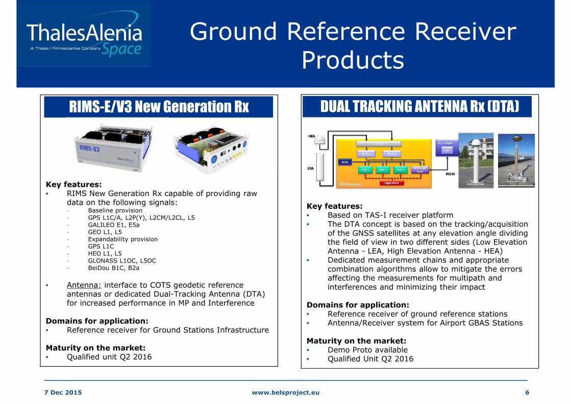
RIMS-E/V3 New Generation Rx
Key features:• RIMS New Generation Rx capable of providing raw
data on the following signals:- Baseline provision
- GPS L1C/A, L2P(Y), L2CM/L2CL, L5- GALILEO E1, E5a- GEO L1, L5- Expandability provision- GPS L1C- HEO L1, L5- GLONASS L1OC, L5OC- BeiDou B1C, B2a
• Antenna: interface to COTS geodetic reference antennas or dedicated Dual-Tracking Antenna (DTA) for increased performance in MP and Interference
Domains for application:• Reference receiver for Ground Stations Infrastructure
Maturity on the market:• Qualified unit Q2 2016
DUAL TRACKING ANTENNA Rx (DTA)
Key features:• Based on TAS-I receiver platform• The DTA concept is based on the tracking/acquisition
of the GNSS satellites at any elevation angle dividing the field of view in two different sides (Low Elevation Antenna - LEA, High Elevation Antenna - HEA)
• Dedicated measurement chains and appropriate combination algorithms allow to mitigate the errors affecting the measurements for multipath and interferences and minimizing their impact
Domains for application:• Reference receiver of ground reference stations• Antenna/Receiver system for Airport GBAS Stations
Maturity on the market:• Demo Proto available• Qualified Unit Q2 2016

www.belsproject.eu 77 Dec 2015
Multi-Constellation / Multi-Frequency Ground Receivers
COMMON PLATFORM SCALABLE ARCHITECTURE
• Designed for Ground Station Infrastructures & GNSS Networks
• Expandable to All-constellation / All-signals (GPS/GAL/GEO/GLO/BEI)
• State-of-Art Performance
• Robustness to environment for usage in harsh sites
- Interference: NB, WB, Pulse, Extreme
- Multipath: up to 6dB D/U
- Scintillation: extension to Equatorial/Polar Regions
• 11+1 Multicorr/Channel for EWF function (local / central)
• Digital I/Q samples output for RF Env Monitoring (RFEM)
• Interface to COTS geodetic antenna or DTA technology
• Adaptable external data interface
• Security Features
• Qualified to DO-254/278 standards
• TAS-I commitment to continuous Rx technology evolution

www.belsproject.eu 87 Dec 2015
GISMOIonospheric Monitoring Receiver
FLEXIBILITY & CONFIGURABILITY
Dual Frequency, Dual Constellation Signal Tracking
GPS/GAL: L1CA, L2c, L5/E5a
Tracking Loops Configurability (DLL/PLL BW, code/phase
discriminators)
Expandability: Channels expandability by adding boards in the Rx
ROBUSTNESSTracking Loops: PLL, FLL-aided-PLL, Kalman Filter PLL
Bit grabbing capability: Storage capability and post-processing I/Q data
OBSERVABILITY
Rate: Meas Rate configurable: 50, 20, 1 Hz (SNR and Carrier Phase)
Clock: Ultra stable OCXO: spectral purity (phase noise) and short term
(Allan deviation)
Ionospheric Products: S4, Sigma-Phi, TEC, ΔTEC, Iono Flag
Environmental Products: CCC Iono Free, Cycle Slip Flag, Interf. & MP Flags
Data Output: Rinex, ISMR, Binary High Rate Files
GISMO Reference Receiver
MISW, MONITOR, BELS Stations
EQUATORIAL REGIONS AFFECTED BY IONO
IONO MONITORING STATIONS FORMODELING & FORECAST TO USERS

www.belsproject.eu 97 Dec 2015
Space-borne GNSS Receivers

www.belsproject.eu 107 Dec 2015
Combined Ground/Space Iono Monitoring
GNSS-RO FROM SPACE A HIGH ACCURACY PROFILING TECHNIQUE
- Long Term Stability
- All-weather operation, Global 3D coverage
- High Vertical Resolution
• Exploit “co-located ground/space” observations
• Relative strengths of different measurements
• Space RO provides good vertical resolution combined
with ground based ionospheric tomography
• Physical modeling of neutral atmosphere using ground-
based and radio-occultation space data

www.belsproject.eu 117 Dec 2015
Earth Observation byGNSS Reflectometry
EARTH OBSERVATION FROM SPACE FOR AGRICULTURE
• Measure from satellite bio-geophysical
quantities: soil moisture, soil roughness and
plant water content
• GNSS Reflectometry based on interferometric
measurement of the reflected signal .vs. the
direct signal
• Allow retrieval of arrival time delay and of
properties of the reflecting surface
• GNSS-R implements a bistatic observation at L
band
• Low cost, increasing number of GNSS
transmitters, many specular points on earth
(high coverage), L-band penetrates into
vegetation and soil
Occulted GPS
radio occultation
navigation
scatterometry / altimetry
Ground receiver
TX TX

www.belsproject.eu 127 Dec 2015
MicroSatellite R&D for GNSS Remote Sensing
GNSS Remote Sensing Application (internal R&D):
- GNSS RADIO OCCULTATION: global meteorological predictions & space weather studies
- GNSS REFLECTOMETRY: land, vegetation and ocean studies
MICROSATELLITE BY ADDITIVE MANUFACTURING TECHNOLOGY (1.6m x 1m, 100Kg)

www.belsproject.eu 137 Dec 2015
RAIL Safety-Critical GNSS User Terminal
• RAIL User Terminal based on GNSS Rx + IMU
- Virtual Balise
- Enhanced Odometry
- Train Integrity (Train Head-Tail)
• Output Traveled Distance + Speed to Train On-Board Guidance System
• CENELEC Safety-Integrity-Level: SIL-2 (THR < 1e-7 / hr)
• Confidence level with TAS-I “Along-Track Protection Level” algorithm provides error over-bound
• The confidence level is the range around the provided distance (velocity) within which the true distance (velocity) lays with a probability of 5σ
FIELD TESTS ON HIGH-SPEED LINES
IN SPAIN (MADRID-BARCELONA)
TAS-I GRAIL USER TERMINAL AND PEGASUS RECEIVER0 500 1000 1500 2000 2500 3000 3500 4000
-300
-200
-100
0
100
200
300D S A ou tpu t d is tanc e erro r envelope
Dis
tanc
e E
rror
[m
]
t im e [s ]
K *C *s q rt (t ) fit t ing
K *s td (D is tanc e E rro r)D is tanc e E rro r
IMU
GNSS TERMINAL PEGASUS Rx

www.belsproject.eu 147 Dec 2015
Thales Alenia SpaceResearch & Technology Activities
- Advanced Antennas (simple DBF)
- RF Direct Sampling & DDC
- GNSS waveforms (SCA-like
architectures)
- Algorithms for robust tracking,
adaptive filtering, hybridization,
confidence bounds
- GNSS Remote Sensing techniques
1. Multi-constellation
Multi-Frequency
scalable architecture
2. Robustness to RF
environments
3. Performance
4. Integrity & Continuity
Needs TechnologiesGNSS Receivers
Reference
Safety Critical
Space

www.belsproject.eu 157 Dec 2015
Collaborations
• TESTS IN NAVIS HUST CENTER (HANOI) IN THE FRAME OF BELS PROGRAM:
– TASI will install a GISMO Iono Receiver in Hanoi to perform measurements
and analyse performance in presence of scintillation within this region
• TAS-I READY TO COLLABORATE WITH SOUTH EAST ASIA INSTITUTIONS in the
fields of GNSS Equipment, Technologies and Applications related to:
– GNSS Ground Infrastructures
– Ionospheric Monitoring Networks
– Remote Sensing by use of GNSS signals
– Rail Safety-Critical Applications
• TAS-I READY TO HOST RESEARCH STUDENTS FOR STAGE PERIODS IN ITALIAN
SITES

www.belsproject.eu 167 Dec 2015
LIVIO MARRADI
Thales Alenia Space Italia
Via E. Mattei 1, Gorgonzola (Milano)
E-MAIL: [email protected]
PHONE: +39 0225075361
CONTACT