overview of remote sensing applications for cultural heritage...
TRANSCRIPT

Overview of Remote Sensing applications for Cultural Heritage in Cyprus in the “Pre-ESA” era
Athos Agapiou, Vasiliki Lysandrou, Branka Cuca*, Kyriacos Themistocleous and Diofantos G. Hadjimitsis
*Department of civil Engineering and Geomatics Cyprus University of Technology
Department of Architecture, Built Environment and Construction
Politecnico di Milano [email protected] | [email protected]
ADVANCES IN REMOTE SENSING FOR CULTURAL HERITAGE: FROM SITE DETECTION, TO DOCUMENTATION AND RISK MONITORING
12 - 13 November 2015 | ESA - ESRIN | Frascati (Rome), Italy
Intro Examples of integration of RS technologies for
Cultural Heritage in Cyprus • Marine Spatial Planning (MSP) as a tool for
CH protection • Risk maps • Detection of buried archaeological remains
based on RS data • Low altitude airborne systems Conclusions

Interreg CY-GR Marine Spatial Planning (MSP)
Thal-Hor: http://mspcygr.info/
Η Πράξη συγχρηματοδοτείται κατά 80% από την Ευρωπαϊκή Ένωση (ΕΤΠΑ) και κατά 20% από εθνικούς πόρους της Ελλάδας και της Κύπρου
Πρόγραμμα Διασυνοριακής Συνεργασίας Ελλάδα – Κύπρος 2007 – 2013
Marine Spatial Planning (MSP) as a tool for mapping, monitoring, protection and management of coastal areas (including Cultural Heritage)

Marine Spatial Planning (MSP) as a tool for mapping, monitoring, protection and management of Cultural Heritage: the case study if Nea Paphos Archaeological site The coastal zones including important cultural heritage sites are more affected by various activities with permanent impacts to CH (land use, ports, fisheries, ship routes, bathymetry, energy centers) thus evidencing the need for a priori planning and management decisions. In the case study of Nea Paphos archaeological site and the surrounding protected zones (red dots in the figure) a significant number of other activities are taking place.
Cumulative number of MSP activities in the island of Cyprus, in the area of Nea Paphos UNESCO World Heritage site. Archaeological sites are indicated with red dots (Maps from “Cross-Border Cooperation for the development of Marine Spatial Planning” project ©)

Sources used: low, medium and high resolution images (MODIS; Landsat; QuickBird) and satellite products (ASTER Global Digital Elevation Model, ASTER GDEM). The overall risk analysis assessed on the Analytic Hierarchy Process (AHP) methodology. Benefits: each hazard (and therefore the overall risk
assessment of an area) can be re-evaluated after a short period of time.
This aspect is seen as particularly beneficial if the stakeholders (e.g. Public Authorities) require updated information.
Marine Spatial Planning (MSP) as a tool for mapping, monitoring, protection and management of Cultural Heritage: the case study if Nea Paphos Archaeological site

An extremely sensitive area related to the MSP of Cyprus is oberved in Limassol district, between Zygi - Vasilikos villages as well as to the area of the Port of Limassol, where more than 50 conflicts between the various activities have been recorded.

Due to the significant archaeological and historical importance of Nea Paphos site, major land use changes over the years were prevented over the years. However, the site is under a “pressure” of other conflicted activities just at the outskirts of the protected areas

RISK MAPS HR QuickBird images: landslides and erosion parameters calculations; Landsat 5TM, 7ETM+: urban expansion, landslides, salinity and road network; MODIS images: Burned Areas over the Paphos region; Calibrated DMSP-OLS night-time data set for 2010 used for mapping urban areas ; ASTER GDEM: detecting neotectonic activity as well mapping the drainage network.
Figure on the right shows: (a) Landslides map: very high and high hazard areas in red; (b) Erosion map: soil loss greater than the mid value in red; (c) Salinity map: CH areas in proximity to the sea suffering from salinity impact in red; (d) Tectonic activity; (e) Urban expansion; (f) Road network proximity (250 m) to CH sites; (g) Drainage network (50 meter buffer zone) and (h) Fires map: observed during the period 2010-2013
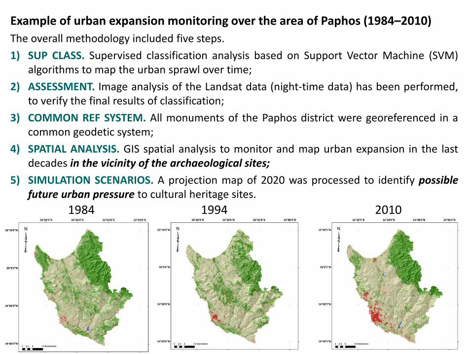
Example of urban expansion monitoring over the area of Paphos (1984–2010) The overall methodology included five steps. 1) SUP CLASS. Supervised classification analysis based on Support Vector Machine (SVM)
algorithms to map the urban sprawl over time; 2) ASSESSMENT. Image analysis of the Landsat data (night-time data) has been performed,
to verify the final results of classification; 3) COMMON REF SYSTEM. All monuments of the Paphos district were georeferenced in a
common geodetic system; 4) SPATIAL ANALYSIS. GIS spatial analysis to monitor and map urban expansion in the last
decades in the vicinity of the archaeological sites; 5) SIMULATION SCENARIOS. A projection map of 2020 was processed to identify possible
future urban pressure to cultural heritage sites. 1984 1994 2010

Urban expansion of the town of Paphos from 1984 to 2010. Legend: Black colour urban areas in 1984; Orange urban areas of 1990; Red colour urban areas of 2000; Green colour urban areas of 2010.

0,00
10,00
20,00
30,00
40,00
50,00
60,00
70,00
80,00
1984 1990 2000 2010
Land
use
cov
er (%
)
Year
Land use change in a distance of 500m arround archaeological sites of Paphos district
Urban
Soil
Vegetation
Land use change of Paphos District WITHIN the BUFFER ZONE (500m)

0,00
2,00
4,00
6,00
8,00
10,00
12,00
14,00
16,00
1984 1990 2000 2010
Land
use
cov
er (%
)
Year
Land use change in a distance of 500m arround archaeological sites of Paphos district
Urban
Rescue Excavations!!!
Land use change of Paphos District WITHIN the BUFFER ZONE (500m)

Results: The classification results urban expansion has been increased by 350%
during the last 35 years (1984-2010). The building boom in Paphos town was relatively sudden and abrupt, due
to large population movements in areas remaining undeveloped since the 1980s.
This phenomenon of urbanization resulted in extensive archaeological excavations for rescue purposes;
This phenomenon is actively documented in the Annual Reports of the Department of Antiquities of Cyprus (1980-2008) an almost absent reference to Paphos with reports on the active on-going excavations in the area was replaced from the mid-1980s onwards.

Paphos before 1940s
SOMETHING OLD, SOMETHING NEW… Detection of buried archaeological remains based on RS data Images below from Italian Geographic Military Institute (IGM)

A ground survey has confirmed several cases of vanishing traces of the landscape visible in the images of 1945 (aerial flight left)

Burried treasures – the example of the amphiteathre of the Nea Paphos archaeological site

Aerial and Satellite observations
Soil mark as seen from different sources: topographic map (top left); aerial image from 1993 (top right); GeoEye (middle left); QuickBird (middle right); IKONOS (down left) and GeoEye (down right)
A grayscale aerial image taken in the ‘40s over the area clearly shows an elliptical shape buried archaeological feature in the area. An entrance form is visible at the western part, while three different levels (“terraces”) are observed

Results from IKONOS dataset from Nea Paphos archaeological site (34°45'17.92"N, 32°24'19.39"E). (a) RGB composite; (b) NIR-R-G composite; (c) linear transformation RGB
pseudo colour; (d) first component; (e) second component; (f) third component; (g) NDVI; (h) PCA composite; (i) first PCA
component; (j) second PCA component; and (k) third PCA component.
A burried feature of eliptic shape (supposatly an amphiteatre?)

GPS survey and Spectral signature
Profile of the site is clearly visible from the GPS survey, indicating several geo-morphologic layers
Spectral profiles from the central section of the crop mark confirm the presence of a buried feature
GPS results in ArcScene: altimetry changes of landscape clearly visible

High Pass Filter (HPF) transformation over “Nea Paphos archaeological site using archive aerial image taken in 1945 and recently aerial RGB orthophotos taken in 2008 clear indications of VANISHING CULTURAL LANDSCAPE

Low altitude airborne systems - UAV

UAV photography

UAV photography

UAV photography

2 cm
UAV photography
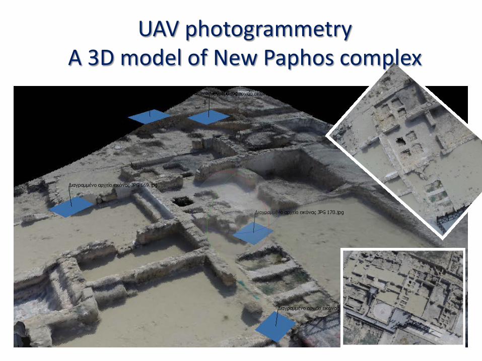
UAV photogrammetry A 3D model of New Paphos complex

UAV photogrammetric applications – orthophoto
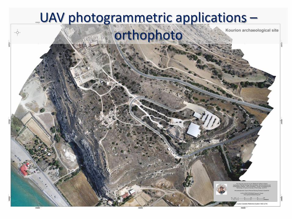
UAV photogrammetric applications – orthophoto

UAV photogrammetric applications – DEM


Excavation season in Old Paphos area (Kouklia village) with Archaeologists of University of Cyprus Site of Hadjiabdulah

Summary • Significant amount of Cultural Heritage relevant for the history of
the region and of Europe is found in Cyprus; • Long history of archaeological excavations but recent expanding
phenomenon of «rescue» escavations (due to scarsly planned urban development and climate changes);
• An increasing level of awareness towards RS technologies by the end-users and decision makers;
• Significant survey and scientific efforts in order toproperly document and study cultural heritage and landcsape of Cyprus (especially with regards to areas under pressures);
• Awarness of the added value given by the integration of technologies (satellite, ground truth, spectroradiometers, UAV, terrestrial survey etc.) and by a common spatial data framework;
• Presence of active scientific community.

Most recent experience of CUT Partecipation as partner in 2 JPI projects on Remote Sensing for Cultural Heritage: «CLIMA» and «PROTHEGO» Coodinator of the 3 year TWIN project «ATHENA - Remote Sensing Science Center for Cultural Heritage », HORIZON2020 with German Aerospace Agency (DLR) and Italian National Research Centre (CNR)
Starting date ::: 1 December 2015 :::

4th International Conference RSCy 2016, 8-10 April 2016 ::: WELCOME ::: Call for abstract OPEN http://www.cyprusremotesensing.com/rscy2016/
WORKSHOP / SPECIAL SESSION ON USES OF REMOTE SENSING FOR CULTRAL HERITAGE AND LANDSCAPES
::: TO BE ANNOUNCED SHORTLY :::

http://www.cyprusremotesensing.com/
THANK YOU!!! An insight into space and remote sensing technologies concerning
agriculture and landscape analysis
Branka Cuca