overview land reform in rwanda - world banksiteresources.worldbank.org/intard/resources/335807...and...
TRANSCRIPT

Land Reform in Rwanda - Technology & the Land Tenure Regularisation Process -
Presentation Bahar Dar Workshop
Ethiopia
11 – 12 May 2009
HTSPE (UK), Premier Consulting Group (Rwanda),
Matrix (Kenya)

"
""
"
"
""
" "
"
"
"
"
"
"
"
"
"
"
"
"
"
"
"
"
"""
"
"
INTARA Y'IBURASIRAZUBA
INTARA Y'AMAJYEPFO
INTARA Y'IBURENGERAZUBA
INTARA Y'AMAJYARUGURU
UMUJYI WA KIGALI
KAYONZA
GATSIBO
KIREHE
NYAGATARE
RUSIZI
RUTSIRO
BUGESERA
NGOMA
KARONGI
HUYE
GICUMBI
NYAMAGABE
NYAMASHEKENYANZA
NYARUGURU
BURERA
GAKENKE
KAMONYI
GISAGARA
MUHANGA
RULINDO
RUHANGO
NYABIHU
MUSANZE
RWAMAGANA
NGOROREROGASABO
RUBAVU
KICUKIRONYARUGENGE
.
Insobanuro
" Ibiro by'Akarere
Imbibi z'Intara n'Umujyi wa Kigali
Imbibi z'Akarere
Pariki
Ikiyaga
© Institut National de la Statistique du Rwanda, Novembre 2005
IKARITA NSHYA IGARAGAZA IMBIBI Z'INTARA, UTURERE N'UMUJYI WA KIGALI
10 0 105 Km
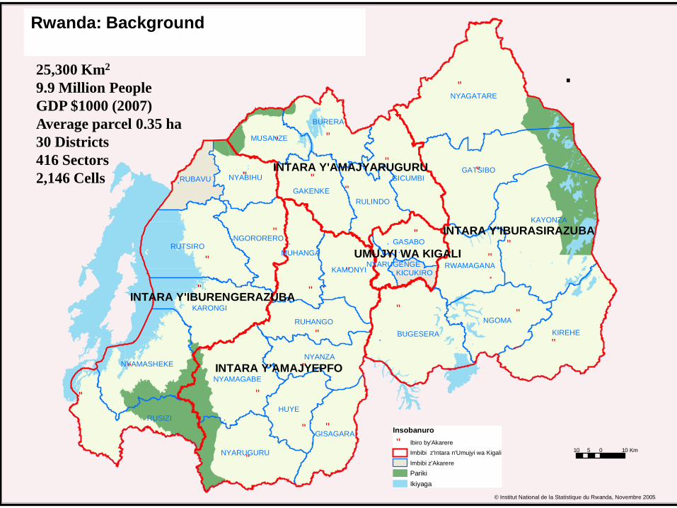
25,300 Km2
9.9 Million People
GDP $1000 (2007)
Average parcel 0.35 ha
30 Districts
416 Sectors
2,146 Cells
Rwanda: Background

Regulatory Framework
• Chain of Legislation from Constitution 2003 to
National Land Policy 2004 to Land Law – the
Organic Land Law 2005
• Progressed to drafting of orders and decrees
(2006) that set the details for planning and land
administration

Salient Features Organic Land Law (OLL)
• Defines rights in land – customary tenure effectively abolished but rights previously obtained are protected
• All land in country has to be registered and titled –forms of tenure - dispute resolution will be required
• Sets out institutional arrangements central and district levels and below – to enable effective implementation
• Meeting urban and rural requirements in a unified
system
• Requires a rational land planning framework for country
•

Land Governance Institutions
• Centralised Office of the Registrar housed within a National Land Centre (NLC) – handle mostly land administration and planning issues sets procedures and standards for land administration
• District Land Bureaux to handle all district land issues, planning and land administration (30 in number) and liaise with sectors and cells.
• National and District Land Commissions to oversee work of the NLC and the Districts.
• Strong Sector and Cell involvement ensures there is space for maximum local participation and transparency
Ministry of Natural Resources (MINIRENA)

National Land Commission
National Land Centre
District Land Commission
District Land Bureaux
Sector Land Committees
Cell Land Committees
Landholders
MINIRENA
The Registrar of Land Titles (Director General)
Office of the Registrar (five deputy registrars)
with Land Tenure Regularisation Support Team for first
Registration
Land Management
Planning Unit
Land Information,
Survey and Mapping
Finance and
Internal Resources
Office of the Deputy Director General (Technical)
Current Institutional Structure

Field Testing and Research
Field Consultations 2006;to gain understanding of what was required. These
consultations provided direction for
Field trials and analysis 2007-08;test acceptability, buy-in and appropriate systems for
implementation of the law. This provided the basis for
Monitoring and Evaluation 2008;how trials had worked and collect baseline information
outside of the trials areas
Ministry of Lands, Environment, Forestry, Water and Mines
(MINITERE)
1
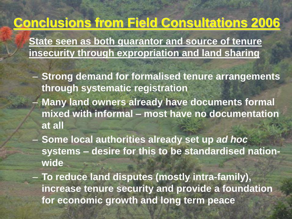
Conclusions from Field Consultations 2006
State seen as both guarantor and source of tenure
insecurity through expropriation and land sharing
– Strong demand for formalised tenure arrangements
through systematic registration
– Many land owners already have documents formal
mixed with informal – most have no documentation
at all
– Some local authorities already set up ad hoc
systems – desire for this to be standardised nation-
wide
– To reduce land disputes (mostly intra-family),
increase tenure security and provide a foundation
for economic growth and long term peace
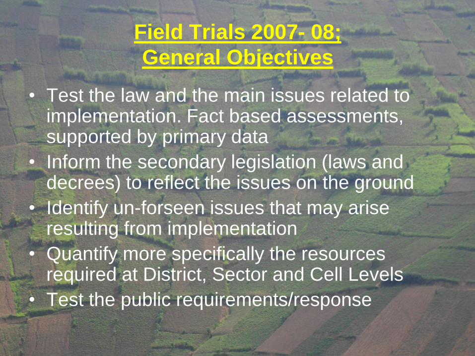
Field Trials 2007- 08;
General Objectives
• Test the law and the main issues related to implementation. Fact based assessments, supported by primary data
• Inform the secondary legislation (laws and decrees) to reflect the issues on the ground
• Identify un-forseen issues that may arise resulting from implementation
• Quantify more specifically the resources required at District, Sector and Cell Levels
• Test the public requirements/response

Land Tenure Regularisation (LTR) –
the guiding principlesLTR is an administrative procedure undertaken for the purpose of recognising and securing existing rights that people and organisations other than the State have to, in or over land in Rwanda and to convert those into legally recognised rights.
• Establishing rights and obligations in land
• Transparent mechanism for resolving disputes
• Open process based on active Public Participation
• Just administration
• Low tech and low cost model programme that can be adapted and is replicable in all areas
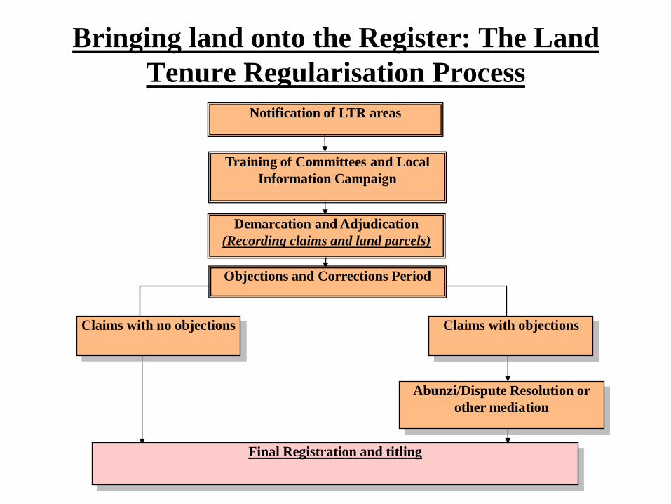
Bringing land onto the Register: The Land
Tenure Regularisation Process
Final Registration and titling
Notification of LTR areas
Demarcation and Adjudication
(Recording claims and land parcels)
Claims with no objections
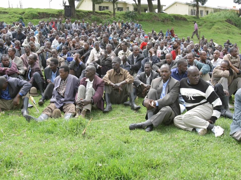
Training of Committees and Local
Information Campaign
Objections and Corrections Period
Claims with objections
Abunzi/Dispute Resolution or
other mediation

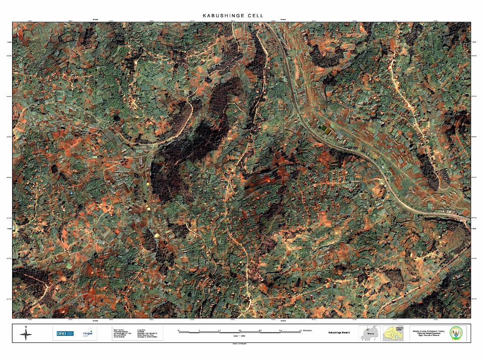
Kabushinge
MwogaBiguhu
Nyamugali
Kigali
Trial Cells
Kirehe
Karongi
Musanze

Four AreasProvince
District Sector CellHH
(no)
Umudugudu
(no)
Parcels
(no)
Total
(Ha)
West Karongi Ruganda Biguhu 358 8 3,019 740
North Musanze Rwaza Kabushinge 1,118 8 7,432 584
Kigali Gasabo Gatsata Nyamugali 1,200 5 1,562 66
East Kirehe Muhama Mwoga 837 5 2,895 2,058
Total 3,513 26 14,908 3,448
Analyse records acquired to gain an understanding of;
1. how land is held and transferred,
2. analysis of local land markets and ‘means of access’ to land
3. supporting evidence documents and community attestation
4. family arrangements for land allocation and use (gender family/household
issues, inheritance, polygamy etc
5. test arrangements for formal documentation and institutional structures
6. disputes – number, nature, typology
7. parcel sizes, no, of parcels held per household (holding), size of holding

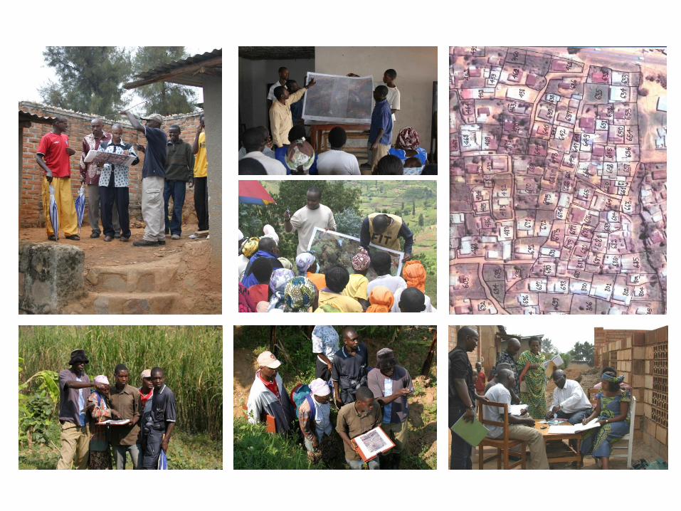
Recording claims and land parcels- a participatory low cost, low tech approach -
Human Resources
• Each Field Team consisted of 2 - 4 para surveyors and 8 to 10 members of adjudication committee (4 – 5 village representatives and 4 –5 Cell land committee members)
• One Field Manager supervising all field teams
• One qualified Surveyor for technical backstopping and initial training of para surveyors (3 days); experienced para surveyors training new para surveyors (ToT principle)
• Claimant and Neighbours

Recording claims and land parcels- a participatory low cost, low tech approach -
Technical Resources• Quick Bird Imagery (2 archive images (2004) & 2 new
images; orthocorrected (Erdas) and georeferenced)
• These were tiled and printed at 1:2000 image
• Images divided into printed (colored) field worksheets and laminated
• In the field overlaid with transparent upon which agreed upon parcel boundaries were sketched
• At end of the day transparent indexed (UPI) and digitized.
• Arial Photography (low level) used in urban areas for 1:1000 images

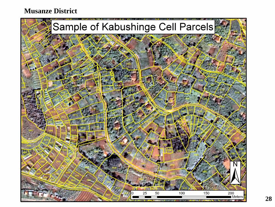
28
Musanze District
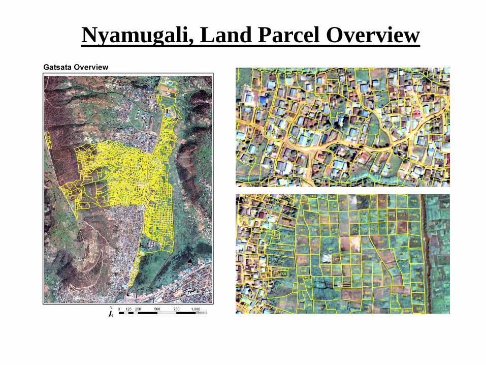
Nyamugali, Land Parcel Overview
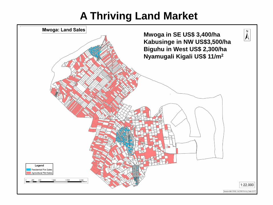
A Thriving Land Market
Mwoga in SE US$ 3,400/ha
Kabusinge in NW US$3,500/ha
Biguhu in West US$ 2,300/ha
Nyamugali Kigali US$ 11/m2
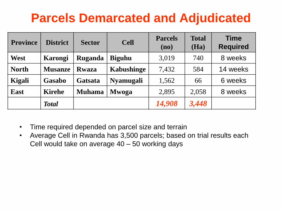
Parcels Demarcated and Adjudicated
Province District Sector CellParcels
(no)
Total
(Ha)
Time
Required
West Karongi Ruganda Biguhu 3,019 740 8 weeks
North Musanze Rwaza Kabushinge 7,432 584 14 weeks
Kigali Gasabo Gatsata Nyamugali 1,562 66 6 weeks
East Kirehe Muhama Mwoga 2,895 2,058 8 weeks
Total 14,908 3,448
• Time required depended on parcel size and terrain
• Average Cell in Rwanda has 3,500 parcels; based on trial results each
Cell would take on average 40 – 50 working days
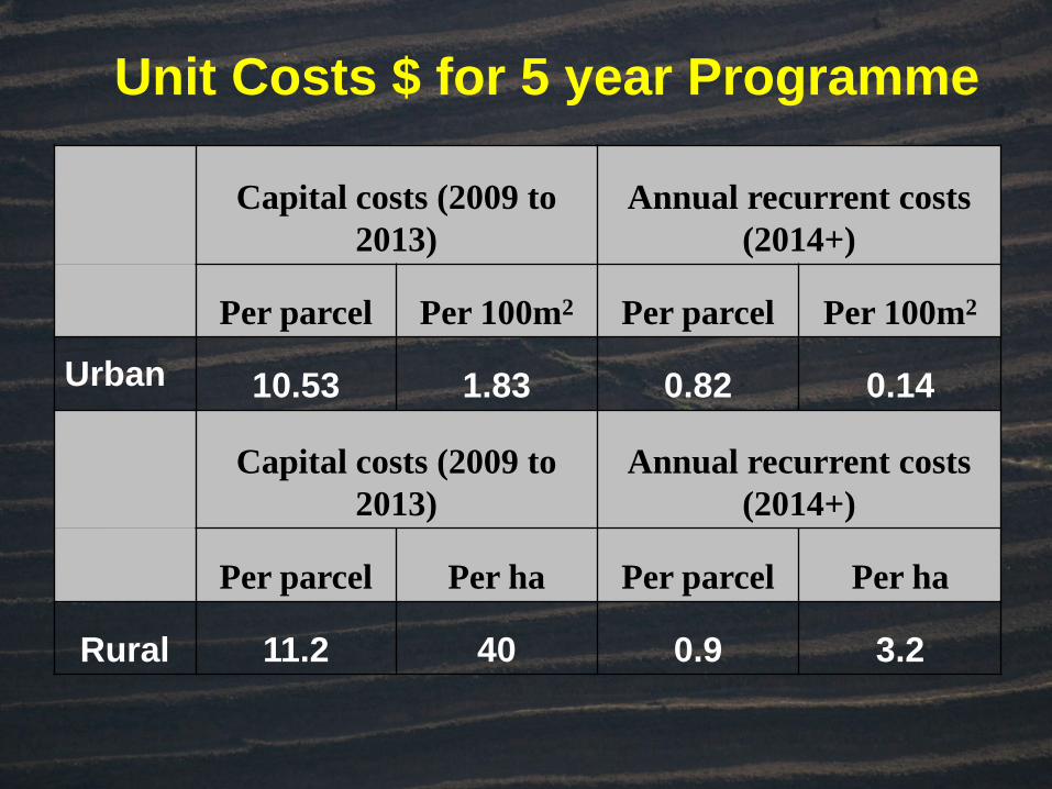
Capital costs (2009 to
2013)
Annual recurrent costs
(2014+)
Per parcel Per 100m2 Per parcel Per 100m2
Urban 10.53 1.83 0.82 0.14
Capital costs (2009 to
2013)
Annual recurrent costs
(2014+)
Per parcel Per ha Per parcel Per ha
Rural 11.2 40 0.9 3.2
Unit Costs $ for 5 year Programme
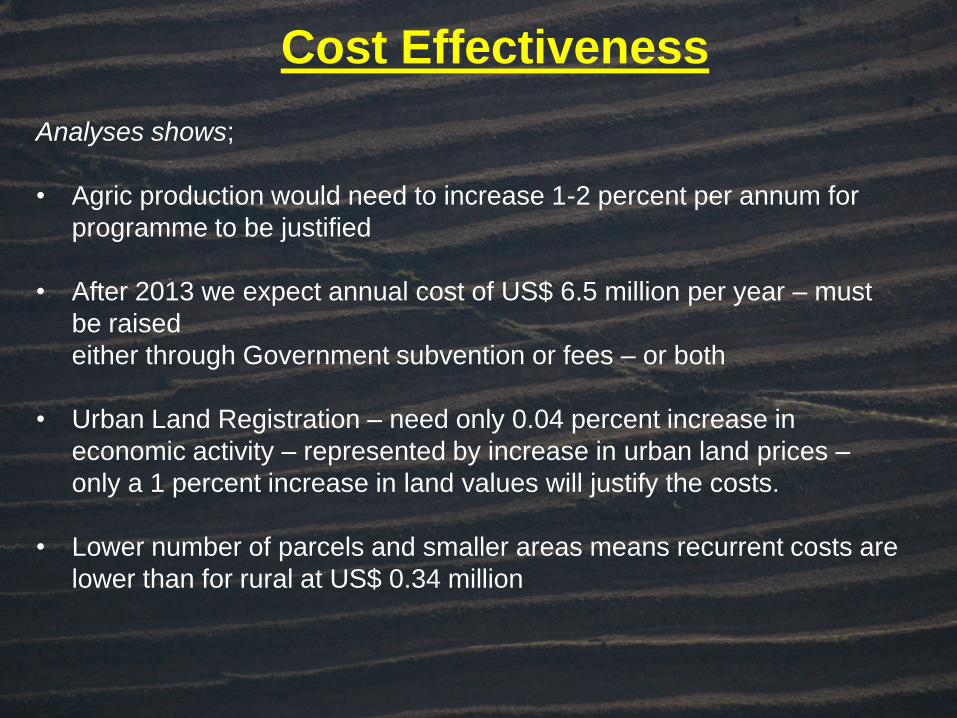
Cost Effectiveness
Analyses shows;
• Agric production would need to increase 1-2 percent per annum for
programme to be justified
• After 2013 we expect annual cost of US$ 6.5 million per year – must
be raised
either through Government subvention or fees – or both
• Urban Land Registration – need only 0.04 percent increase in
economic activity – represented by increase in urban land prices –
only a 1 percent increase in land values will justify the costs.
• Lower number of parcels and smaller areas means recurrent costs are
lower than for rural at US$ 0.34 million

Can LTR be replicated in other countries?
Five Critical LTR Success Factors
• High Population Density & Land Scarcity
• On balance State is perceived to be fair, impartial and
acting
• LTR is transparent & participatory
• Economic and financial Cost-Benefit for people is positive
• Speedy and cost effective