outstanding geologic feature of pennsylvania
TRANSCRIPT
Location Ohiopyle State Park, Fayette Co., Stewart Twp., lat: 39.84490, lon: -79.47371 (parking); lat: 39.844638, lon: -79.473026 (vista); Ohiopyle 7.5-minute quadrangle
Recommended Reading
Speicher, Renee, 2019, Rocks and water—the conflict of a typist in a geologist’s world—Reflections from the Pennsylvania Geological Survey staff field trip to Ohiopyle State Park, Pennsylvania, April 2019: Pennsylvania Geology, v. 49, no. 1, p. 12–19.
Ohiopyle State Park web page of DCNR.
OUTSTANDING GEOLOGIC FEATURE OF PENNSYLVANIA
BAUGHMAN ROCK, FAYETTE COUNTY James Shaulis and Stuart O. Reese, 2020
Trail of Geology
20–121.0
Published by the Pennsylvania Geological Survey.
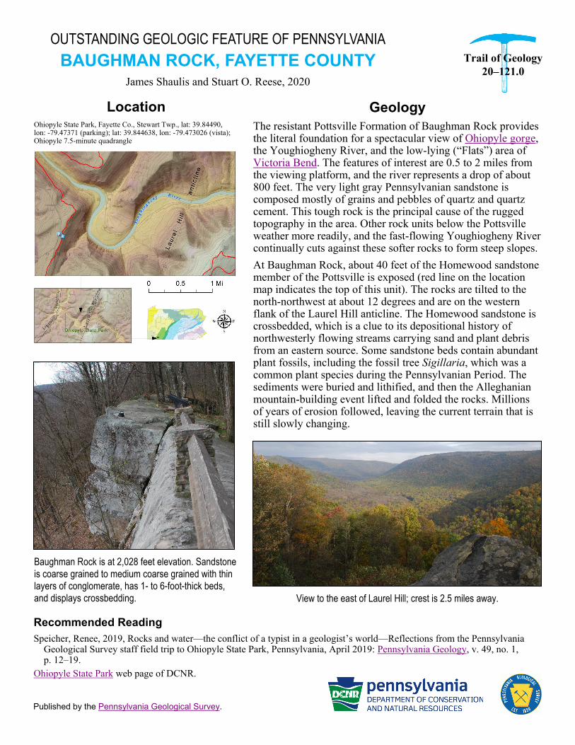
Baughman Rock is at 2,028 feet elevation. Sandstone
is coarse grained to medium coarse grained with thin layers of conglomerate, has 1- to 6-foot-thick beds,
and displays crossbedding.
Geology
The resistant Pottsville Formation of Baughman Rock provides the literal foundation for a spectacular view of Ohiopyle gorge, the Youghiogheny River, and the low-lying (“Flats”) area of Victoria Bend. The features of interest are 0.5 to 2 miles from the viewing platform, and the river represents a drop of about 800 feet. The very light gray Pennsylvanian sandstone is composed mostly of grains and pebbles of quartz and quartz cement. This tough rock is the principal cause of the rugged topography in the area. Other rock units below the Pottsville weather more readily, and the fast-flowing Youghiogheny River continually cuts against these softer rocks to form steep slopes.
At Baughman Rock, about 40 feet of the Homewood sandstone member of the Pottsville is exposed (red line on the location map indicates the top of this unit). The rocks are tilted to the north-northwest at about 12 degrees and are on the western flank of the Laurel Hill anticline. The Homewood sandstone is crossbedded, which is a clue to its depositional history of northwesterly flowing streams carrying sand and plant debris from an eastern source. Some sandstone beds contain abundant plant fossils, including the fossil tree Sigillaria, which was a common plant species during the Pennsylvanian Period. The sediments were buried and lithified, and then the Alleghanian mountain-building event lifted and folded the rocks. Millions of years of erosion followed, leaving the current terrain that is still slowly changing.
View to the east of Laurel Hill; crest is 2.5 miles away.