oro loma and castro valley sanitary districts to … · the oro loma experiment will research how...
TRANSCRIPT
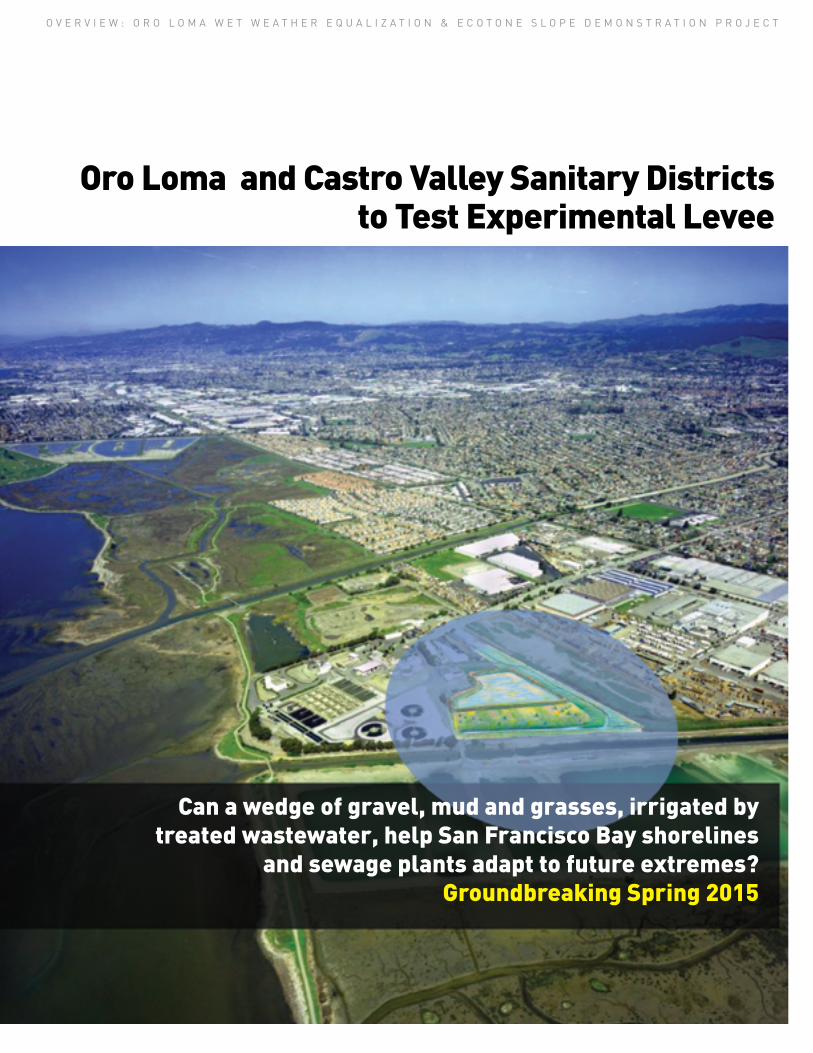
Oro Loma and Castro Valley Sanitary Districts to Test Experimental Levee
O V E R V I E W : O R O L O M A W E T W E A T H E R E Q U A L I Z A T I O N & E C O T O N E S L O P E D E M O N S T R A T I O N P R O J E C T
Can a wedge of gravel, mud and grasses, irrigated by treated wastewater, help San Francisco Bay shorelines
and sewage plants adapt to future extremes? Groundbreaking Spring 2015
When we built our roads, pipelines, airports and other critical infrastructure on the shores of San Francisco Bay, no one imagined the sea level would rise so fast in the 21st century. The National Research Council projects a regional rise for San Francisco Bay of 5-24 inches by 2050 and 17-66 inches by 2100. The Na-tional Oceanic and Atmospheric Admin-istration lists the Bay Area as one of the top ten most vulnerable metropolitan regions in the country. As the ice caps melt and the Pacific Ocean expands, ex-perts predict that water levels in the Bay will climb more rapidly than ever before. Meanwhile changes in the atmosphere may make storms more extreme.
The region has always been forward- thinking, however. Those in charge of the infrastructure now in harms way are making plans, and not all of them involve taller sea walls. This spring, a 10-acre field adjacent to the Oro Loma wastewater treatment and purification plant in San Lorenzo will be the site of an experiment testing ways in which the plant can use a basin to accommodate peak flows while taking a more natural approach to shoreline protection. If it works, experts hope the project can be a new model for adapting critical infrastructure at the Bay’s edge to climate change.
HISTORY
When a New Year storm sent Bay waves crashing over local levees in 2005, regional park manager Mark Taylor showed slides of the event to the Hayward Area Shoreline Planning Association (HASPA). This group, formed in the 1970s, realized sea level rise could worsen such events in the future. In 2008, aided by then City Councilmem-ber Bill Quirk of Hayward, HASPA hired consultants Philip Williams and Associ-ates (now ESA) to evaluate the potential impacts of sea level rise on the shore between San Lorenzo Creek and the San Mateo Bridge. This was one of the Bay Area’s first serious planning efforts around sea level rise. By 2010, all this legwork had made the Hayward shore a perfect pilot project for the San Francis-co Bay Conservation and Development Commission’s fledgling Adapting to Rising Tides program (ART). Under the program, local agencies and surround-ing jurisdictions worked with ART to pinpoint Hayward area facilities and shores at risk and explore adaptation proposals.
One proposal by Peter Baye and ESA was to create a new type of levee to mimic the natural slope from historic wetlands into upland areas. If planted with sedges and grasses, and irrigated with treated wastewater, this wedge of habitat, built alongside the new levee, could slow down waves, resist floods, and protect infrastructure and homes in the Bay Area flats. They called it an “ecotone slope.” (Ecotone refers to those areas between different natural systems, such as land and water, or field and forest).
Elsewhere around the Bay Area, people began describing similar kinds of ideas as “horizontal” or “laid back” or “habitat” levees. In any case, such pro-posals embraced concepts that have been floated by local biologists and restoration managers ever since they recognized the severity of sea level rise threats to their painstakingly-rebuilt bayland habitats.
When the Oro Loma Sanitary District offered a site for testing some of these adaptation ideas in 2012, sup-port for the project grew. The district felt it would be a good investment in its future ability to provide services to its 46,000 customers, and to protect its facilities, in any kind of weather or flood condition.
Triple Win? Water Quality, Flood Protection, Wildlife Habitat
PROJECT & PARTNERS
Oro Loma’s project will turn a degraded diked bayland behind a wastewater treatment plant into an outdoor laboratory. On this flat, weedy field, construction crews will create two things: first, a two-acre wetland basin that can both remove nutrients from wastewater and provide extra wet weather storage capacity; and second, on one side of the basin, the experi-mental levee. Wastewater that has al-ready undergone secondary treatment (required by Clean Water Act protec-tions to prepare it for discharge into San Francisco Bay) will pass first across the surface of the basin and treatment wetland, and second through the levee and down into the sub-layers of 1.4 acres of experimental habitat slope. The idea is that the combina-tion of treatment wetlands and newly designed habitats, and surface and sub-surface filtering processes, will sup-port native plants and purify the water enough so that one day this kind of system can be directly connected to the Bay edge.
Oro Loma expects to start con-struction in spring 2015 and begin operating the experimental levee in early 2016. Construction is expected to end by late 2016, but researchers expect to monitor the results for up to a decade. Project partners include the Oro Loma and Castro Valley Sanitary Districts, which co-own the treatment plant, and the East Bay Dischargers Authority (for brevity’s sake, however, subsequent references throughout this overview refer only to Oro Loma). Oro Loma also collaborated with the San Francisco Estuary Partnership to get funding through the Integrated Regional Water Management Pro-gram. Project consultants include Jeremy Lowe, ESA Associates; Peter Baye; Whitley Burchett and Associates; David Sedlak and Alex Horne, ReNU-WIt, UC Berkeley; The Bay Institute and Save The Bay. The approximately $7 million project budget is being covered largely by the two sanitary districts and an IRWMP grant of $2.1 million from California’s Department of Water Resources.
MORE THAN A TREATMENT WETLAND
Wastewater treatment plants have long used wetlands for additional treat-ment of municipal wastewater effluent; it is well known that the natural bacteri-al and biological processes in wetlands can break down contaminants and remove nutrients that cause excessive algal growth in the Bay. In the Oro Loma experiment, the new treatment wetland and basin will not only enhance the quality of the treated wastewater be-fore it reaches the ecotone slope, it will
also do critical double duty as a storage facility during wet weather. During a storm or peak flow event, the basin is designed to store up to 8 million gallons of enhanced primary treated wastewater. Once rainfall subsides, this wastewater can be returned to the plant for more treatment.
BAY AREA INFRASTRUCTURE AT RISK
8-10 wastewater treatment plants
9-15 power plants
208-235 hazardous waste sites
1,450-1,780 miles roads & highways
140-170 miles railroad track
4 airports
Up to 270,000 residents in the flood zone
$49-$62 billion property
Shoreline parks & trails
Source: Pacific Institute 2012
“Even if we cut our greenhouse
gas emissions drastically, sea level
will continue to rise. Today’s flood-
ing during king tides or storms will
become less infrequent and more
the norm. Everyone recognizes this
is something much bigger than we
can solve on our own. Even if we’re
just talking about building up our
own levees, it’s such an
expensive proposition.“
ERIK PEARSON ENVIRONMENTAL SERVICES DIRECTOR, CITY OF HAYWARD
“If you can create a really
wide levee, roughened up by a
covering of plants, it will slow down
waves, and maybe you can actually
build a smaller levee. Also, what
we’re building in these cases is not
technically a levee, but a sloping
terrace, or ramp, against a levee.“ PETER BAYE COASTAL ECOLOGIST
O V E R V I E W : O R O L O M A W E T W E A T H E R E Q U A L I Z A T I O N & E C O T O N E S L O P E D E M O N S T R A T I O N P R O J E C T2
Freshwater treatment wetlandWet weather storage LeveeLeveeEcotone slopeChannel
Control structurePercolation trench
with perforated pipe
Abandonbayshore
levee
SF Bay
SF Bay
Restore wetlandWave attenuation
Buildleveeinland
Wave attenuation
Tidal marsh Brackish marsh Freshwater swale
Over�ow
Seepage
Treated wastewater& stormwater
Options for more resilient levees, habitats and shoreline protection. Top: moving the levee inland and buffering it with a wetland; middle, elements of Oro Loma experiment; bottom; profile of possible future shoreline gradient from fresh to salt water habitats. Source: ESA
2005 storm overtops Hayward Shoreline levees. Inset: Same levee after storm. Lower photo: Mark Taylor
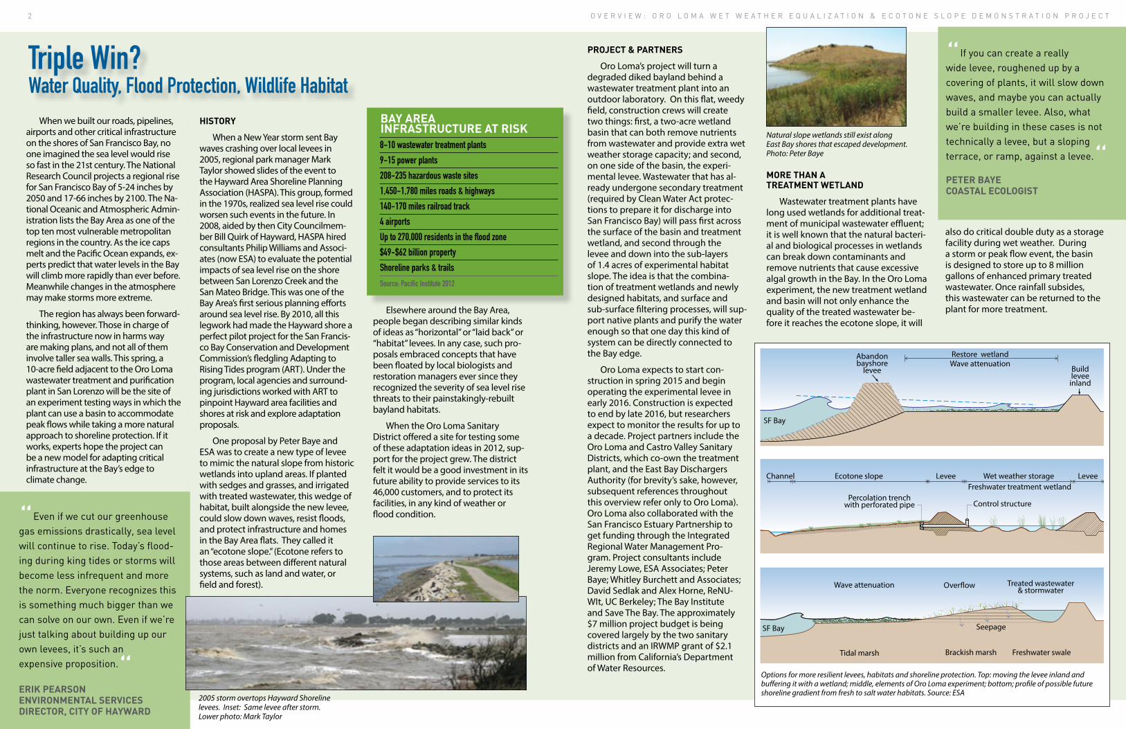
Natural slope wetlands still exist along East Bay shores that escaped development. Photo: Peter Baye

The Oro Loma experiment will research how to engineer some important missing elements in the natural landscape back into the shoreline. The region has done a good job of learning how to recreate salt marshes, but most have little connection left to the creek mouths, moist mead-ows, cattail thickets, willow groves and barrier beaches that once served as transi-tion zones, or “ecotones,” between tidal habitats and terrestrial ones. Instead, our marshes and beaches more often back up directly on levees separating them from homes, industries and cities. The region may not be able to salvage historic creek connections in many areas, but it does have a reliable source of freshwater in the same zone: pipelines used for the distribution and discharge of treated wastewater along the East Bay shore. This water source, currently discharged in the deep Bay south of the Oakland airport, could provide millions of gallons of scarce fresh water to any shoreline adapta-tion zone in need of irrigation.
Transition zones naturally do all the things necessary to help our shorelines keep from drowning under advancing seas. Transition zones can change ele-vation by trapping or redistributing sediment, by bulking up with plant matter, and by naturally migrating
The Ecotone Slope: A Wide, Vegetated Terrace on the Bay Side of a Levee
O V E R V I E W : O R O L O M A W E T W E A T H E R E Q U A L I Z A T I O N & E C O T O N E S L O P E D E M O N S T R A T I O N P R O J E C T4
“Responding to sea level rise in an environmentally friendly way is a decent win; but it can be a grand slam if it
succeeds in addressing the water quality, flooding and habitat loss problems we face on our shorelines all at once. “ JASON WARNER, GENERAL MANAGER, ORO LOMA SANITARY DISTRICT
“This ecotone slope experiment will be the first out
the gate in the Bay Area to really ground-test some
of the bold new ideas in our updated regional
recommendations.“ LETITIA GRENIER, LEAD SCIENTIST BAYLANDS ECOSYSTEM HABITAT GOALS 2015 UPDATE
landward. They can also encompass important salinity gradients from fresh to saltier waters. Harnessing these natural processes for the protection of both humans and the Bay ecosys-tem is what Oro Loma’s ecotone slope experiment is all about. In this scenar-io, however, the transition zone will have to work its magic in a fraction of the space it might have under natural conditions.
The Oro Loma experiment creates a vegetated slope, or terrace on the Bay side of the levee, which emulates a natural alluvial fan or a creek mouth delta. These fans and deltas accumu-lated sediment eroded from upper watersheds. Such slopes might one day provide areas for marshes to migrate inland and upstream, in the face of sea level rise.
REGIONAL PRIORITY
Oro Loma’s experiment addresses some new regional priorities set by leading resto-ration scientists. The 1999 Bayland Ecosystem Habitat Goals estab-lished regional scientific consen-sus around the need to restore 100,000 acres of tidal wetlands and transition zone habitats to save the ecosystem and provide habitat for endangered species. The 2015 goals update calls for even more emphasis on upland transition zones all around tidal marshes, and for restoring estuary-watershed connections that nourish the bay-lands with sediment and freshwa-ter. Making North Bay and Suisun Bay landscapes more adaptive will be easier, as there are many rem-nants of original transition zones and very little development. In the South Bay , thousands of acres of former salt ponds offer a vast land-scape for experimentation. In the East Bay however, space between urban buildings and the shore is constricted, suggesting the need for more engineered and complex adaptations.
MORE DECENTRALIZED DISCHARGE?
The Oro Loma experiment is located at a mid point on a 22-mile-long pipeline that collects treated wastewater from six plants (serving nine cities and unincor-porated areas) and then moves it to a centralized discharge outfall to the Bay near the San Leandro Marina. Exploring ways to redirect and decentralize discharge of this increasingly valuable freshwater resource – and put it to good use irrigating ecotone slopes, transi-tional habitats and buffer zones along our shorelines – is another goal of the Oro Loma experiment.
san leandro4.9 mgd
oro loma12.6 mgd
lavwma17.5 mgd
hayward12.2 mgd
alvarado25.1 mgd
marsh discharge
marsh discharge
mount eden creek
old alameda creek
alameda county �ood control
estudillo canal
bockman canal
hayward �ood control channel
sulphur creek
�ood control channel
recycle
recycle
marsh discharge
san lorenzo creek
creek restoration?
johnson landing
hayward landing
eden landing
roberts landing
san mateo bridge
EBDA combined outfall72.3 mgd
creek discharge
for EBDA by Molly Meha�y Design, MBA Consultants, San Francisco Estuary Institute, Environmental Science Associates
DRAFT
SYMBOL KEY
EBDA pipeline pumping station (av dry weather �ow)
potential discharge outlets horizontal levee: levee discharge water �ow transition/seepage slope
freshwater wetland
brackish wetland
beach/dunes/delta stormwater pipes
stormwater channels
natural creeks
SYMBOL KEY
EBDA pipeline Pumping Station (AV dry weather �ow) Potential Discharge Outlets Horizontal Levee: Levee Discharge Water Flow Transition/Seepage Slope
Freshwater Wetland
Brackish Wetland
Beach/Dunes/Delta Stormwater Pipes
Stormwater Channels
Natural Creeks
1 mile
Opportunities for Multi-Bene�t Projects Along East Bay EBDA Pipeline
HABITAT & HIGH WATER REFUGE
As sea level rises and flood risk in-creases, the endangered species, birds, mice and other wildlife of the tidal marsh need places to escape high water. The addition of new ecotone slopes and transition zones in any future applications of this experiment’s results could greatly enhance escape options and survival rates during flood events. In addition if such slopes were vegetated they would provide more places to hide from predators. With 570 miles of levees in the Bay Area, many in the vicinity of wastewater plants and pipelines, if only 25 percent were suitable for moist grassland or seepage slope levees the region could gain 5,000 acres of new habitat.

THE SANDWICH DESIGN
Each of the 12 experimental beds in the Oro Loma ecotone slope is set up like a sandwich. The bottom layer is impermeable clay, the middle layer is porous gravel, and the top layer is a mixture of bay mud and sandy soil where plants can grow roots. In most seasons, most of the water is expected to seep through the gravelly middle layer. The experiment seeks to create a terrestrial, not tidal, habitat with a subsurface watering system. As each bed is watered, scientists expect to see chemical and biological changes in both the treated effluent and the soils and plant roots it encounters.
NUTRIENTS A-Z
Some of the nutrients in sewage remain in the water after conventional treatment. Though adding nutrients to soil can help plants grow, when too many nutrients enter the Bay via
wastewater discharges they can cause problems like algae blooms. When too much algae blooms and dies, it removes oxygen from the water and suffocates fish. Although San Francis-co Bay has been historically resistant to such impacts from high nutrient loads, there is growing concern that changing conditions are pushing us toward a tipping point. As a result, the wastewater treatment community is partnering with regulators, environ-mental agencies and NGOs to evaluate alternatives for a long term response to increasing nutrient impacts on the Bay, which the Oro Loma experiment will explore.
REMOVING NUTRIENTS
This experiment will use plants and soil microbes to remove nutrients from treated wastewater coming out of the Oro Loma Sanitary District facility. After passing through a conventional treatment wetland full
of cattails and bulrushes, scientists estimate 10-30 percent of nutrients will be removed. The water will then be seeped into the buried gravel layer of the sandwich beds, which will include some wood chips. Two things should happen as it flows through this layer. First, microbes living in the wood chips will absorb nitrates and release inert nitrogen gas through a process referred to as denitrification. Second, plants growing in the soil above will sink roots down as far as the gravel layer and take up some of the water and nutrients. Scientists will test water going in, passing through, and coming out of the system to measure how effective the ecotone is at removing nutrients and other impurities. To guarantee no threats to Bay water quality from this experiment, the final product will be returned to the treat-ment plant. Project managers hope the effluent from the ecotone slope will turn out to be so highly purified that any future replicate slopes could be connected with, and seep into, outlying marshes and the Bay. Scien-tists also hope to see removal of the trace amounts of pharmaceuticals and synthetic hormones that are often present in the effluent – contaminants of emerging concern to the Bay ecosystem.
The Experiment: Soils, Plants, Wastewater and Nutrients
TREATMENT TOOLBOX
Removing problematic nutrients from wastewater with advanced tech-nology requires significant energy and chemical inputs compared to a natural treatment system. The main reason wastewater treatment engineers select such systems is that they can control the entire process and reliably meet water quality objectives. A natural treatment system like the ecotone slope or wetland, on the other hand, is harder to control directly. Processes at work in them also vary with the seasons: microbes and plants are less active in the wintertime, for example. Scientists hope to better understand this seasonable variability through the Oro Loma experiment. In the case of San Francisco Bay, the fact that treat-ment performance may diminish in winter may not be an intractable prob-lem, as that’s when storms flush water quickly out the Golden Gate. Indeed in this region nutrient removal may be more important in spring, summer and fall — a period when the ecotone is ex-pected to provide the greatest benefits.
NATIVE PLANTS & NURSERY
The planting palette for the Oro Loma was carefully chosen to include a diverse range of species native to wet meadows, stream banks, and low spots where seasonal pools might occur. Spe-cies were also chosen for their efficien-cy in removing nitrates and phospho-rus from wastewater. The growing and
planting will be done by Save The Bay’s communi-ty-based resto-ration program. First they will locate existing East Bay plant stocks growing in lowlands or grasslands, and then harvest or transplant material to a new nursery estab-lished on the Oro Loma property. There, they plan to grow more
than 70,000 seedlings in 50 raised beds for use in the experiment. More than 20 species — including creeping wild rye, Baltic rush, spikerush, basket sedge and field sedge, western ragweed, California blackberry, and alkali bulrush – will be tested for growth and resilience in the experimental ecotone slope.
THREE-YEAR MONITORING PLAN
The Oro Loma project is an exper-iment. What happens on the project site will be meticulously monitored over the next three years by research-ers from the University of California, Berkeley as part of the NSF ReNUWIt Engineering Research Center. These scientists and other team members will monitor both ecological and effluent treatment parameters. Every three months, they will assess general site conditions (stress, erosion, damage from grazing waterfowl), plant health and vigor, composition of the plant community, and any encroachment by weeds and invaders. They will also take samples of water coming in and going out of the ecotone slope for lab analysis at UC Berkeley. At the lab, they will also measure everything from concentra-tions of various kinds of nitrogen and phosphorous to the amount of total organic carbon, temperature, pH, dis-solved oxygen, salinity and more.
“The Bay is becoming more
nutrient-enriched, and the Oro Loma
project will demonstrate if natural
means can be used to treat this
problem in a low cost and ecologically
beneficial way. We need more
innovative, multi-benefit approaches
that address habitat loss, sea level
rise defense, and water quality
challenges.“ IAN WREN, SCIENTIST SAN FRANCISCO BAYKEEPER
O V E R V I E W : O R O L O M A W E T W E A T H E R E Q U A L I Z A T I O N & E C O T O N E S L O P E D E M O N S T R A T I O N P R O J E C T6
Perimeter levee
Realign stormwater channelSecondary
treated e�uentNitri�cation
facility
Return lineto WWTP
Weir gate
Culvert with tide gate
B o c k m a n C a n a l
Levee
Freshwatertreatment wetland &wet weather storage
V
Ecotone slopePerforated seep &
collection lines
Pump station
Brown-headed rush, field sedge, and western golden rod, three species to be tested in the experiment. Photos: Peter Baye
Source: ESA
The experiment is divided into 12 beds and will test four different combina-tions of soil types, plant species and watering regimes, as well as provide three replicates. Source: ESA
SPECSEcotone Area: 1.4 acres
Ecotone Width: 480 feet
Experimental Cells: 12 cells, each 40 feet wide & 150 feet long
Ecotone Elevation: 5-foot drop basin side to canal, 30:1 slope
Ecotone Vegetation Palettes: 4
Ecotone Wet Zone: 2 feet
Treatment Wetland Area: 2 acres
System flow range: 100-300,000 gallons per day
O V E R V I E W : O R O L O M A W E T W E A T H E R E Q U A L I Z A T I O N & E C O T O N E S L O P E D E M O N S T R A T I O N P R O J E C T8
The Oro Loma experiment is timely. Findings from its water quality, flood control and habitat restoration tests will inform much-needed improvements and adaptations to the shoreline’s infrastruc-ture in the decades ahead. Many levees and flood control facilities and sewage treatment plants are more than 50 years old, and were built in the Clean Water Act era when federal and state grants covered most costs. The time to plan is now; every-thing from railroad tracks to gas pipe-lines to freeways and airports will be in the same boat as flood risk increases. Much of what makes the Bay Area hum is built right on its shores. Though concerns about such challenges to our infrastructure have been growing for decades, funds to address them have not.
Beyond the price tag, the regulatory and institutional challenges of doing multi-benefit projects remain substan-tial. When clean water regulations, flood control specs, and bans on Bay fill were written 20-50 years ago, local conditions were quite different than they are today.
In the same time span, scientific re-sults from regional water quality mon-itoring programs and ecosystem res-toration activities are suggesting the need for change in our priorities for the management of wastewater, sed-iment and flooding whilst continuing
to protect the Bay’s ecological riches. Those involved in the Oro Loma project are not alone in tack-ling these challenges. Groups all around the Bay Area are now trying to collab-orate on shoreline protection projects with multiple objectives like the one described in these pages.
The Challenge: Funding, Collaboration and Regulation
“The challenges of modernizing
our institutions to handle these
multi-benefit projects are more
complex than the science or
engineering of designing and
building them. If this small
experimental project succeeds,
it will help convince people that
the extra effort required to make
it compliant with the patchwork
of regulations out there, or to use
pots of money that normally are
reserved for other purposes, may
be worth it. Oro Loma has
been a wonderful partner
on the project.“ DAVID SEDLAK PROFESSOR UNIVERSITY OF CALIFORNIA BERKELEY
“If we’re going to ask ratepayers
to ante up, it’s time to look at all
options. Maybe treatment is good
enough now that instead of piping
wastewater into outfalls in 30 feet
of Bay water, we can run it through
wetlands. Rather than spending
$50 million to rehabilitate our outfall, I’d rather spring for
something where we can see
the benefits right on our shore.“ MICHAEL CONNOR GENERAL MANAGER EAST BAY DISCHARGERS AUTHORITY
“Some partners have got land,
some have sediment, some have
water, some have other resources.
Individually we’re not going to fix
the problem, but working together
I think we can.“ JEREMY LOWE COASTAL GEOMORPHOLOGIST ESA ASSOCIATES
PROJECT PARTNERS & FUNDERSOro Loma Sanitary District Castro Valley Sanitary District East Bay Dischargers AuthorityCalifornia Dept. of Water Resources San Francisco Estuary PartnershipThe Bay InstituteSave The Bay
PRIMARY CONSULTANTSESAPeter Baye
ReNUWit, University of California, Berkeley
FOR MORE INFORMATION Contact Jason Warner, General Manager, Oro Loma Sanitary District 510-276-4700 [email protected]
Editor: Ariel Rubissow Okamoto
Design: Darren Campeau
Art: Brad Evans, ESA (diagrams & cover sketch); Peter Baye (centerfold drawing).
2nd Version, Printed 2/26/15
SA
N
ITARY DIST
RIC
T
O
RO LOM
A
Oro Loma plant. Source: Sara Burke, OLSD