ordinance 50 - dakota county
TRANSCRIPT

Dakota County Shoreland and Floodplain Management Ordinance i
TABLE OF CONTENTS
DAKOTA COUNTY ORDINANCE NO: 50 SHORELAND AND FLOODPLAIN MANAGEMENT
SECTION 1.00 APPLICABLITY ............................................................................................... 1
SECTION 2.00 PURPOSE, AUTHORITY, POLICY AND COMPLIANCE ................................. 1
2.01 PURPOSE --------------------------------------------------------------------------------------------------------------- 1 2.02 AUTHORITY ------------------------------------------------------------------------------------------------------------ 1 2.03 POLICY ------------------------------------------------------------------------------------------------------------------- 2 2.04 COMPLIANCE ---------------------------------------------------------------------------------------------------------- 2
SECTION 3.00 JURISDICTION ................................................................................................ 3
3.01 SHORELAND DEVELOPMENT ------------------------------------------------------------------------------------ 3 3.02 FLOODPLAIN MANAGEMENT ------------------------------------------------------------------------------------- 4 3.03 VEGETATIVE BUFFERS --------------------------------------------------------------------------------------------- 4
SECTION 4.00 DEFINITIONS ................................................................................................... 4
SECTION 5.00 ADMINISTRATION .......................................................................................... 9
5.01 CREATION OF ZONING ADMINISTRATOR ------------------------------------------------------------------- 9 5.02 CREATION OF ZONING BOARD OF ADJUSTMENT (ZBA) ----------------------------------------------- 9 5.03 PLANNING COMMISSION ------------------------------------------------------------------------------------------ 9 5.04 RIGHT OF ENTRY AND ACCESS TO RECORDS ------------------------------------------------------------ 9 5.05 INSPECTIONS ---------------------------------------------------------------------------------------------------------- 9 5.06 INTERFERENCE PROHIBITED ----------------------------------------------------------------------------------- 10 5.07 ADDITIONAL REQUIREMENTS ----------------------------------------------------------------------------------- 10 5.08 APPEALS TO ZONING BOARD OF ADJUSTMENT --------------------------------------------------------- 10 5.09 TIMING OF ZONING DECISIONS -------------------------------------------------------------------------------- 10 5.10 LAND ANNEXATION ------------------------------------------------------------------------------------------------- 10
SECTION 6.00 PERMITTING ................................................................................................. 11
6.01 PERMITS REQUIRED------------------------------------------------------------------------------------------------ 11 6.02 PERMIT APPLICATION PROCEDURES ------------------------------------------------------------------------ 11 6.03 CERTIFICATION REQUIRED FOR FLOODPLAIN MANAGEMENT PERMIT ------------------------- 13 6.04 VIOLATION ------------------------------------------------------------------------------------------------------------- 13
SECTION 7.00 CONDITIONAL USE PERMITS ...................................................................... 13
7.01 CONDITIONAL USES ALLOWED --------------------------------------------------------------------------------- 13 7.02 CONDITIONAL USE PERMIT APPLICATION PROCEDURES -------------------------------------------- 13 7.03 VIOLATION ------------------------------------------------------------------------------------------------------------- 17
SECTION 8.00 VARIANCES .................................................................................................. 17
8.01 VARIANCES ALLOWED --------------------------------------------------------------------------------------------- 17 8.02 PROCEDURE FOR REQUESTING VARIANCE --------------------------------------------------------------- 17

Dakota County Shoreland and Floodplain Management Ordinance ii
SECTION 9.00 ORDINANCE VIOLATIONS ........................................................................... 20
9.01 WARNING NOTICE --------------------------------------------------------------------------------------------------- 20 9.02 NOTICE OF VIOLATION (NOV) ----------------------------------------------------------------------------------- 20 9.03 CITATIONS ------------------------------------------------------------------------------------------------------------- 20 9.04 STIPULATION AGREEMENT -------------------------------------------------------------------------------------- 21 9.05 COMMENCEMENT OF CIVIL ACTION -------------------------------------------------------------------------- 21 9.06 CONSTRUCTION/DEVELOPMENT STOPPAGE ------------------------------------------------------------- 22 9.07 AFTER-THE-FACT PERMIT ---------------------------------------------------------------------------------------- 22 9.08 NATIONAL FLOOD INSURANCE PROGRAM ----------------------------------------------------------------- 22
SECTION 10.00 NONCONFORMITIES .................................................................................. 22
10.01 SHORELAND STANDARDS ---------------------------------------------------------------------------------------- 22 10.02 FLOODPLAIN STANDARDS --------------------------------------------------------------------------------------- 24
SECTION 11.00 SEVERABILITY ........................................................................................... 24
SECTION 12.00 REMEDIES CUMULATIVE........................................................................... 24
SECTION 13.00 INTERPRETATION ...................................................................................... 24
SECTION 14.00 ABROGATION AND GREATER RESTRICTIONS ....................................... 24
SHORELAND DEVELOPMENT
SECTION 15.00 SHORELAND CLASSIFICATION SYSTEM AND LAND USE DISTRICTS . 25
15.01 LAND USE ZONING DISTRICTS --------------------------------------------------------------------------------- 25 15.02 SHORELAND CLASSIFICATION SYSTEM -------------------------------------------------------------------- 25 15.03 CRITERIA FOR DESIGNATION ----------------------------------------------------------------------------------- 28 15.04 LAND USE DISTRICT DESCRIPTIONS ------------------------------------------------------------------------- 28
SECTION 16.00 ZONING AND WATER SUPPLY/SANITARY PROVISIONS ........................ 33
16.01 SETBACKS AND LOT AREA STANDARDS -------------------------------------------------------------------- 33 16.02 PLACEMENT AND DESIGN OF STRUCTURES -------------------------------------------------------------- 35 16.03 SHORELAND ALTERATIONS ------------------------------------------------------------------------------------- 38 16.04 TOPOGRAPHIC ALTERATIONS/GRADING AND FILLING ------------------------------------------------ 39 16.05 WETLAND PROTECTION ------------------------------------------------------------------------------------------ 41 16.06 PLACEMENT AND DESIGN OF ROADS, DRIVEWAYS AND PARKING AREAS -------------------- 41 16.07 STORMWATER MANAGEMENT ---------------------------------------------------------------------------------- 42 16.08 SPECIAL PROVISIONS FOR COMMERCIAL, PUBLIC/SEMIPUBLIC, AGRICULTURAL,
FORESTERY AND EXTRACTIVE USES------------------------------------------------------------------------ 42 16.09 WATER SUPPLY AND SEWAGE TREATMENT -------------------------------------------------------------- 44
SECTION 17.00 SUBDIVISION/PLATTING PROVISIONS..................................................... 45
17.01 LAND SUITABILITY --------------------------------------------------------------------------------------------------- 45 17.02 SUBDIVISION REQUIREMENTS --------------------------------------------------------------------------------- 45 17.03 CONSISTENCY WITH OTHER CONTROLS ------------------------------------------------------------------- 45 17.04 INFORMATION REQUIREMENTS FOR SUBDIVISION/PLATTING ------------------------------------- 45 17.05 DEDICATIONS --------------------------------------------------------------------------------------------------------- 46 17.06 PLATTING --------------------------------------------------------------------------------------------------------------- 46 17.07 CONTROLLED ACCESS OR RECREATIONAL LOTS ------------------------------------------------------ 46

Dakota County Shoreland and Floodplain Management Ordinance iii
FLOODPLAIN MANAGEMENT
SECTION 18.00 GENERAL PROVISIONS ............................................................................. 47
18.01 INTERPRETATION OF FLOODPLAIN DISTRICT BOUNDRIES ------------------------------------------ 47 18.02 WARNING AND DISCLAIMER OF LIABILITY ----------------------------------------------------------------- 47 18.03 ESTABLISHMENT OF OFFICIAL ZONING MAP -------------------------------------------------------------- 47 18.04 REGULATORY FLOOD PROTECTION ELEVATIONS ------------------------------------------------------ 47 18.05 RECORD OF FIRST FLOOR ELEVATION --------------------------------------------------------------------- 47 18.06 NOTIFICATIONS FOR WATERCOURSE ALTERATIONS ------------------------------------------------- 49 18.07 NOTIFICATION TO FEMA OF PHYSICAL CHANGES ------------------------------------------------------ 49
SECTION 19.00 CLASSIFICATION OF FLOODPLAIN DISTRICTS ...................................... 49
19.01 FLOODPLAIN CLASSIFICATION SYSTEM -------------------------------------------------------------------- 49 19.02 FLOODWAY DISTRICT ---------------------------------------------------------------------------------------------- 49 19.03 FLOOD FRINGE DISTRICT ---------------------------------------------------------------------------------------- 51 19.04 GENERAL FLOODPLAIN DISTRICT ----------------------------------------------------------------------------- 52
SECTION 20.00 SUBDIVISION IN FLOODPLAIN AREAS .................................................... 54
20.01 SUBDIVISION GUIDELINES IN FLOODPLAIN AREAS ----------------------------------------------------- 54 20.02 FLOODWAY/FLOOD FRINGE DETERMINATIONS IN THE GENERAL FLOODPLAIN
DISTRICTS FOR SUBDIVISIONS -------------------------------------------------------------------------------- 54 20.03 REMOVAL OF SPECIAL FLOOD HAZARD AREA DESIGNATIONS ------------------------------------ 54
SECTION 21.00 UTILITIES, TRANSPORTATION FACILITIES, SSTS AND WATER SUPPLY SYSTEMS ................................................................................................................................ 54
21.01 PUBLIC UTILITIES ---------------------------------------------------------------------------------------------------- 54 21.02 PUBLIC TRANSPORTATION FACILITIES---------------------------------------------------------------------- 55 21.03 SSTS AND WATER SUPPLY SYSTEMS ----------------------------------------------------------------------- 55
SECTION 22.00 MANUFACTURED HOMES, MANUFACTURED HOME PARKS AND PLACEMENT OF RECREATIONAL VEHICLES ..................................................................... 55
22.01 MANUFACTURED HOMES ----------------------------------------------------------------------------------------- 55 22.02 RECREATIONAL VEHICLES --------------------------------------------------------------------------------------- 55 22.03 MANUFACTURED HOME PARKS -------------------------------------------------------------------------------- 56
SECTION 23.00 AMENDMENTS TO FLOODPLAIN MANAGEMENT REGULATIONS ......... 56
SECTION 24.00 EFFECTIVE DATE ....................................................................................... 57

Dakota County Shoreland and Floodplain Management Ordinance 1
DRAFT DAKOTA COUNTY
ORDINANCE NO. 50
SHORELAND AND FLOODPLAIN MANAGEMENT
GENERAL PROVISIONS
SECTION 1.00 APPLICABILITY
This ordinance applies to shoreland and floodplain areas located in the 13 unincorporated townships of Dakota County, Minnesota. The shoreland areas governed by this ordinance overlap the floodplain areas. Floodplain areas may extend beyond shoreland areas.
SECTION 2.00 PURPOSE, AUTHORITY, POLICY AND COMPLIANCE
2.01 PURPOSE
A. SHORELAND DEVELOPMENT. The purpose of the provisions of this ordinance relating to shorelands is to regulate the use and orderly development of shorelands within the unincorporated areas of the county to promote the interests of public health, safety and welfare and to protect, preserve and enhance natural resources as provided in Minn. Stat. § 103A.201 and Minn. Stat. ch. 116B.
B. FLOODPLAIN MANAGEMENT. The purpose of the provisions of this ordinance relating to
floodplain management is to regulate the use and development of floodplain areas within the unincorporated areas of the county in a manner which will result in minimum loss of life and threat to health, and reduction of private and public economic loss caused by flooding.
In addition, the floodplain provisions of this ordinance are adopted to comply with the rules and regulations of the National Flood Insurance Program codified as 44 CFR Parts 59-78, as may be amended, so as to maintain the county’s eligibility in the National Flood Insurance Program.
C. VEGETATIVE BUFFER. The purpose of this provision is to provide for riparian vegetative
buffers and water quality practices to achieve the following: 1. Protect state water resources from erosion and runoff pollution. 2. Stabilize soils, shores and banks; and 3. Protect or provide riparian corridors.
2.02 AUTHORITY
A. SHORELAND DEVELOPMENT. The provisions of this ordinance relating to shoreland development are adopted pursuant to the authorization and policies contained in Minn. Stat. ch. 103F, Minn. Stat. ch. 394, Minn. R. 6120.2500 – 6120.3900, 6105.0010 – 6150.0250 and 6105.1550 – 6105.1700.

Dakota County Shoreland and Floodplain Management Ordinance 2
B. FLOODPLAIN MANAGEMENT. The provisions of this ordinance relating to floodplain management are adopted pursuant to the authorization and policies contained in Minn. Stat. §§ 103F.101 – 103F.155, Minn. Stat. ch. 394 and Minn. R. 6120.5000 – 6120.6200.
C. VEGETATIVE BUFFER. The provisions of this ordinance relating to buffer implementation
are adopted pursuant to the authorization and policies contained in Minn. Stat. § 103F.48 and the county planning and zoning authority in Minn. Stat. ch. 394.
2.03 POLICY
A. SHORELAND DEVELOPMENT. The uncontrolled use of shorelands within the unincorporated area of the county affects public health, safety and general welfare not only by contributing to pollution of public waters, but also by impairing the local tax base. Accordingly, it is in the best interests of public health, safety and welfare to provide for the wise use and development of shorelands of public waters. The Minnesota Legislature has delegated responsibility to local governments of the state to: regulate the subdivision, use and development of shorelands of public waters, preserve and enhance the quality of surface waters, protect and preserve the outstanding values of a designated Scenic River, conserve the economic and natural environmental values of shorelands, identify and eliminate non-conforming uses and provide for the wise use of waters and related land resources. This responsibility is hereby recognized by the county and is the stated policy and intent of the provisions of this ordinance related to shoreland development.
B. FLOODPLAIN MANAGEMENT. The flood hazard areas in the unincorporated areas of the
county are subject to periodic inundation which results in potential loss of life, loss of property, health and safety hazards, disruption of commerce and governmental services, extraordinary public expenditures of flood protection and relief, and impairment of the tax base, all of which adversely affect the public health, safety and general welfare. It is the stated policy and intent of the provisions of this ordinance related to floodplain management to promote the public health, safety and general welfare and to minimize those losses described above.
C. VEGETATIVE BUFFER. Coordinate the implementation and enforcement of riparian
protection requirements of Minn. Stat. § 103F.48 with the shoreland management rules and ordinances adopted under the authority of Minn. Stat. §§ 103F.201 and 103F.227, and the management of public drainage systems established under Minn. Stat. ch. 103E where applicable, provide efficient and effective direction to landowners, and protection of surface water quality and related land resources.
2.04 COMPLIANCE
A. SHORELAND DEVELOPMENT. The use of any shoreland of public waters; the size and shape of lots; the use, size, type and location of structures on lots; the installation and maintenance of water supply and onsite sewage systems; the excavation of ferrous and nonferrous metallic minerals; the grading and filling of any shoreland area; the cutting of shoreland vegetation; and the subdivision of land shall be in full compliance with the applicable terms of this ordinance and other applicable local, state and federal regulations.
B. FLOODPLAIN MANAGEMENT. No new structure or land shall hereafter be used and no
structure shall be located, extended, converted, repaired, maintained or structurally altered without full compliance with the applicable terms of this ordinance and other applicable regulations that apply to uses within the jurisdiction of this ordinance. Within the Floodway, Flood Fringe and General Floodplain Districts, all uses not listed as permitted uses or conditional uses in sections 19.02, 19.03 and 19.04 respectively, shall be prohibited.

Dakota County Shoreland and Floodplain Management Ordinance 3
In addition, a caution is provided here that: New manufactured homes, replacement manufactured homes and certain recreational vehicles are subject to the general provisions of this ordinance and specifically section 22. Modifications, repair and maintenance, additions, structural alterations or repair after damage to existing nonconforming structures and nonconforming uses of structures or land are regulated by the general provisions of this ordinance and specifically section 10.02.
As-built elevations for elevated or flood proofed structures must be certified by ground surveys and flood proofing techniques must be designed and certified by a registered professional engineer or architect as specified in the general provisions of this ordinance.
C. VEGETATIVE BUFFER. Compliance status will be determined on a parcel basis identified by property identification numbers. Each bank or edge of water body on an individual parcel will be determined independently.
SECTION 3.00 JURISDICTION 3.01 SHORELAND DEVELOPMENT
A. The provisions of this ordinance relating to shoreland development shall apply to the shorelands of the public water bodies as classified in section 15.00 of this ordinance. Pursuant to Minn. R. 6120.2500 - 6120.3900, no lake, pond, or flowage less than 25 acres in size in unincorporated areas need be regulated in local government shoreland regulations. A body of water created by a private user where there was no previous shoreland may, at the discretion of the county, be exempt from this ordinance.
B. WILD, SCENIC AND RECREATIONAL RIVER SYSTEMS. The Wild, Scenic and
Recreational Rivers Systems Act was passed in 1973 (Minn. Stat. §§ 103F.301 - .345) and subsequent rules were enacted concerning the Wild, Scenic and Recreational Rivers systems (Minn. R. 6105.0010 – 6105.0250). The provisions of this ordinance relating to shoreland development shall include all lands designated within the Cannon River Scenic and Recreational River land use district boundaries as defined in Minn. R. 6150.1680. (See Minn. R. 6105.1550 – 6105.1700 for rules governing the Cannon River as part of the Wild, Scenic and Recreational Rivers system).
C. MISSISSIPPI RIVER CRITICAL AREA. The Critical Areas Act was passed by the Minnesota
Legislature in 1973. The Mississippi River Critical Area was established by Governor’s Executive Order in 1976. The Mississippi River Critical Area was established for the following purposes:
1. Protect and preserve unique and valuable resources.
2. Prevent and mitigate irreversible damage to this state, regional and national resource.
3. Preserve and enhance the river’s natural, aesthetic, cultural and historic value for
public use.
4. Protect and preserve the river as an essential element in the transportation, sewer, water and recreational systems.
5. Protect and preserve biological and ecological functions of the river corridor.

Dakota County Shoreland and Floodplain Management Ordinance 4
The Governor’s 1976 Executive Order established standards and requirements for land use planning and zoning in the Mississippi River Critical Area, which were continued in 1979 under Executive Order 79-19. In Dakota County, the Critical Area extends from the I-494 bridge on the Eagan/Mendota Heights border (Minnesota River Valley) to the eastern boundary of Ravenna Township. The cities in the county with land in the Critical Area are responsible for their own Critical Area plans and ordinances. Nininger and Ravenna Townships also have land in the Critical Area. Both townships updated their Critical Area plans and ordinances in 1999, which have been approved by DNR and made effective. Where the conditions imposed by any provisions of the Nininger and Ravenna Township ordinances for the designated Mississippi River Critical Area are more restrictive than this ordinance, the more restrictive standards shall apply to the affected land area. In 2009, the county adopted a Mississippi River Critical Area Plan as part of the Dakota County 2030 Comprehensive Plan.
D. MISSISSIPPI NATIONAL RIVER AND RECREATIONAL AREA (MNRRA). In 1988,
Congress established MNRRA as a unit of the National Park Service System. The MNRRA boundary coincides with the Critical Area boundary. The National Park Service has a comprehensive management plan to help communities plan and manage the resources of the river corridor. In general, the MNRRA planning framework attempts to elaborate upon the purposes of the Mississippi River Critical Areas Act and encourage more extensive implementation of programs and projects in the river corridor.
3.02 FLOODPLAIN MANAGEMENT
The provisions of this ordinance relating to floodplain management shall apply to all lands within the unincorporated townships of the county shown on the official zoning map and/or the attachments thereto as being located within the boundaries of the Floodway, Flood Fringe or General Floodplain Districts as indicated on the Flood Insurance Rate Map.
3.03 VEGETATIVE BUFFER
The buffer provisions of this ordinance apply to all waters shown on the buffer protection map, excluding public drainage systems for which the County is not the drainage authority under Minn. Stat. ch.103E.
SECTION 4.00 DEFINITIONS Unless the context clearly indicates otherwise, the following words and phrases shall have the meanings ascribed to them in this section. Unless specifically defined herein, terms used in this ordinance shall have the same definition as provided in state statute, Minn. R. chs. 6105, 6120, 6130, 6132, 7020 and 8420 and if not defined there, shall have common usage meaning. For purposes of this ordinance, the words “must” and “shall” are mandatory and not permissive unless a different definition appears in this ordinance.
4.01 "AGRICULTURAL SERVICES" means those establishments primarily engaged in the service, sale
and repair of farm equipment. 4.02 "BASE FLOOD ELEVATION" means the water-surface elevation of the 1% annual chance flood
and is synonymous with the term “regional flood.” 4.03 "BASEMENT" means any area of a structure, including crawl spaces, having its floor or base
subgrade (below ground level) on all four sides, regardless of the depth of excavation below ground level.

Dakota County Shoreland and Floodplain Management Ordinance 5
4.04 "BLUFFLINE" means a line along the top of a slope connecting the points at which the slope becomes less than 12%.
4.05 “BLUFF IMPACT ZONE” means a bluff and land located within 40 feet from the top of a bluff. 4.06 “BUFFER” means an area consisting of perennial vegetation, excluding invasive plants and noxious
weeds, adjacent to all bodies of water that protects the water resource from runoff; stabilizes soils, shores, and banks; and protects or provides riparian corridors.
4.07 “BWSR” means Board of Water and Soil Resources. 4.08 "CLEAR CUTTING" means intensive vegetation clearing. 4.9 "COMMERCIAL AGRICULTURAL USE" means growing crops or raising livestock on property
meeting or exceeding 40 acres in area where the primary source of income of the resident is derived from farming.
4.10 “COMMERCIAL NAVIGATION CHANNEL” means a deeper channel cut into the river bed which is
maintained for commercial purposes. 4.11 "COMMERCIAL SERVICES" means non-polluting, low traffic, low water usage, businesses and
industries that comply with all applicable state and federal air, water and noise standards. Specifically excluded from commercial services are restaurants, liquor establishments, convenience stores and gas stations.
4.12 "CONDITIONAL USE" means a land use or development as defined by this ordinance that would
not be appropriate generally but may be allowed with appropriate restrictions as provided by official controls upon a finding that certain conditions as detailed in the zoning ordinance exist, the use or development conforms to the comprehensive land use plan of the county and the use is compatible with the existing neighborhood.
4.13 "COUNTY" means Dakota County, Minnesota. 4.14 "COUNTY BOARD" means the Dakota County Board of Commissioners. 4.15 "DNR" means the Minnesota Department of Natural Resources and its Commissioner. 4.16 "DEPARTMENT" means the Environmental Resources Department of the Dakota County Physical
Development Division, its staff and designated agents. 4.17 “DRAINAGE AUTHORITY” means the Dakota County Board of Commissioners having jurisdiction
over drainage systems under Minn. Stat. ch. 103E. 4.18 "DUPLEX" means a dwelling structure on a single lot, having two units, attached by common walls
and each unit is equipped with separate sleeping, cooking, eating, living and sanitation facilities. 4.19 "FEMA" means the Federal Emergency Management Agency. 4.20 “GROUND MOUNTED SOLAR PANEL” means a freestanding solar panel mounted to the ground
by use of stabilizers, poles or similar apparatus. 4.21 “HOME BASED ECONOMIC ACTIVITY” means a business, profession, occupation or trade
conducted for gain or support entirely within a residential building or accessory structure on the same lot or parcel, which is incidental and secondary to the use of such building for dwelling purposes and which does not generate traffic in substantially greater volume than would be normal and reasonable for a residential or farm use and does not change the essential character of such building or area.

Dakota County Shoreland and Floodplain Management Ordinance 6
4.22 "LOT WIDTH" means the shortest distance between lot lines measured at the midpoint of the building line.
4.23 "LOWEST FLOOR" means the lowest floor of the lowest enclosed area (including basement). 4.24 "MANUFACTURED HOME" means a structure, transportable in one or more sections, which is built
on a permanent chassis and is designed for use with or without a permanent foundation when attached to the required utilities. The term “manufactured home” does not include the term “recreational vehicle.”
4.25 "NONSTRUCTURAL FLOOD MANAGEMENT MEASURES" means action in floodplains designed
to reduce the damaging effects of floods on existing and potential users of floodplains, without physically altering the flood behavior. Nonstructural flood management measures include:
A. Public acquisition of floodplain lands; B. Relocation of public and private structures and facilities; C. Floodproofing of public and private facilities; D. Installation and operation of flood warning systems and evacuation procedures; E. Adoption and enforcement of land use control ordinances and building codes; F. Installation of signs and other notifications in regional flood areas; and G. Provision of flood insurance and public education.
4.26 "NOTICE OF VIOLATION" means an administrative version of a judicial complaint that is issued by
the department to a person. A notice of violation must contain the following sections:
A. Findings of fact with corresponding conclusions of law that describe the alleged violations
and the corresponding ordinance section(s), statute(s), and/or rule(s) which are allegedly
violated;
B. Orders for corrective action that describe specifically how each alleged violation must be
corrected and the time frames within which the corrections are required to be made; and
C. Notice of further action that describes in general terms the additional administrative and
judicial enforcement actions that could be pursued by the county if the alleged violations are
not satisfactorily corrected. 4.27 "OBSTRUCTION" means any dam, wall, wharf, embankment, levee, dike, pile, abutment, projection,
excavation, channel modification, culvert, building, wire, fence, stockpile, refuse, fill, structure or matter in, along, across, or projecting into any channel, watercourse, or regulatory floodplain which may impede, retard or change the direction of the flow of the water, either in itself or by catching or collecting debris carried by such water.
4.28 "PLANC" means the Dakota County Planning Commission. 4.29 "PRINCIPAL USE OR STRUCTURE" means all uses or structures that are not accessory uses or
structures. 4.30 “PUBLIC DRAINAGE SYSTEM” means a system of ditch or tile, or both, to drain property, including
laterals, improvements, and improvements of outlets, established and constructed by a drainage authority. "Drainage system" includes the improvement of a natural waterway used in the construction of a drainage system and any part of a flood control plan proposed by the United States or its agencies in the drainage system.
4.31 “PUBLIC WATERS” means any waters as defined in Minnesota Statutes, section 103G.005,
subdivisions 15 and 15a. However, no lake, pond, or flowage of less than ten acres in size in municipalities and 25 acres in size in unincorporated areas need be regulated for the purposes of parts 6120.2500 to 6120.3900. A body of water created by a private user where there was no
Dakota County Shoreland and Floodplain Management Ordinance 7
previous shoreland may, at the discretion of the local government, be exempted from parts 6120.2500 to 6120.3900.
The official determination of the size and physical limits of drainage areas of rivers and streams shall
be made by the commissioner of the DNR. 4.32 "RECREATIONAL VEHICLE" means a vehicle that is built on a single chassis, is 400 square feet or
less when measured at the largest projection, is designed to be self-propelled or permanently towable by a light duty truck and is designed primarily not for use as a permanent dwelling but as temporary living quarters for recreational, camping, travel or seasonal use. For the purposes of this ordinance, the term “recreational vehicle” shall be synonymous with the term “travel trailer/travel vehicle”.
4. 33 "REGULATORY FLOOD PROTECTION ELEVATION" means an elevation no lower than one foot
above the elevation of the regional flood plus any increases in flood elevation caused by encroachments on the floodplain that results from designation of a floodway.
4.34 "RIPARIAN LOT" means a lot which borders on or has direct access to a lake, river or stream. 4.35 "SELECTIVE CUTTING" means the removal of single scattered trees. 4.36 "SHORELAND" means land located within the following distances from the ordinary high water
elevation of public waters: (1) land within 1,000 feet from the normal high watermark of a lake, pond, or flowage; and (2) land within 300 feet of a river or stream or the landward side of a floodplain delineated by ordinance on the river or stream, whichever is greater. Minnesota Rule, Chapter 6120.2500 or as amended.
4.37 "SOLAR COLLECTOR" means a device, structure, or part of a device or structure for which the
primary purpose is to transform solar radiant energy into thermal, mechanical, chemical or electrical energy.
4.38 "SOLAR COLLECTOR SURFACE" means any part of a solar energy system that absorbs solar
energy for use in the system’s transformation process. The collector surface does not include frames, supports and mounting hardware.
4.39 "SOLAR ENERGY" means radiant energy received from the sun that can be collect in the form of
heat or light by a solar collector. 4.40 "SOLAR ENERGY SYSTEM" means a device or set of devices, or structural design feature, a
substantial purpose of which is to provide for the collection, storage and distribution of sunlight for space heating or cooling, generation of electricity or water heating.
4.41 "STRUCTURE" means any building or accessory structure, including but not limited to buildings,
factories, decks, sheds, detached garages, ground mounted solar panels, cabins, manufactured homes, recreational vehicles not meeting the exemption criteria of this ordinance and other similar items, except aerial or underground utility lines, such as sewer, electric, telephone, telegraph, gas lines, tower poles and other supporting facilities.
4.42 "SUBSTANTIAL DAMAGE" means damage of any origin sustained by a structure where the cost of
restoring the structure to its before damaged condition would equal or exceed 50% of the market value of the structure before the damage occurred.
4.43 "SUBSTANTIAL IMPROVEMENT" means within any consecutive 365-day period, any
reconstruction, rehabilitation (including normal maintenance and repair), repair after damage, addition or other improvement of a structure, the cost of which equals or exceeds 50% of the market value of the structure before the start of construction of the improvement. This term includes

Dakota County Shoreland and Floodplain Management Ordinance 8
structures that have incurred substantial damage regardless of the actual repair work performed. The term does not include the following:
A. Any project for improvement of a structure to correct existing violations of state or local
health, sanitary or safety code specifications which have been identified by the local code enforcement official and which are the minimum necessary to assure safe living conditions.
B. Any alteration of a historic structure provided that the alteration will not preclude the
structure’s continued designation as a historic structure. For the purpose of this provision, “historic structure” shall be as defined in 44 C.F.R. Part 59.1.
4.44 "SUBSURFACE SEWAGE TREATMENT SYSTEM (SSTS") means a sewage treatment system or
part thereof, serving a dwelling, or other establishment, or group thereof, and using sewage tanks or advanced treatment followed by soil treatment and disposal, as described and regulated in Minn. R. chs. 7080, 7081 and 7082 and Dakota County Ordinance No. 113.
4.45 "SWCD" means the Dakota County Soil and Water Conservation District. 4.46 "UTILITY SCALE SOLAR ENERGY SYSTEM" means an energy system that is the primary use of
the land, design to provide energy primarily to off-site uses or exported to the wholesale market.
4.47 "WARNING NOTICE" means a written document issued by the Department to a person that
includes the following:
A. A list of violations, including the ordinance section(s), rule(s), or statute(s) violated, the
factual basis for the violations and the date(s) of the violations;
B. The specific actions required to be taken by the person to correct the violations and the time
frames within which the corrections are required to be made; and
C. A description, in general terms, of the additional administrative and judicial enforcement
actions that could be pursued by the county if the alleged violations are not satisfactorily
corrected. 4.48 "ZBA" means the Dakota County Zoning Board of Adjustment.

Dakota County Shoreland and Floodplain Management Ordinance 9
SECTION 5.00 ADMINISTRATION
5.01 CREATION OF ZONING ADMINSTRATOR
Pursuant to Minn. Stat. § 394.29, the County Board has created the position of zoning administrator. The zoning administrator is responsible for the administration and enforcement of this ordinance.
5.02 CREATION OF ZONING BOARD OF ADJUSTMENT
Pursuant to Minn. Stat. § 394.27, a Zoning Board of Adjustment (ZBA) is hereby established and continued with the authority to order the issuance of variances, hear and decide appeals from, and review any order, requirement, decision or determination made by the Zoning Administrator.
The ZBA shall consist of three members and one alternate member appointed by the County Board for two-year terms which shall begin on the first Tuesday following the first Monday in January of the first year of the term. A member shall also serve after the expiration of a term until a successor is appointed and qualified. The County Board shall fill any vacancy by appointment for the unexpired portion of the term. At least one member shall be from the unincorporated area of the county and at least one member shall also be a member of the Planning Commission (PLANC). If the ZBA member who is also a member of the PLANC ceases to be a member of the PLANC, such member shall have automatically vacated the office of the ZBA.
Any member of the ZBA may be removed from the office for nonperformance of duty or misconduct in office and on written charges by a two-thirds majority vote of the entire County Board, but such member shall be entitled to a public hearing before such a vote is taken. The ZBA shall elect a chair and vice-chair from among its members and shall appoint a secretary who is not a member of the ZBA. The ZBA shall adopt rules for the transaction of its business and shall keep a public record of its transactions, findings and determinations. ZBA members shall receive per diem at the County rate for attendance at meetings of the ZBA.
5.03 PLANNING COMMISSION
Pursuant to Minn. Stat. § 394.30, a Planning Commission has been established by the County Board (Dakota County Ordinance No. 118) and has the authority to conduct public hearings on the issuance of proposed conditional use permits and zoning amendments presented by the zoning administrator charged with the enforcement of this ordinance.
5.04 RIGHT OF ENTRY AND ACCESS TO RECORDS
Upon request of the zoning administrator and as a condition to receive or retain a permit, the applicant, permittee or any other person must allow access at any reasonable time to the affected premises, as well as any related records and any associated personal property, for the purpose of regulating and enforcing this ordinance.
5.05 INSPECTIONS
The zoning administrator or his designee may inspect sites as frequently as deemed necessary to ensure compliance with this ordinance including reinspections as needed to verify the correction or removal of any violations.

Dakota County Shoreland and Floodplain Management Ordinance 10
5.06 INTERFERENCE PROHIBITED
No person shall hinder or otherwise interfere with the zoning administrator or his designee in the performance of his duties and responsibilities pursuant to this ordinance.
5.07 ADDITIONAL REQUIREMENTS
The zoning administrator may establish policies, procedures, guidelines and other requirements for regulating and enforcing this ordinance consistent with its provisions.
5.08 APPEALS TO ZONING BOARD OF ADJUSTMENT
A. The ZBA shall hear and decide appeals from and review any order, requirements, decisions, or determinations made by the zoning administrator charged with enforcing the provisions of this ordinance. The ZBA shall hear and decide requests for appeals in accordance with rules that it has adopted for the conduct of business. The burden of providing clear, accurate and adequate information pertaining to the request for appeal is on the applicant.
B. The DNR shall be notified when a zoning appeal is approved by the ZBA after the DNR has
formally recommended denial in the hearing record. The DNR notification must include the ZBA’s summary of the public record/testimony and the findings of fact and conclusions that support the approval of the appeal.
C. APPEAL PROCEDURES. The following procedures shall be used when considering zoning
appeals:
1. Within 10 days from the date on which the appellant was notified in writing by the zoning administrator of the administrator’s decision, the appellant shall complete and return an appeal hearing application to the zoning administrator for further processing.
2. The appeal hearing application shall be reviewed by the zoning administrator. The
zoning administrator must prepare written recommendations and forward the recommendations to the ZBA. The ZBA shall fix a reasonable time for the appeal hearing and provide notice as required by Minn. Stat. § 394.26.
3. The ZBA may reverse, affirm in whole or part, or may modify the order,
requirements, decisions or determinations as in its opinion ought to be made in the premises and to that end shall have all powers of the zoning administrator and may issue or direct the issuance of a permit. In addition, the ZBA may impose conditions, including time limits, to protect the public health, safety and welfare of the public. The reasons for the ZBA’s decision shall be stated in writing. The decision of the ZBA shall be final unless appealed to an appropriate court having jurisdiction by a person having an interest affected by such decision.
5.09 TIMING OF ZONING DECISIONS
The County must comply with the requirements of Minn. Stat. §15.99 when considering written zoning requests made pursuant to this ordinance.
5.10 LAND ANNEXATION
If land subject to regulation under this ordinance is annexed, incorporated or in any other way transferred to another jurisdiction, a moratorium shall exist on all subdivision platting, building

Dakota County Shoreland and Floodplain Management Ordinance 11
permits, construction, grading and filling and cutting of vegetation until the newly responsible unit of government adopts zoning for said land. The zoning standards adopted by the newly responsible unit of government shall be at least as restrictive as the standards that applied to the land prior to the transfer.
SECTION 6.00 PERMITTING 6.01 PERMITS REQUIRED
A. SHORELAND PERMIT REQUIRED. A person must obtain a shoreland permit from the zoning administrator prior to conducting the following activities. The failure to do so is a violation of this ordinance.
1. The construction or demolition of structures or building additions regardless of cost
and size (and including such related activities as construction of fences higher than five feet, ground mounted solar panels decks, stairs and signs).
2. The installation or alteration of a SSTS. 3. Those grading and filling activities not exempted by section 16.04 of this ordinance.
4. The removal of live natural vegetation not exempted by section 16.03 of this ordinance.
B. FLOODPLAIN PERMIT REQUIRED. A person must obtain a floodplain permit from the
zoning administrator prior to conducting the following activities. The failure to do so is a violation of this ordinance.
1. The erection, addition, modification, rehabilitation (including normal maintenance
and repair) or alteration of any building, structure or portion thereof. 2. A use or change of use of building, structure or land. 3. Construction of a dam, fence or SSTS. 4. Change or extension of a nonconforming use. 5. Repair of a structure damaged by flood, fire, tornado or other act.
6. Temporary placement of fill, the excavation of materials or the temporary storage of materials or equipment within the floodplain.
C. PERMITTING NOT EXCLUSIVE. The obtaining of a permit shall not be deemed to exclude
the necessity of obtaining other appropriate permits or approvals. Compliance with the provisions of this ordinance shall not relieve any person of the need to comply with any and all other applicable rules, regulations and laws.
6.02 PERMIT APPLICATION PROCEDURES
A. APPLICATION FOR PERMIT. Permit applications shall be submitted to the zoning administrator on forms provided by the zoning administrator. Applicants shall provide all information as required for the administration of this ordinance.
B. CONTENTS OF PERMIT APPLICATION. The permit application shall include the following:

Dakota County Shoreland and Floodplain Management Ordinance 12
1. The names, addresses and telephone numbers of the owners of the property or any
person having a legal interest therein. 2. The legal description of the real property for which the permit is requested.
3. A site plan showing all pertinent dimensions, and existing or proposed buildings, structures and significant natural features having an influence on the permit.
4. Copies of any required municipal, county, state or federal permits or approvals.
5. Other relevant information requested by the zoning administrator as necessary to properly evaluate the permit application.
C. APPLICATION FEE. The application fee shall accompany the permit application.
D. INCOMPLETE OR NON-CONFORMING APPLICATION. If a permit application is not complete or otherwise does not conform with the requirements of this ordinance or Minn. Stat. ch. 394, the zoning administrator shall advise the applicant in writing of the reasons for non-acceptance within 15 business days of receipt of the application.
E. SEQUENCING. If applicable, no permit application will be considered until written proof that
the local governing body has considered the permit request and the results of that consideration are provided to the zoning administrator in accordance with the Dakota County Ordinance No. 119, Sequencing Ordinance.
F. SITE INVESTIGATION. Upon receipt and acceptance of a permit application, the zoning
administrator shall decide if a site investigation conducted by the zoning administrator is necessary.
G. APPROVAL OF PERMIT REQUIRED. The zoning administrator must review and approve
the permit application before issuing a permit. Any work requiring a permit under this ordinance must not be initiated until the zoning administrator grants a permit.
H. NONCONFORMING SSTS. Any permit that is issued shall stipulate that an identified
nonconforming SSTS shall be reconstructed or replaced in accordance with the provisions of this ordinance and Dakota County Ordinance No. 113.
I. PERMIT EXPIRATION. A permit issued under section 6.00 of this ordinance is valid for a
period of no more than one year from the date of issue unless it is extended in accordance with section 6.02(K) below.
J. EXTENSIONS AND RENEWALS. The zoning administrator may grant an extension of a
permit issued under this section if the work allowed under the permit has commenced prior to the original expiration date of the permit. The permit may be extended for a period of no more than six months.
K. PERMIT NOT TRANSFERABLE. A permit issued under this section shall not be
transferable to a new owner. The new owner must apply for a new permit in accordance with this section.
L. POSTING. A permit issued under this section shall be posted on the property in such a
location and manner so that the permit is visible and available for inspection until the work allowed by the permit is completed.

Dakota County Shoreland and Floodplain Management Ordinance 13
M. DENIAL OF PERMIT. If the zoning administrator denies a permit to an applicant, the applicant shall be notified of such denial in writing. The zoning administrator shall serve the denial by personal service or by certified mail to the address designated in the permit application. Service by certified mail shall be deemed to complete upon mailing. The applicant may appeal the permit denial to the ZBA pursuant to section 5.08 above.
6.03 CERTIFICATION REQUIRED FOR FLOODPLAIN MANAGEMENT PERMIT
An applicant for a floodplain management permit must submit to the zoning administrator certification by a registered professional engineer, registered architect or registered land surveyor that the finished fill and building elevations were accomplished in compliance with the provisions of the permit and this ordinance. Flood-proofing measures must be certified by a registered professional engineer or registered architect.
6.04 VIOLATION
Any use, arrangement or construction that varies from what has been authorized by a permit shall be deemed a violation of this ordinance and shall be punishable as provided in section 9.00 of this ordinance.
SECTION 7.00 CONDITIONAL USE PERMITS 7.01 CONDITIONAL USES ALLOWED
Conditional use permits may only be granted in accordance with Minn. Stat. ch. 394 and this ordinance. A conditional use permit shall not circumvent the general purposes and intent of this ordinance. No conditional use permit may be granted that would allow any use that is prohibited in the zoning district in which the subject property is located.
When a development proposal requires both a conditional use permit and a variance, the conditional use permit must be applied for and received prior to the making the variance request.
7.02 CONDITIONAL USE PERMIT APPLICATION PROCEDURES
A. APPLICATION FOR PERMIT. Conditional use permit applications shall be submitted to the zoning administrator on forms provided by the zoning administrator. Applicants shall provide all information as required for the administration of this ordinance.
B. CONTENTS OF PERMIT APPLICATION. The conditional use permit application shall
include the following:
1. The names, addresses and telephone numbers of the owners of the property or any person having a legal interest therein.
2. The legal description of the real property for which the conditional use permit is
requested. 3. Copies of any required municipal, county, state or federal permits or approvals.
4. The following information prepared by a registered engineer unless waived by the zoning administrator:

Dakota County Shoreland and Floodplain Management Ordinance 14
a. Plans, drawn to a minimum scale of 100 feet/inch and contour intervals no more than two feet showing the nature, location, dimensions and elevation of the lot, existing or proposed structures, fill, storage of materials, flood-proofing measures and the relationship of the above to the location of the ordinary high water level of the water body or stream channel.
b. Specifications for building construction and materials, filling, dredging,
mining, grading, channel improvement, storage of materials, water supply and sanitary facilities.
c. A typical valley cross-section showing the channel of the stream, elevation
of land areas adjoining each side of the channel, cross-sectional areas to be occupied by the proposed development and high water information, or elevations from the ordinary high water level.
d. A plan showing location and spatial arrangement of all proposed and
existing structures on the site, location and elevation of streets, photographs showing existing land uses and vegetation upstream and downstream; and soil type.
e. Profile showing the slope of the bottom of the channel or flowline of the
stream for at least 500 feet in either direction from the proposed development.
5. Other relevant information requested by the zoning administrator as necessary to
properly evaluate the conditional use permit application.
C. APPLICATION FEE. The application fee shall accompany the conditional use permit application.
D. INCOMPLETE OR NON-CONFORMING APPLICATION. If a conditional use permit
application is not complete or otherwise does not conform with the requirements of this ordinance or Minn. Stat. ch. 394, the zoning administrator shall advise the applicant in writing of the reasons for non-acceptance within 15 business days of receipt of the application.
E. SEQUENCING. If applicable, no conditional use permit application will be considered until
written proof that the local governing body has considered the permit request and the results of that consideration are provided to the zoning administrator in accordance with the Dakota County Ordinance No. 119, Sequencing Ordinance.
F. SITE INVESTIGATION. Upon receipt and acceptance of a conditional use permit
application, the zoning administrator shall decide if a site investigation conducted by the zoning administrator is necessary.
G. ZONING ADMINISTRATOR RECOMMENDATION. After the necessary information has
been gathered and reviewed, the zoning administrator shall make a written recommendation to approve or deny the conditional use permit to the PLANC.
H. PUBLIC HEARING. The PLANC shall conduct a public hearing in accordance with Minn.
Stat. § 394.26. In addition to the notice requirements of Minn. Stat. § 394.26, notice of the public hearing shall be sent by mail to the DNR sufficiently in advance so that the DNR receives at least 10 days’ notice of the hearing.

Dakota County Shoreland and Floodplain Management Ordinance 15
I. EVALUATION CRITERIA. The PLANC shall hear and forward its recommendation for conditional use permits to the County Board for approval or denial in accordance with the rules that it has adopted for the conduct of business.
1. Shoreland Development. In considering whether to grant or deny a conditional use
permit under the shoreland development provisions of this ordinance, a thorough evaluation of the waterbody and the topographic, vegetation and soils conditions on the site must be made to ensure that all the following are met:
a. The prevention of soil erosion or other possible pollution of public waters
both during and after construction.
b. The visibility of structures and other facilities as viewed from public waters is limited.
c. The site is adequate for water supply and on-site sewage treatment.
d. The types, uses and number of watercraft that the project will generate are compatible in relation to the suitability of public waters to safely accommodate these watercraft.
e. The impact of the proposed use with existing and anticipated development
of the adjacent lands will not adversely affect existing permitted uses, unduly restrict enjoyment of surrounding property owners or have a major negative impact on scenic views and surrounding land values.
f. The use is not contrary to established standards, regulations or ordinances
of other governmental agencies.
g. If the proposed conditional use is also located within floodplain or flood prone area, the criteria set forth in section 7.02(J)(2) below must also be considered.
2. Floodplain Management. In considering whether to grant or deny a conditional use
permit under the floodplain management provisions of this ordinance, the following evaluation criteria shall be considered:
a. The danger to life and property due to increased flood heights or velocities
caused by encroachments.
b. The danger that materials may be swept onto other lands or downstream to the injury of others or they may block bridges, culverts or other hydraulic structures.
c. The proposed water supply and sanitation systems and the ability of these
systems to prevent disease, contamination and unsanitary conditions.
d. The susceptibility of the proposed facilities and its contents to flood damage and the effect of such damage on the individual owner.
e. The importance of the services provided by the proposed facility to the
community. f. The requirements of the facilities for a waterfront location.

Dakota County Shoreland and Floodplain Management Ordinance 16
g. The availability of alternative locations not subject to flooding for the proposed use.
h. The compatibility of the proposed use with existing development and
development anticipated in the foreseeable future.
i. The relationship of the proposed use to the comprehensive plan and floodplain management program for the area.
j. The safety of access to the property in times of flood for ordinary and
emergency vehicles.
k. The expected heights, velocity, duration, rate of rise and sediment transport of the floodwaters expected at the site.
l. Such other factors which are relevant to the purpose of this ordinance.
K. CONDITIONS. The PLANC may attach such conditions to the issuance of conditional use permits as it deems necessary to fulfill the purposes of this ordinance.
1. Shoreland Development. For conditional use permits recommended for issuance
under the shoreland development provisions of this ordinance, the conditions may include, but are not limited to the following:
a. Increased setbacks from the ordinary high water level.
b. Limitations on the natural vegetation to be removed or the requirement that additional vegetation be planted.
c. Special provisions for the location, design and use of structures, SSTS,
watercraft launching and docking areas and vehicle park areas.
2. Floodplain Management. For conditional use permits recommended for issuance under the floodplain management provisions of this ordinance, the conditions may include, but are not limited to, the following:
a. Modification of waste treatment and water supply facilities. b. Limitations on period of use, occupancy and operation. c. Imposition of operational controls, sureties and deed restrictions.
d. Requirements for construction of channel modifications, compensatory storage, dikes, levees and other protective measures.
e. Flood proofing measures in accordance with the State Building Code and
this ordinance. The applicant shall submit a plan or document certified by a registered professional engineer or architect that the flood-proofing measures are consistent with the Regulatory Flood Protection elevation and associated flood factors for the particular area.
L. COUNTY BOARD APPROVAL REQUIRED. The report of the PLANC shall be placed on the
County Board agenda for action by the County Board. If it grants the conditional use permit, the County Board may impose conditions it considers necessary to protect the public health, safety and welfare. Such conditions may include a time limit for the use to exist or operate.

Dakota County Shoreland and Floodplain Management Ordinance 17
M. DURATION. Unless otherwise limited by the County Board, a conditional use permit shall remain in effect for so long as the conditions imposed are observed. Nothing in this section prevents the County Board from enacting or amending this ordinance to change the status of conditional uses.
N. DENIAL OF CONDITIONAL USE PERMIT. No application for a conditional use permit which
has been denied wholly or in part shall be resubmitted for a period of six months from the
date of said denial, except on the grounds of relevant new evidence or proof of a significant
change of conditions.
O. APPEAL. Any person aggrieved by the decision of the County Board may appeal the
decision to any court with appropriate jurisdiction.
P. NOTICE TO DNR. A copy of all decisions granting conditional uses under this ordinance
shall be sent by mail to the DNR within 10 days of such action.
7.03 VIOLATION
Any use, arrangement or construction that varies from what has been authorized by a conditional use permit shall be deemed a violation of this ordinance and shall be punishable as provided in section 9.00 of this ordinance.
SECTION 8.00 VARIANCES 8.01 VARIANCES ALLOWED
The ZBA has the exclusive power to order the issuance of a variance from the requirements of any official control set forth in this ordinance. A variance shall only be permitted when it is in harmony with the general purposes and intent of the official control and when the variance is consistent with this ordinance. A variance may be granted when the applicant for the variance establishes that there are practical difficulties in complying with an official control set forth in this ordinance. No variance may be granted that would allow any use that is not allowed in the zoning district in which the subject property is located. No variances may be granted to § 16.08 (B1): Vegetative Use Standards and Buffer Implementation.
8.02 PROCEDURE FOR REQUESTING VARIANCE
A. APPLICATION FOR VARIANCE. A variance application shall be submitted by the property owner to the zoning administrator on forms provided by the zoning administrator. Applicants shall provide all information as required for the administration of this ordinance.
B. CONTENTS OF VARIANCE APPLICATION. The variance application shall include
development plans and specifications and such other information as may be required by other sections of this ordinance or the zoning administrator. The application shall also include:
1. The legal description of the real property for which the variance is requested.
2. The names, addresses and telephone numbers of the owners of the property or any person having a legal interest therein.
3. A site plan showing all pertinent dimensions, any existing or proposed buildings,
structures and significant natural features having an influence on the variance.

Dakota County Shoreland and Floodplain Management Ordinance 18
4. Copies of any required municipal, county, state or federal permits or approvals.
5. A statement identifying the specific provision(s) in the ordinance from which the variance is requested.
6. The reasons why compliance with the provision(s) is difficult or inappropriate.
7. The alternative measures that will be taken to ensure a comparable degree of compliance with the intention of the applicable provision(s).
8. Other relevant information requested by the zoning administrator as necessary to
properly evaluate the variance request.
C. ADDITIONAL REQUIREMENTS FOR VARIANCES FROM FLOODPLAIN REQUIREMENTS. The zoning administrator must notify an applicant for a variance from the floodplain management provisions of this ordinance of the following:
1. The issuance of a variance to construct a structure below the base flood level will
result in increased premium rates of flood insurance; and 2. Such construction below the 1% chance or regional flood level increases risks to life
and property.
Such notification shall be maintained with a record of all variance actions. The department shall maintain a record of all variance actions, including justification for their issuance and report such variances issued in its annual or biennial report submitted to the Administrator of the National Flood Insurance Program.
D. APPLICATION FEE. The application fee shall accompany the initial variance application.
E. INCOMPLETE OR NON-CONFORMING APPLICATION. If a variance application is not complete or otherwise does not conform with the requirements of this ordinance or Minn. Stat. ch. 394, the zoning administrator shall advise the applicant in writing of the reasons for non-acceptance within 15 business days of receipt of the application.
F. SEQUENCING. No variance application will be considered until written proof that the local
governing body has considered the variance request and the results of that consideration are provided to the zoning administrator in accordance with the Dakota County Ordinance No. 119, Sequencing Ordinance.
G. SITE INVESTIGATION AND APPLICATION REVIEW. Upon receipt and acceptance of a
variance application, the zoning administrator shall decide if a site investigation conducted by the zoning administrator is necessary.
H. ZONING ADMINISTRATOR RECOMMENDATION. After the necessary information has
been gathered and reviewed, the zoning administrator shall make a written recommendation to approve or deny the variance to the ZBA.
I. PUBLIC HEARING. The ZBA shall conduct a public hearing in accordance with Minn. Stat.
§ 394.26. In addition to the notice requirements of Minn. Stat. § 394.26, notice of the public hearing shall be sent by mail to the DNR sufficiently in advance so that the DNR receives at least 10 days’ notice of the hearing.
J. EVALUATION CRITERIA FOR VARIANCE. A variance may be granted when the applicant
for the variance establishes that there are practical difficulties in complying with an official

Dakota County Shoreland and Floodplain Management Ordinance 19
control set forth in this ordinance. “Practical difficulties” means that the property owner proposes to use the property in a reasonable manner not permitted by an official control; the plight of the property owner is due to circumstances unique to the property not created by the property owner; and the variance, if granted, will not alter the essential character of the locality. Economic considerations alone do not constitute practical difficulties.
The following additional criteria of FEMA and the State of Minnesota must be satisfied for any variance from the floodplain provisions of this ordinance: 1. Variances shall not be issued within any designated regulatory floodway if any
increase in flood levels during the base flood discharge would result. 2. Variances shall not be issued that permit a lower degree of flood protection than the
regulatory flood protection elevation for the particular area. 3. Variances shall only be issued upon:
a. A showing of good and sufficient cause;
b. A determination that failure to grant the variance would result in exceptional hardship to the property owner; and
c. A determination that the granting of a variance will not result in increased
flood heights, additional threats to public safety, extraordinary public expense, create nuisances, cause fraud on or victimization of the public, or conflict with existing local laws or ordinances.
4. Variances shall only be issued upon a determination that the variance is the
minimum necessary, considering the flood hazard, to afford relief. K. OTHER FACTORS. In addition to the factors set forth above, in considering a variance
request from this ordinance, the ZBA must consider:
1. The variance will secure for the applicant a right or rights that are enjoyed by other property owners in the same area.
2. A SSTS needs upgrading.
3. The variance will be contrary to the public interest or damaging to the rights of other persons or property values in the neighborhood.
L. CONDITIONS. The ZBA may impose conditions in granting the variance to ensure
compliance and to protect the public health, safety or welfare. A condition must be directly
related to and must bear a rough proportionality to the impact created by the variance. Each
violation of any condition set forth in the variance shall be a separate violation of this
ordinance subject to enforcement and shall be sufficient grounds for terminating the
variance.
M. DENIAL OF VARIANCE. No application for a variance which has been denied wholly or in
part shall be resubmitted for a period of six months from the date of said denial except on
the grounds of relevant new evidence or proof of a significant change of conditions.
N. APPEAL. Any person aggrieved by the decision of the ZBA may appeal the decision to any
court with appropriate jurisdiction.

Dakota County Shoreland and Floodplain Management Ordinance 20
O. NOTICE TO DNR. A copy of all decisions granting variances under this ordinance shall be sent by mail to the DNR within 10 days of such action.
SECTION 9.00 ORDINANCE VIOLATIONS For violations of this ordinance, the county may take the following actions.
9.01 WARNING NOTICE
The County may issue a warning notice to any person alleged to have committed a violation of this ordinance. A warning notice shall serve to place the person on notice that compliance with specified ordinance requirements must occur to avoid additional enforcement actions. Service of the warning notice shall be made by first class mail or by personal service.
9.02 NOTICE OF VIOLATION (NOV)
The County may issue a notice of violation (NOV) to any person alleged to have committed a violation of this ordinance. A NOV shall serve to place the person on notice that compliance with specified ordinance requirements must occur to avoid additional enforcement actions. Service of the NOV shall be made by certified mail or by personal service.
9.03 CITATIONS
Any person who fails to comply with the provisions of this ordinance is guilty of a misdemeanor and upon conviction thereof shall be punished as provided by law. A separate offense shall be deemed committed each day during or on which a violation occurs or continues.
An authorized representative of the County shall have the power to issue citations for violations of this ordinance, but shall not be permitted to physically arrest or take into custody any violator. A. ISSUANCE OF THE CITATION. Citations shall be issued to the person alleged to have
committed the violation (alleged violator) either by personal service or by certified mail. In the case of a public, private or municipal corporation, the citation shall be issued to any officer or agent with express or implied authorization to accept such issuance.
B. NOTICE OF CITATION. Citations shall be made out in quadruplicate (4). One copy shall be
issued to the alleged violator; one copy shall be filed with the Department; one copy shall be filed with the Dakota County Attorney’s Office; and one copy shall be filed with the Dakota County District Court, First Judicial District in Hastings.
C. FORM OF CITATION. Citations shall be on such form(s) as approved by the Department
and shall contain at least the following:
1. The name and address of the alleged violator and when known, the owner or person in charge of the premises at which the violation occurred.
2. The date, time (if known) and place of violation.
3. A short description of the violation followed by reference to the section of this ordinance violated.
4. The name of the person issuing the citation.

Dakota County Shoreland and Floodplain Management Ordinance 21
5. The date, time and place at which the alleged violator shall appear in court and notice that if such person does not appear, a warrant may be issued for such person's arrest.
6. Such other information as the court may specify. D. COURT APPEARANCE. The alleged violator shall appear at the place and on the date and
time specified in the citation and either:
1. Plead guilty to the citation and meet the requirements of the sentence imposed by the court; or
2. Plead not guilty to the citation and schedule a court date for further hearing or trial. E. FAILURE TO APPEAR ON THE CITATION. If the alleged violator does not appear at the
place and on the date and time specified on the citation, the court may issue a warrant for the person’s arrest.
F. COMPLAINT. A complaint may be issued in lieu of a citation as determined by the Dakota
County Attorney’s Office. G. AIDING AND ABETTING. As set forth in Minn. Stat. § 609.05, a person is criminally liable
for a crime committed by another if the person intentionally aids, advises, hires, counsels or conspires with or otherwise procures the other to commit the crime. A person liable for such crime is also liable for any other crime committed in pursuance of the intended crime if reasonably foreseeable by the person as a probable consequence of committing or attempting to commit the crime intended. A person who intentionally aids, advises, hires, counsels or conspires with or otherwise procures another to commit a crime and thereafter abandons that purpose and makes a reasonable effort to prevent the commission of the crime prior to its commission is not liable if the crime is thereafter committed.
A person liable under this section may be charged with and convicted of the crime although the person who directly committed the crime has not been convicted, or has been convicted of some other degree of the crime or of some other crime based on the same act, or if the person is a juvenile who has not been found delinquent for the act. For purposes of this section, a crime also includes an act committed by a juvenile that would be a crime if committed by an adult.
9.04 STIPULATION AGREEMENT
The County and a person alleged to have violated provisions of this ordinance may voluntarily enter into a stipulation agreement whereby the parties to the agreement: identify conditions that require corrective action; agree on the corrective actions that must be performed by the person; and agree on the time frames in which the corrective actions must be completed. If the person fails to fulfill the requirement of the agreement, the county may seek compliance with the terms of the agreement through a court of competent jurisdiction or pursue other enforcement action allowed by this ordinance.
9.05 COMMENCEMENT OF A CIVIL COURT ACTION
In the event of a violation or a threat of violation of this ordinance, the County Board may institute appropriate civil actions or proceedings in any court of competent jurisdiction requesting injunctive relief, to prevent, restrain, correct or abate such violations or threatened violations. The County may recover all costs, including reasonable attorney’s fees, incurred for enforcement of this ordinance.

Dakota County Shoreland and Floodplain Management Ordinance 22
9.06 CONSTRUCTION/DEVELOPMENT STOPPAGE
If a structure and/or use is under construction or development and is in violation of this ordinance, the zoning administrator may order the construction or development immediately halted until a proper permit or approval is granted by the County.
9.07 AFTER-THE-FACT PERMIT
If a structure and/or use has been constructed or developed in violation of this ordinance, the zoning administrator may require the property owner or responsible person to apply for an after-the-fact permit/development approval within a specified period of time not to exceed 30 days.
9.08 NATIONAL FLOOD INSURANCE PROGRAM
If a person violates the provisions of this ordinance, the zoning administrator may notify the National Flood Insurance Program and request that the violator be denied flood insurance through said agency.
SECTION 10.00 NONCONFORMITIES Any legal use, structure or parcel of land already in existence, recorded or authorized before the adoption of this ordinance, but which is not in conformity with the provisions of this ordinance may be continued subject to the standards set forth in sections 10.01 and 10.02 below. Historic structures shall be subject to this section of the ordinance. No nonconforming structure or use of a nonconforming structure shall be expanded, changed, enlarged or altered. If a nonconforming use is discontinued for 12 consecutive months, any future use of the building premises shall conform to this ordinance.
10.01 SHORELAND STANDARDS A. CONSTRUCTION ON NONCONFORMING LOTS OF RECORD.
1. Lots of record in the Dakota County Office of Property Records on the date of enactment of shoreland controls (i.e., September 6, 1973) that do not meet the requirements of section 16.01 of this ordinance may be allowed as building sites without variances from lot size requirements provided the use is permitted in the zoning district, the lot has been in separate ownership from abutting lands at all times since it became substandard, the lot was created in compliance with official controls in effect at the time, and current sewage treatment and setback requirements are met.
2. Any variance from setback requirements must be obtained before any use, SSTS or
building permit is issued for a lot. In evaluating the variance, the ZBA must consider sewage treatment and water supply capabilities or constraints of the lot and shall deny the variance if adequate facilities cannot be provided.
3. If, in a group of two or more contiguous lots under common ownership, an individual
lot does not meet the requirements of section 16.01 of this ordinance, the lot must not be considered as a separate parcel of land for the purposes of sale or development. The lot must be combined with the one or more contiguous lots so

Dakota County Shoreland and Floodplain Management Ordinance 23
they equal one or more parcels of land, each meeting the requirements of section 16.01 of this ordinance before sale or development shall occur.
An undeveloped lot must be considered an individual separate parcel of land for the purpose of sale or development if it meets the following requirements: (1) The lot is at least 66 percent of the lot area width requirements for the shoreland
classification; (2) Structures must meet County setback requirements without the need for a variance,
and be of suitable size for a Type I sewage treatment system and reserve area consistent with MN Rules, chapter 7080-7083; and
(3) Impervious surface coverage must not exceed 25 percent of each lot. (Page 21)
For contiguous lots under common ownership on Lake Byllesby, which were platted prior to enactment of this ordinance, and are sold to separate parties, the lots are legal nonconforming buildable lots under Minn. Stat. § 394.36 if they meet the requirements in Section 10.01A3.2 and 10.01A3.3.
B. ADDITIONS/EXPANSIONS TO NONCONFORMING STRUCTURES.
1. All additions or expansions to the outside dimensions of any existing nonconforming structure must meet the setback, height and other requirements of section 16.00 of this ordinance. Any deviation from these requirements must be authorized by a variance pursuant to section 8.00 of this ordinance.
2. Except on the Cannon River, deck additions may be allowed without a variance to a
structure not meeting the required setback from the ordinary high water level if all of the following criteria and standards are met:
a. The structure existed on the date the structure setbacks were established;
(The original ordinance was adopted in 1974, the structure setback from the Cannon River was increased from 100-feet to 200 feet in 1989, tributary creeks were added as required by the DNR in 1992);
b. An evaluation of the property and structure reveals no reasonable location
for a deck that would meet or exceed the existing ordinary high water level setback of the structure;
c. The deck encroachment toward the ordinary high water level does not
exceed 15% of the existing set back of the structure from the ordinary high water level or does not encroach closer than 30 feet whichever is more restrictive; and
d. The deck is constructed primarily of wood and is not roofed or screened.
C. NONCONFORMING SSTS. A SSTS not meeting the requirements of section 16.09 of this ordinance constitutes a nonconforming SSTS and must be upgraded in accordance with Dakota County Ordinance No. 113. For the purpose of this section, an SSTS that existed at the time of the adoption of this ordinance shall not be considered nonconforming or in violation of this ordinance if the only deficiency is the improper setback of the SSTS from the ordinary high water level.
D. BUFFER IMPLMENTATION: The provisions in section 10.00 do not apply to compliance
with the requirements of section 16.08 of this ordinance.

Dakota County Shoreland and Floodplain Management Ordinance 24
10.02 FLOODPLAIN STANDARDS
If a substantial improvement occurs, the existing nonconforming building must meet the requirements of sections 19.02 or 19.03 for new structures.
SECTION 11.00 SEVERABILITY If any section, clause, provision or portion of this ordinance is adjudged unconstitutional or invalid by a court of law, the remainder of this ordinance shall not be affected and shall remain in full force.
SECTION 12.00 REMEDIES CUMULATIVE No remedy set forth in this ordinance is intended to be exclusive but each such remedy shall be cumulative and in addition to other remedies now or hereafter existing at law or in equity. No delay in the exercise of any remedy for violation of this ordinance shall later impair or waive any such right or power by the County.
SECTION 13.00 INTERPRETATION In their interpretation and application, the provisions of this ordinance shall be held to be minimum requirements and shall be liberally construed in favor of the county and shall not be deemed a limitation or repeal of any other powers granted by state statutes.
SECTION 14.00 ABROGATION AND GREATER RESTRICTIONS It is not intended by this ordinance to repeal, abrogate or impair any existing easements, covenants, or deed restrictions. Where conditions imposed by any provision of this ordinance are either more restrictive or less restrictive than conditions imposed by any law, ordinance, statute, resolution or regulation of any kind, the regulations which are more restrictive or which impose higher standards or requirements shall prevail. In case of conflict between a provision of the Minnesota Wild and Scenic River statewide standards and criteria and provisions of this ordinance or other law, the more protective provisions shall apply.

Dakota County Shoreland and Floodplain Management Ordinance 25
SHORELAND DEVELOPMENT
SECTION 15.00 SHORELAND CLASSIFICATION SYSTEM AND LAND USE DISTRICTS
15.01 LAND USE ZONING DISTRICTS
The development of shorelands of public waters must be controlled by means of land use zoning districts, which are designated to be compatible with the classes of public waters to which they apply. Land use zoning districts are established to provide for:
A. The management of areas unsuitable for development due to wet soils, steep slopes,
flooding, inadequate drainage, severe erosion potential, presence of significant historic sites or any other feature likely to be harmful to the health, safety or welfare of the residents of the County.
B. The preservation of areas suitable for residential development from encroachment by
commercial and industrial uses.
C. The centralization of service facilities for residential areas and enhancement of economic growth for those areas suitable for limited commercial development.
D. The management and protection of valuable agricultural lands from conversion to other
uses. E. The preservation and enhancement of the quality of water-based recreational use of public
waters including provisions for public accesses.
15.02 SHORELAND CLASSIFICATION SYSTEM
The public waters of the County have been classified in this ordinance consistent with criteria found in Minn. R. 6120.3300 and Minn. R. 6105.1600 and the Protected Waters Inventory for Dakota County, Minnesota. The Protected Waters Inventory is on file at the Dakota County Environmental Resources Department.
The shoreland area for the waterbodies listed in sections 15.02(A) and 15.02(B) shall be as defined
and as shown on the official zoning map. The official zoning map is on file at the Dakota County Environmental Resources Department. The shoreland areas for the waterbodies listed in sections 15.02(A) and 15.02(B) shown with an asterisk may be within the designated Mississippi River Critical Area and subject to additional requirements specified in section 3.01.

Dakota County Shoreland and Floodplain Management Ordinance 26
A. LAKES.
The following table identifies those lakes that are part of the DNR Protected Waters Inventory.
Natural Environment Lakes
Protected Waters
Inventory I.D. Number Mud Hen Lake 19-1P Spring Lake* 19000501 Chub Lake 19-20P Rice Lake 70-1P Reuters Pond 19-2W Recreational Development Lake
Protected Waters Inventory I.D. Number
Lake Byllesby 19-6P
The names of lakes listed here and on the official zoning map are unofficial, local names. The official names of lakes are set forth in the DNR Protected Waters Inventory.
*See Minn. R. ch. 6105 for additional restrictions/requirements.

Dakota County Shoreland and Floodplain Management Ordinance 27
B. RIVERS AND STREAMS.
The following table identifies those rivers and streams that are part of the DNR Protected Waters Inventory.
River Classification
Township Location
Remote Mississippi River* Ravenna Vermillion River* Ravenna Transition Mississippi River* Nininger Vermillion River* Ravenna Agricultural Vermillion, Main Channel
Empire, Eureka, Marshan, Nininger, Vermillion
Recreation Cannon River Randolph, Sciota, Waterford Scenic Cannon River Douglas Tributary Streams Multiple townships –see official map All protected watercourses in Dakota County shown on the Protected Waters Inventory Map for Dakota County, a copy of which is hereby adopted by reference, not specifically mentioned above shall be considered tributary streams. *See Minn. R. ch. 6105 for additional restrictions/requirements.
The names of rivers and streams listed here and on the official zoning maps are unofficial, local names. The official names of rivers and streams are set forth in the DNR Protected Waters Inventory.

Dakota County Shoreland and Floodplain Management Ordinance 28
15.03 CRITERIA FOR DESIGNATION
The land use zoning districts in section 15.04 and the delineation of a land use zoning district’s boundaries on the official zoning map are consistent with the goals, policies and objectives of the comprehensive land use plan and the following criteria, considerations and objectives: A. Preservation of natural areas; B. Present ownership and development of shoreland areas; C. Shoreland soil types and their engineering capabilities; D. Topographic characteristics; E. Vegetative cover; F. In-water physical characteristics, values and constraints; G. Recreational use of the surface water; H. Road and service center accessibility; I. Socioeconomic development needs and plans and they involve water and related land
resources; J. The land requirements of industry which, by its nature, requires location in shoreland areas;
and K. The necessity to preserve and restore certain areas having significant historical or ecological
value.
15.04 LAND USE DISTRICT DESCRIPTIONS
The land use districts listed in this ordinance and the allowable land uses therein for the given classifications of waterbodies are delineated on the official zoning map for the shorelands of the County. These land use districts are in conformance with the criteria specified in Minn. R. 6120.3200, subp. 3, Minn. R. 6105.0100 and Minn. R. 6105.1600. Tables 3 and 4 summarize the permitted, conditional and prohibited uses for lake, river and stream districts.
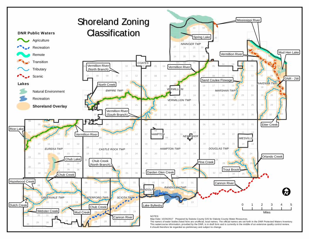
Vermillion RiverRice Lake
Chub Lake
Chub Creek
Cannon River
Vermillion River
Vermillion River
Vermillion River(North Branch)
North Creek
Vermillion River(South Branch)
Sand Coulee Flowage
Orlando Creek
Trout Brook
Etter Creek
Pine Creek
Darden Glen Creek
Chub Creek(North Branch)
Chub Creek
Mud CreekWebster CreekDutch Creek
Hazelwood Creek
Mississippi River
Lake Byllesby
Spring Lake
Mississippi River
Mud Hen Lake
DNR - 2W
HAMPTON
VERMILLION
MIESVILLENEW TRIER
RANDOLPH
COATES
Cannon River
EUREKA TWP
EMPIRE TWP
DOUGLAS TWPHAMPTON TWP
MARSHAN TWP
VERMILLION TWP
CASTLE ROCK TWP
GREENVALE TWP
RAVENNA TWP
SCIOTA TWP
NININGER TWP
WATERFORD TWP
RANDOLPH TWP
30 29 28 27 2526
0718
19
06
31
30
18
19
07
11
1111
11 11
11
11
11
11
11
0807
14
32
13
19
18
05
20
03
20
12
04
05
17
28
2022
24
17
35
22
1008
21
03
01
23
27
04
09
30
15
10
22
17
02
0810
28
21
01
34
29
32
15
33
29
09
15
13
08
27
24
25
16
32
05
20
02
19
16
33
06
09
01
09
23
12
27
21
23
35
34
24
26
16
25
31
1010
25
34
20
29
35
26
22
01
24
28
14
05
20
36
13
27
13
34
10
3536
13
35
15
08
24
14
32
24
15
2322
26
22
17
25
12
14
23
09
14
2826
14
25
13
13
31
26
12
02
21
24
05
08
27
03
29
09
17
05
12
14
08
06
29
3331
19
10
26
15
25
12
25
21
36
10
21
30
15
04
23
03
21
16
02
16
23
17
08
32
02
27
22
1518
21
12
01
01
24
20
13
04
15
22
09
33
17
34
01
34
04
27
09
17
36
01
08
27
32
24
36
10
12
20
18
0403
16
27
23
28
18
36
25
19
12
28
07
34
36
21
05
16
32
20
20
13
05
26
17
02
07
33
33
29 28
29
31
14
23
01
10
15
30
06
04
31
02
14
22
30
1314
09
26
02
30
08
02
3531
03
07 08
09
04
25
28
03
09
26
29
06
19
06
32
31
05 03
22
35
07
23
0707
31
18
18
0606
33
19
30
07
30
04 04
18
21
30
19
16
30
0306
36
0502 01 06
18134
14
I
DNR Public WatersAgricultureRecreationRemoteTransitionTributaryScenic
LakesNatural EnvironmentRecreationShoreland Overlay
0 1 2 3 4 5
MilesNOTES:Map Date: 10/26/2017 Prepared by Dakota County GIS for Dakota County Water Resources.The names of water bodies listed here are unofficial, local names. The official names are set forth in the DNR Protected Waters Inventory. This watercourse information, provided by the DNR, is in draft form and is currently in the middle of an extensive quality control review.It should therefore be regarded as preliminary and subject to change.
Shoreland ZoningShoreland ZoningClassificationClassification

13 18 17 16
23 24 19 21 2220
272830 292526
353432 333135
0203040506010204 0305
10 110907 0810 11 120908
15 141618 17 16 15 14 18 1713
24 19 22 232119 202420 22 2321
272826 25 2930 25 3027 2629 2827
33 343235 36 35 3634 313132 33 343332
13 1815 1714 1816 131516 1417 1813 18 171315 14 171516
2120 2122 2323 24 19 2022 24 192423 24 19212019 232122 22
252628 27 28 2729 26 25 3027 26 3025 2530 29 2728 2628
323136353433 34 3332 35 36 31 32313635 36 31 35323433 3433
06 0405010204 03 02 01 0505 0106 02 0602 0601 0503 01 030402
11 12 07 081009 090809 100811 1211 12 11 12 11 1207 08 09 070707 08 1010
18 171315 1417 16 16 1618 15 1714 1313 18 1814 1815 131416 1517 16 17
19 202421 22 2320 2119 2123 24 2024 19 22 192220 22 2323 1921 2420 21
26 25 3026 25 30 29 28 272827 2828 2925 3025 30 292729 26 25 263026 2729 28
36 31 31 32363535 3432 33 33333433 36 3132 32313635 3534 35 36 3431 3332
0101 0602 020305 040306 05 01 0604 0504 0206 0503 0401 0302
1212 07 10 110912 07 08111007 10 11 0808 08 0909 10 1109 12 07
18 17 16 1513 13141418 15 14 13 18 17 1513 1817 14 171516 1616
19 20 21 22 2424 23232422 2319 19 2223 2420 1920 2021 22 2121
30 29 28 27 2525 262630 2729 27 25 3026 30 2925 28262729 2828
33 34 353231 36363431 35 3532 31 3236 3431 33363532 33 3433
0506 0104 0203 0102 03050601 0406 0205 04 03
12 0711 0807 100910 11 0908 1012 07 1108 09 12
13141518 16141517 16 1713 18
24232219 2120 21 2022 23 1924
25262730 2829 2928 27 26 25 30
26 2527 30 29
34 31 3235 36
05 0406
09
14 13
23 24
27
363433
20
29
0304
3344
33
14
WESTST PAUL
MENDOTA HEIGHTS
LILYDALE
SOUTHST
PAULMENDOTA
INVER GROVEHEIGHTS
SUNFISH LAKE
EAGAN
BURNSVILLE
NININGER TWP
HASTINGS
APPLE VALLEY ROSEMOUNT
RAVENNA TWP
COATES
MARSHAN TWP
EMPIRE TWP
VERMILLIONTWPLAKEVILLE
FARMINGTON VERMILLION
DOUGLAS TWP
EUREKA TWP
CASTLEROCK TWP
HAMPTON TWP
HAMPTON MIESVILLENEW TRIER
GREENVALE TWP RANDOLPH TWP
SCIOTA TWP
WATERFORDTWP
RANDOLPH
NORTHFIELD
DNR Public Waters (50' Buffer)Public Ditch (16.5' Buffer)Public Ditch & DNR Public Water (50' Buffer)Protected Lakes and Wetlands (50' Buffer)
NOTES:Map Date: 10/31/2017 Prepared by Dakota County GIS for Dakota County Water Resources.The names of water bodies listed here are unofficial, local names. The official names are set forth in the DNR Protected Waters Inventory. This watercourse information, provided by the DNR, is in draft form and is currently in the middle of an extensive quality control review. It should therefore be regarded as preliminary and subject to change.
Buffer ProtectionBuffer Protection
I
0 2 4 6 8
Miles

Dakota County Shoreland and Floodplain Management Ordinance 31
Table 3 - Land Use Districts For Lakes
Types of Uses*
Recreational Development
Lakes
Natural Environment Lakes
Special Protection District Uses
Forest management Permitted Permitted
Sensitive resource management Permitted Permitted
Agricultural: crop and pasture Permitted Permitted
Agricultural: feedlots Not allowed Not allowed
Park and historical sites Conditional Conditional
Single-family residential Conditional Conditional
Residential clustering Conditional Conditional
Extractive use Not allowed Not allowed
Planned unit developments Not allowed Not allowed
Utility Scale Solar Energy Systems Not allowed Not allowed
Residential District Uses
Forest management Permitted Permitted
Sensitive resource management Permitted Permitted
Agricultural: crop and pasture Permitted Permitted
Agricultural: feedlots Not allowed Not allowed
Park and historical sites Conditional Conditional
Single-family residential Permitted Permitted
Semi-public Conditional Conditional
Extractive use Not allowed Not allowed
Duplex residential Conditional Not allowed
Surface water oriented commercial Conditional Conditional
Residential clustering Conditional Conditional
Planned unit developments Not allowed Not allowed
Metropolitan systems airport Not allowed Not allowed
Utility Scale Solar Energy Systems Not allowed Not allowed
Home Based Economic Activity Permitted Conditional
Any principal land use not listed is specifically prohibited.
Land use activities must also be allowed under township zoning.
*See Minn. R. ch. 6105 for additional restrictions/requirements.
Any feedlot that ceases operations for any period in excess of one (1) year shall require a conditional use permit prior to resuming operations.
There shall be only one (1) dwelling unit (single-family detached) per lot. Duplexes shall require a minimum lot size of twice the minimum lot size required for single-family dwellings and double the lot width requirements. The maximum density of residential dwellings shall be consistent with the maximum residential density regulations contained in township zoning ordinances.

Dakota County Shoreland and Floodplain Management Ordinance 32
Table 4 - Land Use Districts For Rivers and Streams
Remote
Transition
Agriculture
Tributary
Recreation Scenic
Single-family residential N P P P P N
Semi-public N C C N N N
Parks and historical sites C C C C C C
Extractive use N C C C C N
Duplex residential N N N N N N
Forest management P P P P P P
Surface water oriented commercial
N C C N N N
Agricultural services N N N N N N
Sensitive resource management
P P P P P P
Agricultural: cropland & pasture
C P P P P P
Agricultural: new feedlots N N N N N N
Residential clustering N C C C C C
Planned unit developments N N N N N N
Metropolitan systems airport N C C N N N
Commercial services N N N N C C
Utility Scale Solar Energy Systems
N N N N N N
Home Based Economic Activity
N P P P P N
Key: P= Permitted C= Conditional N= Not Allowed
Any principal land use not listed is specifically prohibited.
Land use activities must also be allowed under township zoning.
*See Minn. R. ch. 6105 for additional restrictions/requirements.
In the Recreation and Scenic River Districts, canoe rental establishments are allowed as conditional use, subject to state rules. Inner tube rental establishments are specifically prohibited.
There shall be only one (1) dwelling unit (single-family detached) per lot. No more than 25% of the lot shall be an impervious surface. In addition to the minimum lot width requirements, the maximum density of residential dwellings shall be consistent with the maximum residential density regulations contained in township zoning ordinances.
Any feedlot that ceases operations for any period in excess of one (1) year shall require a conditional use permit prior to resuming operations. See Minn. R. ch. 7020.
In the Recreation and Scenic River District, only underground mining that does not involve surface excavation is allowed as a conditional use, with the exception of sand and gravel extraction. Sand and gravel extraction shall be allowed as a conditional use subject to conditions in Minn. R. 6105.1610, subp. 5.

Dakota County Shoreland and Floodplain Management Ordinance 33
SECTION 16.00 ZONING AND WATER SUPPLY/SANITARY PROVISIONS
16.01 SETBACKS AND LOT AREA STANDARDS
Table 5 summarizes the required setback and lot specifications for properties within the shoreland. The points below are additional requirements that complement the table. A. There shall be only one dwelling unit (single-family detached) per lot. The installation of
toilet and shower facilities in a garage, shed or similar structure is permitted provided that the structure will not be used for human habitation.
B. Duplexes shall require a minimum lot size of twice (two times) the minimum lot size
required for single-family dwellings and double the lot width required for single-family dwellings.
C. Not more than 25% of the lot shall be an impervious surface.
D. In addition to the minimum lot size requirements, the maximum density of residential
dwellings shall be consistent with the maximum residential density regulations contained in township zoning ordinances.
E. The lot minimum area (in square feet) and minimum lot width standards (in lineal feet) for
residential lots created after the date of enactment of this ordinance for the lake and river/stream classifications are as set forth in the tables provided.
F. Only land above the ordinary high water level of public waters can be used to meet lot
area standards and lot width standards must be met at both the ordinary high water level and at the building line.
G. Bluff Impact Zones. Structures and accessory facilities, except stairways and landings,
cannot be placed within bluff impact zones (40 feet from top of bluff).
H. Uses Without Water-Oriented Needs on a Commercial Navigation Channel. Uses without water-oriented needs on a commercial navigation channel must be located on lots or parcels without public water frontage or if located on lots or parcels with public water frontage, must either be setback double the normal ordinary high water level setback or be substantially screened from view from the water by vegetation or topography, assuming summer leaf-on conditions.
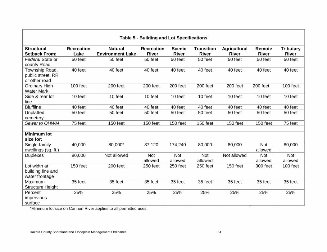
Dakota County Shoreland and Floodplain Management Ordinance 34
Table 5 - Building and Lot Specifications
Structural Setback From:
Recreation Lake
Natural Environment Lake
Recreation River
Scenic River
Transition River
Agricultural River
Remote River
Tributary River
Federal State or county Road
50 feet 50 feet 50 feet 50 feet 50 feet 50 feet 50 feet 50 feet
Township Road, public street, RR or other road
40 feet 40 feet 40 feet 40 feet 40 feet 40 feet 40 feet 40 feet
Ordinary High Water Mark
100 feet 200 feet 200 feet 200 feet 200 feet 200 feet 200 feet 100 feet
Side & rear lot line
10 feet 10 feet 10 feet 10 feet 10 feet 10 feet 10 feet 10 feet
Bluffline 40 feet 40 feet 40 feet 40 feet 40 feet 40 feet 40 feet 40 feet
Unplatted cemetery
50 feet 50 feet 50 feet 50 feet 50 feet 50 feet 50 feet 50 feet
Sewer to OHWM 75 feet 150 feet 150 feet 150 feet 150 feet 150 feet 150 feet 75 feet
Minimum lot size for:
Single-family dwellings (sq. ft.)
40,000 80,000* 87,120 174,240 80,000 80,000 Not allowed
80,000
Duplexes 80,000 Not allowed Not allowed
Not allowed
Not allowed
Not allowed Not allowed
Not allowed
Lot width at building line and water frontage
150 feet 200 feet 250 feet 250 feet 250 feet 150 feet 300 feet 100 feet
Maximum Structure Height
35 feet 35 feet 35 feet 35 feet 35 feet 35 feet 35 feet 35 feet
Percent impervious surface
25% 25% 25% 25% 25% 25% 25% 25%
*Minimum lot size on Cannon River applies to all permitted uses.

Dakota County Shoreland and Floodplain Management Ordinance 35
16.02 PLACEMENT AND DESIGN OF STRUCTURES
A. PLACEMENT OF STRUCTURES ON LOTS.
When more than one setback applies to a site, structures and facilities must be located to meet all setbacks. Where structures exist on the adjoining lots on both sides of a proposed building site, structure setbacks required for a new proposed building or an addition to an existing building may be altered without a variance to conform to the average setbacks on the adjoining lots from the ordinary high water level, provided the proposed building site is not located in a shore impact zone or in a bluff impact zone. In the Cannon Recreational and Scenic River Districts, this shall only apply to lots that do not meet the minimum lot width requirements.
B. DESIGN CRITERIA FOR STRUCTURES.
1. Height of Structures. Structures located in all river or lake classification areas cannot exceed 35 feet in height. Barns, silos and other buildings necessary for commercial agricultural uses are exempt from maximum structure height requirements. Except for the Cannon River, places of worship are exempt from maximum structure height requirements.
2. High Water Elevations. Structures must be placed in accordance with the
floodplain regulations contained in this ordinance that are applicable to the site. In areas not mapped as 100-year floodplain by FEMA, the elevation to which the lowest floor, including basement, is placed or flood-proofed must be determined as follows:
a. For lakes, by placing the lowest floor at a level at least three feet above
the highest known water level or three feet above the ordinary high water level, whichever is higher.
b. For rivers and streams, by placing the lowest floor at least three feet
above the flood of record, if data is available. If data is not available, by placing the lowest floor at least three feet above the ordinary high water level or by conducting a technical evaluation to determine the effects of proposed construction upon flood stages and flood flows and to establish a flood protection elevation. Under all three approaches, technical evaluations must be done by a qualified engineer or hydrologist consistent with Minn. R. 6120.5000 to 6120.6200 governing the management of floodplain areas. If more than one approach is used, the highest flood protection elevation determined must be used for placing structures and other facilities.
3. Water-oriented Accessory Structures. On Recreation Development Lakes, (Lake
Byllesby only) each residence may have one water-oriented accessory structure not meeting the normal structure setback in section 16.01 of this ordinance if this water-oriented accessory structure complies with the following provisions:
a. Boathouses, piers or permanent docks are not allowed in the
Recreational or Scenic River District. Boat houses, piers and permanent docks may be placed within the Recreational Lake District as prescribed herein.

Dakota County Shoreland and Floodplain Management Ordinance 36
b. Any type of temporary dock or waterfront use in the Scenic River District shall require a conditional use permit.
c. The structure or facility, except boathouses, must not exceed 10 feet in
height, exclusive of safety rails, and cannot occupy an area greater than 150 square feet. Detached decks must not exceed eight feet above grade at any point.
d. The setback of the structure or facility from the ordinary high water level
must be at least 10 feet. e. The structure or facility must be treated to reduce visibility as viewed
from public waters and adjacent shorelands by vegetation, topography, increased setbacks or color, assuming summer, leaf-on conditions.
f. The roof may be used as a deck with safety rails, but must not be
enclosed or used as a storage area. g. The structure or facility must not be designated or used for human
habitation and must not contain water supply or sewage treatment facilities.
h. Water-oriented accessory structures used solely for watercraft storage
(boathouse), and including storage of related boating and water-oriented sporting equipment, may occupy an area up to 400 square feet provided the maximum width of the structure is 20 feet as measured parallel to the configuration of the shoreline.
i. Water-oriented accessory structures may have the lowest floor placed
lower than the elevation determined by the procedures in this section if the structure is constructed of flood-resistant materials to the elevation, electrical and mechanical equipment is placed above the elevation and, if long duration flooding is anticipated, the structure is built to withstand ice action, wind-driven waves and debris.
4. Stairways, Lifts, Landings and Docks. Stairways and lifts are the preferred
alternative to major topographic alterations for achieving access up and down bluffs and steep slopes to shore areas. Stairways and lifts must meet the following design requirements:
a. Stairways and lifts must not exceed four feet in width on residential lots.
Wider stairways may be used for commercial properties and public open-space recreational properties.
b. Landings for stairways, landings at the bottom of stairways and lifts on
residential lots must not exceed 32 square feet in area. Landings larger than 32 square feet may be used for commercial properties and public open-space recreational properties.
c. Canopies or roofs are not allowed on stairways, lifts or landings.
d. Stairways, lifts and landings may be either constructed above the ground
on posts or pilings or placed into the ground, provided they are designed and built in a manner that ensures control of soil erosion.

Dakota County Shoreland and Floodplain Management Ordinance 37
e. Stairways, lifts and landings must be located in the most visually inconspicuous portions of lots, as viewed from the surface of the public water assuming summer, leaf-on conditions, whenever practical.
f. Facilities such as ramps, lifts or mobility paths for physically disabled
persons are also allowed for achieving access to shore areas, provided that the dimensional and performance standards of subsections (a) to (e) above are complied with in addition to the requirements of Minn. R. ch. 1340.
g. Boathouses, piers or permanent docks are not allowed in the
Recreational or Scenic River District. Any type of temporary dock or waterfront use in the Scenic River District shall require a conditional use permit.
h. Docks that exceed five feet in width require a shoreland building permit.
5. Significant Historic Sites. No structure may be placed on a significant historic
site in a manner that affects the historical value of the site unless adequate information about the site as determined by the Minnesota Historical Society has been removed and documented in a public repository.
6. Steep Slopes/Challenging Soils. The zoning administrator will evaluate possible
soil erosion impacts and development visibility from public waters before issuing a permit for construction of structures, roads, driveways, SSTS or other improvements on steep slopes. When determined necessary, conditions must be attached to permits to prevent soil erosion and to preserve existing vegetation screening of structures, vehicles and other facilities as viewed from the surface of public waters, assuming summer, leaf-on conditions.
In those areas where soils and slopes present potential additional problems of surface or groundwater contamination, the county shall require either larger lot sizes than prescribed in this ordinance or provisions for the treatment of sewage in a manner that the county deems will not contaminate surface or ground waters. Lots of record in the Dakota County Property Records Department prior to the effective date of this ordinance that do not meet the requirements of this section may be allowed as building sites, provided the lot meets the conditions set forth in section10.00 of this ordinance.
Structures may be allowed on slopes of greater than 12% (but not on bluffs or within bluff impact zones) if structures can meet the following criteria: a. Sanitary provisions of this ordinance can be met. b. Structures are adequately screened and color and architectural design
are approved by the township and PLANC. c. Erosion and sedimentation provisions of this ordinance can be met.
7. Utility Crossings of DNR protected watercourse. All utility crossings require a
license from the DNR pursuant to Minn. Stat. § 84.415. All utility transmission crossings constructed within the Cannon Recreational and Scenic River Districts shall require a conditional use permit. The construction of such transmission services shall be subject to Minn. R. 6105.0170 and Minn. R. 6105.0180. No conditional use permit shall be required for high voltage transmission lines under control of the Environmental Quality Board pursuant to Minn. Stat. § 116C.61.

Dakota County Shoreland and Floodplain Management Ordinance 38
16.03 SHORELAND ALTERATIONS
A. IN GENERAL. Alterations of vegetation and topography will be regulated to prevent soil
erosion into public waters, fix nutrients, preserve shoreland aesthetics, preserve historic values, prevent bank slumping and protect fish and wildlife habitat.
B. VEGETATION ALTERATIONS.
The following standards for the alteration of vegetation shall apply in shoreland areas. Vegetation alteration necessary for the construction of structures and SSTS and the construction of roads and parking areas regulated by section 16.06 of this ordinance are exempt. 1. The removal of vegetation in shoreland areas outside of the shore and bluff
impact zone and not on steep slopes/challenging soils requires a permit. 2. The pruning and trimming of branches is the preferred method of obtaining
views. 3. The removal or alteration of vegetation, except for agricultural and forest
management uses as regulated in sections 16.08(B) and 16.08(C), is allowed subject to the following standards:
a. Alteration of vegetation on Steep Slopes/Challenging Soils. The zoning
administrator will evaluate possible soil erosion impacts before issuing a permit for vegetation alteration. When determined necessary, conditions may be attached to permits to prevent soil erosion. In those instances where the zoning administrator determines that alteration of vegetation on steep slopes/challenging soils will cause permanent harm to the integrity of the slope, permits will be denied.
b. Clear-cutting and intensive vegetation clearing within the shore and bluff
impact zones and on steep slopes are not allowed. Intensive vegetation clearing for forest land conversion to another use outside of these areas requires a conditional use permit.
c. In shore and bluff impact zones and on steep slopes, limited clearing of
trees and shrubs and pruning and trimming of trees is allowed to provide a view to the water from the principal dwelling site and to accommodate the placement of stairways and landings, picnic areas, access paths, beach and watercraft areas and permitted water-oriented accessory structures of facilities, provided that:
i. the screening of structures, vehicles or other facilities as viewed
from the water, assuming summer, leaf-on conditions, is not substantially reduced;
ii. along rivers, existing shading of water surfaces is preserved; and
iii. in the shore impact zone, live trees larger than six inches in
diameter, measured 4½ feet above ground level shall not be cut, except to provide for water-oriented accessory structures or to provide a water-viewing corridor not to exceed 20% of the shoreline width of the lot.

Dakota County Shoreland and Floodplain Management Ordinance 39
4. The above provisions are not applicable to the removal of dead or diseased trees that upon inspection are found to impose safety hazards.
5. In addition to the above provisions which are more restrictive, the following
applies to the shorelands within the Cannon Recreational and Scenic River Districts, the shorelands of Ravenna Township, Trout Brook and the Special Protection Districts of Spring Lake and Lake Byllesby:
a. Clear cutting, except for any authorized public services such as roads
and utilities, is not permitted.
b. The size of clear-cut blocks, patches or strips for authorized public services shall be kept at the minimum necessary.
c. Selective cutting of trees in excess of six inches in diameter measured
4½ feet above ground level is permitted providing removal is spaced in several cutting operations and a continuous tree canopy is maintained, uninterrupted by large openings.
d. The cutting provisions of (a) and (b) immediately above shall not be
deemed to prevent:
i. the removal of diseased or insect-infested trees, or of rotten or damaged trees that present safety hazards.
ii. pruning understory vegetation, shrubs, plants, bushes, grasses or from harvesting crops, or cutting suppressed trees or trees less than six inches in diameter at 4½ feet above ground level.
6. Clear cutting in those areas not identified in subsection 16.03(B)(5) above is
subject to the following standards and criteria:
a. Clear cutting is not allowed where soil, slope or other watershed conditions are determined by the zoning administrator to be fragile and subject to severe erosion and/or sedimentation.
b. Clear cutting shall be conducted only where clear-cut blocks, patches or
strips are in all cases, shaped and blended with the natural terrain.
c. All clear cuts must be conducted between September 15 and May 15. If natural regeneration will not result in adequate vegetative cover, areas in which clear cutting is conducted must be replanted to prevent erosion and to maintain the aesthetic quality of the area. Where feasible, replanting must be performed in the same spring or the following spring.
16.04 TOPOGRAPHIC ALTERATIONS/GRADING AND FILLING
A. Grading, filling and excavations necessary for the construction of buildings, SSTS, and driveways under validly issued shoreland permits for these facilities do not require the issuance of a separate shoreland alteration permit. However, the grading and filling standards in this section must be incorporated into the issuance of permits for construction of buildings, SSTS and driveways.
B. Public roads and parking areas are regulated by section 16.06 of this ordinance. C. Grading and filling activities that require a shoreland alteration permit include:

Dakota County Shoreland and Floodplain Management Ordinance 40
1. The disturbance of more than five cubic yards of material on steep slopes and within shore and bluff impact zones.
2. The disturbance of more than 50 cubic yards of material outside of steep slopes
and shore and bluff impact zones.
3. The disturbance of any amount of material in the Cannon Recreational and Scenic River Districts. Grading and filling in these districts which is not accessory to a permitted or conditional use is not permitted.
D. The following considerations and conditions must be adhered to during the issuance of
building permits, shoreland alteration permits, conditional use permits and variances:
1. Any activity below the ordinary high water level of a DNR Protected Water may require a permit from the DNR.
2. Alterations must be designed and conducted in a manner that ensures that only
the smallest amount of bare ground is exposed for the shortest time possible.
3. Mulches, hydro-seeding, fiber blankets or similar materials must be used, where necessary, for temporary bare soil coverage, and a permanent vegetation cover must be established within 72 hours of final grading.
4. Methods to minimize soil erosion and to trap sediments before they reach any
surface water feature must be used such as, silt fence, fiber blankets or straw bales.
5. Altered areas must be stabilized to acceptable erosion control standards as
determined by the zoning administrator which are consistent with the field office technical guides of the SWCD and the United States Soil Conservation Service.
6. Fill or excavated material must not be placed in a manner that creates an
unstable slope.
7. Plans to place fill or excavated material on steep slopes must be reviewed by qualified professionals for continued slope stability and must not create finished slopes of 30% or greater.
8. Fill or excavated material must not be placed in bluff impact zones.
9. Alterations of topography will be allowed only if they are accessory to permitted or conditional uses and do not adversely affect adjacent or nearby properties.
10. Placement of natural rock riprap, including associated grading of the shoreline
and placement of a filter blanket, is permitted if the finished slope does not exceed three feet horizontal to one foot vertical, the landward extent of the riprap is within 10 feet of the ordinary high water level and the height of the riprap above the ordinary high water level does not exceed three feet.
E. A conditional use permit is required for excavations where the intended purpose is
connection to a public water, such as boat slips, canals, lagoons and harbors. Permission for excavations may be given only after the DNR has approved the proposed connection to public waters.

Dakota County Shoreland and Floodplain Management Ordinance 41
16.05 WETLAND PROTECTION
Grading or filling in any wetland must be evaluated by the County to determine how extensively
the proposed activity would affect the following functional qualities of the wetland: A. Sediment and pollutant trappings and retention; B. Storage of surface runoff to prevent or reduce flood damage; C. Fish and wildlife habitat; D. Recreational use; E. Shoreline or bank stabilization; and
F. Noteworthiness, including special qualities such as historic significance, critical habitat for endangered plants and animals or other.
This evaluation must also include a determination of whether the wetland alteration being proposed requires permits, reviews or approvals by other local, state or federal agencies such as a watershed district, the SWCD, DNR or the United States Army Corps of Engineers.
Minn. R. ch. 6105 prohibits the drainage or filling of wetlands within wild, scenic or recreational river land use districts.
16.06 PLACEMENT AND DESIGN OF ROADS, DRIVEWAYS AND PARKING AREAS
A. Public and private roads and parking areas must be designed to take advantage of
natural vegetation and topography to achieve maximum screening from view from public waters. Documentation must be provided by a qualified individual that all roads and parking areas are designed and constructed to minimize and control erosion to public waters consistent with the field office technical guides of the SWCD or other applicable technical materials.
B. Roads, driveways and parking areas must meet structure setbacks and must not be
placed within bluff and shore impact zones when other reasonable and feasible placement alternatives exist. If no alternatives exist, they may be placed within these areas and must be designed to minimize adverse impacts.
C. Public and private watercraft access ramps, approach roads and access-related parking
areas may be placed within shore impact zones provided the vegetation screen and erosion control conditions of this subpart are met. For private facilities, the grading and filling provisions of section 16.04 of this ordinance must be met.
D. A conditional use permit shall be required for any construction or reconstruction of public
roads within the Cannon Recreational and Scenic River Districts. Such construction or reconstruction shall be subject to Minn. R. 6105.0200. Public roads include township, county and municipal roads, streets and highways that serve or are designed to serve flows of traffic between communities or other traffic generating areas. A conditional use permit is not required for minor public streets, which are streets intended to serve primarily as an access to abutting properties.

Dakota County Shoreland and Floodplain Management Ordinance 42
16.07 STORMWATER MANAGEMENT
A. GENERAL STANDARDS FOR STORMWATER MANAGEMENT.
1. When possible, constructed facilities or constructed wetlands and vegetated soil
surfaces must be used to convey, store, filter and retain stormwater runoff before discharge to public waters.
2. Development must be planned and conducted in a manner that will minimize the
extent of disturbed areas, runoff velocities and erosion potential that will reduce and delay runoff volumes. Disturbed areas must be stabilized and protected as soon as possible and facilities or methods must be used to retain sediment on the site.
3. When development density, topographic features and soil and vegetation
conditions are not sufficient to adequately handle stormwater runoff using natural features and vegetation, various types of constructed facilities such as diversions, settling basins, skimming devices, dikes, waterways and ponds shall be required.
4. Preference must be given to designs using surface drainage, vegetation and
infiltration rather than buried pipes and manmade materials and facilities. Settling basins to intercept urban runoff shall be sized to a minimum of a 10-year storm design.
B. SPECIFIC STANDARDS FOR STORMWATER MANAGEMENT.
1. Impervious surface coverage of lots must not exceed 25% of the lot.
2. When constructed facilities are used for stormwater management, documentation
must be provided by a qualified individual that they are designed and installed consistent with the field office technical guide of the SWCD.
3. Newly constructed stormwater outfalls to public waters must provide for filtering
or settling of suspended solids and skimming of surface debris before discharge.
16.08 SPECIAL PROVISIONS FOR COMMERCIAL, PUBLIC/SEMIPUBLIC, AGRICULTURAL, FORESTRY AND EXTRACTIVE USES
Commercial uses are only allowed by conditional use permit on Transition, Agriculture and Natural Environment zoned rivers and Recreational zoned lakes (Lake Byllesby).
A. COMMERCIAL AND PUBLIC/SEMIPUBLIC USE STANDARDS.
1. Surface water-oriented commercial uses and semipublic uses, where allowed by
this ordinance, that have need for access to and use of public waters may be located on parcels or lots with frontage on public waters. Those uses with water-oriented needs must meet the following standards:
a. In addition to meeting impervious surface coverage limits, setbacks and
other zoning standards in this ordinance, the uses must be designed to incorporate topographic and vegetation screening of parking areas and structures.

Dakota County Shoreland and Floodplain Management Ordinance 43
b. Uses that require short-term watercraft mooring for patrons must centralize these facilities and design them to avoid obstructions of navigation and to be the minimum size necessary to meet the need.
c. Uses that depend on patrons arriving by watercraft may use signs and
lighting to convey needed information to the public, subject to the following general standards:
i. No advertising signs or supporting facilities for signs may be
placed in or upon public waters. Signs conveying information or safety messages may be placed in or on public waters by a public authority or under a permit issued by the Dakota County Sheriff.
ii. Signs may be placed, when necessary, within the shore impact
zone if they are designed and sized to be the minimum necessary to convey needed information. Such signs must convey only the location and name of the establishment and the general types of goods or services available. The signs must not contain other detailed information such as product brands and prices, must not be located higher than 10 feet above the ground and must not exceed 32 square feet in size. If illuminated by artificial lights, the lights must be shielded or directed to prevent illumination out across public waters.
iii. Other outside lighting may be located within the shore impact
zone or over public waters if it is used primarily to illuminate potential safety hazards and is shielded or otherwise directed to prevent direct illumination out across public waters. This does not preclude use of navigational lights.
iv. Commercial uses such as boat rides, dinner tours and on-board
vendors are allowed only as a part of shore-based surface water-oriented commercial use.
2. Uses without water-oriented needs on navigable waters must be located on lots
or parcels without public waters frontage or if located on lots or parcels with public waters frontage, must either be set back double the normal ordinary high water level setback or be substantially screened from view from the water by vegetation or topography, assuming summer, leaf-on conditions.
B. AGRICULTURE USE STANDARDS and VEGETATIVE BUFFER IMPLEMENTATION.
1. For parcels where row crop agriculture is an allowed land use, a permanent 50-
foot perennial vegetative buffer must be maintained. The perennial vegetative buffer is measured from the ordinary high water mark as determined by the zoning administrator. The buffer width along all rivers and streams classified as DNR public waters, and public ditch & DNR public waters, as identified on the buffer protection map, is 50-feet. The buffer width along all public ditches not classified as public waters, is 16.5-feet. The buffer width along protected lakes and wetlands is 50-feet.
2. In all lake and river shoreland areas, general cultivation farming, grazing,
nurseries, horticulture, truck farming, sod farming and wild crop harvesting are allowed land uses if steep slopes and shore and bluff impact zones are maintained in a permanent vegetative buffer.

Dakota County Shoreland and Floodplain Management Ordinance 44
3. Where allowed by this ordinance, animal feedlot and grazing operations must
meet the following standards:
a. New feedlots must not be located in the shoreland of watercourses or in bluff impact zones and must meet a minimum setback of 300 feet from the ordinary high water level of all public waters basins; and
b. Modifications or expansions to existing feedlots that are located within
300 feet of the ordinary high water level or within a bluff impact zone are allowed by conditional use permit if they do not further encroach into the existing ordinary high water level setback or encroach on bluff impact zones.
4. New feedlot operations must have a manure management plan approved by the
SWCD prior to beginning operations.
C. FOREST MANAGEMENT STANDARDS.
The harvesting of timber and associated reforestation must be conducted consistent with the provisions of the document, Protecting Water Quality in Forest Management: “Best Management Practices in Minnesota.” A copy of this document is on file in the Dakota County Environmental Resources Department.
D. EXTRACTIVE USE STANDARDS.
The extraction of ferrous and nonferrous metallic minerals from the shorelands in the unincorporated area of the county must be conducted consistent with the provisions of Minn. R. chs. 6130, 6132, and 6105 and Minn. Stat. ch. 93.
16.09 WATER SUPPLY AND SEWAGE TREATMENT
A. WATER SUPPLY.
Any public or private supply of water for domestic purposes must meet or exceed standards for water quality of the Minnesota Department of Health, the County and the Minnesota Pollution Control Agency.
B. SEWAGE TREATMENT.
1. All private SSTS must meet or exceed the Minnesota Pollution Control Agency’s
standards for SSTS contained in Minn. R. chs. 7080, 7081, and 7082, and Dakota County Ordinance No. 113, Individual Sewage Treatment Systems, which are hereby adopted into this ordinance by reference and declared to be part of this ordinance.
2. A SSTS must be set back from the ordinary high water level in accordance with
the setbacks contained in section 16.01 of this ordinance.
3. Nonconforming SSTS shall be regulated and upgraded in accordance with section 10.01(C) of this ordinance and Dakota County Ordinance No. 113.
4. Outdoor toilets (privy pits), experimental SSTS and performance SSTS are
expressly prohibited in shoreland and floodplain areas.

Dakota County Shoreland and Floodplain Management Ordinance 45
SECTION 17.00 SUBDIVISION/PLATTING PROVISIONS 17.01 LAND SUITABILITY
Each lot created through subdivision must be suitable in its natural state for the proposed use with minimal alteration. Suitability analysis by the zoning administrator shall consider susceptibility to flooding, existence of wetlands, soil and rock formations with severe limitations for development, severe soil erosion potential, steep topography, inadequate water supply or sewage treatment capabilities, near-shore aquatic conditions unsuitable for water-based recreation, existence of endangered or threatened species, important fish and wildlife habitat, presence of significant historic sites or any other feature of the natural land likely to be harmful to the health, safety or welfare of future residents of the proposed subdivision or of the watershed.
17.02 SUBDIVISION REQUIREMENTS
Subdivision review and approval by the zoning administrator is required whenever a parcel is subdivided into three or more lots prior to recording. Review criteria will consist of those characteristics detailed in section 17.01 and any other relevant characteristics determined by the zoning administrator. If the proposed subdivision is found to be compliant with all applicable standards found in this ordinance, the applicant will record the subdivision with the Dakota County Property Records Department.
17.03 CONSISTENCY WITH OTHER CONTROLS
Subdivisions must conform to all official local controls of the County. A subdivision will not be approved where a later variance from one or more standards in official local controls would be needed to use the lots for their intended purpose. In areas not served by publicly owned sewer and water systems, a subdivision will not be approved unless domestic water supply is available and a SSTS consistent with sections 16.09 and 10.01(C) can be provided for every lot. Each lot shall meet the minimum lot size and dimensional requirements of section 16.01, including at least a minimum contiguous lawn area that is free of limiting factors sufficient for the construction of two standard SSTS. Lots that could require use of holding tanks must not be approved.
17.04 INFORMATION REQUIREMENTS FOR SUBDIVISION/PLATTING
Sufficient information must be submitted by the applicant for the zoning administrator to make a determination of land suitability. The zoning administrator may request any additional information he deems necessary to make a determination. The information shall include at a minimum the following:
A. Topographic contours at 10-foot intervals or less from United States Geological
Survey maps or more accurate sources showing limiting site characteristics.
B. The surface water features required in Minn. Stat. § 505.02, subd. 1, to be shown on plats obtained from United States Geological Survey quadrangle topographic maps or more accurate sources.
C. Adequate soils information to determine suitability for building and on-site
sewage treatment capabilities for every lot from the most current existing sources or from field investigations such as soil borings, percolation tests or other methods.
D. Information regarding adequacy of domestic water supply.
E. Extent of anticipated vegetation and topographic alterations.

Dakota County Shoreland and Floodplain Management Ordinance 46
F. Near-shore aquatic conditions, including depths, types of bottom sediments and aquatic vegetation.
G. Proposed methods for controlling stormwater runoff and erosion, both during and
after construction activities.
H. Location of 100-year floodplain areas and floodway districts from existing adopted maps or data.
I. Lines or contours representing the ordinary high water level, the “toe” and the
“top” of bluffs and the minimum building setback distances from the top of the bluff and the lake or stream.
17.05 DEDICATIONS
When a land or easement dedication is a condition of subdivision approval, the applicant must provide easements over natural drainage or ponding areas for management of stormwater and significant wetlands.
17.06 PLATTING
All subdivisions that create two or more lots or parcels that are five acres or less in size shall be processed as a plat in accordance with Minn. Stat. ch. 505. No permit for construction of buildings or SSTS shall be issued for lots created after these official county controls were enacted, unless the lot was approved as part of a formal subdivision.
17.07 CONTROLLED ACCESS OR RECREATIONAL LOTS
Lots intended as controlled accesses to public waters or for recreational use areas for use by non-riparian lots within a subdivision must meet or exceed the sizing criteria in section 16.01 of this ordinance.

Dakota County Shoreland and Floodplain Management Ordinance 47
FLOODPLAIN MANAGEMENT
SECTION 18.00 GENERAL PROVISIONS
18.01 INTERPRETATION OF FLOODPLAIN DISTRICT BOUNDRIES
The boundaries of the floodplain district shall be determined by scaling distances on the official zoning map. When interpretation is needed as to the exact location of the boundaries of the district as shown on the official zoning map, as for example where there appears to be a conflict between a mapped boundary and actual field conditions, the zoning administrator shall make the necessary interpretation. All decisions will be based on the ground elevations that existed on the site at the time the county adopted its initial floodplain ordinance or the date of the first National Flood Insurance Program map that placed the site in the floodplain if earlier and the regional (1% chance) flood profile, if available. If the 1% chance flood elevations are not available, the zoning administrator shall: 1) require a floodplain evaluation consistent with section 19.04(B) of this ordinance to determine 1% chance flood elevation for the site; or 2) base the decision on available hydraulic/hydrologic or site elevation survey data which demonstrates the likelihood the site is within or outside of the floodplain. The zoning administrator may elicit the review of the DNR Area Hydrologist or other qualified technical expert. Persons contesting the location of the district boundaries shall be given a reasonable opportunity to present their case to the ZBA and to submit technical evidence.
18.02 WARNING AND DISCLAIMER OF LIABILITY
This ordinance does not imply that areas outside the floodplain districts or land uses permitted within such districts will be free from flooding or flood damages. This ordinance shall not create liability on the part of the County or any officer or employee thereof for any flood damages that result from reliance on this ordinance or any administrative decision lawfully made thereunder.
18.03 ESTABLISHMENT OF OFFICIAL ZONING MAP
The official zoning map together with all materials attached thereto are hereby adopted by reference and declared to be a part of this ordinance. The attached material shall include the Flood Insurance Study titled, “FLOOD INSURANCE STUDY DAKOTA COUNTY, MINNESOTA AND INCORPORATED AREAS”, the FIRM FLOOD INSURANCE RATE MAP, DAKOTA COUNTY MINNESOTA, AND INCORPORATED AREAS MAP INDEX and all FIRM FLOOD INSURANCE RATE MAP, DAKOTA COUNTY, MINNESOTA AND INCORPORATED AREAS panels shown on the FIRM Index that contain unincorporated areas of Dakota County, all of these documents being dated December 2, 2011 as prepared by FEMA. The map found on page 46 titled, “Floodplain Areas Administered by Dakota County” is for reference purposes only.
18.04 REGULATORY FLOOD PROTECTION ELEVATIONS
The Regulatory Flood Protection Elevation shall be an elevation no lower than one foot above the elevation of the regional flood plus any increases in flood elevation caused by encroachments on the floodplain that resulted from designation of a floodway.
18.05 RECORD OF FIRST FLOOR ELEVATION
The zoning administrator shall maintain a record of elevation of the lowest floor (including basement) of all new structures and alterations or additions to existing structures in the floodplain. The zoning administrator shall also maintain a record of the elevation to which structures and/or alteration additions to structures are flood-proofed.

HAMPTON
VERMILLION
MIESVILLENEW TRIER
RANDOLPH
COATES
NORTHFIELD
EUREKA TWP
EMPIRE TWP
DOUGLAS TWPHAMPTON TWP
MARSHAN TWP
VERMILLION TWP
CASTLE ROCK TWP
GREENVALE TWP
RAVENNA TWP
SCIOTA TWP
NININGER TWP
WATERFORD TWP
RANDOLPH TWP
I
Rivers & Streams
Floodplain Areas
Map Date: 3/25/2016Prepared by Dakota County GIS for Dakota County Water Resources.
0 1 2 3 4 5
Miles
Floodplain Areas AdministeredFloodplain Areas Administeredby Dakota Countyby Dakota County

Dakota County Shoreland and Floodplain Management Ordinance 49
18.06 NOTIFICATIONS FOR WATERCOURSE ALTERATIONS
The zoning administrator shall notify, in riverine situations, adjacent communities and the DNR prior to the county authorizing any alteration or relocation of a watercourse. If the applicant has applied for a permit to work in the beds of public waters pursuant to Minn. Stat. ch. 103G, this shall constitute adequate notice to the DNR. A copy of said notification shall also be submitted to the Chicago Regional Office of FEMA.
18.07 NOTIFICATION TO FEMA OF PHYSICAL CHANGES
As soon as is practicable, but no later than six months after the date such supporting information becomes available, the zoning administrator shall notify the Chicago Regional Office of FEMA of any increase or decrease in the 1% chance flood elevation by submitting a copy of said technical or scientific data.
SECTION 19.00 CLASSIFICATION OF FLOODPLAIN DISTRICTS 19.01 FLOODPLAIN CLASSIFICATION SYSTEM
The floodplain districts are described as follows:
A. FLOODWAY DISTRICT. The Floodway District shall include those areas designated as floodway on the Flood Insurance Rate Map adopted in section 18.03.
B. FLOOD FRINGE DISTRICT. The Flood Fringe District shall include those areas
designated as Zone AE on the Flood Insurance Rate Map adopted in section 18.03 that are located outside of the floodway.
C. GENERAL FLOODPLAIN DISTRICT. The General Floodplain District shall include those
areas designated as Zone A or Zone AE without a designated floodway on the Flood Insurance Rate Map adopted in section 18.03.
19.02 FLOODWAY DISTRICT
A. PERMITTED USES. The permitted uses in the Floodway District are as follows: 1. Agricultural Related Uses:
general farming
pasture
grazing
outdoor plant nurseries
horticulture
truck farming
forestry
sod farming
wild crop harvesting
gardens
residential lawns

Dakota County Shoreland and Floodplain Management Ordinance 50
2. Recreational Related Uses:
private and public golf courses
tennis courts
driving ranges
archery ranges
picnic grounds
boat launching ramps
swimming areas
parks wildlife and nature preserves
game farms
fish hatcheries
shooting preserves
target ranges
trap and skeet ranges
hunting and fishing areas
single or multiple purpose recreational trails
play areas
parking areas
B. STANDARDS FOR FLOODWAY PERMITTED USES. A permitted use in the Floodway District must meet the following standards:
1. The use must be permissible in the underlying zoning district if one exists. 2. The use must have no flood damage potential.
3. The use must not obstruct flood flows or increase flood elevations and shall not involve structures, fill, obstructions, excavations or storage of materials or equipment including:
a. All excavated material from a repair or clean out of a public ditch or ditch lateral must be removed from the floodplain and not placed on the crown of the ditch bank.
C. CONDITIONAL USES. The conditional uses permitted in the Floodway District are as follows:
1. Extraction and temporary storage of sand, gravel and other earthen materials.
2. Docks, piers, wharves and water control structures. 3. Railroads, streets, bridges, utility transmission lines, communication towers and
pipelines. 4. Fences that do not restrict or impede flow. 5. Structural works for flood control such as levees, dikes and floodwalls
constructed to any height where the intent is to protect individual structures and levees or dikes where the intent is to protect agricultural crops for a frequency flood event equal to or less than the 10-year frequency flood event.
6. Temporary placement of earthen material as provided in section 19.03(D) below.
D. STANDARDS FOR CONDITIONAL USES. A conditional use in the Floodway District
must meet the following standards:

Dakota County Shoreland and Floodplain Management Ordinance 51
1. All floodway conditional uses shall be subject to the procedures and standards contained in section 7.02 of this ordinance.
2. The conditional use shall be permissible in the underlying zoning district if one
exists. E. FLOOD STAGE INCREASE PROHIBITION.
No conditional uses shall be allowed that will cause any increase in the stage of the 1% chance or regional flood or cause an increase in flood damages in the reach or reaches affected.
F. TEMPORARY PLACEMENT OF EARTHEN MATERIAL.
1. Fill material for the uses permissible in section 19.02 shall be protected from erosion by vegetative cover, mulching, riprap or other acceptable method.
2. The temporary placement of earthen material in the floodway which would cause
an increase to the stage of the 1% chance or regional flood is allowed, but only after the county has received an appropriate plan which assures the removal of the materials from the floodway based upon the flood warning time available and upon other conditions deemed necessary by the County.
G. STRUCTURAL WORKS AS CONDITIONAL USE.
1. Structural works for flood control that will change the course, current or cross section of protected wetlands or public waters shall be subject to the provisions of Minn. Stat. § 103G.245. Community-wide structural works for flood control intended to remove areas from the regulatory floodplain shall not be allowed in the floodway.
2. A levee, dike or floodwall constructed in the floodway shall not cause an increase
to the 1% chance or regional flood and the technical analysis must assume equal conveyance or storage loss on both sides of a stream.
H. PROHIBITED USES. All uses not listed as permitted, accessory or conditional uses are
prohibited in the Floodway District.
19.03 FLOOD FRINGE DISTRICT
A. PERMITTED USES AND CONDITIONAL USES.
Permitted uses and conditional uses shall be those uses of land or structures listed as permitted uses or conditional uses in the underlying zoning use district(s). If no pre-existing, underlying zoning use districts exist, then any residential or non-residential structure or use of a structure of land shall be permitted use in the Flood Fringe District provided such use does not constitute a public nuisance. All permitted uses and conditional uses shall comply with the standards set forth in section 19.03(B) below.
B. STANDARDS FOR FLOOD FRINGE PERMITTED USES.
1. Principal Structure Access. All new principal structures must have vehicular
access no lower than 1 foot below the 1% annual chance flood with stage increase. If a variance to this requirement is granted, the ZBA must specify limitations on the period of use or occupancy of the structure for times of flooding and only after emergency response procedures exist.
Dakota County Shoreland and Floodplain Management Ordinance 52
2. Placement of Fill. Fill shall be properly compacted and the slopes shall be properly protected by the use of riprap, vegetative cover or other acceptable method. FEMA has established criteria for removing the special flood hazard area designation for certain structures properly elevated on fill above the 100 year flood elevation - FEMA's requirements incorporated specific fill compaction and side slope protection standards for multi-structure or multi-lot developments. These standards should be investigated prior to the initiation of site preparation if a change of special flood hazard area designation will be requested.
3. Compensatory Storage Requirement. Any fill placed in the Flood Fringe must be
offset with compensatory flood storage capacity at a volume ratio of 2:1 storage to fill. Compensatory storage must occur on the same lot or parcel that the fill is placed. The excavated material removed to create the compensatory storage area must not be deposited in the floodplain. Preparation and final grading must be consistent with the applicable standards set forth in section 16.04 above.
4. Effect on Hydraulic Capacity. Floodplain developments must not adversely affect
the hydraulic capacity of the channel and adjoining floodplain of any tributary watercourse or drainage system where a floodway or other encroachment limit has not been specified on the official zoning map.
C. LOWEST FLOOR ELEVATION.
1. Structures must be constructed on non-settling fill so that the lowest floor is at or above the Regulatory Flood Protection Elevation. The finished fill elevation shall be no lower than one foot below the Regulatory Flood Protection Elevation and shall extend at such elevation at least 15 feet beyond the limits of any structure or building erected thereon. Principal structures constructed in the Flood Fringe District shall be subject to the vehicular access requirements in section 19.03(B)(1).
2. Basement construction shall not be allowed below the Regulatory Flood
Protection Elevation.
D. STORAGE OF MATERIALS AND EQUIPMENT. The temporary storage or processing of materials that are, in time of flooding, flammable, explosive or potentially injurious to human, animal or plant life is prohibited. Storage of other materials or equipment may be allowed if readily removable from the area within the time available after a flood warning and in accordance with a plan approved by the zoning administrator.
19.04 GENERAL FLOODPLAIN DISTRICT
A. PERMISSIBLE USES.
Permissible uses in the General Floodplain District shall be those uses of land or structures listed as permitted uses in section 19.02(A) above.
All other uses shall be subject to the floodway/flood fringe evaluation criteria pursuant to section 19.04(B) below. Section 19.02 shall apply if the proposed use is in the Floodway District. Section 19.03 shall apply if the proposed use is in the Flood Fringe District.
B. PROCEDURES FOR FLOODWAY AND FLOOD FRINGE DETERMINATIONS WITHIN THE GENERAL FLOODPLAIN DISTRICT. Upon receipt of a permit application for a use

Dakota County Shoreland and Floodplain Management Ordinance 53
within the General Floodplain District, the applicant shall be required to furnish the following information as is deemed necessary by the zoning administrator for the determination of the Regulatory Flood Protection Elevation and whether the proposed use is within the Floodway or Flood Fringe District.
The information needed to evaluate the project includes, but is not limited to: 1. A typical valley cross-section showing the channel of the stream, elevation of
land areas adjoining each side of the channel, cross-sectional areas to be occupied by the proposed development and high water information.
2. Plan (surface view) showing elevations or contours of the ground, pertinent
structure, fill or storage elevations; size, location and spatial arrangement of all proposed and existing structures on the site; and location and elevation of streets.
3. Photographs showing existing land uses, vegetation upstream and downstream
and soil types. 4. Profile showing the slope of the bottom of the channel or flow line of the stream
for at least 500 feet in either direction from the proposed development. 5. Required Hydrologic and Hydraulic Data. The applicant shall submit one copy of
the above information to a designated engineer or other expert person or agency for technical assistance in determining whether the proposed use is in the Floodway or Flood Fringe District and to determine the Regulatory Flood Protection Elevation. Procedures consistent with Minn. R. 6120.5000 – 6120.6200 shall be followed in this expert evaluation.
The designated engineer or expert is strongly encouraged to discuss the proposed technical evaluation methodology with the respective Department of Natural Resources Area Hydrologist prior to commencing the analysis. The designated engineer or expert shall:
a. Estimate the peak discharge of the regional flood. b. Calculate the water surface profile of the regional flood based upon a
hydraulic analysis of the stream channel and outer bank areas.
c. Compute the floodway necessary to convey or store the regional flood without any increase in flood stages.
6. Technical Evaluation. The zoning administrator shall review the technical
evaluation and findings of the designated engineer or expert. The zoning administrator, prior to official action, may submit the application and all supporting data and analyses to FEMA and/or the DNR for review and comment.
Once the Floodway and Flood Fringe boundaries have been determined, the zoning administrator shall process the permit application consistent with the applicable provisions of sections 19.02 and 19.03 of this ordinance.

Dakota County Shoreland and Floodplain Management Ordinance 54
SECTION 20.00 SUBDIVISION IN FLOODPLAIN AREAS
20.01 SUBDIVISION GUIDELINES IN FLOODPLAIN AREAS
The following guidelines must be followed when property is proposed to be subdivided in the floodplain:
A. No land shall be subdivided which is unsuitable for the reason of flooding, inadequate drainage water supply or sewage treatment facilities.
B. All lots within the floodplain districts shall be able to contain a building site outside of the
Floodway District at or above the Regulatory Flood Protection Elevation.
C. All subdivisions shall have water and sewage treatment facilities that comply with the provisions of this ordinance and have road access both to the subdivision and to the individual building sites at the 1% annual chance flood.
D. For all subdivisions in the floodplain, the Floodway and Flood Fringe boundaries, the
Regulatory Flood Protection Elevation and the required elevation of all access roads shall be clearly labeled on all required subdivision drawings and platting documents.
20.02 FLOODWAY/FLOOD FRINGE DETERMINATIONS IN THE GENERAL FLOODPLAIN DISTRICTS FOR SUBDIVISIONS
In the general Floodplain District, applicants shall provide the information required in section 19.04(B) of this ordinance to determine the 1% chance flood elevation, the Floodway and Flood Fringe District boundaries and the Regulatory Flood Protection Elevation for the subdivision site.
20.03 REMOVAL OF SPECIAL FLOOD HAZARD AREA DESIGNATIONS
FEMA has established criteria for removing the special flood hazard area designation for certain structures properly elevated on fill above the 1% chance flood elevation. FEMA's requirements incorporate specific fill compaction and side slope protection standards for multi-structural or multi-lot developments. These standards should be investigated prior to the initiation of site preparation if a change of special flood hazard area designation will be requested.
SECTION 21.00 PUBLIC UTILITIES, PUBLIC TRANSPORTATION FACILITIES AND INDIVIDUAL SEWAGE TREATMENT AND WATER SUPPLY SYSTEMS
21.01 PUBLIC UTILITIES
All public utilities and facilities (including communication towers) such as gas, electrical, sewer and water supply systems to be located in the floodplain shall be flood-proofed in accordance with the State Building Code or elevated to above the Regulatory Flood Protection Elevation.
Dakota County Shoreland and Floodplain Management Ordinance 55
21.02 PUBLIC TRANSPORATION FACILITIES
Railroad tracks, roads and bridges to be located within the floodplain shall comply with sections 19.02 and 19.03 of this ordinance. Elevations to the Regulatory Flood Protection Elevation shall be provided where failure or interruption of these transportation facilities would result in danger to the public health or safety or where such facilities are essential to the orderly functioning of the area. Minor or auxiliary roads or railroads may be constructed at a lower elevation where failure or interruption of transportation services would not endanger the public health or safety.
21.03 SSTS AND WATER SUPPLY SYSTEMS
A. SSTS must comply with Minn. R. chs. 7080, 7081, and 7082 governing the design and
installation of septic systems as well as Dakota County Ordinance No. 113. B. On-site water supply systems must be designed to minimize or eliminate infiltration of
flood waters into the systems.
SECTION 22.00 MANUFACTURED HOMES AND MANUFACTURED HOME PARKS AND PLACEMENT OF RECREATIONAL VEHICLES
22.01 MANUFACTURED HOMES
A. NEW OR REPLACEMENT HOME. The placement of new or replacement manufactured
homes on individual lots of record or in manufactured home parks that are located in floodplain districts will be treated as a new structure and may be placed only if elevated in compliance with section 19.03 of this ordinance.
B. ANCHORING AND SECURING. All manufactured homes must be securely anchored to
an adequately anchored foundation system that resists flotation, collapse and lateral movement. Methods of anchoring may include, but are not limited to, use of over-the-top or frame ties to ground anchors. This requirement is in addition to applicable state or local anchoring requirements for resisting wind forces.
22.02 RECREATIONAL VEHICLES
A. Recreational vehicles and appurtenant structures are treated as structures and must be
placed in accordance with section 19.03.
B. EXEMPTION. Recreational vehicles are exempt from the provisions of this ordinance if they are placed in any of the areas listed in section 22.02(C) below and if they meet the following criteria:
1. Have current licenses required for highway use. 2. Are highway ready meaning on wheels or the internal jacking system.
3. Are attached to the site only by quick disconnected type utilities commonly used
in campgrounds and trailer parks. 4. The recreational vehicle has no permanent structural type additions attached to
it.

Dakota County Shoreland and Floodplain Management Ordinance 56
C. AREAS EXEMPTED FOR PLACEMENT OF RECREATIONAL VEHICLE. The areas exempted for the placement of recreational vehicles include:
1. Individual lots or parcels of record.
2. Existing commercial recreational vehicle parks or campgrounds.
D. STRUCTURAL ADDITIONS AND ACCESSORY STRUCTURES PROHIBITED.
Structural additions to recreational vehicles such as decks or porches or accessory structures such as garages, sheds, or storage buildings are prohibited.
22.03 MANUFACTURED HOME PARKS
New manufactured home parks and expansions to existing manufactured home parks are subject to the provisions placed on subdivisions in section 20.00 of this ordinance.
SECTION 23.00 AMENDMENTS TO FLOODPLAIN MANAGEMENT REGULATIONS
The floodplain designation on the official zoning map shall not be removed from the floodplain areas unless it can be shown that the designation is in error or that the area has been filled to or above the elevation of the Regulatory Flood Protection Elevation and is contiguous to lands outside the floodplain. Special exceptions to this rule may be permitted by the DNR if determined that, through other measures, lands are adequately protected for the intended use. All amendments to the floodplain provisions of this ordinance, including amendments to the official zoning map, must be submitted to and approved by the DNR prior to adoption. Changes in the official zoning map must meet FEMA’s technical conditions and criteria and must receive prior FEMA approval before adoption. The DNR must be given 10 days written notice of all hearings to consider an amendment to this ordinance and said notice shall include a draft of the ordinance amendment or technical study under consideration.

Dakota County Shoreland and Floodplain Management Ordinance 57
SECTION 24.00 EFFECTIVE DATE This ordinance shall be in full force and effect from and after its passage and publication according to law.
Passed by the Board of County Commissioners of Dakota County this 6th
day of September 1973.
Amended by the Board of County Commissioners of Dakota County this 10th
day of December 1974.
Amended by the Board of County Commissioners of Dakota County this 6th
day of November 1975.
Amended by the Board of County Commissioners of Dakota County this 22nd
day of June 1976.
Amended by the Board of County Commissioners of Dakota County this 12th
day of April 1977.
Amended by the Board of County Commissioners of Dakota County this 6th
day of September 1977.
Amended by the Board of County Commissioners of Dakota County this 17th
day of July 1979.
Amended by the Board of County Commissioners of Dakota County this 19th
day of August 1980.
Amended by the Board of County Commissioners of Dakota County this 17th
day of March 1981.
Amended by the Board of County Commissioners of Dakota County this 10th
day of April 1984.
Amended by the Board of County Commissioners of Dakota County this 17th
day of June 1989.
Amended by the Board of County Commissioners of Dakota County this 4th
day of August 1992.
Amended by the Board of County Commissioners of Dakota County this 19th
day of September 2000.
Amended by the Board of County Commissioners of Dakota County this 18th
day of October 2005.
Amended by the Board of County Commissioners of Dakota County this 1st
day of February, 2011.
Amended by the Board of County Commissioners of Dakota County this 15th
day of November, 2011.
Amended by the Board of County Commissioners of Dakota County this 7th
day of June, 2016.
Amended by the Board of County Commissioners of Dakota County this 2
nd day of January, 2018.
ATTEST: COUNTY OF DAKOTA, STATE OF MINNESOTA
________________________________ ________________________________
Jennifer Reynolds Kathleen A. Gaylord, Chair Admin. Services Coordinator Dakota County Board of Commissioners DATE:___________________________ DATE:___________________________
Approved as to Form: Approved as to Execution:
________________________________ ________________________________ Helen Brosnahan Helen Brosnahan
Assistant County Attorney Assistant County Attorney DATE:___________________________ DATE:___________________________