orange county, california - save newport banning...
TRANSCRIPT

TTHHEE NNEEWWPPOORRTT
BBAANNNNIINNGG RRAANNCCHH
BBiioollooggiiccaall TTeecchhnniiccaall RReeppoorrtt Orange County, California
Prepared by:
Glenn Lukos Associates, Inc.
FORMA Designs, Inc.
FUSCOE Engineering
Newport Banning Ranch LLP
BIOLOGICAL TECHNICAL REPORT FOR THE
NEWPORT BANNING RANCH PROPERTY NEWPORT BEACH, CALIFORNIA
Prepared for:
Mike Mohler Newport Banning Ranch LLC 1300 Quail Street, Suite 100 Newport Beach, CA 92660 Telephone: (949) 833-0222
Fax: (949) 833-1960
Prepared By:
Glenn Lukos Associates, Inc. 29 Orchard Street
Lake Forest, California 92630 Contact: Tony Bomkamp
Telephone: (949) 837-0404 Fax: (949) 837-5834
April 21, 2009
ii
TABLE OF CONTENTS 1.0 INTRODUCTION 1.1 Location of Project Site...................................................................................................1 1.2 Project Description..........................................................................................................2 1.3 Existing Conditions.........................................................................................................2 2.0 METHODOLOGY 2.1 Summary of Surveys .......................................................................................................4 2.2 Soil Resources.................................................................................................................7 2.3 Botanical Resources ........................................................................................................8 2.4 Wildlife Resources..........................................................................................................9 2.5 Jurisdictional Delineation..............................................................................................14 3.0 REGULATORY SETTING 3.1 State and/or Federally Listed Plants and Animals ........................................................17 3.2 Jurisdictional Waters/Wetlands/Riparian Habitats .......................................................20 3.3 California Environmental Quality Act ..........................................................................22 4.0 RESULTS 4.1 Reconnaissance Surveys ...............................................................................................25 4.2 Vegetation Mapping and Surveys .................................................................................25 4.3 Special-status Plants......................................................................................................34 4.4 Special-status Plants Observed or With the Potential to Occur on Site........................37 4.5 Wildlife Surveys............................................................................................................41 4.6 Special-Status Animals .................................................................................................41 4.7 Special-status Animals Observed or With the Potential to Occur on Site ....................47 4.8 Special-status Habitats ..................................................................................................55 4.9 Critical Habitat ..............................................................................................................61 4.10 Jurisdictional Delineation..............................................................................................62 5.0 IMPACT ANALYSIS 5.1 California Environmental Quality Act ..........................................................................63 5.2 Impacts to Vegetation Associations from Site Development .......................................66 5.3 Impacts to Special-Status Plants ...................................................................................69 5.4 Impacts to Special-Status Animals – Threshold (a)......................................................69 5.5 Impacts to Special-Status Habitats – Threshold (b)......................................................81 5.6 CLUP – Avoidance of ESHA – Threshold (e)..............................................................85 5.7 Impacts to Raptor Habitat – Threshold (d) ...................................................................94 5.8 Nesting Birds and Migratory Bird Treaty Act Considerations – Threshold (d) ...........94 5.9 Impacts to Critical Habitat – Threshold (a)...................................................................94 5.10 Impacts to Corps, CDFG, and CCA Jurisdictional Waters...........................................96 5.11 Impacts from Pipeline Removal /Soil Remediation....................................................101 6.0 MITIGATION MEASURES 6.1 Special-Status Plants ...................................................................................................103

iii
6.2 MSS/ES,SCBS, CSS, and Associated Special-Status Animals ..................................103 6.3 Grassland and AM for Raptor Foraging and Burrowing Owl.....................................107 6.4 Jurisdictional Waters – Riparian/Wetland Impacts.....................................................110 6.5 Nesting Birds Protected Under the MBTA .................................................................114 6.6 Pipeline Removal and Oilfield Decommissioning......................................................114 7.0 CERTIFICATION 8.0 REFERENCES/BIBLIOGRAPHY EXHIBITS
Exhibit A Planned Community Development Plan – Proposed Project Exhibit B Planned Community Development Plan – Alternative A Project Exhibit C Impacts Map – Proposed Project Exhibit D Mitigation Areas Map – Proposed Project Exhibit E Habitat Restoration Map – Proposed Project Exhibit F Composite Habitat Restoration/Preservation Map – Proposed Project Exhibit G Impacts Map – Alternative A Project Exhibit H Mitigation Areas Map – Alternative A Project Exhibit I Habitat Restoration Map – Proposed Project Exhibit J Composite Habitat Restoration/Preservation Map – Alternative Project A Exhibit 1 Regional Map Exhibit 2 Vicinity Map Exhibit 3 Site Photographs Exhibit 4a California Gnatcatcher Location Map – 2006 Exhibit 4b California Gnatcatcher – 2007 Exhibit 5a Least Bell’s Vireo Location Map – 2006 Exhibit 5b Least Bell’s Vireo Location Map – 2007 Exhibit 6 Fairy Shrimp Survey Map Exhibit 7 Wintering Burrowing Owl location Map Exhibit 8a Corps Section 10 Waters Delineation Map Exhibit 8b Corps Jurisdictional Delineation Map Exhibit 8c CDFG Jurisdictional Delineation Map Exhibit 8d CCA Jurisdictional Delineation Map Exhibit 9 Vegetation Map Exhibit 10 Special Status Plant Location Map Exhibit 11 Other Special Status Birds Location Map Exhibit 12 Environmentally Sensitive Habitat (ESHA) Map Exhibit 13 California Gnatcatcher Critical Habitat Unit Map Exhibit 14 San Diego Fairy Shrimp Critical Habitat Unit Map Exhibit 15a Habitat Restoration Map – Proposed Project Exhibit 15b Habitat Restoration Map – Alternative A Project Exhibit 16 Oil Pipeline Removal Map

iv
APPENDICES
Appendix A Floral Compendium Appendix B Faunal Compendium Appendix C Coastal California Gnatcatcher Report Appendix D Southwestern Willow Flycatcher Report Appendix E Seasonal Pool Wet Season Survey Report Appendix F Impact CEQA Significance Table

v
EXECUTIVE SUMMARY The Newport Banning Ranch site (Site) covers approximately 400 acres and is located in unincorporated Orange County and the City of Newport Beach. The Site is located north of Pacific Coast Highway, east of the Santa Ana River, south of 19th Street and Talbert Regional Park, and west of existing residential and commercial areas. 1.0 Existing Conditions The Site has been degraded by oil extraction operations for decades. The property is divided into two distinct areas, an upper mesa area bisected by canyons and a "lowland" area covering approximately 110 acres at the northwest corner of the site. The majority of the Site is dominated by non-native vegetation and a number of invasive species are locally dominant; however, some patches of native vegetation remain intact on the site. Specifically, on the slopes along the southern and southwestern boundary of the property the site supports several large patches of maritime succulent scrub and highly disturbed coastal bluff scrub. The southwestern corner of the site, consisting of southern coastal bluff scrub supports several special status plants, and the slopes of the large arroyo (Drainage C) support several locations of the federally listed threatened coastal California gnatcatcher and the coastal cactus wren (a CDFG Species of Concern). Although highly degraded by invasive plants, the lowlands support a number of wetland habitats, including areas of tidal coastal salt marsh that supports the state-listed endangered Belding’s savannah sparrow, southern willow scrub and southern willow forest that support the state and federally listed endangered least Bell’s vireo, and a variety of special-status nesting raptors including the white-tailed kite. The lowlands also support special-status plants including substantial populations of southern tarplant. The extent of Corps Jurisdictional waters, including wetlands, has been determined and verified by the Corps. Corps jurisdiction pursuant to Section 10 of the Rivers and Harbors Act totals 63.51 acres, while potential Corps jurisdiction pursuant to Section 404 at the site totals 53.76 acres of which 53.15 acres consist of jurisdictional wetlands. Potential CDFG jurisdiction at the site totals 11.88 acres of which 11.79 acres consists of vegetated riparian habitat. Potential CCA wetlands at the site totals 73.42 acres, potential CCA riparian habitat totals 5.59 acres, and areas that potentially meet the definition of both CCA wetlands and CCA riparian habitat total 0.95 acre. In addition to jurisdictional waters, the site was evaluated for the presence of Environmentally Sensitive Habitat Area (“ESHA”) as defined by the City of Newport Beach CLUP. Potential upland scrub ESHA totals 32.97 acres on the site and includes maritime succulent scrub/encelia scrub, buckwheat scrub, and southern coastal bluff scrub. Potential ESHA that meets the definition of either wetland or riparian, or both wetland and riparian, totals 51.43 acres and includes alkali meadow, mud flats, southern black willow forest, southern coastal brackish marsh, southern coastal salt marsh, vernal pool, and southern willow scrub. The project

vi
contains or is within Critical Habitat units defined by the USFWS for the coastal California gnatcatcher and the San Diego Fairy shrimp. 2.0 Evaluation of Proposed Project and Alternative A Project Two project alternatives are evaluated by this document. The Proposed Project (see Exhibit A), which includes construction of an extension of “North Bluff Road” from 17th Street north to connect to the existing 19th Street, would permanently impact 163.18 acres and temporarily impact 4.26 acres. The Alternative A Project (see Exhibit B), which does not include the 17th/19th Street connector portion of North Bluff Road, would permanently impact 157.60 acres and temporarily impact 1.59 acres. 2.1 Proposed Project 2.1.1 Impacts Impacts to potential ESHA caused by the Proposed Project are illustrated on Exhibit C. The Proposed Project has been designed to avoid all areas of ESHA as defined by the City of Newport Beach CLUP and provide minimum setbacks of at least 50 feet, with the exception of permanent impacts to 2.03 acres and temporary impacts to 1.21 acres of potential scrub ESHA and permanent impacts to 0.30 acre of potential riparian and/or wetland ESHA for a major access road (Bluff Road). The project may have a significant impact if determined to conflict with the policies of the CLUP regarding ESHA. Project design also has avoided impacts to all wetlands as defined by the CCA with the exception of permanent impacts to 0.25 acre of potential CCA wetlands, as well as limited impacts specifically for purposes of restoration to Drainage B, an allowable impact under the Coastal Act. The impact would be self-mitigating through the restoration of Drainage B, resulting in a net increase in wetland and riparian habitat. The project may have a significant impact if determined to conflict with the policies of the CLUP regarding wetlands. The Proposed Project will result in significant impacts to Corps jurisdictional wetlands and waters and CDFG vegetated riparian habitat and unvegetated streambed. The Proposed Project will also result in the loss of 67.98 acres of non-native grassland that represents potentially suitable habitat for foraging raptors. Although the vegetation is mostly non-native, this impact would be considered significant. 2.1.2 Mitigation Mitigation areas for impacts caused by the Proposed Project are illustrated on Exhibit D. Permanent and temporary impacts to potential scrub ESHA and permanent impacts to potential riparian and/or wetland ESHA for Bluff Road would be fully mitigated by the Proposed Project
vii
through restoration/creation of coastal bluff scrub and maritime succulent scrub habitat, riparian restoration in Drainages B and C and alkali meadow creation/restoration in the lowlands. Significant impacts Corps jurisdictional wetlands and waters and CDFG vegetated riparian habitat and unvegetated streambed will be mitigated through restoration of Drainages B and C and restoration/creation of alkali meadow in the lowlands. Significant impacts to non-native grasslands will be mitigated at a ratio of at least 0.5:1 per recommendations of CDFG. Mitigation for all significant impacts is fully detailed within Habitat Restoration Plan (HRP). Exhibit E, Proposed Project Habitat Restoration Map, illustrates the proposed mitigation and project design features within the Site’s open space. For clarity, Exhibit F provides a composite of Proposed Project habitat restoration with existing vegetation to be preserved. 2.2 Alterative A Project 2.2.1 Impacts Impacts caused by the Alternative A Project are illustrated on Exhibit G. The Alternative A Project has been designed to avoid all areas of ESHA as defined by the City of Newport Beach CLUP and provide minimum setbacks of at least 50 feet, with the exception of impacts to 0.06 acre of potential scrub ESHA and 0.05 acre of potential riparian ESHA for construction of North Bluff Road. The project may have a significant impact if determined to conflict with the policies of the CLUP regarding ESHA. Project design also has avoided impacts to all wetlands as defined by the CCA with the exception of permanent impacts to 0.20 acre of potential CCA wetlands, as well as limited impacts specifically for purposes of restoration to Drainage B, an allowable impact under the Coastal Act. The impact would be self-mitigating through the restoration of Drainage B, resulting in a net increase in wetland and riparian habitat. The project may have a significant impact if determined to conflict with the policies of the CLUP regarding wetlands The Alternative A Project will result in significant impacts Corps jurisdictional wetlands and waters and CDFG vegetated riparian habitat and unvegetated streambed. The Alternative A Project will also result in the loss of 67.98 acres of non-native grassland that represents potentially suitable habitat for foraging raptors. Although the vegetation is mostly non-native, this impact would be considered significant. 2.2.2 Mitigation Mitigation areas for impacts caused by the Alternative A Project are illustrated on Exhibit H.

viii
Permanent and temporary impacts to potential scrub ESHA and permanent impacts to potential riparian and/or wetland ESHA for Bluff Road would be fully mitigated by the Alternative A Project through restoration/creation of coastal bluff scrub and maritime succulent scrub habitat, riparian restoration in Drainages B and C, and alkali meadow creation/restoration in the lowlands. Significant impacts Corps jurisdictional wetlands and waters and CDFG vegetated riparian habitat and unvegetated streambed will be mitigated through restoration of Drainages B and C and restoration/creation of alkali meadow in the lowlands. Significant impacts to non-native grasslands will be mitigated at a ratio of at least 0.5:1 per recommendations of CDFG. Mitigation for all significant impacts is fully detailed within Habitat Restoration Plan (HRP). Exhibit I, Alternative A Project Habitat Restoration Map, illustrates the proposed mitigation and project design features within the Site’s open space. For clarity, Exhibit J provides a composite of Alternative A Project habitat restoration with existing vegetation to be preserved.
1
1.0 INTRODUCTION Biologists from Glenn Lukos Associates, Inc. (GLA) conducted comprehensive surveys on the Newport Banning Ranch property to identify the presence of special-status species or habitats capable of supporting special-status species on the site or adjacent to the site in areas that could be affected by the project. In addition, the property was evaluated for the presence of areas potentially subject to the jurisdiction of the U.S. Army Corps of Engineers (Corps) pursuant to Section 404 of the Clean Water Act and Section 10 of the 1899 Rivers and Harbors Act, the California Department of Fish and Game (CDFG) pursuant to Section 1602 of the California Fish and Game Code, and the California Coastal Act (CCA). Finally, the project was evaluated relative to potential impacts to Environmentally Sensitive Habitat Area (ESHA) as defined under Section 30240 of the California Coastal Act, as well as Section 4.1.1 of the City’s Coastal Land Use Policies. This report includes an analysis of the potential biological resources associated with the above-mentioned property as it pertains to special-status species and habitats. Potential impacts (direct and/or indirect) to special-status species and habitats are addressed below for purposes of review under the California Environmental Quality Act (CEQA). In addition, impacts to species listed as threatened or endangered under the federal Endangered Species Act (ESA) or their designated Critical Habitat are regulated by the U.S. Fish and Wildlife Service (USFWS) and species listed as threatened or endangered by the State of California are regulated by the California Department of Fish and Game (CDFG) pursuant to the State ESA and are addressed below. Wildlife that are assigned other designations by CDFG (i.e., species of special concern, fully-protected species, etc.), and plants given special status by the California Native Plant Society (CNPS) are not granted additional protection, except that impacts to these species generally require evaluation pursuant to CEQA. This report also provides an analysis of requirements of the Regional Water Quality Control Board specifically as they relate to areas of Corps jurisdiction pursuant to Section 401 of Clean Water Act. 1.1 Location of Project Site The Newport Banning Ranch site (Site) covers approximately 400 acres and is located in unincorporated Orange County and the City of Newport Beach (Exhibit 1). The Site is located north of Pacific Coast Highway, east of the Santa Ana River, south of 19th Street and Talbert Regional Park, and west of existing residential and commercial areas (Exhibit 2). No blue-line drainages occur on site, however, one tidal channel occurs near the southwest corner of the site as depicted on the U.S. Geological Survey (USGS) topographic map Newport Beach, California [dated 1965 and photorevised in 1981]. The Site is situated within unsectioned areas of Township 6 South, and Range 10 West. General site photographs are included as Exhibit 3. Land uses adjacent to the Site include Talbert Regional Park to the north, residential neighborhoods to the northeast, residential neighborhoods and light industry to the east, the Newport Crest residential neighborhood to the southeast, Pacific Coast Highway to the south, Newport Shores residential neighborhood to the southwest, and a channel that includes a U.S. Army Corps of Engineers salt marsh restoration site that separates the Site from the Santa Ana River Channel to the west.
2
1.2 Project Description The project site is currently and has historically been used for oil extraction. The proposed project consists of a phased development including at least 50-percent of the site preserved as open space, a residential village, commercial development, a coastal inn, and local and community park uses on an approximately 400-acre site. In total, approximately 130 acres are proposed for residential and commercial development. The project will also provide approximately 270 acres of open space uses including habitat preservation and restoration and educational boardwalk over preserved wetland habitat. This document analyzes the potential biological impacts of two project alternatives: (1) the Proposed Project would, in addition to the development described above, construct a northerly extension of “North Bluff Road” from 17th Street to connect with the existing 19th Street with the North Bluff Road extension, and (2) the Alternative A Project would reserve a right-of-way for future construction by an entity other than the project applicant to construct a northerly extension of “North Bluff Road” from 17th Street to connect with the existing 19th Street. Both the Proposed Project and the Alternative A Project also include right-of way reservations for future construction by an entity other that the project applicant to construct and extension of 19th Street and a connector road from 15th Street to Coast Highway at the southwest corner of the site. 1.3 Existing Conditions Much of the project site has been the subject of ongoing oilfield operations over an extended period of time. In order to evaluate potential impacts on resources located within oilfield operations areas, it is necessary to understand the scope of prior oilfield operations that have impacted the property and the likely scale of future abandonment and remediation activities that are typically mandated by regulation for any oilfield at the end of production and associated processing. Oilfield activities have been ongoing at the site for over 75 years. Given the extensive production history of the site, oil wells, pipelines, and related facilities have been added and/or replaced over a long period. The extent of “known” facilities is depicted in Exhibit 4, Oil Field Surface Use Map. The word “known” is highlighted because, in the context of a 75-year production history, there is a strong likelihood that numerous facilities, mapped and unmapped, will be encountered during oilfield remediation. The oilfield area includes an extensive road network and a wide variety of production and support facilities, as described below. Due to the physical disruption caused by the construction and use of roads, wells, pipelines and production facilities, many habitat areas are significantly disturbed and are likely remnants of larger habitat systems extant prior to oilfield operations. Consequently, potential ESHA as defined by the City’s CLUP and Coastal Act are interspersed with both disturbed habitat and extensive oil facilities as depicted by Exhibit 5, Potential ESHA with Existing and Historic Oil Operations Overlay.

3
Facilities associated with oilfield activities fall into several categories: (1) Oil Operations Areas. These areas were historically used in the oil and gas producing operations. This includes all roads, wells and surrounding wellpads, tanks and facilities, pipeline and utility corridors and general staging and work areas. These areas have generally been graded and may be surfaced with gravel, asphalt, crude oil, crude oil tank sediments, or other materials. In some cases vegetation has grown around or amongst these facilities and surface materials. These same areas are typically targeted for demolition and removal work during an oil field abandonment process and may require additional soil work in the remediation process. (2) Oil Wells and Pads. These areas consist of the surface locations of the existing or abandoned oil wells. The oil well pad generally included an area of 10 to 30 feet around each oil well that contained pipelines, concrete pads, pumping and power equipment, and the work area for large workover rigs, trucks, and tanks. (3) Oil Pipeline Corridors. These corridors are areas where one or more pipelines exist to convey oil, water and gas from each well to larger group lines and on to each processing facility. Most lines are above ground with some sitting on pipeline support structures that are cemented into the ground to raise the actual pipeline above the ground surface. Some older lines may still exist below the surface, and the locations of some historic pipelines will likely not be known until grading for remediation begins. (4) Utility Poles. Power poles to support the electrical system are located throughout the oilfield. These treated wood poles support transformers, power lines, electrical panels and other equipment to serve the oil operations. Poles were often left in place even at abandoned well locations to support potential future drilling. (5) Facilities. There are numerous facility areas throughout the property. These vary from large facility areas that include extensive piping, oil separation and processing tanks, power facilities, mechanics and work shops, and other equipment, to smaller individual tanks, vessels, equipment storage yards, sheds or staging areas. The oilfield activities have resulted in disturbed and in some cases highly fragmented, remnant habitats including small fragments of southern coastal bluff scrub, maritime succulent scrub, and coastal sage scrub. Additionally, disturbance from oilfield operations has created conditions that allow colonization of exotic, non-native plant species including non-native grasslands and large patches of hottentot fig (Carpobrotus edulis) as well as extensive stands of pampas grass (Cortedaria selloana), poison hemlock (Conium maculatum), giant reed (Arundo donax), and ornamental trees such as myoporum (Myoporum laetum), which are interspersed with native riparian and wetland species.

4
2.0 METHODOLOGY GLA biologists visited the Newport Banning Ranch property throughout 2006, 2007, 2008, and the first few months of 2009 to conduct focused and general biological surveys of the property as well as a jurisdictional delineation. Site reconnaissance was conducted in such a manner as to allow inspection of the entire site by direct observation, including the use of binoculars. The site was inspected to determine whether any sensitive species, sensitive habitats, or potential jurisdictional areas are present on site. The Newport Banning Ranch Property was also subject to previous biological surveys conducted in 1998 through 2002. These studies were reviewed and their findings incorporated into the analysis of existing conditions and potential impacts. 2.1 Summary of Surveys In addition to site reconnaissance and focused surveys, evaluation of the property included a review of the California Natural Diversity Database (CNDDB) 1 and a review of the California Native Plant Society (CNPS) inventory2 for the Newport Beach and Seal Beach Quadrangles. Table 2-1 summarizes the dates of each survey and the personnel that conducted each survey conducted.
Table 2-1. Summary of Biological Surveys for the Project Site
Survey Date
Survey Type
Surveying Biologist
Spring 1998 Focused botanical surveys PCR Services and GLA staff
Winter 1999 Vernal Pool Habitat Survey GLA staff
2/29/2000 Wet Season Monitoring for Fairy Shrimp surveys
T. Bomkamp
3/13/2000 Wet Season Monitoring for Fairy Shrimp surveys
T. Bomkamp
3/15/2000 Wet Season Monitoring for Fairy Shrimp surveys
T. Bomkamp
3/21/2000 Wet Season Monitoring for Fairy Shrimp surveys
T. Bomkamp
4/7/2000 Wet Season Monitoring for Fairy Shrimp surveys
T. Bomkamp
4/7/2006 General Biological Survey California Gnatcatcher Survey
J. Ahrens, T. Bomkamp
4/11/2006 General Biological Survey Least Bell’s Vireo Survey
T. Bomkamp
4/14/2006 General Biological Survey California Gnatcatcher Survey
J. Ahrens
4/21/2006 General Biological Survey California Gnatcatcher Survey Least Bell’s Vireo Survey
J. Ahrens T. Bomkamp
1 California Department of Fish and Game. December 2007. California Natural Diversity Database: RareFind 2. State of California Resources Agency. Sacramento, California. 2 California Native Plant Society. 2007. Inventory of Rare and Endangered Plants of California. (Seventh Edition, online) v7-07c. http://cnps.web.aplus.net/cgi-bin/inv/inventory.cgi

5
Survey Date
Survey Type
Surveying Biologist
4/28/2006 California Gnatcatcher Survey I. Chlup, K. Livergood, J. Ahrens
5/2/2006 General Biological Survey Least Bell’s Vireo Survey
I. Chlup
5/5/2006 California Gnatcatcher Survey I. Chlup, K. Livergood, J. Ahrens
5/16/2006 California Gnatcatcher Survey Least Bell’s Vireo Survey Southwestern Willow Flycatcher Survey
D. Moskovitz, J. Ahrens
5/17/2006 General Biological Survey California Gnatcatcher Survey
I. Chlup, K. Livergood
5/26/2006 General Biological Survey Least Bell’s Vireo Survey
J. Ahrens, E. Bomkamp
6/5/2006 General Biological Survey Least Bell’s Vireo Survey
D. Moskovitz, J. Ahrens T. Bomkamp
6/16/2006 General Biological Survey Southwestern Willow Flycatcher Survey Least Bell’s Vireo Survey
J. Ahrens, D. Moskovitz T. Bomkamp
6/25/2006 General Biological Survey Least Bell’s Vireo Survey
D. Moskovitz, J. Ahrens
6/28/2006 Southwestern Willow Flycatcher Survey J. Ahrens
7/9/2006 Southwestern Willow Flycatcher Survey J. Ahrens
7/16/2006 Southwestern Willow Flycatcher Survey J. Ahrens, I. Chlup
10/20/2006 Vegetation Mapping General Biological Survey Focused Plant Surveys
T. Bomkamp E. Bomkamp
10/28/2006 Vegetation Mapping General Biological Survey Focused Plant Surveys
T. Bomkamp E. Bomkamp
11/4/2006 Vegetation Mapping General Biological Survey Focused Plant Surveys
T. Bomkamp E. Bomkamp
11/30/2006 Vegetation Mapping General Biological Survey Focused Plant Surveys
T. Bomkamp
2/17/2007 Vegetation Mapping General Biological Survey Focused Plant Surveys
T. Bomkamp
2/26/2007 General Biological Survey T. Bomkamp, B. Smith
3/19/2007 General Biological Survey California Gnatcatcher Survey
I. Chlup, K. Livergood
3/26/07
General Biological Survey California Gnatcatcher Survey
I. Chlup, K. Livergood
4/2/2007 General Biological Survey California Gnatcatcher Survey
I. Chlup, K. Livergood
4/9/2007 California Gnatcatcher Survey J. Ahrens, K. Livergood
4/16/2007 California Gnatcatcher Survey Least Bell’s Vireo Survey
J. Ahrens, K. Livergood, D. Lloyd
4/23/2007 General Biological Survey California Gnatcatcher Survey
I. Chlup, K. Livergood
4/26/2007 Vegetation mapping T. Bomkamp, D. Lloyd

6
Survey Date
Survey Type
Surveying Biologist
4/27/2007 General Biological Survey Least Bell’s Vireo Survey
J. Ahrens
5/6/2007 General Biological Survey Least Bell’s Vireo Survey
I. Chlup
5/16/2007 General Biological Survey Least Bell’s Vireo Survey Southwestern Willow Flycatcher Survey
J. Ahrens, D. Henning
5/27/2007 Least Bell’s Vireo Survey T. Bomkamp, B. Smith
5/31/2007 Jurisdictional Delineation D. Lloyd, A. Kessans
6/6/2007 General Biological Survey Least Bell’s Vireo Survey Southwestern Willow Flycatcher Survey
J. Ahrens, D. Henning
6/13/2007 Jurisdictional Delineation T. Bomkamp, D. Lloyd
6/15/2007 Jurisdictional Delineation D. Lloyd, A. Kessans
6/17/2007 General Biological Survey Least Bell’s Vireo Survey
I. Chlup
6/21/2007 Jurisdictional Delineation T. Bomkamp, D. Lloyd
6/22/2007 Jurisdictional Delineation T. Bomkamp, D. Lloyd
6/27/2007 Southwestern Willow Flycatcher Survey Jurisdictional Delineation
J. Ahrens, K. Livergood D. Lloyd, K. Livergood
6/28/2007 General Biological Survey Least Bell’s Vireo Survey
D. Moskovitz, J. Ahrens
7/6/2007 Southwestern Willow Flycatcher Survey J. Ahrens
7/12/2007 General Biological Survey Southwestern Willow Flycatcher Survey
J. Ahrens
7/16/2007 Vegetation mapping T. Bomkamp, D. Lloyd
7/20/2007 Vegetation mapping T. Bomkamp, D. Lloyd
7/30/2007 Jurisdictional Delineation T. Bomkamp, D. Lloyd
9/29/2007 Jurisdictional Delineation T. Bomkamp, D. Lloyd
12/14/2007 Vegetation Mapping Jurisdictional Delineation
T. Bomkamp
12/17/2007 Vegetation Mapping Jurisdictional Delineation
T. Bomkamp
12/18/2007 Vegetation Mapping Jurisdictional Delineation
T. Bomkamp, D. Lloyd
1/2/2008 Vegetation Mapping Burrowing owl survey
T. Bomkamp
1/16/2008 Focused plant surveys T. Bomkamp
1/18/2008 Burrowing owl survey J. Ahrens, D. Lloyd
1/21/2008 Burrowing owl survey J. Ahrens
1/22/2008 Burrowing owl survey J. Ahrens
1/26/2008 Burrowing owl survey J. Ahrens
2/7/2008 Wet Season Fairy Shrimp survey D. Moskovitz
3/21/2008 Burrowing owl survey J. Ahrens
3/22/2008 Burrowing owl survey J. Ahrens
4/8/2008 Burrowing owl survey J. Ahrens

7
Survey Date
Survey Type
Surveying Biologist
4/14/2008 Burrowing owl survey J. Ahrens
5/5/08 Focused Plant Surveys T. Bomkamp
5/12/08 Focused Plant Surveys T. Bomkamp
5/27/08 Focused Plant Surveys T. Bomkamp
12/1/2008 Burrowing Owl Survey J. Ahrens
12/9/2008 Burrowing Owl Survey J. Ahrens
12/23/09 Wet Season Fairy Shrimp survey E. Bomkamp
12/29/08 Wet Season Fairy Shrimp survey E. Bomkamp
1/2/09 Wet Season Fairy Shrimp survey E. Bomkamp
1/6/09 Burrowing Owl Survey E. Bomkamp
1/16/09 Burrowing Owl Survey J. Ahrens
2/18/09 Wet Season Fairy Shrimp survey E. Bomkamp
2/26/09 Wet Season Fairy Shrimp survey E. Bomkamp
3/3/09 Wet Season Fairy Shrimp survey E. Bomkamp
3/20/09 Focused Plant Surveys T. Bomkamp, E. Bomkamp
2.2 Soil Resources The Soil Conservation Service (SCS)3 has mapped the following soil types as occurring on the project site: 2.2.1 Bolsa The Bolsa series consists of somewhat poorly drained soils on alluvial fans. These soils formed in mixed alluvium. They have slopes of 0 to 2 percent, are nearly level and occur on large alluvial fans. The following Bolsa series soil type was mapped on the Newport Banning ranch property:
� Bolsa Silt Loam (122)
2.2.2 Capistrano The Capistrano series consists of well-drained soils. These soils formed in sedimentary alluvium of the coastal foothills. Slopes are 9-15 percent. The soil is medium acid throughout.
� Capistrano Sandy Loam, 9-15 percent slopes (136).
3 SCS is now known as the National Resource Conservation Service or NRCS.

8
2.2.3 Myford The Myford series consists of moderately well drained soils on marine terraces. These soils formed in sandy sediments. Slopes range from nearly level to a moderately sloping 9 percent, and from 9 to 30 percent, eroded.
� Myford Sandy Loam, 0-2 percent slopes (172) � Myford Sandy Loam, 2-9 percent slopes (173) � Myford Sandy Loam, 9-30 percent slopes, eroded (177)
2.2.4 Pits (185) The Pit series consists of very deep, poorly drained soils that formed in fine-textured alluvium weathered from extrusive and basic igneous rocks. Pit soils are on flood plains and in basins. Slopes range from 0 to 5 percent. 2.2.5 Riverwash (185) Riverwash consists of areas of unconsolidated alluvium, generally stratified and varying widely in texture. Riverwash can be sandy, gravelly, or cobbly. 2.2.6 Tidal Flats Tidal Flats are nearly level areas adjacent to bays and lagoons along the coast. Periodically they are covered by tidal overflow. Some of the higher areas are only covered during very high tides. Tidal flats are stratified clayey to sandy deposits. They are poorly drained and high in salts. Bolsa silt loam (122), Myford sandy loam (172 and 173), Pits (185), Riverwash (185) and Tidal Flats (211) are listed as hydric in SCS’s Field Office Official List of Hydric Soil Map Units for Orange & Part of Riverside Co., California.4 It is important to note that under the Arid West Supplement, the presence of mapped hydric soils is no longer dispositive for the presence of hydric soils. Rather, the presence of hydric soils must now be confirmed in the field independent of previous mapping. 2.3 Botanical Resources A site specific survey program was designed to accurately document the botanical resources for the Project Site, which consisted of (1) a literature review; (2) preparation of a list of target special-status plant species and sensitive vegetation communities that could occur on site; (3) general field reconnaissance surveys; (4) vegetation mapping; (5) focused surveys for special-status plants; and (6) preparation of a vegetation map, including the location of any sensitive
4 United States Department of Agriculture, Soil Conservation Service. 1992. Hydric Soil Lists, Field Office Technical Guide, Davis California.
9
vegetation communities found on site. Scientific nomenclature and common names for plant species referred to in this report follow Hickman5 and Munz6. Prior to conducting fieldwork a review of the CNPS inventory, and a review of the CNDDB was conducted for the USGS 7.5’ Newport Beach and Seal Beach quadrangles to evaluate what special-status species might have the potential to occur on site. Site reconnaissance was conducted in such a manner as to allow inspection of all areas of potential habitat on the Project Site by direct observation. Observations of all plants were recorded in field notes during each visit. A complete list of plant species observed within the Project Site is provided in Appendix A. 2.3.1 General Surveys During general surveys and the jurisdictional delineation on the Project Site, all plants observed were recorded in field notes. 2.3.2 Focused Surveys Focused botanical surveys were initiated in fall 2006, with a focus on southern tarplant, which flowers in late summer and early fall. Focused surveys were also performed in spring 2007; however, because of the 2007 drought conditions, surveys were repeated in 2008 beginning in March, and extending through May 2008. Additional surveys were conducted over a limited portion of the site in March 2009. 2.4 Wildlife Resources A site specific survey program was designed to accurately document the wildlife resources for the Project Site, which consisted of (1) a literature review; (2) preparation of a list of target special-status animal species that could occur on site; (3) general field reconnaissance surveys; (4) focused surveys for special-status animals; and (5) preparation of maps with the location of any special-status animal species found on site. Prior to conducting fieldwork a review of the CNDDB was conducted for the USGS 7.5’ Newport Beach and Seal Beach quadrangles to evaluate what special-status species might have the potential to occur on site. Wildlife species were evaluated and detected during field surveys by sight, call, tracks, and scat. Site reconnaissance was conducted in such a manner as to allow inspection of the Project Site by direct observation, including the use of binoculars. Observations of physical evidence and direct sightings of wildlife were recorded in field notes during each visit. A complete list of wildlife species observed or that are expected to occur within the Project Site is provided in Appendix B. Scientific nomenclature and common names for vertebrate species referred to in this report follow Collins7 for amphibians and reptiles, Jones, et al.8 for mammals, and
5 Hickman, J.C., Ed. 1993. The Jepson Manual: Higher Plants of California. University of California Press. 1,400 pp. 6 Munz, P.A. 1974. A Flora of Southern California. University of California Press. 1,086 pp. 7 Collins, J. T. 1990. Standard common and scientific names for North American amphibians and reptiles. Herpetological Circular (25), 4th ed. Society for the Study of Amphibians and Reptiles, Lawrence, Kansas.

10
AOU Checklist9 for birds. The methodology (including any applicable USFWS survey protocols) utilized to conduct the focused surveys or the habitat assessments of each listed or special-status animal are discussed below. 2.4.1 General Surveys 2.4.1.1 Birds During general surveys of the Project Site, birds were identified opportunistically. Birds were detected by both direct observation and by vocalizations, and were recorded in field notes. 2.4.1.2 Mammals During general surveys of the Project Site, mammals were identified incidentally. Mammals were detected both by direct observation and by the presence of diagnostic sign (i.e. tracks, burrows, scat, etc.). 2.4.1.3 Reptiles and Amphibians During general surveys of the Project Site, reptiles and amphibians were identified. Habitats were examined for diagnostic reptile signs, which include shed skins, scat, tracks, snake prints, and lizard tail drag marks. All reptiles and amphibian species observed, as well as diagnostic sign, were recorded in field notes. 2.4.2 Focused Surveys for Coastal California Gnatcatcher Protocol focused surveys for the coastal California gnatcatcher (Polioptila californica californica, CAGN) were performed in all areas of suitable habitat on site. Surveys were conducted in accordance with the 1997 U.S. Fish and Wildlife Service (USFWS) guidelines, which stipulate that during the breeding season, six surveys shall be conducted in all areas of suitable habitat with at least seven days between site visits. The USFWS survey guidelines also stipulate that no more than 80 acres of suitable habitat shall be surveyed per biologist per day. The overall Site comprises approximately 400 acres, however the total amount of suitable scrub habitat is less than 80 acres. As such, the Site could be covered as one survey polygon for the presence/absence survey. In 2006, GLA permitted biologists Jeff Ahrens (TE-052159-2), Ingrid Chlup (TE-092469-0), and David Moskovitz (TE-084606-0) conducted the protocol surveys between April 21 and May 17, 2006, and in 2007 GLA permitted biologists Jeff Ahrens and Ingrid Chlup conducted the protocol surveys between March 19 and April 23, 2007. Accompanying non-permitted biologists are specified in Table 2-2 below, which summarizes personnel and weather data for
8 Jones, J. K., R. S. Hoffman, D. W. Rice, C. Jones, R. S. Baker, and M. D. Engstrom. 1992. Revised checklist of North American mammals North of Mexico, 1991. Occasional Papers The Museum Texas Tech University (146):1-23. 9 American Ornithologists' Union. 1998. Checklist of North American Birds, Seventh Edition.

11
the CAGN surveys. GLA filed separate reports for 2006 and 2007 with USFWS10. Copies of these reports are attached as Appendix C, and CAGN location maps for 2006 and 2007 are provided as Exhibits 4a and 4b, respectively.
Table 2-2. Coastal California Gnatcatcher Survey Personnel and Weather Information
Date Start Time
End Time
Permitted Surveyor
Temp ºF start/end
Windspeed mph
Cloud Cover start/end
04-07-2006 0610 1200 I. Chlup D. Moskovitz
55 - 65 1 - 3 Broken/Broken
04-14-2006 0700 1105 D. Moskovitz 63 - 68 0 - 3 Overcast/Overcast
04-21-2006 0650 1200 I. Chlup K. Livergood
64 - 73 1 - 5 Overcast/Clear
04-28-2006 0709 1104 I. Chlup K. Livergood
58 - 68 1 - 5 Overcast/Overcast
05-05-2006 0651 1119 I. Chlup K. Livergood
62 - 72 0 - 3 Overcast/Overcast
05-17-2006 0807 1134 I. Chlup K. Livergood
67 - 73 1 - 3 Overcast/Overcast
04-07-2006 0610 1200 J. Ahrens 55 - 65 1 - 3 Broken/Broken
04-14-2006 0605 1030 J. Ahrens 62 - 66 0 - 3 Overcast/Overcast
04-21-2006 0620 1045 J. Ahrens 59 - 68 2 - 5 Overcast/Clear
04-28-2006 0610 1105 J. Ahrens 59 - 67 1 - 4 Overcast/Overcast
05-05-2006 0615 1040 J. Ahrens 61 - 70 0 - 3 Overcast/Overcast
05-16-2006 0700 1140 D. Moskovitz 69 - 72 1 - 3 Overcast/Overcast
03-19-2007 0652 1200 I. Chlup 62/70 0-1 Overcast/Overcast
03-26-2007 0658 1200 I. Chlup 62/72 1-2 Overcast/Overcast
04-02-2007 0710 1140 I. Chlup K. Livergood
56/72 0-2 Broken/Broken
04-09-2007 0630 1115 J. Ahrens K. Livergood
61/75 0-4 Broken/Clear
04-16-2007 0615 0930 J. Ahrens 61/66 1-6 Clear/Clear
04-23-2007 0700 1200 I. Chlup K. Livergood
59/68 0-5 Broken/Clear
2.4.3 Focused Surveys for Least Bell’s Vireo The riparian areas on site have the potential to support nesting least Bell’s vireo (Vireo bellii pusillus, LBV), a state and federally listed endangered bird. The LBV is a small, gray, migratory
10 GLA. July 25, 2006. Submittal of 45-Day Report for coastal California gnatcatcher Surveys for the 412.5-acre Newport Banning Ranch Property, City of Newport Beach and Unincorporated Orange County, Orange County, California, was filed with USFWS. GLA. July 19, 2007. Submittal of 45-Day Report for coastal California gnatcatcher Surveys for the 412.5-acre Newport Banning Ranch Property, City of Newport Beach and Unincorporated Orange County, Orange County, California, was filed with USFWS.

12
songbird that inhabits riparian habitats of nine southern California counties. The breeding season generally extends from April 10th to July 31st. Presence/absence surveys following the USFWS protocol were conducted to determine if LBV occurs/breeds within suitable habitat associated with riparian areas within the Project site. The survey protocol consists of eight surveys with at least ten days between site visits during the breeding season conducted in all areas of suitable habitat. Surveys for LBV were conducted between April 11 and June 25, 2006, and between April 16 and June 28, 2007, as summarized in Table 2-3. A map of LBV locations for 2006 and 2007 are provided as Exhibits 5a and 5b, respectively.
Table 2-3. Least Bell’s Vireo Survey Personnel and Weather Information
Date Start Time
End Time
Surveyors Temp (oF) start/end
Wind Speed (Mph)
Cloud Cover start/end
04-11-2006 0640 1100 T. Bomkamp 52/66 0-2 Broken/Clear
04-21-2006 0630 1035 T. Bomkamp 59/71 0-2 Overcast/Overcast
05-06-2006 0705 1100 I. Chlup 60/81 2-5 Clear/Clear
05-16-2006 0700 1140 D. Moskovitz J. Ahrens
69/72 1-3 Overcast/Overcast
05-26-2006 0715 1145 E. Bomkamp J. Ahrens
64/77 1-4 Overcast/Clear
06-05-2006 0600 11:30 D. Moskovitz T. Bomkamp
62/71 1-2 Overcast/Overcast
06-16-2006 0615 11:00 D. Moskovitz J. Ahrens
70/75 0-1 Clear/Clear
06-25-2006 0600 1030 J. Ahrens 71/75 0-2 Broken/Clear
04-16-2007 0710 1050 K. Livergood D. Lloyd
58/70 0-2 Broken/Clear
04-27-2007 0600 1030 J. Ahrens 61/66 0-3 Overcast/Overcast
05-06-2007 0705 1100 I. Chlup 60/81 0-5 Clear/Clear
05-16-2007 0700 1115 J. Ahrens D. Henning
61/68 0-1 Overcast
05-27-2007 0600 0915 T. Bomkamp B. Smith
60/66 0-1 Clear/Clear
06-06-2007 0700 1100 J. Ahrens D. Henning
64/81 1-3 Broken/Broken
06-17-2007 0730 1100 I. Chlup 67/73 1-5 Overcast/Clear
06-28-2007 0605 0950 J. Ahrens 67/75 0-2 Clear
2.4.4 Focused Surveys for Southwestern Willow Flycatcher The riparian areas on site have the potential to support nesting southwestern willow flycatchers (Empidonax trailii extimus, SWFL), a state and federally listed endangered bird. The SWFL is a small, insectivorous songbird, which is drab olive-brown above with a white throat and a pale yellow belly. It is one of four subspecies of willow flycatchers recognized in North America,
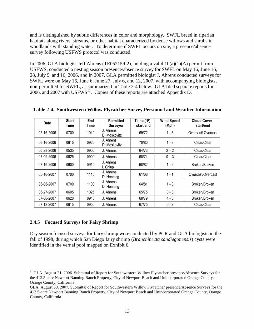
13
and is distinguished by subtle differences in color and morphology. SWFL breed in riparian habitats along rivers, streams, or other habitat characterized by dense willows and shrubs in woodlands with standing water. To determine if SWFL occurs on site, a presence/absence survey following USFWS protocol was conducted. In 2006, GLA biologist Jeff Ahrens (TE052159-2), holding a valid 10(a)(1)(A) permit from USFWS, conducted a nesting season presence/absence survey for SWFL on May 16, June 16, 28, July 9, and 16, 2006, and in 2007, GLA permitted biologist J. Ahrens conducted surveys for SWFL were on May 16, June 6, June 27, July 6, and 12, 2007, with accompanying biologists, non-permitted for SWFL, as summarized in Table 2-4 below. GLA filed separate reports for 2006, and 2007 with USFWS11. Copies of these reports are attached Appendix D.
Table 2-4. Southwestern Willow Flycatcher Survey Personnel and Weather Information
Date Start Time
End Time
Permitted Surveyor
Temp (oF) start/end
Wind Speed (Mph)
Cloud Cover start/end
05-16-2006 0700 1040 J. Ahrens D. Moskovitz
69/72 1 - 3 Overcast/ Overcast
06-16-2006 0615 0920 J. Ahrens D. Moskovitz
70/80 1 - 3 Clear/Clear
06-28-2006 0535 0900 J. Ahrens 64/73 2 – 2 Clear/Clear
07-09-2006 0625 0900 J. Ahrens 68/74 0 – 3 Clear/Clear
07-16-2006 0600 0910 J. Ahrens I. Chlup
68/82 1 - 2 Broken/Broken
05-16-2007 0700 1115 J. Ahrens D. Henning
61/68 1 - 1 Overcast/Overcast
06-06-2007 0700 1100 J. Ahrens, D. Henning
64/81 1 - 3 Broken/Broken
06-27-2007 0605 1025 J. Ahrens 65/75 0 - 3 Broken/Broken
07-06-2007 0620 0940 J. Ahrens 68/79 4 - 3 Broken/Broken
07-12-2007 0615 0950 J. Ahrens 67/75 0 - 2 Clear/Clear
2.4.5 Focused Surveys for Fairy Shrimp Dry season focused surveys for fairy shrimp were conducted by PCR and GLA biologists in the fall of 1998, during which San Diego fairy shrimp (Branchinecta sandiegonensis) cysts were identified in the vernal pool mapped on Exhibit 6.
11 GLA. August 21, 2006. Submittal of Report for Southwestern Willow Flycatcher presence/Absence Surveys for the 412.5-acre Newport Banning Ranch Property, City of Newport Beach and Unincorporated Orange County, Orange County, California GLA. August 30, 2007. Submittal of Report for Southwestern Willow Flycatcher presence/Absence Surveys for the 412.5-acre Newport Banning Ranch Property, City of Newport Beach and Unincorporated Orange County, Orange County, California

14
Subsequent wet season monitoring was conducted on site in 2000 and 2008 to identify any additional areas that ponded for sufficient duration during normal rainfall years to support San Diego fairy shrimp. Water temperature in the ponded areas ranged from 53-72°F (11.5-22°C). The location of additional areas that ponded for sufficient duration but did not contain the San Diego fairy shrimp are mapped on Exhibit 6. Protocol surveys were conducted in one pool that ponded for sufficient duration but did not support San Diego fairy shrimp [Exhibit 6] during the 2007-2008 rainy season by David Moskovitz (TE-084606-0) and during the 2008-2009 rainy season by Erin Bomkamp (TE-123409-0). 2.4.6 Focused Surveys for Burrowing Owl In 2008 and 2009, GLA Biologists conducted focused surveys for burrowing owl (Athene cunicularia) in accordance with the guidelines published by the Burrowing Owl Consortium as well as by CDFG. Surveys included wintering season surveys, conducted on January 20, 21, 22 and 25, 2008 and December 1, December 9, January 6, and January 16, 2009, as well as breeding surveys conducted between on March 21, 22, April 8, and 14, 2008. A summary of the survey times and conditions are included in Table 2-5, and the locations are depicted on Exhibit 7.
Table 2-5. Burrowing Owl Survey Personnel and Weather Information
Date Start Time
End Time
Surveyor Temp (oF) start/end
Wind Speed (Mph)
Cloud Cover
2008 Winter Season Surveys
01-18-08 0615 0930 J. Ahrens 40/67 3 - 3 Clear
01-21-08 1300 1820 J. Ahrens 58/50 1 - 3 Overcast
01-22-08 0620 0940 J. Ahrens 54/60 4 - 2 Overcast
01-26-08 0610 0920 J. Ahrens 43/65 3 - 2 Broken
2008 Breeding Season Surveys
03-21-08 0615 0945 J. Ahrens & D. Lloyd
52/64 1 - 2 Clear
03-22-08 0600 0940 J. Ahrens 49/74 2 - 3 Broken
04-8-08 0600 0935 J. Ahrens 53/62 3 - 3 Broken
04-14-08 0610 0920 J. Ahrens 57/65 2 - 3 Clear
2009 Winter Season Surveys
12-01-08 0540 0930 J. Ahrens 55/58 2-3 Overcast
12-09-08 0545 0940 J. Ahrens 54/61 2-3 Clear
01-06-09 1430 1725 E. Bomkamp 65/60 1-2 Clear
01-16-09 0600 1010 J. Ahrens 53/62 2-3 Clear
2.5 Jurisdictional Delineation The jurisdictional delineation included two phases: review of existing materials/information (“Background Review”) and field data collection for hydrophitic vegetation, hydric soils and hydrology (“Field Procedures”). In determining the extent of wetlands under Section 404 and under the Coastal Act, it is important to note a major difference in how wetland determinations
15
are made. For undisturbed sites, the Corps requires a positive determination for 1) the presence of a predominance of wetland indicator plants (i.e., hydrophytes), 2) hydric soils, and 3) wetland hydrology (referred to as a “three parameter” or “criteria” wetland). On the project site, where a positive determination could not be made for all three, the area was not determined to be a wetland under Section 404. For the Coastal Act, a positive determination of any one of the three criteria is sufficient to make a wetland determination (i.e., “one parameter” wetland). 2.5.1 Background Review Prior to beginning the field delineation a 200-scale color aerial photograph, the Natural Resources Conservation Service (NRCS) soil map for the area,12 and the USGS topographic map Newport Beach, California were examined to determine the locations of potential wetland areas (descriptions derived from the NRCS soil accounts of the mapped soil series are provided below). 2.5.2 Field Procedures The review of existing information, including soil maps, USGS topographic map, and aerial photographs allowed for identification of features that exhibit potential for supporting wetlands or other waters of the U.S. or State. All areas were field checked for the presence of wetland vegetation, soils and hydrology relying on the methodology set forth in the 1987 Wetland Manual13 and the 2006 Interim Regional Supplement to the Corps of Engineers Wetland Delineation Manual: Arid West Region14 (Arid West Supplement). While in the field, the points where data was collected were recorded using a GPS unit, and areas that exhibited wetland characteristics were also mapped using GPS or on a high-resolution aerial photograph. Selection of sites for data collection was based on a variety of factors including the presence of wetland-indicator plants or obvious topographic low points. Site-specific data regarding vegetation, soils and hydrology were recorded onto wetland data sheets. Additional discussion relative to the methods employed is provided below. 2.5.2.1 Hydrophytic Vegetation The presence of hydrophytic wetland indictor plant species was determined based on The National List of Plant Species that Occur in Wetlands.15 The indicator list categorizes plants according to their estimated affinity for occurrence in wetlands summarized as follows:
12 http://websoilsurvey.nrcs.usda.gov/app/WebSoilSurvey.aspx 13 U.S. Army Corps of Engineers. January 1987. Wetlands Delineation Manual by Environmental Laboratory Waterways Experiment Station. Wetlands Research Program Technical Report Y-87-1. Washington, DC 20314-1000 14 U.S. Army Corps of Engineers. December 2006. Interim Regional Supplement to the Corps of Engineers Wetland Delineation Manual: Arid West Region. Wetlands Regulatory Assistance Program, ERDC/EL TR-06-16. Washington, DC 20314-1000. 15 Reed, P.B., Jr. 1988. National List of Plant Species that Occur in Wetlands. U.S. Fish and Wildlife Service Biological Report 88(26.10).

16
• Obligate Wetland Plants (OBL) are assumed to be associated with wetlands 99-percent of the time
• Facultative Wetland Plants (FACW) are assumed to occur in wetlands between 67- and 99-percent of the time
• Facultative species (FAC) are assumed to occur in wetlands between 34- and 66-percent of the time
• Facultative Upland species are assumed to occur in wetlands only 1- to 33-percent of the time (meaning they occur in uplands from 67- to 99-percent of the time
• Upland (UPL) species are assumed to occur in wetlands less than one-percent of the time For each data collection point (see attached data sheets in Appendix A and discussion below for each of the areas investigated), vegetation data was collected as set forth in the Arid West Supplement.16 Only areas exhibiting a predominance of wetland indicator plants using the 50/20 Rule or that exhibited a Prevalence Index score of 3.0 or less, as defined in the Arid West Supplement, were determined to exhibit “hydrophytic” vegetation. 2.5.2.2 Hydric Soils
The presence of hydric soils was determined in accordance with the 1987 Manual and the Arid West Supplement, which in turn has largely adopted Field Indicators of Hydric Soils in the United States v. 6.017. At each data collection point, a soil pit was excavated using a “sharp-shooter” shovel to a minimum of 12 inches and the soil was evaluated for characteristics consistent with the presence of hydric soils such as (but not limited to) sulfidic odor, gleyed soils, and low-chroma matrix with redoximorphic features. In most instances, soil pits were excavated in areas such as topographic depressions that exhibited at least some potential for wetland characteristics, or in areas with a predominance of wetland indicator species. 2.5.2.3 Wetland Hydrology
The presence of wetland hydrology was determined in accordance with the indicators set forth in the 1987 Manual and the Arid West Supplement. 2.5.2.4 Riparian Habitats (CDFG and CCA Only) The limits of CDFG Riparian habitats, regulated pursuant to Section 1600 of the Fish and Game Code, were determined based on the outer extent of the canopy of riparian species which was generally limited to a number of species of willow (Salix spp.) and mulefat (Baccharis salicifolia) where it was specifically associated with drainage courses. It is important to note that not all willows and mulefat were determined to be “riparian” species, as in some instances they were associated with (for example) depressional areas in the lowlands or for mulefat, a variety of disturbed areas growing with a predominance of upland species and clearly not associated with
16 The 1987 Wetland Manual (page 65) suggests that herbaceous vegetation be sampled using a five-foot radius. 17 USDA, NRCS. 2006. Field Indicators of Hydric Soils in the United States v. 6.0. G.W. Hurt, G.M Vasilas (eds). USDA, NRCS in cooperation with the National Technical Committee for Hydric Soils, Fort Worth TX.

17
drainage courses. Such areas were identified as “upland” mulefat as depicted on the vegetation map [Exhibit 9]. 3.0 REGULATORY SETTING The Newport Banning Ranch development project is subject to state and federal regulations associated with a number of regulatory programs, as well as local regulations such as the City of Newport Beach Coastal Land Use Plan (CLUP) Policies. These programs often overlap and were developed to protect natural resources, including state- and federally-listed plants and animals; aquatic resources including rivers and creeks, ephemeral streambeds, wetlands, and areas of riparian habitat; other special-status species which are not listed as threatened or endangered by the state or federal governments; and other special-status vegetation communities. 3.1 State and/or Federally Listed Plants and Animals 3.1.1 State of California Endangered Species Act California’s Endangered Species Act (CESA) defines an endangered species as “a native species or subspecies of a bird, mammal, fish, amphibian, reptile, or plant which is in serious danger of becoming extinct throughout all, or a significant portion, of its range due to one or more causes, including loss of habitat, change in habitat, overexploitation, predation, competition, or disease.” The State defines a threatened species as “a native species or subspecies of a bird, mammal, fish, amphibian, reptile, or plant that, although not presently threatened with extinction, is likely to become an Endangered species in the foreseeable future in the absence of the special protection and management efforts required by this chapter. Any animal determined by the commission as rare on or before January 1, 1985 is a threatened species.” Candidate species are defined as “a native species or subspecies of a bird, mammal, fish, amphibian, reptile, or plant that the commission has formally noticed as being under review by the department for addition to either the list of endangered species or the list of threatened species, or a species for which the commission has published a notice of proposed regulation to add the species to either list.” Candidate species may be afforded temporary protection as though they were already listed as threatened or endangered at the discretion of the Fish and Game Commission. Unlike the FESA, CESA does not list invertebrate species. Article 3, Sections 2080 through 2085, of the CESA addresses the taking of threatened, endangered, or candidate species by stating “No person shall import into this state, export out of this state, or take, possess, purchase, or sell within this state, any species, or any part or product thereof, that the commission determines to be an endangered species or a threatened species, or attempt any of those acts, except as otherwise provided.” Under the CESA, “take” is defined as “hunt, pursue, catch, capture, or kill, or attempt to hunt, pursue, catch, capture, or kill.” Exceptions authorized by the state to allow “take” require permits or memoranda of understanding and can be authorized for endangered species, threatened species, or candidate species for scientific, educational, or management purposes and for take incidental to otherwise lawful activities. Sections 1901 and 1913 of the California Fish and Game Code provide that notification is required prior to disturbance.

18
3.1.2 Federal Endangered Species Act The FESA of 1973 defines an endangered species as “any species that is in danger of extinction throughout all or a significant portion of its range.” A threatened species is defined as “any species that is likely to become an Endangered species within the foreseeable future throughout all or a significant portion of its range.” Under provisions of Section 9(a)(1)(B) of the FESA it is unlawful to “take” any listed species. “Take” is defined in Section 3(18) of FESA: “...harass, harm, pursue, hunt, shoot, wound, kill, trap, capture, or collect, or to attempt to engage in any such conduct.” Further, the USFWS, through regulation, has interpreted the terms “harm” and “harass” to include certain types of habitat modification that result in injury to, or death of species as forms of “take.” These interpretations, however, are generally considered and applied on a case-by-case basis and often vary from species to species. In a case where a property owner seeks permission from a Federal agency for an action that could affect a federally listed plant and animal species, the property owner and agency are required to consult with USFWS. Section 9(a)(2)(b) of the FESA addresses the protections afforded to listed plants. In addition to the prohibitions on the take of listed species, the Service is also required to designate areas of “Critical Habitat” for species listed under the FESA. The FESA defines critical habitat as "the specific areas within the geographical area occupied by the species, at the time it is listed, on which are found those physical or biological features (I) essential to the conservation of the species and (II) which may require special management considerations or protection; and specific areas outside the geographical area occupied by the species at the time it is listed that are determined by the Secretary to be essential for the conservation of the species." A designation does not set up a preserve or refuge and only applies to situations where Federal funding, permits, or projects are involved. 3.1.3 State and Federal Take Authorizations for Listed Species Federal or state authorizations of impacts to or incidental take of a listed species by a private individual or other private entity would be granted in one of the following ways:
• Section 7 of the FESA stipulates that any federal action that may affect a species listed as threatened or endangered requires a formal consultation with USFWS to ensure that the action is not likely to jeopardize the continued existence of the listed species or result in destruction or adverse modification of designated critical habitat. 16 U.S.C. 1536(a)(2).
• In 1982, the FESA was amended to give private landowners the ability to develop Habitat Conservation Plans (HCP) pursuant to Section 10(a) of the FESA. Upon development of an HCP, the USFWS can issue incidental take permits for listed species where the HCP specifies at minimum, the following: (1) the level of impact that will result from the taking, (2) steps that will minimize and mitigate the impacts, (3) funding necessary to implement the plan, (4) alternative actions to the taking considered by the applicant and the reasons why such alternatives were not chosen, and (5) such other measures that the Secretary of the Interior may require as being necessary or appropriate for the plan .
• Sections 2090-2097 of the California Endangered Species Act (CESA) require that the state lead agency consult with CDFG on projects with potential impacts on state-listed species. These provisions also require CDFG to coordinate consultations with USFWS

19
for actions involving federally listed as well as state-listed species. In certain circumstances, Section 2080.1 of the California Fish and Game Code allows CDFG to adopt the federal incidental take statement or the 10(a) permit as its own based on its findings that the federal permit adequately protects the species under state law.
3.1.4 Central Coastal NCCP In July 1996, a Natural Communities Conservation Plan/Habitat Conservation Plan (NCCP/HCP) was approved, and an Implementing Agreement (IA) was executed between the federal and state Wildlife Agencies (USFWS and CDFG) and participating entities, including various Cities, Agencies, and private landowners within the Orange County Central & Coastal NCCP Subregion. This program was developed to satisfy the requirements for both the FESA and CESA. The NCCP/HCP generally addresses vegetation communities and species associated with the upland coastal sage scrub habitat mosaic within the Central & Coastal NCCP Subregion. A primary purpose of the NCCP/HCP was to identify reserve design and management requirements for the coastal sage scrub habitat mosaic from a subregional, or ecosystem-based, scale rather than under the traditional approach of piecemeal, project-by-project review. Environmental documentation for the NCCP/HCP was incorporated in a Joint EIR/EIS that was certified by the County of Orange and for which a Record of Decision (ROD) was issued by USFWS. The EIR/EIS addresses biological impacts for “take” of “Identified Species” and “Covered Habitats” within the development areas designated in the NCCP/HCP, and through the EIR/EIS, these biological impacts have been addressed in a certified environmental document. Impacts to identified species and establishment and implementation of the subregional conservation strategy and other measures included in the NCCP/HCP compensate for covered habitats within designated development areas in the NCCP/HCP area. The measures incorporated in the NCCP/HCP are therefore intended to address the federal, state, and local project-specific mitigation requirements for the species and habitats addressed in the NCCP/HCP under FESA, CESA, CEQA, NEPA and the Migratory Bird Treaty Act (MBTA). As such, the NCCP/HCP is intended to streamline review of individual projects with respect to the species and habitats addressed in the NCCP/HCP, and to provide for an overall Habitat Reserve System that would be of greater benefit to biological resources than would result from a piecemeal regulatory approach. The Banning Ranch site was not included within the covered areas for which take authorization was granted under the NCCP/HCP. Instead, it was designated as an “existing use area”, which although was geographically included in the subregion does not benefit from the take authorizations and therefore requires authorization independent through Section 7 or Section 10 of the FESA. The Banning Ranch project has elected to seek take authorization through Section 7 of FESA.
20
3.2 Jurisdictional Waters/Wetlands/Riparian Habitats 3.2.1 U.S. Army Corps of Engineers (Corps) Pursuant to Section 404 of the Clean Water Act, the Corps regulates the discharge of dredged and/or fill material into waters of the United States. The term "waters of the United States" is defined in Corps regulations at 33 CFR Part 328.3(a) as:
(1) All waters which are currently used, or were used in the past, or may be susceptible to use in interstate or foreign commerce, including all waters which are subject to the ebb and flow of the tide;
(2) All interstate waters including interstate wetlands; (3) All other waters such as intrastate lakes, rivers, streams (including
intermittent streams), mudflats, sandflats, wetlands, sloughs, prairie potholes, wet meadows, playa lakes, or natural ponds, the use, degradation or destruction of which could affect foreign commerce including any such waters:
(i) Which are or could be used by interstate or foreign travelers for
recreational or other purposes; or (ii) From which fish or shell fish are or could be taken and sold in
interstate or foreign commerce; or (iii) Which are used or could be used for industrial purpose by industries
in interstate commerce... (4) All impoundments of waters otherwise defined as waters of the United States
under the definition; (5) Tributaries of waters identified in paragraphs (a) (1)-(4) of this section; (6) The territorial seas; (7) Wetlands adjacent to waters (other than waters that are themselves wetlands)
identified in paragraphs (a) (1)-(6) of this section. In the absence of wetlands, the limits of Corps jurisdiction in non-tidal waters, such as intermittent streams, extend to the OHWM which is defined at 33 CFR 328.3(e) as:
...that line on the shore established by the fluctuation of water and indicated by physical characteristics such as clear, natural line impressed on the bank, shelving, changes in the character of soil, destruction of terrestrial vegetation, the presence of litter and debris, or other appropriate means that consider the characteristics of the surrounding areas.
The term “wetlands” (a subset of “waters of the United States”) is defined at 33 CFR 328.3(b) as "those areas that are inundated or saturated by surface or ground water at a frequency and duration sufficient to support...a prevalence of vegetation typically adapted for life in saturated soil conditions." The discharge of dredge or fill material into waters of the United States, including wetlands requires authorization from the Corps prior to impacts. The location of all jurisdictional waters subject to Corps provided on Exhibit 8a.
21
3.2.2 California Department of Fish and Game (CDFG) Pursuant to Division 2, Chapter 6, Sections 1600-1603 of the California Fish and Game Code, the CDFG regulates all diversions, obstructions, or changes to the natural flow or bed, channel, or bank of any river, stream, or lake which supports fish or wildlife. CDFG defines a "stream" (including creeks and rivers) as "a body of water that flows at least periodically or intermittently through a bed or channel having banks and supports fish or other aquatic life. This includes watercourses having surface or subsurface flow that supports or has supported riparian vegetation." CDFG's definition of "lake" includes "natural lakes or man-made reservoirs." Diversions, obstructions, or changes to the natural flow or bed, channel, or bank of any river, stream, or lake which supports fish or wildlife, require authorization from CDFG by means of entering into an agreement pursuant to Section 1602 of the Fish and Game Code. The location of all jurisdictional waters subject to CDFG is provided on Exhibit 8b. 3.2.3 California Coastal Commission (CCC) The CCA protects important coastal biological resources including wetlands, riparian habitats and other areas defined as Environmentally Sensitive Habitat Areas (ESHA) by the CCC in accordance with the Coastal Act. The Coastal Act Section 30107.5 defines an ESHA as:
…any area in which plant or animal life or their habitats are either rare or especially valuable because of their special nature or role in an ecosystem and which could be easily disturbed or degraded by human activities and developments.
The project site includes habitat areas that potentially fall into one or more categories that are protected from impacts associated with development under Coastal Act including wetlands, riparian areas, and upland habitats. In addition, the City of Newport Beach has an approved Coastal Land Use Plan (CLUP) that describes allowable land uses for areas within the Coastal Zone. Although the Newport Banning Ranch Property was not included in the CLUP, the City’s CLUP is highly detailed in addressing specific wetland, riparian, and upland habitats that are generally considered ESHA within the City, providing a useful tool for evaluation of resources on the project site. As discussed immediately below and summarized in Table 4-4, there are areas of overlap between certain habitat categories such that careful distinctions are necessary when evaluating each as potential wetland areas or as potential ESHA. For example, not all wetlands are considered ESHA (e.g., wetlands dominated by non-native invasive species); however, they are still protected under Section 30233 of the Coastal Act. Similarly, some riparian areas are not wetlands because they lack wetland hydrology and/or the plants are growing as phreatophytes rather than hydrophytes, but may be ESHA due to their importance in the ecosystem. Other non-wetland riparian areas may be so limited in size, degraded, or isolated that they do not meet the minimum threshold under the Coastal Act or City’s CLUP for ESHA. Each of these is addressed below.

22
3.2.3.1 Wetlands as Defined by the Coastal Act Pursuant to the California Coastal Act (California Public Resources Code Section 30233), the CCC regulates the diking, filling, or dredging of wetlands within the coastal zone. The Coastal Act Section 30121 defines “wetlands” as land “which may be covered periodically or permanently with shallow water.” The 1981 CCC Statewide Interpretive Guidelines state that hydric soils and hydrophytic vegetation, “are useful indicators of wetland conditions, but the presence or absence of hydric soils and/or hydrophytes alone are not necessarily determinative when the Commission identifies wetlands under the Coastal Act. In the past, the Commission has considered all relevant information in making such determinations and relied upon the advice and judgment of experts before reaching its own independent conclusion as to whether a particular area will be considered wetland under the Coastal Act. The Commission intends to continue to follow this policy.” The location of all wetlands potentially subject to CCC jurisdiction is provided on Exhibit 8c. 3.2.3.2 Riparian Areas Defined by the Coastal Act and City’s CLUP The 1981 CCC Statewide Interpretive Guidelines defines riparian habitats as follows:
A “riparian habitat” is an area of riparian vegetation. This vegetation is an association of plant species which grows adjacent to freshwater watercourses, including perennial and intermittent streams, lakes, and other bodies of freshwater.
The project site includes areas of riparian habitat that meet the CCA definition of wetland, as well as areas of riparian habitat that do not meet the CCA definition of wetland. Similarly, the site contains wetland and riparian areas that meet the definition of ESHA as well as limited areas of riparian habitat that meet neither the wetland definition nor the ESHA definition. Finally, the site contains wetland areas, as defined under the coastal act that do not meet the thresholds for making an ESHA determination (e.g., wetland areas in the lowlands vegetated by monocultures of the invasive non-native plant poison hemlock). 3.2.3.3 Upland ESHA Areas The City of Newport Beach has carefully defined habitats, including habitats on the project site such as maritime succulent scrub and southern coastal bluff scrub, that generally meet the definition of ESHA, unless they are sufficiently degraded, isolated, or otherwise affected by development that the habitat values are limited as detailed in Section 4.8 below. 3.3 California Environmental Quality Act 3.3.1 CEQA Guidelines Section 15380 The California Environmental Quality Act (CEQA) requires evaluation of a project’s impacts on biological resources and provides guidelines and thresholds for use by lead agencies for

23
evaluating the significance of proposed impacts. Sections 5.1.1 and 5.2.2 below set forth these thresholds and guidelines. Furthermore, pursuant to the CEQA Guidelines Section 15380, CEQA provides protection for non-listed species that could potentially meet the criteria for state listing. For plants, CDFG recognizes that plants on Lists 1A, 1B, or 2 of the California Native Plant Society (CNPS) Inventory of Rare and Endangered Plants in California may meet the criteria for listing and should be considered under CEQA. CDFG also recommends protection of plants, which are regionally important, such as locally rare species, disjunct populations of more common plants, or plants on the CNPS Lists 3 or 4. 3.3.2 Non-Listed Special-Status Plants and Animals Evaluated Under CEQA 3.3.2.1 Federally Designated Special-Status Species Within recent years, the USFWS instituted changes in the listing status of candidate species. Former C1 (candidate) species are now referred to simply as candidate species and represent the only candidates for listing. Former C2 species (for which the USFWS had insufficient evidence to warrant listing) and C3 species (either extinct, no longer a valid taxon or more abundant than was formerly believed) are no longer considered as candidate species. Therefore, these species are no longer maintained in list form by the USFWS, nor are they formally protected. However, some USFWS field offices have issued memoranda stating that former C2 species are to be considered federal Species of Concern (FSC). This term is employed in this document, but carries no official protections. All references to federally-protected species in this report (whether listed, proposed for listing, or candidate) include the most current published status or candidate category to which each species has been assigned by USFWS. For this report the following acronyms are used for federal special-status species:
• FE Federally listed as Endangered • FT Federally listed as Threatened • FPE Federally proposed for listing as Endangered • FPT Federally proposed for listing as Threatened • FC Federal candidate species (former C1 species) • FSC Federal Species of Concern (former C2 species)
3.3.2.2 State-Designated Special-Status Species Some mammals and birds are protected by the state as Fully Protected (SFP) mammals or Fully Protected birds, as described in the California Fish and Game Code, Sections 4700 and 3511, respectively. California Species of Special Concern (SPOC) are species designated as vulnerable to extinction due to declining population levels, limited ranges, and/or continuing threats. This list is primarily a working document for the CDFG’s CNDDB project. Informally listed taxa are not protected, but warrant consideration in the preparation of biotic assessments. For some species, the CNDDB is only concerned with specific portions of the life history, such as roosts, rookeries, or nest sites. For this report the following acronyms are used for State special-status species:

24
• SE State-listed as Endangered • ST State-listed as Threatened • SR State-listed as Rare • SCE State candidate for listing as Endangered • SCT State candidate for listing as Threatened • SFP State Fully Protected • SP State Protected • CSC California Special Concern Species
3.3.2.3 California Native Plant Society The CNPS is a private plant conservation organization dedicated to the monitoring and protection of sensitive species in California. The California Native Plant Society’s Seventh Edition (Online) of the California Native Plant Society’s Inventory of Rare and Endangered Plants of California separates plants of interest into five categories. CNPS has compiled an inventory comprised of the information focusing on geographic distribution and qualitative characterization of Rare, Threatened, or Endangered vascular plant species of California (Tibor 2001). The list serves as the candidate list for listing as threatened and endangered by CDFG. CNPS has developed five categories of rarity that are summarized in Table 3-1.
Table 3-1. CNPS Lists 1, 2, 3, & 4
CNPS List Comments List 1A – Presumed Extinct in California Thought to be extinct in California based on a lack of observation or
detection for many years.
List 1B – Rare or Endangered in California and Elsewhere
Species, which are generally rare throughout their range that are also judged to be vulnerable to other threats such as declining habitat.
List 2 - Rare or Endangered in California, More Common Elsewhere
Species that are rare in California but more common outside of California
List 3 – Need More Information Species that are thought to be rare or in decline but CNPS lacks the information needed to assign to the appropriate list. In most instances, the extent of surveys for these species is not sufficient to allow CNPS to accurately assess whether these species should be assigned to a specific list. In addition, many of the List 3 species have associated taxonomic problems such that the validity of their current taxonomy is unclear.
List 4 – Plants of Limited Distribution Species that are currently thought to be limited in distribution or range whose vulnerability or susceptibility to threat is currently low. In some cases, as noted above for List 3 species above, CNPS lacks survey data to accurately determine status in California. Many species have been placed on List 4 in previous editions of the “Inventory” and have been removed as survey data has indicated that the species are more common than previously thought. CNPS recommends that species currently included on this list should be monitored to ensure that future substantial declines are minimized.

25
Table 3-2. CNPS Threat Code Extensions
Threat Code Extension Comments
.1 Seriously endangered in California (over 80% of occurrences threatened / high degree and immediacy of threat)
.2 Fairly endangered in California (20-80% occurrences threatened)
.3 Not very endangered in California (<20% of occurrences threatened or no current threats known)
4.0 RESULTS 4.1 Reconnaissance Surveys Generally, the Site includes a mesa on the east and south portions of the property and lowland areas on the west and north portions of the property. The Site has been utilized as an operating oil field for over 50 years and ongoing oil extraction operations, including paved and dirt roads and remnant oil wells, support facilities (buildings, storage areas, etc.) and pipelines occur throughout the site. Topographically, the Site includes flat lowlands throughout the western portion of the property, south and west facing slopes located east of the lowlands, a southwest facing bluff overlooking the Newport Shores residential area, a large mesa encompassing the eastern portion of the site, and two arroyos between mesa portions of the site. 4.2 Vegetation Mapping and Surveys As noted, GLA biologists conducted vegetation mapping on October 20, 28, November 4, and 30, 2006 and on April 26, July 16, 20, December 14, 17, 18, 2007, and January 2, 2008. A vegetation map is provided as Exhibit 9. Descriptions of the vegetation associations have been separated into “upland habitats” and “wetland/riparian habitats.” In some cases, certain vegetation associations include both wetland and non-wetland stands (e.g., mulefat scrub), where the upland/wetland status was based on a predominance of wetland indicator species as well as soils and hydrological conditions. Table 4-1 summarizes the detailed information below.
Table 4-1. Summary of Vegetation Associations on Site
Vegetation Type OCHCS Code Total on Site (acres)
UPLAND SCRUB ASSOCIATIONS Buckwheat Scrub 2.3.7 1.19 Coast Goldenbush Scrub 2.3.13 4.08 Coast Goldenbush Scrub/Mulefat Scrub 2.3.13/7.3 1.91 Coyote Bush Scrub/ Mulefat Scrub Ecotone 2.3.9/7.3 0.68 Disturbed Coyote Bush Scrub 2.3.9 0.55 Encelia Scrub/Goldenbush Scrub 2.2.1/2.3.13 1.56

26
Encelia Scrub/Mulefat Scrub 2.2.1/7.3 3.67 Maritime Succulent Scrub/Encelia Scrub 2.2/2.2.1 33.81 Mulefat Scrub 7.3 11.96 Saltbush (Chenopod) Scrub 2.7 0.40 Southern Cactus Scrub/Non-native grassland 2.4/4.1 0.09 Southern Coastal Bluff Scrub 2.1 4.90
Subtotal 65.00
WETLAND/RIPARIAN ASSOCIATIONS Alkali Meadow 5.2 23.36 Mulefat Scrub 7.3 20.95 Ruderal Wetland 4.6w 8.60 Southern Black Willow Forest 7.7 21.35 Southern Coastal Brackish Marsh 6.2 0.17 Southern Coastal Salt Marsh 6.1 4.34 Southern Willow Scrub 7.2 4.69 Tidal Mudflat 11.5 1.37 Vernal Pool 5.1 0.32
Subtotal 84.95
UPLAND GRASSLAND ASSOCIATIONS Annual Grassland 4.1 73.55 Non-native grassland/Coastal Goldenbush Ecotone 2.8.3 2.14 Ruderal Upland 4.6u 42.72
Subtotal 118.41
OTHER Disturbed/Developed 15.3 99.70 Flood Control Channel 13.4 0.08 Invasive/Ornamental 15.5 32.93
Subtotal 132.71 TOTAL 401.07
4.2.1 Upland Scrub Vegetation Associations 4.2.1.1 Southern Coastal Bluff Scrub (SCBS, 2.1) This vegetation association covers 4.90 acres on site and is generally limited to the bluff faces along the western portion of the site between Pacific Coast Highway and the lowlands. Most of the SCBS overlooking Newport shores is dominated by California encelia (Encelia californica), bladderpod (Isomeris arborea) and coyote brush (Baccharis pilularis) with non-native hottentot fig and myoporum common throughout with areas exhibiting the highest density of non-natives characterized as disturbed. A few California boxthorn (Lycium californicum) and wooly seablite (Suaeda taxifolia) are common along with California buckwheat (Eriogonum fasciculatum) at the southwest corner overlooking the City of Newport Beach oil facilities. Of the 4.90 acres of southern coastal bluff scrub, 3.92 acres have been designated as disturbed due to a substantial

27
component of non-native invasive species including hottentot fig, myoporum, and/or pampas grass. 4.2.1.2 Maritime Succulent Scrub (MSS, 2.2) and Encelia Scrub (ES 2.2.1) Scrub dominated by California encelia (Encelia californica) is the dominant upland scrub habitat on the site covering 33.81 acres. Portions of the Encelia-dominated areas correspond with the OCHCS description for maritime succulent scrub (covering 15.91 of 33.81 acres) which includes California encelia, coast cholla (Opuntia prolifera), prickly pear (Opuntia littoralis), bladderpod (Isomeris arborea), and occasional individuals of California buckwheat (Eriogonum fasciculatum). Other areas, more accurately characterized as “Encelia Scrub” or the “California encelia series” from A Manual of California Vegetation18 consist of near monocultural stands of California encelia (covering 16.74 of 33.81 acres). Other species present, but typically in low numbers include California buckwheat (Eriogonum fasciculatum) and bladderpod (Isomeris arborea). Of the Maritime Succulent Scrub and Encelia Scrub acreage, 4.74 acres, and 8.70 acres have been designated as disturbed, respectively, due to a substantial component of non-native invasive species including hottentot fig, tree tobacco, tocalote, black mustard, sweet fennel, and non-native grasses. 4.2.1.3 Encelia Scrub/Mulefat Scrub (ES/MFS 2.2.1/7.3) This vegetation association covers 3.67 acres and supports a mixture of scrub co-dominated by California encelia (Encelia californica) and mulefat (Baccharis salicifolia). Typically these patches are small, often occurring in areas that were formerly disturbed by oil field operations, as both species are good colonizers of disturbed ground. Of the 3.67 acres of ES/MFS, 2.61 acres are characterized as “disturbed” and include a substantial component of non-native invasives such as hottentot fig, pampas grass or Spanish sunflower. 4.2.1.4 Encelia Scrub (ES, 2.2.1)/Goldenbush Scrub (GBS, 2.3.13) This vegetation association covers 1.56 acres and supports a mixture of scrub co-dominated by California encelia and coastal goldenbush (Isocoma menziesii ssp. vernonioides). Typically these patches are small, often occurring in areas that were formerly disturbed by oil field operations, as both species are good colonizers of disturbed ground. Of the 1.56 acres of ES/MFS, 1.16 acres are characterized as “disturbed” and include a substantial component of non-native invasives such as hottentot fig, pampas grass, black mustard, castor bean or sweet fennel. 4.2.1.5 Buckwheat Scrub (BS, 2.3.7) Buckwheat scrub is limited to two areas on the site and covers 1.19 acres total. BS is dominated by California buckwheat (Eriogonum fasciculatum) with California encelia and California sagebrush contributing less than approximately 25-percent of the cover, and is a subassociation of coastal sage scrub (CSS). Of the 1.19 acres of Buckwheat Scrub, 0.21 acre has been
18 Sawyer, John O. and Todd Keeler-Wolf. 1995. A Manual of California Vegetation. California Native Plant Society, Sacramento, CA.

28
designated as disturbed due to a substantial component of non-native invasive species including hottentot fig, myoporum, pampas grass or tree tobacco. 4.2.1.5 Disturbed Coyote Bush Scrub (CBS, 2.3.9) Coyote bush scrub is limited to a few small patches on the site, collectively covering 0.55 acres. This subassociation of coastal sage scrub (CSS) is dominated by coyote brush (Baccharis pilularis), which often occurs in small monocultural patches or with other upland species such as coast goldenbush (Isocoma menziesii ssp. vernonioides), and occasional individuals of California encelia, California sagebrush, and bladderpod. All the coyote brush scrub on site has been designated as “disturbed” due to a high percentage of non-native grasses and forbs including red brome (Bromus madritensis ssp. rubens), ripgut (Bromus diandrus), black mustard (Brassica nigra), tocolote (Centauria melitensis), and sweet fennel (Foeniculum vulgare). 4.2.1.6 Coyote Bush Scrub (CBS, 2.3.9)/Mulefat Scrub (MFS, 7.3) Ecotone Limited areas of the site, accounting for 0.68 acre are comprised of a near-equal mix of coyote bush and mulefat. Based on the Prevalence Index scores, soils, and hydrology, these areas were determined to be upland. 4.2.1.7 Coast Goldenbush Scrub (GBS, 2.3.13) Coastal Goldenbush (Isocoma menziesii ssp. vernonioides) is common in many subassociations on the site mostly due to the combination of substantial historic disturbance and the ability of this species to rapidly colonize disturbed areas. It also occurs in nearly pure stands, with mulefat as a co-dominant as well as a component in grasslands corresponding to Goldenbush-Grassland ecotone (2.8.3 in the OCHCS). Neither the OCHCS nor A Manual of California Vegetation includes a description of areas where coast goldenbush (Isocoma menziesii ssp. vernonioides) is the dominant shrub within areas that exhibit more than 15-percent cover. The Project site includes areas where coast goldenbush is the only canopy shrub or is clearly the dominant canopy shrub. These areas are designated as Goldenbush scrub. This vegetation association covers 4.08 acres on the site, and is typically found on roadsides in the lowlands or areas disturbed by oilfield operations. This habitat association consists of mostly monocultural stands of coastal goldenbush. Of the 4.08 acres of goldenbush scrub on site, 1.58 acres have been designated as “disturbed” due to a substantial component of non-native invasive species including pampas grass, tree tobacco, black mustard, tocalote, and non-native grasses. 4.2.1.8 Coast Goldenbush Scrub (2.3.13)/Mulefat Scrub (7.3) This vegetation association covers 1.91 acres that occur in higher elevation portions of the lowlands, commonly on berms or along road edges that do not exhibit sufficient hydrology for other wetland indicator species. Of the 1.91 acres of goldenbush scrub/mulefat scrub on site, 1.12 acres have been designated as “disturbed” due to a substantial component of non-native invasive species including pampas grass, tree tobacco, castor bean, black mustard, and tocalote.

29
4.2.1.9 Southern Cactus Scrub (SCS, 2.4)/Non-native grassland (4.1) Southern cactus scrub is limited to a few small patches on the site covering 0.09 acre, combined. The limited areas of southern cactus scrub consist of local patches of monocultural stands of prickly pear (Opuntia littoralis) among a variety of non-native grasses. 4.2.1.10 Saltbush (Chenopod) Scrub (SS, 2.7) Limited areas along the southern and western edges of the site covering 0.40 acre consist of nearly monocultural stands of Brewer’s saltbush (Atriplex lentiformis ssp. breweri). 4.2.1.11 Mulefat Scrub (MFS, 7.3) [Upland] This vegetation association, which includes all mulefat scrub on site that is not associated with either a jurisdictional wetland or riparian area, covers 11.96 acres on the site. The majority of the mulefat scrub is associated with the lowlands, while a lesser amount is associated with the arroyos and smaller gullies. Hydrological monitoring of these areas has demonstrated that they lack wetland hydrology and hydric soils. This association consists of dense stands of mulefat (Baccharis salicifolia, FACW) with native understory that varies from location to location but may include one or more of the following species: coastal goldenbush (Isocoma menziesii ssp. vernonioides, UPL), California encelia (Encelia californica, UPL), giant horseweed (Conyza canadensis, FAC), fascicled tarplant (Deinandra fasciculata, UPL), alkali heath (Frankenia salina, FACW), seaside heliotrope (Heliotropum curassivicum, FAC), alkali mallow (Malvella leprosa, FAC), alkali weed (Cressa truxillensis) smooth cocklebur (Xanthium strumarium, FAC), with non-natives that include Spanish sunflower (Pulicaria paludosa, FACW), black mustard (and bristly ox-tongue (Picris echioides, FAC). Of the 11.96 acres of MFS not associated with wetland or riparian areas, 8.29 acres are considered disturbed due to the presence of substantial amounts of hottentot fig (Carpobrotus edulis, UPL), pampas grass (Cortedaria selloana, UPL) as well as myoporum (Myoporum laetum, UPL), or the other non-native species in combination with the hottentot fig and/or pampas grass. 4.2.2 Marsh and Herbaceous Wetland Vegetation Associations Marsh and herbaceous wetland associations are generally restricted to the lowlands with limited areas on the mesa or in the canyons that also support vegetation associations that exhibit a predominance of wetland indicator plant species with an indicator status of FAC or wetter. Substantial portions of these associations exhibit hydric soils and wetland hydrology and as such meet the Section 404 three-criteria definition of wetlands. Limited areas fail to exhibit hydric soils and therefore are wetlands under the Coastal Act but not under Section 404. In a few instances, areas with FAC or FACW species demonstrably lacked hydric soils and wetland hydrology and do not meet either the Section 404 or Coastal Act definition of wetlands.
30
4.2.2.1 Ruderal Wetland (RW, 4.6w)19 This vegetation association covers 8.60 acres throughout the site. This association consists of patches of non-native and/or weedy species with wetland indicator status of FAC or FACW that also exhibit wetland hydrology or soils indicative of reducing conditions growing in disturbed areas. The dominant species is poison hemlock (Conium maculatum, FACW) with local dominance by five-hook bassia (Bassia hyssopifolia, FAC), Spanish sunflower (Pulicaria paludosa, FAC), and giant horseweed (Conyza canadensis, FAC) in limited areas. 4.2.2.2 Vernal Pool (VP, 5.1) Two vernal pools occur on the mesa near the east-central portion of the site covering 0.32-acre. The larger of the vernal pools is an artificial feature that formed in an onsite softball field that was abandoned in the mid-1970s. The pool supports and mix of herbaceous perennial hydrophytes including creeping spikerush and saltgrass (Distichlis spicata, FACW) along with annuals that are indicative of vernal pool habitats in southern California including woolly marbles (Psilocarphus brevissimus, OBL) and waterfern (Marsilea vestita, OBL). Mulefat has colonized the pool and now accounts for a substantial component of the vegetative cover. This feature supports the federally listed endangered San Diego fairy shrimp. The small pool is very shallow and does not support a predominance of hydrophytes, but was identified as a vernal pool based on the presence of San Diego fairy shrimp during wet season surveys in 2000. 4.2.2.3 Alkali Meadow (AM, 5.2) This vegetation association covers 23.36 acres throughout the lowlands. This association is similar in species composition to southern coastal salt marsh (described below), except that it does not receive tidal flows; rather it receives only direct rainfall and local runoff. Component species include pickleweed (Salicornia virginica) saltgrass (Distichlis spicata), alkali heath (Frankenia salina), alkali mallow (Malvella leprosa), and alkali weed (Cressa truxillensis). Of the 23.36 acres of AM, 4.11 acres support a substantial component of non-native weedy species including five-hook bassia (Bassia hyssopifolia, FAC) and poison hemlock (Conium maculatum, FACW) and are designated as disturbed alkali meadow. 4.2.2.4 Southern Coastal Salt Marsh (SCSM, 6.1) This vegetation association covers 4.34 acres on site. This association is limited to a small area in the southwest portion of the lowlands that receives muted tidal flows. Component species include common pickleweed (Salicornia virginica, OBL), alkali heath (Frankenia salina), fleshy jaumea (Jaumea carnosa), saltgrass (Distichlis spicata), shoregrass (Monanthochloe littoralis), and saltwort (Batis maritima). Of the 4.34 acres of SCSM, 0.26 acre supports a substantial
19 “Ruderal Wetland” is not included in the OCHCS. The areas designated as “Ruderal Wetland” share characteristics of coastal freshwater marsh (6.4) and riparian herb (7.1); however the species composition of the Ruderal Wetland is entirely non-native with poison hemlock the dominant species with five-hook bassia, Spanish sunflower, and giant horseweed providing only local or limited cover.

31
component of non-native weedy species consisting mostly of five-hook bassia (Bassia hyssopifolia, FAC), and is designated as disturbed southern coastal salt marsh. 4.2.2.5 Southern Coastal Brackish Marsh (SCBM, 6.2) This vegetation association covers 0.17 acres in the lowlands. These consist of a few small areas dominated by southern cattail (Typha domingensis), California bulrush (Scirpus californicus), and alkali bulrush (Scirpus maritmus), with marsh fleabane (Pluchea odorata), alkali weed (Cressa truxillensis), and saltgrass (Distichlis spicata) in the understory. 4.2.2.6 Tidal Mudflat (MUD, 11.5) Muted tidally connected mudflats cover 1.37 acres of the lowlands on site. These areas are limited to the tidally connected areas in the southwest corner of the site and forms a matrix with areas of coastal salt marsh within those limited portions of the lowlands that receive muted tidal flows. Tidal mudflats are unvegetated except for algal mats. 4.2.3 Riparian Vegetation Associations Riparian associations are most prevalent in the lowlands and also occur in each of the arroyos on the site. As noted for the wetland associations described above, some of these areas exhibit wetland hydrology, hydric soils and a predominance of hydrophytes and are wetlands subject to Section 404 jurisdiction. Some of these areas, while exhibiting a predominance of hydrophytes and wetland hydrology, lack hydric soils and are therefore only considered wetlands under the Coastal Act. Some of these areas associated with the arroyos exhibit a predominance of wetland indicator species but lack hydric soils and wetland hydrology, and are therefore considered riparian but not Coastal Act wetlands. Finally, areas that support riparian indicator species that do not predominate (e.g., mulefat) that also lack hydric soils and wetland hydrology are included in the upland associations above. 4.2.3.1 Southern Willow Scrub (SWS, 7.2) This vegetation association covers 4.69 acres throughout the lowlands and in the arroyos. This association consists of dense stands of shrubby arroyo willow (Salix lasiolepis), black willow (Salix gooddingii), and narrow-leaved willow (Salix exigua), with some mulefat (Baccharis salicifolia). The understory varies throughout the site and includes native species such as saltgrass (Distichlis spicata, FACW), southern cattail (Typha domengensis, OBL), smooth cocklebur (Xanthium strumarium, FAC), and western ragweed (Ambrosia psilostachya, FAC). Of the 4.69 acres of SWS, 1.30 acres are characterized as disturbed due to the presence of a substantial component of non-native species including pampas grass (Cortederia selloana, UPL), giant reed (Arundo donax, FACW), poison hemlock (Conium maculatum, FACW), and/or Spanish sunflower (Pulicaria paludosa, FACW).

32
4.2.3.2 Mulefat Scrub (MFS, 7.3) [Wetland/Riparian] This vegetation association, which includes all mulefat scrub on site that is associated with either a jurisdictional wetland or riparian area20, covers 20.95 acres on the site. As noted above, the majority of the mulefat scrub is associated with the lowlands, while a lesser amount is associated with the arroyos and smaller gullies. This association consists of dense stands of mulefat (Baccharis salicifolia, FACW) with native understory that varies from location to location but may include one or more of the following species: alkali heath (Frankenia salina, FACW), saltgrass (Distichlis spicata, FACW), tall nutsedge (Cyperus eragrostis, FACW), willowherb (Epilobium ciliatum, FACW), seaside heliotrope (Heliotropum curassivicum, FAC), alkali mallow (Malvella leprosa, FAC), alkali weed (Cressa truxillensis) smooth cocklebur (Xanthium strumarium, FAC), with non-natives that include Spanish sunflower (Pulicaria paludosa, FACW), curly dock (Rumex crispus, FACW), and bristly ox-tongue (Picris echioides, FAC). Of the 20.95 acres of MFS associated with wetland or riparian areas, 15.96 acres are considered disturbed due to the presence of substantial amounts of hottentot fig (Carpobrotus edulis, UPL), pampas grass (Cortedaria selloana, UPL) as well as myoporum (Myoporum laetum, UPL), or the other non-native species in combination with the hottentot fig and/or pampas grass. 4.2.3.3 Southern Black Willow Forest (SBWF, 7.7) This vegetation association covers 21.35 acres on the site with the majority associated with the lowlands as well as portions of the large arroyo. This association consists of a closed canopy of and black willow (Salix gooddingii) that includes arborescent forms of arroyo willow (Salix lasiolepis) with an understory that varies substantially throughout the site but that may include one or more of the following species: saltgrass (Distichlis spicata, FACW), western goldenrod (Euthamia occidentalis, OBL), tall nutsedge (Cyperus eragrostis, FACW), willowherb (Epilobium ciliatum, FACW), seaside heliotrope (Heliotropum curassivicum, FAC), alkali mallow (Malvella leprosa), alkali weed (Cressa truxillensis) smooth cocklebur (Xanthium strumarium, FAC), with non-natives that include Spanish sunflower (Pulicaria paludosa, FACW), curly dock (Rumex crispus, FACW), and bristly ox-tongue (Picris echioides, FAC). Of the 21.35 acres of SBWF, 14.22 acres are considered disturbed due a substantial component of pampas grass (Cortederia selloana, UPL), giant reed (Arundo donax, FACW), poison hemlock (Conium maculatum, FACW), castor bean (Ricinus communis, FACU), and/or Spanish sunflower (Pulicaria paludosa, FACW). 4.2.4 Upland Grassland Vegetation Associations 4.2.4.1 Annual Grassland (AG, 4.1) The mesa portion of the site supports substantial areas of annual grassland dominated by non-native grasses, typically of Mediterranean origin, covering 73.55 acres. Dominant species vary across the site but can include red brome (Bromus madritensis ssp. rubens), slender oats (Avena barbata), Italian ryegrass (Lolium multiflorum), soft chess (Bromus hordeaceus), hare barley
20 Mulefat in this association may be associated with Corps, and/or CDFG, and/or CCC jurisdictional wetland or riparian areas.

33
(Hordeum murinum ssp. leporinum), and rattail fescue (Vulpia myuros). In some areas, saltgrass also occurs in densities that vary from sparse to locally dense areas where it comprises 30-40 percent of the cover. This association also includes limited areas with a mix of non-native grassland and ruderal upland species including black mustard (Brassica nigra), wild radish (Raphanus sativus), tocalote (Centaurea melitensis), Russian thistle (Salsola tragus), Australian saltbush (Atriplex semibaccata), cheeseweed (Malva parviflora), telegraph weed (Heterotheca grandiflora), and fascicled tarplant (Deinandra fasciculata). 4.2.4.2 Non-native grassland/coastal goldenbush ecotone (2.8.3) In addition to annual grassland, the mesa supports areas covering 2.14 acres with the above-mentioned non-native grasses that also include coastal goldenbush (Isocoma menziesii ssp. vernonioides), which accounts for up to 15-percent cover. 4.2.4.3 Ruderal Upland (Rud, 4.6u) Areas characterized as ruderal upland exhibit a predominance of non-native forbs in addition to non-native annual grasses and cover 42.72 acres. In addition to cover by the non-native annual grasses noted in AG, ruderal areas support black mustard (Brassica nigra), wild radish (Raphanus sativus), tocalote (Centaurea melitensis), Russian thistle (Salsola tragus), Australian saltbush (Atriplex semibaccata), cheeseweed (Malva parviflora), telegraph weed (Heterotheca grandiflora), and fascicled tarplant (Deinandra fasciculata). This association also includes patches of non-native and/or weedy species in the lowlands with wetland indicator status of FAC or FACW that do not exhibit wetland hydrology or soils indicative of reducing conditions. Dominant upland ruderal species in the lowlands include poison hemlock (Conium maculatum, FACW), five-hook bassia (Bassia hyssopifolia, FAC), Spanish sunflower (Pulicaria paludosa, FAC), and giant horseweed (Conyza canadensis, FAC). 4.2.4.4 Disturbed/Developed (D/D, 15.3) The site includes a variety of areas described as disturbed/developed including asphalt and dirt roads, building pads, oil well pads and pads for oil field infrastructure that cover 99.70 acres. These areas are generally unvegetated or support only occasional weedy species that are able to colonize highly disturbed areas, compacted soils, and areas subject to regular routine maintenance. 4.2.4.5 Flood Control Channel (13.4) One flood control channel is located at the south-eastern property boundary that covers 0.08 acre. 4.2.4.6 Invasive/Ornamental (I/O, 15.5) Because of the history of disturbance associated with the oil field operations, the site supports substantial areas of non-native invasive or ornamental vegetation that combined total 32.93 acres. Areas mapped as I/O vary according to location and can include: large stands/mats of hottentot fig, dense thickets of pampas grass and/or giant reed (mostly in the lowland), areas of
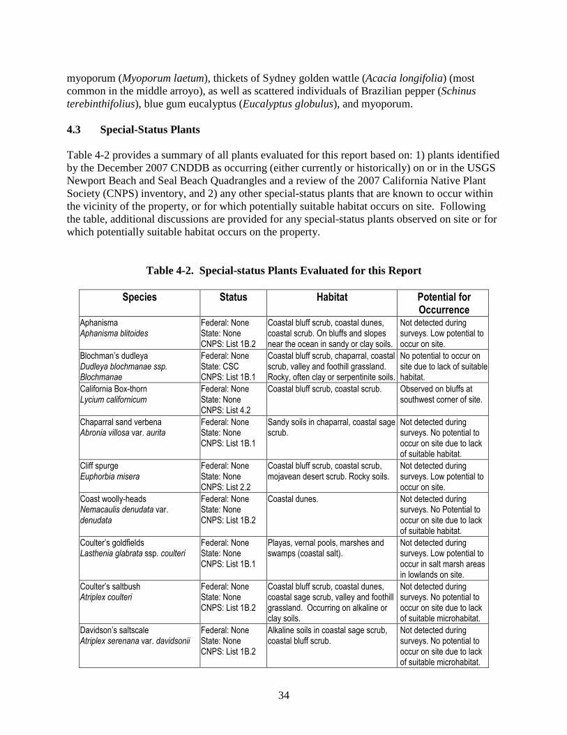
34
myoporum (Myoporum laetum), thickets of Sydney golden wattle (Acacia longifolia) (most common in the middle arroyo), as well as scattered individuals of Brazilian pepper (Schinus terebinthifolius), blue gum eucalyptus (Eucalyptus globulus), and myoporum. 4.3 Special-Status Plants Table 4-2 provides a summary of all plants evaluated for this report based on: 1) plants identified by the December 2007 CNDDB as occurring (either currently or historically) on or in the USGS Newport Beach and Seal Beach Quadrangles and a review of the 2007 California Native Plant Society (CNPS) inventory, and 2) any other special-status plants that are known to occur within the vicinity of the property, or for which potentially suitable habitat occurs on site. Following the table, additional discussions are provided for any special-status plants observed on site or for which potentially suitable habitat occurs on the property.
Table 4-2. Special-status Plants Evaluated for this Report
Species Status Habitat Potential for Occurrence
Aphanisma Aphanisma blitoides
Federal: None State: None CNPS: List 1B.2
Coastal bluff scrub, coastal dunes, coastal scrub. On bluffs and slopes near the ocean in sandy or clay soils.
Not detected during surveys. Low potential to occur on site.
Blochman’s dudleya Dudleya blochmanae ssp. Blochmanae
Federal: None State: CSC CNPS: List 1B.1
Coastal bluff scrub, chaparral, coastal scrub, valley and foothill grassland. Rocky, often clay or serpentinite soils.
No potential to occur on site due to lack of suitable habitat.
California Box-thorn Lycium californicum
Federal: None State: None CNPS: List 4.2
Coastal bluff scrub, coastal scrub. Observed on bluffs at southwest corner of site.
Chaparral sand verbena Abronia villosa var. aurita
Federal: None State: None CNPS: List 1B.1
Sandy soils in chaparral, coastal sage scrub.
Not detected during surveys. No potential to occur on site due to lack of suitable habitat.
Cliff spurge Euphorbia misera
Federal: None State: None CNPS: List 2.2
Coastal bluff scrub, coastal scrub, mojavean desert scrub. Rocky soils.
Not detected during surveys. Low potential to occur on site.
Coast woolly-heads Nemacaulis denudata var. denudata
Federal: None State: None CNPS: List 1B.2
Coastal dunes. Not detected during surveys. No Potential to occur on site due to lack of suitable habitat.
Coulter’s goldfields Lasthenia glabrata ssp. coulteri
Federal: None State: None CNPS: List 1B.1
Playas, vernal pools, marshes and swamps (coastal salt).
Not detected during surveys. Low potential to occur in salt marsh areas in lowlands on site.
Coulter’s saltbush Atriplex coulteri
Federal: None State: None CNPS: List 1B.2
Coastal bluff scrub, coastal dunes, coastal sage scrub, valley and foothill grassland. Occurring on alkaline or clay soils.
Not detected during surveys. No potential to occur on site due to lack of suitable microhabitat.
Davidson’s saltscale Atriplex serenana var. davidsonii
Federal: None State: None CNPS: List 1B.2
Alkaline soils in coastal sage scrub, coastal bluff scrub.
Not detected during surveys. No potential to occur on site due to lack of suitable microhabitat.

35
Species Status Habitat Potential for Occurrence
Estuary seablite Suaeda esteroa
Federal: None State: None CNPS: List 1B.2
Coastal salt marsh and swamps. Occurs in sandy soils.
Not detected during surveys. Low potential to occur in marsh areas in lowlands on site.
Gambel’s water cress Rorippa gambellii
Federal: FE State: ST CNPS: List 1B.1
Marshes and swamps. Not detected during surveys. No potential to occur on site.
Giardner’s yampah Perideridia gairdneri ssp. Gairdneri
Federal: None State: CSC CNPS: List 4.2
Broadleafed upland forest, chaparral, coastal prairie, valley and foothill grassland, vernal pools. Vernally mesic soils.
Not detected during surveys. No potential to occur on site.
Golden-spined cereus Bergerocactus emoryi
Federal: None State: None CNPS: List 2.2
Closed-cone coniferous forest, chaparral, coastal scrub. Sandy soils.
Not detected during surveys. No potential to occur on site.
Los Angeles sunflower Helianthus nuttallii ssp. parishii
Federal: None State: None CNPS: List 1A
Salt and freshwater marshes, historically in Los Angeles, Orange, Riverside and San Bernardino Counties.
Not detected during surveys. No potential to occur on site due to lack of suitable habitat
Many-stemmed dudleya Dudleya multicaulis
Federal: None State: None CNPS: List 1B.2
Chaparral, coastal sage scrub, valley and foothill grassland. Often occurring in clay soils.
Not detected during surveys. No potential to occur on site due to lack of suitable habitat.
Mud nama Nama stenocarpum
Federal: None State: None CNPS: List 2.2
Marshes and swamps. Not detected during surveys despite suitable habitat in vernal pool on site.
Oval-leaved live-forever Santa Monica Mountains dudleya
Federal: None State: None CNPS: List 1B.2
Chaparral, coastal scrub. Volcanic and/or rocky soils.
Not detected during surveys. No potential to occur due to lack of suitable habitat.
Palmer’s grapplinghook Harpagonella palmeri
Federal: None State: CSC CNPS: List 4.2
Chaparral, coastal scrub, valley and foothill grassland. Clay soils.
Not detected during surveys. Low potential to occur on site.
Prostrate navarretia Navarretia prostrata
Federal: FSC State: None CNPS: List 1B.1
Coastal sage scrub, valley and foothill grassland (alkaline), vernal pools. Occurring in mesic soils.
Not detected during surveys despite suitable habitat in vernal pool on site.
Rayless ragwort Senecio aphanactis
Federal: None State: None CNPS: List 2.2
Chaparral, cismontane woodland, coastal scrub. Sometimes alkaline soils.
Not detected during surveys. Moderate potential to occur on site.
Robinson’s pepper-grass Lepidium virginicum var. robinsonii
Federal: None State: None CNPS: List 1B.2
Chaparral, coastal scrub. Not detected during surveys. Moderate potential to occur on site.
Salt marsh bird’s-beak Cordylanthus maritimus ssp. maritimus
Federal: FE State: SE CNPS: List 1B.2
Coastal dune, coastal salt marshes and swamps.
Not detected during surveys. Potentially suitable habitat present in marsh areas in lowlands on site.
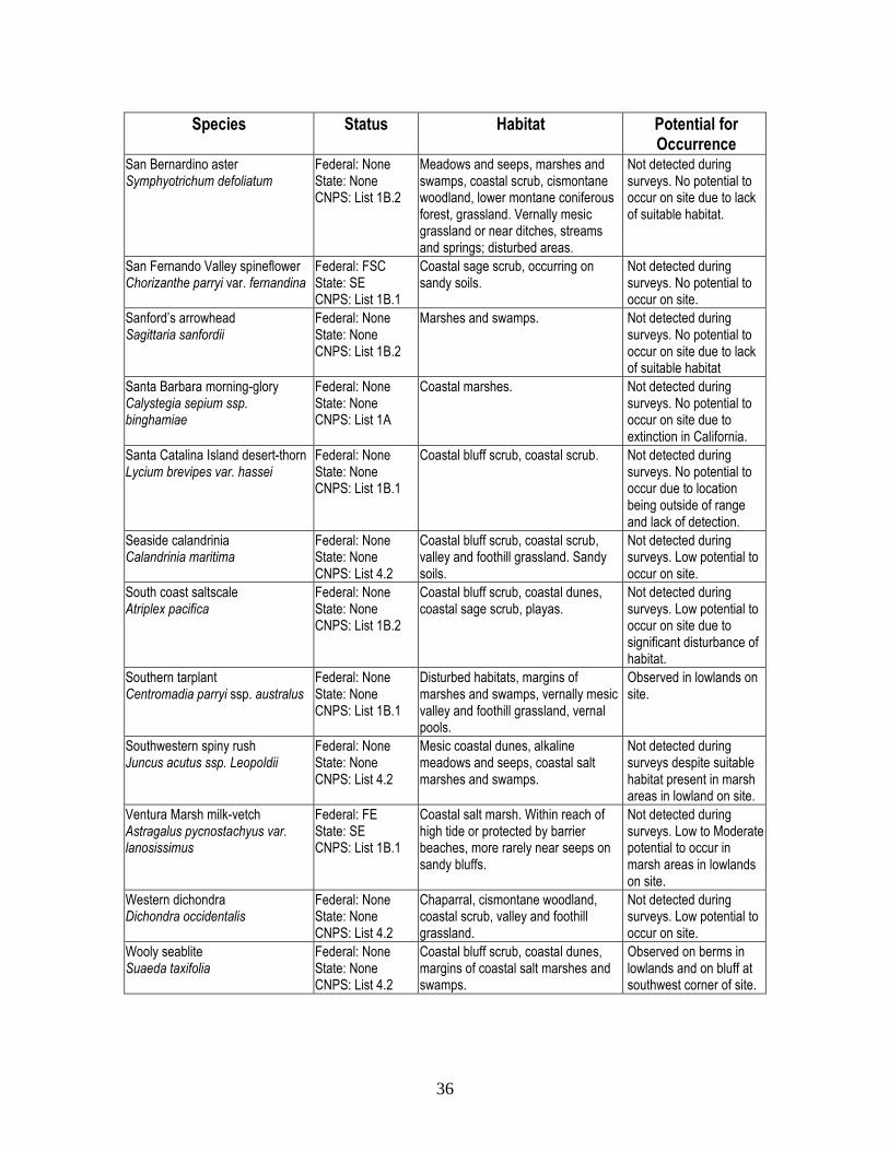
36
Species Status Habitat Potential for Occurrence
San Bernardino aster Symphyotrichum defoliatum
Federal: None State: None CNPS: List 1B.2
Meadows and seeps, marshes and swamps, coastal scrub, cismontane woodland, lower montane coniferous forest, grassland. Vernally mesic grassland or near ditches, streams and springs; disturbed areas.
Not detected during surveys. No potential to occur on site due to lack of suitable habitat.
San Fernando Valley spineflower Chorizanthe parryi var. fernandina
Federal: FSC State: SE CNPS: List 1B.1
Coastal sage scrub, occurring on sandy soils.
Not detected during surveys. No potential to occur on site.
Sanford’s arrowhead Sagittaria sanfordii
Federal: None State: None CNPS: List 1B.2
Marshes and swamps. Not detected during surveys. No potential to occur on site due to lack of suitable habitat
Santa Barbara morning-glory Calystegia sepium ssp. binghamiae
Federal: None State: None CNPS: List 1A
Coastal marshes. Not detected during surveys. No potential to occur on site due to extinction in California.
Santa Catalina Island desert-thorn Lycium brevipes var. hassei
Federal: None State: None CNPS: List 1B.1
Coastal bluff scrub, coastal scrub. Not detected during surveys. No potential to occur due to location being outside of range and lack of detection.
Seaside calandrinia Calandrinia maritima
Federal: None State: None CNPS: List 4.2
Coastal bluff scrub, coastal scrub, valley and foothill grassland. Sandy soils.
Not detected during surveys. Low potential to occur on site.
South coast saltscale Atriplex pacifica
Federal: None State: None CNPS: List 1B.2
Coastal bluff scrub, coastal dunes, coastal sage scrub, playas.
Not detected during surveys. Low potential to occur on site due to significant disturbance of habitat.
Southern tarplant Centromadia parryi ssp. australus
Federal: None State: None CNPS: List 1B.1
Disturbed habitats, margins of marshes and swamps, vernally mesic valley and foothill grassland, vernal pools.
Observed in lowlands on site.
Southwestern spiny rush Juncus acutus ssp. Leopoldii
Federal: None State: None CNPS: List 4.2
Mesic coastal dunes, alkaline meadows and seeps, coastal salt marshes and swamps.
Not detected during surveys despite suitable habitat present in marsh areas in lowland on site.
Ventura Marsh milk-vetch Astragalus pycnostachyus var. lanosissimus
Federal: FE State: SE CNPS: List 1B.1
Coastal salt marsh. Within reach of high tide or protected by barrier beaches, more rarely near seeps on sandy bluffs.
Not detected during surveys. Low to Moderate potential to occur in marsh areas in lowlands on site.
Western dichondra Dichondra occidentalis
Federal: None State: None CNPS: List 4.2
Chaparral, cismontane woodland, coastal scrub, valley and foothill grassland.
Not detected during surveys. Low potential to occur on site.
Wooly seablite Suaeda taxifolia
Federal: None State: None CNPS: List 4.2
Coastal bluff scrub, coastal dunes, margins of coastal salt marshes and swamps.
Observed on berms in lowlands and on bluff at southwest corner of site.

37
Federal State FE - Federally Endangered SE - State Endangered FT - Federally Threatened ST – State Threatened CSC –California Species of Special Concern CNPS List 1B - Plants rare, threatened, or endangered in California and elsewhere. List 2 - Plants rare, threatened, or endangered in California, but more common elsewhere. List 3 – Plants about which more information is needed.
4.4 Special-status Plants Observed or With the Potential to Occur on Site The only special-status plants observed on site were estuary seablite and southern tarplant; however all plants with any potential to occur on site are discusses in more detail below. 4.4.1 Aphanisma (Aphanisma blitoides) Aphanisma is an annual herb designated as a CNPS List 1B.2 species. The species is known from Los Angeles, Orange, Santa Barbara, San Diego, and Ventura counties, several offshore islands in Southern California, U.S.A, and Baja California, and offshore islands in Baja California, Mexico. Aphanisma is associated with sandy habitats from 1-305 meters. The species occurs within coastal habitats including coastal bluff scrub and coastal dunes, and flowers from March through June. The coastal bluff scrub on site is highly degraded and exhibits low potential for supporting this species, however, this species was not detected during surveys on site. 4.4.2 California box-thorn (Lycium californicum) California box-thorn is a shrub designated a CNPS List 4.2 species. The species is known from Los Angeles, Orange, San Bernardino, San Diego counties in California, as well as several California islands, Arizona U.S.A., Baja California, and Sonora, Mexico. This species occurs on coastal bluff scrub and coastal scrub from 5-150 meters. The flowering period is from March through August, and rarely, in December. This species was detected on site on the bluffs at the southwest corner of the site, as well as at one location overlooking the lowlands, as shown on Exhibit 10. 4.4.3 Cliff spurge (Euphorbia misera) Cliff spurge is a shrub designated as a CNPS List 2.2 species. The species is known from several counties of southern California including Orange, Riverside, San Diego, Baja California and more. Cliff Spurge is associated with rocky soils from 10-500 meters. The species occurs within coastal bluff scrub and coastal scrub. The flowering period occurs from December to August. The coastal bluff scrub on site is highly degraded and exhibits low potential for supporting this species; however, this species was not detected during surveys on site. 4.4.4 Coulter’s goldfields (Lasthenia glabrata ssp. coulteri) Coulter’s goldfield is an annual herb designated as a CNPS List 1B.1 species. The species is known from several counties in southern California including Los Angeles, Orange, Riverside,
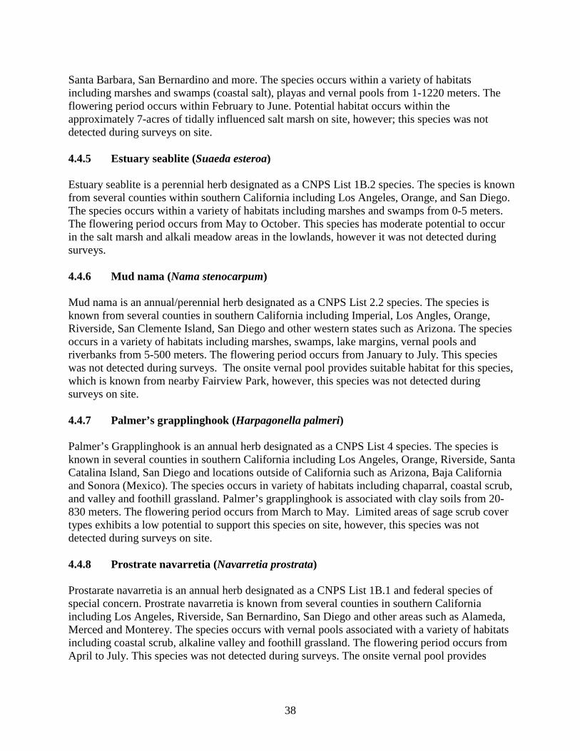
38
Santa Barbara, San Bernardino and more. The species occurs within a variety of habitats including marshes and swamps (coastal salt), playas and vernal pools from 1-1220 meters. The flowering period occurs within February to June. Potential habitat occurs within the approximately 7-acres of tidally influenced salt marsh on site, however; this species was not detected during surveys on site. 4.4.5 Estuary seablite (Suaeda esteroa) Estuary seablite is a perennial herb designated as a CNPS List 1B.2 species. The species is known from several counties within southern California including Los Angeles, Orange, and San Diego. The species occurs within a variety of habitats including marshes and swamps from 0-5 meters. The flowering period occurs from May to October. This species has moderate potential to occur in the salt marsh and alkali meadow areas in the lowlands, however it was not detected during surveys. 4.4.6 Mud nama (Nama stenocarpum) Mud nama is an annual/perennial herb designated as a CNPS List 2.2 species. The species is known from several counties in southern California including Imperial, Los Angles, Orange, Riverside, San Clemente Island, San Diego and other western states such as Arizona. The species occurs in a variety of habitats including marshes, swamps, lake margins, vernal pools and riverbanks from 5-500 meters. The flowering period occurs from January to July. This species was not detected during surveys. The onsite vernal pool provides suitable habitat for this species, which is known from nearby Fairview Park, however, this species was not detected during surveys on site. 4.4.7 Palmer’s grapplinghook (Harpagonella palmeri) Palmer’s Grapplinghook is an annual herb designated as a CNPS List 4 species. The species is known in several counties in southern California including Los Angeles, Orange, Riverside, Santa Catalina Island, San Diego and locations outside of California such as Arizona, Baja California and Sonora (Mexico). The species occurs in variety of habitats including chaparral, coastal scrub, and valley and foothill grassland. Palmer’s grapplinghook is associated with clay soils from 20-830 meters. The flowering period occurs from March to May. Limited areas of sage scrub cover types exhibits a low potential to support this species on site, however, this species was not detected during surveys on site. 4.4.8 Prostrate navarretia (Navarretia prostrata) Prostarate navarretia is an annual herb designated as a CNPS List 1B.1 and federal species of special concern. Prostrate navarretia is known from several counties in southern California including Los Angeles, Riverside, San Bernardino, San Diego and other areas such as Alameda, Merced and Monterey. The species occurs with vernal pools associated with a variety of habitats including coastal scrub, alkaline valley and foothill grassland. The flowering period occurs from April to July. This species was not detected during surveys. The onsite vernal pool provides

39
suitable habitat for this species, which is known from nearby Fairview Park, however, this species was not detected during surveys on site. 4.4.9 Rayless ragwort (Senecio aphanactis) Rayless ragwort is an annual herb designated as a CNPS List 2 species. The species is known from several counties in southern California including Los Angeles, Orange Riverside, Ventura, San Diego and elsewhere including Alameda, Contra Costa, Fresno, Merced, Santa Clara, Santa Catalina Island, Santa Cruz Island and San Luis Obispo, Solona, and Santa Barbara. The species occurs in a variety of habitats including chaparral, cismontane woodland and coastal scrub. Rayless ragwort is associated with alkaline soils from 15-800 meters. The flowering period occurs from January to April. Limited areas of sage scrub cover types exhibits a low potential to support this species on site, however, this species was not detected during surveys on site. 4.4.10 Robinson’s pepper-grass (Lepidium virginicum var. robinsonii) Robinson’s pepper-grass is an annual herb designated as a CNPS List 1B species. The species is known from several counties in southern California including Los Angeles, Orange, Riverside, Santa Barbara, San Bernardino, Santa Cruz Island, San Diego and Baja California. Robinson’s pepper-grass occurs in chaparral and coastal scrub from 1-500 meters. The flowering period occurs from January to July. Limited areas of sage scrub cover types exhibits a low potential to support this species on site, however, this species was not detected during surveys on site. 4.4.11 Salt marsh bird’s-beak (Cordylanthus maritimus ssp. maritimus) Salt marsh bird’s beak is a hemiparasitic annual herb designated as a CNPS List 1B.2, and is federally and state listed as endangered. The species is known from Los Angeles, Orange, Santa Barbara, San Bernardino, San Diego, San Luis Obispo, and Ventura Counties, and Baja California. The species occurs in coastal salt marshes, typically in midmarsh areas where it is associated with pickleweed. The flowering period occurs from June to October. Potentially suitable habitat is present in the approximately 7-acres of tidally influenced salt marsh on site, however, this species was not detected during surveys on site. 4.4.12 South coast saltscale (Atriplex pacifica) South coast saltscale is an annual herb designated as CNPS List 1B.2 species that is known from Los Angeles, Orange, Riverside, San Diego, and Ventura counties, several offshore islands in California, Arizona, and Baja California and Sonora, Mexico. The species occurs in coastal bluff scrub, coastal dunes, coastal scrub and playas from 0 to 100 meters. The flowering period is from March to October. Limited areas of sage scrub cover types exhibits a low potential to support this species on site, however, this species was not detected during surveys on site. 4.4.13 Southern tarplant (Centromadia parryi ssp. australus) Southern tarplant is an annual herb designated as a CNPS List 1B.1 that is known from Los Angeles, Orange, Santa Barbara, Santa Catalina Island, San Diego Ventura and Baja California.

40
Southern tarplant occurs in marshes and swamps (margins), valley and foothill grasslands and vernal pools. The species grows in the elevations from 0 to 425 meters. The flowering period occurs from May to November. This species was detected in lowlands on site during surveys as depicted on Exhibit 10. 4.4.14 Southwestern spiny rush (Juncus acutus ssp. leopoldii) Southwestern spiny rush is a CNPS List 4.2 species. The species is known from Los Angeles, Orange, Santa Barbara, San Diego, San Luis Obispo, and Ventura counties, and Baja California, Mexico. The species occurs in a variety of habitats including coastal dunes, meadows and alkaline seeps, and coastal salt marshes and swamps from 3 to 900 meters. The species usually blooms from May to June. Potentially suitable habitat is present in the approximately 7-acres of tidally influenced salt marsh on site, however, this species was not detected during surveys on site. 4.4.15 Ventura Marsh milk-vetch (Astragalus pycnostachyus var. lanosissimus) Ventura Marsh milk-vetch is designated as CNPS List 1B.1, federally and state endangered species. This species was historically known from Los Angeles, Orange, Santa Barbara, and Ventura counties, but was presumed extinct until recently rediscovered in Ventura. This species is still presumed to be extirpated from Orange County and is not expected to occur on site, based on local extirpation and lack of detection during surveys. This species occurs at the edges of coastal salt or brackish marshes and swamps, as well as coastal dunes and coastal scrub from 1-35 meters. The flowering period is from June to October. Potentially suitable habitat is present in the approximately 7-acres of tidally influenced salt marsh on site; however, this species was not detected during surveys on site. 4.4.16 Western dichondra (Dichondra occidentalis) Western dichondra is a CNPS List 4.2 species. The species is known from Los Angeles, Orange, Santa Barbara, San Diego, and Ventura counties, several offshore California islands, and Baja California, Mexico. The species occurs in a variety of habitats including chaparral, cismontane woodland, coastal scrub, and valley and foothill grassland from 50 to 500 meters. The species usually blooms from March to July, though it rarely blooms as early as January. Limited areas of sage scrub cover types exhibits a low potential to support this species on site, however, this species was not detected during surveys on site. 4.4.17 Woolly seablite (Suaeda taxifolia) Wooly seablite is an evergreen shrub designated as a CNPS List 4.2 species. The species is known from several counties including Los Angeles, Orange, Santa Barbara, San Diego, San Luis Obispo, and Ventura Counties, and is also present on the offshore islands of California. Wooly seablite occurs in coastal bluff scrub, coastal dunes, salt marshes and swamps from 0-50 meters. The flowering period is from January to December. This species was detected in the lowlands and on the bluff at the southwestern corner of the site during surveys.

41
4.5 Wildlife Surveys 4.5.1 Birds Avian species commonly observed on site included American crow (Corvus brachyrhnchos), house finch (Carpodacus mexicanus), bushtit (Psaltriparus minimus), song sparrow (Melospiza melodia), Anna’s hummingbird (Calypte anna), lesser goldfinch (Carduelis psaltria), California towhee (Pipilo crissalis), northern mockingbird (Mimus polyglottos), and mourning dove (Zenaida macroura). Special-status birds detected on the Site include Least Bell’s vireo (Vireo bellii pusillus), yellow-breasted chat (Icteria virens), California gnatcatcher (Polioptila californica californica), ashy rufous-crowned sparrow (Aimophila ruficeps), yellow warbler (Dendroica petechia), coastal cactus wren (Campylohrynchus brunneicapillus), white-tailed kite (Elanus leucurus), Belding’s savannah sparrow (Passerculus sandwichensis beldingi), nesting Cooper’s hawks (Accipiter cooperii), foraging/wintering merlin (Falco columbarius), foraging/wintering northern harrier (Circus cyaneus), and foraging/wintering sharp-shinned hawk (Accipiter striatus). 4.5.2 Mammals Mammals detected on site either by direct observation or by physical evidence included coyote (Canis latrans), California ground squirrel (Spermophilus beechyi), Audubon’s cottontail (Sylvilagus audubonii), brush rabbit (Sylvilagus bachmani), Botta’s pocket gopher (Thomomys bottae), raccoon (Procyon lotor), and domestic dog (Canis lupus familiaris). 4.5.3 Reptiles and Amphibians Herpetofauna observed included western fence lizard (Sceloporus occidentalis) and side-blotched lizard (Uta stansburiana). 4.6 Special-Status Animals Table 4-3 provides a summary of all species evaluated for this report based on: 1) species identified by the December 2007 CNDDB as occurring (either currently or historically) on or in the USGS Newport Beach and Seal Beach Quadrangles, and 2) any other special-status species that are known to occur within the vicinity of the property, or for which potentially suitable habitat occurs on site. Following the table, additional discussions are provided for any special-status animals observed on site or for which potentially suitable habitat occurs on the property.

42
Table 4-3. Special-status Wildlife Evaluated for this Report
Species Name Status Habitat Requirements Potential for Occurrence
INVERTEBRATES
Quino checkerspot butterfly Euphydryas editha quino
Federal: FE State: None CDFG: None
Meadow habitats dominated by western plantain and/or owl’s clover
No potential to occur on site due to a lack of suitable habitat and extirpation from Oange county.
San Diego fairy shrimp Branchinecta sandiegonensis
Federal: FE State: None CDFG: None
Seasonal vernal pools Observed in both of the vernal pools on site during focused surveys in 2000.
Riverside fairy shrimp Streptocephalus wootoni
Federal: FE State: None CDFG: None
Deep seasonal vernal pools, with warm water, and low to moderate dissolved solids, that remained filled for extended periods of time. Annual grasslands, or patches.
Not observed on site during focused surveys. No potential to occur on site due to a lack of suitable habitat.
AMPHIBIANS
Arroyo southwestern toad Bufo microscaphus californicus
Federal: FE State: None CDFG: CSC
Historically along length of drainages; currently in headwaters, sandy washes and arroyos grown to willows, cottonwoods or sycamores.
No potential to occur on site due to a lack of suitable habitat.
California red-legged frog Rana aurora draytonii
Federal: FT State: None CDFG: CSC
Permanent flowing water sources, including marshes, streams, lakes ponds; woodland or valley foothill grasslands; sufficient vegetative cover
No potential to occur on site due to a lack of suitable habitat.
Western spadefoot toad Scaphiopus hammondi
Federal: None State: None CDFG: CSC
Coastal sage scrub, vernal pools, and grasslands; breeds in associated temporary pools and riparian areas.
No potential to occur on site due to significant habitat disturbance.
REPTILES
Coast patch-nosed snake Salvadora hexalepis virgultea
Federal: None State: None CDFG: CSC
Open areas within coastal sage scrub, chaparral, grassland, desert scrub, washes, sand flats, & rocky areas.
No potential to occur on site due to significant habitat disturbance.
Orange-throated whiptail Aspidoscelis hyperythra
Federal: None State: None CDFG: CSC
Inhabits low-elevation coastal scrub, chaparral, and valley-foothill hardwood habitats. Prefers washes & other sandy areas with patches of brush & rocks. Perennial plants necessary for its major food –termites.
Low potential to occur in limited areas of the large arroyo or sage scrub on site due to marginally suitable habitat.
Red diamond rattlesnake Crotalus ruber ruber
Federal: None State: None CDFG: CSC
Chapparal, woodland, grassland, & desert areas from coastal San Diego county to the eastern slopes of the mountains. Occurs in rocky areas & dense vegetation. Needs rodent burrows, cracks in rocks or surface cover objects.
No potential to occur on site due to location being out of range.
San Diego horned lizard Phrynosoma coronatum blainvillei
Federal: None State: None CDFG: CSC
Occurs in a variety of vegetation types including coastal sage scrub, chaparral, annual grassland, oak woodland, and riparian woodlands. Sandy soils.
Low potential to occur on site due to marginally suitable soils for burrowing.
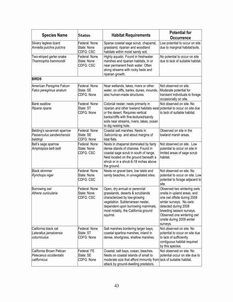
43
Species Name Status Habitat Requirements Potential for Occurrence
Silvery legless lizard Anniella pulchra pulchra
Federal: None State: None CDFG: CSC
Sparse coastal sage scrub, chaparral, grassland, riparian and woodland habitats within moist sandy soil.
Low potential to occur on site due to marginal habitat/soils.
Two-striped garter snake Thamnophis hammondii
Federal: None State: None CDFG: CSC
Highly aquatic. Found in freshwater marshes and riparian habitats, in or near permanent fresh water. Often along streams with rocky beds and riparian growth.
No potential to occur on site due to lack of suitable habitat.
BIRDS
American Peregrine Falcon Falco peregrinus anatum
Federal: None State: SE CDFG: None
Near wetlands, lakes, rivers or other water, on cliffs, banks, dunes, mounds, also human-made structures.
Not observed on site. Moderate potential for transient individuals to forage occasionally on site.
Bank swallow Riparia riparia
Federal: None State: ST CDFG: None
Colonial nester; nests primarily in riparian and other lowland habitats west or the desert. Requires vertical banks/cliffs with fine-textured/sandy soils near streams, rivers, lakes, ocean to dig nesting hole.
Not observed on site. No potential to occur on site due to lack of suitable habitat.
Belding's savannah sparrow Passerculus sandwichensis beldingi
Federal: None State: SE CDFG: None
Coastal salt marshes. Nests in Salicornia sp. and about margins of tidal flats.
Observed on site in the lowland marsh areas.
Bell’s sage sparrow Amphispiza belli belli
Federal: None State: None CDFG: CSC
Nests in chaparral dominated by fairly dense stands of chamise. Found in coastal sage scrub in south of range. Nest located on the ground beneath a shrub or in a shrub 6-18 inches above the ground.
Not observed on site. Low potential to occur on site in limited areas of sage scrub habitat.
Black skimmer Rynchops niger
Federal: None State: None CDFG: CSC
Nests on gravel bars, low islets and sandy beaches, in unvegetated sites.
Not observed on site. No potential to occur on site. Low potential to forage adjacent to site.
Burrowing owl Athene cunicularia
Federal: None State: None CDFG: CSC
Open, dry annual or perennial grasslands, deserts & scrublands characterized by low-growing vegetation. Subterranean nester, dependent upon burrowing mammals, most notably, the California ground squirrel.
Observed two wintering owls onsite in upland areas, and one owl offsite during 2008 winter surveys. No owls detected during 2008 breeding season surveys. Observed one wintering owl onsite during 2009 winter surveys.
California black rail Laterallus jamaicensis coturniculus
Federal: None State: ST CDFG: None
Salt marshes bordering larger bays, coastal spartina marshes, inland in dense, shortgrass, shallow marshes.
Not observed on site. No potential to occur on site due to lack of sufficiently contiguous habitat required by this species.
California Brown Pelican Pelecanus occidentalis californicus
Federal: FE State: SE CDFG: None
Coastal, salt bays, ocean, beaches. Nests on coastal islands of small to moderate size that afford immunity from attack by ground-dwelling predators.
Not observed on site. No potential occur on site due to lack of suitable habitat.

44
Species Name Status Habitat Requirements Potential for Occurrence
California horned lark Eremophila alpestris actia
Federal: None State: None CDFG: CSC
Coastal regions in Southern California. Short-grass prairies “bald” hills, mountain meadows, open coastal plains, fallow grain fields, alkali flats.
Not observed on site. Low potential to nest on site due to significantly disturbed habitat.
California least tern Sterna antillarum browni
Federal: FE State: SE CDFG: CFP
Flat, vegetated substrates near the coast. Occurs near estuaries, bays, or harbors where fish is abundant.
Not observed on site. No potential to nest on site, low potential to forage in open water adjacent to site.
Coastal cactus wren Campylorhynchus brunneicapillus couesi
Federal: None State: None CDFG: CSC
Southern California coastal sage scrub. Wrens require tall opuntia cactus for nesting and roosting.
Observed in limited areas of cactus on site.
Coastal California gnatcatcher Polioptila californica californica
Federal: FT State: None CDFG: CSC
Low elevation coastal sage scrub and coastal bluff scrub.
Observed in sage scrub vegetation on site.
Double Crested cormorant Phalacrocorax auritus
Federal: None State: None CDFG: CSC
Coasts, bays, lakes, rivers. Not observed on site. No potential to nest on site. Low potential to forage adjacent to site.
Ferruginous hawk Buteo regalis
Federal: FSC State: None CDFG: CSC
Only present as wintering individuals. Prefers open grasslands and agricultural areas.
No potential to nest on site. Low potential to forage occasionally on site in the winter.
Golden Eagle Aquila chrysaetos
Federal: None State: None CDFG: CFP
In southern California, occupies grasslands, brushlands, deserts, oak savannas, open coniferous forests, and montane valleys. Nests on rock outcrops and ledges.
Not observed on site. No potential to occur on site due to lack of suitable habitat.
Least Bell’s vireo Vireo belii pusilus
Federal: FE State: SE CDFG: CSC
Summer resident of southern California in low riparian in vicinity of water or in dry river bottoms. Nests placed along margins of bushes or on twigs projecting into pathways, usually willow, Baccharis, mesquite.
Observed in riparian areas in the lowlands on site during focused surveys.
Light-footed clapper rail Rallus longirostris levipes
Federal: FE State: SE CDFG: CFP
Found in salt marshes where cordgrass and pickleweed are the dominant vegetation. Requires dense growth of either pickleweed or cordgrass for nesting or escape cover, feeds on mollusks and crustaceans.
Not observed on site. Reported to occur in limited marsh areas in the Army Corps mitigation area adjacent to the site. No potential to nest on site.
Loggerhead shrike Lanius ludovicianus
Federal: None State: None CDFG: CSC
Broken woodlands, savannah, pinyon-juniper, Joshua tree & riparian woodlands, desert oases, scrub & washes. Prefers open country for hunting with perches for scanning and fairly dense shrubs and brush for nesting.
Observed in the lowlands on site. Moderate potential to nest on site.
Long-eared owl Asio otus
Federal: None State: None CDFG: CSC
Riparian bottomlands grown to tall willows & cottonwoods; also belts of live oak paralleling stream courses. Require adjacent open land productive of mice and presence of old nests of crows.
Not observed on site. Low potential to occur in riparian woodlands on site.

45
Species Name Status Habitat Requirements Potential for Occurrence
Merlin Falco columbarius
Federal: None State: None CDFG: CSC
Only present as wintering individuals. Forages in a variety of habitats including riparian areas such as present on the site.
Observed one merlin foraging on site in the winter of 2008.
Northern harrier (nesting) Circus cyaneus
Federal: None State: None CDFG: CSC
A variety of habitats, including open wetlands, grasslands, wet pasture, old fields, dry uplands, and croplands.
Observed foraging on site in the winter of 2008. Moderate potential to nest on site.
Osprey Pandiohn haliaetus
Federal: None State: None CDFG: CSC
Ocean shore, bays, fresh-water lakes, and larger streams. Large nests built in treetops within one mile of a good fish-producing body of water.
Observed foraging over site. Moderate potential to nest on site.
Tri-colored blackbird Agelaius tricolor
Federal: None State: None CDFG: CSC
Requires open water, protected nesting & foraging area with insect prey within a few km of the colony.
Not observed on site. No potential to occur on site due to lack of suitable habitat.
Short-eared owl Asio flammeus
Federal: None State: None CDFG: CSC
Found in swamplands, both fresh and salt; lowland meadows; irrigated alfalfa fields. Tule patches/tall grass needed for nesting/daytime seclusion. Nests on dry ground in depression concealed in vegetation.
Not observed on site during surveys. High potential to occur during winter in lowlands on site.
Southwestern willow flycatcher Empidonax traillii extimus
Federal: FE State: SE CDFG: CSC
Riparian woodlands in southern California.
Not observed during focused surveys in 2006 and 2007. High potential to occur in riparian areas on site.
Swainson’s Hawk Buteo swainsoni
Federal: None State: ST CDFG: None
Breeding habitat consists of grasslands with scattered trees, juniper-sage flats, riparian areas, savannahs, & agricultural or ranch lands. Requires adjacent suitable foraging areas such as grasslands or alfalfa or grain fields that support rodent populations.
Not observed on site. No potential to occur on site due to lack of suitable habitat.
Western least bittern Ixobrychus exilis hesperis
Federal: None State: None CDFG: CSC
Colonial nester in marshlands and borders of ponds and reservoirs that provide ample cover. Nests usually placed low in tules over water.
Not observed on site. Low potential to occur in the limited marsh areas on site or adjacent to site.
Western snowy plover Charadrius alexandrinus nivosus
Federal: FT State: None CDFG: CSC
Sandy or gravelly beaches along the coast, estuarine salt ponds, alkali lakes, and at the Salton Sea.
Not observed on site. Low potential to forage in limited marsh areas on site or adjacent to site. No potential to nest on site.
White-tailed kite (nesting) Elanus leucurus
Federal: FSC State: None CDFG: CFP
Low elevation open grasslands, savannah-like habitats, agricultural areas, wetlands, and oak woodlands. Dense canopies used for nesting and cover.
Observed one pair foraging and nesting on site.
Yellow-breasted chat Icteria virens
Federal: None State: None CDFG: CSC
Summer resident; inhabits riparian thickets of willow & other brushy tangles near watercourses. Nests in low, dense riparian, consisting of willow, blackberry, wild grape; forages and nests within 10 ft of ground.
Observed in the lowlands on site. High potential to nest on site.

46
Species Name Status Habitat Requirements Potential for Occurrence
Yellow warbler Dendroica petechia brewsteri
Federal: None State: None CDFG: CSC
Riparian plant associations. Prefers willows, cottonwoods, aspens, sycamores & alders for nesting & foraging. Also nests in montane shrubbery in open conifer forests.
Observed in the lowlands on site. High potential to nest on site.
MAMMALS
American badger Taxidea taxus
Federal: None State: None CDFG: CSC
Occurs in drier shrub, forest, and herbaceous habitats. Needs open, uncultivated ground and friable soils for digging burrows. Preys on burrowing rodents.
Not observed on site. Very low potential to occur on site. Last known occurrence in vicinity of project site was in 1998.
Big free-tailed bat Nyctinomops macrotis
Federal: None State: None CDFG: CSC
Occurs in low-lying arid areas in Southern California. Roosts in high cliffs or rocky outcrops.
Low potential to forage on site. No potential to roost or breed on site due to a lack of suitable habitat.
Hoary bat Lasiurus cinereus
Federal: None State: None CDFG: CSC
Prefers open habitats or habitat mosaics, with access to trees for cover & open areas or habitat edges for feeding. Roosts in dense foliage of medium to large trees. Feeds primarily on moths. Requires water.
Low potential to forage and roost on site due to marginally suitable habitat.
Pacific pocketmouse Perognathus longimembris pacificus
Federal: FE State: None CDFG: CSC
Seems to prefer soils of fine alluvial sands near the ocean.
No potential to occur on site due to a lack of suitable habitat.
South coast marsh vole Microtus californicus stephensi
Federal: None State: None CDFG: CSC
Tidal marshes in Los Angeles, Orange and southern Ventura Counties.
Low potential to occur in the limited marsh areas on site or adjacent to site.
Southern California salt marsh shrew Sorex ornatus salicornicus
Federal: None State: None CDFG: CSC
Coastal marshes in Los Angeles, Orange and southern Ventura Counties. Requires dense vegetation and woody debris for cover.
Low potential to occur in the limited marsh areas on site or adjacent to site.
Western mastiff bat Eumops perotis californicus
Federal: None State: None CDFG: CSC
Many open, semi-arid to arid habitats, including conifer & deciduous woodlands, coastal scrub, grasslands, chaparral, etc. Roosts in crevices in cliff faces, high buildings, trees, & tunnels.
Moderate potential to forage in riparian areas on site. No potential to roost or breed on site due to lack of suitable habitat.
Federal State FE – Federally Endangered SE – State Endangered FT – Federally Threatened ST – State Threatened FSC – Federal Species of Special Concern
CDFG CSC – California Species of Special Concern CFP – California Fully Protected Species

47
4.7 Special-status Animals Observed or With the Potential to Occur on Site 4.7.1 American Badger (Taxidea taxus) The American badger is a California Species of Special Concern. American Badgers occur from northern Alberta southward to central Mexico. They range from the Pacific Coast eastward through Ohio. In California, Badgers occupy a diversity of habitats. The principal requirements seem to be sufficient food, friable soils, and relatively open, uncultivated ground. Grasslands, savannas, and mountain meadows near timberline are preferred. Badgers prey primarily on burrowing rodents such as gophers, ground squirrels, marmots, and kangaroo rats. No badgers or badger burrows were detected during surveys. As badger burrows are large and conspicuous, it is unlikely that they would have remained undetected by biologists, and there is very low potential for them to occur on site. However, badgers are known to occur historically occur in the vicinity of the project site. A dead specimen was observed near the corner of Pacific Coast Highway and Superior Avenue immediately southeast of the project site in 1998. Nevertheless, this species is not expected to occur. 4.7.2 American Peregrine Falcon (Falco peregrinus anatum) The American peregrine falcon is a state endangered species, but was federally delisted in 1999. Northwestern populations are year-round residents from central Mexico to Alaska. American peregrine falcons forage in a variety of habitats including grasslands, meadows, coastlines and wetlands where they hunt waterfowl and shorebirds. Organochlorine pesticides were a primary cause for decline before they were banned in the 1970’s, but habitat loss due to development and human disturbance is also responsible for this raptor’s decline. Habitat for prey is limited to the saltmarsh areas at the southwest corner of the site. No American peregrine falcons were observed on site during any surveys; however, transient individuals may forage occasionally on site. 4.7.3 Belding’s Savannah Sparrow (Passerculus sandwichensis beldingi) The Belding's savannah sparrow is a State Endangered bird, and a candidate species for federal protection. This species is a non-migratory subspecies that occurs in coastal salt marshes between Goleta Slough, Santa Barbara County, and Bahia de San Quentin in Mexico. The Belding’s savannah sparrow is entirely dependent on salt marshes for nesting and foraging, and thus resides year-round in this habitat. This species nests preferentially in pickleweed (Salicornia virginica). The major threat is destruction of limited salt marsh habitat available along the coast. The Belding’s savannah sparrow was observed on site in the limited saltmarsh areas and is presumed to breed on site (Exhibit 11). 4.7.4 Bell’s sage sparrow (Amphispiza belli belli) The Bell’s sage sparrow is listed as a California Species of Special Concern. This species is a non-migratory subspecies that occurs in chaparral and sagebrush scrub from Baja California, Mexico to Central California. Bell’s sage sparrow typically occurs in areas with large intact blocks of scrub habitat (typically 100’s of acres). Nests are built low in shrubs or occasionally

48
on the ground. No Bell’s sage sparrows were observed on site during any of the surveys, however areas of preserved sage scrub vegetation may provide suitable habitat. 4.7.5 Big free-tailed bat (Nyctinomops macrotis) The big free-tailed bat is a California Species of Special Concern. It is generally solitary and prefers roosting in rock crevaces of cliffs, but will also roost in buildings and upland woody vegetation. No big free-tailed bats were observed on site, and while certain areas on site may provide suitable foragin habitat, no suitable roosting or breeding habitat is present on site. 4.7.6 Burrowing Owl (Athene cunicularia) The burrowing owl is a California Species of Special Concern. Currently, this partial migrant breeds in southern California; however, breeding in Orange County is presumed to be limited to the Anaheim Naval Weapons Station in Seal Beach. Wintering owls occur occasionally in Orange County and can occupy sites for a few weeks to a few months. During winter season surveys in 2008, two wintering owls were observed on site and one wintering owl was observed offsite. During winter season surveys in winter 2009, one wintering owl was observed onsite. The results of wintering owl surveys are depicted by Exhibit 7. No burrowing owls were detected during breeding season surveys, confirming only winter use by burrowing owl on site. 4.7.7 California horned lark (Eremophila alpestris actia) The California horned lark is listed as a California Species of Special Concern. This species breeds from Alaska southward to Mexico, and winters in the southern part of its breeding range. This bird prefers open, barren country with bare ground or short grasses. The California horned lark nests in a basket woven of fine grass or other plant materials, lined with finer material, placed in a depression or cavity in ground. No horned larks were observed on site during any of the surveys, however, the open and disturbed areas on site may provide marginally suitable habitat. 4.7.8 Coastal cactus wren (Campylorhynchus brunneicapillus couesi) The cactus wren in southern California is considered to comprise two distinct subspecies (C.b. sandiegensis and C.b. anthonyi). The coastal cactus wren (C.b.sandiegenssis) occurs in coastal Orange and San Diego Counties, extending into Mexico, while the coastal-slope populations in Riverside, San Bernardino, Los Angeles, Ventura, and northern Orange counties are classified as (C.b. anthonyi), the same subspecies that occurs in the deserts of California and Western Arizona. The sandiegensis subspecies is considered a California Species of Special Concern, but anthonyi is not considered to be rare or sensitive (USFS 1999). The cactus wren is usually associated with habitats dominated by prickly pear or cholla cactus. This species was observed in areas of cactus scrub on near the large arroyo, as depicted on Exhibit 11.

49
4.7.9 Coastal California Gnatcatcher (Polioptila californica californica) The coastal California gnatcatcher (CAGN) is a federally listed threatened species and a California Species of Special Concern. This small songbird is a year-round, obligate resident of coastal sage scrub communities in southern California and northwestern Baja California, Mexico. CAGN is insectivorous, and nests and forages in moderately dense stands of sage scrub occurring on arid hillsides, mesas, and in washes. CAGN generally occur below 1,200 feet in elevation. Coastal sage scrub communities dominated by California sagebrush (Artemisia californica), California buckwheat (Eriogonum fasciculatum) and white sage (Salvia apiana) are preferred by this species. In 2006, GLA biologists detected 15 pairs and eight individual California gnatcatchers on the Newport Banning Ranch property, and in 2007, GLA biologists detected 12 pairs and six individual California gnatcatchers. In both years, many pairs exhibited nesting behavior, and active nests were observed. The birds were located in contiguous coastal sage scrub near the large arroyo in the southern portion of the Site, near the southernmost extent of the Site near Pacific Coast Highway, and in coastal sage scrub patches fragmented by roads along the edges of the mesa portions of the site. Most unpaired individuals were males that were detected in highly fragmented areas of coastal sage scrub that contained a large percentage of non-native vegetation. Exhibits 4a and 4b depict the results of the 2006 and 2007 surveys, respectively. 4.7.10 Ferruginous hawk (Buteo regalis) The ferruginous hawk is identified as a California Species of Special Concern and Federal Species of Concern. In California, the hawk occurs only as a wintering species, and does not breed in southern California. Adequate perching sites (trees, power line towers and poles, buildings, and other structures) as well as adequate foraging habitat make the property a suitable wintering site for the ferruginous hawk. No ferruginous hawks were observed on site; however, they may forage occasionally on site during the winter in either the lowlands or grasslands on the mesas. 4.7.11 Hoary bat (Lasiurus cinereus) The hoary bat is a California Species of Special Concern and ranges from Argentina and Chile northward through Canada. It prefers coniferous forests, mixed deciduous forests and croplands. The hoary bat is solitary, except during the fall migration. Breeding occurs in the fall, and birthing occurs in the spring. The hoary bat forages after dusk in open meadows, over streams and rivers, or above stands of trees at canopy level. Hoary bats are highly territorial returning to the same feeding site each night. Migration occurs in the fall with most individuals in the U.S. hibernating in coastal areas along the west coast from San Francisco through northern Mexico, along the east coast from South Carolina to central Florida, and along the Gulf coast. Major threats include loss of suitable roosting and foraging habitat when diverse forests are replaced by fewer tree species of less diverse ages. No hoary bats were observed on site; however, hoary bats are difficult to observe. The dense woody riparian vegetation in portions of the site may provide suitable foraging and roosting habitat, however the hoary bat is not expected to breed on site due to lack of suitable breeding habitat.

50
4.7.12 Least Bell’s vireo (Vireo belii pusillus) Least bell’s vireo is a State and Federally listed endangered migratory songbird that breeds in riparian habitats in southern California. This vireo nests and forages almost exclusively in multi-layered riparian woodland habitats. Least Bell’s vireo winter in southern Baja California, Mexico, and typically migrate between mid March and early April to southern California and northwestern Baja California, where they remain until late September. Historically, least Bell’s vireo was abundant in riparian habitats throughout the central valley, coastal southern California, and in scattered oases and canyons in California deserts. Populations have declined dramatically this century owing to widespread destruction and degradation of riparian habitats and brood-parasitism by the brown-headed cowbird (Molothrus ater). The largest LBV populations in southern California are currently located at the Prado Basin in Riverside County, and along drainages in Camp Pendelton in San Diego County. During the last decade, least Bell’s vireo has begun to exhibit a substantial recovery due to management and habitat restoration. Least bell’s vireos were observed in the riparian areas of the lowland exhibiting both foraging and breeding behaviors. The locations are depicted on Exhibits 5a and 5b. 4.7.13 Light-footed clapper rail (Rallus longirostris levipes) The light-footed clapper rail is a federally listed endangered, State listed endangered, and California fully protected species. The clapper rail breeds along Atlantic, Gulf, and California coasts. It overwinters in north to central California and New Jersey. The clapper rail is a year-round resident that prefers coastal salt marshes, but also inhabits freshwater marshes. Requires rushes, sedges, cord grass, and other tall vegetation for nesting and cover. Chances for rangewide recovery are minimal given limited remaining habitat and availability for habitat restoration. The major threat is habitat loss of floodplain river areas and tidal estuaries. This species was not observed on site; however, it has been observed breeding in the restored cordgrass habitat at the mouth of the Santa Ana River adjacent to the site. The limited marsh areas on the southwest corner of the lowlands have some potential to be used for foraging. However, as the coastal salt marsh on site is dominated by low-growing species including common pickleweed, alkali heath, fleshy jaumea, saltgrass, shoregrass, and saltwort, and weedy species such as five-hook bassia, this species is not expected to nest on site due to lack of suitable cordgrass habitat required for breeding. 4.7.14 Loggerhead shrike (Lanius ludovicianus) The loggerhead shrike is a CDFG California Species of Special Concern, is a resident that breeds in dense vegetation, and prefers nearby open spaces for hunting. The loggerhead shrike was observed in the lowlands on site, and may nest on site. 4.7.15 Long-eared owl (Asio otus) The long-eared owl, which is a California Species of Special Concern, is a resident that breeds in riparian habitats and oak thickets in southern California. Breeding habitat must include thickly
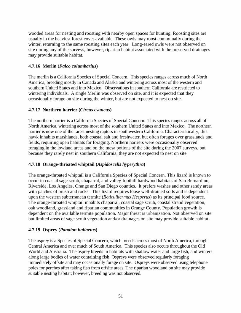
51
wooded areas for nesting and roosting with nearby open spaces for hunting. Roosting sites are usually in the heaviest forest cover available. These owls may roost communally during the winter, returning to the same roosting sites each year. Long-eared owls were not observed on site during any of the surveys, however, riparian habitat associated with the preserved drainages may provide suitable habitat. 4.7.16 Merlin (Falco columbarius) The merlin is a California Species of Special Concern. This species ranges across much of North America, breeding mostly in Canada and Alaska and wintering across most of the western and southern United States and into Mexico. Observations in southern California are restricted to wintering individuals. A single Merlin was observed on site, and it is expected that they occasionally forage on site during the winter, but are not expected to nest on site. 4.7.17 Northern harrier (Circus cyaneus) The northern harrier is a California Species of Special Concern. This species ranges across all of North America, wintering across most of the southern United States and into Mexico. The northern harrier is now one of the rarest nesting raptors in southwestern California. Characteristically, this hawk inhabits marshlands, both coastal salt and freshwater, but often forages over grasslands and fields, requiring open habitats for foraging. Northern harriers were occasionally observed foraging in the lowland areas and on the mesa potions of the site during the 2007 surveys, but because they rarely nest in southern California, they are not expected to nest on site. 4.7.18 Orange-throated whiptail (Aspidoscelis hyperythra) The orange-throated whiptail is a California Species of Special Concern. This lizard is known to occur in coastal sage scrub, chaparral, and valley-foothill hardwood habitats of San Bernardino, Riverside, Los Angeles, Orange and San Diego counties. It prefers washes and other sandy areas with patches of brush and rocks. This lizard requires loose well-drained soils and is dependent upon the western subterranean termite (Reticulitermus Hesperus) as its principal food source. The orange-throated whiptail inhabits chaparral, coastal sage scrub, coastal strand vegetation, oak woodland, grassland and riparian communities in Orange County. Population growth is dependent on the available termite population. Major threat is urbanization. Not observed on site but limited areas of sage scrub vegetation and/or drainages on site may provide suitable habitat. 4.7.19 Osprey (Pandion haliaetus) The osprey is a Species of Special Concern, which breeds across most of North America, through Central America and over much of South America. This species also occurs throughout the Old World and Australia. The osprey breeds in habitats with shallow water and large fish, and winters along large bodies of water containing fish. Ospreys were observed regularly foraging immediately offsite and may occasionally forage on site. Ospreys were observed using telephone poles for perches after taking fish from offsite areas. The riparian woodland on site may provide suitable nesting habitat; however, breeding was not observed.

52
4.7.20 Riverside fairy shrimp (Streptocephalus woottoni) The Riverside fairy shrimp is listed as Federally Endangered and is endemic to vernal (ephemeral) pools in western Riverside County, California, and is restricted to deep pools, with warm water that have low to moderate dissolved solids, and remained filled for extended periods of time. Development from egg to reproductive adult takes between 7 and 12 days. Major threats are habitat loss due to agricultural and urban development, modified hydrology due to adjacent road construction, and illegal trash dumping. No Riverside fairy shrimp were observed during focused surveys on site. 4.7.21 San Diego fairy shrimp (Branchinecta sandiegonensis) The San Diego fairy shrimp is listed as Federally Endangered and only breeds in vernal pools. Development from encysted egg to reproductive adult only takes two weeks. When laid, eggs fall to the soil surface, develop to the early embryo stage, and finally become dormant cysts until the next wet season. Major threats are habitat loss due to agricultural and urban development, alteration of wetland hydrology by draining, off-road vehicle activity, cattle grazing, and replacement by other fairy shrimp species that are habitat generalists. San Diego fairy shrimp were observed on site during focused surveys in 2000 within vernal pool habitat depicted on Exhibit 6. 4.7.22 San Diego horned lizard (Phrynosoma coronatum blainvillei) The San Diego horned lizard is a California Species of Special Concern. This lizard inhabits coastal sage scrub and chaparral habitats characterized associated with sandy, rocky, or shallow soils that support native harvester ants (Pogonomyrmex spp.). This species occurs in areas characterized by loose, fine soils with a high sand fraction, along with native harvester ants (Pogonomyrmex spp.). No San Diego horned lizards were observed on site during any of the general biological surveys however, low potential to occur on site due to marginally suitable soils for burrowing on site. 4.7.23 Short-eared owl (Asio flammeus) The short-eared owl is a California Species of Special Concern. It prefers open habitats such as grasslands, prairie, agricultural fields, salt marshes, estuaries, and mountain meadows. Breeding habitat must have sufficient ground cover to conceal nests and nearby sources of small mammals for food. Roosts in disturbed areas such as thick hedgerows, overgrown rubble and abandoned fields. The lowlands on site provide potentially suitable wintering habitat, however, this species was not observed on site during surveys. 4.7.24 Silvery legless lizard (Anniella pulchra pulchra) The silvery legless lizard is a California Species of Special Concern. This small secretive species lives and forages in leaf litter and under small debris within sandy washes, coastal dune, scrub habitats and woodlands. It often occurs in sparse vegetation within beaches, pine-oak and riparian woodland, alluvial fans, oak savannahs, and grape vineyards. This species requires sandy or loose

53
organic soil or plenty of leaf litter under trees and bushes on sunny slopes. No silvery legless lizards were observed on site during any of the general biological surveys, however, limited areas on the eastern half of the large arroyo may provide marginally suitable habitat. 4.7.25 South coast marsh vole (Microtus californicus stephensi) The South coast marsh vole is a California Species of Special Concern, and ranges from southwestern Oregon through much of California. This species prefers grassy meadow habitats and feeds on grasses and other green vegetation when available; piles of cuttings are found along its runways. It breeds from September to December. In winter, it eats mostly roots and other underground parts of plants. Major threats are non-native plants that have replaced the plants it needs to survive and introduced non-native animals such as the common house mouse and other non-natives have displaced it through competition. This species was not observed on site during any general biological surveys, however the limited salt marsh areas on the southwest portion of the site and/or the salt marshes adjacent to site may provide suitable habitat. 4.7.26 Southern California salt marsh shrew (Sorex ornatus salicornicus) The southern California salt marsh shrew is a California Species of Special Concern that is endemic to southern California’s coastal marshes in from Point Mugu, Ventura County to salt marshes around Anaheim Bay and Newport Beach in Orange County. Appears to prefers coastal marshes. Based on studies of other similar shrews, the southern California salt marsh shrew likely requires fairly dense ground cover, nesting sites above mean high tide free from inundation, and fairly moist surroundings. Major threats are loss of habitat due to development along the coast, and lack of refuge sites above the marshes to escape from flooding during seasonal high tides and periodic storms. This species was not observed on site during any general biological surveys, however the limited salt marsh areas on the southwest portion of the site and/or the salt marshes adjacent to site may provide suitable habitat. 4.7.27 Southwestern willow flycatcher (Empidonax traillii extimus) The southwestern willow flycatcher (SWF) is State and Federally endangered. This species is one of four subspecies of willow flycatchers recognized in North America, and is distinguished by subtle differences in color and morphology. Although the subspecies occupy distinct breeding ranges, northern subspecies (E. t. brewsteri and E. t. adastus) do pass through southern California during migration. Southwestern willow flycatchers breed in riparian habitats along rivers, streams, or other wetlands characterized by dense willows and shrubs in woodlands with standing water. Willow flycatcher subspecies winter in Mexico and Central America, and typically arrive at breeding sites in the southwest in mid-May and remain until late August. Historically, SWF were abundant in riparian habitats throughout the southwestern states and extreme northern Mexico. SWF currently occupies a small fraction of its former range. The decline has been attributed to widespread destruction and degradation of riparian habitats and brood-parasitism by the brown-headed cowbird. Currently, less than 100 breeding pairs are known in southern California. No SWF were observed on site during focused surveys, however suitable habitat for both foraging and nesting occurs in the riparian areas on site.
54
4.7.28 Western least bittern (Ixobrychus exilis hesperis) The western least bittern is a California Species of Special Concern. This species inhabits freshwater or brackish marshes with tall emergent vegetation and breeds in scattered locations in the western United States. The western least bittern nests in a platform of marsh vegetation in dense, tall stands of vegetation. A major threat is likely loss of wetland habitat and invasive exotic marsh vegetation. No western least bitterns were observed on site during any general biological surveys, however the limited brackish marsh areas in the preserved lowlands may provide suitable habitat. 4.7.29 Western mastiff bat (Eumops perotis californicus) The Western mastiff bat is a California Species of Special Concern and a Federal Species of Concern. It is a colonial, cliff-roosting species whose distribution is constrained to areas where there are significant rock features offering suitable roosting habitat. Major threats to the species are urban expansion and activities that disturb or destroy cliff habitat. Roosts of this species are usually within crevices high above the ground. This species may potentially forage in riparian areas on site, however this species is not likely to roost or breed on site due to lack of suitable habitat. 4.7.30 Western snowy plover (Charadrius alexandrinus nivosus) The western snowy plover is listed as Federally Endangered and is a California Species of Special Concern that nests on coastal beaches from southern Washington to southern Baja California, Mexico. The breeding season extends from March through September. Nests occur in flat, open areas with sandy substrates without much vegetation. The western snowy plover forages on invertebrates along the shore and along the edges of salt marshes. Habitats used by this species include sandy coastal beaches, saltpans, coastal dredged spoils sites, dry salt ponds, salt pond levees, gravel bars, salt marshes, and lagoons. Major threats are loss of suitable nesting habitat and where habitat remains, disturbance from human activity near nesting sites, including general maintenance practices necessary to maintain our beaches and recreational activity. The western snowy plover was not observed on site during any general biological surveys on site, however the limited marsh areas on the southwest portion of the site and/or the salt marshes adjacent to the site may provide suitable foraging habitat for the occasional western snowy plover. 4.7.31 White-tailed kite (Elanus leucurus) The white-tailed kite is a state fully protected species that occurs through much of California, extending into Oregon and down into Mexico. California is the main breeding area for the kite in North America, with nearly all areas up to the western Sierra Nevada foothills and southeast deserts occupied by the species. In California, the white-tailed kite is a year-round resident in coastal and valley lowlands. It prefers open habitats including grasslands, open shrub, agricultural areas, wetlands dominated by grasses, fence rows and irrigation ditches adjacent to grazed lands, riparian, oak woodlands, coastal sage scrub, and salt marsh. Southern California populations appear to be in decline, which may be due in part to a decrease in agricultural areas,

55
which are used as winter foraging areas. The main prey in coastal Southern California is the California vole (M. californicus), and they will forage in almost any habitat with a dense population of voles (Microtus spp.). White-tailed kites were observed foraging and nesting in the riparian areas of the lowlands on site. 4.7.32 Yellow-breasted chat (Icteria virens) The yellow-breasted chat is a California Species of Special Concern. This species is a migratory songbird that breeds in riparian habitats in southern California, with habitat requirements similar to least Bell’s vireo. Suitable habitat typically consists of multi-layered riparian scrub or willow woodland corridors along flowing streams or dry streambeds. Yellow-breasted chats were observed in the riparian areas of the lowland on site, and are presumed to nest on site. 4.7.33 Yellow warbler (Dendroica petechia) The yellow warbler is a California Species of Special Concern. This species is a migratory songbird that breeds in riparian habitats in southern California with habitat requirements similar to least Bell’s vireo. Suitable habitat typically consists of multi-layered riparian scrub or willow woodland corridors along flowing streams or dry streambeds. Yellow warblers were observed in the riparian areas of the lowland on site, and are presumed to nest on site. 4.8 Special-Status Habitats A review of the September 2007 CNDDB identified the following special-status habitats as occurring within the Newport Beach Quadrangle: southern coastal salt marsh, southern cottonwood willow riparian forest, southern dune scrub and southern foredunes. Of the habitats identified in the CNDDB, only one special-status habitat, southern coastal salt marsh, occurs on the site. Special-status habitats identified in the City of Newport Beach Coastal Land Use Policies, Section 4.0 Coastal Resource Protection and Section 4.1 Biological Resources (as potential ESHA) occur on the site including southern coastal bluff scrub, maritime succulent scrub, and coastal sage scrub. In addition to the southern coastal salt marsh, a variety of wetland and riparian habitats occur on the site including vernal pool, alkali meadow, southern coastal brackish marsh, southern willow scrub, and southern black willow forest. Although not included in the City’s CLUP, mud flats are also included as such areas are covered by tidal water on a regular basis and are considered wetlands under the Coastal Act definition (descriptions for each of these habitats are provided in Section 4.2 above). 4.8.1 Environmentally Sensitive Habitat Areas (ESHA) All of the habitats referenced in the paragraph immediately above were evaluated in accordance with the policies set forth below under Coastal Land Use Policies Section 4.1.1 (et seq.). The following criteria were used to determine whether each habitat would be considered ESHA under Section 4.1.121. In addition, because of the highly fragmented and disturbed character of nearly 21 It is important to note that the potential ESHA designations discussed in this report are based on GLA’s best professional judgment of all applicable laws, regulations, and policies, but only the City in accordance with the CLUP or the CCC in accordance with the Coastal Act can make a final ESHA determination.

56
all the habitat on the site, it was necessary to extend the evaluation to specific patches such that in some cases (for example), large intact areas of MSS or ES with only limited disturbance were determined to be ESHA, whereas, small isolated fragments, exhibiting high levels of disturbance were determined to not meet the minimum requirements for ESHA. The Criteria set forth in Section 4.1.1 are as follows:
• The presence of natural communities that have been identified as rare by the California Department of Fish and Game.
• The recorded or potential presence of plant or animal species designated as rare, threatened, or endangered under State or Federal Law.
• The presence or potential presence of plant or animal species that are not listed under State or Federal law, but for which there is other compelling evidence of rarity, such as designation as a 1B or 2 species by the California Native Plant Society.
• The presence of coastal streams. • The degree of habitat integrity and connectivity to other natural areas.
In addition, in accordance with section 4.1.1, CSS is specifically identified by the City as potential ESHA as follows:
“Another important habitat within the City of Newport Beach is coastal sage scrub (CSS). Although CSS has suffered enormous losses in California (estimates are as high as 85%), there are still thousands of acres in existence and this community type is no longer listed as rare by CDFG. Nevertheless, where CSS occurs adjacent to coastal salt marsh or other wetlands, or where it is documented to support or known to have the potential to support rare species such as the coastal California gnatcatcher, it meets the definition of ESHA because of its especially valuable role in the ecosystem. CSS is important transitional or “edge” habitat adjacent to salt marsh, providing important function such as supporting pollinators for wetland plants and essential habitat for edge-dependent animals like several species of butterflies that nectar on upland plants but whose caterpillars require wetland vegetation. CSS also provides essential nesting and foraging habitat for the coastal California gnatcatcher, a rare species designated threatened under the Federal Endangered Species Act.”
Areas of MSS, ES and CSS, “are presumed to be ESHA unless there are strong site-specific reasons to rebut that presumption. Factors that should be considered when making site-specific assessments include:
• Patch size and connectivity. Very small patches of habitat that are
effectively isolated from other natural areas may lose many of their natural ecological functions. Functional patch size is dependent upon both the ecological needs of the species of importance supported by the habitat and the spatial scale of the habitat. For

57
example, what is isolated for a small mammal may not be for a bird and what is small for a coyote may not be for some insects.
• Dominance by invasive, non-native species. Non-native species often provide poorer habitat for wildlife than native vegetation and proliferation of exotic plant species alters ecosystem processes and may threaten certain native species with extirpation. However, there are probably no habitats in southern California that have not been invaded by exotic species, and the remaining stands of native grassland are almost always dominated by non-native annual species. Only where exotic species are so overwhelmingly dominant that the native community can no longer perform its functions in the ecosystem should the presence of exotic species rebut the presumption of ESHA.
• Disturbance and proximity to development. Disturbance is the negative effect of human activities such as dumping, vegetation removal, development, pollution, etc. Habitat areas bordering development may be subject to impacts from negative edge effects, such as lighting, non-native invasive plant species, domestic animals, and human activity. The negative effects of disturbance are strongest immediately adjacent to development and decline with distance from the edge. However, where very small patches of habitat are effectively surrounded by development, these impacts may be severe. In general, disturbance by itself is not enough to rebut the finding of ESHA. Disturbance that is clearly reversible (e.g., presence of trash or illegal dumping) is not determinative.
• Fragmentation and isolation. Where there are large areas of more-or-less continuous development, native communities may be reduced to small islands of habitat that are distant from other natural habitats. This fragmentation and isolation can create barriers to migration, reduce wildlife food and water resources and generally compress territory size to reduce existing wildlife populations to non-viability. The smaller a particular habitat patch is, the greater the proportion of its area that experiences negative edge effects.”
4.8.1.1 ESHA Determination for Upland Habitats Potential upland ESHA totals 32.97 acres on the site and includes maritime succulent scrub/encelia scrub, buckwheat scrub, and southern coastal bluff scrub. As noted above, coastal California gnatcatchers were detected in maritime succulent scrub, encelia scrub, and a few coastal sage scrub subassociations on the site, and are mapped on Exhibits 4a and 4b. Based on these sightings, areas with suitable habitat are considered “occupied” by the gnatcatcher and potential ESHA in accordance with the City’s Coastal Land Use Policies. As discussed below application of the criteria that would allow rebutting of the presumed ESHA status does not lead to a conclusion that the subject areas are not ESHA.

58
In addition, the west-facing bluffs near the western boundary of the site support degraded southern coastal bluff scrub, which in some areas intergrade with MSS. In general, the SCBS is on slopes that are too steep and the vegetation is too sparse for the California gnatcatcher. Limited portions of the SCBS, near the southwest corner of the site support scattered individuals or patches of California boxthorn, a CNPS List 4 taxon (one of three special-status plants on the site) as well as scattered individuals of wooly seablite (Exhibit 10). Patch Size and Connectivity While the majority of the site is highly disturbed, the site contains limited patches of MSS, ES and CSS that are of sufficient size to support the California gnatcatcher and which are connected to adjacent open space areas to the north. As discussed above, these larger patches would be potential ESHA in accordance with the City’s Coastal Land Use Policies. However, the site also contains numerous very small isolated patches of highly disturbed MSS, ES and CSS (typically less than one acre and often only fractions of an acre) that are scattered throughout the areas most highly disturbed by ongoing oil operations. Based on the small size of such patches, and the general isolation of these patches, none of these areas would be considered ESHA. As noted above, the SCBS is highly degraded with only sparse cover by native shrubs. Although the SCBS occurs in fairly large patches, the location on the site limits the SCBS from providing important connectivity on the site. Furthermore, the sparse shrub cover that limits its function for dispersing gnatcatchers or cactus wrens and the high cover by non-native invasive species results in a non-ESHA determination for these areas. Dominance by Invasive non-native species Much of the site is dominated by non-native invasive species. Areas of MSS, ES and CSS defined as ESHA typically exhibit a low percentage of non-native species and in many areas exhibit nearly 100 percent cover by native species. Conversely, many of the small isolated patches of MSS, ES, and CSS discussed above exhibit very high cover by non-native invasive species such as hottentot fig, black mustard, fennel, pampas grass, and tocalote. Such areas exhibit very little habitat value and are not considered ESHA. The SCBS on the site is highly disturbed/degraded with non-native species such as hottentot fig and pampas grass co-dominant with the few native species such as California buckwheat, California boxthorn, and California encelia. Other than the extreme southwest corner where the disturbance is limited, as further evidenced by the occurrence of the California boxthorn, the SCBS would be considered ESHA; whereas the remaining areas would not meet the minimum threshold for ESHA. Disturbance and Proximity to development As described above, the largest intact patches of MSS mixed with ES and CSS occur on the site along the southern edge, on both sides of the large arroyo, and on both sides of the middle arroyo, in the northeast portion of the site. All of these areas are subject to ongoing low-level disturbance associated with oil field operations (e.g., service vehicles and crews, weed abatement along the margins, etc.). Nevertheless, both the California gnatcatcher and the coastal cactus wren continue to persist in these areas and are considered to be ESHA. Smaller isolated patches

59
of ES exhibit very high levels of disturbance as described above, and do not meet the minimum threshold for ESHA. Fragmentation and Isolation The largest intact patches of MSS, ES and CSS, although fragmented, are considered ESHA based on the occurrence of the California gnatcatcher and coastal cactus wren. The smaller isolated fragments exhibit no potential for supporting the California gnatcatcher or coastal cactus wren and do not meet the minimum threshold for ESHA. 4.8.1.2 ESHA Determination for Wetland and/or Riparian Habitats The two vernal pools in the east-central portion of the project support the federally listed endangered San Diego fairy shrimp and are considered ESHA based on the presence of a listed species. The majority of wetlands and/or riparian habitat on the site occur in the lowlands or are associated with the large arroyo. Most of these areas are considered ESHA as depicted on Exhibit 12. Specifically, the lowlands support southern coastal salt marsh, alkali meadow, southern willow scrub, and southern black willow forest. Ruderal wetlands and mulefat scrub in the lowlands are not ESHA, though they are subject to wetland protections outlined in the Coastal Act. Furthermore, a few small isolated patches of southern willow scrub in the lowlands are not ESHA because they do not exhibit wetland hydrology or hydric soils and do not support special-status species. Species associated with the lowland wetlands are summarized in Table 4-3 below. Table 4-4 below summarizes the relationship of CCA wetlands, riparian, and ESHA areas on the site.
Table 4-3. Lowland Wetlands and Associated Special-Status Species
Wetland Type Associated Listed or Special-Status Species Coastal Salt Marsh Belding’s savannah sparrow, southern tarplant Alkali Meadow Southern tarplant, White-tailed Kite (foraging) Southern Willow Scrub Least Bell’s vireo Black Willow Forest Least Bells Vireo, White-tailed kite (nesting)

60
Table 4-4. Summary of Potential ESHA, Wetland, and Riparian Habitats Habitat Total on
Site (Acres)
CCA Wetland (Acres)
CCA Riparian (Acres)
CCA Wetland/Riparian (Acres)
Potential ESHA (Acres)
Non-ESHA (Acres)
UPLAND SCRUB ASSOCIATIONS
Maritime Succulent Scrub/Encelia Scrub
33.81 - - - 30.34 3.47
Southern Coastal Bluff Scrub
4.90 - - - 1.12 3.78
Coastal Sage Scrub22 1.74 - - - 1.19 0.55
Disturbed Goldenbush Scrub (with woolly sea blight)
0.32 - - - 0.32 0
Subtotal 40.77 - - - 32.97 7.80
WETLAND/RIPARIAN ASSOCIATIONS
Alkali Meadow 23.36 20.29 0.0 0.0 20.29 3.07
Mule Fat Scrub (wetland/riparian only)
20.95 18.95 0.88 0.0 0.0 20.95
Ruderal Wetland 8.60 8.60 0.0 0.0 0.0 8.60
Southern Black Willow Forest
21.35 18.85 2.06 0.44 21.35 0
Southern Coastal Brackish Marsh
0.17 0.17 0.0 0.0 0.17 0.0
Southern Coastal Salt Marsh
4.34 4.34 0.0 0.0 4.34 0.0
Southern Willow Scrub 4.69 0.53 2.65 0.51 3.59 1.00
Tidal Mudflat 1.37 1.37 0.0 0.0 1.37 0.0
Vernal Pool 0.32 0.32 0.0 0.0 0.32 0.0
Subtotal 85.15 73.42 5.59 0.95 51.43 33.62
TOTAL 125.92 73.42 5.59 0.95 84.40 41.42
The riparian habitat associated with the large arroyo (Drainage C) does not support any special-status riparian species (e.g., least Bell’s vireo); however, this habitat is used by the California gnatcatcher for foraging, particularly during the drier summer months, and contributes to the persistence of a relatively dense California gnatcatcher population in the adjacent MSS and ES. All of the riparian habitat associated with the large arroyo is ESHA with the exception of degraded mulefat and southern willow scrub at the uppermost limits where there is a substantial component of non-native invasive species such as pampas grass and in the lowermost segment that is bisected by a road and dominated by hottentot fig in the understory. The native riparian habitat associated with the middle arroyo (Drainage B) is very limited and highly degraded due to invasion by non-native invasives including Sydney golden wattle, giant reed, and Brazilian pepper. The limited riparian habitat in the middle arroyo does not support
22 Coastal sage scrub onsite consists of two subassociations, buckwheat scrub and coyote brush scrub.

61
any special-status species and as such, none of it except for the wetland/riparian southern willow scrub area in the uppermost portion of the arroyo and the riparian southern willow scrub in the middle portion of the arroyo would potentially be considered ESHA. Those areas containing hydrophytic vegetation and other wetland indicators would be defined as wetlands under the Coastal Act and subject to the wetland protections outlined in the Coastal Act, Section 30233. The site contains limited areas of highly degraded wetland habitat, including ruderal wetlands that are dominated by non-native species such as poison hemlock that are not considered ESHA; although, because of the presence of hydrophytic vegetation and other wetland indicators, they are subject to the wetland protections outlined in the Coastal Act, Section 30233. In addition, the site contains limited areas mapped as disturbed alkali meadow that are not wetlands (i.e., they demonstrably do not exhibit wetland hydrology and lack hydric soils and support a mix of facultative and upland species). In addition, these areas are small, typically less than one tenth of an acre and exhibit minimal habitat function and are therefore not considered ESHA. 4.9 Critical Habitat The USFWS has designated Critical Habitat for two listed species on the site: the federally listed threatened coastal California gnatcatcher23 and the federally listed endangered San Diego fairy shrimp24. 4.9.1 California Gnatcatcher Exhibit 13 depicts the limits of Critical Habitat Unit for the California gnatcatcher, which covers the entire site, extending offsite to the west and south to the Corps’ Santa Ana River restoration site as well as to southeast to City of Newport Beach property. Only limited areas exhibit primary constituent elements that for the California gnatcatcher are defined as:
For inclusion in a critical habitat designation, habitat within the geographical area occupied by the species at the time it was listed must first have features that are essential to the conservation of the species. Critical habitat designations identify, to the extent known using the best scientific data available, habitat areas that provide essential life cycle needs of the species (areas on which are found the primary constituent elements, as defined at 50 CFR 424.12(b)).
In accordance with section 3(5)(A)(i) of the Act and regulations at 50 CFR 424.12, in determining which areas to designate as critical habitat within the geographical areas occupied by the species at the time of listing, USFWS considers the physical and biological features
23 Fish and Wildlife Service, Interior. Federal Register: December 19, 2007 (Volume 72, Number 243). Endangered and Threatened Wildlife and Plants; Revised Designation of Critical Habitat for the Coastal California Gnatcatcher (Polioptila californica californica). Page 72009-72058 24 Fish and Wildlife Service, Interior. Federal Register: December 12, 2007 (Volume 72, Number 238). Endangered and Threatened Wildlife and Plants; Designation of Critical Habitat for the San Diego Fairy Shrimp (Branchinecta sandiegonensis). Page 70647-70714

62
“primary constituent elements”, or PCEs, that are essential to the conservation of the species and that may require special management considerations or protection.
These include, but are not limited to: (1) Space for individual and population growth and for normal behavior; (2) Food, water, air, light, minerals, or other nutritional or physiological requirements; (3) Cover or shelter; (4) Sites for breeding, reproduction, or rearing (or development) of offspring; and (5) Habitats that are protected from disturbance or are representative of the historic, geographical, and ecological distributions of a species.
Areas on the site that exhibit these characteristics are limited to areas defined as ESHA and are depicted on Exhibit 12. This includes areas of MSS, ES, or CSS that are of sufficient size to support breeding behaviors, provide sufficient resources to meet nutritional or physiological requirements, as well as cover and shelter. In addition to the MSS, ES and CSS, the riparian habitat associated with each of the arroyos is also utilized by gnatcatchers for food sources during the summer and are also considered to exhibit PCEs. 4.9.2 San Diego Fairy Shrimp PCEs for the San Diego fairy shrimp include vernal pools or other seasonal ponds that pond for sufficient duration to allow for maturation and sexual reproduction of the fairy shrimp, while also providing areas of ponding that provide for nutritional as well as for the physiological requirements of the species. Protocol surveys conducted on the site have identified the San Diego fairy shrimp in the two mapped vernal pools. PCEs include the pools, which cover 0.32 acre, and associated watershed, which covers 2.23 acres of the approximately 15-acre area designated by USFWS and depicted on Exhibit 14.25 4.10 Jurisdictional Delineation Because only a limited area is subject to tidal flooding due to construction of berms put in place more than 50 years ago, it is not possible to determine the extent of Section 10 Waters based on current site conditions. Therefore, the limit of the tidal flats soil series in conjunction with the limit of Mean High Water Mark (MHWM) was generally used as a surrogate in consultation with Mr. Jae Chung of the Corps of Engineers26. Using the MHWM, Corps jurisdiction pursuant to Section 10 of the Rivers and Harbors Act totals 63.51 acres. Corps jurisdiction pursuant to Section 404 at the site totals 53.76 acres of which 53.15 acres consist of jurisdictional wetlands27.
25 As shown on Exhibit 14, the USFWS Critical Habitat overlay does not capture the entire watershed of the vernal pool. The applicant is in the process of obtaining revised boundaries for the Critical Habitat in order to ensure consistency between the actual watershed and Critical Habitat overlay. 26 Personal communication with Jae Chung on July 3, 2008 regarding Section 10 jurisdiction. 27 The Corps has verified the extent of both Section 404 and Section 10 waters as set forth in a letter in preparation at the time of this report.

63
CDFG jurisdiction at the site totals 11.88 acres of which 11.79 acres consists of vegetated riparian habitat. CCA wetlands at the site total 73.42 acres. CCA vegetated riparian habitat that does not constitute CCA wetland at the site totals 5.59 acres. Areas that meet the definition of both CCA wetland and CCA riparian total 0.95 acre [see Table 4-4 above for summary]. 5.0 IMPACT ANALYSIS The following discussion examines the potential impacts to plant and wildlife resources that may occur as a result of implementation of the project. Project-related impacts can occur in two forms, direct and indirect. Direct impacts are considered to be those that involve the loss, modification or disturbance of plant communities, which in turn, directly affect the flora and fauna of those habitats. Direct impacts also include the destruction of individual plants or wildlife, which may also directly affect regional population numbers of a species or result in the physical isolation of populations thereby reducing genetic diversity and population stability. Other impacts, such as loss of foraging habitat, can occur although these areas or habitats are not directly removed by project development; i.e., indirect impacts. Indirect impacts can also involve the effects of increases in ambient levels of noise or light, unnatural predators (i.e., domestic cats and other non-native animals), competition with exotic plants and animals, and increased human disturbance such as hiking and dumping of green waste on site. Indirect impacts may be associated with the subsequent day-to day activities associated with project build-out, such as increased traffic use, permanent concrete barrier walls or chain link fences, exotic ornamental plantings that provide a local source of seed, etc., which may be both short-term and long-term in their duration. These impacts are commonly referred to as “edge effects: and may result in a slow replacement of native plants by exotics, and changes in the behavioral patterns of wildlife and reduced wildlife diversity and abundances in habitats adjacent to project sites. The potential for significant adverse effects, either directly or through habitat modifications, on any special-status plant, animal, or habitat that could occur as a result of project development is discussed below. 5.1 California Environmental Quality Act 5.1.1 Thresholds of Significance Environmental impacts relative to biological resources are assessed using impact significance threshold criteria, which reflect the policy statement contained in CEQA, Section 21001(c) of the California Public Resources Code. Accordingly, the State Legislature has established it to be the policy of the State of California:
“Prevent the elimination of fish or wildlife species due to man’s activities, ensure that fish and wildlife populations do not drop below self-perpetuating levels, and

64
preserve for future generations representations of all plant and animal communities...”
Determining whether a project may have a significant effect, or impact, plays a critical role in the CEQA process. According to CEQA, Section 15064.7 (Thresholds of Significance), each public agency is encouraged to develop and adopt (by ordinance, resolution, rule, or regulation) thresholds of significance that the agency uses in the determination of the significance of environmental effects. A threshold of significance is an identifiable quantitative, qualitative or performance level of a particular environmental effect, non-compliance with which means the effect will normally be determined to be significant by the agency and compliance with which means the effect normally will be determined to be less than significant. In the development of thresholds of significance for impacts to biological resources CEQA provides guidance primarily in Section 15065, Mandatory Findings of Significance, and the CEQA Guidelines, Appendix G, Environmental Checklist Form. Section 15065(a) states that a project may have a significant effect where:
“The project has the potential to substantially degrade the quality of the environment, substantially reduce the habitat of a fish or wildlife species, cause a fish or wildlife population to drop below self-sustaining levels, threaten to eliminate a plant or wildlife community, reduce the number or restrict the range of an endangered, rare, or threatened species, ...”
Therefore, for the purpose of this analysis, impacts to biological resources are considered potentially significant (before considering offsetting mitigation measures) if one or more of the following criteria discussed below would result from implementation of the Proposed Project. 5.1.2 Criteria for Determining Significance Pursuant to CEQA Appendix G of the State CEQA guidelines indicate that a project may be deemed to have a significant effect on the environment if the project is likely to:
a) Have a substantial adverse effect, either directly or through habitat modifications, on any species identified as a candidate, sensitive, or special status species in local or regional plans, policies, or regulations, or by the California Department of Fish and Game or U.S. Fish and Wildlife Service. b) Have a substantial adverse effect on any riparian habitat or other sensitive natural community identified in local or regional plans, policies, regulations or by the California Department of Fish and Game or U.S. Fish and Wildlife Service. c) Have a substantial adverse effect on federally protected wetlands as defined by Section 404 of the Clean Water Act (including, but not limited to, marsh, vernal pool, coastal, etc.) through direct removal, filling, hydrological interruption, or other means.

65
d) Interfere substantially with the movement of any native resident or migratory fish or wildlife species or with established native resident or migratory wildlife corridors, or impede the use of native wildlife nursery sites. e) Conflict with any local policies or ordinances protecting biological resources, such as a tree preservation policy or ordinance. f) Conflict with the provisions of an adopted Habitat Conservation Plan, Natural Community Conservation Plan, or other approved local, regional, or state habitat conservation plan.
As described in the thresholds above, impacts to biological resources are subject to evaluation under a number of overlapping regulatory programs. In some cases, impacts to a particular resource may result in exceeding the threshold of significance of more than one of the above-listed thresholds based upon the guidance of CEQA Guidelines Appendix G. For example, impacts to large contiguous patches MSS/ES occupied by the federally-listed threatened coastal California gnatcatcher would be considered a significant impact because it would exceed Thresholds (a), (b) and (e) in that the impact would result in modifications to habitat for a species listed under the federal Endangered Species Act under Threshold (a); would impact a sensitive natural community under Threshold (b); and would conflict with the policies of the City's LUP requiring protection of such habitat under Threshold (e). While the detailed analysis beginning in Section 5.3 below results in discussion of certain biological resources under multiple categories, such multiple treatment is necessary to ensure that each potential impact is properly characterized against the thresholds of significance based upon Appendix G of the CEQA Guidelines.
Also, for purposes of the analysis below, very small isolated and/or degraded fragments of vegetation types listed in the CNDDB as sensitive are not treated in the same manner as large contiguous patches with a similar species composition. For example, a 0.05-acre patch of MSS/ES, surrounded by disturbed areas or areas of non-native vegetation and which is demonstrably not capable of supporting special-status species, is not treated in the same manner as the larger contiguous habitat blocks on the site that support special-status species. In other words, a 0.05-acre patch of MSS/ES is not considered a "sensitive natural community" for purposes of impact analysis against Threshold (b), whereas a large block of such habitat that functions as a "community" or "habitat" would be considered a "sensitive natural community" impacts to which would be considered significant and requiring mitigation. Such treatment of isolated/degraded vegetation fragments is consistent with the approach for determining whether that community should be considered ESHA pursuant to the policies of the CLUP, which also recognizes that such patches do not meet the minimum threshold for ESHA. The methodology for excluding such fragments from ESHA determinations have been applied to determinations as to whether CNDDB-listed associations should be accorded “community” or “habitat” status.

66
5.2 Impacts to Vegetation Associations from Site Development 5.2.1 Proposed Project Permanent impacts to vegetation on site total 163.18 acres, and temporary impacts total 4.26 acres, for a total of 167.44 acres. The temporary impact areas are associated with (1) the construction of the 17th/19th Street connection/North Bluff Road extension, which would be revegetated with appropriate native species following grading; and (2) bluff restoration and restoration of Drainage B. Of this acreage, permanent impacts to native vegetation associations total 16.12 acre and temporary impacts to native associations total 4.26 acres. The rest of the impacted vegetation associations include ruderal vegetation and highly disturbed associations where non-native vegetation is dominant. The remainder of the impacts are to existing dirt roads, abandoned oil operations infrastructure, and a concrete flood control channel. Table 5-1 below summarizes the Orange County Habitat Classification System Code for each vegetation association and land use, total acreage, impacted acreage, and percentage of the total acreage impacted of each vegetation association and land use on the site.
Table 5-1. Summary of Impacts to Special-Status and Non Special-Status
Vegetation Associations/Cover Types from Proposed Project Implementation (not including Oil Field Decommissioning)
Vegetation Association/ Land Use
OCHCS Code
Total on Site (acres)
Permanent Impacts (acres)
Temporary Impacts (acres)
Percentage of Total
Permanently Impacted (%)
UPLAND ASSOCIATIONS Buckwheat Scrub 2.3.7 1.19 0.23 0.25 19% Coast Goldenbush Scrub 2.3.13 4.08 1.03 25% Coast Goldenbush Scrub/Mulefat Scrub 2.3.13/7.3 1.91 0.09 5% Coyote Brush Scrub/Mulefat Scrub Ecotone 2.3.9/7.3 0.68 0 0 Disturbed Coyote Brush Scrub 2.3.9 0.55 0.40 73%
Encelia Scrub/Goldenbush Scrub 2.2.1/2.3.1
3 1.56 1.13 0.01 72% Encelia Scrub/Mulefat Scrub 2.2.1/7.3 3.67 0.82 0.18 22% Maritime Succulent Scrub/Encelia Scrub 2.2/2.2.1 33.81 5.21 0.96 15% Mulefat Scrub 7.3 11.96 3.55 0.19 30% Saltbush (Chenopod) Scrub 2.7 0.40 0.09 23% Southern Cactus Scrub/Non-Native Grassland 2.4/4.1 0.09 0 0.02 0 Southern Coastal Bluff Scrub 2.1 4.90 1.33 0.40 27%
Subtotal 65.00 13.88 2.01 21% WETLAND/RIPARIAN ASSOCIATIONS Alkali Meadow 5.2 23.36 0.21 1%

67
Mulefat Scrub 7.3 20.95 0.54 0.51 3% Ruderal wetland 4.6w 8.60 0 0 Southern Black Willow Forest 7.7 21.35 0.05 1% Southern Coastal Brackish Marsh 6.2 0.17 0 0 Southern Coastal Salt Marsh 6.1 4.34 0 0 Southern Willow Scrub 7.2 4.69 0.22 0.71 5% Tidal Mudflat 11.5 1.37 0 0 Vernal Pool 5.1 0.32 0 0
Subtotal 84.95 1.04 2.25 1% UPLAND GRASSLAND ASSOCIATIONS Annual Grassland 4.1 73.55 67.98 92% Non-native grassland/Coastal Goldenbush Ecotone 2.8.3 2.14 1.70 79% Ruderal Upland 4.6 42.72 26.95 63%
Subtotal 118.41 96.63 0.00 82% OTHER Disturbed/Developed 15.3 99.70 39.32 39% Flood Control Channel 13.4 0.08 0.06 75% Invasive/Ornamental 15.5 32.93 12.25 37%
Subtotal 132.71 51.63 0.00 38% TOTAL 401.07 163.18 4.26 41%
5.2.2 Alternative A Project Permanent impacts to vegetation on site total 157.60 acres. Temporary impacts associated with the Alternative A Project total 1.59 acres and are for bluff restoration and restoration of Drainage B. Of the permanent impacts, 13.51 acres are to native vegetation associations. Of the temporary impacts, 1.59 acres are to native vegetation associations. The rest of the impacted vegetation associations include ruderal vegetation and highly disturbed associations where non-native vegetation is dominant, and the remainder of the impacts are to existing dirt roads, abandoned oil operations infrastructure, and the edge of a flood control channel. Table 5-2 below summarizes the Orange County Habitat Classification System Code for each vegetation association and land use, total acreage, impacted acreage, and percentage of the total acreage impacted of each vegetation association and land use on the site.

68
Table 5-2. Summary of Impacts to Special-Status and Non Special-Status Vegetation Associations/Cover Types from the Alternative A Project Implementation
(not including Oil Field Decommissioning)
Vegetation Association/ Land Use
OCHCS Code
Total on Site (acres)
Permanent Impacts (acres)
Temporary Impacts (acres)
Percentage of Total
Permanently Impacted (%)
UPLAND ASSOCIATIONS Buckwheat Scrub 2.3.7 1.19 0 0 Coast Goldenbush Scrub 2.3.13 4.08 1.03 25% Coast Goldenbush Scrub/Mulefat Scrub 2.3.13/7.3 1.91 0.09 5% Coyote Brush Scrub/Mulefat Scrub Ecotone 2.3.9/7.3 0.68 0 0 Disturbed Coyote Brush Scrub 2.3.9 0.55 0.40 73%
Encelia Scrub/Goldenbush Scrub 2.2.1/2.3.1
3 1.56 0.85 54% Encelia Scrub/Mulefat Scrub 2.2.1/7.3 3.67 0.38 10% Maritime Succulent Scrub/Encelia Scrub 2.2/2.2.1 33.81 3.48 10% Mulefat Scrub 7.3 11.96 3.35 28% Saltbush (Chenopod) Scrub 2.7 0.40 0.09 23% Southern Cactus Scrub/Non-Native Grassland 2.4/4.1 0.09 0 0 Southern Coastal Bluff Scrub 2.1 4.90 1.33 0.40 27%
Subtotal 65.00 11.00 0.40 17%WETLAND/RIPARIAN ASSOCIATIONS Alkali Meadow 5.2 23.36 0.21 1% Mulefat Scrub 7.3 20.95 0.36 0.48 2% Ruderal Wetland 4.6w 8.60 0 0 Southern Black Willow Forest 7.7 21.35 0 0 Southern Coastal Brackish Marsh 6.2 0.17 0 0 Southern Coastal Salt Marsh 6.1 4.34 0 0 Southern Willow Scrub 7.2 4.69 0.22 0.71 5% Tidal Mudflat 11.5 1.37 0 0 Vernal Pool 5.1 0.32 0 0
Subtotal 84.95 0.81 1.19 1% UPLAND GRASSLAND ASSOCIATIONS Annual Grassland 4.1 73.55 67.98 92% Non-native grassland/Coastal Goldenbush Ecotone 2.8.3 2.14 1.70 79% Ruderal Upland 4.6 42.72 26.24 61%
Subtotal 118.41 95.92 81%
OTHER

69
Disturbed/Developed 15.3 99.70 37.87 38% Flood Control Channel 13.4 0.08 0.06 75% Invasive/Ornamental 15.5 32.93 11.94 36%
Subtotal 132.71 49.87 38%
TOTAL 401.07 157.60 1.59 39%
5.3 Impacts to Special-Status Plants 5.3.1 Proposed Project The project site contains three special-status plant species, southern tarplant, woolly seablite, and California boxthorn, as depicted on Exhibit 10. All three of these species will be subject to full avoidance by the Proposed Project and therefore no impacts will occur to these species. 5.3.2 Alternative A Project The project site contains three special-status plant species, southern tarplant, woolly seablite, and California boxthorn, as depicted on Exhibit 10. All three of these species will be subject to full avoidance by the Alternative A Project and therefore no impacts will occur to these species. 5.4 Impacts to Special-Status Animals – Threshold (a) 5.4.1 Proposed Project 5.4.1.1 American Peregrine Falcon No American peregrine falcons were observed during surveys on the site. Limited areas of suitable foraging habitat are present in the lowlands on site that will be preserved and subject to localized restoration. Therefore, no potentially significant impacts to the American peregrine falcon are associated with the project. 5.4.1.2 Belding’s Savannah Sparrow Belding’s savannah sparrow was observed during surveys on site as depicted on Exhibit 11. Suitable foraging and nesting habitat is present in the lowland areas that will be preserved. Therefore, no potentially significant impacts to the Belding’s savannah sparrow are associated with the project. 5.4.1.3 Bell’s sage sparrow No Bell’s sage sparrows were observed during surveys on the site. Areas of maritime succulent scrub, encelia scrub, and coastal sage scrub are generally too fragmented and patch sizes too small to provide suitable habitat for this species. Therefore, no potentially significant impacts to the Bell’s sage sparrow are associated with the project.

70
5.4.1.4 Burrowing Owl Individual burrowing owls were observed at two locations on site and one location off site during wintering surveys as depicted on Exhibit 7. Breeding season surveys did not detect burrowing owls on the site, confirming that the site is only used for wintering. Impacts to habitat used by wintering burrowing owls would be considered significant pursuant to Threshold (a); however, with mitigation, the proposed impacts would be reduced to less than significant. 5.4.1.5 California black rail No California black rails were observed during surveys on the site. Limited areas of suitable foraging habitat are present in the southwest corner of the lowlands on site that will be preserved. Therefore, no potentially significant impacts to the California black rail are associated with the project. 5.4.1.6 Coastal cactus wren The coastal cactus wren (CAWR) was observed in limited areas of maritime succulent scrub, encelia scrub, and coastal sage scrub during surveys on site. Some high quality maritime succulent scrub will be impacted by the 17th/19th Street connector/North Bluff Road extension associated with the Proposed Project. One patch of MSS proposed for impact adjoins habitat in which CAWR had been observed during 2006 and 2007 surveys on the project site. Direct impacts to one CAWR territory would be considered significant pursuant to Threshold (a); however, with mitigation, the proposed impacts would be reduced to less than significant. Construction of the project may cause minimal direct impacts to CAWR nesting within areas of preserved maritime succulent scrub adjacent to the development areas due to construction noise which could disrupt breeding activities. Potential impacts due to construction noise would be considered significant pursuant to Threshold (a), but would be mitigated to a level that is less than significant as set forth in the mitigation measures below. The Proposed Project would result in the construction of roads and dwelling units in proximity to maritime succulent scrub occupied by the CAWR, resulting in potential indirect impacts from lighting. Lighting impacts could be significant to scrub dependent species including cactus wren, and would be considered significant pursuant to Threshold (a); however with mitigation, such impacts can be reduced to less than significant. 5.4.1.7 Coastal California Gnatcatcher The coastal California gnatcatcher (CAGN) was observed in areas of maritime succulent scrub, encelia scrub, and coastal sage scrub on site. Large areas of maritime succulent scrub, encelia scrub, and coastal sage scrub on site, some of which is occupied, and all of which falls within CAGN critical habitat, are to be preserved. However, the Proposed Project would result in direct permanent impacts to 2.03 acre of maritime succulent scrub/encelia scrub and coastal sage scrub habitat that is occupied by CAGN. Of this total, 1.97 acres would be impacted for the 17th/19th Street connector road, and 0.06 acre would be impacted for the construction of “Bluff Road” at

71
the top of the large arroyo. Construction of the 17th/19th Street connector/North Bluff Road would also result in direct temporary impacts to 1.21 acres MSS/ES and CSS. Additional scrub habitat that is not occupied but exhibits PCE’s for CAGN would also be impacted. These impacts would be significant pursuant to Threshold (a). Significant impacts under Threshold (a) to the CAGN would be reduced to less than significant through onsite mitigation as described in the mitigation measures below. In addition to mitigation under CEQA, because CAGN is a federally threatened species, impacts to CAGN must be authorized under the FESA through a Section 7 consultation. The consultation will identify conservation measures that will reflect the mitigation measures deemed necessary by the FWS under FESA. Construction of the project may cause minimal direct impacts to CAGN nesting within areas of maritime succulent scrub, encelia scrub, and coastal sage scrub adjacent to development areas due to construction noise which could disrupt breeding activities. To the extent that such impacts occur, the impact would be significant pursuant to Threshold (a), but would be mitigated to a level that is less than significant as set forth in the mitigation measures below. The Proposed Project would result in the construction of dwelling units and roads in proximity to maritime succulent scrub, encelia scrub, and coastal sage scrub occupied by the CAGN, resulting in potential indirect impacts from lighting. Lighting impacts could be significant pursuant to Threshold (a); however, with mitigation, such impacts can be reduced to less than significant. 5.4.1.8 California horned lark No California horned larks were observed during surveys on the site. All areas that would provide only marginally suitable habitat are significantly disturbed by ongoing oil operations. Because this habitat is consistently disturbed, loss of this habitat is not a significant, therefore no potentially significant impacts to the California horned lark are associated with the project. 5.4.1.9 Coast patch-nosed snake No coast patch-nosed snakes were observed during surveys on the site. Suitable habitat may be present in areas of maritime succulent scrub, encelia scrub, and coastal sage scrub on site and in the large arroyo. A large portion of maritime succulent scrub, encelia scrub, and coastal sage scrub areas on site will be preserved along with the large arroyo and middle arroyo, therefore no potentially significant impacts to the coast patch-nosed snake are associated with this project. 5.4.1.10 Ferruginous hawk No ferruginous hawks were observed during surveys on the site. Ferruginous hawks are winter visitors to southern California and forage in grassland areas and to a lesser extent in agricultural areas where a suitable prey base occurs. Its absence from the site during surveys indicates that the habitat is not important for winter foraging. Therefore, no potentially significant impacts to ferruginous hawks are associated with the project.

72
5.4.1.11 Hoary bat No hoary bats were observed during surveys on the site. Suitable foraging habitat is present on the site and marginally suitable roosting habitat is present within the riparian areas on the site. The majority of the riparian areas on the site will be avoided and preserved, thus no potentially significant impacts to hoary bats are associated with the project. 5.4.1.12 Least Bell’s vireo Least bell’s vireos were observed in the riparian areas of the lowland both foraging and exhibiting breeding behaviors. All of the riparian areas in the lowlands will be avoided and preserved, thus no potentially significant impacts to least Bell’s vireo are associated with the project. 5.4.1.13 Light-footed clapper rail No light-footed clapper rails were observed during surveys on the site. Nesting individuals have been observed in the restored cordgrass habitat at the mouth of the Santa Ana River adjacent to the site. The limited marsh areas on the southwest corner of the lowlands have limited potential to be used for foraging. However, as the coastal salt marsh on site is dominated by low-growing species including common pickleweed, alkali heath, fleshy jaumea, saltgrass, shoregrass, and saltwort, and weedy species such as five-hook bassia, this species is not expected to nest on site due to lack of suitable cordgrass habitat required for breeding. All suitable habitat present in the lowland areas will preserved. Therefore, no potentially significant impacts to the light-footed clapper rail are associated with the project. 5.4.1.14 Long-eared owl No long-eared owls were observed during surveys on the site. The limited areas of suitable habitat are located within the preserved riparian woodlands; therefore no potentially significant impacts to the long-eared owl are associated with the project. 5.4.1.15 Merlin A single merlin was observed during surveys on the site. Its general absence from the site during surveys indicates that the habitat is not important for winter foraging for this species. Furthermore, the primary diet of merlins consists of small songbirds, which will continue to be present on the site after project implementation. Therefore, no potentially significant impacts to merlins are associated with the project. 5.4.1.16 Northern harrier No northern harriers were observed on the site, but this species is expected to occur on site. Typical foraging areas for the harrier include marshlands, areas of low scrub and grasslands. Foraging and nesting habitat for this species is present in the lowlands, which will be preserved, therefore, no potentially significant impacts to northern harriers are associated with the project.

73
5.4.1.17 Orange-throated whiptail No orange-throated whiptails were observed during surveys on the site. Suitable foraging and breeding habitat is present on the site within coastal sage scrub and the arroyos. Large areas of coastal sage scrub and riparian areas on the site will be avoided and preserved, thus no potentially significant impacts to orange-throated whiptail are associated with the project. 5.4.1.18 Osprey Ospreys are observed regularly during surveys on the site. Foraging habitat is limited on site due to the lack of permanent water; however, osprey regularly forage immediately west of the site in the Army Corps Mitigation area. Osprey observations on site have been limited to perching and foraging. Suitable nesting habitat is present in the lowland areas that will be preserved; however osprey nesting has not been observed. Because the lowlands will be preserved, no potentially significant impacts to ospreys are associated with the project. 5.4.1.19 San Diego fairy shrimp San Diego fairy shrimp were observed during focused surveys on site. However, the two vernal pools on site will be preserved, therefore, no potentially significant impacts to the San Diego fairy shrimp are associated with the project. 5.4.1.20 Silvery legless lizard No silvery legless lizards were observed during surveys on the site. Suitable habitat is limited to areas of friable soils within undisturbed MSS, ES, CSS and the arroyos on site. Although the 17th/19th Street connector associated with the Proposed Project would impact areas of MSS/ES, these areas do not exhibit friable soils. Therefore all areas of potentially suitable habitat on site will be avoided and preserved, and no potentially significant impacts to silvery legless lizard are associated with the Proposed Project. 5.4.1.21 South coast marsh vole No south coast marsh voles were observed during surveys on the site. Suitable foraging and breeding habitat are present in the lowland areas that will be preserved. Therefore, no potentially significant impacts to the south coast marsh vole are associated with the project. 5.4.1.22 Southern California salt marsh shrew No Southern California salt marsh shrews were observed during surveys on the site. Suitable foraging and breeding habitat are present in the lowland areas that will be preserved. Therefore, no potentially significant impacts to the Southern California salt marsh shrew are associated with the project.

74
5.4.1.23 Southwestern willow flycatcher No southwestern willow flycatchers were observed on site during focused surveys, however suitable habitat for both foraging and nesting occurs in the riparian areas associated with the lowlands. All potentially suitable riparian habitat will be preserved, therefore no potentially significant impacts to southwestern willow flycatcher are associated with the project. 5.4.1.24 Two-striped garter snake No two-striped garter snakes were observed during general surveys on site. Since this species is highly aquatic, only very limited areas in the upstream-most end of the arroyos represent potentially suitable habitat, as they contain water for part of the year. Since both of the large arroyos will be preserved, no potentially significant impacts to the two-striped garter snake are associated with the project. 5.4.1.25 Western least bittern No western least bitterns were observed during surveys on the site. Limited areas of suitable foraging habitat are present in the southwest corner of the lowlands on site. Suitable nesting habitat is present in the lowland areas will be preserved. Therefore, no potentially significant impacts to the western least bittern are associated with the project. 5.4.1.26 Western snowy plover No Western snowy plovers were observed during surveys on the site. Limited areas of suitable foraging habitat are present in the southwest corner of the lowlands on site, however no suitable nesting habitat is present on the site. The lowlands will be preserved, therefore, no potentially significant impacts to the Western snowy plover are associated with the project. 5.4.1.27 Western spadefoot toad No western spadefoot toads were observed during surveys on the site. Limited marginally suitable habitat is located at the vernal pools on site. The vernal pool areas will be preserved, therefore, no potentially significant impacts to the western spadefoot toad are associated with the project. 5.4.1.28 White-tailed kite White-tailed kites were observed foraging during several surveys. Foraging and nesting habitat for this species are present on the site in the lowland area that will be preserved, thus no permanent potential impacts to white-tailed kite are associated with the project.
75
5.4.1.29 Yellow-breasted chat Yellow-breasted chats were observed foraging in the riparian areas of the lowland. All of the riparian areas in the lowlands will be avoided and preserved, thus no permanent potential impacts to least yellow-breasted chat are associated with the project. 5.4.1.30 Yellow warbler Yellow warblers were observed foraging in the riparian areas of the lowland. All of the riparian areas in the lowlands will be avoided and preserved, thus no permanent potential impacts to yellow warbler are associated with the project. 5.4.2 Alternative A Project 5.4.2.1 American Peregrine Falcon No American peregrine falcons were observed during surveys on the site. Limited areas of suitable foraging habitat are present in the lowlands on site that will be preserved and subject to localized restoration. Therefore, no potentially significant impacts to the American peregrine falcon are associated with the Alternative A Project. 5.4.2.2 Belding’s Savannah Sparrow Belding’s savannah sparrow was observed during surveys on site as depicted on Exhibit 11. Suitable foraging and nesting habitat is present in the lowland areas that will be preserved. Therefore, no potentially significant impacts to the Belding’s savannah sparrow are associated with the Alternative A Project. 5.4.2.3 Bell’s sage sparrow No Bell’s sage sparrows were observed during surveys on the site. Areas of maritime succulent scrub, encelia scrub, and coastal sage scrub are generally too fragmented and patch sizes too small to provide suitable habitat for this species. Therefore, no potentially significant impacts to the Bell’s sage sparrow are associated with the Alternative A Project. 5.4.2.4 Burrowing Owl Individual burrowing owls were observed at two locations on site and one location off site during wintering surveys as depicted on Exhibit 7. Breeding season surveys did not detect burrowing owls on the site, confirming that the site is only used for wintering. Impacts to habitat used by wintering burrowing owls would be considered significant pursuant to Threshold (a); however, with mitigation, the proposed impacts would be reduced to less than significant.

76
5.4.2.5 California black rail No California black rails were observed during surveys on the site. Limited areas of suitable foraging habitat are present in the southwest corner of the lowlands on site that will be preserved. Therefore, no potentially significant impacts to the California black rail are associated with the Alternative A Project. 5.4.2.6 Coastal cactus wren The coastal cactus wren (CAWR) was observed in limited areas of maritime succulent scrub, encelia scrub, and coastal sage scrub during surveys on site. The majority of high quality maritime succulent scrub will be preserved on the project site, and no CAWR territories will be impacted. Therefore no potentially significant direct impacts to the coastal cactus wren from vegetation removal are associated with the Alternative A Project. Construction of the project may cause minimal direct impacts to CAWR nesting within areas of preserved maritime succulent scrub adjacent to the development areas due to construction noise which could disrupt breeding activities. Potential impacts due to construction noise would be considered significant pursuant to Threshold (a), but would be mitigated to a level that is less than significant as set forth in the mitigation measures below. The Alternative A Project would result in the construction of roads and dwelling units in proximity to maritime succulent scrub occupied by the CAWR, resulting in potential indirect impacts from lighting. Lighting impacts could be significant to scrub dependent species including cactus wren, and would be considered significant pursuant to Threshold (a); however with mitigation, such impacts can be reduced to less than significant. 5.4.2.7 Coastal California gnatcatcher The coastal California gnatcatcher (CAGN) was observed in areas of maritime succulent scrub, encelia scrub, and coastal sage scrub on site. Large areas of maritime succulent scrub, encelia scrub, and coastal sage scrub on site, some of which is occupied, and all of which falls within CAGN critical habitat, are to be preserved. However, the Proposed Project would result in direct permanent impacts to 0.06 acre of maritime succulent scrub habitat that is part of a breeding CAGN territory. Additional scrub habitat that is not occupied but exhibits PCE’s for CAGN would also be impacted. These impacts would be significant pursuant to Threshold (a). Significant impacts under Threshold (a) to the CAGN would be reduced to less than significant through onsite mitigation as described in the mitigation measures below. In addition to mitigation under CEQA, because CAGN is a federally threatened species, impacts to CAGN must be authorized under the FESA through a Section 7 consultation. The consultation will identify conservation measures that will reflect the mitigation measures deemed necessary by the FWS under FESA. Construction of the Alternative A Project may cause minimal direct impacts to CAGN nesting within areas of maritime succulent scrub, encelia scrub, and coastal sage scrub adjacent to development areas due to construction noise which could disrupt breeding activities. To the extent that such impacts occur, the impact would be significant pursuant to Threshold (a), but

77
would be mitigated to a level that is less than significant as set forth in the mitigation measures below. The Alternative A Project would result in the construction of dwelling units and roads in proximity to maritime succulent scrub, encelia scrub, and coastal sage scrub occupied by CAGN, resulting in potential indirect impacts from lighting. Lighting impacts could be significant pursuant to Threshold (a); however, with mitigation, such impacts can be reduced to less than significant. 5.4.2.8 California horned lark No California horned larks were observed during surveys on the site. All areas that would provide only marginally suitable habitat are significantly disturbed by ongoing oil operations. Because this habitat is consistently disturbed, loss of this habitat is not a significant, therefore no potentially significant impacts to the California horned lark are associated with the Alternative A Project. 5.4.2.9 Coast patch-nosed snake No coast patch-nosed snakes were observed during surveys on the site. Suitable habitat may be present in areas of maritime succulent scrub, encelia scrub, and coastal sage scrub on site and in the large arroyo. A large portion of maritime succulent scrub, encelia scrub, and coastal sage scrub areas on site will be preserved along with the large arroyo and middle arroyo, therefore no potentially significant impacts to the coast patch-nosed snake are associated with the Alternative A Project. 5.4.2.10 Ferruginous hawk No ferruginous hawks were observed during surveys on the site. Ferruginous hawks are winter visitors to southern California and forage in grassland areas and to a lesser extent in agricultural areas where a suitable prey base occurs. Its absence from the site during surveys indicates that the habitat is not important for winter foraging. Therefore, no potentially significant impacts to ferruginous hawks are associated with the Alternative A Project. 5.4.2.11 Hoary bat No hoary bats were observed during surveys on the site. Suitable foraging habitat is present on the site and marginally suitable roosting habitat is present within the riparian areas on the site. The majority of the riparian areas on the site will be avoided and preserved, thus no potentially significant impacts to hoary bats are associated with the Alternative A Project. 5.4.2.12 Least Bell’s vireo Least bell’s vireos were observed in the riparian areas of the lowland both foraging and exhibiting breeding behaviors. All of the riparian areas in the lowlands will be avoided and

78
preserved, thus no potentially significant impacts to least Bell’s vireo are associated with the Alternative A Project. 5.4.2.13 Light-footed clapper rail No light-footed clapper rails were observed during surveys on the site. Nesting individuals have been observed in the restored cordgrass habitat at the mouth of the Santa Ana River adjacent to the site. The limited marsh areas on the southwest corner of the lowlands have limited potential to be used for foraging. However, as the coastal salt marsh on site is dominated by low-growing species including common pickleweed, alkali heath, fleshy jaumea, saltgrass, shoregrass, and saltwort, and weedy species such as five-hook bassia, this species is not expected to nest on site due to lack of suitable cordgrass habitat required for breeding. All suitable habitat present in the lowland areas will preserved. Therefore, no potentially significant impacts to the light-footed clapper rail are associated with the Alternative A Project. 5.4.2.14 Long-eared owl No long-eared owls were observed during surveys on the site. The limited areas of suitable habitat are located within the preserved riparian woodlands; therefore no potentially significant impacts to the long-eared owl are associated with the Alternative A Project. 5.4.2.15 Merlin A single merlin was observed during surveys on the site. Its general absence from the site during surveys indicates that the habitat is not important for winter foraging for this species. Furthermore, the primary diet of merlins consists of small songbirds, which will continue to be present on the site after project implementation. Therefore, no potentially significant impacts to merlins are associated with the Alternative A Project. 5.4.2.16 Northern harrier No northern harriers were observed on the site, but this species is expected to occur on site. Typical foraging areas for the harrier include marshlands, areas of low scrub and grasslands. Foraging and nesting habitat for this species is present in the lowlands, which will be preserved, therefore, no potentially significant impacts to northern harriers are associated with the Alternative A Project. 5.4.2.17 Orange-throated whiptail No orange-throated whiptails were observed during surveys on the site. Suitable foraging and breeding habitat is present on the site within coastal sage scrub and the arroyos. Large areas of coastal sage scrub and riparian areas on the site will be avoided and preserved, thus no potentially significant impacts to orange-throated whiptail are associated with the Alternative A Project.

79
5.4.2.18 Osprey Ospreys are observed regularly during surveys on the site. Foraging habitat is limited on site due to the lack of permanent water; however, osprey regularly forage immediately west of the site in the Army Corps Mitigation area. Osprey observations on site have been limited to perching and foraging. Suitable nesting habitat is present in the lowland areas that will be preserved; however osprey nesting has not been observed. Because the lowlands will be preserved, no potentially significant impacts to ospreys are associated with the Alternative A Project. 5.4.2.19 San Diego fairy shrimp San Diego fairy shrimp were observed during focused surveys on site. However, the two vernal pools on site will be preserved, therefore, no potentially significant impacts to the San Diego fairy shrimp are associated with the Alternative A Project. 5.4.2.20 Silvery legless lizard No silvery legless lizards were observed during surveys on the site. Suitable habitat is limited to areas of friable soils within undisturbed MSS, ES, CSS and the arroyos on site. All areas of potentially suitable habitat on site will be avoided and preserved, thus no potentially significant impacts to silvery legless lizard are associated with the Alternative A Project. 5.4.2.21 South coast marsh vole No south coast marsh voles were observed during surveys on the site. Suitable foraging and breeding habitat are present in the lowland areas that will be preserved. Therefore, no potentially significant impacts to the south coast marsh vole are associated with the Alternative A Project. 5.4.2.22 Southern California salt marsh shrew No Southern California salt marsh shrews were observed during surveys on the site. Suitable foraging and breeding habitat are present in the lowland areas that will be preserved. Therefore, no potentially significant impacts to the Southern California salt marsh shrew are associated with the Alternative A Project. 5.4.2.23 Southwestern willow flycatcher No southwestern willow flycatchers were observed on site during focused surveys, however suitable habitat for both foraging and nesting occurs in the riparian areas associated with the lowlands. The majority of potentially suitable riparian habitat will be preserved, therefore no potentially significant impacts to southwestern willow flycatcher are associated with the Alternative A Project.

80
5.4.2.24 Two-striped garter snake No two-striped garter snakes were observed during general surveys on site. Since this species is highly aquatic, only very limited areas in the upstream-most end of the arroyos represent potentially suitable habitat, as they contain water for part of the year. Since both of the large arroyos will be preserved, no potentially significant impacts to the two-striped garter snake are associated with the Alternative A Project. 5.4.2.25 Western least bittern No western least bitterns were observed during surveys on the site. Limited areas of suitable foraging habitat are present in the southwest corner of the lowlands on site. Suitable nesting habitat is present in the lowland areas will be preserved. Therefore, no potentially significant impacts to the western least bittern are associated with the Alternative A Project. 5.4.2.26 Western snowy plover No Western snowy plovers were observed during surveys on the site. Limited areas of suitable foraging habitat are present in the southwest corner of the lowlands on site, however no suitable nesting habitat is present on the site. The lowlands will be preserved, therefore, no potentially significant impacts to the Western snowy plover are associated with the Alternative A Project. 5.4.2.27 Western spadefoot toad No western spadefoot toads were observed during surveys on the site. Limited marginally suitable habitat is located at the vernal pools on site. The vernal pool areas will be preserved, therefore, no potentially significant impacts to the western spadefoot toad are associated with the Alternative A Project. 5.4.2.28 White-tailed kite White-tailed kites were observed foraging during several surveys. Foraging and nesting habitat for this species are present on the site in the lowland area that will be preserved, thus no permanent potential impacts to white-tailed kite are associated with the Alternative A Project. 5.4.2.29 Yellow-breasted chat Yellow-breasted chats were observed foraging in the riparian areas of the lowland. All of the riparian areas in the lowlands will be avoided and preserved, thus no permanent potential impacts to least yellow-breasted chat are associated with the Alternative A Project. 5.4.2.30 Yellow warbler Yellow warblers were observed foraging in the riparian areas of the lowland. All of the riparian areas in the lowlands will be avoided and preserved, thus no permanent potential impacts to yellow warbler are associated with the Alternative A Project.

81
5.5 Impacts to Special-Status Habitats – Threshold (b) As noted in Section 4.2 above, the following special-status habitats occur on the site: southern coastal bluff scrub, maritime succulent scrub/encelia scrub, coastal sage scrub, vernal pool, southern coastal salt marsh, alkali meadow, southern coastal brackish marsh, southern willow scrub, southern black willow forest, and mud flats (descriptions for each of these habitats is provided in Section 4.2 above). The majority of the habitats will be fully avoided except for unavoidable impacts to MSS, CSS, and SWS for major roadways (details of these impacts are provided below). The project will also impact small isolated patches of several of these communities, but due to their small size, isolation, and disturbed conditions are not treated as areas of functioning habitat. 5.5.1 Proposed Project 5.5.1.1 Southern Coastal Bluff Scrub All of the SCBS on the site is highly degraded, consisting of a substantial component of non-native invasive species. Nevertheless, the project has been designed to fully avoid permanent impacts to all areas of SCBS with the exception of the most degraded, isolated patches of disturbed SCBS totaling 1.33 acre. Temporary impacts will also occur to a 0.40-acre patch of SCBS for bluff restoration activities, and would be revegetated following the impacts. Impacts to the degraded and fragmented patches of SCBS would not be significant in accordance with Threshold (b) because the impact areas are sufficiently degraded and/or fragmented as to not exhibit the functions typical of this community. 5.5.1.2 Maritime Succulent Scrub/Encelia Scrub The Proposed Project has been designed to fully avoid all areas of MSS/ES except for unavoidable impacts to a 0.06-acre patch of MSS near the top of Drainage C for construction of Bluff Road, and permanent impacts to 1.74 acres and temporary impacts to 0.96 acres of MSS/ES for construction of the North Bluff Road to 19th Street Connector Road. The impact to 2.76 acre of MSS/ES would be considered significant prior to mitigation pursuant to Threshold (b); however, these impacts will be mitigated at a 3:1 ratio, which would reduce the impacts to less than significant. Additionally, 3.41 acre of isolated/fragmented MSS/ES that is not occupied by any special-status species will be subject to direct impacts. The loss of these small patches of degraded and/or isolated MSS/ES totaling 3.41 acres would not be considered significant pursuant to Threshold (b) because the small fragments are not considered special-status habitats as described above. 5.5.1.3 Coastal Sage Scrub The Proposed Project has been designed to fully avoid the majority of areas of CSS; however, 0.23 acre of CSS that is part of a larger habitat block will be subject to direct permanent impacts and 0.25 acre that is connected to a larger habitat block will be subject to direct temporary

82
impacts for construction of the North Bluff Road to 19th Street connector road. These direct impacts to CSS would be considered significant prior to mitigation pursuant to Threshold (b); however, these impacts will be mitigated at a 3:1 ratio as discussed below, reducing the impacts to less than significant with mitigation. Additionally, 0.40 acre of CSS that is degraded, fragmented, and/or isolated and is not occupied by any special-status species will be subject to direct impacts. The loss of a number of small patches or fragments of degraded and/or isolated CSS totaling 0.40 acre combined would not be considered significant because such small patches are not considered sensitive habitat. 5.5.1.4 Vernal Pool The Proposed Project has been designed to fully avoid the onsite vernal pools. The associated watersheds will be expanded and enhanced. In addition, development will be set back from the vernal pools a minimum of 50 feet from the small pool and 100 feet from the large pool in accordance with the City’s CLUP. Therefore there will be no significant direct impacts to vernal pools associated with the Proposed Project. 5.5.1.5 Southern Coastal Salt Marsh (includes mudflat) The Proposed Project has been designed to fully avoid all areas of SCSM and in addition, development from all areas of SCSM will be set back a minimum of 300 feet far exceeding the City’s CLUP policies. Therefore there will be no significant direct impacts to SCSM associated with Proposed Project. 5.5.1.6 Alkali Meadow The Proposed Project has been designed to fully avoid areas of AM that meet at least one wetland criterion, with the exception of impacts to 0.20 acre of AM located at the southern boundary of the project site adjacent to Pacific Coast Highway (PCH) for construction of South Bluff Road. The impact to the PCH AM would be considered significant prior to mitigation pursuant to Threshold (b). With mitigation, at a 3:1 ratio, impacts to AM would be reduced to less-than-significant. The Proposed Project would also impact a 0.01-acre patch of alkali heath (Frankenia salina) that lacks wetland hydrology, exhibits no other wetland functions, and would not be considered a wetland under the CCA or the CLUP policies. This impact would not be significant. 5.5.1.7 Southern Coastal Brackish Marsh The Proposed Project has been designed to fully avoid all areas of SCBM and in addition, development from all areas of SCBM will be set back a minimum of 300 feet far exceeding the standard set forth in the City’s CLUP. Therefore there will be no significant direct impacts to SCBM associated with the Proposed Project.

83
5.5.1.8 Southern Willow Scrub The Proposed Project has been designed to fully avoid areas of SWS with the exception of impacts to 0.05 acre of southern willow scrub at the top of the large arroyo for construction of Bluff Road. An additional 0.29 acre of degraded SWS at the top and bottom of the large arroyo will be impacted for construction of North Bluff Road and a water quality basin. Finally, 0.71 acre of degraded SWS will be subject to temporary impacts for restoration of Drainage B. Impacts to 0.05 acre of SWS for construction of North Bluff Road would be considered significant prior to mitigation pursuant to CEQA Threshold (b) because these areas consist of a special-status habitat type as classified by the California Department of Fish and Game. However, with mitigation as discussed below, the impacts would be reduced to less than significant. Impacts to 0.05 of SWS for construction of North Bluff Road, 0.29 acre of degraded SWS for project construction and 0.71 acre of degraded SWS restoration of Drainage B would also be significant pursuant to Threshold (b) as this SWS, although degraded, consists of CDFG jurisdictional riparian habitat. With mitigation this impact would be reduced to less than significant, as addressed in Section 5.10 below. 5.5.1.9 Southern Black Willow Forest The Proposed Project has been designed to fully avoid all areas of SBWF with the exception of permanent impacts to 0.05 acre of southern black willow forest for the northern extension of North Bluff Road to connect to 19th Street. Permanent impacts to 0.05 acre of SBWF would be considered significant prior to mitigation pursuant to Threshold (b). However, with mitigation, as described below, the impacts would be reduced to less than significant. 5.5.2 Alternative A Project 5.5.2.1 Southern Coastal Bluff Scrub All of the SCBS on the site is highly degraded, consisting of a substantial component of non-native invasive species. Nevertheless, the Alternative A Project has been designed to fully avoid permanent impacts to all areas of SCBS with the exception of the most degraded, isolated patches of disturbed SCBS totaling 1.33. Temporary impacts will occur to a 0.40-acre patch of SCBS for bluff restoration activities, and would be revegetated following the impacts. Impacts to the degraded and fragmented patches of SCBS would not be significant in accordance with Threshold (b) because the impact areas are sufficiently degraded and/or fragmented as to not exhibit the functions typical of this community. 5.5.2.2 Maritime Succulent Scrub/Encelia Scrub The Alternative A Project has been designed to fully avoid all areas of MSS/ES except for unavoidable impacts to a 0.06-acre patch of MSS that is part of a larger block of MSS/ES near

84
the top of Drainage C for construction of Bluff Road. This impact to 0.06 acre of MSS/ES would be considered significant prior to mitigation pursuant to Threshold (b); however, these impacts will be mitigated at a 3:1 ratio, which would reduce the impacts to less than significant. Additionally, 3.41 acre of isolated/fragmented MSS/ES that is not occupied by any special-status species will be subject to direct impacts. The loss of these small patches of degraded and/or isolated MSS/ES totaling 3.41 acres would no be considered significant pursuant to Threshold (b) because the small fragments are not considered special-status habitats as described above. 5.5.2.3 Coastal Sage Scrub The Alternative A Project has been designed to fully avoid the majority of areas of CSS; however, 0.40 acre of CSS that is degraded, fragmented, and/or isolated and is not occupied by any special-status species will be subject to direct impacts. The loss of a number of small patches or fragments of degraded and/or isolated CSS totaling 0.40 acre combined would not be considered significant in accordance with Threshold (b) because such small patches are not considered sensitive habitat. 5.5.2.4 Vernal Pool The Alternative A Project has been designed to fully avoid the onsite vernal pools. The associated watersheds will be expanded and enhanced. In addition, development will be set back from the vernal pools a minimum of 50 feet from the small pool and 100 feet from the large pool in accordance with the City’s CLUP. Therefore there will be no significant direct impacts to vernal pools associated with the Alternative A Project. 5.5.2.5 Southern Coastal Salt Marsh (includes mudflat) The Alternative A Project has been designed to fully avoid all areas of SCSM and in addition, development from all areas of SCSM will be set back a minimum of 300 feet far exceeding the City’s CLUP. Therefore there will be no significant direct impacts to SCSM associated with the Alternative A Project. 5.5.2.6 Alkali Meadow The Alternative A Project has been designed to fully avoid areas of AM that meet at least one wetland criterion, with the exception of impacts to 0.20 acre of AM located at the southern boundary of the project site adjacent to Pacific Coast Highway (PCH) for construction of South Bluff Road. The impact to the PCH AM would be considered significant prior to mitigation pursuant to Threshold (b). With mitigation, at a 3:1 ratio, impacts to AM would be reduced to less-than-significant. The Alternative A Project would also impact a 0.01-acre patch of alkali heath (Frankenia salina) that lacks wetland hydrology, exhibits no other wetland functions, and would not be considered a wetland under the CCA or the CLUP policies. This impact would not be significant

85
5.5.2.7 Southern Coastal Brackish Marsh The Alternative A Project has been designed to fully avoid all areas of SCBM and in addition, development from all areas of SCBM will be set back a minimum of 300 feet far exceeding the City’s CLUP. Therefore there will be no significant direct impacts to SCBM associated with the Alternative A Project. 5.5.2.8 Southern Willow Scrub The Alternative A Project has been designed to fully avoid areas of SWS with the exception of impacts to 0.05 acre of southern willow scrub at the top of the large arroyo for construction of Bluff Road. An additional 0.29 acre of degraded SWS at the top and bottom of the large arroyo will be impacted for construction of North Bluff Road and a water quality basin. Finally, 0.71 acre of degraded SWS will be subject to temporary impacts for restoration of Drainage B. Impacts to 0.05 acre of SWS for construction of North Bluff Road would be considered significant prior to mitigation pursuant to CEQA Threshold (b) because these areas consist of a special-status habitat type as classified by the California Department of Fish and Game. However, with mitigation as discussed below, the impacts would be reduced to less than significant. Impacts to 0.05 of SWS for construction of North Bluff Road, 0.29 acre of degraded SWS for project construction and 0.71 acre of degraded SWS restoration of Drainage B would also be significant pursuant to Threshold (b) as this SWS, although degraded, consists of CDFG jurisdictional riparian habitat. With mitigation this impact would be reduced to less than significant, as addressed in Section 5.10 below. 5.5.2.9 Southern Black Willow Forest The Alternative A Project has been designed to fully avoid all areas of SBWF and in addition, development from all areas of SCSM will be set back a minimum of 300 feet far exceeding the City’s CLUP policies. Therefore there will be no significant direct impacts to SBWF associated with the Alternative A Project. 5.6 CLUP– Avoidance of ESHA – Threshold (e) Section 4.1.1-1 of the CLUP sets forth several attributes to be used when determining whether a habitat area meets the definition of ESHA. In addition to identifying those sensitive vegetation communities that could potentially be considered ESHA under the Coastal Act, the CLUP sets forth various policies that establish development restrictions for ESHA in the City’s coastal zone, as follows:
4.1.1-3 Prohibit new development that would necessitate fuel
modification in ESHA. 4.1.1-4 Protect ESHAs against any significant disruption of
habitat values.

86
4.1.1-5 Design land divisions, including lot line adjustments, to preclude new development within and minimize impacts to ESHAs.
4.1.1-6 Require development in areas adjacent to environmentally sensitive habitat areas to be sited and designed to prevent impacts that would significantly degrade those areas, and to be compatible with the continuance of those habitat areas
A number of special-status habitats listed by the CNDDB were identified on the site. All of these habitats are also presumed to be ESHA by the City of Newport Beach, as set forth in the CLUP, unless site-specific evidence rebuts the ESHA presumption. As documented in Section 4.8 above, portions of the southern coastal bluff scrub, maritime succulent scrub/encelia scrub, and coastal sage scrub do not meet the City’s ESHA threshold due to one or more of the following reasons/conditions: small patch size, isolation, dominance by non-native species, disturbance, or fragmentation. As such, proposed direct impacts to those identified areas of maritime succulent scrub/encelia scrub, southern coastal bluff scrub, and coastal sage scrub would not affect ESHA as these impacts would be associated with limited areas with very low habitat function. The habitats that meet the definition of ESHA will be fully avoided except for unavoidable impacts to potential ESHA MSS, CSS, and SWS for major roadways (details of these impacts are provided below). The project will also impact small isolated patches of several of these communities, but as noted above, due to their small size, isolation, and disturbed conditions these low-value areas do not constitute ESHA. The analysis of the Proposed Project and the Alternative A Project’s conformity with the CLUP ESHA policies is set forth below for specific ESHA present on the project site. 5.6.1 Proposed Project 5.6.1.1 Southern Coastal Bluff Scrub All of the SCBS on the site is highly degraded with a substantial component of non-native invasive species. Nevertheless, the Proposed Project has been designed to fully avoid permanent impacts to all areas of SCBS with the exception of the most degraded, isolated patches of disturbed SCBS totaling 1.33 acre that would not be considered ESHA. Temporary impacts will occur to a 0.40-acre patch of degraded SCBS for bluff restoration activities, and would be revegetated following the impacts. The loss of degraded and/or isolated SCBS totaling 1.33 acre and temporary impacts to 0.40 acre SCBS would not be considered significant relative to the CLUP under Threshold (e) because these areas are not considered ESHA under CLUP criteria and are too degraded and isolated to be occupied by special-status species.
87
Additionally, all potential ESHA SCBS is located on bluff areas that are sufficiently set back from development such that fuel modification activities would not be required within SCBS. 5.6.1.2 Maritime Succulent Scrub/Encelia Scrub The Proposed Project has been designed to fully avoid all areas of MSS/ES that meet the CLUP’s minimum requirements for ESHA, except for unavoidable impacts to a 0.06-acre patch of MSS at the top of Drainage C for construction of Bluff Road, and permanent impacts to 1.74 acres and temporary impacts to 0.96 acres of MSS/ES for construction of the North Bluff Road connector to 19th Street. The impact to 2.76 acre of potential ESHA MSS/ES would be considered significant prior to mitigation pursuant to Threshold (e); however, these impacts will be mitigated at a 3:1 ratio as required by the CLUP. CLUP Policy 4.1.1-14 recognizes that mitigation, through habitat creation or substantial restoration, can fully mitigate allowable impacts to ESHA and onsite mitigation is preferred. As noted above, impacts to scrub habitat occupied by CAGN, which is coincident with scrub determined to constitute potential ESHA, will be fully mitigated through onsite habitat creation or restoration. Because MSS is a habitat utilized by the federally protected CAGN, the project will be required to consult with USFWS under FESA Section 7. The Section 7 consultation process will identify appropriate conservation measures for the CAGN and its habitat. These measures will include the mitigation measures adopted pursuant to CEQA. Therefore, while impacts to potential ESHA MSS/ES occupied by CAGN can be fully mitigated based on biological considerations, the project may have a significant impact if it is determined to conflict with the policies of the CLUP. Additionally, 3.41 acre of non-ESHA isolated/fragmented MSS/ES that is not occupied by any special-status species will be subject to direct impacts. The loss of these small patches of MSS/ES totaling 3.41 acre would not be considered significant relative to the CLUP under Threshold (e) because these areas are not considered ESHA under CLUP criteria and are too degraded and isolated to be occupied by special-status species. Finally, all potential ESHA MSS/ES is sufficiently set back from development such that fuel modification activities would not be required within MSS/ES. 5.6.1.3 Coastal Sage Scrub The Proposed Project has been designed to fully avoid the majority of areas of CSS that meet the CLUP’s minimum requirements for ESHA; however, 0.23 acre of potential ESHA CSS will be subject to direct permanent impacts and 0.25 acre will be subject to direct temporary impacts for construction of the North Bluff Road connector to 19th Street. The impact to 0.48 acre of potential ESHA CSS would be considered significant prior to mitigation pursuant to Threshold (e); however, these impacts will be mitigated at a 3:1 ratio as required by the CLUP. CLUP Policy 4.1.1-14 recognizes that mitigation, through habitat creation or substantial restoration, can fully mitigate allowable impacts to ESHA and onsite mitigation is preferred. As noted above, impacts to scrub habitat occupied by CAGN, which is
88
coincident with scrub determined to constitute potential ESHA, will be fully mitigated through onsite habitat creation or restoration. Because MSS is a habitat utilized by the federally protected CAGN, the project will be required to consult with USFWS under FESA Section 7. The Section 7 consultation process will identify appropriate conservation measures for the CAGN and its habitat. These measures will include the mitigation measures adopted pursuant to CEQA. Therefore, while impacts to potential ESHA MSS/ES occupied by CAGN can be fully mitigated based on biological considerations, the project may have a significant impact if it is determined to conflict with the policies of the CLUP. Additionally, 0.40 acre of non-ESHA CSS that is degraded, fragmented, and/or isolated and is not occupied by any special-status species will be subject to direct impacts. The loss of these small patches of CSS totaling 0.40 acre would not be considered significant relative to the CLUP under Threshold (e) because these areas are not considered ESHA under CLUP criteria and are too degraded and isolated to be occupied by special-status species. Finally, all potential ESHA CSS is sufficiently set back from development such that fuel modification activities would not be required within CSS. 5.6.1.4 Vernal Pool The Proposed Project has been designed to fully avoid the onsite vernal pools. The associated watersheds will be expanded and enhanced. In addition, development will be set back from the vernal pools a minimum of 50 feet from the small pool and 10 feet from the large pool in accordance with the City’s CLUP. Therefore there will be no significant direct impacts to vernal pools associated with the Proposed Project. 5.6.1.5 Southern Coastal Salt Marsh (includes mudflat) The Proposed Project has been designed to fully avoid all areas of SCSM and in addition, development from all areas of SCSM will be set back a minimum of 300 feet far exceeding the City’s CLUP. Therefore there will be no significant direct impacts to SCSM associated with Proposed Project. 5.6.1.6 Alkali Meadow The Proposed Project has been designed to fully avoid areas of AM that meet at least one wetland criterion, with the exception of impacts to 0.20 acre of potential ESHA AM located at the southern boundary of the project site adjacent to Pacific Coast Highway (PCH) for construction of South Bluff Road. CLUP Policy 4.1.1-14 recognizes that mitigation, through habitat creation or substantial restoration, can fully mitigate allowable impacts to ESHA, and onsite mitigation is preferred. Impacts to AM wetland habitat, which is regulated by the Corps pursuant to Section 404, and is coincident with the potential ESHA AM, will be fully mitigated through onsite habitat creation or restoration in compliance with the federal no-net-loss wetland policy. Even though the impacts to potential ESHA are fully mitigable in a biological sense, the CLUP may not recognize

89
the Proposed Project as an allowable use. Rather, the CLUP only recognizes “resource dependent” uses such as “limited public access improvements,” and development associated with “minor educational, interpretive and research activities” as allowable uses. Therefore, while impacts to the AM wetland can be fully mitigated based on biological considerations, the project may have a significant impact if it is determined to conflict with the policies of the CLUP. Development from all other areas of AM will be set back a minimum of 50 feet in accordance with the City’s CLUP, with the exception of impacts to a 0.01 acre patch of degraded AM vegetated only with alkali heath (Frankenia salina) that would not be considered ESHA or wetland under the CLUP criteria. The impact to the PCH AM would be considered significant prior to mitigation pursuant to Threshold (e). Significant impacts under Threshold (e) would be mitigated at a 3:1 ratio in accordance with the City’s CLUP reducing the impact to less than significant. 5.6.1.7 Southern Coastal Brackish Marsh The Proposed Project has been designed to fully avoid all areas of SCBM and in addition, development from all areas of SCBM will be set back a minimum of 300 feet far exceeding the City’s CLUP. Therefore there will be no significant direct impacts to SCBM associated with the Proposed Project. 5.6.1.8 Southern Willow Scrub The Proposed Project has been designed to fully avoid areas of SWS with the exception of impacts to 0.05 acre of potential ESHA SWS at the top of the large arroyo for construction of Bluff Road. An additional 0.29 acre of degraded non-ESHA SWS at the top and bottom of the large arroyo will be impacted for construction of North Bluff Road and a water quality basin. Finally, 0.71 acre of degraded non-EHSA SWS will be subject to temporary impacts for restoration of Drainage B. Permanent impacts to 0.05 acre of potential ESHA SWS would be considered significant prior to mitigation under the CLUP and pursuant to Threshold (e). However, with mitigation at more than a 3:1 ratio as discussed below, the impacts would be reduced to less than significant. Impacts to 0.29 acre of degraded SWS for project construction and 0.71 acre of degraded SWS for restoration described above would not be significant pursuant to Threshold (e) as this SWS is degraded and not considered ESHA. CLUP Policy 4.1.1-14 recognizes that mitigation, through habitat creation or substantial restoration, can fully mitigate allowable impacts to ESHA, and onsite mitigation is preferred. Impacts to potential ESHA and non-ESHA riparian SWS, which is regulated by CDFG pursuant to Section 1600 of the Fish and Game Code and is coincident with riparian habitat as regulated pursuant to the CCA, will be fully mitigated through onsite habitat creation or restoration. Even though the impacts to potential ESHA are fully mitigable in a biological sense, the CLUP may not recognize the Proposed Project as an allowable use. Rather, the CLUP only recognizes “resource dependent” uses such as “limited public access improvements,” and development

90
associated with “minor educational, interpretive and research activities” as allowable uses. Therefore, while impacts to SWS can be fully mitigated based on biological considerations, the project may have a significant impact if it is determined to conflict with the policies of the CLUP. 5.6.1.9 Southern Black Willow Forest The Proposed Project has been designed to fully avoid all areas of SBWF with the exception of permanent impacts to 0.05 acre of potential ESHA southern black willow forest for the northern extension of North Bluff Road to connect to 19th Street. Development from all other areas of SBWF will be set back a minimum of 300 feet far exceeding the City’s CLUP. Permanent impacts to 0.05 acre of potential ESHA SBWF would be considered significant prior to mitigation under the CLUP pursuant to Threshold (e). However, with mitigation at more than a 3:1 ratio as discussed below, the impacts would be reduced to less than significant. CLUP Policy 4.1.1-14 recognizes that mitigation, through habitat creation or substantial restoration, can fully mitigate allowable impacts to ESHA, and onsite mitigation is preferred. Impacts to potential ESHA riparian SBFW, which is regulated by CDFG pursuant to Section 1600 of the Fish and Game Code and the Corps pursuant to Section 404 of the Clean Water Act, and is coincident with potential ESHA SBWF, will be fully mitigated through onsite habitat creation or restoration. Even though the impacts to potential ESHA are fully mitigable in a biological sense, the CLUP may not recognize the Proposed Project as an allowable use. Rather, the CLUP only recognizes “resource dependent” uses such as “limited public access improvements,” and development associated with “minor educational, interpretive and research activities” as allowable uses. Therefore, while impacts to SBWF can be fully mitigated based on biological considerations, the project may have a significant impact if it is determined to conflict with the policies of the CLUP. 5.6.2 Alternative A Project 5.6.2.1 Southern Coastal Bluff Scrub All of the SCBS on the site is highly degraded with a substantial component of non-native invasive species. Nevertheless, the Alternative A Project has been designed to fully avoid permanent impacts to all areas of SCBS with the exception of the most degraded, isolated patches of disturbed SCBS totaling 1.33 acre that would not be considered ESHA. Temporary impacts will occur to a 0.40-acre patch of degraded SCBS for bluff restoration activities, and would be revegetated following the impacts. The loss of degraded and/or isolated SCBS totaling 1.33 acre and temporary impacts to 0.40 acre SCBS would not be considered significant relative to the CLUP under Threshold (e) because these areas are not considered ESHA under CLUP criteria and are too degraded and isolated to be occupied by special-status species.

91
Additionally, all potential ESHA SCBS is located on bluff areas that are sufficiently set back from development such that fuel modification activities would not be required within SCBS. 5.6.2.2 Maritime Succulent Scrub/Encelia Scrub The Alternative A Project has been designed to fully avoid all areas of MSS/ES that meet the CLUP’s minimum requirements for ESHA, except for unavoidable impacts to a 0.06-acre patch of MSS at the top of Drainage C for construction of Bluff Road The impact to 0.06 acre of potential ESHA MSS/ES would be considered significant prior to mitigation pursuant to Threshold (e); however, these impacts will be mitigated at a 3:1 ratio as required by the CLUP. CLUP Policy 4.1.1-14 recognizes that mitigation, through habitat creation or substantial restoration, can fully mitigate allowable impacts to ESHA and onsite mitigation is preferred. As noted above, impacts to scrub habitat occupied by CAGN, which is coincident with scrub determined to constitute potential ESHA, will be fully mitigated through onsite habitat creation or restoration. Because MSS is a habitat utilized by the federally protected CAGN, the project will be required to consult with USFWS under FESA Section 7. The Section 7 consultation process will identify appropriate conservation measures for the CAGN and its habitat. These measures will include the mitigation measures adopted pursuant to CEQA. Therefore, while impacts to potential ESHA MSS/ES occupied by CAGN can be fully mitigated based on biological considerations, the project may have a significant impact if it is determined to conflict with the policies of the CLUP. Additionally, 3.41 acre of non-ESHA isolated/fragmented MSS/ES that is not occupied by any special-status species will be subject to direct impacts. The loss of these small patches of MSS/ES totaling 3.41 acre would not be considered significant relative to the CLUP under Threshold (e) because these areas are not considered ESHA under CLUP criteria and are too degraded and isolated to be occupied by special-status species. Finally, all potential ESHA MSS/ES is sufficiently set back from development such that fuel modification activities would not be required within MSS/ES. 5.6.2.3 Coastal Sage Scrub The Alternative A Project has been designed to fully areas of CSS that meet the CLUP’s minimum requirements for ESHA. Permanent impacts to 0.40 acre of non-ESHA CSS that is degraded, fragmented, and/or isolated and is not occupied by any special-status species would not be considered significant relative to the CLUP under Threshold (e) because these areas are not considered ESHA and are too degraded and isolated to be occupied by special-status species. All potential ESHA CSS is sufficiently set back from development such that fuel modification activities would not be required within CSS.

92
5.6.2.4 Vernal Pool The Alternative A Project has been designed to fully avoid the onsite vernal pools. The associated watersheds will be expanded and enhanced. In addition, development will be set back from the vernal pools a minimum of 50 feet from the small pool and 100 feet from the large pool in accordance with the City’s CLUP. Therefore there will be no significant direct impacts to vernal pools associated with the Alternative A Project. 5.6.2.5 Southern Coastal Salt Marsh (includes mudflat) The Alternative A Project has been designed to fully avoid all areas of SCSM and in addition, development from all areas of SCSM will be set back a minimum of 300 feet far exceeding the City’s CLUP. Therefore there will be no significant direct impacts to SCSM associated with the Alternative A Project. 5.6.2.6 Alkali Meadow The Alternative A Project has been designed to fully avoid areas of AM that meet at least one wetland criterion, with the exception of impacts to 0.20 acre of potential ESHA AM located at the southern boundary of the project site adjacent to Pacific Coast Highway (PCH) for construction of South Bluff Road. CLUP Policy 4.1.1-14 recognizes that mitigation, through habitat creation or substantial restoration, can fully mitigate allowable impacts to ESHA, and onsite mitigation is preferred. Impacts to AM wetland habitat, which is regulated by the Corps pursuant to Section 404, and is coincident with the potential ESHA AM, will be fully mitigated through onsite habitat creation or restoration in compliance with the federal no-net-loss wetland policy. Even though the impacts to potential ESHA are fully mitigable in a biological sense, the CLUP may not recognize the Alternative A Project as an allowable use. Rather, the CLUP only recognizes “resource dependent” uses such as “limited public access improvements,” and development associated with “minor educational, interpretive and research activities” as allowable uses. Therefore, while impacts to the AM wetland can be fully mitigated based on biological considerations, the Alternative A Project may have a significant impact if it is determined to conflict with the policies of the CLUP. Development from all other areas of AM will be set back a minimum of 50 feet in accordance with the City’s CLUP, with the exception of impacts to a 0.01 acre patch of degraded AM vegetated only with alkali heath (Frankenia salina) that would not be considered ESHA or wetland under the CLUP criteria. The impact to the PCH AM would be considered significant prior to mitigation pursuant to Threshold (e). Significant impacts under Threshold (e) would be mitigated at a 3:1 ratio in accordance with the City’s CLUP reducing the impact to less than significant.

93
5.6.2.7 Southern Coastal Brackish Marsh The Alternative A Project has been designed to fully avoid all areas of SCBM and in addition, development from all areas of SCBM will be set back a minimum of 300 feet far exceeding the City’s CLUP. Therefore there will be no significant direct impacts to SCBM associated with the Alternative A Project. 5.6.2.8 Southern Willow Scrub The Alternative A Project has been designed to fully avoid areas of SWS with the exception of impacts to 0.05 acre of potential ESHA SWS at the top of the large arroyo for construction of Bluff Road. An additional 0.29 acre of degraded non-ESHA SWS at the top and bottom of the large arroyo will be impacted for construction of North Bluff Road and a water quality basin. Finally, 0.71 acre of degraded non-EHSA SWS will be subject to temporary impacts for restoration of Drainage B. Permanent impacts to 0.05 acre of potential ESHA SWS would be considered significant prior to mitigation under the CLUP and pursuant to Threshold (e). However, with mitigation at more than a 3:1 ratio as discussed below, the impacts would be reduced to less than significant. Impacts to 0.29 acre of degraded SWS for project construction and 0.71 acre of degraded SWS for restoration described above would not be significant pursuant to Threshold (e) as this SWS, is degraded and not considered ESHA CLUP Policy 4.1.1-14 recognizes that mitigation, through habitat creation or substantial restoration, can fully mitigate allowable impacts to ESHA, and onsite mitigation is preferred. Impacts to potential ESHA and non-ESHA riparian SWS, which is regulated by CDFG pursuant to Section 1600 of the Fish and Game Code and is coincident with riparian habitat as regulated pursuant to the CCA, will be fully mitigated through onsite habitat creation or restoration. Even though the impacts to potential ESHA are fully mitigable in a biological sense, the CLUP may not recognize the Alternative A Project as an allowable use. Rather, the CLUP only recognizes “resource dependent” uses such as “limited public access improvements,” and development associated with “minor educational, interpretive and research activities” as allowable uses. Therefore, while impacts to SWS can be fully mitigated based on biological considerations, the project may have a significant impact if it is determined to conflict with the policies of the CLUP. 5.6.2.9 Southern Black Willow Forest The Alternative A Project has been designed to fully avoid all areas of SBWF and in addition, development from all areas of SCSM will be set back a minimum of 300 feet far exceeding the City’s CLUP. Therefore there will be no significant direct impacts to SBWF associated with the Alternative A Project.
94
5.7 Impacts to Raptor Foraging Habitat – Threshold (d) The site is heavily used by raptors; however, in general, the lowland portion of the site receives much heavier use by raptors than the mesas and arroyos or upland mesa areas. Red-tailed hawks, Cooper’s hawks and white-tailed kites have been documented to nest in the lowland portions of the site as well as use the site for foraging. In addition, ospreys are commonly observed in the lowlands using telephone or power poles as perches. 5.7.1 Proposed Project Although the upland mesas and grassland areas receive only limited use, impacts to 67.98 acres of non-native grassland are considered significant pursuant to Threshold (d). Impacts to raptor foraging would be reduced to less than significant with mitigation. 5.7.2 Alternative A Project Although the upland mesas and grassland areas receive only limited use, impacts to 67.98 acres of non-native grassland are considered significant pursuant to Threshold (d). Impacts to raptor foraging would be reduced to less than significant with mitigation. 5.8 Nesting Birds and Migratory Bird Treaty Act Considerations – Threshold (d) The Newport Banning Ranch property currently contains trees and shrubs that have the potential to support nesting birds. Impacts to migratory nesting birds are prohibited under the Migratory Bird Treaty Act (MBTA), and would be significant pursuant to Threshold (d)28. Mitigation is necessary to reduce potential impacts to less than significant. 5.9 Impacts to Critical Habitat – Threshold (a) 5.9.1 Proposed Project 5.9.1.1 California Gnatcatcher All areas of MSS/ES and CSS occupied by CAGN meet the minimum requirements for Critical Habitat PCEs. Additionally, all MSS/ES, SCBS, and CSS fragments not occupied by CAGN would also meet the minimum requirements for Critical Habitat PCE’s, regardless of the level of disturbance. Please note that although these fragments would not be considered ESHA under application of the CLUP criteria, they would still be considered critical habitat under FESA, and because of this designation, impacts to areas designated as critical habitat under FESA would be considered significant under application of Threshold (a). The Proposed Project has been designed to avoid the majority of occupied MSS/ES, SCBS, and CSS, also providing full avoidance for many areas exhibiting PCEs for the gnatcatcher. However, as described above, the Proposed Project would result in direct permanent impacts to
28 The MBTA makes it unlawful to take, possess, buy, sell, purchase, or barter any migratory bird listed in 50 C.F.R. Part 10, including feathers or other parts, nests, eggs, or products, except as allowed by implementing regulations (50 C.F.R.21). In addition, sections 3505, 3503.5, and 3800 of the California Department of Fish and Game Code prohibit the take, possession, or destruction of birds, their nests or eggs.

95
1.80 acres of MSS/ES and 0.23 acre of CSS, and direct temporary impacts to 0.96 acre of MSS/ES and 0.25 acre of CSS that exhibit PCE’s and are occupied by CAGN. The Proposed Project would also permanently impact 5.15 acres of non-occupied MSS/ES, SCBS, and CSS fragments, and temporarily impact 0.40 acre of non-occupied SCBS for bluff stabilization. These impacts to scrub exhibiting PCE’s for gnatcatcher are considered significant pursuant to Threshold (a). All permanently impacted scrub fragments exhibiting PCEs but not occupied by CAGN, no matter how degraded, will be replaced at a 1:1 ratio, and all temporarily impacted scrub exhibiting PCEs but not occupied by CAGN will be revegetated. All impacted scrub that is occupied by CAGN and exhibits PCEs will be replaced at a 3:1 ratio to ensure no net loss of CAGN habitat. With implementation of the proposed mitigation, the project would not result in an “adverse modification” of critical habitat and the impacts to CAGN critical habitat would be reduced to less than significant, and would be considered appropriate conservation measures by the USWS under FESA. 5.9.1.2 San Diego Fairy Shrimp The project has been designed to fully avoid the vernal pools that are occupied by San Diego fairy shrimp. Grading for the Proposed Project will remove approximately 0.35 acre of the watershed in order to accommodate a proposed road alignment. However, grading will also expand the watershed on the north and west by 1.03 acres, for a net increase of 0.68 in vernal pool watershed. The project will also include a 100-foot buffer around the large vernal pool and a 50-foot buffer around the small vernal pool to eliminate any potential indirect impacts to the pools. Because the work within the watershed will result in a net increase of watershed and will occur outside of the rainy season, there is no significant impact to San Diego fairy shrimp critical habitat. 5.9.2 Alternative A Project 5.9.2.1 California Gnatcatcher All areas of MSS/ES and CSS occupied by CAGN meet the minimum requirements for Critical Habitat PCEs. Additionally, all MSS/ES, SCBS, and CSS fragments not occupied by CAGN would also meet the minimum requirements for Critical Habitat PCE’s, regardless of the level of disturbance. Please note that although these fragments would not be considered ESHA under application of the CLUP criteria, they would still be considered critical habitat under FESA, and because of this designation, impacts to areas designated as critical habitat under FESA would be considered significant under application of Threshold (a). The Alternative A Project has been designed to avoid the majority of occupied MSS/ES, SCBS, and CSS, also providing full avoidance for many areas exhibiting PCEs for the gnatcatcher. However, as described above, the Alternative A Project would result in direct permanent impacts to 0.06 acre of MSS/ES that exhibit PCE’s and are occupied by CAGN. The Alternative A Project would also permanently impact 5.15 acres of non-occupied MSS/ES, SCBS, and CSS fragments, and temporarily impact 0.40 acre of non-occupied SCBS for bluff stabilization.

96
These impacts to scrub exhibiting PCE’s for gnatcatcher are considered significant pursuant to Threshold (a). All permanently impacted scrub fragments exhibiting PCEs but not occupied by CAGN, no matter how degraded, will be replaced at a 1:1 ratio, and all temporarily impacted scrub exhibiting PCEs but not occupied by CAGN will be revegetated. All impacted scrub that is occupied by CAGN and exhibits PCEs will be replaced at a 3:1 ratio to ensure no net loss of CAGN habitat. With implementation of the proposed mitigation, the project would not result in an “adverse modification” of critical habitat and the impacts to CAGN critical habitat would be reduced to less than significant, and would be considered appropriate conservation measures by the USFWS under FESA. 5.9.2.2 San Diego Fairy Shrimp The project has been designed to fully avoid the vernal pools that are occupied by San Diego fairy shrimp. Grading for the project will remove approximately 0.35 acre of the watershed in order to accommodate a proposed road alignment. However, grading will also expand the watershed on the north and west by 1.03 acres, for a net increase of 0.68 in vernal pool watershed. The project will also include a 100-foot buffer around the large vernal pool and a 50-foot buffer around the small vernal pool to eliminate any potential indirect impacts to the pools. Because the work within the watershed will result in a net increase of watershed and will occur outside of the rainy season, there is no significant impact to San Diego fairy shrimp critical habitat. 5.10 Impacts to Corps, CDFG, and CCC Jurisdictional Waters 5.10.1 Proposed Project 5.10.1.1 Corps Jurisdiction – Section 10 The Proposed Project will not result in any impacts to Corps Section 10 waters. 5.10.1.2 Corps Jurisdiction – Section 404 Within Drainage A, 0.02 acre of permanent impacts to Corps waters would result from the construction of the northern extension of North Bluff Road to connect to 19th Street. Within Drainage B, temporary impacts to Corps jurisdictional waters total 0.11-acre, none of which consists of jurisdictional wetlands. Of the 0.11 acre, 0.01 acre represents potential temporary impacts that occur during bridge construction, and the remainder (0.10 acre) is specifically for purposes of habitat restoration. Restoration impacts would include use of heavy equipment to remove high-density areas of non-native invasive species including Sydney golden wattle, pampas grass, giant reed, and Brazilian pepper. Following removal of the invasive species, the drainage would be recontoured and replanted with native riparian species.

97
Within Drainage C, permanent impacts to jurisdictional waters total 0.02-acre for construction of North Bluff Road and a water quality basin. At the alkali meadow at PCH, permanent impacts to Corps jurisdictional wetlands total 0.20-acre for construction of South Bluff Road. An additional 0.05 acre of wetlands would be permanently impacted in the lowlands for construction of the 17th/19th Street/North Bluff Road connector. Impacts to Corps jurisdictional waters that is heavily invaded by non-native invasive species, specifically for purposes of restoration of Drainage B is not considered a significant impact; nevertheless, a habitat restoration plan has been prepared that addresses the proposed restoration. Impacts to Drainages A, B, C, and lowland wetlands and the PCH alkali meadow would be considered significant pursuant to Threshold (c) prior to mitigation, and with mitigation will be reduced to less than significant. 5.10.1.3 CDFG Jurisdiction Within Drainage A, permanent impacts would result from construction of the northern extension of North Bluff Road to connect to 19th Street connector road. These impacts total 0.06 acre, of which 0.04 acre is vegetated riparian habitat. Within Drainage B, temporary impacts total 1.39 acres, of which 1.28 acre is for restoration and 0.11 acre represents construction of a bridge crossing. The 0.11 acre for the bridge crossing consists of vegetated riparian habitat. For the restoration, 1.21 acres consists of riparian habitat and 0.07 consists of ephemeral channel. The upper reach of Drainage B supports substantial areas of non-native invasive species with limited areas of native southern willow scrub at the project boundary. Impacts will occur during removal of non-native species and recontouring of the drainage to enhance the hydrology. Within Drainage C, permanent impacts total 0.35-acre of which 0.34-acre consists of riparian habitat and 0.01-acre consists of ephemeral channel. Within Feature D (a degraded artificial channel/erosional feature), permanent impacts for a road crossing total 0.18 acre, all of which consists of degraded vegetated riparian habitat. In the lowlands, permanent impacts from construction of the northern extension of North Bluff Road to connect to 19th Street total 0.22 acre, all of which consists of vegetated riparian habitat. All impacts to CDFG jurisdiction, including temporary impacts to Drainage B for restoration, would be considered significant prior to mitigation pursuant to Threshold (b). With mitigation, the impacts would be reduced to less than significant. 5.10.1.4 CCA Jurisdiction Temporary impacts within the upper reach of Drainage B to CCA wetland/riparian habitat totals 0.71-acre of vegetated streambed in the uppermost portion of the drainage feature. All impacts to

98
Drainage B are specifically for purposes of habitat restoration, which is an allowable use in accordance with Section 30233(a)(6) of the Coastal Act. Temporary impacts to CCA wetlands in wetland/riparian habitat, although degraded, would be considered significant prior to mitigation. Within Drainage C, permanent impacts to potential ESHA CCA riparian habitat total 0.05-acre for construction of North Bluff Road. This impact would be considered significant prior to mitigation under Threshold (e) due to conflicts with CLUP ESHA policies. Mitigation would consist of the restoration of 2.34 acres of wetland/riparian habitat in Drainages B and C, with an additional 0.28 acres restored as a project design feature. Construction of North Bluff Road would also impact 0.29 acre of non-ESHA riparian habitat, which does not constitute ESHA because the willow and mulefat habitat proposed for impact are isolated from nearby riparian vegetation, and are not in close proximity to scrub habitat occupied by CAGN that potentially utilize it for foraging. Impacts to 0.29 acre of non-ESHA riparian habitat would not be significant under the CLUP and no mitigation is required. At the alkali meadow at PCH, permanent impacts to CCA jurisdictional wetlands total 0.20-acre for construction of South Bluff Road. This impact would be considered significant prior to mitigation under Threshold (e). Mitigation would consist of the creation of 0.20 acre of alkali meadow adjacent to the impact area and 0.40 acre of alkali meadow in the lowlands. As impacts to wetlands and ESHA may result in conflicts with the policies of the CLUP, the project may have a significant impact under Threshold (e). Construction of the North Bluff Road connector road to 19th Street would result in permanent impacts to 0.05 acre of potential ESHA CCA wetlands (southern black willow forest) in the lowlands. The impact would be considered significant prior to mitigation pursuant Threshold (e) for conflicts with both the CLUP ESHA and wetland policies. Impacts to CCA wetlands would be significant under Threshold (e) as the Coastal Act and CLUP permit the fill of wetlands only for certain enumerated uses, unless the City and Coastal Commission determine, pursuant to the Coastal Act that the impact on balance is more protective of coastal resources, or the City, acting as CEQA lead agency, finds significant overriding considerations to permit this significant impact. CLUP Policy 4.1.1-14 recognizes that mitigation, through habitat creation or substantial restoration, can fully mitigate allowable impacts to ESHA, and onsite mitigation is preferred. Impacts to habitat categorized as riparian and/or wetland under the CLUP, which is also regulated by CDFG pursuant to Section 1600 of the Fish and Game Code and/and the Corps pursuant to Section 404 of the Clean Water Act, will be fully mitigated through onsite habitat creation or restoration. Even though the impacts to riparian/wetland habitat are fully mitigable in a biological sense, the CLUP may not recognize the Proposed Project as an allowable use. Rather, the CLUP only recognizes “resource dependent” uses such as “limited public access improvements,” and development associated with “minor educational, interpretive and research activities” as allowable uses. Therefore, while impacts to riparian/wetland habitat determined to be ESHA can be fully mitigated based on biological considerations, the project may have a significant impact if it is determined to conflict with the policies of the CLUP regarding ESHA and wetlands.
99
5.10.2 Alternative A Project 5.10.2.1 Corps Jurisdiction – Section 10 The Alternative A Project will not result in any impacts to Corps Section 10 waters. 5.10.2.2 Corps Jurisdiction – Section 404 Within Drainage B, temporary impacts to Corps jurisdictional waters total 0.10-acre, none of which consists of jurisdictional wetlands. All impacts to Drainage B are specifically for purposes of habitat restoration. All impacts to Drainage B would be associated with the restoration of this drainage, as no development will occur in this area. Impacts would include use of heavy equipment to remove high-density areas of non-native invasive species including Sydney golden wattle, pampas grass, giant reed, and Brazilian pepper. Following removal of the invasive species, the drainage would be recontoured and replanted with native riparian species. Impacts to Corps jurisdictional waters that is heavily invaded by non-native invasive species, specifically for purposes of restoration is not considered a significant impact; nevertheless, a habitat restoration plan has been prepared that addresses the proposed restoration. Within Drainage C, permanent impacts to jurisdictional waters total 0.02-acre are for construction of North Bluff Road and a water quality basin. At the alkali meadow at PCH, permanent impacts to Corps jurisdictional wetlands total 0.20-acre due to a road crossing. Impacts to Drainages A, B, C, and lowland wetlands and the PCH alkali meadow would be considered significant pursuant to Threshold (c) prior to mitigation, and with mitigation will be reduced to less than significant. 5.10.2.3 CDFG Jurisdiction Within Drainage B, temporary impacts to wetland/riparian areas total 1.28 acres, of which 1.21 acres consists of riparian habitat and 0.07 consists of ephemeral channel. All impacts to Drainage B are specifically for purposes of habitat restoration. As noted, the upper reach of Drainage B supports substantial areas of non-native invasive species with limited areas of native southern willow scrub at the project boundary. Impacts will occur during removal of non-native species and recontouring of the drainage to enhance the hydrology. Temporary impacts to CDFG jurisdiction in Drainage B, although degraded, would be considered significant prior to mitigation. Within Drainage C, permanent impacts to wetland/riparian areas total 0.35-acre of which 0.34-acre consists of riparian habitat and 0.01-acre consists of ephemeral channel. This impact is due to construction of North Bluff Road and a water quality basin. Within Feature D (a degraded artificial channel/erosional feature), permanent impacts for a road crossing total 0.18 acre, all of which consists of degraded vegetated riparian habitat.

100
All impacts to CDFG jurisdiction, including temporary impacts to Drainage B for restoration, would be considered significant prior to mitigation pursuant to Threshold (b). With mitigation, the impacts would be reduced to less than significant. 5.10.2.4 CCA Jurisdiction Temporary impacts within the upper reach of Drainage B to CCA wetland/riparian habitat totals 0.71-acre of vegetated streambed in the uppermost portion of the drainage feature. All impacts to Drainage B are specifically for purposes of habitat restoration, which is an allowable use in accordance with Section 30233(a)(6) of the Coastal Act. Temporary impacts to CCA wetlands in wetland/riparian habitat, although degraded, would be considered significant prior to mitigation. Within Drainage C, permanent impacts to potential ESHA CCA riparian habitat total 0.05-acre for construction of North Bluff Road. This impact would be considered significant prior to mitigation under Threshold (e) due to conflicts with CLUP ESHA policies. Mitigation would consist of the restoration of 2.34 acres of wetland/riparian habitat in Drainages B and C, with an additional 0.28 acres restored as a project design feature. Construction of North Bluff Road would also impact 0.29 acre of non-ESHA riparian habitat, which does not constitute ESHA because the willow and mulefat habitat proposed for impact are isolated from nearby riparian vegetation, and are not in close proximity to scrub habitat occupied by CAGN that potentially utilize it for foraging. Impacts to 0.29 acre of non-ESHA riparian habitat would not be significant under the CLUP and no mitigation is required. At the alkali meadow at PCH, permanent impacts to CCA jurisdictional wetlands total 0.20-acre for construction of South Bluff Road. This impact would be considered significant prior to mitigation under Threshold (e). Mitigation would consist of the creation of 0.20 acre of alkali meadow adjacent to the impact area and 0.40 acre of alkali meadow in the lowlands. As impacts to wetlands and ESHA may result in conflicts with the policies of the CLUP, the project may have a significant impact under Threshold (e). CLUP Policy 4.1.1-14 recognizes that mitigation, through habitat creation or substantial restoration, can fully mitigate allowable impacts to ESHA, and onsite mitigation is preferred. Impacts to habitat categorized as riparian and/or wetland under the CLUP, which is also regulated by CDFG pursuant to Section 1600 of the Fish and Game Code and/and the Corps pursuant to Section 404 of the Clean Water Act, will be fully mitigated through onsite habitat creation or restoration. Even though the impacts to riparian/wetland habitat are fully mitigable in a biological sense, the CLUP may not recognize the Proposed Project as an allowable use. Rather, the CLUP only recognizes “resource dependent” uses such as “limited public access improvements,” and development associated with “minor educational, interpretive and research activities” as allowable uses. Therefore, while impacts to riparian/wetland habitat determined to be ESHA can be fully mitigated based on biological considerations, the project may have a significant impact if it is determined to conflict with the policies of the CLUP regarding ESHA and wetlands.

101
5.11 Impacts from Pipeline Removal/Soil Remediation Associated with Oilfield Decommissioning In order to construct the Proposed Project, all oilfield infrastructure within the development areas will be removed and the underlying soil remediated as necessary in conjunction with project grading. Therefore, there will be no additional impacts resulting from oilfield decommissioning within the development footprint. Outside of the development area within the open space areas, some oilfield decommissioning will occur. Pipelines within the dedicated open space areas in the upland portions of the site not subject to grading will be removed. Impacts from pipeline removal are minimal and temporary, as the majority of the pipelines can be cut and removed with little to no disturbance to the surrounding vegetation. These impacts do not require authorization from CCC as they are authorized under the existing oilfield operations exemption. This includes impacts to ESHA pursuant to the CLUP and the Coastal Act. Therefore, these impacts are being presented and analyzed separately from the other project impacts as discussed above. 5.11.1 Critical Habitat 5.11.1.1 Pipeline Removal Removal of pipelines from coastal sage scrub, maritime succulent scrub/encelia scrub, and coastal bluff scrub habitats that exhibit PCE’s for gnatcatcher will result in minor temporary impacts to these habitats, and must be authorized by Fish and Wildlife Service. Pipeline removal on average will impact an area not more than 1.5 feet on either side of the pipeline alignment, and will not result in impacts in areas where the pipelines can be cut and pulled straight out of the scrub. These “straight pull” pipeline sections include the majority of areas within 60 feet of the edge of scrub polygons, as 60 feet is the maximum segment length into which the pipelines can be cut. This impact is significant pursuant to Thresholds (a) and (b). These impacts would be addressed during the ESA Section 7 consultation project, and with mitigation, can be reduced to less than significant. All impacts to scrub resulting from pipeline removal will be mitigated “in place” by revegetation of the impacted areas following completion of pipeline removal. Table 5-2 below summarizes impacts to scrub habitat that would result from pipeline removal under the Proposed Project and the Alternative A Project as depicted by Exhibit 16.

102
Table 5-3. Summary of Impacts to Vegetation Associations/Cover Types from Pipeline Removal for the Proposed Project and the Alternative A Project
Vegetation Association/ Land Use
OCHCS Code
Total on Site (acres)
Proposed Project
Temporary Impacts (Acres)
Alternative A Project
Temporary Impacts (acres)
UPLAND ASSOCIATIONS Buckwheat Scrub 2.3.7 1.19 0.01 0.02
Maritime Succulent Scrub/Encelia Scrub 2.2/2.2.1 34.01 0.08 0.09
TOTAL 35.20 0.9 0.11 5.11.1.2 Soil Remediation When pipelines are removed, contaminated soil requiring remediation may be detected. It is not known with certainty the extent of required remediation prior to pipeline removal, but based on past remediation efforts at similar sites the potential remediation is estimated at approximately 10-percent of a 5-foot wide area encompassing all pipelines within the scrub. Under the both the Proposed Project and the Alternative A Project, it is estimated that remediation would result in impacts to 0.08 acre of scrub within California gnatcatcher critical habitat. This impact is significant pursuant to Thresholds (a) and (b). This impact will be addressed through the ESA Section 7 consultation process, and with mitigation, impacts can be reduced to less than significant. All impacts to scrub resulting from pipeline removal will be mitigated by revegetation of the impacted areas following completion of pipeline removal. 5.11.2 Impacts to Special-Status Wildlife 5.11.2.1 Pipeline Removal Pipeline removal will be a minimally invasive process. Given the nature of the work, it has no potential to impact special-status wildlife except nesting special-status birds. All work will be conducted outside the nesting season and with biological monitors as appropriate. Therefore no significant impacts to special-status wildlife will occur from pipeline removal. 5.11.2.2 Soil Remediation The extent of remediation is not known with certainty prior to initiation of pipeline removal, although it is estimated at 0.08 acres for both the Proposed Project and the Alternative A Project. Given the nature of the work, it has no potential to impact special-status wildlife except nesting special-status birds. All work will be conducted outside the nesting season and with biological monitors as appropriate. Therefore no significant impacts to special-status wildlife will occur from remediation.

103
6.0 MITIGATION MEASURES 6.1 Special-Status Plants 6.1.1 Proposed Project The Proposed Project avoids all special-status plants. Therefore, mitigation for special-status plants is not required. 6.1.2 Alternative A Project The Alternative A Project avoids all special-status plants. Therefore, mitigation for special-status plants is not required. 6.2 MSS/ES, SCBS, CSS, and Associated Special-Status Animals As set forth in detail in the impacts section above, impacts to MSS/ES, SCBS, and CSS, and associated special-status avifauna (i.e., CAGN and CAWR), were subject to separate analyses under each of the Thresholds (a-f). The analysis for each impact and Threshold is summarized in Appendix F. Mitigation for MSS/ES, SCBS, and CSS is based on the combined impacts under Thresholds (a), (b) and (d), which also provides for full mitigation for CAGN under the FESA and CEQA, and consistency with the CLUP as well as for CAWR under CEQA and consistency with the CLUP. 6.2.1 Proposed Project 6.2.1.1 Direct Permanent Impacts to Habitat As described above for MSS/ES, SCBS, and CSS, all areas occupied by the CAGN and CAWR were determined to meet the City’s requirements for ESHA and have been avoided and buffered through project design with the exception of 1.74 acres of MSS/ES and 0.23 acres of CSS that would be subject to permanent impacts for construction of the 17th/19th Street connector road as well as an additional 0.06 acre of potential ESHA MSS/ES that would be permanently impacted by the construction of Bluff Road at the top of the Large Arroyo (for a total of 2.03 acres of permanent impacts to potential ESHA). These impacts are considered significant under CEQA and the permanent impacts would be mitigated at a ratio of 3:1 (6.06 acre of MSS). A total of 1.21 acres of potential ESHA would be subject to temporary impacts for construction of the 17th/19th Street connector road, including 0.96 acres of MSS/ES and 0.25 acres of CSS. These impacts would be mitigated by revegetation and by the restoration of 2.42 acres (2:1 ratio) of MSS elsewhere on site. Permanent impacts to 5.15 acres and temporary impacts to 0.40 acres (for bluff restoration) of non-ESHA MSS, ES, SCBS, and CSS, which are scattered across the site in small isolated habitat fragments, would be considered significant under CEQA pursuant to Threshold (a) because of their status as “critical habitat” under FESA, but because these areas are not considered significant relative to the CLUP and CCA, these areas would be mitigated by

104
restoration of 5.15 acres of MSS and SCBS elsewhere on site for the permanent impacts (1:1 ratio). The temporary impacts would be mitigated by revegetation. An additional estimated 0.17 acres of impacts to scrub resulting from pipeline removal and remediation would be mitigated through revegetation. Mitigation for these impacts is discussed in more detail in Section 6.6 below. In total, the Proposed Project would restore 9.27 acres of MSS and 4.75 acres of SCBS as mitigation as set forth in the HRP. An additional 1.14 acres of MSS will be restored as a project design feature. 6.2.1.2 Potential Impacts During Construction If construction occurs during the breeding season (February 15 to July 15) for the CAGN or CAWR, a biological monitor will conduct weekly surveys of the coastal sage scrub within 300 feet of grading activities. If CAGN or CAWR nests are located within 300 feet, noise monitoring will be implemented and where construction noise exceeds 60 decibels and the birds appear to be distressed, noise mitigation will be implemented and may include (but not be limited to), construction of noise barriers, change in grading arrays, or other means determined appropriate by the project biologist. 6.2.1.3 Indirect Permanent Impacts to Habitat from Lighting In order to ensure that project lighting on the site does not cause significant impacts to nesting CAGN or CAWR the following measures will be implemented:
1. All lighting within 100 feet of coastal sage scrub will be directed away from coastal sage scrub habitat.
2. All lighting within 100 feet of coastal sage scrub will consist of the lowest intensities that still provide for adequate safety.
3. A qualified biologist will review lighting plans prior to construction to ensure that the proposed lighting minimizes potential impacts on the CAGN or CAWR.
6.2.2 Alternative A Project 6.2.2.1 Direct Permanent Impacts to Habitat As described above for MSS/ES, SCBS, and CSS, all areas occupied by the CAGN and CAWR were determined to meet the City’s requirements for ESHA and have been avoided and buffered through design of the Alternative A Project with the exception of 0.06 acre of potential ESHA MSS/ES that would be permanently impacted by the construction of Bluff Road at the top of the Large Arroyo. The permanent impacts would be mitigated by the restoration of 0.18 acre of maritime succulent scrub (3:1 ratio). Permanent impacts to 5.15 acres and temporary impacts to 0.40 acres (for bluff restoration) of non-ESHA MSS, ES, SCBS, and CSS, which are scattered across the site in small isolated

105
habitat fragments, would be considered significant under CEQA pursuant to Threshold (a) because of their status as “critical habitat” under FESA, but because these areas are not considered significant relative to the CLUP and CCA, permanent impacts to 5.15 acres of scrub would be mitigated by the restoration/creation of 5.15 acre of scrub elsewhere on site (1:1 ratio), and the temporary impacts would be mitigated through revegetation of the affected areas. An additional estimated 0.19 acres of impacts to scrub resulting from pipeline removal and remediation would be mitigated through revegetation. Mitigation for these impacts is discussed in more detail in Section 6.6 below. In total, the Alternative A Project would restore 5.79 acres of MSS as mitigation as set forth in the HRP. An additional 1.81 acres of MSS and 4.75 acres of SCBS will be restored as a project design feature. 6.2.2.2 Potential Impacts During Construction If construction occurs during the breeding season (February 15 to July 15) for the CAGN or CAWR, a biological monitor will conduct weekly surveys of the coastal sage scrub within 300 feet of grading activities. If CAGN or CAWR nests are located within 300 feet, noise monitoring will be implemented and where construction noise exceeds 60 decibels and the birds appear to be distressed, noise mitigation will be implemented and may include (but not be limited to), construction of noise barriers, change in grading arrays, or other means determined appropriate by the project biologist. 6.2.2.3 Indirect Permanent Impacts to Habitat from Lighting In order to ensure that project lighting on the site does not cause significant impacts to nesting CAGN or CAWR the following measures will be implemented:
1. All lighting within 100 feet of coastal sage scrub will be directed away from coastal sage scrub habitat.
2. All lighting within 100 feet of coastal sage scrub will consist of the lowest intensities that still provide for adequate safety.
3. A qualified biologist will review lighting plans prior to construction to ensure that the proposed lighting minimizes potential impacts on the CAGN or CAWR.
6.2.3 Maritime Succulent Scrub and Southern Coastal Bluff Scrub Habitat Restoration Impacts to MSS/ES, CSS, and SCBS, as well as associated special-status animals, will be mitigated as described above is Sections 6.2.1 and 6.2.2. Although the Proposed Project and the Alternative A Project would result in different impacts and quantities of mitigation and project design features, the performance standards are the same for each alternative as follows.
106
6.2.3.1 Performance Standards The success of habitat restoration is usually measured as percent coverage by target species. Natural habitats rarely exhibit 100-percent coverage, but rather include a considerable proportion of open spaces. While this monitoring program uses percent coverage criteria, it is noted that determination of successful coverage is expected to be relative to other similar native habitats typical of the region. Areas of the least disturbed MSS and SCBS habitat on-site will be used as a reference sites. The means of determining successful restoration for this site will be through a series of quantitative annual measurements for species composition, exotic species cover, and cover by native species. In addition, monthly or quarterly qualitative surveys, consisting of a general site walkover and habitat characterization, will be completed. During these qualitative site visits the fitness and health of the planted species, pest problems, weed persistence/establishment, mortality, and drought stress, will be noted in each site walkover along with data regarding wildlife usage. The Project Monitor will determine remedial measures necessary to facilitate compliance with performance standards. Standard Vegetation Monitoring procedures will be as follows:
First-Year Monitoring Success Standard: 40-percent coverage of native species, relative to the reference site
(<5-percent deviation allowed); At least 80-percent of the planted species will be represented in the restoration site; No more than 10-percent coverage by non-native shrub species; and No more than 20-percent coverage by non-native annual species Second-Year Monitoring Success Standard: 50-percent coverage of native species, relative to the
reference site (<5-percent deviation allowed); At least 80-percent of the planted species will be represented in the restoration site;
No more than 5-percent coverage by non-native shrubs species; and No more than 15-percent coverage by non-native annual species Third-Year Monitoring Success Standard: 65-percent coverage of native species, relative to the
reference site (<5-percent deviation allowed); At least 80-percent of the planted species will each attain at least 5-percent cover of the total native cover;
No more than 5-percent coverage by non-native shrubs species; and No more than 10-percent coverage by non-native annual species

107
Fourth-Year Monitoring Success Standard: 75-percent coverage of native species, relative to the reference site
(<5-percent deviation allowed); At least 80-percent of the planted species will each attain at least 5-
percent cover of the total native cover; No more than 5-percent coverage by non-native shrub species; and No more than 10-percent coverage by non-native annual species Fifth-Year Monitoring Success Standard: 80-percent coverage of native species, relative to the reference site
(<5-percent deviation allowed); or utilized by nesting California gnatcatchers At least 80-percent of the planted species will each attain at least 5-percent cover of the total native cover;
No more than 5-percent coverage by non-native shrub species; and No more than 10-percent coverage by non-native annual species
6.3 Grassland and AM for Raptor Foraging and Burrowing Owl As set forth in detail in the impacts section above, impacts to non-native grassland used by foraging raptors and wintering burrowing owls were subject to analysis under Threshold (d) for raptor foraging and Thresholds (a) and (d) for burrowing owl. The analysis for each impact and Threshold is summarized in Appendix F. The majority of native grassland and alkali meadow proposed for creation/restoration is intended to mitigate for loss of raptor and burrowing owl foraging area as discussed below. However, please note that a 0.60-acre portion of the alkali meadow proposed for restoration is intended to mitigate for impacts to 0.20 acre of alkali meadow that would result from construction of South Bluff Road at Coast Highway, as discussed in Section 6.4 below and in the HRP. 6.3.1 Proposed Project 6.3.1.1 Burrowing Owl As noted in the impacts section above, burrowing owls do not breed on the site; therefore, no impacts to breeding burrowing owl are associated with the project. However, during 2008 winter surveys, two burrowing owls were observed on site and one burrowing owl was observed approximately 200 feet off site, and during 2009 winter surveys one burrowing owl was observed onsite. In accordance with CDFG mitigation requirements of 6.5 acres per owl, impacted burrowing owl wintering habitat will be mitigated by creation of 13 acres of suitable habitat, including artificial burrows, for wintering or breeding burrowing owls. Mitigation would include an onsite component and an offsite component at Fairview Park in Costa Mesa or similar suitable location.

108
6.3.1.2 Raptor Foraging As discussed in Section 5.6 above, raptors have been documented to nest in the lowland, with only limited areas in the large arroyo and middle arroyo also providing suitable areas for nesting. As such, all areas with potential for nesting raptors will be preserved. The majority of raptor foraging has also been observed in the lowland portions of the site; however, limited raptor foraging in non-native grasslands has been observed by red-tailed hawks, American kestrels, merlin (one occurrence observed), and white-tailed kite (infrequent when compared with the lowlands). The loss of 67.96 acres of non-native grassland would be considered significant without mitigation. Impacts to raptor foraging habitat will be mitigated as recommended by CDFG and the CCC at a ratio of at least 0.5:1 by creation of a total of 38.80 acres of raptor foraging habitat, including 25.22 acres of upland grassland and 13.58 acres of lowland alkali meadow, which will reduce impacts to less than significant. An additional 0.67 acre of alkali meadow and 1.99 acre of upland grassland will be restored for raptor foraging as a project design feature. 6.3.2 Alternative A Project 6.3.2.1 Burrowing Owl As noted in the impacts section above, burrowing owls do not breed on the site; therefore, no impacts to breeding burrowing owl are associated with the project. However, during 2008 winter surveys, two burrowing owls were observed on site and one burrowing owl was observed approximately 200 feet off site, and during 2009 winter surveys one burrowing owl was observed onsite. In accordance with CDFG mitigation requirements of 6.5 acres per owl, impacted burrowing owl wintering habitat will be mitigated by creation of 13 acres of suitable habitat, including artificial burrows, for wintering or breeding burrowing owls. Mitigation would include an onsite component and an offsite component at Fairview Park in Costa Mesa or similar suitable location. 6.3.2.2 Raptor Foraging As discussed in Section 5.6 above, raptors have been documented to nest in the lowland, with only limited areas in the large arroyo and middle arroyo also providing suitable areas for nesting. As such, all areas with potential for nesting raptors will be preserved. The majority of raptor foraging has also been observed in the lowland portions of the site; however, limited raptor foraging in non-native grasslands has been observed by red-tailed hawks, American kestrels, merlin (one occurrence observed), and white-tailed kite (infrequent when compared with the lowlands). The loss of 67.96 acres of non-native grassland would be considered significant without mitigation. Impacts to raptor foraging habitat will be mitigated as recommended by CDFG and the CCC at a ratio of at least 0.5:1, through creation of a total of 42.30 acres of raptor foraging habitat, including 28.72 acres of upland grassland and 13.58 acres of lowland alkali meadow, which will reduce impacts to less than significant. An additional 0.67 acre of alkali meadow and 3.59 acres of grassland for raptor foraging will be restored as a project design feature.
109
6.3.3 Upland Grassland and Lowland Alkali Meadow Restoration Impacts to raptor foraging and wintering burrowing owls will be mitigated as described above in Sections 6.3.1 and 6.3.2. Although the Proposed Project and the Alternative A Project would result in different impacts and quantities of mitigation and project design features, the performance standards are the same for each alternative as follows. 6.3.3.1 Performance Standards The success of habitat restoration is usually measured as percent coverage by target species. Natural habitats rarely exhibit 100-percent coverage, but rather include a considerable proportion of open spaces. While this monitoring program uses percent coverage criteria, it is noted that determination of successful coverage is expected to be relative to other similar native habitats typical of the region. Areas of the least disturbed AM habitat on-site will be used as a reference site. Onsite annual grassland is not available, so an appropriate offsite reference site for annual grassland will be identified by the project biologist as set forth in the HRP. The means of determining successful restoration for this site will be through a series of quantitative annual measurements for species composition, exotic species cover, and cover by native species. In addition, monthly or quarterly qualitative surveys, consisting of a general site walkover and habitat characterization, will be completed. During these qualitative site visits the fitness and health of the planted species, pest problems, weed persistence/establishment, mortality, and drought stress, will be noted in each site walkover along with data regarding wildlife usage. The Project Monitor will determine remedial measures necessary to facilitate compliance with performance standards. Standard Vegetation Monitoring procedures will be as follows:
First-Year Monitoring Success Standard: 40-percent coverage of native species, relative to the reference site
(<5-percent deviation allowed); At least 80-percent of the planted species will be represented in the restoration site; No more than 10-percent coverage by non-native shrub species; and No more than 20-percent coverage by non-native annual species Second-Year Monitoring Success Standard: 50-percent coverage of native species, relative to the
reference site (<5-percent deviation allowed); At least 80-percent of the planted species will be represented in the restoration site;
No more than 5-percent coverage by non-native shrubs species; and No more than 15-percent coverage by non-native annual species

110
Third-Year Monitoring Success Standard: 65-percent coverage of native species, relative to the
reference site (<5-percent deviation allowed); At least 80-percent of the planted species will each attain at least 5-percent cover of the total native cover;
No more than 5-percent coverage by non-native shrubs species; and No more than 10-percent coverage by non-native annual species Fourth-Year Monitoring Success Standard: 75-percent coverage of native species, relative to the reference site
(<5-percent deviation allowed); At least 75-percent of the planted species will each attain at least 5-percent cover of the total native cover; No more than 5-percent coverage by non-native shrub species; and No more than 10-percent coverage by non-native annual species Fifth-Year Monitoring Success Standard: 80-percent coverage of native species, relative to the reference site
(<5-percent deviation allowed); or utilized by nesting California gnatcatchers At least 80-percent of the planted species will each attain at least 5-percent cover of the total native cover;
No more than 5-percent coverage by non-native shrub species; and No more than 10-percent coverage by non-native annual species
6.4 Jurisdictional Waters – Riparian/Wetland Impacts As set forth in detail in the impacts section above, impacts to special-status wetland and riparian habitats, as well as jurisdictional waters/wetlands/riparian vegetation, were subject to separate analyses under Thresholds (a-f). The analysis for each impact and Threshold is summarized in Appendix F. Mitigation for AM, SWS, and SBWF, as well as jurisdictional water/wetlands/riparian vegetation, is based on the combined impacts under Thresholds (b), (c) and (e). Impacts to jurisdictional waters, including wetland and riparian habitat, will be mitigated through riparian restoration in Drainages B and C and through creation/restoration of alkali meadow. Restoration in Drainage B will require recontouring/grading within the channel, which will result in jurisdictional impacts; however, restoration within Drainage C will involve only invasive plant removal and revegetation, and will not impact jurisdictional waters.

111
Please note that a 0.60-acre portion of the alkali meadow proposed for restoration is intended to mitigate for impacts to 0.20 acre of jurisdictional wetland alkali meadow that would result from construction of South Bluff Road at Coast Highway. 6.4.1 Proposed Project 6.4.1.1 Corps Compensatory mitigation for permanent impacts to Corps jurisdictional waters from the Proposed Project, including 0.25 acres of jurisdictional wetlands and 0.04 acres of Corps waters and 0.11 acre of temporary impacts, would consist of the restoration of Drainages B and C and would total 2.34 acres, with an additional 0.28 acres as a project design feature. An additional 0.60 acres of alkali meadow restoration (as set forth in the Raptor Foraging section above) would mitigate for the impact to the alkali meadow at Coast Highway and would occur adjacent to the impact area and in the lowlands. 6.4.1.2 CDFG The Proposed Project would permanently impact 0.81 acre of jurisdictional riparian areas on site, of which 0.78 acre is vegetated riparian habitat, and temporarily impact 0.11 acres, all of which is vegetated riparian habitat. Additionally, the project would impact 1.28 acres, of which 1.21 acres is vegetated riparian habitat, for restoration of Drainage B. Compensatory mitigation for would consist of the restoration of Drainages B and C and would total 2.34 acres, with an additional 0.28 acres as a project design feature. 6.4.1.3 CCA Jurisdiction Permanent impacts to CCA riparian and/or wetland habitat total 0.59-acre, and are limited to the upper and lower reach of Drainage C (riparian), a small patch of southern black willow forest in the lowlands (wetlands), and the alkali meadow adjacent to Coast Highway (wetlands). Temporary impacts total 0.71 acre within Drainage B for the purpose of habitat restoration. Compensatory mitigation for would consist of the restoration of Drainages B and C and would total 2.34 acres, with an additional 0.28 acres as a project design feature. An additional 0.60 acres of alkali meadow restoration would mitigate for the impact to the alkali meadow at Coast Highway and would occur adjacent to the impact area and in the lowlands. 6.4.2 Alternative A Project 6.4.2.1 Corps Compensatory mitigation for permanent impacts to Corps jurisdictional waters from the Alternative A Project, including 0.20 acres of jurisdictional wetlands and 0.02 acres of Corps waters and 0.11 acre of temporary impacts would consist of the restoration of Drainages B and C and would total 2.34 acres, with an additional 0.28 acres as a project design feature. An additional

112
0.60 acres of alkali meadow restoration would mitigate for the impact to the alkali meadow at Coast Highway and would occur adjacent to the impact area and in the lowlands. 6.4.2.2 CDFG As previously discussed, the Alternative A Project would impact permanently impact 0.52 acre of of CDFG jurisdiction, of which 0.51 consists of vegetated riparian habitat, and temporarily impact 1.28 acres, of which 1.21 acres is vegetated riparian habitat, for restoration of Drainages B. Compensatory mitigation for would consist of the restoration of Drainages B and C and would total 2.34 acres, with an additional 0.28 acres as a project design feature. 6.4.2.3 CCC Jurisdiction Unavoidable permanent impacts to CCA riparian and/or wetland habitat total 0.54-acre, and are limited to the upper and lower reach of Drainage C (riparian) and the alkali meadow adjacent to Coast Highway (wetlands). Temporary impacts total 0.71 acre within Drainage B for the purpose of habitat restoration. Compensatory mitigation for would consist of the restoration of Drainages B and C and would total 2.34 acres, with an additional 0.28 acres as a project design feature. An additional 0.36 acres of alkali meadow restoration would mitigate for the impact to the alkali meadow at Coast Highway and would occur adjacent to the impact area and in the lowlands. 6.4.3 Riparian/Wetland Habitat Restoration Impacts to raptor foraging and wintering burrowing owls will be mitigated as described above in Sections 6.4.1 and 6.4.2. Although the Proposed Project and the Alternative A Project would result in different impacts and quantities of mitigation and project design features, the performance standards are the same for each alternative as follows. 6.4.3.1 Performance Standards The success of habitat restoration is usually measured by percent coverage by target species. Natural habitats rarely exhibit 100-percent coverage, but rather include a considerable proportion of open spaces. While this monitoring program uses percent coverage criteria, it is noted that determination of successful coverage is expected to be relative to other similar native habitats typical of the region. Undisturbed riparian habitat on-site will be used as a reference site. The means of determining successful restoration for this site will be through a series of quantitative annual measurements for species composition, exotic species cover, and cover by native species. In addition, monthly or quarterly qualitative surveys, consisting of a general site walkover and habitat characterization will be completed. During these qualitative site visits the fitness and health of the planted species, pest problems, weed persistence/establishment, mortality, and drought stress, will be noted in each site walkover along with data regarding wildlife usage. The Project Monitor will determine remedial measures necessary to facilitate compliance with performance standards.

113
Standard Vegetation Monitoring procedures will be as follows:
First-Year Monitoring Success Standard: 40-percent coverage of native species, relative to the reference site
(<5-percent deviation allowed); At least 80-percent of the planted species will be represented in the restoration site; No more than 10-percent coverage by non-native shrub species; and No more than 20-percent coverage by non-native annual species Second-Year Monitoring Success Standard: 50-percent coverage of native species, relative to the
reference site (<5-percent deviation allowed); At least 80-percent of the planted species will be represented in the restoration site;
No more than 5-percent coverage by non-native shrubs species; and No more than 15-percent coverage by non-native annual species Third-Year Monitoring Success Standard: 65-percent coverage of native species, relative to the
reference site (<5-percent deviation allowed); At least 80-percent of the planted species will each attain at least 5-percent cover of the total native cover;
No more than 5-percent coverage by non-native shrubs species; and No more than 10-percent coverage by non-native annual species Fourth-Year Monitoring Success Standard: 75-percent coverage of native species, relative to the reference site
(<5-percent deviation allowed); At least 80-percent of the planted species will each attain at least 5-
percent cover of the total native cover; No more than 5-percent coverage by non-native shrub species; and No more than 10-percent coverage by non-native annual species Fifth-Year Monitoring Success Standard: 80-percent coverage of native species, relative to the reference site
(<5-percent deviation allowed); At least 80-percent of the planted species will each attain at least 5-percent cover of the total native cover;
No more than 5-percent coverage by non-native shrub species; and No more than 10-percent coverage by non-native annual species
114
6.5 Nesting Birds Protected Under the MBTA As noted above, the site contains vegetation suitable for nesting birds (trees, shrubs, etc.). Because there is the potential for migratory birds to nest in vegetation on site, the following recommendations are provided to ensure that nesting birds (including Cooper’s hawk, white-tailed kite, least Bell’s vireo, yellow breasted chat, and yellow warbler that were observed on site) are not harmed during project construction:
1. If feasible, the removal of vegetation should occur outside of the nesting season, generally recognized as February 15 to August 31 (potentially earlier for raptors). If vegetation removal must occur during the nesting season, then a qualified biologist shall conduct a nesting bird survey prior to any vegetation removal. If active nests are identified, the biologist shall flag vegetation containing active nests. The biologist shall establish appropriate buffers around active nests to be avoided until the nests are no longer active and the young have fledged. Buffers will based on the species identified, but generally will consist of 50 feet for non-raptors and 300 feet for raptors.
2. If for some reason it is not possible to remove all vegetation during the non-nesting
season, then vegetation to be removed during the nesting season must be surveyed by a qualified biologist no more than three days prior to removal. If no nesting birds are found, the vegetation can be removed. If nesting birds are detected, then removal must be postponed until the fledglings have vacated the nest or the biologist has determined that the nest has failed. Furthermore, the biologist shall establish an appropriate buffer zone where construction activity may not occur until the fledglings have vacated the nest or the biologist has determined that the nest has failed.
3. Similarly, for vegetation being preserved, if construction is to occur during the nesting
season, preserved vegetation should be surveyed for the presence of nesting birds. If nesting birds are detected, the biologist shall establish an appropriate buffer zone where construction activity may not occur until the fledglings have vacated the nest or the biologist has determined that the nest has failed.
6.6 Pipeline Removal and Oilfield Decommissioning Mitigation for Pipeline Removal and Remediation 6.6.1 Proposed Project Impacts from pipeline removal and soil remediation, which is estimated at 0.17 acre, will be fully mitigated both through revegetation of the impacted area immediately following completion of remediation. Impacted areas would be restored to appropriate elevation contours and levels of soil compaction, and replanted with native species disturbed by the pipeline removal. These areas would be subject to the monitoring methods and performance standards consistent with other areas of MSS/ES and SCBS restoration.

115
6.6.2 Alternative A Project Impacts from pipeline removal and soil remediation, which is estimated at 0.19 acre, will be fully mitigated both through revegetation of the impacted area immediately following completion of remediation. Impacted areas would be restored to appropriate elevation contours and levels of soil compaction, and replanted with native species disturbed by the pipeline removal. These areas would be subject to the monitoring methods and performance standards consistent with other areas of MSS/ES and SCBS restoration.


117
8.0 REFERENCES/BIBLIOGRAPHY American Ornithologist Union (AOU). 2008. Check-list of North American Birds. 7th ed. 49th
supplement. American Ornithologists’ Union, Washington, D.C Atwood, J.L. 1990. Status Review of the California gnatcatcher (Polioptila californica).
Unpublished Technical Report. Manomet Bird Observatory, MA. Bibby, C.J., N.D. Burgess, D.A. Hill, and S.H. Mustoe. 2000. Bird census techniques. 2nd ed.
Academic Press. 350 pp. Burrowing Owl Consortium . 1993. Burrowing owl survey protocol and mitigation guidelines.
California Burrowing Owl Consortium. California Natural Diversity Data Base (CNDDB). 2009. Element reports for Newport Beach,
Seal Beach 7.5' USGS Quadrangles. Biogeographic Data Branch, California Department of Fish and Game. Version 3.1.0. March 1, 2009.
California Department of Fish and Game. 2009. Special Animals. Biogeographic Data Branch,
Natural Diversity Data Base, Department of Fish and Game. California Department of Fish and Game. 2009. Special Vascular Plants, Bryophytes, and
Lichens. Biogeographic Data Branch, Natural Diversity Data Base, Department of Fish and Game.
California Native Plant Society. 2001. Botanical survey guidelines of the California Native
Plant Society. Fremontia 29: 64-65. California Native Plant Society’s Online Inventory of Rare and Endangered Vascular Plants of
California. V7-09b. http://cnps.web.aplus.net/cgi-bin/inv/inventory.cgi. Collins, J. T. 1990. Standard common and scientific names for North American amphibians and
reptiles. Herpetological Circular (25), 4th ed. Society for the Study of Amphibians and Reptiles, Lawrence, Kansas.
Dames & Moore and D. Bramlet. 1994a. Species of special interest (revised). Orange County
Natural Resources GIS Project. Prepared for County of Orange, EMA. Santa Ana, California.
Dames & Moore and D. Bramlet. 1994b. Habitat types of special interest (revised). Orange
County Natural Resources GIS Project. Prepared for County of Orange, EMA. Santa Ana, California.
Edwards, D. K., G. L. Dorsey and J. A. Crawford. 1981. A comparison of three avian census
methods. Studies in Avian Biology No. 6:170-176.
118
Ferren, W.R., and P.L. Fiedler 1993. Rare and threatened wetlands of Central and Southern California, in Interface between Ecology and Land Development in California, J.E. Keely editor, Southern California Academy of Sciences, Los Angeles.
Franzreb, K.E. 1981. A comparative analysis of territorial mapping and variable-strip transect
censusing methods. Studies in Avian Biology No. 6: 164-169. Franzreb, K.E. 1989. Ecology and conservation of the least Bell’s vireo. U.S. Fish and Wildlife
Service, Biological Report 89(1). 17 pp. Gray, J., and D. Bramlet. 1992. Species of Special Interest Natural Resources Geographic
Information System (GIS) Project. Prepared for County of Orange Environmental Management Agency, Santa Ana, California.
Gray, J., and D. Bramlet. 1992. Habitat Classification System Natural Resources Geographic
Information System (GIS) Project. Prepared for County of Orange Environmental Management Agency, Santa Ana, California. May.
Hickman, J.C. (ed). 1993. The Jepson Manual, Higher Plants of California. University of
California Press. Berkeley, CA. 1424 pp. Hoffman S.M. and R. Zembal. 2008. The status and management of the least Bell’s vireo and
southwestern willow flycatcher in the Santa Ana River watershed, 2007 and summary data by site and watershed-wide, 2000-2007. Prepared for the Orange County Water District and U.S. Fish and Wildlife Service. The Santa Ana Watershed Association.
Holland, R. F. 1986. Preliminary Descriptions of the Terrestrial Natural Communities of California.
Non-Game Heritage Program. California Department of Fish and Game. Sacramento, California
Holland, D. C. 1991. A synopsis of the ecology and status of the southwestern pond turtle
(Clemmys marmorata) in 1991. Prepared for the U. S. Fish and Wildlife Service National Ecological Research Center, San Simeon Field Station.
Jarvinen, O. and R.A. Vaisanen. 1983. Confidence limits for estimates of population density in
line transects. Ornis Scandinavica 14: 129-134. Jennings, M. R., and M. P. Hayes. 1994. Amphibian and reptile Species of Special Concern in
California. Final report submitted to California Department of Fish and Game, Inland Fisheries Division, Rancho Cordova, California, under Contract 8023.
Jones, J. K., R. S. Hoffman, D. W. Rice, C. Jones, R. S. Baker, and M. D. Engstrom. 1992.
Revised checklist of north american mammals North of Mexico, 1991. Occasional Papers The Museum Texas Tech University (146):1-23.

119
Lathrop, E. and R. Thorne. 1978. A flora of the Santa Ana Mountains, California. Aliso 9: 197-278.
Mattoni, R., G. Pratt, T. Longcore, J. Emmel, and J. George. The endangered quino checkerspot
butterfly, Euphudryas editha quino (Lepidoptera: Nymphalidae). 1997. J. Res. Lepid. 34:99-118.
Munz, P.A. 1974. A Flora of Southern California. University of California Press. Berkeley,
California. Nelson, J. 1984. Rare plant survey guidelines. .In: Inventory of rare and endangered vascular
plants of California. J. Smith and R. York (eds.). Special Publication No. 1. California Native Plant Society.
O’Meara, T.E. 1981. A field test of two density estimates for transect counts. Studies in Avian
Biology No. 6: 193-196. O'Leary, J.F. 1990. Californian coastal sage scrub: General observations and considerations for
biological conservation. In Schoenherr, A.A. (ed.) Endangered plant communities of southern California. Proceedings of the 15th Annual Symposium of the Southern California Botanists, Claremont, California.
Ralph, C. J., G.R. Geuple, P. Pyle, T.E. Martin and D.F. de Sante. 1993. Handbook of field
methods for monitoring landbirds. Pacific Southwestern Research Station, Forest Service. Reiser, G.H. 2001. Rare plants of San Diego County. Aquafir Press, Imperial Beach,
California. Roberts, F.M., Jr. 1990. Rare and Endangered Plants of Orange County. Crossosoma Vol. 16(2):
3-12. Roberts, F.M., Jr. 1998. A Checklist of the Vascular Plants of Orange County, California. F.M.
Roberts Publications, Encinitas, California. Roberts, F.M., Jr. 1999. Many-Stemmed Dudleya (Dudleya multicaulis): Status Trend Summary.
September 1999. Unpublished report, F.M. Roberts Publications, Encinitas. Roberts, F.M. 2000. Bolsa Chica Land Trust: Southern Tarplant (Hemizonia parryi ssp.
australis) on the Bolsa Chica Mesa, Orange County, California. This report was submitted to the Coastal Commission and is part of the public record for the Bolsa Chica project.
Sedgwick, J.A. and F.L. Knopf 1992. Describing willow flycatcher habitats: Scale perspectives
and gender differences. The Condor 94:720-733.

120
Sogge, M.K., R.M. Marshall, S.J. Sferra and T.J. Tibbitts 1997. A southwestern willow flycatcher natural history summary and survey protocol. Technical Report NPS/NAUCPRS/NRTR-97/12.
Southern California Coastal Sage Scrub Scientific Review Panel. 1993. Coastal Sage Scrub
Survey Guidelines. August. Thelander, C.G. 1994. Life on the edge; a guide to California’s endangered natural resources.
BioSystems Analysis, Inc. 550 pgs. Tibbitts, T.J., M.K. Sogge, and S.J. Sferra. 1994. A survey protocol for the southwestern willow
flycatcher (Empidonax trallii extimus). National Park Service Technical Report NPS/NAUCPRS/NRTR-94/04.
Tibor, D. (ed.). 2001. California Native Plant Society’s Inventory of Rare and Endangered
Vascular Plants of California. California Native Plant Society Special Publication Number 1, 6th edition, Sacramento, California.
Unitt, P. 1987. Empidonax traillii extimus: an endangered species. Western Birds 18:137-162. U.S. Fish and Wildlife Service. 1986. Endangered and threatened wildlife and plants:
Determination of endangered status for the least Bell’s vireo. Federal Register. 51: 16474-16482.
U.S. Fish and Wildlife Service. 1988. Draft least Bell’s vireo recovery plan. U.S. Fish and
Wildlife Service, Portland, Oregon. 177 pp. Unpublished report. U.S. Fish and Wildlife Service. 1991. Endangered and Threatened Wildlife and Plants; Animal
Candidate Review for Listing as Endangered or Threatened Species, Proposed Rule. Federal Register Vol. 56, No. 225, government publications.
U.S. Fish and Wildlife Service. 1995c. Southwestern willow flycatcher workshop. U.S. Fish
and Wildlife Service, Carlsbad, California. U.S. Fish and Wildlife Service. 1997. Coastal California Gnatcatcher (Polioptila californica
californica). Presence/Absence Survey Guidelines, February 28, 1997. U.S. Fish and Wildlife Service. 1997. Endangered riparian birds meeting. U.S. Fish and
Wildlife Service, Carlsbad, California. U.S. Fish and Wildlife Service. 2005. Revised guidance on site assessment and field surveys for
California red-legged frogs. U.S. Fish and Wildlife Service, Carlsbad Field Office U.S. Fish and Wildlife Service. 1998. Determination of endangered or threatened status for four
southwestern California plants from vernal wetlands and clay soils. 63 FR 54975.

121
U.S. Fish and Wildlife Service. 2001. Least Bell’s Vireo Survey Guidelines, January 19, 2001. U.S. Fish and Wildlife Service. 1999. Recommended survey protocol for the endangered Quino
Checkerspot Butterfly. Federal Register, Vol. 64 No. 20, government publications.
U.S. Fish and Wildlife Service. 2000. Southwestern Willow Flycatcher Protocol Revision 2000.
Internet: http://www.dfg.ca.gov/wildlife/nongame/survey_monitor.html. Zeiner, D. C., W. F. Laudenslayer, Jr., and K. E. Mayer (eds.). 1988. California’s wildlife.
California Statewide Wildlife Habitat Relationships System, California Department of Fish and Game, Sacramento, California.
472-8aBiotech_April 09.doc