o.p.a.p. final report (grant # op97-246 rockstone too ... · o.p.a.p. final report (grant #...
TRANSCRIPT
2. 1 850 3O.P.A.P. FINAL REPORT
(grant # OP97-246
ROCKSTONE TOO PROPERTY
NTS 52A 5
....picket line grid
....prospecting l sampling
....geophysical searching
Report Author:
David E. Christianson R. R. 14 Dog Lake Road Thunder Bay On P7B 5E5
807-767-46.f
January 25th , 1998
52A05NW2001 2.18508 ADRIAN 010
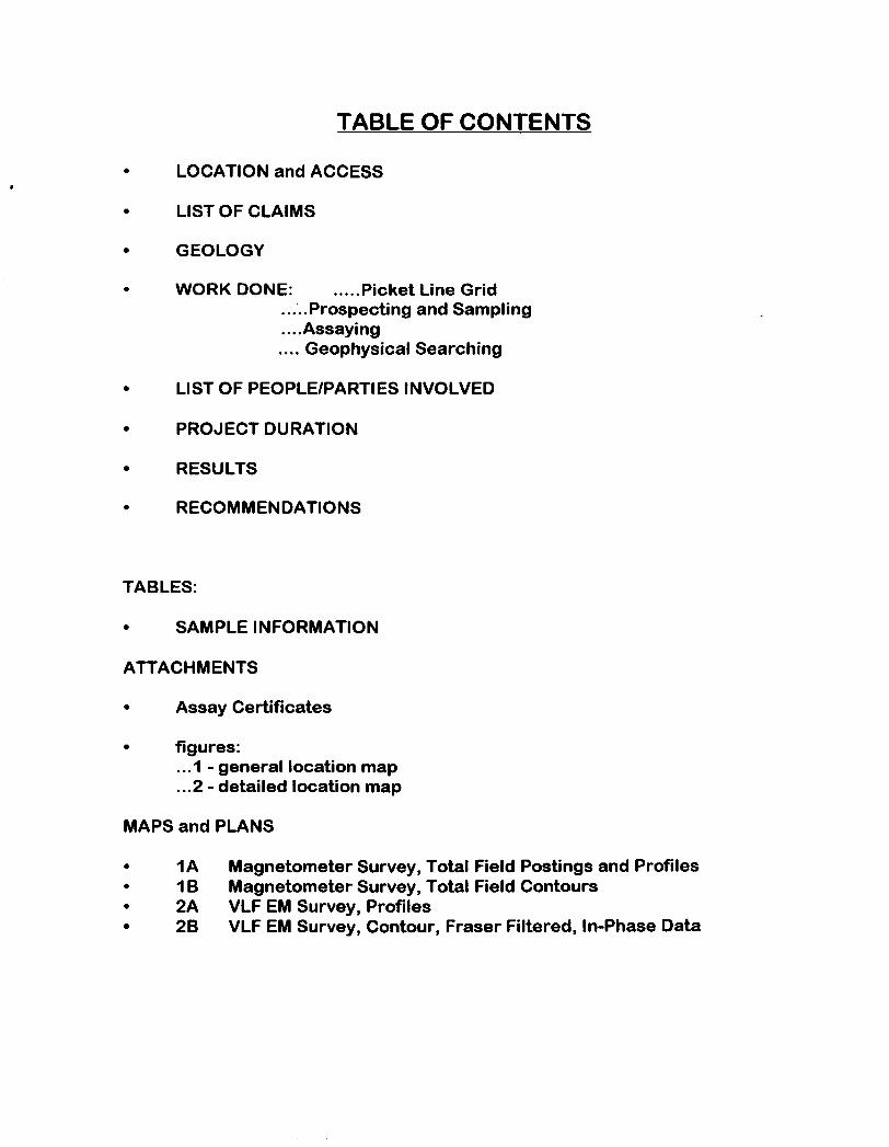
TABLE OF CONTENTS
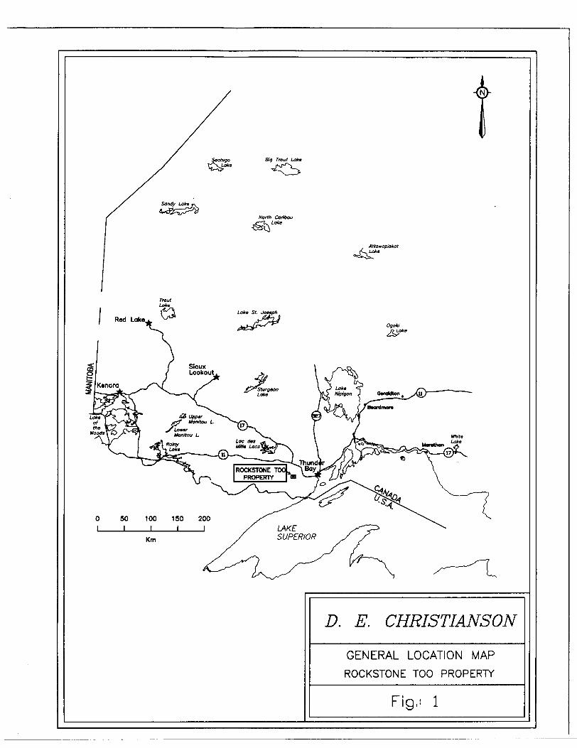
LOCATION and ACCESS
LIST OF CLAIMS
GEOLOGY
WORK DONE: .....Picket Line Grid.....Prospecting and Sampling....Assaying.... Geophysical Searching
LIST OF PEOPLE/PARTIES INVOLVED
PROJECT DURATION
RESULTS
RECOMMENDATIONS
TABLES:
SAMPLE INFORMATION
ATTACHMENTS
* Assay Certificates
figures:...1 - general location map...2 - detailed location map
MAPS and PLANS
1A Magnetometer Survey, Total Field Postings and Profiles* 1B Magnetometer Survey, Total Field Contours
2A VLF EM Survey, Profiles2B VLF EM Survey, Contour, Fraser Filtered, In-Phase Data
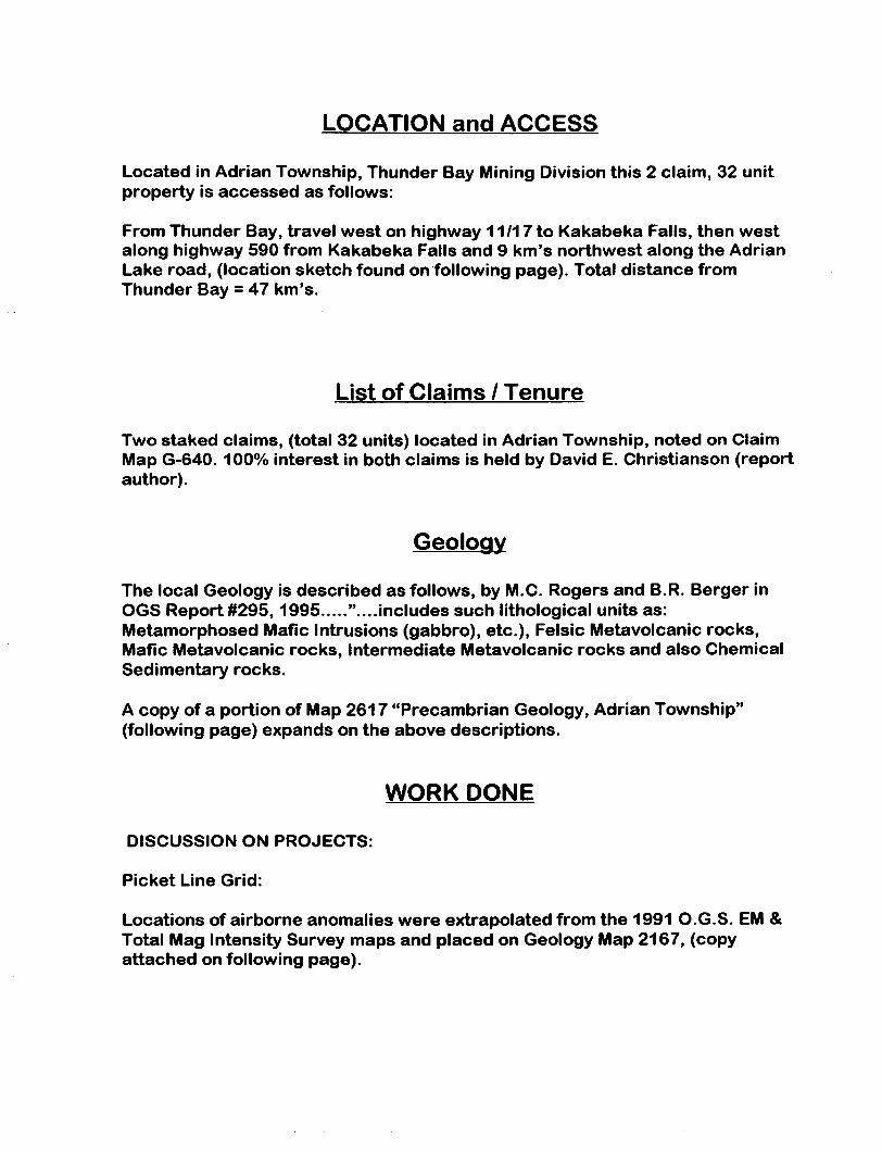
LOCATION and ACCESS
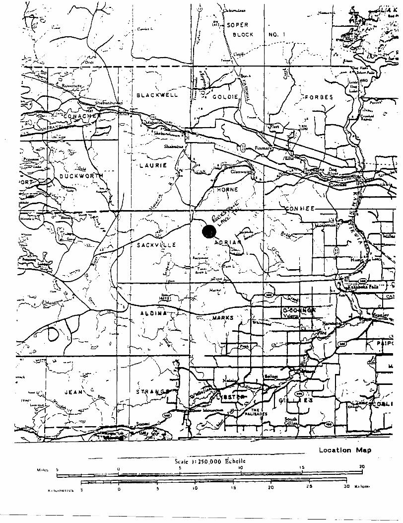
Located in Adrian Township, Thunder Bay Mining Division this 2 claim, 32 unit property is accessed as follows:
From Thunder Bay, travel west on highway 11/17 to Kakabeka Falls, then west along highway 590 from Kakabeka Falls and 9 km's northwest along the Adrian Lake road, (location sketch found on following page). Total distance from Thunder Bay = 47 km's.
List of Claims / Tenure
Two staked claims, (total 32 units) located in Adrian Township, noted on Claim Map G-640. 10007o interest in both claims is held by David E. Christianson (report author).
Geology
The local Geology is described as follows, by M.C. Rogers and B.R. Berger in OGS Report #295,1995....."....includes such lithological units as: Metamorphosed Mafic Intrusions (gabbro), etc.), Felsic Metavolcanic rocks, Mafic Metavolcanic rocks, Intermediate Metavolcanic rocks and also Chemical Sedimentary rocks.
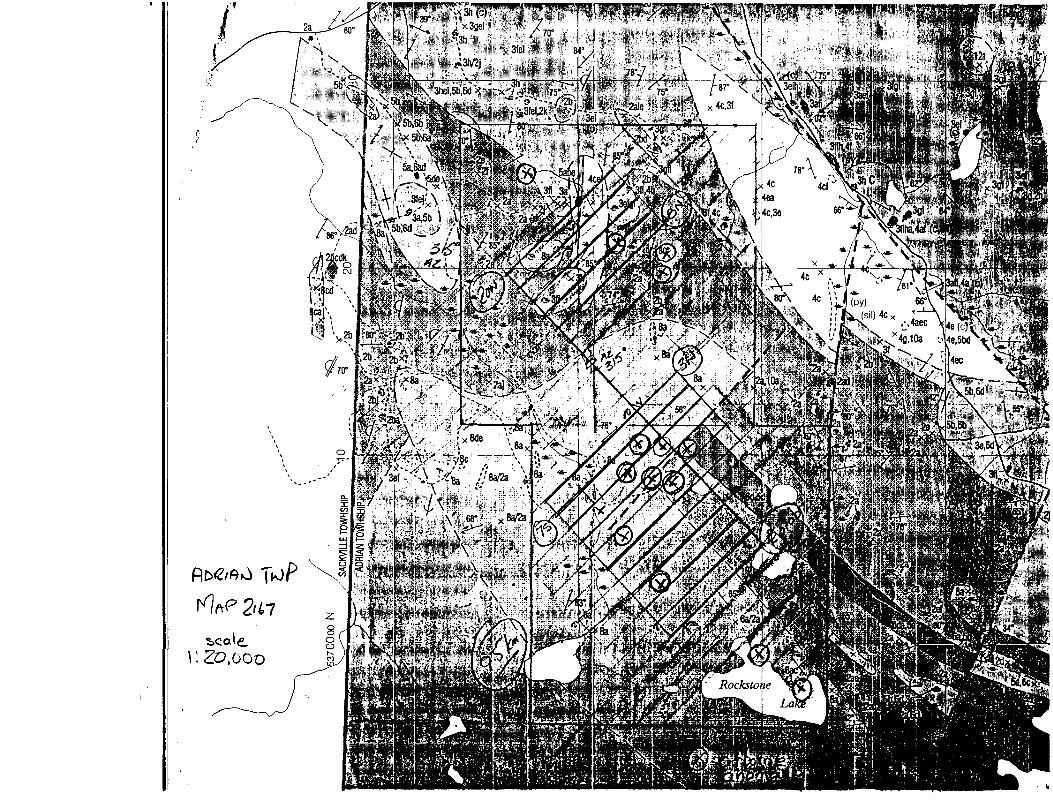
A copy of a portion of Map 2617 "Precambrian Geology, Adrian Township" (following page) expands on the above descriptions.
WORK DONE
DISCUSSION ON PROJECTS:
Picket Line Grid:
Locations of airborne anomalies were extrapolated from the 1991 O.G.S. EM Total Mag Intensity Survey maps and placed on Geology Map 2167, (copy attached on following page).
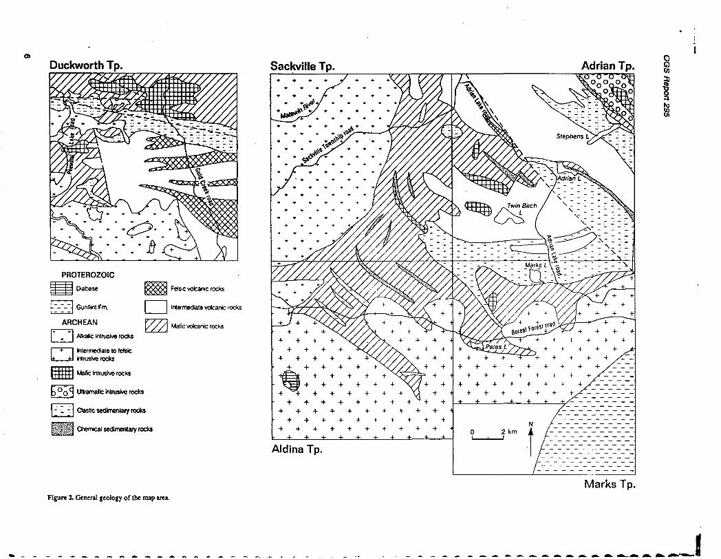
Duckworth Tp. Sackville Tp. Adrian Tp.
PROTEROZOIC
^S Diabase
i-~-~-"-| Gunflint Fm.
ARCHEAN
Alkalic intrusive rocks
l Inlermediate to felsic intrusive rocks
Mafic intrusive rocks
Ultramafic intrusive rocks
Clastic sedimentary rocks
Chemical sedimentary rocks
Felsic volcanic rocks
Inlermediate volcanic rocks
Malic volcanic rocks
Aldina Tp.
Marks Tp.
en
f18Ui
Figure 2. General geology of the map area.
Vjjt
i;;|'T
V
ii'^T
^I'.j
?P
i5''i:i-^-;
v v'liv
--.
- '-'
-- '- '
,~. ,
,*"d
'n-^
wi
H..-V
f'it. .
.^ ,
,s
"H
:! "-
."."
-
- -'
. .-
:'.,:-.
',i j'-"j j*
9057648093 TERRAPLUS INC. 786 PQ3 ClAY 20 "96 16:26
GSM-19Magnetometer VLF System
S 1 ••V^'V -''.^V ;:'"
VJFOJLV.I-JLJ7
The GSM-19 is a state-of-the-art magnetometer l VLF system that delivers both the quality of data and the extensive capabilities required to perform a broad spectrum of applications. Whether the application calls for detailed ground surveys, high-resolution marine surveys, or remotely controlled magnetic observatory measurements, you can count on the GSM-19 system to meet your goals.
The GSM-19 can be configured as either an Overhauser effect proton precession magnetometer or a conventional proton unit.
GEM's advanced Overhauser version employs continuous radiofrequency polarization and special sensors to maximize the signal-to-noise ratio. Instrument sensitivity (0.05 gamma), resolution (0.01 gamma) and absolute accuracy (0.2 gamma) set new performance standards. Moreover omnidirectional sensors ensure a high quality of data even in low magnetic latitudes.
You can also take advantage of versatile options that reduce field costs and increase survey productivity. And the lightweight Overhauser unit is easy to transport and operate in the field (console with rechargeable batteries weighs only 2. l kilograms).
The modular design of the GSM-19 Overhauser magnetometer ensures that the system can be upgraded as workloads change. You can select from a number of building blocks, including:
* Simultaneous gradiometer.* Continuous profiling "Walking" magnetometer l
gradiometer.* Very fast sampling (up to 5 readings per second)
magnetometer/gradiometer.* Omnidirectional VLF.* Shallow or deep marine operation.
. * Remote control for observatory and airborne base station applications.
If your application does not yet require the extended capabilities or the cost benefits of an Overhauser unit, conventional GSM-19 unit is available. This dedicated proton magnetometer can be equipped with gradiomet or VLF options, and is upgradable to an Overhauser magnetometer.
The Overhauser and conventional magnetometers shai many powerful features:
* Easy to learn interactive menu.* Streamlined grid coordinate system with "end of
tine" quick change capability.0 128 kilobyte basic memory, expandable to
2 Megabytes.* Programmable RS-232 high-speed data transfer (tc
19.2 kilobaud).* 50 and 60 Hz filters, user selectable.* Automatic tuning and base station synchronization
Type of Magnetometer
BuikSng Stocks (Upgrade Options)
c** .
Conventional Proton
Overhauser Proton
Total Field
"Walking" V yHip-Chain
A Proton Total Field system may be upgraded to an Overhauser system, which allows further upgrade to "Walking" and Hip Chain models.
VJUJ.VJL- JL s w v
A Full Range of Building Blocks
Simultaneous GradiometerMany mining, environmental, and archaeological applications call for high-sensitivity gradiometer surveys. The GSM-19 meets these needs in several ways. For example, simultaneous measurement of the magnetic field at both sensors eliminates diurnal magnetic effects. And Overhauser proton precession improves data accuracy and precision. The net result is a true gradient reading that resolves even weak anomalies (less than 0.25 gamma).
Omnidirectional VLFWith OEM's omnidirectional VLF option, up to three stations of VLF data can be acquired without orienting. Moreover, the operator is able to record both magnetic and VLF data with a single stroke on the keypad.
A 12-bit A/D converter has also been incorporated in the VLF instrumentation to enhance resolution of near- surface electromagnetic conductors.
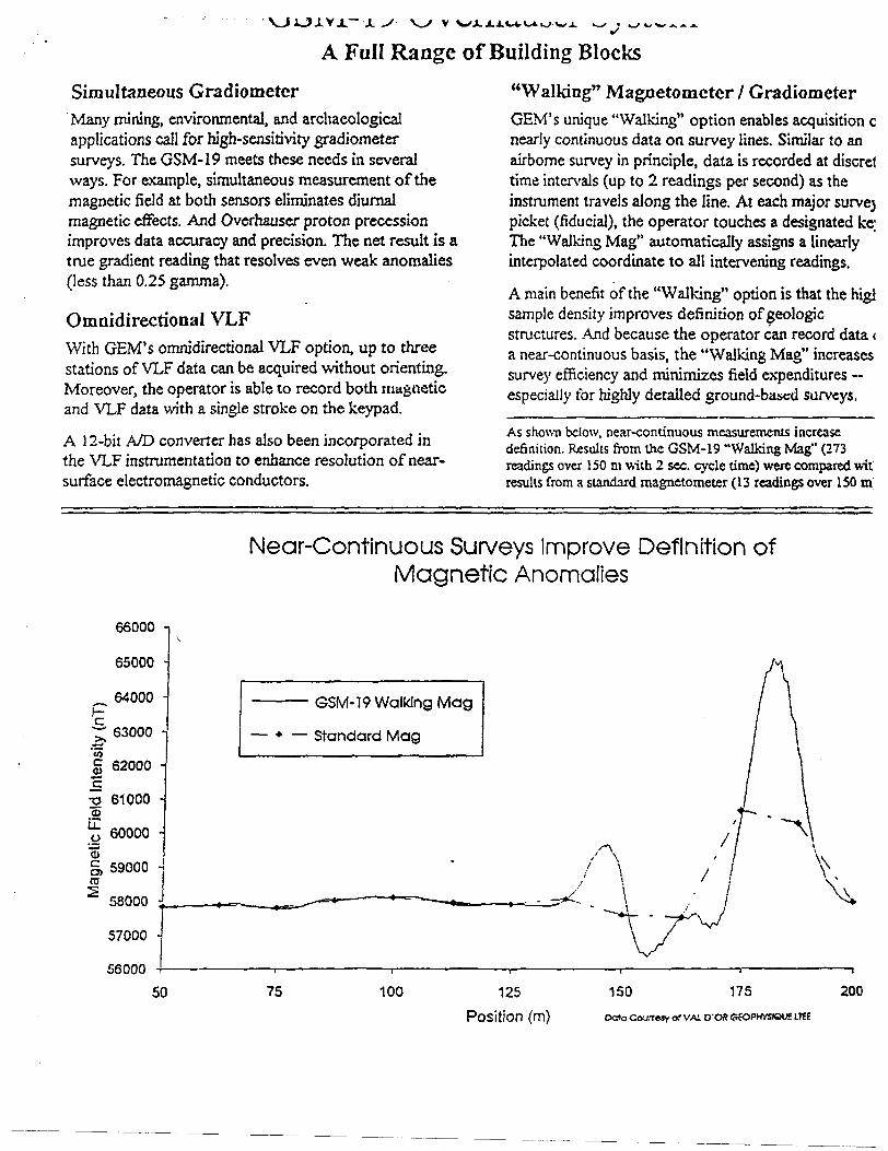
"Walking" Magnetometer 7 GradiometerOEM's unique "Walking" option enables acquisition oi nearly continuous data on survey lines. Similar to an airborne survey in principle, data is recorded at discrett time intervals (up to 2 readings per second) as the instrument travels along the line. At each major survey picket (fiducial), the operator touches a designated kej The "Walking Mag" automatically assigns a linearly interpolated coordinate to all intervening readings.
A main benefit of the "Walking" option is that the higt sample density improves definition of geologic structures. And because the operator can record data (. a near-continuous basis, the "Walking Mag" increases survey efficiency and minimizes field expenditures especially for highly detailed ground-based surveys.
As shown below, near-conu'nuous measurements increase definition. Results from the GSM-19 "Walking Mag" (273 readings over 150 m with 2 sec. cycle time) were compared wit results from a standard magnetometer (13 readings over 150 m;
Near-Continuous Surveys Improve Definition of Magnetic Anomalies
^c. jj, '55
66000
65000
64000
63000 -
62000 -
2 61000 -.2^l 60000 -
g, 59000 co5 58000 i
57000 -
56000
50
GSM-19 Walking Mag
— * — Standard Mag
75 100 125
(ft!)
150 175 200
OatoCourteiyQ?VALD-OftCEOPHYSlQUSLTEE
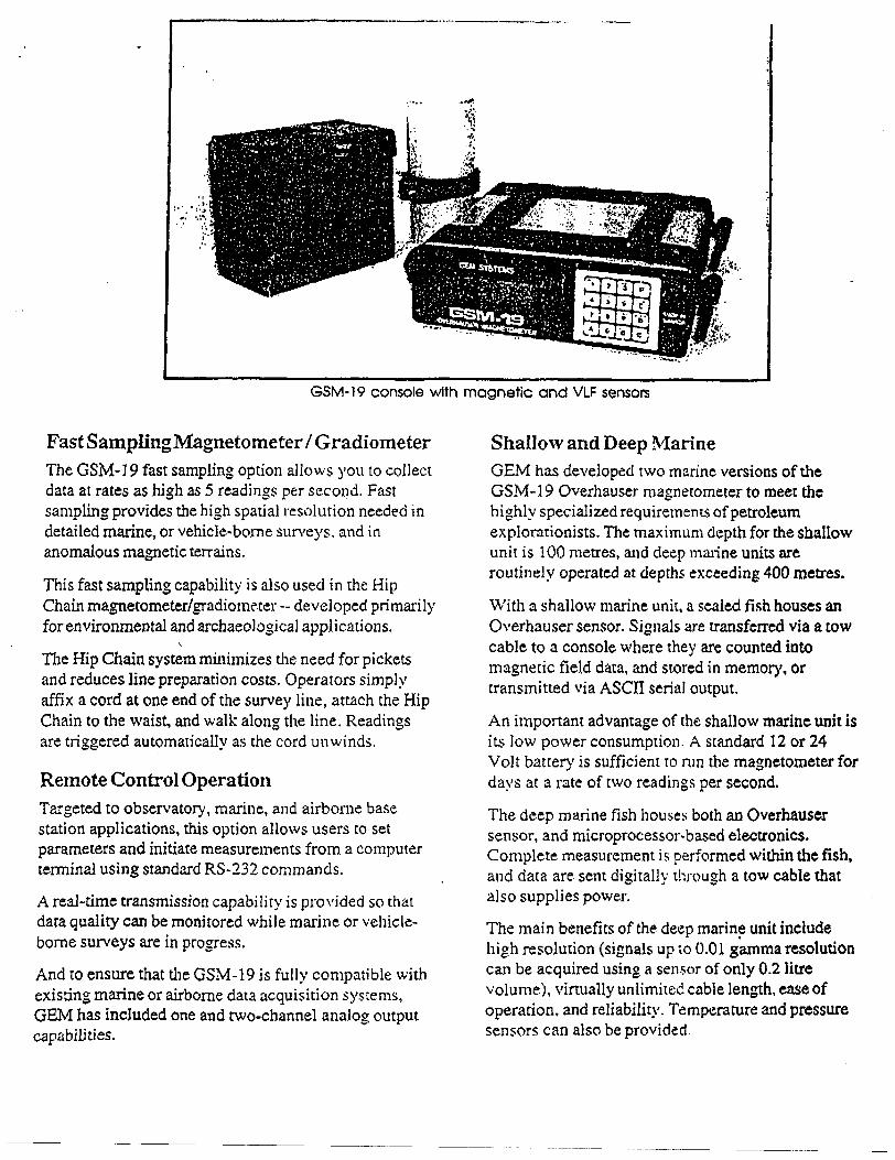
GSM-19 console with magnetic and VLF sensors
Fast S ampling Magnetometer l GradiometerThe GSM-] 9 fast sampling option allows you to collect data at rates as high as 5 readings per second. Fast sampling provides the high spatial resolution needed in detailed marine, or vehicle-borne surveys, and in anomalous magnetic terrains.
This fast sampling capability is also used in the Hip Chain magnetometer/gradiometer - developed primarily for environmental and archaeological applications.
s.
The Hip Chain system minimizes the need for pickets and reduces line preparation costs. Operators simply affix a cord at one end of the survey line, attach the Hip Chain to the waist, and walk along the line. Readings are triggered automatically as the cord unwinds.
Remote Control OperationTargeted to observatory, marine, and airborne base station applications, this option allows users to set parameters and initiate measurements from a computer terminal using standard RS-232 commands.
A real-time transmission capability is provided so that data quality can be monitored while marine or vehicle- borne surveys are in progress.
And to ensure that the GSM-19 is fully compatible with existing marine or airborne data acquisition systems, GEM has included one and two-channel analog output capabilities.
Shallow and Deep MarineGEM has developed two marine versions of the GSM-19 Overhauser magnetometer to meet the highly specialized requirements of petroleum explorationists. The maximum depth for the shallow unit is 100 metres, and deep marine units are routinely operated at depths exceeding 400 metres.
With a shallow marine unit, a sealed fish houses an Overhauser sensor. Signals are transferred via a tow cable to a console where they are counted into magnetic field data, and stored in memory, or transmitted via ASCII serial output.
An important advantage of the shallow marine unit is its low power consumption. A standard 12 or 24 Volt battery is sufficient to run the magnetometer for days at a rate of two readings per second.
The deep marine fish houses both an Overhauser sensor, and microprocessor-based electronics. Complete measurement is performed within the fish, and data are sent digitally through a tow cable that also supplies power.
The main benefits of the deep marine unit include high resolution (signals up to 0.01 gamma resolution can be acquired using a sensor of only 0.2 litre volume), virtually unlimited cable length, ease of operation, and reliability. Temperature and pressure sensors can also be provided.
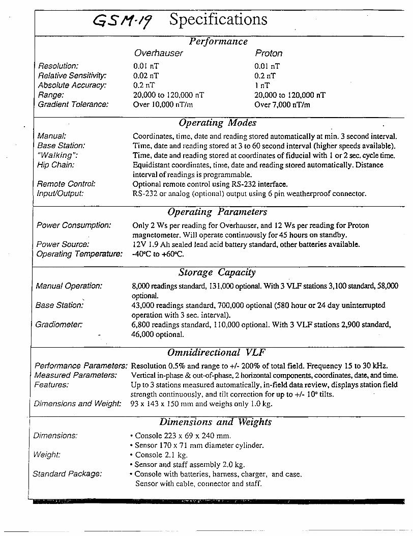
SpecificationsPerformance
OverhauserResolution: Relative Sensitivity: Absolute Accuracy: Range: Gradient Tolerance:
0.01 nT0.02 nT0.2 nT20,000 to 120,000 nTOver lO.OOOnT/m
Proton0.01 nT0.2 nTl nT20,000 to 120,000 nTOver 7,000 nT/m
Manual: Base Station: "Walking": Hip Chain:
Remote Control: Input/Output:
Operating ModesCoordinates, time, date and reading stored automatically at min. 3 second interval.Time, date and reading stored at 3 to 60 second interval (higher speeds available).Time, date and reading stored at coordinates of fiducial with l or 2 sec. cycle time.Equidistant coordinates, time, date and reading stored automatically. Distanceinterval of readings is programmable.Optional remote control using RS-232 interface.RS-232 or analog (optional) output using 6 pin weatherproof connector.
Power Consumption:
Power Source: Operating Temperature:
Operating ParametersOnly 2 Ws per reading for Overhauser, and 12 Ws per reading for Proton magnetometer. Will operate continuously for 45 hours on standby. 12V l .9 Ah sealed lead acid battery standard, other batteries available,
to 4-600C.
Manual Operation:
\
Base Station:
Gradiometer:
Storage Capacity8,000 readings standard, 131,000 optional. With 3 VLF stations 3,100 standard, 58,000optional.43,000 readings standard, 700,000 optional (580 hour or 24 day uninterruptedoperation with 3 sec. interval).6,800 readings standard, 110,000 optional. With 3 VLF stations 2,900 standard,46,000 optional.
Omnidirectional VLFPerformance Parameters: Resolution Q.5% and range to +I- 2009b of total field. Frequency 15 to 30 kHz. Measured Parameters: Vertical in-phase *fe out-of-phase, 2 horizontal components, coordinates, date, and time. Features: Up to 3 stations measured automatically, in-field data review, displays station field
strength continuously, and tilt correction for up to +J- 1 0" tilts. Dimensions and Weight: 93 x 143 x 150 mm and weighs only 1.0 kg.
Dimensions:
Weight-
Standard Package:
Dimensions and Weights* Console 223 x 69 x 240 mm.* Sensor 170 x 71 mm diameter cylinder.* Console 2.1 kg.* Sensor and staff assembly 2.0 kg.* Console with batteries, harness, charger, and case.
Sensor with cable, connector and staff.
A 'fine tuned' grid (limited by budget dollars) was laid out in such a fashion as to provide minimum basic coverage to facilitate the use of geophysical prospecting tools on the ground, in hopes of ground proofing the airborne locations.
Scott Christiansen was contracted to install the picket line grid. The results and location of which are noted on Map #3 in this Report. A total of 15.5 km's of lines including base line, were installed and chained to 25 metre stations.
Prospecting/Sampling:
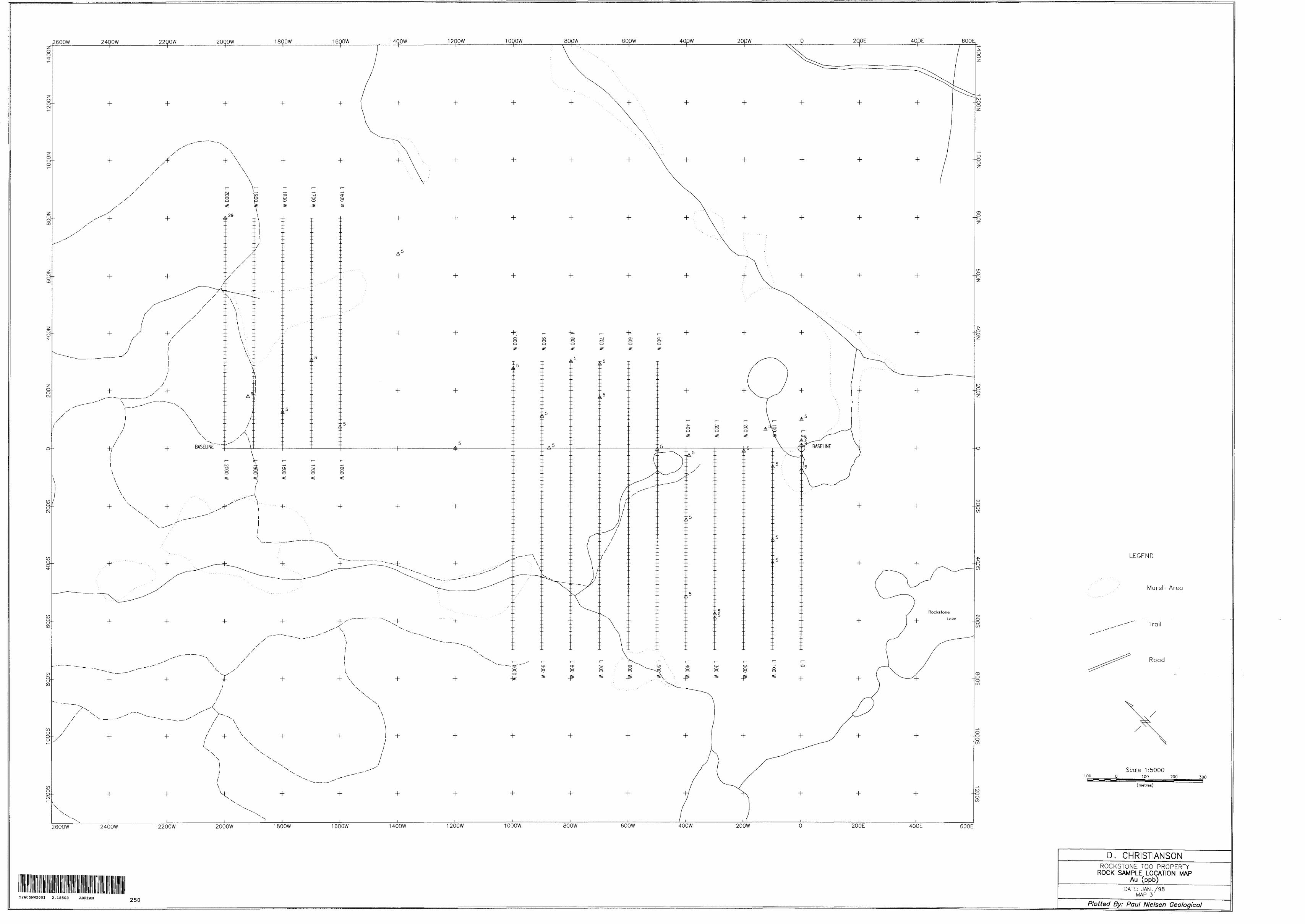
The grid was later prospected and samples were collected and described as per locations on Map #3 in this Report, and also the ASSAY DATA TABLE.
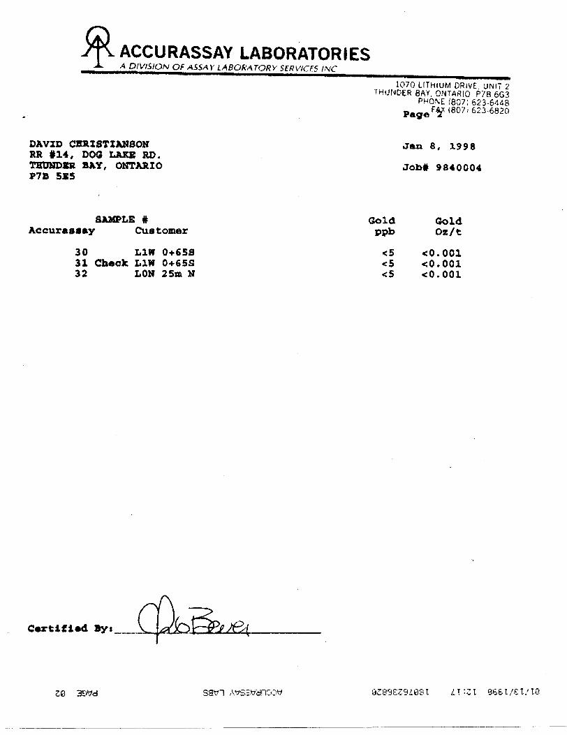
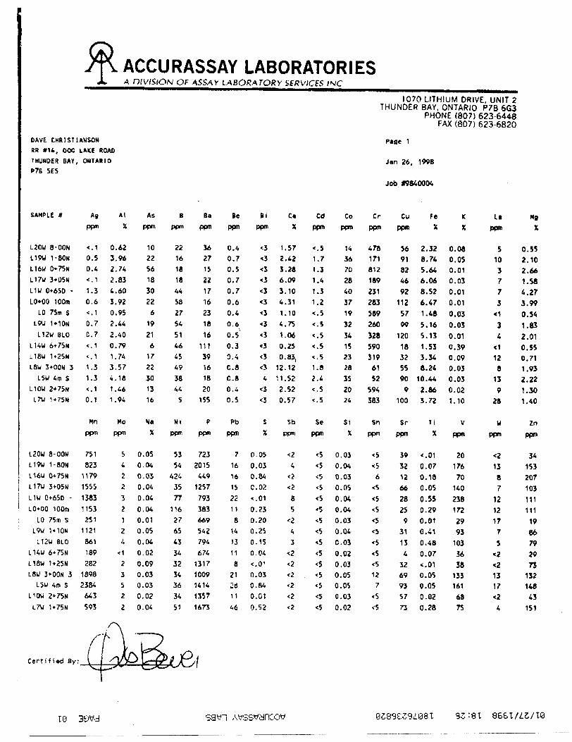
Assaying:
The 29 samples subjected to analysis were treated as follows:Gold assays were performed using the fire assay technique followed with an AAfinish.A litho-geochemical multi element analysis was also performed on all 29samples using the I.C.A.P. technique. All lab work was performed byAccurassay Laboratories of Thunder Bay, Ontario.
Geophysical searching:
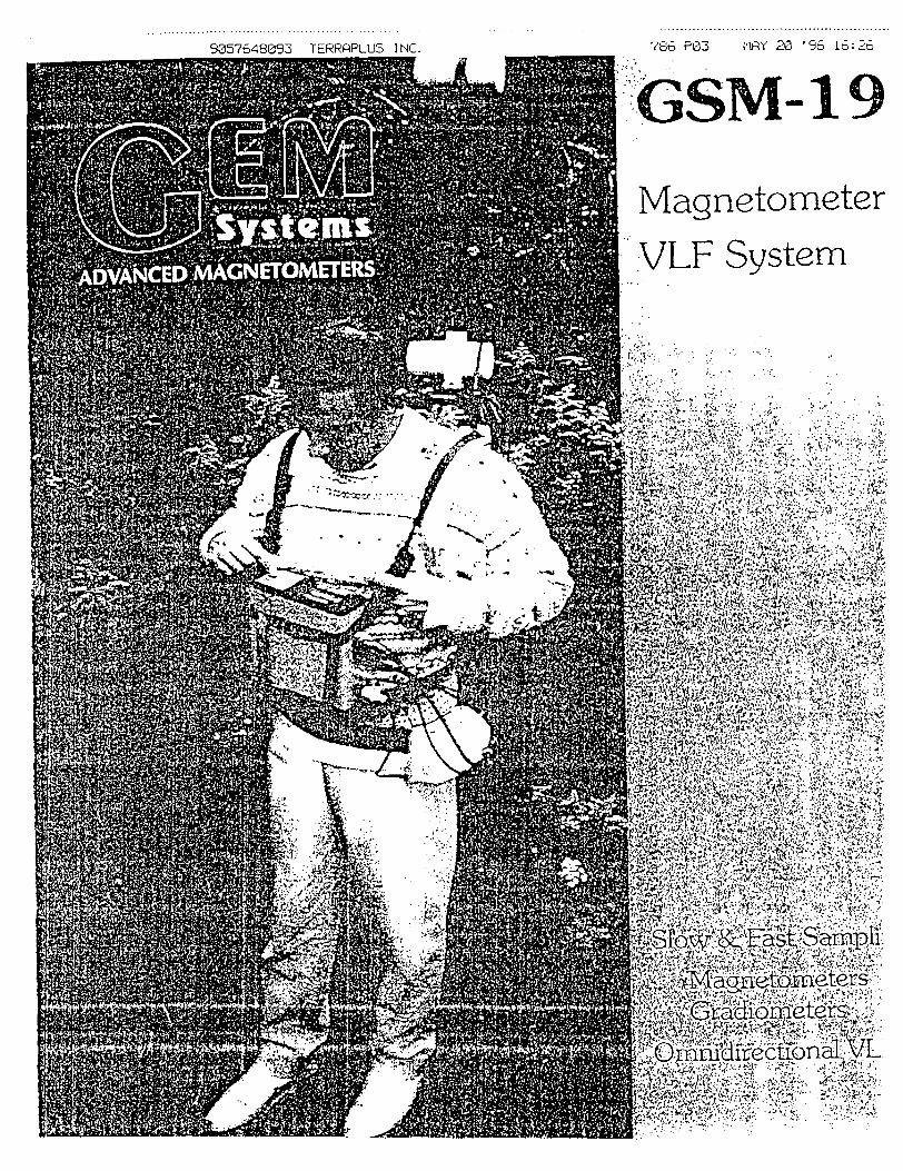
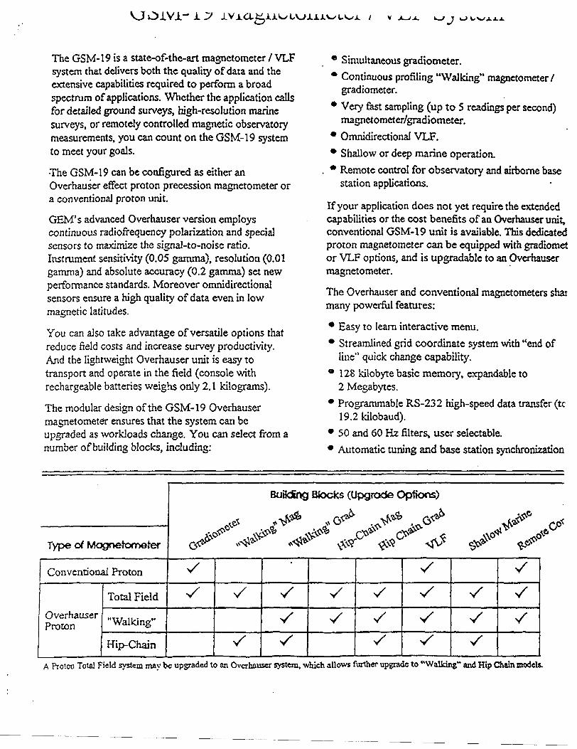
Grey Owl resources was contracted to collect geophysical data from the grid locations. It was hoped that the resultant maps would help pin point anomalous areas (relating to the airborne data) so as to enable quick location for more detailed prospecting.Instrument used was a GEM, GSM-19, serial no. field,66573, base,66565 Further info, re the instrument and collection method, etc. is found on the 5 pages following.
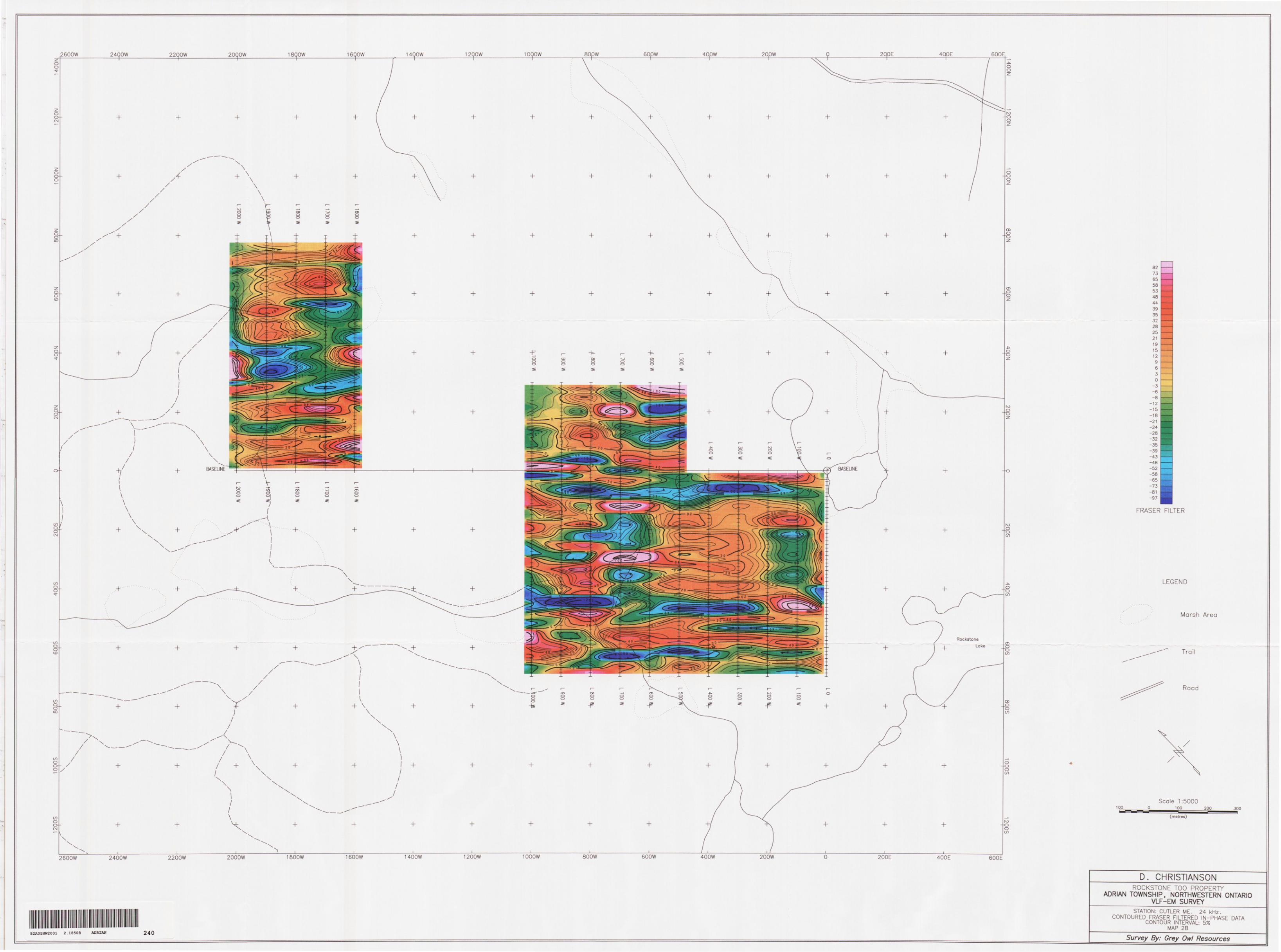
The following Maps were produced from the information gathered:Map 1A - MAGNETOMETER SURVEY, TOTAL FIELD POSTINGS ANDPROFILESMap 1B - MAGNETOMETER SURVEY, TOTAL FIELD CONTOURSMap 2A - VLF EM SURVEY, PROFILESMap 2B - VLF EM SURVEY, CONTOUR FRASER FILTERED IN-PHASE DATA
.....and are attached to this Report.
List of people/parties involved in the overall project:
Grid Installation: Scott Christianson c/o R.R. 14, Dog Lake Road, Thunder Bay On P7B 5E5
Helper: Scott Christianson, as above
Geophysics: Magnum Explorations Inc., R.R. #1 Mining Road, Murillo On POT 2GO
Drafting/Plotting: Pauf E. Nielsen, 777 Red River Road, Thunder Bay On P7B 1J9
Assay Laboratory: Accurassay Lab's., 1070 Lithium Dr., Thunder Bay On P7B 6G3
Project Duration:
All work was carried out between, June 1/97 and Jan 28/98
RESULTS
A total of 15.5 kilometres of grid lines (including 2 km base line) were cut and chained in location noted on Plan attached.
The grid provided a means of controlling 1 st pass general prospecting l sampling, during which time a total of 29 samples were collected and later subjected to lab analysis for gold and other mineral content. No evidence was found to support the location of referenced airborne geophysical anomalies from 1 st pass prospecting. The assay results from the 29 samples tested was less than encouraging as far as mineral content is concerned. The highest gold value obtained was 29 ppb's from samp/location L20W - 800 N.
The same 29 samples were subjected to I.C.A.P. multi-element analysis. It is unknown as to exactly these data mean right now, however, they will considered while we plan what to do next.
The combined Magnetometer l VLF survey that was carried out over the entire grid has failed to blatantly outline the referenced airborne anomalies on the ground. This is mainly due to the fact that the writer's knowledge is limited as far as interpretation of the geophysical data is concerned. Time and budget limitations prevented additional interpretation at this time. This issue is further addressed in the Recommendations portion of this report.
RECOMMENDATIONS
The main purpose of this project was to try to ground-proof the airborne anomalies noted in the 1991 O.G.S. Airborne EM and Total Intensity Mag survey which were noted to be within the boundaries of these staked claims. It was further hoped that we would be able to locate, sample, assay any mineralized rocks located.
Although we were unable to meet the above-noted objective as a result of this project's multi-level attack, the fact remains that the source of the original 'Stares Float' referenced to in the 'Application' for this project, has not yet been identified.It is believed, and evidenced by the data assembled from this project, that it may be worthwhile to fill in the blanks in the geophysical data, (expand the survey) as this very limited (budget-controlled) area was too selective and small to provide the picture needed. A detailed interpretation of the litho-geo chemical data (ICAP information) should also be considered while attempting to determine possible diamond drill hole locations or potential zones for further detailed prospecting and/or stripping.

SAMPLE INFORMATION TABLE
SAMP # 1 LOCATION
BL - 8+75 N
LO - 25m N
L010N
LO- 100 N
LO - 75m S
L1W-65S + 25W
L1W-65S
L1W - 320 S
L1W-400S
L2W-10S
L3W-590S
LAW- 25 S * 10 E
L4W-250S
L4W-517S
L5W - 4m S
L7W-175N
L7W-290N
L8W-300N
L8W - 300 N * 30m W
L9W-110N
L10W-275N
L12W-BLO
L14W-675N
L16W-75N
DESCRIPTION
rusty intermediate volcanic with fine dissem sulphides
coarse grained qtz/carb, mica, sm cubes py * some dissem sulphides
brecciated, felsic interm vole rock with qtz stringers * some minor sulphides
felsic-interm vole, some fine dissem py
med grained, vuggy qtz blobs in f.g. interm vole matrix
fine grained massive interm vole with fine dissem sulph
med grained amphibolite, fine sulph mineralization
coarse grained qtz with some cubes py
granite gneiss, fine scattered py
f.g. massive interm vole rock with narrow qtz veining * minor sulphides
coarse grained interm vole with veinlets qtz * diss py
med grained interm vole , some scattered suphided
sheared mafic vole rock from 1 m wide shear zone, badly broken, some minor sulph mineral.
fine grained felsic-interm vole, some fine sulphides
brecciated mafic vole, fine scattered sulphides
fine grained rhyolite?, some sulphides
f. g. massive interm vole, fine sulphide mineralization
coarse grained, brecciated, mafic vole rock with qtz and coarse cubes py
same as above
fine grained mafic meta vole with stringers f.g. sulphides
coarse grained qtz with biotite and coarse cubes py from 30 cm wide vein
med grained interm vole, some dissem sulphides
qtz 1 gneiss with coarse biotite * dissem sulphides
f.g. interm vole, some fine sulphides
AU ppb's
-5
-5
-5 .
-5
-5
-5
-5
-5
-5
-5
-5
-5
-5
-5
-5
-5
-5
-5
-5
-5
-5
-5
-5
-5
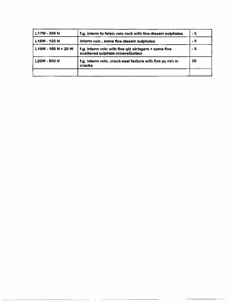
L17W-305N
L18W-125N
L19W-180N + 20W
L20W - 800 N
f.g. interm to felsic vole rock with fine dissem sulphides
interm vole , some fine dissem sulphides
f.g. interm vole with fine qtz stringers * some fine scattered sulphide mineralization
f.g. interm vole, crack-seal texture with fine py min in cracks
-5
-5
-5
29
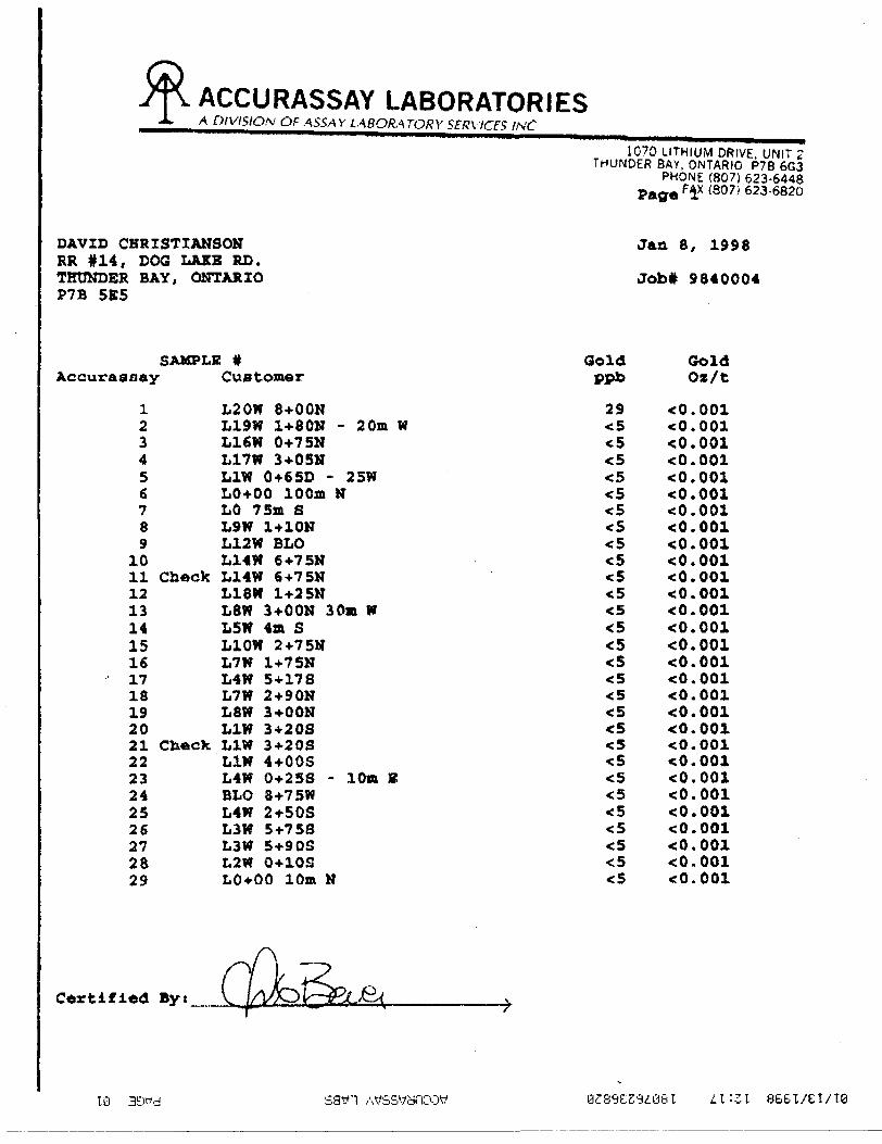
ACCURASSAY LABORATORIESA OtVISION OF ASSAY LABORATORY SERVICFS INC
1070 LITHIUM DRIVE. UNIT 2THUNDER BAY, ONTARIO P?B 6G3
PHONE (807) 623-6448Page pix (807) ̂ 23-6820
DAVID CHRISTIANSON Jan 8, 1998 RR #14, DOG LAKE RD.THTJNDER BAY, ONTARIO Job* 9840004 P7B 5E5
SAMPLE # Gold Gold Accurassay Customer ppb Oz/t
Certified
1 L20W 8+OON 29 <02 L19W 1+80N - 20m W ^ <0.0013 L16W 0+75N *5 <0.0014 L17W 3+05N *5 cO.OOl5 L1W 0+65D - 25W <5 <0.0016 LO+00 100m K *5 <0.0017 LO 75m S ^ < 0.0018 L9W 1+10K <5 < 0.0019 L12W BLO ^ <0.001
10 L14W 64-75N *S cO.OOl11 Check L14W 6+75N <5 cO.OOl12 L18W 1+25N <5 <0.00113 L8W 3+OON 30m W ^ <0.00114 L5W 4m S ^ <0.00115 L10W 2+75N ^ <0.00116 L7W 1+75N ^ <0.00117 L4W 5*178 ^ <0.00118 L7W 2+90N ^ cO.OOl19 L8W 3+OON *5 <0.00120 L1W 3+20S ^ <0.00121 Check L1W 3+20S ^ cO.OOl22 L1W 4+OOS <5 *:0.00123 L4W 0+25S - l On 8 c5 ^.00124 BLO 8-I-75W <5 cO.OOl25 L4W 2*50S <5 ^.00126 L3W 5+758 <5 ^.00127 L3W 5+90S <5 <0.00l28 L2W 0+10S <5 *c0.00129 L0*00 10m H ^ *0.001
10 3oyd sawn Atfssyyroow a^s^tS'^osi ^1:31 BBBI/EI/TB
ACCURASSAY LABORATORIESA DIVISION QF ASSAY LABOKATORY SERV/CFS f.\C
1070 LITHIUM DRIVE UNIT 2 THUNDER BAY. ONTARIO P7B 6G3
PHONE (807; 623-6448 * (807/623-6820
DAVID CHRISTIANSON jan 8, 1998 RR #14, DOO LAKE RD.THUNDKR BAY, ONTARIO Job* 9840004 P7B 5B5
SAMPLE # Gold GoldAccuraoaay Customer ppb Oz/t
30 LIN 0+65S ^ < 0.00131 Check L1W 0+65S <5 <0.00132 LON 25m N < 5 < 0.001
C*rtifi*d Byt
sawn/wsc*an:ow azsaessiesi L I-ZI
ACCURASSAY LABORATORIESA DIVISION OF ASSAY LABORATORY SERVICES /VC
1070 LITHIUM DRIVE. UNIT 2THUNDER BAY, ONTARIO P 7B 6G3
PHONE (807) 623-6448FAX (807) 623-6820
DAVE CHRISTIANSEN
RR #14, 000 LAKE ROAD
THUNDER BAY, ONTARIO
P7B 5E5Jan 26, 1998
Job #9840004
SAMPLE *
L20W 8-OQN
L19W 1-80NL16W 0-75NL17U 3+05NL1U 0+65D -
LO+00 100mLO 75m S
L9U 1*10N
L12W BLOL14U 6+75NL18U 1+2SNI.8W 3+OON 3
L5W 4m SL10U 2+75N
L7U 1 + 75N
L20U 8 -00 WL19W 1-80NL16W 0+75NL17U 3+05N
L1U 0+65D -LO+00 100m
LO 75m SL9U 1*10N
L12W BLOL14U 6+75NL18U 1+25NL8U 3+OON 3
L5W 4m SLIOW 2+75N
L7U 1+75N
ASppm
-.1
0.50.4 O
1.30.6--.1
0.70.7*.1 O
1.31.3<.1
0.1
Mnppm
751
82311791555138311532511121861189
28218982384643
593
Al
X
0.623.962.74
2.834.60
3.920.952.44
2.400.791.743.574.181.461.94
Ho
ppm
5422
32
124
:1
2
35
2
2
Asppm
10225618
3022619
2161722301316
NaX
0.050.040.030.040.04
0.040.010.050.040.02
0.090.030.030.020.04
B
ppm
22161818
4458
275451464549
38445
Nippm
5354
424
3577
11627654334
3234363451
Ba
ppm
362715
221716231816
111391618
20155
pppm
72320154491257
793383669
542794
67413171009141413571673
Beppm
0.40.70.50.70.7
0.60.40.6
0.50.30.4C. 8C. 80.4
0.5
Pbppm
716
1615
221 1
81413
11
821
261146
Bippm
*3x3
^^
^^
O"3
^OO^
4^*3
5X
0.05
0.030.840.02".01
0.230.200.250.150.04-r. O 1
0.03O.ft40.01
0.52
Ca
X
1.572.423.286.09
3.104.311.104.75
1.06
0.250.83,12.1211.522.520.57
Sbppm
,2
4T?
*2
85
^43
*2
rtt?•i
rtrt
Cd Coppm ppm
*.5 141.7 361.3 701.4 281.3 40
1.2 37 t. 5 19*. i 32
^5 34^5 15t. 5 231.8 282.4 35*:.5 20^5 24
Se Sippm X
^ 0.03^ 0.04^ 0.03*5 0.05
^ 0.04*5 0.04^ 0.03^ 0.04^ 0.03^ 0.02^ 0.03^ 0.05*5 0.05^ 0.03*5 0.02
Cr
ppm
478171812189
231283
589260
3285903196152
594383
Snppm
* 5
^6^
^^
^*5
^^^127
'5
*5
Cuppm
56918246921125799
120183255909
100
Srppm
39
3212
6628
259
31134
3269935773
feX
2.328.745.646.068.52
6.471.4ft
5.165.131.533.348. 2410.44
2.865.72
T iX
".01
0.070.180.05
0.550.290.010.41
0.480.07^010.050.050.020.28
K
X
0.08o.os0.010.030.010.010.030.030.010.390.090.030.030.021.10
V
ppm
2017670140
238172
299310336
38133161
6875
L*ppm
5103773O34
t 1
12813
928
U
ppm
^1387
1212177
5,2
^1317*2
4
"9X
0.552.102.661.S84.273.99O.S41.832.010.550.711.932.221.301.40
Zn
ppm
34
153207103
111111
1986792973
13214643151
Certified By:
18 8681/^2/10

ACCURASSAY LABORATORIESA DIVISION OF ASSAY LABORATORY SERVICES /
1070 LITHIUM DRIVE, UNIT 2THUNDER BAY. ONTARIO P7B 6G3
PHONE (807) 623-6448FAX (807) 623-6820
DAVE CHRIST (ANSON
RR #14, COC LAKE ROAD
THUNDER BAY,
P7B 5ES
ONTARIO Jan 26, 1998
Job 1*9840004
SAMPLE It
L20W 8-OON
L19W 1-SONL16W 0*75NL17W 3+05NL1U 0*650 -
L 0*00 100mLO 75m S
L9U 1*10N
L12W 8LO
L14U 6+75N
L18W 1+2SN
L8W 3+OON 3L5U 4m S
L10U 2*75HL7U 1*75N
L20U 8-OONL19U 1-80NL16U 0+75NL17W 3+05N
L1W 0+65D -
LO+00 100mLO 75m S
L9U 1*1 ONL12W BLO
L14W 6*7SNL18U 1+25NL8U 3+OON 3
L5U 4m SL10W 2+75N
L7U 1+75N
ASppm
<.1
0.50.4 O
1.30.6^.1
0.70.7<.1<.1
1.31.3O0.1
Mnppm
751
8231179155513831153251
1121861189
28218982384643
593
At
X
0.623.962.74
2.834.60
3.920.952.44
2.400.791.743.574.181.461.94
Mo
ppm
54
22
32124
:1
2
3S2
2
Asppm
10225618
3022619
216
1722
301316
laX
0.050.040.030.040.04
0.040.010.050.040.02
0.090.030.030.020.04
Bppm
2216181844
58
275451464549
38445
Nippm
5354
4243577
116276543
3432343634SI
Ba
ppm
3627152217162318
1611139161820155
Pppm
72320154491257
793383669542794
67413171009141413571673
Beppm
0.40.70.50.70.7
0.60.40.6
0.50.30.4
C. 8C. 80..'.
0.5
Pb
Ppm
716
1615
2211
8141311
821is1146
fiippm
O^^^*3*3
^O^*3fi*14
^*3
SX
0.05
0.030.840.02*.01
0.230.200.250.15
0 04<.Q''
0.030.84
O.C10.52
Ca
X
1.572.423.2ft6.09
3.104.311.104.75
1.06
0.250.83,12.1211.522.520.57
Sbppm
^
4^*2
85
^4
3rtrtrt*2
rtti
Cdppm
,. 5
1.71.31.4
1.31.2 0 f.*
^5^5 c. 5
1.82.4^5*.5
Seppm
,5^*5-.5
^*5^t5
^*S*5^ 5*5
^
Coppn
1436702840
3719
323415232835
2024
SiX
0.030.040.030.05
0.040.040.030.040.03
0.020.030.050.050.03
0.02
Cr
ppm
478171812189231283
589260
3285903196152
594383
Snppn
, 5
^6
*5
^^
OO^^*5127
^^
Cuppm
5691824692112
5799
120183255909
100
Srppm
39
3212
6628
259
31134
3269935773
F*X
2.328.745.646.068.52
6.471.48
5.165.131.533.348.2410.44
2.86X. 72
TiX
*.01
0.070.180.050.550.290.010.410,48
0.07t. 010.050.050.020.28
K
X
0.0ft0.050.010.030.010.01
0.030.03
0.010.390.090.030.030.021.10
V
ppm
2017670140
238172
29931033638133161
6875
L*ppm
510377
3^34^12813
92ft
Wppm
,21387
1212177
5K2
^1317i2
4
H9
X
0.552.102.661.584.273.990.541.832.010.550.711.93
2.221.301.40
Zn
ppm
34153207103111111
198679297313214843
1S1
Certified By:
10
Big Trout Lake
North Caribou Lake
Attawapiskat Lake
Ogoki
50 100 150 200 l____l____l____l
Km
D. E. CHRISTIANSON
GENERAL LOCATION MAP
ROCKSTONE TOO PROPERTY
Fig,' l
Location Map
Scale |:2?0.000 Echelle5 10 is 20
:d
K i luitiull c^10 20 J S 30 K i lorn-
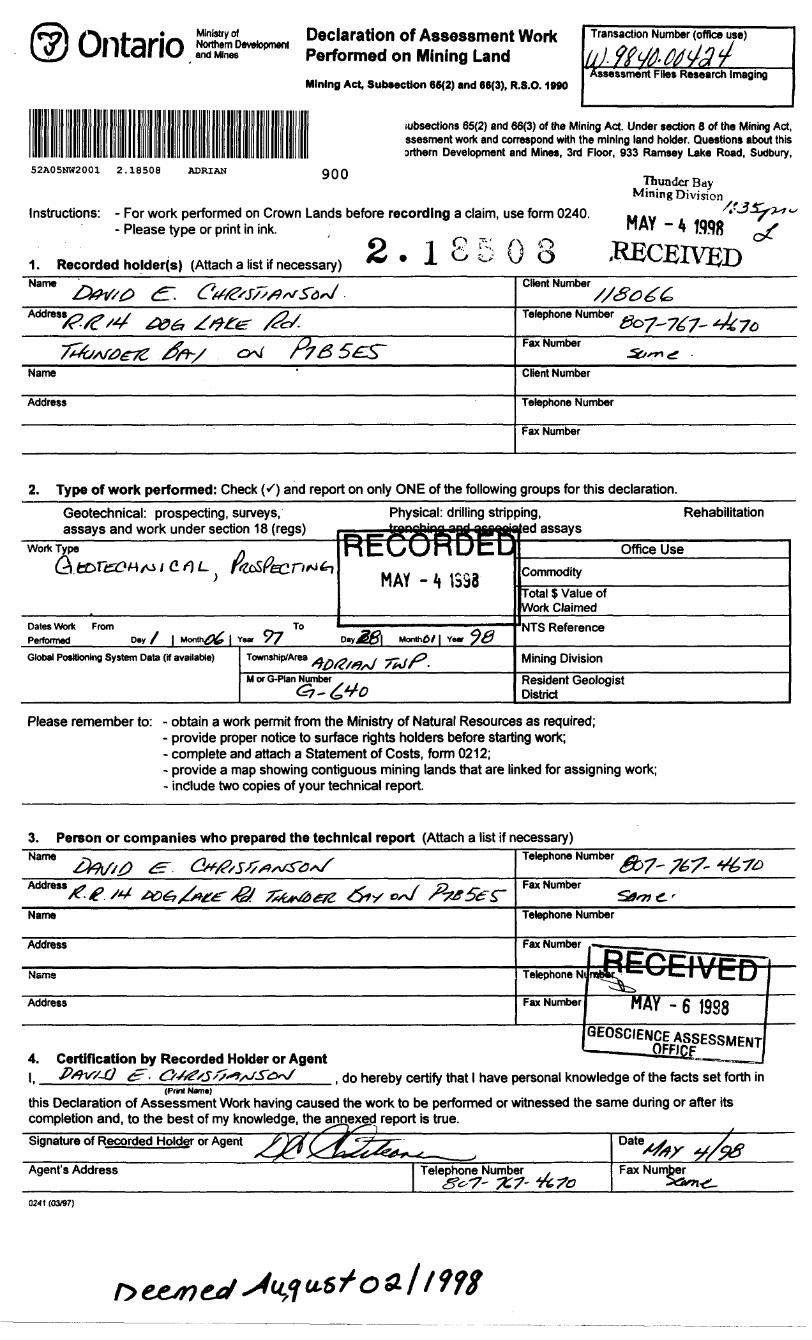
and MinesDeclaration of Assessment Work Performed on Mining Land
Mining Act, Subsection 66(2) and 66(3), R.S.0. 1990
Transaction Number (office use)
sessment Files Research Imaging
subsections 65(2) and 66(3) of the Mining Act. Under section 8 of the Mining Act, ssesment work and correspond with the mining land holder. Questions about this orthern Development and Mines, 3rd Floor, 933 Ramsey Lake Road, Sudbury,
52A05NW2001 2.18508 ADRIAN
Instructions: - For work performed on Crown Lands before recording a claim, use form 0240. - P lease type or print in ink. j
1. Recorded holder(s) (Attach a list if necessary) ^ * l C -o? (J O
Thunder Bay Mining Division
- A fflflg
Name Client Number
Telephone Number -j ^- — x.—^07-7^7-Fax Number
Name Client Number
Address Telephone Number
Fax Number
2. Type of work performed: Check (^) and report on only ONE of the following groups for this declaration.Geotechnical: prospecting, surveys,
and work under section 18Physical: drilling stripping, Rehabilitation
assaysOffice Use
Commodity
Total S Value of Work Claimed
Dates Work From
PerformedNTS Reference
D*y
Global Positioning System Data (if available) Mining Division
Resident Geologist District
Please remember to: - obtain a work permit from the Ministry of Natural Resources as required;- provide proper notice to surface rights holders before starting work;- complete and attach a Statement of Costs, form 0212;- provide a map showing contiguous mining lands that are linked for assigning work;- include two copies of your technical report.
3. Pereon or companies who prepared the technical report (Attach a list if necessary)Name Tetephone Number
Fax Number
Name Telephone Number
Address Fax Number
Name Telephone N
Address Fax Number "AY - 6 1988
4. Certification by Recorded Holder or Agent
GEOSOENsESSMENT
, do hereby certify that l have personal knowledge of the facts set forth in(Print Name)
this Declaration of Assessment Work having caused the work to be performed or witnessed the same during or after its completion and, to the best of my knowledge, the annexgd report is true.Signature of Recorded Holder or Agent
Agent's Address Telephone Number Fax Number
0241 (03/97)
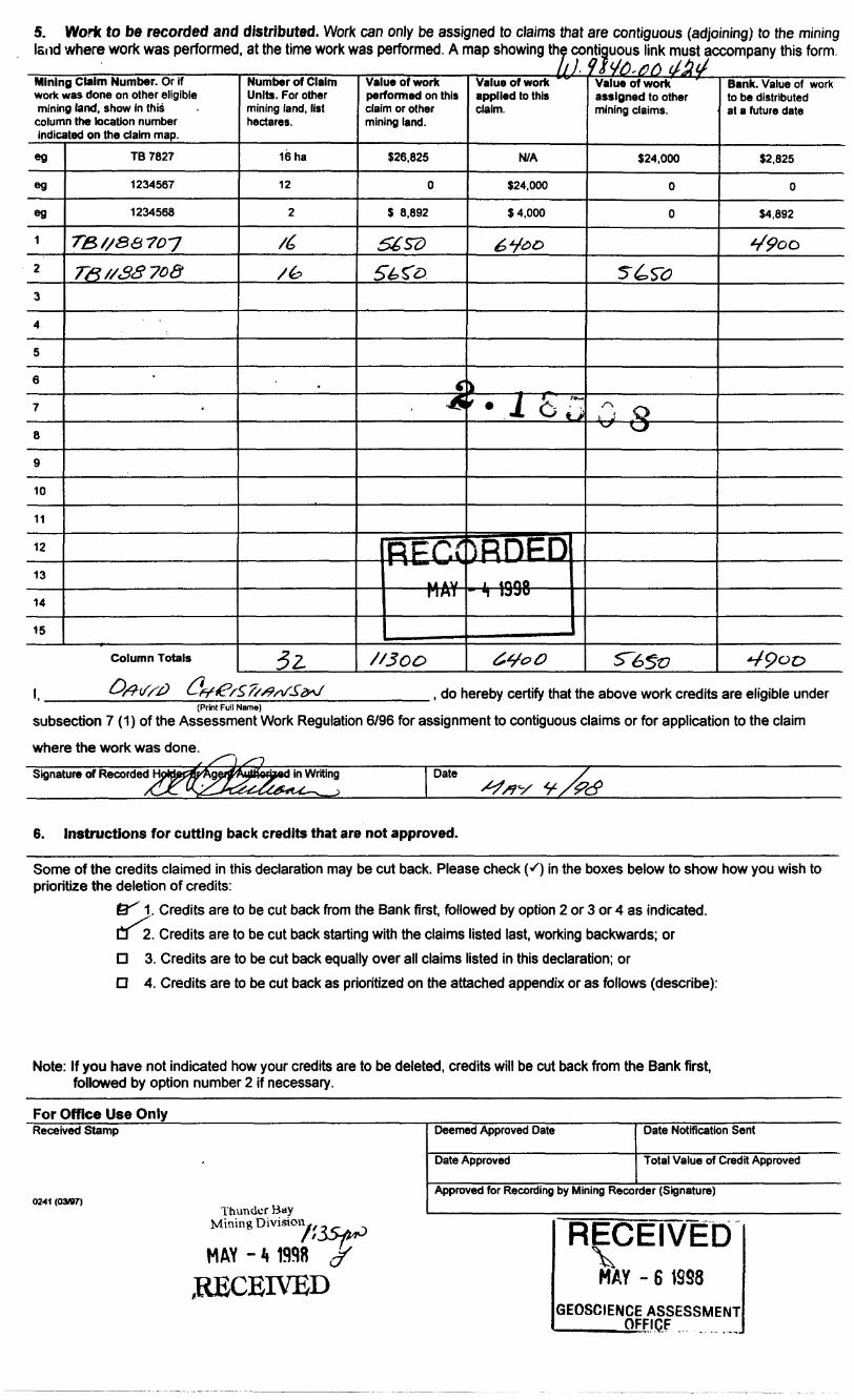
5. Work to be recorded and distributed. Work can only be assigned to claims that are contiguous (adjoining) to the mining land where work was performed, at the time work was performed. A map showing the contiguous link must accompany this form.
Mining Claim Number. Or if work was done on other eligible mining land, show in this column the location number indicated on the claim map.
eg
eg
eg
1
2
3
4
5
6
7
8
9
10
11
12
13
14
15
TB 7827
1234567
1234568
TB//8&7D-J
T&//3370&
-
Column Totals
Number of Claim Units. For other mining land, list hectares.
16 ha
12
2
/6
/b
.
52.
Value of work performed on this claim or other mining land.
S26,825
0
S 8,892
56SDSb^o
f"^
RECC
/'SCO
Value of work applied to this claim.
N/A
324,000
54,000
6*foo
k.r*w
)RHED- \ 1998 ——
6V* o
Value of work assigned to other mining claims.
S24,000
0
0
5"^, St?
r\ —^t y ^t\s ^ Tj
S~6St7
Bank. Value of work to be distributed at a future date
12,825
0
H892
V^oo
Vpoc?
l, ., do hereby certify that the above work credits are eligible under(Print Full Name)
subsection 7 (1) of the Assessment Work Regulation 6/96 for assignment to contiguous claims or for application to the claim
where the work was done.
Signature of Recorded yed in Writingj
Date
6. Instructions for cutting back credits that are not approved.
Some of the credits claimed in this declaration may be cut back. Please check K) in the boxes below to show how you wish to prioritize the deletion of credits:
tef 1 , Credits are to be cut back from the Bank first, followed by option 2 or 3 or 4 as indicated, a 2. Credits are to be cut back starting with the claims listed last, working backwards; or D 3. Credits are to be cut back equally over all claims listed in this declaration; or D 4. Credits are to be cut back as prioritized on the attached appendix or as follows (describe):
Note: If you have not indicated how your credits are to be deleted, credits will be cut back from the Bank first, followed by option number 2 if necessary.
For Office Use Only____________________Received Stamp
0241 (03/97)Thunder Bay
Mining D ivision^,
MAY - * 1998
.RECEIVED
Deemed Approved Date
Date Approved
Date Notification Sent
Total Value of Credit Approved
Approved for Recording by Mining Recorder (Signature)
RECEIVEDMAY - 6
GEOSCIENCE ASSESSMENT ____ OFFICE
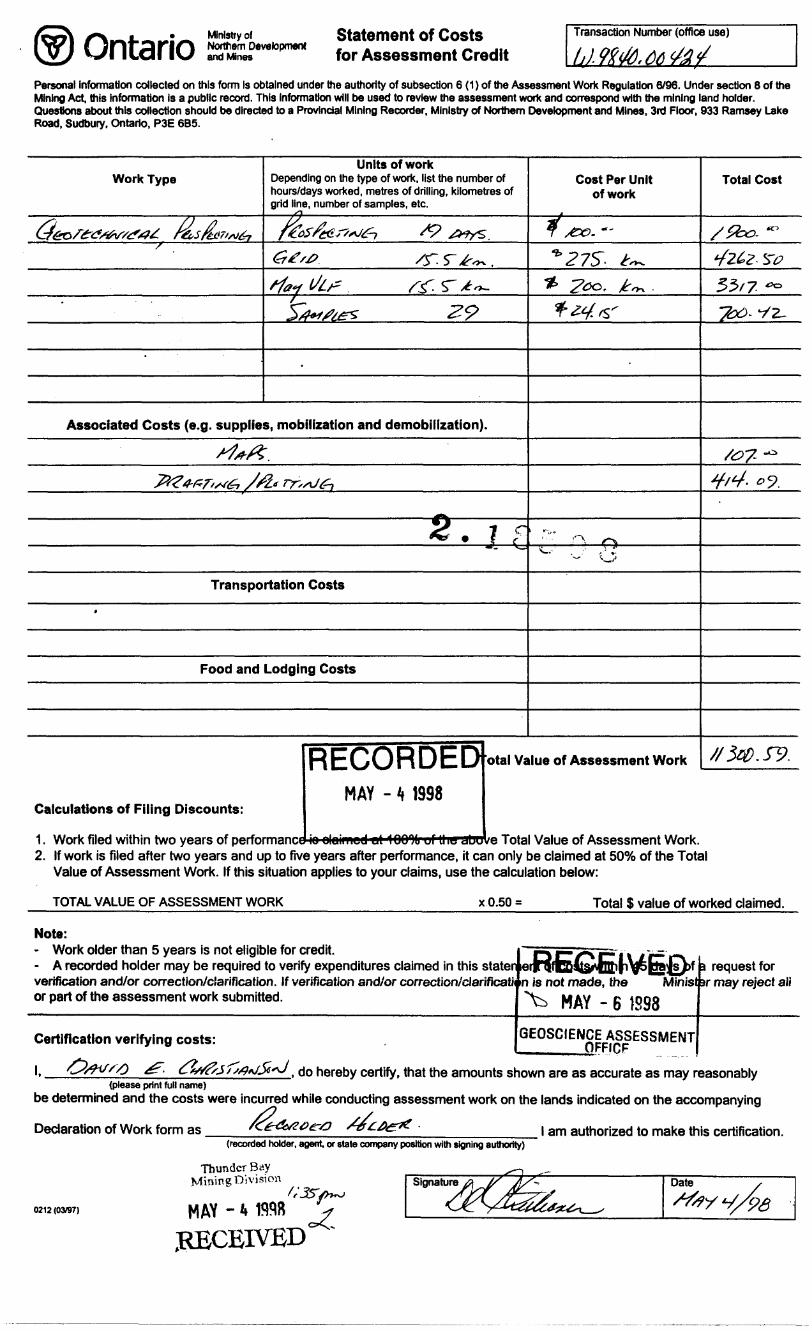
Ontario Ministry ofNorthern Developmentand Mines
Statement of Costs for Assessment Credit
Transaction Number (office use)
Personal Information collected on this form Is obtained under the authority of subsection 6 (1) of the Assessment Work Regulation 6/96. Under section 8 of the Mining Act, this Information Is a public record. This Information will be used to review the assessment work and correspond with the mining land holder. Questions about this collection should be directed to a Provincial Mining Recorder, Ministry of Northern Development and Mines, 3rd Floor, 933 Ramsey Lake Road, Sudbury. Ontario, P3E 6B5.
Work Type
(36of6:**/**/*?**. r&s/hrw^TS
.
'
Units of workDepending on the type of work, list the number of hours/days worked, metres of drilling, kilometres ofgrid line, number of samples, etc. xi
f*LosScas''*J6-1 s? ^^s
6ts# /r r^~ .rfay l/b* . /-^.ST*-^
3/fr/^ 29
.
Associated Costs (e.g. supplies, mobilization and demobilization).
/^/?.
-Z^w/xvg; .//it rr,sJfr
2. 7 f
Transportation Costs
4
Food and Lodging Costs
Cost Per Unit of work
T &G- ~~
^27S- ^1* 2co, ^ .**4*r
r"' ^ o1* ' . :' , ' Z
-" ^
RECORDED otal Value of Assessment Work
MAY - 4 1998Calculations of Filing Discounts:
Total Cost
/Zbo- ~
42&Z- SV
35/7 **
"Z&- y z.
/#7- -^
y/4. o?.
//3W.&.
2. If work is filed after two years and up to five years after performance, it can only be claimed at 5007o of the Total Value of Assessment Work. If this situation applies to your claims, use the calculation below:
TOTAL VALUE OF ASSESSMENT WORK Total S value of worked claimed.
or part of the assessment work submitted.
Note:- Work older than 5 years is not eligible for credit.- A recorded holder may be required to verify expenditures claimed in this staterverification and/or correction/clarification. If verification and/or correction/darificati n is not made, the Mirtist sr may reject ali
sim atbfc^vfnfrn\jfepajs))f a request for
MAY - 6 1598
Certification verifying costs:
l.
GEOSCIENCE ASSESSMENT ____QFFICF
. do hereby certify, that the amounts shown are as accurate as may reasonably(please print full name)
be determined and the costs were incurred white conducting assessment work on the lands indicated on the accompanying
Declaration of Work form as(recorded holder, agent or state company position with signing authority)
l am authorized to make this certification.
0212 (03/97)
Thunder Bay Mining Division
MAY - k W98RECEIVED
Signature Date
Ministry of Ministere duNorthern Development Developpement du Nordand Mines et des Mines Ontario
Geoscience Assessment Office 933 Ramsey Lake Road
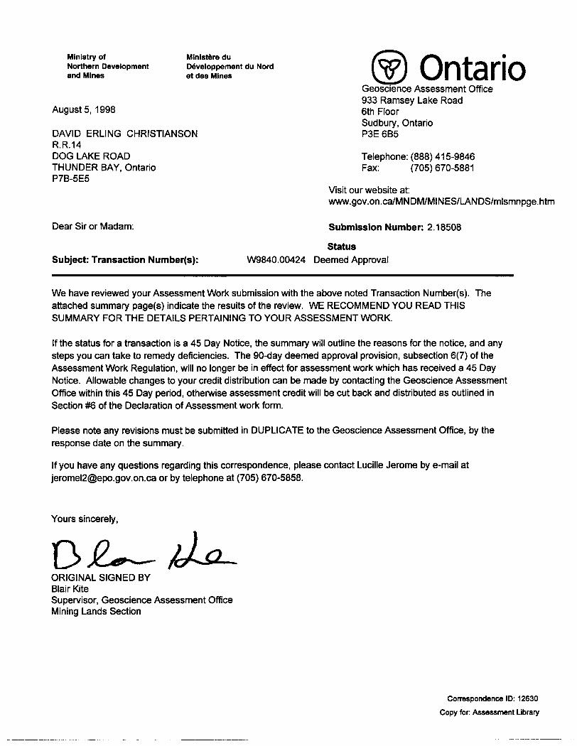
Augusts, 1998 6th FloorSudbury, Ontario
DAVID ERLING CHRISTIANSON P3E 6B5R.R.14DOG LAKE ROAD Telephone: (888) 415-9846THUNDER BAY, Ontario Fax: (705) 670-5881P7B-5E5
Visit our website at: www.gov.on.ca/MNDM/MINES/LANDS/mlsmnpge.htm
Dear Sir or Madam: Submission Number: 2 .18508
Status Subject: Transaction Number(s): W9840.00424 Deemed Approval
We have reviewed your Assessment Work submission with the above noted Transaction Number(s). The attached summary page(s) indicate the results of the review. WE RECOMMEND YOU READ THIS SUMMARY FOR THE DETAILS PERTAINING TO YOUR ASSESSMENT WORK.
If the status for a transaction is a 45 Day Notice, the summary will outline the reasons for the notice, and any steps you can take to remedy deficiencies. The 90-day deemed approval provision, subsection 6(7) of the Assessment Work Regulation, will no longer be in effect for assessment work which has received a 45 Day Notice. Allowable changes to your credit distribution can be made by contacting the Geoscience Assessment Office within this 45 Day period, otherwise assessment credit will be cut back and distributed as outlined in Section #6 of the Declaration of Assessment work form.
Please note any revisions must be submitted in DUPLICATE to the Geoscience Assessment Office, by the response date on the summary.
If you have any questions regarding this correspondence, please contact Lucille Jerome by e-mail at [email protected] or by telephone at (705) 670-5858.
Yours sincerely,
ORIGINAL SIGNED BYBlair KiteSupervisor, Geoscience Assessment OfficeMining Lands Section
Correspondence ID: 12630
Copy for: Assessment Library
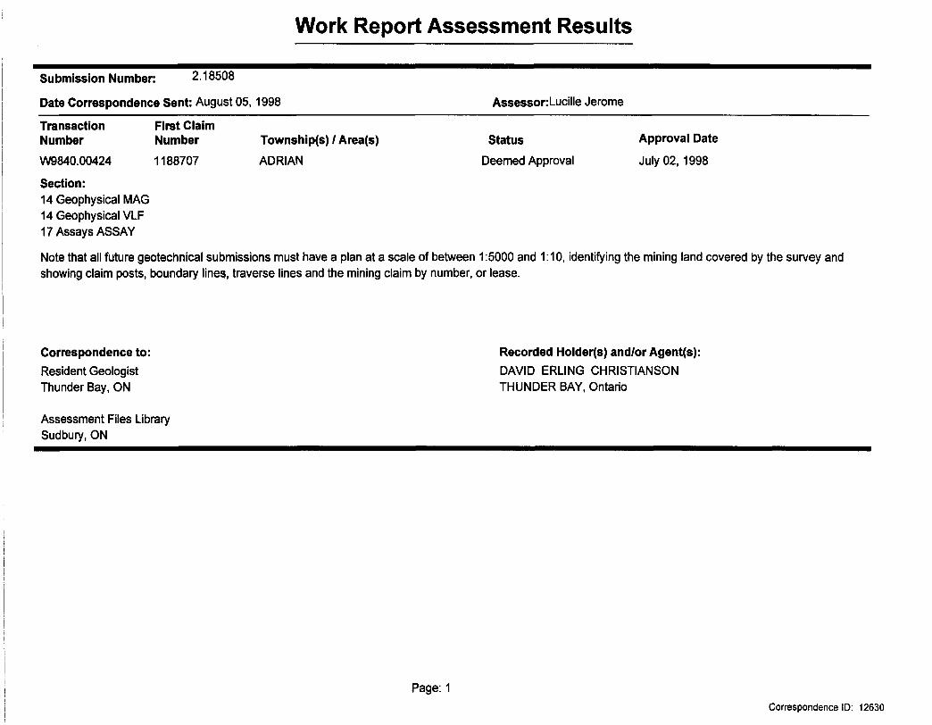
Work Report Assessment Results
Submission Number: 2.18508
Date Correspondence Sent: August 05,1998 Assessor: Lucille Jerome
First Claim Number
1188707
Township(s) l Area(s)
ADRIAN
Status
Deemed Approval
Approval Date
July 02,1998
Transaction Number
W9840.00424
Section:14 Geophysical MAG 14 Geophysical VLF 17 Assays ASSAY
Note that all future geotechnical submissions must have a plan at a scale of between 1:5000 and 1:10, identifying the mining land covered by the survey and showing claim posts, boundary lines, traverse lines and the mining claim by number, or lease.
Correspondence to:Resident Geologist Thunder Bay, ON
Assessment Files Library Sudbury, ON
Recorded Holder(s) and/or Agent(s):DAVID ERLING CHRISTIANSON THUNDER BAY, Ontario
Page: 1Correspondence ID: 12630
iO
OS
2 3
3 cos
( ^i
||i^
p||^|
-|^
t <f
>m
>z^
C3S
>Q
>^<
tD:5
2
ij*
to O o
* -
y 'W
~
'-- -
^ .^i^
wf'"*
^w
' .
^K
" l
* I
1 5
•- *
--- z
t-: *.
.y?
-- i
iH R
svl*
*
O-
H 5
5 r-
' -Z
7 n
I
5 2
?
:^6
>O
|-l5
Os
OzO
'~
•^ '.-"
CO in l o c. x T
'
S ir
H
l
^
o o
2 O
•-.f
Pt,
;*f?
..ia?
B^
fi-
685
SA
CK
VIL
LE
T
WP
2151
32\-y
——
—
L_
__
;__
_JU
.-J
053/
9
1502
8
G-
647
CO
NM
EE
T
WP
it ft
2600W 40,0 E 600E
LEGEND
Marsh Area
Trail
Road
100Scale 1:5000
O 100 200 300
(metres)
2600W 2400W 2200W 2000W 1800W 1600W 1400W 1200W 1000W 800W 600W 400W 200W 200E 400E 600E
52A05NW2001 2 .18S08 ADRIAN 210
D. CHRISTIANSONROCKSTONE TOO PROPERTY
MAGNETOMETER SURVEY TOTAL FIELD POSTINGS AND PROFILES
BASE REMOVED: 58500 nT PROFILE SCALE: 1 cm = 1000 nTINTRUMENT: GEM GSM19
DATE: JAN./98MAP 1A
SURVEY BY: GREY OWL RESOURCES
2600W 24QOW 22QOW 20QOW 1800W 40,0 E 600E
LEGEND
Marsh Area
Trail
Road
100
Scale 1:5000O 100 200 300
(metres)
2600W 2400W 2200W 2000W 1800W 1600W 1400W 1200W 1000W 800W 600W 400W 200W 200E 400E 600E
52A05NW2001 2 .1950S ADRIAN 220
D. CHRISTIANSONROCKSTONE TOO PROPERTY
MAGNETOMETER SURVEY TOTAL FIELD CONTOURSCONTOUR INTERVAL: 100 nT
INTRUMENT: GEM GSM19DATE: JAN./98
MAP 1B
SURVEY BY: GREY OWL RESOURCES
2600W 24QOW 600E
42--26-79 - - 37)
6--26 36 - - 2 4--2
-49--2-54- - 2-62--23-73--39--66- -72-79---79---5B--
-61--2-63--fa-62--17-67--19-58-i9-77-j8-65--4-73---2-64+1 .
43 f 64-4*-6
94V+-13 87^-7 97 + -11 89H- -6
-52 f-2-634-3-67 fi-87 i-
101-99 f 30--94 + 2?
200
65M--14 67 4--30
Rockstone
Lake
LEGEND
Marsh Area
Trail
Road
100Scale 1:5000
O______ 100 200 300
(metres)
2600W 2400W 2200W 2000W 1800W 1600W 1400W 1200W 1000W 800W 600W 400W 200W 200E 400E 600E
52A05NW2001 2 .18508 ADRIAN 230
D. CHRISTIANSONROCKSTONE TOO PROPERTY
ADRIAN TOWNSHIPVLF-EM SURVEY
STATION: CUTLER ME. 24 kHz. PROFILE SCALE: 1 cm = 75?S
IN-PHASE: SOLID LINE OUT OE PHASE: DASHED LINEMAP 2A
Survey By: Grey Owl Resources
2600W 40,0 E 600E
-12-15-18-21-24-28-32-35-39-43-48-52-58-65-73-81-97
FRASER FILTER
LEGEND
Marsh Area
Trail
Road
100Scale 1:5000
O 100 200 300
(metres)
2600W 2400W 2200W 2000W 1800W 1600W 1400W 1200W 1000W 800W 600W 400W 200W 200E 400E 600E
52A05NW2001 2 .18508 ADRIAN 240
D. CHRISTIANSONROCKSTONE TOO PROPERTY
ADRIAN TOWNSHIP, NORTHWESTERN ONTARIOVLF-EM SURVEY
STATION: CUTLER ME. 24 kHz.CONTOURED FRASER FILTERED IN-PHASE DATA
CONTOUR INTERVAL: 5?gMAP 2B
Survey By: Grey Owl Resources
2600W 600E
LEGEND
Marsh Area
Trail
Road
100Scale 1:5000
O_____ 100 200 300
(metres)
2600W 2400W 2200W 2000W 200E 400E 600E
52A05NW2001 2.18508 ADRIAN 250
D. CHRISTIANSONROCKSTONE TOO PROPERTY
ROCK SAMPLE LOCATION MAP ___ Au (ppb)
DATE: JAN./98 MAP 3
Plotted By: Paul Nielsen Geological