onaping lake conservation reserve - ontariofiles.ontario.ca/environment-and-energy/parks-and... ·...
TRANSCRIPT

Onaping Lake
Conservation Reserve
Statement of Conservation Interest
Ontario Ministry of Natural Resources
Information and Resource Management, Sudbury District January 2006
Ce document est seulement disponsible en anglais.

Onaping Lake Conservation Reserve _ __ Statement of Conservation Interest
_______________________________________________________________________________________
Ontario Ministry of Natural Resources, Sudbury District ii
Ontario Ministry of Natural Resources
Sudbury District APPROVAL STATEMENT
I am pleased to approve this Statement of Conservation Interest (SCI) for Onaping Lake Conservation Reserve (C322).
Onaping Lake Conservation Reserve consists of Onaping Lake, its islands, Vondet Lake and the north part of White Partridge Lake, and a 120-meter wide area around the shoreline of the lake, excluding areas of patent land. Onaping Lake is an important lake in terms of recreation, tourism and fish habitat. At the turn of the century, the lake was used for log driving and remnants of old camps and other cultural sites still exist. Fish species present in Onaping Lake include lake trout, walleye, smallmouth bass and northern pike. Regulated on November 22, 2002, this 16,698-hectare conservation reserve is situated in the Townships of Ulster, Munster, Antrim, Emo, Rhodes, Fairbairn, Scotia, Onaping, Shelley and Blewett and is located in Sudbury and Timmins OMNR Districts. Direction for establishing, planning and managing conservation reserves is defined under the Public Lands Act, the Crown Land Use Policy Atlas, the Ontario’s Living Legacy Land Use Strategy and other applicable policies. The specific direction for managing this conservation reserve is in the form of a basic SCI, which defines the area to which the plan applies, provides the purpose for which the conservation reserve has been proposed, and outlines the Ministry of Natural Resources’ management intent for the protected area. This SCI has been created with input from program specialists within Sudbury and Timmins District. It will provide both the foundation for the continued monitoring of activities and guidance for the management of the conservation reserve. More detailed direction at this time is not anticipated. However, should significant facility development be considered or complex issues arise requiring additional studies, more detailed management direction in the form of special protection measures, or a detailed Resource Management Plan, will be prepared with full public consultation. Public and Aboriginal consultation occurred prior to the regulation of this conservation reserve. Additional public and aboriginal consultation provided stakeholders an opportunity to comment on the draft SCI, which began in November 2004. Following the completion of this consultation period, additional changes were made to the draft SCI and the associated Crown Land Use Policy Atlas policy report for this site. A second public and aboriginal consultation period, related to the revised draft SCI and the associated amendments, took place between February and March 2005. Comments from both reviews have been considered in the finalization of this document. The management guidelines outlined in this SCI will be implemented by the Sudbury Area Supervisor, and will be reviewed every five years and amended as required by the Sudbury District Planner in consultation with the Timmins District Planner and Ministry of Natural Resources.
Prepared by: Rebecca Zeran and Mike Jackson (Crown Land @ Protected Areas Planning Assistants) Recommended for Approval by:
Signed by Stephen DeVos Jan 31, 2006 Signed by David King Jan 31, 2006
Stephen Devos (Sudbury Area Supervisor) David King (A/District Manager Sudbury) Signed by Rick Carbino Feb 9, 2006 Signed by Randy Pickering Feb 7, 2006 Rick Carbino (Watershed Area Supervisor) Randy Pickering (A/District Manager Timmins) Approved by: Signed by Rob Galloway Feb 21, 2006 Rob Galloway (Regional Director, Northeast Region)

Onaping Lake Conservation Reserve _ __ Statement of Conservation Interest
_______________________________________________________________________________________
Ontario Ministry of Natural Resources, Sudbury District iii
TABLE OF CONTENTS
LIST OF FIGURES.................................................................................................... V LIST OF TABLES...................................................................................................... V EXECUTIVE SUMMARY ...........................................................................................VI
1.0 INTRODUCTION................................................................................................ 1
2.0 GOAL AND OBJECTIVES OF THE SCI.................................................................. 1 2.1 Goal .............................................................................................................. 1 2.2 Objectives..................................................................................................... 1
2.2.1 Short Term Objectives ........................................................................... 1 2.2.2 Long Term Objectives ............................................................................ 2
3.0 MANAGEMENT PLANNING................................................................................. 2 3.1 Provincial Context ........................................................................................ 2 3.2 Planning for a Conservation Reserve ............................................................ 3 3.3 Planning Process for Onaping Lake Conservation Reserve............................ 4
3.3.1 Boundary Refinement and Regulation....................................................... 4 3.3.2 Planning Area........................................................................................ 4 3.3.3 Consultation and Significant Land Use Issues ............................................ 4
4.0 BACKGROUND INFORMATION........................................................................... 5 4.1 Location and Site Description ....................................................................... 5 4.2 Site History................................................................................................... 7 4.3 Socio-economic Interest............................................................................... 8 4.4 Inventories................................................................................................... 8
5.0 STATE OF THE RESOURCE ................................................................................. 9 5.1 Key Values.................................................................................................... 9 5.2 Natural Heritage Values................................................................................ 9
5.2.1 Earth Science Values.............................................................................. 9 5.2.1a Regional Landforms........................................................................... 9 5.2.1b Surficial Geology..............................................................................10 5.2.1c Bedrock Geology ..............................................................................10 5.2.2 Life Science Values ...............................................................................10 5.2.2a Regional Ecology...............................................................................10 5.2.2b Vegetation and Forest Communities ....................................................10 5.2.2c Fish and Wildlife...............................................................................11 5.2.2d Wetlands and Watersheds .................................................................11 5.2.2e Species at Risk ................................................................................12 5.2.3 Recreational Values ..............................................................................12 5.2.4 Cultural Values.....................................................................................12 5.2.5 Research Values ...................................................................................13
5.3 Quality of the Resource .............................................................................. 13 5.3.1 Site Condition ......................................................................................13 5.3.2 Diversity .............................................................................................13 5.3.3 Ecological Considerations.......................................................................13
6.0 MANAGEMENT GUIDELINES ............................................................................ 14 6.1 First Nations ............................................................................................... 14 6.2 Industrial Activities .................................................................................... 14
6.2.1 Commercial Timber Harvest...................................................................14 6.2.2 Mining and Exploration..........................................................................15
Onaping Lake Conservation Reserve _ __ Statement of Conservation Interest
_______________________________________________________________________________________
Ontario Ministry of Natural Resources, Sudbury District iv
6.2.3 Extraction of Peat, Soil, Aggregate and Other Material ..............................15 6.2.4 Energy Generation................................................................................15
6.3 Existing and Proposed Development........................................................... 15 6.3.1 Transportation Corridors........................................................................15 6.3.1a Roads ...............................................................................................15 6.3.1b Trails................................................................................................16 6.3.2 Other Corridor Development/Maintenance ...............................................16 6.3.3 Natural Heritage Appreciation Facilities/Recreational Structures .................16 6.3.4 Land Disposition...................................................................................17
6.4 Commercial Activities ................................................................................. 17 6.4.1 Commercial Bait Harvesting...................................................................17 6.4.2 Commercial Fishing...............................................................................18 6.4.3 Commercial Fur Trapping.......................................................................18 6.4.4 Bear Management Areas........................................................................18 6.4.5 Commercial Food Collection ...................................................................18 6.4.6 Commercial Non-Timber Forest Products .................................................18 6.4.7 Sunken Log Retrieval ............................................................................19 6.4.8 Outpost Camps/Main Base Lodges ..........................................................19
6.5 Non-commercial Activities .......................................................................... 19 6.5.1 Nature Appreciation/Low-impact Recreation Activities ...............................19 6.5.2 Camping..............................................................................................19 6.5.3 Non-Commercial Consumptive Resource Use............................................19 6.5.4 Hunting and Fishing ..............................................................................20 6.5.5 ATV and Snowmobile Use ......................................................................20
6.6 Resource Management Activities ................................................................ 20 6.6.1 Insect and Disease Control ....................................................................20 6.6.2 Exotic and/or Invasive Species...............................................................21 6.6.3 Species at Risk Management..................................................................21 6.6.4 Fish and Wildlife Management ................................................................21 6.6.5 Vegetation Management........................................................................21 6.6.6 Fire Management..................................................................................22 6.6.7 Forest Renewal ....................................................................................22
6.7 Research..................................................................................................... 22
7.0 RECOMMENDATIONS ...................................................................................... 23
8.0 IMPLEMENTATION, REVIEW AND REVISIONS................................................. 23 8.1 Monitoring .................................................................................................. 23 8.2 Marketing ................................................................................................... 24 8.3 Review and Revisions ................................................................................. 24
9.0 REFERENCES................................................................................................... 24
10.0 APPENDICES................................................................................................. 27 Appendix A: Onaping Lake Conservation Reserve Maps...................................... 27
Map 1: Recreational Values of Onaping Lake Conservation Reserve .........................28 Map 2: Landforms in the Onaping Lake Conservation Reserve ................................29 Map 3: Forest Communities within Onaping Lake Conservation Reserve...................29 Map 4: Wetland Communities within Onaping Lake Conservation Reserve ................30
Appendix B: Onaping Lake Conservation Reserve Photos ................................... 32 Appendix C: Summary of Terrestrial Wildlife Found in the Onaping Lake Area ... 36 Appendix D: Amendments to the SCI.................................................................. 38

Onaping Lake Conservation Reserve _ __ Statement of Conservation Interest
_______________________________________________________________________________________
Ontario Ministry of Natural Resources, Sudbury District v
List of Figures Figure 1: Site location map for Onaping Lake Conservation Reserve................................. 6 Figure 2: North end of the East Bay area of Onaping Lake .............................................. 7
List of Tables Table 1: Administrative details for Onaping Lake Conservation Reserve (C322)……………………….vi Table 2: Inventory and survey information for Onaping Lake Conservation Reserve…………………9 Table 3: Future needs and considerations for Onaping Lake Conservation Reserve…………………23

Onaping Lake Conservation Reserve _ __ Statement of Conservation Interest
_______________________________________________________________________________________
Ontario Ministry of Natural Resources, Sudbury District vi
EXECUTIVE SUMMARY The purpose of this Statement of Conservation Interest is to identify and describe the natural, recreational, and cultural values of Onaping Lake Conservation Reserve (C322) and to outline and guide the Ministry of Natural Resources’ management intent for this area. Onaping Lake Conservation Reserve consists of Onaping Lake, its islands, Vondet Lake and the north part of White Partridge Lake, and a 120-meter wide area around the shoreline of the lake, excluding areas of patent land. Onaping Lake is an important lake in terms of recreation, tourism and fish habitat. At the turn of the century, the lake was used for log driving and remnants of old camps and other cultural sites still exist. Fish species present in Onaping Lake include lake trout (Salvelinus namaycush), walleye (Stizostedion vitreum), smallmouth bass (Micropterus dolomieu) and northern pike (Esox lucius). Regulated on November 22, 2002, this 16,698-hectare conservation reserve is situated in the Townships of Ulster, Munster, Antrim, Emo, Rhodes, Fairbairn, Scotia, Onaping, Shelley and Blewett and is located in both Sudbury and Timmins OMNR Districts.
Table 1: Administrative details for Onaping Lake Conservation Reserve (C322). OMNR Administrative
Region/District/Area
Northeast Region/Sudbury District/Sudbury Area and Timmins District/Watershed Area
Site Region – Site District (Hills 1959) 4E-3
Ecoregion – Ecodistrict (Crins and Uhlig
2000)
4E-3 (Mississagi)
Township Ulster, Munster, Antrim, Emo, Rhodes, Fairbairn, Scotia, Onaping, Shelley, Blewett
Topographical Map Number & Name 41P/03 Thor Lake 41P/04 Low Water Lake 41P/05 Westree 41P/06 Opikinimika Lake 41I/13 Pogamasing 41I/14 Venetian Lake
UTM Co-ordinates Zone 17 (NAD 83) 462478 E, 5211932 N
Latitude/Longitude 47˚03’28”N / 81˚30’11”W
OBM Numbers 2017450051900, 2017460051900, 2017450052000, 2017460052000, 2017450052100, 2017460052100, 2017450052200, 2017460052200, 2017450052300, 2017460052300
Nearest Town Cartier, Levack
Altitude 400-470m
Area 16,698 ha
Wildlife Management Unit 39
Forest Management Unit Spanish Forest
Watershed Lake Huron basin 2CF and 2DA
Regulated November 22, 2002
Ontario Gazette December 7, 2002
SCI Completed January 30, 2005

Onaping Lake Conservation Reserve ___ Statement of Conservation Interest
_______________________________________________________________________________________
Ontario Ministry of Natural Resources, Sudbury District 1
1.0 Introduction The following document is a Statement of Conservation Interest (SCI) for Onaping Lake Conservation Reserve (C322). The purpose of this SCI is to identify and describe the natural, recreational, and cultural values of Onaping Lake Conservation Reserve and to outline the Ministry of Natural Resources’ management intent for this area. The first three sections of this document highlight the provincial context in which it was produced, state its goal and objectives, and summarize the planning process for conservation reserves. Sections 4.0 through 7.0 are specific to Onaping Lake Conservation Reserve and provide background information and management direction for the site. Section 8.0 outlines the requirements for continued implementation and review of this document. Management direction specified in this SCI will serve to protect the conservation reserve for the benefit of all Ontario residents. This direction will comply with the land use intent and guidelines stated in the Crown Land Use Policy Atlas (CLUPA) on the internet at http://crownlanduseatlas.mnr.gov.on.ca. The CLUPA is a consolidation of existing local land use policies for Crown lands within the Ontario Living Legacy Land Use Strategy (LUS) (1999) planning area, an area that covers 45 percent of the province and that extends from Lake Simcoe in the south to the Albany River in the north. Additionally, this conservation reserve will be managed under the Public Lands Act (R.S.O. 1990, c.P.43), and will comply with all legal requirements as specified under the Environmental Assessment Act (R.S.O. 1990, c.E.18). Onaping Lake Conservation Reserve consists of the lake, islands, Vondet Lake and the north part of White Partridge Lake, and a 120-meter wide area around the shoreline of the lake, excluding areas of patent land. Onaping Lake is an important lake in terms of recreation, tourism and fish habitat. At the turn of the century, the lake was used for log driving and remnants of old camps and other cultural sites still exist. Fish species present in Onaping Lake include lake trout, walleye, smallmouth bass and northern pike. The protection of these features is considered paramount and future management decisions that affect these values will require a thorough evaluation to ensure that the values remain protected. The Ontario Ministry of Natural Resources, Sudbury District (Sudbury Area) and Timmins District (Watershed Area) will be responsible for implementing the management policies and guidelines for Onaping Lake Conservation Reserve. Their primary role will be to provide public information and compliance monitoring to ensure adherence to current policies and guidelines. 2.0 Goal and Objectives of the SCI 2.1 Goal The goal of this SCI is to provide the framework and the direction to guide management decisions affecting Onaping Lake Conservation Reserve. 2.2 Objectives The following objectives are identified as the means to achieve the above stated goal: 2.2.1 Short Term Objectives
� To describe the site's current state of the resource in terms of its values and existing uses
and activities. � To outline the Ministry of Natural Resources’ management intent for the protected area.

Onaping Lake Conservation Reserve ___ Statement of Conservation Interest
_______________________________________________________________________________________
Ontario Ministry of Natural Resources, Sudbury District 2
� To determine the land use compatibility of current land uses, and to develop specific
guidelines and prescriptions to manage these uses. � To provide direction for the evaluation of proposed new uses or economic ventures through
the application of Class Environmental Assessment (EA) for Provincial Parks and Conservation Reserves.
2.2.2 Long Term Objectives
� To maintain the conservation reserve in a natural state. � To identify research and/or monitoring strategies that may contribute to sound long-term
management of the conservation reserve. � To create public awareness of the values within this conservation reserve by providing
information on the resources it contains and protects, and to support responsible stewardship through partnerships with local stakeholders.
3.0 Management Planning 3.1 Provincial Context Ontario’s network of protected areas has been established to conserve representative areas of the province’s natural diversity (which includes species, habitats, landforms, and ecological systems). Protected natural heritage areas are a key component in the sustainable management of natural resources, ensuring that representative sites within the larger managed landscape are retained in as natural a state as possible.
On July 16, 1999, the Ontario’s Living Legacy Land Use Strategy (LUS) (OMNR 1999) was released to guide the planning and management of much of Ontario’s Crown lands. Extensive consultation was conducted during the development of the LUS. The objectives of the LUS were to complete Ontario’s system of parks and protected areas; recognize the land use needs of the resource-based tourism industry; provide forestry, mining and other resource industries with greater certainty around land and resource use; and, enhance hunting, angling and other Crown land recreational opportunities.
These areas are considered to have significant features and values or are representative of major landforms and vegetation types. As such, they require protection from incompatible activities in order for their values to endure over time. The Onaping Lake Conservation Reserve was created during this expansion and now forms part of Ontario’s network of natural heritage areas. Onaping Lake is an important lake in terms of recreation, tourism and fish habitat. At the turn of the century, the lake was used for log driving and remnants of old camps and other cultural sites still exist. Fish species present in Onaping Lake include lake trout, walleye, smallmouth bass and northern pike. The Ontario Ministry of Natural Resources has established conservation reserves as a tool to protect natural heritage values on Crown lands, while permitting most traditional Crown land uses to continue. These uses include recreational activities, such as hunting and fishing. Lands designated as conservation reserves in the LUS (OMNR 1999) are removed from the Sustainable Forest License area and mining and surface rights are withdrawn from staking under the Mining Act (RSO 1990 Chapter M.14).

Onaping Lake Conservation Reserve ___ Statement of Conservation Interest
_______________________________________________________________________________________
Ontario Ministry of Natural Resources, Sudbury District 3
The CLUPA, available on the internet at http://crownlanduseatlas.mnr.gov.on.ca, is a consolidation of existing Crown land use policies and is now the official source for guidance on the management of Crown land and protected areas. 3.2 Planning for a Conservation Reserve The planning process for a conservation reserve consists of regulating the site and preparing a site-specific management plan. Consultation with the public, aboriginal communities and industry occur during site identification, boundary finalization, and management planning. Regulation of a conservation reserve involves the preparation of a legal description of site boundaries, the removal of the site from the Sustainable Forest Licence area, and the withdrawal of the site from staking under the Mining Act (RSO 1990 Chapter M.14). Once a conservation reserve is regulated, the level of management planning required to fulfill the protection targets is determined, and a basic Statement of Conservation Interest (SCI), enhanced SCI or a Resource Management Plan (RMP) is prepared. A basic SCI is prepared when there is no deviation from the land use direction provided in the LUS (OMNR 1999) and there are few to no issues that require resolution. Alternatively, a RMP is prepared in situations where one or more complex issues have to be addressed, and/or where there is widespread public interest in a site. An enhanced SCI is an intermediary document which is used when a site requires more detailed management direction than would be provided by a basic SCI, but does not have issues significant enough to warrant the preparation of a RMP. Whichever the determination, the plan should be completed within three years of the conservation reserve’s regulation date. The guidelines for the preparation of these documents are provided in Procedural Guidelines A – Resource Management Planning (OMNR 1997) and the Northeastern Region Guidelines on the Planning Process for Conservation Reserves: Statement
of Conservation Interest and Resource Management Plan (Thompson 2001). A SCI is a management plan guided by the policy direction contained in the CLUPA. The purpose of a SCI is to identify the state of the resource in terms of the site’s values and its current land use activities, and to outline the Ministry of Natural Resources’ management intent for the conservation reserve. Basic SCIs typically have a 30-day public consultation period, whereas enhanced SCIs and RMPs have a longer consultation period. Upon completion of this public review, the SCI or RMP is revised as necessary and approved by the Regional Director of the MNR Northeast Region.
Existing permitted uses within conservation reserves may continue, unless they are shown to have a significant negative impact on the values protected by the site. A review/evaluation mechanism is in place to address new permitted uses or land use proposals. The Class Environmental Assessment (EA) for Provincial Parks and Conservation Reserves will be used to screen all most project proposals and management activities occurring within the conservation reserve. Where cultural resources may be impacted, proposals may be screened through Conserving a Future for our Past: Archaeology, Land Use Planning & Development in Ontario, Section 3 (MCzCR 1997). Public comment may be solicited during a review of any future land use proposals that require new decisions to be made. Appropriate Environmental Assessment Act (R.S.O. 1990, c.E.18) requirements and amendment processes (e.g., Environmental Bill of Rights posting, CLUPA amendment) will apply to any future proposal and/or any significant change in management direction being considered for a site.

Onaping Lake Conservation Reserve ___ Statement of Conservation Interest
_______________________________________________________________________________________
Ontario Ministry of Natural Resources, Sudbury District 4
3.3 Planning Process for Onaping Lake Conservation Reserve 3.3.1 Boundary Refinement and Regulation
The Onaping Lake Conservation Reserve was proposed as a conservation reserve in the LUS (OMNR 1999). A letter, fact sheet and proposed boundary map were mailed to stakeholders and to interested members of the public during the boundary consultation process. Consultation occurred with the general public, Aboriginal communities, and industry, and the boundary of the site was regulated through an amendment to Ontario Regulation 805/94 of the Public Lands Act on November 22, 2002, by Ontario Regulation 313/02. The official Ontario Gazette amendment is available on the internet at http://www.ontariogazette.gov.on.ca/ in volume 135, issue 49 on December 7, 2002. 3.3.2 Planning Area
The planning area for this SCI consists of the regulated boundary for Onaping Lake Conservation Reserve (see Figure 1). However, to fully protect values within the conservation reserve, the area beyond the regulated boundary may require additional consideration through landowner outreach programs when adjacent land uses pose potential negative impacts on the conservation reserve. Crown land areas beyond the regulated boundary may also require additional consideration when larger land use planning initiatives, such as forest management planning, pose potential negative impacts on the site. Section 5.3.3- Ecological Considerations and section 7.0-Recommendations discuss management implications of areas outside the regulated boundary. 3.3.3 Consultation and Significant Land Use Issues
During preparation of the preliminary draft Statement of Conservation Interest (SCI) no significant issues related to land use in this area were identified. For that reason, it was determined that a basic SCI adequately identified the site’s significant features and served as the appropriate format for providing management direction. Following preparation of the preliminary draft SCI it was noted that there were land use issues that would need to be dealt with during planning, and resolution of these issues would need to be consulted on, and incorporated into the final SCI. This document only addresses those issues or land use proposals currently known to the Ministry of Natural Resources, Sudbury District and Timmins District. The direction provided by this SCI, and future management decisions, will work to resolve any potential land use conflicts and ensure that identified values continue to be adequately protected. This SCI has been created with input from program specialists from the area, district, regional and provincial levels of the Ministry of Natural Resources. Local and regional stakeholders as well as Sudbury area First Nations were provided the opportunity to comment on the preliminary draft SCI. Public consultation took place November 12, 2004 to December 13, 2004. First Nations consultation took place between November 12, 2004 and January 12, 2004. During the notification period it became apparent that the management prescriptions for the northern portion of Onaping Lake had not been incorporated into the policy report and consequently the draft SCI. Following consultation, a proposal was initiated to edit the Crown Land Use Policy Atlas through a minor amendment to incorporate these changes. These changes were concurrently incorporated into a revised SCI with many of the other changes recommended by stakeholders during the review of the preliminary draft SCI. A second consultation period was held to review the proposed amendment to the policy report and review the revised second draft SCI. Local and regional stakeholders as well as First Nations were notified through a mailout in both the Sudbury and Gogama areas. The consultation period took place between February 14, 2005 and March 15, 2005. Newspaper ads were also posted the week for February 7, 2005 in both Sudbury and Timmins and an Environmental Bill Rights

Onaping Lake Conservation Reserve ___ Statement of Conservation Interest
_______________________________________________________________________________________
Ontario Ministry of Natural Resources, Sudbury District 5
(EBR) posting was also posted from February 11, 2005 to March 13, 2005. All comments that were received were considered in the refinement of this document and the proposed policy report.
4.0 Background Information 4.1 Location and Site Description The Onaping Lake Conservation Reserve is located approximately 56 kilometers northwest of the City of Greater Sudbury. The conservation reserve is situated 9 kilometers west of Friday and Scotia Lakes Conservation Reserve, and 12 kilometers east of Spanish River Provincial Park. Supplies, food and accommodation can be obtained in the Towns of Cartier, 13 kilometers south of the site, Levack located 25 kilometers southeast of the site, or in the City of Greater Sudbury. The Onaping Lake Conservation Reserve is encompassed by ten townships: Ulster, Munster, Antrim, Emo, Rhodes, Fairbairn, Scotia, Onaping, Shelley and Blewett. Figure 1 illustrates the general location of the Onaping Lake Conservation Reserve.

Onaping Lake Conservation Reserve ___ Statement of Conservation Interest
_______________________________________________________________________________________
Ontario Ministry of Natural Resources, Sudbury District 6
Figure 1: Site location map for Onaping Lake Conservation Reserve. Whenever possible, recognizable natural and cultural features, such as creeks, shorelines or old roads have been used to delineate conservation reserve boundaries to facilitate on-the-ground identification. The conservation reserve is surrounded mainly by Crown land with several small tracts of adjacent patent land. The boundaries of the conservation reserve are comprised of the lake, the islands contained within the lake and a 120-meter wide area around the shoreline of Onaping Lake excluding areas of patent land.

Onaping Lake Conservation Reserve ___ Statement of Conservation Interest
_______________________________________________________________________________________
Ontario Ministry of Natural Resources, Sudbury District 7
Two public access points and boat launches are located at the south end of Onaping Lake. To access the site from Sudbury, take Highway 144 north to the Onaping Lake Road (about 16 km north of Cartier). Turn east on this road and drive for approximately 5 km to the public access point. There is also a private access point to Onaping Lake at the south end. Onaping Lake Conservation Reserve is located within Ecodistrict1 4E-3 (Hills 1959). Fish species present in Onaping Lake include lake trout, walleye, smallmouth bass and northern pike. Section 5.2 (Natural Heritage Values) further discusses the life science and earth science values of the conservation reserve and Section 5.3 (Quality of the Resource) discusses the current state of these values.
Figure 2: North end of the East Bay area of Onaping Lake. Photo by B. Burkhardt, August 26-27/03
4.2 Site History The area surrounding Onaping Lake has been used for trapping purposes. At the north end of the lake a former Hudson’s Bay Trading Post known as Stewart’s Camp operated until it closed due to a dwindling supply of fur (OMNR 1980). This important post was on an established fur trade route located on the crossroads to the Arctic and the Great Lakes-St. Lawrence watersheds (OMNR 1974). At the turn of the century, the shoreline and watersheds of Onaping Lake were intensively logged (OMNR 1974). In 1906 to 1907, the Onaping Lumber Company removed over a million board feet of red pine (Pinus resinosa) and white pine (Pinus strobus) from the area (OMNR 1980). The Strong Lumber Company from 1917 to 1924 carried out harvest operations in the Onaping Lake area. White and red pine saw logs as well as spruce boom timber was driven down the Bannerman Creek from Onaping Lake and manufactured into lumber at a mill in Benny (OMNR 1980). From 1925 to 1928, the Northern Timber Company harvested white and red pine as well as jack pine (Pinus banksiana) from the Onaping Lake area (OMNR 1980). The
1 Ecodistricts are areas characterized by physiographic (landform) similarities, and by the successional trends exhibited by the predominant vegetation types on those physiographic features, see section 5.0- State of the Resource (Hills 1959; Crins and Uhlig 2000).
Onaping Lake Conservation Reserve ___ Statement of Conservation Interest
_______________________________________________________________________________________
Ontario Ministry of Natural Resources, Sudbury District 8
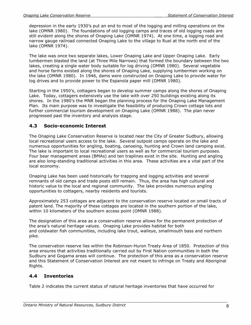
depression in the early 1930’s put an end to most of the logging and milling operations on the lake (OMNR 1980). The foundations of old logging camps and traces of old logging roads are still evident along the shores of Onaping Lake (OMNR 1974). At one time, a logging road and narrow gauge railroad connected Onaping Lake to the village to Ruel at the north end of the lake (OMNR 1974). The lake was once two separate lakes, Lower Onaping Lake and Upper Onaping Lake. Early lumbermen blasted the land (at Three Mile Narrows) that formed the boundary between the two lakes, creating a single water body suitable for log driving (OMNR 1980). Several vegetable and horse farms existed along the shores of Onaping Lake, supplying lumbermen working on the lake (OMNR 1980). In 1946, dams were constructed on Onaping Lake to provide water for log drives and to provide power to the Espanola paper mill (OMNR 1980). Starting in the 1950’s, cottagers began to develop summer camps along the shores of Onaping Lake. Today, cottagers extensively use the lake with over 250 buildings existing along its shores. In the 1980’s the MNR began the planning process for the Onaping Lake Management Plan. Its main purpose was to investigate the feasibility of producing Crown cottage lots and further commercial tourism development on Onaping Lake (OMNR 1988). The plan never progressed past the inventory and analysis stage. 4.3 Socio-economic Interest The Onaping Lake Conservation Reserve is located near the City of Greater Sudbury, allowing local recreational users access to the lake. Several outpost camps operate on the lake and numerous opportunities for angling, boating, canoeing, hunting and Crown land camping exist. The lake is important to local recreational users as well as for commercial tourism purposes. Four bear management areas (BMAs) and ten traplines exist in the site. Hunting and angling are also long-standing traditional activities in this area. These activities are a vital part of the local economy. Onaping Lake has been used historically for trapping and logging activities and several remnants of old camps and trade posts still remain. Thus, the area has high cultural and historic value to the local and regional community. The lake provides numerous angling opportunities to cottagers, nearby residents and tourists. Approximately 253 cottages are adjacent to the conservation reserve located on small tracts of patent land. The majority of these cottages are located in the southern portion of the lake, within 10 kilometers of the southern access point (OMNR 1988). The designation of this area as a conservation reserve allows for the permanent protection of the area’s natural heritage values. Onaping Lake provides habitat for both and coldwater fish communities, including lake trout, walleye, smallmouth bass and northern pike. The conservation reserve lies within the Robinson-Huron Treaty Area of 1850. Protection of this area ensures that activities traditionally carried out by First Nation communities in both the Sudbury and Gogama areas will continue. The protection of this area as a conservation reserve and this Statement of Conservation Interest are not meant to infringe on Treaty and Aboriginal Rights. 4.4 Inventories Table 2 indicates the current status of natural heritage inventories that have occurred for

Onaping Lake Conservation Reserve ___ Statement of Conservation Interest
_______________________________________________________________________________________
Ontario Ministry of Natural Resources, Sudbury District 9
Onaping Lake Conservation Reserve. Recommendations for future inventory needs are located in Table 3, subsection 7.0-Recommendations. Table 2: Inventory and survey information for Onaping Lake Conservation Reserve. Type of
Inventory
Inventory
Method
Date(s) of
Inventory
Report
Life Science Aerial reconnaissance
26/27 Aug. 2003
Cudmore W., Shaver M., King L. and Longyear S. 2004. Onaping Lake Conservation Reserve (C322) Natural Heritage Area - Life Science Checksheet. Unpublished Information. Ontario Ministry of Natural Resources.
Earth Science Aerial photo interpretation
May 2004 Kristjansson, R.J. 2004. Earth Science Inventory Checklist for C322 Onaping Lake Conservation Reserve. Unpublished Information. Ontario Ministry of Natural Resources. (In prep.)
Recreation Ground and aerial reconnaissance
Air: 26/27 Aug. 2003 Boat/Ground: 20 Sept. 2004
Zeran, R. and Jackson, M. Onaping Lake Conservation Reserve (C322) Recreation Resource Inventory Report. Unpublished Information. Ontario Ministry of Natural Resources.
5.0 State of the Resource Descriptions in this section are not necessarily complete. If new key values or otherwise are identified, they will be added to this document as an amendment. If any new value is considered significant, management guidelines may be modified, if required, to ensure its protection. 5.1 Key Values Key values are values that make this site unique and have led to its designation as a conservation reserve. Their protection is paramount. The key values of the Onaping Lake Conservation Reserve include the following: � A large lake providing habitat for fish and wildlife, as well as excellent recreational and
tourism opportunities � Areas of cultural/archaeological/historical significance � Significant spawning areas of lake trout and walleye Additional values, listed in subsection 5.2- Natural Heritage Values, are also important features and activities identified within the site. 5.2 Natural Heritage Values 5.2.1 Earth Science Values
5.2.1a Regional Landforms Onaping Lake Conservation Reserve is found within Mississagi Ecodistrict 4E-3 of Ecoregion 4E (Lake Timagami) (Hills 1959; Crins & Uhlig 2000). Ecodistrict 4E-3 is characterized by bedrock covered with stony/sandy till along with frequent flats and ridges of water-laid sand. Materials are commonly of granitic origin with a few local areas of low-base materials. Landforms include Precambrian hills mantled by rolling till which are dissected by deep fault valleys in the west

Onaping Lake Conservation Reserve ___ Statement of Conservation Interest
_______________________________________________________________________________________
Ontario Ministry of Natural Resources, Sudbury District 10
and east; the central portions are sectioned with moderately developed valleys that grade into a sedimentary Palaeozoic plain in the northeastern corner. The conservation reserve is also located within section L.9 (Timagami) of Rowe’s (1972) Great Lakes – St. Lawrence Forest Region. Topography in the western portion is moderately rolling, while in the east, it is more rugged and broken. Hills are usually covered with shallow till, but the section also has extensive areas of exposed bedrock. Soils are sandy and gravely and are of glaciofluvial and fluvial origin. 5.2.1b Surficial Geology Glaciofluvial deposits are oriented in a north-south direction around Onaping Lake (OMNR 1980). These sand and gravel deposits were formed by meltwater which deposited particles as it flowed from glaciers (OMNR 1980). A large glaciofluvial deposit is located at the south end of the lake from the Onaping Dam down along the Onaping River. Smaller deposits occur in the central and northern portions of the lake (OMNR 1980). Five surficial geology units are present within the conservation reserve: organic deposits (Unit 9), glaciolacustrine deposits (Unit 6), unsubdivided ice-contact stratified drift deposits (Unit 4a), ice-contact stratified drift deposits (Unit 4) and bedrock drift complex (Unit 2a) (Cudmore et. al. 2004). 5.2.1c Bedrock Geology The bedrock geology of Onaping Lake consists primarily of felsic intrusive rocks (mainly quartz and granite) or the Archean or Proterozoic period (OMNR 1980). Sections of conglomerate, quartizite, argillite and siltstone from the Lorrain and Gowganda formations are located in the southern portions of the lake, while mafic metavolcanic rocks can be found at the northern end of the lake (OMNR 1980).
5.2.2 Life Science Values
5.2.2a Regional Ecology The conservation reserve is found in Ecoregion 4E (Lake Timagami) (Hills 1959; Crins & Uhlig 2000). Vegetation in this region is typically boreal with pine being a common component of well to excessively drained sites. Red pine is common on the shallow exposed ridges and white pine is found on the deeper more retentive sites. Jack pine is found in areas recently disturbed by fire. Forest climate for this area is moist-humid, warm-boreal. The Ecoregion is located between the Boreal and Great Lakes-St.Lawrence Forest Regions and contain a variety of vegetation species from both regions throughout. The area is located in section L.9 (Timagami) of Rowe’s (1972) Great Lakes – St. Lawrence Forest Region. This section commonly consists of eastern white pine with scattered white birch (Betula papyrifera) and white spruce (Picea glauca). Another common forest type includes a mixture of white birch, white pine, white spruce, balsam fir (Abies balsamea), trembling aspen (Populus tremuloides) and largetooth aspen (Populus grandidentata). Red pine is often prominent in bluffs along ridges and jack pine is usually restricted to dry sandy or rocky sites. The prevalent forest cover in upland areas of this section is generally white pine, red pine and jack pine, mainly due to sandy soils and periodic past fires. On lowland areas, in poorly-drained depressions and in swamps, black spruce (Picea mariana), tamarack (Larix laricina) and eastern white cedar (Thuja occidentalis) occur. 5.2.2b Vegetation and Forest Communities According to the Forest Resource Inventory (FRI), the Onaping Lake Conservation Reserve contains 56 different forest communities (Cudmore et. al. 2004). The main forest communities

Onaping Lake Conservation Reserve ___ Statement of Conservation Interest
_______________________________________________________________________________________
Ontario Ministry of Natural Resources, Sudbury District 11
contained within the conservation reserve are white birch mixedwood (9.9% of total area), white birch hardwood mixed (5.1%), black spruce mixedwood (4.8%) and black spruce conifer mixed (4.1%) (Cudmore et. al. 2004). The white birch mixedwood communities are found mainly on the islands and peninsulas in the north central region of the conservation reserve (Cudmore et. al. 2004). White pine and red pine are more prevalent in southern portions of the site (Cudmore et. al. 2004). Stocking of forest stands is lower when associated with bedrock and areas of natural forest decline (Cudmore et. al. 2004). The majority of forest stands within the site are 60-89 and 90-119 years of age (Cudmore et. al. 2004). 5.2.2c Fish and Wildlife A large part of the area included in the conservation reserve is composed of open water. Shorelines and bays provide excellent habitat for a variety of fish species. Onaping Lake supports both coolwater and coldwater fish communities. Fish species present include lake trout, walleye, muskellunge (Esox masquinongy), northern pike, smallmouth bass, yellow perch (Perca flavescens), lake whitefish (Coregonus clupeaformis), common white sucker (Catostomus commersoni), brown bullhead (Ameiurus nebulosis) and burbot (Lota lota) (OMNR 1980, 1988). Several excellent walleye and lake trout spawning area exist throughout the lake (OMNR 1980). All species are native except for bass (introduced in 1960) and muskellunge (introduced in 1968) (OMNR 1980). Since 1951, Onaping Lake has been stocked with lake trout. Walleye, muskellunge and smallmouth bass have also been stocked in the lake (OMNR 1980). All commercially important furbearers are also present with the exception of wolverine (Gulo gulo). Terrestrial wildlife found within the Onaping Lake area consists of species commonly associated with forest habitat in the Canadian Shield (OMNR 1980). Please see Appendix C for a listing Two moose winter concentration areas are located near to Onaping Lake (one along the upper portion of the lake and one along the upper mid-lake section) (OMNR 1988). Numerous moose aquatic feeding areas are located in the Onaping Lake area. A significant aquatic feeding area is located at the extreme northeast end of the lake (OMNR 1988). 5.2.2d Wetlands and Watersheds The conservation reserve is located in the tertiary watersheds 2CF of the Lake Huron Basin (Cudmore et. al. 2004). Almost 50% of the area included in the conservation reserve is composed of open water. Onaping Lake is clear in colour. Shorelines in the northern portion consist of mainly of bedrock outcrops or a silt/sand/cobble mix – those in the southern portion consists of boulder and rock outcrops with occasional sandy sediment (Cudmore et. al. 2004). All waters flowing into and out of Onaping Lake flow to the south and drain into the North Channel of Lake Huron (OMNR 1980). Onaping Lake is fed by several lakes, including Muldrew Lake, Fairbairn Lake, Lower Lake, Low Water Lake, McGowan Lake, Vondet Lake, Otterpelt Lake, Brebeuf Lake, Grave Lake and Rhodes Lake (OMNR 1980). Onaping Lake has 42 perennial inlets and two major outlets (Onaping River and Bannerman Creek) (OMNR 1980). Aquatic vegetation present in the lake includes mare’s tail (Hippuris vulgaris), sedge (Carex spp.), cattail (Typha spp.), spadderdock (Nuphar spp.), white waterlily (Nymphaea odorata) and pondweed (Potamogeton spp.) (OMNR 1980). The maximum depth of the lake is 53.3 meters and materials present on the lake bottom consist of clay (5%), sand (10%), gravel (10%), boulder (15%), rock (50%) and detritus (10%) (OMNR 1988). There are 26 different wetlands identified within the conservation reserve (Cudmore et. al. 2004). The Forest Resource Inventory attributes 1.7% of the total area of the conservation

Onaping Lake Conservation Reserve ___ Statement of Conservation Interest
_______________________________________________________________________________________
Ontario Ministry of Natural Resources, Sudbury District 12
reserve to wetlands, but does not account for wetlands present in the water (Cudmore et. al. 2004). Dominant wetlands include a mix of moderately rich fen and cattail/open water marsh in the northern portion, treed bog/open water marsh and floating mats in the central section, floating mats and open water marsh in the southeastern portion, and a scattering of open water marshes throughout (Cudmore et. al. 2004). Wetlands tend to be more extensive in the northern half of the conservation reserve, composed mainly of fens and floating mats (Cudmore et. al. 2004). Small bays were commonly composed of open water marsh with tapegrass (Vallisneria americana) and/or floating pondweed (Cudmore et. al. 2004). Wetland vegetation observed included, fuzzy brown moss (Tomenthypnum nitens), marsh St. John’s wort (Triadenum fraseri), northern bugleweed (Lycopus uniflorus), small bedstraw (Gallium trididum), nodding bur-marigold (Bidens cernua), balsam willow (Salix pyrifolia), sweet gale (Myriad gale), bog rosemary (Andromeda glaucophylla), leatherleaf (Chamaedaphne calyculata), marsh cinquefoil (Potentilla palustris), unidentified rush (Juncus sp.), tapegrass and floating arrowhead (Sagittaria cuneata) (Cudmore et. al. 2004). 5.2.2e Species at Risk Species at Risk have been identified or documented within the conservation reserve. However, identification of these species and their location on the landscape will not be provided, as this may jeopardize their continued existence. 5.2.3 Recreational Values
The Sudbury District intent for Onaping Lake is to provide for general recreational opportunities. Recreational activities occurring within the conservation reserve include: hunting, trapping, boating, canoeing, angling, ice fishing, snowmobiling, swimming, Crown land camping and nature and cultural appreciation. Several recreational camps occur on Onaping Lake and approximately 253 cottages are present on patent land adjacent to Onaping Lake and the conservation reserve. A canoe route and a snowmobile portage trail are present within the conservation reserve (see Section 6.3.1b – Trails for a description of these trails). Two public access points and boat launches are located at the southern portion of the conservation reserve, north of the Bannerman Dam. The site provides excellent habitat for large game including black bear and moose. The area also provides habitat to fur-bearing mammals. Several shoals exist throughout the lake which can be quite hazardous to recreational boaters unfamiliar with commonly used boat channels (OMNR 1980). In the winter, these shoals are also dangerous to snowmobiles traveling on the ice. 5.2.4 Cultural Values
The conservation reserve is located within the Robinson-Huron Treaty Area of 1850. Several First Nations have identified numerous recreational and cultural activities that occur throughout this Treaty area, including areas designated as conservation reserves, such as Onaping Lake Conservation Reserve. The area within the conservation reserve has been traditionally used for trapping, angling and logging. Several archaeological/cultural heritage areas are present within or nearby to Onaping Lake, including old lumber and tie camps, grave sites, a 1911 forest Ranger shack and early farm sites (OMNR 1980). See section 4.2 – Site History for a more detailed discussion on historical occurrences within the conservation reserve.

Onaping Lake Conservation Reserve ___ Statement of Conservation Interest
_______________________________________________________________________________________
Ontario Ministry of Natural Resources, Sudbury District 13
5.2.5 Research Values
No research activities are currently occurring within the conservation reserve. Creel census, lake surveys and fall walleye index netting studies have been carried out in the past. 5.3 Quality of the Resource 5.3.1 Site Condition
The level of disturbance2 in the conservation reserve is considered high (Cudmore et. al. 2004). The area is popular for recreational activities and over 200 cottages are present on Onaping Lake (in patent areas adjacent to the conservation reserve) as well as outpost camps and trapper’s cabins. There is a large well-used public access point in the southern portion of the conservation reserve. Two dams are present on the lake (Bannerman Dam at the south end of Onaping Lake and Onaping Dam at Turcotte Bay) causing water levels to periodically fluctuate. Forests surrounding Onaping Lake were harvested in the early 1900s and the lake was used for log drives. See section 4.2 (Site History) for more information regarding human activities on Onaping Lake. Natural disturbances including a fire at the northern end in 1934, a tornado touchdown at the north end and a wind event have had a minor influence on the conservation reserve. 5.3.2 Diversity
Diversity3 is a measure of the site’s life and earth science heterogeneity. At present, a landform:vegetation analysis can not be performed. Analysis will be completed once an aerial photo interpretation of the landform components is completed (Cudmore et. al. 2004). With the information currently available, the diversity rating is only based on the number of forest and protective communities and would result in the site being rated as having low diversity (Cudmore et. al. 2004). 5.3.3 Ecological Considerations
Whenever possible, the boundaries of a protected area should include the greatest possible diversity of earth and life science features to provide maximum ecological integrity. For example, the site should be ecologically self-contained, bound by natural features and include adequate protection for the core ecosystem from intrusive influences (OMNR 1992 as cited in Cudmore et. al. 2004). The core area protected by this conservation reserve is the water body of Onaping Lake. A 120-meter wide area surrounding the lake is also protected by the conservation reserve. The Bannerman Dam and the Onaping Dam currently regulate the water level on Onaping Lake. Fluctuations in water levels contribute to the erosion and undercutting of sand and gravel banks throughout the lake (OMNR 1980). A water management plan is currently being developed for the area through the Spanish/Vermilion Rivers Water Management Plan. A copy of this plan can be obtained at the Sudbury District MNR office.
2 Disturbance rating is based on the amount of conservation reserve area currently under some form of known disturbance: >20%, high; 10-20%, medium; <10%, small (Cudmore and Longyear 2004). 3 Diversity rating is based on the size of the protected area versus the number of landforms: vegetation (SFU/HU) combinations. For conservation reserves <500 ha in size, >25 L:V combinations is considered to have high diversity, >15 L:V combinations is considered to have medium diversity, and <15 L:V combinations is considered to have low diversity. For areas 500 – 2000 ha, diversity is rated as high if there are >30 L:V combinations, medium if there are >20 L:V combinations and low if there are < 20 L:V combinations. For areas > 2000 ha, high >35, medium >25 and low <25 L:V combinations (Thompson and Noordhof 2003).

Onaping Lake Conservation Reserve ___ Statement of Conservation Interest
_______________________________________________________________________________________
Ontario Ministry of Natural Resources, Sudbury District 14
Fishing pressure on Onaping Lake is of concern to local cottagers. In 1994 two areas - Muldrew Bay (Onaping Lake) and Vondet Lake/Creek - were designated as fish sanctuaries and closed to angling from April 1st to June 15th of each year. A portion of the conservation reserve is located adjacent to the Onaping/Friday/Scotia Lakes Enhanced Management Areas (E190a). This area will be managed to ensure the continuation of limited access. The area will be managed to protected remote tourism opportunities and high quality recreational values (Cudmore et. al. 2004). Management activities on Onaping Lake are outlined in section 6.6.4 (Fish and Wildlife Management).
6.0 Management Guidelines All management guidelines in this SCI are based on the policy direction contained in the Crown Land Use Policy Atlas (CLUPA). For the most up-to-date version of this policy report, please refer to the CLUPA on the internet at http://crownlanduseatlas.mnr.gov.on.ca, or contact your local Ministry of Natural Resources office. The management guidelines outlined in this section are specific to the Onaping Lake Conservation Reserve and are intended to protect the site’s unique values. The guidelines in this document are subject to change and may be amended as necessary. If a conflict between management guidelines exists, the conservation reserve will be managed to protect the integrity of its natural values, while permitting compatible land use activities (OMNR 1997). Proposed new uses and/or development, including research and education activities, will be reviewed on a case-by-case basis. All new proposals will be subject to evaluation under at least one of the following processes: the Environmental Assessment Act (R.S.O. 1990, c.E.18); and Conserving a Future for our Past: Archaeology, Land Use Planning & Development in Ontario, Section 3 (MCzCR 1997). The Class Environmental Assessment for Provincial Parks and Conservation Reserves (OMNR 2003) will be used to screen most proposals and management activities occurring within the conservation reserve. 6.1 First Nations Traditional activities and existing Aboriginal and Treaty Rights, as defined in the Robinson-Huron Treaty of 1850 and other applicable legislation, is not intended to be infringed upon by the boundaries of this conservation reserve. Any First Nation land claims within this area will be addressed according to appropriate Ministry of Natural Resources' procedures. When possible, the Ministry of Natural Resources will work with the Ontario Ministry of Culture to identify archaeological and/or cultural sites to ensure protection of those sites/values. 6.2 Industrial Activities
6.2.1 Commercial Timber Harvest
The area contained within this conservation reserve (16,698 ha) has been withdrawn from the Spanish Forest Sustainable Forest License area and no commercial timber harvesting will be permitted. Please refer to subsection 6.5.3- Non-Commercial Consumptive Resource Use for information regarding non-commercial wood harvesting.

Onaping Lake Conservation Reserve ___ Statement of Conservation Interest
_______________________________________________________________________________________
Ontario Ministry of Natural Resources, Sudbury District 15
6.2.2 Mining and Exploration
There are no existing mining claims or leases within the area regulated as the Onaping Lake Conservation Reserve. Mining and surface rights within the conservation reserve’s boundaries have been withdrawn from staking under the Mining Act (RSO 1990 c.M.14). Mineral exploration is not permitted. 6.2.3 Extraction of Peat, Soil, Aggregate and Other Material
No extraction operations are currently occurring within the conservation reserve. New activities for the extraction of peat, soil, aggregate or other materials will not be permitted within the conservation reserve. 6.2.4 Energy Generation
No energy generation facilities exist within the conservation reserve. New hydropower development and wind power generation operations are not permitted. Existing dams regulate water flow downstream for energy generation facilities. Reservoir levels are subject to fluctuation and have been approved through water management planning. Existing use of the lake as reservoir will be permitted to continue. 6.3 Existing and Proposed Development 6.3.1 Transportation Corridors
6.3.1a Roads Under the Public Lands Act, section 48 (OMNR 2003a), a road is defined as “a travel corridor that is reasonably capable of allowing travel by motor vehicles licensed to operate on a King’s Highway as defined in the Highway Traffic Act (e.g., personal or commercial cars and trucks).” Minor maintenance (as defined under Policy PL 3.03.04 [OMNR 2003b]) of existing private access roads will be permitted provided that maintenance activities do not negatively impact the values being protected by the conservation reserve. Road maintenance activities may be subject to the Class Environmental Assessment (EA) for Provincial Parks and Conservation Reserves. The upgrading of private access roads is not permitted. Several access roads to private cottages and camps are present at the south end of Onaping Lake. Some of these roads are gated and have restricted access. New private access roads proposed after March 29, 1999 and, for which MNR did not make a commitment, will not be permitted within the conservation reserve. The use of existing resource access roads, including maintenance and possible future upgrading, will be permitted to continue but must take into consideration the values for which the site was protected. These roads must be essential for continued access beyond the recommended conservation reserve for forest management purposes and where alternative access does not exist and road relocation is not feasible. According to the LUS (OMNR 1999), no new resource access roads will be permitted except for those identified in Forest Management Plans prior to March 31, 1999 and where no other viable alternative exists. Necessary access to mining claims and leases for future mineral exploration and/or development, where there are no other viable alternatives exists, is also permitted. A public access road is located near the southwestern portion of the site. This road leads to two public access points each complete with a boat launch and parking area. The northern boat

Onaping Lake Conservation Reserve ___ Statement of Conservation Interest
_______________________________________________________________________________________
Ontario Ministry of Natural Resources, Sudbury District 16
launch and parking area is the larger of the two public access points and allows for a higher level of use. An additional private parking area and boat launch is located in between the two public access points. 6.3.1b Trails Under the Public Lands Act, Ontario Regulation 453/96 (OMNR 2003a), a trail is defined as “a path over public lands not used for mineral exploration or extraction.” A trail is minor in nature compared to a road, allowing passage of pedestrians, ATVs, snowmobiles or the like (OMNR 2003b). Existing authorized trails are permitted to continue. Several existing trails have also been identified within the conservation reserve. Use of existing trails will be permitted to continue provided this use does not negatively impact the values being protected by the conservation reserve. Should this use begin to degrade the landscape or negatively impact the values for which the conservation reserve was protected, this use will be revaluated and a new strategy developed. A canoe route passes from the south end of Onaping Lake (beginning at the southern most public access point) to Turcotte Bay (at the Onaping Dam) and out to the Onaping River, into Kasakawawia Lake, Bennet Lake and Kawawia Lake. The canoe route also branches off and runs up into Muldrew Bay to Hough Creek where a portage leads into Twisted Lake, Hough Lake, McDougall Lake and back into Muldrew Bay. In addition, a second canoe route leads down the Bannerman Creek into the Spanish River. A snowmobile portage trail exists in the southern portion of Onaping Lake (457379E 5191869N) to allow snowmobile users to by-pass open water in the winter. Minor maintenance of existing trails (as defined under Policy PL 3.03.04 [OMNR 2003b]) will be permitted provided maintenance activities do not negatively impact the values being protected by the conservation reserve. Any proposed new trails or development of existing trails are subject to the Class Environmental Assessment (EA) for Provincial Parks and Conservation Reserves and applicable Ministry of Natural Resources’ policies and procedures. Trail development should take into account the unique characteristics of this site and must be compatible with the site’s key values. The location information of the new trail must be provided to the Ministry of Natural Resources, Sudbury or Timmins District. 6.3.2 Other Corridor Development/Maintenance
An energy transmission corridor is present within the conservation reserve supplying Halfway Lake Provincial Park. New corridor developments will be actively discouraged. Proposals for new corridors will be subject to the Class Environmental Assessment (EA) for Provincial Parks and Conservation Reserves. 6.3.3 Natural Heritage Appreciation Facilities/Recreational Structures
There are currently no existing authorized natural heritage appreciation facilities or recreational structures (i.e. boardwalks, bird viewing platforms, kiosks, ski shelters, or interpretative signs) located within the conservation reserve. New public natural heritage appreciation facilities and recreation structures are permitted, subject to the Class Environmental Assessment (EA) for Provincial Parks and Conservation Reserves. Facility development should take into account the unique characteristics of this site and must be compatible with the site’s key values

Onaping Lake Conservation Reserve ___ Statement of Conservation Interest
_______________________________________________________________________________________
Ontario Ministry of Natural Resources, Sudbury District 17
6.3.4 Land Disposition
Sale of land is not permitted, except for some types of minor dispositions (e.g., the sale of small tracts of land to provide adequate area for the installation of a septic system), where it does not detrimentally affect the key values of the site. Such sales will be subject to the Class Environmental Assessment (EA) for Provincial Parks and Conservation Reserves. Boundaries of the conservation reserve will be amended to reflect the sale of land. negatively impact the values being protected by the conservation reserve Existing leases or LUPs may be renewed or transferred subject to MNR approval. Private recreation camps may be eligible for enhanced tenure but may not be sold. Permit holders for outpost camps or tourism facilities (e.g., main base lodges) can apply to upgrade tenure from a LUP to a lease. Two private dams (currently owned by Domtar Inc.) are located within the Onaping Lake conservation reserve. The Onaping Dam on the Onaping River in Turcotte Bay controls the runoff down the Onaping River to the Vermillion River and the Bannerman Dam at the southwest end of the lake controls drainage into the Spanish River via Bannerman Creek. Approximately 24 Land Use Permits (LUPs) are currently issued within this conservation reserve. Two Licenses of Occupation (LOs) are also issued within the conservation reserve (for the Bannerman and Onaping Dams). New private recreation camps will not be permitted within the Onaping Lake Conservation Reserve. However, new leases or LUPs may be issued for approved public uses subject to the Class Environmental Assessment (EA) for Provincial Parks and Conservation Reserves and applicable Ministry of Natural Resources’ policies and procedures. Leases and LUPs can be considered for enhanced tenure subject to the Class Environmental Assessment (EA) for Provincial Parks and Conservation Reserves and applicable Ministry of Natural Resources’ policies and procedures. Enhanced tenure is defined as anything beyond the term and form of current tenure. All requests for transfer or enhanced tenure will be subject to the following screening criteria: • Is the transfer or enhanced tenure consistent with the conservation reserve’s land use
intent, which is the protection and enhancement of the site’s natural, recreational and cultural values?
• Is it consistent with the land disposition policies outlined in the District Land Use Guidelines, the Crown Land Use Policy Atlas, this SCI and any other applicable document?
• Does it adversely affect the values as identified in Section 5.0, and/or conflict with other uses?
• Does the transfer or enhanced tenure clash with traditional Aboriginal uses, land claims or Treaty agreements?
• Are all rents, taxes, fees, rates or charges paid up for the existing LUP or lease? 6.4 Commercial Activities
6.4.1 Commercial Bait Harvesting
Ten commercial baitfish harvest areas (Ulster, Munster, Antrim, Emo, Rhodes, Fairbairn, Scotia, Onaping, Shelley, and Blewett Townships) are associated with the conservation reserve. New operations may be considered subject to the Class Environmental Assessment (EA) for Provincial Parks and Conservation Reserves. Any proposed new trails for baitfish harvesting purposes are subject to the Class Environmental Assessment (EA) for Provincial Parks and Conservation Reserves. Please refer to subsection 6.3.1b – Trails for further information on the establishment and maintenance of new trails and subsection 6.5.5 – ATV and Snowmobile Use for further information on their usage.

Onaping Lake Conservation Reserve ___ Statement of Conservation Interest
_______________________________________________________________________________________
Ontario Ministry of Natural Resources, Sudbury District 18
6.4.2 Commercial Fishing
There are currently no commercial fisheries operating within the conservation reserve. New operations will not be permitted within the Onaping Lake Conservation Reserve. 6.4.3 Commercial Fur Trapping
Ten registered traplines (SU32, SU31, SU22, SU21, SU11, SU10, GO58, GO57, GO50, and GO44) overlay the boundaries of this conservation reserve. Existing traplines are permitted to continue. Each registered trapline area is currently allocated to a head trapper. If a head trapper surrenders a registered trapline, or the head trapper’s privileges are revoked, the registered trapline may be transferred to another trapper following established allocation procedures. If the registered trapline is not transferred in due course, or remains unallocated for ten years, reallocation of the trapline may occur following applicable district screening processes. New traplines may be considered but will be subject to the Class Environmental Assessment for Provincial Parks and Conservation Reserves. Any proposed new trails for the purposes of commercial fur trapping are subject to the Class Environmental Assessment (EA) for Provincial Parks and Conservation Reserves. Please refer to subsection 6.3.1 – Trails for further information on the establishment and maintenance of new trails and subsection 6.5.5 – ATV and Snowmobile Use for further information on their usage. Five trap cabins are located within Onaping Lake Conservation Reserve. Repair and replacement of existing cabins will normally be permitted, providing that the scale and function of the cabin is not significantly altered. The relocation of existing trap cabins may be permitted subject to the Class Environmental Assessment (EA) for Provincial Parks and Conservation Reserves. The establishment of new trap cabins will not be permitted.
6.4.4 Bear Management Areas
Four active bear management areas (BMA’s) (SU-39-009, SU-39-010, GO-39-006, and GO-39-003) are currently associated with this conservation reserve. The policies regarding BMA’s (OMNR 2003a) states that the issuance of Licences to Provide Bear Hunting Services will be allowed where areas have been licensed or authorized under agreement for the activity since January 1, 1992. Thus, existing authorized operations are permitted to continue. New operations will not be permitted. Any proposed new trails for the purposes of bear hunting are subject to the Class Environmental Assessment (EA) for Provincial Parks and Conservation Reserves. Please refer to subsection 6.3.1b – Trails for further information on the establishment and maintenance of new trails and to subsection 6.5.5 – ATV and Snowmobile Use for further information on their usage. 6.4.5 Commercial Food Collection
There is currently no existing commercial food harvesting ventures within the conservation reserve. Any new ventures requiring permits from the Ministry of Natural Resources will be subject to the Class Environmental Assessment (EA) for Provincial Parks and Conservation Reserves. Wild rice harvesting will not be permitted within the conservation reserve. 6.4.6 Commercial Non-Timber Forest Products
Currently, there is no explicit policy direction towards the commercial harvesting of non-timber forest products (e.g. Canada Yew [Taxus canadensis]). New ventures may be considered
Onaping Lake Conservation Reserve ___ Statement of Conservation Interest
_______________________________________________________________________________________
Ontario Ministry of Natural Resources, Sudbury District 19
subject to the Class Environmental Assessment (EA) for Provincial Parks and Conservation Reserves. Such ventures will be discouraged within the conservation reserve where possible, as this use does not necessarily coincide with the intent of protecting the area as a conservation reserve. 6.4.7 Sunken Log Retrieval
The retrieval of sunken trees will not be permitted within the conservation reserve. Such practices are not consistent with the protection of the waterway nor do they coincide with the management intent for this area. 6.4.8 Outpost Camps/Main Base Lodges
There is currently one authorized outpost camp situated within the conservation reserve. The existing outpost camp will be permitted to continue unless there are significant demonstrated conflicts. New outpost camps and main base lodges may be considered through planning and will be subject to the Class Environmental Assessment (EA) for Provincial Parks and Conservation Reserves and applicable Ministry of Natural Resources’ policies and procedures. The form of land tenure for these new uses will remain as a land use permit or lease. Sale of Crown land for new outpost camps or main base lodges will not be permitted. Existing outfitting services will be permitted to continue and new operations may be considered subject to a Class Environmental Assessment for Provincial Parks and Conservation Reserves.
6.5 Non-commercial Activities 6.5.1 Nature Appreciation/Low-impact Recreation Activities
Off-trail hiking, cross-country skiing, snowshoeing, and other non-motorized activities will be permitted within this conservation reserve subject to the Class Environmental Assessment (EA) for Provincial Parks and Conservation Reserves. However, should the impact of these activities degrade the landscape, the Ministry of Natural Resources will re-evaluate these permitted uses and decide upon a new strategy for this site. New trails to support these activities may be considered. Please refer to subsection 6.3.1b- Trails for more details related to trail development. 6.5.2 Camping
There are no maintained campsites or campgrounds within this conservation reserve. The establishment of new campgrounds and/or campsites may be permitted subject to the Class EA for Provincial Parks and Conservation Reserves. Crown land camping policies apply, unless significant adverse effects on protected values necessitate further planning and management for this activity. Existing traditional campsites should be used in order to avoid disturbance of new areas within the conservation reserve. Note: Houseboats anchored in Onaping Lake must adhere to crown land camping policies.
6.5.3 Non-Commercial Consumptive Resource Use
Cutting of trees for non-commercial purposes may be authorized by the local Ministry of Natural Resources, subject to review and determination of the impact that such cutting would have on the values identified in section 5.0- State of the Resource. Such permits are intended only for leaseholders and land use permit holders within the conservation reserve who do not have road access to their property and who do not have an alternate wood source outside of the conservation reserve. Property owners adjacent to the conservation reserve will not be issued

Onaping Lake Conservation Reserve ___ Statement of Conservation Interest
_______________________________________________________________________________________
Ontario Ministry of Natural Resources, Sudbury District 20
permits for areas within the protected area. Such permits are intended to cover fuel wood, dock stringers, and other occasional small-scale uses. Non-commercial harvesting of non-timber forest products such as berries and mushrooms may occur provided the values of the site, identified in section 5.0- State of the Resource, are not jeopardized.
6.5.4 Hunting and Fishing
In conjunction with current hunting regulations (Wildlife Management Unit 39), hunting is permitted to continue within the conservation reserve. Recreational fishing is also permitted to continue in compliance with current fishing regulations. Muldrew Bay (Onaping Lake) and Vondet Lake/Creek were designated as fish sanctuaries in 1994 and are closed to angling from April 1st to June 15th of each year. Please refer to subsection 6.3.1b (Trails) for information on the construction of new trails or the maintenance of existing trails. Section 6.5.5 (ATV and Snowmobile Use) details the use of all-terrain vehicles and snowmobiles for hunting and trapping purposes. 6.5.5 ATV and Snowmobile Use
Several trails exist throughout the conservation reserve. ATV’s and snow machines are utilizing these trails. One snowmobile portage trail exists in the southern portion of Onaping Lake (457379E 5191869N) to provide safe passage around open water to snowmobile users in the winter. A variety of portage trails connecting various water bodies in the area are used by recreationists to move from one lake to another. Please refer to section 6.3.1b (Trails) for more information on trails. Off-trail use of ATVs and snowmobiles is not permitted; however, in some cases, off-trail use is permitted for licensed trappers to access their traplines, for licensed bait harvest operators to conduct bait harvest operations and for use in bear management areas (BMA’s). Hunters are also allowed off-trail ATV and snowmobile use for the direct retrieval of large game. In all of these cases, formal intensive off-trail use is discouraged. Should the impact of off-trail ATV and snowmobile use degrade the natural values; the Ministry of Natural Resources will re-evaluate these permitted uses and determine a new strategy. 6.6 Resource Management Activities Resource management activities refer to those tools used to protect and enhance the values of this conservation reserve. Some management activities may require the use of intrusive techniques. Under normal circumstances, some of these techniques would not be permitted to occur in the conservation reserve; however, if they are found to be necessary, they may be applied under controlled conditions, to achieve a desired result. Infrastructure such as roads, trails and buildings may need to be constructed to support activities such as prescribed burns, forest regeneration, wildfire control, and insect and disease control. Activities described in this section will be deemed acceptable if the ultimate outcome complies with the management intent for this conservation reserve. 6.6.1 Insect and Disease Control
This conservation reserve will be maintained in a natural state. Insect and disease control measures should only be considered if the identified values of the conservation reserve or adjacent forest values on Crown Land are significantly threatened. If such measures are proposed, they will be subject to the Class Environmental Assessment (EA) for Provincial Parks and Conservation Reserves.

Onaping Lake Conservation Reserve ___ Statement of Conservation Interest
_______________________________________________________________________________________
Ontario Ministry of Natural Resources, Sudbury District 21
6.6.2 Exotic and/or Invasive Species
The management intent of the conservation reserve is to maintain the site in a natural state. The deliberate introduction of exotic and/or invasive species will not be permitted. If the key values of the site are threatened, new management strategies to control exotic/invasive species may be considered and will be subject to the Class Environmental Assessment (EA) for Provincial Parks and Conservation Reserves.
6.6.3 Species at Risk Management
Species at risk which have been identified within the conservation reserve and which are considered to be either endangered or threatened (as designated by either the national Committee on the Status of Endangered Wildlife in Canada, COSEWIC, or the Committee on the Status of Species at Risk in Ontario, COSSARO) will be given protection under the Fish and Wildlife Conservation Act (1997, S.O. 1997, c.41), the Endangered Species Act (R.S.O 1990, c.E15) and/or the federal Species at Risk Act (June 2003). Recovery plans, consisting of both a recovery strategy and a recovery action plan, prepared for nationally endangered and threatened species under the Accord for the Protection of Species at Risk will be implemented within the conservation reserve if deemed necessary by the Ontario Ministry of Natural Resources and/or the Government of Canada.
6.6.4 Fish and Wildlife Management
Ongoing fisheries management activities to restore the natural reproduction cycle of Onaping Lake are not affected by the management of Onaping Lake Conservation Reserve. Rehabilitation and enhancement (e.g. spawning bed enhancement, fish stocking) of the fishery have been ongoing and will continue unless there are significant demonstrated conflicts. Onaping Lake has been identified as a Class B2 lake trout lake (OMNR 1988). The Sudbury District Fisheries Management Plan (1987-2000) outlines the following management activities on Onaping Lake: (1) Stocking Onaping Lake with lake trout and monitoring the success of these stockings; (2) Reducing harvest through increased enforcement effort and by establishing spring sanctuaries in sensitive areas to protect walleye spawning habitat; (3) Redirecting angling pressure to other areas, such as the Onaping River; (4) Protect existing habitat by ensuring water levels are maintained to protect the fishery as well as mapping locations of critical spawning and nursery areas for lake trout and walleye; and (5) New spawning habitat can be created and existing areas improved, upon identification of such areas. New fish and wildlife management activities (e.g., fish stocking, habitat enhancement/ rehabilitation, population control) may be considered but will be subject to the Class Environmental Assessment (EA) for Provincial Parks and Conservation Reserves. Existing previously approved fish and wildlife management activities will be permitted to continue but may be subject to the Class Environmental Assessment (EA) for Provincial Parks and Conservation Reserves. 6.6.5 Vegetation Management
New vegetation management activities (e.g., the restoration of natural environments) may be considered but will be subject to the Class Environmental Assessment (EA) for Provincial Parks and Conservation Reserves. Such activities may also require the development of a separate vegetation management plan. Specific management prescriptions, as outlined by the new management plan, must be either referenced within this SCI or attached as an amendment to this document.

Onaping Lake Conservation Reserve ___ Statement of Conservation Interest
_______________________________________________________________________________________
Ontario Ministry of Natural Resources, Sudbury District 22
6.6.6 Fire Management
The Ministry of Natural Resources recognizes fire as an essential process fundamental to the ecological integrity of conservation reserves. In accordance with existing conservation reserve policy and the Forest Fire Management Strategy for Ontario, forest fire protection will be carried out as on surrounding lands. Whenever feasible, the Ministry of Natural Resources' fire program will endeavour to use “light on the land” techniques, which do not unduly disturb the landscape, in this conservation reserve. Examples of light on the land techniques may include limiting the use of heavy equipment or limiting the number of trees felled during fire response efforts. Opportunities for prescribed burning to achieve ecological or resource management objectives may be considered but will be subject to the Class Environmental Assessment (EA) for Provincial Parks and Conservation Reserves. Such activities may also require the development of a separate vegetation management plan developed in accordance with the Ministry of Natural Resources Prescribed Burn Planning Manual (OMNR 1997b).
6.6.7 Forest Renewal
Forest renewal is an activity associated with commercial timber harvest and with vegetation restoration projects involving tree species. Such practices would only be considered if the area within the conservation reserve has been recently cut prior to becoming regulated or following approval of vegetation management activities as outlined in Section 6.6.5. Forest loss within the conservation reserve due to wind (i.e., blowdown), fire or insect damage will not be considered for forest renewal – such areas will be left to regenerate naturally. Should unauthorized forest harvest occur within the boundaries of the conservation reserve, forest renewal will be considered. Any possible renewal project will be subject to the Class Environmental Assessment (EA) for Provincial Parks and Conservation Reserves and would be carried out to replicate natural conditions as much as possible. 6.7 Research Scientific research by qualified individuals or institutions is encouraged, especially if the research contributes to a better understanding of the natural and cultural values protected by this conservation reserve or if it advances the protection, planning and management of these values. The District Planner, Sudbury or Timmins District should be contacted for information on research and/or monitoring opportunities within this conservation reserve. Proposals to conduct research should be directed to the Sudbury Area Supervisor, Sudbury District or Watershed Area Supervisor, Timmins District and will be subject to the Class Environmental Assessment (EA) for Provincial Parks and Conservation Reserves and relevant Ministry of Natural Resources’ policies, procedures and conditions, as well as any applicable Environmental Assessment Act (R.S.O. 1990, Chapter E.18) requirements. Any site that is disturbed during research activities is to be rehabilitated as closely as possible to its original condition. Collecting may only be permitted as part of an authorized research project and may be subject to appropriate permits and conditions. Existing research and monitoring activities currently occurring within the conservation reserve are permitted to continue, but may be subject to the Class Environmental Assessment (EA) for

Onaping Lake Conservation Reserve ___ Statement of Conservation Interest
_______________________________________________________________________________________
Ontario Ministry of Natural Resources, Sudbury District 23
Provincial Parks and Conservation Reserves should detrimental impacts to the values protected by the conservation reserve be detected. 7.0 Recommendations It is recognized that not all features or uses occurring within the Onaping Lake Conservation Reserve have been identified during the current planning process. This section outlines future activities, which might be conducted to ensure that features of the site are protected or to better develop our understanding of the natural features protected by this conservation reserve. Table 3 highlights future needs and considerations for Onaping Lake Conservation Reserve. Table 3: Future needs and considerations for Onaping Lake Conservation Reserve. Future Needs/ Considerations
Details
Detailed Life Science Inventory
A gap analysis of the site could be completed using provincial data sets. This analysis should be used to review the landforms/vegetation information presented in this SCI and the life science checksheet to determine more fully the site’s significance and contribution to the parks and protected areas program.
Adjacent Forest Management
A viewscape of 1 kilometre (from the high water mark) is currently in place and should be considered under future Forest Management Plans. Visibility of cutovers might impact the site’s value as a tourist destination.
Fisheries Management Onaping Lake is currently being stocked with lake trout. Management activities are listed in the Sudbury District Fisheries Management Plan (see section 6.6.4, Fish and Wildlife Management). These activities may be reviewed and adapted to current fisheries needs on the lake. Ongoing relevant fisheries management activities (such as fish stocking) will continue unless there are significant demonstrated conflicts.
Remote Access The Onaping/Friday/Scotia Lakes Enhanced Management Area (EMA, E190a) surrounds a large portion of the Onaping Lake Conservation Reserve. Management direction for this EMA focuses on remote access and is intended to maintain the remote character of selected areas. Public access to the southern portion of Onaping lake should be maintained, however any potential future access to the lake should take the remote access character of the area into account.
Cultural and Archaeological Sites
The Ministry of Natural Resource and the Ministry of Culture may wish to collaborate to better identify cultural and archaeological sites within the conservation reserve, which are not of First Nations in origin.
8.0 Implementation, Review and Revisions The Sudbury Area and Watershed Area teams will be responsible for implementing the management policies and guidelines for the Onaping Lake Conservation Reserve. The primary role of the teams will be to perform compliance monitoring and provide public information to ensure adherence to current policies and guidelines. 8.1 Monitoring Periodic monitoring of human activities and/or their impacts within this conservation reserve will be conducted. The Sudbury Area Supervisor, Watershed Area Supervisor, the Sudbury District Enforcement Supervisor and Timmins District Enforcement Supervisor will oversee these activities.

Onaping Lake Conservation Reserve ___ Statement of Conservation Interest
_______________________________________________________________________________________
Ontario Ministry of Natural Resources, Sudbury District 24
Approved inventory, monitoring and/or assessment activities that are compatible with protection objectives are encouraged. Any area that is disturbed during such monitoring activities must be rehabilitated to restore the affected area as closely as possible to its original condition. If at any time human activities are deemed to be negatively impacting the protected features, the activities will be reviewed and measures taken to mitigate any disturbance.
8.2 Marketing No active marketing of this conservation reserve is anticipated. 8.3 Review and Revisions The Onaping Lake Conservation Reserve SCI will be reviewed every five years by the District Planner, Sudbury District with input from the Timmins District Planner to confirm and update the information in this document. Revisions to this document will be subject to requirements as specified in the Environmental Assessment Act (R.S.O. 1990, Chapter E.18). If changes in management direction are needed at any time, the significance of the changes will be evaluated. Minor amendments to the plan that do not alter the overall protection objectives may be considered and approved by the appropriate Area Supervisor without further public consultation. All minor amendments to the SCI will be documented in Appendix D. In assessing major amendments, the need for a more detailed Resource Management Plan (RMP) will first be considered. Where a RMP is not considered necessary or feasible, a major amendment to management direction may be considered with public consultation. Major amendments will be recommended by the appropriate District Manager and approved by the Regional Director, and will follow the appropriate guidelines (OMNR 2001). 9.0 References Cudmore W., Shaver M., King L. and Longyear S. 2004. Onaping Lake Conservation Reserve
(C322) Natural Heritage Area - Life Science Checksheet. Unpublished Information. Ontario Ministry of Natural Resources.
Crins, W.J. and Uhlig, P.W.C. 2000. Ecoregions of Ontario: Modification to Angus Hills’ Site
Regions and Site Districts – Revisions and Rationale. Hills, G. A. 1959. A Ready Reference for the Description of the Land of Ontario and its
Productivity. Preliminary Report. Ontario Department of Lands and Forests. Maple. Ontario.
Kristjansson, R.J. 2004. Earth Science Inventory Checklist for C322 Onaping Lake Conservation
Reserve. Unpublished Information. Ontario Ministry of Natural Resources. Ministry of Citizenship, Culture and Recreation. 1997. Conserving a Future for Our Past:
Archaeology Land Use Planning and Development in Ontario, Section 3. Ontario Ministry of Natural Resources. 1974. Lake Survey Summary – Aquatic Habitat
Inventory: Onaping Lake. Ontario Ministry of Natural Resources. Ontario Ministry of Natural Resources. 1980. Onaping Lake Background Information. Ontario
Ministry of Natural Resources, internal report.

Onaping Lake Conservation Reserve ___ Statement of Conservation Interest
_______________________________________________________________________________________
Ontario Ministry of Natural Resources, Sudbury District 25
Ontario Ministry of Natural Resources. 1983. Gogama District Land Use Guidelines (DLUG) and associated amendments.
Ontario Ministry of Natural Resources. 1983. Sudbury District Land Use Guidelines (DLUG) and
associated amendments. Ontario Ministry of Natural Resources. 1988. Onaping Lake Management Plan: Resource
Inventory and Analysis. Ontario Ministry of Natural Resources, internal report. Ontario Ministry of Natural Resources. 1989. Gogama District Fisheries Management Plan
(1989-2000). Ontario Ministry of Natural Resources. 1990. Sudbury District Fisheries Management Plan
(1990-2000). Ontario Ministry of Natural Resources. 1997a. Conservation Reserves Policy PL 3.03.05. Ontario Ministry of Natural Resources. 1997b. Prescribed Burn Planning Manual. AFFMB
Publication No. 313. Ontario Ministry of Natural Resources. Ontario Ministry of Natural Resources. 1999. Ontario’s Living Legacy Land Use Strategy.
Queen’s Printer for Ontario, Ontario, Canada. Ontario Ministry of Natural Resources. 2000. Conservation Reserve Policy-As Amended by the
Ontario Living Legacy Land Use Strategy. Unpublished document. September 2000. Ontario Ministry of Natural Resources. 2001. Procedures for the Amendment of Ministry of
Natural Resources Land Use Direction. Ontario Ministry of Natural Resources. Ontario Ministry of Natural Resources. 2003a. Direction for Commercial Resource Use Activities
in Provincial Parks and Conservation Reserves. June 2003. Ontario Ministry of Natural Resources. 2003b. Public Lands Act Work Permits (Section 14) PL
3.03.04. August 13, 2003. Ontario Ministry of Natural Resources. 2003c. Silviculture Guide to Managing Spruce, Fir, Birch
and Aspen Mixedwoods in Ontario’s Boreal Forest. Version 1.0. Ontario Ministry of Natural Resources, Queen’s Printer for Ontario. 286 pp + Appendices.
Ontario Ministry of Natural Resources. 2004. Onaping Lake Conservation Reserve (C322) –
Crown Land Use Policy Atlas Policy Report, [Accessed: September 1, 2004], http://crownlanduseatlas.mnr.gov.on.ca/pdfs/C322.pdf
Rowe, J.S. 1972. Forest regions of Canada. Dept. of Fisheries and the Environment. Canadian
Forestry Service. Publication No. 1300. 172pp. R.S.O. 1990, Chapter E.15. Endangered Species Act. [Accessed: September 1, 2004],
http://www.e-laws.gov.on.ca/DBLaws/Statutes/English/90e15_e.htm. R.S.O. 1990, Chapter E.18. Environmental Assessment Act. [Accessed: September 15, 2003]
http://www.e-laws.gov.on.ca/DBLaws/Statutes/English/90e18_e.htm. R.S.O. 1990, Chapter M.14. Mining Act. [Accessed: September 15, 2003] http://www.e-
laws.gov.on.ca/DBLaws/Statutes/English/90m14_e.htm.

Onaping Lake Conservation Reserve ___ Statement of Conservation Interest
_______________________________________________________________________________________
Ontario Ministry of Natural Resources, Sudbury District 26
R.S.O. 1997, Chapter 41. Fish and Wildlife Conservation Act. [Accessed: September 1, 2004]. http://www.e-laws.gov.on.ca/DBLaws/Statutes/English/90c41_e.htm.
Thompson, J. 2001. Northeast Region Guidelines on the Planning Process for Conservation
Reserves: Statements of Conservation Interest and Resource Management Plan. Unpublished Information. Ontario Ministry of Natural Resources.
Thompson, J. and Noordhof, J. 2003. Edit Model for N.E. Region Life Science Checksheets.
Internal Report. Ontario Ministry of Natural Resources. Uhlig, P., A. Harris, G. Craig, C. Bowling, B. Chambers, B. Naylor and G. Beemer. 2001. Old
Growth Forest Definitions for Ontario. Ontario Ministry of Natural Resources, Queen’s Printer for Ontario, Toronto. ON. 27p.
Zeran, R. and Jackson, M. Onaping Lake Conservation Reserve (C322) Recreation Resource
Inventory Report. Unpublished Information. Ontario Ministry of Natural Resources.

27
10.0 Appendices
Appendix A: Onaping Lake Conservation Reserve Maps

28
Map 1: Recreational Values of Onaping Lake Conservation Reserve

Map 2: Landforms in the Onaping Lake Conservation Reserve

Map 3: Forest Communities within Onaping Lake Conservation Reserve

Map 4: Wetland Communities within Onaping Lake Conservation Reserve
32
Appendix B: Onaping Lake Conservation Reserve Photos

33
Photo1:
The Bannerman dam located at the south end of Onaping Lake. Photo by R. Zeran 2004
Photo 2:
Public access point and boat launch. Photo by R. Zeran 2004
Photo 3:
Shoreline view of Onaping Lake. Photo by R. Zeran 2004
Photo 4:
Portage on Onaping Lake. Photo by R. Zeran 2004

34
Photo 5:
Condition of the portage and vegetation growth on site. Photo by R. Zeran 2004
Photo 6:
The north side of the portage. Photo by R. Zeran 2004
Photo 7:
Evidence of an old logging camp on the shore of Onaping Lake.
Photo by R. Zeran 2004
Photo 8:
Typical shoreline on Onaping Lake. Photo by R. Zeran 2004

35
Photo 9:
One of several beaches found on Onaping Lake. Photo by R. Zeran 2004
Photo 10:
A trapper’s cabin on the shore of Onaping Lake. Photo by R. Zeran 2004
Photo 11:
Shoreline with large rocks in Muldrew Bay.
Photo by R. Zeran 2004

36
Appendix C: Summary of Terrestrial Wildlife Found in the
Onaping Lake Area
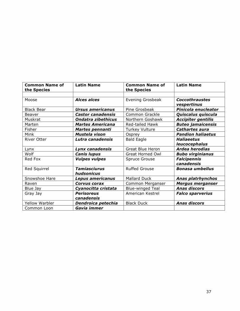
37
Common Name of
the Species
Latin Name Common Name of
the Species
Latin Name
Moose Alces alces Evening Grosbeak Coccothraustes
vespertinus
Black Bear Ursus americanus Pine Grosbeak Pinicola enucleator
Beaver Castor canadensis Common Grackle Quiscalus quiscula
Muskrat Ondatra zibethicus Northern Goshawk Accipiter gentilis
Marten Martes Americana Red-tailed Hawk Buteo jamaicensis
Fisher Martes pennanti Turkey Vulture Cathartes aura
Mink Mustela vison Osprey Pandion haliaetus
River Otter Lutra canadensis Bald Eagle Haliaeetus
leucocephalus
Lynx Lynx canadensis Great Blue Heron Ardea herodias
Wolf Canis lupus Great Horned Owl Bubo virginianus
Red Fox Vulpes vulpes Spruce Grouse Falcipennis
canadensis
Red Squirrel Tamiasciurus
hudsonicus
Ruffed Grouse Bonasa umbellus
Snowshoe Hare Lepus americanus Mallard Duck Anas platrhynchos
Raven Corvus corax Common Merganser Mergus merganser
Blue Jay Cyanocitta cristata Blue-winged Teal Anas discors
Gray Jay Perisoreus
canadensis
American Kestrel Falco sparverius
Yellow Warbler Dendroica petechia Black Duck Anas discors
Common Loon Gavia immer

38
Appendix D: Amendments to the SCI