on the vertical of suspended sediment transport in … sediment transport studies in yangshan port...
TRANSCRIPT

International Journal of Applied Environmental Sciences
ISSN 0973-6077 Volume 11, Number 4 (2016), pp. 1025-1035
© Research India Publications
http://www.ripublication.com
On the Vertical of Suspended Sediment Transport in
Dumai Estuary
Mubarak1, A. Nurhuda2 and A. Sulaiman3
1Department of Marine Science, Universitas Riau, Indonesia.
2Department of Marine Science, Universitas Riau, Indonesia.
3Geostech Laboratory, BPPT, Kawasan Puspiptek Serpong, Tangerang Selatan, Indonesia.
Abstract
Study of suspended sediment transport in Dumai Estuary is investigated.
Observation of suspended sediment, bed sediment, salinity, tidal elevation and
surface current were conducted in the surrounding the mouth of estuaries. The
observation was conducted at Northwest monsoon in two tidal cycle. The
results show that the land effect more dominant in this research area and the
salinity at the surface is higher at low to high period than high to low periods.
The bottom sediments are composed by mud and fine sand with 70 % for
mud, 25% for fine sand and 5% is gravel. The measurement of suspended
sediment also shows that sediment concentration higher at the high to low tide
than low to high tide. The vertical suspended sediments in the vertical
diraction is about 50-460 mg/l. The high concentration observed at the surface
layer and decrease to the bottom. Comparision between analytical model dan
observation in vertical structure of sediment transport showed a good
agreements. The concentration of sediment in a Dumai river lower compared
with Rupat strait, this revealed that the Dumai river is only a tiny fraction of a
source of suspended sediment in that area.
Keywords: dumai estuary, suspended sediment transport,
1. INTRODUCTION
The water exchange and sediment transports thought the river mouth govern by
hydrodynamics and physico-chemical proceses is very importance to understand
1026 Mubarak et al
productivity and carrying capacity of the estuary. Generally known that in the coastal
zone and estuaries, sediments are suspended, transported and deposited under various
action, such as the river discharge, waves, currents and local topography. For example
intensive sediment transport studies in Yangshan port showed that tidal currents are
the most dominant factor affecting the suspended sediment transport. For long term
measurement showed that sediment transport has strong seasonal variations [1]. In
another place such as Sheyang estuary, the transport due to the wind-induced current
is also strong aspecially in crosshore direction in the river mouth [2 ].
The estuary in South East Asia region is clasify as an alluvial estuaries i.e. estuaries
that have movable beds, consisting of sediments of both riverine and marine origin
and influence of freshwater inflow [3]. This region in which the ocean dynamics
dominated by tide is a one of very complex coastal seas and very active processes on
suspended sediment transport [4, 5]. For an example, the study of transport sediment
in Salut Mengkabong lagoon, Sabah, Malaysia showed strong tidal effect. Suspended
sediment concentration and sediment fluxs are higher in spring tidal cycles compared
to the same neap tidal cycles and the flood tidal fluxes [6]. Hoitink [5] showed that in
the equatorial shallow embayment such as Banten bays Indonesia, the turbidity and
sedimentation nearshore are controlled predominantly by the hydrodynamics of their
environment and availability of bed sediment rather than sediment suplay from the
land. But for an extreme condition such as heavy flood even, the sediment dominated
come from river discharge. For instance, the great flood of 2011 increase sediments
discharge more than 5 times higher than the average sediment discharge over 60 years
in Chao Phraya Estuary Thailand [7].
A study of sedimentology in the strait of Rupat, Riau, Indonesia show the effect of the
tidal current very strong for coarse-grained sediments dispersion. But for the region
away from the mouth of estuaries the influence of longshore currents more stronger
than tidal currents [8]. Previous studies showed that the horizontal suspended
sediment transport also affected by the tidal currents [9]. There are no study further of
vertical suspended sediment transport in Dumai River estuary. The dynamics of
suspended sediment transport in the area unknown properly. Paper is intended to
investigate the dynamics of vertical transport of suspended sediment in the area.
Measurement of the horizontal and vertical suspended sediment was conducted
around the mouth of estuary simultaneously with hydro-oseanography observation.
An analytic model will be used to get an insight of the physical properties of
suspended sediment transport in the area. Paper will be organized as follows, in Sec 2,
a description of the research area and methodology of the research are presented. The
result and discussions are given in the next chapter. The paper will be ended by a
summary.
2. STUDY AREA AND METHODOLOGY
The reasearch area located at the mouth of Dumai River which is part of Rupat
Estuary. This is depicted in Fig-1. Position of Rupat Strait semi-closed with the
condition of semi-diurnal tide has the variety of various type mangrove representing
habitat of various fish. There are various transportation activity, fishery and

On the Vertical of Suspended Sediment Transport in Dumai Estuary 1027
processing and oil distribution in coastal area of Dumai. The topography of the river
is very step with the slope is less than 3% which has 22km long. The Dumai river
stretched the city of Dumai. Along banks and riversides many the activity taking
place, including: agricultural activity, settlement, industry, traditional port and many
activities. The activities have also influence the quality and quantity of the Dumai
river and then affect the quality of the strait of Rupat waters.
The observation held on January 2016 with the parameter measurements are
suspended sediment, surface currents velocity, tidal elevation, salinity and bed
sediment sampling. The data were taken with the sampling methods consisting of
fifteen point or stations. The station location starts from the river to the mouth of
estuary. The parameter taken at the instant of observation is suspended sediment, bed
sediment, ocean currents and salinity. At the same time, the measurement of elevation
tides was also observed. The observation such as sampling of suspended sediment,
bed sediment, salinity and surface currents measurement were done at high tide and
on at low tide. An analytical model will be used to analyze the behavior of the vertical
sediment distribution.
Figure 1: Research area
3. RESULT AND DISCUSSION
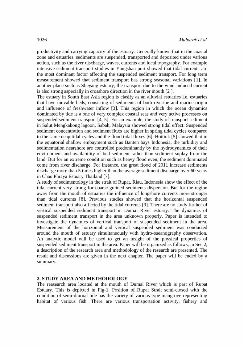
The tidal elevation is depicted in Fig-2. It show that the tidal range is about 300cm,
with the Formzhal number is about 0.2148 indicates tidal type which occur in Dumai
estuaries is semi-diurnal ( M2 ) that is occurring twice up and twice down in one day.
The average tidal elevation is about 1 m showing the region has micro-tidal type. The
1028 Mubarak et al
most of western part of Indonesia is predominantly semidiurnal [10]. The tidal
circulation in this region determined by the motion of water mass from Southchina
sea to Java sea in shelf topography.
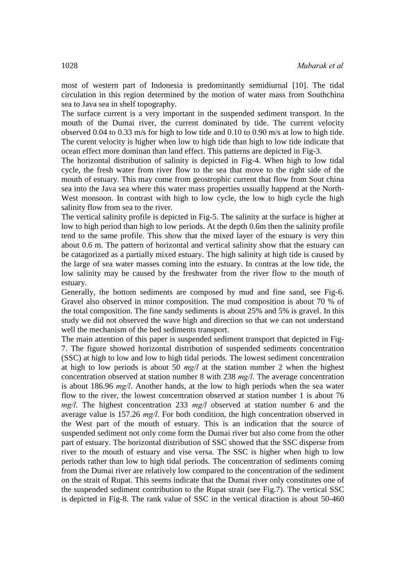
The surface current is a very important in the suspended sediment transport. In the
mouth of the Dumai river, the current dominated by tide. The current velocity
observed 0.04 to 0.33 m/s for high to low tide and 0.10 to 0.90 m/s at low to high tide.
The curent velocity is higher when low to high tide than high to low tide indicate that
ocean effect more dominan than land effect. This patterns are depicted in Fig-3.
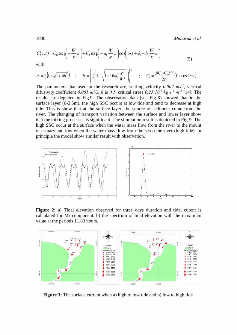
The horizontal distribution of salinity is depicted in Fig-4. When high to low tidal
cycle, the fresh water from river flow to the sea that move to the right side of the
mouth of estuary. This may come from geostrophic current that flow from Sout china
sea into the Java sea where this water mass properties ussually happend at the North-
West monsoon. In contrast with high to low cycle, the low to high cycle the high
salinity flow from sea to the river.
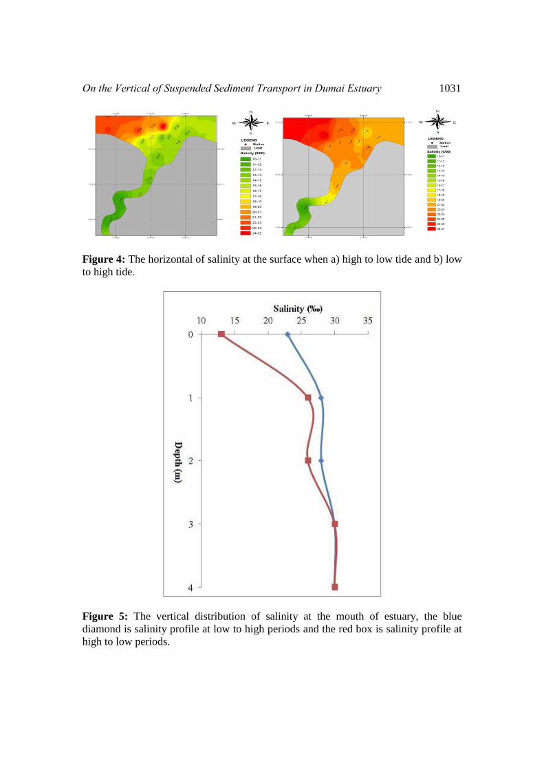
The vertical salinity profile is depicted in Fig-5. The salinity at the surface is higher at
low to high period than high to low periods. At the depth 0.6m then the salinity profile
tend to the same profile. This show that the mixed layer of the estuary is very thin
about 0.6 m. The pattern of horizontal and vertical salinity show that the estuary can
be catagorized as a partially mixed estuary. The high salinity at high tide is caused by
the large of sea water masses coming into the estuary. In contras at the low tide, the
low salinity may be caused by the freshwater from the river flow to the mouth of
estuary.
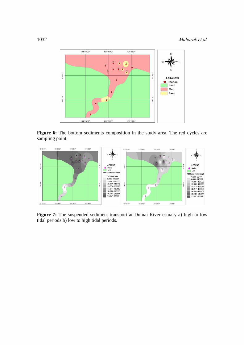
Generally, the bottom sediments are composed by mud and fine sand, see Fig-6.
Gravel also observed in minor composition. The mud composition is about 70 % of
the total composition. The fine sandy sediments is about 25% and 5% is gravel. In this
study we did not observed the wave high and direction so that we can not understand
well the mechanism of the bed sediments transport.
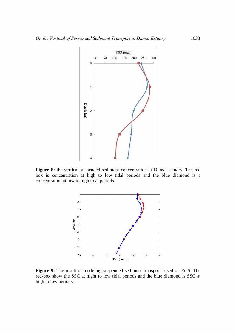
The main attention of this paper is suspended sediment transport that depicted in Fig-
7. The figure showed horizontal distribution of suspended sediments concentration
(SSC) at high to low and low to high tidal periods. The lowest sediment concentration
at high to low periods is about 50 mg/l at the station number 2 when the highest
concentration observed at station number 8 with 238 mg/l. The average concentration
is about 186.96 mg/l. Another hands, at the low to high periods when the sea water
flow to the river, the lowest concentration observed at station number 1 is about 76
mg/l. The highest concentration 233 mg/l observed at station number 6 and the
average value is 157.26 mg/l. For both condition, the high concentration observed in
the West part of the mouth of estuary. This is an indication that the source of
suspended sediment not only come form the Dumai river but also come from the other
part of estuary. The horizontal distribution of SSC showed that the SSC disperse from
river to the mouth of estuary and vise versa. The SSC is higher when high to low
periods rather than low to high tidal periods. The concentration of sediments coming
from the Dumai river are relatively low compared to the concentration of the sediment
on the strait of Rupat. This seems indicate that the Dumai river only constitutes one of
the suspended sediment contribution to the Rupat strait (see Fig.7). The vertical SSC
is depicted in Fig-8. The rank value of SSC in the vertical diraction is about 50-460

On the Vertical of Suspended Sediment Transport in Dumai Estuary 1029
mg/l. The high concentration observed at the surface and decrease to the bottom. The
vertical distribution of SSC was inversely with the salinity (see Fig/5 and Fig.8).
When low to high tidal periods, the SSC is high and the salinity is low. This condition
reverse on high to low tidal periods.
To get the more qualitative result let us compare the obervation result with the
analytical model. It is well known that tidal systems play important roles in
morphologic change, suspended sediment transport, and biogeochemical processes.
The response of suspended sediment concentration to the tidal current velocity, or the
bed shear stress, is not instantaneous but there is a phase lag of the SSC behind the
tidal velocity. To get a more detail of description of the transport of vertical
suspended sediment in the areas then we use an analytical model of advection-
dispersion equation with nonlinear tidal velocity. The one dimensional advection-
dispersion equation [11],
02
2
2
2
zC
xC
zCW
xCU
tC
zx (1)
where C is suspended sediment concentration (SSC) which is a function of the time (t)
and the distance above the seabed (z), U is tidal currents, κ is vertical dispersion
coefficient, (x,z) is horizontal and vertical (depth) coordinate. By assuming unsteady
uniform velocity and horizontal dispersion is ignored, the equation (1) reduce to,
02
2
zC
zCW
tC
z (2)
where W and κ are sediment settling velocity and sediment vertical eddy diffusivity,
respectively. The solution is given by [12],
zWbtzWaCzWCtzC nnnn
nn
cosexpexp,1
0
(3)
where
2
1
4
22
812
21 1611;411
Wbba nnnn
and we have the boundary condition as,
tUCCtC D
2cos1
2,0
0
2
0
(4)
where ω and φ are semidiurnal tidal frequency and phase lag respectively, τ0 critical
shear stress, CD is drag coefficient, β is a small constant and γ is an empirical constant
with the range of 10−3~10−5.
To apply this formula, first we should calculated tidal velocity derived from tidal
elevation. From the Fig-2, we have the semi-diurnal periods (T) is about 11.83 hours
(ω1=2π/T) and the amplitude (U) is about 1m/s. The tidal current calculation is given
in [13]. The tidal elevation and tidal currents are depicted in Fig-2. We consider only
M2 component so that the Eq-3 yields,
1030 Mubarak et al
zWbtzWaCzWCtzC
111110 cosexpexp,
(5)
with
tUCCCW
bba D1
0
2
014
22
18
11
2
12
11 2cos1
2;1611;411
21
The parameters that used in the research are, settling velocity 0.002 ms-1, vertical
difusivity coefficient 0.001 m2/s, β is 0.1, critical stress 0.25 10-3 kg s-1 m-2 [14]. The
results are depicted in Fig.9. The observation data (see Fig-8) showed that in the
surface layer (0-2.5m), the high SSC occurs at low tide and tend to decrease at high
tide. This is show that at the surface layer, the source of sediment come from the
river. The changing of transport variation between the surface and lower layer show
that the mixing processes is significant. The simulation result is depicted in Fig-9. The
high SSC occur at the surface when the water mass flow from the river to the mount
of estuary and low when the water mass flow from the sea o the river (high tide). In
principle the model show similar result with observation.
Figure 2: a) Tidal elevation observed for three days duration and tidal curent is
calculated for M2 component. b) the spectrum of tidal elevation with the maximum
value at the periods 11.83 hours.
Figure 3: The surface current when a) high to low tide and b) low to high tide.
On the Vertical of Suspended Sediment Transport in Dumai Estuary 1031
Figure 4: The horizontal of salinity at the surface when a) high to low tide and b) low
to high tide.
Figure 5: The vertical distribution of salinity at the mouth of estuary, the blue
diamond is salinity profile at low to high periods and the red box is salinity profile at
high to low periods.
1032 Mubarak et al
Figure 6: The bottom sediments composition in the study area. The red cycles are
sampling point.
Figure 7: The suspended sediment transport at Dumai River estuary a) high to low
tidal periods b) low to high tidal periods.
On the Vertical of Suspended Sediment Transport in Dumai Estuary 1033
Figure 8: the vertical suspended sediment concentration at Dumai estuary. The red
box is concentration at high to low tidal periods and the blue diamond is a
concentration at low to high tidal periods.
Figure 9: The result of modeling suspended sediment transport based on Eq.5. The
red-box show the SSC at hight to low tidal periods and the blue diamond is SSC at
high to low periods.

1034 Mubarak et al
5. CONCLUSION
Suspended sediment observation including salinity, surface velocity and tide
elevations ware conduct at the mouth of Dumai river on January 2016. The land effect
more dominant in this research area indicated by the fact that the curent velocity is
higher when high tide than low tide. While salinity the opposite namely, higher at low
to high period than high to low periods. The bottom sediments are composed by mud,
gravel and fine sand. The mud composition is about 70 % of the total composition.
The fine sandy sediments is about 25% and 5% is gravel. The measurement of
suspended sediment also shows that sediment concentration higher at the high to low
tide than low to high tide. The vertical suspended sediments in the vertical direction is
about 50-460 mg/l with the high concentration observed at the surface and decrease to
the bottom. The water quality of Rupat strait was influenced several factor, the one is
the contribution from the credit of the Dumai river into the strait. The SSC that comes
from the strait has lower concentration than SSC average of the Rupat strait. It is
concluded that the source of suspended sediment in Rupat strait is not come from the
Dumai River but come from another part of the strait. Hence, we need to investigate
more comprehensively to know the sources of suspended sediment that is in column
waters of the Rupat strait.
ACKNOWLEDGMENTS
The research is funded by Universitas Riau, Indonesia in fiscal years 2016. AS is
supported by DIPA PTPSW-BPPT in fiscal years 2016.
REFERENCES
[1] Zuo, S.H., Zhang, N.C., Li, B., and Chen, S.L, 2012, A study of suspended
sediment concentration in Yangshan deep-water port in Shanghai, China,
International of Sediment Reserach, Vol 27, No 1, 50-60.
[2] Liu,G.F., Wu, J.X., and Wang, Y.Y, 2014 Near-bed sedeimnt transport in a
heavily modified coastal plain estuary, International Journal of Sediment
Research, Vol:29, No 2, 232-245.
[3] Savanije, H.H.G, 2005, Salinity and tides in alluvial estuaries, Elsevier,
Amsterdam, pp. 10-14.
[4] Hoitink, A.J.F 2000, Three dimensional velocity structure and suspended
sediments at coral reef s in Teluk Banten, In: B.L. Edge, ed. Coastal
Engineering 2000, Sydney, Australia: ASCE (American Society of Civil
Engineering), pp. 3345-3358.
[5] Hoitink A.J.F 2003, Physics of coral reef system in a shallow tidal
embayment, Netherland Geographycal Studies, 313, Utrecht, 145pp. Liu,G.F.,
Wu, J.X., and Wang, Y.Y, 2014 Near-bed sedeimnt transport in a heavily
modified coastal plain estuary, International Journal of Sediment Research,
Vol:29, No 2, 232-245.
On the Vertical of Suspended Sediment Transport in Dumai Estuary 1035
[6] Haque Md.A., Ahad, B.G., Saleh E, 2010, Hydrodynamics and suspended
sediment transport at tidal inlets of Salut Mengkabong Lagoon, Sabah,
Malaysia, International of journal sediment research, 25, 399-410.
[7] Bidorn, B., Chanyotha,S., Kish, S.A., Donoghue, J.F., Bidorn, K., and Mama,
R, 2015, The effect of Thailand’s great flood of 2011 on river sediment
discharge in the upper Chao Phraya River basin, Thailand, International of
sediment research Vol:30, 328-337.
[8] Rifardi, 2001, Study on sedimentology from the mesjid river estuary and its
environs in the Rupat strait, the east coast of Sumatra island, Journal of coastal
development, Vol: 4, No 2, 87-98.
[9] Mubarak, Edison, Sri Fitria R, and Yeeri Badrun. Transport Suspended
Modeling In Rupat Strait. 2013. Proceeding “2nd International seminar on
Fisheries and Marine (2nd ISFM). Pekanbaru, 6 – 7 November 2013. ISBN
978-979-792-437-9. Penerbit UR Press Pekanbaru. pp. 198 – 205.
[10] Ray, R.D., G.D. Egbert, and S.Y. Erofeeva, 2005, A Brief Overview of Tides
in the Indonesian Seas, Oceanography, Vol 18,4, 74-79.
[11] Pethick, J. 1984,An Introduction to Coastal Geomorphology, Edward Arnold
Ltd., London, 260p
[12] Yu, Q, Burg W. Flemming & Shu Gao, 2011, Tide-induced vertical suspended
sediment concentration profiles: phase lag and amplitude attenuation, Ocean
Dynamics (2011) 61:403–410, DOI 10.1007/s10236-010-0335-x.
[13] Mubarak and A. Sulaiman, 2016, Analytical model of heavy-particle pollutant
transport in estuary, International Journal of Physical Science, Vol 11 (3) 40-
49. DOI: 10.5897/IJPS2015.4383.
[14] Zheng, L.Y., C.S. Chen., M. Albert, and H.D. Liu, 2003, Modeling Study of
Satilla River Estuaries, Georgia II, suspended sedimen, estuaries, Vol 20, 3,
670-679.

1036 Mubarak et al