omb no. 1024-0018 · omb no. 1024-0018 exp. 10-31-84 united states department of the interior...
TRANSCRIPT

NPS Form 10-900 (3-82)
OMB No. 1024-0018 Exp. 10-31-84
United States Department of the InteriorNational Park Service
National Register of Historic Places Inventory Nomination FormSee instructions in How to Complete National Register FormsType all entries complete applicable sections________________
1. Name__________________
historic N/A _ _
and or common Branford Center Historic District ____
2. Location
For NPS use only
received MAR 2 3 1937
date enter
street & number See continuation sheet not for publication
city, town Branford vicinity of
state Connecticut code 09 county New haven code 009
3. ClassificationCategory^ district
building(s)structure
_ siteobject
Ownershippublicprivate
x bothPublic Acquisition
in processbeing considered
N/A
StaX3L_
Ac<X
itUS
occupied _ unoccupied
work in progress :essible
yes: restricted yes: unrestricted no
Present Useagriculture
X commercialX educational X entertainment x governmentX industrial
_JC military
museumX parkX private residence
religiousscientifictransportationother:
4. Owner of Propertyname Multiple Ownership
street & number
city, town vicinity of state
5. Location of Legal Description
courthouse, registry of deeds, etcBranf ord Town Hall
street & number 1019 Main Street
city, town Branford state Connecticut
6. Representation in Existing SurveysState Register of
title Historic Places has this property been determined eligible? x* Yes
date 1986*As noted on continuation sheet
__ federal __ state __ county
_ no
local
depository for survey records Connecticut Historical Commission, 59 S. Prospect Street
city, town Hartford state Connecticut

7. Description
Condition_X _ excellent _X _ good JK_fair
deterioratedruinsunexposed
Check oneunaltered
X altered
Check oneX_ original
movedsite (except as noted in
date . . . _ .inventory)
Describe the present and original (if known) physical appearance
The Branford Center Historic District is located in Branford, Connecticut, a small coastal town encompassing approximately 27.9 square miles of land lying roughly 5 miles east of the City of New Haven and 25 miles west of the mouth of the Connecticut River. Embracing the core south-central por tion of the formerly incorporated Borough of Branford, and flanked to the east and southeast by the Branford River, the district lies roughly 2 miles north of Long Island Sound and 1/2-mile south of Interstate 95.
The irregularly shaped borders of the district encompass roughly 250 acres of partially undulating land which rise gradually toward the northwest away from the Branford River. Including garages, carriage houses and, similar substantial ancillary outbuildings, the district contains a total of 706 major structures. Of these 706 major structures, 557 (78.9%) contribute to the architectural and/or historical significance of the area.
The district is traversed by an irregular pattern of streets, virtually all of which were laid out between the mid 17th and late 19th centuries. The district's principal east/west traffic arteries are Main, East Main, Meadow, and Maple Streets; principal north/south arteries are Cedar and Montowese Streets. Spanning the northern and eastern ends of the district,Main and Montowese Streets, respectively, form the district's two principal commercial loci. Dominated by industrial architecture, Meadow and Maple Streets span the length of the district's southern end; portions of each of these two streets flank an extant trackbed associated with the former New York, New Haven, and Hartford, Railroad.
East Main Street is the district's principal access road from the north east, while Cedar Street provides the most direct link between the district and Interstate 95. Other streets included within the district (in whole or part) are Monroe Street, John Street, Laurel Street, Harrison Avenue, Park Place, Hillside Avenue, Veto Street, Rose Street, Ivy Street, Chestnut Street, Bradley Avenue, Danberg Place, Wilford Avenue, Church Street, South Main Street, Eades Street, Prospect Street, Meadow Street, Hopson Avenue, Rogers Street, Kirkham Road, Svea Street, and Rice Terrace. Like East Main and Cedar Streets, these latter roads are almost entirely dominated by architecture designed and currently utilized as residences.
The district contains several prominent park-like spaces. The most notable of these are the town green at the junction of Main and Montowese Streets, the area framed by Main Street and the semicircular driveway fronting the Blackstone Memorial Library, and the wide esplanade at Main Street between Cedar and John Streets. A large open park also abuts the southern edge of the district along Prospect Street between Church Street and Hopson

NPS Form 10-900-a OUB Approval No. 1024-0018 (MS)
United States Department of the InteriorNational Park Service
National Register of Historic Places Continuation SheetBranford Center Historic District, Branford, Connecticut
Section number 2 Page 2
Location (cont.)
Street Street Numbers
Averill Place.................... 14 through 59.
Bradley Avenue................... 7 through 37; 40, 42, and 46.
Chestnut Street.................. 2 through 77.
Church Street.................... 1 through 92 (excluding 38-40).
Danberg Place.................... 1 through 5.
Eades Street..................... 14 through 24.
East Main Street................. 3 through 182.
Elm Street....................... 131 through 140.
Harrison Avenue.................. 23 through 75.
Hillside Avenue.................. 10 through 41.
Hopson Avenue.................... 4 through 83.
Indian Neck Avenue............... 4.
Ivy Street....................... 19 and 21.
John Street...................... 14 through 18.
Laurel Street.................... 19 through 51.
Main Street...................... 554 through 1265.
Meadow Street.................... 94 and 98; 188 through 276.
Montowese Street................. 41 through 239.
Monroe Street.................... 11 through 46; 55.
Park Place....................... 12 through 32; 36, 42, and 46.
Prospect Street.................. 16 through 50 (even side only).

NPS Form 10-900* OUB Appnvtl No. 1024-0018 <**»)
United States Department of the InteriorNational Park Service
National Register of Historic Places Continuation SheetBranford Center Historic District, Branford, Connecticut
Section number 2 Page 3
Location (cont.)
Street Street Numbers
Rice Terrace..................... 13 through 21.
Rogers Street.................... 8 through 95.
Rose Street...................... 12.
South Main Street................ 1 through 125.
Svea Street...................... 2 through 14 (even side only).
Wilford Avenue................... 9 through 49.

NPS Form 10-900-a QMB Appmvfl No. 7024-0018
United States Department of the InteriorNational Park Service
National Register of Historic Places Continuation SheetBranford Center Historic District, Branford, Connecticut
Section number 6 Page 2
Representation in Existing Surveys (cont.)
Title: "Branford, Connecticut: A Survey of Architectural and Histori cal Resources. The Town of Branford, Phase I". Prepared by The Architectural Preservation Trust of Branford, Inc.
Date: 1985.
Type of Survey: Local.
Depository of Survey Records: Connecticut Historical Commission,59 South Prospect Street.
City/Town: Hartford
State: Connecticut.

NPS Form 10-9OX* OWB Apprw* No. 10244018
United States Department of the InteriorNational Park Service
National Register of Historic Places Continuation SheetBranford Center Historic District, Branford, Connecticut
Section number 7 Page 2
Description (cont.)
Avenue. The district also encompasses two significant burial grounds: Center Cemetery (established in the 17th century), and Saint Mary's Roman Catholic Cemetery (established in the mid-19th century).
The district's building stock includes a great variety of 19th- and early 20th-century commercial, industrial, municipal, and religious structures, as well as numerous single- and multi-family houses dating from the 18th through early 20th centuries (photographs 1-5, 7, 8, 11, 15-17, 20, 21, 23- 30). While wooden construction predominates, most of the industrial, a number of the commercial, and a few of the municipal and religious struc tures stand as significant examples of brick, cut-stone, cast-stone, concrete-block and/or metal-clad steel-frame construction (photographs 6, 12-14, 18, 22).
Virtually all of the structures in the district range from one and one-half to four stories in height. With the exception of several of the more prominent municipal and religious structures located along Main Street, the State Armory at 83 Montowese Street, and some structures associated with the industrial complexes located along the south side of Meadow and Maple Streets, most buildings are sited relatively close (5-30 feet) to the street. On streets dominated by residential architecture, most structures maintain esentially uniform setbacks.
The principal architectural styles represented within the district include the Colonial, Federal, Greek Revival, Italianate, Gothic Revival, Second Empire, Queen Anne, Colonial Revival, Tudor Revival, and Bungalow modes. Most of these styles appear as vernacular interpretations, reflecting the fact that the majority of the area's buildings were "designed" as well as erected by local builders (photographs 1-5, 7-11, 16, 17, 25-30). However, the district also contains a handful of structures known to have been designed by professional architects. The most significant of these is the classically inspired, monumental 1893 James Blackstone Memorial Library by S.S. Beman of Chicago Illinois (photograph 22). A number of other struc tures, such as the Branford Town Hall, the former Connecticut Light and Power Company Building, the Toole Building, and the G.A.R. Hammer Building, exhibit design qualities which strongly suggest the direct involvement or strong influence of an unknown professional hand (photographs 12-15). The district also includes a number of structures with essentially unadorned, functional lines (e.g. 19th- and early 20th-century industrial buildings and mill workers' houses). Despite their plain character, the massing, materials, workmanship, location, and siting of these buildings clearly mark them as an integral component of the district's historical development (photographs 6 and 29).

NPS Form 10-900-a OMB Approval No. 1024-0018 (M6)
United States Department of the InteriorNational Park Service
National Register of Historic Places Continuation SheetBranford Center Historic District, Branford, Connecticut
Section number 7 Page 3
The district maintains a strong level of historical and architectural integrity. On an individual basis, approximately 75 percent of all contri buting structures retain the bulk of their significant historic exterior fabric and features. Alterations to the remainder of the district's contributing structures are generally limited to the application of later siding materials, the enclosure of front porches, unobtrusive additions, and/or post-1936 storefront and signage modifications. The district has been spared from the debilitating effects of extensive demolition and modern construction. It contains only a few small and widely scattered vacant lots/parking areas. The most notable intrusion is formed by Saint Mary's Roman Catholic Church, a 1974 brick structure at the northwest corner of Main Street and Hopson Avenue, and the adjacent block of five modern brick commercial structures located immediately to its east along the south side of South Main Street between Hopson Avenue and Eades Street.
An inventory of buildings and sites located within the district is provided on the following pages. Inventoried buildings and sites are listed in the following format:
Street Name
Status St. # Description
Contributing: C 14 *Date of construction. Historic name or (Common name). A: architect. B: build-
Noncontributing: NC er. Building description, other structuresassociated with property.
*Categories not listed if attributions are unknown.

NPS Form 10-900-a OMB Approval No. 10244X18
United States Department of the InteriorNational Park Service
National Register of Historic Places Continuation SheetBranford Center Historic District, Branford, ConnecticutSection number 7 Page 4
Averill Place
NC 14 (a) Ca. 1970. Late 20th-century frame house.
C 14(b) Ca. 1910. Frame carriage house.
C 18 Ca. 1920. Arthur H. Merrill House. Frame ColonialRevival. Garage (C).
C 23 Ca. 1910. Walter H. Clapp House. Frame Queen Anne.Garage (C).
C 24 Ca. 1920. Wallace H. Foote House. Frame ColonialRevival. Garage (C).
C 29 Ca. 1915. William T. Flanders House. Frame QueenAnne/Colonial Revival. Garage (C).
C 34 Ca. 1920. Dr. George E. Evans House. Frame ColonialRevival. Carriage House (C).
C 35 Ca. 1920. Harry A. Smith House. Frame ColonialRevival.
C 39 Ca. 1930. William C. Higley House. Brick ColonialRevival. Garage (C).
C 40 Ca. 1925. Frank A. Stieler House. Frame ColonialRevival/Shingle. Garage (NC) .
C 43 Ca. 1930. Merritt A. Huggins House. Brick Bungalow.Garage (C).
C 44 Ca. 1925. Chester W. Prann House. Frame Bungalow.Barn (C).
C 47 Ca, 1930. Harry V. McCoy House. Frame ColonialRevival. Garage (C).
C 48 Ca. 1930. Lyman J. Monroe House. Frame ColonialRevival. Garage (C).

NPS Form 10-900-a (M6)
OMB Approval No. 10244018
United States Department of the InteriorNational Park Service
National Register of Historic Places Continuation SheetBranford Center Historic District, Branford, Connecticut
Section number 7 Page ___5_
Averill Place (cont.)
C 49 Ca. 1930. Scott W. Gilbert House. Frame ColonialRevival. Carriage House (C).
50
51
53
55
56
57
58
59
(end Averill Place)
Ca. 1930. Herbert C. Holman House. Frame Colonial Revival.
Ca. 1930. Paul G. McClean House. Frame Colonial Revival. Garage (C).
Ca. 1930. Emi1 A. Nygard House. Frame Colonial Revival. Garage (NC).
Ca. 1930. Herbert G. Foote House. Frame Colonial Revival. Garage (C).
Ca. 1930. William Van Wiglen House. Frame Colonial Revival. Garage (C).
Ca. 1935. Hulda M. Foote House. Frame Colonial Revival. Garage (C).
Ca. 1930. Leonard K. Maddern House. Frame Bungalow. Garage (C).
Ca. 1930. James Doyle House. Frame Colonial Revival. Garage (NC).
Bradley Avenue
NC 1
C 14-16
Ca. 1970. Late 20th-century frame house.
Ca. 1900. William G. Downes House. Frame Queen Anne. Garage (C).

NPS Form 10-900-a OMB Apprwul No. 1024-0010 (M6)
United States Department of the InteriorNational Park Service
National Register of Historic Places Continuation SheetBranford Center Historic District, Branford, Connecticut
Section number 7 Page 6
Bradley Avenue (cont.)
C 15 Ca. 1910. Clif ford-Hal1-Kimbal 1 House. FrameColonial Revival.
C 17 Ca. 1890. Harry M. Ferguson House. Frame Stick withColonial Revival motifs. Garage (NC) .
C 20 Ca. 1910. Olive and Clifford Morgan House. FrameColonial Revival. Garage (C).
C 21 Ca. 1885. Henry L. Randall House. Late 19th-centuryframe house. Garage (C).
C 24 Ca. 1900. Couch-Grier House. Frame Queen Anne/Colonial Revival with enclosed (2nd-story) front porch. Garage (C).
C 25 Ca. 1885. Martin A. Haglin House. Frame Queen Anne.Garage (C).
C 28 Ca. 1885. Martin L. Bradley House. Frame Queen Anne.
C 29 Ca. 1890. Hitchcock-Neely House. Frame Queen Anne.Garage (C).
C 33 Ca. 1895. Allsworth-01iner House. Frame Queen Anne.Garage (NC).
C 34 Ca. 1900. McCarthy-0'Brien House. Frame Queen Anne.Garage (NC).
C 37 Ca. 1890. David S. Baldwin House. Frame Queen Annewith enclosed front porch. Garage (NC).
C 38 Ca. 1905. Ke11y-McDermott House. Frame QueenAnne/Colonial Revival. Garage (C).
C 40 Ca. 1930. George H. Baisley House. Frame ColonialRevival. Garage (C).

NFS Form 10-900-a <M8)
OWB Approval No. 10244018
United States Department of the InteriorNational Park Service
National Register of Historic Places Continuation SheetBranford Center Historic District, Branford, Connecticut
Section number 7 Page 7
Bradley Avenue (cont.)
C 42
C 46
(end Bradley Avenue)
Ca. 1925. John F. Kinney House. Frame Colonial Revival.
Ca. 1915. Charles H. Porter House. Frame Bungalow. Garage (NC).
Cedar Street
NC 24
C
C
C
C
C
C
C
C
NC
NC
C
C
28
34
45
47
48
52
53
61
63
67
71
75
Ca. 1900. Frame Queen Anne with extensive ca. 1970 exterior alterations.
Ca. 1920. Frame Bungalow with enclosed front porch.
Ca. 1860. Mid 19th-century frame house.
Ca. 1920. Frame Bungalow.
Ca. 1880. Late 19th-century frame house. Gagrage (C).
Ca. 1890. Frame Queen Anne.
1936. Frame Colonial Revival.
Ca. 1920. Frame Bungalow. Garage (C).
Ca. 1885. Frame Queen Anne.
Ca. 1945. Brick and frame Colonial Revival.
Ca. 1970. Late 20th-century brick house.
Ca. 1915. Frame Bungalow.
Ca. 1865. Frame Italianate with additions and Colonial Revival front porch.
NPS Form 10-900-a (W6)
OMB Approval No. 1024-0018
United States Department of the InteriorNational Park Service
National Register of Historic Places Continuation SheetBranford Center Historic District, Branford, Connecticut
Section number 7 Page 8
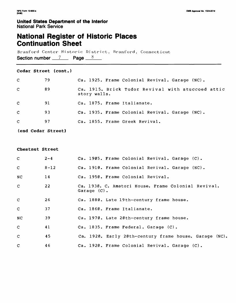
Cedar Street (cont.)
79
89
91
93
97
Ca. 1925. Frame Colonial Revival. Garage (NC).
Ca. 1915. Brick Tudor Revival with stuccoed attic story walls.
Ca. 1875. Frame Italianate.
Ca. 1935. Frame Colonial Revival. Garage (NC).
Ca. 1855. Frame Greek Revival.
(end Cedar Street)
Chestnut Street
C 2-4
C 8-12
NC 14
C 22
C
C
NC
C
C
C
26
37
39
41
45
46
Ca. 1905. Frame Colonial Revival. Garage (C).
Ca. 1910. Frame Colonial Revival. Garage (NC).
Ca. 1950. Frame Colonial Revival.
Ca. 1930. C. Amatori House. Frame Colonial Revival. Garage (C).
Ca. 1880. Late 19th-century frame house.
Ca. 1860. Frame Italianate.
Ca. 1970. Late 20th-century frame house.
Ca. 1835. Frame Federal. Garage (C).
Ca. 1920. Early 20th-century frame house. Garage (NC).
Ca. 1920. Frame Colonial Revival. Garage (C).
NPS Form 10-900-a OMB Approval No. 1 024-001 B
United States Department of the InteriorNational Park Service
National Register of Historic Places Continuation SheetBranford Center Historic District, Branford, Connecticut
Section number 7 Page 9
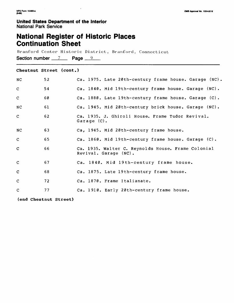
Chestnut
NC
C
C
NC
C
NC
C
C
C
C
C
C
Street
52
54
60
61
62
63
65
66
67
68
72
77
(cont.)
Ca. 1975. Late 20th-century frame house. Garage (NC)
Ca. 1840. Mid 19th-century frame house. Garage (NC) .
Ca. 1880. Late 19th-century frame house. Garage (C) .
Ca. 1945. Mid 20th-century brick house. Garage (NC) .
Ca. 1935. J. Ghiroli House. Frame Tudor Revival. Garage (C) .
Ca, 1945. Mid 20th-century frame house.
Ca. 1860. Mid 19th-century frame house. Garage (C) .
Ca. 1935. Walter C. Reynolds House. Frame Colonial Revival. Garage (NC) .
Ca. 1840. Mid 19th-century frame house.
Ca. 1875. Late 19th-century frame house.
Ca. 1870. Frame Italianate.
Ca. 1910. Early 20th-century frame house.
(end Chestnut Street)
NPS Form 10-900* (M6)
0MB Approve No. J024-OOJ8
United States Department of the InteriorNational Park Service
National Register of Historic Places Continuation SheetBranford Center Historic District, Branford, Connecticut
Section number 7 Page 11
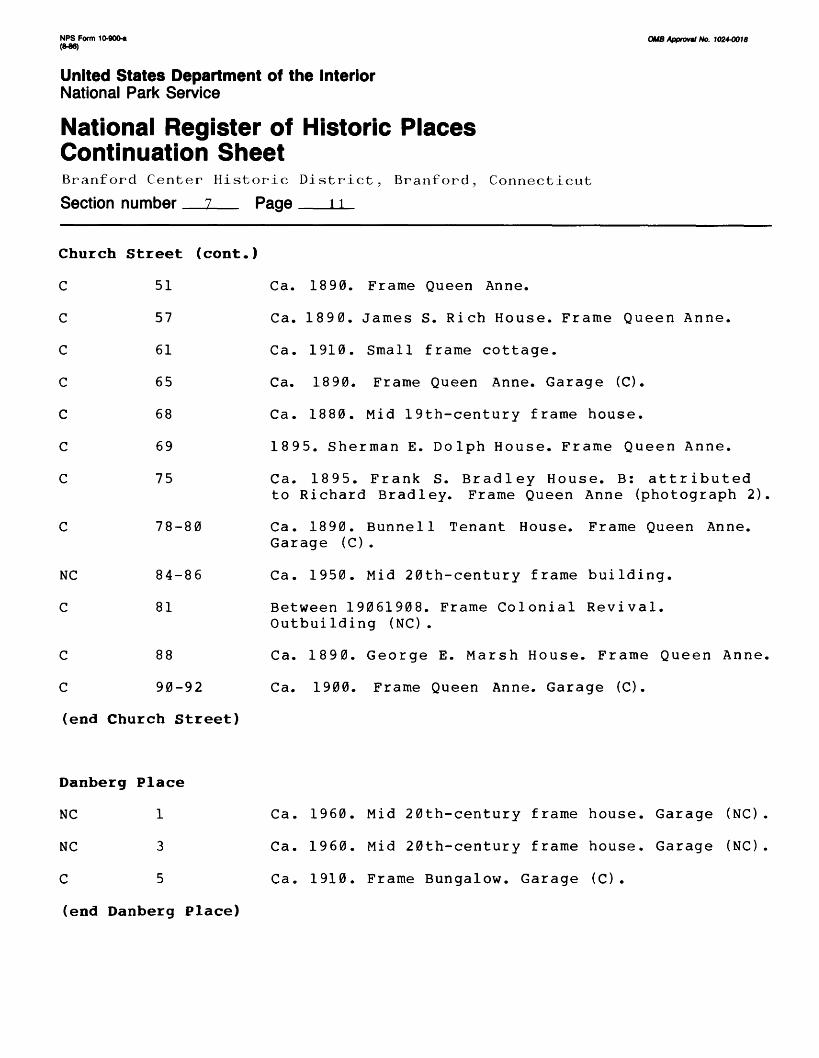
Church Street (cont.)
C
C
C
C
C
C
C
51
57
61
65
68
69
75
Ca.
Ca.
Ca.
Ca.
Ca.
189
Ca.
1890.
1890.
1910.
1890.
1880.
Frame
James
Small
Frame
Queen Anne.
S. Rich House. Frame
frame cottage.
Queen Anne. Garage
Queen
(C).
Anne.
Mid 19th-century frame house.
5. Sherman E,
1895. Frank
, Dolph House. Frame
S. Bradley House.
Queen
B: att
Anne.
r ibuted
NC
C
C
C
78-80
84-86
81
88
90-92
to Richard Bradley. Frame Queen Anne (photograph 2)
Ca. 1890. Bunnell Tenant House. Frame Queen Anne. Garage (C).
Ca. 1950. Mid 20th-century frame building.
Between 19061908. Frame Colonial Revival. Outbuilding (NC).
Ca. 1890. George E. Marsh House. Frame Queen Anne,
Ca. 1900. Frame Queen Anne. Garage (C).
(end Church Street)
Danberg Place
NC 1
NC 3
C 5
(end Danberg Place)
Ca. 1960. Mid 20th-century frame house. Garage (NC)
Ca. 1960. Mid 20th-century frame house. Garage (NC)
Ca. 1910. Frame Bungalow. Garage (C).

NFS Form 10-90O* OMB Approvul No. 1024-0018 <W6)
United States Department of the InteriorNational Park Service
National Register of Historic Places Continuation SheetBranford Center Historic District, Branford, Connecticut
Section number 7 Page 10
Church Street
C 1 Atlantic Wire Company (Atlantic Wire Company). 14building industrial complex including 11 brick, conrete-block, and/or steel-frame structures dating between 1911 and 1935 (photograph 6).
NC 15 Ca. 1925. Early 20th-century concrete-block commercialbuilding with extensive ca. 1970 exterior alterations.
C 19 Ca. 1880. Olaf and Gus Gustafson House. Frame lateItalianate/Queen Anne.Garage (C).
C 22 Ca. 1890. Frame Queen Anne.
C 25 Ca. 1890. Herman Mickleson House. Frame QueenAnne. Garage (NC).
C 26 Ca. 1895. John J. Welch House. Frame Queen Anne/Colonial Revival. Outbuilding (C).
C 29 Ca. 1890. Edward Welch House. Frame Queen Anne.frame house.
C 33 Ca. 1890. Benjamin F. Hosley House. B: Benjamin F.Hosley. Frame Queen Anne. Garage (C).
C 37 Ca. 1894. Mary Freeman House. Frame Queen Anne.Garage (C).
C 43 Ca. 1920. Frame Colonial Revival. Garage/outbuilding(NC) .
C 47 Ca. 1920. Frame Colonial Revival. Garage (NC).
NPS Form 10-90O-e (MB)
OMB Approval No. 1024-0018
United States Department of the InteriorNational Park Service
National Register of Historic Places Continuation SheetBranford Center Historic District, Branford, Connecticut
Section number 7 Page 12
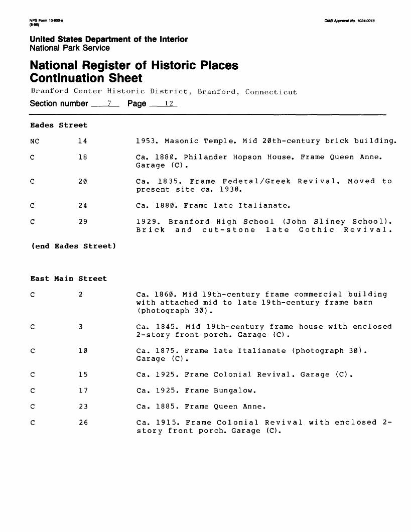
Eades Street
NC 14
C 18
C 20
C
C
24
29
1953. Masonic Temple. Mid 20th-century brick building,
Ca. 1880. Philander Hopson House. Frame Queen Anne. Garage (C).
Ca. 1835. Frame Federal/Greek Revival. Moved to present site ca. 1930.
Ca. 1880. Frame late Italianate.
1929. Branford High School (John Sliney School). Brick and cut-stone late Gothic Revival.
(end Eades Street)
East Main Street
C 2
C
C
C
C
10
15
17
23
26
Ca. 1860. Mid 19th-century frame commercial building with attached mid to late 19th-century frame barn (photograph 30).
Ca. 1845. Mid 19th-century frame house with enclosed 2-story front porch. Garage (C) .
Ca. 1875. Frame late Italianate (photograph 30). Garage (C).
Ca. 1925. Frame Colonial Revival. Garage (C).
Ca. 1925. Frame Bungalow.
Ca. 1885. Frame Queen Anne.
Ca. 1915. Frame Colonial Revival with enclosed 2- story front porch. Garage (C).

NPS Form 10-900-a OMB Approval No. 10244018 <M6)
United States Department of the InteriorNational Park Service
National Register of Historic Places Continuation SheetBranford Center Historic District, Branford, Connecticut
Section number 7 Page 13
East Main Street (cont.)
C 30 Ca. 1890. Frame Queen Anne with enclosed front porch.
C 31 Ca. 1865. Frame Italianate.
C 34 Ca. 1885. Late 19th-century frame house. Garage (C).
C 35 Ca. 1885. Frame Queen Anne.
C 41 Ca. 1915. Frame Bungalow (photograph 29). 2 garages(2 NO .
C 44 Ca. 1755. Elnathan Beach House. Frame Colonial withGreek Revival front doorway. Garage (NC).
C 45 Ca. 1850. Frame Italianate (photograph 29).
C 49 Ca. 1865. Frame Italianate with Queen Anne frontporch (photograph 29).
C 50 Ca. 1890. Late 19th-century frame house. Barn (C).
C 52 Ca. 1890. Late 19th-century frame house. Garage (NC).
C 55 Ca. 1920. Early 20th-century frame house (photograph29) .
C 57 Ca. 1870. Mid 19th century frame house with ColonialRevival front doorway. 2 garages (2 C).
C 58 Ca. 1850. Frame Italianate.
NC 60 Ca. 1970. Late 20th-century frame house.
C 61 Ca. 1890. Late 19th-century frame house.
NC 63 Ca. 1975. Late 20th-century frame house.
NPS Form 10-90Q« OUB Approval No. 1024-0018 (M6)
United States Department of the InteriorNational Park Service
National Register of Historic Places Continuation SheetBranford Center Historic District, Branford, Connecticut
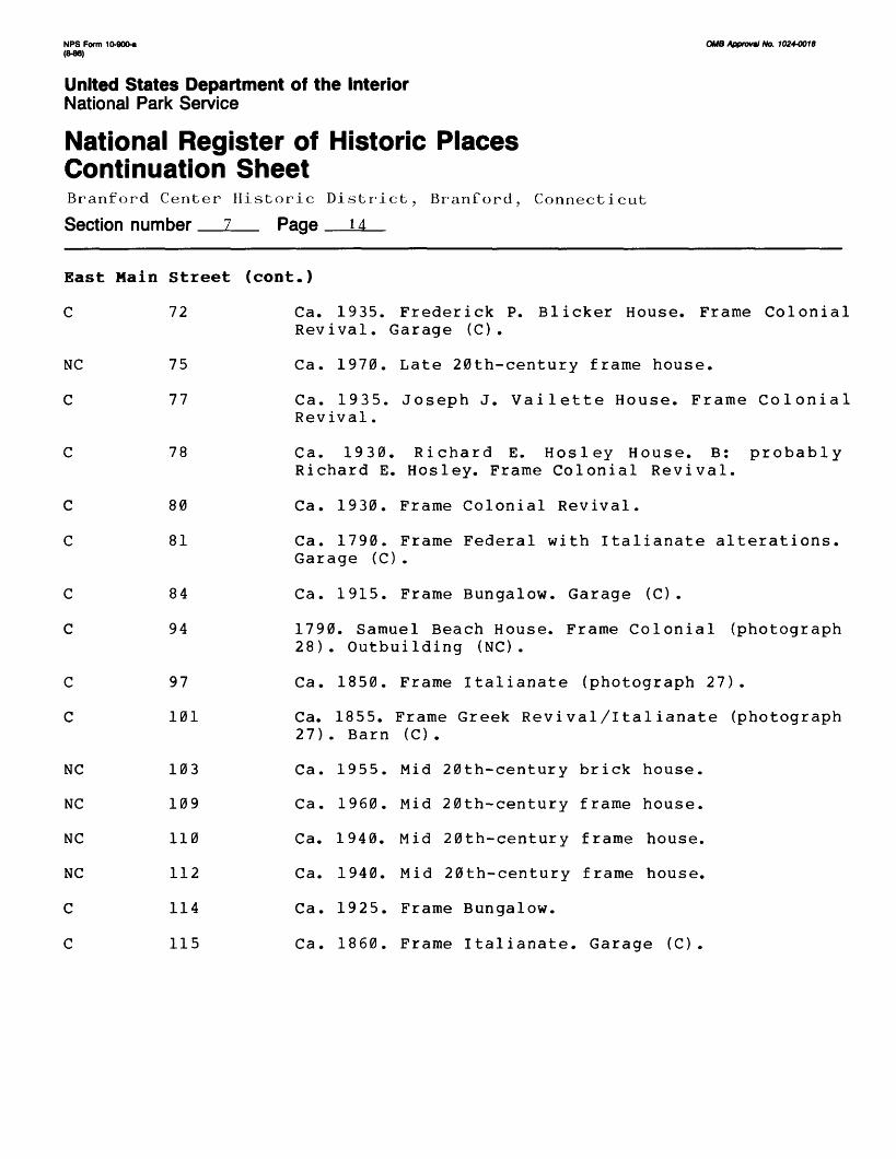
Section number 7 Page 14
East Main Street (cont.)
C 72 Ca. 1935. Frederick P. Blicker House. Frame ColonialRevival. Garage (C).
NC 75 Ca. 1970. Late 20th-century frame house.
C 77 Ca. 1935. Joseph J. Vailette House. Frame ColonialRevival.
C 78 Ca. 1930. Richard E. Hosley House. B: probablyRichard E. Hosley. Frame Colonial Revival.
C 80 Ca. 1930. Frame Colonial Revival.
C 81 Ca. 1790. Frame Federal with Italianate alterations.Garage (C).
C 84 Ca. 1915. Frame Bungalow. Garage (C).
C 94 1790. Samuel Beach House. Frame Colonial (photograph28). Outbuilding (NC).
C 97 Ca. 1850. Frame Italianate (photograph 27).
C 101 Ca. 1855. Frame Greek Revival/Italianate (photograph27). Barn (C).
NC 103 Ca. 1955. Mid 20th-century brick house.
NC 109 Ca. 1960. Mid 20th-century frame house.
NC 110 Ca. 1940. Mid 20th-century frame house.
NC 112 Ca. 1940. Mid 20th-century frame house.
C 114 Ca. 1925. Frame Bungalow.
C 115 Ca. 1860. Frame Italianate. Garage (C).

NPS Form 10-900-a OMB Approval No. 1024-0018 <M6)
United States Department of the InteriorNational Park Service
National Register of Historic Places Continuation SheetBranford Center Historic District, Branford., Connecticut
Section number 7 Page *5
East Main Street (cont.)
C 118 Ca. 1915. Frame Bungalow.
NC 121 Ca. 1960. Mid 20th-century frame house.
NC 123 Ca. 1960. Mid 20th-century frame house.
NC 124 Ca. 1975. Late 20th-century frame house.
C 125 Ca. 1930. Charles L. Squires House. Early 20th- century frame house.
NC 131 Ca. 1960. Mid 20th-century frame house.
C 137 Ca. 1930. Howard Bartholomew House. Frame Bungalow.
C 138 Ca. 1930. Guiseppe Rovaldi House. Early 20th-centuryframe house with enclosed front porch. Garage (NC).
C 143 Ca. 1935. R.N. Baldwin House. Early 20th-centuryframe house.
NC 147 Ca. 1970. Frame Tudor Revival.
C 148 Ca. 1855. Frame Italianate. Garage (C).
C 156 Ca. 1855. Frame Italianate. Barn/garage (C).
C 159 Ca. Ca. 1845. Frame Greek Revival with large rearaddition.
C 160 Ca. 1930. Frame Colonial Revival. Garage (C).
C 165 Ca. 1870. Frame Italianate/Gothic Revival.
NC 167 Ca. 1975. Late 20th-century frame house.
C 172 Ca. 1930. Frame Bungalow with extensive alterations.Garage (C).

NPS Form 10-900-a OMB Apprwml No. 1024-0018 (M6)
United States Department of the InteriorNational Park Service
National Register of Historic Places Continuation SheetBranford Center Historic District, Branford, Connecticut
Section number 7 Page 16
East
c
NC
C
C
C
C
Main Street
174
175
177
179
180
182
(cont.)
Ca.
Ca.
Ca.
1845.
1955.
1930.
Ca. 1915 Revival .
Ca.
Ca.
1890.
1860.
Frame Greek Revival. Garage
Mid 20th-century frame house
Frame Colonial Revival.
(C) .
. Garage (NC) .
(Maple Shade Tourists). Frame Colonial Garage (C) , 2 outbuildings (1 C/l NC) .
Late 19th-century frame house. Barn (C) .
Frame Italianate.
(end East Main Street)
Elm Street
C 131-33 Ca. 1925. John and Ida Michaelson House. Tudor Revi val with stuccoed and half-timbered exterior walls. Garage (C).
NC 140 Ca. 1940. Mid 20th-century house with stuccoedexterior walls.
(end Elm Street)
Harrison Avenue
C 23 Ca. 1895. Lawrence T. McGrail House.Frame Queen Anne.
C 29 1897. Frank T. Bradley House. B: probably C.WHarrington Co. Frame Queen Anne. Barn/garage (C).

NFS Form 10-900-a OMB Approval No. 102+0018 (M6)
United States Department of the InteriorNational Park Service
National Register of Historic Places Continuation SheetBranford Center Historic District, Bran ford, Connecticut
Section number 7 Page 17
Harrison Avenue (cont.)
NC 30 Ca. 1935. (Branford Department of Police Services.Mid 20th-century brick building with extensive ca. 1975 exterior alterations.
C 33 Ca. 1898. Frame Queen Anne with enclosed front porch.Garage (C).
C 37 Ca. 1900. Gustave Erickson House. Frame Queen Anne(photograph 25). Garage (C) .
C 41 Ca. 1900. John E. Dahl House. Frame Queen Anne/Colonial Revival (photograph 25).
C 42 Ca. 1895. Frame Queen Annestyle with additions.Garage (C).
C 45 Ca. 1895. Saint Mary's Hall. Frame Queen Anne/Colonial Revival (photograph 25).
C 46 Ca. 1895. Christian Hegelheimer House. Frame QueenAnne.
C 52 Ca. 1900. Joseph Lee House. Frame Queen Anne.
C 53 Ca. 1900. Michael O'Neil House. Frame Stick/QueenAnne.
C 55 Ca. 1915. Frame Bungalow (photograph 26). Garage (C).
C 56-58 Ca. 1895. Anton E. Kronholm House. Frame Queen Anne.
C 59 Ca. 1910. William Olver House. Frame Queen Anne/Colonial Revival.
C 64 Ca. 1895. Adelard Houde House. Frame Queen Anne.
C 65 1912. Thomas D. Williams Tenant House. Frame Stick.Garage (NC).

NPS Form 10-900* OMB Approval No. 1024-0018 (M6)
United States Department of the InteriorNational Park Service
National Register of Historic Places Continuation SheetBranford Center Historic District, Branford, Connecticut
Section number 7 Page 18
Harrison Avenue (cont.)
C 71 Ca. 1920. Thomas D. Williams House. Frame Bungalow.
C 75 1912. T.D. Williams Tenant House. Frame Queen Anne.
(end Harrison Avenue)
Hillside Avenue
C 10 Ca. 1860. Frame Italianate.
C 16 Ca. 1850. Frame Italianate.
NC 17 Vacant lot.
C 22 Ca. 1850. E. Simpson House.Frame Greek Revival withlater additions. Garage (C).
C 23 Ca. 1900. M.P. Rice Livery Stable and L.A. Fisk HoseCompany Building (East Shore District Health Depart ment). Frame Colonial Revival. Garage (C).
C 28 Ca. 1850. Saint Mary's Rectory. Frame Italianate.Garage (C).
C 33 Ca. 1850. J. King House. Frame Greek Revival/Italianate. Garage (C).
C 36 Ca. 1850. S. and M.S. Grannis House. Frame Italianate,
C 37-39 Ca. 1875. Frame Italianate.
C 41 Ca. 1915. John Wasilesky House. Early 20th-centuryframe cottage with sawtooth gable roof.
(end Hillside Avenue)

NPS Form 10-900-a OMB Approvtl No. 1024-001S
United States Department of the InteriorNational Park Service
National Register of Historic Places Continuation SheetBranford Center Historic District, Branford, Connecticut
Section number 7 Page IQ
Hopson Avenue
C 4
C 8
C 12
C 18
C 22
C
C
C
C
C
C
C
26
32
36-38
37
42
45
48
-39
52
53
Ca. 1895. Carmine Lalla Tenant House. Late 19th- century frame cottage. Outbuilding (NC).
Ca. 1895. James Ravallo House. Late 19th-century frame cottage with steep gables.
Ca. 1895. Ca. 1895. Dominic Sansone Tenant House. Late 19th-century frame cottage.
Ca. 1895. Domninic Sansone Tenant House. Late 19th- century frame cottage with steep gables, rear addi tion.
Ca. 1895. Viola Sansone House. Late 19th-century frame cottage with steep gables.
Ca. 1895. Frame Queen Anne.
Ca. 1895. Victor Wickstrom House. Frame Queen Anne with enclosed front porch. Garage (C).
Ca. 1895. Katherine Wadstrom House. Frame Queen Anne.
Ca. 1895. Frame Queen Anne.
Ca. 1895. Joseph Mattson House. Frame Queen Anne. Garage (C).
Ca. 1895. Gustave Johnson House. Frame Queen Anne.
Ca. 1895. Joseph Frieberg House. Frame Queen Anne with additions.
Ca. 1925. C. Henry Holsenbeck House. Frame Colonial Revival.
Ca. 1890. Swedish Evangelical Lutheran Church. Frame Romanesque church with steepled facade tower.

NPS Form 10-900-a (846)
OMB Approval No. 10244X10
United States Department of the InteriorNational Park Service
National Register of Historic Places Continuation SheetBranford Center Historic District, Brariford, Connecticut
Section number 7 Page 20
Hopson Avenue (cont.)
57
58
c
c
c
c
c
c
61
62-64
65
67
68
73
C 74
C 78
C 79
C 83
(end Hopson Avenue)
Ca. 1885. Frame Queen Anne.
Ca. 1880. Frame Gothic Revival with facade corner tower. Garage (C).
Ca. 1895.Frame Queen Anne.
Ca. 1905. Timothy McCarthy House. Frame Queen Anne.
Ca. 1920. Carl E. Hult House. Frame Colonial Revival.
Ca. 1935. Frame Tudor/Colonial Revival.
Ca. 1880. Frame Queen Anne.
Ca. 1870. Oscar A. Johnson House. Frame Second Empire.
Ca. 1880. Charles A. Hoadley House. Frame Stick/ Queen Anne.
Ca. 1920. Early 20th-century frame house. Garage (C).
Ca. 1885. Swedish Evangelical Lutheran Church Parsonage. Frame Queen Anne. Garage (C).
Ca. 1875. B: attributed to Philander Hopson. Frame late Italianate. Garage (NC).
Indian Neck Avenue
C 4 Ca. 1890. Late 19th-century frame house. Outbuilding (NC) .
(end Indian Neck Avenue
NPS Form 10-900-a OMB Approval No. 1024-0018
United States Department of the InteriorNational Park Service
National Register of Historic Places Continuation SheetBranford Center Historic District, Branford, Connecticut
Section number 7 Page ?i
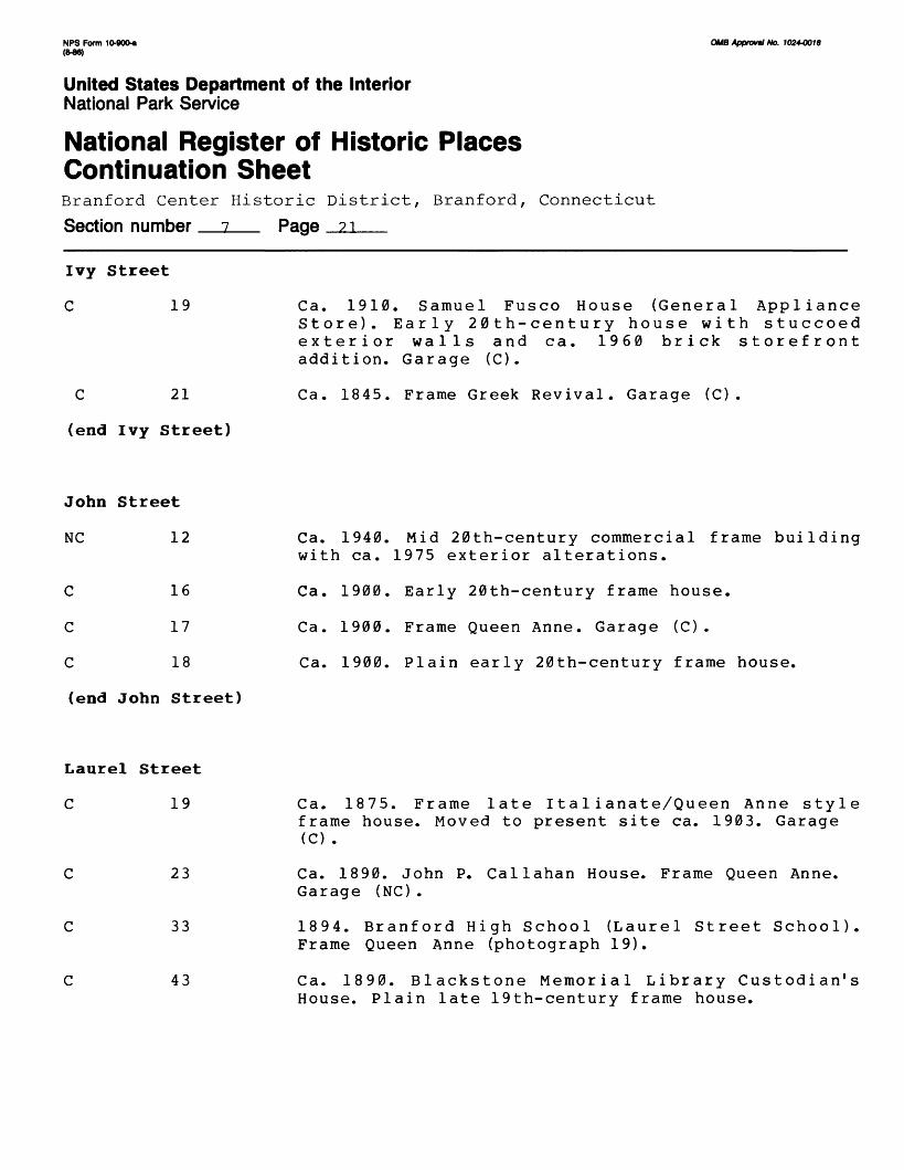
Ivy Street
C 19
C 21
(end Ivy Street)
Ca. 1910. Samuel Fusco House (General Appliance Store). Early 20th-century house with stuccoed exterior walls and ca. 1960 brick storefront addition. Garage (C).
Ca. 1845. Frame Greek Revival. Garage (C).
John Street
NC 12
C
C
C
16
17
18
Ca. 1940. Mid 20th-century commercial frame building with ca. 1975 exterior alterations.
Ca. 1900. Early 20th-century frame house.
Ca. 1900. Frame Queen Anne. Garage (C).
Ca. 1900. Plain early 20th-century frame house.
(end John Street)
Laurel Street
C 19
C 23
C 33
C 43
Ca. 1875. Frame late 11a 1ianate/Queen Anne style frame house. Moved to present site ca. 1903. Garage (C) .
Ca. 1890. John P. Callahan House. Frame Queen Anne. Garage (NC).
1894. Branford High School (Laurel Street School). Frame Queen Anne (photograph 19).
Ca. 1890. Blackstone Memorial Library Custodian's House. Plain late 19th-century frame house.

NFS Form 10-900* (M6)
OW8 Approval No. 1024-0018
United States Department of the InteriorNational Park Service
National Register of Historic Places Continuation SheetBranford Center Historic District, Branford, Connecticut
Section number 7 Page 22
Laurel Street (cont.)
NC 47 Ca. 1950. Mid 20th-century frame house.
C 51 Ca. 1915. Joseph B. Smith House. Frame Bungalow.
(end Laurel Street)
Main Street
C 554-60
C 562-66
C 567-75
C 576
C 584-86
C 606
C 611-27
618
629-45
Ca. 1925. Early 20th-century brick commercial buiIding.
Ca. 1930. Early 20th-century brick commercial building.
Ca. 1850. Frame Italianate converted for commercial use ca. 1950.
Ca. 1890. Late 19th-century frame commercial building. Carriage House (C).
Ca. 1890. Frame Queen Anne with ca. 1920 single-story commercial front.
Ca. 1880. Malleable Iron Fittings Company Tenant House. Plain late 19th-century frame structure.
Ca. 1900. Malleable Iron Fittings Company Apartment Building. Tudor Revival with brick, stucco, and wooden exterior wall finishes. Detached period guest house/garage on northwest corner of lot. Carriage House (C).
Ca. 1925. Central Garage (Traders). Early 20th- century brick commercial building.
Ca. 1865. T.J. Smith Tin Shop. Frame Italianate.

NFS Form 10-90G-a OW8 Approval No. 10244018
United States Department of the InteriorNational Park Service
National Register of Historic Places Continuation SheetBranford Center Historic District, Branford, Connecticut
Section number 7 Page 23
Main Street (cont.)
C 634
C 642
C 647-55
NC
C
C
NC
650
657-97
668
674
678
698
700-12
707
730
Ca. 1920. Sachlos-Sinkievich House. Frame Queen Anne/ Colonial Revival. Garage (C).
Ca. 1875. Michael Sinkievich Tenant House. Plain late 19th-century frame house.
Ca. 1890. Carl F. Mory House and Bakery. Frame Queen Anne with enclosed second-story front porch. Garage (NC) .
Ca. 1910. (Dziura Chiropractic Center). Early 20th- century frame building with extensive ca. 1975 commercial alterations.
Ca. 1850. CookHammer House. Frame Italianate with flanking ca. 1970 rear additions.
Ca. 1910. Ignatz Ramon House. Frame Queen Anne. Garage (C).
Ca. 1890. Frame Queen Anne with enclosed front porch.
Ca. 1930. Julius Zdanowicz House. Frame Colonial Revival with stuccoed exterior wall surfaces.
Ca. 1970. (Richard W. Squeri Agency). Late 20th- century brick commercial building. Outbuilding (NC).
Ca. 1734. Parish Gillett House (Carman Real Estate). Frame Colonial with Queen Anne exterior modifica tions (photograph 21). Barn/garage (C).
1792. Jason Atwater House (Beazley Company Realtors). Frame Colonial with Colonial Revival front porch.
1893.LesterNicho1s House (Patterson AndBrencher, et. al). A: William H. Alien. Frame Georgian Revival (photograph 20). Carriage House (C).
NPS Form 10-900-a OMB Approval No. 10244018
United States Department of the InteriorNational Park Service
National Register of Historic Places Continuation SheetBranford Center Historic District, Branford, Connecticut
Section number 7 Page 24
Main Street (cont.)
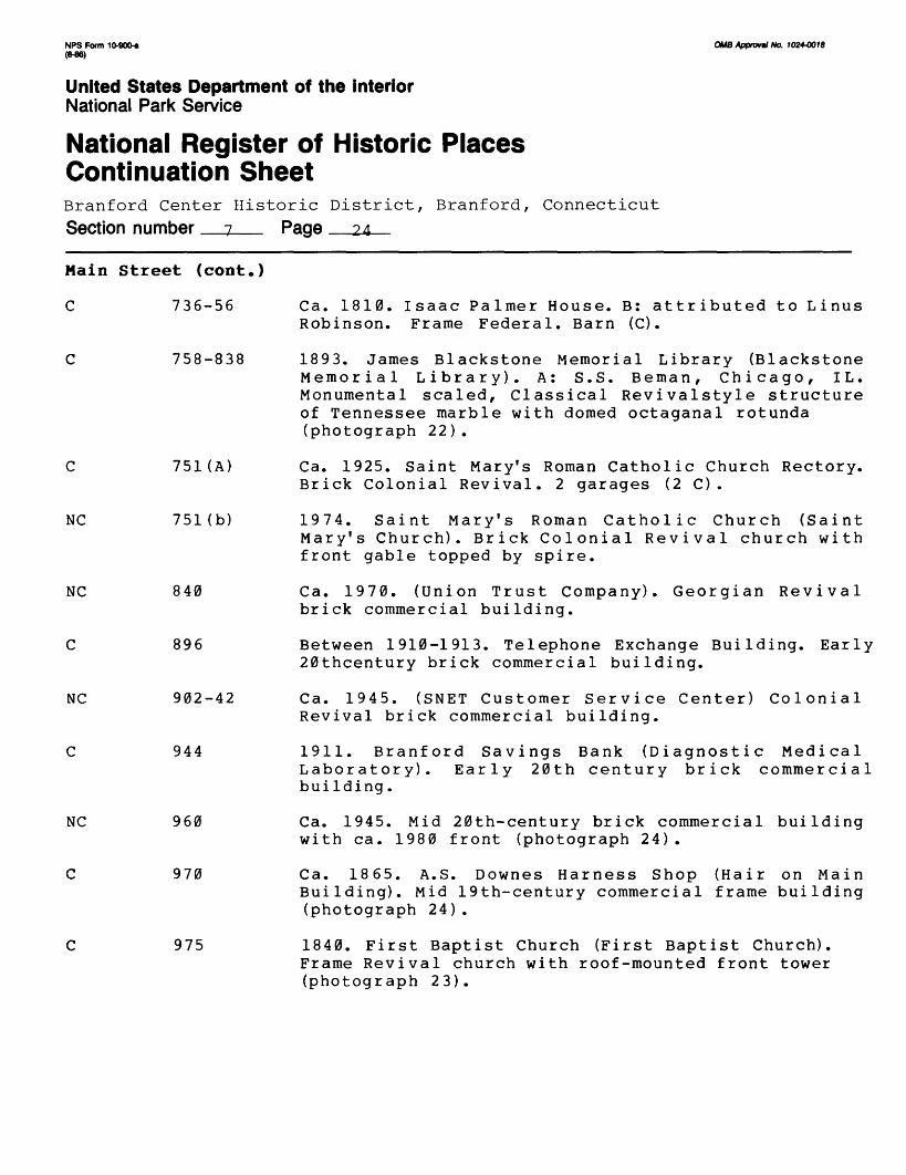
C 736-56 Ca. 1810. Isaac Palmer House. B: attributed to LinusRobinson. Frame Federal. Barn (C) .
C 758-838 1893. James Blackstone Memorial Library (BlackstoneMemorial Library). A: S.S. Beman, Chicago, IL. Monumental scaled, Classical Revivalstyle structure of Tennessee marble with domed octaganal rotunda (photograph 22) .
C 751 (A) Ca. 1925. Saint Mary's Roman Catholic Church Rectory.Brick Colonial Revival. 2 garages (2 C) .
NC 751(b) 1974. Saint Mary's Roman Catholic Church (SaintMary's Church). Brick Colonial Revival church with front gable topped by spire.
NC 840 Ca. 1970. (Union Trust Company). Georgian Revivalbrick commercial building.
C 896 Between 1910-1913. Telephone Exchange Building. Early20thcentury brick commercial building.
NC 902-42 Ca. 1945. (SNET Customer Service Center) ColonialRevival brick commercial building.
C 944 1911. Branford Savings Bank (Diagnostic MedicalLaboratory). Early 20th century brick commercial building.
NC 960 Ca. 1945. Mid 20th-century brick commercial buildingwith ca. 1980 front (photograph 24) .
C 970 Ca. 1865. A.S. Downes Harness Shop (Hair on MainBuilding). Mid 19th-century commercial frame building (photograph 24).
C 975 1840. First Baptist Church (First Baptist Church).Frame Revival church with roof-mounted front tower (photograph 23) .

NPS Form 10-900-a (M6)
OMB Approval No. 1024-0018
United States Department of the InteriorNational Park Service
National Register of Historic Places Continuation SheetBranford Center Historic District, Branford, Connecticut
Section number _z__ Page ?R
Main Street (cont.)
C 978-86
C 988-1006
NC
NC
NC
NC
1008
1009
1012-14
1018
1019
1024
1032-64
1897. Griswold Block (Castellon's Bakery). Frame Queen Anne commercial building (photograph 24).
Ca. 1900. Wilford Block 19th/early 20th-century mid 20th-century front.
(Page's Sport Shop). Late commerical structure with
1885. Charles F. Bradley General Store (Horowitz Building). Original frame portion of structure almost wholly obscured by unsympathetic Ca. 1960 addition.
1843. First Congregational Church (First Congrega tional Church). A: attributed to Sidney M. Stone. Brick and stone Greek Revival with late-19th century Italianate front addition featuring corner towers, wooden belfry/steeple atop eastern front tower.
Ca. 1975 (Towne Pharmacy/Wards). Late 20th-century concrete-block commercial building with wood and glass front.
Ca. 1940. (Branford Stationary/Carr Travel). Mid 20th-century brick commercial with ca. 1965 front.
1857. Branford Town Hall and Court House.A: attri buted to Henry Austin. Greek Revival with stuccoed exterior wall surfaces, early 20th-century columned front portico, late 20th-century rear addition (photograph 15).
Ca. 1975. (Branford Card and Book Shop/0'Donnel 1 Travel). Late 20th-century commercial frame building with large frame addition under construction.
Ca. 1900. Toole Building. Brick and cast-stone Tudor Revival commercial structure (photograph 14).

NFS Form 10-900-a (846)
OMB Approval No. 1024-0016
United States Department of the InteriorNational Park Service
National Register of Historic Places Continuation SheetBranford Center Historic District, Branford, Connecticut
Section number 7 Page __26
Main Street (cont.)
C 1070
C 1074-82
C 1084-92
C 1094
NC
C
C
C
NC
1106
1109
1111
1116-22
1136-40
1143
1145
1155
1912. Post Office Block (Chez Bach Restaurant). Brick Classical Revival commercial building (photograph 13).
1925. Suval Block (Fleischman 1 s). Brick late Gothic Revivial with stuccoed front wall (photograph 13).
G.A.R. Hammer Building (Collins and Freeman). Early 20th-century brick commercial structure with ca. 1960 corrugated aluminum front wall panels (photograph 13).
1869. Eli F. Rogers Building (Sherwin Williams). Mid- 19th-century commercial frame building with Ca. 1928 Colonial Revival front (photograph 13).
Ca. 1975. (Cafe Flora). Late 20th-century concrete- block commercial building.
1851. Trinity Episcopal Church (Trinity Episcopal Church). A: attributed to Henry Austin. Frame Gothic Revival church with flushboarded exterior wall sur faces, central front tower topped by steeple.
U.S. Post Office. Brick and cut-stone Georgian Revival
Ca. 1855. L. Staples Building (Ray Jeanne 1 s/Josephine 1 s Dress Shop). Mid 19th-century commercial frame structure.
Ca. 1880. Late 19thcentury commercial frame building with ca. 1925 front.
Ca. 1845. Frame Greek Revival with additions.
Ca. 1970. (Branford Building Supplies). Late 20th- century commercial building.
Ca. 1870. M.P. Rice House (Branford Building Supplies). Frame Second Empire.

NPS Form 10-900-a OMB Approval No. 1024-001B
United States Department of the InteriorNational Park Service
National Register of Historic Places Continuation SheetBranford Center Historic District, Branford, Connecticut
Section number i Page 27
Main Street (cont.)
NC 1157(a)
NC
NC
1157(b)
1156
1159-61
1168
1180
1188
1185-95
1199
Ca. 1970. (Branford Building Supplies). Late 20th- century commercial building.
Ca. 1970. (Branford Building Supplies). Late 20th century commercial building.
Ca. 1850. O.D. Squire House. Frame Greek Revival/ Italianate.
Ca. 1850. First Congregational Church Parsonage (Benny's Pizza/Singer Products). Frame Italianate with mid 20th-century commercial front addition.
Ca. 1940. Mid 20th-century brick commercial building with ca, 1965 corrugated aluminum and glass front.
Ca. 1885. Branford Lock Works (Harold's Sandwich Shop). Brick late-Italianate commercial.
Ca. 1930. (Empire Kitchens). Early 20th-century brick and concrete-block commercial building.
Ca. 1865. Mid 19th-century frame house with Colonial Revival front doorway.
Ca. 1845. (Nina's Restaurant). Frame Greek Revival with mid 20th-century commercial alterations.
NC
NC
1203
1207
1208
Ca. 1975. (Branford Shoe Repair). Late 20th-century commercial frame building.
Ca. 1965. (Branford Self-Service Laundromat). Late 20th-century concrete-block commercial building.
Ca. 1900. Branford Lock Works. Turn-of-the-century brick industrial structure with gable roof topped by clerestory monitor.
NPS Form 10-900-a (M6)
OW8 Apprm«/ Ato. 1024-0018
United States Department of the InteriorNational Park Service
National Register of Historic Places Continuation SheetBranford Center Historic District, Branford, Connecticut
Section number 7 Page ?«
Main Street (cont.)
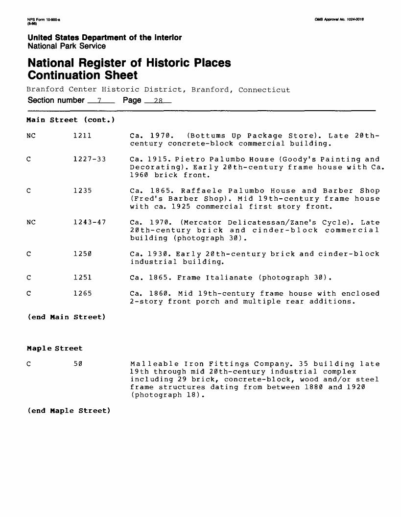
NC 1211
C 1227-33
C 1235
NC 1243-47
1250
1251
1265
Ca. 1970. (Bottums Up Package Store). Late 20th- century concrete-block commercial building.
Ca. 1915. Pietro Palumbo House (Goody's Painting and Decorating). Early 20th-century frame house with Ca, 1960 brick front.
Ca. 1865. Raffaele Palumbo House and Barber Shop (Fred's Barber Shop). Mid 19th-century frame house with ca. 1925 commercial first story front.
Ca. 1970. (Mercator Delicatessan/Zane's Cycle). Late 20th-century brick and cinder-block commercial building (photograph 30).
Ca. 1930. Early 20th-century brick and cinder-block industrial building.
Ca. 1865. Frame Italianate (photograph 30).
Ca. 1860. Mid 19th-century frame house with enclosed 2-story front porch and multiple rear additions.
(end Main Street)
Maple Street
C 50 Malleable Iron Fittings Company. 35 building late 19th through mid 20th-century industrial complex including 29 brick, concrete-block, wood and/or steel frame structures dating from between 1880 and 1920 (photograph 18).
(end Maple Street)

NPS Form 10-900-a (M6)
OMB Approval No. 10244018
United States Department of the InteriorNational Park Service
National Register of Historic Places Continuation SheetBranford Center Historic District, Branford, Connecticut
Section number 7 Page 29
Meadow Street
NC 94
C 98
C 188
C 196
C 200
NC
C
C
C
206
270(a)
270(b)
270(c)
Ca. 1945. Small brick industrial building.
Ca. 1890. Luigi Sansone House. Late 19th-century frame house. Outbuilding (NC).
Ca. 1900. S. Ball House. Early 20th-century frame house.
Ca. 1900. Joseph Nygard House. Late 19th-century frame house. Garage (NC).
Ca. 1900. Oscar Rank House. Late 19th/early 20th- century frame house.
Ca. 1945. Mid-20th century wood and concrete-block commercial structure.
Ca. 1910. Early 20th-century frame barn.
Ca. 1910. Early 20th-century frame barn.
Ca. 1910. Early 20th century frame building.
C 276 Ca. 1910. Early-20th century frame building.
(end Meadow Street)
Monroe Street
C 11
C 14
C 16
Ca. 1860. Mid 19th-century frame house.
Ca. 1860. Mid 19th-century frame house.
Ca. 1860. Mid 19th-century frame house.

NPS Form 10-900^ OMB Approval No. 1024-0018 <M6)
United States Department of the InteriorNational Park Service
National Register of Historic Places Continuation SheetBranford Center Historic District, Branford, ConnecticutSection number 7 Page 30
Nonroe
C
C
C
C
C
C
NC
NC
C
NC
C
NC
C
C
Street (cont.)
17 Ca.
18 Ca.
20 Ca.
19-21 Ca.
23 Ca.
26 Ca.
28 Ca.
31
25
36
35
42
45
46
1875.
1950.
1885.
1860.
1915.
1860.
1940.
Mid 19th-century frame house. Garage (NC) .
Mid 20th-century frame house.
Frame Queen Anne.
Mid 19th-century frame house.
Early 20th-century frame house.
Frame Greek Revival.
Mid 20th-century frame house.
Ca. 1850. Frame Greek Reviva alterations.
Ca. (NC)
Ca.
Ca.
Ca.
Ca.
Ca.
1905.
1970.
1890.
1970.
1850.
1870.
Earl
Late
Late
Late
Mid
y 20th-century
20th-century
19th-century
20th-century
1 with
frame
frame
frame
frame
extensive ca. 1970
house. Outbuilding
house.
house. Garage (C) .
house.
19th-century frame house.
Late 19th century frame house. Garage (C) ,outbuilding (NC).
55 Saint Mary's Roman Catholic Cemetery. Containsgravesites with marble markers dating from mid-19th century
(end Monroe Street)
NPS Form 10-90O-* (M6)
OMB Approval No. 1024-0018
United States Department of the InteriorNational Park Service
National Register of Historic Places Continuation SheetBranford Center Historic District, Branford, Connecticut
Section number 7 Page 31
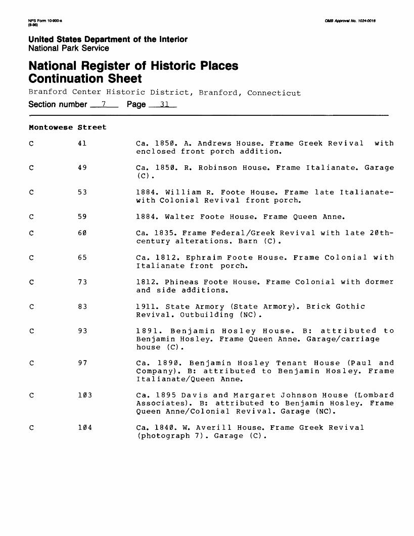
Montowese Street
C 41
C 49
C 53
59
60
65
73
83
93
97
103
104
Ca. 1850. A. Andrews House. Frame Greek Revival with enclosed front porch addition.
Ca. 1850. R. Robinson House. Frame Italianate. Garage (C) .
1884. William R. Foote House. Frame late Italianate- with Colonial Revival front porch.
1884. Walter Foote House. Frame Queen Anne.
Ca. 1835. Frame Federal/Greek Revival with late 20th- century alterations. Barn (C).
Ca. 1812. Ephraim Foote House. Frame Colonial with Italianate front porch.
1812. Phineas Foote House. Frame Colonial with dormer and side additions.
1911. State Armory (State Armory). Brick Gothic Revival. Outbuilding (NC).
1891. Benjamin Hosley House. B: attributed to Benjamin Hosley. Frame Queen Anne. Garage/carriage house (C).
Ca. 1890. Benjamin Hosley Tenant House (Paul and Company). B: attributed to Benjamin Hosley. Frame Italianate/Queen Anne.
Ca. 1895 Davis and Margaret Johnson House (Lombard Associates). B: attributed to Benjamin Hosley. Frame Queen Anne/Colonial Revival. Garage (NC).
Ca. 1840. W. Averill House. Frame Greek Revival (photograph 7). Garage (C) .

NPS Form 10-9004 QMB Approval No. 1024-0018 (M6)
United States Department of the InteriorNational Park Service
National Register of Historic Places Continuation SheetBranford Center Historic District, Branford, Connecticut
Section number 7 Page 32
Montowese Street (cont.)
C 106 Ca. 1920. Frame Colonial Revival (photograph 7).
C 107-09 1825. Daniel Averill House (Branford Manor). B:attributed to Daniel Averill, II. Unusually congigured frame Federal double house with later additions. Garage (C).
C 112 1854. Saint Mary's Roman Catholic Church (K & GGraphics). Mid 19th-century frame building with ca. 1920 commercial front addition (photograph 7). Garage (C) .
C 116(a) 1735. Philemon Robbins House. Frame Colonial withColonial Revival alterations (photograph 7).
NC 116(b) Ca. 1925. (Shoreline Stove and Chimney Works). Early20th-century garage heavily modified ca. 1950 and ca. 1975 for commercial use.
C 119 Ca. 1895. Henry W. Averill House (ConnecticutNational Bank). Frame Queen Anne with Colonial Revival alterations. Outbuilding (NC).
C 125 Ca. 1840. S. Averill House (Village Realty). Mid19th- century frame house with ca. 1965 Colonial Revival commercial front and additions. Garage (NC).
C 130 Ca. 1830. John Foote House. Frame Greek Revival(photograph 8). Barn/carriage house (C).
C 131 Ca. 1840. F.S. Isbell House. Frame Greek Revivalwith Italianate front porch (photograph 9). Garage (C) .
C 134 1840. Trinity Episcopal Church Parsonage. Frame GreekRevival (photograph 8).

NPS Form 10-90041 ((HJ6)
CMS Approval No. 1024-0018
United States Department of the InteriorNational Park Service
National Register of Historic Places Continuation SheetBranford Center Historic District, Branford, ConnecticutSection number 7 Page ??
Montowese Street (cont.)
c
c
NC
C
C
C
NC
135
146
147
152
158
162
168 (a)
NC
168(b)
e side opposite S. Main St.
nw corner of S. Main St.
171-73
Ca. 1935. Frame Colonial Revival. Garage (C) .
Ca. 1890. W. Lynde Lay House. Frame Queen Anne.
Ca. 1975. Late 20th-century brick commercial building.
Ca. 1890. Frame Italianate/Queen Anne. Garage (C).
Ca. 1850. G. Wilford House. Mid 19th-century frame house. Garage (C).
1925. George Golem House. Frame Bungalow.
Ca. 1980. (Suntech of Connecticut). Late 20th-century frame commercial building with greenhouse front.
Ca f 1910. Richard Maddern House. Frame Queen Anne. Period barn/workshed on rear of lot. Barn/garage (C).
Center Cemetery. Branford's earliest burial ground. Includes granite, brownstone, slate and marble markers dating from the 17th through 20th centuries and one ca. 1970 brick storage building (NC).
1820. The Academy. Frame Federal with belfry topped by cupola above front gable. Moved to present site from original site approximately 50 yards to west along north side of South Main Street in 1970s (photograph 11).
Ca. 1980. (Devlin Brown Realty). Late 20th-century commercial frame building.
175 Ca. 1850. R. Bartholemew House. Frame Italianate.

NPS Form 10-900-a OMB Approvtl No. 1024-0018 (8-86)
United States Department of the InteriorNational Park Service
National Register of Historic Places Continuation SheetBranford Center Historic District, Branford, Connecticut
Section number 7 Page 34
Montowese Street (cont.)
C 177-83 Ca. 1850. J. Blackstone House (Martin Bohan,Jewler/Swish) . Mid 19th-century frame house. 19th- century barn converted for commercial use on rear of lot (C).
C 187 Ca. 1900. Dr. Arthur S. McQueen House. Frame QueenAnne.
C 191 Ca. 1890. Howard M. Williams House. Frame lateItalianate/Queen Anne (photograph 10).
C 195 Ca. 1900. Frame Colonial Revival with exterioralterations (photograph 10). Garage (C).
C 197 Ca. 1870. Mid 19th-century frame house (photograph10) .
C 203 Ca. 1890. Alfred L. Hibbard House. Frame Queen Anne(photograph 10).
C 209 Ca. 1895. Andrew Coyle House (Kennedy Perkins). FrameQueen Anne with ca. 1960 2-story commercial front (photograph 10). Garage (C) , outbuilding (NC).
C 211 Ca. 1875. Richard Bradley House. B: probably RichardBradley. Frame Italianate (photograph 10).
C 217 Ca. 1875. Henry Morton House. Frame Italianate(photograph 10).
C 221 Ca. 1930. Connecticut Light and Power CompanyBuilding (Branford Block). Cast-stone and Brick Art Deco (photograph 12).
C 223 Ca. 1900. Frame Queen Anne.
NC 225 Ca. 1960. Mid 20th-century brick and concrete-blockcommercial building.

NFS Form 10-90O« (WO)
OMB Approval No. 1024-0018
United States Department of the InteriorNational Park Service
National Register of Historic Places Continuation SheetBranford Center Historic District, Branford, ConnecticutSection number 7 Page 35
Montowese Street (cont.)
C 229
C
C
233
239
Ca. 1830. George Page House. Frame Federal with alterations.
Ca. 1920. Frame Bungalow.
Ca. 1925. Louis Bruno Meat Market. (Virgina Alan Shop). B: atributed to Frank Sullivan of East Haven. Brick early 20th-century commercial building.
(end Nontowese Street)
Park Place
NC 12
NC 18
NC 20
NC 27
C 28
C 29
C 32
C 36
C 42
C 46
(end Park Place)
Ca. 1945. Brick Colonial Revival.
Vacant lot.
Ca. 1945. Brick Colonial Revival.
Ca. 1955. Mid 20th-century brick and frame commercial buiIding.
Ca. 1895. Frame Queen Anne. Garage (C).
Ca. 1930. Harry Ferguson House. Early 20th-century frame house.
Ca. 1915. Early 20th-century frame house with enclosed front porch. Garage (NC).
Ca. 1915. Early 20th-century frame house with screened-in front porch. Garage (C).
Ca. 1915. Early 20th-century frame house with enclosed front porch. Garage (C).
Ca. 1920. Early 20th-century frame house.

NPS Form 10-9004 OMB Approval No. 1024-0018 (M6)
United States Department of the InteriorNational Park Service
National Register of Historic Places Continuation SheetBranford Center Historic District, Branford, Connecticut
Section number 7 Page 36
Prospect Street
NC 16 Ca. 1890. Frame Queen Anne with extensive ca. 1975exterior alterations. Garage (C).
NC 22 Ca. 1890. Frame Queen Anne with extensive ca. 1975exterior alterations.
C 28 Ca. 1905. William J. McKee House. Early 20th-centuryframe house.
C 30 Ca. 1905. Hugh McGowan House. Frame Queen Anne.Garage (C).
C 50 Ca. 1870. Late 19th-century frame house.
(end Prospect Street)
Rice Terrace
C 13 Ca. 1845. Frame Greek Revival with 20th-centuryadditions.
NC 14 Ca. 1975. (Robert N. Giamo Housing). Steelframed,late 20th-century apartment building with stuccoed exterior walls.
NC 15 Ca. 1980. Late 20th-century frame house.
C 17 Ca. 1850. Mid 19th-century frame house.
NC 21 Ca. 1975. (Robert N. Giamo Housing). Steel-framed,late 20th-century apartment building with stuccoed exterior.
(end Rice Terrace)

NFS Form 10-900-a (M6)
OMB Appro**! No. 1024-0018
United States Department of the InteriorNational Park Service
National Register of Historic Places Continuation SheetBranford Center Historic District, Branford, ConnecticutSection number 7 Page 37
Rogers Street
C 8
C
C
NC
13-15
18
29-31
C
C
C
C
C
33
34
37
39
40
41
43
52
55
58
Ca. 1875. Charles Gladwin House. Late 19th-century frame with enclosed front porch.
Ca. 1860. Mid 19th-century frame house.
Ca. 1880. Lynde W. Rowland House. B: attributed to Lynde W. Rowland of Branford. Frame Stick (photograph 17) .
Ca. 1975. (Saint Stephen's A.M.E. Zion Church). Late 20th-century brick church.
Ca. 1855. John E. Erickson House. Frame Italianate.
Ca. 1860. David S. Adams House. Frame Italianate.
Ca. 1900. Sundquist-Francis House. Frame Queen Anne.
Ca. 1885. J. Launsberry House. Frame late Italianate.
Ca. 1925. Harold G. Tousey House. Tudor Revival with stuccoed and half-timbered exterior. Garage (C).
Ca. 1885. John A.Nelson House.Late 19th-century frame house with later additions.
Ca. 1900. Ray C. Enquist House. Frame Queen Anne.
Ca. 1850. Samuel Pond House. Frame Greek Revival with later additions. Garage/barn (C).
Ca. 1870. Frame Italianate (photograph 16).
Ca. 1895. Dolph-Knowlton House. Frame Queen Anne. Garage (NC).
61-63 Ca. 1875. Frame Italianate (photograph 16).

NPS Form 10-900* (M6)
OMB Approval No. 1024-0018
United States Department of the InteriorNational Park Service
National Register of Historic Places Continuation SheetBranford Center Historic District, Branford, Connecticut
Section number 7 Page T«
Rogers Street (cont.)
62
NC 65
69
75
81
85
91
92
95
(end Rogers Street)
Ca. 1890. Hammer-Thatcher House. Frame Queen Anne/Stick. Garage (C).
Ca. 1970. Late 20th-century frame house (photograph 16).
Ca. 1895. Irwin W. Morton House. Frame Queen Anne (photograph 16). Barn (C).
Ca. 1870. Frame Italianate with Queen Anne front porch.
Ca. 1895. Charles Peterson House. Frame Queen Anne with enclosed 2-story front porch. Carriage house (C) .
Ca. 1880. Frame Queen Anne with enclosed front porch. Barn/outbuilding (C).
Ca. 1895. Patrick McGowan House. Frame Queen Anne with front corner turret. Garage (C).
Ca. 1900. Valdemar T. Hammer House (Knights of Columbus Hall). Colonial/Tudor Revival with stuccoed exterior walls.
Ca. 1860. Frame Italianate.
Rose Street
NC 12
(end Rose Street)
Ca. 1950. Concrete-block commercial garage.

NFS Form 10-900-a (846)
OMB Approval No. 1024-0018
United States Department of the InteriorNational Park Service
National Register of Historic Places Continuation SheetBranford Center Historic District, Branford, ConnecticutSection number i Page ^Q
South Main Street
NC 1-3
NC 5
NC
NC
NC
C
7
17-29
45
53
57
65
69
75
85-87
91-93
Ca. 1970. (First Federal Bank). Brick Georgian Revival.
Ca. 1975. (South Main Street Professional Center). Brick Colonial Revival.
Ca. 1975. (Law Offices). Brick Colonial Revival.
Ca. 1960. (Branford Theatre Building). Mid 20th- century brick and stone veneer commercial building.
Ca. 1980. (Branford Savings Bank). Brick Post-Modern.
Ca. 1895. Earl A. Barker House. Frame Queen Anne with screened-in wraparound front porch. Garage (C).
Ca. 1890. Sidney V. Osborn House. Frame Queen Anne with side addition.
Ca. 1870. Benjamin Bunnell House. Frame Second Empire (photograph 1) .
Between 1722 and 1753. Martin Page House. Frame Georgian with later additions. Moved to site from the corner of Eades and South Main Streets by Samuel Griswold in 1928.
1889. First Congregational Church Parsonage. Frame Queen Anne/Colonial Revival.
1879. Gaylord's Opera House. Late 19th-century frame building with Colonial Revival front porches.
Ca. 1850. Norton-Gaylord House. Frame Italianate with Queen Anne/Colonial Revival alterations. Carriage house (C).

NFS Form 10-900* OMB Approval No. 1024-0018 (M6)
United States Department of the InteriorNational Park Service
National Register of Historic Places Continuation SheetBranford Center Historic District, Branford, Connecticut
Section number 7 Page 40
South Main Street (cont.)
C 101 Ca. 1895. Frame Queen Anne.
C 107 1851. Wi1 ford-Hitchcock House. Frame Greek Revivalwith large Colonial Revival side addition. Outbuilding (NC).
C 117 Ca. 1885. Frame Queen Anne. Outbuilding (NC).
NC 125 Parking Lot.
(end South Main Street)
Svea Street
C 2 Ca. 1895. John Estrom House. Late 19th-century framehouse.
NC 4 Late 20th-century frame garage.
C 6 Ca. 1870. Frame Italianate with enclosed 2-storyfront porch. Garage (C).
C 8 Ca. 1880. Svea Hall. Mid 19th-century frame building.
C 10 Ca. 1880. Late 19th-century frame house with enclosed2-story front porch.
C 12 Ca. 1910. Early 20th-century frame house withenclosed 2-story front porch.
C 14 Ca. 1915. Charles I. Estrom House. Early 20th-centuryframe house.
(end Svea Street)

NFS Form 10-900-a 0MB Approval No. 1024-0018 (8-86)
United States Department of the InteriorNational Park Service
National Register of Historic Places Continuation SheetBranford Center Historic District, Branford, Connecticut
Section number 7 Page 41
Wilford Avenue
C 9 Ca. 1890. Henry W. Hubbard House. Frame Queen Anne.
C 10 Ca. 1885. Thomas M. Bray House. Frame Queen Anne.
C 14 Ca. 1895. Arthur E. Bellis House. Frame QueenAnne/Colonial Revival (photograph 3). Garage (C).
C 15 1904. John H. Morton House. Frame Queen Anne/ColonialRevival.
C 17 Ca. 1895. Southern New England Telephone CompanyExchange Building and Operator's House. Frame Colonial Revival. Garage (C).
C 18 Ca. 1895. Frame Queen Anne (photograph 3). Garage(C) .
C 23 Ca. 1880. George S. Pond House. Frame Italianate(photograph 4). Garage (NC).
C 24 Ca. 1890. Frame Queen Anne (photograph 3). Garage(C) .
C 27 Ca. 1900. George L. Sheldon House. Frame QueenAnne (photograph 5). Carriage house (C).
C 28 Ca. 1910. J. Arthur Bradley House. Frame QueenAnne/Colonial Revival (photograph 3). Garage (NC).
C 33 Ca. 1910. T. Parker Preble House. Frame ColonialRevival (photograph 5). Garage (C).
C 34 1913. Charles F. Bradley House. Frame ColonialRevival. Garage (C).
C 37 Ca. 1890. Charles W. Covert House. Frame Queen Annewith ca. 1970 Colonial Revival front doorway. Garage (NC) .

NPS Form 10-900-a OMB Approval No. 1024-0018 (M6)
United States Department of the InteriorNational Park Service
National Register of Historic Places Continuation SheetBranford Center Historic District, Branford, Connecticut
Section number 7 Page 42
Wilford Avenue (cont.)
C 38 Ca. 1890. John W. Hart House. Frame Queen Anne.
NC 43 Ca. 1955. Mid 20th-century brick house. Garage (NC).
C 42-44 Ca. 1890. Frame Queen Anne. Garage (C).
C 46-48 Ca. 1920. Batters1ey-Murray House. Frame ColonialRevival.
C 49 Ca. 1935. Frame Colonial Revival. Garage (NC)
(end Wilford Avenue)

8. Significance
Periodprehistoric1400-1499
...__ 1500-1599_.._ 1600-1699
X 1700-1799L 1800-1899
_JL 1900-
Criteria A
Areas of Significance Check and justify belowarcheology-prehistoricarcheology-historic
_ agricultureX architecture
_ artcommercecommunications
& C.
community planningconservationeconomicseducationengineeringexploration/settlementindustryinvention
landscape architecture_.. law
literature..... military
...._ musicphilosophy
. politics/government
religionscience
. .__ sculpture._ social/
humanitarian.__._ theater
transportationother (specify)
Specific dates See Item # 7 Builder/Architect See Item # 7
Statement of Significance (in one paragraph)
The Branford Center Historic District has two principal areas of signifi cance. First, the district's buildings, streets, waterfront, and open spaces combine to form a coherent and cohesive example of an 18th-century Connecticut farming/maritime village which developed, over the course of the 19th century, into the core of a small, coastal town dominated by an industrial-based economy, (criterion A) Second, the district encompasses a large and relatively well-preserved contiguous collection of structures representing an unusually broad range of functions and popular architec tural modes dating from the 18th through early 20th centuries (criterion C) .
Historical and Architectural Summary
The Branford Center Historic District encompasses the bulk of the original core-settlement area of Branford. Originally part of the New Haven Colony (1639-1666), the Town of Branford was laid out on land purchased from Montowese, son of Sowheog, a sachem of the Mattabeseck Indians. At that time, the area was known by its Indian name, Totoket ("the Land of the Tidal River"). The first English settlers recruited by the New Haven Colony to move to Totoket were a group of 40 families from Wether sf i eld led by William Swaine and the Reverend John Sherman. They are believed to have arrived in the spring of 1644, some travelling by water down the Connecti cut River and others coming overland, driving their domestic animals before them. They were joined the following year by settlers from New Haven under the leadership of the Reverend Abraham Pierson, who replaced John Sherman as the new community's pastor.
The choice of Totoket for settlement proved fruitful. The land was produc tive and the Branford River estuary proved to be the best harbor between New Haven and New London. Shortly after its initial settlement, the name was changed to Branford, presumably derived from Brentford, the Thames River near London in which some of the initial born.
town's a town on
settlers had been
The first setback to the town's growth came soon after the unification of the New Haven and Connecticut Colonies under the colonial charter granted by King Charles II in 1666. Displeased with the new charter's provisions for broadened suffrage, in 1667 Branford's minister, Abraham Pierson, led a substantial number of families to New Jersey, where they subsequently settled the area known today as Newark. Enough of Branford's population remained, however, to ensure the town's survival and eventual growth. More extensive portions of the community's fertile land were soon cleared for farming, while the town's harbor provided an increasingly important link to local as well as inter-colonial trade. By the end of the 17th century,

9. Major Bibliographical References
See continuation sheets
10. Geographical DataAcreage of nominated property .250______ Quadrangle name Branford_______
UT M References see continuationsheet
A
Quadrangle scale 1:Z4£1QCL
I I I I I IZone Easting
cl . I I I . I , ,
Northing Zone Easting Northing
El , 1
G , I
, 1 , , 1 1 , 1 ,
, i , , 1 1 , 1 ,
1 1
1 1
F| , I I
H| , I I
1
1
I 1
1 I
1
1
1
I
I I
1 I
Verbal boundary description and justification
See continuation sheets
List all states and counties for properties overlapping state or county boundaries
state N/A code N/A county N/A code N/A
state N/A code county N/A code
11. Form Prepared By
name/title J. Paul Loether/Principal (edited by John Herzan, National Register Coordinator)
organization J.P. Loether Associates
street & number 35 Pierpont Street
date September 15, 1986
telephone (203) 787-3437
city or town Fair Haven (New Haven) state Connecticut
12. State Historic Preservation Officer CertificationThe evaluated significance of this property within the state is:
__________ national______X._ state____ local_______________ _________________________________
As the designated State Historic Preservation Officer for the National Historic Preservation Act of 1966 (Public Law 89- 665), I hereby nominate this property for inclusion in the National Register and certify that it has been evaluated according to the criteria and procedures set forth by the National Park Service.
State Historic Preservation Officer signature
title Director, Connecticut Hiararical Ccmnission date March 18, 1987
For NPS use only I hereby certify that
/
property is included in the National Register
date
keeper of the National Register
Attest: dateChief of Registration
<;PO 8*4-789

NFS Form 10-900-a OMB Approval No. 1024-0018(free)
United States Department of the InteriorNational Park Service
National Register of Historic Places Continuation SheetBranford Center Historic District, Branford, Connecticut
Section number 8 Page 2
Significance (cont.)
Branford had begun to develop an economic base in agriculture and the maritime trades which would dominate its development over the course of the ensuing 125 years.
Relatively little remains in Branford Center that evokes its distant 17th- and early 18th-century past. The names of a few of the area's older roads, such as Montowese Street and Indian Neck Avenue, serve to recall the area's early Indian inhabitants. Most of Main Street, which along with East Main Street formed part of the 18th-century "King's Highway," generally follows the route of the "Totoket Path" used by early English settlers. Center Cemetery along the northeastern side of Montowese Street includes graves of a number of these settlers, and also marks the site of the town's first meetinghouse. Finally, a marker on the Branford Green commemorates the former site of the parsonage of Samuel Russell, where a group of ministers met in 1701 to donate books for the purpose of "...founding a college in this Colony" - the present Yale University.
Prior to 1699, the Branford Green formed part of the homelot of John Taintor, who willed the land to the town for use as the site of a new meeting house and/or common. By 1699, the Branford Society had outgrown its original meetinghouse, and a new and larger one was built on the south side of the newly established Green facing South Main Street in 1701. West of the new meetinghouse were "Whipping Post Hill," where the stocks and pillory stood as constant reminder of civil and religious authority, and a smithy. With its visible symbols of religious, cultural, and social development, the Green quickly emerged as the nucleus of the expanding 18th-century village commonly known as Branford Center.
The first half of the 18th century was marked by a rising tide of prosper ity in the growing village of Branford Center. Through much of this century, the village rivaled New Haven in terms of commercial importance. This prosperity resulted from both the success its inhabitants met with in farming and the development of the Branford River estuary as a major port for the coasting trade. During this era, the harbor itself was improved, while numerous wharves were erected along an extensive portion of the town's riverbanks. Ships laden with agricultural products from points as far north as Maine departed Branford harbor, and returned to Branford with other cargoes such as fish for inland distribution.

NPS Form 10-900-a QMB Approval No. 1024-0018 (8-86)
United States Department of the InteriorNational Park Service
National Register of Historic Places Continuation SheetBranford Center Historic District, Branford, Connecticut
Section number 8 Page 3
Significance (cont.)
The rising tide of prosperity experienced in Branford at the turn of the 18th century had been dissipated by the turn of the 19th century. Depleted of both men and money by the Revolutionary War, and with its farmland divided and exhausted, the town began to lose population. Like many New England towns, by the end of the 18th century Branford was losing many of its young farmers to the virgin soils of western New York and Ohio. With much of its fleet having been lost during the French and Indian and Revolu tionary Wars, the village's once prosperous coasting trade diminished to the point where Branford could claim but six vessels of 40 to 60 tons each. In 1810, Yale's president, Timothy Dwight, found Branford to be:
... at a stand in the progress of improvement, and ... fixed in its present state by a mere want of energy and effort. The inhabi tants are principally farmers; sober, industrious, orderly citizens; not remarkable for energy; and like those of East Haven, less attentive than most of their countrymen to the education of their children.
In retrospect, Dwight's assessment was unduly pessimistic, for 1810 proved to be the nadir of Branford's economic fortunes. By the early 1820s, the town's population was, once again, gradually increasing, suggesting the return of some measure of prosperity. Perhaps most importantly, like many communities in the the northeast, by the 1820s Branford Center stood poised on the threshold of the Industrial Revolution.
The period 1820 through 1860 was an era of major transition for Branford Center during which gradual changes took place in the educational and architectural, as well as the economic and social aspects of village life. With an eye toward improving local education, a number of townspeople led by the First Congregational Church's minister Timothy Gillett organized a secondary academy. The Federal-style frame building built to house "The Academy" on the Branford Green, stands today as a rare example of early 19th-century schoolhouse construction (photograph 11).
Religious pluralism became an accepted as well as an established fact during this period. In 1840, the Baptists erected their extant building, a good and highly representative example of a frame church designed in the Greek Revival-style, on the site of the old whipping post (photograph 23). Three years later, the original portion of the present First Congrega tional Church, a prominent brick and stone Greek Revival-style structure later modified by the addition of an Italianate-style front, was erected on

NPS Form 10-900-a 0MB Approval No. 10244018 (8-86)
United States Department of the InteriorNational Park Service
National Register of Historic Places Continuation SheetBranford Center Historic District, Branford, Connecticut
o .
Section number Page 4
Significance (cont.)
a nearby portion of the Green. Not to be outdone, by 1852 the local Episco palian parish had erected the present Trinity Church, a frame Gothic Revival-style structure which currently features unusually clean exterior lines. (An old photograph of the building indicates it originally featured far more elaborate exterior detail features.) With the construction of the extant late Greek Revival-style Branford Town Hall and Court House, a monumental frame structure now fronted by an early 20th-century front portico addition, the architectural development of the present Green was completed (photograph 15).
Manufacturing would not become firmly established as the foremost deter minant of Branford Center's development until several years after the advent of the railroad in 1852. However, the earliest stirrings of modern industrial activity in Branford Center which eventually led to the founding of Branford's first major industry can be traced to 1818. In that year, Orin D. Squire, who in 1809 had established a smithy in the hollow located slightly northeast of the Green, formed a partnership with L.D. Hosley and Daniel Nichols. Together, the three men erected a small building in which they manufactured cast-iron goods. By 1852, this small foundry became the Squires and Parsons Manufacturing Company and began to produce locks. Following the failure of this company several years later, it was reor ganized by Thomas Kennedy, a lock maker from New York. Renamed the Branford Lock Works, within a few decades the company boasted 500 employees and a 5- acre site occupied by buildings valued at one million dollars. Some of these buildings still stand along the northern side of Main Street immediately west of Ivy Street. Eventually purchased by Yale and Towne, the company continued to operate until about 1910.
With the coming of the railroad, industrial activity got underway at Pages Point, along the district's riverfront. The first of these enterprises was a dock and coal yard built by Elizur Rogers. Shortly thereafter, the Totoket Company, recognizing the transportaion advantages afforded by both the river and the railroad, occupied a site between them along Maple Street in the southwestern portion of the district. Here the company began production of malleable iron, brass, and wrought-iron goods in 1855. In 1864, the Malleable Iron Fittings Company was incorporated. Under the direction of members of the Hammer family, Malleable Iron developed into one of the largest plants of its kind, employing 1400 persons by 1915. The company continued in operation until 1970. While its earliest buildings disappeared long ago, this site retains an extensive complex of reasonably intact late 19th- and early 20th-century structures which today stand in mute testimony to the district's former heyday as a significant industrial locus (photograph 18).

NPS Form 10-900-a QMB Approval No. 10244018 (M6)
United States Department of the InteriorNational Park Service
National Register of Historic Places Continuation SheetBranford Center Historic District, Branford, Connecticut
Section number Page 5
Significance (cont.)
The district's only other historically significant industrial enterprise, the Atlantic Wire Company, was established in 1906. The company was founded by William E. Hitchcock, Sr., for the purpose of manufacturing low-carbon wire rods. Located along the Branford River between Church and Montowese Streets, Altantic Wire is the district's only historically significant manufacturing enterprise which remains in operation today. Its plant com plex retains a number of pre-1936 industrial structures (photograph 6).
Industrial development in Branford Center between the 1850s and the early years of the 20th century also appears to have brought changes to the ethnic makeup of the village's heretofore predominantly "Yankee" popula tion. While hard statistical data remains scarce, the fact that a Roman Catholic church (112 Montowese Street) and cemetery (55 Monroe Street) were established in the district by the end of the third quarter of the 19th century strongly suggests that, like other growing industrial communi ties, the village experienced a significant influx of Irish immigrant laborers during this era. City directories further suggest that the wave of Irish immigration may have been succeeded by a notable influx of Italian immigrant workers during the decades surrounding the turn of the 20th century.
While manufacturing would continue to be a mainstay of Branford Center's economy through much of the first third of the 20th century, the area also gradually began to emerge as the heart of a modern suburb of nearby New Haven during this period as well. As in similar communities, Branford Center's emergence as a suburban hub was fostered primarily by the and improvement in personal transportation afforded by the extension of streetcar lines running into New Haven, and by the growing popularity and use of the "family car". A review of Branford Town directories dating from the 1920s and 1930s indicates that it was during this era that Branford Center began to emerge as the heart of modern town from which an constantly increasing number of residents commuted to workplaces in the City of New Haven.
The district's historic 19th/early 20th-century pattern of development is well-defined by the location and character of its extant residential and commercial neighborhoods, as well as by the location and character of its Green and industrial sites, and its proximity to the Branford River. For example, mid to late 19th-century industrial worker's houses which line the southern end of Hopson Avenue and portions of the northern side of Meadow Street are easily recognized by their relatively plain, functional lines and close proximity to the district's riverfront industrial area. The somewhat more remote location of a group of similar houses along Monroe

NPS Form 10-900-a QMS Approval No. 1024-0018 (8-86)
United States Department of the InteriorNational Park Service
National Register of Historic Places Continuation SheetBranford Center Historic District, Brariford, Connecticut
Section number 8 Page 6
Significance (cont.)
Street adjacent to a Roman Catholic Cemetary identify this area as a 19th- century enclave for Irish immigrant laborers.
The larger and somewhat more style-oriented late 19th- and early 20th- century frame houses which dominate the side streets immediately south and north of Main Street and east of Montowese Street clearly reflect the development of these areas as middle-class residential neighborhoods during this era (photographs 2-5, 16, 17). The district's fashionable residential loci of this era, along South Main Street and the northern side of Main Street immediately west of the high-style Blackstone Memorial Library, are readily recognized by the scale, siting, and/or more refined exteriors displayed by most of the structures standing in these two areas (photographs 20-22). Preindustrial-era roads, such as East Main and Monto wese Streets, are visually noted by the survival of several colonial-era houses and their inclusion of a relatively high proportion of Greek Revival and early Italianate-style residences (photographs 7, 8. 27, 28). Main Street's early existence, as well as its development as Branford Center's principal early 20th-century commercial thoroughfare, is reflected by a wide variety of architecture ranging from the Jason Atwater House of the 18th century, to the unusual Oueen Anne-style Griswold Block of the 19th century, and the Tudor Revival-style Toole Building, late Gothic Revival-style G.A.R. Hammer Building, and classically inspired Post Office Block of the 20th century (photographs 13, 14, 24).
End Notes
1. This and much of the following text is drawn from "Branford, Connec ticut: A Survey of Architectural and Historical Resources, The Town of Branford, Phase I." (Unpublished survey prepared by the Architectural Preservation Trust of Branford, Inc., 1985.)
2. See article entitled "Branford" in Homeworld, A Magazine for the Home. Vol. II, No. II. (New Haven: Stafford Printing Company, 1888.)

NPS Form 1<WOO« OMS Appro** No. 10244018 (848)
United States Department of the InteriorNational Park Service
National Register of Historic Places Continuation Sheet
Branford Center Historic District, Branford, Connecticut
Section number 9 Page 2
Major Bibliographical References (cont.)
Primary and Second Sources
Branford Assessor's Records. (On file in Branford Town Hall, Branford, CT.)
Branford City Directories. Price and Lee, 1900-1976. (Copies on file in Blackstone Memorial Library, Branford, CT.
"Branford, Connecticut: A Survey of Architectural and Historical Resources, The Town of Branford, Phase I." Unpublished survey prepared by the Architectural Trust of Branford, Inc., 1985. (Copy filed at the Connecticut Historical Commission, Hartford, CT).
Branford Land Records. (On file in Branford Town Hall, Branford, CT.)
Carr, John C.,comp. Branford. Compiled for the Branford Tercentennary, 1935. (Copy on filed at Blackstone Memorial Library, Branford, CT).
Maps and Atlases
Map of New Haven, Connecticut From Actual Surveys by R. Whiteford, Civil Eng A. Budington and R. Whiteford, 1852. (Copy on file at New Haven Colony Historical Society, New Haven, CT.)
Map of New Haven County From Actual Surveys. Philadelphia, PA: H. and C.T. Smith, 1856. (Copy on file at New Haven Colony Historical Society, New Haven, CT.
Atlas of New Haven County, Connecticut From Actual Surveys By and Under The Direction of F.W. Beers Assisted By A.B. Prindle and Others. New York: F.W. Beers, A.D. Ellis and G.G. Soule, 1868. (Copy on file at New Haven Colony Historical Society, New Haven, CT.)
View of Branford, Connecticut. Boston: O.H. Bailey and Company, 1881. (Copy on file at Blackstone Memorial Library, Branford, CT.)
Sanborn Map of Branford. New York: Sanborn Map and Publishing Company, Limited, 1889. (Copy on file at Yale University Library, New Haven, CT.) .v

NFS Form 10-90O* (MB)
OMB Appnv* NO. 1024-0018
United States Department of the InteriorNational Park Service
National Register of Historic Places Continuation Sheet
Branford Center Historic District, Branford, Connecticut
Section number 9 Page 3
Major Bibliographical References (cont.)
Maps and Atlases (cont.)
Sanborn Map of Branford. New York: SanbornPerris Map Company, Limited, 1895. (Copy on file at Yale University Library, New Haven, CT.)
Bird's Eye View of Branford. New York Hughes and Bailey, 1905. (Copy on file at Blackstone Memorial Library, Branford, CT.)

NPS Form 10-900-a QMB ApprwH No. 10244018 (8-86)
United States Department of the InteriorNational Park Service
National Register of Historic Places Continuation SheetBrariforcl Center Historic District, Branford, Connecticut
Section number 10 Page 2
BRANFORD CENTER HISTORIC DISTRICTBranford, Connecticut
UTM References (cont.)
Pt. Zone/Easting/Northing
A. . 18/683980/4572920B. 18/684020/4572845C. 18/683790/4572845D. 18/683680/4572685E. 18/683590/4572550F. 18/683490/4572470G. 18/683590/4572400H. 18/683590/4572380I. 18/683430/4572390J. 18/683435/4572360K. 18/683570/4572335L. 18/683580/4572310M. 18/683570/4572280N.- 18/683620/45722300. 18/683580/4572190P. 18/683620/4572145Q. 18/683690/4572200R. 18/683720/4572150S. 18/683835/4572090T. 18/683860/4572050U. 18/683800/4572000V. 18/683830/4571930W. 18/683880/4571960X. 18/683900/4571900Y. 18/683850/4571865Z. 18/683890/4571790AA. - 18/683735/4571700BB. 18/683795/4571570CC. 18/683760/4571500DD. 18/683330/4571550EE. 18/683490/4571540FF. 18/683440/4571630GG. 18/683390/4572600HH. 18/683340/4571640II. 18/683410/4571680JJ.- 18/683340/4571840KK. " 18/683140/4571650

NPS Form 10-900-a QMB Approval No. 1024-0018 (846)
United States Department of the InteriorNational Park Service
National Register of Historic Places Continuation SheetBranford Center Historic District, Branford. Connecticut
"1 C\ "*
Section number Page 6
Pt. Zone/Easting/Northing
LL. 18/683160/4571630MM. 18/683120/4571600NN. 18/683190/457149000. 18/683110/4571440PP. 18/683140/4571390QQ. 18/683230/4571430RR. 18/683040/4571080SS. 18/682740/4570930TT. 18/682690/4571000UU. 18/682780/4571080VV. 18/682860/4571290WW. 18/682990/4571320XX. 18/682980/4571400YY. 18/683010/4571420ZZ. 18/682920/4571640AAA. 18/682980/4571690BBB. 18/682960/4571710CCC. 18/682880/4571690ODD. 18/682860/4571740EEE. 18/682790/4571700FFF. 18/682810/4571630GGG. 18/682740/4571620HHH. 18/682720/4571660III. 18/682560/4571810JJJ. 18/682600/4571840KKK. 18/682570/4571870LLL. 18/682620/4571920MMM. 18/682660/4571880NNN. 18/682640/4571860000. 18/682740/4571770PPP. 18/682900/4571890QQQ. 18/682900/4572130RRR. 18/682940/4572130SSS. 18/682920/4572210TTT. 18/682790/4572380UUU. 18/682980/4572220VVV. 18/683200/4572180WWW. 18/683350/4572460XXX. 18/683360/4572740YYY. 18/683430/4572860ZZZ. 18/683500/4572840AAAA. 18/683460/4572760BBBB. 18/683460/4572540CCCC. 18/683730/4572820

,1PJLFOrm 10"900* QMS Approval No. 10244018 (0-B6)
United States Department of the InteriorNational Park Service
National Register of Historic Places Continuation SheetBrant'ord Center Historic District, Branford, Connecticut
Section number 1Q Page ___£
Verbal Boundary Description (cont.)
West -
Beginning at the junction of the northwestern bank of the Branford River and the southwestern property line of 50 Maple Street (the former Malleable Iron Fittings Company complex): proceed northwest along the southwestern property line of 50 Maple Street to the southeastern line of Maple Street; then northeast along the southeastern line of Maple Street to the eastern line of Kirkham Street; then north along the eastern line of Kirkham Street to the northern line of Meadow Street; then east along the northern line of Meadow Street to the western property line of 8 Rogers Street; then north along the western property lines of the lots fronting the western side of Rogers Street to the northern property line of 62 Rogers Street; then east along the northern property line of 62 Rogers Street to the western line of Rogers Street; then north along the western line of Rogers Street to the southern property line of 92 Rogers Street; then west along the southern property line of 92 Rogers Street to the western property line of 92 Rogers Street; the north along the western property line of 92 Rogers Street to the southern property line of 657-97 Main Street; then west along the southern property lines of the lots fronting the southern side of Main Street to the eastern property line of 611-27 Main Street; then south along the eastern property line of 611-27 Main Street to the southern property line of 611-27 Main Street; then west along the southern property line of 611-27 Main Street, continuing across Kirkham Street and along the southern property line of 80 Kirkham Street to the western property line of 80 Kirkham Street; then north along the western property lines of the lots fronting the western side of Kirkham Street, continuing across Main Street and along the western property line of 554-60 Main Street and the south western property lines of the lots fronting the southwestern side of Monroe Street to the northwestern property line of 46 Monroe Street.
North -
From the junction of the southwestern and northwestern property lines of 46 Monroe Street: proceed northeast along the northwestern property line of 46 Monroe Street, continuing across Monroe Street to the southwestern property line of 55 Monroe Street (Saint Mary's Roman Catholic Cemetery); then northwest along the southwestern property line of 55 Monroe Street to the northwestern property line of 55 Monroe Street; then northeast along the northwestern property line of 55 Monroe Street to the northeastern property line of 55 Monroe Street; then southeast along the northeastern property line of 55 Monroe Street to the southeastern property line of 55 Monroe Street; then southwest along the southeastern property line of 55 Monroe

OMB Approval No. J02*OO*8 (B-06)
United States Department of the InteriorNational Park Service
National Register of Historic Places Continuation SheetBranford Center Historic District, Branforci, Connecticut
Section number 10 Page 5
Verbal Boundary Description (cont.)
Street to the northeastern property line of 45 Monroe Street; then south east along the northeastern property lines of the lots fronting the northeastern side of Monroe Street to the northwestern property line of 618 Main Street; then northeast along the northwestern property line of 618 Main Street to the southwestern property line of 634 Main Street; then northwest along the southwestern property line of 618 Main Street to the northwestern property line of 634 Main Street; then northeast along the northwestern property line of 634 Main Street to the southwestern property line of 642 Main Street; then northeast along the southwestern property line of 642 Main Street to the northwestern property line of 642 Main Street; then northeast along the northwestern property line of 642 Main Street to the southwestern property line of 18 John Street; then north west along the southwestern property line of 18 John Street to the northwestern property line of 18 John Street; then northeast along the northwestern property line of 18 John Street, continuing across John Street and along the northwest property line of 17 John Street to the northeastern property line of 17 John Street; then southeast along the northeastern property line of 17 John Street to the northwestern property line of 674 Main Street; then northeast along the northwestern property lines of the lots fronting the northwestern side of Main Street to the western property line of 24 Cedar Street; then north along the western property lines of the lots fronting the western side of Cedar Street to the northern property line of 52 Cedar Street; then east along the northern property line of 52 Cedar Street to the western line of Cedar Street, continuing across Cedar Street and along the southeastern property line of 63 Cedar Street to the south western line of Harrison Avenue; then north to the junction of the north eastern lines of Harrison Avenue and Cedar Street; then northwest along the northeastern line of Cedar Street to the northwestern property line of 99 Cedar Street; then northeast along the northwestern property line of 99 Cedar Street to the northeastern property line of 99 Cedar Street; then southeast along the northeastern property lines of the lots fronting the northeastern side of Cedar Street, continuing southeast along the north eastern property lines of the lots fronting the northeastern side of Harrison Street to the northwestern property line of 46 Park Place; then northeast along the northwestern property line of 46 Park Place and across Park Place to the northeastern line of Park Place; then southeast along the northeastern line of Park Place to the northwestern property line of 29 Park Place; then northeast along the northwestern property line of 29 Park Place to the southwestern property line of 36 Hillside Avenue; then north west along the southwestern property line of 36 Hillside Avenue to the northwestern property line of 36 Hillside Avenue; then northeast along the northwestern property line of 36 Hillside Avenue to the junction of the southwestern line of Hillside Avenue; then northwest along the the
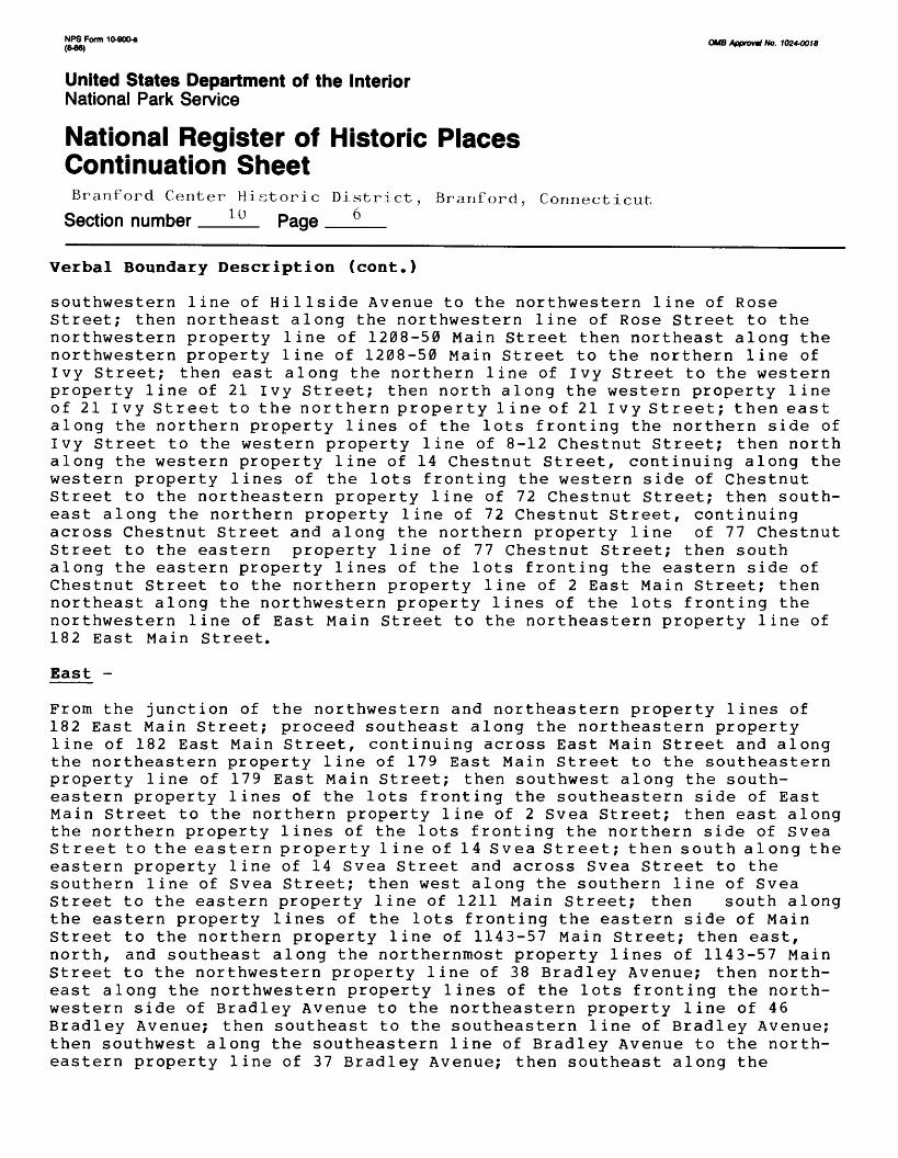
j!l2LFon" 1 °-90°-a OMB Approval No. 10244018 (8-86)
United States Department of the InteriorNational Park Service
National Register of Historic Places Continuation SheetBranford Center Historic District, Brariforcl, Connecticut
Section number 10 Page 6
Verbal Boundary Description (cont.)
southwestern line of Hillside Avenue to the northwestern line of Rose Street; then northeast along the northwestern line of Rose Street to the northwestern property line of 1208-50 Main Street then northeast along the northwestern property line of 1208-50 Main Street to the northern line of Ivy Street; then east along the northern line of Ivy Street to the western property line of 21 Ivy Street; then north along the western property line of 21 Ivy Street to the northern property line of 21 Ivy Street; then east along the northern property lines of the lots fronting the northern side of Ivy Street to the western property line of 8-12 Chestnut Street; then north along the western property line of 14 Chestnut Street, continuing along the western property lines of the lots fronting the western side of Chestnut Street to the northeastern property line of 72 Chestnut Street; then south east along the northern property line of 72 Chestnut Street, continuing across Chestnut Street and along the northern property line of 77 Chestnut Street to the eastern property line of 77 Chestnut Street; then south along the eastern property lines of the lots fronting the eastern side of Chestnut Street to the northern property line of 2 East Main Street; then northeast along the northwestern property lines of the lots fronting the northwestern line of East Main Street to the northeastern property line of 182 East Main Street.
East -
From the junction of the northwestern and northeastern property lines of 182 East Main Street; proceed southeast along the northeastern property line of 182 East Main Street, continuing across East Main Street and along the northeastern property line of 179 East Main Street to the southeastern property line of 179 East Main Street; then southwest along the south eastern property lines of the lots fronting the southeastern side of East Main Street to the northern property line of 2 Svea Street; then east along the northern property lines of the lots fronting the northern side of Svea Street to the eastern property line of 14 Svea Street; then south along the eastern property line of 14 Svea Street and across Svea Street to the southern line of Svea Street; then west along the southern line of Svea Street to the eastern property line of 1211 Main Street; then south along the eastern property lines of the lots fronting the eastern side of Main Street to the northern property line of 1143-57 Main Street; then east, north, and southeast along the northernmost property lines of 1143-57 Main Street to the northwestern property line of 38 Bradley Avenue; then north east along the northwestern property lines of the lots fronting the north western side of Bradley Avenue to the northeastern property line of 46 Bradley Avenue; then southeast to the southeastern line of Bradley Avenue; then southwest along the southeastern line of Bradley Avenue to the north eastern property line of 37 Bradley Avenue; then southeast along the

!iPJLForm 1 °-900-« QMS Approval No. 10244018 (8-86)
United States Department of the InteriorNational Park Service
National Register of Historic Places Continuation SheetBranford Center Historic District, Branford, Connecticut
Section number 10 Page 7
Verbal Boundary Description (cont.)
northeastern property line of 37 Bradley Avenue to the northwestern property line of Center Cemetery; then northeast along the northwesternmost property lines of Center Cemetery to the northeastern property line of Center Cemetary; then southeast along the northeastern property line of Center Cemetary to the southwestern bank of the Branford River; then south east along the southwestern bank of the Branford River to a point due northeast of the junction of the northeastern and northwestern property lines of 58 Averill Place; then southwest to the junction of the north eastern and northwestern property lines of 58 Averill Place; then southeast along the northeastern property line of 58 Averill Place and across Averill Place to the southeastern line of Averill Place; then northeast along the southeastern line of Averill Place to the northeastern property line of 59 Averill Place; then southeast along the northeastern property line of 59 Averill Place to the southeastern property line of 59 Averill Place; then southwest along the southeastern property lines of the lots fronting the southeastern side of Averill Place to the northeastern property line of 83 Montowese Street (State Armory); then southeast along the northeastern property line of 83 Montowese Street to the southeastern property line of 83 Montowese Street; then southwest along the southastern property line of 83 Montowese Street to the northern line of Pine Orchard Road; then west along the northern line of Pine Orchard Road to a point due north of the junction of the northeastern and northwestern property lines of 73 Monto wese Street; then across Pine Orchard Road and southeast along the north eastern property lines of the lots fronting the northeastern side of Montowese Street to the junction of the northeastern and southwestern property lines of 41 Montowese Street; then due southwest to the north eastern bank of the Branford River.
South -
From the junction of the northeastern bank of the Branford River and a line extending due southwest from the junction of the northeastern and south western property lines of 41 Montowes Street: proceed northwest/west along the northeastern/northern bank of the Branford River to a point directly in line with the southern terminus of the northeastern line of Church Street; then northwest along the northeastern line of Church Street, continuing across Meadow Street to the northwestern line of Meadow Street; then southwest along the northwestern line of Meadow Street to the southwestern property line of 188 Meadow Street; then northwest along the southwestern property line of 188 Meadow Street to the northernwestern property line of 188 Meadow Street; then northeast along the northwestern property line of 188 Meadow Street to the southwestern property line of 196 Meadow Street; then northwest along the southwestern property line of 196 Meadow Street to the northwestern property line of 196 Meadow Street; then northeast along the northwestern property lines of 196 Meadow Street and 26 Church Street

NPS Form 10*00* o^ /(pprmill ^ »02*00tfl(B-8B)
United States Department of the InteriorNational Park Service
National Register of Historic Places Continuation SheetBranford Center Historic District, Branford, Connecticut
Section number 1Q Page 8
Verbal Boundary Description (cont.)
to the southwestern line of Church Street; then northwest along the south western property line of Church Street to the southeastern line of Prospect Street; then southwest along the southeastern line of Church Street to the northeastern property line of 37-39 Hopson Avenue; then southeast along the northeastern property line of 37-39 Hopson Avenue to the southeastern property line of 37-39 Hopson Avenue; then southwest along the southeastern property line of 37-39 Hopson Avenue to the northeastern line of Hopson Avenue; then southeast along the northeastern line of Hopson Avenue and across Meadow Street to the southeastern line of Meadow Street; then southwest along the southeastern line of Meadow Street to the northeastern line of Indian Neck Avenue; then southeast along the northeastern line of Indian Neck Avenue to the northwestern property line of 4 Indian Neck Avenue; then northeast along the northwestern property line of 4 Indian Neck Avenue to the northeastern property line of 4 Indian Neck Avenue; then southeast along the northeastern property line of 4 Indian Neck Avenue to the northwestern bank of the Branford River; then southwest along the northwestern bank of the Branford River to the southwestern property line of 50 Maple Street (former Malleable Iron Fittings Complex).

QMS ApprovH No. 10244018 (B-OB)
United States Department of the InteriorNational Park Service
National Register of Historic Places Continuation SheetBranford Center Historic District, Branforri, Connecticut
Section number 10 Page 9
Verbal Boundary Justification (cont.)
The district's boundaries were delineated on the basis of four general criteria:
a) Thematic unity.
b) Current physical characteristics of the district which visually dis tinguish the area from the surrounding portions of the town, including the historic architectural integrity of individual structures, sight lines, and terrain.
c) Exclusion of properties which do not contribute to the historical or architectural significance of the district, wherever such exclusions were reasonable and practical.
d) Conformance with the National Register guideline that structures pro posed for listing on the Register be a minimum of 50 years old.
The southern end of the district's western boundary was drawn to include all of the former Malleable Iron Fittings Company's property at 50 Maple Street. While already determined eligible for individual listing on the Register, Malleable Iron's inclusion within the district was deemed parti cularly appropriate on the basis of thematic considerations.
Residential structures which stand immediately west and northwest of Malleable Iron along Maple, Harbor, and Curve Streets, the majority of which date from the 19th century, were excluded from the district for three principal reasons. First, while located close to the extreme western end of the Malleable Iron lot, these houses are otherwise far removed from the bulk of the district. Second, the scale and siting of the westernmost structures associated with Malleable Iron, the large undeveloped lot fronting the northwest side of Maple Street between Kirkham and Curve Streets, the dense vegetation screen bordering the southeast side of Maple Street between Curve and Harbor Streets, and the bend in Maple Street toward the west which begins just northeast of Curve Street all work in concert to establish Maple Street as a strong visual terminus for this portion of the district. Third, these houses are more appropriately con sidered as part of the eastern edge of a large and distinct, almost wholly residential section of the town known as Branford Point. Retaining numer ous, relatively well-preserved examples of houses dating from the 18th and 19th centuries, Branford Point appears to meet the crieteria for listing on the National Register as an historic district in its own right.

NFS Form 10-900* O^g A()pfwll, f^ J024OOJ8(O-WJ)
United States Department of the InteriorNational Park Service
National Register of Historic Places Continuation SheetBranford Center Historic District, Branford, Connecticut
Section number 10 Page 10
Verbal Boundary Justification (cont.)
From the junction of Maple and Kirkham Streets north to Main Street, the district's western boundary is defined by a distinct visual shift resulting from the dominance of post-1936 construction along Hammer Place, Elm Street, Abbott's Lane, and most of Kirkham Street. The western boundary's crossing at Main Street is defined by an intrusive ca. 300-yard strip of predominantly modern construction which separates the district from another large group of historic structures beginning at the junction of Bradley Street. A sharp curving of Main Street to the northwest just west of the district provides a strong visual emphasis to the physical discontinuity of these two concentrations of historic architecture.
North of Main Street, the western boundary was drawn to include Saint Mary's Roman Catholic Cemetery, a significant burial ground dating from the mid-19th century. It also includes a number of reasonably intact, modest 19th- and early 20th-century houses along both sides of most of Monroe Street, which is separated from Lincoln Avenue to the west by a sizeable tract of low-lying marsh.
The western end of the district's northern boundary is drawn to exclude several pre-1936 buildings at the northern end of Monroe Street which, due to a lack of historic architectural integrity, do not contribute to the district's significance. Most of the remainder of the northern boundary reflects the transition from a dominance of historic architecture to a dominance of post-1936 construction and/or vacant land. Properties along Barton Court, Palmer Road, Palmer Woods Circle, the western side of Cedar Street north of number 52, the eastern side of Cedar Street north of number 97, the northern end of Hillside Avenue, the western end of Rose Street, the northern portion of Ivy Street, Oliver Street, and Beach Place were excluded on this basis.
At its northeastern corner, the district's boundaries extend outward in finger-like fashion to encompass a group of houses dating from the 18th through early 20th centuries which line both sides of the principal traffic artery leading into the district from the northeast, East Main Street. The boundaries in this area are well-defined visually by the surrounding terrain, road alignments, and/or adjacent modern construction, such as the Branford High School complex at 185 East Main Street.
From the southwestern end of East Main Street, the eastern boundary runs southwest and southeast encompassing all extent concentrations of reason ably intact pre-1936 construction and excluding notable concentrations of non-contributing properties . The only exclusionary exception to this approach is Rice Terrace, which is dominated by modern, multi-story,

NPS Form 10-900-a OMB Approval No. 1024-0018 (846)
United States Department of the InteriorNational Park Service
National Register of Historic Places Continuation SheetBranford Center Historic District, Branford, Connecticut
Section number 10 Page n
Verbal Boundary Justification
multi-unit housing construction. This exception was made solely on the basis of one inescapable practical consideration: the thematic imperative to include Center Cemetery, Branford's well-preserved original burial ground, within the district.
The basic determinant in the delineation of the district's southern boundary was the Branford River. The river not only forms a well-defined natural boundary, but also marks the southernmost extent of the district's historic development. Near its midpoint the southern boundary of the dis trict deviates away from the river bank in order to exclude non-contri buting modern construction along the northern side of Meadow Street as well as the modern Branford Community House at 30-48 Church Street and its adjacent open athletic fields framed by Hopson Avenue and Meadow, Church, and Prospect Streets.