old trafford · old trafford is faced with a number of challenges summarized as: the challenge of...
TRANSCRIPT

OLD TRAFFORDMasterplanning ReportPrepared for Trafford Council, Trafford Housing Trust and Old Trafford Neighbourhood Partnershipby URBED and EKOS
October 2009

EmpressCourt
PrincessCourt
Trafford & Rylands
St. BridesField
Old Trafford Library
St Alphonsus School
Hullard
The Rivers Estate

�
StretfordRoad
HulmePark
Loreto CollegeOsprey
Court
Eagle Court
Raven Court
Falcon Court
GraftonCourt
PickfordCourtClifford
Court
Chorlton Road
Hulme
TamworthPark
Old Trafford Priority Regeneration AreaCourtesy of Web Aviation
�
Old Trafford Masterplan
Old Trafford is located to the south-west of Manchester
City Centre. The area occupies a strategic location within
Greater Manchester, falling within the Manchester City
Region. The area of Old Trafford is home to the famous Old
Trafford Football Club, and Old Trafford Cricket Ground and
lies adjacent to strategic locations such as Exchange Quay
financial quarter, Trafford Park and the emerging Media
City which will be home to the BBC from 2011. The area
is well connected in a national and international context.
Manchester Airport is around 20 minutes away, and the area
is well connected to the conurbation core by metrolink and
bus routes and the A56 Corridor.
Despite its strategic location Old Trafford is ranked one of the
most deprived areas nationally. There is a high proportion
of economically inactive persons of working age, high levels
of free school meals take-up, housing overcrowding, and an
adverse ratio of income levels to average house prices which
hinders local peoples ability to enter into home ownership.
There are also higher incidences of crime.
Old Trafford’s identity - Not just the home of Man United
The name Old Trafford usually conjures up images of Old
Trafford Football Club. But what is the true identity of Old
Trafford? The neighbourhood ‘Old Trafford’ is forgotten about
within the context of the famous football club ‘Old Trafford’.
It is the place where fans park, where Stretford Road crosses
through as you head towards ‘the theatre of dreams’. So
with such an inspirational football club on its door step what
does Old Trafford Neighbourhood have to offer?
Lots of people from a variety of cultures and backgrounds
have settled here. Old Trafford has approximately 13,000
residents with 5385 living within the Old Trafford Priority
Regeneration Area. Cultural diversity has been a feature of
the area for over a century, with influxes of Irish, Polish, East
Europeans, Afro-Caribbean, Pakistani and Indian residents
over time. Trafford represents the eclectic mix of urban life
in the UK. It is a place where the world comes together,
where there are people with cultures and traditions from
all over the world. This gives the area a heart, and this is
reflected in the food, clothing and music which all comes
together to create a mix of 21 century Urban living.
Within the boundary of the study area there are a number
of local businesses. The number of local independent
businesses within the study area is a clear indication of the
entrepreneurial spirit of the local people. Within this area of
Trafford local traders have managed to provide valuable and
much needed services for the local community. Ayres road is
a beehive of local enterprise and there are shops on almost
every corner. From Shrewsbury Streets famous Trafford
Bakery employing local people selling Jamaican Bun and
fresh Patties (the best in town!) to the Cool Running’s Mobile
van, these are the people whom have remained committed
and loyal to the area.
And within the community of Old Trafford there are hundreds
of individuals and organizations committed to tapping the
potential of the community for they see the energy and the
enthusiasm and the thinking outside the box that has evolved
Executive summary
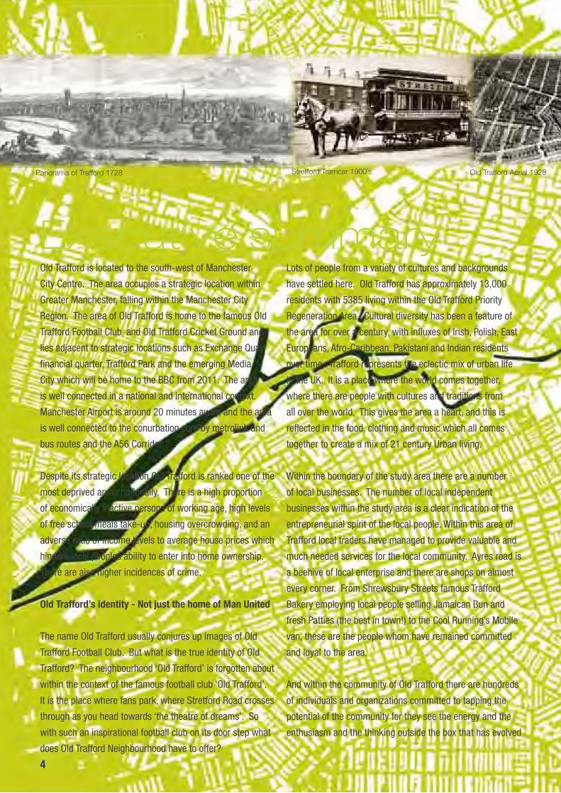
Panorama of Trafford 1728 Stretford Tramcar 1900’s Old Trafford Aerial 1928
�

�
Executive summarya diverse neighbourhood where many have settled in search
of a better life, whom where not afraid of change.
Historically Old Trafford has expanded and become an
urban area serving a number of employment sites after the
building of the Manchester Ship Canal in the 1890s, and the
subsequent development of nearby Trafford Park Industrial
Estate, in the early 20th century. Local employment was
also provided by Duerrs Jams, Vimto, Arkady Soya Mill and
Ludwig Oppenheimer Mosaics. Employment within Old
Trafford had declined over the years however the Trafford
Park area is one of the largest employment areas in the
region with over 10,300 firms based there. Traditionally the
Old Trafford area housed the many workers in Trafford. Slum
clearances during the 1960s and early 1970s saw some
of the worst condition Victorian housing stock demolished
and replaced with medium sized council estates and tower
blocks built by Trafford Council. Highly sought after at the
time, a majority of the housing estates have remained.
Following on from stock transfer approximately 1259 of
the social housing stock in the area is largely managed by
Trafford Housing Trust.
Old Trafford is faced with a number of challenges
summarized as:
The challenge of moving onward and upward during an
economic downturn
Meeting the Decent Homes Standard by 2010
Housing growth and supporting growth through
■
■■
improvements in infrastructure and services to support
growth
Continuing to serve as an area of diversity and choice
Diversifying the housing choices
Encouraging tenure types and supporting people into
stepping into property ownership
Improving connectivity and increasing opportunities
for the community to access existing jobs and training
opportunities in the conurbation
Improving the range of community services available in
Old Trafford
Improving the quality of the environment
We have seen the commitment from local organisations
and residents to remain optimistic and are confident that
Old Trafford will continue to progress as a neighbourhood.
Throughout the process of developing this masterplan
the local community and key stakeholders have been
involved in helping to steer decisions on the future of their
neighbourhood, and some have been directly involved in the
design process.
We would like to thank Trafford Housing Trust, Trafford
Council and Old Trafford Neighbourhood Management Board
for giving us the opportunity to steer the regeneration of Old
Trafford through the Community Design Process. Most of all
we would like to thank all the residents of Old Trafford whom
have got involved in the process.
■■■
■
■
■
Old Trafford Aerial 1928 Pickford Court, & Pickford Street 1967 Pickford Court 2009 Ayres Road 2009
Report by URBED and EKOS
CREDITS
Old Trafford Masterplan

■
CONTENTS
INTRODUCTION 1
PART 1: Policy Drivers 3National policy 5
Growth Point 7
A decent home for all 9
Local policy 11
Housing need 13
PART 2: The Area 158 Communities 17
The People 19
Community facilities 21
History 23
Urban form 25
Connections 27
Open Space 29
PART 3: The Vision 31Diagnosis 33
Consultations 35
Vision for the area 37
Achieving the vision 39
PART 4: Developing Options 41Opportunity for Change 43
The design charrettes 45
Hullard and Rivers options 47
Shrewsbury Street and School Walk options 49
Tamworth Options 51
Resident views 53
Options appraisal 55
PART 5: The Masterplan 57Masterplan 59
The illustrative plan 61
The 9 Projects 63
Project I: Tamworth Neighborhood 65
Project 2: Chorlton Road Gateway 71
Project 3: Hullard Neighborhood 73
Project 4 : The Rivers 75
Projects 5 and 6: The Clifton’s and Shrewsbury Street 79
Project 7: Stretford Road 81
Project 8: Fahey’s Depot 83
Project 9: St. George’s Gate 85
PART 6: Implementation 89Implementation strategy 90
Planning framework 91
Masterdeveloper 92
Joint ventures 93
Affordable housing 94
PART 7: Appendices 97Appendix 1: Community Land Trust
Appendix 2: Appraisals
Appendix 3: Community Space Study (to follow)
Report by URBED and EKOS


�
INTRODUCTIONThis study was commissioned in 2008 to develop a masterplan and vision for the Old Trafford Neighbourhood. The plan has been developed in partnership both with the client group and with the people of the area. It forms, we believe, the basis for the transformation of the neighbourhood over the coming years.
This masterplan was commissioned by Trafford Housing
Trust, Trafford Metropolitan Borough Council and Old Trafford
Neighbourhood Management Board. The process began in
May 2007 when concerns were identified over long-term
demand for some housing in the area, particularly the
tower blocks, walk-up flats and sheltered schemes owned
by Trafford Housing Trust. The area was also displaying
social and environmental problems, issues that Old Trafford
Neighbourhood Management Partnership were seeking to
address. These housing and neighbourhood issues led to the
area being designated as a Priority Regeneration Area in the
Trafford UDP. In addition to this the area was identified as a
Growth Point in 2008 with opportunity for significant housing
development with good access to Manchester City Centre
and the employment areas of Trafford Park. The masterplan
has therefore sought to bring together the social issues and
growth opportunities to create a plan that can form the basis
for the area’s transformation.
This report starts with an assessment of the area based
on the baseline report that we prepared in Summer 2008.
It paints a picture of a relatively impoverished but largely
stable community that has avoided many of the problems
that have historically affected the neighbouring areas in
Manchester such as Hulme and Moss Side. The physical
structure of the area is however very poor and there is an
opportunity to use the Growth Point to completely restructure
the area, integrate it with its surroundings and turn it back
into the sort of lively urban neighbourhood that it was in the
past. This is what we seek to do in this report.
URBED’s approach to this type of work is to undertake it with
the local community. This was very much part of our brief
and has been central to the study. The process started with a
workshop in May 2008 and the masterplans were drawn up
through a series of hands-on community workshops in June
2008 which resulted in plasticine models for each part of the
area. As part of this we organised a bus tour for local people
to take them to see other redevelopment areas in Greater
Manchester. The models were developed into a series of
options that were used as part of an exhibition and drop in
sessions in September 2008. We also presented the options
to the area partnership and to other local groups. Based on
the findings of this work we arrived at the preferred option
that is described in this report. This has been developed and
appraised in detail and forms, we believe, a firm foundation
for the transformation of the area over the coming years.
The work has been undertaken by URBED and EKOS and has
included a separate study to look at the need for community
facilities in the area. The process has been steered by a
group made up of Trafford Council, the Trafford Housing
Trust and the Old Trafford Neighbourhood Management
Partnership for who’s input we are grateful.
�
Report by URBED and EKOS

�
Old Trafford Masterplan
�

�
This chapter positions the masterplan area in terms of regeneration and planning policies and strategies and explores some of the neighbourhood issues of deprivation, service provision and housing market characteristics.
PART 1: Policy Drivers
Report by URBED and EKOS
�
Old Trafford Masterplan
�
Poole
Newark
Torbay
Didcot
Oxford
Telford
Taunton
Swindon
Reading
Hereford
Coventry
Grantham
Thetford
Plymouth andSouth Hams
Worcester
MaidstoneBasingstoke
Haven Gateway
EastStaffordshire
Reigate &Banstead
Shrewsbury& Atcham
Birmingham& Solihull
Lincoln3 Cities &3 Counties
Exeter andEast Devon
West of EnglandPartnership
Greater NorwichDevelopmentPartnership
Partnership forUrban South Hampshire
(PUSH)
Carlisle
Gainsborough
North Tyneside
South EastNorthumberland
Tees Valley
West Cheshire
MerseyHeartlands
GreaterManchester
Newcastle &Gateshead
Warrington/Halton/St.Helens
Central Lancashire& Blackpool
South EastDurham
Doncaster &South Yorkshire
Luton
Corby
Bedford
Ashford
ThurrockStratford
Greenwich
Cambridge
Stevenage
Kettering
Northampton
Peterborough
Milton Keynes
Aylesbury Vale
Wellingborough
London Riverside
North KentThameside
Harwich
Ipswich
Felixstowe
Colchester
King's Lynn
HarlowHatfield Chelmsford
Bury St Edmunds
Hemel Hempstead
Welwyn Garden City
0 40 80 12020Kilometres
Produced by the GI Team, Analytical Services.This map is based upon Ordnance Survey material with the permission of Ordnance Survey on behalfof the Controller of Her Majesty's Stationery Office © Crown copyright. Unauthorised reproductioninfringes Crown copyright and may lead to prosecution or civil proceedings. 100018986 2008. 07 002
Growth Areas & Growth Points
Nominal Scale 1:2,000,000 @ A3
Data Sources:OS Boundary LineHousing & Growth Programmes
Truro
Nottingham
Derby
Leicester
Additional Growth Point Partnership Areas
Growth Point Partnership AreasGrowth Points
Leeds City Region
Black Country /Sandwell
Stafford
Carrick, Kerrierand Restormel Teignbridge
Shoreham
Milton Keynes and South Midlands (MKSM)
Thames Gateway
London-Stansted-Cambridge-Peterborough (LSCP)Ashford
Additional Growth Points
Key Growth Area Locations
Dacorum, St Albans and Welwyn Hatfield (theDepartment is currently seeking views on whetherthese districts should form part of MKSM or LSCP)
Growth Areas
Dover
Black Country/Birmingham/Solihull
Partnership
St Albans
��

�
National PolicyGovernment policy since the late 1990’s has been focused on accommodating housing growth within urban areas, with higher quality design, greater choice and higher standards. This policy agenda is designed to prioritise development in areas like Old Trafford.
Government Policy since the late 1990’s has aimed to
increase the proportion of homes in urban areas like Old
Trafford and to improve the quality and choice of housing
provision. The Urban Task Force Report published in 1999
fed into an Urban White Paper in 2002 and to the Sustainable
Communities Plan of 2003. The latter included provision for
the support of housing areas in the north through Housing
Market Renewal as well as the Northern Way that proposed
using the city regions as economic stimuli to improve
the GDP of northern England. The Communities Plan was
rolled forward in 2005 through Homes for all and People
Places and Prosperity to improve the provision of affordable
housing.
This policy agenda has been rolled out through a series
of Planning Policy Guidance Notes and Guidance from
government and CABE (such as By-Design). This agenda
aims to improve the design of housing and urban areas
through street-based layouts and higher densities.
In terms of social housing the government’s aim to improve
the quality of the stock has been expressed through the
Decent Homes programme. A target was set in 2000 that
all social housing in the UK should meet its decent homes
standard by 2010. Local authorities were required to set
out a programme for achieving this through Arms Length
Management Organisations or Stock Transfer Associations.
In recent years a concern about housing numbers has been
added to this agenda. In 2004 the Barker Review highlighted
�
the shortfall in housing provision and its impact on the
market. As a result the Government announced the Growth
Point initiative in December 2005. The first round of Growth
Points were announced in the following year and in 2008 a
second round were announced including Greater Manchester.
These strands of government policy are reflected in regional
policy:
Regional Housing Strategy seeks to improve housing
supply in areas of high demand and to address low
demand areas. Its four themes are; Urban renaissance and
regeneration, affordable homes and balanced communities,
decent homes and specialist and supported housing. This
strategy would support the Old Trafford area under all of
these headings.
Regional Economic Strategy which as part of the
Northern Way seeks to use the city regions as engines of
economic growth. Old Trafford is surrounded by a range
of opportunities identified in the strategy including the
Universities, The Regional Centre and Trafford Park. Rather
than become an economic centre in its own right. Old
Trafford should provide an urban neighbourhood for people
working in these employment areas.
Regional Spatial Strategy focuses growth on Manchester,
Liverpool and the Central Lancashire City Region. Housing
growth is to be concentrated in these cities to reinforce their
economies.
Report by URBED and EKOS
�
�
Old Trafford Masterplan
�

Growth PointOld Trafford is part of the Greater Manchester Growth Point designated in 2008. The current neighbourhood regeneration of Old Trafford provides an opportunity to explore the possibility of promoting housing growth in the area to the benefit both of the study area and the region. The role of this masterplan, in addition to addressing the housing issues in the area, is therefore also to look at the potential for regional housing growth.
In 2007 the government announced the intention of
extending the Growth Point Initiative to areas in the north of
England. Twenty one local authorities and partnerships were
announced in 2008 as second-round Growth Points including
Greater Manchester. In total these Growth Points have the
potential to contribute 180,000 additional dwellings by 2016.
This will both help the government meet its housing supply
targets as well as contributing to the economy of these
areas.
The Greater Manchester Growth Point was approved in
July 2008. The strategy is to bring forward an additional
10,000 homes by 2017 bringing the total new homes in the
area during that period to 87,000. The aim is to support the
development of high quality affordable homes and balanced
communities. With Growth Point status comes access to
funding to facilitate development including infrastructure
provision ground conditions and flood risk. £12 million has
been allocated to Greater Manchester by 2011.
The first phase of Growth Points covers the whole of
Greater Manchester but the intention is to focus growth in
Manchester, Salford, Trafford and Bolton. In East Manchester
it includes 4,600 new homes over 10 years in Holt Town and
a further 1,000 units in Miles Platting. Also included are the
Lower Kersal and Broughton areas of Salford and an Urban
Village in the heart of Bolton.
In Trafford sites have been identified in Partington, Trafford
Quays, Pomona Dock and sites around Lancashire County
Cricket Club. In total it is estimated that Trafford will
accommodate more than 7,000 new homes. The area
covered by this masterplan is identified in the Growth point
bid. It is potentially an important opportunity because of its
proximity to the regional centre, its good public transport
links, access to employment and the opportunities for infil
and replacement of housing in the area at the present time.
An initial capacity exercise identified the potential for 500
new homes in the area. As part of this masterplanning
exercise we are suggesting that the net gain in the area
could be double this. These units may also be easier to
achieve than other Growth Point sites.
�
Report by URBED and EKOS

Key
THT Estates
Land owned by Trafford Council
Land leased from THT
THT properties
Property yet to be brought up to the Trafford Standard
Right-to-buy propertiesPrincess Court
Empress Court
Trafford and Ryland’s Courts
School Walk
The Tamworth Balcony Blocks
The Tamworth Bird Blocks
�
Old Trafford Masterplan
�
A Decent Home for AllThe Trafford Housing Trust (THT) business plan agreed in 2005 made provision for all of its property to be brought up to the Trafford Standard (above the Decent Homes Standard). Much of the stock has been improved however in the case of the remaining blocks it may be that the condition of the blocks and low demand for the property may make redevelopment a more sensible option.
The government set a target in 2000 that all social housing
in the UK should meet its Decent Homes standard by 2010.
Local authorities were required to set out a programme
for achieving this through Arms Length Management
Organisations or Stock Transfer Associations. Any property
not likely to meet the target will require a waver from the
HCA and TSA.
Trafford Housing Trust was established as a Stock Transfer
Association and took over the management of 10,000
council homes from Trafford Council in 2005. As part of this
the Trust pledged to exceed the Decent Homes Standard by
putting in place the Trafford Standard and made provision
for £132 Million in its business plan to achieve this. This
is sufficient to get all homes under THT management to
the Trafford Standard by 2010 through the Blue Ribbon
Programme of works.
Much of the property within the study area has been brought
up to the Trafford Standard. The properties that remain are as
follows:
Princess and Empress Court: The two towers on the
Hullard Estate, like those on the Tamworth Estate have
not been included on any programme of works relating
to the Trafford Standard however it is proposed as part
of this strategy that they should be retained so that the
Trafford Standard works will need to be programmed.
Trafford and Ryland’s Courts: These two walk-up
blocks on Stretford Road on the edge of the Rivers
Estate are in a poor condition and are not popular with
residents. Their future was in question and was put to
residents during the Design Charettes. A view has been
The Tamworth Bird Blocks
taken that they should be replaced with better quality
housing.
School Walk: A programme of internal Blue Ribbon
works (kitchens, bathrooms, boilers, central heating
systems and rewiring) was completed in late 2008.
External Blue Ribbon works to replace windows and
doors is scheduled for 2009/2010.
The Tamworth Estate: None of the tower blocks have
had work done to bring them up to the Trafford Standard.
There are two types of blocks the ‘Balcony Blocks’ on
Chorlton Road and the ‘Bird Blocks’ to the east. Both
have had improvements to lifts and security including
CCTV. However there are structural issues with services
and risers that have led to questions about whether the
full decent homes package is value for money. Trafford
Housing Trust are seeking a waiver on the 2010 deadline
and have sought advice from this study as to whether
investment should be made to upgrade the blocks. The
conclusion that we come to is that the Balcony Blocks
should be refurbished and the Bird Blocks demolished.
Maher Gardens: The low-rise properties on Moss Lane
West have had full internal and external Blue Ribbon
works and are now up to the Trafford Standard for
decent homes.
Trafford Housing Trust will need to be clear as to whether
properties not up to the Decent Homes Standard will be
replaced or whether they are scheduled for work prior to
2010. It will be possible to apply for a temporary waiver
on the properties that will be replaced and discussions are
underway with the HCA and TSA.
�
Report by URBED and EKOS
�0
Old Trafford Masterplan
Key
Urban area
Inner Areas
Strategic sites
�0

��
Local Policy
Old Trafford sits at a strategic point in the conurbation and is surrounded by regeneration initiatives. It is identified as a regeneration area within Trafford and the priorities are skills and access to work, the quality of the environment and the range and quality of the housing stock.
Old Trafford sits within a strategic part of greater Manchester
just south of the point where Trafford, Manchester and
Salford meet. The local policy context is therefore only partly
about what is happening in Trafford. The key initiatives in this
wider area are the development of the Regional Centre, the
University Knowledge Corridor and the ongoing regeneration
of Hulme, Salford Quays, Media City and the regeneration of
the Ordsall Estate.
Trafford has developed a series of economic strategies
including the Economic Development Plan, The Trafford
Economic Assessment and the Trafford 2021 Blueprint.
These seek to exploit the advantages of the borough in terms
of location, infrastructure and skills. The main employment
growth areas are Trafford Park and the corridor along the
Ship Canal into Pomona and the Cornbrook area.
The central part of Old Trafford is not seen as an employment
growth area. The nearest employment areas are the
Cornbrook and Wharfside strategic employment areas to the
west and the Hadfield Street area across Chester Road which
is identified as an industrial improvement area.
The main relevance of these strategies is the skills and
access to work agenda. While Trafford as a whole is the
8th highest achieving borough in the country with regard
to educational attainment, Old Trafford is very much the
exception to this and the priority is to help local people
access employment in the surrounding areas.
The Trafford Housing Strategy published in 2005 focuses on
the creation of healthy, secure and safe communities. This is
related partly to the programme to improve the quality of the
housing stock, partly to increase choice and access to home
ownership and partly to the need to create diverse, tolerant
communities. The main objectives of the strategy are;
the provision of affordable homes,
celebrating diversity and promoting community cohesion,
improving the quality of life
reducing homelessness,
improving the stock condition.
The Old Trafford area is identified as a Priority Regeneration
Area in the UDP adopted in June 2006. The Old Trafford
Strategy and Action Plan aims are;
Improving the quality and diversity of the housing stock
Improving the quality, appearance and safety of the
environment
Providing facilities for pedestrians cyclists and public
transport users and reducing the impact of traffic
Promoting the development of under used land for
residential business of commercial use
Improving the quality and diversity of recreational
provision.
The strategy proposes that the Stretford Road corridor should
be developed as a strategic gateway. It also proposes the
development of a multi-purpose community facility in the
area alongside support for local shops and improvements to
local parks and open space. Planning policy is being rolled
forward into the Local Development Framework which is in
preparation and is scheduled for adoption in 2009.
Report by URBED and EKOS

��
Old Trafford Masterplan
��

��
Housing NeedHousing need in Old Trafford remains high because the price of new private housing for rent and sale in the area has outstripped local incomes. This has led to concerns about gentrification, as has happened in neighbouring Hulme. The strategy needs to include sufficient affordable housing along with measures to assist local people to gain access to new private homes.
The Trafford Housing Strategy 2009-2011 (GVA Grimley) was
released as a Draft document in April 2009.
Overall the future projections for the borough where;
increasingly elderly and diverse population.
growing population and household numbers
more single households
growth of older person households
In Section 3 the document highlighted that housing need
in the borough has been exacerbated by a decline in the
number of social units (despite increased development in
2008). This was predicted in the Trafford HMA affordable
housing needs assessment in 2006 which concluded that
there was an annual affordable shortfall across the Borough
of 541 units. This breaks down into 371 for the Southern
sub-market and 169 in the Northern sub-market including
Old Trafford.
There has in recent years been a surplus of accommodation
for older people (both single pensioners and larger pensioner
households) and Trafford Housing Trust has vacant elderly
persons accommodation at Isobel Baillie Lodge and at
Cornbrook Court. However the projections point to an
increased demand from older households. This low demand
is therefore likely to be a result of the type of accommodation
available (old people’s homes) being unpopular.
Demographic groups most likely to fall into housing need
category are:
■■■■
single non-pensioner households
lone parent households
other households with children
with regards homelessness there was a greater
proportion of BME persons registered.
Affordability
Concerns have been raised by local residents and
stakeholders about the sort of gentrification that has taken
place in Hulme where housing is now unaffordable to
most local people. When the housing in Hulme was being
built there was very little support or information on how
local people could purchase properties. The demand for
affordable homes is driven by high price of private homes for
rent and sale in the area and the strategy for Old Trafford will
need to address affordability issues. This is likely to include:
an adequate number of affordable homes
information on other housing options such as supported
private renting with support from the Local Housing
Allowance (LHA)
support for home ownership
limits the level of properties sold to investors
Trafford Housing Trust and the library already provide a
point of contact however the level of information required
to support regeneration in the area will be crucial. More
vulnerable areas like Old Trafford could see an increase
in housing need as fewer jobs become available however
measures still need to be taken to ensure that Old Trafford
remains somewhere that people will find an affordable and
desirable place to live.
■■■■
■■
■■
Report by URBED and EKOS

��
Old Trafford Masterplan
��
��
PART 2: The Area
In Summer 2008 URBED and EKOS prepared a baseline report on the Old Trafford area in order to understand the area. This is available on www.urbed.coop and is summarised on the following pages.
Report by URBED and EKOS

��
Old Trafford Masterplan
NO
RTH
��
��
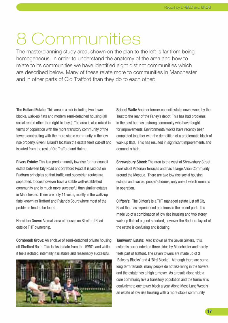
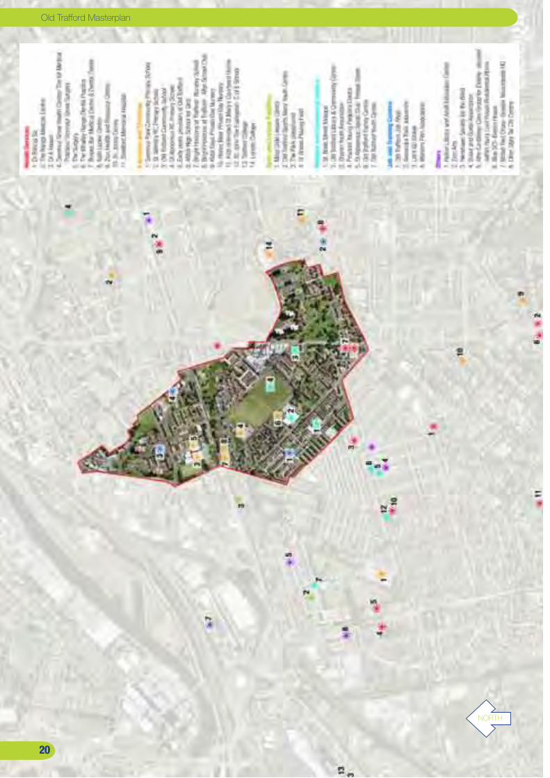
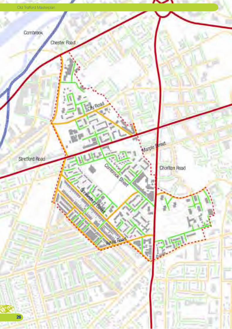
8 CommunitiesThe masterplanning study area, shown on the plan to the left is far from being homogeneous. In order to understand the anatomy of the area and how to relate to its communities we have identified eight distinct communities which are described below. Many of these relate more to communities in Manchester and in other parts of Old Trafford than they do to each other:
The Hullard Estate: This area is a mix including two tower
blocks, walk-up flats and modern semi-detached housing (all
social rented other than right-to-buys). The area is also mixed in
terms of population with the more transitory community of the
towers contrasting with the more stable community in the low
rise property. Given Hullard’s location the estate feels cut-off and
isolated from the rest of Old Trafford and Hulme.
Rivers Estate: This is a predominantly low rise former council
estate between City Road and Stretford Road. It is laid out on
Radburn principles so that traffic and pedestrian routes are
separated. It does however have a stable well-established
community and is much more successful than similar estates
in Manchester. There are only 11 voids, mostly in the walk-up
flats known as Trafford and Ryland’s Court where most of the
problems tend to be found.
Hamilton Grove: A small area of houses on Stretford Road
outside THT ownership.
Cornbrook Grove: An enclave of semi-detached private housing
off Stretford Road. This looks to date from the 1990’s and while
it feels isolated, internally it is stable and reasonably successful.
School Walk: Another former council estate, now owned by the
Trust to the rear of the Fahey’s depot. This has had problems
in the past but has a strong community who have fought
for improvements. Environmental works have recently been
completed together with the demolition of a problematic block of
walk up flats. This has resulted in significant improvements and
demand is high.
Shrewsbury Street: The area to the west of Shrewsbury Street
consists of Victorian Terraces and has a large Asian Community
around the Mosque. There are two low rise social housing
estates and two old people’s homes, only one of which remains
in operation.
Clifton’s: The Clifton’s is a THT managed estate just off City
Road that has experienced problems in the recent past. It is
made up of a combination of low rise housing and two storey
walk up flats of a good standard, however the Radburn layout of
the estate is confusing and isolating.
Tamworth Estate: Also known as the Seven Sisters, this
estate is surrounded on three sides by Manchester and hardly
feels part of Trafford. The seven towers are made up of 3
‘Balcony Blocks’ and 4 ‘Bird Blocks’. Although there are some
long term tenants, many people do not like living in the towers
and the estate has a high turnover. As a result, along side a
core community live a transitory population and the turnover is
equivalent to one tower block a year. Along Moss Lane West is
an estate of low rise housing with a more stable community.
Report by URBED and EKOS

��
Old Trafford Masterplan
Long-term illness
Owner occupation
Ethnicity
IMD - Deprivation
IMD - Income
IMD 2007 (0% is the most deprived)
IMD - EducationIMD - Crime
��
��
The PeopleOld Trafford is more typical of some parts of inner Manchester than it is of the Trafford Borough. Its people are younger, more ethnically diverse and more deprived than the rest of Trafford. There are problems of crime, health and poor education, however much of the area is stable and characterised by strong communities.
Population: There are 5385 people living within the study
area boundary in 2074 households. Half of all households
are single person and the age profile shows relatively high
numbers of young adults and children.
Diversity: The area is ethnically diverse and Hullard and
Rivers Estates are made up of 48% of people from Black
and Minority Ethnic groups (BME). The central area and
Shrewsbury Street areas are made up of 60% BME groups
and Tamworth is made up of 44% BME people. Careful
consideration needs to be given to the diverse mix of the
local population to reflect the housing needs and culturally
sensitive service provision.
Deprivation: Most of the area falls within the 10% most
deprived nationally. Only a small area at the northern end of
Shrewsbury Street falls outside this.
Employment: In terms of levels of employment the Hullard,
Rivers and Tamworth Estates are in the bottom 5% nationally
although the Tamworth Estate did show a significant
improvement (over 5%) between 2004 and 2007.
Income: In terms of income the worst area stretches from
School Walk to Shrewsbury Street despite this area having
higher levels of employment. This reflects low wage levels
particularly within the BME community.
Health: Most of the area falls within the bottom 5% in terms
of health, the exception being Shrewsbury Street that has
also shown the greatest improvement since 2004.
Education: In terms of Education the area does slightly
better. The central area and Tamworth Estate fall in the
bottom 10-30% band and the Hullard and Rivers Estate in
the 30-50% band. The Tamworth Estate in particular has
improved by more than 5% since 2004.
Crime: The worst performing area for crime statistics
is a central band running from School Walk through the
Shrewsbury Street Community Centre. Most of the area falls
within the 10-20% worst band and the eastern part of the
area has seen significant improvements.
Housing: Owner occupation across the area is 42% compared
to the Trafford average of 72%. However much of this is in the
terraced streets to the south and the majority of the study area
is overwhelmingly social housing (except for right-to-buys).
There are 1,259 THT homes in the area of which 79% are flats
- including 758 flats in high-rise blocks. Most of the housing is
relatively good quality. Trafford Standard decent homes works
have been completed across most of the area, the exception
being the tower blocks.
Report by URBED and EKOS
�0
Old Trafford Masterplan
NORTH
�0
Old Trafford Masterplan
�0�0

��
Community facilitiesThe study area is generally well served with community facilities and residents have access to some facilities in Manchester such as the Zion Centre. The main deficiencies are in youth provision and the quality of local shops.
Childcare: This is considered to be relatively good in the
study area, with 5 nurseries identified either within or close
to the study area. The local SureStart coordinator’s view is
that provision is sufficient to meet current demand. There is
an established nursery in the Old Trafford Community Centre
currently using the community hall. This means that the use of
the hall is limited for other activities. There is a need to develop
a purpose built nursery facility as part of the community centre
for use by the nursery and also to provide childcare for the
community using both the Old Trafford Library and community
centre.
Youth Facilities: There is a youth worker covering the Old
Trafford area funded by THT. However the main youth facilities
are associated with churches and are not adequate for the
population. The Old Trafford Youth Club in Seymour Park
is some way from the area. There is a need for new youth
facilities which has been explored as part of the community
facilities study undertaken in parallel with this masterplan.
Education: The main primary schools serving the area are
Old Trafford Community School (OTCPS), St. Alphonsus and
Seymour Park School. All are rated as Good overall with St
Alphonsus and OTCPS rated as Good or Outstanding overall.
There are the three available secondary schools, Trinity CE High
School in Hulme, Stretford Grammar School and Stretford High
School. Stretford High School is rated one of the top 100 high
schools in the country and is rated by Ofsted as Outstanding.
Aififah High School is independent and has a satisfactory
record of educational attainment. Stretford Grammar School
has recently been taken into special measures due to a drop in
attainment levels. College provision includes Trafford College
and Loreto 6th Form College in Manchester which boarders
with the Tamworth Estate.
Healthcare: There are seven GP surgeries or health centres
available to the people of the study area. The Stretford
Memorial Hospital and the Kath Locke and Zion Centres in
Hulme area also accessible, however provision for Trafford
residents is restricted as priority is given to Manchester
residents. The Trafford PCT are proposing to develop a hub
for GP services at Stretford Memorial Hospital on Seymour
Grove which will reduce the accessibility of services but would
improve the range of services available to the Old Trafford area.
Community Facilities: The main community facility within
the area is on Shrewsbury Street. This includes a library
and a community hall. A Community Feasibility study was
commissioned to review existing community facilities in the
area and to explore the need for a New Community Facility in
Old Trafford. The first stage of the Community Feasibility Study
identified the need for an improved community centre with
better services, more sustainable design and a more flexible
approach to the use of the building. As part of the second
stage of the Community feasibility study the development of a
new facility on an alternative site will be explored.
Sports and leisure: The main sports facility is the Trafford
Sports Barn in Seymour Park which provides a good range of
services in a new facility. The nearest sports centre is in Moss
Side and the Stretford Leisure Centre is a bus ride away.
Employment: Access to employment services are provided
through the Old Trafford Job Shop which forms part of the Old
Trafford Community Centre. The nearest Job Centre is on Moss
Lane. Adult education and training services are delivered by
Lets go Global, and St John’s Centre and Lets Go Global as well
as through many other community organisations based in the
area.
Shops: There is a limited range of shops in the area. Many
residents shop at supermarkets outside the area such as ASDA
in Hulme. There are local shopping areas on Seymour Grove,
Ayres Road and Shrewsbury Street, the latter doing poorly. ��
Report by URBED and EKOSReport by URBED and EKOS

��
Old Trafford Masterplan
��00���� �000
��
��
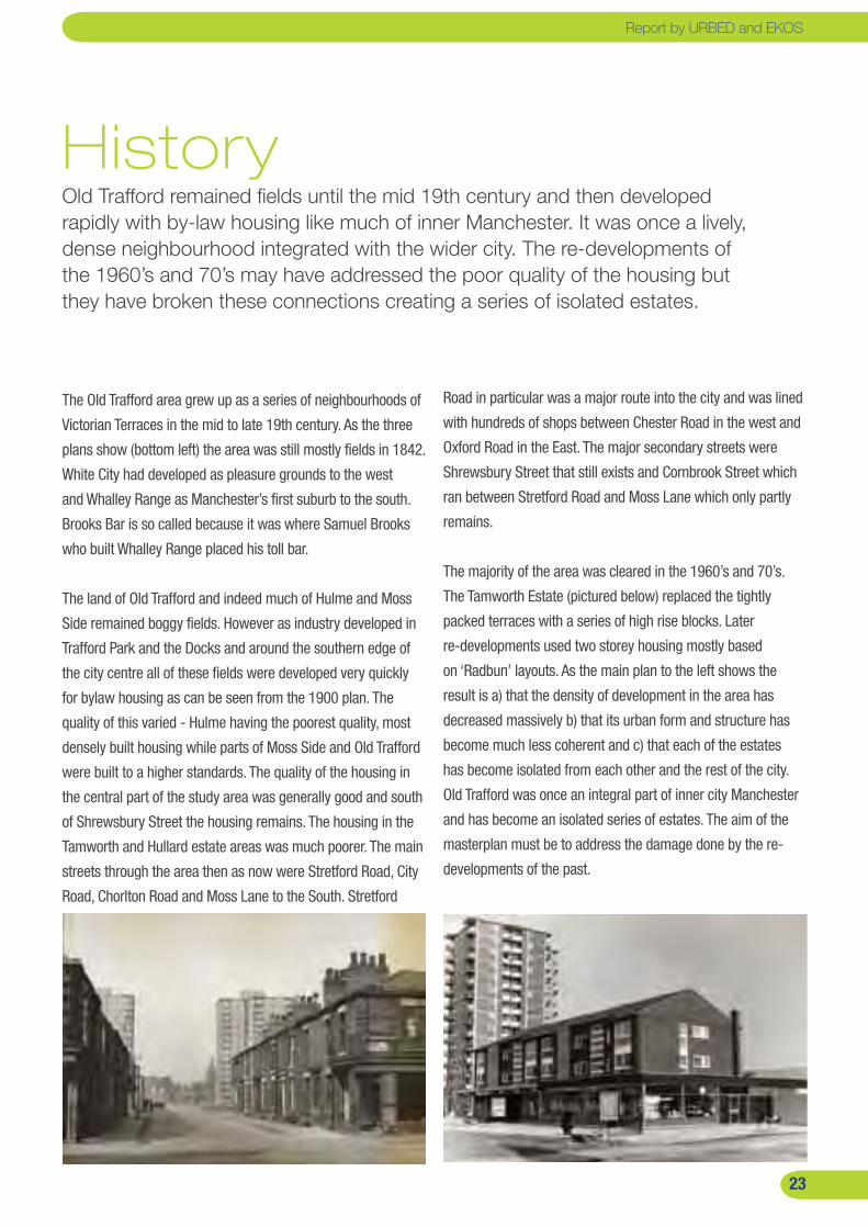
HistoryOld Trafford remained fields until the mid 19th century and then developed rapidly with by-law housing like much of inner Manchester. It was once a lively, dense neighbourhood integrated with the wider city. The re-developments of the 1960’s and 70’s may have addressed the poor quality of the housing but they have broken these connections creating a series of isolated estates.
The Old Trafford area grew up as a series of neighbourhoods of
Victorian Terraces in the mid to late 19th century. As the three
plans show (bottom left) the area was still mostly fields in 1842.
White City had developed as pleasure grounds to the west
and Whalley Range as Manchester’s first suburb to the south.
Brooks Bar is so called because it was where Samuel Brooks
who built Whalley Range placed his toll bar.
The land of Old Trafford and indeed much of Hulme and Moss
Side remained boggy fields. However as industry developed in
Trafford Park and the Docks and around the southern edge of
the city centre all of these fields were developed very quickly
for bylaw housing as can be seen from the 1900 plan. The
quality of this varied - Hulme having the poorest quality, most
densely built housing while parts of Moss Side and Old Trafford
were built to a higher standards. The quality of the housing in
the central part of the study area was generally good and south
of Shrewsbury Street the housing remains. The housing in the
Tamworth and Hullard estate areas was much poorer. The main
streets through the area then as now were Stretford Road, City
Road, Chorlton Road and Moss Lane to the South. Stretford
Road in particular was a major route into the city and was lined
with hundreds of shops between Chester Road in the west and
Oxford Road in the East. The major secondary streets were
Shrewsbury Street that still exists and Cornbrook Street which
ran between Stretford Road and Moss Lane which only partly
remains.
The majority of the area was cleared in the 1960’s and 70’s.
The Tamworth Estate (pictured below) replaced the tightly
packed terraces with a series of high rise blocks. Later
re-developments used two storey housing mostly based
on ‘Radbun’ layouts. As the main plan to the left shows the
result is a) that the density of development in the area has
decreased massively b) that its urban form and structure has
become much less coherent and c) that each of the estates
has become isolated from each other and the rest of the city.
Old Trafford was once an integral part of inner city Manchester
and has become an isolated series of estates. The aim of the
masterplan must be to address the damage done by the re-
developments of the past.
Report by URBED and EKOS

��
Old Trafford Masterplan
��
Old Trafford Masterplan
����
��
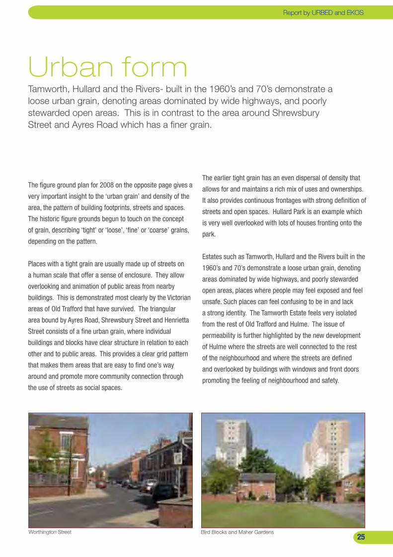
Urban form Tamworth, Hullard and the Rivers- built in the 1960’s and 70’s demonstrate a loose urban grain, denoting areas dominated by wide highways, and poorly stewarded open areas. This is in contrast to the area around Shrewsbury Street and Ayres Road which has a finer grain.
The figure ground plan for 2008 on the opposite page gives a
very important insight to the ‘urban grain’ and density of the
area, the pattern of building footprints, streets and spaces.
The historic figure grounds begun to touch on the concept
of grain, describing ‘tight’ or ‘loose’, ‘fine’ or ‘coarse’ grains,
depending on the pattern.
Places with a tight grain are usually made up of streets on
a human scale that offer a sense of enclosure. They allow
overlooking and animation of public areas from nearby
buildings. This is demonstrated most clearly by the Victorian
areas of Old Trafford that have survived. The triangular
area bound by Ayres Road, Shrewsbury Street and Henrietta
Street consists of a fine urban grain, where individual
buildings and blocks have clear structure in relation to each
other and to public areas. This provides a clear grid pattern
that makes them areas that are easy to find one’s way
around and promote more community connection through
the use of streets as social spaces.
The earlier tight grain has an even dispersal of density that
allows for and maintains a rich mix of uses and ownerships.
It also provides continuous frontages with strong definition of
streets and open spaces. Hullard Park is an example which
is very well overlooked with lots of houses fronting onto the
park.
Estates such as Tamworth, Hullard and the Rivers built in the
1960’s and 70’s demonstrate a loose urban grain, denoting
areas dominated by wide highways, and poorly stewarded
open areas, places where people may feel exposed and feel
unsafe. Such places can feel confusing to be in and lack
a strong identity. The Tamworth Estate feels very isolated
from the rest of Old Trafford and Hulme. The issue of
permeability is further highlighted by the new development
of Hulme where the streets are well connected to the rest
of the neighbourhood and where the streets are defined
and overlooked by buildings with windows and front doors
promoting the feeling of neighbourhood and safety.
Worthington Street Bird Blocks and Maher Gardens��
Report by URBED and EKOSReport by URBED and EKOS
��
Old Trafford Masterplan
��
Old Trafford Masterplan
����

��
ConnectionsA great number of tertiary streets are cul-de-sacs or severed secondary streets which undermine permeability and movement. One of the key issues to be addressed by the masterplan will be to improve permeability in the Old Trafford area and to increase connections to other areas.
The road hierarchy opposite helps us understand movement
dynamics and linkages, in and through an area. Cities and
places are often thought of as “movement economies” where
movement and connectivity are the single most important
variables. The greater number of connections; the more
democratic and the better dispersed activity is.
Old Trafford benefits from very good wider connectivity with
three A-roads: Stretford Road, Chorlton Road and Chester Road
running through the study area connecting to Manchester City
centre and the wider area. Secondary routes are strong in the
south west of the study boundary. Streets such as Shrewsbury,
Henrietta and Ayres Road all provide a clear secondary
network. However, with the exception of City Road, the
remainder of the study area lacks strategic secondary streets.
In places, vital routes such as Cornbrook Street and Marple
Street have been severed. This places a level of dependence
on neighbouring roads that is unnecessary. A great number
of tertiary streets are cul-de-sacs and / or severed secondary
streets which undermine permeability and movement between
the neighbourhoods of Old Trafford.
The current Metrolink skirts the northern boundary of the
study area with Cornbrook as the closest tram stops. This
station is not popular with residents due to its location and
poor quality environment. The confirmed Metrolink extension
(orange) runs south from the Altrincham line with new stops at
Firswood and Chorlton. However the marority of the study area
will not fall within 400 meters (10 minute walk) of a tram stop.
The proposed extension, to the Trafford Centre, via Trafford
Park, would be a very positive introduction- making important
links to these two employment hubs. Should this extension
materialise, it is unlikely to happen until 2013.
A Quality Bus Corridor (QBC) programme has been
implemented in the area. This has included new priority bus
lanes along Upper Chorlton Road and the alteration of traffic
light phasing along the A56 to improve efficiency of bus flow.
However, bus coverage is patchy, it is well-served by services
into the city centre but less so with cross town routes (The
250, 253 and 258 being the only available choices; to be
found along Stretford Road). Stretford and Chester Road are
the best served, with several day and night services. However
Chorlton Road, King’s Road and City Road, which all have a
single day bus service and no night service, and there are
several potential routes such as Ayres Road, Northumberland
Road and Victoria Street which have no service at all.
Secondary Route - Shrewsbury Street Primary Route - Chorlton Road ��
Report by URBED and EKOSReport by URBED and EKOS

��
Old Trafford Masterplan
��
Old Trafford Masterplan
����

��
Open Space The open space plan highlights the large quantity of space which is best described as passive amenity space and has little, or sometimes no, functional or amenity value.
One of the most immediate observations that jumps out of
the plan is the number, volume and distribution of parks,
gardens and childrens play facilities in the area. The most
notable in terms of quality and feel are the Victorian Parks-
Hullard and Seymour. Tamworth Park provides valuable open
space for the area but is not an official park. This space
is well maintained, with good paths, diverse and mature
vegetation, play and sports facilities. This space however,
largely because of its size and undulating topography, lacks
natural surveillance from the neighbouring buildings and
despite modern lighting, does not feel safe at night.
In 2007, Groundwork completed an Open Space Feasibility
Study on behalf of Trafford Housing Trust. This work covered
four estates: Hullard, Rivers, School Walks and Clifton Close,
evaluating open space within the estates and their potential
for improvement. The plan opposite includes designations
given by Groundwork’s audit.
Maher/ Tamworth Gardens- childrens playPassive amenity space in the Clifton’s area
The open space plan highlights the very large quantity of
space which is best described as passive amenity space
and has little, or sometimes no, functional or amenity value.
Although many of these space are well maintained with grass
that is cut regularly in the summer and vegetation that is
pruned, they very often feel like ‘left-over’ scraps of land that
collect litter and are not well overlooked or used.
Brown areas within the study boundary represent St
Alphonsus school playing fields, St Brides Field and
Old Trafford Community School play area. The recent
development of an Astroturf football pitch at Old Trafford
Community School is currently condemned for use due to
flooding and further investment will be needed to bring it back
to use. St. Brides Field is currently used for football and cricket
and is currently managed by a dedicated team including
Youth Workers for the area whom run mentoring and football
coaching sessions. They are keen to develop a Community
Resource Centre in conjunction with St Alphonsus School.
��
Report by URBED and EKOSReport by URBED and EKOS
�0
Old Trafford Masterplan
�0�0�0
����
PART 3: The Vision
The Round Table Workshop brought together key stakeholders all committed to the progress of Old Trafford, as well as members of the community whom understand better than anyone what needs to change in order for Old Trafford to prosper. The workshop established some key objectives for the development of Old Trafford.
Report by URBED and EKOS

��
Old Trafford Masterplan
��
Diagnosis The picture of Old Trafford painted in Part 2 of this report is of a series of relatively strong communities in a physically fragmented and disconnected part of the city. The twin drivers of Decent Homes and Growth Point Status offers the opportunity to restructure the area and repair its urban form for the benefit of the existing community and to attract newcomers into the area.
The population of the area is more similar to the adjacent
districts in Manchester than the rest of Trafford. In terms
of deprivation and issues such as long-term illness the
Tamworth and Hullard/Rivers estates are the most deprived.
In contrast the central Shrewsbury Street area has higher
levels of employment and owner occupation, yet also the
highest crime levels and the lowest income levels.
The different housing types in the area attract different
types of people. The nine high-rise blocks fulfil an
important housing need in Trafford. The residents tend to
be childless and generally younger while the turnover of
flats is high (around 15% a year with higher turnover on
the Tamworth Estate). The low-rise social housing estates
have traditionally housed families but, as well-established
areas, they accommodate a significant number of older
people alongside families. The central part of the area has
more private housing, mainly traditional terraces. This
area is characterised by larger families and a large Asian
community centred around the local Mosque. Many of
these areas are within the IMD’s most deprived 5% of areas
nationally. However despite this and the poor layout of the
social housing estates, most remain stable and are exhibiting
far less signs of stress than similar neighbourhoods in
Manchester and Salford.
In physical terms the area lacks coherence. As the historic
plans illustrate, the neighbourhood was once part of a
seamless stretch of terraced housing running from the edge
of the city centre to White City. Much of this was redeveloped
in the 1960’s and 1970s as a series of council estates that
face inwards and relate poorly to each other. The worst
connections are those over the boundary with Manchester. It
is as if the estates were planned by Trafford and Manchester
councils almost as if the legislative boundary was the end of
the earth!
Because of its fragmented structure, its lack of linkages and
the low density of some estates, much of the masterplanning
area feels isolated, belying its central location. The area does
not operate as one community – we have identified up to
eight communities often with very few links to each other.
This means, for example, that people from the Tamworth or
Hullard estates are unlikely to use the Shrewsbury Street
community facilities. One reason for this is the decline
of the high streets. In the past Stretford Road, City Road,
Cornbrook Road and Chorlton Road would have been high
streets providing a community hub to unite the adjacent
communities. Today the streets are dominated by fast
moving traffic, are hostile, and most of their shops and pubs
are gone. The estates turn their backs on the roads.
The masterplanning area therefore has significant structural
weaknesses in its design and layout and yet remains home
to strong and relatively stable communities. The twin drivers
of Decent Homes requirement and Growth Point status
offer an important opportunity to address these structural
weaknesses by redeveloping or restructuring parts of the
area, increasing the density of housing, repairing its urban
structure and turning it once more into a thriving urban
neighbourhood.
��
Report by URBED and EKOS
��
Old Trafford Masterplan
��
��
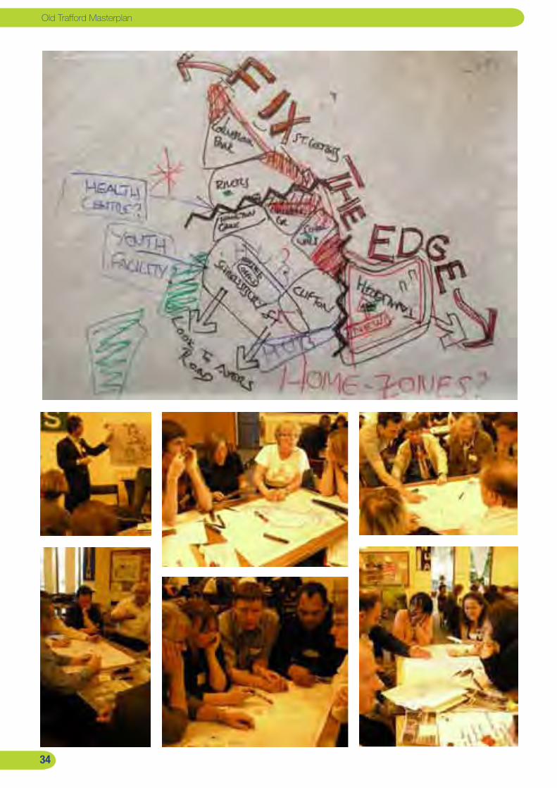
ConsultationsThe masterplan has been undertaken in partnership with local people through an extensive programme of consultations. The design Charrettes are described in Part 4 of this report. However the consultation started with a round table workshop on 30th June 2008 at St. Brides Church on Shrewsbury Street.
The initial workshop was aimed at stakeholders and
residents of Old Trafford to set the agenda for the
masterplanning exercise. The workshop included a
presentation of URBED’s initial findings and two interactive
sessions:
A sustainable community: The first session identified
the elements of a sustainable community against which
Old Trafford could be measured.
Mapping of the issues: The second session focused
upon identifying which parts of the area were most
affected by these issues and what needed to change.
The feedback on each of the areas was as follows:
Hullard: This area was seen as overcrowded, with the tower
blocks making it feel like people were living on top of each
other. There was conflict between young people and the
more established community and the lack of play facilities
meant that children were seen as ‘out of control’. The area
was seen as having been ‘thrown’ together with no sense of
identity and only one way in and out. There were problems
with litter and too many parked cars.
The Rivers: People disliked the layout of the estate which
‘may have worked thirty years ago doesn’t work today’. The
houses are back-to-front making it confusing and preventing
people from parking near their home. The communal space
is fenced-off and unusable. There is a feeling that the area is
too dense and that it is surrounded by busy roads.
The Central Area: The open space was seen as
inaccessible, underused and dangerous to cross. The
Shrewsbury Street area had problems because streets were
blocked so that the alleyways were used as rat runs. The
area has also suffered gang related problems. The more
recent estates were described as islands. The Community
Centre was seen as a good facility but was not used by
people in other parts of the area.
The Tamworth Estate: This area had the worst problems.
The tower blocks were intimidating and detached from Old
Trafford. The play area was very good and well-used but
the open space generally was uninviting. The area had drug
and alcohol issues, with high unemployment, a refugee
population with language barriers, a high turnover of flats
and levels of apathy. The balcony blocks were felt to have
improved and had a better sense of community.
The main points raised in the second session were:
There was a need for redevelopment of the tower blocks.
Stretford Road and Chorlton Road were barriers
preventing the integration of the area.
There was a need for better connections between
neighbourhoods
There needs to be a much stronger community hub and
focal point for the area possibly based around a new
community facility.
There was a need for improved shopping facilities, on
Stretford Road, City Road and Chorlton Road.
Report by URBED and EKOS

��
Old Trafford Masterplan
��
The question is therefore what we mean by a sustainable
community. The main objective for the masterplan for Old
Trafford outlined by Trafford Housing Trust, Trafford MBC and Old
Trafford Neighbourhood Management Partnership is to create a:
‘vibrant, sustainable community, with quality housing,
excellent environment, and good connections to
employment opportunities together with improved retail
and community facilities’
The key principles that should underlie the masterplan are:
�. Preserving what we have: We do not start with a blank
sheet of paper. The area is populated by strong and stable
communities and we must build on their success rather than
sweep them away as has happened in some other regeneration
areas.
�. Improving the quality of the environment: One of the
greatest weaknesses of the area is the quality of public spaces.
A focus must therefore be the transformation of the public
realm, both within estates and in the large public open spaces.
This will make the area feel more inviting and safer.
�. Connecting things together: One of the aims of the public
realm works should be to connect the estates together, to Hulme
and Stretford and to training and employment opportunities.
We need to establish an integrated and permeable network of
streets so that the estates no longer feel like isolated enclaves.
�. Strengthening local identity: The Old Trafford area is
the most culturally diverse part of Trafford. This is a strength
and is reflected in the diversity of local business. We should
capture this cultural capital to boost further business growth to
revive Stretford Road and Chorlton Road as local centres and
community hubs for the area.
�. A decent home for everyone: Everyone in the area should
have a decent home including all of the homes that have not yet
had decent homes work undertaken. The amount, affordability
and quality of homes in the area needs to be improved to meet
the needs of local residents.
�. A mixed and balanced community: Redevelopment and
infill opportunities should be used as an opportunity to diversify
the local community. The overall amount of social housing
should be maintained whilst additional new housing should
diversify the mix and tenure of the area with more family homes
and low cost home ownership.
�. Opportunities for all: The redevelopment of the area
and the mix of community facilities accessible to residents is
crucial. Facilities and services should be aimed at helping local
people improve their skills and qualifications and gain access to
employment in the conurbation. The Old Trafford Neighbourhood
Management Board will play a key role in ensuring that
opportunities are linked to residents and that training and
education remain at the forefront of service provision in the area.
�. A range of local facilities: There is a need to create a
balanced range of local facilities accessible to the whole of the
area. The main identified needs are for Youth Facilities, Training
Facilities and local shopping parades. These should be focused
on the Stretford Road and Chorlton Road high streets to be
accessible to all of the community.
Vision for the area The aim of the masterplan is to address the issues described in the first part of this report. However the masterplan has the potential to be more than just a repair job. The aim should be to create a series of thriving, sustainable neighbourhoods that can integrate with each other as well as with the neighbouring areas of Hulme and Stretford.
��
Report by URBED and EKOS
��
Old Trafford Masterplan
Achieving the Vision Outlined below is a list of key regeneration objectives to support the masterplan in order for the regeneration of Old Trafford to be successful. These objectives fall under 6 categories.
Housing and the built EnvironmentTrafford has always been a popular choice of location for
working professionals whom are drawn to the location due to
easy reach of jobs in Manchester and Trafford Park. However
Old Trafford is still one of the most deprived neighbourhoods
in the Borough of Trafford. There is also a higher population
of Minority and Ethnic groups. In order to ensure local
communities benefit from regeneration and the area continues
to attract new residents some key actions need to be taken:
To promote the development of Old Trafford as a housing
Growth point and to develop infrastructure, transport,
retail and community
To create a more balanced mix of property types and
tenures across the area
To provide more choice and diversity to meet the
differing needs of the existing population and to attract
people into the area
To provide new housing of high quality in terms of
design, energy efficiency and sustainability
To encourage stepping into home ownership by
supporting people from social rented accommodation to
part and full ownership
To improve the management and availability of services
to local residents
Transport and ConnectivityThe Trafford Boundary is shared by Hulme, which has
benefited from major regeneration that has improved the
layout, introduced much improved housing and community
infrastructure and has benefited from the opening of Stretford
Road. The Northern tip of Trafford is serviced by a tram station
which has the potential to link the community of Old Trafford to
opportunities within the wider city region.
■
■
■
■
■
■
Old Trafford Gateway Development Framework
An area running from the far northern tip of Old Trafford to
Stretford Road was identified in the Old Trafford Gateway
Development Framework as a key gateway to Old Trafford
where special consideration needs to be given to the
development of the area. Key priorities for the improvements
are:
Improve access to Cornbrook Park station and other
public transport nodes in order to link Old Trafford with
jobs and training opportunities
To improve connectivity throughout the area by
promoting linkages between the north, central and east
of Old Trafford and the rest of Manchester.
Improve the streetscape environment and provide safer
and more legible routes
New development and public realm improvements
should be based on the guidance as set out in the
manual for Streets and Home Zone principles.
There should be stricter design guidance on the
development of properties along Stretford Road to
strengthen the role of the route as a key connector
between Trafford and Manchester.
To promote better walking and cycling routes in the area
To introduce better crossings on Stretford Road and
Chorlton Road
EconomyThe Trafford Economic Development Plan 2006-2009 outlined
the importance of Trafford as an economic driver for the North
and highlighted the importance of Trafford’s location at the edge
of the regional centre and close to many of the regions key
assets. Old Trafford is in a position to exploit its prime location
and tap into the economic growth for the region. Trafford
has one of the highest business density rates in the north
(Trafford has 49 businesses per 1000 residents compared
to Manchester which has 34 per 1000 residents). There is
■
■
■
■
■
■■
��
��
however a disproportionate share of business and enterprise
growth in the Trafford Borough with a majority of growth in
financial, professional and business services accounting for
30% of jobs in Trafford, with IT services accounting for 4.7%
of jobs and media accounting for 8.7% of jobs. There is also
disproportion in relation to the economic activity of residents in
Trafford as wards within Old Trafford are the most deprived in
the borough and nationally and have high unemployment rates.
Key priorities for Old Trafford will be:
Improve training and employment services within Old
Trafford to connect local residents to opportunities within
Trafford and the wider city region.
Encourage training and targets for better quality
employment
Specific support for BME community into sectors where
there is under-representation such as finance and
banking.
Support for long term unemployed to get back into work
Continued support services geared towards confidence
building and retraining for relevant skills
EnvironmentalThe masterplan suggests improvements which will
help to improve the permeability of the area as well as
improvements to Tamworth Park, St Brides Fields and
introduction of a new park/green corridor at Hullard Estate.
Overall new layouts and buildings will adhere to Code for
sustainable Homes level 4.
To connect and enhance the network of green spaces
To improve Tamworth Park
To open up a green corridor between St George’s Park in
Hulme and Hullard Estate in Old Trafford
To improve the layout of estates through de-radburning
schemes, and promotion of better quality public realm.
To promote sustainable development through the design
and layout of new housing and facilities
■
■
■
■■
■■■
■
■
Social and CulturalThe development and continued improvement to community
facilities in the area is crucial to the progress of the
community. These are crucial to the promotion of social
cohesion in Old Trafford.
To develop and improve community facilities within Old
Trafford
To improve youth provision in the area
To ensure development of accessible facilities which are
sensitive to the needs of local people.
To develop an action plan for a new and improved Old
Trafford Community Centre
Governance, Equity and Services
Continued Neighborhood Management to maximize
on the regeneration through management of the Old
Trafford masterplan with representation and support
from Old Trafford Neighborhood Management, Trafford
Council and Trafford Housing Trust
Development of a Digital Inclusion Strategy to help local
residents gain computer skills to assist with training and
job opportunities, and help with making computers more
accessible. This could be done with the Media City, and
Lets Go Global.
Develop the Financial Inclusion Strategy in relation to
Old Trafford (currently being developed with THT and The
University of Salford)
To support residents through the process of regeneration
by providing assistance and information on housing
options.
■
■■
■
■
■
■
■
Report by URBED and EKOS
�0
Old Trafford Masterplan
�0�0�0
����
PART 4: Developing Options
This chapter builds on the existing opportunities and begins the process of Community Design through a series of Design Charettes for each of the three areas of Old Trafford. The masterplanning options which emerge from the Charettes are then taken back to the community for feedback and a preferred option is developed. This is divided into 9 key projects.
Report by URBED and EKOS
��
Old Trafford Masterplan
��
��
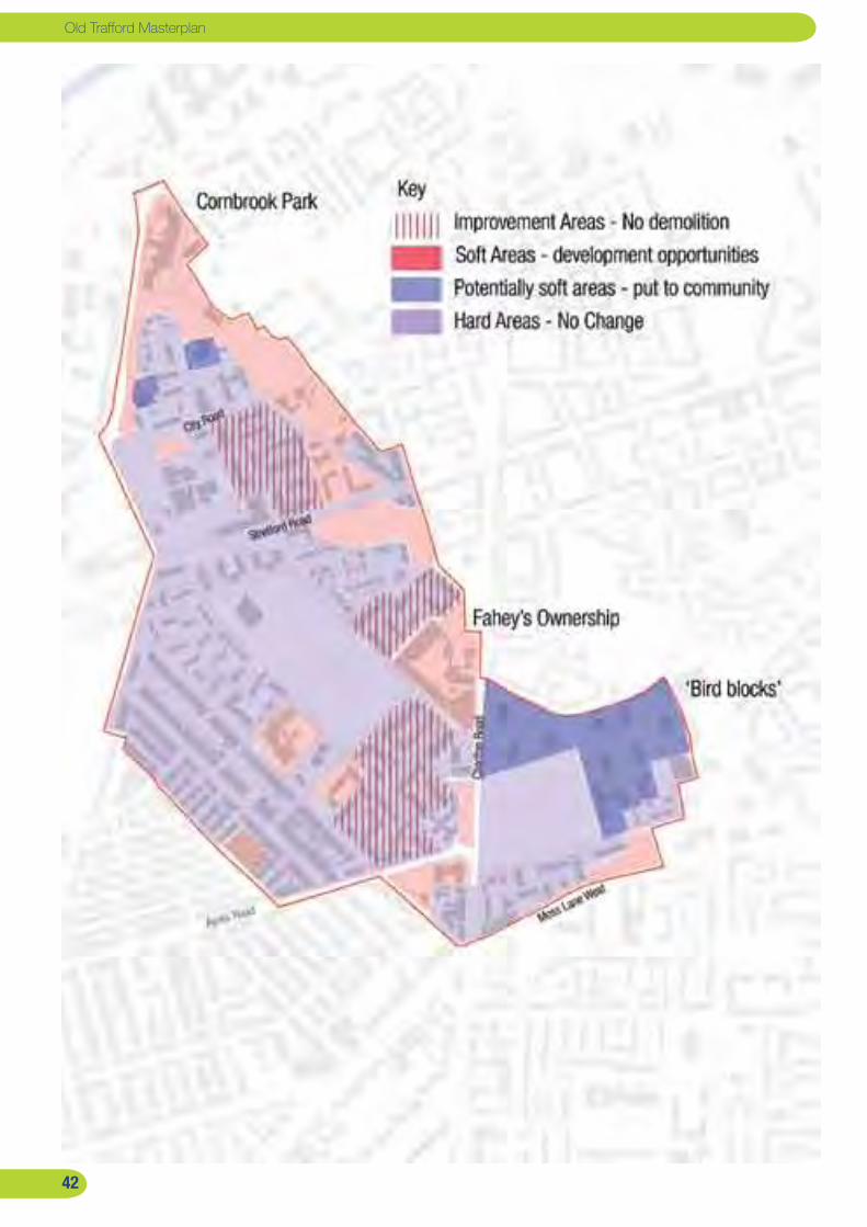
Opportunities for Change The starting point for the masterplanning exercise is what we call the ‘hard and soft’ exercise. The aim of this is to identify those parts of the area where minimal change is expected (the hard areas) and those area where development is possible (soft). The latter becomes the canvas for the masterplan.
A number of factors feed into the identification of soft areas;
The current condition of the site and its prominence, whether
it is in public ownership, the intentions of private owners and
the viability of investment in housing that doesn’t yet meet the
Trafford Standard. On the basis of these criteria the area has
been divided up into the following categories:
Hard sites where no change is envisaged.
Improvement areas where no demolition is planned.
Sites which are definitely available for development.
Sites which are potentially available and where the
community should be asked what should happen.
The results of this process are described on the plan to the left
and below:
Hullard Estate:
The low rise housing at the heart of the estate will remain
unchanged.
There are questions over the future of the two tower
blocks because of the costs of bringing them up to the
Trafford Standard. Its was agreed that the community
should be asked about the future of these blocks.
The supported accomodation for older persons on City
Road currently vacant and on a short term lease, to
become available in the near future.
The Malvern Walk shops have been categorised as
possibly soft.
The same is true of the open space in the area that is
poorly defined and feels unsafe.
The poor quality industrial space to the north of the area is
shown as soft because of the prominence of this site.
The Rivers
Most of the Rivers estate will remain as it and is identified
for improvement.
Trafford and Ryland’s Blocks are in a poor state and
currently do not meet the decent homes standard and are
identified for demolition.
The Central Area
The Essex Way area is a vacant site and is available for
development.
The Fahey’s depot is being explored by the owners as a
development site and so is soft.
Isobel Baillie Lodge is surplus to requirements and is
available for development.
The community centre would become available if a new
community facility were to be built elsewhere.
Duerrs, has been vacant for a while and is subject to
and outline planning application for 19 homes which are
likley to be developed in the near future.
The Polish Ex Service Mens Club is currently vacant and is
a possible re-furbrishment opportunity for other business
and community uses.
There are a series of potential sites on Chorlton Road that
may become available. Clifton Court is leased from THT
and may be available at the end of the lease.
Tamworth
The main issue here is the seven towers. The three
balcony blocks are generally more successful than the
four Bird Blocks but all need significant investment. The
money for this is however in the business plan and it was
agreed that the community should be asked about which
if any towers should be demolished.
Report by URBED and EKOS
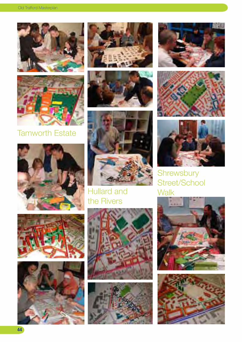
��
Old Trafford Masterplan
Tamworth Estate
Hullard and the Rivers
Shrewsbury Street/School Walk
��

��
The design charrettes The Design Charrettes were held over a two week period in July 2008 where the masterplanning options were developed in public through interactive sessions with local people and parallel youth workshops.
The masterplanning options were developed through a series
of community ‘design charrettes’. The masterplanning area
was split into three - the Hullard and Rivers Estates, the
Shrewsbury Street/School Walk areas and the Tamworth
Estate. In each area we found a local venue and ran two
evening sessions together with a bus tour. Alongside the
workshops we ran a series of sessions for young people
which involved going out to talk to them on the estate and
then running workshops parallel to the charrettes.
The first of these sessions looked at the areas as they are
today. The workshop started with a presentation of urban
principles and was followed by a series of analysis sessions
looking at the urban form, street network, open spaces and
land uses of the area. The intention was to get people to
identify the area’s problems as well as identifying the causes
in as much as they related to the design and layout of the
estate. The session concluded with a hard and soft exercise,
in which the groups discussed which parts of the area could
be developed.
The Saturday after the first workshops we arranged a bus
tour of new housing schemes in Manchester. This included
Ordsall, Chimney Pot Park and Lower Broughton in Salford,
the Three Sisters in Collyhurst, New Islington and New East
Manchester, the Northmoor Home Zone and Hulme. The
intention was to give a feeling for what was possible in the
Old Trafford area.
This fed into the second session which started with a slide
show of possibilities that people used to create a set of
‘mood boards’ with collages of pictures of the sort of places
that they would like to see in Old Trafford. This led into the
main masterplanning session that started by replanning the
street network of each area, looking at the open space and
then developing a three dimensional masterplan in plasticine.
Each workshop was split into subgroups and each of these
were encouraged to explore different options. The result
was two options from each workshop, typically a modest
option and a radical option. Following the workshops these
were expanded into three options as the basis for a public
exhibition in September 2008.
Report by URBED and EKOS

��
Old Trafford Masterplan
Option � - Minimal change Demolition of Cornbrook Court
Retention and refurbishment of Empress Court, Princess
Court as well as Trafford and Ryland’s Courts
New build on Cornbrook Court and around Princess Court
New housing on the site in front of Old Trafford
Community School on City Road.
Improved open space linking to St. George’s Park
overlooked by housing
Cornbrook Park Road reopened to link Princess St. and
City Rd.
Virgil Street Extended to City Rd.
Home Zones created on residential streets
Option � - Medium change Cornbrook Court, Malvern Row, Trafford Court, Ryland’s
Court demolished and redeveloped for housing
Retention and refurbishment of Empress Court and
Princess Court
New residential development on Chester Road
Open space reduced but improved with new
development providing surveillance
Cornbrook Park Road reopened to link Princess Street.
Virgil Street Extended to City Road, Trafford Place
extended to Lucy Street
Home Zones created on residential streets
Lets Go Global moved into a new unit
Option � - Maximum Change Empress Court, Princess Court, Trafford Court, Ryland’s
Court, Cornbrook Court, Malvern Row, garages on Rivers
Estate to be redeveloped for housing
De-Radburning of Rivers and reintroduce streets and
internal courtyards
New gateway development in the northern part of the
area
New residential development on Chester Road
Reduced open space to create a new frontage to St.
George’s Park
Access improvements as in Option 2
��

��
Hullard and Rivers options
The residents at the Hullard and Rivers Workshops were very open to the idea of radically re-configuring the estates but were more cautious when it came to demolition.
The Hullard and Rivers workshops were held at Lets Go
Global on 8th and 15th July 2008. The main concerns related
to the lack of facilities in the area, the fact that it felt cut
off and the problems associated with the tower blocks and
walk up blocks. There was also concern about the confusing
layout of the Rivers Estate.
The workshop came up with two options for the area
illustrated below. Both options are fairly similar – they retain
the tower blocks, reopen Cornbrook Park Road, re-configure
the Rivers Estate and redevelop the industrial units to the
north. They differ mainly in the amount of open space.
The three options developed for consultation introduce more
variety to give people a wider choice. Options 1 and 2 retain
the towers while 3 redevelops them. The redevelopment of
the industrial units is only shown on Option 3 along with the
re-configuration of the Rivers Estate. These three options
were used as the basis for consultation. Youth comments:“It would be so nice to have a cinema close by” Jenna Hughes, 12yrs “We want a clean area with astroturf like the one at West Union St. Community School”, Tony Robinson, 15yrs
Report by URBED and EKOS

��
Old Trafford Masterplan
Option � - Minimal change The refurbishment of part of Fahey’s depot for
community use.
The redevelopment for housing of: the car wash site on
Chorlton Road, Isobel Baillie Lodge, Essex Way/Stretford
Road, Shrewsbury Street Car Park, the cleared Site on
Ayres Road and the corner of Maher Gardens.
The improvement of the St. Alphonsus fields as a park.
Cornbrook Street improved between Stretford Road and
St, Brides Way.
Shrewsbury Street Community Centre expanded and a
smaller facility developed on Fahey’s Site.
Option � - Medium change Redevelopment of the Fahey’s Depot for housing with
community use in the retained building
Mixed use development of the Essex Way/ Stretford Road.
Redevelopment for housing of the car wash site, Ayton
House, Isobel Baillie Lodge and the Shrewsbury Street
car park.
Improvements and de-radburning of the Clifton’s estate.
New frontage onto Chorlton Road around the Sharon
Church and Clifton Court.
The improvement of the St. Alphonsus fields as a park.
Reopening of Clifton St. Hamilton St. and Cornbrook St.
Shrewsbury Street Community Centre expanded and a
smaller facility developed on Fahey’s Site.
Option � - Maximum change Redevelopment of the Fahey’s Depot for employment and
housing with community use in the retained building.
Mixed use development of the Essex Way/ Stretford Road.
Redevelopment for housing of the car wash site, Ayton
House, Isobel Baillie Lodge and surroundings and the
Shrewsbury Street car park.
Improvements and de-radburning of the Clifton’s estate.
New frontage onto Chorlton Road around the Sharon
Church and Clifton Court.
The improvement of the St. Alphonsus fields as a park.
Reopening of Clifton St. Hamilton St. and Cornbrook St.
Shrewsbury Street Community Centre expanded and a
smaller facility developed on Fahey’s Site.
��
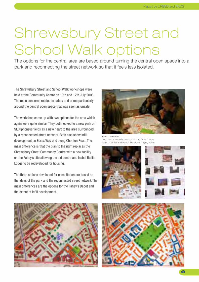
��
Shrewsbury Street and School Walk optionsThe options for the central area are based around turning the central open space into a park and reconnecting the street network so that it feels less isolated.
The Shrewsbury Street and School Walk workshops were
held at the Community Centre on 10th and 17th July 2008.
The main concerns related to safety and crime particularly
around the central open space that was seen as unsafe.
The workshop came up with two options for the area which
again were quite similar. They both looked to a new park on
St. Alphonsus fields as a new heart to the area surrounded
by a reconnected street network. Both also show infill
development on Essex Way and along Chorlton Road. The
main difference is that the plan to the right replaces the
Shrewsbury Street Community Centre with a new facility
on the Fahey’s site allowing the old centre and Isobel Baillie
Lodge to be redeveloped for housing.
The three options developed for consultation are based on
the ideas of the park and the reconnected street network The
main differences are the options for the Fahey’s Depot and
the extent of infill development.
Youth comment:“We have a lovely house but the graffiti isn’t nice at all ...” Linko and Vanish Mackova, 11yrs, 13yrs
Report by URBED and EKOS
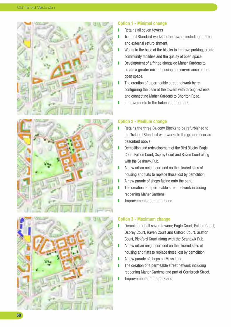
�0
Old Trafford Masterplan
Option � - Minimal change Retains all seven towers
Trafford Standard works to the towers including internal
and external refurbishment.
Works to the base of the blocks to improve parking, create
community facilities and the quality of open space.
Development of a fringe alongside Maher Gardens to
create a greater mix of housing and surveillance of the
open space.
The creation of a permeable street network by re-
configuring the base of the towers with through-streets
and connecting Maher Gardens to Chorlton Road.
Improvements to the balance of the park.
Option � - Medium change Retains the three Balcony Blocks to be refurbished to
the Trafford Standard with works to the ground floor as
described above.
Demolition and redevelopment of the Bird Blocks: Eagle
Court, Falcon Court, Osprey Court and Raven Court along
with the Seahawk Pub.
A new urban neighbourhood on the cleared sites of
housing and flats to replace those lost by demolition.
A new parade of shops facing onto the park.
The creation of a permeable street network including
reopening Maher Gardens
Improvements to the parkland
Option � - Maximum change Demolition of all seven towers; Eagle Court, Falcon Court,
Osprey Court, Raven Court and Clifford Court, Grafton
Court, Pickford Court along with the Seahawk Pub.
A new urban neighbourhood on the cleared sites of
housing and flats to replace those lost by demolition.
A new parade of shops on Moss Lane.
The creation of a permeable street network including
reopening Maher Gardens and part of Cornbrook Street.
Improvements to the parkland
�0
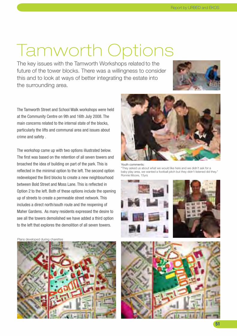
��
Tamworth OptionsThe key issues with the Tamworth Workshops related to the future of the tower blocks. There was a willingness to consider this and to look at ways of better integrating the estate into the surrounding area.
XXX
Youth comments:“They asked us about what we would like here and we didn’t ask for a baby play area, we wanted a football pitch but they didn’t listened did they.” Ronnie Moore, 15yrs
The Tamworth Street and School Walk workshops were held
at the Community Centre on 9th and 16th July 2008. The
main concerns related to the internal state of the blocks,
particularly the lifts and communal area and issues about
crime and safety .
The workshop came up with two options illustrated below.
The first was based on the retention of all seven towers and
broached the idea of building on part of the park. This is
reflected in the minimal option to the left. The second option
redeveloped the Bird blocks to create a new neighbourhood
between Bold Street and Moss Lane. This is reflected in
Option 2 to the left. Both of these options include the opening
up of streets to create a permeable street network. This
includes a direct north/south route and the reopening of
Maher Gardens. As many residents expressed the desire to
see all the towers demolished we have added a third option
to the left that explores the demolition of all seven towers.
Plans developed during charettes
Report by URBED and EKOS
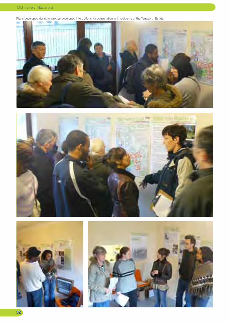
��
Old Trafford Masterplan
Plans developed during charettes developed into options for consultation with residents of the Tamworth Estate.
��

��
Resident viewsA total of 88 questionnaires were completed by residents, the majority on the Tamworth Estate where most change is likely. The majority of residents opted for radical change including the demolition of the tower blocks. This fed into the options appraisal described on the following page.
Residents views were collected through a series of
exhibitions in each area at the end of September/early
October 2008. Staffed exhibitions were held in each part
of the area after which the boards stayed in the library
for another two weeks. Questionnaires were available for
people to record their views. In total 119 residents attended
these exhibitions and 88 response forms were completed.
The majority of these (58) came from the Tamworth Estate,
which is remarkable given the low level of community
involvement in this area in the past. There was however a
poor response from the Central Area, insufficient to draw any
firm conclusions.
Hullard and the Rivers: In this area 25 responses were
received. Of those that expressed a preference, eleven
preferred Option 3 and only one and two respectively
preferred Options 1 and 2. This represented a desire for
radical change and to see the demolition of Trafford and
Ryland’s Courts and the two towers. However most of the
respondents were from the low rise blocks and there was
not enough feedback from the towers to judge the views of
residents.
Central Area: There were only five completed questionnaires
for the central area, reflecting the limited change proposed
in the area. Three of the five opted for the radical option and
the other two chose option 1 but the numbers are too small
to draw firm conclusions.
The Tamworth Estate: This area elicited the greatest
response with 58 completed forms from across the area.
The preferred option was a close call between Option 2
(demolition of the Bird Blocks) and option 3 (total demolition
of the Bird and Balcony Blocks). The situation was confused
however because many residents of the low rise blocks
objected mainly to opening the streets up and expressed
a preference accordingly. We have however looked more
closely at the responses from the residents of the tower
blocks. The response for Option 2 was very balanced with
equal numbers for each of the four categories; ‘strongly
agree, agree, disagree and strongly disagree. By contrast
the responses on Option 3 were 16 ‘strongly agree’ and
10 ‘strongly disagree’ with nothing in the middle. Further
analysis shows that the balcony residents were fairly evenly
split with a small majority for Option 2 while the Bird blocks
had a significant majority for Option 3 (in other words if our
blocks are to be demolished the balcony blocks should be
too!).
Report by URBED and EKOS
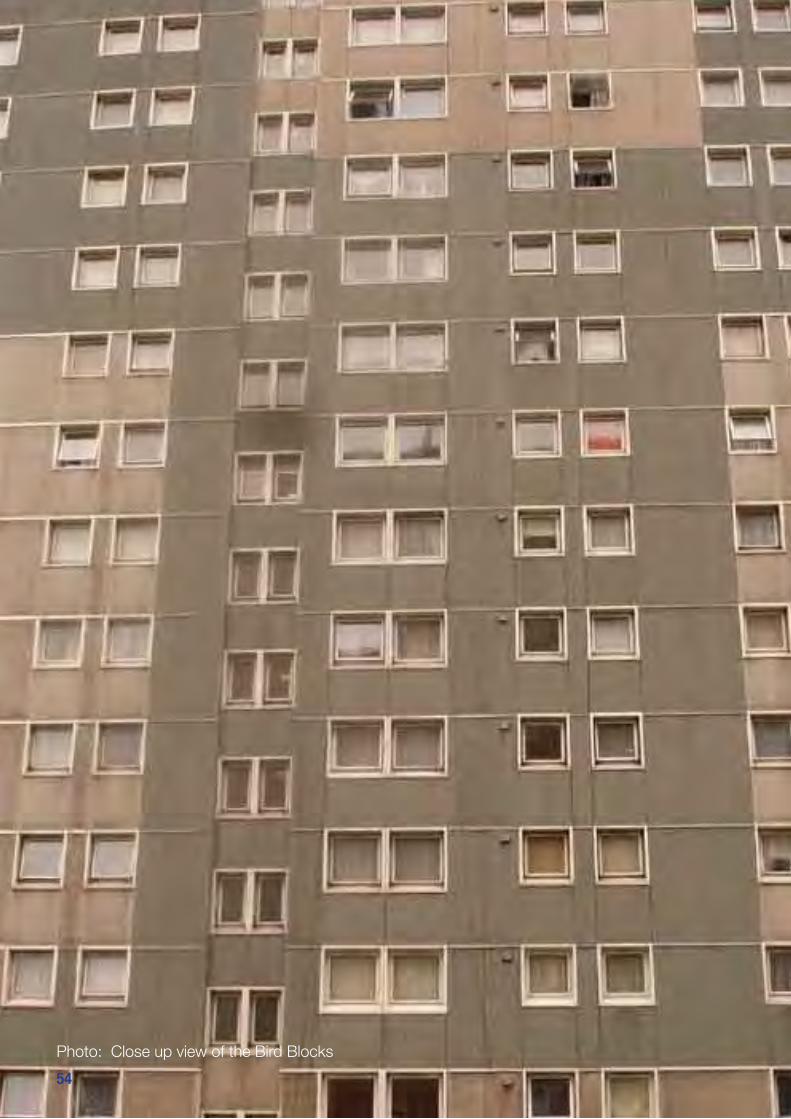
��
Old Trafford Masterplan
Photo: Close up view of the Bird Blocks
��
��
Options appraisalThe views of residents were generally in favour of radical intervention including demolition. This has been tempered by a viability assessment, assessment of regeneration impact and the views of stakeholders to arrive at a preferred option.
Resident Views: The views of residents, as described on the
previous page can be summarised as follows:
A general preference for more radical options.
A willingness to see the towers demolished.
A willingness in the northern and central areas to open up
the street network.
A concern about opening streets on the Tamworth Estate
- from the residents of the low rise housing.
The views of the community have been set alongside three
further options appraisals; viability, regeneration impact and
the views of stakeholders.
Viability: Advice on viability was provided by EKOS. This
has proved difficult in the current market because very little
is viable. However the main issue as the market picks up
will relate to the amount of publicly-owned land released by
demolition and the potential for developing housing rather
than flats (because the former are more viable). The viability of
redeveloping the tower blocks on the Tamworth Estate would
therefore be greater than the tower blocks on the Hullard
Estate, because the latter would release very little additional
development land.
Regeneration impact: The issue with regeneration
impact is whether the minimal options will be sufficiently
transformational to bring about a permanent change in the
area. The issue, for example on the Hullard and Tamworth
estates, is whether they can thrive in the future with some
or all of the tower blocks remaining. The conclusion from
the visit to the refurbished Three Sisters towers in Collyhurst
was that this probably was possible provided that the towers
are comprehensively refurbished. More important to the
transformation of the area than the demolition of blocks is the
opening up of the street network. The neighbourhoods with
the greatest problems are those that feel most isolated and
transformation is possible by opening up the street network
and de-redburning the low rise estates. Stakeholder Views: Throughout the study meetings have
been held with a range of stakeholders including land owners,
departments in Trafford Council, Manchester Council, the
Trafford Housing Trust and the Neighbourhood Management
Partnership. The options together with the views of the
community and the options appraisal were discussed with
them to agree the preferred option. The conclusions of these
discussions were as follows:
We should go for the radical option where possible to
bring about transformational change in line with the views
of the community.
Princess and Empress Court should not be demolished
because they remain popular with residents (who were
not represented in the consultations) and because
redevelopment is unlikely to be viable.
The Balcony Blocks should be retained but the Bird Blocks
should be redeveloped. This would allow for the planned
decanting of residents and the creation of a good viable
development site.
The road network should be reconnected but this should
be tempered on the Tamworth Estate in response to
tenant concerns.
Report by URBED and EKOS
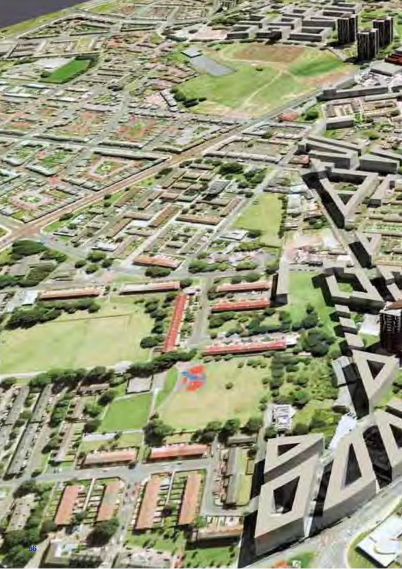
��
Old Trafford Masterplan
��

��
PART 5: The Masterplan
The consultations have fed into a masterplanning process based on the analysis of the area and the decisions taken as part of the options appraisal. This is based on a masterplanning framework to repair the urban fabric of the area, to redevelop the social housing areas identified in the last section and to provide opportunities for infill development. The Masterplan has then been parcelled into nine projects each of which have been appraised. This section described the masterplan framework and the nine projects.
Report by URBED and EKOS

��
Old Trafford Masterplan
1 2
3 4
Connectivity Urban Form
Parks Sense of Place
��
Old Trafford Masterplan
View of de-radburned homes in Plymouth Grove, Manchester Streets and mixed tenure blocks in Hulme
����
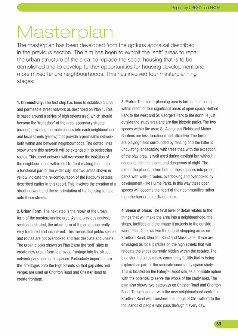
��
MasterplanThe masterplan has been developed from the options appraisal described in the previous section. The aim has been to exploit the ‘soft’ areas to repair the urban structure of the area, to replace the social housing that is to be demolished and to develop further opportunities for housing development and more mixed tenure neighbourhoods. This has involved four masterplanning stages:
�. Connectivity: The first step has been to establish a clear
and permeable street network as described on Plan 1. This
is based around a series of high streets (red) which should
become the ‘front door’ of the area, secondary streets
(orange) providing the main access into each neighbourhood
and local streets (yellow) that provide a permeable network
both within and between neighbourhoods. The dotted lines
show where this network will be extended in to pedestrian
routes. This street network will overcome the isolation of
the neighbourhoods within Old Trafford making them into
a functional part of the wider city. The two areas shown in
yellow indicate the re-configuration of the Radburn estates
described earlier in this report. This involves the creation of a
street network and the re-orientation of the housing to face
onto these streets.
�. Urban Form: The next step is the repair of the urban
form of the masterplanning area. As the previous analysis
section illustrated, the urban form of the area is currently
very fractured and incoherent. This means that public spaces
and routes are not overlooked and feel desolate and unsafe.
The urban blocks shown on Plan 2 use the ‘soft’ sites to
create new urban form to provide frontage into the street
network parks and open spaces. Particularly important are
the frontages onto the High Streets so that gap sites and
verges are used on Chorlton Road and Chester Road to
create frontage.
�. Parks: The masterplanning area is fortunate in being
within reach of four significant areas of open space. Hullard
Park to the west and St. George’s Park to the north lie just
outside the study area and are fine historic parks. The two
spaces within the area; St. Alphonsus Fields and Maher
Gardens are less functional and attractive. The former
are playing fields surrounded by fencing and the latter is
undulating landscaping with trees that, with the exception
of the play area, is well used during daylight but without
adequate lighting is dark and dangerous at night. The
aim of the plan is to turn both of these spaces into proper
parks with well-lit routes, overlooking and overlooked by
development (like Hulme Park). In this way these open
spaces will become the heart of their communities rather
than the barriers that divide them.
�. Sense of place: The final level of detail relates to the
things that will make the area into a neighbourhood, the
shops, facilities and the image it projects to the outside
world. Plan 4 shows two three local shopping areas on
Stretford Road, Chorlton Road and Moss Lane. These are
envisaged as local parades on the high streets that will
relocate the shops currently hidden within the estates. The
blue star indicates a new community facility that is being
explored as part of the separate community space study.
This is located on the Fahey’s Depot site, as a possible option
with the potential to serve the whole of the study area. The
plan also shows two gateways on Chester Road and Chorlton
Road. These together with the new neighbourhood centre on
Stretford Road will transform the image of Old Trafford to the
thousands of people who pass through it every day.
��
Report by URBED and EKOSReport by URBED and EKOS

�0
Old Trafford Masterplan
�0
Old Trafford Illustrative Masterplan
�0�0

��
The illustrative plan
The masterplanning framework described on the previous
page has been developed into the illustrative masterplan to
the left. This shows the area as it could be in ten or fifteen
years time when its transformation has been completed and
when its streets will form a safe and seamless link between
Hulme and Stretford.
The key features of the plan are as follows:
North area (Rivers, Hullard, Trafford and Ryland’s)
The decision was taken following the community charrettes
and discussions with THT to retain both Princess and
Empress Court. However the redevelopment of Cornbrook
Court and Malvern Row creates an opportunity to
substantially redevelop and reconfigure the Hullard estate
including a smaller but better supervised open space linking
to St. George’s Park and the reopening of Cornbrook Way
through the area to overcome its isolation.
The industrial area to the north is shown as a
landmark scheme key gateway into Old Trafford from the
city centre. This however would been to be apartments and
will not be viable for a number of years and as such is not
included in the current appraisals.
South of City Road the masterplan proposes the
demolition of Trafford and Ryland’s Court and a combination
of infill development and de-radburning to reconfigure the
Rivers Estate.
Central area (between Stretford Road and Ayres Road)
Retention and demolition in Central Old Trafford.
The proposals for the central part of the area are based
around the improvement of St. Alphonsus Park and the
de-radburning of the Clifton’s neighbourhood. There are
also a number of opportunities around the edge of the
area for new build. These include the council-owned site
Essex Way on Stretford Road together with the THT Owned
Isobel Bailey Lodge and possibly the Shewsbury Street
Community Centre if it is replaced with a new facility. There
are also opportunities on publicly owned land along Upper
Chorlton Road to create a new frontage together with the
redevelopment of the Fahey’s depot which will be brought
forward as a private scheme.
Eastern area (Tamworth and Maher Gardens)
The plan for the Tamworth estate sees the retention of the
Balcony Blocks and the demolition of the four Bird Blocks
(total no of units demolished is 336 made up of 112 one bed
flats and 224 two bed flats). These together with the site of
the old people’s home that has recently been demolished
and the Seahawk Pub will create a significant development
site that is shown developed with a range of new homes
and apartments. The scheme includes a small block on
the corner of Tamworth Park which together with the new
housing will create a greater degree of supervision of the
greenspace.
��
The masterplanning principles have been brought together into an illustrative masterplan which is a vision of how the area could look in ten or fifteen years time.
Report by URBED and EKOSReport by URBED and EKOS
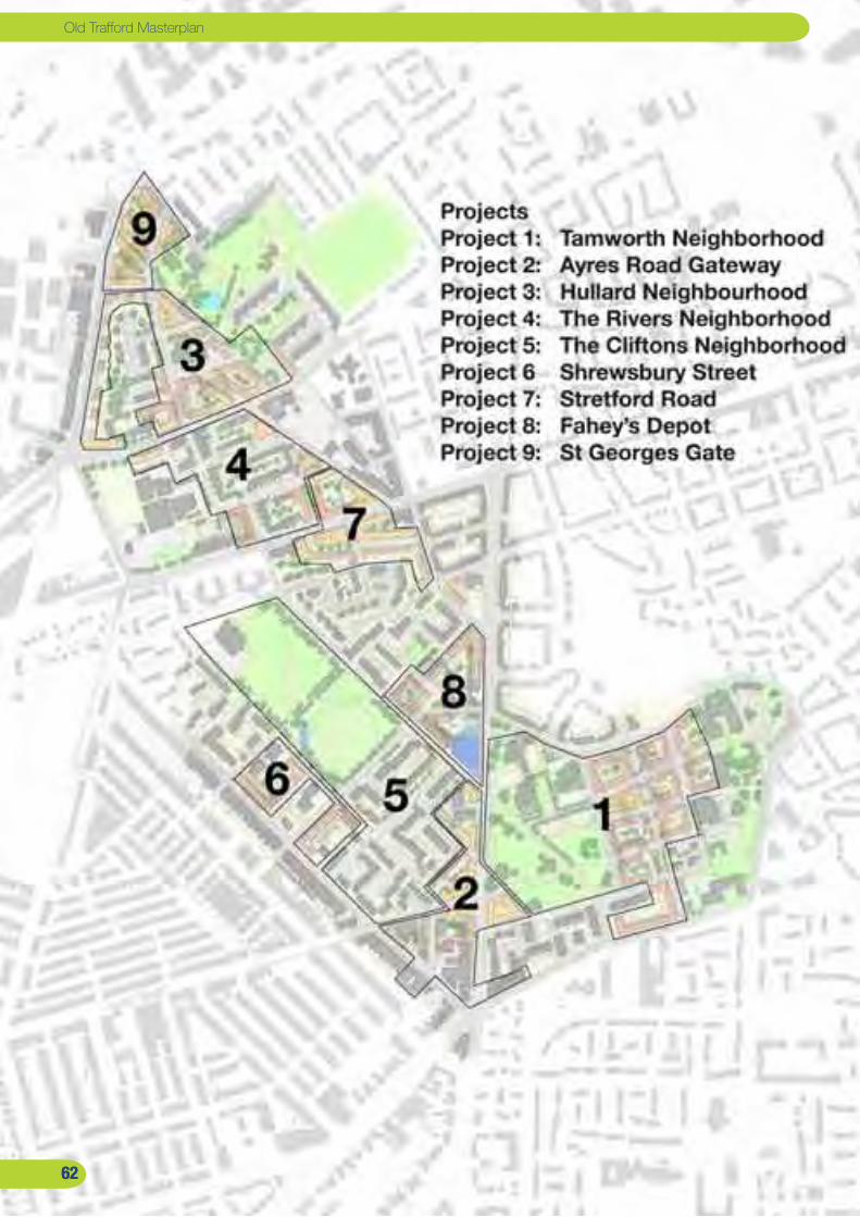
��
Old Trafford Masterplan
��
Old Trafford Masterplan
����

��
The 9 Projects The Illustrative Masterplan has been parcelled up into nine projects. These range from projects that can be promoted by the public sector partners to schemes that should be left to the market.
The masterplan has been split into 9 projects for ease of
description and appraisal. In reality some of these may be
combined while others will include sub projects. The aim has
been to facilitate the transformation of the area while dealing
with the decent homes issues and illustrating the potential
for future development in the area.
Based on the ownership of land in the area and the strategy
to redevelop/improve social housing the nine projects have
been broken down into four types:
a) Public sector development schemes: The most
important sites are those in public ownership where we
are proposing that THT take the lead as a masterdeveloper
(as described in the implementation section). These are
Projects 1-3 essentially the Tamworth and Hullard Estates.
Project 2, the sites along Chorlton Road, has been included
because, while not all of the sites are publicly owned, it is a
natural link to the Tamworth scheme and these sites should
be acquired where possible.
b) Environmental improvement/infill schemes: In the
central part of the area we are proposing a programme of
environmental improvements, de-radburning to reconnect
the areas to their surroundings and a small amount of infill.
This includes Projects 4 ;The Rivers Estate and Project 5 the
Clifton’s Estate.
c) Public sector disposals: This includes sites that
the council will sell to developers to bring forward for
development thereby generating a capital receipt while also
meeting housing needs. These include projects 6 and 7,
Isobel Bailey/the community centre and Essex Way
d) Private sector schemes: The final schemes are those
in private ownership that will be developed by the private
sector with little or no public sector involvement. These
include Project 8; Fahey’s Depot and Project 9; St. George’s
Gate. In both cases the schemes will not be developed
in the current market or indeed until the later part of the
programme. Because of this they have not been appraised or
included in the outputs.
Housing mixAt the heart of these proposals is the notion of demolishing
386 social housing units (all but three of which are
apartments). The majority of these (336) are in the four Bird
Blocks on the Tamworth Estate. The masterplan replaces
these demolished flats like for like but spreads the new
social housing apartments throughout the area to avoid a
concentration on the Tamworth Estate. New social housing
apartments are therefore included in all of the Projects
except for Projects 8 and 9.
Overall Projects 1-7 include 1,358 new homes so that after
the 386 demolitions there is a net gain of 972 units. Of
these units 834 will be houses, 386 will be social housing
apartments and just 138 will be new private apartments.
There has been some concern as part of the study that the
profound crash in the apartment market in Manchester
makes any apartments for sale risky. The number of
apartments has therefore been confined to locations where
there is little choice such as corner units or space over
shops. Given that this is a 10-15 year strategy we believe
that this is achievable.
��
Report by URBED and EKOSReport by URBED and EKOS

��
Old Trafford Masterplan
Key
THT Land
Trafford Council
Leases sites
Right-to-buys
��

��
Project I: Tamworth NeighborhoodThe largest project involves the redevelopment of the Tamworth Estate, refurbishing the three Balcony Blocks and redeveloping the Bird Blocks. The development would include 297 houses and 117 apartments. Total demolitions would be totalling 336.
The Tamworth Estate is the most significant change
within the masterplanning area. This is the area identified
throughout the process as having the greatest problems.
The seven towers have not been brought up to the Trafford
Standard and it is necessary to obtain a waiver from the
Homes and Communities Agency because this cannot
happen before the 2010 deadline.
The conclusion of the masterplanning process is that all
seven towers could be brought up to the Trafford Standard
but that this would be very expensive and it is important
to take into account the quality and likely popularity of the
flats once improved. Based on discussions with local people,
the maintenance department in THT and other stakeholders
we have come to the conclusion that there is a difference
between the ‘Balcony Blocks’ and the ‘Bird Blocks’. The
former we believe should be refurbished while the latter
should be redeveloped. The retained Balcony Blocks will
provide a valuable resource in the short term in helping the
decanting of people from the bird blocks and in the long term
as a resource for people wishing to remain in the Tamworth
Neighbourhood. It is anticipated that THT will do a detailed
consultation with residents in the Bird Blocks to facilitate
meeting housing needs and finding appropriate temporary
and long term accommodation.
Redevelopment of the Bird Blocks: The plan shows
the redevelopment of the Bird Blocks. This involves the
demolition of 336 flats in four blocks and creates a 3.57
hectare development site. This is a significant opportunity,
most of which is in the ownership of THT. The masterplan is
based on a simple grid of streets between Bold Street and
Moss Lane. This does not however include a traffic route on
the line of Tamworth Street in front of the shops because of
residents concerns about creating a rat run. The plan also
does not re-open Maher Gardens for the same reason. The
street network consists of a mix of local streets and home
zones. These streets are vital to overcome the isolation of
the area but would be designed as ‘Home Zones’ to prevent
them becoming an attractive through route for traffic. The
scheme as a whole would provide 100% parking through a
mix of on-street and in-curtilage provision for the houses.
The plan is based on a mix of houses and apartments.
There are 297 houses ranging from 2 to 5 bedroom units.
There are also 116 apartments shown in light orange on
the plan. There has been discussions about whether the
redevelopment should replace the demolished flats like
for like. The view has been taken that this should be done
across the whole of the masterplanning area rather than
just within the bounds of the Tamworth Estate. Given the
retention of the Balcony Blocks this is important to avoid an
over concentration of flats in this area by creating a more
balanced community.
There is an existing corner shop on the estate that looks
inwards onto a pedestrian route. The plan proposes moving
this into a new unit on Moss Lane as part of a small parade
of shops. This would extend the existing shopping parade on
Moss Lane and would be able to attract passing trade.
Report by URBED and EKOS

��
Old Trafford Masterplan
Passive ventilation structures on the roof to provide passive stack ventilation to the flats
Prefabricated panels incorporating insulation and a choice of window configurations (to be chosen by the tenant)
Balconies glazed to form winder
gardens.
Refurbishing the ‘3 Sisters’
The Balcony Blocks as well as Princess and Empress need new windows. The masonry while not in bad condition needs insulating. The exposed concrete frame the characterizes these blocks makes for very substantial cold bridges. It would be extremely difficult to get rid of these cold bridges as the floors and ceilings would have to be insulated for the first 1m into the flat from the external walls. This means external insulation is the only other option available. The Bird blocks have had this done but this did not improve their appeal and comfort. If the Balcony blocks are to avoid losing all their attraction the rendering needs to be better thought through to avoid using the standard externally applied render.This proposal assumes that if you are externally insulating and replacing the windows they need to be near the outside wall not deepest as occurs on external render systems. This can be done with prefabricated panels complete with insulation being applied to the outside.This presents further opportunities the first to give the towers a 21st century look as well as more sustainable insulation standards. If the brickwork is removed entirely this enables much thicker insulation to be applied without adding too much weight to the structure. It then also creates an opportunity for windows to be in different places. This in turn creates a fantastic opportunity for real community participation on the design of the new elevations. With only a few different windows but in a few different configurations residents can move those windows out of the places they don’t want them into the places they do, creating a
distinctive elevation as well as internal variety. Our experience is that this level of individuality remains attractive to future tenants once those that made the decisions have moved out.The thicker insulation would enable the whole tower to reach the new ultra insulated standard from Germany called Passivhaus. Once reached this standard can eliminate the need for central heating, heat instead is gained from appliances and the occupants kept in the flats by the insulation and using heat recovery on the ventilation, hence the new structure on the roof. There are already a lot of vertical ducts in the buildings and by using the fact the warm air rises combined with the Venturi effect of a air passing the cowls and drawing air up it will be possible to draw stale air out to the roof, extract the heat from it, when occasionally necessary warm it up a little and blow it back into the homes. The removal of individual central heating would reduce maintenance costs considerably, as well as head towards being the region’s first carbon neutral tower block.
��

��
The scheme includes improvements to Maher Gardens to
help it operate as a park. This would include railings around
the space and clear, straight, well-lit public routes through
the park that feel safe and appealing. These routes are
positioned on the lines of the former terraced streets and
form an important part of the public realm network. Maher
Gardens should feel and operate like Hullard Park and has
the potential to be the heart of the new neighbourhood.
Refurbishment of the towers: The retained Balcony blocks
should be transformed as part of their refurbishment and can
become a symbol of the area’s recovery. The potential can
be seen in the Urban Splash Scheme for the Three Sisters
in Collyhurst (below). We have looked at the potential for
transforming the balcony blocks in this way. The illustration
to the right shows the potential impact of replacing the brick
panels with a new insulated panel in which residents could
choose from three window configurations. The balconies
are glazed over to create winter gardens and a passive
ventilation structure is created on the roof. At the base of
the blocks the intention would be to extend the parkland
to create a garden between the towers and to regularise
parking into a series of car parks accessible off the
surrounding roads. The base of the towers would be opened
up with a improved caretaker and security base with views
of the surrounding area and a improved community flat. It is
anticipated that the work to these flats would be funded by
the provision for Trafford Standard works in the THT business
plan.
Viability: The viability of the scheme has been assessed
by EKOS. Based on the development of 413 residential
units and 1300m2 of commercial space this would create a
development value of £60-£70 Million. Against this is set the
costs of the development:
Land acquisition: £3.7 Million - Including two right-to-
buy flats, compensation for social housing tenants and the
acquisition of some small areas of third party land.
Development Costs: Just under £56 Million - Demolitions
and land remediation, development costs, highways,
just under £1.8 Million for the park and professional fees
and contingency. This includes just under £7.4 Million
additional costs to achieve Code for Sustainable Homes
Level 4.
Before and after view of the Three sisters in Collyhurst following refurbishment by
Urban Splash
Passive ventilation structures on the roof to provide passive stack ventilation to the flats
Prefabricated panels incorporating insulation and a choice of window configurations (to be chosen by the tenant)
Balconies glazed to form winder
gardens.
Illustration of the ‘3 Sisters’ after refurbishment Collyhurst Tower Blocks prior to refurbishment
Report by URBED and EKOS
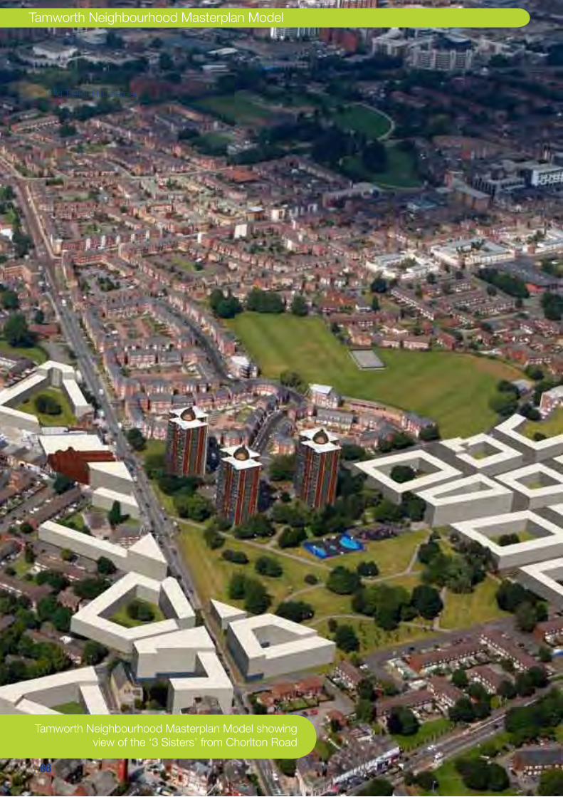
��
Old Trafford Masterplan
��
Old Trafford Masterplan
Tamworth Neighbourhood Masterplan Model showing view of the ‘3 Sisters’ from Chorlton Road
Tamworth Neighbourhood Masterplan Model
����
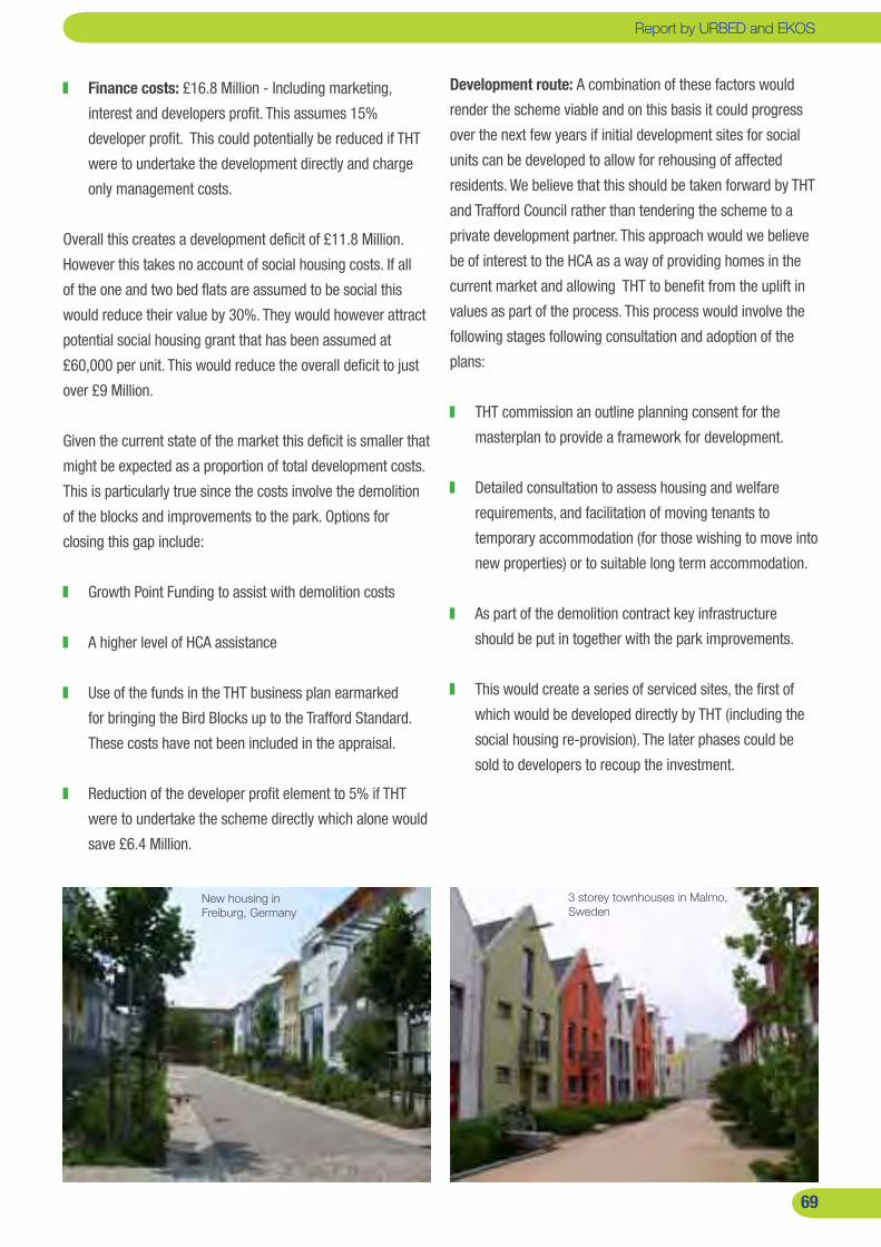
��
Finance costs: £16.8 Million - Including marketing,
interest and developers profit. This assumes 15%
developer profit. This could potentially be reduced if THT
were to undertake the development directly and charge
only management costs.
Overall this creates a development deficit of £11.8 Million.
However this takes no account of social housing costs. If all
of the one and two bed flats are assumed to be social this
would reduce their value by 30%. They would however attract
potential social housing grant that has been assumed at
£60,000 per unit. This would reduce the overall deficit to just
over £9 Million.
Given the current state of the market this deficit is smaller that
might be expected as a proportion of total development costs.
This is particularly true since the costs involve the demolition
of the blocks and improvements to the park. Options for
closing this gap include:
Growth Point Funding to assist with demolition costs
A higher level of HCA assistance
Use of the funds in the THT business plan earmarked
for bringing the Bird Blocks up to the Trafford Standard.
These costs have not been included in the appraisal.
Reduction of the developer profit element to 5% if THT
were to undertake the scheme directly which alone would
save £6.4 Million.
Development route: A combination of these factors would
render the scheme viable and on this basis it could progress
over the next few years if initial development sites for social
units can be developed to allow for rehousing of affected
residents. We believe that this should be taken forward by THT
and Trafford Council rather than tendering the scheme to a
private development partner. This approach would we believe
be of interest to the HCA as a way of providing homes in the
current market and allowing THT to benefit from the uplift in
values as part of the process. This process would involve the
following stages following consultation and adoption of the
plans:
THT commission an outline planning consent for the
masterplan to provide a framework for development.
Detailed consultation to assess housing and welfare
requirements, and facilitation of moving tenants to
temporary accommodation (for those wishing to move into
new properties) or to suitable long term accommodation.
As part of the demolition contract key infrastructure
should be put in together with the park improvements.
This would create a series of serviced sites, the first of
which would be developed directly by THT (including the
social housing re-provision). The later phases could be
sold to developers to recoup the investment.
��
New housing in Freiburg, Germany
3 storey townhouses in Malmo, Sweden
Report by URBED and EKOSReport by URBED and EKOS

�0
Old Trafford Masterplan
Key
THT Land
Trafford Council
Leases sites
Right-to-buys
�0

��
Project 2: Chorlton Road GatewayHistorically Chorlton Road was a busy street with a mix of businesses and houses. This project would restore part of the street to its former character as a gateway to the area and a community hub. It would be sensible to bring this site forward as part of the Tamworth Neighbourhood redevelopment and the site could accommodate 164 flats as part of the replacement of the Bird Blocks.
There are a number of development opportunities on
Chorlton Road. On historic plans Chorlton Road is an
important route, fronted by institutional buildings (although
probably not many shops). The design philosophy in
the 1960’s was however to turn it into an urban dual
carriageway (which is how it is shown on the original
masterplan for Hulme from this period). As a result all the
new development of the time turned away from the road
and the road verges were grassed. Only the Sharon Church
remains as a clue to what the street once looked like.
The result is that Chorlton Road feels hostile, unsafe and
dominated by traffic.
The aim of the masterplan is to transform this situation by
making it the heart of the surrounding communities as a
high street. As the ownership plan illustrates, the northern
part of the site is owned by the council and let to the current
occupiers. The Hilton Court site is leased as a hostel and
there is no intention that this use should be terminated.
However our understanding is that the condition of the
building and the intentions of the occupier mean that it may
come available at the end of the lease and would therefore
form an important development opportunity. The sites south
of Ayres Road are privately owned but are vacant or have
recently been cleared. We have also included a small section
of Maher Gardens in order to control both sides of the street.
This is likely to be controversial but has been reasonably well
received in consultations.
The masterplan proposes development of just under 261
units two thirds of which would be apartments because
of the nature of the sites and proximity to the road. These
would provide part of the replacement for the Bird Blocks
and some could be built in advance to aid decanting. There
is also 1,400m2 of ground floor commercial space that could
be retailing or office space to provide active frontage onto
the road. The scheme creates a new node at the junction of
Ayres Road and a strong 3/4 storey frontage along Chorlton
Road. It would extend southwards to encompass the
improvement of the existing properties in Chorlton Road.
The influence of this scheme should extend to the Brooks
Bar junction. This is currently s struggling local centre
where work is required to improve shop fronts, bring derelict
buildings back into use and improve the environment.
Viability and Delivery: This is a complex scheme involving
a series of sites in different ownerships. The appraisal has
assumed that it would be developed in one go with THT
acquiring the privately owned sites. This creates a significant
deficit of just under £11 million on a £36 million scheme
and therefore clearly cannot happen. However if the scheme
is confined to the publicly owned land shown in red and
yellow on the plan above left, then there would be a saving
of £6 million acquisition costs. If social housing grant is
assumed on the apartments the deficit to around £1 million.
This could be developed as part of the overall Tamworth
neighbourhood scheme and dealt with in the ways suggested
on the previous pages.
Report by URBED and EKOS

��
Old Trafford Masterplan
Key
THT Land
Trafford Council
Leases sites
Right-to-buys
Project 9
St George’s
Gateway
Project 3
The Hullard
Estate
��
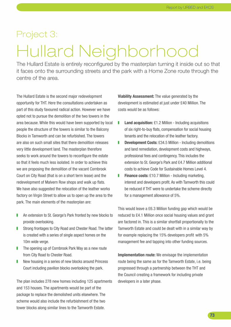
��
Project 3: Hullard NeighborhoodThe Hullard Estate is entirely reconfigured by the masterplan turning it inside out so that it faces onto the surrounding streets and the park with a Home Zone route through the centre of the area.
Viability Assessment: The value generated by the
development is estimated at just under £40 Million. The
costs would be as follows:
Land acquisition: £1.2 Million - Including acquisitions
of six right-to-buy flats, compensation for social housing
tenants and the relocation of the leather factory.
Development Costs: £34.5 Million - Including demolitions
and land remediation, development costs and highways,
professional fees and contingency. This includes the
extension to St. George’s Park and £4.7 Million additional
costs to achieve Code for Sustainable Homes Level 4.
Finance costs: £10.7 Million - Including marketing,
interest and developers profit. As with Tamworth this could
be reduced if THT were to undertake the scheme directly
for a management allowance of 5%.
This would leave a £6.3 Million funding gap which would be
reduced to £4.1 Million once social housing values and grant
are factored in. This is a similar shortfall proportionally to the
Tamworth Estate and could be dealt with in a similar way by
for example replacing the 15% developers profit with 5%
management fee and tapping into other funding sources.
Implementation route: We envisage the implementation
route being the same as for the Tamworth Estate, i.e. being
progressed through a partnership between the THT and
the Council creating a framework for including private
developers in a later phase.
The Hullard Estate is the second major redevelopment
opportunity for THT. Here the consultations undertaken as
part of this study favoured radical action. However we have
opted not to pursue the demolition of the two towers in the
area because. While this would have been supported by local
people the structure of the towers is similar to the Balcony
Blocks in Tamworth and can be refurbished. The towers
are also on such small sites that there demolition releases
very little development land. The masterplan therefore
seeks to work around the towers to reconfigure the estate
so that it feels much less isolated. In order to achieve this
we are proposing the demolition of the vacant Cornbrook
Court on City Road (that is on a short term lease) and the
redevelopment of Malvern Row shops and walk up flats.
We have also suggested the relocation of the leather works
factory on Virgin Street to allow us to open up the area to the
park. The main elements of the masterplan are:
An extension to St. George’s Park fronted by new blocks to
provide overlooking.
Strong frontages to City Road and Chester Road. The latter
is created with a series of single aspect homes on the
10m wide verge.
The opening up of Cornbrook Park Way as a new route
from City Road to Chester Road.
New housing in a series of new blocks around Princess
Court including pavilion blocks overlooking the park.
The plan includes 278 new homes including 125 apartments
and 153 houses. The apartments would be part of the
package to replace the demolished units elsewhere. The
scheme would also include the refurbishment of the two
tower blocks along similar lines to the Tamworth Estate.
Report by URBED and EKOS

��
Old Trafford Masterplan
Key
THT Land
Trafford Council
Leases sites
Right-to-buys
��

��
Project 4 : The Rivers There was strong support in the masterplanning process for the de-Radburning of the Rivers Estate. This involves the creation of a new street network, the reorientation of housing to face onto these streets and infill opportunities.
The Rivers Estate is a classic ‘Radburn’ Layout in which the
housing is accessible from a footpath network while the
roads and parking courts are to the rear of the property. This
type of layout means that the estate becomes a warren of
footpaths and unused communal areas, while people are not
able to park their car within sight of their home. It was clear
from the consultations that the community are fed up with
this layout and amenable to radical change of the kind that
has been done on the Alexandra Park Estate in Manchester.
The layout of the estate Rivers Estate is particularly well
suited to this process because the old terraced streets on
the plan top left, have not been built over. The masterplan
therefore involves reopening Eastnor Close and Trafford Place
to traffic as Home Zones. This involves the demolition of
three properties. It proposes turning the properties around so
that the communal areas which are currently at the front of
the house become back gardens. The plan also creates some
small infill sites in order to complete the blocks which could
potentially accommodate 60 new units. The former snooker
hall on Johnson Street is in private ownership but is a further
opportunity for an infill scheme.
Viability and Implementation: The de-radburning works
to the estate are estimated to cost around £1.3Million. The
masterplan shows the opportunity for infill development
that, in a stronger market could be used to fund this work.
However at the present time the new housing is not viable
itself. The costs of the works would therefore have to be
found by THT or the scheme would need to wait until such
time that the housing generates a surplus. In this respect it
is likely that works would be combined with Stretford Road
(Project 7) to provide a critical mass of new development
to interest a developer and to generate sufficient surplus to
cover the works.
Housing in Salford seen on the bus tour with residents De-radburning scheme in Longsight seen on the bus tour with residents
Report by URBED and EKOS

��
Old Trafford Masterplan
��
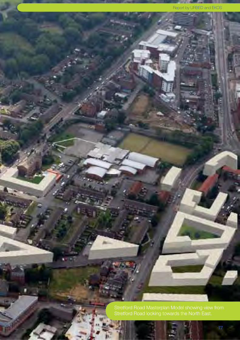
��
Stretford Road Masterplan Model showing view from Stretford Road looking towards the North East.
Report by URBED and EKOS

��
Old Trafford Masterplan
Key
THT Land
Trafford Council
Leases sites
Right-to-buys
Project 6
Shrewsbury
Project 5
The
Clifton’s
��
��
Projects 5 and 6: The Cliftons and Shrewsbury Street The central part of the plan explores environmental improvements to St. Alphonsus Fields and St. Brides Field to incorporate more pitches and a new community resource centre linked to the school. Clifton’s estate is put forward for environmental improvements, and the Shrewsbury Street Community Centre is redeveloped.
The central part of the masterplanning area is probably
the most changed by redevelopment over the years as can
be seen from the historic plan. A whole neighbourhood of
streets was cleared to create the fields at the heart of the
area and this is now feels unsafe and isolated. The aim of
the masterplan is to turn this space into a park, like Hullard
Park that can become the heart of the community. This could
be done by improving access to the fields and agreeing new
management arrangements between St Alphonsus, the
Council, THT and key users. Something similar has been
done with the former recreation ground in the Alexandra Park
Estate. The work would involve introducing lighting, railings,
new paths, tree planting and an astro-turf pitch and a
possible resource centre for use by the St Alphonsus School
and the locally run football coaching and cricket team. This
would include changing facilities currently located on the
Community Centre car park as an outbuilding.
There is also a need to improve the housing surrounding
the park. Improvements have been undertaken to School
Walk and there is limited opportunity to re-configure Lowry
Place. There is an opportunity to make environmental
improvements to Clifton Estate to address the problems
in this area that are exasperated by its poor layout. Like
the Rivers Estate the lines of the former terraced streets
have not been built over and it is possible to consider a
de-radburning scheme as shown on the masterplan so that
a network of home zone style streets can create a better
connected, more attractive neighbourhood for residents.
There are not opportunities for infill development within
the estate but adjacent sites are available on Chorlton
Road (see Project 2) and on Shrewsbury Street. The latter
includes Isobel Baillie Lodge. This is a THT-owned supported
accommodation for older people, currently vacant and used
on a temporary basis for community offices. There is also
the potential use of the Shrewsbury Community Centre site if
this relocates onto the Fahey’s Depot (see Project 8).
Viability and Implementation: The costs of the de-
Radburning works to the Clifton’s Estate is likely to be just
over £1.8 Million and the works to the park will be about
the same. Together with on-costs the capital costs of these
environmental works will therefore be £5 Million.
The Shrewsbury Street and Isobel Baillie sites could be
developed entirely with housing and therefore are viable
even in the present economic. The appraisal suggests that
together these sites could accommodate 90 homes with a
value of £15.2 million and costs of £14.9 Million generating
a small surplus. The Shrewsbury site however could not be
redeveloped unless sufficient surplus were created to invest
in a new community centre and so the surplus would not be
available to Project 5. Indeed the surplus is not sufficient at
present to generate sufficient surplus for the new community
centre and the project is unlikely to happen until the market
improves.
Report by URBED and EKOS

�0
Old Trafford Masterplan
Key
THT Land
Trafford Council
Leases sites
Right-to-buys
�0
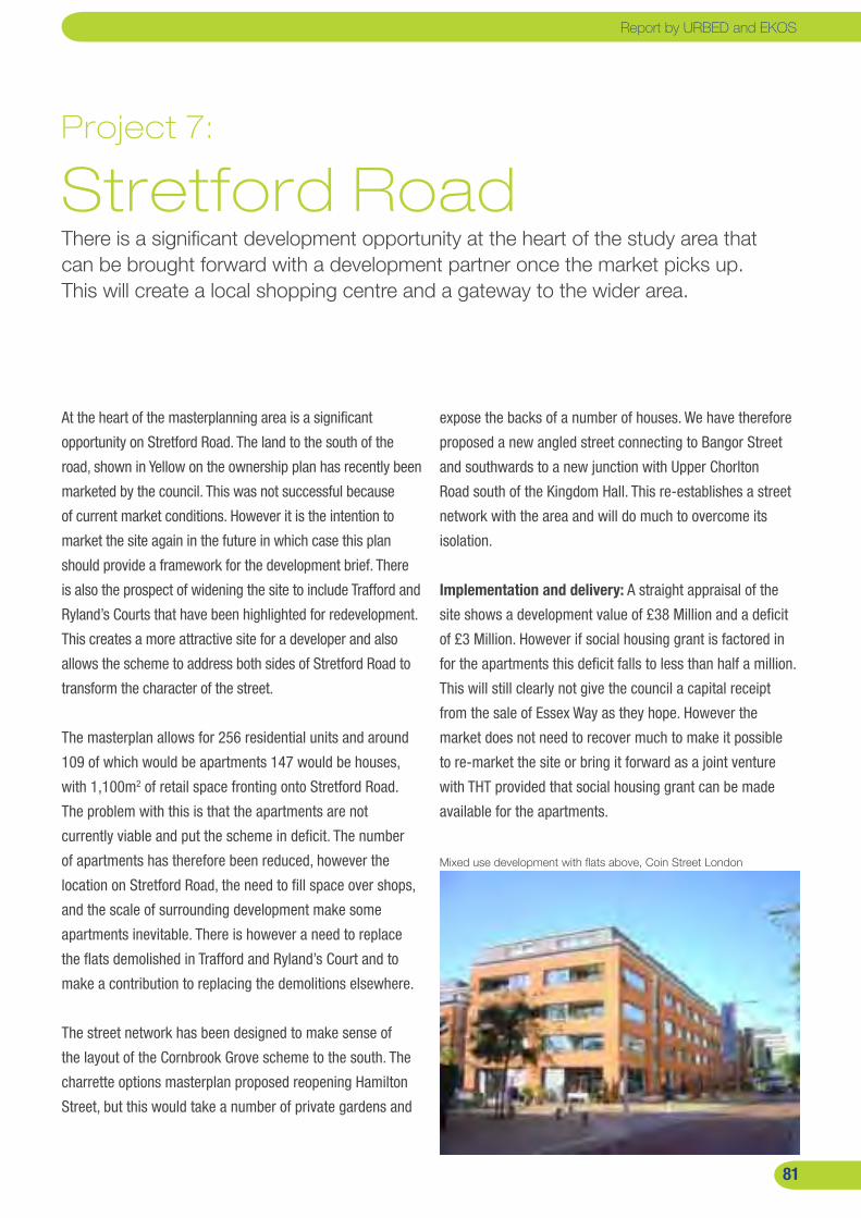
��
Project 7: Stretford RoadThere is a significant development opportunity at the heart of the study area that can be brought forward with a development partner once the market picks up. This will create a local shopping centre and a gateway to the wider area.
At the heart of the masterplanning area is a significant
opportunity on Stretford Road. The land to the south of the
road, shown in Yellow on the ownership plan has recently been
marketed by the council. This was not successful because
of current market conditions. However it is the intention to
market the site again in the future in which case this plan
should provide a framework for the development brief. There
is also the prospect of widening the site to include Trafford and
Ryland’s Courts that have been highlighted for redevelopment.
This creates a more attractive site for a developer and also
allows the scheme to address both sides of Stretford Road to
transform the character of the street.
The masterplan allows for 256 residential units and around
109 of which would be apartments 147 would be houses,
with 1,100m2 of retail space fronting onto Stretford Road.
The problem with this is that the apartments are not
currently viable and put the scheme in deficit. The number
of apartments has therefore been reduced, however the
location on Stretford Road, the need to fill space over shops,
and the scale of surrounding development make some
apartments inevitable. There is however a need to replace
the flats demolished in Trafford and Ryland’s Court and to
make a contribution to replacing the demolitions elsewhere.
The street network has been designed to make sense of
the layout of the Cornbrook Grove scheme to the south. The
charrette options masterplan proposed reopening Hamilton
Street, but this would take a number of private gardens and
expose the backs of a number of houses. We have therefore
proposed a new angled street connecting to Bangor Street
and southwards to a new junction with Upper Chorlton
Road south of the Kingdom Hall. This re-establishes a street
network with the area and will do much to overcome its
isolation.
Implementation and delivery: A straight appraisal of the
site shows a development value of £38 Million and a deficit
of £3 Million. However if social housing grant is factored in
for the apartments this deficit falls to less than half a million.
This will still clearly not give the council a capital receipt
from the sale of Essex Way as they hope. However the
market does not need to recover much to make it possible
to re-market the site or bring it forward as a joint venture
with THT provided that social housing grant can be made
available for the apartments.
Mixed use development with flats above, Coin Street London
Report by URBED and EKOS
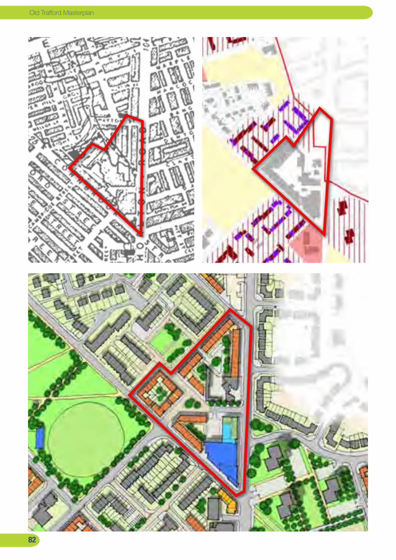
��
Old Trafford Masterplan
��

��
Project 8: Fahey’s DepotThis privately owned site is being explored as a redevelopment opportunity by the owners. The main part of the site to the rear will come forward once the market recovers. There is however an opportunity on the frontage to create a scheme that incorporates a community facility.
The Fahey’s depot is a privately-owned site that has for
many years provided employment in the area. The buildings,
were once a tram depot and have been occupied by Fahey’s
for thirty years. They used part of the space for their haulage
business and let the remainder to other small businesses.
The site also includes Griffith’s builders Merchants which is
in a separate ownership and a former car wash premises.
Fahey’s have been exploring the development potential
of the site and have instructed a consultant team to
develop proposals for the site. These include an element
of retailing, community and business space and residential
accommodation following the demolition of all structures on
the site. As part of this scheme discussions have been held
with the Neighbourhood Management Partnership about
a new community facility/youth centre on the site. While
Fahey’s are only able to undertake the scheme if it is viable,
they also have a wish to leave a legacy for the area.
We are aware of the scheme that has been developed for
the site based around apartments and significant amount
of retailing. Certain elements of the scheme - notably the
amount of retailing is likely to cause challenges in terms of
planning. The masterplan illustrated to the right therefore
shows a scheme with a more modest retail component. This
splits into two potential phases:
The land to the rear incorporates the majority of the housing.
This could be developed as houses but we understand that
the owners have aspirations for an apartment-based scheme
once the market recovers. We have therefore not included
the residential yield from this site in our figures.
The land on the Chorlton Road frontage south of the Griffith’s
depot could however be brought forward as an early
phase. The masterplan includes a 4,000m2 community /
youth / workspace facility together with a small 1,000m2
supermarket to generate value. The community centre is the
subject of a more detail feasibility exercise by EKOS carried
out in parallel to this study. It could include the relocation
of the Library and Shrewsbury Street Community Centre
together with a purpose built youth centre and managed
office space for community based organisations and small
business.
The illustrated scheme shows the retention of the existing
building with a new entrance built onto the corner and a
retail unit between the retained building and Griffith’s. We
are however aware that the building may have deteriorated
beyond the point where refurbishment is viable, in which
case a new build option would be necessary.
The viability of the community centre is subject to further
work but could include a capital receipt for the Shrewsbury
Street site and public funding. In terms of procurement the
scheme would be developed in partnership with Fahey’s in
a number of ways. This could include them developing the
building and leasing it or selling it to the council.
Report by URBED and EKOS
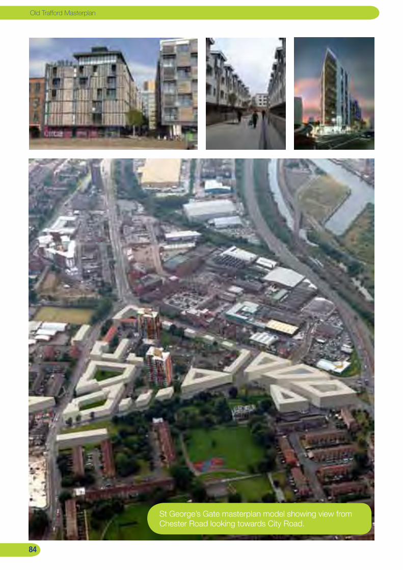
��
Old Trafford Masterplan
St George’s Gate masterplan model showing view from Chester Road looking towards City Road.
��
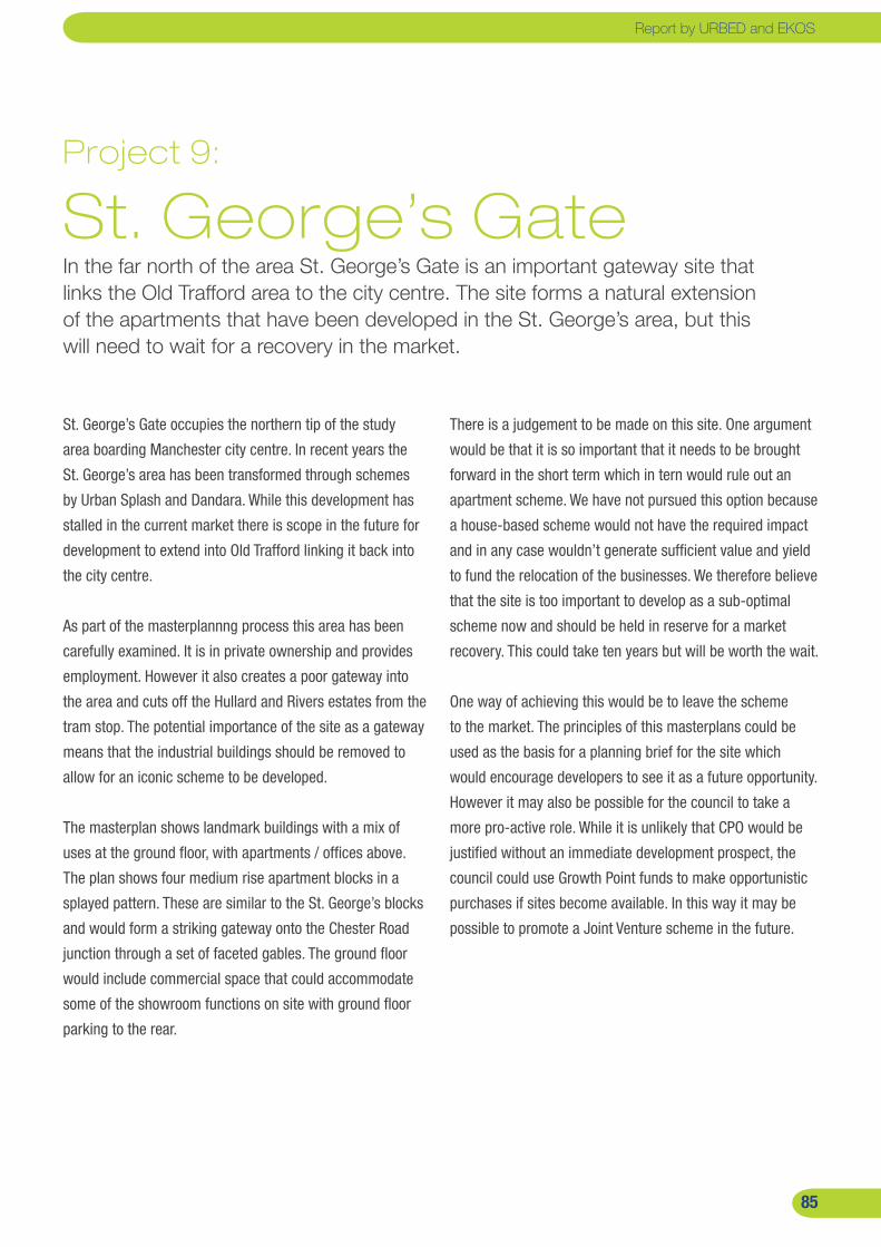
��
Project 9: St. George’s GateIn the far north of the area St. George’s Gate is an important gateway site that links the Old Trafford area to the city centre. The site forms a natural extension of the apartments that have been developed in the St. George’s area, but this will need to wait for a recovery in the market.
St. George’s Gate occupies the northern tip of the study
area boarding Manchester city centre. In recent years the
St. George’s area has been transformed through schemes
by Urban Splash and Dandara. While this development has
stalled in the current market there is scope in the future for
development to extend into Old Trafford linking it back into
the city centre.
As part of the masterplannng process this area has been
carefully examined. It is in private ownership and provides
employment. However it also creates a poor gateway into
the area and cuts off the Hullard and Rivers estates from the
tram stop. The potential importance of the site as a gateway
means that the industrial buildings should be removed to
allow for an iconic scheme to be developed.
The masterplan shows landmark buildings with a mix of
uses at the ground floor, with apartments / offices above.
The plan shows four medium rise apartment blocks in a
splayed pattern. These are similar to the St. George’s blocks
and would form a striking gateway onto the Chester Road
junction through a set of faceted gables. The ground floor
would include commercial space that could accommodate
some of the showroom functions on site with ground floor
parking to the rear.
There is a judgement to be made on this site. One argument
would be that it is so important that it needs to be brought
forward in the short term which in tern would rule out an
apartment scheme. We have not pursued this option because
a house-based scheme would not have the required impact
and in any case wouldn’t generate sufficient value and yield
to fund the relocation of the businesses. We therefore believe
that the site is too important to develop as a sub-optimal
scheme now and should be held in reserve for a market
recovery. This could take ten years but will be worth the wait.
One way of achieving this would be to leave the scheme
to the market. The principles of this masterplans could be
used as the basis for a planning brief for the site which
would encourage developers to see it as a future opportunity.
However it may also be possible for the council to take a
more pro-active role. While it is unlikely that CPO would be
justified without an immediate development prospect, the
council could use Growth Point funds to make opportunistic
purchases if sites become available. In this way it may be
possible to promote a Joint Venture scheme in the future.
Report by URBED and EKOS
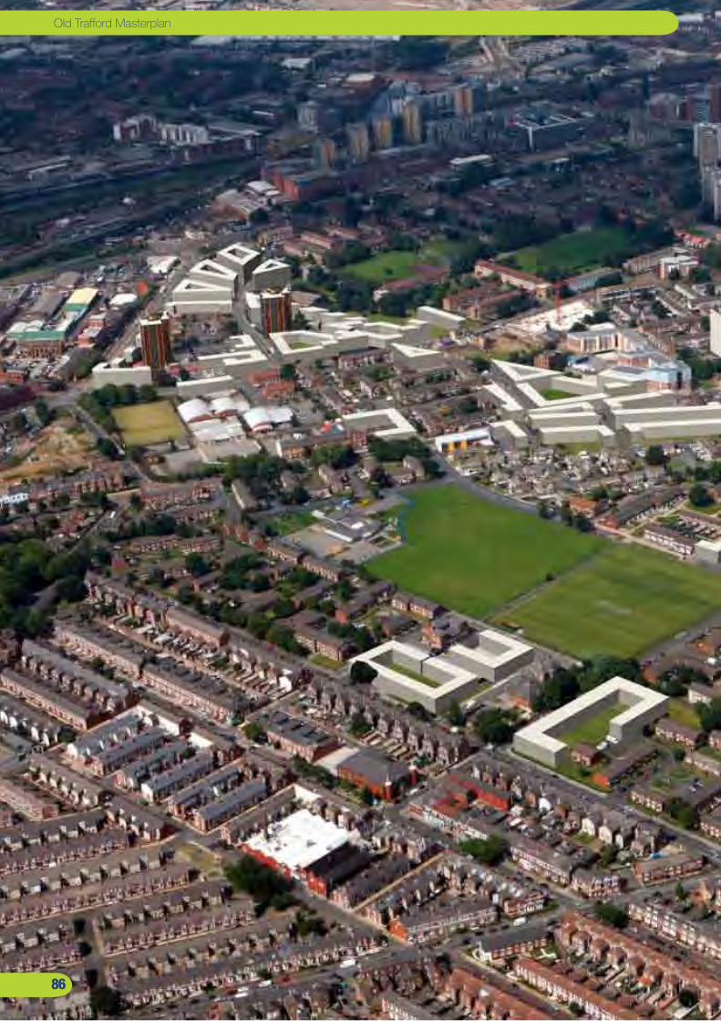
��
Old Trafford Masterplan
��
Old Trafford Masterplan
����

����
Old Trafford masterplan model showing the view from the south.
Report by URBED and EKOSReport by URBED and EKOS
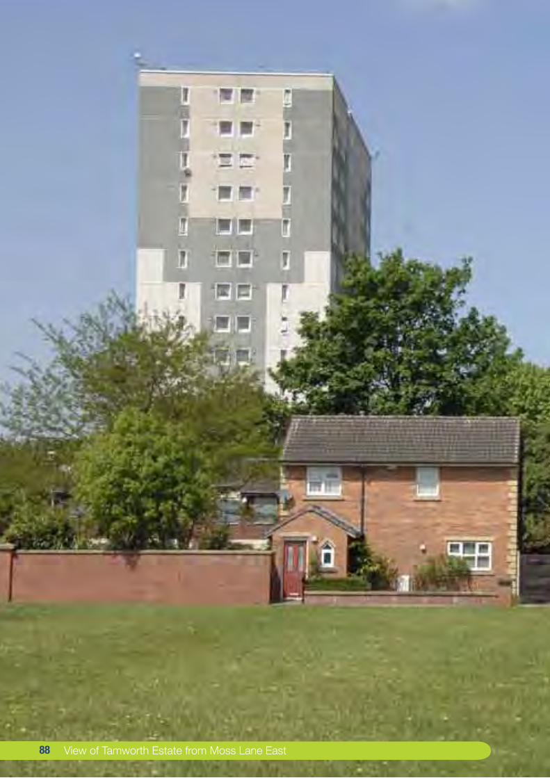
�� View of Tamworth Estate from Moss Lane East ��

PART 6: Implementation
The Masterplan has then been parcelled into nine projects each of which have been appraised. This section describes how each of the projects might be implemented over the next 15 years.
��
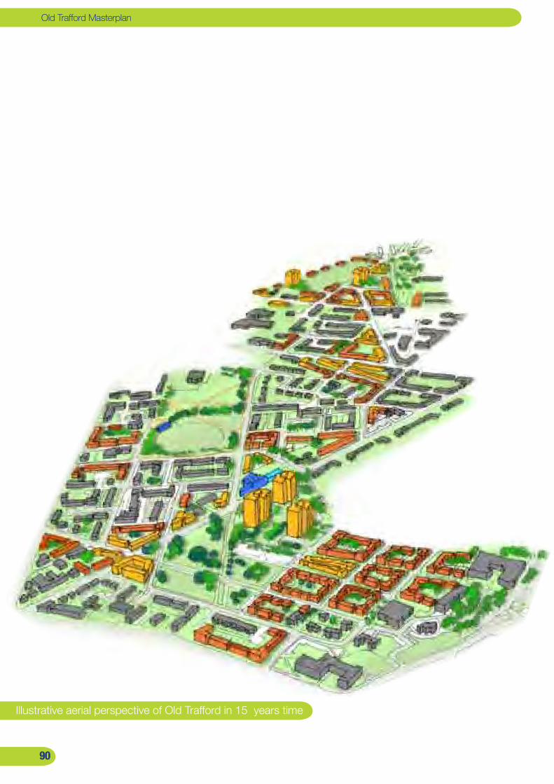
�0
Old Trafford Masterplan
�0
Old Trafford Masterplan
Illustrative aerial perspective of Old Trafford in 15 years time
�0�0
��
Implementation strategyThe strategy set out in this report has the potential to transform the Old Trafford area. This includes improvements to social housing estates, the removal of poor quality accommodation, the increase in the density of the area to accommodate housing growth, the creation of a more mixed and balanced community and the increase in community facilities and shops.
Overall the core projects in the plan (Projects 1-7) provide for
1,358 new homes and 386 demolitions - a net gain of 972
units. In addition to this if the Fahey’s and St. George’s Gate
sites were to be included this would take the yield up to just
under 1,800 units. This represents a huge transformation of
the area.
For ease of description we have parcelled up the masterplan
into nine projects. However this is a complex process,
particularly in the current difficult market conditions. The
Implementation strategy is therefore based on a ten year
programme of work as described in the following pages. As
described on page 67, the projects have been graded into
four types:
a) Public sector development schemes: The Tamworth
and Hullard Estates (together with the Chorlton Road scheme
which is linked to Tamworth). Rather that appointing a
development partner we are suggesting that THT takes
this role directly by appointing a design team, securing
planning consent and creating a framework in which a
number of developers can work. This we believe is a much
more satisfactory arrangement than giving control to a
development partner even if one could be secured, which in
the current market is unlikely.
b) Environmental improvement/infill schemes: Projects
4 and 5 involve environmental works for the Rivers and
Clifton’s Estates. While there is some opportunity for infill
development, these are traditional environmental works
schemes that will need to be funded through THT’s business
plan. At present, the appraisals that we have done show no
potential for cross subsidy across the programme, by for
example land disposals. This however is at what appears
to be the bottom of the market and it is possible that as the
10 year programme progresses surpluses can be generated
from land sales to fund these environmental projects.
c) Public sector disposals: Projects 6 and 7 are sites for
disposal. This includes the THT owned Trafford and Ryland’s
Courts and Isobel Bailey Lodge and the Council-owned Essex
Way site and in the future the Shewsbury Street Community
Centre if it’s relocation proceeds. These sites need to be
marketed in a way that allows the public sector to retain
a decree of control through development agreements or
development partnerships.
d) Private sector schemes: Projects 8 and 9 are private
sector schemes. St. George’s Gate and the rear part of the
Fahey’s site are likely to be brought forward by developers
towards the end of the ten year programme. The public
sector’s influence is therefore likely to be through the
planning system. The front part of the Fahey’s site is a
possible exception to this is it is agreed as the site of a new
community facility. The situation may also change if the
council or THT is able to make opportunistic purchases in
these areas.
The following pages describe in more detail the component
parts of this implementation strategy.
��
Report by URBED and EKOSReport by URBED and EKOS
��
Old Trafford Masterplan
Planning frameworkThis strategy has not been designed as a statutory planning document. However it has been drawn up in consultation with the planning authority and the statutory planning system will be an important context for the implementation of the strategy.
As described in the introduction to this report, the masterplan
is in line with planning policy for Old Trafford including the
emerging Local Development Framework. In order to tie the
two together it is important that his plan is given some status
in the statutory planning system.
Material Planning Consideration
One option is that this strategy is adopted as a material
consideration. In this way each of the nine projects could
be developed as planning briefs to help shape and control
development as it comes forward. The dangers of this process
are that it would give the masterplan insufficient weight to
prevent development that is incompatible with this plan. In
order for this masterplan to be routed more firmly within the
planning system there are 2 options which would give it more
status, function and influence on planning decisions:
Inclusion within the Core Strategy
The Masterplan is a Strategic Location within the next stage
of the Core Strategy, with a number of Key Sites within it.
The masterplan could therefore be adopted by the council as
a non-statutory policy document and part of the evidence
base listed in the Core Strategy. The level of consultation done
as part of this strategy would give it significant weight as a
document of this kind.
Adopted as an Area Action Plan
Alternatively this strategy could either be converted into an
Area Action Plan within the Local Development Framework
or certain elements could be included in a Supplementary
Planning Document. This would make the Masterplan more
than just ‘a material consideration’ on planning decisions but
an integral part of the development plan.
The risk with both of these routes is that the Core Strategy /
Area Action Plan production process is slow. The Core Strategy
will not be adopted until January 2011 and an Area Action Plan
could take 3 years. However as a long term process this would
give the masterplan status over the 10-15 years that it will
take to implement. It is therefore worth doing provided that the
statutory planning process is not seen as an excuse to delay
the initial schemes that can be progressed in parallel with the
planning system.
Development Control
In addition to the statutory plan making process there is also
the potential to use the development control system. The
framework for the redevelopment of the Tamworth and Hullard
Estates should be set out in an outline planning consent. This
consent would fix the siting, massing, means of access and
yields of the scheme together with Section 106 obligations.
This would allow individual phases of development to come
forward as Reserved Matters applications. The process has
been widely used by private sector developers to give them
certainty about what is possible while retaining flexibility in the
design of each phase.
Action Plan: 1. The Masterplan is submitted to the planning committee
with a recommendation that it is adopted as council
policy and becomes part of the evidence base for the core
strategy.
2. The report considers the possible development of the plan
as an Area Action Plan.
3. The Report recommends that the planning authority
prepare briefs for Projects 6-9
4. The Trafford Housing Trusts commissions detailed
masterplans and outline planning applications for the
Tamworth and Hullard Estates.
��
��
MasterdeveloperThe two key schemes proposed by the masterplan are the redevelopment of the Tamworth and Hullard Estates. We are proposing that these are progressed by Trafford Housing Trust as a masterdeveloper.
In the fairly recent past these sites would have been bundled
up as a development brief in order to appoint a development
partner (probably a private housebuilder). The partner would
have taken responsibility for progressing the scheme,
employing a design team, gaining planning consent and
covering all of the ongoing costs.
This was never a particularly satisfactory system and a lot
of the developers appointed in this way through Housing
Market Renewal have not delivered, sometimes in cases
where the existing housing has already been demolished.
The process involves a loss of control by the public sector
and a great deal of administration and quality control to try
and ensure that the scheme aspirations are achieved. At the
present time this type of partnership is also not an option
because developers are not in the market and indeed have
laid off the teams that used to specialise in this type of bid.
We are therefore proposing that THT takes on the
development of the Tamworth and Hullard Estates directly.
This does not mean that the Trust would develop all of the
housing. Instead we are proposing that it takes the role of
masterdeveloper. This is a role that has been played by many
successful companies over recent years. Having acquired an
interest in a large site these developers have commissioned
a masterplan which has been used as the basis of an outline
planning application as described in the previous section.
Once consent is gained the developer provides the structural
infrastructure - main roads, services etc.... to create a
series of services sites. Some of these they develop directly
while others will be sold off to other developers. Each of
the services sites will be brought forward as an individual
reserved matters planning application. This helps to create
neighbourhoods with an inbuilt diversity of buildings unlike
the homogeneity of standard house types that is found for
example in large parts of Hulme.
This development model is based on the uplift in values
that is created by the outline planning consent and by the
investment in infrastructure. It is also ideally suited to the
current situation in that it allows THT to use its land holding
and the finance available through its business plan, Growth
Point funding and the HCA to kick start development. This
would involve demolishing the towers, servicing the sites
and undertaking the initial phases of social housing. This
will take a number of years by which time the market will
have recovered and the serviced sites can be sold. This is a
system that developers use to make significant profits even
factoring in the purchase of the land. In a situation where
THT owns the land and can cover other costs through grant
it should be possible to generate a surplus from this process
that would be shared by THT, The Council and the HCA.
Action Plan: 1. THT to consult on this masterplan
2. THT to appoint a masterplanning team and project
manager to progress an outline planning application
3. A detailed scheme to be progressed for Chorlton Road and
City Road sites to provide decanting opportunities
4. THT to rehouse people from the Bird Blocks and
commence decent homes works on the Balcony Blocks.
5. The Bird Blocks to be demolished, the land re-mediated
and structural infrastructure installed.
6. THT to develop directly the first phases directly
7. Subsequent sites to be marketed to developers.
Report by URBED and EKOS

��
Old Trafford Masterplan
Joint venturesThere are a number if instances in the plan which will be developed through a partnership with a private developer. It is important to have a clear structure for these partnerships to ensure that the sites re developed in line with the plan. .
There are a number of occasions in the masterplan that
are best implemented through a partnership with a private
developer. This includes publicly owned sites such as
Essex Way, Trafford and Ryland’s Courts (once they are
demolished), Isobel Bailey Lodge and possibly the Shewsbury
Street Community Centre. This will also be the case with the
sale of serviced sites in Tamworth and Hullard as described
in the previous section, on the community centre element of
the Fahey’s depot and even the St. George’s Gateway if the
council take an land interest. This is likely to happen in one
of the following ways:
Site marketing
This was tried last year on Essex Way unsuccessfully but
will become a possibility again when the market recovers.
These sites should be marketed with a development brief to
identify a purchaser and a price they are prepared to pay. It
will however be necessary for the council and THT to retain
a degree of control to ensure that the wider objectives of the
plan are achieved and to take back the land if the developer
does not deliver. This could be achieved through a leasehold
arrangement, or a deferred sale which is completed once
the development has taken place. The latter can encourage
developers because they do not have to pay up front for the
land but can do so out of sales.
Development partnership
A well-trodden development route is the development
partnership where a scheme is advertised and a developer is
appointed to partner with Trafford Council / THT and to manage
the development process. While we are not proposing this on
the larger sites (Projects 1-3) it may have a role elsewhere.
For example once the market recovers a development partner
could be appointed for St. George’s Gateway backed up by
council CPO powers to assemble the site.
Private sites
On privately owned sites where the owner wishes to pursue
the masterplan (such as the Fahey’s depot) the council or
THT could become involved as development partners on the
community elements of the scheme. This could range from
purchasing the site from the owner to a turnkey arrangement
on a new building that the developer provides for the council.
It is a route that a number of council’s have used to provide
developers with a pre-let and therefore allow development to
proceed even in current conditions.
Action Plan: 1. Development briefs to be prepared initially for Isobel
Bailey Lodge and for the Stretford Road sites (Project 7)
2. These sites to be market tested in 12 months to gauge
interest. Once there is market interest the sites should
be put to the market as part of a competitive dialogue/
tendering process.
3. St. George’s Gateway to be considered in four or five years
time as a possible JV development.
4. Negotiations to continue with Fahey’s about the
community centre site.
��
��
Affordable housing There are a number if instances in the plan which will be developed through a partnership with a private developer. It is important to have a clear structure for these partnerships to ensure that the sites re developed in line with the plan. .
The development of this strategy has taken place in a period
when the housing market has been in collapse. Housing
values in the area have fallen significantly, making all of
the schemes less viable. However the fundamentals of
the market in the area are strong. There is a strong local
community and the location is idea for people wanting to
live in Manchester with access to employment in Trafford
Park and the City Centre. Falling prices have also made
housing more affordable to local people the problem being
the difficultly of accessing mortgages. This creates an
opportunity to for a double win in which THT and the council
help local people gain access to new housing while helping
to stimulate the local market.
Trafford Housing Trust currently has just under 12,000
applicants on its waiting list. The Tamworth estate, despite
(or indeed because of) the high turnover of properties
provides an important housing resource in Old Trafford and
is used to provide emergency accommodation. Five of the
tower blocks in the area will be retained and will continue
to perform this function. The demolished Bird Blocks will
be replaced like for like so that the overall number of social
housing apartments in the area is maintained.
In addition to this there is the potential for a proportion of
the remaining 972 properties to be affordable. Given the
over representation of social housing in the area at present it
would not be desirable for the majority to be social housing.
However the main requirements for social housing in the
area are for 2 and 3 bedroom houses. The new houses
should therefore be developed with a range of options for
social renting to low cost ownership. This will benefit local
people and help scheme viability in the current market.
Community Land Trust
One option would be an intermediate housing market model
such as a CLT (see Appendix 1) . This is a model that is being
promoted by the HCA and would involve the development of
new homes for sale on land that is transferred to a CLT. The
cost of the homes would therefore be reduced by the value
of the land which would be held as an asset by the CLT. This
would allow homeowners to access mortgages, effectively
because the value of the land can provide collateral. It also
ensures an ongoing supply of affordable accommodation
into the future because the CLT retains the land even
when the property is sold on. This will help kick start the
housing market in the area. Also as the value of the CLT’s
land holding increases it will create a powerful community
controlled regeneration player in the future.
Action Plan: 1. New social housing apartments to be allocated to Projects
1,2,3, 4,6 and 7.
2. Discussions to be held with the HCA to confirm the level of
Social Housing Grant available for the new apartments and
a proportion of the houses.
3. Discussions should start between THT, the Council,
HCA and local community groups about establishing a
Community Land Trust.
Report by URBED and EKOS
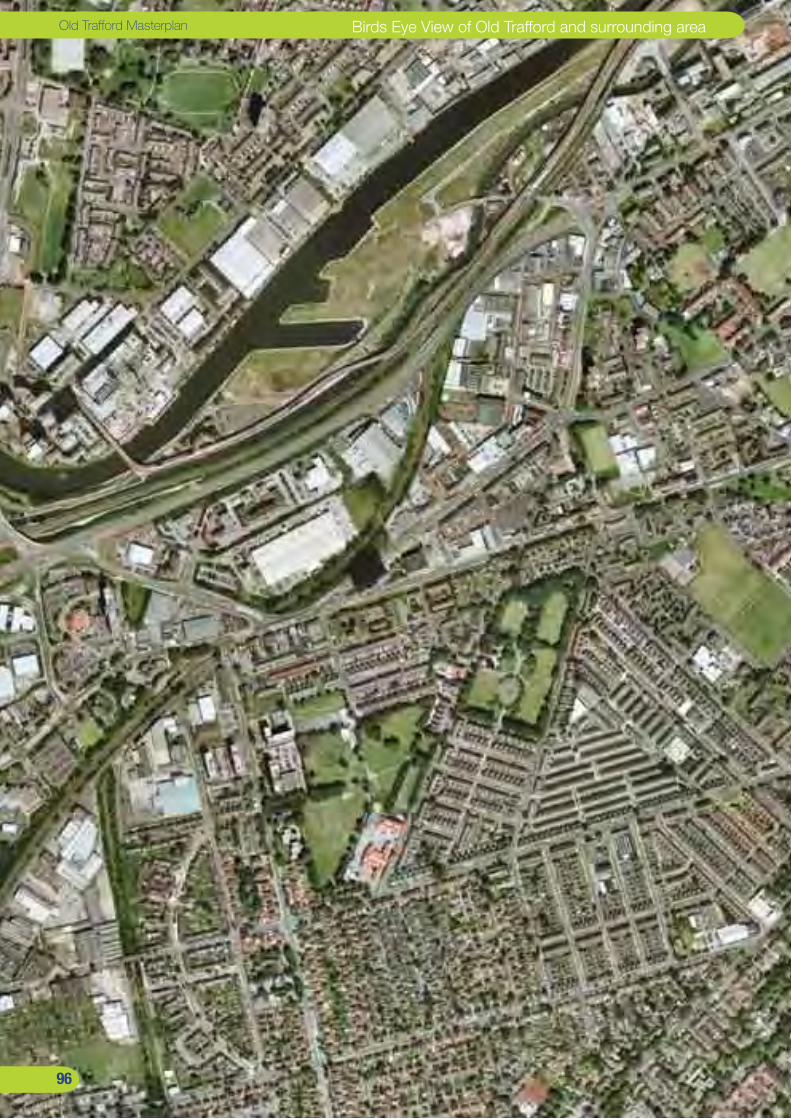
��
Old Trafford Masterplan Birds Eye View of Old Trafford and surrounding area
��
PART 7: Appendices
Appendix 1: Community Land Trust
Appendix 2: Appraisals
Appendix 3: Community Space Study (to follow)
��
Birds Eye View of Old Trafford and surrounding area Report by URBED and EKOS
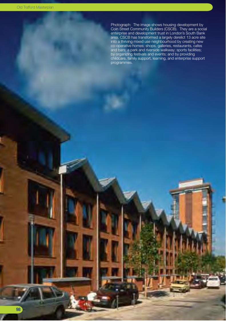
��
Old Trafford Masterplan
Photograph: The image shows housing development by Coin Street Community Builders (CSCB). They are a social enterprise and development trust in London’s South Bank area. CSCB has transformed a largely derelict 13 acre site into a thriving mixed use neighbourhood by creating new co-operative homes; shops, galleries, restaurants, cafes and bars; a park and riverside walkway; sports facilities; by organizing festivals and events; and by providing childcare, family support, learning, and enterprise support programmes.
��

��
APPENDIX 1: Community Land Trusts Intermediate housing market models
Community Land Trusts are quite well known in the USA where there is less of a culture of state or even state sponsored provision of affordable housing. Some of these have been going for 25 years. CLT’s have been the subject of a lot of attention in the UK over the last 10 years and there are already a few around, especially in Wales where the provision of affordable housing in small villages is very poor, leading to local people having to leave their communities.
Recently the HCA and the Joseph Rowntree Foundation have become interested in how CLT’s may be used on larger scale redevelopment like Old Trafford. Here they could play a similar role to an RSL - receiving properties from a larger volume builder or contractor. They would then sell the property to the prospective home owner but not the land on which it sits.
This can have advantages in securing a mortgage. The relationship between the CLT and the home owner can mean that by working with them they can offer a lender the cover they require by offering up the value of the land. If the CLT wants to retain the opportunity to offer these homes to other families in need it may want to have the opportunity to buy homes back off those leaving to pass onto others. If this is the case it can act as a ‘de facto’ mortgage guarantor. The CLT will also be able to offer the land underneath the home as well as the homes itself as security, creating the asset cover that lending institutions now need.
This will mean the CLT becoming an active player in the communities of Old Trafford as it will be effectively standing alongside every purchaser of the new homes. This model may also overcome some lenders’ concerns that in an unstable jobs market mortgagees may find themselves losing their jobs and so be less able to pay. There is a possibility for a relationship to be forged with the local credit union to spread the load of default a little.
Should a CLT adopt a less interventionist model where it does not intervene in the ongoing process of homes passing
to new owners, simply using lease conditions instead can still contain conditions to give lenders comfort. The property would still be sold without the land so still cheaper than it would be normally. If the mortgagee is in default and foreclosure is sought, the CLT is offered the property first so giving a lender more confidence. If after an agreed period they are unable to get the finance together the mortgage provider could then be enabled to sell the property on the open market complete with the land under it as well which would create the additional value once the market has lifted a little further.
The CLT can be set up with governance that reflects the provenance of the land it is using or the public sector could itself choose to take a less interventionist approach and let the regulatory bodies provide the necessary check and balances that will ensure the best possible future for the asset base in the longer term. One of the key advantages of these kinds of bodies is that where communities have opportunities to come together, those communities are strengthened. Furthermore the presence of a mutual housing provider offers a conduit for early attention on issues like neighbour disputes and anti-social behaviour. It may even be possible to place clauses in leases.
The CLT would offer benefits as a result of continuing beyond the sale of the houses, as the asset of the land will get more and more valuable once the market starts to recover. Given that the local authority without the CLT model would have been selling the freehold to individuals there seems no reason to insist that it is the Council that claws back this rise in asset value but recognises the huge regenerative value of the CLT doing so. This will mean that the community will possess a vehicle capable of carrying out further development of whatever form in the future, guaranteeing borrowing against that asset base and effectively allowing an ongoing recycling of public assets for the public benefit. Given the aspirations for more community facilities in the neighbourhoods it is possible that the CLT could become a valuable future delivery body.
Report by URBED and EKOS

�00
Old Trafford Masterplan
�00

�0�
� The Tamworth NeighbourhoodMix Unit No. Values Values Units Value1B Apartments 47 £90K Total Residential Value 413 £62,870,0002B Apartments 46 £110K Commercial Value 1,292m2 £1,624,0003B Apartments 23 £135K TOTAL £64,494,000TOTAL flats 1162B Houses 89 £135K Costs Units Costs3B Houses 89 £169K RTBs 2 £240,0004B Houses 89 £191K Home loss comp. 334 £1,670,0005B Houses 30 £214K Site acquisition 3,738m2 £1,619,000TOTAL houses 297 Purchase costs 5.75% £203,000
TOTAL 413 Land remediation 63,3376m2 £1,077,000
Demolitions housing 30 £171,000
Action Plan
1. THT to consult on this masterplan
2. Appoint a masterplanning team and project manager to progress an outline planning application.
3. THT to rehouse people from the Bird Blocks and commence decent homes works on the Balcony Blocks.
4. The Bird Blocks to be demolished, the land remediated
5. Reserved matters application for the structural infrastructure
6. THT to develop the first phases directly
6. Subsequent sites to be marketed to developers.
Demolitions other 4 blocks £1,600,000De-radburning - -Build costs housing 36,696m2 £31,034,000Build costs commercial 1,293m2 £835,000CSH Level 4 £7,359,000
S106 cost £1,033,000
New roads £874,000
New parks £1,772,000
Contingency 10% £4,575,000Fees 12% £5,491,000Marketing 2.5% £1,612,000Finance 6% £5,505,000
Profit 15% £9,674,000
TOTAL £76,344,000
Deficit -£11,850,000Value Social housing 93 units
Deficit with SHG -£9,057,000
Potential Funding1. THT Business plan provision for decent homes
2. Growth Point funding
3. Social Housing Grant (assumed at £5.58 million)
4. HCA Funding
5. THT Development allowance at 5% rather than 15% developer profit
APPENDIX 2:
Appraisals
Report by URBED and EKOS

�0�
Old Trafford Masterplan
� Chorlton Road GatewayMix Unit No. Values Values Units Value1B Apartments 65 £90K Total Residential Value 261 £34,060,0002B Apartments 66 £110K Commercial Value 1,468m2 £1,844,0003B Apartments 33 £135K TOTAL £35,904,000TOTAL flats 1642B Houses 29 £135K Costs Units Costs3B Houses 29 £169K RTBs 0 £04B Houses 29 £191K Home loss comp. 0 £05B Houses 10 £214K Site acquisition 13,302m2 £5,760,000TOTAL houses 97 Purchase costs 5.75% £332,000
TOTAL 261 Land remediation - £0
Demolitions housing - £171,000
Action Plan
1. THT to consult on this masterplan
2. Appoint a masterplanning team and project manager to progress an outline planning application for projects 1 and 2.
3. THT to develop the block in the park as a first phase to decant people from the Bird Blocks
4. THT to seek to acquire other sites by agreement.
5. Further phases to be brought forward as sites become available
Demolitions other - £1,600,000De-radburning - -Build costs housing 21,448m2 £19,423,000Build costs commercial 1,469m2 £949,000CSH Level 4 £4,290,000S106 cost £653,000New roads £172,000New parks £0
Contingency 10% £2,549,000Fees 12% £3,058,000Marketing 2.5% £898,000Finance 6% £3,427,000
Profit 15% £5,386,000
TOTAL £46,894,000
Deficit -£10,990,000Value Social housing 131 units
Deficit with SHG -£7,063,000
Potential Funding1. Growth Point funding
2. Social Housing Grant (assumed at £7.86 million)
3. HCA Funding
4. THT Development allowance at 5% rather than 15% developer profit
APPENDIX 2:
Appraisals
�0�

�0�
� The Hullard NeighbourhoodMix Unit No. Values Values Units Value1B Apartments 50 £90K Total Residential Value 278 £39,355,0002B Apartments 50 £110K Commercial Value 219m2 £275,0003B Apartments 25 £135K TOTAL £39,630,000TOTAL flats 1252B Houses 46 £135K Costs Units Costs3B Houses 46 £169K RTBs 6 £720,0004B Houses 46 £191K Home loss comp. 31 £155,0005B Houses 15 £214K Site acquisition 648m2 £280,000TOTAL houses 153 Purchase costs 5.75% £66,000
TOTAL 278 Land remediation 32,059m2 £545,000
Demolitions housing 94 £536,000
Action Plan
1. THT to consult on this masterplan
2. Appoint a masterplanning team and project manager to progress an outline planning application.
3. Decent Homes work to be progressed on Princess and Empress Courts
4. Reserved matters application for the structural infrastructure
5. THT to develop the first phases directly
6. Subsequent sites to be marketed to developers.
Demolitions other - £0De-radburning - £0Build costs housing 23,816m2 £20,777,000Build costs commercial 219m2 £142,000CSH Level 4 £4,763,000S106 cost £695,000New roads £698,000New parks £145,000
Contingency 10% £2,829,000Fees 12% £3,395,000Marketing 2.5% £991,000Finance 6% £3,306,000Profit 15% £5,944,000
TOTAL £45,978,000
Deficit -£6,348,000Value Social housing 75 units
Deficit with SHG -£4,113,000
Potential Funding1. THT Business plan provision for decent homes
2. Growth Point funding
3. Social Housing Grant (assumed at £4.5 million)
4. HCA Funding
5. THT Development allowance at 5% rather than 15% developer profit
APPENDIX 2:
Appraisals
Report by URBED and EKOS
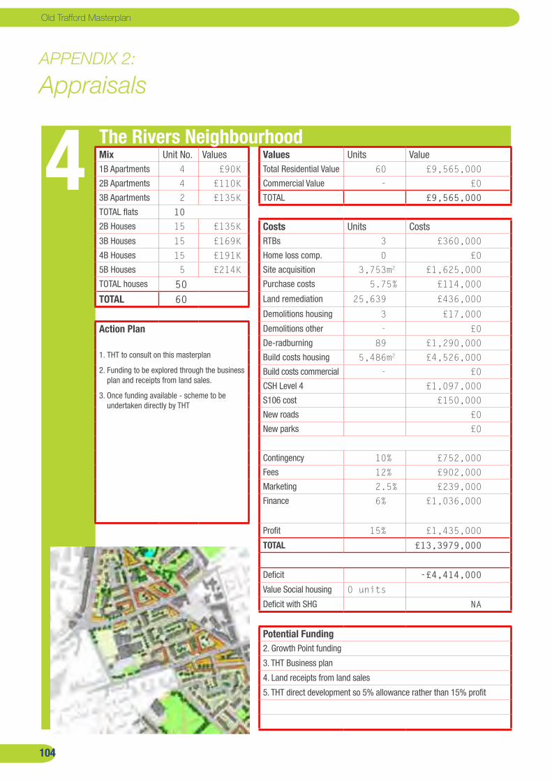
�0�
Old Trafford Masterplan
� The Rivers NeighbourhoodMix Unit No. Values Values Units Value1B Apartments 4 £90K Total Residential Value 60 £9,565,0002B Apartments 4 £110K Commercial Value - £03B Apartments 2 £135K TOTAL £9,565,000TOTAL flats 102B Houses 15 £135K Costs Units Costs3B Houses 15 £169K RTBs 3 £360,0004B Houses 15 £191K Home loss comp. 0 £05B Houses 5 £214K Site acquisition 3,753m2 £1,625,000TOTAL houses 50 Purchase costs 5.75% £114,000
TOTAL 60 Land remediation 25,639 £436,000
Demolitions housing 3 £17,000
Action Plan
1. THT to consult on this masterplan
2. Funding to be explored through the business plan and receipts from land sales.
3. Once funding available - scheme to be undertaken directly by THT
Demolitions other - £0De-radburning 89 £1,290,000Build costs housing 5,486m2 £4,526,000Build costs commercial - £0CSH Level 4 £1,097,000S106 cost £150,000New roads £0New parks £0
Contingency 10% £752,000Fees 12% £902,000Marketing 2.5% £239,000Finance 6% £1,036,000
Profit 15% £1,435,000
TOTAL £13,3979,000
Deficit -£4,414,000Value Social housing 0 units
Deficit with SHG NA
Potential Funding2. Growth Point funding
3. THT Business plan
4. Land receipts from land sales
5. THT direct development so 5% allowance rather than 15% profit
APPENDIX 2:
Appraisals
�0�
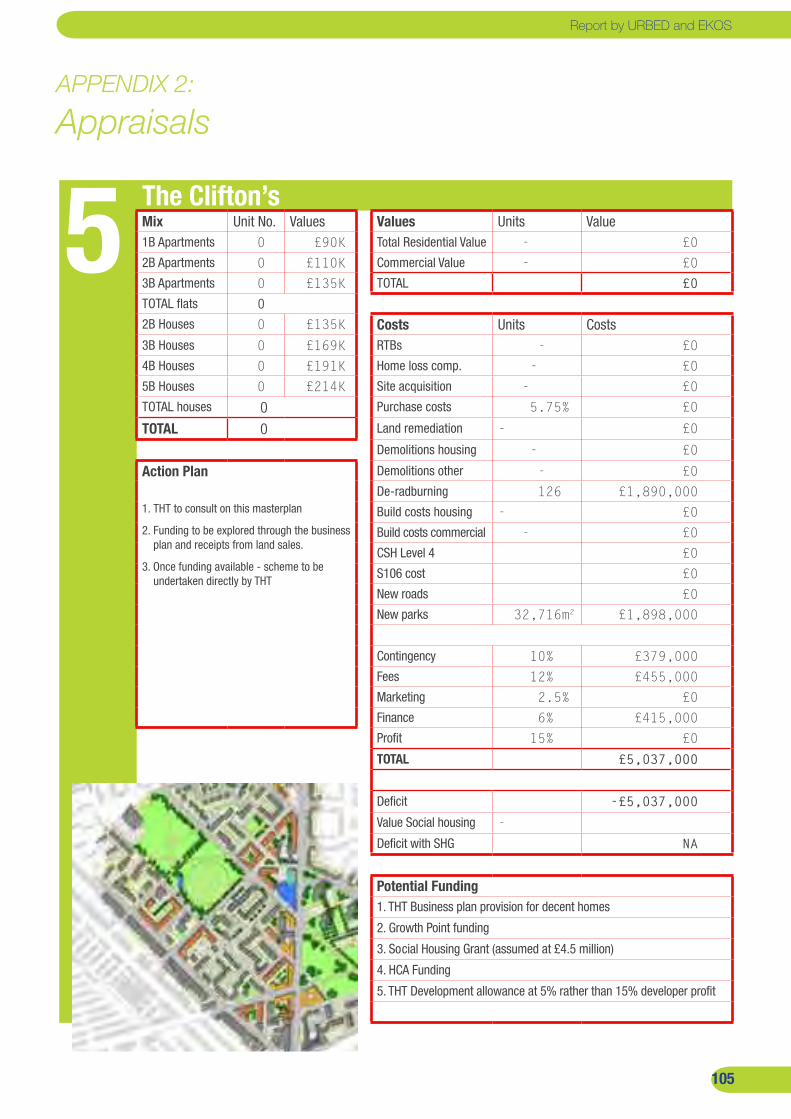
�0�
� The Clifton’sMix Unit No. Values Values Units Value1B Apartments 0 £90K Total Residential Value - £02B Apartments 0 £110K Commercial Value - £03B Apartments 0 £135K TOTAL £0TOTAL flats 02B Houses 0 £135K Costs Units Costs3B Houses 0 £169K RTBs - £04B Houses 0 £191K Home loss comp. - £05B Houses 0 £214K Site acquisition - £0TOTAL houses 0 Purchase costs 5.75% £0
TOTAL 0 Land remediation - £0
Demolitions housing - £0
Action Plan
1. THT to consult on this masterplan
2. Funding to be explored through the business plan and receipts from land sales.
3. Once funding available - scheme to be undertaken directly by THT
Demolitions other - £0De-radburning 126 £1,890,000Build costs housing - £0Build costs commercial - £0CSH Level 4 £0S106 cost £0New roads £0New parks 32,716m2 £1,898,000
Contingency 10% £379,000Fees 12% £455,000Marketing 2.5% £0Finance 6% £415,000Profit 15% £0
TOTAL £5,037,000
Deficit -£5,037,000Value Social housing -
Deficit with SHG NA
Potential Funding1. THT Business plan provision for decent homes
2. Growth Point funding
3. Social Housing Grant (assumed at £4.5 million)
4. HCA Funding
5. THT Development allowance at 5% rather than 15% developer profit
APPENDIX 2:
Appraisals
Report by URBED and EKOS

�0�
Old Trafford Masterplan
� Shewsbury StreetMix Unit No. Values Values Units Value1B Apartments 0 £90K Total Residential Value 90 £15,291,0002B Apartments 0 £110K Commercial Value - £03B Apartments 0 £135K TOTAL £15,291,000TOTAL flats 02B Houses 27 £135K Costs Units Costs3B Houses 27 £169K RTBs - £04B Houses 27 £191K Home loss comp. - £05B Houses 9 £214K Site acquisition - £0TOTAL houses 90 Purchase costs 5.75% £0
TOTAL 90 Land remediation 9,891m2 £168,149
Demolitions housing - £0
Action Plan
1. Brief to be prepared for Isobel Bailey Lodge
2. Isobel Bailey Lodge to be marketed in 12 months depending on the market.
3. Shewsbury Street Community Centre dependent on the outcome of discussions on the new community centre.
Demolitions other - £0De-radburning - £0Build costs housing 8,532m2 £6,825,000Build costs commercial - £0 CSH Level 4 £1,706,000S106 cost £225,000New roads £231,000New parks £0
Contingency 10% £915,000Fees 12% £1,099,000Marketing 2.5% £382,000Finance 6% £1,040,000
Profit 15% £2,293,000
TOTAL £14,886,000
Deficit +£404,000Social housing 0
Deficit with SHG NA
Potential FundingSites to generate a capital receipt.
APPENDIX 2:
Appraisals
�0�

�0�
� Stretford RoadMix Unit No. Values Values Units Value1B Apartments 43 £90K Total Residential Value 256 £36,670,0002B Apartments 44 £110K Commercial Value 1,121m2 £1,409,0003B Apartments 22 £135K TOTAL £38,079,000TOTAL flats 1092B Houses 44 £135K Costs Units Costs3B Houses 44 £169K RTBs 0 £04B Houses 44 £191K Home loss comp. 0 £05B Houses 15 £214K Site acquisition 833m2 £361,000TOTAL houses 147 Purchase costs 5.75% £21,000
TOTAL 256 Land remediation 20,869m2 £355,000
Demolitions housing 0 £0
Action Plan
1. Tenants to be decanted from Trafford and Ryland’s
2. A brief to be drawn up for the whole of the site.
3. The site to be marketed when market conditions improve.
Demolitions other 0 £0De-radburning 0 £0Build costs housing 22,087m2 £19,176,000Build costs commercial 1,122m2 £724,000CSH Level 4 £4,417,000S106 cost £640,000New roads £248,000New parks £0
Contingency 10% £2,556,000Fees 12% £3,067,000Marketing 2.5% £951,000Finance 6% £2,927,000Profit 15% £5,712,000
TOTAL £41,156,000
Deficit -£3,078,000Value Social housing 87 units
Deficit with SHG -£471,000
Potential FundingSites to be brought forward when it can generate a capital receipt.
APPENDIX 2:
Appraisals
Report by URBED and EKOS

�0�
Old Trafford Masterplan
Comments & FeedbackThis report sets out a draft Masterplan for Old Trafford. It has been prepared by URBED working with EKOS in collaboration with the community, stakeholders, Trafford Council, Trafford Housing Trust and the Old Trafford Neighbourhood Management Board. We welcome feedback so please send comments to [email protected] or write to:
URBED (urbanism : environment : design)10 Little Lever StreetManchester, M1 1HR
t. 0161 200 5500f. 0161 237 3994e. [email protected]. www.urbed.com
Other reports available:
Baseline Report Baseline SummaryCommunity Space Feasibility Study
available on www.urbed.com.
�0�