offering memorandum - braunco.com · page | 2 confidentiality agreement this is a confidential...
TRANSCRIPT

OFFERING MEMORANDUM
Bankruptcy Sale - Dunn Mill
316.41 ACRES
Active Rail Siding
866.568.6638 x233
Chris Strait - Sales Manager CA BOND: # 0347742 • DRE # 01248708
Page | 2
CONFIDENTIALITY AGREEMENT
THIS IS A CONFIDENTIAL MEMORANDUM intended solely for your limited use to determine
whether you wish to express an interest in the Industrial Property (APN 0542-141-19-0-000)
located in Barstow, California, as more particularly described herein (“Property”). This
confidential memorandum contains brief, selected information on behalf of the U.S. Bankruptcy
Court-Central District of California, Riverside Division and Trustee Steven M. Speier and, has been
prepared by BRAUN Corporation (“BRAUN”), the Owner’s exclusive agent, primarily from
information supplied by the Owner. Although representatives of the Owner have reviewed this
confidential memorandum, it does not purport to be all-inclusive or contain all of the
information that a potential investor may desire. Neither the Owner, nor any of its members,
officers, directors, employees or agents, nor BRAUN make any representation or warranty,
expressed or implied, as to the accuracy or completeness of any of the information contained
herein. Each of the Owner and BRAUN disclaims any liability which may be based on such
information, errors therein, or omissions there from. All financial data contained herein is
unaudited. The projections and pro- forma information contained herein represent estimates
based on assumptions considered reasonable under the circumstances. No representations or
warranties, expressed or implied, are made that the actual results will conform to such
projections. There is no representation as to environmental condition of the property, or as to any
other aspect of the property.
By your receipt of this confidential memorandum, you agree that this memorandum and the
information contained herein are of a confidential nature and that you hold and treat them in the
strictest of confidence, and that you will not, directly or indirectly, disclose or permit anyone else
to disclose this memorandum or any part of the contents in any fashion or manner detrimental to
the interests of the Owner.
This confidential memorandum shall not be deemed an indication of the state of affairs of the
Owner or constitute an indication that there has been no change in the business or affairs of the
Owner since the date of preparation of this memorandum. Neither the Owner nor BRAUN
undertakes any obligation to provide additional information or to correct or update any of the
information contained in this confidential memorandum.
Page | 3
Executive Summary BRAUN, as sole exclusive agent, is pleased to offer the fee-simple interest in the Industrial Property (collectively known as the “Property”), located on 316.41 Gross Acres situated adjacent to the 15 Freeway, in the unincorporated area of San Bernardino County, 30 Miles NE of the City of Barstow, California.
Identification of Properties: 316.41 Gross Acres situated adjacent to the 15 Freeway, in the
unincorporated area of San Bernardino County, 30 Miles NE of the City of Barstow, California.
Assessor Parcel Number: 0542-141-19-0-000
Thomas Map No: 350-A5
Date of Value: December 31, 2012, the last date of physical inspection.
Property Rights Appraised: Fee Simple Value As Is.
Land Area: 316.41Gross Acres gross.
Improvements: Mill and support structures, Rail Spur, Scale & Siding (Union Pacific Property), Single Family residence and water well system.
Zoning: Industrial* use within RC Resource Conservation District Zone.
Flood Zone: Not in a known Flood Zone, except that portion in the Mojave River AO zone.
Lender/client: Morris Financial Group.
Utilities: Telephone / Electric / Wells / High Pressure Natural Gas property/Petroleum line
Highest & Best Use of Subject Properties:
As is or land development.
As Vacant: Speculative land suitable for Industrial Development.
Page | 4
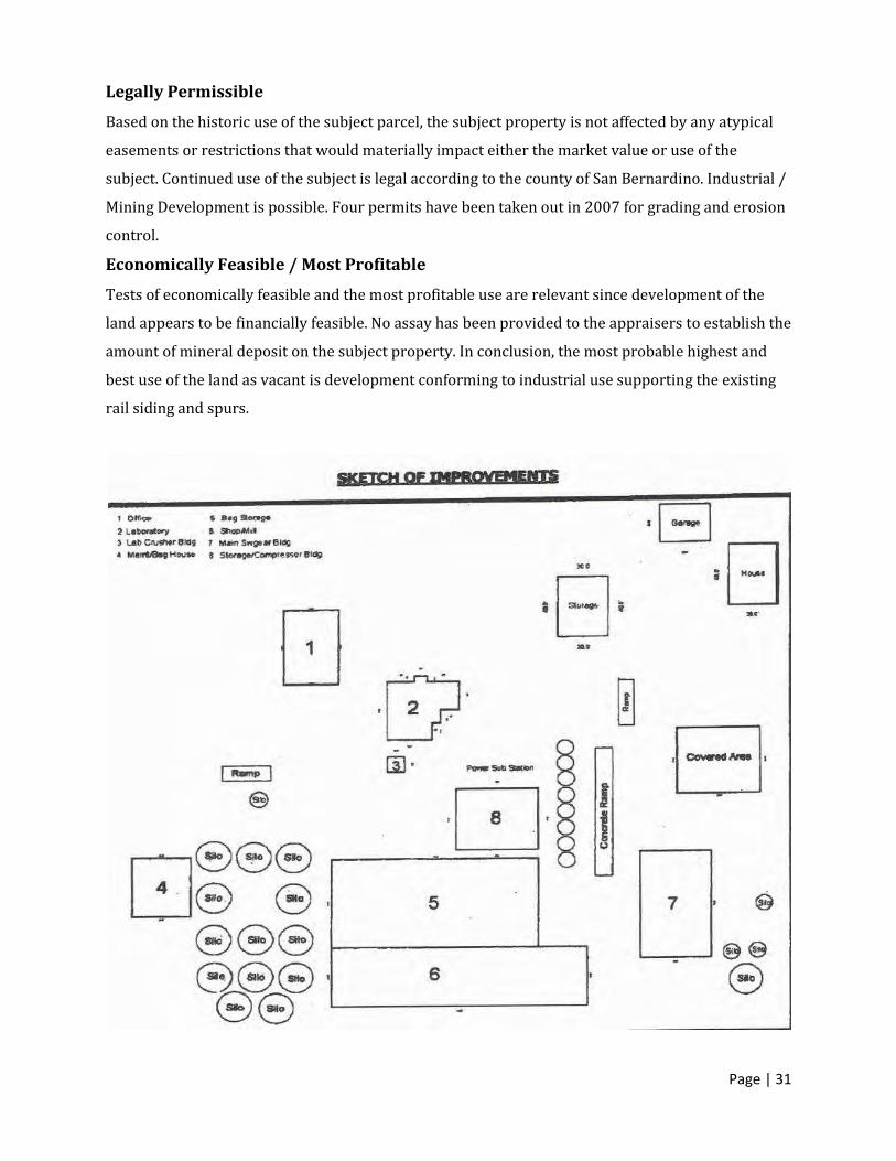
The County contends that there are real property improvements on site consisting of 23,803 square feet under roof; of those there are ten structures as follows: Office 1 comprised of 1,596 square feet class D – Frame and stucco construction, one story divided into six offices, 2 restrooms, 2 small closets, one reception room and a central hallway.
Office 2 comprised of 6 offices and a restroom comprised of 1,508 square feet of class D – Frame and stucco construction. Building 3 the well house, 144 square feet at 12 foot by 12 foot. Structure has nominal value.
Building 4 is a 1,360 frame storage room and shop located West of the main silo farm, is 34 by 40 feet or 1360 square feet. Building 5 is 60 foot by 120 feet long or 7200 square feet.
Building 6 a class S heavy steel structure like 5.
Building 7 a class S heavy steel multi-level structure with steel side panels, home to the Raymond mills, is 3024 square feet being 42 by 72 feet designed by Cantrall Steel Corporation of El Monte, CA. Building 8 a utility structure with transformer pad and fencing adjacent class D-Frame metal clad exterior of average quality industrial construction. Building 9 is a single family residential structure occupied by the watchman and family approximately 1500 square feet with an adjacent three car stand-alone garage of about 600 square feet. Building 10 is a large canopy adjacent to the jaw crushed between the crusher and building 7 estimated at 40 feet by 60 feet of class S pre-engineered steel construction used to for raw material storage.
Page | 5
In August 1976, Johns-Manville offered all its properties in the northeastern Mojave Desert
for sale, plus its grinding plant in Dunn, California. Johns-Manville considered donating its
talc claims to the National Park Service in the summer of 1976, but in September 1977,
Desert Minerals, Inc., a Kentucky-based company, purchased them. Before operations
began, in May 1978, the claims and the company plants in Dunn and Los Angeles were
acquired by Continental Minerals Corporation of Las Vegas, Nevada, by lease and option
sales agreements.
The new owners expressed their intention to resume production at the Big Talc, and hoped
to supply talc competitively by late 1978. Mining beyond the near future depends on
implementing major exploration and development. In addition, to supplying the developing
Japanese market for Second Layer talc, which is used as paper filler to provide the grit that
holds the ink in place. Talc is also used in a number of other products such as body powers,
paint, cosmetics, fillers, and glues. The property may be used to process minerals of many
types. Source: San Bernardino County Assessor’s web page.
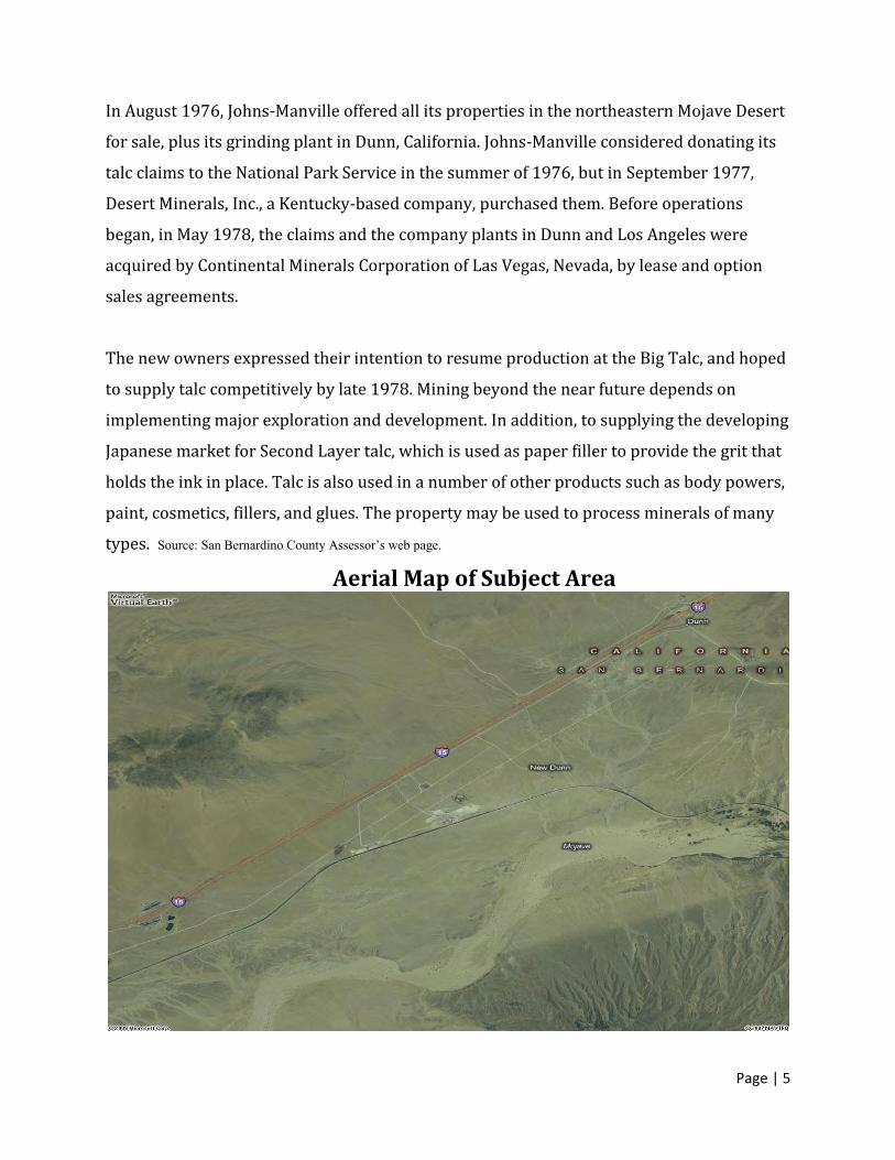
Aerial Map of Subject Area
Page | 6
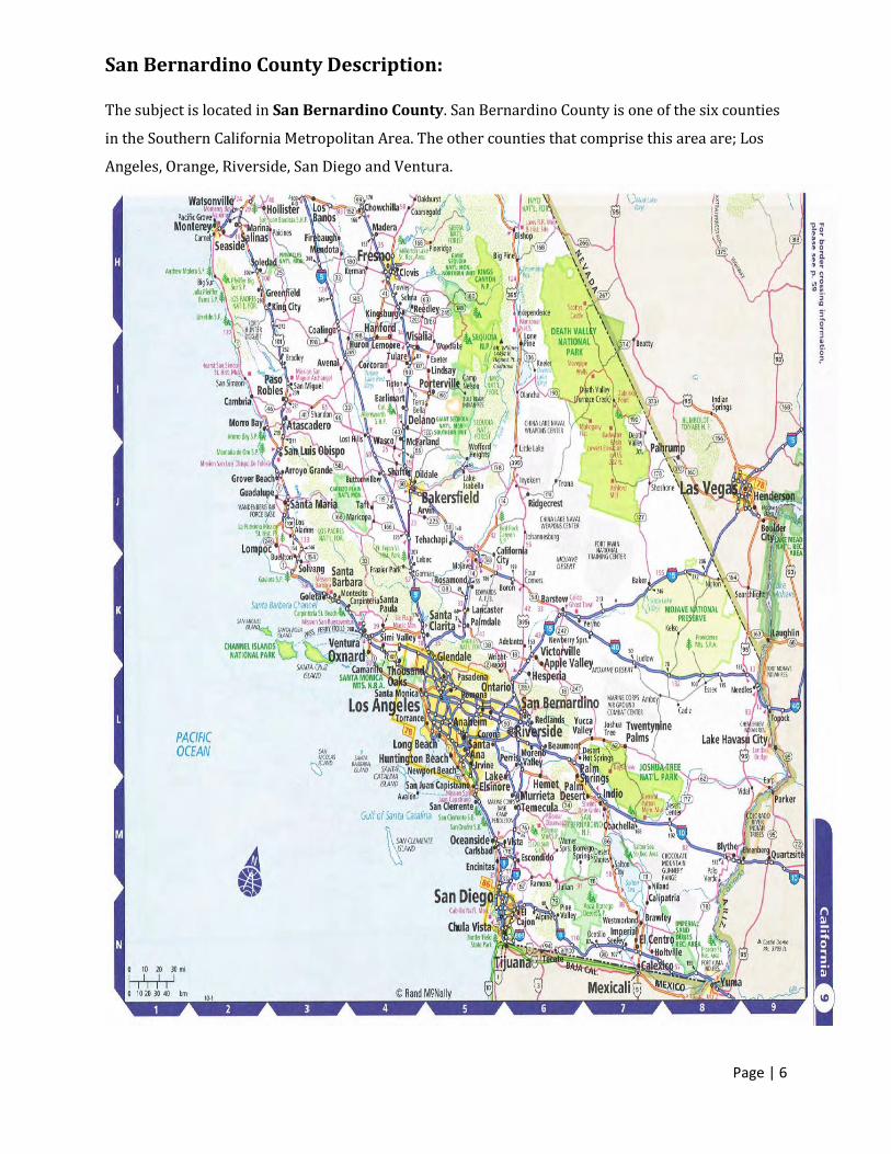
San Bernardino County Description: The subject is located in San Bernardino County. San Bernardino County is one of the six counties
in the Southern California Metropolitan Area. The other counties that comprise this area are; Los
Angeles, Orange, Riverside, San Diego and Ventura.
Page | 7
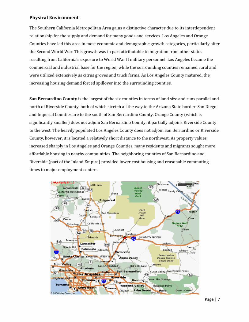
Physical Environment
The Southern California Metropolitan Area gains a distinctive character due to its interdependent
relationship for the supply and demand for many goods and services. Los Angeles and Orange
Counties have led this area in most economic and demographic growth categories, particularly after
the Second World War. This growth was in part attributable to migration from other states
resulting from California’s exposure to World War II military personnel. Los Angeles became the
commercial and industrial base for the region, while the surrounding counties remained rural and
were utilized extensively as citrus groves and truck farms. As Los Angeles County matured, the
increasing housing demand forced spillover into the surrounding counties.
San Bernardino County is the largest of the six counties in terms of land size and runs parallel and
north of Riverside County, both of which stretch all the way to the Arizona State border. San Diego
and Imperial Counties are to the south of San Bernardino County. Orange County (which is
significantly smaller) does not adjoin San Bernardino County; it partially adjoins Riverside County
to the west. The heavily populated Los Angeles County does not adjoin San Bernardino or Riverside
County, however, it is located a relatively short distance to the northwest. As property values
increased sharply in Los Angeles and Orange Counties, many residents and migrants sought more
affordable housing in nearby communities. The neighboring counties of San Bernardino and
Riverside (part of the Inland Empire) provided lower cost housing and reasonable commuting
times to major employment centers.

Page | 8
History of San Bernardino County
San Bernardino County is the largest county in the State of California. Its easterly boundary is the
State of Nevada. The geography Area is 20,106 square miles. About 90% of county is desert; the
remainder consists of the San Bernardino Valley and the San Bernardino Mountains. San
Bernardino County also shares borders with Imperial County, and Riverside County. Los Angeles
County is just northwest sharing borders with Orange and Riverside Counties.
In 1850 California, was admitted into the United States. On April 26, 1853, San Bernardino County
was created from parts of Los Angeles, San Diego, and Mariposa Counties. In 1854, the City of San
Bernardino was incorporated as the County Seat. In 1893, Riverside County was created out of
parts of San Bernardino and San Diego Counties.
Although the county marks its political beginnings in 1853, the land was occupied long before
Europeans and their descendants entered the area. Paleo-Indian sites dating from 10,000 BC show
that the San Bernardino county area has been inhabited for at least 12,000 years. In the past three
thousand years various Indian tribes flourished in the area; the Gabrielenos occupied the West
Valley, the Serranos lived in the foothills of the San Bernardino Mountains; the Vanyumes lived
along the Mojave River, the Mohave lived along the Colorado River, and in the 1500’s the
Chemehuevi moved into the Mojave Desert. The first explorers to enter the area were Pedro Fages,
Military Commander of California in 1771, and Fr. Francisco Graces, a missionary priest, in 1774.
The Needles Harvey House is named El Garces after the good padre. On May 20, 1810, Franciscan
missionary Francisco Dumatz, of the San Gabriel Mission, led his company into a valley. In
observance of the feast day of St. Bernardine of Siena, Dumatz named the valley San Bernardino.
This name was later given to the nearby mountain range and later the city and county.
In 1848, with the signing of the Treaty of Guadalupe Hidalgo, California became a territory of the
United States, and in 1850 California became a State. This event generated a steady flow of settlers
into the area, including gold miners, entrepreneurs, health-seekers, speculators, politicians,
adventurers, seekers of religious freedom, and individuals desiring to create utopian colonies.
Page | 9
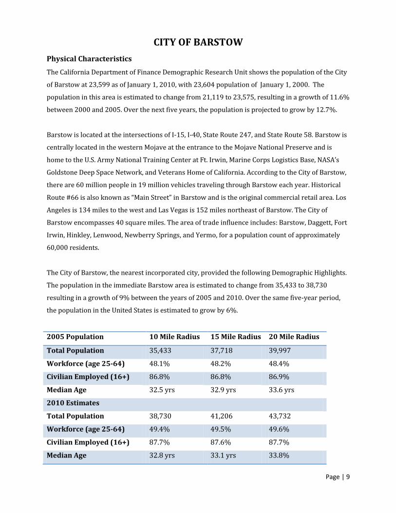
CITY OF BARSTOW
Physical Characteristics
The California Department of Finance Demographic Research Unit shows the population of the City
of Barstow at 23,599 as of January 1, 2010, with 23,604 population of January 1, 2000. The
population in this area is estimated to change from 21,119 to 23,575, resulting in a growth of 11.6%
between 2000 and 2005. Over the next five years, the population is projected to grow by 12.7%.
Barstow is located at the intersections of I-15, I-40, State Route 247, and State Route 58. Barstow is
centrally located in the western Mojave at the entrance to the Mojave National Preserve and is
home to the U.S. Army National Training Center at Ft. Irwin, Marine Corps Logistics Base, NASA’s
Goldstone Deep Space Network, and Veterans Home of California. According to the City of Barstow,
there are 60 million people in 19 million vehicles traveling through Barstow each year. Historical
Route #66 is also known as “Main Street” in Barstow and is the original commercial retail area. Los
Angeles is 134 miles to the west and Las Vegas is 152 miles northeast of Barstow. The City of
Barstow encompasses 40 square miles. The area of trade influence includes: Barstow, Daggett, Fort
Irwin, Hinkley, Lenwood, Newberry Springs, and Yermo, for a population count of approximately
60,000 residents.
The City of Barstow, the nearest incorporated city, provided the following Demographic Highlights.
The population in the immediate Barstow area is estimated to change from 35,433 to 38,730
resulting in a growth of 9% between the years of 2005 and 2010. Over the same five-year period,
the population in the United States is estimated to grow by 6%.
2005 Population 10 Mile Radius 15 Mile Radius 20 Mile Radius
Total Population 35,433 37,718 39,997
Workforce (age 25-64) 48.1% 48.2% 48.4%
Civilian Employed (16+) 86.8% 86.8% 86.9%
Median Age 32.5 yrs 32.9 yrs 33.6 yrs
2010 Estimates
Total Population 38,730 41,206 43,732
Workforce (age 25-64) 49.4% 49.5% 49.6%
Civilian Employed (16+) 87.7% 87.6% 87.7%
Median Age 32.8 yrs 33.1 yrs 33.8%

Page | 10
MARKET ANALYSIS
Labor Market Statistics (San Bernardino, Riverside Counties) INDUSTRY NUMBER EMPLOYED
Agriculture 17,500 Building & Housing 125,500 Manufacturing 108,600 Export Services 298,800 Locally Based Sectors 436,300
TOTAL EMPLOYMENT 986,700
Source: California Employment Development Department
Inland Empire construction and housing related sectors remain strong, up 9.5% or 10,900 jobs.
Growth was due to increases in residential, commercial and industrial construction in 2000. With
new and existing home sales beginning to recover, employment in retail building material outlets
was up 9,400 jobs or 13.3%; real estate and insurance grew 700 jobs or 4.0%.
Manufacturing sectors have grown about 4,400 jobs or 4.2%. The strongest sector was non-durable
manufacturing up 6.1%. Moderate increases in furniture & fixtures up 4.0%, fabricated metal &
industrial manufacturing up 4.1%. Export Service sectors primarily performing services for other
regions grew 4.3%. Locally based services are up 2.4% and agriculture is down -4.4%.
The Riverside/San Bernardino area has experienced rapid change over the last decade. Historically,
this was a relatively unpopulated area, with roots in agriculture, tourism, and transportation. The
Atchison, Topeka, and Santa Fe Railroads cut through this area, and the city of Colton is home to one
of the largest railroad junction yards in the United States. In addition, the resort communities of
Lake Arrowhead, Big Bear, and Palm Springs are located in the Riverside/San Bernardino Area. In
the 1980’s, with the cost of housing in the Los Angeles/Orange County areas increasing, developers
of single-family homes began constructing projects in the Inland Empire. The availability of land
and the relatively unrestrictive development attitudes of local governments combined to create a
housing and population boom that resulted in dramatic growth in the Inland Empire over the last
decade. The dramatic growth in housing and population resulted in a great deal of employment in
the construction field. In fact, approximately 9.5% of the workers in the Inland Empire are in the
construction field. The region’s unemployment rate of 4.4% is below the National unemployment
rate of 4.5% for August 2000; however increased during the recent 2008 to 2010 recession to 12%
or more in some isolated areas.
Page | 11
LOGISTICS
Ports of Los Angeles and Long Beach
The San Bernardino region is also advantaged by a close spatial relationship to the Ports of Los
Angeles and Long Beach. A close location to the San Pedro Bay ports provides many advantages for
the San Bernardino region, including a large capacity, access to Asian markets, and the dominance
of the Southern California port network. In a 2005 report for the Southern California Associations of
Governments (SCAG), Leachman estimated the amount of import and export activity for the Ports of
Los Angeles and Long Beach, while also evaluating the competition from other ports in the U.S. This
report found that the San Pedro Bay Ports possess economic, logistical, and location advantages
over all other ports on the West Coast. An additional advantage of the Ports of Los Angeles and Long
Beach is the increased capacity for transloading international merchandise. When merchandise is
transloaded, goods are transferred from one size of container to another, often involving the
transition from ship to truck, and then taken to warehouses to be redistributed. For many of the
transloaded goods that leave the Ports of Los Angeles and Long Beach, the destination is the San
Bernardino region where the merchandise is transferred from short-haul to long-haul rail lines, or
from rail to truck, or from truck to rail (Leachman 2005). The opportunity for the San Bernardino
region to benefit from transloading is further advantaged by the fact that the Long Beach and Los
Angeles Ports are the transloading destination for much of the U.S. import traffic. The West Coast
ports have a much lower per cubic foot cost for transloading than the East Coast ports, and the San
Pedro Bay Ports are the principle West Coast destination. The difference in cost is substantial, as
imports are largely elastic, and a single cent savings may provide a company with the incentive to
change routes. Fortunately for the San Bernardino region, the primary route seems to be the Ports
of Los Angeles and Long Beach. The California Division of Geology reports that sand and gravel
aggregate material is being shipped from British Columbia via barge to the ports of Long Beach and
San Francisco for hull ballast.
Multimodal Logistics Parks
Alliance, Texas Port of Huntsville, Alabama Rickenbacker/Columbus Inland Ports Logport, Duisburg Germany Long Beach/Los Angeles, CA Seattle, Washington Sacramento, CA Victorville, CA
Page | 12
These developments have used multi-modal infrastructure (air-rail-truck, or sea-rail-truck) as the
core of business/industrial parks. Whereas conventional business or industrial parks seek office
buildings or manufacturers as “anchor tenants”, these “logistics parks” use the transportation
infrastructure as a selling point. These developments have much in common with the shippers,
consignees, and ancillary businesses that surround seaports. They are “inland ports” without being
extensions of seaports.
Southern California Logistics Center
(SCLC) is a 2,500-acre commercial and industrial complex totaling 60 million square feet of diverse
development.
Manufacturing/distribution facilities (some with direct rail spur access) from 2,500 to 2.5
million square feet
Intermodal rail
International air cargo facilities and hangars
Aviation maintenance facilities
Corporate office campus
Executive jet travel / business center
Multimodal logistics centre
Air cargo services
Minutes from I-15 and U.S. 395
Less than 100 miles from the Ports of Los Angeles and Long Beach
Optimal location for interstate and international distribution
Abundant skilled workforce at competitive rates
Municipalized utilities / low cost reliable power
Competitive operating costs / lowest in the region
Project-wide expansion opportunities
Onsite property management
Most Logistics Parks are designed around the utilization of a main spur and several smaller spurs.
This design allows for maximization of available space and the highest return on the land. On the
following page is a Map of the project at SCLC in Victorville, CA. It depicts a design that is typical of
logistics center. Because SCLC is also an airfield, formally George Air Force Base, it is limited on the
amount of space specifically designated for rail distribution. The overall amount of rail facility is
similar to the amount of space available to the subject.
Location
Southern California is a global crossroad between America, Asia, and Europe. A great deal of the
economic success of the region is attributable to capitalizing on this.
Page | 13
Transportation Networks
Given the San Bernardino region’s relative proximity to the San Pedro Bay Port Complex, as well as
major airports including LA/Ontario International Airport (ONT), the area is an advantageous
location for companies active in international trade. Key findings with respect to infrastructure
include:
• Interstate 10 and State Highways 60, 91, and 210 provide the necessary linkages between the San
Bernardino region and major Southern California ports.
• After goods reach the San Bernardino region, access to Interstates 10, 15 and 40 allow movement
of international trade into the majority of major markets in the U.S. For instance, Phoenix, Las
Vegas, San Antonio, Memphis, and Raleigh-Durham are within two exchanges on interstate
freeways from the San Bernardino region.
• The San Bernardino region is located at a rail nexus, with lines moving goods East, West, North,
and South. Southern California is connected to vast markets by two principle long-haul railroads:
The Burlington Northern Santa Fe Railway and Union Pacific Railroad. Combined, these two
companies move more intermodal cargo than any other rail system in the world (Jones and Stokes
2004).
International Trade Statistics and Trends
• Total international merchandise trade in San Bernardino and Riverside counties amounted to
$17.5 billion in 2005 or close to 18.5% of aggregate income. San Bernardino County was
responsible for the vast majority of regional international trade, with $14.9 billion in imports and
$917 million in exports.
• Recent figures show a marked reduction in regional trade activity between 2002 and 2004,
followed by a drastic increase in trade activity in 2005—total trade nearly tripled between 2004
and 2005. Total trade values are at record levels and are determined almost entirely by year-to year
changes in imports.
• Total import activity more than doubled from 2002 to 2005, while exports maintained a growth
rate 10.4% over the period. Healthy import and export growth over the four year period is
encouraging and may suggest that Inland companies are taking advantage of international
economic opportunities.
• Inland import commodities consist primarily of intermediate and consumer goods. Machinery
parts topped the list in 2005, with an estimated value of $1.5 billion or 11.4% of overall imports.
Merchandise in this category primarily consisted of items such as computer parts and cables, as
well as various other office-related components. Other significant import commodities included
Page | 14
iron and steel ($1.6 billion), electronics ($1.1 billion), medical or surgical instruments ($1.1 billion),
and furniture ($1.1 billion).
• The region’s top export commodities are dominated by raw materials, including scrap metal
($196 million) and raw fabrics ($171 million). These two raw materials alone represented close to
48.5% of the value of all commodities exported in 2005. Other significant export commodities
included vehicle parts ($66 million), articles of plastic ($45 million), and medical or surgical
instruments ($40 million).
• Seven out of the region’s top 10 trading partners are located in Asia or the South Pacific,
representing 84.1% of all vessel trade or $12 billion. China alone represents just over 50% of total
trade activity in the region or $7.1 billion, making it the region’s most important trading partner in
terms of both imports and exports in 2005.
• Taiwan and Japan also recorded impressive trade numbers, with both countries providing over a
billion dollars of international trade.
International Trade and Southern California Ports
Given the San Bernardino region’s geographic location, it is not surprising that the Ports of Los
Angeles and Long Beach are the most important trade hubs for inland vessel trade. Moreover,
Inland airports contribute to regional trade movements, providing companies located in the San
Bernardino region with opportunities to move high value products.
CPIC’s key findings with respect to trade and regional ports include:
• Over 2.4 million tons of trade merchandise flowed through the Port of Los Angeles with the San
Bernardino region as its destination, while over 1.7 million flowed through the Port of Long Beach.
These figures show that the two Southern California ports are far and away the most important
trading hub for vessel trade in the region—the closest port competitor (the Port of San Diego) only
provided 617,000 tons.
• From 2004 to 2005, import growth at the San Pedro Ports more than doubled, while exports grew
at a rate of 2.5%. The primary factor leading to double digit import growth was a considerable
reduction in the port congestion that impacted the San Pedro Ports over the past two years (Kyser
and Huang 2005).
• Total international air cargo trade at the LA/Ontario International Airport (ONT) increased by
75.6% from 2004 to 2005, with imports increasing by 29.5% and exports increasing by 109.3%. It
is important to keep in mind that air cargo tends to consist of high value/low weight high tech
goods and thus contributes more to the regional economy than suggested by its modal share of
weight.
Page | 15
• According to recent Southern California Association of Governments (SCAG) forecasts, ONT is
expected to reach close to 2.25 million tons of total trade by 2030, which is just below estimates for
Los Angeles International Airport (LAX) (SCAG 2004).
• Several other Inland airports are expected to record significant growth over the next several decades.
These airports include San Bernardino International Airport, March Air Reserve Base, and the Southern
California Logistics Airport. Both San Bernardino International and March Air Reserve are projected to
have upward of a million tons of air cargo movement by 2030(SCAG 2004).
International Trade and Employment
International trade contributes to regional employment and facilitates economic development.
Before presenting CPIC’s findings, it is important to note an important 36 limitation of the
employment estimates provided in this report. These estimates do not include multiplier effects—
i.e., the coefficients used to produce the estimates show the impacts of all the purchases of inputs
for production, but fail to include the impact of spending for consumer goods by those individuals
earning income from producing goods.
With this limitation in mind, findings with respect to trade and employment include:
• Two-county employment related to the production of international merchandise in 2005 was just
over 50,000. Of the total jobs generated, 46,000 (or 90%) are located in San Bernardino County.
Close to 24,000 trade-related jobs have an average annual salary of $35,000 or more.
Bernardino County (which represents approximately 4% the County’s overall aggregate income)
and $166 million in income for Riverside County in 2005.
• International trade is critical to the economic viability of certain local industries. International
trade was responsible for approximately 38% of all employment in the wholesale trade industry
and 25% of all employment in the retail trade industry in San Bernardino County.
• The majority of employment generated by international trade is due to import activity. Because a
majority of international merchandise transitions through the San Bernardino region, employment
is generated regardless of whether local firms are importing or exporting.
International Trade and Economic Development
The employment figures in this report provide a good picture of regional development and growth.
Findings with respect to trade’s impact on economic development include:
• Based on the employment calculations in this report, it is clear that international trade is
impacting regional economic development. The employment associated with international
merchandise production alone accounted for approximately 7.2% of San Bernardino County’s
overall employment in 2005.

Page | 16
• Many of the jobs associated with international trade pay high average wages and have few formal
education requirements. The culmination of this information suggests that international trade
could offer economic opportunities to a large portion of San Bernardino residents (for a similar
argument, see Husing 2005 and 2010).
• These data suggests that international trade has the potential to have long-term and beneficial
effects on the economic development of the San Bernardino region. Literature on economic
development, job creation, and business attraction suggests that a cluster of businesses engaged in
international trade, along with the relatively unique advantages of the area, will provide leverage
for the area when bargaining with businesses (Held 2005; Porter 2000; Steinacker 2002).
The Future of International Trade Activity in the Region
International trade presents a valuable opportunity for the San Bernardino region. Relative
closeness to the Ports of Los Angeles and Long Beach, access to a logistics and infrastructure nexus,
a growing population, and a strong base of industries that support international trade combine to
provide the region with a competitive advantage few other regions in the world possess. Projects to
improve goods movement in the San Bernardino region are recognized as critical to the region’s
economic development goals and are currently funded appropriately. If appropriate funding is
maintained, the San Bernardino region has the potential to become one of the U.S.’ major trade
gateways, linking the nation to the rest of the world. Exports to China from the San Bernardino
region consist primarily of raw materials and intermediate goods used in the manufacturing
process. The top export commodity sector in 2005 consisted of cements and base metals, with an
estimated value of $186 million. Cotton and woven fabrics followed closely behind in the number
two spot, with $167 million.
Alunite production has been on the increase and anticipated to expand with development of the
Blawn Mountain mine and the shipping of the product to international locations with milling at
Dunn Siding in Northeast Newberry Springs along Hwy 15 and the Union Pacific rail lines with a
siding and static scale for shipping and receiving hundreds of tons the product.
Local Commodities and Trends
The location has appeal as a regional distribution facility as it would allow for the more cost
effective exportation of local commodities i.e. Mineral products from the North East Mojave Desert.
The Las Vegas Airport Authority has secured 4500 acres at the North end of Ivanpah Valley at Leach
Dry Lake to build a companion international airport to its sister facility McCarran Airport. That new
facility is scheduled to open 2017 with construction to begin in 2013. The subject is the nearest rail
hub to that facility in California and with its estimated 6,390,000 tons of aggregate sand and gravel
Page | 17
material on the North 180 acres to be removed it can be a nearby source of material and/or cement
with delivery by train to the construction site.
Mineral Products
This region has vast mineral wealth as well as appeal to large scale mining operations. Materials
commonly recovered by mining include bauxite, copper, iron, gold, lead, nickel, phosphate,
platinum, rock salt, silver, tin, titanium, uranium, and zinc. North Americas largest supplier of rare
earth metals is located at Mountain Pass, California, just 40 minutes Northeast of Dunn Siding.
Other highly useful materials that are mined include clay, sand, cinder, gravel, granite, and
limestone. The export of clay products and other mineral products is expected to increase as the
world economy grows. Once poor countries with limited recourses are now prospering and
beginning to emerge and develop more sophisticated infrastructures, increasing demand for
products mined in the subjects region will increase.
The subject soils are comprised of aggregate material that can be mined, washed and filtered by
size for use in cement and road construction. Granite Rock Corporation has obtained a contract
with CalTrans to widen and improve Interstate 15 from Barstow to the California/Nevada state line.
Granite has agreed to pay seventy-one cents per ton of 38 raw aggregate on an adjacent plot of land
to the Northeast. Appraisers estimate that the removal of twenty two feet of over burden aggregate
soils comprised of 6,390,000 tons would be worth $4,540,000.00. Source: Prior appraisal and
contract.
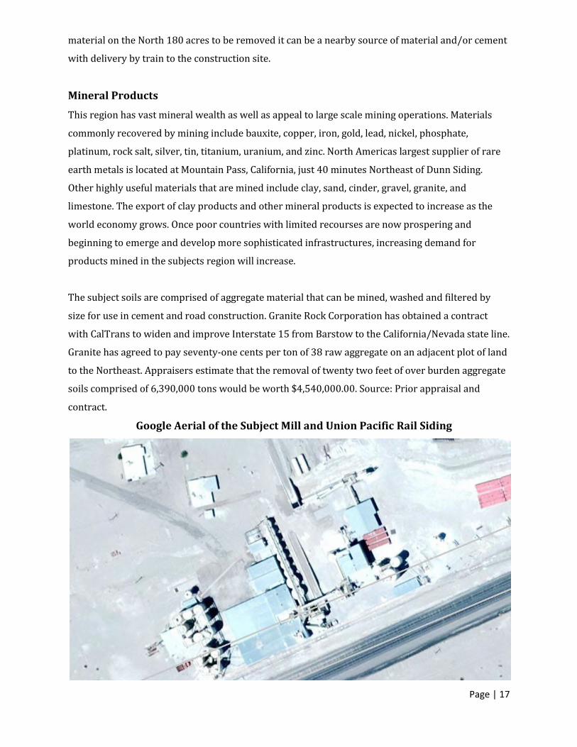
Google Aerial of the Subject Mill and Union Pacific Rail Siding
Page | 18
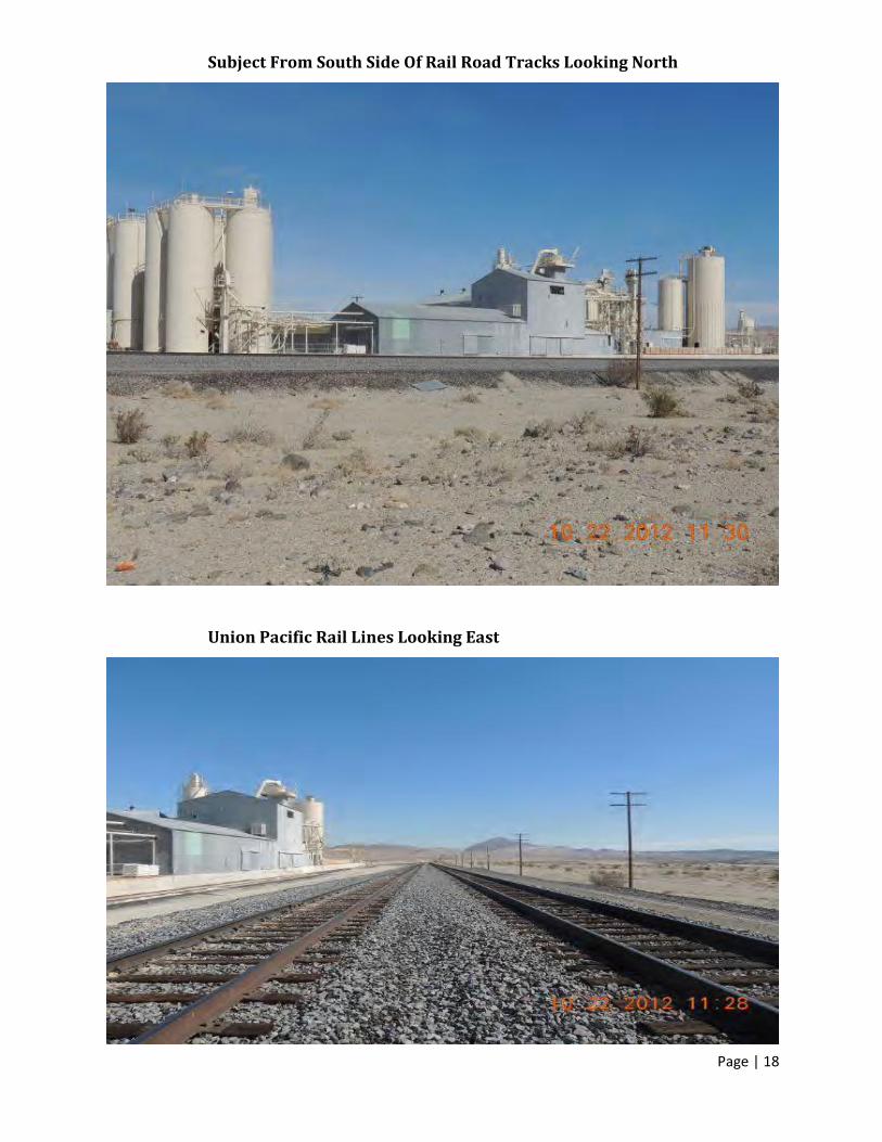
Subject From South Side Of Rail Road Tracks Looking North
Union Pacific Rail Lines Looking East
Page | 19
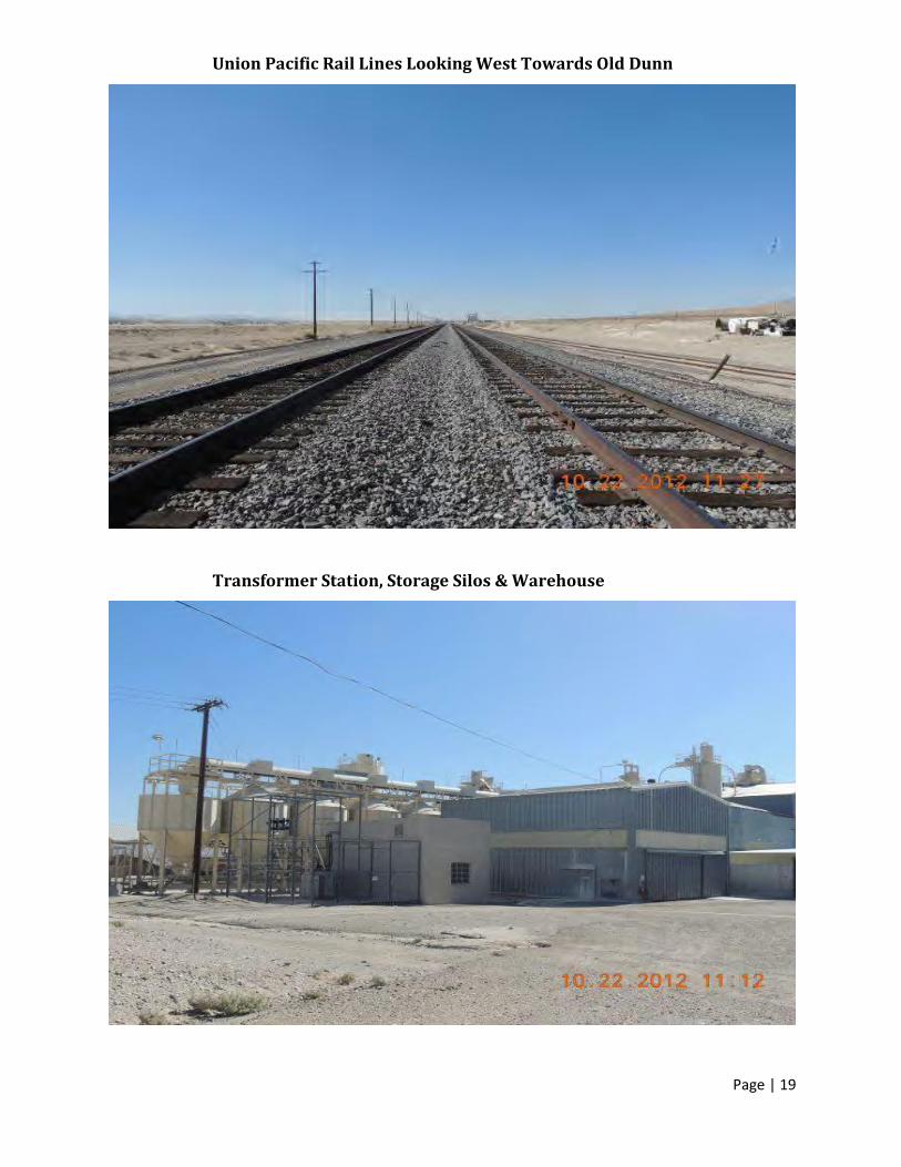
Union Pacific Rail Lines Looking West Towards Old Dunn
Transformer Station, Storage Silos & Warehouse

Page | 20
Silos For Various Products To Be Mixed, With Computer Controls To Be Added
Conveyor System To/From Jaw Crusher

Page | 21
Superstructure And Access Stairs
54” Raymond Vertical Mill

Page | 22
Switch Room
West Main Silo Detail -At Any Given Time There Is 200 Tons Of Refined Mineral On-Site

Page | 23
Additional West Silo Detail
Additional West Silo Detail -Silo Distribution System At Base

Page | 24
Southern Portion Of Property South Of The Union Pacific Rail Lines Mitigation Land
Rail/Truck Load Out System

Page | 25
Plant Uses
Commercial talc falls into four categories:
• Steatite: Compact, massive and fine-grained: can be sawed, drilled or machined to required
shapes. Usually it is heat treated to convert the talc to clinoenstatite which is used as insulation.
• Soft platy talc: An alteration product of dolomite with chlorite as a common accessory. This is the
most important type of talc and is used in wide variety of ceramic, paper, roofing and plastic
products.
• Tremolite talc: Massive or laminated rock with varying percentages of tremolite, anthophyllite,
calcite and dolomite. It is characterized by a high CaO content, and is often in demand for products
which require a greater cohesive strength.
• Mixed talc: Various types of talc; usually any type which is not characterized as one of the above.
Used for applications that is less selective in terms of oxide mineral content.
Most commercial talc products are a blend of two or more types specifically designed to meet the
specifications of the buyer. For example, the ceramic industry prefers hard massive, white talc
while the paint and plastics industries prefer soft, foliated talc. Death Valley talc, because of its
purity, commanded a premium price and was much in demand for specialized applications
requiring higher purity, such as cosmetics.
Rail Siding And Spur Description
The subject has approximately 9,529 lineal feet of Rail Spur siding. Currently, 2,910 lineal feet is
suitable for use on the subject property. There is a second set of siding rails somewhat covered by
sand in unknown condition and apparently not in use and thus not valued herein in an abundance
of caution. The spur is a valuable aspect of the land and adds significantly to the value. No other
large land pieces were found to have transferred in the subject’s area that had a rail spur on it. The
only other transactions that were found in the subjects region were found in the city of Palmdale,
and both were significantly smaller. The rail spurs location proximate to the 15 Freeway make it
ideally suited for a distribution facility. Development of a large inland facility at this location would
be possible only in conjunction with and not separate from the rail spur and Hwy 15.
Rail lines are the property of Union Pacific Railway Company referred to on the title report as the
old San Pedro, Los Angeles and Salt Lake Railroad Company, and as the Los Angeles and Salt Lake
Railroad Company.

Page | 26
The line is spurred for turning cars, which includes a static scale to weigh rail cars and content and
turnout switches. The usable siding replacement, according to the technical help line at Marshall &
Swift, for a 130# per lineal yard 6” x 6 3/4” rail at mid-dollars per lineal foot of approximately
$138.00 per lineal foot plus switch and turnout costs at mid-dollars of approximately $44,400.00
each with two switches and turnouts based on replacement of the usable 9,529 feet would be
$1,390,000.00. The data came from M&S, section 66 page 3, and confirmed verbally on 4/17/2013
via telecom (213) 683-9000 with Kristy @ Tech Support. The switches appear to be manual rather
than the powered type currently being installed. See photo attached.
When then applying a western multiplier found in M&S section 99 page 3 of 1.06 and to bring the
previous data to current April, 2013, $1,390,000.00 x 1.06, a value of $1,473,400.00 is calculated
and rounded down to $1,473,000.00.
As an alternative, we looked to the 2012 building of a turnout lead line at Hesperia, CA of just under
one mile in length off of the SFRR/UPRR rail lines into the industrial district. Rail weight is 130# rail
size is 6” x 6 ¾” and the lines are parallel with three switches, two of which are for the turnaround
parallel siding. The cost, according to Community Development, was $8,100,000.00, which included
design, plans, grading, ballast bed, installation, labor, supervision and contractor overhead and
profit. The length was reported to be 5,280 linear feet, thus the total current regional cost per foot
was $8,100,000.00 / 5280 = $1,534.09 per foot. Applying this to the subject line of 9,529 lineal feet,
the resulting cost today would be a probable $14,618,343.61. That portion lying on the subject is
reported to be 2,910 lineal feet, equating to a current cost of $4,464,201.90, rounded up to
$4,500,000.00.
UTILITIES:
View Northeast County Rd 20866
Page | 27
Access to utilities is good. The nearest location for power and telephone is located at the site. Water
is accessed by way of a well - information on the depth was not provided. A review of the Grant
Deed did not reveal the presence of any water shares/rights. The value of the water rights would
need to be studied further.
It is outside the adjudicated area based on Mojave Water Agency per David Seielstad at the
Watermaster’s office via e-mail dated March 4, 2013. No valuation of the water rights was provided.
Water extraction reports should be filed with California Department of Water Resources to perfect
a water right in the event of expansion of the adjudicated area. Natural gas is available. Sewer is not
available and onsite treatment would need to be conforming for large scale development.
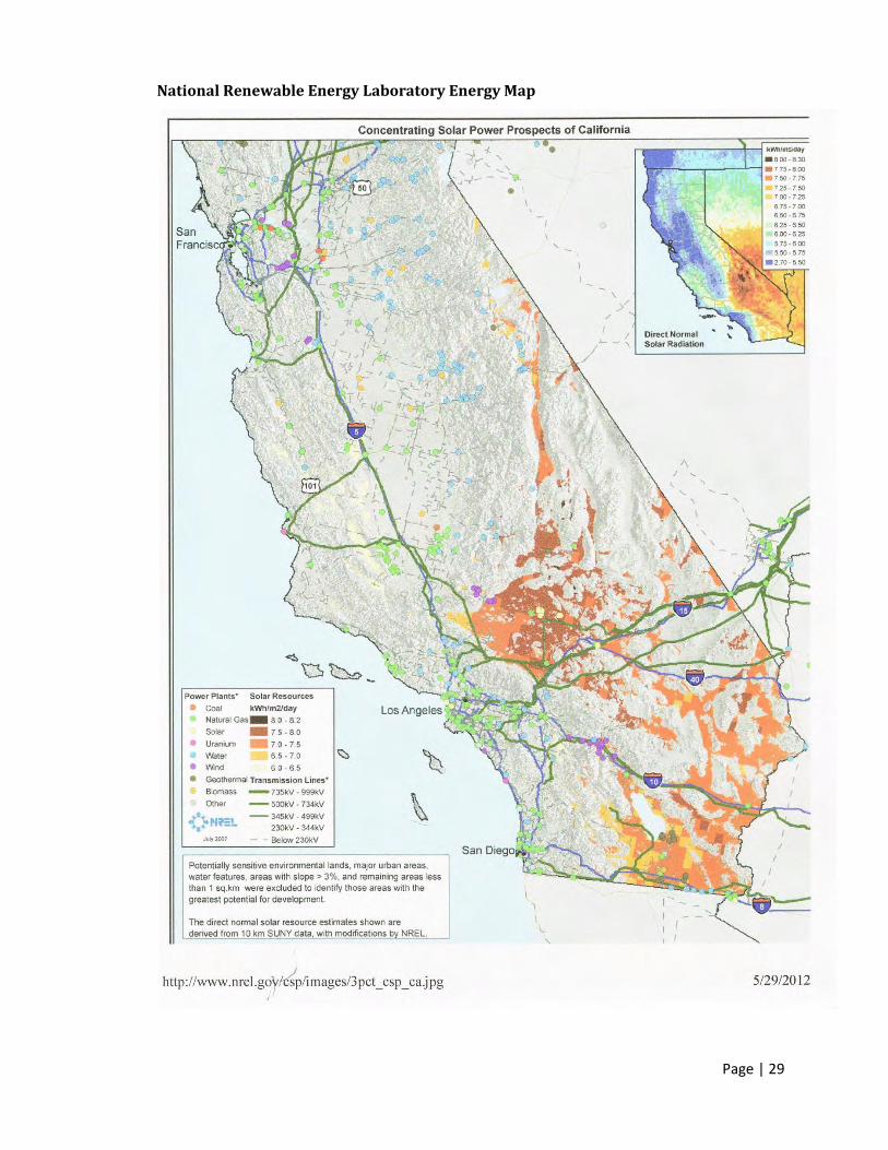
The subject’s location adjacent to the main electric grid affords it the possibility of solar and/or
wind generated electrical project. While the National Renewable Energy Laboratory identifies the
subject as prime solar collection area, the subject is rated as only fair for wind power generation.
The high voltage electrical line passing through the subject property is being upgraded to 500 KW.
ACCESS
There is good physical access to the subject at this time. The closest access point to the subject
would be County Rd #20866, adjacent to the subject property on the north side.
County Rd #20866 is an asphalt paved road in fair condition, crossed with desert washes at several
points. It provides direct access to the I-15. The existing two lane road is narrow (average
pavement width 22’ with soft dirt shoulders ranging from two to eight feet) with significant
constraints at vertical alignments for access.
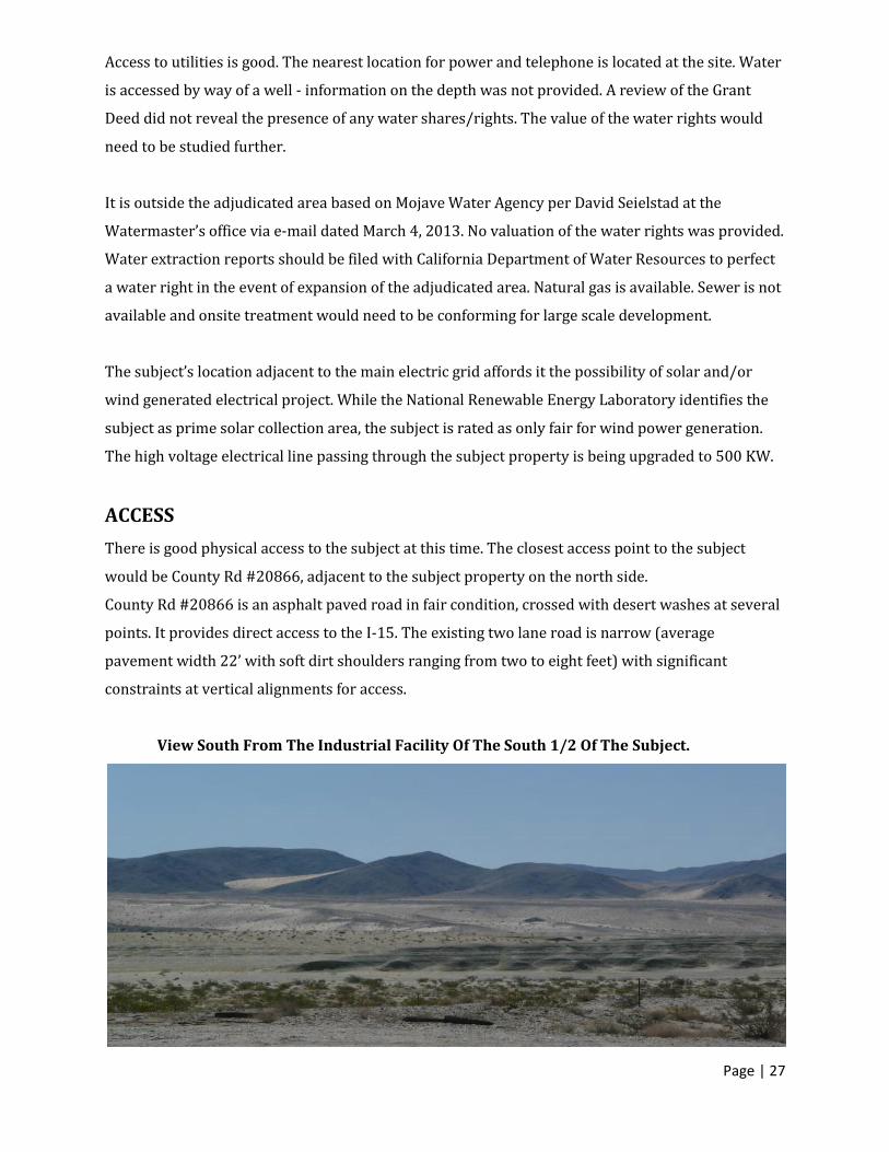
View South From The Industrial Facility Of The South 1/2 Of The Subject.
Page | 28
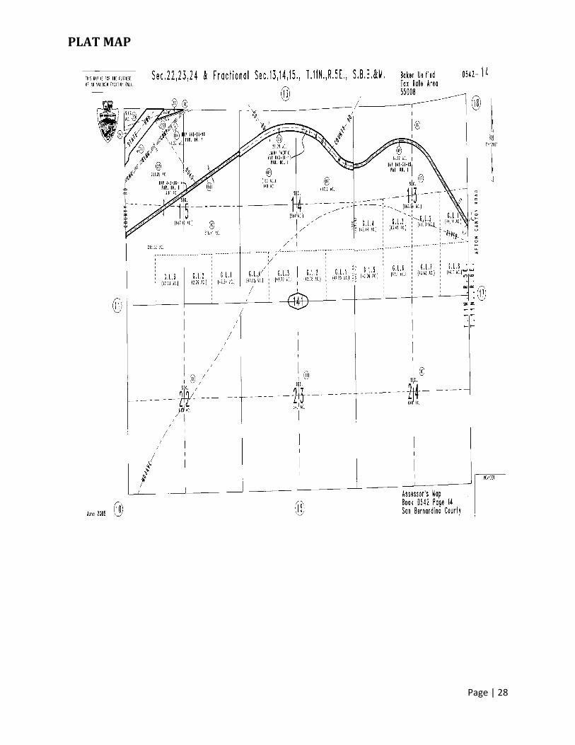
PLAT MAP
Page | 29
National Renewable Energy Laboratory Energy Map
Page | 30
Zoning
According to the County of San Bernardino Land Use Services Dept. (760) 843-4343, the subject is
zoned (RC). The historic use of the land, however, has been Mining / Industrial M1 and M2.
According to the San Bernardino Land Use Services Dept., the County would most likely favor a
General Plan Amendment to change the zoning to Industrial due to the existence of a rail spur as it
would be the highest and best use. At one time, the subject was zoned heavy manufacturing and
was modified to RC. The reason for the change is unknown; but probably an oversight done when
the desert portion was generally reserved for conservation. The current use is “Industrial” by
permits issued by the County years ago.
84.0305 Resource Conservation (RC) District
The Resource Conservation (RC) District shall be located as specified by the San Bernardino County
General Plan.
HIGHEST AND BEST USE
The Highest and Best Use is that use which is most likely to produce the greatest net return over a
given period of time to the land. Net return refers to the residual left over from gross yield after all
costs have been deducted. Only those uses which are physically possible, legally permissible,
financially feasible, and maximally productive may be considered tenable. Highest and best use
maybe defined as the available use and program of future utilization that produces the highest
present land value.
The appraisers have investigated and analyzed the highest and best use of the 316.41 gross acre
parcel in regard to those uses which are physically possible, legally permissible, economically
feasible, and maximally productive. That use which passes the three initial criteria and maximizes
net return is the highest and best use. We have considered the highest and best use assuming that
the subject property is vacant as of the appraisal date.
Physically Possible
The size and shape and topography of the 316.41acre parcel do not restrict development options.
The site is considered to have good potential for Industrial development. Other physical
characteristics of the site, such as accessibility and availability of utilities, are adequate for
Industrial use.
Our physical inspection of the subject property resulted in our finding that the physical condition of
the land would not prohibit additional development. The appraisers were not furnished with a
detailed site specific soils report. Soils are alluvial fill from observation of sand and gravel.
Therefore, the appraisers are unable to definitively comment on the adequacy of the subject soils
load bearing capacity. However, a field inspection of the subject neighborhood indicated that the
soils appear to be capable of supporting industrial use since they have been so for decades.
Page | 31
Legally Permissible
Based on the historic use of the subject parcel, the subject property is not affected by any atypical
easements or restrictions that would materially impact either the market value or use of the
subject. Continued use of the subject is legal according to the county of San Bernardino. Industrial /
Mining Development is possible. Four permits have been taken out in 2007 for grading and erosion
control.
Economically Feasible / Most Profitable
Tests of economically feasible and the most profitable use are relevant since development of the
land appears to be financially feasible. No assay has been provided to the appraisers to establish the
amount of mineral deposit on the subject property. In conclusion, the most probable highest and
best use of the land as vacant is development conforming to industrial use supporting the existing
rail siding and spurs.

Page | 32
Chris Strait - Sales Manager
866.568.6638 x233
• Submit your offer for bankruptcy court approval.
Pricing:
• Upon opening of escrow, court approval may take up to 30 days.
Timing of Sale:
• 10% upon offer acceptance.
Deposit:
• You may preview the property by appointment only by contacting Braun at 866.568.6638 x233.
Property Preview: