of the - core
TRANSCRIPT

VII INTERNATIONALGEOMECHANICS CONFERENCE
27 June – 01 July 2016Internati onal House of Scienti sts “Fr. J. Curie”
Resort “St. St. Constanti ne and Elena”, Varna, Bulgaria
FEDERATION OFTHE SCIENTIFIC ENGINEERINGUNIONS IN BULGARIA
SCIENTIFIC AND TECHNICAL UNION OF MINING, GEOLOGY
AND METALLURGY
PROCEEDINGSof the
PRO
CEED
ING
S O
F TH
E V
II IN
TERN
ATIO
NA
L G
EOM
ECH
AN
ICS
CON
FERE
NCE

ORGANIZERS
SCIENTIFIC AND TECHNICAL UNION OF MINING, GEOLOGY AND METALLURGY
FEDERATION OF THE SCIENTIFIC ENGINEERING UNIONS IN BULGARIA
Co-organizers
• University of mining and geology "St. Ivan Rilski"
• University of architecture, civil engineering and geodesy
• National Institute of Geophysics, Geodesy and Geography
• University of Transport "Todor Kableshkov"
• University of Structural Engineering & Architecture "Lyuben Karavelov"
• Bulgarian chamber of mining and geology
• "Antech TFA" Ltd.
• "Assarel Medet" JSCo
• Association "Bulgarian Coal mining"
• "Geotechmin" Ltd.
• "Gips" JSCo.
• "Dundee Precious Metals Chelopech" EAD
• "Ellatzite-med" JSCo.
• "Kaolin" JSCo.
• "Metropolitan" JSCo.
• Maritza-Iztok Mines JSCo.
• "Minproekt" JSCo.
• "Minstroy holding" JSCo.
• "Niproruda" JSCo.
• "Hemus - M" JSCo.
With media partners
Journal "Geology and mineral resources" Newspaper "Rudnichar" Publishing house "Ore and metals" Newspaper "Science and society"

ORGANIZING COMMITTEE Chairman: Prof. Dr. Tzolo Voutov Chairman, Scientific and technical union of mining,
geology and metallurgy
Honorary Chairman: Prof. DSc Nikolai Nikolaev Chairman of the National Committee of Rock mechanics Deputy Chairmen: Mag. Eng. Shteryo Shterev Vice-chairman, Scientific and technical union of mining,
geology and metallurgy Prof. Dr. Lyuben Totev Rector, University of mining and geology "St. Ivan Rilski"
Scientific Secretaries: Dr. Eng. Kremena Dedelyanova Secretary general, Scientific and technical union of
mining, geology and metallurgy Dr. Eng. Konstantin Georgiev Honorary member of the ISM Dr. Juliyan Dimitrov University of mining and geology "St. Ivan Rilski" Organizer: Dr. Krassimira Arsova Scientific and technical union of mining, geology and
metallurgy
Members: Mag. Eng. Andon Andonov Executive director, Maritza-Iztok Mines JSCo. Prof. Dr. Bozhidar Bozhinov University of mining and geology "St. Ivan Rilski" Prof. Dr. Valeri Mitkov "Videx" JSCo. Dr. Eng. Vladimir Genevski Scientific and technical union of mining, geology and
metallurgy Prof. DSc. Georgi Shoushoulov Scientific and technical union of mining, geology and
metallurgy Mag. Eng. Dancho Todorov Executive director, "Niproruda" JSCo. Mag. Eng. Delcho Nikolov Executive director, "Assarel Medet" JSCo Prof. Dr. Dimitar Anastasov University of mining and geology "St. Ivan Rilski" Prof. DSc. Dimcho Iossifov Scientific and technical union of mining, geology and
metallurgy Mag. Eng. Dobri Tzvetkov Executive director, "Ellatzite-med" JSCo. Mag. Eng. Dragomir Draganov General director, "Ellatzite-med" JSCo. Prof. Dr. Ivan Markov Rector, University of architecture, building and geodetics Dr. Eng. Ilia Garkov Executive director, "Dundee Precious Metals
Chelopech" EAD Prof. Dr. Lachezar Tzotzorkov Chairman, Bulgarian chamber of mining and geology Prof. Dr. Mihail Vulkov Chief of Department, University of mining and geology
"St. Ivan Rilski" Prof. DSc. Nikolai Valkanov Chairman of the National committee of mine surveying Assoc. Prof. Dr. Pavel Pavlov University of mining and geology "St. Ivan Rilski" Prof. Dr. Petar Daskalov Scientific and technical union of mining, geology and
metallurgy Assoc. Prof. Dr. Stanislav Topalov University of mining and geology "St. Ivan Rilski" Prof. Dr. Stoyan Bratoev Executive director, "Metropolitan" JSCo. Mag. Eng. Huben Hubenov Executive director, "Minproekt" JSCo.

INTERNATIONAL ADVISORY COMMITTEE
Prof. Мichael Zhuravkov - Belarus Corr. member Victor Prushak - Belarus Prof. Nikolai Nikolaev - Bulgaria Prof. Kolyo Kolev - Bulgaria Prof. Ivan Vrkljan - Croatia Dr. Eng. Petr Konicek - Czech Republic Prof. Georg Heerten - Germany Prof. George Gazetas - Greece Prof. Ishtvan Havazi - Hungary Prof. Sebastiano Pelizza - Italy Prof. Risto Dambov - Macedonia Prof. Dorj Dondov - Mongolia Dr. Eng. Grzegorz Smolnik - Poland Prof. Petru Ciobanu - Romania Prof. Viktor Gordeev - Russia Prof. Nikolai Bulychev - Russia Prof. Vassilii Barishnikov - Russia Prof. Nina Fotieva - Russia Prof. Vladimir Sedlak - Slovakia Prof. Uros Bajzelj - Slovenia Prof. Neboisha Goikovich - Serbia Prof. Ersin Arioglu - Turkey Prof. Garri Litvinskii - Ukraine
TOPICS
A. Physical and mechanical rock properties. Methods and means of identification.
B. Stressed and deformed state of the rock mass. Technological solutions and systems for management of the rock pressure.
C. Stability of flanks and slopes. D. Geodynamic impacts on underground and surface excavation
equipment. Geomechanical securing of rock falls and landslides. E. Mine-surveying methods and computer systems for monitoring
and management. F. Ecology and environment protection.


Proceedings of the VII International Geomechanics Conference 27 June – 01 July 2016, Varna, Bulgaria
GEOTECHNICAL INVESTIGATION ON THE LOCATION FOR SMALL HYDROPOWER PLANT "KADINA"- REPUBLIC OF MACEDONIA
Vojo Mircovski 1, Gorgi Dimov2, Risto Dambov3, Laste Ivanovski4, Blagica Doneva51University Goce Delcev, FNTS, Stip, R. Macedonia, [email protected]
2University Goce Delcev, FNTS, Stip, R. Macedonia, [email protected] 3University Goce Delcev, FNTS, Stip, R. Macedonia, ristodam@gmail.
4Geohidrokonsalting – Skopje, R. Macedonia, [email protected] 5University Goce Delcev, FNTS, Stip, R. Macedonia, [email protected]
ABSTRACT To establish the geological structure of the field and taking of representative samples of soil and rock materials for determining the physical and mechanical characteristics, detailed engineering geological mapping was performed of the terrain along the route of the pipeline and locations of water intakes, surge tank and powerhouse. The morphology of this region shows a complex condition which is caused by the mutual influence of tectonic, neotectonic and contemporary processes. Field investigations included the following studies:
• engineering-geological mapping of the terrain; • construction of investigation wells; • mapping the material from exploration works; • selecting of the uninterrupted and disturbed samples of soil materials as well as solid pieces of rock;
On the researched area for small hydropower station - "Kadina" is performed 16 investigations wells. For determining the physical and mechanical characteristics of represented materials was performed laboratory tests.From the data obtained by measuring the structural elements of fissure systems is calculated quality of the rock mass (RQD). Based on the research made an assessment of the conditions for excavation of terrain and also made a calculation of the permitted loads of ground facilities of minimum depths. Keywords: engineering geological mapping, investigation wells, RQD parameter, physical and mechanical characteristics
INTRODUCTION
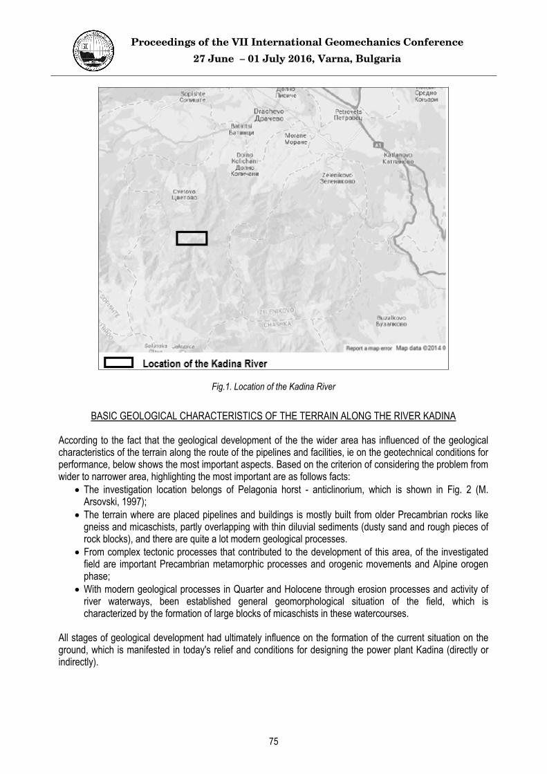
Location provided for the construction of a small hydropower plant on River Kadina is located in the western part of Macedonia, southwest of the city of Skopje. The access to the location is a through Dracevo by asphalt road towards the villages of Lower and Upper Kolichani, through the village of Crvena Voda and the village Aldinci, among them countryside is Kadina River (Fig.1). For determination of geological structure of the field and taking of representative samples of soil and rock materials for determining the physical and mechanical characteristics of represented lithological units was performed detailed engineering geological mapping of the terrain along the route of the pipeline and locations of water intakes, surge and powerhouse. At this stage are determined the locations where will be performed and investigation wells, which are mapped, photographed, and are sampled for additional laboratory tests.
74
Proceedings of the VII International Geomechanics Conference 27 June – 01 July 2016, Varna, Bulgaria
Fig.1. Location of the Kadina River
BASIC GEOLOGICAL CHARACTERISTICS OF THE TERRAIN ALONG THE RIVER KADINA
According to the fact that the geological development of the the wider area has influenced of the geological characteristics of the terrain along the route of the pipelines and facilities, ie on the geotechnical conditions for performance, below shows the most important aspects. Based on the criterion of considering the problem from wider to narrower area, highlighting the most important are as follows facts:
The investigation location belongs of Pelagonia horst - anticlinorium, which is shown in Fig. 2 (M. Arsovski, 1997); The terrain where are placed pipelines and buildings is mostly built from older Precambrian rocks like gneiss and micaschists, partly overlapping with thin diluvial sediments (dusty sand and rough pieces of rock blocks), and there are quite a lot modern geological processes. From complex tectonic processes that contributed to the development of this area, of the investigated field are important Precambrian metamorphic processes and orogenic movements and Alpine orogen phase;With modern geological processes in Quarter and Holocene through erosion processes and activity of river waterways, been established general geomorphological situation of the field, which is characterized by the formation of large blocks of micaschists in these watercourses.
All stages of geological development had ultimately influence on the formation of the current situation on the ground, which is manifested in today's relief and conditions for designing the power plant Kadina (directly or indirectly).
75

Proceedings of the VII International Geomechanics Conference 27 June – 01 July 2016, Varna, Bulgaria
Fig 2. Location of Pelagonia horst-anticlinorium where they belong researched area, compared to other tectonic units in R. Macedonia (M. Arsovski, 1997).
TECTONIC STRUCTURE
In view of the tectonic structure of the ground, it should be emphasized that the tectonics of this terrain was on great influence of two major orogenic phases. The first phase represents crimping related to regional metamorfizam and accompanying structures, and the second is the impact of the Alpine orogeny. At the left side of Kadina River in engineering geological mapping has been observed impressive fault structure. It is mostly remarkable between the two undertakings with significant vertical displacement of the blocks with "dm" dimensions to whole tables to the riverbed. At investigated field remarkable is the basic structural element of these Precambrian metamorphic rocks (gneiss and micaschists) - foliation, and the block matching. This in a way sets predetermines the possible mechanisms of fracture rock mass, that extracts bigger blocks, resulting from the combination of foliation and fissure systems certainly precautions should be taken and the direction of extension of the future pipeline. In all characteristic rock appears on the surface was made the measurement of the represented fissure system with measuring points designated by M1 to M27. The characteristic cracking of the rock masses gives us the the contour diagram shown below for a micashists and gneiss (Fig. 3 and Fig. 4).
Approximate
location of SHPP
Kadina
76

Proceedings of the VII International Geomechanics Conference 27 June – 01 July 2016, Varna, Bulgaria
Fig. 3. Concentration of fissure systems represented in micashists (from measuring point M9-M23).
Fig. 4. Concentration of fissure systems in gneiss (from measuring point M1-M8 and M24-M27).
GEOTECHNICAL CHARACTERISTICS OF THE TERRAIN
On the applied research and testing, we can conclude the condition of engineering geological and geotechnical characteristics of the represented lithological units. Here are given the physical and mechanical characteristics of lithological units represented classification of rocks, and recommended measures and terms of performance.
Engineering geological types of rock masses
All rock masses represented along investigated pipelines, surge tank and the intake of Kadina River are classified from engineering geological aspect. From this perspective there are the following types of rocks:
Not coherent and poorly bonded rock masses Highly coherent (rocky) rock masses
77

Proceedings of the VII International Geomechanics Conference 27 June – 01 July 2016, Varna, Bulgaria
Of the Investigative area dominant are the highly coherent (rocky) rock masses. Proper analysis of the highly coherent rock masses in the form of their geotechnical classification, physical and mechanical characteristics and other aspects are given in the text that follows.
Degree of cracking of the rocks
It is well known that discontinues has great influence on the mechanical behavior, physical and mechanical parameters and possible ways of fracture of solid rock masses. Taking into account this fact, proper attention is paid to determining the properties of discontinuities. The route of the pipelines and facilities of River Kadina mostly pass and will be conducted through a terrain built of solid rock masses such as micaschists and gneiss.During engineering geological mapping of the terrain were performed measurements of characteristic rock masses visible on the surface (measuring points M1 - M27). On measuring points are measured the following parameters in which marks are identical to those given in Table 1:
Gpi - density of cracks of one meter for every fissure system Gpi - (for example Gp1 for the fissure system 1, etc.).
Table 1. Results of measuring points and analysis of the degree of cracking
Lithological unit measuringpoints
Density Gp1[ j/m�]
Density Gp2[ j/m�]
Density Gp3[ j/m�]
Jv[ j/m3]
RQD [%]
Gneiss (G)
1 4 2 2 8 88,6 2 3 2 2 7 91,9 3 3 2 1 6 95,2 4 2 2 1 5 98,5 5 4 2 2 8 88,6 6 3 1 2 6 95,2 7 3 2 1 6 95,2 8 2 2 1 5 98,5
Micaschists (Sm)
9 3 1 1 5 98,5 10 3 1 2 6 95,2 11 4 2 1 7 91,9 12 2 2 1 5 98,5 13 2 2 2 6 95,2
13 2 1 2 5 98,5 14 2 2 2 6 95,2 15 2 2 1 5 98,5 16 3 2 2 7 91,9 17 4 2 2 8 88,6 18 2 2 1 5 98,5 19 2 2 2 6 95,2 20 3 3 2 8 88,6 21 3 2 3 8 88,6 22 2 2 2 6 95,2 23 2 2 2 6 95,2 24 2 2 3 7 91,9 25 2 2 1 5 98,5 26 2 2 2 6 95,2 27 3 2 1 6 95,2
78

Proceedings of the VII International Geomechanics Conference 27 June – 01 July 2016, Varna, Bulgaria
These data are properly used as inputs in the calculation of the following parameters:
RQD [%] - rock quality, calculated according Palstrom
RQD 115 3.3 Jv
Jv [j/m3] - number of cracks (joints) per unit volume. By this methodology has been obtained on the level of cracks of rocks, which is appropriate used in their classification.The results in Table 1 we can conclude that micashists and gneiss obtained RQD values from 88.6 to 98.5 and are characterized by medium good to good RQD. All these analyze served as a basis for evaluating the excavation, and classification of rocks from geotechnical aspect.
CLASSIFICATION OF HIGHLY COHERENT ROCK MASSES
For the purposes of geotechnical classification of the represented solid rock masses, as well as analysis of the stability of the same, were carried out tests on basic physical and mechanical properties of the intact parts of the rocks, i.e. volume weight and index dotted strength. These parameters are presented in Table 2, where are given the values of the strength of the pressure and tension, calculated according correlative dependencies. The test of strength index (Js) is performed with field press for dotted load, type Interfels No. 431, and is calculated according to the following formula:
Js P/De2 [MPa]
P - strength at the time of fracture of the sample; De - equivalent diameter of the sample.
It should be noted that it tested only samples of irregular shape, and as recommended by the International Society for rock mechanics, all results are corrected to a value Js (50).
The determination of the reversal of the index of strength is carried out with using the following formulas:
Js(50) F JsF (De /50)0.45
De (4A / )0.5
A Wsr DWsr (W1 W2)/2
D - distance between points of fracture [mm]; Wsr - average dimension of the sample (average value of W1 and W2) [mm]; Js - uncorrected value of the index of strength [MPa]; Js (50) - corrected value of the strength index for the diameter 50 mm [MPa];
p - compressive strength (strength of the pressure) of the sample [MPa];
z - strength of tensioning of the sample [MPa].
To calculate the strength of the pressure and tension were used following correlative dependencies:
p 22 Js(50)
z 1.5 Js(50)
79

Proceedings of the VII International Geomechanics Conference 27 June – 01 July 2016, Varna, Bulgaria
Table 2. Basic physical and mechanical parameters of the intact parts of the rocks.
(chainage of the supply pipeline and facilities)volumeweight
[kN/m3]
Index of dottedstrength
Js(50) [MPa]
Comp
ress
ive st
reng
th p
22
J s(5
0) [M
Pa]
Tens
ioning
stre
ngth
z 1
.5J s
(50)
[MPa
]
Micaschists (Sm) (km 1+643) 27.74 2.82 62.03 4.23
(1 intervention - Kadina River) 27.28 3.44-5.00 75.60-110.02 5.15-7.50 Gneiss (G)
(powerhouse) 26.12 2.45 53.89 3.67 (surge tank) 25.77 0.87-1.64 19.04-36.06 1.30-2.46 (km 4+914) 26.25 0.84-2.49 18.38-54.87 1.25-3.74 (km 4+323) 28.30 4.18 92.04 6.28
Based on the results shown in the tables above, is made classification according to RMR system (Bieniawski 1989). The points that have been adopted for the parameters in the classification of each type of rocks as well received RMR ratings are shown in Table 3.
Table 3. RMR classification of rock masses by Bieniawski (1989).
Parameter
Type of rock and scores
mica
schis
ts
(Sm)
gneis
s (G
)
Compressive strength 7 – 12 4 – 7
Rock quality (RQD) 17 – 20 17 – 20
Distance between cracks 8 – 10 8 – 10
Condition of cracks 10 – 16 10 – 16
Groundwater 15 15
The rock mass rating (RMR) 57 – 73 54 – 68
Angle of internal friction 33-43 33-43
Cohesion of the massif (kPa) 280-380 280-380
Class of rock mass III – II III – II
We should mention that the scoring for the condition of cracks for the rocky masses types is performed according to the detailed classification of discontinuities, taking into account the length of the cracks, their
80

Proceedings of the VII International Geomechanics Conference 27 June – 01 July 2016, Varna, Bulgaria
opening, roughness, type of the core as well the breakdown of the walls of the cracks. The values obtained from the monolithic pieces of rocks and concrete condition of discontinuities determined by derived measuring stations in engineering geological mapping are important in determining the potential unstable blocks that are observed between the route and water intakes.
CONDITIONS OF EXCAVATION
These conditions are estimated by using the known classification methods for excavation for the seed of line facilities. Represented rocks are classified using known empirical methods such as two parametric classification based on the relationship between volume weight and average size of the block (according Jovanovski, 2001). The input parameters to be used in this classification are shown in the table 2, and the characteristics of discontinuities described in the performed engineering geological mapping in the field.
Fig. 6. Assessment of way of excavation based on the relationship between volumetric weight and average distances between fissure (according Jovanovski, 2001).
From fig.5 it can be concluded that a possible method of excavation in micashists and gneiss is blasting. For comparison, represented rock masses are categorized according to the existing building standards GN 200 as follows:
V category - surface cracked micaschists and gneiss; VI category - a relatively fresh micaschists and gneiss.
Considering the fact that the rocks are dissolved in the surface areasas well partial coverage on the ground with thin diluvial layers are expected to be applied combined methods of excavation (digging in non-coherent rock masses, plowing into surface areas and blasting in fresh rock masses).
CONCLUSION
Metamorphic rocks like micaschists and gneiss are basic rock masses of the investigated field that are represented here. Quite on small areas can be seen thin incoherent deluvial creations, usually mixed with raw
81

Proceedings of the VII International Geomechanics Conference 27 June – 01 July 2016, Varna, Bulgaria
pieces of the rocks of various sizes to larger blocks and masses. While exploring the terrain was applied complex methodology to field investigations and laboratory testing, using the methods of engineering geological mapping of the terrain, construction of investigation wells, mapping them and taking the optimal number of samples.SHPP - Kadina was located conveniently on Pelagonia horst - anticlinorium regarding the geotectonic units of I order in R. Macedonia, which is shown in Fig, 2 (M. Arsovski, 1997). From the data obtained by measuring the structural elements of fissure systems of characteristic kept suckerless is calculated the quality of the rock mass (RQD). Where it can be concluded that micashists and gneiss are characterized by average good to good RQD quality that ranges from 88.6 to 98.5%. During this has also been specified geological index of strength in both types of rocks (GSI = 52-62).Based on a number of factors made an assessment of the conditions for extraction, which can be concluded that a possible method of excavation in (micashists and gneisses) was plowing into in surface areas and blasting combined with heavy plowing in fresh rock mass and carefully blasting in the area between water intakes and the route of the pipeline. As a final conclusion, it is considered that the surveys studies, as well as the recommendations of the geotechnical aspects, is formed a database that can be used for optimal and safe projection of the SHPP - Kadina.
REFERENCE
[1] Arsovski M. (1997): Tectonics of Macedonia; RGF, Štip,[2] Palmstrom A., 1974. Characterization of jointing density and the quality of rock masses (in Norwegian).
Internal report, A.B. Berdal, Norway, 26 p. [3] Palmstrom A., 1982. The volumetric joint count - A useful and simple measure of the degree of rock mass
jointing. IAEG Congress, New Delhi, 1982. pp. V.221 – V.228. [4] Bieniawski Z.T .: Geomechanics classification of rock masses and it's application in tunneling,
Proceedings of 3-rd International Conference in Rock Mechanics, Denver 1974 [5] Bieniawski Z.T .: Classification of Rock Masses for Engineering: The RMR System and future trends.
Comprehensive Rock Engineering, 1993 [6] Jovanovski M. (2013): Engineering Geology, University "Ss. Cyril and Methodius "- Skopje, Faculty of
Civil Engineering - Skopje. [7] Jovanovski, M., Gapkovski, N., Ilijovski, Z., (2002): Correlation between Rock Mass Rating and
deformability on a profile for arch dam Sveta Petka. 10-th International Conference of the DGKM, Ohrid.
82