of national development. bureau of mineral resources ... · department of national development....
TRANSCRIPT

.: "L = -\, ,, ,
COMMONWEALTH OF AUSTRALIA. \
DEPARTMENT OF NATIONAL DEVELOPMENT.
BUREAU OF MINERAL RESOURCES GEOLOGY AND GEOPHYSICS.
RECORDS.
DAM SITE E. UPPER COTTER RIVER.
L.C. Moakes.
Geologist.
The informaton contained in this report has been obtained by the Department of National Development, as part of the policy of the Commonwealth Government, to assist in the exploration and develop- ment of mineral resources. It may not be published in any form or used in a company prospectus without the permission in writing of the Director, Bureau of Mineral Resources, Geology and Geophysics.

A. Baa sits 3. 4 I, CCens&. 4 2, ti^^ at Site 8.. 5 3. & ~ @ h r 8 8 0 6
The inforrn~tion contained in this report hns teen ob:nin@Q by t h ~ f3cp~r:rncr;c o f i.,:ari?nal De..elopmcnt, as p;rc of t h e pclirr cf tkc Comrro:tv;:,l:!, G.>.c!.nmcn:. t 2 assist
' In the cspbra;is.> acd dcvp!oprner.t ~i t ~ i n e r i l rt:sources. '
It may nor bo ~:~bl i :h.- i i~ J n j i o t n l or ui.:g i.! ; rcmpanp prOZp2Ctus or statement w i t ! m ~ t L ~ C pr..::.Is;iun in crriting
of the Director, Buieau of Mineral Rcsourccs, Geologp md Ceephysics,

1. A fifth posstble dam aite bas been examlnsd on the Dpper Cotter Bivar. 22-a site ha8 been demignated Si te B, and If ea mar the oonfl~encs of gangsroo Creek w i t h the Cotter Rfver,
. 2. The geology and stmotwers priavioaslg mpped in the- Bnshranger*s - Collins Creeks area can be traced south t o the Kangaroo Creek area where the 'Mdbinbfllet quartzite an8 gnderlying, metazaorphSc rocks of the Kau&amo Creek fo~aatfon have been faulted do= against the Fsanklia formation by the Cotter F d t .
39 Consideration of reglonal ge~loglcal f aof ore indieat~s tha& Site li: is not as tmltable as Site B for the conmrtruotlona of a dam, but Site E should be aati~f'actory f o r a coaparatirely low refaiming wall.
4. 'Ehs rocks at Sfte B ahould provide firm foundations, bat exposu~sa are poop aad exploratopy exeav8Liom w i l l be needed to detenaine the detailed diafribufion of rook tgpas.
4
5 , Alluvial flalts along the Cotter Biver abwe Kangaroo Creek should provfde ample sapplies of both -regate an8 sand for concrete.
6. A prellminarg estimate of storage oapaclity indicates that a 60 foot wall at Site B would impound appmIdIRately 846,000,000 gallons of wafer.
- fn March 31946 the Department oft Worke and Haulsl ing requesrted .that a geological exadzmaon be made of the Upper Cotter Valw ia th6 vfciafty of Kaagaroo Creek t o debmine w h e t h e r a dam uoulb be uonst~uoted near the junetion 02 Kangaroo Creek wSfh tbo Cotter River.
A geological exaa2natjSon of the ares ilnss mbseq- menfly mads by Messrs. Noakes an4 D-ck. The arty war transported by pack horse from Tidbinbilla, ant3 opemted fop four Bags, 11th fa 14th Apdl , f r o m a camp esltabliahetl st the moath of Xaagamo Creek.
'Ph;ts report 8eals primarfly w i t h a possible dm site, near %he mouth of Kangaroo Greek, and includes onlfr a brief addifion to the general geology of the Ogper Cotter Valley, wUch was desrcribed at reone Zength in the report on dam s i tes referre8 to abwe.
Additional geological &ndPormaf ion has been incorp- orated on a regions2 plan 02' portton of the Upper Cotter Valley (Plate I), m d a laore de*taileb account of t'he geologp of the area w i l l be presented when the elcaaaination of t W Cotter Vallex i e r uomplete.

The poasible dam site 'at Kangaroo Creek 1s rsferred t o as dam Si t e E, anb the position of thie b i t e re la t ive to fkfs four s i t e s (A-D) prevlonsly exqrnhed Se shown on Plate 1,
Ihngaroo Creek risea on %he Coftez4-Paddy*a river ', dfviae about 3 dies .north-east of BBcmnt McHeahnf e. It flow& neefward f o r about 5 milea to doin the Cotter 'Iifver eome 8 miles downetmsm from the old Cotter Homeetead, 'Ehs possible s i t e a t the Xangaroo creek junction Uesr approximately 86 mile8 from the source of the Cotter Biver, and some 19 mileo f- C O ~ ~ ~ U B Q C B 61%h the t d ~ r b l b i d j ~ ~ ~ ~ ~ P C B I ? .
There %a' at preaent no access by road i n t o the . Upper Cotter. Valley, and the Kangaroo Creek junction ira beat mauled on horseback. Rough tmehs lead fn from CB9 valley of the Tidbinbil ls R%veq from GibraLter Creek and from Booxoomba Homestead. Ib6 trracka from these three loeaZ5tfes join a t the head of Kmgamo Creek, In each case the d i e tame fs approxfntatelg 10 mile^, and takes 4 to 5 hours with pmk horees, but the track from Booroomba Homeafead provide8 the easiest riding, Anotbs, track leade tfnto the old Cottsr Homestead f r o m UrroraZ Homestead on tba hxdgenby fall, and a ntgged mot or oehicPe cc~ld porsefbly reacth the Usper Cof ter Valley along this track*
Kangaroo. Creek jrtnctfon could a lso be reached by horse from the lountr FmakZin road; whfoh follow8 the Cottar- (tootIradigbee div%de fro1 BBorsaf Franklin to the vicin%ty of Mount Bfmberi. Them are no es t ab l i ebd tracks .leading from ' t U a road i n t o the Upper CoP;ter Valley, but horses could - probably t ravel d o m most of the =Jar spurs leadfng from w e road down t o the Cotter River,
It ie tvrderatood that a pre1tLmainm.y amvey for a road f r o m Oibralter Creek to the Kaagw?oo Creek-Cotter River j.wlclMon has already been made, -8 road would trareree granite f o r aost of %he way, and should be compars2ively easy to conatruck,
GeologLcal featurea we= plotted directlg on to r?fr photo~rapha fn the fieX4, snd a base msg of poz?fion of $he Upper'Cofter Valley above Collins Creek was Zater oom- pilea f r o m aeCitb'l photogrtagihs+ gehis WM done by rsbdial line plot t o a l l o w f o r mriatfonsljs soale of the photographs, The atPips so obtainad f r o m the photographno "mansw and the plan of portion of the Cotter Va2ley prepared for a 4 ~ r a r i o u o report were $hen reduced to a tlnfforr~ scale of 2 W&es to a mile and assembled t o ,form Flats 1, lCPus position8 of keg points anch am Mounts &idbinbflla, MeHeahnse, Gingera and Pranklb were $&en Prom surrey plans of the Uppr CoP;te~ areas, and these conrjtituted the centrol'gofnts for that arseembly of the stripe, Geological boundaries established tn the fiexd'were exterrdea by skidy2ng the aJx p h o t o p p b , and a prellninary geologic& plan of the ares produced,
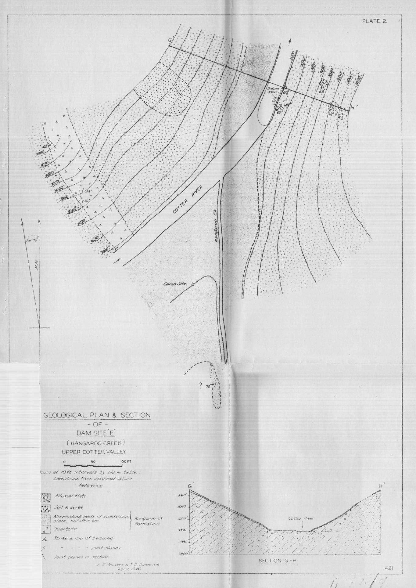
A plane tabXe survey was made of dam S i t s E, and a g&n and section of thla a%te appear in Plate 2.
The course o f the Upper Coeter River b s been ,
determined part ly br the strfb. of the metasuorphlpe rock8 and partly by the trend of the Cotter fatxlf (see Plate 1). The topogzlapby 02 the Upper Cotter Valley uhangea merrkedlg in the vloinity of Kangaroo Creek, Dormatream t r o m this

Creek the Cotter flow8 through a maec?essfon of gorges with few rPver flat@, but upretrem from Kangaroo Greek ths, valley floor wi&em ccmreidembly and river f b t a are uontinuoue for a diatanoe of approximately l* mile^. Pareher upstream the Cotter Valley becomes wider and tPlce slogea less rugged.
. , , .
, Tkds. &hinge in topogmQhy c& pxybab3.y be explaiaed on a basis of stretigraphy anti atructum. Above KangEiroo '
Creek the Cotter River 1 % e ~ slmsaZ entfrely in grarait e, an8 the less rugged topography, of the upper reae&ea of %he, river, i n the vioinfty of the O l i i Cotter Homestead, probab3g refleces the rela$fve ease *th wUoh the atssefve gzmxLte' hasr been eroded. The river, f laf s immediately' above roo Creek were aplpwenflly famed 1~324ter the Snfluenee of' tempommy base levele of erooion eatabl9ehed b$ g o r e s in aefanrorphio rocks below lhagaroo Creek. Wring these Intervals the fiver above Kangaroo Creek, edene'd ierjr bed, which lap slain3.y in and along the Co%ter fault, a d aubeeqnen%ly b e l t up exten- sive alluv%a3. f l a t s , Several tr%butary stirearn ffowlng t ; ~ the Cotter frora the ranges to the east sad west disgorge on to theee f late 'bhrough large' dLZuv%s3i fans,' fndieatlng that over consitlerable perlod8 the' Cotter River in th18 vioinity WEh8 ~ O O 181l2ggi8b t O thg 1 3 0 8 ~ 8 6 ~ mafe&%l delavered by its tfibuf€qles in f loo@.,
A,. f rnRODD0 TI OH.
The geology of gortfon of the Upper Ootter Valley haa been descrAbe8 2x1 some BetaS3. in a prepious regolet by 6.C. l?o&es (No. 1946/l2), an3 th, follorrizrg brief account of the geologp of the Kangaroo Creek area i a intendeia a8 an addS%ion t o ths p r n ~ 3 . 0 ~ ~ ~ ~ k e
me forntatione rand 8DZlr;rcfures previously eEeainsd between Buahranger's sad C ~ l Z i n ~ a Creeko extend southward along $he Cotter Valley and are little d%ffemnt.in the gangaroo Creek area, dm%mnt atructwsX fea tum ie the Ootter fault which Bas been traced sou%hmrd f r o m CoZUnars Greek t o rr p o w about 2 e l e s mpth of Kangaroo C m ~ k . fault apseam to be less prominent to $he south and m y beooas ina imicmt In %he granite count= a% the b a d of the Cotter River,
!the Franklin fum&t~on aad intms&ve granite aon- tinue along the upthrow or weatern ad$? of the fault. !fhe atrnoture of thie foxslrtsfisn i n %he Kangaroo Omek area varles lftt le 'froa that deacr%bs& farther north northerly strfks w i t h aipa averaging about 60 degrees to the weat -. but UthologScal changes are apparent, Xn the Kangaroo Creek '
area the formation contains a greater numbex? of aa* an8 poseible tafiaceous phases, and is represented by phyllite, quartsite a d echfestoae ;sandy tuffs, 'South of Mount Fmnklln. a large bow of g r d t e - the Ofngera pimite - in,tmdes the fcrrsaatlon w%th a contaat aureole of q-ts5fe ant3 (gpanitized pock and well-joented contact q~8;~tefta oocurs along the Cotts~Qoodsadigbee hivide for leevexdl milea aouth .of Motaxit ~ l n ,
On the downthrow or eastern side oi! the Coet crr fault; the WUbinbilla quartzif e Beeornee th%ner to the "south, a . the urzderlying T h r w a granite and an older iorslatfon of meta- morphic ro& axe exposed. ' The'se older xaetaanorphlc rocks,, which gnconformably under14e fhe 'ItfdibinbilXa .quarts$ te have been tentatively &2eia the K a q p o o Oreek formation. This

iormstlcrn contalns sock typea raagl.xig from quartzitear ~ 8 n d - sf one8 aod W f ta t o finely banded &ales. gome sandstop~a have been eheared, and ahales hare Been converted in%q $latg rock in places. Cleavage syedema have been fnducsd in'.bedrs of shale and alat 8 , a& the relatf onslSip of cleavage to. , ': ,
bedding fn eeveml places indicates %hat the for~lstlon hCM ;; been thrown into a series. of p i t M w folds. 2he 1 deg-6 o$ S ; \':
confact metamorphism varies, but in general., it is ~nrpr9rP; , \ . ?: B ingby low ooneiderfng the pPoxPmi%y of the 5 m a ' gnmf fe\? ,>% \
About mile up $he Cotter,Biver from the'monW of the . %
".: 1 'i : \ b'.
lbngamo Creek the fomatfon 9% Zntruded by a tongue of ~\
granite, and f o %his can be at;trfbuted the tsflhcifbcet&on o f the rock8 at &mi alee B, !&e ~eTat%onshfp o f the lhngazm Cree& f omatf on f o the PmnkUn f onnartfon is not clear. %he two fonaafions have much ia comnsi)n lithoXogf &lg, but the grade of reg20riaX me taorphism apgeara higher Pn the. rock6 .
of the lbank12n for?mst%on.. 1 t oeema probsbPe that the two formatione belonged ,to %he erne -up on? seriee before faultiag took plaee,
Xri the Xhngaroa Creek m a t b Tidbfnbilla quartzite occtlrs 5n outliers anti a study of atir ghofogr8phs Ondloatee that their relationsUp with the undarlyfng; Kangaroo Creek formation ha8 been coltlplf ctated by nonaal faultfntg, Xn the Kengaroo Creek ares t@ lomatb~n tmfferet? lesa silioif'b- at?ion t h d in the ares t o the norm because the older met* morphia make were fnterpoaed between it and the granite, and tb,dom&mmt sock type is 4% bt&f or reddfa21, partially aiUci- fied sandstone. The ioruabion atrfkes north and south enB & i p ~ west a% wgles ranging from 12 to 25 degrees w h e r e it has not been disturbed by fault%-.
Pour separate areas of gmmLZe, are shown on 'Plate 3. - the 'Phalewa granfte, the Cow Flat ,grm%te,, the Bndosa grai2e and the Gingem g~antte. These granites are gcobably all nonsanguineoua axid are & I Q ~ by the ~ f m e convention on the plan. A gormcrl rime" bas Been gfwn t o each &ranitee because bodies mcar on both sides of the fault, and their intel?i ~pelatfonshiggs have not bean clea~lp aetablf@he(X.
lPBe d&na\nf rook type fn each area is bf otite .
granite, w % t h little az no other Perno-azagneslan m i n e r a l ,
31he Tharwa grb%te conat%tn%es the =in batholi%h, an8 occurs on the domthruw eide of the Cotter faalt. !b Cow P l a t graarfte also occnra on the downthrow aide and ,is s stock or apophyefs probably csrmcacted in depth w$th the 'PBam~t gmdte. IbPre $enaora granite oc- on the upthros sfde of the fault, Eand I s s sill or elmgated stock of ahesmd granite. X t m y be connecteit i n bepth w i t h the Ofngem gran- ite, a larger body of dontinantly unabast~d granite L n t ~ d i q the P r a n k l a formaaon t o %he eouth. The Ginge2.8 gro;nlte wikl premuably be found t o abat the 2 h m a gran%fe song the Cot%er fault towards the bat3 of the Cotter River.
A tongue of pozybyrffic biotite granite trranated, on the west by the Cotter fault, 3ntmBes tho Kangaroo Week formation along the Cotter River a + nt;Lle upstream from %he mouth of Kangaroo CZW8ks and fus fs connected raifh the 1iml.21
~ m t e e
V, 3E.JGIrnERXI'SO GBOEWY.
A. DAM SJ;= E (See Plates 1 & 21,
1, General.
Dam S i t e B ie situated 200 feet downstream from the

month of Kangaroo Creek, where the valley of the Cotter. River Becomes rrXatively c o ~ t ~ i c t e c l .
In 'regard t o zeglonol problems moh as seismic adfirity and l~akage ol: water b~om the starage. area, thia a5tis f r not a8 suitably glace&. orr. site B, wlzach was dfscuesed in, aa earlPer! ~ p ~ t . 5 8 main Cottqr Pan18 lkes approrimat tbly 850 feet wesC of Sitor E, ftnd air pMtographs suggest %bat amall s W e fauP4ing has taken place aappzoz3raafeXy 1,300 feet south-east af the rrite, Roarever, the rocks expoeed at sf%e E do not Qppear a b t t s r e d an8 h o u l d prorlde a m~ftab le fomda%ion f o e engineering works.
Ime possibilitg. of leakwe. from the atokge ,are3 warrants some consideratbon. The mok:s exposed .5a the rrtorage m a censist of granite., steeply dfppkng qns~teite, .sandstom, 8bI.e and slste, TBese ,rocks a.& Bhefr inte-1 tructuree ase not Zlkely t o cmse any s%gnLf'fcant. leakage particulerrly since Zhe optzhr fable namri.aU,y PSss at OX close t6 river Xevel, Bowever, s retrsi,nbge~e3;12 at 8% te E woula flsnpound water over portfon of the C o t t e s Zaalt zone 2,000 feet upstmsra tmm Si t e B, with tb po8s%b215ty that Xeakage into the fault zom m%#t O C ~ . On the o t b r hut&, -me problem ha differen% from that prevLouely cons24ered In the case o f s i t e n A,BTbC, and f). 1%. 98. uraderato& $hat a c ~ ~ ~ p a ~ t f v e l y Low mta3nimzg waX1, appronimately 60 fee% high, would 'be conatmated at Site E, whereaa 81, wa21 of more than tu%ce kteiaht was envisaged 8% the other faur sites, A t SLte 3, the t3aourm.t; of wafer B p u n d e d over fha raaln Cotter fault zone by s retaPa?ing wall 60 feet hi& woul&, not exceed a mslrfPnm of 40 feet, and 1x1 m o s t places w o a d be coonrfdembfy 2easr than thir. In the absence o f any evfdence t o atzggest that aig~stfon of ratsl~ along the fault could msdf ly t e e place, there seeae little likl%hood that the Ampoundfnrg. of op to 40 f e e t of mfer over tb fault song could give Tese t o sigqfilcant leakageY kt amo of, however, be overlookdr
&om a ~)n82dern$Pon 0% the general g&ologioal teaftlreo and the poasibfi%ley of leakage Zxm t b storage area, it is conaidered tbatr-
(I) Sfte B is not as m.2itably place& as Si te B for .%he comlmoBfon sf a &am,
(2) Site B fa, probably s satfafactory @it@ for a ~etalning -1 abmd 60 feet Ma,
2. F o ~ ~ t f o n s st Site B,
Site B lies,in rrtetam03pMc rocks of the Eangaroo Creek f omation, The - x o c k ~ ~ sxpased af ths a i te f gcrlurte bands of qnartl;fte and alternating beda at ei1icf;Pfed sadstone, indurated &xiale aadl slate. 'SBe q-:~rteite and sandstone shw a vary%= degree ,of' silicif%cation and %n m n . aectbon c o ~ ~ i s % principally of quartz grains, m a y of w h i c h at132 show a rounded f o m and .ovldence of bedding, w%th 'limarilte, mgnetjbfe and traces of .alterad biotite and f elatgar?, ' Spe cimenas' f m the prom%nent bea of quartsf f e ,300 feet soutbweet of Si te 6 ( m e Pla%e 21, showed an unusual degree of s~licfficafisn,
!#ie slates and partly s i l i c i f i e d shales ore b e , grey or dark grey Pn colour and usually occnp in Uyrs a foot or eo in %hickrms8 between beds of gapdstone, or c;b.ttrs;l.%e2fec' ,!he slate# Eind ahlepr are flne-grained ,and m a q r are weU Iarni~teB. Under mioroscope they ahow ev&denee of dteraff ons a d wrne seaondam dnsraf;s- wrch as epfdote b v e probably be& d e v e l a ~ d .
A c h l outcrops at Sfte E, were Zoo spa~se td allow an srcou~ate elstimsrte to be made of .the relative proportiom of sand- .stone and slate, but elate anil eb3e do not appear f o amow% to more than 50 per cent of the formation in the oufwopa obspmed and
. they occur kn U beds alternating with mom conpetent roc&. . . .
S ~ r i a c e weathering is selatPvely shRllow at Site E, parttu because the mckshsrve been bardexled fo.varying degree@ by gtstamoqBiam and prtly becnurcre the water fable normally If es olose to the stxctac~. Wex mcB of tbb d t e the rooks are covered by a. mnt le of ao%l and scree, bnt con-
: * pawtfvelg weethered rock shonld be enoount&red a f e w feet below the surface. .
50 mcks at S i t e E shauld, therefore, provide saff f clently solSd f ouMat%o~@ for st; least a relatSvely low rqtaining wa31. However, before worls is cornencad, an exaaination sf the rocks a h o m be made By prelisaigarg excava- ,tfions, t o enme that them a m no uneatfafacdory feature8 mch as too deep a zone of weatharing or too great a develop- men% of slats.' .
In the vicinity 02 S i t e B Ithe metamorpUc rook8 atrike nort;h-we rsterby anti 8 % ~ eouth-westerly ef angles w u c h rrangs from 60 aegreers t~ ve-rRfcel. Beddgng planee aould, therefore, lee at an angle of app~ofimately 215 degrees to a regafning m11, conatmeted at fight mglers t o the river, snil este cZip wou3.d be upstream, Vndex these cont3i.tioas t h m ~ shguld be little risk of leskage along bedding pl~k28e, but %be deta%aed diefribution of sandatone and alate m a l l n ~ e d t o be datenafned so that foundations ca3t be pbced t o bear on ths most wmpeteat beds.
Two prononnoedC joint syriitemcsr were observed in quartsite fa tPle east bank of 2he river at S l t t B. hm sysfom otrfked aarth-weart, parallel to the Btsddfng, sLnd aipl~ north- aast at 40 degssoe, and the other atr4kes soutbw88t, psraUe1 t o ths dig of ?he ~ o c k s and dips north-west at 60 dcereea, Joints of the seeom3 rr~gstem, str2Mng approxinate2y at rl@t q l e s t o the re ta lang waXX, could e v e r i s e to leakage &er the fomdatfons, but the goent planes ob~leme(f were elem tf$ht fractmea w h i c h are not L%keXy t o proviae ready chatmala for leakage; No faultrs or amwh sonea were observed fn tBc~ outcrop st Sfte B, bnf ergoauxes were relatively poop* and the: foundation rocks w i 1 Z have t o be exposed aad carefully examined beforts the ~Eaances QZ lealase along joOnts m d possib'le fe,ubfs can be accurately assessed.
Stmm p v e l a f r o m the rZer flats above Kangaroo Creek gumtion p~obably conatiZuts the beat source of a g p - w t e above Sfte Be. Aboue a quarter sf the p v e l condsts 'of granite andthe remsinder of oontact metallorphlc .types - prfncipally qpark;ei te, s i2 icWied sandstone, ho~nfels , e to.. Only a smaXP. propurt$on 0% the gravel obee&ed oonsi~ted of tabular slaty rock and this could be eliminated if necoesary, 'Gravels in the rbmme6i;LFite vicinity of Xangapoo Oreek aontsin a high per~enliage of ,slat2 materZal and mSght, therefore, be avoided
A3ternatSve or additional auppliea of aggregate ooulb be obfalned by crush5ng the P%&bfnBiXla qusrfrtite, which ontcrops on the M l l ~ f d e 0n the eaatern bank of the Cotter above' Kangaroo Creek or by eruahibg the pronimnt bed of quartsste from tbe $arysroo Greek f ornmtioa, wMch outctrope 300 feet npatmsm from Site E (eee P h t e 2). Speofmens of both quartzites have been examined 5n thb aeotlon, and theue d i d not ahow xitinemla or struofames eonafdered unb@afz-&ble raafercial, and in met oases wi&l contain 8 Ugh percentaee of silica,


The d;~eoEogy of d m site ?f'i;l"9 is dcscwibed by. N~akca (1946), w h o gives a plan an& cec%Son acroras the,,.sft;s up to 70 Pest; above I'PVBF., Meah rJ%$h &he ' obgekt QP wrt;en8ing~b;Be' mppf n6p up t o a t least '150 fee$ sbovs the rfver, the site wae.-vi.aited:'on. U/5/58 br N.H, PBaher, L.C, Noekda and :%heB B B P ~ ~ & i'l'bf. the .Burtnau of %Sneral R(ssowces ant3 I, Fiood' 'of tha Depmtment of' #orka,,
Accoea ,bp,;~landroverp ~ a 8 . ..-obtadinsd v ia a newPy cons~ucted Porestrg road .. thnt p?&o f img' the. >' .$&--Rt'. Gangera sou%)hmor(88 and sastwarde to , f ie p~rafaf. Rf v'esr, ',,an&..c~esaeia.. the - C e t t e ~ Rfvtsr approx-tely 3.0 .'a%iee ~upsfr&an.3'rprm ',$Pie,. d a m . aitc~. . :F.~om the woesfag . the veh%i=X+ wa~s .miwen' ~Bawxi..'$b: .Cott&ga~ valley! to a poSnt abouk '4 mdles \apta%~eam.. ie;Pomoaa the 'da3id.!\@%tod - .The 'renrahn5ag df eta-qce vaa: com~ed on. foot&*.
TW sd%tiortaX xiizppii1~5.i:. ahown +:,an .the , sttachei3~,dsqw~ng0 was dons by ccxqma;le *-. tape anbl::a~n6g...+'&6l;.&nd :~fipla:s ..~el~%r,tet.~d. 'te, s3ho~t travewsea. oar 'either. sf d e ; . ~ f , .theo.'vi;&%ey, :a.long . tho axf q' of ' the p~op~~&i;&~~.aflt&:; .. Tb~,@,biog3):. of ..:the,:alte, from iaW1P.aoc .'. mapping..' is d@crib,ea bp ~y~o&LBdO:;:(19&6) <,, On the ;right abutkent TfdbPnbi2la qm;rr)$zSte .rests witeistr6rig meo&ormity oir. the Kangaroo ~ C ~ % e k ; . F ~ m n a t ton. : - Lt .forma: '&.yqe%va ,'outcrop 970 feet above.,. rikw leyetli-.'. . ?,at ''tkicr~;. ~ 6 c t . f on th+t,,$%ce&pQniee thia repor€ if f s .asqg&&eid: t,bt :'the '.udcor~$u~d%.t;y'. PI@@ :a ttls below &hs . baa& o ~ . t h $ outcrop;::.&n8'.: d$pp.::,fil:.,;.thb .:samest ;8fr$ctlon. ae -the - . . - . qtmrtef te... ' H O W W ~ :;.thi~ ..bEitin~km,~y~~:.b.tafwosocEdn:lthe :TiiW.nbilli $tar a& ' tihe under~%ng.:gaagsriji,'r;.qwk ~~zqzxiqion : 18-.not ' exposed ,!&id ita ,1)08ition .. . _ an4 . . . , . . :att$t~:t\adl+.@~a~~:n@$~~~~nqq~~.~~ _ . .
. . . , . . 1: : :.: I - . . . _ .. . ,. , .. . . I . ' 1 ' . . I _ . .
he :-po~$+bn - o ~ $ t h ~ : : C ~ ~ t t ~ p . , ; ~ ~ ~ t ~ : 58 no&: mown; it. :
probably a itet&:: ,w&::;~fl~.t; ~$:<$~;i:f~Qti: . & j k . t ; , - left bad', : : and ~ihou~d:.:bei '01~1ar: ?if: .~k~~.,:.fiiu$a%!iatlra.~;;.:. ~b '-$eta i.leid g 6 o . 1 0 ~ of. the s i t g I . .hclird*ng- .iri~~.pir%fct&hi??~he f f tholagy "of ' thh?. &kngtir~o Creek PorlnatSomz.'alid.' $Be .p0sitt%~n'~i,d''''~th6:.c=at~~. ~ 3 a l t ,, c,sn be ,
nscer%nined. only. by .aUb~rs\irf q,crs, l ~ g g t , i ' ~ . % S o n , : It . f s, augges'ted that thie. be. b n e .:f hf . Plf , al~~Qt':,by,.'~~~tg~riiifrig: h a . subsequ6ntly by
, - diamond d r l l l h g + . - - .
Aocess t o . t h i i . . i i t e . s*ffcieitccibr investigation. cou~a best be provlldo&...By i bul&dokf ; & ~ ' : ~ 1 & ~ 6 ~ 0 v ~ : ~ t r @ c & ,down ;.the Cotter Va2ley-.1Rm .*kt$ & r o ~ a l ' klbatd, :n#i='i~a SaIi~~~reek, t o S P l h E,, a
, . dietance of, 5-6 mJ,le?a.-. '
P$OAKBS, L C. , 1946 - - Darn, s i te 27. . Uppep.- Cot te r River, gwi Hin, RstPaur.: Arm'&. -.Report 1946/26.

,
'.
I, \
-
--
- -- -
--
--
--
... - ~.--- . ,,-"
- .-
;;~ -
... - ._-
GE.OLOGICAL PLAN - OF-
PORTION OF UPPER COTTER VALLEY (BASED ON AERIAL PHOTOGRAPHS)
o 1 !
I MILE I
- -.. --~:- --- .. - ~-~ _._._---- ---.- - ----
-- ~~~~~:--- =.: '--- ,,-~~ :--=- --:'~-' ---: -------~ ------ ~
-- .. r + .. ~
+ + + +, + + ~
+;~ + + - + +
.-- -- "':~ '. -+ '+ + + ~ '\1- -+ < + of +
- • ! :.,.-~ ~' ... : .~. . ..- of"'" :;
.- :',.--- ... ~ .-
:=-.:-= -= -=-; t~ + .... 'f+:,w:"f.:" --:"" .~ +.. ~ J4'~S~ ~~~~~~~--::':-- +-+ + + + ~ '- 'r<', -= __ ._.___ ~ ;;: + i, + '- + + +
I ,
;
C)-- ~-:' + + +' """'+ ........ + -F"' 7 _-: R. + + + +'\.+ ...
-
-. -
:"1J9. .
" + + + +' '\. -+ + + 'f. .... +' , ,+_ ."""
' 4- + + + + + + + ~ it... + + ~'T -+ + + +
~';~,,+ 8ENDORA + + t" + '-.l + + . ~ T +
+ + ~+ + t . + + + + ~ ~:-;t-;-:-.:r.: 'r' oi;.
+ +~.,jllt:J. + I' -r ,i -+- + +
+ + +' + -I- +""" 7 + + + + +
++""1' + +,-+-+ + + + +
+ + + + + r + + + . + ~ ...-- - .-
+ y + + -+ 7 ' 1-1 -+ +
+ -* + + -+ ..... + ......... -+
. + +~''''A'' + + + -+ .it- + + f + +
·t + +
+ + +
~
+
.. -:-:-=..,- .
.... :---
-- ~
Pt AT[ I RE.FERENCE
o l1d't)/nLJI//a t;J(N~/'tzde
CJAlllIWb/ fiiY/s & Terrace.'}
V _:~.J ;Fra?/?k///] rorrn,Jtlon
DBlobte GranIte
.........-::: -S'trtke&d'/p obseryed 20
..x-- re/cic~/ bedc*n;'
• Aobc/t~/ 4~IS
--
SITE A Prospc.-:Ll ve /J,;)rn SI tes
Access roo(/ /0 OallJ Site C'
\ DIp Interred rroff1 /fIr Photos
1 ~ ~25: \ 15°-45: \ > 01.5"
- - - Cie%9IC.;J/ bou/x:;/arlt'!S
1
Ce% ;yby: L C Noakes & T f) DI/7·,rnicA
Aprl~ f.Ul;
,
. "
~I ~l
I
I i I
. ,, "'",.&, ..... oC" C'
~ ')
GEOLOGfCAL PLAN & SE.CTION
OF .1 "
DAM SITE E
( KANGAROO CREEK)
UPPER Co.ITER VALLEY
o t
so 100FT d
burs ('~ 10 rc mte./'i"&I...., ~v pl;:;ne table
[/eYO'l'lo/7s .,croff)' O'S$U/neo' O'aCuI'TJ
,·-9 .~
~ I
o I ~
r /
, ~
" '\
1'.f~./~~
.5oll ~ .scree
4It.eroa6/'9 beds of' scYndsto/lF! '} slede-, .J"O/·/l~./S' e.tc
Que:; rev te.
.I0lnt p/a.oes
jOint p/anes /.rt sect/on
I(.yn~roo Ck
ITJr'o>a6ol.1
L C ,No<~kes & TO L)I/nrr:"ck. 4/.J// / /946
. .: .. ,
" ' ... ~ ' .
. . ~ ., "
'.* • ','.- ...•. . , ",) .
. \.,
, G
30m
, '
"
PLATE. 2.
J
. , ".'
, . c .
. " •
~ '.)\ .\ \':;1
" ~ ~
. L.' ,~
.. !l
, :) 1 OJ (- O.
t'J "
,-::- A/ "'/? '7 "/ 1/ A", » . • ' "/ '/' I '
. .' ~ " '/',,/~ /' - '/' I' ' / ,/ ? ...-: - , .. , /. . " . / " .;/ '/ '
./? / . ' .. --: - /. /" ./' . . ,/. , / './ / ,/- ,/
.' >. :/" - -
SECTION G-H ------------------
H
~ "/)', : ,:~ 7'/, ," " 'I
A ?/' :/<:/Y/,]: , . • . ' , • I I ~ •
. ... . 4 I . / ',.. I ,.
:-t''-;r2·- .,L---~;: : (:, ..... ----. ";-, -: '" . / 1" / , . . ;- .. "
/ .,/ .. ,' . ", '~'.', :,"'''~ I ,F I' . (. .. /. , •
1421
'_ L / -- _. - - . _. __ , __ ,:..i.~~ ! . . -:~j J ----------'-------------------------------------------------------------------------~----------------_r.----------.------------- .----------------"---~;--------
/ r , l
j' .? , . .,.

SECTIONSA-B (>0 E-F &G-H UPPER COTTER VALL EY
LC>t/e.f -(modrao,;bee !Ji¥./de.
A
4000 r~
t-~ .. +
..JO(X)
+ 2000
t , i
1000 t, +-
'. -+
~viLer uCJOdr~d~?'bet'> Dhide
E {iLJOo'
+
-1-
--t".
j{)OO + -+-
+
.~.
+
+
'-f-
+
f-
HOR 8. VERT SCALES 2" - 1 MILE ,----_ .. _--------_. __ .. _------'--FOR. REFERENCE SEE PLATE ,-----'-----'-----,"--
SECTION A B -----~ .. -.---.. ~-,-
-~ -.---t,
i"- i- t-+ -~ + +
t· + + + + t
+ + + +
-+- ~,
SECTION C-O
o
+ i + +-
'j- '.' -+ +:'::~r" ~ + + l
• I
_____ • ±-__ -± ___ .. __ ..... , .. __ J
SECTION E. - F
... + ...
+. .. +
?OOO ~ -+ ... + + + 'r -i- + + -+- + '1- + ,to ~. + +-
JOOO ,{, ~ i : + : + : +: + : +: i: +:" ~+'~'++""+i-,
- .. ----~--,,-------~--.------,,--.. -----
G
SECTION G-H
Wt/Q'!?,YeF f),9mJICe t" ..
PLATE :3
Ht 7idfJ/nbd!a 5124'
B
F
t
1422
i i'.i'l