observed flood extent - amazon web services
TRANSCRIPT

Radiant Solutions Proprietary and Business Confidential
Observed Flood ExtentNew Urban Flood Risk – DHS Science & Technology Research Study
Catherine Ipsan, Project Manager
Mihir Datta Chaudhuri, Imagery Scientist
Radiant Solutions Proprietary and Business Confidential
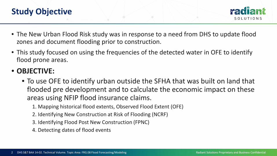
Study Objective
• The New Urban Flood Risk study was in response to a need from DHS to update flood zones and document flooding prior to construction.
• This study focused on using the frequencies of the detected water in OFE to identify flood prone areas.
• OBJECTIVE:• To use OFE to identify urban outside the SFHA that was built on land that
flooded pre development and to calculate the economic impact on these areas using NFIP flood insurance claims.
1. Mapping historical flood extents, Observed Flood Extent (OFE)2. Identifying New Construction at Risk of Flooding (NCRF)3. Identifying Flood Post New Construction (FPNC)4. Detecting dates of flood events
DHS S&T BAA 14-02. Technical Volume. Topic Area: FRG.08 Flood Forecasting/Modeling2
Radiant Solutions Proprietary and Business Confidential
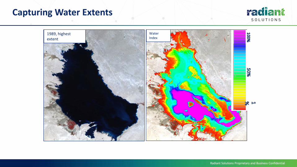
1989, highest extent
Water Index
Capturing Water Extents

Radiant Solutions Proprietary and Business Confidential
. .
.700+ images
Lake Razzaza has changed significantly over the past 33 years:
1984
Present
Landsat Satellite Imagery

Radiant Solutions Proprietary and Business Confidential
Terrain Normalization/C-Correction applied to each SR image.
Approx. 800 scenes per path row downloaded. Converted to surface reflectance and cloud masked.
Using each TNSR image and other ancillary data, our model utilizes multiple spectral indices that are used to identify water.
Based on the number of indices that collaborate, each pixel is established as standing water or non-water.
Using the TNSR imagery, a snow/ice model is applied to incorporate areas of snow or ice to the water layer.
Result: A layer identifying areas of standing water for the respective image.
Methodology

Radiant Solutions Proprietary and Business Confidential
Radiant’s water detection algorithm analyzes 30m Landsat imagery and processes up to 800 scenes per path row:
Present
1984
All scenes are layer stacked
The water frequency is produced from analyzing the layer stack
The water detection model processes approx. 4.2 GB of data per scene
OFE uses python scripts, Imagine models, and manual editing and are processed in the Cloud
Methodology

Radiant Solutions Proprietary and Business Confidential
Methodology Workflow – New Urban Flood Risk
DHS S&T BAA 14-02. Technical Volume. Topic Area: FRG.08 Flood Forecasting/Modeling7

Radiant Solutions Proprietary and Business Confidential
Spatial and Economic Priority
1. Austin, TX2. Charleston, SC3. Houston, TX4. Jacksonville, FL5. Phoenix, AZ6. Shreveport, LA7. St. Louis, MO8. Tuscaloosa, AL
DHS S&T BAA 14-02. Technical Volume. Topic Area: FRG.08 Flood Forecasting/Modeling8
Economic Risk Analysis Study Extent of eight Areas of Interest.

Radiant Solutions Proprietary and Business Confidential
Demos
• https://www.youtube.com/watch?v=2aOH0C7YDXM&feature=youtu.be
DHS S&T BAA 14-02. Technical Volume. Topic Area: FRG.08 Flood Forecasting/Modeling9

Radiant Solutions Proprietary and Business Confidential
Flood Risk on Undeveloped Land in Houston, TX
Observed Flood Extent on undeveloped landObserved Flood Extent prior to urbanizationSpecial Flood Hazard AreaUrban
Detailed Example

Radiant Solutions Proprietary and Business Confidential
Observed Flooding on Land Prior to Development
Dry, May 2006 Flooded, January 1992
In Katy, Texas flooding occurs on undeveloped land in January 1992. Flood waters collect in areasof slight depression and can be seen on Landsat satellite imagery in blues and dark purples. Theland is normally dry, as seen in May 2006.
Future development

Radiant Solutions Proprietary and Business Confidential
New Construction on Flood Prone Land
Observed Flood Extent (blue) detected flooding in the area prior to development.
OFE detected pluvial flooding outside the SFHA prior to development
Observed Flood Extent – All historical flood events over 33 years prior to urbanization

Radiant Solutions Proprietary and Business Confidential
Flooding on Recent Construction
• Neighborhood built in 2012• Flooded in April 2016 from torrential rains• Flooded again in Hurricane Harvey, August 2017
April 18, 2016
April 2016
New Construction at Risk of Flooding (NCRF)

Radiant Solutions Proprietary and Business Confidential
St Louis – Flooding Outside the SFHA
DHS S&T BAA 14-02. Technical Volume. Topic Area: FRG.08 Flood Forecasting/Modeling14

Radiant Solutions Proprietary and Business Confidential
Shreveport– Pluvial Flooding
DHS S&T BAA 14-02. Technical Volume. Topic Area: FRG.08 Flood Forecasting/Modeling15

Radiant Solutions Proprietary and Business Confidential
Validation
• Random-stratified point sample in low water frequency zones
• Avoid validating permanent water bodies
• Better test for overcall
DHS S&T BAA 14-02. Technical Volume. Topic Area: FRG.08 Flood Forecasting/Modeling16
AOI Accuracy
Austin 93%
Charleston 99%
Houston 100%
Jacksonville 100%
Phoenix 97%
Shreveport 100%
St. Louis 100%
Tuscaloosa 99%
Total 99%
OFE validation results. The results showed that OFE has an average of 99% accuracy
Radiant Solutions Proprietary and Business Confidential
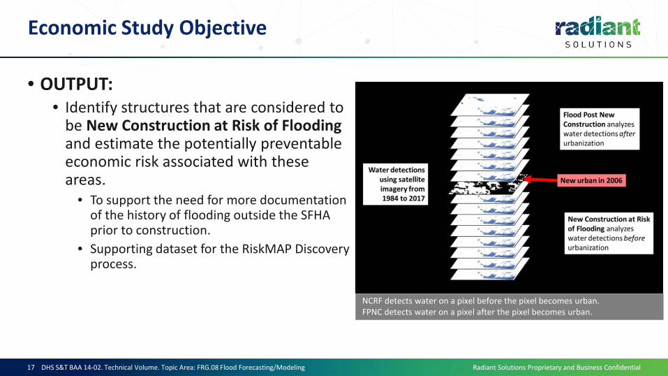
Economic Study Objective
• OUTPUT:• Identify structures that are considered to
be New Construction at Risk of Flooding and estimate the potentially preventable economic risk associated with these areas.
• To support the need for more documentation of the history of flooding outside the SFHA prior to construction.
• Supporting dataset for the RiskMAP Discovery process.
DHS S&T BAA 14-02. Technical Volume. Topic Area: FRG.08 Flood Forecasting/Modeling17
NCRF detects water on a pixel before the pixel becomes urban. FPNC detects water on a pixel after the pixel becomes urban.

Radiant Solutions Proprietary and Business Confidential
Economic Analysis
• Workflow:
DHS S&T BAA 14-02. Technical Volume. Topic Area: FRG.08 Flood Forecasting/Modeling18

Radiant Solutions Proprietary and Business Confidential
Economic Analysis
• Primary Input Datasets for the Economic Risk Analysis:
DHS S&T BAA 14-02. Technical Volume. Topic Area: FRG.08 Flood Forecasting/Modeling19

Radiant Solutions Proprietary and Business Confidential
Economic Analysis
500m from NCRF - Multi-block neighborhood analysis:
• Because the exact location of a flood insurance claim was provided at the Census block group level, it is therefore assumed that flooding generally occurs where it has occurred historically.
• To maintain a conservative estimate of loss potential for the economic analysis, the estimate takes the fraction of structures (parcel points) in a block group that are identified as “within 500m of NCRF” vs the total # of structures in that block group.
This fraction is ten multiplied by the sum of all claims recorded after that earliest-identified NCRF/structure year (for each structure intersected).
• The calculations are performed on each block group. • The economic value in an AOI is based on the total for the block groups in that AOI. • The calculations do not account for inflation.
DHS S&T BAA 14-02. Technical Volume. Topic Area: FRG.08 Flood Forecasting/Modeling20

Radiant Solutions Proprietary and Business Confidential
Economic Analysis
500m from NCRF - Multi-block neighborhood analysis:
DHS S&T BAA 14-02. Technical Volume. Topic Area: FRG.08 Flood Forecasting/Modeling21
Xr(y) is the number of NCRF structures in year (y)Xt is the total number of structures in a block groupC is the total claims in year (y)
�𝑦𝑦=1987
2017)𝑋𝑋𝑟𝑟(𝑦𝑦
𝑋𝑋𝑡𝑡�
𝑦𝑦`=𝑦𝑦+1
2017
)𝐶𝐶(𝑦𝑦`

Radiant Solutions Proprietary and Business Confidential
Economic Analysis - Results
DHS S&T BAA 14-02. Technical Volume. Topic Area: FRG.08 Flood Forecasting/Modeling22
• Vulnerable Structures Identified
AOI Total #
structures analyzed
NCRF Structures
% of the total
structures that were
identified as NCRF
NCRF Structures
Outside SFHA
% of the NCRF
structures that were
outside the SFHA
Austin 725,994 129,097 17.80% 86,505 67.00% Charleston 414,948 121,306 29.20% 67,646 55.80% Houston 1,746,060 435,372 24.90% 360,674 82.80% Jacksonville 481,300 158,284 32.90% 117,360 74.10% Phoenix 417,265 14,635 3.50% 6,822 46.60% Shreveport 183,247 35,219 19.20% 17,050 48.40% St. Louis 778,099 169,374 21.80% 129,359 76.40% Tuscaloosa 92,299 11,107 12.00% 7,674 69.10% Total 4,839,212 1,074,394 22% 793,090 74%

Radiant Solutions Proprietary and Business Confidential
Economic Analysis - Results
DHS S&T BAA 14-02. Technical Volume. Topic Area: FRG.08 Flood Forecasting/Modeling23
• Potentially Preventable Economic Risk Estimates
AOI ALL NCRF
Only NCRF Outside NFHL
Austin $29,656,000 $15,120,000 Charleston $49,525,000 $24,766,000 Houston(pre-Harvey) $387,819,000 $202,472,000 Jacksonville $40,866,000 $21,757,000 Phoenix $111,000 $66,000 Shreveport $12,413,000 $5,675,000 St. Louis $70,347,000 $29,492,000 Tuscaloosa $725,000 $320,000 Total $591,462,000 $299,668,000

Radiant Solutions Proprietary and Business Confidential
Economic Analysis - Results
• Vulnerable Structures Identified - Hurricane Harvey
The estimated total loss that the 500m neighborhood buffer of NCRF outside the SFHA could have prevented for Hurricane Harvey – for the 21,338 structures intersecting the Hurricane Harvey Flood Extent - amounts to more than $609 million.
• Emphasizes how conservative the base economic analysis method is• Constricting claims to this known event allows for a more direct loss impact analysis with more
precise claims location assumption• Applying average dollars instead of fraction of the NFIP claims provides larger economic
estimate ~ $ 609,989,000.00 of preventable Hurricane Harvey flood damage.
DHS S&T BAA 14-02. Technical Volume. Topic Area: FRG.08 Flood Forecasting/Modeling24

Radiant Solutions Proprietary and Business Confidential
Economic Analysis - Results
Vulnerable Structures Identified - Hurricane Harvey
29°39'38.83"N 95°44'20.63"W
DHS S&T BAA 14-02. Technical Volume. Topic Area: FRG.08 Flood Forecasting/Modeling25

Radiant Solutions Proprietary and Business Confidential
Items to Improve
• Flood Post New Construction• Dropped Very difficult to detect water in urban areas
• 30 meter pixel of Landsat• Cloud cover• Still used reports and FEMA issued flood exents
• Incorporate Sentinel 2 and RADARSAT• Higher resolution• Can capture during flood event Don’t have to worry about cloud cover
DHS S&T BAA 14-02. Technical Volume. Topic Area: FRG.08 Flood Forecasting/Modeling26

Radiant Solutions Proprietary and Business Confidential
Observed Flood Extent
Summary:• Documenting previously unknown flood prone areas prior to new
construction will prevent $ billions in future NFIP claims.• 10,000’s of new homes are being built each year outside the SFHA on
undeveloped land with a previously unknown history of pluvial flooding.• If previously undocumented flood events were known by FEMA/FIMA,
communities, developers, banks, insurers, etc., subsequent pre-development hydrologic/mitigation efforts may have prevented most of these NFIP claims.
• The Observed Flood Extent (OFE) product identifies additional flood risk through direct observations of previously unknown flood events using 33 years of satellite imagery for the entire US.

Radiant Solutions Proprietary and Business Confidential
Thank You
Catherine Ipsan, Project [email protected]
Mihir Datta Chaudhuri, Imagery [email protected]