oaj_issue6_tortora_cocco - … · open arts journal, issue 6, winter 2017/18 issn 2050-3679 86...
TRANSCRIPT
OPEN ARTS JOURNAL, ISSUE 6, WINTER 2017/18 www.openartsjournal.orgISSN 2050-3679
85
BAROQUE TECTONICS: ERUPTIONS AND DISRUPTIONS IN THE VESUVIAN CITY Alfonso Tortora and Sean Cocco
AbstractThe Vesuvian city is a neologism that describes parts of the Neapolitan hinterland that have interacted historically with frequent bouts of volcanism. Heavily urbanised today, this territory has a complex and highly varied history shaped by how flows of volcanic rock and debris have altered human and natural environments. Tortora and Cocco argue for the need to expand historical approaches to Vesuvius beyond the traditional focus on the recovery of classical sites and the modern appetite for tourism. They argue for an approach that is attentive to the different histories that emerged when people responded to volcanism’s effects on the territory. Eruptions threatened people by burying settlements and roads–but they did so unevenly and sporadically. Likewise, eruptions created new conditions for rebuilding, quarrying, and working volcanic rock out to markets–but did so only in some places.
Keywords: Vesuvius, volcanism, history, 1631, seventeenth century, eighteenth century, disaster, environment, rock, stoneFull text: http://openartsjournal.org/issue-6/article-4DOI: http://dx.doi.org/10.5456/issn.2050-3679/2018w04
Biographical notesAlfonso Tortora is Aggregate Professor of Modern History in the Department of Humanistic Studies at the University of Salerno. He is the author of numerous works on Vesuvius, including L’eruzione vesuviana del 1631. Una storia d’età moderna (Rome, 2014). Along with Domenico Cassano and Sean Cocco, he has edited a recent collection of historical studies of Vesuvius entitled L’Europa moderna e l’antico Vesuvio (Battipaglia, 2017).
Sean Cocco is Associate Professor of History at Trinity College (Hartford, CT). He is the author of Watching Vesuvius: A History of Science and Culture in Early Modern Italy (Chicago, 2013) and co-editor (with Alfonso Tortora and Domenico Cassano) of the recent collection of historical studies of Vesuvius, L’Europa moderna e l’antico Vesuvio (Battipaglia, 2017).

OPEN ARTS JOURNAL, ISSUE 6, WINTER 2017/18 www.openartsjournal.orgISSN 2050-3679
86
BAROQUE TECTONICS: ERUPTIONS AND DISRUPTIONS IN THE VESUVIAN CITY Alfonso Tortora, University of Salerno, and Sean Cocco, Trinity College, CT
The neologism the Vesuvian city (la città Vesuviana) describes much of the Neapolitan hinterland because its geologic, biotic and anthropic features have emerged in interaction with eruptive activity since 1631.1 Naples administered the towns located around Mount Vesuvius throughout the early modern period, so these settlements formed an integral part of the city’s territory (Muto, 2013, p.42). Exposure to the effects of volcanism has been a key feature of a history documented by a widening array of sources since the
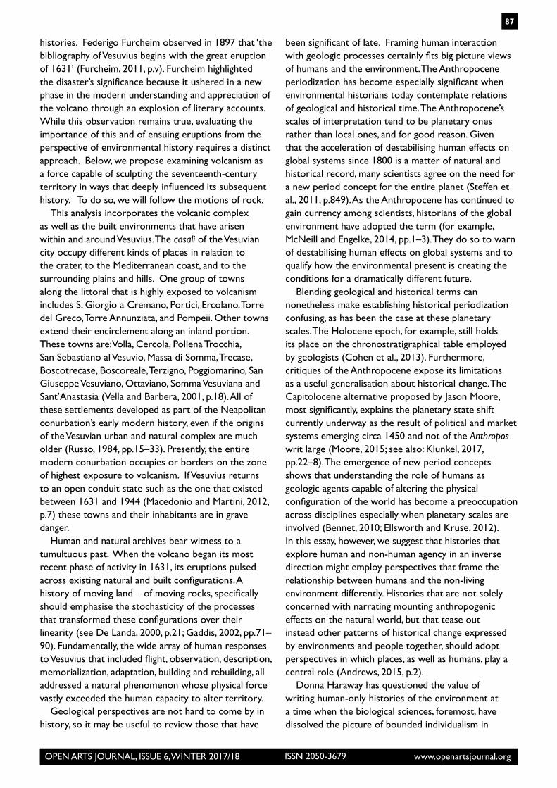
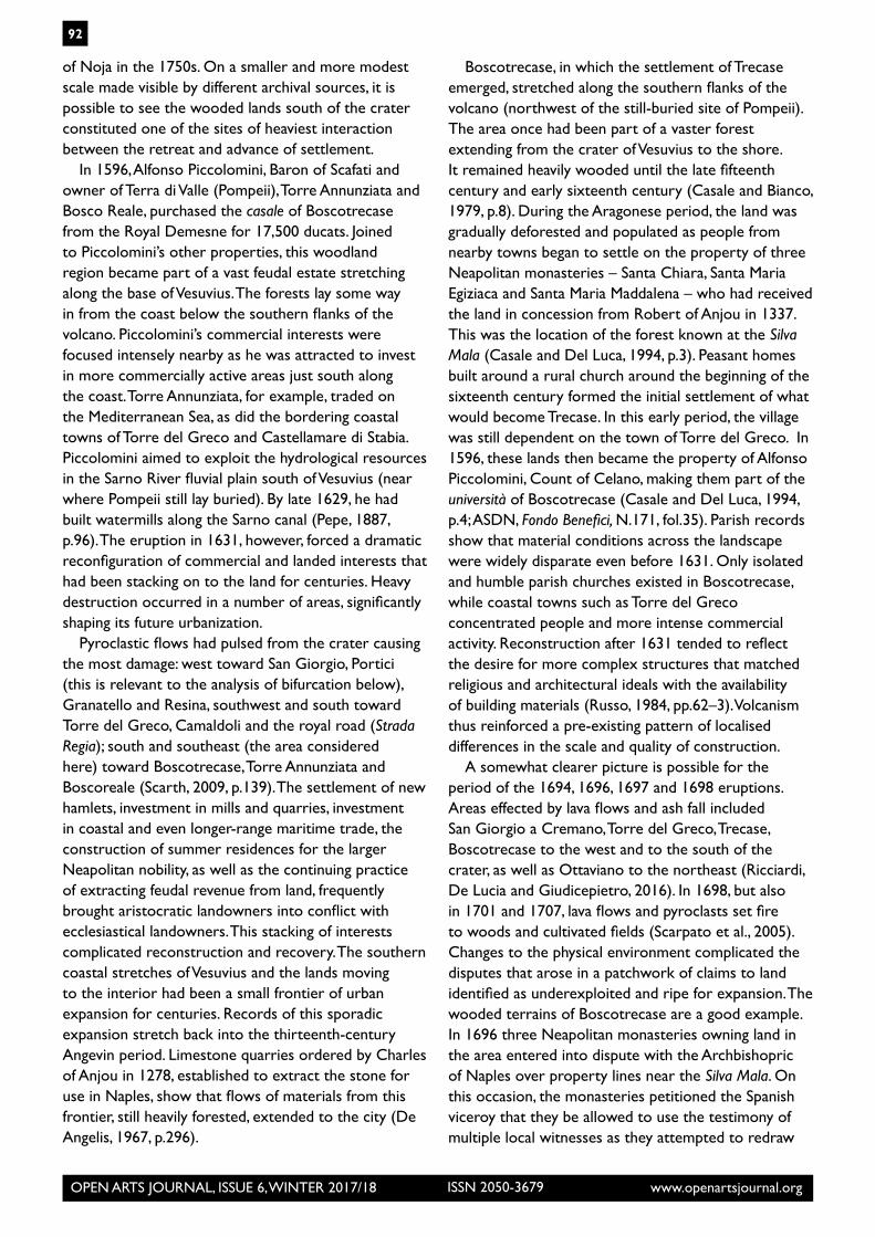
seventeenth century. Andrea Pigonati’s eighteenth-century topographical map of the volcano illustrates how observers recorded the kinds of changes that the Vesuvian city experienced once the volcano began its most recent historical phase of volcanism in the 1600s (Pigonati, 1767). (Fig. 4.1) In this particular representation, Pigonati marked the location of the Vesuvian casali (rural settlements) in relation to areas where eruptions were continuing to alter the territory. By depicting the location and the timing of volcanism’s disruption of built and natural environments, Pigonati identified the sites of physical transformation as a key topographic feature.
The physical transformations of the lands in the Somma-Vesuvius volcanic complex present an especially interesting case of non-human (geologic) and human (historical) processes in interaction. Our principal claim in this essay is that it is necessary to recognize how geological processes underlying environmental change around Vesuvius could shape different local
Figure 4.1: Andrea Pigonati, Topografia del Monte Vesuvio (Naples, 1767). The Huntington Library, San Marino, California. (Image credit: The Huntington Library, San Marino, California)
OPEN ARTS JOURNAL, ISSUE 6, WINTER 2017/18 www.openartsjournal.orgISSN 2050-3679
87
histories. Federigo Furcheim observed in 1897 that ‘the bibliography of Vesuvius begins with the great eruption of 1631’ (Furcheim, 2011, p.v). Furcheim highlighted the disaster’s significance because it ushered in a new phase in the modern understanding and appreciation of the volcano through an explosion of literary accounts. While this observation remains true, evaluating the importance of this and of ensuing eruptions from the perspective of environmental history requires a distinct approach. Below, we propose examining volcanism as a force capable of sculpting the seventeenth-century territory in ways that deeply influenced its subsequent history. To do so, we will follow the motions of rock.
This analysis incorporates the volcanic complex as well as the built environments that have arisen within and around Vesuvius. The casali of the Vesuvian city occupy different kinds of places in relation to the crater, to the Mediterranean coast, and to the surrounding plains and hills. One group of towns along the littoral that is highly exposed to volcanism includes S. Giorgio a Cremano, Portici, Ercolano, Torre del Greco, Torre Annunziata, and Pompeii. Other towns extend their encirclement along an inland portion. These towns are: Volla, Cercola, Pollena Trocchia, San Sebastiano al Vesuvio, Massa di Somma, Trecase, Boscotrecase, Boscoreale, Terzigno, Poggiomarino, San Giuseppe Vesuviano, Ottaviano, Somma Vesuviana and Sant’Anastasia (Vella and Barbera, 2001, p.18). All of these settlements developed as part of the Neapolitan conurbation’s early modern history, even if the origins of the Vesuvian urban and natural complex are much older (Russo, 1984, pp.15–33). Presently, the entire modern conurbation occupies or borders on the zone of highest exposure to volcanism. If Vesuvius returns to an open conduit state such as the one that existed between 1631 and 1944 (Macedonio and Martini, 2012, p.7) these towns and their inhabitants are in grave danger.
Human and natural archives bear witness to a tumultuous past. When the volcano began its most recent phase of activity in 1631, its eruptions pulsed across existing natural and built configurations. A history of moving land – of moving rocks, specifically should emphasise the stochasticity of the processes that transformed these configurations over their linearity (see De Landa, 2000, p.21; Gaddis, 2002, pp.71–90). Fundamentally, the wide array of human responses to Vesuvius that included flight, observation, description, memorialization, adaptation, building and rebuilding, all addressed a natural phenomenon whose physical force vastly exceeded the human capacity to alter territory.
Geological perspectives are not hard to come by in history, so it may be useful to review those that have
been significant of late. Framing human interaction with geologic processes certainly fits big picture views of humans and the environment. The Anthropocene periodization has become especially significant when environmental historians today contemplate relations of geological and historical time. The Anthropocene’s scales of interpretation tend to be planetary ones rather than local ones, and for good reason. Given that the acceleration of destabilising human effects on global systems since 1800 is a matter of natural and historical record, many scientists agree on the need for a new period concept for the entire planet (Steffen et al., 2011, p.849). As the Anthropocene has continued to gain currency among scientists, historians of the global environment have adopted the term (for example, McNeill and Engelke, 2014, pp.1–3). They do so to warn of destabilising human effects on global systems and to qualify how the environmental present is creating the conditions for a dramatically different future.
Blending geological and historical terms can nonetheless make establishing historical periodization confusing, as has been the case at these planetary scales. The Holocene epoch, for example, still holds its place on the chronostratigraphical table employed by geologists (Cohen et al., 2013). Furthermore, critiques of the Anthropocene expose its limitations as a useful generalisation about historical change. The Capitolocene alternative proposed by Jason Moore, most significantly, explains the planetary state shift currently underway as the result of political and market systems emerging circa 1450 and not of the Anthropos writ large (Moore, 2015; see also: Klunkel, 2017, pp.22–8). The emergence of new period concepts shows that understanding the role of humans as geologic agents capable of altering the physical configuration of the world has become a preoccupation across disciplines especially when planetary scales are involved (Bennet, 2010; Ellsworth and Kruse, 2012). In this essay, however, we suggest that histories that explore human and non-human agency in an inverse direction might employ perspectives that frame the relationship between humans and the non-living environment differently. Histories that are not solely concerned with narrating mounting anthropogenic effects on the natural world, but that tease out instead other patterns of historical change expressed by environments and people together, should adopt perspectives in which places, as well as humans, play a central role (Andrews, 2015, p.2).
Donna Haraway has questioned the value of writing human-only histories of the environment at a time when the biological sciences, foremost, have dissolved the picture of bounded individualism in

OPEN ARTS JOURNAL, ISSUE 6, WINTER 2017/18 www.openartsjournal.orgISSN 2050-3679
88
nature (Haraway, 2016, p.1). Thus, an insistence on calling the larger question about historical actors and the natural world may be timely. If one response can be to sustain reflection on the flows of non-human and human agency, historians need not generate perspectives commensurate with those of the sciences when it comes to locating humans’ relation to environmental change, since our scale of interpretation is most concerned with what people experienced, thought and did (Thomas, 2014, pp.1577–88). Nonetheless, identifying the co-shaping of cultural formation and geoformation (Ellsworth and Kruse, 2012) ruptures the dualistic portrayal in which the vectors of environmental change emanate from people alone. The preindustrial environmental past merits a richer array of perspectives. Explaining the relatively recent environmental past solely as a precursor to the widespread degradation of the modern period should not exhaust approaches to what is traditionally termed the early modern period (Chaplin, 2015, p.285). Historians might tell different stories about different landscapes.
The concepts delineated above suggest how to think about the history of Vesuvius in a different way that emphasizes physical changes in the territory. For three centuries after 1631, alterations of the Vesuvian landscape emanated from different parts of the larger volcanic complex. Specifically, historians might conceptualise how eruptions, acting over time, impelled historical processes by driving rock into human environments. Microhistories cited throughout this essay have already constructed a highly localised specific knowledge of how the landscape changed, so moving out from a reasonably detailed local picture is possible.
What might a more lithic perspective of the changing territory reveal? In general, cultural histories of Vesuvius arrive at modernity by means of an ellipsis of a significant moment of physical change. A feature of seventeenth-century volcanism after 1631 (between 1631 and 1707 in this essay) is its omission from the dominant modes of historical narration. It is possible, starting from the flows of rock and moving out, to historicise the gap between 1631 and the better-known eighteenth-century picturesque, the discovery of Pompeii and Herculaneum (Scarth, 2009, pp.135–72, p.226), and the nineteenth-century sublime (Scarth, 2009, pp.227–44). Buried histories of Vesuvius only resurface when localised physical transformations become the subject of more serious study.
Volcanism in the seventeenth century created sudden micro-frontiers of physical change around Vesuvius. John F. Richards has conceptualised the
early modern world as a vast frontier, one feature of which were ‘intensified human impacts on the natural environment of nearly every region in the world’ (Richards, 2003, p.17). In this construct, historical interpretation focuses on human agency and helps to explain how seventeenth-century societies began to increase their capacity to transform environments. It is possible to point out, however, that there is no reason to see specific transactions between people and their environment as moving in any particular direction; the small frontiers along the volcano were places of give and take where Vesuvius generally had the upper hand. What is clear, in fact, is that erupted rocks drove human reconfigurations of the territory. Changes in these labile frontiers remain largely invisible when the interpretative framework is that of cultural reception flowing into Naples. That frame has been the basis of monographic studies more concerned with the development of textual representation (see: Cocco, 2013; Tortora, 2014).
The Vesuvian city was a patchwork of uneven settlements containing prospering towns, cultivated land, but in the first half of the seventeenth century much of it remained sparsely-inhabited and forested land. The casali, and the land these settlements occupied, felt the effects of volcanism more immediately than Naples. Indeed, people and rocks moved in dramatic and sometimes extended ways, a fact evinced by the intensified use of lava stone for use in Campania and the larger Mediterranean after decades of eruptions had modified the landscape to create favourable conditions for quarrying and distribution to markets (Tortora, 2004, pp.207–16).
Rock flows had surprising effects, driving histories along different pathways. Understanding that volcanism could have the effects described here goes some way toward explaining why particular regions of Vesuvius, but not others, were normalised by a European and eventually global taste for discovery and delight in the Campanian landscape (Rowland, 2015), while other lands remained marginal borderlands. Here again, different frames might be useful. In the 1990s, Prasenjit Duara proposed the concept of a ‘bifurcated history in order to escape both the teleology of nationalist History and the view that history is simply constructed or invented’ (Duara, 1993, p.798). More recently, Linda Heidenreich has suggested that the concept of bifurcated history ‘first maps out dispersed histories co-existing in time, then turns to the dominant narrative that was used to cover and subordinate many of those histories to map out how such histories became dominant’ (Heidenreich, 2007, p.172). The concept of bifurcation identifies the transmission of
OPEN ARTS JOURNAL, ISSUE 6, WINTER 2017/18 www.openartsjournal.orgISSN 2050-3679
89
ideas through which the meaning of historical events was ‘returned to an apparently coherent historical memory’ (Duara, 1993, p.799). It becomes more difficult to select which landscapes remain subaltern, and which landscapes belong to the progress of an imagined historical teleology. In the case of Vesuvius, that teleology becomes making the relatively recent discovery of the volcano as an object of cosmopolitan appetite and global tourism a triumph of modernity.
The picturesque characterisation of the human-Vesuvius relationship emphasizes the paradox of human presence, but it would be good to note that the construction of Neapolitan peculiarity and ignorance of danger developed in the eighteenth century through the lens of foreign tourism (see: Hamilton, 1776, 1779; Saint-Non, 1781). From the different perspective of the environmental past, on the other hand, the relationship between danger and opportunity was always a two-way interaction. Vesuvius was a source of peril, but eruptions also created a unique and uneven availability of extruded materials. There were rocks to quarry, use and transport. It is necessary, therefore, to develop a synoptic view of geological and human processes that cannot, in isolation, explain the distribution and settlement of human spaces around Vesuvius, nor fully tell the story of cultural representation (Galasso, 1979, pp.1–10). In such a synoptic view, the locations of volcanism and the locations of historical transformation are spaces of interaction. Identifying the specific human and lithic arrangements that developed in interaction envisions the territory as a context of cultural production and not simply as a place of disasters.2
The Vesuvian city that grew in the seventeenth century stacked new layers on to those produced by what the volcano and people had done in the past, but at accelerated rates relative to the volcano’s long periods of dormancy (Mastrolorenzo and Rolandi, 1986, pp.55–66). New locations emerged from landscapes composed of vestigial geomorphologies sometimes hundreds or even thousands of years old. The most visible structure reflecting this layering is the lower Vesuvius’s two famed humps (when viewed from Naples). This feature is the caldera wall known as Somma (hence the terminology Somma-Vesuvius complex). The 79 CE eruption had been responsible for the destruction of numerous settlements beyond the well-known sites of Herculaneum and Pompeii. Other sites that remained largely unknown before the modern period included: Tora (likely corresponding today to San Valentino Torio), Veseri (on what once was the river Sebeto), Sola (near Torre del Greco today), Cossa (between Herculaneum and Pompeii), Leucoptera (known today as Pietrarsa), Civita and Taurania (near
Palma Campania) (Tortora, 2014; Rosi and Sbrana, 1987; Alfano and Friendlander 1929, p.10).
Starting with a great pulse of physical motion in the second third of the seventeenth century, transformations rippled through the volcanic complex and its human environments, greatly effecting the peri-urban spaces built into its foundations. While it is necessary first to generalise about a set of relations between geological and historical change, only a localised view sheds light on an environmental and human past that emanated not from Naples per se, but from zones of thickest interaction between volcanism and human settlements.
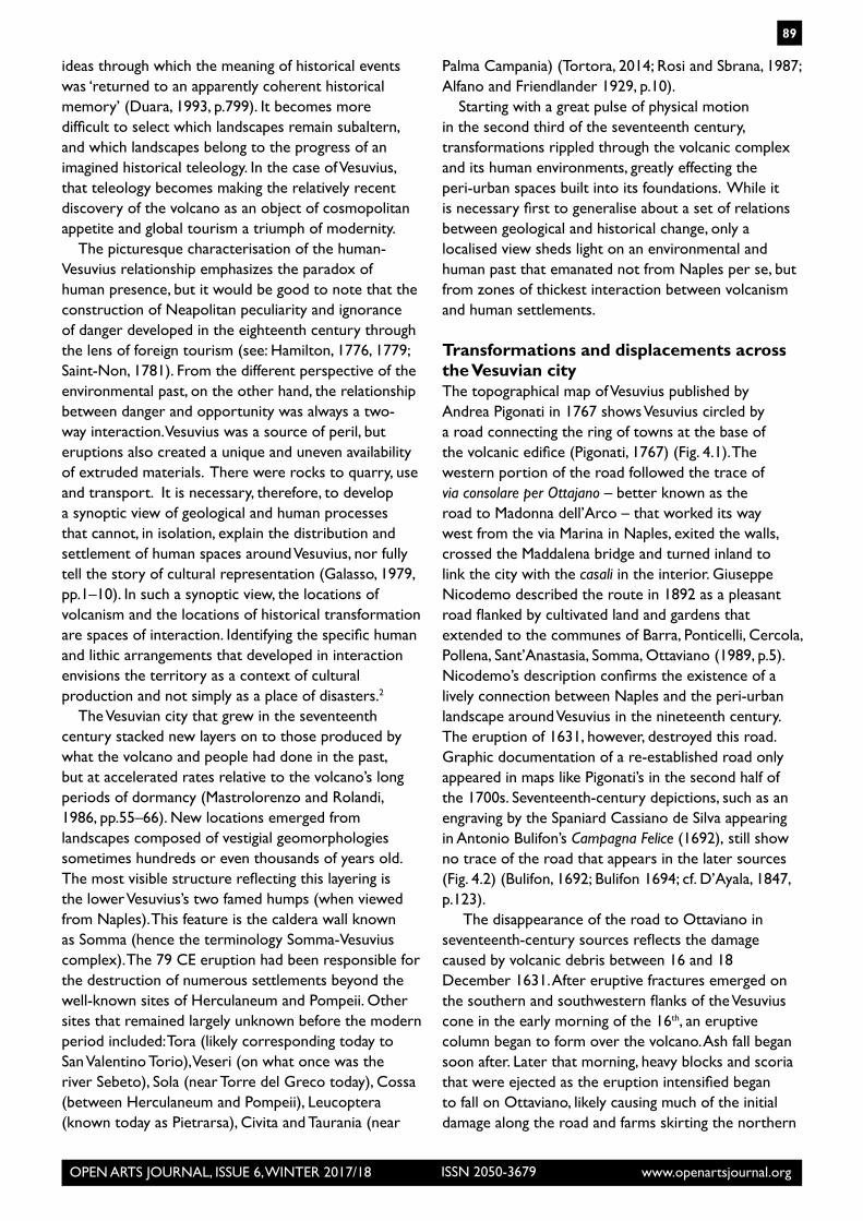
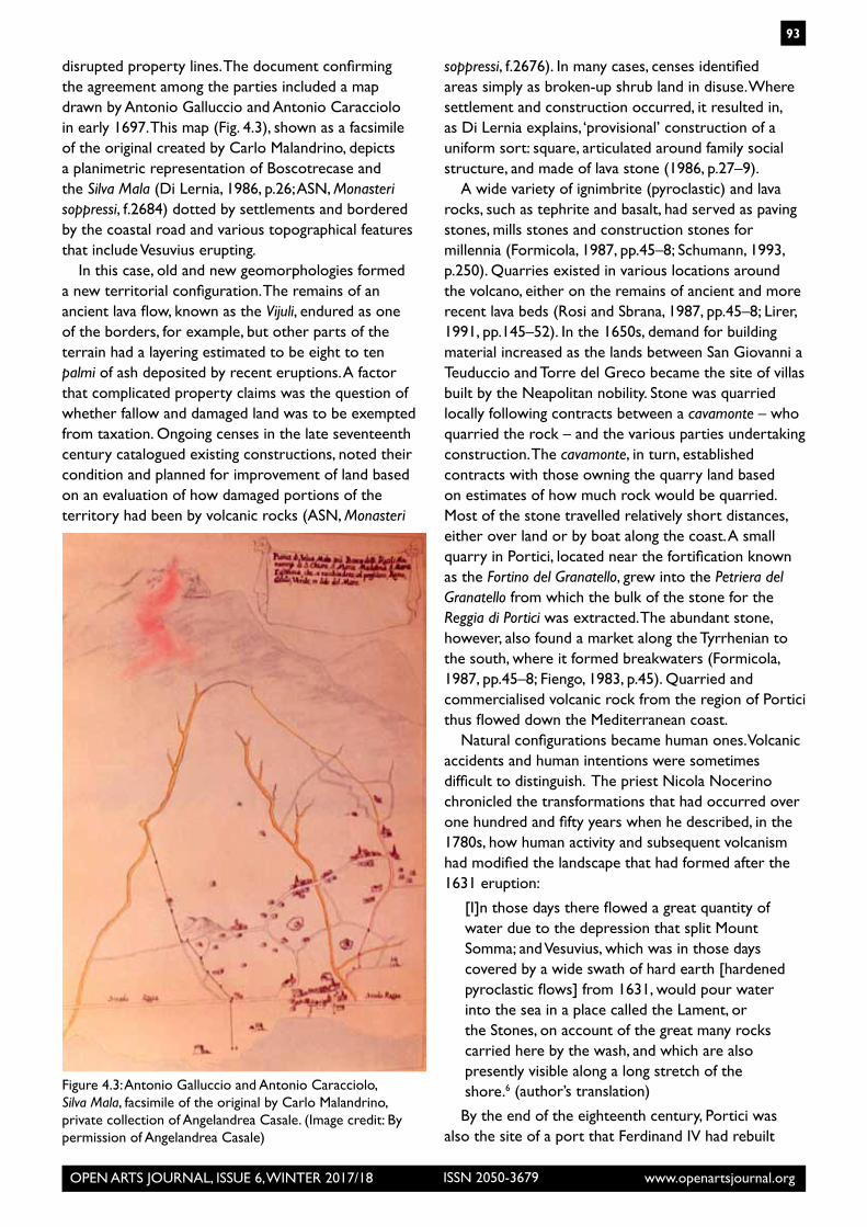
Transformations and displacements across the Vesuvian cityThe topographical map of Vesuvius published by Andrea Pigonati in 1767 shows Vesuvius circled by a road connecting the ring of towns at the base of the volcanic edifice (Pigonati, 1767) (Fig. 4.1). The western portion of the road followed the trace of via consolare per Ottajano – better known as the road to Madonna dell’Arco – that worked its way west from the via Marina in Naples, exited the walls, crossed the Maddalena bridge and turned inland to link the city with the casali in the interior. Giuseppe Nicodemo described the route in 1892 as a pleasant road flanked by cultivated land and gardens that extended to the communes of Barra, Ponticelli, Cercola, Pollena, Sant’Anastasia, Somma, Ottaviano (1989, p.5). Nicodemo’s description confirms the existence of a lively connection between Naples and the peri-urban landscape around Vesuvius in the nineteenth century. The eruption of 1631, however, destroyed this road. Graphic documentation of a re-established road only appeared in maps like Pigonati’s in the second half of the 1700s. Seventeenth-century depictions, such as an engraving by the Spaniard Cassiano de Silva appearing in Antonio Bulifon’s Campagna Felice (1692), still show no trace of the road that appears in the later sources (Fig. 4.2) (Bulifon, 1692; Bulifon 1694; cf. D’Ayala, 1847, p.123).
The disappearance of the road to Ottaviano in seventeenth-century sources reflects the damage caused by volcanic debris between 16 and 18 December 1631. After eruptive fractures emerged on the southern and southwestern flanks of the Vesuvius cone in the early morning of the 16th, an eruptive column began to form over the volcano. Ash fall began soon after. Later that morning, heavy blocks and scoria that were ejected as the eruption intensified began to fall on Ottaviano, likely causing much of the initial damage along the road and farms skirting the northern
OPEN ARTS JOURNAL, ISSUE 6, WINTER 2017/18 www.openartsjournal.orgISSN 2050-3679
90
flanks of the volcano. Seismic pulses emanating from Vesuvius caused further destruction. Pyroclastic flows surged out and cascaded in at least three major lobes in different directions, including the direction of Torre del Greco on the littoral southwest of the crater. Finally, lahar flows formed as water precipitation created in the eruptive column rained down on the pyroclastic blanket and set it into motion. The shoreline shifted and this movement caused a tsunami to sweep the shore (Rosi, Principe and Vecci, 1993, pp.151–82).
The accounts written immediately after the eruption recorded these physical transformations as shocking. Writing from Naples on 27 December 1631, the Jesuit priest Ascanio Capece described how layers of debris had obliterated familiar features:
The massacre caused by the earthquakes stemmed from the fire, as well as from the ash and water, though why a large river poured forth from another side of Vesuvius itself is inexplicable. Torre Annunziata, [Torre del] Greco,
Palma, Monteforte, Bosco and other places were almost completely destroyed. Portici is unrecognizable. Nola is abandoned because of the destruction caused by the hail of a great many stones weighing half a libra each … I will say nothing of the fortified farms [masserie] and terrains of Somma, Ottaiano, Palma, S. Giorgio and S. Anastasio, because whatever I might say is miniscule in face of the reality of what occurred.3
(authors’ translation)
Clearly, massive displacements had shifted materials along vertical and horizontal planes. Islands and peninsulas of debris had formed, redistributing the densities of human and natural materials in ways that stunned observers. Capece described the destruction:
Ferrante Capece, my relative, used to have three fortified farms [masserie] in the places I have mentioned, and having seen it with his eyes tells me that he cannot tell if they even existed, since
Figure 4.2: Antonio Bulifon, Campagna Felice (1692). Bibliothèque Nationale de France, Paris. (Image credit: gallica.bnf.fr/ Bibliothèque nationale de France)

OPEN ARTS JOURNAL, ISSUE 6, WINTER 2017/18 www.openartsjournal.orgISSN 2050-3679
91
the ash above has grown in some places 40, in some 60, and in some 100 palmi high. It has covered a tower he possessed in S. Giorgio that was once 60 palmi tall, from which one could not previously see the sea, as it was obstructed by the flanks of Somma, and now one sees freely the entire port of Naples, meaning that that the ash is at least 40 palmi above the level of the tower […] a new river is flooding all of the terrain in the direction of Nola and Ottaviano, and it must be at least 10 palmi deep for a few miles.4 (authors’ translation)
The areas most exposed to destruction were also the most exposed to historical oblivion, as the description above suggests. Significantly, the way in which destruction shaped the territory’s subsequent history is more difficult to observe if the vantage point is the view of Vesuvius from Naples.
The urban view was the perspective established early on by seventeenth-century chronicles of the 1631 eruption. Having observed the eruption from the view his palazzo (De Frede, 2005, p.20) afforded just off of the Decumano maggiore, Giovanni Battista Manso saw the transformation differently. Manzo wrote on 23 December 1631 that looking in ‘the direction of Somma, the casali of S. Sebastiano, Massa and Trocchia were destroyed partly by fire and partly by flood. As I explained in my previous letter, Somma itself, S. Anastasio and Pollena did not suffer from fire, but from ash and water, thanks to which many houses are ruined and buried’ (Riccio, 1889, pp.71). Descriptions of the eruption expressed the observers’ location around an observational perimeter from which multiple lines of sight were possible. The positional aspects of seeing and narrating were, in fact, very important for the literature of historical and scientific observation that developed around the volcano subsequently (Cocchia, 1901, p.20). This feature is instructive. Historians can also move around the perimeter of Vesuvius, making forays into the specific sites of transformation.
Approximately four hundred and fifty metres of the pre-1631 cone structure collapsed during the eruption (Scarpato et al., 2005). The crater was not, of course, a place of permanent settlement and human density. The same is not true of the many casali around the volcano. The central feature of early reports was the reference to loss of life, property damage and the depopulation of the peri-urban environment surrounding Vesuvius, but especially in the areas most hit by scoria fall, pyroclastic flows and lahar. These places became unrecognisable to the survivors. Capece explained that everything from the landscape to the presence of people had changed beyond recognition:
All of the areas close to Vesuvius have been abandoned and many, because they delayed their escape, were overcome by ash or by fire, which lifting itself up [as a whole] cascaded down in pieces, sowing death on those it met. The number of dead is said to rise to 150; certainly, many bodies of burned people have been brought in from the fields. The road to S. Maria dell’Arco is now a tongue of water, which we do not know whether it is a river or the sea, eight palmi deep, and bearing many stones.5 (authors’ translation)
Livestock, cultivated and uncultivated environments, roads and paths, buildings, demarcations of property, and people with knowledge of place were gone. The destruction of the road to Ottaviano and its reappearance in the sources over a century later illustrates the historical disjuncture that bouts of volcanism could create. Lost places only reappeared on the other side of an ellipsis, but most often new places emerged. Studies of the Vesuvian casali give a strong indication that the decades following 1631 were especially difficult, since there are major gaps in parish records showing population. For many casali, good demographic information only becomes available for the late seventeenth and early eighteenth centuries (Russo, 1984, p.42).
BifurcationFragmentary evidence creates a broken image of the lands around Vesuvius most affected by volcanism after 1631. Nonetheless, human presence sometimes intensified, even if the expanding built environment continued to feel the effects of volcanism. The very grave damage caused to buildings and to local economies was a stimulus to renew activity and to reclaim or simply claim land (Avvisati, Casale and Sorrentino, 1996, p.19). Responses included attempts to survey the damage and redraw property lines. More subtle features possibly emerged as well, such as the use of piled volcanic clasts instead of wooden posts as property markers. Intermittent volcanism in the period between 1694 and 1707 actually intensified certain kinds of human activity. For example, the woodlands around Boscotrecase, known as the Silva Mala, were mapped for the first time because property disputes had arisen on account of the destruction. Localised mapping of this kind differed from the state-sanctioned cartographic project that would be undertaken by the Bourbons after 1734, a time when the topographic traditions of Naples reached ‘the highest levels of European figurative and scientific accomplishment’ (Valerio, 2013, p.81) through the efforts of the Duke
OPEN ARTS JOURNAL, ISSUE 6, WINTER 2017/18 www.openartsjournal.orgISSN 2050-3679
92
of Noja in the 1750s. On a smaller and more modest scale made visible by different archival sources, it is possible to see the wooded lands south of the crater constituted one of the sites of heaviest interaction between the retreat and advance of settlement.
In 1596, Alfonso Piccolomini, Baron of Scafati and owner of Terra di Valle (Pompeii), Torre Annunziata and Bosco Reale, purchased the casale of Boscotrecase from the Royal Demesne for 17,500 ducats. Joined to Piccolomini’s other properties, this woodland region became part of a vast feudal estate stretching along the base of Vesuvius. The forests lay some way in from the coast below the southern flanks of the volcano. Piccolomini’s commercial interests were focused intensely nearby as he was attracted to invest in more commercially active areas just south along the coast. Torre Annunziata, for example, traded on the Mediterranean Sea, as did the bordering coastal towns of Torre del Greco and Castellamare di Stabia. Piccolomini aimed to exploit the hydrological resources in the Sarno River fluvial plain south of Vesuvius (near where Pompeii still lay buried). By late 1629, he had built watermills along the Sarno canal (Pepe, 1887, p.96). The eruption in 1631, however, forced a dramatic reconfiguration of commercial and landed interests that had been stacking on to the land for centuries. Heavy destruction occurred in a number of areas, significantly shaping its future urbanization.
Pyroclastic flows had pulsed from the crater causing the most damage: west toward San Giorgio, Portici (this is relevant to the analysis of bifurcation below), Granatello and Resina, southwest and south toward Torre del Greco, Camaldoli and the royal road (Strada Regia); south and southeast (the area considered here) toward Boscotrecase, Torre Annunziata and Boscoreale (Scarth, 2009, p.139). The settlement of new hamlets, investment in mills and quarries, investment in coastal and even longer-range maritime trade, the construction of summer residences for the larger Neapolitan nobility, as well as the continuing practice of extracting feudal revenue from land, frequently brought aristocratic landowners into conflict with ecclesiastical landowners. This stacking of interests complicated reconstruction and recovery. The southern coastal stretches of Vesuvius and the lands moving to the interior had been a small frontier of urban expansion for centuries. Records of this sporadic expansion stretch back into the thirteenth-century Angevin period. Limestone quarries ordered by Charles of Anjou in 1278, established to extract the stone for use in Naples, show that flows of materials from this frontier, still heavily forested, extended to the city (De Angelis, 1967, p.296).
Boscotrecase, in which the settlement of Trecase emerged, stretched along the southern flanks of the volcano (northwest of the still-buried site of Pompeii). The area once had been part of a vaster forest extending from the crater of Vesuvius to the shore. It remained heavily wooded until the late fifteenth century and early sixteenth century (Casale and Bianco, 1979, p.8). During the Aragonese period, the land was gradually deforested and populated as people from nearby towns began to settle on the property of three Neapolitan monasteries – Santa Chiara, Santa Maria Egiziaca and Santa Maria Maddalena – who had received the land in concession from Robert of Anjou in 1337. This was the location of the forest known at the Silva Mala (Casale and Del Luca, 1994, p.3). Peasant homes built around a rural church around the beginning of the sixteenth century formed the initial settlement of what would become Trecase. In this early period, the village was still dependent on the town of Torre del Greco. In 1596, these lands then became the property of Alfonso Piccolomini, Count of Celano, making them part of the università of Boscotrecase (Casale and Del Luca, 1994, p.4; ASDN, Fondo Benefici, N.171, fol.35). Parish records show that material conditions across the landscape were widely disparate even before 1631. Only isolated and humble parish churches existed in Boscotrecase, while coastal towns such as Torre del Greco concentrated people and more intense commercial activity. Reconstruction after 1631 tended to reflect the desire for more complex structures that matched religious and architectural ideals with the availability of building materials (Russo, 1984, pp.62–3). Volcanism thus reinforced a pre-existing pattern of localised differences in the scale and quality of construction.
A somewhat clearer picture is possible for the period of the 1694, 1696, 1697 and 1698 eruptions. Areas effected by lava flows and ash fall included San Giorgio a Cremano, Torre del Greco, Trecase, Boscotrecase to the west and to the south of the crater, as well as Ottaviano to the northeast (Ricciardi, De Lucia and Giudicepietro, 2016). In 1698, but also in 1701 and 1707, lava flows and pyroclasts set fire to woods and cultivated fields (Scarpato et al., 2005). Changes to the physical environment complicated the disputes that arose in a patchwork of claims to land identified as underexploited and ripe for expansion. The wooded terrains of Boscotrecase are a good example. In 1696 three Neapolitan monasteries owning land in the area entered into dispute with the Archbishopric of Naples over property lines near the Silva Mala. On this occasion, the monasteries petitioned the Spanish viceroy that they be allowed to use the testimony of multiple local witnesses as they attempted to redraw
OPEN ARTS JOURNAL, ISSUE 6, WINTER 2017/18 www.openartsjournal.orgISSN 2050-3679
93
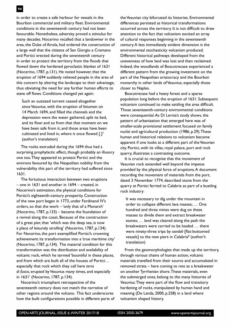
disrupted property lines. The document confirming the agreement among the parties included a map drawn by Antonio Galluccio and Antonio Caracciolo in early 1697. This map (Fig. 4.3), shown as a facsimile of the original created by Carlo Malandrino, depicts a planimetric representation of Boscotrecase and the Silva Mala (Di Lernia, 1986, p.26; ASN, Monasteri soppressi, f.2684) dotted by settlements and bordered by the coastal road and various topographical features that include Vesuvius erupting.
In this case, old and new geomorphologies formed a new territorial configuration. The remains of an ancient lava flow, known as the Vijuli, endured as one of the borders, for example, but other parts of the terrain had a layering estimated to be eight to ten palmi of ash deposited by recent eruptions. A factor that complicated property claims was the question of whether fallow and damaged land was to be exempted from taxation. Ongoing censes in the late seventeenth century catalogued existing constructions, noted their condition and planned for improvement of land based on an evaluation of how damaged portions of the territory had been by volcanic rocks (ASN, Monasteri
soppressi, f.2676). In many cases, censes identified areas simply as broken-up shrub land in disuse. Where settlement and construction occurred, it resulted in, as Di Lernia explains, ‘provisional’ construction of a uniform sort: square, articulated around family social structure, and made of lava stone (1986, p.27–9).
A wide variety of ignimbrite (pyroclastic) and lava rocks, such as tephrite and basalt, had served as paving stones, mills stones and construction stones for millennia (Formicola, 1987, pp.45–8; Schumann, 1993, p.250). Quarries existed in various locations around the volcano, either on the remains of ancient and more recent lava beds (Rosi and Sbrana, 1987, pp.45–8; Lirer, 1991, pp.145–52). In the 1650s, demand for building material increased as the lands between San Giovanni a Teuduccio and Torre del Greco became the site of villas built by the Neapolitan nobility. Stone was quarried locally following contracts between a cavamonte – who quarried the rock – and the various parties undertaking construction. The cavamonte, in turn, established contracts with those owning the quarry land based on estimates of how much rock would be quarried. Most of the stone travelled relatively short distances, either over land or by boat along the coast. A small quarry in Portici, located near the fortification known as the Fortino del Granatello, grew into the Petriera del Granatello from which the bulk of the stone for the Reggia di Portici was extracted. The abundant stone, however, also found a market along the Tyrrhenian to the south, where it formed breakwaters (Formicola, 1987, pp.45–8; Fiengo, 1983, p.45). Quarried and commercialised volcanic rock from the region of Portici thus flowed down the Mediterranean coast.
Natural configurations became human ones. Volcanic accidents and human intentions were sometimes difficult to distinguish. The priest Nicola Nocerino chronicled the transformations that had occurred over one hundred and fifty years when he described, in the 1780s, how human activity and subsequent volcanism had modified the landscape that had formed after the 1631 eruption:
[I]n those days there flowed a great quantity of water due to the depression that split Mount Somma; and Vesuvius, which was in those days covered by a wide swath of hard earth [hardened pyroclastic flows] from 1631, would pour water into the sea in a place called the Lament, or the Stones, on account of the great many rocks carried here by the wash, and which are also presently visible along a long stretch of the shore.6 (author’s translation)
By the end of the eighteenth century, Portici was also the site of a port that Ferdinand IV had rebuilt
Figure 4.3: Antonio Galluccio and Antonio Caracciolo, Silva Mala, facsimile of the original by Carlo Malandrino, private collection of Angelandrea Casale. (Image credit: By permission of Angelandrea Casale)
OPEN ARTS JOURNAL, ISSUE 6, WINTER 2017/18 www.openartsjournal.orgISSN 2050-3679
94
in order to create a safe harbour for vessels in the Bourbon commercial and military fleet. Environmental conditions in the seventeenth century had not been favourable. Nonetheless, adversity proved a stimulus for many decades. Nocerino recalled that a landowner in the area, the Duke of Airola, had ordered the construction of a large wall that the citizens of San Giorgio a Cremano and Portici erected during the seventeenth century in order to protect the territory from the floods that flowed down the hardened pyroclastic blanket of 1631 (Nocerino, 1787, p.131). He noted however, that the eruption of 1694 suddenly relieved people in the area of this concern by altering the landscape to their advantage, thus obviating the need for any further human efforts to stave off flows. Conditions changed yet again:
Such an outsized torrent ceased altogether since Vesuvius, with the eruption of bitumen on 14 March 1694, and filled the channels and the depression were the water gathered, split its bed, and its flow: and so from that that moment on we have been safe from it, and those areas have been cultivated and lived in, where it once flowed [.]7 (author’s translation)
The rocks extruded during the 1694 thus had a surprising prophylactic effect, though probably an illusory one too. They appeared to protect Portici and the environs favoured by the Neapolitan nobility from the vulnerability this part of the territory had suffered since 1631.
The fortuitous interaction between two eruptions – one in 1631 and another in 1694 – created, in Nocerino’s estimation, the physical conditions for Portici’s eighteenth-century prosperity. Construction of the new port began in 1773, under Ferdinand IV’s orders, so that the work – ‘only that of a Monarch’ (Nocerino, 1787, p.133) – became the foundation of a revival along the coast. Because of the construction of a great pier, that ’which was the deep sea, is now a place of leisurely strolling’ (Nocerino, 1787, p.134). For Nocerino, the port exemplified Portici’s crowning achievement: its transformation into a ‘true maritime city’ (Nocerino, 1787, p.134). The material condition for this transformation was the distribution and availability of volcanic rock, which he termed ‘bountiful in these places, and from which are built all of the houses of Portici…especially that rock which they call here terra di fuoco, erupted by Vesuvius many times, and especially in 1631’ (Nocerino, 1787, p.134).
Nocerino’s triumphant retrospective of the seventeenth century does not match the narrative of other regions around the volcano. This fact underscores how the built configurations possible in different parts of
the Vesuvian city bifurcated its histories. Environmental differences persisted as historical transformations occurred across the territory. It is not difficult to draw attention to the fact that volcanism excited an array of cultural responses beginning in the seventeenth century. A less immediately evident dimension is the environmental stochasticity volcanism produced. Different historical pathways developed from the unevenness of how land was lost and then reclaimed. Indeed, the woodlands of Boscotrecase experienced a different pattern from the growing investment on the part of the Neapolitan aristocracy and the Bourbon monarchy in other lands of Vesuvius, especially those closer to Naples.
Boscotrecase had a heavy forest and a sparse population long before the eruption of 1631. Subsequent volcanism continued to make settling the area difficult. Those seventeenth-century environmental conditions were consequential. As Di Lernia’s study shows, the pattern of urbanisation that emerged here was of smaller-scale provisional settlement focused on family nuclei and agricultural production (1986, p.29). These human and historical relations to volcanism become apparent if one looks at a different part of the Vesuvian city. Portici, with its villas, royal palace, port and rock quarry, illustrates a contrasting outcome.
It is crucial to recognise that the movement of Vesuvian rock extended well beyond the impetus provided by the physical force of eruptions. A document recording the movement of materials from the port, dated 3 November 1774, described stone from the quarry at Portici ferried to Calabria as part of a bustling rock industry:
It was necessary to dig under the mountain in order to collapse different lava masses; … One hundred and three mines were dug on these masses to divide them and extract breakwater stones; … land was cleared along the path the breakwaters were carried to be loaded … there were ninety-three trips by sandali [flat-bottomed vessels] to the new piers in Calabria8 (author’s translation)
From the geomorphologies that made up the territory, through various chains of human action, volcanic materials travelled from their source and accumulated in removed strata – here coming to rest as a breakwater on another Tyrrhenian shore. These materials, even the submerged ones, belong to the many histories of Vesuvius. They were part of the flow and transitory hardening of rocks, manipulated by human hand and meaning (De Landa, 2000, p.258) in a land where volcanism shaped history.
OPEN ARTS JOURNAL, ISSUE 6, WINTER 2017/18 www.openartsjournal.orgISSN 2050-3679
95
Notes1 For a discussion of the holocoenotic concept in ecology, see Kruckeberg (2004, pp.16-18).2 Exploring the flow and settlement of materials into emergent spaces is an approach that works in different contexts as well. See Helen Hills’s interpretation of the Treasury Chapel of San Gennaro in Calaresu and Hills (2013, pp.32–8); cf. Russo (1984, pp.15-33), Luongo (1997, pp.9–26), Musi (2000, pp.63–78) and Vella and Barbera (2001, pp.15–22).3 La strage poi fatta dai terremoti parte dal fuoco, come ancora dalla cenere e acqua, essendo per un’altra parte dell’istesso Vesuvio uscito fuora un grandissimo fiume, non è esplicabile. La Torre Annunziata, del Greco, Resina, Ottaviano, Palma, Monteforte, Bosco e altri luoghi quasi affatto destrutti. Portici non si riconosce più. Nola deshabitata per la gran rovina delle case fatta dalla gragnola delle pietre di meza libra l’una incirca e queste erano frequentissime... Delle masserie e possessioni poi di Somma, Ottaiano, Palma, S. Giorgio e S. Anatasio non dico niente, perché qualunque cosa mi dica e di gran lunga inferiore alla verità del fatto. (Riccio, 1889, p.499; cf. Carafa, 1632, p.21)4 Il S. r. Ferrante Capece mio parente haveva tre masserie ne’ luoghi nominati, come testimonio di vista mi afferma che non può riconoscere si fossero nemmeno, essendo la cenere cresciuta sopra terra dove 40, dove 60, e dove 100 palmi d’altezza; imperciò che ha coperta una torre che lui haveva in S. Giorgio alta palmi 60, dalla cima della qual torre non arrivava a scoprir il mare, toltoli dalla falda della montagna di Somma, hora dal piano lasciato della Cenere sopra d’essa torre vede liberamente tutta la marina di Napoli che bisognasi sia avanzata la Cenere quaranta palmi al meno sopra la sommità di detta torre [...]. Il nuovo fiume d’acqua poi allaga tutte queste campagne verso Nola e Ottaiano, e per lo spatio d’alcune miglia è alta 10 palmi l’acqua. (Riccio, 1889, pp.449–50).5 Tutti i luoghi vicini al Vesuvio sono stati dalla gente abbandonati affatto, e molti perché furon tardi a fuggire, sono stati oppressi dalla cenere o dalla fiamma, la quale sollevandosi in alto cascava giù di nuovo divisa in pezzi, con morte di quanti incontrava. Il numero de’ morti ascende per quanto si dice a 150, certo è che son stati portati molti corpi da li campi di persone arse. Per la strada di S. Maria dell’Arco corre una lingua d’acqua non si sa se sia di fiume o di mare, alta otto palmi, e porta quantità di pietre. (Riccio, 1889, p.496). 6 [S]correva in quei tempi una smisurata lava di acqua, causata dal vacuo, che tramezza il Monte di Somma, e il Vesuvio ricoperto allora di dura terra del 1631, la quale essendo di molta larghezza, finalmente si scaricava nel mare nel luogo detto il Lagno, o pure le Petrazze, dalla gran quantità delle pietre, che qui trasportate dalla gran piena, anche al presente a lungo tratto del mare si osservano. (Nocerino, 1787, p.131) 7 Tal smisurato torrente di acqua cessò dell’intutto allorchè il Vesuvio coll’eruzione di bitume de’ 14. Marzo 1694 empì i valloni, ed il vacuo ove radunavasi tant’acqua, e troncò il suo letto, e camino: e perciò da llora in poi ne siamo stati sicuri,
anzi coltivati, ed abbitati si sono quai luoghi, ove scorreva [.] (Nocerino, 1787, p.132)8 Petriera del Granatello nell’ultimo scorso mese ... si è dovuto scavare sotto la montagna per far cascar diversi massi di lava;... si son fatte centotrè mine sopra detti massi per dividersi e così ritrarne scogli ...; si è dovuto levar la terra per ove si dovevano trasportare li scogli per imbarcarli ...; si son fatti novantatrè viaggi colli sandali per questi nuovi moli in Calabria (ASN, Segreteria di Marina Espedienti, vol.162, f.397)
Archival sources
1 Archivio di Stato di Napoli, Segreteria di Marina Espedienti, vol. 162, fol.397.
2 Archivio di Stato di Napoli, Volume di copie di censuazioni di Bosco fatte dal Re e Monisterio di S. Chiara, Monasteri soppressi, f.2676.
3 Archivio di Stato di Napoli, Volume di copie di censuazioni di Bosco fatte dal Re e Monisterio di S. Chiara, Monasteri soppressi, f.2684
4 Archivio Storico Diocesano di Napoli, Fondo benefici, N.171, fol.35.
Bibliography1 Andrews, T. (2015) Coyote Valley: Deep History in the High Rockies, Cambridge, Harvard University Press.
2 Alfano, G.B. and Friendlander, I. (1929) La Storia del Vesuvio, illustrata da documenti coevi, Ulm, K. Hoehn.
3 Avvisati, C., Casale, A. and Sorrentino, G. (1996) Boscoreale. Storia, tradizioni e vocazione turistica, Boscoreale, Linea Grafica Aurora.
4 Bennet, J. (2010) Vibrant Matter: A Political Ecology of Things, Durham and London, Duke University Press.
5 Bulifon, A. (1692) Campagna Felice (engraving) http://gallica.bnf.fr/ark:/12148/btv1b5903472f/f1.item, accessed 20.9.2016.
6 Bulifon, A. (1694) Lettera nella quale si dà distinto ragguagli nell’incendio del Vesuvio succeduto nel mese d’aprile 1694, Napoli, Per Giuseppe Roselli.
7 Calaresu, M. and Hills, H. (2013) New Approaches to Naples, c.1500–1800, Farnham, Ashgate.
8 Carafa, G. (1775) Mappa topografica della città di Napoli e de’ suoi contorni, Napoli, Biblioteca Nazionale di Napoli, S.Q. XXVII L100.
9 Carafa, G. (1632) In opusculum de nouissima Vesuuij Conflagratione, Epistola Isagogica, Neapoli, Ex Typographia Aegidi Longhi.
10 Casale, A. and Bianco, A. (1979) ‘Primo contributo alla topografia del suburbio pompeiano’, Pompei 79, Rome.

OPEN ARTS JOURNAL, ISSUE 6, WINTER 2017/18 www.openartsjournal.orgISSN 2050-3679
96
11 Casale, A. and Del Luca R. (1994) La venerabile parrocchia matrice di Santa Maria delle Grazie in Trecase (in occasione di restauro), Trecase.
12 Chaplin, J. (2015) ‘The other revolution’, Early American Studies: An Interdisciplinary Journal, vol.13, no.2, pp.285–308.
13 Cocchia, E. (1901) La forma del Vesuvio nelle pitture e descrizioni antiche (con VIII figure intercalate nel testo). Memoria letta all’Accademia dal Socio Enrico Cocchia, Napoli, Accademia di Archeologia, Lettere e Belle Arti, Vol. 21.
14 Cocco, S. (2013) Watching Vesuvius: A History of Science and Culture in Early Modern Italy, Chicago, University of Chicago Press.
15 Cohen, K.M., Finney, S.C., Gibbard, P.L. and Fan, J-X. (2013) ‘The ICS International Chronostratigraphic Chart’, International Commission on Stratigraphy, http://www.stratigraphy.org/ICSchart/ChronostratChart2016-12.jpg, accessed 25.4. 2017)
16 D’Ayala, M. (1847) Napoli militare per Mariano D’Ayala, Napoli, Stamperia dell’Iride.
17 De Angelis, R.O. (ed.) (1967) I Registri Angioni ricostruiti da Riccardo Filangieri con la collaborazione degli archivisti napoletani, 1278-1279, Napoli, Accademia Pontaniana.
18 De Frede, C. (2005) Il Decumano maggiore da Castelcapuano a S. Pietro a Maiella, Naples, Liguori.
19 De Landa, M. (2000) A Thousand Years of Nonlinear History, New York, Swerve.
20 Di Lernia, L. (1986) ‘La colonia monastica di Boscotrecase’, Quaderni del laboratorio ricerche e studi vesuviani, vol.5, pp.19–29.
21 Duara, P. (1993) ‘Bifurcating linear history: Nation and histories in China and India’, Positions, vol.1, no.3, pp.779–804.
22 Ellsworth, E. and Kruse, J. (2012) Making the Geologic Now: Responses to Material Conditions of Contemporary Life, New York, Punctum books.
23 Fiengo, G. (1983) Organizzazione e produczione edilizia a Napoli all’avvento di Carlo di Borbone, Naples, Arte Tipografica.
24 Formicola, A. (1987) ‘La Real Petriera del Granatello’, Quaderni del laboratorio ricerche e studi Vesuviani, vol.8, pp.45–8.
25 Furchheim, F. ([1897] 2011) Bibliografia del Vesuvio. Compilata e corredata di note critiche estratte dai più autorevoli scrittori Vesuviani da Federigo Furcheim, già libraio-editore autore della Bibliografia di Pompei. Con un copioso indice metodico, Napoli, Ditta F. Furchheim di Emilkio Prass Editore.
26 Gaddis, J. (2002) The Landscape of History: How Historians Map the Past, Oxford, Oxford University Press.
27 Galasso, G. (1979) ‘L’Italia come problema storiografico’, in G. Galasso (ed.) Storia d’Italia, Turin, Einaudi Editore.
28 Hamilton, W. (1776) Campi Phlegraei: Observations on the Volcanoes of the Two Sicilies as They Have Been Communicated to the Royal Society of London, Naples.
29 Hamilton, W. (1779) Supplement to the Campi Phlegraei: Being an Account of the Great Eruption of Mount Vesuvius in the Month of August 1779, Naples.
30 Haraway, D. (2016) ‘Tentacular thinking: Anthropocene, capitolocene, chthulucene’, e-flux, no.75, http://www.e-flux.com/journal/75/67125/tentacular-thinking-anthropocene-capitalocene-chthulucene/, accessed 31.5.2017)
31 Heidenreich, L. (2007) This Land Was Mexican Once: Histories of Resistance from Northern California, Austin, University of Texas Press.
32 Klunkel, B. (2017) ‘The capitolocene’, London Review of Books, vol.39, no.5, pp.22–8.
33 Kruckeberg, A.R. (2004) Geology and Plant Life: The Effects on Landforms and Rock Types on Plants, Seattle, University of Washington Press.
34 Lirer, L. (1991) ‘Il tufo giallo napoletano’ in Terza conferenza annuale sulle attività di ricerca del Dipartimento di Geofisica e Vulcanologia dell’Università di Napoli ‘Federico II’, Naples, De Frede, pp.147–52.
35 Luongo, G. (1997) Mons Vesuvius. Sfide e catastrofi tra paura e scienza, Naples, Fiorentino.
36 Macedonio, G. and Martini, M. (2010) ‘Scenari eruttivi e livelli di allerta per il Vesuvio’, Istituto Nazionale di Geofisica e Vulcanologia, Sezione Napoli, Osservatorio Vesuviano.
37 Mastrolorenzo, G. and Rolandi, G. (1986) ‘Le eruzioni del Somma-Vesuvio in epoca protostorica’ in C. Albore Livadie (ed.) Tremblements de terre, éruptions volcanique et vie des hommes dans la Campanie antique, Naples, Centre Jean Berard, pp.55–66.
38 McNeill, J.R. and Engelke, P. (2014) The Great Acceleration: An Environmental History of the Anthropocene since 1945, Cambridge, Harvard University Press.
39 Moore, J.W. (2015) Capitalism in the Web of Life: Ecology and the Accumulation of Capital, London, Verso.
40 Musi, A. (2000) Le città del Mezzogiorno nell’età moderna, Naples, Edizioni Scientifiche Italiane.
41 Muto, G. (2013) ‘Urban structures and population’ in Astarita, T. (ed.) A Companion to Early Mondern Naples, Leiden, Brill, pp. 325-61.
OPEN ARTS JOURNAL, ISSUE 6, WINTER 2017/18 www.openartsjournal.orgISSN 2050-3679
97
42 Nicodemo, G. ([1892] 1988) Memorie storiche artistiche della parrochiale Chiesa ed insigne simulacro di Mara SS. Della Neve, ed. by Giovanni Alagi, Volla, Tipografia Russi.
43 Nocerino, N. (1787) La Real Villa di Portici illustrata dal Reverendo D. Nicola Nocerino parrocco in essa, Naples, Fratelli Raimondi.
44 Pepe, L. (1887) Memorie storiche dell’antica Valle di Pompei, Pompei, Scuola Tipografica Editrice Bartolo Longo.
45 Pigonati, A. (1767) Topografia del monte Vesuvio città e terre vicine, dimostrando i corsi delle lave vecchie e l’eruzioni del mese di marzo, ed aprile MDCCLXVI, in Pigonati, A., Descrizione delle ultime eruzioni del Monte Vesuvio da 25 marzo 1766 fino a 10 dicembre dell’anno medesimo, Naples, Stamperia Simoniana, tav. II.
46 Ricciardi, G., De Lucia, M. and Giudicepietro, F. (2016) ‘Catalogo storico delle eruzioni del Vesuvio dal 1631 al 1944’, Osservatorio Vesuviano, http://www.ov.ingv.it/ov/en/catalogo-1631-1944.html, accessed 6.10.2016).
47 Riccio, L. (1889) ‘Nuovi documenti sull’incendio vesuviano dell’anno 1631 e Bibliografia di quella Eruzione’, Archivio Storico per le Province Napoletane, vol.14, pp.489-555.
48 Richards, J. (2003) The Unending Frontier: An Environmental History of the Early Modern World, Berkeley, University of California Press.
49 Rosi, M., Principe, C. and Vecci, R. (1993) ‘The 1631 Vesuvius eruption: A reconstruction based on historical and stratigraphical data’, Journal of Volcanology and Geothermal Research, vol.58, no.1–4, pp.151–82.
50 Rosi, M. and Sbrana A. (1987) Phlegrean Fields, Roma, CNR.
51 Rowland. I.D. (2015) From Pompeii: The Afterlife of a Roman Town, Cambridge, Harvard University Press.
52 Russo, C. (1984) Chiesa e comunità nella diocesi di Napoli tra Cinque e Settecento, Naples, Guida.
53 Saint-Non, A. (1781) Voyage pittoresque ou description des Royaumes de Naples et de Sicilie, Pt. 1, Paris, De Clousier,
54 Scarpato, G., Ricciardi, G.P., Giudicipietro, F. and De Lucia, M. (2005) ‘L’evoluzione morfologica del Vesuvio in relazione alla sua storia eruttiva attraverso un’applicazione Web: SlideVes’, Istituto Nazionale di Geofisica e Vulcanologia, Osservatorio Vesuviano, Open File Report, no.6, http://www.ov.ingv.it/ov/doc/ofr05006.pdf, accessed 7.10.2016).
55 Scarth, A. (2009) Vesuvius: A Biography, Princeton, Princeton University Press.
56 Schumann, W. (1993) Handbook of Rocks, Minerals, and Gemstones, Boston and New York, Houghton Mifflin.
57 Shyrock, A. and Smail, D. (2011) Deep History: The Architecture of Past and Present, Berkeley, Los Angeles, and London, University of California Press.
58 Steffen, W., Grinevald, J., Crutzen, P. and McNeill, J. (2011) ‘The anthropocene: Conceptual and historical perspectives’, Philosophical Transactions of the Royal Society, vol.369, no.1938, pp.842–67.
59 Thomas, J.A. (2014) ‘History and biology in the age of the anthropocene: Problems of scale, problems of value’, American Historical Review, vol.119, no.5, pp.1587–607.
60 Tortora, A. (2004) ‘Tra territorio vesuviano e produzioni di pietra lavica verso il Mediterraneo in età moderna. Una ipotesi di ricerca’ in M. Mafrici (ed.) Rapporti diplomatici e scambi commerciali nel Mediterraneo moderno, Soveria Mannelli, Rubbettino.
61 Tortora, A. (2014) L’eruzione vesuviana del 1631. Una storia d’età moderna, Rome, Carocci Editore.
62 Valerio, V. (2013) ‘Representation and self-perception: Plans and views of Naples in the early modern period’ in T. Astarita (ed.) A Companion To Early Modern Naples, Leiden, Brill, pp.63–86.
63 Vella, A. and Barbera, F. (2001) Il territorio storico della città vesuviana. Struttura urbana e sviluppo della fascia costiera, San Giorgio a Cremano, Laboratorio Studio e Ricerche Vesuviane.