"ntsb report" - collections | embry-riddle aeronautical...
TRANSCRIPT

.

1. 1.1 1..2. 1.3 1.4 L 5 1.6 1.7 1.8 1.9, 1 s o 1.U 1.12 1.13 1.14 1.15 1.16 2. 2.1 2.2
4 , , .
4 4
f l ' i
X ) x) P
! '
! ,


1. IRVESTIGATION
1.1 llisto1y of the Flight
Mohawk A i r l i n e s Flight kll (KI-411) , Fairchild-Hiller k-&, N 7 8 l l I 4 , departed. Albany, New York, on an Instrument Flight Rules (IFR) flight plan,for,Warren County A i r p o r t , (Uens FUa,'tiew York, about 2003 on tiovernber 19, 1569. Plight 411 w a s , a scheduled psasenger/; c a r p night. , , . ) ' I I *
" A t 2006:?4, Albany Departure Control gave'M)-4il the lo l loving weather report: ' "A& Ebhawk foul. eleven, the Glens Falls weather measured ceiling two chowand one hundred (feet) overcast, vis ibi l i ty seven, light rain, wind one eight zero a t one two, pd gusts two two, aml altimeter two n b e eight zero,' Ruuvay one nine in use."
' j i
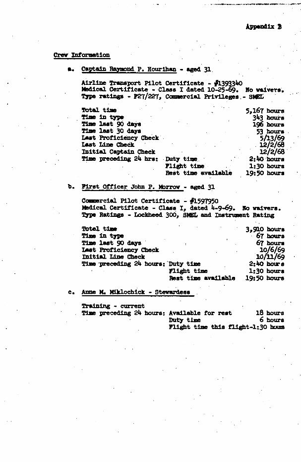
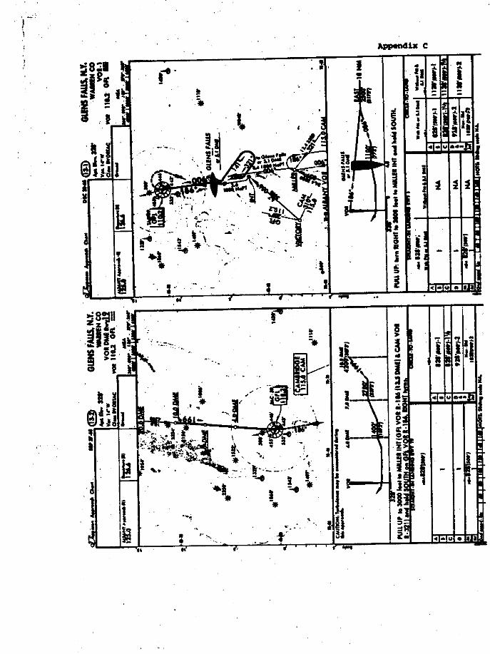
The& are two m approaches to tk: Warren C c p + A i r p o r t a t Glens palls, k w York. are the VOR-1 as4 the VOR m ~hmvay 19 (see ~ppelldix c). Mstance ~ t e ~ ~ i n g equiprent (DME) is required on an aircratt In order to use the VOR KME 3umray.19 approach. Cclnpany res- ulations m i b i t the use of DMe as a prlriiary navigational ?atrum?nt. mis mew that If a i rc ra f t m is to be used, it ulust be in conjunction with a fan marker, a radar fix, etc. , .
he ~ 0 ~ - 1 ' a p p r o a ~ h applies t o any '~wsy. It can k init iated either a t Miller Intersection or over the Glens Falls VOIZCAC. According, ;
descent can be initiated a t the ELlll;?r Intersection t o descend t o to the ,Jeppesen ~pproach charts, used by Whawk Airlines, an -ate
1,W feet mean sea level. 2j
i t
. ,
i
i
r ?
2 . b
,, k t
- . . . .- . .. .. . . -. . . . . .
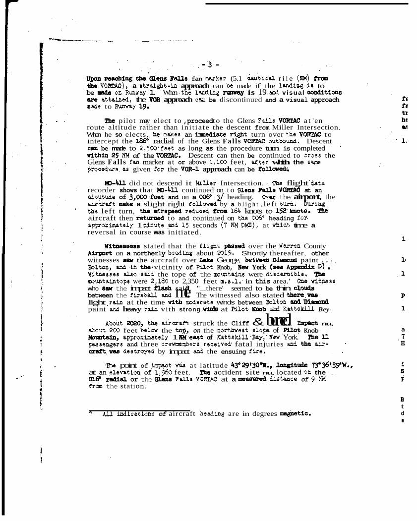
Upon ra.ching the ' ( a a r y k l s fan mnrker (5.1 &t ica l r i l e (HM) from the -), a stinight-in approach can be made if the larding is to be na& on Runway 1. When .the lePalng nmy(~y is 19 snd visual co&tiona are nttrined, the VOR approach C(YL be discontinued and a visual approach m d e to lhmway 19.
'&e pilot may elect t o ,proceed t o the Glens F U V O W a t 'en route altitude rather than in i t ia te the descent from Miller Intersection. When he so elects, !E makes an '3mediete.right turn over +,he VOKTAC t o '
intercept the 1%' radial of the Glens F a l l s VCR2M OutbImd. Descent
vithin 25 NM of the VOIi24C. Descent can then be continued to cross the can be made to 2,SOO'feet as long as the procedure turn is completed
Glens F a l l s fan marker a t or above 1,100 feet, a i t e i which the sare rOpcadura aa given fo r the VOR-1 approach can be folloyedi
, ,
, ,
recorder shows that ~)-4ll continued on t o olens ~alls VOKTAC at an altutude of 3 ,W. fee t and on a 0 0 6 O 2/ heading. Ovq the airport, the &kraft w e a slight right followed by a b l i g h t , l e f t turh. During thc l e f t turn, the speed reduced from 164 knots to 152']mota. The
aggmximately 1 minute ,& 15 seconds (7 IiM Dm), a t whicll time a aircraft then ret- to and continued on the, 006' heading for,
reversal in course was initiated.
W-4l.l did not descend it k i l le r Intersection. rtDe flight '@ta
Witncsscss stated that the fllght peased over the W a m n County on a northerly headlng about 2015,. Shortly thereafter, other
witnesses 8 5 1 the aircraft over Lake George, betma D i m o d paint a n d ,
Witnessas dso snid the tope of the muntains were discernible. The Bolton, snd in t h e ' vicinity of PYot Knob, New York (nee AppmaFx D) . who Saw the impact flash said, "...there' seemed to be thin clnuds muntaintops were 2,180 t o 2,350 feet m.a.1: in this area.' QlE WltMss
light ,rain at the time vith moderate winds between Bolton and M d paint ard heavy rsin vith strong .+&I at W o t Knob ard Kattu Bey-
A k t X&Q, th &craft struck the Cliff & burned. Impact nu,
between the fireball p d me." The witnessed also stated t h r r , w a a
sbaut 200 feet belov the to$, on the nortlnrest slopC of ,mot Knob l4nmtain, appoxirkately 1 NWeast of KsttskilPBay,' Uew York. The li p~sscngers and three crewmembers receiwd fatal injuries snd the air- ' '
cnri t ,nu, destmyed by impact and the ensuing fire. , ,
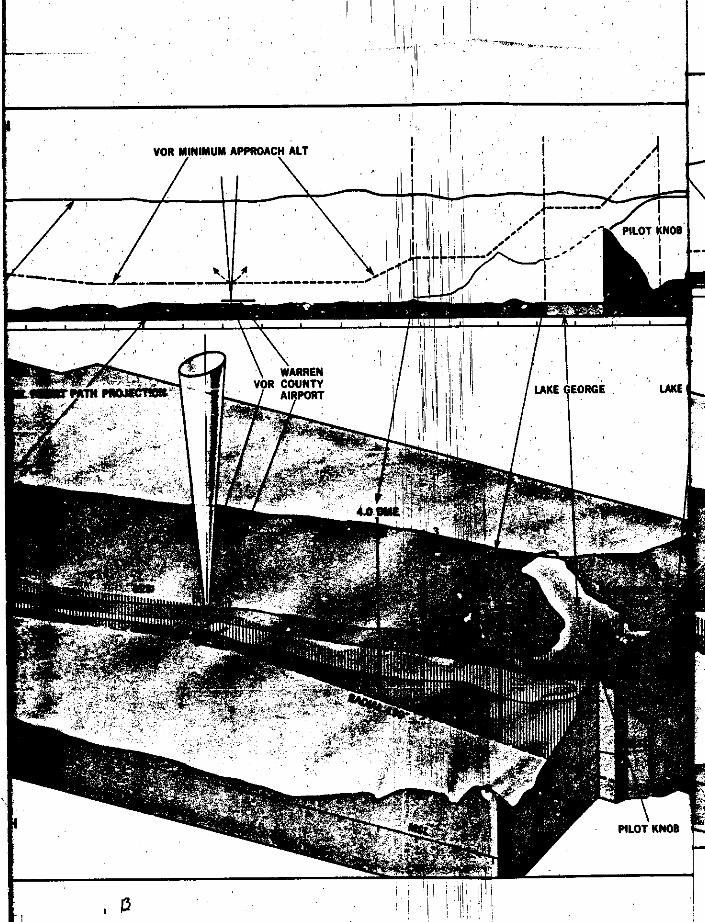
'Ibs point of impsct Was a t latitude 4Y29f30W1, loagituie W36':39"W., at an +ention of 1,350 feet. he accident site nu, located on the , ,
016. radial or the FU vw at a neaamed distance of 9 IpM f& the station.
5 W W c a t i a n s of aircraft heading are in degrees m&etic.
1
1 1
, 1
P
1
a , 7 E
B t d LI

. . - 4 -
Firs t impact w& with evergreen tree8 then, eppmximately 20 feat farther along the fli@ttprth, the drcrcUt impacted the 3ear-vertical face of pllot Knob Muntain. Damage to the evergreens indicated the traclr of the aircraft vea 1763 "Us dsmsge d.so Mice ted the aircraft had e 12. right-wing-down attitude and was descending et a 12. m e at impact.
' ' ' 1.2 Injuries to.Persons '
Injuries C r e w Fnsseugers Othml
Fetal 3 ll 0
Nonfatal 0 0 0 '
None 0 0
1.3 Damage' to Aircraft , ,
he e c r m vas bstroyea by impact thc'ens~ing h e .
1.4 Other Damage
large trees.
1.5 Crew Information
The only other aamage caused by impact aud fire w88 &ne t o several
AX crememters were pmprly CertmcatM ad q : l ~ l l ~ ~ e d for the* positions. (For detalle see Appendix B.)
1.6 Aircraft momat ion
available w a s No.54-247 which indicated e total aircraft time of 7553:36 hours) showed the aircraft was maintained in accordance with FA4 and, company procedures.
The aircraft maintenance records reviewed (the last log a b e t
lnstnnpent problems began to 'a~pea;. in the aircraft log Sooh on September 10, 1969. Further investigation, hovever, revealed that these pwblems did 110% constitute a t r ed in navigation instrument problems.
ming our normal records check, it vas found that sow navigation
The captain who flew the aircraft -lately pior , to C a p t a i n
that the aircraft was et the time of crew change without any mechanical Esurihan stated, in part, 88 iollms: "...Captain Kertz indicated t o me
discrepancy. The log book of Aircrate N78llM contained 110 writeup ' et the time and none were edded by me."

. . - 5 -
p e we-t and center of Ip=dty were within the p e a c r i k d limits ,for. m. 1.7 Meteorological Inrormation
, .
Synoptic situation . . . ' . The 1900 surface weather chart showed a strong cold front Oriented
north-south a c r o s s eastern New Yoxk, west of Glens Falls.
.Surface Weather Observatiolis
Glens Fal l s (Glens F a l l s is located 9 NM south of the accident s i te) .
1956, - eascred 2,100-foot overcast, v i s ib i l i ty 7 miles,
wind 150. at 12 knots, gusts 20 knots, altktcr light rain, temperature 53' F.) dew pint k@ F.,
Ejetting 29.80 inches. Rain began at 1819.
Bivlington (-lington is about 60 AM north of the accident site).
2000 - &ssirred 4,000 feet broken, 7,000 feet W e r C a S t ,
' , 49 F., dew pint 44' F., wind 1w 15 knots, gusts
- . . v i s ib i l i t y 7 mlles, light rain showers, tempera+.ure
22 knots, altimeter setting 29.76 inches, rsin bew at lW.
PO0 - Measured 3,600 feet overcast, vis ibi l i ty 7 miles, light rain, temperature 50' F., dew pint ,ae F., setting 29.74 in&=s. wind 1 5 r 17 knots, gusts 24 Imots., altimeter
3 1W
4 17V
41
r
I
Nev ' Glen

i
,
! ( .
0000 to 2400 on November 19, 1969, w a s 0.27 inches. .'The to ta l rainfall a t Glens Falls for the 24-hour Grid' &Om I
I
!

me captain wtm ,flew m11~ M i a t e l y prior t o Captain stated in part an follows concern- the weather: "After
with Captain Hourihan, wtro was; at that time (1800 hours), Si@ing bis Flight 402, I entered our operation office at LaOuardia snd spoke
flight plan and working over weather sequences. Captain Hourihan discussed briefly, three points: (1) condition of +craft - good
2) altitude between points - smooth between layers for m e , '
Surface) a t destination and departure - strong b for me." , .
1.8 A i d s t o Navigation , ,
The aids t o navigation a t Warren County Airprt Were (VOR with Dm),, a rotating beacon, FEIL (Runway End Ident on the approach end of Runway 01, and 'high-intensity runw (on maximum brightness). The may lights a t the ti& 0
were set on maximum brightness. All of the aids were i n the time of the accident, and there were , n o problems indi monitors. , . , ,
' ,
h e F M c d u c t e d a n i g h t deck of pB1.t of the nav within a few hourn following the' accident, and the r e m i following day . No discrepancies were found. Subsequent maintenance checks revealed no equipment difficultie. .. 1.9 Commnmications
. ,, ' , ,
coamnmicatlons made' t o & 'by Mo-kll were recorded takeoff through arrival at ' Miller Intersection. these transmissions are:
0058:21 411 Albany; Mohawk Four Qeven taxi
0058:24 GC Mohawk Four Eleven taxi Rumray One zero degrees ,at one two gusts t o
0101:OO GC ' Mohakk FOP Eleven is cleared Glens F a l l s VOR vi6 the ; I Albany zero three nine radial, Glens F a l l s one, e+'ght ~ 1: six radial, mrrintain three thousand, after d e p s r t y , ! : I
be a left turn heeding zero one zero vectors ' I;,, ' ,
, , ' , I 1 1 '
;I

oloi:18 411 'Pour Eleven cleared t o ah Glens Falls VOR via the Glens Falls zero three nine Glens Falls one eighty
. ' six t o mintain three thousand, a le% turn zero one zeso for'vectors, squwk one thousand, departure one twnty-six six
. .
, ,
0101:46 411 Albany Four Eleven i s reedy for takeolf , '
0101:57 LC khavk Four Eleven clqared for takeoff
0106:24, DR Mohawk. Four Eleven, the Glens Falls weather measured
I '
ceiling tvo thousand one hundred overcast, v is ib i l i ty seven light rain, vlnd one eight zero at one two peak gusts two two, and altimeter two nine eight zero,
, , Rumray ,+e N i n e in use , , '
0106:40 ,411 Four Qeven, thanks
Ol06:49. 411 Albany ah Four Eleven, do you have the temperstme up there please
0107:16 DR Glens FaUs temperature, flve foUr
0107:19 4ll Thank you'
, .
. .
0107:32 DR Mohawk Four Eleven, you're cleared to' the-for a VOI? . ' , a F a c h a t the Warren County A i r p o r t
0107:38 4ll Cleared approach, thank you Fcur Eleven
0110:48 411 Albany Mohavk,Four Eleven's at Miller, going t o Glens Falls Radio , .
OllO:52 'DR ' Roger, Wh&k Four Eleven, advise Glens Falls to, bf , ,
your down tiiae or your ah cancellation and radar service ' , terminated
, O l l l : O l ,411 Roger thdnk you
An "In Range" ca l l 'is usually made by each f l ight vhen it I s about 5 minutes from touchdovn. Flight 411 made no "In Range.' cell.
1.10 Aerodome and, Ground Facilit.ies , .
Not applicable. , ' ,
i.11 Flight Recorderq
The f l ight data recorder (FDR) and the cockpit voice recorder ( h l R ) vere found loose but on proper station i n the aft section of the pressurized

!
; . . . .
; I
f
, .
- 9 -
compartmcnt. aOth had teen exposed t o high heat after 1-t. The rmR tape YM melted to the extent that it V(LS unreadable. zhe FDR was a We1 F-5& Serial No. 1616, manufactured by United C o n t r o l 'Data Division. The, readout of t h e flight data recorder is attached aa Appendtx E.
1.12 Wreckage
Impact . a n d 'the ensuing f i r e dest,Tbyed mast of the a i rcra i t ,so that much of the structure could not be identified positively., However, those parts which were outside the ground f i r e area showed no evidence of in-flight fire.
. .
close t o the base of the rock cliff which the aircraft impacted. The
The rear fuselage and the t a i l section were located upproxin=tely s i t e waa located 9 IPM from the Glens Falls VO€iTAC'on the 016' radial.
70 !eet west of the initial impact point. The'right engine e d propeller, the k j o r components located farthest along the general llne of flight, were approximtely 100 feet south-sovthvest of +&e impeJ2t "
point. The l e f t vlngtip was recovered on top of the c l i f f near the east- ern edge of the cut in the trees. mine parts end parts from the ,forward ; fuselage were fowd wedged icto the c l i f f or lying on ledges along the face of it. The pilct 's control colunm and many of the cokcpit in- strument remains were also found on these ledges. ,Eo aircraft parts were found outside ,of , the impact area described above. All fractures observed were typical of those caused by overload. Ihe preimpact integrity of the control system could not be determined b+cause of the extensive impact and fire damage. , . i
the flaw were extended to a setting of I*, and the landing ge~r was E extended at the time of impact.
?&st of the wreckage of N781l.M was distributed along ,and'quite
, .
!
, ,
E
i, 'Exmination of the' wing f lap and landing gear components revealed '
I , ,
The cockpit area diaiutegr~ted during impact, thus precluding accomplishment of any comprehensive cockpit documentation. Although the cockpit area w a s disintegrated, various cockpit components were thrown free at i m p a c t Bnd were recovered from the ledges and from the bottom of , the 'c l i f f below the i n l t i a l impact point.' Siflificant data was obtained from these compments. ,I
' ,I The instrument' panel, which is of one-piece constrizcticn, YBS
, . j.
i .
recovered in S I X sections from scattered locations. l!he copilot's side of this instrument panel hed been exposed t o the ground fire. I Sections of this panel contained the flap indicator snd mpilot 's s t a t i c selector switches. The remains of various other switches, li@t sockets, and the dual water-methem1 quantity indicator were also attached. However, the condition of these p a n e l s , prevsnted the obtaining of any usable information.
< .
" I k. i
+ I 1 f

- 10 - 'Ihe DMe wan tuned to the assigned chumel (Channel 39) for the
Warren County A l r p o r t a t Glens F a l l s 8ad lullcatad 9 mUes to the station on the DME unit located in the ndio rack.
Both the No. 1 and No. 2 VHF transceiver units were recovered. Both were asmeged by impact Md fire. No. 1 had a setting between
wan 123.6 Mi?.. No. 2 had a setting gf 130.0 Miz which corresponds t o 123.6 and 123.65 WZ. "he Ciens Fa l l s Flight Service Station fmqueocy
the Wswk Airlines receiver frequency a t Glens Falls.
The pedestal where the frequency selector panels for the transceiver units are'normally munt-d.waa not recovered. One selector panelwss recovered but the internal mechanW! MB broken, allowing the selector drvms t o rotate freely, ami thus preventing the obtaining of W i d Enrimpact settings.
The left engine revolutions pc ndnute (r.p.m.) indicater ML)
recovered. The face glass waa mlssiog but the pointers ami face, though distorted, were attached. This indicator displayed a 12,280 r.p.m. resding and the pointers were not free t o mve. Ihs right e q l m r.p.m. indicator waa llot recovered.
he r-t pmp~er pitch control piston was 3 4 4 i~ches from the front face of the cylhder which is the setting for a blade angle of 23" 50'. me blade angle for n i g h t fine is 16' ami for cruise is 28..
Rotation of both engines a t im€ECt was estsblished by turbine blade bend6 sni rotational'rubbing of the blades on Stat- APther, it waa'established that the No. 1 turbine shaft had f-ed in torsion.
There was m indication of overheat on the turbine assembly of either engine.
The elongated filament of the vertical fin rotating baacon indicated that it waa operating a t impsct.
Other instruments found slld their indications:
1. Captain's Flight Director Indicator ,lo. nosedovn
2. Captain's course Deviation Illdicator le, nosedorn Course selector *Between l v a n d 2og '
Reading marker 352- ccdlp=s card 19' course arrow 240- and r e C 1 p r c - l
at 025. 3. First officer's Course Deviation Indicator
Course selector *Between 19 aod 19
More accurate readings were not possible because the needles were bent.

-ll-
d m t
6. Altimeters - two unrelated parts, one of which indicated a
7. PI% head - hll of tree bark . ' ¶et- of 29.70
ve
rd
I Ihe Board asked' the aircraft division of Fairchild-Hiller
to, &%lye the last 2 minutes of the flight recorder data concernlad this accident. Their analysis concluded that K1-4ll en'ountered an averege vind of 61 knots from 181' b e t m n IJ qer. Intersection and impact. They also stated: "U the time per1.d from 16:40 to 17:05 (time from liftoff a 1 Alb aircraft's speed vw stabilized on the
i t u@ 16.50 flaps approach'speed of 110 hots acceding to the flight veight of 39,500 pounds.
speed indicating a reduction in hesdvind vas $0 17:05, indicated airspeed falls below the sched-
the airplane entered the vake of F%lot Knob,."
E ) '
' ' ' . " ' , ' , '
, , , . rence in calculated winds in the two reports
en Killer Intersection and the accident site, fact ,th'at the Fairchild report considers only
wheread t h e ; Bureau Report considers the entire flight from ' ,
!@hark FH-227 flL@tc& 'participated
of W-kll 's flight recorder in- from f l y i n g the flight
nt utilizing their, simulator located at Vtica, directions and velocities obtsined by
analyses. computed path presented
, ,
to Albany. On one in vhich his gyro failure pe noticed it idiately, svitched his attelltion :pfficer's instrument, end continued the approach.
requ>ed the first officer to contact Albany ApP'oach Control
The oChe+three or four runs cons4ttuted combinatious of instrrrmedtl and gyro failure, the last of vhie vas an unsucdessful,i;attempt to motor a gyr0.Y The captain held his . .
1
' ! 1
t
' - 13 - . ,
"(h l%urnday eve, No&. 19th b appl'oximately 8& p.m. 1 m a , ,
drivlng north on m o t Knob iaoaa & when I YM about even w i t h the cemetary (E. my a t t en t ion was drawn to an
I , . . . I ' ,;

- . . , , . , .
. .
- 14 - airwatt OW t o i y right on a parruel b a g he- m x t ~ going way from me., The bright red light (stenily) particularly
could see the outline of the Pilot Wob Muntsin. The A/C m e e d got my attention aud 88 I watched it the aircraft M law atld I
to change heding from time t o time s n d , my lmpesaion VM thst I t waa b&ng buffeted by the gusty vind.
, '"1 continued k r t h on Pilot Knob Road for approx f mlle ' '
- , ,
'to Katbkill Ray. 'I waa not able t o see the aircraft at aU tines due to the trees hdvever 88 I turned in sf Katshill Bay (Mayilower Lane) I observed a might Fld t o th E w t . The Flash lit up the sky &,it appeared to be i n back of S p c e "' MDuntapn.
' . ' W n I first sat .the aircratt I a0-t pos~imy it WM a
, . "I recall the ,watheF 8 8 ' being very v3dy and gusty. A t
, .
light a i r e r a i t kcause it was going so slw.,
' ' the time it MLI rainin(: ve r j hard (big amps), ard it MLI a cold rain...."
Witness No.' 5 neithei sat wr he* the aircraft. He said t ha t be was vatchlng television when he kc- aware of a 'large red fireball In t h e ' p i c t w window located behird the television a&. He described the weather 88 light rain and W e r a t e wind. He stated in part M ioLlws: "...there seemed t o k thin clouds between the flrebll and me."
2. AAAIYSIS m C c m ~ I O R s
2.1 AnaLysis ~
Investigation disclosed that the causal factors involved in 'this accident yere dlrectly related to m-4I.l operating north of the Gl- Fall6 V O m at 3,000'feet vhl le operating on an IFR flight SII.~D. The rollcuing are a few possible T C M ~ S that M0-4ll vas m x t h of the
would be faster, it wuld be better for pcrasenger condort l eas tar- bulent than at lower levels. (3j -re might have been a misinter- pretation or the clearance given by ~lbany center. ' (4) AZI ~ g a o e y might have occurred. ( 5 ) Some distraction might have occurred 'M tba flight approached or vas over the Glens FSUS VORl!AC.
The only VOR instrument approach procedure authorized into Warren County A i r p o r t f r o m the north required utilization of Dl@ equipnent, which MLI not authorized for use as a wlmary procedure for

I ! I
. .
! i
i 1 I
1
i
1
!
m - 4 ~ due to pol~cy, ' mere&, d n N L ~ ~cpartlnr control cleared M)&ll, "...for a VCR approach at the Warren County Airport,"
mlnd. Hcvever,. possible irdsucderstanhing might have been created ' i n
the VOR-1 a p p m d waa the only OM that should have entered the captain's
two wsys: . .
two approaches t o the Warren County Airport a t O l e o s Falla, Raw York:
uses the 019 Mal ae the approach. radial apd uses three different
feet m.s.l., 7 IIM DME - 2,7ocI feet m.s.l., 4 NM DMZ - 1,400 feet m.s.1.). A procedure turn is not depJcted on the approach chart. The explanation for this nonappearance is carried in t&e Legend Section of the Jeppesen, Approach Charts Manual. This discussion explains that vhen a 'procedure turn is not authorized, it VFU rmt 'be, depicted. If a p a t were unaware of this explanation, or If he were a e r stress, he mlght overlook the si ificance of the nonapparance of a procedure turn on the chait, d x r he m i g h t refer to , the plan a n d ,
, p r ~ l e ,views of the approach chart q d conclude :that a procedure turn could be executed, provided.the m+aimum altitGde r- his disteace from the VORFAC was ~ta inea . , '
(2) The second area of possible miswxlerstarding' &old the
(1) The Jeppesen &ual is used by hbhmrk A k l i n e s snd contain&
' , the VOR-1 and the VOR DME-19 (see Appendix C) . The l a t t e r appmach
, , NM distance fixes t o kontrol altitudes (i.e., 10 FM E W - 4,200 . .
approach clearance received by the flight. The clearance as dellvered by the controller was tu follovs: "A& Mohart B o w gleven, ypu're +eared t o the - for a VOR approach at the W- C,ounhr'Airgort."
, , , ,
Aa stated earller, e r e sre two VOR qpmaches to the U- County Airport.' %e VOR. rn to Runway 19 was not authorized for use hy this flight as stated previously. Hmmr, this clearance, coupled with the facts tbat Kwnvay 19 was in use, w d the letdown plate did not
could have led to a misun3erstsmilng on the part of the crew. ' ,
specifically Varn the pilot that the pmcedure turn vas not authorized,
Intersection or from over the Glens Falla V O W . (See pages 2 ani 3.) ha vm-1 appro& may be init iated either a t mer
Seven mght recorder tapes (aU that were available), cove- 14 flights into Glena FaUs by hkhmrk pllots durlng the mnths or O c t o b e r snd Rovemhar, were perused. It was found that 11 of t&2 f l I@tS
' ' initiafcd descent a t Etlller Intersection and three begen the approach from overhesd the VOETAC. ~
~
. ,
r e a u t of m-411 indicates a reaUaio. of aped conmcnced shortly after receipt of , the approsch clearance, vhlch wuld read one to believe the captain waa 'slowing his aircraft to begin a descent a t EPUer Intersection. However, d u r a t h turn from 046' to OlO', the indicated airspeed stabilized kt- 165 ard l?U knots, i snd the aircraft continued on a t 3,000 feet. Turbulence mnsiderations might accoimt ror such action. i
1
i
,

- 16 - . .
The acceleration trace on the FDR wan inopcrative but the airspeed rpd heading traces indicated -rate turbulence throughout mst of the flight, with the mre m k e d turbulence in the .lover f l i6ht levLls.
Since' the c k r of Flight 4 l l ww talking to Albany Departure contml imnediately prior t o reaching Miller,Intersection am3 t o Glens ' .
'' P U S FSS for a short time after Mlller, with no indications of an -rgncy, sdl since there were indications of turbulence, the Board concludes that the reduction in airsptd w a s for the' purpose of attaining turbulence penetration sirspeed (174 b o t s for light to nod- erate, lb knots for severe) and not in preparation for a VOR-1 approeah.
MI-kll then continued to the Glens Fbus VOFSAC at an altitude of about 3,000 feet and heading of about 006". Over the airport, the alrcratt made a slight right followed by a slight l e f t turn, then' returned to and continued on an average heading of de for spproximstely
waa initiated. 1 minute and '15 seconds (7XM W), at which time a 'reversal in course
I ,
Three witnesses In the Glens FdUs mea saw the alrcrai t as it proceeded northbound. Therefore, it is believed that the' err. of M)-4ll a t least could have seen the lights of the town of Glens F a l l s '
were on maxlmm brightness and the m a y end lights (south end) aad the' and probably the lights of the Warren County A i r p o r t (the runway lights
rotating beecon l ight were operating). The officially reported weather, ' however, indicates that the prevalling celling and vis ib i l i ty at Glens
, Falls was 2,lM) feet overcast and 7 miles visibility in light rain.
. B a s e d upon the above considerations, it is reasonable t o assume that no emergency occurred as the flight MB in the vicinity of the Glens ,
F a l l s VORTAC. Had there been, the pllot could have initiated an
distracted at t h i s point, the distraction would not have 'been of ,such 8 inmediate descent t o the airport. Similarly, if the crew vere
nature that it constituted an emergency or cr i t ica l situation, since there were no indications of problems associated with grormd-based navigational aids or recovered airborne instrumentation, at least intermittent ground reference w a s mssible.
During the investiption, the question of failure trends with r e spc t to n+gational ins t rxents WM discussed at length. Rovever, the problems revealed by the maintenance records check were typical of problems encountered by dl of the airlines using the "remove and replace" system .of maintenance. ' The inverter was finally replaced, and
, .
5J The explanation of Moderate Turbulence contained in the Weather Bureau Observers Manual 68-12, dated May 24, 1968, is as follows: "Turbulence that is similar to L i g h t Turbulence but of greater intensity. Changes i n alt i tude and/or attitude occur b r > t . the aircraft r?mains i n positive control at all times. It usually causes var- iations in indicated airspeed. Report as Moderate Turbulence."
i

~ .- . . . - :
- 17 - this p&ed to have been the problem. The fact that. the DhE problem w y solved by replacement of the instrument is denmatrated by our f i n d i n g that the one instfblled In the aircraft w a s oprat ional at impsct. Furthermore, the two previous flights that day had been wlthout mechrdcal difficult ies except for nonrotation o f the bottom rotating beacon (see Section 1.6). Since a l l but one of the several navigation inetrrrments that were removed, checked out when benoh-
trend. chocked, the Board concluded that these problems did not ConStitUte a
a continuow turn from OW t o 300O., then BD inrmediate right turn t o 15Q, at which timc the alrsped w a s reduced t o about 135 knots, (flap extension s p e d ,is 140 knots). AS the aircraft crossed the 10 RM DM3
and 3,200 feet from level off.
A reversal turn VBB' comnced to the l e f t at the 7 SI4 DMi BTC with
I . arc, a Cescent YLLB initiated.' The altitude had remained between 3,ooC
The DM3 receiver w e located in the radio rack on the a i r c rq t , ' and the infomation received vas being relayed t o the Cockpit instruments. When it was found i n the wreckage, it w a s tuned to ' w i 39, the proper channel for Glens F a l l s . It was. indicating 9 RM t o the station and a heading of 1p. This is not. positbe prcof that the captain vas receiving the same information, but OUT investigation leads' u8 t o believe that he vas.
Sinea there MB no CVR information avdlable and c&idering tie foregoing, the Board is unable to determine the &act reason why the captain used t h i s procedure. However, it is concluded that, regardless of ~ s ' r e a s o n , he was util izing th+ procedure by choice and his navigation instruments were operating. Further substantiation of t h i s lies in the fact that the flight had not mate an "in Ranse" C a l l . If there had been any intent t o descwd imDediately e.fTer passing the
imediately sfeer the flight arrived over the V O m . VOFiTAC, t h e "In call. should have been made prior t o or
. ,
A strong cold front with minor waves w a 8 oriented ~ ' r t h - 8 0 ~ t . h
approximstely 35 IPM west of the r c iden t s i t e at the time the' accident occurred. &ea and terminal forecasts that were apilable prior to depsrtwe from IaOuardia Airport;, New York, did n d h i l c a t e the front would mve aa fast aa it did; however, ' t h e forecasts were accurate , i n
. ' for 3,000 feat were reasonably accurate w i t h respect to dikectiosbut most other respacts. W i n d s Qof% forecasts for Albany and plattsburg
the existiw velocity w e 8 25 to 30 knots stronger tban forecast. With this flow, severe turbulence and strong downdrafts would have encountered on the lee side of pilot Wob MXntSin.
Surface weather observations at Burlington, Vermont, at 2000 and 2100 indicate that the cloud bases sloped upraraa t o the north of Glens Fal l s . Three witnesses near Glens F a l l s and two in the vicihity
i

of wte &ge saw the acratt. witnesses. around ~ a k c George also oaid they could see the tope of the mouutFains t o the east (two of them were about 4. miles from the mountaintops and one wan about 1 mile Ustaat). Thcse mountaintops r&d from 2,180 feet to. 2,334 feet
.wat side of Lakc Oeorge said there vas light raln fal l ing , a t the time in t8a M a t e vicinity of t h e ' accident s i te . OW witness on the
md that the vlnds were &rate. " Another witness said it ma rain-
M to silhouette tbs trees and each hidividucll branch." It could not hud, but she also said, ."It (the explosion at impact) y ( ~ 8 so bright
*h been r s i n i n g : v e r y hard at time for her t o have been ahle to -a thst a, M she Ma ,located over 4 miles, trh the .site. . . , ,
Witnesnes along tbs eastern shore of Lake Oeorge said it' wan , . I W D b g hard With strong ps ty . winds. However, one ai these witnesses, qho V8a drivl~ 6 l o ~ =lot IDlob RMd, was able t o see the aircraft,. Bis aisconceptiop . a s t o the h e w of the fli@ just prior to impact
0b.Srvation. Attention t o &riving, combined with In t eTn ing trees i# quite possible attributable to the intermittent Mture of 'hia
aud existing weather conditions, precluded conetent' obsemtion. .' The
larsr rotating,rsd beacon which j, lighted but probably not rotating. rtee3y red li&t vhich.he observed 09, the s i r c m presunablyma the
( I t bad been reported ad not rotating earlier that day by m t e n a n c e Oprstlons.1
We believe strong wlnds pay have been the reaaon that some of the vit&ses copsided the rainfall heavy. ACtual ly , only 0.27 of m inch af &. feu at V- County A$zport on November 19.
Wed t&n a complete miev of the lrltness statements, we conclke ,that m-4U . w a s beneath the clouds i n 'the vicinity of meas FUS and
noted tbst the flight waa beneath the clouds from the West aide of Lake acOrge to withh 1 mile of the accident s i t e and wan visible from the (pplmd d u r t q a t least part or the last minute of flight prior to hmt.
d w mUCh O f thc flight Ml'th' Of Glens Fal ls . In particular, It is
, ,
Whether the descent vas init iated ta clear c l o d s in the area or abcauae the 10 m Bit3 w a s reached could, not , b e determined. Suffice it t o , say that descent init iation at 1 minute and 8 secords prior to bpxt wan +tentional by the crew. Thc mmentary level-off a t 28
, p o q 16P to 186' or it could h a v e . been a belated, h t e n t i o u d eecoads prior to lmpsct could have, been 'a result of the turn reversal
lwel-off that should have occurred a t 2,700 feet. ' RegardZess of the cause for the 6-seccmd level-off, the indicated sirspeed began to drop imediately thereafter aad to fluctuate. In the period 12 aecomb before impact, the airspeed decreased from UO kmts to 84 knots.
The aircraft crashed in a 1.Z' rlght-w?&..?own attitude while . .
descending a t a 1T m e .
i

1 I
I
I1 ' I
j i
. .
, , . , , .
, ,
-19-
The bard concludts from the foregoing that the crew of rn-4l.l
prior t o impact. Turns were ma&e thereafter, either, in an endeavor init iated E letdown from 3,000 feet a b u t 1 minute and.8 seconds
t o remain clear of clouds, or because of the aircraft's appro8~hlbg the inbound redial of 019. Wing this descent bna vhlle the crew WSB probably concentratiq on the ,turns, the aircraft encountered
mountai!mus terrain "lee of mountain eiiect" (the winds were 60 severe turbulence and w i n d shear associated with strong winds over
t o 65 knots at 3,COO feet) which resulted in an uncontrolled , ,
descent into Pilot Knob Moubtain.
. ,
6J Lee 'of the mountain effect - Followf.ng is . t h e definition given by the,.book, ,"Aviation Weather for Pilots and Flight Opcrstiow
Weather Bureau: "A much disturbed conditibn Occurs when wind Feraonr&el" which is a joint publication of the FA4 and the
b l o w over lar@ mountain ridges. wind blowing up the ,vindward slope, in a',stable atmosphere, is usually relatively ,smooth'. However, it sp i l l s rapidly down the leeward' side, setting
which can.& compared t o water flowing down a rough stre- bed. '
up strong d m m d p f t s and ,cpaing turbulence in a situation
These downdrafts may be dangerous a~xi can, place an &craft in a position f r o m which it might not be able t o recover. Pilots should al low for this condition when approaching muntain
pronounced, several thous+d feet above the highest obstruction is recomm.lded in crossing the' area. It is important t o climb t o the crossing altitude w e l l before reaching the nuuntains to
ridges &bSt the Wind. If the wind' is strong, and ' the 'ridges
', avoid havine, t o climb (or trying to climb) i n a persistent downdraft.
" X o t s should be extremely cautious when attempting to cmes high mountain r-s under strong wind conditions because w i n d s over ridges rmd through p e e s and narrow valleys ususlly are muckstronger and more turbulent than the general wind flw. In
and valleys, rather than in the direction of the gener&,rlnd flow.
., addition, the wind usually blows in the dire,ction of the passes , ,
When winds in excess or about 50 h o t s blow a P F o x i m a t C l Y perpendicular t o a high mount& range, the resd t ing turbulence m4y be extreme. Associated areas of s t e w updra i t s and down- draft- can extend many times higher than. the elevation of the mountain peaks, wlth larp waves forming on the leerard side , '
of the mountains and exteadm upnvd to . M ~ v D ~ the tromsphere. In the horizontal dimension, these air waves, referred t o M 'stsoding waves' or "mountain waves,' sometimes extend as far a8 100 d e s or more downstream f rom the mountsin m."
!

I
2.2 conclusions ..'*
1. . me crev v(LII properly certificated and qualified for '3;. , the flight and .had time for &iequste rest pr,lor t o porting for the flight. I. ' ,
2. The aircrat t vas certificate& & being airworthy, and , . , .
the log book w a s carrying no discrepancies prlor t o de- parture as K I - L ~ ~ .
3. MI-1111 w a s cleared for a VOR ,approach t o Warren County' , ,
A i ~ + o r t by Albany Departure Control *en it MI1 about halfway betveen' Albany and miller Intersection.
4. : m - ~ reported ovA h u c r atersect ion a b u t minutes after departing Albany. The aircraft was at 3,000 feet, , ,
, , ' indicating,about 170 knots airspeed.,
5 . ,EO-kll passed the V O R W at 3,000 fee t and about 160
6. ccmpeny policy 'did not authorize the use of Dm
Wets indicated airspeed.
equipnent 8s the primary navigational instrument. , . , ,
7. Ttn-ee witnesses saw the aircrrrit io the Glens F a l i s area.
8. , m e aircrait w e a r*&t tm, t o o l e , w i t h , an irrmedi,ate return t o o020, ' I n the vicinity of the Clew F a l l s VOETAC. . .
9. A minute as3 1.5 seconds after 'completion or the tun over the v o m (about 7 RN m), a reversal of course commenced.
10. The aircraft vas both seep and heard during the course '
11. There was heah rain with strorig, &sty winds ah law hanging clouds along the eastern shore of,Lake George in the vicinity of the accident site.
reversal.
12. ' The aircraft was seen beneath the clouds &u& the last minute before impact.
13. The aircraft encountered severe turbulence and wind she= when it was approaching the lee aide of Pi lo t Knob t6untain.
14. The average wind at 3,000 feet &.tween Miller Intersection
knots from.181' msgL+tic. . ' and the accident s i t e vas calculated t o have been 61
. .
.!
j ' ,
i i '
, . i
15
16.
17.
18.
' I
M)-411 impacted the Grtbuest s l o p of =lot Knob MDuntain: about 2020 oxi November 19, L969, d e r e it buraed fiercely for a t less t 40 minutes.
me captain's VOR waa tuned to Glens P U S VOR bna the CDI had a course selection between 19T and 2@. This ipdicator wan show
I
The Dm wan indic&ting 9 miles t o the station on the !init in the rad10 rack a wna tuned t o Ch&.el 39, which is the p m p r setting for Glcns.,,Fslls.
The DM3 indication .on the captalk's CDI V(L. 919 milea .but the indicators were free to move.
. ,
, , . ,
. '13. The Bccident s i t e V(L. located 9 XM imr the Glena F s U s VOW on the 0 l 6 O rsdid.
, , , :
20. me blsde angle of the .right e m propeller wan fod ' ''
to be 23'50'. (1dJ.e @e is 16', cruise is ZW.) 'P. me l e t t engine r.p.m. Mica to r read 12,280 r.p.m. a t
impact and the poimters were not +e to my.
(b) Probable Cause
Tbe Board determines that the kobible c-e of this accident was that the captain, while conducting in appoac3, exceeded hi s clearance limits, ad, thereafter, flew the. aircraft into a severe "lee of the mountain downtkaft" a t an altitude insutiicient for re- , ,
covery. Ho evidence uaa found t o explain why this particular a p o a c h wae attempted.
1 '1 I
BY TRE NATIONAL TRANSE'ORTATICR4 SAFBTY BCYLRD: 1 I" i ' .
/a/ ISABEL A. HTWESS Member
June 25, 1970.

Plercely MnmtdI
i the This
:he unit L c h I s tk
, .
Ues .but
Falls
I
1. et
fOu&
ccident
.
I I
1 ' .
i: -* ,4

. . . . . .
i


. . , . . , ,
. .

APPEND1
.. . Y

APPENDIX E

I
i
MOHAWK AIRLINES. INC. FAIRCHILO.HlLLER FH.227. N7811 NEAR KATTSKILL BAY. NEW VORK
NOVEMBGc 19. 1969
OCA 70-A-5. NTSB I


i
.,,.. . .
& foU.owing information W M extracted from the aircraft log book co-ncing vith the paec dated September 19,, 1569, .oi ending with the one dated November 18, 1969.
~adar OK -F/O m I a i R c t i o n s l n a p o~casionslly disappears f r o m view (aa if indicating station parsage). Course indicator +icatea cor rec t4 (this only happens within 10-15 miles of station). Repwa' #2 VOR rec. qund checks OK. 'Request in flt functforucl check. ' ,
Rsdar OK - #2 VOR .- n o ' course info 'on F/O . ,
fU@t djxector. Rrezytbiog else normal with exception of VOR flap.,, Note: This condition intermittent - 011 TYJY. Reseated #2 VOR sys. Functional. ck ~ n ~ ? . l on ' . test. kqueqt further inflight. c!ieck and observatio+
6 VOR illdicitor intermittent on so& '
frequencies. Momentary flap end buzz on audio Refer to prev. write-ups. Replace&# VOR control and #2 VOR rcvr - inspected antenna con- nectors - mct iona i l y chew on severid frequencies with SG'l3 tester.
, .
IIsdar - Dm OK . ,
capts. CDI santimes sticks vaeh coming off side. Replaced CDI indicatm, che& normal. Inflight Check WUir&.
ADF loop witch wlll not rotate AD? needle either right or left. ~oo~'kiag muted to A/C - operate per HEL C h a p t . . 34, Item 17, p.sC 30.
Raaar appears no-. laeplscea ADF rec. per . ,
Fage n828 and iunctianslly checrcd napal. ,
Radar & DMB OK. #2 cam hesd still stuck on .m,ai@t. Fplacea #2 -. rec. !led.
, , . .
checlrs nom&.
ADF d l not home until dlmost on top of station. ' . Found ALP loose i n e, tightened.
, I
Radar apd DM3 OK. #l lpRV C m COdtml he& is id non-st- location as t o rest of fleet. Please mDye sere. standardized nav.-colmrl control head. Lef t cruise pitch lock hung on level. off, light remained on .af ter 10 min. Light went out and lock cperated n o d after that.. Replaced cruise pitch lock indicator switch, performed pitch lock ~removfals s ta t i c check Prom expanded check list on l e f t eng. Functionally checked good.
. .

spare inverter volts. a at m. Rapuest further inflight check. MB homing weak. Replaced ADF rec.-check.
R a d a r and DM3 c(c. Tm Msts, etc. There is a
'officer's course directors at t h s . Cleaned 4 degree discfepancy between capts and f i r s t
and reseated both compsss couplers.' Request ,*her obsemation. A t cruise altitude of l2,ooO a t 180 kts indicated, left cruise pitch . '
unlock light 'started blinking intermittently, put cruise pitch lock to emcrg. Found wrong trpc @&et and installed new OD., Left cruise pitch ewitch. C h e c k e d nod on run aod shut dovn. . ,
10/19/69 #I conpsss system pcessing - replacad #l
ON 607559. Do aui systep Nnctlonally checked. (BF 583
10/24/69 R e d n r D W 2 head sets OK , .
Check capts VOR for error - 8 degree dlff between capts a n d . f.0. VOR. Reseated VOR - checks normal.
. ,
. . 11/3/69 , ~adar and DME nod.. , copilots V a erratic. Needle bounces, VOR/ICC flag bounces in end out. ~adar spoking (c,ccasionally). R e p l e receiver wit. Please corrrment next flight. VOR rec. OFF 325, ON 3524. , .
Note - VOR rec. 325 fomd OK. Bench check OK. 11/5/69 Capts head set intermittt?nt. Replaced head set.
Marker beacon receiver reslaced and functional Capts marker beacon l i t e s not worklug properly.
Cd Ti'l. #l corn T/R due O.t!. Replaced Wk' checked satisfactory vi th tes t set. OFF 675,
743, ON 1756. DME due Ob. Replaced DME T/R- functional check satisfactory. OFF 160, On 1%.
i

1
' , i i i
I
i I { i , I
! -
: I
i I
i I I i !
I
!
.̂."II_ .. . ..
Radu-DME #2 VQ 8lW t o erect - replaced #2 VG. System funct. Cbd. Satis- factory. OFF 537, ON 520.
1. Copilot's vOR erratic, flag occ~sionslly
previous. Chen& VOR rec. JFK. OFF 3534, ON shws Md course deviation needle Mvera , - see
5503. Note - bench check 3534 OK. 2. Capts conpees card starts motorlng during turns, eventually lost sensin@ altogether. 3. Capts pitch comaad bars alug&ah to extend, unable to fully retract-afterswitching inverter all instruarnts wurked normal. 213 - folud miin inverter lor voltage output 4OV. Replaced inverter. Functional checked satisfactory. OFF 15088, ON m o l . ' ,
FDR t a p ha6 lesa than 20 hours remaining - . action - reversed F'DR tape. Fuuctional checked
replaced iy2 nav. rec. Functionally checked OK. satisfactory. #2 vHF nav. receiver failed - SIN 5503 Ow, S b 5641 ON. TRY pi tot drains missing in noSeulleel well. Actior. taken - put in OPR (Opn m o t RepoFt)
Form #lam) (watt Status acd Deferred Item sheet hbhavk
Note - E*ehatllc aubL2itted clarification stat&- mcnt - "pitot static drains .dssing should red: push to drain 011 tvo s t a t i c dnrins in nosewell missing."
Radar transponder end DME normel
both VOR flags appear intermittently. A p p s r s Item 1 - When cpersting on the spare Inverter,
to be frequency problem, voltage is mnanl. No flags appear when operating main inverter. Action - see Item 3 belov. 1te.m 3 - In reference to item 1, upon further investigation the problem seems to stem from the No. 1 MV. h e d or from the VOR receiver.
Receive an intennittent flag on both VORs with a loud tone at the same time. With iy2 mv. off, there seems t o be no problem. IIS freq. OK. Replaced spare inverter and taxi checked for correct @asing. Checked normal. VOR s/lr 5641 OFF, 10422 ON. Inverter OFF S/N 474, On Sb 015.
DME inop. Action - replaced DME. checked OK
DME look OK. on test. OFF, S/N 151, ON 113. Radar snd
1.