ntrs.nasa.gov,; u lj u li u u u u u u u u u u tj tl u u =)u!ju&juul 30on ,, ljo uu.uuuu°uuuuuuu...
TRANSCRIPT
/Technical Memorandum 86199
(ld&S&-TM-_61Sg) |_7.&_ CF I_C_IV]_l N85-2q508 _,r_
¥EG_-'£ATIC_, LIN£-£S_. A_5 S_SCN&L ILBY,DO iIDA_& $E_5 (N&SA) 55 1: iJ£ Jo_/t.P P01 , I
i- CSCZ 08]_ gncLas .'_
ATLAS, OF ARCHIVED VEGETATION, !".-T
" LAND-USE AND SEASONAL ALBEDO i':d
DATA SETS
Elaine Matthews
/_ , .,,_.,s _-'
,:-2'- • _- r,_ z_,
_=:_ February 1985 --.,..,7_";_'_:_,_.._,,_
National Aeronautics and
Space Administration
, Goddard 8pace Flight CenterInltltute for 8pa(:e 8tud!et
..... New York, New York 10025
- )
00000001
https://ntrs.nasa.gov/search.jsp?R=19850016197 2020-04-03T05:21:35+00:00Z
'T
Atlas of Archlved Vegetation, Land-Use and "iSeasonal A1DedoData Sets , ,
?)_' .
t_ .
i,:k
¢
: E, MatthewsSigma Data Services
i NASA-GoddardSpace Flight Center_ Institutefor Space Studiesi 2880 Broadway,_ New York, New York 10025
00000001-TSA03
Introduction
Global digitald_a base. ef naturalvegetationand land use were compiled
at 1Q resolutionfrom over 100 publishedsources(Matthews,1983) for use in
climate studies_. A seriesof 6 data sets, derivedfrom the originalcom-
pilations,was preparedand archivedon tape at the NationalCenter for
AtmosphericResearch (NCAR)(Matthews,1984).The first is a vegetationdata set
li representingnatural (pre-agricultural)vegetationbased on the UNESCO(1973) '
classificationsystem. The 178 vegetationtypes distinguishedin the original
_ii compilationwere groupedinto 32 types for the archivedtape. The second,J_
_ derived from the land-usecompilation,is a cultivation-intensitydata set
definingthe areal extent (expressedas %) of presently-cultivatedland in the
I° cells. The land-usedata, classifiedaccordingto a systemdevelopedby the '4
author, includedllg land-usetypes which were groupedinto 5 cultivation-
intensitygroups (seeMatthews,1983) for the archivedtape. The last four are
present integratedsurfacealbedo data sets (January,April,July, October)for _i_
_ snow-freeconditions,incorporatingnatural-vegetationand cultivationcharac-F teristicsfrom the vegetationand cultivation-intensitydata sets. Each of '
these data sets coversthe entire land surfaceof the earth.They all include; I
! non-zero data for permanentland only, includingcontinentalice; water,
i _uding oceans and lakes,is zero.
This report includesmaps, presentedby continent,of the completearchived
data, with the excdptionof Antarctica. This seriesof maps is designedto be
used independentlyor as a complementto the archlveddata. For the sake of ,_:
brevity, the reader is referredto Matthews (1983) 'ora completediscussionof
the vegetationand land-usedata bases, includingclassificationsystems,metho- ._i
dology, compilationsourcesand results. _
"!L
.¢
00000001-TSA04
There are severaldifferencesbetweenthe presentationof these data in
Matthews (1983,1984) and in the presentwork. First,both the originalvegeta-
tion compilationand the archIvedvegetationdata set include81 points
._ designatedas cultivationin areas of SouthwestAsia with long use historiesfor
which vegetationdata were not readilyavailable.These 81 poin.tshave been
revisedwith natural-vegetationdesignationsand are mappedhere with these
revisions. The four seasonalalbedodata sets, since they were derivedfrom the
vegetationand cultivation-intensitydata bases, underwentassoGiatedrevisions
which are incorporatedin the maps presentedhere, All revisionsto the vegeta-
tion and albedo data sets are detailedin AppendicesI and 2, respectively,for
tape users. Secondly,severalchangesin map symbolshave been made simplyto"4
allow for ease in readingthe maps. These symbolmodificationsare noted in the "
' legendsthat accompanythe maps (TablesI.A and 3,A.2), Lastly,albedo-map
symbolsin Matthews (1984)were associatedwl'_htruncatedalbedo values;here,.&
they are associatedwith roundedalbedo values.
For easy reference,the figuresand tables of this reporthave been hum- _
bered consistentlyas follows:
Fig. I • VEGETATION Table I • VEGETATION _-_iI.A : North America I,A : map legendfor Figs.I.B : South America I.A-I,FI,C : W_sternEurope1.O : AfricaI.E : AsiaI.F : Australia
Flg. 2 : CULTIVATION Table 2 : CULTIVATION _IN1ENSITY INTr_NSITY G
2.A : North America 2,A : map legendfor Figs. _?2.B : South America 2.A-2.F _2.C : WesternEurope2.D : Africa2.E : Asta _2.F : Australia "_k
3
00000001-TSA05
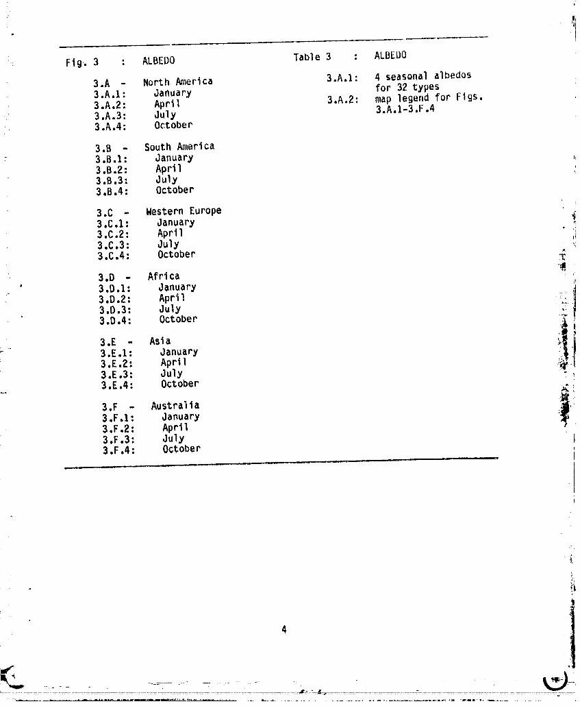
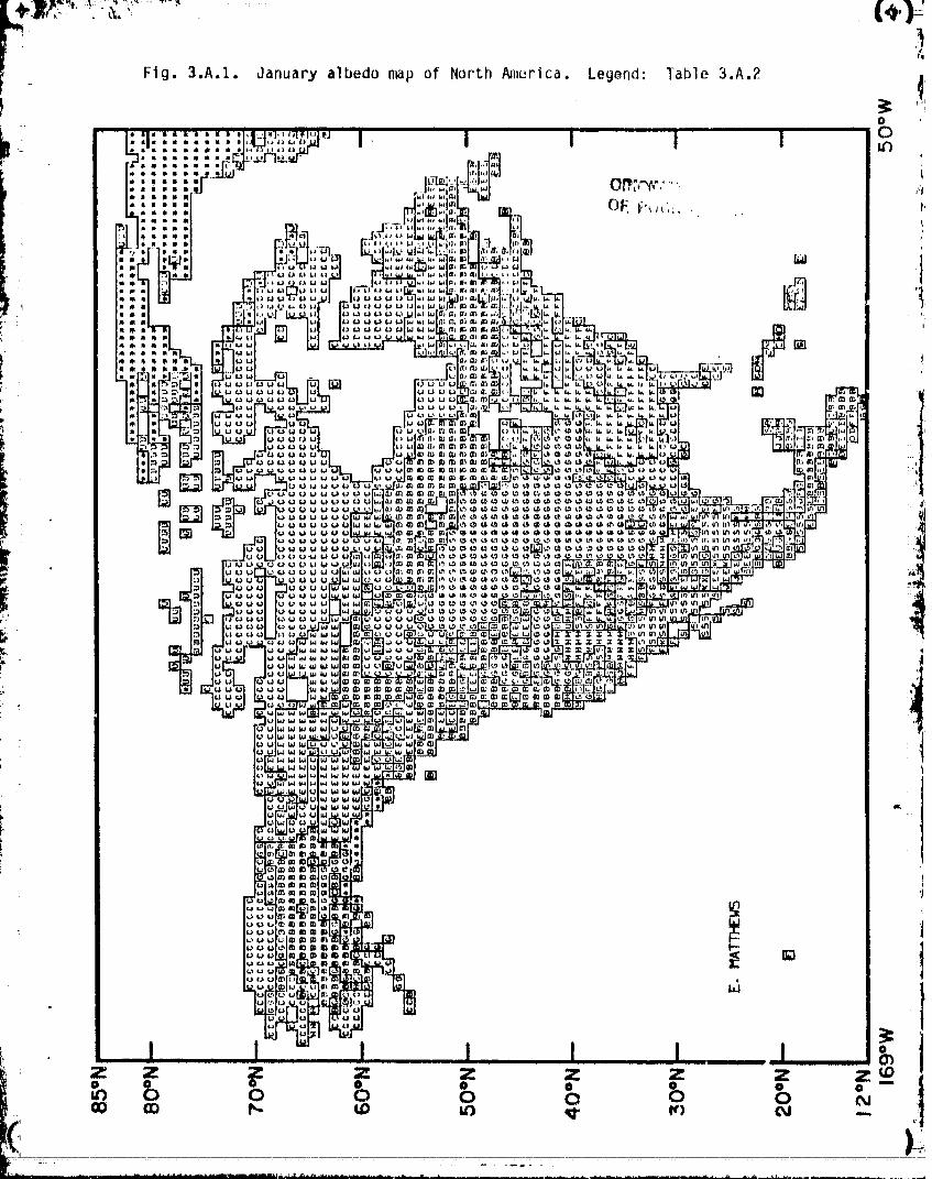
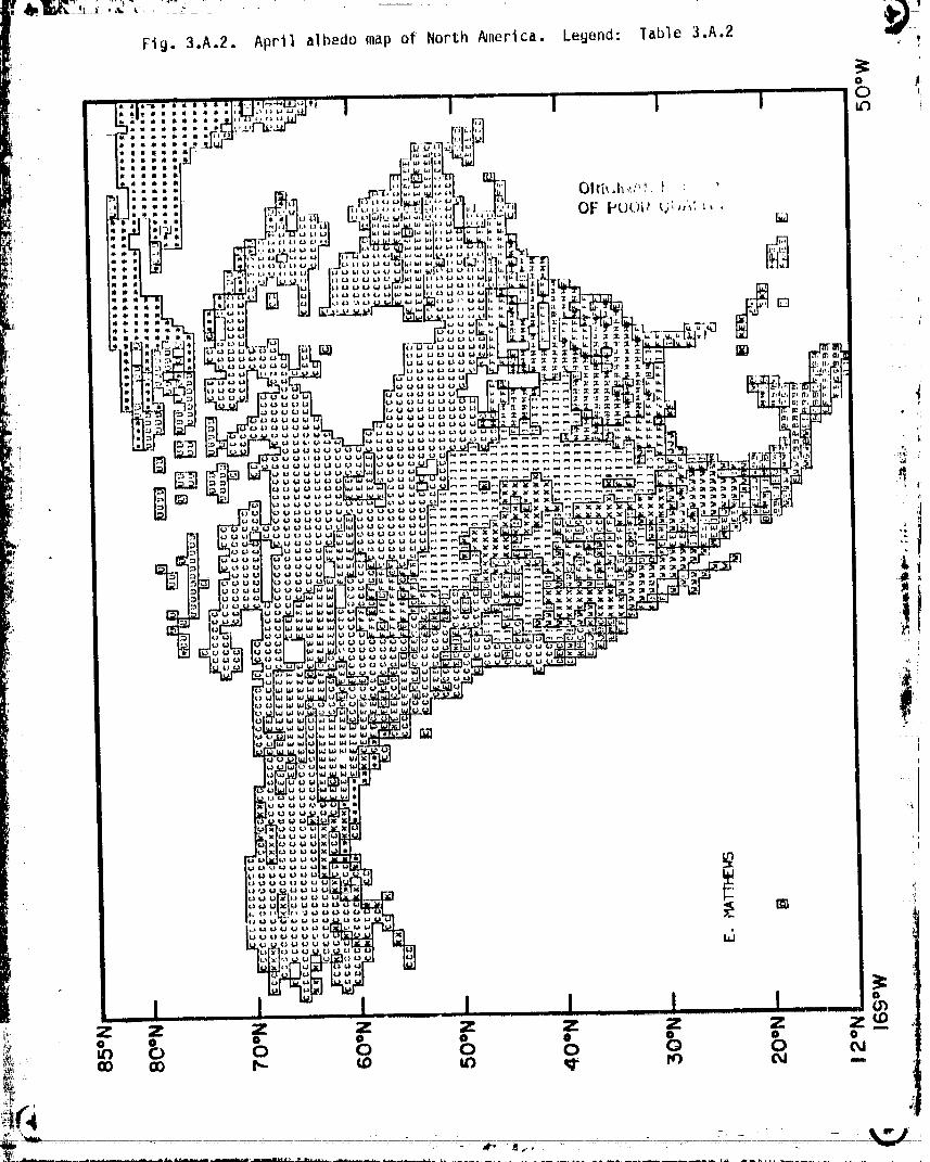
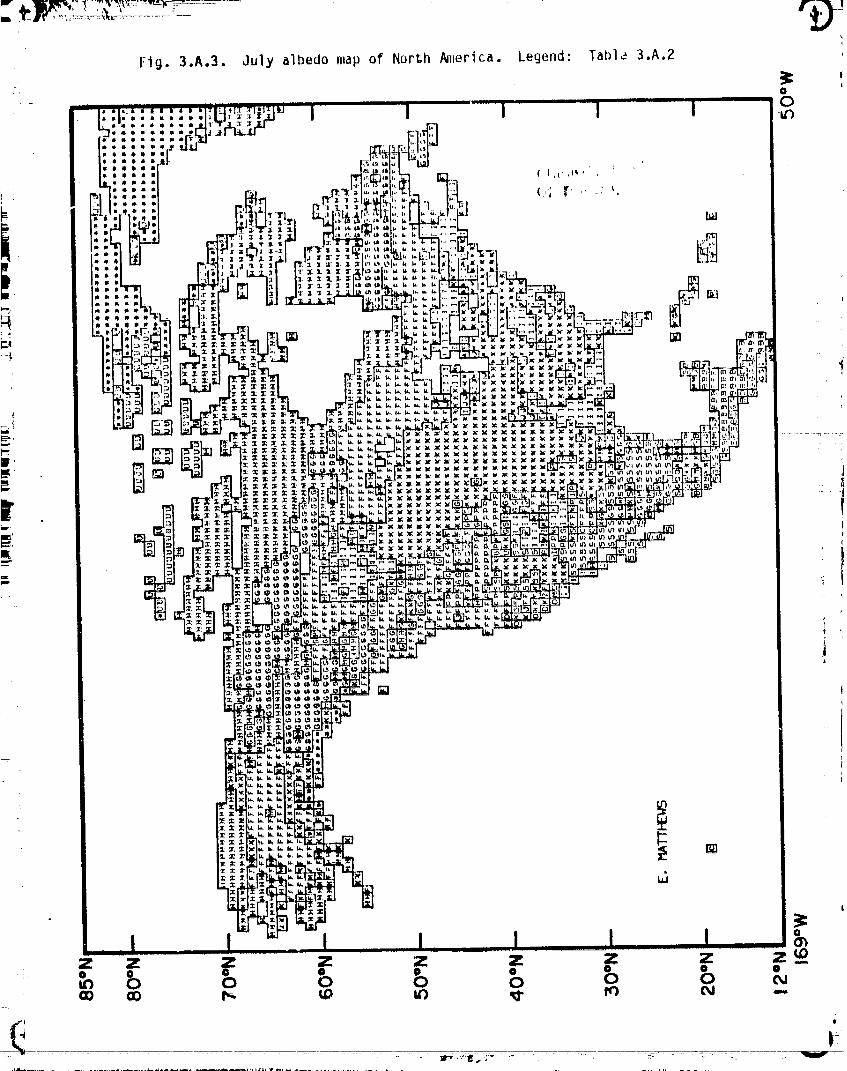
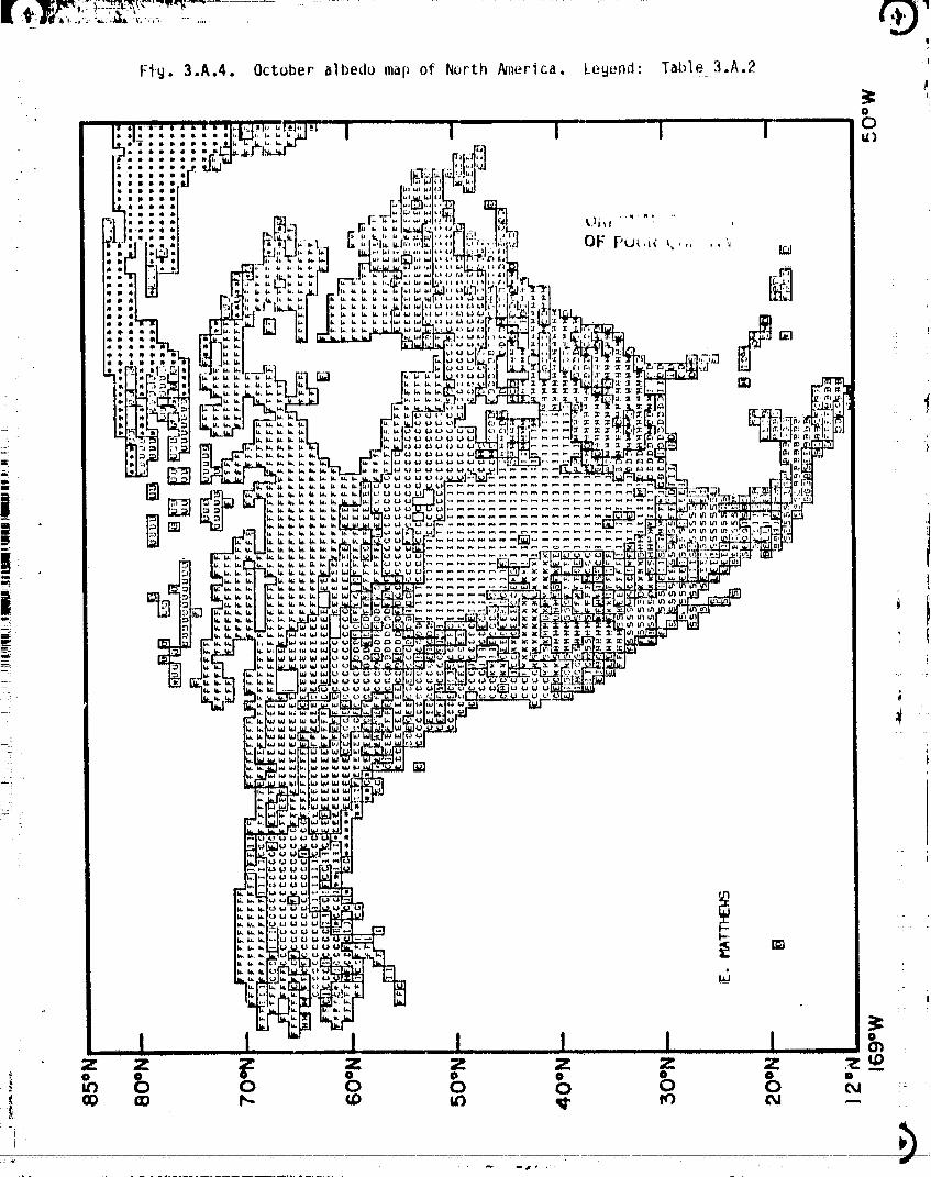
Fig-.3 : ALBEDO Table 3 : ALBEDO
3.A - North America 3.A.I: 4 seasonalalbeclos3.A,I: January for 32 types3.A.2: Aprll 3,A.2: map legendfor Figs,
_ 3.A.3: July 3.A.I-3,F,4• 3,A.4: October
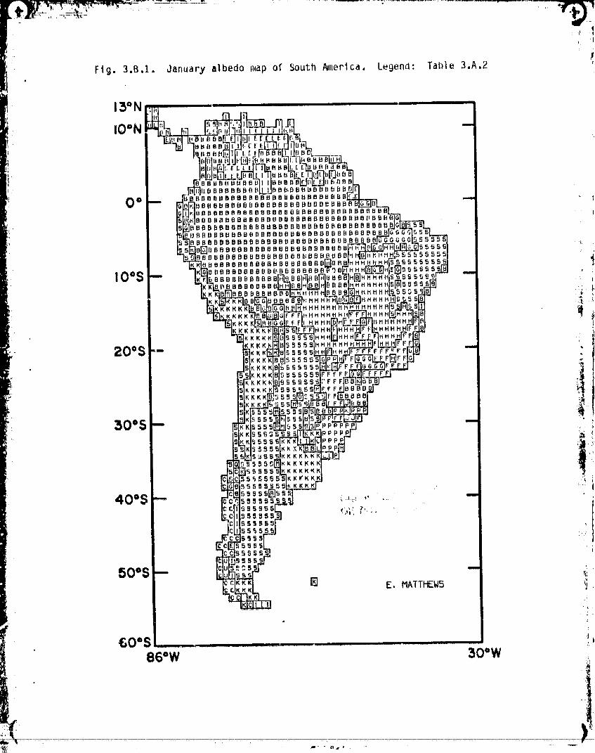
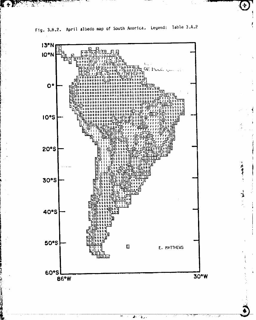
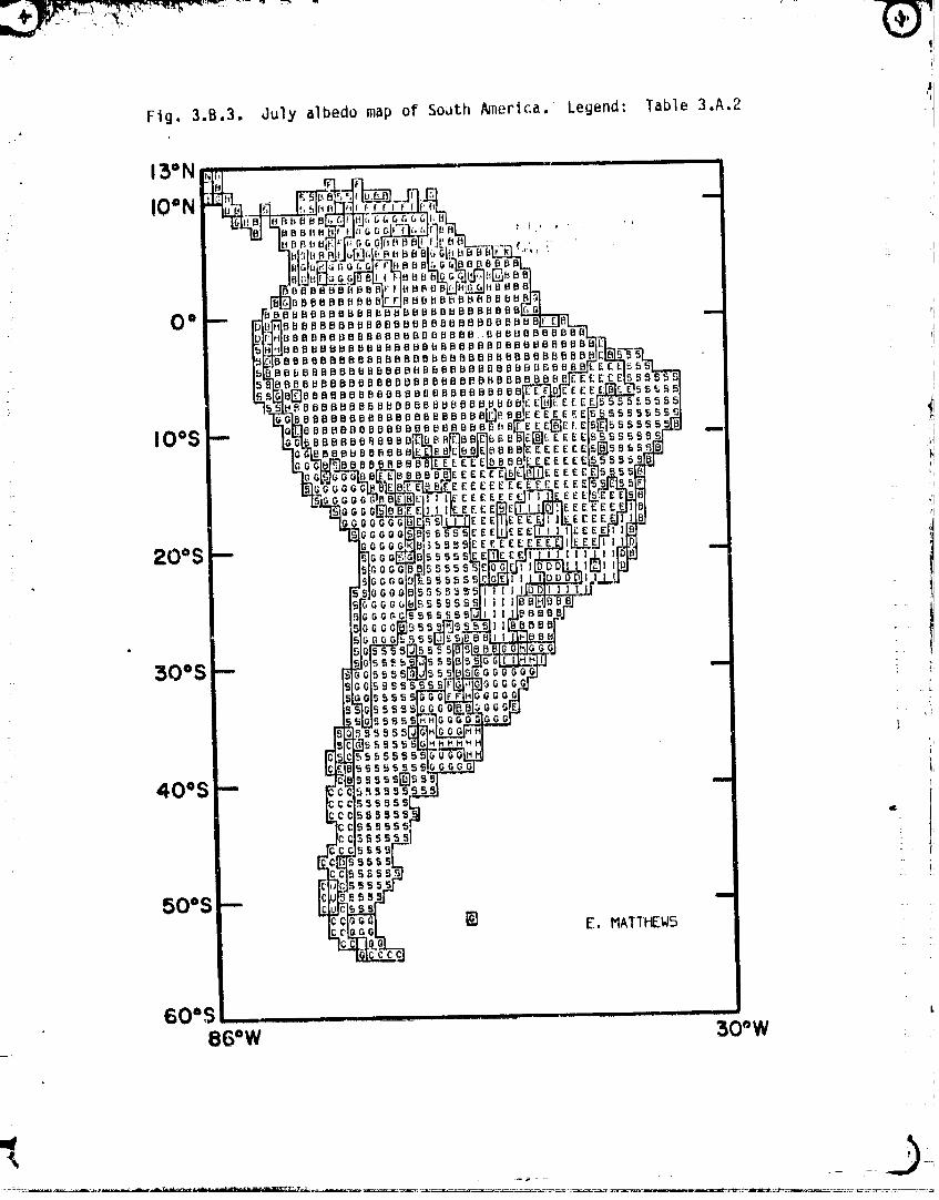
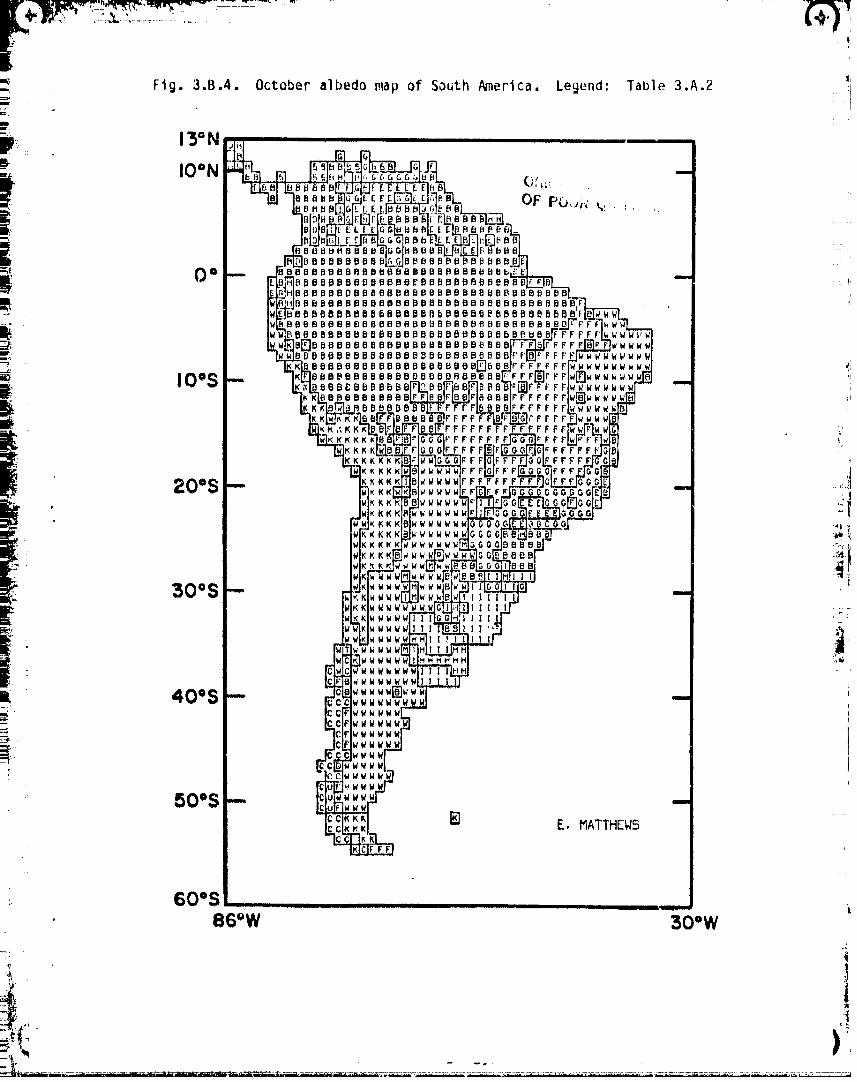
3.B - South America3.B.I: January3,B,2: Apri13.B,3: July3,B,4: October
3,C - WesternEurope3,C,I: January3.C,2: April3,C,3: July3,C,4: October
r6• 3,D - Africa .._
,. 3.D.1: January3.D.2: April3.D.3: July ii_3.D.4: October .!
3.E - Asia ,Jr" 3.E.I: January
3,E,2: ApriI3.E,3: July
_ 3,E,4: October
3,F - Austraila .._
3,F,1: January I'3.F.2: April3,F.3: July3,F,4: October
-__.,q __JL. __ 1111 i u
r°
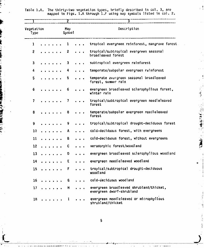
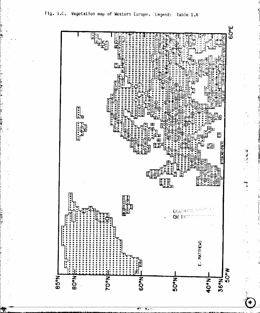
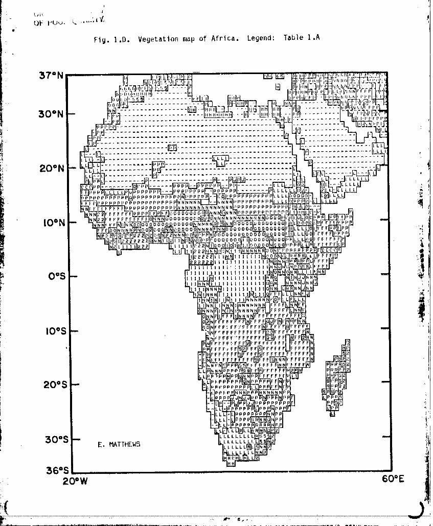
Table I.A. The thirty-twovegetationtypes, brieflydescribedin col, 3, aremapped in Figs. I,A throughI.F using map symbolslisted in col. 2.
I 2 3
Vegetation Map DescriptionType Symbol
i I ...... I . . . tropicalevergreenrainforest,mangrove forest .2 , ..... 2 . . . tropical/subtropicalevergreenseasonal
broadleavedforest3 ...... 3 . . . subtropicalevergreenrainforest
4 .... . . 4 . . . temperate/subpolarevergreenrainforest
Z 5 . . . . . . 5 . . . temperateevurgreenseasonalbroadleaved_. forest,summer rain
6 . . . . . . 6 . . . evergreenbroadleavedsclerophyllousforest, ;winter rain ,,_
. 7 . . . . . . 7 . . . tropical/subtropicalevergreenneedleleaved :_forest
8 , , , . . . 8 . . . temperate/subpolarevergreenneedlelea.ved _iforest _wTi
i
_:,, 9 ...... g . . . tropical/subtropicaldrought-deciduousforest
_. 10 .... . . A . . . cold-deciduousforest,with evergreens-t.,_
11 , , , , . . B . . , cold-deciduousforest,withoutevergreens ,_.
12 . . . . . . C . . . xeromorphicforest/woodland ,..
13 . , . . . . D . . . evergreenbroadleavedsclerophyllouswoodland
14 . . . . . . E . . . evergreenneedleleavedwoodland
15 . . . . . . F . . . tropical/s_btropicaldrought-deciduouswoodland
16 . . . . . . G . . . cold-deciduouswoodland
17 . . . . o ° H . . . evergreenbroadleavedshrubland/thicket,evergreendwarf-shrubland
18 , . . . . . I . , . evergreenneedleleavedor microphyllus
shrubland/thicket ,_I
5
L _)
00000001-TSA07
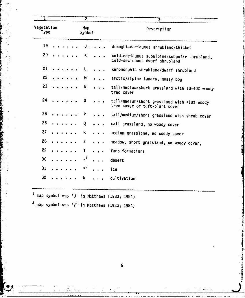
I" t 2 3I _ " Vegetat i on Map Descri pti on ..iI'
Type Symbol
.-" 19 ..... , J • . , , drought-deciduous shrubland/thlcket
ii _20 , ..... K . , , cold-declduous subalpine/subpolar shrubland,
' cold-deciduous dwarf shrubland
I_ _ 21 . . , , , , L . . o xeromorphicshrubland/dwarfshrubland i
22 , . , . , , M . , . arctlc/alpinetundra,mossy bog I
i 'i!
:.._ 23 , , . , , . N , , , tall/medium/shortgrasslandwith i0-40%woodytree cover .....................
24 , . , , . , 0 , , , tall/meolum/shortgrasslandwith <10% woodytree cover or tuft-plantcover
25 . , , , . , P , , , tall/medium/shortgrasslandwith shrub cover
26 . , . , . , Q . , . tall grassland,no woody cover
27 . . . , , . R , , . medium grassland,no woody cover ;i
.. 28 . , . , , . S . , . meadow,short grassland,no woody cover,
29 , , . , , . T . , . forb formations
_;_ 30 . . , , , , .z . , . desert
31 ,2 ice- eeoeoe $$0
32 . . . . . . W . . . cultivation
! z map symbolwa_ 'U' in Matthews (1983;Ig84)t
inapsymbolwas 'V' in Matthews (1983;1984)
6
i
00000001-TSA08
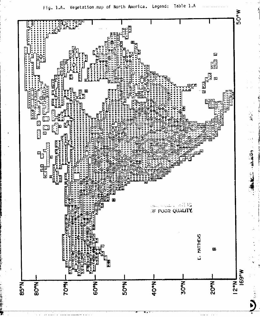
Fig. I.A. Vegetation-map of North _lerica. Legend: Table I.A ..................
..... _, _._,,, I I I I Immmm_
mB _lBS •mS
, : : r, • ,_ _.
m m mI l_I [
_mm
'iFPOOR _UALiT_
0
Z Z __ z z _ z z z F . o-
/
J ......__ a ".
00000001-TSA09
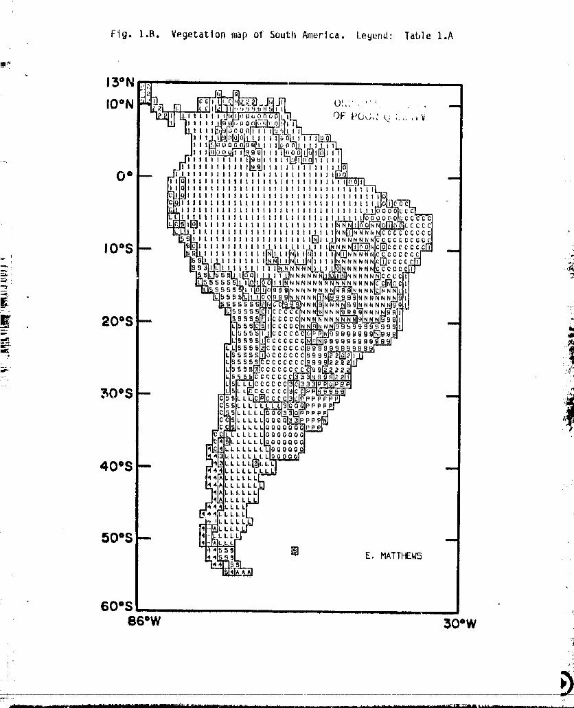
Fig. I.B. Vegetation map of South i_+lerica.Legend: Table I.A
60°S ......................860W 30"W
O0000001-TSAIO
I
.I
OF I'Uu, _ •.... .1t,I
Fig. I.D. Vegatatl.onmap af Africa, Legend: Table I.A
"___..."................................................................20=W 60°E
.........................bd66d60_-TsA_2

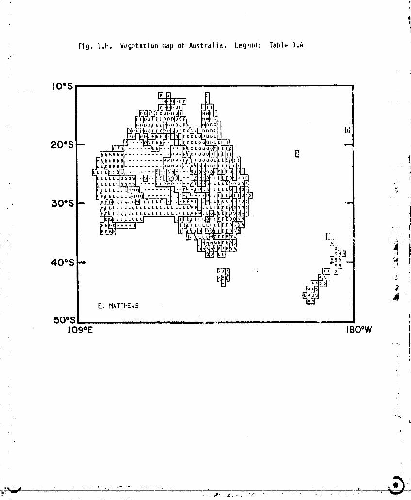
Flg. 1.t:. Vegetation map of Au._tr_ll_. Legend: Table 1.A
IO°S ....
L
00000001-TSA14
Bglh I
!
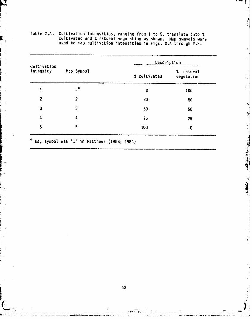
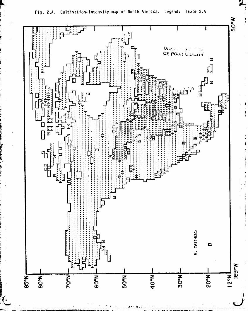
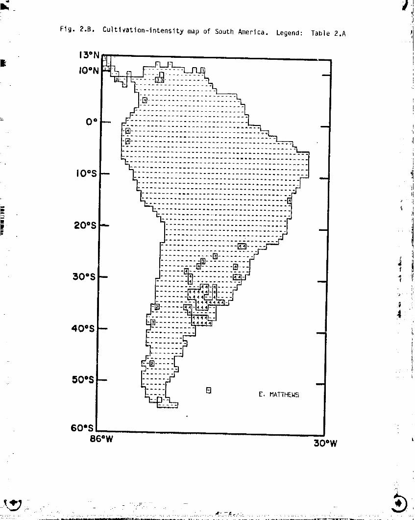
Table 2.A. Cultivationintensities,rangingfrom I to 5, translateinto %cultivatedand % naturalvegetationas shown. Map symbolswereused to map cultivationintensitiesin Figs. 2.A through2.F.
DescriptionCultivation
Intensity Map Symbol % natural I
% cultivated vegetation _
_ - 0 100 j
2 2 20 80
3 3 50 50 '
4 4 75 25t
5 5 100 0I
* mak symbol was 1 in Matthews {1983; 1984)
r- ii],
t13
)
00000001-TSB01
I
Fig. 2.A. Cultivati0n-intensitymap of North _lerica. Legend: Table 2.A
- 00
II ,,° _II I #
i III!I
)' , O_ POOi( _tJ,.._i;7II t
li I []
ltli II
Iltl li
I '". 11 II
, Q ,t )
I OII | I I
D [] m
,, _II :
II o t t!I I I I I
Ii ii i,.
i I ____
I i I I "t
,,, ' 'N', tll I It I I
II Ill II III
II IlillII lilill
ltl llli Illil_ i
ltil Ill
l :'l
'I
i 'IIIII|IIt)II
II
"I I I
I )I I
I i illi I I
oI i
t Itillltlilli
li ii, i |
z z z z z z z z z_O O O O O • O • O
0 0 0 0 0 0 0
i
00000001-TSB02
-i
il,
Fig. 2.B. Cultivation-intensity map of South N1_erica. Legend: Tab|e 2.A
13=N
IO°N ........
e_m
iO=S .......................................--
0
| 20°S ............................. __
" 30°S 11ZZZ:.I _Z:Z
40oS --
I
i.2
50=S --"" [] E. HATTHEW5
60=S86=W 30"W
................ -'_'--_'" O0000001-TSB03
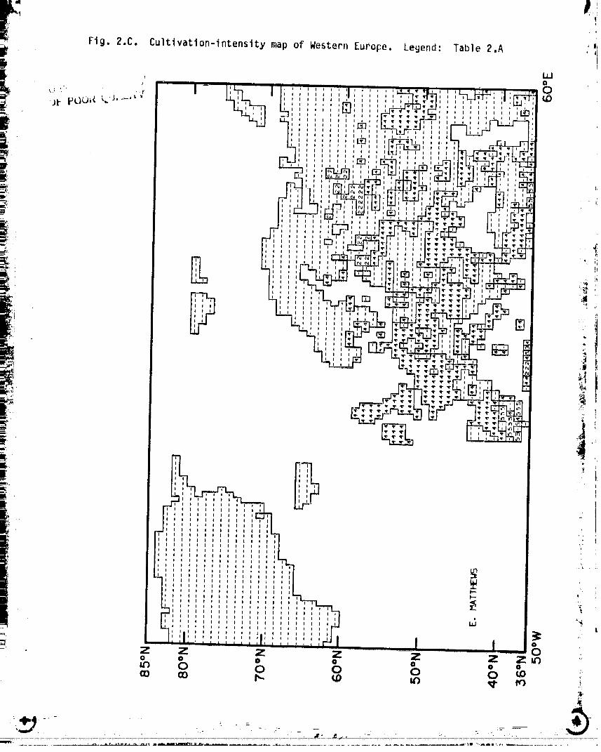
Fi Fig. 2.C. Cultivation-intensitymap of WesterllEurope. Legend: Table 2.A
.f 0
' ';'.' " 'i i i *d ',Ii._ll I I J I
i
Jt pO0_l _- , , ;[] ,,, ........tllllllll_+ ,' ; N ,,
i @ ' .... ,'I • q l !
- tIll I I
_, II li
I I I_1
_" I IllI
1 ,_ ,I l
II '
,i_ _r_
It
*" i li
2 I lii
I ti
II Illllllll• li illllillll
ii iiiitillli
II lilillliiliII tililtlllll
II Ilillllltil 'iII liiillllill
II itlllllillllII Iilillllllllt
II llllltlllilll wII Illllllillitl _ ,
li IIIIIIIliltll _ 1II IIIllltlillllII lilllltlliilli _
tl Iltlillltllilil _ t
_l__ll lililtllillltlllll
It Illlllllllillllllli _ '*+_II illllllliiltl|lllil Llillttllilitliiillilil
= IIIltllllltllllllllll 0
_: Z Z Z Z Z Z Z0 0 0 0 0 0 0
O 0 0 0 0 _ :,+
• - • - - :- . -- • 7+
- - " - ++ i:+:+_ ' "+'. ..... " • :+• 7-_:=+:_:.m......... +:-..... --:+-++_-+
O0000001-TSB04
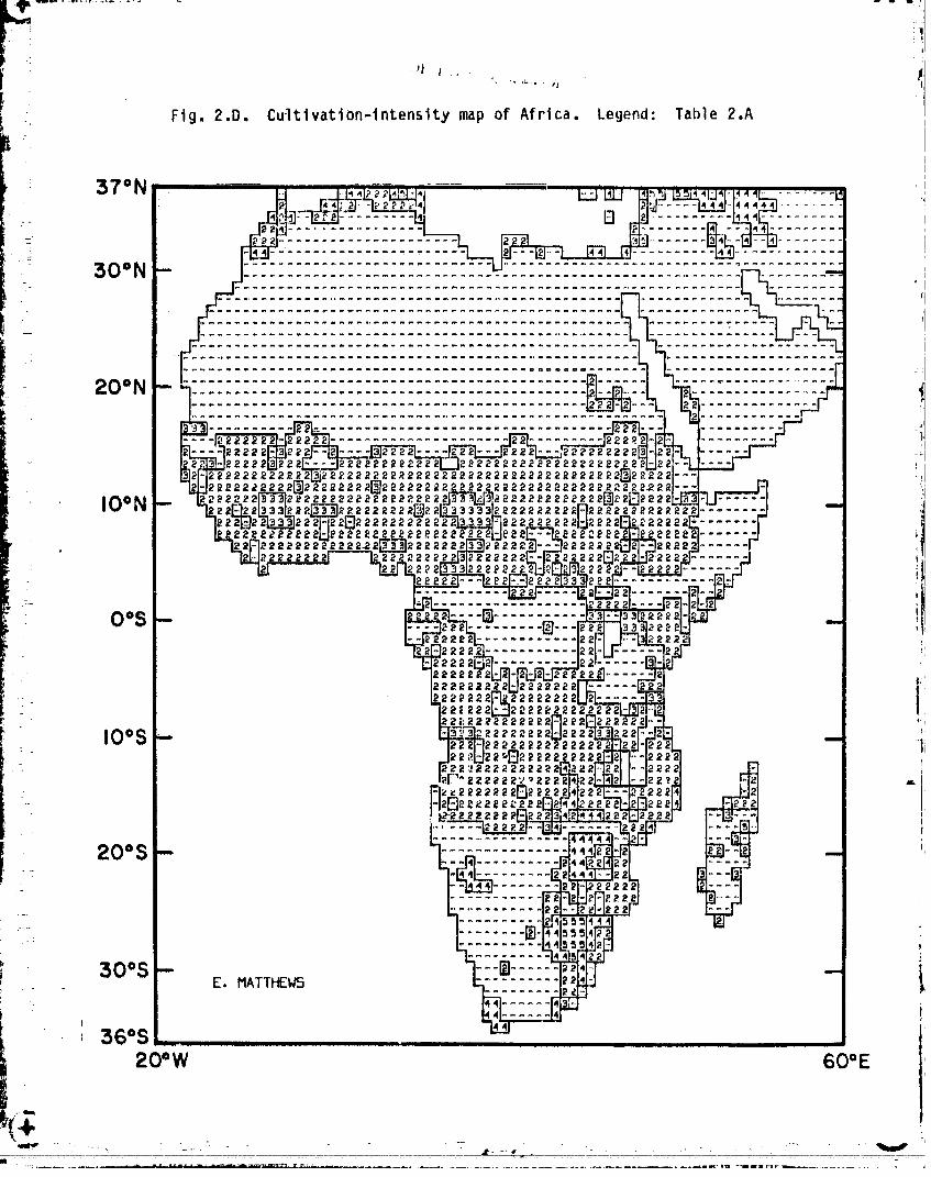
. Flg. 2.D. Cultlvation-intensitymap of Africa. Legend: Table 2.A
36=S20=W 60OE
T.it
O0000001-TSB05
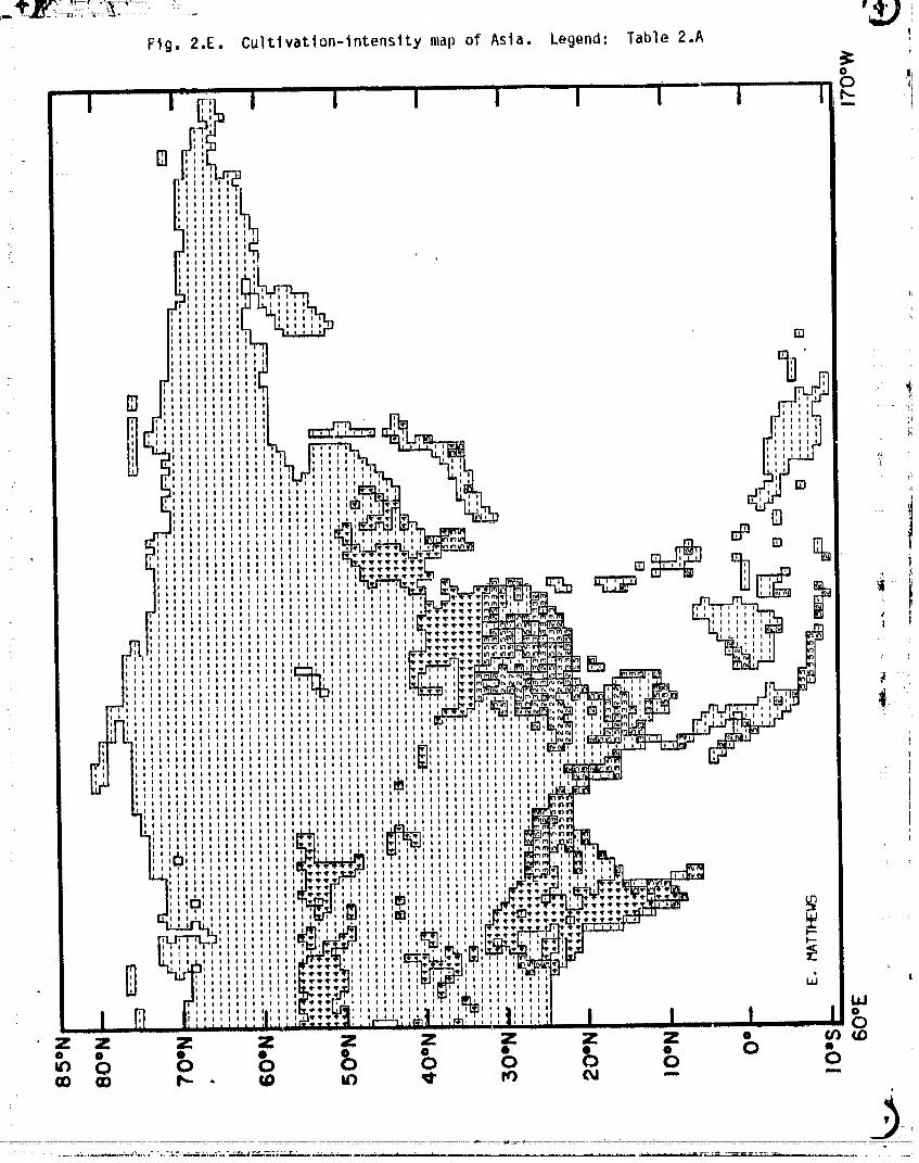
Fig. 2,E. Cultlvatlon-intensitymap of Asia. Legend: Table 2.A
0" iimm -- .l_I ! IU In.
i _ J J I 'l"' I i J I °
ii]
!
:__ :) 1
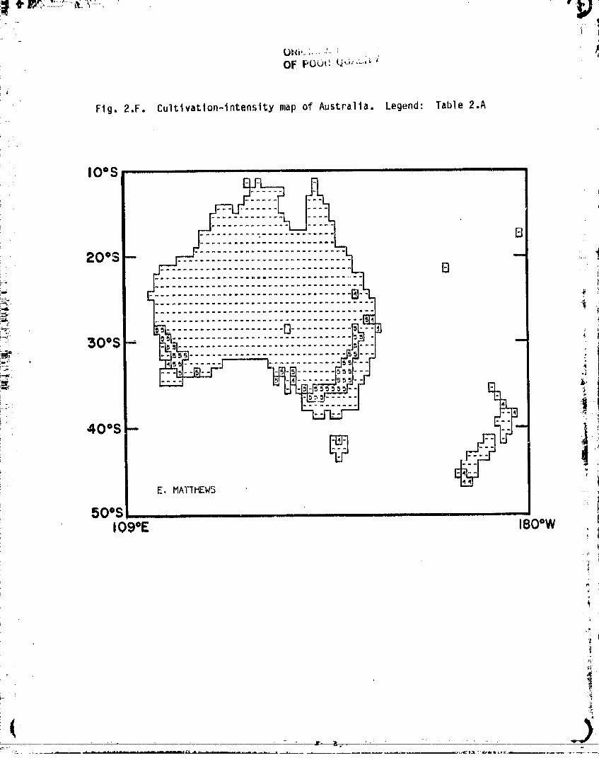
Fig. 2.F. Cultivation-intensitymap of Australia. Legend: Table 2.A
IOoS ..... ,,[
,
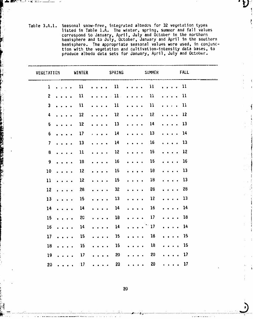
3.A.I. Seasonalsnow-free,integratedalbedesfor 32 vegetationtypeslisted in Table I.A. The winter, spring,su_ne_rand fall values
correspondto.January,April,July and Octoberin the northernhemisphereand to July, October,Januaryand April in the southernhemisphere. The appropriateseasonalvalueswere used, in conjunc-tion with the vegetationand cultlvation-intensitydata bases, toproducealbedo data sets for January,April,July and October.
3 . . . . 11 . . . . 11 . . • • 11 . . . . 11
4 12 12 12 12O000 OeO0 OlOO llOO _1
5 . . . . 12 , . . . 13 .... 14 . . . . 13 " ;'
6 , , . . 17 , . . . 14 . . . . 13 . . . . 14
7 .... 13 , , . . 14 . . . . 16 , . . . 13
8 . . . , 11 . . , , 12 . , . . 15 . . . . 12
9 . . . . 18 . . . . 16 . . . . 15 . . . . 16
I0 , . . . 12 . . . . 15 . , , • 18 .... 13
11 . . . . 12 .... 15 . . . . 18 • • • . 13
12 , . . . 28 .... 32 . . . . 28 . . . . 28
13 . . . . 15 . . , . 13 . . . . 12 .... 13
14 . . . . 14 . . . . 14 . . . . 16 . . . . 14
15 . . , . 20 . . . . 18 .... 17 . . . . 18
"' 1416 . . . . 14 . . . . 14 . . . . 17 . . . .
17 . . . . 15 . . . . 15 . . . . 18 . , , . 15
18 . . . . 15 . . . . 15 . . . . 18 . . . , 15
19 . . . . 17 , . , . 20 , . . . 20 . . . . 17
20 . , . , 17 . . . . 20 . . , . 20 • . , . 17 : !L
00000001-TSB08
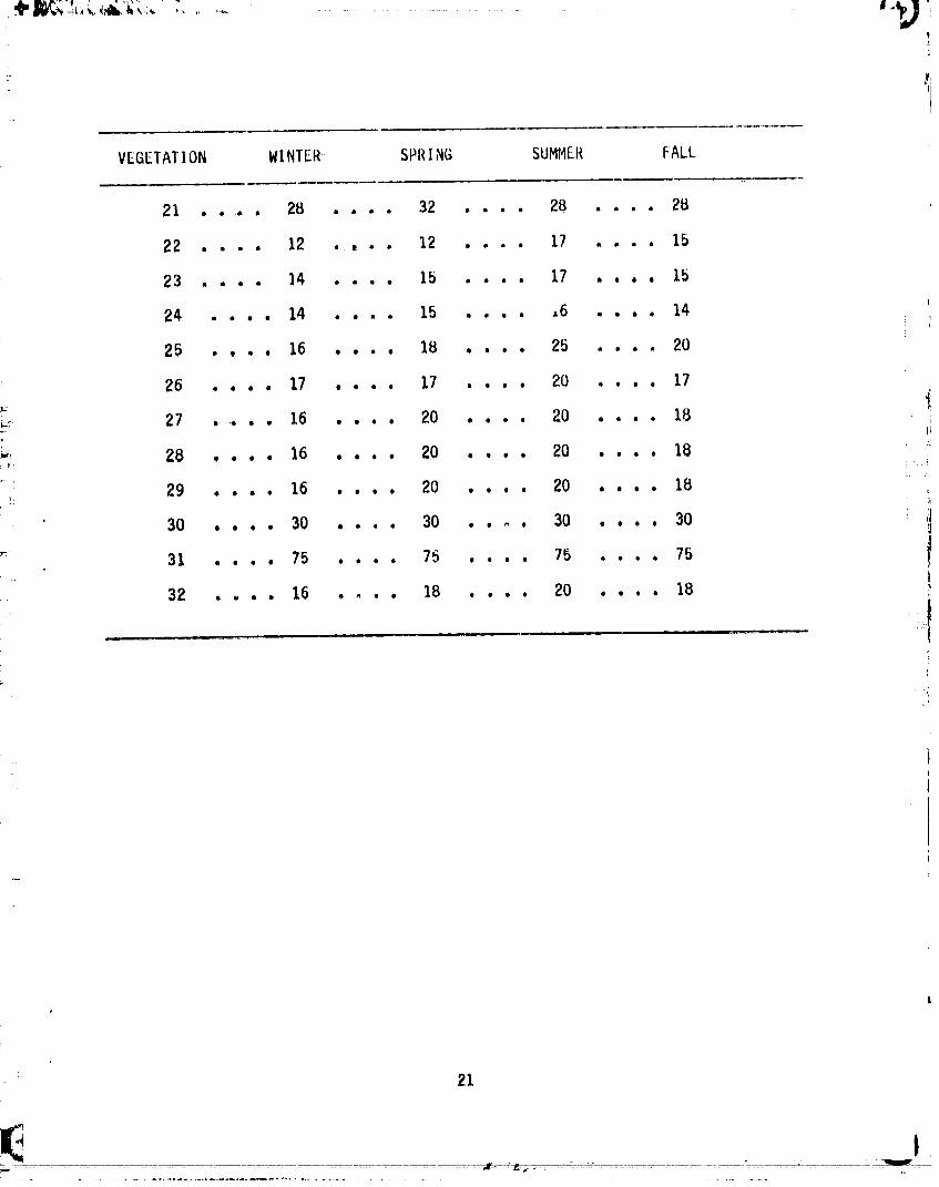
VEGETATION WINTER SPRING SUMMER FALL
21 ..... , 28 .... 32 .... 28 .... 28
22 .... 12 , . . . 12 . , . . 17 . . . , 15
23 , . . . 14 . , . . 15 .... 17 ,., ° , 15
24 , , , . 14 .... 15 . . , . ,6 . , , , 14
25 . , , , 16 , , . , 18 , . , , 25 . , , . 20
26 . , . , 17 , . , , 17 . , , , 20 . . , , 17
18_ 27 • • 16 , , . , 20 . , . , 20 " " " ' iI
•", 28 , , , , ],6 , , , , 20 , , , . 20 . . . , 18
29 . . . . 16 , , . . 20 , . , . 20 , . . . ],8 .', )q
30 . . . , 30 . . . . 30 , , _ , 30 , . , . 30
31 . , , , 75 , . . , 75 , . , , 75 . . . . 75
3;, .... 16 .,.. ].S.... ZO .... ],S Ii
}
:' 21
- h_ ..¢___,: - - __:____
00000001-TSB09
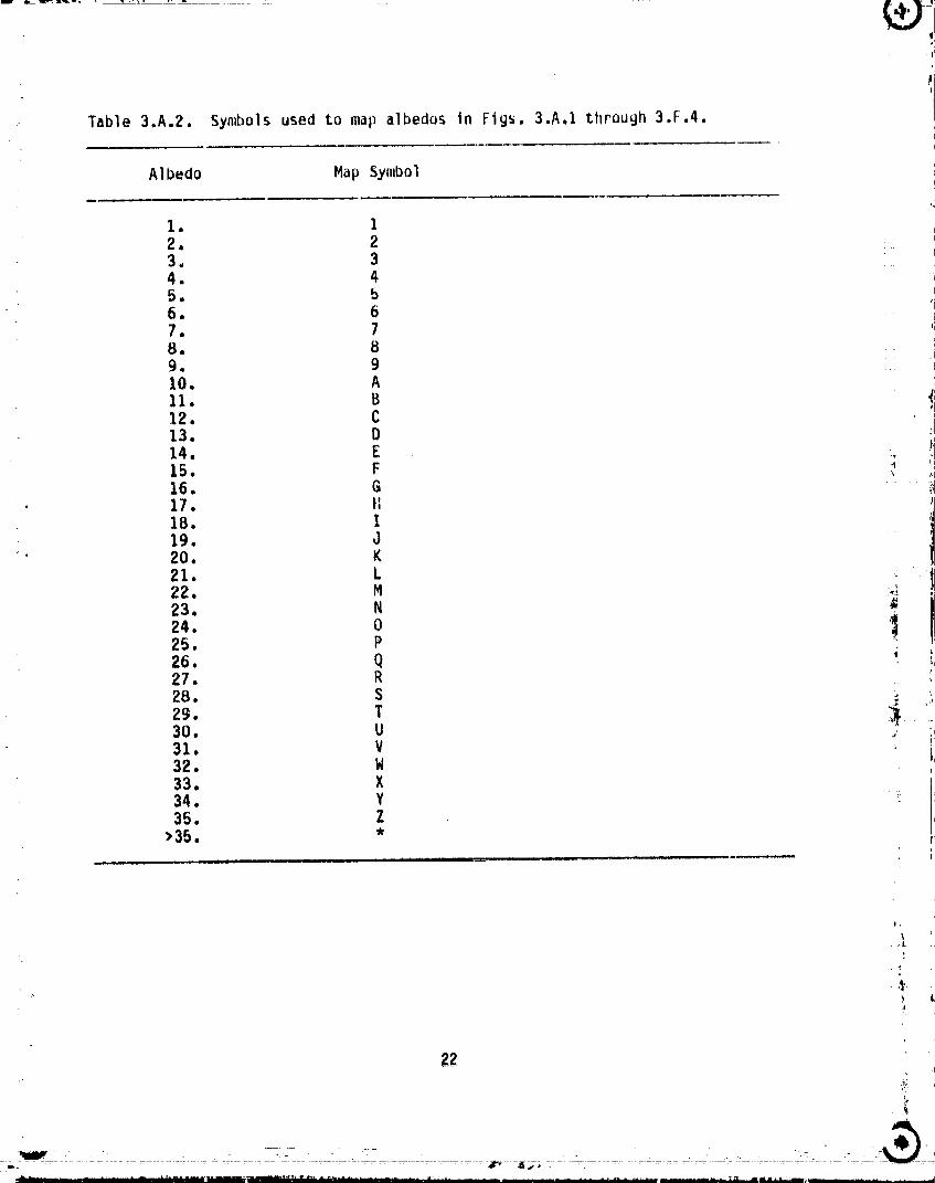
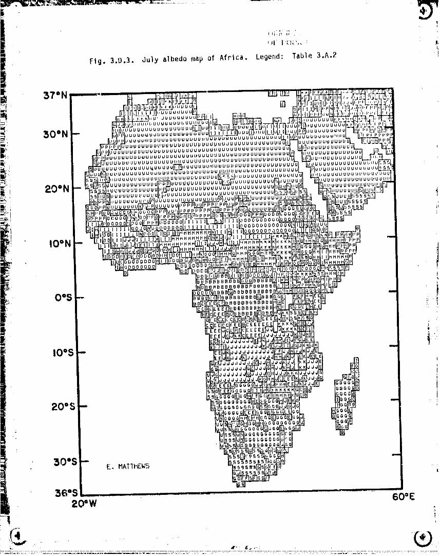
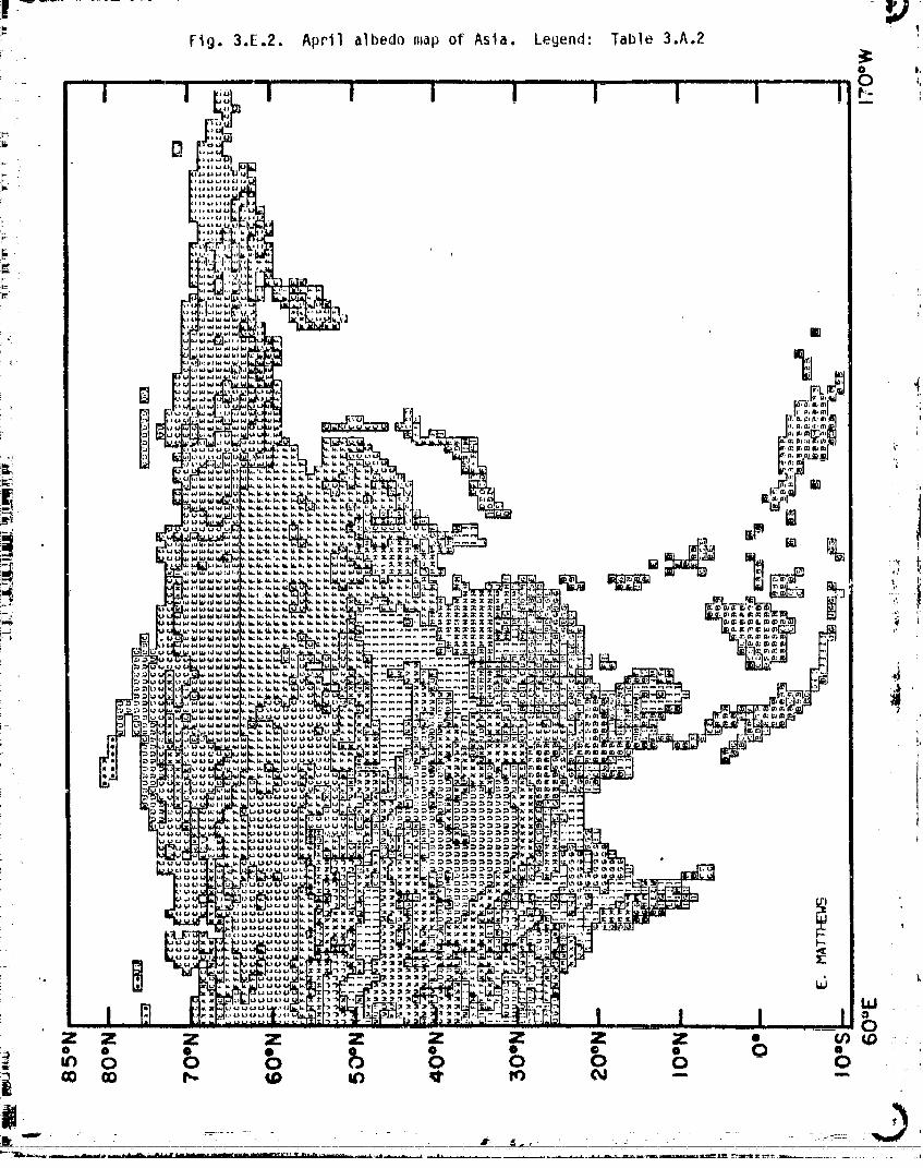
Table 3.A.2. Symbols used to map albedos in Figs. 3.A.! through 3.F.4.
A1bedo Map Symbol
1. I2. 23,, 34. 45. ,56. 67. 78. 89. 9I0. A
11. B t
12 c ;i13. D IJ
14• E ._ il15• F "_ "16. G17. tI18. I19. J
' 20. K21. L ....i ..22. M '<,4r,_
23. N i24. 0 '_25. P26. Q27. R28. S ;,_
29. T _,30. U .,31. V32, W33, X34. Y _35. Z
>35, *
,t
g2I
}2
'* i "' .... _"11 .... ------'+" " _ ......... r i1 ii i i ....................... l_ i .... i ifri i i
O0000001-TSBIO
it,
I .I............ I.... _,,I....,_ _.! ,,I , -._i: Z - z ......z - z ...... z_ z z ....... z ..........z ___,_:_ 0 0 0 0 • 0 0 0
b o o o o o o
bo]36o-6(31LTS;R 1p
I
O
z z z z z z F z z_OO • @ @ • • "--o o 0 0 o o 0
- C)O000001-TSB13
- -.,,._
00000001-TSC01
555555E .....'555555 =.
40oS __ +_-__N_._
50o$--[] E. HATTHEW5
,+_ 60os +i! 860W 30°W +
.-.-................................................ ,:
= - aT'-e,,,, -- _:_":-----":.__::?2_:._+ ........-_-"
00000001-TSC02
60"S ............... _............................... ,.86"W 30"W :
00000001-TSC03
50"S --E. MATTHEW5
60"S .86°W 30"W
_FI, .__.... ___.....),
00000001-T$C04
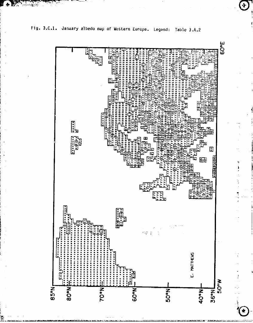
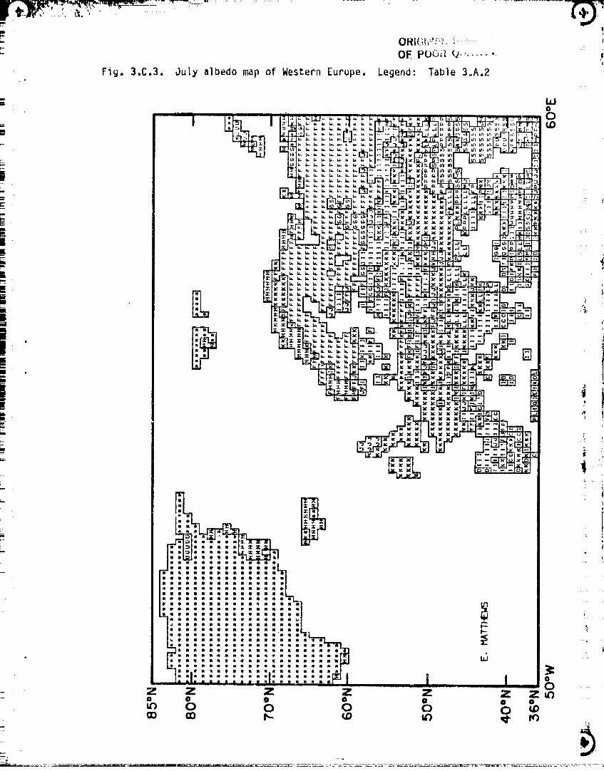
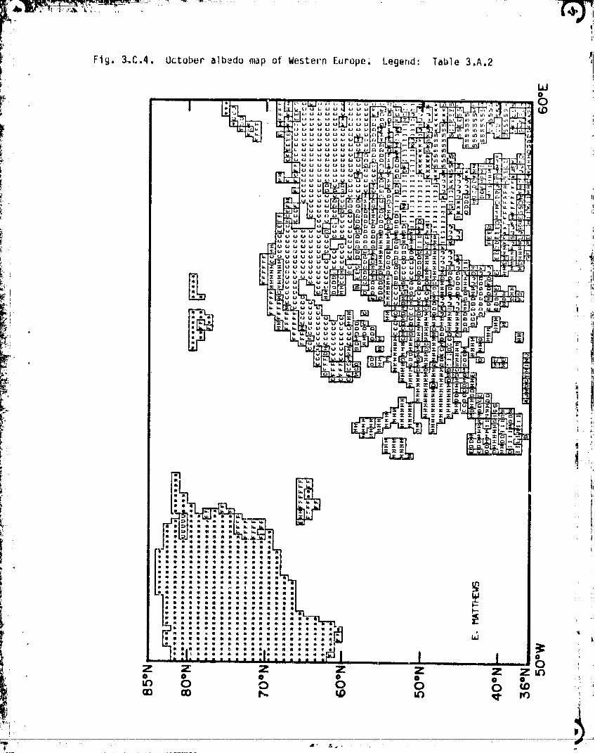
Fig. 3.C.I, January albedo map of Western Europe. Legend: Table 3,A.2
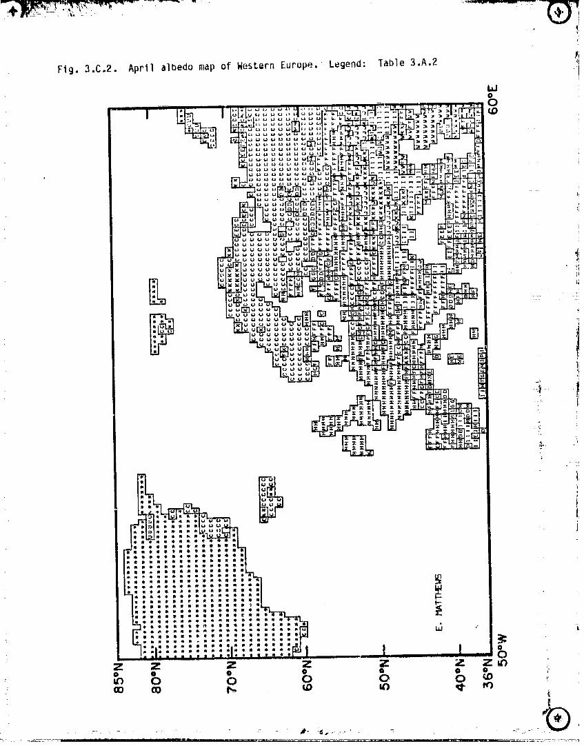
Fig. 3.C.2. April albedo map of Western Europe. Legend: Table 3.A.2
!
OF(ICI;_;/'_,Lf' "
OF.POOR¢_.u;.,;i, '; ._
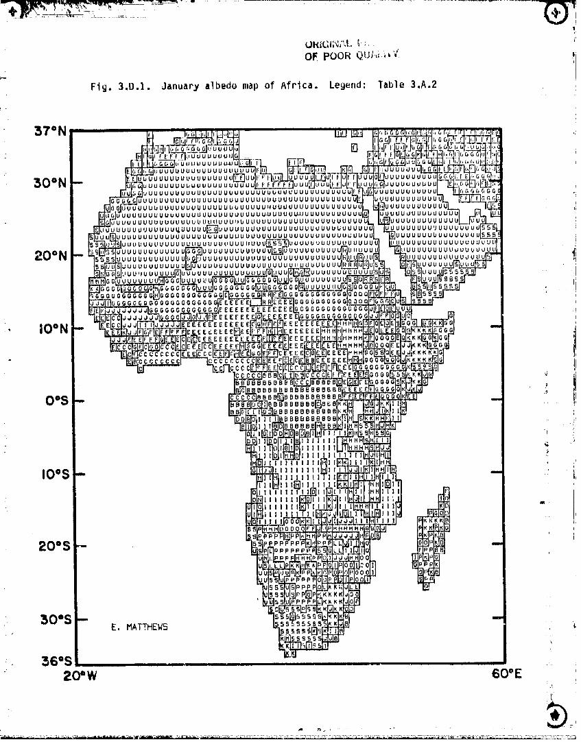
Fig. 3.D.I. January albedo map of Africa, Legend: Table 3oA.2
37 =N _,"_ ,_r_[] I_I_ _ ,IG(, blL,u UI,,I.@.,(
_uuuuuuuuuuuuuuu_Juu uuuuuu _'l_,r]_,'_UUUUUUUUUUUUUUUU_UU UUUUUUUUUlG _'i.I EJ_GG_',)_'_
UUUUUUUUUUUUUUUUUUUUUUUUUUUUUUUUUUUUUU; uUUUUUUUUUUUL. "-_(,GG G G GGUUUUUUUUUUUUUUUUUUUUUUUUUUUUUUUUUUUUUUUL UUUUUUUUUU_ _GG
UUUUUUUUUUUUUUUUUUUUUUUUUUHUUUUUUUUUUUUUUUUt, UUUUU UU UU UU'L._ _JUUUUUUUUUUUUUUUUUUUUUUUUUUU-UUUUU_U UUUUUUUU U_, UUU_JUUUUU_UU
UUUUUUUUUUUUUUUUUU))bUI, UUUUUUUUUUUUUUUUUUUU UUUUUUUUUUUUJUUUUUUUUUUUUU_,UUUUU_UUUUUUUUUUUUUUUUUUUUUUUUUUUU U UU U U U U'JUU U u E'O'UU5_
jUI,;UUUUUUUUUUUUUUUUU UUUUUUUUUUUUUUUU UUUU UUUL;UUU UUU UUUUUUUUUUUUU5LL_juut:UUUUUUU uuuu uuuu uUUUl_UUU_UUUU uuuuuuuuuuuu JUUUUUUUUUUUUUUUUUU
UUUUUUUUUUUU_ UUUUUUUUUUUUUUUUUUUUUUU¢ )UUUUUUUOUU__uuuuuuuuuu_ uuuuuuuuuuuuuuuuuu Juu uuu_uuu_ _'
uuuuuuu_ uuuuuuduuuuuuu _uuuuuuuuuuu ,_uu _"_ 5 _ $ ,SI " il,_uuuuuuuu Juu_ _ s sF--
GGGGGGOGGGOGGGGG E )GG(_GGGGOGJ _I,,,I_I EEEEEEEE ;GGOGGGOGGGGG
EEFEE E _OoOqO00(_O
IO_N __ _._, _EE_EEEE_EEEI_E
CCCCCCCG _KklCCCCCCCC
BBBBBBBBBBBBBBB ._
BBBBBBBB_B_IBBBBBB
IBBBBBBBBBB
Ill II III l
IOOS- , I I I 11 ' ] ,ii "IIIl),III
III
• II ! "
_6g
50o$ -E. MATTHEW5
_, _6"S ......20"W 60_E
_'_
00000001-TSC09
!
v
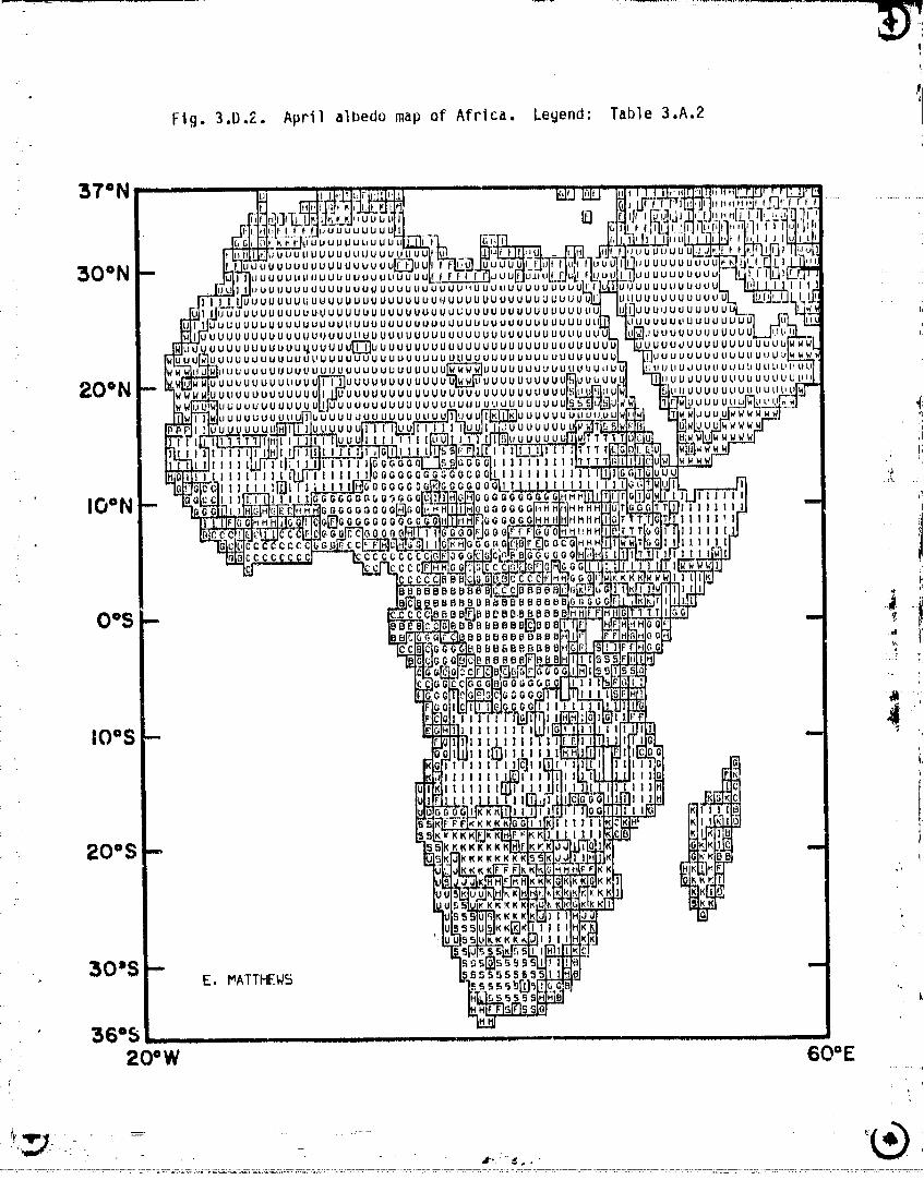
• 4Fig. 3.D.2. April albedo map of Africa. Legend: Table 3.A.2
37iN ....B
UUUUUUU il
JUUUUUULIUUUL_
,; U lJ U LI U U U U U U U U U U tJ tl U U =)U!JU&JUUL
30ON ,,o.uuuu°uuuuuu_uuuE ,.uuouuuuuLj UU U UUU i_ltU U U UUU ULIU U U U IUUUUUUU
UUUUUU UUUU tiUUUUU'lU UUUUUUUU UUUU UUUUUUUUUUUUJUUUUUU_JUUUUUUUUUUUUUUUNUUUU UUUUUUUUUUUU ULtUUUUUUUUUU
IUUUUUUUUUUUUUUUUUUUUUUUUUUUL;UUUUUUUUUUUUUUU _UUUUUUUUUUUUUUUUUUUUUUUUUUUUUUUUUUUUUUUUUUUUUUUUUUUUUUUU JUUUUUL_UUUUUUUUUUUUUUUUUUUUUUUUUtIUUUUUUUUUUUUUUUUUUUUUUUUUUUUU _'ULIUUUUUUUUUU
uU UUUUUUUUUUU_UUUUUI]_U UUUU UUUUUUUU UU UU UUUU UUUUUUUU JUUUUUUUUUUUUUUUUUUUUUUUUDUUUUUUUUUUUUUUUUUUUUUUUUUUUUUUUUUtJUUUUU_ UUUUUUUUUUUUULJV_
,)U UUUUU UUUU UU UUUUUU UU UU UUUUW_WW_UUUU ULIUU UUtIU UUiJU U tI .I UUUUUll UL_tJUUl$ UlI ltU LIUUUUUUUUUU UUUU UUUUUUUUUL_U UUUUUUUU UUUUUUUUUUUUUUU!
20°NF Jo<,o°oo°uoo°_ooouuuu°ouou°ooooou°uouu.uooouoo.oo<,<,< .i
L
JUUUUUUUUUU IV U U U UU U U U U U U U U _ U U U U Li U U U U U U U U I =
IUUUUUUUUU UUU tUUl l JUL _:
uouvuuo il; 14
l|lllillt
_GGQGG;IG0 II 1 Ilill I11Illlll II '7>
' lOON O0_(_b_'lGG 6G_GQ ":,oooo_oo_o Iilli',.
OOGGGGG i: CCCGCC ,
• i,
,BBBBBBDB_IBBBBI_BBE "_'# iBB_--JBB_ BB-BBBB B
OOS -- BBBBBBBBB[_BBE "BBUBBBBBBE ,At f _BB_BBBBBE _
glOiS -- li 11 I I I I
I III11111
lllll
200S - <_.,<,<,<,<,<,<<KKKKKK
OKKKKI
30"S -, E. MATTHEW5 ,,,
36°5 ..................20'W ................................ 60"E
t
O0000001-TSCIO
36°S , .......................................................20°W 60OE
00000001-TRKt 4
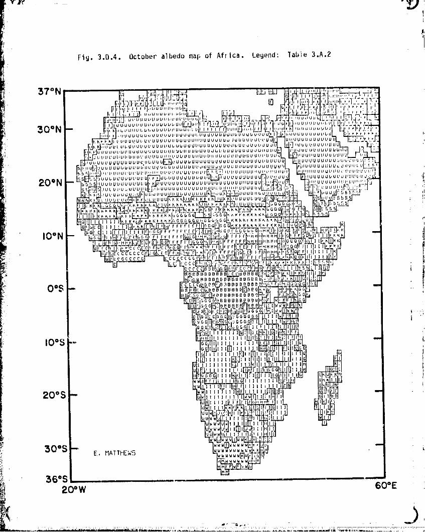
Fig. 3.D.4. October albedo ma$; of Africa. Legend: ]able 3.A.2
IO°S-.. , _,,,,,
I[ i
Illlill till _ Ill K_II_20 S_ O_ __ t I , 1 it I 1 :
f
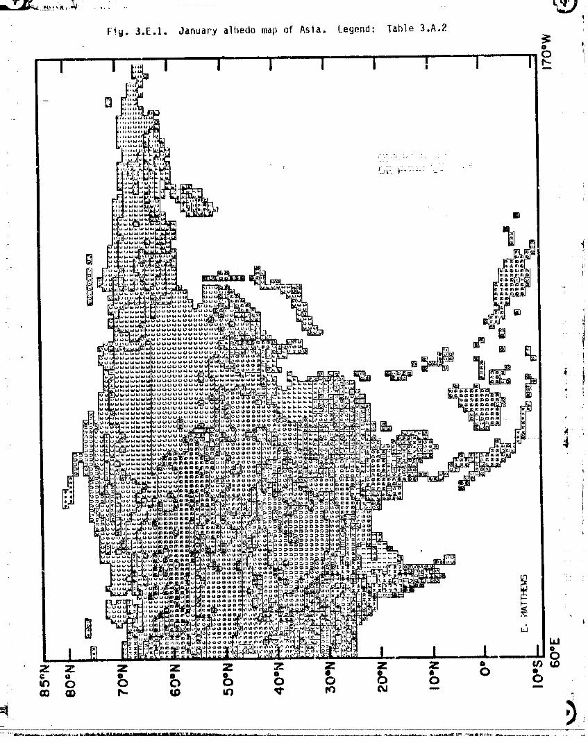
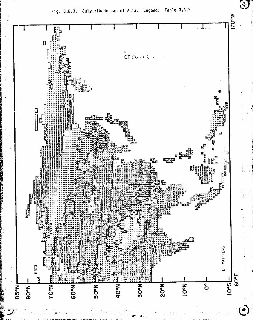
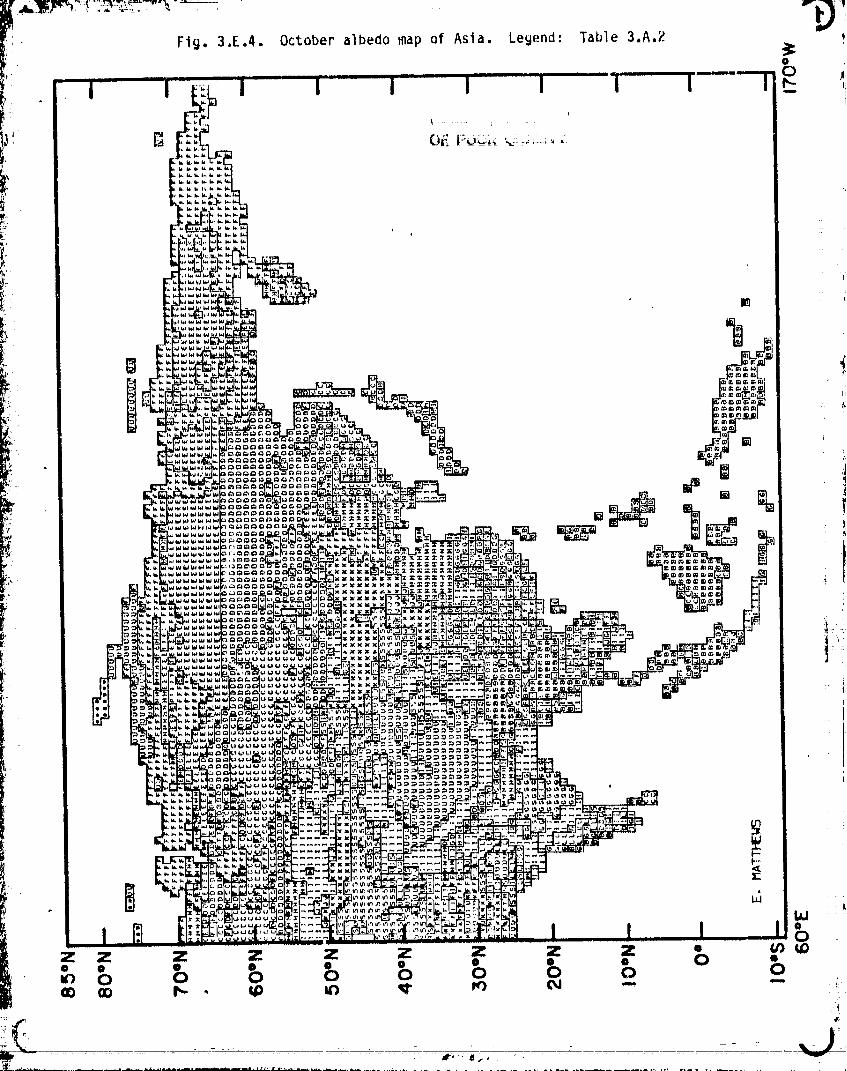
Fig. 3.E.I. January alhedo map of Asia. Legend: Table 3.A.2
@____lUll I I I I I F_ I - I II
:
00000001-TSC14
I
=.
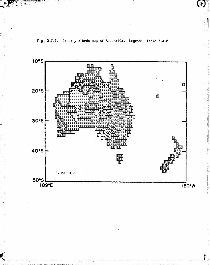
Fig. 3.F.I. January albedo map of Austral';a. Legend: Table 3.A.2
IO=S , I,IT_F I IT ......... I . I |_1 ...... ' ....
(i4II
] "
20os - _'i
I
"I
30°$ - _ t
E. MATTHEW5
50"S ........109*E 180=W
00000001-TSD03
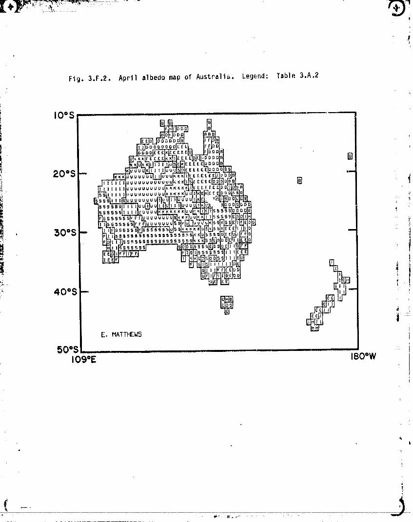
Fig. 3.F.2. April albedo map of Australia. Legend: Table 3.A.2
• l
' j00000001-TSD04
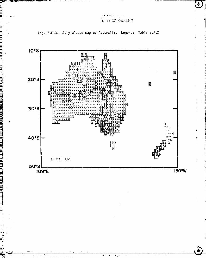
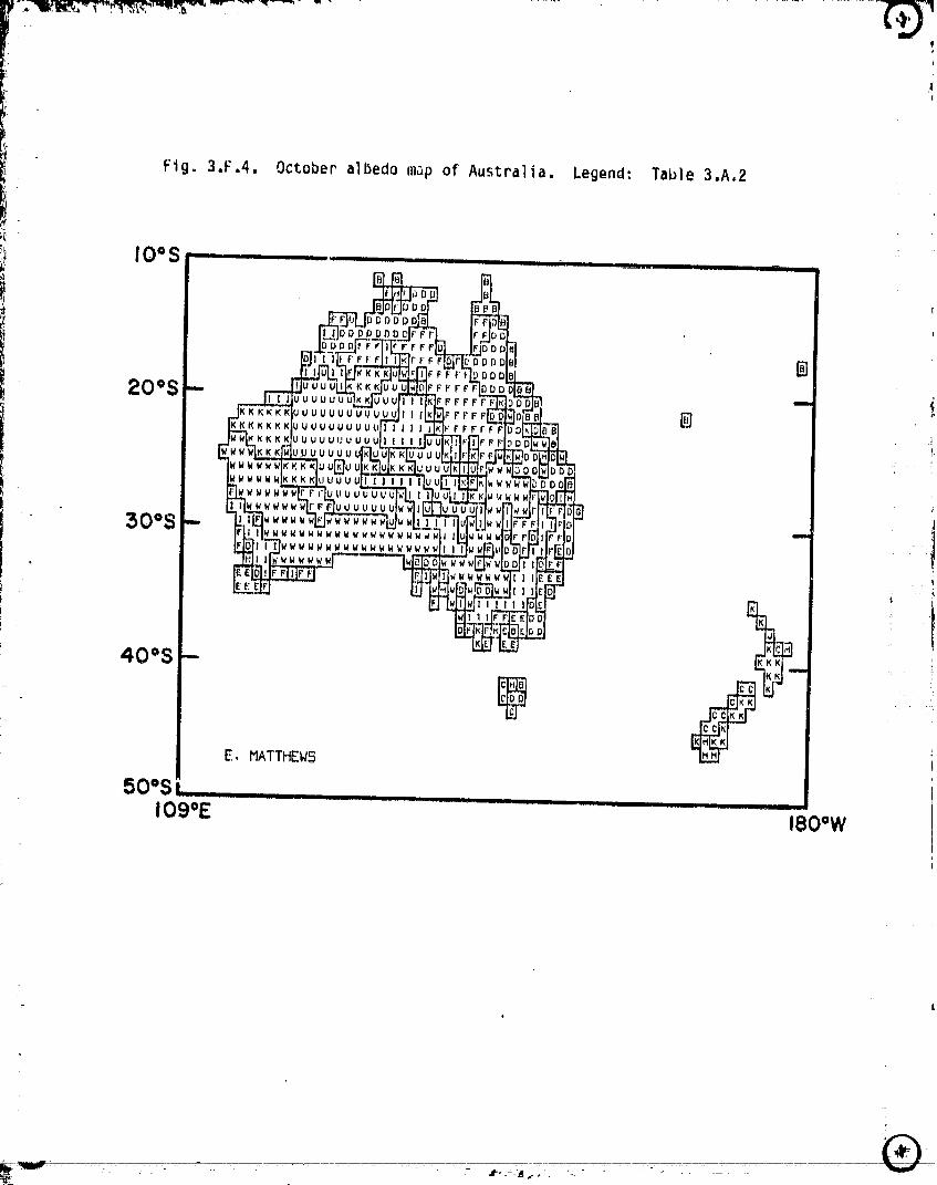
Fig. 3.F.4, October albedo map of Australia. Legend: Table 3.A,2
!_ IO=S- ,.................. _......_oo,.........., ,
20oS -B
$O°S -
40°S - I__
E. MATTHEW5
50°S I_...........109°E I80oW
5
00000001 -TSD06
m .
_!' APPENDICES
The following appendices outline all revisions to the vegetation and
seasonalalb_do data sets mentionedin the introduction. Points are identified
by (I,J) Iocatlons,compatiblewith the tape formatoutlinedin Matthews(1984).
I locations,extendingfrom the datelineeastwardthroughthe Greenwichmeridian
_. to the dateline,are analogousto longitudeand railgefrom 1-360; I(I) is the i°
longitudeband betweenIgO° (da_eline)-I79°W,I(2)between179°W-17B°W,... ,ii
I(3fiO)between 1790E-180° (dateline). J locationsare analogousto latitudeand
range south-to-north from 1-180_ J(1) is the 1° lati%ude band between 90°S-89"S,
- d(2) between89°S-88"S,... , d(180) between89°N-90°N. :;
- 1
- l-?
_4
1/
_ 47
00000001-TSD07
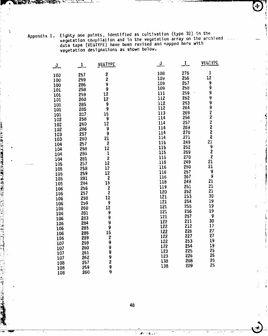
AppendixI. Eighty one points,identifiedas cultivation(type32) in the•_ vegetationcoi,pilationand In the vegetationarray on the archlved
data tape (VEGTYPE)have been revisedand _appedhere withvegetationdesignation_as shown below.
J I VEGTYPE J I VEGTYPE
100 257 2 108 276 IlO0 259 2 i0_ 256 12100 286 9 109 257 9101 258 9 109 258 9101 259 12 111 259 9101 260 12 112 262 9101 285 9 112 263 9101 286 9 112 2.64 9101 237 15 113 269 2
i_ 102 258 9 114 256 2102 260 12 114 257 2
, 102 286 9 114 269 2103 257 9 114 270 2103 260 21 114 271 2
. 104 257 2 115 249 21:'_ ),04 258 12 115 252 9
104 28D I 115 269 2- 104 2BI 2 115 270 2
...... 105 257 12 116 249 21!-'-: 105 258 12 116 250 21
105 259 12 116 257 9"_ 105 281 2 116 267 9i_ 105 284 15 118 249 21 1_ 106 256 2 119 251 21 "'_ 106 257 2 120 252 21
ik)i 106 258 12 121 253 30!_; 106 269 9 121 254 19
106 260 12 121 255 19___ 106 281 9 121 256 19i_' 106 283 9 121 257 9_ 106 284 9 122 211 30"" 106 285 9 122 212 17
lo6 286 122 226 27_-_ 106 289 2 122 227 27_ 107 259 9 122 253 19-.6 107 260 9 122 254 19i - 107 261 9 123 225 25
.-i 107 262 9 123 226 25' 108 257 2 138 208 25
_-.... 108 259 9 138 209 25"/ 108 260 9
(
i" 4B
i
• at- -_,,- . _-. ::- . .-.. :
0000000 -TSD08
•l__h,:,}_,Iw _, _ ......... i_
I
i
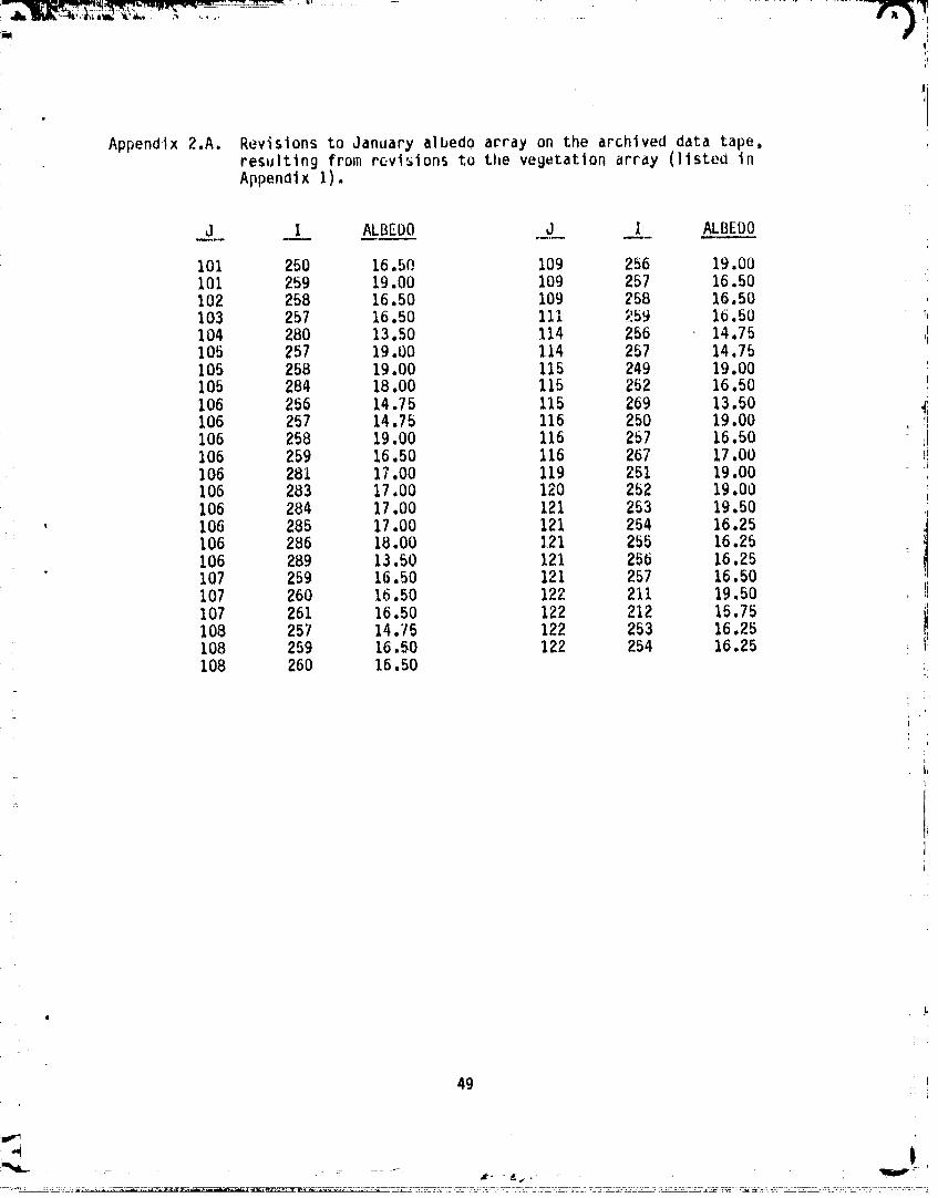
Appendlx 2.A. Revisions to January albedo apray on the archived data tape,resulting from revisions to the vegetation array (llstea inAppendix I).
._J _ ALBEDO ,_J __.I_ ALBEDO
1oi 250 16._o 1o9 256 19.oo1oi 259 19.oo IO9 2_7 16.5o102 258 16.50 109 258 16.50
,59 16.50 _103 257 16.50 111 "104 280 13.50 114 256 14.75105 257 19.00 114 257 14.75105 258 19.00 115 249 19.00 !105 284 18.00 %15 252 16.50 :i
106 256 14.75 115 269 13.50106 257 14.75 116 250 19.00 I106 258 19.00 116 257 16.50 il106 259 16.50 116 267 17.00 I,!106 281 17.00 119 251 19.00106 283 17.00 120 252 19.00106 284 17.00 121 253 19.50
' 106 285 17.00 121 254 16.25106 286 18.00 ]21 255 16.25106 289 13.50 121 256 16.25107 259 16.50 121 257 16.50 ,I107 260 16.50 122 211 19.50 !i107 261 16.50 122 212 15.75 I_I108 257 14.75 122 253 16.25108 259 16.50 122 254 16.25 i!108 260 16.50
L
J49
f
|
00000001-TSD09
!
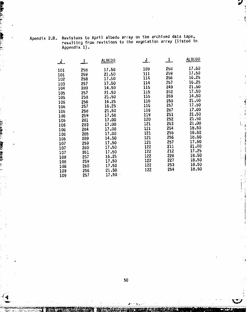
|_ Apendix2.B. Revisionsto April albeduarray o, the archiveddata taperesultingfrom revisionsto the veBetatlonarray (listedinr; Appendix I).
J I ALBEDOj I ALBEDO _
101 25B I/.50 109 25B 17.50101 259 21.50 111 259 ]7.50102 258 17.50 114 256 16.2b '103 257 17.50 114 257 16.25104 280 14.50 115 249 21.50105 257 2].50 115 252 17.50105 25B 21.50 115 269 14,50106 256 16.25 116 250 21.50106 257 16.25 116 257 17.50 ii106 258 21.50 116 267 17.00 _i106 259 17.50 119 251 21.50 _,
!-. 106 281 17.00 120 252 21.50!d: 106 283 17.00 121 253 21.00 }I.}i_ 106 284 17.00 121 254 18.50 !
_ 106 285 17.00 121 255 18.50 : 1106 289 14.50 121 256 Ib.50 !i
. 107 259 17.50 121 257 17.50 : _= 107 260 17.50 122 211 21.00107 261 17.50 122 212 17.25 , i
' !i_ 108 257 16.25 122 226 18.50- 108 259 17.50 122 227 18.50
108 260 17.50 122 253 18.50109 256 21.50 122 254 18.50109 257 17.50
tJ
50
\
_. _... ,- - - -"I_,_ ¸
O000000]-TSD] 0
il
_m: I, I
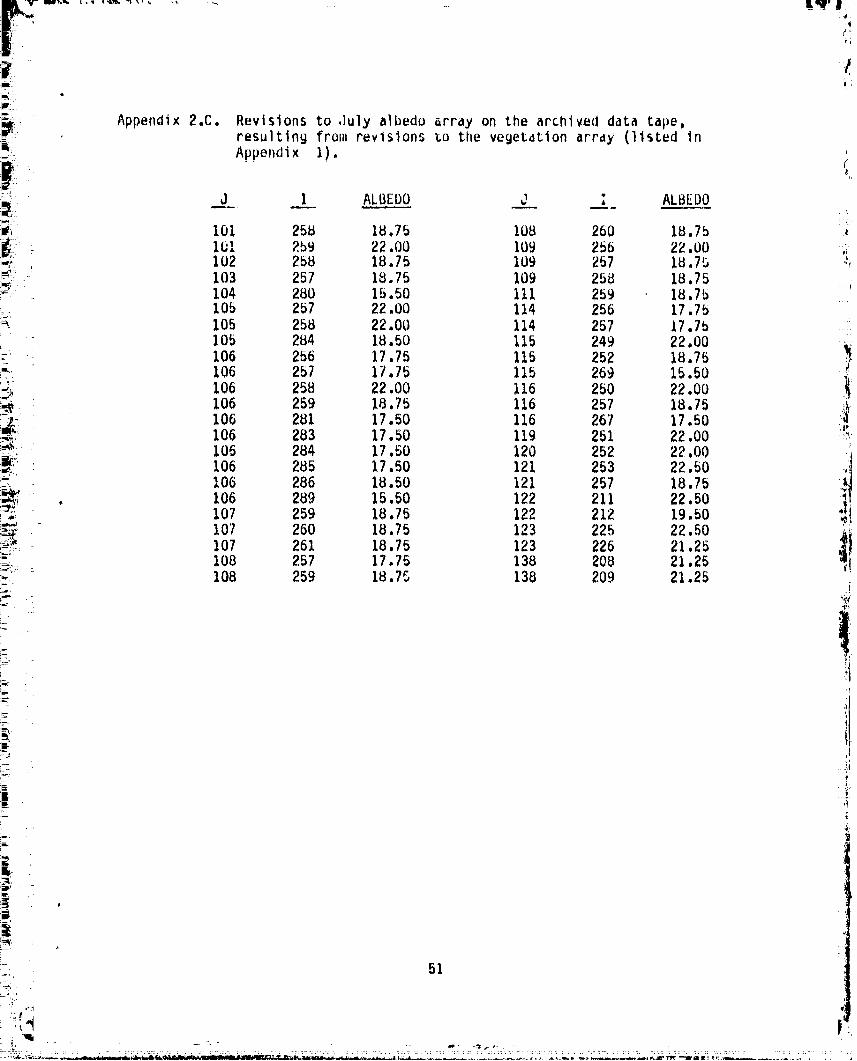
/ Appendix 2.C. Revisions to July albedo array on the archlved data tape,resulting from revisions _o the vegetation array (listed in
m Appendix I).
_ d I ALBEbO d i ALBEDO
_i I01 25a IU.7B lOB 260 ig.7b
!:i Ibl 259 22.00 109 256 22.00 ,,102 258 18.75 109 257 18,7_ _,
_ 103 257 18.75 109 258 18.75 : ,i_ :_ 104 280 15.50 111 259 18.75!i_ 105 257 22.00 114 256 17.75:_ 105 258 22.00 114 257 17.75
105 284 18.50 115 249 22.00 ;_:' 106 256 17.75 I15 252 18.75:_' 106 257 17.75 115 269 15.50
106 258 22.00 116 250 22.00
_ 106 259 18.75 116 257 18.75_ 106 281 17.50 116 267 17.50106 283 17.50 119 251 22.00 _'_
i_ I06 284 17.50 120 252 22.00 '
i_;_I, 106 285 17.50 121 253 22.50 Sl10G 286 18.50 121 257 ia.75_=_!_. i06 289 15._0 122 211 22.50 ]!.5 ..... 107 259 18.75 122 212 19.50
_ 107 260 18.75 123 225 22.50 ii_i,_, 107 261 18.75 123 226 21.25108 257 17.75 138 208 21.25
_, I08 259 18.75 138 209 21.25
i-J
iP.
#
_-, 51
00000001-TSD11
i ........................
!
P
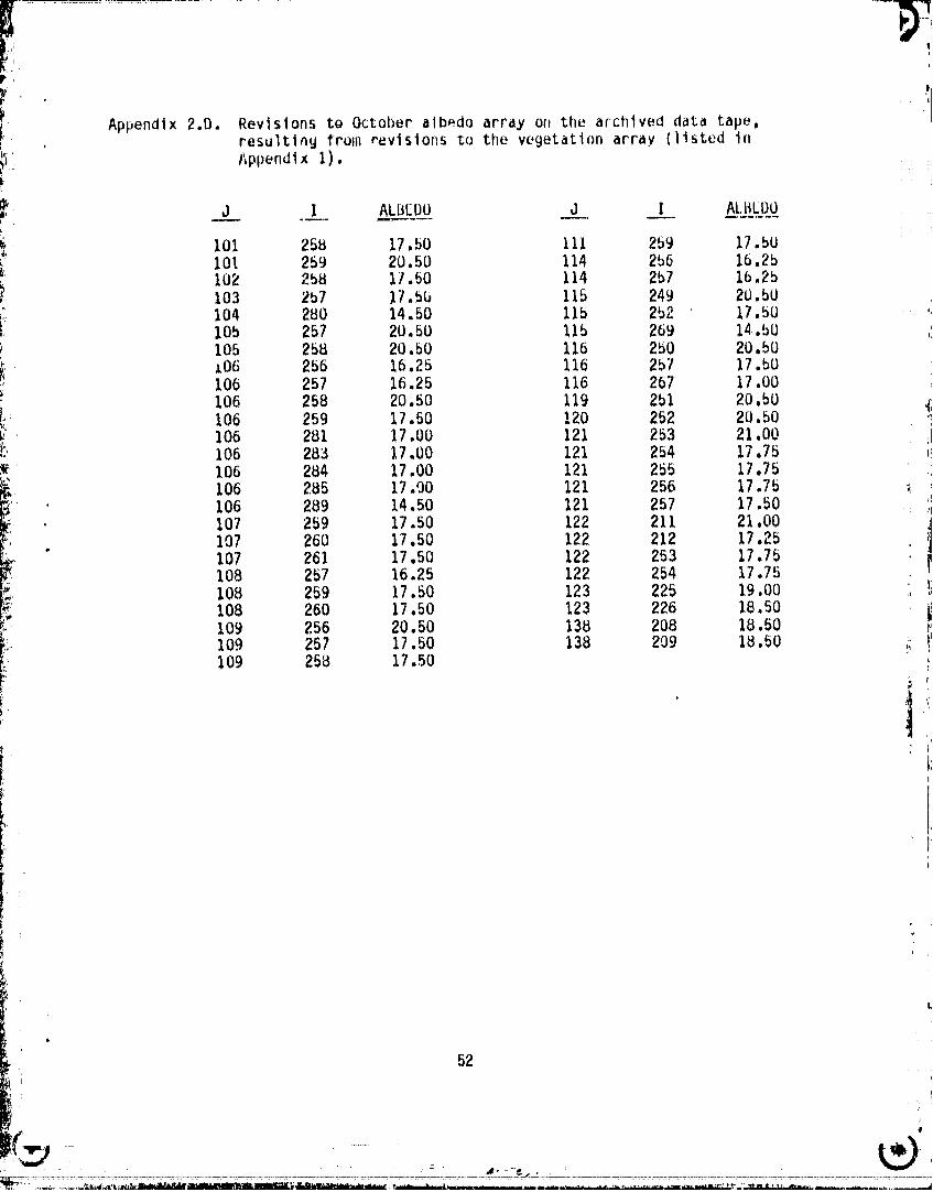
I Appendix 2.D. Revisions to October albedo array or,the archived data tape._ , resulting from revisiot_sto the vegetation array (listed inK l_pl)endix I)
_ J .I_L AL_EDO .J___ _J_l ALBLDO
101 25B 17.50 111 259 17.50_: 101 259 20.50 114 255 16.2b_ 102 258 17.50 114 257 16.2bi 103 267 17.5b 115 249 20,50
_ 104 280 14.50 115 252 17.50 '_ 10b 257 20.50 !15 269 14.bO ,ii 105 258 20.50 116 250 20.50
i _O(i 256 16.25 116 257 17.bO106 257 16.25 116 267 17,00
_C_ 106 258 20.50 119 251 20.50 _106 259 17.50 !20 252 20.50V 106 281 17.00 121 253 21.00 iiI",,: 106 283 17.00 121 254 17.75 _!
106 284 17.00 121 255 17.75
106 285 17.00 121 256 17.75 _ ,' 106 289 14.50 121 257 17.50 _ _i
107 259 17._0 122 211 21.00. I07 260 17.50 122 212 17.2_
_ 107 261 17.50 122 253 17.75108 257 16.25 122 254 17.75 I' 108 259 17.50 123 225 19.00_ I08 260 17.50 123 226 Ie.so
109 256 20.50 138 208 18.50t/ 109 257 17.50 138 209 IB.50 ,_
109 258 17.50z
i ' 1A
r
,
L
52
m _
00000001-TSD12
pL
References .J_'
m, . Matthews, E., 1983: Global vegetation and land use: new hlgh-resolution data
bases for climatestudies. J. C1im. A_p]_l___..Me___teor-ol_..,2--2,474-487.
Matthews, E., 1984; Vegetation, land-use aridseasonal albedu data sets;documentation of arcnived data tape. NASA lechnical Memorandum 86107, May1984.
UNESCO,1973: Internationalclassificationand mappin9of vecj,,tation.Paris,UNESCO, 93p.
f
iAcknowledgments. I am gratefulfor suggestionsand technicalassistancefrom7. Fung, J, Lerner,L. OelValle,A. Calarco,and J. Notario. ;,
I
.I
_).... i
00000001-TSD13