nps archaeology approval - broadland...nps archaeology quality assurance job number 01-04-16-2-1304...
TRANSCRIPT

nps archaeology
2016/1304
Little Plumstead Hospital, Hospital Road, Little Plumstead,
Norfolk NR13 5EW
Archaeological Evaluation by Trial Trenching
Prepared for: Cripps Developments Ltd.
HER: ENF141154
October 2016
SUBJ
ECT
TO A
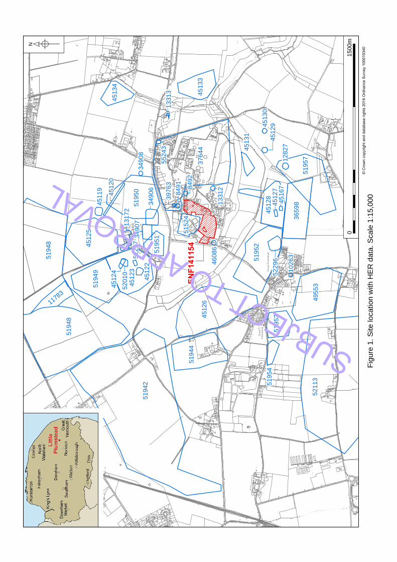
PPRO
VAL

nps archaeology
QUALITY ASSURANCE
Job Number 01-04-16-2-1304
Overview David Adams
Draft Steve Hickling 04-10-2016
Graphics David Dobson 07-10-2016
Edit David Adams 05-10-2016
Review Andrew Crowson 07-10-2016
Issue 1
Steve Hickling BA MA ACIfA Author Rebecca Sillwood BA ACIfA Glass, metalwork, metalworking debris,
stone, animal bone Andrew Peachey BA MCIfA Pottery, brick and tile, flint Disclaimer This document has been prepared in good faith on the basis of information available at the date of publication without any independent verification for the exclusive use and benefit of the named client and for the sole purpose for which it is provided. NPS Archaeology does not guarantee the accuracy, reliability, completeness, or currency of the content of this document nor its usefulness in achieving any purpose. This document is not intended to nor should it be relied upon by any third party. NPS Archaeology accepts no responsibility nor liability should this document be used for any alternative purpose other than for which it is intended nor to any third party. NPS Archaeology will not be liable for any loss, damage, cost, or expense incurred or arising by reason of any person using or relying on information in this document.
nps archaeology Scandic House 85 Mountergate Norwich NR1 1PY T 01603 756150 F 01603 756190 E [email protected] W nau.nps.co.uk © NPS Archaeology Ltd 2016, all rights reserved
SUBJ
ECT
TO A
PPRO
VAL

nps archaeology Little Plumstead Hospital, Norfolk Archaeological Evaluation
Contents
Summary ........................................................................................................ 1
Introduction.............................................................................................................. 2
Project Background ......................................................................................... 2
Planning Background ...................................................................................... 2
Geology and Topography ........................................................................................ 4
Geology .......................................................................................................... 4
Topography ..................................................................................................... 4
Archaeological and Historical Background .............................................................. 5
Sources ........................................................................................................... 5
NHER data ...................................................................................................... 5
Previous archaeological investigations ........................................................... 7
Cartographic evidence .................................................................................... 7
Methodology ............................................................................................................ 8
General ........................................................................................................... 8
Objectives ....................................................................................................... 8
Methods .......................................................................................................... 8
Archive ............................................................................................................ 9
Results .................................................................................................................. 11
Archaeological Finds ............................................................................................. 56
Pottery .......................................................................................................... 56
Ceramic Building Material (CBM) and Fired Clay .......................................... 60
Glass ............................................................................................................. 61
Metal Finds ................................................................................................... 61
Metalworking Waste ...................................................................................... 61
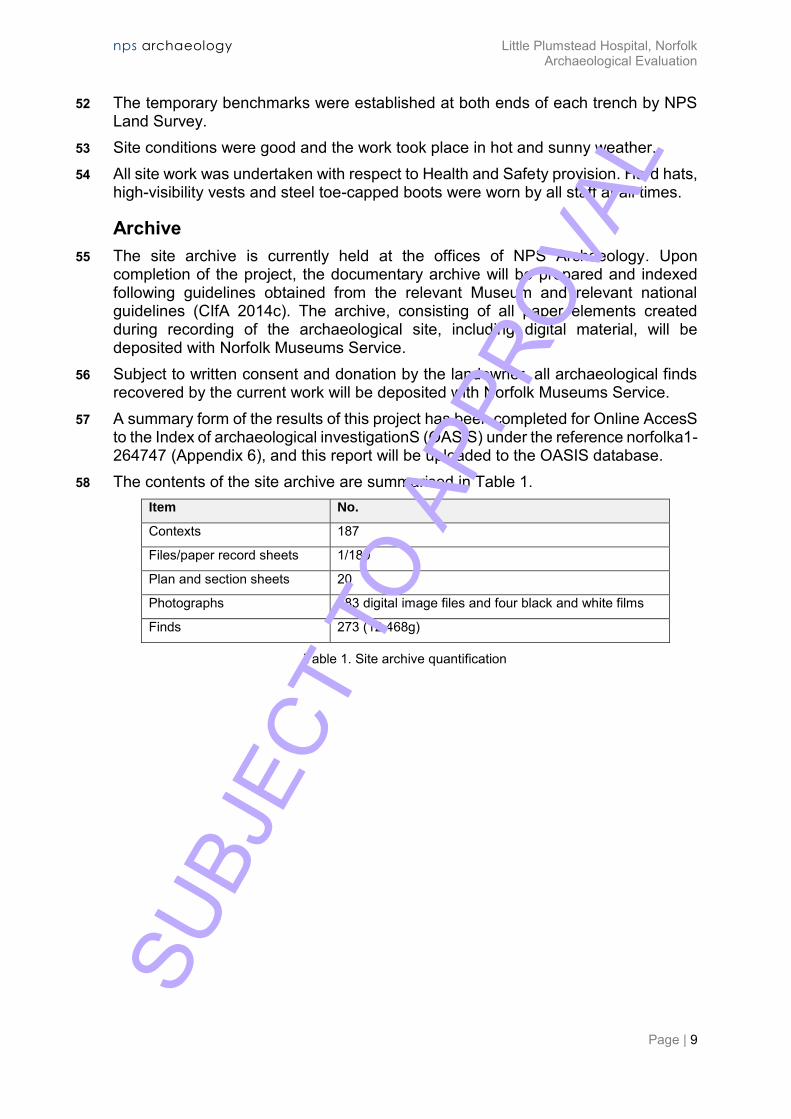
Flint ............................................................................................................. 61
Stone ............................................................................................................ 62
Animal Bone.................................................................................................. 62
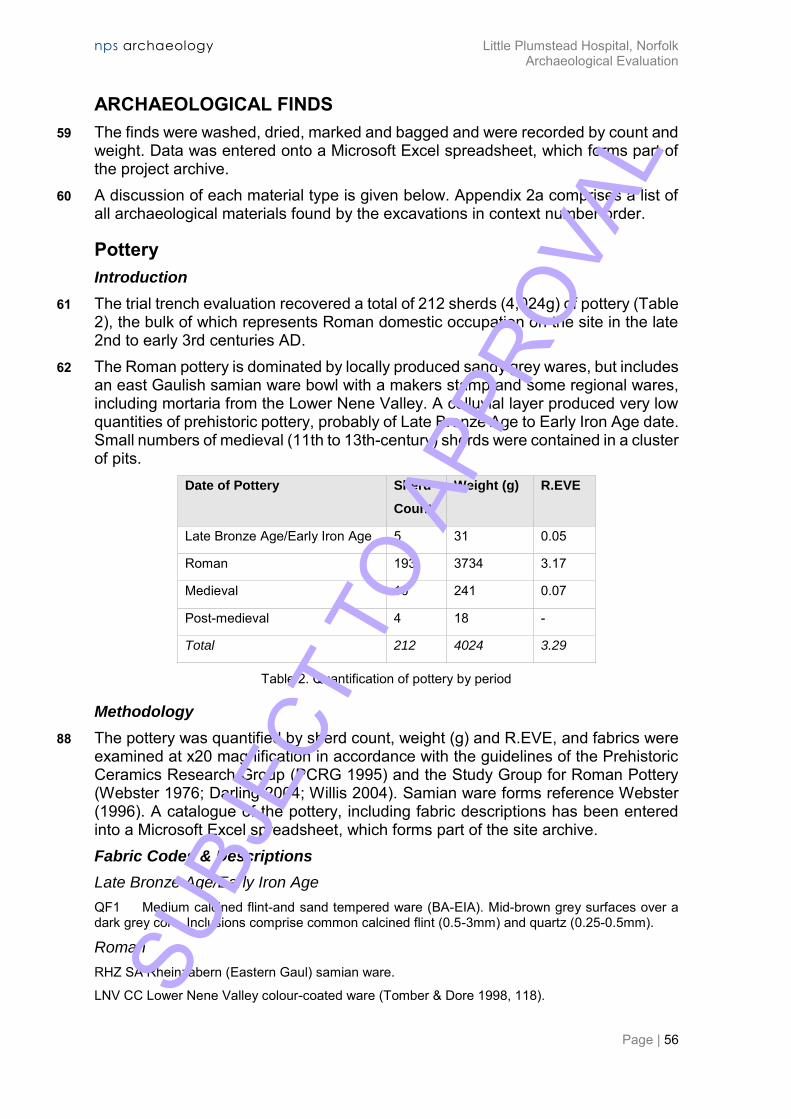
Environmental Evidence ........................................................................................ 63
Discussion ............................................................................................................. 64
Acknowledgements ....................................................................................... 65
Bibliography and Sources ............................................................................. 66
Appendix 1a: Context Summary ................................................................... 68
Appendix 1b: Feature Summary ................................................................... 74
Appendix 2a: Finds by Context ..................................................................... 75
SUBJ
ECT
TO A
PPRO
VAL
nps archaeology Little Plumstead Hospital, Norfolk Archaeological Evaluation
Appendix 2b: Finds Summary ...................................................................... 76
Appendix 3: Pottery Catalogue..................................................................... 77
Appendix 4: CBM Catalogue ........................................................................ 78
Appendix 5: Historical Periods ..................................................................... 79
Appendix 6: OASIS Report Summary .......................................................... 80
Appendix 7: Archaeological Specification .................................................... 84 Figures
Figure 1 Site location and HER data Figure 2 Trench plan Figure 3 Trench 2 plan Figure 4 Trench 4 plan and section Figure 5 Trench 5 plan and sections Figure 6 Trench 6 plan and section Figure 7 Trench 7 plan and sections Figure 8 Trench 8 plan and sections Figure 9 Trench 9 plan and sections Figure 10 Trench 10 plan and sections Figure 11 Trench 11 plan and section Figure 12 Trench 12 plan and section Figure 13 Trench 13 plan and sections Figure 14 Trench 14 plan and sections Figure 15 Trench 16 plan and sections Figure 16 Trench 17 plan and sections Figure 17 Trench 19 plan and sections Plates
Cover The development area facing east Plate 1 Pit 17 and ditch 20 facing south (scale 1m) Plate 2 Ditch 25 facing east (scale 1m) Plate 3 Possible burnt post-hole 152 facing east Plate 4 Probable oven 166 (incorrect number on board) facing east (scale
0.50m) Plate 5 Burnt pit 05 facing northeast (scale 1m) SU
BJEC
T TO
APP
ROVA
L

nps archaeology Little Plumstead Hospital, Norfolk Archaeological Evaluation
Plate 6 Structure 75 facing southeast (scale 2m) Plate 7 Ditch 60 facing northwest (scale 0.50m) Plate 8 Ditch 11 (incorrect label) facing north (scale 1m) Plate 9 Ditch 51 facing east (scale 0.50m) Plate 10 Ditch 122 facing east (scale 0.50m) Plate 11 Possible burnt beam-slot 144 facing west (scale 0.50m) Tables
Table 1 Site archive quantification Table 2 Quantification of pottery by period Table 3 Total quantification of fabric types in the assemblage Table 4 Quantification of CBM and fired clay types
SUBJ
ECT
TO A
PPRO
VAL

SUBJ
ECT
TO A
PPRO
VAL
nps archaeology Little Plumstead Hospital, Norfolk Archaeological Evaluation
Page | 1
Client: Cripps Developments Ltd. Location: Little Plumstead Hospital, Little Plumstead, Norfolk District: Broadland Planning Reference: n/a Grid Reference: TG 3065 1065 HER No.: ENF141154 OASIS ID: norfolka1-264747 Dates of Fieldwork: 22 August–1 September 2016
Summary
NPS Archaeology was commissioned by Cripps Developments Ltd to carry out an archaeological evaluation by trial trenching ahead of the construction of residential housing covering 38,608m2 at Little Plumstead Hospital, Hospital Road, Little Plumstead, Norfolk (TG 3065 1065). The evaluation of 19 trenches (providing a 4% sample of the development area) was required because previous discovery to the east of evidence of Neolithic or Bronze Age activity indicated high archaeological potential for the development area.
The evaluation recorded remains dating from the prehistoric to modern periods with a concentration of Roman activity. The survival of archaeological deposits appeared to be good, perhaps reflecting that most of the development area was formerly the hospital cricket pitch. In the central area, archaeological remains appeared to be beneath a layer of topsoil in excess of 0.50m in depth.
Prehistoric remains consisted of a scatter of artefacts residual in later features and within a colluvial layer in a shallow valley bottom. A number of 13th-century quarry pits suggested medieval activity in the west of the development area. Most archaeological activity, though, dated to the Roman period, with possible farmstead-type occupation in the central part of the site. Elements of a field system aligned on the cardinal compass points dated from the Roman period, with elements added through the post-medieval and modern periods.
The putative farmstead remains dated primarily to the late 2nd to early 3rd-centuries, with evidence of an episode of burning in the early to mid-3rd century. The limited amount of Roman brick or tile and absence of plaster might suggest relatively low status occupation.
Most of the archaeological evidence was in the form of ditches and pits, but there were also possible burnt beam-slots and post-holes, as well as at least one probable oven and one substantial semi-subterranean structure. Surviving wall bases and one floor were of chalky, clay lump construction. The burning episode was evident in a large proportion of the Roman features, especially in two beam-slots showing burnt earth on their vertical sides. One of the boundary ditches may have been open when the burning occurred, with its earlier fill dated late 2nd to early 3rd century, and its later fill, with a high proportion of burnt material, dated to the late 2nd to late 3rd century. SU
BJEC
T TO
APP
ROVA
L
nps archaeology Little Plumstead Hospital, Norfolk Archaeological Evaluation
Page | 2
INTRODUCTION
Figure 1
Project Background
1 NPS Archaeology was commissioned and funded by Cripps Developments Ltd to conduct an evaluation by trial trenching at Little Plumstead Hospital.
2 The development is for residential housing and associated landscaping and services covering 38,608m2, with access from the north and west. It is located within the grounds of the former Little Plumstead Hospital (formerly Little Plumstead Hall) at TG 3065 1065.
3 Previous archaeological work within the hospital grounds included an evaluation of 19 trenches to the northwest for a new school (NHER 51524), and an evaluation of over 100 trenches to the east for housing (NHER 37644).
Planning Background
4 The current programme of archaeological work was required to support and inform planning for the site and to fulfil a Brief issued by Norfolk County Council Historic Environment Service (NCCHES). The work was conducted in accordance with a Written Scheme of Investigation prepared by NPS Archaeology (ref: 01-04-16-2-1304/Hickling 2016).
5 The programme of work was designed to assist in defining the character and extent of any archaeological remains within the proposed development area, following guidelines set out in National Planning Policy Framework (Department for Communities and Local Government 2012).
6 The results of the evaluation will enable decisions to be made by the Local Planning Authority about the future treatment of any archaeological remains found.
7 The recipients of this report will be Cripps Developments Ltd, NCCHES and Broadland District Council.
SUBJ
ECT
TO A
PPRO
VAL
W
i
t
t
o
n
R
u
n
W
i
t
t
o
n
R
u
n
Plu
mste
ad
Gre
at
Nu
rse
ry
Sm
ee
F
arm
Plu
mste
ad
G
re
en
W
i
t
t
o
n
R
u
n
Pla
nta
tio
n
Ice
H
ou
se
Gre
at P
lu
mste
ad
Wo
od
Ho
rse
y
Ca
rr
Th
e
Th
e C
arr
Blo
fie
ld
Co
rn
er
Blo
fie
ld
C
orn
er
(d
isu
se
d)
Wo
rks
Se
wa
ge
Pla
nta
tio
n
Po
nd
Lo
rd
's P
la
nta
tio
n
Lo
rd
's P
la
nta
tio
n
Big
W
oo
d
Big
W
oo
d
Gro
ve
Birch
Birch
G
ro
ve
Ch
erry T
re
e F
arm
Witto
n
Witto
n H
all
W
it
t
o
n
R
u
n
Ca
rr W
oo
d
W
i
t
t
o
n
R
u
n
C
a
r
r
W
o
o
d
Plu
mste
ad
G
re
en
Pla
yin
g F
ie
ld
Th
e G
ro
ve
Dye
's
Fa
rm
51957
51952
51953
52113
45126
51944
51942
45133
37644
51950
45134
45125
51949
45123
51948
51948
1
1
7
8
3
12827
36598
4512945130
45131
10263
49553
51954
52296
45128
45167
45127
13312
8492
55243
13313
34908
46086
51524
51951
45120
45119
34906
34907
13172
45122
52297
52010
45124
8491
39763
EN
F141154
N
© Crown copyright and database rights 2016 Ordnance Survey 100019340
Fig
ure
1
. S
ite
lo
ca
tio
n w
ith
H
ER
d
ata
. S
ca
le
1
:1
5,0
00
01
50
0m
SUBJECT TO APPROVAL

nps archaeology Little Plumstead Hospital, Norfolk Archaeological Evaluation
Page | 4
GEOLOGY AND TOPOGRAPHY
Geology
8 The underlying geology in the area of the development consists of Quaternary diamicton of the Happisburgh Glacigenic Formation above Quaternary and Neogene sands and gravels of the Crag Group (BGS 2016).
9 The topsoil across the site is deep and pale in colour. The interface between the topsoil and the natural geology is somewhat indistinct.
Topography
10 The development area is set within the grounds of the former Little Plumstead Hospital, which was formerly a landscape garden attached to Little Plumstead Hall. At the time of the evaluation the site was open grassland bordered by woodland to the west and southwest, a school to the northwest, housing to the north and northeast, and the remaining active hospital to the east and southeast.
11 The development area consists of a flat plateau at a height of c. 20.00m OD, descending to a valley bottom in its northeast corner at a minimum height of 16.00m OD.
12 The total area of the development is 38,608m2. It was not possible to excavate trenches in some parts of the site due to demolition activity and the extent of mature trees.
SUBJ
ECT
TO A
PPRO
VAL
nps archaeology Little Plumstead Hospital, Norfolk Archaeological Evaluation
Page | 5
ARCHAEOLOGICAL AND HISTORICAL BACKGROUND
Sources
13 The primary source for archaeological evidence in the county of Norfolk is the Norfolk County Council Historic Environment Record (NHER), which details archaeological discoveries and sites of historical interest. In order to characterise the likely archaeological potential of the proposed development site, HER record data was purchased from NCCHES for a 1km radius of TG 3065 1065. This exercise returned 51 individual records, including monuments, find spots and buildings, containing evidence of historical activity spanning the prehistoric to modern periods.
14 Online sources of historical mapping (Norfolk County Council 2016; Macnair 2016) were consulted to establish a context of post-medieval land use at the site.
15 A reference table listing dates for historical periods described in this report is provided in Appendix 5.
NHER data
16 The NHER data that are most relevant to the current work are referenced and summarised below, along with details of previous archaeological work in the vicinity. The information presented that is sourced from NHER remains copyright of NCCHES. Prehistoric
17 This area is rich in both chance finds of prehistoric artefacts and in cropmarks of prehistoric features.
18 Artefacts found in the surrounding area include an Early Neolithic scraper/knife (NHER 8493), a Neolithic polished axe-head and a Bronze Age axe head (NHER 34906), and a prehistoric re-touched flint flake (NHER 34908).
19 The cropmark evidence includes possible Bronze Age barrows (NHER 12827, 45129 and possibly 45167), Late Neolithic to Bronze Age hengiform structures (NHER 45130 and possibly 45167), and a possible Neolithic mortuary enclosure (NHER 45127).
20 A number of small curved or D-shaped enclosures nearby are thought to be possible Iron Age or Roman settlement sites (NHER 45119, 45122, 45124, 52010 and 52297), and there are also enclosures and field boundaries (NHER 51950). Roman
21 The cropmarks of enclosures and field boundaries noted above may relate to Roman settlement sites (NHER 45119, 45122, 45124, 52010, 52297, 51950).
22 A Roman coin (NHER 34906) has been found to the north of the current development and Roman coins and pottery have been found to the south (NHER 36598). Anglo-Saxon
23 There is little known Anglo-Saxon activity in the area, and that which is known is of later Anglo-Saxon date. SU
BJEC
T TO
APP
ROVA
L
nps archaeology Little Plumstead Hospital, Norfolk Archaeological Evaluation
Page | 6
24 The parish church of St Protase and St Gervase has possibly a Late Anglo-Saxon base to its round tower (NHER 8491).
25 A Late Anglo-Saxon, or early medieval weight has been found by metal detecting (NHER 34908). Medieval
26 The medieval settlement pattern in the local area appears to be dispersed, possibly due to heathy and perhaps quite marginal land. The Domesday Book shows that Great and Little Plumstead were made up of a large number of small land holdings (Williams and Martin 1992).
27 There are three parish churches within the NHER search area: The church of Little Plumstead has a Norman tower, nave and other details (NHER 8491). Great Plumstead church dates from the 13th century (NHER 10263), and St Margaret’s Witton church has 12th-century origins. The site of a second medieval church once in Great Plumstead, All Saints’, has not been accurately established.
28 Metal detecting to the north (NHER 34907) and south (NHER 36598) of the current development has found medieval coins and other metal items.
29 There are cropmarks possibly relating to medieval farms to the west and south of the development site (NHER 51944, 45126, 52296), and to the former settlement of Tuke’s Green (NHER 51954) to the southwest. Further possibly medieval or later field systems are visible to the north, west and south (NHER 51948, 45125, 51949, 45123, 51951, 51942, 52113, 51953, 51952, 45128, 51957). Post-Medieval
30 Little Plumstead Hall (NHER 8492) was built in 1889 in ‘Elizabethan’ style and was a hospital from 1929. Earlier mapping (Norfolk County Council 2016) shows a rectory and then a hall surrounded by parkland close to this site. Associated with the hall are Manor Farm, a 19th-century estate farm (NHER 13172), an icehouse and possible summer houses (NHER13312), and The Old Lodge, an early 19th-century gate lodge (NHER 46086). The Clock Tower at Little Plumstead Hospital is in Arts and Crafts style and dates to 1903 (NHER 39763).
31 There are cropmarks possibly relating to post-medieval farms to the west and south of the development site (NHER 51944, 45126, 52296) and to the settlement of Tuke’s Green (NHER 51954) to the southwest.
32 The Grange is an early 19th-century Gothic-style house built of reused 16th-century brick, possibly at the location of an earlier site of Plumstead Hall (NHER 13313).
33 Little Plumstead Church of England School was built in the 1860s (NHER 55243). 34 A bombing decoy was laid out to the north of the development area during World
War Two to resemble an industrial area of Norwich (NHER 11783). Unknown
35 There are a number of cropmarks of field boundaries and trackways visible on aerial photographs which cannot be dated (NHER 45120, 45131, 45133, 45134 and 49553). SU
BJEC
T TO
APP
ROVA
L
nps archaeology Little Plumstead Hospital, Norfolk Archaeological Evaluation
Page | 7
Previous archaeological investigations
36 The east part of the hospital grounds was subject to an evaluation in 2003, which recovered evidence of Late Neolithic to Early Bronze Age settlement activity and medieval field boundaries (NHER 37644).
37 An evaluation north of the current development before the construction of the new primary school (NHER 51524), revealed evidence of late medieval enclosures and a 19th-century brick wall, possibly associated with the hall gardens.
Cartographic evidence
38 The information for this section is derived from the Norfolk County Council Map Explorer website (NCC 2016).
39 The 1839 Little Plumstead Tithe map shows the development area as parkland with a belt of woodland impinging into the centre of the site from the north. The hall is shown closer to the church than the present (recently burned-down) hall.
40 Likewise, the First Edition Ordnance Survey map shows the development area as lightly wooded parkland with the hall closer to the church, as per the Tithe map.
41 The 1946/7 aerial photograph shows the area as parkland, with the southwest part probably as a cricket pitch.
SUBJ
ECT
TO A
PPRO
VAL
nps archaeology Little Plumstead Hospital, Norfolk Archaeological Evaluation
Page | 8
METHODOLOGY
Figure 2
General
42 Methodology for the evaluation followed the agreed Written Scheme of Investigation (ref: 01-04-16-2-1304/Hickling 2016), where the mitigation strategy for the works is presented in full (Appendix 7).
43 Archaeological procedures conformed to guidelines issued by the Chartered Institute for Archaeologists (CIfA 2014a) and the evaluation was conducted within the context of the relevant regional archaeological framework (Medlycott 2011).
Objectives
44 The objective of the evaluation was to determine as far as reasonably possible the presence or absence, location, nature, extent, date, quality, condition and significance of any surviving archaeological deposits within the development area.
45 The archaeological project aimed to provide appropriate and adequate data to permit informed decisions regarding any requirement for future archaeological mitigation work at Little Plumstead Hospital, and to make the results of the work accessible.
Methods
46 The Brief required that 4% of the proposed development area be sampled through trial trenching. Trenches were situated according to the agreed plan (ref: 01-04-16-2-1304/Hickling 2016). Site survey was carried out by NPS Land Survey and located within the Ordnance Survey National Grid using a Leica GS14 GPS.
47 Prior to mechanical excavation, each trench location was scanned with a CAT to check for buried services. The areas to be stripped of topsoil were examined for surface features and for archaeological artefacts prior to any excavation.
48 Machine excavation was carried out by a hydraulic 360˚ excavator equipped with a toothless ditching bucket. All mechanical excavation was constantly and directly monitored by an archaeologist.
49 All trench surfaces revealed by machine were hand-cleaned and any archaeological deposits were excavated by hand. Upon completion of the work all trenches were backfilled by machine.
50 Spoil, exposed surfaces and features were scanned with a metal-detector. All metal-detected and hand-collected finds, other than those that were evidently modern, were retained for examination. All retained finds were identified by context number to a specific deposit and were processed and recorded in line with relevant guidelines for archaeological finds (CIfA 2014b).
51 All archaeological features and deposits were recorded using NPS Archaeology pro forma. Trench locations, plans and sections were recorded at appropriate scales. Monochrome 35mm negatives and digital photographs were taken of all relevant archaeological features and deposits where appropriate. SU
BJEC
T TO
APP
ROVA
L
nps archaeology Little Plumstead Hospital, Norfolk Archaeological Evaluation
Page | 9
52 The temporary benchmarks were established at both ends of each trench by NPS Land Survey.
53 Site conditions were good and the work took place in hot and sunny weather. 54 All site work was undertaken with respect to Health and Safety provision. Hard hats,
high-visibility vests and steel toe-capped boots were worn by all staff at all times.
Archive
55 The site archive is currently held at the offices of NPS Archaeology. Upon completion of the project, the documentary archive will be prepared and indexed following guidelines obtained from the relevant Museum and relevant national guidelines (CIfA 2014c). The archive, consisting of all paper elements created during recording of the archaeological site, including digital material, will be deposited with Norfolk Museums Service.
56 Subject to written consent and donation by the landowner, all archaeological finds recovered by the current work will be deposited with Norfolk Museums Service.
57 A summary form of the results of this project has been completed for Online AccesS to the Index of archaeological investigationS (OASIS) under the reference norfolka1-264747 (Appendix 6), and this report will be uploaded to the OASIS database.
58 The contents of the site archive are summarised in Table 1. Item No.
Contexts 187
Files/paper record sheets 1/180
Plan and section sheets 20
Photographs 183 digital image files and four black and white films
Finds 273 (12,468g)
Table 1. Site archive quantification
SUBJ
ECT
TO A
PPRO
VAL

21.5m
3
1
Octagon
Cottage
The F
irs
Pavilion
Bow
ling G
reen
Playing F
ield
Little
P
lu
mste
ad
Ho
sp
ita
l
TR
1
TR
2
TR
5
TR
4
TR
6
TR
10
TR
14
TR
7
TR
9
TR
8
TR
11
TR
12
TR
13
TR
17
TR
19
TR
18
TR
16
TR
3
TR
15
N
© Crown copyright and database rights 2016 Ordnance Survey 100019340
Fig
ure
2
. T
re
nch
lo
ca
tio
n. S
ca
le
1
:1
50
0
01
50
m
Tre
nch
es w
ith
a
rch
ae
olo
gica
l fe
atu
re
s
Tre
nch
es w
ith
n
o a
rch
ae
olo
gica
l fe
atu
re
s
SUBJECT TO APPROVAL

nps archaeology Little Plumstead Hospital, Norfolk Archaeological Evaluation
Page | 11
RESULTS
Trench 1
Figure 2
Location
Orientation East–west West end 630676.932, 310770.246
East end 630701.814, 310772.437
Dimensions
Length 25.00m
Width 1.60m Depth 0.85–0.90m
Levels
West end top 16.82m OD
East end top 16.13m OD
Context Type Description and Interpretation Thickness
39 Deposit Colluvium, pale orangey brown silty sand 0.85m
Discussion
Colluvium layer 39 produced five small sherds of Late Bronze Age to Early Iron Age pottery, which had probably been transported from up-slope either to the north or to the south.
SUBJ
ECT
TO A
PPRO
VAL

nps archaeology Little Plumstead Hospital, Norfolk Archaeological Evaluation
Page | 12
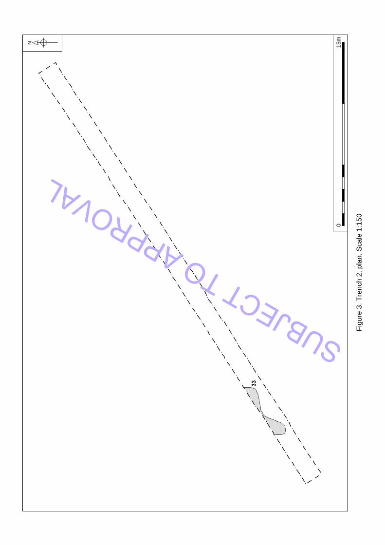
Trench 2
Figures 2 and 3
Location
Orientation Northeast–southwest Northeast end 630722.851, 310753.916
Southwest end 630689.045, 310731.884
Dimensions
Length 40.20m
Width 1.60m
Depth 0.35–1.16m
Levels
Northeast end top 16.02m OD
Southwest end top 17.82m OD
Context Type Description and Interpretation Thickness
31 Deposit Topsoil. Pale greyish brown silt. 0.35m
32 ? Subsoil. Orangey brown clay and sand.
33 Cut Irregular shaped pit. Not excavated. Unknown
34 Deposit Fill of 33. Pale greyish brown sandy silt with occasional flint gravel and brick/tile fragments, and rare charcoal flecks and burnt clay.
Discussion
No significant archaeological features or artefacts were identified in Trench 2.
Feature 33 was not excavated because it contained a 20th-century brick.
SUBJ
ECT
TO A
PPRO
VAL
33
N
Fig
ure
3
. T
re
nch
2
, p
la
n. S
ca
le
1
:1
50
01
5m
SUBJECT TO APPROVAL

nps archaeology Little Plumstead Hospital, Norfolk Archaeological Evaluation
Page | 14
Trench 3
Figure 2
Location
Orientation East–west West end 630465.505, 310646.355
East end 630494.556, 310640.225
Dimensions
Length 29.40m
Width 1.60m
Depth 0.40–0.90m
Levels
West end top 20.99m OD
East end top 20.74m OD
Context Type Description and Interpretation Thickness
29/189 Deposit Topsoil. Mid-greyish brown clayey silt with rare charcoal and flint gravel. 0.35m
30/190 Deposit Layer above topsoil at west end of trench. Mid-greyish brown silt, full of roots. 0.45m
Discussion
The trench was sited in an area of recently felled young trees. No archaeological artefacts or features were present.
SUBJ
ECT
TO A
PPRO
VAL

nps archaeology Little Plumstead Hospital, Norfolk Archaeological Evaluation
Page | 15
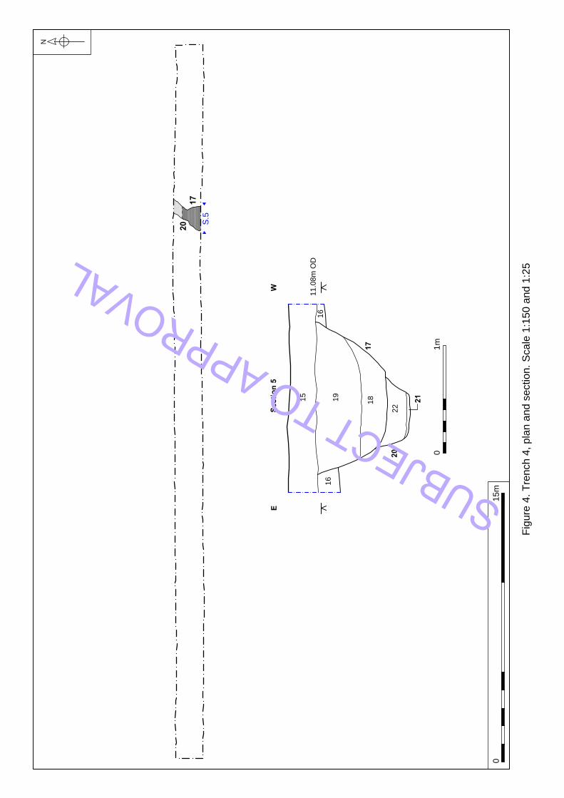
Trench 4
Figures 2 and 4
Location
Orientation East–west West end 630683.387, 310710.244
East end 630723.386, 310710.240
Dimensions
Length 40.00m
Width 1.60m
Depth 0.50–0.55m
Levels
West end top 18.47m OD
East end top 17.48m OD
Context Type Description and Interpretation Thickness
15 Deposit Landscaping deposit. Pale orange and pale brown silty sand. 0.50m
17 Cut Possibly circular pit. 1.42m wide with a flat base and steep sides. 0.66m
18 Deposit Primary fill of 17. Mid-brownish orange sand. 0.38m
19 Deposit Fill of 17. Mid-greyish brown sandy silt with occasional brick/tile and gravel, and rare burnt clay. 0.42m
20 Cut Northeast–southwest ditch with a flat base and steep sides. 0.31m
21 Deposit Base fill of 20. Dark reddish black compacted burnt soil. 0.20m
22 Deposit Dark orangey yellow sand. 0.27m
Discussion
Pit 17 could not be dated but was cut into the top of ditch 20, suggesting that ditch 20 may still have been a boundary feature at the time 17 was dug. Ditch 20 contained burnt material and slag and appeared similar in character to many of the Roman features in the trenches to the southwest, but could not be dated. The ditch appeared to be on a different alignment to the majority found elsewhere, and contained fired clay and metal working waste of unknown date.
SUBJ
ECT
TO A
PPRO
VAL

nps archaeology Little Plumstead Hospital, Norfolk Archaeological Evaluation
Page | 16
Trench 4
Plate 1. Pit 17 and ditch 20 facing south (scale 1m)
SUBJ
ECT
TO A
PPRO
VAL
S.5
17
20
Sectio
n 5
EW
11.08m
O
D
15
16
16
19
18
17
20
22
21
N
Fig
ure
4
. T
re
nch
4
, p
la
n a
nd
se
ctio
n. S
ca
le
1
:1
50
a
nd
1
:2
5
01
5m
01
m
SUBJECT TO APPROVAL

nps archaeology Little Plumstead Hospital, Norfolk Archaeological Evaluation
Page | 18
Trench 5
Figures 2 and 5
Location
Orientation North–south North end 630739.443, 310725.531
South end 630739.398, 310685.531
Dimensions
Length 30.00m
Width 1.60m
Depth 0.25–1.00m
Levels
North end top 16.47m OD
South end top 17.74m OD
Context Type Description and Interpretation Thickness
23 Cut East–west ditch, 0.90m wide with a concave base. 0.66m
24 Deposit Base fill of 23. Pale orangey brown silty sand with occasional flint gravel. 0.30m
25 Cut East–west ditch, 1.60m wide with a flat base. 1.20m
26 Deposit Base fill of 25. Mid-greyish brown silty sand with occasional flint gravel. 1.00m
27 Cut Pit cutting ditch 23. 3.00m wide with a sloped base and irregular sides. 0.94m
28 Deposit Base fill of 27. Pale orangey grey silty sand with occasional large flints. 0.94m
40 Deposit Landscaping material. Light orange and pale brown silty sand with turf on top. 0.50m
41 Deposit Geological sand and gravel
43 Deposit Fill of 23. Dark greyish brown silty sand. 0.36m
44 Deposit Fill of 23. Pale greyish brown silty sand with occasional flint gravel. 0.26m
46 Deposit Fill of 25. Pale greyish brown silty sand with occasional flint gravel. 0.72m
47 Deposit Fill of 25. Mid-grey silty sand with occasional flint gravel. 0.74m
Discussion
Ditch 25 could not be dated, but appeared to be approximately perpendicular to ditch 20 in Trench 4, so may be associated. SU
BJEC
T TO
APP
ROVA
L
nps archaeology Little Plumstead Hospital, Norfolk Archaeological Evaluation
Page | 19
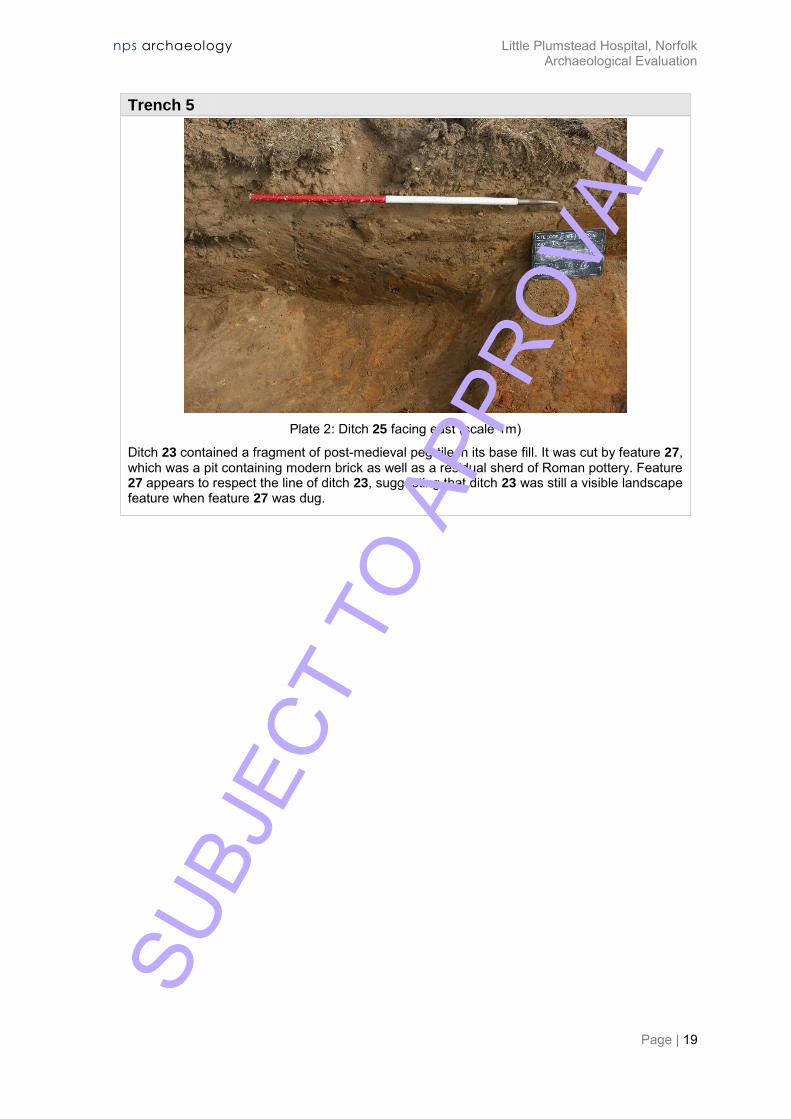
Trench 5
Plate 2: Ditch 25 facing east (scale 1m)
Ditch 23 contained a fragment of post-medieval peg-tile in its base fill. It was cut by feature 27, which was a pit containing modern brick as well as a residual sherd of Roman pottery. Feature 27 appears to respect the line of ditch 23, suggesting that ditch 23 was still a visible landscape feature when feature 27 was dug.
SUBJ
ECT
TO A
PPRO
VAL

S.6
S.7
25
23
27
42
46
40
47
26
25
Black
28
24
23
27
43
44
brick
16.74m OD
Section 6S N
mineralisation
16.60m OD
Section 7 SN
Natural
geology
N
Figure 5. Trench 5, plan and sections. Scale 1:150 and 1:50
0 15m
0 2m
SUBJ
ECT
TO A
PPRO
VAL

nps archaeology Little Plumstead Hospital, Norfolk Archaeological Evaluation
Page | 21
Trench 6
Figures 2 and 6
Location
Orientation North–south North end 630687.664, 310686.543
South end 630685.681, 310646.696
Dimensions
Length 40.00m
Width 1.60m
Depth 0.35–0.40m
Levels
North end top 18.88m OD
South end top 19.61m OD
Context Type Description and Interpretation Thickness
35 Deposit Topsoil. Sandy loam. 0.40m
36 Geological sands
37 Geological clay
Discussion
No archaeological artefacts or features were identified in Trench 6. The interface between the geological sand and clay was examined due to the dark nature of the boundary between the two.
SUBJ
ECT
TO A
PPRO
VAL

S.8
35
36
Section 8S N
18.58m OD
S.8
36
0 1m
N
Figure 6. Trench 6, plan and section. Scale 1:150 and 1:25
0 15m
SUBJ
ECT
TO A
PPRO
VAL

nps archaeology Little Plumstead Hospital, Norfolk Archaeological Evaluation
Page | 23
Trench 7
Figures 2 and 7
Location
Orientation Southeast–northwest Southeast end 630614.179, 310607.930
Northwest end 630601.115, 310645.438
Dimensions
Length 39.70m
Width 1.60m
Depth 0.40–0.65m
Levels
Southeast end top 20.30m OD
Northwest end top 20.38m OD
Context Type Description and Interpretation Thickness
149 Deposit Topsoil. Pale greyish brown silty sand with occasional brick/tile and frequent flint gravel. 0.40m
150 Deposit Interface between topsoil and natural geology. 0.25m
151 Geological pale orange and greyish brown sand with gravel.
152 Cut Oval pit, 0.70m long, 0.55m wide with a flat base and steep sides. 0.18m
153 Deposit Fill of 152. Mid-greyish brown sandy clay with occasional charcoal flecks, rare flint gravel and burnt clay.
0.18m
154 Cut Circular pit, 0.70m wide with a concave base and steep sides. 0.16m
155 Deposit Fill of 154. Dark black with reddish patches, silty sand with frequent charcoal and occasional fine flint gravel.
0.16m
156 Pit Circular pit, 0.50m wide with a concave base and gently sloping sides. 0.08m
157 Deposit Fill of 156. Dark greyish brown silty sand with occasional flint gravel. 0.08m
158 Cut Oval pit, 0.60m long with a concave base and moderately sloping sides. 0.10m
159 Deposit Fill of 158. Dark grey silty sand with occasional fine gravel. 0.10m
160 Cut Oval pit, 2.20m long with a flat base and steep sides. 0.27m SUBJ
ECT
TO A
PPRO
VAL

nps archaeology Little Plumstead Hospital, Norfolk Archaeological Evaluation
Page | 24
Trench 7
161 Deposit Fill of 160. Black/dark brown silty sand with frequent burnt clay and charcoal and occasional flint gravel. 0.19m
162 Cut Oval pit 1.10m long with near vertical sides. 0.17m
163 Deposit Fill of 162. Black/dark brown silty sand with very frequent burnt clay and charcoal. 0.17m
164 Cut Possibly oval pit, 0.65m long with vertical sides and a flat base. 0.32m
165 Deposit Fill of 164. Mid–pale brown chalky clay with occasional small flints. 0.32m
166 Cut Probable oven. 1.10m wide. Not excavated. ?
167 Cut East–west ditch, 1.65m wide with a steeper north side. 0.40m
168 Deposit Fill of 167. Mid-yellowish brown silty sand with flint gravel. 0.36m
169 Cut East–west ditch, 0.88m wide with a flat base and steep sides. 0.40m
170 Deposit Fill of 169. Mid-orangey brown sandy clay with occasional flint gravel 0.40m
171 Cut East–west ditch, 0.80m wide with a flat base and gently sloping sides. 0.18m
172 Deposit Fill of 171. Pale greyish brown sandy silt with rare flint gravel. 0.18m
173 Deposit Oven wall. Pale cream clay with moderate chalk flecks and lumps, 0.20m wide. n/a
174 Deposit Oven wall. Pale cream clay with moderate chalk flecks and lumps, 0.12m wide. n/a
175 Deposit Burnt oven wall. Pink-red clay with moderate chalk flecks and lumps. Burnt hard.
n/a
176 Deposit Burnt oven wall. Pink-red clay with moderate chalk flecks and lumps. Burnt hard.
n/a
177 Deposit Demolition rubble. Loose mixed pale cream and pink-red chalky clay lumps.
n/a
178 Deposit Oven fill. Mid-creamy brown clayey silt with occasional charcoal and rare chalk and flint gravel.
n/a
179 Deposit Oven fill. Mid-creamy brown clayey silt with rare charcoal and chalk flecks.
n/a
180 Deposit Collapsed part of wall 173. n/a
181 Deposit Oven fill. Dark brown clayey silt with frequent charcoal, occasional burnt pink chalky clay and rare flint gravel.
n/a
SUBJ
ECT
TO A
PPRO
VAL

nps archaeology Little Plumstead Hospital, Norfolk Archaeological Evaluation
Page | 25
Trench 7
182 Cut Pit cut by oven 166. Circular, 0.70m wide with a concave base and gently sloping sides.
0.10m
183 Deposit Fill of 182. Mid-greyish brown clayey silt with rare flint gravel.
0.10m
184 Deposit Base fill of 167. Mid-greyish brown silty sand with occasional flint gravel.
0.25m
185 Deposit Base fill of 160. Dark grey silty sand with occasional small flints.
0.08m
186 Finds Unstratified finds. n/a
187 Cut Possibly circular pit, c. 0.46m in diameter with a flat base and gently sloping sides. 0.14m
188 Deposit Fill of 187. Mid-orangey brown sandy silt with rare flint gravel. 0.14m
Discussion
Trench 7 contained an oven, three ditches and nine other features, mostly pits. Only one of the features was dated, but five showed considerable evidence of burning, which in comparison with similar-dated features in adjacent trenches, may suggest a Roman date for the features.
Ditches 167, 169 and 171, were all aligned east–west and were located close to one another. Only ditch 167 contained dated material (post-medieval peg-tile), but they probably all represent the same boundary. They were the same as ditches 112, 114 and 116 in Trench 14 to the west.
Ditch 171 cut pit 187, which could not be dated.
Neither of pits 156 and 158 could be dated and nor did they contain burnt material. Pit 182 could not be dated and there was no evidence of burning, but it was cut by oven 166.
Pits 152, 154 and 160 all had considerable evidence of burning and therefore may possibly be considered to be Roman in date, but they were of unknown use. Pit 152 could have been a post-hole in which the post had been burnt in situ.
Plate 3: Possible burnt post-hole 152 facing east
SUBJ
ECT
TO A
PPRO
VAL

nps archaeology Little Plumstead Hospital, Norfolk Archaeological Evaluation
Page | 26
Trench 7
Possible oven 166 was perhaps the most significant feature Trench 7. Only the central part of the feature was visible, consisting of a chalky clay-lined flue, burnt on the inside, and part of a probable working chamber to the west. Just to the south of this were pits 162 and 164. Pit 162 contained much burnt material. Pit 164 contained solid chalky clay and was probably the lining for another oven flue, with perhaps pit 162 being another working chamber. Both features were heavily truncated by the edge of the trench.
Plate 4: Probable oven 166 (incorrect number on board) facing east (scale 0.50m)
There was no evidence of industrial waste in either of the possible ovens, so a possible interpretation is that they may have been corn driers or malting ovens.
Seven sherds of Roman pottery and two fragments of 20th-century brick were found during the machining of Trench 7.
The archaeological remains in Trench 7 are suggestive of a small agricultural settlement of Roman date.
SUBJ
ECT
TO A
PPRO
VAL

171
187
169
S.44
152
S.37
167
S.45
162
164
156
154
158
166
160
S.43
S.42
S.41
S.40
S.39
S.38
S.46
182
179
180
178
181
174
175
173
176
177
166
182
TR7
153
152
165
164
163
162
157
156
161
185
160
154
152
188
172
171
187
168
184
167
170
169
172
171
Section 46SE NW
19.81m OD
Section 44N S
19.75m OD
Section 45N S
19.73m OD
Section 37NW SE
19.82m OD
S.43SW NE
19.78m OD
Section 42SW NE
19.77m OD
Section 41 SWNE
19.78m OD
155
S.38SW NE
19.73m OD
159
158
S.40 SWNE
19.76m OD
Section 39SW NE
19.75m OD
N
Figure 7. Trench 7, plan and sections. Scale 1:150, 1:50 and 1:25
0 15m
0 2m
0 1m
0 1m0 1m
SUBJ
ECT
TO A
PPRO
VAL

nps archaeology Little Plumstead Hospital, Norfolk Archaeological Evaluation
Page | 28
Trench 8
Figures 2 and 8
Location
Orientation North–south North end 630659.594, 310617.627
South end 630657.382, 310578.322
Dimensions
Length 39.50m
Width 1.60m
Depth 0.65-0.95m
Levels
North end top 19.75m OD
South end top 19.88m OD
Context Type Description and Interpretation Thickness
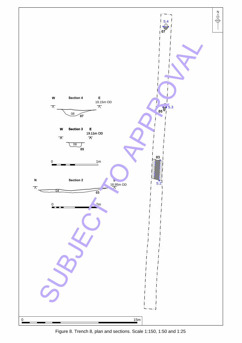
01 Deposit Possible landscaping material, pale orangey brown silty sand. 0.65–0.95m
02 Geological sands and gravels.
03 Cut East–west ditch, 2.85m wide with a flat base and gently sloping sides. 0.12m
04 Deposit Fill of 03. Mid-greyish brown silty sand with occasional charcoal and flint gravel. 0.12m
05 Cut Rectangular pit, 1.10m long x 0.29m wide with a flat base and steep sides. 0.11m
06 Deposit Fill of 05. Black charcoal with rare burnt clay and flint gravel. 0.11m
07 Cut Possible oval pit, 0.80m long x 0.65m wide with a concave base. 0.14m
08 Deposit Fill of 07. Mid-orangey brown silty sand with rare flint gravel. 0.14m
Discussion
None of the three features in Trench 8 (ditch 04, pit 05, pit 07) contained datable material, but pit 05 contained burnt material, which in comparison with other burnt fills in other trenches, may suggest a Roman date.
SUBJ
ECT
TO A
PPRO
VAL
nps archaeology Little Plumstead Hospital, Norfolk Archaeological Evaluation
Page | 29
Trench 8
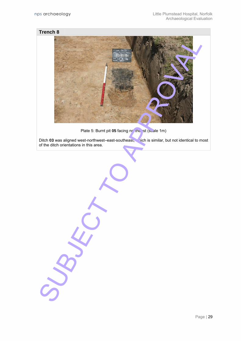
Plate 5: Burnt pit 05 facing northeast (scale 1m)
Ditch 03 was aligned west-northwest–east-southeast, which is similar, but not identical to most of the ditch orientations in this area.
SUBJ
ECT
TO A
PPRO
VAL
08
06
05
07
Section 4W E
19.15m OD
Section 3W E
19.11m OD
Section 3W E
19.11m OD
07
S.4
05
S.3
03
S.2
03
04
18.95m OD
Section 2 SN
0 1m
N
Figure 8. Trench 8, plan and sections. Scale 1:150, 1:50 and 1:25
0 15m
0 2m
SUBJ
ECT
TO A
PPRO
VAL
nps archaeology Little Plumstead Hospital, Norfolk Archaeological Evaluation
Page | 31
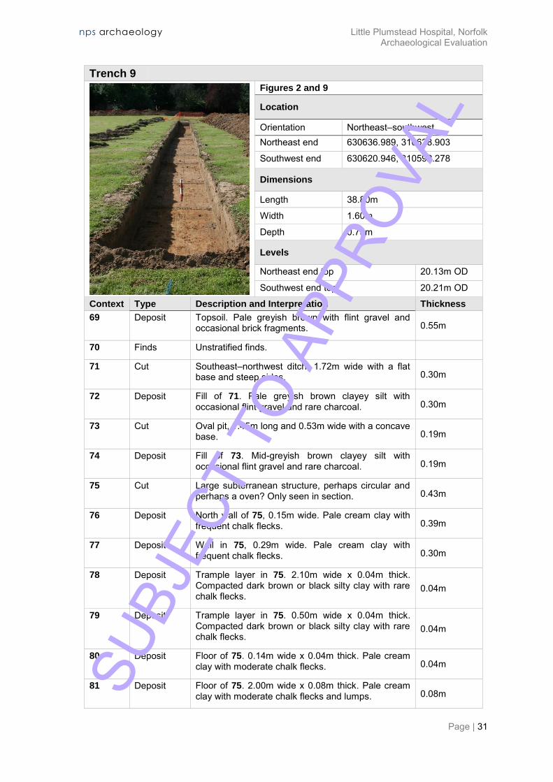
Trench 9
Figures 2 and 9
Location
Orientation Northeast–southwest Northeast end 630636.989, 310628.903
Southwest end 630620.946, 310592.278
Dimensions
Length 38.80m
Width 1.60m
Depth 0.75m
Levels
Northeast end top 20.13m OD
Southwest end top 20.21m OD
Context Type Description and Interpretation Thickness
69 Deposit Topsoil. Pale greyish brown with flint gravel and occasional brick fragments. 0.55m
70 Finds Unstratified finds.
71 Cut Southeast–northwest ditch, 1.72m wide with a flat base and steep sides. 0.30m
72 Deposit Fill of 71. Pale greyish brown clayey silt with occasional flint gravel and rare charcoal. 0.30m
73 Cut Oval pit, 1.45m long and 0.53m wide with a concave base. 0.19m
74 Deposit Fill of 73. Mid-greyish brown clayey silt with occasional flint gravel and rare charcoal. 0.19m
75 Cut Large subterranean structure, perhaps circular and perhaps a oven? Only seen in section. 0.43m
76 Deposit North wall of 75, 0.15m wide. Pale cream clay with frequent chalk flecks. 0.39m
77 Deposit Wall in 75, 0.29m wide. Pale cream clay with frequent chalk flecks. 0.30m
78 Deposit Trample layer in 75. 2.10m wide x 0.04m thick. Compacted dark brown or black silty clay with rare chalk flecks.
0.04m
79 Deposit Trample layer in 75. 0.50m wide x 0.04m thick. Compacted dark brown or black silty clay with rare chalk flecks.
0.04m
80 Deposit Floor of 75. 0.14m wide x 0.04m thick. Pale cream clay with moderate chalk flecks. 0.04m
81 Deposit Floor of 75. 2.00m wide x 0.08m thick. Pale cream clay with moderate chalk flecks and lumps. 0.08m SU
BJEC
T TO
APP
ROVA
L
nps archaeology Little Plumstead Hospital, Norfolk Archaeological Evaluation
Page | 32
Trench 9
82 Deposit Fill of 75. Reddish brown clayey silt with rare chalk flecks. Burnt surface of natural subsoil. 0.04m
83 Deposit Wall of 75, 0.39m thick. Pale cream clay with moderate chalk flecks and lumps. 0.26m
84 Deposit Burnt upper parts of wall 83. 0.73m wide. Reddish brown clay with moderate chalk flecks and lumps. 0.30m
85 Deposit Fill of 75. 0.40m wide. Dark brown silty clay with frequent charcoal and rare chalk flecks. 0.10m
87 Deposit Possible floor of 75. 0.40m wide. Pale cream clay with moderate chalk flecks and lumps. 0.18m
88 Deposit Backfill of 75. 0.56m wide. Dark brown clayey silt with occasional flint and chalk gravel and rare chalky clay lumps.
0.08m
89 Deposit Demolished structure of 75. 0.35m wide. Pale cream clay with moderate chalk flecks and lumps. 0.06m
90 Deposit Layer of trample on floor 81, 2.00m wide. Dark brown silty clay with moderate charcoal and rare chalk flecks.
0.03m
91 Deposit Wall of 75, 0.64m wide. Pale cream clay with moderate chalk flecks and lumps. 0.17m
92 Deposit Backfill of 75, 2.06m wide. Dark greyish brown clayey silt with moderate charcoal flecks and burnt and unburnt chalky clay lumps and rare chalk flecks and flint gravel.
0.38m
Discussion
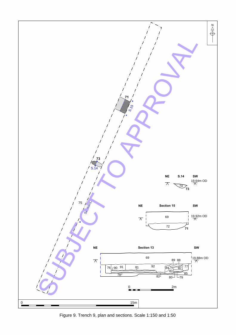
None of the three features in Trench 9 contained datable artefacts.
Ditch 71 was on a similar alignment to ditch 03 in Trench 8 and had a similar profile, but as they were not in line with each other it is unlikely that they were the same feature.
Pit 73 was of unknown purpose.
Feature 75 was identified in section. It appeared to be a partially subterranean structure with chalky clay-lump walls and a chalky clay floor surface with associated layers of trampled material. There was evidence of burning at its south end. The northwest section contained a short stretch of chalky clay material, perhaps the west wall of the structure. It is possible that the structure was another oven-like feature as it was constructed similarly to the oven in Trench 7.
SUBJ
ECT
TO A
PPRO
VAL

nps archaeology Little Plumstead Hospital, Norfolk Archaeological Evaluation
Page | 33
Trench 9
Plate 6: Structure 75 facing southeast (scale 2m)
SUBJ
ECT
TO A
PPRO
VAL
S
e
c
t
i
o
n
1
3
S
.
1
5
S.14
73
75
71
TR8
05
S.3
03
74
73
69
72
71
69
92
76
91
81
90
78
82
83
84
77
89 88
87
85
80 79
19.64m OD
S.14 SWNE
19.92m OD
Section 15 SWNE
19.88m OD
Section 13 SWNE
Figure 9. Trench 9, plan and sections. Scale 1:150 and 1:50
N
0 15m
0 2mSUBJ
ECT
TO A
PPRO
VAL
nps archaeology Little Plumstead Hospital, Norfolk Archaeological Evaluation
Page | 35
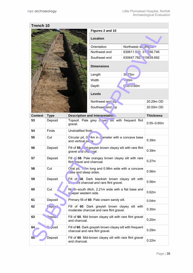
Trench 10
Figures 2 and 10
Location
Orientation Northwest–southeast Northwest end 630611.590, 310656.746
Southeast end 630647.782, 310639.692
Dimensions
Length 39.75m
Width 1.60m
Depth 0.55-0.60m
Levels
Northwest end top 20.29m OD
Southeast end top 20.00m OD
Context Type Description and Interpretation Thickness
53 Deposit Topsoil. Pale grey clayey silt with frequent flint gravel. 0.55–0.60m
54 Finds Unstratified finds.
55 Cut Circular pit, 0.74m in diameter with a concave base and vertical sides. 0.39m
56 Deposit Fill of 55. Mid-greyish brown clayey silt with rare flint gravel and charcoal. 0.39m
57 Deposit Fill of 58. Pale orangey brown clayey silt with rare flint gravel and charcoal. 0.27m
58 Cut Oval pit, 1.3m long and 0.96m wide with a concave base and steep sides. 0.56m
59 Deposit Fill of 58. Dark blackish brown clayey silt with frequent charcoal and rare flint gravel. 0.56m
60 Cut North–south ditch, 2.21m wide with a flat base and steeper western side. 0.62m
61 Deposit Primary fill of 60. Pale cream sandy silt. 0.04m
62 Deposit Fill of 60. Dark greyish brown clayey silt with moderate charcoal and rare flint gravel. 0.30m
63 Deposit Fill of 60. Mid brown clayey silt with rare flint gravel and charcoal. 0.20m
64 Deposit Fill of 60. Dark greyish brown clayey silt with frequent charcoal and rare flint gravel. 0.29m
65 Deposit Fill of 60. Mid-brown clayey silt with rare flint gravel and charcoal. 0.22m SU
BJEC
T TO
APP
ROVA
L
nps archaeology Little Plumstead Hospital, Norfolk Archaeological Evaluation
Page | 36
Trench 10
Discussion
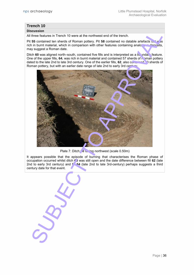
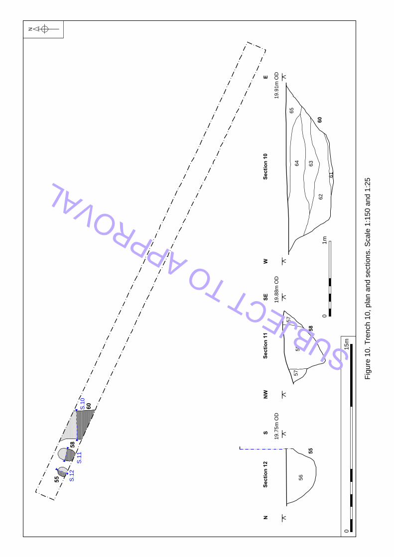
All three features in Trench 10 were at the northwest end of the trench.
Pit 55 contained ten sherds of Roman pottery. Pit 58 contained no datable artefacts but was rich in burnt material, which in comparison with other features containing analogous deposits, may suggest a Roman date.
Ditch 60 was aligned north–south, contained five fills and is interpreted as a boundary feature. One of the upper fills, 64, was rich in burnt material and contained 57 sherds of Roman pottery dated to the late 2nd to late 3rd century. One of the earlier fills, 62, also contained 10 sherds of Roman pottery, but with an earlier date range of late 2nd to early 3rd century.
Plate 7: Ditch 60 facing northwest (scale 0.50m)
It appears possible that the episode of burning that characterises the Roman phase of occupation occurred whilst ditch 60 was still open and the date difference between fill 62 (late 2nd to early 3rd century) and fill 64 (late 2nd to late 3rd-century) perhaps suggests a third century date for that event.
SUBJ
ECT
TO A
PPRO
VAL
S.10
S.11
S.12
60
58
55
65
64
63
62
60
61
59
58
57
57
56
55
133
125
124
Sectio
n 10
EW
19.91m
O
D
Sectio
n 11
SE
NW
19.88m
O
D
Sectio
n 12
SN
19.75m
O
D
Sectio
n 27
NS
20.02m
O
D
Sectio
n 26
SN
19.97m
O
D
N
Fig
ure
1
0. T
re
nch
1
0, p
la
n a
nd
se
ctio
ns. S
ca
le
1
:1
50
a
nd
1
:2
5
01
5m
01
m
SUBJECT TO APPROVAL

nps archaeology Little Plumstead Hospital, Norfolk Archaeological Evaluation
Page | 38
Trench 11
Figures 2 and 11
Location
Orientation East–west West end 630607.492, 310568.580
East end 630647.479, 310568.598
Dimensions
Length 37.5m (shortened due to cable)
Width 1.60m
Depth 0.75m
Levels
West end top 20.14m OD
East end top 20.02m OD
Context Type Description and Interpretation Thickness
9 Deposit Topsoil. Mid-brown sandy loam. 0.70-0.80m
10 Geological clayey sand with flints.
11 Cut North–south ditch, 2.19m wide with a concave base and a steeper eastern slope. 0.76m
12 Deposit Fill of 11. Pale greyish brown clayey sand with moderate flint gravel and occasional burnt clay. 0.76m
Discussion
Ditch 11 follows a similar alignment to most of the other ditches in this area and contained a sherd of post-medieval bottle glass.
Plate 8: Ditch 11 (incorrect number on board) facing north (scale 1m)
SU
BJEC
T TO
APP
ROVA
L
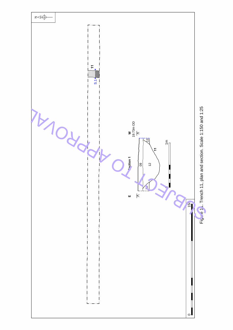
11
S.1
TR
11
09
12
11
13
13
Sectio
n 1
WE
19.73m
O
D
N
Fig
ure
1
1. T
re
nch
1
1, p
la
n a
nd
se
ctio
n. S
ca
le
1
:1
50
a
nd
1
:2
5
01
5m
01
m
SUBJECT TO APPROVAL

nps archaeology Little Plumstead Hospital, Norfolk Archaeological Evaluation
Page | 40
Trench 12
Figures 2 and 12
Location
Orientation Southeast–northwest Southeast end 630589.700,
310564.854 Northwest end 630582.239,
310604.158
Dimensions
Length 40.20m
Width 1.60m
Depth 0.56-0.72m
Levels
Southeast end top 20.04m OD
Northwest end top 20.35m OD
Context Type Description and Interpretation Thickness
48 Deposit Topsoil. Mid-greyish brown sandy loam. 0.55m
50 Geological clayey sand with flints.
51 Cut East-west aligned ditch, 1.00m wide with a flat base and moderately sloping sides. 0.23m
52 Deposit Fill of 51. Mid-greyish brown sandy silt with rare flint gravel, burnt clay and charcoal flecks. 0.23m
Discussion
Ditch 51 contained Roman pottery as well as a small amount of burnt material and was on the same alignment as most other ditches in this area.
Plate 9: Ditch 51 facing east (scale 0.50m)
SUBJ
ECT
TO A
PPRO
VAL

51
S.9
10m to end of trench
48
49
52
51
Section 9N S
Not known
Figure 12. Trench 12, plan and section. Scale 1:150 and 1:25
N
0 15m
0 1m
SUBJ
ECT
TO A
PPRO
VAL

nps archaeology Little Plumstead Hospital, Norfolk Archaeological Evaluation
Page | 42
Trench 13
Figures 2 and 13
Location
Orientation East–west East end 630596.612, 310612.929
West end 630556.613, 310612.935
Dimensions
Length 39.00m
Width 1.60m
Depth 0.70-0.80m
Levels
East end top 20.43m OD
West end top 20.77m OD
Context Type Description and Interpretation Thickness
126 Deposit Topsoil. Mid-greyish brown clayey silt with flint gravel and occasional CBM fragments. 0.50m
127 Cut North–south ditch, 1.07m wide with a concave base and a steeper western slope. 0.47m
128 Deposit Fil of 127. Pale grey silty clay with occasional flint gravel and rare charcoal lumps. 0.47m
129 Cut Sub-circular pit, c. 0.50m in diameter with a concave base and steep sides. 0.13m
130 Deposit Fill of 129. Mid-brownish grey clayey silt with occasional flint gravel. 0.13m
131 Cut Sub-circular pit, c. 0.60m in diameter with a flat base and vertical sides. 0.21m
132 Deposit Fill of 131. Dark brown clayey silt with rare flint gravel and flecks of burnt clay and occasional charcoal flecks.
0.21m
Discussion
None of the features in Trench 13 were datable, but the presence of burnt material in pit 131 may suggest the possibility of a Roman date.
SUBJ
ECT
TO A
PPRO
VAL
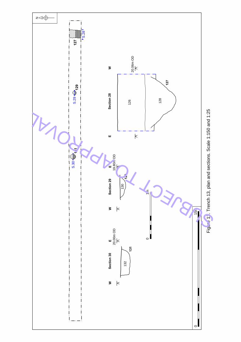
131
129
127
S.28
S.29
S.30
130
129
132
131
126
128
127
Sectio
n 30
WE
20.00m
O
D
Sectio
n 29
WE
19.80m
O
D
Sectio
n 28
WE
20.06m
O
D
N
Fig
ure
1
3. T
re
nch
1
3, p
la
n a
nd
se
ctio
ns. S
ca
le
1
:1
50
a
nd
1
:2
5
01
5m
01m
SUBJECT TO APPROVAL
nps archaeology Little Plumstead Hospital, Norfolk Archaeological Evaluation
Page | 44
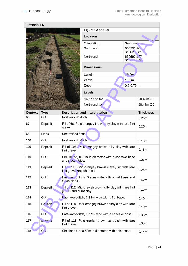
Trench 14
Figures 2 and 14
Location
Orientation South–north South end 630593.262,
310629.881 North end 630593.257,
310669.877
Dimensions
Length 39.7m
Width 1.60m
Depth 0.5-0.75m
Levels
South end top 20.42m OD
North end top 20.43m OD
Context Type Description and Interpretation Thickness
66 Cut North–south ditch. 0.25m
67 Deposit Fill of 66. Pale orangey brown silty clay with rare flint gravel. 0.25m
68 Finds Unstratified finds.
108 Cut North–south ditch. 0.18m
109 Deposit Fill of 108. Pale orangey brown silty clay with rare flint gravel 0.18m
110 Cut Circular pit, 0.80m in diameter with a concave base and steep sides. 0.26m
111 Deposit Fill of 110. Mid-orangey brown clayey silt with rare flint gravel and charcoal. 0.26m
112 Cut East–west ditch, 0.95m wide with a flat base and steep sides. 0.42m
113 Deposit Fill of 112. Mid-greyish brown silty clay with rare flint gravel and burnt clay. 0.42m
114 Cut East–west ditch, 0.88m wide with a flat base. 0.40m
115 Deposit Fill of 114. Dark orangey brown sandy clay with rare flint gravel. 0.40m
116 Cut East–west ditch, 0.77m wide with a concave base. 0.33m
117 Deposit Fill of 116. Pale greyish brown sandy silt with rare flint gravel. 0.33m
118 Cut Circular pit, c. 0.52m in diameter, with a flat base. 0.14m SUBJ
ECT
TO A
PPRO
VAL

nps archaeology Little Plumstead Hospital, Norfolk Archaeological Evaluation
Page | 45
Trench 14
119 Deposit Fill of 118. Pale greyish brown silty sand with rare flint gravel. 0.14m
120 Cut Circular pit, 0.71m in diameter with a sloping base and sides of variable steepness. 0.28m
121 Deposit Fill of 120. Brownish orange sandy clay with rare flint gravel. 0.28m
122 Cut Northwest–southeast ditch, 1.30m wide with a flat base and steep sides. 0.32m
123 Deposit Fill of 122. Pale brown sandy silt with rare flint gravel. 0.32m
124 Cut Oval pit, 1.78m long x 0.60m wide with a flat base. 0.32m
125 Deposit Fill of 124. Mid-brown silty sand with rare flint gravel, charcoal and burnt clay. 0.32m
133 Deposit Topsoil. Pale greyish brown silty sand with flint gravel and occasional brick fragments. 0.50m
135 Deposit Pale orangey brown sand and gravel natural geology.
Discussion
Six of the features in Trench 14 could be dated to the Roman period by pottery or briack and tile fragments. The other four features could not be dated.
Ditch 122 at the north end of the trench contained an assemblage of Roman material including pottery, brick, an iron object and a fragment of a millstone grit quern stone. The ditch was on an atypical alignment and showed no evidence of burning.
Plate 10: Ditch 122 facing east (scale ½ m)
Adjacent pits 120 and 124 contained Roman pottery. Pit 124 also contained burnt material.
Ditches 112, 114 and 116 were all close together and all aligned east–west. They also appeared in adjacent Trench 7 as ditches 167, 169 and 171 respectively. Ditch 116 contained Roman pottery and ditch 112 contained a fragment of Roman brick.
Pits 110 and 118 could not be dated.
Only a small part of ditch 66/108 was visible against the east side of the trench. It was probably a continuation of ditch 127 in Trench 13 and contained Roman (2nd–3rd-century) pottery.
SUBJ
ECT
TO A
PPRO
VAL
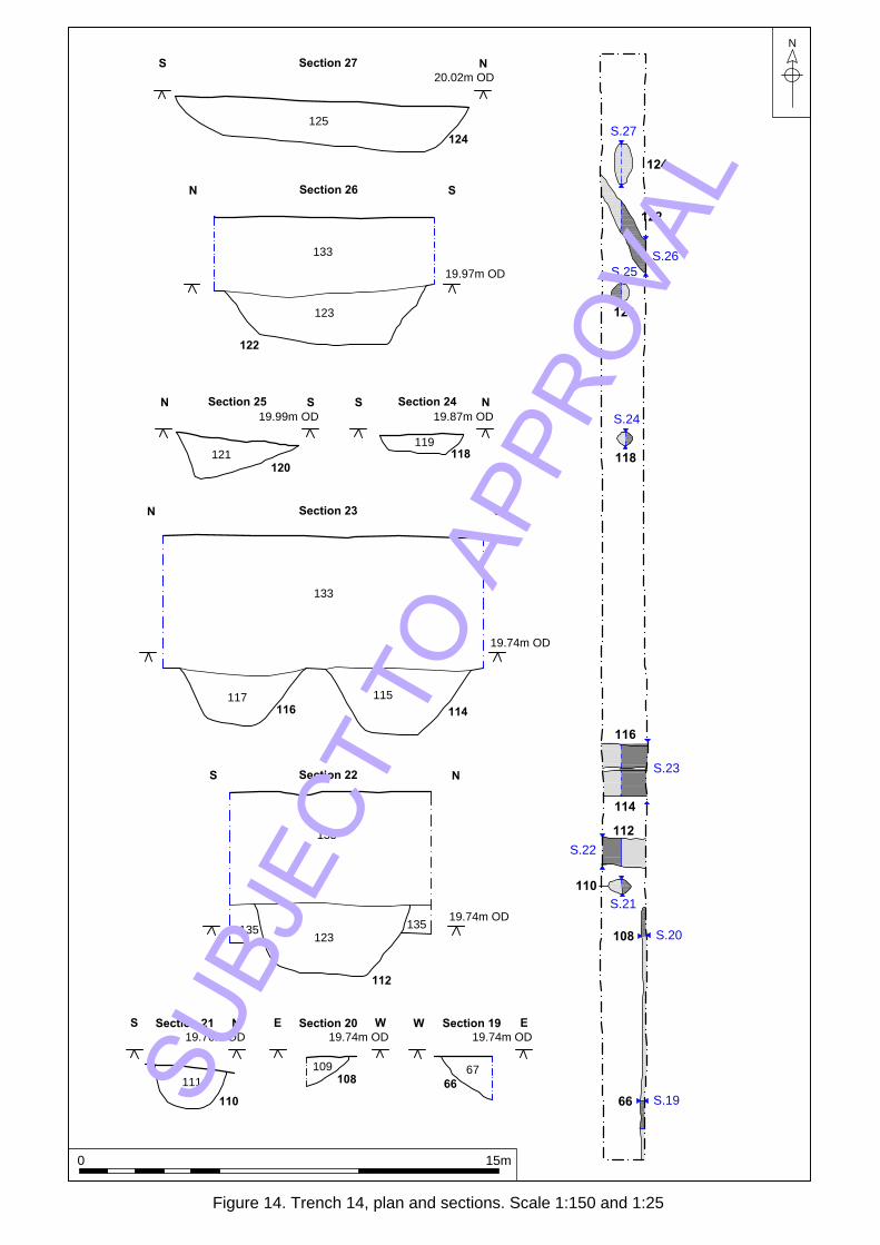
67
66
109
108
111
110
133
135
135
133
117
116
115
114
119
118121
120
133
123
122
125
124
Section 27NS
20.02m OD
Section 26SN
19.97m OD
Section 25N S
19.99m OD
Section 24NS
19.87m OD
Section 23N S
19.74m OD
Section 19W E
19.74m OD
Section 20 WE
19.74m OD
Section 21 NS
19.76m OD
Section 22NS
19.74m OD
112
123
S.46
S.19
S.20
S.21
S.22
S.23
S.24
S.25
S.26
S.27
66
108
110
112
114
116
118
120
122
124
N
Figure 14. Trench 14, plan and sections. Scale 1:150 and 1:25
0 15m
SUBJ
ECT
TO A
PPRO
VAL

nps archaeology Little Plumstead Hospital, Norfolk Archaeological Evaluation
Page | 47
Trench 15
Figure 2
Location
Orientation Southeast–northwest Southeast end 630581.475, 310670.424
Northwest end 630548.070, 310692.414
Dimensions
Length 31.30m (shortened due to cable)
Width 1.60m
Depth 0.75m
Levels
Southeast end top 20.57m OD
Northwest end top 20.69m OD
Context Type Description and Interpretation Thickness
14 Deposit Modern pit containing modern slag fragments towards its northwest end.
191 Deposit Topsoil. Pale grey silty sand. 0.40m
192 Deposit Subsoil. Pale orangey brown silty sand 0.35m
Discussion
Trench 15 revealed no significant archaeological features or artefacts.
SUBJ
ECT
TO A
PPRO
VAL
nps archaeology Little Plumstead Hospital, Norfolk Archaeological Evaluation
Page | 48
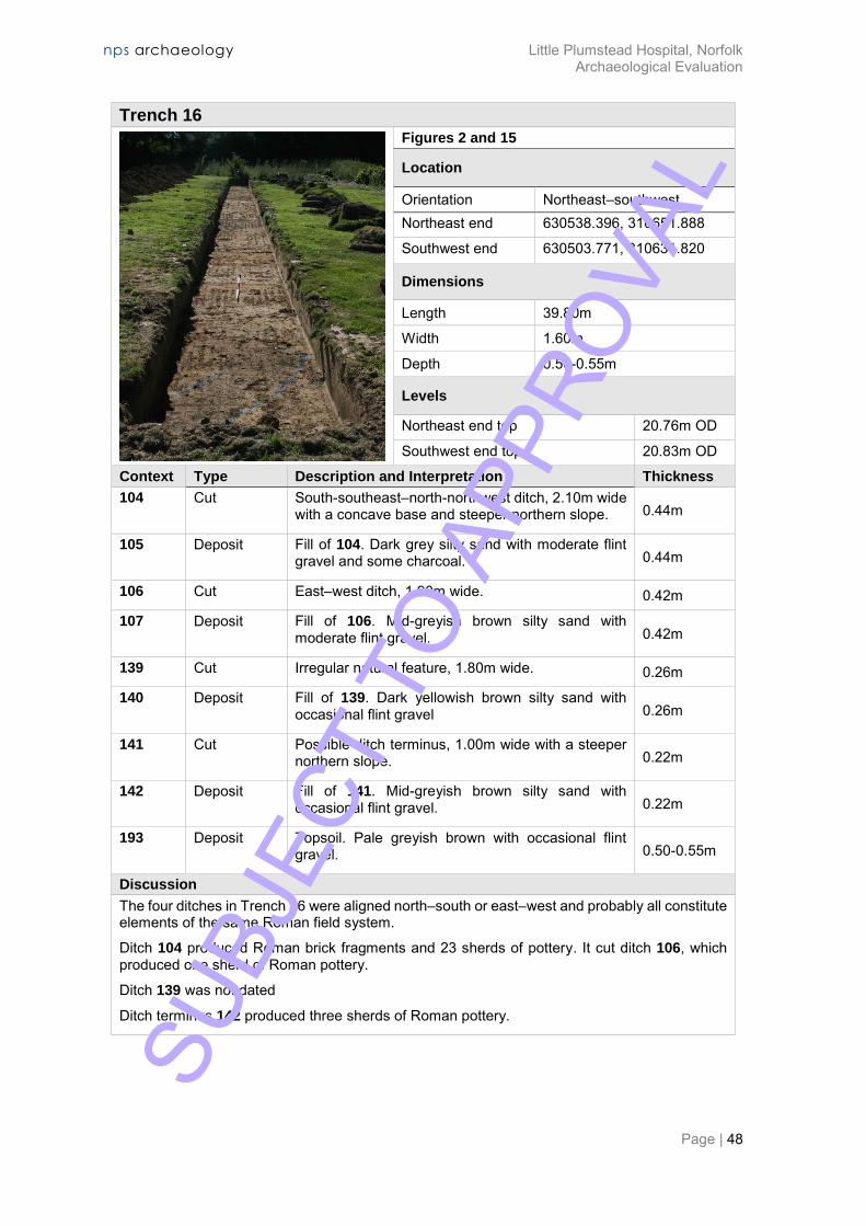
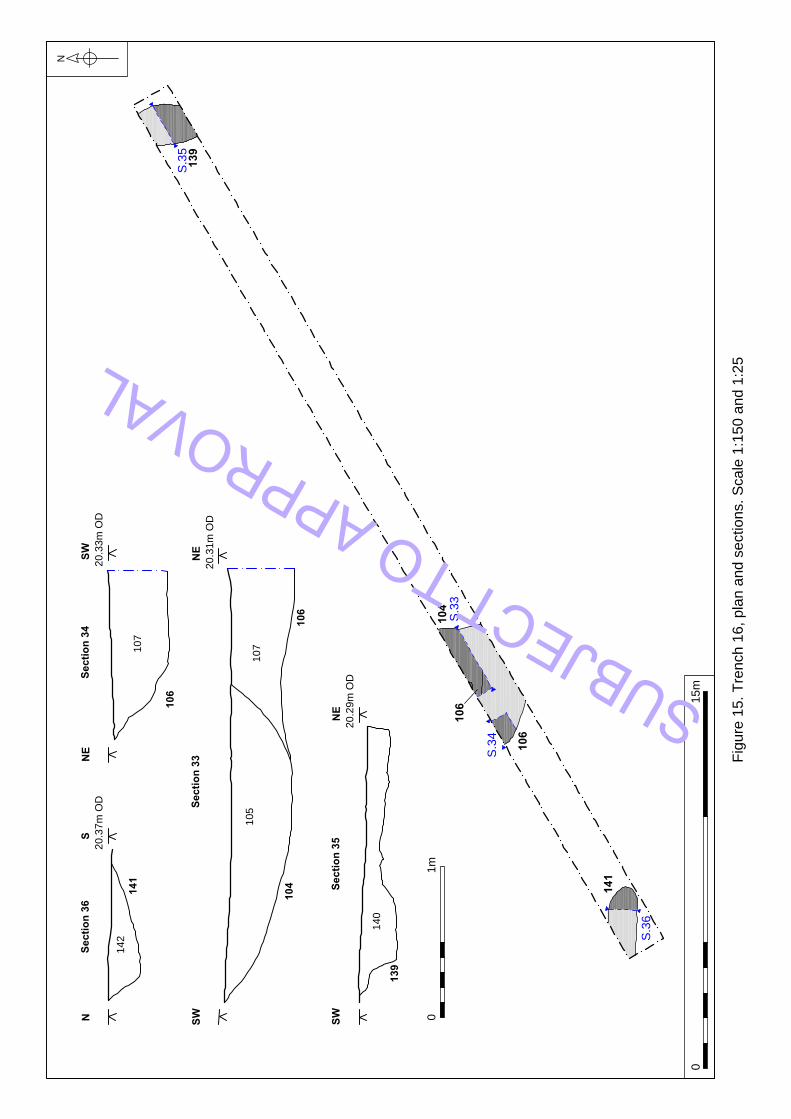
Trench 16
Figures 2 and 15
Location
Orientation Northeast–southwest Northeast end 630538.396, 310651.888
Southwest end 630503.771, 310631.820
Dimensions
Length 39.80m
Width 1.60m
Depth 0.50-0.55m
Levels
Northeast end top 20.76m OD
Southwest end top 20.83m OD
Context Type Description and Interpretation Thickness
104 Cut South-southeast–north-northwest ditch, 2.10m wide with a concave base and steeper northern slope. 0.44m
105 Deposit Fill of 104. Dark grey silty sand with moderate flint gravel and some charcoal. 0.44m
106 Cut East–west ditch, 1.90m wide. 0.42m
107 Deposit Fill of 106. Mid-greyish brown silty sand with moderate flint gravel. 0.42m
139 Cut Irregular natural feature, 1.80m wide. 0.26m
140 Deposit Fill of 139. Dark yellowish brown silty sand with occasional flint gravel 0.26m
141 Cut Possible ditch terminus, 1.00m wide with a steeper northern slope. 0.22m
142 Deposit Fill of 141. Mid-greyish brown silty sand with occasional flint gravel. 0.22m
193 Deposit Topsoil. Pale greyish brown with occasional flint gravel. 0.50-0.55m
Discussion
The four ditches in Trench 16 were aligned north–south or east–west and probably all constitute elements of the same Roman field system.
Ditch 104 produced Roman brick fragments and 23 sherds of pottery. It cut ditch 106, which produced one sherd of Roman pottery.
Ditch 139 was not dated
Ditch terminus 142 produced three sherds of Roman pottery.
SU
BJEC
T TO
APP
ROVA
L
S.32
S.35
139
104
S.33
106
S.34
106
S.36
141
105
104
106
107
107
106
142
141
139
140
Sectio
n 36
NS
20.37m
O
D
Sectio
n 34
NE
SW
20.33m
O
D
Sectio
n 33
NE
SW
20.31m
O
D
Sectio
n 35
NE
SW
20.29m
O
D
N
Fig
ure
1
5. T
re
nch
1
6, p
la
n a
nd
se
ctio
ns. S
ca
le
1
:1
50
a
nd
1
:2
5
01
5m
01m
SUBJECT TO APPROVAL

nps archaeology Little Plumstead Hospital, Norfolk Archaeological Evaluation
Page | 50
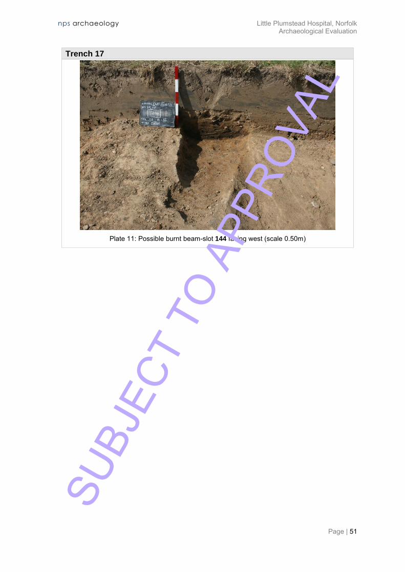
Trench 17
Figures 2 and 16
Location
Orientation Northwest–southeast Northwest end 630535.867, 310633.215
Southeast end 630543.133, 310593.831
Dimensions
Length 40.00m
Width 1.60m
Depth 0.50m
Levels
Northwest end top 20.66m OD
Southeast end top 20.50m OD
Context Type Description and Interpretation Thickness
143 Deposit Topsoil. Pale orangey brown silty sand 0.50m
144 Cut Possible burnt beam-slot. East–west aligned, 0.73m wide with a flat base and steep to vertical sides. 0.22m
145 Deposit Fill of 144. Mid–dark brown silty clay with frequent burnt earth, especially at the sides, frequent charcoal, especially at the base and rare flint gravel.
0.22m
146 Cut Possible burnt beam-slot. East–west aligned, 0.56m wide with a concave base and steep sides. 0.25m
147 Deposit Fill of 146. Mid–dark brown silty clay with frequent charcoal flecks, moderate burnt earth, especially at the sides and base and rare flint gravel.
0.25m
148 Finds Unstratified finds.
Discussion
Both the features in Trench 17 were aligned east–west and had burnt earth at the sides and charcoal on the base, suggesting the presence of burnt in situ wooden beams. Beam-slot 144 contained eight sherds of Roman (early 2nd to late 3rd-century) pottery.
SUBJ
ECT
TO A
PPRO
VAL
nps archaeology Little Plumstead Hospital, Norfolk Archaeological Evaluation
Page | 51
Trench 17
Plate 11: Possible burnt beam-slot 144 facing west (scale 0.50m)
SUBJ
ECT
TO A
PPRO
VAL

143
145
144
147
146
Section 32N S
20.38m OD
Section 31 NS
20.30m OD
146
144
S.32
S.31
N
Figure 16. Trench 17, plan and sections. Scale 1:150 and 1:25
0 15m
0 1m
SUBJ
ECT
TO A
PPRO
VAL
nps archaeology Little Plumstead Hospital, Norfolk Archaeological Evaluation
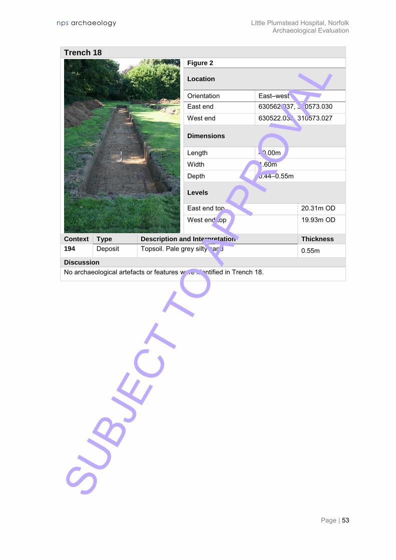
Page | 53
Trench 18
Figure 2
Location
Orientation East–west East end 630562.037, 310573.030
West end 630522.033, 310573.027
Dimensions
Length 40.00m
Width 1.60m
Depth 0.44–0.55m
Levels
East end top 20.31m OD
West end top 19.93m OD
Context Type Description and Interpretation Thickness
194 Deposit Topsoil. Pale grey silty sand 0.55m
Discussion
No archaeological artefacts or features were identified in Trench 18.
SUBJ
ECT
TO A
PPRO
VAL

nps archaeology Little Plumstead Hospital, Norfolk Archaeological Evaluation
Page | 54
Trench 19
Figures 2 and 17
Location
Orientation Southeast–northwest Southeast end 630513.902, 310574.140
Northwest end 630507.737, 310613.753
Dimensions
Length 40.0m
Width 1.60m
Depth 0.44-0.58m
Levels
Southeast end top 20.04m OD
Northwest end top 20.67m OD
Context Type Description and Interpretation Thickness
93 Deposit Topsoil. Pale grey silty sand. 0.48m
95 Deposit Geological sands and gravel.
96 Cut Possible pit or linear 8.60m wide with a flat base and moderate slopes. Same as 98 and 100. 0.25m
97 Deposit Fill of 96. Mid-greyish brown silty sand with occasional flint gravel. Same as 99 and 101. 0.25m
98 Cut Possible pit or linear 8.60m wide with a flat base and moderate slopes. Same as 96 and 100. 0.33m
99 Deposit Fill of 98. Mid-greyish brown silty sand with occasional flint gravel. Same as 97 and 101. 0.33m
100 Cut Possible pit or linear 8.60m wide with a flat base and moderate slopes. Same as 96 and 98. 0.35m
101 Deposit Fill of 100. Mid-greyish brown silty sand with occasional flint gravel. Same as 97 and 99. 0.35m
102 Cut Possible circular pit. Only a small portion seen. 0.62m
103 Deposit Fill of 102. Dark brown (with dark grey patches) silty sand with occasional flint gravel and charcoal. 0.62m
136 Cut Possible pit or ditch, 8.60m wide with steep sides. 0.9m
137 Deposit Base fill of 136. Dark greyish brown silty sand with occasional flint gravel and charcoal. 0.79m
138 Deposit Fill of 136. Pale orangey brown clayey sand with occasional flint gravel 0.11m
Discussion
Trench 19 contained a group of inter-cut quarry pits of medieval (probably 13th-century) date. SUBJ
ECT
TO A
PPRO
VAL

103
97
96
102
99
98
137
136
138
Auger
Section 16NS
20.17m OD
Section 17N S
20.00m OD
96
102
98
136
136
100
S.16
S.17
S.18
137
101
136
100
138
Auger
Section 18N S
19.89m OD
N
Figure 16. Trench 17, plan and sections. Scale 1:150, 1:50 and 1:25
0 15m
0 1m
0 2mSUBJ
ECT
TO A
PPRO
VAL
nps archaeology Little Plumstead Hospital, Norfolk Archaeological Evaluation
Page | 56
ARCHAEOLOGICAL FINDS
59 The finds were washed, dried, marked and bagged and were recorded by count and weight. Data was entered onto a Microsoft Excel spreadsheet, which forms part of the project archive.
60 A discussion of each material type is given below. Appendix 2a comprises a list of all archaeological materials found by the excavations in context number order.
Pottery
Introduction
61 The trial trench evaluation recovered a total of 212 sherds (4,024g) of pottery (Table 2), the bulk of which represents Roman domestic occupation on the site in the late 2nd to early 3rd centuries AD.
62 The Roman pottery is dominated by locally produced sandy grey wares, but includes an east Gaulish samian ware bowl with a makers stamp and some regional wares, including mortaria from the Lower Nene Valley. A colluvial layer produced very low quantities of prehistoric pottery, probably of Late Bronze Age to Early Iron Age date. Small numbers of medieval (11th to 13th-century) sherds were contained in a cluster of pits.
63 Date of Pottery 64 Sherd
65 Count
66 Weight (g) 67 R.EVE
68 Late Bronze Age/Early Iron Age 69 5 70 31 71 0.05
72 Roman 73 193 74 3734 75 3.17
76 Medieval 77 10 78 241 79 0.07
80 Post-medieval 81 4 82 18 83 -
84 Total 85 212 86 4024 87 3.29
Table 2. Quantification of pottery by period
Methodology
88 The pottery was quantified by sherd count, weight (g) and R.EVE, and fabrics were examined at x20 magnification in accordance with the guidelines of the Prehistoric Ceramics Research Group (PCRG 1995) and the Study Group for Roman Pottery (Webster 1976; Darling 2004; Willis 2004). Samian ware forms reference Webster (1996). A catalogue of the pottery, including fabric descriptions has been entered into a Microsoft Excel spreadsheet, which forms part of the site archive. Fabric Codes & Descriptions
Late Bronze Age/Early Iron Age
QF1 Medium calcined flint-and sand tempered ware (BA-EIA). Mid-brown grey surfaces over a dark grey core. Inclusions comprise common calcined flint (0.5-3mm) and quartz (0.25-0.5mm).
Roman
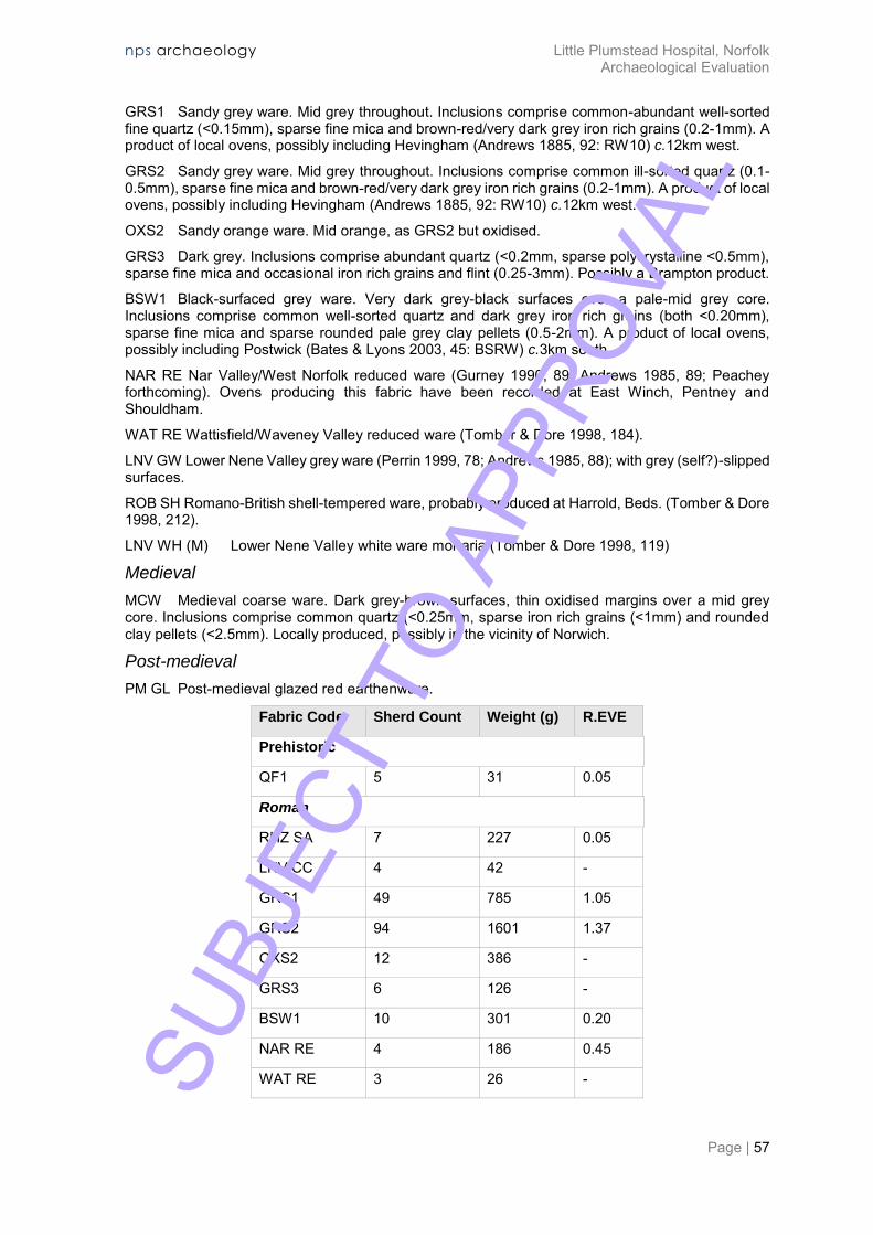
RHZ SA Rheinzabern (Eastern Gaul) samian ware.
LNV CC Lower Nene Valley colour-coated ware (Tomber & Dore 1998, 118). SUBJ
ECT
TO A
PPRO
VAL
nps archaeology Little Plumstead Hospital, Norfolk Archaeological Evaluation
Page | 57
GRS1 Sandy grey ware. Mid grey throughout. Inclusions comprise common-abundant well-sorted fine quartz (<0.15mm), sparse fine mica and brown-red/very dark grey iron rich grains (0.2-1mm). A product of local ovens, possibly including Hevingham (Andrews 1885, 92: RW10) c.12km west.
GRS2 Sandy grey ware. Mid grey throughout. Inclusions comprise common ill-sorted quartz (0.1-0.5mm), sparse fine mica and brown-red/very dark grey iron rich grains (0.2-1mm). A product of local ovens, possibly including Hevingham (Andrews 1885, 92: RW10) c.12km west.
OXS2 Sandy orange ware. Mid orange, as GRS2 but oxidised.
GRS3 Dark grey. Inclusions comprise abundant quartz (<0.2mm, sparse polycrystalline <0.5mm), sparse fine mica and occasional iron rich grains and flint (0.25-3mm). Possibly a Brampton product.
BSW1 Black-surfaced grey ware. Very dark grey-black surfaces over a pale-mid grey core. Inclusions comprise common well-sorted quartz and dark grey iron rich grains (both <0.20mm), sparse fine mica and sparse rounded pale grey clay pellets (0.5-2mm). A product of local ovens, possibly including Postwick (Bates & Lyons 2003, 45: BSRW) c.3km south.
NAR RE Nar Valley/West Norfolk reduced ware (Gurney 1990, 89; Andrews 1985, 89; Peachey forthcoming). Ovens producing this fabric have been recorded at East Winch, Pentney and Shouldham.
WAT RE Wattisfield/Waveney Valley reduced ware (Tomber & Dore 1998, 184).
LNV GW Lower Nene Valley grey ware (Perrin 1999, 78; Andrews 1985, 88); with grey (self?)-slipped surfaces.
ROB SH Romano-British shell-tempered ware, probably produced at Harrold, Beds. (Tomber & Dore 1998, 212).
LNV WH (M) Lower Nene Valley white ware mortaria (Tomber & Dore 1998, 119)
Medieval
MCW Medieval coarse ware. Dark grey-brown surfaces, thin oxidised margins over a mid grey core. Inclusions comprise common quartz (<0.25mm, sparse iron rich grains (<1mm) and rounded clay pellets (<2.5mm). Locally produced, possibly in the vicinity of Norwich.
Post-medieval
PM GL Post-medieval glazed red earthenware.
89 Fabric Code 90 Sherd Count 91 Weight (g) 92 R.EVE
93 Prehistoric
94 QF1 95 5 96 31 97 0.05
98 Roman
99 RHZ SA 100 7 101 227 102 0.05
103 LNV CC 104 4 105 42 106 -
107 GRS1 108 49 109 785 110 1.05
111 GRS2 112 94 113 1601 114 1.37
115 OXS2 116 12 117 386 118 -
119 GRS3 120 6 121 126 122 -
123 BSW1 124 10 125 301 126 0.20
127 NAR RE 128 4 129 186 130 0.45
131 WAT RE 132 3 133 26 134 - SUBJ
ECT
TO A
PPRO
VAL
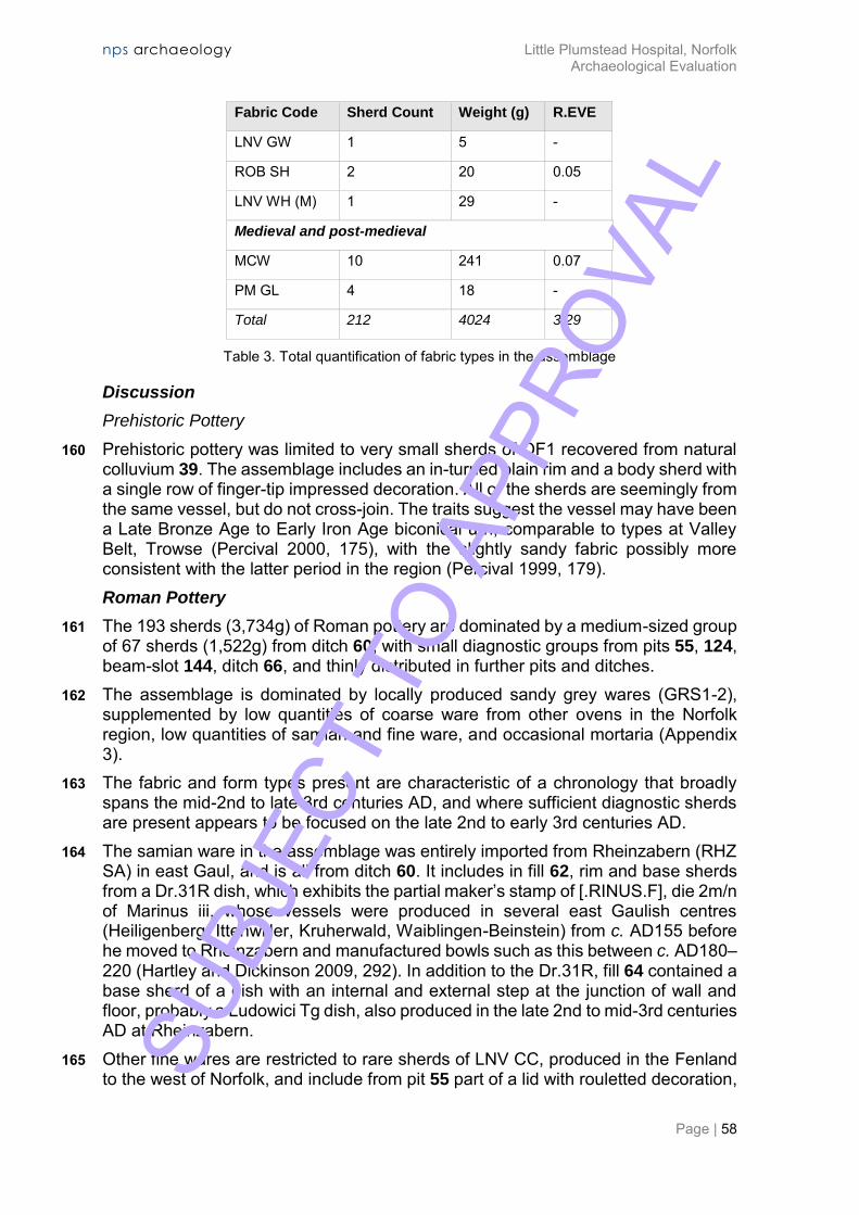
nps archaeology Little Plumstead Hospital, Norfolk Archaeological Evaluation
Page | 58
89 Fabric Code 90 Sherd Count 91 Weight (g) 92 R.EVE
135 LNV GW 136 1 137 5 138 -
139 ROB SH 140 2 141 20 142 0.05
143 LNV WH (M) 144 1 145 29 146 -
147 Medieval and post-medieval
148 MCW 149 10 150 241 151 0.07
152 PM GL 153 4 154 18 155 -
156 Total 157 212 158 4024 159 3.29
Table 3. Total quantification of fabric types in the assemblage
Discussion
Prehistoric Pottery
160 Prehistoric pottery was limited to very small sherds of QF1 recovered from natural colluvium 39. The assemblage includes an in-turned plain rim and a body sherd with a single row of finger-tip impressed decoration. All of the sherds are seemingly from the same vessel, but do not cross-join. The traits suggest the vessel may have been a Late Bronze Age to Early Iron Age biconical urn, comparable to types at Valley Belt, Trowse (Percival 2000, 175), with the slightly sandy fabric possibly more consistent with the latter period in the region (Percival 1999, 179). Roman Pottery
161 The 193 sherds (3,734g) of Roman pottery are dominated by a medium-sized group of 67 sherds (1,522g) from ditch 60, with small diagnostic groups from pits 55, 124, beam-slot 144, ditch 66, and thinly distributed in further pits and ditches.
162 The assemblage is dominated by locally produced sandy grey wares (GRS1-2), supplemented by low quantities of coarse ware from other ovens in the Norfolk region, low quantities of samian and fine ware, and occasional mortaria (Appendix 3).
163 The fabric and form types present are characteristic of a chronology that broadly spans the mid-2nd to late 3rd centuries AD, and where sufficient diagnostic sherds are present appears to be focused on the late 2nd to early 3rd centuries AD.
164 The samian ware in the assemblage was entirely imported from Rheinzabern (RHZ SA) in east Gaul, and is all from ditch 60. It includes in fill 62, rim and base sherds from a Dr.31R dish, which exhibits the partial maker’s stamp of [.RINUS.F], die 2m/n of Marinus iii, whose vessels were produced in several east Gaulish centres (Heiligenberg, Ittenwiller, Kruherwald, Waiblingen-Beinstein) from c. AD155 before he moved to Rheinzabern and manufactured bowls such as this between c. AD180–220 (Hartley and Dickinson 2009, 292). In addition to the Dr.31R, fill 64 contained a base sherd of a dish with an internal and external step at the junction of wall and floor, probably a Ludowici Tg dish, also produced in the late 2nd to mid-3rd centuries AD at Rheinzabern.
165 Other fine wares are restricted to rare sherds of LNV CC, produced in the Fenland to the west of Norfolk, and include from pit 55 part of a lid with rouletted decoration, SU
BJEC
T TO
APP
ROVA
L
nps archaeology Little Plumstead Hospital, Norfolk Archaeological Evaluation
Page | 59
which dates to the late 2nd to mid-3rd centuries AD (Perrin 1999, 100: types 209–211). A body sherd in ditch 60 appears to derive from a beaker. The Lower Nene Valley also supplied specialist wares in the form of mortaria (LNV WH (M)), represented by a single sherd recovered unstratified 68, with heavily worn black slag trituration grits.
166 The most common fabrics are locally produced sandy coarse wares, primarily reduced (GRS1-2), but also oxidized (OXS1) and black-surfaced (BSW1), though all related and varying only slightly in the grade of quartz sand incorporated in the fabric. Vessels in these fabrics are largely represented by everted bead rims of long-lived cooking pots or wide-mouth bowls, largely with plain shoulders (Symonds and Wade 1999: type Cam.268), and a minimum of nine vessels are represented in ditch 60. However, one example in ditch 104 has a plain shoulder cordon, comparable to vessels which decline in the early 3rd century AD at Brampton (i.e. Green 1977, 68: vessel 77). The domestic function of these vessels is supported by two examples with soot on the neck and rim, while other utilitarian form types present in the local coarse wares are limited to shallow non-burnished dishes with bead rims, common in the 2nd-3rd centuries AD, and represented by three examples from ditch 60 and one from beam-slot 144.
167 The locally produced coarse wares were supplemented by low quantities of coarse wares from major industries in the region, including the Lower Nene Valley (LNV GW) to the west, Brampton (GRS3) close to the north, Wattisfield (WAT RE) to the south, and the ovens at Harrold in Bedfordshire, which supplied increasing quantities of shell-tempered pottery to Norfolk in the late 2nd to 4th centuries AD, such as a jar with a triangular bead rim from ditch 104. The most notable regional producer appears to be the Nar Valley in west Norfolk, primarily supplying deep dishes with grooved rims, which were found in ditch 60 and pit 44, and the production of which appears to begin in the late 2nd or early 3rd-centuries AD (Andrews 1985, 113: type 150).
168 The composition of the Roman pottery group appears consistent with moderate status domestic occupation on a site probably in the hinterland of the small town at Brampton. The material was likely included in the primary deposition of rubbish or clearance of material into ditch 60 and other features. The consumption pattern is largely indicative of domestic functions, including cooking pots in locally produced wares and processing in regional mortaria wares, but with access to table goods in samian ware and fine wares which define a chronology probably focused on the late 2nd to early 3rd centuries AD. Medieval and later pottery
169 Small numbers of locally produced medieval coarse ware (MCW) sherds were collected from pits 96, 98 and 100, with the former containing the everted hammer-head rim of a bowl produced in the 11th to 13th-centuries (Jennings 1981, 40: fig.12.264). In addition to the stratified medieval pottery, a handle was recovered from topsoil 93. The handle has a thick (35mm) circular section and was fairly tightly twisted prior to attachment to the globular body and neck of a vessel, probably a large jug of 13th to 14th-century date. Small sherds of post-medieval glazed red earthen ware were recovered from topsoil and unstratified contexts, typical of material spread through agricultural processes and soil improvement. SU
BJEC
T TO
APP
ROVA
L
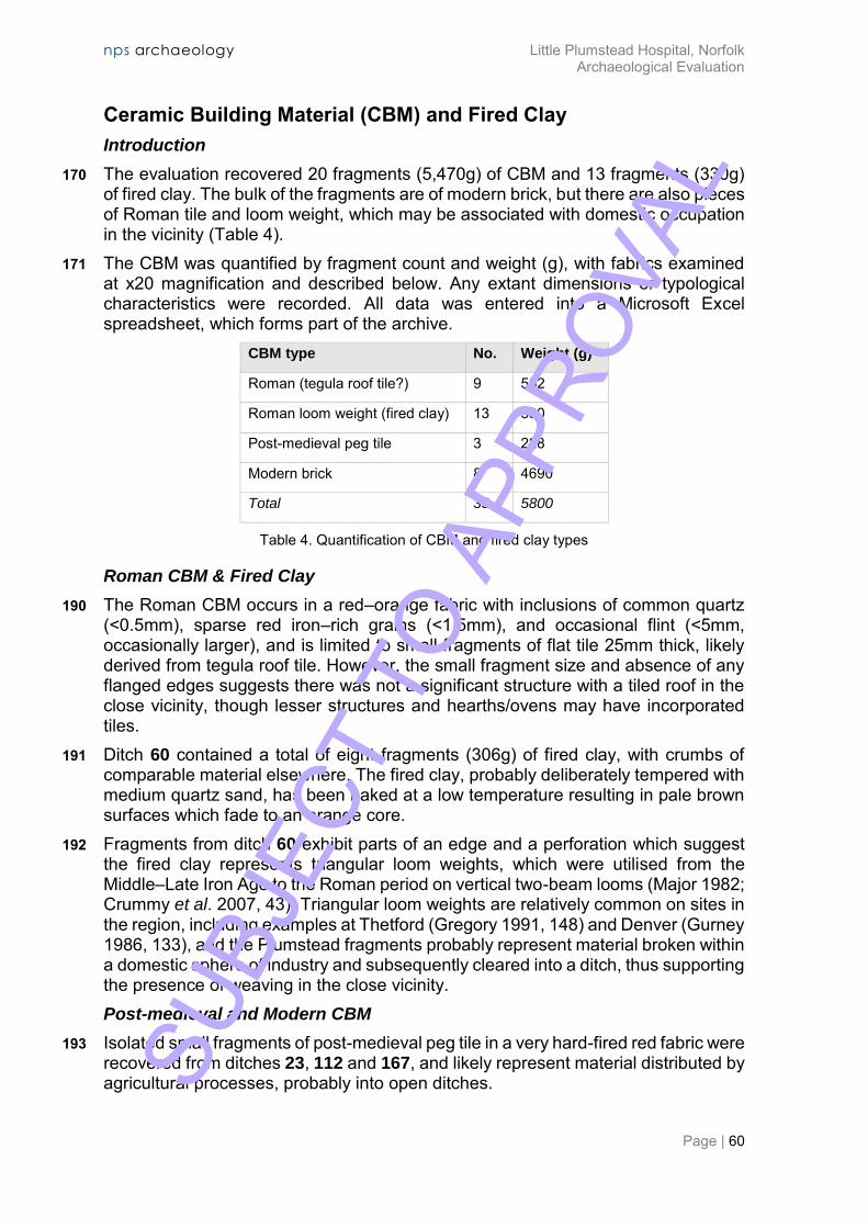
nps archaeology Little Plumstead Hospital, Norfolk Archaeological Evaluation
Page | 60
Ceramic Building Material (CBM) and Fired Clay
Introduction
170 The evaluation recovered 20 fragments (5,470g) of CBM and 13 fragments (330g) of fired clay. The bulk of the fragments are of modern brick, but there are also pieces of Roman tile and loom weight, which may be associated with domestic occupation in the vicinity (Table 4).
171 The CBM was quantified by fragment count and weight (g), with fabrics examined at x20 magnification and described below. Any extant dimensions or typological characteristics were recorded. All data was entered into a Microsoft Excel spreadsheet, which forms part of the archive.
172 CBM type 173 No. 174 Weight (g)
175 Roman (tegula roof tile?) 176 9 177 552
178 Roman loom weight (fired clay) 179 13 180 330
181 Post-medieval peg tile 182 3 183 228
184 Modern brick 185 8 186 4690
187 Total 188 33 189 5800
Table 4. Quantification of CBM and fired clay types
Roman CBM & Fired Clay
190 The Roman CBM occurs in a red–orange fabric with inclusions of common quartz (<0.5mm), sparse red iron–rich grains (<1.5mm), and occasional flint (<5mm, occasionally larger), and is limited to small fragments of flat tile 25mm thick, likely derived from tegula roof tile. However, the small fragment size and absence of any flanged edges suggests there was not a significant structure with a tiled roof in the close vicinity, though lesser structures and hearths/ovens may have incorporated tiles.
191 Ditch 60 contained a total of eight fragments (306g) of fired clay, with crumbs of comparable material elsewhere. The fired clay, probably deliberately tempered with medium quartz sand, has been baked at a low temperature resulting in pale brown surfaces which fade to an orange core.
192 Fragments from ditch 60 exhibit parts of an edge and a perforation which suggest the fired clay represents triangular loom weights, which were utilised from the Middle–Late Iron Age to the Roman period on vertical two-beam looms (Major 1982; Crummy et al. 2007, 43). Triangular loom weights are relatively common on sites in the region, including examples at Thetford (Gregory 1991, 148) and Denver (Gurney 1986, 133), and the Plumstead fragments probably represent material broken within a domestic sphere of industry and subsequently cleared into a ditch, thus supporting the presence of weaving in the close vicinity. Post-medieval and Modern CBM
193 Isolated small fragments of post-medieval peg tile in a very hard-fired red fabric were recovered from ditches 23, 112 and 167, and likely represent material distributed by agricultural processes, probably into open ditches. SU
BJEC
T TO
APP
ROVA
L
nps archaeology Little Plumstead Hospital, Norfolk Archaeological Evaluation
Page | 61
194 Fragments of late 19th to mid-20th-century Fletton brick were retrieved from ditch 23, pit 27, modern feature 33 and unstratified context 186.
195 A half-brick in modern feature 33 bears part of a factory stamp, which would have read LBC PHORPRES, signifying the brick was manufactured by the London Brick Company in Bedfordshire using a technique that pressed the bricks twice in each direction, hence ‘four-pressed’. Phorpres bricks were produced on a massive scale, with production peaking in the post-Second World War reconstruction drive of the 1950–60s.
Glass
196 Seven pieces of bottle glass, all likely from the same vessel, were found in ditch fill 12. The vessel is a cylindrical green glass wine bottle, with the base and some loose body sherds present, and is probably 19th-century in date.
Metal Finds
197 Six iron objects were recovered from three contexts. Four of the objects were nails: one from ditch fill 64 and three unstratified from Trench 14, 68. Nails are difficult date owing to their ubiquitous nature across multiple periods; the present examples could be Roman, but may equally be later in date.
198 The two remaining objects may also be nails, but the detail on them is unclear. The piece from ditch fill 64 seems to consist of a circular tapering shank with no head attached. The second piece, from ditch fill 123, is much larger with a longer square-sectioned tapering shaft and a flaring head. X-radiography of this object may help to define whether this is a nail or a different object.
Metalworking Waste
199 Three pieces of metalworking slag were recovered from two contexts, one from asphalt layer 14 and two from ditch fill 21. All pieces are undiagnostic ironworking slags.
200 The two fragments from ditch fill 21 are both very bubbled and porous and probably conjoin. They are grey–brown in colour, with orange rusty patches. The single piece from 14 is darker, with black shiny patches, and may be derived from the asphalt.
Flint
201 The evaluation recovered three flakes of worked flint (16g), all residual debitage flakes in non-patinated condition.
202 The worked flint was manufactured using good quality dark grey flint with a chalky cortex of medium thickness.
203 The flint in Roman ditch 60 comprises a tertiary and non-corticated debitage flake, with a further tertiary flake was recovered from topsoil 148. The flakes have sub-rectangular–broad-squat profiles, but are very small, and do not offer any evidence for a system of core reduction or technology. The pieces can therefore only be broadly dated to the Neolithic to Bronze Age. SU
BJEC
T TO
APP
ROVA
L

nps archaeology Little Plumstead Hospital, Norfolk Archaeological Evaluation
Page | 62
Stone
204 Three fragments of worked stone were recovered by the evaluation. Two of the pieces were unstratified, but one piece was recovered from a ditch.
205 The largest fragment is a piece of Purbeck limestone from Dorset (F. Green pers. comm. 14 September 2016), and was recovered unstratified from context 54 in Trench 10. The fragment measures 215 x 175 x c. 55mm. The piece is flattish in form and has only one worked side, the others all appear to be broken and incomplete. The possible ‘upper’ surface is burnt to a purple colour, which varies from the body of the piece, which is buff. None of the other surfaces show such evidence for burning, which may imply that only this surface was exposed and visible and was burnt during some incident. It may be that the stone was part of a floor surface—a very luxurious material—and that it was butted against other flagstones, meaning that the sides were not affected by the heat. The opposite face to the burnt surface is undulating, and has evidence for crude ‘pecking’, which was probably to make the surface flat and may also have facilitated it gripping to any mortar or sand base that was used to bed the floor, though there is no evidence of mortar on the piece.
206 A single piece of worn lava quern-stone was recovered unstratified 68 from Trench 14. The piece is of grey vesicular lava, most likely from the Rhineland region of Germany (Buckley 2014, 384). The piece measures 115 x 80 x c. 45mm at maximum. The piece has a tapering profile and is much worn with no evidence for grinding surfaces remaining.
207 A piece of millstone grit was recovered from ditch fill 123, and is likely to be from a quern-stone. The piece measures 140 x 90 x 65mm. Millstone grit was usually sourced from the Pennine region of Britain and was used in millstones from at least the late 1st century AD. In East Anglia, however, it is likely to have taken a little more time for this ‘northern’ stone to find its way into circulation, and it seems to have been the 2nd century before it was widely used here (Buckley 2014, 385).
208 The piece of Purbeck limestone is a high status, luxury material, and in the Roman period was more commonly used for sarcophagi and fine architectural fittings. It seems incongruous that a piece of this material was recovered from a rural site on the outskirts of Norwich, of probable middling status. It could feasibly be that the piece was re-used from a much more affluent site in the vicinity, though the exact source cannot be confirmed. Caistor St Edmund Roman town lies just over 10km to the southwest of Little Plumstead, and may provide a context for the type of grander public building that may have used such material, and may also have acted as a conduit for the trade in luxury items such as this limestone.
Animal Bone
209 Six pieces of animal bone were recovered from two contexts. A fragment of sheep/goat tooth was found in ditch fill 64. A complete cattle tooth and three fragments from the mandible, plus a complete sheep/goat tooth were found in pit fill 56.
SUBJ
ECT
TO A
PPRO
VAL

nps archaeology Little Plumstead Hospital, Norfolk Archaeological Evaluation
Page | 63
ENVIRONMENTAL EVIDENCE
210 Results from soil samples taken for analysis of palaeoenvironmental remains at the site are not available for inclusion in the draft of this report. All such results will be incorporated in the final issue of the report.
SUBJ
ECT
TO A
PPRO
VAL

nps archaeology Little Plumstead Hospital, Norfolk Archaeological Evaluation
Page | 64
DISCUSSION
211 The evaluation by trial trenching carried out by NPS Archaeology at Little Plumstead Hospital revealed remains dating from the prehistoric to the modern periods. Prehistoric remains consisted of a scatter of artefacts residual in later features, including material from a colluvial deposit in what is interpreted as a shallow valley bottom. A number of medieval (13th-century) quarry pits were identified at the west edge of the development site, suggesting medieval activity to the west and perhaps beyond the limit of the site. Most archaeological activity, though, dated to the Roman period with possible farmstead-type occupation in the central part of the site. Elements of a field system aligned on the cardinal compass points and dating from the Roman period were recorded, with other elements instated through the post-medieval and modern periods.
212 The survival of archaeological deposits appeared to be good, indicating a lack of historical development (and therefore truncation) at the site. Most of the evaluated area is thought to have once been the hospital cricket pitch, which may have helped protect underlying archaeology: in the central area the archaeology occurred beneath a layer of topsoil in excess of 0.50m deep.
213 The remains interpreted as perhaps those of a Roman farmstead are dated primarily to the late 2nd to early 3rd centuries AD, and there is evidence of an episode of burning in the early to mid-3rd century. Most of the archaeological evidence was in the form of ditches and pits, but there were also possible burnt beam-slots and post-holes, as well as at least one oven (maybe for corn drying, or malting), and one substantial semi-subterranean structure. The surviving wall bases and one floor were of chalky clay lump construction and the limited amount of Roman brick or tile and absence of plaster perhaps suggests a relatively low status settlement.
214 The episode of burning was strongly in evidence in a large proportion of the Roman features (dated and inferred), especially in two beam-slots showing burnt earth on their vertical sides and a thick charcoal layer on their flat bases. One of the boundary ditches may have been open when the burning occurred as the earlier fills are dated to the late 2nd to early 3rd century and the later fill, containing a high proportion of burnt material, is dated the late 2nd to late 3rd century. The chronological indicators of the two groups of ceramics are not sufficient to be able to distinguish precisely when the burning event occurred, as their potential ranges substantially overlap, but a date in the 3rd century is suggested.
215 The status of the settlement appears to be low, perhaps as peripheral on marginal land. The site is close to the edge of Mousehold Heath, as shown on Faden’s late 18th-century map (Macnair 2016), and it can be assumed that the heath was perhaps more extensive in the Roman period. Perhaps the farmstead was set in newly cleared/enclosed land in the heath, or woodland. Perhaps the episode of burning was a heath fire?
216 The archaeological remains appear to be in step with ideas formed from recent work at Poringland (Ames and Sillwood 2013) and elsewhere, of expansion of settlement and arable into previously marginal areas, perhaps as a result of rising demand caused by expanding population levels in Roman-era Norfolk.
217 Recommendations for further archaeological mitigation work (if required, based on the evidence presented in this report) will be made by NCCHES. SU
BJEC
T TO
APP
ROVA
L

nps archaeology Little Plumstead Hospital, Norfolk Archaeological Evaluation
Page | 65
Acknowledgements
NPS Archaeology would like to thank Daniel Cripps of Cripps Developments Ltd for commissioning and funding this project. Thanks must also go to Nigel and Benny of Cripps Developments for operating the excavators so competently. The HER information was provided by the staff of NHER and the project was monitored by James Albone of NCCHES. The fieldwork was conducted by Gary Collyer, Robbie Copsey, Antonio Pavez and the author. Project oversight was provided by Andrew Crowson and David Adams. Andrew Peachey reported on the pottery, CBM and flint, whilst Rebecca Sillwood reported on the other artefact categories and drew the finds report together. The primary site archive was digitised by the author. This report was illustrated by David Dobson and edited by David Adams and Andrew Crowson.
SUBJ
ECT
TO A
PPRO
VAL
nps archaeology Little Plumstead Hospital, Norfolk Archaeological Evaluation
Page | 66
Bibliography and Sources
Ames, J. and Sillwood, R. 2013. Archaeological Strip, Map and Sample Excavation on Land South of Carr Lane and North of Shotesham Road, Poringland, Norfolk: Assessment Report and Updated Project Design NPS Archaeology report 3071 (unpublished) Andrews, G. 1985. ‘The Coarse Wares’ in Hinchliffe, J. and Sparey Green, C. Excavations at Brancaster 1974 and 1977. East Anglian Archaeology 23, 89–126 British Geological Survey 2016. Geology of Britain viewer. [online] Available at: http://mapapps.bgs.ac.uk/geologyofbritain/home.html. [Accessed 5 September 2016] Chartered Institute for Archaeologists (CIfA) 2014a. Standard and guidance for archaeological field evaluation Chartered Institute for Archaeologists (CIfA) 2014b. Standard and guidance for the collection, documentation, conservation and research of archaeological materials Chartered Institute for Archaeologists (CIfA) 2014c. Standard and Guidance for the creation, compilation, transfer and deposition of archaeological archives
Crummy, P., Benfield, S., Crummy, N., Rigby, V. and Shimmin, D. 2007. Stanway: an elite burial site at Camulodunum. Britannia Monograph Series 24 Cunliffe, B. 2005. Iron Age Communities in Britain (4th edition). Routledge: London Darling, M. (ed.). 1994. Guidelines for the Archiving of Roman Pottery. The Study Group for Roman Pottery Department for Communities and Local Government 2012. National Planning Policy Framework
Green, C. 1977. ‘Excavations in the Roman Oven Field at Brampton, 1973-4.’ East Anglian Archaeology 5, 31–96 Gregory, T. 1991 ‘Iron Age and Roman Pottery’ in Gregory, T. Excavations in Thetford 1980-1982, Fison Way: Vol.1. East Anglian Archaeology 53, 155–73 Gurney, D. 1986 ‘A Salt-Production Site at Denver; Excavations by Charles Green, 1960’ in Gurney, D. Settlement, Religion & Industry on the Roman Fen Edge, Norfolk. East Anglian Archaeology 31, 93–145 Hartley, B. &and Dickinson, B. 2009. Names On Terra Sigillata: An Index of Makers' Stamps and Signatures on Gallo-Roman Terra Sigillata (Samian Ware): Volume 5 (L-MASCLUS I). Institute of Classical Studies, University of London Jennings, S. 1981. Eighteen Centuries of Pottery from Norwich. East Anglian Archaeology 13 Macnair, A. 2016. Faden’s Map of Norfolk. [online] Available at: http://www.fadensmapofnorfolk.co.uk/. [Accessed 27 September 2016] Major, H. 1982 ‘Iron Age triangular clay loom weights, in The Work of the Essex County Council Archaeology Section, 1981’, Essex Archaeology and History 14, 117–22 Medlycott, M. (ed.) 2011. Research and Archaeology Revisited: a Revised Framework for the East of England. East Anglian Archaeology Occasional Paper 24 SU
BJEC
T TO
APP
ROVA
L

nps archaeology Little Plumstead Hospital, Norfolk Archaeological Evaluation
Page | 67
Norfolk County Council 2016. Map Explorer. [online] Available at: http://historic-maps.norfolk.gov.uk/mapexplorer/. [Accessed 5 September 2016] Percival, S. 1999. ‘Iron Age Pottery in Norfolk’ in Davies, J. andWilliamson, T (eds). Land of the Iceni: The Iron Age in Northern East Anglia. Studies in East Anglian History 4, 173–84 Percival, S. 2000. 'Pottery' in Ashwin, T. and Bates, S. Excavations on the Norwich Southern Bypass, 1989-91 Part I: Excavations at Bixley, Caistor St. Edmund, Trowse, Cringleford and Little Melton. East Anglian Archaeology 91, 170–9 Prehistoric Ceramics Research Group (PCRG). 1995. The study of later prehistoric pottery: general policies for analysis and publication. Occasional Paper 1–2 Symonds, R. and Wade, S. (eds) 1999. Roman Pottery from Excavations in Colchester, 1971-86. Colchester Archaeological Report 10 Tomber, R. and Dore, J. 1998. The National Roman Fabric Reference Collection: A Handbook. MOLAS monograph 2 Webster, G. (ed.). 1976. Romano-British Coarse Pottery: a Students Guide. CBA Research Report 6 Webster, P. 1996. Roman Samian Pottery in Britain. CBA Practical Handbook in Archaeology 13 Williams, A. and Martin, G.H. 1992 Domesday Book: A Complete Translation. Penguin Willis, S. 2004. ‘The Study Group for Roman Pottery Research Framework Document for the Study of Roman Pottery in Britain, 2003’. Journal of Roman Pottery Studies 11, 1–20
SUBJ
ECT
TO A
PPRO
VAL

nps archaeology Little Plumstead Hospital, Norfolk Archaeological Evaluation
Page | 68
Appendix 1a: Context Summary
Context Category Cut Type
Fill Of
Description
01 Deposit Possible landscaping material, pale orangey brown silty sand.
02 Deposit Trench 8 natural sands and gravels 03 Cut ditch East to west aligned ditch, 2.85m wide with a flat
base and gently sloping sides. 04 Deposit 03 Mid greyish brown silty sand with occasional
charcoal and flint gravel. 05 Cut Pit Rectangular pit, 1.1m long and 0.29m wide with a
flat base and steep sides. 06 Deposit 05 Black charcoal with rare burnt clay and flint gravel 07 Cut Pit Possible oval pit, 0.8m long and 0.65m wide with a
concave base. 08 Deposit 07 Mid orangey brown silty sand with rare flint gravel 09 Deposit Trench 11 topsoil. Mid brown sandy loam. 10 Deposit Trench 11 geological clayey sand with flints 11 Cut ditch North to south aligned ditch, 2.19m wide with a
concave base and a steeper eastern slope. 12 Deposit 11 Pale greyish brown clayey sand with moderate flint
gravel and occasional burnt clay. 14 Deposit Trench 15 asphalt layer 15 Deposit Trench 4 landscaping layer. Pale orange and pale
brown silty sand 16 Deposit Trench 4 geological. Sand with chalky gravel
patches 17 Cut Pit Possibly circular. 1.42m wide with a flat base and
steep sides. 18 Deposit 17 Primary fill. Mid brownish orange sand 19 Deposit 17 Top fill. Mid greyish brown sandy silt with occasional
cbm and gravel and rare burnt clay 20 Cut Ditch Northeast to southwest aligned ditch with a flat base
and steep sides 21 Deposit 20 Primary fill. Dark reddish black compacted burnt
material 22 Deposit 20 Top fill. Dark orangey yellow sand 23 Cut Ditch East to west aligned. 0.9m wide with a concave
base 24 Deposit 23 Base fill. Pale orangey brown silty sand with
occasional flint gravel 25 Cut Ditch East to west aligned, 1.6m wide with a flat base. Cut
by 27 26 Deposit 25 Base fill. Mid greyish brown silty sand with
occasional flint gravel 27 Cut Pit Cutting 23. 3m wide with a sloped base and
irregular sides5 28 Deposit 27 Base fill. Pale orangey grey silty sand with
occasional large flints 29 Deposit Trench 3 topsoil. Mid greyish brown clayey silt with
rare charcoal and flint gravel. 30 Deposit Layer above topsoil at west end of trench. Mid
greyish brown silt, full of roots. 31 Deposit Trench 2 topsoil. Pale greyish brown silt. 32 Deposit Trench 2 geological subsoil. Orangey brown clay
and sand. SUBJ
ECT
TO A
PPRO
VAL

nps archaeology Little Plumstead Hospital, Norfolk Archaeological Evaluation
Page | 69
33 Cut Modern Irregular shaped pit. Unexcavated. 34 Deposit 33 Pale greyish brown sandy sit with occasional cbm
and flint gravel and rare charcoal and burnt clay 35 Deposit Trench 6 topsoil. Sandy loam 36 Deposit Geological sand [sic] 37 Deposit Geological clay [sic] 39 Deposit Trench 1 geological colluvium, pale orangey brown
silty sand 40 Deposit Trench 5 landscaping material. Light orange and
pale brown silty sand 41 Deposit Trench 5 geological sand and gravel 43 Deposit 23 Dark greyish brown silty sand. 44 Deposit 23 Pale greyish brown silty sand with occasional flint
gravel. 46 Deposit 25 Pale greyish brown silty sand with occasional flint
gravel. 47 Deposit 25 Mid grey silty sand with occasional flint gravel. 48 Deposit . Mid greyish brown sandy loam. 50 Deposit Trench 12 geological Clayey sand with flints 51 Cut ditch East to west aligned ditch, 1m wide with a flat base
and moderately sloping sides. 52 Deposit 51 Mid greyish brown sandy silt with rare flint gravel,
burnt clay and charcoal flecks. 53 Deposit Trench 10 topsoil 54 U/S
Finds Trench 10
55 Cut Pit Circular pit, 0.74m in diameter with a concave base and vertical sides.
56 Deposit 55 Mid greyish brown clayey silt with rare flint gravel and charcoal.
57 Deposit 58 Pale orangey brown clayey silt with rare flint gravel and charcoal.
58 Cut Pit Oval pit, 1.3m long and 0.96m wide with a concave base and steep sides.
59 Deposit 58 Dark blackish brown clayey silt with frequent charcoal and rare flint gravel.
60 Cut ditch North to south aligned ditch, 2.21m wide with a flat base and steeper western side.
61 Deposit 60 Primary fill of 60. Pale cream sandy silt. 62 Deposit 60 Dark greyish brown clayey silt with moderate
charcoal and rare flint gravel. 63 Deposit 60 Mid brown clayey silt with rare flint gravel and
charcoal. 64 Deposit 60 Dark greyish brown clayey silt with frequent
charcoal and rare flint gravel. 65 Deposit 60 Mid brown clayey silt with rare flint gravel and
charcoal. 66 Cut ditch North to south aligned ditch. 67 Deposit 66 Pale orangey brown silty clay with rare flint gravel. 68 U/S
Finds Trench 14
69 Deposit Trench 9 topsoil 70 U/S
Finds Trench 9
71 Cut ditch Southeast to northwest aligned ditch, 1.72m wide with a flat base and steep sides. SU
BJEC
T TO
APP
ROVA
L

nps archaeology Little Plumstead Hospital, Norfolk Archaeological Evaluation
Page | 70
72 Deposit 71 Pale greyish brown clayey silt with occasional flint gravel and rare charcoal.
73 Cut Pit Oval pit, 1.45m long and 0.53m wide with a concave base.
74 Deposit 73 Mid greyish brown clayey silt with occasional flint gravel and rare charcoal.
75 Cut structure Large subterranean structure, perhaps circular and perhaps a oven? Only seen in section.
76 Deposit 75 North wall of 75, 0.15m wide. Pale cream clay with frequent chalk flecks.
77 Deposit 75 Wall in 75, 0.29m wide. Pale cream clay with frequent chalk flecks.
78 Deposit 75 Trample layer in 75. 2.1m wide and 0.04m thick. Compacted dark brown or black silty clay with rare chalk flecks.
79 Deposit 75 Trample layer in 75. 0.5m wide and 0.04m thick. Compacted dark brown or black silty clay with rare chalk flecks.
80 Deposit 75 Floor of 75. 0.14m wide and 0.04m thick. Pale cream clay with moderate chalk flecks.
81 Deposit 75 Floor of 75. 2m wide and 0.08m thick. Pale cream clay with moderate chalk flecks and lumps.
82 Deposit 75 Fill of 75. Reddish brown clayey silt with rare chalk flecks. Burnt surface of geological subsoil.
83 Deposit 75 Wall of 75, 0.39m thick. Pale cream clay with moderate chalk flecks and lumps.
84 Deposit 75 Burnt upper parts of wall 83. 0.73m wide. Reddish brown clay with moderate chalk flecks and lumps.
85 Deposit 75 Fill of 75. 0.4m wide. Dark brown silty clay with frequent charcoal and rare chalk flecks.
87 Deposit 75 Possible floor of 75. 0.4m wide. Pale cream clay with moderate chalk flecks and lumps.
88 Deposit 75 Backfill of 75. 0.56m wide. Dark brown clayey silt with occasional flint and chalk gravel and rare chalky clay lumps.
89 Deposit 75 Demolished structure of 75. 0.35m wide. Pale cream clay with moderate chalk flecks and lumps.
90 Deposit 75 Layer of trample on floor 81, 2m wide. Dark brown silty clay with moderate charcoal and rare chalk flecks.
91 Deposit 75 wall of 75, 0.64m wide. Pale cream clay with moderate chalk flecks and lumps.
92 Deposit 75 Backfill of 75, 2.06m wide. Dark greyish brown clayey silt with moderate charcoal flecks and burnt and unburnt chalky clay lumps and rare chalk flecks and flint gravel.
93 Deposit Trench 19 topsoil. Pale grey silty sand. 94 Deposit Trench 19 subsoil 95 Deposit Trench 19 Geological sands and gravel 96 Cut Pit Possible pit or linear 8.6m wide with a flat base and
moderate slopes. Same as 98 and 100. 97 Deposit 96 Mid greyish brown silty sand with occasional flint
gravel. Same as 99 and 101. 98 Cut Pit Possible pit or linear 8.6m wide with a flat base and
moderate slopes. Same as 96 and 100. 99 Deposit 98 Mid greyish brown silty sand with occasional flint
gravel. Same as 97 and 101. SUBJ
ECT
TO A
PPRO
VAL

nps archaeology Little Plumstead Hospital, Norfolk Archaeological Evaluation
Page | 71
100 Cut Pit Possible pit or linear 8.6m wide with a flat base and moderate slopes. Same as 96 and 98.
101 Deposit 100 Mid greyish brown silty sand with occasional flint gravel. Same as 97 and 99.
102 Cut Pit Possible circular pit. Only a small portion of it seen. 103 Deposit 102 Dark brown (with dark grey patches) silty sand with
occasional flint gravel and charcoal. 104 Cut ditch South-southeast to north-northwest aligned ditch,
2.1m wide with a concave base and steeper northern slope.
105 Deposit 104 Dark grey silty sand with moderate flint gravel and some charcoal.
106 Cut Ditch East to east aligned ditch, 1.9m wide. 107 Deposit 106 Mid greyish brown silty sand with moderate flint
gravel. 108 Cut ditch North to south aligned ditch. 109 Deposit 108 Pale orangey brown silty clay with rare flint gravel 110 Cut Pit Circular pit, 0.8m in diameter with a concave base
and steep sides. 111 Deposit 110 Mid orangey brown clayey silt with rare flint gravel
and charcoal. 112 Cut ditch East to west aligned ditch, 0.95m wide with a flat
base and steep sides. 113 Deposit 112 Mid greyish brown silty clay with rare flint gravel and
burnt clay. 114 Cut ditch East to west aligned ditch, 0.88m wide with a flat
base. 115 Deposit 114 Dark orangey brown sandy clay with rare flint gravel 116 Cut ditch East to west aligned ditch, 0.77m wide with a
concave base. 117 Deposit 116 Pale greyish brown sandy silt with rare flint gravel. 118 Cut Pit Circular pit, c.0.52m in diameter, with a flat base. 119 Deposit 118 Pale greyish brown silty sand with rare flint gravel. 120 Cut Pit Circular pit, c.0.71m in diameter with a sloping base
and sides of variable steepness. 121 Deposit 120 Brownish orange sandy clay with rare flint gravel 122 Cut ditch Northwest to southeast aligned ditch, 1.3m wide
with a flat base and steep sides. 123 Deposit 122 Pale brown sandy silt with rare flint gravel. 124 Cut Pit Oval pit, 1.78m long and 0.6m wide with a flat base. 125 Deposit 124 Mid brown silty sand with rare flint gravel, charcoal
and burnt clay. 126 Deposit Trench 13 topsoil. Mid greyish brown clayey silt with
flint gravel and occasional cbm fragments. 127 Cut ditch North to south aligned ditch, 1.07m wide with a
concave base and a steeper western slope. 128 Deposit 127 Pale grey silty clay with occasional flint gravel and
rare charcoal lumps. 129 Cut Pit Sub-circular pit, c.0.5m in diameter with a concave
base and steep sides. 130 Deposit 129 Mid brownish grey clayey silt with occasional flint
gravel. 131 Cut Pit Sub-circular pit, c.0.6m in diameter with a flat base
and vertical sides. 132 Deposit 131 Dark brown clayey silt with rare flint gravel and
flecks of burnt clay and occasional charcoal flecks. SUBJ
ECT
TO A
PPRO
VAL
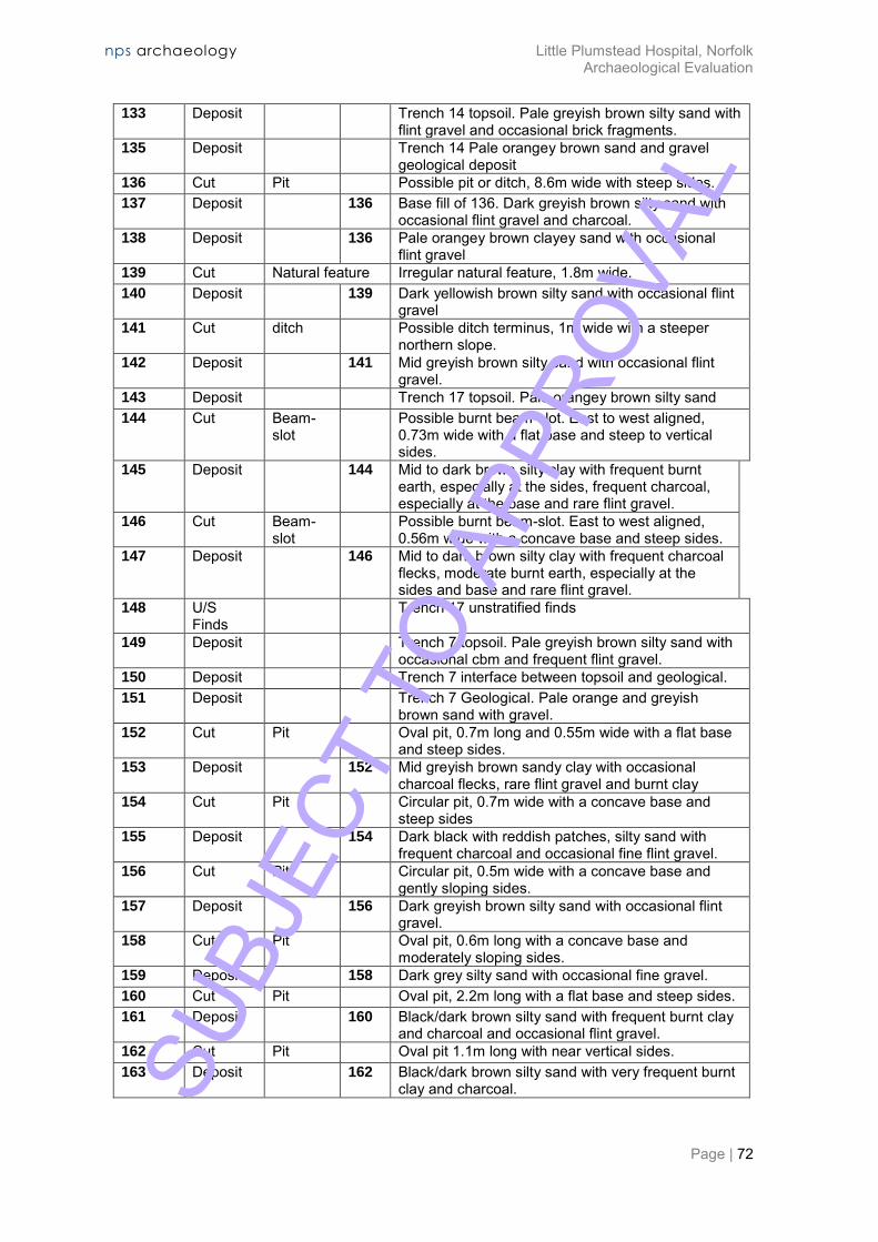
nps archaeology Little Plumstead Hospital, Norfolk Archaeological Evaluation
Page | 72
133 Deposit Trench 14 topsoil. Pale greyish brown silty sand with flint gravel and occasional brick fragments.
135 Deposit Trench 14 Pale orangey brown sand and gravel geological deposit
136 Cut Pit Possible pit or ditch, 8.6m wide with steep sides. 137 Deposit 136 Base fill of 136. Dark greyish brown silty sand with
occasional flint gravel and charcoal. 138 Deposit 136 Pale orangey brown clayey sand with occasional
flint gravel 139 Cut Natural feature Irregular natural feature, 1.8m wide. 140 Deposit 139 Dark yellowish brown silty sand with occasional flint
gravel 141 Cut ditch Possible ditch terminus, 1m wide with a steeper
northern slope. 142 Deposit 141 Mid greyish brown silty sand with occasional flint
gravel. 143 Deposit Trench 17 topsoil. Pale orangey brown silty sand 144 Cut Beam-
slot Possible burnt beam-slot. East to west aligned,
0.73m wide with a flat base and steep to vertical sides.
145 Deposit 144 Mid to dark brown silty clay with frequent burnt earth, especially at the sides, frequent charcoal, especially at the base and rare flint gravel.
146 Cut Beam-slot
Possible burnt beam-slot. East to west aligned, 0.56m wide with a concave base and steep sides.
147 Deposit 146 Mid to dark brown silty clay with frequent charcoal flecks, moderate burnt earth, especially at the sides and base and rare flint gravel.
148 U/S Finds
Trench 17 unstratified finds
149 Deposit Trench 7 topsoil. Pale greyish brown silty sand with occasional cbm and frequent flint gravel.
150 Deposit Trench 7 interface between topsoil and geological. 151 Deposit Trench 7 Geological. Pale orange and greyish
brown sand with gravel. 152 Cut Pit Oval pit, 0.7m long and 0.55m wide with a flat base
and steep sides. 153 Deposit 152 Mid greyish brown sandy clay with occasional
charcoal flecks, rare flint gravel and burnt clay 154 Cut Pit Circular pit, 0.7m wide with a concave base and
steep sides 155 Deposit 154 Dark black with reddish patches, silty sand with
frequent charcoal and occasional fine flint gravel. 156 Cut Pit Circular pit, 0.5m wide with a concave base and
gently sloping sides. 157 Deposit 156 Dark greyish brown silty sand with occasional flint
gravel. 158 Cut Pit Oval pit, 0.6m long with a concave base and
moderately sloping sides. 159 Deposit 158 Dark grey silty sand with occasional fine gravel. 160 Cut Pit Oval pit, 2.2m long with a flat base and steep sides. 161 Deposit 160 Black/dark brown silty sand with frequent burnt clay
and charcoal and occasional flint gravel. 162 Cut Pit Oval pit 1.1m long with near vertical sides. 163 Deposit 162 Black/dark brown silty sand with very frequent burnt
clay and charcoal. SUBJ
ECT
TO A
PPRO
VAL
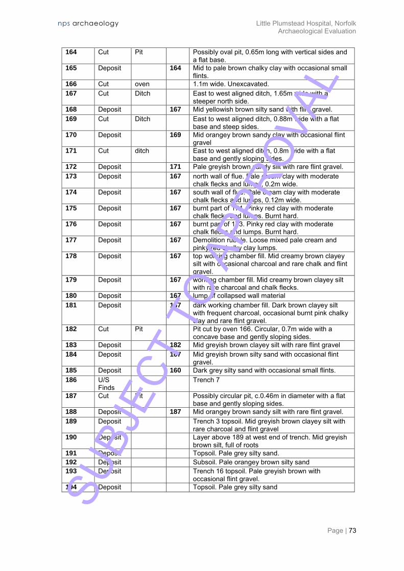
nps archaeology Little Plumstead Hospital, Norfolk Archaeological Evaluation
Page | 73
164 Cut Pit Possibly oval pit, 0.65m long with vertical sides and a flat base.
165 Deposit 164 Mid to pale brown chalky clay with occasional small flints.
166 Cut oven 1.1m wide. Unexcavated. 167 Cut Ditch East to west aligned ditch, 1.65m wide with a
steeper north side. 168 Deposit 167 Mid yellowish brown silty sand with flint gravel. 169 Cut Ditch East to west aligned ditch, 0.88m wide with a flat
base and steep sides. 170 Deposit 169 Mid orangey brown sandy clay with occasional flint
gravel 171 Cut ditch East to west aligned ditch, 0.8m wide with a flat
base and gently sloping sides. 172 Deposit 171 Pale greyish brown sandy silt with rare flint gravel. 173 Deposit 167 north wall of flue. Pale cream clay with moderate
chalk flecks and lumps, 0.2m wide. 174 Deposit 167 south wall of flue. Pale cream clay with moderate
chalk flecks and lumps, 0.12m wide. 175 Deposit 167 burnt part of 174. Pinky red clay with moderate
chalk flecks and lumps. Burnt hard. 176 Deposit 167 burnt part of 173. Pinky red clay with moderate
chalk flecks and lumps. Burnt hard. 177 Deposit 167 Demolition rubble. Loose mixed pale cream and
pinky red chalky clay lumps. 178 Deposit 167 top working chamber fill. Mid creamy brown clayey
silt with occasional charcoal and rare chalk and flint gravel.
179 Deposit 167 working chamber fill. Mid creamy brown clayey silt with rare charcoal and chalk flecks.
180 Deposit 167 lump of collapsed wall material 181 Deposit 167 dark working chamber fill. Dark brown clayey silt
with frequent charcoal, occasional burnt pink chalky clay and rare flint gravel.
182 Cut Pit Pit cut by oven 166. Circular, 0.7m wide with a concave base and gently sloping sides.
183 Deposit 182 Mid greyish brown clayey silt with rare flint gravel 184 Deposit 167 Mid greyish brown silty sand with occasional flint
gravel. 185 Deposit 160 Dark grey silty sand with occasional small flints. 186 U/S
Finds Trench 7
187 Cut Pit Possibly circular pit, c.0.46m in diameter with a flat base and gently sloping sides.
188 Deposit 187 Mid orangey brown sandy silt with rare flint gravel. 189 Deposit Trench 3 topsoil. Mid greyish brown clayey silt with
rare charcoal and flint gravel 190 Deposit Layer above 189 at west end of trench. Mid greyish
brown silt, full of roots 191 Deposit Topsoil. Pale grey silty sand. 192 Deposit Subsoil. Pale orangey brown silty sand 193 Deposit Trench 16 topsoil. Pale greyish brown with
occasional flint gravel. 194 Deposit Topsoil. Pale grey silty sand SU
BJEC
T TO
APP
ROVA
L

nps archaeology Little Plumstead Hospital, Norfolk Archaeological Evaluation
Page | 74
Appendix 1b: Feature Summary
Period Category Total
Roman Ditch 8 Pit 3 Beam-slot 1 Medieval Pit 3 Post-Medieval Ditch 2 Modern Ditch 1 Pit 2 Unknown Ditch 9 Pit 20 Beam-slot 1 Structure 1 Oven 1
SUBJ
ECT
TO A
PPRO
VAL

nps archaeology Little Plumstead Hospital, Norfolk Archaeological Evaluation
Page | 75
Appendix 2a: Finds by Context
Context Material Qty Wt Period Notes
12 Glass 7 388g Post-medieval Bottle 14 Metalworking waste 1 20g Unknown 21 Fired clay 1 2g Unknown 21 Metalworking waste 2 136g Unknown 24 Brick/Tile 1 43g Post-medieval Peg tile 28 Brick/Tile 3 2,861g Modern Brick; 20th century 28 Pottery 1 6g Roman 34 Brick/Tile 1 1,563g Modern Brick; 20th century 39 Pottery 5 31g Bronze Age-Early
Iron Age
44 Brick/Tile 2 80g Modern Brick; 20th century 52 Brick/Tile 1 68g Roman 52 Pottery 5 50g Roman 54 Pottery 14 183g Roman 54 Pottery 3 13g Post-medieval 54 Stone 1 Roman Purbeck limestone 56 Animal bone 5 49g Unknown 56 Pottery 10 255g Roman Late 2nd-mid 3rd
century 62 Fired clay 4 54g Unknown 62 Pottery 10 385g Roman Late 2nd-mid 3rd
century 64 Animal bone 1 1g Unknown 64 Fired clay 4 252g Unknown 64 Iron 1 7g Unknown Nail 64 Iron 1 62g Unknown Object 64 Pottery 57 1,137g Roman Late 2nd-late 3rd
century 64 Worked flint 2 6g Late Neolithic-
Bronze Age
67 Pottery 7 246g Roman 2nd-3rd century 68 Iron 3 29g Unknown Nails 68 Pottery 9 165g Roman 68 Pottery 1 5g Post-medieval 68 Stone 1 454g Roman Lava quern fragment 93 Pottery 1 163g Medieval 13th-14th century 97 Pottery 3 52g Medieval 11th-13th century 99 Pottery 5 20g Medieval 11th-13th century
101 Pottery 1 6g Medieval 11th-13th century 105 Brick/Tile 6 347g Roman 105 Pottery 24 631g Roman Late 2nd-early 3rd
century 107 Pottery 1 13g Roman 112 Brick/Tile 1 62g Post-medieval Peg tile 117 Pottery 5 4g Roman 121 Pottery 2 14g Roman SU
BJEC
T TO
APP
ROVA
L
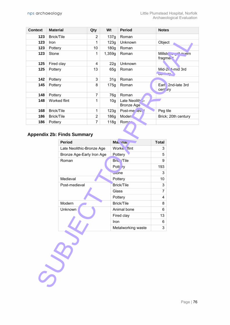
nps archaeology Little Plumstead Hospital, Norfolk Archaeological Evaluation
Page | 76
Context Material Qty Wt Period Notes
123 Brick/Tile 2 137g Roman 123 Iron 1 123g Unknown Object 123 Pottery 10 180g Roman 123 Stone 1 1,359g Roman Millstone grit quern
fragment 125 Fired clay 4 22g Unknown 125 Pottery 13 65g Roman Mid-2nd-mid 3rd
century 142 Pottery 3 31g Roman 145 Pottery 8 175g Roman Early 2nd-late 3rd
century 148 Pottery 7 76g Roman 148 Worked flint 1 10g Late Neolithic-
Bronze Age
168 Brick/Tile 1 123g Post-medieval Peg tile 186 Brick/Tile 2 186g Modern Brick; 20th century 186 Pottery 7 118g Roman
Appendix 2b: Finds Summary
Period Material Total
Late Neolithic-Bronze Age Worked flint 3 Bronze Age-Early Iron Age Pottery 5 Roman Brick/Tile 9
Pottery 193 Stone 3
Medieval Pottery 10 Post-medieval Brick/Tile 3
Glass 7 Pottery 4
Modern Brick/Tile 8 Unknown Animal bone 6
Fired clay 13 Iron 6 Metalworking waste 3
SUBJ
ECT
TO A
PPRO
VAL

nps archaeology Little Plumstead Hospital, Norfolk Archaeological Evaluation
Page | 77
Appendix 3: Pottery Catalogue
Context Spot date Total QF1 GRS1 GRS2 GRS3 NAR RE1 OXS2 BSW1 WAT RE LNV GW ROB SH LNV CC RHZ SA LNV WH (M) MCW PMED glazed red earthenware
No. Wt. No. Wt. No. Wt. No. Wt. No. Wt. No. Wt. No. Wt. No. Wt. No. Wt. No. Wt. No. Wt. No. Wt. No. Wt. No. Wt. No. Wt. No. Wt.
28 Roman 1 6 1 6
39 LBA-EIA 5 31 5 31
52 Roman 5 50 3 11 1 26 1 13
54 Post-medieval
17 196 9 54 1 9 1 14 1 104 2 2 3 13
56 L2-M3 10 255 5 130 2 40 2 63 1 22
62 L2-E3 10 385 1 4 4 144 1 36 4 201
64 L2-L3 57 1137 24 380 22 408 1 25 2 123 3 76 3 95 1 6 1 24
67 2-3rd 7 246 1 53 6 193
68 Post-medieval
10 170 2 10 5 114 1 12 1 29 1 5
93 13-14th 1 163 1 163
97 11-13th C 3 52 3 52
99 11-13th C 5 20 5 20
101 11-13th C 1 6 1 6
105 L2-E3 24 631 4 41 12 263 1 6 2 248 3 50 1 12 1 11
107 Roman 1 13 1 13
117 Roman 5 4 5 4
121 Roman 2 14 2 14
123 Roman 10 180 3 103 3 35 4 42
125 M2-M3 13 65 4 19 4 25 1 4 1 1 1 5 1 9 1 2
142 Roman 3 31 2 26 1 5
145 E2-L3 8 175 1 28 5 65 2 82
148 Roman 7 76 7 76
186 Roman 7 118 6 115 1 3
212 4024 5 31 49 785 94 1601 6 126 4 186 12 386 10 301 3 26 1 5 2 20 4 42 7 227 1 29 10 241 4 18
SUBJ
ECT
TO A
PPRO
VAL
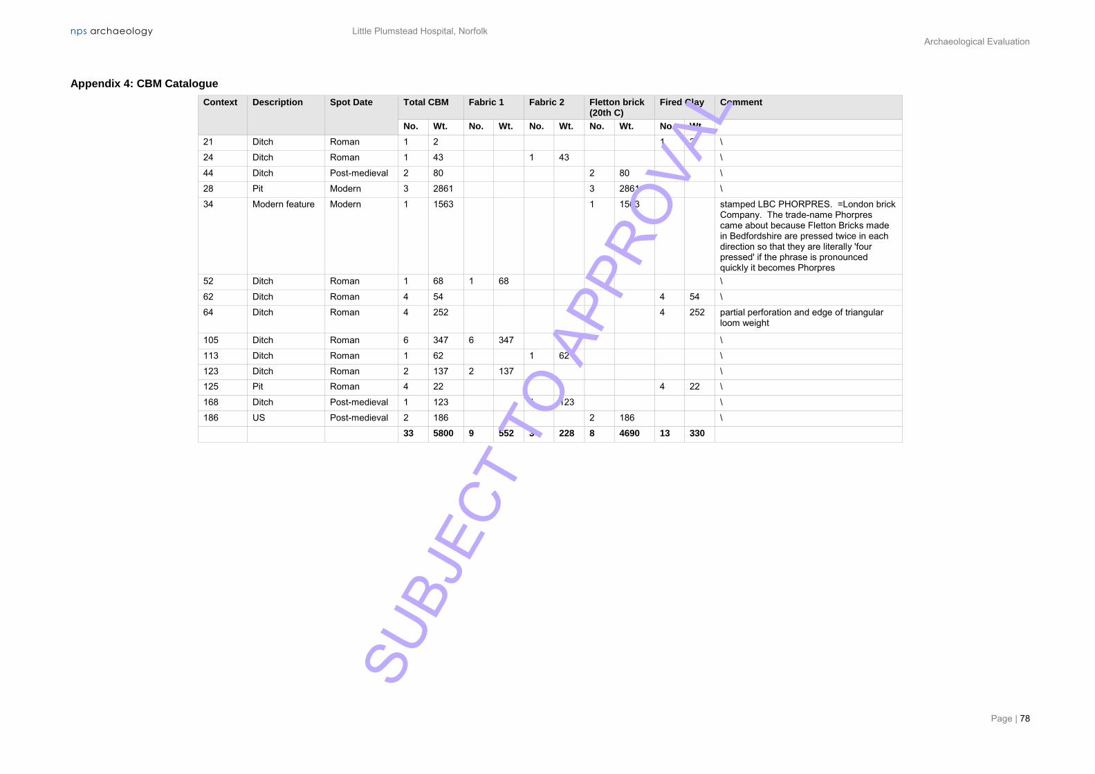
nps archaeology Little Plumstead Hospital, Norfolk Archaeological Evaluation
Page | 78
Appendix 4: CBM Catalogue
Context Description Spot Date Total CBM Fabric 1 Fabric 2 Fletton brick (20th C)
Fired Clay Comment
No. Wt. No. Wt. No. Wt. No. Wt. No. Wt.
21 Ditch Roman 1 2 1 2 \
24 Ditch Roman 1 43 1 43 \
44 Ditch Post-medieval 2 80 2 80 \
28 Pit Modern 3 2861 3 2861 \
34 Modern feature Modern 1 1563 1 1563 stamped LBC PHORPRES. =London brick Company. The trade-name Phorpres came about because Fletton Bricks made in Bedfordshire are pressed twice in each direction so that they are literally 'four pressed' if the phrase is pronounced quickly it becomes Phorpres
52 Ditch Roman 1 68 1 68 \
62 Ditch Roman 4 54 4 54 \
64 Ditch Roman 4 252 4 252 partial perforation and edge of triangular loom weight
105 Ditch Roman 6 347 6 347 \
113 Ditch Roman 1 62 1 62 \
123 Ditch Roman 2 137 2 137 \ 125 Pit Roman 4 22 4 22 \
168 Ditch Post-medieval 1 123 1 123 \
186 US Post-medieval 2 186 2 186 \
33 5800 9 552 3 228 8 4690 13 330
SUBJ
ECT
TO A
PPRO
VAL

nps archaeology Little Plumstead Hospital, Norfolk Archaeological Evaluation
Page | 79
Appendix 5: Historical Periods
Period Date From Date To
Prehistoric -500,000 42 Early Prehistoric -500,000 -4,001
Palaeolithic -500,000 -10,001 Lower Palaeolithic -500,000 -150,001 Middle Palaeolithic -150,001 -40,001 Upper Palaeolithic -40,000 -10,001
Mesolithic -10,000 -4,001 Early Mesolithic -10,000 -7,001 Late Mesolithic -7,000 -4,001
Late Prehistoric -4,000 42 Neolithic -4,000 -2,351
Early Neolithic -4,000 -3,001 Middle Neolithic -3,500 -2,701 Late Neolithic -3,000 -2,351
Bronze Age -2,350 -701 Early Bronze Age -2,350 -1,501
Beaker -2,300 -1,700 Middle Bronze Age -1,600 -1,001 Late Bronze Age -1,000 -701
Iron Age -800 42 Early Iron Age -800 -401 Middle Iron Age -400 -101 Late Iron Age -100 42
Roman 42 409 Post Roman 410 1900
Saxon 410 1065 Early Saxon 410 650 Middle Saxon 651 850 Late Saxon 851 1065
Medieval 1066 1539 Post-medieval 1540 1900
Modern 1900 2050 World War One 1914 1918 World War Two 1939 1945 Cold War 1945 1992
Unknown -- -- after English Heritage Periods List, recommended by Forum on Information Standards in Heritage
available at: http://www.fish-forum.info/inscript.htm SUBJ
ECT
TO A
PPRO
VAL
nps archaeology Little Plumstead Hospital, Norfolk Archaeological Evaluation
Page | 80
Appendix 6: OASIS Report Summary
SUBJ
ECT
TO A
PPRO
VAL
SUBJ
ECT
TO A
PPRO
VAL
SUBJ
ECT
TO A
PPRO
VAL

SUBJ
ECT
TO A
PPRO
VAL

nps archaeology Little Plumstead Hospital, Norfolk Archaeological Evaluation
Page | 84
Appendix 7: Archaeological Specification
SUBJ
ECT
TO A
PPRO
VAL
nps archaeology
01-04-16-2-1304
Little Plumstead Hospital, Hospital Road, Little Plumstead, Norfolk. NR13
5EW
Archaeological Evaluation by Trial Trenching
Written Scheme of Investigation
Prepared for: Cripps Developments Ltd
Planning Ref: N/A
August 2016
SUBJ
ECT
TO A
PPRO
VAL

nps archaeology
QUALITY ASSURANCE
Job Number 01-14-16-2-1304
Client Cripps Developments Ltd
Location Little Plumstead Hospital, Hospital Road, Little Plumstead, Norfolk
District Broadland
Planning Reference N/A
Grid Reference TG 3065 1065
Completed Steve Hickling 16-08-2016
Reviewed David Adams 16-08-2016
Issue 1
Disclaimer This document has been prepared in good faith on the basis of information available at the date of publication without any independent verification for the exclusive use and benefit of the named client and for the sole purpose for which it is provided. NPS Archaeology does not guarantee the accuracy, reliability, completeness, or currency of the content of this document nor its usefulness in achieving any purpose. This document is not intended to nor should it be relied upon by any third party. NPS Archaeology accepts no responsibility nor liability should this document be used for any alternative purpose other than for which it is intended nor to any third party. NPS Archaeology will not be liable for any loss, damage, cost, or expense incurred or arising by reason of any person using or relying on information in this document.
nps archaeology Scandic House 85 Mountergate Norwich NR1 1PY T 01603 756150 F 01603 756190 E [email protected] W nau.nps.co.uk © NPS Archaeology Ltd 2016, all rights reserved SU
BJEC
T TO
APP
ROVA
L
Contents
Introduction.............................................................................................................. 1
Background ..................................................................................................... 1
Aims 3
Method Statement ................................................................................................... 4
Introduction ..................................................................................................... 4
Trial Trenching ................................................................................................ 4
Post-Fieldwork Processes .............................................................................. 5
Report and Archive ......................................................................................... 6
Timetable and Resources ....................................................................................... 8
Project Staff ............................................................................................................. 9
Quality Standards .................................................................................................. 11
General Conditions ................................................................................................ 12
Access, Health and Safety .................................................................................... 13
Insurance............................................................................................................... 14
SUBJ
ECT
TO A
PPRO
VAL
1
Little Plumstead Hospital, Norfolk. NR13 5EW
Archaeological Evaluation by Trial Trenching
Written Scheme of Investigation
Introduction
Background
1 Proposals to develop land at Little Plumstead Hospital, Hospital Road, Little Plumstead, Norfolk, NR13 5EW (TG 3065 1065) require a programme of archaeological work to support and inform the planning application for the site (Figure 1). The site has been identified by Norfolk County Council Historic Environment Service (NCCHES) as potentially containing heritage assets of high archaeological interest, relating to Neolithic, Bronze Age and medieval periods with a smaller chance of post-medieval remains relating to the former late 18th-early 19th century Plumstead Hall.
2 A previous archaeological evaluation to the east of the present development site revealed evidence of Neolithic/Bronze Age settlement activity (NHER 37644) in 2003.
3 The adjacent parish church of Ss Protase and Gervase is Grade II* Listed and is predominantly Norman in date, but the base of the round tower may be Late Saxon.
4 The archaeological evaluation on the school site on the northwest border of the present development revealed several ditches, one of which was dated to the medieval period (NHER 51524). Further evidence of a medieval fieldsystem and possible quarry pits were found during an archaeological evaluation to the east (NHER 37644).
5 The excavation of the trial trenches is aimed to identify the presence, extent, date, state of preservation and hence significance of any heritage assets at the site. The evaluation will be sufficient to characterise any heritage assets identified and the results will be assessed by NCCHES to determine whether further investigations will be necessary should archaeological remains be found at the site which cannot be preserved by design.
6 Cripps Developments Ltd has requested that NPS Archaeology prepares this Written Scheme of Investigation detailing an appropriate programme of archaeological works that will satisfy the NCCHES requirements for trenching.
SUBJ
ECT
TO A
PPRO
VAL

N
NA
UA
rcha
eolo
gy
Site
Cod
e:
Site
Nam
e:
Title
:D
raw
n by
:
Che
cked
by:
Dat
e:
Issu
e:
Sca
le:
Littl
e P
lum
stea
d H
ospi
tal
Tren
ch p
lan
S. H
ickl
ing
16.0
8.20
161
/ 200
0
SUBJECT TO APPROVAL

3
Aims
7 The programme of archaeological work requested by NCCHES is required to recover, by archaeological evaluation, information relating to the extent, date, phasing, character, function, status and significance of the site. A determination of the state of preservation of any features, deposits and structures is also required.
8 The aims of the archaeological work may therefore be summarised as: i. To establish the presence or absence of archaeological remains within the
proposed development site.
ii. To determine the extent, condition, nature, quality and date of any archaeological remains occurring within the site and the possible impacts of the proposed development on them.
iii. Ensure that any archaeological features discovered during trial trenching are identified, sampled and recorded.
iv. To establish, as far as possible, the extent, character, stratigraphic sequence and date of archaeological features and deposits, and the nature of the activities which occurred at the site during the various periods or phases of its occupation.
v. To establish the palaeoenvironmental potential of subsurface deposits by ensuring that any deposits with the potential to yield palaeoenvironmental data are sampled and submitted for assessment to the appropriate specialists.
vi. To explore evidence for social, economic and industrial activity.
vii. To disseminate the archaeological data recovered by the evaluation in the form of a report which will provide a basis for any decisions regarding further archaeological intervention and mitigation proposals should they be necessary.
SUBJ
ECT
TO A
PPRO
VAL
4
Method Statement
Introduction
9 A three-stage evaluation strategy will be undertaken to assess the archaeological potential of the proposed development site. The stages of this strategy may be summarised as follows.
i. Trial Trenching. Machine and manual excavation will be employed to investigate the presence, condition, character and date of any sub-surface archaeological deposits and features occurring at the site. Any archaeological features identified will be cleaned and sample excavated to determine function, form and relative date.
ii Post-Fieldwork Processes. The drawn and written stratigraphic/structural record will be cross-referenced and analysed to provide a synthesis of the results of the work. Cleaning and cataloguing of any artefacts and ecofacts recovered will be carried out throughout the duration of the fieldwork. The finds will be cleaned, marked and packaged in accordance with the archive requirements of Norfolk Museums Service.
iii. Report and Archive. The report will describe the results of the trial trenching with data presented in tabular, graphic and appendix form. Copies of the reports will be submitted to the client and to NHES.
10 The procedures and methodology for each of the stages outlined above are described in detail below. Trial Trenching
11 Trial trenching will be concerned with establishing the condition, character and date of any sub-surface archaeological features and deposits present. Guidelines set out in the documents Standard and guidance for archaeological field evaluation (Chartered Institute for Archaeologists 2014) and Standards for Field Archaeology in the East of England (Gurney 2003) will be followed.
12 The trial trench evaluation is formulated on 20no. 40m x 1.80m trenches providing a 4% sample of the area of the site currently intended for development. The trenches will be spread across the development area as defined by the client. It is considered that the trench plan attached as Figure 1 will provide for an appropriate investigation of the potential archaeology at the site.
13 No known obstructions or TPOs are known at the site, but the final locations of some trenches may be determined on the basis of surface or below ground obstructions and Health and Safety considerations identified at the time of the work.
14 The trenches will be set out in relation to the Ordnance Survey National Grid by NPS Archaeology and scanned by CAT prior to excavation.
15 Excavation will be by mechanical excavator equipped with a toothless bucket in 100mm spits until natural geological ground or archaeological deposits are identified.
16 Initial excavation will be undertaken to the top of any undisturbed archaeological deposits or the surface of the underlying natural geological deposits, whichever is the highest. If neither is encountered it may be necessary to excavate to a maximum depth of 1.20m below the present ground surface in line with Health and Safety guidance for trenches with unsupported sides. If further depth of excavation is required, the trench sides may need to be locally stepped or shored. The requirement for and the scope of works below 1.20m will be agreed with NCCHES and costed as a contingency. SU
BJEC
T TO
APP
ROVA
L

5
17 If the deposits in the trenches extend too deep to evaluate safely, or below the likely level of any development impacts, a hand auger may be used to retrieve information about the characteristics of the lower deposits.
18 Excavations below a depth of 0.60m will be fenced around using Netlon high-visibility fencing and applicable warning signs will be displayed where these measures are.
19 Spoil from the trenches will not be removed from site. The trenches will not be backfilled until agreement to do so is given by NCCHES. Backfilling will be undertaken by the client.
20 Exposed surfaces and archaeological features and deposits will be excavated by hand and screened by metal detector. The metal detector will be utilised to scan excavated spoil and in situ horizons with the operator ensuring that it is used in a correct fashion. All artefacts and ecofacts will be collected and bagged by unique context number.
21 All archaeological deposits, features and layers will be assigned individual context numbers and recorded on standardised forms employing the NPS Archaeology pro forma recording system. The records will include full written, graphic and photographic elements with site and context numbering compatible with the Norfolk Historic Environment Record numbering system. Plans will be made at a scale of 1:50, with provision for 1:20 and 1:10 drawings. Sections will be recorded at scales of 1:10 and 1:20 depending on the detail considered necessary. A photographic record in 35mm monochrome film and digital formats will be maintained of all archaeological deposits, layers and features to record their characteristics and relationships. Photographs will be taken to record the progress of the evaluation.
22 Human remains will be left in situ unless otherwise instructed by NHES. If any human remains or burials are discovered that must be removed, an application for a Licence for the Removal of Human Remains will be made in compliance with the Burial Acts 1857 and 1981 and all relevant Ministry of Justice guidelines. Backfilling of features containing human remains will be carried out manually to ensure that the remains are appropriately protected from any damage or disturbance.
23 Detailed strategies for levels of sampling of buried soils, structures, pits, post-holes and ditches will be determined on site. Allowance will be made for total recovery where appropriate; percentage sampling will apply in areas where complex stratified deposits are encountered. In general, the feature/deposit sampling strategy will be employed throughout the evaluation in accordance with Standards for Field Archaeology in the East of England (Gurney 2003).
24 Soil samples for palaeoenvironmental materials will be collected if suitable sealed and well-dated deposits are identified. Standard 20 litre bulk soil samples, column or monolith samples and Kubiena tins will be collected from such deposits as appropriate, in consultation with the Historic England Science Advisor for the East of England and/or other consultant environmentalists if appropriate. Buried soils will be sampled by sieving to determine artefact densities. In all instances, sampling procedures will follow guidance issued by English Heritage (Historic England) in Environmental Archaeology 2nd edition (2011). Full written, graphic and photographic sample records will be made using NPS Archaeology’s pro forma recording system. Post-Fieldwork Processes
25 The drawn and written stratigraphic/structural record will be cross-referenced and analysed to provide a synthesis of the results of the work. SU
BJEC
T TO
APP
ROVA
L

6
26 The cleaning and cataloguing of any artefactual materials recovered will be undertaken on completion of the trial trenching. All retained materials will be cleaned, marked and packaged in accordance with the requirements of Norfolk Museums Service (NMS).
27 Post-fieldwork analyses will start upon completion of the finds processing and will involve the identification and description of the artefactual materials recovered by the relevant specialists. In general, the following strategies will be employed in the analysis of the artefactual materials recovered:
Pottery. Analysed to determine date and tabulated by context unit
Worked flint. Sorted and tabulated by context unit
Metal artefacts. Assessed for dating and significance, catalogued by context unit and where necessary conserved within four weeks of completion of fieldwork, in accordance with UKIC Conservation Guidelines 3 (1984)
Faunal remains. Sorted and tabulated by context unit. Assessed for the potential for further analysis and for sieving for the recovery of smaller bird and fish bones
Environmental samples. Processed and assessed for content and significance
Other categories of artefactual materials will be analysed in a similar fashion. 28 All finds work will follow the procedures set out in Standard and guidance for the
collection, documentation, conservation and research of archaeological materials (Chartered Institute for Archaeologists 2014). Finds data will be entered on a spreadsheet to aid analysis and report preparation.
29 All archaeological materials, excepting those covered by the Treasure Act 1996, will remain the property of the landowners. NPS Archaeology will seek to reach formal agreement with the landowners for donation of materials to NMS. Report and Archive
30 An evaluation report will be prepared that presents the stratigraphic, structural, artefactual and environmental evidence and analyses, and a synthesis of the results of the trial trenching.
31 The report will present data in written, tabular, graphic and appendix form. A list of archive components generated by the work and a reference to the intended place of archive deposition will be included in the report. Unless otherwise agreed in writing, NPS Archaeology will retain copyright in and ownership of all documentation and other materials prepared by NPS Archaeology. NPS Archaeology may publish or jointly publish any description or illustration of the works with the prior consent of the client.
32 A draft copy of the report will be presented to the client and to NHES for approval within eight weeks of the completion of the evaluation. An advance (interim) report for the purpose of expediting planning applications may be supplied upon request by the client and by agreement with NHES. Multiple copies of the approved report will be produced as appropriate and presented to the client and one digital and one paper copy to NHES. One copy of the report may be sent to the Historic England Science Advisor for the East of England, if considered appropriate. SU
BJEC
T TO
APP
ROVA
L
7
33 An online OASIS record will be initiated immediately prior to the start of fieldwork and completed when the final report is submitted to NHES. This will include a pdf version of the final report.
34 A single integrated archive for all elements of the work will be prepared according to the recommendations set out in Environmental standards for the permanent storage of excavated material from archaeological sites (UKIC Conservation Guidelines 3, 1984) and Archaeological Archives: a guide to best practice in creation, compilation, transfer and curation (Brown 2007), and in accordance with NMS requirements for archive preparation, storage and conservation.
35 The archive will be fully indexed and cross-referenced It will also be integrated with the NMS Project accession number and the Norfolk Historic Environment Record numbering system. Deposition of the archive and archaeological materials (by prior agreement with the landowners) will take place after completion of the final report and confirmed in writing to NMS. A full listing of archive contents and finds boxes will accompany the deposition of the archive and finds.
36 If NMS are not making new archive accessions and no confirmation is provided of when new archives will be accepted, NPS Archaeology reserve the right to make alternative arrangements. From 1 January 2016 NPS Archaeology may charge for storage of prepared archaeological archives.
SUBJ
ECT
TO A
PPRO
VAL

8
Timetable and Resources
37 The different stages of archaeological work have different time and staff requirements. The timetable for fieldwork assumes that there are no major delays to the work programme caused by factors outside of NPS Archaeology’s reasonable control. Such circumstances would include without limitation: long periods of adverse weather conditions, flooding, repeated vandalism, ground contamination, delays in the development programme, unsafe buildings, conflicts between the archaeological recording methods and the protection of flora and fauna on the site, disease restrictions, and unexploded ordnance.
38 The proposed earliest start date for the archaeological work is two working weeks upon notification from the client. No schedule is currently advised.
39 It is estimated that the fieldwork will take two weeks with a team of three–four archaeologists, dependent on archaeological remains present.
SUBJ
ECT
TO A
PPRO
VAL

9
Project Staff
40 A Project Manager will assume overall responsibility for the delivery of the project. The project will be co-ordinated on a day-to-day basis by a Senior Project Officer who will be dedicated to the project throughout its duration. The Senior Project Officer will act under the direction of the Project Manager in respect of logistics, standards, health and safety, and liaison with the client and curators. The Senior Project Officer will have substantial experience in archaeological trench excavation and post-excavation analysis.
41 Other members of staff involved in the project will be a Project Officer, an Archaeological Finds Officer, and up to four Site Assistants. The Project Officer and Site Assistants will have experience of archaeological excavation and experience with NPS Archaeology's pro forma recording systems. The Project Officer will be an experienced metal detector user.
42 NPS Archaeology staff associated with the project will be:
Project Management
Project Manager Andrew Crowson, BA
Project Staff
Senior Project Officer N/A
Project Officer Steve Hickling, BA, MA, ACIfA
Finds Officer Rebecca Sillwood, BA, ACIfA
Site Assistants To be nominated
43 NPS Archaeology reserves the right to change its nominated personnel at any time should project programmes change.
44 The analysis and reporting of artefacts and ecofacts will be coordinated by the Finds Officer and will be undertaken by NPS Archaeology staff, or other nominated specialists drawn from the list below as required. Nominated NPS Archaeology and other specialists and their areas of expertise are:
Specialist Research Field
Susan Anderson Anglo-Saxon and later pottery, human skeletal remains, brick and tile, fired clay
Andrew Barnett Medieval and later numismatic items
Sarah Bates Worked flint
Esther Cameron Textiles
Julie Curl Faunal remains, shell
Richard Darrah Wood technology
David Dobson Graphics and illustration
Valerie Fryer Plant and animal macrofossil remains
Frances Green Palaeoenvironmental remains, architectural stone
Deborah Harris Conservation SUBJ
ECT
TO A
PPRO
VAL

10
David King Window glass and lead
Adrian Marsden Pre-medieval numismatic items
Quita Mould Leather
Andrew Newton Metalworking residues
Andrew Peachey Prehistoric and Roman pottery
Ian Riddler Anglo-Saxon metalwork and artefacts
SUBJ
ECT
TO A
PPRO
VAL
11
Quality Standards
45 All staff employed or sub-contracted by NPS Archaeology will be employed in line with the Chartered Institute for Archaeologists’ Code of Practice.
46 NPS Archaeology operates under a recognised Quality Management System and is accredited with BS EN ISO 9001:2008.
47 The guidelines set out in the document Standards for Field Archaeology in the East of England (Gurney 2003) that remain current will be adhered to. Provision will be made for monitoring the work by NHES in accordance with the procedures outlined in the document Management of Research Projects in the Historic Environment (MoRPHE) (English Heritage 2006, republished April 2015 by Historic England). Monitoring opportunities for each phase of the project are suggested as follows:
a) during archaeological trial trenching b) during post-fieldwork analysis c) upon receipt of the final report
48 A further monitoring opportunity will be provided at the end of the work upon deposition of the integrated archive and finds with NMS.
49 NPS Archaeology operates a Project Management System. Most aspects of this project will be co-ordinated by a Senior Project Officer who has the day-to-day responsibility for the successful completion of the project. The Senior Project Officer’s performance is monitored by a Project Manager. Overall responsibility for the successful delivery of the project lies with the NPS Archaeology Manager, who has responsibility for all of NPS Archaeology's work and ensures the maintenance of quality standards within the organisation.
SUBJ
ECT
TO A
PPRO
VAL
12
General Conditions
50 NPS Archaeology will not commence work until a written order, or signed agreement is received from the client. Where the commission is received through an agent, the agent is deemed to be authorised to act on behalf of the client. NPS Archaeology reserves the right to recover unpaid fees for the service provided from the agent where it is found that this authority is contested by said client.
51 A 7.24-hour working day is normally operated by NPS Archaeology, although their agents may work outside these hours.
52 NPS Archaeology shall not be held responsible for any delay or failure in meeting agreed deadlines resulting from circumstances beyond its reasonable control. Such circumstances would include all those listed in para. 41.
53 NPS Archaeology expects any information concerning the presence of TPOs and/or, protected flora and fauna on the site to be provided by the client prior to the commencement of works and accepts no liability if this information is not disclosed. No excavation will take place within 8.00m or canopy width (whichever is the greater) of any trees within or bordering the site.
54 NPS Archaeology will not accept responsibility for any tree surgery, removal of undergrowth, shrubbery or hedges or reinstatement of gardens. NPS Archaeology will endeavour to restrict the levels of disturbance of to a minimum, but wishes to bring to the attention of the client that the works will necessarily alter the appearance of a site.
SUBJ
ECT
TO A
PPRO
VAL
13
Access, Health and Safety
55 NPS Archaeology expects the client to arrange suitable access to the site for its staff, plant and welfare facilities on the agreed start date.
56 Reasonable access to the site will be granted by NPS Archaeology to NHES and representatives of Cripps Developments Ltd who wish to be satisfied, through site inspections, that the archaeological works are being conducted to appropriate professional standards and in accordance with the agreements made.
57 In advance of works commencing, NPS Archaeology will prepare and submit a Health and Safety Risk Assessment and Method Statement to the client. All NPS staff will be briefed on the contents of the Risk Assessment and required to read it. Personal protective clothing and equipment will be issued and used as required.
58 NPS Archaeology will ensure that all work is carried out in accordance with NPS Property Consultants Limited's Health and Safety Policy, to standards defined in the Health and Safety at Work, etc. Act, 1974 and The Management of Health and Safety Regulations, 1992, and in accordance with the health and safety manual Health and Safety in Field Archaeology (SCAUM 2007).
59 The client will provide NPS Archaeology with all information reasonably obtainable on the location of live services including overhead utilities before site works commence.
60 Whether or not CDM regulations apply to this work, NPS Archaeology expect the client to provide information on the nature, extent and level of any soil contamination present. Should unanticipated contaminated ground be encountered during the works, excavation will cease until an assessment of risks to health has been undertaken and on-site control measures implemented. NPS Archaeology will not be liable for any costs related to the collection and analysis of soils or other assessment methods, on-site control measures, and the removal of contaminated soil or other materials from site. In case of contaminated soil, it may be necessary for NPS Archaeology to produce a revised Risk Assessment and/or adapt the agreed Written Scheme of Investigation in consultation with the client and NHES.
61 Should any disease restrictions be implemented for the area during the excavation, fieldwork will cease and staff will be redeployed until they are lifted. NPS Archaeology will not be liable for any costs related to on-site disease control measures and for any additional costs incurred to complete the fieldwork after the restrictions have been removed.
62 NPS Archaeology will provide copies of NPS Property Consultants Ltd Health and Safety policy on request.
SUBJ
ECT
TO A
PPRO
VAL

14
Insurance
63 NPS Archaeology’s Insurance Cover is: Employers Liability £5,000,000 Public Liability £50,000,000 Professional Indemnity £5,000,000
64 Full details of NPS Archaeology's Insurance cover will be supplied on request.
SUBJ
ECT
TO A
PPRO
VAL