northern qatar arch extension assessment unit … 1 usgs province: zagros fold belt (2030)...
TRANSCRIPT

# ###
# #####
ÊÚÊÚÊÚ
ÊÚ ÊÚ
ÊÚ ÊÚ
ÊÚ
ÊÚ
ÊÚ
ÊÚ
ÊÚÊÚ
ÊÚ
ÊÚ
ÊÚÊÚ
2024
2023
2075
Kuwait
0 250 500 KILOMETERS
Tabriz
Tehran
Esfahan
Mosul
Baghdad
Shiraz
Al Basra
Al Kuwayt
Ar Riyad
Dhahran
Abu Zaby
Doha
CaspianSea
Arabian/Persian
Gulf
U.A.E.
Qatar
Iran
Iraq
SaudiArabia
25
30
35
40
55504540
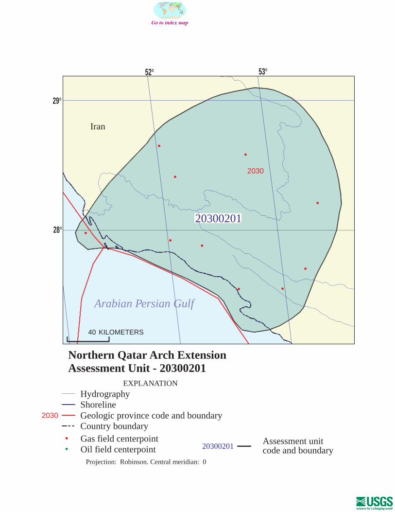
Northern Qatar Arch ExtensionAssessment Unit 20300201
Other geologic province boundaryZagros Fold Belt Geologic Province 2030Northern Qatar Arch Extension Assessment Unit 20300201
Erzurum
Page 1
USGS PROVINCE: Zagros Fold Belt (2030) GEOLOGIST: T.S. Ahlbrandt TOTAL PETROLEUM SYSTEM: Paleozoic-Permian/Triassic (203002) ASSESSMENT UNIT: Northern Qatar Arch Extension (20300201) DESCRIPTION: This assessment unit includes giant and supergiant natural gas fields some with condensate. These large gas fields occur on the northern extension of the Qatar Arch immediately west of the Zagros fold belt. Giant fields such as Pars, Kangan, Nar Aghar, Banubast, Dalan, Asaluyeh, Shanul and Varavi are among the 15 gas fields in this assessment unit. The source of the gas is most likely lateral migration of deep Silurian sourced gas from Zagros foredeeps on the northern and southern side of the Qatar Arch. A more speculative hydrocarbon source is from a potential Permian depocenter (graben) deep beneath the Zagros fold belt. SOURCE ROCKS: The source rocks are most likely Silurian age shales of the Qusaiba or equivalents in the deep portions of the Zagros foreland although a possible Permian source rock interval has been postulated. The lower part of the Silurian shale are the so called “hot” or radioactive shales that range from 10 to 75 m in thickness and occur in the Gulf salt basins. MATURATION: In the deeper parts of the Zagros foredeep, the Silurian source rocks are overmature (Ro >2.6) and thought to be the source for the gas in this unit. MIGRATION: Lateral migration from the Silurian source rock kitchens to the north and south of the Qatar Arch, onto this northern extension of the Arch is the most likely origin for the significant natural gas accumulations here. RESERVOIR ROCKS: Reservoir rocks are commonly Upper Permian and Triassic dolomitic limestones, dolomites, oolitic limestone or carbonates. In Pars field, there are multiple carbonate reservoirs such as the Dalan Formation (Permian), Kangan Formation (Triassic) and one argillaceous sandstone reservoir in the Faraghan Formation (Permian). All other fields produce from carbonates of the Dalan and Kangan formations or Deh Ram Group (Triassic). TRAPS AND SEALS: There are several regional significant seals including stratigraphic equivalents of the upper Triassic Baluti Formation, the Jurassic Hith evaporites, the Nahr Umr Shale (Aptian) is a major regional shale seal trapping major accumulations and in much of the Zagros fold belt and foreland Miocene salt and anhydrite seals are known. The Qatar Arch is a prominent structural feature that serves as a regional focus for hydrocarbon charge in the area. REFERENCES: Al-Jallal, I.A., 1995, The Khuff Formation--Its regional reservoir potential in Saudi Arabia and
other Gulf countries; Depositional and stratigraphic approach, in Al-Husseini, M.I., ed., Geo-94, Middle East Petroleum Geosciences Conference, Petrolink, Bahrain: v.1, p. 103-119.
Page 2
Alsharhan, A.S. and Nairn, A.E.M., 1997, Sedimentary basins and petroleum geology of the Middle East: Netherlands, Elsevier, 843 p.
Bishop, R.S., 1995, Maturation history of the Lower Paleozoic of the Eastern Arabian Platform, in Al-Husseini, M.I., ed., Geo-94, Middle East Petroleum Geosciences Conference, Petrolink, Bahrain: v. 1, p. 180-189.
Jones, P.J., and Stump, T.E., 1999, Depositional and tectonic setting of the Lower Silurian hydrocarbon source rock facies, Central Saudi Arabia: American Association of Petroleum Geologists Bulletin, v. 83, p. 314-332.
Wender, L.E., Bryant, J.W., Dickens, M.F., Neville, A.S., and Al-Moqbel, A.M., 1998, Paleozoic (Pre-Khuff) hydrocarbon geology of the Ghawar area, Eastern Saudi Arabia: GeoArabia, v. 3, p. 273-301.
20300201
20300201Assessment unitcode and boundary
2030
2030
Assessment Unit - 20300201Northern Qatar Arch Extension
EXPLANATION
HydrographyShorelineGeologic province code and boundaryCountry boundaryGas field centerpointOil field centerpoint
Projection: Robinson. Central meridian: 0
40 KILOMETERS
52
28
Arabian Persian Gulf
Iran
53
29
SEVENTH APPROXIMATIONNEW MILLENNIUM WORLD PETROLEUM ASSESSMENTDATA FORM FOR CONVENTIONAL ASSESSMENT UNITS
Date:………………………….. 12/9/99Assessment Geologist:…….. T.S. AhlbrandtRegion:……………………….. Middle East and North Africa Number: 2Province:……………………… Zagros Fold Belt Number: 2030Priority or Boutique.………… PriorityTotal Petroleum System:…… Paleozoic-Permian/Triassic Number: 203002Assessment Unit:…………… Northern Qatar Arch Extension Number: 20300201* Notes from Assessor Lower 48-all growth function. Likely Silurian sourced.
CHARACTERISTICS OF ASSESSMENT UNIT
Oil (<20,000 cfg/bo overall) or Gas (>20,000 cfg/bo overall):… Gas
What is the minimum field size?………. 20 mmboe grown (>1mmboe)(the smallest field that has potential to be added to reserves in the next 30 years)
Number of discovered fields exceeding minimum size:………… Oil: 0 Gas: 10 Established (>13 fields) Frontier (1-13 fields) X Hypothetical (no fields)
Median size (grown) of discovered oil fields (mmboe):1st 3rd 2nd 3rd 3rd 3rd
Median size (grown) of discovered gas fields (bcfg):1st 3rd 18247 2nd 3rd 12054 3rd 3rd
Assessment-Unit Probabilities: Attribute Probability of occurrence (0-1.0)1. CHARGE: Adequate petroleum charge for an undiscovered field > minimum size……………… 1.02. ROCKS: Adequate reservoirs, traps, and seals for an undiscovered field > minimum size…… 1.03. TIMING OF GEOLOGIC EVENTS: Favorable timing for an undiscovered field > minimum size 1.0
Assessment-Unit GEOLOGIC Probability (Product of 1, 2, and 3):……...…….....…. 1.0
4. ACCESSIBILITY: Adequate location to allow exploration for an undiscovered field > minimum size……………………………………………………..………………..……..………… 1.0
UNDISCOVERED FIELDS
Oil fields:…………………………………min. no. (>0) median no. max no.Gas fields:……………………………….min. no. (>0) 5 median no. 45 max no. 100
Size of Undiscovered Fields: What are the anticipated sizes (grown) of the above fields?:
Oil in oil fields (mmbo)………………..……min. size median size max. sizeGas in gas fields (bcfg):……………………min. size 120 median size 650 max. size 40000
(variations in the sizes of undiscovered fields)
(uncertainty of fixed but unknown values)Number of Undiscovered Fields: How many undiscovered fields exist that are > minimum size?:
Page 1

Assessment Unit (name, no.)Northern Qatar Arch Extension, 20300201
AVERAGE RATIOS FOR UNDISCOVERED FIELDS, TO ASSESS COPRODUCTS
Oil Fields: minimum median maximum Gas/oil ratio (cfg/bo)………………………...……… NGL/gas ratio (bngl/mmcfg)…………………....….
Gas fields: minimum median maximum Liquids/gas ratio (bngl/mmcfg)….…………..…….. 22 44 66 Oil/gas ratio (bo/mmcfg)………………………….…
SELECTED ANCILLARY DATA FOR UNDISCOVERED FIELDS(variations in the properties of undiscovered fields)
Oil Fields: minimum median maximum API gravity (degrees)…………………….…………. Sulfur content of oil (%)………………………...….. Drilling Depth (m) ……………...…………….…….. Depth (m) of water (if applicable)……………...…..
Gas Fields: minimum median maximum Inert gas content (%)……………………….....…… 1 6 12 CO2 content (%)……………………………….....… 1 2 4 Hydrogen-sulfide content (%)………………...……. 1 2 5 Drilling Depth (m)…………………………………… 500 3000 5000 Depth (m) of water (if applicable)…………………. 0 10 25
(uncertainty of fixed but unknown values)
Page 2

Assessment Unit (name, no.)Northern Qatar Arch Extension, 20300201
ALLOCATION OF UNDISCOVERED RESOURCES IN THE ASSESSMENT UNITTO COUNTRIES OR OTHER LAND PARCELS (uncertainty of fixed but unknown values)
1. Iran represents 100 areal % of the total assessment unit
Oil in Oil Fields: minimum median maximum Richness factor (unitless multiplier):……….…..… Volume % in parcel (areal % x richness factor):… Portion of volume % that is offshore (0-100%)……
Gas in Gas Fields: minimum median maximum Richness factor (unitless multiplier):…………..…. Volume % in parcel (areal % x richness factor):… 100 Portion of volume % that is offshore (0-100%)…… 7
2. Province 2030 represents 98 areal % of the total assessment unit
Oil in Oil Fields: minimum median maximum Richness factor (unitless multiplier):……….…..… Volume % in parcel (areal % x richness factor):… Portion of volume % that is offshore (0-100%)……
Gas in Gas Fields: minimum median maximum Richness factor (unitless multiplier):…………..…. Volume % in parcel (areal % x richness factor):… 98 Portion of volume % that is offshore (0-100%)…… 5
3. Province 2024 represents 2 areal % of the total assessment unit
Oil in Oil Fields: minimum median maximum Richness factor (unitless multiplier):……….…..… Volume % in parcel (areal % x richness factor):… Portion of volume % that is offshore (0-100%)……
Gas in Gas Fields: minimum median maximum Richness factor (unitless multiplier):…………..…. Volume % in parcel (areal % x richness factor):… 2 Portion of volume % that is offshore (0-100%)…… 100
Page 3

0
2
4
6
8
10
12
14
96-<192 192-<384 384-<768 768-<1536 1536-<3072
3072-<6144
6144-<12288
12288-<24576
24576-<49152
GAS-FIELD SIZE (BCFG)
UN
DIS
CO
VE
RE
D G
AS
FIE
LD
S (
No
.)
Minimum field size: 120 BCFG
Mean number ofundiscovered fields: 47.1
Northern Qatar Arch Extension, AU 20300201 Undiscovered Field-Size Distribution