northern land use guidelines: northwest territories seismic
TRANSCRIPT

northern land use guidelines Northwest Territories Seismic Operations
VOLUME
09a

Table of Contents
preface 3acknowledgements 5
1 introduction 6
1.1 WhatisSeismicExploration? 6
1.2 PurposeandGuidingPrinciples 7
1.3 ValuedComponentsand
EnvironmentalOutcomes 7
2 planninganddesign 9
2.1 Permitting 9
2.2 InformationGathering 10
2.2.1 Supplementary Information 10
2.2.2 Information Sources 11
2.2.3 Community Engagement 11
2.3 TerrainConditions 13
2.3.1 Permafrost 14
2.3.2 Existing Disturbance and Clearings 15
2.4 WaterBodiesandWaterCrossings 16
2.5 ForestResources 19
2.6 WildlifeandWildlifeHabitat 20
2.6.1 Wildlife Sensitive Periods and Setback Distances 22
2.7 EquipmentConsiderations 25
2.8 TraditionalandRecreationalLandUse 26
2.9 VisualImpacts 26
3 clearingandconstruction 27
3.1 DevelopmentTiming 27
3.2 EquipmentPreparation 28
3.3 SurfacePreparation 29
3.4 BrushDisposal 32
4 operations 34
4.1 LineOperations 34
4.2 Camps 35
4.2.1 Waste Management 35
4.2.2 Fuel Storage 36
4.3 SeasonalClosure 38
5 spills 39
5.1 SpillContingencyPlan 40
5.2 SpillPrevention 40
5.3 SpillResponse 40
6 closureandreclamation 41
6.1 FinalLandUsePlan 42
6.2 ProgressiveReclamation 42
6.3 ReclamationActivities 42
6.3.1 Complete Removal 43
6.3.2 Erosion Control 43
6.3.3 Restrict Access 44
6.4 ReclamationMonitoring 44
bibliography 45glossary 46

northwest territories seismic operations 3
Preface
These guidelines apply to land-based seismic activities on both Crown and Commissioner’s land in the Northwest Territories. They are the product of a partnership between the Government of the Northwest Territories – Department of Environment and Natural Resources; Aboriginal Affairs and Northern Development Canada; Environment Canada – Canadian Wildlife Service; and Fisheries and Oceans Canada.
These guidelines are intended to assist operators in planning, undertaking and monitoring reclamation of seismic programs, and to assist federal and territorial departments with mandates for environmental protection by providing consistent expert advice to regulatory authorities. Following these guidelines does not guarantee approval for a given seismic program. Consideration of these guidelines should be supplemented by local research, traditional knowledge, engineering or other professional expertise, and advice obtained from the appropriate regulators.
These guidelines reference legislated requirements and operational policy statements where they may apply to seismic programs. They do not replace acts, ordinances, regulations or the terms and conditions of regulatory authorizations. Although every attempt has been made to provide up-to-date information, it remains the operator’s responsibility to obtain the most recent information related to northern resource development, to ensure all regulatory requirements have been met, and to undertake appropriate consultation with territorial and federal government departments and Aboriginal groups.

4 aandcNorthernLandUseGuidelines
This publication is available electronically from the Aboriginal Affairs and Northern Development website at www.aandc-aadnc.gc.ca.
The issuing departments intend to evaluate the guidelines over an initial two-year period, and update and evaluate them as appropriate. Users of the guidelines are invited to provide any information that could be used to inform and improve future updates. These comments can be directed to Aboriginal Affairs and Northern Development Canada via the following contact information.
Guidelines do not replace acts, ordinances, regulations and permit terms and conditions.
Volumes in this series include:
• Vol. 01 Administrative Framework
• Vol. 02 Administrative Process
• Vol. 03 Applying Sustainable Development
• Vol. 04 Permafrost
• Vol. 05 Access: Roads and Trails
• Vol. 06 Camp and Support Facilities
• Vol. 07 Pits and Quarries
• Vol. 08 Mineral Exploration
• Vol. 09 Hydrocarbon Exploration
• Vol. 09a Northwest Territories Seismic Operations
• Vol. 10 Other Land Uses
• Vol. 11 Closure and Reclamation
The series is available electronically from the AANDC website: www.aadnc-aandc.gc.ca
Readers are encouraged to visit the site for updates and revisions to the series.
For further information concerning the subject matter contained in these guidelines, please contact:
NORTHWESTTERRITORIES
LandAdministrationAboriginal Affairs and Northern Development CanadaP.O. Box 1500 Yellowknife NT X1A 2R3 tel.: 867-669-2671 fax: 867-669-2713 email: [email protected]
EnvironmentandNaturalResourcesGovernment of the Northwest TerritoriesDirector, Wildlife Division
P.O. Box 1320 Yellowknife NT X1A 2L9 tel.: 867-920-8064 fax: 867-873-0293
FisheriesandOceansCanadaSuite 301, 5204-50th Avenue Yellowknife NT X1A 1E2 tel.: 867-669-4900 fax: 867-669-4940
CanadianWildlifeServiceEnvironment Canada P.O. Box 2310 Yellowknife NT X1A 2P7 tel.: 867-669-4700 fax: 867-873-8185 email: [email protected]

northwest territories seismic operations 5
Acknowledgements
In the 1980s, Indian and Northern Affairs Canada published a series of six land use guidelines in a handbook format, intended to help operators of small to medium-scale projects carry out activities in northern Canada in an environmentally sensitive manner. These handbooks, commonly called “The Blue Books,” have been widely distributed and quoted.Their success is a tribute to the efforts of the original authors and contributors, and to the departmental steering committee that guided their preparation.
The development of this volume was directed by a steering committee consisting of regional staff from the federal departments of Aboriginal Affairs and Northern Development Canada, Environment Canada — Canadian Wildlife Service, Fisheries and Oceans Canada, and the Government of the Northwest Territories — Department of Environment and Natural Resources. The guidelines benefited greatly from reviews by land and resource managers and regulators in the Northwest Territories, industry associations and individual operators.

01CHAPTER
6 aandcNorthernLandUseGuidelines
Introduction
1.1 WhatisSeismicExploration?
Seismic exploration is an integral part of the oil and gas resource cycle and a necessary precursor to further exploration and development activities. Seismic exploration programs use energy sources and receivers to generate high-resolution images of subsurface layers of the Earth, providing detailed information on subsurface structures and formations. Energy sources and receivers are arranged along carefully surveyed lines of various lengths, widths, orientation and spacing, directly above geological formations of interest. Energy is directed into the ground and return waves are captured by geophones. The data is recorded and processed, producing images that can be interpreted to assess the potential of the resource. Favourable results can lead to further exploration, e.g., drilling. However, not all seismic exploration leads to drilling programs.
Seismic programs are eithertwo-dimensional or three-dimensional. A two-dimensional seismic program typically requires several lines with the energy source and receivers on the same line. A three-dimensional seismic program arranges energy source lines at right angles to receiver lines (e.g., a grid pattern) to produce a three-dimensional image. The energy sources used for land-based seismic programs are either explosives or vibroseis. When explosives are used, shot holes, typically 8 - 10 cm in diameter and 6 - 30 m deep, are drilled and the holes are loaded with a charge that varies in size according to the depth of the target. When vibroseis is used, large, heavy vibrator units transmit energy into the ground.
Seismic programs require the use of land to place and transport the energy sources and receivers. In forested areas, access can require clearing lines, whereas above the treeline, access is usually directly across the tundra. Helicopters can also be used to conduct some seismic surveys. Due to the remote location of most programs and limited road access in the Northwest Territories, a camp, often mobile, is required to support operational crews.
A typical seismic program has various phases, including planning, line clearing, surveying, drilling, laying out recording equipment, shooting and recording, cleaning up and reclaiming the site. Planning involves consideration of multiple factors, including, but not necessarily limited to, seasonal and environmental conditions and limitations, availability of equipment, geology and program parameters. As a result, seismic programs can vary greatly.
Some of the challenges associated with planning and undertaking seismic programs in the Northwest Territories include:
• extreme weather;
• short and variable operating seasons;
• reduced daylight during winter months;
• remoteness, limited roads and camp facilities;
• requirements to use local equipment and personnel where possible; and
• limited local availability of experienced equipment operators.
intro
du
ction
01
northwest territories seismic operations 7
Challenges and constraints are discussed in these guidelines. To improve future versions of these guidelines, program operators are encouraged to document why a particular program may deviate from the guidelines as a result of specific environmental, situational or local challenges.
1.2 PurposeandGuidingPrinciples
These guidelines are intended to be used by both seismic program operators and resource managers, particularly within federal and territorial government departments. The goals of the guidelines are to:
1. minimize impacts to wildlife, fish, land, and water resources as a result of land-based seismic programs; and
2. outline expectations of the regulatory process so that applications can be processed efficiently.
In support of these goals, the guidelines are intended to promote the use of best practices and innovation, and to promote communication between operators and regulators prior to, and throughout the permitting process.
The guidelines provide information intended to assist proponents when planning and designing seismic programs, conducting operations and carrying out reclamation activities. The guidelines focus on protection of valued components and desired environmental outcomes, which reflect the primary objective of minimizing impacts to the environment.
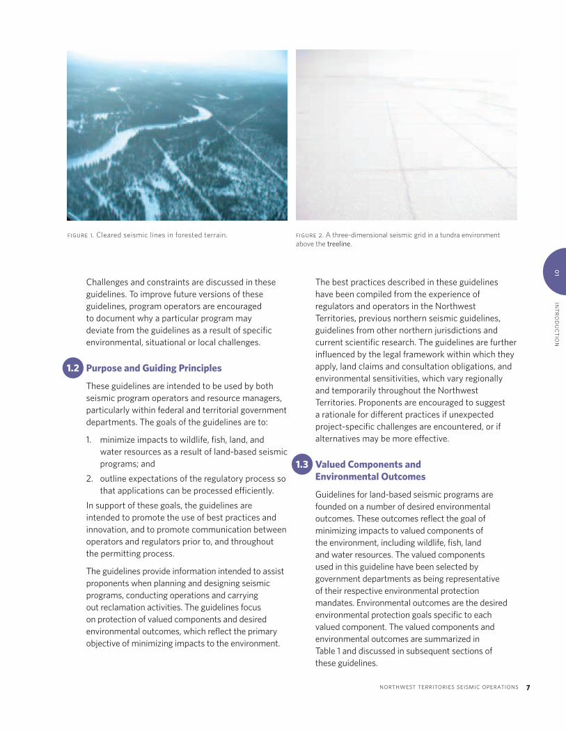
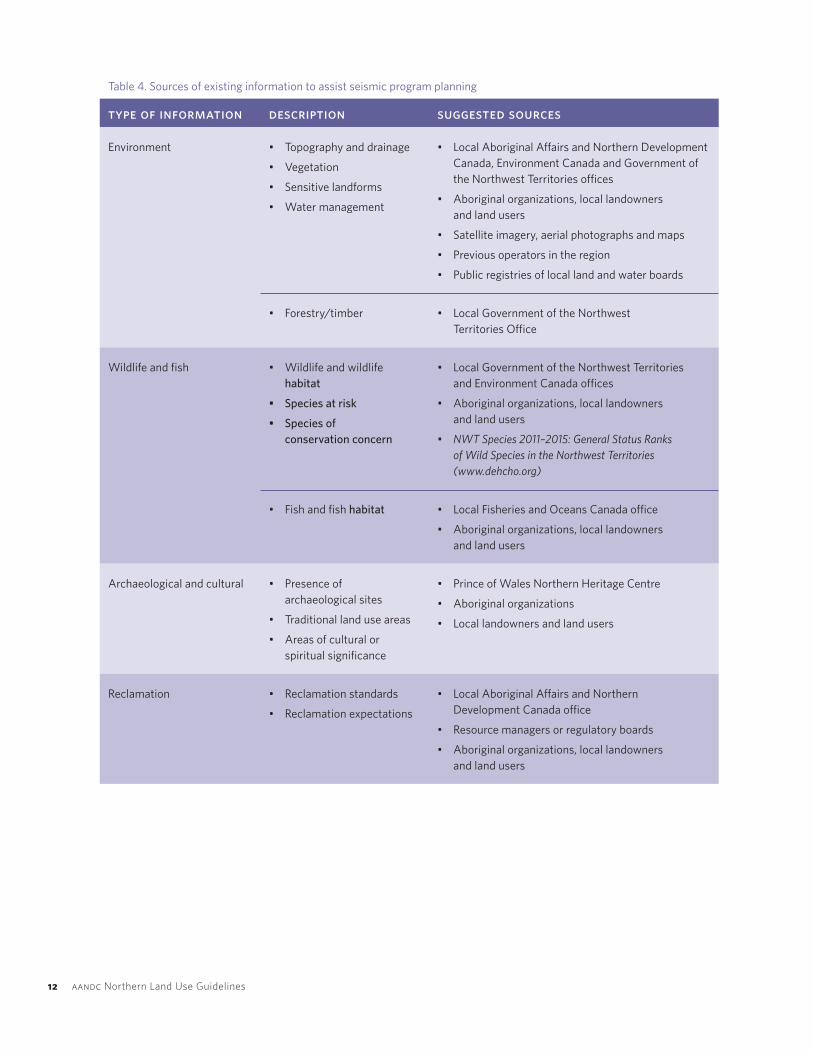
figure 1.Clearedseismiclinesinforestedterrain. figure 2.Athree-dimensionalseismicgridinatundraenvironmentabovethetreeline.
The best practices described in these guidelines have been compiled from the experience of regulators and operators in the Northwest Territories, previous northern seismic guidelines, guidelines from other northern jurisdictions and current scientific research. The guidelines are further influenced by the legal framework within which they apply, land claims and consultation obligations, and environmental sensitivities, which vary regionally and temporarily throughout the Northwest Territories. Proponents are encouraged to suggest a rationale for different practices if unexpected project-specific challenges are encountered, or if alternatives may be more effective.
1.3 ValuedComponentsandEnvironmentalOutcomes
Guidelines for land-based seismic programs are founded on a number of desired environmental outcomes. These outcomes reflect the goal of minimizing impacts to valued components of the environment, including wildlife, fish, land and water resources. The valued components used in this guideline have been selected by government departments as being representative of their respective environmental protection mandates. Environmental outcomes are the desired environmental protection goals specific to each valued component. The valued components and environmental outcomes are summarized in Table 1 and discussed in subsequent sections of these guidelines.

8 aandcNorthernLandUseGuidelines
Table 1. Valued components of the environment and related environmental outcomes
valued component environmental outcomes
A. Wildlife A1. Seismic operations result in the lowest ecological footprint practicable.
A2. Lines cleared in forested areas are designed to limit line of sight.
A3. Sensitive periods for wildlife are avoided.
A4. Lines cleared in forested areas are not barriers to wildlife movement.
A5. Migratory birds, their nests and eggs, or species at risk are not killed, injured,
harassed, destroyed or otherwise disturbed.
A6. Impacts to species of conservation concern are avoided or mitigated.
A7. Residences or critical habitat of migratory birds and species at risk are not
disturbed or destroyed.
B. Fish B1. Fish passage is not impeded by stream crossings.
B2. Fish habitat is not degraded.
B3. Sensitive periods for fish are avoided.
B4. Impacts to overwintering fish as a result of water withdrawal are avoided.
B5. Fish and fish eggs are not impacted by the use of explosives near water bodies.
C. Forest resources C1. Disturbance of forest resources is limited, and forest management issues
are addressed.
D. Terrain and soil D1. Negative impacts to terrain and soil, including soil erosion, are avoided.
D2. Permafrost degradation is avoided.
E. Water resources E1. Water quality is not degraded.
F. Cumulative effects F1. Programs integrate with existing disturbance corridors and/or
other industry activities.
F2. Seismic program design and parameters are the most appropriate and
efficient to achieve minimum disturbance.

plann
ing an
d d
esign0
2
02CHAPTER
northwest territories seismic operations 9
Planning and Design
2.1 Permitting
There are a number of regulatory agencies in the Northwest Territories. Operators should determine which administrative processes a project will be subject to well in advance of submitting any project applications. As a first step, proponents should identify and contact the appropriate regulators to identify authorizations that may be required and time lines associated with each. Questions that should be considered at the permitting stage include the following:
• Who owns or administers the land on which the program will be conducted?
• Which land use regulators have authority over the land?
• Is the project within a region that has an approved land use plan?
• Who are the other land users within the area (e.g., trappers, communities, tourism operators)?
Authorizations that may be required for seismic operations are described in Table 2. Further guidance is available in the Northern Land Use Guidelines: Administrative Process volume (AANDC 2008).
Table 2. Commonly required authorizations for seismic operations in the Northwest Territories
authorization purpose regulatory authority
Land use permit Use of land for seismic program, camp and access roads.
• Land and water boards (Mackenzie Valley)
• Aboriginal Affairs and Northern Development Canada (Inuvialuit Settlement Region)
Water licence Use of water or deposition of waste into water; for example, water used to build ice roads or for camp use.
• Land and water boards (Mackenzie Valley)
• Northwest Territories Water Board (Inuvialuit Settlement Region)
Geophysical operations authorization Approval to conduct seismic program. National Energy Board
Timber permit Clearing timber in forested areas. Government of the Northwest Territories — Forest Management Division

10 aandcNorthernLandUseGuidelines
authorization purpose regulatory authority
Fisheries Act1) Section 35 (2) Authorization2) Section 32 Authorization
1) Authorization of harmful alteration, disruption or destruction of fish habitat (e.g., infilling).
2) Authorization of killing of fish by means other than fishing (e.g., use of explosives).
Fisheries and Oceans Canada
Migratory bird sanctuary permit/ national wildlife area permit
Required for access if proposing work within protected areas.
Canadian Wildlife Service — Environment Canada
Memorandum of understanding Use of community water or disposal of waste in community facilities.
Community government
Land use permit Use of land for the seismic program, camp, and access roads.
• Land and Water Boards (Mackenzie Valley)
• Aboriginal Affairs and Northern Development Canada (Inuvialuit Settlement Region)
Water licence Use of water or deposition of waste into water. For example, water used to build ice roads or for camp use.
• Land and Water Boards (Mackenzie Valley)
• Northwest Territories Water Board (Inuvialuit Settlement Region)
Geophysical Operations Authorization Approval to conduct seismic program. National Energy Board
Timber Permit Clearing of timber in forested areas. GNWT — Forest Management Division
2.2 InformationGathering
The first opportunity to limit environmental disturbance is through appropriate program design and equipment selection. Program design can be informed by collecting existing information on the area of interest. Minimum information requirements for filing applications are set by the regulator issuing the authorization. Proponents should ensure that they have met all of the basic information requirements when filing applications. Providing this information up front will expedite the application process, saving money and time in the long term.
2.2.1SupplementaryInformation
Proponents should be prepared to provide more detailed information in pre-application discussions with federal and territorial government departments (Table 3). Although this information may not be required for filing an application for an authorization, it is used to assist land managers when evaluating potential impacts of proposed programs. Early provision of this information will help avoid delays associated with information requests during the application review process.

plann
ing an
d d
esign0
2
northwest territories seismic operations 11
Table 3. Supplementary information that federal and territorial government departments may request
supplementary information
Explanation of how program parameters achieve environmental outcomes in this document.
Explanation of any limitations or restrictions that will prevent adherence to the guidelines.
Outline of additional mitigation measures proposed to address deviations from the guidelines, if any.
Information collected during pre-application discussions with the Government of the Northwest Territories, Environment Canada, Fisheries and Oceans Canada, and Aboriginal Affairs and Northern Development Canada on any deviations from the guidelines and commitments or actions undertaken to resolve them.
Site-specific information, based on field surveys and digital maps, that shows proposed project components, existing disturbances and environmental sensitivities that have been considered during program design.
Best available imagery of program area with proposed program superimposed.
Precise coordinates identifying locations of planned cutlines, clearings and water crossings.
Water source information as outlined in Fisheries and Oceans Canada’s Protocol for Winter Water Withdrawal from Ice-Covered Waterbodies in the Northwest Territories and Nunavut.
Detailed closure and reclamation plan.
Predicted residual effects of program, including estimate of the length of time that effects are expected to remain on the landscape.
2.2.2InformationSources
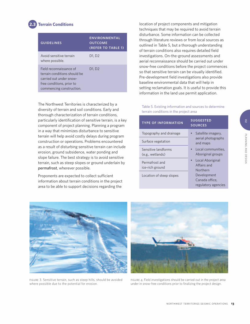
There are a number of sources of existing information that can be used to assist in planning and designing a proposed project. Sources of existing environmental, archaeological, cultural and reclamation information are provided in Table 4.
2.2.3CommunityEngagement
A critical step that should be conducted early in the program design phase is to consult with nearby communities. Thorough community engagement is strongly encouraged prior to and during the permitting process, and throughout operations and closure. Operators should discuss their proposed seismic program with local Aboriginal groups and area land users. Concerns raised by community members should be addressed in a meaningful way. Often, community concerns can be dealt with most efficiently at the planning stage.
12 aandcNorthernLandUseGuidelines
Table 4. Sources of existing information to assist seismic program planning
type of information description suggested sources
Environment • Topography and drainage
• Vegetation
• Sensitive landforms
• Water management
• Local Aboriginal Affairs and Northern Development Canada, Environment Canada and Government of the Northwest Territories offices
• Aboriginal organizations, local landowners and land users
• Satellite imagery, aerial photographs and maps
• Previous operators in the region
• Public registries of local land and water boards
• Forestry/timber • Local Government of the Northwest Territories Office
Wildlife and fish • Wildlife and wildlife habitat
• Species at risk
• Species of conservation concern
• Local Government of the Northwest Territories and Environment Canada offices
• Aboriginal organizations, local landowners and land users
• NWT Species 2011–2015: General Status Ranks of Wild Species in the Northwest Territories (www.dehcho.org)
• Fish and fish habitat • Local Fisheries and Oceans Canada office
• Aboriginal organizations, local landowners and land users
Archaeological and cultural • Presence of archaeological sites
• Traditional land use areas
• Areas of cultural or spiritual significance
• Prince of Wales Northern Heritage Centre
• Aboriginal organizations
• Local landowners and land users
Reclamation • Reclamation standards
• Reclamation expectations
• Local Aboriginal Affairs and Northern Development Canada office
• Resource managers or regulatory boards
• Aboriginal organizations, local landowners and land users
plann
ing an
d d
esign0
2
northwest territories seismic operations 13
guidelinesenvironmental outcome (refer to table 1)
Avoid sensitive terrain where possible.
D1, D2
Field reconnaissance of terrain conditions should be carried out under snow-free conditions, prior to commencing construction.
D1, D2
Table 5. Existing information and sources to determine terrain conditions in the project area
type of information suggested sources
Topography and drainage • Satellite imagery, aerial photographs and maps
• Local communities, Aboriginal groups
• Local Aboriginal Affairs and Northern Development Canada office, regulatory agencies
Surface vegetation
Sensitive landforms (e.g., wetlands)
Permafrost and ice-rich ground
Location of steep slopes
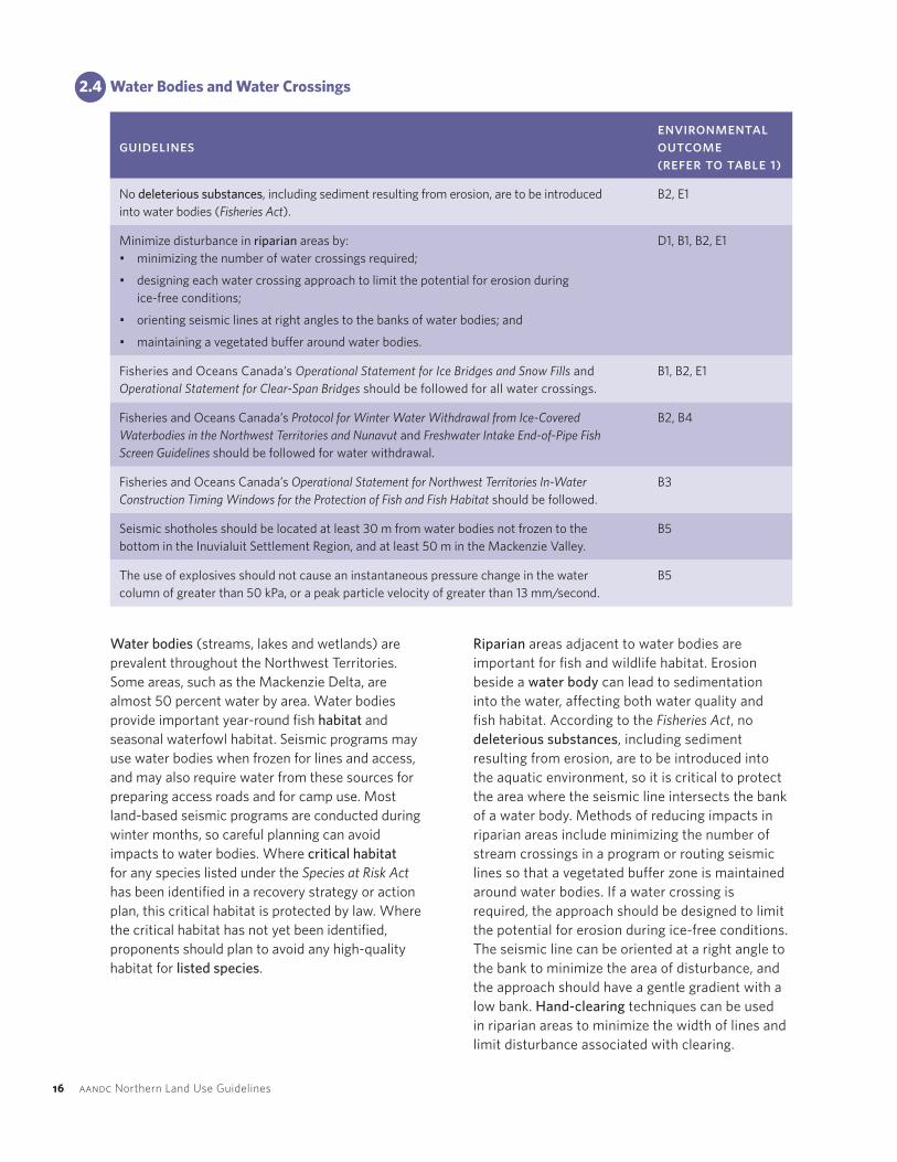
2.3 TerrainConditions
The Northwest Territories is characterized by a diversity of terrain and soil conditions. Early and thorough characterization of terrain conditions, particularly identification of sensitive terrain, is a key component of project planning. Planning a program in a way that minimizes disturbance to sensitive terrain will help avoid costly delays during program construction or operations. Problems encountered as a result of disturbing sensitive terrain can include erosion, ground subsidence, water ponding and slope failure. The best strategy is to avoid sensitive terrain, such as steep slopes or ground underlain by permafrost, wherever possible.
Proponents are expected to collect sufficient information about terrain conditions in the project area to be able to support decisions regarding the
location of project components and mitigation techniques that may be required to avoid terrain disturbance. Some information can be collected through literature reviews or from local sources as outlined in Table 5, but a thorough understanding of terrain conditions also requires detailed field investigations. On-the-ground assessments and aerial reconnaissance should be carried out under snow-free conditions before the project commences so that sensitive terrain can be visually identified. Pre-development field investigations also provide baseline environmental data that will help in setting reclamation goals. It is useful to provide this information in the land use permit application.
figure3.Sensitiveterrain,suchassteephills,shouldbeavoidedwherepossibleduetothepotentialforerosion.
figure 4. Fieldinvestigationsshouldbecarriedoutintheprojectareaunderinsnow-freeconditionspriortofinalizingtheprojectdesign.

14 aandcNorthernLandUseGuidelines
2.3.1Permafrost
guidelinesenvironmental outcome (refer to table 1)
Avoid ice-rich ground where possible.
D1, D2
Vehicles and equipment should not travel within 150 m of a pingo.
D2
Permafrost is present throughout the Northwest Territories and can present planning challenges for seismic programs. The presence of permafrost is not necessarily problematic; however, when permafrost contains excessive amounts of ice near the ground surface, disturbance can lead to melting, ground subsidence and water ponding.
Excess ice in the ground is often visible in the form of ice wedges or lenses. At the surface, ice-rich ground can sometimes be identified by the presence of particular landforms. Terrain that is likely to contain ice-rich ground includes:
• sedge wetlands and peatlands;
• low-lying areas with fine-grained soils; and
• areas of patterned ground, such as hummocky or polygonal terrain.
Operators should avoid areas of near-surface ground ice, where possible. In the discontinuous permafrost zone, it may be possible to avoid permafrost altogether. If avoidance is not possible, low-impact seismic techniques should be used to protect the ground surface.
Pingos are a specific form of ice-rich permafrost, consisting of an ice-cored hill. Pingos are particularly common in the Mackenzie Delta region, near Tuktoyaktuk. Land use permit conditions often prohibit the use of machinery, vehicles and equipment within 150 m of a pingo as they are sensitive to surface disturbance and are culturally significant.
There are certain areas where the ground may not freeze until late in the winter, or not at all. These can include seeps, springs, wetlands or incised valleys with deep snow. Operators should identify these areas and plan to avoid them if possible.
figure 5. (top) Disturbanceofice-richterraincanresultinsubsidence,pondingandpermafrostdegradation.
figure 6. (middle) Exampleofpolygonalterrain,atypeofpatternedground.Wedgesofpureiceunderliethegreenridges.Ice-richterrainshouldbeavoidedwherepossible.
figure 7. (bottom) Landusepermitconditionsoftenrequirethatvehiclesandequipmentremainatleast150mawayfromapingo.
Pingo
Seismicline

plann
ing an
d d
esign0
2
northwest territories seismic operations 15
guidelinesenvironmental outcome (refer to table 1)
Use existing disturbances or natural openings for program components, where appropriate.
A1, C1, F1
Communicate with other operators in the project area and plan to use common access or program components, where possible.
A1, C1, F1
Use frozen water bodies for access, if the ice thickness is capable of supporting equipment.
A1, C1, D2
figure 8. Useexistingdisturbancesandnaturalopenings,whereappropriate,tominimizetheproject’sfootprint.Someoftheseexistingcutlinescouldbeusedforaccesstoanewseismicprogramsite.
2.3.2ExistingDisturbanceandClearings
Seismic programs should utilize existing disturbances and natural openings, where appropriate, to minimize the project’s ecological footprint, impacts to forest resources and cumulative effects. Existing disturbances can include access roads, seismic cutlines, turnaround areas, well sites or campsites. The use of an existing disturbance may not be appropriate if it
is in an advanced stage of revegetation. Examples of appropriate natural openings include forest clearings, burn areas and frozen lakes. Some natural openings, such as wetlands, provide important wildlife habitat, are thaw-sensitive terrain and should not be used. All valued components should be considered when choosing which natural clearings to use for project activities.
Operators should determine if there are any current or planned activities in their project area. If another activity is planned in the project vicinity, operators are encouraged to communicate with other operators and pursue the use of common infrastructure, such as access roads or camps. The use of nearby communities in place of mobile camps or staging areas may also lower costs and will reduce the project’s footprint.
The project’s footprint can also be minimized by using frozen water bodies for access where it is practical and safe to do so. The ice should be thick enough to support the weight of the equipment being used. Operators should also consider that water bodies and riparian areas next to water bodies are important for fish and waterfowl, and that disturbance to water bodies and their banks should be minimized by following the guidelines presented in Section 2.4.
16 aandcNorthernLandUseGuidelines
2.4 WaterBodiesandWaterCrossings
guidelinesenvironmental outcome (refer to table 1)
No deleterious substances, including sediment resulting from erosion, are to be introduced into water bodies (Fisheries Act).
B2, E1
Minimize disturbance in riparian areas by:• minimizing the number of water crossings required;
• designing each water crossing approach to limit the potential for erosion during ice-free conditions;
• orienting seismic lines at right angles to the banks of water bodies; and
• maintaining a vegetated buffer around water bodies.
D1, B1, B2, E1
Fisheries and Oceans Canada’s Operational Statement for Ice Bridges and Snow Fills and Operational Statement for Clear-Span Bridges should be followed for all water crossings.
B1, B2, E1
Fisheries and Oceans Canada’s Protocol for Winter Water Withdrawal from Ice-Covered Waterbodies in the Northwest Territories and Nunavut and Freshwater Intake End-of-Pipe Fish Screen Guidelines should be followed for water withdrawal.
B2, B4
Fisheries and Oceans Canada’s Operational Statement for Northwest Territories In-Water Construction Timing Windows for the Protection of Fish and Fish Habitat should be followed.
B3
Seismic shotholes should be located at least 30 m from water bodies not frozen to the bottom in the Inuvialuit Settlement Region, and at least 50 m in the Mackenzie Valley.
B5
The use of explosives should not cause an instantaneous pressure change in the water column of greater than 50 kPa, or a peak particle velocity of greater than 13 mm/second.
B5
Water bodies (streams, lakes and wetlands) are prevalent throughout the Northwest Territories. Some areas, such as the Mackenzie Delta, are almost 50 percent water by area. Water bodies provide important year-round fish habitat and seasonal waterfowl habitat. Seismic programs may use water bodies when frozen for lines and access, and may also require water from these sources for preparing access roads and for camp use. Most land-based seismic programs are conducted during winter months, so careful planning can avoid impacts to water bodies. Where critical habitat for any species listed under the Species at Risk Act has been identified in a recovery strategy or action plan, this critical habitat is protected by law. Where the critical habitat has not yet been identified, proponents should plan to avoid any high-quality habitat for listed species.
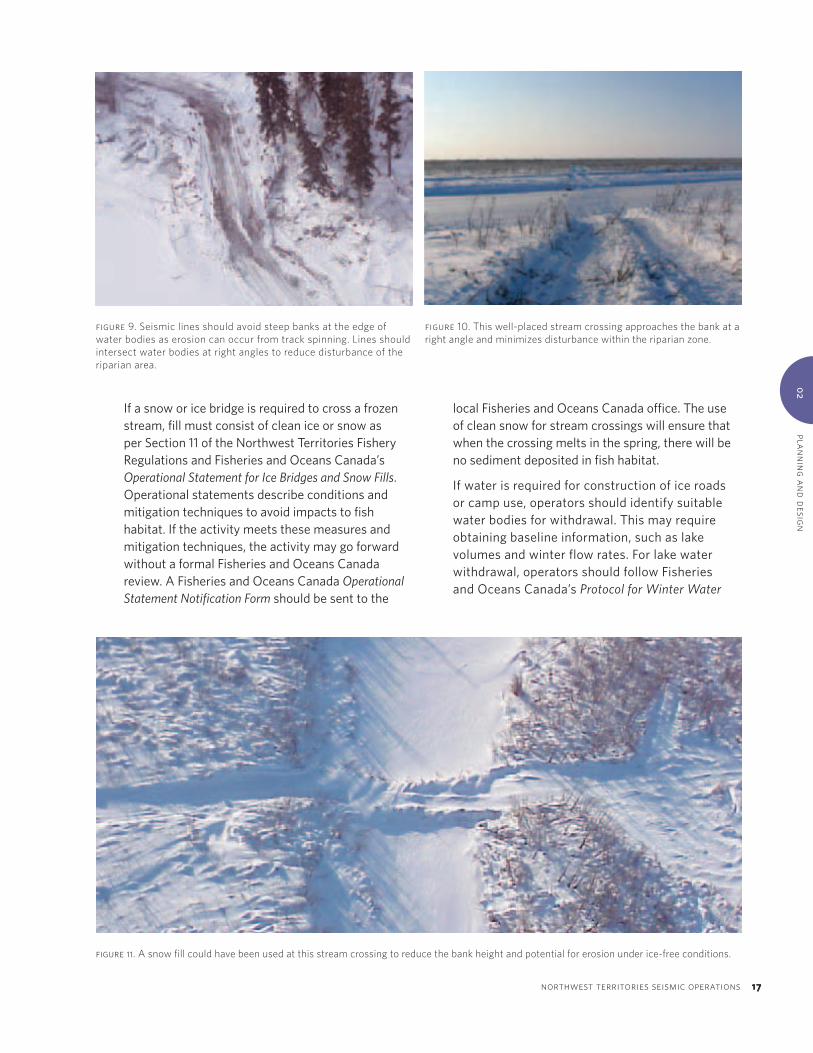
Riparian areas adjacent to water bodies are important for fish and wildlife habitat. Erosion beside a water body can lead to sedimentation into the water, affecting both water quality and fish habitat. According to the Fisheries Act, no deleterious substances, including sediment resulting from erosion, are to be introduced into the aquatic environment, so it is critical to protect the area where the seismic line intersects the bank of a water body. Methods of reducing impacts in riparian areas include minimizing the number of stream crossings in a program or routing seismic lines so that a vegetated buffer zone is maintained around water bodies. If a water crossing is required, the approach should be designed to limit the potential for erosion during ice-free conditions. The seismic line can be oriented at a right angle to the bank to minimize the area of disturbance, and the approach should have a gentle gradient with a low bank. Hand-clearing techniques can be used in riparian areas to minimize the width of lines and limit disturbance associated with clearing.
plann
ing an
d d
esign0
2
northwest territories seismic operations 17
If a snow or ice bridge is required to cross a frozen stream, fill must consist of clean ice or snow as per Section 11 of the Northwest Territories Fishery Regulations and Fisheries and Oceans Canada’s Operational Statement for Ice Bridges and Snow Fills. Operational statements describe conditions and mitigation techniques to avoid impacts to fish habitat. If the activity meets these measures and mitigation techniques, the activity may go forward without a formal Fisheries and Oceans Canada review. A Fisheries and Oceans Canada Operational Statement Notification Form should be sent to the
local Fisheries and Oceans Canada office. The use of clean snow for stream crossings will ensure that when the crossing melts in the spring, there will be no sediment deposited in fish habitat.
If water is required for construction of ice roads or camp use, operators should identify suitable water bodies for withdrawal. This may require obtaining baseline information, such as lake volumes and winter flow rates. For lake water withdrawal, operators should follow Fisheries and Oceans Canada’s Protocol for Winter Water
figure9.Seismiclinesshouldavoidsteepbanksattheedgeofwaterbodiesaserosioncanoccurfromtrackspinning.Linesshouldintersectwaterbodiesatrightanglestoreducedisturbanceoftheriparianarea.
figure10.Thiswell-placedstreamcrossingapproachesthebankatarightangleandminimizesdisturbancewithintheriparianzone.
figure 11. Asnowfillcouldhavebeenusedatthisstreamcrossingtoreducethebankheightandpotentialforerosionunderice-freeconditions.
18 aandcNorthernLandUseGuidelines
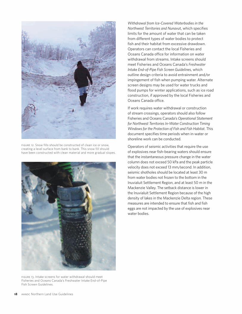
Withdrawal from Ice-Covered Waterbodies in the Northwest Territories and Nunavut, which specifies limits for the amount of water that can be taken from different types of water bodies to protect fish and their habitat from excessive drawdown. Operators can contact the local Fisheries and Oceans Canada office for information on water withdrawal from streams. Intake screens should meet Fisheries and Oceans Canada’s Freshwater Intake End-of-Pipe Fish Screen Guidelines, which outline design criteria to avoid entrainment and/or impingement of fish when pumping water. Alternate screen designs may be used for water trucks and flood pumps for winter applications, such as ice road construction, if approved by the local Fisheries and Oceans Canada office.
If work requires water withdrawal or construction of stream crossings, operators should also follow Fisheries and Oceans Canada’s Operational Statement for Northwest Territories In-Water Construction Timing Windows for the Protection of Fish and Fish Habitat. This document specifies time periods when in-water or shoreline work can be conducted.
Operators of seismic activities that require the use of explosives near fish-bearing waters should ensure that the instantaneous pressure change in the water column does not exceed 50 kPa and the peak particle velocity does not exceed 13 mm/second. In addition, seismic shotholes should be located at least 30 m from water bodies not frozen to the bottom in the Inuvialuit Settlement Region, and at least 50 m in the Mackenzie Valley. The setback distance is lower in the Inuvialuit Settlement Region because of the high density of lakes in the Mackenzie Delta region. These measures are intended to ensure that fish and fish eggs are not impacted by the use of explosives near water bodies.
figure 13. IntakescreensforwaterwithdrawalshouldmeetFisheriesandOceansCanada’sFreshwaterIntakeEnd-of-PipeFishScreenGuidelines.
figure 12. Snowfillsshouldbeconstructedofcleaniceorsnow,creatingalevelsurfacefrombanktobank.Thissnowfillshouldhavebeenconstructedwithcleanmaterialandmoregradualslopes.

plann
ing an
d d
esign0
2
northwest territories seismic operations 19
Forest harvesting for commercial and domestic purposes occurs in a number of areas throughout the territory. It is important that seismic operations planned within these active forest management areas fit within the framework of sustainable forest management. Reforestation and preservation of the forest land base need to be considered relative to timber supplies, and specific measures may be required to guarantee appropriate management. There may also be interest in forest resources cleared for a seismic program to supplement the needs of other forest users. For example, other forest users may be interested in the timber cleared for a seismic program.
Clearing activities should be designed and executed to minimize the overall disturbance area and to keep forest values intact. Projects planned within forested areas should be discussed with the Government of the Northwest Territories — Forest Management Division to establish whether there are forest management concerns and how they can be mitigated.
2.5 ForestResources
guidelinesenvironmental outcome (refer to table 1)
Discuss potential forestry issues and mitigation options with the Government of the Northwest Territories — Forest Management Division as part of project planning.
C1
Forests in the Northwest Territories are valuable for a number of reasons, from their inherent role as wildlife habitat to commercial and domestic uses as a source of fuel, building materials and employment. More recently, the role of forests in carbon storage is attracting national and international interest in the context of greenhouse gas emissions.
figure 14. Forestresourcesclearedforseismiclinesandaccessroutescanbesignificant.OperatorsshouldcontacttheGovernmentoftheNorthwestTerritories—ForestManagementDivisiontodetermineifthereareanyforestmanagementconcernsintheprojectarea.

20 aandcNorthernLandUseGuidelines
2.6 WildlifeandWildlifeHabitat
guidelinesenvironmental outcome (refer to table 1)
Species of conservation concern and their residences should be avoided during the seismic program and impacts to their habitat minimized.
A5, A6, A7
Consult with local communities to identify important wildlife and bird areas. A3, A5, A6, A7
A permit from Environment Canada is required for programs operating in critical habitat identified under provisions of the Species at Risk Act. • No person can engage in an activity affecting a listed species, any part of its critical habitat
or the residences of its individuals unless authorized by the competent Minister under the Species at Risk Act, S.73 (Incidental Effects Permit).
A5, A7
No nests or eggs of migratory birds can be disturbed or destroyed except under authority of a permit (Migratory Bird Convention Act Regulations, S.6a).
A5, A7
Individual migratory birds cannot be hunted or otherwise killed except under authority of a permit (Migratory Birds Convention Act Regulations, S.5(1)). The definition of “hunt” under the Act includes killing that is incidental to other activities.
A5
Low-impact seismic techniques should be used. • Programs should strive to achieve industry-leading narrow line widths as evidenced
from active operations and regulatory requirements in other Canadian jurisdictions.
• Depending on the operating area, specific equipment used and nature of the program, current best practices for line widths vary from 1.5–4.5 m.
• Line widths should not exceed 5 m.
• Where narrow line widths cannot be achieved, such as on specific lines where a portable camp must travel, the maximum recommended line width in forested areas is 6 m.
• Avoid large trees by taking a meandering path.
• Limit the line of sight to less than 200 m in closed forest.
• Minimize disturbance of soil and/or the duff/organic layer.
A1, A2, C1, D1, F2
Identifying any Species at Risk Act listed species that reside in or frequent the project area is an essential step in the planning process. Where critical habitat for a listed species has been identified in a formal recovery strategy or action plan for that species under the Species at Risk Act, specific restrictions and permits apply. Where critical habitat for a listed species has not been formally identified, proponents should plan to avoid or minimize impacts to important habitat and residences for that species. Supporting documentation is available from the Government of the Northwest Territories — Department of Environment and Natural Resources and Environment Canada (e.g., raptor database, key migratory bird habitats and important wildlife areas). Proponents are required under Section 79 of the Species at Risk Act to identify if species at risk or
their critical habitat may be affected by the project, what effects may occur and how they will avoid or lessen them. Further guidance on responsibilities is available in Environmental Assessment Best Practice Guide for Wildlife at Risk in Canada (ISBN 0-662-36753-7) and Addressing Species at Risk Act Considerations Under the Canadian Environmental Assessment Act for Species Under the Responsibility of the Minister Responsible for Environment Canada and Parks Canada (ISBN 978-1-100-14749-9).
There is considerable evidence that linear developments, such as seismic lines and access roads, can detrimentally affect wildlife and habitat used for feeding, reproduction, refuge or predator avoidance. For example, wide, straight seismic lines may negatively impact certain species of wildlife by increasing access for predators and hunters. The

plann
ing an
d d
esign0
2
northwest territories seismic operations 21
severity of the impact may depend on the season during which operations are conducted, the species of wildlife being affected, and the type and extent of the disturbance, which includes factors such as seismic line width and density.
Low-impact seismic techniques can minimize the impact of seismic operations on wildlife. These techniques include cutting narrow lines (less than 5 m wide), avoiding large trees by taking a meandering path, limiting the line of sight to less than 200 m (in a closed forest where natural lines of sight already do not exceed 200 m) and generally not disturbing the soil or duff/organic layer. Mulching, where practicable, can be used to minimize ground cover disturbance.
Minimizing line width in a seismic program is key to minimizing disturbance to many valued environmental parameters and reducing the long-term impact of the program. For instance, research near Fort Liard, N.W.T., reveals that 6 m wide lines negatively affect at least one bird species and have
figure 15. Agoodexampleofameanderinglinecuttoavoidlargetrees;however,thereisinsufficientsnowonthegroundtopreventsurfacedisturbance.
figure 16. (top) Agoodexampleofanarrow,meanderingseismicline.Clearedbrushhasbeenmulchedandspreadontheline.Photo courtesy of Explor.
figure 17. (bottom) Comparativefootprintofnewlow-impactseismictechniques,suchashandcuttingandavoidancecutting,withhistoricseismictechniques.Photo courtesy of Explor.
subtle effects on other migratory bird species. Research from northern Alberta, on the other hand, indicates that these effects disappear if narrower lines are cut.
Each program and local operating circumstance in the Northwest Territories is unique, so a simple prescription for line width is not practical. Input from seismic operators, particularly regarding the need to accommodate portable camps, has helped guide recommendations for line widths within this document. If a portable camp is required for a program, the maximum recommended width for lines used for moving camps is 6 m in forested areas. All other lines in the program should meet minimum low-impact seismic standards (less than 5 m), but will preferably follow industry-leading practices to further minimize line width. Proponents should also consider whether other, less invasive techniques, such as hand cutting and aeromagnetic, gravity or heli-portable surveys, are feasible to achieve some or all of the program’s objectives.
New5mAvoidanceSourceLine
Old6.5mCut
Old6.5mCutNew1.5mHandCutReceiverLine

22 aandcNorthernLandUseGuidelines
2.6.1WildlifeSensitivePeriodsandSetbackDistances
guidelinesenvironmental outcome (refer to table 1)
Important wildlife and bird nesting, denning, staging, overwintering and feeding areas should be avoided during sensitive time periods as noted in Table 6. If these areas cannot be avoided, recommended minimum setback distances should be maintained.
A3, A5, A6, A7
Avoid aircraft use over wildlife habitat during sensitive time periods as noted in Table 7. If these areas cannot be avoided, aircraft should maintain recommended minimum flight altitudes.
A3, A5, A6, A7
Seismic programs conducted during winter are unlikely to directly impact seasonally present birds and wildlife, but can affect resident species. Timing of activities that occur under snow-free conditions, such as field investigations, should consider wildlife sensitive periods to minimize or avoid impacts to wildlife. Aside from direct disturbance, such as impacting wildlife habitat, noise associated with industrial activity can have a significant effect on wildlife in the development area. Noise can cause avoidance behaviour, extra energy expenditure and temporary habitat loss. Noise can also be a nuisance to humans in areas that are used for subsistence or recreation.
The exact timing of wildlife sensitive periods varies by region and species. For example, the approximate breeding period for most migratory birds in the Northwest Territories is mid-May to mid-August. However, there will be variations in the timing and duration of nesting depending on latitude, longitude and elevation. There will also be species differences and annual differences as to when birds nest (e.g., early or late spring). The wildlife sensitive periods presented in Table 6 are a general guide as the specific timing of wildlife and bird activities may vary from year to year. The onus remains with the proponent to comply with applicable legislation.
Table 6. Wildlife sensitive periods and recommended minimum setback distances from wildlife habitat and wildlife use areas
wildlife or wildlife habitat
period specific conditions minimum setback distance
All wildlife and birds, general Breeding and birthing seasons Varies with region and species; contact local Government of the Northwest Territories — Environment and Natural Resources or Environment Canada office
0.25 km
Bear dens (polar bear, grizzly, black bear)
Sept. 30 – Mar. 30 All species’ dens, general industrial activities
0.8 km
All species’ dens, if activity is seismic development or blasting
1.5 km
All species’ dens, if activity is drilling or exploration
1 km
May 16 – Jul. 15 All species 0.3 km
Bears (grizzly and black bear) Jul. 15 – Sept. 15 Berry habitat 0.3 km
Bison Mar. 1 – Jul. 15 0.5 km
Caribou (barren-ground) May 15 – Oct. 15 Water crossings — general activities
1 km
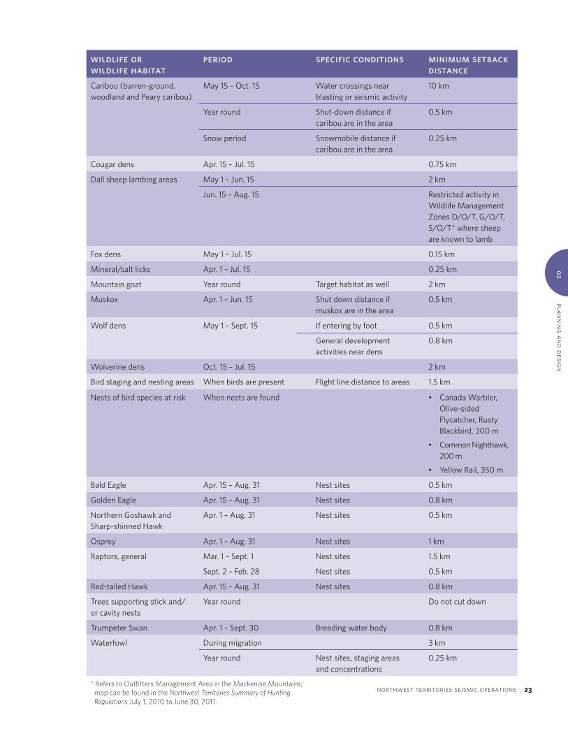
plann
ing an
d d
esign0
2
northwest territories seismic operations 23
wildlife or wildlife habitat
period specific conditions minimum setback distance
Caribou (barren-ground, woodland and Peary caribou)
May 15 – Oct. 15 Water crossings near blasting or seismic activity
10 km
Year round Shut-down distance if caribou are in the area
0.5 km
Snow period Snowmobile distance if caribou are in the area
0.25 km
Cougar dens Apr. 15 – Jul. 15 0.75 km
Dall sheep lambing areas May 1 – Jun. 15 2 km
Jun. 15 – Aug. 15 Restricted activity in Wildlife Management Zones D/O/T, G/O/T, S/O/T* where sheep are known to lamb
Fox dens May 1 – Jul. 15 0.15 km
Mineral/salt licks Apr. 1 – Jul. 15 0.25 km
Mountain goat Year round Target habitat as well 2 km
Muskox Apr. 1 – Jun. 15 Shut down distance if muskox are in the area
0.5 km
Wolf dens May 1 – Sept. 15 If entering by foot 0.5 km
General development activities near dens
0.8 km
Wolverine dens Oct. 15 – Jul. 15 2 km
Bird staging and nesting areas When birds are present Flight line distance to areas 1.5 km
Nests of bird species at risk When nests are found • Canada Warbler, Olive-sided Flycatcher, Rusty Blackbird, 300 m
• Common Nighthawk, 200 m
• Yellow Rail, 350 m
Bald Eagle Apr. 15 – Aug. 31 Nest sites 0.5 km
Golden Eagle Apr. 15 – Aug. 31 Nest sites 0.8 km
Northern Goshawk and Sharp-shinned Hawk
Apr. 1 – Aug. 31 Nest sites 0.5 km
Osprey Apr. 1 – Aug. 31 Nest sites 1 km
Raptors, general Mar. 1 – Sept. 1 Nest sites 1.5 km
Sept. 2 – Feb. 28 Nest sites 0.5 km
Red-tailed Hawk Apr. 15 – Aug. 31 Nest sites 0.8 km
Trees supporting stick and/or cavity nests
Year round Do not cut down
Trumpeter Swan Apr. 1 – Sept. 30 Breeding water body 0.8 km
Waterfowl During migration 3 km
Year round Nest sites, staging areas and concentrations
0.25 km
*ReferstoOutfittersManagementAreaintheMackenzieMountains; mapcanbefoundintheNorthwest Territories Summary of Hunting RegulationsJuly1,2010toJune30,2011.

24 aandcNorthernLandUseGuidelines
Every effort should be made to avoid aircraft use during periods when birds are particularly sensitive to disturbance and are concentrated, such as during migration and moulting. If possible, aircraft flights should be scheduled for times when few birds are present, including early spring, late fall and winter. If flights cannot be scheduled during these times, flights should be minimized over important bird habitat. In general, a minimum flight altitude of 650 m should
be maintained, and a flight altitude of 1100 m should be maintained over areas where birds are known to concentrate. Recommended minimum altitudes for aircraft operating during wildlife sensitive periods are listed in Table 7. Local aircraft firms familiar with the surrounding area are good sources of information about local hazards, timing and altitude restrictions.
Table 7. Recommended minimum flight altitudes and sensitive periods for wildlife
species/group habitat type period minimum altitude
All wildlife and birds, general Varies according to species; contact local Government of the Northwest Territories — Environment and Natural Resources or Environment Canada office
Breeding and birthing seasons; varies according to region and species; contact local Government of the Northwest Territories — Environment and Natural Resources or Environment Canada office
0.65 km
Wildlife, general All habitat types during ferry flights
Year round 0.3 km
When flying point to point in vicinity of caribou and other wildlife species
Year round 0.61 km
During wildlife surveys Year round 0.1 km
Birds, general Areas likely to have birds Year round 0.65 km
Areas where birds are known to concentrate (sanctuaries, colonies, moulting areas)
Year round 1.1 km
Black and grizzly bear Dens Oct. 15 – May 15 0.3 km
Dall sheep Lambing areas May 1 – Jun. 15 0.3 km
Rutting areas Sept. 15 – Sept. 30 0.3 km
Mountain goat Goat habitat Year round 0.3 km
Wolf Dens May 1 – Sep. 15 0.3 km
Wolverine Dens Oct. 15 – May 15 0.3 km
Raptors Nest sites Year round 0.65 km
Waterfowl Nest sites Jun. 1 – Aug. 31 0.65 km
Staging areas May 10 – Sept. 30 0.65 km
Concentrations Year round 0.65 km

plann
ing an
d d
esign0
2
northwest territories seismic operations 25
figure18.Noisefromindustrialactivitycancausewildlifetoexhibitavoidancebehaviourandexpendextraenergy.
figure19.Recommendedshut-downdistanceswhencaribouarepresentintheprojectareaarelistedinTable6.
2.7 EquipmentConsiderations
guidelinesenvironmental outcome (refer to table 1)
Low ground pressure vehicles (<35 kPa) should be used, where possible, particularly above the treeline.
D1, D2
Operators should plan to use low ground pressure vehicles (<35 kPa) for travel on seismic lines where possible. The use of low ground pressure vehicles is particularly important in tundra terrain above
the treeline due to its generally higher ice content and thaw sensitivity. In this environment, terrain disturbance could lead to near-surface ground ice melting and surface subsidence. Low ground pressure vehicles can also be used in forested terrain where clearing is not necessary; for example, in cases where existing lines can be used for access.
Operators are encouraged to employ new technology where possible to reduce terrain disturbance associated with seismic equipment. Examples include using smaller or lighter machines or heli-portable equipment.

26 aandcNorthernLandUseGuidelines
2.8 TraditionalandRecreationalLandUse
Proponents should identify and plan to avoid important archaeological or cultural sites. According to legislation, unless expressly authorized, no permittee shall conduct a land use operation within 30 m of a known or suspected historical site, archaeological site or burial ground (Mackenzie Valley Land Use Regulations, S.6a; Territorial Land Use Regulations, S.10a). Identification of archaeological or cultural sites may require field investigation under snow-free conditions prior to program commencement. The Prince of Wales Northern Heritage Centre can provide information on documented sites, as can local Aboriginal groups, communities and governments.
If an archaeological or cultural site is discovered during construction, legislation states that work in the area must be stopped immediately, and that the Aboriginal Affairs and Northern Development Canada resource management officer or the appropriate regulatory board be notified immediately (Mackenzie Valley Land Use Regulations, S.12; Territorial Land Use Regulations, S.16). Indications of an archaeological site can include the presence of arrowheads, old encampments or evidence of buildings.
Areas that are particularly valued for subsistence or recreational activities, such as traplines, hunting areas, canoe routes or tourist lodge sites, should be avoided. Aboriginal groups, local residents, the Government of the Northwest Territories — Department of Industry, Tourism and Investment,
and Aboriginal Affairs and Northern Development Canada resource management officers can identify sites of subsistence or recreational importance in the proposed program area.
Representatives of existing interests, such as cabin owners or trappers, should be consulted during the planning phase so that their concerns can be addressed in the program design. A land use permit may also contain specific conditions to protect and minimize disruption to those with existing interests. For instance, a 300 m buffer is often specified around existing cabins.
2.9 VisualImpacts
The program should also be designed to minimize visual impacts, especially in areas with high tourism or scenic value. The preferred mitigation technique is to avoid these areas; however, if avoidance is not possible, methods to reduce visual impacts include:
• minimizing lines of sight; and
• maintaining a visual barrier between seismic lines and public roads or water bodies by using buffer zones and/or doglegged access routes.
figure20.Useoflowgroundpressureequipmentisrecommendedintundraterrain.
figure21.Operatorsareencouragedtousesmallerandlightervehicleswherepossible.

clearing an
d co
nstru
ction
03
03CHAPTER
northwest territories seismic operations 27
Clearing and Construction
Clearing and construction associated with a seismic project should be conducted in a manner that avoids environmental disturbance. An effective way to ensure that all project staff are aware of applicable environmental regulations and guidelines is for the operator to host start-up meetings with local contractors, equipment operators and regulators. These meetings can be used to communicate expectations, identify sensitive terrain features and review field manuals outlining the project plan. Establishing a common understanding of environmental goals at the outset of the project will reduce the risk of creating environmental impacts.
guidelinesenvironmental outcome (refer to table 1)
Winter seismic activities can commence once the ground is frozen.
D1, D2
A minimum depth of snow is required before vehicles can be used to access the site for winter seismic activities.
D1, D2
3.1 DevelopmentTiming
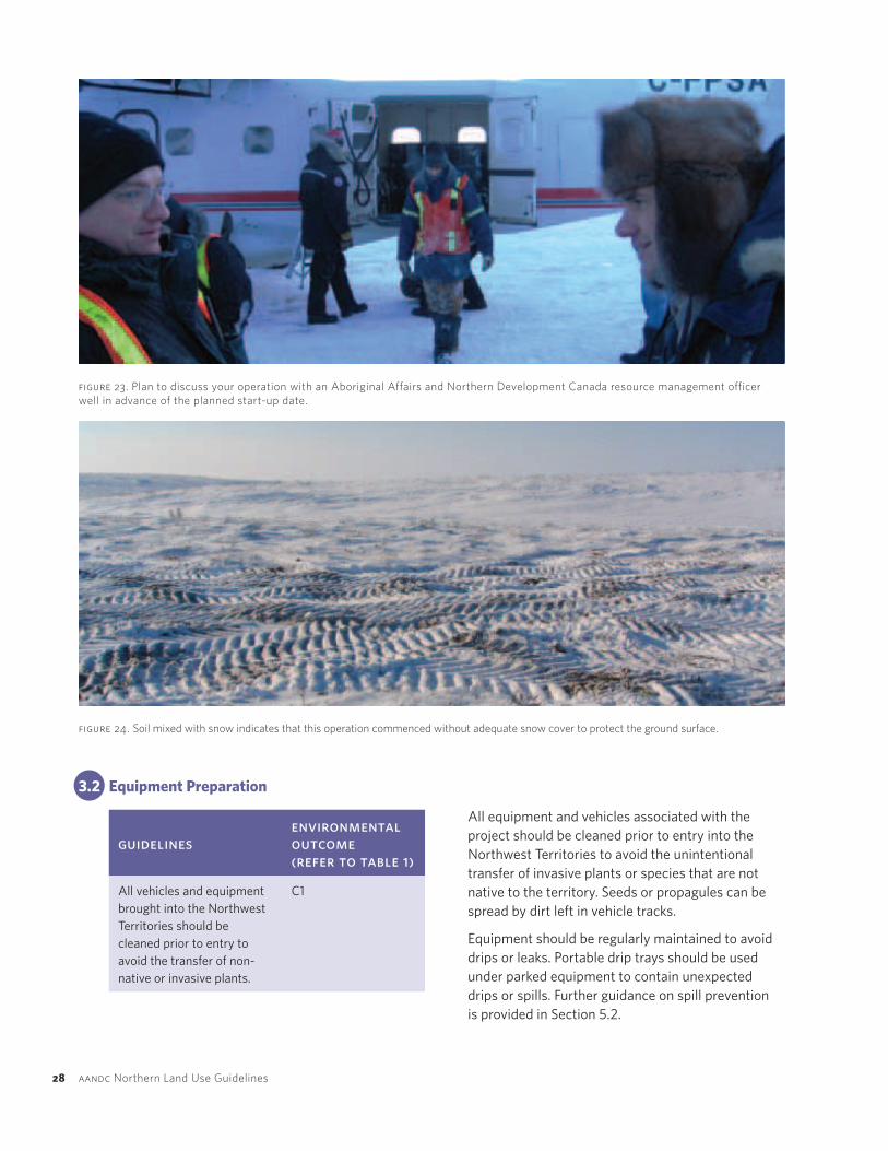
During the winter, seismic activities can commence when frozen ground conditions allow travel over the ground without rutting and subsequent permafrost degradation. To ensure that the ground is frozen, the land use permit will usually specify a date when activities can begin, but this can be modified at the discretion of the Aboriginal Affairs and Northern Development Canada resource management officer depending on local weather conditions. It is a good idea to contact the resource management officer well in advance of the anticipated start-up date to discuss development timing. A start-up meeting with the resource management officer and notification of project commencement are also two common land use permit conditions.
Clearing and travel on a seismic line requires the presence of a protective layer of snow on the ground surface at all times. A layer of snow or ice will protect the vegetation and soil below from mechanical damage and erosion. The land use permit will usually specify the minimum snow thickness required before travel can occur.
Frozen ground conditions and adequate packed snow should be maintained while the seismic lines are in use. The line should be closed before the ground thaws and vehicle travel causes rutting. The closing date is usually specified in the land use permit and is also at the discretion of the resource management officer depending on local weather conditions.
28 aandcNorthernLandUseGuidelines
3.2 EquipmentPreparation
figure 23. PlantodiscussyouroperationwithanAboriginalAffairsandNorthernDevelopmentCanadaresourcemanagementofficerwellinadvanceoftheplannedstart-update.
figure 24. Soilmixedwithsnowindicatesthatthisoperationcommencedwithoutadequatesnowcovertoprotectthegroundsurface.
All equipment and vehicles associated with the project should be cleaned prior to entry into the Northwest Territories to avoid the unintentional transfer of invasive plants or species that are not native to the territory. Seeds or propagules can be spread by dirt left in vehicle tracks.
Equipment should be regularly maintained to avoid drips or leaks. Portable drip trays should be used under parked equipment to contain unexpected drips or spills. Further guidance on spill prevention is provided in Section 5.2.
guidelinesenvironmental outcome (refer to table 1)
All vehicles and equipment brought into the Northwest Territories should be cleaned prior to entry to avoid the transfer of non-native or invasive plants.
C1

clearing an
d co
nstru
ction
03
northwest territories seismic operations 29
guidelinesenvironmental outcome (refer to table 1)
Avoid deviations from the approved program layout. A1, C1, D1
Avoid disturbance of riparian areas and follow Fisheries and Oceans Canada’s Operational Statement for the Maintenance of Riparian Vegetation in Existing Rights-of-Way.
B2, D1, E1
Avoid disturbance of the surface duff/organic layer. D1, D2
If sensitive terrain is unavoidable, appropriate low-impact equipment should be used. D1, D2
Hand clearing can be used in sensitive terrain, particularly at water crossings and steep slopes. B2, D1, D2, E1
Trees supporting stick nests should not be disturbed or cut down. A5, A6, A7
3.3 SurfacePreparation
Surface preparation for seismic lines can include the removal of trees and shrubs and the packing of snow by low ground pressure vehicles for heavier vehicles to subsequently travel on. Seismic lines should be cleared or packed as per the approved program layout so that the project occupies the minimum area necessary to conduct effective and safe operations. During project construction, observation of field conditions can often be used to further minimize the project’s footprint. For example, pushouts for vehicle avoidance can be located in natural clearings, and trees on line edges can be limbed rather than cut down. The operator is encouraged to bring forward ideas on how the program can be laid out more efficiently, with less environmental impact. Field modifications should be discussed with the Aboriginal Affairs and Northern
Development Canada resource management officer or the local regulatory board prior to making changes to the approved program.
In forested areas, trees should be cleared using a shear blade rather than being pushed over to avoid pulling up the roots, creating a depression and potentially melting permafrost. If trees cannot be cleared using a shear blade, for example in an area with a thin active layer, hand-clearing methods should be used. Leaners, or trees that remain partially upright and lean against undisturbed trees, should be cut down immediately after initial clearing because their roots would tear the organic mat if they were to fall. Shrubs should be pushed down or driven over so that the roots are left in place, promoting natural regeneration once seismic activities are complete.
figure 25. Useofashearbladewithaskidderisanacceptablemethodofclearinginrelativelyflatterrain.

30 aandcNorthernLandUseGuidelines
figure 27. Ifshrubsarepusheddownsothatrootsareleftinplaceduringclearing,naturalregenerationcanoccurmorequicklyoncetheoperationiscomplete.Aone-year-oldseismiclineisinthecentreofthephotograph.
figure 26.(left) Leanersonthisrecentlyclearedseismiclineshouldberemovedandmoresnoworiceisrequiredtoprotectthegroundsurface.(right) Anacceptableseismiclinewithnoleanersandadequatepackedsnow.
Riparian areas are vegetated zones adjacent to water bodies that provide shade and cover for fish, and stabilize the banks of water bodies. It is important to retain as much riparian vegetation as possible, especially the vegetation directly adjacent to the watercourse to minimize disturbance to fish habitat and to prevent bank erosion. Disturbance of riparian areas should be avoided where possible. Where avoidance is not possible, clearing should be conducted using appropriate low-impact equipment or by hand. Fisheries and Oceans Canada’s Operational Statement for the Maintenance of Riparian Vegetation in Existing Rights-of-Way should be followed.
The surface duff/organic layer is important because it is the most fertile layer of soil, provides a growth medium for vegetation and is a source of seeds for reclamation. In permafrost terrain, leaving the surface organic layer intact prevents underlying
ice-rich soil from thawing. Operators should avoid scuffing or cutting the surface layer while clearing. This can be particularly difficult in uneven terrain, such as tussocks or hummocks. In this terrain, dozers should be equipped with mushroom shoes or smear blades that raise the blade above the ground surface to avoid scuffing the surface layer.
Steep terrain is generally avoided during project planning because the use of heavy equipment in these areas can lead to soil erosion or disturbance of the surface organic layer. If steep terrain is unavoidable, low-impact techniques such as hand clearing, low ground pressure vehicles or heli-portable equipment should be used to prevent soil erosion.
Avoid disturbing or cutting trees that support stick nests when clearing seismic lines. Clearing equipment operators should be made aware of this as they are the most likely to identify these nests in the field.

clearing an
d co
nstru
ction
03
northwest territories seismic operations 31
figure 28. (top left) Dozerbladesequippedwithmushroomshoesor(top right) smearbladesraisethebladeabovethegroundsurfaceinuneventerrainsothatthesurfaceorganiclayerislesslikelytobescuffedorcut.(bottom) Useofheli-portableseismictechniquesinsteepterrain.Photo courtesy of Explor.
32 aandcNorthernLandUseGuidelines
3.4 BrushDisposal
guidelinesenvironmental outcome (refer to table 1)
If brush is disposed of in windrow piles, their height should be less than 1 m (snow free), with minimum 10 m gaps every 300 m and at identified game or trapping trails.
A4
Once seismic lines have been cleared, the resulting brush should be cleared off the line to allow for vehicle movement. It is good practice to conduct brush disposal concurrently with clearing to take advantage of on-site equipment and reduce vehicle travel on the seismic lines. Proper brush disposal should not impede movement of wildlife from one side of the seismic line to the other.
Windrowing and compaction is a method of brush disposal that involves piling brush in long rows on the side of the seismic line and compacting the piles with heavy equipment to promote decomposition. Compacting the windrow can lever trees back into a standing position, so a slasher should follow compaction to cut these trees down. Land use permits often specify that the windrowed piles should be less than 1 m high with minimum 10 m gaps at 300 m intervals and at identified game or trapping trails to allow for wildlife movement.
Brush can also be disposed of by mulching with a wood chipper or a brush cutter. The resulting wood chips can be scattered on the ground. This method reduces the accumulation of snow on the seismic line in comparison with windrowing because there is no pile to catch snow. The wood chips may decompose more rapidly than windrowed brush, but they may also suppress growth of vegetation on the line by covering the ground surface. A thick layer of wood chips will insulate the ground, which could warm the permafrost below. A thinly scattered layer of wood chips is likely the best method of disposal. The benefits and drawbacks of mulching should be evaluated for each project.
Brush can also be completely disposed of by burning if authorized in the land use permit. Brush piles should be placed well away from standing vegetation to minimize the risk of the fire spreading. Set fires should be monitored at all times. Burning should not be conducted in permafrost terrain with high ground ice content as the resulting heat could cause the ground ice to melt and lead to subsidence.
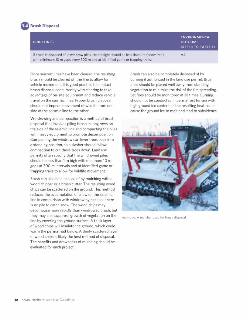
figure 29. Amulcherusedforbrushdisposal.
clearing an
d co
nstru
ction
03
northwest territories seismic operations 33
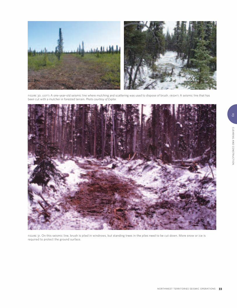
figure 31. Onthisseismicline,brushispiledinwindrows,butstandingtreesinthepilesneedtobecutdown.Moresnoworiceisrequiredtoprotectthegroundsurface.
figure 30. (left) Aone-year-oldseismiclinewheremulchingandscatteringwasusedtodisposeofbrush.(right) Aseismiclinethathasbeencutwithamulcherinforestedterrain.Photo courtesy of Explor.

04CHAPTER
34 aandcNorthernLandUseGuidelines
Operations
4.1 LineOperations
guidelinesenvironmental outcome (refer to table 1)
Avoid unnecessary deviations from planned seismic lines, including sharp turns, loops, and wheel or track spinning.
A1, D1, D2
Minimize use of heavy equipment on the lines. D1, D2
Recreational use of seismic lines by program staff is not recommended. A1, A5, A6, A7
Wildlife should not be fed. A6
Suspend vehicle travel on the line if rutting occurs. D1, D2
Sediment- and erosion-control measures should be applied and maintained throughout multi-year operations.
B2, D1, E1
Operations should follow planned seismic lines as much as possible. On tundra where there is greater opportunity to stray from planned routes, it is particularly important that vehicles avoid deviating from planned seismic lines. Sharp turns, loops, and wheel or track spinning should be avoided as these actions can cut into the ground surface, causing erosion and permafrost degradation. Planned seismic lines should have gentle turns and gradients. Minimizing the number of passes made by heavy vehicles on the lines will also reduce the amount of disturbance to vegetation and soils.
Travel in the program area should be conducted with respect for wildlife. Use of recreational vehicles, such as snowmobiles or all-terrain vehicles, by
program personnel is not recommended as this could lead to additional land disturbance and hunting or fishing pressures. Wildlife should never be fed to avoid habituating animals to human food and causing problem wildlife.
Land use permits often specify that travel in the program area should be suspended if rutting occurs on the surface of seismic lines or roads. Rutting indicates that the surface duff/organic layer and vegetation have already been damaged. With the approval of the Aboriginal Affairs and Northern Development Canada resource management officer, vehicle travel may be permitted at night when freezing conditions allow the ground to support equipment. A more proactive approach
operatio
ns
04
northwest territories seismic operations 35
is to schedule project activities so that they are completed well before spring thaw.
Erosion- and sediment-control measures should be applied prior to, during and after operations as required. Particular attention should be paid to multi-year projects and times of changes in water flow, such as spring freshet. Erosion- and sediment-control measures can include covering exposed soil with erosion-control blankets or tarps, or vegetating disturbed areas by planting
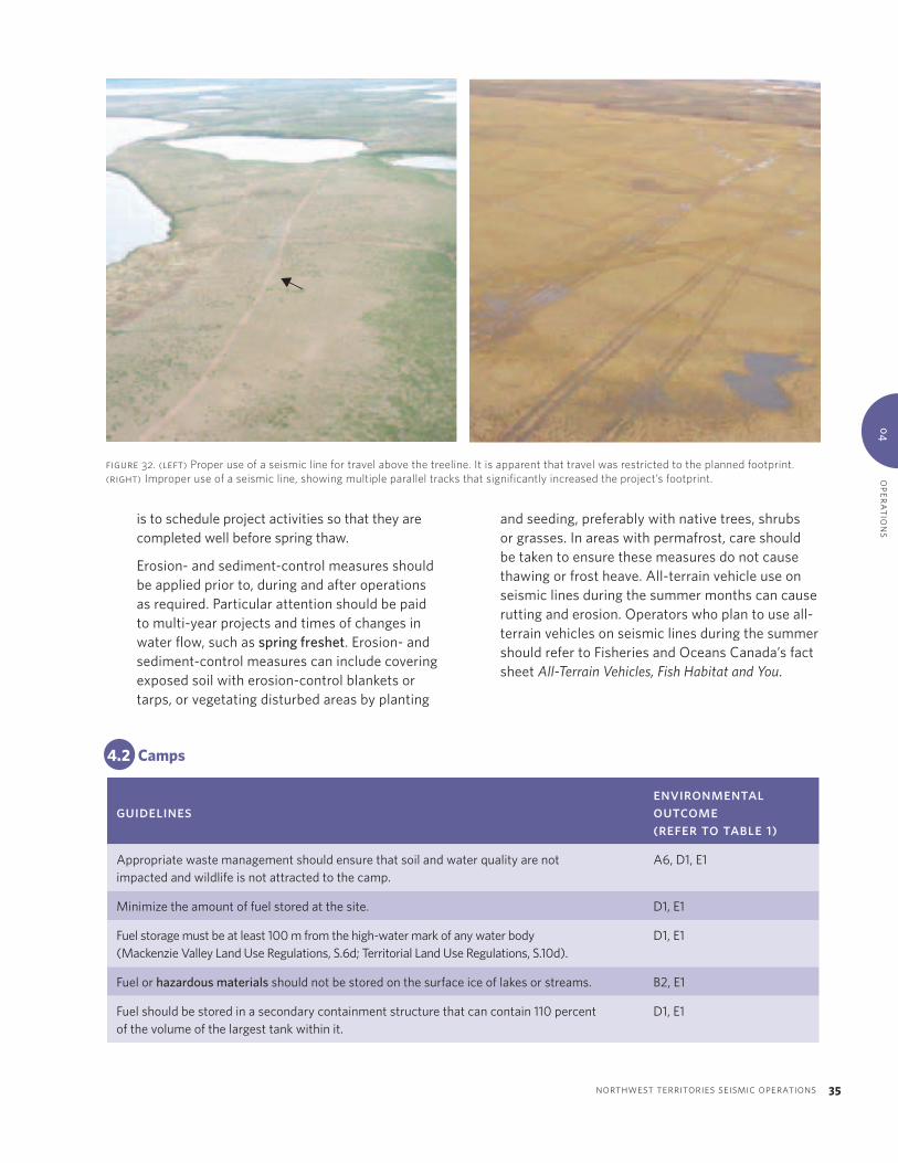
figure 32. (left) Properuseofaseismiclinefortravelabovethetreeline.Itisapparentthattravelwasrestrictedtotheplannedfootprint.(right)Improperuseofaseismicline,showingmultipleparalleltracksthatsignificantlyincreasedtheproject’sfootprint.
4.2 Camps
guidelinesenvironmental outcome (refer to table 1)
Appropriate waste management should ensure that soil and water quality are not impacted and wildlife is not attracted to the camp.
A6, D1, E1
Minimize the amount of fuel stored at the site. D1, E1
Fuel storage must be at least 100 m from the high-water mark of any water body (Mackenzie Valley Land Use Regulations, S.6d; Territorial Land Use Regulations, S.10d).
D1, E1
Fuel or hazardous materials should not be stored on the surface ice of lakes or streams. B2, E1
Fuel should be stored in a secondary containment structure that can contain 110 percent of the volume of the largest tank within it.
D1, E1
and seeding, preferably with native trees, shrubs or grasses. In areas with permafrost, care should be taken to ensure these measures do not cause thawing or frost heave. All-terrain vehicle use on seismic lines during the summer months can cause rutting and erosion. Operators who plan to use all-terrain vehicles on seismic lines during the summer should refer to Fisheries and Oceans Canada’s fact sheet All-Terrain Vehicles, Fish Habitat and You.
36 aandcNorthernLandUseGuidelines
Seismic operations in the Northwest Territories often require a remote camp. Guidance on construction of a new camp and operation of an existing camp can be found in the Northern Land Use Guidelines: Camps and Support Facilities volume (AANDC, 2010). Two important environmental management issues associated with remote camps are management of waste, including solid waste, grey water and sewage, and fuel storage.
4.2.1WasteManagement
Non-combustible solid waste should be removed from the camp by the end of operations. Before removal, solid waste should be organized and stored securely so that it does not attract wildlife. Waste can be removed from the site progressively as the operation is under way to take advantage of cost savings associated with using empty backhauls.
Incineration may be used to dispose of combustible solid waste, but a proper incinerator should be used following guidance provided in Environment Canada’s Technical Document for Batch Waste Incineration to promote complete combustion. The purpose of the document is to provide guidance for owners and operators of batch waste incinerators regarding proper system selection, operation, maintenance and record keeping, with the goal of assisting them in achieving the intent of the Canada-wide standards for dioxins, furans and mercury, and reducing releases of other toxic substances.
Sewage and grey water should be stored and treated separately from solid waste. Sewage refers to toilet
wastes and grey water refers to water from washing and kitchen facilities. Sewage is more likely to contain pathogens, but all waste water should be stored and treated well away from the camp water supply. Options for sewage and grey water treatment or storage depend on the size of the camp and the volume of waste. Small amounts of sewage may be treated and disposed of on-site or placed in a pit privy. Larger amounts of sewage should be stored in a holding tank for future removal from the site by pump truck to an approved disposal facility. Grey water can be stored and treated in a sump, or stored in a tank for future removal from the site by truck.
4.2.2FuelStorage
On federal Crown land, storage of petroleum products in tanks with a capacity of greater than 230 L and associated piping and equipment is regulated by Environment Canada’s Storage Tank Systems for Petroleum Products and Allied Petroleum Products Regulations. The purpose of these regulations is to reduce the risk of contaminating soil and ground water due to spills and leaks of petroleum products from storage tank systems. Land use permit and water licence conditions also address fuel storage location and handling.
The amount of fuel stored at the project site should be minimized to reduce impacts in the event of a spill, lower costs of backhauling empty fuel containers and decrease the risk that unused fuel will be left on-site once the project is complete.
Fuel and hazardous materials must be stored on land, at least 100 m above the high-water mark (Mackenzie Valley Land Use Regulations, S.6d; Territorial Land Use Regulations, S.10d) to reduce the risk of fuel spills in water, unless expressly authorized in the land use permit or in writing by the Aboriginal Affairs and Northern Development Canada resource management officer. Fuel caches should be located on flat, stable terrain, or in a natural depression, away from slopes leading to water bodies. Generally, fuel and hazardous materials should not be stored on the surface of frozen lakes or streams; however, during camp construction, temporary storage of mobile fuel facilities on frozen water bodies may be allowed by the appropriate land use regulator.
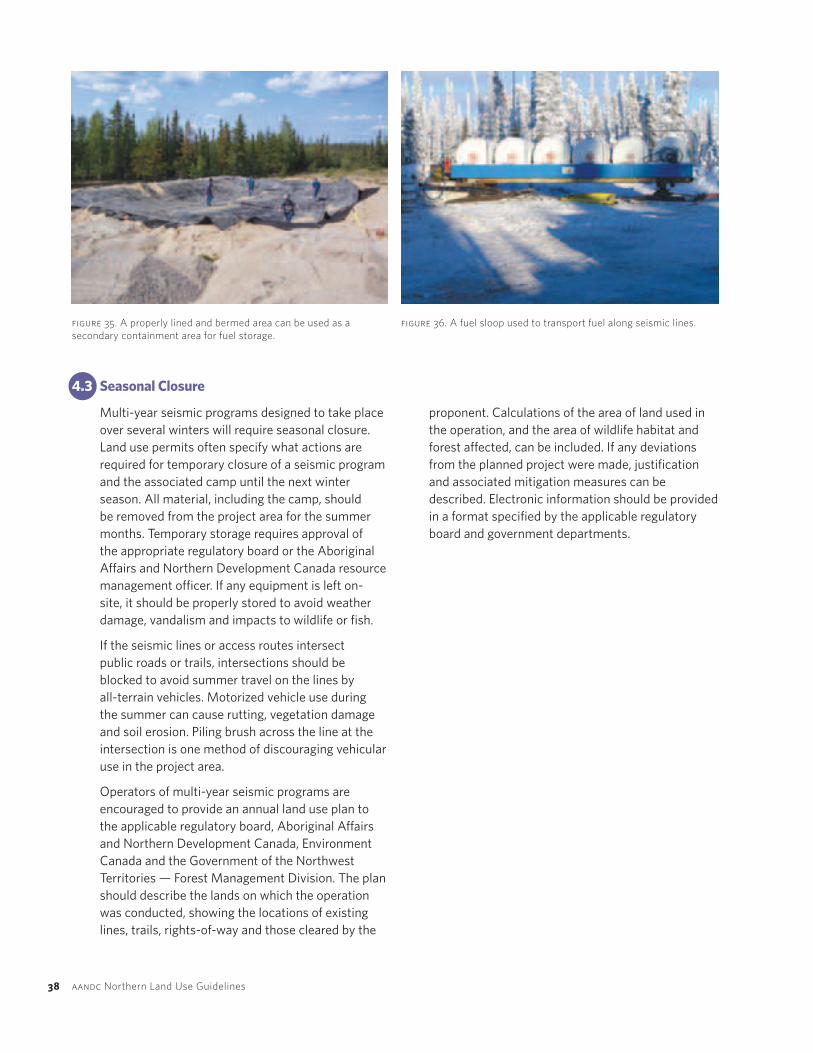
Secondary containment refers to any impermeable storage structure surrounding fuel containers that has the capacity to contain fuel in the event of a
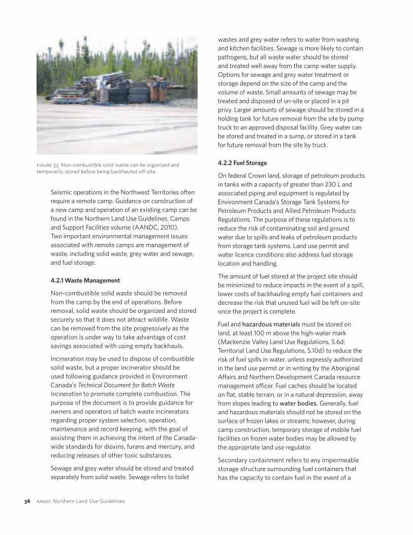
figure 33. Non-combustiblesolidwastecanbeorganizedandtemporarilystoredbeforebeingbackhauledoff-site.

operatio
ns
04
northwest territories seismic operations 37
spill. Land use permits usually require secondary containment for stationary fuel containers with a capacity greater than 230 L. Secondary containment is also a relatively low-cost option to reduce the risk of a spill for small fuel containers such as drums. The volume of the secondary containment structure should be 10 percent greater than the capacity of the largest fuel container within it. Double-walled fuel tanks are one example of secondary containment. Engineered, bermed structures are another method of containment and should be of sufficient height or depth to contain the wave resulting from a major breach of a large container. If possible, tanks in fuel storage areas should be elevated so that leaks can be easily detected. Snow and water should be regularly removed from secondary containment areas to ensure that capacity is maintained. The accumulated snow or water should first be checked for fuel contamination and contaminated material should be appropriately disposed of. Large secondary containment areas may require an oil/water separator.
Tanks with fill and dispense pipes located on the top of the tank are preferred to reduce the chance of spillage during fuel transfer. Valves and fittings for fuel storage tanks are often sources of leaks and should also be surrounded by secondary containment. Fuel drums used for heating camp tents should be elevated on stands, and drip trays should be placed under the fittings and valves.
Fuel sloops provide a means of transporting fuel required for operations along seismic lines. They consist of multiple fuel tanks mounted on skids that can be dragged behind a vehicle. Land use permits often require secondary containment for mobile fuel sloops. A spill tray can be welded underneath the tanks and all pipes or couplings should be contained within the tray. One empty container with a capacity of 110 percent of the largest container within the sloop should be carried at all times.
figure 34. Minimalfuelisstoredatthismobilecampinadouble-walledtank,indicatedbythearrow.
38 aandcNorthernLandUseGuidelines
4.3 SeasonalClosure
Multi-year seismic programs designed to take place over several winters will require seasonal closure. Land use permits often specify what actions are required for temporary closure of a seismic program and the associated camp until the next winter season. All material, including the camp, should be removed from the project area for the summer months. Temporary storage requires approval of the appropriate regulatory board or the Aboriginal Affairs and Northern Development Canada resource management officer. If any equipment is left on-site, it should be properly stored to avoid weather damage, vandalism and impacts to wildlife or fish.
If the seismic lines or access routes intersect public roads or trails, intersections should be blocked to avoid summer travel on the lines by all-terrain vehicles. Motorized vehicle use during the summer can cause rutting, vegetation damage and soil erosion. Piling brush across the line at the intersection is one method of discouraging vehicular use in the project area.
Operators of multi-year seismic programs are encouraged to provide an annual land use plan to the applicable regulatory board, Aboriginal Affairs and Northern Development Canada, Environment Canada and the Government of the Northwest Territories — Forest Management Division. The plan should describe the lands on which the operation was conducted, showing the locations of existing lines, trails, rights-of-way and those cleared by the
figure 35. Aproperlylinedandbermedareacanbeusedasasecondarycontainmentareaforfuelstorage.
figure 36. Afuelsloopusedtotransportfuelalongseismiclines.
proponent. Calculations of the area of land used in the operation, and the area of wildlife habitat and forest affected, can be included. If any deviations from the planned project were made, justification and associated mitigation measures can be described. Electronic information should be provided in a format specified by the applicable regulatory board and government departments.

spills0
5
05CHAPTER
northwest territories seismic operations 39
Spills
Spills can involve hydrocarbons or hazardous materials. Spills of reportable quantities must be reported immediately to the 24-hour spill line at 867-920-8130 according to the Government of the Northwest Territories Spill Contingency Planning and Reporting Regulations. A list of immediately reportable spill quantities is available in Aboriginal Affairs and Northern Development Canada’s Guidelines for Spill Contingency Planning (www.aadnc-aandc.gc.ca/eng/1100100024236).
Meeting the requirements of the Fisheries Act is mandatory, irrespective of any other regulatory or permitting system. Section 36(3) of the Fisheries Act specifies that unless authorized by federal regulation, “no person shall deposit or permit the deposit of a deleterious substance of any type in water frequented by fish or in any place under any conditions where the deleterious substance, or any other deleterious substance that results from the deposit of the deleterious substance, may enter
guidelinesenvironmental outcome (refer to table 1)
An approved spill contingency plan must be in place during all phases of the project. D1, E1
Appropriate spill response equipment should be in place during all stages of the operation. D1, E1
Equipment should be in good mechanical condition and free of leaks. D1, E1
Drip pans should be placed under all parked vehicles, including snowmobiles and all-terrain vehicles.
D1, E1
Spill pads or drip trays should be used underneath refuelling areas. D1, E1
any such water.” The legal definition of “deleterious substance” provided in Section 34(1) of the Fisheries Act, in conjunction with Court rulings, provides a very broad interpretation of deleterious and includes any substance with a potentially harmful chemical, physical or biological effect on fish or fish habitat.
Section 5.1 of the Migratory Birds Convention Act prohibits persons from depositing substances harmful to migratory birds in waters or areas frequented by migratory birds or in a place from which the substance may enter such waters or such an area.

40 aandcNorthernLandUseGuidelines
5.1 SpillContingencyPlan
A spill contingency plan must be in place during all phases of the operation as per land use permit conditions and must be submitted with the land use permit application. Unexpected spill events do occur and a plan will help operators respond to them quickly and effectively. The spill contingency plan should be implemented immediately after a spill event. The plan outlines a logical order of how operators should respond to a spill, resources available on-site for spill response, and agencies and individuals who need to be notified. All project personnel should be aware of and understand the plan so that they can respond effectively to a spill. A spill contingency plan template is provided in Aboriginal Affairs and Northern Development Canada’s Guidelines for Spill Contingency Planning.
5.2 SpillPrevention
Hydrocarbon spills from equipment are a major source of environmental damage and are often preventable. Appropriate spill response equipment should be in place during all stages of the operation, but precautions can be taken to minimize the risk of spills. Equipment should be properly maintained and in good working condition to minimize potential leaks from hydraulic hoses and other working components. Drip trays should be placed under parked vehicles, including snowmobiles and all-terrain vehicles, to catch hydrocarbon drips. Fuel storage and equipment should be inspected daily for spills or leaks. A member of the project team should be responsible for carrying out these inspections and documenting the results.
A common cause of spills is a lack of attention during fuel transfer. Fuel transfer areas should be stocked with adequate spill response supplies. Spill pads or drip trays can be used in the fuel transfer area to confine contamination in the event of a spill. The transfer of fuel should always be closely supervised by trained personnel. Larger operations can designate an employee to conduct refuelling and care for the fuel transfer area. Fuel nozzles should be contained when not in use to prevent drips, and non-drip nozzles can be used. Refuelling should occur away from the ordinary high-water mark of any water body or any natural drainage that leads to a water body.
figure 37. Driptraysshouldbeplacedunderparkedequipmenttocatchunexpecteddripsorspills.
5.3 SpillResponse
Spill response includes stopping, containing and reporting the spill event. Adequate spill response supplies should be available on-site that can be used to contain the spill. Once the spill has been contained and reported, photographs should be taken of the spill area, the extent of the spill should be delineated and a cleanup strategy should be developed. Ensure that there is never an ignition source in the vicinity of spilled flammable products.

closu
re and
reclamatio
n0
6
06CHAPTER
northwest territories seismic operations 41
Closure and Reclamation
The final phase of a seismic program is closure and reclamation. Reclamation is the process of returning a disturbed site to its natural state or another productive use that prevents or minimizes adverse effects on the environment or threats to human health and safety. Reclamation is the responsibility of the operator.
A common reclamation objective is to return the project area to a stable condition that is compatible with surrounding land uses. Where several land use options exist, environmental limitations, local community members, land users and existing regional land use plans will influence the reclamation objective that will ultimately be determined by the local land use regulator.
A closure and reclamation plan may be a requirement of the land use permit. This plan should be developed with input from local community members and land users, and regulatory authorities. For smaller projects, land use permits may contain specific conditions for reclamation rather than a requirement to develop a plan.
guidelinesenvironmental outcome (refer to table 1)
Remove all material that was brought to the project site. A1, D1, E1
Natural revegetation is the preferred method of erosion control in relatively stable areas. C1
If seeding is required in erosion-prone areas, native seeds should be used. C1
Lines in forested areas should be left in such a condition that motorized access is limited. A5, A6, A7, D1
When operations are complete, the site must be reclaimed as outlined in the closure and reclamation plan or land use permit conditions. Monitoring will likely be required for several years after reclamation work is complete to ensure that reclamation objectives are being met. If reclamation objectives are not being met, proponents will be required to return to the site to carry out further reclamation work. Once the land use regulator is satisfied that the site is stable and reclamation objectives have been achieved, a letter of final clearance will be issued.

42 aandcNorthernLandUseGuidelines
figure 38. Thishistoricseismiclinehasbeenrevegetatedwithdeciduousshrubs.
6.1 FinalLandUsePlan
Land use permits require a final land use plan within 60 days after completion of the land use operation or expiration of the land use permit. According to Mackenzie Valley Land Use Regulations, S.29 and Territorial Land Use Regulations, S.33, the final land use plan must describe the lands on which the operation was conducted, showing the locations of existing lines, trails, rights-of-way and those cleared by the proponent, and provide calculations of the area of land used in the operation. In addition to these legal requirements, operators are encouraged to include the following components in their final land use plan:
• Justification for any deviations from the planned project that were made and mitigation measures that were used.
• Calculations of the area of wildlife habitat and forest affected by the land use operation.
Operators are also encouraged to provide their final plans directly to Aboriginal Affairs and Northern Development Canada, Environment Canada and the Government of the Northwest Territories — Forest Management Division, in addition to the appropriate
regulatory board. Electronic information should be provided in a format specified by the applicable regulatory board and government departments.
6.2 ProgressiveReclamation
Once closure and reclamation objectives and activities are approved, conduct reclamation activities throughout operations in areas that are no longer used. For example, brush can be pulled back onto steep slopes to provide erosion control once seismic work is complete in those areas. Progressive reclamation will reduce the amount of reclamation required when operations are completed. This will reduce total reclamation costs by taking advantage of equipment and resources already on-site. Progressive reclamation may also allow for early evaluation of reclamation techniques, thus reducing future reclamation monitoring requirements.
6.3 ReclamationActivities
There are several important activities involved in the reclamation of most seismic program sites. These activities are described in the following sections.

closu
re and
reclamatio
n0
6
northwest territories seismic operations 43
figure 39. Allmaterialshouldberemovedfromtheoperation,includingwirethatcouldentanglewildlife.
6.3.1CompleteRemoval
Closure requires removal of all material that was brought onto the site, including structures, equipment, flagging and garbage. All equipment and debris associated with blasting should also be removed as per the land use permit conditions. Removal of all wire from the project area is particularly important because it can entrap wildlife. Verification of final cleanup will be conducted by an Aboriginal Affairs and Northern Development Canada resource management officer under snow-free conditions when the ground surface is visible.
In addition to surface debris, areas contaminated by fuel or chemical spills should be completely cleaned up and contaminated soils properly disposed of. Shotholes and craters should be backfilled so that they are level with the surrounding ground. This can be done progressively throughout the operation.
Structures such as snow or ice bridges that may block drainage during spring freshet should be removed. Techniques for proper removal of snow or ice bridges are outlined in Fisheries and Oceans Canada’s Operational Statement for Ice Bridges and Snow Fills. When the crossing season is over and where it is safe to do so, a V-notch should be cut in the centre of the ice bridge to promote water flow.
6.3.2ErosionControl
Cleared areas at the seismic program site that are not prone to erosion should generally be left to revegetate naturally. Natural revegetation limits the introduction of invasive plant species that may be inadvertently included in seed mixes, and native plants are often more successful over the long term as they are adapted to northern growing conditions.

44 aandcNorthernLandUseGuidelines
In areas where soil erosion is an immediate concern, such as a slope that has been disturbed by vehicle travel, active revegetation by seeding or planting may be necessary to achieve soil stability. Planting can include the use of shrub cuttings such as willows. Where seeding is required, native seed mixes should be used to lower the risk of introducing invasive species. There is currently no commercial source of grass and legume seeds indigenous to the Northwest Territories. If indigenous species become available in the future, they should be used. At present, similar agronomic cultivars from Yukon, southern Canada, Alaska or continental United States can be used. The Aboriginal Affairs and Northern Development Canada resource management officer and the Government of the Northwest Territories —
figure41.Brushcanberolledbackacrosssteepslopestopreventerosion.
figure 40. Exampleofanaturallyrevegetatedcutline.
Department of Forest Management should be contacted for information on approved seed mixes. Mulch may be used in seeded areas to prevent erosion and help seeds germinate.
On particularly steep or disturbed slopes, slope stabilization can be achieved using blankets or tarps to keep the soil in place. Alternatively, brush can be rolled back across the seismic line to slow downslope water flow and act as a sediment trap. In some cases, cross drainage may be established across the seismic line using cross ditches or berms. Both structures will deflect surface water to the side of the seismic line, reducing the potential for soil erosion. Brush should be placed so that it will not be pushed or fall into a stream and impede water flow. In areas with permafrost, these methods should be planned to ensure they do not cause thawing or frost heave. Sediment- and erosion-control measures should be maintained until revegetation of the disturbed areas is achieved.
6.3.3RestrictAccess
Public use of motorized vehicles, such as snowmobiles or all-terrain vehicles, on reclaimed seismic lines may disturb slopes, vegetation, erosion-control structures and stream banks. To prevent the public from using motorized vehicles on seismic lines, barriers can be constructed where they intersect with public roads or trails. An effective method is to spread brush across the right-of-way near these intersections.
6.4 ReclamationMonitoring
Land use permit conditions may require monitoring for several years after reclamation activities have been completed to assess whether reclamation objectives have been met. Post-closure monitoring should attempt to answer the following questions:
• Are erosion-control measures performing as intended?
• Is the site stable?
• Have all reclamation objectives been achieved?
If monitoring reveals that some reclamation techniques have been unsuccessful, additional reclamation work may be required. When the land use regulator is satisfied that the site is stable and reclamation objectives have been met, a letter of final clearance will be issued.

bibliograph
yB
northwest territories seismic operations 45
Bibliography
Aboriginal Affairs and Northern Development Canada. Environmental Guidelines: Northern Seismic Operations. Prepared by Hardy BBT. Ministry of Supply and Services Canada, Ottawa, 34 pages, 1988.
Aboriginal Affairs and Northern Development Canada. Guidelines for Spill Contingency Planning. Yellowknife, Northwest Territories, 2007. www.aadnc-aandc.gc.ca/eng/1100100024236
AMEC Americas Ltd. 2005. Mackenzie Gas Project: Effects of Noise on Wildlife. Prepared for Imperial Oil Resources Ventures Limited. AMEC Americas Ltd.
Bradshaw, C.J.A., S. Boutin and D.M. Hebert. 1998. Energetic implications of disturbance caused by petroleum exploration to woodland caribou. Can. J. Zool. 76: 1319-1324.
Canadian Association of Petroleum Producers. Guide — Evolving Approaches to Minimize the Footprint of the Canadian Oil and Natural Gas Industry. Publication number 2004-0023, 2004.
Dehcho Land Use Planning Committee. Respect for the Land: The Dehcho Land Use Plan. May 2006. http://www.dehcholands.org/docs.htm
Dyer, S.J., O’Neill, J.P., Wasel, S.M., and Boutin, S. 2001. Avoidance of industrial development by woodland caribou. Journal of Wildlife Management 65: 531-542.
Environmental Impact Screening Committee. Operating Guidelines and Procedures. Inuvik, Northwest Territories, 2004. http://www.screeningcommittee.ca/screening/operating_guidelines.html
Frid. A. 2003. Dall’s Sheep Responses to Overflights by Helicopter and Fixed-wing Aircraft. Biological Conservation 110: 387-399.
Government of the Northwest Territories. Guide to the Spill Contingency Planning and Reporting Regulations. 2002. http://www.enr.gov.nt.ca/eps/pdf/spill_contingency.pdf
Gunne, A., J. Antoine, J. Boulanger, J. Bartlett, B. Croft and A.D’Hont. 2002. Boreal Caribou Habitat and Land Use Planning in the Dehcho, Northwest Territories. Report for Environment Canada’s Habitat Stewardship Program for Species at Risk. 49 pp.
Gwich’in Land Use Planning Board. Gwich’in Land Use Plan Working Document with Proposed Revisions — April 2010 Draft. 2010. http://www.gwichinplanning.nt.ca/publications.html
Jalkotzy, M.G., P.I. Ross, and M.D. Nasserden. 1997. The Effects of Linear Developments on Wildlife: A Review of Selected Scientific Literature. Prepared for the Canadian Association of Petroleum Producers, Calgary, Alberta.
James, A.R.C. and A.K. Stuart-Smith. 2000. Distribution of Caribou and Wolves in Relation to Linear Corridors. Journal of Wildlife Management 64: 65-71.
Latour, P.B., J. Leger, J.E. Hines, M.L. Mallory, D.L. Mulders, H.G. Gilchrist, P.A. Smith and D.L. Dickson. Key Migratory Bird Terrestrial Habitat Sites in the Northwest Territories and Nunavut. Canadian Wildlife Service, Occasional Paper No. 114, Ottawa, 2008. http://www.cws-scf.ec.gc.ca/publications
Lee, P. and S. Boutin. 2006. Persistence and developmental transition of wide seismic lines in the western Boreal Plains of Canada. Journal of Environmental Management 78(3): 240-250.
Machtans, C.S. Songbird Response to Seismic Lines in the Western Boreal Forest: A Manipulative Experiment. Canadian Journal of Zoology, 84, 1421–1430, 2006.
Mackenzie Valley Environmental Review Board. Reference Bulletin - Preliminary Screening of Seismic Operations in the Mackenzie Valley (draft). 2003. http://www.mvlwb.ca/mv/Registry
Maier, J.A.K., S.M. Murphy, R.G. White and M.D. Smith. 1998. Responses of Caribou to Overflights by Low-Altitude Jet Aircraft. Journal of Wildlife Management 62(2): 752-766.
Sahtu Land Use Planning Board. Sahtu Land Use Plan — Draft 3. 2010. http://www.sahtulanduseplan.org/website/web-content/index.html
Seip, D.R., C.J. Johnson, and G.S. Watts. 2007. Displacement of Mountain Caribou From Winter Habitat by Snowmobiles. Journal of Wildlife Management 71(5): 1539-1544.
Thurber, J.M., R.O. Peterson, T.D. Drummer, S.A. Thomasma.1994. Gray Wolf Response to Refuge Boundaries and Roads in Alaska. Wildlife Society Bulletin 22 (1):61-8.
Wildlife Division. Draft Standard Terms and Conditions. Prepared for Environment and Natural Resources, 23 pages, December 2010.
Yukon Energy, Mines and Resources. Oil and Gas Best Management Practices: Seismic Exploration. 2006. http://www.emr.gov.yk.ca/oilandgas/pdf/bmp_seismic.pdf
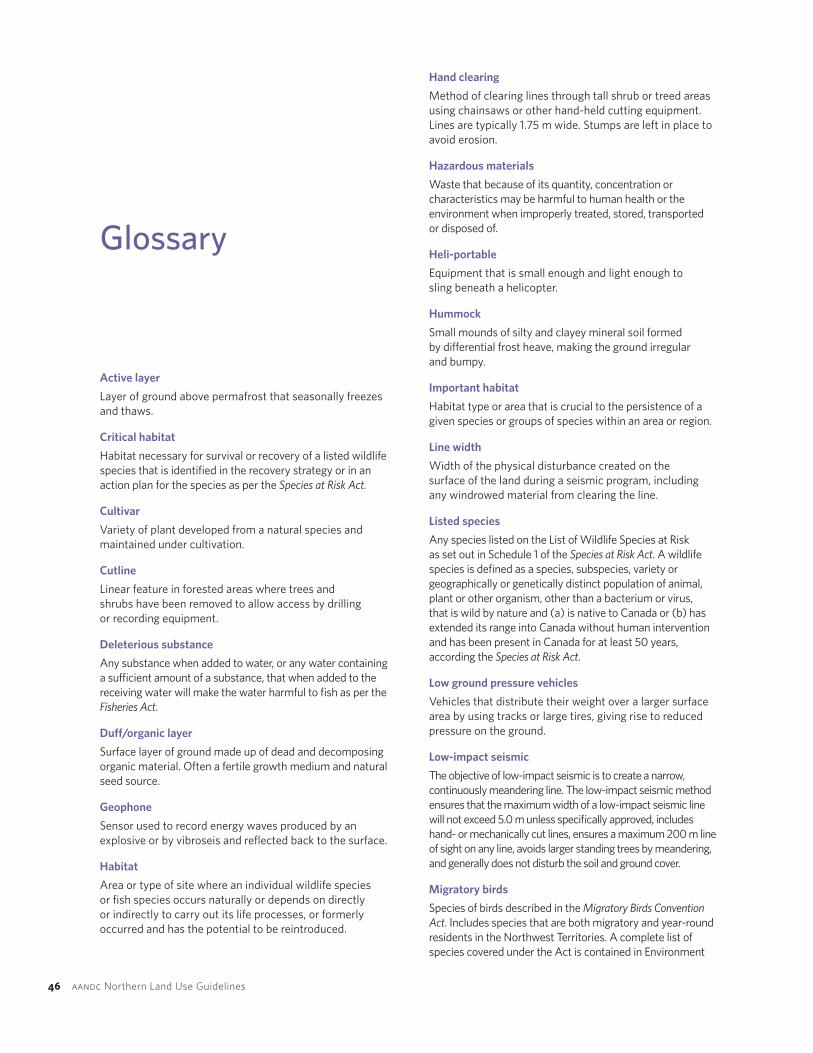
46 aandcNorthernLandUseGuidelines
Glossary
Activelayer
Layer of ground above permafrost that seasonally freezes and thaws.
Criticalhabitat
Habitat necessary for survival or recovery of a listed wildlife species that is identified in the recovery strategy or in an action plan for the species as per the Species at Risk Act.
Cultivar
Variety of plant developed from a natural species and maintained under cultivation.
Cutline
Linear feature in forested areas where trees and shrubs have been removed to allow access by drilling or recording equipment.
Deleterioussubstance
Any substance when added to water, or any water containing a sufficient amount of a substance, that when added to the receiving water will make the water harmful to fish as per the Fisheries Act.
Duff/organiclayer
Surface layer of ground made up of dead and decomposing organic material. Often a fertile growth medium and natural seed source.
Geophone
Sensor used to record energy waves produced by an explosive or by vibroseis and reflected back to the surface.
Habitat
Area or type of site where an individual wildlife species or fish species occurs naturally or depends on directly or indirectly to carry out its life processes, or formerly occurred and has the potential to be reintroduced.
Handclearing
Method of clearing lines through tall shrub or treed areas using chainsaws or other hand-held cutting equipment. Lines are typically 1.75 m wide. Stumps are left in place to avoid erosion.
Hazardousmaterials
Waste that because of its quantity, concentration or characteristics may be harmful to human health or the environment when improperly treated, stored, transported or disposed of.
Heli-portable
Equipment that is small enough and light enough to sling beneath a helicopter.
Hummock
Small mounds of silty and clayey mineral soil formed by differential frost heave, making the ground irregular and bumpy.
Importanthabitat
Habitat type or area that is crucial to the persistence of a given species or groups of species within an area or region.
Linewidth
Width of the physical disturbance created on the surface of the land during a seismic program, including any windrowed material from clearing the line.
Listedspecies
Any species listed on the List of Wildlife Species at Risk as set out in Schedule 1 of the Species at Risk Act. A wildlife species is defined as a species, subspecies, variety or geographically or genetically distinct population of animal, plant or other organism, other than a bacterium or virus, that is wild by nature and (a) is native to Canada or (b) has extended its range into Canada without human intervention and has been present in Canada for at least 50 years, according the Species at Risk Act.
Lowgroundpressurevehicles
Vehicles that distribute their weight over a larger surface area by using tracks or large tires, giving rise to reduced pressure on the ground.
Low-impactseismic
The objective of low-impact seismic is to create a narrow, continuously meandering line. The low-impact seismic method ensures that the maximum width of a low-impact seismic line will not exceed 5.0 m unless specifically approved, includes hand- or mechanically cut lines, ensures a maximum 200 m line of sight on any line, avoids larger standing trees by meandering, and generally does not disturb the soil and ground cover.
Migratorybirds
Species of birds described in the Migratory Birds Convention Act. Includes species that are both migratory and year-round residents in the Northwest Territories. A complete list of species covered under the Act is contained in Environment

glossary
g
northwest territories seismic operations 47
Canada’s Occasional Paper #1, ISBN 0-662-58218-7, Cat. No. CW69-1/1-1991. www.ec.gc.ca/Publications
Mulching
Method of brush disposal that reduces brush and trees to wood chips that are spread over the cutline.
Mushroomshoes
Devices fitted onto a bulldozer blade that extend at least 15 cm below the cutting edge to allow it to float over the ground surface and limit the potential for disturbance.
Naturalopening
An opening in the forest canopy related to a creek, river or lake, or a meadow greater than 200 m across (approximately 4 ha).
Ordinaryhigh-watermark
Usual or average level to which a body of water rises at its highest point and remains for a sufficient time so as to change the characteristics of the land (e.g., vegetation change). In flowing waters, such as rivers and streams, this refers to the active channel level, which is often the 1–2 year flood flow return level.
Permafrost
Ground that remains continuously frozen (below 0°C) for at least two consecutive winters and the intervening summer. Permafrost is overlain by the active layer that annually freezes and thaws.
Propagule
Plant part, such as a bud, that becomes detached from the rest of the plant and grows into a new plant. Willow cuttings are commonly used propagules.
Residence
A dwelling place, such as a den, nest or other similar area or place, occupied or habitually occupied by one or more individuals during all or part of their life cycle, including breeding, rearing, staging, wintering, feeding or hibernating.
Riparian
Area of land adjacent to a stream, river, lake or wetland containing vegetation that, due to the presence of water, is distinctly different from vegetation of adjacent upland areas.
Shearblade
A type of dozer blade used to clear trees or large shrubs by cutting through the trunks. If done properly, this technique avoids uprooting vegetation and exposing underlying frozen soil.
Speciesatrisk
Species on the List of Wildlife Species at Risk as set out in Schedule 1 of the Species at Risk Act — extirpated, endangered or threatened species or a species of special concern.
Speciesofconservationconcern
Species not listed on Schedule 1 of the Species at Risk Act (SARA) or the Northwest Territories Species at Risk Act, but listed on other schedules and species under consideration for listing on SARA, including those designated by the Committee on the Status of Endangered Wildlife in Canada (COSEWIC). Also includes species listed under Northwest Territories Species Assessments (General Status Ranks) with a ranking of “Sensitive” or “May Be At Risk.”
Springfreshet
Annual pulse of water flow resulting from melting snow in the spring.
Sticknest
A medium-sized to large nest comprised of sticks and branches, with a flat top, typically in a tree, used by species covered under the Migratory Bird Conventions Act or the Northwest Territories Wildlife Act.
Three-dimensionalseismic
Exploration technique in which the source and receiver lines are arranged perpendicular to each other in a grid. This method creates a three-dimensional view of the subsurface and provides more accurate data on oil and gas deposits.
Treeline
The Arctic treeline demarcates the furthest north that trees can grow due to extreme environmental conditions, including cold temperatures, lack of adequate moisture and permafrost.
Tussock
Thick clump of grass or sedge that can be up to 1 m tall due to the accumulation of dead vegetation.
Two-dimensionalseismic
Exploration technique in which both the source of the seismic waves and the receivers that detect them are located on the same line. This method creates a two-dimensional slice of the subsurface.
Waterbody
Any topographical feature that holds and/or channels water, including streams, creeks, rivers, wetlands and lakes. Water bodies may be seasonal in nature.
Windrow
Woody debris or brush piled into a long, continuous row.
48 aandcNorthernLandUseGuidelines
Informationcontainedinthispublicationorproductmaybereproduced,inpartorinwhole,andbyanymeans,forpersonalorpublicnon-commercialpurposes,withoutchargeorfurtherpermission,unlessotherwisespecified.
Youareaskedto:
• Exerciseduediligenceinensuringtheaccuracyofthematerialsreproduced;
• Indicateboththecompletetitleofthematerialsreproduced,aswellastheauthororganization;and
• IndicatethatthereproductionisacopyofanofficialworkthatispublishedbytheGovernmentofCanadaandthatthereproductionhasnotbeenproducedinaffiliationwith,orwiththeendorsementoftheGovernmentofCanada.
CommercialreproductionanddistributionisprohibitedexceptwithwrittenpermissionfromtheGovernmentofCanada’scopyrightadministrator,PublicWorksandGovernmentServicesofCanada(PWGSC).Formoreinformation,pleasecontactPWGSCat:613-996-6886orat:[email protected].
www.aandc-aadnc.gc.ca1-800-567-9604TTYonly1-866-553-0554
QS-8622-083-EE-A1Catalogue:R2-226/9-1-2011E-PDFISBN:978-1-100-19738-8©MinisteroftheDepartmentofIndianandNorthernDevelopment,2011
Cettepublicationestaussidisponibleenfrançaissousletitre:Lignes Directrices Sur L’utilisation des Terres du Nord: Travaux de prospection sismique dans les Territoires du Nord-Ouest.