north sydney latm 2 final report feb 2018 · nsw road safety strategy ... north sydney integrated...
TRANSCRIPT

North Sydney Council Local Area Traffic Management
& Action Plan LATM Zone 2
Crows Nest, North Sydney and St Leonards


SMEC | North Sydney Council LATM Action Plans Final Report | Page i
DOCUMENT CONTROL
Title North Sydney Council Local Area Traffic Management (LATM) Action Plans Final Report
Prepared for North Sydney Council
Project Ref 30011932
Name Position Signed/Approved Date
Originators
Federico Ramos Michaela Kemp
Senior Traffic Engineer North Sydney Council
7/11/2017
Reviewer Andrew Brown Associate Transport Planner 7/11/2017
Approver Colin Henson Project Development and Planning Manager
7/11/2017
Details of Revisions
Rev Date Description WVR No. Approved
1 21/03/2017 Draft Report 21/03/2017
2 9/06/2017 Draft Report 9/06/2017
3 27/07/2017 Draft Report (minor corrections) 27/07/2017
4 7/11/2017 Final Report 7/11/2017
5 9/02/2018 Final Report 9/02/2018
CONTACT DETAILS
SMEC Australia Pty Ltd | www.smec.com
Level 5, 20 Berry Street North Sydney NSW 2060 Tel: 02 9925 5555 Fax: 02 9925 5566
Representative: Federico Ramos P: 02 9925 5533 E: [email protected]
www.smec.com

SMEC | North Sydney Council LATM Action Plans Final Report | Page ii
TABLE OF CONTENTS
INTRODUCTION .................................................................................................................... 5
Background .............................................................................................................. 5
Community Strategic Plan ...................................................................................... 5
Study Objectives ...................................................................................................... 6
Data Collection and Review .................................................................................... 6
Community Engagement Feedback ....................................................................... 7
Literature Review ..................................................................................................... 7
Strategic Planning Context ..................................................................................... 7
Disability Discrimination Act, 1992 .......................................................................... 7 Commonwealth Disability Standards for Accessible Public Transport ..................... 8 NSW Long Term Transport Master Plan ................................................................. 8 Transport for NSW – Sydney’s Walking Future ....................................................... 8 Transport NSW Disability Action Plan 2012-2017 ................................................... 9 NSW Road Safety Strategy ..................................................................................... 9 NSW Walking Strategy .......................................................................................... 10 NSW Ageing Strategy 2020 .................................................................................. 10
Local Planning Context ......................................................................................... 10
North Sydney Local Environmental Plan 2013 ...................................................... 10 North Sydney Development Control Plan 2013 ..................................................... 11 North Sydney Integrated Traffic and Parking Strategy .......................................... 12 North Sydney Integrated Cycling Strategy ............................................................. 13 Draft North Sydney Transport Strategy ................................................................. 14
STUDY AREA CHARACTERISTICS ................................................................................... 15
Characteristics of Study Area ............................................................................... 15
Functional Road Hierarchy ................................................................................... 15
Administrative Road Hierarchy .............................................................................. 15 Functional Road Hierarchy .................................................................................... 15
Journey to Work Data (JTW) and Commuter Mode Share .................................. 17
Household vehicle ownership ................................................................................ 17 BTS Travel Zone System in the Core Study Area ................................................. 17 Population and Land Uses .................................................................................... 17 Commuter Transport Mode Share ......................................................................... 19
Local Area Traffic Management Devices ............................................................. 21
Parking Facilities ................................................................................................... 21
Current Management Framework .......................................................................... 21 On-street Parking Control Typologies ................................................................... 21 Current Permit Parking Scheme Operations ......................................................... 21 Restricted Parking Controls Operations ................................................................ 21 Mobility Parking Operations .................................................................................. 22 School Related Parking Control Operations .......................................................... 22 Car Share Operations ........................................................................................... 22

SMEC | North Sydney Council LATM Action Plans Final Report | Page iii
Metered Parking Operations .................................................................................. 22
Walking and Cycling Facilities .............................................................................. 22
Walking Facilities ................................................................................................... 22 Cycling Facilities .................................................................................................... 22
Public Transport Facilities .................................................................................... 24
Bus Services .......................................................................................................... 24 Rail & Ferry Services ............................................................................................. 25
Crash Data Analysis .............................................................................................. 26
SIGNIFICANT DEVELOPMENTS ........................................................................................ 32
Sydney Metro.......................................................................................................... 32
Crows Nest Station ................................................................................................ 32 Victoria Cross Station ............................................................................................ 32
Traffic Impact Assessment of Ongoing Development ........................................ 33
Cumulative Traffic Generation Assessment ........................................................... 33
EXISTING TRANSPORT ISSUES IDENTIFIED THROUGH COMMUNITY ENGAGEMENT36
Introduction ............................................................................................................ 36
Transport for NSW ................................................................................................. 37
Roads and Maritime Services................................................................................ 37
Cycling Strategy ..................................................................................................... 38
Road Safety Education .......................................................................................... 38
Matters Referred to Other Council Departments ................................................. 38
LATM ACTIONS PLANS ..................................................................................................... 40
Action Plan Development ...................................................................................... 40
Existing Conditions (Problem Score) ..................................................................... 40 Community Strategic Plan Criteria ......................................................................... 40 Total Project Score ................................................................................................ 41
Parking Review ....................................................................................................... 42
LATM Actions – Parking ........................................................................................ 42
APPROVALS PROCESSES ............................................................................................... 44
APPENDIX A – PRIORITISED ACTION PLAN ........................................................................... 45
APPENDIX B – ITEMS REFERRED TO TRANSPORT FOR NSW ............................................. 46
APPENDIX C – ITEMS REFERRED TO ROADS AND MARITIME SERVICES ......................... 47
APPENDIX D – ITEMS REFERRED TO OTHER COUNCIL DEPARTMENTS ........................... 48
APPENDIX E – ITEMS NOTED AS PART OF THIS STUDY ...................................................... 49
APPENDIX F – ASSESSMENT PROCESS AND SCORING METHODOLOGY ......................... 50

SMEC | North Sydney Council LATM Action Plans Final Report | Page iv
List of Figures Figure 1: LATM Action Plan Study Area ............................................................................................................................................................... 5 Figure 2: Household vehicle ownership in North Sydney LGA (2011 Census data) .......................................................................................... 17 Figure 3: Transport Mode Share-Study Area as Place of Residence (2011 Census data) ................................................................................ 20 Figure 4: Transport Mode Share-Study Area as Place of work (2011 Census data) ......................................................................................... 20 Figure 5 Existing Cycle Network Typology Map ................................................................................................................................................. 23 Figure 6 Existing Bus Network ............................................................................................................................................................................ 24 Figure 7 Ferry and Rail Services ........................................................................................................................................................................ 25 Figure 8 Summary of Type of Crash for the Study Area (volume) ..................................................................................................................... 26 Figure 9 Summary of Type of Crash for the Study Area (percentage) ............................................................................................................... 27 Figure 10 Location of Recorded Crashes ........................................................................................................................................................... 29 Figure 11: Location of Recorded Crashes involving Cyclists.............................................................................................................................. 30 Figure 12: Location of Recorded Crashes involving Pedestrians ....................................................................................................................... 31 Figure 13: Summary of Issues raised during Public Consultation – LATM Zone 2 ............................................................................................ 36 Figure 14: LATM Parking Principles Plan (Warrants) ......................................................................................................................................... 42
List of Tables Table 2-1 Functional Classification of Roads ..................................................................................................................................................... 16 Table 2-2 Population growth forecast 2016 to 2041 ........................................................................................................................................... 18 Table 2-3 Employment growth forecast 2016 to 2041 ........................................................................................................................................ 18 Table 2-4 Daily Travel Mode Split in the Study Area, 2011 Census Data .......................................................................................................... 19 Table 3-5 Developments with Traffic Generation greater than 5vph .................................................................................................................. 34 Table 4-1 Summary of issues raised for attention of Transport for NSW ........................................................................................................... 37 Table 4-2 Summary of issues raised for attention of RMS ................................................................................................................................. 37 Table 4-3 Summary of issues raised for attention of other Council departments ............................................................................................... 39 Table 5-1 LATM Parking Actions ........................................................................................................................................................................ 43

SMEC | North Sydney Council LATM Zone 2 Action Plans Final Report | Page 5
INTRODUCTION
Background
Council has developed the Integrated Traffic and Parking Strategy to holistically manage traffic and parking across the North Sydney Local Government Area (LGA).
An important component of the Strategy is the delivery of appropriate Local Area Traffic Management (LATM) Action Plans. LATM Action Plans are area-wide traffic plans which take into account the current and future traffic and parking situation in the area and recommend traffic and parking measures to protect, maintain and improve access and parking.
There are a total of seven LATM zones within the study area, as indicated in Figure 1. SMEC has been commissioned by Council to develop LATM Action Plans for zones 1, 2 and 3, which are located to the west of the Pacific Highway, as shown in Figure 1. This report focuses on Zone 2.
Figure 1: LATM Action Plan Study Area
Community Strategic Plan
The Community Strategic Plan is Council’s most important strategic document. It provides a planning and action framework and is part of Council’s integrated planning, reporting and decision making framework.

SMEC | North Sydney Council LATM Zone 2 Action Plans Final Report | Page 6
The Community Strategic Plan is designed to respond to community agreed priorities for the decade 2013 to 2023. The priorities and strategies will help manage inevitable change while protecting what the community values most. The priorities were identified through a community engagement program.
The Council’s land use, infrastructure planning, social, environmental and economic plans are all interconnected, allowing the Council to plan holistically for the future.
The Community Strategic Plan recognises the community’s desire for Council to maximise parking and improve the way it is managed and to expand community engagement to ensure the Council is hearing from all stakeholders. In this regard, the development of the LATM Action Plans recognises the demand for parking and takes account of traffic and parking issues raised by the community in the development of measures. The following relevant objectives from the Community Strategic Plan Include the following:
1.2 Quality urban greenspaces
2.1 Infrastructure, assets and facilities that meet community needs
2.3 Vibrant, connected and well maintained streetscapes and villages that build a sense
of community
2.5 Sustainable transport is encouraged
2.6 Improved traffic management
2.7 Improved parking options and supply
4.7 Community is active and healthy
4.9 Enhanced community safety and accessibility
Study Objectives
The primary goal of the study is to create an area-based LATM Action Plan for each of the LATM zones, in accordance with the North Sydney Integrated Traffic and Parking Strategy. The key objectives of the LATM Action Plan, as identified in the project brief, are as follows: Identify the existing traffic, parking, walking, cycling and public transport situation in the
LATM zone;
Identify future traffic demand as a result of increased density and development;
Identify the traffic and parking needs of the community based on community
engagement feedback and Council’s parking strategies;
Identify existing Local Area Traffic Management (LATM) devices and parking controls in
the LATM zone, including turn restrictions; and
Prepare a Traffic and Parking Plan, including comprehensive maps for the LATM zone,
which include measures to ameliorate impacts on residential areas and to ensure safety.
The Plans should include a list of projects supplemented by a map showing the location
of each project.
Data Collection and Review
The data review and collection process has involved desk top review of a range of information found online, as well as documents and reports that have been provided by Council for consideration in the study. Such information includes, but is not limited to the following:

SMEC | North Sydney Council LATM Zone 2 Action Plans Final Report | Page 7
Crash data within the study area;
Previous pedestrian and bike plans/ reports/ studies;
Relevant traffic and speed survey count data;
Relevant parking data and information provided by Council;
Pedestrian and vehicle turning count data conducted by Council;
Data relating to recent or likely future significant developments in the area; and
Traffic and parking studies and reports relevant to the LATM zone under consideration.
Community Engagement Feedback
North Sydney Council recognises the importance of community engagement to inform decision making. The community engagement plan for the LATM project has been formulated based on Council's Community Engagement Framework.
Community engagement for Stage 1 of the LATM Plans was undertaken between February and May 2016. The extensive community engagement included a suite of online, face-to-face and correspondence methods including resident and business surveys, community-based workshops and general feedback. Council received over 2000 submissions in relation to the project across the 7 zones, including over 5,000 comments relating to specific locations. The outcomes and findings of Stage 1 were reported to Council in July 2016.
To this end, feedback from community engagement undertaken by the Council regarding a wide range of traffic and parking matters has been reviewed by the study team. This information has been used to guide and inform the development of measures that will be included in the relevant LATM Action Plans to address issues raised by the community. Detail concerning the development of the LATM Action Plans is discussed in Section 5 of this report.
Literature Review
A literature review has been undertaken of National, State Government and Council policies, standards and guidelines, as well as additional documents, studies and information provided by North Sydney Council, which will inform the development of the Local Area Traffic Management Action Plans. For purpose of this report, these policies and documents are considered in the following sections.
Strategic Planning Context
Disability Discrimination Act, 1992
One of the key aspects of the Federal Disability Discrimination Act (1992) is the provision of equal services to all. The act legislates the right for equal participation of all members of the community in daily life and is composed of three topics: equality, independence and functionality. The objectives of the act include the following:
To eliminate, as far as possible, discrimination against persons on the ground of
disability;
To ensure that persons with disabilities have the same rights to equality as the rest of
the community; and
To promote recognition and acceptance within the community of the principle that
persons with disabilities have the same fundamental rights as the rest of the community.

SMEC | North Sydney Council LATM Zone 2 Action Plans Final Report | Page 8
As such, proposed LATM measures should provide equal access for all, wherever possible. North Sydney Council should aim to accommodate as many people as possible (including those with disability) as effectively as possible within available budgets. As further improvements to public infrastructure and facilities are made, more people with disability will benefit.
It is recognised that a lack of consideration of these users by anyone in the design and delivery chain makes it difficult for all who follow, particularly the end users. This study’s objectives are in line with the objectives set out in the Act.
Commonwealth Disability Standards for Accessible Public Transport
The Disability Discrimination Act 1992 seeks to provide equity for people with disabilities, which includes suitable access to public transport services. The purpose of the Commonwealth Disability Standards for Accessible Public Transport is to ensure that public transport operators and providers remove discrimination from public transport services. The standards prescribe certain sections of various Australian Standards and include specific requirements for access paths, manoeuvring areas, ramps, surfaces, handrails, lighting, street furniture, bus stops and other infrastructure. This study incorporates these principles with attention being placed in and around public transport infrastructure, including existing and proposed rail stations.
NSW Long Term Transport Master Plan
Transport for NSW published the NSW Long Term Transport Master Plan in 2012. The plan includes the objectives of increasing use of alternative modes of transport for short, local trips to achieve improved environmental outcomes, health benefits and to reduce traffic congestion.
When homes and jobs are within walking distance of each other and within easy walking distance of public transport, accessibility to jobs and services increases and commuting is easier. More people walking, or cycling to catch the train, bus or ferry also means less pressure on town centre streets, busy bus services and commuter car parking. When planning new developments, the surrounding transport infrastructure should have a network of connections that consider:
Personal safety and security, including adequate lighting and activated public spaces;
Adequate footpath and cycle path widths;
Safe and convenient crossings of roads at intersections and midblock locations;
Convenient and legible access to public transport; and
Good signage and way-finding to support efficient movement.
The NSW Long Term Transport Master Plan is mostly applicable to greenfield areas such that the required infrastructure for alternative modes of transport can be incorporated. Nevertheless, the objectives outlined in the Master Plan are all relevant and directly applicable to infrastructure for such users throughout the study area. These objectives have therefore been adopted, where possible.
Transport for NSW – Sydney’s Walking Future
This strategic document provides assurances regarding the following components, representing a step towards an integrated transport system in NSW.

SMEC | North Sydney Council LATM Zone 2 Action Plans Final Report | Page 9
Promotion of walking for transport, including signage on walking routes and improved
information online and at interchanges to help customers to plan their journey;
Support the connection of people to places through safe walking networks around
centres and public transport interchanges;
Engagement with partners across government, with councils, non-government
organisations and the private sector to maximise effectiveness of actions;
Promotion of the many benefits of walking for health and well-being, the environment
and communities;
Investment in new walking links that connect people to places and public transport with
adequate facilities;
The Transport Access Program will continue to deliver benefits to all pedestrians getting
to, from and around public transport interchanges. Upgrades will improve pedestrian
safety, personal security and amenity;
Engagement with and support councils to deliver cost effective improvements to local
walking networks;
The needs of pedestrians will be prioritised in the planning, design and construction of
new transport and urban development projects;
Pedestrian safety will be improved through a new Pedestrian Safety Strategy, which will
encompass all existing safety programs and also explore new measures; and
Support community based initiatives that promote walking as a vital part of the transport
mix and get people walking more for transport.
This study is consistent with the principles outlined in this document as they support growth linked to safety and comfort for pedestrians, while encouraging the integration of different modes of transport. The intention to improve accessibility throughout the LGA will act towards achieving the above objectives, albeit predominantly indirectly as a result of improved infrastructure and accessibility.
Transport NSW Disability Action Plan 2012-2017
Transport for NSW funds specific programs to deliver pedestrian facilities like bridges over busy roads, pedestrian crossings, fencing and shared paths that are used by many pedestrians (as well as cyclists) for transport, exercise and recreation. Public education campaigns also target key risk groups such as older road users and the safe operation of motorised wheelchairs and mobility scooters. The mobility and safety of pedestrians at public transport interchanges is an area of increasing focus. There is an expectation that mobility plans are prepared for all transport interchanges at the design phase to ensure that customers can move safely between modes of transport. This study takes into consideration the need to facilitate connectivity for pedestrians to and from public transport interchanges.
NSW Road Safety Strategy
NSW Road Safety Strategy was prepared in 2012 by Transport for NSW. The strategy covers the potential to address fatal and serious injury crashes on the road network through improved intersection design, eliminating or shielding road users from road side objects or opposing vehicles and by considering pedestrians and bicycle riders particularly in urban areas. The NSW Safer Roads program targets infrastructure safety works programs including safety barriers, highway route reviews, local roads, pedestrian safety measures and motorcycle recreational routes.

SMEC | North Sydney Council LATM Zone 2 Action Plans Final Report | Page 10
During the development of LATM Action Plans cognisance is given to the intentions and recommended measures listed in the NSW Road Safety Strategy. At the same time, it is recognised that many of the measures may not be applicable or appropriate, given that, for example, an “innovative technology solution” may not be required or identified as beneficial/ realistic within the LGA.
NSW Walking Strategy
In September 2011, the NSW Government released NSW 2021 A Plan to Make NSW Number One. This set of documents includes a target to increase walking for short trips and a commitment to develop a NSW Walking Strategy. Walking programs were also reviewed as part of the Long Term Transport Masterplan for NSW. “Sydney's Walking Future, Connecting People and Places” was subsequently released by Transport for NSW. This study is in line with both strategies as it recommends realistic measures to encourage walking within the LGA.
NSW Ageing Strategy 2020
The NSW Ageing Strategy released in 2012 identifies people aged over 65 as the fastest growing population group in NSW. An estimated 2 million community transport trips are provided each year to help older people access recreation, shopping, medical care, community services and social activities in NSW. This travel demand will continue to grow with this population group forecast to double by 2050. As a user group, older pedestrians are generally over represented in fatal crashes. It is therefore necessary to promote safe walking routes that are designed with consideration of older aged groups.
Local Planning Context
North Sydney Local Environmental Plan 2013
The Local Environmental Plan aims to make local environmental planning provisions for land in North Sydney in accordance with the relevant environmental planning Act. The key aims of the Plan are as follows:
to promote development that is appropriate to its context and enhances the amenity of
the North Sydney community and environment;
to ensure that new development is compatible with the desired future character of an
area in terms of bulk, scale and appearance;
to maintain a diversity of activities while protecting residential accommodation and local
amenity;
to ensure that new development on foreshore land does not adversely affect the visual
qualities of that foreshore land when viewed from Sydney Harbour and its tributaries;
to ensure that new development does not adversely affect residential amenity in terms of
visual and acoustic privacy, solar access and view sharing, and to maintain and provide
for an increase in dwelling stock, where appropriate;
to maintain a diversity of employment, services, cultural and recreational activities;
to ensure that non-residential development does not adversely affect the amenity of
residential properties and public places, in terms of visual and acoustic privacy, solar
access and view sharing;

SMEC | North Sydney Council LATM Zone 2 Action Plans Final Report | Page 11
to maintain waterfront activities and ensure that those activities do not adversely affect
local amenity and environmental quality;
to maintain and protect natural landscapes, topographic features and existing ground
levels;
to minimise stormwater run-off and its adverse effects and improve the quality of local
waterways;
to identify and protect the natural, archaeological and built heritage of North Sydney and
ensure that development does not adversely affect its significance; and
to provide for the growth of a permanent resident population and encourage the
provision of a full range of housing, including affordable housing.
North Sydney Development Control Plan 2013
The purpose of the Development Control Plan is to supplement the Local Environment Plan and
provide more detailed provisions to guide future development, such that impacts on the
community and environment are minimised. The key aims of the Plan are as follows:
Ensure that development positively contributes to the quality of the natural and built
environments;
Encourage development that contributes to the quality of the public domain;
Ensure that development is economically, socially and environmentally sustainable;
Ensure future development has consideration for the needs of all members of the
community;
Ensure development positively responds to the qualities of the site and its context;
Ensure development positively responds to the character of the surrounding area; and
Ensure that the aims of Council’s 2020 Vision – North Sydney Community Strategic Plan
are achieved.
It is recognised that increased traffic flow, congestion and parking demand leads to reduced levels of service for public transport through longer journey times, and loss of fleet efficiency. For pedestrians, increased traffic means more difficulty in walking and increased noise levels on major roads. This can result in roads that are intimidating environments for pedestrians. These conditions can also lead to loss in residential amenity and increased use of private vehicles, as alternative transport modes become less attractive.
The objectives of the Plan are therefore also to ensure that:
existing levels of traffic generation are contained and reduced;
public transport, including walking and cycling, is the main form of travel mode;
parking is adequate and managed in a way that maintains pedestrian safety and the
quality of the public domain whilst minimising traffic generation;
parking is limited to minimise impacts on surrounding areas;
parking is accessible to all user groups;
minimal impacts occur on the provision of on-street parking;
ensure consideration is given to the provision of bicycle parking and facilities; and
the actions of the Metropolitan Plan for Sydney 2036 are implemented.

SMEC | North Sydney Council LATM Zone 2 Action Plans Final Report | Page 12
The integration of engineering considerations with planning, architecture and landscaping is important for the purpose of servicing the future infrastructure needs of the North Sydney Local Government Area.
North Sydney Integrated Traffic and Parking Strategy
The North Sydney Council Local Government Area is one of the most highly urbanised areas in Australia. North Sydney Council is experiencing a notable increase in traffic and parking demand. This demand is being caused by an increase in car usage by the existing population, an increase in the number of workers and visitors to the area and an increase in residential and commercial development in the area.
This increasing demand for traffic and parking has instigated the need for the Council to develop an Integrated Traffic and Parking Strategy, which is the guiding document for the way Council manages traffic and parking across the area both now and into the future. The purpose of the Strategy is to:
Provide vision, goals and targets for parking and traffic management in the LGA;
Provide a strategic approach to current issues and needs for the management of traffic
and parking across the LGA;
Ensure that traffic and parking is balanced to meet the needs of road users, particularly
residents and businesses;
Ensure that traffic and parking is managed is a sustainable manner; and
Provide a management framework for consultation, monitoring and evaluation.
The development of the Integrated Traffic and Parking Strategy is aimed at creating a more integrated, strategic and proactive approach to traffic and parking management across the area. To do this, the Local Area Traffic Management (LATM) has been formulated.
In North Sydney, LATM are a fundamental tool for traffic calming and parking planning at the local level. They consider neighbourhood traffic and parking related issues within the context of the overall road network within each LATM zone.
The benefits of the establishment of LATM areas are as follows:
Major traffic and parking issues can be assessed on a holistic area wide basis, taking
into account metropolitan transport issues and requirements;
Traffic and parking management will shift from a reactive (current) approach to a
proactive approach. Instead of waiting for issues to be brought to Council’s attention, the
LATM will identify major issues and propose solutions;
Provide a more unified approach to traffic and parking and improves planning and
coordination issues in traffic and parking management as both traffic and parking are
intrinsically related;
Traffic and parking plans can be tailored to meet the needs and expectation of the local
community;
Traffic and parking consultation areas are based on Council’s Precinct System – which
assists in community engagement and consultation;
The ability to prioritise area-wide traffic and parking facilities for budget allocation and
implementation; and

SMEC | North Sydney Council LATM Zone 2 Action Plans Final Report | Page 13
The LATM approach rationalises a number of Council’s existing complex processes for
managing traffic and parking. The rationalisation and simplification of these processes
will lead to better decision making and a more efficient use of Council’s resources.
All major traffic and parking changes will be considered, designed, prioritised and implemented as part of LATM studies and Action Plans. As discussed in Section 1.1, the purpose of this study is to develop LATM for Zone 2.
The North Sydney Integrated Traffic and Parking Strategy was adopted by Council in May 2015.
North Sydney Integrated Cycling Strategy
North Sydney Council has a goal to increase cycling as a sustainable transport option. Increasing cycling can also help to reduce traffic congestion and demand for parking; reduce air and noise pollution; improve community health and wellbeing; and create opportunities for community interaction and connectedness.
Cycling in North Sydney is currently limited by an incomplete and disconnected cycle network. Gaps and difficult sections in the network discourage potential cyclists and lessen the safety and amenity of those riding in the area. Members of the North Sydney community have told Council that they would like to cycle for everyday transport, but that they feel unable to do so due to poor network connections and concerns about safety.
To improve the overall cycling network and increase cycling participation, Council has produced the Integrated Cycling Strategy. The goals of the Strategy are to:
Deliver an accessible, safe and connected cycle network by 2020;
Make cycling an attractive choice for short trips within the LGA; and
Increase and diversify participation in cycling (people of all ages and abilities will view
cycling as a safe, everyday transport option).
To achieve these goals Council will undertake the following:
Implement priority routes to address key gaps in the network;
Advocate for step free access to the Sydney Harbour Bridge Cycleway;
Update existing routes and improve quality across the network;
Install coherent and consistent bicycle wayfinding signage;
Install bicycle parking that caters for existing demand and future increases;
Provide supporting infrastructure such as public maps, bicycle pumps and water refill
stations to support the cycling network; and
Conduct communications, events and programs to promote cycling and increase safety
and awareness.
Cycling is already part of Council’s vision for a sustainable North Sydney. The North Sydney Community Strategic Plan sets a goal for Council to encourage sustainable transport. One of the key objectives relating to this goal is to provide ‘a network of accessible, safe and linked cycle paths throughout North Sydney’.
The proposed actions within the Strategy are designed to transform cycling in North Sydney, so that cycling becomes accessible as an everyday transport option for a diverse range of community members.

SMEC | North Sydney Council LATM Zone 2 Action Plans Final Report | Page 14
The North Sydney Integrated Cycling Strategy was adopted by Council in July 2014.
Draft North Sydney Transport Strategy
North Sydney has developed a Draft North Sydney Transport Strategy (draft NSTS) which is currently under review. It is expected that the draft NSTS will be adopted later in 2017.
Transport has emerged as one of the most important urban planning issues facing Global Sydney. The draft NSTS is intended to be Council’s guiding document for the delivery of its transport planning and management functions. This includes strategic transport planning, delivery of local transport projects and transport advocacy. The draft NSTS builds on the directions, outcomes and strategies detailed in North Sydney’s Community Strategic Plan 2013-23 (CSP) and Ecologically Sustainable Development Best Practice Project 2013 (ESD) to create an over-arching transport planning and management framework for the whole of Council.
Key elements of the draft NSTS include:
a holistic Vision for transport in North Sydney;
a principled, best practice approach to achieving this Vision;
requirements for the development of mode specific action plans;
a Council-wide transport implementation framework;
a delivery methodology that will help to ensure quick, consistent and robust responses to
increasingly complex transport issues for Council initiated projects, policies and wider
transport advocacy; and
shared CSP/NSTS measuring and reporting requirements.
The Draft North Sydney Transport Strategy is scheduled for public exhibition in July 2017 and adoption by Council in late 2017.

SMEC | North Sydney Council LATM Zone 2 Action Plans Final Report | Page 15
STUDY AREA CHARACTERISTICS
Characteristics of Study Area
North Sydney Council serves an area of 10km2, which incorporates business districts and diverse residential areas. Suburbs in the North Sydney area include Cammeray, Cremorne, Crows Nest, Kirribilli, McMahons Point, Milsons Point, Neutral Bay, North Sydney, St Leonards, Waverton and Wollstonecraft.
Almost half of North Sydney’s residents are aged between 20 and 44 years. There is a comparatively low proportion of households with children. The population is highly mobile. Just under half of all residents rent. The dwelling density is higher than in most other parts of Sydney and is increasing. Four in five residents live in medium to high-density housing. North Sydney has a high level of visitors who travel to North Sydney for work. In regard to students attending schools and tertiary institutions, only one in five lives in the area.
The principal commercial activities in the North Sydney Central Business District (CBD) are advertising, marketing, retail, information technology, finance, telecommunications and property development.
Functional Road Hierarchy
Administrative Road Hierarchy
Roads and Maritime Services (RMS) has adopted an administrative Road Hierarchy to manage the road network across NSW. The three administrative classes are:
State Roads;
Regional Roads; and
Local Roads
In terms of traffic management, Council has been delegated the responsibility for managing traffic on local and regional roads. The RMS has an input into the local and regional road system through Council’s Traffic Committee and through direct contact with Council. Changes to the local road system by Council which influence traffic flows require the submission of a Traffic Management Plan (TMP) to the RMS for approval. Although State Roads remain under the care and control of RMS, Council works closely with RMS to ensure that traffic on the State Road network does not adversely impact on the Regional or Local Road network to which it is responsible for.
Functional Road Hierarchy
The functional classification of roads relates to their role within the overall road network. Changes to traffic flows on roads can then be assessed within the context of the functional road hierarchy. RMS has developed guidelines for functional classifications of roads. These guidelines are published in the document titled “The Functional Classification of Roads”.
Council recognises the importance of defining the roles of roads within the overall road network and proposes to adopt the RMS Functional Classification of Roads. The four functional road classes are:

SMEC | North Sydney Council LATM Zone 2 Action Plans Final Report | Page 16
Arterial Road - typically a main road carrying in excess of 15,000 vehicles per day and over 1,500 vehicles per hour in the peak period. They predominately carry traffic from one region to another, forming principal avenues for metropolitan traffic movements.
Sub Arterial Road – typically a secondary road carrying between 5,000 – 20,000 vehicles per day and over 500 and 2,000 vehicles per hour in the peak period. They predominately carry traffic from one sub-region to another forming secondary inter-regional transport links.
Collector Road – typically a minor road carrying between 2,000 and 10,000 vehicles per day and over 250 and 1,000 per hour in the peak period. They provide a link between local areas and regional areas carrying low traffic volumes. At volumes greater than 5,000 vehicles per day, residential amenity begins to decline. Trunk collector and spine roads with limited property access can carry traffic flows greater than 5,000 vehicles per day.
Local Road – typically a local street carrying less than 2,000 vehicles per day and 250 vehicles per hour in the peak period. They provide direct access to individual houses and carry low traffic volumes.
A summary of road characteristics under the functional classification system is outlined in Table 2-1 Functional Classification of Roads.
Table 2-1 Functional Classification of Roads
Road Type Traffic Volume
(AADT) Through Traffic Inter-Connections
Speed Limit (km/h)
Arterial/ Freeway No Limit Yes Sub-Arterial 70-110
Sub-Arterial <20,000 Some Arterial/ Collector 60-80
Collector <5,000 Little Sub-Arterial/ Local 40-60
Local <2,000 No Collector 40
It should be noted that the road classifications and characteristics are notional concepts developed a significant time after the North Sydney road network was constructed. As such, the characteristics of the roads in the study area do not perfectly match their classification and are more appropriately adopted in greenfield developments. This is consistent with the road network throughout the greater Sydney area and NSW.
The more significant arterial and collector roads throughout the study area are listed below.
Arterial Roads – Pacific Highway and Warringah Expressway
Collector Roads - Miller Street, River Road, Albany Street, Alfred Street, Ernest Street, Willoughby Road, Albany Street, Falcon Street and Alexander St.

SMEC | North Sydney Council LATM Zone 2 Action Plans Final Report | Page 17
Journey to Work Data (JTW) and Commuter Mode Share
The Bureau of Transport Statistics (BTS) provides journey to work (JTW) for the Sydney Metropolitan Area which includes a comprehensive sample of commuter travel, collected during the 2011 Census Year.
Household vehicle ownership
According to the 2011 Census of Population and Housing data, around 62,300 people live in the North Sydney LGA area and the average household size is 1.8. 51% of households in the North Sydney LGA own 1 vehicle and 17% of households do not own any vehicle. The household vehicle ownership in North Sydney LGA is shown in Figure 2.
Figure 2: Household vehicle ownership in North Sydney LGA (2011 Census data)
BTS Travel Zone System in the Core Study Area
Journey to Work 2011 census data has been analysed within the BTS 2011 travel zone system in the study area.
Population and Land Uses
Table 2-2 and Table 2-3 summarise the anticipated growth provided by the Bureau of Transport Statistic (BTS) for the travel zones in the study area from 2016 to 2041.
17%
51%
20%
3%0%
9%
Household vehicle ownership
0 veh
1 vehicle
2 vehs
3 vehs
4 and more vehs
not stated

SMEC | North Sydney Council LATM Zone 2 Action Plans Final Report | Page 18
Table 2-2 Population growth forecast 2016 to 2041
Travel zone
Travel zone name 2016 2021 2026 2031 2036 2041
1844 St Leonards (Partly) 3,777 4,378 4,928 5,398 5,875 6,263
1910 Crows Nest Plaza 1,247 1,363 1,458 1,562 1,655 1,746
1911 Crows Nest 1,642 2,103 2,434 2,816 3,154 3,486
1912 Crows Nest 1,034 1,108 1,166 1,231 1,289 1,345
1913 Cammeray 2,752 2,813 2,869 2,932 2,989 3,045
1914 Crows Nest 658 685 706 729 750 770
1949 North Sydney 480 486 494 502 509 516
1950 North Sydney 265 271 279 286 293 300
1951 North Sydney 2,312 2,848 2,911 2,977 3,037 3,095
Total 14,167 16,055 17,245 18,433 19,551 20,566
Table 2-3 Employment growth forecast 2016 to 2041
Travel zone
Travel zone name 2016 2021 2026 2031 2036 2041
1844 St Leonards 13,159 13,674 14,318 15,055 15,820 16,672
1910 Crows Nest Plaza 1,244 1,291 1,347 1,408 1,472 1,541
1911 Crows Nest 2,428 2,530 2,644 2,767 2,895 3,035
1912 Crows Nest 1,785 1,850 1,922 2,001 2,087 2,186
1913 Cammeray 389 412 437 463 489 518
1914 Crows Nest 498 525 555 587 620 656
1949 North Sydney 1,401 1,447 1,505 1,570 1,637 1,710
1950 North Sydney 558 588 621 657 693 732
1951 North Sydney 7,651 7,917 8,258 8,647 9,046 9,481
Total 29,113 30,234 31,607 33,155 34,759 36,531

SMEC | North Sydney Council LATM Zone 2 Action Plans Final Report | Page 19
Commuter Transport Mode Share
Table 2-4 shows work (commuter) trips by mode of travel reported for the selected travel zones in the core study area based on 2011 JTW Census data.
Table 2-4 Daily Travel Mode Split in the Study Area, 2011 Census Data
Travel Mode
Study Area as a place of Residence (Outbound Trips)
Study Area as a place of Work (Inbound Trips)
Number of Trips
[%] Number of Trips
[%]
Car Driver 2396 32.00% 10886 45.00%
Bus 1423 19.00% 2177 9.00%
Car Passenger
225 3.00% 726 3.00%
Walked Only 1348 18.00% 1693 7.00%
Train 1797 24.00% 7741 32.00%
Other Mode 225 3.00% 484 2.00%
Not Stated 75 1.00% 242 1.00%
Ferry/Tram 0 0.00% 0 0.00%
Total 7,488 100.00% 24,192 100.00% Source: 2011 JTW, BTS Selected travel zones (TZ11)
Figure 3 and Figure 4 show the study area commuter transport mode share for outbound (‘study area as place of residence’) and inbound (‘study area as place of work’) trips respectively.

SMEC | North Sydney Council LATM Zone 2 Action Plans Final Report | Page 20
Figure 3: Transport Mode Share-Study Area as Place of Residence (2011 Census data)
Figure 4: Transport Mode Share-Study Area as Place of work (2011 Census data)
In 2011, about 7,500 residents travelled from the study area to work. The census data showed that around 35% of work related trips from the study area were made by motorists in private vehicles either as a car driver or car passenger. Driving a car and taking train are the most dominant transport modes with the proportion of 32% and 24% of work related trips respectively. Bus services in the study area also accounted for 19% of workers travelling by bus.
SMEC | North Sydney Council LATM Zone 2 Action Plans Final Report | Page 21
Similarly, in 2011, about 24,000 employees travelled to the study area to work. From the inbound trip statistics, it can be seen that taking train and driving a car are still by far the dominant mode of transport to work comprising about 77% of all work related trips. Only 9% of employees travelled by bus and 7% walked. From JTW data it can be concluded that taking train and driving a private car are the dominant modal transport choice for daily commuters.
Local Area Traffic Management Devices
A range of traffic management devices are employed within the North Sydney Council LATM areas. Examples include but are not limited to pedestrian refuges, raised pedestrian refuges, rain gardens, speed cushions, school zones, one way streets, restricted turns and reduced speed limits i.e. 10 km/h and 40km/hr. It should be noted that some of the above noted traffic management devices are State Government traffic management matters, which are not under the care and control of the Council.
Parking Facilities
Current Management Framework
On-street parking is currently managed through 33 Parking Areas across the LGA and three Parking Zones (High Demand, Medium Demand and Low Demand). Within these 33 Parking Areas there are approximately 23,500 on-street parking spaces.
In many Parking Areas of North Sydney, the demand for on-street parking is greater than the supply of on-street parking. Since North Sydney Council is unable to increase the supply of on-street parking, the only way to manage the parking in some areas and give residents and visitors fair access to the resource is to place time restrictions on the available parking spaces.
On-street Parking Control Typologies
To ensure that Council is managing parking fairly and equitably across the LGA, various parking controls have been installed on public roads. An LGA-wide audit of parking controls was undertaken in 2013.
Current Permit Parking Scheme Operations
Council operates three types of Permit Parking Schemes, subject to certain conditions and approvals. A parking permit issued by Council under any of the following schemes exempts the permit holder from charge or time restrictions whilst parked in a permit parking zone:
Resident Parking Scheme
Visitor Parking Scheme
Carers Parking Scheme
Restricted Parking Controls Operations
In addition to the resident parking scheme controls, Council operates a significant amount of parking controls across the LGA. The three main types are as follows:
Long term Parking Controls - greater than 2-hour parking (i.e. 4P, 8P, 9P, 10P)
Medium term Parking Controls – 1 and 2-hour parking (i.e. 1P, 2P).
Short term Parking Controls - less than 1-hour parking (i.e. 15min, 30min)
SMEC | North Sydney Council LATM Zone 2 Action Plans Final Report | Page 22
Mobility Parking Operations
Mobility Parking Spaces are managed in accordance with Council’s three Parking Zones (high demand, medium demand and low demand). Due to an increasing demand for mobility parking spaces, Council’s current practice is not to approve the installation of mobility parking spaces within high demand parking areas or in medium demand parking areas which are within 200m of an area zoned as Commercial or Mixed Use as defined by the LEP.
School Related Parking Control Operations
Council assists local schools in terms of providing ‘Kiss and Ride’ zones. A ‘Kiss and Ride Zone’ provides an appropriate place to drop off or pick up children at school. There are different types of “Kiss and Drop” zones which operate across the LGA, including the following:
No Parking 8.00am – 9.30am, 2.30pm – 4.30pm School Days
5 Min 8.00am – 9.30am – 2.30pm, 4.30pm School Days
Car Share Operations
There are dedicated car share parking spaces installed in various locations across the North Sydney LGA. These spaces are signposted as “No Parking Authorised Car Share Vehicles Excepted” and can only be used by a car share vehicle displaying an appropriate permit.
Metered Parking Operations
Council currently has 433 multi-bay and 6 pay and display Parking Meters servicing 2,681 individual meter spaces. The parking meters throughout the LGA are located in the North Sydney CBD, the major shopping and business areas; Crows Nest, St Leonards, Neutral Bay, Cremorne, Milsons Point, Kirribilli and other fringe/shoulder areas that are in high demand for parking turnover.
Walking and Cycling Facilities
Walking Facilities
The study area is well served by the provision of footpaths and pedestrian facilities. Nevertheless there is room for improvement particularly at key intersections throughout the North Sydney CBD.
Cycling Facilities
There is an extensive cycle network throughout the study area consisting of on and off road cycle routes including shared paths. The existing cycling infrastructure in the study area is shown in Figure 5.

SMEC | North Sydney Council LATM Zone 2 Action Plans Final Report | Page 23
Figure 5 Existing Cycle Network Typology Map

SMEC | North Sydney Council LATM Zone 2 Action Plans Final Report | Page 24
Public Transport Facilities
Bus Services
Most roads in the study area are serviced by public transport buses. There are plenty of bus routes in the study area which mostly operate along Pacific Highway, Miller Street, Falcon Street, Willoughby Road and Blues Point Road. Figure 6 shows existing bus routes in the study area.
Figure 6 Existing Bus Network

SMEC | North Sydney Council LATM Zone 2 Action Plans Final Report | Page 25
Rail & Ferry Services
The nearest rail stations in the study area are Milsons point Station, North Sydney Station, Waverton Station and Wollstonecraft Station as highlighted in Figure 7. These stations are part of the T1 North Shore, Northern and Western line and have frequent services particularly during peak periods.
The nearest ferry wharfs in the study area are Milsons Point, McMahons Point, Greenwich Point and Greenwich as highlighted in Figure 7.
Figure 7 Ferry and Rail Services

SMEC | North Sydney Council LATM Zone 2 Action Plans Final Report | Page 26
Crash Data Analysis
A crash assessment has been conducted for the study area using crash data supplied by Roads and Maritime Services for the five-year period from Jan 2011 to Jan 2015 inclusive. The data covers crashes reported to the police and includes fatal, injury and/ or non-casualty crashes within LATM Zones 1, 2 and 3.
A total of 610 crashes were recorded in the five-year period within the study area. There were four fatal crashes recorded and 48.3 per cent of the total crashes involved at least one injury. About 27.5 per cent of all crashes occurred at intersections and about 19.3 per cent of all crashes involved pedestrians or pedal cycles.
Figure 8 and Figure 9 show the number and percentage of crashes per movement type.
Figure 8 Summary of Type of Crash for the Study Area (volume)
62
106
73
127
65
6
20
95
46
11
0
20
40
60
80
100
120
140
Ped
estrian
Intersectio
ns veh
icle fro
madjace
nt ap
proach
es
Veh
icles from opposin
gdirectio
ns
Veh
icles from sam
e directio
ns
Manoueuvrin
g
Overtakin
g
On path
Off p
ath, on straigh
t
Off p
ath, on cu
rve or tu
rning
Miscellan
eous

SMEC | North Sydney Council LATM Zone 2 Action Plans Final Report | Page 27
Figure 9 Summary of Type of Crash for the Study Area (percentage)
According to Figure 8, it is noted that the dominant crash types in the study area include vehicles from same directions, intersection vehicles from adjacent approaches and off path on straight collisions. As illustrated in Figure 9, these types of crashes comprise about 20.8, 17.3 and 15.5 per cent, respectively.
There were a significant number of collisions occurring along the Pacific Highway and Warringah Freeway as well as on approach to their intersections. These crashes were not assessed in detail given that the Pacific Highway as well as all of its signalised intersections are under the care and control of the RMS and are therefore more appropriate for the RMS to address.
Within Zone 2, there have been 12 cyclist collisions and 15 pedestrian collisions. The following pedestrian crash clusters were identified in LATM Zone 2:
The Miller Street / Falcon Street intersection (2 crashes);
The Miller Street/ Ridge Street intersection (3 crashes);
Walker Street immediately north of Berry Street (2 crashes); and
The Willoughby Road / Burlington Street intersection (2 crashes).
The following cyclist crash clusters were identified in LATM Zone 2:
Ernest Street between Miller Street and the Warringah Expressway (3 crashes);
West Street between Ernest Street and Falcon Street (3 crashes); and
Willoughby Road immediately north of Chandos Street.
10.1%
17.3%
11.9%
20.8%
10.6%
1.0%
3.3%
15.5%
7.5%1.8%
Pedestrian
Intersections vehicle from adjacentapproaches
Vehicles from opposing directions
Vehicles from same directions
Manoueuvring
Overtaking
On path
Off path, on straight
Off path, on curve or turning

SMEC | North Sydney Council LATM Zone 2 Action Plans Final Report | Page 28
LATM Zone 2 was also identified as having the most number of vehicular crash clusters excluding crashes occurring on the Pacific Highway and the Warringah Freeway. The following list identifies the streets in which there were several car crash clusters within the LATM Zone:
Miller Street;
Falcon Street;
Ernest Street;
Alexander Street;
Willoughby Road; and
Burlington Street (between Alexander Street and Willoughby Road).
Figure 10 illustrates the location of all recorded crashes along the corridor for the five-year period between 2010 and 2015, Figure 11 shows the location of recorded crashes involving cyclists, whilst Figure 12 shows the location of recorded crashes involving pedestrians.

SMEC | North Sydney Council LATM Zone 2 Action Plans Final Report | Page 29
Figure 10 Location of Recorded Crashes

SMEC | North Sydney Council LATM Zone 2 Action Plans Final Report | Page 30
Figure 11: Location of Recorded Crashes involving Cyclists

SMEC | North Sydney Council LATM Zone 2 Action Plans Final Report | Page 31
Figure 12: Location of Recorded Crashes involving Pedestrians

SMEC | North Sydney Council LATM Zone 2 Action Plans Final Report | Page 32
SIGNIFICANT DEVELOPMENTS
Sydney Metro
Sydney Metro is Australia’s biggest public transport project which will deliver 31 metro stations
and more than 65 kilometres of new metro rail. Metro means a new generation of world-class
fast, safe and reliable trains easily connecting customers to where they want to go. The
services start in the first half of 2019 and customers won’t need timetables as they’ll just turn
up and go with a train every four minutes in the peak.
When Sydney Metro is extended into the central business district (CBD) and beyond in 2024,
metro rail will run from Sydney’s booming North West region under Sydney Harbor, through
new underground stations in the CBD and beyond to the south west. There will be ultimate
capacity for a metro train every two minutes in each direction under the city, a level of service
never before seen in Sydney. Sydney’s new metro railway will have a target capacity of about
40,000 customers per hour, similar to other metro systems worldwide. Sydney’s current
suburban system can reliably carry 24,000 people an hour per line.
Sydney Metro, together with signalling and infrastructure upgrades across the existing Sydney
rail network, will increase the capacity of train services entering the Sydney CBD – from about
120 an hour today to up to 200 services beyond 2024. That’s an increase of up to 60 per cent
capacity across the network to meet demand.
Crows Nest Station
Crows Nest Station is an underground station, about 25 metres below ground level, located on
the western fringe of the Crows Nest village, between the Pacific Highway and Clarke Lane
(eastern side of the Pacific Highway) and Oxley Street, south of Hume Street. The station
provides new metro rail access to the Crows Nest residential area and serves people within
walking and cycling distance. It improves travel to local schools, businesses and Crows Nest
village. The station creates a new transport focus on the southern side of the St Leonards
specialised centre which supports the St Leonards southern gateway to commercial and
mixed-use activities. The access and entry to the station is via the corner of Clarke Street and
Hume Street, and the corner of Pacific Highway and Oxley Street. The station includes:
A pedestrian crossing with traffic lights at the Pacific Highway/Oxley Street intersection
Pedestrian crossings on Clarke, Hume and Oxley streets
Bike parking at both station entries
On-road marked cycle links on Hume and Oxley streets
Kiss and ride and taxi bays on Clarke Street
Existing bus stops close to the station retained on the Pacific Highway
Wayfinding signage and Sydney Metro information.
Victoria Cross Station
While Victoria Cross Station is not located within LATM Zone 2 it is anticipated that its
introduction will have a positive impact in reducing car dependency throughout the entire North

SMEC | North Sydney Council LATM Zone 2 Action Plans Final Report | Page 33
Sydney LGA. Victoria Cross Station is an underground station, about 31 metres below ground
level, located beneath Miller Street (to the north of the Pacific Highway) between McLaren
Street and south of Berry Street. The station provides new metro rail access to the North
Sydney business, education and residential area. Station access and entry is via the
pedestrian plaza opening to Miller, Denison and Berry streets. The Station access and entry is
via the pedestrian plaza opening to Miller, Denison and Berry streets. The station includes:
new bike parking near the corner of Miller and Berry streets
new kiss and ride bays on Berry Street
existing bus stops close to the station retained on Miller Street
wayfinding signage and Sydney Metro information within the North Sydney CBD
a traction substation integrated into the station building (partially underground)
a services building on Miller Street to the north of the station providing station and tunnel
services
Enhancement of pedestrian infrastructure around the station. This is being investigated
further in consultation with Roads and Maritime Services and North Sydney Council.
Traffic Impact Assessment of Ongoing Development
A strategic traffic impact assessment has been undertaken in the context of the Council’s
Local Environmental Plan and Development Control Plan, which assesses the cumulative
traffic generation from major traffic generating developments identified or proposed within
each of the three LATM zones. This exercise was based on approved developments and
related information provided by the Council.
A high level assessment has also been undertaken to test the road networks ability to handle
the increased density and any potential traffic flow and on-street parking problems resulting
from major traffic generating developments. In this regard, functions of the road network in
terms of access, particularly for pedestrians near to new transport infrastructure, has been
considered.
Cumulative Traffic Generation Assessment
A comprehensive list of developments approved by Council since 2001 has been assessed to
determine the likely increase in traffic. The list did not specify which developments had been
constructed or are under construction.
For the purpose of this assessment, it is assumed that any proposed development that has
been approved prior to 2011 has already been constructed and is generating traffic. As such,
any proposed development approved in 2011 onwards is assumed to not yet be constructed
and is yet to increase traffic on the surrounding road network.
In addition to the above, any development anticipating to generate an additional 5 trips or less
during peak periods is considered to be relatively insignificant in terms of its traffic impact such
that they have not been included in the assessment.

SMEC | North Sydney Council LATM Zone 2 Action Plans Final Report | Page 34
The anticipated trip generation has been determined based on the RMS Technical Directions
(TDT 2013/04a) Guide to Traffic Generating Developments Updated traffic surveys which
suggests the following weekday peak period traffic generation rates for residential units in the
St Leonards area:
AM Peak: 0.14 trips / unit
PM Peak: 0.07 trips / unit
It is considered that these trips are appropriate to adopt for similar developments within LATM zone 2. The total number of proposed developments approved in 2011 onwards in which more than 5 additional trips are anticipated to be generated include the following:
T2 225 -235 Pacific Highway North Sydney (30 & 15)
T2 221 Miller St, North Sydney (25 & 13)
T2 7 – 19 Albany Street, St Leonards (18 & 9)
T2 621 Pacific Highway, St Leonards (11 & 6)
T2 231 Miller Street, North Sydney (9 & 5)
T2 545 – 553 Pacific Highway, St Leonards (9 & 5)
T2 100 Christie Street, St Leonards (9 & 5)
T2 139 - 147 West Street, Crows Nest (7 & 4)
T2 83 – 89 Chandos Street, St Leonards (6 & 3)
Table 3-5 summarises the above noted proposed developments and expected trip generation in the AM and PM peak periods.
Table 3-5 Developments with Traffic Generation greater than 5vph
Location & Development AM
Peak PM
Peak
225 – 235 Pacific Highway, North Sydney 33 17
‐ Change in use to increase residential component
221 Miller St, North Sydney 25 13
‐ Mixed use (173 units)
7 – 19 Albany Street, St Leonards 18 9
‐ Mixed use (125 units)
621 Pacific Highway, St Leonards 11 6
‐ Mixed use (72 units)
545 – 553 Pacific Highway, St Leonards 9 5
‐ Mixed use (62 units)

SMEC | North Sydney Council LATM Zone 2 Action Plans Final Report | Page 35
Location & Development AM
Peak PM
Peak
100 Christie Street, St Leonards 9 5
‐ Mixed use (63 units)
231 Miller St, North Sydney 9 5
‐ Mixed use with 61 units
139 – 147 West St, Crows Nest 7 4
‐ Mixed use with 50 units
83 – 89 Chandos Street, St Leonards 6 3
‐ Mixed use with 42 units
Total 127 67
The following figure presents the location of the abovementioned developments. It is noted
that the vast majority of proposed developments are located on or near the Pacific Highway,
whereby the greatest potential traffic impact is anticipated to occur at intersections along the
Pacific Highway. The key intersections identified include the Pacific Highway / Berry Street
intersection and the Pacific Highway / McLaren Street intersection. This is due to the cluster of
the developments occurring at this location including:
144 – 154 Pacific Highway and 18 Berry Street which is anticipated to generate an
additional 33 and 17 trips during the morning and evening peak periods respectively;
225 – 235 Pacific Highway which is anticipated to generate an additional 30 and 15 trips
during the morning and evening peak periods respectively; and
231 Miller Street, North Sydney which is anticipated to generate an additional 9 and 5
trips during the morning and evening peak periods respectively.
It should be noted that not all of these trips will be distributed through the Pacific Highway. Nevertheless, the additional traffic anticipated to be generated are relatively insignificant in lieu of the current traffic volumes on the surrounding road network, such that they will likely not result in any significant adverse impact to the surrounding road network including the Pacific Highway / Berry Street intersection or the Pacific Highway / McLaren Street intersection. Notwithstanding the above, these intersections are lie on a State Road under the care and control of the RMS.

SMEC | North Sydney Council LATM Zone 2 Action Plans Final Report | Page 36
EXISTING TRANSPORT ISSUES IDENTIFIED THROUGH COMMUNITY ENGAGEMENT
Introduction
An extensive public consultation engagement was undertaken by Council in 2016 to inform transport, traffic, and parking projects. The consultation methods included surveys, drop-in sessions and workshops and culminated in a comprehensive dataset of issues and suggested improvements pertaining to transport, traffic, and parking. The consultation data was analysed to establish key traffic and parking issues/suggestions for LATM Zone 2 as raised by the public.
For LATM Zone 2, Council received 1245 submissions from 520 respondents. Of those submissions there were 1263 specific traffic and transport related issues raised. Of those issues 33% were related to parking. 17% were related to walking, 21% were related to traffic generally and 13% were related to cycling. The remaining 16% of issues were related to public transport, and specific trip generating developments. A summary of issues raised during the consultation is shown in Figure 13.
Figure 13: Summary of Issues raised during Public Consultation – LATM Zone 2
Although the majority of feedback is related to traffic and transport management in the area generally, the responsibility for some of the issues falls outside of Council’s control. This includes matters relating to public transport and roads which are managed by the Roads and Maritime Services. Whilst Council does not have control over this infrastructure, they form an important role in the overall traffic and transport schemes for the area. Accordingly, these matters will be referred to the relevant authority for their attention. A summary of the issues raised is provided below.
The LATM Zone 2 Action Plan is provided in Appendix A.

SMEC | North Sydney Council LATM Zone 2 Action Plans Final Report | Page 37
Transport for NSW
There were 150 issues raised with respect to public transport in LATM Zone 2, as summarised in Table 4-1. 51 (34%) of these responses related to timetables for various modes of public transport. The most recurring of these requests was that the frequency of bus services within the area. A summary of the issues raised and the raw feedback will be forwarded to Transport for NSW for their attention (Appendix D).
Table 4-1 Summary of issues raised for attention of Transport for NSW
Issue Category Frequency
Transport Mode
Buses Public Transport
Train Ferries Grand Total
Public transport - timetables 43 5 2 1 51
Public transport - routes 22 1 1 24
Public transport - passenger congestion 16 4 4 24
Public Transport - Connections 4 10 3 2 19
Public Transport - Stop/ Station / Wharf locations
11 2 13
Public Transport - Infrastructure 1 4 1 6
public transport - cost 4 1 5
Public Transport - Accessibility 3 1 4
Other 2 1 3
Positive feedback 1 1
Grand Total 102 24 19 5 150
Roads and Maritime Services
There were 82 issues raised with respect to roads and routes which are managed by Roads and Maritime Services, as summarised in Table 4-2. 47 (57%) of these responses related to the safety or performance of signalised intersections which are under the care and control of the RMS. A summary of the issues raised and the raw feedback will be forwarded to RMS for their attention (Appendix E).
Table 4-2 Summary of issues raised for attention of RMS
Issue Category Frequency
Traffic - Intersection Safety and/or Performance 47
Pedestrian - Safety 14
Pedestrian - connectivity 7
Pedestrians - Walking Amenity 5

SMEC | North Sydney Council LATM Zone 2 Action Plans Final Report | Page 38
Issue Category Frequency
Vehicle-related Pollution 2
Other 2
Cycling - Connectivity 2
Traffic - decrease speed limits 2
Public Transport - Infrastructure 1
Grand Total 82
Cycling Strategy
As noted previously, 13% of issues raised related to cycling. This included a range of issues such as cycling safety and connectivity, as well as perceived safety of other road users due to the lack of separated cycling infrastructure. Council has already developed and is in the process of implementing the North Sydney Integrated Cycling Strategy, some of the issues raised have already been addressed as part of the cycling strategy and some are new matters that require further action. Many of the submissions justify the work that Council has already planned and highlight the need for more dedicated cycling infrastructure. The items raised are listed in the LATM Zone 2 Action Plan.
In addition, all future road facilities will be designed with cyclists in mind to ensure they do not create additional hazards or pinch points.
Road Safety Education
There were a small number of submissions (12) concerned with a lack of understanding of the road rules amongst the general community. Council already produces a range of road safety campaigns targeted towards specific road users about key road safety messages which have been developed based on local crash data, collaboration with local Police and the RMS. The feedback received during the LATM consultation phase can also be used to inform and enhance these campaigns. These actions have been included in the LATM Zone 2 Action Plan.
Matters Referred to Other Council Departments
63 submissions were received which fall under the responsibility of various Council departments but contribute to the overall transport amenity of the area, as summarised in Table 4-3. These include conditions of footpaths, enforcement of parking restrictions, events management bus stop infrastructure and driveway approvals. A list of these issues has been summarised and will be referred to the appropriate departments within Council for their attention (Appendix F).
42 of the submissions received could not be used further for reasons such as there was not enough information provided, the issue fell within a different LATM Zone, or the issue was outside of the North Sydney Council LGA. A comment has been provided against each of

SMEC | North Sydney Council LATM Zone 2 Action Plans Final Report | Page 39
these in Appendix G to explain why these have not been included in the Action Plans, or if they have been referred to the Action Plan for a different LATM Zone.
Table 4-3 Summary of issues raised for attention of other Council departments
Council Department and Issue Category Frequency
Works Engineers 30
Pedestrians - Footpath Surface Conditions
19
Road Surface Damage 7
Pedestrians - Footpath Provisions 1
Roadworks 1
Pedestrian - Safety 1
Pedestrians - Walking Amenity 1
Rangers 19
Parking - Too little enforcement 13
Pedestrian - Safety 1
Other 1
Parking - Concerns Related to DA 1
Pedestrians - Walking Amenity 1
Parking - Parking Configuration 1
Parking - Parking Restrictions Insufficient 1
Street furniture 10
Public Transport - Infrastructure 10
CIS 3
Pedestrian - Safety 1
Traffic - traffic calming 1
Road Surface Damage 1
OSE 1
Pedestrian - Safety 1
Grand Total 63

SMEC | North Sydney Council LATM Zone 2 Action Plans Final Report | Page 40
LATM ACTIONS PLANS
Action Plan Development
Following identification of issues through community feedback and the physical audit of existing
facilities in the LATM zones, a suite of facility improvements has been developed to address the
issues identified.
Council’s traffic actions and those identified by this study have been assessed against several different criteria as per the North Sydney Integrated Traffic and Parking Strategy (2015) to prioritise the actions on a relative basis. The scoring methodology consists of two parts – an assessment of the current conditions (problem score) and an assessment of the proposed treatment (solution score).
Existing Conditions (Problem Score)
The problem score, P, is derived from the following quantitative criteria:
road classification;
traffic volume vs desired volume;
85th percentile speed vs desired speed of 40km/h;
crash data including weighted scores for severity and vulnerable road users;
relative pedestrian and cyclist volumes; and
surrounding land uses
Community Strategic Plan Criteria
The solution score, S, is derived from the project assessment framework set out in the 2017 Draft North Sydney Transport Strategy which consists of a score from -3 to 3 based on how relatively consistent the proposal is with the following criteria:
Safe Travel - Improve community safety by creating slow speed road environments
where more vulnerable road users are protected from higher impact road users and the
number of crashes and severity of injuries is minimised
Transport Security - Improve personal security through improved streetscape design,
increased street activity and passive surveillance
Social Wellbeing - Provide social spaces where human interaction is given the highest
priority and the negative impacts of traffic are minimised, promoting incidental social
interaction, increasing civic pride, reducing anti-social behaviour and community policing
requirements
Active Health - Provide infrastructure that encourages healthy and active lifestyle/travel
choices
Fair Access to Parking - Reduce demand for parking and / or provide more equitable
access to existing parking supply
Environmental Sustainability - Encourage the use of low greenhouse gas emitting
transport options
Local Environments - Encourage the use of travel modes that have minimal impact on
air quality, water quality and noise

SMEC | North Sydney Council LATM Zone 2 Action Plans Final Report | Page 41
Transport Affordability - Encourage the use of travel options with lower social, health and
economic costs and higher social, health and economic benefits
Congestion - Apply travel demand management principles to minimise traffic demand
and associated traffic congestion
Business Activity - Increase business opportunities by improving the look/ amenity of
North Sydney throughout the day and in to the evening while, at the same time, reducing
the whole of life cost of transport networks, including the ongoing costs associated with
cleaning and maintaining assets
Total Project Score
The total Project Score is calculated using the following formula:
Where:
T = Total Project Score
P = Problem Score
S = Solution Score
N = Relative number of people affected by proposal
C = Cost of implementing project
The Action Plan is intended to provide a 10 year program of works for Council. However the Action Plan will be reviewed on an ongoing basis to highlight projects that have been completed and also incorporate new projects that are subsequently identified through community requests and Council studies. The priority timeframe “Short”, “Medium” or “Long” has been assigned based on relative scoring and project ranking.
It is intended that the indicated timeframe is the timeframe in which the project should be completed. However all projects identified will require some level of further planning, investigation and design in the short and medium. Some projects are also intended to be programs or actions to be implemented on a continued basis over the long term, for example Road Safety Campaigns, and these have been assigned “Long Term” priorities accordingly. An indicative quantitative description of each timeframe is provided below.
Short term: 1-2 years
Medium term: 2-5 years
Long term: 5-10 years
In addition, a small number of projects have been assigned the priority “Not to proceed”. These are for projects which have been assessed under the LATM criteria but were inconsistent with the community priorities and objectives outlined in Council’s Community Strategic Plan. For those projects, the reasons have been noted in the Action Plan and an alternative, positive benefit action has been proposed, but remain on the list for clarity and future reference.

SMEC | North Sydney Council LATM Zone 2 Action Plans Final Report | Page 42
The outcomes of the LATM assessment have been used to produce the LATM Action Plan which is provided at Appendix A.
Parking Review
As noted in Section 4.1, parking-related issues made up 33% of the feedback from the community in LATM Zone 2. Furthermore, 62% of that feedback was that either parking restrictions were either too restrictive or not restrictive enough. The most frequently mentioned streets were Willoughby Road (30); West Street (23); Miller Street (19); Walker Street (17); Parking issues in the general Crows Nest area was mentioned 63 times; and the general North Sydney area was mentioned 34 times.
At the time of preparing the LATM 2 Action Plan, comprehensive parking occupancy data was not available for all streets in the LATM Zone. This data collection is an extensive process that needs to be undertaken on a regular basis either with manual surveys or use of Council's License Plate Recognition vehicle.
North Sydney Council Integrated Traffic and Parking Strategy (2015) provides a LATM Parking Principles Plan (Warrants) table which identifies the occupancy percentage thresholds and actions required (refer Figure 14).
Figure 14: LATM Parking Principles Plan (Warrants)
Source: Table 7.6 – North Sydney Integrated Traffic and Parking Strategy (2015)
LATM Actions – Parking
It is recommended that an ongoing schedule of parking surveys across all streets in LATM Zone 2 be undertaken to ensure parking can be pro-actively managed. The schedule should be initially prioritised based on proximity to major parking generators, then locations with a high number of public complaints and then all other streets to provide an ongoing, complete data inventory. A summary of LATM Parking Actions is contained in Table 5-1 below.
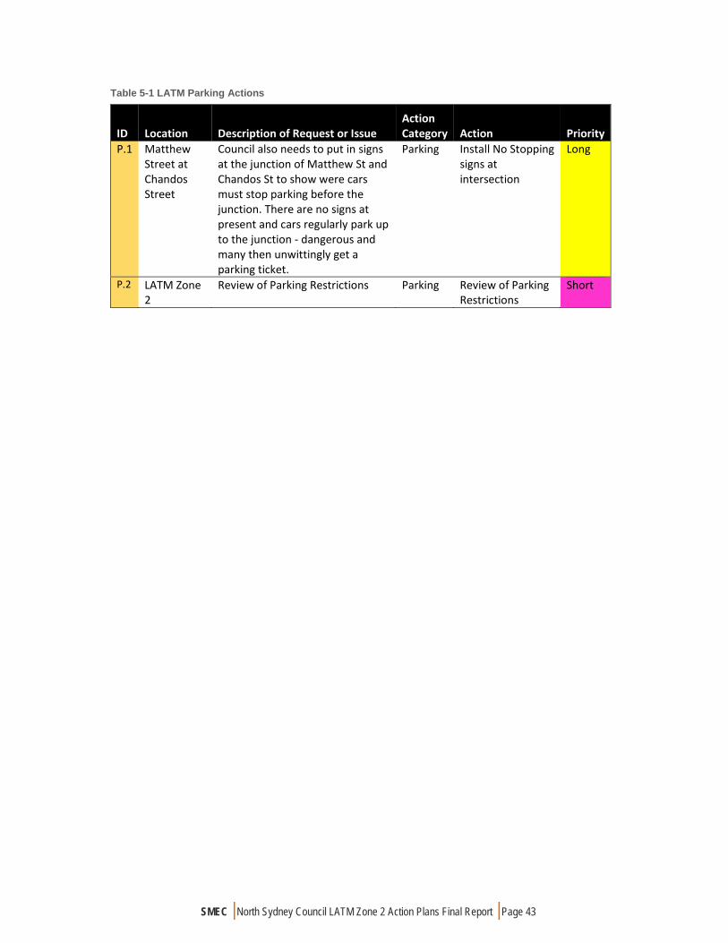
SMEC | North Sydney Council LATM Zone 2 Action Plans Final Report | Page 43
Table 5-1 LATM Parking Actions
ID Location Description of Request or Issue Action Category Action Priority
P.1 Matthew Street at Chandos Street
Council also needs to put in signs at the junction of Matthew St and Chandos St to show were cars must stop parking before the junction. There are no signs at present and cars regularly park up to the junction ‐ dangerous and many then unwittingly get a parking ticket.
Parking Install No Stopping signs at intersection
Long
P.2 LATM Zone 2
Review of Parking Restrictions Parking Review of Parking Restrictions
Short
SMEC | North Sydney Council LATM Zone 2 Action Plans Final Report | Page 44
APPROVALS PROCESSES
The approvals process for the LATM actions involved several different steps to be approved for final recommendations. The steps were:
1. Draft LATM Action Plans submitted to Council for endorsement to place on public exhibition;
2. Draft LATM Action Plans placed on public exhibition for a minimum of 28 days;
3. Feedback from Steps 1-3 incorporated into LATM Action Plans;
4. Final LATM Action Plans submitted to Council for adoption;
5. 5-10 year program of works developed from LATM Action Plans;
6. Ongoing review of LATM Action Plans included completed and new assessed and prioritised items; and
7. Projects referred to Traffic Committee for approval prior to implementation.
North Sydney Council has been delegated certain powers from RMS to manage traffic matters on North Sydney roads. The North Sydney Traffic Committee considers all proposed changes to traffic and parking arrangements within the North Sydney LGA. Any recommendations from the traffic committee must be taken into consideration by North Sydney Council before making a determination to proceed.
The Action Plan will be reviewed on an ongoing basis to highlight completed actions. The Action Plan will also be updated with new projects that are identified by the community or through studies and subsequently prioritised using the LATM assessment criteria.

SMEC | North Sydney Council LATM Zone 2 Action Plans Final Report | Page 45
APPENDIX A – PRIORITISED ACTION PLAN

Copyright:
Copyright © North Sydney Council - No part of this map may be reproducedwithout permission. Commercial decisions should not be made based on information contained in this map without first checking details held by the responsible Government authority.
Further details can be obtained by calling (02) 9936 8100 or e-mail [email protected].
SHIRLE
Y
TRYON
MILRAYLANE
CABLESTREET
Balls HeadBay
AVENUE
BADANGI RESERVE
OYSTERCOVE
R ESE RVE
OYSTE RC
OVERESERVE
KING STREET
ROADRESERVE
DRIVE
SUGAR WORKSRESERV E
KING STREET ROAD RESERVE
GAS
WATERH
EN
ROSS
STREET
HORACE STREET
WORKS
KING
STREET
WHATM
ORE
STREET
DRIVE
BALLS
BAY
ROAD
HEAD
TUNKS
STREET
WOOLCOTT
RO
AD
McKYE
WALU
ME
TTAPA
R K
WOOD STREET
BAY ROADRESERVE
LARKIN
KING
STREET
NOR
THSH
O RE
RAIL
WAY
LIN E
WH
ATMO
RE
LAN
E
CARRADAHPARK
WAVERTO
NSTATIO
N
WILL ASHTON LOOKOUT
STREET
STREET
BRENNAN PARK
WAK
ELI NRES
ERVE
CROWS
WAVERTON PARK
CA RR
ROAD
NORTHSHORE
RAILWAY
LINE
STRE
ET
HARRIOTT
KING
WOO
LCOT
TAV
ENUE
STREET
BAY
CARR
LANE
CLI F
TON
STRE
ET(un
fo rme
d)
HARRIOTT STREET
WOOLCOTT STREET
DAV
IDE AR L E
RE SE R
VE
NEST
COMM
OD
OR
ECR
ESC
ENT
JOHN
CLIF
TON
STR
EET
CLIF
TON
STR
EET
ROAD
RES
ERVE
WAVERTO
N
STREET
BOA
TBU
ILDER
SW
ALK
AVENUE
BANK
EURO
KA
STR
EET
ANCRUM STREETRESERVE
WAV
ERTON
LA
NE
ANC
RUM
UNION
EUROKA LANE
STREET
COMMODORESTREET
EUROKA STREET
PLAYGROUND
DUM
BA
R TO
N
TYE
PAR
K
HA
RB O
URV
I EW
LAVENDER
WENDYS GARDEN
CRESCENT
VICTORIA STREETPLAYGROUND
STREET
MITCHELLSTREETPARK
CLARKPARK
VICTORIA
WATTPARK
O'BRIENSGARDENS
WAL
K ER
STRE
ETRO
A DRE
S ERV
E
STREET
STREET
THO
MAS
STREET
WEB
BSTR
EET
STR EE T
CH
UTER
STREE
T
STREET
VICTO
RIA
PLA
CE
ARTHUR
HOLTSTREET
LAN
E
BRETTWHITELEYPLACE
BRAY
WAL
KER
STRE
ET
STRE
ET
STREET
MOUNT
STREET
MOUNT
STREET
SPRING
ELI Z
AB E
THPL
AZA
EDW
ARD
ORMISTON AVENUE
HILLSTREET
STRE
ET
WHE
ELER
LA
NE
WIL
LIAM
PACIFIC
WAL
KER
STREET
ALFR
ED
LITT
LE
MIL
LER
STRE
ET
OA
K LA
NE
MIL
LER
ALFR
ED
STRE
ET
L ITT
LE
SP
RIN
G
ST
R EET
LAN E
OAK STREET
DENI
S ON
ST
R EET
GAS
DON BANK
MUSEUM GARDENS
CHARLES STREET
ARTH
UR
STRE
ET
STREET
WHALING
DORIS FITTONPARK
BLUE
LORD
STREET
STRE
ET
SHOR
T
STRE
ET
NAPIE
R
STR EET
LIT T
LE
HIGHWAY
STREET
EXPR
ESSW
AY
NORTH SYDNEYSTATION
STRE
ET
STPE
TERS
PARK
STREET
HUNTER CRESCENT
ROAD
BERRY STREET
MACKENZIE
STREET
WIL
LIAM
L ANE
BERRY
RO
AD
RILEY
WILONA AVENUE
STREET
WAR
D
ST
REET
LORD STREET ROAD RESERVE
MIL
LER
STRE
ET
MIDDLEM
ISS
EDWARD
LAN
E
THOMAS
STRE
ET
BANKRESERVE
WAR
RING
AH
DOOHAT AVENUE
RILEY STREETROAD CLOSURE
NORT
H
STRE
ET
STRE
ET
PRIO
RY
HAMPDEN STREET
HI G
HWAY
HAR
NETT
STR
EET
CHUTER
STREE
T
ANG
ELO
STREET
BR
OW
NS
ROAD
LANE
WAL
K ER
TOO
NGARAH R
OAD
BANK
STREET
WAL
KER
STRE
ET
ARTH
URST
REET
STRE
ET
STRE
E T
LAVENDER
McLAREN
MILRAY
TELOPEA
STREET
WO
LLSTN
ECR
AFT
RA
ILWAY
STATIO
NP
ARK
ROAD
SMOOTHEYPARK
WO
LLSTON
ECR
AFT
STATI O
N
R USSELL
NO
RT H
S H O R ER A IL W A Y LI N E
MILNER
SHIRLEY
RUSSELL
LANE
N O R T H S H O R E R A I L W A YL I N E
STREET
BELMONT
SHIRLEY
BORONIASTREET
SER
GEA
NTS
BRI
DGE
END
CH
RIS
TIE ST
REE
TRE
SER
VE
SELWYN STREET
LANE
MILNER
LANE
CH
RISTIE STRE
ET
WALUMETTA DRIVE
BALFO
URSTR
EET
PARK
CARLYLE
L ITHGO
W
RI V
ERRO
AD
PEDE
STR
IAN L I
NK
STREET
L ITH
GOW
STR
EET
ROAD
CLO
SUR
E
BELMONT
LANESH
IRLEY
ROAD
PEDES
TRIAN
LINK
ATCHISON
WALUMETTA PARK
ATCHISON
BALF
OURLAN
E
MEA
DO
WLA
NE
BALFOUR
L
ANE
N OR THSHO
RERAIL W
AY
L INE
LANE
CRESCENT
BALFOUR STREET
CHRISTI E
STREET
LANE
IVY
LANE
ROAD
AVENUE
MITCHELL STREET
PLAZA
MIT
CHEL
L
STR
EET
HARRY HOWARD RESERVE
CARLYLE
NEWLANDS
RIVER
NICHOLSON
STREET ROAD
CLOSURE
IVYSTR
EET
HUME
STREET
ROAD
NICHOLSO
N
CLARKE
ALBANY
ALBANY
LANE
PALM
LANE
SHIR
LEY
LAM
ONT
STREET
POLE
ROCKLANDS
NEWLANDS STREET
LANE
STREET
STRE
ET
OX L
EY
HAZELBANK
NICHOLSON
CLARKE
MO
RTON
STREET
STREET
NICHOLSON LANE
HUME STREETPARK
MORTON
LA
NE
LANE
STREET
LANE
ROCKLANDS
STRE
E T
P LACE
GILLIES
HUM
E
ALFR
ED
McHATTON STREET
KEL
ROSE
LA N
E (P
rivat
e Ro
ad)
LANE
STRE
ET
L AN
E
CH
URC
H
STREET
STREET
CHURCH
NORTH SYDNEY CIVICCENTRE PARK
ROAD
ELLI
OTT
S
TREE
T
RIDG
E S
TREE
T
ROAD
CLO
SURE
CUN
NIN
GHA
M
STR
E ET
STREET
WES
T
JAM
ES P L
ACE
ROAD
RIDGE
STREET SINCLAIR STR
EETSIN C
LAIR S
T REE
T P ED ESTRIA N LIN
K
HAZELBANKPLACE
RIDG
E
LA
NE
EAST
L A
NE
MIL
LER
EDEN LANE
NORTH SYDNEY OVAL
WE ST L AN E
PACIFIC
EDEN
STR
EET
ROAD
MATER GARDENS
CASSINS AVENUE
STREET
MYRTLE
CAS
SINS
L
ANE
FIG TREE LANE (Private Road)
ST LEONARDS PARK
CARLOW
STREET
STREET
BON ANDREWS OVAL
LANE
TUCK
ER
STR
EET
EMMETT
STREET BER
NAR
D
DAVID
D AV ID
LA NE
LANE
BRUCE STREET
EMMETT
STRE
ET
HAYBERRY
STREET
FALCON
SINCLAIR
STRE
ET
HAYBERRY STREET
ROAD CLOSURE
STREET
HAYBERRY
LANE
BAR
D SLE
Y G
ARDE
NS
ALEX
ANDE
R
HIGH
WAY
MOODIE STREET
A LEX
AND
ER
LYTT
ON
STR
EET
RODB
ORO
UGH
AVE
NUE
LAN
E
FALCON
ROAD
FALCON
LANE
STRE
ET
LILLIS STREET
FALCON
LANE
STREET
STREET
WIL
LOUG
HBY
WIL
LOUG
HBY
STREET
BURLINGTONBUR LINGTON
LANE
CAHILLPLAYGROUND
ERNEST
LANE
ANZAC PARK
BURLINGTON
LANE
ZIG
STREET
ANZA
C
AV
ENUE
LA NE
DEAN LANE
MAC
ART
HUR
AVE
NUE
BELL
EVUE
P
ARK
STREET
ZAG
ERNEST
TRAFALGAR STREET
LANE
FRED HUTLEY RESERVE
HAMILTON
HAMILTON RESERVE
VALE
AVENUE
BRIDGEVIEW
STRE
ET
ABBOTT
FOUR FIGS PARK
MASSEY STREET
ARM
STRO
NG
STR
EET
KYNG
DON
STR
EET
BROO
K
STR
EET
BROO
K
LA
NE
JENKINS STREET AB
BOT
T
STREET
JENKINS
LANE
CHANDOS
FRED
BEN
AVE
NUE
LAN E
LAN E
STREET
STREET
AMHERST
CHANDOS
CAMBRIDGE STREET
WARRINGAH M
ILLE
R
INGR
AM
STRE
ET
SEXTON PLACE
LANE
L AN
E
CAMMERAYGAL PLACE
LANE
ATCHISON
MIL
LER
TARE
LLA
P L
ACE
LANE
MATT
H EW
LAN E
LANE
MILL
ER ST
REET
GARDEN
S
STREET
IVE S LANE
IXIO
N
L A
NE
STRE
ET
ZAG
MAT
THEW
ST THOMAS' REST PARK
RALEIGH STREET
METCALFE STREET
STREET
DEVONSHIRE
STREET
WIL
LOU
GHBY
EDW
IN
ST
REET
STREETROAD
CHAP EL LANE
ZIG
BELL
EVUE
HUNTINGTON
STREET
ROSALIND
A LEX
ANDE
R
PINE
STREET
HOLTERMANN
HUNTINGTON
STREET
STREET
LAN
E
LAN
E
HUM
E
MORDEN
THO
MAS
LANE
WES
T
LANE
HOSPITAL LANE
STRE
ET
LAN E
ANZAC AVENUE R ESERVE
STREET
ERNEST LANE
CAMMERAY
ERNEST PLACE
DARBYGARDENS
ERNESTSTREET
SOP
HI A
ERNEST
LANE
McDOUGALL
HIGH STREET RESERVE
DARLEY
NEU
TRAL
STRE
E T
NEU
TRAL
S TRE
ET
ROAD
RES
ERVE
KURRABA
ROAD
NEUT
RAL
STRE
ET
HIGH
STREET
NICH
OLA
S
STRE
ET
BENTLOWER
NOOK
LA
NE
STREET
DOR
IS
STRE
ET
WA
RR
I NG
AP
ARK
NOOK
AVENUE
EATON
STREET
PILELANE
PILE
CLARK
STREET
DORIS STREETRESERVE
DORIS LANE
RAWSON
ROAD
PLACE
THE AVENUE
CLARKRO
AD
ISLAND
WIL
LOW
TRE
E PA
RK
MAR
GARE
T
STRE
ET
STREET
CLARKR
OAD
MAR
GARE
TST
REE T
ROA
DRE
SER
VE
HIPWOOD
KURRABA
HOLD
SWO
RTH
BRADLY
AVENUE
ANDERSON PARK
MON
TPEL
IER
STR
EET
FORSYTH
PARK
ROAD
STREET
COLINDIA AVENUE ROADRESERVE
HIGH
HOLDSWORTHROAD RESERVE
SPRUSON
KIARA CLOSE
(Private Road)
ADDERSTONE
MISS GLADYS CAREY RESERVE
HOLDSWORTHROAD
COLINDIA AVENUE
STREET
AVENUE
SPRUSON
LAN
E
NeutralBay
Neutral BayWharf
HAYES STREET FORESHORE
LOWER WYCOMBE
B EN
BOY
DR
OAD
PAR
K
HAYE
S
STRE
ET
MANNS
AVENUE
ROAD
WYCOMBE
LANE
ROAD
BO
YD
LAN
E
THRU
PP
AUBIN
STREET
HARRIETTE
STREETPHILLIPS STREETPLAYGROUND
PHILLIPS STREET RAYMOND
BOYD
RESERVESTREET
ROADRESERVERESERVE STREET
STREET
BE N
WESTL
EIGHSTRE
ET
ROADCLOSU
RE
PHILLIPS
ROAD
WESTLEIG
H
STREET
LANE
STRE
ET
BEN
UN
DERCLI F F
PH
ILLIPS
HI GHVIEW
AVENUE
RAYM
ON
D
PEDESTRIAN LINK
HIGHVIEWAVENUE
WESTLEIGH
BOYDSTREET
HIGHV
IEW
AVEN
UE
BENT
STR
EET
BYDO
WN
PREMIER
STREET
LINDSAY
STREET
WINTER
AVENUE
HARDIE
STREET
STREET ROSE AVENUE
ROSE AVENUERESERVE
STRE
ET
STREET
WYAGDON STREET
WYAGDON STREET
RESERVE
STRE
ET
BENT
YEO
OLIVE
WYAGDON/ALFRED
STREET NORTH RESERVE
Y EO
LANE
NORTH
ROAD
KENNETHBOLTONLOOKOUT
FRES
HW
ATER
LANE
McINTOSH LA
NE
RESERVE
MERLIN STREET RESERVE
CHEAL
LANEWAT
SON
STRE
ET
LAYC
OCK
STRE
ET
McINTOSH L
ANE
MER
LIN
ROAD
CHEAL
LANE
STRE
ET
CHEAL PARK
GROSVENOR
STREET
TRAMWAY LANE
BEN
BEN
MILITARY SHOR
TLA
NE
MO
ODIE
STR
EET
BOY
D
LANE
LANE
EXPR
ESSW
AY
PARK
AVEN
UE
BYRNES
AVENUE
MOODIE
BOYD
STREET
JEAFFR
ESO
N JA
CKS
ON
RE
SERV
E
STRE
ET
AVENUE
ERNEST
OAKS
COM
O
PARK
TUNKS
PARK
SUSPENSIONBRIDGERESERVE
BOULEVARDE
THE
BROTHERS
AVENUE
NOR
THAV
ENU
E
ROAD
RESE
RVE
MORTLOCKRESERVE
ROWLISON
PARADE
ORI
SSA
LAN
E
EAS
T AVE
NUE
ROAD
RES
ERVE
NORT
H
AVEN
UE
STREET
EAS
TAV
ENU
E
VERNON
COLI
NST
REET
ROAD
RES
ERVE
CUR
RAW
ANG
STRE
ET
STREET
ELLISLOOKOUT
JUDITHAMBLERRESERVE
PINE STREET/ARKLAND STREET RESERVE
COWDROY
STRE
ET
STRE
ET
PINE
STREET
WIL
S ON
STR
EET
RO A
DC
LOSU
R E
STRE
ET
TILEY
STRATFORD STREET
T ILE
YST
REE
TR
OAD
CLO
SUR
E
LANE
ALAN
STREET
AVENUE
WER
I NG
AAV
ENUE
ROAD
RESE
RVE
WERINGA
ARKL
AND
STRE
ET
STRA
TFO
RD
TILE
YST
REET
WIL
SON
STRE
ET
COLI
N
CAIR
O
STREET
CARTER
CARTER
STREETWARRINGA ROAD ROAD CLOSURE
GREENS DRIVE
AVON
STRE
ETECH
OST
REE
TRE
SERV
E
ROAD
ROAD
LUMSDEN
STREET
WARWICK AVENUE
ECHO
STRE
ET
LAMBERT STREET
GARDENSLAMBERT STREET
GREEN PARK
STREET
CAMMERAY
GRAFTON
CREEKLANE
FALLSTREET
BELL
SAV
ENUE
AVEN
UE
STREET
STRE ET
WARRINGA
EARLE
VIEW
STRE
ET
CAMMERAY PARK
GRASMEREGRASMERE
LANE
AVENUE
LANE
SUTHERLAND
ROAD
RIVER
OXLEY
CHANDOS
PACIFIC
STREET
MARKS
STREET
AVEN
UEDONNELLY ROAD
HAM
ILTO
N
PALMER
STRE
ET
WHE
ATLE
IGH
TAPAS 6
TAPAS 1
TAPAS 3
TAPAS 7
TAPAS 5
TAPAS 2
TAPAS 4
North Sydney Council
LATM ZONE 2

LATM Action Plan Zone 2
1 of 51 Updated 20/02/2018
ID Location Description of Request or Issue Action Category Action Notes Priority
C.1 West Street 27 submissions. 17: West St, Pacific Highway ‐ I would really like to be able to commute to the city by bicycle but at the moment it is too unsafe. current cycle lanes on West Street are insufficient, cyclists don't use them because they are too narrow and too close to parked cars. Conflicts between cyclists and cars due to the high number of cyclists that use this route. 10: cyclists are a danger to pedestrians and/or vehicles. Cyclists disregard the road rules, ride more than 2 abreast and talk loudly. I also have to park my car on/the street so residents' parking is also important to me.
Cycling Strategy
Install separated cycleway along West Street (regional cycling route)
West Street forms a regional cycle route and already carries a large volume of cyclists. A separated cycleway would provide a safe facility which separate cyclists from other road users and encourage more members of the community to participate. Separated cycleway should be designed to minimise impact on parking supply.
Medium
C.2 Pacific Highway ‐ North Sydney to Crows Nest
Lack of adequate cycling facilities. Cycling along Pacific Highway is dangerous for cyclists. Risk of car‐dooring when riding on road. No formal crossing facilities for cyclists across Pacific Highway at West Street Shared paths feel unsafe to ride on and share with pedestrians. Cycling ‐ southbound motorists turning east into McLaren Street are not aware that and/or do not respect cyclists crossing McLaren Street on green (pedestrian) lantern are legitimately using a shared path to cross the road Cycling ‐ northbound cycling on Pacific Highway in North Sydney and multiple lane change into right hand turn lane at Miller Street intersection is highly exposed to motor traffic; and lack of space available on Miller Street at corner of Mount Street to accommodate cyclists doing the alternative hook turn manouevre from Pacific Highway onto Miller Street northbound
Cycling Strategy
Lobby RMS for a regional separated cycleway along Pacific Highway connecting Sydney Harbour Bridge and West Street and including appropriate crossing facilities at key intersections.
Long
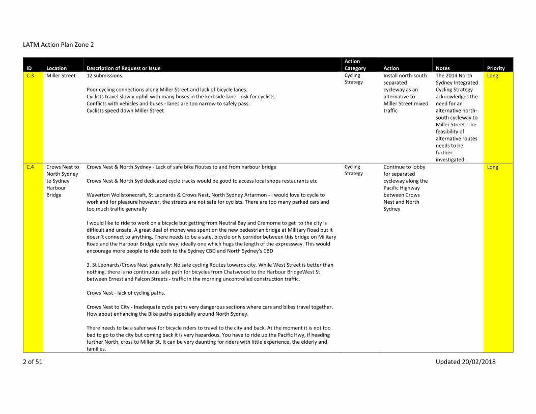
LATM Action Plan Zone 2
2 of 51 Updated 20/02/2018
ID Location Description of Request or Issue Action Category Action Notes Priority
C.3 Miller Street 12 submissions. Poor cycling connections along Miller Street and lack of bicycle lanes. Cyclists travel slowly uphill with many buses in the kerbside lane ‐ risk for cyclists. Conflicts with vehicles and buses ‐ lanes are too narrow to safely pass. Cyclists speed down Miller Street
Cycling Strategy
Install north‐south separated cycleway as an alternative to Miller Street mixed traffic
The 2014 North Sydney Integrated Cycling Strategy acknowledges the need for an alternative north‐south cycleway to Miller Street. The feasibility of alternative routes needs to be further investigated.
Long
C.4 Crows Nest to North Sydney to Sydney Harbour Bridge
Crows Nest & North Sydney ‐ Lack of safe bike Routes to and from harbour bridge Crows Nest & North Syd dedicated cycle tracks would be good to access local shops restaurants etc Waverton Wollstonecraft, St Leonards & Crows Nest, North Sydney Artarmon ‐ I would love to cycle to work and for pleasure however, the streets are not safe for cyclists. There are too many parked cars and too much traffic generally I would like to ride to work on a bicycle but getting from Neutral Bay and Cremorne to get to the city is difficult and unsafe. A great deal of money was spent on the new pedestrian bridge at Military Road but it doesn't connect to anything. There needs to be a safe, bicycle only corridor between this bridge on Military Road and the Harbour Bridge cycle way, ideally one which hugs the length of the expressway. This would encourage more people to ride both to the Sydney CBD and North Sydney's CBD 3. St Leonards/Crows Nest generally: No safe cycling Routes towards city. While West Street is better than nothing, there is no continuous safe path for bicycles from Chatswood to the Harbour BridgeWest St between Ernest and Falcon Streets ‐ traffic in the morning uncontrolled construction traffic. Crows Nest ‐ lack of cycling paths. Crows Nest to City ‐ Inadequate cycle paths very dangerous sections where cars and bikes travel together. How about enhancing the Bike paths especially around North Sydney. There needs to be a safer way for bicycle riders to travel to the city and back. At the moment it is not too bad to go to the city but coming back it is very hazardous. You have to ride up the Pacific Hwy, if heading further North, cross to Miller St. It can be very daunting for riders with little experience, the elderly and families.
Cycling Strategy
Continue to lobby for separated cycleway along the Pacific Highway between Crows Nest and North Sydney
Long

LATM Action Plan Zone 2
3 of 51 Updated 20/02/2018
ID Location Description of Request or Issue Action Category Action Notes Priority
St Leonards ‐ A bike path to link to harbour bridge would be nice, rather than cycling through busy CDB streets. Milsons Point to Crows Nest ‐ Cycling paths poor limited legal alternatives to Pacific Highway. This is particularly an issue given the steep grade north bound. Where ‐ Between Cammeray and City when cycling What ‐ I cross 4 major roads (Ernst, Falcon, Berry and Pacific Hwy) which slow down my journey. The West street corridor is difficult to get to from the bridge and encounters the same issues. Something like the Harbourlink elevated bike path would be useful. 1) complete the cycle link from the harbour bridge north side to connect to the warringah freeway path, and all the bits between. apart from the fact that it will increase the number of cycling commuters, hence less cars, if this critical link is never implemented, the cycle path section beside the warringah freeway between pacific highway lane cove to willoughby road, naremburn is useless. it only encourages cycling‐critics to say that investing in cycling infrastructure is a waste. lobby the state and federal government – it’s your patch! Kirribilli to west st on bike ‐ cycling from kirribilli to west st, north sydney can be very hazardeous. wycombe rd, neutral bay ‐ school bus is often extremely late
C.5 Ernest Street near Warringah Freeway
Ernest Street & Warringah Espressway Needs crossing point with room for bike to wait Cycling ‐ Inability to connect Merlin Street and Ernest Street shared path
Cycling Strategy
Install separated cycleway along Merlin Street and Ernest Street with signalised crossing on Ernest Street at Merlin Street.
Long
C.6 Woolworths/ Alexander Street carpark
More bike parking – where is the street‐level bike parking associated with the new Woolworths shopping centre on Falcon and Alexander Street? Perhaps you could undertake an analysis of NCC’s provision of on street car parking versus bike parking in shopping and commercial areas.
Cycling Strategy
Install bike parking rails near Woolworths
Short
C.7 TAPAS Zone 2 all of north sydney ‐ lack of cycling paths all over north sydney ‐ bike paths and parking between park avenue and rocklands rd ‐ not very safe to cycle to work. no enough bike lanes. not safe to go through the park at 5.30am dark. for cycling, the issue is connectivity of safe routes: to go from one place to another requires to go through some busy and at time dangerous section of roads. with both way of traveling, roundabouts are an issue: roundabouts in sydney are usually too small which means drivers hardly need to slow down to drive through them (see below) and usually only care about
Cycling Strategy
Install separated cycleway along Ernest Street and improve connections through to Crows Nest
Medium

LATM Action Plan Zone 2
4 of 51 Updated 20/02/2018
ID Location Description of Request or Issue Action Category Action Notes Priority
possible incoming traffic from their right leading to some near misses when they turn left if there are pedestrians crossing the street or with bike riders. for instance i was recently nearly hit by a car at the roundabout at the intersection of amherst st/cammeray rd/warringa rd: a driver was going down amherst st and failed to slow down sufficiently to register my presence and that of my daughter on a bike. we were coming from warringa road (south part) and turning into cammeray road and were already on the roundabout when this man went through the give way sign and onto the roundabout missing us by only a few centimetres. you could not blame his lack of awareness of cyclists since he had bike racks on his roof! all over sydney and north sydney lga ‐ bike paths have improved but still dont link up fully. sydney car drivers are so intolerant of bicyclists and so angry that it can be very intimidating. as the population grows without new infrastructure, car drivers are only going to get more intolerant and angrier as our roads clog up more. all suburbs ‐ more bike paths, more bike friendly infrastructure eg bike racks cycling around north sydney ‐i am a car driver, but i like to commute by bike wherever possible. i ride to work, to the hairdresser, the dentist, the shops, my kid’s schools. i think council should lead by example and provide for cycling as it is done in all leading cities around the world. my positive cycling infrastructure tips are: (back to the priority list above). 4) don’t install bike lines adjacent parked cars. especially not in shopping strips. ever been car doored? 5) don’t allow bike lanes to suddenly finish, pushing cyclists abruptly into the next lane of traffic. merge cyclists gradually into the traffic, as it would be done on a freeway. 6) never put road traffic furniture (poles, bollards, rails, bins, traffic pacifiers such as silent policemen, steel drains with slots) in cycling lanes/paths. 7) cyclists are entitled to use the whole lane, so the painted road symbol of the bike should reflect this on major streets such as falcon street, shirley road and river road. particularly with the new 1m overtaking rule, it’s best to educate drivers that they should not overtake cyclists within a road lane by painting on the big bike symbol in the centre of the traffic lane. 8) don’t create local cycling routes on steep, difficult terrain on back streets to keep them off major roads. people will only cycle if it’s efficient and an achievable option. look at the dismal lane cove bike strategy. try riding the suggested local bicycle route from greenwich to lane cove through kingslangley rd, balfour street, ronald avenue. you need to be a very strong, confident cyclist to attempt this. it wouldn’t encourage a new cyclist to commute readily. work with state bodies to make cycling a priority on the major, easier roads. 9) send your staff out riding around the municipality. you don’t understand fully the needs and issues facing cyclists until you have a go yourself.
C.8 Holtermann Street
Cycle route 4 ‐ query on what the status is of this route. Does it still include Holtermann Street? Cycling Strategy
Extend cycle route between Willoughby Road and West Street via Burlington Street to connect
Cycle routes will connect to Crows Nest village from West Street via Atchison Street/ Huntington Street (completed) and
Medium

LATM Action Plan Zone 2
5 of 51 Updated 20/02/2018
ID Location Description of Request or Issue Action Category Action Notes Priority
with future West Street cycleway
Burlington Street. These routes have been selected as they connect with the two major supermarkets and provide a south and north link to the village.
C.9 Walker Street north of McLaren Street
Unsafe, cars zooming past Again on Walker street passed McLaren st going North, I find the bit just after the McLaren St extremely nerve racking while I am riding my bicycle. Council or the RMS deemed a good idea to reduce the road at this point whithout leaving a path for a safe passage for the bicycle. This means cars either overtake me really close or will be really close to me at the back to overtake me while the separator in the middle of the road has disappear.
Cycling Strategy
Redesign kerb extensions on western side of Walker Street to accommodate an uphill cycling lane.
Medium
C.10 St Leonards Park
Cycle route through St. Leonards Park? Safety ‐ Bikeways in St Leonards Park cause risks to walkers. Bike riders ignoring traffic lights are a danger to pedestrian crossing. North Sydney Park ‐ cyclists going too fast. St Leonards Park: Sharing paths in park with cyclists and pedestrians ‐ have been involved in many near miss collisions. Path needs to be wider and designated better lighting. St Leonards Park ‐ dangerous cyclists behaviour, passing at high speed only centre,erred away from pedestrians Paths aren’t wide enough to share with bikes and pedestrians through st leonards park ‐ cyclists going too fast without considering children and dogs unpredictability St Leonards Park ‐ footpaths used by bikes; too narrow.
Cycling Strategy
Investigate options for safe cycling facilities through St Leonards Park in accordance with Plan of Management.
Medium
C.11 Waverton/ Wollstonecraft/ St Leonards/ Crows Nest
Waverton/North Sydney ‐ how to cycle across from West heading North Waverton Wollstonecraft, St Leonards & Crows Nest, North Sydney Artarmon ‐ I would love to cycle to work and for pleasure however, the streets are not safe for cyclists. There are too many parked cars and too much traffic generally
Cycling Strategy
Improvement to linemarking and adjustments to critical intersections to improve on‐road cycling environment. To be implemented
Medium

LATM Action Plan Zone 2
6 of 51 Updated 20/02/2018
ID Location Description of Request or Issue Action Category Action Notes Priority
with road resurfacing projects.
C.12 Willoughby Road
willoughby road, crows nest ‐ needs a bike lane and should have no parking at all once you hit the restaurant area Willougby Rd, West St ‐ This is the main bike Routes for cyclists but there is no provision on these streets. Willoughby‐ cars not leaving distance from bicycles. Throughout Crows Nest ‐ Parked cars heavy traffic and lack of bike lanes "forcing" cyclists onto Footpaths.
Remove on‐street parking and install separated cycleway along Willoughby Road.
Medium
C.13 Ridge Street Cyclists in door zone Ridge St ‐ Fear of opening car door and causing accident with cyclists. 2. The planned upgrading of Ridge Street between Miller & West Streets is likely to have an adverse effect on traffic flow and resultant congestion especially in peak periods thoughout the length of Ridge Street, as well as access to and from Ridge Street from Miller, Walker and West Streets. Ridge Street is already heavily congested in peak periods with North Sydney, and City origin and destination traffic as well as School traffic,and we are concerned it does not appear to be being addressed by Council. We have on several occasions asked that a'right hand turning arrow'be installed to allow traffic to turn safely into Miller Street but this never seems to be considered. We know it is an RMS responsibility but we ask Council to request RMS to consider this as a priority for the safety of all users.
Install separated cycleway along Ridge Street
Miller Street/ Ridge Street signals are proposed to be upgraded as part of the cycleway project. Pedestrian red arrow protection will be provided. Signal designer advises that the number of vehicles turning right from Ridge Street into Miller Street does not warrant a non‐filtered right turn phase.
Long

LATM Action Plan Zone 2
7 of 51 Updated 20/02/2018
ID Location Description of Request or Issue Action Category Action Notes Priority
C.14 Crows Nest Most of Crows Nest and Cammeray ‐ not enough bike lanes or the road, it's hard to ride safely with kids. Throughout Crows Nest ‐ Parked cars heavy traffic and lack of bike lanes "forcing" cyclists onto Footpaths. Cyclists cycling on the pedestrian pavement rather than on the roads. Saw one incident where a cyclist cycling on the walk path of Chandos St heading toward Christie St direction in the evening without helmet or headlight. Pretty dangerous to pedestrians.
Improvement to linemarking and adjustments to critical intersections to improve on‐road cycling environment. To be implemented with road resurfacing projects.
Medium
G.1 Residential areas to Crows Nest Shopping area and train stations
North Sydney, Crows Nest, Neutral Bay ‐ Introduce a free shuttle Bus. Free shuttle services would avoid people driving cars to park at Crows Nest and congesting roads. (Bus) Should the councils supply smaller buses on popular routes to transport residents? Shuttle buses FREE. Wheatleigh St ‐ distance to St Leonards too far to walk, particularly I'd carrying laptops, suitcases etc. shuttle bus from outer streets to station would be fantastic!
Consider Shuttle Service
Consider feasibility of providing a shuttle bus service from residential areas to Crows Nest Shopping area and train stations
Medium
G.4 Crows Nest West St between Ernest and Falcon Streets ‐ traffic in the morning uncontrolled construction traffic. Falcon Street ‐ Street closed (Woolworths Development) Burlington Street Traffic with current roadworks. No notification from Council regrading back lane access, totally inaccessible! Pacific Hwy Crows Nest to North Sydney ‐ All construction of highrises in North Sydney and Simultaeous repairs of Footpaths close lanes that affect and create bottle necks in the traffic flow. A 5 minute commute turns into a 15‐20 min trips at peak hours during week‐days.
Roadworks In 2016 Council developed a coordinated approach to management of roadworks within the North Sydney CBD, including community engagement methods to inform the community. See Council website. RMS also provides up to date information about temporary works
https://www.northsydney.nsw.gov.au/Building_Development/North_Sydney_CBD/CBD_Out_of_Hours_Works_and_Upgrades
Short

LATM Action Plan Zone 2
8 of 51 Updated 20/02/2018
ID Location Description of Request or Issue Action Category Action Notes Priority
on State Roads www.livetraffic.com
G.4 North Sydney CBD
The Stanton Precinct area has been experiencing a high level of traffic congestion resulting from the infrastructure works being undertaken on the comer of Berry and Walker Streets for several weeks. This affects not only these streets but Miller, McLaren and Ridge Streets and it is taking some residents up to 20 mins to exit the area especially at peak and mid afternoon periods. Building construction on Pacific Highway is also affecting traffic flow in the Precinct area. Furthermore pedestrian access and safety has been compromised in the area affected by the Berry and Walker Streets project. We are very concerned that this situation could become a norm given the large amount of construction that is likely to take place over the next four or more years in the Precinct area; for example the construction of 471 apartments on the corner of Walker and McLaren Streets (SAP building), development of other residential buildings in McLaren and Miller Streets, construction of the Wenona STEM building (affecting Ridge, Elliot and Miller Streets), construction work and site development for the new Metro project in Miller Street, other building developments in Berry and Mount Streets, the possible redevelopment of Rydges Hotel, and other likely developments in streets leading into Stanton Precinct which could affect traffic flows over the next several years. Many of these developments could overlap which would cause enormous traffic problems in a very small area which is also a major access route into North Sydney and the Harbour Bridge. ln addition, existing street parking would be highly compromised if parking places are removed for construction zones as has occurred on Pacific Highway as well as being used by construction workers. New buildings, close road on weekends Pavement pulled up Miller Street, North Sydney/Cammeray: Sidewalks interrupted by men at work Ridge St, North Sydney ‐ Effects of infrastructure and building works.
Roadworks In 2016 Council developed a coordinated approach to management of roadworks within the North Sydney CBD, including community engagement methods to inform the community. See Council website. RMS also provides up to date information about temporary works on State Roads www.livetraffic.com
https://www.northsydney.nsw.gov.au/Building_Development/North_Sydney_CBD/CBD_Out_of_Hours_Works_and_Upgrades
Short
G.4 St Leonards Oxley St & Clarke Ln, St Leonards: Two new construction sites sometimes trucks for these Two sites are blocking half of the road or using car park space on the Oxley St, which occupies for a long period of time
Roadworks In 2016 Council developed a coordinated approach to management of roadworks within the North Sydney CBD, including community engagement methods to inform the community. See Council website.
https://www.northsydney.nsw.gov.au/Building_Development/North_Sydney_CBD/CBD_Out_of_Hours_Works_and_Upgrades
Short

LATM Action Plan Zone 2
9 of 51 Updated 20/02/2018
ID Location Description of Request or Issue Action Category Action Notes Priority
RMS also provides up to date information about temporary works on State Roads www.livetraffic.com
P.1 Matthew Street at Chandos Street
Council also needs to put in signs at the junction of Matthew St and Chandos St to show were cars must stop parking before the junction. There are no signs at present and cars regularly park up to the junction ‐ dangerous and many then unwittingly get a parking ticket.
Parking Install No Stopping signs at intersection
Long
P.2 TAPAS Zone 2 Review of Parking Restrictions Parking Review of Parking Restrictions
Short

LATM Action Plan Zone 2
10 of 51 Updated 20/02/2018
ID Location Description of Request or Issue Action Category Action Notes Priority
P.3 Crows Nest Parking Area 19
Holtermann st has become the biggest rat run in the area. The traffic from West street is atrocious. Morning and evening peaks are ridicolous. Cars blatantly use the street too bypass Ernest st lights. Sophia st compounds the issue. The stop sign at Holtermann and Sophia is ignored. People are going to get killed. The new Woolworths and associated traffic changes have made it worse. The new Coles development will create chaos. The street needs to be blocked off to they traffic. The parking issues are woefully out of date....everyone’s parks in the street abusing the outdated parking limits. Parking should be limited to 30mins at the Alexander st end with a cut off at 10:30 at night for non residents. Local businesses know its a rort, and park in Holtermann street all day checking their tires every hour!!!!!! The noise levels have grown beyond acceptable. Close the st off to thru traffic...., NO EXIT TO ALEXANDER ST...NO EXIT TO WEST ST.....SOLVES THE ISSUE The traffic in the street now is unbelievable....starts at 5:00 and non stop till midnight. Peak hour has 30‐40 cars waiting to use Alexander street exit ...it’s disgraceful. No one obeys the stop sign at the corner of Sophia and Holtermann st. The street surface is atrocious. Parking hasn’t been updated for years. Every man and his dog abuses the out of date parking provisions. The new Woolworth’s has aggravated the situation and the new Coles and all the new apartment blocks going up in the area will create mayhem. I’m surprised no 9ne has been killed by the traffic yet. And TAFE is putting 60 car spaces back on the street...60. !!!!!!! If this isn’t sorted out there will b3 traffic chaos here everyday...shut down the street.....NOW.... I am concerned that Holtermann St has become a major rat run for traffic passing through Crows Nest and it will get much worse with general traffic increases as well as development with the new Coles, Metro, etc. Traffic to/from Cammeray via West St is using Holtermann St as a short cut to Albany St and westbound traffic on Ernest St is taking a short cut down Sophia St to get to Albany St via Holtermann St. The same traffic then gets priority at the Holtermann St / Alexander St round‐a bout, so it actually inhibits the westbound traffic flow in Ernest St It is time North Sydney Council takes similar action to that undertaken by Willoughby Council many years ago when it blocked rat runs through Chatswood and forced traffic onto Archer St, etc. This can be done by closing off Huntington St, Holtermann St and Ernest Lane at West St and Sophia St and Alexander Lane at Ernest St. Or instead just close Holtermann St at Alexander Lane (west side). If blocking streets cannot be done in the short term, then some gain can be made by implementing no‐right turn from West St to Holtermann St and no right turn from Ernest to Sophia St. Holtermann Street Rat Run The amount of traffic and the speed of the traffic is becoming a major issue in Holtermann Street. It is only a matter of time before someone will be hit by a car. Some mornings the traffic is backed up for almost three quarters of the length of the street from the roundabout . The No Right Turn from West Street needs to be put back . With the new Coles and TAFE development the parking issue is only going to get worse. This submission concerns the roundabout installed at the intersection of Holtermann Street and Alexander Street and the resulting traffic chaos it has caused. By way of background, this roundabout was vigorously objected to prior to its installation by local residents.
Parking Install parking meters to manage parking demand and induced traffic generation
There is a correlation between traffic generation and parking supply. Much of the parking in residential areas of Crows Nest is unrestricted or time restricted. By limiting opportunities for long term parking in an area, motorists are more likely to consider alternatives to travel by private vehicle.
Short
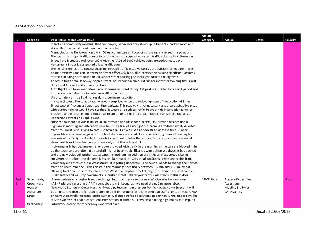
LATM Action Plan Zone 2
11 of 51 Updated 20/02/2018
ID Location Description of Request or Issue Action Category Action Notes Priority
In fact at a community meeting, the then mayor, Genia McAffrey stood up in front of a packed room and stated that the roundabout would not be installed. Manipulation by the Crows Nest Main Street committee and council surprisingly reversed this position. The council arranged traffic counts to be done over subsequent years and traffic volumes in Holtermann Street have increased well over 100% with the AADT of 2000 vehicles being exceeded most days. Holtermann Street is designated a local traffic zone. The installation has also caused chaos for through traffic in Crows Nest as the substantial increase in west bound traffic volumes on Holtermann Street effectively block this intersection causing significant log jams of traffic heading northbound on Alexander Street causing grid lock right back to the highway. Added to this a small laneway, Sophia Street, has become a major rat run for motorists avoiding the Ernest Street and Alexander Street intersection. A No Right Turn from West Street into Holtermann Street during AM peak was trailed for a short period and this proved very effective in reducing traffic volumes. Unfortunately this trail did not result in a permanent solution. In closing I would like to add that I was very surprised when the redevelopment of the section of Ernest Street west of Alexander Street kept the roadway. This roadway is not necessary and a very attractive plaza with outdoor dining would have resulted. It would also reduce traffic delays at this intersection (a major problem) and encourage more motorists to continue to this intersection rather than use the rat runs of Holtermann Street and Sophia Lane. Since the roundabout was installed at Holtermann and Alexander Streets, Holtermann has become a highway in morning and afternoon peak hour. The trial of a no right turn from West Street simply diverted traffic to Ernest Lane. Trying to cross Holtermann St at West St as a pedestrian at these times is near impossible and is very dangerous for school children as cars cut the corner wanting to avoid queuing for two sets of traffic lights. A solution needs to be found to bring Holtermann St back to a quiet residential street and Ernest Lane for garage access only ‐ not through traffic! Holtermann St has become extremely overcrowded with traffic in the mornings ‐ the cars are blocked right up the street and are often at a standstill. It has become significantly worse since Woolworths has opened and the new Coles will further exacerbate this problem. In addition the TAFE on West street is being converted to a school and the area is losing 60 car spaces. Cars sneak up Sophia street and traffic from Cammeray cuts through from West street ‐ it is getting dangerous. The council needs to change the flow of traffic on Holtermann St, Crows Nests in the mornings specifically between 6.30am and 9.30am by not allowing traffic to turn into the street from West St or Sophia Street during these hours. This will increase public safety and will stop overuse of a suburban street. Thank you for your assistance in this matter.
Ped.1
St Leonards/ Crows Nest ‐ west of Alexander Street. Particularly
A new pedestrian crossing is required to get into to entrance to the new Woolworths in crows nest ‐ All ‐ Pedestrian crossing at "All" roundabouts in St Leonards ‐ we need them. Cars never stop. New Metro Station at Crows Nest ‐ without a pedestrian tunnel under Pacific Hwy at Hume Street ‐ it will be an unsafe nightmare for people coming off train ‐ waiting for a long period at traffic lights on Pacific Hwy on narrow sidewalk ‐ to cross Pacific Hwy to Wollstonecraft side solution: pedestrian tunnel under Hwy like at Nth Sydney & St Leonards stations from station at Hume St.Crows Nest parking high hourly rate esp. on Saturdays, loading zones weekdays and weekends
PAMP Study Prepare Pedestrian Access and Mobility Study for LATM Zone 2
Short

LATM Action Plan Zone 2
12 of 51 Updated 20/02/2018
ID Location Description of Request or Issue Action Category Action Notes Priority
walking to St Leonards Station, new Crows Nest Metro station; Chandos Street; Christie Street; Oxley Street; and Clarke Road
Crows Nest shopping precinct, cafes/restaurants monopolising footpath space forcing pedestrians onto the street and away from awnings (when raining)‐ Holtermann St, Crows Nest: Parking Crossings Traffic ‐ Alexander St, Crows Nest: Crossings ‐ Atchison St, Crows Nest: TrafficOXLEY ST BETWEEN ALBANY AND ATCHISON ‐ PARKED cars IMPEDE TRAFFIC FLOW, NARROW FOOTPATHS OXLEY ST UP TO PACIFIC HWY AND OXLEY THOUGH THE HUME ‐ NOT PEDESTRIAN FRIENDLY, MANY PEOPLE TRYING TO CROSS THE ROAD, NEEDS A CROSSING (PEDESTRIAN OR LIGHTS) Crows Nest ‐ Clarke St and Oxley St. Hard to cross roads in peak hours (need to go to roundabout or traffic light)West St ‐ Crossings, Bike paths, bus stop locations, parking, traffic Willoughby Rd ‐ Crossings, Bike paths, bus stop locations, parking, traffic CHANDOS/ CHRISTIE ST ‐ CROSSING TO THE TAIN STATION AT THE ROUNDABOUT.NORTH SYDNEY ‐ LONG TIME BETWEEN BUS AND TRAM SERVICES OUTSIDE PEAK TIMES. WALKING GENERALLY OK BUT CHANDOS ST VERY BAD FOR WHEELCHAIRS. The West Street proposals should also consider longer term active travel planning around the current TAFE site, to become the Cammeraygal High School senior campus. The Anzac Park Public School build was devalued by the absence of pre‐emptive holistic planning approach that considered integrated active transport solutions. This shouldn't be repeated with the new High School. The advantage the high school site has is that it shouldn't involve the RMS as much as Anzac Park PS ‐ their views on this site have been disastrous.
Ped.2
Crows Nest ‐ east of Alexander Street to west of West Street Particularly Alexander Street; Matthew Street; Sophia Lane; routes to shopping village & playgrounds
CROWS NEST ‐ WALKING, SOME STREETS DONT HAVE FOOTPATHS. TRICKY FOR PRAMS ESPECIALLY MATTHEW ST, DIFFICULT TO SEE ONCOMING TRAFFIC WHEN COMING OUT OF LANEWAYS ONTO ALEXANDER ST DUE TO PARKED cars BLOCKING THE VIEW. FULLY INTO THE SPOT AND THE SAME ON LEAVING. DANGEROUS ON MANY LEVELS. Crows Nest ‐ lack of crossing for prams. Crows Nest ‐ Crossings, owing to poor balance and double vision, crossing roads is difficult because slopes provide for prams etc are often rather steep and I therefore often require help from passers by to cross. Recreational walking: important to preserve St. Leonards walking paths (see map for more details). Sophia Lane ‐ Cahill Park too The West Street proposals should also consider longer term active travel planning around the current TAFE site, to become the Cammeraygal High School senior campus. The Anzac Park Public School build was devalued by the absence of pre‐emptive holistic planning approach that considered integrated active transport solutions. This shouldn't be repeated with the new High School. The advantage the high school site has is that it shouldn't involve the RMS as much as Anzac Park PS ‐ their views on this site have been disastrous.
PAMP Study Prepare Pedestrian Access and Mobility Study for LATM Zone 2
Short
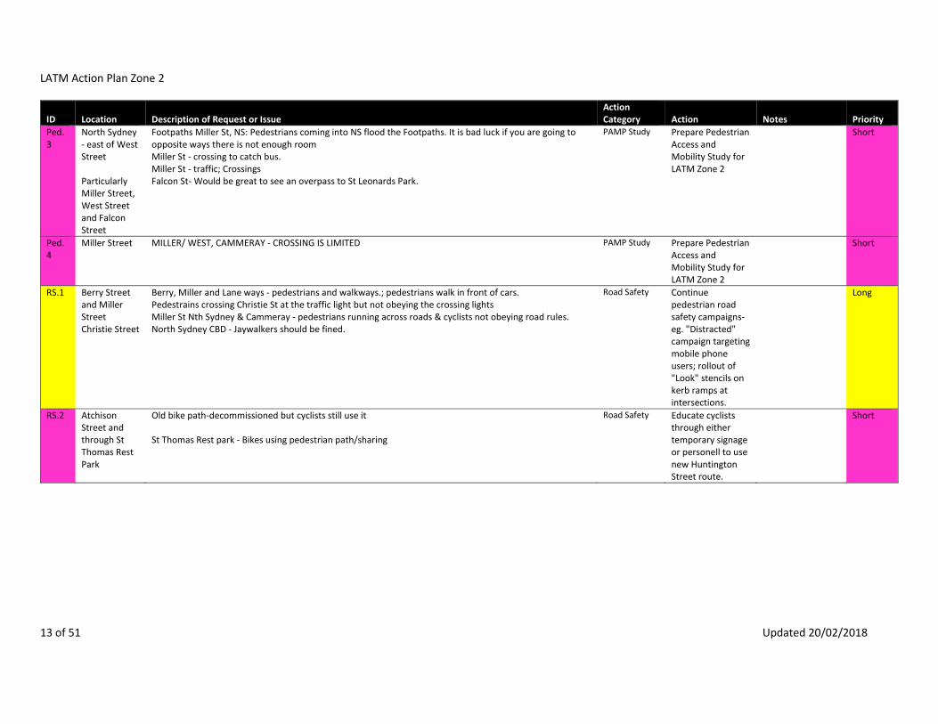
LATM Action Plan Zone 2
13 of 51 Updated 20/02/2018
ID Location Description of Request or Issue Action Category Action Notes Priority
Ped.3
North Sydney ‐ east of West Street Particularly Miller Street, West Street and Falcon Street
Footpaths Miller St, NS: Pedestrians coming into NS flood the Footpaths. It is bad luck if you are going to opposite ways there is not enough room Miller St ‐ crossing to catch bus. Miller St ‐ traffic; Crossings Falcon St‐ Would be great to see an overpass to St Leonards Park.
PAMP Study Prepare Pedestrian Access and Mobility Study for LATM Zone 2
Short
Ped.4
Miller Street MILLER/ WEST, CAMMERAY ‐ CROSSING IS LIMITED PAMP Study Prepare Pedestrian Access and Mobility Study for LATM Zone 2
Short
RS.1 Berry Street and Miller Street Christie Street
Berry, Miller and Lane ways ‐ pedestrians and walkways.; pedestrians walk in front of cars. Pedestrains crossing Christie St at the traffic light but not obeying the crossing lights Miller St Nth Sydney & Cammeray ‐ pedestrians running across roads & cyclists not obeying road rules. North Sydney CBD ‐ Jaywalkers should be fined.
Road Safety Continue pedestrian road safety campaigns‐ eg. "Distracted" campaign targeting mobile phone users; rollout of "Look" stencils on kerb ramps at intersections.
Long
RS.2 Atchison Street and through St Thomas Rest Park
Old bike path‐decommissioned but cyclists still use it St Thomas Rest park ‐ Bikes using pedestrian path/sharing
Road Safety Educate cyclists through either temporary signage or personell to use new Huntington Street route.
Short

LATM Action Plan Zone 2
14 of 51 Updated 20/02/2018
ID Location Description of Request or Issue Action Category Action Notes Priority
RS.3 Falcon Street Falcon Street Shared Path Holtermann Street Miller Street West Street Chandos Street Oxley Street
CYCLISTS SHOULD BE ENCOURAGED TO USE A BELL Falcon St, Cammeray ‐ Adults riding push bikes at high speed on footpath. Bicycle riders ‐ Again, a group with little respect. They ride 5am and talk loudly, echoing their noise into our houses. They ride astride up to 5. They dart inside traffic and ensure they arrive at the lights first. They are slow to take off, yet refuse to move aside in even heavy traffic, causing greater traffic back‐ups. My children witness these frustrating scenarios and they do not learn good lessons during co‐operation. We later discuss the scenario at their request. Miller Street ‐ cyclings not obeying road rules WEST ST CROWS NEST ‐ BIKE RIDERS BREAKING THE LAW AND BEHAVING DANGEROUSLY TO cars AND PEDESTRIANS ‐ West St, NS: Cyclists don't stop at pedestrian Crossings, they race through all the time. They do not use the bike lanes. Chandos Street: Cyclists cycling on the pedestrian pavement rather than on the roads Oxley St, Crows Nest ‐ bikes are not following road traffic rules. Making it very dangerous for themselves e.g. no stop at roundabouts, just ride through and expect all cars to stop for them. North Sydney, Milsons Pt ‐ Bikes on foot paths; North Sydney area ‐ Cyclists riding on pavements/Footpaths
Road Safety Continue cycling‐based events such as Ride to Work Day to inform cyclists of road rules and etiquette, particularly with respect to riding on Shared Paths, footpaths and crossing at intersections, and to promote the benefits of cycling generally.
Long

LATM Action Plan Zone 2
15 of 51 Updated 20/02/2018
ID Location Description of Request or Issue Action Category Action Notes Priority
S.1 Wenona School
9 submissions. Ridge, Miller and Falcon Sts, North Sydney ‐ Congestion in school zones, drop off/pick up parents and rest of drivers Ridge And Walker Sts ‐ increased traffic noise Walker St, North Sydney ‐ frequent gridlock between Ridge St and Berry St. Inadequate parking. Lack of facility for Wenona drop off and pick up. Ridge St, North Sydney ‐ between Walker St and Miller St heavy traffic in school pick up hours. Ridge st/ Walker ‐ inconsiderate drivers dropping childrens at schools taking priorty over pedestrians North Sydney Wonona School ‐ Parents block entrances to 199 Walker St with cars to pick up or drop off kidsWalker St ‐ Wenona Parents/community consistently parking across neighbouring driveways and not clearing the driveway even when a car emerges.‐ Ridge St, NS: Congested during school hours. Everyone drives their cards to school there is gridlock. This is dangerous! Parents congesting Walker St dropping off kids.
School TMP Liaise with Wenona School to develop a School Travel Plan including Traffic Management Plan to reduce vehicle use and minimise the negative impacts on road network, parking and amenity.
Short
S.2 Anzac Park Public School
6 submissions. School ‐ great pedestrian danger. No lights. Not enough parking. My main concern is 'traffic flow'. If traffic is backed up, then getting out of the area, takes a very long time. My concern is that with the new Anzac Club School congestion will be high. These are little children, who require picking up and dropping off every day. Many will not be old enough to walk on their own. How are council/traffic planners planning to deal with this? If the traffic/traffic lights do not 'flow', then congestion builds with little relief. This is greatly evidenced with the Falcon St/Warringah Expressway, where traffic coming off the bridge builds up as each car tries to make it onto Falcon St/Military Rd during the green light. This means Falcon Street traffic has no where to move when they get a green light. In turn, traffic builds up along Miller Street (who are unable to turn into Falcon Street, due to Falcon Street being unable to move forward to Military Rd). This is turn creates congestion in Ernest St, as cars are unable to turn into Miller. It is all about 'flow'. I know the North Sydney area stops at the Warringah Freeway but North Sydney traffic is directly effected by what happens at ours borders. So my questions and concerns are: ‐What is North Sydney planning to do about managing the 'flow of traffic' through the North Sydney area?
Liaise with Anzac Park Public School to develop a School Travel Plan including a Traffic Management Plan to reduce vehicle use and minimise the negative impacts on road network, parking, safety and amenity.
Short

LATM Action Plan Zone 2
16 of 51 Updated 20/02/2018
ID Location Description of Request or Issue Action Category Action Notes Priority
‐ What traffic strategies are being put in place to cope with the Anzac School drops off and pick up by parents, to ensure that residents are not unduly affected by the congestion, and the congestion in the surrounding streets? (And if you think 5‐6 drop off places is going to cut it, think again. These are little kids who require belting up and strapping into a car, we're talking minutes, not seconds. Just look at the other schools in the area, which cater for much older kids who don't require as much assistance getting into cars. (Please note, I'm not against the school, but I'm concerned about the knock on traffic effect). ‐ What is being done about congestion in Falcon, Miller, Ernest streets during morning, evening peak times, and also at weekends, where again the flow of traffic is sometimes at a standstill. Anzac Ave, Cammeray ‐ Congestions around new school, lack of parking for residents due to caravans, boats etc. Traffic management and parking is set to become a major problem with the opening of Anzac Park Public School, Anzac Avenue (off Ernest Street). Please see attached discussion paper prepared by me on behalf of Registry Precinct. 9. Anzac Club School and surrounding streets ‐ Residents who have lived in the area are concerned about the flow of traffic around the school primarily from a safety perspective but also from a traffic management and parking in the area. Specifically residents are concerned about: ‐ a) the flow of traffic east along Ernest Street, which is already congested in the morning peak. There is a pinch point just east of Miller Street along Ernest Street where it is also anticipated that there will be a build up of cars queuing for the kiss and drop. b) the likely increase in cars that turn right from Ernest Street into Lytton Street will create a build up of traffic; c) management of traffic turning left from Rosalind Street into Miller Street. d) cars turning right into Anzac Avenue from Ernest Street travelling west e) general safety issues with K‐6 students crossing Miller and Ernest Streets, especially where there are only crossings (and not lights) on the Ernest and Miller Street corner turning blocks in all directions) which will be under greater pressure from teachers and parents – can the TAFE site which will become the senior high school site be included within the available school community?New schools on Anzac Ave ‐ Where are the lights? And traffic plans for all the mums?

LATM Action Plan Zone 2
17 of 51 Updated 20/02/2018
ID Location Description of Request or Issue Action Category Action Notes Priority
S.3 St Mary's Primary School
5 submissions. Ridge, Miller and Falcon Sts, North Sydney ‐ Congestion in school zones, drop off/pick up parents and rest of drivers Ridge And Walker Sts ‐ increased traffic noise Ridge St, North Sydney ‐ between Walker St and Miller St heavy traffic in school pick up hours. Rat run to access Harbour Bridge and Expressway. Ridge St, NS: Congested during school hours. Everyone drives their cards to school there is gridlock. This is dangerous! Get more school buses for school on Willoughby as there are so many cars with just one child causing congestion Furthermore there are a large number of schools in and adjoining Stanton Precinct area (Wenona, St Marys, Marist, Monte, NS Boys, NS Girls, Shore) and students crossing main roads at traffic lights impedes traffic flows out of local streets. School cycling programs ‐ social media Car sharing ‐ school travel plans Miller St, North Sydney ‐ Traffic down Miller St in peak times/school days School zone all way to Crows Nest, very difficult to get anywhere at drop off or pickup.
School TMP liaise with St Mary's Primary School to develop a School Travel Plan including a Traffic Management Plan to reduce vehicle use and minimise the negative impacts on road network, parking, safety and amenity.
Short
S.4 North Sydney Girls High School
2 submissions. Holterman Estate, West St, Emmett Carlow and Ridge Streets ‐ Traffic volumes ‐ especially due to schools in area. Impacts Safety of pedestrians & cyclists.; Hayberry Street ‐ bus locations Get more school buses for school on Willoughby as there are so many cars with just one child causing congestion Furthermore there are a large number of schools in and adjoining Stanton Precinct area (Wenona, St Marys, Marist, Monte, NS Boys, NS Girls, Shore) and students crossing main roads at traffic lights impedes traffic flows out of local streets. School cycling programs ‐ social media Car sharing ‐ school travel plans
School TMP Liaise with North Sydney Girls High School to develop a School Travel Plan including a Traffic Management Plan to reduce vehicle use and minimise the negative impacts on road network, parking, safety and amenity.
Short

LATM Action Plan Zone 2
18 of 51 Updated 20/02/2018
ID Location Description of Request or Issue Action Category Action Notes Priority
S.5 Marist College
Holterman Estate, West St, Emmett Carlow and Ridge Streets ‐ Traffic volumes ‐ especially due to schools in area. Impacts Safety of pedestrians & cyclists.; Get more school buses for school on Willoughby as there are so many cars with just one child causing congestion Furthermore there are a large number of schools in and adjoining Stanton Precinct area (Wenona, St Marys, Marist, Monte, NS Boys, NS Girls, Shore) and students crossing main roads at traffic lights impedes traffic flows out of local streets. School cycling programs ‐ social media Car sharing ‐ school travel plans Miller St, North Sydney ‐ Traffic down Miller St in peak times/school daysSchool zone all way to Crows Nest, very difficult to get anywhere at drop off or pickup.
School TMP Liaise with Marist College to develop a School Travel Plan including a Traffic Management Plan to reduce vehicle use and minimise the negative impacts on road network, parking, safety and amenity.
Short
S.6 North Sydney Boys High School
Get more school buses for school on Willoughby as there are so many cars with just one child causing congestion Furthermore there are a large number of schools in and adjoining Stanton Precinct area (Wenona, St Marys, Marist, Monte, NS Boys, NS Girls, Shore) and students crossing main roads at traffic lights impedes traffic flows out of local streets. School cycling programs ‐ social media Car sharing ‐ school travel plans Miller St, North Sydney ‐ Traffic down Miller St in peak times/school daysSchool zone all way to Crows Nest, very difficult to get anywhere at drop off or pickup.
School TMP Liaise with North Sydney Boys High School to develop a School Travel Plan including a Traffic Management Plan to reduce vehicle usage and negative impacts on road network, parking, safety and amenity.
Short
S.7 Monte Sant Angelo School
Get more school buses for school on Willoughby as there are so many cars with just one child causing congestion Furthermore there are a large number of schools in and adjoining Stanton Precinct area (Wenona, St Marys, Marist, Monte, NS Boys, NS Girls, Shore) and students crossing main roads at traffic lights impedes traffic flows out of local streets. School cycling programs ‐ social media Car sharing ‐ school travel plans Miller St, North Sydney ‐ Traffic down Miller St in peak times/school daysSchool zone all way to Crows Nest, very difficult to get anywhere at drop off or pickup.
School TMP Liaise with Monte Sant Angelo School to develop a School Travel Plan including a Traffic Management Plan to reduce vehicle usage and negative impacts on road network, parking, safety and amenity.
Short

LATM Action Plan Zone 2
19 of 51 Updated 20/02/2018
ID Location Description of Request or Issue Action Category Action Notes Priority
SL.1 Alexander Street at Holtermann Street ‐ at raised pedestrian crossing
ALEXANDER ST/HOLTERMAN ST ROUNDABOUT ‐ NOT LIT WELL AND RAISED CROSSING IS DANGEROUS FOR TRAFFIC ENTERING ROUNDABOUT AS HARD TO SEE IN DARK
Street lighting Upgrade street lighting
Short
SL.2 Ridge Street ‐ pedestrian crossing outside St Mary's School
RIDGE ST, NORTH SYDNEY ‐ CROSSING AT ST MARYS ISNT LIT UP AT NOGHT, THE cars DO NOT STOP Street lighting Upgrade street lighting
Council is planning to undertake this work in June 2017.
Short
SL.3 Myrtle Street and Eden Street
Street lighting and poor footpaths. Street lighting Upgrade street lighting
Long
SL.4 Carlow Street North Sydney, Carlow St and in general ‐ 1) poor street lighting Street lighting Upgrade street lighting
Medium
SL.5 Emmett Street
EMMETT ST, CROWS NEST ‐ PEDESTRIAN CROSSING ON WEST ST,NOT WELL LIT ENOUGH OR DEFINED Street lighting Upgrade street lighting
Medium
SL.6 Atchison Street between Mitchell Street and Christie Street
Atchison St (Mitchell to Christie) ‐ No lighting in street, too dangerous now a hotel there Street lighting Upgrade street lighting
Short
SL.7 Falcon Street, Crows Nest
FALCON ST, CROWS NEST ‐ LIMITED STREET LIGHTS AND SMALL FOOTPATH MAKING WALKING AT NIGHT DANGEROUS
Street lighting Upgrade street lighting
Short
T.1 Albany Lane at Oxley Street
CNR OF ALBANY LANE AND OXLEY ST ‐ VERY POOR VISIBILITY WHEN COMING OUT OF ALBANY LANE MAKING IT HARD TO PULL OUT INTO OXLEY SAFELY.
Traffic facilities & investigations
Remove parking in Oxley Street to improve visibility exiting Albany Lane
Not to proceed
T.2 Albany Lane Albany Lane is very narrow, yet still allows two way traffic . It would be safer to make it one‐way. Traffic facilities & investigations
Convert Albany Lane to one‐way
Long
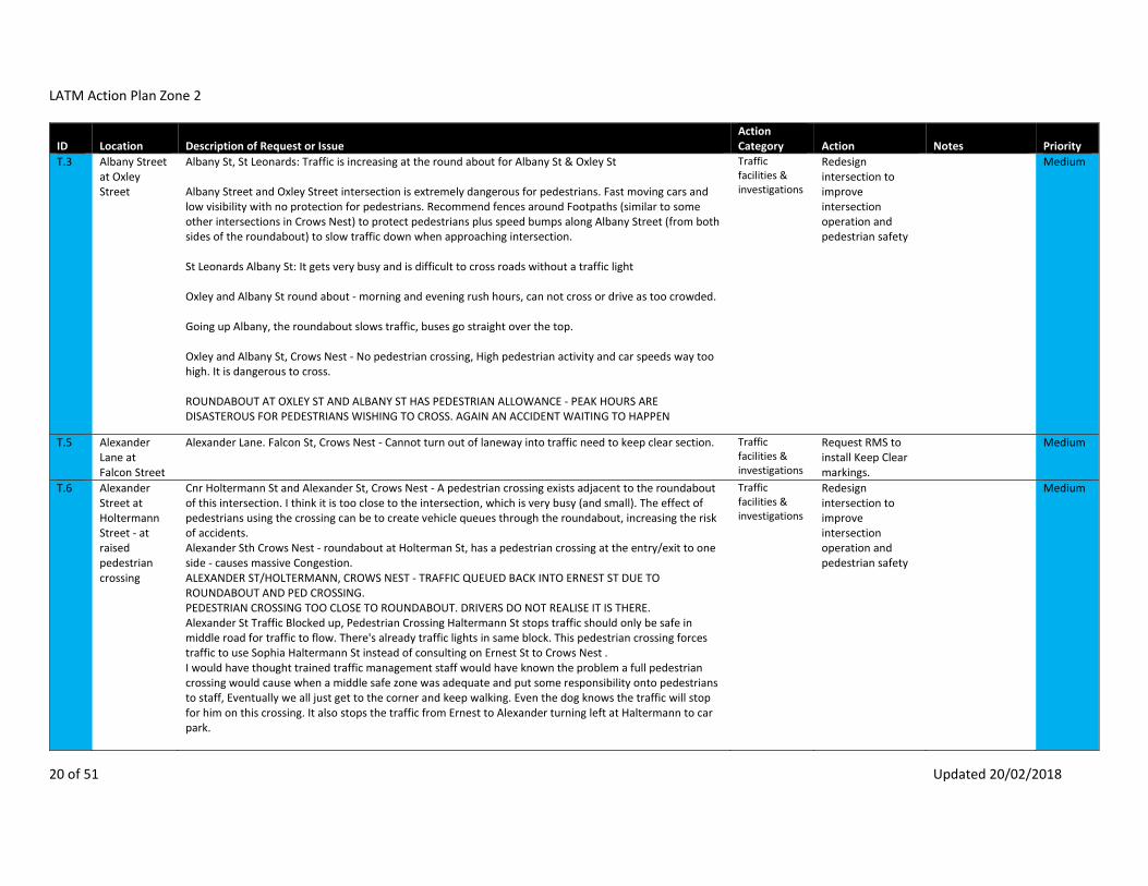
LATM Action Plan Zone 2
20 of 51 Updated 20/02/2018
ID Location Description of Request or Issue Action Category Action Notes Priority
T.3 Albany Street at Oxley Street
Albany St, St Leonards: Traffic is increasing at the round about for Albany St & Oxley St Albany Street and Oxley Street intersection is extremely dangerous for pedestrians. Fast moving cars and low visibility with no protection for pedestrians. Recommend fences around Footpaths (similar to some other intersections in Crows Nest) to protect pedestrians plus speed bumps along Albany Street (from both sides of the roundabout) to slow traffic down when approaching intersection. St Leonards Albany St: It gets very busy and is difficult to cross roads without a traffic light Oxley and Albany St round about ‐ morning and evening rush hours, can not cross or drive as too crowded. Going up Albany, the roundabout slows traffic, buses go straight over the top. Oxley and Albany St, Crows Nest ‐ No pedestrian crossing, High pedestrian activity and car speeds way too high. It is dangerous to cross. ROUNDABOUT AT OXLEY ST AND ALBANY ST HAS PEDESTRIAN ALLOWANCE ‐ PEAK HOURS ARE DISASTEROUS FOR PEDESTRIANS WISHING TO CROSS. AGAIN AN ACCIDENT WAITING TO HAPPEN
Traffic facilities & investigations
Redesign intersection to improve intersection operation and pedestrian safety
Medium
T.5 Alexander Lane at Falcon Street
Alexander Lane. Falcon St, Crows Nest ‐ Cannot turn out of laneway into traffic need to keep clear section. Traffic facilities & investigations
Request RMS to install Keep Clear markings.
Medium
T.6 Alexander Street at Holtermann Street ‐ at raised pedestrian crossing
Cnr Holtermann St and Alexander St, Crows Nest ‐ A pedestrian crossing exists adjacent to the roundabout of this intersection. I think it is too close to the intersection, which is very busy (and small). The effect of pedestrians using the crossing can be to create vehicle queues through the roundabout, increasing the risk of accidents. Alexander Sth Crows Nest ‐ roundabout at Holterman St, has a pedestrian crossing at the entry/exit to one side ‐ causes massive Congestion. ALEXANDER ST/HOLTERMANN, CROWS NEST ‐ TRAFFIC QUEUED BACK INTO ERNEST ST DUE TO ROUNDABOUT AND PED CROSSING. PEDESTRIAN CROSSING TOO CLOSE TO ROUNDABOUT. DRIVERS DO NOT REALISE IT IS THERE. Alexander St Traffic Blocked up, Pedestrian Crossing Haltermann St stops traffic should only be safe in middle road for traffic to flow. There's already traffic lights in same block. This pedestrian crossing forces traffic to use Sophia Haltermann St instead of consulting on Ernest St to Crows Nest . I would have thought trained traffic management staff would have known the problem a full pedestrian crossing would cause when a middle safe zone was adequate and put some responsibility onto pedestrians to staff, Eventually we all just get to the corner and keep walking. Even the dog knows the traffic will stop for him on this crossing. It also stops the traffic from Ernest to Alexander turning left at Haltermann to car park.
Traffic facilities & investigations
Redesign intersection to improve intersection operation and pedestrian safety
Medium

LATM Action Plan Zone 2
21 of 51 Updated 20/02/2018
ID Location Description of Request or Issue Action Category Action Notes Priority
alexander st, crows nest near Holtermann st ‐ traffic banks up northbound due to roundabout at Holtermann st. Traffic short‐cutting down Holtermann in am peak hr. pedestrian crossing very dangerous, I have been almost hit by several cars At the intersection of Alexander Street and Holtermann Street in Crows Nest there is a roundabout. Generally speaking roundabouts in the area work well but not this one. The reason is that a pedestrian crossing has been placed right at the roundabout across Alexander Street, which often prevents traffic from entering and leaving the roundabout and thereby causing a complete gridlock to all 4 roads leading into it. The whole point of roundabouts is to maintain a reasonably smooth flow of traffic as well as share the priority for vehicles entering from any direction. When this gridlock occurs there is a significant temptation for the more impatient drivers to try and race through any gap between the crossing pedestrians regardless of how narrow. I suggest the pedestrian crossing is relocated further up Alexander Street towards Ernest Street which will hopefully cause less congestion and be safer for pedestrians. Alexander St with Holtermann St ‐ Crossing, there should not be a crossing right after a roundabout, too many accidents. People are almost hit everyday. We need lights alexander st, crows nest near Holtermann st ‐ traffic banks up northbound due to roundabout at Holtermann st. Traffic short‐cutting down Holtermann in am peak hr. pedestrian crossing very dangerous, I have been almost hit by several cars Alexander St, Crows Nest ‐ Very dangerous crossing near roundabout, crner of Holtermann and Alexander ‐ nearly been knocked over X4 by cars. ALEXANDER ST PEDESTRIAN CROSSING NEAR HOLTERMANN ST ‐ I DONT FEEL SAFE USING THIS CROSSING AS DRIVERS ARE OFTEN CONCENTRATING ON USING THE ROUNDABOUT AND EITHER STOP AT THE LAST SECOND OR DONT STOP AT ALL. I WONT CROSS UNLESS I KNOW THE DRIVERS HAVE SEEN ME. MY HUSBAND HAS NEARLY BEEN HIT SEVERAL TIMES Dangerous crossing for pedestrians: There's much traffic at this roundabout and it's not easy for pedestrians to cross it. Currently, we have to walk around some barriers and walk over the gutter. There should be a clear pathway for pedestrians to make it easier and safer. Alexander St ‐ cars flying through pedestrian crossing not looking out for pedestrians

LATM Action Plan Zone 2
22 of 51 Updated 20/02/2018
ID Location Description of Request or Issue Action Category Action Notes Priority
T.8 Alexander Street at Chandos Street
Turning right (east) from Alexander St, Crows Nest onto Chandos St. cars travelling the length of Chandos St end up streamlined into one lane, could a lane be created adjacent to the footpath and a turning lane from Alexander St be added? Alexander St, Crows Nest ‐ Chandos St ‐ traffic ‐ lights needed Junction of Alexander St and turn into Brook St ‐ very unsafe for pedestrians crossing. Frequent accidents and close calls; roundabout with refuge island needed at bottom of Alexander ST, where intersects with Chandos. Alexander/Chandos intersection ‐ Badly needs pedestrian traffic lights.Chandos St, Crows Nest Crossing Alexander St & Chandos St (on foot) very scarey at times. Dangerous junction: Cars speed out of Alexander st to beat the traffic coming down Chandos St onto the freeway. We need a mini roundabout here to slow cars down and prevent accidents. There is also a lot of pedestrian activity at the bottom of Alexander St and Chandos St and it's dangerous for them too ‐ very hard to see what's coming, many speeding cars and no thought/consideration for pedestrians. Our main issue is crossing Chandos St as pedestrians. We live between Alexander St and Brook St and need to cross the road to get everywhere ‐ daycare, work, shopping etc. Despite Chandos St being a 50km zone and a fully residential area, I feel I take my life into my hands trying to cross the road. Cars screech out of Alexander St to beat the traffic coming up Chandos St, while cars speed around the corner coming out of Brook St into Chandos St. The pedestrian Crossings are a significant walk away at Willoughby Rd or by the freeway entrance on Brook St. We need a pedestrian crossing or at least a refuge on this section of Chandos St. We also need a roundabout at Alexander/Chandos St ‐ it's a dangerous junction and there are often prangs and near misses.
Traffic facilities & investigations
Install traffic signals with pedestrian signals at intersection
DA condition for Coles 101 Willoughby Road requires traffic signals to be installed prior to occupation.
Long
T.9 Anzac Avenue at Ernest Street
Anzac Ave ‐ Turning right into Ernest will be even more dangerous once school is open. When walking, Ernest street can be difficult and long to cross when traveling between Cammeray and North Sydney.
Traffic facilities & investigations
Redesign intersection to improve intersection operation and pedestrian safety
Short

LATM Action Plan Zone 2
23 of 51 Updated 20/02/2018
ID Location Description of Request or Issue Action Category Action Notes Priority
T.10 Atchison Lane As a resident, I am worry about the traffic condition on Atchison Lane (between Christie & Mitchell St) esp during morning rush hours. The lengthy red traffic light on Christie St outside the post office means traffic from Atchison Lane turning left into Christie St is always stuck. It will be even worse once the 28 level Air building on Atchison St (with carpark entrance & exit on Atchison Lane as well) is fully occupied. Please advise how you are going to manage the traffic condition there? Cars turning right into Atchison Lane from Christie St, ignoring the "No right turn" sign near outside the Telstra building (which is a bit too far away from the corner). It is especially dangerous when most cars usually speed up to make cut corner turns so to avoid oncoming traffic from Chandos St to Pacific Highway direction. Combining with point (1), it heightens the risk of accidents happening.
Traffic facilities & investigations
Install continuous footpath treatment across Atchison Lane at Christie Street
Short
T.11 Atchison Street at Christie Street
Atchison St, St Leonards ‐ mass traffic blocking access from Christie St. Narrow Rd and one way. Minimal Parking. 3. Cars turning right into Atchison St from Christie St, ignoring the clearly visible "No right turn" sign on the corner of Christie & Atchison St.
Traffic facilities & investigations
Liaise with Police and RMS about possible enforcement options
Medium
T.13 Atchison Street at Oxley Street
Atchison St/Oxley St, Crows Nest ‐ roundabouts, too much traffic, people drive too fast during peak hour. OXLEY ST AND ATCHISON ‐ SHOCKING GIVE WAY ENVIRONMENT SHOULD BE A ROUNDABOUT. MANY MANY NEAR ACCIDENTS Oxley and Atchison St, Crows Nest ‐ No pedestrian crossing, High pedestrian activity and car speeds way too high. It is dangerous to cross. This is a major pedestrian Routes.
Traffic facilities & investigations
Redesign intersection to improve intersection operation and pedestrian safety
Short
T.14 Church Street / McLaren Street/ Angelo Street
Rat run from West Street to Berry Street along Church Street, McLaren Street and Angelo Street Berry Street, North Sydney ‐ Traffic exiting Angelo St into Berry St starting to cause road blocks due to increasing traffic volume due to new developments fronting Pacific Hwy,
Traffic facilities & investigations
Restrict right turn from Church Street into McLaren Street during AM peak to reduce amount of through traffic travelling via Angelo Street to Berry Street.
Short

LATM Action Plan Zone 2
24 of 51 Updated 20/02/2018
ID Location Description of Request or Issue Action Category Action Notes Priority
T.15 Burlington Street at Alexander Street
ALEXANDER ST, CROWS NEST, CRNER URLINGTON ‐ THE PEDESTRIAN CROSSING IS A DEATHTRAP BECAUSE OF ITS PROXIMITY TO THE ROUNDABOUT. there needs to be a pedestrian crossing on Burlington Street at the western side of the alexander street roundabout where the ramps are ‐ in front of the taxi zone across to the Woolworths entrance since Woolworths opened it is dangerous crossing there, but many people cross there all day and night The new Woolworths is creating lots of fantastic pedestrian traffic that is put into peril once they leave the store. There are NO safe crossings in the Alexander/ Burlington traffic circle that connect to Woolworths. Pedestrians are leaving Woolworths and crossing Burlington and are really at risk. The taxi rank needs to be moved and a new pedestrian crossing needs to be put in. Crossing anywhere near Burlington and Alexander is like playing frogger with your life. Anecdotally, residents noticed that there have been some issues with cars “clogging” up the exit/entrance to Alexander Street carpark and there have been instances where Woolworths staff have directed traffic on Alexander/Burlington Streets. This is associated with concerns that the changes to Burlington Street (narrowing) are causing bus/car conflicts and there have been instances where buses have had to queue on Willoughby Road to turn into Burlington due to delays caused by delivery vehicles queuing for and entering Willoughby Lane. Precinct is very concerned that bus route remains unchanged along Willoughby Road. There are concerns that there is a lot of demand on that portion of Burlington Street ‐ bus stops, taxi ranks, deliveries to Woolworths via Willoughby Lane etc. and that it needs to be carefully managed. ‐ Crows Nest cnr Alexander & Burlington ‐ Traffic Congestion Burlington St, Crows Nest ‐ the increased traffic from Alexander St into Burlington St as a result of the newly opened Woolworths has made crossing Burlington St in front of the Woolworths pedestrian exit quite dangerous. A new pedestrian crossing is needed. Lack of pedestrian Crossings. Burlington at Alexander (near Woolworths).
Traffic facilities & investigations
Redesign intersection to improve operation and pedestrian safety.
Medium
T.16 Burlington Street at West Street
Crows Nest cnr West & Burlington ‐ Traffic Congestion Traffic facilities & investigations
Redesign intersection to improve traffic flow.
Not to proceed
T.17 Carlow Street at Miller Street
Carlow St gong left onto Miller St ‐ traffic jam caused by pedestrians, especially school children. How about left turn after stopping.
Traffic facilities & investigations
Install "Left Turn Permitted After Stopping" sign
"Left turn after stopping" cannot be installed where there is an adjacent pedestrian
Not to proceed

LATM Action Plan Zone 2
25 of 51 Updated 20/02/2018
ID Location Description of Request or Issue Action Category Action Notes Priority
crossing, for safety reasons.
T.19 Chandos Street at Mitchell Street
Corner Chandos and Mitchell St, St Leonards ‐ Multiple close accidents when turning right out from Mitchell to Chandos St as current street parking/loading is too close to corner. Any large vehicle (esp truck) blocks view to see a safe gap.
Traffic facilities & investigations
Install kerb build outs
Removal of parking would encourage higher turning speeds. Visibility and pedestrian access can be improved with kerb buildouts.
Short
T.20 Christie Street at Chandos Street
1) Chandos and Christie St ‐ Crossings are non existent at points that have high pedestrian traffic, vehicles drive fast and don't slow down for pedestrians for use their to move pedestrians off the roads. There is no Safety once a pedestrian has stepped off the path and there is no designated crossing or traffic lights. Chandos & Christie St, St Leonards ‐ Crossings and Traffic Christie/Chandos St ‐ Needs zebra crossing for redestrians Christie and Chandlers St: "Street‐pedestrians safety‐needs pedestrian crossing, highly dangerous. Cohesive road user strategy‐able to walk/drive/cycle in all areas". No zebra crossing to access station. CHRISTIE ST, ST LEONARDS ‐ TRAFFIC CONGESTION GETTING ON TO PACIFIC HWY, AM PEAK The traffic problems where I live in area of Sergeants Lane, Christie St and Chandos are immense. The roundabout at Christie/Chandos is blocked for hours at a time. Motorist ignore "no right turn sign" at Christie/Atchison and pedestrians seem to think the whole area is a pedestrian plaza. Serious accidents/deaths are only a matter of time. The whole area is a traffic disaster and with more tower blocks proposed will worsen. The new traffic lights in Christie St have not helped. A police presence occasionally to fine traffic infringers and jaywalkers would be a start. However, the whole traffic infrastructure needs to be revised. Sargeant Lane, St Leonards ‐ traffic light can be very long ‐ Christie St round‐about at Chandos: Such a dangerous crossing ‐ so many cars ‐ make it a traffic light
Traffic facilities & investigations
Redesign intersection of Chandos Street and Christie Street to improve operation and pedestrian safety.
Medium
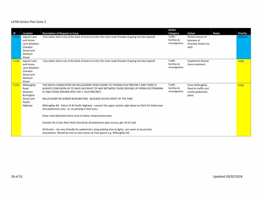
LATM Action Plan Zone 2
26 of 51 Updated 20/02/2018
ID Location Description of Request or Issue Action Category Action Notes Priority
T.21a Ingram Lane and Hume Lane between Chandos Street and Atchison Street
Cars taken short cuts at the back of lanes to enter the main road Chandos St going too fast (speed) Traffic facilities & investigations
Partial closure of laneway at Chandos Street (no exit)
Medium
T.21b Ingram Lane and Hume Lane between Chandos Street and Atchison Street
Cars taken short cuts at the back of lanes to enter the main road Chandos St going too fast (speed) Traffic facilities & investigations
Implement Shared Zone treatment
Long
T.22a Willoughby Road between Burlington Street and Pacific Highway
TOO MUCH CONGESTION ON WILLOUGHBY ROAD GOING TO THOMAS DUX PRECINCT AND THERE IS ALWAYS CONFUSION AS TO WHO HAS RIGHT OF WAY BETWEEN THOSE DRIVING UP FROM HOLTERMANN ST AND THOSE DRIVING INTO THE T. DUX PRECINCT. WILLOUGHBY RD (CRNER BURLINGTON) ‐ BLOCKED ACCESS MOST OF THE TIME Willoughby Rd ‐ Falcon St & Pacific Highway ‐ convert the upper section right down to Clark St/ Holterman into pedestrian area ‐ ie. no parking in that area.; Close road‐dedicated share zone to better shops/restaurants Outside the Crows Nest Hotel should be all pedestrian open access, get rid of road All Streets ‐ not very friendly for pedestrians, long waiting time at lights, cars seem to be priority everywhere. Would be nice to have some car free spaces e.g. Willoughby Rd.
Traffic facilities & investigations
Close Willoughby Road to traffic and create pedestrian plaza
Long

LATM Action Plan Zone 2
27 of 51 Updated 20/02/2018
ID Location Description of Request or Issue Action Category Action Notes Priority
T.22b Burlington Street at Willoughby Road
TOO MUCH CONGESTION ON WILLOUGHBY ROAD GOING TO THOMAS DUX PRECINCT AND THERE IS ALWAYS CONFUSION AS TO WHO HAS RIGHT OF WAY BETWEEN THOSE DRIVING UP FROM HOLTERMANN ST AND THOSE DRIVING INTO THE T. DUX PRECINCT. WILLOUGHBY RD (CRNER BURLINGTON) ‐ BLOCKED ACCESS MOST OF THE TIME Willoughby Rd ‐ Falcon St & Pacific Highway ‐ convert the upper section right down to Clark St/ Holterman into pedestrian area ‐ ie. no parking in that area.; Close road‐dedicated share zone to better shops/restaurants Outside the Crows Nest Hotel should be all pedestrian open access, get rid of road All Streets ‐ not very friendly for pedestrians, long waiting time at lights, cars seem to be priority everywhere. Would be nice to have some car free spaces e.g. Willoughby Rd.
Traffic facilities & investigations
Install Give Way line on Burlington Street at Willoughby Road
Long
T.23 David Street at Pacific Highway
Driving South on Pacific Hwy and turning left into David St, Crows Nest ‐ the recent addition of a pedestrian cross at the junction of David St and Pacific Hwy creates a Safety hazard. If turning left from the Hwy into David St and a pedestrian enters the crossing. I have to stop on the inside lane of the Hwy due to the proximity of the crossing. The vehicles following are not always anticipating me stopping and I am at risk of being "tailended" by the following vehicles. Re‐locating the crossing a few meters down David St to the gate of the Girls School would eliminate this risk.
Traffic facilities & investigations
Relocate pedestrian crossing 6 metres from intersection
Pedestrians would be diverted away from the path alignment. There is no significant crash history to suggest the intersection is operating unsatisfactorily
Not to proceed
T.24 Ernest Street at Miller Street
School being built. Put traffic lights in due to traffic Traffic facilities & investigations
Request RMS to remove slip lanes and zebra crossings and upgrade to a fully signalised intersection.
Short
T.25 Ernest Street at West Street
I'm writing about the intersection of Ernest and West street. Cars are permitted to make a left turn onto Ernest street, as they drive northwards up West street. I believe this is a very dangerous turn, made under the drivers auspices, and dependent on their perception of the oncoming traffic. Having lived at this intersection for just over a year with young children, I've been overlooked by cars three times as I've attempted crossing the road with my children, luckily with no consequences so far. I would like to see this situation addressed.
Traffic facilities & investigations
Remove "Left Turn on Red Permitted After Stopping" sign.
Short

LATM Action Plan Zone 2
28 of 51 Updated 20/02/2018
ID Location Description of Request or Issue Action Category Action Notes Priority
T.26 Falcon Lane at West Street
Coming out of Falcon Lane into West St to turn left at the lights ‐ Traffic build up & banked well up to Ernest St
Traffic facilities & investigations
Install "Do Not Stop Across Intersections" signage
Medium
T.27a Falcon Lane Falcon Ln, Crowns Nest ‐ It its full of pot holes, and many drivers go up or down the lane much too fast. WE have had many near collisions while backing out of our garage ‐ Many drivers think it is a one way lane & position themselves in the middle of the lane either going in or going out! People think its one way St, take up both lanes‐congestion due to dry cleaner + rat run
Traffic facilities & investigations
Paint directional arrows on pavement
Medium
T.27b Falcon Lane Falcon Ln, Crowns Nest ‐ It its full of pot holes, and many drivers go up or down the lane much too fast. WE have had many near collisions while backing out of our garage ‐ Many drivers think it is a one way lane & position themselves in the middle of the lane either going in or going out! People think its one way St, take up both lanes‐congestion due to dry cleaner + rat run
Traffic facilities & investigations
Shared Zone Long
T.29 Side roads entering Falcon Street and Ernest Street (Moodie Street; Lytton Street; Sophia Street)
Crow Nest Control of thorough traffic on roads eg Falcon/Ernest with closure of Minor road. Traffic facilities & investigations
Partial closure of minor roads at main roads (no entry)
Medium
T.30 Holtermann Street at West Street
The corner of Holtermann and West is a danger spot that requires Council attention West St, Crows Nest: Dangerous intersection, West & Holterman Traffic congestion at the corner of West and Holterman Streets. This is pretty much an extension of the issues raised in relation to West Street but is compounded by being the bike route as well. cnr west st and holtermann ‐ cars short cutting down hotermann to reach alexander st make it unsafe for childen to cross holtermann st, pedestrian crossing or no right turn needed.
Traffic facilities & investigations
Install kerb buildouts
Medium
T.31 McLaren Street ‐ private laneway between Hno. 39 & 41
Laneway between 39 and 41 McLaren St ‐ exit to McLaren St from laneway is not safe and traffic both pedestrians and mot is getting worse as building activity occurs.
Traffic facilities & investigations
Install "Stop ‐ Give Way to Pedestrians" signage at private laneway exit
Short

LATM Action Plan Zone 2
29 of 51 Updated 20/02/2018
ID Location Description of Request or Issue Action Category Action Notes Priority
T.32 Miller Street at Ridge Street
2) Right turn lights should be installed at the junctions of McLaren Street and Ridge Street northbound into Miller Street. At peak times the volume of traffic means waiting times can be up to half an hour, and there is a danger of impatience leading to accidents. New residential developments (such as that proposed for the SAP building) will only exacerbate the situation if this is not provided.
Traffic facilities & investigations
Redesign intersection to improve operation
Short
T.33 McLaren Street at Walker Street
Junction o McLaren and Walker can become congested Intersection of McLaren and Walker St ‐ Traffic in Walker and McLaren St is now very heavy. Lights are needed at this intersection. On Walker St, while going home (north) I will always cross the road before McLaren St as I find this crossing extremely dangerous. Cars are going very fast from the bottom of Walker st and turning into McLaren St and will rarely let pedestrian cross as they are supposed to do. The problem for this intersection is that the crossing is way to wide helping the cars not to slow down. For information there's a school at the top of the street and I amazed there is no pedestrian crossing at this crossing. Walker St ‐ Crossings, traffic McLaren St ‐ traffic crossing from Walker, slip side street, accidents Walker/Mclaren Sts, North Sydney ‐ Walker St: cars travel, at inappropriate speed. McLaren St: cars emerge into traffic. Pedestrians: no clear, safe Routes from East side Walker St cross McLaren St without aid. All could be solved by lights on the junction. 3. A safe pedestrian crossing on Mclaren Street is definitely a requirement as we see every day people crossing unsafely with cars tearing down Mclaren & mothers with prams trying to cross either on Mclaren or at the corner of Mclaren and Walker. It is difficult judge the speed of traffic turning into Mclaren from Walker Street.
Traffic facilities & investigations
Install pedestrian crossing with kerb extensions.
Traffic volumes at intersection are below the RMS requirements to warrant traffic signals.
Medium
T.34 Miller Street at Rosalind Street
Allow easier access at the Rosalind/Miller St intersection: Currently, it's not possible to turn right from Rosalind St to Miller St, and also not possible to turn right from Miller St to Rosalind St. Both of these limitations are not only unnecessary, but very annoying for the people to live in the area. It causes drivers to go the long way around, be on the road for longer, and add to traffic congestion. I suggest to change it to allow right turns. Roslyn St, Cammeray ‐ Ernest St right hand turn not clear, currently under school construction zone. Rosalind St ‐ Illegal, dangerous crossing Miller ST all the time ROSALIND ST/ MILLER ST, CAMMERAY ‐ CANNOT TURN RIGHT INTO MILLER, NOR TURN RIGHT INTO ROSALIND. BOTH SHOULD BE ALLOWED AS IT CAUSES MORE BELAY COMING HOME. Rosalind St East Cammeray ‐ Very dangerous intersection as the right hand turn off Miller into Rosalind and turning right off Rosalind there are too many places and people donot see cars or give correct signal of way which leads to many near misses and accidents and very dangerous also for pedestrians.
Traffic facilities & investigations
Redesign intersection to improve safety
Long
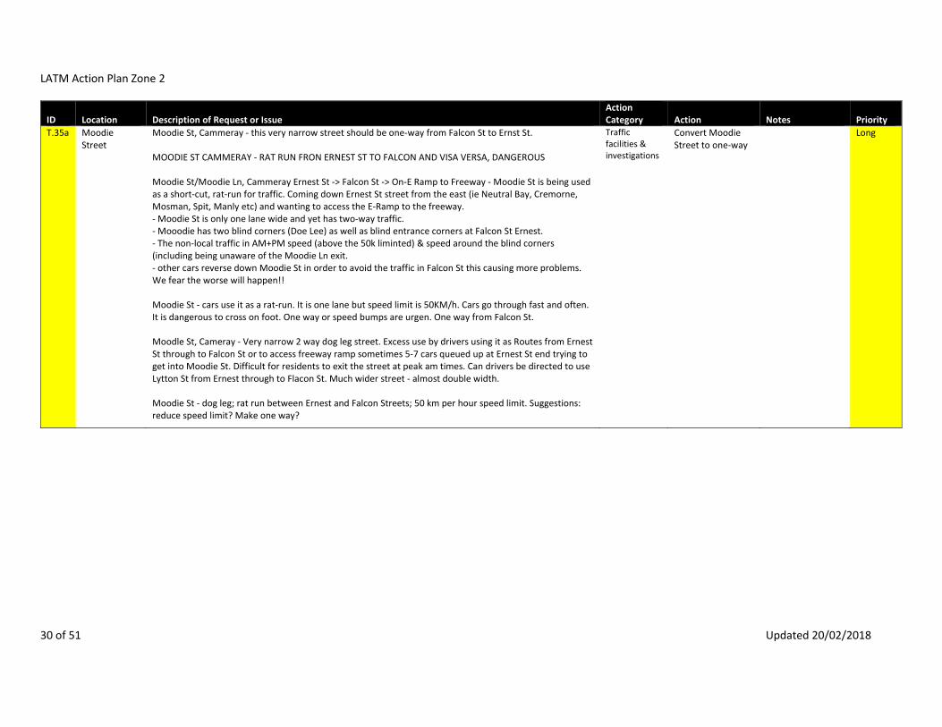
LATM Action Plan Zone 2
30 of 51 Updated 20/02/2018
ID Location Description of Request or Issue Action Category Action Notes Priority
T.35a Moodie Street
Moodie St, Cammeray ‐ this very narrow street should be one‐way from Falcon St to Ernst St. MOODIE ST CAMMERAY ‐ RAT RUN FRON ERNEST ST TO FALCON AND VISA VERSA, DANGEROUS Moodie St/Moodie Ln, Cammeray Ernest St ‐> Falcon St ‐> On‐E Ramp to Freeway ‐ Moodie St is being used as a short‐cut, rat‐run for traffic. Coming down Ernest St street from the east (ie Neutral Bay, Cremorne, Mosman, Spit, Manly etc) and wanting to access the E‐Ramp to the freeway. ‐ Moodie St is only one lane wide and yet has two‐way traffic. ‐ Mooodie has two blind corners (Doe Lee) as well as blind entrance corners at Falcon St Ernest. ‐ The non‐local traffic in AM+PM speed (above the 50k liminted) & speed around the blind corners (including being unaware of the Moodie Ln exit. ‐ other cars reverse down Moodie St in order to avoid the traffic in Falcon St this causing more problems. We fear the worse will happen!! Moodie St ‐ cars use it as a rat‐run. It is one lane but speed limit is 50KM/h. Cars go through fast and often. It is dangerous to cross on foot. One way or speed bumps are urgen. One way from Falcon St. Moodle St, Cameray ‐ Very narrow 2 way dog leg street. Excess use by drivers using it as Routes from Ernest St through to Falcon St or to access freeway ramp sometimes 5‐7 cars queued up at Ernest St end trying to get into Moodie St. Difficult for residents to exit the street at peak am times. Can drivers be directed to use Lytton St from Ernest through to Flacon St. Much wider street ‐ almost double width. Moodie St ‐ dog leg; rat run between Ernest and Falcon Streets; 50 km per hour speed limit. Suggestions: reduce speed limit? Make one way?
Traffic facilities & investigations
Convert Moodie Street to one‐way
Long

LATM Action Plan Zone 2
31 of 51 Updated 20/02/2018
ID Location Description of Request or Issue Action Category Action Notes Priority
T.35b Moodie Street
Moodie St, Cammeray ‐ this very narrow street should be one‐way from Falcon St to Ernst St. MOODIE ST CAMMERAY ‐ RAT RUN FRON ERNEST ST TO FALCON AND VISA VERSA, DANGEROUS Moodie St/Moodie Ln, Cammeray Ernest St ‐> Falcon St ‐> On‐E Ramp to Freeway ‐ Moodie St is being used as a short‐cut, rat‐run for traffic. Coming down Ernest St street from the east (ie Neutral Bay, Cremorne, Mosman, Spit, Manly etc) and wanting to access the E‐Ramp to the freeway. ‐ Moodie St is only one lane wide and yet has two‐way traffic. ‐ Mooodie has two blind corners (Doe Lee) as well as blind entrance corners at Falcon St Ernest. ‐ The non‐local traffic in AM+PM speed (above the 50k liminted) & speed around the blind corners (including being unaware of the Moodie Ln exit. ‐ other cars reverse down Moodie St in order to avoid the traffic in Falcon St this causing more problems. We fear the worse will happen!! Moodie St ‐ cars use it as a rat‐run. It is one lane but speed limit is 50KM/h. Cars go through fast and often. It is dangerous to cross on foot. One way or speed bumps are urgen. One way from Falcon St. Moodle St, Cameray ‐ Very narrow 2 way dog leg street. Excess use by drivers using it as Routes from Ernest St through to Falcon St or to access freeway ramp sometimes 5‐7 cars queued up at Ernest St end trying to get into Moodie St. Difficult for residents to exit the street at peak am times. Can drivers be directed to use Lytton St from Ernest through to Flacon St. Much wider street ‐ almost double width.
Traffic facilities & investigations
Create 40km/h local area speed zone
Medium
T.36 Hayberry Street at Alexander Street
Corner Pacific Highway/Hayberr St/Alexander lane ‐ Turning into Hayberry St from Pacific Hwy southbound can be difficult because people on Alexander St stop for the lights past the indicated white line, blocking people from trying to enter Hayberry Lane across the intersection
Traffic facilities & investigations
No Action Required
No Right Turn sign already prohibits turning right into Hayberry Street from Pacific Highway/Alexander Street.
Not to proceed
T.37 Ridge Street at Walker Street
Ridge Corner walker st Should be roundabout to control school traffic, bowling club traffic and residents at freeway end of ridge st Pedestrian access to St Leonards Park across Ridge Street
Traffic facilities & investigations
Install pedestrian crossing, refuge or kerb build‐out
Roundabouts are difficult for pedestrians to negotiate and not suitable where traffic flows are uneven. Intersection does not meet RMS warrants for traffic signals.
Not to proceed

LATM Action Plan Zone 2
32 of 51 Updated 20/02/2018
ID Location Description of Request or Issue Action Category Action Notes Priority
T.37b Ridge Street at Walker Street
Ridge Corner walker st Should be roundabout to control school traffic, bowling club traffic and residents at freeway end of ridge st
Traffic facilities & investigations
Redesign intersection to improve operation
Roundabouts are difficult for pedestrians to negotiate. Intersection does not meet RMS warrants for traffic signals.
Medium
T.38 Rosalind Street
Rosalind Street East hill ‐ Difficulty in seeing on coming traffic around the corner which could be remedied by installing a mirror ‐ safety issue
Traffic facilities & investigations
Install warning signs.
Convex mirrors are not recommended for public roads due to image of approaching vehicles being distorted and appearing further away. Adopted practice is not to install convex mirrors on public roads.
Medium
T.39 Walker Street between Berry Street & McLaren Street
Walker St/Berry St/McLaren St, North Sydney ‐ traffic Congestion Walker St, North Sydney ‐ traffic Congestion especially North of Berry St
Traffic facilities & investigations
Ongoing monitoring
Walker Street is a collector road which carries traffic to Berry Street. This however forms the minor leg of the intersection at Berry Street so signals would be optimised for the Berry Street and Walker Street (south) legs.
Long
T.40 Willoughby Road
Willoughby Rd, Crows Nest ‐ Bus Stop blocks traffic. Traffic facilities & investigations
Remove kerb build out and create indented bus bay.
Bus Stop is an in‐lane bus stop.
Not to proceed

LATM Action Plan Zone 2
33 of 51 Updated 20/02/2018
ID Location Description of Request or Issue Action Category Action Notes Priority
T.41 Alexander Street Carpark
Woolworths car park ‐ Getting out has been a problem. Traffic facilities & investigations
Ongoing monitoring
Undertake detailed investigation of pinch points in and around new carpark.
Short
T.42 Alexander Street at Atchison Street
Intersection Alexander & Atchison Sts, CN ‐ dangerous crossing without any road calming device. All other intersections on Alexander St have either traffic lights or a roundabout Atchison and Alexander Sts, Crows Nest ‐ there needs to be a pedestrian crossing at this intersection. Someone is going to get hit by a car here, it is extremely dangerous.
Traffic facilities & investigations
Redesign intersection to improve operation and pedestrian safety
Short
T.43 Willoughby Road at Atchison Street
Intersection needs pedestrian crossing (across Willoughby Rd). It's "pot luck" at the moment. Vehicles accessing shopping centre. Willoughby Rd/Atchison St, Crows Nest ‐ there needs to be a pedestrian crossing across Willoughby Rd Atchison St to Willoughby St‐ You can get hurt crossing the road no Crossings
Traffic facilities & investigations
Redesign intersection to improve pedestrian safety.
Short
T.44 Brook Street at Chandos Street
Dangerous pedestrian crossing: So many people cross over Chandos St at this junction with Brook St to get to Cammeray and to walk down West St to North Sydney. We also walk this way to get to St Thomas Rest Park. It's often terrifying trying to get across the road ‐ which let's remember is a 50km residential road ‐ particularly at peak times. Cars speed around the corner from Brook St and scream out of the junction at Alexander St, trying to beat the traffic coming down Chandos to the freeway. We have near the freeway at Brook St. We need a refuge at the very least but preferably a pedestrian crossing on this section of Chandos St.
Traffic facilities & investigations
Redesign intersection to improve pedestrian safety.
Medium
T.45 Albany Street at Alexander Street
Albany St, St Leonards ‐ It is quite difficult to walk across Albany St due to the speed and number of cars. Pedestrians rely on islands at the roundabouts . Reducing the speed limit and installing traffic lights would help Roundabouts‐cars don’t stop and people cant cross
Traffic facilities & investigations
Redesign intersection to improve pedestrian safety.
Short

LATM Action Plan Zone 2
34 of 51 Updated 20/02/2018
ID Location Description of Request or Issue Action Category Action Notes Priority
T.46 Clarke Street at Oxley Street
Cnr of Clarke St & Oxley St ‐ Difficult cross section in terms of traffic. Lack of pedestrian Crossings. Oxley and Clarke
Traffic facilities & investigations
Redesign intersection to improve pedestrian safety.
Medium
T.50a West Street at Emmett Street
Hard to cross/zebra crossing +lots of people waiting on corners West St ‐ cars don't stop at crossing on Emmett St ‐ so many near misses Carlow/West St crossing ‐ many cars do not stop.
Traffic facilities & investigations
Remove excess signage and clutter
Short
T.50b West Street at Emmett Street
Hard to cross/zebra crossing +lots of people waiting on corners West St ‐ cars don't stop at crossing on Emmett St ‐ so many near misses Carlow/West St crossing ‐ many cars do not stop.
Traffic facilities & investigations
Install zig zag markings on approach to pedestrian crossing
Short
T.51 West Street near St Thomas Rest Park
west st near st Thomas rest park ‐ pedestrian crossing needed at freeway overpass for school children THERE SHOULD PROBABLY BE A PEDESTRIAN CROSSING FROM ONE SIDE OF WEST ST NEAR THOMAS REST TO THE OTHER. FOOTPATH IN THOMAS REST PARK COULD BE WIDER TO ACCOMODATE FOOT TRAFFIC
Traffic facilities & investigations
Install pedestrian crossing, refuge or kerb build‐out
Short
T.52 Willoughby Road at Albany Street
Willoughby Rd, Crows Nest ‐ cars banking across lights and pedestrian crossing dangerous for walkers. Traffic facilities & investigations
Liaise with NSW Police and RMS about enforcement options
Short
T.55 Atchison Street between Alexander Street and St Thomas Rest Park
Atchison St also desperately needs traffic calming measures. Cars speed up Atchison St thinking it leads to West St, only to slam on their brakes, perform swift U turns and then speed back the other way. ‐ Atchison St, Crows Nest: Traffic
Traffic facilities & investigations
Install traffic calming scheme
Medium
T.56 Burlington Lane
Burlington Lane near Anzac School ‐ 40Km/H signage painted and now people going too fast in alley We have a problem in our alley in Burlington Lane. People are flying down the lane in excess of 50 km/h. Now there is a school zone sign that says 40 and actually encourages people to go 40 in the lane! We need a speed hump and some speed signs (15 km/h or whatever is right for an alley) to make it safer for our residents.
Traffic facilities & investigations
Install 10km/h Shared Zone Treatment
Long
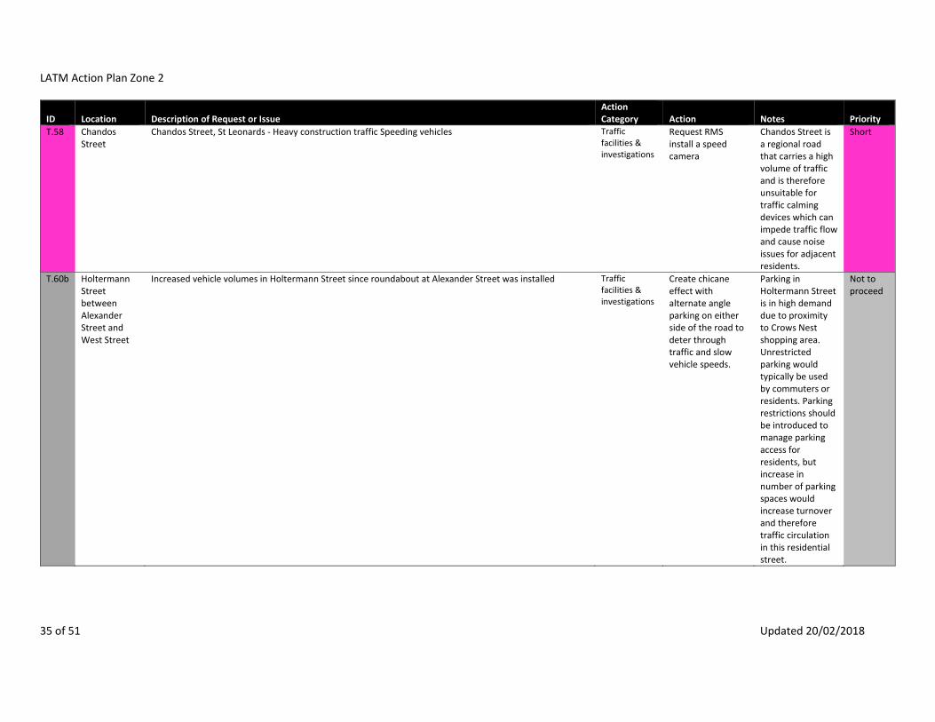
LATM Action Plan Zone 2
35 of 51 Updated 20/02/2018
ID Location Description of Request or Issue Action Category Action Notes Priority
T.58 Chandos Street
Chandos Street, St Leonards ‐ Heavy construction traffic Speeding vehicles Traffic facilities & investigations
Request RMS install a speed camera
Chandos Street is a regional road that carries a high volume of traffic and is therefore unsuitable for traffic calming devices which can impede traffic flow and cause noise issues for adjacent residents.
Short
T.60b Holtermann Street between Alexander Street and West Street
Increased vehicle volumes in Holtermann Street since roundabout at Alexander Street was installed Traffic facilities & investigations
Create chicane effect with alternate angle parking on either side of the road to deter through traffic and slow vehicle speeds.
Parking in Holtermann Street is in high demand due to proximity to Crows Nest shopping area. Unrestricted parking would typically be used by commuters or residents. Parking restrictions should be introduced to manage parking access for residents, but increase in number of parking spaces would increase turnover and therefore traffic circulation in this residential street.
Not to proceed

LATM Action Plan Zone 2
36 of 51 Updated 20/02/2018
ID Location Description of Request or Issue Action Category Action Notes Priority
T.63 Miller Street Miller St ‐ Drivers Speeding Traffic facilities & investigations
Request RMS install a speed camera
Miller Street is a regional road that carries a high volume of traffic and is therefore unsuitable for traffic calming devices which can impede traffic flow and cause noise issues for adjacent residents.
Short
T.66 West Street 1) Vehicle speed and Congestion on Ridge Street and West Street in early morning and late evenings including many trucks. Regularly vehicles speed along these streets at all hours and frequently ignore pedestrian Crossings creating dangerous environment for pedestrians. Need traffic calming measures. West St ‐ Speeding down West St need traffic calming measures. West St ‐ Traffic When walking our dogs we often encounter people Speeding, especially in Myrtle St and on West St. West St and other areas with light ‐ motorbikes for some reason 'wheelie' beginning at lights each time. Unsafe.
Traffic facilities & investigations
Create 40km/h local area speed zone including traffic calming devices
See also T.104 & T.132
Short
T.68 Sophia Street between Ernest Street and Holtermann Street
I am increasingly concerned with traffic management of the one way Sophia Street and the intersections of Ernest street, Ernest Lane and Holtermann streets and the constant traffic going the wrong way by entering from Holtermann street. Apart from some pedestrian traffic who are cautious, there is a children's ballet school situated between Ernest Lane and Holtermann street and their safety is paramount. Aldo line of sight at the Ernest lane intersection with Sophia street needs a mirror so that vehicles entering from Ernest Street can be seen . May i also suggest speed humps be built to slow all traffic down in both Sophia and Ernest Lanes as with other lanes in the precinct Sophia St, Crows Nest ‐ cars Speeding to get to Holtermann St. It would serve to put humps into this section of the road to slow them down.
Traffic facilities & investigations
Install Shared Zone treatment and signs
See also T.132 Long
T.69 Albany Street between Willoughby Road and Hume Lane
Parking: Parking on Albany street too close to side roads creating unsafe conditions for cars joining main roads from side roads. (This is one example but is a problem for many cars trying to join main roads from side roads due to restricted visibility)
Traffic facilities & investigations
Install kerb build‐outs to improve visbility
Medium

LATM Action Plan Zone 2
37 of 51 Updated 20/02/2018
ID Location Description of Request or Issue Action Category Action Notes Priority
T.70 Alexander Street at Burlington Street
ALEXANDER ST ‐ TRAFFIC BUILDS UP DUE TO cars WANTING TO TURN RIGHT ON TO BURLINGTON AND WITH PARKED cars ON THE OTHER SIDE (NORTH BOUND)
Traffic facilities & investigations
Remove parking to improve traffic flow
Not to proceed
T.71 Alexander Street at Chandos Lane
Junction between Chandos Lane and Alexander Street ‐ cars often parked right up the junction, making it difficult to see oncoming traffic when turning, several close encounters/accidents.
Traffic facilities & investigations
Remove parking to improve visibility
Not to proceed
T.72 Alexander Street at Chandos Street
Alexander St and Chandos St ‐ "T" intersection when cars are parked in Chandos St one cannot see around them to enable a safe right hand turn. Most of the problem is 4WD vehicles.
Traffic facilities & investigations
Remove parking to improve visibility
Not to proceed
T.73 Oxley Street at Atchison Lane
ATCHISON LANE @ OXLEY ST CROWS NEST/ ST LEONARDS ‐ cars ARE PARKED SO CLOSE TO THE LANE IT IS DIFFICULT TO SEE OUT TO TURN SAFELY AND AS A PEDESTRIAN cars MOVE QUICKLY IN THAT AREA AND DONT LOOK AND THE ROAD IS VERY CONGESTED DUE TO PARKING ON BOTH SIDES OF THE ROAD.
Traffic facilities & investigations
Install kerb buildouts
Removal of parking would encourage higher turning speeds. Visibility and pedestrian access can be improved with kerb buildouts.
Short
T.74a Atchison Lane Install traffic calming devices or Shared Zone Atchison Lane, Crows Nest ‐ given the narrowness of the lane and the number of apartments accessing the lane, there shouldn't be any parking allowed.
Traffic facilities & investigations
Implement Shared Zone treatment
Removal of parking would encourage higher speeds in this narrow laneway. Driveways provide adequate passing opportunities.
Long
T.74b Atchison Lane Traffic facilities & investigations
Remove parking to improve traffic flow
Not to proceed

LATM Action Plan Zone 2
38 of 51 Updated 20/02/2018
ID Location Description of Request or Issue Action Category Action Notes Priority
T.75 Willoughby Road
Villages/centres (eg Crows Nest, North Sydney, St Leonards hubs) ‐ I feel that the villages and commercial centres in North Sydney should be more about people and less about cars. For example, Crows Nest’s Willoughby Road shopping strip would be greatly improved by: widening the footpath(s) along the entire strip. I love what Council has done so far, but take it further; remove parking along one side of the street for the entire strip, offering off‐street parking now that the new Woolworth car park is operational. Maybe even removing parking both sides eventually; Reduce the speed limit; and add more pedestrian crossings. Of course, the above would make it inconvenient for motorists to drive along Willoughby Road, which is entirely my point. The aim is to reduce people’s perception that they can drive and park along a space which should be for people. Take a look at New York’s Broadway pedestrianised project as a good example (see image below). This was change on a grand scale. Sure, the traders whined about narrowing the road and losing parking at the start, but guess what? More people now frequent the shops and stay longer…and spend more money. Studies prove this. The traders love it! Could Pacific Highway, North Sydney benefit from a model like this? (Photos are of Broadway, NYC). Essentially, I think better community places can be achieved by supplying more off‐street parking and less on‐street parking. Has Council done a study of the number of car parks offered versus the number of people visiting the shops? At a quick look, there are about 60 parks along Willoughby Road. How many hundreds of people frequent the shops and restaurants throughout the day? Can council justify keeping that dead space (an empty car adds zero value to public space) in such an essential part of our public domain? Increase bike parking and include bike lanes in all strategies, particularly linking to essential and daily services such as shops, cafes post office, banks, medical centres, hospitals. Willoughby rd. is a rat race All Streets ‐ not very friendly for pedestrians, long waiting time at lights, cars seem to be priority everywhere. Would be nice to have some car free spaces e.g. Willoughby Rd.
Traffic facilities & investigations
Remove parking to reduce through traffic and widen existing footpath
Long
T.76 Pacific Highway & Falcon Street
ALL OVER LGA ‐ PARKING BEING ALLOWED ON MAJOR ROADS EG FALCON ST, PACIFIC HWY ETC. IT SEVERELY IMPACTS THE FLOW OF TRAFFIC. NO PARKING AT ALL SHOULD BE ALLOWED ON MAJOR ROADS.
Traffic facilities & investigations
Remove parking to improve traffic flow
Not to proceed
T.77 Miller Street at Berry Street
Parked cars on Miller St near Rag and Famish, reduces lanes for turning left into Berry Street so cars waiting to turn left (pedestrian lights) delay cars moving straight across. Just taking away 3 or 4 parking spaces would improve this situation.
Traffic facilities & investigations
Remove parking to improve traffic flow
Not to proceed
T.79 Pole Lane & Clarke Lane
POLE LANE/CLARKE LANE ‐ NEEDS NO MORE PARKING AS ITS SUPPOSED TO BE A 2 WAY STREET. DOESNT HELP AND CONSTRUCTION AT THE MOMENT.
Traffic facilities & investigations
Remove parking to improve traffic flow
Not to proceed

LATM Action Plan Zone 2
39 of 51 Updated 20/02/2018
ID Location Description of Request or Issue Action Category Action Notes Priority
T.80 West Street at Ernest Street
Cnr West St, Ernest St (south west corner outside hairdresser) ‐ Parked cars near traffic lights cause unnecessary Congestion AND bike riders are often in danger of cars going to inside lane in the last 50m before lights. Peak hour could be avoided by banning parking so close to lights.
Traffic facilities & investigations
Remove parking to improve traffic flow
Not to proceed
T.81 West Street at Trafalgar Street
Turning right from Trafalgar into West St is dangerous in peak hour due to parked cars blocking view of oncoming cars. On West St be no standing zone. Add no stopping zone ‐ parked cars block right hand turn from Trafalgar st 24 hour a day.
Traffic facilities & investigations
Remove parking to improve visibility
Short
T.82 Alexander Street at Burlington Street
Pedestrian crossing in poor location ‐ pedestrians don't check for cars (especially after Woolworths reopens). Too close to roundabouts Alexander St ‐ cars flying through pedestrian crossing not looking out for pedestrians
Traffic facilities & investigations
Relocate pedestrian crossing 6 metres from intersection
Not to proceed
T.83 Ernest Lane at Sophia Street
Difficult pedestrian crossing: Think this road is a bit of a rat run in the morning especially. Very hard to cross at this junction as cars often speeding down the road, and with parked cars it's hard to see what's coming and watch the cars turning into the junction too. Need signage or a refuge.
Traffic facilities & investigations
Install kerb buildouts
Long
T.84 Ernest Street at Sophia Street and at West Street
Crossing Ernest St, Crows Nest ‐ crowing path is difficult with pram as road not cut for access. When going across Ernest St.
Traffic facilities & investigations
Install pram ramps at intersections
Short
T.85 Holtermann Street at Alexander Lane
HOLTERMANN ST NEAR ALEXANDER LANE ‐ DIFFICULT TO CROSS HOLTERMANN ST PARTICULARLY WITH A PRAM. IT'S A LONG WALK FOR A SAFE ALTERNATIVE IF YOU'RE HEADING NORTH ON ALEXANDER ST. Turn up Footpaths poor crossing Crossing issues‐busy intersection, cant safely cross
Traffic facilities & investigations
Install pedestrian crossing, refuge or kerb build‐out
Short
T.86 Holtermann Street at Alexander Street
3) Speed limit/reckless driving in our street ‐ I have discussed users in our popular street. We have speed humps etc., but people use our street like a high speed rat track to the station, it begins at 4.30am and is relentless until 9.30/10am. They turn from West St onto Holtermann in drives, drive quickly to the traffic jam at the roundabout (corner Alexander/Holtermann) and make our local area highly dangerous. I walk my daughter to day care and cross either through a traffic jam at the roundabout (nobody stops for a pram), or I cross at the end of the street and must avoid right‐turn drives from West while weaving into West St. Many parents nearby endure similar risks, and it’s simply not good enough. The no right turn needs to be reinstated during 6‐10am, a pedestrian crossing added at Holtermann/Alexander (before the laneways), parking cameras utilised and more Rangers.
Traffic facilities & investigations
Install pedestrian crossing, refuge or kerb build‐out
Short
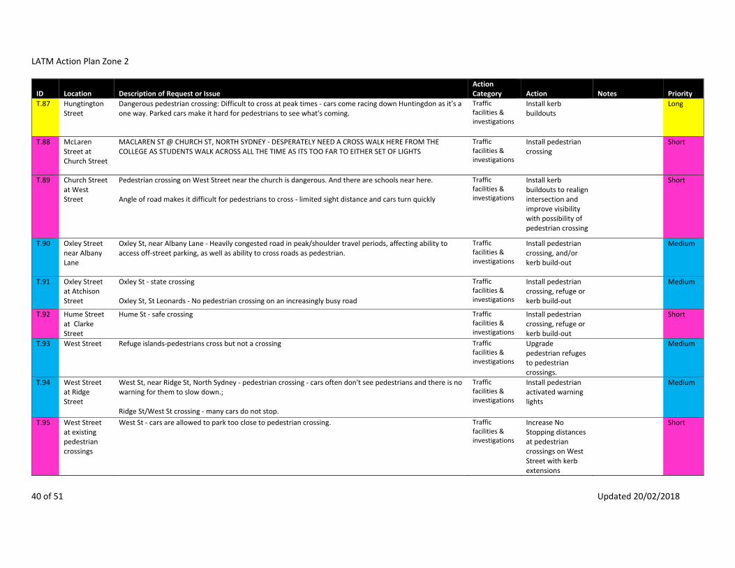
LATM Action Plan Zone 2
40 of 51 Updated 20/02/2018
ID Location Description of Request or Issue Action Category Action Notes Priority
T.87 Hungtington Street
Dangerous pedestrian crossing: Difficult to cross at peak times ‐ cars come racing down Huntingdon as it's a one way. Parked cars make it hard for pedestrians to see what's coming.
Traffic facilities & investigations
Install kerb buildouts
Long
T.88 McLaren Street at Church Street
MACLAREN ST @ CHURCH ST, NORTH SYDNEY ‐ DESPERATELY NEED A CROSS WALK HERE FROM THE COLLEGE AS STUDENTS WALK ACROSS ALL THE TIME AS ITS TOO FAR TO EITHER SET OF LIGHTS
Traffic facilities & investigations
Install pedestrian crossing
Short
T.89 Church Street at West Street
Pedestrian crossing on West Street near the church is dangerous. And there are schools near here. Angle of road makes it difficult for pedestrians to cross ‐ limited sight distance and cars turn quickly
Traffic facilities & investigations
Install kerb buildouts to realign intersection and improve visibility with possibility of pedestrian crossing
Short
T.90 Oxley Street near Albany Lane
Oxley St, near Albany Lane ‐ Heavily congested road in peak/shoulder travel periods, affecting ability to access off‐street parking, as well as ability to cross roads as pedestrian.
Traffic facilities & investigations
Install pedestrian crossing, and/or kerb build‐out
Medium
T.91 Oxley Street at Atchison Street
Oxley St ‐ state crossing Oxley St, St Leonards ‐ No pedestrian crossing on an increasingly busy road
Traffic facilities & investigations
Install pedestrian crossing, refuge or kerb build‐out
Medium
T.92 Hume Street at Clarke Street
Hume St ‐ safe crossing Traffic facilities & investigations
Install pedestrian crossing, refuge or kerb build‐out
Short
T.93 West Street Refuge islands‐pedestrians cross but not a crossing Traffic facilities & investigations
Upgrade pedestrian refuges to pedestrian crossings.
Medium
T.94 West Street at Ridge Street
West St, near Ridge St, North Sydney ‐ pedestrian crossing ‐ cars often don't see pedestrians and there is no warning for them to slow down.; Ridge St/West St crossing ‐ many cars do not stop.
Traffic facilities & investigations
Install pedestrian activated warning lights
Medium
T.95 West Street at existing pedestrian crossings
West St ‐ cars are allowed to park too close to pedestrian crossing. Traffic facilities & investigations
Increase No Stopping distances at pedestrian crossings on West Street with kerb extensions
Short

LATM Action Plan Zone 2
41 of 51 Updated 20/02/2018
ID Location Description of Request or Issue Action Category Action Notes Priority
T.96 Willoughby Road
Barriers near pedestrian crossing in Crows Nest, hard to see pedestrians approaching the Crossings in general.
Traffic facilities & investigations
Replace existing high planter boxes on Willoughby Road with lower planter beds on approach to pedestrian crossings.
Medium
T.97 Atchison Street
Atchison St, St Leonards ‐ Crossings, Bike paths, bus stop locations, parking and traffic all apply due to high rise buildings. Please , have Council Rangers inspect the footpath in and around Atchison St and Atchison Lane. Our area can not cope with the influx of people, cars and bikes.
Traffic facilities & investigations
Install pedestrian crossing, refuge or kerb build‐out
Medium
T.101 Thomas Lane • Motorists using Thomas Lane (at the rear of our property) as a rat run: could speed humps be installed and/or the lane become one way?
Traffic facilities & investigations
Convert Thomas Lane to one‐way
Long

LATM Action Plan Zone 2
42 of 51 Updated 20/02/2018
ID Location Description of Request or Issue Action Category Action Notes Priority
T.103 St Leonards and Crows Nest area bounded by Alexander Street, Pacific Highway, Sergeants Lane and Chandos Street
More 40km speed limits/too much traffic, too fast, lots of pedestrians 2) reduce the speed limit across the municipality. pacific highway 40km/hr – why not?! i know council has discussed this for north sydney cbd and i, for one, compliment you on the initiative. as in my point above about willoughby road, it may make driving slower and (more) inefficient, or perhaps it’s just a perception, but then perhaps motorists will consider using public transport, cycling or walking. i don’t think we should be encouraging more traffic in north sydney municipality and slower traffic is better for people Albany St from Willoughby Rd to Pacific Hwy ‐ morning and evening rush hours can not drive as too crowded. Albany St ‐ Congestion Miller St, North Sydney ‐ traffic is often very congested in this area (during the week). It can take a long time to go a very short distance from Cammeray through to Lavender Bay/McMahons Point). Oxley ‐ Morning traffic is so congested all the way to the roundabout so much clocking. Congestion 7:30‐9:30 AM Congestion travelling north on Alexander St, Crows Nest ‐ between Pacific Hwy and Devonshire St. Morning peak hour Congestion has becoming more of an issue with cut through traffic travelling east to west along Holtermann St. Traffic also travelling east to west on Ernest St and blocking the intersection turning north onto Alexander St. Chandos St, St Leonards ‐ Peak hour traffic backed up from Christie St, All the way along Chandos almost to Willoughby Rd. Very poor traffic signalling. 7. As more and more residential buildings are constructed along Chandos St, can you limit the access to heavy vehicles as they are noisy and pollutes the environment for the residents? 1. Chandos St, Crows Nest/St Leonards ‐ cars, trucks usually drives very fast on Chandos St after exiting Warringah Expressway. Chandos St should have traffic lights all the way to the train station, for pedestrians crossing the streets safely. traffic volume and speed on Albany Street may have increased. The Precinct requests that Traffic investigates possible options for reducing vehicle speed.
Traffic facilities & investigations
Create 40kmh local area speed zone including traffic calming devices
Slower speed environments encourage walking and cycling, reducing vehicle usage and traffic calming schemes may encourage through traffic to use higher order roads.
Short

LATM Action Plan Zone 2
43 of 51 Updated 20/02/2018
ID Location Description of Request or Issue Action Category Action Notes Priority
T.104 Hayberry Precinct ‐ area bounded by Alexander Street, Falcon Street, Miller Street, Ridge Street, West Street and Pacific Highway
Reduce speed limit to 40km/h Ridge St ‐ Traffic jams Ridge St, east of Milner St ‐ Traffic Congestion between 7.30‐9am and 3‐5pm Monday to Friday Congestion, heavy traffic Falcon and West street intersection‐traffic rat runs all down the street Accidents: West has too much traffic. Cyclists a danger. West Street between Falcon and Ernest Streets ‐There are too many right turns off West Street (going south) that disrupt the flow of traffic at morning peak times ‐ in essence this section becomes a parking lot. In future the traffic problem will increase due to: 7) The 4 story 58 unit dwelling with 63 car spaces at 139 West Street beside the TAFE with added traffic coming onto West Street 8)The proposed 3 story mixed use dwelling (12 unit and 2 commercial ) being constructed in Falcon Lane and the added cars and delivery vans from that very narrow street. This will add congestion at the junction of West and Burlington Lane as traffic meets with traffic coming and going into the dry cleaners and traffic into West Street. 9) New schools being constructed in the area (Fromer Anzac Club AND TAFE) ‐ with the added traffic problems of more cars and school buses and bus zones in West Street morning and afternoon 10) The proposed two lane cycleway on the eastern side of West Street as well as cars being allowed to park on either side of the road ‐ the road is not wide enough for two lanes of traffic, parking on both sides of the road and a dedicated dual carriage way cycle way. The major problems for residents will be getting into and out of their driveways and on street parking and noise. West Street is a tertiary road which has experienced significant increases in traffic and congestion in the last 10 years and will have significant increases in traffic due to the new developments and schools. West Street and the rest of Holtermann Precinct should be a 40km zone.
Traffic facilities & investigations
Create 40km/h speed zone including traffic calming devices
Medium
T.106 Hume Street north of Clarke Street
Close Hume Street, demolish houses and create pedestrians Crossings to Willoughby Traffic facilities & investigations
Close Hume Street to traffic, north of Clarke Street
Medium
T.107 West Street Close St make zone and shops rat running Traffic facilities & investigations
Close West Street to Traffic
West Street is a collector road and closure of the street would divert a significant level of traffic to surrounding local
Not to proceed

LATM Action Plan Zone 2
44 of 51 Updated 20/02/2018
ID Location Description of Request or Issue Action Category Action Notes Priority
roads which would exacerbate noise and amenity issues in those streets.
T.108 Oxley Street OXLEY ST, ALBANY LANE, ATCHISON ST, ST LEONARDS ‐ OXLEY ST PARKING IS TOO THIGHT FOR A NARROW ROAD. SUGGEST WIDENING STREET TO ALLOW SAFE AND UNOBSTRUCTED PASSING OF TRAFFIC IN BOTH DIRECTIONS. My concern relates to Oxley Street between Albany and Chandos Streets. This a narrow two‐way street with parking on both sides. It is difficult to see traffic when driving out of Albany Lane into Oxley Street because of vehicles parked on the west side of Oxley Street. Removing or deducing the parking on this side would eliminate vision restriction and improve traffic flow. It's very difficult for two car to pass. Also, vehicles entering Oxley Street from Albany at the roundabout are often driving very fast and it can be dangerous. A speed hump might help slow the traffic. A line in the middle of the ends of lanes would direct traffic to the left lane thus avoiding the situation frequently experienced in Albany Lane, where most people leaving the lane drive down the middle. This effectively prevents anyone attempting to turn left into the lane from Oxley Street from entering. An example where this works well is on Kelrose Lane from McLaren Street, next to North Sydney Council Chambers. CRN OXLEY AND ATCHISON ST ‐ STREET VERY NARROW AND BECAUSE OF PARKED cars DIFFICULT TO SEE PROPERLY WHEN TURNING RIGHT FROM ATICHSON TO OXLEY ‐ CAN TRAVEL QUITE FAST AND OFTEN ONE CAR HAS TO PULL OVER TO LET THOUGH Oxley St, St Leonards ‐ One laned roads with parking allowed on both sides of the street. OXLEY ST BETWEEN ALBANY AND ATCHISON ‐ PARKED cars IMPEDE TRAFFIC FLOW, NARROW FOOTPATHS OXLEY ST, CROWS NEST ‐ IMPOSSIBLE IN A CAR, SHOULD HAVE ONE SIDE ONLY FOR PARKING, NOT BOTH
Traffic facilities & investigations
Remove parking to improve traffic flow
Not to proceed
T.109 Sergeants Lane
Sergaents Lane, St Leonards ‐ shared pedestrian/car laneway feels not integrated and unsafe. Exit from St Leonards forum to Atchison St ‐ no footpath. Large volume of pedestrians but most space allocated to cars. Traffic light phases favour traffic over majority of passengers; Sergeants Lane ‐ parking, bike path
Traffic facilities & investigations
Install Shared Zone treatment and signs
Long
T.110 Holtermann Street at Alexander Lane
Holtermann St ‐ Exiting from Alexander Lane in becoming visually dangerous due to large plants growing on corner and large truck parking outside blocking visual access.
Traffic facilities & investigations
Trim/ prune vegetation at intersection
Removal of parking would encourage higher turning speeds.
Short

LATM Action Plan Zone 2
45 of 51 Updated 20/02/2018
ID Location Description of Request or Issue Action Category Action Notes Priority
Intersection already has landscaped kerb buildouts and visibility can be improved with trimming
T.110b
Holtermann Street at Alexander Lane
Holtermann St ‐ Exiting from Alexander Lane in becoming visually dangerous due to large plants growing on corner and large truck parking outside blocking visual access.
Traffic facilities & investigations
Remove parking to improve visibility
Not to proceed
T.111 The Greens Driveway
The Greens ‐ driveway access walk across; pump room built on shed can't see past; need more clearance and stop sign.
Traffic facilities & investigations
Install "Give Way to Pedestrians" sign
Short
T.111b
The Greens Driveway
The Greens ‐ driveway access walk across; pump room built on shed can't see past; need more clearance and stop sign.
Traffic facilities & investigations
Provide a separated footpath
Traffic speeds are very low. Segregation of pedestrians may mean motorists are less likely to be aware of pedestrians who may be walking along the driveway.
Not to proceed
T.112 Pacific Highway at Cammeraygal High School
Pacific Hwy/Cammeraygal School ‐ Needs median with fence to prevent illegal Crossings Traffic facilities & investigations
Plant low but dense vegetation along kerbs
Pedestrian fencing creates pinch points for cyclists and encourages higher traffic speeds. Jaywalking can be discouraged with landscaping to creater a softer barrier whilst enhancing the street level amenity.
Medium

LATM Action Plan Zone 2
46 of 51 Updated 20/02/2018
ID Location Description of Request or Issue Action Category Action Notes Priority
T.112b
Pacific Highway at Cammeraygal High School
Pacific Hwy/Cammeraygal School ‐ Needs median with fence to prevent illegal Crossings Traffic facilities & investigations
Install pedestrian fencing
Not to proceed
T.113 Ridge Street east of Miller Street
Ridge Street footpaths inconsistent pathways. Traffic facilities & investigations
Install footpath on northern side of Ridge Street
Medium
T.114 Sophia Street at Holtermann Street
Sofia St exit onto Holterman St ‐ pedestrian Safety has been abrogated in favour of driver convenience by removing the pre‐intersection stop marking and moving it further northwards, such that cars no longer stop before the line of the footpath ‐ indeed most cars now don't bother stopping at all
Traffic facilities & investigations
Install continuous footpath treatment
Medium
T.116 Rosalind Street between West Street and Miller Street
Trucks and vehicles use Roslalind Street to cut through between West Street and Miller Street. Some vehicles turn into Rosalind Street at high speed
Traffic facilities & investigations
Install traffic calming scheme
Medium
T.117 Myrtle Street, at the Pacific Highway, near North Sydney Girls
School safety review ‐ install pedestrian crossing on Myrtle Street near the Pacific Highway Traffic facilities & investigations
Pedestrian crossing, refuge or kerb build‐outs
Medium
T.118 Hospital Lane & Willoughby Lane
Reduce vehicle speeds in Hospital Lane near entrance to the Community Centre Traffic facilities & investigations
Implement Shared Zone treatment
Long
T.120 Clarke Street near Hume Street
No formal pedestrian facilities near this intersection Traffic facilities & investigations
Install pedestrian crossing and/or kerb buildouts
Short
T.122 Church Lane Vehicles travel the wrong way up Church Lane Traffic facilities & investigations
Paint directional arrows on pavement
Medium
T.124 David Street at Hayberry
People cut the corner at this intersection Traffic facilities & investigations
Install concrete median at intersection
Long
T.126 Walker Street near McLaren Street
Speeding Traffic facilities & investigations
Install traffic calming scheme
Medium
T.127 Walker Street pedestrian
School safety review - convert flush crossing to a raised crossing Traffic facilities & investigations
Covert flush crossing to a raised pedestrian crossing
Medium

LATM Action Plan Zone 2
47 of 51 Updated 20/02/2018
ID Location Description of Request or Issue Action Category Action Notes Priority
crossing at Wenona
T.128 Rosalind Street west of Miller Street
Request to improve pedestrian facilities Traffic facilities & investigations
Upgrade pedestrian refuge including kerb buildouts
Short
T.129 Rosalind Street east of Miller Street
Request to improve pedestrian facilities Traffic facilities & investigations
Upgrade pedestrian regufe including kerb buildouts
Short
T.130 Angelo Street at McLaren Street
CBD Traffic and Pedestrian Study recommendation Traffic facilities & investigations
Pedestrian crossing or continuous footpath treatment
Short
T.131 Angelo Street at Berry Street
CBD Traffic and Pedestrian Study recommendation Traffic facilities & investigations
Pedestrian crossing or continuous footpath treatment
Short
T.132 Crows Nest residential area bounded by Alexander Street, Falcon Street, West Street and Chandos Street
Local traffic area Congestion travelling north on Alexander St, Crows Nest ‐ between Pacific Hwy and Devonshire St. Morning peak hour Congestion has becoming more of an issue with cut through traffic travelling east to west along Holtermann St. Traffic also travelling east to west on Ernest St and blocking the intersection turning north onto Alexander St. Brook Street ‐ Rat Run West Street and the rest of Holtermann Precinct should be a 40km zone.
Traffic facilities & investigations
Create 40km/h local area speed zone including traffic calming devices
Medium

LATM Action Plan Zone 2
48 of 51 Updated 20/02/2018
ID Location Description of Request or Issue Action Category Action Notes Priority
T.133 Rosalind Street at Miller Street
7. Rosalind Street East ‐ Light traffic only to stop buses and heavy vehicles travelling up and down the hill to ensure that there is a safer environment, especially around the kiss and drop school zone.
Traffic Counts Install No Trucks sign
Heavy vehicles comprise 5% of total vehicles which is typical for a local street. However southbound heavy vehicles comprise 9% of total vehicles which suggests some may be through traffic. A No Trucks sign restricts use of the street by heavy vehicles to only those which have a genuine destination in the street, however does require ongoing enforcement.
Short
T.134 Miller Street at McLaren Street
2) Right turn lights should be installed at the junctions of McLaren Street and Ridge Street northbound into Miller Street. At peak times the volume of traffic means waiting times can be up to half an hour, and there is a danger of impatience leading to accidents. New residential developments (such as that proposed for the SAP building) will only exacerbate the situation if this is not provided.
Traffic facilities & investigations
Redesign intersection to improve operation
There is a No Right Turn on McLaren Street northbound into Miller Street. Reinstating right turn will increase number of vehicles using McLaren Street.
Not to proceed

LATM Action Plan Zone 2
49 of 51 Updated 20/02/2018
ID Location Description of Request or Issue Action Category Action Notes Priority
T.135 McLaren Street ‐ private laneway between Hno. 39 & 41
Once these developments are completed some sort of signaling should be in place on that private lane so that traflic exiting is required to give way to pedestrians.
Traffic facilities & investigations
Install continuous footpath treatment across driveway/laneway between Hno. 39 & 41 McLaren Street
The laneway will operate similar to a driveway where pedestrians have legal priority over vehicles when crossing the driveway. A continuous footpath treatment can be incorporated into the post‐development plans to reinforce this.
Medium

LATM Action Plan Zone 2
50 of 51 Updated 20/02/2018
ID Location Description of Request or Issue Action Category Action Notes Priority
T.136 Holtermann Street
Holtermann st has become the biggest rat run in the area. The traffic from West street is atrocious. Morning and evening peaks are ridicolous. Cars blatantly use the street too bypass Ernest st lights. Sophia st compounds the issue. The stop sign at Holtermann and Sophia is ignored. People are going to get killed. The new Woolworths and associated traffic changes have made it worse. The new Coles development will create chaos. The street needs to be blocked off to they traffic. The parking issues are woefully out of date....everyone’s parks in the street abusing the outdated parking limits. Parking should be limited to 30mins at the Alexander st end with a cut off at 10:30 at night for non residents. Local businesses know its a rort, and park in Holtermann street all day checking their tires every hour!!!!!! The noise levels have grown beyond acceptable. Close the st off to thru traffic...., NO EXIT TO ALEXANDER ST...NO EXIT TO WEST ST.....SOLVES THE ISSUE The traffic in the street now is unbelievable....starts at 5:00 and non stop till midnight. Peak hour has 30‐40 cars waiting to use Alexander street exit ...it’s disgraceful. No one obeys the stop sign at the corner of Sophia and Holtermann st. The street surface is atrocious. Parking hasn’t been updated for years. Every man and his dog abuses the out of date parking provisions. The new Woolworth’s has aggravated the situation and the new Coles and all the new apartment blocks going up in the area will create mayhem. I’m surprised no 9ne has been killed by the traffic yet. And TAFE is putting 60 car spaces back on the street...60. !!!!!!! If this isn’t sorted out there will b3 traffic chaos here everyday...shut down the street.....NOW.... I am concerned that Holtermann St has become a major rat run for traffic passing through Crows Nest and it will get much worse with general traffic increases as well as development with the new Coles, Metro, etc. Traffic to/from Cammeray via West St is using Holtermann St as a short cut to Albany St and westbound traffic on Ernest St is taking a short cut down Sophia St to get to Albany St via Holtermann St. The same traffic then gets priority at the Holtermann St / Alexander St round‐a bout, so it actually inhibits the westbound traffic flow in Ernest St It is time North Sydney Council takes similar action to that undertaken by Willoughby Council many years ago when it blocked rat runs through Chatswood and forced traffic onto Archer St, etc. This can be done by closing off Huntington St, Holtermann St and Ernest Lane at West St and Sophia St and Alexander Lane at Ernest St. Or instead just close Holtermann St at Alexander Lane (west side). If blocking streets cannot be done in the short term, then some gain can be made by implementing no‐right turn from West St to Holtermann St and no right turn from Ernest to Sophia St. Holtermann Street Rat Run The amount of traffic and the speed of the traffic is becoming a major issue in Holtermann Street. It is only a matter of time before someone will be hit by a car. Some mornings the traffic is backed up for almost three quarters of the length of the street from the roundabout . The No Right Turn from West Street needs to be put back . With the new Coles and TAFE development the parking issue is only going to get worse. This submission concerns the roundabout installed at the intersection of Holtermann Street and Alexander Street and the resulting traffic chaos it has caused. By way of background, this roundabout was vigorously objected to prior to its installation by local residents.
Traffic facilities & investigations
Reinstate No Right Turn during peak periods from West Street into Holtermann Street
The No Right Turn was trialled in 2013 and was unsuccessful. Motorists either ignored the restrictions or diverted to adjacent streets and laneways. This simply transferred the problem from one location to another, but does not reduce the amount fo traffic travelling into Crows Nest. See P.3 for alternative proposal.
Not to proceed

LATM Action Plan Zone 2
51 of 51 Updated 20/02/2018
ID Location Description of Request or Issue Action Category Action Notes Priority
In fact at a community meeting, the then mayor, Genia McAffrey stood up in front of a packed room and stated that the roundabout would not be installed. Manipulation by the Crows Nest Main Street committee and council surprisingly reversed this position. The council arranged traffic counts to be done over subsequent years and traffic volumes in Holtermann Street have increased well over 100% with the AADT of 2000 vehicles being exceeded most days. Holtermann Street is designated a local traffic zone. The installation has also caused chaos for through traffic in Crows Nest as the substantial increase in west bound traffic volumes on Holtermann Street effectively block this intersection causing significant log jams of traffic heading northbound on Alexander Street causing grid lock right back to the highway. Added to this a small laneway, Sophia Street, has become a major rat run for motorists avoiding the Ernest Street and Alexander Street intersection. A No Right Turn from West Street into Holtermann Street during AM peak was trailed for a short period and this proved very effective in reducing traffic volumes. Unfortunately this trail did not result in a permanent solution. In closing I would like to add that I was very surprised when the redevelopment of the section of Ernest Street west of Alexander Street kept the roadway. This roadway is not necessary and a very attractive plaza with outdoor dining would have resulted. It would also reduce traffic delays at this intersection (a major problem) and encourage more motorists to continue to this intersection rather than use the rat runs of Holtermann Street and Sophia Lane. Since the roundabout was installed at Holtermann and Alexander Streets, Holtermann has become a highway in morning and afternoon peak hour. The trial of a no right turn from West Street simply diverted traffic to Ernest Lane. Trying to cross Holtermann St at West St as a pedestrian at these times is near impossible and is very dangerous for school children as cars cut the corner wanting to avoid queuing for two sets of traffic lights. A solution needs to be found to bring Holtermann St back to a quiet residential street and Ernest Lane for garage access only ‐ not through traffic! Holtermann St has become extremely overcrowded with traffic in the mornings ‐ the cars are blocked right up the street and are often at a standstill. It has become significantly worse since Woolworths has opened and the new Coles will further exacerbate this problem. In addition the TAFE on West street is being converted to a school and the area is losing 60 car spaces. Cars sneak up Sophia street and traffic from Cammeray cuts through from West street ‐ it is getting dangerous. The council needs to change the flow of traffic on Holtermann St, Crows Nests in the mornings specifically between 6.30am and 9.30am by not allowing traffic to turn into the street from West St or Sophia Street during these hours. This will increase public safety and will stop overuse of a suburban street. Thank you for your assistance in this matter.

SMEC | North Sydney Council LATM Zone 2 Action Plans Final Report | Page 46
APPENDIX B – ITEMS REFERRED TO TRANSPORT FOR NSW

LATM Zone 2 Items referred to TfNSW
Consultation
Method
Sub.
No.
Comment/Response Road 1 Road 2 Road 3 Road 4 Mode Issue Issue 2 (if applicable) Issue 3 (if applicable) Issue 4 (if
applicable)
Action Comments
Online Submission 118 Re Buses from Miller Street going over the bridge (and return)
I live crn of Miller and Falcon Streets and have an issue with walking. The new bus
arrangements means the ONLY option I have going over the bridge is to BRIDGE Street. From
there I must walk to other buses or trains. Or I must take a BUS and a TRAIN (getting off the
bus at Nth Syd, walking to the station, navigate the station, then take a train).
For someone who lives 1 set of traffic lights from the Bridge ‐ getting to Wynard, Central, Surry
Hills, Darling Harbour or Kings Cross requires 2‐3 journey's on different transport.
If I depart from North Sydney or Neutral Bay the options open up. Only I must either walk to
either of those stops or catch a bus to them. The annoyance is that I live at the entrance to
the bridge ‐ but to get anywhere over the bridge involves 2 types of transport. Not to mention
that out of peak hours the wait between buses at Miller/Falcon is 30 minutes.
So where I live (right next to the entrance to the bridge) my ONLY option to get into the city is a
bus to Bridge street (which really is the middle of nowhere). Or to take 2 buses; or a bus and a
train.
Yes, totally a 1st world problem but I'm not feeling the transport love where I live. (That said...
travelling along Falcon/Military Road via bus is a breeze, lots of options)
Miller Street Falcon Street City Buses Public Transport ‐ ConnectioPublic Transport ‐ Routes TfNSW TfNSW
Workshop 1 Access to bus stops on Falcon Street. New stops between Neutral Bay and Crows Nest would
assist.
Falcon Street Neutral Bay
to Crows
Nest
Buses Public Transport ‐ Stop/
Station / Wharf locations
TfNSW TfNSW
Workshop 1 Bus route could be redirected down Alexandra Street, then along Albany Street, up to Pacific
Highway. This to alleviate traffic problems down Willoughby Road which is a highly
pedestrianised area.
Willoughby
Road
Alexander
Street
Albany Street Buses Public transport ‐ routes TfNSW TfNSW
Workshop 1 Put the names of bus shelters on Trip Planner NSW General Buses Public Transport ‐
Accessibility
TfNSW TfNSW
Workshop 1 Not easy to get to major bus/train stations going from say Crows Nest to City. Crows Nest
to City
Public
Transport
Public Transport ‐ Routes Public Transport ‐ Connections TfNSW TfNSW
Workshop 1 ∙ Hard getting to ferries General Ferries Public Transport ‐
Connections
TfNSW TfNSW
Workshop 1 ∙ Hard to travel early morning in Crows Nest Crows Nest Train Public Transport ‐
Connections
TfNSW TfNSW
Workshop 1 ∙ Bus 257 does not do the same route on way back, is problematic Route 257 Buses Public Transport ‐ Routes TfNSW TfNSW
Workshop 1 Buses along Military Road take so long Military
Road
Buses Public Transport ‐ Timetables TfNSW TfNSW
Workshop 1 Having to catch two buses to get anywhere in North Sydney North
Sydney
Buses Public Transport ‐
Connections
TfNSW TfNSW
Workshop 1 Buses are good but so much traffic they cannot run on time! General Buses Public Transport ‐ Timetables TfNSW TfNSW
Workshop 1 Trains are good! Northern line good. Northern
line
Train Positive feedback TfNSW TfNSW
Workshop 1 (Bus) Bus 343 ‐ Chatswood is late (morning peak) Route 343 Buses Public Transport ‐ Timetables TfNSW TfNSW
Workshop 1 (Bus) Bus 257 does not go from the highway in St. Leonards in the morning (Chatswood corner
Albany) and is not frequent enough twice per hour.
Route 257 Buses Public Transport ‐ Timetables Public Transport ‐ Routes TfNSW TfNSW
Workshop 1 Ferries infrequent Ferries Public Transport ‐ Timetables TfNSW TfNSW
Workshop 1 No bus meeting ferries Ferries Public Transport ‐
Connections
TfNSW TfNSW
Workshop 1 Later normal buses and more frequent Buses Public Transport ‐ Timetables TfNSW TfNSW
Workshop 1 Finding the Ferry for new Residents! Ferries Public Transport ‐
Accessibility
TfNSW TfNSW
Workshop 1 Unmarked bus stops. General Buses Public Transport ‐
Infrastructure
TfNSW TfNSW
Workshop 1 Young people need better connections on public transport so they don't need to drive. Public
Transport
Public Transport ‐
Connections
TfNSW TfNSW
Workshop 3 Better public transport outside of Military Rd. esp. on Sunday = discourages us from taking
public transport when it is infrequent.
Military
Road
Public
Transport
Public Transport ‐ Timetables Public Transport ‐ Routes TfNSW TfNSW
Workshop 4 Can't get directly to the University Victoria
Cross Station
ACU
University
Train Public Transport ‐
Connections
TfNSW TfNSW
Workshop 4 Not enough signage at bus stops or enough info. North
Sydney
Buses Public Transport ‐
Accessibility
Public transport ‐ infrastructure TfNSW TfNSW
Workshop 4 Would be good to have a weekend loop bus from North Sydney – Crows Nest – to enjoy cafes/
shops etc.
North
Sydney to
Crows Nest
Buses Public Transport ‐ Routes TfNSW TfNSW
Workshop 4 More buses from North Sydney to Crows Nest. North
Sydney to
Crows Nest
Buses Public Transport ‐ Routes public transport ‐ timetables TfNSW TfNSW
Page 1 of 8

LATM Zone 2 Items referred to TfNSW
Consultation
Method
Sub.
No.
Comment/Response Road 1 Road 2 Road 3 Road 4 Mode Issue Issue 2 (if applicable) Issue 3 (if applicable) Issue 4 (if
applicable)
Action Comments
Workshop Additi
onal
Reside
nt
Works
hop
Congestion traffic Crows Nest
Metro
Congestion TfNSW TfNSW
Workshop Additi
onal
Reside
nt
Works
hop
Access to public transport is negatively affected by general crowding on Pacific Highway buses. Pacific
Highway
Buses Public transport ‐ passenger
congestion
TfNSW TfNSW
Hardcopy
Submission
13 Naturally the availability of public transport is used as an excuse ‐ but while useful for many, it
lacks comprehensive coordination. lf public transport is to be highlighted, where are the "Park
and Ride" parking spaces close to ferry docks, bus stops, and train stations?
General Public
Transport
Public Transport ‐
Connections
TfNSW TfNSW
Email Submission 65 1. To decongest The Spit, Military Road (Mosman, Cremorne, Neutral Bay), Falcon Street, North
Sydney, why not extend the Metro Line Rail from Chatswood to Dee Why / Brookvale, via
Boundary Road, Roseville and Belrose? It would alleviate in the long term, the heavy traffic in
rush hours, school pick‐ups and drop‐offs.
Metro Rail
Line
Train Public Transport ‐ Routes TfNSW TfNSW
Survey 18 Bus delays ‐ to catch a train from St Leonards Station to my work in Macquarie Park, I catch the
144 bus (falcon st near Miller St). This bus is very often late and does not align with the trains
from St Leonards Station. It is often 40 minutes from leaving my house until I depart on a train
from St Leonards Station and is hence quicker for me to walk > greater than 2km than use the
bus.
Route 144 Buses Public Transport ‐ Timetables TfNSW TfNSW
Survey 59 North Syd Station ‐ No buses to Miller/Ernest St later at night
Ernest/Miller St ‐ No buses from the CBD later at night to this area of Crows nest
North
Sydney
Station
Miller Street Ernest Street Buses Public Transport ‐ Timetables TfNSW TfNSW
Survey 61 Ernest St, Crows Nest ‐ Late buses Ernest Street Buses Public Transport ‐ Timetables TfNSW TfNSW
Survey 63 Miller St, Cammeray ‐ empty school buses but 209 bus full of school kids Miller Street Buses Public Transport ‐ Routes TfNSW TfNSW
Survey 64 Not enough bus options to suburbs other than city ‐ Buses: mostly only go to city only (or
Chatswood)
General Buses Public Transport ‐ Routes TfNSW TfNSW
Survey 71 Neutral Bay/North Sydney ‐ Bike paths; crowded buses; and public transport too expensive. Neutral Bay North Sydney Public
Transport
Public transport ‐ passenger
congestion
Public transport ‐ cost TfNSW TfNSW
Survey 82 Willoughby Road ‐ Buses not on time Willoughby
Road
Buses Public Transport ‐ Timetables TfNSW TfNSW
Survey 164 I have relocated to Australia from Austria and was flabbergasted by the public transport in
Sydney. Don't get me wrong it is a fantastic city and the public transport is okay, but I think it
could be much more efficient. I think there is too much emphasis on the roads.
Getting to Ultimo or back by bus takes about 1h which is a lot of time for a short distance.
Motorists block the bus lanes and there are not enough buses. There is a very long line of
passengers in the morning trying to get to the city and the buses don't stop anymore because
they are full.
I could take the light rail to central but to get to the next rail station is also complicated, also it
would mean paying twice. I would love to get there by bike and then take the train but this is
outright dangerous, especially in the morning traffic. Motorists are inconsiderate and
sometimes even abusive towards bicycles, especially on larger roads. So going by bike all they
way to Ultimo over the Harbor Bridge is also not an option.
Moreover if I go to go to Balmoral Beach, there are enough buses going down there during the
day, but they stop after 7 for some reason. I have to hike up the hill to Spit Rd. to catch a bus
there.
The service to Crows Nest is also not really available, we stopped using the bus to go there
since walking is the faster option.
In North Sydney I would like to be more flexible on public transport. I would like to have a short
loop service that takes passengers in the peak hours from the Military Rd to Milson Pt. / North
Sydney to Cremorne Pt. Station / .... so they can go either on the Rail or Ferry and during the
evening hours back again. Also I would like to be able to go to Milson Pt/North Sydney. and the
Harbor Bridge on a segregated bike lane.
General Public
Transport
Public Transport ‐
Connections
TfNSW TfNSW
Survey 239 Miller St, Cammeray crossing Ernest ‐ Buses are too full an does not stop at bus stop. School
kids need move buses ‐ they fill up the "normal buses" around 7.30‐7.40 every morning.
Normally a bus will not stop in 20 min.
Miller Street Ernest Street Buses Public transport ‐ passenger
congestion
TfNSW TfNSW
Survey 240 ‐ Miller St ‐ Not able to catch bus because it is full of school children while there is an empty
school bus following
Miller Street Buses Public transport ‐ passenger
congestion
Public Transport ‐ Routes TfNSW TfNSW
Survey 264 North Sydney ‐ findings a bus to the ferry, no idea how to get to the ferry options!!
Alexander St, Crows Nest ‐ parking
North Sydney/Crows Nest ‐ lack of Timetables on certain bus stops, lack of ID numbers on bus
stops; road works.
North
Sydney
Crows Nest Public
Transport
Public Transport ‐
Accessibility
Public Transport ‐ Connections Public transport ‐
timetables
TfNSW TfNSW
Page 2 of 8

LATM Zone 2 Items referred to TfNSW
Consultation
Method
Sub.
No.
Comment/Response Road 1 Road 2 Road 3 Road 4 Mode Issue Issue 2 (if applicable) Issue 3 (if applicable) Issue 4 (if
applicable)
Action Comments
Survey 265 West St, North Sydney ‐ bike lane disappears south of Ernst St on and off.
North Sydney CBD ‐ lack of bike lanes, difficult to peddle north when combined with hill.
Miller St, Cammeray ‐ bus stop (south bound) no that close to intersection when crossing from
West St.
Huntington St, Crows Nest ‐ difficult to get a park often if return after 9pm at night.
Miller Street,
Cammeray
West Street Buses Public Transport ‐ Stop/
Station / Wharf locations
TfNSW TfNSW
Survey 280 Variable trains available to link into further City transport.
St Leonards Station closed when returning late and exit gates shut.
Burlington/Ernest/West St shopping and restaurant area ‐ lack of parking; no free 15 min
parking in Crows Nest
General Train Public Transport ‐ Timetables TfNSW TfNSW
Survey 281 Walker St ‐ parking; traffic
North Sydney station ‐ too crowded
North
Sydney
Station
Train Public transport ‐ passenger
congestion
TfNSW TfNSW
Survey 285 Pacific Hwy ‐ bus stop location Pacific
Highway
Buses Public Transport ‐ Stop/
Station / Wharf locations
TfNSW TfNSW
Survey 287 Bus ‐ buses never on time
Car ‐ not enough free parking in Crows Nest/St Leonards
New train line ‐ impact of Crows Nest community
General Buses Public Transport ‐ Timetables TfNSW TfNSW
Survey 287 Bus ‐ buses never on time
Car ‐ not enough free parking in Crows Nest/St Leonards
New train line ‐ impact of Crows Nest community
Crows Nest
Metro
Public
Transport
Other TfNSW TfNSW
Survey 289 Pacific Hwy, North Sydney ‐ non existent Bike paths, very dangerous
Crows Nest area ‐ cut bus services make it difficult to get to the City/CBD
Crows Nest Buses Public Transport ‐ Timetables TfNSW TfNSW
Survey 291 Miller St ‐ bus location
Pacific Hwy through to North Sydney ‐ traffic Congestion
Miller Street Buses Public Transport ‐ Stop/
Station / Wharf locations
TfNSW TfNSW
Survey 292 Pacific Hwy ‐ bus stop 257 (not he same in both directions/only goes one way to Balmoral.
St Leonards to Neutral Bay ‐ 144/143 only bus; one direction.
Pacific
Highway
Route 257
Route
144/143
Buses Public Transport ‐ Routes TfNSW TfNSW
Survey 302 Miller St, Cammeray ‐ Buses very inconsistent during peak periods ‐ late, out of Timetable
order.
Miller Street,
Cammeray
Buses Public Transport ‐ Timetables TfNSW TfNSW
Survey 303 St Leonards to Crows Nest ‐ no bus from St Leonards to Crows Nest centre. St Leonards
to Crows
Nest
Buses Public Transport ‐ Routes TfNSW TfNSW
Survey 304 Pacific Why, North Sydney ‐ infrequent buses that go to the CBD (M20 for example), we need
more of them.
North Sydney ‐ lack of Bike paths
North Sydney ‐ public transport, lack of late night public transport
Crows Nest ‐ lack of parking
Pacific
Highway
North Sydney Public
Transport
Public transport ‐ routes public transport ‐ timetables TfNSW TfNSW
Survey 309 Miller St and Pacific Hwy ‐ pedestrian Congestion on footpath; bus crowding; clamouring for
bus at bus stop.
Frequency of Bus and Train transport ‐ overcrowding and irregular services; require more
services.
Updated transport services in area ‐ the Precinct has increased population; more apartments re
updated bus Routes.
Constant footpath and roadworks on Miller Street ‐ it is never ending constant upgrades and
then re‐digging/paving.
Miller Street Pacific
Highway
General Public
Transport
Public transport ‐ passenger
congestion
public transport ‐ timetables Public transport ‐
routes
TfNSW TfNSW
Survey 446 MILLER ST, CROWS NEST ‐ WAY WAY WAY TOO MANY 209 BUSES, NEED MORE BUSES THAT GO
TO THE CITY. LESS TURNING RESTRICTIONS
Miller Street Route 209 Buses Public Transport ‐ Routes public transport ‐ timetables TfNSW TfNSW
Survey 451 PACIFIC HWY CORWS NEST ‐ OVERCROWDED BUSES Pacific
Highway
Buses Public transport ‐ passenger
congestion
TfNSW TfNSW
Survey 452 NORTH SYDNEY AND ST LEONARD STATION ‐ IT WOULD BE GOOD TO HAVE A LIGHT RAIL
CONNECTING THESE 2 STATIONS.
HOLTERMANN ST ‐ CONGESTION AND TOO MANY PARKED cars
North
Sydney
Station
St Leonards Public
Transport
Public Transport ‐
Connections
TfNSW TfNSW
Survey 461 ST LEONARDS ‐ TRAINS OVER CAPACITY, BUSES FULL OF SCHOOL KIDS St Leonards Public
Transport
Public transport ‐ passenger
congestion
TfNSW TfNSW
Survey 461 NORTH SYDNEY ‐ LONG TIME BETWEEN BUS AND TRAM SERVICES OUTSIDE PEAK TIMES.
WALKING GENERALLY OK BUT CHANDOS ST VERY BAD FOR WHEELCHAIRS.
North
Sydney
Chandos
Street
Public
Transport
Public Transport ‐ Timetables TfNSW TfNSW
Survey 502 Issue 1
Where ‐ Between Cammeray and City when cycling
What ‐ I cross 4 major roads (Ernst, Falcon, Berry and Pacific Hwy) which slow down my
journey. The West street corridor is difficult to get to from the bridge and encounters the
same issues. Something like the Harbourlink elevated bike path would be useful.
Issue 2 ‐ 263 bus
Where ‐ Cammeray to City on weekends
What ‐ the 263 is my local bus but it takes a long period of time to get to the city. It is poorly
patronised from Cammeray because of this. If it was say a Miller street bus, or one that went
to Military road and then the city, instead of travelling down through Neutral Bay and Kirribilli,
it may be better used by residents.
Route 263 Buses Public Transport ‐ Routes TfNSW TfNSW
Page 3 of 8

LATM Zone 2 Items referred to TfNSW
Consultation
Method
Sub.
No.
Comment/Response Road 1 Road 2 Road 3 Road 4 Mode Issue Issue 2 (if applicable) Issue 3 (if applicable) Issue 4 (if
applicable)
Action Comments
Survey 504 Bus ‐ Pacific Hwy ‐ over crowding on peak buses
Cycling ‐ not enough Bike paths; dangerous cycling up Pacific Hwy.
Pacific
Highway
Buses Public transport ‐ passenger
congestion
TfNSW TfNSW
Survey 534 Milsons Point to Crows Nest ‐ Cycling paths poor limited legal alternatives to Pacific Highway.
This is particularly an issue given the steep grade north bound.
Bus Transport early mornings towards North Sydney ‐ Frequently public buses are full of school
children, preventing others from catching the bus. These are Routes are also serviced by school
buses.
To North
Sydney
Buses Public transport ‐ passenger
congestion
TfNSW TfNSW
Survey 541 200 Pacific highway/St Leonards ‐ I find it strange that some buses stop right in front of the
station, whole others go further down the road to Albany St.
Pacific
Highway
Buses Public Transport ‐ Stop/
Station / Wharf locations
TfNSW TfNSW
Survey 546 Ridge St ‐ Limited amount of on street parking outside business hours for 2nd car and visitors.
Miller St‐ Infrequent Bus services outside business hours.
Miller Street Buses Public Transport ‐ Timetables TfNSW TfNSW
Survey 549 Pacific Highway, Crowsnest ‐ For how close we are to the city, buses can take far too long to get
into the city. Too much detouring through North Sydney. Need express options.
Pacific Highway, various roads laneways ‐ Often after utility companies open up the road, they
leave it in a dangerous position for cyclists eg bumps, depressions.
Kirribilli Broughton Street surroundings‐ We attend church on Sunday's & midweek. The parking
restrictions can be quite rigid disincentive community gatherings like this . It is difficult to use
public transport with kids so using a car is necessary.
Kirribilli‐ Cycling Routes to work are difficult for inexperienced . Entrance to harbour bridge for
cyclists congested and requires dismounting.
Pacific
Highway
Buses Public Transport ‐ Routes TfNSW TfNSW
Survey 553 CNR Miller and Falcon St ‐ Buses Often Full so don't stop
Crows Nest ‐ Almost 0 parking available so much that o rarely now visit.
Falcon St‐ Would be great to see an overpass to St Leonards Park.
Miller Street Falcon Street Buses Public transport ‐ passenger
congestion
TfNSW TfNSW
Survey 556 Crows Nest to City ‐ Inadequate cycle paths very dangerous sections where cars and bikes
travel together. How about enhancing the Bike paths especially around North Sydney.
Crows Nest next to City Routes (Atchison ) Stopping the 273 bus has massively reduced my
options of catching the bus from the loner end of Crows Nest near my sons childcare near
Atchison St to the city.
Crows Nest to City‐ Need more regular buses from Crows Nest down Pacific Highway into the
city. This will encourage more to get out of cars and travel in public transport.
Crows Nest
to City
Buses Public Transport ‐ Routes public transport ‐ timetables TfNSW TfNSW
Survey 562 Miller St‐ Not enough Services to the City Buses (especially weekends) Miller Street Buses Public Transport ‐ Routes public transport ‐ timetables TfNSW TfNSW
Survey 577 North Sydney Miller St to Wynyard/Central Railway ‐ have to change busses as no direct Routes
from my premises so many busses travel on the expressway and miss miller st.
Miller St to Northern Beaches‐ As above only require 1 bus appro each 1/2 hour to fix eg 180
Routes via miller st.
Miller Street City Northern
Beaches
Buses Public Transport ‐
Connections
TfNSW TfNSW
Survey 578 North Shore Line ‐ Infrequent Night ride options North shore
line
Public
Transport
Public Transport ‐ Timetables TfNSW TfNSW
Survey 585 Falcon St, North Sydney ‐ Bus Stop to Neutral Bay from Crows Nest is very suitable. However,
from Neutral Bay to long space between Watson St and Miller St especially since new lights
putting another traffic on Moddie St needed very heavy. During peak hours difficult to get out
of driveway.
Falcon St, North Sydney ‐ 3 Bus Routes available but buses come within five minutes or each
other every 15 minutes. Should space better
Falcon Street Buses Public Transport ‐ Timetables TfNSW TfNSW
Survey 589 Devonshire Street Crows Nest ‐ People who work nearby come and park their car. I often cant
get a park on my street and have a baby.
343 Bus often late
West St, Crows Nest ‐ cars open their doors on bikes when parked
Route 343 Buses Public Transport ‐ Timetables TfNSW TfNSW
Survey 592 Cammeray /Miller St
Buses are inconsistent in timings and do not stop when not full
Cammeray Avenue
4 boats & 3 Caravans parked permanently in 24 hr parking and there are not enough parking for
residents.
North Sydney
Trains are overcrowded
Miller Street,
Cammeray
Buses Public Transport ‐ Timetables TfNSW TfNSW
Page 4 of 8

LATM Zone 2 Items referred to TfNSW
Consultation
Method
Sub.
No.
Comment/Response Road 1 Road 2 Road 3 Road 4 Mode Issue Issue 2 (if applicable) Issue 3 (if applicable) Issue 4 (if
applicable)
Action Comments
Survey 592 Cammeray /Miller St
Buses are inconsistent in timings and do not stop when not full
Cammeray Avenue
4 boats & 3 Caravans parked permanently in 24 hr parking and there are not enough parking for
residents.
North Sydney
Trains are overcrowded
North
Sydney
Train Public transport ‐ passenger
congestion
TfNSW TfNSW
Survey 610 FALCON ST, CROWS NEST ‐ BUSES, GIVEN TRAFFIC, IT'S COMMON FOR THE BUS TO BE LATE ‐
AN ELECTRONIC MONITOR OF HOW MANY MINUTES UNTIL NEXT BUS AT MAJOR BUS STOPS
WOULD BE GREAT (LIKE TRAINS)
Falcon Street Buses Public Transport ‐ Timetables TfNSW TfNSW
Survey 620 PACIFIC HWY, ST LEONARDS ‐ BUSES OVERCROWDED, BUS ONLY LANE WOULD HELP
FALCON ST ‐ PARKING IN THE STREET ON WEEKENDS WOULD BE MUCH MORE CONVENIENT
FOR RESIDENTS
Pacific
Highway
Buses Public transport ‐ passenger
congestion
TfNSW TfNSW
Survey 628 PACIFIC HWY, CROWS NEST NEAR FALCON ST, CITY BOUND M20 BUS ‐ DID NOT SHOW UP AND
ON TRIP METER APP SAID IT CAME AND WENT.
Pacific
Highway
Falcon Street Buses Public Transport ‐ Timetables TfNSW TfNSW
Survey 630 CRNER MILLER AND FALCON ST ‐ BUS STOP CITY DIRECTION SOMETIMES DOES NOT STOP
(FULL), LATE AND 2 BUSES ONE AFTER ANOTHER
Miller Street Falcon Street Buses Public transport ‐ passenger
congestion
TfNSW TfNSW
Survey 632 ST LEONARDS TO NORTH RYDE TRAIN STATION ‐ TRAIN TO NORTH RYDE FROM ST LEONARDS IS
INSANE. WHY DOES THREE STOPS COST SO MUCH? IT COSTS MORE TO TRAIN THAN TO DRIVE
TO WORK.
St Leonards
Train Station
Train public transport ‐ cost TfNSW TfNSW
Survey 635 PACIFIC HWY, NORTH SYDNEY ‐ BUS LATE AND CANCELLATION. ROAD WORKS AT NIGHT.
WEST ST ‐ RPAD WPRLS AT NIGHT
Pacific
Highway
Buses Public Transport ‐ Timetables TfNSW TfNSW
Survey 637 RIDGE ST ‐ I PLAY TENNIS ON RIDGE ST BUT THERE SEEMS TO BE NO BUSES THAT GOES FROM
WHERE I LIVE TO THERE. I HAVE TO TAKE THE TRAIN TO NORTH SYDNEY AND THEN WALK FOR
15 MIN.
MILLER ST ‐ THE SAME APPLIES TO WHEN I GO TO MY HAIR DRESSER ON MILLER ST (NEAR
RIDGE ST)
Ridge Street Miller Street Buses Public Transport ‐ Routes TfNSW TfNSW
Survey 644 PACIFIC HWY ‐ HARD TO CROSS WHEN BUSY, NO SAFE CROSSINGS FOR KIDS.
NORTH SYDNEY ‐ WEEKEND BUSES ARE INFREQUENT AND DO NOT COME ON TIME
SYDNEY ‐ PUBLIC TRANSPORT IS TOO EXPENSIVE
North
Sydney
Public
Transport
Public Transport ‐ Timetables Public transport ‐ cost TfNSW TfNSW
Survey 648 MILLER ST (BETWEEN RIDGE ST AND PACIFIC HWY) ‐ BUSES TRAVELLING FROM NORTH SYDNEY
STATION TOWARDS NORTH SYDNEY COUNCIL GET STUCK IN CAR AND BIKE TRAFFIC.
Miller Street Ridge Street Pacific
Highway
Buses Public Transport ‐ Routes TfNSW TfNSW
Survey 658 MILLER ST SHOPS BUS STOPS ‐ BUS STOPS IS INEFFICINENT. CITY BUSES AND NORTH SYDNEY
BUSES QUEUE BEHIND EACH OTHER WITH DELAYS. THEY SHOULD BE SEPARATE STOPS TO
MAKE MORE EFFICIENT.
Miller Street
shops
Buses Public Transport ‐ Stop/
Station / Wharf locations
TfNSW TfNSW
Survey 696 St Leonards Train Station ‐ train options should be more varietal than consecutive. For example
train to Gordon comes in two times consecutively, but have to wait train to Macquarie Park for
20 mins.
St Leonards
Train Station
Train Public Transport ‐
Connections
TfNSW TfNSW
Survey 713 Bus from Crows Nest village ‐ poo bus Routes to City, no direct Routes via Freeway. Crows Nest
to City
Buses Public transport ‐ routes TfNSW TfNSW
Survey 714 Holtermann St, Crows Nest ‐ distance to rail. The new Crows Nest station is very poorly located.
Holtermann St, Crows Nest ‐ new Government bus Routes make bus frequency to Town Hall
only the M20 service.
Holtermann
Street
Public
Transport
Public Transport ‐
Connections
public transport ‐ timetables TfNSW TfNSW
Survey 723 Myrtle St, North Sydney ‐ Lack of parking spaces due to construction sites
Pacific Hwy ‐ 200 bus unreliable
North Sydney Railway Station ‐ congested central area
Pacific Hwy ‐ buses too close to pedestrian paths
Pacific
Highway
North Sydney
train station
Route 200 Public
Transport
Public Transport ‐ Timetables Public transport ‐ infrastructure public transport ‐
passenger congestion
TfNSW TfNSW
Survey 728 Hume St/ Pacific Hwy, Crows Nest Bus M20 ‐ Always late, sometimes doesn't come. Need a
sheltered stop, very cold waiting at Pacific Hwy.
Albany St, Crows Nest ‐ Not enough resident parking for home owners. Very difficult seating a
spot near home. Too many all day spots and metred spots paid.
Crows Nest Buses ‐ need more school buses as too many school children on buses standing
with heavy bags and other commuters can not set on very full buses
Hume Street Pacific
Highway
Buses Public Transport ‐ Timetables TfNSW TfNSW
Survey 730 North Sydney Station ‐ Have to pay if changing from bus to train
Rosalind St, Cammeray ‐ I find it very noisy to walk near the Warringah Freeway. It would be
good if sound proof walls were built on both sides of the freeway. I believe that would also be
good for air quality and Safety
North
Sydney
Station
Public
Transport
Public transport ‐ cost TfNSW TfNSW
Page 5 of 8

LATM Zone 2 Items referred to TfNSW
Consultation
Method
Sub.
No.
Comment/Response Road 1 Road 2 Road 3 Road 4 Mode Issue Issue 2 (if applicable) Issue 3 (if applicable) Issue 4 (if
applicable)
Action Comments
Survey 732 Area 19 ‐ Parking pressure at night
Cammeray ‐ slow buses heading into the city in the am peak via north Sydney
Walking and Jogging ‐ Fast Efficient, safe, healthy. North Sydney Oval No. 2 terrific for jogging,
friendly courteous staff
Cammeray Buses Public Transport ‐ Timetables TfNSW TfNSW
Survey 735 Bus Stop on Pacific Hwy ‐ Need more buses to city North
More resident parking spots needs in Myrtle St ‐ Too many construction sites ruining the
quality of life
Pacific
Highway
Buses Public Transport ‐ Timetables public transport ‐ routes TfNSW TfNSW
Survey 742 Miller St, Cammeray ‐ Buses never on time Miller Street Buses Public Transport ‐ Timetables TfNSW TfNSW
Survey 743 Miller St, North Sydney ‐ infrequent buses between 8.30 ‐ 9.30 after peak hour to North
Sydney.
West St and Falcon St ‐ Traffic Lights slow to change going/walking along west St
Miller Street Buses Public Transport ‐ Timetables TfNSW TfNSW
Survey 749 Miller St Bus Stop ‐ buses are often full and don't stop, often weight over 30 mins Miller Street Buses Public transport ‐ passenger
congestion
public transport ‐ timetables TfNSW TfNSW
Survey 751 Trains ‐ what is there works well but there are nowhere near good enough train lines for a city
this size eg. nothing to the Northern Beaches
Northern
Beaches
Train Public Transport ‐
Infrastructure
TfNSW TfNSW
Survey 751 Buses ‐ excellent availability and convenience but the system has to work hard to make up for
the lack of an extensive railway network in Sydney
General Train Public Transport ‐
Infrastructure
TfNSW TfNSW
Survey 752 Pacific Hwy ‐ Buses into City bunch. None for 15 min then 3 in a row. Pacific
Highway
Buses Public Transport ‐ Timetables TfNSW TfNSW
Survey 758 Miller and Ridge St ‐ Buses leave several minutes before scheduled times Miller Street Ridge Street Buses Public Transport ‐ Timetables TfNSW TfNSW
Survey 760 Cammeray, Crows Nest, St Leonards ‐ Crowded Public Transport. NSW bus shelters do not
protect from weather. Footpath sharing, increasingly have to walk on roads as paths crowded
with prams, cyclists and dogs on extendable leaches. Harder to cross streets in crows nest due
to much heavier traffic.
Cammeray Crows Nest St Leonards Public
Transport
Public transport ‐ passenger
congestion
TfNSW TfNSW
Survey 774 Pacific Hwy ‐ Buses travelling down Pacific Hwy into Benny ‐> Miller ‐> Bradfield too slow. Do
not narrow Benny Street. Put two lanes back.
Pacific
Highway
Berry Street Miller Street Buses Public transport ‐ routes TfNSW TfNSW
Survey 776 Miller St/Ridge St, Miller St/McLaren St ‐ Express Buses to the city do not stop frequently at the
top end of Miller St or Walker st at all
Miller Street Ridge Street McLaren
Street
Buses Public Transport ‐ Stop/
Station / Wharf locations
TfNSW TfNSW
Survey 798 West St ‐ Crossings, Bike paths, bus stop locations, parking, traffic
Miller St ‐ Crossings, Bike paths, bus stop locations, parking, traffic
Willoughby Rd ‐ Crossings, Bike paths, bus stop locations, parking, traffic
Falcon St ‐ Crossings, Bike paths, bus stop locations, parking, traffic
West Street Miller Street Willoughby
Road
Falcon Street Buses Public Transport ‐ Stop/
Station / Wharf locations
TfNSW TfNSW
Survey 959 Miller St and Falcon St, North Sydney ‐ the buses are overcrowded and we are not able to get
on many multiple buses in peak hour (7am to 9am). It can take up to 40‐50 mins to get to the
City.
Miller St and Falcon St, North Sydney ‐ there are not enough options to get to the City in
reasonable time. There are no quick/express options.
Miller St and Falcon St, North Sydney ‐ the buses are 50‐60% full of school children. Adults
unable to get on due to the volume of kids.
Miller Street Falcon Street Buses Public transport ‐ passenger
congestion
public transport ‐ timetables Public transport ‐
routes
TfNSW TfNSW
Survey 1105 Miller St, North Sydney ‐ Parking I have to drive as there is no other transport other than
crossing the bridge.
Bus to and from Sydney City ‐ the bus 263 is now leaving from Loftus St. Terrible. Lets go back
to York St. It also finishes too early at nights too
Route 263 Public
Transport
Public Transport ‐
Connections
Public Transport ‐ Stop/ Station /
Wharf locations
TfNSW TfNSW
Survey 1139 Miller St, Cammeray ‐ bus Timetable late Miller Street Buses Public Transport ‐ Timetables TfNSW TfNSW
Survey 1218 Pacific Hwy, North Sydney ‐ time to cross road (Walker St intersection)
Miller St ‐ frequency of weekend buses to City
Trafalgar St ‐ lack of free parking for friends/family visiting.
Miller Street Buses Public Transport ‐ Timetables TfNSW TfNSW
Survey 1221 Occasionally trains skip Waverton station ‐ it would be good to have more that stop there,
particularly late at night. Buses heading towards the harbour bridge clog up the roads quite a
bit as they take several lanes to turn into Berry St and then again into Miller St.
Waverton
Station
Berry Street Miller Street Buses Public transport ‐ routes public transport ‐ timetables TfNSW TfNSW
Page 6 of 8

LATM Zone 2 Items referred to TfNSW
Consultation
Method
Sub.
No.
Comment/Response Road 1 Road 2 Road 3 Road 4 Mode Issue Issue 2 (if applicable) Issue 3 (if applicable) Issue 4 (if
applicable)
Action Comments
Survey 1262 Military Rd between Macpherson and Winnie Sts (Northern side) ‐ Bus stops ‐ pavement is
unusually low; descending or entering a bus can be quite a stretch. This is the only stop with
this problem.
Going to and from Stanton Library along Military and Miller Streets ‐ Problem is buses on
Sundays are very infrequent from Cremorne to North Sydney. Miller Street Military Road Buses Public Transport ‐ Timetables
TfNSW TfNSW
Survey 1315 Parking spaces, though Ridge Street council park is absolutely fantastic.
I encounter overcrowding on the trains
General Train Public transport ‐ passenger
congestion
TfNSW TfNSW
Survey 1343 North Sydney Train Station ‐ Extended wait times between buses once the train arrives. Should
coordinate better.
North
Sydney train
station
Public
Transport
Public Transport ‐
Connections
TfNSW TfNSW
Survey 1379 Miller St, North Sydney ‐ traffic Congestion (morning and around 5‐6pm).
Miller St, North Sydney ‐ buses to Cremorne arrive later then schedule. Miller Street Congestion Public Transport ‐ TimetablesTfNSW TfNSW
Survey 1406 Woolcott St and Larkin St, Waverton ‐ lack of all day parking within the North Sydney local
Council. I am a resident and have no on site parking and do not have access to a parking permit.
Crows Nest ‐ no train station, only buses. I find trains an easier form of transport.
North Sydney ‐ no all day parking. Compromises parking for locals. It's all metered parking.
Parking has become too restricted in time limit.
Crows Nest/Waverton/Wollstonecraft ‐ only one bus around Waverton/Wollstonecraft. No
buses direct to Crows Nest.
Crows Nest Train Public Transport ‐ Stop/
Station / Wharf locations
TfNSW TfNSW
Survey 1406 Woolcott St and Larkin St, Waverton ‐ lack of all day parking within the North Sydney local
Council. I am a resident and have no on site parking and do not have access to a parking permit.
Crows Nest ‐ no train station, only buses. I find trains an easier form of transport.
North Sydney ‐ no all day parking. Compromises parking for locals. It's all metered parking.
Parking has become too restricted in time limit.
Crows Nest/Waverton/Wollstonecraft ‐ only one bus around Waverton/Wollstonecraft. No
buses direct to Crows Nest.
Crows Nest Buses Public transport ‐ routes TfNSW TfNSW
Survey 1482 North Sydney, Cremorne, Cammeray ‐ Very difficult to find parking ‐ with meters very
expensive. Public transport inadequate.
North
Sydney
Cammeray Public
Transport
Other TfNSW TfNSW
Survey 1587 Pacific Hwy, Crows Nest ‐ buses are sparse at night
Wollstonecraft train station ‐ many trains don't stop at night (only St Leonards or Nth Sydney)
Pacific
Highway
Buses Public Transport ‐ Timetables TfNSW TfNSW
Survey 1621 Pacific Hwy, Crows Nest ‐ The 200 bus to city is often late or doesn't show up. These need to
run more regularly.
North Sydney and Crows Nest ‐ Impossible to park if we go to dinner. High cost of parking
meters.
Pacific
Highway
Buses Public Transport ‐ Timetables TfNSW TfNSW
Survey 1660 St Leonards train station ‐ Dirty, messy. Scary at night to get out via Pacific Hwy underpass. St Leonards
Train Station
Underpass Public
Transport
Public Transport ‐
Infrastructure
Pedestrians ‐ Walking Amenity TfNSW TfNSW
Survey 1737
North Sydney station buses ‐ I feel a lot of the time buses that go to similar destinations all
seem to leave North Sydney station at the same time, leaving long gaps between. It would be
best to stagger them to avoid long waits.
I don't think it's fair that it costs so much more to get a train and a bus for the same or a
shorter distance than if you take one mode of transport. Since I moved to Crows Nest from
Roseville it costs me significantly more to pay for transport to work as I have to catch a train
and a bus instead of just a train, even though I live 7km closer to my destination.
North
Sydney train
station
General Public
Transport
Public Transport ‐ Timetables public transport ‐ routes public transport ‐ cost TfNSW TfNSW
Survey 1738
Busses up Miller Street are cramped and are not frequent enough outside peak hours. The new
bus Routes does not connect with any other transport options, including other busses.
Miller Street Buses Public transport ‐ passenger
congestion
Public Transport ‐ Connections TfNSW TfNSW
Survey 1798 St Leonards Station, access between bus and train is tedious (in one direction only). St Leonards
Train Station
Public
Transport
Public Transport ‐
Connections
TfNSW TfNSW
Survey 1839 From Waverton to Crows Nest and McMahons Point, bus 265 runs too infrequently to be used
as a regular transport option, ferry from McMahons not frequent enough to be considered as
regular commute option.
Route 265 Buses Public Transport ‐ Timetables TfNSW TfNSW
Survey 1841 Crows Nest Parking, need 15 min unmetered parking.
Crows Nest, parking of bus in Hume St, near Highway early peak hour.
Hume Street Buses Other TfNSW TfNSW
Survey 1929 Miller St going into North Sydney ‐ road Congestion on bus which makes the bus late. Miller Street Buses Public Transport ‐ Timetables TfNSW TfNSW
Page 7 of 8

LATM Zone 2 Items referred to TfNSW
Consultation
Method
Sub.
No.
Comment/Response Road 1 Road 2 Road 3 Road 4 Mode Issue Issue 2 (if applicable) Issue 3 (if applicable) Issue 4 (if
applicable)
Action Comments
Survey 1930 Ferries are not a tourist "nice‐to‐have" but are essential alternative for CBD commuters.
It would be faster for me to swim across the Harbour than use the buses!
North
Sydney CBD
ferries Public Transport ‐
Infrastructure
TfNSW TfNSW
Survey 1976 Bus trips during the week are very slow in the morning going through the North Sydney CBD
area.
North
Sydney CBD
Buses Public Transport ‐ Timetables TfNSW TfNSW
Survey 1980 Stops are not shown on the available displays in buses. You have no clue what the next stop is.
Specially if the bus has limited stops.
If you don't offer this and expect the people use their smartphones and TfNSW apps then
please provide smartphone charging stations in buses/Trains :‐))
General Buses Public Transport ‐ Timetables TfNSW TfNSW
Survey 2122 Bus ‐ more bus line operating on weekends. General Buses Public Transport ‐ Timetables TfNSW TfNSW
Survey 2203 North Sydney to Town Hall ‐ Used to be one bus service. Has been cancelled. No longer
possible to catch one bus to Central Station.;
North
Sydney to
City
Buses Public transport ‐ routes Public Transport ‐ Connections TfNSW TfNSW
Survey 2287 Pacific Hwy, Falcon St ‐ Bus can run 5 mins early and up to 15 mins late.;
Pacific Hwy, Falcon St ‐ Bus is often full of school kids and cannot collect me.
Pacific
Highway
Falcon Street Buses Public Transport ‐ Timetables public transport ‐ passenger
congestion
TfNSW TfNSW
Survey 2290 Pacific Hwy, North Sydney (bus travelling south) ‐ there is an excessive gap between bus stops
between the Pacific Hwy (West St) stop and the next stop on Miller Street. With hundreds of
new apartments under construction, as well as existing residents, that live in this middle "gap"
an additional bus stop needs to be made in the middle to be consistent with standard busy stop
distances in the area.
Pacific
Highway
Buses Public Transport ‐ Stop/
Station / Wharf locations
TfNSW TfNSW
Survey 2291 Falcon St, Crows Nest ("Mater") Pacific Hwy, Nth Sydney (Rocklands Rd Bus stop) ‐ Buses full
with too many school students ‐ they should be on school buses. Too congested with multiple
schools trying to board govt. buses, I have a lot of problems try to alight with my shopping
trolley.;
Pacific Hwy, Nth Sydney, Bus stop opposite West St "Lady Hay" Shelter ‐ New Pedestrian
crossing needed opposite the Union Hotel & West St. People do not walk down to lights at Dem
school but run across 6 lanes of highway;
Pacific Hwy, Crows Nest Bus shelter "Crowie" near Myrtle St ‐ more seating required at bus
stop. Existing seat on Myrtle St side of shelter needs to be moved to oncoming traffic side,
can't see bus approaching, now side of shelter has been closed in with a moving electronic
moving advertising sign. Also an extra seat URGNETLY REQUIRED.
Pacific
Highway
Buses Public Transport ‐ Stop/
Station / Wharf locations
public transport ‐ passenger
congestion
TfNSW TfNSW
Survey 2383 Bus stop near St Leonards ‐ the bus stops are too far away for an easy connection. St Leonards Buses Public Transport ‐ Stop/
Station / Wharf locations
TfNSW TfNSW
Survey 2472 Miler and Falcon St Cammeray ‐ Bus to train station. Bus doesnt come on time, sometimes 2‐3
buses come at once.
Falcon and M1 Cammeray ‐ Jam at the entrance to M1
North Sydney Train Station ‐ Costly to take a bus and train to city
Miller Street Falcon Street Public
Transport
Public Transport ‐ Timetables public transport ‐ cost TfNSW TfNSW
Survey 2611 Miller Street, corner McLaren Street, North Sydney ‐ In the direction of North Sydney train
station. Bus does not stop
Miller Street McLaren
Street
Buses Public Transport ‐ Stop/
Station / Wharf locations
TfNSW TfNSW
Survey 2644 Alexander St, Crows Nest ‐ Gaps between platforms and trains too big. I need help to off. If no‐
one is there to help I get a taxi or the bus back to Waverton.
St Leonards
Train Station
Train Public Transport ‐
Infrastructure
TfNSW TfNSW
Survey 2653 Pacific Hwy/Hume St stop ‐ M2O bus ‐ Double bus. To get to the other side of the City is always
full of STUDENTS! They get off x2 stops later + we don't get on the bus... x3 busses in arrow +
happened over 3 months x 3 times. We are frustrated.
Pacific
Highway
Hume Street Buses Public transport ‐ passenger
congestion
public transport ‐ timetables TfNSW TfNSW
Survey 2697 Crows Nest bus stop on Falcon St and Willoughby Rd ‐ Lack of buses stopping ‐ not enough to
Cremorne and on between 3.30pm and 5pm on most days but Friday particularly.
Car traffic at cnr Winnie/Gerard ‐ In peaks, impossible to do RH turn from Winnie to Gerard due
to constant traffic oncoming from Military/Winnie.
Alexander St at Holtermann St, Crows Nest ‐ People constantly dawdle across pedestrian
crossing forcing cars form Ernest St to back up, also causing cars dashing down Sophia St to
Holtermann then L up to roundabout then have right of way over the cars going west in
Alexander. Bloody mess!
Falcon StreetWilloughby Road Buses Public Transport ‐ Timetablepublic transport ‐ routes TfNSW TfNSWSurvey 2719 2. Willoughby Rd, Crows Nest ‐ The 343 bus is a replacement for the 273. However it doesn't
run as often as it used to. Pls increase the availabilities.
Willoughby
Road
Route 343 Buses Public Transport ‐ Timetables TfNSW TfNSW
Survey 2719 3. Chandos St, Crows Nest/St Leonards ‐ As a resident living on Chandos St, I would like to
suggest for a bus Routes that will actually take us to the train station (St Leonars)
Chandos
Street
Buses Public transport ‐ routes Public Transport ‐ Connections TfNSW TfNSW
Page 8 of 8

SMEC | North Sydney Council LATM Zone 2 Action Plans Final Report | Page 47
APPENDIX C – ITEMS REFERRED TO ROADS AND MARITIME SERVICES

LATM Zone 2 Items referred to RMS
Consultation
Method
Sub.
No.
Comment/Response Road 1 Road 2 Road 3 Road 4 Mode Issue Issue 2 (if applicable) Issue 3 (if applicable) Issue 4 (if
applicable)
Action Comments
Mapping Tool 29 Traffic lights are hidden (blind corner): The traffic light turning out from the M1 onto Falcon
Street (Crows Nest) is hidden, I would suggest a 'warning light about 25m/30m' for cars to slow
down and stop at the turn out. Also, the lights are too high for car, would be good to add a
small light signal along the view of a car driver (Sedan). I've seen drivers running the red light
and for drivers unfamiliar with the road they may not be aware of the traffic lights there.
M1 Falcon Street Traffic Traffic ‐ Intersection Safety
and/or Performance
RMS RMS
Online Submission 63 I live in Bardsley Garden opposite St Leonards Oval. There is only one entrance/exit to my
street, which is Falcon Street. To go around the block from my house, to the Oaks, return along
Ernest Street and back to my house ‐ involves 10 sets of traffic lights. Yes, TEN, to go around
my residential block. If I don't get a green light, it takes an awfully long time.
My main concern is 'traffic flow'. If traffic is backed up, then getting out of the area, takes a
very long time. My concern is that with the new Anzac Club School congestion will be high.
These are little children, who require picking up and dropping off every day. Many will not be
old enough to walk on their own.
How are council/traffic planners planning to deal with this? If the traffic/traffic lights do not
'flow', then congestion builds with little relief. This is greatly evidenced with the Falcon
St/Warringah Expressway, where traffic coming off the bridge builds up as each car tries to
make it onto Falcon St/Military Rd during the green light. This means Falcon Street traffic has
no where to move when they get a green light. In turn, traffic builds up along Miller Street
(who are unable to turn into Falcon Street, due to Falcon Street being unable to move forward
to Military Rd). This is turn creates congestion in Ernest St, as cars are unable to turn into
Miller. It is all about 'flow'. I know the North Sydney area stops at the Warringah Freeway but
North Sydney traffic is directly effected by what happens at ours borders.
So my questions and concerns are:
‐What is North Sydney planning to do about managing the 'flow of traffic' through the North
Sydney area?
‐ What traffic strategies are being put in place to cope with the Anzac School drops off and pick
up by parents, to ensure that residents are not unduly affected by the congestion, and the
congestion in the surrounding streets? (And if you think 5‐6 drop off places is going to cut it,
think again. These are little kids who require belting up and strapping into a car, we're talking
minutes, not seconds. Just look at the other schools in the area, which cater for much older
kids who don't require as much assistance getting into cars. (Please note, I'm not against the
school, but I'm concerned about the knock on traffic effect).
‐What is being done about congestion in Falcon, Miller, Ernest streets during morning, evening
Bardsley
Garden
Falcon Street Miller Street Ernest Street Congestion RMS RMS
Workshop 1 Crossing busy roads. Particularly Pacific Highway. Overpass (solutions). Pacific
Highway
Walking Pedestrian ‐ Safety Pedestrian ‐ Connectivity RMS RMS
Workshop 1 School ‐ great pedestrian danger. No lights. Not enough parking. Miller Street Ernest Street School Pedestrian ‐ Safety RMS RMS
Workshop 1 Turning Arrow/lights turning right onto Falcon from Alexander. Alexander
Street
Falcon Street Traffic Traffic ‐ Intersection Safety
and/or Performance
RMS RMS
Workshop 1 (Bus) No bus lane ‐ stuck in traffic going from St. Leonards down Falcon and connecting with
Military Road bus lane.
Falcon Street Military Road Buses Public Transport ‐
Infrastructure
Public Transport ‐ Routes RMS RMS
Workshop 2 Congestion, badly designed, lighting poor, needs overhaul, can't cross over as pedestrian (too
many lights very dangerous)
Military
Road
Freeway Walking Traffic ‐ Intersection Safety
and/or Performance
Pedestrian ‐ Safety RMS RMS
Workshop 4 Truck movements Pacific
Highway
Berry Street Traffic Other RMS RMS
Workshop 4 Removing left turn slip lanes. Only turn at traffic light. (Issue with pedestrians and cars not
heeding to each Other) ‐ Light further up the road, more appropriate for turning and crossing
Pacific
Highway
Miller Street Traffic Traffic ‐ Intersection Safety
and/or Performance
RMS Review intersection operation
Workshop 5 Narrow paths, long waiting times Falcon Street Warringah
Freeway
Walking Pedestrian ‐ connectivity Pedestrians ‐ Walking Amenity RMS RMS
Workshop 6 Red light length needs reviewing ‐ not enough time to cross Five Ways Walking Pedestrian ‐ Safety Traffic ‐ Intersection Safety
and/or Performance
RMS RMS
Workshop 1 Berry and Walker Street congestion Berry Street Walker Street Traffic Traffic ‐ Intersection Safety
and/or Performance
RMS Review intersection operation
Drop in Session No.
1 ‐ 9 March
32 Myrtle St ‐ provide parking on both sides of road; 40 km/h sign doesn’t flash. Myrtle Street Traffic Traffic ‐ Decrease Speed
Limits
RMS RMS
Info Stall ‐ 17 April 38 Review of traffic light at Miller St and Freeway ramps Miller Street Freeway Traffic Traffic ‐ Intersection Safety
and/or Performance
RMS Review intersection operation
Hardcopy
Submission
61 Improving Pedestrian Safety in North Sydney’s CBD ‐ The following will allow pedestrians to
again trust signalised pedestrian crossings and increase the flow of vehicles around North
Sydney. Remove clutter around pedestrian crossings and allow the elderly, disabled and
children easier and safer passage around North Sydney. Work with the RMS and NSW Centre
for Road Safety to: a) Trial auto‐Introduction of pedestrian crossings at certain crossings in CBD
and near schools; b) Auto introduction of all pedestrian crossings in CBD during daylight hours 7
days a week; c) Install new countdown timers at crossings without vehicle conflict; d) Improve
cycling of traffic signals after hours to reduce vehicles waiting at red lights for 80 sec; e) As new
laybacks are installed widen ramp to allow multiple prams and elderly to use at same time; f)
Increase width of footpath layback’s that are being replaced due to CBD footpath upgrade; g)
Make sure that all pedestrian crossings are to the correct RMS technical directives (td); h)
Remove speed hump signs from all raised pedestrian crossings as per RMS td; I) Install 25km/hr
sign onto pedestrian crossing signs at all raised pedestrian crossings; j) At all new raised
pedestrian crossings no layback, surface is level with footpath as per RMS td.
North
Sydney CBD
Walking Pedestrians ‐ Walking
Amenity
Pedestrian ‐ Connectivity Pedestrians ‐
Footpath Provisions
Pedestrian ‐
Safety
RMS RMS
Page 1 of 6
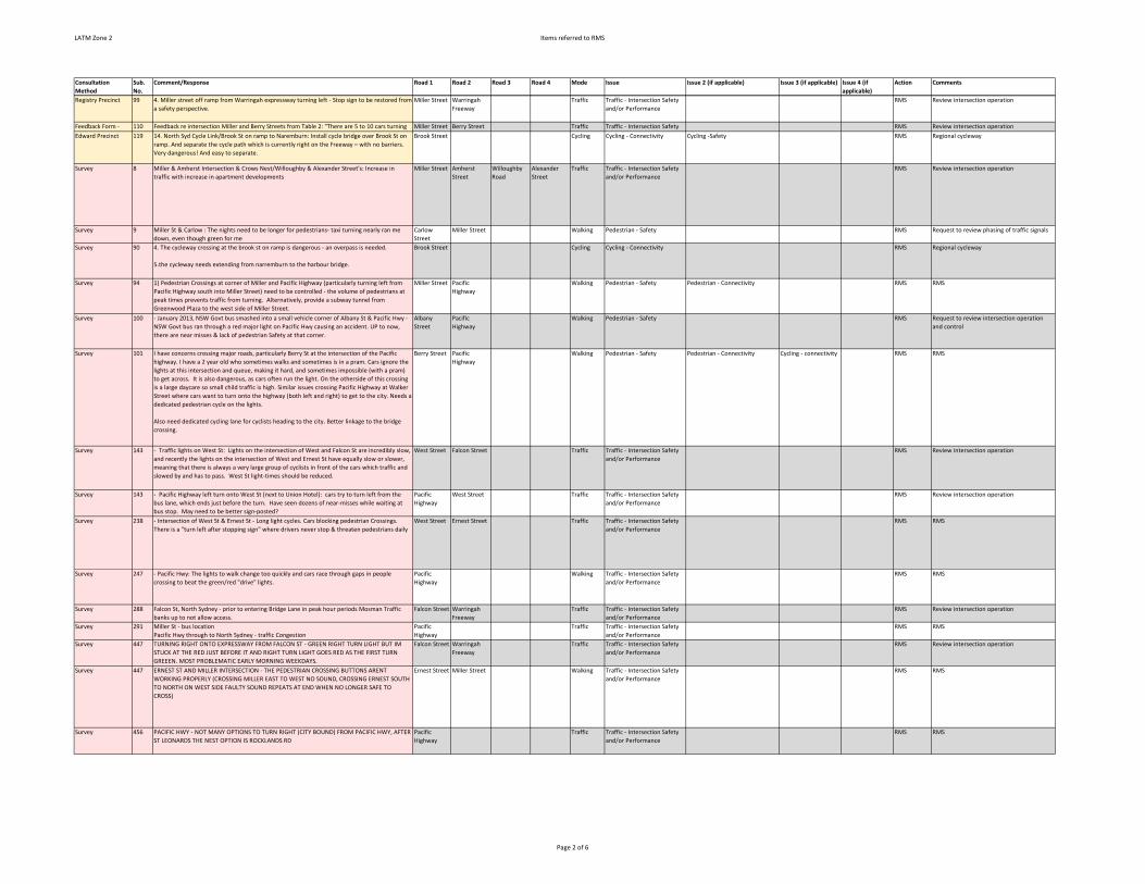
LATM Zone 2 Items referred to RMS
Consultation
Method
Sub.
No.
Comment/Response Road 1 Road 2 Road 3 Road 4 Mode Issue Issue 2 (if applicable) Issue 3 (if applicable) Issue 4 (if
applicable)
Action Comments
Registry Precinct 99 4. Miller street off ramp from Warringah expressway turning left ‐ Stop sign to be restored from
a safety perspective.
Miller Street Warringah
Freeway
Traffic Traffic ‐ Intersection Safety
and/or Performance
RMS Review intersection operation
Feedback Form ‐ 110 Feedback re intersection Miller and Berry Streets from Table 2: "There are 5 to 10 cars turning Miller Street Berry Street Traffic Traffic ‐ Intersection Safety RMS Review intersection operation
Edward Precinct 119 14. North Syd Cycle Link/Brook St on ramp to Naremburn: Install cycle bridge over Brook St on
ramp. And separate the cycle path which is currently right on the Freeway – with no barriers.
Very dangerous! And easy to separate.
Brook Street Cycling Cycling ‐ Connectivity Cycling ‐Safety RMS Regional cycleway
Survey 8 Miller & Amherst Intersection & Crows Nest/Willoughby & Alexander Street's: Increase in
traffic with increase in apartment developments
Miller Street Amherst
Street
Willoughby
Road
Alexander
Street
Traffic Traffic ‐ Intersection Safety
and/or Performance
RMS Review intersection operation
Survey 9 Miller St & Carlow : The nights need to be longer for pedestrians‐ taxi turning nearly ran me
down, even though green for me
Carlow
Street
Miller Street Walking Pedestrian ‐ Safety RMS Request to review phasing of traffic signals
Survey 90 4. The cycleway crossing at the brook st on ramp is dangerous ‐ an overpass is needed.
5.the cycleway needs extending from narremburn to the harbour bridge.
Brook Street Cycling Cycling ‐ Connectivity RMS Regional cycleway
Survey 94 1) Pedestrian Crossings at corner of Miller and Pacific Highway (particularly turning left from
Pacific Highway south into Miller Street) need to be controlled ‐ the volume of pedestrians at
peak times prevents traffic from turning. Alternatively, provide a subway tunnel from
Greenwood Plaza to the west side of Miller Street.
Miller Street Pacific
Highway
Walking Pedestrian ‐ Safety Pedestrian ‐ Connectivity RMS RMS
Survey 100 ‐ January 2013, NSW Govt bus smashed into a small vehicle corner of Albany St & Pacific Hwy ‐
NSW Govt bus ran through a red major light on Pacific Hwy causing an accident. UP to now,
there are near misses & lack of pedestrian Safety at that corner.
Albany
Street
Pacific
Highway
Walking Pedestrian ‐ Safety RMS Request to review intersection operation
and control
Survey 101 I have concerns crossing major roads, particularly Berry St at the intersection of the Pacific
highway. I have a 2 year old who sometimes walks and sometimes is in a pram. Cars ignore the
lights at this intersection and queue, making it hard, and sometimes impossible (with a pram)
to get across. It is also dangerous, as cars often run the light. On the otherside of this crossing
is a large daycare so small child traffic is high. Similar issues crossing Pacific Highway at Walker
Street where cars want to turn onto the highway (both left and right) to get to the city. Needs a
dedicated pedestrian cycle on the lights.
Also need dedicated cycling lane for cyclists heading to the city. Better linkage to the bridge
crossing.
Berry Street Pacific
Highway
Walking Pedestrian ‐ Safety Pedestrian ‐ Connectivity Cycling ‐ connectivity RMS RMS
Survey 143 ‐ Traffic lights on West St: Lights on the intersection of West and Falcon St are incredibly slow,
and recently the lights on the intersection of West and Ernest St have equally slow or slower,
meaning that there is always a very large group of cyclists in front of the cars which traffic and
slowed by and has to pass. West St light‐times should be reduced.
West Street Falcon Street Traffic Traffic ‐ Intersection Safety
and/or Performance
RMS Review intersection operation
Survey 143 ‐ Pacific Highway left turn onto West St (next to Union Hotel): cars try to turn left from the
bus lane, which ends just before the turn. Have seen dozens of near‐misses while waiting at
bus stop. May need to be better sign‐posted?
Pacific
Highway
West Street Traffic Traffic ‐ Intersection Safety
and/or Performance
RMS Review intersection operation
Survey 238 ‐ Intersection of West St & Ernest St ‐ Long light cycles. Cars blocking pedestrian Crossings.
There is a "turn left after stopping sign" where drivers never stop & threaten pedestrians daily
West Street Ernest Street Traffic Traffic ‐ Intersection Safety
and/or Performance
RMS RMS
Survey 247 ‐ Pacific Hwy: The lights to walk change too quickly and cars race through gaps in people
crossing to beat the green/red "drive" lights.
Pacific
Highway
Walking Traffic ‐ Intersection Safety
and/or Performance
RMS RMS
Survey 288 Falcon St, North Sydney ‐ prior to entering Bridge Lane in peak hour periods Mosman Traffic
banks up to not allow access.
Falcon Street Warringah
Freeway
Traffic Traffic ‐ Intersection Safety
and/or Performance
RMS Review intersection operation
Survey 291 Miller St ‐ bus location
Pacific Hwy through to North Sydney ‐ traffic Congestion
Pacific
Highway
Traffic Traffic ‐ Intersection Safety
and/or Performance
RMS RMS
Survey 447 TURNING RIGHT ONTO EXPRESSWAY FROM FALCON ST ‐ GREEN RIGHT TURN LIGHT BUT IM
STUCK AT THE RED JUST BEFORE IT AND RIGHT TURN LIGHT GOES RED AS THE FIRST TURN
GREEEN. MOST PROBLEMATIC EARLY MORNING WEEKDAYS.
Falcon Street Warringah
Freeway
Traffic Traffic ‐ Intersection Safety
and/or Performance
RMS Review intersection operation
Survey 447 ERNEST ST AND MILLER INTERSECTION ‐ THE PEDESTRIAN CROSSING BUTTONS ARENT
WORKING PROPERLY (CROSSING MILLER EAST TO WEST NO SOUND, CROSSING ERNEST SOUTH
TO NORTH ON WEST SIDE FAULTY SOUND REPEATS AT END WHEN NO LONGER SAFE TO
CROSS)
Ernest Street Miller Street Walking Traffic ‐ Intersection Safety
and/or Performance
RMS RMS
Survey 456 PACIFIC HWY ‐ NOT MANY OPTIONS TO TURN RIGHT (CITY BOUND) FROM PACIFIC HWY, AFTER
ST LEONARDS THE NEST OPTION IS ROCKLANDS RD
Pacific
Highway
Traffic Traffic ‐ Intersection Safety
and/or Performance
RMS RMS
Page 2 of 6

LATM Zone 2 Items referred to RMS
Consultation
Method
Sub.
No.
Comment/Response Road 1 Road 2 Road 3 Road 4 Mode Issue Issue 2 (if applicable) Issue 3 (if applicable) Issue 4 (if
applicable)
Action Comments
Survey 462 WEST ST, CROWS NEST ‐ CROSSING NEED TO PRESS BUTTON, WHY? WASTE OF TIME WHEN
YOU GET TO LIGHT 2 SECONDS TOO LATE TO PRESS BUTTON
WEST ST, CROWS NEST ‐ CROSSINGS, IGNORANCE OF CAR DRIVERS OF ROAD RULES 72 & 73:
THEY NEVER GIVE WAY TO PREDESTRIANS WHEN TURNING INTO STREETS
BERRY ST, MILLER ST, NORTH SYDNEY ‐ CROSSING NEED TO PRESS BUTTON, WHY? 30‐40
PEOPLE JUST STANDING THERE BECAUSE NO ONE PRESSED BUTTON. SHOULD ALWYS BE
GREEN
West Street Berry Street Miller Street Walking Pedestrian ‐ connectivity Pedestrian ‐ Safety RMS RMS
Survey 513 Traffic lights on Miller/Walker/Pacific Hwy ‐ too many traffic lights
Pacific Hwy ‐ Bike paths are too dangerous for car commuters
Miller Street Walker Street Pacific
Highway
Traffic Traffic ‐ Intersection Safety
and/or Performance
RMS Review intersection operation
Survey 537 Walker St & Pacific Highway ‐ Pedestrian Island on this corner is inadequate ‐ pedestrians have
to stand on road ‐ very unsafe.
Miller St & Pacific Highway ‐ 2 Pedestrian Islands (diagonally opposite) at this intersection are
too small and become overcrowded.
Intersection of McLaren and Walker St ‐ Traffic in walker and McLaren st is now very heavy.
Lights are needed at this intersection.
Walker
Street
Pacific
Highway
Miller Street Walking Pedestrian ‐ Safety RMS Review intersection to improve pedestrian
safety
Survey 560 Falcon St at Pacific Highway Intersection ‐ Heavy Traffic at Traffic lights
West Street, turning right into Ernest St ‐ Heavy Traffic at Trffic lights
Falcon Street Pacific
Highway
West Street Ernest Street Traffic Traffic ‐ Intersection Safety
and/or Performance
RMS Review intersection operation
Survey 565 Miller St, North Sydney ‐ I See too many cyclists in the bus lane during peak hours. Looks
dangerous particularly around 6pm heading towards Cammeray.
McLaran/Miller St Intersection ‐ Traffic light signal for pedestrians crossing, extremely loud at
night. Difficult to sleep for apartment residents . Would be good to access if necessary late at
night.
McLaren
Street
Miller Street Traffic Other RMS RMS
Survey 573 Falcon /West St ‐ Traffic Congestion, not enough time to get through green lights.
West St ‐ Bikes not stopping or slowing at Crossings. Stay in middle of roads. At lights coming
and centring themselves at lights. Bus 144 needs to stop at hospital earlier then 6.45 as nurses
start at 6.30am.
Falcon Street West Street Traffic Traffic ‐ Intersection Safety
and/or Performance
RMS Review intersection operation
Survey 576 Pacific Highway Crows Nest to North Sydney ‐ Left Turning vehicles not giving way to
pedestrians. Pedestrians giving way to tottering vehicles.
Pacific
Highway
Walking Pedestrian ‐ Safety RMS Review intersection to improve pedestrian
safety
Survey 604 Crows Nest & North Sydney
Lack of safe bike Routes to and from harbour bridge
Blaeberry St
Insufficient monitoring of resident parking
Traffic signals on Pacific Highway
High Traffic speed makes walking to St Leonards station unpleasant
Pacific
Highway
St Leonards
Station
Walking Traffic ‐ Intersection Safety
and/or Performance
Traffic ‐ traffic calming RMS RMS
Survey 611 AROUND MILLER/BERRY ST/ PACIFIC HWY ‐ SEVERE CONGESTION BETWEEN 7.45 ‐ 9.00 AM.
MILSONS POINT TO NORTH SYDNEY OVAL ‐ ONCE EXITING THE HARBOUR BRIDGE, CYCLEWAY
THERE IS A REAL LACK OF SAFE CYCYLING ROUTES
Miller Street Berry Street Pacific
Highway
Congestion RMS RMS
Survey 616 MILLER , NORTH SYDNEY ‐ CROSSING, PEDESTRIANS WAIT TOO LONG, NO SPACE CROSSING AT
MILLER/PACIFIC HWY, NEED UNDERPASS. INFREQUENT BUS SERVICES. PAVEMENTS CROWDED
WHEN SCHOOL IN AREA CLOSE FOR DAY, STUDENTS BLOCK PAVEMENTS UNABLE TO PASS
Miller Street Walking Pedestrian ‐ connectivity Pedestrians ‐ Walking Amenity RMS RMS
Survey 625 CROSS RDS OF RIDGE/MILLER ST ‐ NO ONE SLOWS OR STOPS ON YELLOW TO ALLOW RIGHT
HAND TURNS NOW. VERY CONGESTED WHEN WENONA DROP OFF.
CROWS NEST ‐ PARKING DUE TO WOOLSWORTHS DEVELOPMENT
CARLOW ST ‐ cars DONT FOLLOW SPEED RULES
Ridge Street Miller Street Traffic Traffic ‐ Intersection Safety
and/or Performance
RMS Review intersection operation
Survey 643 RIDGE ST, NORTH SYDNEY ‐ CROSSING AT ST MARYS ISNT LIT UP AT NOGHT, THE cars DO NOT
STOP
THE INTERSECTION LIGHT MILLER/RIDGE ST ‐ THE GREEN MAN DOESNT STAY GREEN LONG
ENOUGH AND IT SEEMS TO BE A BLIND SPOT. WHEN WALKING TOWARDS ST LEONARDS PARK
FROM THE CHURCH SIDE, I ALMOST GET HIT FROM THE CAR TURNING RIGHT FROM THE
OPPOSITE SIDE ‐ IT IS LIKE THEY DO NOT SEE THAT THE MAN IS GREEN! A LOT OF CLOSE CALLS
Ridge Street Miller Street Walking Pedestrian ‐ Safety RMS RMS
Survey 644 PACIFIC HWY ‐ HARD TO CROSS WHEN BUSY, NO SAFE CROSSINGS FOR KIDS.
NORTH SYDNEY ‐ WEEKEND BUSES ARE INFREQUENT AND DO NOT COME ON TIME
SYDNEY ‐ PUBLIC TRANSPORT IS TOO EXPENSIVE
Pacific
Highway
Walking Pedestrian ‐ Safety Pedestrian ‐ Connectivity RMS RMS
Survey 730 North Sydney Station ‐ Have to pay if changing from bus to train
Rosalind St, Cammeray ‐ I find it very noisy to walk near the Warringah Freeway. It would be
good if sound proof walls were built on both sides of the freeway. I believe that would also be
good for air quality and Safety
Rosalind
Street
Traffic Vehicle‐related Pollution RMS RMS
Page 3 of 6

LATM Zone 2 Items referred to RMS
Consultation
Method
Sub.
No.
Comment/Response Road 1 Road 2 Road 3 Road 4 Mode Issue Issue 2 (if applicable) Issue 3 (if applicable) Issue 4 (if
applicable)
Action Comments
Survey 742 West St, Cammeray @ Falcon St Lights ‐ Traffic backed up in the morning to Ernest St West Street Falcon Street Traffic Traffic ‐ Intersection Safety
and/or Performance
RMS Review intersection operation
Survey 743 Miller St, North Sydney ‐ infrequent buses between 8.30 ‐ 9.30 after peak hour to North
Sydney.
West St and Falcon St ‐ Traffic Lights slow to change going/walking along west St
West Street Falcon Street Walking Pedestrian ‐ connectivity RMS RMS
Survey 752 Corner Falcon and Alexander ‐ Pedestrian crossing takes too long, busy intersection for
pedestrians
Alexander
Street
Falcon Street Walking Pedestrian ‐ connectivity RMS RMS
Survey 752 Corner Alexander and Pacific Hwy ‐ Right hand turn onto Pacific Hwy takes too long when only
light traffic.
Alexander
Street
Pacific
Highway
Traffic Traffic ‐ Intersection Safety
and/or Performance
RMS RMS
Survey 757 Miller St ‐ Berry St, left turn to freeway
McLaren St ‐ No right turn to miller
Ridge St ‐ Long delays at right into Miller
Falcon St ‐ Complex lights as freeway crossover
Miller Street Berry Street McLaren
Street
Ridge Street Traffic Traffic ‐ Intersection Safety
and/or Performance
RMS Review intersection operation
Survey 759 Albany St, St Leonards ‐ parking around my apartment is very difficult during business hours.
Traffic conditions deteriorate with new development around this pocket.
Pacific Hwy, New Developments ‐ New major developments at 500 Pacific Hwy will need other
access Routes. Existing traffic at Albany st/Pacific Hwy intersection already extremely bad.
Quality of life at Albany st is experiencing major disruptions due to increased traffic and truck
paths from new developments.
Pacific
Highway
Albany Street Traffic Traffic ‐ Intersection Safety
and/or Performance
Parking ‐ concerns related to DA RMS RMS
Survey 834 Military Rd, Neutral Bay to Mosman ‐ cars travel along this road in both directions has become
increasingly slow and congested.
Miller St/Ridge St, North Sydney ‐ Always congested, slow.
Miller Street Ridge Street Congestion RMS Review intersection operation
Survey 925 Pacific Highway, North Sydney ‐ Crossings, Bike paths Pacific Highway Walking Pedestrian ‐ connectivity Cycling ‐ connectivity RMS RMSSurvey 946 Miller/Falcon ‐ Pacific Highway ‐ Traffic can't get through or banked up on Pacific Highway
during mornings.
Military Rd ‐ Traffic volume increase heading through Neutral Bay. Miller Street Falcon Street Pacific Highway Traffic Traffic ‐ Intersection Safety and/or Performance
RMS Review intersection operation
Survey 960 Falcon St lights and crossing just west of Warringah Fwy ‐ Pedestrian crossing green light should
be automatic and not need a button pressed, to avoid waiting.
Falcon Street Warringah
Freeway
Walking Pedestrians ‐ Walking
Amenity
RMS RMS
Survey 1144 Cnr Pacific Hwy and Walker St ‐ vehicles do not stop at read light so one cannot cross Walker St
on "walk".
Pacific Hwy bottom of Walker St ‐ "walk" too short.
Pacific
Highway
Walker Street Walking Pedestrian ‐ Safety Pedestrians ‐ Walking Amenity RMS RMS
Survey 1190 Ridge St/Miller St to Victoria Cross ‐ intensive strafing Congestion converging arterial Pacific
Hwy/Miller St/Berry St.
Ridge Street Miller Street Pacific
Highway
Berry Street Traffic Traffic ‐ Intersection Safety
and/or Performance
RMS Review intersection operation
Survey 1220
Pacific Hwy, St Leonards ‐ excessive noise from cars, motorbikes and trucks. Not routine traffic
noise ‐ loud mufflers et .
Pacific
Highway
Traffic Vehicle‐related Pollution RMS RMS
Survey 1374 Traffic exiting Albany St to the pacific hwy between 7:30 and 8:30am
A new pedestrian crossing is required to get into to entrance to the new Woolworths in crows
nest
Albany
Street
Pacific
Highway
Traffic Traffic ‐ Intersection Safety
and/or Performance
RMS Review intersection operation
Survey 1197 Miller and McLaren Sts ‐ impatient motorists running red lights when green walking sign still
on, very dangerous.
Miller Street McLaren
Street
Traffic Traffic ‐ Intersection Safety
and/or Performance
RMS Review intersection operation
Survey 1468 Alexander St, turning right into Falcon St, Crows Nest ‐ traffic: North facing right hand turn into
Falcon St needs right hand turn arrow ‐ always banks up all along Alexander back to right hand
turn on Pacific Hwy... frustrating
Left hand turn out of 220 Pacific Hwy on to road ‐ no visibility of North‐bound traffic coming
from North Sydney. Accident waiting to happen as visibility reduced by parked cars.
Alexander
Street
Falcon Street Traffic Traffic ‐ Intersection Safety
and/or Performance
RMS RMS
Survey 1468 Alexander St, turning right into Falcon St, Crows Nest ‐ traffic: North facing right hand turn into
Falcon St needs right hand turn arrow ‐ always banks up all along Alexander back to right hand
turn on Pacific Hwy... frustrating
Left hand turn out of 220 Pacific Hwy on to road ‐ no visibility of North‐bound traffic coming
from North Sydney. Accident waiting to happen as visibility reduced by parked cars.
220 Pacific
Highway
Traffic Traffic ‐ Intersection Safety
and/or Performance
RMS RMS
Survey 1543 Rocklands Rd, Shirley, Gilles, Pacific Hwy, Bruce ‐ No Available parking despite increasing
density of multiple limit dwellings
Alexander and Falcon St ‐ Need a right turn signal now that Woolworths is opening. Massive
back‐ups
Alexander
Street
Falcon Street Traffic Traffic ‐ Intersection Safety
and/or Performance
RMS RMS
Page 4 of 6

LATM Zone 2 Items referred to RMS
Consultation
Method
Sub.
No.
Comment/Response Road 1 Road 2 Road 3 Road 4 Mode Issue Issue 2 (if applicable) Issue 3 (if applicable) Issue 4 (if
applicable)
Action Comments
Survey 1614 Cnr Bay Rd & Edward St, North Sydney ‐ Pedestrian crossing right on the corner of the
intersection danger zone for vehicles turning into Edward St. Crossing too close to intersection.
Alexander St, Crows Nest from Pacific Hwy ‐ right turning traffic into Falcon St holds up traffic
behind creating a bottleneck ‐ needs a right turn traffic light.
Alexander
Street
Falcon Street Pacific
Highway
Traffic Traffic ‐ Intersection Safety
and/or Performance
RMS RMS
Survey 1618 Crossing Hazelbank St is a real challenge especially in peak hours, a roundabout in that junction
would help.
Too many speed zone changes on Pacific Hwy, North Sydney in a short stretch.
Pacific
Highway
Traffic traffic ‐ decrease speed
limits
RMS RMS
Survey 1638 Pacific Hwy Crows Nest to North Sydney ‐ All construction of highrises in North Sydney and
Simultaeous repairs of Footpaths close lanes that affect and create bottle necks in the traffic
flow. A 5 minute commute turns into a 15‐20 min trips at peak hours during week‐days.
Intersection of Miller St and Ridge St ‐ the timing on the traffic light at this intersection is off
giving pedestrians no time to cross safely.
Miller Street Ridge Street Walking Pedestrian ‐ Safety RMS Review intersection to improve pedestrian
safety
Survey 1660 River Rd ‐ Bus stop location exposed. Crossings too few, dangerous for pedestrians.
Pacific Highway ‐ too few crossing ‐ see lots of J Walking, lights favour cars
Crows Nest, Boronia St ‐ Too little off street parking even with new Woolsworths. Commuters ‐
none for visitors
Pacific
Highway
Walking Pedestrian ‐ connectivity Pedestrian ‐ Safety RMS RMS
Survey 1686 Walking ‐ Long wait at traffic lights on Pacific Hwy and Falcon St and Miller St Pacific
Highway
Falcon Street Miller Street Walking Pedestrians ‐ Walking
Amenity
RMS RMS
Survey 1731 Miller/Berry Sts, North Sydney ‐ very busy at peak times.
Military Rd, Cremorne and Mosman ‐ very busy at all times.
Miller Street Berry Street Traffic Traffic ‐ Intersection Safety and/or Performance
RMS Review intersection operation
Survey 1739 Corner of Miller St and McLaren St (Southbound) day time traffic frequently makes right hand
turns difficult. how about a right turn arrow?
Miller Street McLaren
Street
Traffic Traffic ‐ Intersection Safety
and/or Performance
RMS Review intersection operation
Survey 1780 Alexander St, turning right into Falcon St towards Mosman, traffic light has no green arrow for
right
Alexander
Street
Falcon Street Traffic Traffic ‐ Intersection Safety
and/or Performance
RMS RMS
Survey 1789 Alexander St/ Pacific Hwy, long ques/ dangerous driving at the right turn Alexander into Falcon Alexander
Street
Pacific
Highway
Falcon Street Traffic Traffic ‐ Intersection Safety
and/or Performance
RMS RMS
Survey 1836 Alexander St/Falcon St, owing to heavy traffic from Burlington St often impossible to turn right
because of timing of traffic lights and therefore green timing lights should be provided for
timing from Alexander St into Falcon St
Alexander
Street
Falcon Street Burlington
Street
Traffic Traffic ‐ Intersection Safety
and/or Performance
RMS RMS
Survey 1839 Alexander St/Falcon St, need to have a dedicated right turn arrow at lights, often only 1‐2 cars a
time get through.
Alexander
Street
Falcon Street Traffic Traffic ‐ Intersection Safety
and/or Performance
RMS RMS
Survey 2210 Walker St, North Sydney ‐ parking;
Military Rd, Cremorne ‐ parking;
Pacific Highway, North Sydney ‐ traffic
Pacific
Highway
North Sydney Congestion RMS RMS
Survey 2295 Crows Nest, Corner Falcon/ Alexander St ‐ Traffic lights ‐ needs a green arrow to turn onto
Falcon (very congested in the mornings)
Alexander
Street
Falcon Street Traffic Traffic ‐ Intersection Safety
and/or Performance
RMS RMS
Survey 2297 Crows Nest to North Sydney, Pacific Hwy ‐ Waiting time at pedestrian crossing/ traffic. Pacific
Highway
Walking Pedestrians ‐ Walking
Amenity
RMS RMS
Survey 2418 Falcon and West St Intersection ‐ Long queues either side of intersection slow progress. Cars
turning right from West St into Flacon St prohibit the cars going to go straight ahead. Bicycle
riders in am and pm peak hours. Very dangerous. Blue and white dry cleaning clients. Traffic.
West St ‐ Bicycle riders riding the whole length of West St too narrow, very dangerous.
Falcon Street West Street Traffic Traffic ‐ Intersection Safety
and/or Performance
RMS Review intersection operation
Survey 2422 Alexander St, Crows Nest ‐ difficult to cross into Falcon St (South) because of oncoming traffic,
depending on time of day (using car)
Alexander
Street
Falcon Street Traffic Traffic ‐ Intersection Safety
and/or Performance
RMS RMS
Survey 2457 Berry St, North Sydney ‐ traffic Congestion ‐ traffic merging from Pacific Hwy to Berry St;
Alexander St, Crows Nest ‐ lack of parking, high meter costs
Berry Street Pacific
Highway
Traffic Traffic ‐ Intersection Safety
and/or Performance
RMS Review intersection operation
Page 5 of 6

LATM Zone 2 Items referred to RMS
Consultation
Method
Sub.
No.
Comment/Response Road 1 Road 2 Road 3 Road 4 Mode Issue Issue 2 (if applicable) Issue 3 (if applicable) Issue 4 (if
applicable)
Action Comments
Survey 2474 Pacific Hwy and Alexander St, Crows NEst ‐ Pedestrian crossing ‐ takes several minutes to cross
as lights favour cars and not walkers.
Falcon and Alexander ‐ As above.
Pacific
Highway
Alexander
Street
Falcon Street Walking Pedestrians ‐ Walking
Amenity
RMS RMS
Survey 2663 Berry St, Nth Syd ‐ Left turn from Pacific Highway onto Berry ‐ light 2‐lane turn, pedestrians
often cross on their red light.
Traffic lights on Military Rd ‐ Falcon ST, Pacific Highway from Shirley Rd to Nth Syd ‐ The panel
security the traffic light tilt downward of an angle ‐ so difficult to see which light is lit up. It
serious hazards needing urgent attention.
Parking ‐ So limited in residential areas ( with time limits)
Cyclists ‐ Often weave in and out of busy traffic in Nth Syd + Highway.
Berry Street Pacific
Highway
Traffic Pedestrian ‐ Safety Traffic ‐ Intersection Safety
and/or Performance
RMS RMS
Survey 2663 Traffic lights on Military Rd ‐ Falcon ST, Pacific Highway from Shirley Rd to Nth Syd ‐ The panel
security the traffic light tilt downward of an angle ‐ so difficult to see which light is lit up. It
serious hazards needing urgent attention.
Falcon Street Pacific
Highway
Shirley Road Traffic Traffic ‐ Intersection Safety
and/or Performance
RMS Review intersection operation
Survey 2717 Ammerst/Miller ‐ traffic turn sigs required going north from Ammerst St from east.
Ammerst/Miller ‐ traffic sign right turn coming from south.
Miller‐Falcon opposite park ‐ single light should be independent of other lights.
Miller St at Ammerst St Shops ‐ limit car speed.
(Includes hand drawn diagram of Miller and Falcon Sts, illustrating how bus gets delayed
leaving Miller St).
Miller Street Falcon Street Traffic Traffic ‐ Intersection Safety
and/or Performance
RMS Review intersection operation
Page 6 of 6

SMEC | North Sydney Council LATM Zone 2 Action Plans Final Report | Page 48
APPENDIX D – ITEMS REFERRED TO OTHER COUNCIL DEPARTMENTS

LATM Zone 2 Items Referred to other Council Departments
Consultation
Method
Sub.
No.
Comment/Response Road 1 Road 2 Road 3 Road 4 Mode Issue Issue 2 (if applicable) Issue 3 (if applicable) Issue 4 (if
applicable)
Action Comments
Mapping Tool 2 Cars parking in narrow Atchison Lane ignoring "No Standing" or "No Parking" signs": Cars
parking in narrow Atchison Lane ignoring "No Standing" or "No Parking" signs leaving only one
narrow lane for 2 way traffic ‐ re Atchinson Lane between Christie & Mitchell Street, near
Christie St end especially ‐ makes it difficult for cars to turn into the laneway from Christie St,
esp during afternoon peak hours.
Atchison
Lane
Parking Parking ‐ Too little
enforcement
Rangers Enforcement
Mapping Tool 5 The road condition on Atchison Lane (from Christie St to Oxley St) is terribly rough and bumpy:
The road condition on Atchison Lane (from Christie St to Oxley St) is terribly rough and bumpy ‐
lots of patch up during different stages. When is it going to be repaved?
Atchison
Lane
Christie
Street
Oxley Street Traffic Road Surface Damage Works
Engineers
Refer to Works Engineers
Mapping Tool 8 Please plan thoroughly before action to avoid unnecessary re‐digging of pavements: Please
plan thoroughly before action to avoid unnecessary re‐digging of pavements ‐ look at the
pavement on Christie St & around the corner on Chandos St ‐ it was nicely repaved, then had to
dig out for some electrical work straight after the repavement. Now the affected area is just
covered by black cement, this damages the good work done before and waste our money
unnecessarily.
Christie
Street
Chandos
Street
Walking Roadworks Pedestrians ‐ Footpath Surface
Conditions
Works
Engineers
Footpath repair program
Workshop 1 Illegal parking blocking access. Burlington
Lane
Parking Parking ‐ Too little
enforcement
Parking ‐ Parking Access for
Residents
Rangers Enforcement
Workshop 1 State of Footpaths Falcon Street Miller Street Walking Pedestrians ‐ Footpath
Surface Conditions
Works
Engineers
Refer to Works Engineers
Workshop 1 Dangerous due to trees. Overall pedestrian Crossings on Willoughby Road is good. Willoughby
Road
Charlie
Lovetts
Walking OSE Refer to OSE
Workshop 1 Need more rangers? Rangers focus on certain spaces, e.g. Hest Street. West Street Parking Parking ‐ Too little
enforcement
Rangers Enforcement
Workshop 4 Street lighting and poor footpaths. Eden Street Myrtle Street Walking Pedestrians ‐ Walking
Amenity
Works
Engineers
Refer to Works Engineers
Workshop 5 Better path ways ‐ shared paths and better Lighting St Leonards
Park
Walking Pedestrian ‐ Safety Cycling ‐Safety Pedestrians ‐ Street
lighting
OSE Refer to OSE
Workshop 6 Asphalt/tiling where buses stop are uneven, dangerous especially at peak Alexander
Street
Willoughby
Road
Traffic Road Surface Damage Works
Engineers
Refer to Works Engineers
Workshop Additi
onal
Reside
nt
works
hop
Uneven Footpaths. No zebra crossing to access station. Chandos
Street
Christie
Street
Walking Pedestrians ‐ Footpath
Surface Conditions
Works
Engineers
Refer to Works Engineers
Workshop Additi
onal
Reside
nt
works
hop
Turn up Footpaths poor crossing Holtermann
Street
Walking Pedestrians ‐ Footpath
Surface Conditions
Works
Engineers
Refer to Works Engineers
Workshop Additi
onal
Reside
nt
works
hop
Footpaths uneven cobblestones especially Hard for woman in heels Miller Street McLaren
Street
Walking Pedestrians ‐ Footpath
Surface Conditions
Works
Engineers
Refer to Works Engineers
Workshop Additi
onal
Reside
nt
Works
hop
Ridge Street footpaths inconsistent pathways. Chandler Street need repairing Chandos
Street
Walking Pedestrians ‐ Footpath
Surface Conditions
Works
Engineers
Refer to Works Engineers
Hardcopy
Submission
33 CBD ‐ buses good, but bus stops could be better. North
Sydney
Buses Public Transport ‐
Infrastructure
Street
furniture
Consider bus shelter or relocation of bus
stop
Hardcopy
Submission
45 Traffic and parking issues caused by new developments ‐ In light of these existing and
upcoming developments, we are gravely concerned about the following:
‐ Noise and air pollution effects on apartments in Albany St. Traffic noise from
increased traffic and heavy construction vehicles can be heard at very high decibels
from 6am to 6pm during weekdays and even on Saturday morning.
‐ Traffic conditions at the Albany St/Pacific Hwy. Traffic congestion up to Oxley St
roundabout almost throughout the day. Nearby Oxley St and Hume St exits from
Pacific Hwy not available for Northbound traffic. Albany St is mostly residential
street, effects of traffic congestion has major effect on quality of life for residents.
‐ Street parking for visitors during business hours almost none existent in 500 meter radius.
Council carpark in Hume St is almost always full. With thousands of new residents and
businesses moving in the next few years from the new developments, how are any of the
visitors going to parking their car?
Albany
Street
Traffic Traffic ‐ Traffic Calming Parking ‐ concerns related to DA CIS Refer to CIS
Page 1 of 4

LATM Zone 2 Items Referred to other Council Departments
Consultation
Method
Sub.
No.
Comment/Response Road 1 Road 2 Road 3 Road 4 Mode Issue Issue 2 (if applicable) Issue 3 (if applicable) Issue 4 (if
applicable)
Action Comments
Hardcopy
Submission
54 1) Parking ‐ our street, Holtermann St, and others nearby suffer from our popularity. The
situation has grown increasingly frustrating, in that it’s not limited to weekends and weekday
lunch. It is now any time of day that I find it difficult to park near my home. We have a group of
users aside from residents, who regularly disregard the time limits. They lunch goers, shoppers,
transport to City and workers. The greatest problem; workers choose to drive, park and stay all
day every day. They scrub off chalk marks, move their cars and mouth off to residents. I have
had heated discussions with these drivers, who watch me walk a long way carrying a baby,
several bags and walking a youngster. I am red‐faced, exhausted and crossing busy road to get
to my house. I feel betrayed by Council, who charges me to live here and park here. Yet they do
it free and often do not get a fine. I call Council daily, it is a metal block for me that I must keep
an eye on these drivers, I have a life too. Is my only option to move house?
Holtermann
Street
Parking Parking ‐ Too little
enforcement
Rangers Enforcement
Holtermann Precinct
(minutes)
66 Concern re pedestrian safety on highly polished paving on Burlington Street particularly after
rain.
Burlington
Street
Walking Pedestrians ‐ Footpath
Surface Conditions
Works
Engineers
Refer to Works Engineers
Union Precinct 98 Miller between Berry and highway ‐ taxis take up normal parking spaces, residents frozen out. Miller Street Berry Street Pacific
Highway
Parking Parking ‐ Parking Restrictions
Insufficient
Parking ‐ too little enforcement Rangers Enforcement
Union Precinct 98 Berry outside Rag & Famish ‐ beer deliveries occur during clearway hours and block an
important lane
Berry Street Rag & Famish Parking Parking ‐ Too little
enforcement
Rangers Enforcement
Registry Precinct 99 3. Contractor and Builder Parking at developments eg 139 West Street and in Rosalind Street in
respect of the Anzac Club site development ‐ A number of residents have identified a large
number of builders and contractors who park in the 2 hour time limited parking and rotate
their parking or simply watch out for the rangers, occupying parking spots which are otherwise
used by residents who are unable to park near their homes. It is acknowledged that developers
do apply for and pay for works zones, which in the case of 139 West Street is not used for
builder or contractor parking but trucks delivering materials.
West Street Rosalind
Street
Parking Parking ‐ Concerns Related
to DA
Rangers Enforcement
Feedback Form ‐
workshop 1
112 OLGR ‐ Liquor licence ‐ need info ready. Police checks, site visits. DA ha to be supported for
liquor retail. DA did not have cooking allowances. Have been able to cope and manage as
"café". When approached Council: "Your CDC states you will be open with _____ hours. We
know you do not operate as per CDC. Based on this and inFromation available, I cannot endorse
a liquor licence". 1.) Thought this would only need an "endorsement". 2.) Unable to go any
further with OLGR until Council endorses. Concern was operating hours. Want to know WHY?
CIS Refer to CIS
Survey 1 Pacific Highway, North Sydney: Pram Crossings are rough, pavement narrow and uneven Pacific
Highway
Walking Pedestrians ‐ Footpath
Surface Conditions
Pedestrians ‐ Walking Amenity Works
Engineers
Refer to Works Engineers
Survey 27 1. Cars parking in narrow Atchison Lane ignoring "No Standing" or "No Parking" signs leaving
only one narrow lane for 2 way traffic ‐ re Atchinson Lane between Christie & Mitchell Street,
near Christie St end especially ‐ makes it difficult for cars to turn into the laneway from Christie
St, esp during afternoon peak hours.
Atchison
Lane
Christie
Street
Mitchell
Street
Parking Parking ‐ Parking
Configuration
Parking ‐ too little enforcement Rangers Enforcement
Survey 27 5. The road condition on Atchison Lane (from Christie St to Oxley St) is terribly rough and
bumpy ‐ lots of patch up during different stages. When is it going to be repaved?
Atchison
Lane
Traffic Road Surface Damage Works
Engineers
Refer to Works Engineers
Survey 63 Blue St, North Sydney ‐ cars stopping at bus stop Blue Street Parking Parking ‐ Too little
enforcement
Rangers Enforcement
Survey 85 ‐ Falcon Ln, Crowns Nest ‐ It its full of pot holes, and many drivers go up or down the lane much
too fast. WE have had many near collisions while backing out of our garage ‐ Many drivers think
it is a one way lane & position themselves in the middle of the lane either going in or going out!
Falcon Lane Traffic Road Surface Damage Works
Engineers
Refer to Works Engineers
Survey 235 ‐ Anzac Ave, Cammeray ‐ Parking illegally, double parking, in no stopping zones Anzac
Avenue
Parking Parking ‐ Too little
enforcement
Rangers Enforcement
Survey 240 ‐ Miller St ‐ cars ignoring pedestrian Crossings, cars parked in pick up only zones outside schools Miller Street Walking Pedestrian ‐ Safety School zone congestion Rangers Enforcement
Survey 250 ‐ The Greens, Ridge St, NS: Drink people in the street jumping out in front of your car thinking if
is their way. They shout & yell and leave rubbish in the St Leonards Park.
The Greens Ridge Street Walking other Rangers Enforcement
Survey 251 ‐ Falcon St, footpath opposite St Leonards Park: Trip hazards all the way. Have already conveyed
to Council. Was told an inspection would happen this month ‐ Feb 16.
Falcon Street Walking Pedestrians ‐ Footpath
Surface Conditions
Works
Engineers
Refer to Works Engineers
Survey 257 ‐ West St & Ridge St, North Sydney: Pedestrian crossing marking worn off & not very visible to
car drivers
‐ Paths in St Leonards Park: Too narrow for shared cycle and pedestrian use. Very dangerous to
walk along
West Street Ridge Street Walking Pedestrian ‐ Safety Works
Engineers
Refer to Works Engineers
Survey 443 ATCHISON LANE, ST LEONARDS ‐ ROAD IS DESTROYED DUE TO CONSTRUCTION Atchison
Lane
Traffic Road Surface Damage Works
Engineers
Refer to Works Engineers
Survey 522 Athisan St ‐ Large buses turning into Atchison for the new Quest Hotel next door. This is only
new s I had no idea it was a hotel being built next door. I was under the impression it was
residential. We now have large tour buses turning up in a street which has pedestrian traffic
issue.
Atchison
Street
Traffic Pedestrian ‐ Safety Parking ‐ concerns related to DA CIS Refer to CIS
Page 2 of 4

LATM Zone 2 Items Referred to other Council Departments
Consultation
Method
Sub.
No.
Comment/Response Road 1 Road 2 Road 3 Road 4 Mode Issue Issue 2 (if applicable) Issue 3 (if applicable) Issue 4 (if
applicable)
Action Comments
Survey 528 Ernest St, Crows Nest ‐ Parking of boats and trailers make it impossible for locals to secure long
term parking. A council parking permit does not guarantee a car space close to home making it
difficult to carry grocery shopping. Visitors have a long way to work too and complain or don't
visit anymore.
Pacific Highway Crows Nest, North Syd ‐ Bus shelters are inadequate in heavy rain. Buses often
late or too crowded and don't stop. Often have to stand‐ school children take seats and donot
get up unless asked or told to do so. Buses leak water in the wet and from air con ducts.
Pacific
Highway
Buses Public Transport ‐
Infrastructure
Street
furniture
Consider bus shelter or relocation of bus
stop
Survey 530 Christie St (outside Gilroys) ‐ New paving, too smooth ‐ I have already fallen 3 times.
Atchison St (outside new quest hotel) ‐ New paving put down and 3 days later it was up.
Atchison St (Mitchell to Christie) ‐ No lighting in street, too dangerous now a hotel there
Atchison St to Willoughby St‐ You can get hurt crossing the road no Crossings
Christie
Street
Walking Pedestrians ‐ Footpath
Surface Conditions
Works
Engineers
Refer to Works Engineers
Survey 532 From St Leonards St to North Sydney
Inadequate bike Lane Routes, not separated from traffic
Pacific Highway, St Leonards ‐ decrept Stand B & C on Pacific Highway
Pacific
Highway
Stand B & c Buses Public Transport ‐
Infrastructure
Street
furniture
Consider bus shelter or relocation of bus
stop
Survey 547 Intersection of Ernest and West St‐ There is not a well positioned ramp to cross the road, which
means you have to slightly go into the traffic to use the ramp.
Ernest St‐ The footpath is uneven, making it easy for kids to trip.
access to the Harbour Bridge by Bike‐ In several places there are no Bike paths making it
dangerous.
Ernest Street West Street Walking Pedestrians ‐ Footpath
Provisions
Pedestrians ‐ Footpath Surface
Conditions
Works
Engineers
Refer to Works Engineers
Survey 549 Pacific Highway, Crowsnest ‐ For how close we are to the city, buses can take far too long to get
into the city. Too much detouring through North Sydney. Need express options.
Pacific Highway, various roads laneways ‐ Often after utility companies open up the road, they
leave it in a dangerous position for cyclists eg bumps, depressions.
Kirribilli Broughton Street surroundings‐ We attend church on Sunday's & midweek. The parking
restrictions can be quite rigid disincentive community gatherings like this . It is difficult to use
public transport with kids so using a car is necessary.
Kirribilli‐ Cycling Routes to work are difficult for inexperienced . Entrance to harbour bridge for
cyclists congested and requires dismounting.
Pacific
Highway
Laneways Traffic Road Surface Damage Works
Engineers
Refer to Works Engineers
Survey 557 Atchison St‐ I am unable to park in my street as people park in the 2 hour parking area and it is
not patrolled enough during the day to have the turnover required.
Atchison
Street
Parking Parking ‐ Too little
enforcement
Rangers Enforcement
Survey 587 Falcon Lane, Crows Nest. Western Lane of Lane way on the South Side‐ Several houses at the
bottom of the lane Cove no gutter crossing and instead have messy heaps of concrete bricks
timber, metal etc on the gutter. Not only is this unsightly but it is impossible to pass large
vehicle in the lane due to the narrow width of laneway. They should be made to install gutter
Crossings . Some of their parked cars protrude into the lane as well.
Falcon Lane Traffic Road Surface Damage parking ‐ parking configuration CIS Refer to CIS
Survey 591 Falcon St, Crows Nest
There is no bus shelter /Bus Stop. No shelter to protect from the pursing rain. It is a dreadful
spot
Falcon Street Buses Public Transport ‐
Infrastructure
Street
furniture
Consider bus shelter or relocation of bus
stop
Survey 610 PACIFIC IGHWAY, CROWS NEST AND NORTH SYDNEY ‐ FOOTPATHS (EG ACROSS THE ROAD
FROM CAMMERAY GIRL HS) ARE SHOCKING. ROADWORKS HAS OCCURED AND HAS NEVER
BEEN FIXED/ RETURNED TO A PROPER STATE.
Pacific
Highway
Crows Nest North Sydney Walking Pedestrians ‐ Footpath
Surface Conditions
Works
Engineers
Refer to Works Engineers
Survey 652 MILLER ST, NORTH SYDNEY ‐ POOR FOOTPATH CONDITION
NORTH SYDNEY ‐ POOR FOOTPATH CONDITION WITH CONSTRUCTION
Miller Street North Sydney Walking Pedestrians ‐ Footpath
Surface Conditions
Works
Engineers
Refer to Works Engineers
Survey 656 FALCON ST, CROWS NEST ‐ UNEVEN FOOTPATH VERY DANGEROUS.
CROWS NEST IN GENERAL ‐ NEW FOOTPATH TILING ARE VERY SLIPPERY WHEN WET, VERY
DANGEROUS AND COULD RESULT IN LEGAL ACTION AS NO SIGNAGE OR FORETHOUGHT.
Falcon Street Crows Nest Walking Pedestrians ‐ Footpath
Surface Conditions
Works
Engineers
Refer to Works Engineers
Survey 657 FALCON ST, CROWS NEST ‐ LIMITED STREET LIGHTS AND SMALL FOOTPATH MAKING WALKING
AT NIGHT DANGEROUS
Falcon Street Walking Pedestrians ‐ Footpath
Surface Conditions
Works
Engineers
Refer to Works Engineers
Survey 658 WILLOUGHBY ROAD ‐ BUS SHELTERS SHOULD BE SET UP INSTEAD OF SIMPLE STOPS TO
PROTECT FROM RAIN/SUN
Willoughby
Road
Buses Public Transport ‐
Infrastructure
Street
furniture
Consider bus shelter or relocation of bus
stop
Survey 704 North Sydney, Carlow St and in general ‐ 1) poor street lighting and 2) poor condition of
Footpaths.
Carlow
Street
North Sydney Walking Pedestrians ‐ Footpath
Surface Conditions
Works
Engineers
Refer to Works Engineers
Survey 722 Walker street clearway often blocked by taxis or cars dropping off/waiting/parked which causes
backing up on Pacific Highway.
Parked cars on Miller St near Rag and Famish, reduces lanes for turning left into Berry Street so
cars waiting to turn left (pedestrian lights) delay cars moving straight across. Just taking away 3
or 4 parking spaces would improve this situation.
Walker
Street
Pacific
Highway
Parking Parking ‐ Too little
enforcement
Rangers Enforcement
Survey 724 McLaren St, North Sydney beside Council chambers ‐ bike paving dangerously slippery to walk
on especially when damp because of moss growth
McLaren
Street
Walking Pedestrians ‐ Footpath
Surface Conditions
Works
Engineers
Refer to Works Engineers
Survey 725 Crows Nest ‐ A lot of construction in the area is damaging Crows Nest Traffic Road Surface Damage Works
Engineers
Refer to Works Engineers
Page 3 of 4

LATM Zone 2 Items Referred to other Council Departments
Consultation
Method
Sub.
No.
Comment/Response Road 1 Road 2 Road 3 Road 4 Mode Issue Issue 2 (if applicable) Issue 3 (if applicable) Issue 4 (if
applicable)
Action Comments
Survey 728 Hume St/ Pacific Hwy, Crows Nest Bus M20 ‐ Always late, sometimes doesn't come. Need a
sheltered stop, very cold waiting at Pacific Hwy.
Albany St, Crows Nest ‐ Not enough resident parking for home owners. Very difficult seating a
spot near home. Too many all day spots and metred spots paid.
Crows Nest Buses ‐ need more school buses as too many school children on buses standing
with heavy bags and other commuters can not set on very full buses
Hume Street Pacific
Highway
Buses Public transport ‐
infrastructure
Street
furnitureConsider bus shelter or relocation of bus
stop
Survey 760 Cammeray, Crows Nest, St Leonards ‐ Crowded Public Transport. NSW bus shelters do not
protect from weather. Footpath sharing, increasingly have to walk on roads as paths crowded
with prams, cyclists and dogs on extendable leaches. Harder to cross streets in crows nest due
to much heavier traffic.
Cammeray Crows Nest St Leonards Public
Transport
Public transport ‐
infrastructure
Street
furniture
Consider bus shelter or relocation of bus
stop
Survey 766 Emmett St ‐ cars parking in loading zone and car share space illegally
West/Emmett/Carlow ‐ Mothers in 4‐wheel drives just stopping anywhere to drop off, pick up,
get coffee.
Emmett
Street
West Street Carlow Street Parking Parking ‐ Too little
enforcement
Rangers Enforcement
Survey 778 McLaren St ‐ Insane taxi speed, double parking, dangerous. McLaren
Street
Parking Parking ‐ Too little
enforcement
Traffic ‐ traffic calming Rangers Enforcement
Survey 1595 Intermittent cycle lanes for popular cycle commuter Routes
Pacific Hwy, Northbound and Bay Rd to Crows Nest ‐ bus stop locations ‐ new advertisement
additions take up the footpath which impedes visibility for walkers, joggers and there is little
space to get around some of them
Pacific
Highway
Buses Public Transport ‐
Infrastructure
Pedestrians ‐ Walking Amenity Street
furniture
Consider bus shelter or relocation of bus
stop
Survey 1609 Pacific Hwy, Crows Nest ‐ very uneven footpath on both sides of the road Pacific
Highway
Walking Pedestrians ‐ Footpath
Surface Conditions
Works
Engineers
Refer to Works Engineers
Survey 1691 Most Streets ‐ Footpaths in disrepair creating dangerous trip hazards. General Walking Pedestrians ‐ Footpath
Surface Conditions
Works
Engineers
Refer to Works Engineers
Survey 1789 Myrtle St, double parking/ Congestion on weekends and more unit blocks being built Myrtle Street Parking Parking ‐ Too little
enforcement
Rangers Enforcement
Survey 2235 North Sydney CBD ‐ Jaywalkers should be fined. More police presence on taxis. North
Sydney CBD
Parking Parking ‐ Too little
enforcement
Rangers Enforcement
Survey 2291 Pacific Hwy, Crows Nest Bus shelter "Crowie" near Myrtle St ‐ more seating required at bus
stop. Existing seat on Myrtle St side of shelter needs to be moved to oncoming traffic side,
can't see bus approaching, now side of shelter has been closed in with a moving electronic
moving advertising sign. Also an extra seat URGNETLY REQUIRED.
Pacific
Highway
Buses Public Transport ‐
Infrastructure
public transport ‐ passenger
congestion
Street
furniture
Install extra bus seats
Survey 2399 Ridge St ‐ Sporting groups take up oval; Ridge Street OSE Refer to OSE
Survey 2479 Some Footpaths are very uneven in North Sydney council area General Walking Pedestrians ‐ Footpath
Surface Conditions
Works
Engineers
Refer to Works Engineers
Survey 2719 4. Willoughby Rd, Crows Nest ‐ Bus stand waiting areas has no shelter. The bus stands at
Willoughby Council side of Willoughby Rd has glass bus shelters, when will get them in North
Sydney?
Willoughby
Road
Buses Public Transport ‐
Infrastructure
Street
furniture
Consider bus shelter or relocation of bus
stop
Survey (late) L1 Miller Street ‐ telecom pit covers Miller Street
Walking Pedestrians ‐ Footpath Surface ConditionsWorks
Engineers
Refer to Works Engineers
Survey (late) L1 Berry Street ‐ Rag & Famish ‐ Beer barrels on footpath Berry Street
Walking Pedestrians ‐ Walking Amenity Rangers EnforcementSurvey 246 ‐ Chandos St, St Leonards: Walking on this uneven street is dangerous and I have almost tripped
many times
Albany
Street
Chandos
Street
Christie
Street
Walking Pedestrians ‐ Footpath
Surface Conditions
Works
Engineers
Refer to Works Engineers
Page 4 of 4

SMEC | North Sydney Council LATM Zone 2 Action Plans Final Report | Page 49
APPENDIX E – ITEMS NOTED AS PART OF THIS STUDY
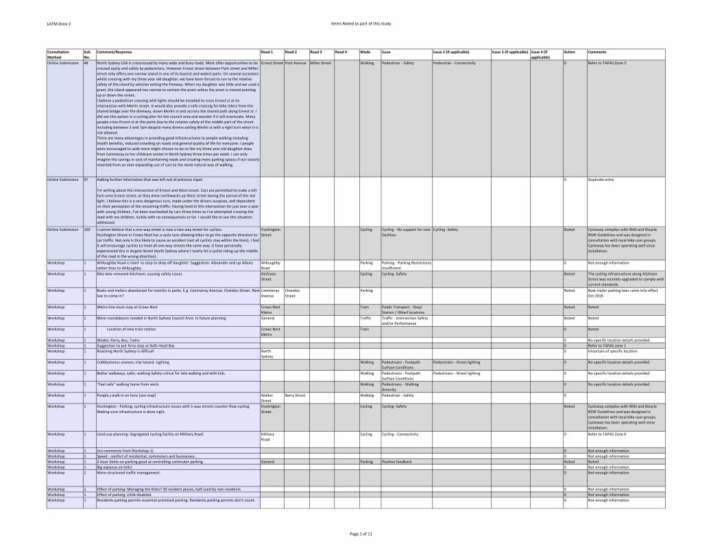
LATM Zone 2 Items Noted as part of this study
Consultation
Method
Sub.
No.
Comment/Response Road 1 Road 2 Road 3 Road 4 Mode Issue Issue 2 (if applicable) Issue 3 (if applicable) Issue 4 (if
applicable)
Action Comments
Online Submission 48 North Sydney LGA is crisscrossed by many wide and busy roads. Most offer opportunities to be
crossed easily and safely by pedestrians. However Ernest street between Park street and Miller
street only offers one narrow island in one of its busiest and widest parts. On several occasions
whilst crossing with my three year old daughter, we have been forced to run to the relative
safety of the island by vehicles exiting the freeway. When my daughter was little and we used a
pram, the island appeared too narrow to contain the pram unless the pram is moved pointing
up or down the street.
I believe a pedestrian crossing with lights should be installed to cross Ernest st at its
intersection with Merlin street. It would also provide a safe crossing for bike riders from the
shared bridge over the dreeway, down Merlin st and accross the shared path along Ernest st. I
did see this option in a cycling plan for the council area and wonder if it will eventuate. Many
people cross Ernest st at this point due to the relative safety of the middle part of the street
including between 3 and 7pm despite many drivers exiting Merlin st with a right turn when it is
not allowed.
There are many advantages in providing good infrastructures to people walking including
health benefits, reduced crowding on roads and general quality of life for everyone. I people
were encouraged to walk more might choose to do so like my three year old daughter does
from Cammeray to her childcare center in North Sydney three times per week. I can only
imagine the savings in cost of maintaining roads and creating more parking spaces if our society
reverted from an ever expanding use of cars to the more natural way of walking.
Ernest Street Park Avenue Miller Street Walking Pedestrian ‐ Safety Pedestrian ‐ Connectivity 0 Refer to TAPAS Zone 5
Online Submission 97 Adding further information that was left out of previous input.
I'm writing about the intersection of Ernest and West street. Cars are permitted to make a left
turn onto Ernest street, as they drive northwards up West street during the period of the red
light. I believe this is a very dangerous turn, made under the drivers auspices, and dependent
on their perception of the oncoming traffic. Having lived at this intersection for just over a year
with young children, I've been overlooked by cars three times as I've attempted crossing the
road with my children, luckily with no consequences so far. I would like to see this situation
addressed.
0 Duplicate entry
Online Submission 100 I cannot believe that a one way street is now a two way street for cyclists.
Huntington Street in Crows Nest has a cycle lane allowing bikes to go the opposite direction to
car traffic. Not only is this likely to cause an accident (not all cyclists stay within the lines), I feel
it will encourage cyclists to treat all one‐way streets the same way. (I have personally
experienced this in Angelo Street North Sydney where I nearly hit a cyclist riding up the middle
of the road in the wrong direction).
Huntington
Street
Cycling Cycling ‐ No support for new
facilities
Cycling ‐Safety Noted Cycleway complies with RMS and Bicycle
NSW Guidelines and was designed in
consultation with local bike user groups.
Cycleway has been operating well since
installation.
Workshop 1 Willoughby Road is Hard to stop to drop off daughter. Suggestion: Alexander and up Albury
rather than to Willoughby
Willoughby
Road
Parking Parking ‐ Parking Restrictions
Insufficient
0 Not enough information
Workshop 1 Bike lane removed Aitchison, causing safety issues Atchison
Street
Cycling Cycling ‐Safety Noted The cycling infrastructure along Atchison
Street was recently upgraded to comply with
current standards.
Workshop 1 Boats and trailers abandoned for months in parks. E.g. Cammeray Avenue, Chandos Street. New
law to come in?
Cammeray
Avenue
Chandos
Street
Parking Noted Boat trailer parking laws came into effect
Oct 2016
Workshop 1 Metro‐line must stop at Crows Nest Crows Nest
Metro
Train Public Transport ‐ Stop/
Station / Wharf locations
Noted Noted
Workshop 1 More roundabouts needed in North Sydney Council Area. In future planning. General Traffic Traffic ‐ Intersection Safety
and/or Performance
Noted Noted
Workshop 1 ∙ Location of new train station Crows Nest
Metro
Train 0 Noted
Workshop 1 Modes: Ferry, Bus, Trains 0 No specific location details provided
Workshop 1 Suggestion to put ferry stop at Balls Head Bay 0 Refer to TAPAS zone 1
Workshop 1 Reaching North Sydney is difficult North
Sydney
0 Uncertain of specific location
Workshop 1 Cobblestones uneven, trip hazard. Lighting Walking Pedestrians ‐ Footpath
Surface Conditions
Pedestrians ‐ Street lighting 0 No specific location details provided
Workshop 1 Better walkways, safer, walking Safety critical for late walking and with kids. Walking Pedestrians ‐ Footpath
Surface Conditions
Pedestrians ‐ Street lighting 0 No specific location details provided
Workshop 1 "Feel safe" walking home from work. Walking Pedestrians ‐ Walking
Amenity
0 No specific location details provided
Workshop 1 People j‐walk in on here (see map) Walker
Street
Berry Street Walking Pedestrian ‐ Safety 0
Workshop 1 Huntington ‐ Parking, cycling infrastructure issues with 1‐way streets counter‐flow cycling.
Making sure infrastructure is done right.
Huntington
Street
Cycling Cycling ‐Safety Noted Cycleway complies with RMS and Bicycle
NSW Guidelines and was designed in
consultation with local bike user groups.
Cycleway has been operating well since
installation.
Workshop 1 Land‐use planning: Segregated cycling facility on Military Road. Military
Road
Cycling Cycling ‐ Connectivity 0 Refer to TAPAS Zone 6
Workshop 1 (no comments from Workshop 1) 0 Not enough information
Workshop 1 Speed ‐ conflict of residential, commuters and businesses. 0 Not enough information
Workshop 1 2‐hour limits on parking good at controlling commuter parking General Parking Positive feedback Noted Noted
Workshop 1 Big expense on tolls! 0 Not enough information
Workshop 1 More structured traffic management. 0 Not enough information
Workshop 1 Effect of parking: Managing the Risks? 30 resident places, half used by non‐residents 0 Not enough information
Workshop 1 Effect of parking: Little disabled. 0 Not enough information
Workshop 1 Residents parking permits essential promised parking. Residents parking permits don't count. 0 Not enough information
Page 1 of 11
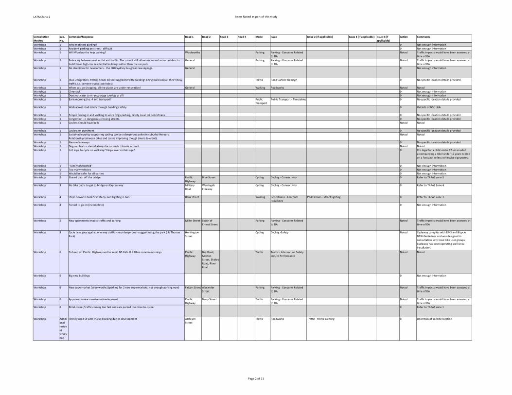
LATM Zone 2 Items Noted as part of this study
Consultation
Method
Sub.
No.
Comment/Response Road 1 Road 2 Road 3 Road 4 Mode Issue Issue 2 (if applicable) Issue 3 (if applicable) Issue 4 (if
applicable)
Action Comments
Workshop 1 Who monitors parking? 0 Not enough information
Workshop 1 Resident parking on street ‐ difficult 0 Not enough information
Workshop 1 Will Woolworths help parking? Woolworths Parking Parking ‐ Concerns Related
to DA
Noted Traffic impacts would have been assessed at
time of DA
Workshop 1 Balancing between residential and traffic. The council still allows more and more builders to
build those high‐rise residential buildings rather than the car park.
General Parking Parking ‐ Concerns Related
to DA
Noted Traffic impacts would have been assessed at
time of DA
Workshop 1 No directions for newcomers ‐ the CBD Sydney has great new signage. General 0 Not enough information
Workshop 1 (Bus, congestion, traffic) Roads are not upgraded with buildings being build and all their heavy
traffic, i.e. cement trucks (pot holes)
Traffic Road Surface Damage 0 No specific location details provided
Workshop 1 When you go shopping, all the plazas are under renovation! General Walking Roadworks Noted Noted
Workshop 1 Cinemas! 0 Not enough information
Workshop 1 Does not cater to or encourage tourists at all! 0 Not enough information
Workshop 1 Early morning (i.e. 4 am) transport! Public
Transport
Public Transport ‐ Timetables 0 No specific location details provided
Workshop 1 Walk across road safely through buildings safely 0 Outside of NSC LGA
Workshop 1 People driving in and walking to work clogs parking, Safety issue for pedestrians. 0 No specific location details provided
Workshop 1 Congestion ‐‐> dangerous crossing streets. 0 No specific location details provided
Workshop 1 Cyclists should have bells Noted Noted
Workshop 1 Cyclists on pavement 0 No specific location details provided
Workshop 1 Sustainable policy supporting cycling can be a dangerous policy in suburbs like ours.
Relationship between bikes and cars is improving though (more tolerant).
Noted Noted
Workshop 1 Narrow laneways 0 No specific location details provided
Workshop 1 Dogs on leads ‐ should always be on leads. Unsafe without Noted Noted
Workshop 1 Is it legal to cycle on walkway? Illegal over certain age? 0 It is legal for a child under 12, or an adult
accompanying a rider under 12 years to ride
on a footpath unless otherwise signposted.
Workshop 1 "Family orientated" 0 Not enough information
Workshop 1 Too many vehicles 0 Not enough information
Workshop 1 Would be safer for all parties 0 Not enough information
Workshop 2 Shared path off the bridge Pacific
Highway
Blue Street Cycling Cycling ‐ Connectivity 0 Refer to TAPAS zone 3
Workshop 3 No bike paths to get to bridge on Expressway Military
Road
Warringah
Freeway
Cycling Cycling ‐ Connectivity 0 Refer to TAPAS Zone 6
Workshop 4 Steps down to Bank St is steep, and Lighting is bad Bank Street Walking Pedestrians ‐ Footpath
Provisions
Pedestrians ‐ Street lighting 0 Refer to TAPAS Zone 3
Workshop 4 Forced to go on (incomplete) 0 Not enough information
Workshop 5 New apartments impact traffic and parking Miller Street South of
Ernest Street
Parking Parking ‐ Concerns Related
to DA
Noted Traffic impacts would have been assessed at
time of DA
Workshop 5 Cycle lane goes against one way traffic ‐ very dangerous ‐ suggest using the park ( St Thomas
Park)
Huntington
Street
Cycling Cycling ‐Safety Noted Cycleway complies with RMS and Bicycle
NSW Guidelines and was designed in
consultation with local bike user groups.
Cycleway has been operating well since
installation.
Workshop 6 To keep off Pacific Highway and to avoid NS Girls H.S 40km zone in mornings Pacific
Highway
Bay Road,
Morton
Street, Shirley
Road, River
Road
Traffic Traffic ‐ Intersection Safety
and/or Performance
Noted Noted
Workshop 6 Big new buildings 0 Not enough information
Workshop 6 New supermarket (Woolworths) (parking for 2 new supermarkets, not enough parking now) Falcon Street Alexander
Street
Parking Parking ‐ Concerns Related
to DA
Noted Traffic impacts would have been assessed at
time of DA
Workshop 6 Approved a new massive redevelopment Pacific
Highway
Berry Street Traffic Parking ‐ Concerns Related
to DA
Noted Traffic impacts would have been assessed at
time of DA
Workshop 6 Blind corner/traffic coming too fast and cars parked too close to corner 0 Refer to TAPAS zone 1
Workshop Additi
onal
reside
nt
works
hop
Heavily used St with trucks blocking due to development Atchison
Street
Traffic Roadworks Traffic ‐ traffic calming 0 Uncertain of specific location
Page 2 of 11

LATM Zone 2 Items Noted as part of this study
Consultation
Method
Sub.
No.
Comment/Response Road 1 Road 2 Road 3 Road 4 Mode Issue Issue 2 (if applicable) Issue 3 (if applicable) Issue 4 (if
applicable)
Action Comments
Workshop Additi
onal
Reside
nt
Works
hop
Access to public transport is negatively affected by the prioritisation of vehicle traffic over
pedestrians (bus passengers) on local roads. (Potential for the introduction of shared space
solutions to help address this issue.)
0 Uncertain of specific location
Workshop Additi
onal
Reside
nt
Works
hop
Access to public transport is negatively affected by roundabouts, where walkers and cyclists get
low levels of priority (and associated safety issues) in comparison to a standard give way
junction.
0 Uncertain of specific location
Workshop Additi
onal
Reside
nt
Works
hop
New units development‐concerned about the future impact on traffic/congestion Pacific
Highway
Doohat
Avenue
Traffic Parking ‐ Concerns Related
to DA
Noted Traffic impacts would have been assessed at
time of DA
Workshop Additi
onal
Reside
nt
Works
hop
Private vehicle traffic congestion/increased demand for parking North Shore
Hospitals
Traffic Parking ‐ Concerns Related
to DA
Noted Traffic impacts would have been assessed at
time of DA
Workshop Additi
onal
Reside
nt
works
hop
Difficult for cars to see cyclists 0 No specific location details provided
Workshop Additi
onal
Reside
nt
works
hop
Cyclists going against traffic Huntington
Street
Cycling Cycling ‐Safety Noted Cycleway complies with RMS and Bicycle
NSW Guidelines and was designed in
consultation with local bike user groups.
Cycleway has been operating well since
installation.
Workshop Additi
onal
Reside
nt
works
hop
Cyclists going against traffic Atchison
Street
Cycling Cycling ‐Safety Noted Cycle lanes have been installed along
Atchison Street.
Workshop Additi
onal
Reside
nt
works
hop
Cyclists riding on the Footpaths e.g. Natural Bay‐need to be separated 0 Refer to TAPAS Zone 5 & 6
Workshop Additi
onal
Reside
nt
Works
hop
St Leonards/Crows Nest area parking stations St Leonards
Parking
Stations
Crows Nest
Parking
Stations
0 Not enough information
Workshop 1 No off street parking 0 Not enough information
Workshop 1 Can’t provide parking for shoppers at North Sydney Coles Coles North
Sydney
Parking Parking ‐ Concerns Related
to DA
Noted Traffic impacts would have been assessed at
time of DA
Workshop 1 Shopping Hard to access due to congestion Coles North
Sydney
Congestion 0 Refer to TAPAS Zone 3
Workshop 1 There is a very large carpark at Ottoman street which they are apparently getting rid of,
according to table this will make parking situation much worse and prevent access to shops
Holtermann
Street Car
Park
Parking Parking ‐ Create New Supply 0 Uncertain of specific location
Workshop 1 Less parking than apartment 0 Not enough information
Workshop 1 Atchison Street, St. Leonards development ‐‐> Parking Atchison
Street
Parking Parking ‐ Concerns Related
to DA
Noted Traffic impacts would have been assessed at
time of DA
Workshop 1 Parking, public open space 0 Uncertain of specific location
Workshop 1 heavy vehicle bans 0 No specific location details provided
Workshop 1 building sites ‐ park and ride, car tradies General Parking Parking ‐ Concerns Related
to DA
Noted Traffic impacts would have been assessed at
time of DA
Hardcopy
Submission
33 CBD ‐ toll charges;. 0 Outside of NSC LGA
Hardcopy
Submission
34 Still on cyclists, I notice that a cycle lane has been introduced in Huntingdon Street going the
opposite way to the one‐way traffic. ls this not asking for some kind of accident as cyclist
numbers increase? One way streets are exactly that ‐ one way.
Huntington
Street
Cycling Cycling ‐Safety Noted Cycleway complies with RMS and Bicycle
NSW Guidelines and was designed in
consultation with local bike user groups.
Cycleway has been operating well since
installation.
Page 3 of 11

LATM Zone 2 Items Noted as part of this study
Consultation
Method
Sub.
No.
Comment/Response Road 1 Road 2 Road 3 Road 4 Mode Issue Issue 2 (if applicable) Issue 3 (if applicable) Issue 4 (if
applicable)
Action Comments
Hardcopy
Submission
34 We've heard that new rail hubs will be provided with no parking facilities. Surely, parking has to
be available at all rail sites?
Crows Nest
Metro
Parking Parking ‐ Create New Supply Noted Parking stations generate increases in traffic
volumes. The Crows Nest Metro Station will
service existing residents and future
residents associated with new high‐density
housing in St Leonards precinct. The station
and surrounding road network will be
designed to be accessible by walking, cycling
and public transport as the main forms of
transport to ensure traffic volumes are
maintained, not increased.
Holtermann Precinct
(minutes)
66 Precinct raised concerns in relation to safety issues associated with the separated bike lane on
Huntington Street as it approaches Devonshire Street – the concern seems to be two‐fold: a
resident raised issues re safety along the contra flow bike lane when cars move from parked
position into the road (I stated that this is an issue with any bike lane and both drivers and
cyclists have an obligation to cautiously pull out etc.); the main concern is cars speed around
from Devonshire Street into Huntington and cross across the centre lane close to cyclists at a
point where the separated bike lane does not continue on this portion of road. They suggested
better signage to warn motorists.
Huntington
Street
Cycling Cycling ‐Safety Noted Cycleway complies with RMS and Bicycle
NSW Guidelines and was designed in
consultation with local bike user groups.
Cycleway has been operating well since
installation.
Stanton Precinct
Submission
93 We believe that consideration of traffic and transport needs in Stanton Precinct area cannot
wait for the overall TAPAS study programme (which is already well behind the original
schedule) because of the situation that we are already experiencing.
We consider that a professional traffic and transport study should be undertaken urgently to
review not only the current situation but most importantly extrapolate this to take account of
the effects of the proposed major construction projects in our Precinct. This would assist in
developing a traffic and transport management plan that not only reflects current needs but
which can be implemented progressively to meet the considerable effects of future
developments on residents, schools, the development projects and efficient through traffic
flows.
Noted Noted
Union Precinct 98 NS Council car park behind Chambers ‐ being used by others (gym classes, community centre
classes) and at least 50% of spaces should be for “Council business only 9am‐5pm”.
Council
Chambers
Parking Parking ‐ Parking Restrictions
Insufficient
Parking ‐ too little enforcement Noted Noted
Registry Precinct 99 8. Burlington Street ‐ This used to be a light traffic only street and now is used extensively by
Woolworths delivery trucks in particular. It is a suburban street and these vehicles should be
using Falcon and Alexander Streets.
Burlington
Street
Traffic Traffic ‐ Traffic Calming Parking ‐ concerns related to DA Noted Loading dock is on Willoughby Lane ‐ access
via Burlington Street
Survey 3 Walker Street, North Sydney:
TRAFFIC. NOT ENOUGH ROOM ON FOOTPATH
NOT WELL LIT AT NIGHT
FEELS UNSAFE
TOO MANY cars PULLING INTO LANEWAYS AND PARKED ILLEGALLY
Walker
Street
Walking Pedestrians ‐ Walking
Amenity
Pedestrians ‐ Street lighting Pedestrian ‐ safety 0 Refer to TAPAS Zone 3
Survey 6 Berry Street, North Sydney: Traffic all around in AM is a nightmare Berry Street Congestion 0 Refer to tapas zone 3
Survey 11 Bike access is fragmented. Links that would make a big difference are:
‐ Neutral Bay area south of Military Rd is not well connected to freeway overpass on Falcon St
and access to Bike paths in St Leonards Park
‐ in the longer term, elevated connection fr
Neutral Bay Cycling Cycling ‐ Connectivity 0 Refer to TAPAS Zone 5 & 6
Survey 20 traffic on Falcon Street Falcon Street Traffic Other 0 Not enough information
Survey 27 Walking Option:
1. Cyclists cycling on the pedestrian pavement rather than on the roads. Saw one incident
where a cyclist cycling on the walk path of Chandos St heading toward Christie St direction in
the evening without helmet or headlight. Pretty dangerous to pedestrians.
2. Please plan thoroughly before action to avoid unnecessary re‐digging of pavements ‐ look at
the pavement on Christie St & around the corner on Chandos St ‐ it was nicely repaved, then
had to dig out for some electrical work straight after the repavement. Now the affected area is
just covered by black cement, this damages the good work done before and waste our money
unnecessarily.
0 Duplicate entry
Survey 46 the safe and smooth integration of cyclists into the traffic flow...cyclists can be an issue, both
to themselves and to traffic in general (I am not a cyclist)
General Noted Noted
Survey 66 Miller St, North Sydney ‐ Too much Congestion Miller St on weekday mornings in Nth Sydney. Miller Street Congestion 0 Refer to TAPAS Zone 3
Survey 79 No Answer 0 Not enough information
Survey 81 No Answer 0 Not enough information
Survey 100 ‐ 460‐520 Pacific Hwy, St Leonards ‐ Lane Cove Council adding over 500 residents without any
improvements in pedestrian Safety. There are now more families with young kids in St Leonards
‐ we need more parks & gardens, childcare centres & cafes to revitalise the local economy &
environment. We do NOT need anymore 10 or more level high rise!
St Leonards Traffic Parking ‐ Concerns Related
to DA
Noted Traffic impacts would have been assessed at
time of DA
Page 4 of 11

LATM Zone 2 Items Noted as part of this study
Consultation
Method
Sub.
No.
Comment/Response Road 1 Road 2 Road 3 Road 4 Mode Issue Issue 2 (if applicable) Issue 3 (if applicable) Issue 4 (if
applicable)
Action Comments
Survey 127 Miller St southbound at Pacific Highway ‐ Footpaths too narrow
Miller St southbound at Pacific Highway ‐ cycle lane squeezed between lanes that are typically
used by buses is dangerous
Cycling in North Sydney CBD area is generally poor
Steps at Sydney Harbour Bridge north approach are an embarrassment for a city such as Sydney
Miller Street Pacific
Highway
Walking Pedestrians ‐ Footpath
Provisions
Cycling ‐ connectivity Cycling ‐safety 0 Refer to TAPAS Zone 3
Survey 235 ‐ Cammeray Ave, Cammeray ‐ Parking in no stopping zones, parking across driveways, double
parking, overstaying limits
Cammeray
Avenue
Parking Parking ‐ Too little
enforcement
0 Refer to TAPAS Zone 4
Survey 238 ‐ Victoria Cross ‐ cars regularly block pedestrian Crossings. There is zero policing
‐ Intersection of William St & Pacific Hwy ‐ There is a stop but cars don't stop. Needs a
pedestrian crossing.
Victoria
Cross
William
Street
Pacific
Highway
Walking Pedestrian ‐ Safety 0 Refer to TAPAS Zone 3
Survey 247 ‐ Walker St: At all pint, including train station and shopping centre, the real problem is caused
by aggressively rude commutes who work in North Syd. They have never head of two‐way
traffic & bang into those going in the opposite direction. There should be a dividing line to
allow a passage way.
‐ Train station & shopping area: There should be a physical barrier such as a crowd control
system at airports, banks etc which makes the rude commuters keep at least 1 lane for the
locals who live here and are trying to get to work and can't even get to the platform let alone
onto the train.
‐ At all points: Working commuters who do not live here, need education in awareness of
others on the Footpaths, streets and train station.
Walker
Street
CBD Walking Pedestrians ‐ Walking
Amenity
0 Refer to TAPAS Zone 3
Survey 260 Walking safely crossing roads General Walking Pedestrian ‐ Safety Noted No specific location details provided
Survey 268 Crows Nest ‐ parking, traffic, Crossings Crows Nest Traffic Pedestrian ‐ Safety Parking ‐ parking restrictions
insufficient
Traffic ‐ Traffic
Calming
0 No specific location details provided
Survey 277 Military Rd, Neutral Bay/Mosman ‐ bus stop aren't clear and having parking clog up bus ways.
More bus from different locations throughout the area and regularly to encourage public
transport
Military
Road
Buses Public Transport ‐
Infrastructure
Public Transport ‐ Routes 0 Refer to TAPAS Zone 5 & 6
Survey 282 Crows Nest‐ crossing, bus stop, locals Crows Nest Buses Pedestrian ‐ connectivity Public Transport ‐ Stop/ Station /
Wharf locations
0 Not enough information
Survey 294 Pacific Hwy, Crows Nest
Burlington St, Crows Nest ‐ constructions. Temporary different bus stops.
Burlington
Street
Pacific
Highway
Buses Public Transport ‐ Stop/
Station / Wharf locations
roadworks Noted Noted
Survey 296 * Walking ‐ All of the pedestrian refuges at the intersection of Pacific Highway, Miller & Mount
Streets are too small, especially during peak hours
* Walking ‐ cars coming out of the dead end section of Edward Street south of Mount Street
routinely ignore the give way sign and fail to yield to vehicles on Edward & Mount Streets
* Walking ‐ Pedestrian lanterns should automatically turn green without the need to press the
button when crossing the Pacific Highway at McLaren & Bay Streets as there is a really long
wait if you do not quite make it to the button on time and miss the green pedestrian signal
* Walking/Driving ‐ Crooked alignment of Miller Street at Blue Street intersection, as well as
uphill and poor intersection lighting, makes right hand turn from Miller Street into Blue Street
heading west (toward Shore School) treacherous for pedestrians crossing Blue Street
Various Walking Pedestrian ‐ Safety Pedestrian ‐ Connectivity Pedestrians ‐ street
lighting
0 Refer to TAPAS Zone 1 & 3
Survey 307 North Sydney ‐ traffic Crossings, parking
Neutral Bay/Cammeray ‐ traffic Crossings, parking
Crows Nest ‐ traffic Crossings, parking
Willoughby ‐ traffic Crossings, parking
General Walking Pedestrian ‐ connectivity Pedestrian ‐ Safety Noted No specific location details provided
Survey 448 ST LEONARDS ‐ TRAFFIC NEW LIGHTS AT SERGEANTS LANE AND CHANDOS ST, STUPID IDEA.
TRAIN DELAYS AND FULL COVERAGE
St Leonards Sergeants
Lane
Chandos
Street
Walking Traffic ‐ Intersection Safety
and/or Performance
public transport ‐ timetables Noted Noted
Survey 449 OXLEY ST BETWEEN ALBANY AND ATCHISON ‐ PARKED cars IMPEDE TRAFFIC FLOW, NARROW
FOOTPATHS
OXLEY ST UP TO PACIFIC HWY AND OXLEY THOUGH THE HUME ‐ NOT PEDESTRIAN FRIENDLY,
MANY PEOPLE TRYING TO CROSS THE ROAD, NEEDS A CROSSING (PEDESTRIAN OR LIGHTS)
POLE LANE/CLARKE LANE ‐ NEEDS NO MORE PARKING AS ITS SUPPOSED TO BE A 2 WAY
STREET. DOESNT HELP AND CONSTRUCTION AT THE MOMENT.
Pole Lane Clarke Lane Parking Parking ‐ Parking
Configuration
Noted Noted
Survey 529 None 0 Noted
Survey 559 Pacific highway/Blue St bus stops‐ Not always clear where to get bus from. Better signage on
directory would help.
Pacific
Highway
Blue Street 0 Refer to TAPAS Zone 3
Survey 559 Pacific Highway Pedestrian overpass @ Greenwood Plaza ‐ Difficult to access Greenwood Plaza
end..Better intergration of structure there would help revitalise
Pacific
Highway
Greenwood
Plaza
0 Refer to TAPAS Zone 3
Page 5 of 11

LATM Zone 2 Items Noted as part of this study
Consultation
Method
Sub.
No.
Comment/Response Road 1 Road 2 Road 3 Road 4 Mode Issue Issue 2 (if applicable) Issue 3 (if applicable) Issue 4 (if
applicable)
Action Comments
Survey 574 Huntington St, Crows Nest ‐ The bike path is dangerous. There is inadequate parking for
residents made worse by the lack of adequate parking in the Crows Nest commercial area
which pushes visitors workers and restaurant patrons and shoppers into surrounding streets.
Council has to realise that people will use cars. Limited parking will not limit car owners. As
council has no control over public transport, you cant solve this problem by pretending people
will just use public transport if there isn't adequate parking.
Huntington
Street
Cycling Cycling ‐Safety Noted Cycleway complies with RMS and Bicycle
NSW Guidelines and was designed in
consultation with local bike user groups.
Cycleway has been operating well since
installation.
Survey 579 Pacific Highway/Miller St ‐ Too many cars backed up blocking bus stop..not enough room
between bus stop and footpath
Miller St / Walker St ‐ Significant concerns about failure of council to adopt a traffic plan that is
suitable for the amount of new development. STOP redevelopment of 480 units with no new
roads ..where is the traffic going to go.
0 Refer to TAPAS Zone 3
Survey 593 Harbour Bridge through to other cycle ways
There needs to be a proper (separated) bike path from the city through North Sydney.
Miller St, North Sydney
Traffic is very bad in the mornings; Also around construction sites
0 Refer to TAPAS Zone 3
Survey 608 VICTORIA CROSS, NORTH SYDNEY ‐ THIS PEDESTRIAN TRIANGLE AT THE INTERSECTION OF
PACIFIC HIGHWAY, MILLER ST COMING DOWN FROM MOUNT ST IS AN ACCIDENT WAITING TO
HAPPEN. CROWDS OF PEDESTRIANS AWAITING LIGHTS TO CHANGE ARE AT RISK.
Victoria
Cross
0 Refer to TAPAS Zone 3
Survey 608 ROCKLANDS ROAD AND PACIFIC HWY, CROWS NEST ‐ CROSSING FROM LEFT HAND SIDE OF
PACIFIC HWY TO WALK DOWN TO MATER HOSPITAL VIA ROCKLANDS IS A DISASTER. I HAVE
PERSONALLY EXPERIENCED cars FROM ROCKLANDS RD TURNING ON TO PACIFIC HWY
TRAVELLING SOUTH TO NORTH SYDNEY EITHER ABUSING ME OR ALMOST RUNNING ME OVER
BECAUSE THEY AND I (WALKING) BOTH HAVE GREEN LIGHT CONCURRENTLY.
0 Refer to TAPAS Zone 1
Survey 608 ST LEONARDS ‐ WITH THE CONTINUOUS NUMBER OF HIGH RISE APARTMENT BLOCKS BEING
ERECTED IN THE ST LEONARD'S AREA WITH THE PROMISE OF MORE TO COME AND THE LOCAL
COUNCIL AWARDING AN ADDITIONAL PARKING PERMIT FOR NEW RESIDENTS WHO OWN
MORE THAN ONE CAR ONSTREET PARKING FOR CASUAL PARKING IS BECOMING ALMOST NON‐
EXISTANT ESPECIALLY AT WEEKENDS. WHO PAYS THE PRICE FOR THIS??
St Leonards Parking Parking ‐ Concerns Related
to DA
Parking ‐ Permits ‐ Residential Noted Traffic impacts would have been assessed at
time of DA
Survey 619 SPIT BRIDGE, MOSMAN ‐ CONSTANT TRAFFIC CONGESTION 0 Outside of NSC LGA
Survey 625 CROSS RDS OF RIDGE/MILLER ST ‐ NO ONE SLOWS OR STOPS ON YELLOW TO ALLOW RIGHT
HAND TURNS NOW. VERY CONGESTED WHEN WENONA DROP OFF.
CROWS NEST ‐ PARKING DUE TO WOOLSWORTHS DEVELOPMENT
CARLOW ST ‐ cars DONT FOLLOW SPEED RULES
Crows Nest Parking Parking ‐ Concerns Related
to DA
Noted Traffic impacts would have been assessed at
time of DA
Survey 627 CROWS NEST, NORTH SYDNEY ‐ VEHICLES DO NOT GIVE WAY TO PEDESTRIANS, PARKING
DIFFICULT
Crows Nest North Sydney Walking Pedestrian ‐ Safety Noted No specific location details provided
Survey 633 OXLEY/ ALBANY, CROWS NEST ‐ BIG CONSTRUCTION PROBLEMS AND NOISE ON SATURDAY
MORNING
0 Not enough information
Survey 634 PACIFIC HWY/HIGH ST, NORTH SYDNEY ‐ EXTREMELY DANGEROUS FOR BIKES BECAUSE THE
CONCRETE BARRIERS IN THE LEFT LANE PREVENT BUSES FROM GOING AROUND BIKES. THERES
NOT ENOUGH ROOM FOR BIKES AND BUSES TO SHARE THE ROAD. REMOVAL OF THOSE
BARRIERS WILL FIX THE PROBLEM.
Pacific
Highway
High Street 0 Refer to TAPAS Zone 3
Survey 654 BERRY ST, NORTH SYDNEY ‐ LACK OF ADHERENCE TO 40 LIMIT.
PACIFIC HWY CNR MILLER ‐ BAD TIMED TRAFFIC LIGHTS LEADING TO LONG WAITS
0 Refer to TAPAS Zone 3
Survey 701 Devonshire, Crows Nest ‐ bike lane going against traffic in a one way street.
Zone 2 ‐ bike lanes generally, how the government expects cars to stay away from riders, I don't
know as its virtually impossible.
Devonshire
Street
TAPAS Zone 2 Cycling Cycling ‐Safety Noted Cycleway complies with RMS and Bicycle
NSW Guidelines and was designed in
consultation with local bike user groups.
Cycleway has been operating well since
installation.
Survey 705 Willoughby Rd, Crows Nest ‐ buses good.
Miller St, Cammeray ‐ buses good.
Rail connection, St Leonards ‐ 10 minute walk but pretty good.
Clarke St, Crows Nest ‐ future light rail link to Chatswood/City excellent vision
Willoughby
Road
Miller Street St Leonards Clarke Street Public
Transport
Positive feedback 0 Positive Feedback
Page 6 of 11
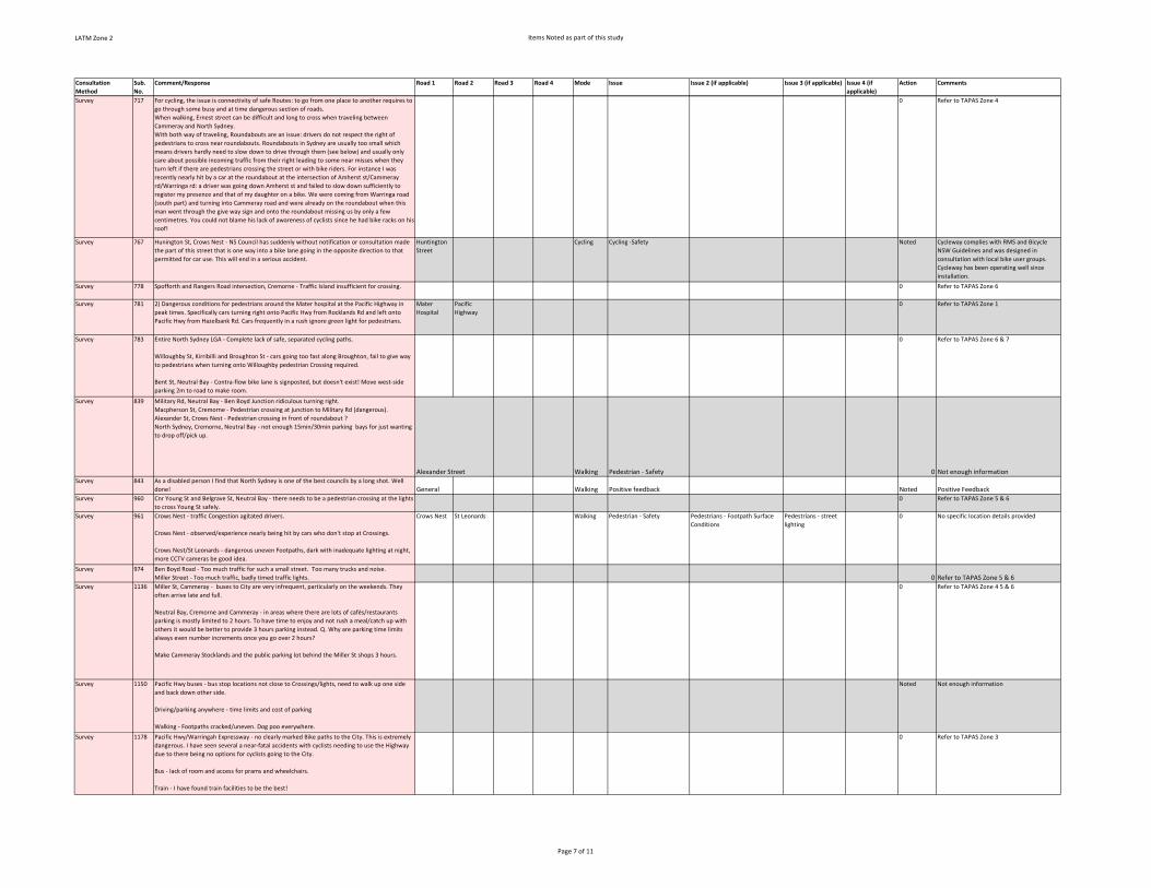
LATM Zone 2 Items Noted as part of this study
Consultation
Method
Sub.
No.
Comment/Response Road 1 Road 2 Road 3 Road 4 Mode Issue Issue 2 (if applicable) Issue 3 (if applicable) Issue 4 (if
applicable)
Action Comments
Survey 717 For cycling, the issue is connectivity of safe Routes: to go from one place to another requires to
go through some busy and at time dangerous section of roads.
When walking, Ernest street can be difficult and long to cross when traveling between
Cammeray and North Sydney.
With both way of traveling, Roundabouts are an issue: drivers do not respect the right of
pedestrians to cross near roundabouts. Roundabouts in Sydney are usually too small which
means drivers hardly need to slow down to drive through them (see below) and usually only
care about possible incoming traffic from their right leading to some near misses when they
turn left if there are pedestrians crossing the street or with bike riders. For instance I was
recently nearly hit by a car at the roundabout at the intersection of Amherst st/Cammeray
rd/Warringa rd: a driver was going down Amherst st and failed to slow down sufficiently to
register my presence and that of my daughter on a bike. We were coming from Warringa road
(south part) and turning into Cammeray road and were already on the roundabout when this
man went through the give way sign and onto the roundabout missing us by only a few
centimetres. You could not blame his lack of awareness of cyclists since he had bike racks on his
roof!
0 Refer to TAPAS Zone 4
Survey 767 Hunington St, Crows Nest ‐ NS Council has suddenly without notification or consultation made
the part of this street that is one way into a bike lane going in the opposite direction to that
permitted for car use. This will end in a serious accident.
Huntington
Street
Cycling Cycling ‐Safety Noted Cycleway complies with RMS and Bicycle
NSW Guidelines and was designed in
consultation with local bike user groups.
Cycleway has been operating well since
installation.
Survey 778 Spofforth and Rangers Road intersection, Cremorne ‐ Traffic Island insufficient for crossing. 0 Refer to TAPAS Zone 6
Survey 781 2) Dangerous conditions for pedestrians around the Mater hospital at the Pacific Highway in
peak times. Specifically cars turning right onto Pacific Hwy from Rocklands Rd and left onto
Pacific Hwy from Hazelbank Rd. Cars frequently in a rush ignore green light for pedestrians.
Mater
Hospital
Pacific
Highway
0 Refer to TAPAS Zone 1
Survey 783 Entire North Sydney LGA ‐ Complete lack of safe, separated cycling paths.
Willoughby St, Kirribilli and Broughton St ‐ cars going too fast along Broughton, fail to give way
to pedestrians when turning onto Willoughby pedestrian Crossing required.
Bent St, Neutral Bay ‐ Contra‐flow bike lane is signposted, but doesn't exist! Move west‐side
parking 2m to road to make room.
0 Refer to TAPAS Zone 6 & 7
Survey 839 Military Rd, Neutral Bay ‐ Ben Boyd Junction ridiculous turning right.
Macpherson St, Cremorne ‐ Pedestrian crossing at junction to Military Rd (dangerous).
Alexander St, Crows Nest ‐ Pedestrian crossing in front of roundabout ?
North Sydney, Cremorne, Neutral Bay ‐ not enough 15min/30min parking bays for just wanting
to drop off/pick up.
Alexander Street Walking Pedestrian ‐ Safety 0 Not enough informationSurvey 843 As a disabled person I find that North Sydney is one of the best councils by a long shot. Well
done! General Walking Positive feedback Noted Positive FeedbackSurvey 960 Cnr Young St and Belgrave St, Neutral Bay ‐ there needs to be a pedestrian crossing at the lights
to cross Young St safely.
0 Refer to TAPAS Zone 5 & 6
Survey 961 Crows Nest ‐ traffic Congestion agitated drivers.
Crows Nest ‐ observed/experience nearly being hit by cars who don't stop at Crossings.
Crows Nest/St Leonards ‐ dangerous uneven Footpaths, dark with inadequate lighting at night,
more CCTV cameras be good idea.
Crows Nest St Leonards Walking Pedestrian ‐ Safety Pedestrians ‐ Footpath Surface
Conditions
Pedestrians ‐ street
lighting
0 No specific location details provided
Survey 974 Ben Boyd Road ‐ Too much traffic for such a small street. Too many trucks and noise.
Miller Street ‐ Too much traffic, badly timed traffic lights. 0 Refer to TAPAS Zone 5 & 6Survey 1136 Miller St, Cammeray ‐ buses to City are very infrequent, particularly on the weekends. They
often arrive late and full.
Neutral Bay, Cremorne and Cammeray ‐ in areas where there are lots of cafés/restaurants
parking is mostly limited to 2 hours. To have time to enjoy and not rush a meal/catch up with
others it would be better to provide 3 hours parking instead. Q. Why are parking time limits
always even number increments once you go over 2 hours?
Make Cammeray Stocklands and the public parking lot behind the Miller St shops 3 hours.
0 Refer to TAPAS Zone 4 5 & 6
Survey 1150 Pacific Hwy buses ‐ bus stop locations not close to Crossings/lights, need to walk up one side
and back down other side.
Driving/parking anywhere ‐ time limits and cost of parking
Walking ‐ Footpaths cracked/uneven. Dog poo everywhere.
Noted Not enough information
Survey 1178 Pacific Hwy/Warringah Expressway ‐ no clearly marked Bike paths to the City. This is extremely
dangerous. I have seen several a near‐fatal accidents with cyclists needing to use the Highway
due to there being no options for cyclists going to the City.
Bus ‐ lack of room and access for prams and wheelchairs.
Train ‐ I have found train facilities to be the best!
0 Refer to TAPAS Zone 3
Page 7 of 11

LATM Zone 2 Items Noted as part of this study
Consultation
Method
Sub.
No.
Comment/Response Road 1 Road 2 Road 3 Road 4 Mode Issue Issue 2 (if applicable) Issue 3 (if applicable) Issue 4 (if
applicable)
Action Comments
Survey 1179 Huntington St ‐ is one way for motor vehicles and two way for bicycles. I am confused about
the Safety aspect of this arrangement and this street will not comply with the new bike laws.
Huntington
Street
Cycling Cycling ‐Safety Noted Cycleway complies with RMS and Bicycle
NSW Guidelines and was designed in
consultation with local bike user groups.
Cycleway has been operating well since
installation.
Survey 1185 St Leonards Station ‐ more car spaces at station, needs multi‐storey (on Christie St) and
walkway St Leonards to Crows Nest.
St Leonards
Train Station
Parking Parking ‐ Create New Supply Pedestrian ‐ Connectivity Noted Parking stations generate increases in traffic
volumes. The Crows Nest Metro Station will
service existing residents and future
residents associated with new high‐density
housing in St Leonards precinct. The station
and surrounding road network will be
designed to be accessible by walking, cycling
and public transport as the main forms of
transport to ensure traffic volumes are
maintained, not increased.
Survey 1185 Congestion on Miller St towards North Sydney in the morning ‐ buses are back logged not
enough bus stopping space at Miller St near Pacific Hwy.
Miller Street Pacific
Highway
Congestion Public Transport ‐
Infrastructure
0 Refer to TAPAS Zone 3
Survey 1185 No accessible underpass or path from bus stop Miller St and Pacific Hwy to North Sydney
station ‐ I have to constantly Walk against thousands of people. Liming out of North Sydney
station to get into the station. Otherwise multiple traffic lights.
Miller Street North Sydney
train station
Pacific
Highway
Walking Pedestrian ‐ connectivity 0 Refer to TAPAS Zone 3
Survey 1190 Military Rd, Big Bear shopping centre to Cremorne ‐ are the many traffic lights linked? Traffic
Congestion. Very poor air quality.
Big Bear shopping centre to Mosman in PM peak ‐ very slow progress even on bus lanes.
Generally in North Sydney ‐ the key issue is over use of private motor vehicles. Only when trips
are taxed will some sanity return, or public transport becomes clearly more effective e.g. Light
rail from City/Neutral Bay/Mosman/Northern Beaches. 0 Refer to TAPAS Zone 5 & 6Survey 1218 Pacific Hwy, North Sydney ‐ time to cross road (Walker St intersection)
Miller St ‐ frequency of weekend buses to City
Trafalgar St ‐ lack of free parking for friends/family visiting.
Pacific
Highway
Walker Street Walking Pedestrians ‐ Walking
Amenity
0 Refer to TAPAS Zone 3
Survey 1220 Atchison St, St Leonards ‐ the bike lane goes the wrong way down a one way street. Pedestrian
hazard. Generally low level of Safety for bike riders and those who ride in peak hour add
Congestion.
Atchison
Street
Cycling Cycling ‐Safety Cycling ‐ connectivity Noted The cycle lane meets current standards and
is an important link in the cycling network.
Survey 1253
Oaks Avenue ‐ Cyclists riding wrong way against one way traffic.
Military Rd, Neutral Bay ‐ Vehicle traffic so slow.
Military Rd, Neutral Bay ‐ Delays in bus travel ‐ peak hours. Not enough frequency at other
times. 0 Refer to TAPAS Zone 5 & 6Survey 1315 Parking spaces, though Ridge Street council park is absolutely fantastic.
I encounter overcrowding on the trains
Ridge Street
car park
Parking Positive feedback Noted Positive Feedback
Survey 1347 North Sydney ‐ Miller St 0 Not enough information
Survey 1351 Blue St, North Sydney (Bus Stand C at North Sydney station ‐ Overhead protection from the sun
is needed at this bus stop (clear Perspex doesn't work) as is shelter from wind and rain.
0 Refer to TAPAS Zone 3
Survey 1388 Crows Nest Road ‐ road camber makes it impossible/very difficult for people with
disability/mobility problems to use railway buses at temporary bus stop in lower Crows Nest
Road.
0 Refer to TAPAS Zone 1
Survey 1392 Whatmore Lane ‐ steepness of footpath: could it be ramped?
Corner of McKye St and King St Upper Level ‐ lighting: overhanging branches from property on
corner
Whole municipality ‐ 50kph speed zones and in some places 40kph to make it safer, esp
Waverton naval traffic
Holterman St Car Park ‐ it would be counterproductive to reduce number of car spaces to this
car park
Waverton ‐ Please promote more trains stopping at weekend
Holtermann
Street Car
Park
Parking Other Noted Noted
Survey 1409 Crows Nest Rd ‐ train replacement buses ‐ too infrequent, take too long to get to town (train
takes 7 mins, bus 20 mins)
Bay Rd ‐ train noise
Waverton village ‐ speed of traffic too fast
0 Refer to TAPAS Zone 1
Survey 1454 Crows Nest ‐ parking, too accommodating for cyclist, restrict parking to those from other LGAs Crows Nest Cycling Cycling ‐ No support for new
facilities
Noted Council has developed a cycling strategy to
formalise cycling facility in order to
encourage cycling so that people can reduce
their reliance on private vehicles which
contribute to congestion, parking issues, and
reduce general amenity of the area.
Page 8 of 11
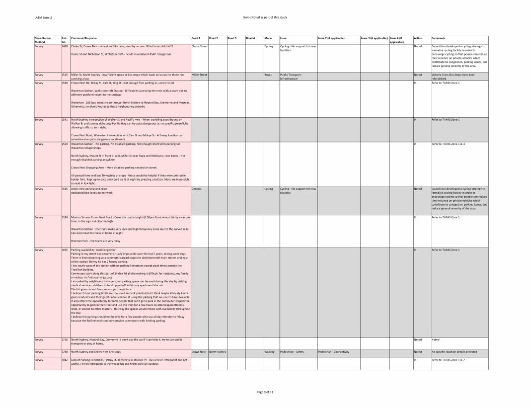
LATM Zone 2 Items Noted as part of this study
Consultation
Method
Sub.
No.
Comment/Response Road 1 Road 2 Road 3 Road 4 Mode Issue Issue 2 (if applicable) Issue 3 (if applicable) Issue 4 (if
applicable)
Action Comments
Survey 1469 Clarke St, Crows Nest ‐ ridiculous bike lane, used by no one. What brain did this??
Hume St and Nicholson St, Wollstonecraft ‐ needs roundabout ASAP. Dangerous.
Clarke Street Cycling Cycling ‐ No support for new
facilities
Noted Council has developed a cycling strategy to
formalise cycling facility in order to
encourage cycling so that people can reduce
their reliance on private vehicles which
contribute to congestion, parking issues, and
reduce general amenity of the area.
Survey 1515 Miller St, North Sydney ‐ insufficient space at bus stops which leads to issues for those not
catching a bus
Miller Street Buses Public Transport ‐
Infrastructure
Noted Victoria Cross Bus Stops have been
refurbished.
Survey 1540 Crows Nest Rd, Mikay St, Carr St, King St ‐ Not enough free parking ie, unrestricted.
Waverton Station, Wollstonecraft Station ‐ Difficulties accessing the train with a pram due to
different platform height to the carriage
Waverton ‐ 265 bus, needs to go through North Sydney to Neutral Bay, Cremorne and Mosman.
Otherwise, no divert Routes to these neighbouring suburbs
0 Refer to TAPAS Zone 1
Survey 1541 North Sydney Intersection of Walker St and Pacific Hwy ‐ When travelling southbound on
Walker St and turning right onto Pacific Hwy can be quite dangerous as no specific green light
allowing traffic to turn right.
Crows Nest Road, Waverton Intersection with Carr St and Mckye St ‐ A 5‐way Junction can
sometimes be quite dangerous for all users.
0 Refer to TAPAS Zone 1
Survey 1559 Waverton Station ‐ No parking. No disabled parking. Not enough short term parking for
Waverton Village Shops
North Sydney, Mount St in front of Aldi, Miller St near Bupa and Medicare, near banks ‐ Not
enough disabled parking anywhere.
Crows Nest Shopping Area ‐ More disabled parking needed on street.
All posted ferry and bus Timetables at stops ‐ these would be helpful if they were printed in
bolder font. Kept up to date and could be lit at night by pressing a button. Most are impossible
to read in low light.
0 Refer to TAPAS Zone 1 & 3
Survey 1585 crows nest parking and costs
dedicated bike lanes do not work
General Cycling Cycling ‐ No support for new
facilities
Noted Council has developed a cycling strategy to
formalise cycling facility in order to
encourage cycling so that people can reduce
their reliance on private vehicles which
contribute to congestion, parking issues, and
reduce general amenity of the area.
Survey 1594 Morton St near Crows Nest Road ‐ Cross the road at night (6.30pm‐7pm) almost hit by a car one
time. Is the sign not clear enough.
Waverton Station ‐ the trains make very loud and high frequency noise due to the curved rails.
Can even hear the noise at home at night.
Brennan Park ‐ the trains are very noisy
0 Refer to TAPAS Zone 1
Survey 1665 Parking availability, road Congestion
Parking in my street has become virtually impossible over the last 5 years, during week days.
There is limited parking at a commuter carpark opposite Wollstonecraft train station and east
of the station Shirley Rd has 2 hourly parking.
I live south‐west of the station with no parking limitations except peak times outside the
Tresillian building.
Commuters park along this part of Shirley Rd all day making it difficult for residents, my family
or visitors to find a parking space.
I am asked by neighbours if my personal parking space can be used during the day by visiting
medical services, children to be dropped off within my apartment bloc etc..
The list goes on and I'm sure you get the picture.
I believe 2 hour parking limits are too short and not practical but I think maybe 4 hourly limits
gives residents and their guests a fair chance at using the parking that we use to have available.
It also offers the opportunity for local people that can't get a park in the commuter carpark the
opportunity to park in the street and use the train for a few hours to attend appointments,
shop, or attend to other matters ‐ this way the spaces would rotate with availability throughout
the day.
I believe the parking should not be only for a few people who use all day Monday to Friday
because the Rail network can only provide commuters with limiting parking.
0 Refer to TAPAS Zone 1
Survey 1716 North Sydney, Neutral Bay, Cremorne ‐ I don't use the car if I can help it, try to use public
transport or stay at home.
Noted Noted
Survey 1748 North Sydney and Crows Nest Crossings Crows Nest North Sydney Walking Pedestrian ‐ Safety Pedestrian ‐ Connectivity Noted No specific location details provided
Survey 1842 Lack of Parking in Kirribilli, Fitzroy St, all streets in Milsons Pt ‐ Bus service infrequent and not
useful. Ferries infrequent in the weekends and finish early on sundays
0 Refer to TAPAS Zone 1 & 7
Page 9 of 11
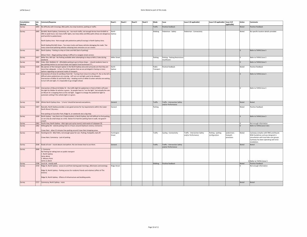
LATM Zone 2 Items Noted as part of this study
Consultation
Method
Sub.
No.
Comment/Response Road 1 Road 2 Road 3 Road 4 Mode Issue Issue 2 (if applicable) Issue 3 (if applicable) Issue 4 (if
applicable)
Action Comments
Survey 1843 No difficulty with Crossings, Bike paths, bus stop locations, parking or traffic. Traffic Positive feedback Noted Positive Feedback
Survey 1845 Kirribilli, North Sydney, Cammeray, etc ‐ too much traffic, not enough ferries from Kirribilli to
CBD on peak hours, too many traffic lights, too many bikes and Bike paths (these are dangerous
and harmful to pedestrians)
North Sydney Area ‐ Not enough safe pedestrian paths/Crossings in North Sydney Area.
North Sydney/Kirribilli Areas ‐ Too many trucks and heavy vehicles damaging the roads. Too
many unserviced polluting vehicles releasing toxic emissions on our streets
North
Sydney
Walking Pedestrian ‐ Safety Pedestrian ‐ Connectivity Noted No specific location details provided
Survey 1862 North Sydney ‐ Parking to shop at Coles and Aldi (lack of parking)
Milson Point ‐ Illegal parking making it difficult to navigate street corners
0 Refer to TAPAS Zone 3
Survey 1927 Miller Stm, Nth Syd ‐ No Parking available when attempting to shop at Aldi's/ Coles during
weekend.
Miller Street Parking Parking ‐ Parking Restrictions
Insufficient
0 Refer to TAPAS Zone 3
Survey 1996 Coles, Aldi, Walkders St ‐ affordable parking to go to these shops.... should residents have to
pay parking metres to use local shops and support local businesses??? ;
0 Refer to TAPAS Zone 3
Survey 2105 My opinion of the transport option in the North Sydney area and surrounds are that they are
more than adequate ‐ in fact, I'm of the opinion that we are privileged in having so many
options regarding our personal mode of transport.
North
Sydney
Public
Transport
Positive feedback Noted Positive Feedback
Survey 2110 Intersection of Union St and Blues Point Rd ‐ Turning from Union St to Blues Pt. Rd, to the left is
difficult when pedestrians are crossing. Left turn on red light used to be allowed.;
Intersection of Miller St and Pacific Hwy ‐ Heading north on Miller St when vehicles are waiting
to turn left and right, it is impossible to go straight ahead.
0 Refer to TAPAS Zone 3
Survey 2159 Intersection of Mount & Walker St ‐ the traffic light for pedestrian in front of Aldi is off even
the light for Walker St vehicles is green. So people have to "run the light", but actually the cars
on Mount St is stopping there at the red light. Suggest to change the pedestrian light to
automatic setting if the vehicle light is in green.
0 Refer to TAPAS Zone 3
Survey 2268 Whole North Sydney Area ‐ `U‐turns' should be banned everywhere.; General Traffic Traffic ‐ Intersection Safety
and/or Performance
Noted Noted
Survey 2307 Basically, North Sydney provides a very good service for my requirements within the Lower
North Shore/ City area.;
Free parking at Councillor Park, Ridge St, on weekends also a big help.
General Parking Noted Positive Feedback
Survey 2359 North Sydney ‐ now there are 3 Supermarkets in North Sydney, but still difficult to find parking,
so can only do small shops at a time. Doctor N.S hard for parking have to walk, not good if
unwell.
0 Refer to TAPAS Zone 3
Survey 2381 Pacific Hwy, North Sydney ‐ Idiot signs put up by council, total waste of ratepayer $$ 0 Not enough information
Survey 2382 Willoughby Rd ‐ extend parking time to 3 hours around Orpheum cinema, Cremorne;
Crows Nest ‐ allow 15 minutes free parking around Crows Nest shopping areas.
0 Refer to TAPAS Zone 5 & 6
Survey 2415 Huntingdon St ‐ Bike Paths, not enough space for cars. Parking, Footpaths, lack off.
Crows Nest, Cammeray ‐ Lack of parking
Huntington
Street
Traffic Cycling ‐ Connectivity Traffic ‐ Intersection Safety
and/or Performance
Parking ‐ parking
configuration
pedestrians ‐
footpath
provisions
Noted Cycleway complies with RMS and Bicycle
NSW Guidelines and was designed in
consultation with local bike user groups.
Cycleway has been operating well since
installation.
Survey 2548 Roads all over ‐ round abouts everywhere. No one knows how to use them. General Traffic Traffic ‐ Intersection Safety
and/or Performance
Noted Noted
Survey 2668 1. Cremorne
No Parking for taking train on public transport
2. North Sydney
Same above
3. Milsons Point
Same as above 0 Refer to TAPAS Zone 3Survey 2708 Local ok ‐ mostly walk Walking Positive feedback Noted Positive Feedback
Survey 2724 Ridge St, North Sydney ‐ access to and from during peak mornings, afternoons and evenings.
Ridge St, North Sydney ‐ Parking access for residents friends and relatives (effect of The
Greens)
Ridge St, North Sydney ‐ Effects of infrastructure and building works.
Ridge Street 0 Not enough information
Survey 2727 Cammeray, North Sydney ‐ none Noted Noted
Page 10 of 11

LATM Zone 2 Items Noted as part of this study
Consultation
Method
Sub.
No.
Comment/Response Road 1 Road 2 Road 3 Road 4 Mode Issue Issue 2 (if applicable) Issue 3 (if applicable) Issue 4 (if
applicable)
Action Comments
Survey 296 * Cycling ‐ Bent Street contraflow bicycle lane northbound from Winter Avenue is not clearly
marked for cyclists and motorists
* Cycling ‐ Lack of bicycle box for westbound cyclists at the traffic lights on Rangers Road at
Murdoch Street; the left lane is left‐only onto Murdoch Street and there is only one lane to go
straight on Rangers Road westbound or turn right onto Murdoch Street; also slip ramp from
Rangers Road onto Harrison Street is oftentimes blocked by a parked car
* Cycling ‐ Lack of bicycle parking rails in close proximity to Cremorne Orpheum, on Parraween
Street or on Military Road
Various Cycling Cycling ‐Safety Cycling ‐ connectivity 0
Refer to TAPAS Zone 5 & 6
Page 11 of 11

SMEC | North Sydney Council LATM Zone 2 Action Plans Final Report | Page 50
APPENDIX F – ASSESSMENT PROCESS AND SCORING METHODOLOGY

Figure 1 Process for consideration of traffic and parking requests
Request Received
Initial review by Council Traffic Engineer
Is request supported based on existing policies, guidelines,
safety or statutory requirements?
No
Traffic Engineer politely responds to customer
with outcome & outlining reasons
Yes
Complete LATM Assessment Matrix and produce priority score &
ranking
Does the proposal have merit under the LATM Assessment process?
No
Investigate alternatives
Yes
Add project to LATM list
Review project priorities
Staff refer design to Traffic Committee under staff Delegated Authority
Implement Project
Refer to Traffic Committee for advice if
required

Site ID T.31 Location: Issue:
1. Existing Conditions
Length of site (m) 0 Activity Generators within 400 metres
Speed Limit (km/h) 50 No. Injury crashes 0
85th Percentile Speed 42.8 No. Non‐injury crashes 0
No. Pedestrian crashes 0
Local No. Cyclist crashes 0
418
Pedestrian Usage Medium
Cyclist Usage Medium
Problem Score (P) (from Problem Scoring Criteria Sheet A) 31.15
2. Solution Score
Proposed Treatment Estimated Cost (C ) $80,000
1000
Score NSTS Priority Rating Total
3 0.81 2.43
1 0.81 0.81
2 0.65 1.3
3 0.65 1.95
‐1 0.59 ‐0.59
2 0.56 1.12 4. Project Priority
2 0.56 1.12
2 0.51 1.02 T ≥ 14 Short Term
0 0.44 0 3 ≤ T < 14 Medium Term
1 0.38 0.38 0 < T < 3 Long Term
9.54 T ≤ 0 Not to Proceed
3. Total Project Score (T) = 3.71
Number of people Affected (N)
Business Activity
Safe Travel
Community Transport Priority
Solution Score (S)
Pedestrian crossing, refuge or kerb build‐outs
Transport Security
Social Wellbeing
Active Health
Fair Access to Parking
Environmental Sustainability
Local Environments
Transport Affordability
Congestion
Road Type
Daily Traffic Volume
(vehicles per day)
Retirement Village/ Aged Care/ Hospital
No. Crashes
(past 5 years of available RMS crash data)
Cremorne Road at Milson Road Request for formal pedestrian facilities
Minor Park
Minor Shopping
Primary School
High School
University
Major Park
Major Shopping
PxSxNC
31.15x9.54x100080000

Sheet A ‐ Existing Conditions ‐ Problem Scoring Criteria
Criteria Measure Score Weighting Total Score
Volume
Road Type Environmental Capacity (veh/day)
Greater than environmental capacity
1
10
Local: Collector:
Sub‐Arterial: Arterial:
2,000 5,000 10,000 20,000
Less than or equal to environmental capacity
0
Speed (85th Percentile)
Above legal speed limit 2
10 Above 40km/h but less than speed limit
1
Less than 40km/h 0
Crashes (most recent 5 years of available RMS crash data)
No. injury crashes per linear metre of total site to be treated
2 per crash/m
5
No. non‐injury crashes per linear metre of total site to be treated
1 per crash/m
5
No. pedestrian crashes 1 per crash 1
No. cyclist crashes 1 per crash 1
Pedestrian Usage High (Guide: More than 50 pedestrians per hour)
4
5
Medium (Guide: 20‐50 pedestrians per hour) 2
Low (Guide: Less than 20 pedestrians per hour) 1
Cyclist Usage High 4
5 Medium 2
Low 1
Activity Generators Sum all that apply within 400 metres of site:
Primary School 10
10
High School 7
University 5
Retirement Village/ Aged Care/ Hospital
10
Major Park 6
Minor Park 4
Major Shopping 6
Minor Shopping 4
Total =Sum/52
TOTAL PROBLEM SCORE =Sum of Total Score

Example Site ID: T.31 Location: Cremorne Road at Milson Road, Cremorne Point
Sheet A ‐ Existing Conditions ‐ Problem Scoring Criteria
Criteria Measure Score Weighting Total Score
Volume
Road Type Environmental Capacity (veh/day)
Greater than environmental capacity
1
10 0
Local: Collector:
Sub‐Arterial: Arterial:
2,000 5,000 10,000 20,000
Less than or equal to environmental capacity
0
Speed (85th Percentile)
Above legal speed limit 2
10 10 Above 40km/h but less than speed limit
1
Less than 40km/h 0
Crashes (most recent 5 years of available RMS crash data)
No. injury crashes per linear metre of total site to be treated
2 per crash/m
5 0
No. non‐injury crashes per linear metre of total site to be treated
1 per crash/m
5 0
No. pedestrian crashes 1 per crash 1 0
No. cyclist crashes 1 per crash 1 0
Pedestrian Usage High (Guide: More than 50 pedestrians per hour)
4
5 10
Medium (Guide: 20‐50 pedestrians per hour) 2
Low (Guide: Less than 20 pedestrians per hour) 1
Cyclist Usage High 4
5 10 Medium 2
Low 1
Activity Generators Sum all that apply within 400 metres of site:
10 1.15
Primary School 10
High School 7
University 5
Retirement Village/ Aged Care/ Hospital
10
Major Park 6
Minor Park 4
Major Shopping 6
Minor Shopping 4
Total =6/52 =0.115
TOTAL PROBLEM SCORE 31.15

23North Sydney Transport Strategy |
7.4 Transport Planning and Management Decision Matrix
The revised Integrated Traffic and Parking Strategy (ITPS): Project Assessment Framework below delivers a justified and consistent transport planning and management decision matrix that addresses North Sydney’s transport vision and poriorities and that can be used to prioritise both strategic*1 and local*2 transport works programs.
Community Transport
PriorityWill the project: Make Worse Improve
NSTS Priority
Rating * TOTAL
Safe Travel
Transport Security
Social Wellbeing
Active Health
Fair Access to
Parking
Environmental
Sustainability
Local Environments
Transport
Affordability
Congestion
Business Activity
...improve community safety by creating slow speed road environments where more vulnerable road users are protected from higher impact road users and the number of crashes and severity of injuries is minimised?
...improve personal security through improved streetscape design, increased street activity and passive surveillance?
...provide social spaces where human interaction is given the highest priority and the negative impacts of traffic are minimised, promoting incidental social interaction, increasing civic pride, reducing anti-social behaviour and community policing requirements?
…provide infrastructure that encourages healthy and active lifestyle/travel choices?
...reduce demand for parking and / or provide more equitable access to existing parking supply?
...encourage the use of low greenhouse gas emitting transport options?
...encourage the use of travel modes that have minimal impact on air quality, water quality and noise?
...encourage the use of travel options with lower social, health and economic costs and higher social, health and economic benefits?
...apply travel demand management principles to minimise traffic demand and associated traffic congestion?
...increase business opportunities by improving the look/amenity of North Sydney throughout the day and in to the evening while, at the same time, reducing the whole of life cost of transport networks, including the ongoing costs associated with cleaning and maintaining assets?
-3 -2 -1 0 1 2 3
0.81
0.81
0.65
0.65
0.59
0.56
0.56
0.51
0.44
0.38
Score X NSTS Priority
Rating
Score X NSTS Priority
Rating
Score X NSTS Priority
Rating
Score X NSTS Priority
Rating
Score X NSTS Priority
Rating
Score X NSTS Priority
Rating
Score X NSTS Priority
Rating
Score X NSTS Priority
Rating
Score X NSTS Priority
Rating
Score X NSTS Priority
Rating
* figures derived from community feedback regarding the relative priority of CSP outcomes
TOTAL = SUM / 16.35
__________________________
Preliminary Project Score = SUM/16.35 x estimated cost x residents effected
Figure 24: Proposed North Sydney Transport Planning and Management Decision Matrix
*1 projects identified through Mode Specific Action Plans*2 projects identified through TAPAS consultation and ongoing resident enquiries