nmtguide
TRANSCRIPT

8/3/2019 nmtguide
http://slidepdf.com/reader/full/nmtguide 1/90
Victoria Transport Policy Institute1250 Rudlin Street, Victoria, BC, V8V 3R7, CANADA
www.vtpi.org [email protected] & Fax 250-360-1560
“Efficiency - Equity - Clarity”
Pedestrian and Bicycle PlanningA Guide to Best Practices
10 October, 2011
byTodd Litman, Robin Blair, Bill Demopoulos, Nils Eddy, Anne Fritzel, Danelle Laidlaw,
Heath Maddox, Katherine Forster
Abstract
This guide covers all aspects of pedestrian and bicycle planning. It is intended for policy makers, planners and advocates who want the best current information on ways to make their communities better places for walking and cycling. It provides basic information on various planning and design concepts, and offers extensive references to help implement them. Itdescribes general nonmotorized planning practices, how to measure and predict nonmotorizedtravel, how to evaluate and prioritize projects, and how to implement various programs thatsupport nonmotorized transportation. It covers planning for paths, sidewalks, bikelanes, streetimprovements, road and path maintenance, road safety, personal security, universal access(including features to accommodate people with disabilities), nonmotorized traffic lawenforcement, education and encouragement programs, and integration with a community’sstrategic plans and various other programs. There are also appendices that provide more detailedinformation on planning, design and evaluation.
This is an ongoing project. We welcome your feedback.

8/3/2019 nmtguide
http://slidepdf.com/reader/full/nmtguide 2/90
Pedestrian and Bicycle Planning; Guide to Best Practices
Foreword
Transport planning practices must change if they are to incorporate nonmotorized modes. Whilewalking and cycling have long been recognized as important activities, mobility and access asmeasured in traditional planning practices focused on motor vehicle travel. There is increasing
recognition that balanced transportation choices are important to individual travelers and societyoverall. This guide presents best practices for nonmotorized transport planning.
Planning for nonmotorized travel can benefit your community in many ways. It can remove barriers to mobility and increase the safety and comfort of pedestrians and cyclists, broadentravel options for non-drivers, reduce conflicts between motorists and other road users, reduceautomobile traffic and the problems it creates, increase recreational activity and exercise,encourage nonmotorized tourism, better accommodate people with disabilities, and help createmore livable communities. Improved pedestrian and cycling conditions can benefit everybody inyour community regardless of how much they use nonmotorized travel modes.
This guide describes how to develop local pedestrian and bicycle plans. It discusses reasons thatcommunities should develop such plans, provides specific instructions for developing your planning process and creating your plan, discusses how to integrate nonmotorized planning intoother local planning activities, and provides an extensive list of pedestrian and bicycle planningresources. This guide describes how to use available resources most efficiently to improvewalking and cycling conditions in your community.
A pedestrian and cycling plan is not just a map showing paths and trails. It can address a varietyof issues including:
1. Coordination of nonmotorized transportation improvements with other community plans.2. Encouraging nonmotorized transport for transportation and recreation.3. Nonmotorized safety education programs.4. Traffic management and traffic calming.5. Improving enforcement of traffic laws related to nonmotorized travel.6. Pedestrian and bicycle facility planning and design.
2

8/3/2019 nmtguide
http://slidepdf.com/reader/full/nmtguide 3/90
Pedestrian and Bicycle Planning; Guide to Best Practices
Table of ContentsABSTRACT..............................................................................................................................................1
I. INTRODUCTION: WHY PLAN FOR WALKING AND CYCLING...............................................5
II. TRANSPORT PLANNING OVERVIEW.............................................................................................7
PLANNING PROCESS..................................................................................................................................7SCOPING AND BACKGROUND R ESEARCH.......................................................................................................9MEASURING CURRENT NONMOTORIZED TRAVEL..........................................................................................10PREDICTING POTENTIAL NONMOTORIZED TRAVEL.........................................................................................12EVALUATING EXISTING CONDITIONS AND FACILITIES.....................................................................................13IDENTIFY AND EVALUATE CONSTRAINTS AND OPPORTUNITIES.........................................................................14PRIORITIZE IMPROVEMENTS .....................................................................................................................16BUDGETING AND EVALUATION..................................................................................................................17ECONOMIC DEVELOPMENT IMPACTS OF NONMOTORIZED TRANSPORT................................................................20
III. NONMOTORIZED TRANSPORTATION PLANNING.................................................................22
1. I NTEGRATING WITH STATE OR PROVINCIAL PLANNING...............................................................................222. PLANNING MULTI-USE TRAILS.............................................................................................................22
DEALING WITH TRAIL CONFLICTS............................................................................................................24FACILITY MAINTENANCE..........................................................................................................................24SPOT IMPROVEMENT PROGRAMS................................................................................................................25PEDESTRIAN AND BICYCLE NEEDS AT CONSTRUCTION PROJECTS....................................................................26PEDESTRIAN AND BICYCLE COORDINATORS.................................................................................................26CRIME PREVENTION THROUGH E NVIRONMENTAL DESIGN (CPTED)...............................................................27
IV. PLANNING FOR PEDESTRIANS......................................................................................................29
TYPES OF PEDESTRIANS...........................................................................................................................30PEDESTRIAN FACILITIES AND PLANNING......................................................................................................31PEDESTRIAN STANDARDS AND IMPROVEMENTS.............................................................................................324. U NIVERSAL DESIGN (I NCLUDING ACCESS FOR PEOPLE WITH DISABILITIES)....................................................355. PEDESTRIAN SAFETY PROGRAMS...........................................................................................................37
V. PLANNING FOR BICYCLISTS...........................................................................................................38TYPES OF CYCLISTS...............................................................................................................................38I NTEGRATING CYCLING I NTO R OADWAY PLANNING.......................................................................................38BICYCLE NETWORK PLANNING..................................................................................................................38ACCOMMODATING CYCLISTS ON R URAL R OADS...........................................................................................41BICYCLE BOULEVARDS............................................................................................................................41BICYCLE PARKING FACILITIES...................................................................................................................42I NTEGRATING CYCLING AND TRANSIT.........................................................................................................44R OADWAY MAINTENANCE FOR CYCLISTS....................................................................................................46
VI. SAFETY PROGRAMS.........................................................................................................................48
SAFETY EDUCATION...............................................................................................................................48TRAFFIC LAW E NFORCEMENT...................................................................................................................49
VII. ENCOURAGEMENT AND PROMOTION.....................................................................................50
VIII. IMPLEMENTATION STRATEGIES AND TOOLS....................................................................52
COMPREHENSIVE PLANS .........................................................................................................................52R OAD DESIGN, R ECONSTRUCTION AND MAINTENANCE R EQUIREMENTS.............................................................52MUNICIPAL LAWS..................................................................................................................................53MAJOR PROJECTS AND SITE PLAN AGREEMENTS..........................................................................................53WORKING WITH NEIGHBORHOOD AND BUSINESS ASSOCIATIONS ......................................................................54LAND EXCHANGE, DEDICATION OF PARKLAND WITH PRIVATE DEVELOPER ........................................................54
3

8/3/2019 nmtguide
http://slidepdf.com/reader/full/nmtguide 4/90
Pedestrian and Bicycle Planning; Guide to Best Practices
R URAL AREAS, UTILITY CORRIDORS, FIRE R OADS AND R AILS-TO-TRAIL OPPORTUNITIES ...................................54
IX. RELATED PLANNING ISSUES................................................................................................... .....55
SCHOOL TRIP MANAGEMENT....................................................................................................................552. TRAFFIC MANAGEMENT AND TRAFFIC CALMING.....................................................................................56R OADWAY ACCESS MANAGEMENT............................................................................................................57LIVABLE COMMUNITY PLANNING..............................................................................................................58
APPENDIX 1 MODEL PEDESTRIAN AND BICYCLE PLAN...........................................................60
I NTRODUCTION ......................................................................................................................................60BACKGROUND TO THE PLAN......................................................................................................61BICYCLING AND WALKING GOALS............................................................................................61OBJECTIVES AND POLICIES.........................................................................................................62
The Engineering Department Will:......................................................................................................63The Parks and Recreation Department Will:......................................................................................64
Law Enforcement Agencies Will:.........................................................................................................64 Public Involvement...............................................................................................................................65
APPENDIX 2 QUICK FACILITY DESIGN GUIDELINES................................................................67
PEDESTRIAN PLANNING GUIDELINES...........................................................................................................67
BICYCLE FACILITY DESIGN GUIDELINES.....................................................................................................69APPENDIX 3 EVALUATING NONMOTORIZED TRAVEL..............................................................72
Surveys..................................................................................................................................................72Crash Data...........................................................................................................................................73
Field Surveys........................................................................................................................................73 Bicycle and Pedestrian Level-of-Service Ratings...............................................................................74The Barrier Effect................................................................................................................................75Cycling Condition Evaluation Techniques..........................................................................................75
Pedestrian Condition Evaluation Techniques.....................................................................................76 Prioritizing Improvements and Selecting Preferred Options..............................................................79
APPENDIX 4 EXEMPLARY BICYCLE AND PEDESTRIAN PLANS..............................................83
BICYCLE PLANS.....................................................................................................................................83
PEDESTRIAN PLANS.................................................................................................................................84
APPENDIX 5 BICYCLE AND PEDESTRIAN PLANNING RESOURCES......................................85
R OADWAY DESIGN R ESOURCES.................................................................................................................85PEDESTRIAN AND BICYCLE PLANNING .......................................................................................................85PEDESTRIAN PLANNING PUBLICATIONS........................................................................................................86BICYCLE PLANNING PUBLICATIONS............................................................................................................87USEFUL ORGANIZATIONS.........................................................................................................................87
4

8/3/2019 nmtguide
http://slidepdf.com/reader/full/nmtguide 5/90
Pedestrian and Bicycle Planning; Guide to Best Practices
I. Introduction: Why Plan for Walking and CyclingThere are many reasons to plan for nonmotorized transportation. Walking, cycling, jogging andskating1 are increasingly popular for transport and recreation. Safe and convenient nonmotorizedtravel provides a many benefits, including reduced traffic congestion, user savings, road and parking facility savings, economic development and a better environment. This section presents a brief overview of the importance of considering nonmotorized transport in transport plans.
The ultimate goal of transportation is to provide access to goods, services and activities. Ingeneral, the more transportation options available, the better the access. Nonmotorized modes areimportant transport choices, for trips made entirely by walking or cycling, and to support publictransport. In urban areas, walking and cycling are often the fastest and most efficient way to perform short trips. A built environment that is hostile to non-motorized transport reduceseverybody’s travel choices. The result of this “automobile dependency” is increased trafficcongestion, higher road and parking facility costs, increased consumer costs, and greater environmental degradation. Adequate pedestrian and cycling conditions are essential to guaranteeeverybody a minimal level of mobility (“basic mobility”). As stated in one of the primaryroadway design guides,
Pedestrians are a part of every roadway environment, and attention must be paid to their presence in rural as well as urban areas…Because of the demands of vehicular traffic incongested urban areas, it is often extremely difficult to make adequate provisions for pedestrians. Yet this must be done, because pedestrians are the lifeblood of our urban areas,especially in the downtown and other retail areas. In general, the most successful shoppingsections are those that provide the most comfort and pleasure for pedestrians.2
Walking, cycling and skating are enjoyable and healthy activities. They are among the most popular forms of recreation. Public health officials increasingly recognize the importance of frequent aerobic exercise.3 According to a government report, “ Regular walking and cycling arethe only realistic way that the population as a whole can get the daily half hour of moderateexercise which is the minimum level needed to keep reasonably fit .”4
Nonmotorized travel can contribute to the local economy by supporting tourism and qualitydevelopment. Pedestrian-friendly conditions improve the commercial and cultural vibrancy of communities. Increased pedestrian traffic helps create a safer and more pleasant environment.Once visitors arrive in a community they often explore it by walking, cycling and skating. Agood walking environment can enhance visitors’ experience. Some trail networks are destinationtourist attractions, bringing hundreds or thousands of visitors, and thousands or millions of dollars annually to a community.
When your community implements pedestrian and cycling improvements, it is important to do itcorrectly. Excellent planning resources are now available to help plan, evaluate, construct andmaintain nonmotorized facilities. There is no need to reinvent the wheel, and no excuse for
1 J. Scott Osberg, Stephanie Faul, Joshua Poole, and John McHenry, Skating: An Emerging Mode of Transportation. Transportation Research Board Annual Meeting, 2000.2 Policy on Geometric Design of Highways and Streets, American Association of State Highway andTransportation Officials, 1994, p. 97.3 Physical Activity and Health: A Report of the Surgeon General , Center for Disease Control(www.cdc.gov/nccdphp/sgr ), 1996.4 Physical Activity Task Force, More People, More Active, More Often, UK Department of Health(London), 1995, cited in Judith Hanna, “Transport and Health: Fit to Get About” Urban Transport
International , No. 4, March/April 1996, p. 11.
5

8/3/2019 nmtguide
http://slidepdf.com/reader/full/nmtguide 6/90
Pedestrian and Bicycle Planning; Guide to Best Practices
employing inadequate or outdated methods. Good planning is far cheaper than correctingmistakes later.
Many communities have provided relatively little support to nonmotorized travel. As describedlater in this guide, methods commonly used to evaluate roadway projects tend to favor motorizedtravel and overlook the benefits of improved nonmotorized access, so pedestrian and cycling
programs tend to be underfunded. As a result, many areas have inadequate sidewalks andcrosswalks, roads are not designed or maintained to accommodate cycling, and opportunities for pedestrian and cycling facilities and connections are overlooked.
Virtually all communities that have increased nonmotorized transport have achieved this byimprovements to their walking and cycling environment. Walking and cycling facilities can payfor themselves through road and parking facility savings. For example, a bicycle improvementthat shifts 100 trips a day from driving to bicycling can provide as much as $1 million in parkingand roadway cost savings over its lifetime.
Few improvements will be implemented without a plan. Good planning can reduce the cost of improvements by allowing, for example, nonmotorized improvements to be incorporated intoscheduled road projects. Funding is often available for nonmotorized projects and programs.Obtaining this support requires that a community have a plan that identifies and prioritizes projects and programs. It is therefore important for local governments to develop plans to beready for opportunities that may arise.
Planning Tip
Summary of Nonmotorized Transportation Benefits5 Personal Benefits• Mobility, particularly important for non-drivers (including children and the elderly).• Financial savings.• Exercise, leading to increased health and well being (reduced heart disease, stroke,
hypertension, obesity, diabetes, colon cancer, osteoporosis, stress, and depression).•
Increased social interaction, opportunities to meet neighbors.• Enjoyment.
Community Benefits of Substituting Walking and Cycling for Short Car Trips• Reduced traffic congestion.• Road and parking facility savings.• Reduced motor vehicle air, water, and noise pollution.• Improved public health.• More livable communities.• Increased community interaction, which can result in safer streets.• Increased appeal and access for tourists.• More efficient land use (reduced sprawl), by encouraging infill development.
5 Todd Litman, Quantifying the Benefits of Nonmotorized Transport , VTPI (www.vtpi.org), 1999.
6

8/3/2019 nmtguide
http://slidepdf.com/reader/full/nmtguide 7/90
Pedestrian and Bicycle Planning; Guide to Best Practices
II. Transport Planning Overview
Planning Process
Any planning should be based on an overall problem statement , vision, and general goals. Thevision and goals help determine specific objectives. This also determines the evaluation criteria
that will be used for prioritizing actions, programs, projects, and tasks.
Problem Statement, Vision, and Goals(examples: safety, health, mobility, equity, economic development)
⇓Objectives
(examples: teach safety, improve roadway and trail facilities, increased nonmotorized travel)⇓
Evaluation Criteria(examples: crash/injury rates, Bicycle Compatibility Index, nonmotorized travel rate)
⇓Actions, Programs, Projects, and Tasks
(examples: adopt design standards, provide safety program, implement road and trail projects)
An effective planning process involves various stakeholders, including staff from other relatedagencies, potential users, and other groups who may be impacted by the plan. This process can provide long-term benefits and support the plan’s implementation by educating officials andcommunity members about pedestrian and cycling issues, establishing communication betweentechnical staff and users, addressing potential conflicts, and creating an on-going framework for pedestrian and cycling planning. Below is a list of typical steps in a planning process.
Typical steps in a planning process:
1. Establish problem statement.*
2. Scoping and background research.
3. Develop planning process.
4. Establish vision, goals, objectives, and evaluation criteria.*
5. Identify constraints and opportunities.*
6. Prioritize projects and programs.*
7. Develop implementation plan and budget.
8. Program evaluation.
9. Update and modify plan as needed.*
* Requires public involvement
7

8/3/2019 nmtguide
http://slidepdf.com/reader/full/nmtguide 8/90
Pedestrian and Bicycle Planning; Guide to Best Practices
Coordination With Other Planning Activities Nonmotorized planning requires coordination among various municipal and regional planningactivities. Table 1 shows some of these relationships. When developing a planning process, other appropriate agencies should be consulted. For example, transportation agencies should becontacted early in the planning process, invited to participate in technical committees, consultedconcerning issues that affect provincial highways, and have a chance to review draft plans.
In general, pedestrian improvements are planned at the neighborhood level, since that is the scaleof most walking trips. Pedestrian improvements tend to be centered around focal points such asschools, residential, commercial, and high-density areas. Because cyclists travel farther, bicycle planning requires more coordination between jurisdictions to create an effective regional bicyclenetwork. Grants may be available to fund some local planning activities and special projects.
Table 1 Activities To Be Coordinated With NMT PlanningType of Planning Examples
Community “strategic,”“comprehensive,” and“sustainability” planning.
Include nonmotorized transportation and pedestrian/bicycle friendlydevelopment strategies as a component of community strategic andcomprehensive plans. Use nonmotorized transport to help achievesustainability objectives.
Regional and localtransportation
Ensure that pedestrian and cycling facilities integrate with regional facilitiesand attractions, including roadway construction and reconstruction,transportation terminals, transportation demand management, and transit planning.
Neighborhood plansEnsure that neighborhood traffic management projects include sidewalks, bicycle routes, and traffic calming and traffic safety features that benefitwalking and cycling.
Municipal andzoning bylaws
Ensure that zoning laws incorporate suitable sidewalk and bicycle parkingrequirements.
Street and newsubdivision designstandards
Develop pedestrian and cycle friendly street designs. Incorporate paths andconnecting links when possible. Locate public services, such as schools,colleges and, local shops, within easy bicycling and walking of residences.
Land preservation
Incorporate trail and public greenspace development when planning land use
and agricultural and other land preservation.
Traffic enforcementEstablish bicycle traffic law enforcement polices and pedestrian safety programs.
Economic developmentProvide suitable pedestrian and cycling facilities to tourist attractions. Createtrails that are tourist attractions and seek to provide public transit access to thetrails and other tourist attractions.
ParksDevelop walking and cycling routes to public parks. Look for opportunitieswhere parks can be included in walking and cycling networks.
SchoolsPerform pedestrian and cycling audits around schools. Identify funding sourcesto improve pedestrian and cycling access to schools and related destinations.Encourage safe route to school programs.
This table illustrates examples of other community planning activities that could be coordinated with pedestrian and bicycle planning.
8
8/3/2019 nmtguide
http://slidepdf.com/reader/full/nmtguide 9/90
Pedestrian and Bicycle Planning; Guide to Best Practices
Public Involvement Public involvement is an important component of nonmotorized planning. It broadens the scopeof concerns, solutions, and perspectives to be considered in the plan, and can help identify potential problems early in the process. It can also help gain support for the plan’simplementation.
Public Involvement Techniques6
• Advisory committee• Audio-visual presentation• Discussion paper • News release, brochure and mail-out• Open house (public information drop-in)
• Public meeting• Site tour • Small group meeting• Survey and questionnaire• Public workshop
Resources
Planning and Public Involvement
Desmond Connor, Constructive Citizen Participation: A Resource Book , Connor Development
Services (www.connor.bc.ca/connor ), 1997, 232 pages.
Innovations in Public Involvement for Transportation Planning , Federal HighwayAdministration, (Washington DC), 1994.
Scoping and Background Research
Scoping involves identifying the range of issues to be considered in the planning process. It isimportant to do this early. For example, it would be inefficient if a year into the process youdiscovered that your pedestrian plan should have incorporated Universal Design (accommodatingthe widest range of users, including people with various physical limitations) or integration with public transit service. It may be helpful to prepare a background report that provides an overviewof pedestrian and bicycle planning issues. It could include available information on:
1. Existing bicycle and pedestrian infrastructure and programming.2. Area demographics.3. Bicycle and pedestrian collision statistics.4. Travel surveys, pedestrian/cycling questionnaires.5. Information on stakeholders (i.e., cycling groups).6. Nonmotorized planning and facility development resources.7. Current and developing planning documents.8. Existing design and engineering standards.9. Existing safety education and enforcement programs.10. Known or proposed road, site, park, or trail projects affecting walking and cycling.
6 Manual of Socioeconomic Procedures, BC Ministry of Transportation and Highways (Victoria), 1994,Chapter 10.
9

8/3/2019 nmtguide
http://slidepdf.com/reader/full/nmtguide 10/90
Pedestrian and Bicycle Planning; Guide to Best Practices
Measuring Current Nonmotorized Travel7
Some nonmotorized travel data may be available from existing travel surveys and traffic counts.8
However, most travel surveys and traffic counts under-record nonmotorized trips. Many excludewalking trips altogether, and they often undercount short trips, non-work trips, travel by children,and recreational trips. Automatic traffic counters may not record nonmotorized travelers, andmanual counters are usually located on arterial streets that are less heavily used by cyclists thanadjacent lower traffic streets. In fact, most trips involve nonmotorized links. For example, tripsclassified as “auto” or “transit” trips are often actually “walk-auto-walk,” or “bike-bus-walk”trips, yet the nonmotorized components are often ignored, even if they occur on public roads.
One study finds that the actual number of nonmotorized trips is six times greater than whatconventional surveys indicate.9 In 2000, the Southern California Metropolitan TransportationAuthority increased the portion of nonmotorized travel in their models from about 2% of regionaltrips (based on conventional travel surveys) up to about 10% (based on more comprehensivetravel data from the 1995 National Personal Transportation Survey).
Information on current walking and cycling travel can be gathered using:
1. A general travel survey designed to elicit sufficient responses concerning nonmotorizedtravel. For example, “travel” should be clearly defined to include walking and bicycling trips.Short, non-work and recreational trips, and trips by children should be counted.
2. A special survey targeting cyclists and pedestrians (such as survey forms distributed through bicycle shops, sport clubs, recreation centres, colleges, and schools).
3. A survey handed out to cyclists and pedestrians as they travel along a street or path.
4. Traffic counts that gather information on pedestrian and bicycle travel. These can include photoelectric counters installed on trails, electronic counters installed on cycle paths and bikelanes, and manual counts. Volunteers from pedestrian and cycling organizations may also bemobilized to perform manual counts for nonmotorized travel.
Pedestrian and bicycle travel surveys should attempt to gather the following information:
• Who – Demographic information such as age, gender, residence location, employment status,and income.
• Where – Origin and destination of trips, including links by other modes (such as transit).
• When – Time, day of the week, day of the year, and conditions, such as weather, roadconditions, and traffic conditions.
• Why – Purpose of trip. What factors affected travel choice (for example, would a cyclist havechosen another route or mode if road conditions or facilities were different).
7 See Appendix 3 for more information on evaluation techniques.8 BTS, Bicycle and Pedestrian Data: Sources, Needs & Gaps, USDOT(www.bts.gov/programs/transtu/bikeped/report.pdf ), 20009 Piet Rietveld, “Nonmotorized Modes in Transport Systems: A Multimodal Chain Perspective for The Netherlands,” Transportation Research D, Vo. 5, No. 1, Jan. 2000, pp. 31-36.
10

8/3/2019 nmtguide
http://slidepdf.com/reader/full/nmtguide 11/90
Pedestrian and Bicycle Planning; Guide to Best Practices
Example
Nonmotorized Transport Survey Questions10
1. Are your neighbourhoods designed to promote walking and cycling to get to school, work,recreation, transit, and retail outlets? Are these facilities used?
2. If these facilities are not used, what improvements might be made to make them moreaccessible?
3. Is street lighting adequate?
4. Are sidewalks maintained, repaired, and cleared of snow in the winter?
5. Are bike lanes part of the roads?
6. Does your community master plan include facilities for cycling and walking?
7. Are there cycling organizations in your community promoting the use of bicycles?
8. Are there bicycle racks at transit stations and outside municipal facilities?
9. Do school organizations promote walking, cycling, and safety programs for both?
10. Do schools and workplaces provide secure bicycle parking?
11. Are local government officials aware of the walking and cycling needs of neighbourhoods?
12. What measures could be taken to calm traffic in your residential neighbourhoods?
13. Can community groups be encouraged to organize bicycle safety workshops?
14. Do local businesses support walking and cycling to their stores?
15. What groups might be involved in forming partnerships to promote active transportation inyour community?
16. Are residents in your community encouraged to keep sidewalks clear of snow for those whowant to walk?
17. Is there bicycle parking near shopping areas and other destinations?
Pedestrian and bicycle collision data can help identify barriers and hazards to nonmotorizedtravel. Locations with frequent pedestrian or cycling crashes indicate some combination of highrisk or heavy use, both of which can justify facility improvements. Pedestrian and cyclingcollisions tend to be underreported, so a variety of data collection methods may be needed.11
If possible, travel data should be recorded in a format that can be Geographic InformationSystems (GIS) coded. Since nonmotorized trips tend to be short, fine-grained mapping isimportant. Most traffic models use zones that are too large to capture such trips and maps that are
too large to illustrate all pedestrian and cycling facilities. However, conventional traffic modelscan be modified to predict nonmotorized travel.12
10 Developing Communities for Active Transportation, Go For Green (www.goforgreen.ca), 1998.11 Helen James, “Under-reporting of Road Traffic Collisions,” Traffic Eng+Con, Dec. 1991, pp. 574-583.12 Ronald Eash, “Destination and Mode Choice Models for Nonmotorized Travel,” Transportation
Research Record 1674, 1999, pp. 1-8.
11

8/3/2019 nmtguide
http://slidepdf.com/reader/full/nmtguide 12/90
Pedestrian and Bicycle Planning; Guide to Best Practices
Predicting Potential Nonmotorized Travel
A number of specific factors can affect demand for nonmotorized transport in a particular situation.13 These include:
• Attractions. Certain activity centres tend to be major attractors for walking and cycling,including commercial districts, school-college-university campuses, employment centres,
recreation centres and parks.
• Trip distance. Most walking trips are less than 2 kilometres and most bicycling trips lessthan 5 kilometres in length, although recreational trips are often much longer.
• Demographics. Young (10-20 years), elderly, and low-income people tend to rely more onwalking for transport. Young and low-income people tend to rely on cycling for transport.
• Land use patterns (density and mix). Walking and bicycling for transportation tend toincrease with density (i.e., number of residents and businesses in a given area) becausehigher density makes these modes more efficient.
• Travel conditions. Wide roads with heavy, high-speed vehicle traffic can form significant barriers to nonmotorized travel. Special facilities for nonmotorized travel (sidewalks, widecurb lanes, and paths) and their condition can have a significant impact on the amount of walking and bicycling that occurs.
• Topography and climate. These factors can affect walking and bicycling, but not as much asmight be expected. For example, the cities of Seattle, Portland and Missoula reportsignificantly higher levels of cycle transportation than many “Sunbelt” cities that are flat andhave mild climates.
• Community attitudes. Local attitudes can have a major impact on the level of cycling in acommunity. For example, it may be unremarkable that cycling tends to be high amongcollege students and staff, but many college towns find that cycling is also relativelycommon among people who have not formal affiliation with the college simply because ithas become an acceptable form of transportation. This indicates that some people hesitate tocycle, but will if they perceive it to be more socially acceptable.
• Time and geographic scope. It may take several years for a community to fully achieve itsfull nonmotorized travel potential. First year impacts are frequently modest, but tend toincrease as individuals become more accustomed to nonmotorized travel and as additionalsupport facilities (pedestrian and bicycle network, bicycle parking, etc.) develop.
Computer modeling improvements allow better prediction of how planning decisions are likelyto affect nonmotorized travel.14 However, these are currently in the development stage and maynot be cost effective for application in every community during the foreseeable future.
Table 2 Areas Likely to Benefit from Nonmotorized FacilitiesFeature Examples
Favorable DemographicsLarge numbers of children and young adults.A significant portion of residents who are non-drivers.Interest in fitness.
13 W.L. Schwartz, et al., Guidebook on Methods to Estimate Nonmotorized Travel: Overview of Methods ,Turner-Fairbank Highway Research Center, FHWA (www.tfhrc.gov), 1999.14 Cambridge Systematics and Bicycle Federation of America, Guidebook on Methods to Estimate Non-Motorized Travel , FHWA, Publication No. FHWA-RD-98-166 (available at www.tfhrc.gov), 1999;PBQD, Data Collection and Modeling Requirements for Assessing Transportation Impacts of Micro-Scale Design, Transportation Model Improvement Program, USDOT (www.bts.gov/tmip), 2000.
12

8/3/2019 nmtguide
http://slidepdf.com/reader/full/nmtguide 13/90
Pedestrian and Bicycle Planning; Guide to Best Practices
Compatible Land UseMedium to high population densityMixed land uses.Presence of cycling generators (e.g. university)
Reasonable Trip Distances andTimes
Jobs/schools within 30 minutes by walking or cycling.Shopping/services within 10-15 minutes by walking/cycling.Most destinations within 10 km.
Supportive Social EnvironmentPerception of safety.Presence of people activity.Employer support/tolerance of cycle commuting.
Functional InfrastructureBasic road system adequate for cycling. No major barriers.Reasonable topography.
Suitable Traffic ConditionsSpeeds/volumes reasonable.Lack of heavy commercial traffic.
Many communities have significant latent demand for nonmotorized travel. That is, peoplewould walk and bicycle more frequently if they had suitable facilities and resources.15 A U.S.survey found that 17% of adults claim they would sometimes bicycle commute if secure storageand changing facilities were available, 18% would if employers offered financial incentives, and20% would if they had safer cycling facilities.16 Table 3 summarizes a recent Canadian publicsurvey indicating high levels of interest in cycling and walking.
Table 3 Active Transportation Survey Findings17
Cycle Walk Currently use this mode for leisure and recreation. 48% 85%Currently use this mode for transportation. 24% 58%Would like to use this mode more frequently. 66% 80%Would cycle to work if there “were a dedicated bike lane which would takeme to my workplace in less than 30 minutes at a comfortable pace.” 70%Support for additional government spending on bicycling facilities. 82%
Appropriate facilities and roadway improvements for walking and cycling (sidewalks,crosswalks, multi-use paths, bike lanes, traffic calming) can increase nonmotorized travel. Onestudy found that each mile of bikeway per 100,000 residents increases bicycle commuting 0.075 percent, all else being equal.18
Evaluating Existing Conditions and Facilities19
Some transportation agencies use volunteers or hired college students to perform field surveys of pedestrian and cycling conditions. If possible, surveys should include special user groups, suchas people in wheelchairs and elderly pedestrians, particularly in areas they frequent.
When evaluating facilities it is important to clearly maintain the distinction between nominal (“in
name”) and functional (“working condition”) dimensions. For example, many sidewalks and paths are nominally 1.8 to 2 metres wide, but functionally they may be much narrower, due to
15 Charles Komanoff and Cora Roelofs, The Environmental Benefits of Bicycling and Walking , NationalBicycling and Walking Study Case Study No. 15, USDOT, January 1993, FHWA-PD-93-015.16 “A Trend On the Move: Commuting by Bicycle.” Bicycling Magazine, Rodale Press, April 1991.17 Environics, National Survey on Active Transportation, Go for Green, (www.goforgreen.ca), 1998.18 Arthur Nelson and David Allen, “If You Build Them, Commuters Will Use Them; Cross-SectionalAnalysis of Commuters and Bicycle Facilities,” Transportation Research Record 1578, 1997, pp. 79-83.19 See Appendix 3 for more information on evaluation techniques.
13

8/3/2019 nmtguide
http://slidepdf.com/reader/full/nmtguide 14/90
Pedestrian and Bicycle Planning; Guide to Best Practices
objects such as telephone poles and signposts located in their right of way, and due to surfacefailures, such as cracks and potholes. As a result, a walkway that meets technical specificationsmay be inadequate for some potential users. Similarly, a bike lane may be useless if it has poor surface conditions or is frequently used for vehicle parking.
Example
Field Survey Data to Collect
• Vehicle traffic volumes and speeds.
• Nonmotorized traffic volumes and speeds.
• Special hazards to walking and cycling.
• Sidewalk, path, and trail conditions (effective width, surface condition, sight distances, etc.).
• Curb cuts, ramps and other universal access facilities.
• Pedestrian road crossing facilities.
• Lighting along streets and paths.
• Roadway and road shoulder widths and pavement conditions.
• Presence of parked cars adjacent to the traffic lane.
• Presence of potholes and dangerous drain grates.
• Bicycle parking facilities.
• Security, cleanliness, vandalism, litter, and aesthetic conditions.
• Public washrooms and other services along trails and bike routes.
It may be difficult to obtain consistent evaluations of roadway conditions by different surveyors.Some cyclists are comfortable riding on roads with heavy, high-speed traffic, and are critical of
paths that restrict cycling riding speed due to design limitations. Other cyclists have the opposite preferences. This problem can be minimized by establishing clear evaluation criteria. For example, rather than simply rating a highway condition as “good” or “bad” for cycling it may be better to record traffic volumes, shoulder width, shoulder condition, and “special problems for cyclists.” Training and supervision can help guarantee consistency between survey teams.
Identify and Evaluate Constraints and Opportunities20
Common constraints to nonmotorized travel include:
• Non-existent, incomplete, and poor quality sidewalks and crosswalks.
• Roads and bridges with heavy vehicle traffic and inadequate lane space for cyclists.
• Highways and other roadways with rough pavement, potholes, drain grates, or other surfaceirregularities along the right lane and shoulder.
• Wide roads and intersections that are difficult for pedestrians to cross.
• Rough railroad tracks crossing a roadway (particularly if at an angle).
20 John Williams, Bruce Burgess, Peter Moe and Bill Wilkinson, Implementing Bicycle Improvements at the Local Level , FHWA, Report FHWA-RD-98-105, 1998.
14

8/3/2019 nmtguide
http://slidepdf.com/reader/full/nmtguide 15/90
Pedestrian and Bicycle Planning; Guide to Best Practices
• Inadequate lane space for bicycles.
• A lack of bicycle and pedestrian connections where it would be suitable, such as between aresidential area and a school or shopping mall.
• Street environments that are perceived as unsafe to pedestrians, either due to crash risk or crime.
• Signal lights that are not activated by bicycles.
When evaluating constraints and potential improvements, consult current users (to identify the problems they encounter), potential users (to identify the problems they perceive), and experts(who may be able to provide technical information and suggestions).
It is important to differentiate between nominal (in name) and functional (working condition)when evaluating facilities. For example, typical sidewalks and paths are nominally 1.8 to 2metres wide, which is sufficient for light- and medium volume pedestrian traffic, but functionallythey may be much narrower due to objects such as telephone poles and signposts located in their right of way, and surface failures, such as cracks and potholes. As a result, a walkway that meets
technical specifications may be inadequate for some potential users. Similarly, a bike lane may be useless if it has poor surface conditions or is frequently used for vehicle parking.
Design Concept
“Shy Distance”
Although a typical pedestrian or cyclist is only about 0.5 metres (1.5 feet) wide, when movingthey need a buffer between themselves and other objects. Traffic engineers call this “shydistance.” As traffic speeds increase, so do shy distance requirements. This should be taken intoaccount when evaluating the adequacy of sidewalks and paths for the volumes and mixes of users. It means, for example, that two people walking quickly side-by-side typically requireabout 2 metres of total width (0.5 metres of body width each, plus 0.5 metres of shy distance on
each side, and that a 3 metre sidewalk or path is just sufficient to comfortably accommodate acouple of pedestrians heading in one direction passing another pedestrian. Wider paths areneeded to accommodate moderate speed skaters and cyclists.
Not all pedestrian and cycling improvements require a specific project or funding. Manyimprovements can be implemented by incorporating appropriate policies and standards into other projects. Implementation tasks may include:
• Adopting appropriate road, path and sidewalk design and maintenance standards.
• Changing development and zoning codes to require pedestrian and bicycle facilities in newdevelopments and when old ones are reconstructed.
• Establishing nonmotorized transportation safety, law enforcement, and promotion programs.
• Establishing a pedestrian and bicycle coordinator position within a planning agency.
• Establishing nonmotorized transportation evaluation programs, including data gathering andongoing public surveys, and consultation.
15

8/3/2019 nmtguide
http://slidepdf.com/reader/full/nmtguide 16/90
Pedestrian and Bicycle Planning; Guide to Best Practices
Prioritize Improvements21
Prioritization means identifying potential projects and ranking them from most to least desirable.There are four factors to consider when prioritizing improvements:
• Level of demand. How many people would use a facility if it were improved. In general, thisincreases around higher density areas, such as business districts and higher-density
residential areas, and around attractions, such as schools and parks.
• Degree of barrier. This can range from minor (pedestrians must take a less direct route thandesirable) to a total barrier (“you can’t get there from here by walking or bicycling”). This issometimes measured using Level-of-Service ratings of walking and cycling conditions.22
• Potential benefits. This refers to the benefits that could result from increased walking andcycling on that corridor. For example, improvements that encourage more nonmotorizedcommuting may be considered to have more value to a community than improvements thatare used primarily for recreational cycling and walking.
• Cost and ease of improvement. This includes the incremental financial costs of the project,and any increase in future maintenance costs.
This information can be presented in an evaluation matrix, such as the one below. Note that“cost” is inverted into “affordability” so all criteria can be ranked from high (best) to low.
Table 4 Project Evaluation Matrix Example
DemandBarrier
Reduction BenefitAffordability
(low cost)Proposal 1 High High Medium HighProposal 2 Medium Low High MediumProposal 3 High Medium High LowProposal 4 Low High Medium Low
It may be desirable to develop a more quantitative evaluation process. Each criterion can beassigned points from zero (worst) to 5 (best). These are then added to create total points for each project. More sophisticated strategies for prioritizing pedestrian and bicycling improvements aredescribed in Appendix 3. Rankings can be done by a small group of technical experts, atechnical/public committee, or through a public survey. This exercise should result in a list of projects ranked from highest to lowest priority.
Table 5 Project Evaluation Matrix Example
DemandBarrier
ReductionSocialBenefit
Affordability(low cost)
Total Points
Proposal 1 4 4 3 4 16
Proposal 2 3 3 5 3 15
Proposal 3 5 3 4 1 13
Proposal 4 2 4 3 1 10
21 See Appendix 3 for more information on evaluation techniques.22 Linda Dixon, “Bicycle and Pedestrian Level-of-Service Performance Measures and Standards for Congestion Management Systems,” Transportation Research Record 1538, 1996, pp. 1-9.
16

8/3/2019 nmtguide
http://slidepdf.com/reader/full/nmtguide 17/90
Pedestrian and Bicycle Planning; Guide to Best Practices
Budgeting and Evaluation23
Once projects are prioritized, the next step is to develop an implementation plan and budget proposal. The implementation plan should identify the order of tasks needed to implement each project, and who is responsible for that task. It should identify projects that are contingent onother activities, such as a path that would be built as part of a larger development, or a sidewalk that would be added when a particular road improvement project is implemented. The proposed budget can be based on an annual estimated expenditure, such as $100,000, or 5% of thetransportation budget, or it can be based on a goal to implement all priority projects within acertain time frame, such as 10 years.
Some project may require special grants. Local jurisdictions can often apply for regional, state, provincial, or federal funds to implement pedestrian and bicycle projects. It is important to become familiar with appropriate grant programs, and maintain project proposals that are readyfor submission. Contact your Metropolitan Planning Organization (MPO, for information visitwww.ampo.org) or state/provincial transportation agency for more information.
Don’t forget to budget for maintenance. Preventive maintenance reduces hazards and futurerepair costs. Use life cycle cost analysis to evaluate expenditures, such as the net value of using a
higher quality, longer-lasting material. A good rule of thumb is that 5% of infrastructurereplacement costs should be spent on annual maintenance. For example, if a bridge costs$100,000 to construct, $5,000 should be budgeted for its maintenance each year.
23 See Appendix 3 for more information on evaluation techniques.
17

8/3/2019 nmtguide
http://slidepdf.com/reader/full/nmtguide 18/90
Pedestrian and Bicycle Planning; Guide to Best Practices
Planning Tip
How much funding should be devoted to walking and bicycling facilities 24
Many people assume that motorist pay for roads through fuel taxes so it is unfair to devote roadresources to bicycle and pedestrian facilities. It is sometimes suggested that cyclists should becharged a special license fee to fund their facilities. However, the local roads that are used most
by pedestrians and cyclists are actually funded by local taxes that everybody pays regardless of how they travel. Since nonmotorized travel costs less to accommodate and motorists tend totravel far more kilometres per year than non-motorists, households that drive less than averagetend to pay more taxes than the roadway costs they impose, while those that drive more thanaverage tend to underpay their roadway costs.
It could be argued that, at a minimum, pedestrian and cycling programs should receive fundingcomparable to their portion of travel. For example, if 5% of trips on local streets are made by pedestrians and another 5% are made by bicycle, it would be fair to devote at least 10% of localtransportation expenditures to nonmotorized transport. (As discussed later, most transportationsurveys underestimate nonmotorized travel by ignoring or undercounting short tips, non-work trips, travel by children, and access links to motor vehicles.) However, there are reasons thatcommunities may justify devoting even more resources to nonmotorized transportation:
• Nonmotorized transport programs have historically been underfunded so there are unmetneeds.
• Nonmotorized transport help meets community livability, equity, and TransportationDemand Management (TDM) objectives.
• Nonmotorized transport serves both transportation and recreation purposes, so it deservesfunding from two municipal budget categories: transport budgets for transportation-orientedfacilities such as sidewalks, wider curb lanes and bike lanes, and recreation budgets for recreation-oriented facilities such as trails.
If possible, a minimum annual municipal budget allocation should be established. Additionalfunding may also be available from other sources, such as regional transportation budgets, the provincial Cycling Network Plan, and federal environmental or infrastructure funds.
Budgets and implementation programs should be flexible to allow for changing needs andopportunities. For example, scheduled maintenance or repairs on a particular roadway couldallow pedestrian and cycling improvements to be included at minimal extra cost. In such asituation it may be sensible to change the plan’s priorities to take advantage of such anopportunity.
It is important to consider early in the planning process how projects will be evaluated. Thisdetermines what data that should be collected before changes are implemented to allow before-and-after analysis. Project evaluation can help to assess whether program goals and objectives are
appropriate, whether they are being met, whether a project is cost effective, and whether priorities, criteria and design factors should be changed.
24 Todd Litman, Whose Roads? Defining Bicyclists’ and Pedestrians’ Right to Use Public Roadways,VTPI (www.vtpi.org), 1998.
18

8/3/2019 nmtguide
http://slidepdf.com/reader/full/nmtguide 19/90
Pedestrian and Bicycle Planning; Guide to Best Practices
World Health Organization Charter on Transport, Environment and Healthwww.who.dk/London99/transport02e.htm
Physical ActivityLack of physical activity is one of the major risk factors for coronary heart disease, which is theleading cause of mortality in Europe. On the other hand, walking and cycling as daily activities
can promote health by providing physical activity, decreasing noise, and air pollution.
The health benefits of regular physical activity can be summarized as:
• 50% reduction in the risk of developing coronary heart diseases (i.e. a similar effect to notsmoking).
• 50% reduction in the risk of developing adult diabetes.
• 50% reduction in the risk of becoming obese.
• 30% reduction in the risk of developing hypertension. 10/8 mm Hg decline in blood pressurein hypertensive subjects (i.e. a similar effect to that obtained from antihypertensive drugs).
• Other effects include reduced osteoporosis, relief of symptoms of depression and anxiety,
and the prevention of falls in the elderly.
A total of 30 minutes’ brisk walking or cycling on most days of the week, even if carried out in10–15 minute episodes, is effective in providing these health benefits.
The average trip by walking in Europe is about 1.5 km and the average cycling trip is about 3.5km, each taking about 15 minutes to make: two such trips each day would be enough to providethe recommended “daily dose” of physical activity.
Psychosocial effectsCertain patterns of transport have a broad range of effects on mental health, including risk-takingand aggressive behaviors, depression, and post-traumatic psychological effects of crashes.
High levels of traffic can cause social isolation and limit interpersonal networks of support,factors which have been found to be associated with higher mortality and morbidity in theelderly.
Children who have the opportunity of playing unhindered by street traffic and without the presence of adults have been found to have twice as many social contacts with playmates in theimmediate neighbourhood as those who could not leave their residence unaccompanied by adultsdue to heavy traffic.
The fear of collisions is reported by parents as being the main reason for taking children toschool by car. This hinders the development of children’s independence and reduces their opportunities for social contact. It also has an influence on children’s attitudes towards car use
and personal mobility in adulthood.
The lack of physical activity, including walking and cycling, is associated with mental ill health,including depression.
19

8/3/2019 nmtguide
http://slidepdf.com/reader/full/nmtguide 20/90
Pedestrian and Bicycle Planning; Guide to Best Practices
Economic Development Impacts of Nonmotorized Transport
Nonmotorized transport can support economic development in several ways described below.25
Regional Economic Productivity and Development Excessive automobile dependency imposes significant economic costs that can reduce economic productivity and development. These include increased vehicle and facility costs, congestion,less efficient land use, and economic costs from collisions and pollution.26 Expenditures onautomobiles and fuel provide little regional economic activity because they are capital intensiveand mostly imported from other regions. A recent study indicates that automobile expenditures provide far less regional economic activity and employment than most other consumer expenditures, indicating that reducing automobile dependency tends to increase economicdevelopment.
Table 6 Regional Economic Impacts of $1 Million Expenditure27
Expenditure Category Regional Income Regional JobsAutomobile Expenditures $307,000 8.4 Non-automotive Consumer Expenditures $526,000 17.0Transit Expenditures $1,200,000 62.2
This table shows economic impacts of consumer expenditures in Texas.
Community Amenities Nonmotorized facilities such as public trails can stimulate tourist activity, increase propertyvalues, and help attract certain types of industries, particularly knowledge-based businesses withemployees who place a high value on amenities such as environmental quality, access togreenspace, and outdoor recreation.28
Local Business ActivitySome commercial districts find that nonmotorized transport increases business activity. Nonmotorized transport land requirements for roads and parking, and commercial destinations
can be located in closer proximity to one another. This allows for both greater site flexibility andefficiency, and generates financial savings from reduced parking requirements. A study in Bern,Switzerland found that cyclists spend far more money per area of commercial parking thanmotorists. Only 25% of motorists buy more than 2 bags of shopping - a quantity easily shipped by bike or on foot, while 17% of cyclists also buy 'car sized' loads and take it home.29
Cost Effective mobilityThe majority of packages delivered weigh less than 30Kkg, loads easily transported on foot or by
25 Jeroen Buis, The Economic Significance of Cycling; A Study to Illustrate the Costs and Benefits of Cycling Policy, VNG uitgeverij (The Haag; www.vnguitgeverij.nl) and I-ce (www.cycling.nl), 2000.26 Peter Newman and Jeff Kenworthy, Sustainability and Cities; Overcoming Automobile Dependency,Island Press (Covelo; www.islandpress.org), 1998; Todd Litman and Felix Laube, Automobile
Dependency and Economic Development , VTPI, (www.vtpi.org), 1998.27 Jon Miller, Henry Robison & Michael Lahr, Estimating Important Transportation-Related Regional
Economic Relationships in Bexar County, Texas, VIA Transit (San Antonio; www.viainfo.net), 1999.28 Economic Impacts of Protecting Rivers, Trails and Greenway Corridors , U.S. National Park Service(www.nps.gov/pwro/rtca/econ_index.htm ), 1995; Economic and Social Benefits of Off-Road Bicycle and
Pedestrian Facilities, Technical Brief, Nat. Bicycle & Pedestrian Clearinghouse, (www.bikefed.org),1995; “Evaluation of the Burke-Gilman Trail’s Effect on Property Values and Crime,” Transportation
Research Record 1168, 1988, pp. 57-59.29 Cycling The Way Ahead For Towns And Cities, European Community, 1999, ISBN 92-828-5724-7 ECno CR-17-98-693-EN-C, Free from DG XI Fax: +32 2 299 0307.
20

8/3/2019 nmtguide
http://slidepdf.com/reader/full/nmtguide 21/90
Pedestrian and Bicycle Planning; Guide to Best Practices
bicycle. Nonmotorized deliveries are often faster than by automobile, and are far cheaper in termsof operating, facility (roads and parking) and congestion costs. Surveys indicate that only about25% of shoppers actually carry away a load that would be difficult to manage on foot or bike.
Police and some emergency response personnel find that they can perform more effectively by bicycle rather than car. They are swift, quiet and approachable, and can reach more destinations
that motor vehicles.
Bicycle parking is far cheaper than automobile parking, and can often be incorporated intocurrently unused spaces. Employees who bicycle to work reduce parking costs and leave more parking available for customers.
Resources
Economic Development Impacts of Nonmotorized Transport
Cycling The Way Ahead For Towns And Cities, DG XI - Environment, Nuclear Safety and CivilProtection, European Community, 1999, ISBN 92-828-5724-7 EC no CR-17-98-693-EN-C, Freefrom DG XI Fax: +32 2 299 0307.
Todd Litman and Felix Laube, Automobile Dependency and Economic Development , VTPI(www.vtpi.org), 1999.
Todd Litman, First Resort; Resort Community TDM , VTPI (www.vtpi.org), 1999.
21

8/3/2019 nmtguide
http://slidepdf.com/reader/full/nmtguide 22/90
Pedestrian and Bicycle Planning; Guide to Best Practices
III. Nonmotorized Transportation PlanningPedestrians and cyclists have both similarities and differences that must be considered in planning, as illustrated below. This section of the guide examines combined planning issues, particularly the development of multi-use trails. Later there are separate sections on pedestrian planning and bicycling planning which address their unique features.
Comparing Pedestrians and Bicyclists
Similarities Differences• Tend to be slower than motor vehicle traffic.• Vulnerable to weather, traffic volumes and
speeds, pollution.• Are unlicensed.• Include wide range of ages and abilities
(may include people with special needs).
• Bicyclists can travel much faster and farther than pedestrians.
• Pedestrians are the slowest mode, can changedirections quickly, and frequently stop.
• Bicyclists can ride on roadway and followvehicle traffic rules.
• Pedestrians require separated facilities.
1. Integrating With State or Provincial Planning
Your local plan should integrate with planning by other agencies including departments of transportation, transit, and ferry companies.
2. Planning Multi-Use Trails
Multi-use trails (trails that accommodate a variety of uses, including walking, bicycling, skating,skiing, and sometimes horses) are popular and an important part of many community’snonmotorized transportation system. It is likely that your planning process will identify many potential multi-use paths and trails.
Multi-use trails must be adequately designed, built, and maintained if they are to make a usefulcontribution to nonmotorized transport. Trails must be more than just an extra wide sidewalk;they should make connections and go where roads do not, and provide an extra safe and pleasant
environment. Designs should meet standards established by professional organizations, such asAASHTO and the Canadian Institute of Planners.
A trail system should be integrated with other pedestrian and bicycle facilities, and connected to popular destinations, including parks, schools, colleges, employment centers and commercialcenters. Connections with the street system should be carefully designed, and signed to indicatestreet name and path destination. A high-quality multi-use trail, such as a converted railroadright-of-way, can become the core of a regional trail system that will expand in the future.
A multi-use path is not a substitute for adequate on-street facilities. All roadways should be safefor cycling to accommodate cyclists who ride too fast for trails or have destinations not served bythe path. Similarly, sidewalks may be needed along roadways for pedestrian access to certain
destinations, even if a path is nearby.
22

8/3/2019 nmtguide
http://slidepdf.com/reader/full/nmtguide 23/90
Pedestrian and Bicycle Planning; Guide to Best Practices
Resources
Planning Trails and Other Nonmotorized Facilities
Alta, Best Practices Analysis in Rails-With-Trails, Alta Transport Consulting(www.altaplanning.com), 2001.
American Trails (www.outdoorlink.com/amtrails) fosters communication among trail users.AASHTO, Guide for the Development of Bicycle Facilities, 3rd Edition, American Association of State Highway and Transportation Officials (Washington DC; 888-227-4860; www.aashto.org),1999; available online at www.bikefed.org.
David Engwicht, Street Reclaiming; Creating Livable Streets and Vibrant Communities, NewSociety Publishers (www.newsociety.com), 1999.
Greenways: A Guide to Planning, Design, and Development , 1993. The Conservation Fund.Island Press, 1718 Connecticut Ave. NW, Suite 300; Washington, DC 20009.
Manual on Uniform Traffic Control Devices (MUTCD), FHWA (http://mutcd.fhwa.dot.gov)“Part IX: Traffic Controls for Bicycle Facilities” provides facility sign and marking standards.
BTS, Bicycle and Pedestrian Data: Sources, Needs & Gaps, USDOT(www.bts.gov/programs/transtu/bikeped/report.pdf ), 2000.
National Bicycle and Walking Study (24 volumes), FHWA, (www.bikefed.org), 1991-95.
NHI, Pedestrian and Bicyclist Safety and Accommodation; Participant Workbook , NationalHighway Institute Course #38061, FHWA, 1996, information at www.ota.fhwa.dot.gov/walk .
Northwestern University Traffic Institute (Evanston, Illinois; 800-323-4011;www.nwu.edu/traffic) offers professional bicycle planning and facility design workshops.
Oregon Bicycle and Pedestrian Planning (www.odot.state.or.us/techserv/bikewalk ) is an exampleof nonmotorized planning at its best.
The Pedestrian and Bicycle Information Center (1-877-WALKBIKE; www.bicyclinginfo.org)
provides a variety of technical information on nonmotorized transport planning and programs.Suzan Anderson Pinsof and Terri Musser, Bicycle Facility Planning , Planners Advisory Service,American Planning Association (Chicago; 312-786-6344), 1995.
Rails-to-Trails Conservancy, (202-331-9696; www.railtrails.org) provides many resources,including Improving Conditions for Bicycling and Walking; A Best Practices Report .
TAC, Bikeway Traffic Control Guidelines, Transportation Association of Canada (Ottawa; 613-736-1350; www.tac-atc.ca), 1999.
Turner-Fairbank Highway Research Center (www.tfhrc.gov), Pedestrian and Bicycle Planning.
Rails-To-Trails Conservancy (www.railtrails.org) is an organization dedicated to helpingcommunities develop public trails. It provides a variety of information and resources.
SWOV, Best Practice to Promote Cycling and Walking , Denmark Ministry of Transport([email protected]), European Commission Directorate General of Transport, 1998.
University of North Carolina Highway Safety Research Center (www.hsrc.unc.edu).
The WSDOT Pedestrian website (www.wsdot.wa.gov) provides information about WashingtonState’s outstanding pedestrian and bicycle planning programs.
23

8/3/2019 nmtguide
http://slidepdf.com/reader/full/nmtguide 24/90
Pedestrian and Bicycle Planning; Guide to Best Practices
Dealing With Trail Conflicts
Many public trails are quite popular, particularly during peak periods. Trail planning shouldinclude strategies to minimize conflicts between users. The following are principles for minimizing trail conflicts:30
1. Recognize that trail conflicts may exist.
2. Provide adequate trail opportunities.3. Minimize the number of contacts between users in problem areas.4. Involve users as early as possible in planning trails.5. Understand user needs.6. Identify the actual sources of conflict.7. Work with affected users.8. Promote trail etiquette.9. Encourage positive interactions among different users.10. Favor “light-handed management.”11. Plan and act locally.12. Monitor progress.
TipTrail Etiquette31
The key word is multi-use. Share the trail. Keep right except to pass. Motorized vehicles are prohibited (except for motorized wheelchairs). Respect private property adjacent to the trail.
• If you’re on foot or on wheels, pass horseback riders with caution – horses can spook atstartling noises or motions.
• If you’re on horseback, let other trail user know when your horse is safe to pass.
• If you’re cycling, yield to pedestrians, control your speed, and warn – call out or use a bell – other trail users before passing.
• If you’re walking your dog, keep it under control or on a leash, please pick up its droppings.
Facility Maintenance
It is not enough to simply build new facilities. A nonmotorized facility plan should includemaintenance policies. It should identify the agencies responsible for maintaining facilities, themaintenance standards that are to be applied, how users should report maintenance needs, andspecial activities such as snow clearing and litter cleanup. Maintenance inspections should be performed routinely in conjunction with a Spot Improvement Program (discussed in more detailin the next section).
30 Roger L. Moore, Conflicts on Multiple-Use Trails: Synthesis of the Literature and State of the Practice, Federal Highway Administration, FHWA-PD-94-031 (www.bikefed.org), 1994.31 Jim Mulchinoch, The Official Guide: The Galloping Goose Regional Trail , Capital District RegionalParks (Victoria; www.crd.bc.ca/parks/pdf/galgoos2.pdf ), 1996.
24
8/3/2019 nmtguide
http://slidepdf.com/reader/full/nmtguide 25/90
Pedestrian and Bicycle Planning; Guide to Best Practices
Trail and Path Maintenance Recommendations32
• Establish a maintenance policy and plan – Establish written procedures that specifymaintenance standards, schedule, quality control, and follow-up that will be used for pedestrian facilities, based on “current best practices.”
• Repairs – Inspect trails and paths regularly for surface irregularities, such as potholes and
cracks, and damage to signage and lighting. Repair potentially hazardous conditions quickly.• Establish a citizen reporting system – Encourage citizens to report pedestrian and bicycle
facility maintenance needs or other problems. Publicize a particular telephone number andemail address for submitting information.
• Sweeping - Establish a seasonal sweeping schedule. In curbed areas sweepings should be picked up, on open shoulders, debris can be swept onto gravel shoulders. In the fall, provideextra sweepings to pick up fallen leaves.
• Vegetation – Vegetation may impede sight lines, or roots may break up the travel surface.Vegetation should be cut back to ensure adequate sight lines, and intrusive tree roots may becut back to keep the walkway surface smooth and level.
• Drainage – Malfunctioning drainage systems may cause accumulations of water at pedestrian crossings.
• Snow Removal – Snow and ice can make pedestrian travel slow and hazardous. Snow should be removed from sidewalks to ensure safe passage of pedestrian facilities.
• Street Markings – bike lane and crosswalk markings may become difficult to see over time.These should be inspected regularly and retraced when necessary.
• Utility Cuts – Poorly performed sidewalk cuts for utilities may leave an interrupted surfacefor pedestrians. Cuts in sidewalk should be back filled with concrete to the sidewalk grade – so the result is as smooth as a new sidewalk.
Roadway Maintenance RequirementsWhat may be an adequate pavement surface for automobiles (with four wide, low-pressure tires)can be hazardous for cyclists (two, high-pressure tires). Small rocks, branches, and other debriscan deflect a wheel, minor ridges in the pavement can cause spills, and potholes can cause wheelrims to bend. Wet leaves are slippery and cause cyclists to fall. Gravel blown off the travel land by traffic accumulates in the area where bicyclists ride. Broken glass can easily puncture tires.
Spot Improvement Programs
Some communities have “spot improvement programs,” which provide an ongoing process toidentify and implement small projects that improve walking and cycling conditions, such asrepairing potholes and rough road shoulders, installing curbcuts, and making signal loopssensitive to bicycles. Users are encouraged to help identify needed improvements through atelephone hotline or request form distributed through bicycle shops and organizations.
32 Maintenance of Bicycle and Pedestrian Facilities, NBPC Technical Assistance #6(wsdot.wa.gov/hlrd/PDF/MaintBicPedArticle.pdf ), 1995; E. Gallagher and V. Scott, Taking Steps;Modifying Pedestrian Environments to Reduce the Risk of Missteps and Falls , STEPS Project, School of Nursing, University of Victoria (Victoria), 1996.
25
8/3/2019 nmtguide
http://slidepdf.com/reader/full/nmtguide 26/90
Pedestrian and Bicycle Planning; Guide to Best Practices
Pedestrian and Bicycle Needs At Construction Projects
Roadway and sidewalk construction projects can disrupt mobility and create special hazards for pedestrians and cyclists.33 The following recommendations should be incorporated into project plans to minimize these problems.
• On highways, enough space should be left at the edge of the construction site to allow a
vehicle to pass a cyclist.
• Barricades and pylons can be used to create a temporary passageway for pedestrians. This is particularly important in urban areas. Sidewalk closures should be avoided or minimized asmuch as possible. Passageway should be wide enough to accommodate a wheel chair, andshould have ramps where there are height changes.
• In urban areas, bicyclists may share the lane with lower speed traffic, or a temporary bikelane may be installed. Avoid routing bicycles onto sidewalks or onto unpaved shoulders.
• Construction signs should not obstruct bicycle and pedestrian paths. Where this isunavoidable, do not block more than half the path or sidewalk.
• Bus stops must remain accessible to pedestrians. Where necessary, bus stops may berelocated provided clear and noticeable signs are provided.
• Additional lighting may be required at night to identify hazards.
Pedestrian and Bicycle Coordinators
The responsibility for nonmotorized transport planning should be clearly established within anagency to help maintain continuity through the process and develop necessary contacts andexpertise. This is especially important because nonmotorized transportation planning crossestraditional institutional categories (involving planning, engineering, safety education, recreation,and marketing). Typical pedestrian/bicycle coordinator responsibilities include:
• Work with other departments and agencies to co-ordinate bicycle and pedestrian programs,
plans, and policies in the region.• Coordinate educational opportunities for designers, traffic technicians, and police in dealing
with the needs and concerns of pedestrians and cyclists.
• Review standards, plans, and development proposals to determine whether they meet theneeds of pedestrians and cyclists.
• Review designs for municipal roads and highways to ensure appropriate consideration for cyclists and pedestrians, and that facilities meet national design standards.
• Work with local advocacy and safety groups to help support nonmotorized promotion andsafety efforts.
• Maintain a database of cycling and pedestrian traffic volumes, complaints, and collisions to
identify locations needing improvements.
33 Gerald Donaldson, “Work Zone Pedestrian Safety,” in Design and Safety of Pedestrian Facilities: A Recommended Practice of the Institute of Transportation Engineers, ITE (www.ite.org), 1998.
26
8/3/2019 nmtguide
http://slidepdf.com/reader/full/nmtguide 27/90
Pedestrian and Bicycle Planning; Guide to Best Practices
Crime Prevention Through Environmental Design (CPTED)
Crime Prevention Through Environmental Design (CPTED) is concerned with designing thelocal environment to minimize opportunities for crime. Local police may be trained to perform“safety audits” to identify design strategies to increase personal safety. Paths intended for dayand evening use are more secure if located near residences, which provide passive surveillance.Lighting should be adequate to remove very dark areas at night, and vegetation should bemanaged to ensure good sight lines, minimal places to hide, and ensure paths are visible tosurrounding areas.34 The placement of bicycle parking facilities should also be well considered toreduce the likelihood of bicycle theft.
The following guidelines, adapted from Safe Cities: Guidelines for Planning, Design and Management , can be used to make cycling facilities and routes safer so that people will not beafraid to use them.
• Is there adequate visibility of parked bicycles, and for people in the process of locking andunlocking their bicycles from people passing by, in adjacent buildings, or from stationattendants?
• Are there entrapment spots? Are there dark isolated spaces near the bicycles?
• Is there a clear system of through routes on city streets, preferably not separated by visual barriers?
• Are the routes clearly sign-posted, not only on the route but along major roads feeding intothe route?
• Are commuting routes chosen not only for convenience and lack of detours, but also for security? This means locating bicycle routes adjacent to areas of high pedestrian and car traffic during the day and evening, with as much continuous building, as few “empty spaces”and as few underground crossings as possible. Separating bicycle paths from both pedestrianand automobile traffic makes them more vulnerable.
• Are the routes well lit?
• Do they avoid underground crossings?
• Are there bushes and dense clusters of trees avoided immediately adjacent to the route?
34 Tom McKay, “The Right Design for Reducing Crime; Crime Prevention Through EnvironmentalDesign,” Security Management Magazine (www.peelpolice.on.ca/cpbook.html ), March 1996.
27

8/3/2019 nmtguide
http://slidepdf.com/reader/full/nmtguide 28/90
Pedestrian and Bicycle Planning; Guide to Best Practices
Resources
Crime Prevention Through Environmental Design
Canadian National Crime Prevention Centre (www.crime-prevention.org)
Crime Prevention From the Ground Up, National Council for the Prevention of Crime
(www.ncpc.org/2add4dc.htm). Design and Crime Program, Nottingham Trent University(www.ntu.ac.uk/soc/psych/miller/crime.htm).
Social Research Associates, Personal Security Issues in Pedestrian Journeys, UK Department of the Environment, Transport and the Regions (London; www.mobility-unit.detr.gov.uk/psi),1999.
Tom McKay, “The Right Design for Reducing Crime; Crime Prevention Through EnvironmentalDesign,” Security Management Magazine (www.peelpolice.on.ca/cpbook.html), March 1996.
Wekerle and Whitzman, Safe Cities: Guidelines for Planning, Design and Management , Van Nostrand Reinhold, 1995.
WAC, Safety Audit Guide, Women’s Action Centre Against Violence (Ottawa, 613-241-5414;[email protected]; http://geocities.com/herzing3), 1996. $25 Canadian.
What is Crime Prevention Through Environmental Design? Alberta Community CrimePrevention Association, University of Alberta (www.ualberta.ca/ACCPA/cpted.htm ) .
28

8/3/2019 nmtguide
http://slidepdf.com/reader/full/nmtguide 29/90
Pedestrian and Bicycle Planning; Guide to Best Practices
IV. Planning for PedestriansAccommodating pedestrians is critical for a quality community. Walking is the most basic formof transportation, and pedestrian conditions affect public transit use, since transit riders usuallywalk for mobility at their destinations. The pedestrian environment provides public space where people can meet and interact. Creating an attractive and safe pedestrian environment is a critical part of developing more livable communities.
Principles for Pedestrian Design35
1. The pedestrian environment should be safe.Sidewalks, pathways, and crossings should be designed and built to be free of hazards and tominimize conflicts with external factors such as noise, vehicular traffic, and protrudingarchitectural elements.
2. The pedestrian network should be accessible to all Sidewalks, pathways and, crosswalks should ensure the mobility of all users by accommodatingthe needs of people regardless of age or ability.
3. The pedestrian network should connect to places people want to go.The pedestrian network should provide continuous direct routes and convenient connections between destinations, including homes, schools, shopping areas, public services, recreationalopportunities, and transit.
4. The pedestrian environment should be easy to use.Sidewalks, pathways, and crossings should be designed so people can easily find a direct route toa destination and delays are minimized.
5. The pedestrian environment should provide good places.Good design should enhance the look and feel of the pedestrian environment. The pedestrianenvironment includes open spaces such as plazas, courtyards, and squares, as well as the buildingfacades that give shape to the space of the street. Amenities such as street furniture, banners, art, plantings, and special paving, along with historical elements and cultural references, should promote a sense of place.
6. The pedestrian environment should be used for many things.The pedestrian environment should be a place where public activities are encouraged.Commercial activities such as dining, vending, and advertising may be permitted when they donot interfere with safety and accessibility.
7. The pedestrian environment should be economical.Pedestrian improvements should be designed to achieve the maximum benefit for their cost,including initial cost and maintenance cost as well as reduced reliance on more expensive modesof transportation. Where possible, improvements in the right-of-way should stimulate, reinforce,and connect with adjacent private improvements.
35 Pedestrian Master Plan, Pedestrian Transportation Program, City of Portland (503-823-7004; [email protected]), 1998.
29

8/3/2019 nmtguide
http://slidepdf.com/reader/full/nmtguide 30/90
Pedestrian and Bicycle Planning; Guide to Best Practices
Types of Pedestrians
Pedestrians have special characteristics that must be considered in planning. They are highlydiverse, including joggers, healthy adults in a hurry, groups enjoying a leisurely stroll, peoplecarrying packages, people stopped to tie a shoe or enjoy a view, parents with children, peoplewith pets on a leash, the elderly, and people using mobility aids. Pedestrian traffic averages about4 feet per second (4.5 kilometers per hour), with a range of 2.5 to 8.0 feet per second (2.8 to 9.0kilometers per hour), or even more.36
Facilities should be designed to meet the needs of all users. Pedestrian space requirements rangefrom less than 1 square metre to several square metres for people with a cart, a pet on a leash, or a group. Steps, steep inclines, and surface irregularities can present significant obstacles tochildren, seniors, people with disabilities, and people using strollers or handtrucks. The lack of asidewalk or ramp may mean little to an able-bodied person, who can sidestep the inconvenience, but some pedestrians may need to use an alternative route just to descend a curb.
Pedestrians generally travel more slowly than any other mode. They may be difficult for driversto see and are vulnerable to injury if hit by a vehicle, particularly when traffic speeds aremoderate or high. Pedestrians are particularly sensitive to traffic congestion, detours, roadway
conditions, street aesthetics, and perception of street crime.
36 “Roadway Design Considerations,” in Design and Safety of Pedestrian Facilities: A Recommended Practice of the Institute of Transportation Engineers, ITE (www.ite.org), 1998, p. 8.
30

8/3/2019 nmtguide
http://slidepdf.com/reader/full/nmtguide 31/90
Pedestrian and Bicycle Planning; Guide to Best Practices
Pedestrian Facilities and Planning
Pedestrian facilities include paths, sidewalks, crosswalks, walkways, stairs, ramps, and buildingentranceways. High quality pedestrian facilities should be incorporated in all urbandevelopments. There are three general ways to implement pedestrian facilities:
• Require pedestrian facilities in new private construction. This can be done through design
standards and zoning laws, and negotiated as part of project development approval.
• Incorporate pedestrian facilities in scheduled municipal projects, such as roadwayconstruction and reconstruction.
• Projects funded by municipal governments, local improvement districts, or property owners.
Pedestrian planning involves more than just providing and maintaining sidewalks and paths. Italso requires consideration of pedestrian needs in roadway design. The pedestrian environmentcan be enhanced with more human-scale streets with narrower roadway widths, lower trafficspeeds, smaller corner radii, planter strips, crosswalks (particularly crosswalks with signals, curb bulges, textured surfaces, raised surfaces, and adequate lighting), street trees, and pedestrianamenities. Traffic calming strategies, described later in this report can also significantly improvethe pedestrian environment.
Parking lots can be high-risk areas for pedestrians. Parking facility design guidelines areavailable that include strategies to reduce pedestrian risks.37 For example, parking lots shouldhave walkways to channel pedestrians safely across traffic lanes, and defines ways to improve pedestrian visibility and security.
The pedestrian environment can also be enhanced with land use policies that result in moremixed use development (so residences, employment centers and commercial businesses arewithin walking distance of each other), narrow road widths, a more connected street network (minimal dead-ends and cul de sacs), and more human-scale development. Resources for thistype of community design are described later in this report in the Livable Communities section.
Planning Tip
Pedestrian UnderpassesThe following guidelines are recommended for pedestrian underpasses:
(1) Always provide a clear view from one end of the underpass to the other, and if at all possibleavoid any curvature, either horizontal or vertical.
(2) Make the motor vehicles climb a few degrees on the overpass so that pedestrians and cyclistscan pass underneath at grade. Downhill slopes into an underpass should be avoided to keepcyclists from attaining excessive speeds.
(3) Don’t build stairs down to underpasses; they discriminate against the nonmotorized users and
deter use of the system.(4) Provide bright, attractive and secure lighting throughout the underpass at all times.
37 G.D. Hamilton Asso., Safety Design Guidelines for Parking Facilities; A Recommended Practice ,Road Improvement Program, ICBC (Vancouver; www.icbc.com), 1998.
31

8/3/2019 nmtguide
http://slidepdf.com/reader/full/nmtguide 32/90
Pedestrian and Bicycle Planning; Guide to Best Practices
Pedestrian Standards and Improvements
The City of Portland’s Pedestrian Design Guide is an excellent resource for pedestrian planning.It provides detailed, practical instructions for designing and implementing pedestrian facilityimprovements and policies that support pedestrian travel. Another excellent source is the Pedestrian Facilities Guidebook developed by the Washington State Department of Transportation. Pedestrian facility design guidelines are being developed by various professionalorganizations (AASHTO, ITE, TRB).
A pedestrian plan usually includes:
1. Design, construction and maintenance standards for sidewalks, crosswalks, paths, andsidewalk furniture.
2. Priorities for pedestrian improvements, including new sidewalks, crosswalks, paths, trafficcalming, new mid-block short cuts, and new connections for dead-end streets.
3. Pedestrian improvement funding options.
32

8/3/2019 nmtguide
http://slidepdf.com/reader/full/nmtguide 33/90
Pedestrian and Bicycle Planning; Guide to Best Practices
Pedestrian Commercial DistrictsPedestrianized commercial districts (“Mainstreets”) can be important for urban revitalization,although they must be carefully implemented to be effective. 38 They can help create a lively andfriendly environment that attracts residents and visitors. Some are closed to motor vehicle trafficaltogether, or during some time periods, such as evenings or weekends, while others use trafficcalming design strategies to control traffic speeds and volumes.39
Business and residents should be involved in planning and managing pedestrian commercialstreets. Often, a downtown business organization or Transportation Management Associationwill oversee streetscape development, as well as parking management and promotion activities.
Pedestrian Commercial Street Guidelines
• Pedestrian streets are only successful in areas that are attractive and lively. They require acritical mass of users. They should form a natural connection route for diverse attractions(tourist activities, shops, offices, etc.), and serve as both a destination and a thoroughfare.
• Develop a pleasant environment, with greenery, shade and rain covers. Use brick, block pavement or textured cement instead of asphalt, if possible. Street-level building features andstreet furniture should be pedestrian scale and attractive. Avoid blank walls on buildings.
• Develop a variety of pedestrian-oriented retail shops and services that attract a broad rangeof customers and clients. If possible there should also be offices and residential apartments, preferably located over shops.
• Allow motor vehicles as required for access, with appropriate restrictions based on need,time and vehicle type. This may include unrestricted motor vehicle traffic during morninghours, transit and HOV vehicles, pickup and drop-off for residents and hotels, service andemergency vehicles, or other categories deemed appropriate.
• Pedestrian streets should have good access to public transit and parking. They should belocated in a pedestrian-friendly area. Mid-block walkways and buildings open to through public traffic should be developed and enhanced as much as possible.
• Security, cleanliness and physical maintenance standards must be high.
• Provide a range of artistic, cultural and recreational amenities (statues, fountains, playgrounds) and activities (concerts, fairs, markets). Highlight historical features.
• Pedestrian streets should generally be small and short, typically just a few blocks in length.
• Vehicle traffic on cross-streets should be slowed or restricted.
38 Amanda West, “Pedestrian Malls: How Successful Are They?” Main Street News(www.mainst.org/pedmallarticle.htm ), Sept. 1990; Kent Robertson, “the Status of the Pedestrian Mall inAmerican Downtowns,” Urban Affairs Quarterly, Vol. 26, No. 2, Dec. 1990, pp. 250-273; Norm Tyler,
Downtown Pedestrian Malls, (www.emich.edu/public/geo/557book/c120.auto.html ).39 Ian Boyd, “Pedestrian-Oriented Environments,” in Design and Safety of Pedestrian Facilities: A
Recommended Practice of the Institute of Transportation Engineers, ITE (www.ite.org), 1998.
33

8/3/2019 nmtguide
http://slidepdf.com/reader/full/nmtguide 34/90
Pedestrian and Bicycle Planning; Guide to Best Practices
Planning Tip
Planning for Large Pedestrian Crowds(Experience from the 2000 Olympics in Sydney, by Ian Napier, Secretary, Pedestrian Council of Australia)
Up to half a million pedestrians were moved in, out or through the Homebush Bay site on the busier days of competition and from my observation and others reports it worked very well. Thelessons from it were:
• Avoid, where possible, two-way pedestrian routes. (The main flows were organised in huge one-wayconverging and diverging loops and where necessary temporary overpasses had been put in so thatthe conflicting flows could cross.)
• Keep people moving where possible. This of course has its limits. People will start to resent beingmoved just for the sake of it especially if they know the territory and are aware that they are beingsent the long way round. Generally there is the reassurance however that one is making progress.
• Keep people informed at all times. The information is in a number of forms the fixed signs usinginternationally recognisable symbols wherever possible, -large programmable message screens (morefamiliar as warning signs for roadworks on highways), - people with loud hailers on raised positions
able to direct and inform the crowds, easily identified staff (in this case usually volunteers) able tomonitor progress and answer questions at ground level. fixed and clearly identified information booths.
• Keep people amused/entertained- here we were blessed with an army (not THE army, although theywere in the background if needed) of goodnatured, tolerant, and often very amusing, volunteers whohave been hailed as the secret of Sydney. Street performers and musicians were located at critical points where queues were anticipated. There were even stories of railway staff breaking into songand announcing trains in rhyming couplets.
• Provide escape routes and eddy spaces so that people don’t feel trapped in crowds
• Provide shady and sheltered places that people can rest and relax between events.
• Provide diversions for children of all ages.
•Build in sufficient flexibility to cope with varying numbers and unexpected eventualities. For example, queuing races (barriers used to shape lines) can be short circuited when the crowds aresmaller.
• Raising (or lowering as the case may be) expectations in order to modify behaviour. By the time theOlympics arrived no one in their right mind expected that they could drive all the way to events.They expected queues and long walks and in the end seemed to accept that with good humour.
34
8/3/2019 nmtguide
http://slidepdf.com/reader/full/nmtguide 35/90
Pedestrian and Bicycle Planning; Guide to Best Practices
4. Universal Design (Including Access for People with Disabilities)
It is important that public facilities be accessible to the greatest number of people including thosewith disabilities. This is called “universal design.” A variety of universal design guides andstandards are available.
ResourcesAccessible Design
The Access Board (800-872-2253; www.access-board.gov) is a U.S. federal agency thatdevelops policies and recommendations for accessible design. Publications include Accessible Rights of Way: A Design Manual, 1999; ADA Accessibility Guidelines for Buildings and Facilities, 1998; Uniform Federal Accessibility Standards; and Designing Sidewalks and Trails for Access, Part One.
American Council of the Blind (1155 15th Street NW, Suite 720, Washington, DC 20005; 202-467-5081; www.acb.org/pedestrian) supports programs to help people with visual impairments,including pedestrian improvements.
Beneficial Designs, Inc. et al., Designing Sidewalks and Trails for Access; Review of Existing
Guidelines and Practices, USDOT, Publication No. FHWA-HEP-99-006, 1999.
Access Exchange International (San Francisco; [email protected]) is a non-profitorganization that provides resources and coordination to develop cost-effective handicappedaccess in developing as well as developed countries.
Institute on Independent Living (www.independentliving.org) serves self-help organisations of disabled people. Full-text online library including access and transport issues.
Access Management Publications, U.S. National Transportation Library(www.bts.gov/ntl/subjects/access.html).
E. Gallagher and V. Scott, Taking Steps; Modifying Pedestrian Environments to Reduce the Risk of Missteps and Falls, School of Nursing, University of Victoria ([email protected]), 1996.
Pedestrian Access Guidelines, City of North Vancouver, (www.cnv.org), 1998.
PLAE, Inc., Universal Access to Outdoor Recreation: A Design Guide, 1993, MIGCommunications, 1802 Fifth Street, Berkeley, CA 94710. (510) 845-0953.
Recommended Street Design Guidelines for People Who Are Blind or Visually Impaired .American Council of the Blind (www.acb.org), (202) 467-5081.
US Federal Highway Administration Accessibility Website (www.dot.gov/accessibility).
U.S. Department of Justice ADA Homepage (www.usdoj.gov/crt/ada/adahom1.htm) providesinformation on implementing the Americans with Disabilities Act.
35

8/3/2019 nmtguide
http://slidepdf.com/reader/full/nmtguide 36/90
Pedestrian and Bicycle Planning; Guide to Best Practices
Resources
Pedestrian Planning
America WALKs (www.webwalking.com/amwalks) is a coalition of walking advocacy groups.
FHWA, A Walkable Community; Your Town USA, FHWA-SA-00-010, USDOT
(http://safety.fhwa.dot.gov/programs/ped_bike.htm), 2000.ITE, Design and Safety of Pedestrian Facilities, Institute of Transportation Engineers(Washington DC; www.ite.org), publication RP-026A, 1998, US$38.
National Transportation Week Pedestrian Website (www.ota.fhwa.dot.gov/ntw/bikeped.htm) provides information and links to pedestrian planning websites.
Pedestrian Planning Guidebook; Incorporating Pedestrians in Washington’s TransportationSystem, Washington State DOT (www.wsdot.wa.gov/hlrd/PDF/PedFacGB.pdf )
Partnership for a Walkable America, (http://nsc.org/walk/wkabout.htm) promotes the benefits of walking and supports efforts to make communities more pedestrian friendly.
Pedestrian Crossing Control Manual , Transportation Asso. of Canada (www.tac-atc.ca), 1998.
Pednet’s International Pedestrian Lexicon (glossary) (http://user.itl.net/~wordcraf/lexicon.html)
Rhys Roth, Getting People Walking: Municipal Strategies to Increase Pedestrian Travel ,WSDOT (Olympia; www.wsdot.wa.gov/ta/t2/t2pubs.htm), 1994.
UK Department of the Environment, Transport and the Regions(www.roads.detr.gov.uk/roadsafety/rs/index.htm) publishes Road Safety Education in Schools -Good Practice Guidelines that describe how to create a safer pedestrian environment.
The U.S. Federal Highway Administration’s pedestrian program (www.ota.fhwa.dot.gov/walk ) provides pedestrian safety information and resources.
Portland Office of Transportation, Portland Pedestrian Design Guide and Pedestrian Master Plan, City of Portland (www.trans.ci.portland.or.us/Sidewalks_and_Pedestrians.html), 1998.
The Pedestrian and Bicycle Information Center (1-877-WALKBIKE; www.bicyclinginfo.org) provides a variety of technical information on nonmotorized transport planning and programs.
Walkable Communities, Inc. (www.walkable.org) works with communities to create more people-oriented environments.
Walkability Checklist , Partnership for a Walkable America (http://nsc.org/walk/wkabout.htm) isa survey that allows children and parents assess how “walkable” their neighborhood is.
Walking Steering Group, Developing a Walking Strategy, Dept. of the Environment Transportand the Regions, downloadable at www.local-transport.detr.gov.uk/walk/walk.htm, 1996.
Walk Tall; A Citizen’s Guide to Walkable Communities, Rodale Press (Emmaus) and PedestrianFederation of America (Washington DC; www.bikefed.org), 1995.
WSDOT, Pedestrian Facilities Guidebook: Incorporating Pedestrians Into Washington’sTransportation System, Washington State Department of Transportation (Olympia;www.wsdot.wa.gov/ta/t2/t2pubs.htm), 1997.
WSDOT Pedestrian website (www.wsdot.wa.gov/hlrd/Sub-defaults/Pedestrian-default.htm) provides extensive information.
36

8/3/2019 nmtguide
http://slidepdf.com/reader/full/nmtguide 37/90
Pedestrian and Bicycle Planning; Guide to Best Practices
5. Pedestrian Safety Programs
Pedestrian safety training is particularly important for children. A number of resources are nowavailable to assist parents, teachers, and traffic agencies develop suitable programs based on arealistic appreciation of children’s learning and behavior comprehension.
ResourcesPedestrian Education for Children
Khaled Abbas, Ibrahim Mabrouk, and Khaled El-Araby, “School Children as Pedestrians inCairo: Proxies for Improving Road Safety,” Journal of Transport Engineering , July/Aug. 1996, pp. 291-299.
Marvin Aoki and Lawrence Moore, “KIDSAFE: A Young Pedestrian Safety Study,” ITE Journal , Sept. 1996, pp. 36-45.
Children on the Move site on children and transport: www.ecoplan.org/children
Mayer Hillman (editor), Children, Transport and the Quality of Life, Policy Studies Institute(London), 1993.
Mayer Hillman, “Foul Play for Children: A Price of Mobility,” Town and County Planning , Oct.1988, pp. 331-332.
Kerbcraft; Smart Strategies for Pedestrian Safety, UK Department of Environment, Transportand the Regions (www.roads.detr.gov.uk/roadsafety/rs2/kerb.pdf ), 1998. A curriculum for teaching children how to cross streets where there is no traffic signal.
NHTSA, Pedestrian Safety Toolkit , National Highway Traffic Safety Administration(www.nhtsa.gov), 1999.
Perils for Pedestrians (www.pedestrian.org) is a cable television series promoting awareness of issues affecting pedestrian safety. Their website includes advocacy tips and links to other pedestrian organizations.
Problems of Attention and Visual Search in the Context of Child Pedestrian, Behaviour, UK DETR, (www.roads.detr.gov.uk/roadsafety/rscdr/no8/index.htm), 1999.
Pedestrian/Bicyclist Resource Kit , FHWA (www.ota.fhwa.dot.gov/walk ).
Pedestrian and Bicycle Crash Analysis Tool , FHWA-RD-99-192, FHWA (202-493-3315;www.tfhrc.gov).
Ian Roberts, Robyn Norton and Binki Taua, Child Pedestrian Injury Rates, “The Importance of ‘Exposure to Risk’ Relating to Socioeconomic and Ethnic Differences, in Auckland, NewZealand,” Health, Journal of Epidemiol Community, Vol. 50, 1996, pp. 162-165.
R.A. Schieber and N.J. Thompson, “Developmental risk factors for childhood pedestrianinjuries” Injury Prevention, Vol. 2, 1996, pp. 228-236.
Speed Kills, The Benefits of Slower Speeds, and Why Reduce Speeds, UK Anti-speed Campaign(www.speed-campaign-info.fsnet.co.uk ).
Study Addresses Safety Of Children On Their Way To And From School , CUTR,(www.cutr.eng.usf.edu/new/news_let/articles/winterB98/winterB98-1.htm), 1998.
University of North Carolina Highway Safety Research Center (www.hsrc.unc.edu).
37
8/3/2019 nmtguide
http://slidepdf.com/reader/full/nmtguide 38/90
Pedestrian and Bicycle Planning; Guide to Best Practices
V. Planning for Bicyclists
Types of Cyclists
Cyclists vary significantly in abilities, needs and preferences. Both children and less experiencedor timid adult cyclists may benefit from facilities with separated right-of-way. Cycle commuters
require ample secure parking as well as suitable routes that offer non-circuitous access toemployment centers. Bolder commuters and serious sport cyclists often prefer riding in traffic or on highway shoulders. Bicycle planning must balance these varying demands to provide thegreatest community benefits with available resources.
Integrating Cycling Into Roadway Planning
Cycling improvements can be integrated into roadway planning by having plans and designsreviewed by experts familiar with cyclists needs, by establishing design standards that meetcyclists needs (for example, minimum shoulder widths on highways), and by performing aCycling Audit (see box below).
Planning Tip
Cycling Audit and ReviewCycle Audit and Review provide a framework to ensure that opportunities to encourage cyclingare considered in transportation planning, and that cycling conditions are not inadvertently madeworse. They provide a detailed process for evaluating roadways to identify positive and negativeattributes for cycling, and to assess possible improvements to encourage more cycling. A CycleAudit applies to a specific project, while a Cycle Review applies to existing transportinfrastructure.
Information on these procedures can be found in Guidelines on Cycle Audit and Cycle Review,Institution of Highway and Transportation (U.K.; www.iht.org), 1998. It provides specific procedures, including model review forms, which can be used at various levels of detail.
Bicycle Network Planning
A cycling network should be designed to link destinations and overcome barriers and hazards tocycling in a community. All roads should be considered cycling facilities (except where cyclingis specifically prohibited) and should accommodate cycling as well as possible. In addition,special cycling routes should be developed that are particularly suitable to cycling because theyhave lower vehicle traffic volumes and speeds, fewer hills, or are separated from vehicle trafficaltogether. The cycling network should be a network of streets (a grid of 0.5 kilometres or less inurban areas) that ensure safe bicycle access to all popular destinations.
38

8/3/2019 nmtguide
http://slidepdf.com/reader/full/nmtguide 39/90
Pedestrian and Bicycle Planning; Guide to Best Practices
There are five major categories of bicycle facilities:
1. Bike paths and trails (Class I bicycle facilities) are entirely separated from the roadwayexcept at infrequent intersections. These are generally “multi-use” facilities used by both bicyclists and pedestrians. These are generally “multi-use” facilities for pedestrians, andsometimes equestrians, as well as bicyclists.
2. Bike lanes (Class II bicycle facilities) are a portion of the road marked with a line, for use by bicyclists. They are always one-way facilities, with cyclists traveling in the same direction asmotor vehicle traffic in the adjacent lane. Bike lanes often become dashed lines approachingan intersection to indicate that cyclists may shift lanes, and motor vehicles may pass throughthe lanes as needed for turning. Bike lanes are generally found on arterial roads and on major collectors. See the National Bicycling and Walking Study #4 (FHWA 1991) for acomparison of the merits and hazards of striped lanes, shoulders, and wide curb lanes.
3. Bike routes (Class III bicycle facilities) are roads particularly suitable for cycling that aremarked with signs. This is typically appropriate for streets with low traffic speeds (40 km/hor less) and volumes (3,000 vehicles per day or less). This may be an opportunisticclassification or may be the result of specific traffic management and traffic calmingmodifications. Bike routes may direct cyclists away from high speed traffic, high congestion
traffic, or difficult intersection situations. “Bicycle Boulevards” are roads that have beenmodified with traffic management and traffic calming features to be particularly suitable for cycling. Note that a network of bike routes does not eliminate the need to make all roads safefor cycling.
4. Other roadway improvements for cyclists include wide, paved shoulders for use in ruralareas, level joints and utility covers, safe drain grates, prompt and smooth repairs, smoothrailroad track crossings, bicycle sensitive traffic sensors, frequent sweeping and debriscleanup, high traction paint for roadway markings, etc.
5. Destination facilities include parking facilities, showers and clothes lockers.
Some people prefer “segregated” facilities, such as bike paths and trails. They consider suchfacilities to be more pleasant and safer to use. Many people cite the lack of such facilities as amajor barrier to increased cycling. Others prefer “integrated” facilities, such as bike lanes, bikeroutes, and roadway improvements for their more complete access to destinations and becausethey are generally suitable for faster riding.40 Segregated facilities sometimes have higher crashrates if they create confusion at intersections or have inadequate designs, and because cyclistsmust share trails with pedestrians, playing children, and leashed or uncontrolled pets. Both bikelanes and wide curb lanes must be properly designed to insure safety.41
Paths and trails can often be developed on available rights-of-way along waterways, abandonedrailroad lines, open space at new developments, and greenbelts. These can help create a network that satisfies a range of cyclists’ preferences.
Sometimes multi-lane arterials can be restriped to provide more space for cyclists in the curblane, by narrowing the inner lanes.42 This will allow capacity to increase by the amount of cyclingadded without decreasing the capacity due to slower moving cyclist.
40 John Forester, Effective Cycling , MIT Press, 1993.41 W.W. Hunter, et al , Bicycle Lanes Versus Wide Curb Lanes: Operational and Safety Findings and Countermeasure Recommendations, Turner-Fairbank Highway Research Center (www.tfhrc.gov), 1999.42 Dan Burden and Peter Lagerwey, Road Diets; Fixing the Big Roads, Walkable Communities(www.walkable.com), 1999.
39
8/3/2019 nmtguide
http://slidepdf.com/reader/full/nmtguide 40/90
Pedestrian and Bicycle Planning; Guide to Best Practices
Sidewalks are generally unsuitable to be used as bikeways for the following reasons:
• Sidewalks are generally not designed for cycling speeds. Cyclists must either reduce their speed or travel too fast for conditions.
• There is generally insufficient width for shared bicycle and pedestrian travel, particularly dueto obstacles such as utility poles, signs, and street furniture that narrows the effective width
of the sidewalk.• Bicyclists face conflicts with motor vehicles at driveways and intersections. Motorists are
generally not expecting a cyclist to cross their path from the sidewalk, and may not belooking for them.
• Traffic rules, such as obligations to yield, are unclear when cyclists ride on sidewalks,creating confusion and risk between pedestrians, cyclists, and motorists.
Sidewalk cycling may be safe for supervised children in uncrowded areas riding at walkingspeeds, but becomes increasingly hazardous as speed is increased and as crossing traffic increasesin driveways and intersections.
Most communities should probably develop a range of facilities to meet the demands for thevarious types of cycling opportunities. A primary effort should be made to insure that all roadsare safe for cycling and to create attractive routes in, or parallel to, major travel corridors. For example, even if a separated path provides cycle access to a college or employment center, it isalso important to accommodate cycling on access roads for those who ride too fast for multi-usetrails, and for cyclists arriving from directions that are most directly reached by the road.Similarly, some cyclists may sometimes prefer a faster, more direct route, although it has morehills or traffic, while at other times take a longer route which is flatter or has less traffic.Communities should strive to have at least some bicycle facilities that are particularly attractive,such as through a park or along a shoreline, for recreational cycling.
A bicycle facility plan should include maintenance standards that apply to trails, paths, bike
lanes, and all roads. For example, it may specify the types of stormwater grates that will beinstalled in the future, and pavement maintenance standards that will apply to roads and roadshoulders.
40

8/3/2019 nmtguide
http://slidepdf.com/reader/full/nmtguide 41/90
Pedestrian and Bicycle Planning; Guide to Best Practices
Accommodating Cyclists on Rural Roads
Many highway agencies and local governments now specify that all highways and arterialswithout curbs have a smooth shoulder of 1-3 metres wherever possible, in part to more safelyaccommodate cyclists.43 Shoulder pavements also make roads more convenient and safer for motorists, increase highway capacity, facilitate maintenance, snow removal, and help extendroadway life by reducing edge deterioration.44
Gravel roads and driveways connecting to a highway should be paved at least 4.5 metres (15feet) back to minimize loose gravel from spilling onto the shoulder.
Table 7 Highway Bikeway Width By Traffic Volume (Metres)45
ADT <250
ADT250-400
ADT 400-DHV 100
DHV100-200
DHV200-400
DHV>400
Rural Arterials 1.2 1.2 1.8 1.8 2.4 2.4Rural Collectors 0.6 0.6 1.2 1.8 2.4 2.4Rural Local Routes 0.6 0.6 1.2 1.8 1.8 2.4
ADT = Average Daily Traffic DHV = Design Hour Volume
Table 7 summarizes recommended shoulder bikelane widths. Extra width is required on steepgrades and where there is a curb. A bikeway of 1.5-1.8 metre width is needed under suchconditions. On shoulder widening projects there may be opportunities to save money by reducingthe thickness of aggregate (50-75 mm) and asphalt (100 mm) if:
• There are no planned roadway widening projects for the road section in the foreseeablefuture.
• The existing road shoulder area and roadbed are stable and there is adequate drainage.
• Existing travel lanes have adequate width and are in stable condition.
• The horizontal curvature is not excessive, so wheels of large trucks do not track onto theshoulder.
• The existing and projected vehicle traffic volumes and truck traffic are not excessive.
Design Tip
If rumble strips (raised or grooved markings at the edge of the road to alert motorists running off the roadway) are installed along highways, it is important to provide adequate smooth, pavedshoulder beyond the rumble strips to accommodate cyclists.46 A good design is to have 400 mmgrooves cut into the shoulder 150 mm to the right of the fog line (the white line at the edge of theroad), leaving at least 1.8 m of smooth shoulder for cyclists.
Bicycle Boulevards
Bicycle Boulevards are designated bicycle routes on urban and suburban streets that use trafficmanagement and traffic calming strategies to control motor vehicle traffic while allowing good
43 Implementing Bicycle Improvements at the Local Level, ITE, FHWA (available online atwww.bikefed.org/local.htm ), 1998. A.M. Khan and A. Bacchus, “Bicycle Use of Highway Shoulders,”Transportation Research Record 1502, 1995, pp. 8-21.44 Michael Ronkin, Reasons for Highway Shoulders, Oregon DOT (available at www.walkable.org).45 Oregon DOT Highway Design Manual , ODOT (www.odot.state.or.us/techserv/bikewalk ) .46 P. Garder, “Rumble Strips or Not Along Wide Shoulders Designated for Bicycle Traffic,”Transportation Research Record 1502, TRB (www4.nationalacademies.org/trb ), 1995, pp. 1-7.
41
8/3/2019 nmtguide
http://slidepdf.com/reader/full/nmtguide 42/90
Pedestrian and Bicycle Planning; Guide to Best Practices
mobility for cyclists and pedestrians. For example, a Bicycle Boulevard may be a residentialstreet with barriers every five or six blocks that restrict or severely limit motor vehicle traffic butallow bicycles and pedestrians to easily pass. Traffic speeds are typically reduced to about 25kilometres per hour through speed limits and traffic calming. Motorists still have full accessalong the street, but cannot use it for through passage. The Bicycle Boulevard has priority atintersections with most cross streets.
Bicycle Parking Facilities
Bicycle parking is an important part of a bicycle plan as it provides security for bicycle users attheir destinations.
• Long-term (Class I) parking is needed at residences, employment centers, schools, andtransportation terminals to safely store bicycles for several hours or days at a time. It must befully protected from the weather, and enclosed in a secure space. This includes lockers,storage rooms, or fenced areas with restricted access.
• Short-term (Class II) parking is needed at commercial and recreation centers. It should be asaccessible (close to destinations) as possible. At least some short-term bicycle parking should be protected from the weather (a portion can be unprotected, since demand tends to increase
during dry weather), and it should be visible to by-passers to discourage theft. Bike racksshould support the frame of the bike and provide something to lock the frame and wheels.
Bicycle racks and lockers must be well anchored to the ground to avoid vandalism and theft.They should be located where cycles already parked, or where recommended by bicycle advisorygroups. Signs may be needed to indicate bike rack location. The following factors should beconsidered when locating bike parking facilities:
• Visibility – Racks should be highly visible so cyclists can spot them immediately when theyarrive from the street. A visible location also discourages theft and vandalism.
• Security – Adequate lighting and surveillance is essential for the security of the bicycles andthe users.
• Weather Protection – Where possible to protect bicycle parking from the weather. It isrecommended to use an existing overhang or covered walkway, or construct a freestandingroof. Clearance of at least 2 meters is recommended.
• Adequate Clearance – Racks should be located so that parked bicycles do not block the pedestrian path. Adequate clearance around the racks is required, to give pedestrianclearance, and clearance from the curb or parked cars. Racks should not be placed at loadingareas, near a fire hydrant, and should not block building entrances or obscure sight lines.
42

8/3/2019 nmtguide
http://slidepdf.com/reader/full/nmtguide 43/90
Pedestrian and Bicycle Planning; Guide to Best Practices
Table 8 Example of Bicycle Parking RequirementsLand Use Bicycle Spaces Required Type
RESIDENTIALSingle family / two family N/A N/AApartment / Townhouse 1 per unit plus 6 space rack at each building
entrance.Class I 100%Class II 6 space
rack COMERCIALHotel / Motel 1 per 15 rooms. In addition, when
hotel/motel is greater than 75 rooms, a 6space visitor rack shall be provided
Class I 60%Class II 40%
Office, retail sales of goods andservices, restaurants, researchestablishments, laboratories
1 per 250 m2 GFA for the first 5000 m2 and 1 per 500 m2 for any additional area
Class I 50%Class II 50%
Shopping Centre 1 per 250 m2 of gross leasable area for thefirst 3000 m2 and 1 per 500 m2 of grossleasable area for any additional area.
Class I 30%Class II 70%
INDUSTRIAL (ALL) 1 per 950 m2 GFA Class I 80%Class II 20%
INSTITUTIONAL
Hospitals 1 per 500 m2 Class I 75%Class II 25%
Schools All levels: 1 per 10 employees Class I employeescollege,university 10%Class II students
Elementary 1 per 10 studentsJunior Secondary 1 per 8 studentsSenior Secondary 1 per 8 studentsCollege 1 per 5 studentsUniversity 1 per 5 students (full time, max. attendance)Churches 1 per 50 members Class II 100%Library / Museum/ Art Gallery a per 100 m2 GFA Class I 20%
Class II 80%Personal Care / Nursing Home /Group Home
1 per 15 dwelling units Class I 75%Class II 25%
Correctional Institutions 1 per 50 beds Class I 70%Class II 30%
CULTURAL ANDRECREATIONALCommunity Centre 1 per 80 m2 of GFA Class I 20%
Class II 80%Stadium, Arena, Pool, ExhibitionHall, similar places with spectator facilities
1 per 100 m2 of surface area Class I 20%Class II 80%
Gymnasium, Health Spa 1 per 80 m2 of surface area Class I 20%Class II 80%
Bowling Alley, Curling Rink 1 per 2 alleys or sheets Class I 20%Class II 80%
Class I bicycle parking provides complete protection for a bicycle and equipment. Class II facilities areracks that a bicycle can be securely locked to.
43

8/3/2019 nmtguide
http://slidepdf.com/reader/full/nmtguide 44/90
Pedestrian and Bicycle Planning; Guide to Best Practices
Resources
Bicycle Parking Facilities
Bicycle Coalition of Massachusetts bicycle parking information, providing bicycle parking bylaws and manufactures contacts (www.users.thecia.net/users/bcom/lawlegis/parking.htm).
Bicycle Parking Facilities Guidelines, City of Portland(www.trans.ci.portland.or.us/Traffic_Management/Bicycle_Program/parkguide.htm)
Integrating Cycling and Transit
Bicycling and public transit (including bus, rail, ferry, and even air transport) work well together.Transit is effective for moderate- and long-distance trips along busy corridors, while cycling iseffective for shorter-distance trips with multiple stops. Integrating transit and cycling can providea high level of mobility. The combination of cycling and public transit often replaces trips thatcould otherwise only be made by automobile. It also allows cyclists to pass major barriers, suchas tunnels or freeways where cycling is prohibited, or particularly difficult.
Bike-and-ride facilities can increase the efficiency of public transit services by expanding thecatchment area. A transit stop normally draws pedestrians within a 10-minute walk, or 400meters. Cyclists can cover three to four times the distance in the same time, increasing thecatchment area by about ten-fold. Bicycling can also benefit drivers using park-and-ride facilities by freeing up vehicle spaces. Bicycle and transit integration has proven successful in attractingnew riders. For example, 30% of users of Vancouver’s bike lockers at a transit station had not previously used public transit to commute. 47
One step to achieving this objective is to provide bike parking at transit stops and terminals. Ahigh level of security (Type I bike storage) is required by many commuters, for storing a bicycleat inter-city bus or ferry terminals. Some cyclists may only require Type II bike storage (simpleracks), particularly in areas with minimal security problems. Table 9 shows typical costs for
bicycle and automobile parking.
Table 9 Park-and-Ride and Bike-and-Ride Facility Comparison48
Characteristic Park-and-Ride Bike-and-RideLand requirements (m2) 30 1-2
Installation cost per space $10,000 - $12,000 $140 - $800
Operating cost per space (year) $110 $0 - $30
Another approach is to accommodate bicycles on transit vehicles. This allows a bicycle to beused at both ends of the journey, and provides an option when cyclist cannot ride due to amechanical failure, changes in weather, or other any other reason. Many public transit agencies
have installed special racks to carry bicycles on buses, or have policies that allow bicycles to becarried as luggage or within vehicles during off-peak periods.
47 Planning and Marketing Division, Bicycle Locker Demonstration Program, BC Transit (Vancouver),1992, p. 5.48 M. Replogle and H Parcells, Linking Bicycle/Pedestrian Facilities with Transit , U.S. Federal HighwayAdministration (Washington DC), 1992, pp. 84-88.
44

8/3/2019 nmtguide
http://slidepdf.com/reader/full/nmtguide 45/90
Pedestrian and Bicycle Planning; Guide to Best Practices
Resources
Transit and Bicycle Integration
Bicycles & Transit; A Partnership That Works, Federal Transit Administration(www.fta.doc.gov).
Bike Racks On All Metro Buses (http://transit.metrokc.gov/bike/bikeride.html). Describes bikerack program in Seattle area.
Michelle DeRobertis and Rhonda Rae, “Buses and Bicycles: Design Alternatives for Sharing theRoad,” ITE Journal , Vol. 71, No. 5 (www.ite.org), May 2001, pp. 36-44.
Planning and Marketing Division, Bicycle Locker Demonstration Program, BC Transit(Vancouver), 1992.
Michael Replogle and Harriet Purcells, Linking Bicycle/Pedestrian Facilities with Transit, National Bicycle and Walking Study, Case Study No. 9, FHWA, (Washington DC;www.bikefed.org), 1992.
Steve Spindler and John Boyle, “Bikes on Transit” (www.bikemap.com/trans.html), 1999.Website lists transit agencies that accommodate bicycling.
“Taking Bikes on Bay Area Transit” (www.transitinfo.org/Bikes/bike.html), 1999. Website provides information on the requirements and rules for carrying bicycles on transit vehicles byvarious San Francisco Bay area transit agencies.
Transit Cooperative Research Program TCRP Synthesis 4, Integration of Bicycles and Transit ,Transportation Research Board (www4.nationalacademies.org/trb/homepage.nsf ), 1994.
Toronto Transit Commission (1994) TTC Bike and Ride Study Final Report , Toronto, Ontario.
45

8/3/2019 nmtguide
http://slidepdf.com/reader/full/nmtguide 46/90
Pedestrian and Bicycle Planning; Guide to Best Practices
Roadway Maintenance for Cyclists
Since most cycling occurs on public roads, roadway maintenance is an important part of accommodating cycling. Below are some types of targeted maintenance.49
• Surface Repairs – Inspect bikeways and road shoulders regularly for surface irregularities,such as potholes, pavement gaps or ridges. Such hazards should be repaired quickly.
• Sweeping - Establish a sweeping schedule. Sweeping road shoulders of accumulated sandand gravel in the springtime, and fallen leaves in the autumn where they accumulate.Sweepings should be picked up rather than just pushed aside in areas with curbs. Drivewayapproaches may be paved to reduce loose gravel on paved roadway shoulders.
• Pavement Overlays – Where new pavement is installed, extend the overlay to the edge of theroadway. If this is not possible, ensure that no ridge remains at the edge of the road shoulder or bike lane. Do not leave a ridge within the bike travel area. Drain grates should be within 6millimetres of the pavement height to create a smooth travel surface. Special attention should be given to ensure that utility covers and other road hardware are flush with new pavement.
• Rail Crossings – Rail crossings can be hazardous to cyclists, particularly if they are at anoblique angle. Warning signs and extra space at the road shoulder can allow cyclists to cross
at a 90º angle. A special smooth concrete apron or rubber flange may be justified at somecrossings.
• Vegetation – Vegetation may impede sight lines, or roots may break up the travel surface.Vegetation should be cut back to ensure adequate sight lines, and invasive tree roots may becut back to preserve the travel surface.
• Street Markings – bike lane markings signal loop indicators may become hard to see over time. These should be inspected regularly and retraced when necessary.
• Snow removal – Road plowing should extend into the lane space used by cyclists. Spotsalting intersections often creates a hazardous icy patch just past the melted intersection.Trails that get significant winter cycling should be plowed unless they are relegated toski/snowshoe users.
• Roadway Markings – Whenever roadway markings are used, traction or non-skid paintshould be used to avoid the markings becoming slippery in wet weather.
49 Implementing Bicycle Improvements at the Local Level , ITE, FHWA (available online atwww.bikefed.org/local.htm ), 1998.
46

8/3/2019 nmtguide
http://slidepdf.com/reader/full/nmtguide 47/90
Pedestrian and Bicycle Planning; Guide to Best Practices
Resources
Bicycle Planning
AASHTO, Guide for the Development of Bicycle Facilities, 3rd Edition, American Association of State Highway and Transportation Officials (www.aashto.org), 1999.
The Bicycle Federation of America (Washington DC; 202-463-6625; www.bikefed.org) provides extensive resources for bicycle and pedestrian planning.
CIP, Community Cycling Manual , Canadian Institute of Planners (www.cip-icu.ca), 1999,available through Go For Green (www.goforgreen.ca).
The Community Bicycle Network (CBN) Factsheets, newsletter, curriculum guides, and actionmanuals, Detour Publications (www.web.net/~detour/cbn).
Guidelines on Cycle Audit and Cycle Review, IHT (www.iht.org), 1998.
John Forester, Bicycle Transportation: A Handbook for Cycling Transportation Engineers, MITPress, 1994. A comprehensive guide written by an advocate of integrated cycle planning.
William Hunter, et al, Bicycle Lanes Versus Wide Curb Lanes: Operational and Safety Findings
and Countermeasure Recommendations, FHWA, FHWA-RD-99-035 (www.tfhrc.gov), 1999. Implementing Bicycle Improvements at the Local Level , ITE, Federal Highway Administration(available online at www.bikefed.org/local.htm), 1998.
National Bicycle and Walking Study (24 volumes), FHWA, (Washington DC;www.bikefed.org/local.htm), 1991-95.
National Highway Traffic Safety Administration (www.nhtsa.dot.gov) has safety resources.
Northwestern University Traffic Institute (Evanston, Illinois; 800-323-4011;www.nwu.edu/traffic) offers bicycle planning and facility design workshops.
Oregon DOT Bicycle and Pedestrian Planning(www.odot.state.or.us/techserv/bikewalk/obpplan.htm) shows nonmotorized planning at its best.
The Bicycle Information Center (www.bicyclinginfo.org) provides information onnonmotorized transport planning and programs.
Pedestrian/Bicyclist Resource Kit , FHWA (www.ota.fhwa.dot.gov/walk ).
Suzan Anderson Pinsof and Terri Musser, Bicycle Facility Planning , Planners Advisory Service,American Planning Association (Chicago; 312-786-6344), 1995.
SWOV, Best Practice to Promote Cycling and Walking , Denmark Ministry of Transport([email protected]), European Commission Directorate General of Transport, 1998.
TAC, Bikeway Traffic Control Guidelines, Transportation Association of Canada (Ottawa; 613-736-1350; www.tac-atc.ca), 1999.
University of North Carolina Highway Safety Research Center (www.hsrc.unc.edu).
John Williams, Bruce Burgess, Peter Moe and Bill Wilkinson, Implementing Bicycle Improvements at the Local Level , FHWA, Report FHWA-RD-98-105, 1998.
The WSDOT Bicycle website (www.wsdot.wa.gov/hlrd/Sub-defaults/Bicycle-default.htm) hasinformation and examples of Washington’s outstanding bicycle planning programs.
47

8/3/2019 nmtguide
http://slidepdf.com/reader/full/nmtguide 48/90
Pedestrian and Bicycle Planning; Guide to Best Practices
VI. Safety ProgramsBicycle and pedestrian safety programs can help reduce the risk of crashes and injuries.
Safety Education
Education of pedestrians, cyclists and motorists is essential for non-motorists’ safety and
mobility. This can be one of the most effective and cost effective ways of reducing collisions andencouraging cycling. Excellent safety education resources are now available. A number of typesof programs can be implemented:
• In-schools, pedestrian and cycling classes can be integrated with school trip management programs (reducing child auto travel to, and traffic around schools), personal safety andfitness, and physical education programs.
• Adult cycling skills classes, such as Can-Bike programs, may be taught at recreationalfacilities, or provided through local traffic safety associations.
• Public education campaigns targeting motorists, cyclists, and pedestrians covering cyclistsand pedestrians rights and safety skills (such as Go Green’s “Share the Road” campaigns).
Although many communities have some programs, few communities have enough pedestrian andcycling programs to educate a significant portion of the population. Responsibility for such programs is fragmented, and there is seldom stable funding.
Resources
Safety Education
Bike Smarts (Vancouver; 800-565-7727; 604-738-2468; [email protected]) providesresources for training cycling safety skills to children 7-13 years old.
Canadian Cycling Association (Gloucester, Ontario; www.canadian-cycling.com) manages theCan-Bike cycling education program.
Anne Fritzel, Smart Moves for Washington Schools, Climate Solutions(www.climatesolutions.org), 2000.
HSRC (Highway Safety Research Center, University of North Carolina), Pedestrian and BicycleCrash Analysis Tool (PBCAT), Federal Highway Administration (FHWA) and NationalHighway Traffic Safety Administration (NHTSA), available free from the Pedestrian and BicycleInformation Center (www.walkinginfo.org), 2000. This is a crash typing software productintended to assist development of a database containing details associated with crashes betweenmotor vehicles and pedestrians or bicyclists.
League of American Bicyclists Education Programs (www.bikeleague.org/ec2/education.htm) provides a variety of resources.
Way To Go! School Program, “small steps towards a big difference,” (Vancouver; 1-877-325-
3636; www.waytogo.icbc.bc.ca) provides a variety of safety education strategies and materials,and information on increasing walking and cycling to school.
Marcus R. Wigan, “Using Geographic Information Systems to Promote Vulnerable Road User Safety Education,” Conference on Road Safety, Proceedings, Australian College of Road Safety,Canberra, 1998, pp. 67-76.
48

8/3/2019 nmtguide
http://slidepdf.com/reader/full/nmtguide 49/90
Pedestrian and Bicycle Planning; Guide to Best Practices
Traffic Law Enforcement
Appropriate traffic law enforcement can prevent conflicts and collisions, and help instill lifelongtraffic safety habits in young people. A teenager who has spent years violating bicycle trafficlaws with impunity is being poorly prepared to become a responsible car driver. Safety expertsrecommend targeting the following cycle traffic violations:
• Motorist’s failure to yield or stop for pedestrians and cyclists when required by traffic law.• Excessive motor vehicle speed.• Intoxicated driver and cyclists.• Cyclist’s failure to yield when required by traffic law.• Cyclist riding in the wrong direction, against traffic.• Cyclists riding at night with inadequate lighting.
Effective enforcement requires overcoming various barriers. Nonmotorized traffic violations, particularly by children, are often considered a low priority by police and the community.Standard traffic fines may appear excessive. Cyclists and pedestrians may ignore citations unless police departments develop a suitable processing system.
A bicycle “diversion” program allows offending cyclists to take a cycling safety workshop as analternative to paying a traffic fine (i.e., they are “diverted” from the court system). Policedepartments can run such workshops internally or contract with an outside expert. Such programsare popular because they emphasize safety rather than punishment, and help develop cooperationamong police, parents, and bicycle safety advocates. Scout troops, school groups, and parentsoften attend the safety workshops voluntarily. Here’s how such programs typically work:
• Cyclist is ticketed for violating a traffic law.
• If the cyclist is a child, police send a standard letter to their parents describingthe violation, emphasizing the importance of observing bicycle traffic laws for the sakeof safety, asking the parent to bring the child to a bicycle safety workshop (typicallyoffered monthly or semi-monthly) within a specified time period (such as three months),and inviting the parent to contact the program coordinator if they have any questions.
• If the cyclist attends the workshop the traffic ticket is void and destroyed.
• If the cyclist fails to attend the workshop in the specified period, the ticket is processed.
• Police and courts coordinate to allow efficient processing of cyclist traffictickets.
Resources
Bicycle Law Enforcement
NHTSA, Resource Guide on Laws Related to Pedestrian and Bicycle Safety, The National
Highway Traffic Safety Administration(www.nhtsa.dot.gov/people/injury/research/ResourceGuide/index.html), contains a compilationof U.S. vehicle and traffic laws that affect walking or cycling.
International Police Mountain Bike Association (www.ipmba.org) is an organization of policeofficers who use bicycles for patrol.
49

8/3/2019 nmtguide
http://slidepdf.com/reader/full/nmtguide 50/90
Pedestrian and Bicycle Planning; Guide to Best Practices
VII. Encouragement and PromotionIncreased nonmotorized transportation can help achieve Transportation Demand Management(TDM) objectives, and provides other community benefits including improved public health, andlocal economic development. There are a number of strategies to help encourage and promotewalking and bicycling to support these objectives. Examples include:
• Transportation demand management programs, such as parking cash out (giving commuterswho don’t drive to work the cash equivalent of parking subsidies provided to drivers), which provide financial incentives to use travel alternatives such as walking and cycling.
• Parks, recreational programs, or non-profit groups can sponsor walking and cycling eventsand activities, particularly on trails and cycling routes.
• Tourist promotion materials can highlight walking and cycling.
• Special bicycle events can raise the profile of cycling in the community. Bike to Work Week (usually held in June) offers commuters an opportunity to try cycling. The event may includespecial publicity, special guidance to first-time bicycle commuters on choosing a route, or special breakfasts for bicycle commuters. Bike to Work Week events have been held in manyBC communities for several years.
Bike MapsA bicycle map can be published which shows cycling facilities, recommended routes, roadwayconditions (shoulders, traffic volumes, special barriers to cycling, etc.) hills, recreationalfacilities, and bicycle shops to help potential cyclists identify their best routes.
50

8/3/2019 nmtguide
http://slidepdf.com/reader/full/nmtguide 51/90
Pedestrian and Bicycle Planning; Guide to Best Practices
Resources
Bicycle Encouragement and Transportation Demand Management
ADONIS, Best Practice to Promote Cycling and Walking , Cordis Transport Program(www.cordis.lu/transport/src/adonisrep.htm), 1999.
Association for Commuter Transportation (Washington DC; 202-393-3497, fax: 202-347-8847;http://tmi.cob.fsu.edu/act/act.htm) is a non-profit organization supporting TDM programs.
BEST – Better Environmentally Sound Transportation (Vancouver; 604-669-2860;www.sustainability.com/best) provides resources to promote transportation alternatives.
Center for Urban Transportation Research, USF (Tampa; http://cutr.eng.usf.edu). Provides TDMmaterials and classes. Publishes TMA Clearinghouse Quarterly.
J. Cleary and Hugh McClintock, “Evaluation of the Cycle Challenge Project, Transport Policy,Vol. 7, No. 2, April 2000, pp. 117-125.
Commuter Choice Program (www.epa.gov/oms/traq) provides information, materials andincentives for developing employee commute trip reduction programs.
Environment Canada “Green Lane” program (www.ec.gc.ca/emission/5-1e.html) promotes TDMand other strategies for reducing transportation environmental impacts.
Anne Fritzel, Smart Moves for Washington Schools, Climate Solutions(www.climatesolutions.org), 2000.
Go For Green, The Active Living & Environment Program (www.goforgree.ca) providesresources to promote nonmotorized transportation.
The Institute of Transportation Engineers (Washington DC; www.ite.org) has extensivetechnical resources on TDM, transportation planning, and traffic calming.
UK Health Education Authority (www.hea.org.uk ) has excellent material to promote “transportexercise” and better integration of nonmotorized transport in public health programs.
Joseph Milazzo, et al., Quality of Service for Interrupted Pedestrian Facilities in the 2000 Highway Capacity Manual , Transportation Research Board Annual Meeting, 1999.
Lawrence Frank and Peter Engelke, How Land Use and Transportation Systems Impact Public Health, Active Community Environments, Center for Disease Control (www.cdc.gov), 2000.
SWOV, Best Practice to Promote Cycling and Walking , Denmark Ministry of Transport([email protected]), European Commission Directorate General of Transport, 1998.
Transportation Association of Canada (Ottawa; www.tac-atc.ca) provides a variety of resourcesrelated to transportation planning and TDM.
Washington Department of Transportation, TDM Resource Center (Seattle; 206-464-6145; fax:206-464-6084; www.wsdot.wa.gov) and Northwest Technology Transfer Center (Olympia;www.wsdot.wa.gov/TA/T2/publications.html) offer a variety of resources for TDM planning.
Victoria Transport Policy Institute (www.vtpi.org) provides resources for planning andevaluating TDM, bicycling, and walking programs.
51

8/3/2019 nmtguide
http://slidepdf.com/reader/full/nmtguide 52/90
Pedestrian and Bicycle Planning; Guide to Best Practices
VIII. Implementation Strategies and ToolsVarious planning strategies and tools used to implement pedestrian and bicycle plans aredescribed in this section.
Comprehensive Plans
U.S. Metropolitan Planning Organizations (MPOs) are required to develop long-range (20-25year) Regional Transportation Plans, and a five-year Transportation Implementation Plan (TIP)to quality for federal transportation funds. These plans are required to take into account safetyand security for nonmotorized travel, accessibility, environmental and quality of life impacts on acommunity.
A community Comprehensive Plan is a statement of the policy direction of a municipal councilthat provides a vision, goals, and performance measures. It is an opportunity to integrate pedestrian and cycling improvements into community projects and activities. Specificcomponents that may support nonmotorized travel include:
• Goals to increase mobility choices and encourage alternatives to automobile travel.
• Specific objectives for modal split, facility use, and increased road safety.
• Policies to review transportation projects and incorporate consideration of bicycle and pedestrian travel where appropriate.
• Specific objectives for making roadways compatible to walking and cycling.
• Land use and development codes that accommodate and encourage nonmotorized travel.
Road Design, Reconstruction and Maintenance Requirements
As roads are redesigned or reconstructed, there are often opportunities to better accommodate bicycle and pedestrian travel at minimal cost. Engineering policies and staff knowledge can beimproved to ensure better consideration of cyclist and pedestrian needs. 50 Examples include:
• Policies to ensure that pedestrian and cycling facilities will be given high priority in newconstruction and rehabilitation.
• The adoption of current standards for the design of pedestrian and cycling facilitiesincorporated into roadway projects (such as AASHTO standards).
• Policies that increase right-of-way for bicycle and pedestrian facilities when appropriate.
• Polices that provide sufficiently wide curb lanes and paved road shoulders to accommodatecyclists on new and reconstructed arterials and highways.
• The training of planning and engineering staff in pedestrian and cycling design.
• Traffic management and traffic calming programs.
• Repair and maintenance programs that provide adequate surface quality for road shoulders,railroad crossings, and storm drain grates that are safe for cyclists, traffic signal sensors thatrecognize cyclists, and high standards for pedestrian crossings.
50 Guidelines for Cycle Audit and Cycle Review, Institution of Highway and Transportation (London;www.iht.org), 1996.
52

8/3/2019 nmtguide
http://slidepdf.com/reader/full/nmtguide 53/90
Pedestrian and Bicycle Planning; Guide to Best Practices
Municipal Laws
Municipal by-laws regulate the actions of residents of the municipality. Bylaws can be changedto provide more safety for nonmotorized travel, and to establish development and designstandards that consider pedestrian and cycling needs. For example, bylaws may:
• Require citizens to clear snow and trim trees along sidewalks on their property.
• Require construction companies to provide safe and well-signed alternate pedestrian and bicycle routes when construction occurs on walkways and roads.
• Allow child cyclists to ride on sidewalks, provided they yield to pedestrians. Note: While notideal, children generally travel at low speeds and do not have the skills to deal with traffic onthe roads.
• Require bicycle parking and allow reductions in automobile parking requirements wherewalking and cycling are likely to reduce vehicle use.
• Require adequate pedestrian facilities in new developments, such as sidewalks on both sidesof streets, and public paths that connect the ends of new cul de sac streets.
• Specify road and parking facility designs that accommodate walking and cycling, and control
vehicle traffic volumes and speeds where appropriate (see sections below on “trafficcalming” and “livable community” for specific design guidelines).
Major Projects and Site Plan Agreements
If major urban infrastructure is planned, construction and development guidelines should ensurethat opportunities to provide bicycle and pedestrian infrastructure are considered. For example,work on a public utility right-of-way may provide an opportunity for a new path, or improvements to a bridge may allow pedestrian facilities to be widened at minimal cost.
Development proposals for residential, commercial, and industrial projects often involve site planagreements. The agreements provide the ideal opportunity to negotiate the inclusion of bicycle
and pedestrian facilities into the overall design.
Development standards can incorporate “traffic calming” and “livable community” strategies,described below. This includes land use planning that provides convenient pedestrian and cyclingaccess to common destinations, “modified grid” street patterns, relatively narrow street widths,reduced off-street parking requirements, and traffic calming strategies.
53

8/3/2019 nmtguide
http://slidepdf.com/reader/full/nmtguide 54/90
Pedestrian and Bicycle Planning; Guide to Best Practices
Working with Neighborhood and Business Associations
Residential neighborhood and business associations may support pedestrian and bicycleimprovements as part of efforts to improve their local street environments. They may be particularly interested in sidewalk improvements and traffic calming. These groups should beconsulted to help identify and prioritize problems and concerns related to nonmotorized planning.
Planning departments can establish a process that residents and businesses on a particular streetcan use to request and fund such improvements.51 For example, this may include a list describingacceptable traffic calming strategies and pedestrian improvements, a requirement that 60% of residents or business owners sign a petition requesting such improvements before they will beconsidered for implementation, and funding options that may include local improvement districts(LIDs), by which property owners in the area pay a special fee to fund the project.
In some cases, neighborhood and business associations can provide sponsorships or matchingfunds, contribute in-kind goods and services, or volunteer labor for implementing improvements,or take responsibility for landscaping and maintenance. For example, the city of Seattle relies onresidents to provide landscaping at more than 700 traffic circles that have been installed on localstreets.
Land Exchange, Dedication of Parkland with Private Developer
Often, developers or landowners are willing to trade part or all of their land for a more favorablesite. In this way, municipalities can acquire lands that can be used for the development of bicycleand pedestrian facilities. Many municipal governments require the dedication of parkland either in the form of land deeded to the municipality or as cash in lieu. This dedication can potentially be used to provide bicycle and pedestrian facilities and linear parks. On a smaller scale, to provide pedestrian access to an adjacent street from the end of a cul de sac, the city may buy asuitable property when it comes onto the market, subdivide to provide a pedestrian right of way,develop a walkway and resell the property.
Rural Areas, Utility Corridors, Fire Roads and Rails-to-Trail Opportunities
Special agreements may be negotiated between government agencies and private organizationsfor permission to use utility corridors, fire roads, or railway beds for bicycle and pedestrianfacilities. Abandoned rail line and other right of way may be obtained by purchase or throughagreements with landowners.
51 For a good example see Making Streets That Work; Neighborhood Planning Tool , Engineering Dept.,City of Seattle (www.ci.seattle.wa.us/npo/tblis.htm ), 1996.
54
8/3/2019 nmtguide
http://slidepdf.com/reader/full/nmtguide 55/90
Pedestrian and Bicycle Planning; Guide to Best Practices
IX. Related Planning IssuesThis section describes a number of specific planning issues that closely relate to nonmotorizedtransportation planning.
School Trip Management
School trips are often made by walking and cycling, and so deserve special attention innonmotorized transportation planning. But this can only occur if school sites are selected anddesigned for pedestrian access. A study in South Carolina found that the portion of studentswalking to school is far higher in older (pre-1970) schools than in schools that were built recently because the newer schools tend to be located at the urban fringe.52 An access plan should bedeveloped for every major educational facility, from grade schools to universities, whichaddresses constraints and problems to nonmotorized travel.
In recent years, an increasing portion of school trips have been made by automobile. This createsa number of problems, including traffic congestion, parking, and neighborhood disruption problems around schools, reduced exercise for children, and environmental impacts. Theresulting vehicle congestion and increased collision risk further degrades conditions for nonmotorized modes, encouraging even more driving. Some schools now encourage the use of “active” (i.e., walking and cycling) modes in order to:
• Increase physical activity and exercise.• Encourage healthier lifestyle habits.• Reduce congestion and parking problems around schools.• Create safer and calmer streets and neighborhoods.• Protect the environment.
Resources
School Trip Management
“Active and Safe Routes to School” (Ottawa; 888-UB-ACTIV; 613-562-531;
www.goforgreen.ca) is a Canada-wide program to encourage the use of active modes of transportation to and from school.
Ministry of Transportation and Highways, Safe Crossings: Guidelines for School Crossing Programs, Road Safety Program, ICBC (Vancouver; 604-661-6643; www.icbc.com), 1998.
Joseph P. Savage, et al., A Guidebook for Student Pedestrian Safety, Washington StateDepartment of Transportation (Olympia; www.wsdot.wa.gov/ta/t2/t2pubs.htm) 1996.
SUSTRANS Safe Routes to School Project (www.sustrans.co.uk/srts) is a demonstration projectin the United Kingdom to show how children can be encouraged to cycle and walk to school.
School Travel , School Travel Advisory Group, (www.local-transport.detr.gov.uk/schooltravel),1999.
Way To Go! School Program, “small steps towards a big difference,” (Vancouver; 1-877-325-3636; www.waytogo.icbc.bc.ca) provides resources and support for school traffic reduction programs, including a variety of safety education strategies and materials.
52 Waiting for the Bus: How Lowcountry School Site Selection and Design Deter Walking to School ,Southern Carolina Coastal Conservation League (Charleston), 1999.
55
8/3/2019 nmtguide
http://slidepdf.com/reader/full/nmtguide 56/90
Pedestrian and Bicycle Planning; Guide to Best Practices
2. Traffic Management and Traffic Calming
Traffic management includes strategies to control the amount of traffic on particular streets,including street layout, traffic routing, and traffic control devices. Traffic calming is the name for road design strategies specifically intended to reduce vehicle speeds and volumes.
Traffic management and traffic calming programs are often a critical component of pedestrianand bicycle planning. Virtually any traffic calming measure enhances the pedestrian environment by reducing traffic speeds and volumes. Traffic calming can be used to create a network of streetsthat encourage cycling. When traffic volumes and speeds are sufficiently reduced, for example,through residential neighborhoods, the need for special bike lanes or separated bicycle trails isreduced.
Resources
Traffic Management and Traffic Calming
APA, Traffic Calming (1995), American Planning Association (www.planning.org).
Dan Burden and Peter Lagerwey, Road Diets; Fixing the Big Roads, Walkable Communities
(www.walkable.com), 1999.Stephen Burrington & Veronika Thiebach, Take Back Your Streets; How to Protect Communities from Asphalt and Traffic, Conservation Law Foundation (Boston; www.clf.org), 1995.
Congress for the New Urbanism’s Narrow Streets database (www.sonic.net/abcaia/narrow.htm) provides information on narrower street standards adopted in various communities.
David Engwicht, Street Reclaiming; Creating Livable Streets and Vibrant Communities, NewSociety Publishers (www.newsociety.com), 1999. David Engwicht Communications(www.lesstraffic.com) provides information on “street reclaiming.”
Institute of Transportation Engineers (Washington DC; www.ite.org) publishes a number of useful traffic calming and pedestrian planning documents. Residential Street Design and TrafficControl , provides detailed guidelines for neighborhood traffic management. Traditional
Neighborhood Development Street Design Guidelines, 1997. Traffic Calming: State of the Practice. 1999, has a collection of case studies.
The Local Government Commission (www.lgc.org/clc/pubinfo) provides a variety of usefulmaterial including Street Design Guidelines for Healthy Neighborhoods by Dan Burden.
The city of Portland (www.trans.ci.portland.or.us/Traffic_Management/trafficcalming) providesexcellent information and materials on traffic calming and pedestrian planning.
City of Seattle (206-684-4000, Fax: 206-684-5360; www.ci.seattle.wa.us/npo/tblis.htm) has anoutstanding neighborhood planning process that includes traffic calming resources. Making Streets that Work is a particularly useful document
Transportation Association of Canada (Ottawa; 613-736-1350; www.tac-atc.ca) publishes the
Canadian Guide to Neighborhood Traffic Calming and sponsors traffic calming workshops.
56

8/3/2019 nmtguide
http://slidepdf.com/reader/full/nmtguide 57/90
Pedestrian and Bicycle Planning; Guide to Best Practices
Roadway Access Management
Access management refers to coordination between roadway design and landuse planning toimprove transportation. It includes the placement and design of driveways and sidestreets tominimize conflicts and hazards, and the design and location of development to improve access bydifferent modes and minimize traffic problems.
Access management tends to reduce the number of and width of driveways and access roads onhighways and arterials. This can benefit cyclists and pedestrians by reducing points of conflictand making vehicle traffic more predictable. It is also important to incorporate pedestrian and bicycle planning into access management programs to avoid problems that can result fromincreased traffic speeds.
Resources
Access Management
U.S. National Transportation Library, Access Management Publication(www.bts.gov/ntl/subjects/access.html).
Ohio-Kentucky-Indiana Regional Council of Governments, Access Management: A Policy for Local Communities, United States Department of Transportation, 1988.
Access Management Program, Oregon DOT, (www.odot.state.or.us/tdb/planning/access_mgt)
Joanne Lazarz, Corridor Preservation And Access Management Guidance; Guidelines to Assist Metropolitan Planning Organizations in Addressing Corridor Preservation and AccessManagement Concerns in their Communities, Wisconsin Department of Transportation(www.bts.gov/ntl/data/plan-policy/access/00223.html), 1994.
Land Development and Subdivision Regulations that Support Access Management , Center for Urban Transportation Research, University of South Florida (www.cutr.eng.usf.edu), 1995.
57

8/3/2019 nmtguide
http://slidepdf.com/reader/full/nmtguide 58/90
Pedestrian and Bicycle Planning; Guide to Best Practices
Livable Community Planning
Recently, there has been growing interest in efforts to create “livable communities,” also called“neotraditional planning,” “New Urbanism,” and “sustainable community planning.” It can alsoinclude “Transit Oriented Developments” and “Pedestrian Pockets,” which represent theapplication of some of these design concepts at the neighborhood level. These incorporate anumber of design features that help facilitate walking and cycling:
• A “modified grid” street system (a dense network of connected streets with many “T”intersections).
• Relatively narrow streets and short block lengths.• Low vehicle traffic design speeds.• Small curb radii.• Pedestrian and bicycle facilities.• Traffic calming strategies.
Although these represent a change from design standards used in most North Americancommunities, they are well accepted by transportation professionals. Publications by Institute of Transportation Engineers,53 the American Society of Civil Engineers, and the NationalAssociation of Home Builders54 endorse such standards. For example, they recommend 22-24 ft.widths for local streets, and 26-28 ft. widths for subcollectors, rather than the 36-feet that arecommonly used.
The basic unit of a livable community is a walkable neighborhood, with streets and other publicspaces that encourage community interaction. Neighborhoods are clustered to form towns andcities. A variety of compatible land uses are mixed to improve access to employment, retail, andcommunity facilities and services. An interconnected network of lower speed streets is designedfor safe and pleasant walking, cycling, and driving, with consideration for transit and people withdisabilities. Automobile traffic is discouraged. A mix of residential forms exists to meet diversehousing needs. Livable community designs are energy efficient and respect the naturalenvironment. Planning for nonmotorized transport is essential for development livable
communities.
53 Wolfgang Homburger, et al., Residential Street Design and Traffic Control , ITE (Washington DC;www.ite.org), 1989.54 Residential Streets, American Society of Civil Engineers, National Association of Home Builders, andthe Urban Land Institute (Washington DC), 1990.
58

8/3/2019 nmtguide
http://slidepdf.com/reader/full/nmtguide 59/90
Pedestrian and Bicycle Planning; Guide to Best Practices
Resources
Livable Community Planning
The American Planning Association (www.planning.org) is a professional society for plannersthat sponsors a “Growing Smart” initiative and provides many useful materials.
Carfree.com (www.carfree.com) explores carfree cities past, present, and future, and provides practical solutions to the problems of urban automobile use.
Center for Livable Communities (www.lgc.org/clc) helps local governments and communityleaders to be proactive in their land use and transportation planning.
Congress for New Urbanism (www.cnu.org) is a movement to develop urban communities builtto a human scale.
The International Council for Local Environmental Initiatives (www.iclei.org) is the“international environmental agency for local governments” which provides tool to helpcommunities become healthier and more environmentally responsible.
LMN Architects, Model Code Provisions; Urban Streets and Subdivisions, Washington State
Community, Trade and Economic Development (Olympia;www.wsdot.wa.gov/hldr/pdf/cted.pdf )
The National Trust for Historic Preservation (www.nationaltrust.org) focuses on preservingdowntown areas and historic buildings.
Planners Web (www.webcom.com/pcj), maintained by Planning Commissioners Journal ,includes a sprawl resources guide, a primer for citizen planners, a tour of 12 key planning relatedsites, and a section on conservation design for subdivisions.
Project for Public Spaces, Inc. Transit-Friendly Streets: Design and Traffic Management Strategies to Support Livable Communities, TCRP Report 33, Transportation Research Board(Washington DC; www4.nationalacademies.org/trb/homepage.nsf ), 1998.
Rhys Roth, Redevelopment for Livable Communities, WSDOT (Olympia;www.wsdot.wa.gov/ta/t2/t2pubs.htm), 1995.
The Smart Growth Network (www.smartgrowth.org) includes planners, govt. officials, lenders,community developers, architects, environmentalists and activists.
Sprawl Watch Clearinghouse (www.sprawlwatch.org) provides information, advice & referralson sprawl & smart growth.
Sustainable Communities Network (www.sustainable.org) provides tools to help citizens work together to define a community’s course and make it more sustainable.
TAC, Achieving Livable Communities, Transportation Association of Canada (www.tac-atc.ca),1998.
Rodney Tolley, The Greening of Urban Transport , John Wiley (New York), 1997.
Transportation for Livable Communities (www.tlcnetwork.org) is a resource for peopleworking to create more livable communities by improving transportation.
World Health Organization Healthy Cities Project (www.who.dk/london99) providesinformation on international efforts to create healthy cities.
59

8/3/2019 nmtguide
http://slidepdf.com/reader/full/nmtguide 60/90
Pedestrian and Bicycle Planning; Guide to Best Practices
Appendix 1 Model Pedestrian And Bicycle PlanThis section describes a typical municipal pedestrian and bicycle plan.
Planning Tip
Typical Plan Components
1. Goals and objectives. Define the outcomes that are to be achieved.
2. Bicycle network plan. Identifies infrastructure (trails, bike lanes, bike routes) that providescycling access to major destinations (schools, commercial centers, intermodal terminals, andrecreational areas), and connections to regional and provincial bicycle routes.
3. Design guidelines. This identifies specific dimensions, clearances, safety features, materials,surface treatments, signage, and pavement markings, etc., for facilities, usually based on published standards recommended by a major professional or government organization.
4. Maintenance policies and procedures. This includes maintenance standards and priorities,and indicates who is responsible for implementation.
5. End-of-trip bicycle facilities (bicycle storage racks or lockers, showers, and clothes changing
facilities).6. Capital expenditure plan. Identifies project costs and timing of implementation.
7. Support programs. Includes safety education, law enforcement, and promotion activities.
8. Evaluation. This includes on-going monitoring of facility use, condition, and problems.
Purpose:• To identify needed improvements to enable and enhance walking and cycling.• To provide standards for planning, designing and maintaining bikeways and walkways.• To fulfill the requirements of the Growth Strategies Act.
IntroductionThe development of Bicycle and Pedestrian plans is an essential component of building cyclingand walking communities. This plan outlines the policies for adoption to support cycling andwalking in communities. It identifies goals, objectives, and evaluation criteria for pedestrian and bicycle planning, design, education, enforcement, and encouragement. It identifies actions for municipal agencies to implement these objectives. It provides a prioritized list of bicycle and pedestrian network programs and projects, and a recommended budget to ensure the plan’simplementation.
Vision:• Walking and bicycling provide safe and convenient access to all destinations within the City.• People can walk or ride to and from their transit stops and have a comfortable and
convenient place to wait or transfer.• Highways, streets, roads, paths, sidewalk, transportation terminals, and land use patternsare designed to accommodate and encourage bicycling and walking.
• Nonmotorized travel becomes increasingly common for transportation and recreation.• Appropriate transportation choices are available to all, including people who do not own or
drive an automobile.
60

8/3/2019 nmtguide
http://slidepdf.com/reader/full/nmtguide 61/90
Pedestrian and Bicycle Planning; Guide to Best Practices
BACKGROUND TO THE PLAN
Bicycling and walking are increasingly recognized as a viable means of transportation in NorthAmerica. Nonmotorized transport provides many benefits to users and non-users alike, includingtravel choice and mobility, affordability, reduced road congestion, infrastructure savings,improved health, recreation and enjoyment, environmental protection, and economicdevelopment. Walking and cycling improvements are critical for creating more livablecommunities.
According to name travel survey X.X% of trips in the City are currently made by walking, andX.X% are made by cycling. Market surveys indicate that the use of nonmotorized travel couldincrease significantly if given appropriate community support. Walking and cycling are keyforms of transportation through neighborhoods, around schools, and in business districts. Theyare also popular forms of recreation. Walking in particular is expected to gain in importance asour population ages for recreation, exercise, and transportation.
Actions that support cycling and walking include:
• Language in the Official Community Plan supporting increased cycling and walking.• Establishment of a Bicycle and Pedestrian Advisory Committee.• Establishment of a bicycle and pedestrian coordinator position.• Development of a trails or bikeway map.• Directives in the Growth Strategies Act requiring consideration of bicycle and pedestrian
infrastructure.• Inclusion of bicycle specific training in new driver education materials.
BICYCLING AND WALKING GOALS
1. The City recognizes that approximately one-third of its residents do not drive and seeks toenable those residents to travel more safely throughout the City on foot, by bicycle, and bywheelchair. The City seeks to accommodate nonmotorized travel in order to provide
equitable opportunity to all residents.
2. The City recognizes that nonmotorized travel can help develop a sense of community,encourage the patronage of local business, reduce noise and pollution, and improve the healthof its residents. To realize these benefits, the City seeks to encourage nonmotorized travel, both functional and recreational.
3. The City recognizes that walking, jogging, hiking, and bicycling are popular forms of recreation and therefore it seeks to encourage and enhance those activities.
4. The City recognizes that walking and cycling are currently more dangerous than necessary,which causes unnecessary death and injuries, discourages nonmotorized travel, and imposeseconomic costs on the community. The City therefore seeks to make walking and cyclingsafer.
61

8/3/2019 nmtguide
http://slidepdf.com/reader/full/nmtguide 62/90
Pedestrian and Bicycle Planning; Guide to Best Practices
OBJECTIVES AND POLICIES
A Pedestrian and Bicycle Advisory Committee shall be established to oversee the developmentand implementation of a Pedestrian and Bicycle Network Plan. The Committee should includerepresentatives of cyclists, pedestrians, parents, the physically challenged and appropriategovernment agencies. This Committee will:
1. Establish a planning process outline and schedule to indicate who is responsible for eachtask, when it should be accomplished, and opportunities for public involvement.
2. Develop a scoping document that outlines what issues are to be considered, summarizesavailable data on walking and cycling in the City, and identifies what would be required toobtain additional data that might be needed for planning purposes.
3. Survey users and potential users to identify existing problems and barriers to nonmotorizedtravel in the City, and opportunities for improving conditions. This should identify potentialfacility improvements and other activities, including education, law enforcement, andencouragement programs, that help achieve nonmotorized transport goals.
4. Develop preliminary estimates of the costs of implementing potential programs and projects.
5. Develop a framework for evaluating and prioritizing potential improvements.
6. Develop a recommended plan and overall budget. This could include a target for completion,for example, that all priority improvements be implemented within 10 years.
7. Seek pedestrian and cycling network program funding, including federal, provincial, andregional grants, and funding from local foundations, service clubs, and private individuals.
8. Establish design and maintenance standards for pedestrian and bicycle facilities, and reviewstandards used by City departments that affect walking and cycling conditions.
9. Establish requirements for bicycle parking facilities as part of municipal parking codes, andeducate city officials and builders concerning appropriate bicycle rack and locker design.
10. Recommend changes to other municipal policies to support nonmotorized transportation,including roadway design and maintenance standards, changes to zoning codes, municipaltraffic bylaws and law enforcement practices, and other appropriate changes.
11. Work with Transit agencies to integrate bicycling into the local transit system, including bicycle racks on buses, bicycle lockers and racks at park and ride lots and bus terminals.
12. Recommend standards for new development to create more pedestrian and bicycle friendlycommunities, such as a modified grid street system with minimal cul de sacs, and the provision of trail connections between cul de sac or dead end streets where possible.
13. Develop recommendations for any actions needed to coordinate pedestrian and bicycle planning with other jurisdictions, including regional and provincial agencies.
14. Develop bicycle education program in coordination with community partners which mayinclude bicycle clubs, police agencies, service clubs, and other groups.
15. Prepare and distribute information about traffic laws, bicycle safety, bicycle theft, major collision types through bicycle and sport shops, and public information sites.
16. Support bicycle encouragement programs, such as Bicycle Commuter Week and bicycletourism promotion efforts.
17. Establish policies for evaluation and updating pedestrian and bicycle plans in the future.
62

8/3/2019 nmtguide
http://slidepdf.com/reader/full/nmtguide 63/90
Pedestrian and Bicycle Planning; Guide to Best Practices
The Engineering Department Will:
1. Identify specific bicycle and pedestrian projects in its annual Capital and Current Budgets.The Bicycle and Pedestrian Advisory committee will have the opportunity to comment onthese budgets before their consideration by City Council.
2. Implement pedestrian and bicycle facility design and maintenance standards, and modify
roadway design and maintenance standards as needed to improve the cycling environment.3. Collect information on walking and bicycle travel patterns in all future travel surveys.
4. Revise existing subdivision design standards and conditions to ensure that subdivisions aredesigned with direct pedestrian and bicycle connections and suitable transit access.
5. Organize bicycle and pedestrian planning workshops for Engineering staff, members of theBicycle and Pedestrian Advisory committee, and other appropriate stakeholders.
6. Coordinate efforts with the Parks and Recreation Department to ensure that connections between on-street and off-street facilities are well designed.
7. Notify the Advisory Committee about all major road works and sewer projects where widecurb lanes, sidewalks, or pathways can be established.
8. Initiate a “Spot Improvement Program” to reduce hazards along popular cycling routes andmajor pedestrian routes through small-scale, low cost improvements. Bicycle hazards includedangerous potholes, sewer grates, and railway crossings. Pedestrian hazards include missingcurb cuts, missing links, uneven and cracked sidewalks. Priority should be given toimprovements along the routes identified on the Bicycle and Pedestrian Network Maps. It isrecommended that funds from the existing road maintenance budget be used. A telephone“hotline” or postcard program should be established to provide cyclists and pedestrians withthe convenient opportunity to suggest improvements.
9. Revise its design standards and specifications to ensure bicycle and pedestrian access acrossand beneath new and renovated bridges and overpasses.
10. Revise the standard tender specifications so that only bicycle-safe sewer grates are
purchased.11. Establish standards to ensure access and safety to pedestrians and cyclists during
construction projects.
12. Ensure that all bicycle and pedestrian projects comply with recognized design standards,such as the Guide for the Development of Bicycling Facilities prepared by the AmericaAssociation of State Highway and Transportation officials (AASHTO).
63

8/3/2019 nmtguide
http://slidepdf.com/reader/full/nmtguide 64/90
Pedestrian and Bicycle Planning; Guide to Best Practices
The Parks and Recreation Department Will:
1. Identify specific bicycle and pedestrian projects in its annual capital and current budgets.The Bicycle and Pedestrian Advisory Committee will have the opportunity to comment onthese budgets before their consideration by City Council.
2. Develop path and trail maintenance and repair programs, which should include maintenance
standards, a well publicized method for users to report problems, scheduled maintenance,and, if appropriate, use of volunteers to help perform maintenance tasks.
3. Ensure that trails and path accommodate an appropriate range of users. This recognizes thatmany cyclists prefer to ride on separated paths instead of roads and that the development of pathways will attract walkers, dog walkers, in-line skaters, joggers, and cyclists. It alsomeans that users with special needs, including people with disabilities, children, and elderlywill be accommodated on such facilities whenever possible.
4. Provide appropriate signage to identify paths and trails, encourage appropriate trail behaviour, and warn of hazards.
5. Monitor rail-related, utility, or natural area actions to ensure that opportunities to develop pathways within abandoned rail corridors are not missed.
6. Monitor conflicts on trails and paths and take appropriate actions to minimize conflicts.
7. Develop a city or regional bicycle map.
8. Identify priority locations for pathway improvements. This includes pathways that are toonarrow, in poor repair, and poorly designed.
9. Prior to the City’s selling or otherwise disposing of public rights of way, the City consider the use of those lands as part of the overall paths/trails system or as informal walkways for nearby residents.
10. When deciding whether to accept lands proffered, either for purchase or otherwise, the Cityconsider the possible use of those lands for off-road travel on foot or by bicycle.
Law Enforcement Agencies Will:
1. Establish policies for the enforcement of bicycle traffic laws. This should include educationfor traffic officers concerning bicycle laws and cyclists rights, education and outreach programs to cyclists and motorists, prioritization of violations that will be cited, policies for citing and fining cyclists (including children and other cyclists who do not have a driverslicense), and development of a “diversion” program, by which cyclists who violate trafficlaws can take a bicycling safety class as an alternative to paying a fine.
2. Provide an advanced bicycle skills course to all staff using bicycles for policing, to ensuresafe and appropriate riding skills for safest riding, and to provide model examples for other cyclists.
3. Compile and analyze reported bicycle and pedestrian collision statistics on an annual basis.This information will be reviewed by the Pedestrian and Bicycle Advisory Committee andEngineering Department staff to determine ways to reduce road hazards.
64
8/3/2019 nmtguide
http://slidepdf.com/reader/full/nmtguide 65/90
Pedestrian and Bicycle Planning; Guide to Best Practices
Public Involvement Public involvement is essential to good pedestrian and bicycle planning. Public involvement canhelp educate stakeholders, gather information, identify public opinions and priorities, anddevelop new ideas and plans. The following techniques can make public involvement effective.
1. Visioning
It can be useful to begin a planning process with open-ended discussion of what might constituteoptimal pedestrian and cycling conditions in a community’s future. This sort of visioning caninvolve any interested citizens. It looks for common ground among participants and produces a broadly based statement on what the community should strive to achieve.
2. Brainstorming Brainstorming involves freethinking for solutions to a particular problem or set of problems.Issues should be carefully defined prior to the brainstorming session. Generally, as many ideas as possible are listed without comment, then the ideas are evaluated, and finally prioritized. All participants are fully invited to give ideas and no one person is allowed to dominate. In this typeof creative and non-critical environment, contentious issues can be viewed in a new light.Brainstorming requires a facilitator who must be sensitive to group dynamics and be able to drawstatements and positions for participants.
3. CharretteA charrette is a special meeting involving all stakeholders and resource people to develop a planor resolve a particular problem. It is typically a day or multi-day event. The objective is to have a basic plan completed by the end of the meeting.
4. Public MeetingsA public meeting is held to present information and obtain feedback from citizens. It provides for a presentation from the agency with opportunities for questions and public comment. Anyonemay attend a public meeting. They should be well publicized, particularly to appropriate interestgroups. Public meetings should be held in locations that are accessible to all users, and peoplewith special needs should be accommodated as much as possible.
5. PublicityPublicity can be used to inform stakeholders about issues and events through newspapers, radio,TV and videos, billboards, posters, direct mail, or flyers. Media strategies should be incorporatedinto any project that needs public focus, consensus, and understanding for it to move forward.
6. Advisory CommitteeMany communities establish temporary or permanent pedestrian and bicycle advisorycommittees with representation from various stakeholder groups as part of nonmotorizedtransportation planning. The role of an advisory committee is to review and comment ontransportation policies and plans from a pedestrian and cyclist perspective and to recommend policies and actions. In addition to helping develop a plan, an advisory committee can help solvefuture problems, negotiate solutions to conflicts, and support specific projects, such as fieldsurveys, and safety education programs.
65

8/3/2019 nmtguide
http://slidepdf.com/reader/full/nmtguide 66/90
Pedestrian and Bicycle Planning; Guide to Best Practices
Planning Tip
Recipe For Developing And Maintaining An Effective Committee.
Recruitment – Recruit members with a range of perspectives and abilities, and who can make asignificant contribution to the work involved.
Orientation – Provide new appointees with a solid orientation which may include thecommittee’s role including duties and responsibilities, how the committee is organized, how thecommittee works, a review of the committee’s structure, policies and bylaws, and a review of thecommittee’s relationship with citizens, staff, and the governing body.
Training – Organize field trips, send members to conferences, arrange presentations, and providecommittee members with material relevant to bicycle and pedestrian planning, and group andadvocacy processes.
Work Plan – Encourage your committee to determine its priority projects once a year to focusenergies. Committee members may also be assigned responsibility for individual projects.
Organizing Meetings – Make sure that the important issues are brought to the committee.Schedule priority items early in the agenda and provide background material to help deal withdifficult questions.
Committee Credibility – The committee members must understand their role as advisory member bodies providing vision, direction, and assistance to programs. Staff members can helpcommittees by identifying decision-makers and how to expedite (or delay) initiatives.
Recognition – Committee members are volunteers and need appreciation for the contribution of their time and energy.
66

8/3/2019 nmtguide
http://slidepdf.com/reader/full/nmtguide 67/90
Pedestrian and Bicycle Planning; Guide to Best Practices
Appendix 2 Quick Facility Design Guidelines
Pedestrian Planning Guidelines
Topic Required or Recommended Reference
Access for People with
Disabilities
In general, accessible design requires the elimination of obstacles withinthe route of travel, 0.9 m minimum width of travel route, 1.5 m passing
areas every 60 m on accessible routes less that 1.5 m in width, maximumgrade of 1:20, steeper grades of up to 1:12 may have ramps and 1.5 mlevel landing areas for every 0.8 m in elevations change along 1:12 ramps.
WSDOT 33-47
Crosswalks A marked crosswalk includes the use of pavement markings and either signs or signals. Pavement markings should not be used alone to indicatea pedestrian crossing, and signs should be supplemented by pavementmarkings. Crosswalk signs should not be where pedestrian or full vehiclesignals are in place (MoTh, 94, 1-3). Stop bars, or twin lines for pedestriancrossings, are suitable only where the approach is controlled by means of a signal or stop sign. Zebra markings are recommended where there areno signal controls as they are more visible to drivers. The length of thezebra stripe differs according to traffic speed (3.0 m where speed is 60km/h or less, 4.0 where speed is 70 km/h and greater.
SpecialCrosswalks
Special crosswalks include pavement markings, internally illuminatedoverhead signs, down lighting of crosswalk, push buttons, timers, and
overhead flashing beacons. These devices can be used in combination tomake a crosswalk safer and more effective. Where traffic speeds andvolumes are very high, grade separated crossings provide the bestprotection and ease in crossing to pedestrians.
Curbs andEdgemarkings
Curbs are useful to provide a physical separation between pedestrians andtraffic. They stop vehicles from mounting the curb for parking, and thegutter acts as a path for storm water drainage. In rural areas, a curb mayseem too urban, and a ditch or swales provide separation. An extruded(asphalt) curb is not recommended where there are bicycle lanes, and mayinterfere with drainage. Raised pavement markings are stronglydiscouraged as a hazard for cyclists.
DrainageGrates
Drainage Grates are best if located outside the route of pedestrian travel, if not possible, the openings should be less than 13 mm in width and shouldbe mounted flush with the surrounding sidewalk surface.
WSDOT 90
Hand Rails In steep areas, continuous handrails are to be provided at a height of 865
to 920 mm to help people in danger of slipping and falling.
STEPS, 41
Grades An accessible route of travel should not exceed a grade of 1:20 or 5percent. If the grade must exceed this maximum, a ramp of not greater than 1:12 or 8.33 percent may be constructed. Landings of 1.5 metres inlength are required for every 9.1 metres of vertical height and must havehandrails and railings. There are exceptions where the distance is minimal,though a slope of greater than 12 percent is difficult for many users.
Building AccessHandbook:1998.
Sidewalks The minimum acceptable width for sidewalks is 1.5 metres on local streetsand 1.8 metres elsewhere, and wider where there are greater numbers of pedestrians. Where a walkway is less than 1.5 metres wide, passing areasmust be installed. Vertical clearance must be a minimum of 2 metres,AASHTO recommends a minimum of 2.4 metres. A cross slope must notbe greater than 2 percent but must allow for adequate drainage. Sidewalksmust not tilt where driveways cross the street as this adds difficulty towalking for people who may be mobility impaired. There are acceptable
designs requiring an extension of a level sidewalk into the driveway;dipping the entire sidewalk where crossed by a driveway may result indrainage problems and add complications to sidewalk travel.
WSDOT 37
SidewalkRamps (CurbCuts)
Ramps are useful for all people, baby strollers, luggage wheels, in-lineskaters, bicyclists, and people in wheelchairs. They provide accessibility atintersections, building entrances, and other areas where elevatedwalkways are edged with curbing. It is recommended that curb ramps havea detectable warning surface for people who are visually impaired. Awarning surface is required at transit ramps. Ramps must be included ontwo sides of a corner to point pedestrians across to the other curb and
WSDOT39
67

8/3/2019 nmtguide
http://slidepdf.com/reader/full/nmtguide 68/90
Pedestrian and Bicycle Planning; Guide to Best Practices
must be 0.9 metres wide with a maximum grade of 1:12 and 1:10 on sideaprons. Curb cuts for multi-use paths should be the full width of thepathway.
StreetFurniture
Street furniture signs, trash cans, and utility boxes may pose hazards tothe visually impaired person. In general, it is suggested that street furniturebe grouped together to be more noticeable than they would individually andtake up less room. Add contrast with a brighter color, maintain a clear
height of pedestrian walkways, and place grouped objects in an area with adifferent surface, and/or mark with a tactile strip.
Scott, 46
Street Trees A minimum planting strip is about six feet in width from the edge of thecurb to the edge of the sidewalk. This provides adequate space for the treeto develop, although as little as four feet may be adequate. Trees may beplanted in 20, 30, 40 or 50-foot intervals and should form a canopyoverhead. Trimming trees to about 9 feet in height preserves sight linesfor drivers and pedestrians. Tree species should be carefully chosen for good performance.
Tree Roots Potential hazards from tree roots can be controlled by laying a good baseof crushed gravel above the tree roots and below concrete sidewalks sothey can grow without causing cracks in the sidewalk. (Scott 41). Treeroots that may be a hazard to pedestrians can be painted yellow as awarning.
STEPS 41
Surface Smooth surfaces such as cement concrete or asphalt are firm and stable
enough to support wheelchair wheels, crutch tips, and other mobility aids.Smoothed gravel screenings may be acceptable in recreational settings,however loose gravel and wood chips generally do not provide for anaccessible surface.
68
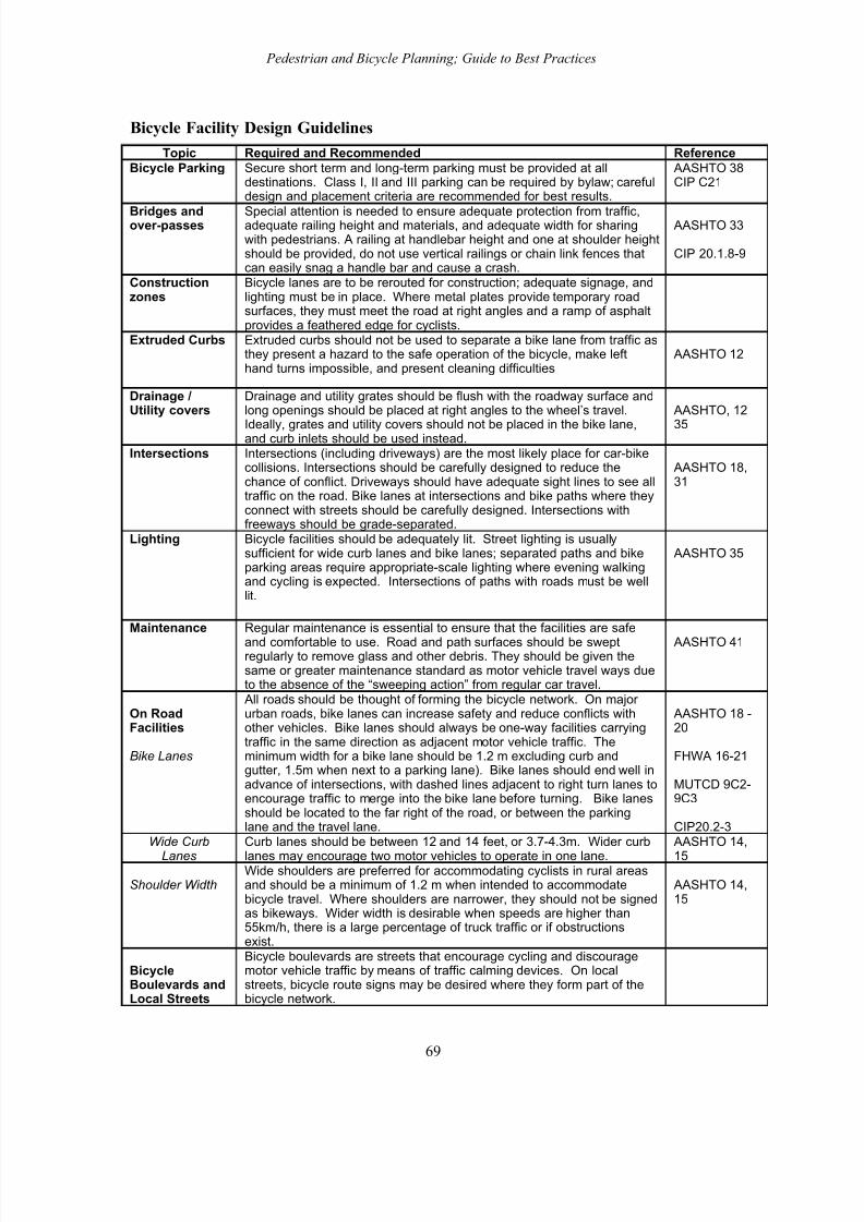
8/3/2019 nmtguide
http://slidepdf.com/reader/full/nmtguide 69/90
Pedestrian and Bicycle Planning; Guide to Best Practices
Bicycle Facility Design Guidelines
Topic Required and Recommended Reference
Bicycle Parking Secure short term and long-term parking must be provided at alldestinations. Class I, II and III parking can be required by bylaw; carefuldesign and placement criteria are recommended for best results.
AASHTO 38CIP C21
Bridges andover-passes
Special attention is needed to ensure adequate protection from traffic,adequate railing height and materials, and adequate width for sharingwith pedestrians. A railing at handlebar height and one at shoulder heightshould be provided, do not use vertical railings or chain link fences thatcan easily snag a handle bar and cause a crash.
AASHTO 33
CIP 20.1.8-9
Constructionzones
Bicycle lanes are to be rerouted for construction; adequate signage, andlighting must be in place. Where metal plates provide temporary roadsurfaces, they must meet the road at right angles and a ramp of asphaltprovides a feathered edge for cyclists.
Extruded Curbs Extruded curbs should not be used to separate a bike lane from traffic asthey present a hazard to the safe operation of the bicycle, make lefthand turns impossible, and present cleaning difficulties
AASHTO 12
Drainage /Utility covers
Drainage and utility grates should be flush with the roadway surface andlong openings should be placed at right angles to the wheel’s travel.
Ideally, grates and utility covers should not be placed in the bike lane,and curb inlets should be used instead.
AASHTO, 12
35
Intersections Intersections (including driveways) are the most likely place for car-bikecollisions. Intersections should be carefully designed to reduce thechance of conflict. Driveways should have adequate sight lines to see alltraffic on the road. Bike lanes at intersections and bike paths where theyconnect with streets should be carefully designed. Intersections withfreeways should be grade-separated.
AASHTO 18,31
Lighting Bicycle facilities should be adequately lit. Street lighting is usuallysufficient for wide curb lanes and bike lanes; separated paths and bikeparking areas require appropriate-scale lighting where evening walkingand cycling is expected. Intersections of paths with roads must be welllit.
AASHTO 35
Maintenance Regular maintenance is essential to ensure that the facilities are safe
and comfortable to use. Road and path surfaces should be sweptregularly to remove glass and other debris. They should be given thesame or greater maintenance standard as motor vehicle travel ways dueto the absence of the “sweeping action” from regular car travel.
AASHTO 41
On RoadFacilities
Bike Lanes
All roads should be thought of forming the bicycle network. On major urban roads, bike lanes can increase safety and reduce conflicts withother vehicles. Bike lanes should always be one-way facilities carryingtraffic in the same direction as adjacent motor vehicle traffic. Theminimum width for a bike lane should be 1.2 m excluding curb andgutter, 1.5m when next to a parking lane). Bike lanes should end well inadvance of intersections, with dashed lines adjacent to right turn lanes toencourage traffic to merge into the bike lane before turning. Bike lanesshould be located to the far right of the road, or between the parkinglane and the travel lane.
AASHTO 18 -20
FHWA 16-21
MUTCD 9C2-9C3
CIP20.2-3Wide Curb
Lanes
Curb lanes should be between 12 and 14 feet, or 3.7-4.3m. Wider curb
lanes may encourage two motor vehicles to operate in one lane.
AASHTO 14,
15
Shoulder WidthWide shoulders are preferred for accommodating cyclists in rural areasand should be a minimum of 1.2 m when intended to accommodatebicycle travel. Where shoulders are narrower, they should not be signedas bikeways. Wider width is desirable when speeds are higher than55km/h, there is a large percentage of truck traffic or if obstructionsexist.
AASHTO 14,15
BicycleBoulevards andLocal Streets
Bicycle boulevards are streets that encourage cycling and discouragemotor vehicle traffic by means of traffic calming devices. On localstreets, bicycle route signs may be desired where they form part of thebicycle network.
69
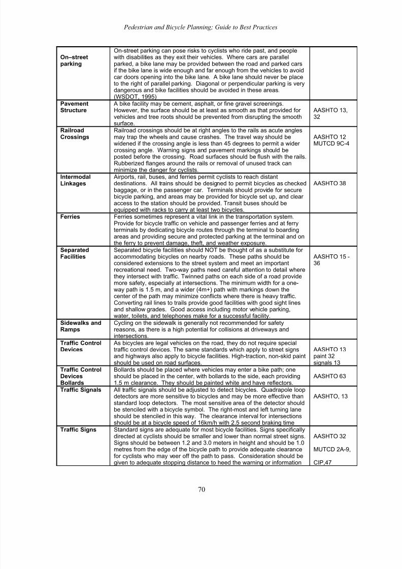
8/3/2019 nmtguide
http://slidepdf.com/reader/full/nmtguide 70/90
Pedestrian and Bicycle Planning; Guide to Best Practices
On–streetparking
On-street parking can pose risks to cyclists who ride past, and peoplewith disabilities as they exit their vehicles. Where cars are parallelparked, a bike lane may be provided between the road and parked carsif the bike lane is wide enough and far enough from the vehicles to avoidcar doors opening into the bike lane. A bike lane should never be placeto the right of parallel parking. Diagonal or perpendicular parking is verydangerous and bike facilities should be avoided in these areas.
(WSDOT, 1995)PavementStructure
A bike facility may be cement, asphalt, or fine gravel screenings.However, the surface should be at least as smooth as that provided for vehicles and tree roots should be prevented from disrupting the smoothsurface.
AASHTO 13,32
RailroadCrossings
Railroad crossings should be at right angles to the rails as acute anglesmay trap the wheels and cause crashes. The travel way should bewidened if the crossing angle is less than 45 degrees to permit a wider crossing angle. Warning signs and pavement markings should beposted before the crossing. Road surfaces should be flush with the rails.Rubberized flanges around the rails or removal of unused track canminimize the danger for cyclists.
AASHTO 12MUTCD 9C-4
IntermodalLinkages
Airports, rail, buses, and ferries permit cyclists to reach distantdestinations. All trains should be designed to permit bicycles as checkedbaggage, or in the passenger car. Terminals should provide for secure
bicycle parking, and areas may be provided for bicycle set up, and clear access to the station should be provided. Transit buses should beequipped with racks to carry at least two bicycles.
AASHTO 38
Ferries Ferries sometimes represent a vital link in the transportation system.Provide for bicycle traffic on vehicle and passenger ferries and at ferryterminals by dedicating bicycle routes through the terminal to boardingareas and providing secure and protected parking at the terminal and onthe ferry to prevent damage, theft, and weather exposure.
SeparatedFacilities
Separated bicycle facilities should NOT be thought of as a substitute for accommodating bicycles on nearby roads. These paths should beconsidered extensions to the street system and meet an importantrecreational need. Two-way paths need careful attention to detail wherethey intersect with traffic. Twinned paths on each side of a road providemore safety, especially at intersections. The minimum width for a one-way path is 1.5 m, and a wider (4m+) path with markings down the
center of the path may minimize conflicts where there is heavy traffic.Converting rail lines to trails provide good facilities with good sight linesand shallow grades. Good access including motor vehicle parking,water, toilets, and telephones make for a successful facility.
AASHTO 15 -36
Sidewalks andRamps
Cycling on the sidewalk is generally not recommended for safetyreasons, as there is a high potential for collisions at driveways andintersections.
Traffic ControlDevices
As bicycles are legal vehicles on the road, they do not require specialtraffic control devices. The same standards which apply to street signsand highways also apply to bicycle facilities. High-traction, non-skid paintshould be used on road surfaces.
AASHTO 13paint 32signals 13
Traffic ControlDevicesBollards
Bollards should be placed where vehicles may enter a bike path; oneshould be placed in the center, with bollards to the side, each providing1.5 m clearance. They should be painted white and have reflectors.
AASHTO 63
Traffic Signals All traffic signals should be adjusted to detect bicycles. Quadrapole loop
detectors are more sensitive to bicycles and may be more effective thanstandard loop detectors. The most sensitive area of the detector shouldbe stenciled with a bicycle symbol. The right-most and left turning laneshould be stenciled in this way. The clearance interval for intersectionsshould be at a bicycle speed of 16km/h with 2.5 second braking time
AASHTO, 13
Traffic Signs Standard signs are adequate for most bicycle facilities. Signs specificallydirected at cyclists should be smaller and lower than normal street signs.Signs should be between 1.2 and 3.0 meters in height and should be 1.0metres from the edge of the bicycle path to provide adequate clearancefor cyclists who may veer off the path to pass. Consideration should begiven to adequate stopping distance to heed the warning or information
AASHTO 32
MUTCD 2A-9,
CIP,47
70

8/3/2019 nmtguide
http://slidepdf.com/reader/full/nmtguide 71/90
Pedestrian and Bicycle Planning; Guide to Best Practices
on the sign.BIKE ROUTE signs should be used in conjunction with sub-platesindicating destinations (with distances) to be found along the signedroute. In addition, BIKE ROUTE signs must be part of a comprehensivesystem. At junctions of separated trails with roadways, the name of theroad should be clearly visible to trail users.
Traffic Calming
Devices
Traffic calming measures usually benefit cyclists by removing or slowing
traffic. Some measures need to be carefully designed to accommodatecyclists. For example, where speed bumps or diverters are used, a by-pass area for cyclists should be included. Where pinch-points are used,rolled curbs reduce the danger of being squeezed. Traffic calmingdevices can also be used as refuges for cyclists crossing two-way busyroads. Refuges should be 3 metres wide, by two metres across andprovide handrails and bollards.
CIP 20.1.11
User Conflict Design features and user policies should be used to minimize conflictsbetween cyclists, pedestrians and equestrians. AASHTO 37
Vegetation It is important that vegetation near roadways and paths be maintained.All vegetation above .3 meters in height should be trimmed back a least1-m on each side of all paths. Vegetation at intersections should betrimmed to provide adequate sight lines. Tree and shrub roots maycause disruption in a path surface, removal of trees within 1 m of thepath and the use of root barriers may help to reduce problems.
AASHTO 41
WorkplaceFacilities Many people say that they would try commuting by bike but feel theyneed a shower and a place to change clothes once they arrive at work.Some jurisdictions are requiring that such facilities be provided when abuilding is built or remodeled. Clothes lockers, large enough toaccommodate a week’s worth of clothes and toilet articles, can beprovided. A bathroom may be remodeled providing a shower stall.
71

8/3/2019 nmtguide
http://slidepdf.com/reader/full/nmtguide 72/90
Pedestrian and Bicycle Planning; Guide to Best Practices
Appendix 3 Evaluating Nonmotorized TravelIt is important to develop ways to measure the quality of walking and cycling conditions toidentify problems and prioritize improvements. This section describes such techniques.
SurveysIt is often useful to survey the public to identify the problems they perceive with current
pedestrian and cycling conditions, and opportunities and priorities for improvements. Publicsurvey forms can be distributed throughout a region, or be targeted at a particular area. Surveyforms can be handed out along a sidewalk, path or roadway, can be attached to bicycles andautomobiles parked at a study site, or can be distributed through local newsletters and employers.The Partnership for a Walkable America has an Internet-based survey form to evaluate walkingconditions (www.nsc.org/walk/wkcheck.htm) that could be replicated in individual communities.
Special consideration should be given to pedestrian and bicycle planning along urban andsuburban arterials, highways near urban areas, and highways that connect to parks, schools,residential neighborhoods, employment centres, and other trip generators.
Example
Nonmotorized Transport Survey Questions55
1. Are your neighbourhoods designed to promote walking and cycling to get to school, work,recreation, transit, and retail outlets? Are these facilities used?
2. If these facilities are not used, what improvements could make them more accessible?
3. Is street lighting adequate?
4. Are sidewalks maintained, repaired, and cleared of snow in the winter?
5. Are bike lanes part of the roads?
6. Does your community master plan include facilities for cycling and walking?
7. Are there cycling organizations in your community promoting the use of bicycles?
8. Are there bicycle racks at transit stations and outside municipal facilities?
9. Do school organizations promote walking, cycling, and safety programs for both?
10. Do schools and workplaces provide secure bicycle parking?
11. Are local government officials aware of the walking and cycling needs of neighbourhoods?
12. What measures could be taken to calm traffic in your residential neighbourhoods?
13. Can community groups be encouraged to organize bicycle safety workshops?
14. Do local businesses support walking and cycling to their stores?
15. What groups might be involved in promoting active transportation in your community?
16. Are residents encouraged to keep sidewalks clean and clear of snow?
17. Is there bicycle parking near shopping areas and other destinations?
55 Developing Communities for Active Transportation, Go For Green (www.goforgreen.ca), 1998.
72

8/3/2019 nmtguide
http://slidepdf.com/reader/full/nmtguide 73/90
Pedestrian and Bicycle Planning; Guide to Best Practices
Crash DataPedestrian and bicycle collision data can help identify barriers and hazards to nonmotorizedtravel. Locations with frequent pedestrian or cycling crashes indicate some combination of highrisk or heavy use, both of which can justify facility improvements. Crash analysis can be used toidentify a variety of possible safety interventions, including pedestrian and bicycle facilityimprovements, traffic management and traffic calming to reduce vehicle speeds and volumes,
and increased traffic safety education and law enforcement for drivers, pedestrians, and cyclists.Pedestrian and cycling collisions tend to be underreported, so a variety of data collectionmethods may be needed.56
Crash data should be evaluated by type of crash and contributing factors, pedestrian and cyclistdemographics, location type (for example, pedestrian crashes can be categorized by intersectioncrosswalk, midblock crosswalk, midblock no crosswalk, driveways, etc.) to identify possible patterns. Smaller communities may only have few pedestrian/cyclist crash reports to work with.Larger communities may find it valuable to establish an ongoing program to analyze pedestrian/cyclist crash data, and integrate it into a municipal mapping program.
Field SurveysSome transportation agencies use volunteers or hired college students to perform field surveys of pedestrian and cycling conditions. If possible, surveys should include special user groups, suchas people in wheelchairs and elderly pedestrians, particularly in areas they frequent. The box below lists typical information to collect.
Field Survey Data to Collect (as appropriate)
• Roadway vehicle traffic volumes and speeds.
• Intersection design, roadway and road shoulder widths, and pavement conditions.
• Nonmotorized traffic volumes and speeds, and available accident data.
• Special hazards to walking and cycling (potholes, dangerous drain grates on road shouldersand curb lanes, etc.).
• Crosswalk, sidewalk, and path conditions (width, surface condition, sight distance, etc.).
• Curb cuts, ramps and other universal access facilities.
• Lighting along streets and paths.
• Presence of parked cars adjacent to the traffic lane.
• Bicycle parking facilities, public washrooms, and other services along trails and bike routes.
• Security, cleanliness, vandalism, litter, and aesthetic conditions.
• Community demographics (age, income, etc.)
• Presence of activity centers that attract nonmotorized travel (schools, colleges, resorts, etc.)
• Land use factors, including density and mix, street connectivity, and building site design.
• Topography and climate.
When evaluating facilities it is important to clearly maintain the distinction between nominal (“inname”) and functional (“working condition”) dimensions. For example, many sidewalks and paths are nominally 1.8 to 2 metres wide, but functionally they may be much narrower, due toobjects such as telephone poles and signposts located in their right of way, and due to surfacefailures, such as cracks and potholes. As a result, a walkway that meets technical specifications
56 Helen James, “Under-reporting of Road Traffic Collisions,” Traffic Eng+Con, Dec. 1991, pp. 574-583.
73

8/3/2019 nmtguide
http://slidepdf.com/reader/full/nmtguide 74/90
Pedestrian and Bicycle Planning; Guide to Best Practices
may be inadequate for some potential users. Similarly, a bike lane may be useless if it has poor surface conditions or is frequently used for vehicle parking.
It may be difficult to obtain consistent evaluations of roadway conditions by different surveyors.Some cyclists are comfortable riding on roads with heavy, high-speed traffic, and are critical of paths that restrict cycling riding speed due to design limitations. Others have the opposite
preferences. This problem can be minimized by establishing clear evaluation criteria. For example, rather than simply rating a highway condition as “good” or “bad” for cycling it may be better to record traffic volumes, shoulder width, shoulder condition, and “special problems for cyclists.” Training and supervision can help guarantee consistency between survey teams.
Bicycle and Pedestrian Level-of-Service RatingsTable A3-1 summarizes a simplified method for evaluating walking and cycling level-of-service.Scores: A = >17; B = >14-17; C = >11-14; D = >7-11; E = >3-7; F = 3 or less.
Table A3-1 Bicycle and Pedestrian Level-of-Service for Congestion Management57
Bicycle Points Pedestrian Points
Facility(Max. value = 10)
Outside lane 3.66 m (12’)Outside lane 3.66-4.27m (12-14’)Outside lane >4.27m (14’)Off-street/parallel alternativefacility
056
4
Not continuous or non-existentContinuous on one sideContinuous on both sidesMin. 1.53 m (5’) wide & barrier freeSidewalk width >1.53 (5’)Off-street/parallel alternative facility
046211
Conflicts(Max. value = 10)
Driveways & sidestreetsBarrier free No on-street parkingMedians presentUnrestricted sight distanceIntersection Implementation
10.51
0.50.50.5
Driveways & sidestreetsPed. Signal delay 40 sec. or lessReduced turn conflictimplementationCrossing width 18.3 m (60’) or lessPosted speedMedians present
10.50.50.50.51
Speed Differential(Max. value = 4)
>48 KPH (>30 MPH)40-48 KPH (25-30 MPH)
24-30 KPH (15-20 MPH)
01
2Amenites(Max. value = 2)
Buffer not less than 1m (3’5”)Benches or pedestrian scale lightingShade trees
10.50.5
Motor VehicleLOS(Max. value = 2)
LOS = E, F, or 6+ travel lanesLOS = D, & < 6 travel lanesLOS = A,B,C, & < 6 travel lanes
012
LOS = E, F, or 6+ travel lanesLOS = D, & < 6 travel lanesLOS = A,B,C, & < 6 travel lanes
012
57 Linda Dixon, “Bicycle and Pedestrian Level-of-Service Performance Measures and Standards for Congestion Management Systems,” Transportation Research Record 1538, 1996, pp. 1-9.
74

8/3/2019 nmtguide
http://slidepdf.com/reader/full/nmtguide 75/90
Pedestrian and Bicycle Planning; Guide to Best Practices
Maintenance(Max. value = 2)
Major or frequent problemsMinor or infrequent problems No problems
-102
Major or frequent problemsMinor or infrequent problems No problems
-102
TDM/Multi Modal(Max. value = 1)
No supportSupport exists
01
No supportSupport exists
01
The Barrier Effect Roads are usually considered transportation links, but they can also be barriers, especially tononmotorized travel.58 The “barrier effect” reduces walking and cycling mobility, and increasesdriving.59 This is not to imply that drivers intentionally cause harm, but rather that such impactsare unavoidable when fast, heavy vehicles share space with more vulnerable road users.
Cycling Condition Evaluation TechniquesTable A3-2 shows one method for evaluating cyclist stress levels, taking into account trafficspeed, volume, type, operating space, and number of hindrances (intersections and commercialdriveways) on a specific stretch of roadway.60
Table A3-2 Cyclist Stress Level ValuesStress Rating Speed Volume Trucks Curb Lane Hindrances
Posted speedlimit (km/hr)
Vehicles/hr per traffic lane
Percentage of truck traffic
Curb lanewidth (m)
Commercial drivewaysand intersections per km
1 <40 <50 <2% >4.6 <62 50 51-150 4% 4.3 133 60 151-250 6% 4.0 194 65 251-350 8% 3.7 255 >75 351-450 >10% <3.3 >31
These values are used to calculate Cycling Suitability Rating in Table A3-2.
Table A3-3 Cycling Suitability RatingSummed Average Stress Road Suitability for Cycling
58 J.M. Clark and B.J. Hutton, The Appraisal of Community Severance, U.K. DoT, Transport ResearchLaboratory (Crowthorne, UK), Report #135, 1991.59 Todd Litman, Transportation Cost Analysis; Techniques, Estimates and Implications, VTPI(www.vtpi.org), 2000; Dr. Peter Bein, Monetization of Environmental Impacts of Roads, and Social Cost of Transverse Barrier Effects, Planning Services Branch, B.C. Ministry of Transportation and Highways(Victoria; www.th.gov.bc.ca/bchighways ), 1997, 1995.60 David L. Harkey, Donald W. Reinfurt, J. Richard Stewart, Matthew Knuiman and Alex Sorton, The
Bicycle Compatibility Index: A Level of Service Concept , Federal Highway Administration, FHWA-RD-98-072 (www.hsrc.unc.edu/oldhsrc/research/pedbike/bci/bcitech.pdf ), 1998.
75

8/3/2019 nmtguide
http://slidepdf.com/reader/full/nmtguide 76/90
Pedestrian and Bicycle Planning; Guide to Best Practices
Values Level
< 7 1 Road is reasonably safe for all types of cyclists.
7-12 2
Road accommodates casual and experienced cyclists, but needsimprovement to accommodate child cyclist.
13-17 3
Road accommodates experienced cyclists, but needs improvement
to accommodate casual and child cyclists.
18-22 4
Needs improvements to accommodate experienced cyclists, notrecommended for casual and child cyclists.
>22 5 May be unsuitable for all cycling.
A more detailed system called the Bicycle Compatibility Index incorporates these factors:61
• Presence of bicycle lane or paved shoulder.• Bicycle lane or paved shoulder width.• Curb lane width.
• Curb lane volume.• Other lane volume.• Average traffic speed.
• Presence of parking lane with more than30% occupancy.
• Type of roadside development.
• Truck volumes.• Parking turnover.• Right turn lanes.
Pedestrian Condition Evaluation TechniquesGenerally available demographic, land use, and transportation planning data can be used toestimate pedestrian travel demand.62 Traffic engineers often use Level of Service (LOS) toevaluate roadway performance for motor vehicle traffic. Pedestrian LOS for street crossings has been defined based on pedestrian delay, as shown in Table A3-4.63 Crosswalk walking speeds areestimated at 1.2 metres per second for most areas, and 1.0 m/s for crosswalks serving large
numbers of older pedestrians.
Table A3-4 Pedestrian Road Crossing Level of Service (LOS)64
Level of Service
SignalizedIntersection*
UnsignalizedIntersection*
Likelihood of PedestrianNoncompliance
A <10 < 5 LowB 10-20 5-10C 20-30 10-20 Moderate
61 David L. Harkey, Donald W. Reinfurt, J. Richard Stewart, Matthew Knuiman and Alex Sorton, The Bicycle Compatibility Index: A Level of Service Concept , Federal Highway Administration, FHWA-RD-98-072 (www.hsrc.unc.edu/oldhsrc/research/pedbike/bci/bcitech.pdf ), 1998; David L. Harkey, Donald W.Reinfurt, Matthew Knuiman, “Development of the Bicycle Compatibility Index,” Transportation
Research Record 1636 , 1998, pp. 13-20.62 Julie Mercer Matlick, If We Build It, Will They Come?, Washington State DOT (Olympia;www.wsdot.wa.gov), undated.63 Colin Henson, “Level of Service for Pedestrians,” ITE Journal , Sept. 2000, pp. 26-30.64 Joseph Milazzo, et al., Quality of Service for Interrupted Pedestrian Facilities in the 2000 HighwayCapacity Manual, Transportation Research Board Annual Meeting, 1999.
76

8/3/2019 nmtguide
http://slidepdf.com/reader/full/nmtguide 77/90
Pedestrian and Bicycle Planning; Guide to Best Practices
D 30-40 20-30E 40-60 30-45 HighF ≥ 60 ≥ 45 Very High
* Average Delay Per Pedestrian in Seconds
A more sophisticated model, called the Walking Security Index (WSI), takes into account a widerange of variables that affect pedestrian safety, comfort, and convenience at roadwayintersections, as summarized in Table A3-5. The “Fathom” model uses a technique calledvisibility graph analysis, which looks at how visually accessible any point is within a building or area.65 This is found to correlate well with observed flows because pedestrians are sensitive tolines of sight and visual access.
Table A3-5 Walking Security Index Variables66
Infrastructure Vehicle Traffic Pedestrian Performance Behavior1. No. of lanes.2. Speed3. Grade (incline).
4. Turning lanes.5. Curb cut at
intersections.6. Stop bar
distance fromcrosswalk.
7. Sight lines
8. Peak vehiclevolumes.
9. Vehicle types.
10. Trip purpose.11. Turning
movements.
12. Pedestrianvolumes.
13. Pedestrian
age.
14. Right-turn-on-red.
15. Signage.
16.
Ice/snow/slushremoval.
17. Pedestrian-vehiclecollisions.
18. Pedestrian-vehicleconflicts.
19. Vehiclemovingviolations.
The four criteria below are each rated on a scale from 1-3, the total of which represents thePedestrian Environmental Factor (PEF).67 The results were found to correlate well with the use of non-automobile travel in an urban area. Urban neighborhoods with a high PEF tend to have twicethe walk/bicycle mode share as the overall average, as much as five times greater than areas with
the lowest PEF.
• Ease of street crossings. This is based on street width, traffic volumes, and speeds.
• Sidewalk continuity. Sidewalks that do not connect create barriers to pedestrian travel. A pedestrian network is only as good as its weakest link, particularly for people with physicaldisabilities. Even problems that appear minor to able-bodied pedestrians may be a major barrier to people with significant mobility constraints.
• Local street characteristics (grid vs. cul de sac). A grid street system provides continuity,allowing more direct access to destinations.
• Topography. Steep slopes create barriers to pedestrians.
An article in Parking Today suggested Level of Service ratings for pedestrian access to parking,which may be considered appropriate for walking trips in general. Acceptable walking distancesare affected by degree of weather protection, climate, line of site (whether pedestrians can seetheir destination), and “friction” (interruptions and constraints along the way, such as crosstraffic). The table below summarizes the findings.
65 www.intelligentspace.com66 Barry Wellar, Walking Security Index; Final Report , Geography Department, University of Ottawa(Ottawa; 613-562-5725; [email protected]), 1998.67 PBQD, The Pedestrian Environment , 1000 Friends of Oregon (www.friends.org) 1993.
77

8/3/2019 nmtguide
http://slidepdf.com/reader/full/nmtguide 78/90
Pedestrian and Bicycle Planning; Guide to Best Practices
78

8/3/2019 nmtguide
http://slidepdf.com/reader/full/nmtguide 79/90
Pedestrian and Bicycle Planning; Guide to Best Practices
Level of Service By Walking Trip Distance (in Feet)68
Walking Environment LOS A LOS B LOS C LOS DClimate Controlled 1,000 2,400 3,800 5,200Outdoor/Covered 500 1,000 1,500 2,000Outdoor/Uncovered 400 800 1,200 1,600Through Surface Lot 350 700 1,050 1,400
Inside Parking Facility 300 600 900 1,200
Prioritizing Improvements and Selecting Preferred OptionsThere are four factors to consider when evaluating barriers and gaps in pedestrian and cyclingnetworks, and when prioritizing improvements:
1. Level of demand. How many people would use a facility if it were improved. In general, thisincreases around higher density areas, such as business districts and higher-densityresidential areas, and around attractions, such as schools and parks.69
2. Degree of barrier. This can range from minor difficulties (such as requiring pedestrians touse a longer route than if a proposed improvement is made) to a total barrier to walking and bicycling. The degree of barrier also depends on who is traveling, and under what conditions.People with physical disabilities are more vulnerable to such barriers.
3. Potential benefits. This refers to the benefits that could result from increased walking andcycling on that corridor. For example, improvements that encourage nonmotorized travel tosubstitute for driving may provide more value to a community than improvements used primarily for recreational cycling and walking.
4. Cost and ease of improvement. This includes the incremental financial costs of the project,and any increase in future maintenance costs.
This information can be presented in a matrix, such as the one below. Note that the concept of “cost” is inverted into “affordability” so all criteria can be ranked from high (best) to low.
Table A3-6 Project Evaluation Matrix Example
DemandBarrier
ReductionSocialBenefit
Affordability(low cost)
Proposal 1 High High Medium HighProposal 2 Medium Low High MediumProposal 3 High Medium High LowProposal 4 Low High Medium Low
It may be desirable to develop a more quantitative evaluation process. For example, proposalscan be ranked from zero (worst) to 5 (best) for each criterion. The criteria can also be given aweight. These are then multiplied to create total points for each project. Rankings can be done bya small group of technical experts, a technical/public committee, or through a public survey.
Table A3-7 Project Evaluation Matrix ExampleBarrier Social Affordability Total
68 PT, “How Far Should Patrons Have to Walk After They Park?” Parking Today
(www.parkingtoday.com), May 2000, pp. 34-36.69 Cambridge Systematics and Bicycle Federation of America, Guidebook on Methods to Estimate Non-
Motorized Travel , FHWA, Publication No. FHWA-RD-98-166 (available at www.tfhrc.gov), July 1999.
79

8/3/2019 nmtguide
http://slidepdf.com/reader/full/nmtguide 80/90
Pedestrian and Bicycle Planning; Guide to Best Practices
Demand Reduction Benefit (low cost) PointsWeight 4 3 2 2
Proposal 1 4 5 3 4 45
Proposal 2 3 2 5 3 34
Proposal 3 5 3 4 1 39
Proposal 4 2 4 3 1 28
Each criteria value is multiplied times the criteria weight factor.
Another approach is to develop a cost value that incorporates various criteria. For example, itmay be possible to calculate dollars per additional bicycle commuter , or dollars per pedestrian/cyclist-kilometre using a new facility. This can be calculated by dividing theannualized project cost by the number of projected users.
A more sophisticated investment analysis technique uses net present values. This involvesestimating all future costs and benefits, depreciating these based on a discount rate, and using aspreadsheet to calculate their net present value. The figure below demonstrates this with theexample of a new pathway that has $1,300,000 in construction costs during the first three years,$20,000 annual maintenance costs, 200,000 annual trips the first year that increases by 3%
annually, with an estimated benefit of $1.00 per trip. Note that the values decline over time duethe discount rate. In this particular example, the net present value of costs is $1.4 million, whilethe net present value of benefits is $2.4 million.
Figure 1 Net Present Value Investment Analysis
Years ==>
C o s t s a n d B e n e f i t s
Benefits Costs
However, such “condensed” values may exclude important factors. For example, two projectsmay have the same cost per additional bicycle commuter, but one provides far more recreational bicycling. Or, perhaps one provides more environmental, aesthetic, or equity benefits. Suchdifferences should be described in evaluation reports.
The city of Portland uses two factors to prioritize pedestrian improvements. The “Pedestrian
Potential Index” measure the potential demand for pedestrian travel, based on the areas PEF(described above), proximity to activity centers (such as schools, housing [especially senior housing] parks, transit, neighborhood shops), and policy factors, such as whether improvementsto the pedestrian environment on that street are part of the regional strategic plan. The“Deficiency Index” measures how critically pedestrian improvements are needed. The highest
80
8/3/2019 nmtguide
http://slidepdf.com/reader/full/nmtguide 81/90
Pedestrian and Bicycle Planning; Guide to Best Practices
priority for pedestrian improvements are projects which rank high on both the Potential andDeficiency indices.70 The same method could be used to prioritize cycling projects.
70 Pedestrian Master Plan, Pedestrian Transportation Program, City of Portland (503-823-7004; [email protected] ), 1998.
81

8/3/2019 nmtguide
http://slidepdf.com/reader/full/nmtguide 82/90
Pedestrian and Bicycle Planning; Guide to Best Practices
Resources
Evaluating Nonmotorized Transportation Conditions
AASHTO, Guide for the Development of Bicycle Facilities, 3rd Edition, AASHTO(www.aashto.org), 1999; available at www.bikefed.org.
Cambridge Systematics and Bicycle Federation of America, Guidebook on Methods to Estimate Non-Motorized Travel , FHWA, Pub. No. FHWA-RD-98-166 (available at www.tfhrc.gov),1999.
David E. Clark, Estimating Future Bicycle and Pedestrian Trips from a Travel Demand Forecasting Model , Compendium of Technical Papers, ITE (www.ite.org), 1997, pp. 407-414.
Linda Dixon, “Bicycle and Pedestrian Level-of-Service Performance Measures and Standards for Congestion Management Systems,” Transportation Research Record 1538, 1996, pp. 1-9.
Ronald Eash, “Destination and Mode Choice Models for Nonmotorized Travel,” Transportation Research Record 1674, 1999, pp. 1-8.
David L. Harkey, et al, The Bicycle Compatibility Index: A Level of Service Concept , FHWA,
FHWA-RD-98-072 (www.hsrc.unc.edu/oldhsrc/research/pedbike/bci/bcitech.pdf ), 1998.
Yael M. Levitte, Bicycle Demand Analysis – A Toronto Case Study, Transportation ResearchBoard Annual Meeting (www4.nationalacademies.org/trb), 1999.
William Moritz, Bicycle Facilities and Use, Washington State Department of Transportation,(Olympia; www.wsdot.wa.gov/ppsc/research/onepages/WA-RD3701.HTM ), 1995.
PBQD, The Pedestrian Environment , 1000 Friends of Oregon (www.friends.org) 1993.
PBQD, Data Collection and Modeling Requirements for Assessing Transportation Impacts of Micro-Scale Design, TMIP, USDOT (www.bts.gov/tmip), 2000.
Christopher Porter, John Suhrbier and William Schwartz, “Forecasting Bicycle and PedestrianTravel,” Transportation Research Record 1674, 1999, pp. 94-101.
Project for Public Spaces, Effects of Environmental Design on the Amount and Type of Bicycling and Walking , National Bicycling and Walking Study No. 20, FHWA, (www.bikefed.org), 1993.
PWA, How Walkable is Your Community? Partnership for a Walkable America(www.nsc.org/walk/wkcheck.htm), 2000.
W.L. Schwartz, et al, Guidebook on Methods to Estimate NonMotorized Travel: Overview of Methods. Turner-Fairbank Highway Research Center (www.tfhrc.org), FHWA-RD-98-165, 1999.
Alex Sorton and Thomas Walsh, “Bicycle Stress Level as a Tool to Evaluate Urban andSuburban Bicycle Computability,” Transportation Research Record 1438, TRB,(www4.nationalacademies.org/trb/homepage.nsf ), 1995, pp. 17-24.
University of North Carolina, A Compendium of Available Bicycle and Pedestrian Trip
Generation Data in the United States, FHWA, (available through www.bikefed.org), 1994.University of North Carolina Highway Safety Research Center (www.hsrc.unc.edu).
Portland Office of Transportation, Portland Pedestrian Design Guide and Pedestrian Master Plan, City of Portland (www.trans.ci.portland.or.us/Sidewalks_and_Pedestrians.html), 1998.
Barry Wellar, Walking Security Index; Final Report , Geography Department, University of Ottawa (Ottawa; 613-562-5725; [email protected]), 1998.
82

8/3/2019 nmtguide
http://slidepdf.com/reader/full/nmtguide 83/90
Pedestrian and Bicycle Planning; Guide to Best Practices
Appendix 4 Exemplary Bicycle and Pedestrian Plans
Bicycle Plans
City of Santa BarbaraA comprehensive plan for integrating bicycling infrastructure into the city's street network,
including on- and off-road facilities, and ancillary facilities such as bicycle parking, signing andother amenities. www.ci.santa-barbara.ca.us/pworks/transp/bike_plan/bmp_toc.html.
City of Portland, Ore.During the 1990's the City of Portland has developed an extensive bicycling infrastructureincluding on- and off-street routes, bicycle parking, and other facilities. A Master Plan is at:www.trans.ci.portland.or.us/traffic_management/bicycle_program/BikeMasterPlan/Default.htm. Contact: City of Portland, 1120 SW Fifth Ave, Room 730, Portland, OR 97204. (503) 823-7671.
City of Philadelphia, PaThe City was awarded more than $3 million of Congestion Mitigation and Air Quality programfunds to plan and implement a city-wide bicycle network featuring bike lanes, trails, and bicycle parking facilities. www.phila.gov/departments/street/html/the_bicycle_network.html.
Contact: City of Philadelphia Streets Department, (215) 686-5514,
City of Chicago, Ill.Mayor Daley announced in the early 1990’s that Chicago would become a bicycle-friendly city by the year 2000. A simple seven-page plan launched a series of improvements to existingfacilities and the striping of several miles of bike lane each year. The plan has spawned moredetailed bicycle plans: www.cityofchicago.org/Transportation/Bikes/bicycle.htm.Contact: Bicycle Program, 30 N. LaSalle Street, #400, Chicago, IL 60602. 312-744-8093
City of Tucson, Ariz.With a network of more than 240 miles of bikeway already on the ground, the Tucson BikewayImprovement Plan identifies more than 50 additional miles of striped bike lanes that will be
added to the system by 2001. www.ci.tucson.az.us/transport/planning/overview.html.Contact: City of Tucson, 201 North Stone - 6th Floor, Tucson, AZ 85726. (520) 791-4372
New York City, NY This award-winning plan identifies more than 900 miles of on- and off-street facilities andrecommends a series of policies and programs that would promote bicycle use, encourageintegration with transit, and link to the City's greenway system.www.ci.nyc.ny.us/html/dcp/html/bndprods.html#b
Wisconsin Department of TransportationAdopted in December, 1998, the Wisconsin Bicycle Transportation Plan 2020 provides a blueprint for more and safer bicycle trips with recommendations and roles for a variety of government agencies and groups. www.dot.state.wi.us/dtim/bop/finalbike.html.Contact: Tom Huber, Wisconsin DOT, P.O.Box 7913, Madison, WI 53707. 608-267-7757
Pennsylvania Department of TransportationOne of the first ISTEA-generated statewide bicycle plans. The PennDOT plan included extensive public outreach and an intensive "in-reach" program for PennDOT staff and agencies. The planincorporates an extensive design manual. Contact: PennDOT, 717-783-8444
83
8/3/2019 nmtguide
http://slidepdf.com/reader/full/nmtguide 84/90
Pedestrian and Bicycle Planning; Guide to Best Practices
Pedestrian plans
City of West Palm Beach, Fla.The Transportation Element of the city's 1998 Comprehensive Plan establishes a new traffichierarchy in which traffic calming is a key strategy in promoting walking and pedestrian safety.Contact: Tim Stillings, Planning Department, P.O. Box 3366, West Palm Beach,FL 33402. (561) 659-8031.
City of Portland, Ore.The City has adopted a two-part plan: Part One outlines the policies and plans for improvingconditions for walking and Part Two is a detailed design manual for pedestrian facilities.www.trans.ci.portland.or.us/Sidewalks_and_Pedestrians.html.Contact: Pedestrian Coordinator, City of Portland, 1120 SW Fifth Ave, Portland, OR 97204.
City of Madison, Wis.Adopted in September 1997, Madison's visionary plan for walking incorporates planning, design,maintenance, and long-term goals and objectives. Madison was one of the first communities toadopt a separate plan for walking. www.ci.madison.wi.us/reports/execsum2.pdf .Contact: Arthur Ross, City of Madison, P.O. Box 2986, Madison, WI 53701. 608-266-6225.
City of Tucson, Ariz.Closely matching the City's bicycling plan, Tucson has adopted an ambitious plan to improveconditions for walking that is clearly identifiable in the City's annual workplan.Contact: Tom Fisher, City of Tucson, 201 North Stone, Tucson, AZ 85726. 520-791-4372
Arlington County, Va.Arlington County is one of the nation's densest urban areas and has developed a pedestrian planthat builds on the accessibility of two major transit corridors in the County. An extensivesidewalk building program is complemented by a neighborhood traffic calming program, alldirected by citizen task forces. www.co.arlington.va.us/dpw/planning/ped/ped.htm.Contact: Arlington County DPW, 2100 Clarendon Blvd - Suite 717, Arlington, VA 22201
North Central Texas Council of GovernmentsBicycle and Pedestrian Facilities Planning and Design Guidelines, developed in December 1995 provides guidance on planning and designing facilities which improve bicycle and pedestrianmobility. www.nctcog.dst.tx.us/envir/bikeped/plandesign/execsumm.html. Contact: Mike Sims, NCTCOG, P.O. 5888, Arlington, TX 76005. 817-695-9226
Washington State Department of TransportationWashington State DOT adopted a Pedestrian Policy Plan in 1993 that focused on local andregional planning for pedestrians, necessary pedestrian facility types and locations, and whoshould pay for them. www.wsdot.wa.gov/hlrd/sub-defaults/pedestrian-default.htm Contact: Julie Mercer Matlick, WSDOT, P.O. Box 47393, Olympia, WA 98504. (360) 705-7505
Oregon Department of TransportationA comprehensive pedestrian (and bicycle) planning and design document.www.odot.state.or.us/techserv/bikewalk .Contact: Michael Ronkin, Bicycle and Pedestrian Program Manager, ODOT, Room210-Transportation Building, Salem, OR 97310. (503) 986-3555.
84

8/3/2019 nmtguide
http://slidepdf.com/reader/full/nmtguide 85/90
Pedestrian and Bicycle Planning; Guide to Best Practices
Appendix 5 Bicycle and Pedestrian Planning ResourcesRoadway Design Resources
A Policy on Geometric Design of Highways and Streets, 1994 (The Green Book). AmericanAssociation of State Highway and Transportation Officials (AASHTO), P.O. Box 96716,Washington, DC, 20090-6716, Phone: (888) 227-4860.
Stephen Burrington & Veronika Thiebach, Take Back Your Streets; How to Protect Communities from Asphalt and Traffic, Conservation Law Foundation (Boston; www.clf.org), 1995.
Wolfgang Homburger, et al., Residential Street Design and Traffic Control , Institute of Transportation Engineers (Washington DC; www.ite.org), 1989.
Highway Capacity Manual, Special Report 209, 1994. Transportation Research Board, Box 289,Washington, DC 20055, Phone: (202) 334-3214. Next Edition: FHWA Research Program projecthas identified changes to HCM related to bicycle and pedestrian design.
LMN Architects, Model Code Provisions; Urban Streets and Subdivisions, Washington StateCommunity, Trade and Economic Development (www.wsdot.wa.gov/hldr/pdf/cted.pdf ).
Manual on Uniform Traffic Control Devices, 1988. Federal Highway Administration (FHWA),
Superintendent of Documents. P.O. Box 371954, Pittsburgh, PA 15250-7954. Includes standardsfor signing and marking both on-road and off-road bicycle facilities. Year 2000 edition willincorporate more bicycle and pedestrian standards.
Flexibility in Highway Design, 1997. FHWA. HEPH 10, 400 Seventh Street SW, Washington,DC 20590.
SWOV, Best Practice to Promote Cycling and Walking , Denmark Ministry of Transport([email protected]), European Commission Directorate General of Transport, 1998.
Pedestrian and Bicycle Planning
Best Practice to Promote Cycling and Walking and How to Substitute Short Car Trips byCycling and Walking , CORDIS Transport RTD Program, European Union(www.cordis.lu/transport/src/adonisrep.htm), 1999.
BTS, Bicycle and Pedestrian Data: Sources, Needs & Gaps, USDOT(www.bts.gov/programs/transtu/bikeped/report.pdf ), 2000.
Cambridge Systematics and Bicycle Federation of America, Guidebook on Methods to Estimate Non-Motorized Travel , Federal Highway Administration, Publication No. FHWA-RD-98-166(available at www.tfhrc.gov), July 1999.
HSRC (Highway Safety Research Center, University of North Carolina), Pedestrian and BicycleCrash Analysis Tool (PBCAT), Federal Highway Administration (FHWA) and NationalHighway Traffic Safety Administration (NHTSA), available free from the Pedestrian and BicycleInformation Center (www.walkinginfo.org), 2000. This is a crash typing software productintended to assist development of a database containing details associated with crashes betweenmotor vehicles and pedestrians or bicyclists.
Improving Conditions for Bicyclists and Pedestrians, A Best Practices Report , 1998. FHWA,HEP 10, 400 Seventh Street SW, Washington, DC 20590.
Making Streets That Work; Neighborhood Planning Tool , Engineering Dept., City of Seattle(www.ci.seattle.wa.us/npo/tblis.htm), 1996.
85

8/3/2019 nmtguide
http://slidepdf.com/reader/full/nmtguide 86/90
Pedestrian and Bicycle Planning; Guide to Best Practices
National Bicycle and Walking Study (24 volumes), FHWA, (Washington DC; www.bikefed.org),1991-95.
National Highway Traffic Safety Administration's “Pedestrian and Bicycle Safety andAccommodation” course, (NHI Course NO. 38061, (www.ota.fhwa.dot.gov/walk ). The courseworkbook is Publication No. FHWA-HI-96-028.
NYBC, Improving Bicycling and Pedestrian Safety, New York Bicycling Coalition(www.nybc.net/programs/NYBC_manual.shtml), 2002.
Pedestrian/Bicyclist Resource Kit , FHWA (www.ota.fhwa.dot.gov/walk ).
Rails-to-Trails Conservancy, Improving Conditions for Bicycling and Walking; A Best Practices Report , U.S. Federal highway Administration (www.fhwa.doc.gov) and Rails-to-TrailsConservancy (www.railtrails.org), 1999.
Rodney Tolley, The Greening of Urban Transport , John Wiley (New York), 1997.
University of North Carolina, A Compendium of Available Bicycle and Pedestrian TripGeneration Data in the United States, Supplement to the National Bicycling and Walking Study,FHWA, USDOT (available through www.bikefed.org), 1994.
Pedestrian Planning Publications
Design and Safety of Pedestrian Facilities, A Recommended Practice, Institute of TransportationEngineers (202-554-8050; www.ite.org), 1998.
Implementing Pedestrian Improvements at the Local Level , FHWA, HSR 20, 6300 GeorgetownPike, McLean, VA, 1999.
Improving Pedestrian Access to Transit: An Advocacy Handbook, 1998. Federal TransitAdministration / WalkBoston. NTIS, 5285 Port Royal Road, Springfield, VA 22161.
Planning and Implementing Pedestrian Facilities in Suburban and Developing Rural Areas, Report No. 294A, Transportation Research Board, Washington DC, Phone: (202) 334-3214.
Pedestrian Crossing Control Manual , Transportation Association of Canada (Ottawa; 613-736-1350; www.tac-atc.ca), 1998.
Pedestrian Facilities Guidebook: Incorporating Pedestrians Into Washington’s TransportationSystem, Washington State DOT (www.wsdot.wa.gov/ta/t2/t2pubs.htm), 1997.
Rhys Roth, Getting People Walking: Municipal Strategies to Increase Pedestrian Travel ,WSDOT (Olympia; www.wsdot.wa.gov/ta/t2/t2pubs.htm), 1994.
Joseph P. Savage, et al., A Guidebook for Student Pedestrian Safety, Washington StateDepartment of Transportation (Olympia; www.wsdot.wa.gov/ta/t2/t2pubs.htm) 1996.
Social Research Associates, Personal Security Issues in Pedestrian Journeys, UK Department of the Environment, Transport and the Regions (London; www.mobility-unit.detr.gov.uk/psi),1999.
Portland Office of Transportation, Portland Pedestrian Design Guide and Pedestrian Master Plan, City of Portland (www.trans.ci.portland.or.us/Sidewalks_and_Pedestrians.html), 1998.
Walking Steering Group, Developing a Walking Strategy, Dept. of the Environment Transportand the Regions, downloadable at www.local-transport.detr.gov.uk/walk/walk.htm, 1996.
Walk Tall; A Citizen’s Guide to Walkable Communities, Rodale Press (Emmaus) and PedestrianFederation of America (Washington DC; www.bikefed.org), 1995.
86

8/3/2019 nmtguide
http://slidepdf.com/reader/full/nmtguide 87/90
Pedestrian and Bicycle Planning; Guide to Best Practices
Bicycle Planning Publications
Suzan Anderson Pinsof and Terri Musser, Bicycle Facility Planning , Planners Advisory Service,American Planning Association (Chicago; 312-786-6344), 1995.
AASHTO, Guide for the Development of Bicycle Facilities, 3rd Edition, American Association of State Highway and Transportation Officials (Washington DC; 888-227-4860; www.aashto.org),1999; available online at www.bikefed.org.
Selecting Roadway Design Treatments to Accommodate Bicyclists, 1993. FHWA, R&T ReportCenter, 9701 Philadelphia Ct, Unit Q; Lanham, MD 20706. (301) 577-1421 (fax only)
Bicycle Facility Design Standards, 1998. City of Philadelphia Streets Department, 1401 JFK Boulevard, Philadelphia, PA 19103.
Bikeway Traffic Control Guidelines, Transportation Association of Canada (Ottawa; 613-736-1350; www.tac-atc.ca), 1999.
CIP, Community Cycling Manual , Canadian Institute of Planners (www.cip-icu.ca), March 1999.
Evaluation of Shared-use Facilities for Bicycles and Motor Vehicles, 1996. Florida DOT,Pedestrian and Bicycle Safety Office, 605 Suwannee Street, Tallahassee, FL 32399.
Florida Bicycle Facilities Planning and Design Manual , 1994. Florida DOT, Pedestrian andBicycle Safety Office, 605 Suwannee Street, Tallahassee, FL 32399.
John Forester, Bicycle Transportation: A Handbook for Cycling Transportation Engineers, MITPress, 1994.
David L. Harkey, Donald W. Reinfurt, J. Richard Stewart, Matthew Knuiman and Alex Sorton,The Bicycle Compatibility Index: A Level of Service Concept , Federal Highway Administration(www.hsrc.unc.edu/research/pedbike/bci), 1998.
Implementing Bicycle Improvements at the Local Level , Federal Highway Administration,
FHWA, HSR 20, 6300, (available online at www.bikefed.org/local.htm), 1998.
William Moritz, Bicycle Facilities and Use, Washington State Department of Transportation,(Olympia; www.wsdot.wa.gov/ta/t2/t2pubs.htm), 1995.
North Carolina Bicycle Facilities Planning and Design Guidelines, 1994. North Carolina DOT,P.O. Box 25201, Raleigh, NC 27611. (919) 733-2804.
John Pucher, “Bicycling Renaissance in North America” Transportation Research A, Vol. 33, Nos. 7/8, September/November 1999, pp. 625-254.
TAC, Bikeway Traffic Control Guidelines for Canada, Transportation Association of Canada(www.tac-atc.ca), 1998
John Williams, Bruce Burgess, Peter Moe and Bill Wilkinson, Implementing Bicycle
Improvements at the Local Level , FHWA, Report FHWA-RD-98-105, 1998.
Useful Organizations
America WALKs (www.webwalking.com/amwalks) is a coalition of walking advocacy groups.
American Planning Association (www.planning.org) is a professional society for planners thatsponsors a “Growing Smart” initiative and provides many extensive resources.
87

8/3/2019 nmtguide
http://slidepdf.com/reader/full/nmtguide 88/90
Pedestrian and Bicycle Planning; Guide to Best Practices
American Trails (www.outdoorlink.com/amtrails) fosters communication among trail users.
Association for Commuter Transportation (Washington DC; 202-393-3497;http://tmi.cob.fsu.edu/act/act.htm) is a non-profit organization supporting TDM programs.
Bicycle Information Center (877-925-5245; www.bicyclinginfo.org) is a comprehensiveclearinghouse of bicycle planning and safety information supported by the U.S. Federal Highway
Administration.Bicycle Federation of America (Washington DC; 202.463.6625; www.bikefed.org) providesextensive resources for bicycle and pedestrian planning.
Canadian Cycling Association (Gloucester, Ontario; www.canadian-cycling.com) manages theCan-Bike cycling education program.
Carfree.com (www.carfree.com) explores carfree cities past, present, and future, and provides practical solutions to the problems of urban automobile use.
Center for Livable Communities (www.lgc.org/clc) helps local governments and communityleaders be proactive in their land use and transportation planning.
Children on the Move site on children and transport: www.ecoplan.org/children.
The Community Bicycle Network (CBN) Factsheets, newsletter, curriculum guides, and actionmanuals, Detour Publications (www.web.net/~detour/cbn).
Community Transportation Association of America (www.ctaa.org) provides resources for improving mobility for disadvantaged populations.
Commuter Choice Program (www.epa.gov/oms/traq) provides information, materials andincentives for developing employee commute trip reduction programs.
Congress for New Urbanism (www.cnu.org) supports human scale urban communities.
David Engwicht Communications (www.lesstraffic.com.) supports “street reclaiming.”
The U.S. Federal Highway Administration’s Pedestrian Program(www.ota.fhwa.dot.gov/walk ) provides pedestrian safety information and resources.
Green Lane Program, Environment Canada (www.ec.gc.ca/emission/5-1e.html) promotes TDMand other strategies for reducing transportation environmental impacts.
Go For Green, The Active Living & Environment Program (www.goforgree.ca) providesresources to promote nonmotorized transportation.
ICBC Road Sense (www.icbc.com) provides a variety of pedestrian and bicycle safetyinformation including Safe Cycle Program material.
The International Council for Local Environmental Initiatives (www.iclei.org) provides planning resources to help communities become healthier and more environmentally responsible.
The Institute of Transportation Engineers (Washington DC; www.ite.org) has extensivetechnical resources on pedestrian and bicycle planning, traffic calming and TDM.
League of American Bicyclists (www.bikeleague.org/ec2/education.htm) provides a variety of bicycle education and encouragement resources.
The Local Government Commission (www.lgc.org/clc/pubinfo) provides a variety of usefulresources, including pedestrian and bicycle planning publications.
National Highway Traffic Safety Administration (www.nhtsa.dot.gov) provides pedestrianand bicycle safety resources.
88

8/3/2019 nmtguide
http://slidepdf.com/reader/full/nmtguide 89/90
Pedestrian and Bicycle Planning; Guide to Best Practices
National Transportation Week Pedestrian Website (www.ota.fhwa.dot.gov/ntw/bikeped.htm) provides information and links to pedestrian planning websites.
Northwestern University Traffic Institute (Evanston, Illinois; 800-323-4011;www.nwu.edu/traffic) offers professional development workshops on bicycle planning andfacility design, and other related subjects.
Oregon Bicycle and Pedestrian Planning (www.odot.state.or.us/techserv/bikewalk ) is anexample of nonmotorized planning at its best.
Perils for Pedestrians (www.pedestrian.org) is a cable television series promoting awareness of pedestrian safety. Their website includes advocacy tips and links to other walking organizations.
Partnership for a Walkable America (http://nsc.org/walk/wkabout.htm) promotes the benefitsof walking and supports efforts to make communities more pedestrian friendly.
The Pedestrian Association (http://web.ukonline.co.uk/walkhf ) has been campaigning since1929 to make walking safer, more convenient, and easier.
The Pedestrian and Bicycle Information Center (1-877-WALKBIKE; www.bicyclinginfo.org) provides a variety of technical information on nonmotorized transport planning and programs.
Pedestrian Information Center (877-925-5245; www.walkinginfo.org) is a pedestrian planningand safety information clearinghouse supported by the Federal Highway Administration.
Pednet (www.ottawalk.org/pednet) is an Internet list with information on pedestrian issues.
Pednet’s International Pedestrian Lexicon (glossary) http://user.itl.net/~wordcraf/lexicon.html
The City of Portland (www.trans.ci.portland.or.us/Traffic_Management/trafficcalming) provides excellent information and materials on traffic calming and pedestrian planning.
Project for Public Spaces (www.pps.org) is a non-profit organization that offers resources andtechnical support to help create special places that build community life.
The Rails-To-Trails Conservancy (www.railtrails.org) resources for public trail development.
The Smart Growth Network (www.smartgrowth.org) includes planners, govt. officials, lenders,community developers, architects, environmentalists and activists.
Sustainable Communities Network (www.sustainable.org) provides tools for communitysustainability planning.
Transportation Association of Canada (Ottawa; www.tac-atc.ca) provides a variety of resources related to transportation planning and TDM.
Transportation for Livable Communities (www.tlcnetwork.org) is a resource centre for peopleworking to create more livable communities by improving transportation.
Turner-Fairbank Highway Research Center (www.tfhrc.gov), provides extensive pedestrianand bicycle planning resources.
UK Department of the Environment, Transport and the Regions
(www.roads.detr.gov.uk/roadsafety/rs/index.htm) publishes Road Safety Education in Schools -Good Practice Guidelines that describe how to create a safer pedestrian environment.
UK Health Education Authority (www.hea.org.uk ) has excellent material to promote“transport exercise” and better integration of nonmotorized transport in public health programs.
Victoria Transport Policy Institute (www.vtpi.org) provides resources for planning andevaluating TDM, bicycling and walking programs.
89

8/3/2019 nmtguide
http://slidepdf.com/reader/full/nmtguide 90/90
Pedestrian and Bicycle Planning; Guide to Best Practices
Walkable Communities, Inc. (www.walkable.org) works with communities to create more people-oriented environments.
Washington Department of Transportation, TDM Resource Center (Seattle; 206-464-6145;www.wsdot.wa.gov) and Northwest Technology Transfer Center (Olympia;www.wsdot.wa.gov/TA/T2/publications.html) offer a variety of resources for TDM planning.
Way To Go! School Program (Vancouver; 1-877-325-3636; www.waytogo.icbc.bc.ca) providesresources and support for school traffic reduction programs.
World Health Organization Healthy Cities Project (www.who.dk/london99) providesinformation on international efforts to create healthy cities.
The WSDOT Bicycle and Pedestrian Websites (www.wsdot.wa.gov) provide extensivereference information for nonmotorized transport planning.
nmtguide.pdf