nj department of environmental protection day, typically thought of as septic systems. therefore,...
TRANSCRIPT

NJ Department of Environmental Protection
State Development & Redevelopment Plan Plan Endorsement
Opportunities & Constraints Analysis
for:
Township of Frankford, Sussex County
May 29, 2009
DRAFT May 29, 2009
Frankford Township Opportunities and Constraints Analysis Report
NJ Department of Environmental Protection
2
This document constitutes the Department of Environmental Protection’s component of the State Opportunity and Constraints Analysis conducted as part of the Plan Endorsement process. This document should serve as a baseline to inform the rest of the Plan Endorsement process. This document provides a general overview of the Department’s regulatory and policy concerns within Frankford. While all efforts have been made to address all major issues, the ever evolving nature of regulatory programs and natural conditions dictates that the information contained within this document will need to be updated on a regular basis. No portion of this document shall be interpreted as granting any specific regulatory or planning approvals by the Department. This document is to be used solely as guidance for municipal planning purposes.

DRAFT May 29, 2009
Frankford Township Opportunities and Constraints Analysis Report
NJ Department of Environmental Protection
3
Table of Contents 2002 LAND USE/LAND COVER ------------------------------------------------------------------- 4 WATER & WASTEWATER ANALYSIS -------------------------------------------------------- 5
Water Availability--------------------------------------------------------------------------------- 5 Wastewater Treatment --------------------------------------------------------------------------- 7
ENVIRONMENTAL CONSTRAINTS ANALYSIS ------------------------------------------- 10 Regulated Environmental Constraints ------------------------------------------------------- 10 Environmental Constraints to Avoid --------------------------------------------------------- 19
Threatened & Endangered Species Habitat --------------------------------------------- 19 Natural Heritage Priority Sites------------------------------------------------------------- 20
Environmental Constraints to Consider ----------------------------------------------------- 22 Groundwater recharge areas --------------------------------------------------------------- 22 Well Head Protection Areas ---------------------------------------------------------------- 22 Priority Species Habitat --------------------------------------------------------------------- 23
CONTAMINATED AREAS CONSIDERATIONS--------------------------------------------- 24 Known Contaminated Sites List --------------------------------------------------------------- 24 Known Contaminated Sites - Classification Exception Areas (CEA) ------------------ 25 Landfills -------------------------------------------------------------------------------------------- 26
PRESERVED LANDS & HISTORIC RESOURCES------------------------------------------ 27 Preserved Lands ---------------------------------------------------------------------------------- 27 Historic Resources-------------------------------------------------------------------------------- 28
ATTACHMENTS: ------------------------------------------------------------------------------------ 29 PERMIT EXTENSION ACT ----------------------------------------------------------------------- 30 SUMMARY OF MAJOR ISSUES ----------------------------------------------------------------- 32 MAPS ---------------------------------------------------------------------------------------------------- 35 NJDEP OFFICE OF PLANNING AND SUSTAINABLE COMMUNITIES ------------- 54
DRAFT May 29, 2009
Frankford Township Opportunities and Constraints Analysis Report
NJ Department of Environmental Protection
4
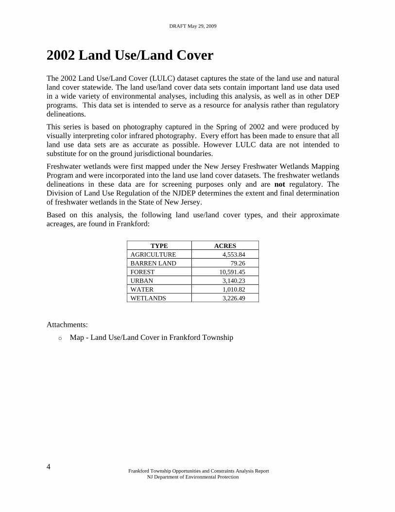
2002 Land Use/Land Cover The 2002 Land Use/Land Cover (LULC) dataset captures the state of the land use and natural land cover statewide. The land use/land cover data sets contain important land use data used in a wide variety of environmental analyses, including this analysis, as well as in other DEP programs. This data set is intended to serve as a resource for analysis rather than regulatory delineations.
This series is based on photography captured in the Spring of 2002 and were produced by visually interpreting color infrared photography. Every effort has been made to ensure that all land use data sets are as accurate as possible. However LULC data are not intended to substitute for on the ground jurisdictional boundaries.
Freshwater wetlands were first mapped under the New Jersey Freshwater Wetlands Mapping Program and were incorporated into the land use land cover datasets. The freshwater wetlands delineations in these data are for screening purposes only and are not regulatory. The Division of Land Use Regulation of the NJDEP determines the extent and final determination of freshwater wetlands in the State of New Jersey.
Based on this analysis, the following land use/land cover types, and their approximate acreages, are found in Frankford:
TYPE ACRES
AGRICULTURE 4,553.84 BARREN LAND 79.26 FOREST 10,591.45 URBAN 3,140.23 WATER 1,010.82 WETLANDS 3,226.49
Attachments:
o Map - Land Use/Land Cover in Frankford Township

DRAFT May 29, 2009
Frankford Township Opportunities and Constraints Analysis Report
NJ Department of Environmental Protection
5
Water & Wastewater Analysis Sufficient water supply and the ability to treat wastewater are essential to any community. The following information on Water Availability and Wastewater Treatment should be used by the community to evaluate its ability to meet current and future demand for water and wastewater treatment. Using this information to plan for future development allows a municipality to estimate the number of people the current (and/or future systems) can sustain. It also provides a way for a municipality to determine where growth is most appropriate, taking into account where water can be treated and supplied. Water Availability
The following information on Water Availability in Frankford Township is based upon the best data readily available to DEP at the time of this analysis. This data should be used by Frankford to inform its community vision and planning processes.
There are three (3) Public Water Supply Systems in Frankford Township, each serving a portion of Frankford’s population. The Deficit/Surplus tables, and a map showing the systems locations within the municipality, are provided with this report.
PWSID WATER SYSTEM NAME POPULATION
SERVED WATER SYSTEM
TYPE 1903001 Branchville Water Department 75 Community 1905002 Culver Lake Water Company 70 Community 1905328 The Pines Inn/Pines Retirement 83 Community
Branchville Water Department - the Deficit/Surplus table for the Branchville Water Department shows available capacity for this system to be approximately 0.149 mgd. However, very little of Frankford is served by the Branchville Water Department.
Culver Lake Water Company – no Deficit/Surplus table is available for this facility.
The Pines Inn/Pines Retirement – no Deficit/Surplus table is available for this facility.
The Deficit/Surplus tables for Public Water Systems may be found on the Department of Environmental Protection, Division of Water Supply website at http://www.nj.gov/dep/watersupply/pws.htm. Not all Public Water Supply Systems will have associated Deficit/Surplus tables available on the Department's website. The website currently contains public water systems that have a demand greater than 100,000 gallons of water per day and have had some water main extension activity since January 1, 2002. For safe demand and firm capacity information not available on this web site please contact the Bureau of Water System and Well Permitting at 609-984-6831 or for water allocation information please contact the Bureau of Water Allocation at 609-292-2957.
Refer to Firm Capacity and Water Allocation Analysis document for a detailed description of the methodology used to calculate capacity limitations.
DRAFT May 29, 2009
Frankford Township Opportunities and Constraints Analysis Report
NJ Department of Environmental Protection
6
There are also multiple Non-Community Water Systems serving specific uses in Frankford Township. See attached table ‘Non-Community Water Systems Listing for Sussex’ for details.
Attachments:
o Deficit/Surplus table – Branchville Water Department http://www.nj.gov/cgi-bin/dep/watersupply/pwsdetail.pl?id=1903001
o Non-Community Water Systems Listing for Sussex - Frankford Twp o Water Supply - Map
DRAFT May 29, 2009
Frankford Township Opportunities and Constraints Analysis Report
NJ Department of Environmental Protection
7
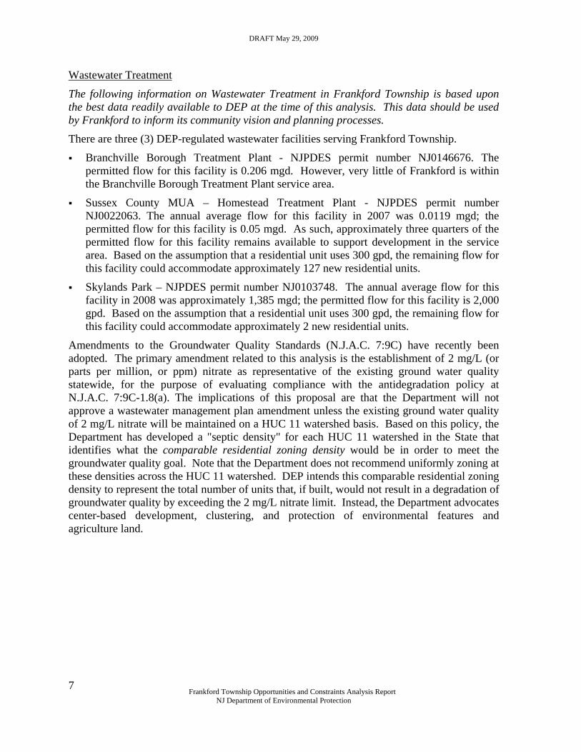
Wastewater Treatment
The following information on Wastewater Treatment in Frankford Township is based upon the best data readily available to DEP at the time of this analysis. This data should be used by Frankford to inform its community vision and planning processes.
There are three (3) DEP-regulated wastewater facilities serving Frankford Township.
Branchville Borough Treatment Plant - NJPDES permit number NJ0146676. The permitted flow for this facility is 0.206 mgd. However, very little of Frankford is within the Branchville Borough Treatment Plant service area.
Sussex County MUA – Homestead Treatment Plant - NJPDES permit number NJ0022063. The annual average flow for this facility in 2007 was 0.0119 mgd; the permitted flow for this facility is 0.05 mgd. As such, approximately three quarters of the permitted flow for this facility remains available to support development in the service area. Based on the assumption that a residential unit uses 300 gpd, the remaining flow for this facility could accommodate approximately 127 new residential units.
Skylands Park – NJPDES permit number NJ0103748. The annual average flow for this facility in 2008 was approximately 1,385 mgd; the permitted flow for this facility is 2,000 gpd. Based on the assumption that a residential unit uses 300 gpd, the remaining flow for this facility could accommodate approximately 2 new residential units.
Amendments to the Groundwater Quality Standards (N.J.A.C. 7:9C) have recently been adopted. The primary amendment related to this analysis is the establishment of 2 mg/L (or parts per million, or ppm) nitrate as representative of the existing ground water quality statewide, for the purpose of evaluating compliance with the antidegradation policy at N.J.A.C. 7:9C-1.8(a). The implications of this proposal are that the Department will not approve a wastewater management plan amendment unless the existing ground water quality of 2 mg/L nitrate will be maintained on a HUC 11 watershed basis. Based on this policy, the Department has developed a "septic density" for each HUC 11 watershed in the State that identifies what the comparable residential zoning density would be in order to meet the groundwater quality goal. Note that the Department does not recommend uniformly zoning at these densities across the HUC 11 watershed. DEP intends this comparable residential zoning density to represent the total number of units that, if built, would not result in a degradation of groundwater quality by exceeding the 2 mg/L nitrate limit. Instead, the Department advocates center-based development, clustering, and protection of environmental features and agriculture land.

DRAFT May 29, 2009
Frankford Township Opportunities and Constraints Analysis Report
NJ Department of Environmental Protection
8
Frankford falls within five (5) HUC11 watersheds. The following table indicates the watershed and the residential density allowed under the nitrate limit.
HUC11
% Twp in HUC11
2 mg/L nitrate limit
Papakating Creek – 02020007020 39.0% 4.9 acres/ residential unit
Big Flat Brook – 02040104140 1.1% 5.2 acres/ residential unit
Flat Brook – 02040104150 0.1% 5.0 acres/ residential unit
Trout Brook/Swartswood Lake – 02040105030
7.4% 4.8 acres/ residential unit
Paulins Kill (above Stillwater Village) - 02040105040
52.4% 4.8 acres/ residential unit
Water Quality Management Plan - Sewer Service Area Mapping
The Department has recently adopted amendments to the Water Quality Management Planning rules identifying the conditions where extension of sewer service is not appropriate. N.J.A.C. 7:15-5.24 sets forth the general policy that large contiguous areas of environmentally sensitive resources, coastal planning areas where the extension of sewers would be inconsistent with New Jersey’s Coastal Zone Management program, and special restricted areas that are prone to natural hazards such as flooding, wave action and erosion should not be included in sewer service areas. The limitations on the extension of sewer service in these areas is consistent with the Department’s mandate to protect the ecological integrity and natural resources of New Jersey, including water, threatened and endangered species, wetlands and unique and rare assemblages of plants.
Centralized wastewater is inappropriate for these areas because it subsidizes and otherwise encourages development in and around these natural resources at a density that is inconsistent with their protection and the environmental protection mandate of the Department. The Department has determined that the appropriate wastewater management alternative for these areas is individual subsurface sewage disposal systems that discharge less than 2,000 gallons per day, typically thought of as septic systems. Therefore, though excluded from the extension of sewer service, these areas have a wastewater management alternative that will promote a density of development consistent with the conservation of these resources.
In establishing the criteria for delineating a sewer service area boundary in consideration of environmentally sensitive areas, the Department identifies environmentally sensitive areas that are not appropriate for sewer service area as any contiguous area of 25 or more acres that contains any or all of the following four features: threatened and endangered species habitats, Natural Heritage Priority Sites, Category One stream buffers, and wetlands. The Department determined that 25 acres was the appropriate size threshold based on a statewide GIS analysis showing that at least 90 percent of the environmentally sensitive features would be excluded from sewer service area, but that the threshold should be large enough to permit the reasonable application of zoning.
The Department is currently working with the County of Sussex in development of a county-wide Wastewater Management Plan based upon on the recent Water Quality Management

DRAFT May 29, 2009
Frankford Township Opportunities and Constraints Analysis Report
NJ Department of Environmental Protection
9
Planning rules. Frankford should continue to coordinate with the County to ensure consistency between municipal planning and the County WMP.
Attachments:
o Sewer Service Areas in Frankford Township - Map
o Nitrate Dilution Concentrate Target by HUC11 - Map

DRAFT May 29, 2009
Frankford Township Opportunities and Constraints Analysis Report
NJ Department of Environmental Protection
10
Environmental Constraints Analysis The following section identifies those environmental constraints that should be considered by Frankford Township in its planning efforts. These environmental constraints are divided into 3 sections - Regulated Constraints, Constraints to Avoid, and Constraints to Consider. Regulated Environmental Constraints
Wetlands, Category One Waters and Total Maximum Daily Loads (TMDL) are environmental constraints currently regulated by DEP. Frankford Township should recognize these environmental constraints in its visioning and planning processes.
Wetlands
Freshwater wetlands and transition areas (buffers) are regulated by the Freshwater Wetlands Protection Act rules (NJAC 7:7A). The Highlands rule (NJAC 7:38), which implements the Highlands Water Protection and Planning Act, prohibits nearly all disturbance within all wetlands within the Highlands Preservation Area.
Wetlands are commonly referred to as swamps, marshes, or bogs. However, many wetlands in New Jersey are forested and do not fit the classic picture of a swamp or marsh. Previously misunderstood as wastelands, wetlands are now recognized for their vital ecological and socioeconomic contributions. Wetlands contribute to the social, economic, and environmental health of our state in many ways:
Wetlands protect drinking water by filtering out chemicals, pollutants, and sediments that would otherwise clog and contaminate our waters.
Wetlands soak up runoff from heavy rains and snow melts, providing natural flood control.
Wetlands release stored flood waters during droughts.
Wetlands provide critical habitats for a major portion of the state's fish and wildlife, including endangered, commercial and recreational species.
Wetlands provide high quality open space for recreation and tourism.
There are on-site activity limits on lands identified as wetlands. The NJ Freshwater Wetlands Protection Act requires DEP to regulate virtually all activities proposed in the wetland, including cutting of vegetation, dredging, excavation or removal of soil, drainage or disturbance of the water level, filling or discharge of any materials, driving of pilings, and placing of obstructions. The Department may also regulate activities within 150 feet of a wetland - called the transition area or buffer.
Land Use/Land Cover data based on 2002 aerial photography identifies approximately 3,226 acres of wetlands in Frankford. It should be noted that these wetlands are based on aerial photo interpretation and are not appropriate for use in determining the true extent of wetlands on a specific site.

DRAFT May 29, 2009
Frankford Township Opportunities and Constraints Analysis Report
NJ Department of Environmental Protection
11
Category One (C1) Waterbodies & Associated Buffers
Category One designations are established in the Surface Water Quality Standards (NJAC 7:9B) – specifically in the tables in N.J.A.C. 7:9B-1.15(c) through (g) - for purposes of implementing the antidegradation policies set forth at N.J.A.C. 7:9b-1.5(d). These waters are designated to provide for their protection from measurable changes in water quality characteristics because of their clarity, color, scenic setting, other characteristics of aesthetic value, exceptional ecological significance (habitat, water quality, and biological functions), exceptional recreational significance, exceptional water supply significance, or exceptional fisheries resource(s).
The Stormwater Management rule (NJAC 7:8) is implemented through DEP Land Use and local regulation. The rule regulates development within 300 feet, and stormwater discharges within 150 feet, of Category One waterways and their tributaries, upstream within the same HUC14 subwatershed. The Stormwater rule establishes a 300-foot Special Water Resource Protection Area (SWRPA) along Category One (C1) waters and certain tributaries that applies only when a “major development” is proposed.
The Flood Hazard Area Control Act (FHACA) rule (N.J.A.C. 7:13) also establishes a 300-foot riparian zone along C1 waters and their upstream tributaries within the HUC-14. This FHACA rule applies to any activity that requires approval in the rule. The Riparian Zone under the FHACA rule is the land and vegetation both within a regulated waterbody and within either 50 feet, 150 feet or 300 feet from the top of bank of a regulated waterbody. Given the many important ecological functions that a healthy riparian zone provides, adequately preserving such areas is essential to protecting New Jersey's natural resources and water supply.
For the purposes of this analysis, the Department is providing generalized information and mapping of C1 waterbodies and associated buffers. This analysis should be used only as a general planning tool. Specific development proposals may be affected, consistent with the information provided above.
The following waterbodies within or adjacent to Frankford are designated as Category one waters:
Paulins Kill
Papakating Creek (and tributaries)
300 foot buffers on these waterbodies constitute approximately 2,695 acres in Frankford.
The Surface Water Quality Standards data used for this analysis is based on a DRAFT version released for general distribution as a preliminary product. NJDEP is releasing this draft version for public review and any potential data errors should be reported to the Department.

DRAFT May 29, 2009
Frankford Township Opportunities and Constraints Analysis Report
NJ Department of Environmental Protection
12
Total Maximum Daily Loads (TMDLs)
In accordance with Section 303(d) of the Federal Clean Water Act (CWA) (33 U.S.C. 1315(B)), the State of New Jersey is required biennially to prepare and submit to the USEPA a report that identifies waters that do not meet or are not expected to meet SWQS after implementation of technology-based effluent limitations or other required controls. This report is commonly referred to as the 303(d) List. In accordance with Section 305(b) of the CWA, the State of New Jersey is also required biennially to prepare and submit to the USEPA a report addressing the overall water quality of the State’s waters. This report is commonly referred to as the 305(b) Report or the Water Quality Inventory Report. The Integrated Water Quality Monitoring and Assessment Report combine these two assessments and assigns waterbodies to one of five sublists on the Integrated List of Waterbodies. Sublists 1 through 4 include waterbodies that are generally unimpaired (Sublist 1 and 2), have limited assessment or data availability (Sublist 3), or are impaired due to pollution rather than pollutants or have had a TMDL or other enforceable management measure approved by EPA (Sublist 4). Sublist 5 constitutes the traditional 303(d) list for waters impaired or threatened by one or more pollutants, for which a TMDL may be required.
Therefore, in accordance with Section 305(b) and 303(d) of the Federal Clean Water Act (CWA), the State of New Jersey, Department of Environmental Protection (Department) is required to assess the overall water quality of the State’s waters and identify those waterbodies with a water quality impairment for which TMDLs may be necessary. A TMDL is developed to identify all the contributors of a pollutant of concern and the load reductions necessary to meet the Surface Water Quality Standards (SWQS) relative to that pollutant. The Department fulfills its assessment obligation under the CWA through the Integrated Water Quality Monitoring and Assessment Report, which includes the Integrated List of Waterbodies (303(d) list) and is issued biennially. The Integrated List of Waterbodies is adopted by the Department as an amendment to the Statewide Water Quality Management Plan, as part of the Department's continuing planning process pursuant to the Water Quality Planning Act at N.J.S.A.58:11A-7 and the Statewide Water Quality Management Planning rules at N.J.A.C. 7:15-6.4(a).
Total Maximum Daily Loads (Frankford Township)
TMDL Name Parameter Percent
Reduction Document EPA Approval Dry Brook at Rt 519 near Branchville Station ID# 01443370 HUC14# 02040105040020
Fecal coliform 95%
TMDL for fecal coliform to address 28 streams in the Northwest Water Region
9/29/2003
Paulins Kill at Balesville Station ID# 01443440
Fecal coliform 98%
TMDL for fecal coliform to address 28 streams in the Northwest Water Region
9/29/2003

DRAFT May 29, 2009
Frankford Township Opportunities and Constraints Analysis Report
NJ Department of Environmental Protection
13
Paulinskill at Blairstown Station ID# 01443500 HUC14#s 02040105030010 02040105030020 02040105030030
Fecal coliform 78%
TMDL for fecal coliform to address 28 streams in the Northwest Water Region
9/29/2003
Jacksonburg Creek near Blairstown Station ID# 01443600 HUC14#s 02040105040090 02040105050010
Fecal coliform 78%
TMDL for fecal coliform to address 28 streams in the Northwest Water Region
9/29/2003
Papakating Creek at Pelletown Station ID# 01367800 HC 14#s 02020007020010 02020007020020 02020007020030 02020007020070
Fecal coliform 96%
TMDL for fecal coliform to address 28 streams in the Northwest Water Region
9/29/2003
Papakating Creek near Wykertown Station ID# 01667780 HC 14# 02020007020010
Fecal coliform
92%
TMDL for fecal coliform to address 28 streams in the Northwest Water Region
9/29/2003
Papakating Creek at Sussex 01367910
Fecal coliform
99%
TMDL for fecal coliform to address 28 streams in the Northwest Water Region
9/29/2003
Papakating Creek at Sussex 01367910, 01367909, 2-PAP-1
Arsenic
* 0.324 kg/yr reduction required
TMDL to Address Arsenic in the Walkill River and Papakating Creek in the Northwest Water Region
9/29/2004
Papakating Creek at Sussex 01367910
Phosphorus 40% TMDL to address phosphorus in the Clove Acres Lake and Papakating Creek in the Northwest Water Region
9/30/2004
Swartswood Lake Phosphorus
57%
TMDL to Address Phosphorus and Fish Community Impairments in Swartswood Lake in the Northwest Water Region
9/28/2005

DRAFT May 29, 2009
Frankford Township Opportunities and Constraints Analysis Report
NJ Department of Environmental Protection
14
* The TMDL is expressed in terms of the loading capacity of the stream segment at a 75 percent duration design flow (i.e., flow which is exceeded 75 percent of the time) as specified in the SWQS. The existing loading was calculated using the average of available concentration data for each impaired segment, multiplied by the 75 percent flow duration for that segment.
A TMDL represents the assimilative or carrying capacity of a waterbody, taking into consideration point and nonpoint sources of pollutants of concern, natural background, and surface water withdrawals. A TMDL quantifies the amount of a pollutant a water body can assimilate without violating a state’s water quality standards and allocates that load capacity to known point and nonpoint sources in the form of waste load allocations (WLAs) for point sources, load allocations (LAs) for nonpoint sources, a margin of safety (MOS) and, as an option, a reserve capacity (RC). The TMDLs that encompass Frankford Township, Sussex County are nonpoint source driven. The various TMDL documents are all amendments to the Sussex County Water Quality Management Plan (WQMP). All of the Department’s TMDL Reports may be downloaded from the Division of Watershed Management’s web site at www.state.nj.us/dep/watershedmgt/tmdl.htm.
The Department recognizes that TMDLs alone are not sufficient to restore impaired stream segments. The TMDL establishes the required pollutant reduction targets while the implementation plan identifies some of the regulatory and non-regulatory tools to achieve the reductions, matches management measures with sources, and suggests responsible entities for non-regulatory tools. This provides a basis for aligning available resources to assist with implementation activities. Projects proposed by the State, local government units and other stakeholders that would implement the measures identified within the impaired watershed are a priority for available State (for example, CBT) and federal (for example, 319(h)) funds. In addition, the Department’s ongoing watershed management initiative will develop detailed watershed restoration plans for impaired stream segments in a priority order that will identify more specific measures to achieve the identified load reductions. Urban and agricultural land use sources must be the focus for implementation. Urban land use will be addressed primarily by stormwater regulation. Agricultural land uses will be addressed by implementation of conservation management practices tailored to each farm. Wherein urban land use will be addressed primarily by stormwater regulation through the municipality’s MS 4 permit.
Papakating Creek Watershed The TMDLs that encompass Frankford Township fall within the Papakating Creek Watershed. The Papakating Creek is a major tributary to the Wallkill River. There are three major tributaries to the Papakating Creek that comprise the watershed. They are the West Branch Papakating Creek, the Neepaulakating Creek, and the Clove Brook. Overall, the Papakating Creek Watershed is comprised of gently sloping agricultural farm files, wooded forests, wetlands, low-density residential development and older individually built homes. Thus, the predominant land uses in the Watershed include forest and woodland, agriculture and urban development. Of the 16,449 acres of forested land, 2850 acres, or 17.3%, of that land is dedicated federal or state open space, which essentially precludes this land from future development pressure.
In its entirety, the Papakating Creek is approximately 15 miles long. Its head waters appear to originate from wetlands drainage areas and underground springs at the

DRAFT May 29, 2009
Frankford Township Opportunities and Constraints Analysis Report
NJ Department of Environmental Protection
15
eastern base of Sunrise Mountain, in northwestern Frankford Township (from Papakating Creek Watershed Stream Priority Assessment Report Characterization and Assessment July 2004, Sussex County Municipal Utilities Authority). Interestingly, three separate TMDLs were completed for the 2.5 mile stream segment known as Papakating Creek at Sussex in 2003 and 2004 for fecal coliform, phosphorus and for arsenic.
Short-term and Long-term Management Strategies Short term management measures include projects recently completed, underway or planned that are designed to address the targeted impairment. Whereas long term strategies include source track-down as well as selection and implementation of specific management measures that will address the identified sources. The Department recognizes that TMDLs alone are not sufficient to restore impaired waterbodies. The TMDL establishes the required reduction target and provides the regulatory framework to effect these reductions. The TMDL implementation plans for the various TMDLs all call for the collection of additional monitoring data in order to target measures to realize reduction.
Dry Brook at Route 519 near Branchville (Site ID #01443370) Predominant land uses in the area include forest, urban, and agriculture. There is a healthy riparian area with abundant wildlife. Load duration curve consistent with storm driven sources. Potential sources of fecal coliform include: septic systems, livestock, and geese. Monitoring: Coliphage to determine if there are human sources.
Papakating Creek near Wykertown (Site ID #01367780) Land uses in this area primarily include agricultural, forest and residential. There are several ponds in this area that are formed from the Creek’s waters. Potential sources of fecal coliform include septic systems, wildlife, particularly deer, and horses. Strategies: prioritize for EQIP funds to install agricultural BMPs; organize local community based goose management programs.
Paulins Kill at Blairstown (Site ID #01443500) and Jacksonburg Creek near Blairstown (Site ID #01443600) Predominant Land uses in the area include forest, agriculture and urban. Potential sources of fecal coliform include septics/cesspools, geese, livestock, horse farms, deer, and beaver. Load duration curve is consistent with a mix of steady state and storm driven sources. Monitoring: Coliphage and MAR to differentiate human, domestic and wildlife sources.
Paulins Kill at Balesville (Site ID #01443440) Predominant land uses in the area include agriculture, urban, and forest. Potential sources of fecal coliform include septic systems, geese, agriculture, waterfowl, and seagulls on landfill. Load duration curve consistent with a mix of steady state and storm driven sources, with a tendency towards storm driven sources. Monitoring: fecal coliform survey to narrow the scope of impairment.
Papakating Creek at Pelletown (Site ID #01367800)

DRAFT May 29, 2009
Frankford Township Opportunities and Constraints Analysis Report
NJ Department of Environmental Protection
16
This site is located just after the confluence of a tributary to the Papakating, which travels through densely wooded areas. This area has a lot of agricultural uses including nurseries and pet farms. This area also has a very large wildlife presence of deer and geese. There are very large cattle farms in this area, where cattle have access to the stream. Monitoring: extensive fecal coliform sampling is proposed to differentiate the significant contributions in terms of the numerous tributaries, as this impaired segment is 21.7 miles long. A flow monitoring station will be established and limited coliphage sampling is also proposed.
Papakating Creek At Sussex (Site ID #01367910) This section of the Papakating is very wide, slow moving and has very heavy bank erosion. Possible sources of fecal contamination could be wildlife, particularly deer and geese, and farm animals, especially cows. Just before this location on the Papakating both the Lake Neepaulin Tributary as well as the Clove Brook empty in the Creek. Both come from densely developed lake communities, both of which also have large geese populations. The Clove Brook also travels through Sussex Borough, which is sewered. The Clove Brook originates and travels through highly agricultural lands before emptying into the Clove Brook. Along these stream reaches, fecal coliform input from grazing farm animals could be significant. Monitoring: fecal sampling is recommended in order to refine the extent of impairment and significant sources. Strategies: prioritize for EQIP funds to install agricultural BMPs; organize local community based goose management programs.
Possible sources of phosphorus loading could be from fertilizer application on agricultural lands and to a lesser extent, from residential lawns. Just before this location on the Papakating both the Lake Neepaulakating Tributary as well as the Clove Brook empty in the Creek. Both come from densely developed lake communities, both of which also have large geese populations. The Clove Brook originates and travels through highly agricultural lands before emptying into the Clove Brook. Along these stream reaches, phosphorus input from agricultural lands could be significant. Strategies: prioritize for EQIP, CRP and CREP funds to install agricultural BMPs; organize local community based nutrient nonpoint source controls, including goose management and low phosphorus fertilizer ordinances for lawns.
Source Assessment of Arsenic Based on an analysis of land use and stream hydrography, several potential sources of arsenic have been identified, all of which are nonpoint in nature. Sources may include leaching of naturally occurring mineralogy; legacy effects of mining operations; and agricultural use of pesticides. An ongoing study in collaboration with USGS involve completion of the metals evaluation monitoring project and study aimed at establishing a baseline for natural background levels for arsenic and water column mercury in surface waters to discern impairments attributed to anthropogenic sources from those that are due to natural conditions, e.g. geologic. This evaluative monitoring has been completed in the Papakating and Wallkill River Watersheds. Natural background levels of arsenic have been found to exceed New Jersey’s Surface Water Quality Standards for these watersheds (and elsewhere throughout the state). In the future, the Department will either establish watershed-specific criteria for arsenic

DRAFT May 29, 2009
Frankford Township Opportunities and Constraints Analysis Report
NJ Department of Environmental Protection
17
or pursue delisting these impairments since a TMDL is not the appropriate mechanism to address this parameter. Whereas the Department already has the nation’s strictest safe drinking water criteria for arsenic; thus offering the public protection of their public drinking water source(s).
Section 319(h) NPS Grant: Watershed Restoration Plan for Papakating Creek and Surrounding Lakeshed Sussex County Municipal Utilities Authority and Wallkill River Watershed Management Group
This project resulted in a plan that assessed and identified applicable restoration and management techniques within the largely agricultural Papakating Creek watershed. The purpose of the plan was to be able to specify implementable the recommended techniques in the future in order to achieve a reduction in total phosphorus and fecal coliform loadings to the Papakating Creek and tributaries. An extensive education and outreach program was developed to target stakeholder involvement from all sectors of the community.
Section 319(h) NPS Grant: Implementation of Clove Acres and Papakating Creek Watershed Restoration Plans Sussex County Municipal Utilities Authority and Wallkill River Watershed Management Group
This 2009 grant covers 800 acres in HUC 14 # 02020007020070 of the Papakating Creek watershed and implements several pollutant source reduction projects. Specifically in regard to Frankford Township the grant will focus on controlling agricultural pollutant loading to the Creek through Agricultural Conservation Plans and Manure Management Plans. This grant implements two previously completed department funded grants Watershed Restoration Plan for the Papakating Creek and the Surrounding Watershed and Watershed Restoration Plan for Clove Acres Lake and the Surrounding Watershed.
Section 319 (h) NPS Grant: Watershed Restoration Plan for the Paulins Kill Headwaters to Balesville: Three Phased Approach Sussex County Municipal Utilities Authority and Wallkill River Watershed Management Group
The scope of this 2007 grant includes targeted sampling and technical studies to refine and augment the TMDLs, pollutant budgets, and proposed control measures for the watershed. In addition the Watershed Restoration Plan will result in the implementation of three riparian buffer restoration projects. Frankford Township falls within the overall drainage area of the Paulins Kill and will benefit indirectly by reductions realized by the implementation of the grant.
Follow-up TMDL Monitoring The Sussex County Municipal Utilities Authority conducted Microbial Source Track-down as part of the Papakating Creek Watershed Stream Priority Assessment Report Characterization and Assessment July 2004. They determined that a coliphage

DRAFT May 29, 2009
Frankford Township Opportunities and Constraints Analysis Report
NJ Department of Environmental Protection
18
sampling site on Roy Road, located just north of the township line between Frankford and Wantage Townships revealed that the source of fecal coliform to be from animals.
In 2006 the Department adopted changes to the SWQS to replace the fecal coliform criteria for those waters designated for primary contact recreation (FW2, SE1 and SC) with enterococcus (SE1 and SC waters) and E. coli as pathogen indicators (FW2 waters), respectively. The United States EPA recommends the use of E. coli and enterococcus as pathogen indicators for fresh waters and enterococcus for marine waters. Thus, the Department now monitors these parameters to determine if the specific designated use for recreation is being attained for the impaired waterbody.
Attachments:
o Waterbodies & Category One Streams – Map
o TMDLs – Map

DRAFT May 29, 2009
Frankford Township Opportunities and Constraints Analysis Report
NJ Department of Environmental Protection
19
Environmental Constraints to Avoid
Threatened and Endangered Species Habitat and Natural Heritage Priority Sites are geographically-identified environmental constraints prioritized for protection by DEP's mandate to protect the ecological integrity and natural resources of New Jersey. DEP recommends avoidance of these areas, to the extent possible, in order to protect these ecosystems from degradation and destruction.
While Threatened and Endangered Species Habitat and Natural Heritage Priority Sites are not specifically regulated as such, the species and sites that are the basis for this information are considered in several DEP regulatory and planning programs - such as the Freshwater Wetlands Program, Water Quality Management Planning, and the Flood Hazard Area Control Act rule.
Threatened & Endangered Species Habitat
The New Jersey Endangered Species Conservation Act was passed in 1973 and directed the New Jersey Department of Environmental Protection (DEP) to protect, manage and restore the state’s endangered and threatened species. The DEP Endangered and Nongame Species Program (ENSP) has since become the voice for more than 400 species of wildlife in New Jersey, with success stories related to the Bald Eagle, the Peregrine Falcon, the Pine Barrens Tree frog, the Osprey, and others. There are currently 73 endangered and threatened wildlife species in New Jersey. Wildlife professionals within DEP's Endangered and Nongame Species Program oversee research, conservation and protection of rare wildlife species such as the bog turtle, great blue heron, piping plover, bobcat, and other animals that are struggling to survive here in New Jersey.
ENSP has developed the Landscape Project to identify and systemically map the habitat most critical for New Jersey’s fish and wildlife populations. This tool is being used to gauge healthy ecosystems and help identify areas appropriate for protection while giving citizens and local government officials valuable scientific information about their municipalities. The Landscape Project ranks habitat patches by the status of the species present, as follows:
Rank 5 is assigned to patches containing one or more occurrences of at least one wildlife species listed as endangered or threatened on the Federal list of endangered and threatened species.
Rank 4 is assigned to patches with one or more occurrences of at least one State endangered species.
Rank 3 is assigned to patches containing one or more occurrences of at least one State threatened species.
Note that there are two versions of the Landscape Project that impact Frankford Township. Version 3.0 was developed, and recently released, specifically for the Highlands Region. This version was developed using a new methodology and based on updated species occurrence data. Due to the methodology of development, areas outside of the Highlands Region as identified by the Highlands Water Protection & Planning Act are included. The area east of Route 565 and north of Route 15 is covered by Version 3.0. The rest of the State (and Frankford Township) is covered by Landscape Project Version

DRAFT May 29, 2009
Frankford Township Opportunities and Constraints Analysis Report
NJ Department of Environmental Protection
20
2.1. This version is an update of Version 2.0 that has been in use for some time. This update incorporated new species occurrence data. For additional information on the Landscape Project, see New Jersey's Landscape Project.
There are approximately 17,287 acres of threatened and endangered species habitat in Frankford Township. This habitat supports a wide range of species, including Bald Eagles, Bobolink, Barred Owl, Cooper’s Hawk, Savannah Sparrow, Wood Turtle, Timber Rattlesnake, Bog Turtle and Bobcat. The attached Threatened & Endangered Species Habitat map shows the extent of habitat in Frankford (including habitat for priority species – Rank 2 – that are discussed below in the ‘Environmental Constraints to Consider’ section).
In addition, through development of the Sussex County Wastewater Management Plan, ENSP has identified areas of “critical habitat” that are “critical to a population of endangered or threatened species, the loss of which would decrease the likelihood of the survival or recovery of the species in the State” consistent with the WQMP rule at N.J.A.C. 7:15-5.24. The critical habitat site identified in Frankford Township is a breeding site for Bobolink.
Natural Heritage Priority Sites
Through its Natural Heritage Database, the DEP Office of Natural Lands Management (ONLM) identifies critically important areas to conserve New Jersey’s biological diversity, with particular emphasis on rare plant species and ecological communities. The database provides detailed information on rare species and ecological communities to planners, developers, and conservation agencies for use in resource management, environmental impact assessment, and both public and private land protection efforts. Using the database, ONLM has identified 343 Natural Heritage Priority Sites (NHPS), representing some of the best remaining habitat for rare species and rare ecological communities in the state. In addition, each NHPS includes a Biodiversity Rank according to its significance for biological diversity using a scale developed by The Nature Conservancy, the network of Natural Heritage Programs and the New Jersey Natural Heritage Program. The global biodiversity significance ranks range from B1 to B5. The specific definition the rank of the NHPS in Frankford Township is as follows:
B4 - Moderate significance, such as a viable occurrence of a globally rare element, a good occurrence of any ecological community, a good or excellent occurrence or only viable state occurrence of an element that is critically imperiled in the State, an excellent occurrence of an element that is imperiled in the State, or a concentration (4+) of good occurrences of elements that are imperiled in the State or excellent occurrences of elements that are rare in the State.
There is one NHPS located within Frankford Township, as follows: SITE NAME DESCRIPTION BIODIVRANK BIODIVCOMM Branchville Mixed hemlock and northern
hardwood forest on a steep, rocky north-facing limestone ridge.
B4 2 single known occurrences for critically imperiled plants.

DRAFT May 29, 2009
Frankford Township Opportunities and Constraints Analysis Report
NJ Department of Environmental Protection
21
Attachments:
o Threatened, Endangered & Priority Species Habitat & Natural Heritage Priority Sites – Map

DRAFT May 29, 2009
Frankford Township Opportunities and Constraints Analysis Report
NJ Department of Environmental Protection
22
Environmental Constraints to Consider
Groundwater Recharge Areas, Wellhead Protection Areas, and Priority Species Habitat are geographically-identified environmental constraints recognized as important for the protection of water quality and biodiversity of New Jersey. DEP recommends avoidance of these areas, to the extent possible, in order to minimize the impact to water quality and species habitat.
Groundwater recharge areas
Groundwater recharge areas are those sites where a high volume of precipitation and surface waters infiltrate into the soil and act to resupply surface and ground waters. Protection of these areas from over-development, and addressing stormwater runoff for these areas, directly affects the water quality of both drinking water supplies and water-based habitats.
The New Jersey Geological Survey (NJGS) has developed ground water recharge data sets using several data factors, such as land use patterns, impervious surface amounts, soil types, precipitation, and evaporation rates, among others, to calculate the amount of water each area of the state normally contributes to the underlying aquifers. The data are reported and mapped in several standard categories, in units of inches per year.
For the State Planning process, the original ground water recharge data, calculated for each Watershed Management Area, were converted to a volume-based rating, and then grouped into three classes to simplify further analysis, based on the percent contribution to the total recharge amounts. Those undeveloped areas contributing the highest one-third of the recharge volume in each Watershed Management Area were selected as high priority for protection. The final Ground Water Recharge layer used for this analysis includes all undeveloped areas in the state that were identified as contributing the highest one-third of the recharge volume in the appropriate Watershed Management Area.
There are approximately 5,557 acres of high volume groundwater recharge areas located within Frankford.
Well Head Protection Areas
Areas of land surrounding public community wells, known as Well Head Protection Areas, from which contaminants may move through the ground to be withdrawn in water taken from the well, have been delineated. Protection of the public health, safety and welfare through protection of ground water resources, ensures a supply of safe and healthful drinking water.
Well Head Protection Areas (WHPA) are mapped areas calculated around a Public Community Water Supply (PCWS) well in New Jersey that delineates the horizontal extent of ground water captured by a well pumping at a specific rate over a two-, five-, and twelve-year period of time for confined wells. The confined wells have a fifty foot radius delineated around each well that defines the well head protection area, which must be acquired and controlled by the water purveyor in accordance with Safe Drinking Water Regulations (see NJAC 7:10-11.7(b)1).
DRAFT May 29, 2009
Frankford Township Opportunities and Constraints Analysis Report
NJ Department of Environmental Protection
23
WHPA delineations are conducted in response to the Safe Drinking Water Act Amendments of 1986 and 1996 as part of the Source Water Assessment Program (SWAP). The delineations are the first step in defining the sources of water to a public supply well. Within these areas, potential contamination will be assessed and appropriate monitoring will be undertaken as subsequent phases of the NJDEP SWAP. WHPA delineation methods are described in "Guidelines for Delineation of Well Head Protection Areas in New Jersey" .
Updates for Public Community Water Supply Well Head Protection Areas are described in Well Head Delineations Updates List.
A complete list of individual Public Community Water Supply Well Head Protection Area delineations are described in Well Head Delineations List.
Approximately 1,266 acres of Frankford Township are identified as Well Head Protection Area. Of those, approximately 419 acres are in Tier One or Tier Two Well Head Protection Areas.
Priority Species Habitat
Similar to threatened and endangered species, the DEP Endangered Non-Game Species Program also considers "priority species." Priority Species are nongame wildlife that are considered to be species of special concern as determined by a panel of experts. These species warrant special attention because of some evidence of decline, inherent vulnerability to environmental deterioration, or habitat modification that would result in their becoming a Threatened species. This category would also be applied to species that meet the foregoing criteria and for which there is little understanding of their current population status in the state. The Landscape Project ranks habitat patches by the status of the species present, as follows:
Rank 2 is assigned to patches containing one or more occurrences of at least one non-listed State priority species.
Mapping showing Priority Species Habitat is included on the Threatened & Endangered Species Habitat map, as discussed earlier in the ‘Environmental Constraints to Avoid’ section.
Attachments:
o Well Head Protection Areas and Groundwater Recharge Areas - Map
DRAFT May 29, 2009
Frankford Township Opportunities and Constraints Analysis Report
NJ Department of Environmental Protection
24
Contaminated Areas Considerations All New Jersey municipalities can be home to contaminated sites, whether the contamination comes from industrial, agricultural, retail, or even residential sources. The information provided in this section is intended to help municipal officials identify known contaminated areas and incorporate consideration of these areas into planning efforts. The existence of a contaminated area does not necessarily mean that it is inappropriate for development or redevelopment. Nonetheless, the severity of the contamination, the potential for remediation, and the potential impact on human health must be considered before development or redevelopment plans are underway. Known Contaminated Sites List
The Known Contaminated Sites List for New Jersey 2005 includes those sites and properties within the state where contamination of soil or ground water has been identified, or where there has been, or there is suspected to have been, a discharge of contamination. This list of Known Contaminated Sites may include sites where remediation is either currently under way, required but not yet initiated or has been completed. The data included here dates from 2001. Additionally, new contaminated sites have been identified since the creation of this list and are not included here. For further information contact NJDEP's Site Remediation Program and Waste Management (SRWM) lead program, which are identified with each site listed in this data base. Contact information for SRWMs lead program can acquired at http://www.state.nj.us/dep/srp/kcs-nj/.
Note: There are some sites found in the 'official' KSCNJ list that do not exist in the GIS mapped version. There were about 50 sites that either had poor address descriptions and could not be located accurately or are 'sites' that actually describe a case covering several locations and cannot be expressed by a single point. These problem sites were intentionally omitted from the GIS map.
There are twenty known contaminated sites in Frankford. The Known Contaminated Sites in New Jersey report (http://www.nj.gov/dep/srp/kcs-nj/) is produced by NJDEP in response to N.J.S.A. 58:10-23.16-17 that requires preparation of a list of sites affected by hazardous substances. It also satisfies the Site Remediation Program's obligations under the New Jersey New Residential Construction Off-Site Conditions Disclosure Act (N.J.S.A 46:3C1 et seq.).
Active Sites With Confirmed Contamination 3/24/2009
Site ID PI Number PI Name Line1 Address
1461 008966 EXXON R/S 34854 77 RT 206
13301 007087 MILLER'S EXXON 3-4866 469 RT 206
13301 019793 CULVER LAKE TEXACO 469 RT 206
43841 007336 VALLEY GULF SERVICE 463 RT 206
46789 010015 AUGUSTA GARAGE RT 206 & ROSS CORNER SUSSEX RD

DRAFT May 29, 2009
Frankford Township Opportunities and Constraints Analysis Report
NJ Department of Environmental Protection
25
56003 030284 ROSS CORNER PROPERTY INC
51 RT 206
62873 216602 BLUE RIDGE RESCUE SQUAD
350 RT 206
88631 G000062546 ROBERT MCCURDY 63 RT 206
119041 030284 ROSS CORNER PROPERTY INC
51 RT 206
120337 158332 103 BEEMER CHURCH ROAD 103 BEEMER CHURCH RD
202928 266892 110 RIDGE ROAD 110 RIDGE RD
217148 283576 12 NEWTON AVENUE 12 NEWTON AVE
220765 288220 23 UNION TURNPIKE 23 UNION TPKE
341456 422277 7 HYATT ROAD 7 HYATT RD
341690 422597 39 PIONEER POINT DRIVE 39 PIONEER POINT DR
378710 469599 188 E SHORE LAKE OWASSA ROAD
188 E SHORE LAKE OWASSA RD
Pending Sites With Confirmed Contamination 3/24/2009
Site ID PI Number PI Name Line 1 Address
357626 441635 PHILLIPS ROAD AIRPLANE CRASH
6 PHILLIPS RD
66945 G000009942 ROUTE 636 RT 636
67310 G000011686 178 SOUTH SHORE DRIVE 178 S SHORE DR
67782 G000022054 10 UNION TURNPIKE 10 UNION TPKE
Known Contaminated Sites - Classification Exception Areas (CEA)
Classification Exception Areas are DEP designated areas of groundwater contamination meeting certain criteria and associated with Known Contaminated Sites or sites on the Site Remediation Program (SRP) Comprehensive Site List. CEAs are institutional controls in geographically defined areas within which the New Jersey Ground Water Quality Standards (NJGWQS) for specific contaminants have been exceeded. When a CEA is designated for an area, the constituent standards and designated aquifer uses are suspended for the term of the CEA. A public understanding of where groundwater is known to be contaminated can help prevent inappropriate well placement, preventing potential health risks and can minimize unintended contaminant plume migration. Contaminants of concern within a CEA record are described in one of two ways, either in a field named for the contaminant, e.g., benzene; or listed in a general contaminant field, e.g., VO.
The Department currently identifies two (2) CEAs within Frankford:
Exxon Service Station #3-4854 - Rt. 206 & Ross Corner (CEA-VO)
DRAFT May 29, 2009
Frankford Township Opportunities and Constraints Analysis Report
NJ Department of Environmental Protection
26
Frankford Township Dept. of Transportation – Rt. 206
For further information about Classification Exception Areas: http://www.state.nj.us/dep/srp/guidance/cea/cea_guide.htm
Landfills
NJDEP maintains a list of landfills in the state, including active facilities, properly closed facilities, those being remediated with public funds, those proposed for redevelopment, and inactive landfills. The state has a landfill strategy to notify and work with owners or other responsible parties to bring into compliance inactive landfills that are out of compliance with closure requirements. Two organizations in NJDEP oversee landfill permitting, remedial, and closure work: the vast majority of operating and inactive landfills come under the jurisdiction of the Solid and Hazardous Waste Program in the Department’s Environmental Regulation Program. Those landfills that are being remediated with public funding are overseen by the Site Remediation Program, as are sites that are proposed for redevelopment with any component of future use that might directly impact human health, including industrial, commercial or residential use.
Landfills often represent some of the largest tracts of potentially developable land that a municipality and/or county can include in its smart growth and planning efforts. Turning a former landfill into a beneficial use may then enable the protection of other sensitive areas in a community. Innovative uses of landfills include passive open space, active open space, renewable energy "farms" for wind turbines, gas collection and use, and/or solar collection, shopping centers, and mixed use developments.
The Department currently identifies one Solid Waste Landfill in Frankford – the Scandia Spa Sanitary Landfill.
For questions regarding the redevelopment of landfill sites, please contact the Office of Brownfield Re-Use at (609) 292-1251.
Attachments:
o Known Contaminated Sites - Map (Note: This map does not show the extent of contamination.)
o Groundwater Contamination Areas - Map

DRAFT May 29, 2009
Frankford Township Opportunities and Constraints Analysis Report
NJ Department of Environmental Protection
27
Preserved Lands & Historic Resources Open space preservation helps to protect New Jersey's rich natural, historic, and cultural heritage. It ensures that animal and plant habitats are protected and that areas of scenic beauty and agricultural importance are preserved. It safeguards streams and water supplies and provides opportunities to enjoy the outdoors. Open space preservation lies at the core of the quality of life of New Jersey's communities - from the most urbanized cities to the most remote rural areas of the state. Besides enhancing the quality of life, protecting open space can provide economic benefits. It can help a community avoid the costly mistakes of misusing available resources. Protected open space usually raises the taxable value of adjacent properties and is less costly to maintain than the infrastructure and services required by residential development. Even taking into account the increased tax base that results from development, open space usually proves easier on the municipal budget in the long-run.
Historic preservation is the identification, evaluation, and protection of historic and archaeological resources so that they continue to play an integral, vibrant role in their communities. New Jersey’s historic properties and the environment in which they exist are irreplaceable assets that contribute to the quality of life that residents enjoy and expect. Historic properties are the physical links to our past, providing meaning to the present and continuity with the future. They are the physical records of the events and people that shaped New Jersey’s history. Historic properties add visual and intellectual spirit to the physical environment that New Jersey residents experience daily. Preserved Lands
Based on the Department's records, the following two tables represent all of the preserved open space lands located in Frankford Township. DEP recognizes that its records may be incomplete or incorrect, and appreciates all assistance in keeping its records up-to-date.
State Owned Lands
BLOCK LOT NAME APPROX.
ACRES STOKES 6.53 PAPAKING CREEK 0.06 62 3 STOKES 0.02 62 12 STOKES 0.04 62 21 STOKES 0.35 58 4 BEAR SWAMP 0.09 58 5 BEAR SWAMP 3.92 62 23.02 STOKES 0.37 58 10 BEAR SWAMP 0.06 58 1 BEAR SWAMP 2.46 BEAR SWAMP 0.94 60 4.02 BEAR SWAMP 0.03 BEAR SWAMP 0.50 61 1 STOKES 0.02 101 12.01 STOKES 0.01 701 2 BEAR SWAMP 0.00

DRAFT May 29, 2009
Frankford Township Opportunities and Constraints Analysis Report
NJ Department of Environmental Protection
28
BEAR SWAMP 1.15 58 19 BEAR SWAMP 0.01 58 9 BEAR SWAMP 1.11 20 5 SUSSEX BRANCH 0.00 19 19 SUSSEX BRANCH 0.08 19 31 SUSSEX BRANCH 0.01 18 7 D&R CANAL PARK 0.25 18 25 SUSSEX BRANCH 0.04 18 18 SUSSEX BRANCH 0.05 18 6 PAULINSKILL 0.77 18 20 PAULINSKILL 0.27 14 3 SUSSEX BRANCH 0.01 17 11.01 SUSSEX BRANCH 0.01
Municipal, County and Non-Profit Owned Lands BLOCK LOT NAME TYPE 81 7 Paulinskill River Greenway M 19 23 T-Ball Field M 39 13 Frankford Rec Facilities M 40 1 Frankford Rec Facilities M 44 1 Frankford Rec Facilities M 57 9 Culvermere Alliance Property C 58 10 Culvermere Alliance Property C 58 5 Culvermere Alliance Property C 6.01 13 Open space M
Type: M - Municipal; C - County; NP - Non Profit
Historic Resources
The NJ Historic Preservation Office administers a variety of programs that offer protection for historic properties. The HPO consults with federal agencies under Section 106 of the National Historic Preservation Act for federally funded, licensed or permitted projects. At the state level, the New Jersey Register of Historic Places Act requires that actions by state, county, or local governments, which may impact a property listed in the New Jersey Register of Historic Places, be reviewed and authorized through the HPO. The HPO also provides advice and comment for a number of permitting programs within the Department of Environmental Protection, including some permits required under the Land Use Regulation Program.
The most effective way to protect historic resources and promote our architectural and archaeological heritage is through local stewardship. When implemented at the local level, historic preservation activities may take the form of master plan elements, comprehensive zoning ordinances, regulated code enforcement, or public education and outreach programs. Local initiatives have far reaching effects on preserving historic resources for future generations. The HPO provides technical assistance, training, and other resources for historic preservation to New Jersey's communities through a variety of programs.
The following New Jersey and National Registers of Historic Places listings include properties and historic districts in New Jersey for which a formal action was taken by the

DRAFT May 29, 2009
Frankford Township Opportunities and Constraints Analysis Report
NJ Department of Environmental Protection
29
State Historic Preservation Officer or designee. The listings are current through the end of 2002, and the HPO will update these listings on a periodic basis to reflect ongoing additions and corrections.
The listings itemize the buildings, structures, sites, objects, and districts listed on the New Jersey Register of Historic Places (SR) and the National Register of Historic Places (NR).They also include resources that have received Certifications of Eligibility (COE), opinions of eligibility from the State Historic Preservation Officer (SHPO Opinion), or Determinations of Eligibility (DOE) from the Keeper of the National Register. These properties and historic districts all meet the New Jersey and National Register criteria for significance in American history, archaeology, architecture, engineering or culture, and possess integrity of location, design, setting, materials, workmanship, feeling and association. Properties that have been entered on the New Jersey and/or National Registers of Historic Places are listed by their historic names, which may be different from their current names. Properties that have SHPO Opinions or DOE's are listed by their historic name, when known.
New Jersey and National Registers of Historic Places Appalachian Trail (ID#2778) The 400-foot wide right-of-way of the trail, from Warren to Passaic Counties DOE: 8/22/1978 SHPO Opinion: 6/14/1978
Augusta Hill Road Bridge (ID#3523) Sussex County Fairgrounds SHPO Opinion: 4/6/1990 Moved from original location – Augusta Hill Road over East Branch Paulins Kill
Ross Farmstead (ID#3936) U.S. Route 206 at NJ Route 15 SHPO Opinion: 5/14/1998
Rutan Farm (former Log Cabin property) (ID#4662) NR: 8/24/1977 (NR Reference # 77000910) SR: 11/23/1976 Cabin moved to Waterloo Village, Byram Township, ca. 1989. Farm property still listed NR/SR; Cabin status unclear.
Attachments: o Open Space – Map
DRAFT May 29, 2009
Frankford Township Opportunities and Constraints Analysis Report
NJ Department of Environmental Protection
30
Permit Extension Act On September 6, 2008 Governor Jon S. Corzine signed the Permit Extension Act of 2008 (P.L. 2008, Chapter 78). For your information and convenience, DEP provides information at http://www.nj.gov/dep/opppc/extension.htm. If the Department's Permit Extension Act website does not address the particular circumstances of a permit holder or applicant, questions may be submitted in writing to NJ Department of Environmental Protection, Office of Permit Coordination and Environmental Review, P.O. Box 423, Trenton, New Jersey 08625-0423, by phone at (609) 292-3600, or at http://www.nj.gov/dep/opppc/permitcoor.htm.
Notice of Permit Extension Act Provisions Take notice that, pursuant to the “Permit Extension Act of 2008” (Act), P.L. 2008, c. 78, approvals, as defined in section 3 of the Act, including any Department authorization in the form of a permit, approval, license, certification, waiver, letter of interpretation, agreement, center designation, or any other executive or administrative decision, except for administrative consent orders, which expire during the period of January 1, 2007 through July 1, 2010, are hereby extended through July 1, 2010. This Act automatically extends any approvals granted by the Department of Environmental Protection, including, but not limited to, those issued under the authority of the following statutes:
(A) Waterfront Development Law, N.J.S.A. 12:5-1 et seq.
(B) Wetlands Act of 1970, N.J.S.A. 13:9A-10 et seq.
(C) Freshwater Wetlands Protection Act, N.J.S.A. 13:9B-1 et seq.
(D) Coastal Area Facility Review Act, N.J.S.A. 13:19-1 et seq.
(E) Water Supply Management Act, N.J.S.A. 58:1A-1 et seq.
(F) Well Drilling Permits, N.J.S.A. 58:4A-5 et seq.
(G) Water Pollution Control Act, N.J.S.A. 58:10A-1 et seq.
(H) The Realty Improvement Sewerage and Facilities Act (1954), N.J.S.A. 58:11-23 et seq.; and N.J.S.A. 58:11-25.1 et seq.
(I) Water Quality Planning Act, N.J.S.A. 58:11A-1 et seq.
(J) Safe Drinking Water Act, N.J.S.A. 58:12A-1 et seq.
(K) Flood Hazard Area Control Act, N.J.S.A. 58:16A-50 et seq.
Nothing in the Act shall have the effect of extending:
1. any permit or approval issued within an environmentally sensitive area as defined in the Act;
2. any permit or approval within an environmentally sensitive area issued pursuant to the Highlands Water Protection and Planning Act, N.J.S.A. 13:20-1 et seq.;
3. any permit or approval issued pursuant to the Flood Hazard Area Control Act, N.J.S.A. 58:16A-50 et seq., except where work has commenced, in any phase or section of the

DRAFT May 29, 2009
Frankford Township Opportunities and Constraints Analysis Report
NJ Department of Environmental Protection
31
development, on any site improvement, as defined in paragraph (1) of subsection a. of section 41 of the Municipal Land Use Law, N.J.S.A. 40:55D-53 or on any buildings or structures; or
4. any coastal center designated pursuant to the Coastal Area Facility Review Act, N.J.S.A. 13:19-1 et seq., that as of March 15, 2007
(a) had not submitted an application for plan endorsement to the State Planning Commission, and
(b) was not in compliance with the provisions of the Coastal Zone Management rules at N.J.A.C. 7:7E-5B.6;
5. any permit or approval issued pursuant to federal assumption or delegation. The Act shall not affect any administrative consent order issued by the Department in effect or issued during the extension period, nor shall it be construed to extend any approval in connection with a resource recovery facility as defined in N.J.S.A. 13:1E-137.
Nothing in the Act shall affect the ability of the Commissioner of the Department to revoke or modify a specific permit or approval, or extension thereof pursuant to the Act, when that specific permit or approval contains language authorizing the modification or revocation of the permit or approval by the Department.
In the event that any approval tolled pursuant to the Act is based upon connection to a sanitary sewer system, the approval’s extension shall be contingent upon the availability of sufficient capacity, on the part of the treatment facility, to accommodate the development whose approval has been extended. If sufficient capacity is not available, those permit holders whose approvals have been extended shall have priority with regard to the further allocation of gallonage over those approval holders who have not received approval of a hookup prior to the date of enactment of the Act. Priority regarding the distribution of further gallonage to any permit holder who has received the extension of an approval pursuant to the Act shall be allocated in order of the granting of the original approval of the connection. Further, nothing in the Act shall be deemed to extend the obligation of any wastewater management planning agency to submit a wastewater management plan or plan update, or the obligation of a municipality to submit a wastewater management plan or plan update, pursuant to the Water Quality Planning Act, N.J.S.A. 58:11A-1 et seq. and the Water Quality Management Planning rules, N.J.A.C. 7:15, adopted by the Department effective July 7, 2008. Nothing in the Act shall be construed or implemented in such a way as to modify any requirement of law that is necessary to retain federal delegation to, or assumption by, the State of any authority to implement a federal law or program.
Finally, nothing in the Act shall be deemed to extend or purport to extend any permit or approval issued by the government of the United States or any agency or instrumentality thereof, or to any permit or approval by whatever authority issued of which the duration or effect or the date or terms of its expiration are specified or determined by or pursuant to law or regulation of the federal government or any of its agencies or instrumentalities.
Attachments:
o Permit Extension Act Environmentally Sensitive Areas – Map
DRAFT May 29, 2009
Frankford Township Opportunities and Constraints Analysis Report
NJ Department of Environmental Protection
32
Summary of Major Issues 1. Sussex County Wastewater Management Plan (WMP) – under development. Frankford
Township should continue to participate in the development of the Sussex County WMP.
o One consideration of the WMP is septic density, which is addressed on pages 4 and 5 of this Report. A simple comparison of (what DEP understands to be the) currently adopted municipal zoning and the septic density permitted within the 5 HUC11s in the Township, indicates the potential for the municipal zoning (5-acre minimum lot sizes) to be generally consistent with the septic density requirements of the WQMP rule (4.8 – 5.2 acres). The wastewater estimator analysis in the WMP process will provide a much more comprehensive analysis. DEP also notes that it neither requires, nor recommends, large-lot zoning across entire watersheds or municipalities. DEP supports density development mechanisms and center-based development.
o Another major consideration of the WMP is the delineation of sewer service area. Due to the existence of environmentally sensitive features, sewer service area may be removed from several areas zoned for commercial development in Frankford Township (C-R, C2, LI). The Township should determine if these zones and/or the intensity of these zones is appropriate considering that likely outcome.
o The majority of the undeveloped portion of the proposed Ross’s Corner Center is identified as environmentally sensitive. Sewer service area may not be permitted here without additional requirements.
o A suitable wastewater treatment alternative to serve the amount of development at the proposed Ross’s Corner Center, or any other dense development, must be identified.
o The WQMP rule utilizes the Plan Endorsement process to allow extensions of sewer service area into areas where it would otherwise not be permitted, due to the existence of environmentally sensitive features. Note that the zoning and center issue identified above may be addressed through this process.
2. Ross’s Corner Center proposal
o As noted above, the site of the proposed Center is, primarily, environmentally sensitive. As part of both the Plan Endorsement process and development of the Sussex County WMP, DEP can not support a Center on the proposed site without additional protections to the environs.
o DEP notes that the August 2, 2007 TDR Element proposes that the Center will be provided via a new wastewater treatment plant, and that there is sufficient groundwater recharge to provide for a wastewater treatment plant with a capacity of approximately 200,000 gallons per day. The TDR Element also proposes that the Center be served by a community water system. DEP recommends that planning and regulatory analysis as soon as possible to ensure that these proposals are realistic.
3. There are a significant number of water quality issues – C1 Streams and TMDLs – in Frankford Township that will serve to limit development and that may require additional implementation measures by the Township.

DRAFT May 29, 2009
Frankford Township Opportunities and Constraints Analysis Report
NJ Department of Environmental Protection
33
4. There are a significant number of acres of Threatened & Endangered Species habitat in Frankford Township. DEP will likely recommend a suite of habitat protections as part of a Habitat Protection Program in accordance with Plan Endorsement Guidelines. In addition, many of the proposed Sending Zones identified on the TDR Sending & Receiving Zone Map in the MSA Report are mapped as threatened & endangered species habitat.
5. DEP will likely seek specific protections for the Natural Heritage Priority Site located within Frankford Township. In addition, the TDR Sending & Receiving Zone Map in the MSA Report identifies portions of the NHPS as Sending Zone.
6. The Critical Habitat Area identified in Frankford Township appears to be owned by Sussex County and/or Sussex County Community College. DEP would like to explore the potential for habitat improvements and/or mitigation on this site.
7. It appears as though Frankford Township has utilized Landscape Project and Natural Heritage Priority Site data that is out-of-date. DEP recommends that the Township update its mapping and make any necessary modifications to its planning documents.
8. Cluster Ordinance
o The Department questions why only ‘tracts’ of 40-acres or larger are encouraged to cluster.
o DEP recommends an open space requirement minimum of 70% for clustered development.
9. DEP Proposed Planning Area Changes. The current State Plan Map identifies areas of Planning Area 4 (Rural), 4b (Rural Environmentally Sensitive) and 5 (Environmentally Sensitive) in Frankford Township. Due to a extensive environmentally sensitive features and low density development, DEP recommends the following Planning Area changes:
o The area currently mapped as Planning Area 5 (Environmentally Sensitive) should remain (generally speaking), and be extended to include the areas:
north of Mattison Reservoir Road, but excluding the lands in agricultural use in the northernmost corner of the municipality;
north of Ridge Road, including the area around Culver’s Lake;
west of NJ Route 206 and north of County Route 633/Kennah Lake Road;
south of the Branchville Borough boundary, west of County Route 519, and north/east of County Route 655, but not including the areas of agricultural use;
areas mapped as Planning Areas 6, 7 or 8 (parks and open space) would not be mapped as PA5, consistent with mapping protocols.
o DEP also recommends that the State Plan Map Open Space/Parks data be updated with DEP’s and Frankford Township’s data. This will result in substantial changes to areas in, and immediately surrounding, Frankford Township.
o A very rough depiction of these proposed Planning Area changes is included with this Report.

DRAFT May 29, 2009
Frankford Township Opportunities and Constraints Analysis Report
NJ Department of Environmental Protection
34
State Agency Assistance Four of the six assistance requests included in the MSA Report are in some way related to DEP. Those applicable requests and DEP’s responses follow.
2. Development of green building, alternative energy programs and energy efficiency programs in the Township.
o The best source of funding for these types of projects is BPU's Clean Energy Program. A table compiling the known NJ State grant & loan programs that support sustainable community-type activities (also, includes some federal and non-government sources) may be found on the DEP OPSC web page at http://www.nj.gov/dep/opsc/docs/njstategrants.pdf.
3. Development of a historic, cultural and scenic resources inventory and preservation plan.
o For guidance on survey (inventory) of local resources visit http://www.state.nj.us/dep/hpo/1identify/survarcht.htm
o If Frankford Township has a historic preservation ordinance and commission, the Township may apply to become a Certified Local Government (CLG). As a CLG the municipality would be eligible for grants and enhanced technical assistance. For more information on CLG program and eligible grants visit http://www.state.nj.us/dep/hpo/3preserve/local.htm#clg
o In addition, the NJ Historical Commission (NJ Department of State) has given grants for surveys in the past. You may view their grant program at http://www.nj.gov/state/divisions/historical/grants/.
5. Assist in creation of appropriate avenue to utilize the State Transfer of Development Rights Bank as a tool for the Township’s TDR program to provide a variety of finance options to farmers interested in utilizing the transfer of development rights program in the township.
o Through the Plan Endorsement and Wastewater Management Planning processes, DEP will provide planning assistance to develop an implementable TDR program that guides development in the environs into center-based development in a manner and location appropriate for protection of the State’s natural resources.
6. Grant assistance for outstanding planning projects related to Plan Endorsement, i.e. completion of the Natural Resources Inventory, the Capital Improvement Program and Utility Service Plan for the Center.
o A table compiling the known NJ State grant & loan programs that support sustainable community-type activities (also, includes some federal and non-government sources) may be found on the DEP OPSC web page at
http://www.nj.gov/dep/opsc/docs/njstategrants.pdf.

DRAFT May 29, 2009
Frankford Township Opportunities and Constraints Analysis Report
NJ Department of Environmental Protection
35
Maps

DRAFT May 29, 2009
Frankford Township Opportunities and Constraints Analysis Report
NJ Department of Environmental Protection
36

DRAFT May 29, 2009
Frankford Township Opportunities and Constraints Analysis Report
NJ Department of Environmental Protection
37

DRAFT May 29, 2009
Frankford Township Opportunities and Constraints Analysis Report
NJ Department of Environmental Protection
38

DRAFT May 29, 2009
Frankford Township Opportunities and Constraints Analysis Report
NJ Department of Environmental Protection
39
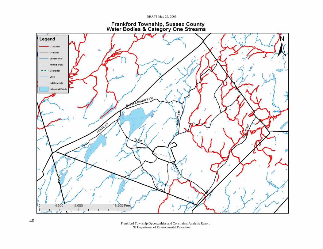
DRAFT May 29, 2009
Frankford Township Opportunities and Constraints Analysis Report
NJ Department of Environmental Protection
40
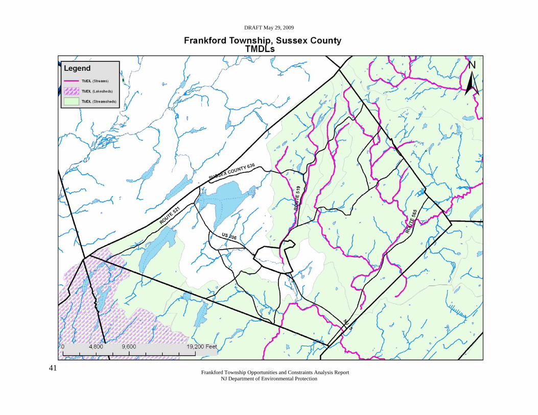
DRAFT May 29, 2009
Frankford Township Opportunities and Constraints Analysis Report
NJ Department of Environmental Protection
41

DRAFT May 29, 2009
Frankford Township Opportunities and Constraints Analysis Report
NJ Department of Environmental Protection
42
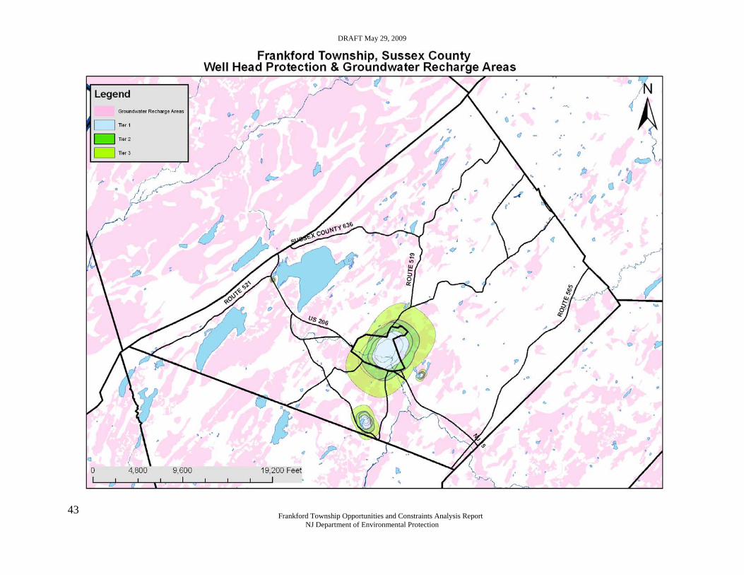
DRAFT May 29, 2009
Frankford Township Opportunities and Constraints Analysis Report
NJ Department of Environmental Protection
43

DRAFT May 29, 2009
Frankford Township Opportunities and Constraints Analysis Report
NJ Department of Environmental Protection
44
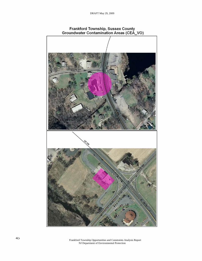
DRAFT May 29, 2009
Frankford Township Opportunities and Constraints Analysis Report
NJ Department of Environmental Protection
45
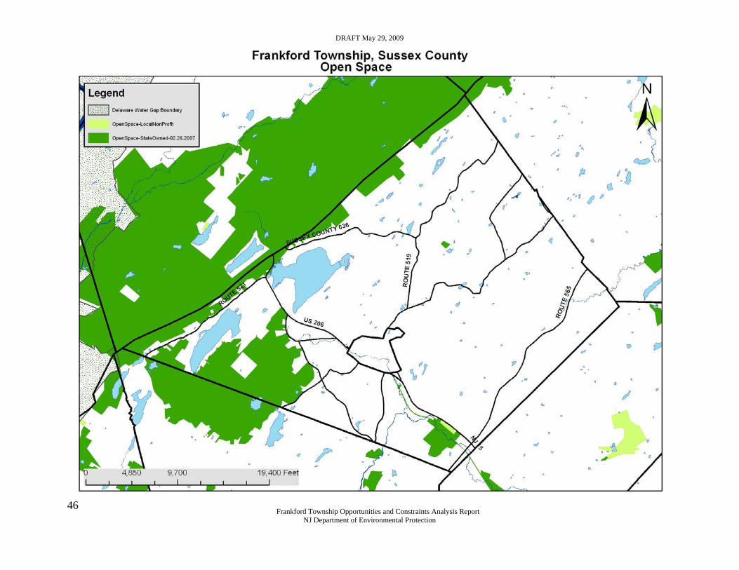
DRAFT May 29, 2009
Frankford Township Opportunities and Constraints Analysis Report
NJ Department of Environmental Protection
46

DRAFT May 29, 2009
Frankford Township Opportunities and Constraints Analysis Report
NJ Department of Environmental Protection
47

DRAFT May 29, 2009
Frankford Township Opportunities and Constraints Analysis Report
NJ Department of Environmental Protection
48

DRAFT May 29, 2009
Frankford Township Opportunities and Constraints Analysis Report
NJ Department of Environmental Protection
49
Additional Attachments
BRANCHVILLE WATER DEPARTMENT
PWSID: 1903001 County: Sussex Last Updated: 09/18/08
Glossary of Terms Listed Below
Water Supply Firm Capacity: 0.288 MGD
Available Water Supply Limits Allocation Contract Total Monthly Limit 6.200 MGM N/A MGM 6.200 MGMYearly Limit 60.000 MGY N/A MGY 60.000 MGY
Water Demand Current Peak Date Committed Peak Total Peak Daily Demand 0.139 MGD 05/2007 0.000 MGD 0.139 MGDMonthly Demand 4.300 MGM 05/2007 0.000 MGM 4.300 MGMYearly Demand 36.300 MGY 2007 0.000 MGY 36.300 MGY
Water Supply Deficit or Surplus Firm Capacity Water Allocation Permit0.149 MGD 1.900 MGM 23.700 MGY
Note: Negative values (a deficit) indicate a shortfall in firm capacity and/or diversion privileges or available supplies through bulk purchase agreements.
Bureau of Water System and Well Permitting Comments: no comments provided
Bureau of Water Allocation Comments: no comments provided
For more information concerning water supply deficit and surplus, please refer to:
Firm Capacity and Water Allocation Analysis (Pdf Format) Currently Effective Water Allocation Permits by County
This report displays all effective water allocation permits issued by the department. Pending Water Allocation Permits with Requests for a Hearing
All pending water allocation permits with public hearing requests. Water Allocation Permits Made Effective within a Selected Timeframe
This report displays water allocation permits based on a specified date range.
Questions regarding safe demands and firm capacity please contact the Bureau of Water System and Well Permitting at 609-984-6831 or for questions concerning water allocation and status please contact the Bureau of Water Allocation at 609-292-2957.
Questions may also be sent to the Division of Water Supply
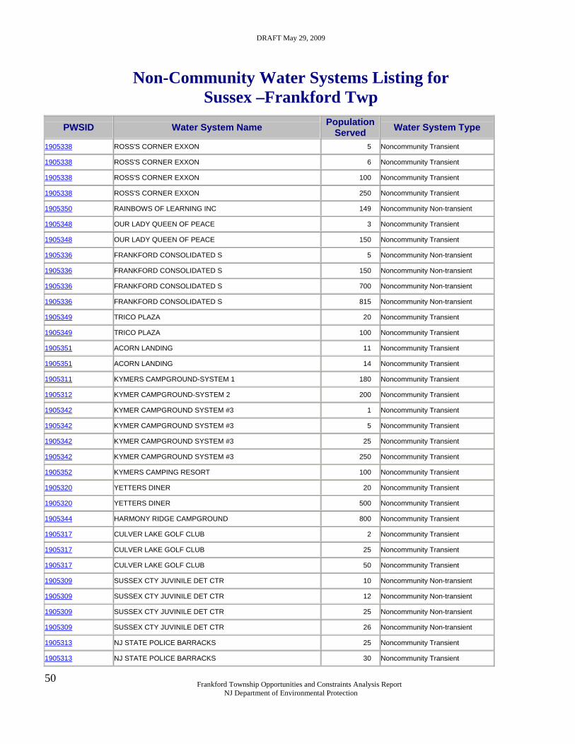
DRAFT May 29, 2009
Frankford Township Opportunities and Constraints Analysis Report
NJ Department of Environmental Protection
50
Non-Community Water Systems Listing for Sussex –Frankford Twp
PWSID Water System Name Population Served Water System Type
1905338 ROSS'S CORNER EXXON 5 Noncommunity Transient 1905338 ROSS'S CORNER EXXON 6 Noncommunity Transient 1905338 ROSS'S CORNER EXXON 100 Noncommunity Transient 1905338 ROSS'S CORNER EXXON 250 Noncommunity Transient 1905350 RAINBOWS OF LEARNING INC 149 Noncommunity Non-transient 1905348 OUR LADY QUEEN OF PEACE 3 Noncommunity Transient 1905348 OUR LADY QUEEN OF PEACE 150 Noncommunity Transient 1905336 FRANKFORD CONSOLIDATED S 5 Noncommunity Non-transient 1905336 FRANKFORD CONSOLIDATED S 150 Noncommunity Non-transient 1905336 FRANKFORD CONSOLIDATED S 700 Noncommunity Non-transient 1905336 FRANKFORD CONSOLIDATED S 815 Noncommunity Non-transient 1905349 TRICO PLAZA 20 Noncommunity Transient 1905349 TRICO PLAZA 100 Noncommunity Transient 1905351 ACORN LANDING 11 Noncommunity Transient 1905351 ACORN LANDING 14 Noncommunity Transient 1905311 KYMERS CAMPGROUND-SYSTEM 1 180 Noncommunity Transient 1905312 KYMER CAMPGROUND-SYSTEM 2 200 Noncommunity Transient 1905342 KYMER CAMPGROUND SYSTEM #3 1 Noncommunity Transient 1905342 KYMER CAMPGROUND SYSTEM #3 5 Noncommunity Transient 1905342 KYMER CAMPGROUND SYSTEM #3 25 Noncommunity Transient 1905342 KYMER CAMPGROUND SYSTEM #3 250 Noncommunity Transient 1905352 KYMERS CAMPING RESORT 100 Noncommunity Transient 1905320 YETTERS DINER 20 Noncommunity Transient 1905320 YETTERS DINER 500 Noncommunity Transient 1905344 HARMONY RIDGE CAMPGROUND 800 Noncommunity Transient 1905317 CULVER LAKE GOLF CLUB 2 Noncommunity Transient 1905317 CULVER LAKE GOLF CLUB 25 Noncommunity Transient 1905317 CULVER LAKE GOLF CLUB 50 Noncommunity Transient 1905309 SUSSEX CTY JUVINILE DET CTR 10 Noncommunity Non-transient 1905309 SUSSEX CTY JUVINILE DET CTR 12 Noncommunity Non-transient 1905309 SUSSEX CTY JUVINILE DET CTR 25 Noncommunity Non-transient 1905309 SUSSEX CTY JUVINILE DET CTR 26 Noncommunity Non-transient 1905313 NJ STATE POLICE BARRACKS 25 Noncommunity Transient 1905313 NJ STATE POLICE BARRACKS 30 Noncommunity Transient

DRAFT May 29, 2009
Frankford Township Opportunities and Constraints Analysis Report
NJ Department of Environmental Protection
51
1905301 THE OLD HOMESTEAD 60 Noncommunity Non-transient 1905301 THE OLD HOMESTEAD 100 Noncommunity Non-transient 1905305 FRANKFORD TWP MUNIC BLDG 12 Noncommunity Transient 1905305 FRANKFORD TWP MUNIC BLDG 50 Noncommunity Transient 1905305 FRANKFORD TWP MUNIC BLDG 60 Noncommunity Transient 1905330 ROSS CORNER PROPERTIES 15 Noncommunity Transient 1905330 ROSS CORNER PROPERTIES 25 Noncommunity Transient 1905330 ROSS CORNER PROPERTIES 40 Noncommunity Transient 1905302 EDGEMONT CAMPGROUND 10 Noncommunity Transient 1905302 EDGEMONT CAMPGROUND 50 Noncommunity Transient 1905303 PUB & GRUB 2 Noncommunity Transient 1905303 PUB & GRUB 4 Noncommunity Transient 1905303 PUB & GRUB 50 Noncommunity Transient 1905303 PUB & GRUB 100 Noncommunity Transient 1905304 BLUE RIBBON 18 Noncommunity Transient 1905304 BLUE RIBBON 75 Noncommunity Transient 1905306 BLUE RIDGE RESCUE SQUAD 25 Noncommunity Transient 1905310 FOR CHILDREN ONLY 8 Noncommunity Transient 1905310 FOR CHILDREN ONLY 15 Noncommunity Transient 1905310 FOR CHILDREN ONLY 22 Noncommunity Transient 1905310 FOR CHILDREN ONLY 24 Noncommunity Transient 1905310 FOR CHILDREN ONLY 25 Noncommunity Transient 1905310 FOR CHILDREN ONLY 62 Noncommunity Transient 1905314 COBMIN RIDGE MOTEL 9 Noncommunity Transient 1905314 COBMIN RIDGE MOTEL 25 Noncommunity Transient 1905314 COBMIN RIDGE MOTEL 50 Noncommunity Transient 1905316 JUMBO LAND 3 Noncommunity Transient 1905316 JUMBO LAND 6 Noncommunity Transient 1905316 JUMBO LAND 147 Noncommunity Transient 1905316 JUMBO LAND 200 Noncommunity Transient 1905318 RIVIERA MAYA 6 Noncommunity Transient 1905318 RIVIERA MAYA 7 Noncommunity Transient 1905318 RIVIERA MAYA 50 Noncommunity Transient 1905318 RIVIERA MAYA 60 Noncommunity Transient 1905318 RIVIERA MAYA 100 Noncommunity Transient 1905321 HENRYS MARKET LLC 8 Noncommunity Transient 1905321 HENRYS MARKET LLC 10 Noncommunity Transient 1905321 HENRYS MARKET LLC 100 Noncommunity Transient

DRAFT May 29, 2009
Frankford Township Opportunities and Constraints Analysis Report
NJ Department of Environmental Protection
52
1905322 LAKESIDE TAVERN 3 Noncommunity Transient 1905322 LAKESIDE TAVERN 60 Noncommunity Transient 1905322 LAKESIDE TAVERN 70 Noncommunity Transient 1905325 DALES MARKET 21 Noncommunity Transient 1905325 DALES MARKET 600 Noncommunity Transient 1905325 DALES MARKET 800 Noncommunity Transient 1905331 CARDINAL COMMONS 12 Noncommunity Transient 1905331 CARDINAL COMMONS 25 Noncommunity Transient 1905331 CARDINAL COMMONS 100 Noncommunity Transient 1905332 STEPPING STONE PRESCHOOL 7 Noncommunity Non-transient 1905332 STEPPING STONE PRESCHOOL 8 Noncommunity Non-transient 1905332 STEPPING STONE PRESCHOOL 34 Noncommunity Non-transient 1905332 STEPPING STONE PRESCHOOL 35 Noncommunity Non-transient 1905333 SUSSEX COUNTY FAIRGROUNDS 7 Noncommunity Transient 1905333 SUSSEX COUNTY FAIRGROUNDS 25 Noncommunity Transient 1905333 SUSSEX COUNTY FAIRGROUNDS 100 Noncommunity Transient 1905333 SUSSEX COUNTY FAIRGROUNDS 250 Noncommunity Transient 1905333 SUSSEX COUNTY FAIRGROUNDS 900 Noncommunity Transient 1905333 SUSSEX COUNTY FAIRGROUNDS 1,000 Noncommunity Transient 1905333 SUSSEX COUNTY FAIRGROUNDS 2,000 Noncommunity Transient 1905333 SUSSEX COUNTY FAIRGROUNDS 3,000 Noncommunity Transient 1905333 SUSSEX COUNTY FAIRGROUNDS 3,800 Noncommunity Transient 1905333 SUSSEX COUNTY FAIRGROUNDS 4,000 Noncommunity Transient 1905333 SUSSEX COUNTY FAIRGROUNDS 5,000 Noncommunity Transient 1905333 SUSSEX COUNTY FAIRGROUNDS 7,000 Noncommunity Transient 1905333 SUSSEX COUNTY FAIRGROUNDS 10,000 Noncommunity Transient 1905333 SUSSEX COUNTY FAIRGROUNDS 13,000 Noncommunity Transient 1905333 SUSSEX COUNTY FAIRGROUNDS 30,000 Noncommunity Transient 1905337 MICHAEL ANTHONYS 5 Noncommunity Transient 1905337 MICHAEL ANTHONYS 50 Noncommunity Transient 1905341 NORMANOCH ASSOCIATION 2 Noncommunity Transient 1905341 NORMANOCH ASSOCIATION 200 Noncommunity Transient 1905341 NORMANOCH ASSOCIATION 260 Noncommunity Transient 1905343 FRANKFORD TOWNSHIP PARK 100 Noncommunity Transient 1905345 CHATTERBOX 8 Noncommunity Transient 1905345 CHATTERBOX 100 Noncommunity Transient 1905345 CHATTERBOX 300 Noncommunity Transient 1905346 YELLOW COTTAGE 10 Noncommunity Transient

DRAFT May 29, 2009
Frankford Township Opportunities and Constraints Analysis Report
NJ Department of Environmental Protection
53
1905346 YELLOW COTTAGE 200 Noncommunity Transient 1905346 YELLOW COTTAGE 300 Noncommunity Transient 1905340 SKYLANDS BALL PARK 42 Noncommunity Non-transient 1905340 SKYLANDS BALL PARK 80 Noncommunity Non-transient 1905340 SKYLANDS BALL PARK 99 Noncommunity Non-transient 1905340 SKYLANDS BALL PARK 2,000 Noncommunity Non-transient 1905340 SKYLANDS BALL PARK 3,050 Noncommunity Non-transient 1905334 FRANKFORD FIRE DEPT 30 Noncommunity Transient
DRAFT May 29, 2009
Frankford Township Opportunities and Constraints Analysis Report
NJ Department of Environmental Protection
54
NJDEP Office of Planning and Sustainable Communities The Office of Planning and Sustainable Communities was formed to facilitate the Department's move toward a proactive planning approach based on principles of sustainability and environmental capacity-based planning.
Mission
To coordinate the sustainable development and environmental capacity-based planning policies of the Department and proactively work with other state agencies, regional entities, local governments and other groups to incorporate these policies into all levels of land use and environmental planning.
Background
In January, 2007, the Department of Environmental Protection (DEP) adopted its Policy Priorities and Action Plan which outlines the strategic direction of the agency over the next three years. The Plan identifies eight broad goal areas and underlying objectives.
One of the eight goal areas is Sustainable Growth:
Maximize use of department resources to encourage sustainable growth and livable communities by incorporating consistent criteria for the protection of natural resources and development of smart growth and green design principles into DEP rulemaking, priority setting and planning efforts, other state smart and economic growth priorities, and in regional and local planning efforts.
The first objective of this goal is:
“Incorporate sustainable growth and environmental protection criteria into state, regional and local planning.”
At the core of this goal is a recognized need for more progressive statewide environmental planning by the Department to help inform the local land use development and redevelopment process. Historically, the Department has engaged primarily in environmental planning in targeted areas based on statutory direction. Critically important work has been done in such areas as water quality management planning, water supply master planning, habitat protection planning (Landscape Project) and county/state solid waste planning. DEP is now committed to ensuring that these various planning programs are integrated and coordinated so that our guidance to regional and local planning agencies is consistent, comprehensive and supportive of both local and state priorities.
In a significant business practice improvement, DEP is also committed to implementing the Sustainable Growth goal by broadening the scope of its major project review process by requiring consideration and rewarding incorporating of green design the principles and practices.
Office of Planning and Sustainable Communities
401 E. State Street, 7 Floor East P.O. Box 402 Trenton, NJ 08625-0402 Phone: (609) 341-5311 Fax: (609) 292-3268