nh route 106 interim corridor study · · 2013-03-10segment 2 – chichester road/south village...
TRANSCRIPT

NH Route 106 Interim Corridor Study
Traffic Impact Assessment
March 2012

NHDOT 16188 NH Route 106 Interim Corridor Study
Traffic Impact Assessment Concord, Loudon, Canterbury, Gilmanton, Belmont
March 2012
Prepared For:
New Hampshire Department of Transportation
J.O. Morton Building 7 Hazen Drive
Concord, NH 03302
Prepared By:
53 Regional Drive Concord, NH 03301

NH ROUTE 106 CORRIDOR ASSESSMENT
TABLE OF CONTENTS PAGE INTRODUCTION 1 EXISTING CONDITIONS 3 TRAFFIC VOLUMES 5 CRASH HISTORY 8 VEHICLE SPEEDS 11 VEHICLE CLASSIFICATION 11 TRAFFIC GROWTH 12 ALTERNATIVES 14 NO-BUILD 14 TRAFFIC DEMAND MANAGEMENT 14 TRANSPORTATION SYSTEM MANAGEMENT 16 ROUNDABOUT 17 UPGRADE 17 INTERIM TYPICAL SECTION 18 FUTURE CONDITIONS 23 2015 OPENING YEAR CONDITIONS 23 2035 DESIGN YEAR CONDITIONS 23 TRAFFIC SIGNAL WARRANT ANALYSIS 23 CAPACITY ANALYSIS METHODOLOGY 27 CONCLUSIONS AND RECOMMENDATIONS 36
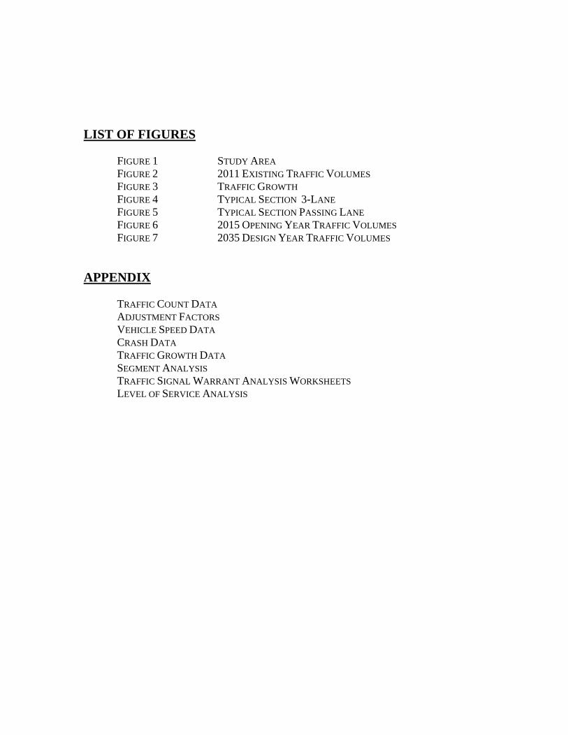
LIST OF FIGURES FIGURE 1 STUDY AREA FIGURE 2 2011 EXISTING TRAFFIC VOLUMES FIGURE 3 TRAFFIC GROWTH FIGURE 4 TYPICAL SECTION 3-LANE FIGURE 5 TYPICAL SECTION PASSING LANE FIGURE 6 2015 OPENING YEAR TRAFFIC VOLUMES FIGURE 7 2035 DESIGN YEAR TRAFFIC VOLUMES APPENDIX TRAFFIC COUNT DATA ADJUSTMENT FACTORS VEHICLE SPEED DATA CRASH DATA TRAFFIC GROWTH DATA SEGMENT ANALYSIS TRAFFIC SIGNAL WARRANT ANALYSIS WORKSHEETS LEVEL OF SERVICE ANALYSIS

INTRODUCTION McFarland Johnson, Inc. (MJ) has prepared the following report to summarize a Traffic Impact Assessment of the existing conditions along NH Route 106 from Interstate 393 in Concord, north to the intersection of NH Route 140 in the Town of Belmont. This Corridor was part of the 1995 Environmental Assessment completed by the New Hampshire Department of Transportation (NHDOT). This study has been prepared to update the traffic projections from that original study and addresses the long-term safety and capacity needs along NH Route 106 from Interstate 393 in Concord to NH Route 140 in Belmont. The scope of this study includes the qualitative evaluation of the reasonable alternatives identified in the original report as well as an evaluation of the proposed interim improvements for the 2035 Design Year. This analysis evaluated traffic operations and safety concerns within the Study Area during the weekday AM peak hour, and the weekday PM peak hour for the 2011 Existing, 2015 Opening Year, and 2035 Design Year Conditions. The 2035 Design Year Conditions represents an analysis of the proposed improvements to the corridor and its intersections. To demonstrate the impacts of the proposed improvements, the 2035 No-Build volumes were analyzed without improvements. The Study Area includes the following roadway segments and intersections: Roadway Segments:
Segment 1 – Interstate 393 to Chichester Road/South Village Road Segment 2 – Chichester Road/South Village Road to NH Route 129 Segment 3 – NH Route 129 to Shaker Road Segment 4 – Shaker Road to Clough Hill Road/Mudgett Hill Road Segment 5 – Clough Hill Road\Mudgett Hill Road to NH Route 140
Major Intersections:
NH Route 106 and Staniels Road\Josiah Bartlett Road NH Route 106 and Chichester Road\South Village Road NH Route 106 and NH Route 129 NH Route 106 and Shaker Road NH Route 106 and Clough Hill Road\Mudgett Hill Road NH Route 106 and NH Route 140
The study area in relation to surrounding roadways is shown in Figure 1. Descriptions of the existing physical conditions within the Study Area are presented in the following narratives.

Path
NEW HAMPSHIRE DOTCONCORD-LOUDON, NHROUTE 106 CORRIDOR
OCTOBER 2011APPROXIMATE SCALE : DATE : FIGURE :
TRAFFIC STUDY
Figure 1
BelmontGilmanton
CanterburyNorthfield
Gilman
ton
Cante
rbury
Conc
ordLo
udon
Currier Road
Intersection 4
LoudonChichesterClough H ill Road
CanterburyLoudon¬«106
¬«106
Intersection 6End Study
Shaker Road
§̈¦393
¬«106
§̈¦93
¬«140
¬«140
¬«129
¬«129 ¬«107
¬«140
£¤4
¬«9
Intersection 3
Intersection 1
Intersection 2
Intersection 5
Begin Study
S. Village R d
Allens Mill Rd
Asby Rd
Stone
Rd
Autum
n Dr
Chich
ester
Rd
Stanie
ls Rd
Mudget Hill Rd
Wales Bridge Rd
³
0 1 20.5Miles

TRAFFIC IMPACT ASSESSMENT LOUDON 16188 - NH ROUTE 106
- 3-
EXISTING CONDITIONS Evaluation of the existing and future traffic conditions of the Study Area requires an understanding of the existing transportation system. Data such as roadway geometrics and peak hour traffic volumes provide the basis for a thorough understanding of existing conditions and the requisite data necessary to provide projections of future traffic conditions, typically under the Design Year scenario. NH Route 106 is a major state highway that carries a large volume of north-south traffic between Pembroke in the south and Laconia in the north that intersects with Interstate 393 in Concord. NH Route 106 has one general purpose travel lane in each direction throughout its length, with shoulders ranging from 4-12 feet within the study area and has exclusive turn lanes at certain intersections that create a wider pavement width that varies from 40 to 68 feet. Although the speed limit on much of the southern section of NH Route 106 is posted at 55 miles per hour (mph), the speed limit reduces to 40 mph at the intersection of NH Route 106 and NH Route 129 and 45 mph at the intersection of NH Route 106 and Shaker Road. On the northern section of NH Route 106 from Stone Road (northern intersection) in Belmont north through the intersection of NH Route 140 the speed limit is posted as 40 mph. As NH Route 106 is a heavily traveled roadway, there is a need to improve traffic operations and mobility as well as safety. In order to accommodate the heavy demand of vehicles, traditional design may dictate a need to widen the roadway to provide additional travel lanes. However this corridor contains numerous residential and commercial driveways that enter the roadway in addition to the numerous side roads that must function in a safe and efficient manner. Therefore, this study has been prepared to evaluate the existing NH Route 106 corridor in terms of traffic operations, safety, and access management, while allowing for special event traffic control operations associated with New Hampshire Motor Speedway (NHMS) to function safely and efficiently. NH Route 106 and Staniels Road\Josiah Bartlett Road NH Route 106 and Staniels Road\Josiah Bartlett Road meet to form a four-legged, unsignalized intersection. The NH Route 106 northbound approach consists of an exclusive left-turn lane, a through lane, and an exclusive right-turn lane. The NH Route 106 southbound approach consists of an exclusive left-turn lane and a shared through/right-turn lane. The Staniels Road approach consists of one shared left-turn/through/right-turn lane. The Josiah Bartlett Road approach consists of one shared left-turn/through/right-turn lane. Directional flow on NH Route 106 and Josiah Bartlett road is separated by a double yellow centerline. Directional flow on Staniels Road is separated by a raised concrete island. There are no sidewalks in the vicinity of the intersection. Land uses in the vicinity of the intersection consist of both commercial and institutional uses.

TRAFFIC IMPACT ASSESSMENT LOUDON 16188 - NH ROUTE 106
- 4-
NH Route 106 and Chichester Road/South Village Road NH Route 106 and Chichester Road/South Village Road meet to form a skewed four-legged, unsignalized intersection. Both the NH Route 106 northbound and southbound approaches consist of an exclusive left-turn lane, and a shared through/right-turn lane. The Chichester Road approach provides one shared left-turn/through/right-turn lane. The South Village Road approach provides one shared left-turn/through/right-turn lane. Directional flow on NH Route 106 is separated by a double yellow centerline. Directional flow on Chichester Road and South Village Road is separated by a raised concrete island. There are no sidewalks in the vicinity of the intersection. Land uses in the vicinity of the intersection consist of both commercial and residential uses. NH Route 106 and NH Route 129 NH Route 106 and NH Route 129 meet to form a four-legged, signalized intersection. Both the NH Route 106 northbound and southbound approaches consist of an exclusive left-turn lane, a through lane and an exclusive right-turn lane. Both the NH Route 129 westbound and eastbound approaches consist of a shared left-turn/through lane and an exclusive right-turn lane. Directional flow on NH Route 106 is separated by a double yellow centerline. Directional flow on NH Route 129 westbound and NH Route 129 eastbound is separated by a raised concrete island. There are no sidewalks in the vicinity of the intersection. Land uses in the vicinity of the intersection consist of both commercial and residential uses. NH Route 106 and Shaker Road NH Route 106 and Shaker Road meet to form a three-legged, signalized intersection. The NH Route 106 northbound approach consists of an exclusive left-turn lane and a through lane. The NH Route 106 southbound approach consists of a through lane and an exclusive right-turn lane. The Shaker Road approach consists of an exclusive left-turn lane and an exclusive right-turn lane. Directional flow on NH Route 106 and Shaker Road is separated by a double yellow centerline. There are no sidewalks in the vicinity of the intersection. Land uses in the vicinity of the intersection consist of both commercial and residential uses. NH Route 106 and Clough Hill Road/Mudgett Hill Road NH Route 106 and Clough Hill Road/Mudgett Hill Road meet to form a four-legged, unsignalized intersection. Both the NH Route 106 northbound and southbound approaches consist of one general purpose travel lane. The Clough Hill Road approach consists of a shared left-turn/through/right-turn lane. The Mudgett Hill Road approach consists of a shared left-turn/through/right-turn lane. Directional flow on NH Route 106, Clough Hill Road, and Mudgett Hill Road is separated by a double yellow centerline. There are no sidewalks in the vicinity of the intersection. Land uses in the vicinity of the intersection consist of both commercial and residential uses. NH Route 106 and NH Route 140 NH Route 106 and NH Route 140 meet to form a skewed four-legged, signalized intersection. The NH Route 106 northbound approach provides an exclusive left-turn lane and a shared through/right-turn lane.

TRAFFIC IMPACT ASSESSMENT LOUDON 16188 - NH ROUTE 106
- 5-
The NH Route 106 southbound approach provides an exclusive left-turn lane, a through lane, and an exclusive right-turn lane. The NH Route 140 westbound approach provides a shared left-turn/through lane and an exclusive right-turn lane. The NH Route 140 eastbound approach provides an exclusive left-turn lane and a shared through/right-turn lane. Directional flow on NH Route 106 and NH Route 140 is separated by a double yellow centerline. There are pedestrian crosswalks and pushbuttons provided on the NH Route 106 northbound and NH Route 140 eastbound approaches to the intersection. There are sidewalks along the south side of both legs of NH Route 140 and a short section of sidewalk along the west side of NH Route 106 north of the intersection. Land uses in the vicinity of the intersection consist of both commercial and residential uses. Special Event Conditions During special events at the New Hampshire Motor Speedway (NHMS) traffic along NH Route 106 follows modified lane use patterns to accommodate the anticipated increase in traffic volumes. Approximately 17,000 vehicles are anticipated traveling northbound on NH Route 106 in the morning hours before the event and approximately 25,300 vehicles are anticipated traveling southbound in the afternoon and early evening following the event. During these time periods the lane usage along NH Route 106 is modified to accommodate the large volume of directional flow through the use of temporary signs, cones, and variable message boards. During the morning hours before the event, NH Route 106 provides for two northbound travel lanes from I-393 in Concord to Chichester Road in Loudon, three northbound travel lanes from Chichester Road north to NHMS in Loudon, and one southbound travel lane along NH Route 106 from NHMS to I-393. During the afternoon and early evening hours following the event, the lane use along NH Route 106 is shifted to provide four southbound travel lanes from NHMS to Clough Hill Road and three southbound travel lanes from Clough Hill Road to I-393 in Concord. During the afternoon and early evening hours when traffic is exiting the track and heading south toward I-393, no northbound traffic is allowed access to NH Route 106 between NHMS and I-393. TRAFFIC VOLUMES Base traffic conditions within the study area were developed by conducting manual turning movement counts (TMC) and vehicle classification counts within the study area. The TMCs and vehicle classifications counts were conducted at four of the intersections on May 25 and 26, 2011 during the weekday AM peak period (7:00 to 9:00 AM), the weekday PM peak period (4:00 to 6:00 PM), and on June 11, 2011 for the Saturday Midday peak period (11:00-1:00 PM). The remaining intersection (Staniels Road/Josiah Bartlett Road) was counted on July 7th, 2011 by the NHDOT during the weekday AM peak period (7:00 to 9:00 AM) and weekday PM peak period (4:00 to 6:00 PM). The TMC data show that the weekday traffic in the study area peaks between 7:15 and 8:15 AM and between 5:00 and 6:00 PM with the PM peak hour yielding the largest volumes. Although Saturday Midday peak hours were collected for this study, this peak hour was not analyzed as the PM peak hour yielded significantly higher volumes. All traffic count data is provided in the Appendix. Traffic on a given roadway typically fluctuates throughout the year depending on the area and the type of roadway. Based on NHDOT guidelines for a traffic study, existing traffic volumes must represent the peak of the monthly average peak-hour conditions. To determine if the traffic count data required

TRAFFIC IMPACT ASSESSMENT LOUDON 16188 - NH ROUTE 106
- 6-
adjustment due to seasonal variation, seasonal adjustment data and count data provided by NHDOT was reviewed.1 This information revealed that traffic volumes in the month of May are 3 percent lower than peak month volumes during the AM peak hour and 8 percent lower than the peak month volumes during the PM peak hour and that June represent the peak month in the study area for the Saturday midday peak hour. Therefore the weekday AM and PM peak hour volumes were adjusted upward 3 percent and 8 percent, respectively, to represent 2011 peak-month traffic volumes. The weekday AM and PM peak hour data provided by NHDOT for Staniels Road/Josiah Bartlett Road was adjusted accordingly for the month of July. The NHDOT seasonal adjustment data are included in the Appendix. Figure 2 graphically depict the 2011 Existing peak-month conditions during the AM and PM peak hours.
1 New Hampshire Department of Transportation Automatic Traffic Recorder Report, Route 106 at the Concord/Loudon Town Line 2010

TRAFFIC IMPACT ASSESSMENT LOUDON 16188 - NH ROUTE 106
- 8-
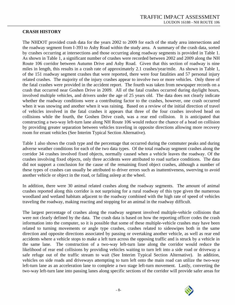
CRASH HISTORY The NHDOT provided crash data for the years 2002 to 2009 for each of the study area intersections and the roadway segment from I-393 to Asby Road within the study area. A summary of the crash data, sorted by crashes occurring at intersections and those occurring along roadway segments is provided in Table 1. As shown in Table 1, a significant number of crashes were recorded between 2002 and 2009 along the NH Route 106 corridor between Autumn Drive and Asby Road. Given that this section of roadway is nine miles in length, this results in a crash rate of approximately 2.1 crashes/year/mile. As shown in Table 1, of the 151 roadway segment crashes that were reported, there were four fatalities and 57 personal injury related crashes. The majority of the injury crashes appear to involve two or more vehicles. Only three of the fatal crashes were provided in the accident report. The fourth was taken from newspaper records on a crash that occurred near Goshen Drive in 2009. All of the fatal crashes occurred during daylight hours, involved multiple vehicles, and drivers under the age of 25 years old. The data does not clearly indicate whether the roadway conditions were a contributing factor to the crashes, however, one crash occurred when it was snowing and another when it was raining. Based on a review of the initial direction of travel of vehicles involved in the fatal crashes it appears that three of the four crashes involved head on collisions while the fourth, the Goshen Drive crash, was a rear end collision. It is anticipated that constructing a two-way left-turn lane along NH Route 106 would reduce the chance of a head on collision by providing greater separation between vehicles traveling in opposite directions allowing more recovery room for errant vehicles (See Interim Typical Section Alternative). Table 1 also shows the crash type and the percentage that occurred during the commuter peaks and during adverse weather conditions for each of the two data types. Of the total roadway segment crashes along the corridor 34 crashes involved fixed objects, normally caused when a vehicle leaves the roadway. Of the crashes involving fixed objects, only three accidents were attributed to road surface conditions. The data did not support a conclusion for the cause of the remaining fixed object crashes, although a number of these types of crashes can usually be attributed to driver errors such as inattentiveness, swerving to avoid another vehicle or object in the road, or falling asleep at the wheel. In addition, there were 30 animal related crashes along the roadway segments. The amount of animal crashes reported along this corridor is not surprising for a rural roadway of this type given the numerous woodland and wetland habitats adjacent to the roadway combined with the high rate of speed of vehicles traveling the roadway, making reacting and stopping for an animal in the roadway difficult. The largest percentage of crashes along the roadway segment involved multiple-vehicle collisions that were not clearly defined by the data. The crash data is based on how the reporting officer codes the crash information into the computer, so it is possible that some of these multiple-vehicle crashes may have been related to turning movements or angle type crashes, crashes related to sideswipes both in the same direction and opposite directions associated by passing or overtaking another vehicle, as well as rear end accidents where a vehicle stops to make a left turn across the opposing traffic and is struck by a vehicle in the same lane. The construction of a two-way left-turn lane along the corridor would reduce the likelihood of rear end collisions by providing vehicles waiting to turn left into a side road or driveway a safe refuge out of the traffic stream to wait (See Interim Typical Section Alternative). In addition, vehicles on side roads and driveways attempting to turn left onto the main road can utilize the two-way left-turn lane as an acceleration lane to complete a two stage left-turn movement. Lastly, converting the two-way left-turn lane into passing lanes along specific sections of the corridor will provide safer areas for

TRAFFIC IMPACT ASSESSMENT LOUDON 16188 - NH ROUTE 106
- 9-
faster moving vehicles to pass slower moving vehicles, thus reducing the chance of sideswipe collisions (See Interim Typical Section Alternative). Crashes were also recorded at five of the six area intersections. Of the five intersections, the unsignalized intersection of NH Route 106 and Staniels Road / Josiah Bartlett Road had 15 crashes with eight of them involving personal injuries. Approximately 63 percent of crashes at this intersection were cross movement or angle collisions attributed to vehicles attempting to pull out into the traffic stream from the side roads. The movements were a combination of vehicles turning left across the opposing lanes and vehicles turning right into the adjacent lane. These types of crashes are common at unsignalized intersections where vehicles on the side road are attempting to pull out onto a busy main road with high traffic volumes, high speeds, and minimal gaps. Since the collection of this data, one additional fatality has occurred at the intersection of Staniels Road and NH Route 106 (2011) which involved a vehicle turning left out of the side road and striking a motorcycle on the main road. The installation of a traffic signal at this location, if warranted, would significantly reduce the volume of cross movement or angle crashes because the side road would have an exclusive phase in which to move onto the main roadway (See Signal Warrant Section). The unsignalized intersection of NH Route 106 and Chichester Road/South Village Road also experienced 15 crashes with nine of those involving personal injury. Similar to Staniels Road, approximately 69 percent of these crashes involved cross movement or angle collisions attributed to vehicles attempting to pull out into the traffic stream from the side roads. These types of crashes are common at unsignalized intersections where vehicles on the side road are attempting to pull out onto a busy main road with high traffic volumes, high speeds, and minimal gaps. The installation of a traffic signal at this location, if warranted, would significantly reduce the volume of cross movement or angle crashes because the side road would have an exclusive phase in which to move onto the main roadway (See Signal Warrant Section). The signalized intersection of NH Route 106 and NH Route 129 experienced 14 crashes of which six involved personal injury. More than half of the crashes were rear-end collisions which are more common at signalized intersections where drivers fail to recognize that the vehicle in front of them is slowing for a yellow light or has stopped for a red light. This intersection also had six cross movement or angle crashes that occurred between the eastbound and westbound movements which are permitted to enter the intersection at the same time with the intent that left-turning vehicles will yield to vehicles traveling straight through the intersection. The signalized intersection of NH Route 106 and Shaker Road experienced fewer crashes than the other signalized intersection. All of the crashes at this location resulted in property damage only with the majority of them being rear-end collisions which are common at signalized intersections where drivers fail to recognize that the vehicle in front of them is slowing for a yellow light or has stopped for a red light. The unsignalized intersection of NH Route 106 and Clough Hill Road/Mudgett Hill Road experienced a total of seven crashes of which three resulted in personal injury. Approximately half of the crashes were rear -end collisions where a vehicle was stopped on the main road waiting to make a left-turn into the side road when they were struck from behind. The construction of an exclusive left-turn lane at this location would help reduce the occurrence of this type of crash.

TRAFFIC IMPACT ASSESSMENT LOUDON 16188 - NH ROUTE 106
- 10 -
Table 1 Crash Summary (NH Route 106 from 2002 – 2009)
Location
Number of Crashes
Severitya
Crash Typeb
Percent During
Total
Average per Year
PD
PI
Fc
CM
RE
MV
FO
Ped
Other
Commuter Peak
Rain/Snow/ Ice
Intersections: NH Route 106 at Staniels Road
16
2.00
8
8
0
10
2
3
1
0
0
17%
17%
NH Route 106 at Chichester Rd
16
2.00
7
9
0
11
1
4
0
0
0
31%
31%
NH Route 106 at Route 129
14
1.75
8
6
0
3
8
3
0
0
0
43%
21%
NH Route 106 at Shaker Road
7
0.88
7
0
0
0
6
1
0
0
0
14%
14%
NH Route 106 at Clough Hill Road
7
0.88
4
3
0
1
3
3
0
0
0
57%
29%
Roadway: Autumn Drive to Asby Road
151
18.88
90
57
4
4
8
67
34
1
37
34%
25%
Source: New Hampshire Department of Transportation, 2002-2009 aPD = Property Damage Only, PI = Personal Injury, F = Fatality bCM = Cross Movement/angle, RE = Rear End, MV = Multiple Vehicle, FO = Fixed Object, Ped = Pedestrian/bicycle. cF= One fatal crash was taken from newspaper accounts of the crash because it was not shown in the accident data.

TRAFFIC IMPACT ASSESSMENT LOUDON 16188 - NH ROUTE 106
- 11 -
VEHICLE SPEEDS Speed measurements were conducted along NH Route 106 within the study area using the “floating car” method. In this method, speeds are recorded by a car that is traveling consistent with the speed of traffic on the roadway. Several observations were conducted along NH Route 106 during non-peak hours. The measurements were taken during hours other than peak travel times so that vehicles were traveling at free-flow speeds. In addition, several observations were taken during the PM peak hours to determine if speeds were affected as a result of the higher vehicle volumes for comparison with Level of Service indicators. The observed speeds are summarized in Table 2 and all data are provided in the Appendix. Table 2 Observed Travel Speeds (in miles per hour)
Location/Direction
Posted Speed Limit
Median Speed (off peak hour)
Median Speed (peak hour)
NH Route 106 south of NH Route 129 Northbound Southbound
55 55
65 62
61 60
NH Route 106 south of Shaker Road Northbound Southbound
55 55
62 62
59 61
NH Route 106 south of Asby Road Northbound Southbound
55 55
58 60
57 58
NH Route 106 south of NH Route 140 Northbound Southbound
40 40
43 43
42 41
As shown, the median speeds along NH Route 106 were found to be slightly higher than the posted speeds during both the peak and non-peak hours. The higher speeds that were observed along this corridor are most likely due to increased driver comfort as a result familiarity with the roadway, wide shoulder widths, the relatively straight nature of the roadway horizontal alignment, and the relatively flat vertical alignment along NH Route 106. The lack of a reduction in speed from the posted speed limit during the peak hours indicates that the Level of Service of the roadway does not appear to be affected by an increase in volume of traffic during these times. VEHICLE CLASSIFICATION Vehicle classification data along NH Route 106 was obtained as part of the Turning Movement Counts at the intersection of Staniels Road/Josiah Bartlett Road. Based on this data, approximately 1.5% of the Design Hourly Volume and 8.5 percent of the total daily traffic on NH Route 106 consists of heavy vehicles.

TRAFFIC IMPACT ASSESSMENT LOUDON 16188 - NH ROUTE 106
- 12 -
TRAFFIC GROWTH A review of the traffic growth along NH Route 106 showed a steady increase in the volume of traffic from 1982 to 2004. Since that time the volumes along NH Route 106 have steadily declined to pre 2004 conditions resulting in a much lower growth rate than the forecast in the 1995 study. In order to forecast traffic volumes into the future it was necessary to consult the Central New Hampshire Regional Planning Commission Regional Traffic Model. This model predicts future traffic volumes along the roadway based on origin-destination, land use, trip assignment, and route choice. The growth values obtained from the model ranged from 0.39 percent to 1.30 percent along the corridor. Based on discussions with NHDOT officials, a minimum 1.0 percent growth rate was used on segments where the growth rate from the model was shown to be below 1.0 percent. Along the remaining segments of the roadway the actual growth rate obtained from the model was utilized to forecast future traffic volumes. Figure 3 shows the existing and projected Annual Average Daily Traffic volumes from the NHDOT permanent count station at the Concord/Loudon Town Line on NH Route 106. The Traffic data was analyzed for the base year (2011), an Opening year (2015), and the Design year (2035) using Highway Capacity Manual2 methodologies to evaluate the roadway and intersection capacities. Analysis of the roadways and intersections involved the determination of a “Level of Service (LOS)” which is defined as a qualitative measure describing operational conditions within a traffic stream and their perception by motorist and/or passengers.
2 Highway Capacity Manual, Transportation Research Board, Washington DC, 2000.


TRAFFIC IMPACT ASSESSMENT LOUDON 16188 - NH ROUTE 106
- 14 -
ALTERNATIVES NO-BUILD (BASELINE) The No-Build alternative assumes that the existing roadway system would be maintained in its current condition through the Design year. Other than normal roadway maintenance by the District, no additional roadway improvements are planned at this time, however project Loudon 22027 will rehabilitate two bridges in Loudon. With the proposed increase in traffic volumes on both NH Route 106 and many of the side roads, increased delays exiting the side streets would be realized. As motorists become more impatient with getting out of the side streets there is the potential for an increase in crash occurrences. In addition, with the increase in the volume of left-turn movements into the side streets from NH Route 106 there would be increased risk of crashes as drivers either fail to perceive and avoid left-turning vehicles resulting in rear end collisions or side swipe these vehicles as they attempt to go around them on narrow shoulders. Therefore this alternative is not considered prudent, as it does not address the existing safety and capacity deficiencies at intersections throughout the corridor. TRAFFIC DEMAND MANAGEMENT (TDM) ALTERNATIVES The Traffic Demand Management alternative includes measures that are designed to reduce the volume of traffic on the roadway rather than increasing capacity. These measures represent various actions that can be taken to reduce the amount of single occupancy vehicles on the roadway. TDM measures include a wide variety of measures designed to promote the use of alternate travel modes and thus decrease travel demand. The goal is to change driver behaviors to reduce travel demand through the use of TDM measures including, but not limited to, the following:
• Ride Sharing • Park and Ride Facilities • Work hour management ( flextime, offset work hours, telecommuting) • High occupancy Vehicle (HOV) • Transit Usage (Bus, trains) • Commuter Bicycle programs
A number of municipal and private organizations were contacted as part of the 1995 EA study to determine the level of existing and future TDM measures. These resources were reviewed as part of this study to determine if there had been any changes within the corridor that would affect travel demand. The Central New Hampshire Regional Planning Commission (CNHRPC) in coordination with the Lakes Regional Planning Commission (LRPC) prepared a draft document titled “Coordinated Transit and Human Services Transportation Plan” (Draft Plan) for the Region 3 area which includes Belknap County and portions of Merrimack and Hillsborough Counties under the FHWA “Safe, Accountable, Flexible,

TRAFFIC IMPACT ASSESSMENT LOUDON 16188 - NH ROUTE 106
- 15 -
Efficient Transportation Equity Act: A Legacy for Users” (SAFETEA:LU). This Draft Plan addressed transportation services and needs based on the following requirements:
• An assessment of available services that identifies current transportation providers (public, private and non-profit);
• An assessment of transportation needs for individuals with disabilities, older adults, and people with low incomes. This assessment can be based on the experiences and perceptions of the planning partners or on more sophisticated data collection efforts, and gaps in service;
• Strategies, activities, and/or projects to address the identified gaps between current services and needs, as well as opportunities to achieve efficiencies in service delivery; and
• Priorities for implementation based on resources (from multiple program sources), time, and feasibility for implementing specific strategies and/or activities.
A review of this document revealed that no fixed route public transportation services are currently servicing the NH Route 106 corridor between Concord and Belmont. While there are no fixed route services along the NH Route 106 corridor, the NHDOT does operate the Rideshare program throughout the state which provides information and assistance about ridesharing including carpools, vanpools, buses, and trains and helps people match up with other people looking to carpool. In addition, the CNHRPC’s Program for Alternative Transportation and Health (PATH) supplements the statewide ridesharing efforts for commuters within the CNHRPC’s region which include Concord, Loudon, and Canterbury along the NH Route 106 corridor. PATH offers incentives for people that carpool, use public transit, bicycle or walk to work. PATH also works with employers by helping them find safe and reliable ways to support employees struggling with transportation issues and to offer the solutions as benefits to employees. PATH works with employers to identify analyze major transportation issues around their workplaces and helps employers develop and implement innovative and effective solutions. PATH also works with employers to promote commuting alternatives, develop transit options specific to workplaces, and identifies incentives to help employers encourage commuting alternative. Currently there is only one Park and Ride lot located along the NH Route 106 corridor, which is located just north of NH Route 140. A review of the Draft Plan indicated that this Park and Ride lot is underutilized with average lot occupancy of about 35 percent. This may indicate that there is either a lack of commuters willing to use carpooling in this area, the lot is serving the communities current needs, or that the lot may be located too far north to function for a majority of the commuters along NH Route 106 between Concord and Belmont. The Draft Plan also revealed that there are a number of providers that service the area, but generally offers services specific to subsets of the population such as seniors or for specific single trip purposes such as travel to and from medical appointments. Many of these providers are members of the Belknap – Merrimack Community Actions Program and the Community Provider Network that operate in the wider Concord area. Therefore this alternative is not considered feasible on its own, as it does not provide enough TDM measures along this corridor to alleviate the existing capacity or safety concerns. However, TDM measures along this corridor should continue to be investigated and improved upon as part of any long range transportation plan. Some measures that could be effective would include:

TRAFFIC IMPACT ASSESSMENT LOUDON 16188 - NH ROUTE 106
- 16 -
• Additional Park and Ride Facilities in the Town of Loudon. • Expanded fixed route bus routes that would provide more services to the commuting public.
TRANSPORATION SYSTEM MANAGEMENT (TSM) ALTERNATIVES Transportation System Management consists of localized improvements to the existing roadway system that do not involve major construction, are generally low cost solutions to existing capacity constraints and safety concerns, and can generally be completed by state maintenance personnel. These improvements tend to focus on intersection related improvements including signal timing and phasing upgrades, signal equipment upgrades, and consolidation of access points. In addition, on roadways with wide shoulders, these improvements can include providing exclusive turn lanes or auxiliary lanes at an intersection without widening the roadway by reducing the existing shoulder width and restriping the roadway during normal pavement overlay programs. Several examples of TSM improvements that have been made to the NH Route 106 corridor are:
• Signal timing improvements at the intersection of NH Route 106 and NH Route 129. • Restriping of NH Route 106 to provide for the installation of left-turn lanes at Chichester
Road/South Village Road, Dunkin Donuts, and Clough Pond Road.
Several additional TSM that could be implemented along NH Route 106 that would improve safety and capacity are as follows:
• Signal timing and phasing adjustments at the intersection of NH Route 106 and NH Route 129. • Signal timing adjustments at the intersection of NH Route 106 and Shaker Road. • Signal timing and phasing adjustments at the intersection of NH Route 106 and NH Route 140. • Restriping of NH Route 106 to provide for the installation of left-turn lanes at a number of town
road intersections. • Improved/upgraded signing and pavement markings.
While the signal timing and phasing adjustments noted above can make an improvement in the overall operations of a signal, thus increasing capacity, the benefits of the improvements are short lived. Some of the existing single lane approaches to signalized intersections on NH Route 106 are nearing capacity and as the volume of traffic on NH Route 106 continues to increase, the capacity afforded by these lanes will be exceeded and the need for additional lanes will be realized. Providing exclusive left-turn lanes increases capacity and safety by removing turning vehicles from the traffic stream. Restriping the roadway to create these lanes by reducing the usable shoulder on a high speed roadway such as NH Route 106, however, can reduce the capacity and safety of the intersection, negating the positive effects of the exclusive turn lane. Therefore, this alternative on its own does not provide enough TSM measures along this corridor to increase the existing capacity and improve the safety concerns, nor does it address the long term needs of the corridor. However, TSM measures along this corridor such as signal timing and phasing adjustments, and improved signing and pavement markings should continue to be investigated and implemented.

TRAFFIC IMPACT ASSESSMENT LOUDON 16188 - NH ROUTE 106
- 17 -
ROUNDABOUT ALTERNATIVE The installation of a Roundabout at key intersections along the corridor was considered from a qualitative analysis standpoint. While either one or two lane roundabouts would be effective at handling peak hour traffic volumes, the management of traffic during special events at NHMS would be more problematic. A review of the general operation of roundabouts during special events where larger than normal volumes are expected revealed that several states, including Florida, have plans in place that utilize roundabouts during special event where a majority of the traffic entering the roundabout travels through the intersection in one direction and all other legs of the roundabout are essentially closed to traffic. This type of operation would require traffic to travel in both directions around the roundabout making crossing maneuvers by emergency vehicles and local traffic difficult or impossible. In addition, this type of operation would require additional police control and signage to guide vehicles through the roundabout. Therefore this alternative is not considered prudent as it would result in poor operations during special events and could restrict access to NH Route 106 by emergency vehicles and local traffic. UPGRADE ALTERNATIVES This group of alternatives was developed during the 1995 EA study based on future traffic projections and analysis and recommended the upgrade of approximately 15 miles of NH Route 106 to a four lane cross section. As a result of this analysis, it became apparent that developing a four lane principal arterial and investigating the associated impacts for the entire 21 mile corridor was warranted. These overall improvements became known as the “Ultimate Improvement” for NH Route 106 and would represent the final layout of the corridor. This Ultimate Improvement would require the widening and reconstruction of the entire corridor with minor changes to both vertical and horizontal alignments. The projected traffic volumes from the 1995 EA study indicated that the Annual Average Daily Traffic volumes on the NH Route 106 corridor would reach nearly 23,000 vehicles by the Design Year (2013) at the Concord\Loudon Town Line. A review of the actual traffic volume increases along NH Route 106 has shown a much smaller growth than was originally forecast. As such, the 2011 Annual Average Daily Traffic volume on NH Route 106 at Concord\Loudon Town Line was found to be 16,371 vehicles. A segment analysis was performed during the PM peak hour to determine the existing LOS of the corridor and to determine the future segment LOS based on the forecasted growth to the 2035 Design Year. The results of this analysis are shown in Table 3. Analysis sheets are included in the Appendix. In addition, a field operational review and field speed study were undertaken to review the current Level of Service of the corridor from a qualitative analysis approach. The conditions that were observed indicate that the free flow speed during both peak and non-peak hours is at or above the posted speed along the corridor. While vehicles queues observed at the signalized intersections are long during the peak hour, they normally clear within one or two cycles and are minimal during non-peak hours. These observations were then compared to the descriptions of Level of Service indicators in the Level of Service Characteristics by Highway Type table from the NHDOT 1999 Highway Design Manual for an arterial roadway. Based on this review, the existing roadway would be considered to be operating at a LOS C during the peak hours and LOS A during non-peak hours for most of the corridor even though the segment analysis shows a

TRAFFIC IMPACT ASSESSMENT LOUDON 16188 - NH ROUTE 106
- 18 -
much lower LOS. It should also be noted that the segment analysis represents the operation of the corridor during the peak hours of the day only and is not indicative of the operations during the remaining hours of the day. Building a four lane cross sections to satisfy the operations of the segment during the peak hours would be similar to installing a traffic signal based on the peal hour needs only. This was taken into consideration when looking at the need for the Ultimate Improvements. Table 3 Segment Analysis Summary – PM Peak Hour
Segment Number/Description 2011 Existing 2035 No-Build PTSFa v/cb LOS PTSF v/c LOS
No.1 – I-393 to Chichester Rd\S. Village Rd 85.3 0.58 E 92.5 0.80 E No. 2 – Chichester Rd\S. Village Rd to NH Route 129 83.6 0.53 E 91.6 0.76 E No 3 – NH Route 129 to Shaker Rd 78.5 0.44 D 86.0 0.60 E No. 4 – Shaker Rd to Clough Hill Rd/Mudgett Hill Rd 75.2 0.38 D 82.9 0.52 E No 5 – Clough Hill Rd/ Mudgett Hill Rd to NH Route 140 72.9 0.37 D 77.0 0.44 E
a PTSF = Percent Time Spent Following – Average percent of time vehicles spend in Platoons unable to pass slower vehicles. b v/c = Volume to Capacity Ratio Therefore it was determined that the Ultimate Improvement to upgrade NH Route 106 to a four lane cross sections was not warranted at this time and that an Interim Typical Section should be investigated that could address some of the safety concerns along the corridor. The next section discussed this Interim Typical Section. INTERIM TYPICAL SECTION ALTERNATIVE Since a review of the traffic volumes and the operations along the corridor indicated that the Ultimate Improvement was not warranted, it became necessary to review the corridor to determine if there was an Interim Typical Section that would provide any measure of improvement in the safety and operations of the corridor through the Design Year. The decision to install left-turn lanes at an intersection is normally predicated on meeting the volume recommended guidance as outlined in “A Policy on the Geometric Design of Highways and Streets”3. These volume thresholds indicate that a left-turn lane should be generally be considered when at least 5% of the advancing volume is making a left turn at the intersection. Many of the side roads along NH Route 106 do not meet this minimum volume threshold. The manual, however, also indicates that it is prudent to consider the installation of left-turn lanes on Arterial roadways with higher operating speeds where improving safety and preserving capacity are an issue. The crash data indicates that a common type of crash on NH Route 106 is rear-end crashes at unsignalized intersections and driveways, which are indicative of the lack of a left-turn refuge. It should be noted that the crash data represents only reportable crashes and does not include minor crashes where no police report was filed or the frequent close calls related during discussions with citizens, commuters, and the 3 A Policy on the Geometric Design of Highways and Streets, American Association of State Highway and Transportation Officials, Washington DC, 2004

TRAFFIC IMPACT ASSESSMENT LOUDON 16188 - NH ROUTE 106
- 19 -
Loudon Police Chief. This indicates that there is a need to provide a safe refuge for vehicles waiting to make a left turn along NH Route 106. It has been found that crash rates can be reduced by 20 to 65 percent with the construction of a left-turn lane4. The “Highway Safety Manual (HSM)”5 discusses the effects of different types of treatments intended to improve roadway and intersection safety. The effects of these treatments can be quantified using Crash Modification Factors (CMF), which are multiplicative factors applied to crashes at a particular intersection or along a specific segment of roadway, to determine the anticipated reduction in crash occurrences. Many agencies choose to describe crash reductions as a percentage of crashes reduced. The Crash Reduction Factors or percentage of crashes reduced can be related to the CMF through the following formula: Percentage of crash reduction = (1-CMF)*100 Where a specific Crash Reduction Factor listed in the Highway Safety Manual has a standard deviation value, these values should be applied to the CMF to provide a range of anticipated crash reduction percentages. Applying the formula for the CMF associated with constructing an exclusive left-turn lane at an intersection results in an anticipated reduction in crash occurrences of 40-56 percent. This reduction provides a measureable decrease in the anticipated crash occurrences associated with left-turn movements. Therefore it is recommended that left-turn refuges be provided at intersections and driveways where feasible. At intersections the left-turn refuge would be provided by exclusive left-turn lanes, while those in areas with frequent driveways, the left-turn refuge would consist of a two-way left-turn lane. The Highway Safety Manual indicates that crash occurrences on rural highway with a driveway density of at least five access points per mile can be reduced with the implementation of a two-way left-turn lane. This corridor has a driveway density of approximately 10 driveways per mile including unsignalized roadway access points which results in a CMF of 0.94 for a two-way left-turn lane. This equates to an anticipated six percent reduction in overall crash occurrences resulting from driveway related left-turn crashes. AASHTO states that shoulder width plays a key role in the operational capacity and safety of a roadway. Currently NH Route 106 has variable width shoulders ranging from 4 to 12 feet. Guidelines indicate that an arterial two lane roadway should provide for a minimum 8-foot wide usable shoulder. Shoulders also function as deceleration and acceleration lanes for right turns at intersections and driveways, although this utility is limited when the shoulder width doesn’t allow turning vehicles to fully depart the travel lane. In addition, wider shoulders allow disabled vehicles to pull over farther from the travel lane and pedestrian bicycles to travel farther from the travel lane, reducing the chance of a collision with vehicles in the traffic stream. Lastly, the 12 foot wide shoulders can be used as travel lanes during special events at NHMS without needing to provide cones along an imaginary lane line as the shoulder line would function as the temporary lane line. The idea of usable shoulder is only valid if vehicles have enough space to utilize them without straddling the white line and encroaching on the travel lane. Therefore it is recommended that uniform 12-foot wide shoulders be provided throughout the corridor to maximize their safety benefit and fully realize their utility as deceleration and acceleration lanes at intersections, provide enhanced safety for disabled or parked vehicles, pedestrians, and bicyclists along the corridor, and better accommodate traffic management during special events at NHMS. 4 Impacts of Access Management Techniques, NHCRP Report 420, Transportation Research Board, Washington DC, 1999. 5 Highway Safety Manual, American Association of State Highway and Transportation Officials, Washington, DC, 2010.

TRAFFIC IMPACT ASSESSMENT LOUDON 16188 - NH ROUTE 106
- 20 -
The two-way left-turn lane and the wider shoulders have the added advantage of providing improved safety and maintenance of capacity for NH Route 106 at all driveways and intersections. A typical sections showing this two-way left-turn lane is shown on Figure 4. The installation of a two-way left-turn lane would result in the removal of all of the existing passing zones along NH Route 106 between I-393 and a point approximately 0.5 miles north of Shaw Road in Canterbury. This would have some impact on the capacity of the roadway in that drivers would lose the ability to pass slower moving vehicles resulting in a greater amount of time spent following. However the benefit of the existing passing zones during peak hours, when they are most needed, is not being realized because the volume of opposing traffic precludes their safe use. Therefore careful consideration was given to converting the two-way left-turn lane into a passing lane in areas where there are little or no driveways to alleviate large platoons of slow moving traffic as shown on typical section in Figure 5. The Highway Capacity Manual (HCM) recommends a minimum passing lane length of approximately ¾ mile where volumes are over 400 vehicles per hour. A review of the corridor shows that there are five areas that meet these criteria, three northbound and two southbound where passing lanes could be utilized. These passing lanes, in conjunction with the proposed additional through lanes that will be needed at signalized intersections will provide ample opportunities for drivers to pass slower moving vehicles resulting in improved capacity and more stable flow through the corridor. In addition, the Highway Safety Manual provides a CMF for the installation of passing lanes on rural highways as a way to reduce crash occurrences including head-on collisions, same direction sideswipes, and opposite direction sideswipes. The installation of passing lanes can be anticipated to reduce crash occurrences in these areas by approximately 25 percent. Another consideration that was reviewed was the effect of any interim improvements on the operations of the corridor during special events held at the New Hampshire Motor Speedway. These events have unique operational concerns due to the large volume of traffic that uses the corridor to gain access to the track. The proposed Interim Typical Section would allow for 5 lanes of traffic flow during those special events which is one more than is currently provided. This additional lane could be utilized as a dedicated emergency vehicle lane, provide for a high occupancy vehicle lane (buses) to and from the track, or provide northbound access to NH Route 106 by local traffic that is currently restricted during these special events.


TRAFFIC IMPACT ASSESSMENT LOUDON 16188 - NH ROUTE 106
- 23 -
FUTURE CONDITIONS A four year design was assumed as the earliest completion of the construction of the improvements and in conformance with NHDOT standards a twenty year design horizon was used to estimate future traffic conditions. Traffic volumes on the roadway network at this time will include existing traffic, new traffic due to normal traffic growth, and traffic related to any significant developments to be completed within the study area. Based on discussions with Town Officials, there are no developments anticipated along this corridor within the near future that would add a significant volume of traffic to the corridor beyond that forecast by the background growth rate. Consideration of these factors resulted in the development of the 2015 Opening Year and 2035 Design Year Traffic Volumes. 2015 Opening Conditions Traffic Volumes Figure 6 shows the weekday Year 2015 AM and PM peak hour traffic volumes. These volumes represent the 2011 existing volumes projected to 2015 using the background growth discussed earlier. This condition was used to develop the improvements to the corridor and its intersections. The 2015 volumes were analyzed for both the No-build and Build conditions to show the impact of the proposed improvements to the study area corridor. 2035 Future Conditions Traffic Volumes Figure 7 shows the weekday Year 2035 AM and PM peak hour traffic volumes. These volumes represent the 2011 existing volumes projected to 2035 using the background growth discussed earlier. This condition shows the long term impacts of the proposed improvements to the corridor and its intersections. The 2035 volumes were analyzed for both the No-build and Build conditions to show the impact of the proposed improvements to the study area corridor. TRAFFIC SIGNAL WARRANT ANALYSIS Traffic signal warrant analyses were completed for three intersections located within the study corridor. The intersections included:
NH Route 106 and Staniels Road\Josiah Bartlett Road NH Route 106 and Chichester Road\South Village Road NH Route 106 and Clough Hill Road\Mudgett Hill Road
The traffic signal warrants listed in the Manual on Uniform Traffic Control Devices (MUTCD)6, were reviewed to determine the need for the installation of a fully actuated traffic control signal at these intersections. All nine of the warrants were reviewed based on their relevance to the given location. In 6 Manual of Uniform Traffic Control Devices, Federal Highway Administration, Washington, DC, 2009.


TRAFFIC IMPACT ASSESSMENT LOUDON 16188 - NH ROUTE 106
- 26 -
accordance with MUTCD, a traffic control signal may only be installed if at least one of the signal warrants is met. However, a number of other factors are involved in determining if a traffic control signal should be installed, including overall operations, safety, and engineering judgment. Based on the available traffic volumes for both the 2011 existing conditions and the 2035 Design Year conditions, only two of the volume related warrants were reviewed, including the Four Hour Warrant (Warrant No. 2) and the Peak Hour Warrant (Warrant No. 3). Generally, the installation of a traffic control signal on the basis of the peak hour warrant alone is not recommended except in rare situations. Therefore more emphasis was placed on the Four Hour Warrant. In addition to the volume related warrants, crashes at each of the intersections were reviewed to determine if the Crash Experience Warrant (Warrant No. 7) was satisfied. Table 4 Traffic Signal Warrant Analysis Summary (2011 Existing Conditions)
Intersection
Warrant No. 2a
Warrant No. 3
Warrant No. 7
Signal Recommended?
NH Route 106 at Staniels Road\Josiah Bartlett Road
Yes
Yes
Yesb
Yes
NH Route 106 at Chichester Road\South Village Road
Yes Yes No Yes
NH Route 106 at Mudgett Hill Road\Clough Hill Road
Yes Yes No No
a Due to the existing posted speed limit of 55 mph along NH Route 106, the values in MUTCD Figure 4C-2 (70% Factor) were used. b This intersection had several 12 month periods where 4 crashes occurred of which 50% were injury related crashes including one recent fatality (2011). As shown in Table 4, the intersection of NH Route 106 and Staniels Road\Josiah Bartlett Road meets two of the volume related warrants during the 2011 existing conditions and the Crash Experience Warrant. Therefore based on results of the warrant analysis and engineering judgment it is recommended that a fully actuated traffic control signal be installed at the intersection of NH Route 106 and Staniels Road\Josiah Bartlett Road. As shown in Table 4, the intersection of NH Route 106 and Chichester Road\South Village Road meets two of the volume related warrants during the 2011 existing conditions. Therefore based on results of the warrant analysis and engineering judgment it is recommended that a fully actuated traffic control signal be installed at the intersection of NH Route 106 and Chichester Road\South Village Road. As shown in Table 4, the intersection of NH Route 106 and Mudgett Hill Road\Clough Hill Road meets two of the volume related warrants during the 2011 existing conditions. However, the Four Hour Volume Warrant is only marginally met in the 2011 conditions. There is concern about constructing a traffic signal at this location given the current side road geometrics. Realignment of this intersection should be considered along with any signalization project. Therefore, based on engineering judgment, it is recommended that the signal not be installed at this time, but rather monitored for possible future installation if conditions change at the intersection. It is also recommended that any proposed roadway work in this area consider the installation of signal conduits to facilitate the installation of a signal at a future date. Copies of the warrant analysis worksheets can be found in the Appendix.
TRAFFIC IMPACT ASSESSMENT LOUDON 16188 - NH ROUTE 106
- 27 -
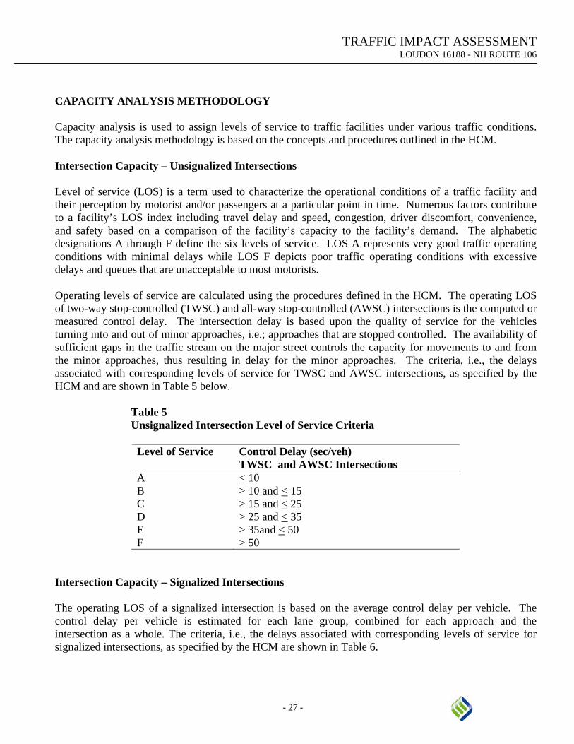
CAPACITY ANALYSIS METHODOLOGY Capacity analysis is used to assign levels of service to traffic facilities under various traffic conditions. The capacity analysis methodology is based on the concepts and procedures outlined in the HCM. Intersection Capacity – Unsignalized Intersections Level of service (LOS) is a term used to characterize the operational conditions of a traffic facility and their perception by motorist and/or passengers at a particular point in time. Numerous factors contribute to a facility’s LOS index including travel delay and speed, congestion, driver discomfort, convenience, and safety based on a comparison of the facility’s capacity to the facility’s demand. The alphabetic designations A through F define the six levels of service. LOS A represents very good traffic operating conditions with minimal delays while LOS F depicts poor traffic operating conditions with excessive delays and queues that are unacceptable to most motorists. Operating levels of service are calculated using the procedures defined in the HCM. The operating LOS of two-way stop-controlled (TWSC) and all-way stop-controlled (AWSC) intersections is the computed or measured control delay. The intersection delay is based upon the quality of service for the vehicles turning into and out of minor approaches, i.e.; approaches that are stopped controlled. The availability of sufficient gaps in the traffic stream on the major street controls the capacity for movements to and from the minor approaches, thus resulting in delay for the minor approaches. The criteria, i.e., the delays associated with corresponding levels of service for TWSC and AWSC intersections, as specified by the HCM and are shown in Table 5 below.
Table 5 Unsignalized Intersection Level of Service Criteria
Level of Service Control Delay (sec/veh)
TWSC and AWSC Intersections A < 10 B > 10 and < 15 C > 15 and < 25 D > 25 and < 35 E > 35and < 50 F > 50
Intersection Capacity – Signalized Intersections The operating LOS of a signalized intersection is based on the average control delay per vehicle. The control delay per vehicle is estimated for each lane group, combined for each approach and the intersection as a whole. The criteria, i.e., the delays associated with corresponding levels of service for signalized intersections, as specified by the HCM are shown in Table 6.

TRAFFIC IMPACT ASSESSMENT LOUDON 16188 - NH ROUTE 106
- 28 -
Table 6 Signalized Intersection Level of Service Criteria
Level of Service Control Delay (sec/veh) Signalized Intersections
A < 10 B > 10 and < 20 C > 20 and < 35 D > 35 and < 55 E > 55 and < 80 F > 80
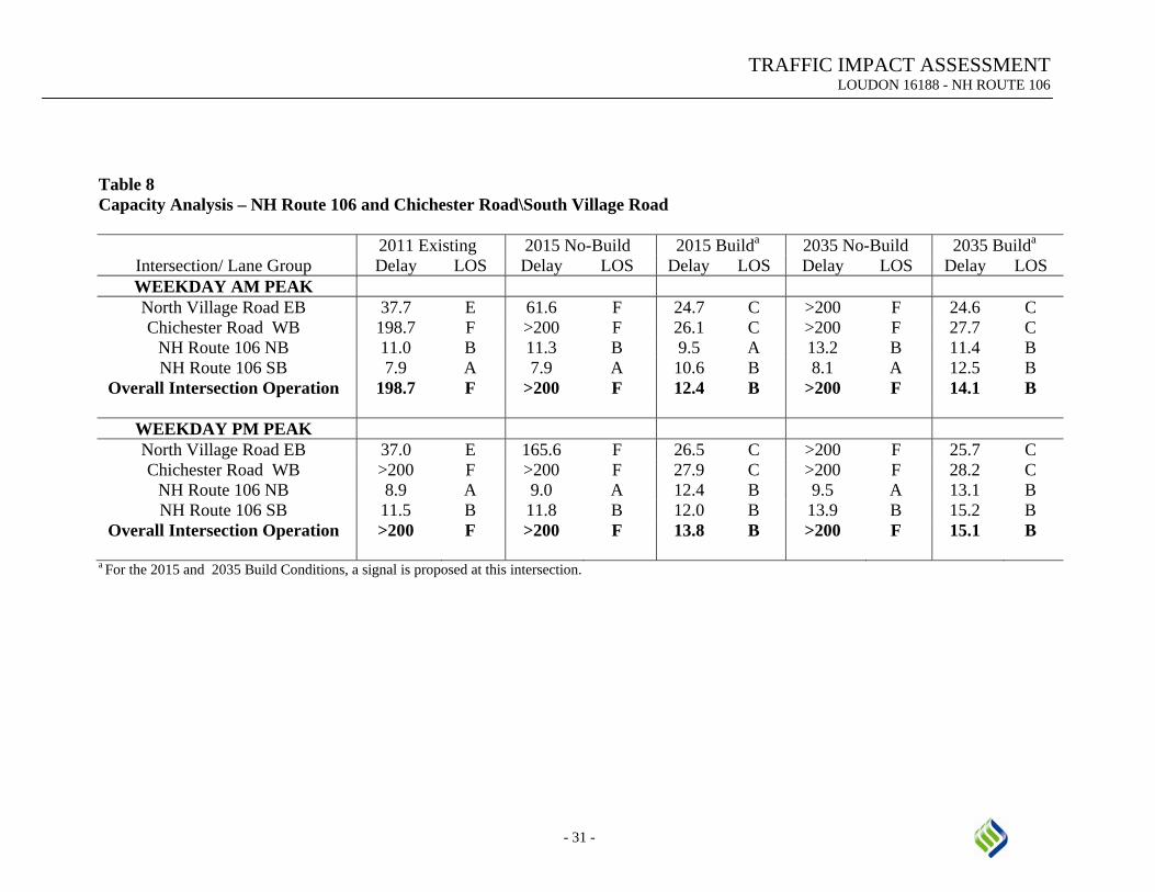
Presented in Tables 7 through 12 are the results of the analysis for the Existing, No-Build, and Build conditions for the intersections located within the study area. The traffic modeling software Synchro, Ver. 7.0 was used for the analysis portion of this Study. The results of the analysis are located in the Appendix. NH Route 106 and Staniels Road \ Josiah Bartlett Road The average control delay and LOS for the intersection of NH Route 106 and Staniels Road / Josiah Bartlett Road for the Existing, No-build and Build Conditions are summarized in Table 7. This intersection is currently operating at a LOS F and will continue to operate poorly into the future as a significant increase in delay is projected as a result of the background growth rate of 1.0 percent per year. To improve the capacity of this intersection, additional through lanes were added to both the northbound and southbound approaches on NH Route 106. A traffic signal is also proposed at this intersection as the results of the signal warrant analysis indicated that two warrants are satisfied for the 2011 traffic volumes. As shown in Table 7, comparing 2015 No-Build to 2015 Build shows that the proposed improvements significantly increase the capacity of this intersection for both the AM and PM peaks. The results also show that the proposed improvements will continue to operate at an acceptable LOS through the 2035 Design Year. NH Route 106 and Chichester Road \ South Village Road The average control delay and LOS for the intersection of NH Route 106 and Chichester Road / South Village Road for the Existing, No-build and Build Conditions are summarized in Table 8. As indicated, the intersection is currently operating at LOS F and will continue to deteriorate due to background growth. To improve the capacity of this intersection, additional through lanes were added to both the northbound and southbound approaches on NH Route 106. A traffic signal is also proposed at this intersection as the results of the signal warrant analysis indicated that two warrants are satisfied for the 2011 traffic volumes. As shown in Table 8, comparing 2015 No-Build to 2015 Build shows that the proposed improvements significantly increase the capacity of this intersection for both the AM and PM peaks. The results also show that the proposed improvements will continue to operate at an acceptable LOS through the 2035 Design Year.

TRAFFIC IMPACT ASSESSMENT LOUDON 16188 - NH ROUTE 106
- 29 -
NH Route 106 and NH Route 129 Summarized in Table 9 are the analysis results of the Existing, No-build and Build Conditions for the intersection of NH Route 106 and NH Route 129. Presently and for the 2015 No-Build Conditions, this intersection is operating at an acceptable LOS. However, the intersection is projected to operate at a poor LOS for the 2035 No-Build Conditions, LOS of F and E for the AM and PM Peak Hours, respectively. To improve the capacity of this intersection, additional through lanes were added to both the northbound and southbound approaches to NH Route 106. As shown in Table 9, adding these additional through lanes significantly reduced the delay and improved the LOS for both the AM and PM peaks for the 2035 Build Condition. The results also show that the proposed improvements will continue to operate at an acceptable LOS through the 2035 Design Year. NH Route 106 and Shaker Road
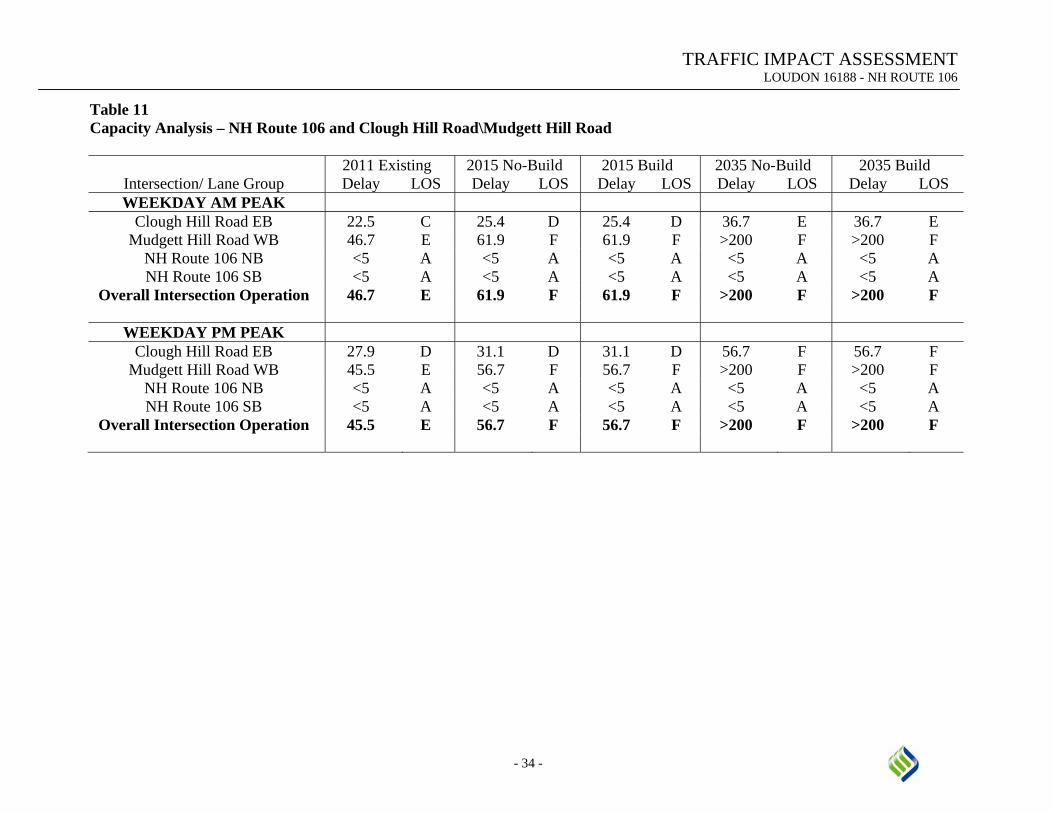
The average control delay and LOS for the intersection of NH Route 106 and Shaker Road for the Existing, No-build and Build Conditions are summarized below in Table 10. A small increase in delay is projected as a result of the background growth comparing the Existing Conditions to the 2015 and 2035 No-Build Conditions. No improvements are proposed for this intersection since it is projected to operate at an acceptable LOS for the 2035 No-Build Conditions for both the AM and PM peaks. Therefore, the 2035 Build Condition was analyzed with no changes to the intersection. NH Route 106 and Clough Hill Road \ Mudgett Hill Road Summarized in Table 11 are the analysis results of the Existing, No-build and Build Conditions for the intersection of NH Route 106 and Clough Hill Road / Mudgett Hill Road. As indicated, the intersection is currently operating at an unacceptable LOS and will continue to deteriorate due to background growth. This location marginally meets the traffic signal warrant as noted in the Traffic Signal Warrant section. The installation of a traffic signal is not recommended at this time, but may need to be installed in the future as volumes increase and delays increase causing the operations at this location to deteriorate. As shown in Table 11, this intersection is projected to operate at a LOS of F for both the AM and PM peaks for the 2015 No-Build and Build Conditions with an acceptable amount of delay. However, during the 2035 No-Build and Build conditions this intersection is projected to operate at a LOS F with an unacceptable amount of delay. This significant increase in delay will increase the safety concerns at this location as drivers begin taking chances pulling out into smaller gaps in the traffic flow. NH Route 106 and NH Route 140 The average control delay and LOS for the intersection of NH Route 106 and NH Route 140 for the Existing, No-build and Build Conditions are summarized in Table 12. Presently and for the 2015 No-Build Conditions, this intersection is operating at an acceptable LOS. However, the intersection is projected to operate at a poor LOS for the 2035 PM Peak No-Build condition. The analysis of the 2035 No-Build Conditions also yielded large queue lengths and volume to capacity ratios over 1.0 for some of the movements. To improve the capacity of this intersection, an additional left-turn lane for the eastbound NH Route 140 approach and a second through lane for the northbound NH Route 106 approach are recommended. As shown in Table 12, adding these lanes significantly reduced the delay and improved the LOS for both the AM and PM peaks for the 2015 Build Condition. The results also show that the proposed improvements will continue to operate at an acceptable LOS through the 2035 Design Year.

TRAFFIC IMPACT ASSESSMENT LOUDON 16188 - NH ROUTE 106
- 30 -
Table 7 Capacity Analysis – NH Route 106 and Staniels Road\Josiah Bartlett Road
Intersection/ Lane Group 2011 Existing 2015 No-Build 2015 Builda 2035 No-Build 2035 Builda
Delay LOS Delay LOS Delay LOS Delay LOS Delay LOS WEEKDAY AM PEAK Josiah Bartlett Road EB 52.0 F 56.7 F 31.7 C 135.3 F 32.8 C
Staniels Road WB 110.4 F 136.1 F 36.3 D >200 F 47.2 D NH Route 106 NB 11.8 B 12.1 B 5.6 A 14.2 B 5.7 A NH Route 106 SB 8.0 A 8.0 A 7.7 A 8.3 A 9.4 A
Overall Intersection Operation 110.4 F 136.1 F 8.7 A >200 F 10.6 B
WEEKDAY PM PEAK Josiah Bartlett Road EB 77.7 F 90.1 F 32.5 C >200 F 33.3 C
Staniels Road WB 100.4 F 127.6 F 34.4 D >200 F 35.6 D NH Route 106 NB 8.4 A 8.4 A 7.5 A 8.8 A 9.1 A NH Route 106 SB 12.1 B 12.4 B 6.6 A 15.0 B 7.6 A
Overall Intersection Operation 100.4 F 127.6 F 8.8 A >200 F 10.2 B
a For the 2015 and 2035 Build Conditions, a signal is proposed at this intersection.
TRAFFIC IMPACT ASSESSMENT LOUDON 16188 - NH ROUTE 106
- 31 -
Table 8 Capacity Analysis – NH Route 106 and Chichester Road\South Village Road
Intersection/ Lane Group 2011 Existing 2015 No-Build 2015 Builda 2035 No-Build 2035 Builda
Delay LOS Delay LOS Delay LOS Delay LOS Delay LOS WEEKDAY AM PEAK North Village Road EB 37.7 E 61.6 F 24.7 C >200 F 24.6 C Chichester Road WB 198.7 F >200 F 26.1 C >200 F 27.7 C
NH Route 106 NB 11.0 B 11.3 B 9.5 A 13.2 B 11.4 B NH Route 106 SB 7.9 A 7.9 A 10.6 B 8.1 A 12.5 B
Overall Intersection Operation 198.7 F >200 F 12.4 B >200 F 14.1 B
WEEKDAY PM PEAK North Village Road EB 37.0 E 165.6 F 26.5 C >200 F 25.7 C Chichester Road WB >200 F >200 F 27.9 C >200 F 28.2 C
NH Route 106 NB 8.9 A 9.0 A 12.4 B 9.5 A 13.1 B NH Route 106 SB 11.5 B 11.8 B 12.0 B 13.9 B 15.2 B
Overall Intersection Operation >200 F >200 F 13.8 B >200 F 15.1 B
a For the 2015 and 2035 Build Conditions, a signal is proposed at this intersection.

TRAFFIC IMPACT ASSESSMENT LOUDON 16188 - NH ROUTE 106
- 32 -
Table 9 Capacity Analysis – NH Route 106 and NH Route 129
Intersection/ Lane Group 2011 Existing 2015 No-Build 2015 Build 2035 No-Build 2035 Build Delay LOS Delay LOS Delay LOS Delay LOS Delay LOS
WEEKDAY AM PEAK NH Route 129 EB 27.4 C 27.6 C 12.6 B 35.8 D 16.5 B NH Route 129 WB 144.4 F 164.7 F 34.6 C 147.2 F 56.7 E NH Route 106 NB 11.0 B 12.3 B 13.3 B 17.6 B 16.5 B NH Route 106 SB 24.9 C 27.6 C 20.9 C 95.0 F 28.3 C
Overall Intersection Operation 41.3 D 46.3 D 20.7 C 81.3 F 29.2 C
WEEKDAY PM PEAK NH Route 129 EB 32.3 C 32.2 C 23.5 C 97.2 F 26.2 C NH Route 129 WB 38.5 D 39.6 D 30.7 C 169.4 F 44.8 D NH Route 106 NB 20.8 C 25.3 C 13.9 B 58.9 E 20.3 C NH Route 106 SB 12.7 B 13.2 B 11.0 B 17.4 B 12.6 B
Overall Intersection Operation 21.1 C 23.9 C 15.4 B 61.1 E 20.9 C

TRAFFIC IMPACT ASSESSMENT LOUDON 16188 - NH ROUTE 106
- 33 -
Table 10 Capacity Analysis – NH Route 106 and Shaker Road
Intersection/ Lane Group
2011 Existing 2015 No-Build 2015 Build 2035 No-Build 2035 Build Delay LOS Delay LOS Delay LOS Delay LOS Delay LOS
WEEKDAY AM PEAK Shaker Road EB 33.4 C 33.4 C 33.4 C 39.3 D 39.3 D
NH Route 106 NB 6.3 A 6.5 A 6.5 A 6.7 A 6.7 A NH Route 106 SB 12.7 B 13.9 B 13.9 B 21.2 C 21.0 C
Overall Intersection Operation 13.0 B 13.8 B 13.8 B 19.0 B 19.0 B
WEEKDAY PM PEAK Shaker Road EB 28.4 C 29.2 C 30.6 C 35.1 D 35.1 D
NH Route 106 NB 10.0 A 10.5 B 10.6 B 15.8 B 15.8 B NH Route 106 SB 11.9 B 11.8 B 12.1 B 11.1 B 11.1 B
Overall Intersection Operation 11.9 B 12.2 B 12.5 B 15.8 B 15.8 B
TRAFFIC IMPACT ASSESSMENT LOUDON 16188 - NH ROUTE 106
- 34 -
Table 11 Capacity Analysis – NH Route 106 and Clough Hill Road\Mudgett Hill Road
Intersection/ Lane Group
2011 Existing 2015 No-Build 2015 Build 2035 No-Build 2035 Build Delay LOS Delay LOS Delay LOS Delay LOS Delay LOS
WEEKDAY AM PEAK Clough Hill Road EB 22.5 C 25.4 D 25.4 D 36.7 E 36.7 E
Mudgett Hill Road WB 46.7 E 61.9 F 61.9 F >200 F >200 F NH Route 106 NB <5 A <5 A <5 A <5 A <5 A NH Route 106 SB <5 A <5 A <5 A <5 A <5 A
Overall Intersection Operation 46.7 E 61.9 F 61.9 F >200 F >200 F
WEEKDAY PM PEAK Clough Hill Road EB 27.9 D 31.1 D 31.1 D 56.7 F 56.7 F
Mudgett Hill Road WB 45.5 E 56.7 F 56.7 F >200 F >200 F NH Route 106 NB <5 A <5 A <5 A <5 A <5 A NH Route 106 SB <5 A <5 A <5 A <5 A <5 A
Overall Intersection Operation 45.5 E 56.7 F 56.7 F >200 F >200 F

TRAFFIC IMPACT ASSESSMENT LOUDON 16188 - NH ROUTE 106
- 35 -
Table 12 Capacity Analysis – NH Route 106 and Route 140
Intersection/ Lane Group
2011 Existing 2015 No-Build 2015 Build 2035 No-Build 2035 Build Delay LOS Delay LOS Delay LOS Delay LOS Delay LOS
WEEKDAY AM PEAK NH Route 140 EB 32.2 C 36.1 D 35.2 D 76.4 E 57.8 E NH Route 140 WB 33.7 C 37.3 D 38.5 D 68.0 E 63.3 E NH Route 106 NB 15.3 B 15.8 B 28.6 C 20.1 C 29.8 C NH Route 106 SB 26.6 C 27.5 C 32.7 C 48.8 D 47.1 D
Overall Intersection Operation 26.8 C 28.7 C 33.5 C 52.2 D 48.9 D
WEEKDAY PM PEAK NH Route 140 EB 27.9 C 30.8 C 23.0 C 109.9 F 46.7 D NH Route 140 WB 41.5 D 46.8 D 42.7 D 127.4 F 42.9 D NH Route 106 NB 28.5 C 27.7 C 21.9 C 35.9 D 24.9 C NH Route 106 SB 14.4 B 17.0 B 25.8 C 42.0 D 28.9 C
Overall Intersection Operation 26.0 C 27.7 C 25.7 C 66.3 E 33.4 C

TRAFFIC IMPACT ASSESSMENT LOUDON 16188 - NH ROUTE 106
- 36 -
CONCLUSIONS AND RECOMMENDATIONS The traffic operations and safety of the roadway segments and the intersections along the NH Route 106 corridor from I-393 in Concord to NH Route 140 in Belmont have been evaluated. These results show that construction of the proposed Interim Typical Section will be able to accommodate the future traffic capacity and improve overall safety along the corridor. With the installation of traffic signals and construction of additional through lanes at some of the key intersections, the operations of these intersections will be improved and continue to operate at a reasonable LOS through the Design Year. In addition, it should be noted that this Interim Typical Section, does not remove the potential future need for the Ultimate Improvements or portions thereof, but rather bridges the gap between what is existing and the long term needs of the corridor should the traffic volumes warrant these improvements. Therefore based on the capacity results and field investigations, the following conclusions and recommendations should be considered:
• Widening of NH Route 106 to provide an Interim Typical Section consisting of one 12-foot travel lane in each direction, 12-foot wide shoulders, and a 16-foot wide center turn lane.
• Modification of the two-way left turn lane at five locations, three northbound and two southbound, to provide passing lanes.
• Installation of traffic signals at the intersection of NH Route 106 and Staniels Road\Josiah Bartlett
Road. In order to maintain acceptable LOS at the signalized intersection it is recommended that NH Route 106 be widened to provide two 12-foot travel lanes in each direction, one 12-foot wide exclusive left-turn lane, and 4-foot wide shoulders. No changes are proposed to the Staniels Road or Josiah Bartlett Road approaches.
• Installation of traffic signals at the intersection of NH Route 106 and Chichester Road\South
Village Road. In order to maintain acceptable LOS at the signalized intersection it is recommended that NH Route 106 be widened to provide two 12-foot travel lanes in each direction, one 12-foot wide exclusive left-turn lane, and 4-foot wide shoulders. No changes are proposed to the Chichester Road or South Village Road approaches.
• In order to maintain acceptable LOS at the signalized intersection of NH Route 106 and NH Route 129 it is recommended that NH Route 106 be widened to provide two 12-foot travel lanes in each direction, one 12-foot wide exclusive left-turn lane, and 4-foot wide shoulders. No changes are proposed to the NH Route 129 approaches.
• In order to maintain acceptable LOS at the signalized intersection of NH Route 106 and NH Route
140, it is recommended that NH Route 106 be widened to provide two 12-foot travel lanes in the northbound direction and provide an additional 12-foot wide exclusive left-turn lane on the NH Route 140 eastbound approach. No changes are proposed to the NH Route 140 westbound approach or the NH Route 106 southbound approach.