next generation compass lite - its) canada · next generation compass lite ... brings up a dialogue...
TRANSCRIPT

Next Generation COMPASS Lite
Presented to: ITS ACGM 2014
Present by: Kris Huber, CTO, Array Systems Computing

COMPASS-Lite, ACGM 2014
What is it?
COMPASS gathers information about traffic flow and then uses that data to display real-time traffic information such as vehicle speed and density.
Using dynamic message signs (DMS), MTO operators then inform drivers of impending traffic congestion as well as managing the dispatch of emergency services to incident sites.
COMPASS Lite is a lightweight system for traffic management for smaller cities and rural areas

COMPASS-Lite, ACGM 2014
History
COMPASS was initially deployed in Mississauga (1985) and Burlington (1986), while Toronto received its first COMPASS system in 1990.
The development of the Next Generation COMPASS System (NGCS) began in 2005, and since 2010 and has been operating continuously in the Toronto and Burlington Traffic Operation Centres (TOCs)
COMPASS works well for central (Toronto), what about Eastern/Western/Northern Ontario regions?

COMPASS-Lite, ACGM 2014
Next Generation COMPASS Lite
Needed a ‘light weight’ simple browser based system that can better focus on the rest of Ontario, for example:
• Boarder advisory service
• Queue warning
• No Ontario Road Network mapping
• No Collector / Express

COMPASS-Lite, ACGM 2014
The NGCS-lite Architecture
Oracle Database
Dynamic Message Sign Device Manager
Light Version of Browser-Based User Interface
Database Manager
CCTV Cameras
PVMS DMS
Queue-end warning systems
Border Advisory Systems
Lane Management
Systems
Figure 2: Components of the Light Version of Next Generation Compass System (NGCS-Lite)

COMPASS-Lite, ACGM 2014
Key Features
Real-time monitoring of current traffic congestion.
Real-time (automatic) selection and updating of upstream and proximal DMS and PVMS.
Web based interface allows access to real-time data to remote responders.
Google Maps used for GIS data (could also use Bing or OpenStreetMap).
All device polling, monitoring, and management is through SNMP. GUI makes it easy to add new devices.
Incident Alarm Management
Data Archival Management
Scheduled Reporting and Report Generation
Border Advisory System (BAS)
Queue Warning System (QWS)
Lane Management System (LMS)
COMPASS-Lite, ACGM 2014
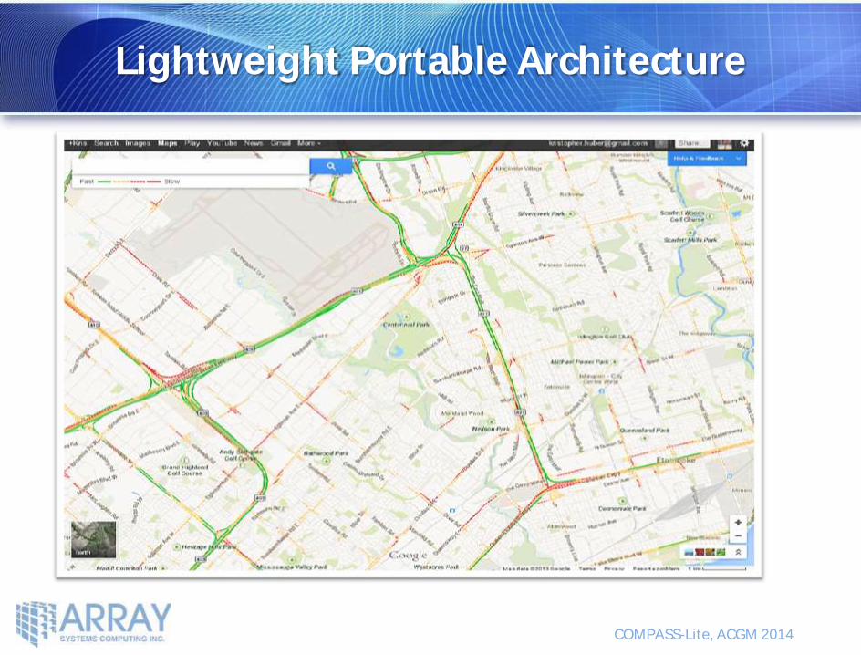
Lightweight Portable Architecture

COMPASS-Lite, ACGM 2014
Only the browser need be installed on remote systems
Makes supporting the system more straightforward, since most IT infrastructure and staffing is available in Central Region.
This allows trusted organizations with access to see the same real-time information that the traffic control center operators do - We can control what information is visible to each user according to region or role, so it is possible to share information with first responders (for example) without giving them full TOC operator privileges
Application server physically resident at user's Traffic Operations Center.
Lightweight Portable Architecture

COMPASS-Lite, ACGM 2014
Benefits of Google Maps
Sophisticated functions like Traffic Layer, Construction, Satellite and Streetview are available
Use of Google Maps means that maintenance of the map is Google's responsibility rather than the Ministry's. – i.e. Google provides regular map updates.
Removes the need of the user to provide thier own Ontario Road Network (ORN) database for spatial information.
ORN data is often variable between jurisdictions, this makes management of border crossings more challenging. Removes the issues of multiple road names between jurisdictons.
In the event that outside connectivity (Google Maps) is unavailable, all functions are available from textual GUIs without any dependence on Google services.

COMPASS-Lite, ACGM 2014
Extending Layers in Google Maps View
COMPASS lite embeds Google Maps and extends it with dedicated layers for:
Events
Devices
• CCTV
• DMS / PVMS
Subsystems
• Queue Warning Systems
• Boarder Advisory system
• Lane Management Systems
Zone congestion levels (realtime traffic)

COMPASS-Lite, ACGM 2014
Event Management on CAT
Traffic Events – defined by crossings
• Incident
• Roadwork
• Flooding etc.
Area Events – apply to one or more 'Jurisdictional Areas'
• Amber Alert
• Civic Event (sports stadium)
• Adverse Weather

COMPASS-Lite, ACGM 2014
Event & Traffic Layer
Event & Traffic shows layers for:
● Google Traffic
● Active Event
● Roadwork Notifications
● NGCS Traffic Flow
Selecting an incident brings up a dialogue box providing additional information.

COMPASS-Lite, ACGM 2014
CCTV Devices
COMPASS lite provides functions for viewing of CCTV camera footage in a pop-up window and for controlling CCTV cameras:
• Camera selection
• Pan, tilt, zoom
• Iris
• Focus

COMPASS-Lite, ACGM 2014
DMS / PVMS Devices
COMPASS lite provides functions for monitoring the status of DMS signs and for commanding messaging:
• Automatically suggest response to an event
• Operator initiated manual messaging
Functions will be provided for:
• Monitoring currently displayed message
• Obtaining PVMS lat / long position from GPS.

COMPASS-Lite, ACGM 2014
Message View Layer on the CAT System
Screenshots of COMPASS lite
COMPASS-Lite, ACGM 2014
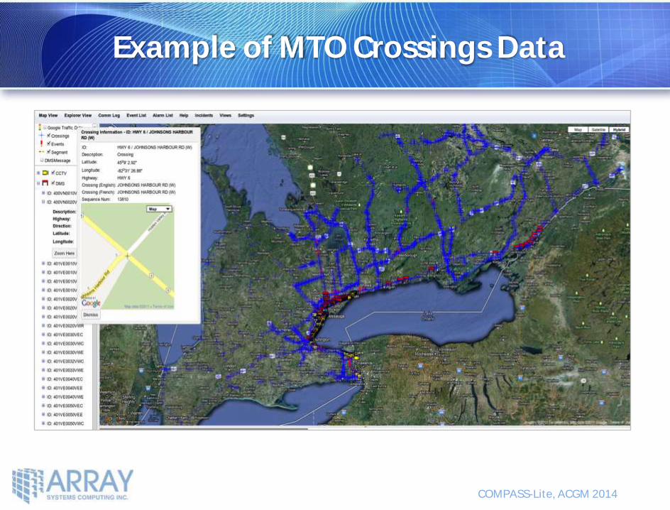
Example of MTO Crossings Data

COMPASS-Lite, ACGM 2014
Event Management
An event declaration is
performed using the
operators database of
crossing information.
Fields are selected
sequentially and are
filtered in real-time
allowing rapid data entry.
COMPASS-Lite, ACGM 2014
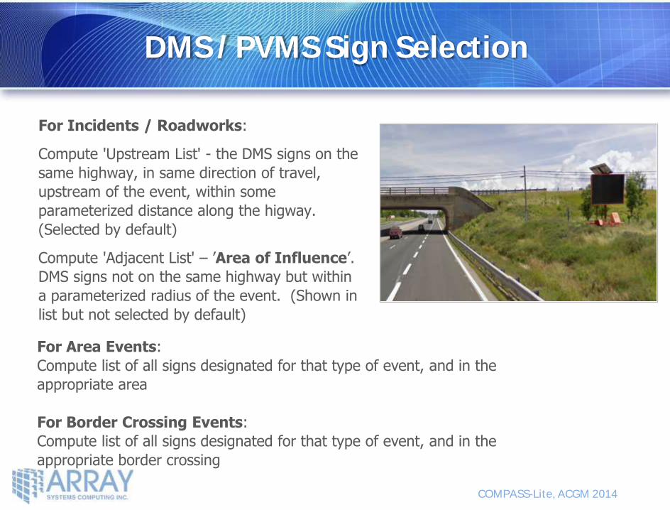
DMS / PVMS Sign Selection
For Incidents / Roadworks:
Compute 'Upstream List' - the DMS signs on the
same highway, in same direction of travel,
upstream of the event, within some
parameterized distance along the higway.
(Selected by default)
Compute 'Adjacent List' – ’Area of Influence’.
DMS signs not on the same highway but within
a parameterized radius of the event. (Shown in
list but not selected by default)
For Area Events:
Compute list of all signs designated for that type of event, and in the
appropriate area
For Border Crossing Events:
Compute list of all signs designated for that type of event, and in the
appropriate border crossing

COMPASS-Lite, ACGM 2014
Automated DMS Response
The CAT System is able to automatically propose DMS/PVMS messaging in response to
events.
Message composition is based on library of template messages (French and English).
All proposed signing is subject to operator review prior to dispatch.
Operator can manually adjust message if necessary.

COMPASS-Lite, ACGM 2014
Communications Log
Logging of all telephone, radio,
email, and in-person
communications into or out of the
TOC.
Agency specific report generation

COMPASS-Lite, ACGM 2014
Summary Benefits of COMPASS lite
Comprehensive event management system, for traffic and various types of events
Complement to COMPASS to provide real-time monitoring and management of current traffic events outside of Central Region.
Doesn’t require Ontario Road Network but instead uses open source mapping software
Provides additional features such as:
• Queue Warning System
• Lane Management System
• Boarder Advisory Service
GUI makes it easy to add new devices

COMPASS-Lite, ACGM 2014
Going Forward
In discussions:
Traffic signal layer, perhaps with a link to their traffic system for online, offline, fault, in flash, etc. status information
Map layer for tracking transit vehicle location, with data from their AVL system
Communication node (i.e. E-switch) status information in the past
Asset management data collection and logging functions
Mobile applications and access into the NGCS system

Corridor Advisory Traffic Software
Offering State-of-the-Art Signal Processing Solutions from Satellites to Submarines