new zealand and the christchurch earthquake 2
TRANSCRIPT

New Zealand and the Christchurch Earthquake

Facts – Christchurch Earthquake• When – 22nd Feb 2011 – 12.51pm
• Magnitude – 6.3
• Centred – 10km South East of the city at a depth of 5km
• (Believed to be an aftershock of initial quake on the 4th Sept 2010 which was a 7.1 Magnitude)

Evolution of the NZ fault-line
Source: http://all-geo.org/highlyallochthonous/2010/09/tectonics-of-the-m7-earthquake-near-christchurch-new-zealand/

Magnitude 6+ earthquakes in New Zealand since 1843. Source: BGS

Christchurch from space, 4 March 2011, showing quake shaking strength, with key


Displacement along a new fault in Canterbury farmland – note the liquefaction

Soil types

What is Liquefaction?

Liquefaction in the Burwood – New Brighton area of Christchurch


• https://www.youtube.com/watch?v=2pzJS15u2PA
• Liquefaction in Christchurch
• https://www.youtube.com/watch?v=j-hyOwsl_NY
• News on liquefaction – good explanation


FissuresA jogger passes a
fissure more than
2m deep in River
Rd, Avonside,
following the 6.3
magnitude
earthquake that
struck
Christchurch

A large fissure on AvonsideDrive after the 6.3 earthquake

Example of lateral spreading along the Avon River and the Eastern Suburbs

Vertical movement
Telegraph road
Darfield were the
fault cut through
producing 30cm
horizontal
movement. Fault line
snaking west
towards Darfield


Rockfalls
• https://www.youtube.com/watch?v=lLBBdYACpio
• GNS rockfalls in ChristchurchHouse in
Lyttleton


Task – glue the map into your book.Give it the title – Case Study – Canterbury Earthquake. 22nd Feb 2011..
Impact on the land
Mark clearly these worst-affected areas of Christchurch on your photocopied map:
•Sumner – landslides & rockfalls
•Redcliffs – hillside collapse, boulders falling
•Port Hills – landslips & rockfalls
•CBD (Central Business District) building collapse, deaths, debris falling
•Avonside – liquefaction
•Avondale – liquefaction, subsidence
•Bexley – liquefaction, subsidence
•Burwood – liquefaction, subsidence
•Dallington – liquefaction, subsidence
•Horseshoe Lake (near Burwood) – Liquefaction, subsidence
Now, draw in the Avon River as best you can.
Sketch in the two faults from slide 9

Answer the following question in your book.
Describe the impact on the Natural Environment of Christchurch caused by the earthquake on the 22nd Feb 2011.
• Make sure you include the following.
• Liquefaction (describe what causes it and where it occurred)
• Uplift and subsidence of land. (where did this occur?)
• Rockfalls (where did they occur and what damage did they do?)
• Fissures (what are these, how are they caused and where did they occur in Christchurch?)

What is a fault?What are the three types of fault?
• https://www.youtube.com/watch?v=AEkbkghWJeI
• Explanation of faults – vertical and lateral movement.

The hidden fault that caused the February 2011 Christchurch earthquake
In September 2010, Christchurch was shaken by the magnitude 7.1 Darfieldearthquake, caused by movement along faults west of the city on the Canterbury Plains. This earthquake produced a visible rent across the landscape that allowed scientists to directly measure the movement of the longest fault segment, the Greendale Fault.


Condemned Zones – cannot rebuild, get compensation

Yellow/orange? Ongoingassessment, no compensation yet

White zone, ongoingassessment, can’t rebuild yet

Green zone, can rebuild now

• However, the violent magnitude 6.3 earthquake that devastated Christchurch on 22 February 2011 was caused by movement along a fault that does not appear to have broken the surface. Scientists have thus had to rely on measurements using a variety of techniques and instruments to determine its location and the nature of its movement.

Based on data from GPS stations, satellite radar images, seismographs and strong-motion recorders, the fault that caused the 22 February earthquake lies within about six kilometres of the city centre, along the southern edge of the city.

• Figure 1 (next slide): This Google map image shows the fault plane (rectangular area) across the southern part of Christchurch and northern Port Hills. Colours on the fault plane indicate the amount of slip between the two sides of the fault (see Fig. 2). The contour lines indicate the amount (in mm) the land has risen (blue contours) or subsided (red contours) due to the slip on the fault. The white line is the contour where there was no change in height.

• The top of the fault lies at a depth of about a kilometre beneath the surface, and the rupture extends down along the fault plane for about seven kilometres. The fault is not a vertical cut through the earth, but rather it dips towards the south at an angle of about 65 degrees from the horizontal. The main part of the fault thus lies beneath the northern edge of the Port Hills.


• Movement of land on either side of the fault plane was a mixture of vertical motion and sideways slip (Fig. 2, next slide). The block of land south of the fault slid up the fault surface by as much as 2.5 metres on the section of fault near the Avon-Heathcote estuary. This raised part of the Port Hills and part of southern Christchurch. This type of fault motion is called reverse faulting. The deeper parts of the fault, and the westernmost 5 to 6 kilometres of the fault slipped predominantly horizontally by a few tens of centimetres. Relative to the fault, the land north of the fault shifted eastward while the land to the south of the fault shifted westward.
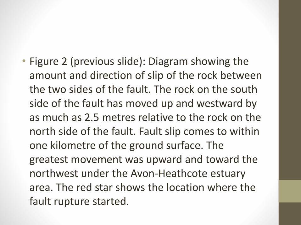
• Figure 2 (previous slide): Diagram showing the amount and direction of slip of the rock between the two sides of the fault. The rock on the south side of the fault has moved up and westward by as much as 2.5 metres relative to the rock on the north side of the fault. Fault slip comes to within one kilometre of the ground surface. The greatest movement was upward and toward the northwest under the Avon-Heathcote estuary area. The red star shows the location where the fault rupture started.
• Because the fault doesn’t break the surface, the land overlying the top of the fault has been slightly folded, with the south side warped upward and the north side down (see Fig. 1).
• The land has gone up as much as 40 centimetres around the western side of the Avon-Heathcote estuary. The Port Hills have gone up by varying amounts, from about 5 centimetres under Lyttelton Harbour to a maximum of about 25 centimetres at the base of the hills near the Heathcote valley.
• As a direct result of the fault slip, the Bexley, Aranui, Wainoni, Avondale and New Brighton areas have gone down, mostly by less than 15 centimetres. Central, northern and northeastern Christchurch have also gone down, but generally by less than 5 centimetres. However, there may be additional subsidence as a result of ground compaction and liquefaction during the strong shaking.

• The fault rupture started with a small amount of slip between the two sides of the fault at about 6 km depth. Over the next few seconds the rupture spread upwards and towards the northwest, with the amount of slip increasing with time. The direction of movement—up and towards the northwest—focussed the energy of the earthquake towards Christchurch and helps explain the severe damage in the city. The suburbs of Heathcote and Redcliffs lie above the fault, resulting in heavy damage and extensive rockfalls.

A number of techniques were used to determine the fault’s position and movement.
• Radar images taken from satellites before and after the earthquake were analysed. The images can be combined to show the total amount of shift of the ground surface, both vertically and horizontally, caused by the earthquake (see Fig. 3, next slide).
• Position data from GPS stations (Fig. 1) before and after the earthquake was analysed, using measurements from both existing continuous GPS stations and temporary stations installed after the earthquake.
• Movement was modelled using the ground shaking recorded during the earthquake by “strong-motion” seismometers. These instruments are designed specifically for recording strong ground shaking.
• The general region of fault slip is outlined by the aftershocks of the 22 February earthquake. There is still additional work to do to locate these aftershocks precisely, at which time they may provide additional detail on the fault rupture.


• Figure 3 (previous slide): Image indicating ground displacement made by combining satellite radar images taken before and after the earthquake. The coloured image shows an “interference pattern” derived from X-band radar images taken on 19 and 23 February 2011 by the Italian Cosmo-SkyMed satellite. Each colour cycle represents 1.5 centimetres of ground displacement, so the total displacement between the western edge of the image and central Christchurch is about 25 centimetres.

This article describes our understanding of the Christchurch earthquake fault as at the 8th of April, about 7 weeks after the earthquake. We expect that details of the fault location and slip distribution will be updated in the future, as we incorporate more data and use more sophisticated data analysis techniques.
SOURCE: http://www.gns.cri.nz/Home/News-and-Events/Media-Releases/Most-damaging-quake-since-1931/Canterbury-quake/Hidden-fault


Group Task
• Choose one of the groups involved in the Christchurch earthquake response and recovery.
• Work as a team to research & describe the following:Who/what are you, what do you do? What did you do to help immediately after the quake? What are you doing now? How do you work with other groups in the Canterbury region?• You can choose to present to the class using whiteboard, PPt, chart or
make a short video clip• Everyone in your group must take an active role and take part in the
presentationUse these websites as a starting point for research: http://canterburyearthquake.org.nz/, http://www.stuff.co.nz/the-press/news/christchurch-earthquake-2011/canterbury-earthquake-2010/more_headlines, http://ellesmeresocialsciences.wikispaces.com/Level+1+Geography, http://rata.learnz.org.nz/summary.php?vft=canterburyearthquake111, http://www.cera.govt.nz/www.wikipedia.com

Christchurch quake organisations• Christchurch City Council• Central Government departments• Civil Defence• Red Cross• NZ Army/Airforce• Barmy Army and/or Farmy Army• TV stations & other media• Schools & Welfare Centres• Coroners• Police & Fire Service• Sewerage, water, electricity, roading contractors• CERA – Canterbury Earthquake Recovery Authority• Other charitable organisations• Christchurch residents• EQC- Earthquake Commission• GNS & University of Canterbury, Geotechnical engineers & other scientists

Task – glue the map into your book.Give it the title – Case Study – Canterbury Earthquake. 22nd Feb 2011..
Impact on the land
Mark clearly these worst-affected areas of Christchurch on your photocopied map:
•Sumner – landslides & rockfalls
•Redcliffs – hillside collapse, boulders falling
•Port Hills – landslips & rockfalls
•CBD (Central Business District) building collapse, deaths, debris falling
•Avonside – liquefaction
•Avondale – liquefaction, subsidence
•Bexley – liquefaction, subsidence
•Burwood – liquefaction, subsidence
•Dallington – liquefaction, subsidence
•Horseshoe Lake (near Burwood) – Liquefaction, subsidence
Now, draw in the Avon River as best you can.
Sketch in the two faults from slide 9

Tasks
• 1. Use pages 42-43 to complete the worksheet on the effects on the Natural Environment caused by the Christchurch Earthquake. (it should include a diagram of each type of ground movement)
• 2. Complete the 2nd sheet describing the effects on the Natural Environment from the Christchurch Earthquake. Again this should include some diagrams.

Christchurch Earthquake Fact File.
• The first quake struck on…
• Magnitude…..
• Depth……
• Damage caused….
• The second quake struck on….
• Magnitude…
• Depth…….
• Damage caused………

On your map label the following.
1. Shade the area in
blue on your map –
label in a Key as the
area raised by the
earthquake up to
450mm.
Shade the area in
red and label in your
key as land raised by
up to 250mm.
The white line is land
unmoved.

How did they help?
How did they help?

How did they help?

How did they help?

How did they help?

How did they help?

Christchurch Quake Quiz
1. The first earthquake struck on:
1. Sept 4th 2010
2. Sept 5th 2010
3. Sept 20th 2010
4. Sept 21st 2010
2. The second quake struck on:
1. February 20th 2011
2. February 21st 2011
3. February 22nd 2011
4. February 23rd 2011

Christchurch Quake Quiz
1. The magnitude of the first quake was:
1. 7.1
2. 6.6
3. 6.1
4. 5.6
2. The magnitude of the second quake was:
1. 7.3
2. 6.5
3. 6.3
4. 5.3

Christchurch Quake Quiz
1. The depth of the first earthquake was:
1. 13km
2. 23km
3. 33km
4. 43km
2. The depth of the second quake was:
1. 5km
2. 8km
3. 13km
4. 15km

Christchurch Quake Quiz
1. The first quake was located at:
1. Darfield
2. 10km south-east of the Christchurch CBD (centre)
3. Akaroa, Banks Peninsula
4. Lyttleton Harbour
2. The second quake was located at:
1. 10km south-east of the Christchurch CBD
2. 10km north-east of the Christchurch CBD
3. 20km south-east of the Christchurch CBD
4. 20km north-east of the Christchurch CBD

Christchurch Quake Quiz
1. The total number of people killed in the second quake was:
1. 120
2. 164
3. 181
4. 205
2. Which is not true of the first quake in Sept 2010:
1. Two residents were seriously injured, one by a collapsing chimney and a second by flying glass.
2. 6 people were killed in a rock fall
3. One person died of a heart attack suffered during the quake
4. The quake caused widespread damage and several power outages

Christchurch Quake Quiz1. The total cost of the Christchurch quakes to NZ will be
approximately:
1. $3 billion
2. $5 billion
3. $7 billion
4. $9 billion
2. Which is not true of the second quake:
1. Significant liquefaction affected the eastern suburbs, producing around 200,000 tonnes of silt
2. It is the second-deadliest natural disaster recorded in New Zealand
3. Nationals from more than 20 countries were among the victims.
4. Several animals escaped from Christchurch Zoo, one of which mauled a dog