new fundingopportunities to supportsafety of navigation: egnos and galileo · egnss...
TRANSCRIPT

e-Navigation Underway
31 January-2 February 2017
New Funding Opportunitiesto Support Safety of Navigation:
EGNOS and Galileo

GSA 2016
The European GNSS Agency (GSA) today:
• Staff: about 145
• Nationalities: 21
• Headquarters: Prague (since September 2012)
• Other Locations: St Germain en Laye, Toulouse, Swanwick,
and Torrejon


Galileo is being implemented
4
Galileo System Testbed v1
Validation of critical algorithms
GIOVE A/B
2 test satellites
In-Orbit Validation
4 operational satellites and
ground segment
Initial services declaration
for OS and SAR,
2003
2005/2008
2013
2016
Full Operational Capability
Full services, 24 satellites
GALILEO:• European GNSS that will provide initial services
in 2016 (OS and SAR), and will contribute to
positioning, navigation and timing applications.
• Recognised by IMO as part of WWRNS (2016)
• Global high performance services.
• Run by civil authorities.
• Dual frequencies as standard.
• Interoperable with other GNSS.
2020
16 satellites for
initial services

EGNOS Open Service (OS)• Service Declaration: 1st October 2009
• Already extensively used in road, agriculture, maritime, and mapping segments
EGNOS Data Access Service (EDAS) http://www.essp-sas.eu/service_definition_documents
• EDAS Service provided since 2010
• Service Declaration: 26th July 2012
• Commercial/professional multimodal applications
European Geostationary Navigation Overlay Service
• Uses geostationary satellites and a network of ground stations to receive, analyse and
augment GPS signals (in the future also Galileo).
• Makes existing GNSS signals suitable for safety critical applications.
• Increases the accuracy of existing satellite positioning signals while providing a crucial
‘integrity message', informing users in the event of problems.
EGNOS services are operational2009
2012
A new safety service for maritime is under definition – compliant with IMO res. 1046 • SBAS Shipborne Receivers – A new sub-group in RTCM SC-104 for the preparation of Guidelines
for implementation and definition of tests specifications
2020

E-NAVIGATION UNDERWAY
31 JANUARY- 2 FEBRUARY 2017
MAIN OBJECTIVES AND ACTIVITIES

EGNOS in Maritime and IWW
surveillance
Where we are:
SBAS/EGNOS used in maritime and IWW navigation without the use of
the integrity information provided. C.a 90% of manufacturers (SOLAS
and non-SOLAS) offer a SBAS-enabled receiver.
Where we want to be:
EGNOS adopted by maritime and IWW users for safety-related
applications, with main focus in General Navigation.
By 2020: EGNOS complementing DGNSS infrastructure providing
integrity information (at system level) for inland and coastal waters.
How to get there: Roadmap definition and implementation which
includes:
- Definition of a new maritime and IWW safety service for SIS
Service provision aspects – Service Definition
RTCM Guidelines/Standard for SBAS shipborne receivers
- EGNOS transmission via existing shore infrastructure
IALA Guidelines for the transmission of EGNOS
corrections via IALA beacons and AIS Stations

High level roadmap for EGNOS in maritime and IWW
EGNOS V2

IALA GUIDELINES AND PILOT PROJECT FORTHE TRANSMISSION OF EGNOS
CORRECTIONS VIA
IALA BEACONS AND AIS STATIONS
E-NAVIGATION UNDERWAY
31 JANUARY- 2 FEBRUARY 2017

Roadmap for adoption of EGNOS v2:IALA Guidelines – AIS/VDES and IALA beacons
• IALA Guideline for the use of SBAS under preparation. Work already started in IALA eNAV17
meeting in WG5-PNT.
• Pilot Project/Test Campaigns.
• Indicative duration of the project foreseen: c.a. 1.5 years

Roadmap for adoption of EGNOS v2: Status on IALA guidelines
• GSA, ESSP and ESA started the work at IALA for the preparation of IALA guidelines
on the use of EGNOS, where several input papers were submitted
• The last input papers focused on an assessment of the best configurations for the
transmission of EGNOS corrections over IALA beacons and AIS Stations.
• Next paper will focus on CBA (March 2017).

Roadmap for adoption of EGNOS v2: Status on Pilot Project
• Following the Call of interest launched on the use of EGNOS via another
means of transmissions different from GEOs (i.e. IALA beacons, AIS and
VDES), GSA received the confirmation of 14 countries interested in
participating in a pilot.
• GSA is analysing how to support testing activities and has the intention to
launch a pilot project in Q1 2017.

Countries that confirmed
their interest in the Call
Spain
France
Italy
IrelandPoland
Romania
Norway
Latvia
Hungary
Portugal
Croatia
Finland
United
Kingdom
Germany
Expressions of interest in the pilot project
of EGNOS over AIS/VDES and IALA beacons

Source: www.visionaryadvertising.co.uk

Applications in Satellite Navigation – Galileo – 2017
Call is OPEN!
15
http://ec.europa.eu/research/participants/portal/desktop/en
Deadline: 01 March 2017
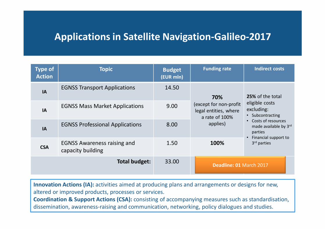
Applications in Satellite Navigation-Galileo-2017
Type of
Action
Topic Budget(EUR mln)
Funding rate Indirect costs
IAEGNSS Transport Applications 14.50
70% (except for non-profit
legal entities, where
a rate of 100%
applies)
25% of the total
eligible costs
excluding:• Subcontracting
• Costs of resources
made available by 3rd
parties
• Financial support to
3rd parties
IAEGNSS Mass Market Applications 9.00
IAEGNSS Professional Applications 8.00
CSAEGNSS Awareness raising and
capacity building
1.50 100%
Total budget: 33.00
Innovation Actions (IA): activities aimed at producing plans and arrangements or designs for new,
altered or improved products, processes or services.
Coordination & Support Actions (CSA): consisting of accompanying measures such as standardisation,
dissemination, awareness-raising and communication, networking, policy dialogues and studies.
Deadline: 01 March 2017

Compulsory Preliminary Business Plan
GALILEO-1,2,3
What for: Demonstrate the commercial potential of the product and/or service
and describe how this potential will be realised.
Why we ask: It is an input to evaluate the Impact criteria.
How to do: Template available in the participant portal.
• Define the proposed offering: the product and/or service and target market sector.
• Review the market sector: structure, size, drivers, market and technology trends.
• Assess the competition: main players, their current offerings and market share.
• Describe the innovation of the proposed offering in the context of the competition and the sector’s needs
• Summarise potential business model(s) together with possible entry price(s) and costs
• Assess the key risks to market entry and possible options for risk mitigation.
• Outline, graphically, the roll-out of the offering: timescale, sales growth and market share.

Be focused and concrete: �Build on fairly mature application or business concepts and fill the gap
�Think to bring the products / services on the market at the end of the project
Successful proposal- some hints
Build on market understanding and business expertise:�Ideally, coordinator with good expertise in the specific market
�Demonstrable capability to commercialise the products and services developed
Demonstrate a clear motivation to commercialise the products and services:�Market entry plan (marketing strategy & business plan)
�Previous achievements in the specific market
Focus on practical impact:� Maximise the use of the available signals
� Prefer trials and large scale demonstration, involving final users in their real life procedures
� Produce practical tools useful for the GNSS developer community
Select applications where EGNOS and Galileo differentiators
are key for the product/service success

Galileo-1-2017 EGNSS Transport ApplicationsMaritime and IWW are ready to benefit from EGNSS
Examples of emerging EGNSS applications in maritime and inland waterways
(including the Arctic):
• vessels navigation,
• traffic management and surveillance,
• search and rescue,
• port operations,
• fisheries monitoring.
Proposals should in particular build on the use of current and future EGNOS dedicated
services for maritime and IWW, and the Search and Rescue service of Galileo, other
Galileo differentiating features and services, such as authentication, and high precision.

Examples of H2020 Galileo 1st call projects
spyGLASS- Galileo-based passive radar system for maritime surveillance
The recurrence of illegal activities at sea such as clandestine immigration, smuggling and
trafficking, have made maritime surveillance a priority.
• A passive bistatic radar (PBR) based on Galileo transmissions for maritime surveillance is proposed
• A ground based receiver is considered for coastal monitoring and also placed on mobile platforms to assure open
sea surveillance
• The primary task of this system is to detect and localize ships.
• This feature potentially enables surveillance both in coastal areas and the open sea
