new delineation for areas with natural constraints common...
TRANSCRIPT

New delineation for Areas with Natural Constraints
Common framework of bio-physical criteria
https://ec.europa.eu/jrc

Content
• From LFA to ANC
• A common framework with 8 bio-physical criteria
• Methodology applying criteria for Art 32.3 (other than mountain and specific)
• Further considerations
2

3
LFA - Mountain
LFA - Specific
LFA - Intermediate
LFA total ≈ 56% EU UAABeneficiaries ≈ 13% EU farms (poor targetting)Financial support: €13 billion (14% RD budget)
32% of Axis2 budget
95
77 74
58 5853 53 52
4536 34 32 28 27
21 21 21 17 149 8 7 5 1 0 0 00
20
40
60
80
100
LU IE LV
PL
PT
DE
UK
LT
ES
EE
CY
SE
FR
GR
CZ FI
SK
BE IT
HU
BG
AT SI
RO
DK
MT
NL
Mountain and specific handicap LFA
Intermediate LFA
Average of total LFA
Average of intermediate LFA
55%
34,8%
Area: % total UAA
75
63
4942
30 27 2719 19 16 16
9 8 6 6 6 5 4 2 1 0 0 0 0 00
20
40
60
80
100
IE
LU
LV
LT
DE
EE
PL
FI
CY
UK
SE
CZ
FR
AT
PT
ES
GR SI
SK IT
HU
BE
DK
MT
NL
Mountain and specific handicap LFAIntermediate LFAAverage of total LFAAverage of intermediate LFA
9%
14%
Beneficiaries: % total farms
A popular and ‘sensitive’ measure for MS• Easy to distribute for MS administrations• Easy to receive for beneficiaries• Appreciated by MEPs, farmers unions,
agricultural ministries
From LFA to ANC
LFA in previous regulation

Less Favoured Areas Areas Natural Constraints
Evolving Objectives
4
1975-1999
Conserve
countryside
Continuation of
farming
Maintain minimum
population
Continued use of
agricultural land
Maintain viable rural community
2000-2006
Maintain countryside
Maintain / promote sustainablefarming systems
2007-2013
Maintain countryside
CAP Reform
decoupling SPS
Within Axis 2:improving the
environment and land management
Strategic Approach
Maintain /promote sustainable farming systems
Continued use of
agricultural land
2014-2020
Continued use of
agricultural land
Maintain countryside
Maintain /promote sustainable farming systems
New delineation
From LFA to ANC

• 2003: Critical report Court of Auditors
• 2005: New Rural development regulation - Mandate by the Council
agreement that the socio-economic dimension is no longer among the objectives as
there are other measures which target these issues better
no agreement on methodology for delineation
• 2009 – Commission Communication outlining 8 biophysical criteria
• 2009 – Council WP: MS committed to test criteria with their own data
• 2010 – 2013 –simulations by MS, intense information exchanges with
MS to apply the criteria
• 2011 – Commission’s legislative proposal with 8 biophysical criteria
• 2013 – Adoption regulation 1305/2013 (Art 32, annex III)
5
Process
From LFA to ANC

Why a new delimitation
2003: Critical report Court of Auditors concerning “intermediate LFA” (mountain
areas and areas with specific constraints not concerned):
• More than 140 national criteria (not comparable, not transparent)
• Poor targeting: under current delimitation, only half of the delimitated area
receives some payment
• Socio-economic criteria (low population density, high share of farmers
population) inconsistent with intervention logic (low soil productivity, poor
climate).
• Under current delimitation, wide discrepancies among MS
6
From LFA to ANC

7
2. Mountain areas – text identical with Art 50 of R 1698/2005Shorter growing periodAltitude + slopeAreas north of 62nd parallel (and certain adjacent areas to these areas)
3. Areas facing significant natural constraints – new delimitationBased on common 8 biophysical criteria with fixed thresholds (Annex III)Constraint(s) on at least 60% of agricultural area in administrative unitFine-tuning for areas where constraint has been overcome
4. Areas affected by specific constraints – some changesTo conserve or improve environmentTo maintain countryside and preserve tourist potentialTo protect coastlineUp to 10% of the entire territory of MSCombination of Annex III criteria (within margin 20% of initial threshold)
Constraint(s) on at least 60% of agricultural area in administrative unit
New regulation Art 32: Designation of areas
From LFA to ANC

88
• Scope
– Support to compensate farmers for additional costs and income foregone
related to the constraints for agricultural production in the area concerned.
• Payment
– Calculation is consistent with WTO (Marrakesh Agreement, Annex II, points
13a, b, d, f) and follows up on 1698/2005 which foresees income
loss/additional cost as well.
• Delimited region: continuous geographical area with definable economic and administrative identity
• Delimitation criteria: neutral and objectives, difficulties not arising from temporary circumstances
• Payments to producers in eligible regions, but generally available to all producers within such region (better targeting)
– Degressivity (WTO rules) of payments above a threshold level of area per
holding to be defined in the programme
Art. 32: Payments to areas facing natural or other
specific constraints

9
• Delineation relates to areas with low productivity soil and poor climate,
and where maintaining extensive farming activity is important for the
management of the land (avoid land abandonment)
• Criteria have to apply to agricultural activity in general, not to specific
production / crops
• Criteria have to be adapted for whole EU28, not for specific local
situations
• Criteria must be clear, robust, easily understandable - to enable
translation into legislative text
Rationale for the new delineation - ANC ‘other’ (Art 32.3)
From LFA to ANC

10
• JRC MARS: Extended experience in Crop modelling, Land quality
evaluation, agro-meteorological zoning …
• Review of scientific literature
• Consultation with international organisations, national research institutes
and universities: FAO, IIASA, INRA, KUL, ITC …
• Panel of top European experts in the field of land quality assessments,
soil, climate, environment, agriculture.
• Many technical meetings with experts and administration from MS
Method development
From LFA to ANC

Bio-physical criteria
Severe impact on agriculture
Climate
Low Temperature Short length of growing period Crop development and production cycle incomplete = reduced production
Too dry Precipitation much below evapotranspiration Water stress and adverse effect on yield
Climate and soil
Excess soil moisture Water saturated soil Tillage operations not possible Grazing period reduced
Soil
Limited soil drainage Lack of oxygen in root zone, reduced roots metabolism and mineralization process Crop productivity reduced Increase soil-borne pathogens
Unfavourable texture & stoniness
Texture controls soil structure, water and nutrient supply, workability
Shallow rooting depth Prevent rooting system to develop Difficult workability Limited storage for water and nutrients
Poor chemical properties
Reduced water available to plant Reduced nutrient availability, toxicity Prone to waterlogging (sodicity)
Terrain Steep slope Limited crop opportunities
Increase management cost
A common framework with 8 bio-physical criteria
11
Bio-physical criteria
• Comparable application: definition and threshold are identical for EU28
• High simplification potential: 1 single criterion can trigger delimitation,
areal aggregation of criteria possible
12
• Bio-physical criteria covers the whole range of agro-meteorological
conditions in EU28:
Northern and north-western MS with climate criteria
Southern MS with “Dry areas”, some soil features and terrain
Mid-latitude and central Europe MS with soil criteria and terrain
• Comparable application: definition and threshold are identical for EU28
• High simplification potential: 1 single criterion can trigger delimitation,
areal aggregation of criteria possible
A Common framework covering EU28
Bio-physical criteria

13
C1: Low temperature
Definition
• Length of Growing Period (number of days) defined by number of days with
daily average temperature > 5°C (LGPt5)
• Thermal-time sum (degree-days) for Growing Period defined by
accumulated daily average temperature > 5°C (TSt5)
Threshold
• LGPt5 ≤ 180 days
• TSt5 ≤ 1500 degree-daysProbability approach (20% → 7 years out of 30)
Bio-physical criteria

14
C2: Dryness – Too dry conditions
Definition
Ratio of annual precipitation (P) to the annual potential evapotransipration
(PET)
Threshold
Pa / PETa ≤ 0.5 Probability approach (20% → 7 years out of 30)
Bio-physical criteria

C3: Excess Soil Moisture
“Field Capacity Duration”
Definition
Number of days with soil moisture content at or above Field capacity
Threshold
≥ 230 days Probability approach (20% → 7 years out of 30)
Bio-physical criteria
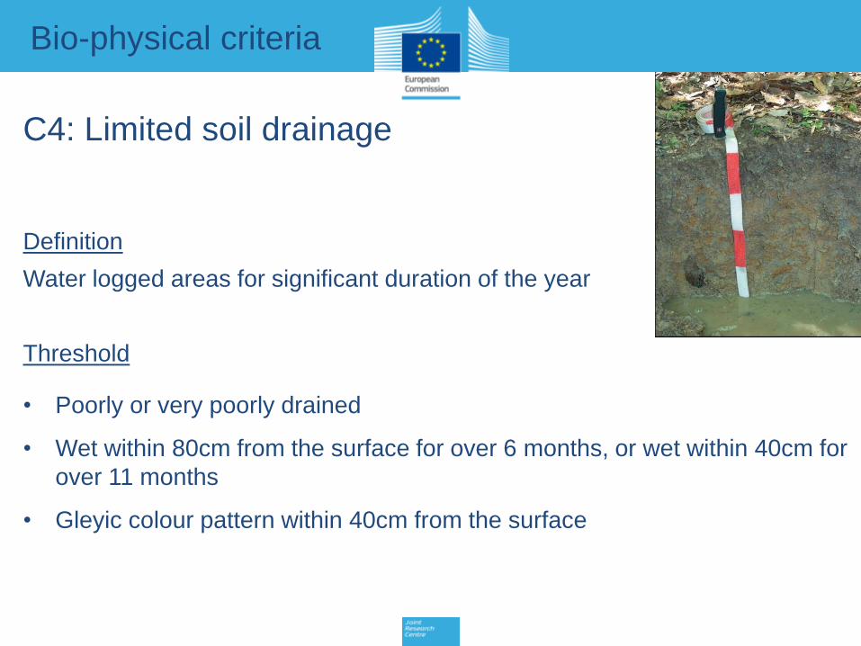
C4: Limited soil drainage
Definition
Water logged areas for significant duration of the year
Threshold
• Poorly or very poorly drained
• Wet within 80cm from the surface for over 6 months, or wet within 40cm for
over 11 months
• Gleyic colour pattern within 40cm from the surface
Bio-physical criteria

C5: Unfavorable Texture & Stoniness
Definition
Relative abundance of clay, silt, sand, organic matter
(weight %) and coarse material (volumetric %) fractions
Threshold
• ≥ 15% of topsoil volume is coarse material, rock outcrops, boulders; or
• Texture class is:
sand, loamy sand (more than half of 1m soil); or
Topsoil: heavy clay ( 60% clay); or
Organic soil (organic matter ≥ 30%) of at least 40 cm; or
Topsoil clay and vertic properties within 1m soil
Bio-physical criteria

Vertisol
Histosol
Organic soil
Coarse fragment
C5: Texture and Stoniness – examples

C6: Shallow Rooting depth
Definition
Depth (cm) from soil surface to coherent hard rock or hard pan
Thresholds
Rooting depth ≤ 30cm
Bio-physical criteria

C7: Poor Chemical Properties
Definition
Presence of salts, exchangeable sodium, excessive acidity
Threshold
• Salinity: ≥ 4 dS/m (deci-Siemens)
• Sodicity ≥ 6 ESP (Exchangeable Sodium Percentage)
• Soil acidity: pH ≤ 5 (in water)
Bio-physical criteria

C8: Steep Slope
Definition
Change of elevation with respect to planimetric
distance (%)
Threshold
Slope ≥ 15%
Bio-physical criteria

22
Methodology Art 32.3
CRITERION DEFINITION THRESHOLD
CLIMATE
Low Temperature*
Length of Growing Period (number of days) (LGPt5) OR ≤ 180 days
Thermal-time sum (degree-days) for Growing Period ≤ 1500 degree-days
Dryness Ratio of the annual precipitation (P) to annuall (PET) P/PET 0.5
CLIMATE AND SOIL
Excess Soil Moisture Number of days at or above Field capacity 230 days
SOIL
Limited Soil Drainage
Areas which are water logged for significant duration of the year Wet within 80cm for over 6 months OR
Poorly or very poorly drained soil OR
Gleyic colour pattern within 40cm
Unfavourable Texture and
Stoniness*
Relative abundance of clay, silt, sand, organic matter (weight %)
and coarse material (volumetric %) fractions
15% of topsoil is coarse material, OR
Texture class is sand, loamy sand OR
Topsoil is heavy clay ( 60% clay) OR
Organic soil (organic matter 30%) OR
Topsoil contains 30% clay vertic properties
Shallow Rooting Depth Depth (cm) from soil surface to coherent hard rock / hard pan 30cm
Poor Chemical Properties*
Presence of salts, exchangeable sodium, excessive acidity Salinity: 4 (dS/m) OR
Sodicity: 6 (ESP) OR
Soil Acidity: pH 5 (in water)
TERRAIN
Steep Slope Change of elevation with respect to planimetric distance (%). 15%
Scientific factsheets available at:
http://agrienv.jrc.ec.europa.eu/lfa.htm

Areal aggregation – Art 32.3
Agriculture
Non agriculture
Criteria A
Criteria B
Agricultural area constrained
Administrative unit
23
Methodology Art 32.3
• One criterion qualifies for an area to be constrained
(when threshold is reached)
All criteria might be present
• Overlap to be counted only once
• Minimum 60% of the agricultural area of the administrative unit must be
constrained to qualify for ANC
It is agricultural area which matters
• Spatial analysis necessary (with GIS)

Applicability
24
• The biophysical criteria have been tested in ALL MS with real data, scrutinized by
MS experts
• The biophysical criteria constitute a credible and sound approach to a transparent
and comparable delineation across all Member States => common framework
• Some issues with data accuracy (to be improved in a few MS):
– Insufficient resolution: several MS use soil map at scale 1:1 million, while most
use between 1:25.000to 1:125.000. It has been shown that maps with a
coarse scale capture the constraints insufficiently
e.g FR, IE have launched national soil mapping program to improve original data
(justification for transition period to 2018)
– Technical assistance funding available through Rural Development regulation
Further considerations

Aim: to exclude from the ANC delineation areas where the handicap
has been overcome (e.g. irrigation in dry areas) or where economic
return is sufficient to ensure no risk of land abandonment.
Flexibility for MS
Poor soil but high economic profitabilityIrrigation in dry areas
25
Fine-tuning: to better target the delineation
Further considerations

26
Thanks for your attention !