network geolocalisation system - installation de votre
TRANSCRIPT

Network Geo loca l i sa t i on Sys tem
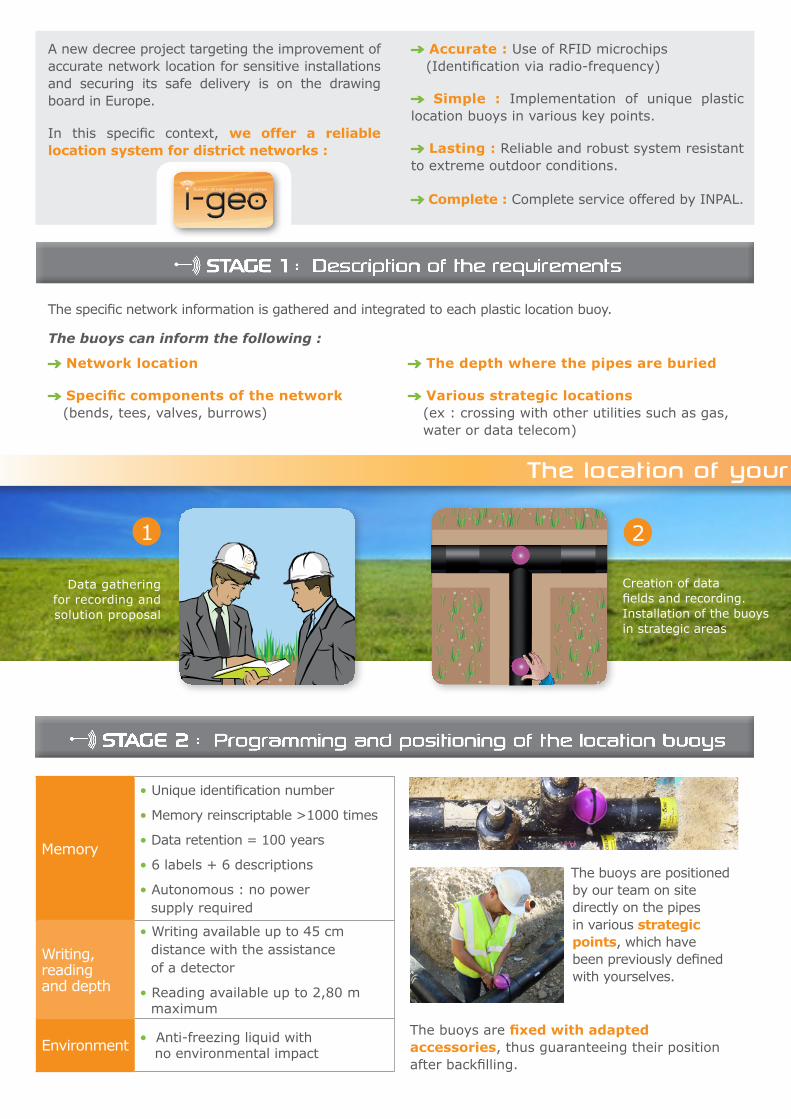
Data gathering for recording and solution proposal
1
Memory
• Unique identification number
• Memory reinscriptable >1000 times
• Data retention = 100 years
• 6 labels + 6 descriptions
• Autonomous : no power supply required
Writing, reading and depth
• Writing available up to 45 cm distance with the assistance of a detector
• Reading available up to 2,80 m maximum
Environment • Anti-freezing liquid with no environmental impact
The buoys are positioned by our team on site directly on the pipes in various strategic points, which have been previously defined with yourselves.
The buoys are fixed with adapted accessories, thus guaranteeing their position after backfilling.
The specific network information is gathered and integrated to each plastic location buoy.
STAGE 1 : Description of the requirements
Creation of data fields and recording. Installation of the buoys in strategic areas
2
STAGE 2 : Programming and positioning of the location buoys
The location of your network step by step
A new decree project targeting the improvement of accurate network location for sensitive installations and securing its safe delivery is on the drawing board in Europe.
In this specific context, we offer a reliable location system for district networks :
Accurate : Use of RFID microchips (Identification via radio-frequency)
Simple : Implementation of unique plastic location buoys in various key points.
Lasting : Reliable and robust system resistant to extreme outdoor conditions.
Complete : Complete service offered by INPAL.
The buoys can inform the following :
Network location
Specific components of the network (bends, tees, valves, burrows)
The depth where the pipes are buried
Various strategic locations (ex : crossing with other utilities such as gas, water or data telecom)

26.09.2010 14:33:25
Géométrie= Point
mis à jour= non
Position courante
Latitude= 46’19’59.73336 N
Longitude= 3’19’16.94340 E
Altitude= 169.637
attributs
ID#= 0000315607
MARKER= 1425-XR/id RFID Ball
COMPAGNI= Inpal
ADRESSE= Chaponnay
DATE= 26/09/2010
SERVICE= 5803
# BLOC= 2
LAST SAVED = 2008-06-16
Data recording on GPS assisted
by a detector
3
Data transfer and processing via Google Earth or any CAO software
4
STAGE 3 : Data recording
Data recording necessary to the network location is carried out by our team on site with a GPS associated to a detector.
After positioning the buoys, the following data can be retrieved :
• Geographical coordinates of the buoys (Longitude and latitude)
• Depth
• Unique identification number
• Other data already programmed in the buoy
STAGE 4 : Data processing and storage
Once the bouys are preset and the data collected, it is therefore possible to :
Realise the «as-built» drawingwith the assistance of the CAO software type Autocad.
Import the data in Google Earth in order to easily visualise the network routing.
Save the whole data in order to set up a database for every network.
The location of your network step by step
Nominal diametre
Fluid temperature
Application type (heat, steam..)
Pressure
Date of service
GPSDetector
26.09.2010 14:33:25
GÉOMÉTRIE= PointMIS À JOUR= NONPOSITION COURANTELatitude= 46’19’59.73336 NLongitude= 3’19’16.94340 EAltitude= 169.637ATTRIBUTSID#= 0000315607MARKER= 1425-XR/id RFID BallCOMPAGNI= InpalADRESSE= ChaponnayDATE= 26/09/2010SERVICE= 5803# BLOC= 2LAST SAVED = 2008-06-16

A turnkey service Study • Material • Installation • Maintenance
Multi data storage
A reliable, robust and independent system • Buoy casing made of Polyethylene
• Power free system
(activation via the detector)
Accurate detection
System respecting the environment
A Complete service
Inpal Energie offers a bespoke service including :
System supply
RFID Microship programming
Location buoys installation on the network
GPS recording and data sending
Positioning GPS coordinates
on a network drawing
Data gathering with Google Earth
Secured data storage on database
Options +
Advantages
Inpal Energie238 rue des Frères Voisin - ZA de Chapotin
69970 CHAPONNAY - FRANCETel. : +33 (0)4 78 69 63 20 - Fax : +33 (0)4 72 71 89 52
www.inpal.com
© I
npal
Ind
ustr
ies
- Ja
nuar
y 20
11 -
Pic
ture
s :
3M,
Inpa
l Ind
ustr
ies,
Fot
olia