network analyst creating network datasets - amazon s3 · esri uc2013 . technical workshop . network...
TRANSCRIPT

Esri UC2013 . Technical Workshop .
Technical Workshop
2013 Esri International User Conference July 8–12, 2013 | San Diego, California
Network Analyst Creating Network Datasets
Colin Childs Alan Hatakeyama

Esri UC2013 . Technical Workshop . Network Analyst—Creating Network Datasets
Agenda
• Preparing street data for use in a network dataset - Oneway streets - Hierarchy - RoadClass attribute
• Using turns, signposts, and historical traffic data • Creating a multi-modal network dataset • Parameterized attributes • Evaluators tips and tricks • Support & Resources • Questions

Esri UC2013 . Technical Workshop . Network Analyst—Creating Network Datasets
Do I need to create my own network dataset?
• Network analysis services on ArcGIS Online - Route, Closest Facility, Service Area, VRP - Generates Driving Directions - Analysis performed on up-to-date street data - Much of the world is covered - Incorporates historical, live, and predicted traffic
where available - No network dataset required

Esri UC2013 . Technical Workshop . Network Analyst—Creating Network Datasets
Do I need to create my own network dataset? I want to have it on disk
• StreetMap network datasets available - SDC format - Ready to use - Network dataset already created
• StreetMap data on Data & Maps
- Comes with ArcGIS - Data for North America
• StreetMap Premium data - Data is more current - Data for North America or Europe

Esri UC2013 . Technical Workshop . Network Analyst—Creating Network Datasets
Know Your Street Data
• What information can be used as a setting in the network dataset?
Documentation
Geometry Attributes
Street Information
Layer Information
Format
Esri UC2013 . Technical Workshop . Network Analyst—Creating Network Datasets
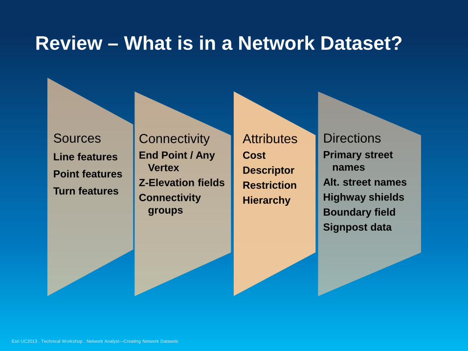
Review – What is in a Network Dataset?
Sources Line features Point features Turn features
Connectivity End Point / Any
Vertex Z-Elevation fields Connectivity
groups
Attributes Cost Descriptor Restriction Hierarchy
Directions Primary street
names Alt. street names Highway shields Boundary field Signpost data

Esri UC2013 . Technical Workshop . Network Analyst—Creating Network Datasets
Know Your Street Data

Esri UC2013 . Technical Workshop . Network Analyst—Creating Network Datasets
Coincident Geometries
• To enable network connectivity to be modeled - Points of coincidence should exist where line features cross
or intersect Case 1
Good quality Poor quality
Case 2
Good quality Poor quality
Esri UC2013 . Technical Workshop . Network Analyst—Creating Network Datasets
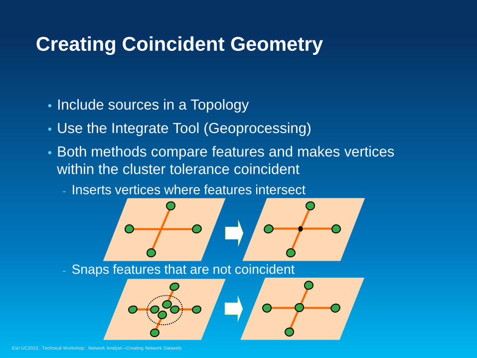
Creating Coincident Geometry
• Include sources in a Topology • Use the Integrate Tool (Geoprocessing) • Both methods compare features and makes vertices
within the cluster tolerance coincident - Inserts vertices where features intersect
- Snaps features that are not coincident
Esri UC2013 . Technical Workshop . Network Analyst—Creating Network Datasets
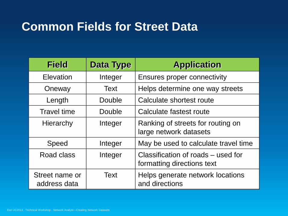
Common Fields for Street Data
Field Data Type Application Elevation Integer Ensures proper connectivity Oneway Text Helps determine one way streets Length Double Calculate shortest route
Travel time Double Calculate fastest route Hierarchy Integer Ranking of streets for routing on
large network datasets Speed Integer May be used to calculate travel time
Road class Integer Classification of roads – used for formatting directions text
Street name or address data
Text Helps generate network locations and directions

Esri UC2013 . Technical Workshop . Network Analyst—Creating Network Datasets
Connectivity using Elevation Fields
• Attribute that enables network dataset to represent multiple “levels” for line features
• Applied to line features with coincident endpoints • Planar and non-planar features are supported • Commonly called z-elevation or z-levels
NAME F_ZLEV T_ZLEV State St 0 0
Endpoint Line feature
State St 0 0
FROM endpoint
TO endpoint

Esri UC2013 . Technical Workshop . Network Analyst—Creating Network Datasets
Elevation Fields – Overpass/Underpass Scenario
• Four lines with coincident endpoints
0
0
1
0
0
0
1
0
Junction Endpoint
0-1 lines do not intersect 0-0 lines at the same junction

Esri UC2013 . Technical Workshop . Network Analyst—Creating Network Datasets
Oneway field – Most common method
• Text field containing values: FT, TF, < >, N - “FT” – one-way in digitized direction
- “TF” – one-way against digitized direction
- <empty> – two-way street “N” – No travel
F_endpoint T_endpoint
FT = traffic only allowed in this direction
If other field values, change expression
F_endpoint T_endpoint
TF = traffic only allowed in this direction
NAME Oneway State St TF
NAME Oneway State St FT
NAME Oneway State St < >
NAME Oneway State St N
Esri UC2013 . Technical Workshop . Network Analyst—Creating Network Datasets
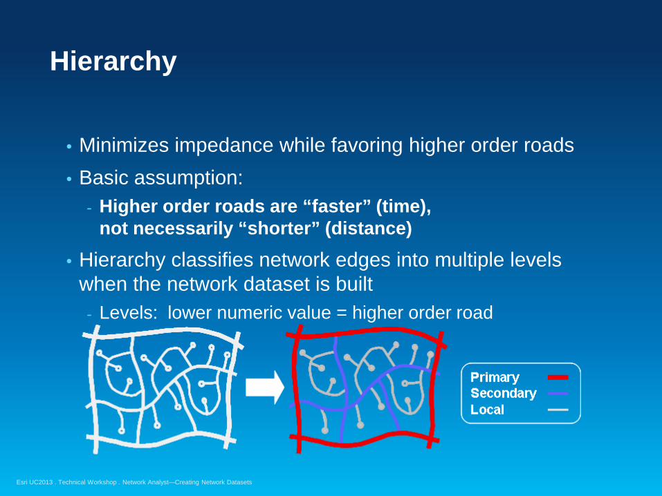
Hierarchy
• Minimizes impedance while favoring higher order roads • Basic assumption:
- Higher order roads are “faster” (time), not necessarily “shorter” (distance)
• Hierarchy classifies network edges into multiple levels when the network dataset is built
- Levels: lower numeric value = higher order road
Esri UC2013 . Technical Workshop . Network Analyst—Creating Network Datasets
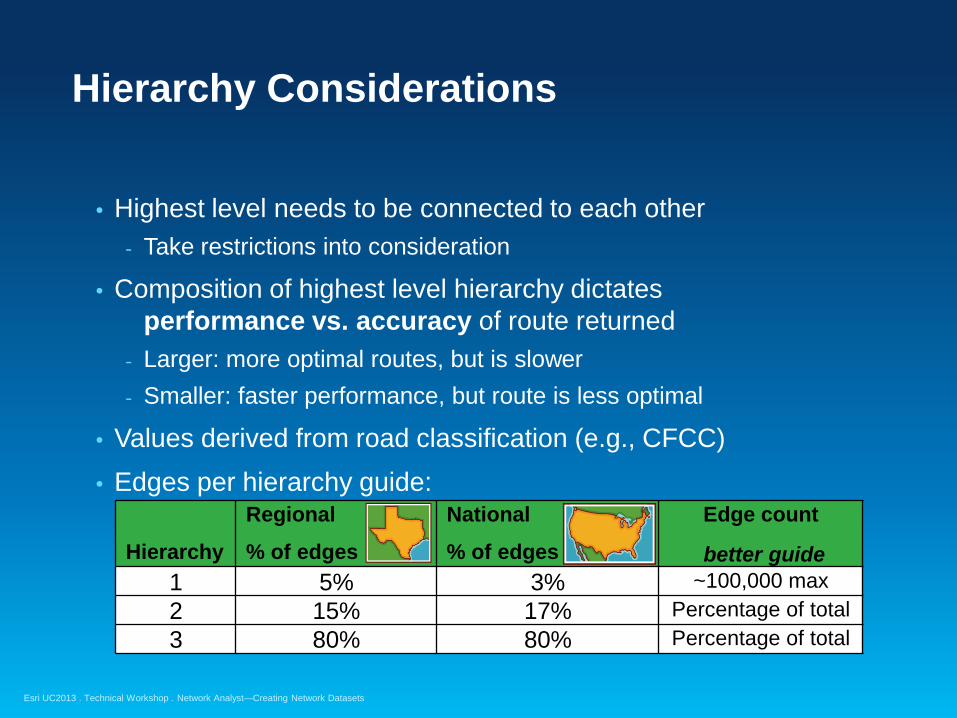
Hierarchy Considerations
• Highest level needs to be connected to each other - Take restrictions into consideration
• Composition of highest level hierarchy dictates performance vs. accuracy of route returned
- Larger: more optimal routes, but is slower - Smaller: faster performance, but route is less optimal
• Values derived from road classification (e.g., CFCC) • Edges per hierarchy guide:
Hierarchy
Regional
% of edges
National
% of edges
Edge count
better guide 1 5% 3% ~100,000 max 2 15% 17% Percentage of total 3 80% 80% Percentage of total

Esri UC2013 . Technical Workshop . Network Analyst—Creating Network Datasets
RoadClass attribute
• Used for formatting the text of driving directions • Has no effect on network analysis • Descriptor attribute, five possible integer values:
RoadClass Value
RoadClass Description Driving Directions
1 Local road “Turn left on Main St” 2 Limited access highway “Go East on I 44” 3 Ramp “Take ramp and go on US-7 N” 4 Ferry “Take Lake Expy ferry” 5 Roundabout “Take roundabout and proceed
South on Main St”
Esri UC2013 . Technical Workshop . Network Analyst—Creating Network Datasets
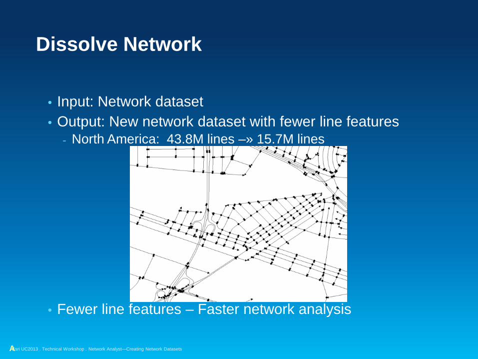
Dissolve Network
• Input: Network dataset • Output: New network dataset with fewer line features
- North America: 43.8M lines –» 15.7M lines
• Fewer line features – Faster network analysis
A

Esri UC2013 . Technical Workshop . Network Analyst—Creating Network Datasets
Dissolve Network
• Speeds up network analysis for large networks • Geoprocessing tool in Network Dataset toolset
• Creates a new dissolved network dataset - Original network dataset is unedited
• Only fields used by network dataset are present in dissolved data
- Use dissolved dataset for network analysis - Keep original data for maintenance and other work

Esri UC2013 . Technical Workshop . Network Analyst—Creating Network Datasets
Adding fields for routing to TIGER/Line® street data
Demonstration
Esri UC2013 . Technical Workshop . Network Analyst—Creating Network Datasets
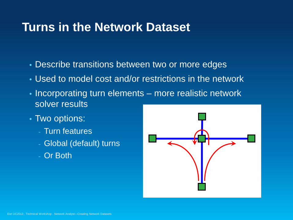
Turns in the Network Dataset
• Describe transitions between two or more edges • Used to model cost and/or restrictions in the network • Incorporating turn elements – more realistic network
solver results • Two options:
- Turn features - Global (default) turns - Or Both
Esri UC2013 . Technical Workshop . Network Analyst—Creating Network Datasets
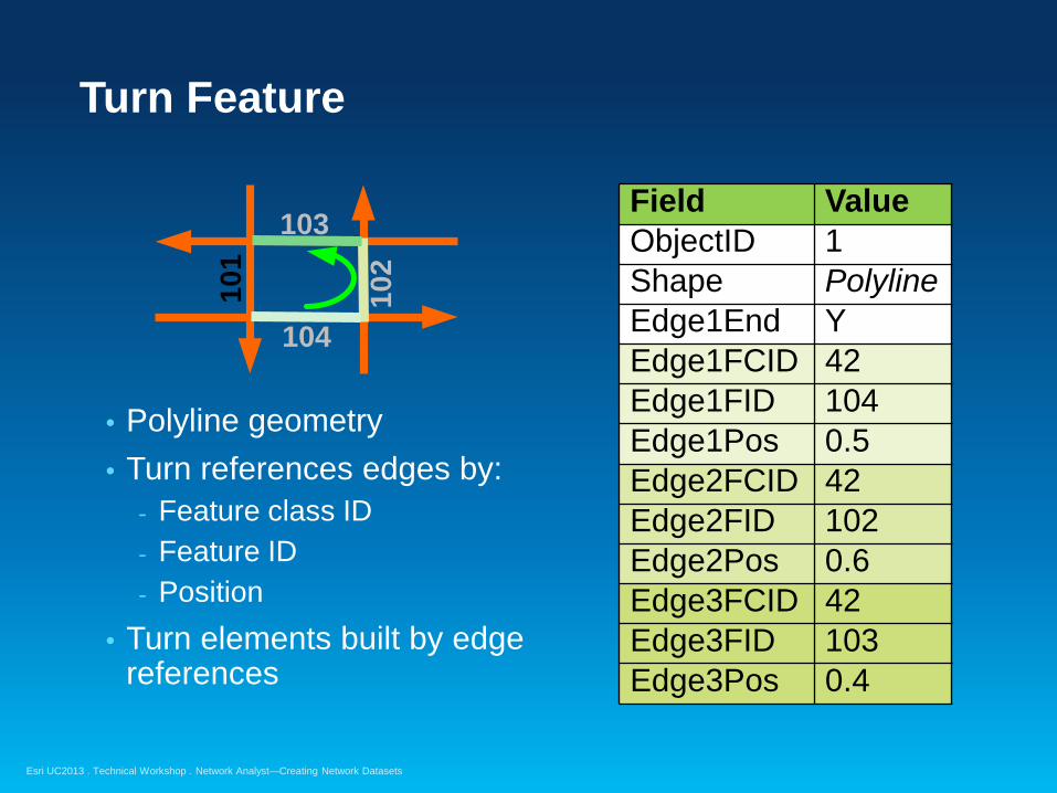
Turn Feature
• Polyline geometry • Turn references edges by:
- Feature class ID - Feature ID - Position
• Turn elements built by edge references
Field Value ObjectID 1 Shape Polyline Edge1End Y Edge1FCID 42 Edge1FID 104 Edge1Pos 0.5 Edge2FCID 42 Edge2FID 102 Edge2Pos 0.6 Edge3FCID 42 Edge3FID 103 Edge3Pos 0.4
101
102
103
104
Esri UC2013 . Technical Workshop . Network Analyst—Creating Network Datasets
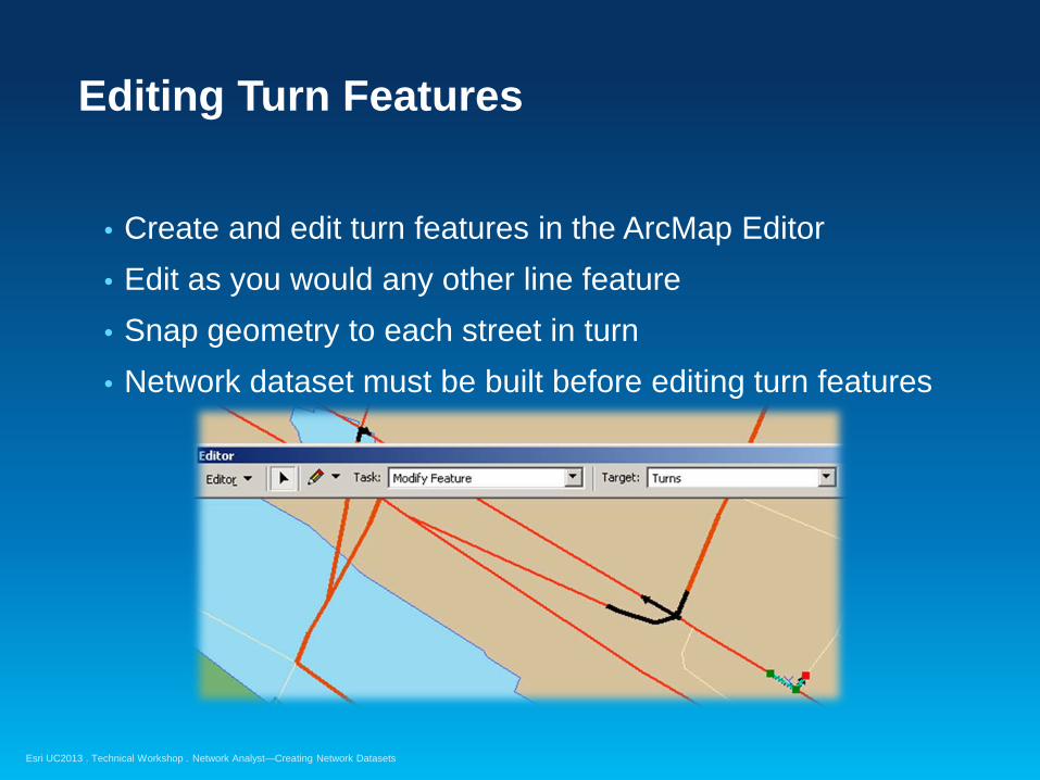
Editing Turn Features
• Create and edit turn features in the ArcMap Editor • Edit as you would any other line feature • Snap geometry to each street in turn • Network dataset must be built before editing turn features

Esri UC2013 . Technical Workshop . Network Analyst—Creating Network Datasets
Global Turns
• For example – adding a penalty for all left turns • Consist of:
- All implied two-edge turning sequences in network - No need to create a turn feature for every two-edge
sequence in the network
• Specify attribute values for global turns • VB Script evaluator –or– Global Turn Delay evaluator
Turn feature
Global left turn
Esri UC2013 . Technical Workshop . Network Analyst—Creating Network Datasets
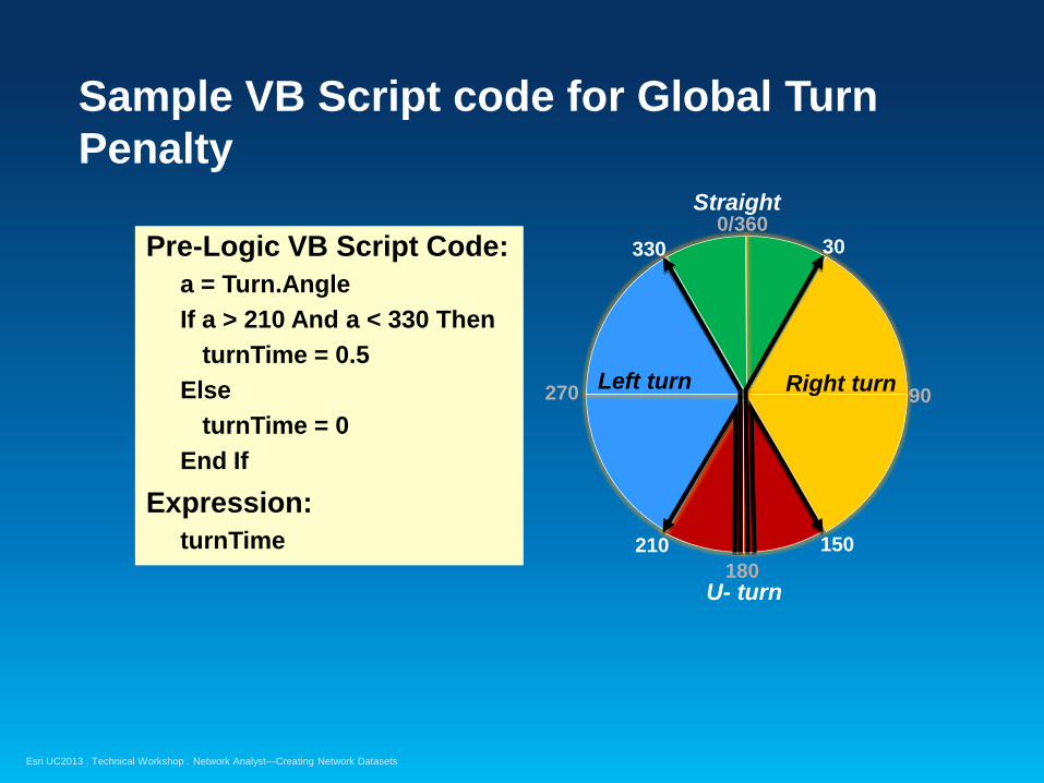
Sample VB Script code for Global Turn Penalty
Pre-Logic VB Script Code: a = Turn.Angle If a > 210 And a < 330 Then turnTime = 0.5 Else turnTime = 0 End If
Expression: turnTime
Right turn Left turn
U- turn
Straight
30 330
150 210
90 270
0/360
180
Esri UC2013 . Technical Workshop . Network Analyst—Creating Network Datasets
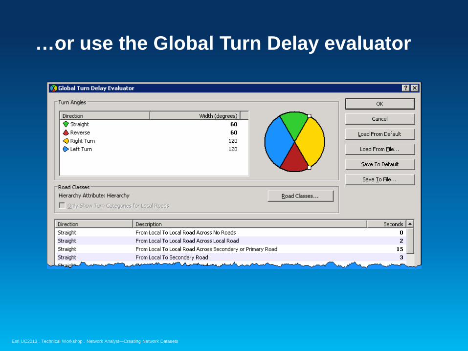
…or use the Global Turn Delay evaluator

Esri UC2013 . Technical Workshop . Network Analyst—Creating Network Datasets
Signposts
• Text seen on highway signs - Typically includes exit number, street name, and/or destination
• Has no effect on network analysis • Enhances text of driving directions:
- “At exit 73B, take ramp to US-421 North toward N Wilkesboro”
Esri UC2013 . Technical Workshop . Network Analyst—Creating Network Datasets
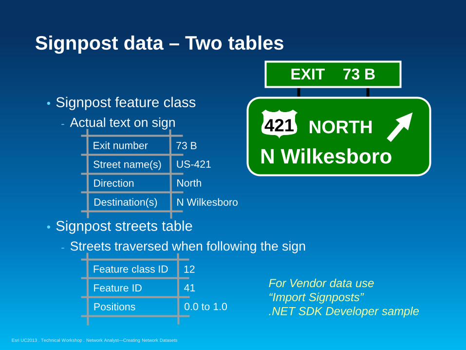
Signpost data – Two tables
• Signpost feature class - Actual text on sign
• Signpost streets table
- Streets traversed when following the sign
For Vendor data use “Import Signposts” .NET SDK Developer sample
Exit number
Street name(s)
Direction
73 B
US-421
N Wilkesboro Destination(s)
North
Feature class ID
Feature ID
Positions
12
41
0.0 to 1.0
EXIT 73 B
N Wilkesboro NORTH 421

Esri UC2013 . Technical Workshop . Network Analyst—Creating Network Datasets
Adding Signposts to the Network Dataset
• Signpost tables specified in the Directions Settings

Esri UC2013 . Technical Workshop . Network Analyst—Creating Network Datasets
Historical Traffic
• Travel time varies by time of day and/or day of week - Travel at 8am:
- Travel at 5pm:
• Used by Network Analyst when a Start Time is specified for the route

Esri UC2013 . Technical Workshop . Network Analyst—Creating Network Datasets
Historical Traffic Data – Two tables
• Traffic Profiles table - Contains free-flow speed multipliers by time of day
• Streets-Traffic Profiles join table - Specifies free-flow travel times and profiles to use
Profile
16
1 am
×1.0
5 am
×1.1
9 am
×2.3
1 pm
×1.2
5 pm
×1.4
9 pm
×1.1
Feature class ID
Feature ID
Positions
12
41
0.0 to 1.0
Free-flow travel 10 seconds
Sunday Profile Profile 10
… … Monday Profile Profile 16

Esri UC2013 . Technical Workshop . Network Analyst—Creating Network Datasets
Historical Traffic in the Network Dataset
• Specify when creating the network dataset

Esri UC2013 . Technical Workshop . Network Analyst—Creating Network Datasets
Using Turns, Signposts, and Historical Traffic Data
Demonstration

Esri UC2013 . Technical Workshop . Network Analyst—Creating Network Datasets
Connectivity for a Multi-Modal Network Dataset
• Connectivity groups “connect” at transfer points - Example: Rail stations
• Non-connecting edge sources in separate connectivity groups
Metro (connectivity group 2)
Transfer Point
Streets (connectivity group 1)

Esri UC2013 . Technical Workshop . Network Analyst—Creating Network Datasets
Multi-Modal: Considerations for Road and Rail
• Road and Rail example – two common scenarios: - Railroad station not on rail track - Railway station entrance along middle of road
• For Railroad stations not along the road - Create “transfer edges”
• For station entrances not at the road ends
- Create junction with Override policy at entrance - Insert vertex on street feature at station entrance
Rail Station
Transfer Edge
Station Entrance
Esri UC2013 . Technical Workshop . Network Analyst—Creating Network Datasets
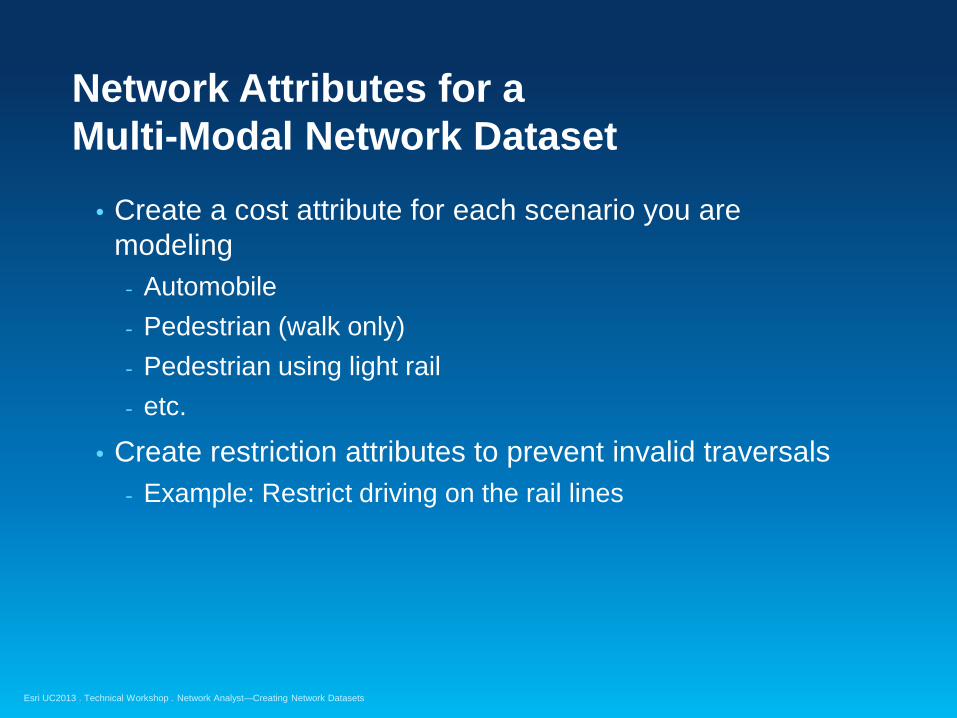
Network Attributes for a Multi-Modal Network Dataset
• Create a cost attribute for each scenario you are modeling
- Automobile - Pedestrian (walk only) - Pedestrian using light rail - etc.
• Create restriction attributes to prevent invalid traversals - Example: Restrict driving on the rail lines
Esri UC2013 . Technical Workshop . Network Analyst—Creating Network Datasets
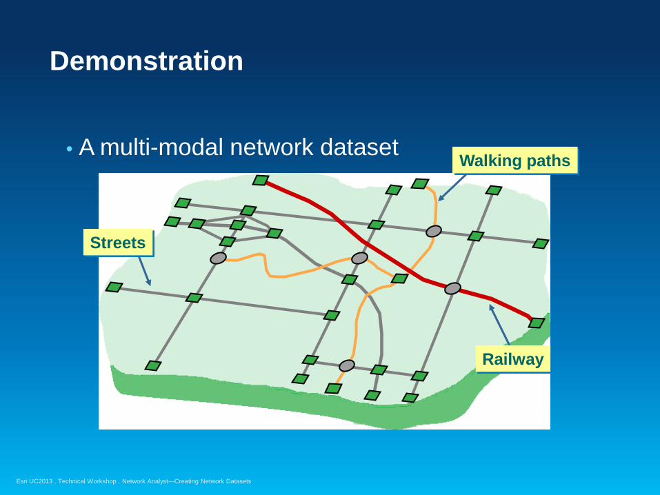
Demonstration
• A multi-modal network dataset
Streets
Walking paths
Railway

Esri UC2013 . Technical Workshop . Network Analyst—Creating Network Datasets
Parameterized Attributes
• Network attribute that accepts a parameter • Used to model dynamic aspect of an attribute’s value
Parameterized attribute
(Optional) Other Network Attribute(s) Input Parameter value(s)

Esri UC2013 . Technical Workshop . Network Analyst—Creating Network Datasets
Example – implementing a height limit
• Requires both a Descriptor and a Restriction attribute
• Descriptor attribute - Specifies the height limit for each road
• Restriction attribute - Stores the vehicle height parameter - Performs the appropriate restriction - May use Function evaluator or
VB Script evaluator - Function evaluator – faster & easier
Bridge clearance: 12’6”
Restriction evaluates to True (Restricted)
if vehicle height exceeds 12 ft, 6 in

Esri UC2013 . Technical Workshop . Network Analyst—Creating Network Datasets
Using Height Restriction During Solve
• When using solver: - Set attribute restriction on Analysis Settings tab - Specify actual vehicle height on Attribute Parameters tab
• Solver Result: - Street is restricted when the actual Vehicle Height is greater
than street’s MaxHeight attribute value
Bridge Bridge
Car height: 6’ Bridge clearance: 12’6”
Truck height: 16’

Esri UC2013 . Technical Workshop . Network Analyst—Creating Network Datasets
Evaluators – review
• A function that determines attribute values for network elements in a network dataset
• Six different types available with ArcGIS: - Field - Constant - Global Turn Delay - Function - Edge Traffic - VB Script
• Example usages:
• Custom evaluators can be developed
Attribute Evaluator(s) Length Field – assign the [meters] field
TravelTime Edge Traffic, Global Turn Delay – use historical traffic, turn delays TurnRestriction Constant – “true” (implies all turns restricted)
MaxHeight Field – assign the [Height_Limit] field HeightRestriction Function – specify MaxHeight attribute < VehicleHeight parameter
Esri UC2013 . Technical Workshop . Network Analyst—Creating Network Datasets
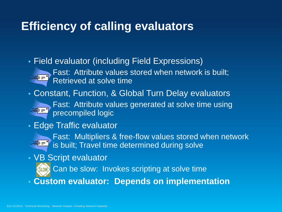
Efficiency of calling evaluators
• Field evaluator (including Field Expressions) Fast: Attribute values stored when network is built;
Retrieved at solve time • Constant, Function, & Global Turn Delay evaluators
Fast: Attribute values generated at solve time using precompiled logic
• Edge Traffic evaluator Fast: Multipliers & free-flow values stored when network
is built; Travel time determined during solve • VB Script evaluator
Can be slow: Invokes scripting at solve time • Custom evaluator: Depends on implementation
Esri UC2013 . Technical Workshop . Network Analyst—Creating Network Datasets
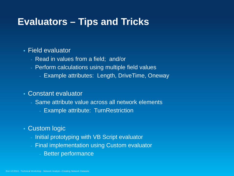
Evaluators – Tips and Tricks
• Field evaluator - Read in values from a field; and/or - Perform calculations using multiple field values
- Example attributes: Length, DriveTime, Oneway
• Constant evaluator - Same attribute value across all network elements
- Example attribute: TurnRestriction
• Custom logic - Initial prototyping with VB Script evaluator - Final implementation using Custom evaluator
- Better performance

Esri UC2013 . Technical Workshop . Network Analyst—Creating Network Datasets
Support and Resources

Esri UC2013 . Technical Workshop . Network Analyst—Creating Network Datasets
Esri Support Center
• Online portal to technical information
• Knowledge Base - Technical articles - White papers
• Community - Discussion Forums - Blogs - E-mail lists
• Downloads - Patches & service packs - ArcScripts and samples http://support.esri.com

Esri UC2013 . Technical Workshop . Network Analyst—Creating Network Datasets
For more information
• Network Analyst product page - Links to Demos, Brochures/White Papers, Success
Stories - http://www.esri.com/software/arcgis/extensions/network
analyst/
• Free recorded training seminar - Using Network Analyst in ArcGIS Desktop 10 - http://training.esri.com/gateway/index.cfm?fa=catalog.
webCourseDetail&CourseID=1955

Esri UC2013 . Technical Workshop . Network Analyst—Creating Network Datasets
Network Analyst Technical Workshops
• Network Analyst – An Introduction - Tuesday 8:30 AM, Room 32B - Wednesday 1:30 PM, Room 32B
• Network Analyst: Performing Network Analysis - Tuesday 10:15 AM, Room 32B - Thursday 1:30 PM, Room 32B
• Designing your Network Analyst workflow (30 min) - Wednesday 4:30 PM, Hall G: 2 - Thursday 8:30 AM, Hall F: 1

Esri UC2013 . Technical Workshop . Network Analyst—Creating Network Datasets
Network Analyst Technical Workshops
• Network Analyst – Network Analysis with ArcGIS Online and On-premise Services - Tuesday 1:30 PM, Room 32B - Wednesday 8:30 AM, Room 32A
• Network Analyst – Automating Workflows with Geoprocessing - Wednesday 10:15 AM, Room 32A - Thursday 1:30 PM, Room 32A

Esri UC2013 . Technical Workshop . Network Analyst—Creating Network Datasets
Network Analyst Showcase Area Demonstrations
• How to Route Inside and Between Buildings Using 3D Network Capabilities - Tuesday 1:00 PM ~ 2:00 PM
• Routing and Directions using Data and Services in ArcGIS Online - Wednesday 12:00 PM ~ 12:30 PM
• Yay, transit! Using GTFS Public Transit Data for Pedestrian Analysis and Transit Accessibility - Wednesday 3:00 PM ~ 3:30 PM
Esri UC2013 . Technical Workshop . Network Analyst—Creating Network Datasets
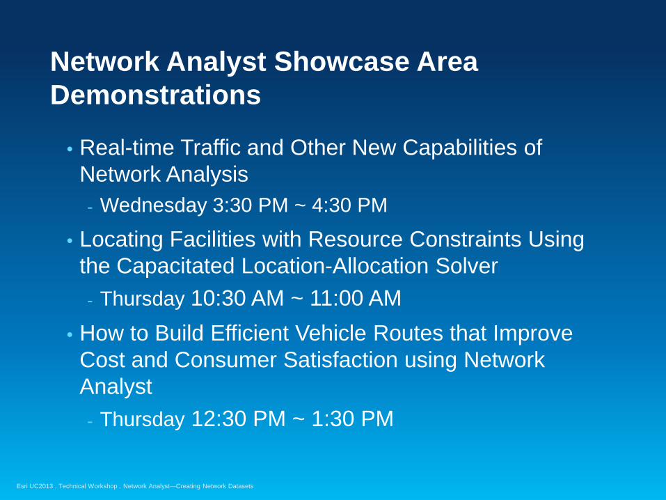
Network Analyst Showcase Area Demonstrations
• Real-time Traffic and Other New Capabilities of Network Analysis - Wednesday 3:30 PM ~ 4:30 PM
• Locating Facilities with Resource Constraints Using the Capacitated Location-Allocation Solver - Thursday 10:30 AM ~ 11:00 AM
• How to Build Efficient Vehicle Routes that Improve Cost and Consumer Satisfaction using Network Analyst - Thursday 12:30 PM ~ 1:30 PM

Esri UC2013 . Technical Workshop . Network Analyst—Creating Network Datasets
Please fill out the session evaluation
First Offering ID: 1274 Second Offering ID: 1375
Online – www.esri.com/ucsessionsurveys Paper – pick up and put in drop box
Thank you…

Esri UC2013 . Technical Workshop . Network Analyst—Creating Network Datasets