netresults mobile enterprise act one: the players c · ware required for mobile enterprise...
TRANSCRIPT

44 Geospatial Solutions March 2002 www.geospat ia l -on l ine .com
an you imaginea communi-cations sales
person spatially pre-qualifying a potentialcustomer at their ini-tial meeting? He auto-matically calculates the cost of running cable from the PDA’scurrent location to thenearest existing networkpoint.
Rumor has it that a few daring commu-nications companies,
utilities, and government organiza-tions with mobile field-based work-forces already conduct busi-ness with this kind of mobile spatialflexibility.
This installment of “Net Results”overviews the mobile data exchangestrategies of Autodesk, (www.autodesk.com), ESRI (www.esri.com), Intergraph (www.intergraph.com/gis), and MapInfo (www.mapinfo.com) for large enterpriseorganizations and lays the ground-work for future columns focused on the handheld hardware and soft-ware required for mobile enterprisesolutions.
C To place the four companies’mobile GIS strategies in con-text, I’ll outline a business problem requiring mobile data exchange, then describe a vendor’s solution. In all cases,though, the broad ideal remainsthe same regardless of theimplementation or vendor.
PDAs: Then and nowOf course, the use of portable com-puting hardware (PDAs, PocketPCs,and so forth) in the field is nothingnew to the spatial market. In practice,field tests of these devices have metwith only partial success. Untilrecently, PDA technology had limitedstorage and processing capabilitiesand could not communicate withother devices without being attachedto a docking cradle. The technology,though, has advanced; PDAs can nowcommunicate wirelessly with othernonportable computing hardware.
The biggest technical advance wasthe miniaturization and commercialavailability of wafer-thin modems that allowed PDAs to connect to the Internet, either directly or via anattached cell phone. The problem,however, is that wireless dataexchange over these micromodems is still fairly slow. Thus, the geospatialvendors’ strategies for mobile appli-cations range from either reducing the amount of data exchanged wirelessly, eliminating the need forwireless data transfer altogether, orrelegating the data exchange problem to the wireless telecommunicationsfirms. (This last group is focusinginstead on building the spatial soft-ware that telcos will require when the networks and devices finally get fast enough.)
Autodesk: A centralized solutionResponding to suggestions by theirutilities customers, Autodesk’s strat-egy does not require wireless. Forexample, consider a utilities scenarioin which, a day or more in advance,the boss reviews the upcoming jobsfor a crew of field workers and clips asubset of spatial and tabular data inthe area each worker will visit. Thiswork order data may come from avariety of sources and formats, but allthe boss has to do is reference a Webpage to clip the area of the job site.Each worker’s PDA (which is con-nected to the network at the end ofthe day) automatically loads thisclipped dataset using synchronizationsoftware. The morning of their assign-ments, workers pick up their PDAsand head into the field. The clippeddataset is a reference for infrastruc-ture design drawings as well as gen-eral navigation basemaps of the area.
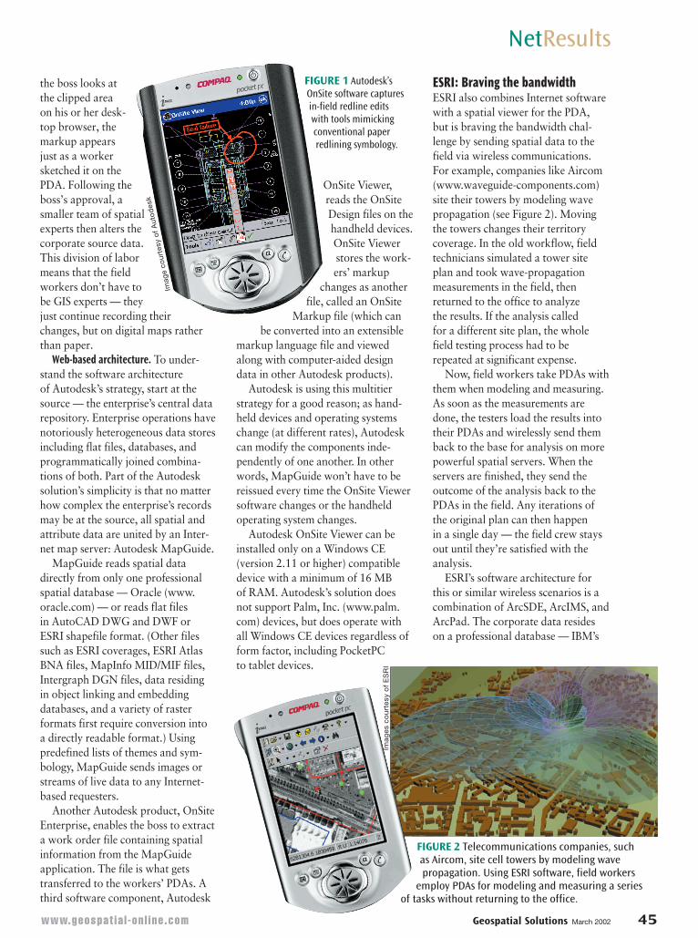
Because field jobs often involvephysical changes, the field workersmake markup changes on the PDAmaps just as they would on paper documents (see Figure 1). It’s thesemarkup changes that are the criticalnew information the boss wants inorder to update the enterprise’s cen-tral database. So, when the workersreturn to the office and dock theirPDAs, their spatial and tabularchanges synch backward to the corporate database. Now, when
This columncovers the
role ofemerging
technologiesin the
exchange of spatial
information.
C
Net ResultscolumnistJonathan W.Lowe is the owner of LocalKnowledgeConsulting(Berkeley,
California), where he designs and implements spatial Web sites. Lowe can be contacted [email protected].
NetResultsNetResults
Mobile EnterpriseAct One: The PlayersJonathan W. Lowe
Co
nn
ie G
orh
am
the boss looks atthe clipped areaon his or her desk-top browser, themarkup appearsjust as a workersketched it on thePDA. Following theboss’s approval, asmaller team of spatialexperts then alters thecorporate source data.This division of labormeans that the fieldworkers don’t have to be GIS experts — theyjust continue recording theirchanges, but on digital maps ratherthan paper.
Web-based architecture. To under-stand the software architecture of Autodesk’s strategy, start at thesource — the enterprise’s central datarepository. Enterprise operations havenotoriously heterogeneous data storesincluding flat files, databases, andprogrammatically joined combina-tions of both. Part of the Autodesksolution’s simplicity is that no matterhow complex the enterprise’s recordsmay be at the source, all spatial andattribute data are united by an Inter-net map server: Autodesk MapGuide.
MapGuide reads spatial datadirectly from only one professionalspatial database — Oracle (www.oracle.com) — or reads flat files in AutoCAD DWG and DWF or ESRI shapefile format. (Other filessuch as ESRI coverages, ESRI AtlasBNA files, MapInfo MID/MIF files,Intergraph DGN files, data residing in object linking and embedding databases, and a variety of raster formats first require conversion into a directly readable format.) Using predefined lists of themes and sym-bology, MapGuide sends images orstreams of live data to any Internet-based requesters.
Another Autodesk product, OnSiteEnterprise, enables the boss to extracta work order file containing spatialinformation from the MapGuideapplication. The file is what getstransferred to the workers’ PDAs. Athird software component, Autodesk
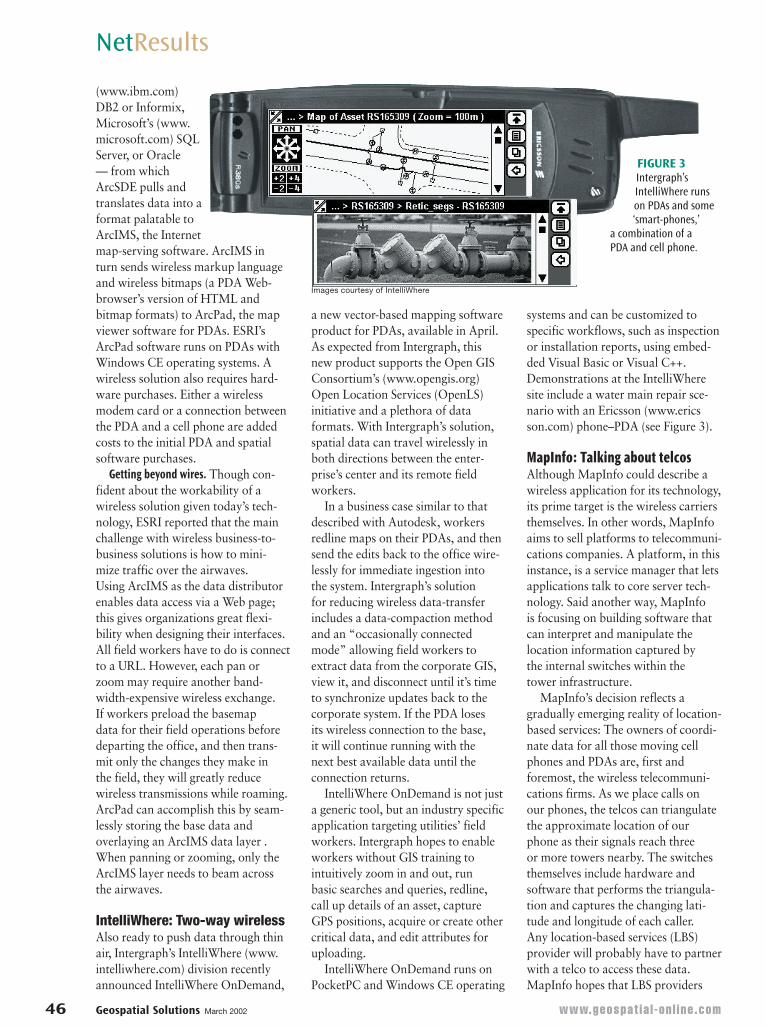
ESRI: Braving the bandwidthESRI also combines Internet softwarewith a spatial viewer for the PDA, but is braving the bandwidth chal-lenge by sending spatial data to thefield via wireless communications. For example, companies like Aircom(www.waveguide-components.com)site their towers by modeling wavepropagation (see Figure 2). Movingthe towers changes their territory coverage. In the old workflow, fieldtechnicians simulated a tower siteplan and took wave-propagationmeasurements in the field, thenreturned to the office to analyze the results. If the analysis called for a different site plan, the wholefield testing process had to berepeated at significant expense.
Now, field workers take PDAs withthem when modeling and measuring.As soon as the measurements aredone, the testers load the results intotheir PDAs and wirelessly send themback to the base for analysis on morepowerful spatial servers. When theservers are finished, they send the outcome of the analysis back to thePDAs in the field. Any iterations ofthe original plan can then happen in a single day — the field crew staysout until they’re satisfied with theanalysis.
ESRI’s software architecture forthis or similar wireless scenarios is acombination of ArcSDE, ArcIMS, andArcPad. The corporate data resides on a professional database — IBM’s
OnSite Viewer,reads the OnSiteDesign files on thehandheld devices.OnSite Viewerstores the work-ers’ markup
changes as anotherfile, called an OnSite
Markup file (which canbe converted into an extensible
markup language file and viewedalong with computer-aided designdata in other Autodesk products).
Autodesk is using this multitierstrategy for a good reason; as hand-held devices and operating systemschange (at different rates), Autodeskcan modify the components inde-pendently of one another. In otherwords, MapGuide won’t have to bereissued every time the OnSite Viewersoftware changes or the handheldoperating system changes.
Autodesk OnSite Viewer can beinstalled only on a Windows CE (version 2.11 or higher) compatibledevice with a minimum of 16 MB of RAM. Autodesk’s solution does not support Palm, Inc. (www.palm.com) devices, but does operate withall Windows CE devices regardless ofform factor, including PocketPCto tablet devices.
NetResults
FIGURE 1 Autodesk’sOnSite software capturesin-field redline edits with tools mimickingconventional paperredlining symbology.
FIGURE 2 Telecommunications companies, such as Aircom, site cell towers by modeling wavepropagation. Using ESRI software, field workers
employ PDAs for modeling and measuring a series of tasks without returning to the office.
www.geospat ia l -on l ine .com Geospatial Solutions March 2002 45
Imag
e co
urte
sy o
f A
uto
des
k
Imag
es c
ou
rtes
y o
f E
SR
I
46 Geospatial Solutions March 2002 www.geospat ia l -on l ine .com
(www.ibm.com)DB2 or Informix,Microsoft’s (www.microsoft.com) SQLServer, or Oracle — from whichArcSDE pulls andtranslates data into aformat palatable toArcIMS, the Internetmap-serving software. ArcIMS in turn sends wireless markup languageand wireless bitmaps (a PDA Web-browser’s version of HTML andbitmap formats) to ArcPad, the mapviewer software for PDAs. ESRI’s ArcPad software runs on PDAs withWindows CE operating systems. Awireless solution also requires hard-ware purchases. Either a wirelessmodem card or a connection betweenthe PDA and a cell phone are addedcosts to the initial PDA and spatialsoftware purchases.
Getting beyond wires. Though con-fident about the workability of a wireless solution given today’s tech-nology, ESRI reported that the mainchallenge with wireless business-to-business solutions is how to mini-mize traffic over the airwaves. Using ArcIMS as the data distributorenables data access via a Web page;this gives organizations great flexi-bility when designing their interfaces.All field workers have to do is connectto a URL. However, each pan or zoom may require another band-width-expensive wireless exchange. If workers preload the basemap data for their field operations beforedeparting the office, and then trans-mit only the changes they make in the field, they will greatly reduce wireless transmissions while roaming.ArcPad can accomplish this by seam-lessly storing the base data and overlaying an ArcIMS data layer .When panning or zooming, only theArcIMS layer needs to beam acrossthe airwaves.
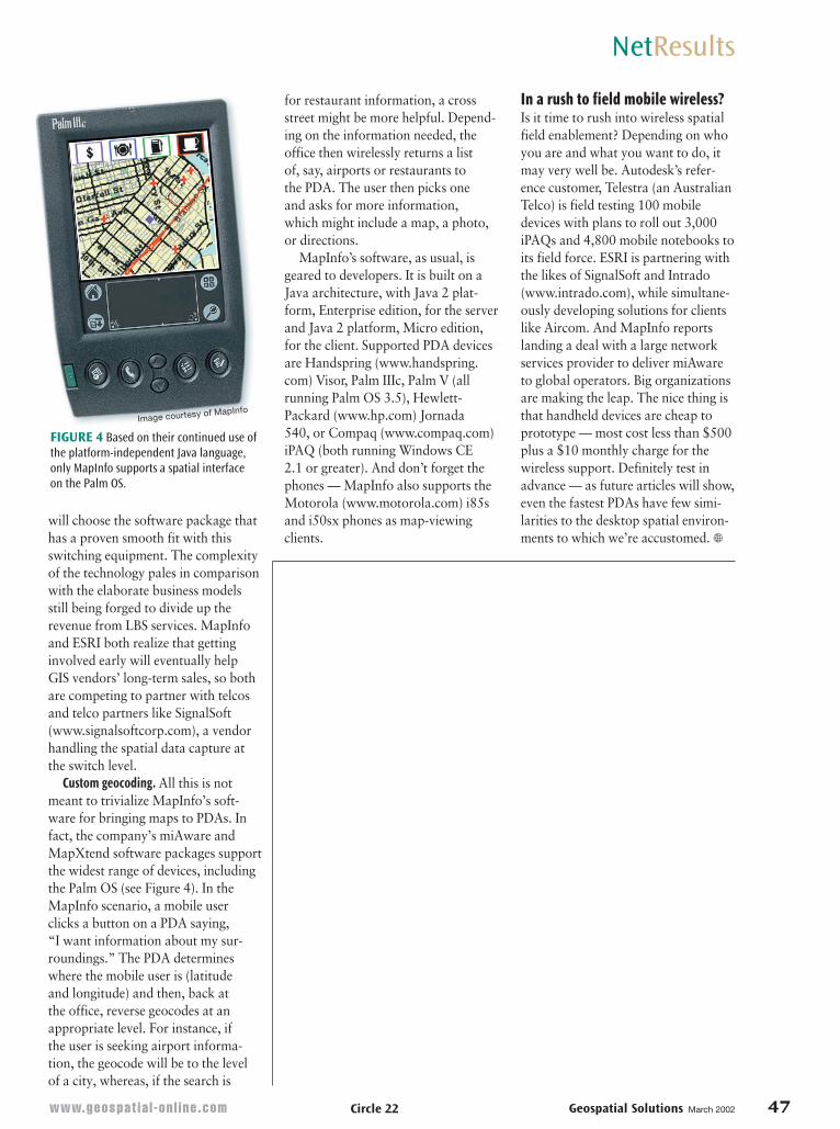
IntelliWhere: Two-way wirelessAlso ready to push data through thinair, Intergraph’s IntelliWhere (www.intelliwhere.com) division recentlyannounced IntelliWhere OnDemand,
systems and can be customized to specific workflows, such as inspectionor installation reports, using embed-ded Visual Basic or Visual C++.Demonstrations at the IntelliWheresite include a water main repair sce-nario with an Ericsson (www.ericsson.com) phone–PDA (see Figure 3).
MapInfo: Talking about telcosAlthough MapInfo could describe awireless application for its technology,its prime target is the wireless carriersthemselves. In other words, MapInfoaims to sell platforms to telecommuni-cations companies. A platform, in thisinstance, is a service manager that letsapplications talk to core server tech-nology. Said another way, MapInfo is focusing on building software thatcan interpret and manipulate the location information captured by the internal switches within the tower infrastructure.
MapInfo’s decision reflects a gradually emerging reality of location-based services: The owners of coordi-nate data for all those moving cellphones and PDAs are, first and foremost, the wireless telecommuni-cations firms. As we place calls on our phones, the telcos can triangulatethe approximate location of ourphone as their signals reach three or more towers nearby. The switchesthemselves include hardware and software that performs the triangula-tion and captures the changing lati-tude and longitude of each caller. Any location-based services (LBS)provider will probably have to partnerwith a telco to access these data. MapInfo hopes that LBS providers
a new vector-based mapping softwareproduct for PDAs, available in April.As expected from Intergraph, this new product supports the Open GISConsortium’s (www.opengis.org)Open Location Services (OpenLS) initiative and a plethora of data formats. With Intergraph’s solution,spatial data can travel wirelessly inboth directions between the enter-prise’s center and its remote fieldworkers.
In a business case similar to thatdescribed with Autodesk, workersredline maps on their PDAs, and thensend the edits back to the office wire-lessly for immediate ingestion into the system. Intergraph’s solution for reducing wireless data-transferincludes a data-compaction methodand an “occasionally connectedmode” allowing field workers toextract data from the corporate GIS,view it, and disconnect until it’s timeto synchronize updates back to thecorporate system. If the PDA loses its wireless connection to the base, it will continue running with the next best available data until the connection returns.
IntelliWhere OnDemand is not justa generic tool, but an industry specificapplication targeting utilities’ fieldworkers. Intergraph hopes to enableworkers without GIS training to intuitively zoom in and out, run basic searches and queries, redline,call up details of an asset, capture GPS positions, acquire or create othercritical data, and edit attributes foruploading.
IntelliWhere OnDemand runs onPocketPC and Windows CE operating
NetResults
FIGURE 3Intergraph’sIntelliWhere runson PDAs and some‘smart-phones,’
a combination of a PDA and cell phone.
Images courtesy of IntelliWhere
www.geospat ia l -on l ine .com Geospatial Solutions March 2002 47
will choose the software package thathas a proven smooth fit with thisswitching equipment. The complexityof the technology pales in comparisonwith the elaborate business modelsstill being forged to divide up the revenue from LBS services. MapInfoand ESRI both realize that gettinginvolved early will eventually help GIS vendors’ long-term sales, so bothare competing to partner with telcosand telco partners like SignalSoft(www.signalsoftcorp.com), a vendorhandling the spatial data capture atthe switch level.
Custom geocoding. All this is notmeant to trivialize MapInfo’s soft-ware for bringing maps to PDAs. Infact, the company’s miAware andMapXtend software packages support the widest range of devices, includingthe Palm OS (see Figure 4). In theMapInfo scenario, a mobile userclicks a button on a PDA saying, “I want information about my sur-roundings.” The PDA determineswhere the mobile user is (latitude and longitude) and then, back at the office, reverse geocodes at anappropriate level. For instance, if the user is seeking airport informa-tion, the geocode will be to the level of a city, whereas, if the search is
for restaurant information, a crossstreet might be more helpful. Depend-ing on the information needed, theoffice then wirelessly returns a list of, say, airports or restaurants to the PDA. The user then picks one and asks for more information, which might include a map, a photo,or directions.
MapInfo’s software, as usual, isgeared to developers. It is built on aJava architecture, with Java 2 plat-form, Enterprise edition, for the serverand Java 2 platform, Micro edition,for the client. Supported PDA devicesare Handspring (www.handspring.com) Visor, Palm IIIc, Palm V (all running Palm OS 3.5), Hewlett-Packard (www.hp.com) Jornada 540, or Compaq (www.compaq.com)iPAQ (both running Windows CE 2.1 or greater). And don’t forget thephones — MapInfo also supports theMotorola (www.motorola.com) i85sand i50sx phones as map-viewingclients.
In a rush to field mobile wireless?Is it time to rush into wireless spatialfield enablement? Depending on whoyou are and what you want to do, itmay very well be. Autodesk’s refer-ence customer, Telestra (an AustralianTelco) is field testing 100 mobiledevices with plans to roll out 3,000iPAQs and 4,800 mobile notebooks toits field force. ESRI is partnering withthe likes of SignalSoft and Intrado(www.intrado.com), while simultane-ously developing solutions for clientslike Aircom. And MapInfo reportslanding a deal with a large networkservices provider to deliver miAwareto global operators. Big organizationsare making the leap. The nice thing isthat handheld devices are cheap toprototype — most cost less than $500plus a $10 monthly charge for thewireless support. Definitely test inadvance — as future articles will show,even the fastest PDAs have few simi-larities to the desktop spatial environ-ments to which we’re accustomed. �
NetResults
FIGURE 4 Based on their continued use ofthe platform-independent Java language,only MapInfo supports a spatial interface on the Palm OS.
Circle 22
Image courtesy of MapInfo