nepal national action programmeon
TRANSCRIPT

NEPAL National Action Programme on
Land Degradation and Desertification in the context of
United Nations Convention to Combat Desertification (UNCCD)
His Majesty's Government of Nepal Ministry of Population and Environment
Kathmandu April 2004
Publisher: His Majesty's Government Ministry of Population and Environment Secretariat Complex, Singhdurbar Kathmandu, Nepal Tel: +977-1-245367/245368 Fax: + 977-1-242138 E-mail: [email protected] Website: www.mope.gov.np Citation: MOPE. 2002. Nepal: National Action Programme on Land Degradation and Desertification in
the Context of the UN Convention to Combat Desertification. Ministry of Population and Environment, Kathmandu, Nepal
Cover Photograph: Prepared by: Batu Krishna Uprety Finalized by: Mr. Deependra Bickram Thapa Mr. Janak Raj Joshi Mr. Bal Govinda Bista Mr. Jay Ram Adhikari Mr. Naresh Sharma Printed at: Manaslu Printing Press Babarmahal, Kathmandu Nepal. The material in this publication may be reproduced in whole or part in any form for educational or non-profit purposes. MOPE would appreciate acknowledgement and hope to receive a copy of any publication, which has used this information as a source. No part of this publication may be used for sale and any other commercial purpose. Contributors: Mr. Sharad Rai, Director General, Department of Soil Conservation and Watershed Management; Dr. Mohan P. Wagley, Joint-Secretary and Chief, Programme Division, Ministry of Forests and Soil Conservation; Mr. Dibya Deo Bhatta, Director General, Department of Forests; Mr. Bhairab Raj Kaini, Director General, Department of Agriculture; and Mr. Raghu N. Sapkota, Executive Director, Nepal Agriculture Research Council provided technical inputs on the draft report. About 340 individuals representing government institutions, private sector, local bodies (municipalities and district development committees), non-governmental organisations, community user groups involved in natural resource management, media, and academic institutions participated in the interaction meetings and provided valuable inputs on the draft NAP. Furthermore, about 20 institutions have provided official inputs on it. The report was also commented by Dr. Mohan M. Sainju, Dr. Ram P. Yadav, Dr. Jagdish C. Pokharel, Dr. Madhav P. Ghimire and Dr. Ava D. Shrestha during the validation seminar. Acknowledgement: MOPE acknowledges the contribution of all reviewers, and participation of all institutions and individuals during the preparation of this Action Programme. MOPE would like to thank Batu Uprety for compiling information and drafting the NAP and other officials for providing in-house inputs.
ii

MOPE also acknowledges the inputs of Dr. Pak Sum Low, Regional Advisor, Environment and Natural Resources Development Division, ESCAP; Mr. Yang Youlin, Deputy Regional Coordinator, Asia Regional Coordinating Unit, UNCCD; Mr. Zheng Rui, UNCCD Secretariat, Dr. Alexandra Côté, Associate Programme Manager, Asia and North Africa Desk, GM of the UNCCD, and others who provided comments and suggestions on the preliminary and revised draft NAP. MOPE acknowledges the financial contribution of the UNCCD Secretariat, and GM of the UNCCD.
iii

FOREWORD Land is the principle resource of Nepal and it constitutes about 97 per cent of thearea of 147,181 sq.km. Over three quarters of the total area lie in the mountains awith rugged topography. Desertification and land degradation are not only an environmental problem essentially, a development problem, whose solution requires an international solidarity and consensus. Therefore, it is necessary to generate active cooperationto the peoples who suffer from this phenomenon. Land degradation and desertification together with its consequences, are major fawider problem: the deterioration of the planet's habitat This alarming, but not neirreversible, challenge brings us face to face with our responsibility as caretakcommon heritage, and obliges us to take wise action that judiciously combobjectives: improving the living condition of people and respecting certain balanecosystem which lays down the limits and laws of true progress. A great part of land degradation in Nepal has been linked directly or indirectly toin land use patterns. There has been a marked changes in land use from foagriculture which has caused severe threat on ecosystem .The human interventiondue to increasing rural poverty, is related to cultivation of marginal lands, elivestock grazing and loss of biomass resulting in continued land degradation. Momarginal agricultural practices have been carried out in sloping fragile mecosystem without proper conservation measures. Land degradation in the mounmultifold adverse impacts not only people at origin, but also on people livindownstream. Experience has shown that land improvement programmes would be effecprovide positive results if these activities are carried out with active participatioconcerned communities. In this regards, His Majesty's Government of Nintroduced various conservation policy and strategies The conservation activinline with the policy and programmmes as contained in the Nepal's conservation strategy, Forestry Sector Master plan and Environmental policy anplan. The Tenth plan of the kingdom of Nepal has prioritized the agdevelopment sustainable management of natural resources, and biodiversity consHalting further degradation of land and water resources is one of the major thrusnational development policy. The United Nations convention to combat Desertification UNCCD has been coas one of the powerful instruments to combat land degradation and mitigate the edrought through effective actions at all levels, supported by international coopera
iv
Photo
total nd hills
but also effort of and aid
cets of a cessarily ers of a
ines two ces of an
changes restry to , as also xcessive st of the ountain
tains has g in the
tive and n of the
epal has ities are National d Action ricultural ervation. ts of the
nsidered ffects of tion and

partnership arrangements, in the framework of integrated approach to improve land productivity and rehabilitate, conserve and manage sustainably the land and water resources. The National Action Progamme for land Degradation and Desertification NAP for Nepal has been prepared through a series of consultative process with the concerned stakeholders in the context of UNCCD to make it as a national document. The NAP as such exhibits our national commitment towards natural resource management in general and land degradation and desertification in particular. I am sure this will serve as a guiding document in addressing the problems and mitigating the impact of land degradation and desertification in Nepal. April 2004 Buddhi Man Tamang Kathmandu Minister
v

Photo
PREFACE Over 80 per cent of the total population of Nepal depend upon the soil, water and forest resources. Subsistence agriculture, cultivation in the marginal land and fragile steep slopes, and high dependence on forests and land resources have accelerated soil erosion and landslides in mountains, and riverbank cutting, flooding, and sedimentation in the plain areas. In spite of concerted efforts to empower the community users and their active involvement through established partnership for the sustainable management of natural resources, land degradation and natural resource depletion are continued in an unprecedented manner. These have increased the number of poor people who particularly depend on these resources for subsistence living. People at different parts of the world are also facing the problems of land degradation, desertification and environmental changes. In order to address these problems, several international instruments are in place. Of them, the United Nations Convention to Combat Desertification (UNCCD) provides ample opportunities to improve the living condition of the poor rural communities through sustainable management of soil, forest and water resources. As a Party to this Convention, the Ministry of Population and Environment – the focal point for UNCCD in Nepal – is pleased to bring out the National Action Programme (NAP) as a part of the implementation process of the Convention. The NAP is prepared through extensive and series of consultations, with the representatives of the government institutions, local bodies, private sectors, NGOs, CBOs, media, and academia. I do consider NAP as a visionary document, a response to long-standing commitment of the Government and people of Nepal on natural resource management, and a framework for on-the-ground synergistic conservation actions. The Ministry appreciates the cooperation extended by the UNCCD Secretariat and its Asia Regional Coordinating Unit, and the Global Mechanism of the UNCCD. It acknowledges the contributions of all participating institutions, individuals, and reviewers for their substantive inputs in various stages of NAP formulation. The Ministry extends its sincere thanks to Messrs. Janak R. Joshi, Deependra B. Thapa, Bal G. Bista, Jay R. Adhikari, and Batu K. Uprety for their efforts in bringing out this NAP in the present form.
April 2004 MohanBahadur Karki
Kathmandu Secretary
vi
Contents Foreword Preface Executive Summary Acronyms Chapter One: INTRODUCTION 1
1.1 Background on UNCCD 2 1.2 Major Obligations 2 1.3 Linkages with the Conventions 2 1.4 Nepal's Participation in UNCCD 4 1.5 The Definition 5 1.6 Scope of the Report 5
Chapter Two: COUNTRY BACKGROUND 7 2.1 Physiography 8 2.2 Climate 10 2.3 Natural Resources 10
2.3.1 Land 10 2.3.2 Water 11 2.3.3 Forest 11 2.3.4 Biodiversity 12
2.4 Agriculture 13 2.5 Population and Poverty 17 2.6 Energy 18 2.7 Significant Environmental Issues 19 2.8 State of Land Degradation and Desertification 19
2.8.1 Causes and Consequences 22
Chapter Three: COMBATING LAND DEGRADATION, DROUGHT AND DESERTIFICATION 26
3.1 Policy and Strategy 26 3.2 Master Plans and Action Plans 30 3.3 Regulatory Mechanisms 32 3.4 Fiscal Incentives 35 3.5 Institutional Framework 36 3.6 Local Governance 40 3.7 Traditional Knowledge and Local Conservation Practices 41 3.8 Disaster Prediction and Early Warning System 42 3.9 Public Awareness and Capacity Building 43 3.10 Past and On-going Programmes 44 3.11 Technical Assistance 45
vii

3.12 Funding Sources for UNCCD Activities 46 3.13 Priority Issues on Land Degradation and Desertification 47
Chapter Four: ECOSYSTEM CONSERVATION PRACTICES 51 4.1 Forests 51 4.2 Soil and Water 54 4.3 Buffer Zone 58 4.4 Farmers-Managed Irrigation Systems 60 4.5 Agro-forestry 61
Chapter Five: NATIONAL ACTION PROGRAMME 64 5.1 Process and Participation 64 5.2 Goals and Objectives 65 5.3 Approach and Strategy 65 5.4 Programmes and Actiions 66
5.4.1 Main Programmes 67 5.4.1.1 Forests Management 67 5.4.1.2 Soil and Water Conservation in Degraded Lands 69 5.4.1.3 Pasture Management 70 5.4.1.4 Special Programmes for the Mountains 70 5.4.1.5 Food Security and Poverty Alleviation 71 5.4.1.6 Early Warning and Disaster Relief Systems 72 5.4.1.7 Cross-sectoral Programmes 73
5.4.2 Supportive Programmes 73 5.4.2.1 Policy Development 73 5.4.2.2 Legal Instruments 74 5.4.2.3 Institutional Strengthening 74 5.4.2.4 Demonstration, Scientific Study and Research 75 5.4.2.5 Indigenous Knowledge and Practice 76 5.4.2.6 Data and Information Sharing 76 5.4.2.7 Technology Development and Transfer 77 5.4.2.8 Education, Public Awareness and Media Campaign 77 5.4.2.9 Capacity Building 78
Chapter Six: PROGRAMME IMPLEMENTATION, MONITORING AND EVALUATION 80 6.1 Implementation Arrangements 80
6.1.1 National Coordinating Body 80 6.1.2 Local Level Coordination 82 6.1.3 Technical Advisory Group 82 6.1.4 Programme Management and Implementing Agencies 82 6.1.5 Stakeholders' Participation 83
6.2 Estimated Financial Resources 84 6.2.1 Domestic Channels 85 6.2.2 External Sources 86
6.3 Priority Areas for International Cooperation and Assistance 87 6.4 Monitoring and Evaluation 88
6.4.1 Indicators 88
viii

6.4.2 Means of Verification 89 6.5 Assumptions 90
REFERENCES 91
ix

ANNEXES 1. Major On-going Projects Contributing to Natural Resource Management 94 2. List of Reviewers 94 3. Number of Participants Attending Interaction Meetings 94 4. Institutions Sending the Official Responses on the Revised Draft NAP 94 5. Programmes and Actions for Land Degradation and Desertification 96 6. Summary of Programmes and Actions with Indicative Budget 100
TABLES 2.1 Areas and Population by Physiographic Regions 7 2.2 Land Use Patten 10 2.3 Beltwise Food Availability and Requirement of Cereals (1999/2000) 14 2.4 Livestock Distribution in Ecological Belts 17 2.5 Prioritisation of Significant Environmental Issues 19 2.6 Estimates of Soil Erosion 21 2.7 Estimated Soil Erosion Rates in Specific Sites 23 2.8 Land Area Affected by Floods and Landslides (1984-2000) 24 2.9 Loss of Lives and Properties by Floods and Landslides (1994-2000) 25 3.1 Land, Forests and Water Related Laws 34 6.1 Estimated Budget for NAP Implementation 85 FIGURES 1.1 A Simplified Relationship between the Conventions 3 2.1 Yield of Paddy, Maize and Wheat 15 2.2 Yield Rate of Fruits and Vegetables 15 2.3 Increasing Trend in Livestock Number 16 4.1 Categories of Protected Areas 59
5.1 Participating Organisations in the Different Consultative Processes till the Preparation of the Preliminary Draft NAP 65
5.2 Stakeholders Participation in the Interaction Meetings 66 BOXES 1 Economic Benefits of Community Forests 52 2 Commercial Utilisation of Community Forestry Products 53 3 Terrace Improvement: Traditional Knowledge Blended with Scientific Know-How 56 4 Torrent and Stream Control Through Bioengineering and Catchment Pond 57 5 Soil Conservation and Income Generation Go Hand in Hand 57 6 Coffee Plantation for Sustainable Land Management 61 7 Women's Participation in Agro-forestry 62
x

Executive Summary Nepal participated in the preparatory processes of the UN Convention to Combat Desertification (UNCCD). The Convention was signed on 12 October 1995 and ratified in October 1996. It entered into force in Nepal on 13 January 1997. One of the major obligations of this Convention is to prepare and implement a National Action Programme (NAP). The NAP contains six chapters. Chapter one summarises the background of the UNCCD, major obligations, inter-linkages between the conventions – UNCCD, CBD and UNFCCC, and Nepal's participation in UNCCD processes. Chapter two documents status of natural resources, significant environmental issues at the national level, and state of land degradation and desertification along with its causes and consequences. Chapter three highlights national level policies, strategies, master plans, regulatory mechanisms, fiscal incentives and institutional development within the framework of sustainable development. This chapter also summarises the state of traditional knowledge and local practices, disaster prediction and early warning systems, public awareness and capacity building, major programmes and technical assistance, funding sources, and priority actions on land degradation and desertification. Chapter four focuses on major achievements in natural resource management, particularly in the areas of forestry, soil and water conservation, buffer zones, irrigation and agro-forestry through people's participation. Chapter five details on National Action Programme (NAP). Chapter six outlines approaches to programme implementation, monitoring and evaluation. Nepal's State of the Environment (SOE) report, 2001 documents a total of 17 environmental issues, and prioritises land degradation and desertification as the most urgent and moderately urgent issues in terms of programme implementation. Land degradation is the cumulative effect of fragile geology, natural phenomena and human activities. About 80 per cent of the total precipitation falls during June to September, and Nepal faces "too much water" and "too little water" problems. The trans-Himalayan region including Mustang, Dolpa, Manang and Jumla receives nearly 250mm of annual rainfall. The ratio of annual precipitation to evapo-transpiration ranges from 0.02 to 0.77 indicating arid, semi-arid and sub-humid characteristics in the selected areas. Some areas are susceptible to floods and landslides, while others are prone to drought even in the wet season. However such drought is temporary in nature. Because of this, production trend in food and cash crops is not encouraging in spite of high inputs. Increased human and livestock population has exerted additional pressure on natural resources – the forest, land and water. Landslides and water-induced erosion is pronounced in the hills and mountains with the resultant effect of riverbank cutting, flooding, sedimentation and water-logging
xi

in the plains. For example, about 1,140 ha of land were lost in 1994 due to landslides and floods while over 41,800 ha were damaged in 1995 indicating unpredictable weather condition. In 1994, about 35 districts were affected by drought while about 74,000 ha of cultivable area of 16 districts of East Nepal were affected by drought in 2001. To put in a nutshell, land degradation and desertification has declined food production, increased the number of poverty-stricken people, and destabilised different ecosystems. In order to address these problems, a number of policies, strategies, plans and programmes, laws, standards, and guidelines including forestry sector master plan and agriculture perspective plan are under implementation. Recent policies and laws promote people's participation and benefit sharing. Decentralisation policy and devolution of powers and responsibilities are in place to empower local bodies and users in natural resource management. Local people have developed and practises a number of environment-friendly techniques. Curative approach has been expanded rather than preventive measures for minimising the effects of disaster. There is an encouraging awareness on the importance of environmental management. A number of programmes and projects are under implementation through technical assistance. These efforts have been instrumental in bringing the people into the mainstream of forest, soil and water, buffer zone and irrigation water management including agro-forestry promotion through user group approach. However, these interventions are inadequate in terms of magnitude, extent and duration of the impacts, and the problems of land degradation, and desertification. Drought recurrence is on the increase. In order to address these issues through comprehensive and integrated approach and meet the obligations of the Convention, this National Action Programme on Land Degradation and Desertification has been developed. This NAP is built on lessons and experiences of the past and on-going programmes, people's participation in natural resource management including in areas prone to land degradation, desertification and drought, and outcomes of a series of workshops and studies, and expert inputs. The draft NAP was discussed with over 240 individuals attending the interaction meetings organised separately for government institutions, local bodies, private sector, NGOs, media, user groups and academic institutions. The NAP outlines its formulation process and participation, goals and objectives, main and supportive programmes in 16 areas. The goal of the NAP is to mitigate land degradation, desertification process and effects of drought through improved land use and sustained land management. The NAP aims to prevent, mitigate and reduce the consequences of land degradation and drought. Specifically, the NAP intends to:
xii
• Identify factors contributing to land degradation and drought; • Identify and implement preventive and rehabilitative measures necessary to
combat land degradation, desertification and mitigate the effects of drought, and alleviate poverty; and
• Specify the roles and responsibilities of the government, local bodies, NGOs and civil society in programme implementation.
Local bodies, the private sector, users, farmers and other stakeholders will implement the NAP and government institutions will play a catalytic role, develop facilitative policy and regulatory frameworks including standards, guidelines and manuals through stakeholders' consultation to maximise people's participation. The government will assist the local bodies, natural resource users and other stakeholders in developing projects and seeking technical and financial resources for NAP implementation. Strategies include, inter alia, empowering and strengthening local bodies and community based organisation, and encouraging research institutions for developing appropriate technologies. The NAP includes main programmes in seven areas such as forests, soil and water conservation, pastures, mountains, food security and poverty alleviation, early warning system and cross-sectoral programmes. Supportive programme areas have also been identified in nine areas – policy, law, institution, demonstration studies and research, indigenous knowledge and practice, data and information sharing, technology development and transfer, education public awareness and media campaign, and capacity building. Programmes and actions are prioritised. Many of the programmes and actions are included for continuation and expansion of their coverage. Each action includes time frame [short-term (within 5 years), medium-term (5-10 years) and long-term (over 10 years)], implementation responsibility and indicative budget. The cost allocation has been grouped into small, medium and large categories which correspond to less than US$ 1 million, US$ 1 to 3 million, and higher than US$ 3 million. This indicative budget has been proposed with due consideration for the scope and coverage of the activities in questions, local financial situation, the need for their continuity over the years. Most of the proposed programmes are applicable for all ecological zones and priority is given to the Siwaliks and Hills – the degraded lands. The NAP will be revised periodically. Each programme could later be developed into a project for implementation. A total of 24 programmes and 96 actions have been proposed in 16 areas. Of them, 50, 40 and 6 actions are put in first, second and third priority respectively. In terms of time frame, 25, 43 and 28 actions are considered as short-term, medium-term and long-term actions respectively. Similarly 66, 24 and 6 actions are categorised as small, medium and large scale actions respectively. The programmes and activities are tabulated below.
xiii
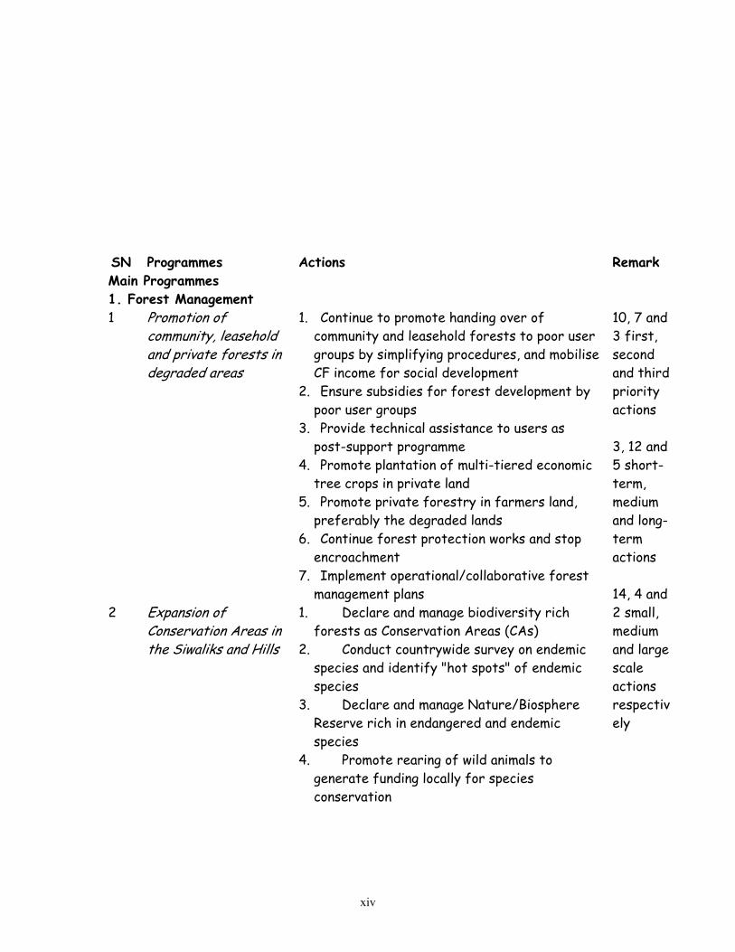
SN Programmes Actions Remark Main Programmes 1. Forest Management 1 Promotion of
community, leasehold and private forests in degraded areas
1. Continue to promote handing over of community and leasehold forests to poor user groups by simplifying procedures, and mobilise CF income for social development
2. Ensure subsidies for forest development by poor user groups
3. Provide technical assistance to users as post-support programme
4. Promote plantation of multi-tiered economic tree crops in private land
5. Promote private forestry in farmers land, preferably the degraded lands
6. Continue forest protection works and stop encroachment
7. Implement operational/collaborative forest management plans
2 Expansion of Conservation Areas in the Siwaliks and Hills
1. Declare and manage biodiversity rich forests as Conservation Areas (CAs)
2. Conduct countrywide survey on endemic species and identify "hot spots" of endemic species
3. Declare and manage Nature/Biosphere Reserve rich in endangered and endemic species
4. Promote rearing of wild animals to generate funding locally for species conservation
10, 7 and 3 first, second and third priority actions 3, 12 and 5 short-term, medium and long-term actions 14, 4 and 2 small, medium and large scale actions respectively
xiv

3 Domestication of high value and low volume plants and sustainable use of Non-wood Forest Products (NWFPs) in different categories of forests
1. Promote inventory of commercially traded NWFPs, conduct studies on stock and sustained yield and marketing
2. Manage NWFPs and encourage plantation of medicinal and aromatic plants (MAPs)
3. Identify low volume and high value NWFPs, develop methods and technologies for cultivation, harvesting and processing including of legally protected and endemic species
4. Develop promotional package of, and enabling mechanism for the sustainable use of endemic species
4 Promotion of renewable energy and energy efficiency
1. Promote locally suitable energy efficient stoves and develop capacity building for their construction and usage
2. Subsidise for high-calorie firewood plantation in private land
3. Promote bio-gas, micro-hydro projects and other alternative energy sources for agro-industries including cheese factory in the hills and mountains
5 Conflict Minimisation on forests and benefit sharing
1. Identify users living far from forests 2. Ensure traditional rights for cattle grazing
in temperate region and develop regulatory measures on benefit sharing from forest management
2. Soil and Water Conservation in Degraded Lands
xv

6 Promotion of land consolida ion, agro-forestry and block plantation
t1. Prescribe minimum area of each parcel and
promote land consolidation based on land capability classification
2. Encourage plantation of nutritious and fast growing plants having water retention and soil binding properties including expansion of on-farm conservation practices
3. Encourage tea, coffee, fruit and MAPs cultivation even through land consolidation
4. Promote the use of farmyard and green manure, and integrated plant nutrient system (IPNS) and phase out subsidies on agro-chemicals
5. Promote sericulture, floriculture, grass raising and other income generating activities
6. Promote and expand sustainable Farmers-Managed Irrigation Systems (FMIS)
7. Promote block plantation (fruit, fodder and forage) in sloping lands
7 Enhancement of mixed cropping and terrace improvement, and promotion of greenery along the riverbanks
1. Expand terrace improvement, water diversion in sloppy farmland and introduce crops having soil binding properties
2. Construct water/run-off harvesting dams, and use catchment pond
3. Integrate sediment trapping facilities in irrigation schemes and promote cultivation of sediment-loving crops (cereals and cash crops)
4. Promote land husbandry in upland watershed areas
5. Implement bioengineering activities along stream/riverbank
6. Promote groundwater extraction for irrigation and shallow tube-wells in drought-prone areas
10 and 6 first and second priority actions 6 and 10 short-term and medium-term actions 7, 6 and 3 small, medium and large scale actions respectively
8 Rehabilitation of degraded lands through bioengineering and evergreen plants having soil binding properties
1. Expand degraded land rehabilitation activities in sloppy lands with bioengineering treatment, sediment trapping facilities and plantation of evergreen species
2. Implement integrated ecosystem management programme in Siwaliks and rehabilitate areas prone to landslides in other
xvi

areas 3. Implement integrated watershed
management activities 3. Pasture Management 9 Conflict resolution
between resource users and cattle grazers and conservation of indigenous livestock
1. Conduct studies on conflicts between cattle herders and community forestry user groups and launch preventive measures
2. Undertake strategic assessment of rangeland, stock and requirement and develop databases of rangeland and cattle
3. Develop and manage pasturelands in temperate zone
4. Conduct census of indigenous livestock and protect endangered and rare species
5. Strengthen germplasm conservation facilities
6. Introduce incentive package for stall-feeding and rearing of productive cattle
2 and 4 first and second priority actions 1, 4 and 1 short-term, medium-term and long-term actions 5 and 1 small and medium scale actions respectively
4. Special Programmes for the Mountains
10 Enhancement of watershed improvement through population management
1. Conduct studies on conflicts between cattle herders and community forestry user groups and launch preventive measures
2. Undertake strategic assessment of rangeland, stock and requirement, and develop databases of rangeland and cattle
3. Develop and manage pasturelands in temperate zone
4. Conduct census of indigenous livestock and protect endangered and rare species
5. Strengthen germplasm conservation facilities
6. Introduce incentive package for stall-feeding and rearing of productive cattle
2, 7 and 3 first, second and third priority actions 6 and 6 medium and long-term actions
11 Promotion of sustainable tourism and natural resource
1. Implement natural resource management activities with focus on village tourism
2. Promote and expand micro-hydro projects
7 and 5 small and medium
xvii

management and energy efficient equipment 3. Diversify income generation activities,
develop raw materials and promote cottage industry such as agro- and forest-based industries
4. Select areas for, and promote high-budget travellers
5. Implement code of conduct, and promote health and sanitation facilities including designation of campsites and waste management schemes
6. Develop water harvesting irrigation system (to enhance the mountain economy)
scale actions respectively
5. Food Security and Poverty Alleviation
12 Enhancement of income-generation activities for land and water conservation
1. Promote MAPs cultivation both in private and public lands and sustainable utilisation of NWFPs (of community and leasehold forests) with operation of semi-processing facilities
2. Develop facilitative mechanisms to lease barren land to user groups of landless people
3. Promote cultivation of raw materials for forest-based industries
4. Improve current land use from cereals to horticulture and/or MAPs
5. Expand farmers-managed irrigation schemes
6. Promote crop modelling (to forecast crop yield)
7. Generate and disseminate post-harvest technologies (with respect to nutritional requirement of rural people through preserving nutritional content of locally available agricultural products)
8. Promote agro-and forest-based income generating activities (such as preservation, processing and storage)
9. Promote traditional practices of managing the food grains and develop co-operative market system
7 and 4 first and second priority, 3, 4 and 4 short, medium and long-term actions 8, 2 and 1 small, medium and large scale actions respectively
13 Enhancement of water management for
1. Implement integrated water resources management programme in land degradation
xviii

poverty alleviation and food security
and desertification-prone areas
6. Early Warning and Disaster Relief Systems 14 Promotion of disaster
forecasting and relief systems
1. Expand and network weather and flood monitoring stations
2. Prepare and update dry spell atlas for different weeks and identify drought-prone areas
3. Develop and/or strengthen flood and drought forecasting facilities and promote community-managed early warning system
4. Conduct vulnerability and risk assessment and hazard mapping
5. Expand water induced and sediment related disaster prevention activities
6. Prepare and implement contingency plan on disaster preparedness and rehabilitation
7. Promote coordination of relief committees 8. Promote rainwater harvesting in trans-
Himalayan region, and FMIS in drought-prone areas
6 and 2 actions in first and second priority 4, 3 and 1 short, medium and long-term actions 7 and 1 small and medium scale actions respectively
7 Cross-sectoral Programmes 15 Development of
carbon sinks through biodiversity conservation
1. Promote in- situ conservation of biodiversity and natural habitats
2. Promote germplasm collection and preservation
3. Conserve mature forests and afforest broad-leaved evergreen trees massively in degraded lands to develop as carbon sinks
4. Establish synergy between relevant conventions, and implement common programmes
2 each first and second priority; 1 short term, 3 long-term 2 each small and medium scale actions respectively
Supportive Programmes 8. Policy Development
xix

16 Avoidance of duplication and bridging gaps on policies for land and water management
Develop and implement an integrated policy on land and water including land use and commercial plantation
9. Legal Instruments 17 Avoidance of duplication on powers,
roles and responsibilities and development of necessary legal instruments in the spirit of the UNCCD in taking into account other relevant conventions
Develop regulatory framework including on land use
10. Institutional Strengthening 18 Establishment and/or
strengthening of institutions at different level
1. Provide additional mandates and strengthen local level implementing agencies and develop coordination mechanism
2. Establish Desertification Cell in MOPE and promote coordination
11. Demonstration, Scientific Studies and Research 19 Development of
demonstration plots and promotion of scientific and technological research
1 Refine conservation methods for degraded lands and processing of NWFPs through scientific studies
2 Promote participatory on-farm research and provide research internship for university students
3 Update land resource mapping project (LRMP) information and launch land degradation mapping periodically
4 Establish and/or strengthen demonstration plots for studies and research in different ecological zones
5 Monitoring of land degradation and desertification in arid and semi-arid regions
6 Update climate change effects on grasslands and wildlife habitat
12. Indigenous Knowledge and Practice
11 and 8 first and second priority 7, 4 and 8 short, medium and long-term actions 16 and 3 small and medium-scale actions respectively
20 Utilisation of indigenous knowledge and replication of proven techniques and conservation practices
1. Refine and replicate site-specific proven conservation techniques, raise awareness and develop capacity for use
xx
13. Data and Information Sharing 21 Institutionalisation of
information collection and sharing system
1. Collect and process data through remote sensing and geographical information system (GIS)
2. Develop Management Information System 3. Exchange experts between national and
international institutions and participation in regional and international workshops
14. Technology Development and Transfer 22 Promotion of
technology transfer and capacity building for its use
Collect information on available technologies, promote their transfer and use
15. Education, Public Awareness and Media Campaign 23 Expansion of land and
drought issues in formal and non-formal education and promotion of public awareness
1. Integrate and/or expand land management issues in environmental education courses at different levels
2. Develop, repackage and disseminate information and establish award for media
3. Organise awareness seminars and mobilise mass media including community radios, and NGOs for information campaign
16. Capacity Building 24 Development of
human resources at all levels, particularly of local bodies and community based organisations
Promote advanced studies, organise skill development training, visits for human resources development
As mentioned above, local bodies, natural resource users and other stakeholders will be involved in programme implementation. An inter-agency National Coordinating Body will be constituted under the chairmanship of the Minister for Population and Environment to facilitate programme implementation and monitoring. The Body will have representation from the National Planning Commission, Parliamentary Committee on the Environment and the concerned ministries, RONAST, Associations of DDCs, VDCs, municipalities, and NGO, and professional federations, donor agency and government nominated experts will also be represented in the body. The Ministry of Population and Environment (MOPE) will serve as its secretariat. Similarly, a local coordination mechanism will also be established. A Technical Advisory Group will be formed to provide scientific, technical and technological inputs to the Body.
xxi

MOPE will follow up the implementation process, collect information and prepare monitoring report and make it public by establishing a Desertification Cell under its Environment Division. The District Development Committees (DDCs) will be encouraged to develop a mechanism for district level coordination, and integrate and implement NAP in the district plans and programmes. Similar approach could be adopted at the municipality, and village development committee level, in areas affected by land degradation and prone to human-induced disasters. Professional societies, cooperatives and user groups will also be encouraged and promoted to develop and implement projects in the spirit of this NAP. The private sector, particularly the commodity associations will be encouraged in achieving twins goals of meeting the need of raw materials and rehabilitating the degraded lands. Local NGOs and CBOs will be the main facilitators and implementers in creating public awareness. A academic, scientific and research institutions will be encouraged to conduct site-specific research and refine locally suitable techniques and technologies blended with scientific innovations. A total of US$ 107.4 million has been estimated to implement the proposed programmes. SN Sector Programmes Small Medium Large
Estimated Budget (US$)
1 Forests Management 4.9 mill 8.5 mill 5 mill 23.4 million 2 Soil and Water Conservation 3.3 mill 16 mill 14 mill 33.3 million 3 Pasture Management 2.4 mill 2 mill 4.4 million 4 Special Programmes for the
Mountains 1.4 mill 10 mill 11.4 million
5 Food Security and Poverty Alleviation
1.5 mill 3.5 mill 5 mill 10 million
xxii

6 Early Warning and Disaster Relief Systems
2.5 mill 3 mill 5.5 million
7 Cross-sectoral Programmes 0.4 mill 5 mill 5.4 million Sub-total 16.4 mill 48 mill 29
mill 93.4 million
Supportive Programmes1 6 mill 8 mill 14 million Total 22.4
mill 56 mill 29
mill 107.4 million
Various categories of existing funds such as National Consolidated Fund, Poverty Alleviation Fund, Environment Conservation Fund, and the proposed Trust Fund for Biodiversity could be mobilised for implementation of these programmes. Funds generated by the user groups may also be used to initiate programmes. About 10- 12 per cent of the total budget will be channelled through national sources, and other funding is expected from external sources. Proposals are made to utilise and export silt, sand and boulders aggregated in the Terai with due consideration the environment, and encourage for pharmaceutical companies to funnel certain percentage of their income to replenish the existing funds. High priority is given to continue on-going activities, introduction of NTFPs harvesting and domestication, sustainable tourism integrated with natural resource management activities, development of disaster prediction and forecasting facilities and establishing synergies amongst relevant environmental conventions. External assistance is also expected in capacity building, in formulating pragmatic policies, enforceable regulatory framework and standards, information sharing, technology development, transfer and use, scientific studies and research, and programme implementation. In order to streamline monitoring and evaluation, a series of indicators and means of verifications have been identified. Major indicators include frequency of landslides and floods and their effect on people, change in flood and drought affected areas, reduction in the area of degraded lands, increased productivity of natural resources and farmland. The means of verification are related with the publications of reports and specific studies. Some of the assumptions made as pre-requisites for the successful implementation of this NAP are related with effective collaboration with the local bodies, private sector, user groups, academic and research institutions and NGOs. The most
1 Include programmes on policy, regulatory framework, institutional strengthening, research and scientific studies,
indigenous technology use and development, data and information management, education, public awareness and capacity building.
xxiii

important assumption is that bilateral and multilateral donors will provide additional technical and financial assistance to implement this NAP in the spirit of the Convention.
xxiv

Acronyms ADB Asian Development Bank AEPC Alternative Energy Promotion Centre APP Agriculture Perspective Plan BPP Biodiversity Profile Project BZMUG Buffer Zone Management User Group CA Conservation Area CAS Centre for Advanced Studies CBD Convention on Biological Diversity CBO Community-Based Organisation CBS Centre Bureau of Statistics CCD Convention to Combat Desertification CDG Community Development Group CECI Centre Canadien d'Etude et de Cooperation Internationale CFUG Community Forestry User Group CIDA Canadian International Development Agency CITES Convention on International Trade of Endangered Wild Flora and Fauna cm centimetre COP1 First Session of the Conference of the Parties COPs Sessions of the Conference of the Parties CRT Centre for Rural Technology DANIDA Danish International Development Assistance DCI Department of Cottage Industry DDC District Development Committee DFO District Forest Office DHM Department of Hydrology and Meteorology DMSP Disaster Mitigation Support Programme Project DNPWC Department of National Parks and Wildlife Conservation DOA Department of Agriculture DOF Department of Forests DOI Department of Irrigation DOL Department of Livestock Development DOR Department of Roads DPR Department of Plant Resources DSCO District Soil Conservation Office DSCWM Department of Soil Conservation and Watershed Management DWIDP Department of Water Induced Disaster Prevention DWSS Department of Water Supply and Sanitation ECCA Environment Camp for Conservation Awareness EEC European Economic Commission EIA Environmental Impact Assessment EISP Environmental Impact Study Project EPA Environment Protection Act EPC Environment Protection Council EPR Environment Protection Rules EU European Union ESCAP UN Economic and Social Commission for Asia and the Pacific
xxv

FAO Food and Agriculture Organisation FECOFUN Federation of Community Forestry Users Nepal FINNIDA Finnish International Development Assistance FMIS Farmers-Managed Irrigation Scheme GDP Gross Domestic Product GEF Global Environmental Facility GM Global Mechanism of the CCD GTZ German Development Cooperation ha hectare HMG His Majesty's Government of Nepal HPPCL Herbs Productions and Processing Company Limited ICIMOD International Centre for Integrated Mountain Development ICT Information, Communication and Technology IDNDR International Decade for Natural Disaster Reduction IEE Initial Environmental Examination IFAD International Fund for Agricultural Development INCD Inter-governmental Negotiating Committee On Desertification INGO International Non-Governmental Organisation IUCN The World Conservation Union JICA Japan International Cooperation Agency kg kilogram km kilometre KMTNC King Mahendra Trust for Nature Conservation KU Kathmandu University LRMP Land Resource Mapping Project LU Livestock Unit m3 cubic metre MFSC Ministry of Forests and Soil Conservation MLD Ministry of Local Development MLRM Ministry of Land Reform and Management mm millimetre MOAC Ministry of Agriculture and Co-operatives MOCTCA Ministry of Culture, Tourism and Civil Aviation MOES Ministry of Education and Sports MOF Ministry of Finance MOH Ministry of Health MOHA Ministry of Home Affairs MOICS Ministry of Industry, Commerce and Supply MOLRM Ministry of Land Reform and Management MOPE Ministry of Population and Environment MPFS Master Plan for Forestry Sector MPPW Ministry Physical Planning and Works MW Megawatt NACRMP Nepal-Australia Community Resource Management Project NAF Nepal Agro-forestry Foundation NAP National Action Programme NARC Nepal Agricultural Research Council NCCNCR National Council for the Conservation of Natural and Cultural Resources
xxvi

NCCNR National Council for the Conservation of Natural Resources NCDC Namsaling Community Development Centre NCS National Conservation Strategy NEA Nepal Electricity Authority NEFEJ Nepal Forum for Environmental Journalists NEPAP Nepal Environmental Policy and Action Plan NFIWUAN National Federation of Irrigation Water Users Association, Nepal NGO Non-governmental Organisation NP National Park NPC National Planning Commission NPWC National Parks and Wildlife Conservation NTB National Tourism Board NTFP Non-Timber Forest Product ODA Official Development Assistance OP Operational Programme PA Protected Area PU Pokhara University RAP Regional Action Programme RONAST Royal Nepal Academy for Science and Technology SALT Sloping Agricultural Land Technology SchEMS School of Environmental Management and Sustainable Development SCWM Soil Conservation and Watershed Management SOE State of the Environment Report TDN Total Digestible Nutrients TU Tribhuvan University UN United Nations UNCCD UN Convention to Combat Desertification UNDP United Nations Development Programme UNEP United Nations Environment Programme UNFCCC United Nations Framework Convention on Climate Change USAID United States Aid for International Development VDC Village Development Committee WB World Bank WECS Water and Energy Commission Secretariat WR Wildlife Reserve WUA Water Users Association WWF World Wide Fund for Nature (known as World Wildlife Fund in the US and Canada) yr year
xxvii

Chapter One Introduction
1.1 Background on UNCCD Although the problems of land degradation and desertification were realised long ago, the United Nations Conference on Desertification (UNCOD) held in Nairobi, Kenya in 1977 urged the international community to halt land degradation further, and implement restoration activities. The conference produced a Plan of Action to Combat Desertification. After 15 years of the 1977 Plan of Action, the world leaders committed to fight against poverty and desertification during the UN Conference on Environment and Development – popularly known as the Earth Summit – held at Rio de Janeiro in June 1992. The Earth Summit adopted an Agenda 21 – a blueprint of action on environment and development for the 21st century – and reaffirmed the need for managing fragile ecosystems to combat desertification and drought (Chapter 12), and to promote sustainable mountain development (Chapter 13). Chapter 12 emphasises promoting the implementation of the following five programme areas with the principles of "prevention is better than cure", i.e., implementation of the preventive measures in lands that are not yet degraded.
• Strengthening the knowledge base and developing information and monitoring systems for regions prone to desertification and drought, including the economics and social aspects of these ecosystems;
• Combating land degradation through, inter alia, intensified soil conservation, afforestation and reforestation activities;
• Developing and strengthening integrated development programmes for the eradication of poverty and promotion of alternative livelihood systems in areas prone to desertification;
• Developing comprehensive anti-desertification programmes and integrating them into national development plans and national environmental planning; and
• Developing comprehensive drought preparedness and drought-relief schemes, including self-help arrangements, for drought-prone areas and designing programmes to cope with environmental refugees.
Chapter 13 of Agenda 21 focuses on:
• Generating and strengthening knowledge about the ecology and sustainable development of mountain ecosystems; and
• Promoting integrated watershed development and alternative livelihood opportunities. In addition, the Rio Summit recommended the United Nations General Assembly to establish an Intergovernmental Negotiating Committee (INCD) to prepare a legally binding international instrument combating desertification. Within one and half years, five negotiation meetings (INCDs) were held in Nairobi, Geneva, New York and Paris, and the United Nations Convention toCombat Desertification (UNCCD) in those countries experiencing serious drought and/or desertification, particularly in Africa was adopted in Paris on 17 June 1994. The Convention was opened for signature on 14-15 October 1994 in Paris and till mid-October 1995 in UN Headquarters. The Convention entered into force on 26 December 1996, 90 days after 50 countries deposited the instrument of ratification to its depository – the UN Secretary-General.
After its fifth meeting, the INCD process continued till its 10th session for the preparation of the First Session of the Conference of the Parties (COP1), which was held in Rome in September-
1
October 1997. The second, third, fourth and fifth sessions of the Conference of the Parties were held in Dhakar, Recife, Bonn and Geneva in 1998, 1999, 2000 and 2001 respectively. These COPs have made several decisions for the implementation of the Convention. The COP5 has decided to discuss land degradation as the main theme in its forthcoming session (COP6), and this issue is very important from Nepalese perspective. The Convention to Combat Desertification offers the country Parties to promote sustainable development by establishing a functional linkage between the climate change and biodiversity conventions. The Convention offers new hope in the struggle against desertification through better management of land ecosystems. The past activities were inadequate to capture the needs, attitudes, perceptions, ownership and priorities of the local people. Local communities have gathered a variety of accumulated experiences through centuries and this could be tapped as the Convention offers to strengthen partnership. When the responsibility for natural resource management is taken away from them, the use of land and other natural resources can become inefficient. They have greater stakes than anyone else in improving agricultural productivity while ensuring the long-term ecological balance of their fragile lands. This Convention provides the local communities comprising men, women, children, small farmers, mother groups, pastoralists, nomads, landless, local leaders, village elders, local government, CBOs etc. opportunities to participate in land and water management activities and contribute to improve the living conditions of the people. 1.2 Major Obligations The Party countries should fulfil a number of obligations under this Convention. General obligations have been included in Article 4 of the Convention. These include, inter alia, adoption of an integrated approach, promotion of sustainable development, and integration of strategies for poverty reduction. Article 5 of the Convention calls upon the affected country Parties to:
give due priority to combating desertification and mitigating the effects of drought, and allocate adequate resources in accordance with their circumstances and capabilities;
establish strategies and priorities, within the framework of sustainable development plans and/or policies, to combat desertification and mitigate the effects of drought;
address the underlying causes of desertification and pay special attention to the socio-economic factors contributing to desertification processes;
promote awareness and facilitate the participation of local populations, particularly women and youth, with the support of non-governmental organisations, in efforts to combat desertification and mitigate the effects of drought; and
provide an enabling environment by strengthening, as appropriate, relevant existing legislation and, where they do not exist, enacting new laws and establishing long-term policies and action programmes.
The Convention emphasises on preparing, making public and implementing the national action programmes which is a core obligation of the Party countries. This National Action Programme has been developed in response to this Convention. 1.3 Linkages with other Conventions Effective implementation of this Convention requires multi-dimensional approach and establishment of linkages with other relevant conventions. The Conventions on climate change, biodiversity and combating desertification have a number of common features and calls upon the
2

implementation of several actions that contribute to achieve the goals of sustainable development through conservation, rehabilitation, sustainable utilisation of natural resources and equitable sharing of benefits. UNCCD focuses on land degradation, desertification and drought; CBD on conservation, sustainable utilisation and benefit sharing of biodiversity; UNFCCC on stabilisation of greenhouse gases by limiting atmospheric emissions and conserving emission sinks. The Conventions realise the environmental problems as a result of increasing poverty, focus on community approach and effective actions at all levels, raise public awareness, and launch joint programmes to meet common objectives. The Conventions also emphasise on the integration of environment-friendly policies into national development plans and programmes, and prepare and implement national action plans/programmes. They also focus on respect, integration, and enhancement of traditional knowledge, skills and know-how and practices for the conservation and sustainable use of natural resources. UNCCD categorically demands joint programmes with CDB and UNFCCC, particularly on research, training, systematic observation, information collection and sharing. They show common concerns on the degradation of natural resources particularly the land and water resources and they will have implications on the delicate ecological balance with far reaching impacts on the life-support system. The following diagram helps to simplify inter-linkages between these conventions.
Human Needs Activities to Supplement Needs Results of the Activities
Energy needs Household Industry Transport
Raw materials needs Industry Comfort and luxury Economic generation
Exploitation of Forest resources Agricultural plants Wild and domestic animals Water resources Mineral resources
Conversion of forestland
Generation of greenhouse gases
Expansion of degraded
Climate change
Alteration of ecology and habitats
So
Food needs Agriculture Livestock
Figure 1.1 A S
urce: MOPE, 2001
Exploitation of Biomass Coal reserves Natural gas and crude oils Water resources
to agriculture Use of marginal lands Change in other land uses Use of agro-chemicals
Depletion in resource production and increase on poverty
implified Relationship between the
3
Depletion/loss of wild and domestic/cultivated
biodiversity
land/desertification area
Change in hydrological/ meteorological cycle
Conventions

Hence, activities should be designed and implemented in such a way that human needs are fulfilled without degrading the land and water systems, affecting biodiversity and emitting greenhouse gases. 1.4 Nepal's Participation in UNCCD Nepal participated in the preparatory processes of the Convention and signed it on 12 October 1995. The House of Representatives ratified the Convention on 10 September 1996. Nepal deposited its instruments of ratification in October 1996, and the Convention entered into force in Nepal on 13 January 1997. After becoming Party to CCD, Nepal has expanded soil and water management activities at the field level with people's participation and they cover over two-third of the administrative districts (total 75 districts) of Nepal. Local conservation practices have been expanded and public awareness activities have been integrated as an important component of the environmental education programmes. In the process for continuing the implementation of the Convention, the Ministry of Population and Environment (MOPE) – the focal point for UNCCD – organised a two-day national seminar on Desertification and Land Improvement on November 4-5, 1997 in collaboration of the UNCCD Secretariat to exchange information and experiences on land degradation, to raise public awareness and to derive a set of priority program areas. The report of the seminar was produced and widely circulated to let the people know about the importance of land improvement.
His Majesty's Government (HMG) of Nepal initiated studies to generate information on land degradation in the spirit of the Convention since 1997 and HMG has continued earmarking seed money for the implementation of the Convention. In 1997, MOPE conducted a study on the implementation status of the selected conventions and in 1999, the Ministry carried out a study for the preparation of the national policy and programmes of action to combat desertification and drought (MOPE, 1999). A study was conducted to outline national programmes and to prepare country status paper in 2000 (MOPE, 2000). In April 2000, HMG prepared a status report on the implementation of the Convention in Nepal with the assistance of the UNCCD Secretariat. The report has clearly indicated the areas for additional assistance from the developed country partners. In July 2001, MOPE completed five studies on traditional knowledge, know-how, practices and technologies; financial, technical and technological needs; capacity building and public awareness activities; data needs, desertification monitoring and evaluation parameters (indicators); and linkages amongst the UNCCD, CBD and UNFCCC and identified issues for the development of necessary regulatory measures for UNCCD. Furthermore, the need for preparing and implementing action programs on major environmental conventions, including UNCCD as a priority attention of the government has been regularly raised in the Donor's Consultative Meetings. In December 2001, MOPE organised a two-day national workshop on Land Degradation, Drought and Sustainable Land Management, as part of National Action Programme (NAP) formulation process, with the assistance of the UNCCD Secretariat and the Global Mechanism of the UNCCD. The workshop report was prepared and disseminated widely. As per the decisions of the Conference of the Parties, the Asian Country Parties were invited to submit the second national report on the implementation of the UNCCD within April 2002.
4

Accordingly, HMG prepared the second national report with the assistance of the UNCCD Secretariat and submitted to its Secretariat on 29 April 2002. Nepal is actively participating in the Thematic Programme Network (TPN 2) on agro-forestry and soil conservation, other programmes of regional and international characters and also meetings of the Conference of the Parties regularly. Information and recommendations of these studies and workshops including concerns of the regional programmes under UNCCD have been used as a building block for NAP formulation and this NAP is the output of these initiatives. 1.5 The Definition The UN Convention to Combat Desertification defines desertification "as land degradation in arid, semi-arid and dry sub-humid areas resulting from various factors, including climatic variations and human activities". The Convention also defines land degradation "as reduction or loss, in arid, semi-arid and dry sub-humid areas, of the biological or economic productivity and complexity of rainfed cropland, irrigated cropland, or range, pasture, forest and woodands resulting from land uses or from a process or combination of processes, including processes arising from human activities and habitation patterns, such as:
Soil erosion caused by wind and/or water; Deterioration of the physical, chemical and biological or economic properties of soil; and Long-term loss of natural vegetation".
In the Nepalese context, decline in productivity of different land systems – the cultivated and/or non-cultivated agricultural lands, forests and pastures – is due to land degradation. Nepal has no drylands as such. Some areas fall within the range from 0.05 to 0.65 (the ratio of annual precipitation to potential evapotranspiration). For example, this ratio for Jumla is 0.59 (MOPE, 2001). In some areas, the ratio ranges from 0.02 to 0.77 indicating arid, semi-arid and sub-humid characteristics. The trans-Himalayan region including Mustang, Dolpa, Manang and Jumla receives nearly 250 mm of annual precipitation. Land degradation is a natural process and may lead to desertification. It is accelerated by soil erosion, landslides and floods leading to watershed degradation. In the Nepalese context, land degradation is the reduction of physical, biological and/or economic productivity of different land systems, and long-term loss of natural vegetation and nutrients, particularly through water-induced erosion, landslides and floods. Land degradation and its process is accelerated by physical, biological and anthropogenic activities. It is hence soil degradation, natural or human-induced. 1.6 Scope of the Report This Chapter summarises the background of the UNCCD, major obligations, inter-linkages amongst the conventions – UNCCD, CBD and UNFCCC, and Nepal's participation in UNCCD process. It also includes the definition of land degradation in the Nepalese context. Chapter two documents status of natural resources, significant environmental issues at the national level, and state of land degradation and desertification with causes and consequences. Chapter three includes information on national level policies, strategies, master plans and action plans, regulatory mechanisms, fiscal incentives and institutional development within the framework of sustainable development. This chapter also presents a synopsis on local governance, traditional knowledge and local practices, disaster prediction and early warning systems, public awareness and capacity building, major programmes and technical assistance, possible funding sources for UNCCD
5
activities, and priority actions on land degradation and desertification. Emphasis has been given to those instruments, which help in combating land degradation, drought and desertification. Chapter four focuses on major achievements in natural resource management, particularly in the areas of community forestry, soil and water conservation, buffer zones, irrigation system and agro-forestry through people's participation. Based on earlier chapters information, chapter five includes details on National Action Programme (NAP). This chapter summarises the NAP formulation process and participation, goals and objectives of NAP, main and supportive programmes in 16 areas. Chapter six outlines the approaches to programme implementation, monitoring and evaluation. The implementation arrangement and estimated financial resources have been included in this chapter. Annexes have also been included as supportive information.
6

Chapter Two Country Background
2.1 Physiography Situated in the southern Himalayan flank, Nepal is roughly rectangular in shape with a total area of 147,181 km2. The average North-South width is about 193km and East-West length averages to 885 km. It lies between India and the People's Republic of China at 26022' to 30027' N latitude and 8004' to 88012' E longitudes with an altitudinal range from 60m in the south to 8,848m in the north. The country is landlocked and bordered by India in the East, West and South, and China in the North. The country is broadly divided into three ecological regions: the Terai (plain area), the Hills and the Mountains covering 23, 42 and 35 per cent of the total area respectively (Table 2.1). Physiographically, the country is divided into five regions – the Terai (upto 330m altitude), the Siwalik zone (120-2000m), the Middle Mountains (500-3000m), the High Mountains (2200-4000m), and the High Himal region (> 4000m).
Table 2.1 Areas and Population by Physiographic Regions
Area Population Census, 2001 (in million)
Physiographic region
Km2 %
Number of districts
No. %
Population Density (Persons/ Km2)
Mountains 51,817 35.2 16 1.688 7.29 33 Hills 61,345 41.7 39 10.251 44.28 167 Terai 34,019 23.1 20 11.212 48.43 330
Total 147,181 100 75 23.151 100.00 157 Source: MOPE, 2001; Population Census Report, 2001
7
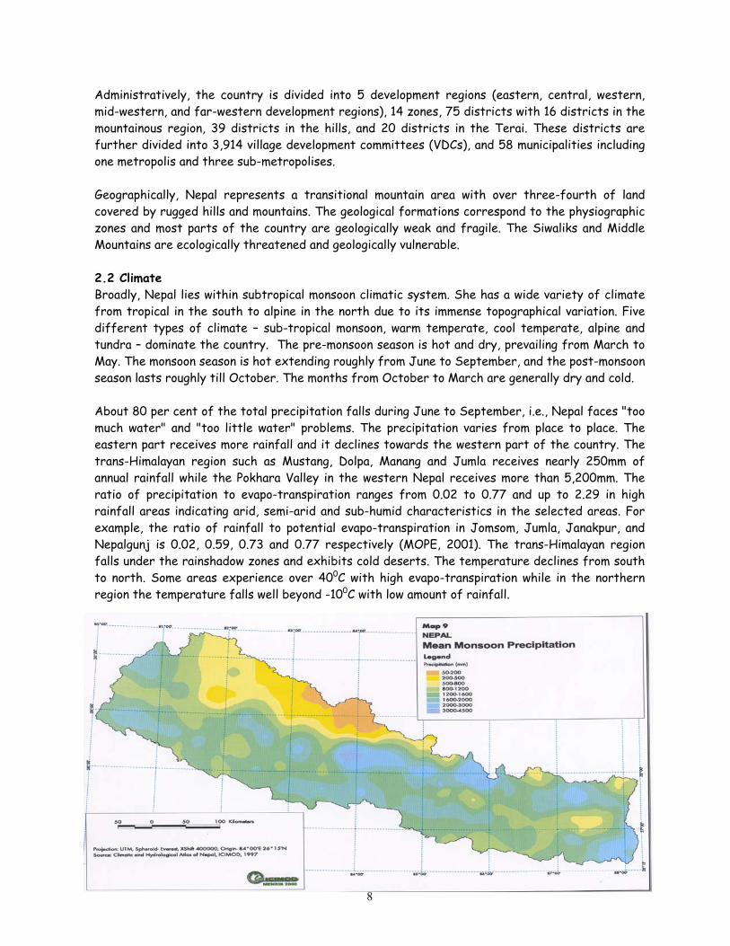
Administratively, the country is divided into 5 development regions (eastern, central, western, mid-western, and far-western development regions), 14 zones, 75 districts with 16 districts in the mountainous region, 39 districts in the hills, and 20 districts in the Terai. These districts are further divided into 3,914 village development committees (VDCs), and 58 municipalities including one metropolis and three sub-metropolises. Geographically, Nepal represents a transitional mountain area with over three-fourth of land covered by rugged hills and mountains. The geological formations correspond to the physiographic zones and most parts of the country are geologically weak and fragile. The Siwaliks and Middle Mountains are ecologically threatened and geologically vulnerable. 2.2 Climate Broadly, Nepal lies within subtropical monsoon climatic system. She has a wide variety of climate from tropical in the south to alpine in the north due to its immense topographical variation. Five different types of climate – sub-tropical monsoon, warm temperate, cool temperate, alpine and tundra – dominate the country. The pre-monsoon season is hot and dry, prevailing from March to May. The monsoon season is hot extending roughly from June to September, and the post-monsoon season lasts roughly till October. The months from October to March are generally dry and cold. About 80 per cent of the total precipitation falls during June to September, i.e., Nepal faces "too much water" and "too little water" problems. The precipitation varies from place to place. The eastern part receives more rainfall and it declines towards the western part of the country. The trans-Himalayan region such as Mustang, Dolpa, Manang and Jumla receives nearly 250mm of annual rainfall while the Pokhara Valley in the western Nepal receives more than 5,200mm. The ratio of precipitation to evapo-transpiration ranges from 0.02 to 0.77 and up to 2.29 in high rainfall areas indicating arid, semi-arid and sub-humid characteristics in the selected areas. For example, the ratio of rainfall to potential evapo-transpiration in Jomsom, Jumla, Janakpur, and Nepalgunj is 0.02, 0.59, 0.73 and 0.77 respectively (MOPE, 2001). The trans-Himalayan region falls under the rainshadow zones and exhibits cold deserts. The temperature declines from south to north. Some areas experience over 400C with high evapo-transpiration while in the northern region the temperature falls well beyond -100C with low amount of rainfall.
8

At present, there are 272 raingauge stations, 22 agro-meteorological stations and 15 synoptic stations. A total of 261 stations have at least 15 years of data. However, non-representative distribution of stations has created data gaps. Furthermore, topographical variation has limited dependable forecasting in Nepal. Orographic effects play a vital role in the distribution of rainfall in Nepal, with some areas susceptible to floods and landslides, and prone to drought. Rainfall is erratic and the country experiences either a short or long dry period each year even within the wet season (DHM, 2001). The recently conducted dry spell study has concluded that seasonal and unexpected drought has affected the agriculture crops most of the year (DHM, 2001). The uneven annual and intra-annual distribution of rainfall, and low vegetative cover in the semi-arid and arid zones are the main climatic attributes that contribute to desert-like condition and land degradation. As the Convention to Combat Desertification (CCD) defines "desertification" as land degradation in arid, semi-arid and dry sub-humid areas resulting from various factors, including climatic variations and human activities, land degradation is prevalent in many parts of the country both in the uplands and the lowlands. The great intensity and irregular distribution of rainfall is one of the main causes of erosive and/or topsoil degrading process in Nepal. Wind erosion is also significant in certain landscapes, particularly in deep valleys of the high Himalayan region such as Dolpa, Mustang and Manang districts. Land degradation and desertification has been a cumulative outcome of unsustainable land use practices and erratic climatic behaviour in the country. Land degradation is further accelerated through the expansion of rain-fed cultivation on to marginal lands, inappropriate crop intensification, mining, overgrazing, groundwater extraction, and uncontrolled harvesting of biomass. To put in a nutshell, water-induced erosion is the main problem of land degradation in Nepal.
9

2.3 Natural Resources 2.3.1 Land About 97 per cent of the total area is covered by land. Although the mountain region covers over one third of the total area (Table 1.1), land suitable for cultivation is only 2 per cent. Out of the total hill area, about one-tenth is considered suitable for cultivation while the Terai area is fertile and is a food production centre of the country. It means that about 23 per cent of the total area supports nearly half of the total population. The land use data shows that the land area includes 2.97 million ha of cultivated agricultural land, 0.99 million ha of non-cultivated agricultural land, 5.8 million ha of forests (including shrubs), 1.7 million ha of pasture land, and 3.1 million ha of other categories (Table 2.2). However, the ratio of cultivated land, forests (including shrub land), and miscellany type of land (mountains, rivers and urban areas) accounts for 20, 39 and 41 per cent respectively of the total land area.
Table 2.2 Land Use Pattern
Land Use Type Area (000 ha) Percentage Cultivated land 2,969 20.2 Non-cultivated land 987 6.7 Forests 4,269 29.0 Shrub land/degraded forests 1,559 10.6 Grassland 1,757 12.0 Others 3,167 21.5 Total 14,718 100.0
Source: MOPE, 2001; MFSC, 1999; and MOAC, 2001. Agriculture is the mainstay of economic activity in Nepal. About 81 per cent of the total population depend upon agriculture for subsistence living. Land distribution in Nepal is very uneven. On an average about 65 per cent of the total cultivated land is rain fed. About 0.951 million ha of land has received irrigation facility and it accounts for about 24 per cent of land (cultivated and uncultivated agricultural land) having access to irrigation in 2001 (MOAC, 2001). The land system is severely affected by fragmentation process particularly through the sharing of parental land property. The number of landholdings has reached 2.74 million in 1997 as against 2.19 million in 1991 (MOPE, 2001). The number of land parcels has increased from 9.51 million in 1991 to 10.83 million in 1997, indicating that about two persons have at least one parcel of land (CBS, 1991 and 1997). Even a small parcel of land in the hilly slopes has been cultivated. Sometimes, existing land tilling practices cause loss of top fertile soil, and later accelerate shifting cultivation. It affects the hill agriculture, which is at subsistence level. The number of marginalized farmers and small farmers with landholding below 1 ha accounts for 69.4 per cent. Land degradation is also accelerated by growing erosion-inducing crops in the outward sloping terraces, marginal lands and steep slopes. This is also accelerated by mining practices. Soil erosion and landslides are the common phenomena in the hills and the mountains while floods and sedimentation are pronounced in the Terai and valley floor. Agricultural land is also affected by the uneven use of agro-chemicals such as chemical fertilisers and pesticides. The consumption of chemical fertilizer increased from 2,069 tonnes in 1965/66 to
10

185,797 tonnes in 1994/95. However, in 2000/2001 the consumption decreased to 146,365 metric tonnes. Although the national average consumption of chemical fertilizer is low, its inappropriate use has increased soil acidity in a number of places, particularly due to high doses of acidic fertilisers. There are cases of contamination of pesticides such as DDT in food items. Introduction of high-yielding varieties of crops may have also modified the genetic composition of the agriculture crops. 2.3.2 Water Although only 3 per cent of the total area is occupied by water bodies, water is the largest natural resource of Nepal. There are about 6000 rivers. Of them, 1000 are longer than 11 km, and 100 are longer than 160 km. The annual mean stream flow of three major snow-fed rivers (Koshi, Gandaki and Karnali) is 4700m3/sec. This amounts to 74 percent of annual surface runoff. The total available water potential of the country is 236 billion m3 (WECS, 1999). Per capita internal renewable resource has declined by 25 percent from the year 1984 to 1998, i.e., 13,800 m3/yr to 10,300 m3/yr. Surface water Resources: The rivers of Nepal are grouped into three categories based on their sources of origin. The first category includes the Karnali, the Sapta Gandaki, and the Sapta Koshi originating from the Himalayas. These snow fed rivers carry significant flow even in dry season, and hence are important from irrigation and power generation point of view. The second category has the Bagmati, the Rapti, the Mechi etc. having their source in the Mahabharat Range. They have a low flow during the dry season. The third category of rivers is Sirsia, Manusmara, Hardinath, Sunsari, Bangan etc. originating from the Siwalik Range. They have either a low amount of water or they dry up during the dry season. Lakes and Hot springs: There are innumerable lakes and ponds, covering 2 per cent of the total runoff. Most of the oxbow lakes are found in Terai. Several hot springs are located in the river valleys. Ground Water Resources: The Terai and Valley floors are the groundwater sites. Static water tables of the aquifer lie normally between 3 to 10 m from the ground surface in the eastern and central Terai with yield between 100 and 300 m3/hr under the drawdown of 7 to 15m. It has been estimated that groundwater occurring in the natural artesian condition yields between 2,000 and 3,000m3/day. 2.3.3 Forest Forest constitutes an important natural resource in terms of coverage and its use by the local people. About 29 per cent of the total area of Nepal is covered with forest with additional 10.6 per cent categorised as shrubs. The forest area has declined from 45 per cent in 1966 to 29 per cent by the end of the 20th century. The quality of forest has also declined as the shrub land area has doubled from 4.8 per cent in mid-1980s to 10.6 per cent in mid-1990s. The annual deforestation is estimated at 1.7 per cent with 2.3 per cent in the Hill, and 1.3 percent in the Terai (MFSC, 1999). The total stem volume of the reachable forest of Nepal is 387.5 million m3, the total biomass about 428.5 million tonnes. The area of reachable forest is estimated at 2179.3 thousand ha, and the mean stem volume is 178 m3/ha. Considering similar growing stock in non-reachable forest, the total stem volume is estimated at 795 million m3/ha (MFSC, 1999). The forest products are used to meet energy requirement, food, fodder, timber and medicines.
11
Furthermore, forests provide about 42 per cent of fodder supply to livestock, and it is predicted that there will a deficit in the available total digestible nutrients (TDNs) by the year 2010. Forest depletion has a direct linkage with agricultural production in the Nepalese farming system. This depletion is remarkable due to population increase. Although the population growth rate has declined from 2.67 per cent in the 1980s to 2.24 per cent in the middle of 2001, the situation is still far from satisfactory. Similarly, the livestock population has increased from 14.9 million heads or 9.79 million LU in 1984 to 17.93 million heads in 2001 while the pastureland has remained constant (1.7 million ha) indicating livestock pressure on forests. About 78 per cent of the total energy demand is met from forests, and this resource is still used as the "free gift" of nature. The fuel consumption for household and industries is estimated at 15.4 million tonnes per year for 2000 as compared to 11.3 million tonnes per year in 1985. Per capita fuel wood consumption in the Hills is estimated to be 640 kg, while it is 479 kg/person/year for the Terai. The per capita timber consumption per annum was estimated at 0.07 m3/year in 1985, which was estimated to have increased to 0.11 m3/year by the year 2000. The projected timber consumption was about 2.5 million m3 for the year 2000 (HMG/ADB/FINNIDA, 1988). Forests are also cleared through Hill-Terai migration and settlement programmes. HMG cleared a total of 103,969 ha of forests in the Siwaliks and Terai for settlement programmes from 1950s to 1985. Of them, about 22,700 ha of forests were cleared between 1978 and 1985. Between 1996 and 1999, about 0.155 million ha of forest area were used for settlement, agriculture expansion, institutional building and road construction (MFSC, 1999). These cleared forests have been converted to agricultural land. It has been estimated that the agricultural land increased from 38.5 per cent to 49.8 per cent between 1963 and 1979 in the Terai area (Gurung, 1989). Commercial use and forest fires are equally responsible for the depletion of the forests. Forests of Nepal have been grouped into four types. They are: (i) tropical and subtropical, (ii) temperate and alpine broadleaved, (iii) temperate and alpine conifer, and (iv) minor temperate and alpine associations (Stainton, 1972). They are categorised into national, community, leasehold, private and religious forests for management purposes and involvement of local people. Furthermore, about 18 per cent of the total area is under protected area system, which includes national parks, wildlife reserves, conservation areas, strict nature reserves and buffer zones. These protected areas are established in different ecological zones. However, the Middle Mountain region, which is densely populated, is considered underrepresented by the protected areas networks. These areas have ensured the conservation of endangered and protected wildlife, and plant species. Involvement of Royal Nepal Army has been instrumental in protecting the national parks and wildlife reserves. In view of Nepal's landscape, it has been estimated that about 1 to 2.8 ha of forests is required to support one ha of arable land. In general, forest depletion is increasing due to firewood collection, cattle grazing, and conversion of forests to agricultural land. 2.3.4 Biodiversity High diversity at species level can be attributed to Nepal's significant topographical and climate variations, and vertical dissimilarities. About 118 types of ecosystems (natural biomes) have been identified in different physiographic zones of Nepal with about 52 and 38 ecosystems in the Middle Mountains and the Highlands (Maskey, 1995; BPP, 1995).
12

Nepal is home to several species of wild plants. Over 2 percent of flowering plants (about 7,000 species), 3 percent of pteridophytes (over 380 species), and 5 percent of bryophytes (over 850 species) of the world’s flora have been reported. Of them, 248 species of lower plants and 246 species of higher plants are endemic to Nepal. In view of the species diversity in wild habitat, Nepal occupies 25th position and 11th position on the global and continental basis respectively (MFSC, 2000). Ninety-three species of the wild plants have nepalensis epithet such as Alnus nepalensis, Begonianepalensis, Centranthera nepalensis, Gynura nepalensis, Piper nepalense etc. Out of the total species having nepalensis epithet, 32 species are endemic to Nepal (Shrestha and Joshi, 1996). Many species have been named either in the surname of the scientists or the places where they were first reported. For example, Eriocaulon kathmanduense, Rabdosia dhankutanus, Cirsium phulchokiense, and Pedicularis annapurnensis are endemic to Nepal, and they were first reported from Kathmandu, Dhankuta, Phulchoki, and Annapurna areas respectively. It has also been reported that over 1,000 species of Nepalese plants have been used for scientific description.
Wild relatives of many plant species are cultivated and their germplasm have been preserved at Nepal Agricultural Research Council (NARC), Khumaltar. There are over 10,600 samples of various crops (Shahi, 2001). Of them, over 6,000 samples are of cereals, followed by grain legumes (3,375 samples) Nepal is also rich in wild animals. About 4.5 per cent (181 species) of the world mammals are reported from Nepal. Over 9 per cent (844 species) of the reported species of birds at the global level are found in Nepal (MFSC, 2000). Out of the total species reported so far, 8 species of fish, 29 species of butterflies, 9 species of amphibians, 108 species of spiders, 2 species of birds and 1 mammal is endemic to Nepal (Uprety, 1998). However, 11 species of birds and 3 species of mammals are believed to be extinct due to habitat destruction and/or alteration. Species diversity has also been recorded amongst domesticated animals. Livestock such as yak and lulu cattle, chyangra goat, and bhyanglung and baruwal sheep of the high Mountain regions have indigenous genotypes. Similarly, kirko cattle, sinhal goat, and dhorel sheep are found in the high Mountains. However, exotic genotypes of cattle, goat and sheep has been introduced in the Terai, Siwaliks and middle Hills. In terms of gene conservation, pure varieties of livestock are now only found only in the trans-himalayan area. Of the total species recorded so far, 12 and 8 species of plants are in the CITES Appendices II and III respectively and HMG has given protection status to 18 plant species under the Forest Act, 1993. Furthermore, HMG has protected 26 species of mammals, 9 species of birds, and 3 species of reptiles under the National Parks and Wildlife Conservation Act, 1973. All the protected mammals except striped hyaena, bird excluding common crane, and reptiles are included in the CITES Appendices. 2.4 Agriculture Although the government accorded agriculture the first priority sector since the initiation of planned development in the mid-1950s, over 80 per cent of the total population still depend upon agriculture sector. The growth in agriculture has been erratic and has fallen below expectation (UNDP, 2002). The Terai and inner valleys are suitable for agricultural production. The trend of
13
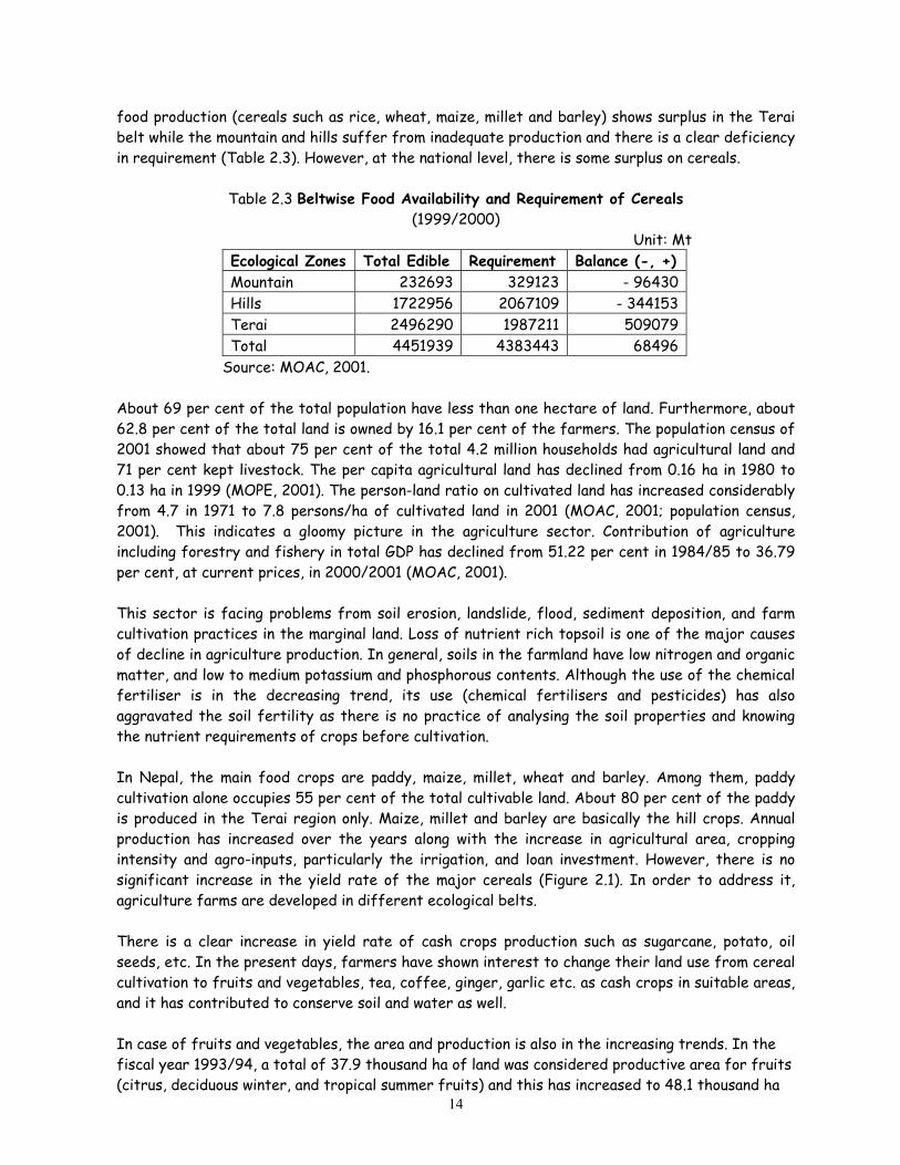
food production (cereals such as rice, wheat, maize, millet and barley) shows surplus in the Terai belt while the mountain and hills suffer from inadequate production and there is a clear deficiency in requirement (Table 2.3). However, at the national level, there is some surplus on cereals.
Table 2.3 Beltwise Food Availability and Requirement of Cereals
(1999/2000) Unit: Mt
Ecological Zones Total Edible Requirement Balance (-, +) Mountain 232693 329123 - 96430 Hills 1722956 2067109 - 344153 Terai 2496290 1987211 509079 Total 4451939 4383443 68496
Source: MOAC, 2001. About 69 per cent of the total population have less than one hectare of land. Furthermore, about 62.8 per cent of the total land is owned by 16.1 per cent of the farmers. The population census of 2001 showed that about 75 per cent of the total 4.2 million households had agricultural land and 71 per cent kept livestock. The per capita agricultural land has declined from 0.16 ha in 1980 to 0.13 ha in 1999 (MOPE, 2001). The person-land ratio on cultivated land has increased considerably from 4.7 in 1971 to 7.8 persons/ha of cultivated land in 2001 (MOAC, 2001; population census, 2001). This indicates a gloomy picture in the agriculture sector. Contribution of agriculture including forestry and fishery in total GDP has declined from 51.22 per cent in 1984/85 to 36.79 per cent, at current prices, in 2000/2001 (MOAC, 2001). This sector is facing problems from soil erosion, landslide, flood, sediment deposition, and farm cultivation practices in the marginal land. Loss of nutrient rich topsoil is one of the major causes of decline in agriculture production. In general, soils in the farmland have low nitrogen and organic matter, and low to medium potassium and phosphorous contents. Although the use of the chemical fertiliser is in the decreasing trend, its use (chemical fertilisers and pesticides) has also aggravated the soil fertility as there is no practice of analysing the soil properties and knowing the nutrient requirements of crops before cultivation. In Nepal, the main food crops are paddy, maize, millet, wheat and barley. Among them, paddy cultivation alone occupies 55 per cent of the total cultivable land. About 80 per cent of the paddy is produced in the Terai region only. Maize, millet and barley are basically the hill crops. Annual production has increased over the years along with the increase in agricultural area, cropping intensity and agro-inputs, particularly the irrigation, and loan investment. However, there is no significant increase in the yield rate of the major cereals (Figure 2.1). In order to address it, agriculture farms are developed in different ecological belts. There is a clear increase in yield rate of cash crops production such as sugarcane, potato, oil seeds, etc. In the present days, farmers have shown interest to change their land use from cereal cultivation to fruits and vegetables, tea, coffee, ginger, garlic etc. as cash crops in suitable areas, and it has contributed to conserve soil and water as well.
14
In case of fruits and vegetables, the area and production is also in the increasing trends. In the fiscal year 1993/94, a total of 37.9 thousand ha of land was considered productive area for fruits (citrus, deciduous winter, and tropical summer fruits) and this has increased to 48.1 thousand ha

in 2000/2001. Although there is some fluctuation in yield rate of fruits, it is on the increasing trend. Similarly, area of vegetables has also increased from 0.14 million ha to 0.157 million ha during the same period (MOAC, 2001). The yield rate of vegetables is on the increase (Figure 2.2). Land cover from citrus, other fruits and vegetables also help to minimise soil loss.
Figure 2.1 Yield of Paddy, Maize and Wheat
0
0.5
1
1.5
2
2.5
319
84/8
5
1986
/87
1988
/89
1990
/91
1992
/93
1994
/95
1996
/97
1998
/99
Fiscal Year
Yield
(Mt/
ha)
Paddy
Maize
Wheat
Figure 2.2 Yield Rate of Fruits and Vegetables
0
2
4
6
8
10
12
1991
/92
1992
/93
1993
/94
1994
/95
1995
/96
1996
/97
1997
/98
1998
/99
1999
/200
0
2000
/200
1
Fiscal Year
Yiel
d (M
t/ha
)
Fruits
Vegetables
Livestock: Livestock contributes 31 per cent of the total agricultural GDP, and 51 per cent of this contribution is derived from the hills, 38 per cent form Terai and 9 per cent from the mountains (APROSC/JMA, 1995). Besides the production of milk and meat, livestock also provides animal power and farmyard manure to maintain and/or improve soil fertility. The country experienced about 15 per cent increase in the number of livestock during 1984 to 1998. Over half of the total livestock are reared in the Hills (5.8 million LU), followed by the Terai (4.1 million LU, and the
15

Mountain (1.3 million LU). In case of stocking rate, the Terai has highest LU/ha (58 LU/ha), followed by the Hills (20 LU/ha) in comparison to the national average of 6.5 LU/ha. In 2000/01, the number of cattle has reached 6.98 million, buffaloes 3.62 million, sheep 0.85 million, and goats 6.49 million which has pressure on limited arable land, forests and pasturelands (Figure 2.3). There is an increase in the livestock density (cattle, buffaloes, sheep and goat) from 5.95 per ha in 1981/82 to 8.89 per ha in 1991/92 and 10.2 per ha of pastureland in 2000/01. Livestock rearing is an important enterprise of the poor people. It seems that there is an increasing pressure of goat as well. The 2001 population census shows that over 70 per cent of the total households have livestock. In Nepal, most of the pasturelands are located in the mountains while the livestock pressure has been noticed in the temperate zone – the hills. This has degraded the pastureland and increased pressure on forests. Forests alone contribute 30 per cent of the animal feed, 47 per cent of their feed is met from crop residues and remaining from grazing in the shrublands and grazing lands. Rangelands supply a low amount of forage. Although forage yield in the alpine meadows is about 3.08 mt – higher than other areas, only 37 per cent of the rangelands are accessible for forage collection. In a nutshell, livestock are generally underfed – by about one third and its production has not increased.
Figure 2.3 Increasing Trend in Livestock Number
0
1
2
3
4
5
6
7
8
1988
/89
1989
/90
1990
/91
1991
/92
1992
/93
1993
/94
1994
/95
1995
/96
1996
/97
1997
/98
1998
/99
1999
/200
0
2000
/200
1
Fiscal Year
Num
ber
(in m
illio
n)
Cattle Buffaloes Sheep Goat
Livestock pressure is intense in the Terai region. About 63.6 per cent of the total categorised pasturelands are located in the mountains while only 13.5 per cent of the total livestock (cattle, buffaloes, sheep and goat) are report (Table 2.4). Similarly, 32 per cent of the total pasturelands should support about 52 per cent of the total livestock.
16

Table 2.4 Livestock Distribution in Ecological Belts (Livestock in Number)
Ecological Belts Total SN Pastures and Livestock Mountain Hills Terai
1 Pasturelands (63.6) (32.05) (4.35) 1.757 million ha area 2 Livestock
a Cattle 827,963 3,407,099 2,747,600 6,982,662 (38.93 b Buffalo 336,139 2,000,203 1,287,678 3,624,020 (20.21) c Sheep 368,634 388,190 93,346 850,170 (04.74) d Goat 892,465 3,491,777 2,094,138 6,478,380 (36.12)
Total 2,425,201 ( 3.52) 1 19,287,269 (51.78) 6,222,762 (34.7) 7,935,232 (100) Note: Figures in parenthesis indicate percentage Source: MOAC, 2001; Pande, 1997. Livestock suffers from inadequate and nutrient-poor fodder supply, resulting in low manure production, which leads to unsustainable agricultural development and additional pressure on forests. It also indicates that livestock pressure is increasing in the forest and barren lands. In order to address these concerns, pasture farms are developed in the Terai, the hills and the mountains. Various fodder species have been grown in pasture/livestock development farms of Janakpur, Banke, Dhangadi, Jiri etc. Similarly, goat, sheep and yak development farms are also operated in the hills and the mountains. As mentioned above, agriculture is the predominant economic activity of over 80 per cent of the total population. Although the population growth rate has declined from 2.67 in early 1980s to 2.24 per cent in 2001, it has significant pressure on marginal land. Fragmentation of cultivable land into smaller pieces has limited mechanisation in farm production, and overuse of acidic fertilisers has increased the use of lime to improve and/or maintain soil fertility. Irrigation-induced sedimentation is an emerging issue in the plain areas. Many farmlands in the Terai and valley floors are affected by silt-loaded irrigation system. Increasing trend of depleting organic matter and plant nutrients along with the loss of topsoil is a growing concern. It is estimated that the annual loss of about 5 tonnes/ha of soil would result in the equivalent loss of about 75 kg/ha of organic matter, 3.8 kg/ha of nitrogen, 10 kg/ha of potassium, and 5 kg/ha of phosphorus (Carson, 1992). In a nutshell, the yield rate of major cereal crops is not encouraging, primarily because of the loss of nutrient rich topsoil. Soil fertility has also been affected due to the disproportionate use of agri-inputs, and the high sedimentation rate. 2.5 Population and Poverty Nepal is predominantly a rural society as about 85 per cent of the population of 23.151 million live in the rural areas. The population growth rate is estimated at 2.24 per cent per annum between 1991 and 2001 with about 7.29, 44.28 and 48.43 per cent of the population living in the Mountains, the Hills and the Terai respectively (Table 2.1). Based on the population of 2001, a total of 4.2 million households having an average households size of 5.44 were recorded. The population density is about 330 persons/km2 in the Terai, 167 persons/km2 in the Hills and only about 33 persons/km2 in the Mountains. However the population density has reached 985.3 persons/km2 in the urban areas in 2001. In terms of regional distribution, the Central Development Region has about one-third of the total population and lowest (about 9.5 per cent) in the far western region where development activities are also low. For 2001, the crude birth and death rates are estimated at 33.06 and 9.62 per thousand populations respectively, with the total fertility rate of
17

4.2. The infant mortality rate has declined from 97.5 in 1991 to 61.5 in 2001 and life expectancy has increased from 54 to 59.7 years during the same period. Nepal conducted the population census in 1911 for the first time and continued decade-wise census since 1941. The total population was 6.3 million in 1941 and it has reached 23 million by the year 2001. The population will double within about 30 years in terms of present growth rate of 2.24 per cent thereby increasing high pressure on land and water resources. Poverty incidence has continued to remain very high in Nepal because of fluctuation in agricultural growth rates, inadequate delivery of social services, and unsustainable development outputs. A household survey by the World Bank1 estimated that the poverty line is about NRs 4000 (USD 77) per capita per annum and it covers a basic calorie intake, housing and various non-food items. The poverty reduction strategy has defined a poverty line of NRs. 4,404/person/year. If the definition of US dollar a day poverty line is used, the incidence of poverty in Nepal is about 37.7 per cent in 2001. It is estimated that about 44 per cent of the rural households and 23 per cent of the urban households lie below the poverty line (NPC, 2001). Some 9 million people of Nepal are currently classified as income-poor (UNDP, 2002). This poverty problem was addressed in the Ninth Plan (1997-2002) with a long-term target of reducing it from 49 per cent to 32 per cent within the plan period. In the lowlands and hills around 42 per cent of the population are below the poverty line, but the proportion is much higher in the western zones than in the east. In the mountains, 57 per cent of the total population are below the poverty line. However, noticeable improvement has been recorded in the Human Development Index (HDI). The HDI value for Nepal was 0.415 in 1990 and it has increased to 0.480 in 2001. The HDI for urban areas (0.616) and for rural areas (0.446) indicates that Nepal's development is urban biased and poverty is persistent in rural areas (UNDP, 2002). Furthermore, the HDI is low for mid-western (0.402) and far western (0.385) development regions. The number of poverty-stricken people is increasing although the ratio is on the decline. As the population consists mostly of farmers, landholdings and production systems determine it very much. In Nepal, holdings of less than one-hectare account for 82 per cent of the total in the mountains and 77 per cent in hills, compared to 59 per cent in the lowlands. The average farm size is 0.7 ha in the mountains, 0.8 ha in the hills, and 1.3 ha in the lowlands. However, some studies have indicated that agricultural production is significantly higher in farmlands of the poor people than in other categories of landholdings. As the number of poor people is increasing and arable land is significantly low, there is an increasing pressure on the marginal lands and forests for cultivation. As majority of the women are involved in agricultural practices and the collection of the household demands for firewood, the decline on agricultural production and natural resources has direct impact on women and disadvantaged groups of people. Similar pressure is also noticed on school-aged children who are involved in cattle grazing, firewood collection, water fetching and so on. 2.6 Energy Firewood is the major source of household energy in Nepal. About 88 per cent of the total energy demand is met from traditional sources (fuelwood, agricultural residues and animal dung which is
181 An estimate based on Nepal Living Standards Survey (NLSS), 1996.
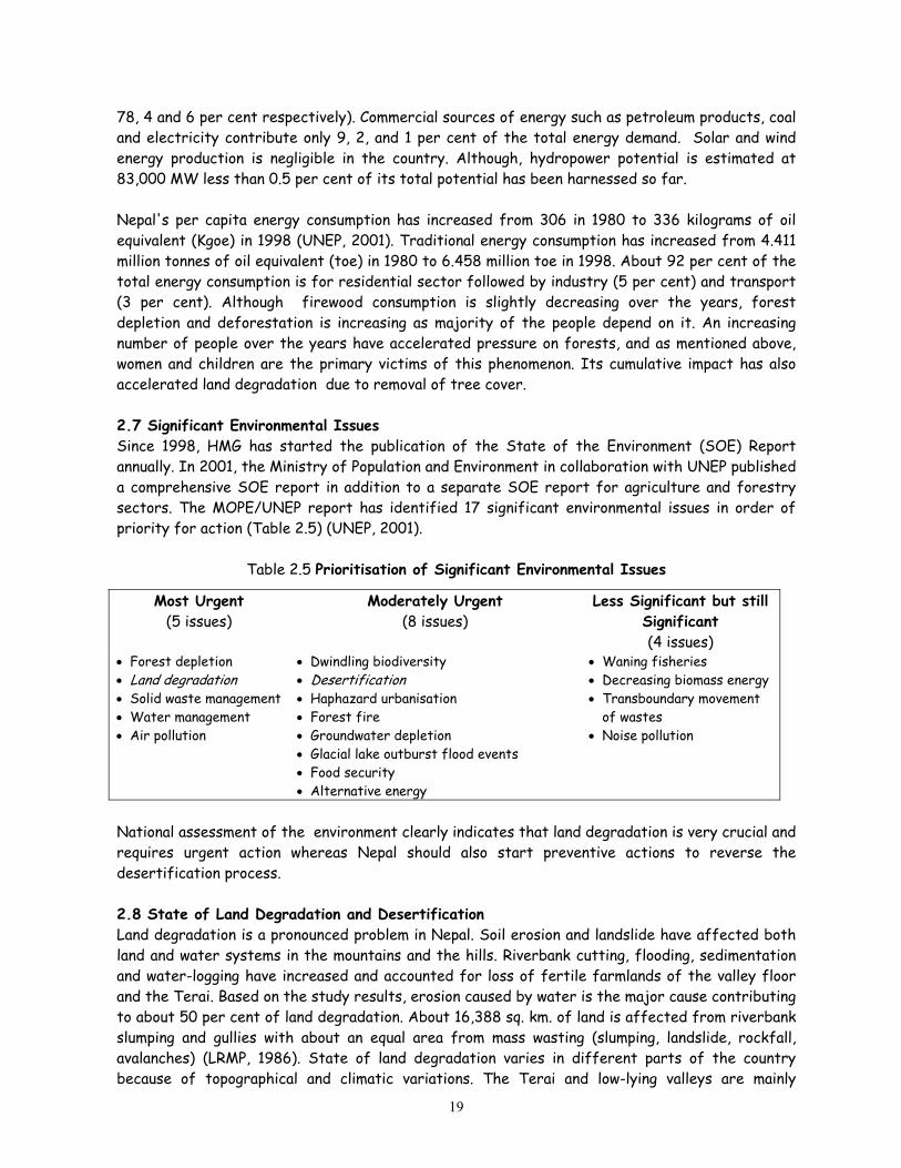
78, 4 and 6 per cent respectively). Commercial sources of energy such as petroleum products, coal and electricity contribute only 9, 2, and 1 per cent of the total energy demand. Solar and wind energy production is negligible in the country. Although, hydropower potential is estimated at 83,000 MW less than 0.5 per cent of its total potential has been harnessed so far. Nepal's per capita energy consumption has increased from 306 in 1980 to 336 kilograms of oil equivalent (Kgoe) in 1998 (UNEP, 2001). Traditional energy consumption has increased from 4.411 million tonnes of oil equivalent (toe) in 1980 to 6.458 million toe in 1998. About 92 per cent of the total energy consumption is for residential sector followed by industry (5 per cent) and transport (3 per cent). Although firewood consumption is slightly decreasing over the years, forest depletion and deforestation is increasing as majority of the people depend on it. An increasing number of people over the years have accelerated pressure on forests, and as mentioned above, women and children are the primary victims of this phenomenon. Its cumulative impact has also accelerated land degradation due to removal of tree cover. 2.7 Significant Environmental Issues Since 1998, HMG has started the publication of the State of the Environment (SOE) Report annually. In 2001, the Ministry of Population and Environment in collaboration with UNEP published a comprehensive SOE report in addition to a separate SOE report for agriculture and forestry sectors. The MOPE/UNEP report has identified 17 significant environmental issues in order of priority for action (Table 2.5) (UNEP, 2001).
Table 2.5 Prioritisation of Significant Environmental Issues
Most Urgent (5 issues)
Moderately Urgent (8 issues)
Less Significant but still Significant (4 issues)
• Forest depletion • Land degradation • Solid waste management • Water management • Air pollution
• Dwindling biodiversity • Desertification • Haphazard urbanisation • Forest fire • Groundwater depletion • Glacial lake outburst flood events • Food security • Alternative energy
• Waning fisheries • Decreasing biomass energy • Transboundary movement
of wastes • Noise pollution
National assessment of the environment clearly indicates that land degradation is very crucial and requires urgent action whereas Nepal should also start preventive actions to reverse the desertification process. 2.8 State of Land Degradation and Desertification Land degradation is a pronounced problem in Nepal. Soil erosion and landslide have affected both land and water systems in the mountains and the hills. Riverbank cutting, flooding, sedimentation and water-logging have increased and accounted for loss of fertile farmlands of the valley floor and the Terai. Based on the study results, erosion caused by water is the major cause contributing to about 50 per cent of land degradation. About 16,388 sq. km. of land is affected from riverbank slumping and gullies with about an equal area from mass wasting (slumping, landslide, rockfall, avalanches) (LRMP, 1986). State of land degradation varies in different parts of the country because of topographical and climatic variations. The Terai and low-lying valleys are mainly
19
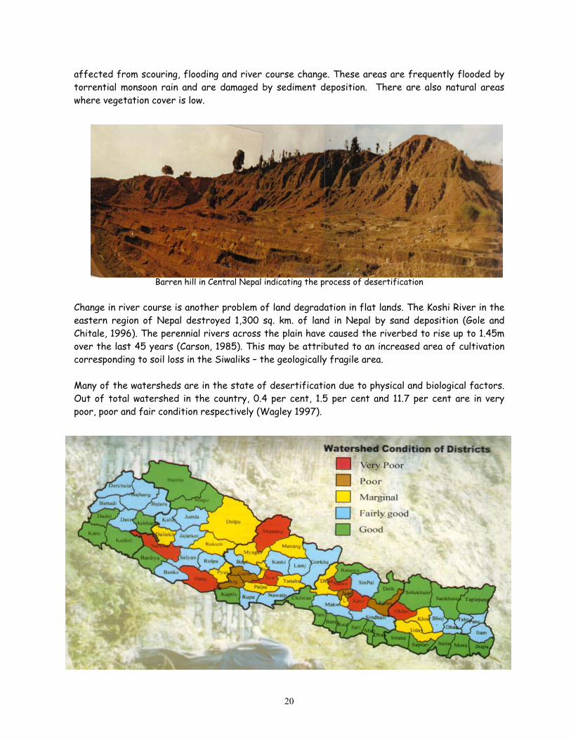
affected from scouring, flooding and river course change. These areas are frequently flooded by torrential monsoon rain and are damaged by sediment deposition. There are also natural areas where vegetation cover is low.
Barren hill in Central Nepal indicating the process of desertification Change in river course is another problem of land degradation in flat lands. The Koshi River in the eastern region of Nepal destroyed 1,300 sq. km. of land in Nepal by sand deposition (Gole and Chitale, 1996). The perennial rivers across the plain have caused the riverbed to rise up to 1.45m over the last 45 years (Carson, 1985). This may be attributed to an increased area of cultivation corresponding to soil loss in the Siwaliks – the geologically fragile area. Many of the watersheds are in the state of desertification due to physical and biological factors. Out of total watershed in the country, 0.4 per cent, 1.5 per cent and 11.7 per cent are in very poor, poor and fair condition respectively (Wagley 1997).
20

Table 2.6 Estimates of Soil Erosion Land Use Category Erosion Rate
(Tonnes/ha/yr) Well managed forest land 5 – 10 Well managed paddy terraces 5 – 10 Well managed maize terraces 5 – 15 Poorly managed sloping
terraces 20 – 100
Soil erosion varies in different land uses. It ranges from 5-10 tonnes/ha/yr in well-managed forestland to about 200 tonnes/ha/yr in degraded hill slopes (Table 2.6). A study in Jhigu Khola watershed in the middle hill of Central Nepal indicated soil erosion rate of 25 to 40 tonnes/ha/yr in open degraded areas as compared to 3 to 25 tonnes/ ha/yr in the cultivated outward sloping terraces (ICIMOD, Degraded rangelands 40 – 200
1998). In Yarsha Khola (stream) watershed of Source: MOPE, 2001 Dolakha district (central Nepal), the soil erosion
rate varies from 0.7 to 8.7 tonnes/ha/yr in the grassland. In this watershed, the soil erosion rate from cultivated terraces ranges from 2.5 to 16.4 tonnes/ha/yr (ICIMOD, 1998). Carson (1992) reported loss of over 200 tonnes/ha/yr of soil in overgrazed lands lying below 1,000m. Inappropriate land use is one of the contributing factors to induce landslides in the Hills. In Kanthe Khola sub-watershed of Baglung district, about 79 per cent of the total landslides was contributed by paddy cultivation in the hill slopes and about 9 per cent of the landslides was associated with marginal land/grazing land and 7 per cent in the bari land (unirrigated upland) (Regmi, 2001). In general, the topsoil is displaced at the rate of 1.63 mm from the total land surface of Nepal every year. Overgrazing and removal of vegetation has also led to a serious land degradation problem in the mountain region of Nepal. Problems of slash and burn agricultural practices, cultivation in unterraced or poorly terraced marginal lands, and shifting cultivation still persist in the Hills. In Nepal, the area showing the process of desertification is yet to be mapped. Land degradation has been considered a major component of the desertification process. In terms of low amount of rainfall and productivity of soil and forest resources, about 10,000 ha of land in the trans-Himalayan region exhibit desert-like conditions and the area is expanding. This could be categorised as the cold desert in view of scanty vegetation and low regeneration rate. Land area is also affected by industrial pollution in and around the industrial areas. The present practice of discharging the wastewater and disposing the solid wastes may have lowered down the productivity of the land and water system. Most of the industries have no effluent treatment facilities and sanitary disposal of their solid wastes. Productive land is also affected by urbanisation pattern. There is an increasing trend in the number of population living in urban areas. For example, the urban population was about 6.4 per cent of the total population in 1981. It almost doubled to 12.4 per cent in 1991. This increase could be attributed to the increase in the number of municipalities from 23 in 1981 to 58 in 1991. The population census of 2001 has showed urban population at 14.2 per cent of the total population. Increase in urban population has tremendous pressure on converting the prime agricultural land to concrete buildings. Although the conversion of such land has not been calculated, this problem has been recognised as one of the major problems in the valleys and the plain municipalities.
21
2.8.1 Causes and Consequences Land is the most valuable renewable natural resource that fulfils the basic needs of human being. The continued unsustainable exploitation has undermined the importance of this resource, and the agro-ecological zones, particularly of the trans-Himalayan zone are affected from cool temperature and low amount of rainfall. The land system of Nepal is prone to degradation and/or desertification because of its young soil, and climatic and physiographic variations. Natural causes like low rainfall, short period of heavy rainfall, high-velocity wind, steep slopes and unstable geology, and flooding are responsible for land degradation. Alternatively, deforestation, inappropriate farming practices, intensive agriculture, overgrazing, and shifting cultivation have accelerated land degradation process. The socio-economic factors, i.e., socio-cultural and religious causes, poverty and food insecurity, population pressure, and gender inequality have compounded the problems. The physical driving forces are water, wind, and landslide. About 50 per cent of the total land degradation is induced by water. Soil erosion is very high during the pre-monsoon season as the intense rainfall hits the ground - the dry and bare steep slopes. Wind-induced erosion mostly prevails in arid and desert-like areas. Wind in the trans-Himalayan region with a velocity of 7 – 9 m/sec at the height of 30cm above the soil surface causes soil displacement. Wind-induced erosion is prevalent also in the Terai during March to May while it prevails round the year in the trans-Himalayan region like Dolpa, Mustang etc. Deforestation, agricultural practice, and increased number of livestock are the major biological driving forces to degrade the land system. Forest depletion has resulted in reducing soil nutrient and drying up of water sources making the land dry. It has reduced the soil binding properties making it vulnerable to nature-induced disasters like landslide, mass wasting, and erosion. Inappropriate farming system and uneven use of agro-chemicals have accelerated land degradation. Overgrazing both in private and forestlands is also a major cause to make the land susceptible to water and wind erosion. Excessive grazing has also resulted in reducing palatable species of grassland, and increasing the growth of xerophytic plant. The intensive and unmanaged grazing has led to soil compaction due to trampling-effect and it reduces the capacity of soil to retain moisture. Land system is also greatly affected by socio-economic factors such as the increasing number of human population, inadequate irrigation facility and/or misuse of available irrigation water leading to waterlogging and salinisation, and irrigation-induced sedimentation in the plain areas thereby depleting the organic matter and plant nutrients. As also mentioned in 2.3, land fragmentation is an important factor for limiting mechanisation in agricultural land. Nepal experiences "temporary drought" owing to delayed onset and early retreat of monsoon. As drought is basically a meteorological and hydrological phenomenon, the low amount of rainfall in the post- and pre-monsoon affects agricultural production. In Nepal, an area is considered affected by drought if total rainfall during monsoon is less than 75 per cent of the normal value (Yogacharya, 1997).
22

Desertification is a cumulative outcome of unsustainable land use practices. The problem is accelerated by human activities including the expansion of rain-fed cultivation onto unsuitable lands, inappropriate intensification, soil mining and shortening of fallows, groundwater mining, and uncontrolled harvesting of biomass (MOPE, 2001). Poor people are directly dependent on the productivity of natural resources and they are seen as both the agents and victims of environmental degradation, i.e., land degradation. Because of synergistic effect on poor households, they are often forced to make trade-offs between immediate household food requirements and environmental sustainability in production and consumption (UNEP, 2001). Ultimately, it reduces the availability of biomass and fuel and construction timber. The consequences of these activities are visible in different ecosystems (Table 2.7). This clearly indicates the nature of the problem and possible loss of nutrient rich fertile soil from its origin. Soil loss as a natural phenomenon may not be a major problem. However, loss of nutrient rich soil would have direct impact on agricultural production. It has been estimated that about 1.8 million tonnes of plant nutrients [Nitrogen, Phosphorus (P2O5), Potassium (K2O) and Calcium] are removed by crop harvesting (0.5 million tonnes) and soil erosion (1.3 million tonnes) each year. Out of this, only 0.3 million tonnes/year (16 per cent) are replenished by organic and mineral fertilisers. This clearly indicates the severity of the problem and possible decline in agricultural production due to nutrient loss. Landslides in the hills and floods in the plains are pronounced, and a large chunk of land is lost and/or affected every year. For example, about 1,140 ha of land was lost in 1994 due to landslides and floods while over 41,800 ha of land was lost in 1995 (Table 2.8). However, the frequency of landslides and floods depends upon rainfall distribution and land use patterns, and area of affected land also corresponds to rainfall. In 1995, the land affected by landslide and floods was found severe in the hills of eastern and central development regions as these areas received more rainfall.
Table 2.7 Estimated Soil Erosion Rates in Specific Sites SN Location Land Use Erosion Rate (Ton/Km2/Yr) A. Siwalik Range 1 Eastern Nepal, South aspect
sandstone foot hills Different land uses ranging from forest to Grazing
780 – 3,680
2 Far west Nepal, South aspect sandstone foot hills of Surkhet
a. Degraded forest b. Degraded forests, gullied land c. Severely degraded, heavily grazed,
gullied land
2,000 4,000 20,000
B Mahabharat Lekh, central Nepal, very steep slope on metamorphic and sedimentary rocks
a. Degraded forest and agricultural land
b. Gullied land
3,150 – 14,000 6,300 – 42,000
C. Middle Mountain 1 Northern foothills of Kathmandu
Valley a. Degraded forest and scrubland b. Overgrazed scrubland c. Severally gullied land
2,700 – 4,500 4,300 125,00-57,000
2 South of Kathmandu Valley 75 per cent dense forest 800 3 Phewatal watershed a. Protected pasture
b. Overgrazed grass land c. Gullied overgrazed grass land
920 2,200-34,700 2,900
Source: CBS, 1998.
23
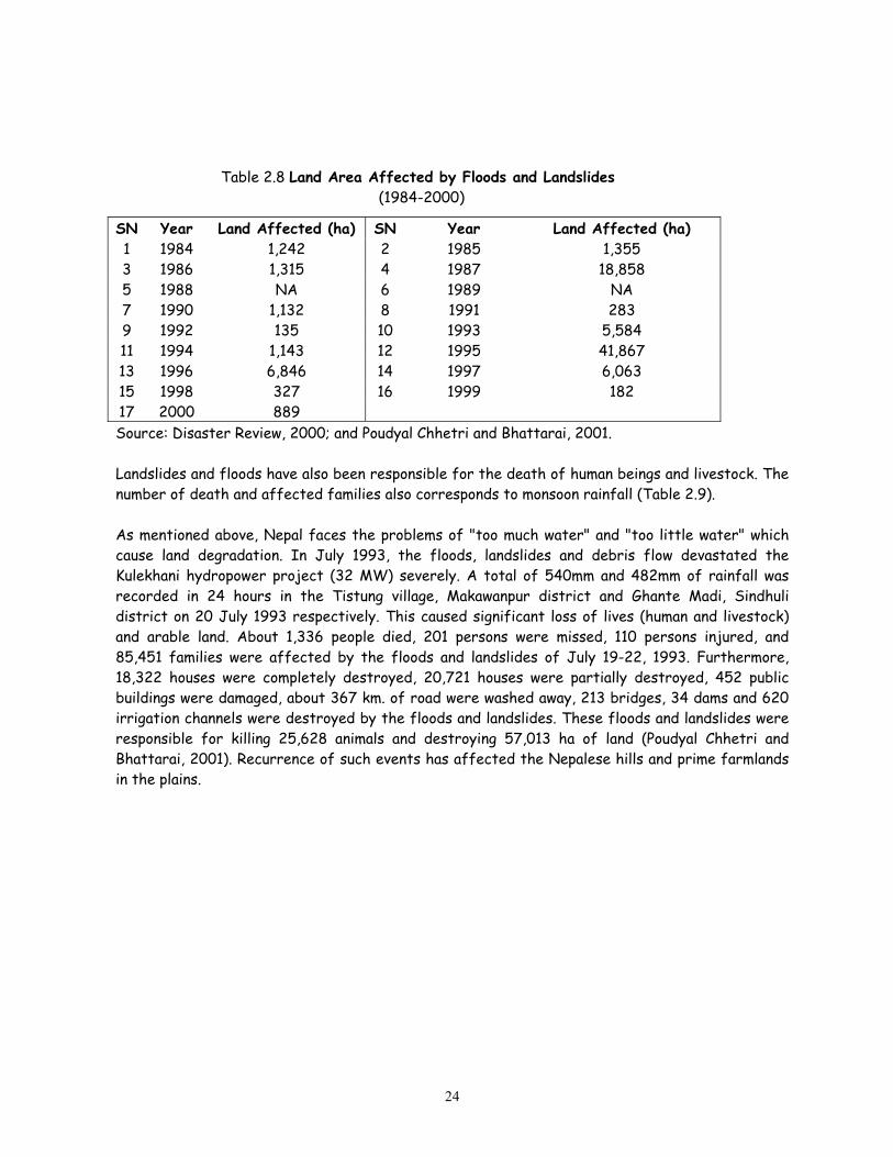
Table 2.8 Land Area Affected by Floods and Landslides
(1984-2000)
SN Year Land Affected (ha) SN Year Land Affected (ha) 1 1984 1,242 2 1985 1,355 3 1986 1,315 4 1987 18,858 5 1988 NA 6 1989 NA 7 1990 1,132 8 1991 283 9 1992 135 10 1993 5,584 11 1994 1,143 12 1995 41,867 13 1996 6,846 14 1997 6,063 15 1998 327 16 1999 182 17 2000 889 Source: Disaster Review, 2000; and Poudyal Chhetri and Bhattarai, 2001. Landslides and floods have also been responsible for the death of human beings and livestock. The number of death and affected families also corresponds to monsoon rainfall (Table 2.9). As mentioned above, Nepal faces the problems of "too much water" and "too little water" which cause land degradation. In July 1993, the floods, landslides and debris flow devastated the Kulekhani hydropower project (32 MW) severely. A total of 540mm and 482mm of rainfall was recorded in 24 hours in the Tistung village, Makawanpur district and Ghante Madi, Sindhuli district on 20 July 1993 respectively. This caused significant loss of lives (human and livestock) and arable land. About 1,336 people died, 201 persons were missed, 110 persons injured, and 85,451 families were affected by the floods and landslides of July 19-22, 1993. Furthermore, 18,322 houses were completely destroyed, 20,721 houses were partially destroyed, 452 public buildings were damaged, about 367 km. of road were washed away, 213 bridges, 34 dams and 620 irrigation channels were destroyed by the floods and landslides. These floods and landslides were responsible for killing 25,628 animals and destroying 57,013 ha of land (Poudyal Chhetri and Bhattarai, 2001). Recurrence of such events has affected the Nepalese hills and prime farmlands in the plains.
24
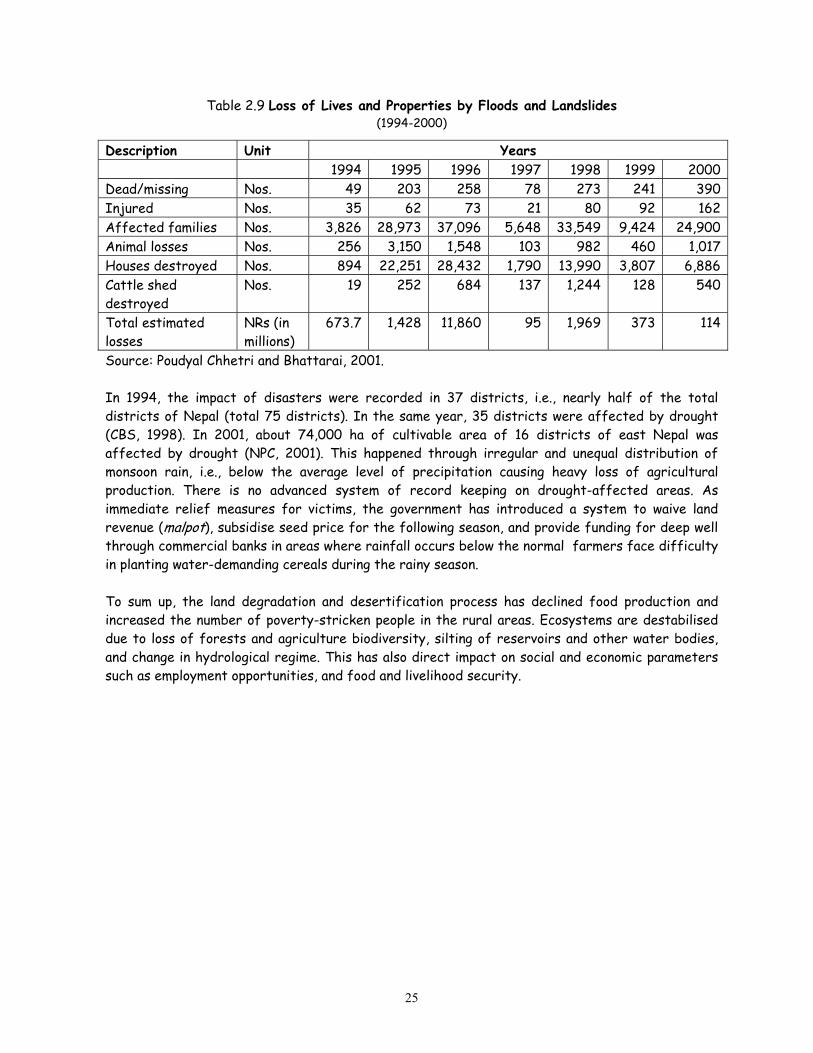
Table 2.9 Loss of Lives and Properties by Floods and Landslides (1994-2000)
Description Unit Years 1994 1995 1996 1997 1998 1999 2000 Dead/missing Nos. 49 203 258 78 273 241 390 Injured Nos. 35 62 73 21 80 92 162 Affected families Nos. 3,826 28,973 37,096 5,648 33,549 9,424 24,900 Animal losses Nos. 256 3,150 1,548 103 982 460 1,017 Houses destroyed Nos. 894 22,251 28,432 1,790 13,990 3,807 6,886 Cattle shed destroyed
Nos. 19 252 684 137 1,244 128 540
Total estimated losses
NRs (in millions)
673.7 1,428 11,860 95 1,969 373 114
Source: Poudyal Chhetri and Bhattarai, 2001. In 1994, the impact of disasters were recorded in 37 districts, i.e., nearly half of the total districts of Nepal (total 75 districts). In the same year, 35 districts were affected by drought (CBS, 1998). In 2001, about 74,000 ha of cultivable area of 16 districts of east Nepal was affected by drought (NPC, 2001). This happened through irregular and unequal distribution of monsoon rain, i.e., below the average level of precipitation causing heavy loss of agricultural production. There is no advanced system of record keeping on drought-affected areas. As immediate relief measures for victims, the government has introduced a system to waive land revenue (malpot), subsidise seed price for the following season, and provide funding for deep well through commercial banks in areas where rainfall occurs below the normal farmers face difficulty in planting water-demanding cereals during the rainy season. To sum up, the land degradation and desertification process has declined food production and increased the number of poverty-stricken people in the rural areas. Ecosystems are destabilised due to loss of forests and agriculture biodiversity, silting of reservoirs and other water bodies, and change in hydrological regime. This has also direct impact on social and economic parameters such as employment opportunities, and food and livelihood security.
25

Chapter Three Combating Land Degradation, Drought and Desertification
As majority of people depend on subsistence agriculture, people hesitate to change the land use from cereal production to perennial cash crops. It is a very difficult task to convince the local people as benefits of soil and water conservation activities could be obtained after some years of continuous management efforts. It is natural that poor people lack patience to wait for longer period due to lack of alternative livelihoods. The government and development partners have encouraged to change the land use from intra-annual cropping to permanent cropping system, i.e., plantation of fruit and other commercially valuable tree species in suitable lands. The problems of soil erosion, landslides, floods and inappropriate farming systems were realised in the early 1970s and various policies, and strategies were formulated. Several programmes were launched to conserve soil and water. This chapter explains in detail the various policies, strategies, legislative and institutional frameworks including the thrusts of various plans and programmes that are under implementation to address accelerated problems of land degradation and/or desertification process. This chapter also includes information on community-based programmes, local practices and technologies developed and used in the country for the conservation of land and water systems. Environment conservation has been considered as a part of physical and socio-economic development of the country. The Directive Principles of the Constitution of the Kingdom of Nepal, 1990 state that "The State shall give priority to the protection of the environment and prevent damage due to physical development activities by making the people conscious of the environmental cleanliness, and by making special arrangements for the protection of rare animal species, forest and vegetation" [Article 26(4)]. The Constitution (Article 64) also provides for an Environment Conservation Committee in the House of Representatives (the Parliament) and this Committee has been constituted to review activities and provide guidance related with, inter alia, soil conservation, environment and forest management. The recent policies and strategies are tuned with the objectives of least damaging the natural resources and contributing to attain the goals of sustainable development in the spirit of the Rio outputs – the Agenda 21 and several other legally and non-legally binding international environmental instruments. 3.1 Policy and Strategy Nepal started the planned development process since the mid-1950s with focus on natural resources utilisation, particularly forests, to increase revenue and promote infrastructure development. Till early 1970s, the policy was directed to using natural resources even at the cost of environment. However, the Fourth Five Year Plan (1970-'75) realised the need for soil and water conservation activities in the degraded areas. The Fifth Plan (1975-'80) included the land use policy for the first time with emphasis on soil and water conservation. This Plan was formulated after Nepal's participation in the Stockholm Conference on Human Environment in June 1972. It introduced a policy to alleviate poverty, increase national productivity, balance regional development, manage forests, and establish protected areas for species conservation.
26

The policies related to soil and water conservation and land use have been continued with focus on people's participation. The National Main Policy, 1985 focussed on the need for conserving the Siwaliks zone, implementing forest management plan, promoting roadside plantation, protecting trees along the streams and riversides, maintaining and improving ecological balance through extensive soil and water conservation activities. The national policies formulated after 1992 – the Rio Earth Summit – emphasise on sustainable development and integration of environmental aspects in sectoral development plans and programmes. The current Ninth Plan (1997-2002), with the single objective of alleviating poverty, re-emphasises the expansion of soil and water conservation activities with priority on, inter alia, agriculture and forests, water resources, human resources and social development. Equal emphasis has been accorded on environmental management, and natural resource conservation to achieve sustainability. The Plan emphasises on participation of local communities, non-governmental organisation, women and disadvantaged groups. Nepal has a long-term vision of involving stakeholders and partners in natural resource management to alleviate poverty, in the spirit of the Convention to Combat Desertification. As the drought is also caused from natural processes, the current Plan (1997-2002) underlines the need for strengthening disaster management capabilities, particularly on prevention, mitigation and reduction of natural disasters through the use of advanced geological, hydrological and meteorological technologies. The Plan also emphasises hazard mapping, vulnerability assessment, risk analysis and development of early warning systems (NPC, 2001). With the objectives of alleviating poverty by maintaining high and sustainable economic growth, and by including the disadvantage groups in the mainstream of development, the approach paper of the Tenth Plan (2002-'07) has a target of attaining the annual economic growth rate from 5.03 in the current plan to 6.5 per cent, decreasing poverty from 38 to 30 per cent, reducing population growth rate from 2.27 to 1.5 per cent, and providing irrigation facility for 1.162 to 1.354 million ha by the end of this Plan. The Plan will accord special priority, inter alia, to agriculture, sustainable management of natural resources, rural development, and biodiversity conservation. The government will play a role of facilitator and regulator while the local bodies, private sector, and NGOs will be encouraged to implement activities (NPC, 2002). The Plan intends, inter alia, to:
• Implement agricultural activities as a package programmes in different agro-ecological zones as also prioritised in the Agriculture Perspective Plan;
• Generate employment opportunities through cereal and cash crops production and livestock development in the Terai with extraction of groundwater for irrigation; expand fruits, livestock, vegetables, bee keeping etc. in the hills; and promote adequate use of organic fertilisers and minimum use of pesticides;
• Minimise land fragmentation, promote land consolidation, acquire land from landlords and distribute to landless and economically disadvantaged peoples and avoid duel land ownership;
• Formulate national land use policy and enact integrated legislation to guide overall land reform activities;
• Discourage use of fertile land for non-agricultural purposes and encourage cultivation in unused land through land leasing;
• Continue to avoid use of forest areas for any activities except for major development projects;
27
• Expand community forestry programmes and give high priority on leasehold forestry programmes to poor community groups;
• Continue the protection of the Siwalik region, land and riverbanks, and expand participatory integrated watershed management programmes;
• Launch production, processing and marketing of medicinal plants in the mountains and hills, as a national programme;
• Promote forage development programmes, buffer zone management and continue to participatory forests and land management programmes;
• Rehabilitate degraded lands, and prioritise the implementation of the Conventions to which Nepal is a Party;
• Introduce land use plan in all municipalities, and encourage new and environment-friendly technologies, scientific and technical approaches for environmental management; and
• Promote adoptive research, and expand hydrological and meteorological services. Realising land fragmentation as one of the problems for squeezing agricultural activities, HMG has also conceptualised a process for land consolidation with an objective of promoting community and joint farming, proper land uses, and increasing production by minimising investment to the extent possible (MOPE, 2002). Within the framework of national policies, sectoral policies have been formulated, inter alia, for forestry, water resources, irrigation and tourism sectors with a view to promote conservation and management of land and water resources. The Water Resources Development Policy 1992 emphasises on the use of electricity to minimise fuelwood consumption, and minimize adverse environmental impacts during hydroelectricity development while the Irrigation Policy, 1993 (revised in 1997) focuses on the need for minimizing environmental impacts during the construction and operation of irrigation projects and calls upon designing and implementing irrigation projects and programmes based on the recommendation of environment impact assessment (EIA) and initial environmental examination (IEE) reports. The Hydropower Development Policy 2001 underscores the importance of minimising environmental problems and rehabilitating the displaced population. Its working policy also underscores the importance of implementing environmental protection measures based on the recommendations of the EIA study, and realising at least 10 per cent of the total water flow in the rivers or streams to maintain aquatic environment. The Forestry Policy 1991 promotes the conservation, management and sustainable use of forest product through people’s participation. It emphasises the need for empowering local people in the management and sustainable use of forest resources. It also emphasises multiple use of land through integrated farming and soil conservation measures. The Industrial Policy 1992 opens avenues to mitigate adverse environmental impacts during the establishment, expansion and diversification of industries and regulates waste disposal in land and water system. The Tourism Policy 1995 reiterates the implementation of environment conservation programmes in an effective and integrated manner to promote sustainable tourism development (MOPE, 2000). The Solid Waste Management Policy 1998 calls upon reducing, reusing, and recycling wastes, inter alia, to minimise pollution in the land and water systems. Other sectoral policies such as Transport Policy, Shelter Policy, Seed Policy etc. have not adequately addressed land and water management issues.
28

Watershed Management Policy and Strategy
• Ensure multiple use of land and water to fulfil diverse needs through rational land use planning • Implement integrated package programmes (vegetative, agronomic and water management measures)
to tackle erosion problems taking the sub-watershed area as an unit of planning and management and on the basis of watershed conditions
• Establish linkage and networking with all other related sectors like forestry, agriculture, livestock, water and land resources
• Ensure people's participation by developing appropriate technologies and by expanding conservation extension education and demonstration
• Adopt ways and means to minimise environmental damage during the development infrastructures • Protect watersheds near hydroelectric dams, irrigation systems and riverbanks through plantation
and other conservation techniques • Expand and institutionalise soil conservation and watershed management (SCWM) services in all
districts • Focus on conservation activities in the Siwaliks and other marginal lands.
HMG has endorsed and implemented the National Conservation Strategy (NCS), 1988 in order to mainstream natural resources management. The Strategy emphasises on wise use, protection, preservation and restoration as the basic elements (HMG/IUCN, 1988). The NCS analysed 18 areas ranging from population and role of women in natural resource management to awareness raising and species conservation. The NCS proposed vanguard programmes in various areas such as catchment conservation, forest conservation, integrated livestock and pasture management, intensive horticulture intercropping, riverbank stabilisation, water source protection, community biogas, agro-forestry and leasehold forests for the mountains, hills and the Terai – the ecological regions. In order to reduce the number of people living below the poverty line, HMG has implemented, inter alia, poverty reduction strategy with focus on economic reform and growth, macroeconomic stability, promotion of trade, investment, and public expenditure. HMG has also increased expenditures on social sectors and infrastructure developments and established a Poverty Alleviation Fund. HMG has set an objective for the next 3 years to achieve broad-based, pro-poor growth rate of about 6.0 – 6.5 per cent per annum. It has planned to increase the GDP from 4.5 per cent in 1999 to 6.5 per cent in 2004, agricultural GDP growth from 2.7 to 4.0 per cent, non-agricultural GDP growth from 5.7 to 8.0 per cent, reduce fiscal deficit from 4.8 to 3.1 per cent, increase revenue from 10.2 to 13.1 per cent, increase national saving from 17.8 to 20.7 per cent and decrease inflation from 11.3 to 4.5 per cent by the year 2004 (NPC, 2001). In order to address these targets, one of the strategies is to improve governance through civil service reform, decentralisation, NGOs' participation in service delivery, and involvement of the private sector. The Water Resources Strategy 2002 has, been guided by the principles of social development, economic development and environmental sustainability(WECS, 2002) .Its objectives include:
Helping to reduce incidence of poverty, unemployment and under employment; Increasing agricultural production and ensuring food security; Protecting the environment and sustaining the biodiversity of natural habitats; and Preventing and mitigating water-induced disasters.
29

The Strategy has committed itself to integrating environmental and ecological considerations at every level of water resources development process, and ensuring participation and consultation with all stakeholders. It has also focussed on the need for protecting and managing the Siwalik Range and the Bhabar Zone to improve forest cover, soil conservation and groundwater recharge. Some of the key strategic outputs of this Strategy related to land and water management include:
Effective measures to manage and mitigate water-induced disasters; Sustainable management of watersheds and aquatic ecosystems; and Appropriate irrigation facility and sustainable use of irrigable land.
The approach paper of the Tenth Plan has clearly adopted the strategic roles of the government as the policy formulator and regulator (NPC, 2002). The local bodies will promote participatory development efforts within the broad framework of the decentralisation and through empowerment partners and good governance. The private sector are encouraged to implement economic development activities while the non-governmental organisations will promote activities that generate employment and reduce poverty. As mentioned above, women who occupy about half of the total population are both the beneficiaries of land and water management, and victims of their degradation. The Plan underscores the importance of women empowerment, and need for mainstreaming gender in national development, and prioritise women's participation for the sustainable use of natural resources and conservation of the environment. Similar emphasis has also been given to other major groups to bring them into the mainstream of national development. These strategies will hopefully contribute to natural resource management within the plan period. In a nutshell, Nepal's policies and strategies adopted natural resources use approach till the 1970s with the notion that "nature can absorb all environmental evils" and "grow first and clean up latter". Since the early 1980s, conservation-oriented policies were formulated to manage flora, fauna, and watersheds. In recent days, the policies and strategies focus on sustainable development, benefit sharing and people's participation, energy and resource use efficiency, adoption of environment-friendly technologies, stakeholder consultation with the understanding that "environment is not a free good", and stakeholders' participation is a pre-requisite for natural resource management and sustainable development. 3.2 Master Plans and Action Plans Nepal endorsed a 21-year Master Plan (1988 – 2011) for Forestry Sector (MPFS) with the assistance of the Asian Development Bank and the Government of Finland in 1989 with the long-term objectives of meeting people's basic needs for fuelwood, timber, fodder and other forestry products on sustained yield basis; contributing to food production through an effective interaction between forestry and farming practices; protecting land against degradation by soil erosion, floods, landslides, desertification, and other effects of ecological disturbances; conserving ecosystems and genetic resources; and contributing to the growth of local and national economies by managing forest resources and developing forest-based industries, and creating opportunities for income generation and employment. The Plan focuses on community and private forests, national and leasehold forests, wood-based industries, medicinal and aromatic plants and other minor forest products, soil conservation and watershed management, and conservation of ecosystems and genetic resources. In order to ensure effective implementation of these primary
30
development programmes, the Plan emphasises on policy and legal reform, institutional reform, human resources development, resource information and planning assistance, research and extension, and monitoring and evaluation as supportive development programmes (HMG/ADB/FINNIDA, 1989). The Plan diagnosed multi-faceted problems in the forestry sector and provided a long-term programme approach for its management. The Plan is under implementation with people's participation since last 12 years. After participation in the Rio Earth Summit in 1992, Nepal prepared an Environmental Policy and Action Plan (NEPAP) in 1993 with a comprehensive list of timeframe action in the areas of sustainable management of natural resources such as land, soil fertility, forest and rangeland, water resources, watershed protection, and management of key watersheds. The Plan outlines activities to safeguard natural heritage including biodiversity conservation and to mitigate adverse environmental impacts associated with development projects and programmes. The Plan also outlines enabling activities to promote natural resource conservation in different land systems. In case of land management, the Plan recommended actions, inter alia, to encourage planting of trees, shrubs and grasses on private land, also encourage stall-feeding of livestock, and promote low cost, vegetative and cultural soil conservation measures to reduce soil erosion (EPC, 1993). In 1995, Nepal prepared an Agriculture Perspective Plan (APP) which is under implementation since 1997 to attain agricultural growth rate by 2 percentage points from 3 to 5 per cent/annum, which will mean a six fold increase in agricultural growth output per capita; and to reduce poverty and promote non-farm employment. The Plan has accorded high priority to irrigation, fertiliser, technology, roads and power as inputs to derive outputs as increased production of livestock, promotion of high-value crops and agribusiness, and management of forests and lands (APROSC/JMA, 1995). The Plan will contribute to reduce poverty, ensure food security, promote better land use and improve environmental conditions through resource management in all ecological zones. Nepal also prepared a National Plan of Action in 1996 for UN Conference on Human Settlements (HABITAT II) with focus, inter alia, on urban planning, shelter and disaster management (HMG, 1996). In 1999, a National Agenda 21 was drafted to promote integration of environment and poverty alleviation aspects in development process. The Agenda recognises direct impacts of land degradation on food security and calls upon the expansion of forestry, and soil conservation and watershed management activities with people's participation. Equal emphasis has been given to implementing integrated resource management programmes in ecologically sensitive areas, integrating aspects related to desertification combating in national development plans, and developing early warning system (MOPE, 1999). Recently, HMG has developed a Decentralisation Implementation Plan to carry out the decentralisation process. Initiatives are underway to devolve authority to local bodies, inter alia, on agricultural extension. As Party to the Convention on Biological Diversity, Nepal has drafted the National Biodiversity Action Plan (NBAP). The Plan contains elaborated programmes to conserve species at different ecosystems – forests, rangelands, protected areas, agro-ecosystems, wetlands, mountain
31
biodiversity (MFSC, 1999). The Plan recognises the importance of peoples' participation and mobilisation of NGOs and social groups. The draft NBAP has proposed to establish a Trust Fund for Biodiversity to provide financial support for the conservation and development of biological diversity both inside and outside the protected areas. The Ministry of Forests and Soil Conservation has constituted a Design Working Group to develop legal instruments, operational manuals, asset management strategy, and fund-raising strategy. The Fund will probably be constituted as an autonomous, tax-free, fully empowered legal entity to manage its capital and investment incomes (MFSC, 1999). Nepal has drafted a Sustainable Development Agenda (SDAN) in the spirit of the broad framework of Agenda 21. Considering the lack of comprehensive land use policy, updated information base, and absence of coordinating agency, awareness on the importance of appropriate land use and management, the SDAN has proposed information update and research, policy formulation for sustainable use of land, institutional basis for land use planning and management, economic policy incentives for desired land use changes, land use zonation in urban areas and so on as essential programmes (HMG/UNDP/WWF/Cap21, 2002). 3.3 Regulatory Mechanisms Till early 1970s, Nepal emphasised on the use of natural resources through policy and legal measures. The Private Forest Nationalisation Act of 1957 encouraged the people to convert private forests to agricultural land and the natural resource depletion started. Nepal recognised the need for people's participation in resource management and started amending and/or enacting laws that promoted land and forest conservation. Several laws enacted after 1970s have provisions for sustainable use of natural resources, particularly the forest, land and water. These provisions have been expanded further in laws enacted or amended after the re-instatement of democracy in 1990, and the UN Conference on Environment and Development in 1992. Nepal has enforced various regulatory measures to improve land conditions and conserve natural resources (Table 3.1). Some of the legal measures related to environment conservation, land and water management are as follows: o The Muluki Ain (Civil Code) 1963 – the oldest codified general law of the country – provides
general rules concerning water rights including upper riparian rights to use water for irrigation purposes.
o The Land Act 1964 provides land ceiling, and the Land Acquisition Act 1977 elaborates
provisions for land acquisition and compensation processes and provides for a Compensation on Determination Committee to decide cash or land to land compensation or both in consultation with the landowners.
o The National Parks and Wildlife Conservation Act 1973 has provisions to expand the areas of
the protected areas (PAs) and launch wildlife conservation activities, and opens avenues for people's participation in buffer zones and Conservation Area (CA) management.
o The King Mahendra Trust for Nature Conservation (KMTNC) Act 1982 empowers a national
NGO – the KMTNC – to implement nature conservation activities in the designated areas.
32
o The Soil and Watershed Conservation Act 1982 empowers the government to regulate land use in the designated watershed areas to minimize soil erosion, and landslides. The Act has provisions to control natural calamities such as flood, and landslides, conserve watershed areas, and classify lands in the protected watershed areas.
o The Nepal Agricultural Research Council (NARC) Act 991 established a Council – NARC – to
carry out research on problems and solutions including development of technologies in the agricultural sector.
1
o The Natural Disaster Relief Act 1982 contains provisions to constitute Natural Disaster
Relief Committees at the central, regional, district and local levels along with Relief and Treatment Sub-Committees, and Shelter and Rehabilitation Sub-Committees. However, the regulatory framework does not clearly specify the functions and duties of the district related agencies and ways to solve the issues related to co-operation and co-ordination (Poudyal Chhetri and Bhattarai, 2001).
o The Pesticide Act 1992 provides provisions to register and regulate the use, production and
distribution of pesticides so as to avoid or minimise the impacts of agro-chemicals on soil, environment and foodstuffs.
o The Water Resource Act 1992 stipulates that the use of water resources should be made
without adversely affecting the environment from soil erosion, landslide, flood or other means. o The Forest Act 1993 empowers the government to handover parts of government-managed
(national) forests to community user groups, private sector and develop as leasehold forests and religious forests. The forestry laws oblige to implement the operational forest management plan in each category of forest. The Act also empowers the government to provide forest area to national priority projects, in case there is no alternative, by ensuring no significant adverse impacts on the environment.
o The Environment Protection Act 1996 contains several provisions to institutionalise
environmental assessment system in development projects and programmes, control pollution, maintain environment conservation area, administer environment protection fund, establish Environmental Protection Council etc. The Environment Protection Rules (EPR), 1997 obliges the proponent to issue a public notice before the preparation of the Scoping Report and conduct public hearing before finalisation of the EIA report, and obliges the Ministry of Population and Environment to make the final EIA report public for 30 days before approval. Furthermore, the proponent should submit the recommendation letters of the concerned VDC and/or municipality. These provisions facilitate to incorporate stakeholders' concerns and suggestions for land and natural resource management that is likely to be affected by the development projects and programmes.
o The Local Self-Governance Act, 1999 empowers the local bodies – the District Development
Committees, Village Development Committees, and Municipalities – to integrate forests and biodiversity conservation, promote land use and environmental planning as an integral part of area development.
33

Table 3.1 Land, Forests and Water Related Laws
SN Name of Laws Remarks 1 Land Act, 1964 Regulating the land ceiling 2 Food Act, 1967 Standards released for various foodstuffs. 3 Plant Protection Act, 1972 Promotes movement of healthy plants and plant products
(through quarantine process) 4 National Parks and Wildlife
Conservation Act, 1973, several Rules including Conservation Area Management Rules, 1996; Buffer Zone Management Rules, 1996; Government-managed Conservation Area Rules, 2000
26 species of mammals, 9 species of birds and 3 species of reptiles legally protected; 9 national parks, 4 wildlife reserves, 1 hunting reserve, 3 conservation area, and 6 buffer zones declared covering over 18 per cent of the total area; 2 national parks (Royal Chitwan and Sagarmatha NPs) included in the World Heritage List
5 Soil and Watershed Conservation Act, 1982 and Soil and Watershed Conservation Rules, 1984
Although laws not specific, participatory watershed management activities institutionalised, community development groups formed to implement soil and water conservation activities
6 King Mahendra Trust for Nature
Conservation (KMTNC) Act, 1982 and its Rules 1984
Annapurna Conservation Area (CA) and Manaslu CA managed by the Trust with people's participation
7 Seed Act, 1989 and Seed Rules, 1996
Registration and release of 153 varieties of crops, vegetables, pulses and oil plants for cultivation.
8 Pesticide Act, 1992 and Pesticide Rules, 1994
78 insecticides, 13 herbicides, 25 fungicides, and other 6 acaricides, rodenticides and growth regulators registered in 1998.
9 Water Resource Act, 1992 Control of pollution and minimisation of environmental impacts
10 Forest Act, 1993 and Forest Rules, 1995
Use of 18 plant species and their products regulated; about 0.859 million ha of government-managed forests handed over to 11,147 CFUGs in 73 districts as of 18 June 2002, and 1.223 million households benefited; 10,532 households benefited under leasehold forestry programmes, and 2,170 institutions or individuals involved in managing handed over 2094 ha as private forests in 47 districts, and about 2.92 million trees are protected in the private forests.
11 Environment Protection Act, 1996 and Environment Protection Rules, 1997
Over 200 projects requiring environmental clearance (either IEE or EIA) listed in the Rules, environmental standards released on industrial effluents
12 Livestock Health and Service Act, 1998, and Livestock Health and Service Rules, 1999
Import regulation through quarantine services
13 Local Self-Governance Act, 1999 and its Rules, 2000
Local bodies promoting integration of land use and environmental aspects in programme implementation
Source: Uprety, 2001, with updates. The government in mid-2001 introduced the land reform programme and has lowered down the land ceiling from 25 bighas (16.93 ha) per family to 11 bighas (7.45 ha) per family in the Terai – the productive area of the country. Land ceiling has also been lowered down from 80 ropani (4.07 ha) to 40 ropani (2.04 ha) in the hills and 45 ropani (2.29 ha) to 24 ropani (1.22 ha) per family in
34

the valley. The land obtained from this regulatory measure will be provided to landless, bonded labour, indigenous and disadvantaged groups of people. The government is also committed to abolish duel land ownership within the next two years (MOPE, 2002). Various standards have been issued to protect the natural resources, foodstuffs, minimise adverse impacts on the environment. In order to protect foodstuffs, pesticide residual limits have been issued. HMG has also issued a Chemical Fertiliser (Control) Order in 1999 under the Essential Commodities Control Act, 1961 with a view to regulate production, import and sale of fertilisers. The Order includes provisions for specification of chemical fertilisers and their registration before production, quality control, packaging and labelling, and independent analysis of sampled chemical fertilisers. HMG has issued specification for chemical fertilisers namely Diammonium Phosphate (18-46-0), Potassium Chloride (Muriate of Potash) (0-0-60), Ammonium Sulphate (21-0-0), Urea (46-0-0), Ammonium Phosphate Sulphate (20-20-0), Ammonium Phosphate Sulphate Nitrate (20-20-0), and Nitro Phosphate (20-20-0). This specification is likely to improve soil fertility and minimise chemical effects on soil. The tolerance limit in plant nutrients for various chemical fertilisers has also been issued for quality control. The national EIA guideline, 1993 and separate sectoral EIA guidelines for forestry and agriculture sectors, 1995 provide the proponent an opportunity to prepare an environmental assessment (Initial Environmental Examination and/or Environmental Impact Assessment) reports and make the project environmentally sound and sustainable. These procedural guidelines have been extensively used to prepare environmental assessment reports. 3.4 Fiscal Incentives Nepal has recognised the importance of community users in natural resource management and has given high priority to subsidise the cost for conservation, and/or provide certain percentage of income generated from resource management programmes to such users. Some of the laws empower the government to provide fiscal incentives on natural resource conservation and pollution control. The Environment Protection Act, 1996 contains provisions to provide concessions and facilities in addition to such facilities provided under prevailing laws in order to encourage any industry, enterprise, technology or process for environment conservation. The National Parks and Wildlife Conservation Act, 1973 has a clear provision to allocate 30 to 50 per cent of the total revenue generated in the protected areas for community development activities around such protected areas. Furthermore, the Forest Act, 1993 enablesthe community forestry user groups to utilise all benefits generated from such forests. However, about 25 per cent of the total income should be utilised for forest conservation and management of the particular community forests. In 2001, HMG has made a decision to share the benefits of forest management in the Terai, inner Terai and Siwaliks. The revenue generated from the sale of timber in the Terai should be shared at a ratio of 25 per cent for village community development, and 75 per cent for the government treasury. Commercial sales of forest products from community forests will be taxed at 40 per cent (Shrestha, 2001). The irrigation policy, 1993 (amendment 1997) acknowledges people's participation for irrigation development. Once the irrigation schemes (canals) are handed over to the Water Users Association (WUA), such institution should invest 5 to 20 per cent of the total investment for the operation of such schemes. The WUAs will receive up to 90 per cent of the irrigation water fee
35
collected from respective irrigation schemes. Similar fiscal incentives have been given for the promotion of biogas plants and reduce them of pressure on forests for firewood. In case of soil and water conservation, HMG provided up to 80 per cent of the total cost for terrace improvement and off-farm conservation activities during the early 1980s and this cost has been reduced to about 50 per cent as the soil and water conservation groups have been mobilised for land improvement and water management activities. However, this cost sharing is based on the nature of the activity and the magnitude of the problems. These additional incentives have been instrumental to bring the local people in the mainstream of natural resource management, including land and water conservation. In order to minimise the effect of drought, HMG has introduced a system to exempt land revenue in areas where water-demanding crops could not be grown due to high and/or low rainfall. In high rainfall zone, the crops will be devastated through flooding while in the low rainfall zone, farmers would not be able to raise cereals. This incentive is provided on case-by-case approach in areas affected by flood and drought. For example, HMG waived land revenue in drought affected (74,000 ha) 16 districts of eastern Nepal and provided an additional NRs. 1.57 million to provide grant on vegetable seeds, 50 per cent subsidy on winter cereal seeds, construct 20 deep wells and 5,000 shallow tube wells in 5 Terai districts, and for small surface water irrigation and sprinkle irrigation in 11 hill districts in 2001 (NPC, 2001). 3.5 Institutional Framework Nepal has established a number of institutions to implement natural resource conservation activities since the early 1950s. The Ministry of Forest established in 1950 could be considered as the oldest organisation involved in forest management. The Department of Forest was established in the early 1940s. The Department of Plant Resources was established in 1961 and the Department of Soil Conservation in 1974. In due course of institutional development for species conservation, HMG established the Department of National Parks and Wildlife Conservation in 1980. These institutions are primarily responsible for implementing activities on soil, water and species conservation. The Ministry of Agriculture and Cooperatives – an old institution dedicated to improve agricultural conditions – has a countrywide network with agriculture and livestock development farms, and concentrates its services in the private land, i.e., provides services to the farmers. The Department of Agriculture and the Department of Livestock Services also provide extension services. In 1979, Nepal constituted a National Commission for the Conservation of Natural Resources (NCCNR) for national co-ordination of natural resources management programmes. HMG established an Environmental Impact Study Project (EISP), in 1982 to integrate environmental aspects into development projects and programmes, and to create public awareness. In 1987 the National Planning Commission Secretariat established an Environment Division to facilitate the integration of environmental aspects in the development planning process. After the endorsement of the National Conservation Strategy, HMG constituted the National Council for the Conservation of Natural and Cultural Resources (NCCNCR) in 1989 as an advisory body. However, in 1992, HMG constituted the Environment Protection Council under the chairmanship of the Rt. Hon'ble Prime Minister as an advisory body and renamed the Ministry of Forests and Environment (MOFE) established in 1991 as the Ministry of Forests and Soil Conservation in 1992. The institutional
36
reform in 1993 provided the sectoral agencies an opportunity to include environment divisions or sections at different ministries On 22 September 1995, HMG established the Ministry of Population and Environment with specific mandates. The institutional review indicates that there are five types of institutions – advisory, policy-making, implementing, local bodies and NGO/CBOs which are directly involved in land, forests and water management in Nepal. The Parliamentary Committee on Environment, constituted in accordance with Article 64 of the Constitution of the Kingdom of Nepal, 1990 and Rules 188 of the Rules of House of Representatives, 1997 advises the Parliament on the bill, prepares annual report on implementation status of HMG's policies and programs, resource mobilisation and administration, and proposes alternative policies for cost (budget) saving. The Committee also reviews and monitors activities of HMG corporate bodies, implementation status of the advice provided in the meetings of the House of Representatives in the areas of environment, forests, soil conservation, industry, housing and physical planning. The National Planning Commission – a principal policy advisor of the government – formulates environmental policies, designs and develops environmental programmes, conducts monitoring and evaluation of such programmes at national level. The Environment Protection Council – an advisory body, constituted on 1 October 1992 under the chairmanship of the Rt. Hon'ble Prime Minister, and reconstituted in September 1997 in accordance with Section 14 of the Environment Protection Act, 1996 – provides policy guidance and suggestion to HMG with regard to environment protection, and ensures co-ordination among different agencies. This Council has representation from concerned government institutions, the Parliament, major political parties, academic institutions, federations of local bodies and government-nominated experts. The Ministry of Population and Environment functions as secretariat of the Council. On 4 April 2002, HMG has constituted a 19-member National Commission on Sustainable Development – an advisory body – under the chairmanship of the Right Honourable Prime Minister to, inter alia, give suggestions on attaining goals of sustainable development, and ensuring inter-ministerial coordination (MOPE, 2002). The Commission is mandated to develop necessary mechanisms for mainstreaming national NGOs, implement sustainable development agenda for Nepal, and ensuring necessary coordination to fulfil the duties and obligations of the environment-related conventions. The Water and Energy Commission advises the government on integrating environmental aspects in water resources and energy development projects and programmes. The Commission acts as the secretariat of the National Water resources Development Council, and is, inter alia, responsible for formulating national water resources strategy, carrying out studies, evaluation and analysis of environmental, social, economic and gender issues relating to the development of water resources and energy projects in the country. With regard to disaster management, post-treatment facilities have been developed. A Central Natural Disaster Relief Committee has been constituted in accordance with the provisions of the Natural Disaster Relief Act, 1982. The legislation has provisions to constitute Natural Disaster
37
Relief Committees at the regional, district and local levels along with Relief and Treatment Sub-Committee, and Shelter and Rehabilitation Sub-Committees. Based on HMG's Business Allocation Rules, 2057 (April 2000), the policy-making institutions – the ministries – have the following responsibilities related to the environment, land and water management. They are also responsible for implementing activities that contribute to attaining the objectives of the UN Convention to Combat Desertification. They are: The Ministry of Population and Environment is responsible for:
1. Formulation and implementation of policies, plans and programs; 2. Conduction of study, survey, research, training, national and international conferences; 3. Acting as a focal point for national and international organisations, and promote coordination; 4. Pollution control, environment conservation and balance; 5. Publication and publicity; 6. Regular and periodic monitoring and evaluation of activities implemented by governmental
and non-governmental organisations; and 7. Development of human resources.
The Ministry is also responsible for performing the following functions based on environmental laws.
1. Institutionalisation of the environmental assessment system, environmental clearance, and environmental audit;
2. Mitigation and control of pollution, mobilisation of environmental inspectors, and implementation of environmental standards.
3. Conservation of national heritage (natural and cultural heritage); 4. Maintenance of environment conservation areas; 5. Establishment and/or accreditation of laboratories; 6. Establishment and operation of an environment conservation fund; 7. Development of procedures for providing additional incentives; and 8. Development of procedures for compensation.
The Ministry of Forests and Soil Conservation has also specific environmental responsibilities. They are:
• Conservation, management and sustainable use of forest products of legally categorised forests (government forests, community forests, leasehold forests, private forests, religious forests);
• Soil conservation and watershed management; • Wildlife conservation and management; • Plants and medicinal plants, botanical gardens, herbarium conservation; and • Conservation and balance of natural environment
The Ministry of Agriculture and Co-operatives is responsible for developing technologies and disseminating research findings to improve soil fertility and increase agriculture production including livestock development. It is also responsible for conducting research on agro-chemistry, soil, crop protection, food, and use of knowledge in areas of agriculture, fruits and livestock. The Ministry promotes the development of seeds, ensures livestock and plant quarantine, maintains crop variety quality and issues certification.
38

The Ministry of industry, Commerce and Supplies has the mandate of standard setting of the products, and development and transfer of environment-friendly technologies. The Ministry of Law, Justice and Parliamentary Affairs gives suggestions on ratification of and accession to multilateral treaties and agreements and membership of international and inter-governmental bodies. The Ministry of Home Affairs provides assistance to disaster victims while the Ministry of Defence provides security to national parks and wildlife reserves. Other ministries also contribute to environmental management. The Ministry of Science and Technology is responsible for developing and disseminating alternative energy. The Ministry of Health ensures the implementation of environmental health and sanitation programmes. The Ministry of Culture, Education and Sports has integrated environmental education into the formal education, and the Ministry of Local Development is promoting the integration of environmental aspects in local planning, conducting environmental assessment of the Ministry's activities, conducting environmental awareness and promoting greenery development. The Ministry of Land Reform and Management formulates and implements policies and programmes on land reform. The Ministry of Defence, through the Royal Nepal Army, has been continuously involved in the protection of the national parks and the wildlife reserves for the last three decades. The Army is also involved in rehabilitating the degraded watersheds.
Besides the above institutions, the Department of Soil Conservation and Watershed Management (DSCWM) is the only government body responsible for implementing soil and water conservation activities nationwide. Other institutions such as Departments of Forests, Agriculture, Livestock, Water Induced Disaster Prevention, and Forest Research and Survey are continuously playing supportive role in soil and water conservation modestly. The last two departments are related to research and technology development in disaster prevention and forestry. The Nepal Agricultural Research Council focuses on agriculture research and technology development and transfer. DSCWM is implementing soil conservation and watershed management activities in the country for the last three decades. This organisation is made responsible for launching activities on land use planning, infrastructure protection, natural hazard prevention, and also launching community soil conservation and extension activities. This department provides services in 55 districts (out of 75 districts) to date and this service will hopefully be extended throughout the country by 2007. The Departments of Agriculture, and Livestock Development provide services on increasing soil fertility, and livestock management. They are involved in conducting research and development, and in managing agricultural and livestock development farms and centres in different ecological zones. The Department of Water Induced Disaster Prevention has focused its activities on developing disaster mitigation measures, human resources through training and information/technology sharing, and developing disaster rehabilitation system in Nepal. Through the countrywide institutional network of the Ministries of Forests and Soil Conservation, and Agriculture and Co-operatives, user group concept has been promoted to ensure people's participation and bring them into the mainstream of land management. Land degradation is a common concern of the countries of South Asia. In this direction, the South Asian Association for Regional Co-operation (SAARC) has initiated a number of programmes for promoting sustainable development in the sub-region. The sub-regional action plan on the environment also encompasses land-based activities and establishes highland-lowland interactions. In this sector, the South Asia Co-operative Environment Programme (SACEP) has conducted a study on land-based pollution and promoted environmental management in the sub-region. The
39

International Centre for Integrated Mountain Development (ICIMOD) – hosted by Nepal since the mid-1980s – focuses on human resource development in the Hindu-Kush Himalayan region to contribute to sustainable development. ICIMOD has been instrumental in developing human resources to address highland-lowland interaction and in developing suitable technologies. Besides, other regional and sub-regional activities also focus on land improvement and sustainable development. In addition to these institutions, a number of non-governmental and community based organisations are implementing natural resource conservation activities at the field level. The NGOs are broadly of three categories – the statutory NGOs, NGOs registered under the Association Registration Act, 1977 and NGOs affiliated with the Social Welfare Council. It has been estimated that over 20,000 NGOs are involved in implementing natural resource management activities. Besides, a number of professional NGOs are also working in specialised areas. In Nepal, the policies and legal provisions encourage local people to form the community user groups – the community based organisation – and such organisations have also formed the federations. For example, the NGO Federation, Federation of Community Forestry User Groups with offices in 71 districts, and the Federation of Water Users Association are involved in soil, forests and water conservation activities. HMG has also continued to strengthen NGOs and CBOs including Community Development Groups (CDGs) for soil and water conservation, and Buffer Zone Management Users Groups (BZMUGs) to implement natural resource management activities all over the country. The NGOs such as the king Mahendra Trust for Nature Conservation (KMTNC) is managing a large area – the Annapurna Conservation Area of about 7,630 km2 and Manaslu CA; Centre for Rural Technology (CRT) is involved in developing and disseminating alternative energy options (solar, hydro, and bio-energy); Environmental Camp for Conservation Awareness (ECCA) launches natural resource conservation camps to educate school children; Institute for Sustainable Development (INSAN) focuses on permaculture for soil conservation; and DEPROS, on legume development for nitrogen fixation and vegetable gardening for intense soil conservation (MOPE, 2001). The Nepal Agro-Forestry Foundation (NAF) is focussing its activities on sustainable management and conservation of non-timber forest products, agro-forestry research and development, and human resource development through training and group mobilisation. The Nepal Forum of Environmental Journalists (NEFEJ) is focussing to generate public awareness on natural resource and environmental management since last one and half decade. It seems that a number of NGOs are developing as professional institutions to work with the local people and to manage natural resources. Social mobilisation is growing in Nepal to manage natural resources. It has promoted ownership and genuine participation of the group members, consensus building, benefit sharing and accountability. The social mobilisers help the group members to pool and manage the financial resources, and raise skills and efficiency. This process has contributed to generate income and reduce poverty in some areas. 3.6 Local Governance Nepal is also encouraging the local bodies to make the local development activities environment-friendly and sustainable. The Local Self-Governance Act, 1999 encourages the Distric Development Committees to formulate and implement plans related to forests, biodiversity and
t
40

soil conservation; and other activities, which facilitates environmental conservation. The Act encourages the Village Development Committees to include environmental aspects, inter alia, in agriculture, irrigation and soil conservation and river training, and physical development. It also encourages to afforest in fallow, hills and sloppy areas, and public land. The Municipalities are made responsible, inter alia, for formulating and implementing activities to conserve fallow land/open spaces. The approach paper of the Tenth Plan commits to continue empowerment of the local bodies and good governance, make the local bodies responsible in implementing local development programmes including soil and water conservation, and develop capacity on local planning, prioritisation, people's mobilisation, implementation, monitoring and evaluation etc. Enabling activities have been implemented to strengthen the local bodies through decentralisation approach. The local bodies – the Village Development Committees – receive a minimum of NRs. 0.5 million (1 US$ = NRs. 77 as of 1 February 2002) from the central treasury (national consolidated fund) each year and the Local Self-Governance Act empowers such bodies to identify the problems on natural resources and environment and implement activities accordingly. 3.7 Traditional Knowledge and Local Conservation Practices For centuries Nepalese people have developed and adopted local conservation practices to conserve soil and water resources. Rural communities of Nepal are credited to maintain traditional knowledge through their indigenous institutions, which follow social norms, resolve local disputes, and mobilise community for common causes and minimise the tragedy of the common properties such as pasture, forests and water bodies. Local communities are effectively managing the natural resources such as forests, pastures and water resources by applying the accumulated knowledge of conservation. In case of evaluating the slope stability, it is interesting to note that local people judge it (slope stability) according to the presence or absence of paharo (exposed massive rock) at the toe of the hill slope (Regmi, 2001). As presence of such a massive rock makes the slope stable, this criterion is considered while constructing a house or establishing settlements. Local people have adopted and practised several conservation measures, and they have been listed below as reference (MOPE, 2001).
• Terracing – an integral part of slope land management • Jyapoo technique of soil management – no fallowing, deep digging but turning the soil,
particularly in the Kathmandu Valley • Use of loose boulders as spurs for reducing soil erosion • Use of vegetation, bamboo, loose boulders or sand bags and gabion boxes for spurs,
embankment and check dams • Mulching – use of weeds, fallen leaves, crop residues, twigs etc. spread over the soil surface • Use of nitrogen fixing plants such as soyabean, black gram, lentil, beans, and nitrogen-fixing
trees etc. • Adoption of SALT (Sloping Agricultural Land Technology) agro-forestry system using
hedgerow barriers of nitrogen fixing plants • Agro-forestry – in the private land, particularly the fodder species with focus on foliage
production, having fast growth, nutritive value, multipurpose use, palatability, disease resistance, milk and fat production, ease in lopping, suitability for plantation on dykes etc. In 41
some cases, agro-forestry follows contour hedgerow systems, windbreakers, multipurpose plants-crops, and woody-cash plant, however, agro-forestry system has some side-effects on agricultural crops
• Bio-engineering – planting trees, shrubs and grasses, seeding plants, bamboo-broom grass planting, brushwood check dams, vegetated rip-rap (reinforces toe walls and gully beds), jute netting and soft engineering structures
• Water harvesting – trapping flood water (diverting sediment-laden runoff water in crop field), farmers-managed irrigation systems, farm pond or conservation pond (storage or plastic sealed ponds) to collect monsoon runoff, diversion channels, drop irrigation in vegetable production and horticulture farming
• Pasture management – seasonal restrictions for grazing, rotational grazing, harvesting of indigenous grasses and legumes, setting fire (for re-growth of green matter)
• SABO techniques – a Japanese technique, recently introduced in some places of Nepal to stabilise slopes and reduce soil and water erosion
These practices are used in different land uses in ecological zones. 3.8 Disaster Prediction and Early Warning Systems As mentioned above, the Water Resources Strategy 2002 has the objective of preventing or mitigating water-induced disasters. One of its strategic outputs is to make functionally effective measures to manage and mitigate water-induced disasters. Nepal, with the assistance of the Government of Japan, has initiated research on water induced disaster prevention through the Department of Water Induced Disaster Prevention – a department of the Ministry of Water Resources – to develop appropriate technologies, cost effective models and human resources. Emphasis has been given to identifying disaster mitigation measures and construction methods suitable in the Nepalese environment, strengthening technically the disaster rehabilitation activities, and sharing disaster information and mitigation technologies (DWIDP/DMSP/JICA, 1999 and 2000). Research activities have shown that the landslides occurred in the Mid- and Far-Western Development region in 2000 were closely related with the amount of precipitation in June. In order to prevent, mitigate and reduce natural disaster, a National Action Programme (NAP) has been prepared with the guidance of the National Committee for the International Decade for Natural Disaster Reduction (IDNDR) in 1990s. The NAP outlines activities on disaster preparedness, response, mitigation, rehabilitation and reconstruction aspects. The NAP also outlines activities on landslide hazard mapping and assessment, awareness raising, disaster management information system, formulation and implementation of a national land use plan and disaster reduction including drought. Drought and water-induced disaster prediction and/or forecasting facilities areas yet to be developed to minimise crop losses. Although NARC does not directly contribute to disaster prediction and early warning systems, it is working on crop modelling based on weather data and contributing to food security. This could be made possible on the basis of automated weather stations, which are likely to be established by the Department of Hydrology and Meteorology. The impact of anomalous weather events including incidence of floods, landslides and drought is vivid in crop production. The early warning system provides reliable information timely on likely drought-related food shortage. The drought may occur through delayed onset of monsoon, early
42

retreat of monsoon, and/or weak monsoon activity with significant crop failures, and economic losses resulting to famine. The weather Forecasting Division in the Department of Hydrology and Meteorology is primarily involved in issuing the date of commencement of monsoon every year. It is a ritual activity to inform the farmers to be prepared for paddy cultivation. The forecasting is based on simple procedures, wind flow, cloud imagery, intelligent and scientific guess. The slow and obsolete mode of data acquisition system, and lack of access to hemispheric weather maps, inadequate knowledge on ENSO phenomenon, and upper air measurement facilities have limited dependable early warning of the disastrous weather phenomena (Yogacharya, 1997). In this context, Nepal has inadequate facilities and competence for early warning systems. Hence, a curative approach has been adopted rather than preventive measures. 3.9 Public Awareness and Capacity Building Various activities are under implementation to create and/or raise public awareness on the importance of soil and water conservation and natural resource management. Programme implementing agencies and their development partners including NGOs and local clubs have been instrumental in raising awareness. This has encouraged the local people to be a part of the resource management endeavours. At present, a number of documentary videos and radio programmes are aired, school conservation education programmes are launched, and awareness materials are repackaged and disseminated. Workshop and training are regularly organised to build local capacity. The Demonstration plots have been used to promote study tours, and technology transfer to engage the local people in assessing site-specific problems and possible solutions, and to share information and experiences. Approximately one-hour radio programme is aired every week on the management of forest, soil, water and biodiversity. A regular programme on agriculture is aired through the national radio to inform the local people on agricultural practices and technologies. The FM radios have also initiated to air issues on land degradation, drought and desertification regularly. Besides, Kalpabrikshya – a forestry newsletter, Community Forestry Bulletin, Agriculture newsletter, Tuki – population and environment newsletter etc. are regularly published and disseminated widely throughout the country. A number of international NGOs and national NGOs also publish and distribute brochures, newsletters, posters, pamphlets, vests etc. to raise public awareness. Environmental education has been a part of formal education from grade 3 to 10. Courses on land and water management are provided as a part of environmental management courses at higher secondary and tertiary levels. HMG has started to recognise individuals, NGOs, CBOs or institutions by giving awards on special days such as World Environment Day. The Environment award established in the early 1990s has encouraged the NGOs to implement resource management activities with people's participation. Similarly, HMG has established Supreme Leader Ganesh Man Singh Forest Conservation Award in 1997 in order to promote community forestry programmes, recognise the contribution of the CFUGs on an annual basis, and encourage others to conserve the forest ecosystems. This award is given each year to individuals or institutions to recognise their excellent works in forest conservation, watershed management, and wildlife conservation. This award carries NRs. 100.000/
43
(US$ 1 = NRs 77.00 as of 1 February 2002) and is the highest award so far given in natural resource management in Nepal. Similarly, the WWF has institutionalised Abraham Conservation Award to honour and recognise dedicated 'grassroots' conservationists in Nepal. The WWF has also launched 'Eco Clubs and Green Gifts Exchange Programme' to create conservation network of selected schools. This programme motivates teachers and students to take part in environmental activities, increase conservation awareness, promote 'green gifts' and encourge exchange of ideas through interactions. In the present days, efforts are also made to invite journalists to visit the sites, and report on the successes and failures of activities. Such efforts have provided opportunities to see the progress from the third eye. 3.10 Past and On-going Programmes About 85 per cent of the total population face the problems of land degradation, soil fertility decline and ecological degradation. In order to address these problems, various programmes have been launched, both at governmental and non-governmental levels to conserve natural resources. People's participation, particularly in the areas of community forestry, soil conservation, irrigation management, and buffer zone management has been increasingly emphasised since the 1990s at a massive scale through policy and legislative interventions. Some of the projects implemented and under implementation on soil and water conservation and on combating land degradation and desertification are given in Annex 1. These initiatives are inadequate to address the magnitude of the land degradation problems the country is facing since last three decades. However, these projects have been instrumental in bringing the local people into the mainstream of natural resources conservation, land improvement and watershed management. Based on about a decade of experience in Nepalese hills, the community development programme has been a breakthrough in forest management through users participation. Integrated soil conservation and watershed management activities have contributed a lot in rehabilitating and restoring degraded lands. Various efforts are also underway on farm management, research and technology development to increase land productivity. However, food production has not increased in comparison to the scale of investment. As a result, local people are continuing to encroach on the marginal lands to feed their families. HMG has introduced a broad-based poverty alleviation programme – Bishweshwor Among the Poor (BAP), popularly known as Garib Sanga Bishweshwor for employment and income generation, human resources development, social empowerment, and local self-governance. It addresses the ultra poor, which constitute about 17.1 per cent of the total population (NPC, 2001). The Programme has envisaged to cover 100 families in each constituency (205 constituencies in total), i.e., 20,500 families with the vision of uplifting their living conditions through their own efforts. Major activities include, inter alia, provisions for demand-based micro-credit, skill training, leadership building, and savings. The above activities have shown a road map for poverty reduction when income-generation schemes are integrated with resource management. In various programmes, micro-credit schemes have been institutionalised, and capacity building has been an integral part of land and water conservation. The past and on-going activities have paved the way for people's participation, and
44

they call upon to strengthen and empower the community users. People's participation has been a key ingredient of overall resource management and has evolved slowly. This evolution could be grouped into five stages (Wagley and Bogati, 1999):
1. Stage 1 (1974-'80): Public awareness activities were launched along with the assessment of the land resources. In order to encourage local people in terrace improvement, HMG provided subsidy up to 80 per cent of its total cost.
2. Stage 2 (1981-'85): HMG expanded public awareness activities and local people were invited to assess their needs. In order to phase out the subsidy and minimise dependency, the subsidy was reduced to 70 per cent for terrace improvements and local people were encouraged to form catchment conservation committees and implement soil and water conservation activities.
3. Stage 3 (1986-'90): The Village Development Committees, and the District Development Committees were involved in watershed planning, and the subsidies were reduced to 50 per cent for terrace improvements in private land. Furthermore, HMG continued to provide assistance to user developed facilities for maintenance, handover natural and planted forests to local communities.
4. Stage 4 (1991-'94): In this stage, the sub-watershed planning was institutionalised and up to 60 per cent of the total resources was channelled to priority sub-watersheds (15 to 25 km2 area). On-farm conservation packages, and guidelines for people's participation were developed. Emphasis was given to establishing user groups as a mandatory provision to launch soil and water conservation activities.
5. Stage 5 (1995-'99): HMG continued to establish the community development groups as a platform of interaction, planning and management, provide direct investments to farmers to strengthen such groups, and implement soil and water conservation activities with people's participation.
During the last nearly three decades, land degradation issues have been identified and necessary policy and legal measures have been developed to encourage and involve local people in land improvement activities through integrated watershed management approach. 3.11 Technical Assistance As mentioned in Annex 1 most of the soil conservation and watershed management activities have been implemented through technical assistance. Till 1990s, land resource mapping project, and some watershed management projects were implemented with the assistance of CIDA, GTZ, EEC, FAO/Norway, WB and UNDP etc.. The Government of Finland and the Asian Development Bank provided assistance to prepare the Master Plan for Forestry Sector, which was endorsed by the government in 1989. Furthermore, the Swiss government provided assistance through the World Conservation Union – IUCN to prepare and implement the National Conservation Strategy for Nepal. Between 1990 and 1995, UNDP, ADB, IFAD, EEC and the governments of Australia, German, Japan, Norway, Switzerland, the United Kingdom, the United States of America including several others continued technical and financial assistance to implement activities on environment, forests, soil conservation and watershed management in the green sector. The Asian Development Bank provided assistance to prepare the Agricultural Perspective Plan – a policy document which mainstreams soil fertility and rural infrastructure for agriculture development. This Plan is under implementation since 1997. Since the mid-1990s, a number of projects and programmes have been
45
implemented through bilateral and multilateral funding. DANIDA, JICA, CARE Nepal etc. have continued to provide assistance in land improvement programmes. Through the implementation of some projects on natural resource conservation, it is obvious that public participation is crucial to make projects successful and effective. The green sector is ahead of the brown sector in formulating necessary policies and legal measures, and developing necessary instruments to promote people's participation in land and water management. Impact of effluent on land and water system is yet to be addressed. 3.12 Funding Sources for UNCCD Activities In accordance with Article 21 of the UNCCD, the Conference of the Parties established the Global Mechanism (GM) and entrusted the International Fund for Agriculture Development (IFAD) to host the Global Mechanism (GM) of the CCD for the implementation of the Convention. The GM "promotes actions leading to the mobilisation and channelling of substantial financial resources, including transfer of technology, on a grant basis, and/or on concessional or other terms, to affected developing country Parties in order to increase the effectiveness and efficiency of existing financial mechanisms". The GM will be instrumental in channelling the financial resources for the developing countries. The Convention also obliges the developed country Parties to "actively support, as agreed, individually or jointly the efforts of affected developing country Parties, particularly those in Africa, and the least developed countries, to combat desertification and mitigate the effects of drought (Article 6). The developed country Parties have additional responsibilities to:
• Provide substantial financial resources, and other forms of support effectively to develop and implement their own long-term plans and strategies;
• Promote the mobilisation of new and additional funding; • Encourage the mobilisation of funding from the private sector and other non-governmental
sources; and • Promote and facilitate access by affected country Parties to appropriate technology, knowledge
and know-how. At the beginning, the UNCCD Secretariat facilitated the developing Party countries to assist in locating additional funding, and providing seed money for activities under the Convention. Article 23 of the Convention urges the Secretariat to facilitate assistance to affected developing country Parties … in the compilation and communication of information required under the Convention. The global community has recognised the impacts of land degradation in different ecosystems and the Global Environmental Facility (GEF) has made land degradation, primarily desertification and deforestation, eligible for funding. So far, the GEF provides funding to support country-driven activities that prevent/control land degradation linking with its four focal areas (biodiversity, climate change, international waters, and Ozone depletion). The GEF Council, in May 2001, has agreed to designate land degradation (desertification and deforestation) as a GEF focal area to enhance the successful implementation of the UNCCD. The GEF Council meeting in December 2001 also expressed unanimous support to designate land degradation as a GEF focal area. However, land degradation could become a full-fledge focal area after the decision of the GEF Assembly, which will be held in October 2002. In the existing arrangement, Nepal could link land degradation
46

issues with Operational Programmes (OPs) such as biodiversity in arid and semi-arid ecosystems (OP1), biodiversity in forestry ecosystems (OP3), biodiversity in mountain ecosystems (OP4), and integrated ecosystem management (OP12) for GEF funding. Project development funds could be tapped from Block A, B or C. About US$ 25,000/ could be obtained from Block A for pre-project activities, up to US$ 350,000/ to complete the project proposals through Block B, and up to US$ 1 million to complete technical design and feasibility work for large-scale projects (Low, 2001). A number of funding arrangements are also made at bilateral and multi-lateral levels. At the national level, besides regular funding for land improvement activities, HMG has established a Poverty Alleviation Fund with the twin objectives of supporting activities that directly contribute to poverty alleviation, and also institutionalising decentralisation through empowering people by taking resources at their doorsteps. The Environment Protection Fund has been established in 1997 as per the provisions of the Environment Protection Act, 1996. The amounts received from HMG, foreign governments or international organisations, and from other sources shall be deposited in this Fund. HMG provides a modest amount (about US$ 50,000/) annually to this Fund. Nepal has also planned to establish a Trust Fund for Biodiversity for the implementation of the National Biodiversity Action Plan (NBAP). In view of the present allocation of budget for land degradation, and funding sources available, other sources should also be explored. At present, the possible funding sources, if adequately replenished, could be (MOPE, 2002):
National Consolidated Fund Environment Conservation Fund Poverty Alleviation Fund Proposed Trust Fund for Biodiversity Conservation National Agricultural Research and Development Fund Funds generated by the users such as Community Forestry User Groups, Irrigation Water
Users, and Buffer Zone Users Bilateral and multilateral donors The Global Mechanism of the UNCCD Global Environmental Facility UN Bodies etc.
3.13 Priority Issues on Land Degradation and Desertification In spite of several efforts, land degradation is increasing. Yield rate of major cereals is not increasing in comparison to agri-inputs provided. Watershed degradation is a massive problem in different ecological zones, particularly in the Siwaliks and the Hills. The Terai – food grain area of Nepal – is rapidly experiencing sedimentation problem and productivity of prime agricultural land is declining due to frequent floods and sediment deposition. "Too much water" and "too little water" problems prevail. Landslides, floods and topsoil losses are inherently related with unpredictable rainfall distribution. Drought occurrence information is inadequate and drought prediction and forecasting facilities are non-existent. Many of the prime lands have been converted to buildings and/or settlements in the urban areas. In nutshell, land improvement activities are grossly inadequate to address the magnitude of these problems. Technical assistance and financial resource are basically used for process development while local people need subsidies to change land uses and rehabilitate degraded lands. Furthermore, the
47

subsistence economy has limited to encourage local people in getting involved in natural resource management programmes. Financial supports are inadequate to build capacities of the grass-root institution. Local people are unaware on what they have in terms of natural resources and how they should utilise to improve their living conditions through sustainable management. Furthermore, research and extension activities are limited in view of the need to cater the information and technological services and also develop and transfer appropriate technologies. Nepal has yet to identify "hot spots" of land degradation and desertification problems, and strengthen partnership arrangement amongst stakeholders. In the past, attempts were made to thrash priority issues in this area. The National Seminar on Desertification and Land Improvement, organised by MOPE in collaboration with the Secretariat of the UNCCD in November 1997 recommended considering soil erosion and sedimentation, natural resource depletion, inappropriate land use, inadequate database and information networking, use of indigenous knowledge, inter-agency coordination, capacity building etc. during NAP formulation (MOPE, 1997). Studies conducted during the last five years emphasised, inter alia, to maximise the use of local conservation practices, expand natural resource conservation through people's participation, promote capacity building of local institutions and strengthen national institutions, reclaim degraded lands, bridge the data gaps on site-specific land degradation and drought, change land uses through increased vegetation cover, promote hydrology and sediment transport and meteorological measurement facilities, and implement income generation activities. In the process for NAP formulation, MOPE with the assistance of the UNCCD Secretariat and the Global Mechanism of the UNCCD organised a National Workshop on Land Degradation, Drought and Sustainable Land Management in December 2001. The workshop identified the following priority issues for NAP with its goals and objectives (MOPE, 2001): NAP Goals and Objectives Goal – Mitigate land degradation and drought through improved land use and sustainable resource
management Objectives
To identify factors contributing to land degradation and drought; To identify practical measures necessary to combat desertification; and To investigate the effects of drought.
48

Priority Areas
Areas Strategy Public awareness and education Develop curriculum and incorporate in school education
Involve/mobilise CBOs Launch awareness campaign Enhance information dissemination
Capacity building/institutional building
Mobilise CBOs Launch training/extension at a massive scale Enhance social preparation
Appropriate technology (affordable, adaptable, profitable)
Recognise, document and use indigenous knowledge and local knowledge
Effective implementation of land use planning
Improve parcel-based land recording system Classify appropriate land uses Develop and implement stringent regulations with
alternatives Identify best use of land resources
ICT (Information, Communication and Technology)
Promote ICT at the community level Promote ICT networking
Food security and agricultural practices
Promote and adopt SALT, agro-forestry practices
Soil and water conservation Enhance participatory soil conservation and watershed management system
Energy Use Adopt renewable energy and promote alternate energy technology
Livestock and pasture Promote effective highland pasture development and management Encourage farmers to reduce unproductive animals Promote stall feeding practices/livestock husbandry
practices Early warning system Strengthen capacity of institutions dealing with
meteorological aspects and awareness programmes for disaster preparedness
The workshop recommended integrating land degradation and desertification issues into the national development policies and programmes so as to contribute to the national goal of poverty reduction through sustainable management of natural resources i.e. soil, forests, water and biodiversity. The workshop also recommended increasing the participation of local people including rural women, promote alternative energy though economic instruments and fiscal measures, and encouraging the use of indigenous knowledge and technology. The need for developing institutions for national coordination and local level implementation with stakeholders' participation was also recommended. The workshop participants provided an outline for the implementation of an Integrated Siwalik Ecosystem Management Project at pilot scale to manage critical watershed, promote agro-forestry, improve socio-economic condition of the rural people through participatory approach and involvement of NGOs/CBOs/DDC/VDCs, gender integration, and user groups mobilisation.
49

The workshop participants also provided an outline on Integrated Water Resources ManagementProgramme for Combating Desertification with the objective of alleviating rural poverty and solving the problems of ownership, enhancing capacity building, and involving women, marginalized and disadvantaged groups at all levels of project implementation.
The workshop emphasised the need for strengthening existing institutions, decentralising the resources and delegating power to local bodies, incorporating land degradation and drought in formal education, literacy class and other informal education packages. It has also urged to establish synergies between the relevant conventions. As the land degradation is the major concern of Nepal, the workshop proposed to expand linkages with VDC/DDC, mainstream gender, continue capacity building, and document and disseminate success stories in the field of agro-forestry and soil conservation. During the workshop, the paper presenters emphasised the inclusion of alternative livelihoods, poverty reduction through improvement of national economic environment, food security, demographic dynamics, sustainable management of natural resources, alternative energy sources, institutional and legal frameworks, assessment and systematic observation, capacity building, and education and public awareness in priority areas for NAP. The NAP includes the above outlines as a building block in making it user-friendly and comprehensive.
50

Chapter Four Ecosystem Conservation Practices
Local people have started concerted efforts to manage their natural resources including soil and water as an integral part of livelihood in order to address the decline in forest area and forest's growth stock, and agricultural production. Nepal has accumulated a vast experience of knowledge, developed traditional technologies and used them in land, forest and water management. Nepal has also formulated policies, enacted legislation and other necessary instruments to empower local people in resource management. This chapter documents some of the achievements on soil conservation and watershed management and natural resource conservation aspects through people's participation. This is likely to enhance awareness and promote replication of best practices in similar ecological zones. 4.1 Forests The National Forest Plan, 1976 for the first time realised the need for mobilising local people in forest management. The Panchayat Forest Rules and Panchayat Protected Forest Rules 1978 were enforced to involve and recognise the rights of the local people over forests. Although the Decentralisation Act, 1982 empowered the district and village panchayats – the political bodies at the local level – to form the user committee, the Act did not yield encouraging results on real participation of the local people in forest management (Shrestha, 2001). This prompted to incorporate the concept of forest user group in the Forestry Sector Master Plan 1989. Accordingly, forest policies were re-formulated by opening avenues to handover the government-managed forest to user groups. The Forest Act, 1993 and the Forest Rules, 1995 made provisions to hand over such forests to community forestry user groups (CFUGs) as priority government programmes. The forest laws also made provisions to define government-managed forests in the form of leasehold forests, private forests, and religious forests. In order to promote users participation, approaches such as operationalising the guidelines, re-orientation of the field staff, grass-root planning, institutional capacity building and NGO's participation have been adopted. All users, rich and poor, men and women could be members of the user groups and get benefit equitably from the forests. The community forestry is considered an improved version of the indigenous forest management system of Nepal (Shrestha, 2001). Through the community forestry programme, HMG has handed over about 0.859 million ha of government-managed forests to 11,147 CFUGs and about 1.223 million people are benefited by being a member of such groups as of 18 June 2002. The number of CFUGs has doubled within the last five years, which was only 5,300 users in the mid-April 1996. Of the 11,147 CFUGs formed so far, over 440 CFUGs are exclusively managed by women. In the rest of CFUGs, about 22 per cent of FUG committees are women. Women participation in forest management is encouraging and their enthusiasm and participation may likely reshape our barren hills with luxurious vegetation.
51
Again, encouraging results have been achieved in group formation and handover in leasehold forestry programmes. Over 1,650 leasehold forestry user groups are formed and over 7,000 ha of forests are handed over as leasehold forests to poor people. This has been one of the effective programmes for poverty alleviation. Data indicates that over 25 per cent of the total leasehold forests are managed by women user groups. Women are coming ahead in managing the natural forests, at least in the forestry sector. HMG has also registered about 2,100 ha of government-managed forests in the form of private forests and has handed over to 2,170 institutions or

individuals within the same period. These initiatives have greatly contributed to bring the local people into the mainstream of managing different categories of forests. As the forestry laws provide the users with an opportunity to use all benefits generated from the management and sustainable use of such forests, almost all CFUGs have secured economic benefits, which are used for community development (Box 1).
Box 1 Economic Benefits of Community Forests
A 21.5 ha of government-managed forests of Kavre district in central mid-hill (Dhulikhel Municipality) was handed over to Gaukhureshwor CFUG in December 1995. Thirty-five households are involved in managing this forest. CFUG's continuous effort for the last several years has resulted in the increment of leaf litter, fodder and other forest products, and quantity of water. This effort has also improved soil fertility, and increased crop and livestock products. The users have made rules and regulation for the management and utilisation of forest products. The forest is opened for 28 days every year from mid-November to mid-March to collect one head load of firewood/family/day. The users also get seasonal employment in nursery works, plantation, weeding, value added processing of Japanese lokta (Edigworthia popyrifeba) and alaichi (Amomum subulatum). The user group earned about NRs. 252 thousand between 1996/97 and 1998/99. A study has concluded net saving of 3.625 hours per family per day after the formation of this CFUG, resulting to over 46 thousand hours of saving a year for total households. At the rate of 8 hours working day, and Rs. 75/day, the monetary value reaches NRs. 0.434 million a year. Although small in size, this community forest has a great potentiality for additional economic benefits to local communities and environmental conservation.
Source: Roy, 1999 Some of the community forests are now over 15 years old, and the quality of forests has improved during this period. Some studies on increment rate analysis indicate low growth rate. As the forest products extracted in such areas exceed the local demand, HMG and local people are planning to operate forest-based industries such as sawmills, paper industries for utilising additional products in a sustainable manner. This will generate more income for community development (Box 2). The benefits could again be utilised for forest development and management, as the CFUGs should spend at least 25 per cent of the total benefits in forestry sector.
52

Box 2 Commercial Utilisation of Community Forestry Products
Severe degradation of forests in Sindhupalchok district in the mid-1970s prompted the local people for plantations till the end of 1990s and such community plantations reached about 12 thousand hectares. After the launching of community forestry (CF) programme, HMG handed over about 18 thousand ha of planted and national forests to the CF user groups (CFUGs). Although, "plant only concept" remained till 1980s, CFUGs have started harvesting and selling of surplus forest products since mid-1990s. Overstocking of the community forests, dominated by over 20 years old pines (Pinus roxburghii and P. patula) encouraged the District Forest Office (DFO) and the Nepal-Australia Community Resource Management Project (NACRMP) to conceptualise the operation of a joint sawmill to utilise the planted pines of Chautara ridge areas. Some CFUGs discussed and decided to operate such a facility but this joint approach did not materialise. Finally, the Shree Chhap CFUG came forward in this endeavour. Two hundred and six households are managing Shree Chhap CF forests of 125 ha. Women, poor and rich people have equal access and play an active role in decision-making process in this CFUG. The pine-dominated forest is considered overstocked, and an increment rate analysis study carried out by DFO and NACRMP showed low growth rate of pine since the last decade. This led to amend the Operational Plan (OP) and it has estimated the possible extraction of about 15 thousand cft of wood annually. With a view to promote sustainable use of forest products, CFUG members discussed several times within themselves and with DFO and NACRMP officials, and the CFUG's General Assembly decided to operate a sawmill based on the revised Operational Plan. The CFUG has registered the sawmill as a cottage industry. In that connection, DFO and NACRMP provided training to CFUG members on tree measurement, calculation, marking and selection for tree felling. This new venture will likely develop a replicable model to promote sustainable use of people managed forests, and generate more income for community development.
Source: MOPE, 2001
The community forestry programme has been strengthened all over the country. In order to strengthen and protect the interests of CFUG’s, the users have formed a Federation of Community Users Nepal (FECOFUN) and this has established offices in 71 districts (out of 75 districts) by April 2002. A decade of experience shows that, the benefit sharing mechanism does not differentiate the rich and poor. In other words, each member of the user group receives equal benefit although the poor people depend more on forests. The focus is still on the timber species while the benefits could be maximised through the sustainable use of non-timber forest products and cultivation of medicinal and aromatic plants as well. In the recent years, HMG has developed a mechanism to encourage the conservation and sustainable use NWFPs within the CFUGs. As the number of users is increasing over the years, there is a need for providing technical support to the users continuously on forest management, sustainable use, and equitable sharing of benefits with focus on poor people.
53
4.2 Soil and Water As mentioned above, soil conservation and watershed management activities have been implemented in Nepal by grouping them into following five broad headings:
• Land use planning – prepare and implement watershed, and sub-watershed management plans, and provide technical service for land use development;
• Land productivity conservation – restore and improve productivity of private and community lands through biological measures such as on-farm conservation, fuel-fodder-fruit plantation, grass plantation, greenbelt/shelterbelt development, agro-forestry, nursery operation and conservation plantation;
• Infrastructure protection – stabilise and protect infrastructures such as reservoirs, irrigation systems, roads etc. through bio-engineering measures;
• Natural hazard prevention – treat gullies and landslides, control torrent, protect stream bank and rehabilitate degraded lands through check dams, retaining walls, diversion channels, grass sowing and tree plantation etc.; and
• Community soil conservation and extension – develop broad package including conservation demonstration; conduct extension education, training, study tours, exhibitions, competitions; support community development groups by strengthening and institutionalisation process; and develop and transfer conservation technologies.
Traditional practices, knowledge and know-how blended with scientific approaches have been promoted during the implementation of these programmes. As soil conservation and watershed management activities take considerable time to pay back, income generation activities have been incorporated to gain the confidence of the local people. Saving and Credit programmes have also been integrated as an alternative banking through local institutions in some watersheds. The Bagmati Integrated Watershed Management Programme, under implementation with the assistance of Commission of European Communities, has provided NRs. 4.8 million on credit by June 2001 in three districts (Kathmandu, Lalitpur and Makawanpur) to support integrated development programmes of the farmers, private entrepreneurs, and cooperatives. The micro-finance initiatively has benefited 289 individual members and the repayment rate of the first instalment was 100 per cent. This scheme will reach at least 1000 beneficiary groups and 30 marketing cooperatives by the end of the Project, i.e., 31 December 2003 (Shakya, 2001). Efforts are also underway to organise the poorest of the poor in some micro-watersheds to benefit them from soil conservation and watershed management activities. In Nepal, most of the women are affected by land degradation process, as they are involved in agricultural production, firewood and fodder collection. Hence, public awareness activities have been institutionalised to seek women's involvement in planning, decision-making, and programme implementation. Similarly, the need for transparency and public auditing has been realised in the recent days to strengthen user group capacity, and build trust and faith (Rimal, 2001). In Nepal, there is a close relationship amongst the amount of rainfall, runoff and soil loss. In maize, millet, wheat and mustard farms, the relationship between monthly rainfall and runoff is found weak. In areas of having the rainfall above 80 mm/month (threshold of rainfall), the runoff increases rapidly. Soil loss increases rapidly above the monthly rainfall of approximately 250mm (threshold of rainfall) in micro-catchments of Makawanpur district (Johnson, 2001). A study has revealed that up to 65 per cent of the total annual runoff and up to 75 per cent of annual soil loss occur during the monsoon season. This finding calls for re-thinking previous understanding of
54

heavy soil loss during the pre-monsoon season, and also calls upon to continue research in ecological zones to find appropriate conservation measures. Realisation of the benefits of user group involvement in forest management has provided a basis for the government to replicate this model, i.e., user group mobilisation in other sectors including soil conservation and watershed management since 1990s. Community development (soil and water conservation) groups were formed as part of social mobilisation, and now they have been registered as the community development groups (CDGs) in accordance with the provisions of the Association Registration Act of 1977. In these activities, people's participation has been the key element. The policy encourages to form user groups and mobilise the local people to carry out soil and water conservation activities. Based on it, the Department of Soil Conservation and Watershed Management has considered the following elements to promote and ensure people's participation. They are:
• Identifying conservation activities that provide profits to farmers; • Identifying and plan grass root level activities with budget allocation; • Developing and implement extension programmes to create awareness; and • Getting people's involvement at all stages of programme planning, implementation,
monitoring, evaluation and benefit sharing. Within this framework, the above activities have been implemented and successes have been achieved at micro level. Users' participation has been instrumental in rehabilitating degraded hill slopes, torrent/stream-bank control through bioengineering techniques, and run-off harvesting dams, particularly in the Siwaliks and foothills. Although people's participation has contributed positively, some pitfalls have also been observed in participatory watershed management activities in some areas. For example, the Upper Andhi Khola Watershed Project contributed about 87 per cent of the total cost of NRs. 113,685/ to protect the surrounding areas and lands downstream of Simle Landslide in the fiscal year 1997/98. The community contracted the work to a group of people and the work was completed successfully through Project fund without any participation of the community, i.e., remaining 13 per cent of users contribution was not used (Sthapit and Bendtsen, 1999). In order to control stream bank erosion in Tanahu district, the users received funds for plantation from the District Soil Conservation Office, and for gabion boxes from District Irrigation Office for the same area, i.e., community received dedicated support from two different line agencies. However, the process has been effective to inject ownership feeling and it has contributed positively to sustain people's initiatives. Several local practices have been expanded in erosion-prone areas and scientific inputs have been provided to manage the resources (Box 3).
55

Box 3 Terrace Improvement: Traditional Knowledge Blended with Scientific Know-How
Terracing has been an integral part of land management in the uplands. Studies have shown that soil loss from outward sloping terraces is about three times higher than from level terraces. This has led to improving terracing in many parts of Nepal. Some people in the Bagmati Watershed Management Programme have started to construct diversion channel to protect land from surface water flow. As the farmhouse itself makes a significant catch area for concentrated runoff, the first few terraces below the house are levelled and supported by stone risers, if necessary, to dissipate water energy and to protect the housing complex from rill and gully formation. As a next step, the downslope contour bunds are constructed at appropriate intervals, and grasses and fodder trees are planted in riser and bunds to meet the fodder and manure requirements. The household wastewater provides moisture for vegetable farming during the dry season. A catch pond is also built to trap water from terraces below the house. This increases moisture and agricultural production and minimise washout of manure and fertilisers. The terrace improvement has contributed in reducing soil erosion and nutrient loss, protect houses from rill and gully formation, promote vegetable farming, generate income, produce more fodder and grass, and conserve soil and water.
Source: MOPE, 2001 As mentioned above, the Siwalik zone is geologically fragile and ecologically vulnerable. Soil conservation in this area requires proven scientific and technological interventions. Local people have started activities to minimise the impacts in the foothills of the Siwaliks (Box 4). Construction of the conservation pond has been integrated into soil conservation and watershed management activities in areas having low water during the dry season with the twin objectives of providing water to livestock and vegetable farming. Such ponds are also developed in the foothills of the Siwaliks to collect monsoon rain and use it in the dry season. Furthermore, income generation activities could attract the local people in soil conservation programmes to meet the twin objectives of land management and income generation (Box 5).
56
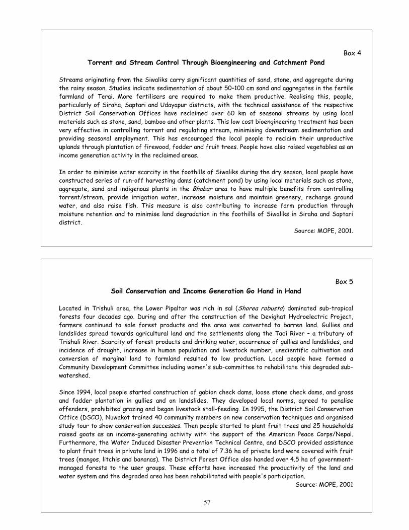
Box 4 Torrent and Stream Control Through Bioengineering and Catchment Pond
Streams originating from the Siwaliks carry significant quantities of sand, stone, and aggregate during the rainy season. Studies indicate sedimentation of about 50–100 cm sand and aggregates in the fertile farmland of Terai. More fertilisers are required to make them productive. Realising this, people, particularly of Siraha, Saptari and Udayapur districts, with the technical assistance of the respective District Soil Conservation Offices have reclaimed over 60 km of seasonal streams by using local materials such as stone, sand, bamboo and other plants. This low cost bioengineering treatment has been very effective in controlling torrent and regulating stream, minimising downstream sedimentation and providing seasonal employment. This has encouraged the local people to reclaim their unproductive uplands through plantation of firewood, fodder and fruit trees. People have also raised vegetables as an income generation activity in the reclaimed areas. In order to minimise water scarcity in the foothills of Siwaliks during the dry season, local people have constructed series of run-off harvesting dams (catchment pond) by using local materials such as stone, aggregate, sand and indigenous plants in the Bhabar area to have multiple benefits from controlling torrent/stream, provide irrigation water, increase moisture and maintain greenery, recharge ground water, and also raise fish. This measure is also contributing to increase farm production through moisture retention and to minimise land degradation in the foothills of Siwaliks in Siraha and Saptari district.
Source: MOPE, 2001.
Box 5 Soil Conservation and Income Generation Go Hand in Hand
Located in Trishuli area, the Lower Pipaltar was rich in sal (Shorea robusta) dominated sub-tropical forests four decades ago. During and after the construction of the Devighat Hydroelectric Project, farmers continued to sale forest products and the area was converted to barren land. Gullies and landslides spread towards agricultural land and the settlements along the Tadi River – a tributary of Trishuli River. Scarcity of forest products and drinking water, occurrence of gullies and landslides, and incidence of drought, increase in human population and livestock number, unscientific cultivation and conversion of marginal land to farmland resulted to low production. Local people have formed a Community Development Committee including women's sub-committee to rehabilitate this degraded sub-watershed. Since 1994, local people started construction of gabion check dams, loose stone check dams, and grass and fodder plantation in gullies and on landslides. They developed local norms, agreed to penalise offenders, prohibited grazing and began livestock stall-feeding. In 1995, the District Soil Conservation Office (DSCO), Nuwakot trained 40 community members on new conservation techniques and organised study tour to show conservation successes. Then people started to plant fruit trees and 25 households raised goats as an income-generating activity with the support of the American Peace Corps/Nepal. Furthermore, the Water Induced Disaster Prevention Technical Centre, and DSCO provided assistance to plant fruit trees in private land in 1996 and a total of 7.36 ha of private land were covered with fruit trees (mangos, litchis and bananas). The District Forest Office also handed over 4.5 ha of government-managed forests to the user groups. These efforts have increased the productivity of the land and water system and the degraded area has been rehabilitated with people's participation.
Source: MOPE, 2001
57

Nepal has institutionalised resource planning at sub-watershed level. The DSCWM has institutionalised the implementation of SCWM activities at sub-watershed level based on management plans. Similar approaches are taken by NGOs. A non-governmental organisation – Namsaling Community Development Centre – has prepared a Sya Khola Sub-Watershed Management Plan as part of District Environmental Planning Project. Based on the assessment of the watershed condition, the study has recommended the following activities for implementation to rehabilitate the degraded lands and improve the socio-economic conditions of the people.
• Economic Activity – income generation, saving and credit group formation and training, introduction of multi-crops systems, health and sanitation through environmental education, training and awareness, gender integration, improvement of transportation and communication system, and alternative energy development;
• Farming Practices – Introduction of short-duration high yielding seeds, fruit tree and cash crops plantation, soil management in agricultural land, livestock management through genetic improvement, forage and fodder development and grazing control, and rational use of agro-chemicals (chemical fertiliser and pesticide),
• Forest Management – Awareness raising, NTFP development on degraded and open pasture as income generation, nursery and seed bank, CFUGs technical skill development, research and assessment.
• Soil Conservation and Landslides – slope stabilisation and erosion control, and road drainage. • Water Supply – drinking water management, irrigation system improvement and EIA. • Monitoring Mechanism.
Source: NCDC/CECI, 2000. These localised efforts have paved the road to replicate proven techniques in bringing back the fertility of the land system, increasing water quantity and improving the living conditions of the rural people. 4.3 Buffer Zone Nepal introduced protected area (PA) management system in the early 1970s through the declaration of National Parks (NPs) and Wildlife Reserves (WRs) in different ecological zones. These PAs restricted people's involvement in resource management and utilisation, and their protection was continued with the active participation of the Royal Nepal Army in selected PAs. This effort has contributed to protect the landscape and improve their productivity. In due course of time, Nepal realised the need for involving local people, and introduced Conservation Area (CA) concept to bring the people in the mainstream of natural resource management. However, park-people conflict continued around NPs and WRs particularly for forest products, and damage of private property from protected large mammals. In order to address it, and institutionalise benefit sharing mechanism, the Parliament amended the National Parks and Wildlife Conservation Act, 1973 by introducing provisions to allocate 30 to 50 per cent of the total revenue generated in the PAs for community development, and to declare buffer zones. Furthermore, HMG has implemented a Park-People Programme (PPP) since 1994 with the assistance of UNDP in the Terai parks and reserves and HMG started the declaration of the buffer zones. The PAs cover a total of 26,696 km2 (18.14 per cent of the total land area) including buffer zones. At present, 9 NPs, 4 WRs, 3 Conservation Areas (CAs), 1 hunting reserve and 5 buffer zones are in operation (Figure 4.1).
58
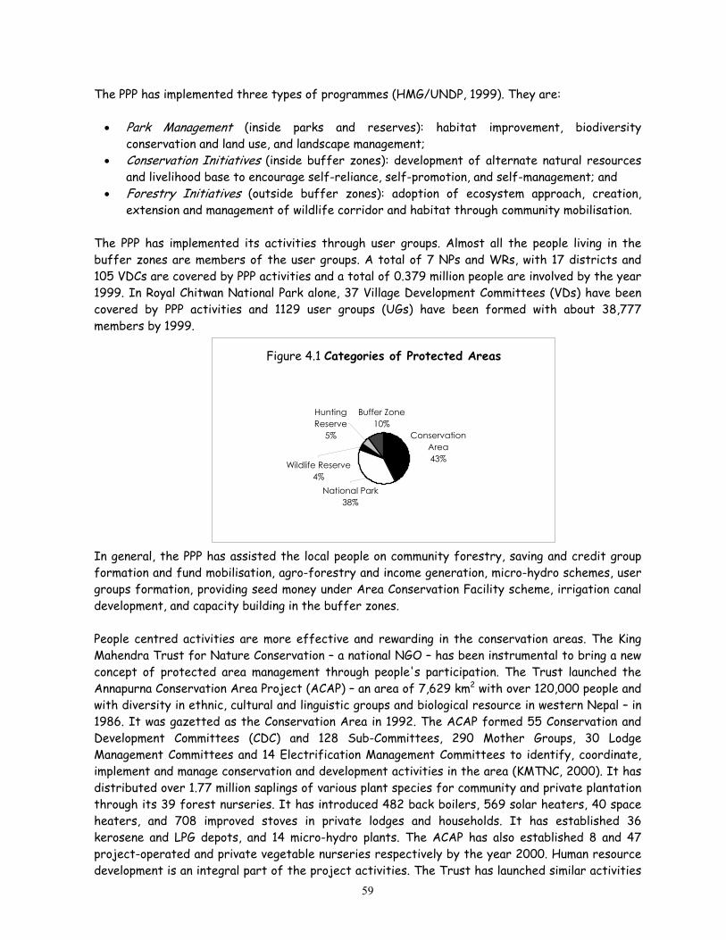
The PPP has implemented three types of programmes (HMG/UNDP, 1999). They are:
• Park Management (inside parks and reserves): habitat improvement, biodiversity conservation and land use, and landscape management;
• Conservation Initiatives (inside buffer zones): development of alternate natural resources and livelihood base to encourage self-reliance, self-promotion, and self-management; and
• Forestry Initiatives (outside buffer zones): adoption of ecosystem approach, creation, extension and management of wildlife corridor and habitat through community mobilisation.
The PPP has implemented its activities through user groups. Almost all the people living in the buffer zones are members of the user groups. A total of 7 NPs and WRs, with 17 districts and 105 VDCs are covered by PPP activities and a total of 0.379 million people are involved by the year 1999. In Royal Chitwan National Park alone, 37 Village Development Committees (VDs) have been covered by PPP activities and 1129 user groups (UGs) have been formed with about 38,777 members by 1999.
Figure 4.1 Categories of Protected Areas
Hunting Reserve
5%
Wildlife Reserve4%
Buffer Zone10%
National Park38%
Conservation Area43%
In general, the PPP has assisted the local people on community forestry, saving and credit group formation and fund mobilisation, agro-forestry and income generation, micro-hydro schemes, user groups formation, providing seed money under Area Conservation Facility scheme, irrigation canal development, and capacity building in the buffer zones. People centred activities are more effective and rewarding in the conservation areas. The King Mahendra Trust for Nature Conservation – a national NGO – has been instrumental to bring a new concept of protected area management through people's participation. The Trust launched the Annapurna Conservation Area Project (ACAP) – an area of 7,629 km2 with over 120,000 people and with diversity in ethnic, cultural and linguistic groups and biological resource in western Nepal – in 1986. It was gazetted as the Conservation Area in 1992. The ACAP formed 55 Conservation and Development Committees (CDC) and 128 Sub-Committees, 290 Mother Groups, 30 Lodge Management Committees and 14 Electrification Management Committees to identify, coordinate, implement and manage conservation and development activities in the area (KMTNC, 2000). It has distributed over 1.77 million saplings of various plant species for community and private plantation through its 39 forest nurseries. It has introduced 482 back boilers, 569 solar heaters, 40 space heaters, and 708 improved stoves in private lodges and households. It has established 36 kerosene and LPG depots, and 14 micro-hydro plants. The ACAP has also established 8 and 47 project-operated and private vegetable nurseries respectively by the year 2000. Human resource development is an integral part of the project activities. The Trust has launched similar activities
59
in the Manasalu Conservation Area Project since 1998. This approach of involving the local people in species and landscape conservation activities blended with income generation programme has been replicated in different protected areas of the country. The Trust has paved the road for expanding conservation activities with people's participation in Nepal's protected areas. 4.4 Farmers-Managed Irrigation Systems Irrigation management is deeply rooted in the Nepalese farming system and it is probably as old or even older than rice terraces carved by the farmers. Many of the Farmers-Managed Irrigation System (FMIS) in Nepal originated during 18th and 19th century and first half of 20th century. These systems are still functioning very well. The Raj Kulo at Argali in Palpa district is, for example, believed to have been developed by the King Mukund Sen, a ruler of the then State of Palpa about 400 years ago. The Tharu inhabitants developed the Chhattis Mauja Irrigation System in Rupendehi district over 150 years ago to irrigate about 3,500 ha of land. Hundreds of similar examples are found in Nepal. These systems were developed when there were no transportation and communication facilities and even the concepts of modern engineering principles and materials were not available to the people. It is estimated that about 15,000 traditional FMIS are operated in the Hills and Terai and provide irrigation facility to about 70 per cent of the total irrigable land (NFIWUAN, 2001). Strong indigenous knowledge system is available for design, construction, operation and governance of FMIS in Nepal. These knowledge systems are tested, modified, dynamic, and changed over time in response to the stresses of social, economic and ecological forces. Brushwood temporary weir is the most common diversion structure found in the FMIS. These are built using locally available materials like boulders, brushwood, grasses, tree branches, and wooden piles. They have to be repaired or replaced once a year. Farmers are also knowledgeable on stability of brushwood weir and selection of sites for the construction of diversion structure. The weir is never laid across the stream at right angle to the river axis but is inclined to flow a portion of stream and is less likely to be damaged by normal stream flow. In most cases, the intake is found to be located in a narrow section of the stream. Obviously a diversion weir would be reasonably stable and cost effective if the weir length is short. In the hills, a number of FMIS originating from the same stream and running parallel to each other are observed. Two or more parallel canals originating from the same point in the stream are common. Instead of one large system on an unstable hill slope prone to landslide and soil erosion, a number of systems at different levels would ensure low disturbance of soil with less chances of damaging the system. Traditionally FMIS in Nepal have been made and managed on a self-help basis. Effective governance and organisation has been key to successful irrigation management in most FMIS and local people define membership, water allocation, distribution, resource mobilisation, conflict management, fines and sanctions (MOPE, 2001). In order to further recognise the role of people in conserving and managing water, the Water Resources Act, 1992 contains provisions to form Water Users Association (WUA) and places water use for irrigation purposes under second priority (after drinking water). Existing policies encourage the users to contribute up to 10 per cent of the total investment cost in most of the
60

irrigation schemes, and the WUAs receive up to 90 per cent of the irrigation service fee if they are involved in managing main canal system. The WUAs have formed the National Federation of Irrigation Water Users Association, Nepal (NFIWUAN) in August 1999 to promote participatory irrigation development, extend sustainable irrigation system, and safeguard their interests and rights under the prevailing legal regime. 4.5 Agro-forestry Agro-forestry – a traditional practice in Nepal has been a part of mountain farming system. Local people have started to expand fodder and cash crop plantation in the farmland in order to conserve soil, increase livestock product and reduce rural poverty through increased income. Farmers have continued plantation of over 40 species of trees and other plants by considering foliage production, fast growth, nutritive value, multi-purpose uses, side effect on agricultural crops, disease resistance, and ease for lopping. Alnus nepalensis, Artocarpus lakoocha, Azadirachta indica, Bauhinia variegata, Choerospondias axillaries, Ficus nemoralis, Ficus roxburghii, Ficus subincisa and Leucaena diversifolia are the major species raised in the farmland. Farmers have also started to plant medicinal and aromatic plants (MAPs) such as Zanthoxylum armatum, Phyllanthus emblica, Bergenia ligulata, Sapindus mukurossi, Zanthoxylum oxyphyllum, Artemisia vulgaris, Ocimum basilicum, Mentha arvensis etc. within a range of 700 to 2,500m asl. Besides, farmers have started raising cash crops to increase income and conserve natural resource base (Box 6). Box 6
Coffee Plantation for Sustainable Land Management
Assessing soil type and fertility status, and organising training to local people in groups on site selection, plantation techniques/methods, organic manure, and shade trees, 22 coffee growers groups are involved in raising coffee in Kavrepalnchowk and Sindhupalchowk districts, located at about 50 km east from Kathmandu – the capital city of Nepal with the effort of the Nepal Agro-forestry Foundation (NAF). Gender sensitisation activities have been internalised to maximise the participation of women and disadvantage people. Over 650 people are benefited by this effort. The coffee growers produced 1.2 mt of dry cherries in the year 1995 which increased to 5 mt in 2000. The total production of dry cherries is expected to increase in the following years. In 2000, over 7,150 coffee saplings were planted in the above two districts. The coffee growers have raised about 66,000 seedlings in the nursery. Local people also raise species of Leucaena, and Morus, in addition to papaya, orange and other citrus fruits as shade plants. People have switched from growing cereal crops such as rice and wheat in the irrigated lowland areas and maize and millet in the upland (unirrigated slopes) towards coffee within an altitude range of 900 to 1200 m above the sea level, which provide ideal climatic condition to produce good quality coffee in this area. In order to produce good quality coffee, users need to know on soil properties and nutrient deficiency, planting methods and spacing (current practice of 1.2 m distance and to be maintained at about 3x3 m while growing under the shade trees), fertiliser use, distance of shade trees etc. (Nelson, 2001). It is also necessary to have high canopy shade trees at appropriate distance. The practice of topping mature trees should be discontinued although it helps to keep the tree size down and to make picking easier. It seems that local people need additional training as this could be proved a successful programme to alleviate poverty, and reduce soil erosion and landslide. The thinning of shade trees would also help in meeting the demand for firewood and fodder, and maintain ecological balance in the area. Source: NAF, 2001
61
Efforts are also underway to promote coffee plantation through co-operatives. The Nepal Coffee Producers Association, which is mobilising about 32,000 farmers currently, is also promoting land leasing through pooling of private land and involve the local people in coffee plantation through co-operative approach to contribute to poverty reduction and conserve natural resource base in the hills of Nepal. Similar efforts have also been promoted by other professional associations to cover the barren land through cash crops.
Box 7 Women's Participation in Agro-forestry
Majhimtar, a small hilly village located on the bank of Trishuli river in Dhading District, Central Nepal is dominated by Majhis (fishermen) communities who migrated from the hill slopes in around 1890. Until 1960, Majhis depend on fishing, and growing cereals in a small parcel of land available. Hill-hill migration and population growth increased pressure on local forests and poverty. Then the government introduced hybrid buffalo in the mid-1970s, provided veterinary services and exotic grass species in early 1980s including some fodder and fruit trees. As the population increased with the influx of migrants along with road construction, the nearby forests were severely degraded. Realising this problem, NAF initiated activities to identify the women farmers interested in on-farm agro-forestry activities and assisted in plantation of multi-purpose trees to produce fodder, fuelwood, timber, fruit and grasses. Local people planted Morus alba, Leucaena diversifolia, Flemingia congesta, Guazuma ulmifolia, Crotolaria sp., Stylosanthes sp,, Melinis minutiflora, Mangifera indica, Litchi chinensis, Michelia champaca, Dalbergia sissoo and Melia azedarach, and have increased livestock production. At present about one third of the group members are self-sufficient in fodder and one-fifth in fuelwood. They have formed a local NGO named Majhimtar Community Development Centre to promote and expand agro-forestry activities in the area. In Nepal, women are the primary beneficiaries of agro-forestry activities and also the victims of land degradation. User group concept through social mobilisation process is working perfectly in the hills, particularly in homogenous community. This approach in heterogeneous community takes more time to convince the local people, and unite them in user committees.
Overall, agro-forestry activities have increased farmer's income, reduced time required for collecting fodder, grasses and fuelwood, provided green and nutritious fodder in dry season, and reduced farmers dependence on local forests. Furthermore, it has also ensured soil and water conservation, maintained greenery and promoted aesthetic value. In view of the activities so far implemented, and the magnitude of the problems, the area covered by agro-forestry is quite low, and hence, it is necessary to expand it, launch local capacity building activities, maximise the use of traditional knowledge and technologies, promote information exchange, and integrate high value and low volume medicinal and aromatic plants (MAPs) by inviting pharmaceutical companies to meet the twin objectives of rehabilitating degraded lands and fulfilling the demand for raw materials. There are also possibilities to raise MAPs and non-wood forest products (NWFPs) in the horticulture orchards to maximise income.
62

These activities have contributed to reduce soil erosion and minimise downstream effects, and increase soil fertility. Although, studies have yet to be carried out to assess the effectiveness of these conservation measures, and income-generating activities on reducing natural disasters and minimise soil loss, the vegetation/tree cover would have lowered down the occurrence and frequency of disasters.
63

Chapter Five National Action Programme
A review of national policies, plans, strategies, regulatory frameworks and programmes related natural resource management and disaster and drought mitigation clearly indicates that they are in line with the spirit of the UNCCD. Effective implementation of these policies and programmes through an action programme would contribute significantly to land and water management in Nepal. As Party to the UNCCD, Nepal should prepare and implement a National Action Programme (NAP). And as a focal point for the Convention matters, MOPE has prepared this NAP on land degradation and desertification to meet the obligation of the UNCCD and also to mainstream our existing policy commitments into action. This NAP covers the issues included in the Convention, in general, and provisions of the Article 10 of the Convention, in particular. The NAP is based on the review of preceding chapters and within the framework of existing policies and laws in order to promote its early implementation. 5.1 Process and Participation In the process of formulating the NAP, MOPE – the focal point for UNCCD – organised a national seminar in 1997, conducted some studies till July 2001, and organised a national workshop again in December 2001. During this period, a number of discussion meetings, interactions, workshops and seminars were organised. The mass media was mobilised to enhance public awareness. A number of resource persons were consulted to discuss issues and generate ideas to combat land degradation and mitigate the effects of drought. This NAP has been prepared involving a team of experts working in natural resource management. After the preliminary draft report was prepared in early January it was circulated for in-house discussion and presented with a view to accommodate appropriate issues in the NAP. Initial comments and suggestions were incorporated, and MOPE circulated the draft NAP for expert review . The preliminary draft NAP was discussed with over 240 individuals representing different stakeholders. MOPE organised a series of interaction meetings with stakeholders, namely government institutions, local bodies, private sector, NGOs, media, user groups and academic institutions. The concerned agencies were instrumental in organising the interaction meetings jointly with MOPE. After receiving comments and suggestions from reviewers and through interaction meetings, the draft was revised and circulated for official inputs. About 20 government ministries, commission and council, private sector, INGOs and federations of the community-based organisations have provided inputs to refine the revised draft NAP. In the process of NAP formulation, number of institutions and people have participated directly or indirectly at different stages (from 1997 to April 2002) and a number of organisations contributed by providing information and suggestions (Figures 5.l and 5.2). The NAP validation seminar was organised on September ... 2002 and based on the inputs of the institutions, workshop participants and experts, the following goals, objectives and strategies for NAP have been defined and the main programmes and supportive
64

programmes have been designed and implementing agencies proposed for further discussion in the forth-coming national workshop on the NAP. 5.2 Goal and Objectives The goal of the NAP is to mitigate land degradation, desertification process and effects of drought through improved land use and sustained land management. The NAP aims to prevent, mitigate and reduce the consequences of land degradation and drought in the country. Specifically, the NAP intends to further: Identify factors contributing to land degradation and drought; Identify and implement preventive and rehabilitative measures necessary to combat land degradation, desertification and mitigate the effects of drought, and alleviate poverty; and Specify the roles and responsibilities of the government, local bodies, NGOs and the civil society in programme implementation.
IGO/UN/Donors • ICIMOD • UNDP • FAO • WB • ADB • DANIDA • ESCAP • UNCCD Secretariat etc.
Federations of CBOs • CFUGs and WUAs Local Bodies • DDC, VDC and
Municipality
NGOs
Academic Institution • TU • KU • PU – SchEMS & CAS
Figure 5.1 Participating Organisa
5.3 Approach and StrategyUnless poverty is reduced, landNepal. This inter-sectoral issueincome-generating activities. implementation, monitoring andand actions listed in this NAP will be encouraged to implement
Ministry of Population andEnvironment (National Focal
Point)
Commission/Council • NPC • WECS • NARC Ministries Resources • MFSC, MOAC,
MOWR, MLRM Others • MLD, MOICS,
MOF, MPPW, MOST, MOF and MOH
I-NGO • IUCN and WWF
N-NGO • KMTNC & NEFEJ
Departments • DSCWM, DOF,
DOA, DOL, DHM, DOR and DWIDP
• Other NGOs
Media • Television • Radio • National News Agency• Daily newspapers
Others • Consulting firms • Experts/Reviewers
tions in the Different Consultative Processes till the Preparation of
the Preliminary Draft NAP
degradation will continue to be a major environmental problem in could be addressed through holistic approach and integration of Bottom-up approach will be adopted in project planning, evaluation. Local bodies will implement appropriate programmes by incorporating in the district level periodical plans. Local people preventive and restorative activities to improve land productivity
65

and conserve water. Participation of the local bodies and community-based organisations in replicating the successful programmes will improve land productivity and water conservation.
Draft NAP
Local bodies Association of District
Development Committee Municipality Association
Private Sector Agricultural enterprises Associations of tea,
coffee, dairy, seed, silk etc.
NGOs INGOs National NGOs IUCN member NGOs
Media Daily newspapers National and FM Radios/TV Professional societies Freelance Journalists
Academic Institutions Universities Private colleges having
environmental courses Research institutions
User Groups Forestry users Buffer zone users Irrigation water users Soil conservation groups Farmers
Government organisations Natural resource management Infrastructure development Research Institutions
Figure 5.2 Stakeholders Participation in the Interaction Meetings The government plays a catalytic role for effective implementation of this NAP. The key strategy for programme implementation is to develop facilitative policy and regulatory frameworks including standards, guidelines and manuals to ensure people's participation through user group concept. These instruments will be developed through stakeholders' participation and users consultation. The government will assist the local bodies, natural resource user groups, The private sector, including commodity associations (e.g., tea, coffee, dairy and silk) and farmer groups, and other stakeholders in developing projects and mobilizing technical and financial resources for NAP implementation along with the spirit of decentralisation policy and legal regime on the devolution of powers and responsibilities. Necessary working modalities will be development for partnership arrangement during implementation. Empowerment and strengthening of local bodies and community based organisations along with other stakeholders – one of the major strategies – will greatly contribute towards effective implementation of the NAP and meet the twin objectives of natural resource management and poverty reduction. The problems faced by the farmers will be reported to institutions involved in research and development to find solutions. The media and NGOs will be encouraged for raising awareness on land improvement and water management activities. The basic philosophy is to mainstream major groups including women in programme implementation, continue on-going activities and increase their coverage, and promote participatory management. 5.4 Programmes and Actions The NAP includes main programmes in the areas of forests, soil and water conservation in private and public lands, and pastures. It also proposes cross-sectoral programmes, special programmes for mountains, food security, early warning and disaster mitigation. Attention has been given to selecting pro-poor programmes to the extent possible. These programmes would contribute to
66
increase production of agriculture and other natural resources. Dealing with private land –cultivated and non-cultivated agriculture land – would be duly taken care by the farmers. The NAP prioritises the programmes requiring urgent action to address significant problems. Each programme includes activities, time frame [short-term (within 5 years), medium-term (5-10 years) and long-term (over 10 years)], implementation responsibility and tentative cost. It does not put a limitation on starting the medium-term and long-term activities earlier. However, it indicates that such activities should be completed within the time frame, to the extent possible, and next phase could be started for continuation and expansion of the coverage of activities. The responsibility is specified to government agencies to continue initiatives for each programme outlined below. Local bodies, NGOs, CBOs, farmers, private sector agencies etc. will take the lead role in their implementation. The short-term activities require implementation immediately. The medium-term and long-term activities are significant and demand implementation to the earliest possible. These activities should be continued to cover more physical areas, i.e., degraded or prone to degradation through necessary revision, as necessary. The cost allocation has been grouped into small, medium and large categories for each group which denotes to less than US$ 1 million, US$ 1 to 3 million, and higher than US$ 3 million. This indicative budget ceiling has been proposed with due consideration on the scope and coverage of the activities in questions, local financial situation, and need for their continuity over the years. Most of the proposed programmes are applicable for all ecological zones. However they have been specified in the following tables on priority basis – the Siwaliks and Hills or in broader sense the degraded lands. The NAP will be revised periodically. Stakeholders may select the programme within their jurisdiction, interest and expertise. Each programme could later be developed into project for implementation. 5.4.1 Main Programmes In order to address the problems described in Chapter II, III and IV, the following main programmes have been included in this NAP. Major actions are proposed for each programme indicating geographical area, priority ranking, time frame, estimated budget and implementation responsibility of different stakeholders (Annex 5). A total of 77 actions have been proposed in 15 programmes. Of them 39, 32 and 6 actions are placed in first, second and third priority groups. Fifty actions are of small category followed by 21 medium-sized and 6 large-scale actions. 5.4.1.1 Forest Management 1. Promotion of community, leasehold and private forests in degraded areas This programme will focus in increasing the area of community, leasehold and private forests with particular focus on improvement of livelihood of people and rehabilitation of degraded lands by promoting economic tree crops and benefit sharing, simplifying procedures for forest handover, and providing technical services to strengthen user groups. The recommended activities include:
1. Continue to promote handing over of community and leasehold forests to poor user groups by simplifying procedures, and mobilise CF income for social development
2. Ensure subsidies for forest development by poor user groups 3. Provide technical assistance to users as post-support programme 4. Promote plantation of multi-tiered economic tree crops in private land 67

5. Promote private forestry in farmers land, preferably degraded lands 6. Continue forest protection works and stop encroachment 7. Implement operational/collaborative forest management plans1
-
2. Expansion of Conservation Areas in the Siwaliks and Hills1 This programme will address the conservation of degraded lands in the Siwaliks and Hills by declaring conservation areas and management of such areas will be ensured through the mobilisation of community user groups. The recommended actions are as follows:
1. Declare and manage biodiversity rich forests as Conservation Areas (CAs) 2. Conduct countrywide survey on endemic species and identify "hot spots" of endemic
species 3. Declare and manage Nature/Biosphere Reserve rich in endangered and endemic species 4. Promote rearing of wild animals to generate funding locally for species conservation
3. Domestication of high value and low volume plants and sustainable use of Non Wood Forest Products (NWFPs) in different categories of forests2
NWFPs and medicinal and aromatic plants (MAPs) could provide a basis for improving the living standard of the local people in all ecological zones. Most of the annual plants could be harvested on sustainable basis with due consideration for genetic conservation in designated areas. This programme will provide an opportunity to develop techniques for domestication of NWFPs and MAPs, and to conserve and promote sustainable use of endemic species so as to improve the living condition of the landless and poor people. The recommended actions are as follows:
1. Promote inventory of actively traded NWFPs, conduct studies on stock and sustained yield and marketing
2. Manage NWFPs and encourage plantation of medicinal and aromatic plants (MAPs) 3. Identify low volume and high value NWFPs, develop methods and technologies for
cultivation, harvesting and processing including of legally protected and endemic species 4. Develop promotional package of, and enabling mechanism for the sustainable use of
endemic species 4. Promotion of renewable energy and energy efficiency Many people depend on firewood and biomass to meet household energy demand and this programme will promote energy saving and improve energy efficiency thereby reducing pressure on forest firewood. The recommended actions include:
1 Proposal has been received to replace it by collaborative forest management plans, and promote community
forestry process. 1 Proposal on the need for promoting community concept; priority focus to be on conservation programmes
rather than declaring conservation area
68
2 Proposal has been received to replace non-wood forest products (NWFPs) by non-timber forest products (NTFPs) as the later terminology is commonly used in Nepal.
1. Promote locally suitable energy efficient stoves and develop capacity building for their construction and usage
2. Subsidise high-calorie firewood plantation in private land 3. Promote bio-gas, micro-hydro projects and other alternative energy sources for agro-
industries including cheese factory in the hills and mountains 5. Conflict Minimisation on forests and benefit sharing This programme will address the identification of traditional forest users and minimise conflict between different users and develop benefit-sharing mechanisms. The recommended actions are:
1. Identify users living far from forests 2. Ensure traditional rights for cattle grazing in temperate region and develop regulatory
measures on benefit sharing from forest management 5.4.1.2 Soil and Water Conservation in Degraded Lands 6. Promotion of land Consolidation, agro-forestry and block plantation Land fragmentation has limited the promotion of agro-forestry and block plantation (fruit, fodder and forage) in sloping land areas and this programme encourages land consolidation and promotes plant-based economic activities. Seven actions are proposed under this programme.
1. Prescribe minimum area of each parcel and promote land consolidation based on land capability classification
2. Encourage plantation of nutritious and fast growing plants having water retention and soil binding properties including expansion of on-farm conservation practices
3. Encourage tea, coffee, fruit and MAPs cultivation even through land consolidation and leasing
4. Promote the use of farmyard and green manure, and integrated plant nutrient system (IPNS) and phase out subsidies on agro-chemicals
5. Promote sericulture, floriculture, grass raising and other income generating activities 6. Promote and expand sustainable Farmers-Managed Irrigation Systems (FMIS) 7. Promote block plantation (fruit, fodder and forage) in sloping lands
7. Enhancement of mixed cropping and terrace improvement, and promotion of greenery along
the riverbanks This programme will encourage cultivation of erosion reducing crops, and promote terrace improvement and suitable farming practices. This will also promote cultivation of economic plants by changing cropping pattern. The following actions are recommended.
1. Expand terrace improvement, water diversion in sloppy farmland and introduce crops having soil binding properties
2. Construct water/run-off harvesting dams, and use catchment pond 3. Integrate sediment trapping facilities in irrigation schemes and promote cultivation of
sediment-loving crops (cereals and cash crops) 4. Promote land husbandry in upland watershed areas 5. Implement bioengineering activities along stream/riverbank 69

6. Promote groundwater extraction for irrigation and shallow tube-wells in drought-prone areas
8. Rehabilitation of degraded lands through bioengineering and evergreen plants having soil
binding properties This programme promotes restoration of degraded public and private lands and increase plant cover with minor engineering treatments. This also helps in promoting conservation-oriented infrastructure development and strengthening flood-forecasting facilities. Three major actions are proposed under this programme.
1. Expand degraded land rehabilitation activities in sloppy lands with bioengineering treatment, sediment trapping facilities and plantation of evergreen species
2. Implement integrated ecosystem management programme in Siwaliks and rehabilitate areas prone to landslides in other areas
3. Implement integrated watershed management activities 5.4.1.3 Pasture Management 9. Conflict resolution between resource users and cattle grazers and conservation of indigenous
livestock
The increasing area of community forests has limited the movement of cattle in lower altitudes and this problem should be resolved so as to increase production of meat, milk and wool. This programme encourages rearing of productive cattle through stall-feeding practices and conservation of indigenous livestock. The following actions are recommended to resolve conflicts on resource use:
1. Conduct studies on conflicts between cattle herders and community forestry user groups and launch preventive measures
2. Undertake strategic assessment of rangeland, stock and requirement, and develop databases of rangeland and cattle
3. Develop and manage pasturelands in temperate zone 4. Conduct census of indigenous livestock and protect endangered and rare species 5. Strengthen germplasm conservation facilities 6. Introduce incentive package for stall-feeding and rearing of productive cattle
5.4.1.4 Special Programmes for the Mountains 10. Enhancement of watershed improvement through population management
The hills suffer from high rate of soil erosion and population growth. This has increased cultivation of erosion-prone marginal lands. In some areas of the trans-Himalayan region, depopulation is increasing which is attributed to decline in the farm production, lack of alternative employment, and higher frequency of landslides. This has accelerated hill-terai and hill-hill (valley floor) migration. Agro-forestry development and cultivation of cash crops would help to rejuvenate the area and retain the people at their birthplace. This programme approaches to
70

address watershed improvement through development of greenery, basic social facilities and infrastructure, and population management. The recommended actions include:
1. Promote low-cost vegetative techniques, agro-forestry and implement watershed management plans at sub-watershed basis
2. Develop and expand financial incentives for small families, and promote reproductive health and family planning facilities
3. Integrate population and environment management activities in sectoral programmes 4. Promote cable cars, and social service including rainwater harvesting facilities 5. Promote the cultivation of low volume high value horticultural crops including agro-non-
timber forestry inside the fruit orchard 6. Generate off-farm employment, and off-farm income (in order to reduce consequences of
subsistence farming) 11. Promotion of sustainable tourism and natural resource management Promotion of tourism industry is likely improve the socio-economic conditions among the mountain people and generate more revenue. However, emerging environmental problems have limited its development and there is a need for promoting sustainable approach. Accordingly this programme will contribute to encourage the mountain dwellers in achieving the twin goals of natural resource management and tourism development. This will likely promote to harness 'non-use values' of the mountains.
1. Implement natural resource management activities with focus on village tourism 2. Promote and expand micro-hydro projects and energy efficient equipment 3. Diversify income generation activities, develop raw materials and promote cottage industry
such as agro- and forest-based industries 4. Select areas for, and promote high-budget travellers 5. Implement code of conduct, and promote health and sanitation facilities including
designation of campsites and waste management schemes 6. Develop water harvesting irrigation system (to enhance the mountain economy)
5.4.1.5 Food Security and Poverty Alleviation 12. Enhancement of income-generation activities for land and water conservation Accelerated land degradation from low-income group and practice of cereal production even in a small area of land has increased the number of poor people. Income-poor people suffer from land degradation further and they should be brought in the mainstream of soil conservation to improve their living conditions. Hence, this programme helps to achieve the twin objectives of natural resource management and poverty alleviation.
1. Promote MAPs cultivation both in private and public lands and sustainable utilisation of NWFPs (of community and leasehold forests) with operation of semi-processing facilities
2. Develop facilitative mechanisms to lease barren land to user groups of landless people 3. Promote cultivation of raw materials for forest-based industries 4. Improve current land use from cereals to horticulture and/or MAPs 5. Expand farmers-managed irrigation schemes 71
6. Promote crop modelling (to forecast crop yield) 7. Generate and disseminate post-harvest technologies (with respect to nutritional
requirement of rural people through preserving nutritional content of locally available agricultural products)
8. Promote agro-and forest-based income generating activities (such as preservation, processing and storage)
9. Promote traditional practices of managing the food grains and develop co-operative market system
13. Enhancement of water management for poverty alleviation and food security Poverty is the root cause for exploiting and degrading the environmental resources. Increased number of poor people has also accelerated land degradation and decline in food production. This programme focuses on water management and income generation of low-income groups of people. This programme promotes watershed management through community users, multi-purpose use of water resources and enabling mechanisms.
1. Implement integrated water resources management programme in land degradation and desertification-prone areas
2. Promote sub-surface water management in the Eastern Hills (drainage for spring water to reduce landslides, and provide additional water supply)
5.4.1.6 Early Warning and Disaster Relief Systems 14. Promotion of disaster forecasting and relief systems Disaster (flood and drought) forecasting facilities are inadequate and/or non-existent thereby limiting disaster preparedness activities. This programme will institutionalise early warning and/or forecasting systems on floods and drought, and timely relief systems and rehabilitation of disasters affected people through a coordinated approach. The community managed early warning system focuses on developing communication facilities in the hills and developing a mechanism to timely inform the people residing in the plain area on the possible damage of floods and debris. The following 8 actions are recommended:
1. Expand and network weather and flood monitoring stations 2. Prepare and update dry spell atlas for different weeks and identify drought-prone areas 3. Develop and/or strengthen flood and drought forecasting facilities and promote
community-managed early warning system 4. Conduct vulnerability and risk assessment and hazard mapping 5. Expand water induced and sediment related disaster prevention activities 6. Prepare and implement contingency plan on disaster preparedness and rehabilitation 7. Promote coordination of relief committees 8. Promote rainwater harvesting in trans-Himalayan region, and FMIS in drought-prone areas1
721 Some consider difficult to implement this action due to low precipitation.

5.4.1.7 Cross-sectoral Programmes 15. Development of carbon sinks through biodiversity conservation Land, water and forests are inherently inter-linked and complex. As mentioned in 1.3, UNCCD, UNFCCC and CBD are closely inter-related and programmes implemented to meet the objectives of one convention should also contribute to attaining the objectives of other conventions. Hence, cross-sectoral programmes are required to benefit each other. Increased habitat loss and/or alteration has disturbed ecosystems and reduced species diversity. Conservation of mature forests would ensure biodiversity conservation and absorb carbon compounds. This programme promotes covering of degraded lands by broad-leaved trees and other plants, ensure biodiversity conservation, and minimise nutrient rich topsoil from forest habitats.
1. Promote in-situ conservation of biodiversity and natural habitats including wetlands 2. Promote germplasm collection and preservation 3. Conserve mature forests and afforest broad-leaved evergreen trees massively in
degraded lands to develop carbon sinks 4. Establish synergy between relevant conventions, and implement common programmes
5.4.2 Supportive Programmes It is imperative to launch supportive programmes in order for effective implementation of above activities. As part of enabling mechanisms, the existing institutions, policies, and legal measures should be strengthened for good governance; human resources should be developed; and synergies at least amongst the conventions on biological diversity, climate change and desertification should be established by re-formulating consumption-oriented policies and legal measures for conservation, sustainable use, and benefit sharing. Public awareness and capacity building will be another area of intervention to bring the larger number of major stakeholders in the mainstream of natural resources management. Similar focus should be given to research, science and technology, data collection and information networking. In this context, good governance and human resource development and strengthening of local institutions play a vital role. The following sub-sections highlight the needs on these aspects. The details on priority ranking, estimated budget and implementation responsibilities are given in Annex 5. Nineteen actions are proposed for nine programmes and nearly 60 per cent of them have been ranked under first priority. Most of them are categorised as small as they support to implement the main programmes. 5.4.2.1 Policy Development In Nepal, sectoral development policies are in some cases detrimental to land degradation. Inadequate land use planning and sectoral approach of programme planning and implementation has led to the emergence of site-specific environmental problems. Policies on drought preparedness and alternative livelihoods, promotion and cultivation of medicinal and aromatic plants (MAPs) in public and private land, and sustainable use of forest's NWFPs are inadequate. In view of the existing policies, it is necessary to review them and design a comprehensive policy framework that facilitates the implementation of the above programmes with people's participation. 16. Avoidance of duplication and bridging the gaps on policies for land and water management
73

This programme should be implemented by developing an integrated policy on land and water to facilitate people's empowerment including women over natural resources. A land use policy, and other policies related with discouraging activities that destroy or alter biodiversity habitats, promote domestication of medicinal and aromatic plants, handing over of selected areas for tea or coffee plantation and/or horticulture development in order to conserve the soil and water and turn the unproductive lands into productive ones. Policies are also required to regulate migration, settlement, maintenance of river width, and transmigration of livestock etc. While formulating the policy with a view to contributing to the national goal of poverty reduction through sustainable management of natural resources, due consideration will be given to maximising the participation of local people including rural women, promote alternative energy use through economic instruments and fiscal measures, and encourage indigenous knowledge and technology. Adequate attention should be given to ensure enhanced participation of the women and/or mainstreaming women right from the policy formulation to implementation stages. 5.4.2.2 Legal Instruments Although regulatory measures developed and enforced after the re-instatement of democracy in 1990 focus on people's participation through user group concept, there are emerging conflicts on the traditional rights of the users on forests and pastures. Introduced incentive mechanisms on resource management have been instrumental in conserving soil and water, and generating funding at local level. However, people still face difficulty in solving issues related with resource utilisation. Priority focus of the policy instruments is yet to be translated into action through regulatory framework to encourage local people in land and water management. A review indicates gaps and duplication on policies, laws, and institutional roles and responsibilities, and demands a review of existing legal provisions to bridge the gaps and avoid duplication on powers, duties and responsibilities for the effective implementation of the NAP. 17. Avoidance of duplication on powers, roles and responsibilities and development of necessary
legal instruments in the spirit of the UNCCD in taking into account other relevant conventions A regulatory framework should be developed through comprehensive analysis of the existing legal regime and this should focus on benefit sharing of natural resources, leasing of appropriate land for cash crop production, and carbon trading. A separate Land Use Act should also be enacted to facilitate use of wasteland, barren land or non-used land for commercial purposes. As existing legal regime on non-wood forest products discourage the entrepreneurs to produce them in private land, tax and revenue generation instruments should also be revised so that barren land could be covered with vegetation, and funds generated for socio-economic development. 5.4.2.3 Institutional Strengthening The NAP is designed to address the emerging problems in land and water system and meet the obligations as reflected in the UNCCD. In order to institutionalise the implementation of these programmes, a number of organisations in government, private and non-governmental sectors should be strengthened to deliver the services to the local people. In addition, the existing coordination mechanism should be made effective along with reporting mechanisms. In view of the nature of the programmes identified, institutional strengthening would be necessary at the central level and local bodies. As grass root organisations lie at the crux of implementing the proposed programs, awareness raising and exposure (field visit) should be
74

encouraged to promote the adoption of alternative methods of resource management, minimise conflict and promote equitable sharing of benefits. Furthermore, organisations and private sector agencies, local bodies, NGO and CBOs involved in implementing environment-friendly activities and land improvement programmes at the local and regional levels should be strengthened and facilitated through additional funding mechanisms. 18. Establishment and/or strengthening of institutions at different levels This programme will open avenues to provide additional mandates and strengthen local level institutions in implementing NAP and also develop coordination mechanisms. Besides, a Desertification Cell will be established at the Ministry of Population and Environment with a view to coordinate NAP and convention related activities. 5.4.2.4 Demonstration, Scientific Study and Research Research and development are the pre-requisites to develop practical policies and other instruments to benefit local people during land improvement programmes and for refining project goals, inputs and outputs. Inadequate information base and lack of scientific studies on land and water resources limit replication of successful activities. Such studies are also necessary to develop problem-solving and cost-effective technologies. As information base on practical mitigation measures are inadequate and are in an early stage of development, it is necessary to undertake studies on "hot spots" – areas potential for land degradation, desertification and drought. Hence, study and research will be an integral part of the implementation of the above programmes to develop and refine cost-effective and locally suitable techniques and technologies by national experts. Studies are also required to know the effectiveness and practicality of traditional versus modern technologies in the Nepalese soil. Priority will also be given to develop and/and strengthen demonstration plots for skill development and research. 19. Development of demonstration plots and promotion of scientific and technological research This programme facilitates the operation of the demonstration plot as an educational centre to share information, skills and technology with farmers and researchers. The scientific studies and researches should be result-oriented, problem solving, and user-friendly. Studies should be conducted to identify areas facing land degradation, desertification, and drought, areas for expanding forest management through users, indigenous knowledge and harvesting and processing techniques of NWFPs and MAPs etc. The following actions are recommended.
1 Refine methods for conserving degraded lands and NWFPs processing through scientific studies
2 Promote participatory on-farm research and provide research internship for university students
3 Update land resource mapping project (LRMP) information including land/soil degradation mapping, and demarcation of 'hot spots' periodically
4 Establish and/or strengthen demonstration plots for studies and research in different ecological zones
75
5 Monitor land degradation and desertification process in arid and semi-arid regions 6 Update climate change effects on grasslands and wildlife habitat
5.4.2.5 Indigenous Knowledge and Practice A number of local practices and technologies are in existence and refined in Nepal for natural resources management. These are developed over the years through accumulated knowledge, experience and testing. In view of the present information on indigenous knowledge, know-how, experiences and practices, it is necessary to continue and maximise the use of terracing, live check dam of bamboo and loose boulders or sand bags, mulching, Jyapoo technique of soil management, contour hedgerow system, loose boulders as spurs, bioengineering, flood water trapping, farmers-managed irrigation system (FMIS), water harvesting and pasture management. Some NGOs are also involved in promoting vermiculture/earthworm culture as one the appropriate means of land management. In view of the proven benefits, terracing, bioengineering and FMIS will be expanded during the NAP implementation. These practices and technologies should be refined through scientific inputs to make them cost-effective and locally suitable. 20. Utilisation of indigenous knowledge and replication of proven techniques and conservation
practices Under this programme, the following actions are recommended.
1. Refine and replicate site-specific proven conservation techniques, raise awareness and develop capacity for use
5.4.2.6 Data and Information Sharing A variety of data and information is required to understand the complexities of land degradation and develop appropriate technologies. Inadequate time series data, particularly on land system, climatic and drought phenomena at national, regional, district and local levels, has limited the ability to use analytical framework, develop models, and provide inputs in policies, laws and other instruments. Information and research findings are also inadequate on the displacement of soil materials (soil erosion by water and wind), and in situ soil degradation (chemical and physical soil degradation), and causes and consequences of yield reduction or crop failure. The NAP could be implemented effectively through collection, and analysis of a large volume of data and their use in policy formulation, decision-making and programme planning. In this context, data and information collection on carrying capacity, pressure on and state of agriculture, forestry, land, pasture and water systems are necessary so as to better tune NAP implementation. Compilation of existing reports and dissemination of a synthesis report would also streamline the data collection and sharing practices. Data on barren land, annual conversion of marginal land to other land uses, erosion and landslide potential, flood trend, drought and climate, waterlogging, soil acidity, salinity and alkalinity are equally necessary to develop and implement integrated package programmes in specific sites. Similarly, data on carrying capacity of the pastures and livestock pressure, required management interventions, stock of forest products and growth rate, expansion of degraded land and effectiveness of rehabilitative programmes are essential for replication of successful activities and proven technologies. Furthermore, socio-economic indicators on land and water systems would help in assessing process, rate, extent and effects of
76

land degradation, desertification and drought. In addition, there is a need for collecting and processing baseline data on stakeholders' initiatives, degraded area, conservation techniques, capacity at the local level, and organisational strengths and weaknesses etc. In this context, a data collection, data creation, and management of information system (MIS) will be a pre-requisite for future programme planning and implementation, and hence, MIS will be developed for best use and sharing of information. 2 . Institutionalisation of information collection and sharing system 1 Under this programme, three actions are recommended. They are:
1. Collect and process data through different methods including remote sensing and geographical information system (GIS)
2. Develop Management Information System 3. Exchange experts between national and international institutions and participation in
regional and international workshops 5.4.2.7 Technology Development and Transfer Local people are using stones hedge, and natural vegetative barriers to minimise the effects of high wind blowing in the fertile topsoil in trans-Himalayan areas such as Mustang, Manang and Dolpa districts. There is an increasing demand for water harvesting and retaining technologies. Technical and technological inputs are also required to identify drought-prone areas, disseminate and analyse data quickly, know ENSO phenomenon at the time of monsoon forecast and improve mode of meteorological data acquisition system. Furthermore, Nepal would not be in a position to develop sophisticated technologies and hence, should focus on transfer of land improvement- and water management-friendly technologies. 22. Promotion of technology transfer and capacity building for its use Collection and collation of information on technologies is the first action to know what is available and how it has been used. Studies on the effectiveness and applicability of traditional and modern technologies are equally helpful to develop locally suitable technologies, promote their transfer and use. There is an emerging need for developing technologies for harvesting and processing of actively traded non-timber forest products, and medicinal and aromatic plants as well. 5.4.2.8 Education, Public Awareness and Media Campaign This component plays a vital role in implementing NAP effectively. Local people are unaware on what they have, i.e., the potential natural resources, stock and state, and how they could be utilised at sustained yield basis. People have developed indigenous techniques through decades and centuries on conserving farmlands, evaluating slope stability, using scarce water for vegetable production and horticulture farming, and managing rangelands in the mountains. However, they have been poorly documented. Besides, a number of people lack information, and have limited capacity to contribute to resource management. In this context, awareness raising and human resource building are considered pre-requisites for effective implementation of the NAP. Furthermore, women - the victims of land degradation and beneficiaries of natural resource management – are traditionally involved in soil and water management, and are overloaded with their "reproductive role", household activities such as child caring and cooking etc. They have to
77

spend most of the time in fetching firewood, fodder and drinking water. Hence, it is necessary to create public awareness on what they can do for land and water conservation and build their capacity through formal and informal education. MOPE and line agencies including local bodies, NGOs and CBOs will be involved in generating and repackaging public awareness materials. Institutions involved in generating and packaging information will encourage journalists to give maximum coverage in both print and electronic media. Involvement of journalists in creating public awareness will be one of the strategies of information sharing for land degradation and desertification control activities. Equal emphasis will be given to increasing the coverage of successful conservation programmes so as to promote their replication. Gender mainstreaming and women empowerment will also be enhanced through public awareness programmes. 23. Expansion of land and drought issues in formal and non-formal education and promotion of
public awareness Under this programme, a number of activities should be implemented to enhance the level of understanding on the importance of soil and water conservation. Information dissemination should also focus on establishing synergies amongst relevant conventions to help people understand about linkages, threats and opportunities. The following activities are recommended as an entry point of public awareness.
1. Integrate and/or expand land and water management issues in environmental education courses at different levels
2. Develop, repackage and disseminate information and establish award for media 3. Organise awareness seminars and mobilise mass media including community radios, and
NGOs for information campaign 5.4.2.9 Capacity Building Capacity building and mobilisation of knowledge-based manpower is the prerequisite for effective implementation of the NAP. Unless people know how to solve the problem, it would be extremely difficult to attain NAP objectives. At present, Nepal has low level of technical and managerial capacity to handle land and water issues. It is equally important, sometimes, to update information and skill of the policymakers, scientific and technological communities. In order to implement the varied nature of activities listed above under the main and supportive programmes, wider participation is required and their capacity should be built, enhanced and used. NAP implementation essentially demands the active participation of local bodies, farmers and community-based organisations including women. Advanced studies, training and refresher training, and exposures visits are also required for different stakeholders so that human resources are adequately developed. Adequate attention will be given to build the capacities of the women, local bodies and other major groups. For this, a number of general and specialised training will be organised and such training will range from land preparation to cultivation, harvesting and processing of products, handling of equipment to information sharing and so on. Hence, this is the most important and prioritised programme for NAP implementation. The main programme under this heading is: 24. Development of human resources at all levels, particularly of local bodies and community based
organisations
78
Under this programme, training and advanced studies within the country and abroad, field visits etc. are considered important to develop human resources, build their capacity and translate their skills into practice. In short, the above supportive activities are required for the implementation of the NAP in a more comprehensive manner. They will help in developing facilitative policy and regulatory framework, strengthening institutions, developing management information system and also developing capacities of the implementing agencies including major groups. During the implementation period, local bodies will mobilise local NGOs, CBOs and farmers in the respective activities to the extent applicable.
79

Chapter Six Programme Implementation, Monitoring and Evaluation
The programmes outlined in Chapter 5 will be implemented through coordinated approach. Various government agencies, local bodies, private sectors including commodity associations, NGOs, CBOs the farmers will have pivotal roles in their implementation. The Ministry of Population and Environment – the focal point for UNCCD activities in Nepal – will play a coordinating role and develop facilitative mechanisms for their implementation. The National Planning Commission is the principal advisory body of the government, and it plays greater role in integrating land and water conservation activities into the national development plans and programmes. Realisation of this problem has encouraged the line agencies to integrate natural resource conservation aspects in sectoral plans and programmes. In the spirit of the decentralisation policy and local self-governance laws, the local bodies at the district and village levels are focussing on managing their natural resources through coordinated approach. Similarly civil society will have the major roles in creating public awareness and in assisting the rural people for programme implementation at different capacities. The implementation of NAP demands for effective monitoring and evaluation to realise the achievements of land and water conservation. In order for internalising the NAP implementation, and ensuring monitoring and evaluation, a framework of institutional arrangement is given below. 6.1 Implementation Arrangements The central level organisations – the line ministries – will be involved in formulating necessary policies, laws, standards, guidelines, and procedures. As a focal point for UNCCD, the Ministry of Population and Environment will focus on developing these instruments with stakeholders' participation. MOPE will ensure necessary coordination, monitoring and evaluation of the NAP activities. In order to ensure effective implementation of this NAP, the following mechanisms have been proposed. They are: 6.1.1 National Coordinating Body The land degradation, desertification, and drought issues are multi-faceted and multi-dimensional. They require multi-agency approach for programme implementation. The Environment Protection Council, chaired by the Right Honourable Prime Minister and constituted in accordance with Section 14 of the Environment Protection Act of 1996, will ensure national coordination as and when necessary. The recently established National Commission on Sustainable Development will also facilitate necessary coordination. Besides, His Majesty's Government will constitute a national coordinating body (NCB) as an institutional arrangement for NAP implementation and to promote inter-agency coordination under the chairmanship of the Honourable Minister for Population and Environment. The composition of the NCB is proposed as follows:
80

Composition of the National Coordinating Body 1 Hon'ble Minister for Population and Environment Chairman 2 Hon'ble Vice-Chairman, National Planning Commission Vice-
Chairman 3 Hon'ble Member, Parliamentary Committee on Environment Member 4 Secretary, Ministry of Population and Environment Member 5 Secretary, Ministry of Forests and Soil Conservation Member 6 Secretary, Ministry of Local Development Member 7 Secretary, Ministry of Agriculture and Cooperatives Member 8 Secretary, Ministry of Land Reform and Management Member 9 Secretary, Ministry of Science and Technology Member 10 Executive Secretary, Water and Energy Commission Secretariat Member 11 Member, Royal Nepal Academy of Science and Technology Member 12 Chairperson, Association of District Development Committees Member 13 Chairperson, Association of Village Development Committees Member 14 Chairperson, Municipality Association of Nepal Member 15 President, Federation of Nepalese Chambers of Commerce and Industry Member 16 Chairperson, NGO Federation Member 17 President, Federation of Nepalese Journalists 18 President, Federation of Community Forestry Users Member 19 President, Federation of Irrigation Water Users Association Member 20 Representative, donor agency Member 21 Government nominated three experts (women, academic institution and INGO) Member 22 Joint-Secretary and Chief Environment Division, MOPE Member-Secretary The NCB will provide policy and operational guidance, and facilitate donor coordination and project implementation. All decisions will be made on consensus basis. It will also be involved in reviewing the monitoring and evaluation of the programmes and projects and in approving annual report on project implementation. The annual report will be made public. The Body will meet at least twice a year. The annual report will be the basis for preparing the national report for the Conference of the Parties to UNCCD. The NCB may establish working committees to develop projects on cross-sectoral programmes as and when required. As a focal point for UNCCD activities, having a mandate for acting as a focal point on national and international activities in the domain of environment, and also acting as the Secretariat of the Environment Protection Council (EPC) and the National Commission on Sustainable Development, MOPE will function as the Secretariat of this national coordinating body. MOPE will establish a Desertification Cell under its Environment Division to follow up the implementation of these programmes, collect information and prepare monitoring report.
81

Working Group
Technical Advisory
Group
People, NGOs, user group, local clubs
Municipality/Village Level Coordination Committee Women, disadvantage group, user's groups, NGOs, clubs
Chair – Major/VDC Chairperson; Secretary – As appointed by the Chairperson
District Level Coordination Committee DOF, DSCWM, DOA, Irrigation Office, Women's Group, User group, NGO
Chair – DDC President; Member Secretary – LDO
National Coordinating Body Representation of concerned government agencies
and stakeholders; Secretariat (MOPE)
Note: At all levels, concerned development agencies should be accommodated. 6.1.2 Local Level Coordination The local bodies – DDCs, municipalities (Metropolis or Sub-metropolis or Municipality as applicable) and the VDCs – will be encouraged to establish appropriate coordinating and reporting bodies and/or a mechanism for district level coordination. The Association of the DDCs may encourage its members to implement NAP regularly by integrating them into the district plans and programmes. The district line agencies, involved in natural resource management and land reform, Chambers of Commerce and Industry, NGOs and CBOs as appropriate with due consideration on the programmes and actions outlined in # 5.4 will be encouraged to participate, and implement integrated land and water conservation activities. Similar emphasis will be given to developing local level coordination mechanism, i.e., at the municipality and village development committee level, as they work on geographical boundary, in areas affected by land degradation and prone to human-induced disasters. Emphasis will be given to ensuring the representation of the women, backward/disadvantage community, user groups, local NGOs and clubs involved in developmental activities. The professional societies, cooperatives and user groups will also be encouraged and promoted to develop projects and programmes in the spirit of this NAP. 6.1.3 Technical Advisory Group The National Coordinating Body will establish a Technical Advisory Group (TAG) to get scientific, technical and technological inputs on the implementation of the NAP. This Group will be representing academic and research institutions and will provide guidance on technology development and transfer. The TAG will report to the NCB annually. 6.1.4 Programme Management and Implementing Agencies The Ministry of Population and Environment – the Secretariat of the NCB – will assist the partners in developing projects to implement the proposed programmes. A total of 96 activities
82

(66 small, 24 medium and 6 large-scale activities) have been proposed to translate 24 programmes into actions. Of them, 50 actions are prioritised first. A number of government departments and their district offices, local bodies, NGOs and users are involved in implementing similar activities and they will continue to expand on-going activities and integrate these proposed programmes during project planning and implementation. The line agencies, in particular the Department of Soil Conservation and Watershed Management, the Department of Forests, the Department of Agriculture, the Department of Livestock Development, and the Department of Hydrology and Meteorology will have direct role in implementing majority of the activities proposed in this NAP in collaboration with the local bodies, users and other stakeholders. In short, the District Development Committees, municipalities and the Village Development Committees will have a greater role in implementing the NAP. 6.1.5 Stakeholders Participation The NAP coordinating body and institutions having catalytic role and implementation responsibility will develop mechanisms to ensure the participation of farmers, NGOs and CBOs, academic and research institutions, and scientific communities. Private sector, particularly the business community, cooperatives and commodity associations such as coffee and tea producers, floriculture, sericulture etc. will be encouraged in achieving twins goals of meeting the need for raw materials and rehabilitating the degraded lands. The pharmaceutical companies will also be encouraged to raise perennial economic plants to meet the multiple objectives of raw materials, reduce nutrient loss and conserve water. The major stakeholders in implementing the NAP are:
Local bodies (DDC, VDC, and municipalities) Non-governmental organisations and community-based organisations such as user groups Private sector and commodity associations Academic and research institutions Media Women, farmers and people at large
Local NGOs and CBOs will be the main facilitators and implementers in creating public awareness. Facilitative mechanisms will be developed to encourage their participation in developing farmers' capabilities to implement NAP activities. The academic, scientific and research institutions will be encouraged to conduct site-specific research and refine locally suitable techniques and technologies blended with scientific innovations. The Institute of Science and Technology, the Institute of Agriculture and Animal Sciences, the Institute of Forestry of the Tribhuvan University will be encouraged in problem-solving action research independently or through collaborative arrangement. The Royal Nepal Academy of Science and Technology (RONAST) will take part in developing technologies and providing scientific advices. The Department of Forest Research and Survey and Nepal Agriculture Research Council (NARC) will promote research and development activities to assist the farmers in adopting proven high-yielding forestry and cereal species and having water retention and soil-binding properties including crop modelling. The Department of Hydrology and Meteorology will focus on countrywide networking of automated weather stations. The Department of Water-Induced Disaster Prevention will mainstream its activities on developing disaster mitigation measures.
83
6.2 Estimated Financial Resources The budget is estimated based on the coverage of the NAP implementation. The programmes have been grouped into small, medium and large so as to derive indicative cost estimates. The programme categorised as small will require less than US$ 1 million, and the medium projects will require US$ 1 to 3 million. As the nature of the programme is large and covers wide area, indicative budget estimated has been proposed and it will be elaborated during project formulation. A total of 24 programmes and 96 actions have been enumerated as an entry point for land and water management including natural resource conservation. These programmes could be elaborated into several activities and sub-activities during programme implementation. In order to implement these programmes, a total of US$ 96.9 million has been estimated (Table 6.1) (Annex 6). However, this is only an indicative budget. This could be changed during the preparation of the projects for specific geographical areas. It is assumed that small-scale activities proposed for the development of necessary policies, legal instruments, guidelines and manuals will be cost effective while the implementation level activities may require higher cost than proposed. The budget estimate indicates significant amount of funding required for NAP implementation. This could be financed through the mobilisation and channelling of resources both at national and international levels.
84

Table 6.1 Estimated Budget for NAP Implementation
Programmes SN Sector Small Medium Large Total
Estimated Budget (US$)
Main Programmes 1 Forests Management 14 4 2 20 Budget 4.9 mill 8.5 mill 10 mill 23.4 million 2 Soil and Water Conservation 7 6 3 16 Budget 3.3 mill 16 mill 14 mill 33.3 million 3 Pasture Management 5 1 6 Budget 2.4 mill 2 mill 4.4 million 4 Special Programmes for the
Mountains 7 5 12
Budget 1.4 mill 10 mill 11.4 million 5 Food Security and Poverty
Alleviation 8 2 1 11
Budget 1.5 mill 3.5 mill 5 mill 10 million 6 Early Warning and Disaster Relief
Systems 7 1 8
Budget 2.5 mill 3 mill 5.5 mill 7 Cross-sectoral Programmes 2 2 4 Budget 0.4 mill 5 mill 5.4 million 50 21 6 77 16.4 mill 48 mill 29 mill 93.4 million Supportive Programmes1 16 3 19 Budget 6 mill 8 mill 14 million Total Programmes 24 Total Activities 96 Total Budget 107.4 million 6.2.1 Domestic Channels The poor people in Nepal depend on resources of the degraded lands. Low per capita income has limited people's investment to make land productive even if they have the skill and willingness to do so. Similarly, local bodies, users and other stakeholders also lack funding to implement activities aimed at natural resource management. In this NAP, many programmes and activities are designed for degraded lands, particularly the Siwaliks and the Hills. Income generating activities have been integrated to the extent possible to involve the poor people in the mainstream of land and water conservation activities and contribute poverty reduction. As the current Ninth Plan has a single objective of poverty alleviation, and this will continue in the forth-coming Tenth Plan (2002-'07), programmes and actions of this NAP related with income-generating activities could be integrated into the poverty alleviation programmes so that it will have twin objectives of improving the living conditions of the poor people and conserve the land, forests and water resources. It is estimated that about 10 to 12 per cent of the total estimated budget could be channelled through domestic resources.
85
1 Includes programmes on policy, regulatory framework, institutional strengthening, research and scientific studies, indigenous technology use and development, data and information management, education, public awareness and capacity building.
The Environment Conservation Fund and the Poverty Alleviation Fund are in operation. The Nepal Trust Fund for Biodiversity may be established to implement the proposed National Biodiversity Action Plan. Although the existing Fund has no adequate financial resource to meet the demand for NAP implementation, some fund could be funnelled for capacity building and public awareness activities. Similarly local bodies, NGOs, CBOs etc. could also provide seed money for income generating activities. Based on the legal provision, the funds generated by the community forestry user groups (CFUGs) and, Buffer Zone Forestry User Groups and Irrigation Water Users Associations may also be used for funding small level of activities to rehabilitate specific degraded sites requiring small amounts of funds. The donor community may assist in increasing technical and financial resources and mobilise the existing fund and/or funds planned. Silt, sand and boulders aggregated in the valley floor and the Terai can be best utilised as construction materials with due consideration for the environmental aspects, and fund could be generated by adopting economic instruments. The river boulders and stones could also be used for construction of houses instead of bricks. This will help in guiding the river course and minimise food damage, and also retain the productive soil generally used for brick making. The pharmaceutical companies have recognized the importance of the Himalayan medicinal plants and are involved in collecting and utilising them. Some economic instruments could be developed so as to funnel certain percentage of their income to replenish the existing funds. They could also be encouraged to cultivate medicinal and aromatic plants in the degraded hill slopes. As also included in # 3.12, the minimum funding arrangement could be made from the following domestic sources to implement the selected activities outlined in the NAP.
National Consolidated Fund Environment Conservation Fund Poverty Alleviation Fund National Agricultural Research and Development Fund Funds generated by the users such as Community Forestry User Groups, Irrigation Water
Users, and Buffer Zone Users Sale of silt, sand and boulders from the rivers and streams Contribution of the pharmaceutical companies Private sector and commodity associations Proposed Trust Fund for Biodiversity Conservation
In a nutshell, local and poor people could contribute only labour and other programmes should be financed through national or external sources. In most cases, people's participation and willingness to conserve soil and water would be instrumental in achieving NAP goals and objectives. 6.2.2 External Sources As about 30 per cent of the national budget is met through external grants and loans, there are possibilities to integrate many of these activities in the existing projects and programmes under implementation through external funding. The proposed activities focus on the rehabilitation of degraded land by integrating income-generating activities, and many of the donor-funded projects are also on the same line.
86

Integration of the proposed activities into the donor-funded projects and use of unallocated fund, if any, would be a basis to achieve the twin objectives of poverty alleviation and degraded land rehabilitation. However, some programmes like the protection of Siwaliks, integrated water resources management, development of disaster prediction, forecasting and relief measures, introduction of NTFPs and MAPs in natural resource management programmes require urgent attention for funding. This assistance could also be extended as per Article 6 of the Convention that provides the developed Country Parties an opportunity to assist in NAP implementation by providing substantial financial resources and other forms of support. 6.3 Priority Areas for International Cooperation and Assistance These programmes are the bases to expand activities on land and water conservation. As a least-developed country, Nepal would not be in a position to invest a significant amount of financial resources through national sources for the implementation of these programmes. Several programmes have been initiated with donors assistance. Because of the magnitude and extent of the problem, the on-going activities should be expanded to rehabilitate degraded lands including the implementation of preventive measures so as to minimise potential land degradation and mitigate the effects of drought. Nepal will make every effort to mobilise the national financial sources and allocate counterpart funding. It seeks additional funding through bilateral and multilateral sources. In this context, the developed Country Parties and the international donor communities are urged to further assist Nepal in the spirit of the UN Convention to Combat Desertification for the implementation of these programmes. These programmes have been developed through extensive consultative processes and ensure the participation of local people. The programmes facilitate to empower major groups and bring them into the mainstream of natural resource conservation with focus on land and water management. As mentioned above, programmes that promote the conservation of the Siwaliks and degraded hills are priority concerns of Nepal. Introduction of NWFPs harvesting and domestication will provide a basis to attract poor people as an entry point, in the restoration of the degraded lands through income generation. The Bishweshwor Among the Poor (BAP programme) has planned to provide services to about 20,500 families of 205 parliamentary constituencies. As the international community is observing this year (2002) as an International Year of the Mountains, and the International Year of the Eco-tourism, funding for sustainable tourism integrated with natural resource management activities is another priority concern for Nepal. In addition, Nepal needs international assistance for the development of disaster prediction and forecasting facilities and establishing synergies amongst the relevant environmental conventions and implementing common programmes. There is a need for external financial support to accelerate the pace of rehabilitation of the degraded lands. Furthermore, capacity building deserves special attention for international cooperation and assistance. In order to promote NAP implementation, it is necessary to build the capacity of both the central and local organisations in formulating pragmatic policies, enforceable regulatory framework and standards, information sharing, technology development, transfer and use, and scientific studies and research. However, adequate emphasis should be given to build the capacity of the local level organisations, particularly the DDCs, municipalities, and VDCs, involved in programme implementation. In this context, capacity building is considered a top priority for international cooperation and assistance.
87

In sum, Nepal cannot implement all activities contained in this NAP through national efforts alone due to her financial situation. Many programmes and actions can be accomplished through the modality adopted in Technical Cooperation among Developing Countries (TCDC). Adequate financial and human resources is needed to take greater advantage of the technical assistance opportunities. It is considered that most of the programmes could be implemented within the framework of technical assistance. 6.4 Monitoring and Evaluation Progress and performance monitoring and evaluation of the National Action Programme (NAP) are pre-conditions for realising goals and objectives within the time frame. Monitoring generates useful information and improves the quality of implementation. Nepal has developed an in-built monitoring and evaluation system at the central and project levels. Most of the government agencies have institutional arrangement for regular and periodic monitoring and evaluation. The National Planning Commission has an established system for monitoring and evaluation and it prepares and disseminates monitoring and evaluation reports at regular intervals. The National Action Programme will be a part of the overall national development plan and programme. Hence, progress monitoring will be tied-up with the existing system. The national coordinating body, as mentioned above, will assume its responsibility for NAP monitoring and evaluation. Furthermore, the district level and local level coordination committees will also be involved in progress monitoring and evaluation. The national coordinating body will review, monitor and evaluate the progress of NAP implementation. It will also prepare and disseminate monitoring reports and it will also report the progress on NAP implementation to the Environment Protection Council (EPC), and the National Commission on Sustainable Development (NCSD) at their meetings. The EPC is represented by the concerned ministers, Parliamentary Committee on Environment, representatives of the national political Parties, National Planning Commission, academic institutions, Federations of Nepalese Chambers of Commerce and Industry, District Development Committee, Village Development Committee and the Municipalities. The Honourable Minister for Population and Environment serves as the Vice-Chair and the Ministry of Population and Environment as the Secretariat of the Council. The NCSD is also an inter-agency body with representation from women, ethnic group, youth, NGO, local body, industry and commerce, scientific and technical community, and farmers. The Honourable Minister for Population and Environment will serve as the Secretariat Head of the Commission. A reporting mechanism will be developed so that reports on monitoring activities of the village and municipal level are obtained timely at the national coordinating body through district coordination committees. 6.4.1 Indicators
88
Some indicators have been included in order to assist NAP monitoring. If the coverage of the vegetation including trees is increased both in private and public lands, frequency of landslides and floods and their effect on people and productive land is reduced. This also reduces flood and drought affected area , NAP actions would be effective to objectives. Because of the inadequate baseline conditions in each ecological belt and physiographic zones, broad-based monitoring
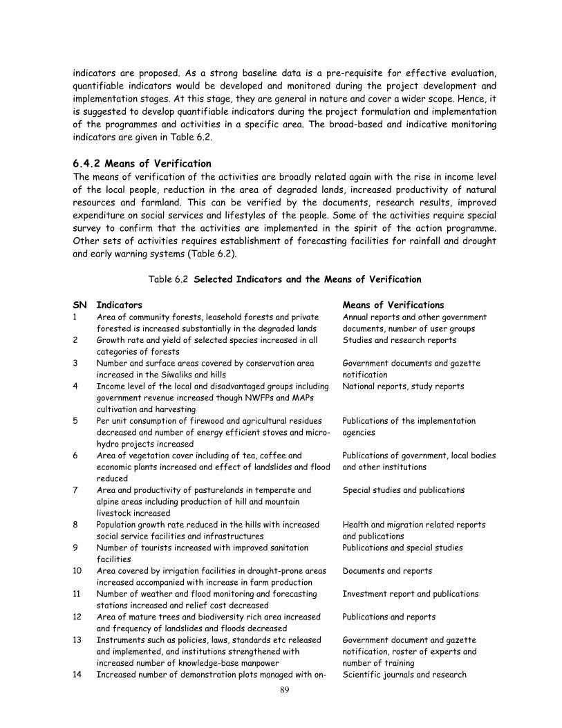
indicators are proposed. As a strong baseline data is a pre-requisite for effective evaluation, quantifiable indicators would be developed and monitored during the project development and implementation stages. At this stage, they are general in nature and cover a wider scope. Hence, it is suggested to develop quantifiable indicators during the project formulation and implementation of the programmes and activities in a specific area. The broad-based and indicative monitoring indicators are given in Table 6.2. 6.4.2 Means of Verification The means of verification of the activities are broadly related again with the rise in income level of the local people, reduction in the area of degraded lands, increased productivity of natural resources and farmland. This can be verified by the documents, research results, improved expenditure on social services and lifestyles of the people. Some of the activities require special survey to confirm that the activities are implemented in the spirit of the action programme. Other sets of activities requires establishment of forecasting facilities for rainfall and drought and early warning systems (Table 6.2).
Table 6.2 Selected Indicators and the Means of Verification SN Indicators Means of Verifications 1 Area of community forests, leasehold forests and private
forested is increased substantially in the degraded lands Annual reports and other government documents, number of user groups
2 Growth rate and yield of selected species increased in all categories of forests
Studies and research reports
3 Number and surface areas covered by conservation area increased in the Siwaliks and hills
Government documents and gazette notification
4 Income level of the local and disadvantaged groups including government revenue increased though NWFPs and MAPs cultivation and harvesting
National reports, study reports
5 Per unit consumption of firewood and agricultural residues decreased and number of energy efficient stoves and micro-hydro projects increased
Publications of the implementation agencies
6 Area of vegetation cover including of tea, coffee and economic plants increased and effect of landslides and flood reduced
Publications of government, local bodies and other institutions
7 Area and productivity of pasturelands in temperate and alpine areas including production of hill and mountain livestock increased
Special studies and publications
8 Population growth rate reduced in the hills with increased social service facilities and infrastructures
Health and migration related reports and publications
9 Number of tourists increased with improved sanitation facilities
Publications and special studies
10 Area covered by irrigation facilities in drought-prone areas increased accompanied with increase in farm production
Documents and reports
11 Number of weather and flood monitoring and forecasting stations increased and relief cost decreased
Investment report and publications
12 Area of mature trees and biodiversity rich area increased and frequency of landslides and floods decreased
Publications and reports
13 Instruments such as policies, laws, standards etc released and implemented, and institutions strengthened with increased number of knowledge-base manpower
Government document and gazette notification, roster of experts and number of training
14 Increased number of demonstration plots managed with on- Scientific journals and research
89

going research facilities, and participatory study and research reports published
reports
15 Management information system established and website users increased
Website, annual report on international visits and visitors
16 Land degradation and drought issued incorporated in the formal education, and media coverage increased
Review of curriculum and media coverage, number of seminar, workshop etc.
17 Number of knowledge-based and skilled manpower increased Number of training, publications and special survey
6.5 Assumptions Some of the assumptions made as pre-requisites for the successful implementation of this NAP are related with effective participation of, and collaboration with the local bodies, private sector, user groups, academic and research institutions and NGOs. Stakeholders will be involved in implementing the programmes with due consideration for their expertise. The most important assumption is that bilateral and multilateral donors will provide additional technical and financial assistance to implement this NAP in the spirit of the Convention.
90

References APROSC/JMA, 1995. Agriculture Perspective Plan. John Mellor and Associates and Agricultural Project
Service Centre, Kathmandu. BPP, 1995. An Assessment of the Representation of the Terrestrial Ecosystems within the
Protected Areas' System of Nepal. Biodiversity Profile Project/DNPWC, Kathmandu. Carson, B. 1985. Erosion and Sedimentation Processes in the Nepalese Himalaya. ICIMOD Occasional Paper 1,
Kathmandu Carson, B. 1992. The Land, the Farmer and the the Future: A Soil Fertility Management Strategy for Nepal.
International Centre for Integrated Mountain Development, Occ. Pap. # 21, Kathmandu. CBS, 1991. Statistical Year Book of Nepal. Central Bureau of Statistics, Kathmandu. CBS, 1997. Statistical Year Book of Nepal. Central Bureau of Statistics, Kathmandu. CBS, 1998. A Compendium on Environmental Statistics Nepal. Central Bureau of Statistics, Kathmandu. CBS, 1999. A Statistical Year Book of Nepal. Central Bureau of Statistics, Kathmandu DHM, 2001. Weekly Dry Spell Atlas of Nepal (Final Report). Department of Hydrology and Meteorology,
Kathmandu. DWIDP/DMSP /JICA, 1999. Disaster Review. Department of Water Induced Disaster Prevention/DMSP/
ICA, Kathmandu. DWIDP/DMSP /JICA, 2000. Disaster Review. Department of Water Induced Disaster Prevention/DMSP/
ICA, Kathmandu. EPC, 1993. Nepal Environmental Policy and Action Plan (NEPAP). Environment Protection council, Kathmandu. Gole, C.V. and Chitale, S.V 1996. Inland Delta Building Activity of Koshi River. Journal of Hydrolic Divisions,
Proceedings of the American Society of Civil Engineering, NY. Gurung, H. 1989. Regional Patterns of Migration in Nepal. Papers of the East-West Population Institute, No.
113, Hawaii: E-W .Institute. HMG, 1996. National Plan of Action: Nepal (HABITAT II). His Majesty's Government, Ministry of Housing
and Physical Planning, Kathmandu. HMG/ADB/FINNIDA, 1989. Master Plan for Forestry Sector Nepal (Main Report). His Majesty's
Government, Asian Development Bank, and FINNIDA, Kathmandu HMG/IUCN, 1988. National Conservation Strategy for Nepal. HMG/The World Conservation Union (IUCN),
Kathmandu. HMG/UNDP, 1999. Park-People Programme: The Year in Review. Department of National Parks and Wildlife
Conservation/United Nations Development Programme, Kathmandu. HMG/UNDP/WWF/Cap21, 2002. Sectoral Reports for Sustainable Development Agenda for Nepal (SDAN)
Draft Report. His Majesty's Government/United Nations Development Programme/World Wildlife Fund/Capacity 21, Kathmandu.
ICIMOD, 1998. Newsletter No. 2. International Centre for Integrated Mountain Development, Kathmandu. Johnson, R. 2001. Soil and Water Loss from Micro-Catchments in Makawanpur. Jaladhar, Issue 3 (January-
March), Quarterly Newsletter of Bagmati Integrated Watershed Management Programme, Kathmandu KMTNC, 2000. Profile of a National NGO (Revised Edition). King Mahendra Trust for Nature Conservation,
Kathmandu Laban, P. 1979. Landslide Occurrence in Nepal. Integrated Watershed Management, Torrent Control and Land
Use Development Project, IWM/WP/13, HMG/FAO/UNDP, Kathmandu. Low, P.S. 2001. How to Formulate a GEF Project Proposal on Land Degradation. In Report of the National
Workshop on Land Degradation, Drought and Sustainable Land Management (Eds. Dr. M. K. Shrestha, J. R. Joshi and B. K. Uprety). Ministry of Population and Environment, Kathmandu.
LRMP, 1986. Land Utilisation Report. Land Resource Mapping Project/Kenting Earth Science Ltd., Kathmandu. Maskey, T. M. 1995. State of Biodiversity in Nepal. In Banking on Biodiversity: Report of the Regional
Consultation on Biodiversity Assessment in the Hindu Kush-Himalayas (Ed. P. Shenji), International Centre for Integrated Mountain Development, Kathmandu.
91

MFSC, 1999. Forest and Shrub Cover of Nepal, 1994. Department of Forest Research and Survey, Kathmandu.
MFSC, 2000. Nepal Biodiversity Action Plan (Draft). Ministry of Forests and Soil Conservation, Kathmandu. MOAC, 2001. Statistical Information on Nepalese Agriculture (1999/2000). Ministry of Agriculture and Co-
operatives, Kathmandu. MOPE, 1997. Implementation Status of the Environment-Related Conventions in Nepal. Ministry of Population
and Environment/NESS, Kathmandu. MOPE, 1999. Agenda 21 for Sustainable Development (Draft). MOPE/Cosmos Engineering, Kathmandu. MOPE, 1999. Information Collection and Generic Programmes for UN Conveniton to Combat Desertification.
Ministry of Population and Environment/Team Nepal, Kathmandu. MOPE, 2000. Combating Desertification: National P ogramme and Country Status Paper. Ministry of
Population and Environment/Full Bright Consultancy, Kathmandu. r
,
i
MOPE, 2000. Implementation of the UN Convention to Combat Desertification: National Report. Ministry of Population and Environment, Kathmandu.
MOPE, 2001. Data Requirement Needs and Identification of Desertification Monitoring and Evaluation Parameters. Ministry of Population and Environment/DEVS Consult Nepal, Kathmandu.
MOPE, 2001. Identification of Capacity Building and Public Awareness Activities including Outreach Materials to Combat Desertification. Ministry of Population and Environment/BDA Nepal/GOEC Nepal, Kathmandu.
MOPE, 2001. Identification of Financial Technical and Technological Needs on Desertification. Ministry of Population and Environment/NEHA Consultancy, Kathmandu.
MOPE, 2001. Nepal's State of the Environment (Agriculture and Forests). Ministry of Population and Environment, Kathmandu
MOPE, 2001. Potential Linkages between CBD, UNFCCC and UNCCD. Ministry of Population and Environment/ ESS, Kathmandu.
MOPE, 2001. Report of the National Workshop on Land Degradation, Drought and Sustainable Land Management. Dr. M.K. Shrestha, J.R. Joshi and B. K. Uprety (Eds), Ministry of Population and Environment, Kathmandu.
MOPE, 2001. Traditional Knowledge, Know-how and Practices and Technology to Combat Desertification. Ministry of Population and Environment/Sigma Consultancy, Kathmandu.
MOPE, 2002. Nepal: Second National Report on the Implementation of the UN Convention to Combat Desertification. Ministry of Population and Environment, Kathmandu.
Mulder, R.P. 1978. Erosion Plots Measurements in Phewa Tal Catchment. Integrated Watershed Management Project, No. 6, DSCWM, Kathmandu.
NAF, 2001. Introduction of Coffee Plantations into Agroforestry Systems I n Kavrepalanchowk and Sindhupalchowk Districts as an Approach to Sustainable Soil Management: Annual Report (1 April 2000 – 31 March 2001). Nepal Agroforestry Foundation/HELVETAS, Kathmandu.
NCDC/CECI, 2000. Sya Khola Sub-Watershed Management Plan. Namsaling Community Development Centre/ ECI, Ilam.
Nelson, R. 2001. Improved Agronomic Practices for Coffee in the Kavrepalanchowk and Sindhupalchowk Districts of Nepal. Winrock International Institute for Agricultural Development Programmes (Farmer to Farmer Program), February 2001, K athmandu.
NFIWUAN, 2001. Report of National Seminar and Interaction Programme on Irr gation Policy and Laws. National Federation Irrigation Water User Association, Nepal, Kathmandu
NPC, 2001. Bishweshwor Among the Poor for Poverty Alleviation. National Planning Commission Secretariat, Kathmandu.
NPC, 2001. Interim Poverty Reduction Strategy Paper. National Planning Commission Secretariat, Kathmandu. NPC, 2001. Major Achievements of the Government in 100 days. National Planning Commission Secretariat,
Kathmandu. NPC, 2002. Approach Paper of the Tenth Plan (2002-'07). National Planning Commission, Kathmandu. Pande, R.S. 1997. Fodder and Pasture Development in Nepal. Udaya Research and Development Services (P.)
Ltd., Kathmandu.
92

Poudyal Chhetri, M.B. and D. Bhattarai, 2001. Mitigation and Management of Floods in Nepal. Ministry of Home Affairs, Kathmandu.
Regmi, B. 2001. Inventory of Landslides, Its Past and Present Trend in Kanthekhola Sub-watershed in Baglung District. NARMSAP/IOF, Pokhara.
Rimal, B. 2000. Changing Perspective through Public Auditing. Jaladhar, Issue 2 (July-December), Quarterly Newsletter of Bagmati Integrated Watershed Management Programme, Kathmandu
Roy, R. 1999. Assessment of Rural Livelihood through Community Forestry: A Case Study of GaukhureshworCommunity Forests, Kavrepalanchowk District. Institute of Forestry, Pokhara.
Shahi, B. B. 2001. Restoration of Lost Biodiversity and Their Registration in Nepal. In Institutionalising Biodiversity Registration: Report of the National Workshop on Biodiversity Registration in Nepal (unpublished). G.P.S. Ghimire, L.R. Sharma and B.K. Uprety (Eds.). NPCS/MFSC, Kathmandu
Shakya, 2001 Credit for the Poor: Alternative Banking through local Institutions. Jaladhar, Issue 4 (April-June), Quarterly Newsletter of Bagmati Integrated Watershed Management Programme, Kathmandu
Shrestha, K.B. 2001. Community Forestry. CF Bulletin. Department of Forests, Kathmandu. Shrestha, T.B. and Joshi, R.M. 1996. Rare, Endemic and Endangered Plants of Nepal. WWF Nepal Program,
Kathmandu. Stainton, J.D.A. 1972. Forests of Nepal. John Murray, London. Sthapit, K.M. and Bendtsen, K.S. 1999. Pitfalls in Participatory Watershed Management – A Case Study from
Nepal. Proceedings of Danida's Third International Workshop on Watershed Development, Kathmandu. UNDP, 2002. Nepal Human Development Report: Poverty Reduction and Governance. United Nations
Development Programme, Kathmandu. UNEP, 2001. State of the Environment: Nepal, 2001. MOPE/ICIMOD/ SACEP/NORAD/UNEP, Kathmandu. Uprety, B. K. 1998. Natural Biodiversity, in Environmental Statistics 1998: Nepal. Central Commission
Secretariat, Kathmandu. Uprety, B.K. 2001. Environment Conservation and Sustainable Development. School of Environmental
Management and Sustainable Development (SchEMS) affiliated with Pokhara University, Kathmandu. Wagley, M.P. 1997. Policy and Programme Responses for Combating Desertification. In Combating
Desertification: Report of the National Seminar on Desertification and Land Improvement. M.P. Ghimire and B.K. Uprety (Eds.) Ministry of Population and Environment, Kathmandu.
Wagley, M.P. and Bogati, R. 1999. State of the Art and Status of Watershed Management in Nepal. Proceedings of Danida's Third International Workshop on Watershed Development, Kathmandu.
WECS, 1999. WECS Bulletin No. 10. Water and Energy Commission Secretariat, Kathmandu. WECS, 2002. Water Resources Strategy: Nepal. Water and Energy Commission Secretariat, Kathmandu. Yogacharya, K.S. 1997. Climatic Conditions in Different Ecological Zones and Early Warning System in Nepal.
In Combating Desertification: Report of the National Seminar on Desertification and Land Improvement. M.P. Ghimire and B.K. Uprety (Eds.) Ministry of Population and Environment, Kathmandu.
93

Annex 1 Major On-going Projects Contributing to Natural Resource Management
94
Date Name of the project Donors Amounts Commencement Completion
Bagmati Integrated Watershed Management Project
EU EURO 12.2 mill
1998 2003
Bardia Integrated Conservation Project WWF USD 1.5 mill 1995 2000 Bhutani Refugee Project UNHCR 1998 Buffer Zone Development Project, Bardiya CARE USD 0.97
mill 1997 2003
Churia Forestry Development Project II phase
GTZ 4200 1998 2001
Churiya Watershed Management Project CARE 2002 2007 Community based Poverty Alleviation Programme for Development
DFID, UK 770,000 2000 2003
Community Development and Forest/watershed Cons. Project II Phase
JICA 148 1999 2004
Community Forestry Field Implementation Component
DANIDA DKK 45 mill 1999 2003
Dhading Resource Management Project (DRMP)
UMN / USAID
2002
Enabling activities for the preparation for the initial communication related to UNFCC in Nepal
UNEP/ GEF UDS 0.310 mill
1999 2003
Environmental and Forest Enterprises Activity Project
USAID USD 88 milll
1996 2002
Inform and Analysis for Sustainable Forest Management Linking National & International effort in South and South- East Asia
FAO USD 2 mill 2000 2004
Kanchenjunga Conservation Area Project WWF USD 1.28 mill
1998 2006
Lease Hold forest Project IFAD 2003 Middle Range Development Project, Bardia CARE Nepal 2002 NARMSP-SCWM Component Central Level Support
DANIDA DANIDA
4656 990
1998 1998
2003 2003
Natural Resource Management Sector Assistance Programme (NARMSAP) Project
DANIDA USD 17.4 mill
1999 2004
Nepal – Denmark Watershed Management Project
DANIDA DKK 15.8 mill
1996 2001
Nepal Australia Community Resource Management Project
Australia AUS$ 9.85 mill
1997 2002
Nepal Swiss Community Forestry Development Project (Fourth Phase)
Swiss 2004
Nepal Swiss Community Forestry Project (III phase)
Switzerland CHF 3.6 mill 1997 2001
Nepal: Livelihoods and Forestry Programmes DFID 2010 Northern Mountains Conservation Project (new phase)
WWF USD 0.750 mill
2001 2006
Sagarmatha Community Agro-Forestry Project
WWF USD 0.6 mill
1996 2006

Date Name of the project Donors Amounts Commencement Completion
Soil Conservation and Watershed Management Component Project (NARMSAP)
DANIDA DKK 32.4 mill
1998 2003
Sustainable Community Development Programme (Cap 21)
UNDP 819,106 2000 2002
Sustainable Soil Management SWISS CHF 1.674 mill
1998 2002
Terai Arc Landscape Programme WWF USD 5 mill 2001 2006 Terai Forest Management, Biodiversity and Trust Fund , Community Forestry - 38 Districts
DANIDA 1999 2004
Tree Improvement and Silviculture Component, NARMSAP Project
DANIDA NRs 62.37 mill
1998 2003
Upper Andhilhola Watershed Management Project
CARE USD 1.11 mill
1997 2002
95

National Action Programme on Land Degradation and Desertification
Annex 2 Programmes and Actions for Land Degradation and Desertification
(Budget in USD) Role SN Programme/Actions
ImplementationArea
TimeFrame
PriorityCatalytic Implementation
Project Category
Indicative Budget
7 Main Programmes A Forest Management 1 Promotion of community, leasehold and private forests in degraded areas
1.1 Continue handing over of community and leasehold forests to poor user groups by simplifying procedures, and mobilise CF income for social development
Countrywide with focus on Hills and part of Siwaliks
First Short-term
DOF District forestoffices, Forestry groups
Large 5 million
1.2 Ensure subsidies for forest development by poor user groups
Countrywide Second Medium-term
MFSC MFSC Small 0.3 million
1.3 Provide technical assistance to users as post-support programme
Countrywide Second Medium-term
DOR DOF, Usersfederation
Small 0.2 million
1.4 Promote plantation of multi-tiered economic tree crops (wild and domestic species) in private land
Terai and Hills Second Medium-term
DOF Private sector,farmers
Small 0.1 million
1.5 Promote private forestry in farmers land, preferably degraded lands
Hills First Medium-term
DOF Private sector Small 0.1 million
1.6 Continue forest protection works and stop encroachment
Terai and Siwaliks
First Medium-term
DOF District forestofficer
Medium 3 million
1.7 Implement operational/collaborative forest management plans
Terai and Siwaliks
First Medium DOF District forestoffices
Large 5 million
2 Expansion of Conservation Areas in the Siwaliks and Hills 2.1 Declare and manage biodiversity rich forests as
Conservation Areas (CAs) Hills and Siwaliks
First Medium-term
DNPWC Local bodies,User Committees
Small 2 million
2.2 Conduct survey on endemic species and identify "hot spots" of endemic species
Countrywide First Short-term
DPR, DNPWC
Academic and research institutions
Small 0.2 million
2.3 Declare and manage Nature/Biosphere Reserve rich in endangered and endemic species
Hills and Siwaliks
Second Medium-term
MFSC NGOs Small 1 million
2.4 Promote rearing of wild animals to generate funding locally for species conservation
Conservation areas
Second Long-term
DNPWC Private sector Small 0.1 million
3 Domestication of high value and low volume plants and sustainable use of Non-wood Forest Products (NWFPs) in different categories of forests
Ministry of Population and Environment 1

National Action Programme on Land Degradation and Desertification
3.1 Promote inventory of commercially traded NWFPs, conduct studies on stock and sustained yield and marketing
Countrywide First Medium-term
DPR, DOF Academic and research institutions
Small 0.3 million
Role SN Programme/Actions
ImplementationArea
TimeFrame
PriorityCatalytic Implementation
Project Category
Indicative Budget
3.3 Identify low volume and high value NWFPs, develop methods and technologies for cultivation, harvesting and processing including of legally protected and endemic species
Countrywide Second Long-term
DPR Researchinstitutions, local bodies, users and NGOs
Medium 3 million
3.4 Develop promotional package of, and enabling mechanism for the sustainable use of endemic species
Countrywide Third Long-term
DPR, DNPWC
NGOs, forest users
Small 0.1 million
4 Promotion of renewable energy and energy efficiency 4.1 Promote locally suitable energy efficient stoves and
develop capacity building for their construction and usage
Hills and mountains
Second Medium-term
AEPC Local bodies Medium 1 million
4.2 Subsidise for high-calorie firewood plantation in private land
Hills and mountains
First Short-term
DOF Local bodies,User groups
Small 0.2 million
4.3 Promote bio-gas, micro-hydro projects and other alternative energy sources for agro-industries including cheese factory in the hills and mountains
Hills and Terai First Medium-term
AEPC Private sector,Biogas company, local bodies
Medium 1.5 million
5 Conflict Minimisation on forests and benefit sharing 5.1 Identify users living far from forests Terai Third Long-
term DOF Local bodies,
user groups Small 0.1 million
5.2 Ensure traditional rights for cattle grazing in temperate region and develop regulatory measures on benefit sharing from forest management
Mountains Third Long-term
DOL, DOF Local bodies, user groups
Small 0.1 million
B Soil and Water Conservation in Degraded Lands 6 Promotion of land pooling, agro-forestry and block plantation
6.1 Prescribe minimum area of each parcel and promote land consolidation based on land capability classification
Countrywide First Short-term
MLRM Local bodies Small 0.1 million
6.2 Encourage plantation of nutritious and fast growing plants having water retention and soil binding properties including expansion of on-farm conservation practices
Countrywide First Medium-term
DSCWM, DOA, DOL, DOI
Local bodies, federations
Small 0.3 million
Ministry of Population and Environment 2

National Action Programme on Land Degradation and Desertification
6.3 Encourage tea, coffee, fruit and MAPs cultivation even through land consolidation and leasing
Hills and Mountain
First Short-term
MOAC, DPR, DOF
Local bodies, Cooperatives, NGOs, users
Small 1 million
6.4 Promote the use of farmyard and green manure, and integrated plant nutrient system (IPNS) and phase out subsidies on agro-chemicals
Hills Second Short-term
DOA, DOI, DSCWM
Farmers associations
Small 0.5 million
Role SN Programme/Actions
ImplementationArea
TimeFrame
PriorityCatalytic Implementation
Project Category
Indicative Budget
6.5 Promote sericulture, floriculture, grass raising and other income generating activities
Hills and Terai Second Medium-term
DOA, DPR, DOI
Private sector, farmers
Small 0.3 million
6.6 Promote and expand sustainable Farmers-Managed Irrigation Systems (FMIS)
Hills and Terai First Medium-term
DOA, DOI Local bodies, NGOs, Farmers associations
Large 5 million
6.7 Promote block plantation (fruit, fodder and forage) in sloping lands
Hills and Siwaliks
First Short-term
DOF, DSCWM
Local bodies, private sector
Small 0.1 million
7 Enhancement of mixed cropping and terrace improvement, and promotion of greenery along the riverbanks 7.1 Expand terrace improvement, water diversion in
sloppy farmland and introduce crops having soil binding properties
Hills First Medium-term
DSCWM Local bodies,farmers associations
Large 5 million
7.2 Construct water/run-off harvesting dams, and use catchment pond
Hills and low rainfall area
Second Medium-term
DSCWM Farmers, users Small 1 million
7.3 Integrate sediment trapping facilities in irrigation schemes and promote cultivation of sediment-loving crops (cereals and cash crops)
Water source area
First Short-term
DOI, DSCWM, DIA
Local bodies, users, federations
Medium 2 million
7.4 Promote land husbandry in upland watershed areas Water source area
Second Medium-term
DOI, DSCWM
Local bodies, farmers
Medium 3 million
7.5 Implement bioengineering activities along stream/riverbank
Terai and valleys
Second Medium-term
DSCWM Local bodies,farmers
Medium 2 million
7.6 Promote groundwater extraction for irrigation and shallow tube-wells in drought-prone areas
Terai First Short-term
DOA, DOI Local bodies, farmers
Medium 3 million
8 Rehabilitation of degraded lands through bioengineering and evergreen plants having soil binding properties 8.1 Expand degraded land rehabilitation activities in
sloppy lands with bioengineering treatment, sediment trapping facilities and plantation of evergreen species
Hills, Siwaliks, Terai
First Medium-term
DSCWM, DOI, DOF, DOLIDAR
Local bodies, user groups, NGOs
Medium 3 million
8.2 Implement integrated ecosystem management Siwaliks First Medium DSCWM, Local bodies, Medium 3 million
Ministry of Population and Environment 3

National Action Programme on Land Degradation and Desertification
programme in Siwaliks and rehabilitate areas prone to landslides in other areas
-term DOF user groups
8.3 Implement integrated watershed management activities
Reservoir watersheds
Second Medium-term
DSCWM Electricitydeveloper
Large 4 million
C Pasture Management 9 Conflict resolution between resource users and cattle grazers and conservation of indigenous livestock
9.1 Conduct studies on conflicts between cattle herders and community forestry user groups and launch preventive measures
Mountain and hills
Second Medium-term
DOF, DOL Users Small 0.1 million
Role SN Programme/Actions
ImplementationArea
TimeFrame
PriorityCatalytic Implementation
Project Category
Indicative Budget
9.2 Undertake strategic assessment of rangeland, stock and requirement and develop databases of rangeland and cattle
Mountains Second Medium-term
DOF, DOL Academic institutions
Small 1 million
9.3 Develop and manage pasturelands in temperate zone Hills Second Medium-term
DOL Users Small 1 million
9.4 Conduct census of indigenous livestock and protect endangered and rare species
Countrywide First Short-term
DOL Local bodies Small 0.1 million
9.5 Strengthen germplasm conservation facilities Countrywide First Long-term
DOL NARC Medium 2 million
9.6 Introduce incentive package for stall-feeding and rearing of productive cattle
Countrywide Second Medium-term
DOL, DSCWM
Farmers Small 0.2 million
D Special Programmes for the Mountains 10 Enhancement of watershed improvement through population management
10.1 Promote low-cost vegetative techniques, agro-forestry and implement watershed management plans at sub-watershed basis
Hills and Siwaliks
First Medium-term
DSCWM Communitygroups, local bodies
Medium 2 million
10.2 Develop and expand financial incentives for small families, and also promote reproductive health and family planning facilities
Hill Second Long-term
MOPE, MOH
Local bodies, professional associations
Medium 3 million
10.3 Integrate population and environment management activities in sectoral programmes
Hill Second Long-term
MOPE Line ministries,local bodies
Small 0.1 million
10.4 Promote cable cars, and social service including rainwater harvesting facilities
Hill and mountain
Third Long-terms
Line ministries
Local bodies, private sector
Medium 2 million
10.5 Promote cultivation of low volume high value horticultural crops including agro-non-timber
Hill and mountain
Second Long-term
DOA Commodityassociations,
Small 0.2 million
Ministry of Population and Environment 4

National Action Programme on Land Degradation and Desertification
forestry inside the fruit orchard farmers 10.6 Generate off-farm employment, and off-farm
income (in order to reduce consequences of subsistence farming)
Countrywide Third Long-term
DOA Farmers,commodity associations
Medium 1 million
11 Promotion of sustainable tourism and natural resource management 11.1 Implement natural resource management activities
with focus on village tourism Hill and mountain
Second Medium-term
NTB Private sector Medium 2 million
11.2 Promote and expand micro-hydro projects and energy efficient equipment
Hill and mountain
First Medium-term
AEPC Local bodies,NGOs
Small 0.1 million
11.3 Diversify income generation activities, develop raw materials and promote cottage industry such as agro- and forest-based industries
Hill and mountain
Second Medium-term
NTB, DCI Private sector Small 0.5 million
Role SN Programme/Actions
ImplementationArea
TimeFrame
PriorityCatalytic Implementation
Project Category
Indicative Budget
11.4 Select areas for, and promote high-budget travellers
Mountain Second Medium-term
MOCTA NTB, Privatesector
Small 0.1 million
11.5 Implement code of conduct, and promote health and sanitation facilities including designation of campsites and waste management schemes
Mountain Second Medium-term
NTB Private sector Small 0.2 million
11.6 Develop water harvesting irrigation system (to enhance the mountain economy)
Mountain Third Long-term
DOI Federations,farmers, users
Small 0.2 million
E Food Security and Poverty Alleviation 12 Enhancement of income-generation activities for land and water conservation
12.1 Promote MAPs cultivation both in private and public lands and sustainable utilisation of NWFPs (of community and leasehold forests) with operation of semi-processing facilities
Countrywide First Short-term
DPR, DOF HPCCL, Private sector, NGOs
Medium 2 million
12.2 Develop facilitative mechanisms to lease barren land to user groups of landless people
Countrywide First Short-term
DOR User groups Small 0.1 million
12.3 Promote cultivation of raw materials for forest-based industries
Countrywide Second Medium-term
DOF, DCI Private sector Small 0.1 million
12.4 Improve current land use from cereals to horticulture and/or MAPs
Hill and mountain
First Short-term
DSCWM, DPR, DOA
Local bodies Small 0.5 million
12.5 Expand farmers-managed irrigation schemes Hill First Long-term
DOI, DOA Farmers Small 0.2 million
12.6 Promote crop modelling (to forecast crop yield) Terai Second Long- NARC Farmers Small 0.1 million
Ministry of Population and Environment 5
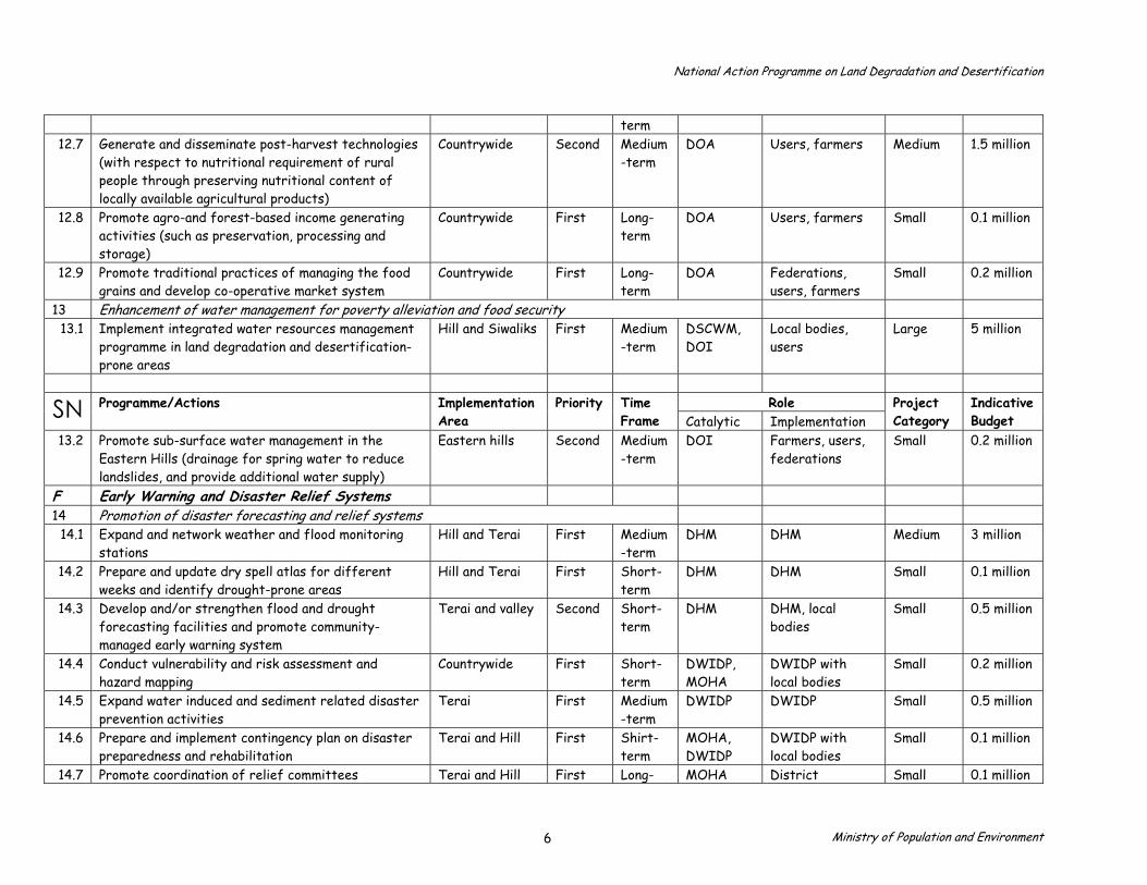
National Action Programme on Land Degradation and Desertification
term 12.7 Generate and disseminate post-harvest technologies
(with respect to nutritional requirement of rural people through preserving nutritional content of locally available agricultural products)
Countrywide Second Medium-term
DOA Users, farmers Medium 1.5 million
12.8 Promote agro-and forest-based income generating activities (such as preservation, processing and storage)
Countrywide First Long-term
DOA Users, farmers Small 0.1 million
12.9 Promote traditional practices of managing the food grains and develop co-operative market system
Countrywide First Long-term
DOA Federations,users, farmers
Small 0.2 million
13 Enhancement of water management for poverty alleviation and food security 13.1 Implement integrated water resources management
programme in land degradation and desertification-prone areas
Hill and Siwaliks First Medium-term
DSCWM, DOI
Local bodies, users
Large 5 million
Role SN Programme/Actions
ImplementationArea
TimeFrame
PriorityCatalytic Implementation
Project Category
Indicative Budget
13.2 Promote sub-surface water management in the Eastern Hills (drainage for spring water to reduce landslides, and provide additional water supply)
Eastern hills Second Medium-term
DOI Farmers, users,federations
Small 0.2 million
F Early Warning and Disaster Relief Systems 14 Promotion of disaster forecasting and relief systems
14.1 Expand and network weather and flood monitoring stations
Hill and Terai First Medium-term
DHM DHM Medium 3 million
14.2 Prepare and update dry spell atlas for different weeks and identify drought-prone areas
Hill and Terai First Short-term
DHM DHM Small 0.1 million
14.3 Develop and/or strengthen flood and drought forecasting facilities and promote community-managed early warning system
Terai and valley Second Short-term
DHM DHM, localbodies
Small 0.5 million
14.4 Conduct vulnerability and risk assessment and hazard mapping
Countrywide First Short-term
DWIDP, MOHA
DWIDP with local bodies
Small 0.2 million
14.5 Expand water induced and sediment related disaster prevention activities
Terai First Medium-term
DWIDP DWIDP Small 0.5 million
14.6 Prepare and implement contingency plan on disaster preparedness and rehabilitation
Terai and Hill First Shirt-term
MOHA, DWIDP
DWIDP with local bodies
Small 0.1 million
14.7 Promote coordination of relief committees Terai and Hill First Long- MOHA District Small 0.1 million
Ministry of Population and Environment 6
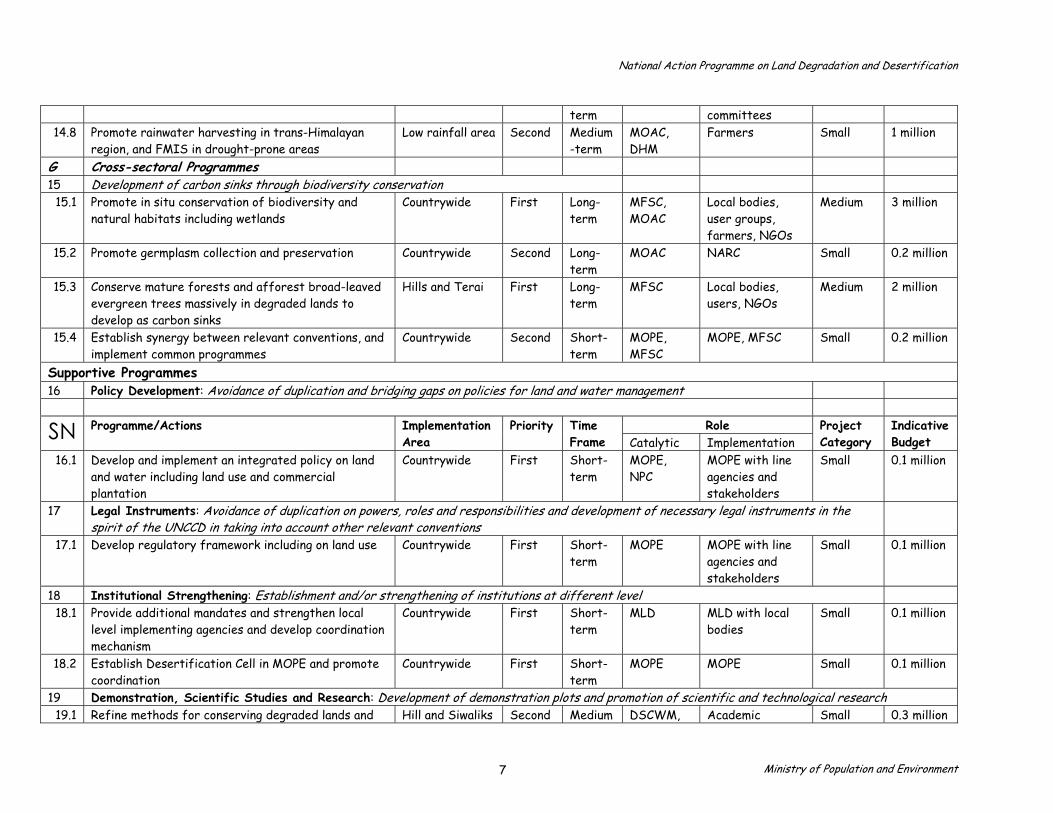
National Action Programme on Land Degradation and Desertification
term committees14.8 Promote rainwater harvesting in trans-Himalayan
region, and FMIS in drought-prone areas Low rainfall area Second Medium
-term MOAC, DHM
Farmers Small 1 million
G Cross-sectoral Programmes 15 Development of carbon sinks through biodiversity conservation
15.1 Promote in situ conservation of biodiversity and natural habitats including wetlands
Countrywide First Long-term
MFSC, MOAC
Local bodies, user groups, farmers, NGOs
Medium 3 million
15.2 Promote germplasm collection and preservation Countrywide Second Long-term
MOAC NARC Small 0.2 million
15.3 Conserve mature forests and afforest broad-leaved evergreen trees massively in degraded lands to develop as carbon sinks
Hills and Terai First Long-term
MFSC Local bodies,users, NGOs
Medium 2 million
15.4 Establish synergy between relevant conventions, and implement common programmes
Countrywide Second Short-term
MOPE, MFSC
MOPE, MFSC Small 0.2 million
Supportive Programmes 16 Policy Development: Avoidance of duplication and bridging gaps on policies for land and water management
Role SN Programme/Actions
ImplementationArea
TimeFrame
PriorityCatalytic Implementation
Project Category
Indicative Budget
16.1 Develop and implement an integrated policy on land and water including land use and commercial plantation
Countrywide First Short-term
MOPE, NPC
MOPE with line agencies and stakeholders
Small 0.1 million
17 Legal Instruments: Avoidance of duplication on powers, roles and responsibilities and development of necessary legal instruments in the spirit of the UNCCD in taking into account other relevant conventions
17.1 Develop regulatory framework including on land use Countrywide First Short-term
MOPE MOPE with line agencies and stakeholders
Small 0.1 million
18 Institutional Strengthening: Establishment and/or strengthening of institutions at different level 18.1 Provide additional mandates and strengthen local
level implementing agencies and develop coordination mechanism
Countrywide First Short-term
MLD MLD with local bodies
Small 0.1 million
18.2 Establish Desertification Cell in MOPE and promote coordination
Countrywide First Short-term
MOPE MOPE Small 0.1 million
19 Demonstration, Scientific Studies and Research: Development of demonstration plots and promotion of scientific and technological research 19.1 Refine methods for conserving degraded lands and Hill and Siwaliks Second Medium DSCWM, Academic Small 0.3 million
Ministry of Population and Environment 7

National Action Programme on Land Degradation and Desertification
NWFPs processing through scientific studies -term NARC institutions19.2 Promote participatory on-farm research and provide
research internship for university students Countrywide Second Medium
-term DSCWM, NARC
Academic institutions
Small 0.2 million
19.3 Update land resource mapping project (LRMP) information including land/soil degradation mapping, and demarcation of 'hot spots' periodically
Countrywide First Short-term
MLRM Department ofSurvey
Small 1 million
19.4 Establish and/or strengthen demonstration plots for studies and research in different ecological zones
Countrywide Second Long-term
DSCWM, NARC
NARC, DSCWM, Academic institutions
Small 0.5 million
19.5 Monitor land degradation and desertification process in arid and semi-arid regions
Countrywide Second Long-term
DSCWM, NARC
Academic institutions
Small 1 million
19.6 Update climate change effects on grasslands and wildlife habitat
Terai and Alpine area
Second Medium-term
MOPE Academicinstitution
Small 0.1 million
20 Indigenous Knowledge and Practice1: Utilisation of indigenous knowledge and replication of proven techniques and conservation practices 20.1 Refine and replicate site-specific proven
conservation techniques site, raise awareness and develop capacity for use
Countrywide Second Medium-term
DSCWM, NARC
NGOs, Users Small 0.5 million
Role SN Programme/Actions
ImplementationArea
TimeFrame
PriorityCatalytic Implementation
Project Category
Indicative Budget
21 Data and Information Sharing: Institutionalisation of information collection and sharing system 21.1 Collect and process data through different methods
including remote sensing and geographical information system (GIS)
Countrywide First Short-term
MOPE Line agencies andstakeholders
Medium 2 million
21.2 Develop Management Information System Countrywide Second Long-term
MOPE Line agencies andlocal bodies
Small 0.5 million
21.3 Exchange experts between national and international institutions and participation in regional and international workshops
Countrywide First Long-term
MOPE MOPE withstakeholders
Small 0.2 million
22 Technology Development and Transfer: Promotion of technology transfer and capacity building for its use 22.1 Collect information on available technologies,
promote their transfer and use Countrywide Second Long-
term MOPE DSCWM, NARC,
Local bodies and others
Small 0.2 million
1 Proposal has been received to shift this supportive programme under Main Programme and keep in medium category.
Ministry of Population and Environment 8
National Action Programme on Land Degradation and Desertification
23 Education, Public Awareness and Media Campaign: Expansion of land and drought issues in formal and non-formal education and promotion of public awareness
23.1 Integrate and/or expand land and water management issues in environmental education courses at different levels
Countrywide First Short-term
MOPE MOES Small 0.1 million
23.2 Develop, repackage and disseminate information and establish award for media
Countrywide First Long-term
MOPE Line agencies,stakeholders
Small 1 million
23.3 Organise awareness seminars and mobilise mass media including community radios, and NGOs for information campaign
Countrywide First Long-term
MOPE Line agencies,stakeholders
Medium 3 million
24 Capacity Building: Development of human resources at all levels, particularly of local bodies and community based organisations 24.1 Promote advanced studies, organise skill
development training, visits for human resources development
Countrywide First Long-term
MOPE Line agencies,stakeholders
Medium 3 million
Note: Number of programmes = 24 Number of recommended actions = 96
Ministry of Population and Environment 9

National Action Programme on Land Degradation and Desertification
Annex 3 Summary of Programs and Actions with Indicative Budget
(Based on Annex 5) (Budget in USD)
SN Programmes Actions Priority Time Frame Category and Indicative Budget I II III ST MT LT Small Medium Large TotalMain Programmes 1 Forest Management = 5 20 10 7 3 3 12 5 14 4 2
4.9 mill 8.5 mill 10 mill 23.4
million 2 Soil and Water Conservation = 3 16 10 6 - 6 10 - 7 6 3
3.3 mill 16 mill 14 mill 33.3
million 3 Pasture Management = 1 6 2 4 - 1 4 1 5 1 -
2.4 mill 4.4
million 2 million -4 Special Programmes for the
Mountain = 2 12 2 7 3 - 6 6 7 5 -
1.4 mill 10 mill -
11.4 million
5 Food Security and Poverty Alleviation = 2
11 7 4 - 3 4 4 8 2 1
1.5 mill 3.5 mill 5 mill
10 million
6 Early Warning and Disaster Relief System = 1
8 6 2 - 4 3 1 7 1
-
2.5 mill
5.5 million
3 million -7 Cross-sectoral Programmes = 1 4 2 2 - 1 - 3 2 2 -
0.4 mill 5.4
million 5 mill - Sub-total = 15 77 39 32 6 18 39 20 50 21 6
16.4mill 48 mill 29 mill 93.4 million
Supportive Programmes 8 Programmes = 9 19 11 8 - 7 4 8 16 3 -
6 mill 8 million - 14 million
Total Programmes = 24 96 50 40 6 25 43 28 66 24 6 22.4mill 56 mill 29 mill 107.4mill
Ministry of Population and Environment 10
National Action Programme on Land Degradation and Desertification
Note: I = First Priority; II = Second Priority; III = Third Priority; ST = Short-term; MT = Medium-term; LT = Long-term Supportive Programmes include programmes and activities on policy, law, institution, studies and research, indigenous technology development and use, data and information management, education and public awareness, and capacity building
Ministry of Population and Environment 11