neighborhood stories: dolphin heights
DESCRIPTION
March 16, 2013 Dolphin Heights Dallas, TX For more information, please contact [email protected] or www.bcworkshop.orgTRANSCRIPT
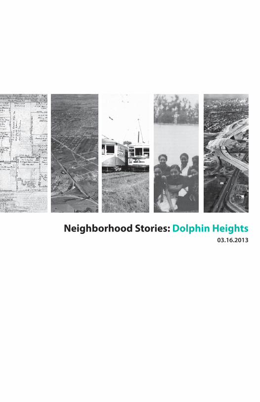
Neighborhood Stories: Dolphin Heights03.16.2013

Neighborhood Stories is made possible byNeighborhood Stories es posible por

POP DALLAS: Neighborhood Stories
Vecindarios activos y resistentes son la clave para una ciudad exitosa. POP [People Organizing Place] Dallas es un esfuerzo de diseño publico por parte de bcWORKSHOP para fortalecer la salud social, económica, y física de los vecindarios de Dallas. Como un componente de POP Dallas, Recuentos de Vecindario fortalece el conocimiento de nuestra ciudad, celebra los lugares diversos que dan el carácter y la textura, y crea una plataforma para dialogar activamente sobre su historia y su futuro.
La organización sin fin de lucro buildingcommunityWORKSHOP [bcWORKSHOP] es un centro de diseño comunitario, establecido en Dallas, que busca mejorar la condición de vida en nuestras comunidades por medio de diseño y construcción atento y cuidadoso.
Active and resilient neighborhoods are the foundation of a successful city. POP [People Organizing Place] Dallas is the bcWORKSHOP public design effort strengthening the social, economic, and physical health of Dallas’s neighborhoods. As a component of POP Dallas, Neighborhood Stories strengthens awareness of our city, celebrates the diverse places that give it character and texture, and creates a platform for active dialogue about its history and future.
The buildingcommunityWORKSHOP [bcWORKSHOP] is a Dallas based nonprofit community design center seeking to improve the livability and viability of communities through the practice of thoughtful design and making.

Home to one of the oldest inhabited sites in Dallas, Dolphin Heights has transformed over the past 170 years from a pioneer homestead to a resilient, if isolated, source of housing punctuated by a diverse set of land uses.In 1842 at the invitation of Dallas’s founder, John Neely Bryan, the Beeman family settled 640 acres of land west of White Rock Creek. Though their farm has long since disappeared, its location set in motion a series of decisions that shaped Dolphin Heights for years to come. Following the arrival of the Texas & Pacific Railroad in 1873, the neighborhood developed in stages, with a series of compact pockets of housing bounded by railways, industrial areas, and major thoroughfares. Dividing the east and west sides of the neighborhood as well as limiting connections between blocks, the effects of these
nonresidential uses have made it difficult to identify the area as a cohesive unit.However, even as industry and trains roared through Dolphin Heights, a dense mix of housing populated the neighborhood from the 1920s to the 1950s, creating one of several segregated African American enclaves in mid-century East Dallas. Neighbors became friends, supporting each other as the city’s planning efforts and segregation policies overlooked the interests of this small neighborhood.Surviving several decades of increasing vacancy and crime, Dolphin Heights has defined itself in order to pull together, address common challenges, and make a plan for the future.
Dolphin Heights
FAIR PARK
I-30
I-45

El hogar de uno de los sitios más antiguos habitados en Dallas, Dolphin Heights se ha transformado durante los últimos 170 años de un patrimonio familiar de pionero a un resistente, si aislado, fuente de viviendas marcada por un uso de tierra diverso.En 1842, por invitación del fundador de Dallas, John Neely Bryan, la familia Beeman se asentó 640 acres de tierra al oeste de White Rock Creek. Aunque su finca desaparecio hace mucho tiempo, su ubicación puso en marcha una serie de decisiones dandole forma a Dolphin Heights en los próximos años. Después de la llegada de Texas & Pacific Railroad en 1873, el barrio desarrolló en etapas, con una serie de viviendas compactas delimitadas por vías férreas, zonas industriales, y carreteras. Dividiendo los lados este y oeste del barrio, así como limitar las conexiones entre los bloques, los
efectos de estos usos no residenciales lo ha hecho difícil para identificar el área como una unidad cohesiva. Sin embargo, aun cuando la industria y los trenes rugieron a través de Dolphin Heights, una mezcla densa de viviendas poblaron el barrio desde 1920 hasta la década de 1950, creando uno de varios enclaves segregados Afroamericano en East Dallas a medio siglo. Los vecinos se hicieron amigos, apoyándosen unos a otros mientras los esfuerzos de planificación de la ciudad y las políticas de segregación pasaron por alto los intereses de este pequeño barrio.Sobreviviendo varias décadas de aumento de vacantes y la delincuencia, Dolphin Heights se ha definido con el fin de aunar esfuerzos, frentar a los retos comunes, y hacer un plan para el futuro.

top / arriba1891 - Murphy and Bolanz real estate map showing early landownership in what is now Dolphin Heights. Located within the John Beeman Subdivision north of the Texas & Pacific Railroad line and west of White Rock Creek, this area was initially the site of the Beeman family’s homestead and cemetery.1891 - Mapa de bienes raíces de Murphy y Bolanz mostrando la propiedad de la tierra a principios de la actual en lo que es ahora Dolphin Heights. Situado dentro del John Beeman Subdivision al norte de la línea Texas & Pacific Railroad y al oeste de White Rock Creek, esta área fue inicialmente el sitio del patrimonio familiar y el cementerio de la familia Beeman.Image courtesy of the University of Texas at Arlington LibraryImagen cortesía de University of Texas at Arlington Library
right / derechaImage of John Neely Bryan and Margaret Beeman Bryan, courtesy of the Dallas Public LibraryImagen de John Neely Bryan y Margaret Beeman Bryan, cortesía de Dallas Public Library

John Beeman y su familia decidieron asentarse varias millas al este de lo que es ahora el centro de Dallas en un territorio salvaje por White Rock Creek en la primavera de 1842, cuatro años antes que Dallas fuera integrada como una ciudad. Pronto los Beemans aventureros aprendieron a llamar este nuevo lugar su casa, plantando las primeras cosechas en el condado, construyendo un molino para procesar madera y maíz, casándose a otros colonizadores, y, cuando la vida terminó, enterrando su muerto en lo que es ahora el cementerio restante más viejo de la ciudad.
John Beeman and his family decided to settle several miles east of what is now downtown Dallas in wild territory along White Rock Creek in the spring of 1842, four years before Dallas was incorporated as a city. Soon the adventurous Beemans learned to call this new place home, planting the first crops in the county, building a mill to process lumber and corn, marrying other settlers, and, when life ended, burying their dead in what is now the city’s oldest remaining cemetery.
Beeman SettlementBeeman Asentamiento

right / derecha1924 - Bird’s eye view of Dallas from the east, showing Dolphin Heights to be largely undeveloped. Visible neighborhood elements include the Shearith Israel Memorial Cemetery, the Dallas-Terrell Interurban line, and the beginnings of residential and industrial development.1924 - La vista del ojo del pájaro de Dallas del este, mostrando Dolphin Heights en gran parte subdesarrollado. Los elementos visibles del vecindario incluyen Shearith Israel Memorial Cemetery, la línea Dallas-Terrell Interurban, y los principios del desarrollo residencial e industrial. Image courtesy of the Dallas Public LibraryImagen cortesía de Dallas Public Library
Thirty years after the Beemans came to White Rock Creek, two railroads crossed near downtown Dallas: the Houston & Texas Central in 1872, and the Texas & Pacific in 1873. Running from east to west, the Texas & Pacific railroad was constructed along the southern edge of the Beeman’s land, creating the physical boundary that defines the southern edge of Dolphin Heights. Lumber yards, mills, and box factories soon followed, establishing the beginnings of an industrial center with adjacent workers’ housing.By 1924, two more railways passed through the area as the H&TC was rerouted out of the city center at the recommendation of the Kessler Plan, Dallas’s first masterplan, and the Dallas-Terrell Interurban line cut through the
middle of the neighborhood, hampering future residential development while providing little benefit to residents. Along with Haskell Avenue, these boundaries limited both opportunities for expansion and connections within the neighborhood.
El Vecindario y la Ciudad
The Neighborhood and the City
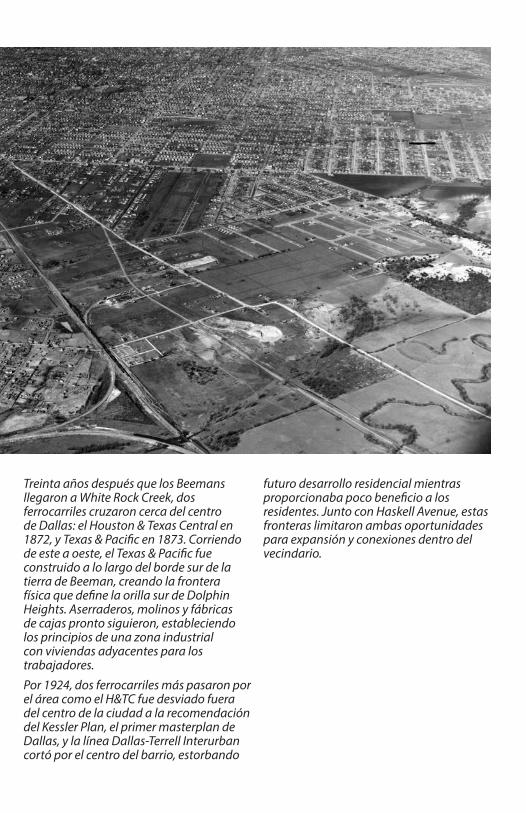
Treinta años después que los Beemans llegaron a White Rock Creek, dos ferrocarriles cruzaron cerca del centro de Dallas: el Houston & Texas Central en 1872, y Texas & Pacific en 1873. Corriendo de este a oeste, el Texas & Pacific fue construido a lo largo del borde sur de la tierra de Beeman, creando la frontera física que define la orilla sur de Dolphin Heights. Aserraderos, molinos y fábricas de cajas pronto siguieron, estableciendo los principios de una zona industrial con viviendas adyacentes para los trabajadores.Por 1924, dos ferrocarriles más pasaron por el área como el H&TC fue desviado fuera del centro de la ciudad a la recomendación del Kessler Plan, el primer masterplan de Dallas, y la línea Dallas-Terrell Interurban cortó por el centro del barrio, estorbando
futuro desarrollo residencial mientras proporcionaba poco beneficio a los residentes. Junto con Haskell Avenue, estas fronteras limitaron ambas oportunidades para expansión y conexiones dentro del vecindario.
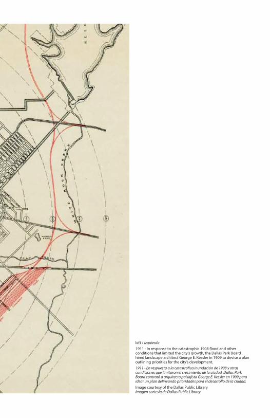
left / izquierda1911 - In response to the catastrophic 1908 flood and other conditions that limited the city’s growth, the Dallas Park Board hired landscape architect George E. Kessler in 1909 to devise a plan outlining priorities for the city’s development.1911 - En respuesta a la catastrófica inundación de 1908 y otras condiciones que limitaron el crecimiento de la ciudad, Dallas Park Board contrató a arquitecto paisajista George E. Kessler en 1909 para idear un plan delineando prioridades para el desarrollo de la ciudad. Image courtesy of the Dallas Public LibraryImagen cortesía de Dallas Public Library

DOLPHIN HEIGHTS
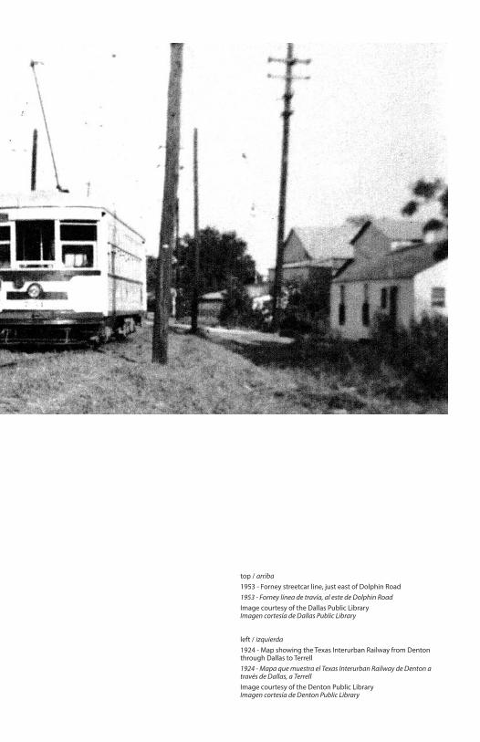
top / arriba1953 - Forney streetcar line, just east of Dolphin Road1953 - Forney línea de travía, al este de Dolphin RoadImage courtesy of the Dallas Public LibraryImagen cortesía de Dallas Public Library
left / izquierda1924 - Map showing the Texas Interurban Railway from Denton through Dallas to Terrell1924 - Mapa que muestra el Texas Interurban Railway de Denton a través de Dallas, a TerrellImage courtesy of the Denton Public LibraryImagen cortesía de Denton Public Library

There was a clear need to address the haphazard development and lack of connectivity that had arisen in areas like Dolphin Heights. Several subsequent planning efforts attempted to do so, the most important of which was the extension of Hatcher Street north from Scyene Road to Dolphin Road in 1940. In addition to linking Dolphin Heights with South Dallas institutions like Lincoln High School, the project was intended to encourage the development of additional African American residential neighborhoods to ease overcrowding and racial tensions.In 1943, Harland Bartholomew began to develop the city’s most comprehensive physical plan to date. In it, he called for the separation of residential and industrial uses where possible,
recommending the relocation of housing in White Rock Creek’s floodplain and proposing a route for Interstate 30 that passed directly through Dolphin Heights. Significantly, Bartholomew’s route was rejected and I-30 ultimately passed just south of Samuell Grand Park, providing the neighborhood with convenient access to the expanding freeway system.
right / derecha1940 - A Master Plan for Dallas, Location of Industry1940 - A Master Plan for Dallas, Ubicación de la IndustriaImage courtesy of the Dallas Public LibraryImagen cortesía de Dallas Public Library

Había una necesidad clara de dirigir el desarrollo y la falta casuales de conectividad que había surgido en áreas como Dolphin Heights. Varios esfuerzos de planificación subsiguientes procuraron hacer así, la más importante de las cuales fue la extensión de Hatcher Street al norte de Scyene Road a Dolphin Road en 1940. Además de ligar Dolphin Heights con instituciones del South Dallas como Lincoln High School, el proyecto fue pensado favorecer el desarrollo adicional de vecindarios Afroamericanos para aliviar la superpoblación y las tensiones raciales. En 1943, Harland Bartholomew comenzó a desarrollar el plan físico más completo de la ciudad hasta hoy día. En el, Bartholomew llamó para la separación de los usos residenciales e industriales donde posible, recomendando la recolocación de
viviendas en las tierras inundadas de White Rock Creek y proponiendo una ruta para Interstate 30 que pasara directamente por Dolphin Heights. Apreciablemente, la ruta de Bartholomew fue rechazada y I-30 últimamente pasó sólo al sur de Samuell Grand Park, proporcionando el vecindario con acceso conveniente al sistema expansivo de autopistas.
existing industries / industria existenteexisting warehouses / almacén existente

1943 - Harland Bartholomew’s Plan for the City of Dallas, issued from 1943 to 1945, created a plan for virtually every aspect of the city to meet the needs of a population that was expected to double by 1970. His 15-volume proposal addressed streets, transportation, parks and schools, land use, zoning, and housing. 1943 - El Plan de Harland Bartholomew para la Ciudad de Dallas, emitido desde 1943 a 1945, creó un plan para prácticamente todos los aspectos de la ciudad para satisfacer las necesidades de una población que se esperaba duplicar por 1970. Su propuesta de 15 volúmenes dirigió las calles, el transporte, los parques y las escuelas, la utilización de la tierra, zonificaciónes, y la vivienda.Image courtesy of the Dallas Public LibraryImagen cortesía de Dallas Public Library
Overcrowding1940
more than 40
20 - 40
less than 20
percentage of living units containing 1.51 or more persons per roomporcentaje de unidades de vivienda que contienen 1,51 o más personas por habitación
Neighborliness of the Population1938
Living in Neighborhood by Choice1938
175 - 299 300 - 399400 - 499500 - 599600 - 675
least neighborlylo menos buen vecino
most neighborlylo más buen vecino
25 - 3940 - 4950 - 59
60 - 6970 - 7980 - 95
percentage of total sampleporcentaje de la muestra total


top / arriba1949 - Aerial view of Dolphin Heights; nearby industries at the time included the RC Cola Bottling Company, Purity Milk Company (officially named Schepps Dairy in 1952), Temple Manufacturing Company (previously Hoffman Box Company and Silver’s Box Company, now owned by Schepps), and the Ford Manufacturing Plant.1949 - La vista aérea de Dolphin Heights; industrias cercanas del tiempo incluían RC Cola Bottling Company, Purity Milk Company (oficialmente nombrado Schepps Dairy en 1952), Temple Manufacturing Company (anteriormente Hoffman Box Company y Silver’s Box Company, ahora poseído por Schepps), y Ford Manufacturing Plant.Image courtesy of the Dallas Municipal ArchivesImagen cortesía de Dallas Municipal Archives
left / izquierda1939 - Advertisment for Royal Crown Cola 1939 - Anuncio para Royal Crown Cola 1969 - Advertisment for Schepps Dairy 1969 - Anuncio para Schepps DairyImages courtesy of Dallas Morning News Imágenes cortesía de Dallas Morning News

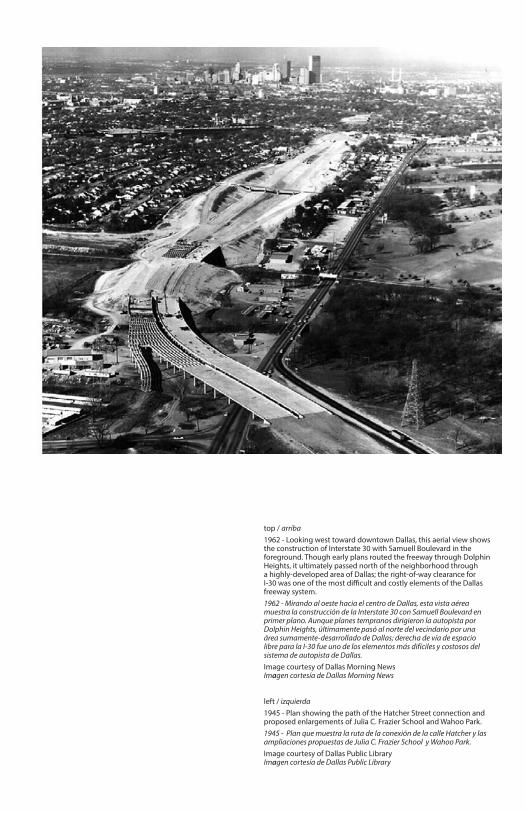
top / arriba 1962 - Looking west toward downtown Dallas, this aerial view shows the construction of Interstate 30 with Samuell Boulevard in the foreground. Though early plans routed the freeway through Dolphin Heights, it ultimately passed north of the neighborhood through a highly-developed area of Dallas; the right-of-way clearance for I-30 was one of the most difficult and costly elements of the Dallas freeway system.1962 - Mirando al oeste hacia el centro de Dallas, esta vista aérea muestra la construcción de la Interstate 30 con Samuell Boulevard en primer plano. Aunque planes tempranos dirigieron la autopista por Dolphin Heights, últimamente pasó al norte del vecindario por una área sumamente-desarrollado de Dallas; derecha de vía de espacio libre para la I-30 fue uno de los elementos más difíciles y costosos del sistema de autopista de Dallas. Image courtesy of Dallas Morning News Imagen cortesía de Dallas Morning News
left / izquierda 1945 - Plan showing the path of the Hatcher Street connection and proposed enlargements of Julia C. Frazier School and Wahoo Park.1945 - Plan que muestra la ruta de la conexión de la calle Hatcher y las ampliaciones propuestas de Julia C. Frazier School y Wahoo Park.Image courtesy of Dallas Public LibraryImagen cortesía de Dallas Public Library
FORD

La Lucha por la Vivienda Igual
As industrial activity began to cluster to the west of White Rock Creek in the 1920s, the Beeman’s original tracts of land were further subdivided, sold to developers, and built into a series of small housing additions west of Dolphin Road. Sometimes referred to as White Rock Heights, this area remained outside Dallas city limits until 1929, when the eastern boundary of the city was extended to Dolphin Road.This isolation encouraged the development of a robust African American community in the area. Just
to the south of the T & P railroad tracks, Wahoo Lake served as a center for community life after it was purchased by the City and converted to an African American park in the 1930s. Neighbors attended local churches, played baseball at the current site of Schepps Dairy, and attended Julia C. Frazier School.
The Struggle for Equal Housing
right / derecha 1940 - This page from the 1940 census provides information about households on Beall Street, Dolphin Road, and Haskell Avenue, showing a snapshot of life in the neighborhood.1940 - Esta página del 1940 censo proporciona información sobre casas en Beall Street, Dolphin Road, y Haskell Avenue, mostrando una fotografía de la vida en el vecindario.
1940 Census, United States Department of Commerce1940 Censo, United States Department of Commerce

Como actividad industrial comenzó a agruparse al oeste de White Rock Creek en la década de 1920, los tractos de tierra originales de Beeman fueron aún más subdivididos, vendidos a los desarrolladores, y construidos en una serie de pequeñas adiciones de viviendas al oeste de Dolphin Heights. Referido a veces como White Rock Heights, esta área quedó fuera del perímetro urbano de Dallas hasta 1929, cuando la frontera oriental de la ciudad fue extendida hasta Dolphin Road. Este aislamiento favoreció el desarrollo de una comunidad Afroamericana robusta
en el área. Sólo al sur de las vías férreas T & P, Wahoo Lake sirvió como un centro para la vida comunitaria después de que fuera comprado por la Ciudad y convertido en un parque Afroamericano en la década de 1930. Los vecinos asistieron las iglesias locales, jugaban el béisbol en el sitio actual de Schepps Dairy, y asistieron a Julia C. Frazier School.


top / arribac. 1940 - Wahoo Lake, a popular picnic and recreation spot for the surrounding neighborhoods, hosts a gathering of local residents including Vivian Starks, Blanche Davis, Ethelyn Chisum, and Viola Dixon-Cole. The lake dried up over the years and eventually became the site for the Juanita Jewel Craft Recreation Center and Park in 1974.c. 1940 - Wahoo Lake, un lugar popular de picnic y recreación para los vecindarios circundantes, acoge una reunión de residentes de la zona incluyendo a Vivian Starks, Blanche Davis, Ethelyn Chisum, y Viola Dixon-Cole. El lago se secó en los últimos años y con el tiempo se convirtió en el sitio para Juanita Jewel Craft Recreation Center and Park en 1974. Image courtesy of Dallas Public LibraryImagen cortesía de Dallas Public Library
left / izquierdaThe Wahoo Park Community House was a project of the federal Works Progress Administration, which funded jobs for several Dolphin Heights residents during the years between the Great Depression and War World II.El Wahoo Park Community House fue un proyecto del Works Progress Administration federal, que financió trabajos para varios residentes de Dolphin Heights durante los años entre el Great Depression y World War II.Image courtesy of Dallas Public LibraryImagen cortesía de Dallas Public Library

Between 1940 and 1950, however, the African American population in Dallas increased by approximately 6,500 people, putting a strain on the limited number of housing units available in segregated neighborhoods. Overcrowding was rampant, and in his 1943 plan for the City of Dallas, Harland Bartholomew called for the creation of new African American neighborhoods to meet the needs of the growing population. Though numerous schemes were proposed in the late 1940s, most were rejected due to the difficulty of finding an appropriate site. It was during this time that the land east of Dolphin Heights was developed; formerly used as a city dump, this flood-prone area was ultimately deemed suitable for housing the African American population.
After the passage of the Civil Rights Act in 1964, neighborhood demographics shifted as wealthier African American residents left segregated neighborhoods, older residents passed away, and more of the housing stock was converted to rentals. Residents watched their once-vibrant neighborhood deteriorate as vacancy and crime increased and families moved out.
right / derecha 1945 - This hand-colored map was created by the City of Dallas Public Works department to catalogue the location of primarily Mexican American (blue) and African American neighborhoods (red), including the area of Dolphin Heights.1945 - Este mapa coloreado a mano fue creado por el departamento de City of Dallas Public Works para catalogar la ubicación de vecindarios, principalmente vecindarios Mexicano-americanos (azul) y Africano-americanos (rojo), inclusive el área de Dolphin Heights.Created by the City of Dallas Public Works DepartmentHecha por City of Dallas Public Works Department
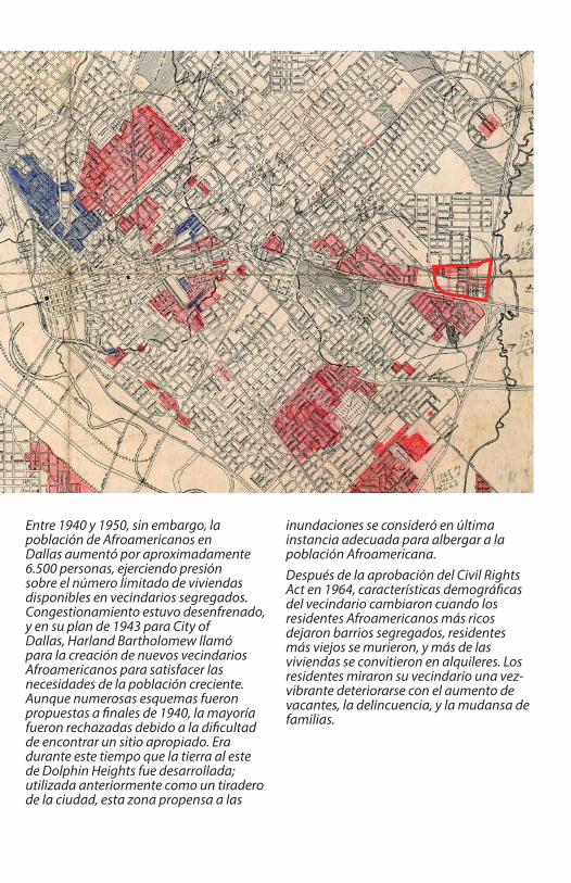
Entre 1940 y 1950, sin embargo, la población de Afroamericanos en Dallas aumentó por aproximadamente 6.500 personas, ejerciendo presión sobre el número limitado de viviendas disponibles en vecindarios segregados. Congestionamiento estuvo desenfrenado, y en su plan de 1943 para City of Dallas, Harland Bartholomew llamó para la creación de nuevos vecindarios Afroamericanos para satisfacer las necesidades de la población creciente. Aunque numerosas esquemas fueron propuestas a finales de 1940, la mayoría fueron rechazadas debido a la dificultad de encontrar un sitio apropiado. Era durante este tiempo que la tierra al este de Dolphin Heights fue desarrollada; utilizada anteriormente como un tiradero de la ciudad, esta zona propensa a las
inundaciones se consideró en última instancia adecuada para albergar a la población Afroamericana.Después de la aprobación del Civil Rights Act en 1964, características demográficas del vecindario cambiaron cuando los residentes Afroamericanos más ricos dejaron barrios segregados, residentes más viejos se murieron, y más de las viviendas se convitieron en alquileres. Los residentes miraron su vecindario una vez-vibrante deteriorarse con el aumento de vacantes, la delincuencia, y la mudansa de familias.

Mid-century housing options for African Americans ranged from slums to housing projects to segregated, single-family subdivisions: (from top left, clockwise) the Bottoms, Roseland Homes, Hamilton Park, and an example of 1954 housing improvements.Opciones de albergas del medio-siglo para Africano-americanos varió de tugurios a proyectos de vivienda a subdivisiones segregadas y unifamiliares: (desde arriba a la izquierda, hacia la derecha) los Bottoms, Roseland Homes, Hamilton Park, y un ejemplo de mejoramiento de vivienda en 1954.Image courtesy of Dallas Public LibraryImagen cortesía de Dallas Public Library


Unnamed SourceLeader of a women’s groupLíder de un grupo de mujeres
Dallas Express, March 18, 1950
“
“
Thank you to the following; without your participation, Neighborhood Stories: Dolphin Heights would not have been possible:Gracias a las siguientes personas; sin esta participación, Neighborhood Stories: Dolphin Heights no serían posible:
Total dwelling unitsTotal de unidades de vivienda
Dwellings lacking some/all plumbingViviendas que carecen de algunas / todas plomería
Dwelling unit year of constructionUnidad de vivienda el año de construcción
It seems that these people still think that anything is good
enough for a Negro. We came out of river bottoms. Some of
us are still either in them or are so crowded into slum areas
that decent home life is not possible. We are forced to live in
alleys, on muddy streets and in all the worst parts of town.
to stay out of this place where they are trying to put us
and where we’ll have to live for the rest of our lives among
mosquitoes, frogs, dampness and smoke.”
Parece que estas personas todavía piensan que cualquier cosa
ríos. Algunos de nosotros todavía estamos en ellos o estamos
tan hacinados en barrios pobres que la vida de familia decente
no es posible. Somos forzados a vivir en callejones, en calles
fangosas y en todas las peores partes del pueblo. Sabe que
nosotras las mujeres lucharemos con nuestros líderes para
quedarnos afuera de este lugar donde tratan de ponernos
y donde tendremos que vivir para el resto de nuestras vidas
entre mosquitos, las ranas, la humedad y el humo.”
You know we women are going to �ght with our leaders
es su�ciente bueno para un Negro. Salimos del fondo de los

Housing Profile 1940 - 2013El Perfil de las Viviendas 1940 - 2013
Housing Profile 1940 - 2013El Perfil de las Viviendas
Total dwelling unitsTotal de unidades de vivienda
Dwelling unit year of construction Unidad de vivienda año de construcción
Dwellings lacking some/all plumbingViviendas que carecen de algunas / todas plomería
DOLPHIN HEIGHTS DALLAS
69%
29%
12%
2.5%
27%
18%
6.7%
1.7%
1940
1950
1960
1970
1940
1950
1960
1970
1990
2010
owner occupiedocupada por el dueno
renter occupiedocupado por arrendatar v vio
vacant dwellingvivienda vacía
452 total
185 total
267 total84 vacant dwellings vivienda vacía
0
450
225
1920 - 1939
1940 - 1959
1960 - 1979
2000 - 2013
vacantvivienda vacíaindustry / commercial industria / comercial
The number of dwelling units in Dolphin Heights peaked by 1960 and experienced a significant decline following the passage of the Fair Housing Act in 1968, which created more housing opportunities for African Americans. Though many homes in the neighborhood initially lacked indoor plumbing, improvements were made over a 30 year period to bring basic amenities in line with conditions in the rest of the city. Housing constructed within the last ten years has expanded the housing choices available to residents of Dolphin Heights.
ESRI AcrGIS, ESRI Community Analyst, United States Census
El número de unidades de viviendas en Dolphin Heights alcanzó su punto máximo en 1960y tuvo una disminución significativa después de la aprobación del Fair Housing Act en 1968, que creó más oportunidades de viviendas para Afroamericanos. Aunque muchas casas en el vecindario faltaban inicialmente de instalación de agua en el interior, mejoramientos fueron hechas sobre un período de 30 años para traer servicios básicos de acuerdo con condiciones en el resto de la ciudad. Las viviendas construidas en los últimos diez años han expandido las elecciones de viviendas disponibles a residentes de Dolphin Heights.
Housing Profile 1940 - 2013El Perfil de las Viviendas
Total dwelling unitsTotal de unidades de vivienda
Dwelling unit year of construction Unidad de vivienda año de construcción
Dwellings lacking some/all plumbingViviendas que carecen de algunas / todas plomería
DOLPHIN HEIGHTS DALLAS
69%
29%
12%
2.5%
27%
18%
6.7%
1.7%
1940
1950
1960
197019
40
1950
1960
1970
1990
2010
owner occupiedocupada por el dueno
renter occupiedocupado por arrendatar v vio
vacant dwellingvivienda vacía
452 total
185 total
267 total84 vacant dwellings vivienda vacía
0
450
225
1920 - 1939
1940 - 1959
1960 - 1979
2000 - 2013
vacantvivienda vacíaindustry / commercial industria / comercial
The number of dwelling units in Dolphin Heights peaked by 1960 and experienced a significant decline following the passage of the Fair Housing Act in 1968, which created more housing opportunities for African Americans. Though many homes in the neighborhood initially lacked indoor plumbing, improvements were made over a 30 year period to bring basic amenities in line with conditions in the rest of the city. Housing constructed within the last ten years has expanded the housing choices available to residents of Dolphin Heights.
ESRI AcrGIS, ESRI Community Analyst, United States Census
El número de unidades de viviendas en Dolphin Heights alcanzó su punto máximo en 1960y tuvo una disminución significativa después de la aprobación del Fair Housing Act en 1968, que creó más oportunidades de viviendas para Afroamericanos. Aunque muchas casas en el vecindario faltaban inicialmente de instalación de agua en el interior, mejoramientos fueron hechas sobre un período de 30 años para traer servicios básicos de acuerdo con condiciones en el resto de la ciudad. Las viviendas construidas en los últimos diez años han expandido las elecciones de viviendas disponibles a residentes de Dolphin Heights.
The number of dwelling units in Dolphin Heights peaked by 1960 and experienced a significant decline following the passage of the Fair Housing Act in 1968, which created more housing opportunities for African Americans. Though many homes in the neighborhood initially lacked indoor plumbing, improvements were made over a 30-year period to bring basic amenities in line with conditions in the rest of the city. Housing constructed within the last ten years has expanded the housing choices available to residents of Dolphin Heights.
El número de unidades de viviendas en Dolphin Heights alcanzó su punto máximo en 1960 y tuvo una disminución significativa después de la aprobación del Fair Housing Act en 1968, que creó más oportunidades de viviendas para Afroamericanos. Aunque muchas casas en el vecindario faltaban inicialmente de instalación de agua en el interior, mejoramientos fueron hechas sobre un período de 30 años para traer servicios básicos de acuerdo con condiciones en el resto de la ciudad. Las viviendas construidas en los últimos diez años han expandido las elecciones de viviendas disponibles a residentes de Dolphin Heights.
Thank you to the following; without your participation, Neighborhood Stories: Dolphin Heights would not have been possible:Gracias a las siguientes personas; sin esta participación, Neighborhood Stories: Dolphin Heights no serían posible:
Total dwelling unitsTotal de unidades de vivienda
Dwellings lacking some/all plumbingViviendas que carecen de algunas / todas plomería
Dwelling unit year of constructionUnidad de vivienda el año de construcción
It seems that these people still think that anything is good
enough for a Negro. We came out of river bottoms. Some of
us are still either in them or are so crowded into slum areas
that decent home life is not possible. We are forced to live in
alleys, on muddy streets and in all the worst parts of town.
to stay out of this place where they are trying to put us
and where we’ll have to live for the rest of our lives among
mosquitoes, frogs, dampness and smoke.”
Parece que estas personas todavía piensan que cualquier cosa
ríos. Algunos de nosotros todavía estamos en ellos o estamos
tan hacinados en barrios pobres que la vida de familia decente
no es posible. Somos forzados a vivir en callejones, en calles
fangosas y en todas las peores partes del pueblo. Sabe que
nosotras las mujeres lucharemos con nuestros líderes para
quedarnos afuera de este lugar donde tratan de ponernos
y donde tendremos que vivir para el resto de nuestras vidas
entre mosquitos, las ranas, la humedad y el humo.”
You know we women are going to �ght with our leaders
es su�ciente bueno para un Negro. Salimos del fondo de los

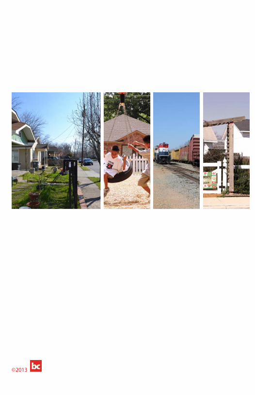
top left, clockwise / arriba a la izquierda, hacia la derechaEast Dallas Community Organization (EDCO) home, 2011Carpenter’s Point Senior Housing, 2010bcWORKSHOP sustainABLEhouse, 2013Frazier Revitalization, Inc. home, 2011


Moving ForwardSiguiendo Adelante
In the early 2000s, residents living in the area bounded by two sets of railroad tracks and South Haskell Avenue voted to call their neighborhood Dolphin Heights. Since that time, an active and persistent community has laid the groundwork to transform its future into a hopeful one. By partnering with community development organizations and civic leaders, the Dolphin Heights Neighborhood Association has seen new homes built, a community garden planted, the creation of an after school program, repaved streets, and a reduction in crime. However, several challenges remain, including aging infrastructure on the east side of Dolphin, industrial activity on Sapphire Street, vacancy, and the recent closing of local schools.
In the coming years, residents will have the opportunity to be involved in a planning process to create a framework for future improvements to the neighborhood. Additionally, the 2006 forwardDallas! Comprehensive Plan focuses on creating commercial development in the South Dallas/Fair Park region that will help the area to grow through increased commercial development at major intersections, additional parks, and greater connectivity to Downtown.
right / derecha 2013 - Dolphin Heights, looking east on Mingo Street2013 - Dolphin Heights, mirando hacia el este por la calle Mingo

Moving Forward
Al principio de la década de 2000, los residentes que viven en el área delimitada por dos conjuntos de vías férreas y South Haskell Avenue votaron a favor de llamar su vecindario Dolphin Heights. Desde ese tiempo, una comunidad activa y persistente ha sentado las bases para transformar su futuro en uno lleno de esperanza. Al asociarse con organizaciones del desarrollo de la comunidad y líderes cívicos, Dolphin Heights Neighborhood Association ha visto nuevas casas construidas, un jardín de la comunidad sembrado, la creación de un programa de después de escuela, calles pavimentadas, y una reducción en la delincuencia. Sin embargo, varios desafíos quedan, inclusive infraestructura vieja en la zona del este de Dolphin, actividad industrial en Sapphire Street, vacantes, y el cierre reciente de escuelas locales.
En los próximos años, los residentes tendrán la oportunidad de participar en un proceso de planificación para crear un marco de mejoramientos para el barrio en el futuro. Adicionalmente, el 2006 forwardDallas! Comprehensive Plan se centra en crear el desarrollo comercial en la región de South Dallas/Fair Park que ayudará el área crecer a traves del aumento del desarrollo comercial en las intersecciones principales, parques adicionales, y mejor conectividad al Centro.


Successful efforts of the Dolphin Heights Neighborhood Association include providing the neighborhood with improved street conditions and landscaping, a community garden, a playground built in partnership with the national nonprofit KaBoom!, and the Belay House after school tutoring program.Los esfuerzos exitosos de Dolphin Heights Association incluyen proporcionar el vecindario con condiciones mejoradas de calle y paisajismo, un jardín de la comunidad, un parque infantil construido en colaboración con la organización no lucrativa nacional Kaboom!, y el programa de tutoría de después de la escuela de Belay House
top / arriba2013 - Belay House
left / izquierdaKaboom! playgoundParque infantil Kaboom!
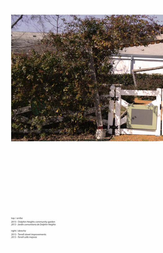
top / arriba2013 - Dolphin Heights community garden2013 - Jardín comunitario de Dolphin Heights
right / derecha 2013 - Terrell street improvements2013 - Terrell calle mejoras


Situado en un terreno asentado antes de la incorporación de la ciudad de Dallas, Dolphin Heights evolucionó de la granja familiar de Beeman en un barrio que agrupa a las viviendas y dúplex unifamiliares, viviendas para personas mayores multifamiliares, los usos industriales y comerciales, y cementerios. Estos mapas muestran la evolución física del barrio y sus alrededores, incluyendo los patrones de desarrollo y el uso del edificio a través del tiempo. Creado mediante la compilación de mapas históricos de Sanborn Fire Insurance Maps y las imágenes aéreas de la zona, los mapas representan cómo el tejido de la zona ha cambiado, pero sigue ofreciendo opciones flexibles para la vivienda.
Located on land settled before the incorporation of the City of Dallas, Dolphin Heights evolved from the Beeman family farmstead into a neighborhood that groups together single-family homes and duplexes, multi-family senior housing, industrial and commercial uses, and cemeteries. These maps show the physical evolution of the neighborhood and surrounding areas, including development patterns and building use over time. Created by compiling historic Sanborn Fire Insurance Maps and aerial images of the neighborhood, the maps represent how the fabric of the neighborhood has shifted, yet continues to provide resilient options for housing.
Mapping Dolphin HeightsRealizando un Mapa de Dolphin Heights

BARRY AVENUE
CARL STREET
ROWAN AVENUE
FOREMAN STREET
LAGOW STREET
JEROME STREET
BALDWIN STREET
SILVE
R AVE
NUE
REYNOLDS AVENUE
SPURLOCK AVENUE
COLLINS AVEN
UE
CALDWELL STREET
SPRI
NG AV
ENUE
HOUS
TON
& TE
XAS C
ENTR
AL RA
ILROA
D
WHITE ROCK CREEK
HELE
N ST
REET
GAISFORD STREET
HARRIS COURT
DALLAS-TERRELL INTERURBAN
TEXAS & PACIFIC RAILROAD
TROY STREET
CLEM STREET
PACIFIC AVENUE
UPSHUR STREET
ALPINE AVENUE
SABIN STREET
INDU
STRI
US ST
REET
JONES STREET
INDU
STRI
AL ST
REET
BEEM
AN AV
ENUE
BENTON AVENUE
FRANK STREET
JAMAICA STREET
CARR STREET
METROPOLIT
AN AVENUE
HAMILTON AVEN
UE
FITZHUGH AVENUE
FORNEY ROAD
CANAL STREET
TROY STREET
HAMILTON AVEN
UE
JAMAICA STREET
GAISFORD STREET
BALDWIN STREET
DETONTE STREET
MIDWAY STREET
HASKELL AVENUE
BARRY AVENUE
DENTON STREET
FITZHUGH AVENUE
SCHULL STREET
HENDERSON AVENUE
ST. C
HARL
ES AV
ENUE
JEROME STREET
HATC
HER R
OAD
RIGH
T OF W
AY
BOOTH AVENUE
LAW
THER
AVEN
UE
JEROME STREET
WARE STREET
SPRING AVENUE
SKILLERN STREET
DUCKETT STREET
BOW
LING
AVEN
UE
FITZH
UGH
AVEN
UE
SILVE
R AVE
NUE
BEEMAN CEMETERY
SHEARITH ISREAL CEMETERY
N
N
1927
Dolphin Heights block developmentDesarrollo de cuadra en Dolphin Heights
Area housing developmentZona de urbanización
1927
BARRY AVENUE
CARL STREET
ROWAN AVENUE
FOREMAN STREET
LAGOW STREET
JEROME STREET
BALDWIN STREET
SILVE
R AVE
NUE
REYNOLDS AVENUE
SPURLOCK AVENUE
COLLINS AVEN
UE
CALDWELL STREET
SPRI
NG AV
ENUE
HOUS
TON
& TE
XAS C
ENTR
AL RA
ILROA
D
WHITE ROCK CREEK
HELE
N ST
REET
GAISFORD STREET
HARRIS COURT
DALLAS-TERRELL INTERURBAN
TEXAS & PACIFIC RAILROAD
TROY STREET
CLEM STREET
PACIFIC AVENUE
UPSHUR STREET
ALPINE AVENUE
SABIN STREET
INDU
STRI
US ST
REET
JONES STREET
INDU
STRI
AL ST
REET
BEEM
AN AV
ENUE
BENTON AVENUE
FRANK STREET
JAMAICA STREET
CARR STREET
METROPOLIT
AN AVENUE
HAMILTON AVEN
UE
FITZHUGH AVENUE
FORNEY ROAD
CANAL STREET
TROY STREET
HAMILTON AVEN
UE
JAMAICA STREET
GAISFORD STREET
BALDWIN STREET
DETONTE STREET
MIDWAY STREET
HASKELL AVENUE
BARRY AVENUE
DENTON STREET
FITZHUGH AVENUE
SCHULL STREET
HENDERSON AVENUE
ST. C
HARL
ES AV
ENUE
JEROME STREET
HATC
HER R
OAD
RIGH
T OF W
AY
BOOTH AVENUE
LAW
THER
AVEN
UE
JEROME STREET
WARE STREET
SPRING AVENUE
SKILLERN STREET
DUCKETT STREET
BOW
LING
AVEN
UE
FITZH
UGH
AVEN
UE
SILVE
R AVE
NUE
BEEMAN CEMETERY
SHEARITH ISREAL CEMETERY
N
N
1927
Dolphin Heights block developmentDesarrollo de cuadra en Dolphin Heights
Area housing developmentZona de urbanización

BARRY AVENUE
CARL STREET
ROWAN AVENUE
FOREMAN STREETLAGOW STREET
JEROME STREET
BALDWIN STREET
SILVE
R AVE
NUE
GAUL
T
SAPP
HIRE
STRE
ET
REYNOLDS AVENUE
SPURLOCK AVENUE
COLLINS AVEN
UE
CALDWELL STREET
DOLP
HIN
ROAD
HELE
N ST
REET
GAISFORD STREET
HARRIS COURT
TERRELL AVENUE
TROY STREET
CLEM STREET
PACIFIC AVENUE
UPSHUR STREET
HOBB
S STR
EET
ALPINE AVENUE
MITCHELL STREET
MINGO STREETTH
OLL A
VENU
E
ISBEL
STRE
ET
JONES STREET
WAHOO STREET
BOXW
OOD
STRE
ET
BEEM
AN AV
ENUE
BENTON AVENUE
CHARBA STREET
FRANK STREET
JAMAICA STREET
BEALL STREET
METROPOLIT
AN AVENUE
HAMILTON AVEN
UE
FITZHUGH AVENUE
FORNEY ROAD
CANAL STREET
TROY STREET
HAMILTON AVEN
UE
METROPOLITAN AVENUE
PENELO
PE STREET
JAMAICA STREET
GAISFORD STREET
BALDWIN STREET
DETONTE STREET
MINGO STREET
HASKELL AVENUE
BARRY AVENUE
DENTON STREET
FITZHUGH AVENUE
SCHULL STREET
HENDERSON AVENUE
OWEN
WOO
D AV
ENUE
ST. C
HARL
ES AV
ENUE
JEROME STREET
HATC
HER R
OAD
BOOTH AVENUE
DOLP
HIN
ROAD
THOL
L AVE
NUE
OWEN
WOO
D AV
ENUE
SPURLOCK AVENUE
ALPINE AVENUE
REYNOLDS AVENUE
JEROME STREET
WARE STREET
SPRING AVENUE
BOW
LING
AVEN
UE
FITZH
UGH
AVEN
UE
SILVE
R AVE
NUE
DETONTE STREET
OWEN
WOO
D AV
ENUE
SPECKLEY STREET
GORMAN STREET
LIL GREEN STREET
REDMAN CIRCLE
BARR
Y AVE
NUE
HAM
ILTON
AVEN
UE
HOUS
TON
& TE
XAS C
ENTR
AL RA
ILROA
D
WHITE ROCK CREEK
TEXAS & PACIFIC RAILROAD
FORNEY STREETCAR LINE
BEEMAN CEMETERY
SHEARITH ISREAL CEMETERY
N
N
1952
Dolphin Heights block developmentDesarrollo de cuadra en Dolphin Heights
Area industrial developmentZona de desarrollo industrial
1952
BARRY AVENUE
CARL STREET
ROWAN AVENUE
FOREMAN STREETLAGOW STREET
JEROME STREET
BALDWIN STREET
SILVE
R AVE
NUE
GAUL
T
SAPP
HIRE
STRE
ET
REYNOLDS AVENUE
SPURLOCK AVENUE
COLLINS AVEN
UE
CALDWELL STREET
DOLP
HIN
ROAD
HELE
N ST
REET
GAISFORD STREET
HARRIS COURT
TERRELL AVENUE
TROY STREET
CLEM STREET
PACIFIC AVENUE
UPSHUR STREET
HOBB
S STR
EET
ALPINE AVENUE
MITCHELL STREET
MINGO STREET
THOL
L AVE
NUE
ISBEL
STRE
ET
JONES STREET
WAHOO STREET
BOXW
OOD
STRE
ET
BEEM
AN AV
ENUE
BENTON AVENUE
CHARBA STREET
FRANK STREET
JAMAICA STREET
BEALL STREET
METROPOLIT
AN AVENUE
HAMILTON AVEN
UE
FITZHUGH AVENUE
FORNEY ROAD
CANAL STREET
TROY STREET
HAMILTON AVEN
UE
METROPOLITAN AVENUE
PENELO
PE STREET
JAMAICA STREET
GAISFORD STREET
BALDWIN STREET
DETONTE STREET
MINGO STREET
HASKELL AVENUE
BARRY AVENUE
DENTON STREET
FITZHUGH AVENUE
SCHULL STREET
HENDERSON AVENUE
OWEN
WOO
D AV
ENUE
ST. C
HARL
ES AV
ENUE
JEROME STREET
HATC
HER R
OAD
BOOTH AVENUE
DOLP
HIN
ROAD
THOL
L AVE
NUE
OWEN
WOO
D AV
ENUE
SPURLOCK AVENUE
ALPINE AVENUE
REYNOLDS AVENUE
JEROME STREET
WARE STREET
SPRING AVENUE
BOW
LING
AVEN
UE
FITZH
UGH
AVEN
UE
SILVE
R AVE
NUE
DETONTE STREET
OWEN
WOO
D AV
ENUE
SPECKLEY STREET
GORMAN STREET
LIL GREEN STREET
REDMAN CIRCLE
BARR
Y AVE
NUE
HAM
ILTON
AVEN
UE
HOUS
TON
& TE
XAS C
ENTR
AL RA
ILROA
D
WHITE ROCK CREEK
TEXAS & PACIFIC RAILROAD
FORNEY STREETCAR LINE
BEEMAN CEMETERY
SHEARITH ISREAL CEMETERY
N
N
1952
Dolphin Heights block developmentDesarrollo de cuadra en Dolphin Heights
Area industrial developmentZona de desarrollo industrial

BARRY AVENUE
CARL STREET
ROWAN AVENUE
FOREMAN STREETLAGOW STREET
JEROME STREET
BALDWIN STREET
SILVE
R AVE
NUE
REYNOLDS AVENUE
SPURLOCK STREET
COLLINS AVEN
UE
CALDWELL STREET
DOLP
HIN
ROAD
HELE
N ST
REET
GAISFORD STREET
BEALL STREET
HARRIS COURT
TERRELL STREET
CROS
STOW
N EX
PRES
SWAY
OWEN
WOO
D AV
ENUE
TROY STREET
DETONTE STREET
CLEM STREET
PACIFIC AVENUE
UPSHUR STREET
HOBB
S STR
EET
ALPINE STREET
MITCHELL STREET
MINGO STREET
THOL
L AVE
NUE
ISBEL
L STR
EET
JONES STREET
SAPP
HIRE
STRE
ET
WAHOO STREET
BOXW
OOD
STRE
ET
BEEM
AN AV
ENUE
GORMAN STREET
LIL GREEN STREET
BENTON AVENUE
CHARBA STREET
FRANK STREET
MILITARY PARKWAY
JAMAICA STREET
BEALL STREET
METROPOLIT
AN AVENUE
HAMILTON AVEN
UE
FITZHUGH AVENUE
FORNEY ROAD
CANAL STREET
TROY STREET
HAMILTON AVEN
UE
METROPOLIT
AN AVENUE
PENELO
PE STREET
JAMAICA STREET
GAISFORD STREET
BALDWIN STREET
DETONTE STREET
MINGO STREET
THOL
L AVE
NUE
OSAGE CIRCLE
HASKELL AVENUE
REDMAN CIRCLE
BARR
Y AVE
NUE
HAM
ILTON
AVEN
UE
BARRY AVENUE
FARGO STREET
FITZHUGH AVENUE
SCHULL STREET
HENDERSON AVENUE
OWEN
WOO
D AV
ENUE
ST. C
HARL
ES AV
ENUE
JEROME STREET
DOLP
HIN
ROAD
DOLP
HIN
ROAD
HOUS
TON
& TE
XAS C
ENTR
AL RA
ILROA
D
TEXAS & PACIFIC RAILROAD
FRAZIER COURTS
BEEMAN CEMETERY
SHEARITH ISREAL CEMETERY
N
N N
1979
Dolphin Heights block developmentDesarrollo de cuadra en Dolphin Heights
Area lot vacancyÁrea de vacancia
Area parkingÁrea de aparcamiento
1979
BARRY AVENUE
CARL STREET
ROWAN AVENUE
FOREMAN STREETLAGOW STREET
JEROME STREET
BALDWIN STREET
SILVE
R AVE
NUE
REYNOLDS AVENUE
SPURLOCK STREET
COLLINS AVEN
UE
CALDWELL STREET
DOLP
HIN
ROAD
HELE
N ST
REET
GAISFORD STREET
BEALL STREET
HARRIS COURT
TERRELL STREET
CROS
STOW
N EX
PRES
SWAY
OWEN
WOO
D AV
ENUE
TROY STREET
DETONTE STREET
CLEM STREET
PACIFIC AVENUE
UPSHUR STREET
HOBB
S STR
EET
ALPINE STREET
MITCHELL STREET
MINGO STREET
THOL
L AVE
NUE
ISBEL
L STR
EET
JONES STREET
SAPP
HIRE
STRE
ET
WAHOO STREET
BOXW
OOD
STRE
ET
BEEM
AN AV
ENUE
GORMAN STREET
LIL GREEN STREET
BENTON AVENUE
CHARBA STREET
FRANK STREET
MILITARY PARKWAYJAMAICA STREET
BEALL STREET
METROPOLIT
AN AVENUE
HAMILTON AVEN
UE
FITZHUGH AVENUE
FORNEY ROAD
CANAL STREET
TROY STREET
HAMILTON AVEN
UE
METROPOLIT
AN AVENUE
PENELO
PE STREET
JAMAICA STREET
GAISFORD STREET
BALDWIN STREET
DETONTE STREET
MINGO STREET
THOL
L AVE
NUE
OSAGE CIRCLE
HASKELL AVENUE
REDMAN CIRCLE
BARR
Y AVE
NUE
HAM
ILTON
AVEN
UEBARRY AVENUE
FARGO STREET
FITZHUGH AVENUE
SCHULL STREET
HENDERSON AVENUE
OWEN
WOO
D AV
ENUE
ST. C
HARL
ES AV
ENUE
JEROME STREET
DOLP
HIN
ROAD
DOLP
HIN
ROAD
HOUS
TON
& TE
XAS C
ENTR
AL RA
ILROA
D
TEXAS & PACIFIC RAILROAD
FRAZIER COURTS
BEEMAN CEMETERY
SHEARITH ISREAL CEMETERY
N
N N
1979
Dolphin Heights block developmentDesarrollo de cuadra en Dolphin Heights
Area lot vacancyÁrea de vacancia
Area parkingÁrea de aparcamiento
BARRY AVENUE
CARL STREET
ROWAN AVENUE
FOREMAN STREETLAGOW STREET
JEROME STREET
BALDWIN STREET
SILVE
R AVE
NUE
REYNOLDS AVENUE
SPURLOCK STREET
COLLINS AVEN
UE
CALDWELL STREET
DOLP
HIN
ROAD
HELE
N ST
REET
GAISFORD STREET
BEALL STREET
HARRIS COURT
TERRELL STREET
CROS
STOW
N EX
PRES
SWAY
OWEN
WOO
D AV
ENUE
TROY STREET
DETONTE STREET
CLEM STREET
PACIFIC AVENUE
UPSHUR STREET
HOBB
S STR
EET
ALPINE STREET
MITCHELL STREET
MINGO STREET
THOL
L AVE
NUE
ISBEL
L STR
EET
JONES STREET
SAPP
HIRE
STRE
ET
WAHOO STREET
BOXW
OOD
STRE
ET
BEEM
AN AV
ENUE
GORMAN STREET
LIL GREEN STREET
BENTON AVENUE
CHARBA STREET
FRANK STREET
MILITARY PARKWAY
JAMAICA STREET
BEALL STREET
METROPOLIT
AN AVENUE
HAMILTON AVEN
UE
FITZHUGH AVENUE
FORNEY ROAD
CANAL STREET
TROY STREET
HAMILTON AVEN
UE
METROPOLIT
AN AVENUE
PENELO
PE STREET
JAMAICA STREET
GAISFORD STREET
BALDWIN STREET
DETONTE STREET
MINGO STREET
THOL
L AVE
NUE
OSAGE CIRCLE
HASKELL AVENUE
REDMAN CIRCLE
BARR
Y AVE
NUE
HAM
ILTON
AVEN
UE
BARRY AVENUE
FARGO STREET
FITZHUGH AVENUE
SCHULL STREET
HENDERSON AVENUE
OWEN
WOO
D AV
ENUE
ST. C
HARL
ES AV
ENUE
JEROME STREET
DOLP
HIN
ROAD
DOLP
HIN
ROAD
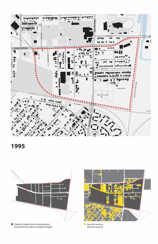
BEEMAN CEMETERY
SHEARITH ISREAL CEMETERY
FRAZIER COURTS
HOUS
TON
& TE
XAS C
ENTR
AL RA
ILROA
D
TEXAS & PACIFIC RAILROAD
N
N N
1995
Dolphin Heights block developmentDesarrollo de cuadra en Dolphin Heights
Area lot vacancyÁrea de vacancia
1995
BARRY AVENUE
CARL STREET
ROWAN AVENUE
FOREMAN STREETLAGOW STREET
JEROME STREET
BALDWIN STREET
SILVE
R AVE
NUE
REYNOLDS AVENUE
SPURLOCK STREET
COLLINS AVEN
UE
CALDWELL STREET
DOLP
HIN
ROAD
HELE
N ST
REET
GAISFORD STREET
BEALL STREET
HARRIS COURT
TERRELL STREET
CROS
STOW
N EX
PRES
SWAY
OWEN
WOO
D AV
ENUE
TROY STREET
DETONTE STREET
CLEM STREET
PACIFIC AVENUE
UPSHUR STREET
HOBB
S STR
EET
ALPINE STREET
MITCHELL STREET
MINGO STREET
THOL
L AVE
NUE
ISBEL
L STR
EET
JONES STREET
SAPP
HIRE
STRE
ET
WAHOO STREET
BOXW
OOD
STRE
ET
BEEM
AN AV
ENUE
GORMAN STREET
LIL GREEN STREET
BENTON AVENUE
CHARBA STREET
FRANK STREET
MILITARY PARKWAYJAMAICA STREET
BEALL STREET
METROPOLIT
AN AVENUE
HAMILTON AVEN
UE
FITZHUGH AVENUE
FORNEY ROAD
CANAL STREET
TROY STREET
HAMILTON AVEN
UE
METROPOLIT
AN AVENUE
PENELO
PE STREET
JAMAICA STREET
GAISFORD STREET
BALDWIN STREET
DETONTE STREET
MINGO STREET
THOL
L AVE
NUE
OSAGE CIRCLE
HASKELL AVENUE
REDMAN CIRCLE
BARR
Y AVE
NUE
HAM
ILTON
AVEN
UE
BARRY AVENUE
FARGO STREET
FITZHUGH AVENUE
SCHULL STREET
HENDERSON AVENUE
OWEN
WOO
D AV
ENUE
ST. C
HARL
ES AV
ENUE
JEROME STREET
DOLP
HIN
ROAD
DOLP
HIN
ROAD
BEEMAN CEMETERY
SHEARITH ISREAL CEMETERY
FRAZIER COURTS
HOUS
TON
& TE
XAS C
ENTR
AL RA
ILROA
D
TEXAS & PACIFIC RAILROAD
N
N N
1995
Dolphin Heights block developmentDesarrollo de cuadra en Dolphin Heights
Area lot vacancyÁrea de vacancia

BARRY AVENUE
CARL STREET
ROWAN AVENUE
LAGOW STREET
JEROME STREET
BALDWIN STREET
SILVE
R AVE
NUE
REYNOLDS AVENUE
SPURLOCK STREET
COLLINS AVEN
UE
CALDWELL STREET
DOLP
HIN
ROAD
HELE
N ST
REET
GAISFORD STREET
BEALL STREET
HARRIS COURT
TERRELL STREET
CROS
STOW
N EX
PRES
SWAY
OWEN
WOO
D AV
ENUE
TROY STREET
DETONTE STREET
CLEM STREET
PACIFIC AVENUE
UPSHUR STREET
HOBB
S STR
EET
ALPINE STREET
MITCHELL STREET
MINGO STREETTH
OLL A
VENU
E
ISBEL
L STR
EET
JONES STREET
SAPP
HIRE
STRE
ET
WAHOO STREET
BOXW
OOD
STRE
ET
BEEM
AN AV
ENUE
GORMAN STREET
LIL GREEN STREET
BENTON AVENUE
CHARBA STREET
FRANK STREET
MILITARY PARKWAY
JAMAICA STREET
BEALL STREET
METROPOLIT
AN AVENUE
HAMILTON AVEN
UE
FITZHUGH AVENUE
FORNEY ROAD
CANAL STREET
TROY STREET
HAMILTON AVEN
UE
JAMAICA STREET
GAISFORD STREET
BALDWIN STREET
DETONTE STREET
MINGO STREETTH
OLL A
VENU
E
OSAGE CIRCLE
HASKELL AVENUE
REDMAN CIRCLE
BARR
Y AVE
NUE
HAM
ILTON
AVEN
UE
BARRY AVENUE
FARGO STREET
FITZHUGH AVENUE
SCHULL STREET
HENDERSON AVENUE
OWEN
WOO
D AV
ENUE
ST. C
HARL
ES AV
ENUE
JEROME STREET
DOLP
HIN
ROAD
DOLP
HIN
ROAD
BEEMAN CEMETERY
SHEARITH ISREAL CEMETERY
FRAZIER COURTS
HOUS
TON
& TE
XAS C
ENTR
AL RA
ILROA
D
TEXAS & PACIFIC RAILROAD
N
N N
2013
Dolphin Heights block developmentDesarrollo de cuadra en Dolphin Heights
Area recent housing developmentZona de urbanización recién
2013
BARRY AVENUE
CARL STREET
ROWAN AVENUE
LAGOW STREET
JEROME STREET
BALDWIN STREET
SILVE
R AVE
NUE
REYNOLDS AVENUE
SPURLOCK STREET
COLLINS AVEN
UE
CALDWELL STREET
DOLP
HIN
ROAD
HELE
N ST
REET
GAISFORD STREET
BEALL STREET
HARRIS COURT
TERRELL STREET
CROS
STOW
N EX
PRES
SWAY
OWEN
WOO
D AV
ENUE
TROY STREET
DETONTE STREET
CLEM STREET
PACIFIC AVENUE
UPSHUR STREET
HOBB
S STR
EET
ALPINE STREET
MITCHELL STREET
MINGO STREET
THOL
L AVE
NUE
ISBEL
L STR
EET
JONES STREET
SAPP
HIRE
STRE
ET
WAHOO STREET
BOXW
OOD
STRE
ET
BEEM
AN AV
ENUE
GORMAN STREET
LIL GREEN STREET
BENTON AVENUE
CHARBA STREET
FRANK STREET
MILITARY PARKWAYJAMAICA STREET
BEALL STREET
METROPOLIT
AN AVENUE
HAMILTON AVEN
UE
FITZHUGH AVENUE
FORNEY ROAD
CANAL STREET
TROY STREET
HAMILTON AVEN
UE
JAMAICA STREET
GAISFORD STREET
BALDWIN STREET
DETONTE STREET
MINGO STREET
THOL
L AVE
NUE
OSAGE CIRCLE
HASKELL AVENUE
REDMAN CIRCLE
BARR
Y AVE
NUE
HAM
ILTON
AVEN
UEBARRY AVENUE
FARGO STREET
FITZHUGH AVENUE
SCHULL STREET
HENDERSON AVENUE
OWEN
WOO
D AV
ENUE
ST. C
HARL
ES AV
ENUE
JEROME STREET
DOLP
HIN
ROAD
DOLP
HIN
ROAD
BEEMAN CEMETERY
SHEARITH ISREAL CEMETERY
FRAZIER COURTS
HOUS
TON
& TE
XAS C
ENTR
AL RA
ILROA
D
TEXAS & PACIFIC RAILROAD
N
N N
2013
Dolphin Heights block developmentDesarrollo de cuadra en Dolphin Heights
Area recent housing developmentZona de urbanización recién

Thank you to the Dolphin Heights neighborhood Gracias al vecindario de Dolphin Heights
Ann BagleyCaroline B. Brettell George CollinsCarolyn ElliottAnna Hill Walter Isler
Ollie LyonsMike MorrisDonald PaytonAndy SturmLaura I. WatsonNikki Young
Belay HouseDallas Housing Acquisitions & Development CorporationDallas Municipal ArchivesDallas Public Library Texas, Dallas History & Archives DivisionDolphin Heights Neighborhood AssociationOak Farms DairyResponse Able Design (RAD)Trinity River Audubon Center
Thank you to the following; without your participation, Neighborhood Stories: Dolphin Heights would not have been possible:Gracias a las siguientes personas; sin esta participación, Neighborhood Stories: Dolphin Heights no serían posible:
Total dwelling unitsTotal de unidades de vivienda
Dwellings lacking some/all plumbingViviendas que carecen de algunas / todas plomería
Dwelling unit year of constructionUnidad de vivienda el año de construcción
It seems that these people still think that anything is good
enough for a Negro. We came out of river bottoms. Some of
us are still either in them or are so crowded into slum areas
that decent home life is not possible. We are forced to live in
alleys, on muddy streets and in all the worst parts of town.
to stay out of this place where they are trying to put us
and where we’ll have to live for the rest of our lives among
mosquitoes, frogs, dampness and smoke.”
Parece que estas personas todavía piensan que cualquier cosa
ríos. Algunos de nosotros todavía estamos en ellos o estamos
tan hacinados en barrios pobres que la vida de familia decente
no es posible. Somos forzados a vivir en callejones, en calles
fangosas y en todas las peores partes del pueblo. Sabe que
nosotras las mujeres lucharemos con nuestros líderes para
quedarnos afuera de este lugar donde tratan de ponernos
y donde tendremos que vivir para el resto de nuestras vidas
entre mosquitos, las ranas, la humedad y el humo.”
You know we women are going to �ght with our leaders
es su�ciente bueno para un Negro. Salimos del fondo de los

Neighborhood Stories: Dolphin Heights is one in a series of six events celebrating Dallas’s diverse neighborhoods. It has been an honor and a privilege to prepare this work. We look forward to hearing your story.Neighborhood Stories: Dolphin Heights es uno en una seria de seis eventos celebrando los vecindarios diversos de Dallas. Ha sido un honor y privilegio a preparar esta obra. Esperamos con interés escuchar su cuento.
To find out more, please call 214.252.2900 or visit our website at bcworkshop.org.Para más información, por favor llame 214.252.2900 o visite nuestra página web a bcworkshop.org.
©2013