need for rain water harvesting in the context of … · need for rain water harvesting in the...
TRANSCRIPT
Proceedings of the One Day Seminar and Exhibition on RAIN WATER HARVESTING - June 12, 2010. Environmental Association of Bangalore (EAB), Bangalore. Pp. 16-33.
1
Need For Rain Water Harvesting in the Context of Urbanization.
Dr. Ramachandra T.V. Centre for Ecological Sciences, Indian Institute of Science, Bangalore 560012, India
Centre for Sustainable Technologies (ASTRA), Indian Institute of Science, Bangalore Centre for infrastructure, Sustainable Transportation and Urban Planning [CiSTUP], IISc
SYNOPSIS Sustainable management of natural resources has attained the attention of decision makers in the early 20th century consequent to the crisis faced by the society due to unplanned developmental activities. The anthropogenic activities have affected the quality and quantity of natural resources, which is evident from the disappearance of waterbodies, degraded catchments and increased organic pollutants in waterbodies, which necessitated optimal resource planning. Spatial and temporal tools such as Geographic Information System (GIS) are helpful in analyzing the spatial data. To meet the growing demand for water due to burgeoning population, planners attention is diverted towards alternatives such as rainwater harvesting, treatment of waste water, recycling, etc. Rainwater harvesting and artificial recharge of ground water augments the ground water storage and improves the condition of the other water resources in the vicinity. Rainwater harvesting forms one of the most cost-effective methods for improving the water resources for domestic water requirements. This paper analyses the feasibility of a harvesting structure at Indian Institute of Science (IISc) campus using GIS. IISc covers an area of 180 ha and forms a part of Sankey lake catchment (located to south east of the Institute). The location and size of harvesting structure was identified with a detailed investigation of the land use pattern, hydrological analyses, catchment delineation, and identification of potential water demand areas. Ecological, economical, social and technical aspects were also considered. Harvesting structure with an area of 1.5 ha and a depth of about 3m can hold about 48,000 m3 of water. This was found sufficient to meet the requirement of swimming pool, gardening and toilet usage in the campus. Topographical analyses with the help of Digital Elevation Model (DEM) created using Geomedia Professional 5.1 and Geomedia Grid, suggested suitable location of the harvesting structure at eastern side of the campus. About 1.5 ha land is available in this region to construct harvesting structure. Hydrological analyses were carried out taking into account various land uses (sub-catchment delineation) to assess the water yield in the eastern part of the campus. The cumulative annual yield of the catchment ranged from 0.4 million m3 to 0.8 million m3.
Address for Correspondence: Dr. T.V. Ramachandra, Energy & Wetlands Research Group, Centre for Ecological Sciences Indian Institute of Science, Bangalore 560 012, India E Mail: [email protected] ;[email protected] ; Telephone: 91-080-23600985 /2293 3099/2293 2506 Telefax: 91-080-23601428 [CES TVR] URL: http://ces.iisc.ernet.in/energy
Proceedings of the One Day Seminar and Exhibition on RAIN WATER HARVESTING - June 12, 2010. Environmental Association of Bangalore (EAB), Bangalore. Pp. 16-33.
2
1.0 INTRODUCTION Urbanisation is a form of metropolitan growth that is a response to often bewildering sets of economic, social, and political forces and to the physical geography of an area. It is the increase in the population of cities in proportion to the region's rural population. The 20th century is witnessing "the rapid urbanisation of the world’s population", as the global proportion of urban population rose dramatically from 13% (220 million) in 1900, to 29% (732 million) in 1950, to 49% (3.2 billion) in 2005 and is projected to rise to 60% (4.9 billion) by 2030 (World Urbanization Prospects, 2005). Urban ecosystems are the consequence of the intrinsic nature of humans as social beings to live together (Sudhira et al., 2003; Ramachandra and Uttam Kumar, 2008, Ramachandra and Uttam Kumar, 2009; Ramachandra and Shwetmala, 2009). The process of urbanisation contributed by infrastructure initiatives, consequent population growth and migration results in the growth of villages into towns, towns into cities and cities into metros. Urbanisation and urban sprawl have posed serious challenges to the decision makers in the city planning and management process involving plethora of issues like infrastructure development, traffic congestion, and basic amenities (electricity, water, and sanitation), etc. (Kulkarni and Ramachandra, 2006). Apart from this, major implications of urbanisation are:
• Heat island: Surface and atmospheric temperatures are increased by anthropogenic heat discharge due to energy consumption, increased land surface coverage by artificial materials having high heat capacities and conductivities, and the associated decreases in vegetation and water pervious surfaces, which reduce surface temperature through evapotranspiration.
• Loss of aquatic ecosystems: Urbanisation has telling influences on the natural
resources such as decline in number of water bodies and / or depleting groundwater table.
There has been a 632% increase in built up area from 1973 to 2009 leading to a sharp decline of 79% area in water bodies in Greater Bangalore mostly attributing to intense urbanisation process (Ramachandra and Uttam Kumar 2009). The rapid development of urban sprawl has many potentially detrimental effects including the loss of valuable agricultural and eco-sensitive (e.g. wetlands, forests) lands, enhanced energy consumption and greenhouse gas emissions from increasing private vehicle use (Ramachandra and Shwetmala, 2009). Vegetation has decreased by 32% from 1973 to 1992, by 38% from 1992 to 2002 and by 63% from 2002 to 2009. Disappearance of water bodies or sharp decline in the number of waterbodies in Bangalore is mainly due to intense urbanisation and urban sprawl. Many lakes (54%) were unauthorised encroached for illegal buildings. Field survey (during July-August 2007) shows that nearly 66% of lakes are sewage fed, 14% surrounded by slums and 72% showed loss of catchment area. Also, lake catchments were used as dumping yards for either municipal solid waste or building debris. The surrounding of these lakes have illegal constructions of buildings and most of the times, slum dwellers occupy the adjoining areas. At many sites, water is used for washing and household activities and even fishing was observed at one of these sites. Multi-storied buildings have come up on some lake beds that have totally intervene the natural catchment flow leading to sharp decline and deteriorating quality of
Proceedings of the One Day Seminar and Exhibition on RAIN WATER HARVESTING - June 12, 2010. Environmental Association of Bangalore (EAB), Bangalore. Pp. 16-33.
3
waterbodies. This is correlated with the increase in built up area from the concentrated growth model focusing on Bangalore, adopted by the state machinery, affecting severely open spaces and in particular waterbodies. Some of the lakes have been restored by the city corporation and the concerned authorities in recent times. Unplanned urbanisation has drastically altered the drainage characteristics of natural catchments, or drainage areas, by increasing the volume and rate of surface runoff. Drainage systems are unable to cope with the increased volume of water and are often encountered with the blockage due to indiscriminate disposal of solid wastes. Encroachment of wetlands, floodplains, etc. obstructs floodways causing loss of natural flood storage. Damages from urban flooding could be categorized as: direct damage – typically material damage caused by water or flowing water, and indirect damage – e.g. traffic disruptions, administrative and labour costs, production losses, spreading of diseases, etc. Over exploitation of surface water sources like wells for drinking water and industrial use has also resulted in depleted water levels and drying up of bore wells or sea water intrusions (in coastal area) due to the imbalance of inflow and outflow for sub-surface water. The urbanization has also reduced original permeable ground surface. Pavements, roads and construction of storm water drains to drain the rain water as quickly as possible to natural stream, river or sea to avoid flooding of grounds and disruption in traffic. These surfaces and quick run off gives no scope for percolation of rain water to replenish the sub-surface aquifer causing the dropping of water levels or drying up of wells. In addition to this, land use and land cover changes (involving the large-scale conversion of natural ecosystems) have contributed to the regional and global climate changes, resulting in irregular, reduced, erratic and uncertain rainfalls. Dwindling of water resources coupled with the increased water demand has necessitated the viable alternatives to cater the water requirement. This highlights the need to conserve and augment the renewable natural water resources as last chance for survival, realizing that natural resources are not unlimited if they are exploited beyond certain limit. Conservation and sustainable management practices helps in the restoration of the natural balance. This requires the adoption of basic ecological principles in the management of natural resources to ensure the sustainability. In this context, rainwater harvesting is seen as a viable alternative to augment water resources.
1.1 Natural resources management: Water is a renewable natural resource and plays a pivotal role in the region’s development. However, unplanned anthropogenic activities have lead to the scarcity of resources, which has affected the economic, productive, infrastructural and social sectors. Scarcity of water is becoming a limiting factor for sustainable development in many parts of the world. Due to these, infiltration of rainwater into the sub-soil has decreased drastically and recharging of groundwater has diminished. The solution to achieve sustainable development lies in the efficient management of water and other natural resources. Rainwater is the main source of water and annually 300 to 800 mm of seasonal rainfall is lost as surface runoff or deep drainage. Water harvesting can also be achieved by following the watershed-based approaches in ecosystem management using pre-treated catchment and micro-catchment areas to increase the efficiency of runoff and maximize the amount of collected rainfall. Better management of water resources is achieved through water conservation, inter-sectoral water reallocations, water costing, and by using water efficiently. In water stress

Proceedings of the One Day Seminar and Exhibition on RAIN WATER HARVESTING - June 12, 2010. Environmental Association of Bangalore (EAB), Bangalore. Pp. 16-33.
4
region, rainfall is collected from areas specifically treated to increase precipitation runoff and stored in tanks or ponds for human and animal consumption and for supplemental irrigation.
1.2 Planning: If collection and storage are designed carefully, it is possible to cater water demand even in areas with rainfall as little as 400 mm / year. Analysis shows that between 80 to 85 % of all measurable rain can be collected and stored from the catchment area, which includes light drizzle and dew condensation. The run-off from a catchment area is computed (Raghunath,1995) by considering the spatial extent of a catchment (A), catchment coefficient (C, that depends on the land use pattern in the catchment) and rainfall intensity (I) and is given by Q= C * I * A [Where, Q = discharge (m3), C = co-efficient of run-off, I = total rainfall / annum (m) and A = catchment area (m2)]. The co-efficient of run-off depends upon the land use pattern in the region. The catchment coefficient for rocky and impermeable: 0.8-1.0; slightly permeable, bare: 0.6-0.8; cultivated or covered with vegetation: 0.4-0.6; cultivated absorbent soil: 0.3-0.4; sandy soil: 0.2-0.3; heavy forest: 0.1-0.2. The co-efficient of run-off also depends on the shape, size, soil conditions, temperature, and geological conditions of the area of the catchment. However, on the basis of average annual rainfall and land use in the area, the co-efficient can be assumed, which are listed in Table 1.
1.3 Spatial and Temporal Analyses: Sustainable management of natural resources depends on optimal planning based on spatial and temporal data. In this regard, GIS aids as a dynamic and versatile technology capable of providing information for efficient planning and implementation. The unique feature of GIS is its ability as decision support system and provides answers to the queries through rational and systematic analysis of the situation. This aids planners to take quick decision. For example, in order to understand the topographic undulation a DEM is generated with the help of GIS. It consists of terrain elevations for ground positions at regularly spaced horizontal intervals. DEM data are arrays of regularly spaced elevation values referenced horizontally to a geographic coordinate system. The grid cells are spaced at regular intervals along south to north profiles that are ordered from west to east. A DEM is a set of points defined in a three–dimensional Cartesian space (x, y, and z) that approximates a real surface. X and Y-axis may be expressed as geographic co-ordinates (i.e. longitude and latitude), whereas Z-axis usually represents the altitude above sea level. The low elevation areas are identified by creating the DEM with the contour data, which helps the decision makers in selecting the sites for setting the rain water harvesting structure. The repetitive synoptic coverage provided by the space borne sensors (which operates on various bands of electro magnetic spectrum) has been widely used for mapping and monitoring areal extent of natural resources including surface water bodies / reservoirs. This is useful for reliable estimation of storage capacity of the reservoirs and its changes over the years. Ground

Proceedings of the One Day Seminar and Exhibition on RAIN WATER HARVESTING - June 12, 2010. Environmental Association of Bangalore (EAB), Bangalore. Pp. 16-33.
5
water surveys through satellite remote sensing have been found to narrow down considerably the areas for detailed ground water exploration. Management tasks of conserving available resources to meet growing demands and preserving water quality, compatible with socio-economic and environmental constraints have become exceedingly complex. In this context, remote sensing provides spatial data at regular interval and aids as a powerful tool for inventorying and monitoring water resources. Spatial analysis is done to get an idea about the terrain, to identify water logging area (seasonal and annual), and to identify sites for rainwater harvesting.
2.0 OBJECTIVES Design of structures for optimal harvesting of rainwater using GIS includes
• Creation of the topographical elevation model. • Identification of suitable sites for locating water harvesting structures using DEM. • Land use analyses in the catchment. • Computation of water yield. • Study of geological and soil characteristics for civil design of the structure. • Optimal design of rainwater harvesting structure considering the demand.
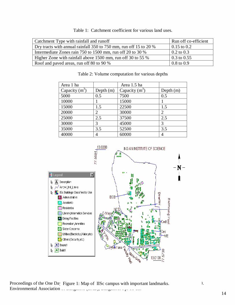
3.0 STUDY AREA Indian Institute of Science (IISc) campus has been considered for the present study. The campus limits are enclosed within 13°00'38''N to 13°01'15''N latitude and 77°33'34''E to 77°34'26''E longitude. The area falls in the 57G/12 of SOI topo-sheet of scale 1:50000, 57G of scale 1:250,000. IISc is located in northern part of Bangalore city and Figure 1 gives the map of IISc campus with important landmarks. It is endowed with lush green vegetation and has a green canopy of trees covering the buildings in the campus. The campus, consisting of five bounds, covers an area of 180 ha. The main campus covers 158 ha. The altitude of campus varies from 914m (from Mean Sea Level) to 942 m. The natural terrain of the campus is rolling and provides good natural drainage. The campus slopes towards three sides (north, east and west) from a central ridge along the middle and along the main road of the campus (Gulmohar Marg). Historical precipitation data of 54 years reveal that, the major portion of rainfall being May-June and thunderstorms during September-October. Bangalore receives mean annual rainfall of 860 mm (Radhakrishnan et al., 1996). Sankey Lake located to the Southeast of the campus. A large drain running all along the eastern side of the campus forms the main feeder of the Sankey Lake.
4.0 METHODOLOGY
4.1 Development of database (spatial and attribute data) for GIS The Survey of India (SOI) toposheets of scale 1:1000 of IISc campus in 10 sheets and GIS software Geomedia Professional 5.1 and Geomedia Grid were used to build the vector layers of
Proceedings of the One Day Seminar and Exhibition on RAIN WATER HARVESTING - June 12, 2010. Environmental Association of Bangalore (EAB), Bangalore. Pp. 16-33.
6
IISc boundary, boundary with landmarks, buildings, roads, surrounding lakes of IISc, IISc zones based on utilities, tree distribution, canopy cover in IISc based on NDVI ranges, drainage and contours. A vector layer of vegetation showing all the trees (species wise) in the IISc was prepared through an extensive field survey carried out simultaneously. Contour maps (generated using Geomedia Professional 5.1 and Geomedia Grid) are used to generate slope maps of the area and DEM. The SOI toposheets (scale 1:1000) were scanned and georegistered in geomedia professional. For georegistration a feature class definition of point feature was made and the original corner points from the topsheets were inserted for that point feature class. Then the scanned toposheet was brought to the geoworkspace working window with the help of insert interactive images. The image is selected through the select tool and source control point and target control points are inserted through the image registration dialog. For each feature class, projection system is defined and the datum and projection is set as per the geographical location of the region and through digitization of the raster image, individual features (like roads, contours etc.) are transformed to vector format. Different feature class (layers) of IISc was created. This includes boundary, boundary with landmarks, buildings, surrounding lakes, zones based on utilities, tree distribution, canopy cover and contour layer (1m interval) by digitizing toposheets SOI (scale 1:1000).
4.2 DEM generation in GEOMEDIA grid The contour feature (layer) of one m interval is brought to the geoworkspace working window and new study area is defined and cell resolution and output unit is set for the new study area. The contour features are selected from the legend and are rasterized. Through the edit window the non-void cells values are combined and the values are noted and one third of the noted value is calculated for random sampling. The output unit is set from the information dialog, same as that of the output unit of study area defined. Interpolation of the random sample result layer is done and the interpolated layer is smoothed. The depression (in DEM) is filled for the smoothed layer. The filled depression layer’s name with color assignment to the layer was done through the edit window (by selecting the first and last cell in the edit window and right clicking on the selected cells to assign color’s through color sequence dialog) of filled depression layer. For DEM, the shaded relief model is made with the filled depression layer and is viewed in the map window.
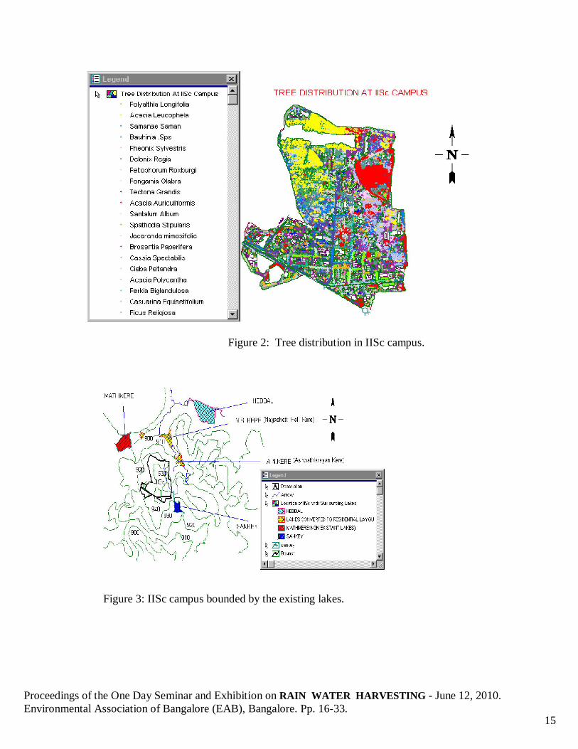
4.3 Field Investigation A detailed field survey was undertaken to map trees (with diameter >10 cm) in the campus. Figure: 2 shows tree distribution in IISc campus. The field investigation gave an idea of the terrain, drainage pattern, vegetation cover and other constraints. Apart from this, a detailed field survey was under taken to map trees in various sub catchments. The drainage network of the campus was also studied to find out the possible problems of channeling the rainwater. The
Proceedings of the One Day Seminar and Exhibition on RAIN WATER HARVESTING - June 12, 2010. Environmental Association of Bangalore (EAB), Bangalore. Pp. 16-33.
7
slope of the drains was also noted to delineate the catchment for the Pond. The local problems like blockage, clogging of the drains were also noted, so that remedial actions could be taken.
4.3.1 Storm-water pond Economic and ecological considerations highly favor the creation of a water body inside the campus and divert the storm water generated in the campus to the pond. The water stored in the pond may be used for various purposes such as gardening and for meeting the non-drinking water needs of the adjacent buildings. A small filtration plant near the pond would help in treating the stored water usable for various purposes. A garden may be developed around the pond to enhance the aesthetic appeal. Creation of the water body, apart from providing usable water, is also advantageous from ecological considerations by providing a water source for the number of bird species (about 110 species) that the campus is proud to be a habitat. The need to conserve water assumes more importance than ever before in the present scenario of water table depletion due to increased demand and over exploitation of groundwater resources. Surface water harvesting has multiple advantages, viz., recharge of ground water and efficient use of rainwater, which otherwise gets wasted or contaminated. This study through spatial and temporal data highlights the parameters to be considered for designing harvesting pond at an appropriate suitable location in the campus. The harvesting pond is designed with a detailed investigation of land use pattern, hydrological analyses, catchment delineation and identification of potential problem areas. The optimal design was arrived at taking into account ecological, economical, social and technical aspects.
4.4 Data analyses Data analyses involved:
Calculations of the area of sub-catchments and land use analysis, Computation of water yield in respective sub-catchments, Suitable location of harvesting structures, Optimal capacity of the pond.
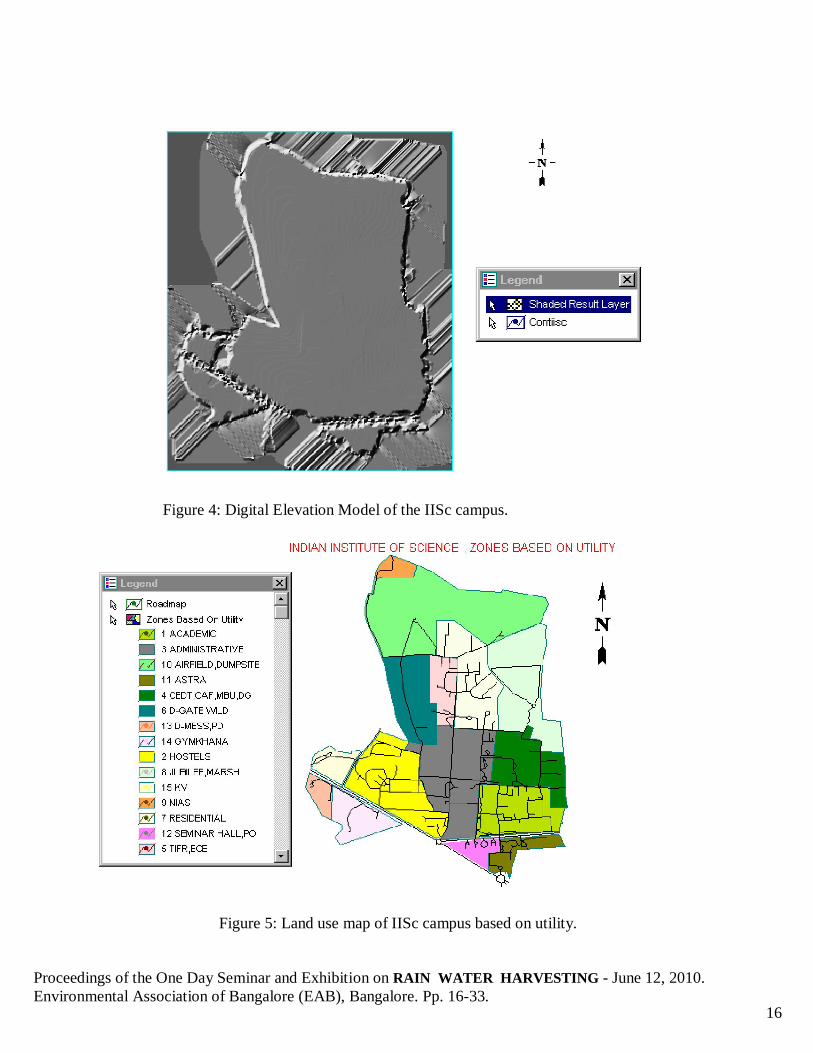
The sub-catchments were delineated from the main catchment area and coefficients of runoff were given to each according to their catchment characteristics. The daily precipitation data at Bangalore city observatory from 1990 to 1997 were used to arrive at a water yield of the pond. Daily yield was calculated using the rational formula, which was computed for the catchment for all these years. Daily yield was cumulated to obtain the monthly and yearly yields. Topographical analyses with the help of DEM suggest suitable location of the harvesting structure in the eastern part of the campus, which is currently a marshy region. About 1.5 hectare land is available in this region to construct harvesting structure. During the early 1960's, there were many lakes around the campus that acted as water storage structures and aided in groundwater recharge mechanism. Anthropogenic stresses have led to conversion of lakes to residential, commercial layouts and public utilities. Recent study shows that about 35 % lakes have disappeared during the last twenty years (Deepa, et al. 1998).
Proceedings of the One Day Seminar and Exhibition on RAIN WATER HARVESTING - June 12, 2010. Environmental Association of Bangalore (EAB), Bangalore. Pp. 16-33.
8
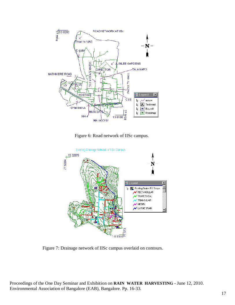
Aswathnarayana-kere and Nagashettihalli-kere in the vicinity of IISc are now non-existent, and have been converted into residential layouts. Figure 3 shows the IISc campus bounded by the existing lakes. Consequently, during peak rainfall season, water from the catchment gets into the low-lying areas adjacent to the IISc campus (like ISRO Head quarters, Vigyanapura, etc.). The three-dimensional elevation image generated using Geomedia Grid was used to identify suitable location for this rainwater-harvesting pond. Figure 4 shows the DEM of the IISc campus. With an identification of lowest positions in a region, the possibility of channeling water was explored considering the following aspects. Social : Acceptance of pond and usage of its water by people in the vicinity. Proper managerial solution to avoid breeding of mosquitoes. Technical : Remedial measures to prevent water seepage into the soil taking into account
the stability aspects of structures in the vicinity. Ecological : Environmental impact assessment to ensure minimum damage to the
ecosystem from biodiversity point of view. Economical : To ensure cost effective structure. All possible locations were identified in the campus. The best option was selected considering above criteria and based on the simplicity of construction and channeling of the storm water. The pond was located at a point where the storm water drained can be channeled without much alterations of the existing drainage network. After identification of suitable location for constructing harvesting structures (ponds), region was explored to find out the extent of land available. Location and area were decided based on ecologically sound strategies. From the land use map, Figure 5 gives the land use map of IISc campus based on utility (vector layer) of the spatial coverage of possible harvesting structure (pond / reservoir) was prepared. The area available ranges from 1 to 1.5 ha. One and half hectare spatial coverage entails removal of about 15 trees belonging to Acacia nilotica species. Considering these two areas and for different depths, capacity of the pond was computed. Volumes were compared with the water yield of the catchment of the campus considering the continuity equation i.e. Storage volume = Inflow – Outflow - Losses (evaporation, seepage, etc.) The losses considered were the evaporation from the catchment using the monthly mean of daily evaporation data for Bangalore (Muthreja, 1995). The demand for the swimming pool, gardening was ascertained from the volume of the swimming pool and the volume of the storage tank for gardening respectively. The average rainfall of Bangalore was computed taking 55 years (from 1940 to 1997- 1948, 1967 were not available) of daily rainfall data from Bangalore city observatory. Harvesting structure in an available area of 1.5 ha and a depth of about 3 m can hold about 22000 m3 of rainwater. This is sufficient to meet the requirement of swimming pool, gardening and toilet usage in the campus. The campus swimming pool approximately requires 1000 m3 of
Proceedings of the One Day Seminar and Exhibition on RAIN WATER HARVESTING - June 12, 2010. Environmental Association of Bangalore (EAB), Bangalore. Pp. 16-33.
9
water per refilling. The pool faces scarcity of water during the lean season (i.e. during month of January, February and March). Apart from this, storage structures helps in recharging of the groundwater sources. The maximum depth available at the proposed site is about 1.5 m. It is desirable to increase this to about 3m, so that the storage may be increased. All round excavation may be taken up to achieve a maximum depth of about 3 m, and to give aesthetic appearance. Inlet to the pond: The existing main drain that runs in the eastern parts of the campus collects a major portion of the storm water. The lowest point on this drain occurs opposite to the proposed pond location, which could be easily connected to the pond. Outlet from the pond: An outlet drain of size 1.8 m width and 1.2 m height must be provided at a slope of 1 in 1000, and joined to the existing drain leading to the municipal drain along the eastern part. The invert level of this outlet drain must be the same as that of the inlet drain. Maintenance of water quality: Adequate care and attention must be focussed on maintenance of clear water in the pond, so that it does not become a source for unhygienic and unpleasant surrounding. Under no circumstances, sewage water and other waste water must be permitted inside the pond. For prevention of mosquito breeding, periodic treatment with lime and/or biological control is required.
5.0 RESULTS, DISCUSSION AND SUGGESTIONS The base layers of the IISc campus for the analysis were generated using Geomedia Professional 5.1. From the scanned maps of SOI 1:1000 sheets. IISc campus covers an area of 180 ha, of this main campus occupies about 158 ha. Gymkhana bounds is about 10 ha, followed by ASTRA, Post office bound (7.5 ha), KV bounds (3.86 ha) and Staff quarters bounds (0.32 ha) The two main roads, Gulmohar and Tala Marg run parallel along the middle of the campus as shown in Figure 6. The buildings were classified based on usage as administrative, academic, residential, library and information services, dining facilities, recreation and amenities, sister institutions (NIAS, JNCASR, INSDOC, TIFR), utilities and others (which included unidentified and unused buildings). The Faculty hall or the main building of the campus and other administrative buildings are shown in red color. The elevation contours (topographic elevation) of the campus was generated by digitizing line features from the scanned maps. The generated contours indicate that, elevation in campus varies from 914 m (along the periphery of the Jubilee garden extension) to 942 m (near C.N.R. Rao circle closer to IISc main gate). The campus slopes towards three sides from the ridge that falls along the Gulmohar Marg (road from C.N.R. Rao circle to TIFR). The contour map of the campus shows that the campus has a good natural drainage. Figure 7 shows the drainage network of IISc campus overlaid on contours. Hence, the problems of

Proceedings of the One Day Seminar and Exhibition on RAIN WATER HARVESTING - June 12, 2010. Environmental Association of Bangalore (EAB), Bangalore. Pp. 16-33.
10
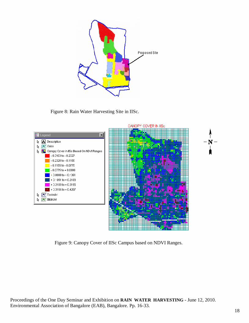
water stagnation in the campus are not grave except for some local problems. In addition, due to the gradient that is available, runoff drains off quickly. The natural drainage drains towards the either side of the main road. The drains are classified on their shape. The drains sloping towards the eastern side joins the large drain flowing towards the Sankey Lake. The new buildings that were not available in the scanned maps were added using Global Positioning System and the shapes of these buildings are guesstimate. The percentage plinth area of the buildings, tree density, species diversity indices were calculated for each zone and this analysis also helped in arriving at the runoff coefficients. The location of harvesting structure / storage pond was based on the topographical elevations, existing drainage network, area available and land use / land cover. Campus slopes toward either side from the middle ridge, lending to mainly two drainage directions. The eastern side of the campus has a greater gradient / slope than the western side. The eastern side has positions of low altitude compared to other areas of campus. Moreover, the major portion of the drainage flows to the eastern side. In addition, the large drain flowed along the eastern side (main feeder to Sankey Lake) to which all the eastbound drains lead. Two areas identified for locating harvesting structures / pond are along the periphery of Jubilee garden having an altitude of 914 to 915 m and at the marshy area on the eastern side having an altitude from 917 to 920 m. Among these locations, area having an altitude around 914 m was unsuitable because of retrograde natural drainage, lesser area available and difficulty of water being channeled to that area. The campus was also explored for other possible locations. The western side of the campus lacked any suitable site where possible structures could be located. Moreover, marshy area collects rainwater during monsoon season and wetness is present throughout the year. In view of these, location is selected for the proposed harvesting structure which can cater the water requirement of swimming pool and garden and also be a good recreational spot. The proposed rain water harvesting site is indicated in Figure 8. The marshy area was selected because it is located in low lying area naturally holding water and this endeavour proposes to modify the existing condition of the area to hold water. The area where the structure is being located has minimum number of trees. The DEM was generated from the vector contour map using the linear surface interpolation and converted to a raster image. This image was used to visually identify the possible locations for the structure. This confirms the location of proposed harvesting structure in the marshy area (eastern side of the campus). The accuracy of DEM generated from the vector map depends on the no of rows and column selected during the conversion. The DEM was used only for visualisation of the terrain as against the extraction of drainage characteristics. The spatial extent available for pond would be 1 to 1.5 ha depending on the inclusion or exclusion of the vegetated area around the pond. A depth of 1.5 m can be achieved without any excavation of the present pond bed. The volume of the pond that can be constructed depends

Proceedings of the One Day Seminar and Exhibition on RAIN WATER HARVESTING - June 12, 2010. Environmental Association of Bangalore (EAB), Bangalore. Pp. 16-33.
11
on the area available. Table 2 shows the volume of pond for 1 and 1.5 ha for different depths (ranging from 1 m to 5 m). In order to arrive at the optimal capacity of the proposed harvesting structure / storage pond water demand in the vicinity (such as swimming pool, garden etc.) was explored. The water supply for the Institute swimming pool comes from the Bangalore water supply in addition to well water. There is a shortage of water supply during lean season (December to March). Swimming pool being recycled twice a week its monthly requirement comes to around 4000 m3. Assuming a pond capacity of 10000 m3 (if spatial coverage of pond is 1 hectare and depth 1 m), this would be sufficient for two months after the evaporation losses. The gardening requirement for the Institute is about 6000 m3 / month. For 10000 m3 of capacity, this would only be sufficient for 45 days. If the requirement for the swimming pool and the gardening is analysed this would be hardly sufficient for one month. Instead, a capacity of 15000 m3 achieved through 1.5 hectare area and a depth of 1 m, can support the swimming pool requirements for three months after evaporation losses. For gardening purposes, it would be sufficient for two months. Both requirements combined would suffice for 40 days. A capacity of 30000 m3 (if spatial coverage of pond is 1.5 hectare and depth of 2 m), would be adequate to cater both swimming pool and garden annual water requirements. Figure 9 shows the canopy cover of IISc campus based on NDVI ranges. The possibility of pond water catering to toilet usage in the campus was also analysed. This calculated on the assumption that 50 people each in 50 departments use 20 litres / person / day. This works out to 1500 m3/month, which is to be supplied throughout the year. The swimming pool, garden and toilet water requirement on campus amounts to 48000 m3. Since there is sufficient yield in this catchment, to harvest this quantity, in an available area of 1.5 ha the depth has to be 3.2 m. The rainwater harvesting structure could be built as earthen structure like a percolation pond but with adequate inflow and out flow structures. This also results in a cost-effective structure. A small filtration plant near the pond would help in treating the stored water usable for various purposes. A garden may be developed around the pond to enhance the aesthetic appeal. Suitable measures could be undertaken subsequently for maintaining the pond in a good condition, so that mosquito breeding (through biological control-successfully managed elsewhere) and other undesirable conditions may be avoided. As a rainfall harvesting method to conserve water, another efficient method is to install a roof water harvesting system for each building, which is more cost effective and more efficient in solving the water scarcity in the lean seasons. This water can be used for laboratory usage, toilet usage and for other purposes if some simple treatment is given. This treatment can be simple chlorinating to be bacteriologically safe. Also filtering the water through a sand filter would be appropriate.

Proceedings of the One Day Seminar and Exhibition on RAIN WATER HARVESTING - June 12, 2010. Environmental Association of Bangalore (EAB), Bangalore. Pp. 16-33.
12
6.0 CONCLUSIONS A comprehensive spatial database has been developed as a tool in aiding decision making for future development. The GIS is used for design of pond to harvest rain water optimally, considering economic and ecological considerations. The surface water stored in the pond may be used for suitable purposes such as gardening and for meeting the non-drinking water needs of the adjacent buildings. The low-lying area adjacent on the eastern side is most suitable for the water body. Approximately 1.5 ha of low-lying area is available at this site. About 20,000 m3 of water may be stored in this pond. This site also provides an easy opportunity for diverting a major portion of the storm water generated inside the campus, to the pond. The excess water from the pond may be diverted into the drain going out of the campus through the adjacent CPRI campus. An outlet drain of size 1.8 m width and 1.2 m height must be provided at a slope of 1 in 1000, and joined to the existing drain on the eastern side leading to the municipal drain along the New BEL road. The invert level of this outlet drain must be the same as that of the inlet drain. It is emphasized that this drain must be of the minimum size mentioned above, and the existing drain that passes through the CPRI campus, to which the outlet drain from the pond is joined must be enlarged to the same cross section (1.8 m x 1.5 m). Adequate care and attention must be focussed on maintenance of clear water in the pond, so that it does not become a source for unhygienic and unpleasant surrounding. Under no circumstances, sewage water and other waste water must be permitted inside the pond. It is emphasized that a good maintenance of the drainage system is as important as its design and construction. It is necessary that a periodic cleaning of drains, inlets, outlets, culverts etc., is taken up, to remove the muck, weed, solid wastes and other obstacles that may have been deposited, at least once before every monsoon. Like any other service facility, the system will work well when it is needed the most only if it is maintained well even when it is not needed.
ACKNOWLEDGEMENT I thank the Ministry of Environment and Forest, Government of India and IISc for financial assistance and infrastructural support. I acknowledge M/S Intergraph and Rolta India Ltd. for providing GIS softwares Geomedia Professional 5.1 and Geomedia Grid, which helped in creating vector layer and DEM. We thank Mr. Praveen Kumar Gautam (M/S Intergraph Rolta India Ltd.) for the software support.
Proceedings of the One Day Seminar and Exhibition on RAIN WATER HARVESTING - June 12, 2010. Environmental Association of Bangalore (EAB), Bangalore. Pp. 16-33.
13
ABBREVIATIONS BEL- Bharath electronics limited CPRI-Central power research institute INSDOC-Indian national scientific documentation centre ISRO-Indian space research organization JNCASR-Jawaharlal Nehru centre for advanced scientific research KV-Kendriya vidyalaya NDVI- Noramalized difference vegetation index NIAS- National institute of advanced studies TIFR- Tata institute for fundamental research REFERENCES:
1. World Urbanization Prospects. (2005). Revision, Population Division, Department of Economic and Social Affaris, UN.
2. Ramachandra T V and Uttam Kumar (2009). Land surface temperature with land cover dynamics: multi-resolution,spatio-temporal data analysis of Greater Bangalore, International Journal of Geoinformatics, 5 (3):43-53
3. Ramachandra T.V and Uttam Kumar (2008). Wetlands of Greater Bangalore, India: Automatic Delineation through Pattern Classifiers, The Greendisk Environmental Journal. Issue 26 (International Electronic Jour. URL: (http://egj.lib.uidaho.edu/index.php/egj/article/view/3171).
4. Ramachandra T.V. and Shwetmala (2009). Emissions from India's Transport sector: Statewise Synthesis, Atmospheric Environment, 43 (2009) 5510–5517.
5. Sudhira, H.S., Ramachandra, T.V., and Jagadish, K. S. (2003). Urban sprawl: metrics, dynamics and modelling using GIS, International Journal of Applied Earth Observation and Geoinformation 5(2004): 29-39.
6. Kulkarni, V. and Ramachandra T.V. (2006). Environmental Management, Commonwealth Of Learning, Canada and Indian Institute of Science, Bangalore.
7. Deepa R. S., Kiran R., Ramachandra, T. V., (1997) Application of Geographical Information Systems (GIS) and Remote Sensing in the study of the spatial and temporal changes in the water bodies of Bangalore, Karnataka, Twelfth Annual Conference of National Environmental Science Academy (NESA), New Delhi.
8. INTERGRAPH, URL: http://imgs.intergraph.com/geomedia/ 9. Muthreja, K. N., (1995) Applied Hydrology, Tata McGraw-Hill Company Limited, New Delhi. 10. Radhkrishnan, K., Adiga, S., Geeta Varadan, Diwakar, P.G., (1996) Enhanced geographic
information system application using IRS-1C data - Potential for urban utility mapping and modelling, Current science, 70(7), pp. 629-637.
11. Raghunath, H. M., (1985) Hydrology, Wiley Eastern Limited, New Delhi. 12. Ramachandra, T. V. and Uttam Kumar, (2004). Watershed management using GRDSS, GIS
Development, 8 (8):20-26. 13. Rolta India Limited Geomedia Professional 5.1, URL: http://www.rolta.com
Proceedings of the One Day Seminar and Exhibition on RAIN WATER HARVESTING - June 12, 2010. Environmental Association of Bangalore (EAB), Bangalore. Pp. 16-33.
14
Table 1: Catchment coefficient for various land uses.
Catchment Type with rainfall and runoff Run off co-efficient Dry tracts with annual rainfall 350 to 750 mm, run off 15 to 20 % 0.15 to 0.2 Intermediate Zones rain 750 to 1500 mm, run off 20 to 30 % 0.2 to 0.3 Higher Zone with rainfall above 1500 mm, run off 30 to 55 % 0.3 to 0.55 Roof and paved areas, run off 80 to 90 % 0.8 to 0.9
Table 2: Volume computation for various depths
Area 1 ha Area 1.5 ha Capacity (m3) Depth (m) Capacity (m3) Depth (m) 5000 0.5 7500 0.5 10000 1 15000 1 15000 1.5 22500 1.5 20000 2 30000 2 25000 2.5 37500 2.5 30000 3 45000 3 35000 3.5 52500 3.5 40000 4 60000 4
Figure 1: Map of IISc campus with important landmarks.
Proceedings of the One Day Seminar and Exhibition on RAIN WATER HARVESTING - June 12, 2010. Environmental Association of Bangalore (EAB), Bangalore. Pp. 16-33.
15
Figure 2: Tree distribution in IISc campus.
Figure 3: IISc campus bounded by the existing lakes.
Proceedings of the One Day Seminar and Exhibition on RAIN WATER HARVESTING - June 12, 2010. Environmental Association of Bangalore (EAB), Bangalore. Pp. 16-33.
16
Figure 4: Digital Elevation Model of the IISc campus.
Figure 5: Land use map of IISc campus based on utility.
Proceedings of the One Day Seminar and Exhibition on RAIN WATER HARVESTING - June 12, 2010. Environmental Association of Bangalore (EAB), Bangalore. Pp. 16-33.
17
Figure 6: Road network of IISc campus.
Figure 7: Drainage network of IISc campus overlaid on contours.
Proceedings of the One Day Seminar and Exhibition on RAIN WATER HARVESTING - June 12, 2010. Environmental Association of Bangalore (EAB), Bangalore. Pp. 16-33.
18
Figure 8: Rain Water Harvesting Site in IISc.
Figure 9: Canopy Cover of IISc Campus based on NDVI Ranges.