nebraska game and parks commission...
TRANSCRIPT
C03-1
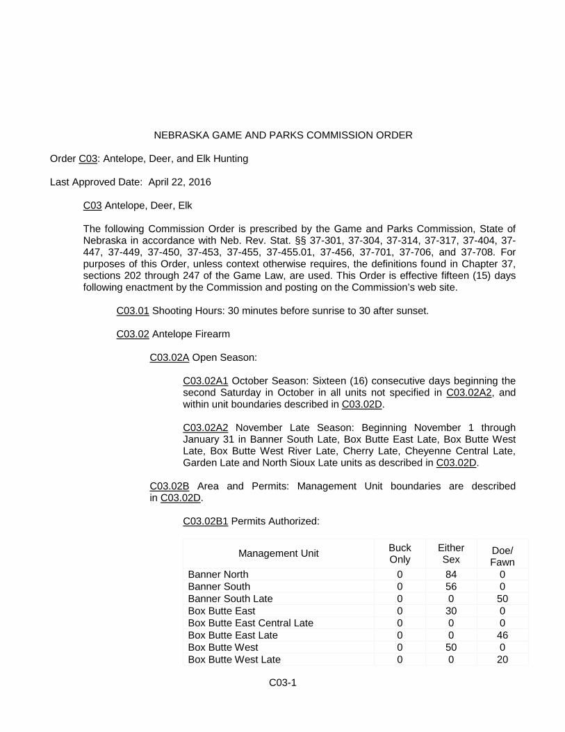
NEBRASKA GAME AND PARKS COMMISSION ORDER Order C03: Antelope, Deer, and Elk Hunting Last Approved Date: April 22, 2016
C03 Antelope, Deer, Elk
The following Commission Order is prescribed by the Game and Parks Commission, State of Nebraska in accordance with Neb. Rev. Stat. §§ 37-301, 37-304, 37-314, 37-317, 37-404, 37-447, 37-449, 37-450, 37-453, 37-455, 37-455.01, 37-456, 37-701, 37-706, and 37-708. For purposes of this Order, unless context otherwise requires, the definitions found in Chapter 37, sections 202 through 247 of the Game Law, are used. This Order is effective fifteen (15) days following enactment by the Commission and posting on the Commission’s web site.
C03.01 Shooting Hours: 30 minutes before sunrise to 30 after sunset. C03.02 Antelope Firearm
C03.02A Open Season:
C03.02A1 October Season: Sixteen (16) consecutive days beginning the second Saturday in October in all units not specified in C03.02A2, and within unit boundaries described in C03.02D.
C03.02A2 November Late Season: Beginning November 1 through January 31 in Banner South Late, Box Butte East Late, Box Butte West Late, Box Butte West River Late, Cherry Late, Cheyenne Central Late, Garden Late and North Sioux Late units as described in C03.02D.
C03.02B Area and Permits: Management Unit boundaries are described in C03.02D.
C03.02B1 Permits Authorized:
Management Unit Buck Only
Either Sex
Doe/ Fawn
Banner North 0 84 0 Banner South 0 56 0 Banner South Late 0 0 50 Box Butte East 0 30 0 Box Butte East Central Late 0 0 0 Box Butte East Late 0 0 46 Box Butte West 0 50 0 Box Butte West Late 0 0 20
C03-2
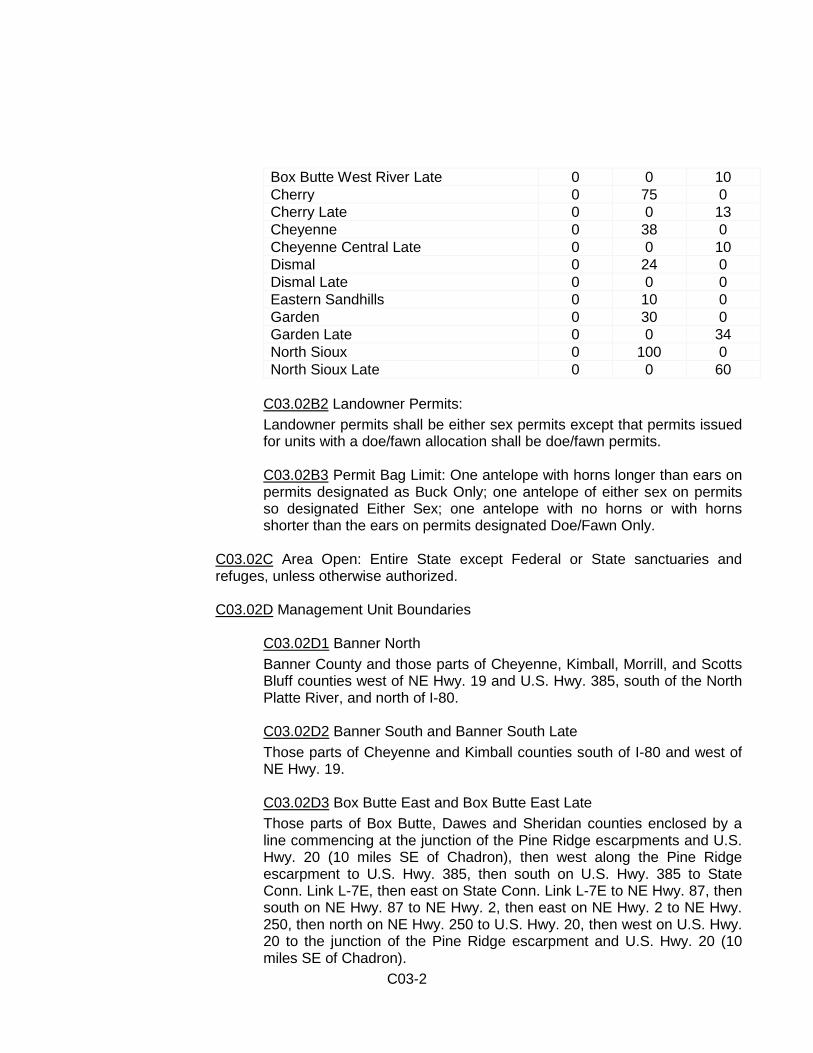
Box Butte West River Late 0 0 10 Cherry 0 75 0 Cherry Late 0 0 13 Cheyenne 0 38 0 Cheyenne Central Late 0 0 10 Dismal 0 24 0 Dismal Late 0 0 0 Eastern Sandhills 0 10 0 Garden 0 30 0 Garden Late 0 0 34 North Sioux 0 100 0 North Sioux Late 0 0 60
C03.02B2 Landowner Permits: Landowner permits shall be either sex permits except that permits issued for units with a doe/fawn allocation shall be doe/fawn permits.
C03.02B3 Permit Bag Limit: One antelope with horns longer than ears on permits designated as Buck Only; one antelope of either sex on permits so designated Either Sex; one antelope with no horns or with horns shorter than the ears on permits designated Doe/Fawn Only.
C03.02C Area Open: Entire State except Federal or State sanctuaries and refuges, unless otherwise authorized.
C03.02D Management Unit Boundaries
C03.02D1 Banner North Banner County and those parts of Cheyenne, Kimball, Morrill, and Scotts Bluff counties west of NE Hwy. 19 and U.S. Hwy. 385, south of the North Platte River, and north of I-80.
C03.02D2 Banner South and Banner South Late Those parts of Cheyenne and Kimball counties south of I-80 and west of NE Hwy. 19.
C03.02D3 Box Butte East and Box Butte East Late Those parts of Box Butte, Dawes and Sheridan counties enclosed by a line commencing at the junction of the Pine Ridge escarpments and U.S. Hwy. 20 (10 miles SE of Chadron), then west along the Pine Ridge escarpment to U.S. Hwy. 385, then south on U.S. Hwy. 385 to State Conn. Link L-7E, then east on State Conn. Link L-7E to NE Hwy. 87, then south on NE Hwy. 87 to NE Hwy. 2, then east on NE Hwy. 2 to NE Hwy. 250, then north on NE Hwy. 250 to U.S. Hwy. 20, then west on U.S. Hwy. 20 to the junction of the Pine Ridge escarpment and U.S. Hwy. 20 (10 miles SE of Chadron).

C03-3
C03.02D4 Box Butte East Central Late Those parts of Box Butte and Sheridan counties enclosed by a line beginning at the junction of Dodge Road and NE Hwy. 87 (16 mile corner), then north to the Dawes county line, then due east on the Dawes/Box Butte county line to approximately 22 miles to NE Hwy. 250 at a trail junction 3.5 miles north of Smith Lake Wildlife Management Area, then south 11 miles on NE Hwy. 250 to a trail junction 7.5 miles south of Smith Lake Wildlife Management Area, then due west on a line to the junction of Dodge Road and NE Hwy. 87.
C03.02D5 Box Butte West and Box Butte West Late Those parts of Box Butte, Dawes, Morrill, Scotts Bluff and Sioux counties included within the following boundaries: from the junction of U.S. Hwy. 20 with the Nebraska-Wyoming state line, then east on U.S. Hwy. 20 to U.S. Hwy. 385, then south on U.S. Hwy. 385 to State Conn. Link L-7E, then east on State Conn. Link L-7E to NE Hwy. 87, then south on NE Hwy. 87 to NE Hwy. 2, then west on NE Hwy. 2 to U.S. Hwy. 385, then south on U.S. Hwy. 385 to the North Platte River, then west along the North Platte River to the Nebraska-Wyoming state line, except that part of Dawes County south of U.S. Hwy. 20, east of NE Hwy. 2, west of U.S. Hwy. 385, and north of the Pine Ridge escarpment.
C03.02D6 Box Butte West River Late Those parts of the Box Butte West Unit (C03.02D5) within five (5) miles of
the banks of the Niobrara River from NE Hwy. 29 west to the Nebraska-Wyoming border.
C03.02D7 Cherry Those parts of Cherry, Grant, Hooker, Thomas, and Sheridan counties included within a line from the South Dakota border at NE Hwy. 87, thence south on NE Hwy. 87 to U.S. Hwy. 20, thence east on U.S. Hwy. 20 to NE Hwy. 250, thence south on NE Hwy. 250 and its connecting road to NE Hwy. 2, thence east on NE Hwy. 2 to U.S. Hwy. 83, thence north on U.S. Hwy. 83 to the South Dakota border.
C03.02D8 Cherry Late Those parts of Cherry and Sheridan counties east of NE Hwy. 87, west of U.S. Hwy. 83 and north of the Niobrara River.
C03.02D9 Cheyenne and Cheyenne Late Those parts of Cheyenne, Deuel, Garden, Morrill, and Keith counties east of U.S. Hwy. 385 and NE Hwy. 19, south of the North Platte River, and west of a line commencing at the junction of NE Hwy. 61 with the North Platte River, thence south on NE Hwy. 61 to U.S. Hwy. 30, thence west
C03-4
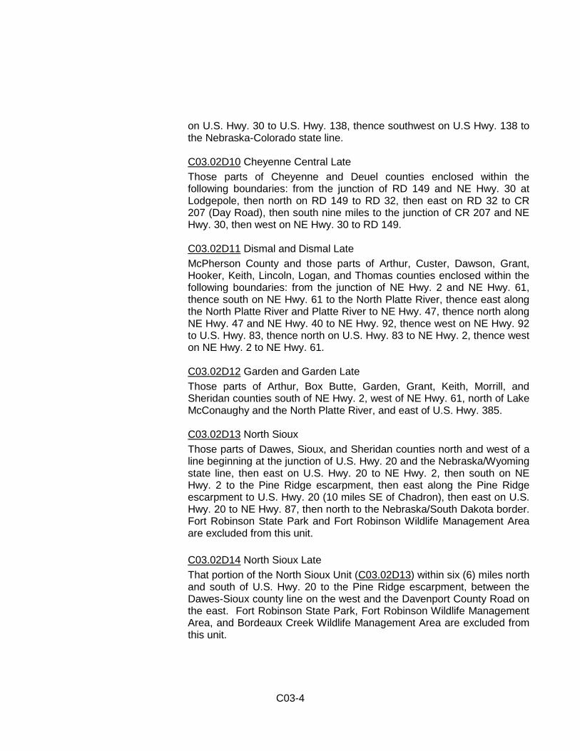
on U.S. Hwy. 30 to U.S. Hwy. 138, thence southwest on U.S Hwy. 138 to the Nebraska-Colorado state line.
C03.02D10 Cheyenne Central Late Those parts of Cheyenne and Deuel counties enclosed within the following boundaries: from the junction of RD 149 and NE Hwy. 30 at Lodgepole, then north on RD 149 to RD 32, then east on RD 32 to CR 207 (Day Road), then south nine miles to the junction of CR 207 and NE Hwy. 30, then west on NE Hwy. 30 to RD 149.
C03.02D11 Dismal and Dismal Late McPherson County and those parts of Arthur, Custer, Dawson, Grant, Hooker, Keith, Lincoln, Logan, and Thomas counties enclosed within the following boundaries: from the junction of NE Hwy. 2 and NE Hwy. 61, thence south on NE Hwy. 61 to the North Platte River, thence east along the North Platte River and Platte River to NE Hwy. 47, thence north along NE Hwy. 47 and NE Hwy. 40 to NE Hwy. 92, thence west on NE Hwy. 92 to U.S. Hwy. 83, thence north on U.S. Hwy. 83 to NE Hwy. 2, thence west on NE Hwy. 2 to NE Hwy. 61.
C03.02D12 Garden and Garden Late Those parts of Arthur, Box Butte, Garden, Grant, Keith, Morrill, and Sheridan counties south of NE Hwy. 2, west of NE Hwy. 61, north of Lake McConaughy and the North Platte River, and east of U.S. Hwy. 385.
C03.02D13 North Sioux Those parts of Dawes, Sioux, and Sheridan counties north and west of a line beginning at the junction of U.S. Hwy. 20 and the Nebraska/Wyoming state line, then east on U.S. Hwy. 20 to NE Hwy. 2, then south on NE Hwy. 2 to the Pine Ridge escarpment, then east along the Pine Ridge escarpment to U.S. Hwy. 20 (10 miles SE of Chadron), then east on U.S. Hwy. 20 to NE Hwy. 87, then north to the Nebraska/South Dakota border. Fort Robinson State Park and Fort Robinson Wildlife Management Area are excluded from this unit. C03.02D14 North Sioux Late That portion of the North Sioux Unit (C03.02D13) within six (6) miles north and south of U.S. Hwy. 20 to the Pine Ridge escarpment, between the Dawes-Sioux county line on the west and the Davenport County Road on the east. Fort Robinson State Park, Fort Robinson Wildlife Management Area, and Bordeaux Creek Wildlife Management Area are excluded from this unit.
C03-5
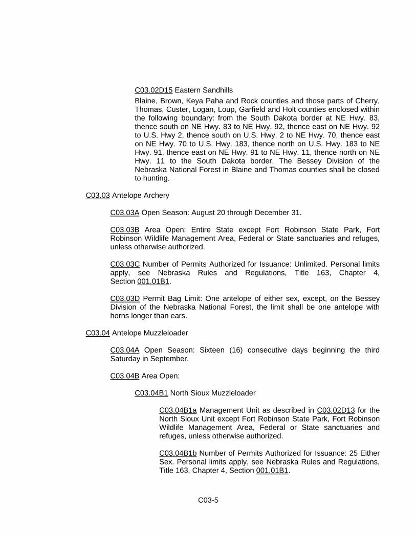
C03.02D15 Eastern Sandhills Blaine, Brown, Keya Paha and Rock counties and those parts of Cherry, Thomas, Custer, Logan, Loup, Garfield and Holt counties enclosed within the following boundary: from the South Dakota border at NE Hwy. 83, thence south on NE Hwy. 83 to NE Hwy. 92, thence east on NE Hwy. 92 to U.S. Hwy 2, thence south on U.S. Hwy. 2 to NE Hwy. 70, thence east on NE Hwy. 70 to U.S. Hwy. 183, thence north on U.S. Hwy. 183 to NE Hwy. 91, thence east on NE Hwy. 91 to NE Hwy. 11, thence north on NE Hwy. 11 to the South Dakota border. The Bessey Division of the Nebraska National Forest in Blaine and Thomas counties shall be closed to hunting.
C03.03 Antelope Archery
C03.03A Open Season: August 20 through December 31.
C03.03B Area Open: Entire State except Fort Robinson State Park, Fort Robinson Wildlife Management Area, Federal or State sanctuaries and refuges, unless otherwise authorized.
C03.03C Number of Permits Authorized for Issuance: Unlimited. Personal limits apply, see Nebraska Rules and Regulations, Title 163, Chapter 4, Section 001.01B1.
C03.03D Permit Bag Limit: One antelope of either sex, except, on the Bessey Division of the Nebraska National Forest, the limit shall be one antelope with horns longer than ears.
C03.04 Antelope Muzzleloader
C03.04A Open Season: Sixteen (16) consecutive days beginning the third Saturday in September.
C03.04B Area Open:
C03.04B1 North Sioux Muzzleloader
C03.04B1a Management Unit as described in C03.02D13 for the North Sioux Unit except Fort Robinson State Park, Fort Robinson Wildlife Management Area, Federal or State sanctuaries and refuges, unless otherwise authorized.
C03.04B1b Number of Permits Authorized for Issuance: 25 Either Sex. Personal limits apply, see Nebraska Rules and Regulations, Title 163, Chapter 4, Section 001.01B1.
C03-6
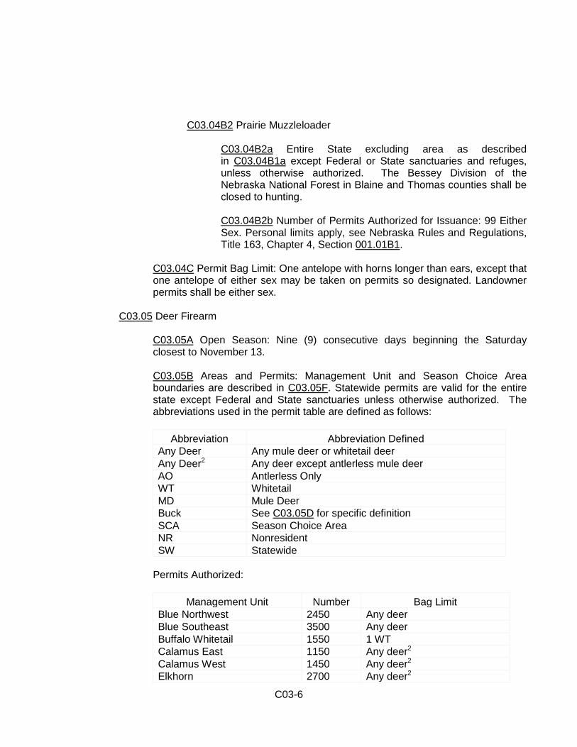
C03.04B2 Prairie Muzzleloader
C03.04B2a Entire State excluding area as described in C03.04B1a except Federal or State sanctuaries and refuges, unless otherwise authorized. The Bessey Division of the Nebraska National Forest in Blaine and Thomas counties shall be closed to hunting. C03.04B2b Number of Permits Authorized for Issuance: 99 Either Sex. Personal limits apply, see Nebraska Rules and Regulations, Title 163, Chapter 4, Section 001.01B1.
C03.04C Permit Bag Limit: One antelope with horns longer than ears, except that one antelope of either sex may be taken on permits so designated. Landowner permits shall be either sex.
C03.05 Deer Firearm
C03.05A Open Season: Nine (9) consecutive days beginning the Saturday closest to November 13. C03.05B Areas and Permits: Management Unit and Season Choice Area boundaries are described in C03.05F. Statewide permits are valid for the entire state except Federal and State sanctuaries unless otherwise authorized. The abbreviations used in the permit table are defined as follows:
Abbreviation Abbreviation Defined
Any Deer Any mule deer or whitetail deer Any Deer2 Any deer except antlerless mule deer AO Antlerless Only WT Whitetail MD Mule Deer Buck See C03.05D for specific definition SCA Season Choice Area NR Nonresident SW Statewide
Permits Authorized:
Management Unit Number Bag Limit Blue Northwest 2450 Any deer Blue Southeast 3500 Any deer Buffalo Whitetail 1550 1 WT Calamus East 1150 Any deer2 Calamus West 1450 Any deer2 Elkhorn 2700 Any deer2
C03-7
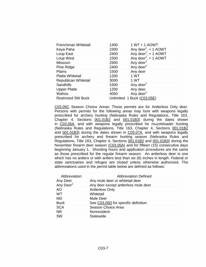
Frenchman Whitetail 1400 1 WT + 1 AOWT Keya Paha 2300 Any deer2, + 1 AOWT Loup East 2400 Any deer2, + 1 AOWT Loup West 1500 Any deer2, + 1 AOWT Missouri 2900 Any deer2 Pine Ridge 2400 Any deer2
Plains 1500 Any deer Platte Whitetail 1200 1 WT Republican Whitetail 3000 1 WT Sandhills 1500 Any deer2 Upper Platte 1200 Any deer Wahoo 4050 Any deer2 Restricted SW Buck Unlimited 1 Buck (C03.05E)
C03.05C Season Choice Areas: These permits are for Antlerless Only deer. Persons with permits for the following areas may hunt with weapons legally prescribed for archery hunting (Nebraska Rules and Regulations, Title 163, Chapter 4, Sections 001.01B2 and 001.01B3) during the dates shown in C03.06A, and with weapons legally prescribed for muzzleloader hunting (Nebraska Rules and Regulations, Title 163, Chapter 4, Sections 001.01B2 and 001.01B3) during the dates shown in C03.07A, and with weapons legally prescribed for archery and firearm hunting season (Nebraska Rules and Regulations, Title 163, Chapter 4, Sections 001.01B2 and 001.01B3) during the November firearm deer season (C03.05A) and for fifteen (15) consecutive days beginning January 1. Shooting hours and application procedures are the same as those prescribed for the regular firearm season. An antlerless deer is one which has no antlers or with antlers less than six (6) inches in length. Federal or state sanctuaries and refuges are closed unless otherwise authorized. The abbreviations used in the permit table below are defined as follows:
Abbreviation Abbreviation Defined
Any Deer Any mule deer or whitetail deer Any Deer2 Any deer except antlerless mule deer AO Antlerless Only WT Whitetail MD Mule Deer Buck See C03.05D for specific definition SCA Season Choice Area NR Nonresident SW Statewide
C03-8
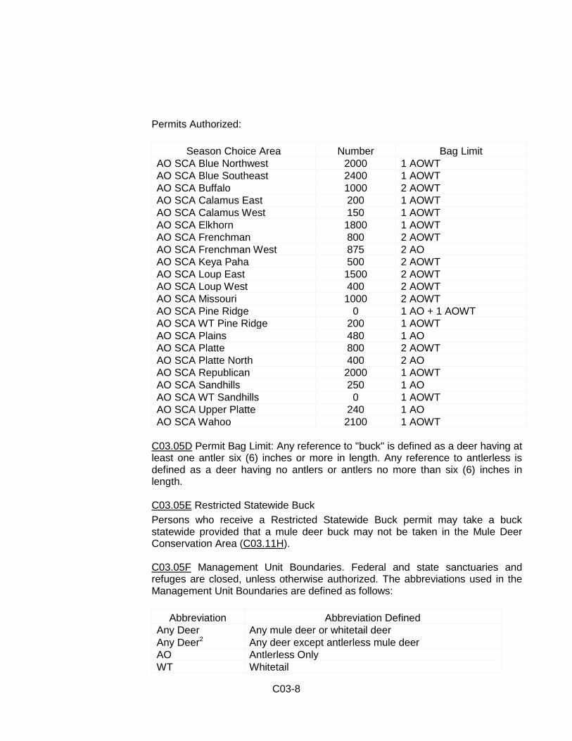
Permits Authorized:
Season Choice Area Number Bag Limit AO SCA Blue Northwest 2000 1 AOWT AO SCA Blue Southeast 2400 1 AOWT AO SCA Buffalo 1000 2 AOWT AO SCA Calamus East 200 1 AOWT AO SCA Calamus West 150 1 AOWT AO SCA Elkhorn 1800 1 AOWT AO SCA Frenchman 800 2 AOWT AO SCA Frenchman West 875 2 AO AO SCA Keya Paha 500 2 AOWT AO SCA Loup East 1500 2 AOWT AO SCA Loup West 400 2 AOWT AO SCA Missouri 1000 2 AOWT AO SCA Pine Ridge 0 1 AO + 1 AOWT AO SCA WT Pine Ridge 200 1 AOWT AO SCA Plains 480 1 AO AO SCA Platte 800 2 AOWT AO SCA Platte North 400 2 AO AO SCA Republican 2000 1 AOWT AO SCA Sandhills 250 1 AO AO SCA WT Sandhills 0 1 AOWT AO SCA Upper Platte 240 1 AO AO SCA Wahoo 2100 1 AOWT
C03.05D Permit Bag Limit: Any reference to "buck" is defined as a deer having at least one antler six (6) inches or more in length. Any reference to antlerless is defined as a deer having no antlers or antlers no more than six (6) inches in length.
C03.05E Restricted Statewide Buck Persons who receive a Restricted Statewide Buck permit may take a buck statewide provided that a mule deer buck may not be taken in the Mule Deer Conservation Area (C03.11H). C03.05F Management Unit Boundaries. Federal and state sanctuaries and refuges are closed, unless otherwise authorized. The abbreviations used in the Management Unit Boundaries are defined as follows:
Abbreviation Abbreviation Defined
Any Deer Any mule deer or whitetail deer Any Deer2 Any deer except antlerless mule deer AO Antlerless Only WT Whitetail
C03-9
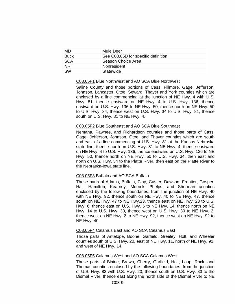
MD Mule Deer Buck See C03.05D for specific definition SCA Season Choice Area NR Nonresident SW Statewide
C03.05F1 Blue Northwest and AO SCA Blue Northwest Saline County and those portions of Cass, Fillmore, Gage, Jefferson, Johnson, Lancaster, Otoe, Seward, Thayer and York counties which are enclosed by a line commencing at the junction of NE Hwy. 4 with U.S. Hwy. 81, thence eastward on NE Hwy. 4 to U.S. Hwy. 136, thence eastward on U.S. Hwy. 136 to NE Hwy. 50, thence north on NE Hwy. 50 to U.S. Hwy. 34, thence west on U.S. Hwy. 34 to U.S. Hwy. 81, thence south on U.S. Hwy. 81 to NE Hwy. 4.
C03.05F2 Blue Southeast and AO SCA Blue Southeast Nemaha, Pawnee, and Richardson counties and those parts of Cass, Gage, Jefferson, Johnson, Otoe, and Thayer counties which are south and east of a line commencing at U.S. Hwy. 81 at the Kansas-Nebraska state line, thence north on U.S. Hwy. 81 to NE Hwy. 4, thence eastward on NE Hwy. 4 to U.S. Hwy. 136, thence eastward on U.S. Hwy. 136 to NE Hwy. 50, thence north on NE Hwy. 50 to U.S. Hwy. 34, then east and north on U.S. Hwy. 34 to the Platte River, then east on the Platte River to the Nebraska-Iowa state line.
C03.05F3 Buffalo and AO SCA Buffalo Those parts of Adams, Buffalo, Clay, Custer, Dawson, Frontier, Gosper, Hall, Hamilton, Kearney, Merrick, Phelps, and Sherman counties enclosed by the following boundaries: from the junction of NE Hwy. 40 with NE Hwy. 92, thence south on NE Hwy. 40 to NE Hwy. 47, thence south on NE Hwy. 47 to NE Hwy.23, thence east on NE Hwy. 23 to U.S. Hwy. 6, thence east on U.S. Hwy. 6 to NE Hwy. 14, thence north on NE Hwy. 14 to U.S. Hwy. 30, thence west on U.S. Hwy. 30 to NE Hwy. 2, thence west on NE Hwy. 2 to NE Hwy. 92, thence west on NE Hwy. 92 to NE Hwy. 40.
C03.05F4 Calamus East and AO SCA Calamus East Those parts of Antelope, Boone, Garfield, Greeley, Holt, and Wheeler counties south of U.S. Hwy. 20, east of NE Hwy. 11, north of NE Hwy. 91, and west of NE Hwy. 14.
C03.05F5 Calamus West and AO SCA Calamus West Those parts of Blaine, Brown, Cherry, Garfield, Holt, Loup, Rock, and Thomas counties enclosed by the following boundaries: from the junction of U.S. Hwy. 83 with U.S. Hwy. 20, thence south on U.S. Hwy. 83 to the Dismal River, thence east along the north side of the Dismal River to NE
C03-10
Hwy. 2, thence north on NE Hwy. 2 to NE Hwy. 91, thence east on NE Hwy. 91 to NE Hwy. 11, thence north on NE Hwy. 11 to U.S. Hwy. 20, thence west on U.S. Hwy. 20 to U.S. Hwy. 83, except that Valentine National Wildlife Refuge and Bessey Division of the Nebraska National Forest shall be closed to the use of bonus antlerless tags or bonus antlerless whitetail tags and Season Choice antlerless only permits.
C03.05F6 Elkhorn and AO SCA Elkhorn Burt, Cuming, Madison, Stanton, Thurston, and Wayne counties and those parts of Antelope, Boone, Cedar, Colfax, Dakota, Dixon, Dodge, Pierce, Platte, and Washington counties included within the following boundaries: from the junction of NE Hwy. 14 with U.S. Hwy. 20, thence south on NE Hwy. 14 to NE Hwy. 91, thence east on NE Hwy. 91 to U.S. Hwy. 81, thence south on U.S. Hwy. 81 to U.S. Hwy. 30, thence east on U.S. Hwy. 30 to the Nebraska-Iowa state line, thence north along said state line to U.S. Hwy. 20, thence west on U.S Hwy. 20 to NE Hwy. 14.
C03.05F7 Frenchman and AO SCA Frenchman Chase, Dundy, Hayes, Hitchcock, and Red Willow counties and those parts of Dawson, Frontier, Furnas, Gosper, Lincoln, and Perkins counties south of NE Hwy. 23 and west of U.S. Hwy. 283, provided that Medicine Creek SRA/WMA, Red Willow SRA/WMA, Enders SRA/WMA and Swanson SRA/WMA shall be closed to the use of Season Choice Antlerless permits. C03.05F8 Keya Paha and AO SCA Keya Paha Keya Paha County and those parts of Boyd, Brown, Cherry, Holt, and Rock counties east of U.S. Hwy. 83, north of U.S. Hwy. 20, and west of U.S. Hwy. 281.
C03.05F9 Loup East and AO SCA Loup East Howard and Nance counties and those parts of Boone, Buffalo, Garfield, Greeley, Hall, Merrick, Platte, Sherman, Valley, and Wheeler counties included within the following boundaries: from the junction of NE Hwy. 70 with NE Hwy. 91 west of Ericson, thence south on NE Hwy. 70 to NE Hwy. 58, thence south on NE Hwy. 58 to NE Hwy. 10, thence south and west on NE Hwy. 10 to NE Hwy. 2, thence east on NE Hwy. 2 to U.S. Hwy. 30, thence east on U.S. Hwy. 30 to U.S. Hwy. 81, thence north on U.S. Hwy. 81 to NE Hwy. 91, thence west on NE Hwy. 91 to its junction with NE Hwy. 70 west of Ericson. C03.05F10 Loup West and AO SCA Loup West Those parts of Blaine, Custer, Garfield, Logan, Loup, Sherman, Thomas, and Valley counties enclosed by the following boundaries: from the junction of U.S. Hwy. 83 with the Dismal River, thence south on U.S. Hwy. 83 to NE Hwy. 92, thence east on NE Hwy. 92 to NE Hwy. 2, thence
C03-11
east on NE Hwy. 2 to NE Hwy. 10, thence east and north on NE Hwy. 10 to NE Hwy. 58, thence north on NE Hwy. 58 to NE Hwy. 70, thence north on NE Hwy. 70 to NE Hwy. 91, thence west on NE Hwy. 91 to NE Hwy. 2, thence south on NE Hwy. 2 to the Dismal River, thence west along the south side of the Dismal River to U.S. Hwy. 83.
C03.05F11 Missouri and AO SCA Missouri Knox County and those parts of Antelope, Boyd, Cedar, Dakota, Dixon, Holt, and Pierce counties north of U.S. Hwy. 20 and east of U.S. Hwy. 281.
C03.05F12 Pine Ridge and AO SCA Pine Ridge Those parts of Box Butte, Dawes, Sheridan, and Sioux counties north of the Niobrara River and west of NE Hwy. 27.
C03.05F13 Plains and AO SCA Plains Those parts of Arthur, Box Butte, Dawes, Garden, Grant, Keith, Morrill, Scotts Bluff, Sheridan, and Sioux counties included within the following boundaries: from the junction of U.S. Hwy. 26 with Nebraska-Wyoming state line, thence east on U.S. Hwy. 26 to State Link 62A, thence east on State Link 62A to U.S. Hwy. 385, thence south on U.S. Hwy. 385 to U.S. Hwy. 26, thence east on U.S. Hwy. 26 to NE Hwy. 92, thence east on NE Hwy. 92 to NE Hwy. 61, thence north on NE Hwy. 61 to NE Hwy. 2, thence west on NE Hwy. 2 to NE Hwy. 27, thence north on NE Hwy. 27 to the Niobrara River, thence west along the south side of the Niobrara River to the Nebraska-Wyoming state line.
C03.05F14 Platte and AO SCA Platte Those parts of Arthur, Custer, Dawson, Deuel, Frontier, Garden, Keith, Lincoln, Logan, McPherson, and Perkins counties south of NE Hwy. 92, west of NE Hwys. 40 and 47, north of NE Hwy. 23, and east of a line commencing at the junction of NE Hwy. 27 and NE Hwy. 92, thence south on NE Hwy. 27 to U.S. Hwy. 30, thence west on U.S. Hwy. 30 to U.S. Hwy. 385, thence south on U.S. Hwy. 385 to the Nebraska- Colorado state line.
C03.05F15 Republican and AO SCA Republican Franklin, Harlan, Nuckolls, and Webster counties and those parts of Adams, Clay, Fillmore, Furnas, Gosper, Hamilton, Kearney, Phelps, Thayer, and York counties east of U.S. Hwy. 283, west of U.S. Hwy. 81, and south of a line commencing at the junction of U.S. Hwy. 81 with U.S. Hwy. 34, thence west on U.S. Hwy. 34 to NE Hwy. 14, thence south on NE Hwy. 14 to U.S. Hwy. 6, thence west on U.S. Hwy. 6 to NE Hwy. 23, thence west on NE Hwy. 23 to U.S. Hwy. 283, provided that Harlan County Reservoir Corps of Engineers lands shall be closed to the use of Season Choice antlerless permits.

C03-12
C03.05F16 Sandhills and AO SCA Sandhills Hooker County and those parts of Arthur, Cherry, Grant, Logan, McPherson, Sheridan, and Thomas counties included within the following boundaries: from the junction of NE Hwy. 27 with the Nebraska-South Dakota state line, thence south on NE Hwy. 27 to NE Hwy. 2, thence east on NE Hwy. 2 to NE Hwy. 61, thence south on NE Hwy. 61 to NE Hwy. 92, thence east on NE Hwy. 92 to U.S. Hwy. 83, thence north on U.S. Hwy. 83 to the Nebraska-South Dakota state line, except that Valentine National Wildlife Refuge and Samuel McKelvie National Forest shall be closed to the use of bonus antlerless tags or bonus antlerless whitetail tags and Season Choice antlerless only permits.
C03.05F17 Upper Platte and AO SCA Upper Platte Banner, Cheyenne, and Kimball counties and those parts of Deuel, Garden, Morrill, and Scotts Bluff counties south and west of a line commencing at the junction of U.S. Hwy. 26 with the Nebraska-Wyoming state line, thence east on U.S. Hwy. 26 to State Link 62A, thence east on State Link 62A to U.S. Hwy. 385, thence south on U.S. Hwy. 385 to U.S. Hwy. 26, thence east on U.S. Hwy. 26 to NE Hwy. 27, thence south on NE Hwy. 27 to U.S. Hwy. 30, thence west on U.S. Hwy. 30 to U.S. Hwy. 385, thence south on U.S. Hwy. 385 to the Nebraska-Colorado state line.
C03.05F18 Wahoo and AO SCA Wahoo Butler, Douglas, Polk, Sarpy, and Saunders counties and those parts of Cass, Colfax, Dodge, Hamilton, Lancaster, Merrick, Platte, Seward, Washington, and York counties bounded by a line beginning at the junction of the Missouri River and U.S. Hwy. 30, then west on U.S. Hwy. 30 to NE Hwy. 14, then south on NE Hwy. 14 to U.S. Hwy. 34, then east and north on U.S. Hwy. 34 to the Platte River, then east on the Platte River to the Missouri River. C03.05F19 AO SCA Frenchman West: That portion of the Frenchman Unit (C03.05F7) west of a line commencing at Moorefield, NE on NE Hwy. 23; then south on County Road 399 to Stockville, NE; then south on County Road 396 to U.S. Hwy. 6/34 (Indianola, NE); then west on U.S. Hwy. 6/34 to U.S. Hwy. 83; then south on U.S. Hwy. 83 to the Nebraska-Kansas border. Permits are not valid on the Red Willow SRA/WMA, Swanson SRA/WMA or the Enders SRA/WMA. C03.05F20 AO SCA Platte North: That portion of the Platte Unit (C03.05F14) north of U.S. Hwy. 30 or east of U.S. Hwy. 83.

C03-13
C03.06 Deer Archery
C03.06A Open Season: September 1 through December 31 provided that special season dates apply to the DeSoto National Wildlife Refuge (C03.11C1).
C03.06B Area Open: Entire state except Federal or State sanctuaries and refuges, unless otherwise authorized. Bonus antlerless permits are not valid on Bessey National Forest, McKelvie National Forest, Valentine National Wildlife Refuge.
C03.06C Number of Permits Authorized for Issuance: Unlimited. Personal limits apply, see Nebraska Rules and Regulations, Title 163, Chapter 4, Section 001.01B1.
C03.06D Permit Bag Limit: One deer of either sex, provided that a buck may not be taken in January. Any reference to antlerless is defined as a deer having no antlers or antlers no more than six (6) inches in length.
C03.07 Deer Muzzleloader
C03.07A Open Season: December 1 through December 31, inclusive.
C03.07B Number of Permits Authorized for Issuance: Unlimited. Personal limits apply, see Nebraska Rules and Regulations, Title 163, Chapter 4, Section 001.01B1. C03.07C Permit Bag Limit: One deer of either sex provided that a mule deer may not be taken in the Mule Deer Conservation Area (C03.11H). Any reference to antlerless is defined as a deer having no antlers or antlers no more than six (6) inches in length.
C03.07D Area Open: Entire State except Federal or State sanctuaries and refuges unless otherwise authorized. Bonus antlerless permits are not valid on Bessey National Forest, McKelvie National Forest, Valentine National Wildlife Refuge.
C03.08 Youth Deer Season
C03.08A Open Season: Persons with youth deer permits may hunt with weapons legally prescribed for archery hunting (Nebraska Rules and Regulations, Title 163, Chapter 4, Sections 001.01B2 and 001.01B3) during the dates shown in C03.06A, and with weapons legally prescribed for muzzleloader hunting (Nebraska Rules and Regulations, Title 163, Chapter 4, Sections 001.01B2 and 001.01B3) during the dates shown in C03.07A, and with weapons legally prescribed for archery and firearm hunting (Nebraska Rules and Regulations, Title 163, Chapter 4, Sections 001.01B2 and 001.01B3) during the November
C03-14
firearm deer season (C03.05A) and for fifteen (15) consecutive days beginning January 1.
C03.08A1 Number of Permits Authorized for Issuance: Unlimited. Personal limits apply, see Nebraska Rules and Regulations, Title 163, Chapter 4, Section 001.01B1. No person may obtain more than one Youth permit that allows the take of a mule deer buck.
C03.08A1a Youth Whitetail Permit Bag Limit: One whitetail deer provided that a buck may not be taken in January. Any reference to antlerless is defined as a deer having no antlers or antlers no more than six (6) inches in length.
C03.08A1b Resident Youth Deer Permit Bag Limit: One deer of either sex provided that a buck may not be taken in January. Any reference to antlerless is defined as a deer having no antlers or antlers no more than six (6) inches in length. C03.08A1c Nonresident Restricted Youth Deer Permit Bag Limit: One deer of either sex provided that a buck may not be taken in January. Any reference to antlerless is defined as a deer having no antlers or antlers no more than six (6) inches in length.
C03.08B Area Open: Entire state except Federal or State sanctuaries and refuges, unless otherwise authorized. Bonus antlerless permits are not valid on Bessey National Forest, McKelvie National Forest, Valentine National Wildlife Refuge. Nonresident Restricted Youth Deer permits are not valid in Draw Units listed in Nebraska Rules and Regulations, Title 163, Chapter 4, Section 003.02A1.
C03.09 Landowner Deer Season: No person may apply for or obtain more than one limited landowner permit per year for deer.
C03.09A Open Season: Persons with landowner deer permits may hunt with weapons legally prescribed for archery hunting (Nebraska Rules and Regulations, Title 163, Chapter 4, Sections 001.01B2 and 001.01B3) during the dates shown in C03.06A, and with weapons legally prescribed for muzzleloader hunting (Nebraska Rules and Regulations, Title 163, Chapter 4, Sections 001.01B2 and 001.01B3) during the dates shown in C03.07A, and with weapons legally prescribed for archery and firearm hunting (Nebraska Rules and Regulations, Title 163, Chapter 4, Sections 001.01B2 and 001.01B3) during the November firearm deer season (C03.05A) and for fifteen (15) consecutive days beginning January 1.
C03.09B Number of Permits Authorized for Issuance: Unlimited. Personal limits apply, see Nebraska Rules and Regulations, Title 163, Chapter 4, Section 001.01B1.

C03-15
C03.09C Permit Bag Limit: One deer of either sex and one antlerless deer, provided that a buck may not be taken in January.
C03.09D Area Open: Entire state. Persons who obtain a limited landowner permit may hunt on lands described on their application.
C03.10 Statewide Whitetail Buck
C03.10A Open Season: Persons with Statewide Whitetail Buck deer permits may hunt with weapons legally prescribed for archery hunting (Nebraska Rules and Regulations, Title 163, Chapter 4, Sections 001.01B2 and 001.01B3) during the dates shown in (C03.06A), and with weapons legally prescribed for muzzleloader hunting (Nebraska Rules and Regulations, Title 163, Chapter 4, Sections 001.01B2 and 001.01B3) during the dates shown in (C03.07A), and with weapons legally prescribed for archery and firearm hunting season (Nebraska Rules and Regulations, Title 163, Chapter 4, Sections 001.01B2 and 001.01B3) during the November firearm deer season (C03.05A).
C03.10B Number of Permits Authorized for Issuance: Unlimited. Personal limits apply, see Nebraska Rules and Regulations, Title 163, Chapter 4, Section 001.01B1.
C03.10C Permit Bag Limit: One whitetail buck. Any reference to antlerless is defined as a deer having no antlers or antlers no more than six (6) inches in length.
C03.10D Area Open: Entire state except Federal or State sanctuaries and refuges, unless otherwise authorized.
C03.11 Deer - Special Area Provisions
Restrictions pertaining to permit bag limits define a buck as a deer having at least one antler six (6) inches or more in length and an antlerless deer defined as a deer with no antlers or antlers no more than six (6) inches in length.
C03.11A The Dodge-Saunders County Game Refuge, described in section 37-706 and the North Platte River Refuge, described in section 37-706, shall be open to hunting deer during all established deer seasons.
C03.11B The Garden County Game Refuge. Archery hunting for deer shall be permitted on the Garden County Game Refuge, as described in section 37-706, from September 1 through October 31.
C03.11C DeSoto National Wildlife Refuge Those lands within and designated as open by the DeSoto National Wildlife Refuge.
C03-16
C03.11C1 Archery: Those lands within and designated as open by the DeSoto National Wildlife Refuge shall be open to archery deer hunting in accordance with all pertinent state regulations except that season dates shall be September 1 through December 31. See C03.06A. C03.11C2 Muzzleloader Seasons: Shooting hours and application procedures are the same as those prescribed for the regular firearm season. Legal weapons as specified for statewide muzzleloader hunting (Nebraska Rules and Regulations, Title 163, Chapter 4, Sections 001.01B2 and 001.01B3).
C03.11C2a DeSoto October: October 21 and 22. One hundred twenty-five (125) permits with a bag limit of two antlerless deer.
C03.11C2b DeSoto October Late: Zero (0) permits are authorized.
C03.11C2c DeSoto December: December 16 and 17. One hundred twenty-five (125) permits with a bag limit of two antlerless deer.
C03.11C2d DeSoto January: Zero (0) permits are authorized.
C03.11D Gifford Wildlife Management Area: Special deer hunting regulations shall be in effect on the Gifford Wildlife Management Area in Sarpy County, which includes all land owned by the Nebraska Game and Parks Commission and the Educational Service Unit Number Three on Sec. 16, 17, 18, 19, 20, and 21 in T14N R14E of the 6th P.M.
C03.11D1 Archery: Hunting is permitted in accordance with all applicable state regulations except that season dates shall be September 1 through December 31. C03.11D2 Muzzleloader: Hunting is permitted in accordance with all applicable state regulations for muzzleloader (Nebraska Rules and Regulations, Title 163, Chapter 4, Sections 001.01B2 and 001.01B3) hunting during the statewide muzzleloader season (C03.07A) and the January portion of AO SCA Wahoo (C03.05F18). Except that muzzleloaders are not allowed during the November Firearm Deer season.
C03.11E Boyer Chute National Wildlife Refuge
C03.11E1 Area Open: Special deer hunting regulations shall be in effect on lands within and designated as open by the Boyer Chute National Wildlife Refuge.

C03-17
C03.11E2 Seasons
C03.11E2a Boyer Chute October: Zero (0) permits are authorized. Legal weapons as specified for muzzleloader hunting (Nebraska Rules and Regulations, Title 163, Chapter 4, Sections 001.01B2 and 001.01B3).
C03.11E2b Boyer Chute November: Zero (0) permits are authorized. Legal weapons as specified for muzzleloader hunting (Nebraska Rules and Regulations, Title 163, Chapter 4, Sections 001.01B2 and 001.01B3). C03.11E2c Boyer Chute December: Zero (0) permits are authorized. Legal weapons as specified for muzzleloader hunting (Nebraska Rules and Regulations, Title 163, Chapter 4, Sections 001.01B2 and 001.01B3).
C03.11F Pine Ridge Special Areas
C03.11F1 Special deer hunting regulations shall be in effect for all lands within the Pine Ridge Unit as described in (C03.05F12).
C03.11F2 Harvest of antlerless mule deer is prohibited, except that persons hunting under the authority of a Landowner’s permit are exempted (C03.09).
C03.11G River Antlerless
C03.11G1 Open Season: Persons with River Antlerless permits may hunt with weapons legally prescribed for archery hunting (Nebraska Rules and Regulations, Title 163, Chapter 4, Sections 001.01B2 and 001.01B3) during the dates shown in C03.06A, and with weapons legally prescribed for muzzleloader hunting (Nebraska Rules and Regulations, Title 163, Chapter 4, Sections 001.01B2 and 001.01B3) during the dates shown in C03.07A, and with weapons legally prescribed for archery and firearm hunting (Nebraska Rules and Regulations, Title 163, Chapter 4, Sections 001.01B2 and 001.01B3) during the November firearm deer season (C03.05A) and for fifteen (15) consecutive days beginning January 1 and for ten (10)consecutive days beginning the Saturday closest to October 1. C03.11G2 Number of Permits Authorized for Issuance: 12,000. C03.11G3 Permit Bag Limit: Two antlerless whitetail deer. Any reference to an antlerless deer is one which has no antlers or with antlers less than six (6) inches in length.
C03-18
C03.11G4 Areas Open:
Those areas of Nebraska within:
That portion of Nebraska east of a boundary commencing with U.S. Hwy. 281 from the South Dakota border, thence south on U.S. Hwy. 281 to NE Hwy. 12, thence east on NE Hwy. 12 to U.S. Hwy. 20, thence east on U.S. Hwy. 20 to U.S. Hwy. 75, thence south on U.S. Hwy. 75 to NE Hwy. 133, thence south on NE Hwy. 133 to U.S. Hwy. 6, thence east on U.S. Hwy. 6 to Interstate 480, thence south on Interstate 480 to U.S. Hwy. 75, thence south on U.S. Hwy. 75 to NE Hwy. 67, thence east and south on NE Hwy. 67 to U.S. Hwy. 136, thence east on U.S. Hwy. 136 to NE Hwy. 67, thence south on NE Hwy. 67 to U.S. Hwy. 73, thence east and south on U.S. Hwy. 73 to the Kansas border.
Three (3) miles of the landward banks of the Platte River, North Platte River, South Platte River, Republican River, Loup and the Keya Paha Rivers. From the mouth of Long Pine Creek to a point five (5) miles south of U.S. Hwy. 20 where Long Pine Creek crosses the west side of Section 19, T29N R20W. The South Loup River from the mouth to U.S.Hwy. 83. The Niobrara River from the mouth to NE Hwy. 27.
The Elkhorn River from the mouth to Stuart, Nebraska.
The south fork of the Elkhorn River from the mouth to NE Hwy. 11.
The North Loup River from the mouth to NE Hwy. 7.
The Cedar River from the mouth to NE Hwy. 11.
The Middle Loup River from the mouth to NE Hwy. 2.
The White River between the intersection of the White River and NE Hwy. 71 northeasterly to the intersection of the White River and the Nebraska/South Dakota state line. All state and federal public lands are closed.
C03.11H Mule Deer Conservation Areas Persons with permits for the following areas may hunt with weapons legally prescribed for muzzleloader hunting (Nebraska Rules and Regulations, Title 163, Chapter 4, Sections 001.01B2 and 001.01B3) during the dates shown in (C03.07A) and with weapons legally prescribed for archery and firearm hunting
C03-19
(Nebraska Rules and Regulations, Title 163, Chapter 4, Sections 001.01B2 and 001.01B3) during the dates shown in (C03.05A).
C03.11H1 Frenchman: Area as described for the Frenchman Unit (C03.05F7). One thousand nine hundred (1,900) permits for one (1) Any Deer and one (1) antlerless whitetail deer. No person may obtain more than one Frenchman permit that allows the take of a mule deer buck. The nonresident permit quota for Mule Deer Conservation Area permits is eight percent (8%) of the total permit allocation.
C03.11H2 Platte: Area as described for the Platte Unit (C03.05F14). One thousand three hundred (1,300) permits for one (1) mule deer buck or one (1) whitetail deer and one (1) antlerless whitetail deer. No person may obtain more than one Platte permit that allows the take of a mule deer buck. The nonresident permit quota for Mule Deer Conservation Area permits is fifteen percent (15%) of the total permit allocation.
C03.11H3 Buffalo: Area as described for the Buffalo Unit (C03.05F3). One thousand six hundred (1,600) permits for one (1) mule deer buck or one (1) whitetail deer. No person may obtain more than one Buffalo permit that allows the take of a mule deer buck.
C03.11H4 Republican Mule Deer Buck: Area as described for the Republican Unit (C03.05F15). One hundred (100) permits for one (1) mule deer buck. No person may obtain more than one Republican permit that allows the take of a mule deer buck.
C03.11I Crescent Lake National Wildlife Refuge shall be closed to the harvest of
antlerless mule deer.
C03.12 Elk
C03.12A Open Season: Bull C03.12A1 Firearm season, all units: Thirty (30) consecutive days
beginning the last Saturday in September. C03.12A2 Archery season, all units: Beginning September 15, closing on
the last day of firearm season for bulls (C03.12A1). Persons hunting from September 15 until the opening of the firearm season (C03.12A1) must hunt with archery equipment as specified in Nebraska Rules and Regulations, Title 163, Chapter 4, Section 001.01B2.
C03.12B Open Season: Antlerless All units, beginning August 15 and closing on the last day of firearm season for bulls (C03.12A1) and open December 1 through December 31, except that State
C03-20
and Federal public lands are closed to antlerless elk hunting until the start of the firearm bull season (C03.12A1).
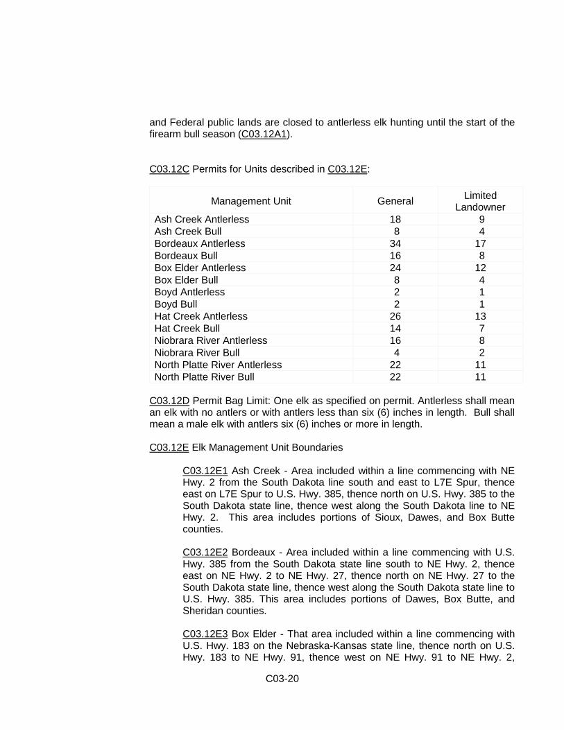
C03.12C Permits for Units described in C03.12E:
Management Unit General Limited Landowner
Ash Creek Antlerless 18 9 Ash Creek Bull 8 4 Bordeaux Antlerless 34 17 Bordeaux Bull 16 8 Box Elder Antlerless 24 12 Box Elder Bull 8 4 Boyd Antlerless 2 1 Boyd Bull 2 1 Hat Creek Antlerless 26 13 Hat Creek Bull 14 7 Niobrara River Antlerless 16 8 Niobrara River Bull 4 2 North Platte River Antlerless 22 11 North Platte River Bull 22 11
C03.12D Permit Bag Limit: One elk as specified on permit. Antlerless shall mean an elk with no antlers or with antlers less than six (6) inches in length. Bull shall mean a male elk with antlers six (6) inches or more in length.
C03.12E Elk Management Unit Boundaries
C03.12E1 Ash Creek - Area included within a line commencing with NE Hwy. 2 from the South Dakota line south and east to L7E Spur, thence east on L7E Spur to U.S. Hwy. 385, thence north on U.S. Hwy. 385 to the South Dakota state line, thence west along the South Dakota line to NE Hwy. 2. This area includes portions of Sioux, Dawes, and Box Butte counties.
C03.12E2 Bordeaux - Area included within a line commencing with U.S. Hwy. 385 from the South Dakota state line south to NE Hwy. 2, thence east on NE Hwy. 2 to NE Hwy. 27, thence north on NE Hwy. 27 to the South Dakota state line, thence west along the South Dakota state line to U.S. Hwy. 385. This area includes portions of Dawes, Box Butte, and Sheridan counties.
C03.12E3 Box Elder - That area included within a line commencing with U.S. Hwy. 183 on the Nebraska-Kansas state line, thence north on U.S. Hwy. 183 to NE Hwy. 91, thence west on NE Hwy. 91 to NE Hwy. 2,

C03-21
thence west on NE Hwy. 2 to NE Hwy. 61, thence south on NE Hwy. 61 to I-80, thence west on I-80 to I-76, thence west on I-76 to the Nebraska-Colorado state line.
C03.12E4 Boyd - That portion of Boyd County east of U.S. Hwy. 281 and north of NE Hwy. 12.
C03.12E5 Hat Creek - Area included within a line commencing with U.S. Hwy. 26 from the Wyoming state line east to the junction of U.S. Hwy. 26 and NE Hwy. 71, thence north and east on NE Hwy. 71 to NE Hwy. 2, thence north on NE Hwy. 2 to the South Dakota state line, thence west along the South Dakota line to the Wyoming state line, thence south along the Wyoming state line to U.S. Hwy. 26. This area includes portions of Scotts Bluff, Sioux, Dawes, and Box Butte counties.
C03.12E6 North Platte River - Area included within a line commencing with U.S. Hwy. 26 from the Wyoming state line east to the junction of U.S. Hwy. 26 and NE Hwy. 71, thence north and east on NE Hwy. 71 to NE Hwy. 2, thence east on NE Hwy. 2 to the junction of NE Hwy. 2 and L7E Spur, thence east on L7E Spur to U.S. Hwy. 385, thence south on U.S. Hwy. 385 to NE Hwy. 2, thence east on NE Hwy. 2 to NE Hwy. 61, thence south on NE Hwy. 61 to U.S. Hwy. 26, progressing south on U.S. Hwy. 26 to the I-80 junction south of Ogallala, thence west on I-80 from Exit 126 to I-76, thence south on I-76 to the Colorado state line, thence west along the Colorado state line to the Wyoming state line, thence north along the Wyoming state line to U.S. Hwy. 26. This area includes all of Banner, Cheyenne, Garden, Kimball, and Morrill counties and portions of Scotts Bluff, Sioux, Box Butte, Sheridan, Grant, Arthur, Keith, and Deuel counties.
C03.12E7 Niobrara River Unit - Area included within a line commencing with NE Hwy. 27 on the Nebraska-South Dakota state line, thence south on NE Hwy. 27 to NE Hwy. 2, thence east on NE Hwy. 2 to NE Hwy. 91, thence east on NE Hwy. 91 to U.S. Hwy. 183, thence south on U.S. Hwy. 183 to NE Hwy. 91, thence east on NE Hwy. 91 to NE Hwy. 70, thence east on NE Hwy. 70 to U.S. Hwy. 281, thence north on U.S. Hwy. 281 to the Nebraska-South Dakota state line.
C03.12E8 Statewide Unit - Any portion of Nebraska open to elk hunting as described in C03.12E1 through C03.12E7.
C03.12F Elk Management Zones
C03.12F1 Ash Creek - The following lands in Dawes County: except any lands owned by the Forest Service, U.S. Department of Agriculture, or the Nebraska Game and Parks Commission shall not be included in the zone.
C03-22
T30N R52W: Sec. 1, 12-13, 24 and those parts of Sec. 2, 11, 14, 23, 25-26 and 36 east of NE Hwy. 2. T29N R52W: that part of Sec. 1 that lies east of NE Hwy. 2. T31N R51W: Sec. 13-17, 20-29, 32-36 T30N R51W: Sec. 1-36 T29N R51W: Sec. 1-5, 8-12, 15, 17 and those parts of Sec. 6 and 7 that lie east of NE Hwy. 2 T31N R50W: Sec. 11-36 T30N R50W: Sec. 1-11, 14-22, 27-34 T29N R50W: Sec. 3-7, 14, 22 T32N R49W: Sec. 9-16, 21-23, 26-28, 31-35, and those parts of Sec. 24, 25, and 36 west of U.S. Hwy. 385 T31N R49W: Sec. 1-24, 28-33, and those parts of Sec. 26 and 27 north of Table Road T30N R49W: Sec. 4-6 T31N R48W: Sec. 18-20, and those parts of Sec. 6-8 and 17 west of U.S. Hwy. 385
C03.12F2 Bordeaux - The following lands in Dawes and Sheridan counties; except that any lands owned by the Forest Service, U.S. Dept. of Agriculture or the Nebraska Game and Parks Commission shall not be included in the zone. T33N R48W: Sec. 35-36 T32N R48W: Sec. 1-3, 9-14, 22-26, 32, 33, 36; S1/2 of the SE1/4 of Sec.31 T31N R48W: Sec. 1-3, 10-12; N1/2 of the SW1/4 of Sec. 5, all of Sec. 6 east of U.S. Hwy. 385, N1/2 of Sec. 13, E1/2 of Sec. 15, W1/2 of Sec. 16, those parts of Sec. 17 that lie east of U.S. Hwy. 385 T35N R47W: Sec. 25, 36 T33N R47W: Sec. 1, 12, 13, 21-36 T32N R47W: Sec. 1-32 T31N R47W: Sec. 5-7; S1/2 of Sec. 18 T35N R46W: Sec. 26, 28-33, 35; N1/2 of Sec. 27 T34N R46W: Sec. 1, 2, 5-7, 11-14, 17, 23-26, 33-36 T33N R46W: Sec. 1, 2, 8, 10-35; W1/2 of the W1/2 of Sec. 7 T32N R46W: Sec. 3-11, 17-20, 29, 30 T34N R45W: Sec. 2, 7-11, 14-23, 28-33; N1/2 of Sec. 13, N1/2 of Sec. 11, S1/2 of Sec. 14, NW1/4 and the N1/2 of the NE1/4 of Sec. 27 T33N R45W: Sec. 4-10, 14, 17-20, 23, 26-33; south 1/2 of Sec. 3, N1/2 of Sec. 13, E1/2 of Sec. 15, NE1/4 of Sec. 22, E1/2 of Sec. 24, T35N R44W: Sec. 25, 26, 35; E1/2 of Sec. 27, W1/2 of Sec. 32, E1/2 of Sec. 34 T34N R44W: Sec. 1-4, 9-17, 19-30, 34-36; NE1/4 and S1/2 of Sec. 5, NE1/4 and the S1/2 of Sec. 8, N1/2 of Sec. 15, W1/2 of Sec. 32, E1/2 of Sec. 33

C03-23
T33N R44W: Sec. 1-3, 11-12, 14, 16, 22; SE1/4 of Sec. 8, SW1/4 of Sec. 9, N1/2 of Sec. 17, NE1/4 of Sec. 18, W1/2 of Sec. 19, NE1/4 of Sec. 30 T35N R43W: Sec. 29-33 T34N R43W: Sec. 4-8, 18, 30
C03.12F3 Box Elder - The following lands in Frontier, Hayes and Lincoln County: T8N R31W: Sec. 11-14, 23-26, 36 T7N R31W: Sec. 1 T8N R30W: Sec. 7-8, 15-22, 29-32 T7N R30W: Sec. 5-6 T12N R29W: Sec. 9-16, 21-29, 32-36 T11N R29W: Sec. 1-5, 8-36 T11N R30W: Sec. 13, 24, 25, 36 T10N R29W: Sec. 1-5, 9-16, 21-28, 33-36 T9N R29W: Sec. 1-5, 8-17, 20-27, 34-36 T12N R28W: Sec. 17-21, 26-36 T11N R28W: Sec. 1-36 T10N R28W: Sec. 1-36 T9N R28W: Sec. 3-10, 15-22, 27-34 T10N R26W: Sec. 22-27, 34-35 T9N R26W: Sec. 2-3 T9N R27W: Sec. 25, 26, 35, 36
C03.12F4 Boyd - That part of Boyd County east of U.S. Hwy. 281 including the following lands: T35N R12W: Sec. 22-27, 35-36 T35N R11W: Sec. 19-36 T34N R11W: Sec. 1-2, 12-13 T35N R10W: Sec. 19-21, 28-34 T34N R10W: Sec. 3-11, 14-18
C03.12F5 Hat Creek - The following lands in Dawes and Sioux County; except that any lands owned by the Forest Service, U.S. Dept. of Agriculture or the Nebraska Game and Parks Commission shall not be included in the zone. T33N R57W: Sec. 14-16, 22-23, 25-26, 35-36 T32N R57W: Sec. 1, 2, 11, 12, SE1/4 of Sec. 9, SW1/4 of Sec. 10, N1/2 of Sec. 14 T33N R56W: Sec. 19 T32N R56W: Sec. 5-18, 23-25, 36 T32N R55W: Sec. 1-3, 7-36 T31N R55W: W1/2 of Sec. 1, N1/2 of Sec. 2 T33N R54W: Sec. 13, 24, 25, 36
C03-24
T32N R54W: Sec. 1-36 T31N R54W: Sec. 1, 3, 4, 5, 7, 9, 12, 16, 17, 18, 32-35; N1/2 of Sec. 10 and that portion of Sec. 13 north of U.S. Hwy. 20, N1/2 Sec. 20, N1/2 Sec. 21, N1/2 Sec. 22, NE1/4 of Sec. 25 T30N R54W: Sec. 1, 2, 4, 5, 6, 8, 9, 16, 21, 22; W1/2 of Sec. 3, E1/2 of Sec. 20, W1/2 and SE1/4 of Sec. 23, E1/2 of Sec. 26, N1/2 of Sec. 27, N1/2 of Sec. 28, N1/2 of the N1/2 of Sec. 29 T33N R53W: Sec. 32; SW1/4 of Sec. 33 T32N R53W: Sec. 6-9, 16-21, 28-31; SW1/4 of Sec. 1, W1/2 of W1/2 of Sec. 5, N1/2 of Sec. 12 T31N R53W: Sec. 6, 7, 20, 28, 29, 30, 31; E1/2 of Sec. 19, and that part of Sec. 18 north of U.S. Hwy. 20 T30N R53W: Sec. 1-4, 7-8, 10-12, 15, 17-23, 34; N1/2 of Sec. 9, S1/2 of Sec. 14, W1/2 of Sec. 24, E1/2 of Sec. 28 T30N R52W: Sec. 31, 32; NE1/2 of Sec. 27, NW1/4 of Sec. 26, portions of the S1/2 of Sec. 23 and the N1/2 of Sec. 26 that lies west of U.S. Hwy. 2/71 T29N R52W: E1/2 of Sec. 14
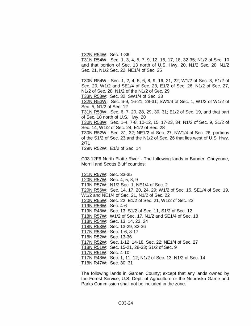
C03.12F6 North Platte River - The following lands in Banner, Cheyenne, Morrill and Scotts Bluff counties: T21N R57W: Sec. 33-35 T20N R57W: Sec. 4, 5, 8, 9 T19N R57W: N1/2 Sec. 1, NE1/4 of Sec. 2 T20N R56W: Sec. 14, 17, 20, 24, 29; W1/2 of Sec. 15, SE1/4 of Sec. 19, W1/2 and NE1/4 of Sec. 21, N1/2 of Sec. 22 T20N R55W: Sec. 22; E1/2 of Sec. 21, W1/2 of Sec. 23 T19N R56W: Sec. 4-6 T19N R48W: Sec. 13, S1/2 of Sec. 11, S1/2 of Sec. 12 T18N R57W: W1/2 of Sec. 17, N1/2 and SE1/4 of Sec. 18 T18N R54W: Sec. 13, 14, 23, 24 T18N R53W: Sec. 13-29, 32-36 T17N R53W: Sec. 1-6, 8-17 T18N R52W: Sec. 13-36 T17N R52W: Sec. 1-12, 14-18, Sec. 22; NE1/4 of Sec. 27 T18N R51W: Sec. 15-21, 28-33; S1/2 of Sec. 9 T17N R51W: Sec. 4-10 T17N R48W: Sec. 1, 11, 12; N1/2 of Sec. 13, N1/2 of Sec. 14 T18N R47W: Sec. 30, 31 The following lands in Garden County; except that any lands owned by the Forest Service, U.S. Dept. of Agriculture or the Nebraska Game and Parks Commission shall not be included in the zone.
C03-25
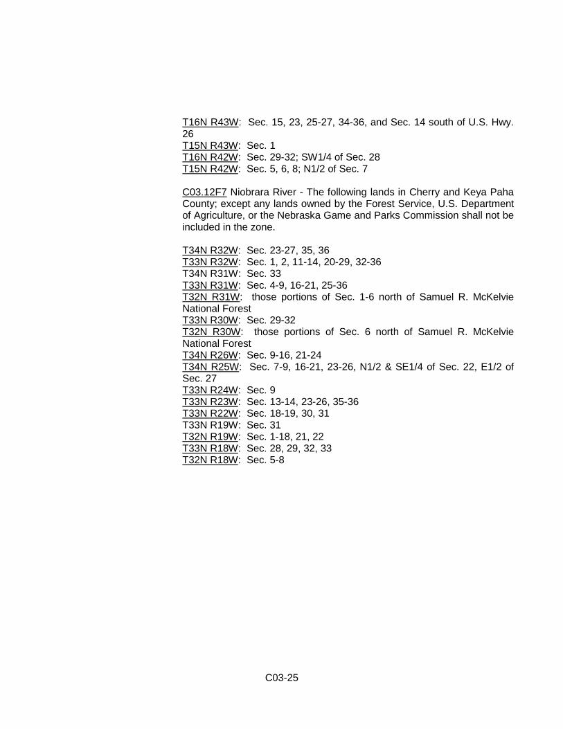
T16N R43W: Sec. 15, 23, 25-27, 34-36, and Sec. 14 south of U.S. Hwy. 26 T15N R43W: Sec. 1 T16N R42W: Sec. 29-32; SW1/4 of Sec. 28 T15N R42W: Sec. 5, 6, 8; N1/2 of Sec. 7
C03.12F7 Niobrara River - The following lands in Cherry and Keya Paha County; except any lands owned by the Forest Service, U.S. Department of Agriculture, or the Nebraska Game and Parks Commission shall not be included in the zone. T34N R32W: Sec. 23-27, 35, 36 T33N R32W: Sec. 1, 2, 11-14, 20-29, 32-36 T34N R31W: Sec. 33 T33N R31W: Sec. 4-9, 16-21, 25-36 T32N R31W: those portions of Sec. 1-6 north of Samuel R. McKelvie National Forest T33N R30W: Sec. 29-32 T32N R30W: those portions of Sec. 6 north of Samuel R. McKelvie National Forest T34N R26W: Sec. 9-16, 21-24 T34N R25W: Sec. 7-9, 16-21, 23-26, N1/2 & SE1/4 of Sec. 22, E1/2 of Sec. 27 T33N R24W: Sec. 9 T33N R23W: Sec. 13-14, 23-26, 35-36 T33N R22W: Sec. 18-19, 30, 31 T33N R19W: Sec. 31 T32N R19W: Sec. 1-18, 21, 22 T33N R18W: Sec. 28, 29, 32, 33 T32N R18W: Sec. 5-8