n.c. wetland assessment method (nc wam) user manual quality/surface water protection... · nc...
TRANSCRIPT
N.C. Wetland Assessment Method (NC WAM)
User Manual
Prepared by the N.C. Wetland Functional Assessment Team
Version 4.1 October 2010

NC Wetland Assessment Method (NC WAM) v4.1 ii Executive Summary
EXECUTIVE SUMMARY
The North Carolina Wetland Assessment Method (NC WAM) is the culmination of a process begun in 2003 by an interagency team of federal and state agency staff – the N.C. Wetland Functional Assessment Team (WFAT). The goal of the WFAT was to develop an accurate, consistent, rapid, observational, and scientifically based field method to determine the level of function of a wetland relative to reference condition (where appropriate) for each of 16 North Carolina general wetland types. The WFAT defined “rapid” as taking no more than 15 additional minutes for a trained observer to evaluate a wetland within an assessment area.
The WFAT identified 16 general wetland types: 1) Salt/Brackish Marsh, 2) Estuarine Woody Wetland, 3) Tidal Freshwater Marsh, 4) Riverine Swamp Forest, 5) Seep, 6) Hardwood Flat, 7) Non-Riverine Swamp Forest, 8) Pocosin, 9) Pine Savanna, 10) Pine Flat, 11) Basin Wetland, 12) Bog, 13) Non-Tidal Freshwater Marsh, 14) Floodplain Pool, 15) Headwater Forest, and 16) Bottomland Hardwood Forest. A dichotomous key is used for identifying wetland types.
Functional ratings are developed for each assessment area wetland type in comparison to a reference wetland. Three major functions are recognized with ten sub-functions as follows: hydrology (surface storage and retention and sub-surface storage and retention), water quality (pathogen change, particulate change, soluble change, physical change, and pollution change), and habitat (physical structure, landscape patch structure, and vegetation composition).
Sub-functions and functions are evaluated using 22 field metrics listed on a field assessment form. These metrics have been designed and tested to be appropriate to North Carolina wetland types. Data from completed field assessment forms are entered into a computer program to generate High, Medium, and Low ratings for each sub-function, function, and the assessment area. The sub-function ratings are reported both with and without consideration of overall wetland function of the opportunity that the wetland has to perform specific functions. The computer program was developed based on an iterative Boolean logic process and then field tested across the state at more than 200 sites of various levels of wetland quality.
This user manual provides conceptual background and instruction essential to implementing NC WAM. Each of the 22 metrics is described with examples to calibrate the user. A comprehensive Glossary of Terms as well as other detailed appendices is also included. The WFAT expects that a multi-day training class, coupled with subsequent field experience with the methodology, will be needed to use NC WAM properly. An additional resource developed to familiarize users with the NC WAM methodology is the GIS-based NC WAM “Tool Box.” The Tool Box is a collection of previously evaluated reference and non-reference sites and will be available via an internet website.
NC WAM was created to be used for project planning, alternatives analysis, compliance and enforcement, mitigation planning, and tracking functional replacement. The details of how NC WAM will be used will be developed by the regulatory agencies after appropriate public notice and comment.

NC Wetland Assessment Method (NC WAM) v4.1 iii Table of Contents
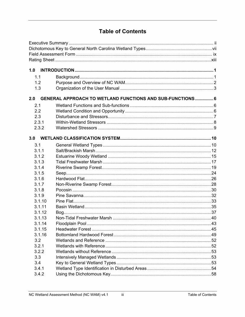
Table of Contents
Executive Summary ...................................................................................................................... ii Dichotomous Key to General North Carolina Wetland Types ...................................................... viiField Assessment Form ............................................................................................................... ix Rating Sheet ............................................................................................................................... xiii
1.0� INTRODUCTION ................................................................................................................. 1�
1.1� Background ............................................................................................................. 1�1.2� Purpose and Overview of NC WAM ........................................................................ 2�1.3� Organization of the User Manual ............................................................................ 3�
2.0� GENERAL APPROACH TO WETLAND FUNCTIONS AND SUB-FUNCTIONS ............... 6�
2.1� Wetland Functions and Sub-functions .................................................................... 6�2.2� Wetland Condition and Opportunity ........................................................................ 6�2.3� Disturbance and Stressors ...................................................................................... 7�2.3.1� Within-Wetland Stressors ....................................................................................... 8�2.3.2� Watershed Stressors .............................................................................................. 9�
3.0� WETLAND CLASSIFICATION SYSTEM .......................................................................... 10�
3.1� General Wetland Types ........................................................................................ 10�3.1.1� Salt/Brackish Marsh .............................................................................................. 12�3.1.2� Estuarine Woody Wetland .................................................................................... 15�3.1.3� Tidal Freshwater Marsh ........................................................................................ 17�3.1.4� Riverine Swamp Forest ......................................................................................... 19�3.1.5� Seep...................................................................................................................... 24�3.1.6� Hardwood Flat ....................................................................................................... 26�3.1.7� Non-Riverine Swamp Forest ................................................................................. 28�3.1.8� Pocosin ................................................................................................................. 30�3.1.9� Pine Savanna ........................................................................................................ 32�3.1.10� Pine Flat ................................................................................................................ 33�3.1.11� Basin Wetland ....................................................................................................... 35�3.1.12� Bog........................................................................................................................ 37�3.1.13� Non-Tidal Freshwater Marsh ................................................................................ 40�3.1.14� Floodplain Pool ..................................................................................................... 43�3.1.15� Headwater Forest ................................................................................................. 45�3.1.16� Bottomland Hardwood Forest ............................................................................... 49�3.2� Wetlands and Reference ...................................................................................... 52�3.2.1� Wetlands with Reference ...................................................................................... 52�3.2.2� Wetlands without Reference ................................................................................. 53�3.3� Intensively Managed Wetlands ............................................................................. 53�3.4� Key to General Wetland Types ............................................................................. 53�3.4.1� Wetland Type Identification in Disturbed Areas .................................................... 54�3.4.2� Using the Dichotomous Key .................................................................................. 58�

NC Wetland Assessment Method (NC WAM) v4.1 iv Table of Contents
4.0� FUNCTIONAL ASSESSMENT METRICS ........................................................................ 68�
4.1� Introduction to Metrics ........................................................................................... 68�4.2� Metric Evaluation Areas ........................................................................................ 68�4.2.1� Assessment Area .................................................................................................. 68�4.2.2� Wetland Type ........................................................................................................ 72�4.2.3� Forested Wetland .................................................................................................. 73�4.2.4� Wetland Complex .................................................................................................. 74�4.2.5� Landscape Patch .................................................................................................. 74�4.3� Guidance for Completing the Field Assessment Form ......................................... 75�4.3.1� Field Assessment Form Introductory Information ................................................. 75�4.3.2� Field Assessment Form Metrics ............................................................................ 78�
1.� Ground Surface Condition/Vegetation Condition .................................................. 78�2.� Surface and Sub-Surface Storage Capacity and Duration .................................... 80�3.� Water Storage/Surface Relief ................................................................................ 81�4.� Soil Texture/Structure ............................................................................................ 82�5.� Discharge into Wetland ......................................................................................... 83�6.� Land Use ............................................................................................................... 84�7.� Wetland Acting as Vegetated Buffer ..................................................................... 88�8.� Wetland Width at the Assessment Area ................................................................ 91�9.� Inundation Duration ............................................................................................... 93�10.� Indicators of Deposition ......................................................................................... 95�11.� Wetland Size ......................................................................................................... 95�12.� Wetland Intactness ................................................................................................ 96�13.� Connectivity to Other Natural Areas ...................................................................... 98�14.� Edge Effect ............................................................................................................ 99�15.� Vegetative Composition ...................................................................................... 102�16.� Vegetative Diversity ............................................................................................. 102�17.� Vegetative Structure ............................................................................................ 103�18.� Snags .................................................................................................................. 104�19.� Diameter Class Distribution ................................................................................. 105�20.� Large Woody Debris ............................................................................................ 105�21.� Vegetation/Open Water Dispersion ..................................................................... 106�22.� Hydrologic Connectivity ....................................................................................... 108�
5.0� THE WETLAND ASSESSMENT PROCESS .................................................................. 110�
5.1� Background Information ...................................................................................... 110�5.1.1� General Information ............................................................................................ 110�5.1.2� NC WAM Tool Box .............................................................................................. 111�5.2� On-Site Investigation ........................................................................................... 111�5.2.1� Presence of Wetland Stressors .......................................................................... 112�5.2.2� Wetland Type, Number, and Boundaries ............................................................ 112�5.2.3� Assessment Area Identification ........................................................................... 113�5.3� Completion of the NC WAM Field Assessment Form ......................................... 119�5.3.1� Field Assessment Form ...................................................................................... 119�5.3.2� Field Map ............................................................................................................ 120�

NC Wetland Assessment Method (NC WAM) v4.1 v Table of Contents
5.3.3� Photographs........................................................................................................ 120�5.4� Generation of Functional Assessment Ratings ................................................... 120�5.4.1� Data Analysis ...................................................................................................... 120�5.4.2� Final Product ....................................................................................................... 121�
6.0� TECHNICAL RESOURCES ............................................................................................ 124�
7.0� REFERENCES ................................................................................................................ 125�
List of Tables
Table 1. Relationship of metrics, sub-functions, and functions ............................................. 122
List of Figures
Figure 1. Wetland Type Occurrence by Level III Ecoregion .......................................... 5 Figure 2. Headwater Forest/Bottomland Hardwood Forest Stream-Order Boundary . 46 Figures 3A-3B. Riparian vs. Non-riparian Wetlands Guidance 1 .......................................... 61 Figures 4A-4D. Riparian vs. Non-riparian Wetlands Guidance 2 .......................................... 62 Figure 5. Example Wetland Complex .......................................................................... 69 Figures 6A-6B. Assessment Area Determination Guidance 1 .............................................. 71 Figures 7A-7B. Assessment Area Determination Guidance 2 .............................................. 72 Figures 8A-8B. Metric 6 Land Use Determination Guidance ................................................ 86 Figure 9. Metric 7 Wetland Buffer Width Guidance .................................................... 89 Figure 10. Metric 8 Wetland Width Guidance ................................................................ 92 Figures 11A-11F. Metric 12 Pocosin Intactness Guidance .................................................. 97-98 Figure 12. Metric 14 Edge Effect Determination Guidance ......................................... 101 Figure 13. Metric 22 Overbank and Overland Flow Guidance .................................... 109 Figures 14A-14D. Assessment Area Determination Guidance 3 ..................................... 114-115

NC Wetland Assessment Method (NC WAM) v4.1 vi Table of Contents
Appendices in User Manual
A. Abbreviations B. Cross-reference of Wetland Types C. Stream Order Schematics D. Pocosin Soils E. Ecoregion Map of North Carolina F. Soil Texture Decision Chart G. North Carolina Exotic Plant Species H. Rating Calculator User Guide I. Glossary of Terms
Appendices Available On-Line
J. Relationship of Metrics, Sub-functions, and Functions for all Wetland Types K. Field Metric Evaluation Sheets L. Cross-walk from the Field Metric Evaluation Sheets to the Field Assessment Form M. Functional Rating Boolean Logic for Each Wetland Type
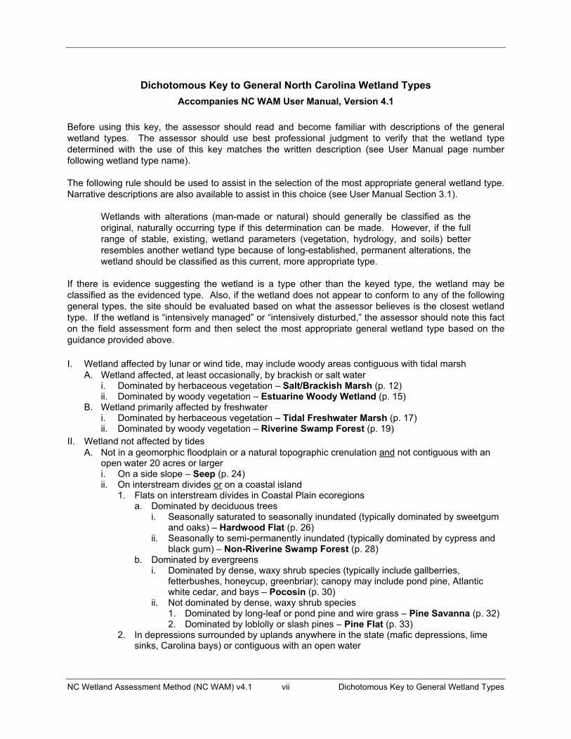
NC Wetland Assessment Method (NC WAM) v4.1 vii Dichotomous Key to General Wetland Types
Dichotomous Key to General North Carolina Wetland Types Accompanies NC WAM User Manual, Version 4.1
Before using this key, the assessor should read and become familiar with descriptions of the general wetland types. The assessor should use best professional judgment to verify that the wetland type determined with the use of this key matches the written description (see User Manual page number following wetland type name).
The following rule should be used to assist in the selection of the most appropriate general wetland type. Narrative descriptions are also available to assist in this choice (see User Manual Section 3.1).
Wetlands with alterations (man-made or natural) should generally be classified as the original, naturally occurring type if this determination can be made. However, if the full range of stable, existing, wetland parameters (vegetation, hydrology, and soils) better resembles another wetland type because of long-established, permanent alterations, the wetland should be classified as this current, more appropriate type.
If there is evidence suggesting the wetland is a type other than the keyed type, the wetland may be classified as the evidenced type. Also, if the wetland does not appear to conform to any of the following general types, the site should be evaluated based on what the assessor believes is the closest wetland type. If the wetland is “intensively managed” or “intensively disturbed,” the assessor should note this fact on the field assessment form and then select the most appropriate general wetland type based on the guidance provided above.
I. Wetland affected by lunar or wind tide, may include woody areas contiguous with tidal marsh A. Wetland affected, at least occasionally, by brackish or salt water
i. Dominated by herbaceous vegetation – Salt/Brackish Marsh (p. 12)ii. Dominated by woody vegetation – Estuarine Woody Wetland (p. 15)
B. Wetland primarily affected by freshwateri. Dominated by herbaceous vegetation – Tidal Freshwater Marsh (p. 17)ii. Dominated by woody vegetation – Riverine Swamp Forest (p. 19)
II. Wetland not affected by tides A. Not in a geomorphic floodplain or a natural topographic crenulation and not contiguous with an
open water 20 acres or largeri. On a side slope – Seep (p. 24)ii. On interstream divides or on a coastal island
1. Flats on interstream divides in Coastal Plain ecoregionsa. Dominated by deciduous trees
i. Seasonally saturated to seasonally inundated (typically dominated by sweetgum and oaks) – Hardwood Flat (p. 26)
ii. Seasonally to semi-permanently inundated (typically dominated by cypress and black gum) – Non-Riverine Swamp Forest (p. 28)
b. Dominated by evergreensi. Dominated by dense, waxy shrub species (typically include gallberries,
fetterbushes, honeycup, greenbriar); canopy may include pond pine, Atlantic white cedar, and bays – Pocosin (p. 30)
ii. Not dominated by dense, waxy shrub species1. Dominated by long-leaf or pond pine and wire grass – Pine Savanna (p. 32) 2. Dominated by loblolly or slash pines – Pine Flat (p. 33)
2. In depressions surrounded by uplands anywhere in the state (mafic depressions, lime sinks, Carolina bays) or contiguous with an open water
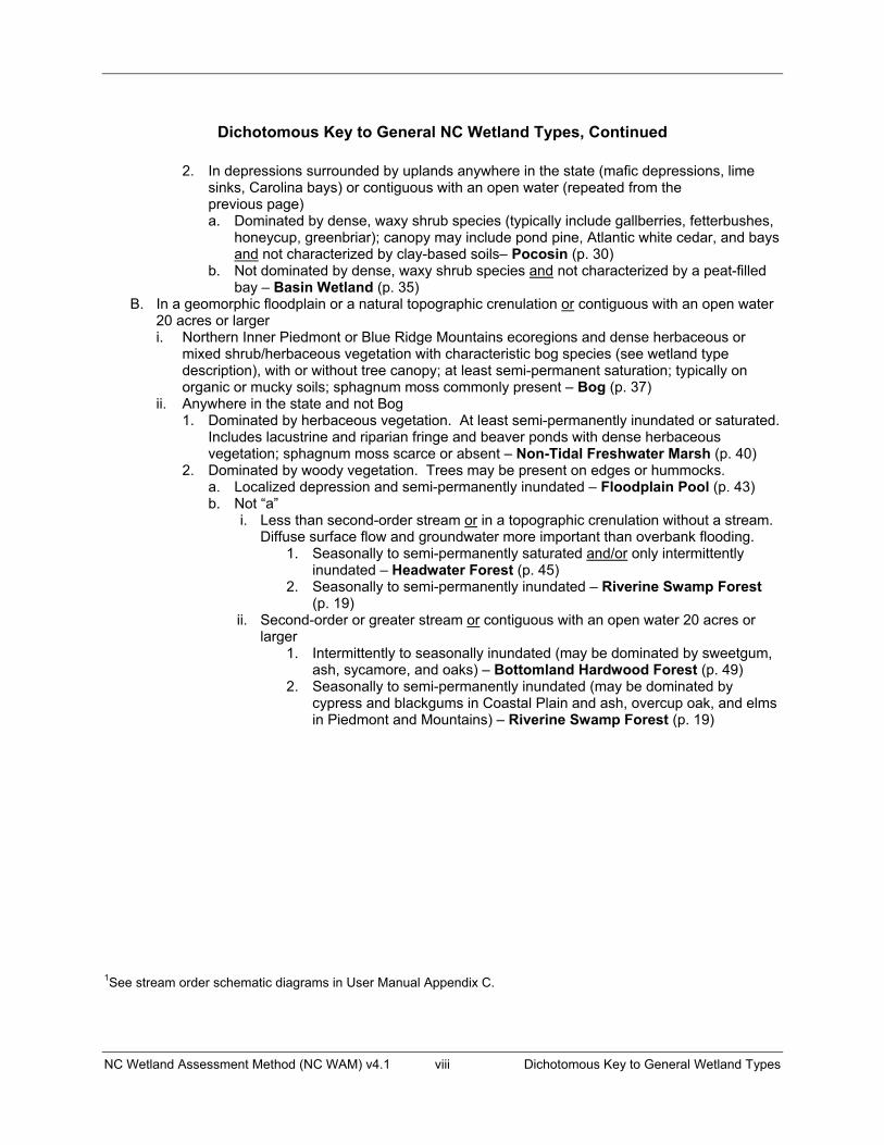
NC Wetland Assessment Method (NC WAM) v4.1 viii Dichotomous Key to General Wetland Types
Dichotomous Key to General NC Wetland Types, Continued
2. In depressions surrounded by uplands anywhere in the state (mafic depressions, lime sinks, Carolina bays) or contiguous with an open water (repeated from the
previous page) a. Dominated by dense, waxy shrub species (typically include gallberries, fetterbushes,
honeycup, greenbriar); canopy may include pond pine, Atlantic white cedar, and bays and not characterized by clay-based soils– Pocosin (p. 30)
b. Not dominated by dense, waxy shrub species and not characterized by a peat-filled bay – Basin Wetland (p. 35)
B. In a geomorphic floodplain or a natural topographic crenulation or contiguous with an open water 20 acres or largeri. Northern Inner Piedmont or Blue Ridge Mountains ecoregions and dense herbaceous or
mixed shrub/herbaceous vegetation with characteristic bog species (see wetland type description), with or without tree canopy; at least semi-permanent saturation; typically on organic or mucky soils; sphagnum moss commonly present – Bog (p. 37)
ii. Anywhere in the state and not Bog 1. Dominated by herbaceous vegetation. At least semi-permanently inundated or saturated.
Includes lacustrine and riparian fringe and beaver ponds with dense herbaceous vegetation; sphagnum moss scarce or absent – Non-Tidal Freshwater Marsh (p. 40)
2. Dominated by woody vegetation. Trees may be present on edges or hummocks.a. Localized depression and semi-permanently inundated – Floodplain Pool (p. 43)b. Not “a”
i. Less than second-order stream or in a topographic crenulation without a stream. Diffuse surface flow and groundwater more important than overbank flooding.
1. Seasonally to semi-permanently saturated and/or only intermittently inundated – Headwater Forest (p. 45)
2. Seasonally to semi-permanently inundated – Riverine Swamp Forest (p. 19)
ii. Second-order or greater stream or contiguous with an open water 20 acres or larger
1. Intermittently to seasonally inundated (may be dominated by sweetgum, ash, sycamore, and oaks) – Bottomland Hardwood Forest (p. 49)
2. Seasonally to semi-permanently inundated (may be dominated by cypress and blackgums in Coastal Plain and ash, overcup oak, and elms in Piedmont and Mountains) – Riverine Swamp Forest (p. 19)
1See stream order schematic diagrams in User Manual Appendix C.

NC WAM FIELD ASSESSMENT FORM Accompanies User Manual Version 4.1
Wetland Site Name ����� Date �����
Wetland Type ����� Assessor Name/Organization �����
Level III Ecoregion ����� Nearest Named Water Body �����
River Basin ����� USGS 8-Digit Catalogue Unit �����
Yes No Precipitation within 48 hrs? Latitude/Longitude (deci-degrees) �����
Evidence of stressors affecting the assessment area (may not be within the assessment area) Please circle and/or make note on the last page if evidence of stressors is apparent. Consider departure from reference, if appropriate, in recent past (for instance, within 10 years). Noteworthy stressors include, but are not limited to the following.
• Hydrological modifications (examples: ditches, dams, beaver dams, dikes, berms, ponds, etc.) • Surface and sub-surface discharges into the wetland (examples: discharges containing obvious pollutants, presence of nearby
septic tanks, underground storage tanks (USTs), hog lagoons, etc.) • Signs of vegetation stress (examples: vegetation mortality, insect damage, disease, storm damage, salt intrusion, etc.) • Habitat/plant community alteration (examples: mowing, clear-cutting, exotics, etc.)
Is the assessment area intensively managed? Yes No Regulatory Considerations (select all that apply to the assessment area)
Anadromous fish Federally protected species or State endangered or threatened species NCDWQ riparian buffer rule in effect Abuts a Primary Nursery Area (PNA) Publicly owned property N.C. Division of Coastal Management Area of Environmental Concern (AEC) (including buffer) Abuts a stream with a NCDWQ classification of SA or supplemental classifications of HQW, ORW, or Trout Designated NCNHP reference community Abuts a 303(d)-listed stream or a tributary to a 303(d)-listed stream
What type of natural stream is associated with the wetland, if any? (check all that apply) Blackwater Brownwater Tidal (if tidal, check one of the following boxes) Lunar Wind Both
Is the assessment area on a coastal island? Yes No Is the assessment area’s surface water storage capacity or duration substantially altered by beaver? Yes NoDoes the assessment area experience overbank flooding during normal rainfall conditions? Yes No
1. Ground Surface Condition/Vegetation Condition – assessment area condition metric Check a box in each column. Consider alteration to the ground surface (GS) in the assessment area and vegetation structure (VS) in the assessment area. Compare to reference wetland if applicable (see User Manual). If a reference is not applicable, then rate the assessment area based on evidence of an effect. GS VS
A A Not severely altered B B Severely altered over a majority of the assessment area (ground surface alteration examples: vehicle tracks, excessive
sedimentation, fire-plow lanes, skidder tracks, bedding, fill, soil compaction, obvious pollutants) (vegetation structure alteration examples: mechanical disturbance, herbicides, salt intrusion [where appropriate], exotic species, grazing, reduced diversity [if appropriate], hydrologic alteration)
2. Surface and Sub-Surface Storage Capacity and Duration – assessment area condition metric Check a box in each column. Consider surface storage capacity and duration (Surf) and sub-surface storage capacity and duration (Sub). Consider both increase and decrease in hydrology. Refer to the current NRCS lateral effect of ditching guidance for North Carolina hydric soils (see USACE Wilmington District website) for the zone of influence of ditches in hydric soils. A ditch � 1 foot deep is considered to affect surface water only, while a ditch > 1 foot deep is expected to affect both surface and sub-surface water. Consider tidal flooding regime, if applicable. Surf Sub
A A Water storage capacity and duration are not altered. B B Water storage capacity or duration are altered, but not substantially (typically, not sufficient to change vegetation). C C Water storage capacity or duration is substantially altered (typically, alteration sufficient to result in vegetation change)
(examples: draining, flooding, soil compaction, filling, excessive sedimentation, underground utility lines). 3. Water Storage/Surface Relief – assessment area/wetland type condition metric (evaluate for non-marsh wetlands only)
Check a box in each column for each group below. Select for the assessment area (AA) and the wetland type (WT). AA WT
3a. A A Majority of wetland with depressions able to pond water > 1 foot deep B B Majority of wetland with depressions able to pond water 6 inches to 1 foot deep C C Majority of wetland with depressions able to pond water 3 to 6 inches deep D D Depressions able to pond water < 3 inches deep
3b. A Evidence that maximum depth of inundation is greater than 2 feet B Evidence that maximum depth of inundation is between 1 and 2 feet C Evidence that maximum depth of inundation is less than 1 foot
ix
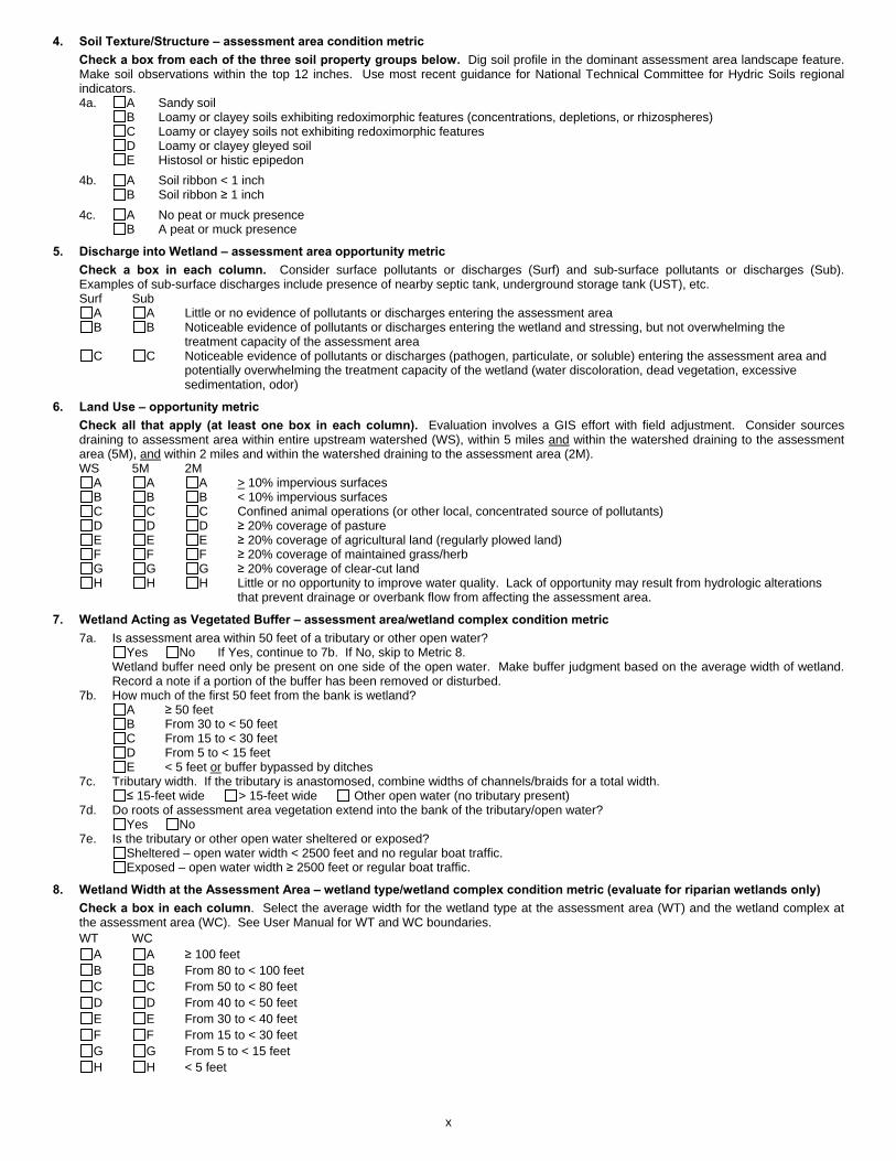
4. Soil Texture/Structure – assessment area condition metric Check a box from each of the three soil property groups below. Dig soil profile in the dominant assessment area landscape feature. Make soil observations within the top 12 inches. Use most recent guidance for National Technical Committee for Hydric Soils regional indicators. 4a. A Sandy soil
B Loamy or clayey soils exhibiting redoximorphic features (concentrations, depletions, or rhizospheres) C Loamy or clayey soils not exhibiting redoximorphic features D Loamy or clayey gleyed soil E Histosol or histic epipedon
4b. A Soil ribbon < 1 inch B Soil ribbon � 1 inch
4c. A No peat or muck presence B A peat or muck presence
5. Discharge into Wetland – assessment area opportunity metric Check a box in each column. Consider surface pollutants or discharges (Surf) and sub-surface pollutants or discharges (Sub). Examples of sub-surface discharges include presence of nearby septic tank, underground storage tank (UST), etc. Surf Sub
A A Little or no evidence of pollutants or discharges entering the assessment area B B Noticeable evidence of pollutants or discharges entering the wetland and stressing, but not overwhelming the
treatment capacity of the assessment area C C Noticeable evidence of pollutants or discharges (pathogen, particulate, or soluble) entering the assessment area and
potentially overwhelming the treatment capacity of the wetland (water discoloration, dead vegetation, excessive sedimentation, odor) 6. Land Use – opportunity metric
Check all that apply (at least one box in each column). Evaluation involves a GIS effort with field adjustment. Consider sources draining to assessment area within entire upstream watershed (WS), within 5 miles and within the watershed draining to the assessment area (5M), and within 2 miles and within the watershed draining to the assessment area (2M). WS 5M 2M
A A A > 10% impervious surfaces B B B < 10% impervious surfaces C C C Confined animal operations (or other local, concentrated source of pollutants) D D D � 20% coverage of pasture E E E � 20% coverage of agricultural land (regularly plowed land) F F F � 20% coverage of maintained grass/herb G G G � 20% coverage of clear-cut land H H H Little or no opportunity to improve water quality. Lack of opportunity may result from hydrologic alterations
that prevent drainage or overbank flow from affecting the assessment area. 7. Wetland Acting as Vegetated Buffer – assessment area/wetland complex condition metric
7a. Is assessment area within 50 feet of a tributary or other open water? Yes No If Yes, continue to 7b. If No, skip to Metric 8.
Wetland buffer need only be present on one side of the open water. Make buffer judgment based on the average width of wetland.Record a note if a portion of the buffer has been removed or disturbed.
7b. How much of the first 50 feet from the bank is wetland? A � 50 feet B From 30 to < 50 feet C From 15 to < 30 feet D From 5 to < 15 feet E < 5 feet or buffer bypassed by ditches
7c. Tributary width. If the tributary is anastomosed, combine widths of channels/braids for a total width. � 15-feet wide > 15-feet wide Other open water (no tributary present)
7d. Do roots of assessment area vegetation extend into the bank of the tributary/open water? Yes No
7e. Is the tributary or other open water sheltered or exposed? Sheltered – open water width < 2500 feet and no regular boat traffic. Exposed – open water width � 2500 feet or regular boat traffic.
8. Wetland Width at the Assessment Area – wetland type/wetland complex condition metric (evaluate for riparian wetlands only) Check a box in each column. Select the average width for the wetland type at the assessment area (WT) and the wetland complex at the assessment area (WC). See User Manual for WT and WC boundaries. WT WC
A A � 100 feet B B From 80 to < 100 feet C C From 50 to < 80 feet D D From 40 to < 50 feet E E From 30 to < 40 feet F F From 15 to < 30 feet G G From 5 to < 15 feet H H < 5 feet
x
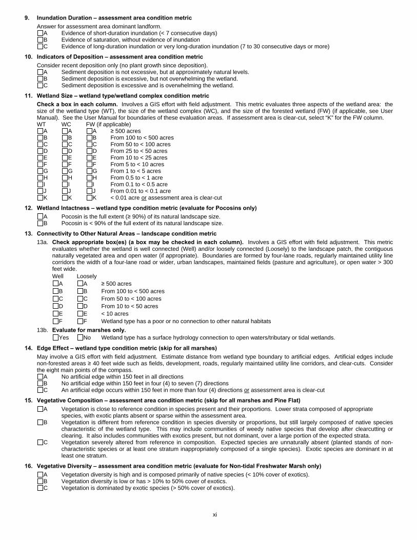
9. Inundation Duration – assessment area condition metric Answer for assessment area dominant landform.
A Evidence of short-duration inundation (< 7 consecutive days) B Evidence of saturation, without evidence of inundation C Evidence of long-duration inundation or very long-duration inundation (7 to 30 consecutive days or more)
10. Indicators of Deposition – assessment area condition metric Consider recent deposition only (no plant growth since deposition).
A Sediment deposition is not excessive, but at approximately natural levels. B Sediment deposition is excessive, but not overwhelming the wetland. C Sediment deposition is excessive and is overwhelming the wetland.
11. Wetland Size – wetland type/wetland complex condition metric Check a box in each column. Involves a GIS effort with field adjustment. This metric evaluates three aspects of the wetland area: the size of the wetland type (WT), the size of the wetland complex (WC), and the size of the forested wetland (FW) (if applicable, see User Manual). See the User Manual for boundaries of these evaluation areas. If assessment area is clear-cut, select “K” for the FW column. WT WC FW (if applicable)
A A A � 500 acres B B B From 100 to < 500 acres C C C From 50 to < 100 acres D D D From 25 to < 50 acres E E E From 10 to < 25 acres F F F From 5 to < 10 acres G G G From 1 to < 5 acres H H H From 0.5 to < 1 acre I I I From 0.1 to < 0.5 acre J J J From 0.01 to < 0.1 acre K K K < 0.01 acre or assessment area is clear-cut
12. Wetland Intactness – wetland type condition metric (evaluate for Pocosins only) A Pocosin is the full extent (� 90%) of its natural landscape size. B Pocosin is < 90% of the full extent of its natural landscape size.
13. Connectivity to Other Natural Areas – landscape condition metric 13a. Check appropriate box(es) (a box may be checked in each column). Involves a GIS effort with field adjustment. This metric
evaluates whether the wetland is well connected (Well) and/or loosely connected (Loosely) to the landscape patch, the contiguousnaturally vegetated area and open water (if appropriate). Boundaries are formed by four-lane roads, regularly maintained utility line corridors the width of a four-lane road or wider, urban landscapes, maintained fields (pasture and agriculture), or open water > 300 feet wide. Well Loosely
A A � 500 acres B B From 100 to < 500 acres C C From 50 to < 100 acres D D From 10 to < 50 acres E E < 10 acres F F Wetland type has a poor or no connection to other natural habitats
13b. Evaluate for marshes only. Yes No Wetland type has a surface hydrology connection to open waters/tributary or tidal wetlands.
14. Edge Effect – wetland type condition metric (skip for all marshes) May involve a GIS effort with field adjustment. Estimate distance from wetland type boundary to artificial edges. Artificial edges include non-forested areas � 40 feet wide such as fields, development, roads, regularly maintained utility line corridors, and clear-cuts. Consider the eight main points of the compass.
A No artificial edge within 150 feet in all directions B No artificial edge within 150 feet in four (4) to seven (7) directions C An artificial edge occurs within 150 feet in more than four (4) directions or assessment area is clear-cut
15. Vegetative Composition – assessment area condition metric (skip for all marshes and Pine Flat) A Vegetation is close to reference condition in species present and their proportions. Lower strata composed of appropriate
species, with exotic plants absent or sparse within the assessment area. B Vegetation is different from reference condition in species diversity or proportions, but still largely composed of native species
characteristic of the wetland type. This may include communities of weedy native species that develop after clearcutting or clearing. It also includes communities with exotics present, but not dominant, over a large portion of the expected strata.
C Vegetation severely altered from reference in composition. Expected species are unnaturally absent (planted stands of non-characteristic species or at least one stratum inappropriately composed of a single species). Exotic species are dominant in atleast one stratum.
16. Vegetative Diversity – assessment area condition metric (evaluate for Non-tidal Freshwater Marsh only) A Vegetation diversity is high and is composed primarily of native species (< 10% cover of exotics). B Vegetation diversity is low or has > 10% to 50% cover of exotics. C Vegetation is dominated by exotic species (> 50% cover of exotics).
xi
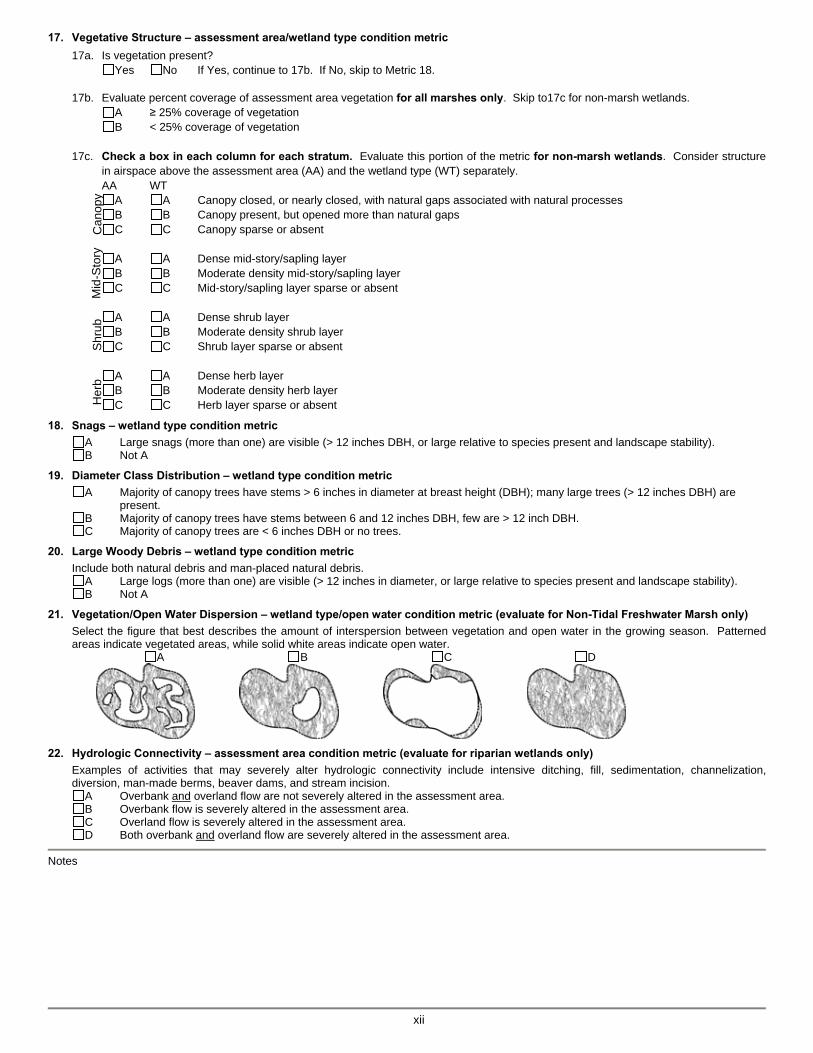
17. Vegetative Structure – assessment area/wetland type condition metric 17a. Is vegetation present?
Yes No If Yes, continue to 17b. If No, skip to Metric 18.
17b. Evaluate percent coverage of assessment area vegetation for all marshes only. Skip to17c for non-marsh wetlands.A � 25% coverage of vegetation B < 25% coverage of vegetation
17c. Check a box in each column for each stratum. Evaluate this portion of the metric for non-marsh wetlands. Consider structure in airspace above the assessment area (AA) and the wetland type (WT) separately. AA WT
A A Canopy closed, or nearly closed, with natural gaps associated with natural processes B B Canopy present, but opened more than natural gaps C C Canopy sparse or absent
A A Dense mid-story/sapling layer B B Moderate density mid-story/sapling layer C C Mid-story/sapling layer sparse or absent
A A Dense shrub layer B B Moderate density shrub layer C C Shrub layer sparse or absent
A A Dense herb layer B B Moderate density herb layer C C Herb layer sparse or absent
18. Snags – wetland type condition metric A Large snags (more than one) are visible (> 12 inches DBH, or large relative to species present and landscape stability). B Not A
19. Diameter Class Distribution – wetland type condition metric A Majority of canopy trees have stems > 6 inches in diameter at breast height (DBH); many large trees (> 12 inches DBH) are
present. B Majority of canopy trees have stems between 6 and 12 inches DBH, few are > 12 inch DBH. C Majority of canopy trees are < 6 inches DBH or no trees.
20. Large Woody Debris – wetland type condition metric Include both natural debris and man-placed natural debris.
A Large logs (more than one) are visible (> 12 inches in diameter, or large relative to species present and landscape stability).B Not A
21. Vegetation/Open Water Dispersion – wetland type/open water condition metric (evaluate for Non-Tidal Freshwater Marsh only) Select the figure that best describes the amount of interspersion between vegetation and open water in the growing season. Patterned areas indicate vegetated areas, while solid white areas indicate open water.
A B C D
22. Hydrologic Connectivity – assessment area condition metric (evaluate for riparian wetlands only) Examples of activities that may severely alter hydrologic connectivity include intensive ditching, fill, sedimentation, channelization, diversion, man-made berms, beaver dams, and stream incision.
A Overbank and overland flow are not severely altered in the assessment area. B Overbank flow is severely altered in the assessment area. C Overland flow is severely altered in the assessment area. D Both overbank and overland flow are severely altered in the assessment area.
Notes �����
xii
Can
opy
Mid
-Sto
ry
Shru
bH
erb

NC Wetland Assessment Method (NC WAM) v4.1 xiii NC WAM Wetland Rating Sheet
NC WAM Wetland Rating Sheet Accompanies User Manual Version 4.1
Wetland Site Name Date of Assessment Wetland Type Assessor Name/Organization Notes on Field Assessment Form (Y/N) Presence of regulatory considerations (Y/N) Wetland is intensively managed (Y/N) Assessment area is located within 50 feet of a natural tributary or other open water (Y/N) Assessment area is on a coastal island (Y/N) Assessment area is substantially altered by beaver (Y/N) Assessment area experiences overbank flooding during normal rainfall conditions (Y/N)
Sub-function Rating Summary Function Sub-function Metrics Rating Hydrology Surface Storage and Retention Condition
Sub-surface Storage and Retention Condition Water Quality Pathogen Change Condition Condition/Opportunity
Opportunity Presence (Y/N) Particulate Change Condition Condition/Opportunity
Opportunity Presence (Y/N) Soluble Change Condition Condition/Opportunity
Opportunity Presence (Y/N) Physical Change Condition Condition/Opportunity
Opportunity Presence (Y/N) Pollution Change Condition Condition/Opportunity
Opportunity Presence (Y/N) Habitat Physical Structure Condition
Landscape Patch Structure Condition Vegetation Composition Condition
Function Rating Summary Function Metrics Rating Hydrology Condition Water Quality Condition Condition/Opportunity
Opportunity Presence (Y/N) Habitat Condition
Overall Wetland Rating

NC Wetland Assessment Method (NC WAM) v4.1 1 1.0 Introduction
NORTH CAROLINA WETLAND ASSESSMENT METHOD (NC WAM)
USER MANUAL
1.0 INTRODUCTION
1.1 Background This manual provides guidance for the use of the field-based, rapid wetland assessment method, the N.C. Wetland Assessment Method (NC WAM). A companion document to this manual is an initial position paper (white paper – entitled “Status Report: North Carolina Wetland Functional Assessment,” dated January 13, 2004), which describes the purpose, reasoning, and process behind the development of this method; an intermediate development position paper (gray paper – entitled “Report of the North Carolina Wetland Functional Assessment Team GIS- and Field-Based Methods [Final, but Not Complete],” dated October 15, 2004), which describes the decision-making process during development of this method. NC WAM was developed as part of a collaborative effort by representatives of the U.S. Army Corps of Engineers (USACE), U.S. Department of Transportation Federal Highway Administration (USFHWA), U.S. Environmental Protection Agency (USEPA), U.S. Fish and Wildlife Service (USFWS), N.C. Division of Coastal Management (NCDCM), N.C. Department of Transportation (NCDOT), N.C. Division of Water Quality (NCDWQ), N.C. Wildlife Resources Commission (NCWRC), N.C. Natural Heritage Program (NCNHP), and the Ecosystem Enhancement Program (EEP).
In May 2003, the USACE, NCDWQ, and NCDOT, with the active participation of several other state and federal agencies, established the N.C. Wetland Functional Assessment Team (WFAT) to address and develop an accurate, consistent, rapid, observational, and scientifically based field method for wetland functional assessment. The WFAT had its last regular meeting in June 2005 and a follow-up meeting to discuss public comments on the draft method in October 2007. WFAT members included the following.
N.C. Division of Water Quality – John Dorney (Co-Chair) N.C. Department of Transportation – LeiLani Paugh (Co-Chair) U.S. Army Corps of Engineers – Dave Lekson and Amanda Jones U.S. Fish and Wildlife Service – Gary Jordan (replaced by Howard Hall) N.C. Division of Coastal Management – Kelly Williams (replaced by Melissa Carle) U.S. Environmental Protection Agency – Kathy Matthews and Becky Fox N.C. Wildlife Resources Commission – David Cox Ecosystem Enhancement Program – Jim Stanfill N.C. Natural Heritage Program – Mike Schafale Federal Highway Administration – Clarence Coleman and Donnie Brew U.S. Army Corps of Engineers (Coordination Group representative) – Scott McLendon
In addition, the team was ably assisted by staff of EcoScience Corporation (Sandy Smith, Matt Cusack, and Brad Allen) in development and testing of this method.
NC Wetland Assessment Method (NC WAM) v4.1 2 1.0 Introduction
WFAT met from May 2003 to June 2005. During the development and testing of NC WAM, the WFAT visited approximately 200 wetland sites across the state and spent more than 140 person-days in the field.
NC WAM training classes were organized by the WFAT in the Mountains (Brevard), Piedmont (Greensboro), and Coastal Plain (Washington) and held in 2008, 2009, and 2010. Each class consisted of approximately 25 students representing either various public agencies or private consultants. The experience with NC WAM gained through these training exercises, ongoing discussions among the NC WAM instructors, valuable and much appreciated input from students, and use of NC WAM for real-world project documentation has resulted in the accumulation of sufficient additions and revisions to the User Manual to warrant generation of this edition of the fourth version (v4.1).
1.2 Purpose and Overview of NC WAM The purpose of NC WAM is to provide the public and private sectors with an accurate, consistent, rapid, observational, and scientifically based field method to determine the level of function of a wetland relative to reference condition (when appropriate) for each general wetland type identified within North Carolina. For this method, the term “rapid” is defined as taking no more than 15 minutes for a trained individual (assessor) to evaluate a defined wetland within an “assessment area” after the wetland boundary has been determined or delineated. It is important to emphasize that NC WAM is not a wetland/upland determination or delineation method; NC WAM is a method to determine the level of function of wetlands.
This method will not replace more comprehensive wetland evaluation methods that may be more appropriate for other purposes. However, NC WAM is expected to replace other rapid assessment methods in North Carolina (such as the NCDWQ Guidance for Rating the Values of Wetlands in North Carolina [NCDEM 1995]).
NC WAM defines 16 general wetland types in North Carolina, which are described in Section 3.1. NC WAM generates an overall functional rating relative to reference for each wetland type, if available. Functional ratings depend on indicators of function rather than actual measurements of function. Functional ratings are generated based on an assessor’s evaluation of 22 questions (metrics) concerning wetland field indicators. The 22 metrics are presented on the NC WAM Field Assessment Form. The Field Assessment Form is included at the beginning of the User Manual (see pp. ix to xii). A discussion of individual metrics and guidance for use of metrics are provided in Section 4.3.2. To complete the Field Assessment Form, the assessor selects the appropriate answer(s), or descriptor(s), for each metric. The selected descriptors are then converted by a computer program (the NC WAM Rating Calculator) into a functional rating for each metric. Ratings are provided as “High,” “Medium,” or “Low” relative only to other wetlands of the same type. Metric descriptors are combined to provide sub-function ratings using a weighting strategy that reflects the relative importance of the metric to the wetland sub-functions. Likewise, sub-function ratings are combined to generate function ratings (Hydrology, Water Quality, and Habitat; see Section 5.4.1), and wetland function ratings are combined to yield an overall wetland rating. All functional ratings are provided on a Wetland Rating Sheet. The Wetland Rating Sheet is included at the beginning of the User Manual (see p. xiii).
NC Wetland Assessment Method (NC WAM) v4.1 3 1.0 Introduction
General wetland types have been defined with wetland function in mind. Functions are considered to vary among these wetland types, but are relatively consistent within each wetland type (when wetlands of a particular type are located in the same ecoregion). NC WAM generates functional ratings for each assessed wetland through comparison with reference examples of the same wetland type only (in-kind functional assessment). This approach allows each wetland to be located on a conceptual functional continuum, ranging from relatively undisturbed, reference examples of the specific wetland type (functional rating of “High”) to heavily disturbed examples of the same wetland type (functional rating of “Low”). The developers of NC WAM have reasoned that the generation of an in-kind functional assessment rating for each wetland will give an accurate indication of the function or importance of that wetland based on its landscape position and level of disturbance. The functional rating produced by NC WAM will thereby provide regulators, planners, and the general public with a more meaningful estimate of wetland function than previously available for use in the consideration of wetland function when evaluating potential wetland impacts and mitigation activities.
Unique to the Water Quality function and associated sub-functions, NC WAM generates two wetland functional ratings: the first is a reflection of wetland condition as represented by on-site indicators of function, and the second is wetland condition as modified by wetland opportunity. Wetland opportunity is determined by the condition of the watershed draining to a specific wetland (see Section 2.2). The distinction acknowledges that in some cases, the condition (degree of disturbance) of the immediate watershed may increase the wetland’s opportunity to provide Water Quality function. The proximity of wetlands to disturbance within a watershed may only increase the functional rating. Both Water Quality sub-function and function ratings are provided on the Wetland Rating Sheet (see p. xiii).
NC WAM has been designed by an interagency team to provide project reviewers with a consistent tool to aid in consideration of project design and information concerning assessed wetland characteristics and functions that may be used at the discretion of the regulatory community. Experience has shown that regulatory concerns will change over time, but this assessment method is intended to provide a consistent source of functional assessment information to support the regulatory review process. It is fully expected by the developers of NC WAM that the current method may be modified for more specific applications concerning project planning, alternatives analysis, compliance/enforcement, mitigation planning, and mitigation success monitoring. Updates to the method itself may be applied as more scientific information and field experience become available.
1.3 Organization of the User Manual The main body of the User Manual provides an introduction to NC WAM, a conceptual discussion of the NC WAM approach to wetland functions and sub-functions, a general discussion of the wetland classification system (including detailed descriptions of general wetland types utilized by NC WAM, a discussion of the concept of reference wetlands, and guidance for use of the key to general wetland types), a discussion of functional assessment metrics including guidance for evaluating metrics in the field, and guidance for implementation of NC WAM. To promote ease of reference, additional information necessary for the

NC Wetland Assessment Method (NC WAM) v4.1 4 1.0 Introduction
implementation of NC WAM has been organized into the attached appendices. The Table of Contents contains a complete list of information provided in the appendices. Many terms used in the manual and appendices are defined in the NC WAM Glossary of Terms (Appendix I). Abbreviations used in NC WAM are defined in Appendix A.
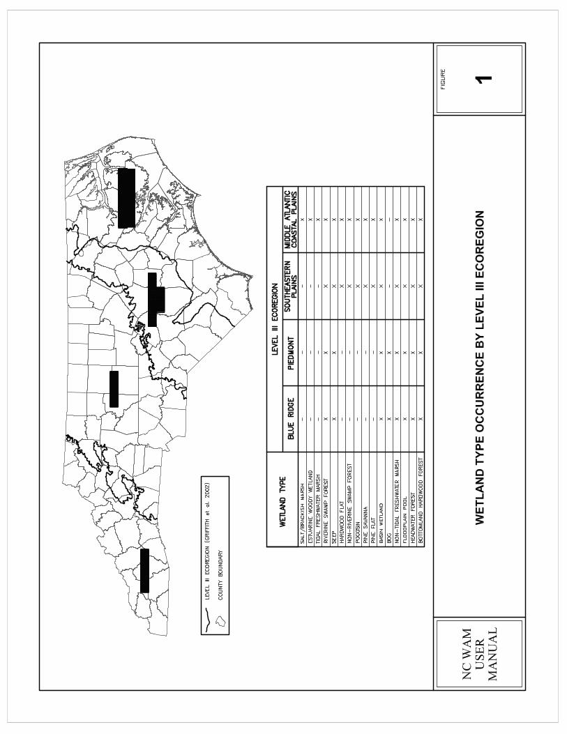
Throughout the User Manual, NC WAM general wetland types are discussed in terms of occurrence within the four level III ecoregions of North Carolina (Griffith et al. 2002). The level III ecoregions of North Carolina, from east to west, include 1) Middle Atlantic Coastal Plain, 2) Southeastern Plains, 3) Piedmont, and 4) Blue Ridge (see Figure 1 and Appendix E). For the sake of simplicity, the Middle Atlantic Coastal Plain (commonly known as the Outer Coastal Plain) and Southeastern Plains (commonly known as the Inner Coastal Plain) are collectively referred to as the Coastal Plains ecoregions in this manual. More detailed descriptions of the ecoregions, including correlations between North Carolina physiographic provinces, are provided in the NC WAM Glossary of Terms (Appendix I). The most recent version of the 7.5-minute topographic quadrangle prepared by the U.S. Geologic Survey (USGS) is referred to as the USGS 7.5-minute quadrangle in this manual. The scale of mapping presented in figures throughout this manual is variable, and is provided when deemed important to the purpose of the figure.
NC Wetland Assessment Method (NC WAM) v4.1 6 2.0 Wetland Functions and Sub-functions
2.0 GENERAL APPROACH TO WETLAND FUNCTIONS AND SUB-FUNCTIONS
2.1 Wetland Functions and Sub-functions NC WAM considers chemical, physical, and biological functions for each general wetland type and assesses the general performance of each function relative to that wetland type. Scientific literature, existing wetland functional assessment methods, and best professional judgment were the basis for generation of a list of wetland functions, sub-functions, and field indicators for this field-based method. The primary reference source for wetland functional assessments was Bartoldus (1999). The Bartoldus document provides a review of 40 wetland assessment procedures. This list of assessment procedures was augmented with a literature search.
Three wetland functions were identified for use by NC WAM: Hydrology, Water Quality, and Habitat. Each of these primary functions has been sub-divided into sub-functions that vary by general wetland type. The Hydrology function is divided into 1) surface storage and retention, and 2) sub-surface storage and retention. The Water Quality function is divided into 1) particulate change, 2) soluble change, 3) pathogen change, 4) physical change, and 5) pollution change. The first four Water Quality sub-functions are considered for riparian wetlands, and the fifth Water Quality sub-function (a combination of components of the first four) is considered for non-riparian wetlands. The Habitat function is divided into 1) physical structure, 2) landscape patch structure, and 3) vegetation composition. Various combinations of Habitat sub-functions are used for the general wetland types.
Subsequently, the WFAT generated and refined through field testing a series of field indicators to be evaluated during a wetland assessment. The field indicators are evaluated by an assessor through questions (or metrics) presented on a Field Assessment Form (see pp. ix to xii). Due to the broad-based approach of the wetland assessment method, WFAT decided that ratings would be qualitative (High, Medium, and Low) as opposed to quantitative (a specific numerical system). The WFAT agreed that assigning a specific value along a numeric continuum of functional significance would greatly exaggerate the accuracy with which current knowledge (and this method) can realistically be applied.
2.2 Wetland Condition and Opportunity It is recognized that direct measurement of wetland function is impractical with the time limitations imposed on this rapid field assessment method. Therefore, NC WAM uses indicators of wetland condition (condition metrics) relative to a reference wetland (if available) as a surrogate for wetland function. In effect, observed wetland condition is used to infer wetland function. These indicators are general measures (metrics) of the condition of the subject wetland. A condition metric rates inherent characteristics of a wetland that affect its ability to perform a given function. Most condition metrics are rated relative to a reference wetland of the same type, but a few condition metrics are used to rate characteristics that naturally vary among wetlands. The condition of a wetland can range from reference (little apparent disturbance, indicating a fully functional wetland) to severely degraded (disturbance has altered a wetland’s ability to perform one or more functions).
NC Wetland Assessment Method (NC WAM) v4.1 7 2.0 Wetland Functions and Sub-functions
An opportunity metric considers landscape position of a wetland relative to activities on-going in the watershed. In NC WAM, opportunity metrics apply only to the Water Quality function. When runoff from watershed alterations and/or discharges is directed to a wetland, the wetland has an opportunity to improve water quality, and when the watershed draining to the wetland is not characterized by disturbance or runoff from watershed alterations and/or discharges is directed away from the wetland, no opportunity is present.
NC WAM recognizes that measures of opportunity for a change in Water Quality function, due to circumstances directly or indirectly affecting a wetland, may be useful to some regulatory agencies in estimating the level of wetland function. NC WAM utilizes indicators of both condition and opportunity in the generation of Water Quality functional ratings, and condition and opportunity indicators are analyzed independently of each other. NC WAM presents results derived from both indicators for consideration by permitting agencies. The Wetland Rating Sheet (see p. xiii) provides 1) Water Quality sub-function ratings based on condition metrics only, 2) Water Quality sub-function ratings based on condition metrics as modified by the presence of an opportunity to enhance wetland function in the watershed, and 3) an indication as to whether an opportunity to enhance wetland function is present in the watershed.
Human values were also considered during development of NC WAM. In particular, the WFAT considered whether urban wetlands were undervalued by the proposed approach and whether an “urban uniqueness” sub-function was needed. Deliberations on this issue resulted in the development of the concept of the aforementioned “opportunity” metrics. Opportunity metrics used in the Water Quality function are expected to help address the issue of possibly undervaluing urban wetlands.
2.3 Disturbance and Stressors The term “disturbance” refers to both natural and anthropogenic activities that may result in alteration to one or more wetland functions. Natural disturbances include, but are not limited to, storm and fire damage, salt-water intrusion (when inappropriate for that wetland type), beaver impoundment, stream migration, and sedimentation. The term “stressor” refers to a typically anthropogenic activity that affects one or more wetland functions by altering the wetland from reference condition. The response of a wetland to a stressor depends on the wetland type, size, and severity of the stressor.
Examples of stressors may include the following (modified from Adamus and Brandt 1990). Wetland functions likely to be affected by each stressor are indicated in parentheses.
� Nutrient enrichment/eutrophication (Water Quality, Habitat) � Organic loading and reduced dissolved oxygen (Water Quality, Habitat) � Contaminant toxicity (Water Quality, Habitat) � Acidification (Water Quality, Habitat) � Salinization (Water Quality, Habitat) � Sedimentation/burial (Water Quality, Habitat) � Turbidity/shade (Water Quality, Habitat) � Vegetation removal (Hydrology, Water Quality, Habitat)
NC Wetland Assessment Method (NC WAM) v4.1 8 2.0 Wetland Functions and Sub-functions
� Thermal alteration (Water Quality, Habitat) � Dehydration, inundation (Hydrology, Water Quality, Habitat) � Fragmentation of habitat (Hydrology, Water Quality, Habitat) � Soil disturbance (Hydrology, Water Quality, Habitat) � Sea level rise (Hydrology, Habitat, Water Quality) � Salt run-off from roads (Water Quality, Habitat)
2.3.1 Within-Wetland Stressors The presence of stressors within a wetland is anticipated to always degrade the condition of the wetland. Common stressors located within wetlands and their impact on wetland functions are discussed below.
DitchingDitching can typically be considered to remove water from a site; however, ditching is more effective if the ditches are connected and transport water off site. In the Coastal Plain ecoregions, ditches are sometimes not connected. In this case, ditches provide storage with negligible drainage. Also, depth of ditching may determine the effectiveness of drainage. An assessor should determine whether ditches are connected and draining an area prior to conducting a wetland assessment.
Effective ditching can degrade all three wetland functions through a reduction in both surface and sub-surface storage and retention. Ditching potentially increases flashiness of water volumes draining to downstream surface waters, reduces treatment time for overbank flows and upland runoff, increases the potential for erosion and sedimentation, and degrades wildlife habitat. Also, in the Coastal Plain ecoregions, ditching may provide a conduit for wind-driven saltwater intrusion into freshwater areas.
BeaverBeaver activity may have a substantial effect on all three wetland functions. Whether the effects are considered positive or negative depends on the circumstances. Beaver activity tends to alter the local plant community composition and structure through flooding and tree cutting. Removal of vegetation may reduce energy dissipation; however, formation of open-water impoundments may provide more storage than was previously available. Impoundments may also act as sinks for water-borne particulates and toxicants, while at the same time reducing a wetland’s efficiency at removing water-borne pathogens. The alterations to Hydrology, Water Quality, and vegetation structure and composition combine to change local habitats available to wildlife and aquatic species.
Beaver impoundments are generally not thought to result in wetland type change in the short term (generally less than 10 years), but are expected to result in wetland type change over the long term (if long established [generally in existence for 10 years or more] and permanent). A beaver impoundment should not be considered a stressor if it is a long-established, permanent alteration. An assessor will need to decide if a beaver-impacted wetland appears to be stable, in terms of hydroperiod and vegetation. When beaver activity has been recently introduced, or

NC Wetland Assessment Method (NC WAM) v4.1 9 2.0 Wetland Functions and Sub-functions
is in a state of flux, a change in vegetation should be apparent, such as die-off of less hydrophytic species in areas subject to longer-duration saturation or inundation.
Vegetation Removal Removal of vegetation affects all three wetland functions. Hydrology is affected through the loss of evapotranspiration. Mechanical clear-cutting may compact soils, especially if conducted during the winter wet season. Compaction of surface soils increases potential for surface scour and reduces infiltration. Vegetation acts to slow and hold flood flows and sequesters nutrients and toxicants. Removal of vegetation reduces shade, which moderates surface water temperatures. Removal of vegetation, along with the associated ground disturbance, removes food and habitats for all fauna (arboreal, ground dwelling, and fossorial).
LivestockLivestock operations may negatively affect all three wetland functions. Removal of wetland/riparian vegetation through grazing may increase erosion, reduce energy dissipation, reduce surface water shading, reduce habitat diversity, and degrade water quality. The presence of livestock will result in soil compaction, thereby increasing runoff rates and flow velocity and decreasing sub-surface storage. Livestock excrements are a discharge and should be considered pollutants.
2.3.2 Watershed Stressors The presence of stressors within the watershed draining to the wetland may provide opportunities to enhance components of the wetland’s Water Quality function – but only if the stressors are not overwhelming the assimilative capacity of the wetland. Water Quality sub-functions potentially enhanced due to the presence of one or more stressors in the watershed include Pathogen Change (retention of and reduction of increased loads of bacteria and viruses), Particulate Change (retention of increased loads of sediment and particle-sized toxicants), Soluble Change (retention of increased loads of dissolved materials and suspended toxicants and nutrients), Physical Change (dissipation of energy), and Pollution Change (retention of increased loads of sediment, toxicants, and nutrients). See Section 2.2 for a brief discussion of wetland condition and opportunity.

NC Wetland Assessment Method (NC WAM) v4.1 10 3.0 Wetland Classification System
3.0 WETLAND CLASSIFICATION SYSTEM
3.1 General Wetland Types NC WAM recognizes 16 general wetland types for North Carolina. The purpose of specifying general wetland types is to 1) provide a unified list of wetland types for North Carolina, 2) account for impacts by wetland type, and 3) account for the inherent differences in function for each wetland type.
� Salt/Brackish Marsh � Estuarine Woody Wetland � Tidal Freshwater Marsh � Riverine Swamp Forest � Seep � Hardwood Flat � Non-Riverine Swamp Forest � Pocosin � Pine Savanna � Pine Flat � Basin Wetland � Bog � Non-Tidal Freshwater Marsh � Floodplain Pool � Headwater Forest � Bottomland Hardwood Forest
The general wetland types are a consolidation of wetland types previously defined by the NCNHP in Classification of the Natural Communities of North Carolina: Third Approximation(Schafale and Weakley 1990), NCDWQ in A Field Guide to North Carolina Wetlands (NCDEM 1996), NCDCM in DCM Wetland Mapping in Coastal North Carolina (Sutter 1999), and USACE in the Hydrogeomorphic Method (HGM) (Brinson unpublished). NCNHP classified North Carolina wetlands into 59 types, NCDWQ classified North Carolina wetlands into 14 types, NCDCM classified Coastal Plain (physiographic province) wetlands into 13 types, and HGM currently recognizes five wetland classes. It should be noted that since the resulting grouping of general wetland types in NC WAM is a consolidation of types defined by these sources, definitions may overlap to some extent. A table cross-referencing NC WAM, NCNHP, NCDCM, and HGM wetland types is provided in Appendix B.
NC WAM separates the 16 general wetland types into three categories: Salt/Brackish Marsh, riparian, and non-riparian. NC WAM considers the term riparian wetlands to refer to wetland types typically found in one or more of the following landscape positions: in a geomorphic floodplain or a natural topographic crenulation; contiguous with an open water 20 acres or larger; or subject to tidal flow regimes, excluding Salt/Brackish Marsh (see NC WAM wetland type key). Riparian wetlands include the following eight NC WAM general wetland types: Estuarine Woody Wetland, Tidal Freshwater Marsh, Riverine Swamp Forest, Bog, Non-Tidal Freshwater Marsh, Floodplain Pool, Headwater Forest, and Bottomland Hardwood Forest. The
NC Wetland Assessment Method (NC WAM) v4.1 11 3.0 Wetland Classification System
remaining seven NC WAM general wetland types are considered to be non-riparian wetlands: Seep, Hardwood Flat, Non-Riverine Swamp Forest, Pocosin, Pine Savanna, Pine Flat, and Basin Wetland. These terms (riparian and non-riparian) are used on the Field Assessment Form to indicate the applicability of metrics to specific wetland types (example: “evaluate for riparian wetlands only”).
Following are the groupings of the wetland types among the three categories.
� Salt/Brackish Marsh o Salt/Brackish Marsh
� Riparian o Estuarine Woody Wetland o Tidal Freshwater Marsh o Riverine Swamp Forest o Bog o Non-Tidal Freshwater Marsh o Floodplain Pool o Headwater Forest o Bottomland Hardwood Forest
� Non-riparian o Seep o Hardwood Flat o Non-Riverine Swamp Forest o Pocosin o Pine Savanna o Pine Flat o Basin Wetland
The WFAT also generated a list of four non-wetland open water types: natural waterbodies, artificial waterbodies, estuarine waters, and ocean. A method of functional assessment has not been generated for these open water types, and these open water types will not be discussed in this manual.
Some general guidance regarding the narrative descriptions of the general wetland types follows. References to inundation pertain to inundation during the growing season. Figure 1 depicts boundaries of North Carolina level III ecoregions and provides tables of the occurrence of general wetland types by ecoregion (while Appendix E depicts boundaries of level IV and level III ecoregions). Vascular plant names follow nomenclature found in Weakley (2006) or Radford et al. (1968).

NC Wetland Assessment Method (NC WAM) v4.1 12 3.0 Wetland Classification System
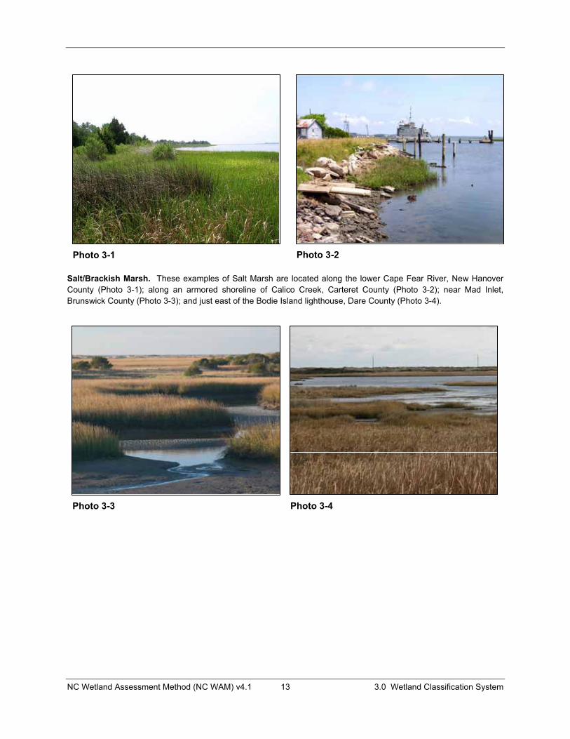
3.1.1 Salt/Brackish Marsh Salt/Brackish Marshes are found in the tidewater region of the Middle Atlantic Coastal Plain ecoregion (see Figure 1 and Appendix E) in areas subject to regular or occasional flooding by tides, including wind tides (whether or not the tidal waters reach wetlands through natural or artificial watercourses), provided that 1) water salinities equal or exceed 0.5 parts per thousand during the period of average, annual low flow; 2) flooding by saline waters is not limited to storm events; and 3) woody vegetation constitutes less than 50 percent coverage of the community. The salt marsh component is associated more closely with ocean and inlet waters, while the brackish marsh component is somewhat removed from a direct connection with ocean and inlet saline waters. Salt/Brackish Marshes typically occur on both organic and mineral soils. This wetland type is characterized by predominantly herbaceous vegetation (less than 50 percent coverage by woody species). Salt marsh vegetation is dominated by saltmarsh cordgrass (Spartina alterniflora) and contains black needle rush (Juncus roemerianus) and large saltmeadow cordgrass (Spartina patens). Brackish marsh vegetation may include salt marsh species, but are typically more diverse in the vegetation assemblage, which commonly includes giant cordgrass (Spartina cynosuroides) and sawgrass (Cladium jamaicense).
Most examples of Salt/Brackish Marsh are considered by regulatory agencies as high-quality wetlands. Indicators of degradation within this wetland type may include dead vegetation, altered hydrology, ditching, spoil piles, reduced size, and extensive presence of invasive species.
Reference wetlands (Section 3.2) are available for this type. This wetland type may vary in size from small, narrow, fringing bands to hundreds of acres. Salt/Brackish Marsh can transition upstream to Tidal Freshwater Marsh and upslope to Estuarine Woody Wetland, Non-Riverine Swamp Forest, and Pocosin.
Salt/Brackish Marsh includes NCNHP types Salt Marsh, Brackish Marsh, and Salt Flat when these sites are wetlands. This type is included in the NCDCM wetland type of Salt/Brackish Marsh. Salt/Brackish Marsh corresponds with HGM class Estuarine Tidal Fringe (sub-classes Estuarine Lunar and Estuarine Wind). Appendix B provides a cross-reference of wetland types across three classification systems.
NC Wetland Assessment Method (NC WAM) v4.1 13 3.0 Wetland Classification System
Salt/Brackish Marsh. These examples of Salt Marsh are located along the lower Cape Fear River, New Hanover County (Photo 3-1); along an armored shoreline of Calico Creek, Carteret County (Photo 3-2); near Mad Inlet, Brunswick County (Photo 3-3); and just east of the Bodie Island lighthouse, Dare County (Photo 3-4).
Photo 3-1 Photo 3-2
Photo 3-3 Photo 3-4

NC Wetland Assessment Method (NC WAM) v4.1 14 3.0 Wetland Classification System
Salt/Brackish Marsh. These examples of Brackish Marsh are in association with Estuarine Woody Wetland in Huddy Gut, Beaufort County (Photo 3-5); along Rose Bay at Bell Island, Swanquarter National Wildlife Refuge, Hyde County (Photo 3-6); near the battleship U.S.S. North Carolina, New Hanover County (supporting a stand of the exotic species Phragmites australis) (Photo 3-7); and fringing a roadside canal near the US 64/US 264 junction, Dare County (Photo 3-8).
Photo 3-5 Photo 3-6
Photo 3-7 Photo 3-8
NC Wetland Assessment Method (NC WAM) v4.1 15 3.0 Wetland Classification System
3.1.2 Estuarine Woody Wetland Estuarine Woody Wetlands occur in the tidewater region of the Middle Atlantic Coastal Plain ecoregion (see Figure 1 and Appendix E). These wetlands are transitional in nature. They occur on the margins of estuaries, are typically fringing tidal marshes, and have the following attributes: 1) they are subject to occasional flooding from salt or brackish water; 2) they are subject to occasional flooding by tides, including wind tides (regardless of whether or not the tidal waters reach wetlands through natural or artificial watercourses); and 3) they are dominated (greater than 50 percent coverage) by woody vegetation including shrubs and trees. Estuarine Woody Wetlands occur on mineral or organic soils. Due to typically unstable hydrological and chemical influences, the plant community is one adapted to disturbance, resulting in variable vegetation composition and physical structure. The vegetation assemblage is typically dominated by loblolly pine (Pinus taeda), cedars (Juniperus spp.) and hardwoods adapted to disturbance such as red maple (Acer rubrum) and sweetgum (Liquidambar styraciflua), or by shrubs. Shrubs include bays, silverling (Baccharis halimifolia), marsh elder (Iva frutescens), and common wax myrtle (Morella cerifera). Herbs may include grasses and sedges from contiguous marshes.
Reference wetlands (Section 3.2) exist for this type; however, an assessor must recognize that this community occurs with variable vegetation composition and structure components. The size and shape of this wetland type ranges from narrow, sometimes intermittent bands along the outer fringe of Salt/Brackish Marshes to broad expanses of hundreds of acres. Estuarine Woody Wetland may transition up slope to Pocosin, Pine Flat, Hardwood Flat, and Non-Riverine Swamp Forest and down slope to Tidal Freshwater Marsh or Salt/Brackish Marsh.
Estuarine Woody Wetland includes NCNHP types Salt Shrub and Estuarine Fringe Loblolly Pine Forest. This type is included in the NCDCM wetland type of Estuarine Shrub-Scrub and Estuarine Forested Wetlands. Estuarine Woody Wetland corresponds to HGM class Estuarine Tidal Fringe (sub-classes Estuarine Lunar and Estuarine Wind). Appendix B provides a cross-reference of wetland types across three classification systems.
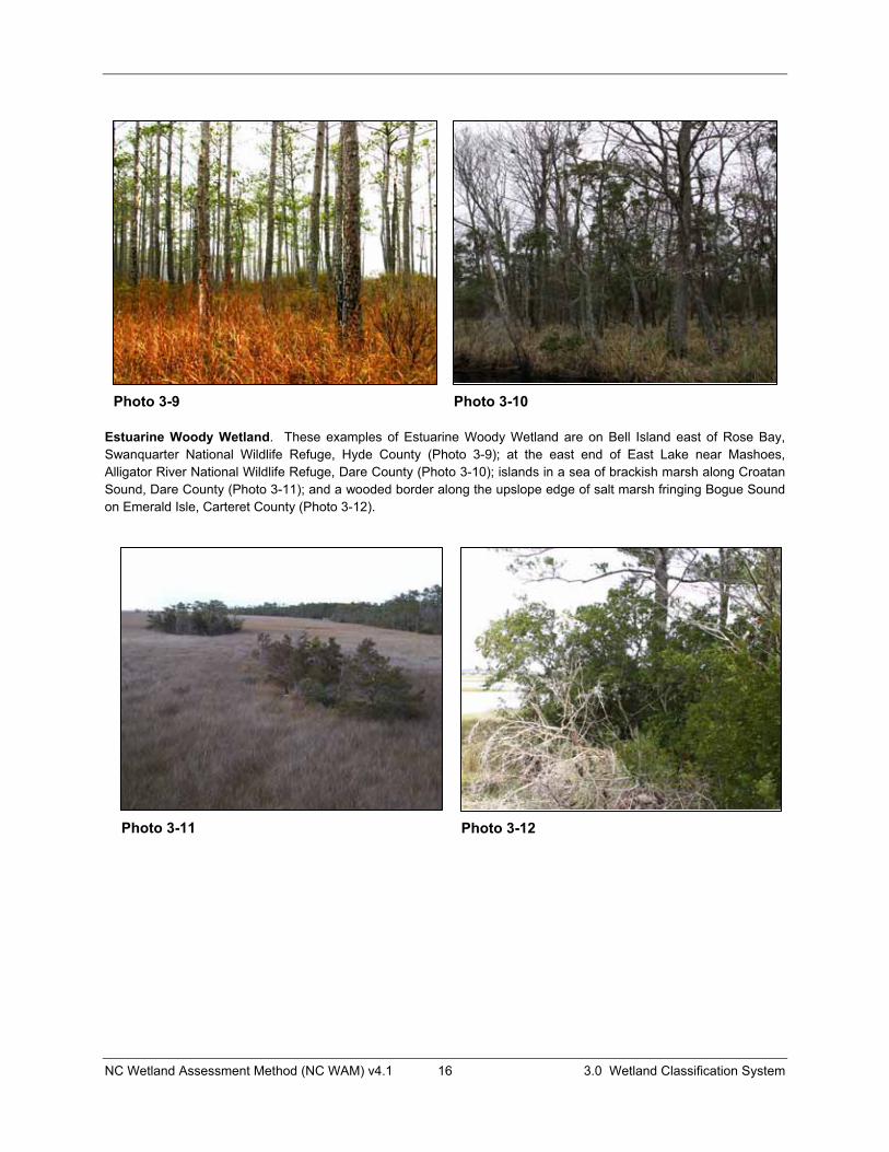
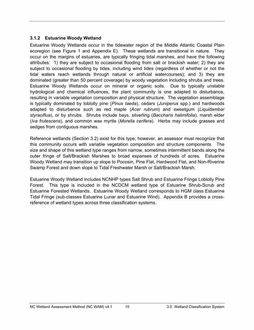
NC Wetland Assessment Method (NC WAM) v4.1 16 3.0 Wetland Classification System
Estuarine Woody Wetland. These examples of Estuarine Woody Wetland are on Bell Island east of Rose Bay, Swanquarter National Wildlife Refuge, Hyde County (Photo 3-9); at the east end of East Lake near Mashoes, Alligator River National Wildlife Refuge, Dare County (Photo 3-10); islands in a sea of brackish marsh along Croatan Sound, Dare County (Photo 3-11); and a wooded border along the upslope edge of salt marsh fringing Bogue Sound on Emerald Isle, Carteret County (Photo 3-12).
Photo 3-9 Photo 3-10
Photo 3-11 Photo 3-12

NC Wetland Assessment Method (NC WAM) v4.1 17 3.0 Wetland Classification System
3.1.3 Tidal Freshwater Marsh Tidal Freshwater Marshes are found in the tidewater region of the Middle Atlantic Coastal Plain ecoregion (see Figure 1 and Appendix E) on the margins of estuaries and in lower reaches of streams and rivers where they are saturated most of the time and are also subject to regular or occasional flooding by tides, including wind tides (regardless of whether or not the tidal waters reach wetlands through natural or artificial watercourses). Tidal Freshwater Marshes typically have salinities below the threshold of 0.5 parts per thousand, but may be subject to salinities above this threshold as a result of storm events. Tidal Freshwater Marshes occur on mineral or organic soils. This wetland type is characterized by predominantly herbaceous vegetation (less than 50 percent coverage by living woody species). Tidal Freshwater Marshes typically support a larger diversity of plant species than either Non-Tidal Freshwater Marshes or Salt/Brackish Marshes. Indicators of degradation within this wetland type may include dead vegetation, ditching, spoil piles, reduced size, lack of vegetation diversity, presence of invasive species and saltwater intrusion. Presence of snags is only considered to be an indicator of degradation if there is evidence of a recent die-off.
Reference wetlands (see Section 3.2) are available for this type. This wetland type may vary in size from small, narrow, fringing bands to broad patches extending hundreds of acres. Tidal Freshwater Marsh can transition upstream to Riverine Swamp Forest; upslope to Estuarine Woody Wetland, Non-Riverine Swamp Forest, and Pocosin; and downstream to Salt/Brackish Marsh.
Tidal Freshwater Marsh includes the NCNHP type Tidal Freshwater Marsh. This type is included in the NCDCM wetland type of Freshwater Marsh. Tidal Freshwater Marsh corresponds to the HGM class Estuarine Tidal Fringe (sub-classes Estuarine Lunar and Estuarine Wind). Appendix B provides a cross-reference of wetland types across three classification systems.
NC Wetland Assessment Method (NC WAM) v4.1 18 3.0 Wetland Classification System
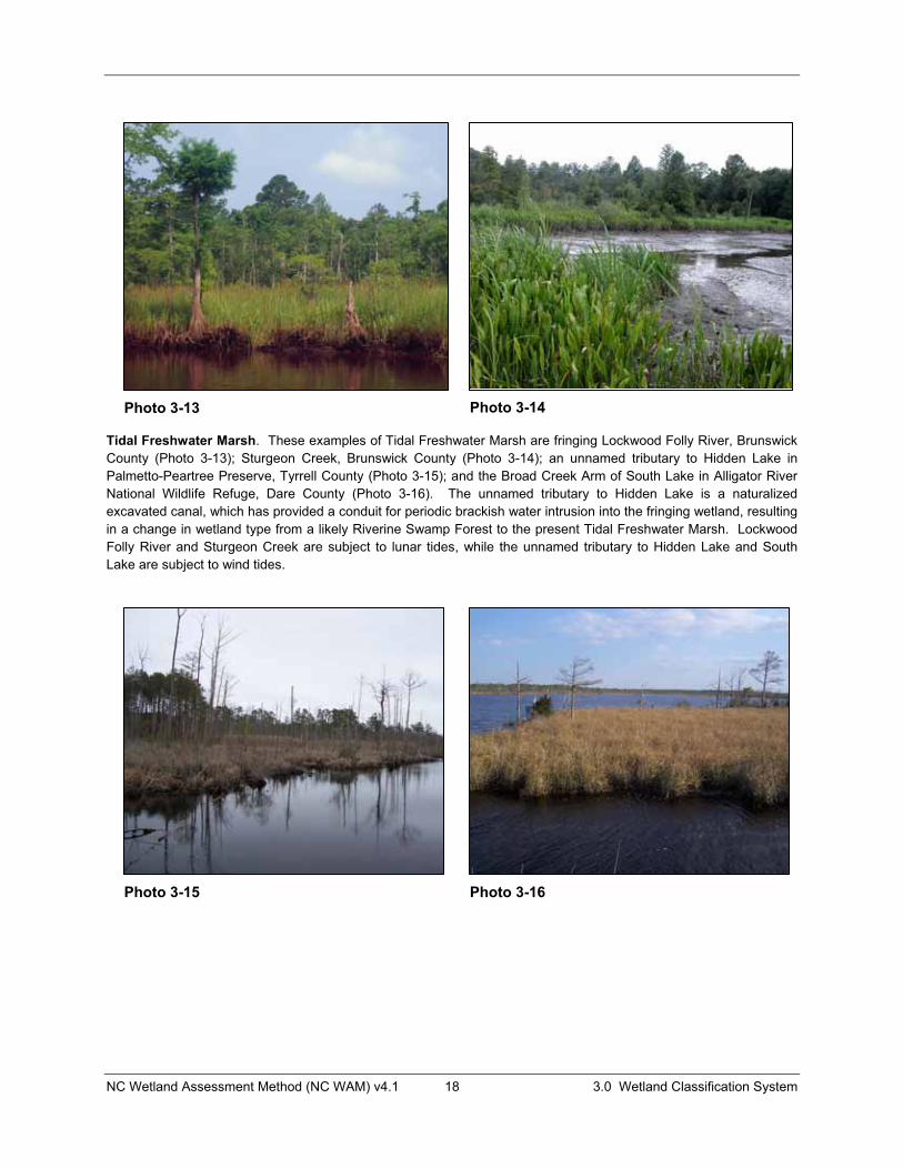
Tidal Freshwater Marsh. These examples of Tidal Freshwater Marsh are fringing Lockwood Folly River, Brunswick County (Photo 3-13); Sturgeon Creek, Brunswick County (Photo 3-14); an unnamed tributary to Hidden Lake in Palmetto-Peartree Preserve, Tyrrell County (Photo 3-15); and the Broad Creek Arm of South Lake in Alligator River National Wildlife Refuge, Dare County (Photo 3-16). The unnamed tributary to Hidden Lake is a naturalized excavated canal, which has provided a conduit for periodic brackish water intrusion into the fringing wetland, resulting in a change in wetland type from a likely Riverine Swamp Forest to the present Tidal Freshwater Marsh. Lockwood Folly River and Sturgeon Creek are subject to lunar tides, while the unnamed tributary to Hidden Lake and South Lake are subject to wind tides.
Photo 3-13 Photo 3-14
Photo 3-15 Photo 3-16
NC Wetland Assessment Method (NC WAM) v4.1 19 3.0 Wetland Classification System
3.1.4 Riverine Swamp Forest Riverine Swamp Forests are found throughout the state, but are most extensive and abundant in Coastal Plain ecoregions (see Figure 1 and Appendix E). This wetland type may occur in a variety of landscape positions and on mineral or organic soils, but all undisturbed Riverine Swamp Forests are characterized by seasonal to semi-permanent inundation. This wetland type occurs in (but is not limited to) the following settings (listed from highest to lowest in the landscape).
� Headwaters of streams in depressions subject to surface flow and/or groundwater expression
� Wettest portions of large river floodplains and other permanent water bodies, including linear depressions that lead to stream systems
� Tidally-influenced lower river reaches (primarily freshwater, but also brackish water in the upper reaches of estuaries)
� Linear depressions (both with and without surface water channels [natural or man-made]) draining to rivers and sounds in the Middle Atlantic Coastal Plain
� Shorelines of open waters 20 acres or larger
Overbank or tidal flooding is usually an important source of water, but groundwater and overland runoff are also important. Long-established beaver impoundments may be the cause of semi-permanent to permanent inundation. Many Riverine Swamp Forests in North Carolina were formed under the influence of long-established beaver impoundments. Seasonal fluctuations in water levels of large open waters (20 acres or larger) may mimic the seasonal flooding of rivers. These large open waters may provide enough fetch for effective wind tides, approximating overbank flooding as experienced in floodplains. The size threshold used to determine small versus large open waters was taken from Cowardin et al. (1979).
Vegetation is most often dominated by mesic and hydrophytic tree species such as overcup oak (Quercus lyrata), ashes (Fraxinus spp.), and American elm (Ulmus americana) in the Piedmont and Blue Ridge ecoregions and bald cypress (Taxodium distichum), black gum (Nyssa biflora),and water tupelo (N. aquatica) in the Coastal Plain ecoregions. Herbaceous cover is typically more open than in Bottomland Hardwood Forest. In estuaries, lower reaches of rivers, and along the shorelines of large open waters, Riverine Swamp Forest can be distinguished from marshes by having a predominance of woody vegetation.
Reference wetlands (see Section 3.2) are available for this type. The size of this wetland type varies widely from narrow strips of backwater at the toe of valley walls along the outer extent of floodplains to broad expanses extending for hundreds of acres. Areas of Riverine Swamp Forest are typically larger in the Coastal Plain ecoregions and smaller in the Piedmont and Blue Ridge ecoregions. Riverine Swamp Forest is often a result of the impoundment of water by beaver dams or man-made dams. When determining the type of a riparian wetland dominated by woody vegetation and characterized by seasonal to semi-permanent inundation, the assessor should consider whether the stated hydrology is long established and permanent or not. The wetland type may be a Riverine Swamp Forest in the former instance, and a disturbed
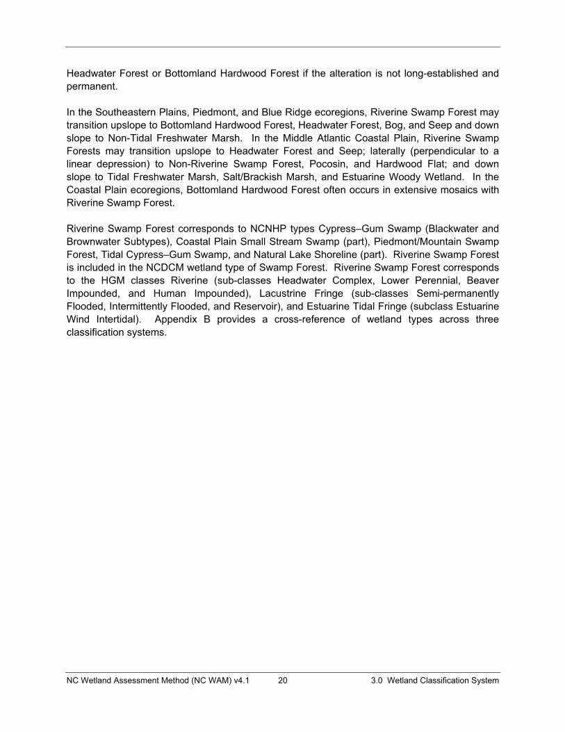
NC Wetland Assessment Method (NC WAM) v4.1 20 3.0 Wetland Classification System
Headwater Forest or Bottomland Hardwood Forest if the alteration is not long-established and permanent.
In the Southeastern Plains, Piedmont, and Blue Ridge ecoregions, Riverine Swamp Forest may transition upslope to Bottomland Hardwood Forest, Headwater Forest, Bog, and Seep and down slope to Non-Tidal Freshwater Marsh. In the Middle Atlantic Coastal Plain, Riverine Swamp Forests may transition upslope to Headwater Forest and Seep; laterally (perpendicular to a linear depression) to Non-Riverine Swamp Forest, Pocosin, and Hardwood Flat; and down slope to Tidal Freshwater Marsh, Salt/Brackish Marsh, and Estuarine Woody Wetland. In the Coastal Plain ecoregions, Bottomland Hardwood Forest often occurs in extensive mosaics with Riverine Swamp Forest.
Riverine Swamp Forest corresponds to NCNHP types Cypress–Gum Swamp (Blackwater and Brownwater Subtypes), Coastal Plain Small Stream Swamp (part), Piedmont/Mountain Swamp Forest, Tidal Cypress–Gum Swamp, and Natural Lake Shoreline (part). Riverine Swamp Forest is included in the NCDCM wetland type of Swamp Forest. Riverine Swamp Forest corresponds to the HGM classes Riverine (sub-classes Headwater Complex, Lower Perennial, Beaver Impounded, and Human Impounded), Lacustrine Fringe (sub-classes Semi-permanently Flooded, Intermittently Flooded, and Reservoir), and Estuarine Tidal Fringe (subclass Estuarine Wind Intertidal). Appendix B provides a cross-reference of wetland types across three classification systems.

NC Wetland Assessment Method (NC WAM) v4.1 21 3.0 Wetland Classification System
Photo 3-17
Riverine Swamp Forest. These photos depict Riverine Swamp Forest in settings affected by lunar or wind tides and primarily affected by freshwater (key location I.B.ii): along the eastern shore of the Alligator River (subject to wind tides and wave action), Dare County (Photo 3-17); in the floodplain of Doe Creek (subject to lunar tides), Brunswick County (Photo 3-18); in the floodplain of Town Creek (subject to lunar tides), Brunswick County (Photo 3-19); and in Deep Creek, a broad natural topographic crenulation with no readily identifiable channel, Washington County (Photo 3-20).
Photo 3-18
Photo 3-19
Photo 3-20

NC Wetland Assessment Method (NC WAM) v4.1 22 3.0 Wetland Classification System
Riverine Swamp Forest. These photos depict Riverine Swamp Forests on less than a second-order stream or within a natural topographic crenulation without a channel (key location II.B.2.b.i.2): a natural topographic crenulation without a channel in the headwaters of Huddle’s Cut, Beaufort County (Photo 3-21); an unnamed, anastomosed, first-order stream in the Green Swamp, Brunswick County (Photo 3-22); a first-order unnamed tributary to Robertson’s Millpond on Buffalo Creek, Wake County (Photo 3-23); and within a beaver-impacted first-order unnamed tributary to Milburnie Lake, Wake County (Photo 3-24).
Photo 3-21 Photo 3-22
Photo 3-23
Photo 3-24
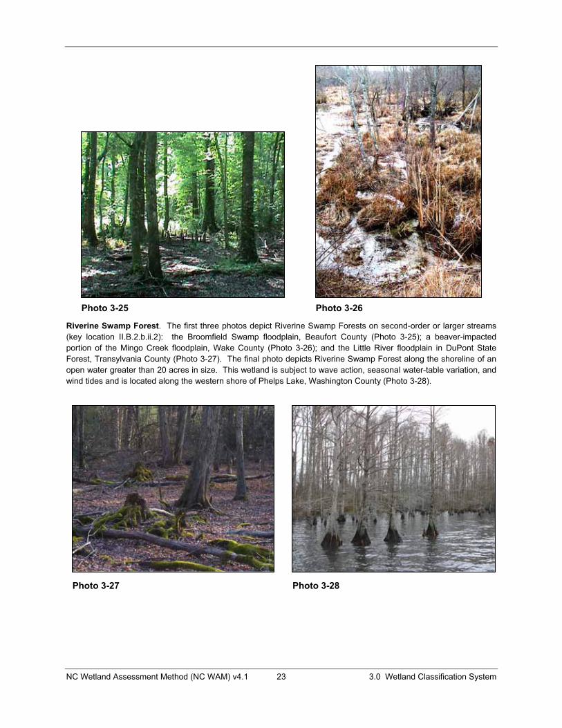
NC Wetland Assessment Method (NC WAM) v4.1 23 3.0 Wetland Classification System
Riverine Swamp Forest. The first three photos depict Riverine Swamp Forests on second-order or larger streams (key location II.B.2.b.ii.2): the Broomfield Swamp floodplain, Beaufort County (Photo 3-25); a beaver-impacted portion of the Mingo Creek floodplain, Wake County (Photo 3-26); and the Little River floodplain in DuPont State Forest, Transylvania County (Photo 3-27). The final photo depicts Riverine Swamp Forest along the shoreline of an open water greater than 20 acres in size. This wetland is subject to wave action, seasonal water-table variation, and wind tides and is located along the western shore of Phelps Lake, Washington County (Photo 3-28).
Photo 3-25 Photo 3-26
Photo 3-27 Photo 3-28
NC Wetland Assessment Method (NC WAM) v4.1 24 3.0 Wetland Classification System
3.1.5 Seep Seeps are located throughout the state where groundwater is discharged to the surface on a slope not in a geomorphic floodplain or a natural topographic crenulation. Wetlands of this type usually occupy small areas on sloping hillsides in interstream divides or on the valley wall outside of floodplains and are semi-permanently to permanently saturated by ground water on mineral or organic soils. This wetland type typically does not have sufficient surface flow to form channels, but is usually saturated to the surface. Topographic mapping is useful in determining the extent of Seeps, especially when a Seep abuts another wetland type. For instance, a Seep may occur on the valley wall outside of a geomorphic floodplain and extend down slope into another wetland type on the floodplain (such as Headwater Forest, Bottomland Hardwood Forest, Riverine Swamp Forest, Floodplain Pool, Non-Tidal Freshwater Marsh, or Bog). In this case, the lower boundary of this wetland type may be defined using topographic mapping at the point where the toe of the valley wall meets the floodplain. Likewise, a wetland on a ridge or valley wall slope is a Seep, but it becomes another wetland type when it enters a natural topographic crenulation. When making this determination, an assessor may use the most detailed topographic mapping available. Assessors will need to use best professional judgment to determine the boundary between a Seep and the upper limit of a Headwater Forest.
Vegetation in Seeps is quite variable. Depending on size, vegetation of Seeps in the Piedmont and Blue Ridge ecoregions may be zoned, with open interiors characterized by sparse to dense wetland herbs and a forested outer edge. This wetland type may be small enough to be shaded by trees. Vegetation structure in the Coastal Plain ecoregions is dependent on fire regime and may vary from dense to sparse growth of shrubs.
Reference wetlands (see Section 3.2) are available for this type. Because this type is very heterogeneous, care will be needed to select the appropriate reference, which will vary by ecoregion and site conditions. Seeps are typically small relative to other general wetland types, but may be larger in the Sandhills ecoregion and in the higher mountains. A Seep can transition to Headwater Forest, Bottomland Hardwood Forest, Riverine Swamp Forest, Non-Tidal Freshwater Marsh, Pine Flat, and Bog. Seeps can be distinguished from all these wetland types by location on a slope.
Seep includes the NCNHP types Low Elevation Seep, High Elevation Seep, Sandhill Seep, and Hillside Seepage Bog. This wetland type is not separately identified with the NCDCM wetland classification system. Seep corresponds to the HGM class Slope (sub-classes Organic Soil and Mineral Soil). Appendix B provides a cross-reference of wetland types across three classification systems.
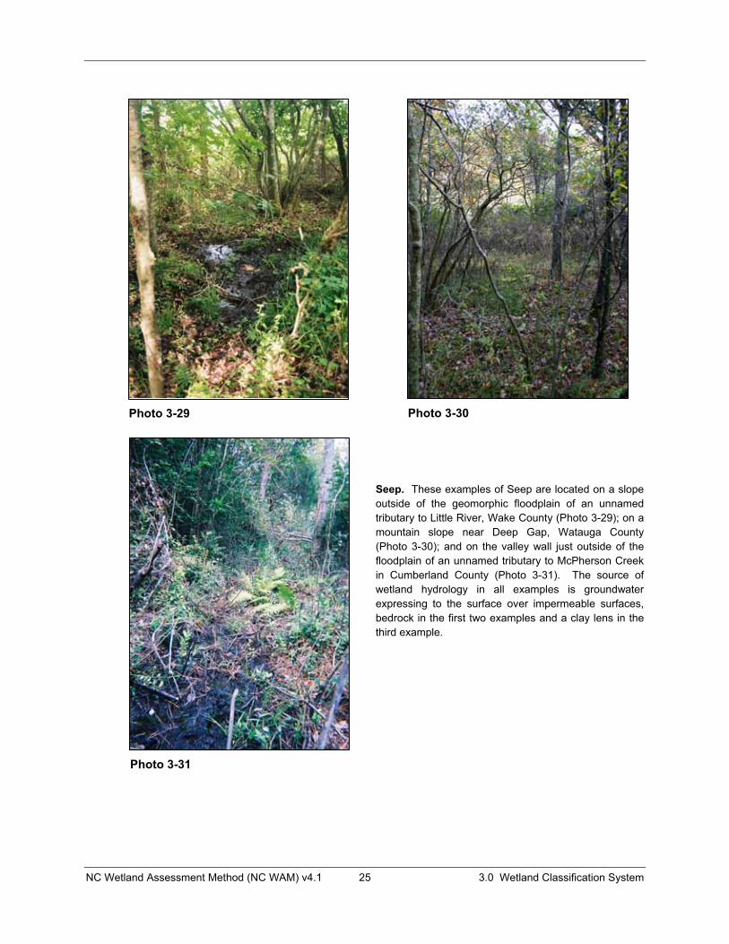
NC Wetland Assessment Method (NC WAM) v4.1 25 3.0 Wetland Classification System
Seep. These examples of Seep are located on a slope outside of the geomorphic floodplain of an unnamed tributary to Little River, Wake County (Photo 3-29); on a mountain slope near Deep Gap, Watauga County (Photo 3-30); and on the valley wall just outside of the floodplain of an unnamed tributary to McPherson Creek in Cumberland County (Photo 3-31). The source of wetland hydrology in all examples is groundwater expressing to the surface over impermeable surfaces, bedrock in the first two examples and a clay lens in the third example.
Photo 3-29 Photo 3-30
Photo 3-31
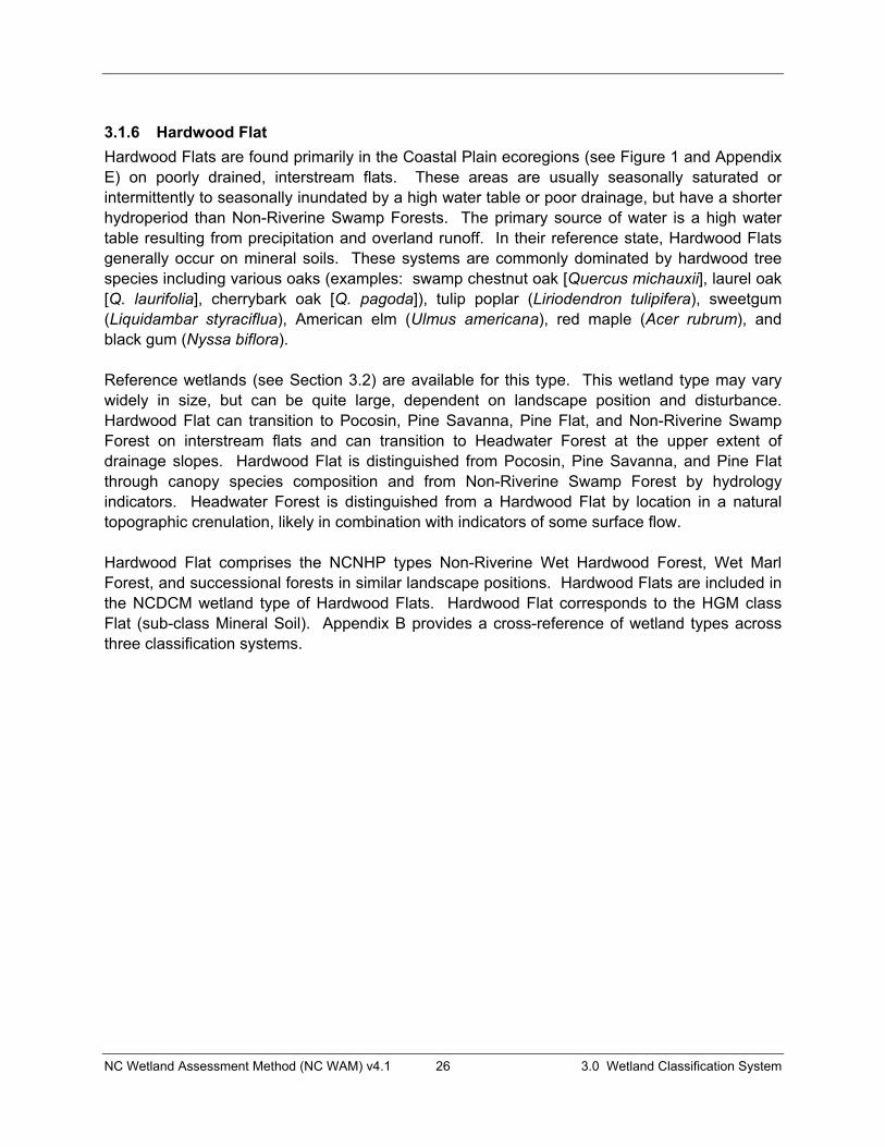
NC Wetland Assessment Method (NC WAM) v4.1 26 3.0 Wetland Classification System
3.1.6 Hardwood Flat Hardwood Flats are found primarily in the Coastal Plain ecoregions (see Figure 1 and Appendix E) on poorly drained, interstream flats. These areas are usually seasonally saturated or intermittently to seasonally inundated by a high water table or poor drainage, but have a shorter hydroperiod than Non-Riverine Swamp Forests. The primary source of water is a high water table resulting from precipitation and overland runoff. In their reference state, Hardwood Flats generally occur on mineral soils. These systems are commonly dominated by hardwood tree species including various oaks (examples: swamp chestnut oak [Quercus michauxii], laurel oak [Q. laurifolia], cherrybark oak [Q. pagoda]), tulip poplar (Liriodendron tulipifera), sweetgum (Liquidambar styraciflua), American elm (Ulmus americana), red maple (Acer rubrum), and black gum (Nyssa biflora).
Reference wetlands (see Section 3.2) are available for this type. This wetland type may vary widely in size, but can be quite large, dependent on landscape position and disturbance. Hardwood Flat can transition to Pocosin, Pine Savanna, Pine Flat, and Non-Riverine Swamp Forest on interstream flats and can transition to Headwater Forest at the upper extent of drainage slopes. Hardwood Flat is distinguished from Pocosin, Pine Savanna, and Pine Flat through canopy species composition and from Non-Riverine Swamp Forest by hydrology indicators. Headwater Forest is distinguished from a Hardwood Flat by location in a natural topographic crenulation, likely in combination with indicators of some surface flow.
Hardwood Flat comprises the NCNHP types Non-Riverine Wet Hardwood Forest, Wet Marl Forest, and successional forests in similar landscape positions. Hardwood Flats are included in the NCDCM wetland type of Hardwood Flats. Hardwood Flat corresponds to the HGM class Flat (sub-class Mineral Soil). Appendix B provides a cross-reference of wetland types across three classification systems.
NC Wetland Assessment Method (NC WAM) v4.1 27 3.0 Wetland Classification System
Hardwood Flat. These examples of Hardwood Flat are located south of the Pamlico River, Beaufort County (Photo 3-32), near the community of East Lake, Dare County (Photo 3-33), north of Phelps Lake, Washington County (this wetland had recently suffered storm damage from Hurricane Isabel) (Photo 3-34), and on an interstream flat east of I-95 in northern Robeson County (Photo 3-35).
Photo 3-32 Photo 3-33
Photo 3-34 Photo 3-35
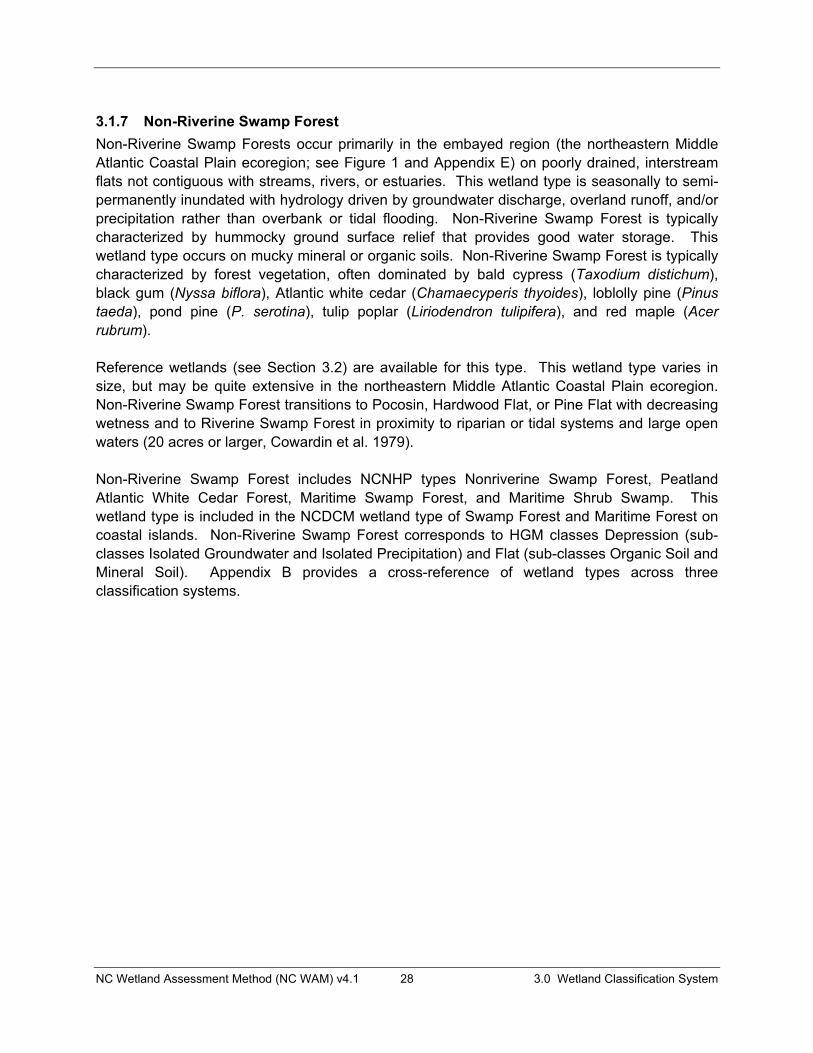
NC Wetland Assessment Method (NC WAM) v4.1 28 3.0 Wetland Classification System
3.1.7 Non-Riverine Swamp Forest Non-Riverine Swamp Forests occur primarily in the embayed region (the northeastern Middle Atlantic Coastal Plain ecoregion; see Figure 1 and Appendix E) on poorly drained, interstream flats not contiguous with streams, rivers, or estuaries. This wetland type is seasonally to semi-permanently inundated with hydrology driven by groundwater discharge, overland runoff, and/or precipitation rather than overbank or tidal flooding. Non-Riverine Swamp Forest is typically characterized by hummocky ground surface relief that provides good water storage. This wetland type occurs on mucky mineral or organic soils. Non-Riverine Swamp Forest is typically characterized by forest vegetation, often dominated by bald cypress (Taxodium distichum),black gum (Nyssa biflora), Atlantic white cedar (Chamaecyperis thyoides), loblolly pine (Pinustaeda), pond pine (P. serotina), tulip poplar (Liriodendron tulipifera), and red maple (Acerrubrum).
Reference wetlands (see Section 3.2) are available for this type. This wetland type varies in size, but may be quite extensive in the northeastern Middle Atlantic Coastal Plain ecoregion. Non-Riverine Swamp Forest transitions to Pocosin, Hardwood Flat, or Pine Flat with decreasing wetness and to Riverine Swamp Forest in proximity to riparian or tidal systems and large open waters (20 acres or larger, Cowardin et al. 1979).
Non-Riverine Swamp Forest includes NCNHP types Nonriverine Swamp Forest, Peatland Atlantic White Cedar Forest, Maritime Swamp Forest, and Maritime Shrub Swamp. This wetland type is included in the NCDCM wetland type of Swamp Forest and Maritime Forest on coastal islands. Non-Riverine Swamp Forest corresponds to HGM classes Depression (sub-classes Isolated Groundwater and Isolated Precipitation) and Flat (sub-classes Organic Soil and Mineral Soil). Appendix B provides a cross-reference of wetland types across three classification systems.
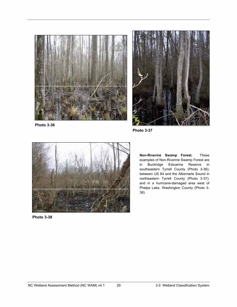
NC Wetland Assessment Method (NC WAM) v4.1 29 3.0 Wetland Classification System
Non-Riverine Swamp Forest. These examples of Non-Riverine Swamp Forest are in Buckridge Estuarine Reserve in southeastern Tyrrell County (Photo 3-36); between US 64 and the Albemarle Sound in northeastern Tyrrell County (Photo 3-37); and in a hurricane-damaged area west of Phelps Lake, Washington County (Photo 3-38).
Photo 3-36Photo 3-37
Photo 3-38

NC Wetland Assessment Method (NC WAM) v4.1 30 3.0 Wetland Classification System
3.1.8 Pocosin Pocosins are found in the Coastal Plain ecoregions (see Figure 1 and Appendix E) on poorly drained, interstream flats and in basins of various sizes such as peat-filled Carolina bays. Pocosins can be seasonally saturated or inundated by a high or perched water table. The primary source of water is a high water table resulting from precipitation and slow drainage, but, rarely, Pocosins are found in proximity to surface waters. Pocosins occur on mineral or organic soils. Vegetation is dominated by dense, waxy evergreen shrubs that typically include gallberries (Ilex spp.), fetterbushes (Leucothoe spp.), honey-cup (Zenobia pulverulenta), and bamboo-vine (greenbrier – Smilax laurifolia) often mixed with pond pine (Pinus serotina) and evergreen hardwoods such as loblolly bay (Gordonia lasianthus), swamp bay (Persea palustris),and sweet bay (Magnolia virginiana).
Pocosin vegetation structure may take a variety of forms, resulting in the need for the assessor to be familiar with multiple sub-type reference wetlands (see Section 3.2) (see corresponding NCNHP wetland types below). Pocosin may transition to a variety of wetland types depending on topography, hydrologic regime, and disturbance including Non-Riverine Swamp Forest, Pine Savanna, Pine Flat, Hardwood Flat, Riverine Swamp Forest, Salt/Brackish Marsh, Non-Tidal Freshwater Marsh, and Estuarine Woody Wetland. Areas of this wetland type vary greatly in size dependent on landscape position. The extent of the wetland type may not be apparent in the field or with the use of aerial photography due to past disturbance; however, soils mapping may prove useful in determining the potential extent of Pocosin prior to disturbance. Appendix D contains a list of soils that are known to typically support Pocosin; more specifically, these soils typically support a vegetation community dominated by dense waxy shrub species and that includes pond pine and/or bays. This list is not considered to be all-inclusive, but rather a guide for use when estimating the original aerial extent of a Pocosin.
Pocosin comprises NCNHP types Low Pocosin, High Pocosin, Pond Pine Woodland, Small Depression Pocosin, and Bay Forest. Pocosins are included in the NCDCM wetland type of Pocosin along with some of the Pine Flat wetland type if it is dominated by pond pine. Pocosin corresponds to the HGM classes Flat (sub-classes Mineral Soil and Organic Soil) and Depression (sub-classes Isolated Groundwater and Isolated Depression). Appendix B provides a cross-reference of wetland types across three classification systems.
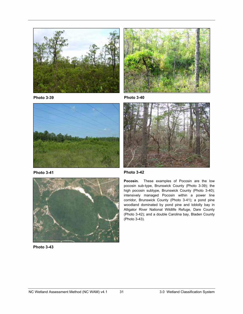
NC Wetland Assessment Method (NC WAM) v4.1 31 3.0 Wetland Classification System
Pocosin. These examples of Pocosin are the low pocosin sub-type, Brunswick County (Photo 3-39); the high pocosin subtype, Brunswick County (Photo 3-40); intensively managed Pocosin within a power line corridor, Brunswick County (Photo 3-41); a pond pine woodland dominated by pond pine and loblolly bay in Alligator River National Wildlife Refuge, Dare County (Photo 3-42); and a double Carolina bay, Bladen County (Photo 3-43).
Photo 3-39 Photo 3-40
Photo 3-41 Photo 3-42
Photo 3-43

NC Wetland Assessment Method (NC WAM) v4.1 32 3.0 Wetland Classification System
3.1.9 Pine Savanna Pine Savannas are found in the Coastal Plain ecoregions (see Figure 1 and Appendix E) on poorly drained, interstream flats. These areas are usually seasonally saturated by a high water table or poor drainage, but have a shorter hydroperiod than Non-Riverine Swamp Forest. The primary sources of water are a high water table resulting from precipitation and overland runoff. This wetland type is characterized by relatively flat ground surface that provides little surface water storage. Pine Savannas are maintained by frequent, low-intensity fires and occur on mineral soils. This wetland type is dominated by long-leaf (Pinus palustris) and pond pine (P.serotina), with scattered, low shrubs such as little gallberry (Ilex glabra), creeping blueberry (Vaccinium crassifolium), common wax-myrtle (Morella cerifera), and dangleberry (Gaylussacia frondosa) (Schafale and Weakley 1990) and grassy ground cover (dominated by grasses, sedges, composites, orchids, and lilies (Schafale and Weakley 1990) in reference condition. Regular burns provide conditions for very high herb species diversity.
Reference wetlands (see Section 3.2) are available for this type; the few examples remaining in North Carolina are located primarily in the southeastern portion of the state. Size of this wetland type is dependent on long-term fire frequency. Pine Savanna can transition to Pocosin and Pine Flat.
Pine Savanna corresponds to NCNHP types Wet Pine Flatwoods and Pine Savannas. Pine Savannas are included in the NCDCM wetland type of Pine Flats. Pine Savanna corresponds to the HGM class Flat (sub-class Mineral Soil). Appendix B provides a cross-reference of wetland types across three classification systems.
Pine Savanna. These examples of Pine Savanna are both from Brunswick County and are located within the Military Ocean Terminal, Sunny Point (Photo 3-44) and along NC 211 in the Green Swamp (Photo 3-45).
Photo 3-44 Photo 3-45
NC Wetland Assessment Method (NC WAM) v4.1 33 3.0 Wetland Classification System
3.1.10 Pine Flat Pine Flats are found primarily in the Coastal Plain ecoregions (see Figure 1 and Appendix E) on poorly drained interstream flats. These areas are usually seasonally saturated or intermittently to seasonally inundated by a high water table or poor drainage. The primary source of hydrology is a high water table resulting from precipitation and overland runoff. Pine Flats generally occur on mineral soils. This wetland type may be dominated by forest, early successional forest/shrub, or managed pine plantation. Common canopy trees are pines including loblolly (Pinus taeda) and slash pine (P. elliottii), and may include a large component of red maple (Acer rubrum) and sweetgum (Liquidambar styraciflua). The shrub component is typically not dense and may include horsesugar (Symplocos tinctoria), American holly (Ilexopaca), swamp bay (Persea palustris), coastal white alder (sweet pepperbush – Clethraalnifolia), and common wax-myrtle (Morella cerifera).
Almost all Pine Flats are successional in nature and represent altered variants of Pine Savanna, Hardwood Flat, or Non-Riverine Swamp Forest; therefore, there are no reference wetlands for this type (see Section 3.2). This wetland type is typically managed and is often characterized by low species diversity and structural complexity, which decreases the Habitat function of this wetland. Pine Flats may vary widely in size, but can be quite large, dependent on landscape position and disturbance. Pine Flat can transition to Pocosin, Pine Savanna, Hardwood Flat, and Non-Riverine Swamp Forest on interstream flats; to Headwater Forest at the upper extent of drainage slopes; and to Estuarine Woody Wetland and Salt/Brackish Marsh in the embayed portion of the Middle Atlantic Coastal Plain ecoregion.
This wetland type has no NCNHP counterpart, but includes disturbed variants of several types of non-alluvial forests such as Nonriverine Wet Hardwood Forest, Nonriverine Swamp Forest, Wet Pine Flatwoods, and Pine Savanna. Pine Flat is included in the NCDCM wetland type of Pine Flat and Managed Pineland. Pine Flat corresponds to the HGM class Flat (sub-class Mineral Soil). Appendix B provides a cross-reference of wetland types across three classification systems.
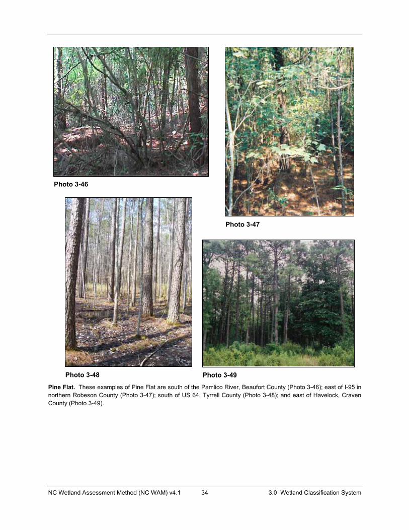
NC Wetland Assessment Method (NC WAM) v4.1 34 3.0 Wetland Classification System
Pine Flat. These examples of Pine Flat are south of the Pamlico River, Beaufort County (Photo 3-46); east of I-95 in northern Robeson County (Photo 3-47); south of US 64, Tyrrell County (Photo 3-48); and east of Havelock, Craven County (Photo 3-49).
Photo 3-47
Photo 3-46
Photo 3-48 Photo 3-49
NC Wetland Assessment Method (NC WAM) v4.1 35 3.0 Wetland Classification System
3.1.11 Basin Wetland Basin Wetlands occur throughout the state in depressions surrounded by uplands (usually on interstream flats or in localized depressions). This wetland type may also occur on the fringe of small open waters (less than 20 acres in size). Wetlands fringing larger water bodies are subject to hydrology more closely matching riparian conditions and are therefore considered Riverine Swamp Forest or Non-Tidal Freshwater Marsh. The size threshold used to determine small versus large open waters was taken from Cowardin et al. (1979). Basin Wetlands are seasonally to semi-permanently inundated but may lose surface hydrology during later portions of the growing season. Sources of water are perched groundwater, groundwater discharge, overland runoff, and precipitation. Seasonal waterlines are often apparent on the vegetation. Basin Wetlands generally occur on mineral soils. Basin Wetlands may be characterized by a variety of mineral soil types ranging in particle size and type from sandy soils associated with Coastal Plain lime sinks and inter-dune swales to clay-based soils underlying mafic depressions. Vegetation structure within this wetland type may vary widely from forest in mafic depressions and ephemeral pools, to primarily herbaceous or emergent in lime sinks, man-excavated depressions, and along the shorelines of small open waters.
Reference wetlands (see Section 3.2) are available for some forms of this wetland type, but since this wetland type is so heterogeneous, an assessor must recognize that an appropriate reference must be considered on a case-by-case basis. Sub-types of Basin Wetland that are considered to have reference wetlands include mafic depressions and Carolina bays. Non-reference Basin Wetlands most frequently include the wetland edges of excavated farm ponds. Basin Wetlands vary in size based on the variable landscape positions that they may occupy. This wetland type is generally surrounded by uplands, but may occasionally transition to Pine Savanna, Pocosin, or Pine Flat.
Basin Wetland comprises NCNHP types Vernal Pool, Cypress Savanna, Upland Depression Swamp Forest, Small Depression Pond, Inner Dune Pond, and Upland Pool. This wetland type is not separately identified in the NCDCM methodology, but would likely be included in the Swamp Forest (non-riverine) and Freshwater Marsh in some cases. Basin Wetland corresponds to the HGM classes Depression (sub-classes Isolated Groundwater, Isolated Precipitation, and Human Impounded or Excavated) and Estuarine (sub-class Impounded). Appendix B provides a cross-reference of wetland types across three classification systems.

NC Wetland Assessment Method (NC WAM) v4.1 36 3.0 Wetland Classification System
Basin Wetlands. These examples of Basin Wetland are a mafic depression on an interstream divide, Mecklenburg County (Photo 3-50), an herb-dominated wetland within an interdune swale at Cape Lookout, Carteret County (Photo 3-51); a woody vegetation-dominated wetland within an inter-dune swale on Bogue Banks, Carteret County (Photo 3-52); and a grass and sedge-dominated limesink depression within Carolina Beach State Park, New Hanover County (Photo 3-53).
Photo 3-50
Photo 3-51
Photo 3-52 Photo 3-53
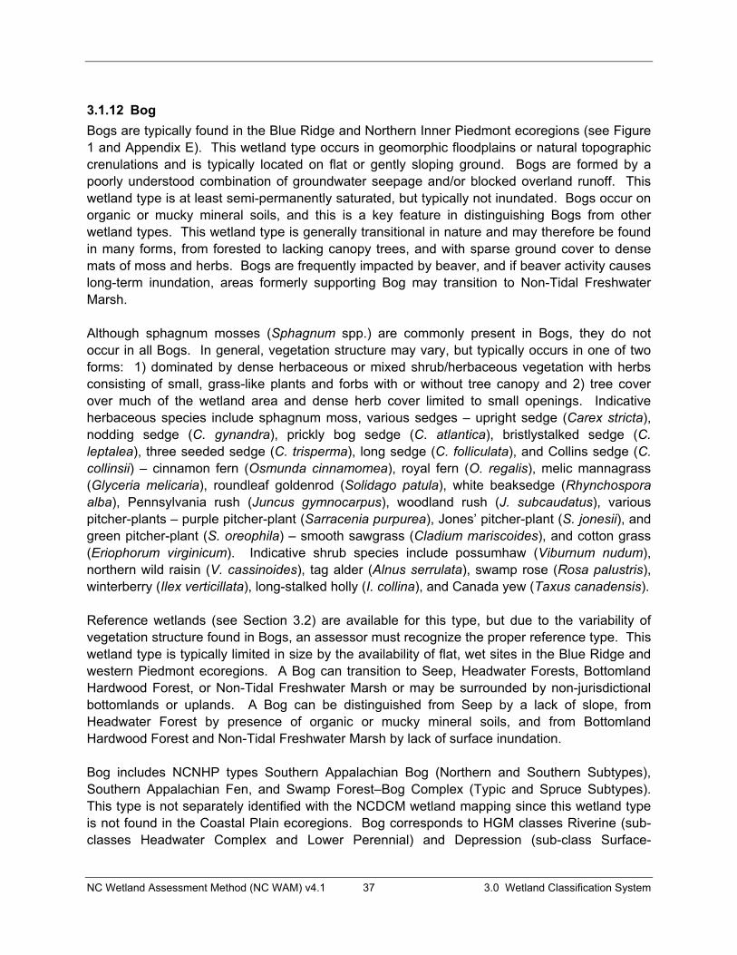
NC Wetland Assessment Method (NC WAM) v4.1 37 3.0 Wetland Classification System
3.1.12 Bog Bogs are typically found in the Blue Ridge and Northern Inner Piedmont ecoregions (see Figure 1 and Appendix E). This wetland type occurs in geomorphic floodplains or natural topographic crenulations and is typically located on flat or gently sloping ground. Bogs are formed by a poorly understood combination of groundwater seepage and/or blocked overland runoff. This wetland type is at least semi-permanently saturated, but typically not inundated. Bogs occur on organic or mucky mineral soils, and this is a key feature in distinguishing Bogs from other wetland types. This wetland type is generally transitional in nature and may therefore be found in many forms, from forested to lacking canopy trees, and with sparse ground cover to dense mats of moss and herbs. Bogs are frequently impacted by beaver, and if beaver activity causes long-term inundation, areas formerly supporting Bog may transition to Non-Tidal Freshwater Marsh.
Although sphagnum mosses (Sphagnum spp.) are commonly present in Bogs, they do not occur in all Bogs. In general, vegetation structure may vary, but typically occurs in one of two forms: 1) dominated by dense herbaceous or mixed shrub/herbaceous vegetation with herbs consisting of small, grass-like plants and forbs with or without tree canopy and 2) tree cover over much of the wetland area and dense herb cover limited to small openings. Indicative herbaceous species include sphagnum moss, various sedges – upright sedge (Carex stricta),nodding sedge (C. gynandra), prickly bog sedge (C. atlantica), bristlystalked sedge (C. leptalea), three seeded sedge (C. trisperma), long sedge (C. folliculata), and Collins sedge (C.collinsii) – cinnamon fern (Osmunda cinnamomea), royal fern (O. regalis), melic mannagrass (Glyceria melicaria), roundleaf goldenrod (Solidago patula), white beaksedge (Rhynchospora alba), Pennsylvania rush (Juncus gymnocarpus), woodland rush (J. subcaudatus), various pitcher-plants – purple pitcher-plant (Sarracenia purpurea), Jones’ pitcher-plant (S. jonesii), and green pitcher-plant (S. oreophila) – smooth sawgrass (Cladium mariscoides), and cotton grass (Eriophorum virginicum). Indicative shrub species include possumhaw (Viburnum nudum),northern wild raisin (V. cassinoides), tag alder (Alnus serrulata), swamp rose (Rosa palustris),winterberry (Ilex verticillata), long-stalked holly (I. collina), and Canada yew (Taxus canadensis).
Reference wetlands (see Section 3.2) are available for this type, but due to the variability of vegetation structure found in Bogs, an assessor must recognize the proper reference type. This wetland type is typically limited in size by the availability of flat, wet sites in the Blue Ridge and western Piedmont ecoregions. A Bog can transition to Seep, Headwater Forests, Bottomland Hardwood Forest, or Non-Tidal Freshwater Marsh or may be surrounded by non-jurisdictional bottomlands or uplands. A Bog can be distinguished from Seep by a lack of slope, from Headwater Forest by presence of organic or mucky mineral soils, and from Bottomland Hardwood Forest and Non-Tidal Freshwater Marsh by lack of surface inundation.
Bog includes NCNHP types Southern Appalachian Bog (Northern and Southern Subtypes),Southern Appalachian Fen, and Swamp Forest–Bog Complex (Typic and Spruce Subtypes). This type is not separately identified with the NCDCM wetland mapping since this wetland type is not found in the Coastal Plain ecoregions. Bog corresponds to HGM classes Riverine (sub-classes Headwater Complex and Lower Perennial) and Depression (sub-class Surface-

NC Wetland Assessment Method (NC WAM) v4.1 38 3.0 Wetland Classification System
connected). Appendix B provides a cross-reference of wetland types across three classification systems.
Bog. These examples of Bog are located on an unnamed tributary to Cranberry Creek, Avery County (Photo 3-54); in the Pink Beds on an unnamed tributary to the South Fork Mills River, Transylvania County (Photo 3-55); on an unnamed tributary to Price Creek, Watauga County (Photo 3-56); and at Franklin Bog on Blyths Mill Creek, Henderson County (Photo 3-57).
Photo 3-54 Photo 3-55
Photo 3-1 Photo 3-57 Photo 3-56
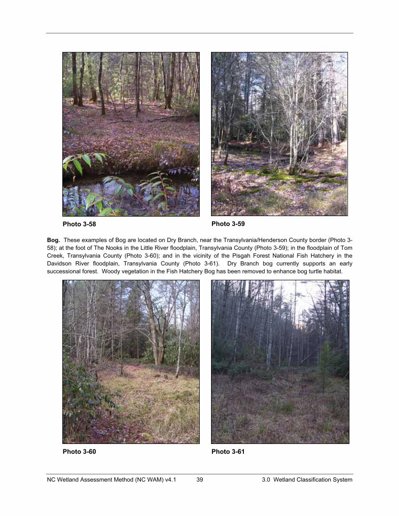
NC Wetland Assessment Method (NC WAM) v4.1 39 3.0 Wetland Classification System
Bog. These examples of Bog are located on Dry Branch, near the Transylvania/Henderson County border (Photo 3-58); at the foot of The Nooks in the Little River floodplain, Transylvania County (Photo 3-59); in the floodplain of Tom Creek, Transylvania County (Photo 3-60); and in the vicinity of the Pisgah Forest National Fish Hatchery in the Davidson River floodplain, Transylvania County (Photo 3-61). Dry Branch bog currently supports an early successional forest. Woody vegetation in the Fish Hatchery Bog has been removed to enhance bog turtle habitat.
Photo 3-58 Photo 3-59
Photo 3-60 Photo 3-61

NC Wetland Assessment Method (NC WAM) v4.1 40 3.0 Wetland Classification System
3.1.13 Non-Tidal Freshwater Marsh Non-Tidal Freshwater Marshes are found throughout the state in geomorphic floodplains, in natural topographic crenulations, or contiguous with open waters 20 acres or larger (Cowardin et al. 1979). These wetlands are subject to semi-permanent inundation or saturation, but are typically not subject to regular or occasional flooding by tides, including wind tides (regardless of whether or not the tidal waters reach wetlands through natural or artificial watercourses). Non-Tidal Freshwater Marshes occur on mineral or organic soils. Vegetation within this wetland type is predominantly herbaceous (less than 50 percent coverage by living woody species).
Due to the transitional nature of this wetland type, reference wetlands are not available for this type (see Section 3.2). Since this general wetland type has no reference, the condition of Non-Tidal Freshwater Marshes may be difficult for an assessor to discern. Indicators of condition degradation within this wetland type may include dead vegetation, ditching, spoil piles, reduced size, lack of vegetation diversity, and presence of invasive species. The size of these marshes varies depending on landscape position from very small to rarely 50 acres or more. Non-Tidal Freshwater Marsh can transition to other riparian wetlands such as Bottomland Hardwood Forest, Riverine Swamp Forest, and Headwater Forest.
Non-Tidal Freshwater Marshes may occur naturally along the fringes of streams, rivers, and large open waters, whether man-made or natural (example: beaver impoundments). These wetlands also commonly occur in association with regularly disturbed areas (maintained utility-line corridors) in the aforementioned landscape positions. Other wetland types with similar hydroperiods (Riverine Swamp Forest, Non-Riverine Swamp Forest, Bog, Seep) may acquire marsh-like vegetation due to disturbance (examples: fire or clear-cuts). However, when identifying the wetland type, an assessor will need to determine whether the full range of stable, existing wetland parameters better resemble Non-Tidal Freshwater Marsh or another wetland type that existed prior to disturbance. Freshwater marshes found outside of geomorphic floodplains or natural topographic crenulations and contiguous with small (less than 20 acres) open waters are considered Basin Wetlands. Localized depressions that are dominated by woody vegetation and located within geomorphic floodplains or adjacent to tributaries are considered Floodplain Pools.
Non-Tidal Freshwater Marsh includes NCNHP types Piedmont/Mountain Semipermanent Impoundment (part), Coastal Plain Semipermanent Impoundment (part), and Natural Lake Shoreline (part). This type is included in the NCDCM wetland type of Freshwater Marsh. Non-Tidal Freshwater Marsh corresponds to HGM classes Riverine (sub-classes Headwater Complex, Beaver Impounded, and Human Impounded), Lacustrine Fringe (sub-classes Semipermanently Flooded and Reservoir), and Depression (sub-class Surface-connected). Appendix B provides a cross-reference of wetland types across three classification systems.
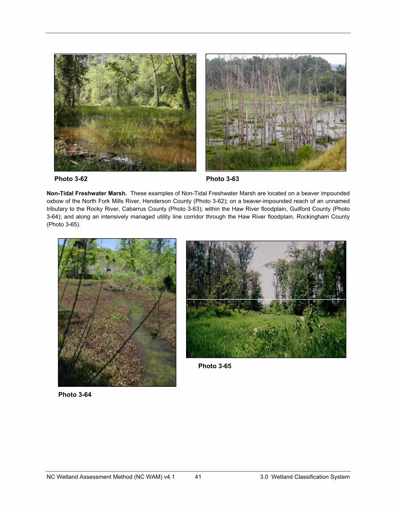
NC Wetland Assessment Method (NC WAM) v4.1 41 3.0 Wetland Classification System
Non-Tidal Freshwater Marsh. These examples of Non-Tidal Freshwater Marsh are located on a beaver impounded oxbow of the North Fork Mills River, Henderson County (Photo 3-62); on a beaver-impounded reach of an unnamed tributary to the Rocky River, Cabarrus County (Photo 3-63); within the Haw River floodplain, Guilford County (Photo 3-64); and along an intensively managed utility line corridor through the Haw River floodplain, Rockingham County (Photo 3-65).
Photo 3-62 Photo 3-63
Photo 3-64
Photo 3-65

NC Wetland Assessment Method (NC WAM) v4.1 42 3.0 Wetland Classification System
Non-Tidal Freshwater Marsh. These examples of Non-Tidal Freshwater Marsh are located on a man-impounded reach of an unnamed tributary to McPherson Creek, Cumberland County (Photo 3-66); in association with a beaver dam spillway on an unnamed tributary to Little River, Transylvania County (Photo 3-67); at the upper end of a man-made impoundment on Stewarts Creek, Hoke County (Photo 3-68); and in a beaver impoundment in the floodplain of Jimmy’s Creek, Davidson County (Photo 3-69).
Photo 3-66 Photo 3-67
Photo 3-68 Photo 3-69
NC Wetland Assessment Method (NC WAM) v4.1 43 3.0 Wetland Classification System
3.1.14 Floodplain Pool Floodplain Pools are found throughout the state in geomorphic floodplains. These wetlands often occur in abandoned stream or river channels (oxbows) or in localized depressions near the toe of slopes. They are generally small in size, typically occur on mineral soils, and are semi-permanently inundated. Sources of water are primarily ground water, precipitation, and sometimes overbank flooding. A distinctive feature of Floodplain Pools is that they usually dry out at some point of the year and thereby provide important habitat for amphibians due to the lack of fish communities. Trees characteristic of wetland and upland floodplains and levees are commonly found around the edge of the pool rather than growing within the pool. Vegetation within the pool can be sparse or variable with a variety of ferns, sedges, and other herbaceous plants present.
Reference wetlands (see Section 3.2) are available for this type. Floodplain Pool can transition to Bottomland Hardwood Forest, Riverine Swamp Forest, and Bog or may be surrounded by uplands. Relative to Riverine Swamp Forest, Floodplain Pools typically support vegetation only on the periphery and exist as local depressions. Floodplain Pools can be distinguished from Bogs by hydrology and soils. Floodplain Pools are characterized by semi-permanent inundation, while Bogs are characterized by long-duration saturation and little or no inundation. Floodplain Pools typically occur on mineral soils, while Bogs typically occur on organic or mucky mineral soils. Floodplain Pools near the outer boundary of geomorphic floodplains may transition to Seeps along the toe of the valley wall. As stated above, Floodplain Pools are generally small in size.
Floodplain Pool corresponds to the NCNHP type of Floodplain Pool. This wetland type is not separately identified within the NCDCM wetland classification system. Floodplain Pool corresponds to the HGM classes Riverine (sub-classes Headwater Complex, Intermittent-Upper Perennial, and Lower Perennial) and Depression (sub-class Surface-connected). Appendix B provides a cross-reference of wetland types across three classification systems.
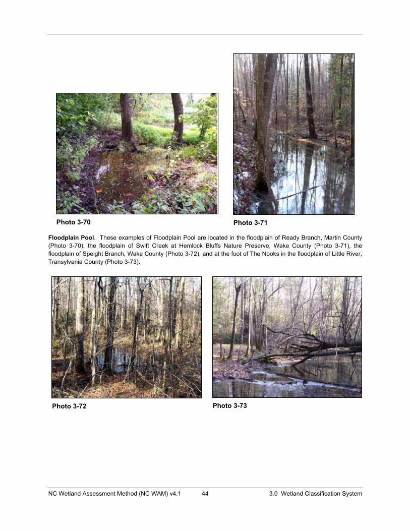
NC Wetland Assessment Method (NC WAM) v4.1 44 3.0 Wetland Classification System
Floodplain Pool. These examples of Floodplain Pool are located in the floodplain of Ready Branch, Martin County (Photo 3-70), the floodplain of Swift Creek at Hemlock Bluffs Nature Preserve, Wake County (Photo 3-71), the floodplain of Speight Branch, Wake County (Photo 3-72), and at the foot of The Nooks in the floodplain of Little River, Transylvania County (Photo 3-73).
Photo 3-70 Photo 3-71
Photo 3-72 Photo 3-73
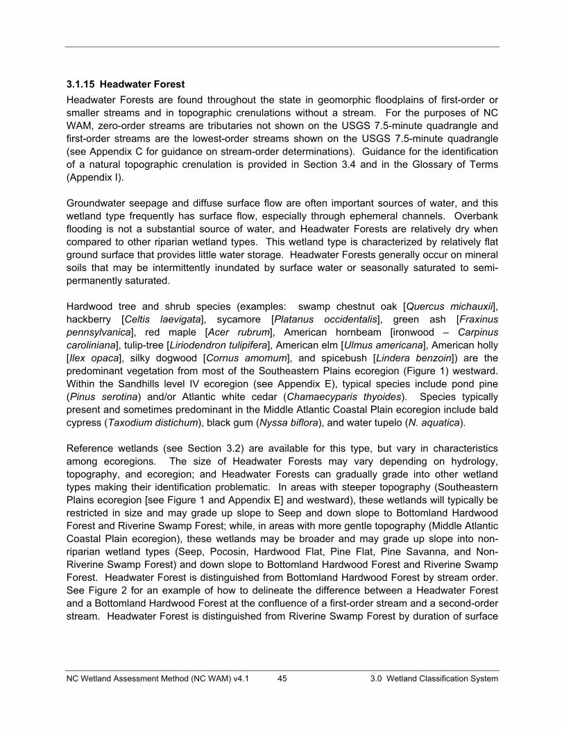
NC Wetland Assessment Method (NC WAM) v4.1 45 3.0 Wetland Classification System
3.1.15 Headwater Forest Headwater Forests are found throughout the state in geomorphic floodplains of first-order or smaller streams and in topographic crenulations without a stream. For the purposes of NC WAM, zero-order streams are tributaries not shown on the USGS 7.5-minute quadrangle and first-order streams are the lowest-order streams shown on the USGS 7.5-minute quadrangle (see Appendix C for guidance on stream-order determinations). Guidance for the identification of a natural topographic crenulation is provided in Section 3.4 and in the Glossary of Terms (Appendix I).
Groundwater seepage and diffuse surface flow are often important sources of water, and this wetland type frequently has surface flow, especially through ephemeral channels. Overbank flooding is not a substantial source of water, and Headwater Forests are relatively dry when compared to other riparian wetland types. This wetland type is characterized by relatively flat ground surface that provides little water storage. Headwater Forests generally occur on mineral soils that may be intermittently inundated by surface water or seasonally saturated to semi-permanently saturated.
Hardwood tree and shrub species (examples: swamp chestnut oak [Quercus michauxii], hackberry [Celtis laevigata], sycamore [Platanus occidentalis], green ash [Fraxinus pennsylvanica], red maple [Acer rubrum], American hornbeam [ironwood – Carpinuscaroliniana], tulip-tree [Liriodendron tulipifera], American elm [Ulmus americana], American holly [Ilex opaca], silky dogwood [Cornus amomum], and spicebush [Lindera benzoin]) are the predominant vegetation from most of the Southeastern Plains ecoregion (Figure 1) westward. Within the Sandhills level IV ecoregion (see Appendix E), typical species include pond pine (Pinus serotina) and/or Atlantic white cedar (Chamaecyparis thyoides). Species typically present and sometimes predominant in the Middle Atlantic Coastal Plain ecoregion include bald cypress (Taxodium distichum), black gum (Nyssa biflora), and water tupelo (N. aquatica).
Reference wetlands (see Section 3.2) are available for this type, but vary in characteristics among ecoregions. The size of Headwater Forests may vary depending on hydrology, topography, and ecoregion; and Headwater Forests can gradually grade into other wetland types making their identification problematic. In areas with steeper topography (Southeastern Plains ecoregion [see Figure 1 and Appendix E] and westward), these wetlands will typically be restricted in size and may grade up slope to Seep and down slope to Bottomland Hardwood Forest and Riverine Swamp Forest; while, in areas with more gentle topography (Middle Atlantic Coastal Plain ecoregion), these wetlands may be broader and may grade up slope into non-riparian wetland types (Seep, Pocosin, Hardwood Flat, Pine Flat, Pine Savanna, and Non-Riverine Swamp Forest) and down slope to Bottomland Hardwood Forest and Riverine Swamp Forest. Headwater Forest is distinguished from Bottomland Hardwood Forest by stream order. See Figure 2 for an example of how to delineate the difference between a Headwater Forest and a Bottomland Hardwood Forest at the confluence of a first-order stream and a second-order stream. Headwater Forest is distinguished from Riverine Swamp Forest by duration of surface
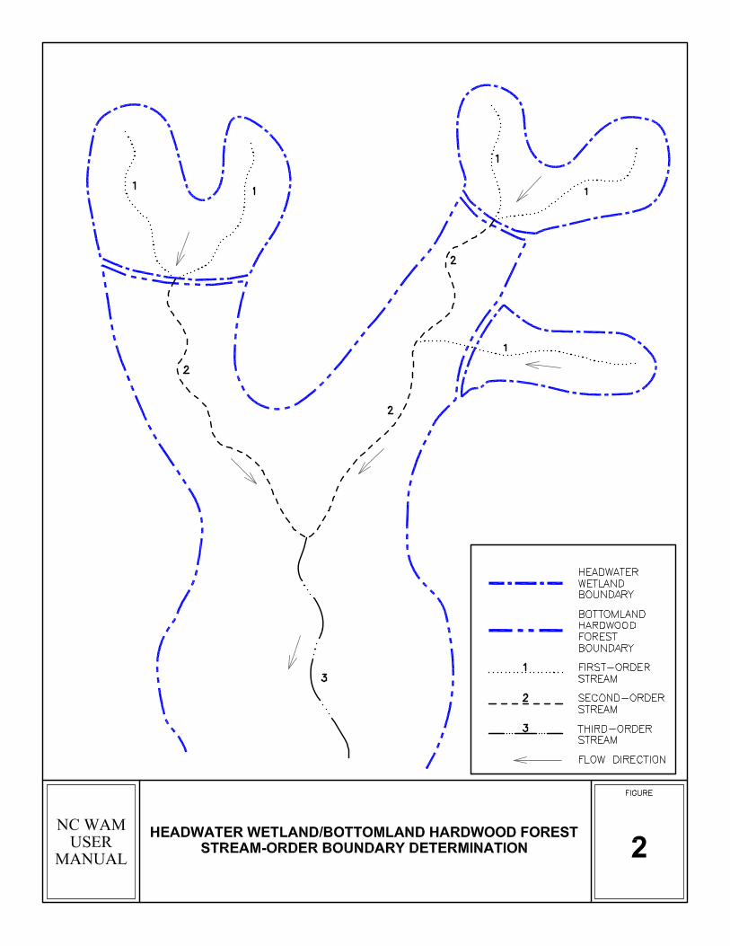
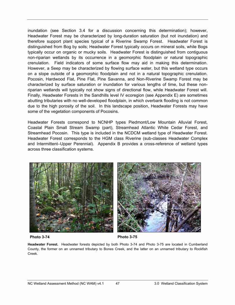
NC Wetland Assessment Method (NC WAM) v4.1 47 3.0 Wetland Classification System
inundation (see Section 3.4 for a discussion concerning this determination); however, Headwater Forest may be characterized by long-duration saturation (but not inundation) and therefore support plant species typical of a Riverine Swamp Forest. Headwater Forest is distinguished from Bog by soils; Headwater Forest typically occurs on mineral soils, while Bogs typically occur on organic or mucky soils. Headwater Forest is distinguished from contiguous non-riparian wetlands by its occurrence in a geomorphic floodplain or natural topographic crenulation. Field indicators of some surface flow may aid in making this determination. However, a Seep may be characterized by flowing surface water, but this wetland type occurs on a slope outside of a geomorphic floodplain and not in a natural topographic crenulation. Pocosin, Hardwood Flat, Pine Flat, Pine Savanna, and Non-Riverine Swamp Forest may be characterized by surface saturation or inundation for various lengths of time, but these non-riparian wetlands will typically not show signs of directional flow, while Headwater Forest will. Finally, Headwater Forests in the Sandhills level IV ecoregion (see Appendix E) are sometimes abutting tributaries with no well-developed floodplain, in which overbank flooding is not common due to the high porosity of the soil. In this landscape position, Headwater Forests may have some of the vegetation components of Pocosins.
Headwater Forests correspond to NCNHP types Piedmont/Low Mountain Alluvial Forest, Coastal Plain Small Stream Swamp (part), Streamhead Atlantic White Cedar Forest, and Streamhead Pocosin. This type is included in the NCDCM wetland type of Headwater Forest. Headwater Forest corresponds to the HGM class Riverine (sub-classes Headwater Complex and Intermittent–Upper Perennial). Appendix B provides a cross-reference of wetland types across three classification systems.
Headwater Forest. Headwater forests depicted by both Photo 3-74 and Photo 3-75 are located in Cumberland County, the former on an unnamed tributary to Bones Creek, and the latter on an unnamed tributary to Rockfish Creek.
Photo 3-74 Photo 3-75

NC Wetland Assessment Method (NC WAM) v4.1 48 3.0 Wetland Classification System
Headwater Forest. These examples of Headwater forest are located in upper Porter Creek, Beaufort County (Photo 3-76); a first-order unnamed tributary to the South Fork of the French Broad River, Transylvania County (Photo 3-77); a Headwater Forest located along a first-order unnamed tributary to Hominy Creek, Buncombe County (Photo 3-78) (this Headwater Forest occurs on a sediment delta at the head of a beaver impoundment on a first-order stream); and upslope of a Bog in the floodplain of Dry Branch, on the border of Transylvania and Henderson Counties (Photo 3-79).
Photo 3-76 Photo 3-77
Photo 3-78 Photo 3-79
NC Wetland Assessment Method (NC WAM) v4.1 49 3.0 Wetland Classification System
3.1.16 Bottomland Hardwood Forest Bottomland Hardwood Forests are found throughout the state in geomorphic floodplains of second-order and larger streams (see Appendix C for guidance on stream-order determinations). These wetlands are generally intermittently to seasonally inundated. Overbank flooding can be an important source of water as can groundwater and surface runoff. Overbank flooding may be less influential for Bottomland Hardwood Forests west of the Middle Atlantic Coastal Plain ecoregion (see Figure 1 and Appendix E). Bottomland Hardwood Forests along brownwater streams receive more sediment and nutrients from overbank flooding than those found along blackwater streams. This wetland type is generally characterized by ground surface relief that provides good water storage. Bottomland Hardwood Forests generally occur on mineral soils. This wetland type is dominated by a variety of hardwood tree species including various oaks (Quercus spp.), red maple (Acer rubrum), ashes (Fraxinus spp.), sycamore (Platanus occidentalis), sweetgum (Liquidambar styraciflua), box elder (Acernegundo), hackberry (Celtis laevigata), and American elm (Ulmus americana).
Reference wetlands (see Section 3.2) are available for Bottomland Hardwood Forest, but vary widely in character among different floodplain sizes and the various regions of the state. The size and extent of these wetlands are dependent on floodplain size and disturbance. While smaller-order streams will typically support narrower wetlands, these wetlands may be extensive along the length of the floodplain. Bottomland Hardwood Forest may contain Floodplain Pools and may transition up slope to Headwater Forest and down slope to Riverine Swamp Forest. In the Coastal Plain ecoregions, Bottomland Hardwood Forest often occurs in extensive mosaics with Riverine Swamp Forest. See Figure 2 for an example of how to delineate the difference between a Headwater Forest and a Bottomland Hardwood Forest at the confluence of a first-order stream and a second-order stream.
Bottomland Hardwood Forest correlates to the NCNHP types Coastal Plain Bottomland Hardwoods (Blackwater and Brownwater Subtypes), Coastal Plain Levee Forest (Blackwater and Brownwater Subtypes), Piedmont/Mountain Levee Forest, Piedmont/Mountain Bottomland Forest, Montane Alluvial Forest, and part of Piedmont/Low Mountain Alluvial Forest. Bottomland Hardwood Forest is included in the NCDCM wetland type of Bottomland Hardwood Forest. Bottomland Hardwood Forest corresponds to the HGM class Riverine (sub-classes Headwater Complex, Intermittent–Upper Perennial, and Lower Perennial). Appendix B provides a cross-reference of wetland types across three classification systems.

NC Wetland Assessment Method (NC WAM) v4.1 50 3.0 Wetland Classification System
Bottomland Hardwood Forest. Photos 3-80 and 3-81 are examples of Bottomland Hardwood Forest located in association with unnamed tributaries to the Cape Fear River, Cumberland County; Photo 3-82 is located in the Swift Creek floodplain, Wake County; and Photo 3-83 depicts the Little Creek floodplain at the headwaters of Jordan Lake, Durham County. Vegetation in Photo 3-82 is early secondary growth, while shrub and herb growth in Photo 3-83 is sparse due to extended surface inundation resulting from management of the area as a waterfowl impoundment.
Photo 3-80 Photo 3-81
Photo 3-82 Photo 3-83

NC Wetland Assessment Method (NC WAM) v4.1 51 3.0 Wetland Classification System
Bottomland Hardwood Forest. Photos 3-84 and 3-85 are more examples of Bottomland Hardwood Forest in Wake County. Photo 3-84 depicts a clear-cut portion of the Swift Creek floodplain, and Photo 3-85 depicts the outer edge of a floodplain on a greater than second order unnamed tributary of Little Branch. Photos 3-86 and 3-87 are examples of disturbed Bottomland Hardwood Forests located in Cumberland and Hoke County, respectively. Photo 3-86 depicts a wetland maintained as a utility line corridor abutting Rockfish Creek, and Photo 3-87 depicts an area abutting Horsepen Branch that was formerly inundated as part of a beaver impoundment.
Photo 3-84 Photo 3-85
Photo 3-86 Photo 3-87
NC Wetland Assessment Method (NC WAM) v4.1 52 3.0 Wetland Classification System
3.2 Wetlands and Reference An understanding of the concept of a reference wetland is crucial for the appropriate use of NC WAM. A reference wetland (or wetland in reference condition) is a discrete wetland identified as a typical, representative, or common example of that particular wetland type without, or removed in time from, substantial human disturbance.
For the purposes of NC WAM, the term “reference wetland” includes a range of biotic and abiotic characteristics within each recognized wetland type and is synonymous with “relatively undisturbed.” A reference wetland indicates quality along with the presence of expected functions for each general wetland type. An appropriate reference wetland needs to be comparable to the wetland being assessed, sometimes at a finer scale of resolution than the general wetland type. The reference wetland can thus serve to indicate what Hydrology, Water Quality, and Habitat functions the wetland under evaluation would have if it were unaltered.
3.2.1 Wetlands with Reference NC WAM considers reference wetlands to be available for all general wetland types with the exception of Pine Flat, Non-Tidal Freshwater Marsh, and some sub-types of Basin Wetland (see Section 3.1 for descriptions). Sub-types of Basin Wetland that are considered to have reference wetlands include mafic depressions and Carolina bays.
In order to properly utilize NC WAM, assessors will need to be familiar with the physiography, hydrologic regime, water quality function, typical vegetation structure and composition, and wildlife attributes for the range of reference examples in each general wetland type. Currently, the best source of information concerning the location of reference wetlands is NCNHP mapping, which documents the locations of natural communities of North Carolina. Communities documented on this map base have been identified according to Classification of the Natural Communities of North Carolina: Third Approximation (Schafale and Weakley 1990). These NCNHP wetland community designations are cross-referenced with NC WAM wetland types in the NC WAM wetland type descriptions (Section 3.1) and the wetland type cross-reference provided in Appendix B. A Geographic Information System (GIS) database (the NC WAM “Tool Box,” see Section 5.1.2) provides on-site information about wetlands evaluated with the use of NC WAM. One of the resources intended to be available with this product will be the location and identification of wetlands considered to be in reference condition. Additional information provided for each reference wetland contained within the NC WAM “Tool Box” will include associated site mapping (aerial photography, topographic mapping, soils mapping), completed Field Assessment Form, Wetland Rating Sheet, and on-site photographs.
Because some of the general wetland types are heterogeneous in certain characteristics, it may be necessary to choose a site-specific reference – one that matches the site under evaluation more precisely than merely belonging to the same general wetland type. One example is Bottomland Hardwood Forest. Reference wetlands for Bottomland Hardwood Forest might be quite different among ecoregions. For example, overbank flooding is often less influential for Bottomland Hardwood Forests west of the Middle Atlantic Coastal Plain ecoregion than those east of this ecoregion. Bottomland Hardwood Forests along brownwater streams receive more
NC Wetland Assessment Method (NC WAM) v4.1 53 3.0 Wetland Classification System
sediment and nutrients from overbank flooding than examples of this wetland type found along blackwater streams. Another example is Pocosin. The Pocosin general wetland type ranges widely in characteristics: from woodlands with substantial tree canopy on mucky mineral soils to nearly treeless shrub lands on deep peats. The appropriate site-specific reference for a Pocosin with mucky mineral soil is a relatively undisturbed Pocosin with mucky mineral soil, rather than one with deep peat. Absence of trees in the case of a Pocosin with mucky, deep, peat soil would not be considered a departure from reference.
For a few rare types, condition may need to be judged on its own merits against a conceptual reference condition synthesized from multiple altered remnants of the appropriate wetland type and literature review (examples: Pine Savanna and Seep). An important environmental factor for the maintenance of Pine Savanna is fire. Some Pine Savannas currently exist in areas subject to management with controlled burns, which maintains these wetlands in reference condition. Others exist in relatively undisturbed areas where fire is suppressed, resulting in a wetland type shift toward Pine Flat or Pocosin. The assessor will need to consider the true reference condition, characterized by regular fire events, when evaluating this wetland type. Seeps usually occupy small areas and can therefore be degraded by relatively local activities. Again, an assessor will need to consider the reference condition of an undisturbed seep in the appropriate landscape when evaluating this wetland type.
3.2.2 Wetlands without Reference Some wetlands will not have a usable reference. Pine Flat, Non-Tidal Freshwater Marsh, and some sub-types of Basin Wetland (for instance, freshwater marshes in man-made depressions) consist largely of successional wetlands for which a natural reference condition is not distinguishable. The same metrics are used by NC WAM to generate functional ratings for both wetlands with reference and wetlands without reference, so it is important that the assessor be knowledgeable concerning whether each general wetland type assessed can be evaluated relative to reference condition or not.
3.3 Intensively Managed Wetlands Although not a true general wetland type, wetlands that are “intensively managed” include any wetland that has been severely altered or unintentionally created by humans and is maintained in a severely altered state. Intensively managed wetlands have degraded wetland functions, but the sites remain jurisdictional wetlands. These areas may include, but are not limited to, farmed wetlands and mowed wetlands within utility-line corridors. Intensively managed wetlands correspond to the NCDCM wetland types of Managed Pinelands, Human Impacted Wetlands, and Cleared Wetlands – if still jurisdictional. If an assessor determines that a specific wetland is intensively managed, NC WAM requires that the assessor document this fact on the Field Assessment Form (see pp. ix to xii), then proceed to classify the wetland.
3.4 Key to General Wetland Types The initial step in the field application of NC WAM is to clearly identify the various wetland types found at the site to be evaluated. To this end, NC WAM uses the Dichotomous Key to General North Carolina Wetland Types (see pp. vii and viii) to assist assessors with identification.
NC Wetland Assessment Method (NC WAM) v4.1 54 3.0 Wetland Classification System
Assessors will need to be familiar with characteristics of the general wetland types in order to properly utilize the key.
Within the key text, an underlined “and” (and) indicates that two or more conditions must be met to continue on a particular branch of the key. An underlined “or” (or) indicates that any one of multiple conditions can be met to continue on a particular branch of the key.
It is important that the assessor walk the entire wetland area prior to making a determination as to the wetland type(s) present. If the assessor believes a wetland can reasonably fit into more than one wetland type, the assessor may find it helpful to generate a list of wetland characteristics that fit each of the potential wetland types, or the assessor may consider rating the wetland as each potential wetland type. With this information, the assessor may use best professional judgment to determine the appropriate wetland type. The assessor should always document the decision-making process. If there is evidence suggesting that the wetland is a type other than the keyed type, the assessor should document this evidence then classify the wetland as the evidenced type.
3.4.1 Wetland Type Identification in Disturbed Areas All wetlands should be evaluated in the context of landscape setting and recent history. Wetlands that have been subject to disturbance may be identified as degraded examples of general wetland types and/or as “intensively managed” wetlands on the Field Assessment Form. If identified as intensively managed, the subject wetland should still be identified as the appropriate general wetland type using the Dichotomous Key to General North Carolina Wetland Types.
The following rule will assist the assessor with the identification of wetland type in confusing, substantially modified, or disturbed situations.
Wetlands with alterations (man-made or natural) should generally be classified as the original, naturally occurring type if this determination can be made. However, if the full range of stable, existing, wetland parameters (vegetation, hydrology, and soils) better resembles another wetland type because of long-established, permanent alterations, it should be classified as this current, more appropriate type.
The first sentence of the rule will typically allow the assessor to determine the appropriate wetland type for a disturbed wetland. The term “alteration” refers to a modification to one or more of the three wetland parameters: vegetation, hydrology, and soils. Examples of alterations not expected to result in a change in wetland type include increased stormwater inputs and clear-cuts. If a wetland has been disturbed but appears to be in a stable condition and progressing toward recovery, then the assessor should use the key to identify the wetland type based on current conditions. If a portion of a wetland has been altered, the assessor may look to nearby wetlands for guidance in determining the appropriate wetland type. If a large area, or all of a wetland, type has been altered, the assessor may look at area mapping (aerial photography, topographic mapping, soils mapping, and the NC WAM Tool Box [see Section
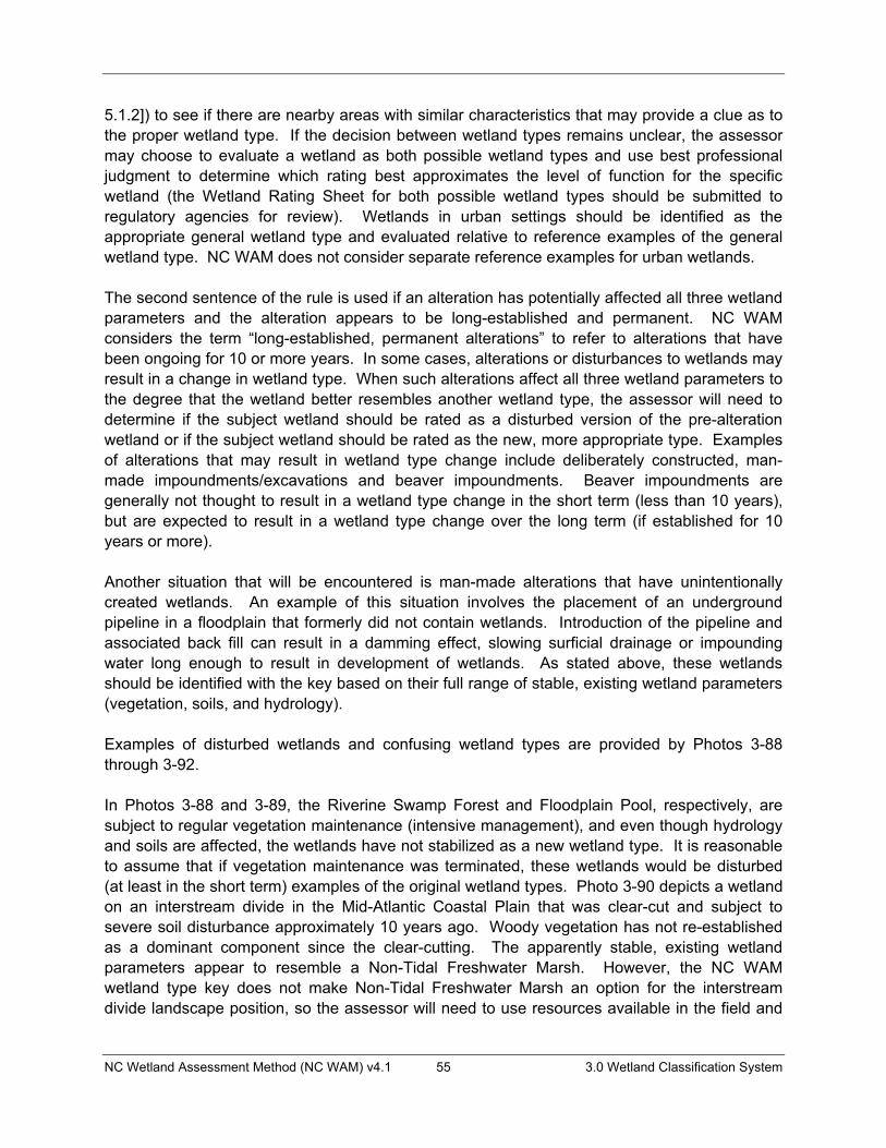
NC Wetland Assessment Method (NC WAM) v4.1 55 3.0 Wetland Classification System
5.1.2]) to see if there are nearby areas with similar characteristics that may provide a clue as to the proper wetland type. If the decision between wetland types remains unclear, the assessor may choose to evaluate a wetland as both possible wetland types and use best professional judgment to determine which rating best approximates the level of function for the specific wetland (the Wetland Rating Sheet for both possible wetland types should be submitted to regulatory agencies for review). Wetlands in urban settings should be identified as the appropriate general wetland type and evaluated relative to reference examples of the general wetland type. NC WAM does not consider separate reference examples for urban wetlands.
The second sentence of the rule is used if an alteration has potentially affected all three wetland parameters and the alteration appears to be long-established and permanent. NC WAM considers the term “long-established, permanent alterations” to refer to alterations that have been ongoing for 10 or more years. In some cases, alterations or disturbances to wetlands may result in a change in wetland type. When such alterations affect all three wetland parameters to the degree that the wetland better resembles another wetland type, the assessor will need to determine if the subject wetland should be rated as a disturbed version of the pre-alteration wetland or if the subject wetland should be rated as the new, more appropriate type. Examples of alterations that may result in wetland type change include deliberately constructed, man-made impoundments/excavations and beaver impoundments. Beaver impoundments are generally not thought to result in a wetland type change in the short term (less than 10 years), but are expected to result in a wetland type change over the long term (if established for 10 years or more).
Another situation that will be encountered is man-made alterations that have unintentionally created wetlands. An example of this situation involves the placement of an underground pipeline in a floodplain that formerly did not contain wetlands. Introduction of the pipeline and associated back fill can result in a damming effect, slowing surficial drainage or impounding water long enough to result in development of wetlands. As stated above, these wetlands should be identified with the key based on their full range of stable, existing wetland parameters (vegetation, soils, and hydrology).
Examples of disturbed wetlands and confusing wetland types are provided by Photos 3-88 through 3-92.
In Photos 3-88 and 3-89, the Riverine Swamp Forest and Floodplain Pool, respectively, are subject to regular vegetation maintenance (intensive management), and even though hydrology and soils are affected, the wetlands have not stabilized as a new wetland type. It is reasonable to assume that if vegetation maintenance was terminated, these wetlands would be disturbed (at least in the short term) examples of the original wetland types. Photo 3-90 depicts a wetland on an interstream divide in the Mid-Atlantic Coastal Plain that was clear-cut and subject to severe soil disturbance approximately 10 years ago. Woody vegetation has not re-established as a dominant component since the clear-cutting. The apparently stable, existing wetland parameters appear to resemble a Non-Tidal Freshwater Marsh. However, the NC WAM wetland type key does not make Non-Tidal Freshwater Marsh an option for the interstream divide landscape position, so the assessor will need to use resources available in the field and
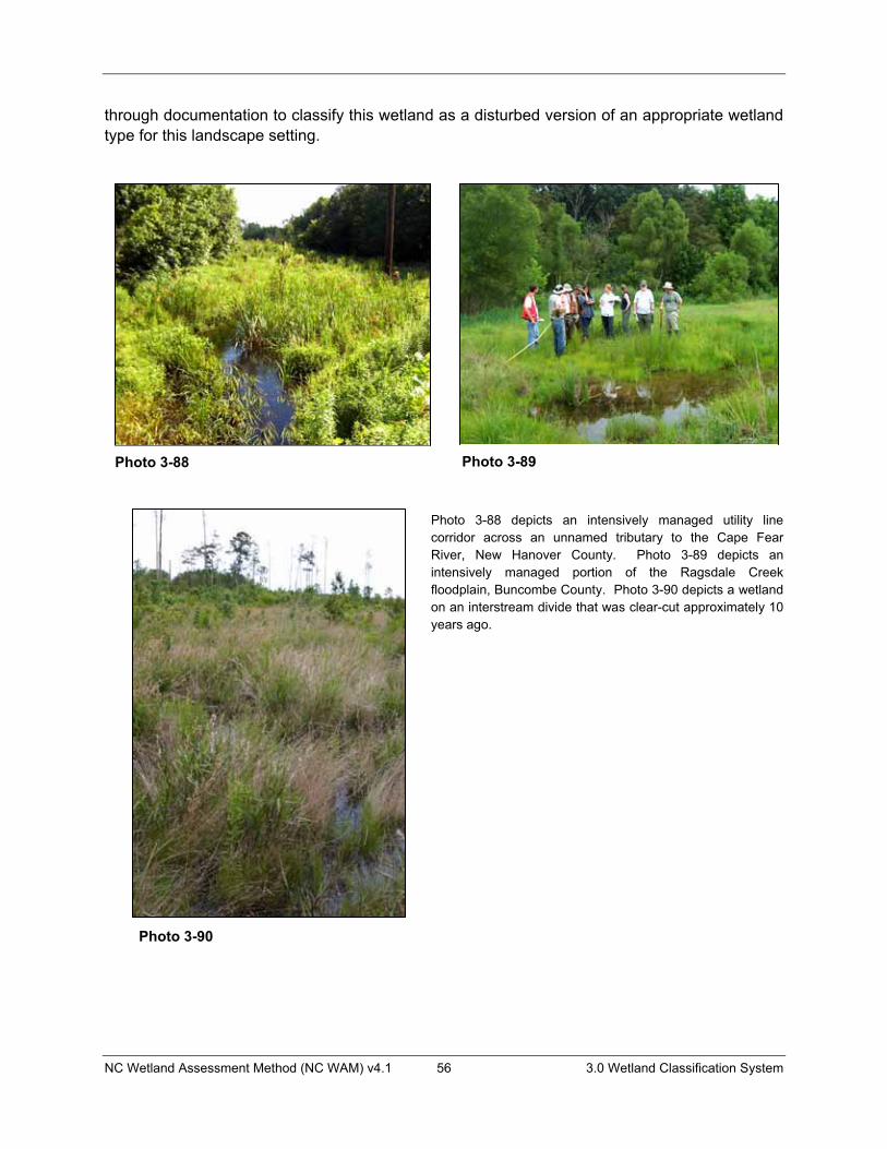
NC Wetland Assessment Method (NC WAM) v4.1 56 3.0 Wetland Classification System
through documentation to classify this wetland as a disturbed version of an appropriate wetland type for this landscape setting.
Photo 3-88 depicts an intensively managed utility line corridor across an unnamed tributary to the Cape Fear River, New Hanover County. Photo 3-89 depicts an intensively managed portion of the Ragsdale Creek floodplain, Buncombe County. Photo 3-90 depicts a wetland on an interstream divide that was clear-cut approximately 10 years ago.
Photo 3-88 Photo 3-89
Photo 3-90

NC Wetland Assessment Method (NC WAM) v4.1 57 3.0 Wetland Classification System
Photo 3-91 depicts a gas line corridor across the Haw River floodplain, Rockingham County. Photo 3-92 depicts post hurricane scour pools on Ocracoke Island, Hyde County.
Photos 3-91 and 3-92 depict wetlands that have been altered to the degree that the full range of stable, existing, wetland parameters now better resemble another wetland type because of long-established, permanent alterations. Photo 3-91 depicts a gas line corridor across the floodplain of the Haw River. The floodplain intersecting this gas line corridor supports Riverine Swamp Forest. The insertion of the gas line resulted in excavation of a trench for the pipe and then replacement of the soil in the trench, resulting in a severe alteration to soil structure and ground surface slumping along the pipe line corridor. This wetland is within a geomorphic floodplain, is not a Bog, and is dominated by herbaceous vegetation, which leads the assessor to Non-Tidal Freshwater Marsh in the dichotomous key (key location II.B.ii.1).
Photo 3-92 depicts scour depressions on the sound side of Ocracoke Island following the passage of Hurricane Isabel in 2004. These areas were likely not wetlands at all prior to the hurricane, but are now considered wetlands. These wetlands are on a coastal island; in depressions surrounded by uplands; are not dominated by dense, waxy shrub species and not characterized by a peat-filled bay, which leads the assessor to Basin Wetland in the dichotomous key (key location II.A.ii.2.b).
Photo 3-91 Photo 3-92

NC Wetland Assessment Method (NC WAM) v4.1 58 3.0 Wetland Classification System
3.4.2 Using the Dichotomous Key Following is a discussion of decision making points used in the key to general wetland types. For guidance on determining wetland types in disturbed areas, see Section 3.4.1. An example for identifying wetland types within a delineated wetland complex is provided in Section 5.2.3.
I. Wetland affected by lunar or wind tide, may include woody areas contiguous with tidal marsh
II. Wetland not affected by tides
The first decision separates wetlands in terms of tidal versus non-tidal influence. The question of tidal influence is exclusive of salinity. The term “tidal” typically refers to a situation in which the water level periodically fluctuates due to the action of lunar and solar forces upon the rotating earth (Environmental Laboratory 1987). “Wind tides” refer to surface water level fluctuations due to the action of wind on the water surface. NC WAM uses the term “tidal” for wetlands subject to surface waters flushing in and out due to tidal action. For the purposes of NC WAM, lakes 20 acres or larger (examples: Lake Phelps, Lake Waccamaw, Lake Mattamuskeet) may have sufficient fetch to be considered subject to wind tides. However, this characteristic may be more likely to occur on lakes in the Coastal Plain ecoregions that are characterized by extensive shallows along the rims, as opposed to lakes in the Piedmont and Blue Ridge ecoregions that are characterized by greater depths and steeper slopes along the rims. A wetland is considered to be subject to tides even when tidal waters reach the wetland through an artificial watercourse (such as a ditch, canal, or pipe through a berm).
I.A. Wetland affected, at least occasionally, by brackish or salt waterI.A.i. Dominated by herbaceous vegetation – Salt/Brackish MarshI.A.ii. Dominated by woody vegetation – Estuarine Woody Wetland
I.B. Wetland primarily affected by freshwater I.B.i. Dominated by herbaceous vegetation – Tidal Freshwater MarshI.B.ii Dominated by woody vegetation – Riverine Swamp Forest
This decision requests the assessor to determine whether or not a wetland is subject to saline waters at least occasionally. NC WAM considers brackish, estuarine, and salt water to be included in this category, which is defined by waters in which ocean-derived salts measure 0.5 parts per thousand or greater. In regards to Estuarine Woody Wetlands, “affected at least occasionally” may include being affected by saline waters due to aperiodic events such as storms (tropical cyclones, northeasters). The frequency of such aperiodic events must be sufficient for salinity to have an observable effect on community biology. Both Riverine Swamp Forest and Tidal Freshwater Marsh are considered to be affected by saline waters so infrequently that salinity has little to no effect on community biology. No map source has been established for this determination, so, in the absence of water chemistry data, the assessor will need to rely on site-specific evidence (such as plant species present) and best professional judgment. Some plant species common to this landscape position are intolerant of salt water (such as pond pine [Pinus serotina], bald cypress [Taxodium distichum], and gallberry [Ilex glabra and I. coriacea]) and may provide useful indicators in making this determination.

NC Wetland Assessment Method (NC WAM) v4.1 59 3.0 Wetland Classification System
The phrase “dominated by” refers to a biological, chemical, or physical feature that exerts a controlling influence on or defines the character of a community. For the purposes of NC WAM, only living vegetation is considered in the determination of wetland type, and vegetation dominance is determined by areal coverage (or “drip line” coverage) rather than number of stems. A wetland dominated by herbaceous vegetation is characterized by greater than 50 percent coverage of herbs and less than 50 percent coverage by living woody plants. A wetland dominated by woody vegetation is characterized by greater than 50 percent coverage of living woody vegetation, regardless of the percent coverage of herbs.
See Photos 3-93 through 3-96 for examples of the decision making involved in this portion of the key.
II.A. Not in a geomorphic floodplain or a natural topographic crenulation and not contiguous with an open water 20 acres or larger
II.B. In a geomorphic floodplain or a natural topographic crenulation or contiguous with an open water 20 acres or larger
This decision requires that the assessor make a landscape position determination, rather than a determination of whether or not the wetland is affected by riparian hydrology. The term “geomorphic” is intentionally used to avoid the need for the assessor to make a determination as to whether or not a floodplain is active. Geomorphic floodplain wetlands are those that occur on the floodplain between the toes of the valley walls. Wetlands on the slope above the toe of a valley wall do not meet this criterion. Geomorphic floodplain wetlands are considered to be riparian wetlands. NC WAM does not require that there be any sign of overbank flow, or even a channel, for a wetland to be considered a riparian system. For many floodplains, especially west of the Mid-Atlantic Coastal Plain ecoregion, overbank flooding may not be an important source of wetland hydrology.
A crenulation is a linear, topographic feature that is less defined than a channel or valley and may be characterized by “v”-shaped contour lines on topographic mapping. Topographic crenulations are typically smaller-scale, localized features as opposed to larger-scale, landscape-wide features. Field observations and/or detailed mapping are very important in determining the presence or absence of a topographic crenulation. A “natural” topographic crenulation excludes man-made features. Wetlands located within a natural topographic crenulation are considered to be riparian wetlands.
The best available information should be used by the assessor in the determination of the presence or absence of a geomorphic floodplain or natural topographic crenulation, as well as the extent of these features when present (examples: USGS 7.5-minute quadrangle, Light Detection and Ranging (LiDAR) mapping, best professional judgment based on on-site characteristics). Figures 3A and 3B depict the same landscape area and delineation boundaries on both a USGS 7.5-minute quadrangle background and a LiDAR terrain model background. Note that some delineated wetlands are located in the geomorphic floodplain or topographic crenulations, while some are located on the slope outside of the floodplain and topographic crenulations. In this case, wetlands located in the floodplain or in
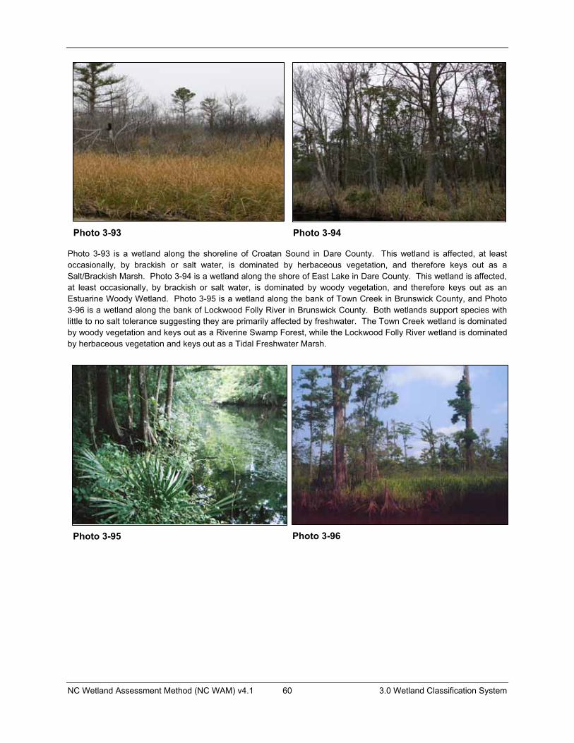
NC Wetland Assessment Method (NC WAM) v4.1 60 3.0 Wetland Classification System
Photo 3-93 is a wetland along the shoreline of Croatan Sound in Dare County. This wetland is affected, at least occasionally, by brackish or salt water, is dominated by herbaceous vegetation, and therefore keys out as a Salt/Brackish Marsh. Photo 3-94 is a wetland along the shore of East Lake in Dare County. This wetland is affected, at least occasionally, by brackish or salt water, is dominated by woody vegetation, and therefore keys out as an Estuarine Woody Wetland. Photo 3-95 is a wetland along the bank of Town Creek in Brunswick County, and Photo 3-96 is a wetland along the bank of Lockwood Folly River in Brunswick County. Both wetlands support species with little to no salt tolerance suggesting they are primarily affected by freshwater. The Town Creek wetland is dominated by woody vegetation and keys out as a Riverine Swamp Forest, while the Lockwood Folly River wetland is dominated by herbaceous vegetation and keys out as a Tidal Freshwater Marsh.
Photo 3-93 Photo 3-94
Photo 3-95 Photo 3-96
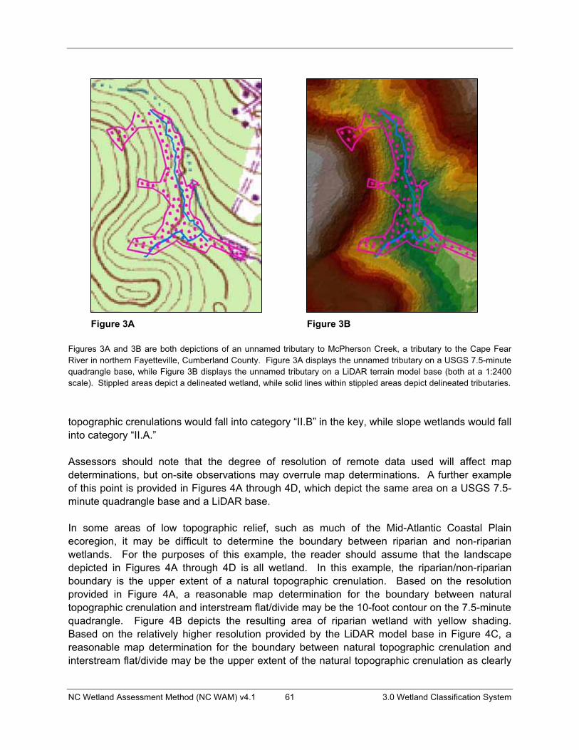
NC Wetland Assessment Method (NC WAM) v4.1 61 3.0 Wetland Classification System
Figures 3A and 3B are both depictions of an unnamed tributary to McPherson Creek, a tributary to the Cape Fear River in northern Fayetteville, Cumberland County. Figure 3A displays the unnamed tributary on a USGS 7.5-minute quadrangle base, while Figure 3B displays the unnamed tributary on a LiDAR terrain model base (both at a 1:2400 scale). Stippled areas depict a delineated wetland, while solid lines within stippled areas depict delineated tributaries.
topographic crenulations would fall into category “II.B” in the key, while slope wetlands would fall into category “II.A.”
Assessors should note that the degree of resolution of remote data used will affect map determinations, but on-site observations may overrule map determinations. A further example of this point is provided in Figures 4A through 4D, which depict the same area on a USGS 7.5-minute quadrangle base and a LiDAR base.
In some areas of low topographic relief, such as much of the Mid-Atlantic Coastal Plain ecoregion, it may be difficult to determine the boundary between riparian and non-riparian wetlands. For the purposes of this example, the reader should assume that the landscape depicted in Figures 4A through 4D is all wetland. In this example, the riparian/non-riparian boundary is the upper extent of a natural topographic crenulation. Based on the resolution provided in Figure 4A, a reasonable map determination for the boundary between natural topographic crenulation and interstream flat/divide may be the 10-foot contour on the 7.5-minute quadrangle. Figure 4B depicts the resulting area of riparian wetland with yellow shading. Based on the relatively higher resolution provided by the LiDAR model base in Figure 4C, a reasonable map determination for the boundary between natural topographic crenulation and interstream flat/divide may be the upper extent of the natural topographic crenulation as clearly
Figure 3A Figure 3B
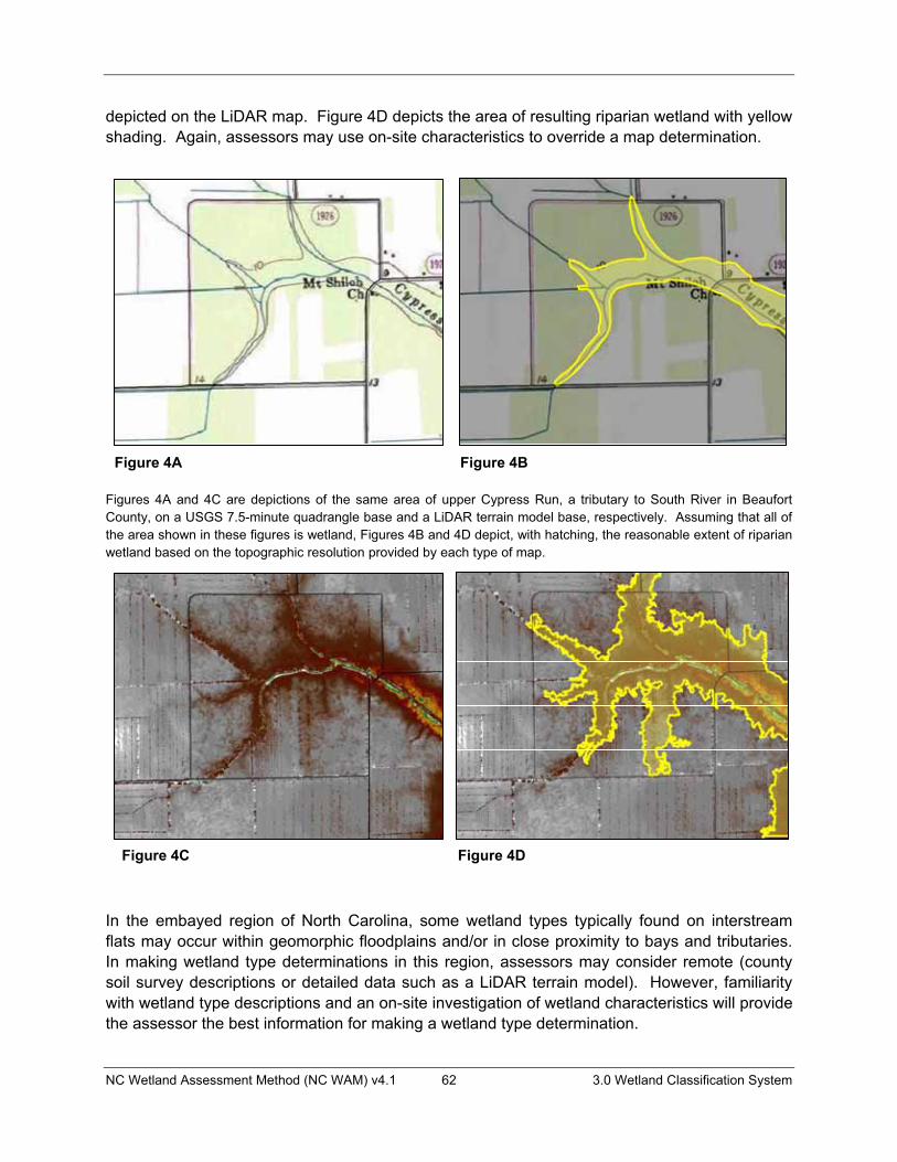
NC Wetland Assessment Method (NC WAM) v4.1 62 3.0 Wetland Classification System
depicted on the LiDAR map. Figure 4D depicts the area of resulting riparian wetland with yellow shading. Again, assessors may use on-site characteristics to override a map determination.
Figures 4A and 4C are depictions of the same area of upper Cypress Run, a tributary to South River in Beaufort County, on a USGS 7.5-minute quadrangle base and a LiDAR terrain model base, respectively. Assuming that all of the area shown in these figures is wetland, Figures 4B and 4D depict, with hatching, the reasonable extent of riparian wetland based on the topographic resolution provided by each type of map.
In the embayed region of North Carolina, some wetland types typically found on interstream flats may occur within geomorphic floodplains and/or in close proximity to bays and tributaries. In making wetland type determinations in this region, assessors may consider remote (county soil survey descriptions or detailed data such as a LiDAR terrain model). However, familiarity with wetland type descriptions and an on-site investigation of wetland characteristics will provide the assessor the best information for making a wetland type determination.
Figure 4A Figure 4B
Figure 4C Figure 4D
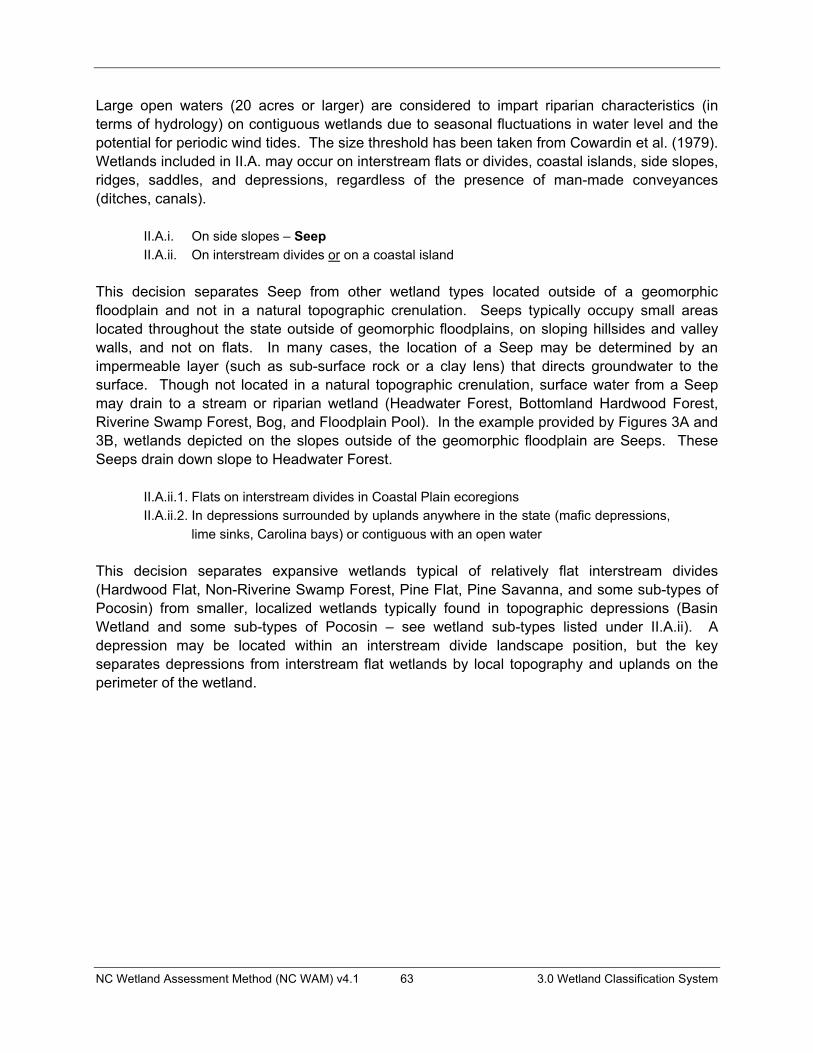
NC Wetland Assessment Method (NC WAM) v4.1 63 3.0 Wetland Classification System
Large open waters (20 acres or larger) are considered to impart riparian characteristics (in terms of hydrology) on contiguous wetlands due to seasonal fluctuations in water level and the potential for periodic wind tides. The size threshold has been taken from Cowardin et al. (1979). Wetlands included in II.A. may occur on interstream flats or divides, coastal islands, side slopes, ridges, saddles, and depressions, regardless of the presence of man-made conveyances (ditches, canals).
II.A.i. On side slopes – SeepII.A.ii. On interstream divides or on a coastal island
This decision separates Seep from other wetland types located outside of a geomorphic floodplain and not in a natural topographic crenulation. Seeps typically occupy small areas located throughout the state outside of geomorphic floodplains, on sloping hillsides and valley walls, and not on flats. In many cases, the location of a Seep may be determined by an impermeable layer (such as sub-surface rock or a clay lens) that directs groundwater to the surface. Though not located in a natural topographic crenulation, surface water from a Seep may drain to a stream or riparian wetland (Headwater Forest, Bottomland Hardwood Forest, Riverine Swamp Forest, Bog, and Floodplain Pool). In the example provided by Figures 3A and 3B, wetlands depicted on the slopes outside of the geomorphic floodplain are Seeps. These Seeps drain down slope to Headwater Forest.
II.A.ii.1. Flats on interstream divides in Coastal Plain ecoregions II.A.ii.2. In depressions surrounded by uplands anywhere in the state (mafic depressions,
lime sinks, Carolina bays) or contiguous with an open water
This decision separates expansive wetlands typical of relatively flat interstream divides (Hardwood Flat, Non-Riverine Swamp Forest, Pine Flat, Pine Savanna, and some sub-types of Pocosin) from smaller, localized wetlands typically found in topographic depressions (Basin Wetland and some sub-types of Pocosin – see wetland sub-types listed under II.A.ii). A depression may be located within an interstream divide landscape position, but the key separates depressions from interstream flat wetlands by local topography and uplands on the perimeter of the wetland.

NC Wetland Assessment Method (NC WAM) v4.1 64 3.0 Wetland Classification System
II.A.ii.1.a. Dominated by deciduous trees II.A.ii.1.a.i. Seasonally saturated to seasonally inundated (typically dominated by
sweetgum and oaks) – Hardwood FlatII.A.ii.1.a.ii. Seasonally to semi-permanently inundated (typically dominated by
cypress and black gum) – Non-Riverine Swamp ForestII.A.ii.1.b. Dominated by evergreens
II.A.ii.1.b.i. Dominated by dense, waxy shrub species (typically include gallberries, fetterbushes, honeycup, greenbriar); canopy may include pond pine, Atlantic white cedar, and bays – Pocosin
II.A.ii.1.b.ii. Not dominated by dense, waxy shrub species II.A.ii.1.b.ii.1. Dominated by long-leaf or pond pine and wire grass – Pine
SavannaII.A.ii.1.b.ii.2. Dominated by loblolly or slash pines – Pine Flat
The phrase “dominated by” refers to a biological, chemical, or physical feature that exerts a controlling influence on or defines the character of a community. For the purposes of NC WAM, vegetation dominance is considered in terms of areal coverage (or “drip line” coverage) rather than number of stems. In order to determine dominance between deciduous and evergreen trees or types of shrub species, the assessor may choose to employ the “50/20 rule.” This is the recommended method for selecting dominant species from a plant community when quantitative data are available. The most abundant species (when ranked in descending order of abundance and cumulatively totaled) that exceed 50 percent of the total dominance measure for a given stratum, plus any additional species comprising 20 percent or more of the total dominance measure for that stratum, are considered dominant species for the stratum (USFWS et al. 1989).
A wetland subject to seasonal to semi-permanent inundation (Non-Riverine Swamp Forest) will be characterized by prominent surface water indicators. Specific evidence of this hydrology includes visual observation of long- to very long-duration inundation (ponding or flooding), presence of emergent vegetation, absence of ground cover in combination with prominent water marks on fixed objects, muck surface layer in combination with prominent surface water indicators, hydrogen sulfide odor, water-stained leaves that are grayish or blackish in color, algal mat or crust, surface soil cracks, presence of aquatic fauna, moss trim lines, and redoximorphic features not masked by organic material. A wetland subject to seasonal saturation to seasonal inundation (Hardwood Flat) may be characterized by less prominent evidence of the above-referenced indicators or may lack the above-referenced indicators. Vegetation composition may also be helpful in separating Non-Riverine Swamp Forest from Hardwood Flat (see Schafale and Weakley 1990). Non-Riverine Swamp Forest is often dominated by bald cypress (Taxodium distichum), black gum (Nyssa biflora), loblolly pine (Pinustaeda), Atlantic white cedar (Chamaecyperis thyoides), pond pine (P. serotina), tulip poplar (Liriodendron tulipifera), and red maple (Acer rubrum). The understory may vary from open to dense and include sweet bay (Magnolia virginiana), red bay (Persea palustris), ti-ti (Cyrilla racemiflora), fetter-bush (Lyonia lucida), and sweet pepperbush (Clethera alnifolia). Hardwood Flat is often dominated by hardwood tree species typical of bottomlands such as swamp chestnut oak (Quercus michauxii), laurel oak (Q. laurifolia), cherrybark oak (Q. pagoda), tulip

NC Wetland Assessment Method (NC WAM) v4.1 65 3.0 Wetland Classification System
poplar (Liriodendron tulipifera), sweetgum (Liquidambar styraciflua), American elm (Ulmus americana), red maple (Acer rubrum), and black gum. The understory may include ironwood (Carpinus caroliniana), red maple, American holly (Ilex opaca), and pawpaw (Asimina triloba).
II.A.ii.2.a. Dominated by dense, waxy shrub species (typically include gallberries, fetterbushes, honeycup, greenbriar); canopy may include pond pine, Atlantic white cedar, and bays and not characterized by clay-based soils – Pocosin
II.A.ii.2.b. Not dominated by dense, waxy shrub species and not characterized by a peat-filled bay –Basin Wetland
This decision effectively separates two general wetland types that both have many possible forms. This form of Pocosin includes Carolina bay wetlands, which may vary from tall, vertically stratified pond pine woodlands, to tall, less well stratified high pocosin, to a short pocosin with little stratification. Carolina bay wetlands may or may not contain open water. Basin Wetlands include lime sink ponds, mafic depressions, and open waters less than 20 acres in size.
II.B.i. Northern Inner Piedmont or Blue Ridge ecoregions and dense herbaceous or mixed shrub/herbaceous vegetation with characteristic bog species (see wetland type description), with or without tree canopy; at least semi-permanent saturation; typically on organic or mucky soils; sphagnum moss commonly present – Bog
II.B.ii. Anywhere in the state and not Bog
This decision separates Bog from all other riparian wetland types. See the general wetland type description (Section 3.1.12) for more detailed characteristics used to identify the Bog wetland type.
II.B.ii.1. Dominated by herbaceous vegetation. At least semi-permanently inundated or saturated. Includes lacustrine and riparian fringe and beaver ponds with dense herbaceous vegetation; sphagnum moss scarce or absent – Non-TidalFreshwater Marsh
II.B.ii.2. Dominated by woody vegetation. Trees may be present on edges or hummocks.
This decision separates Non-Tidal Freshwater Marsh from all other riverine wetland types (with the exception of Bog). The phrase “dominated by” refers to a biological, chemical, or physical feature that exerts a controlling influence on or defines the character of a community. For the purposes of NC WAM, vegetation dominance is considered in terms of areal coverage, or “drip line” coverage (rather than number of stems) of “living” vegetation in the air space over the wetland (though the plants may be rooted outside of the wetland type) as well as vegetation growing within the wetland. A small Floodplain Pool may not support woody vegetation within its boundaries, but may still be dominated by woody vegetation from the floodplain forest. If the site was a riparian forested community that has been affected by a beaver impoundment, the assessor needs to decide if the full range of current stable, existing wetland parameters (vegetation, hydrology, and soils) better resemble a marsh or a forested wetland. If the
NC Wetland Assessment Method (NC WAM) v4.1 66 3.0 Wetland Classification System
assessor is in doubt as to the keyed wetland type, the site should be rated as each likely wetland type.
II.B.ii.2.a. Localized depression; semi-permanently inundated – Floodplain PoolII.B.ii.2.b Not “a”
A localized depression will likely not have a regular surface water connection to another wetland type. Examples of this are oxbows, floodplain backwaters along the toe of valley walls, and tree tip depressions. Localized depressions contiguous with other wetland types (possibly Bottomland Hardwood Forest or Riverine Swamp Forest) may often be considered a component of the contiguous wetland type.
II.B.ii.2.b.i. Less than second-order stream or in a natural topographic crenulation. Diffuse surface flow and groundwater more important than overbank flooding.
II.B.ii.2.b.i.1 Seasonally to semi-permanently saturated and/or only Intermittently inundated – Headwater Forest
II.B.ii.2.b.i.2. Seasonally to semi-permanently inundated – Riverine Swamp ForestII.B.ii.2.b.ii. Second-order or greater stream or contiguous with an open water 20 acres
or larger I.B.ii.2.b.ii.1. Intermittently to seasonally inundated (may be dominated by
sweetgum, ash, sycamore, and oaks) – Bottomland Hardwood Forest
I.B.ii.2.b.ii.2. Seasonally to semi-permanently inundated (may be dominated by cypress and black gums in Coastal Plain and ash, overcup oak, and elms in Piedmont and Mountains) – Riverine Swamp Forest
To determine stream order, an assessor needs to consider the following: 1) is the assessment area within the geomorphic floodplain of a tributary or contiguous with a natural tributary; 2) if so, is the tributary depicted on a 7.5-minute topographic quadrangle, and 3) in what ecoregion is the assessment area located. Appendix C contains two schematic diagrams to assist the assessor with understanding how to determine stream order.
The term “tributary” refers to an open conduit, either naturally or artificially created, that periodically or continuously contains moving water (examples: river, stream, ditch, canal, inter-dune swale connected to surface waters). For the purposes of NC WAM, the term “tributary” implies federal and/or state jurisdictional status. A “natural” tributary excludes man-made features (ditches, canals) outside of a natural topographic crenulation, even when man-made features appear to have “naturalized.”
In most of the state, stream order should be determined by consulting blue lines on the USGS 7.5-minute quadrangle (see Appendix C, Figure C1 for an example). Wetlands in the geomorphic floodplain of a less than second-order stream or in a natural topographic crenulation fall under II.B.ii.2.b.i in the dichotomous key. When the less than second-order stream or natural topographic crenulation crosses into the geomorphic floodplain of a second-

NC Wetland Assessment Method (NC WAM) v4.1 67 3.0 Wetland Classification System
order or larger stream, the wetlands will fall under II.B.ii.2.b.ii in the dichotomous key. See Figure 2 for a depiction of this example.
For sites in the Coastal Plain ecoregions, the assessor should not incorporate blue lines in the determination of stream order when the blue lines occur outside of a natural topographic crenulation as depicted on a 7.5-minute topographic quadrangle. Blue lines outside of the natural topographic crenulation (if tributaries) are either zero-order streams or man-made ditches or canals. In the example provided in Appendix C, Figure C2 (taken from a 7.5-minute topographic quadrangle), only the blue lines depicted within the 10-foot contour should be considered when determining stream order. Based on this perspective, the confluence of first-order streams in the middle of the figure view and below the number “10” forms the second-order stream, Cypress Run. Another first-order stream joins the main branch just upstream of Mt. Shiloh Church, but Cypress Run remains a second-order stream as it passes to the right out of the figure view.
Wetland hydrology terms are derived from Cowardin et al. (1979). Headwater Forest situated high in the landscape or characterized by coarse substrate may be subject to seasonal saturation without evidence of surface inundation. Both remote and on-site evidence may be used in making the determination between “intermittently to seasonally inundated” and “seasonally to semi-permanently inundated;” however, on-site evidence is preferred. Remote sources may include county soil surveys, USFWS NWI mapping, and site-specific documentation. Aside from long-term, recorded hydrology data, on-site observations are not always conclusive (especially when access to the site is limited); even so, evidence useful in making this determination includes (but is not limited to) presence of hydric soil indicators; wetland indicator status of dominant vegetation; and presence of wetland hydrology indicators (observation of inundation, watermarks, drift deposits, sediment deposits, drainage patterns within wetlands, and water-stained leaves).
A wetland subject to seasonal to semi-permanent inundation (Riverine Swamp Forest) will be characterized by prominent surface water indicators. Specific evidence of this hydrology includes visual observation of long- to very long-duration inundation (ponding or flooding), presence of emergent vegetation, absence of ground cover in combination with prominent water marks on fixed objects, muck surface layer in combination with prominent surface water indicators, hydrogen sulfide odor, water-stained leaves that are grayish or blackish in color, algal mat or crust, surface soil cracks, presence of aquatic fauna, moss trim lines, and redoximorphic features not masked by organic material. A wetland subject to intermittent to seasonal inundation (Headwater Forest) will typically lack the above-referenced indicators but may be characterized by water marks, drift deposits, drainage patterns, and sediment deposits.
NC Wetland Assessment Method (NC WAM) v4.1 68 4.0 Wetland Assessment Metrics
4.0 FUNCTIONAL ASSESSMENT METRICS
4.1 Introduction to Metrics NC WAM assesses wetland condition as an alternative to direct assessment of wetland function. Wetland condition can be observed, and is more readily assessed than wetland function, which must be measured or inferred. The method of determining the condition and opportunity of a specific wetland is to answer a series of questions or metrics concerning 1) the observable condition of the wetland and 2) the opportunity for potential enhancement of wetland functions due to disturbance in the watershed draining to the wetland. A list of metrics specific to each general wetland type was generated by the WFAT. Metrics corresponding to wetland types with a reference standard are designed to assess the departure of wetland condition from the reference standard. All metrics for all wetland types were field tested and revised at multiple test sites representing various levels of disturbance, from relatively pristine to intensively managed. Following initial field testing, state and federal agency personnel participated in beta-testing exercises across the state concerning the applicability of metrics for all general wetland types. Beta testing included a classroom explanation of the method, field exercises, and a provision for comments by beta testers regarding the draft method. Following beta testing, metrics for each of the general wetland types were finalized.
The comprehensive metric list for all general wetland types includes 63 individual metrics. For the purpose of generating a single, relatively concise field metric evaluation form, the original 63 metrics were separated into component parts, reorganized, and condensed into the 22 “condensed” metrics (hereafter referred to as metrics) now presented on the Field Assessment Form (see pp. ix to xii). On the Field Assessment Form, each metric is presented in the form of a multiple-choice question. The selected answers, or “descriptors,” are then used by the NC WAM Rating Calculator (computer program) to determine wetland functional ratings.
4.2 Metric Evaluation Areas Each metric requests the assessor to evaluate field indicators within one or more specific areas. The title line for each metric on the Field Assessment Form indicates the area(s) of consideration for that metric. Five different areas may be considered: 1) assessment area, 2) wetland type, 3) forested wetland, 4) wetland complex, and 5) landscape patch. Figure 5 is referred to for illustrations of these areas in the following discussion.
4.2.1 Assessment Area The assessment area is the defined area of a wetland type subject to the functional evaluation. Depending on circumstances, assessment area boundaries may be formed by one or more of the following.
� The limits of a proposed activity � The limit of a single wetland type within the footprint of a proposed activity � All uplands � The extent of a wetland type with a homogeneous set of characteristics within the
footprint of a proposed activity
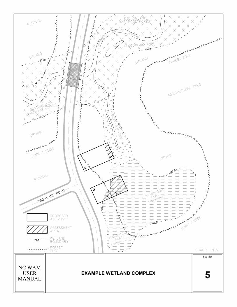
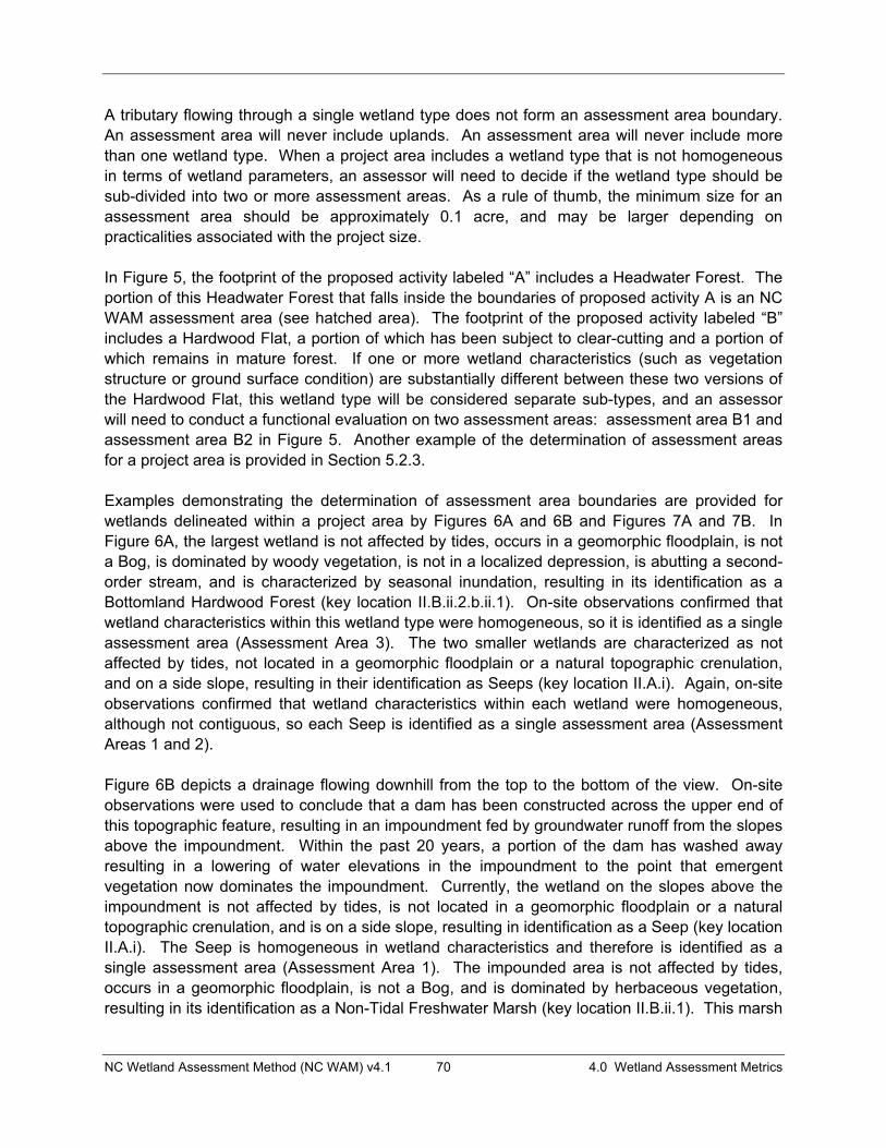
NC Wetland Assessment Method (NC WAM) v4.1 70 4.0 Wetland Assessment Metrics
A tributary flowing through a single wetland type does not form an assessment area boundary. An assessment area will never include uplands. An assessment area will never include more than one wetland type. When a project area includes a wetland type that is not homogeneous in terms of wetland parameters, an assessor will need to decide if the wetland type should be sub-divided into two or more assessment areas. As a rule of thumb, the minimum size for an assessment area should be approximately 0.1 acre, and may be larger depending on practicalities associated with the project size.
In Figure 5, the footprint of the proposed activity labeled “A” includes a Headwater Forest. The portion of this Headwater Forest that falls inside the boundaries of proposed activity A is an NC WAM assessment area (see hatched area). The footprint of the proposed activity labeled “B” includes a Hardwood Flat, a portion of which has been subject to clear-cutting and a portion of which remains in mature forest. If one or more wetland characteristics (such as vegetation structure or ground surface condition) are substantially different between these two versions of the Hardwood Flat, this wetland type will be considered separate sub-types, and an assessor will need to conduct a functional evaluation on two assessment areas: assessment area B1 and assessment area B2 in Figure 5. Another example of the determination of assessment areas for a project area is provided in Section 5.2.3.
Examples demonstrating the determination of assessment area boundaries are provided for wetlands delineated within a project area by Figures 6A and 6B and Figures 7A and 7B. In Figure 6A, the largest wetland is not affected by tides, occurs in a geomorphic floodplain, is not a Bog, is dominated by woody vegetation, is not in a localized depression, is abutting a second-order stream, and is characterized by seasonal inundation, resulting in its identification as a Bottomland Hardwood Forest (key location II.B.ii.2.b.ii.1). On-site observations confirmed that wetland characteristics within this wetland type were homogeneous, so it is identified as a single assessment area (Assessment Area 3). The two smaller wetlands are characterized as not affected by tides, not located in a geomorphic floodplain or a natural topographic crenulation, and on a side slope, resulting in their identification as Seeps (key location II.A.i). Again, on-site observations confirmed that wetland characteristics within each wetland were homogeneous, although not contiguous, so each Seep is identified as a single assessment area (Assessment Areas 1 and 2).
Figure 6B depicts a drainage flowing downhill from the top to the bottom of the view. On-site observations were used to conclude that a dam has been constructed across the upper end of this topographic feature, resulting in an impoundment fed by groundwater runoff from the slopes above the impoundment. Within the past 20 years, a portion of the dam has washed away resulting in a lowering of water elevations in the impoundment to the point that emergent vegetation now dominates the impoundment. Currently, the wetland on the slopes above the impoundment is not affected by tides, is not located in a geomorphic floodplain or a natural topographic crenulation, and is on a side slope, resulting in identification as a Seep (key location II.A.i). The Seep is homogeneous in wetland characteristics and therefore is identified as a single assessment area (Assessment Area 1). The impounded area is not affected by tides, occurs in a geomorphic floodplain, is not a Bog, and is dominated by herbaceous vegetation, resulting in its identification as a Non-Tidal Freshwater Marsh (key location II.B.ii.1). This marsh
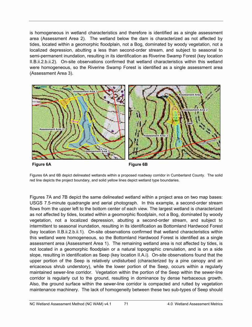
NC Wetland Assessment Method (NC WAM) v4.1 71 4.0 Wetland Assessment Metrics
is homogeneous in wetland characteristics and therefore is identified as a single assessment area (Assessment Area 2). The wetland below the dam is characterized as not affected by tides, located within a geomorphic floodplain, not a Bog, dominated by woody vegetation, not a localized depression, abutting a less than second-order stream, and subject to seasonal to semi-permanent inundation, resulting in its identification as Riverine Swamp Forest (key location II.B.ii.2.b.ii.2). On-site observations confirmed that wetland characteristics within this wetland were homogeneous, so the Riverine Swamp Forest is identified as a single assessment area (Assessment Area 3).
Figures 6A and 6B depict delineated wetlands within a proposed roadway corridor in Cumberland County. The solid red line depicts the project boundary, and solid yellow lines depict wetland type boundaries.
Figures 7A and 7B depict the same delineated wetland within a project area on two map bases: USGS 7.5-minute quadrangle and aerial photograph. In this example, a second-order stream flows from the upper left to the bottom center of each view. The largest wetland is characterized as not affected by tides, located within a geomorphic floodplain, not a Bog, dominated by woody vegetation, not a localized depression, abutting a second-order stream, and subject to intermittent to seasonal inundation, resulting in its identification as Bottomland Hardwood Forest (key location II.B.ii.2.b.ii.1). On-site observations confirmed that wetland characteristics within this wetland were homogeneous, so the Bottomland Hardwood Forest is identified as a single assessment area (Assessment Area 1). The remaining wetland area is not affected by tides, is not located in a geomorphic floodplain or a natural topographic crenulation, and is on a side slope, resulting in identification as Seep (key location II.A.i). On-site observations found that the upper portion of the Seep is relatively undisturbed (characterized by a pine canopy and an ericaceous shrub understory), while the lower portion of the Seep, occurs within a regularly maintained sewer-line corridor. Vegetation within the portion of the Seep within the sewer-line corridor is regularly cut to the ground, resulting in dominance by dense herbaceous growth. Also, the ground surface within the sewer-line corridor is compacted and rutted by vegetation maintenance machinery. The lack of homogeneity between these two sub-types of Seep should
Figure 6A Figure 6B
NC Wetland Assessment Method (NC WAM) v4.1 72 4.0 Wetland Assessment Metrics
result in an assessor sub-dividing this wetland type into two discrete assessment areas (Assessment Areas 2 and 3).
Figures 7A and 7B depict the same delineated wetlands within a proposed roadway corridor in Cumberland County on USGS 7.5-minute quadrangle and aerial photography bases. The solid red line depicts the project boundary, and solid yellow lines depict assessment area boundaries.
“Assessment area” metrics focus only on the field indicators evident in the assessment area. The characteristics of any portion of wetland outside of the assessment area should not be considered when evaluating assessment area metrics.
4.2.2 Wetland Type The wetland type is a wetland area comprised of one of the 16 NC WAM general wetland types, irrespective of the limits of any proposed activity. Wetland type boundaries are formed by the following.
� Another wetland type � A wetland/natural upland boundary � A man-made berm/causeway wider than that needed to support a two-lane road
A wetland type determination may be made based on general wetland type descriptions (see Section 3.1), with the use of the NC WAM Dichotomous Key to General North Carolina Wetland Types (see pp. vii and viii), or following guidelines provided for the identification of wetland types in disturbed areas (see Section 3.4.1). Man-made berms, supporting two-lane roads or narrower, are not boundaries for wetland type. Regarding the example provided in Figure 5 (p. 69), the two-lane road crossing the Bottomland Hardwood Forest is not wide enough to act as a boundary, so all of the Bottomland Hardwood Forest is considered a single wetland type. Similarly, in the example provided in Figure 14C (p. 115), a one-lane road crossing the Bottomland Hardwood Forest is not wide enough to act as a boundary, so all of the Bottomland
Figure 7A Figure 7B

NC Wetland Assessment Method (NC WAM) v4.1 73 4.0 Wetland Assessment Metrics
Hardwood Forest is considered a single wetland type. The maintained utility line corridor crossing the south arm of the Headwater Forest is not a wetland type boundary. The assessor should employ best professional judgment when interpreting this guidance. For instance, if a two-lane road is atop a tall causeway with a wide base resulting from the crossing of a floodplain with high valley walls, this road may be considered a wetland type boundary.
“Wetland type” metrics require the evaluation of field indicators evident throughout the entire wetland type. If wetland characteristics vary within the wetland type, the assessor will evaluate metrics based on the dominant field indicators. Using the example in Figure 5 (p. 69), a wetland type metric used in the functional evaluation of assessment area A will need to consider dominant field indicators of the entire Headwater Forest, not just the portion within the assessment area. Likewise, an assessor must determine and consider dominant field indicators for the entire Seep when evaluating wetland type metrics for the example provided by Figures 7A and 7B.
4.2.3 Forested Wetland The forested wetland may consist of one NC WAM general wetland type or an association of two or more contiguous NC WAM general wetland types. In general, a forested wetland is characterized by over 50 percent coverage of woody vegetation that is 10 feet or taller (modified from NCDEM 1995). For the purposes of NC WAM, a forested wetland type in reference condition always supports forest. NC WAM forested wetland types include Estuarine Woody Wetland (some forms), Riverine Swamp Forest, Seep, Hardwood Flat, Non-Riverine Swamp Forest, Pocosin (some forms), Pine Savanna (some forms), Pine Flat, Basin Wetlands (some forms), Bog (some forms), Floodplain Pool, Headwater Forest, and Bottomland Hardwood Forest. Forested wetland boundaries are based on perceived barriers to forested wetland-dependent wildlife movement and include the following.
� Natural uplands � Open water that extends across the entire width of a floodplain � A man-made berm/causeway the width of a four-lane road or wider � A forested wetland type that averages less than 10 feet in height and is the width of a
four-lane road or wider
The assessor should employ best professional judgment when interpreting this width guidance. For instance, if a two-lane road crossing a floodplain with high valley walls is atop a tall causeway with a wide base, this causeway/berm may constitute enough of a barrier to be considered a forested wetland boundary.
Regarding the example provided in Figure 5 (p. 69), all three wetland types displayed (Bottomland Hardwood Forest, Headwater Forest, and Hardwood Flat), with the exception of the clear-cut area, comprise the forested wetland. The road depicted is a two-lane road and is therefore not considered to be a forested wetland boundary. Regarding the example provided in Figure 14C (p. 115), the four-lane road is a boundary dividing forested wetlands. This figure also displays two forested wetlands, one on each side of the four-lane road. The maintained utility corridor is narrower than a four-lane road and does not create a forested wetland

NC Wetland Assessment Method (NC WAM) v4.1 74 4.0 Wetland Assessment Metrics
boundary. The forested wetland west (left of the four-lane road) includes only the Riverine Swamp Forest and not the Non-Tidal Freshwater Marsh.
“Forested wetland” metrics typically ask broad questions (such as general sizes and widths) and are not expected to require detailed information obtained in the field. These data are best determined from the examination of maps, which may be accomplished most efficiently in the office.
4.2.4 Wetland Complex A wetland complex may consist of one NC WAM general wetland type or an association of two or more contiguous NC WAM general wetland types. Wetland complex boundaries are based on perceived barriers to wetland-dependent wildlife movement and include the following.
� Natural uplands � Open water that extends across the entire width of a floodplain � A man-made berm/causeway the width of a four-lane road or wider
The assessor should employ best professional judgment when interpreting this width guidance. For instance, if a two-lane road crossing a floodplain with high valley walls is atop a tall causeway with a wide base, this causeway/berm may constitute enough of a barrier to be considered a wetland complex boundary.
Regarding the example provided in Figure 5 (p. 69), all three wetland types displayed (Bottomland Hardwood Forest, Headwater Forest, and Hardwood Flat) are considered to be part of a single wetland complex. The road depicted is a two-lane road and is therefore not considered to be a wetland complex boundary. Regarding the example provided in Figure 14C (p. 115), the four-lane road is a boundary dividing displayed wetlands into two complexes. This figure also displays two forested wetlands, one on each side of the four-lane road.
“Wetland complex” metrics typically ask broad questions (such as general sizes and widths) and are not expected to require detailed information obtained in the field. These data are best determined from the examination of maps, which may be accomplished most efficiently in the office.
4.2.5 Landscape Patch The landscape patch is the contiguous natural habitat that includes the assessment area irrespective of the watershed of the assessment area. “Landscape patch” is used in only one metric (Field Assessment Form Metric 13; see pp. xi and 98), which concerns the area of available habitat readily accessible from the assessment area. This metric defines landscape patch boundaries as follows.
� Four-lane roads � Regularly maintained utility-line corridors the width of a four-lane road or wider � Urban landscapes � Maintained fields (pasture and agriculture)
NC Wetland Assessment Method (NC WAM) v4.1 75 4.0 Wetland Assessment Metrics
� Open water greater than 300 feet wide
In the example given in Figure 5 (p. 69), all of the forested habitats are part of a landscape patch. Again, these data may be best determined from examining maps in the office.
4.3 Guidance for Completing the Field Assessment Form It is important that the assessor walk the entire assessment area prior to completing the Field Assessment Form (see pp. ix to xii). During this investigation, the assessor should make note of the presence of potential wetland stressors (such as roads, utility lines, maintained vegetation, septic fields, and stormwater runoff) and consider the effect of potential stressors on the subject wetland. The assessor should take notes liberally, documenting important site features and reasoning used in best professional judgment on the Field Assessment Form. A sketch map (or higher quality) indicating assessment area characteristics should be generated and attached to the completed Field Assessment Form.
4.3.1 Field Assessment Form Introductory Information The most current version of the Field Assessment Form as of the date of generation of this User Manual is provided as pp. ix to xii at the beginning of the User Manual. The box at the top of the first page requests general information concerning the setting, time, and assessor involved in the wetland assessment.
� Wetland Site Name – name used to identify the assessed wetland site � Wetland Type – based on use of the general wetland type key in combination with best
professional judgment � Level III Ecoregion – based on the ecoregion map provided in Appendix E � River Basin – name of river basin � Precipitation within 48 hours – indicate whether measurable rainfall has fallen within the
past 48 hours (http://water.weather.gov/precip/ for assistance) � Date – date of the field assessment � Assessor Name/Organization – name and affiliation (agency, company) of the party
responsible for the evaluation decisions � Nearest Named Water Body – name of the nearest named water body as indicated on
the USGS 7.5-minute quadrangle or other reliable resource � USGS 8-Digit Catalogue Unit – provide the 8-digit catalogue unit (available from USGS
1974 and NCDWQ basinwide management plans at the following web site - http://portal.ncdenr.org/web/wq/ps/bpu)
� Latitude/Longitude (deci-degrees) – coordinates in decimal degrees to six significant figures (example: 35.123456, -79.123456)
The section entitled “Evidence of stressors affecting the assessment area” is meant to prompt the assessor to consider the overall condition of the assessment area by looking for evidence of environmental stressors. Comments provided by the assessor will be used by resource agency personnel and are not directly involved in generating the assessment ratings. The term “consider departure from reference, if appropriate, in recent past” is intended to prompt the assessor to consider whether the vegetation appears to have been disturbed within
NC Wetland Assessment Method (NC WAM) v4.1 76 4.0 Wetland Assessment Metrics
approximately the past 10 years. The bulleted list provides examples of common disturbances that are generally considered to reduce wetland function. The assessor should record whether or not the assessed wetland is intensively managed. It is important that the assessor describe in writing the observed effects of stressors within an assessment area prior to completing the Field Assessment Form.
The section entitled “Regulatory Considerations” requests that the assessor acknowledge, by selecting the corresponding box(es), known issues that apply to the assessment area that are regulated by one or more federal, state, or local natural resource agencies.
� “Anadromous fish” – The assessor should select “Anadromous fish” if there are either direct observations or documentation of the presence of anadromous fish within the assessment area or within a tributary abutting the assessment area.
� “Federally protected species or State endangered or threatened species” – The assessor should select this box if there are either direct observations or documentation of the presence of these species within the assessment area. Sources for documentation include the U.S. Fish and Wildlife Service and the N.C. Natural Heritage Program.
� “NCDWQ riparian buffer rule in effect” – The assessor should select “Riparian buffer rule in affect” only if the N.C. Environmental Management Commission (EMC) has instituted buffer rules that apply to the assessment area (located on the web at http://portal.ncdenr.org/web/wq/swp/ws/401/riparianbuffers/rules).
� ”Abuts a Primary Nursery Area (PNA)” – Information concerning the identification and location of Primary Nursery Areas is available in 15A NCAC 03N 0.0104 and 15A NCAC 03R .0103, respectively. The assessor should use best professional judgment when considering if the distance between the assessment area and a designated PNA makes selection of this descriptor appropriate.
� “Publicly owned property” – Property ownership should always be established prior to an assessor making a site visit.
� “NCDCM Area of Environmental Concern (AEC) (including buffer)” – Communication with a NCDCM representative or familiarity with the most current version of the “CAMA Handbook for Development in Coastal North Carolina” (located on the web at http://dcm2.enr.state.nc.us/) will aid the assessor in determining whether the assessment area includes an AEC.
� “Abuts a tributary with a NCDWQ best usage classification of SA or supplemental classification of HQW, ORW, or Trout” – Surface water quality classifications and definitions for terms such as High Quality Waters (HQW), Outstanding Resource Waters (ORW), and Trout Waters (Trout) are available through NCDWQ stream classification schedules and other publications and can be found on-line at the following web site: http://h2o.enr.state.nc.us/bims/reports/reportsWB.html.
� “Designated NCNHP reference community” – Information concerning the location of NCNHP-designated reference communities is available through NCNHP publications such as county inventories and lists of Significant Natural Heritage Areas.
� “Abuts a 303(d)-listed stream or a tributary to a 303(d)-listed stream” – Information concerning the names of current 303(d)-listed streams is available through NCDWQ
NC Wetland Assessment Method (NC WAM) v4.1 77 4.0 Wetland Assessment Metrics
N.C. Water Quality Assessment and Impaired Waters list located at the following website: http://portal.ncdenr.org/web/wq/ps/mtu/assessment.
The type of natural stream is important information used by the Rating Calculator for riparian wetlands. Blackwater streams are streams that generally originate in the Coastal Plain ecoregions, contain negligible amounts to no sediment, are tannic in nature, and often flow through peat-based or sandy areas. Brownwater streams generally originate in the Piedmont or Blue Ridge ecoregions and sometimes contain high amounts of clay and silt and may be turbid and brown in color. The breakdown of source of tides is used to locate wetlands in the landscape. Acknowledging that a wetland occurs on a coastal island potentially prevents a lowering of wetland rating based on size when an assessment area is confined to an island. Acknowledgement that a wetland is affected by beaver provides additional information for consideration to assessment reviewers. Important terms are defined in the Glossary of Terms (Appendix I).
Whether or not a riparian wetland assessment area experiences overbank flow during normal rainfall conditions is important in determining the wetland’s function. Wetlands located abutting tributaries or other open waters may not necessarily be subject to overbank flow from those water bodies. The assessor is requested to use on-site evidence and best professional judgment to determine whether the assessment area is subject to overbank flow during normal rainfall conditions (see next paragraph for a discussion of “normal rainfall” conditions). Indicators of overbank events during normal rainfall conditions include recent sedimentation, waterlines, debris deposits, reclining vegetation, and gauge data. “Normal rainfall conditions” includes regular events such as nor’easters along the coast but is not considered to include severe, aperiodic events such as hurricanes or drought.
The U.S. Department of Agriculture (USDA), Natural Resources Conservation Service (NRCS), National Water and Climate Center provides, through its WETS tables, a normal range for monthly precipitation based on climate data collected through the National Weather Service Cooperative Network. These tables can be used in conjunction with recent rainfall data to determine if a specific site is characterized as being subject to “normal rainfall conditions” at the time of a functional assessment. The following description concerning the determination of whether a site is subject to normal rainfall conditions is taken from the Interim Regional Supplement to the Corps of Engineers Wetland Delineation Manual: Atlantic and Gulf Coastal Plain (USACE 2008).
Determine whether the amount of rainfall that occurred in the 2-3 months preceding the site visit was normal, above normal, or below normal based on the normal range reported in WETS tables. WETS tables are provided by the NRCS Water and Climate Center (http://www.wcc.nrcs.usda.gov/climate/wetlands.html) and are calculated from long-term (30-year) weather records gathered at National Weather Service meteorological stations. To determine whether precipitation was normal prior to the site visit, actual rainfall in the current month and previous 2-3 months should be compared with the normal ranges for each month given in the WETS table (USDA Natural Resources Conservation Service 1997, Sprecher and Warne 2000). The lower and

NC Wetland Assessment Method (NC WAM) v4.1 78 4.0 Wetland Assessment Metrics
upper limits of the normal range are indicated by the columns labeled “30% chance will have less than” and “30% chance will have more than” in the WETS table. The USDA Natural Resources Conservation Service (1997, Section 650.1903) also gives a procedure that can be used to weight the information from each month and determine whether the entire period was normal, wet, or dry.
4.3.2 Field Assessment Form Metrics The metric name, metric type, and metric scope are included on the metric title line. Consider metric number 1 (Metric 1) for example.
1. Ground Surface Condition/Vegetation Condition – assessment area condition metric
In this case, the assessor is to consider the assessment area when evaluating both the “ground surface condition” and “vegetation condition” components of this metric. This is a condition metric because the assessor uses it to evaluate the extent a wetland departs from full integrity with respect to these components. The metric scope will be indicated if the metric is only to be applied to certain wetland types (examples: evaluate for non-marsh wetlands only, evaluate for riparian wetlands only).
Each metric is composed of one or more questions. For each metric, the assessor is provided two or more possible answers or “descriptors.” Each descriptor is accompanied by a box. The evaluation of each metric will involve the selection of one or more descriptors by checking the appropriate boxes.
Each of the 22 metrics included on the Field Assessment Form follows, along with a clarifying discussion. The Field Assessment Form is included at the beginning of the User Manual (see pp. ix to xii).
1. Ground Surface Condition/Vegetation Condition – assessment area condition metric Check a box in each column. Consider alteration to the ground surface (GS) in the assessment area and vegetation structure (VS) in the assessment area. Compare to reference wetland if applicable (see User Manual). If a reference is not applicable, then rate the assessment area based on evidence of an effect. GS VS
A A Not severely altered B B Severely altered over a majority of the assessment area (ground surface alteration examples:
vehicle tracks, excessive sedimentation, fire-plow lanes, skidder tracks, bedding, fill, soil compaction, obvious pollutants) (vegetation structure alteration examples: mechanical disturbance, herbicides, salt intrusion [where appropriate], exotic species, grazing, reduced diversity [if appropriate], hydrologic alteration)
With regard to ground surface, the assessor should consider the assessment area when evaluating this metric and should check one box in the GS column. The ground surface component addresses the departure, or alteration, from reference of the ground surface condition. Departure from reference may include roughening of the ground surface in wetlands typically characterized by little microtopography such as Headwater Forest and Pine Savanna or leveling of the ground surface in wetlands typically characterized by more microtopography such as Pocosin and Bottomland Hardwood Forest. Examples of disturbance provided in the metric

NC Wetland Assessment Method (NC WAM) v4.1 79 4.0 Wetland Assessment Metrics
wording, when found in sufficient severity and with coverage of over 50 percent of the assessment area, are anticipated to degrade ground surface habitats enough to receive descriptor “B.” Evidence of local (not severe) disturbances such as small numbers of fire plow lanes or skidder trails, or shallow tire ruts are likely not sufficient evidence to receive descriptor “B.” Evidence that an area has previously been ditched but now the ditches have been partially back-filled (naturally or intentionally) is sufficient to rate a “B.” The metric is applicable to the Habitat function in all general wetland types and the Water Quality function in Non-tidal Freshwater Marsh, Seep, and Bog.
With regard to vegetation structure, the assessor should consider the assessment area when evaluating this metric and check a box in the VS column. The vegetation structure component addresses the departure, or alteration, from reference of the vegetation structure. The assessor should consider the following in terms of Habitat: are expected strata present, or has disturbance resulted in the elimination of one or more expected strata or the addition of one or more unexpected strata? Examples of disturbance are provided in metric wording. Vegetation removal may result in both an increase in surface storage capacity (due to surface roughening) and a reduction of water transport out of the wetland (evapotranspiration). This metric is applicable to the Habitat function in all wetland types and the Water Quality function in Seep and Bog.
The clear-cut Bottomland Hardwood Forest depicted by Photo 3-84 is characterized by descriptor “B” for both ground surface condition and vegetation condition. Descriptor “B” for vegetation condition is appropriate for the Bog being maintained (removal of woody vegetation) for the enhancement of bog turtle habitat depicted by Photo 3-61, the beaver-impacted Headwater Forest depicted by Photo 3-78, and the intensively managed (regularly mowed) Pocosin depicted by Photo 3-41.
If a wetland has undergone an alteration that has caused the full range of stable, existing wetland parameters to better resemble another wetland type, the wetland should be classified as the current, more appropriate type. In this case, the assessor needs to be careful when evaluating this metric. The assessor is now evaluating ground surface condition and vegetation condition relative to reference (if applicable) of the current wetland type, and not a potential former wetland type. For instance, if the assessment area is a former Bottomland Hardwood Forest that has been altered by a beaver impoundment so that the full range of stable, existing wetland parameters better resemble a Riverine Swamp Forest, the assessor needs to evaluate this metric relative to a reference Riverine Swamp Forest and not a reference Bottomland Hardwood Forest.
NC Wetland Assessment Method (NC WAM) v4.1 80 4.0 Wetland Assessment Metrics
2. Surface and Sub-Surface Storage Capacity and Duration – assessment area condition metric Check a box in each column. Consider surface storage capacity and duration (Surf) and sub-surface storage capacity and duration (Sub). Consider both increase and decrease in hydrology. Refer to the current NRCS lateral effect of ditching guidance for North Carolina hydric soils (see USACE Wilmington District website) for the zone of influence of ditches in hydric soils. A ditch � 1 foot deep is considered to affect surface water only, while a ditch > 1 foot deep is expected to affect both surface and sub-surface water. Consider tidal flooding regime, if applicable.
Surf Sub A A Water storage capacity and duration are not altered. B B Water storage capacity or duration are altered, but not substantially (typically, not sufficient to
change vegetation). C C Water storage capacity or duration is substantially altered (typically, alteration sufficient to result in
vegetation change) (examples: draining, flooding, soil compaction, filling, excessive sedimentation, underground utility lines).
This metric is a key to an accurate assessment because it is used in the evaluation of all three wetland functions. The assessor should consider the assessment area when evaluating this metric and should check one box in each column.
The surface storage capacity and duration component (Surf) is concerned with the departure, or alteration, from reference with respect to all three wetland functions in most general wetland types (the exception is Bottomland Hardwood Forest, where this metric is only used for the Habitat function). The assessor is asked to determine among the possibilities of no alteration, little alteration, or substantial alteration. The assessor should be able to determine visually if the ground surface has been disturbed enough to remove “A” as a possibility. Examples of alterations that may affect water storage capacity are provided in the metric wording. Please note that both an increase and a decrease in storage capacity are considered “alterations.” The severity of evidenced alterations will be used to determine between descriptors “B” and “C.” The condition and/or species composition of vegetation may provide assistance with the determination between “B” and a “C.”
In order for a ditch(es) to be considered effective, it must be connected to a tributary, or other external receiving water (i.e., water must be leaving the wetland via the ditch). If a ditch is not connected to external receiving waters, it will not be considered to be effective at draining the wetland. When the assessor encounters a ditch within or near the assessment area, several tools exist to assist with the challenging decision regarding a ditch’s zone of influence. These tools include groundwater monitoring data, scope and effect models, and drainage guides. It is very important to note that many ditches do not drain as far as suggested by such models or guides due to many site-specific factors including, but not limited to, variable soil textures and restrictive layers, compaction and damming effects of roads, berms, and other land disturbing activities, vegetation growth within the ditch bottom, bank sloughing and sedimentation, and the topographic setting of the ditch(es). A key indicator of the effective drainage depth of a ditch is the physical point where vegetation disappears along the side of the ditch. For example, the effective drainage of a 4-foot deep ditch exhibiting no vegetation to within 12 inches of the ground surface is equivalent to a ditch only one-foot deep. The assessor must also consider normal rainfall conditions when making this decision. An incised stream can have the same effect as a ditch by reducing wetland surface storage and retention. The cause of an alteration to assessment area surface storage capacity and duration does not necessarily have to be
NC Wetland Assessment Method (NC WAM) v4.1 81 4.0 Wetland Assessment Metrics
located within the assessment area. Again, making decisions relating to the zone of influence of a ditch is challenging, and the drainage effect is very often over estimated.
The sub-surface storage capacity and duration component (Sub) is concerned with the departure, or alteration, from reference with respect to the Hydrology and Water Quality functions. The assessor is again asked to determine among the possibilities of no alteration, little alteration, or substantial alteration. For the purposes of NC WAM, a ditch needs to exceed a foot in depth to be considered to degrade sub-surface wetland hydrology. The threshold of 1 foot for depth has been derived from the 1-foot threshold used by the USACE to determine presence of wetland hydrology (Environmental Laboratory 1987). In areas supporting histic epipedons or histisols, ditching must extend below the surface peat and into the subsoil to be considered to have an effect on sub-surface hydrology. The assessor should also consider departure from reference of sub-surface hydrology resulting from impoundment (such as surface berms, construction of underground utility lines, and beaver dams). Clear-cutting of wetlands may compact surface soils, especially if the activity occurred in winter when soils are wetter. Such compaction reduces infiltration to the sub-surface and increases surface inundation. The cause of an alteration to assessment area sub-surface storage capacity and duration does not necessarily have to be located within the assessment area. Nearby features such as a borrow pit, a large canal, or an impoundment may result in an alteration to assessment area sub-surface storage capacity and duration.
3. Water Storage/Surface Relief – assessment area/wetland type condition metric (evaluate for non-marsh wetlands only) Check a box in each column for each group below. Select the appropriate storage for the assessment area (AA) and the wetland type (WT).
AA WT 3a. A A Majority of the wetland with depressions able to pond water > 1 foot deep
B B Majority of wetland with depressions able to pond water 6 inches to 1 foot deep C C Majority of wetland with depressions able to pond water 3 to 6 inches deep D D Depressions able to pond water < 3 inches deep
3b. A Evidence that maximum depth of inundation is greater than 2 feet B Evidence that maximum depth of inundation is between 1 and 2 feet C Evidence that maximum depth of inundation is less than 1 foot
The assessor should consider the assessment area (AA) and then the wetland type (WT) separately for the 3a evaluation. Metric 3a addresses surface roughness, which indicates the amount of water that can be stored above the ground surface with respect to the Hydrology function for selected wetland types. The assessor should keep in mind the “greater than 50 percent coverage” aspect of the metric. A simple way of measuring the depth of depressions is to lay a stick (auger, shovel, or branch) across depressions (see Photo 4-1) and approximate the height of the stick above the ground surface. The optimum characteristics for this metric vary by general wetland type.
The assessor should only consider the assessment area (AA) when evaluating Metric 3b. Evidence of the height of inundation includes water marks, sediment deposits, wrack material,
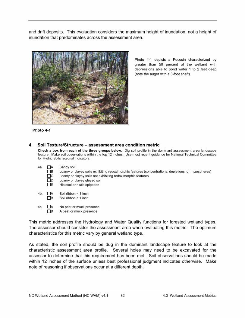
NC Wetland Assessment Method (NC WAM) v4.1 82 4.0 Wetland Assessment Metrics
and drift deposits. This evaluation considers the maximum height of inundation, not a height of inundation that predominates across the assessment area.
Photo 4-1 depicts a Pocosin characterized by greater than 50 percent of the wetland with depressions able to pond water 1 to 2 feet deep (note the auger with a 3-foot shaft).
4. Soil Texture/Structure – assessment area condition metric Check a box from each of the three groups below. Dig soil profile in the dominant assessment area landscape feature. Make soil observations within the top 12 inches. Use most recent guidance for National Technical Committee for Hydric Soils regional indicators.
4a. A Sandy soil B Loamy or clayey soils exhibiting redoximorphic features (concentrations, depletions, or rhizospheres) C Loamy or clayey soils not exhibiting redoximorphic features D Loamy or clayey gleyed soil E Histosol or histic epipedon
4b. A Soil ribbon < 1 inch B Soil ribbon � 1 inch
4c. A No peat or muck presence B A peat or muck presence
This metric addresses the Hydrology and Water Quality functions for forested wetland types. The assessor should consider the assessment area when evaluating this metric. The optimum characteristics for this metric vary by general wetland type.
As stated, the soil profile should be dug in the dominant landscape feature to look at the characteristic assessment area profile. Several holes may need to be excavated for the assessor to determine that this requirement has been met. Soil observations should be made within 12 inches of the surface unless best professional judgment indicates otherwise. Make note of reasoning if observations occur at a different depth.
Photo 4-1
NC Wetland Assessment Method (NC WAM) v4.1 83 4.0 Wetland Assessment Metrics
Soil texture should be determined through use of a texture decision chart (Appendix F). Redoximorphic features are formed by the processes of reduction, translocation, or oxidation of iron and magnesium oxides. Redoximorphic features were formerly called mottles and low chroma colors. For a detailed discussion of redoximorphic features, gleying, histosoils, histic epipedons, peat, and muck, see “Field Indicators of Hydric Soils in the United States: Guide for Identifying and Delineating Hydric Soils” (see most recent guidance from the National Technical Committee for Hydric Soils [ftp://ftp-fc.sc.egov.usda.gov/NSSC/Hydric_Soils and http://soils.usda.gov/use/hydric/]). See Appendix F for directions for determining soil ribbon length.
5. Discharge into Wetland – assessment area opportunity metric Check a box in each column. Consider surface pollutants or discharges (Surf) and sub-surface pollutants or discharges (Sub). Examples of sub-surface discharges include presence of nearby septic tank, underground storage tank (UST), etc. Surf Sub
A A Little or no evidence of pollutants or discharges entering the assessment area B B Noticeable evidence of pollutants or discharges entering the wetland and stressing, but not
overwhelming the treatment capacity of the assessment area C C Noticeable evidence of pollutants or discharges (pathogen, particulate, or soluble) entering the
assessment area and potentially overwhelming the treatment capacity of the wetland (water discoloration, dead vegetation, excessive sedimentation, odor)
The assessor should consider the assessment area when evaluating this metric. Both surface (Surf) and sub-surface (Sub) discharge components address departure from reference for the Water Quality function of non-riparian wetlands, marshes, and Estuarine Woody Wetland. For the purposes of NC WAM, the term “pollutants” refers to substances introduced into the assessment area that adversely affect the usefulness or health of the wetland (for instance, salt may not be a pollutant in estuarine wetlands but is considered a pollutant in freshwater wetlands); the term “pathogen” refers to undesirable bacteria and viruses; the term “particulate” refers to sediment and insoluble organic matter in the water column; and the term “soluble” refers to dissolved materials from the water column (for example, nutrients that are readily water soluble, such as nitrate nitrogen).
Examples of discharges may include stormwater from a point or a non-point discharge, sediment, herbicides on road shoulders and utility line corridors, and animal waste. A key term used in this metric is the word “evidence.” Evidence of discharges is almost always something the assessor can see within the assessment area, an effect within the assessment area resulting from a discharge. A cow standing in the assessment area is not evidence of a discharge, while algae in surface water receiving cow manure is evidence of an effect resulting from a discharge. A road passing by an assessment area is not evidence of a discharge, while an oily sheen in the wetland beside the road is evidence of an effect resulting from a discharge. The only time discharges do not have to be directly observed by the assessor is when they can be inferred from other sources of information. For instance, estuarine wetlands that have been given the designation of “closed shellfish bed” may be inferred to be subject to a detrimental discharge. Wetlands subject to such designations should not receive descriptor “A.” Examples of evidence of discharges that may potentially overwhelm the treatment capacity of a wetland include water discoloration, dead vegetation, excessive sedimentation, and odor. For this
NC Wetland Assessment Method (NC WAM) v4.1 84 4.0 Wetland Assessment Metrics
metric, “excessive sedimentation” that may overwhelm the treatment capacity of the wetland may include both recent sediment that lacks vegetation and sediment from a past event that now supports vegetation.
“Discharge into Wetland” is an opportunity metric that accounts for or infers watershed conditions affecting the level of performance of the Water Quality wetland function. “Opportunity” can increase the amount of water quality treatment a wetland provides by increasing the amount and types of discharges to which the wetland is exposed. Opportunity only leads to increased function if the wetland has the capacity for performing additional function. In NC WAM, opportunity is used to modify the functional rating based on condition, with the combination of condition and opportunity metrics used to determine if the wetland has the capacity to respond to the opportunity.
6. Land Use – opportunity metric Check all that apply (at least one box in each column). Evaluation involves a GIS effort with field adjustment. Consider sources draining to assessment area within entire upstream watershed (WS), within 5 miles and within the watershed draining to the assessment area (5M), and within 2 miles and within the watershed draining to the assessment area (2M). WS 5M 2M
A A A > 10% impervious surfaces B B B < 10% impervious surfaces C C C Confined animal operations (or other local, concentrated source of pollutants) D D D � 20% coverage of pasture E E E � 20% coverage of agricultural land (regularly plowed land) F F F � 20% coverage of maintained grass/herb G G G � 20% coverage of clear-cut land H H H Little or no opportunity to improve water quality. Lack of opportunity may result from
hydrologic alterations that prevent drainage or overbank flow from affecting the assessment area.
This metric is concerned with conditions within the watershed that may enhance the “opportunity” of the assessment area to perform the Water Quality function. “Opportunity” can increase the amount of water quality treatment a wetland provides by increasing the amount and types of discharges the wetland is exposed to. Opportunity only leads to increased function if the wetland has the capacity for performing additional function. This metric is used in the assessment of Water Quality function for riparian wetlands.
Following is a discussion of the evaluation areas used by this metric and the descriptors presented for consideration by the assessor.
Evaluation Areas (WS, 5M, and 2M)Assessors should note the importance of the underlined conjunctions in the metric description. An “and” requires that two conditions be met - so the landscape area evaluated has to be characterized by both conditions. Note that no area outside of the watershed or catchment draining to the assessment area should be considered in this evaluation. The term “watershed draining to the assessment area” means all of the watershed area that drains to any portion of the assessment area – from the farthest point upstream in the assessment area to the farthest point downstream in the assessment area.

NC Wetland Assessment Method (NC WAM) v4.1 85 4.0 Wetland Assessment Metrics
The assessor will need to consider three landscape areas relative to the assessment area when evaluating this metric.
1) The “WS” landscape area is the entire watershed draining to the assessment area. The WS landscape area is important to the assessment area’s opportunity to dissipate water energy (the physical change sub-function of the Water Quality function).
2) The “5M” landscape area is the area that meets both of the following criteria: within 5 miles of the assessment area boundary and within the watershed draining to the assessment area. The 5M landscape area is important to the assessment area’s opportunity to remove sediments and attached pollutants (the particulate change sub-function of the Water Quality function) and to remove dissolved pollutants (the soluble change sub-function of the Water Quality function).
3) The “2M” landscape area is the area that meets both of the following criteria: within 2 miles of the assessment area boundary and within the watershed draining to the assessment area. The 2M landscape area is important to the assessment area’s opportunity to remove bacteria and viruses (the pathogen change sub-function of the Water Quality function). The shorter distance of concern (2 miles) placed on pathogens is due to die-off of bacteria and viruses while traveling through the system.
Figures 8A and 8B are provided as examples for making the determination of area assessed for each of the three columns of check boxes included in this metric. Following is a discussion of what landscape area should be evaluated for each column in these two examples.
In Figure 8A, the watershed draining to the assessment area (area bounded by the line labeled “watershed boundary”) extends beyond 5 miles from the assessment area boundary. When selecting one or more descriptor(s) in the first column of Metric 6 (WS), the landscape area evaluated by the assessor is the entire watershed draining to the assessment area (the entire watershed as shown in Figure 8A). When selecting a descriptor in the second column of Metric 6 (5M), the landscape area evaluated by the assessor is the portion of the watershed draining to the assessment area that occurs within 5 miles of the assessment area boundary (the area characterized by any type of hatching in Figure 8A). When selecting a descriptor in the third column of Metric 6 (2M), the landscape area evaluated by the assessor is the portion of the watershed draining to the assessment area that occurs within 2 miles of the assessment area boundary (the area characterized by double hatching in Figure 8A).
In Figure 8B, the entire watershed draining to the assessment area (bounded area of double hatching) is located within 2 miles of the assessment area boundary. Therefore, the landscape area evaluated by the assessor is the same for all three columns in Metric 6.

NC Wetland Assessment Method (NC WAM) v4.1 86 4.0 Wetland Assessment Metrics
Figure 8B
Figure 8A

NC Wetland Assessment Method (NC WAM) v4.1 87 4.0 Wetland Assessment Metrics
DescriptorsThe evaluation of this metric is expected to involve a mapping investigation. The assessor may benefit from traveling through the watershed draining to the assessment area or talking with someone with local knowledge in order to gain first-hand information for the evaluation of this metric. Sources of information that may be used by the assessor to evaluate this metric include Geographic Information System (GIS) data (made available by the county or state), aerial photography, USGS topographic mapping, county soils survey information, and land use/land cover mapping. These GIS data sources will all be characterized by a certain degree of error, and regulatory agencies acknowledge the existence of this error.
Please note that percent coverage thresholds used by metric descriptors (20% and 10%) are anticipated to be coarse estimates (not precise calculations) on the part of the assessor.
Confined animal operations are facilities associated with production of animal products through raising livestock in large numbers in a limited space, resulting in on-site concentration of animal byproducts. Confined animal operations (CAFOs) are defined by the EPA and Division of Water Quality with respect to a minimal number of livestock in a confined area. The evaluator is not required to actually count the number of animals, but rather has to make a judgment whether livestock in a confined space could result in the runoff of animal waste products to surface waters. Livestock manure is considered a “pollutant” by NC WAM. Examples of “other local, concentrated sources of pollutants” may include landfills, wastewater treatment plants, and localized concentrations of sources of livestock-derived pollutants (such as a small, intensively used pasture or local feed lot) that are situated and managed in such a way that could result in the runoff of animal waste products to surface waters.
Indications that an assessment area is not subject to watershed inputs (overbank events, upslope runoff) suggest the assessment area has little or no opportunity to provide aspects of the Water Quality function (example: a stream has been deepened and/or a berm has been established between the wetland and the stream so that overbank flooding [based on field evidence] rarely, if ever, occurs). Conversely, the presence of sedimentation, organic debris lines or piles, and reclining vegetation within the assessment area may indicate that the wetland is subject to watershed inputs.
Note that the descriptor “H” is selected for either of two extremes: 1) when a severe hydrologic modification has occurred which prevents overbank flow or overland runoff from reaching the assessment area resulting in “little or no opportunity to improve water quality” or 2) when one or more of the evaluation areas is relatively undisturbed resulting in “little or no opportunity” to improve water quality.”
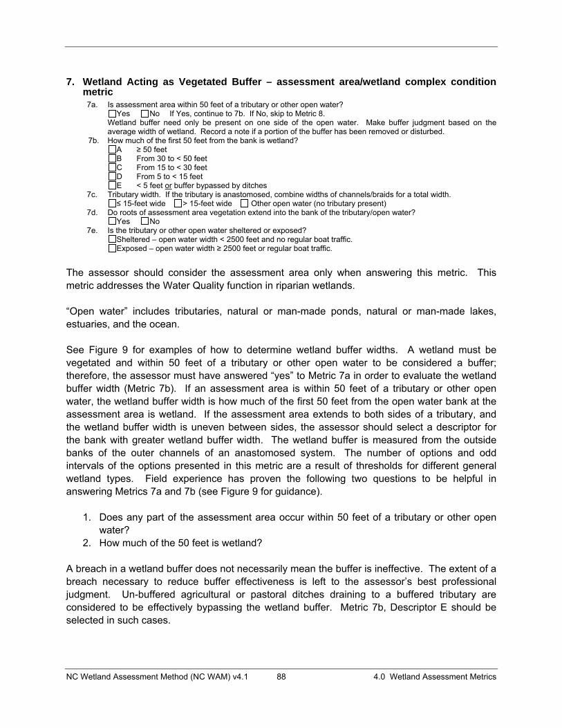
NC Wetland Assessment Method (NC WAM) v4.1 88 4.0 Wetland Assessment Metrics
7. Wetland Acting as Vegetated Buffer – assessment area/wetland complex condition metric 7a. Is assessment area within 50 feet of a tributary or other open water? Yes No If Yes, continue to 7b. If No, skip to Metric 8.
Wetland buffer need only be present on one side of the open water. Make buffer judgment based on the average width of wetland. Record a note if a portion of the buffer has been removed or disturbed.
7b. How much of the first 50 feet from the bank is wetland? A ≥ 50 feet B From 30 to < 50 feet C From 15 to < 30 feet D From 5 to < 15 feet E < 5 feet or buffer bypassed by ditches
7c. Tributary width. If the tributary is anastomosed, combine widths of channels/braids for a total width. ≤ 15-feet wide > 15-feet wide Other open water (no tributary present)
7d. Do roots of assessment area vegetation extend into the bank of the tributary/open water? Yes No 7e. Is the tributary or other open water sheltered or exposed? Sheltered – open water width < 2500 feet and no regular boat traffic. Exposed – open water width ≥ 2500 feet or regular boat traffic.
The assessor should consider the assessment area only when answering this metric. This metric addresses the Water Quality function in riparian wetlands. “Open water” includes tributaries, natural or man-made ponds, natural or man-made lakes, estuaries, and the ocean. See Figure 9 for examples of how to determine wetland buffer widths. A wetland must be vegetated and within 50 feet of a tributary or other open water to be considered a buffer; therefore, the assessor must have answered “yes” to Metric 7a in order to evaluate the wetland buffer width (Metric 7b). If an assessment area is within 50 feet of a tributary or other open water, the wetland buffer width is how much of the first 50 feet from the open water bank at the assessment area is wetland. If the assessment area extends to both sides of a tributary, and the wetland buffer width is uneven between sides, the assessor should select a descriptor for the bank with greater wetland buffer width. The wetland buffer is measured from the outside banks of the outer channels of an anastomosed system. The number of options and odd intervals of the options presented in this metric are a result of thresholds for different general wetland types. Field experience has proven the following two questions to be helpful in answering Metrics 7a and 7b (see Figure 9 for guidance).
1. Does any part of the assessment area occur within 50 feet of a tributary or other open water?
2. How much of the 50 feet is wetland? A breach in a wetland buffer does not necessarily mean the buffer is ineffective. The extent of a breach necessary to reduce buffer effectiveness is left to the assessor’s best professional judgment. Un-buffered agricultural or pastoral ditches draining to a buffered tributary are considered to be effectively bypassing the wetland buffer. Metric 7b, Descriptor E should be selected in such cases.
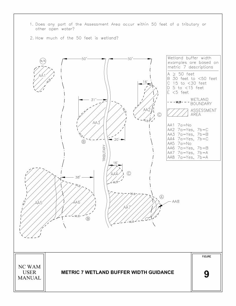

NC Wetland Assessment Method (NC WAM) v4.1 90 4.0 Wetland Assessment Metrics
Tributary width (Metric 7c) is the normal flow width, or distance of ordinary high water on one bank to ordinary high water on the opposite bank that may be determined by referring to USACE Regulatory Guidance Letter No. 05-05 (Ordinary High Water Mark Identification) for guidance (USACE 2005). If a tributary consists of multiple channels (an anastomosed or braided system), combine the channel widths to estimate the total width. If an assessed wetland occurs within 50 feet of both a tributary greater than 15 feet wide and a tributary less than or equal to 15 feet wide, the assessor should use best professional judgment in determining which tributary the wetland best serves in terms of buffer and flood-flow attenuation. “Other open water” is selected if the assessment area is within 50 feet of an open water that is not a tributary. Roots of vegetation (both woody and herbaceous) extending into banks (Metric 7d) are considered to be an important factor in stabilizing bank sediments and preventing erosion and subsequent water quality degradation. This determination can be made based on visual assessment of roots in banks or the extent of drip-line coverage of assessment area vegetation. The assessor will need to use best professional judgment to determine when drip-line coverage is not appropriate for this metric, such as when a berm exists along the assessment area side of a tributary. Shorelines regularly subject to waves of a height of 1 foot or more are considered to be “exposed” (Metric 7e). NC WAM considers an open-water width of 2500 feet to provide sufficient fetch for regular development of waves meeting or exceeding this threshold. Also, shorelines of open water with regular boat traffic that generates high-energy wakes are considered to be “exposed,” regardless of the open-water width. Shorelines not anticipated to be regularly subject to waves of greater than 1 foot in height are considered to be “sheltered” (Metric 7e). NC WAM considers an open-water width of less than 2500 feet to provide too little fetch for regular development of waves meeting or exceeding this threshold unless there is regular boat traffic. Following are discussions of the evaluation of Metric 7 for example assessment areas depicted in Figure 9.
• Assessment area 1 does not occur within 50 feet of the tributary, so Metric 7a is “No.” • Assessment area 2 occurs partially within 50 feet of the tributary, so Metric 7a is “Yes;”
an average of 16 feet of the 50 feet is wetland, so Metric 7b is “C” (15 to < 30 feet); the tributary is “< 15 feet wide” (Metric 7c); the roots of the assessment area likely do not extend into the bank of the tributary, so Metric 7d is “No;” and the tributary is “Sheltered” (Metric 7e).
• Assessment area 3 occurs within 50 feet of the tributary, so Metric 7a is “Yes;” for the bank with the greater wetland buffer width, an average of 31 feet of the 50 feet is wetland, so Metric 7b is “B” (30 to < 50 feet); the tributary is “< 15 feet wide” (Metric 7c); the roots of the assessment area extend into the bank of the tributary, so Metric 7d is ”Yes;” and the tributary is “Sheltered” (Metric 7e).
• Assessment area 4 occurs within 50 feet of the tributary, so Metric 7a is “Yes;” an average of 16 feet of the 50 feet is wetland, so Metric 7b is “C” (15 to < 30 feet); the

NC Wetland Assessment Method (NC WAM) v4.1 91 4.0 Wetland Assessment Metrics
tributary is “< 15 feet wide” (Metric 7c); the roots of the assessment area extend into the bank of the tributary, so Metric 7d is “Yes;” and the tributary is “Sheltered” (Metric 7e).
• Assessment area 5 does not occur within 50 feet of the tributary, so Metric 7a is “No.” • Assessment area 6 is partially within 50 feet of the tributary, so Metric 7a is “Yes;” an
average of 38 feet of the 50 feet is wetland, so Metric 7b is “B” (30 to < 50 feet); the tributary is “< 15 feet wide” (Metric 7c); the roots of the assessment area may extend into the bank of the tributary if the assessment area supports vegetation with a canopy that extends over the tributary bank, so Metric 7d may be “Yes;” and the tributary is “Sheltered” (Metric 7e).
• Assessment area 7 is partially within 50 feet of the tributary, so Metric 7a is “Yes;” all of the 50 feet is wetland, so Metric 7b is “A” (> 50 feet); the tributary is “< 15 feet wide” (Metric 7c); the roots of the assessment area extend into the bank of the tributary so Metric 7d is “Yes;” and the tributary is “Sheltered” (Metric 7e).
• Assessment area 8 is partially within 50 feet of the tributary, so Metric 7a is “Yes;” all of the 50 feet is wetland, so Metric 7b is “A” (> 50 feet); the tributary is “< 15 feet wide” (Metric 7c); the roots of the assessment area do not extend into the bank of the tributary, so Metric 7d is “No;” and the tributary is “Sheltered” (Metric 7e).
8. Wetland Width at the Assessment Area – wetland type/wetland complex condition metric (evaluate for riparian wetlands only) Check a box in each column. Select the average width for the wetland type at the assessment area (WT) and the wetland complex at the assessment area (WC). See User Manual for WT and WC boundaries. WT WC
A A ≥ 100 feet B B From 80 to < 100 feet C C From 50 to < 80 feet D D From 40 to < 50 feet E E From 30 to < 40 feet F F From 15 to < 30 feet G G From 5 to < 15 feet H H < 5 feet
This metric is evaluated for riparian wetlands only. The assessor needs to evaluate this metric for the width of the wetland type at the assessment area (WT) and the wetland complex at the assessment area (WC). The number of options and odd intervals of the options presented in this metric are a result of thresholds for different general wetland types. This metric is used primarily in the Water Quality function and, to a lesser extent, in the Hydrology function in riparian wetlands and all marshes. See Figure 10 for examples of how to determine wetland widths. Measure the average wetland width perpendicular to elevation contours, stream bank, or shoreline at the assessment area. In the case of a wetland extending along a lower-order stream into the geomorphic floodplain of a higher-order stream, the direction of measured width is dependent on the location of the assessment area. If the assessment area is located along the lower-order stream outside of the geomorphic floodplain of the higher-order stream (Figure 10, Assessment Area 5), wetland type width should be measured perpendicular to the elevation contours of the lower-order stream.
NC Wetland Assessment Method (NC WAM) v4.1 93 4.0 Wetland Assessment Metrics
However, if the assessment area is located along the lower-order stream and within the geomorphic floodplain of the higher-order stream (Figure 10, Assessment Area 7), wetland type width should be measured perpendicular to the elevation contours of the channel with the dominant hydrologic influence on the assessment area (this may be the higher-order stream or the lower-order stream, and the assessor must make this determination). Measurements of wetland type width and wetland complex width should be made along the same axis (relative to slope, stream bank, or shoreline) and along the same line. The WFAT considers wetland width to be more important than wetland size with consideration to dissipation of wave energy for shoreline-fringing wetlands.
9. Inundation Duration – assessment area condition metric Answer for assessment area dominant landform.
A Evidence of short-duration inundation (< 7 consecutive days) B Evidence of saturation, without evidence of inundation C Evidence of long-duration inundation or very long-duration inundation (7 to 30 consecutive days or more)
The assessor should consider the assessment area only when evaluating this metric. This metric addresses departure from reference for both the Hydrology and Water Quality functions of some riparian wetlands and Non-Tidal Freshwater Marsh. Wetland delineation experience is very helpful in evaluating this metric. The assessor must also rely on knowledge of the reference condition of the subject wetland, the presence or absence of specific field indicators, and best professional judgment in making this challenging decision.
Inundation is the condition in which water from any source temporarily or permanently covers a land surface and includes both flooding and/or ponding. The duration of such inundation often leaves its mark upon the landscape in the form of recognizable field indicators. The challenge to the assessor lies in interpreting this metric within areas that experience only short-term inundation or saturation.
The assessor will need to rely on on-site evidence of inundation during the growing season when possible and best professional judgment. Wetland indicator status of dominant plant species present and soil type provide the primary indications of wetland hydroperiod utilized in answering this metric. The USACE Hydrophytic Vegetation Indicator Dominance Test (50/20 Rule) is the recommended method for selecting dominant species from a plant community when quantitative data are available. “Dominance” refers strictly to the spatial extent of a species that is measurable in the field. Absolute Percent Cover is the preferred abundance measure for all species. Dominant species are chosen independently from each stratum of the community. Ingeneral, dominants are the most abundant species that individually or collectively account for more that 50 percent of the total coverage of vegetation in the stratum, plus any other species that, by itself, accounts for at least 20 percent of the total. Once this determination has been made, the assessor may then use the wetland indicator status of the dominant species to make judgments relative to the wetland hydroperiod. Information regarding vegetation indicator status may be found at https://wetland_plants.usace.army.mil. Hydric soils information may be obtained at the following web sites: http://websoilsurvey.nrcs.usda.gov/app/HomePage.htm and ftp://ftp-fc.sc.egov.usda.gov/NSSC/Hydric_Soils.
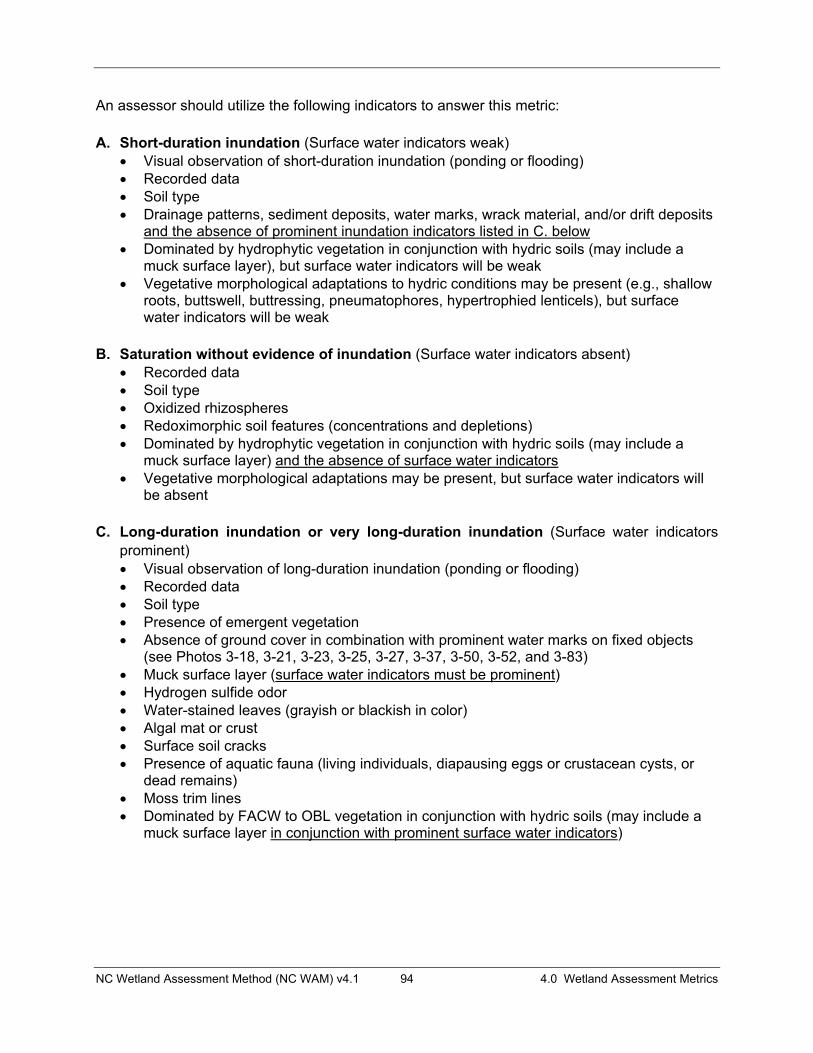
NC Wetland Assessment Method (NC WAM) v4.1 94 4.0 Wetland Assessment Metrics
An assessor should utilize the following indicators to answer this metric:
A. Short-duration inundation (Surface water indicators weak) � Visual observation of short-duration inundation (ponding or flooding) � Recorded data � Soil type � Drainage patterns, sediment deposits, water marks, wrack material, and/or drift deposits
and the absence of prominent inundation indicators listed in C. below� Dominated by hydrophytic vegetation in conjunction with hydric soils (may include a
muck surface layer), but surface water indicators will be weak � Vegetative morphological adaptations to hydric conditions may be present (e.g., shallow
roots, buttswell, buttressing, pneumatophores, hypertrophied lenticels), but surface water indicators will be weak
B. Saturation without evidence of inundation (Surface water indicators absent) � Recorded data � Soil type � Oxidized rhizospheres � Redoximorphic soil features (concentrations and depletions) � Dominated by hydrophytic vegetation in conjunction with hydric soils (may include a
muck surface layer) and the absence of surface water indicators� Vegetative morphological adaptations may be present, but surface water indicators will
be absent
C. Long-duration inundation or very long-duration inundation (Surface water indicators prominent)� Visual observation of long-duration inundation (ponding or flooding) � Recorded data � Soil type � Presence of emergent vegetation � Absence of ground cover in combination with prominent water marks on fixed objects
(see Photos 3-18, 3-21, 3-23, 3-25, 3-27, 3-37, 3-50, 3-52, and 3-83) � Muck surface layer (surface water indicators must be prominent)� Hydrogen sulfide odor � Water-stained leaves (grayish or blackish in color) � Algal mat or crust � Surface soil cracks � Presence of aquatic fauna (living individuals, diapausing eggs or crustacean cysts, or
dead remains) � Moss trim lines � Dominated by FACW to OBL vegetation in conjunction with hydric soils (may include a
muck surface layer in conjunction with prominent surface water indicators)

NC Wetland Assessment Method (NC WAM) v4.1 95 4.0 Wetland Assessment Metrics
10. Indicators of Deposition – assessment area condition metric Consider recent deposition only (no plant growth since deposition).
A Sediment deposition is not excessive, but at approximately natural levels. B Sediment deposition is excessive, but not overwhelming the wetland. C Sediment deposition is excessive and is overwhelming the wetland.
The assessor should consider only the assessment area when evaluating this metric. This metric addresses the departure from reference of the Water Quality function in forested, riparian wetland types only. The term “recent deposition” refers to sediment deposited by moving water that has not been in place long enough for vegetation to become established in it. The term “overwhelming the wetland” refers to conditions resulting in loss of vegetation components or wetland hydrology. It is assumed that the assessor will have an understanding of the amount of sediment appropriate to a particular wetland type, ecoregion, and landscape position.
11. Wetland Size – wetland type/wetland complex condition metric Check a box in each column. Involves a GIS effort with field adjustment. This metric evaluates three aspects of the wetland area: the size of the wetland type (WT), the size of the wetland complex (WC), and the size of the forested wetland (FW) (if applicable, see User Manual). See the User Manual for boundaries of these evaluation areas. If assessment area is clear-cut, select “K” for the FW column. WT WC FW (if applicable)
A A A � 500 acres B B B From 100 to < 500 acres C C C From 50 to < 100 acres D D D From 25 to < 50 acres E E E From 10 to < 25 acres F F F From 5 to < 10 acres G G G From 1 to < 5 acres H H H From 0.5 to < 1 acre I I I From 0.1 to < 0.5 acre J J J From 0.01 to < 0.1 acre K K K < 0.01 acre or assessment area is clear-cut
The assessor needs to evaluate this metric for the wetland type (WT), the wetland complex (WC), and the forested wetland (FW). This metric is principal to the assessment because it addresses the departure from reference of all three wetland functions and is used in the functional assessment of all general wetland types. This metric is used to assess the Water Quality function of non-riparian wetland types and the Habitat function of all wetland types. In the case of Estuarine Woody Wetland, this metric is used to assess the Hydrology function. The number of metric options and odd intervals of the metric options are the result of compiling different thresholds for different general wetland types. The “forested wetland” column will only be used if the assessment area occurs in a forested wetland type. If the assessment area is a forested wetland type that has been clear-cut, the assessor should select “K” for the “forested wetland” column.
Depending on the size of the assessment area, wetland type, and wetland complex, the evaluation of this metric may require a mapping investigation. Sources of information that may be used by the assessor to evaluate this metric include Geographic Information System (GIS) data (made available by the county or state), aerial photography, USGS topographic mapping,
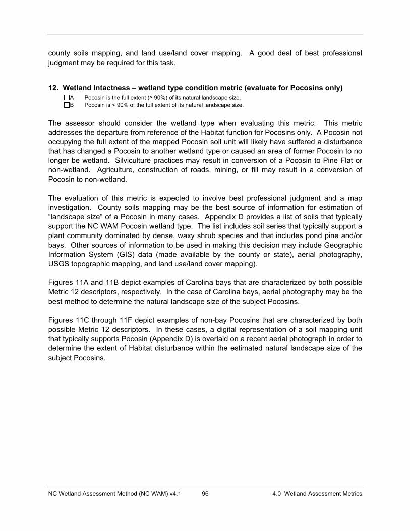
NC Wetland Assessment Method (NC WAM) v4.1 96 4.0 Wetland Assessment Metrics
county soils mapping, and land use/land cover mapping. A good deal of best professional judgment may be required for this task.
12. Wetland Intactness – wetland type condition metric (evaluate for Pocosins only) A Pocosin is the full extent (� 90%) of its natural landscape size. B Pocosin is < 90% of the full extent of its natural landscape size.
The assessor should consider the wetland type when evaluating this metric. This metric addresses the departure from reference of the Habitat function for Pocosins only. A Pocosin not occupying the full extent of the mapped Pocosin soil unit will likely have suffered a disturbance that has changed a Pocosin to another wetland type or caused an area of former Pocosin to no longer be wetland. Silviculture practices may result in conversion of a Pocosin to Pine Flat or non-wetland. Agriculture, construction of roads, mining, or fill may result in a conversion of Pocosin to non-wetland.
The evaluation of this metric is expected to involve best professional judgment and a map investigation. County soils mapping may be the best source of information for estimation of “landscape size” of a Pocosin in many cases. Appendix D provides a list of soils that typically support the NC WAM Pocosin wetland type. The list includes soil series that typically support a plant community dominated by dense, waxy shrub species and that includes pond pine and/or bays. Other sources of information to be used in making this decision may include Geographic Information System (GIS) data (made available by the county or state), aerial photography, USGS topographic mapping, and land use/land cover mapping).
Figures 11A and 11B depict examples of Carolina bays that are characterized by both possible Metric 12 descriptors, respectively. In the case of Carolina bays, aerial photography may be the best method to determine the natural landscape size of the subject Pocosins.
Figures 11C through 11F depict examples of non-bay Pocosins that are characterized by both possible Metric 12 descriptors. In these cases, a digital representation of a soil mapping unit that typically supports Pocosin (Appendix D) is overlaid on a recent aerial photograph in order to determine the extent of Habitat disturbance within the estimated natural landscape size of the subject Pocosins.

NC Wetland Assessment Method (NC WAM) v4.1 97 4.0 Wetland Assessment Metrics
Figure 11A depicts a Carolina bay at Suggs Mill Pond Game Land, Bladen County, that appears to be less than the full extent of its original landscape size but is likely greater than 90 percent of its natural landscape size. Figure 11B depicts a Carolina bay in Pender County that has been modified to be less than 90 percent of its natural landscape size. Figures 11C and 11D are examples of Pocosins that are greater than 90 percent of their natural landscape size. Figure 11C depicts with a white line a mapping unit of Croatan muck within the Croatan National Forest, Craven County. Figure 11D depicts with a white line a mapping unit of Murville mucky fine sand near Hooper Hill, Brunswick County.
Figure 11A Figure 11B
Figure 11C Figure 11D

NC Wetland Assessment Method (NC WAM) v4.1 98 4.0 Wetland Assessment Metrics
Figures 11E and 11F are examples of Pocosins that are less than 90 percent of their natural landscape size. Figure 11E depicts with a white line a mapping unit of Belhaven muck near Scuppernong, Washington County. Figure 11F depicts with a white line a mapping unit of Dare muck near Fairfield Harbor, Craven County.
13. Connectivity to Other Natural Areas – landscape condition metric 13a. Check appropriate box(es) (a box may be checked in each column). Involves a GIS effort with field
adjustment. This metric evaluates whether the wetland is well connected (Well) and/or loosely connected (Loosely) to the landscape patch, the contiguous naturally vegetated area and open water (if appropriate). Boundaries are formed by four-lane roads, regularly maintained utility line corridors the width of a four-lane road or wider, urban landscapes, maintained fields (pasture and agriculture), or open water > 300 feet wide. Well Loosely
A A � 500 acres B B From 100 to < 500 acres C C From 50 to < 100 acres D D From 10 to < 50 acres E E < 10 acres F F Wetland type has a poor or no connection to other natural habitats
13b. Evaluate for marshes only.Yes No Wetland type has a surface hydrology connection to open waters/tributary or tidal wetlands.
The assessor should consider the relative position of the wetland type in the regional landscape when evaluating Metric 13a. This metric addresses the juxtaposition of other naturally vegetated areas relative to the wetland type. This metric applies to the Habitat function of all general wetland types.
For the purposes of NC WAM, a “landscape patch” is the contiguous natural habitat that includes the assessed wetland type regardless of whether the natural habitat is located within the watershed of the assessed wetland type. “Well connected” (Well) is a term that generally refers to a wetland type that is surrounded by or adjoins a landscape patch along a substantial part of its boundary on at least one side. A wetland type is considered to be “loosely connected” (Loosely) to other habitats if connected by narrow corridors of habitat. Boundaries must present a barrier or danger to wildlife attempting to negotiate them in order to disconnect the assessment area from landscape patches. Such boundaries include four-lane roads, regularly
Figure 11E Figure 11F
NC Wetland Assessment Method (NC WAM) v4.1 99 4.0 Wetland Assessment Metrics
maintained utility line corridors the width of a four-lane road or wider, urban landscapes, maintained fields (pasture and agriculture), or open water greater than 300 feet wide. The assessor may check a box in each column. If a wetland type is well connected to 15 acres and loosely connected to 200 acres, the assessor should check “D” in the “Well” column and “B” in the “Loosely’ column. If a wetland type has poor or no connection to a landscape patch, the assessor may check either one or both “F” boxes. The assessor should document best professional judgment concerning the evaluation of this metric when the assessed wetland is on an island.
“Surface hydrology connection to open waters/tributary or tidal wetlands” is an important factor in the evaluation of the Habitat function in marshes. When evaluating marshes, an assessor should only consider other marsh-like areas in terms of connection to natural areas. “Marsh-like areas” include emergent herbs and shrubs with or without an interspersion of surface water. Metric 13b is concerned with the potential for movement of wildlife and fish among contiguous, suitable habitat types, and wetland types found higher in the landscape would likely not provide suitable habitat for many marsh specialists. In this sense, a “surface hydrology connection” includes any type of connection that will allow aquatic life movement. A ditch or canal is only considered to be a surface hydrology connection if it has been determined to be subject to Section 404 jurisdiction. A marsh is still considered to have a surface hydrology connection to other natural areas if culverts allow aquatic life access into and out of the marsh.
14. Edge Effect – wetland type condition metric (skip for all marshes) May involve a GIS effort with field adjustment. Estimate distance from wetland type boundary to artificial edges. Artificial edges include non-forested areas � 40 feet wide such as fields, development, roads, regularly maintained utility line corridors, and clear-cuts. Consider the eight main points of the compass.
A No artificial edge within 150 feet in all directions B No artificial edge within 150 feet in four (4) to seven (7) directions C An artificial edge occurs within 150 feet in more than four (4) directions or assessment area is clear-cut
The assessor should consider the wetland type when evaluating this metric. This metric addresses the departure from reference of the Habitat function for all forested wetland types. Artificial edges are barriers to travel or population expansion for some native flora and fauna, yet provide access to forest interiors for invasive and exotic fauna and flora. The listed artificial edges (permanent features such as fields, development, two-lane or larger roads [greater than 40 feet wide], utility lines wider than a two-lane road, and clear-cuts) include areas that break the structure of forested wetlands (forested uplands are not considered an artificial edge).
The eight main points of the compass comprise north, northeast, east, southeast, south, southwest, west, and northwest. Figure 12 provides a display of the eight main points of the compass and depicts two proposed activities, A and B. These activities are represented with emphasis on the issue of artificial edge. The wetland type included in proposed activity A assessment area (Headwater Forest) is characterized by artificial edge within 150 feet in only three directions (southeast, south, and southwest), resulting in descriptor “B.” The wetland type included in proposed activity B assessment area (Hardwood Flat) is characterized by artificial edge within 150 feet in all directions, resulting in a descriptor of “C.”

NC Wetland Assessment Method (NC WAM) v4.1 100 4.0 Wetland Assessment Metrics
Photos 4-2, 4-3, and 4-4 are examples of artificial edges. Photo 4-2 depicts a two-lane road, Photo 4-3 depicts a single-lane road and man-made ditch (together, wider than a two-lane road), and Photo 4-4 depicts a maintained utility line corridor wider than a two-lane road. Photo 4-5 is not an example of an artificial edge because the maintained corridor is narrower than the width of a two-lane road.
Photo 4-2 Photo 4-3
Photo 4-4 Photo 4-5
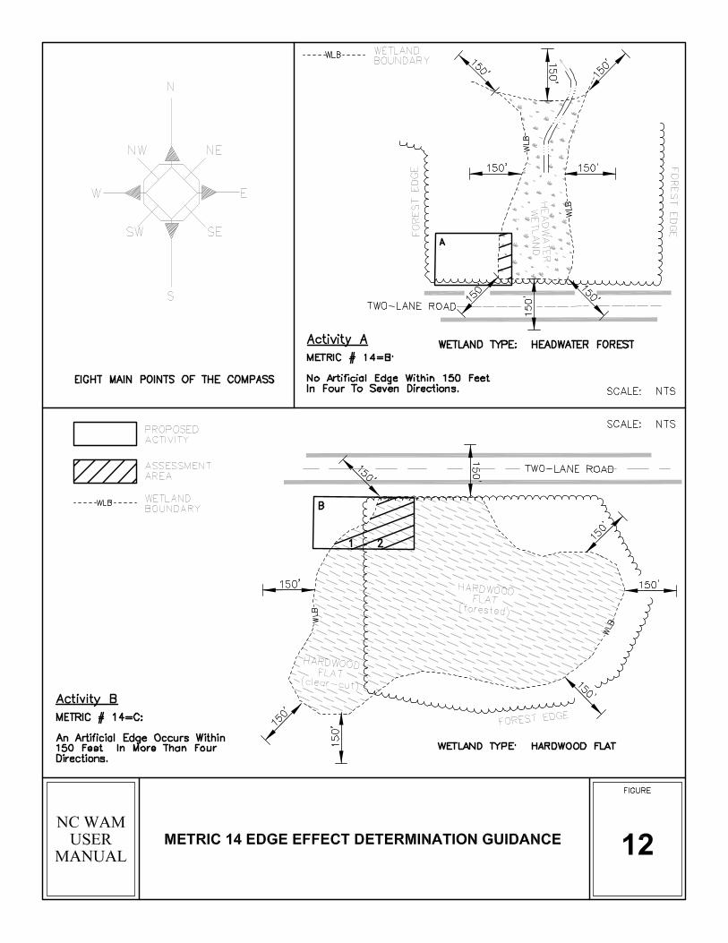

NC Wetland Assessment Method (NC WAM) v4.1 102 4.0 Wetland Assessment Metrics
15. Vegetative Composition – assessment area condition metric (skip for all marshes and Pine Flat)
A Vegetation is close to reference condition in species present and their proportions. Lower strata composed of appropriate species, with exotic plants absent or sparse within the assessment area.
B Vegetation is different from reference condition in species diversity or proportions, but still largely composed of native species characteristic of the wetland type. This may include communities of weedy native species that develop after clear-cutting or clearing. It also includes communities with exotics present, but not dominant, over a large portion of the expected strata.
C Vegetation severely altered from reference in composition. Expected species are unnaturally absent (planted stands of non-characteristic species or at least one stratum inappropriately composed of a single species). Exotic species are dominant in at least one stratum.
The assessor should consider the assessment area only when evaluating this metric. This metric addresses the departure from reference of the Habitat function for all general wetland types with the exception of marshes and Pine Flat. In order to evaluate this metric, the assessor needs to be familiar with the composition of vegetation within the range of reference examples of each general wetland type. Exotic species may become established in disturbed areas, so the presence of exotic species suggests a past disturbance that resulted in a window of opportunity for establishment. A list of species considered to be exotic in North Carolina is provided in Appendix G. Although not on the list of exotics, common reed (Phragmites australis) is considered a non-native, invasive species in North Carolina, and presence of this species should be considered equivalent to presence of an exotic.
16. Vegetative Diversity – assessment area condition metric (evaluate for Non-Tidal Freshwater Marsh only)
A Vegetation diversity is high and is composed primarily of native species (< 10% cover of exotics). B Vegetation diversity is low or has > 10% to 50% cover of exotics. C Vegetation is dominated by exotic species (> 50% cover of exotics).
The assessor should consider the assessment area only when evaluating this metric. This metric is used in the Habitat function in Non-tidal Freshwater Marsh only. An estimation of percent coverage of vegetation should be made for the growing season. Exotic species usually become established in disturbed areas, so the presence of exotic species may suggest a past disturbance that resulted in a window of opportunity for establishment. A list of species considered to be exotic in North Carolina is provided in Appendix G. Although not on the list of exotics, common reed (Phragmites australis) is considered a non-native, invasive species in North Carolina, and presence of this species should be considered equivalent to presence of an exotic.

NC Wetland Assessment Method (NC WAM) v4.1 103 4.0 Wetland Assessment Metrics
17. Vegetative Structure – assessment area/wetland type condition metric 17a. Is vegetation present?
Yes No If Yes, continue to 17b. If No, skip to Metric 18.
17b. Evaluate percent coverage of assessment area vegetation for all marshes only. Skip to17c for non-marsh wetlands.
A � 25% coverage of vegetation B < 25% coverage of vegetation
17c. Check a box in each column for each stratum. Evaluate this portion of the metric for non-marsh wetlands.Consider structure in airspace above the assessment area (AA) and the wetland type (WT) separately. AA WT
A A Canopy closed, or nearly closed, with natural gaps associated with natural processes B B Canopy present, but opened more than natural gaps C C Canopy sparse or absent
A A Dense mid-story/sapling layer B B Moderate density mid-story/sapling layer C C Mid-story/sapling layer sparse or absent
A A Dense shrub layer B B Moderate density shrub layer C C Shrub layer sparse or absent
A A Dense herb layer B B Moderate density herb layer C C Herb layer sparse or absent
Metric 17a should be evaluated for all wetlands. Metric 17b is used in the assessment of the Water Quality function for marshes. Metric 17c addresses the departure from reference for all three wetland functions in non-marsh wetlands.
The assessor should consider both the assessment area and the wetland type when evaluating Metric 17c. Woody structure is important in riparian wetlands for slowing flood waters and overland runoff (Hydrology function) and increasing residence time for treatment and infiltration of surface waters (Water Quality function). Woody structure, at appropriate density and stratification for specific general wetland types, is important in terms of diversity of habitats (Habitat function). The assessor should consider living vegetation in the growing season when evaluating this metric.
Definitions for “canopy,” “tree,” “sapling,” “shrub,” and “herb” can be found in the glossary (Appendix I). Woody vines should be considered in the stratum in which they occur. For example, woody vines should be classified as shrubs if they are the height of shrubs and should be classified as canopy if they are the height of trees. “Natural gaps associated with natural processes” includes large gaps resulting from natural tree fall as well as storm damage, including hurricane damage. For forested wetlands that may be characterized by a variety of structural variations (Floodplain Pool, Bog, Pine Savanna, Pocosin, Pine Flat, Seep), this metric is not used for generation of functional ratings.
Can
opy
Mid
-Sto
ryS
hrub
Her
b

NC Wetland Assessment Method (NC WAM) v4.1 104 4.0 Wetland Assessment Metrics
Photo 3-38 depicts a Non-Riverine Swamp Forest recovering from hurricane damage. Although canopy gaps are larger than typical for reference of this wetland type, a hurricane is considered to be a natural process, and therefore “canopy closed or nearly closed, with natural gaps associated with natural processes” (descriptor “A”) is an appropriate descriptor. In this same example, the mid-story/sapling layer is sparse or absent (descriptor “C”), while the shrub and herb layers are responding to increased sunlight since the hurricane, resulting in descriptors of “B” and “A,” respectively, for these layers.
18. Snags – wetland type condition metric A Large snags (more than one) are visible (> 12 inches DBH, or large relative to species present and landscape
stability). B Not A
The assessor should consider the wetland type when evaluating this metric. This metric addresses the departure from reference of the Habitat function for forested wetland types. Diameter at breast height (DBH) is the width of a plant stem as measured at 4.5 feet above the ground surface. The term “large” used in this metric should be considered relative to the species present in the assessment area (see Photo 4-6). For example: a stand of 8- to 10-inch DBH black willows (Salix nigra) is less than the 12-inch DBH criteria listed in the metric, but these trees are considered “large” for this species. The term “visible” means “visible within the wetland type from the assessment area.” An assessor is expected to have walked the assessment area prior to conducting the functional assessment but is not expected to have searched throughout a large wetland type that may extend well outside of a given project area. “Landscape stability” refers to wetlands subject to disturbance or somehow lacking stability – such as wetlands located at stormwater outfalls or on deltas at the heads of reservoirs. More than one large snag must be visible to the assessor within the wetland type for the selection of descriptor “A.” This is a “value-added metric;” selection of descriptor “A” may increase a wetland rating for Habitat, while selection of descriptor “B” will not affect the rating.
Photo 4-6 depicts both a large snag and large woody debris in a Pine Flat.
Photo 4-6

NC Wetland Assessment Method (NC WAM) v4.1 105 4.0 Wetland Assessment Metrics
19. Diameter Class Distribution – wetland type condition metric A Majority of canopy trees have stems > 6 inches in diameter at breast height (DBH); many large trees (> 12
inches DBH) are present. B Majority of canopy trees have stems between 6 and 12 inches DBH, few are > 12 inch DBH. C Majority of canopy trees are < 6 inches DBH or no trees.
The assessor should consider the wetland type when evaluating this metric. This metric addresses the departure from reference of the Habitat function for forested wetland types. DBH (diameter at breast height) is the width of a living plant stem as measured at 4.5 feet above the ground surface. For this metric, canopy tree size is a surrogate estimate for habitat diversity – with the presence of larger trees considered indicative of higher structural diversity. The term “large” used in this metric should be considered relative to the species present in the assessment area. For example: a stand of 8- to 10-inch DBH black willows (Salix nigra) is less than the 12-inch DBH criteria listed in the metric, but these trees are considered “large” for this species.
20. Large Woody Debris – wetland type condition metric Include both natural debris and man-placed natural debris.
A Large logs (more than one) are visible (> 12 inches in diameter, or large relative to species present and landscape stability).
B Not A
The assessor should consider the wetland type when evaluating this metric. This metric addresses the departure from reference of the Habitat function in forested wetland types only. The term “large” used in this metric should be considered relative to the species present in the assessment area (see Photo 4-6). For example: a stand of 8- to 10-inch diameter black willow trunks are less than the 12-inch criteria listed in the metric, but these trees are considered “large” for this species. An example of woody debris being large relative to landscape position might include Estuarine Woody Wetland, a transitional wetland type that might not be expected to provide a stable enough environment to support large trees; therefore, in this wetland type, the presence of woody debris that is less than 12-inches in diameter may be evaluated with a descriptor of “A.” More than one large log must be visible to the assessor within the wetland type for descriptor “A” to be appropriate. The term “visible” means “visible within the wetland type from the assessment area.” An assessor is expected to have walked the assessment area prior to conducting the functional assessment but is not expected to have searched throughout a large wetland type that may extend well outside of a given project area. This is a “value-added metric;” selection of descriptor “A” may increase a wetland rating for Habitat, while selection of descriptor “B” will not affect the rating.
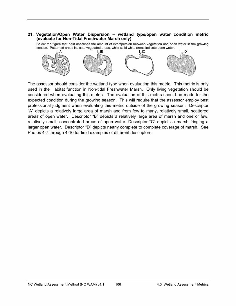
NC Wetland Assessment Method (NC WAM) v4.1 106 4.0 Wetland Assessment Metrics
21. Vegetation/Open Water Dispersion – wetland type/open water condition metric (evaluate for Non-Tidal Freshwater Marsh only) Select the figure that best describes the amount of interspersion between vegetation and open water in the growing season. Patterned areas indicate vegetated areas, while solid white areas indicate open water.
A B C D
The assessor should consider the wetland type when evaluating this metric. This metric is only used in the Habitat function in Non-tidal Freshwater Marsh. Only living vegetation should be considered when evaluating this metric. The evaluation of this metric should be made for the expected condition during the growing season. This will require that the assessor employ best professional judgment when evaluating this metric outside of the growing season. Descriptor “A” depicts a relatively large area of marsh and from few to many, relatively small, scattered areas of open water. Descriptor “B” depicts a relatively large area of marsh and one or few, relatively small, concentrated areas of open water. Descriptor “C” depicts a marsh fringing a larger open water. Descriptor “D” depicts nearly complete to complete coverage of marsh. See Photos 4-7 through 4-10 for field examples of different descriptors.
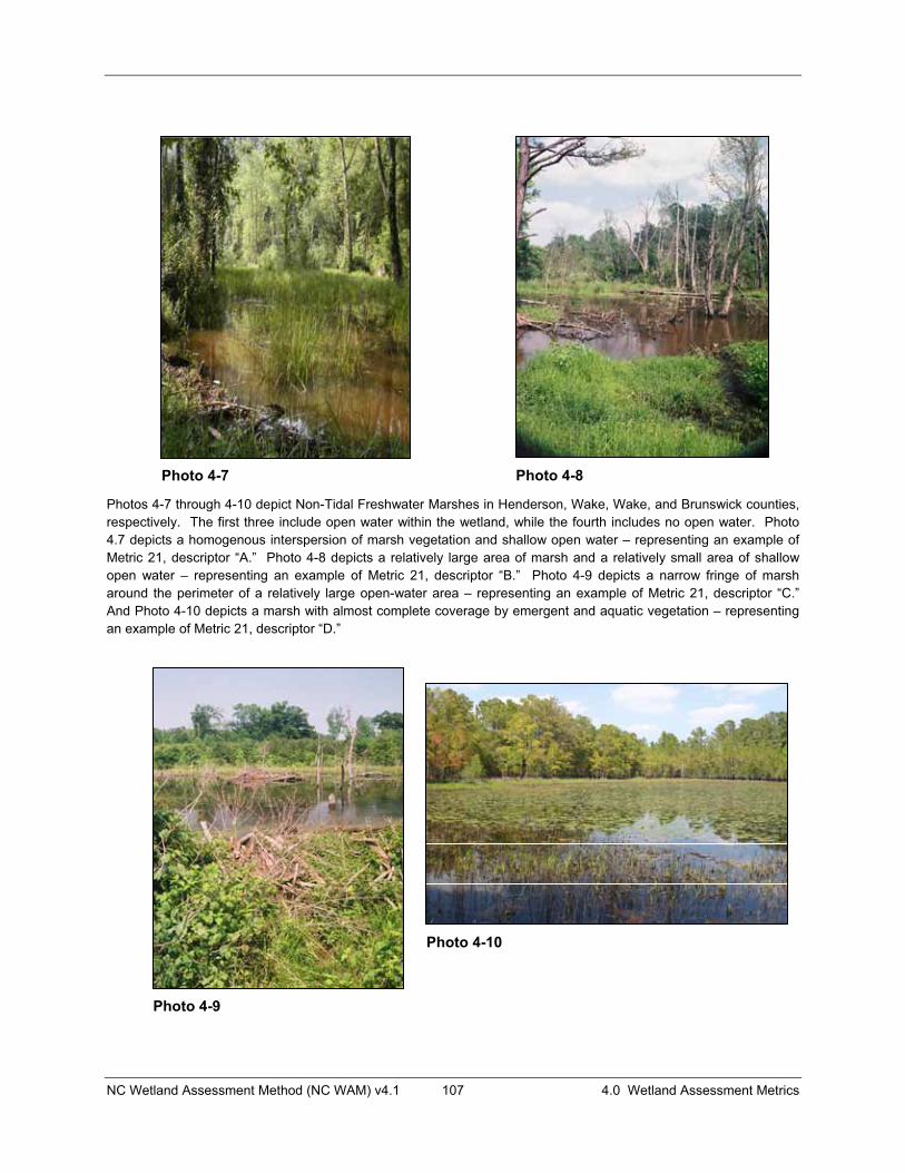
NC Wetland Assessment Method (NC WAM) v4.1 107 4.0 Wetland Assessment Metrics
Photos 4-7 through 4-10 depict Non-Tidal Freshwater Marshes in Henderson, Wake, Wake, and Brunswick counties, respectively. The first three include open water within the wetland, while the fourth includes no open water. Photo 4.7 depicts a homogenous interspersion of marsh vegetation and shallow open water – representing an example of Metric 21, descriptor “A.” Photo 4-8 depicts a relatively large area of marsh and a relatively small area of shallow open water – representing an example of Metric 21, descriptor “B.” Photo 4-9 depicts a narrow fringe of marsh around the perimeter of a relatively large open-water area – representing an example of Metric 21, descriptor “C.” And Photo 4-10 depicts a marsh with almost complete coverage by emergent and aquatic vegetation – representing an example of Metric 21, descriptor “D.”
Photo 4-7 Photo 4-8
Photo 4-9
Photo 4-10
NC Wetland Assessment Method (NC WAM) v4.1 108 4.0 Wetland Assessment Metrics
22. Hydrologic Connectivity – assessment area condition metric (evaluate for riparian wetlands only) Examples of activities that may severely alter hydrologic connectivity include intensive ditching, fill, sedimentation, channelization, diversion, man-made berms, beaver dams, and stream incision.
A Overbank and overland flow are not severely altered in the assessment area. B Overbank flow is severely altered in the assessment area. C Overland flow is severely altered in the assessment area. D Both overbank and overland flow are severely altered in the assessment area
The status of overbank and overland flow within riparian wetlands is very important in the generation of Hydrology and Water Quality function ratings, and, therefore, the overall rating of the wetland. The assessor is urged to evaluate this question carefully. Please note that the conjunction “and” is underlined, meaning that the same condition applies to both overbank and overland flow. A substantial portion of the Hydrology and Water Quality functions in riparian wetlands is dependent on the availability of these wetlands to receive overbank flow and to receive and transport overland flow. Figure 13 provides depictions of overbank and overland flow. Overbank flow occurs when water rises in a tributary or other open water, such as a lake, until it exceeds bank elevation and spreads across the land surface outside of the banks. Indicators of overbank flow include sedimentation, drainage patterns, debris lines, reclining vegetation, and gauge data. Overland flow is water movement above and parallel with the soil surface. When considering a wetland abutting a tributary or other open water, unaltered overland flow includes surface water from contiguous uplands or wetlands and transport of surface water across the wetland to a tributary or other open water. When considering a linear wetland without a tributary or other open water, overland flow may include down-valley surface flow and down-slope surface flow from uplands. Overland flow does not assume the existence of a tributary.
To select descriptors “B,” “C,” or “D,” the assessor must see definitive evidence of a severe alteration to overbank flow or overland flow. Indicators of overbank or overland flow include recent sedimentation, waterlines, debris lines, reclining vegetation, and gauge data. “Overland” flow refers to surface water moving from high to low ground. Overland flow includes, but is not limited to, surface flow down valley and surface flow from upslope uplands into a geomorphic floodplain or a natural topographic crenulation.
Examples of severe alterations to overbank flow may include deeply incised tributaries and high berms or other structures between the tributary or other open water and assessment area. Examples of severe alterations to overland flow may include development such as walls or parking lots up slope of riparian wetlands or causeways across a floodplain. The cause of an alteration to assessment area overbank or overland flow does not necessarily have to be located within the assessment area.
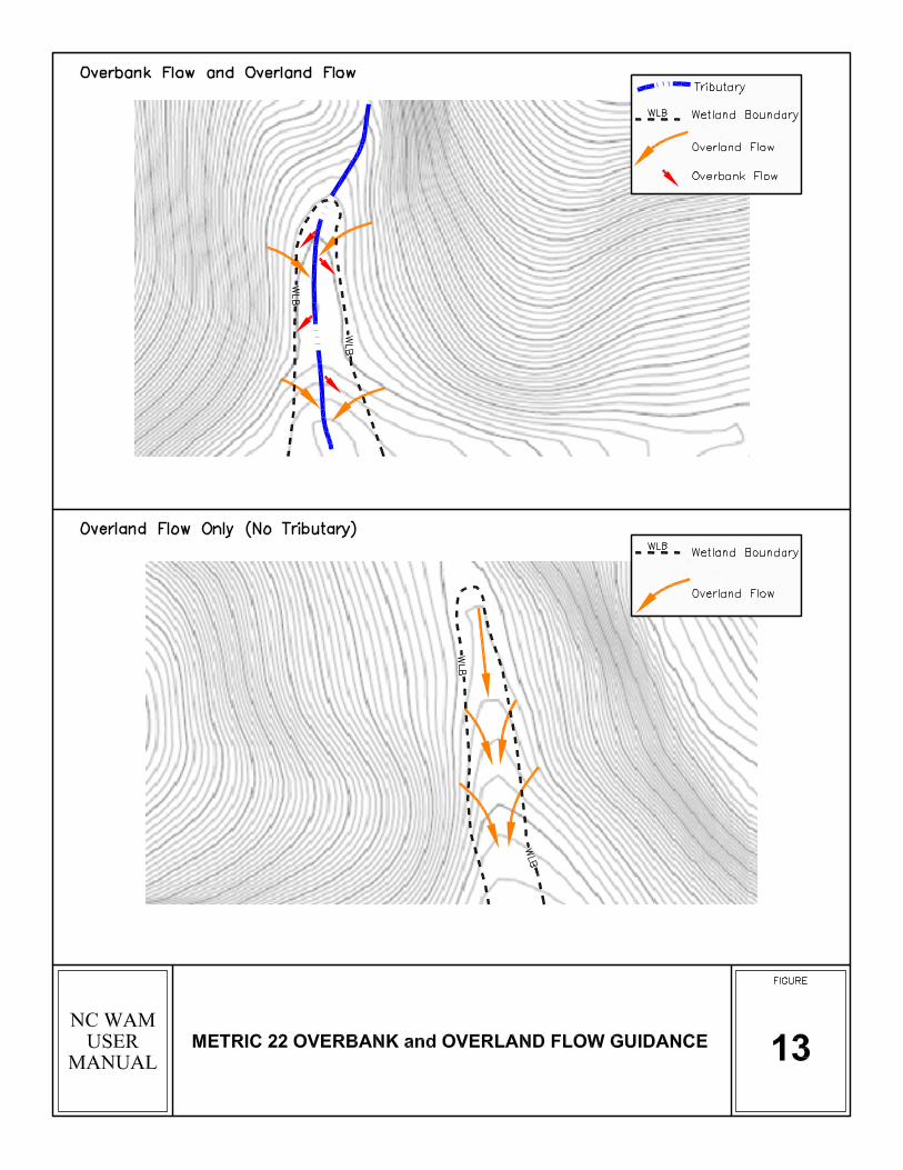
NC Wetland Assessment Method (NC WAM) v4.1 110 5.0 The Wetland Assessment Process
5.0 THE WETLAND ASSESSMENT PROCESS
It is crucial that the assessor become familiar with the NC WAM general wetland types and Field Assessment Form metrics in order to conduct a proper wetland assessment. Assessors will need to be familiar with the physiography, hydrologic regime, water quality function, typical vegetation structure and composition, and wildlife attributes for the range of reference examples appropriate to each general wetland type within the project area. Assessors will also need to develop a clear understanding of the intention of each metric, how the intention of each metric may change with different general wetland types, and how characteristics within each wetland type may change among different ecoregions.
An on-going objective during development of NC WAM is that on-site completion of the Field Assessment Form should take no more than 15 minutes. However, it is assumed that this 15-minute, on-site wetland assessment will be performed following a wetland boundary delineation or determination, and that during the course of the delineation/determination, the assessor will have become knowledgeable of the environmental features important to this wetland assessment method. This being the case, the assessor should have become familiar with site and regional physiography, soils, hydrology, vegetation, wetlands, and watershed activities affecting the site. The assessor should also be familiar with the proposed project in order to determine potential impact areas and identify individual assessment areas.
Completion of a wetland functional assessment will typically be a six-step process (the first three steps will likely be completed as part of a wetland boundary delineation/determination but are outlined here to maintain continuity in the discussion of information sources and methods): 1) become familiar with regional features through off-site research (mostly map analysis); 2) conduct an on-site investigation sufficient to delineate separate general wetland types; 3) make a determination of the boundaries of one or more assessment areas within the proposed project or action area; 4) conduct a rapid, on-site evaluation of each assessment area; 5) conduct an in-office map/GIS evaluation if needed (may be helpful in evaluation of Metrics 6, 11, 13, and 14) and 6) use the NC WAM Rating Calculator computer program to generate assessment ratings. Assessors are urged to document the basis for judgments on the Field Assessment Form or attach information for future reference by regulatory personnel and the public.
5.1 Background Information
5.1.1 General Information Tools available for the assessor to become familiar with regional features may include the following.
� Aerial photography � Topographic mapping � County soil survey � Wetlands mapping � Land-use mapping � Natural heritage element occurrence mapping from NCNHP
NC Wetland Assessment Method (NC WAM) v4.1 111 5.0 The Wetland Assessment Process
� NC WAM Tool Box (see description below)
Wetland assessors should examine available natural resource data prior to making the field visit. Available resources to be consulted include (but are not limited to) aerial photography, topographic mapping (USGS 7.5-minute quadrangles or more accurate mapping if available), the county soil survey, U.S. Fish and Wildlife Service (USFWS) National Wetlands Inventory (NWI) maps, the N.C. Division of Coastal Management (NCDCM) wetland map (if the site to be assessed is in the Coastal Plain ecoregions), NCNHP mapping of significant natural heritage areas and reference wetlands, local municipal web-based Information Mapping System (IMS) or GIS data sets (photography, contours, zoning, parcel data, etc.), and (if available) previously conducted jurisdictional area delineations/determinations from the project vicinity. These resources should initially be viewed with an eye toward landscape/watershed scale features. Next, the assessor should consider how potential wetland characteristics of the assessment site fit into the landscape perspective. The assessor should evaluate features of interest such as wetland delineation criteria (vegetation, hydrology, and soils) and anthropogenic disturbances (roadways, impoundments, deforestation, impermeable surfaces, and storm-water sources).
5.1.2 NC WAM Tool Box Another important tool for the wetland assessor (which utilizes much of the above-mentioned reference materials), currently under development, is a suite of GIS data layers collectively known by the working name “Tool Box.” The Tool Box is intended to provide specific information concerning wetland sites previously evaluated, including locations and descriptions for reference examples of WFAT-identified wetland types. The Tool Box will contain a map of North Carolina subdivided into level III and IV ecoregions (Appendix E). Ideally, a queried ecoregion will provide the assessor with a location map of previously identified and assessed wetlands. Digital files of available natural resources information pertinent to the assessment of that wetland will be linked to each wetland assessment site - topographic mapping, aerial photography, soils mapping, NWI mapping, on-site photography, and a completed Field Assessment Form. By comparing digital data layers for the wetland area to be assessed with the reference information contained in the Tool Box, an assessor should be able to make a reasonable estimation of wetland types that may be encountered. As future assessments are performed and compiled, the Tool Box will be supplemented with the intent to expand wetland functional information for each wetland type over a range of levels of disturbance. This feature may 1) assist the assessor with identification of wetlands in substantially disturbed condition and 2) provide the assessor with a reference wetland functional rating based on a documented, previously rated wetland with a similar level of disturbance.
Information gathered during this task might be used to plan the assessor’s course of travel to the wetland assessment site to maximize the assessor’s knowledge and understanding concerning natural features in the region.
5.2 On-Site Investigation This discussion assumes the assessor has conducted a wetland boundary delineation or determination (or is relying on a pre-existing wetland boundary delineation or determination) and knows that wetlands are present in a project area.
NC Wetland Assessment Method (NC WAM) v4.1 112 5.0 The Wetland Assessment Process
Following a delineation/determination effort that results in the identification of wetlands within a project area, an assessor will need to 1) determine if wetland stressors are present, 2) determine if more than one wetland type is present, and, if so, identify wetland type boundaries, and 3) identify assessment areas for evaluation.
5.2.1 Presence of Wetland Stressors During the on-site investigation, the assessor should make note of the presence of wetland stressors and consider the effect of stressors on project area wetlands. Wetland stressors typically include anthropogenic activities that affect one or more wetland functions. Potential wetland stressors may include, but are not limited to, ground surface disturbances, vegetation removal or maintenance, hydrological modification (stormwater runoff, ditching), presence of infrastructure that fragments habitat (roads, utility lines), and septic fields (see Section 2.3). The assessor should be familiar with the NRCS document that describes the lateral effect of ditches in North Carolina hydric soils (see USACE Wilmington District website) to analyze the affects of ditches in hydric soils. The effect of a stressor on a wetland depends on the wetland type and size, stressor type and severity, and the amount of time the wetland has been subject to the stressor. In some cases, when given sufficient time, a wetland may adjust to one or more stressors by shifting to another general wetland type.
5.2.2 Wetland Type, Number, and Boundaries NC WAM is designed for the assessor to consider current wetland condition during wetland type identification (not a past condition or anticipated future condition). The assessor should identify each discrete general wetland type that occurs within the project area using knowledge of the general wetland type descriptions (see Section 3.1) and the Dichotomous Key to General North Carolina Wetland Types (see pp. vii and viii and Section 3.4). It is important that the assessorwalk the entire project area prior to making a wetland type determination or deciding if more than one wetland type is present. In cases where identification of the general wetland type is difficult, and a wetland appears to potentially fit into more than one general wetland type, the assessor should use best professional judgment in determining the appropriate wetland type and document the reasoning. The assessor may choose to rate an assessment area as more than one wetland type and use best professional judgment to evaluate the results.
It is important that an assessor determine all boundaries between the wetland to be assessed (assessment area) and other wetland types or uplands. If the project area contains more than one wetland type, a determination of transition boundaries will need to be made. Depending on wetland types involved, the boundary between an assessment area and other wetland types may be straightforward or problematic. When problematic, the assessor will need to use best professional judgment in boundary determination and provide written justification on the Field Assessment Form or attached map. Examples of problematic areas include 1) the boundary between Riverine Swamp Forest and Non-Riverine Swamp Forest in a large floodplain swamp system in the embayed region of the state, 2) the boundary between Headwater Forest and Bottomland Hardwood Forest in a Piedmont or Mountain floodplain at the confluence of a first-order stream with a second-order stream (see Figure 2), 3) the boundary between Pine Flat and Hardwood Flat on an interstream system in the Coastal Plain ecoregions, and 4) the boundary between an interstream wetland (examples: Pocosin, Pine Flat, Hardwood Flat) and a riparian
NC Wetland Assessment Method (NC WAM) v4.1 113 5.0 The Wetland Assessment Process
wetland such as a Headwater Forest. The NC WAM Tool Box will provide assessors with guidance concerning these types of problems.
5.2.3 Assessment Area Identification “Assessment area” refers to a defined area of wetland that is subject to functional evaluation using NC WAM. Boundaries of the assessment area may be determined by the boundaries of a proposed activity (the project area), wetland type boundaries, the extent of a wetland type with a specific set of characteristics in common, or an upland area. A project area may contain multiple assessment areas, each of which will be evaluated separately using NC WAM. Steps taken in determining the boundaries of one or more assessment areas include the following: 1) conduct a Section 404 jurisdictional area determination/delineation within a project area to determine wetland locations and limits, 2) identify wetland types within the project area using the NC WAM Dichotomous Key to General North Carolina Wetland Types, and 3) use landscape and wetland features to potentially separate identified wetland types into discrete assessment areas.
It is anticipated that assessors will encounter wetlands of a single type characterized by more than one level of modification or disturbance. Examples of this include 1) a Hardwood Flat transected by a regularly (or irregularly) maintained utility line corridor or 2) a Riverine Swamp Forest with a portion that has been clear-cut. The decision of whether to break these areas into separate assessment areas should be based on the assessor’s best professional judgment. In general, when considering breaking a single wetland type into more than one assessment area due to a difference in wetland characteristics, the assessor may consider a minimum assessment area size of 0.1 acre (66 feet by 66 feet). This minimum size is proposed as general guidance based on project practicalities. The assessor will need to be prepared to defend this size decision when presenting NC WAM results.
Figures 14A through 14D provide an example of the process determining assessment area boundaries for a proposed roadway intersection. This example is located in the Southeastern Plains ecoregion in the Sandhills of Cumberland County. Figure 14A depicts the proposed intersection vicinity and project area boundaries on a USGS 7.5-minute quadrangle base. Note that a second-order stream (Tributary 1) flows into the project area from the north on the east side of the four-lane road (in the exhibits, the term “trib” is used for tributary). To the east, two streams (Tributaries 2 and 3) join to form a second-order stream (Tributary 4) that flows westward to a confluence with the previously mentioned second-order stream to form a third-order stream (Tributary 5) at the four-lane road crossing.
Step 1: Section 404 Jurisdictional Area Delineation Figure 14B introduces a Section 404 jurisdictional area delineation completed for the proposed roadway intersection. A yellow boundary with internal shading depicts a delineated wetland, while blue solid lines within wetland shading depict delineated tributaries.

NC Wetland Assessment Method (NC WAM) v4.1 114 5.0 The Wetland Assessment Process
Figure 14A depicts a proposed intersection vicinity and project area boundaries on a USGS 7.5-minute quadrangle base. This site is located in the Sandhills region of the Southeastern Plains ecoregion, Cumberland County. The term “Trib” refers to tributary. Figure 14B depicts a slightly zoomed-in view of the project area introduced by Figure 14A. A yellow boundary with internal shading depicts a delineated wetland; blue solid lines within wetland shading depict delineated tributaries.
Figure 14A
Figure 14B

NC Wetland Assessment Method (NC WAM) v4.1 115 5.0 The Wetland Assessment Process
Figure 14C depicts general wetland types identified within the project area. Figure 14D depicts assessment areas (1 through 9) identified within the project area.
Figure 14C
Figure 14D
NC Wetland Assessment Method (NC WAM) v4.1 116 5.0 The Wetland Assessment Process
Step 2: Identify General Wetland Types Subsequent to the jurisdictional area delineation, the Dichotomous Key to General North Carolina Wetland Types (see pp. vii and viii) is used to identify general wetland types present (Figure 14C). For this example, the wetland types will be identified in the order they occur in the key.
No wetlands in this example are affected by lunar or wind tides (key location II). Only one area of delineated wetlands occurs outside of a geomorphic floodplain (key location II.A); a small wetland located on a slope above the Tributary 4. The straight topographic lines within the wetland, rather than “u” or ‘v”-shaped lines of a topographic crenulation, indicate this wetland is on a slope. The lower boundary of this wetland is the outer edge of the floodplain floor. This wetland is not in a geomorphic floodplain or a natural topographic crenulation and is located on a side slope, resulting in its identification as a Seep (key location II.A.i).
Tributary 5, a third-order stream, flows southward from the four-lane road, through a maintained power-line corridor, and on across the project area boundary. Maintenance of the utility corridor has resulted in disturbance within the floodplain of this tributary, and beavers have constructed a dam along the lower boundary of the maintained utility corridor. The resulting impoundment has modified wetland hydrology between the four-lane road and the beaver dam, which is currently subject to semi-permanent to permanent inundation. This hydrologic change has been in place long enough to result in a change in the wetland plant community from forested to primarily emergent herbs with a fringe of woody shrubs (the wetland vegetation is dominated by herbaceous vegetation); therefore, the hydrologic influence of the beaver impoundment on the wetland is considered to be a “long-established, permanent alteration.” The wetland associated with this beaver impoundment is located within a geomorphic floodplain, not a Bog, dominated by herbaceous vegetation, abutting a second-order or larger stream, and characterized by semi-permanent to permanent inundation, resulting in its identification as Non-Tidal Freshwater Marsh (key location II.B.ii.1).
The remaining delineated wetlands occur within a geomorphic floodplain, are not Bogs, are dominated by woody vegetation, and are not in a localized depression (key location II.B.ii.2.b). The 7.5-minute topographic quadrangle depicts Tributary 2 to be a second-order stream. Even though the on-site jurisdictional area delineation did not identify a tributary within this feature, information provided on the 7.5-minute quadrangle is used to determine the stream order for use in the key. The quadrangle depicts the headwaters of Tributary 2 to include two linear drainages located outside the geomorphic floodplain and not in a natural topographic crenulation (Tributaries 2a and 2b). These linear drainages are straight and located in the maintained yard of an industrial facility, providing an indication that they are man-made ditches that should not be used in determining stream order for use in the key. Based on this consideration, Tributary 2 is determined to be a first-order stream. Observations made during the field visit concluded that this wetland is characterized by intermittent inundation. So the wetland abutting Tributary 2 is within a geomorphic floodplain, is not a Bog, is dominated by woody vegetation, is not in a localized depression, is abutting a first-order stream, and is characterized by intermittent inundation, resulting in a determination that this wetland is a Headwater Forest (key location II.B.ii.2.b.i.1).

NC Wetland Assessment Method (NC WAM) v4.1 117 5.0 The Wetland Assessment Process
The 7.5-minute topographic quadrangle depicts Tributary 3 to be a first-order stream. Even though the delineated tributary does not extend to the upper end of the delineated wetland, all of the delineated wetland exhibits the same hydrological characteristic (temporary inundation). So the wetland is located within a geomorphic floodplain, is not a Bog, is dominated by woody vegetation, is not in a localized depression, abuts a first-order stream, and is characterized by intermittent inundation, resulting in a determination that this wetland is a Headwater Forest(key location II.B.ii.2.b.i.1). A maintained power-line corridor crosses the Tributary 3 Headwater Forest just above its confluence with Tributary 2. Within this utility corridor, the regularly maintained vegetation is dominated by saplings and shrubs – woody vegetation. Therefore this maintained wetland area remains part of the Tributary 3 Headwater Forest.
Tributary 4 forms at the confluence of Tributaries 2 and 3 and extends downstream to a confluence with Tributary 1. Since, for the purposes of NC WAM, Tributaries 2 and 3 are first-order streams, Tributary 4 is a second-order stream (see Figure 2 for guidance in determining the boundary between wetlands primarily influenced by a first-order stream and wetlands primarily influenced by a second-order stream). The wetland abutting Tributary 4 exhibits evidence of seasonal inundation downstream to the vicinity of the confluence with Tributary 1, where the wetland becomes much wetter as a result of beaver activity on Tributary 1. The wetland abutting Tributary 4 is within a geomorphic floodplain, not a Bog, dominated by woody vegetation, not in a localized depression, abutting a second-order or higher stream, and characterized by seasonal inundation, resulting in its identification as Bottomland Hardwood Forest (key location II.B.ii.2.b.ii.1).
Tributary 1 is a second-order stream that has been subject to the hydrologic influence of a beaver dam in the vicinity of the four-lane road crossing and the confluence with Tributary 4. The wetland abutting Tributary 1 is wholly within the beaver impoundment and is currently subject to semi-permanent to permanent inundation. This hydrologic change has been in place long enough to alter the wetland plant community to an open canopy of hydrophytic tree species and a dense undergrowth of emergent herbs (based on tree coverage, the plant community is dominated by woody vegetation); therefore, the hydrologic influence of the beaver impoundment on the wetland is considered to be a “long-established, permanent alteration.” The wetland abutting Tributary 1 is within a geomorphic floodplain, not a Bog, dominated by woody vegetation, not in a localized depression, abutting a second-order or higher stream, and characterized by semi-permanent to permanent inundation, resulting in its identification as Riverine Swamp Forest (key location II.B.ii.2.b.ii.2).
Tributary 5, between the utility corridor beaver dam and the project area boundary, is a third-order stream, is bounded by a delineated wetland characterized by forest vegetation and semi-permanent inundation. This wetland is within a geomorphic floodplain, is not a Bog, is dominated by woody vegetation, is not in a localized depression, abuts a second-order or higher stream, and is characterized by semi-permanent to permanent inundation, resulting in its identification as Riverine Swamp Forest (key location II.B.ii.2.b.ii.2).
NC Wetland Assessment Method (NC WAM) v4.1 118 5.0 The Wetland Assessment Process
Step 3: Identify Discrete Assessment Areas As stated earlier, boundaries of an assessment area may be determined by the boundaries of a proposed activity (the project area), wetland type boundaries, the extent of a wetland type with a specific set of characteristics in common, or an upland area. Steps 1 and 2 have resulted in the identification and delineation of wetland types based on project area boundaries, upland boundaries, and wetland characteristics (Figure 14C). The assessor should now consider each identified wetland type in turn and determine if it should be sub-divided based on variation in important characteristics such as differences in vegetation structure (clear-cutting, different age stands, thinning), hydrology (ditching, beaver impacts), and watershed disturbances that may affect the subject wetland (commercial sites, industrial sites, or highways).
The land within the boomerang-shaped Headwater Forest is relatively undisturbed and homogeneous, with the exception of a power-line corridor subject to regular vegetation maintenance (mowing) that crosses Tributary 3 and abutting wetlands just upstream of the confluence with Tributary 2. This power-line corridor is approximately 300 feet wide and supports a substantially different plant community structure from the remainder of the Headwater Forest. Therefore, the Headwater Forest should be broken into three assessment areas: the northern arm of the boomerang (Assessment Area 1), the portion of Headwater Forest within the power-line corridor (Assessment Area 2), and the southern arm of the boomerang upslope of the power-line corridor (Assessment Area 3) (Figure 14D). If on-site observations indicate that wetland characteristics are similar within Assessment Areas 1 and 3, and the area outside of the wetland type boundaries is similar for both assessment areas, the assessor may consider combining them as one assessment area. However, in this case, Assessment Area 1 contains a tributary and Assessment Area 2 does not; and although both assessment areas are near a maintained utility line corridor, Assessment Area 3 is near and downstream of a residential neighborhood, while Assessment Area 1 appears to have a wooded watershed. Because of these differences, it is reasonable to keep these areas of Headwater Forest separated as discrete assessment areas. Note that assessors will need to justify the validity of combining assessment areas.
The Seep and both Riverine Swamp Forests are characterized by relatively homogeneous wetland characteristics; therefore, each of these wetlands is considered to be a discrete assessment area (Assessment Areas 4, 7, and 9, respectively).
The Bottomland Hardwood Forest is divided into two by a causeway over a culverted tributary crossing. The causeway includes a 15-foot wide soil road. Therefore, these two wetlands are considered discrete assessment areas (Assessment Areas 5 and 6). If on-site observations indicate that wetland characteristics are similar within these two areas of Bottomland Hardwood Forest and the area outside of the wetland type boundaries was similar for both Bottomland Hardwood Forest areas, the assessor may consider combining them as one assessment area. However, assessors will need to justify the validity of combinations. The portion of the Non-Tidal Freshwater Marsh that is subject to regular maintenance within the power-line corridor generally retains similar wetland characteristics (such as surface water hydroperiod, soils, and vegetation structure) to the non-maintained portion of this wetland, and both areas are characterized by similar features outside of the wetland type boundaries;
NC Wetland Assessment Method (NC WAM) v4.1 119 5.0 The Wetland Assessment Process
therefore, the entirety of the Non-Tidal Freshwater marsh is considered a single assessment area (Assessment Area 8).
Wetlands depicted in Figures 14A-D comprise two wetland complexes. In this case, wetland complex boundaries are natural uplands and a man-made berm or causeway the width of a four-lane road or wider (the causeway between the two areas of Bottomland Hardwood Forest is not a wetland complex boundary). The depicted four-lane road bridges the tributary, but no wetlands extend under the bridges; therefore, these figures depict one wetland complex east (right) of the four-lane road and a second wetland complex west (left) of the four-lane road.
Wetlands depicted in Figures 14A-D comprise two areas of forested wetland. In this case, forested wetland boundaries are a man-made berm or causeway the width of a four-lane road or wider and any wetland not dominated by forest the width of a four-lane road or wider. The maintained utility line corridor is not quite wide enough to be a forested wetland boundary; however both the four-lane road and the Non-Tidal Freshwater Marsh act as forested wetland boundaries. So, one forested wetland includes all wetlands east (right) of the four-lane road and the Riverine Swamp Forest south of (below) the Non-Tidal Freshwater Marsh is a second forested wetland.
5.3 Completion of the NC WAM Field Assessment Form Tools needed to complete the NC WAM Field Assessment Form and associated attachments include (but are not limited to) the following.
� Soil auger or sharp-shooter shovel � Appropriate Munsell soil color chart � Pocket rod, or other measurement device � Site and watershed mapping � Global Positioning System (GPS) or other method for determining location � Camera for recording site conditions and characteristics � NC WAM Dichotomous Key to General North Carolina Wetland Types � Knowledge of soil texture-by-feel analysis (Appendix F) � Knowledge of the latest version of the Natural Resources Conservation Service/National
Technical Committee for Hydric Soils (NRCS/NTCHS) “Field Indicators of Hydric Soils in the United States, Guide for Identifying and Delineating Hydric Soils.”
� Knowledge of the NRCS lateral affect of ditching guidance (see USACE Wilmington District website) to analyze the affects of ditches in hydric soils
� Knowledge of the use of NC WAM � Plant identification manuals such as “Common Wetland Plants of North Carolina
(NCDWQ 1997a)
5.3.1 Field Assessment Form The Field Assessment Form is provided with other NC WAM forms at the beginning of the User Manual (see pp. ix to xii). Guidance for completion of the Field Assessment Form is provided in Section 4.3. Completion of the Field Assessment Form should be thorough and accurate. It is important that the assessor include notes concerning wetland characteristics, especially any
NC Wetland Assessment Method (NC WAM) v4.1 120 5.0 The Wetland Assessment Process
that might not be captured when answering the metrics on the Field Assessment Form. These forms are not only a means to a functional rating, but also a documentation of the condition of the wetland.
Information requested in the box at the beginning of the Field Assessment Form provides space for documentation of stressors affecting the assessment area, regulatory considerations, general site hydrology, and landscape position. The Field Assessment Form requests that the evaluator note evidence of various stressors on an assessment area. This particular information is not directly used in the determination of ratings but helps the assessor consider anthropomorphic impacts to the assessment area. The presence and extent of a stressor should be documented on the Field Assessment Form with consideration for the resulting departure of wetland functions from reference condition for the assessed wetland type.
When evaluating metrics, the assessor should compare the assessed wetland to a reference wetland (if appropriate). A discussion of the intention and use of Field Assessment Form metrics is included in Section 4.3. Familiarization with the watershed of the assessment area watershed and descriptions of wetland types will facilitate this process. It is essential that the assessor walk the entire assessment area prior to completing the Field Assessment Form.
5.3.2 Field Map The assessor should attach a field map to each completed Field Assessment Form. The field map may be hand drawn or include a refined base map (USGS 7.5-minute quadrangle, county soil survey, aerial photograph, or printed-out map from a web-based geography server or local municipality IMS). The map should provide useful information for the identification of area features for evaluation by regulatory agency personnel and the public.
5.3.3 Photographs Photographs of the assessment area taken while on-site should be attached to the completed Field Assessment Form. Attached photographs should depict typical features of the assessment area.
5.4 Generation of Functional Assessment Ratings
5.4.1 Data Analysis Tools needed for data analysis include the following.
� Completed NC WAM Field Assessment Form and associated attachments � NC WAM Rating Calculator computer program to generate wetland functional ratings
NC WAM utilizes a Boolean logic chain of reasoning to convert the metric evaluation results into functional ratings. The Boolean logic process was developed by the WFAT following extensive discussions regarding the possible interactions of the metrics and sub-functions. These results were re-evaluated at numerous field sites. The Boolean logic has been written into a computer program (NC WAM Rating Calculator, see Appendix H) that generates ratings for wetland metrics, sub-functions, functions, and the over-all wetland. The Rating Calculator is an Excel
NC Wetland Assessment Method (NC WAM) v4.1 121 5.0 The Wetland Assessment Process
macro that is planned to be made available on an internet site through the N.C. Division of Water Quality.
The Boolean process proceeds by determining descriptors for metrics and then functional ratings for sub-functions, functions, and the assessment area, in sequence. Each level of function subsumes the next, effectively serving as the building blocks for the levels that follow (Table 1). For instance, of the four levels of functional assessment, the metric level has the narrowest purview. Singularly, metrics pertain to very specific aspects of the wetland, such as ground surface condition or duration of inundation. Collectively, however, metrics are organized into sub-functions. Combining the descriptors of all metrics within a particular sub-function (through the use of Boolean logic) produces a sub-function rating that offers a broader account of wetland function. Sub-functions themselves are organized into one of three wetland functions: Hydrology, Water Quality, and Habitat. The ratings generated for all sub-functions corresponding to a particular wetland function (such as the Hydrology function) are combined to produce a wetland function rating. The individual function ratings provide a still broader account of wetland function than the sub-function ratings. Ultimately, the individual wetland function ratings are combined to produce an over-all wetland rating. The over-all wetland rating is the most comprehensive of the four levels of function – an aggregate of all functional levels considered in NC WAM.
The NC WAM Rating Calculator provides a screen that approximates the Field Assessment Form. The assessor completes the form within the Rating Calculator by selecting the proper boxes and option buttons. The program generates functional ratings from the completed form. The assessor can then print a hard copy of the rating results (Wetland Rating Sheet) for the assessed wetland. An example of the Wetland Rating Sheet is provided as p. xiii at the beginning of the User Manual.
5.4.2 Final Product The use of NC WAM is expected to result in the generation of a functional rating for each assessed wetland and the specific component functions and sub-functions of that particular wetland, as well as documentation of field conditions contributing to the ratings. The product resulting from implementation of NC WAM includes, but is not limited to, a completed Field Assessment Form (with assessor notes), a completed Wetland Rating Sheet, a site map, site photographs, and additional notes if appropriate. This product is intended to be utilized by land owners, planners, as well as, local, state, and federal regulatory agency personnel.
The Wetland Rating Sheet is comprised of five sections: general information, red-flag issues, sub-function rating summary, function rating summary, and overall wetland rating. General information at the top of the wetland rating sheet provides limited site information including wetland site name, wetland type, date of assessment, and the assessor’s name and organization. Next is a list of five items of interest concerning the assessed wetland. A Yes/No toggle is provided to allow the Wetland Rating Sheet to indicate if one or more of these items has been observed during the assessment.

Table 1. Relationship of metrics, sub-functions, and functions for generation of wetland functional ratings for a Bottomland Hardwood Forest assessment area.
Condition metric
Opportunity metric
Diagonal lines indicate the potential to modify a sub-function rating
NOTE:
Metric Sub-function Function Wetland9. Inundation Duration
3. Water Storage / Surface Relief
4. Soil Texture / Structure Sub-surface Storage and Retention
9. Inundation Duration
4. Soil Texture / Structure Pathogen Change
22. Hydrologic Connectivity
6. Land Use
10. Indicators of Deposition
17. Vegetative Structure
9.
22. Hydrologic Connectivity
6. Land Use
4. Soil Texture / Structure
9. Inundation Duration Soluble Change
22. Hydrologic Connectivity
6. Land Use
7. Wetland Acting as a Vegetated Buffer
8.
6. Land Use
17. Vegetative Structure
19.
18. Snags
20. Large Woody Debris
2. Storage Capacity and Duration
1. Ground Surface / Vegetation Condition Habitat
11. Wetland Size
13. Natural Area Connectivity Landscape Patch Structure
14. Edge Effect
15. Vegetative Composition Vegetative Composition
Inundation DurationParticulate Change
Wetland Width at the Assessment AreaPhysical Change
Surface Storage and Retention
Hydrologic Connectivity22.
17.
Hydrology
Diameter Class DistributionHabitat Physical Structure
Water Quality
Vegetation Structure
Assessment Area
NC Wetland Assessment Method (NC WAM) v4.1 123 5.0 The Wetland Assessment Process
organization. Next is a list of five items of interest concerning the assessed wetland. A Yes/No toggle is provided to allow the Wetland Rating Sheet to indicate if one or more of these items has been observed during the assessment.
The sub-function rating summary provides ratings for all sub-functions associated with the evaluated wetland type. This summary also indicates if the assessment area has the opportunity for enhanced Water Quality function and how an existing opportunity is expected to affect Water Quality condition ratings. The function rating summary provides the function ratings resulting from a combination of sub-function ratings. This summary also indicates if the assessment area has the opportunity for enhanced Water Quality function and how an existing opportunity is expected to affect the water quality condition rating. Finally, an overall wetland rating is provided, which is a combination of the function ratings for Hydrology, Water Quality, and Habitat.
NC Wetland Assessment Method (NC WAM) v4.1 124 6.0 Technical Resources
6.0 TECHNICAL RESOURCES This version of NC WAM contains supporting information in Appendices A through I. Additional information supporting NC WAM, presented as Appendices J through M, will be made available on the internet. The contents of these additional appendices are described briefly below.
Appendix J Relationship of Metrics, Sub-functions, and Functions for all Wetland Types. This appendix includes a table similar to Table 1 (p. 120 in the User Manual) for each wetland type. The purpose of each table is to provide a depiction of how metrics are organized into sub-functions, which are themselves organized into one of three wetland functions.
Appendix K Field Metric Evaluation Sheets. This appendix includes the original Field Metric Evaluation Sheet developed by the WFAT for each general wetland type.
Appendix L Cross-walk from the Field Metric Evaluation Sheets to the Field Assessment Form. This appendix depicts the relationships between the original metrics developed on the Field Metric Evaluation Sheets and the metrics presented on the current Field Assessment Form.
Appendix M Functional Rating Boolean Logic for Each Wetland Type. This appendix provides a depiction of the Boolean logic chain of reasoning used to convert the metric evaluation results into functional ratings for sub-functions, functions, and the assessment area, in sequence.

NC Wetland Assessment Method (NC WAM) v4.1 125 7.0 References
7.0 REFERENCES
Adamus, Paul and Karla Brandt. 1990. Impacts on Quality of Inland Wetlands of the United States: A Survey of Indicators, Techniques, and Applications of Community Level Biomonitoring Data. Report # EPA/600/3-90/073, U.S. Environmental Protection Agency.
Bartoldus, C.C. 1999. A Comprehensive Review of Wetland Assessment Procedures: A Guide for Wetland Practitioners. Environmental Concern, Inc., St. Michaels, MD. 196 pp.
Beyer, Fred. 1991. North Carolina, the Years before Man: A Geologic History. Carolina Academic Press, Durham, NC. 244 pp.
Brinson, M.M. Unpublished. A draft table of Hydrogeomorphic Method classes and sub-classes provided to the N.C. Wetland Functional Assessment Team by Dr. Brinson in the summer of 2004.
Cowardin, L.M., V. Carter, F.C. Golet, and E.T. LaRoe. 1979. Classification of Wetlands and Deepwater Habitats of the United States. USFWS/OBS -79/31. Fish and Wildlife Service, U.S. Department of the Interior, Washington, DC. 103 pp.
Environmental Laboratory. 1987. Corps of Engineers Wetlands Delineation Manual. U.S. Army Corps of Engineers, U.S. Army Engineers Waterways Experiment Station, Vicksburg, MS. 92 pp.
Griffith, G.E., J.M. Omernick, J.A. Comstock, M.P. Schafale, W.H. McNab, D.R. Lenat, T.F. MacPherson, J.B. Glover, and V.B. Shelburne. 2002. Ecoregions of North Carolina and South Carolina. U.S. Geological Survey (map scale 1:1,500,000), Reston, VA.
N.C. Division of Coastal Management (NCDCM). 2001. CAMA Handbook for Development in Coastal North Carolina. N.C. Department of Environment and Natural Resources. 49 pp.
N.C. Division of Environmental Management (NCDEM). 1995. Guidance for Rating the Values of Wetlands in North Carolina, Fourth Version. Department of Environment, Health, and Natural Resources, Division of Environmental Management, Water Quality Section, Raleigh, NC. 57 pp.
N.C. Division of Environmental Management (NCDEM). 1996. A Field Guide to North Carolina Wetlands. Department of Environment, Health, and Natural Resources, Water Quality Section, Raleigh, NC. EPA #904/B-94/001. DEM Report No. 96-01. 129 pp.
N.C. Division of Water Quality (NCDWQ). 1997a. Common Wetland Plants of North Carolina, N.C. Department of Environment, Health, and Natural Resources, Water Quality Section. Report 97-01. 147 pp.

NC Wetland Assessment Method (NC WAM) v4.1 126 7.0 References
N.C. Division of Water Quality (NCDWQ). 1997b. Pasquotank River Basinwide Water Quality Management Plan. N.C. Department of Environment and Natural Resources, Division of Water Quality, Water Quality Section.
N.C. Wetland Functional Assessment Team (WFAT). Unpublished. Status Report: North Carolina Wetland Functional Assessment (White Paper). Dated January 13, 2004.
N.C. Wetland Functional Assessment Team (WFAT). Unpublished. Report of the North Carolina Wetland Functional Assessment Team GIS- and Field-Based Methods - Final, but Not Complete (Gray Paper). Dated October 15, 2004.
Radford, A.E., H.E. Ahles, and C.R. Bell. 1968. Manual of the Vascular Flora of the Carolinas. The University of North Carolina Press. Chapel Hill, NC. 1183 pp.
Reed, P.B., Jr. 1988. National List of Plant Species That Occur in Wetlands: Southeast (Region 2). U.S. Department of the Interior, Fish and Wildlife Service Biological Report 88(26.2). 124 pp.
Schafale, M.P. and A.S. Weakley. 1990. Classification of the Natural Communities of North Carolina: Third Approximation. Natural Heritage Program, Division of Parks and Recreation, N.C. Department of Environment, Health, and Natural Resources. 325 pp.
Sprecher, S.W. and A.G. Warne. 2000. Accessing and Using Meteorological Data to Evaluate Wetland Hydrology. Technical Report, ERDC/EL TR-WRAP-00-1, U.S. Army Engineer Research and Development Center, Vicksburg, MS. (http://el.erdc.usace.army.mil/elbups/pdf/wrap00-1/wrap00-1.pdf)
Steen, E.B. 1971. Dictionary of Biology. Barnes and Noble Books, New York. 630 pp.
Strahler, A.N. 1952. Dynamic basis of geomorphology. Geological Society of America Bulletin (63) 923-938.
Sutter, L.A. 1999. DCM Wetland Mapping in Coastal North Carolina, a Report of the Strategic Plan for Improving Coastal Management in North Carolina. Division of Coastal Management, N.C. Department of Environment and Natural Resources pursuant to the U.S. Environmental Protection Agency Award No. 994548-94-5. 33 pp.
Sutter, L.A., J.B. Stanfill, D.M. Haupt, C.J. Bruce, and J.E. Wuenscher. 1999. NC-CREWS: North Carolina Coastal Region Evaluation of Wetland Significance, a Report of the Strategic Plan for Improving Coastal Management in North Carolina. Division of Coastal Management, N.C. Department of Environment and Natural Resources pursuant to the U.S. Environmental Protection Agency Award No. 994548-94-5.
U.S Army Corps of Engineers (USACE). 2005. Ordinary High Water Mark Identification. USACE Regulatory Guidance Letter No. 05-05, dated December 7, 2005, 4 pp.
NC Wetland Assessment Method (NC WAM) v4.1 127 7.0 References
U.S. Army Corps of Engineers (USACE). 2006. Wilmington District, Regulatory Division Wetland Mitigation Definitions website, which is subject to revision without notice: http://www.saw.usace.army.mil/WETLANDS/Mitigation/definitions.html.
U.S. Army Corps of Engineers (USACE). 2008. Interim Regional Supplement to the Corps of Engineers Wetland Delineation Manual: Atlantic and Gulf Coastal Plain Region. ERDC/EL TR-08-30, U.S. Army Engineer Research and Development Center, Vicksburg, MS. 127 pp.
U.S. Department of Agriculture (USDA). 1997. Hydrology Tools for Wetland Determination. Chapter 19, Engineering Field Handbook. Natural Resources Conservation Service, Fort Worth, TX. (http://www.info.usda.gov/CED/ftp/CED/EFH-CH19.pdf)
U.S. Department of Agriculture (USDA). No date; subject to change without notice. Field Indicators of Hydric Soils in the United States: A Guide to Identifying and Delineating Hydric Soils, (most recent guidance from the National Technical Committee for Hydric Soils - ftp://ftp-fc.sc.egov.usda.gov/NSSC/Hydric_Soils).
U.S. Department of Agriculture (USDA). No date, subject to change without notice. National Soil Survey Handbook, title 430-VI. USDA Natural Resources Conservation Service [online]. (http://soils.usda.gov/technical/handbook)
U.S. Environmental Protection Agency (USEPA). 2006. Field Indicators of Hydric Soils in the Mid-Atlantic United States. Mid-Atlantic Hydric Soils Committee. With excerpts from Field Indicators of Hydric Soils in the United States, (most recent guidance from the National Technical Committee for Hydric Soils - http://soils.usda.gov/use/hydric/).
U.S. Fish and Wildlife Service (USFWS), U.S. Environmental Protection Agency (USEPA), U.S. Army Corps of Engineers (USACE), and U.S. Department of Agriculture, Soil Conservation Service (USDA). 1989. Federal Manual for Identifying and Delineating Jurisdictional Wetlands. An Interagency Cooperative Publication. 86 pp.
U.S. Geological Service (USGS). 1974. Hydrologic Unit Map – 1974, State of North Carolina. U.S. Department of the Interior, in cooperation with the U.S. Water Resources Council.
Weakley, Alan S. 2006. Flora of the Carolinas, Virginia, Georgia, and Surrounding Areas (working draft of 17 January 2006). University of North Carolina Chapel Hill. 1026 pp.

APPENDIX A
Abbreviations

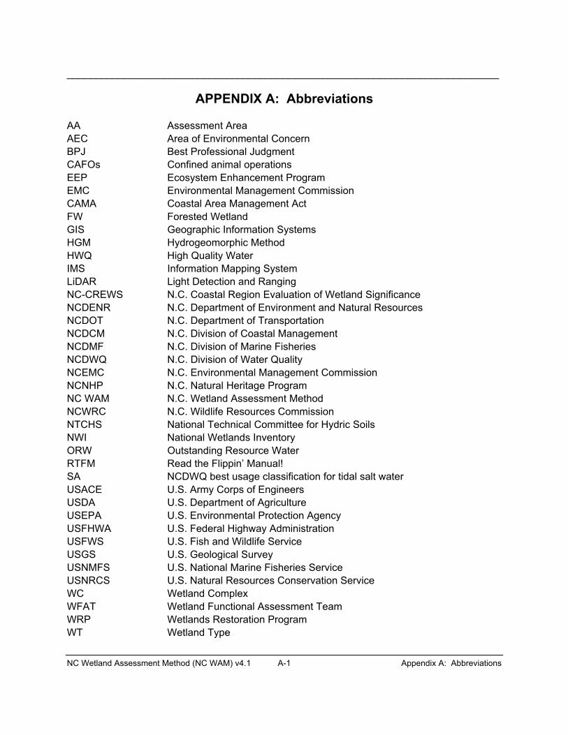
____________________________________________________________________________
NC Wetland Assessment Method (NC WAM) v4.1 A-1 Appendix A: Abbreviations
APPENDIX A: Abbreviations
AA Assessment Area AEC Area of Environmental Concern BPJ Best Professional Judgment CAFOs Confined animal operations EEP Ecosystem Enhancement Program EMC Environmental Management Commission CAMA Coastal Area Management Act FW Forested Wetland GIS Geographic Information Systems HGM Hydrogeomorphic Method HWQ High Quality Water IMS Information Mapping System LiDAR Light Detection and Ranging NC-CREWS N.C. Coastal Region Evaluation of Wetland Significance NCDENR N.C. Department of Environment and Natural Resources NCDOT N.C. Department of Transportation NCDCM N.C. Division of Coastal Management NCDMF N.C. Division of Marine Fisheries NCDWQ N.C. Division of Water Quality NCEMC N.C. Environmental Management Commission NCNHP N.C. Natural Heritage Program NC WAM N.C. Wetland Assessment Method NCWRC N.C. Wildlife Resources Commission NTCHS National Technical Committee for Hydric Soils NWI National Wetlands Inventory ORW Outstanding Resource Water RTFM Read the Flippin’ Manual! SA NCDWQ best usage classification for tidal salt water USACE U.S. Army Corps of Engineers USDA U.S. Department of Agriculture USEPA U.S. Environmental Protection Agency USFHWA U.S. Federal Highway Administration USFWS U.S. Fish and Wildlife Service USGS U.S. Geological Survey USNMFS U.S. National Marine Fisheries Service USNRCS U.S. Natural Resources Conservation Service WC Wetland Complex WFAT Wetland Functional Assessment Team WRP Wetlands Restoration Program WT Wetland Type


APPENDIX B
Cross-reference of Wetland Types

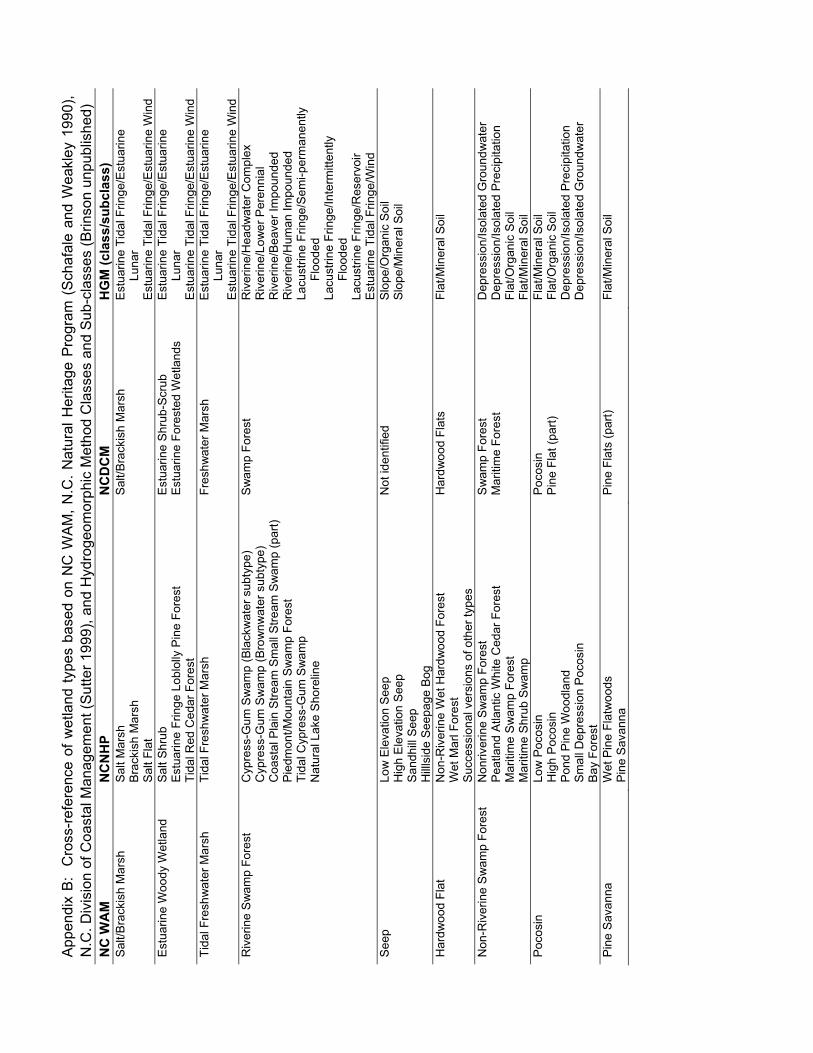
App
endi
x B
: C
ross
-ref
eren
ce o
f wet
land
type
s ba
sed
on N
C W
AM
, N.C
. Nat
ural
Her
itage
Pro
gram
(S
chaf
ale
and
Wea
kley
199
0),
N.C
. Div
isio
n of
Coa
stal
Man
agem
ent (
Sut
ter 1
999)
, and
Hyd
roge
omor
phic
Met
hod
Cla
sses
and
Sub
-cla
sses
(Brin
son
unpu
blis
hed)
N
C W
AM
N
CN
HP
NC
DC
M
HG
M (c
lass
/sub
clas
s)
Sal
t/Bra
ckis
h M
arsh
S
alt M
arsh
B
rack
ish
Mar
sh
Sal
t/Bra
ckis
h M
arsh
E
stua
rine
Tida
l Frin
ge/E
stua
rine
Luna
r S
alt F
lat
Est
uarin
e Ti
dal F
ringe
/Est
uarin
e W
ind
Est
uarin
e W
oody
Wet
land
S
alt S
hrub
E
stua
rine
Frin
ge L
oblo
lly P
ine
Fore
st
Est
uarin
e S
hrub
-Scr
ub
Est
uarin
e Fo
rest
ed W
etla
nds
Est
uarin
e Ti
dal F
ringe
/Est
uarin
e Lu
nar
Tida
l Red
Ced
ar F
ores
t E
stua
rine
Tida
l Frin
ge/E
stua
rine
Win
d Ti
dal F
resh
wat
er M
arsh
Ti
dal F
resh
wat
er M
arsh
Fr
eshw
ater
Mar
sh
Est
uarin
e Ti
dal F
ringe
/Est
uarin
e Lu
nar
Est
uarin
e Ti
dal F
ringe
/Est
uarin
e W
ind
Riv
erin
e S
wam
p Fo
rest
C
ypre
ss-G
um S
wam
p (B
lack
wat
er s
ubty
pe)
Sw
amp
Fore
st
Riv
erin
e/H
eadw
ater
Com
plex
C
ypre
ss-G
um S
wam
p (B
row
nwat
er s
ubty
pe)
R
iver
ine/
Low
er P
eren
nial
C
oast
al P
lain
Stre
am S
mal
l Stre
am S
wam
p (p
art)
Pie
dmon
t/Mou
ntai
n S
wam
p Fo
rest
Riv
erin
e/B
eave
r Im
poun
ded
Riv
erin
e/H
uman
Impo
unde
d Ti
dal C
ypre
ss-G
um S
wam
p N
atur
al L
ake
Sho
relin
e
Lacu
strin
e Fr
inge
/Sem
i-per
man
ently
Fl
oode
d
Lacu
strin
e Fr
inge
/Inte
rmitt
ently
Fl
oode
d
Lacu
strin
e Fr
inge
/Res
ervo
ir E
stua
rine
Tida
l Frin
ge/W
ind
See
p Lo
w E
leva
tion
See
p N
ot id
entif
ied
Slo
pe/O
rgan
ic S
oil
Hig
h E
leva
tion
Seep
Sl
ope/
Min
eral
Soi
l
San
dhill
See
p
H
illls
ide
Seep
age
Bog
Har
dwoo
d Fl
at
Non
-Riv
erin
e W
et H
ardw
ood
Fore
st
Har
dwoo
d Fl
ats
Flat
/Min
eral
Soi
l W
et M
arl F
ores
t S
ucce
ssio
nal v
ersi
ons
of o
ther
type
s N
on-R
iver
ine
Sw
amp
Fore
st
Non
river
ine
Sw
amp
Fore
st
Sw
amp
Fore
st
Dep
ress
ion/
Isol
ated
Gro
undw
ater
P
eatla
nd A
tlant
ic W
hite
Ced
ar F
ores
t M
ariti
me
Fore
st
Dep
ress
ion/
Isol
ated
Pre
cipi
tatio
n M
ariti
me
Sw
amp
Fore
st
Flat
/Org
anic
Soi
l M
ariti
me
Shr
ub S
wam
p Fl
at/M
iner
al S
oil
Poc
osin
Lo
w P
ocos
in
Poc
osin
Fl
at/M
iner
al S
oil
Hig
h P
ocos
in
Pin
e Fl
at (p
art)
Flat
/Org
anic
Soi
l Po
nd P
ine
Woo
dlan
d D
epre
ssio
n/Is
olat
ed P
reci
pita
tion
Sm
all D
epre
ssio
n P
ocos
in
Dep
ress
ion/
Isol
ated
Gro
undw
ater
Bay
For
est
Pin
e S
avan
na
Wet
Pin
e Fl
atw
oods
P
ine
Flat
s (p
art)
Flat
/Min
eral
Soi
l
Pin
e S
avan
na
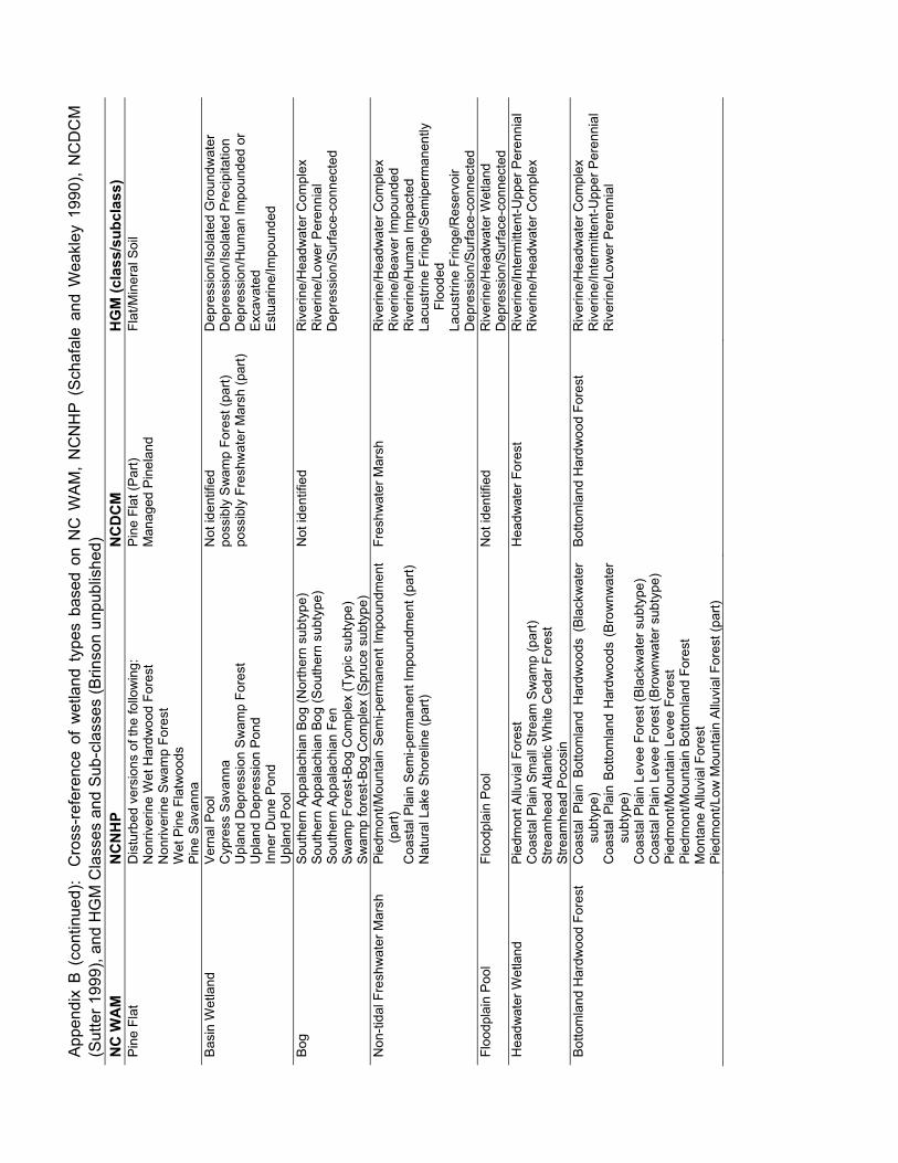
App
endi
x B
(co
ntin
ued)
: C
ross
-ref
eren
ce o
f w
etla
nd t
ypes
bas
ed o
n N
C W
AM
, N
CN
HP
(S
chaf
ale
and
Wea
kley
199
0),
NC
DC
M
(Sut
ter 1
999)
, and
HG
M C
lass
es a
nd S
ub-c
lass
es (B
rinso
n un
publ
ishe
d)
NC
WA
M
NC
NH
PN
CD
CM
H
GM
(cla
ss/s
ubcl
ass)
P
ine
Flat
D
istu
rbed
ver
sion
s of
the
follo
win
g:
Pin
e Fl
at (P
art)
Flat
/Min
eral
Soi
l N
onriv
erin
e W
et H
ardw
ood
Fore
st
Man
aged
Pin
elan
d N
onriv
erin
e S
wam
p Fo
rest
W
et P
ine
Flat
woo
ds
P
ine
Sav
anna
B
asin
Wet
land
V
erna
l Poo
l N
ot id
entif
ied
Dep
ress
ion/
Isol
ated
Gro
undw
ater
C
ypre
ss S
avan
na
poss
ibly
Sw
amp
Fore
st (p
art)
Dep
ress
ion/
Isol
ated
Pre
cipi
tatio
n U
plan
d D
epre
ssio
n S
wam
p Fo
rest
po
ssib
ly F
resh
wat
er M
arsh
(par
t) D
epre
ssio
n/H
uman
Impo
unde
d or
U
plan
d D
epre
ssio
n Po
nd
Exca
vate
d In
ner D
une
Pon
d E
stua
rine/
Impo
unde
d
Upl
and
Pool
Bo
g So
uthe
rn A
ppal
achi
an B
og (N
orth
ern
subt
ype)
N
ot id
entif
ied
Riv
erin
e/H
eadw
ater
Com
plex
So
uthe
rn A
ppal
achi
an B
og (S
outh
ern
subt
ype)
Riv
erin
e/Lo
wer
Per
enni
al
Sou
ther
n A
ppal
achi
an F
en
Dep
ress
ion/
Sur
face
-con
nect
ed
Sw
amp
Fore
st-B
og C
ompl
ex (T
ypic
sub
type
)
Sw
amp
fore
st-B
og C
ompl
ex (S
pruc
e su
btyp
e)
N
on-ti
dal F
resh
wat
er M
arsh
P
iedm
ont/M
ount
ain
Sem
i-per
man
ent I
mpo
undm
ent
(par
t)Fr
eshw
ater
Mar
sh
Riv
erin
e/H
eadw
ater
Com
plex
R
iver
ine/
Bea
ver I
mpo
unde
d C
oast
al P
lain
Sem
i-per
man
ent I
mpo
undm
ent (
part)
Riv
erin
e/H
uman
Impa
cted
N
atur
al L
ake
Sho
relin
e (p
art)
Lacu
strin
e Fr
inge
/Sem
iper
man
ently
Fl
oode
d
Lacu
strin
e Fr
inge
/Res
ervo
ir
Dep
ress
ion/
Sur
face
-con
nect
ed
Floo
dpla
in P
ool
Floo
dpla
in P
ool
Not
iden
tifie
d R
iver
ine/
Hea
dwat
er W
etla
nd
D
epre
ssio
n/S
urfa
ce-c
onne
cted
H
eadw
ater
Wet
land
P
iedm
ont A
lluvi
al F
ores
t H
eadw
ater
For
est
Riv
erin
e/In
term
itten
t-Upp
er P
eren
nial
C
oast
al P
lain
Sm
all S
tream
Sw
amp
(par
t) R
iver
ine/
Hea
dwat
er C
ompl
ex
Stre
amhe
ad A
tlant
ic W
hite
Ced
ar F
ores
t
Stre
amhe
ad P
ocos
in
Bot
tom
land
Har
dwoo
d Fo
rest
C
oast
al P
lain
Bot
tom
land
Har
dwoo
ds (
Bla
ckw
ater
su
btyp
e)
Bot
tom
land
Har
dwoo
d Fo
rest
R
iver
ine/
Hea
dwat
er C
ompl
ex
Riv
erin
e/In
term
itten
t-Upp
er P
eren
nial
Coa
stal
Pla
in B
otto
mla
nd H
ardw
oods
(B
row
nwat
er
subt
ype)
Riv
erin
e/Lo
wer
Per
enni
al
Coa
stal
Pla
in L
evee
For
est (
Bla
ckw
ater
sub
type
)
Coa
stal
Pla
in L
evee
For
est (
Bro
wnw
ater
sub
type
)
Pie
dmon
t/Mou
ntai
n Le
vee
Fore
st
Pie
dmon
t/Mou
ntai
n B
otto
mla
nd F
ores
t M
onta
ne A
lluvi
al F
ores
t P
iedm
ont/L
ow M
ount
ain
Allu
vial
For
est (
part)

APPENDIX C
Stream Order Schematics


NC Wetland Assessment Method (NC WAM) v4.1 C-1 Appendix C: Stream Order Schematics
Appendix C: Stream Order Schematics
This appendix contains two schematic diagrams (Figures C1 and C2) to assist the assessor with understanding how to determine stream order. The upper and lower portions of Figure C1 depict the same area in the Piedmont ecoregion. The upper portion of the figure is based on a USGS 7.5-minute quadrangle, while the lower portion of the figure is based on LiDAR mapping of the same area. Similarly, the upper and lower portions of Figure C2 depict the same area in the Middle Atlantic Coastal Plain ecoregion. The upper portion of the figure is based on a USGS 7.5-minute quadrangle, while the lower portion of the figure is based on LiDAR mapping of the same area.
In most of the state, stream order should be determined by consulting blue lines on the USGS 7.5-minute quadrangle. A blue-line stream with no tributaries is considered a first-order stream. A segment downstream of the confluence of two first-order streams is a second-order stream. Thus, an nth-order stream is always located downstream of the confluence of two (n-1)th-orderstreams (Strahler 1952). Streams found on the ground but not depicted on the USGS 7.5-minute quadrangle are considered “zero-order streams.”
For sites in the Coastal Plain ecoregions, the assessor should not incorporate blue lines in the determination of stream order when the blue lines occur outside of a natural topographic crenulation as depicted on a USGS 7.5-minute topographic quadrangle. Blue lines outside of a natural topographic crenulation most likely represent man-made ditches or canals. In the example provided in the upper portion of Figure C2, only the blue lines depicted within the 10-foot contour should be considered when determining stream order. Based on this perspective, the confluence of first-order streams in the middle of the figure view and below the number “10” forms the second-order stream, Cypress Run. Another first-order stream joins the main branch just upstream of Mt. Shiloh Church, but Cypress Run remains a second-order stream as it passes to the right out of the figure view.
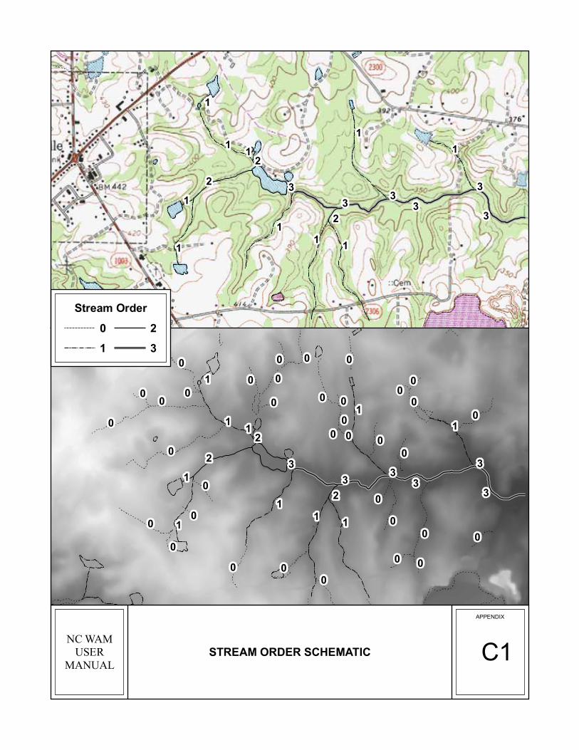
33
33
1
3
1
3
2
11
21
11
1
1
1
2
APPENDIX
C1STREAM ORDER SCHEMATIC
33
33
1
3
1
3
2
11
21
11
1
1
1
2
00
00
000
00
0 00
0 00
00
0
000
00
000
0
00
0
0
0
0
0
0
0
NC WAMUSER
MANUAL
Stream Order
1 3
0 2
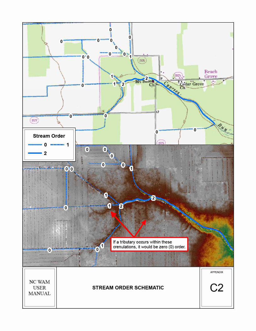


APPENDIX D
Pocosin Soils

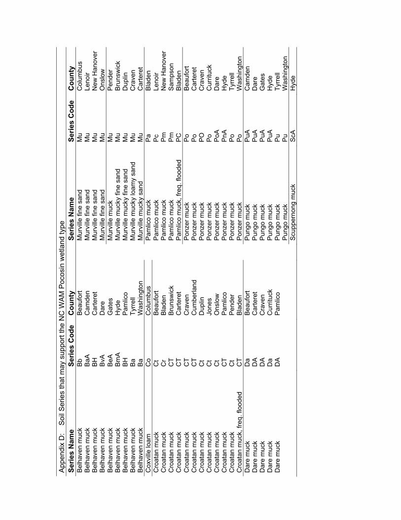
App
endi
x D
: S
oil S
erie
s th
at m
ay s
uppo
rt th
e N
C W
AM
Poc
osin
wet
land
type
Se
ries
Nam
e Se
ries
Cod
e C
ount
y
Serie
s N
ame
Serie
s C
ode
Cou
nty
Bel
have
n m
uck
Bb
Bea
ufor
t
Mur
ville
fine
san
d M
uC
olum
bus
Bel
have
n m
uck
BaA
Cam
den
M
urvi
lle fi
ne s
and
Mu
Leno
ir B
elha
ven
muc
k B
HC
arte
ret
M
urvi
lle fi
ne s
and
Mu
New
Han
over
Bel
have
n m
uck
BvA
Dar
e
Mur
ville
fine
san
d M
uO
nslo
w
Bel
have
n m
uck
BeA
Gat
es
Mur
ville
muc
k M
uP
ende
rB
elha
ven
muc
k B
mA
Hyd
e
Mur
ville
muc
ky fi
ne s
and
Mu
Bru
nsw
ick
Bel
have
n m
uck
BH
Pam
lico
M
urvi
lle m
ucky
fine
san
d M
u D
uplin
B
elha
ven
muc
k B
aTy
rrell
M
urvi
lle m
ucky
loam
y sa
nd
Mu
Cra
ven
Bel
have
n m
uck
Ba
Was
hing
ton
M
urvi
lle m
ucky
san
d M
uC
arte
ret
Cox
ville
loam
C
oC
olum
bus
P
amlic
o m
uck
Pa
Bla
den
Cro
atan
muc
k C
tB
eauf
ort
P
amlic
o m
uck
Pc
Leno
ir C
roat
an m
uck
Cr
Bla
den
Pam
lico
muc
k P
mN
ew H
anov
er
Cro
atan
muc
k C
TB
runs
wic
k
Pam
lico
muc
k P
mS
amps
onC
roat
an m
uck
CT
Car
tere
t
Pam
lico
muc
k, fr
eq. f
lood
ed
PC
B
lade
nC
roat
an m
uck
CT
Cra
ven
P
onze
r muc
k P
oB
eauf
ort
Cro
atan
muc
k C
T C
umbe
rland
Pon
zer m
uck
Po
Car
tere
t C
roat
an m
uck
Ct
Dup
lin
P
onze
r muc
k P
OC
rave
nC
roat
an m
uck
Ct
Jone
s
Pon
zer m
uck
Po
Cur
rituc
kC
roat
an m
uck
Ct
Ons
low
Pon
zer m
uck
PoA
Dar
eC
roat
an m
uck
CT
Pam
lico
P
onze
r muc
k P
nAH
yde
Cro
atan
muc
k C
tP
ende
r
Pon
zer m
uck
Po
Tyrre
ll C
roat
an m
uck,
freq
. flo
oded
C
T B
lade
n
Pon
zer m
uck
Po
Was
hing
ton
Dar
e m
uck
Da
Bea
ufor
t
Pun
go m
uck
PuA
Cam
den
Dar
e m
uck
DA
Car
tere
t
Pun
go m
uck
PuA
Dar
eD
are
muc
k D
AC
rave
n
Pun
go m
uck
PuA
Gat
esD
are
muc
k D
aC
urrit
uck
P
ungo
muc
k P
uAH
yde
Dar
e m
uck
DA
Pam
lico
P
ungo
muc
k P
uTy
rrell
Pun
go m
uck
Pu
Was
hing
ton
Scu
pper
nong
muc
kS
cAH
yde


APPENDIX E
North Carolina Ecoregions


____________________________________________________________________________
______________________________________________________________________NC Wetland Assessment Method (NC WAM) v4.1 E-1 Appendix F: North Carolina Ecoregions
Appendix E: North Carolina Ecoregions
This map has been prepared by USEPA and many other state and federal agencies (Griffith et al. 2002). Ecoregions are depicted as either level III ecoregions (four in the state – Blue Ridge [Mountains], Piedmont, Southeastern Plains [inner Coastal Plain], and Middle Atlantic Coastal Plain [outer Coastal Plain]) or as level IV ecoregions (27 in North Carolina including such areas as the Triassic Basin, Sandhills, and New River Plateau).

NC
map
fnl.a
i 7/
07/2
002-
gg
PRIN
CIP
AL
AU
TH
OR
S:
Gle
nn E
. G
riff
ith (
NR
CS)
, Ja
mes
M.
Om
erni
k (U
SEPA
),
Jeff
rey
A.
Com
stoc
k (I
ndus
Cor
pora
tion)
, M
icha
el P
. Sc
hafa
le (
NC
DE
NR
), W
. H
enry
M
cNab
(U
SFS)
, Dav
id R
. Len
at (
NC
DE
NR
), a
nd T
rish
F. M
acPh
erso
n (N
CD
EN
R).
CO
LL
AB
OR
AT
OR
S A
ND
CO
NT
RIB
UT
OR
S:
Jam
es E
. H
arri
son
(USE
PA),
Dav
id L
. Pe
nros
e (N
CD
EN
R),
Roy
L.V
ick,
Jr.
(N
RC
S),
Ger
ard
McM
ahon
(U
SGS)
, R
ober
t Pe
et
(UN
C),
Chi
p Sm
ith (
NR
CS)
and
Tom
Lov
elan
d (U
SGS)
.
CIT
ING
TH
IS M
AP:
G
riff
ith,
G.E
., O
mer
nik,
J.M
., C
omst
ock,
J.A
., Sc
hafa
le,
M.P
., M
cNab
, W.H
., L
enat
, D.R
., an
d M
acPh
erso
n, T
.F.,
2002
, Eco
regi
ons
of N
orth
Car
olin
a,
U.S
. Env
iron
men
tal P
rote
ctio
n A
genc
y, C
orva
llis,
OR
, (m
ap s
cale
1:1
,500
,000
).
Eco
regi
ons
of N
orth
Car
olin
a
45 P
iedm
ont
45a
Sout
hern
Inn
er P
iedm
ont
45b
Sout
hern
Out
er P
iedm
ont
45c
Car
olin
a Sl
ate
Bel
t45
eN
orth
ern
Inne
r Pi
edm
ont
45f
Nor
ther
n O
uter
Pie
dmon
t45
gT
rias
sic
Bas
ins
45i
Kin
gs M
ount
ain
63 M
iddl
e A
tlan
tic
Coa
stal
Pla
in63
bC
hesa
peak
e-Pa
mlic
o L
owla
nds
and
Tid
al M
arsh
es63
cN
onri
veri
ne S
wam
ps a
nd P
eatla
nds
63d
Vir
gini
an B
arri
er I
slan
ds a
nd C
oast
al M
arsh
es63
eM
id-A
tlant
ic F
latw
oods
63g
Car
olin
ian
Bar
rier
Isl
ands
and
Coa
stal
Mar
shes
63h
Car
olin
a Fl
atw
oods
63n
Mid
-Atla
ntic
Flo
odpl
ains
and
Low
Ter
race
s
65 S
outh
east
ern
Pla
ins
65c
Sand
Hill
s65
lA
tlant
ic S
outh
ern
Loa
m P
lain
s65
mR
ollin
g C
oast
al P
lain
65p
Sout
heas
tern
Flo
odpl
ains
and
Low
Ter
race
s
66 B
lue
Rid
ge
66c
New
Riv
er P
late
au66
dSo
uthe
rn C
ryst
allin
e R
idge
s an
d M
ount
ains
66e
Sout
hern
Sed
imen
tary
Rid
ges
66g
Sout
hern
Met
ased
imen
tary
Mou
ntai
ns66
iH
igh
Mou
ntai
ns66
jB
road
Bas
ins
66k
Am
phib
olite
Mou
ntai
ns66
lE
aste
rn B
lue
Rid
ge F
ooth
ills
66m
Saur
atow
n M
ount
ains
SCA
LE
1:1
500
000
Alb
ers
Equ
al A
rea
Proj
ectio
n
3060
mi
0
6012
0 k
m0
510
15
1020
30
Lev
el I
II e
core
gion
Lev
el I
V e
core
gion
Cou
nty
boun
dary
Stat
e bo
unda
ry
84°
83°
82°
81°
80°
79°
78°
77°
76°
84°
83°
82°
81°
80°
79°
78°
77°
76°
34°
35°
36°
34°
35°
36°
AT
LA
NT
IC
OC
EA
N
Hig
h R
ock
Lak
eL
ake
Nor
man
Lak
eG
asto
nJo
hn H
. Ker
rR
eser
voir
Cat
awba
Riv
er
Yadk
in R
iver
Lumber Riv
erC
ape
Fear
Riv
er
Neu
se
Riv
er
AL
BE
MA
RL
E S
OU
ND
PA
ML
ICO
S
OU
ND
Tar
R
iver
Lak
eW
iley
LO
NG
B
AY
ONSL
OW
BA
Y
Chowan River
Roan
oke R
iver
Bro
ad
Riv
er
S.
Fk. New
River
French Broad River
Littl
e T
enne
ssee
Rive r
Font
ana
Lak
e
Hiw
asse
e L
ake
Bad
inL
ake
Lak
eTi
ller
y
Fall
sL
ake
B. E
vere
ttJo
rdan
Lak
e
Har
ris
Res
ervo
ir
Phe
lps
Lak
e
Alligator River
Lake
M
atta
mus
keet
Pam
lico
Riv
er
Neu
se
Riv
er
Whi
te Oak Riv
er
L
ake
Wac
cam
aw
63d
63d
63b
63c
63e
63n
65m
65m
63e
45f
65p
45c
45e
45e
45b
45g
63c
63b
63n
65p
63e
66d
66
66d
66c
45g
66d
66k
66m
63g
63n 63
e
66l
45g
65p
66i
63b
63b
66e
66e
63c
45f
63n
66g
66l
66g
63h
63c
66i
45f
65p
66j66
i
66l
65c
63b
63c
63c
66g
63c
65l
63g
66j
45g
45a
65p
45c
63h
66i
66i
66i
63c
65p
63h
63n
63c
66j
63h
66d
66j
66i
63n
66i
66g
63c
63g
45
65p
65
63
63g
63g
66i
66i
66d
6365
45
45
66
66
66
67
6966
e
45i
45b
Faye
ttevi
lle
Gre
envi
lle
Roc
kyM
ount
Wilm
ingt
on
Ral
eigh
Ash
evill
e
Boo
ne
Cha
rlot
te
Dur
ham
Gre
ensb
oro
Win
ston
-Sal
em
Gre
envi
lle
Col
umbi
a
Myr
tle B
each
Ath
ens
Kno
xvill
e
Hic
kory
Fran
klin
Bre
vard
Roa
noke
Rap
ids
Eliz
abet
h C
ity
New
Ber
n
Jack
sonv
ille
Shel
by
Roc
k H
illSp
arta
nbur
g
John
son
City
Eco
regi
ons
deno
te a
reas
of
gene
ral
sim
ilari
ty i
n ec
osys
tem
s an
d in
the
typ
e, q
ualit
y, a
nd q
uant
ity o
f en
viro
nmen
tal
reso
urce
s. T
hey
are
desi
gned
to
serv
e as
a s
pati
al f
ram
ewor
k fo
r th
e re
sear
ch,
asse
ssm
ent,
man
agem
ent,
and
mon
itori
ng o
f ec
osys
tem
s an
d ec
osys
tem
com
pone
nts.
Eco
regi
ons
are
dire
ctly
app
licab
le t
o m
any
stat
e ag
ency
act
iviti
es,
incl
udin
g th
e se
lect
ion
of r
egio
nal
stre
am r
efer
ence
si
tes,
the
dev
elop
men
t of
bio
logi
cal
crite
ria
and
wat
er q
ualit
y st
anda
rds,
and
the
est
ablis
hmen
t of
m
anag
emen
t go
als
for
nonp
oint
-sou
rce
poll
utio
n. T
hey
are
also
rel
evan
t to
int
egra
ted
ecos
yste
m
man
agem
ent,
an u
ltim
ate
goal
of
man
y fe
dera
l and
sta
te r
esou
rce
man
agem
ent a
genc
ies.
The
app
roac
h us
ed t
o co
mpi
le t
his
map
of
Nor
th C
arol
ina
is b
ased
on
the
prem
ise
that
eco
logi
cal
regi
ons
are
hier
arch
ical
and
can
be
iden
tifie
d th
roug
h th
e an
alys
is o
f th
e sp
atia
l pa
ttern
s an
d th
e co
mpo
sitio
n of
bio
tic a
nd a
biot
ic p
heno
men
a th
at a
ffec
t or
ref
lect
dif
fere
nces
in
ecos
yste
m q
ualit
y an
d in
tegr
ity
(Wik
en 1
986;
Om
erni
k 19
87,
1995
). T
hese
phe
nom
ena
incl
ude
geol
ogy,
phy
siog
raph
y,
vege
tati
on,
clim
ate,
so
ils,
la
nd
use,
w
ildl
ife,
an
d hy
drol
ogy.
The
re
lati
ve
impo
rtan
ce
of
each
ch
arac
teri
stic
var
ies
from
one
eco
logi
cal r
egio
n to
ano
ther
reg
ardl
ess
of th
e hi
erar
chic
al le
vel.
A R
oman
nu
mer
al h
iera
rchi
cal
sche
me
has
been
ado
pted
for
dif
fere
nt l
evel
s of
eco
logi
cal
regi
ons.
Lev
el I
and
L
evel
II
divi
de t
he N
orth
Am
eric
an c
ontin
ent
into
15
and
52 r
egio
ns,
resp
ectiv
ely
(Com
mis
sion
for
E
nvir
onm
enta
l C
oope
ratio
n W
orki
ng G
roup
199
7). A
t L
evel
III
, th
e co
ntin
enta
l U
nite
d St
ates
con
tain
s 10
4 re
gion
s (U
nite
d St
ates
Env
iron
men
tal
Prot
ectio
n A
genc
y [U
.S.
EPA
] 20
00).
Lev
el I
V i
s a
furt
her
subd
ivis
ion
of t
he L
evel
III
eco
regi
ons.
Exp
lana
tions
of
the
met
hods
use
d to
def
ine
the
U.S
. E
PA's
ec
oreg
ions
are
giv
en i
n O
mer
nik
(199
5),
Om
erni
k an
d ot
hers
(20
00),
Gri
ffith
and
oth
ers
(199
4, 1
997)
, an
d G
alla
nt a
nd o
ther
s (1
989)
.
The
Lev
el I
II a
nd I
V e
core
gion
s w
ere
com
pile
d at
a s
cale
of
1:25
0,00
0 an
d de
pict
rev
isio
ns a
nd
subd
ivis
ions
of
earl
ier
leve
l II
I ec
oreg
ions
tha
t w
ere
orig
inal
ly c
ompi
led
at a
sm
alle
r sc
ale
(U.S
. E
PA
2000
; O
mer
nik
1987
). C
ompi
latio
n of
thi
s m
ap i
s pa
rt o
f a
colla
bora
tive
proj
ect
prim
arily
bet
wee
n th
e U
.S.
Dep
artm
ent
of A
gric
ultu
re's
Nat
ural
Res
ourc
es C
onse
rvat
ion
Serv
ice
(NR
CS)
, th
e U
.S.
EPA
N
atio
nal
Hea
lth a
nd E
nvir
onm
enta
l E
ffec
ts R
esea
rch
Lab
orat
ory
(NH
EE
RL
), U
.S. E
PA R
egio
n IV
, and
th
e N
orth
Car
olin
a D
epar
tmen
t of
Env
iron
men
t an
d N
atur
al R
esou
rces
. T
his
proj
ect
is a
lso
asso
ciat
ed
with
an
inte
rage
ncy
effo
rt to
dev
elop
a c
omm
on f
ram
ewor
k of
eco
logi
cal r
egio
ns (
McM
ahon
and
oth
ers
2001
). R
egio
nal c
olla
bora
tive
proj
ects
, suc
h as
this
one
in N
orth
Car
olin
a w
here
som
e ag
reem
ent c
an b
e re
ache
d am
ong
mul
tipl
e re
sour
ce m
anag
emen
t ag
enci
es,
are
a st
ep i
n th
e di
rect
ion
of a
ttai
ning
co
mm
onal
ity a
nd c
onsi
sten
cy in
eco
regi
on f
ram
ewor
ks f
or th
e en
tire
natio
n.
Com
men
ts r
egar
ding
the
Lev
el I
II a
nd I
V E
core
gion
s of
Nor
th C
arol
ina
map
sho
uld
be a
ddre
ssed
to
Gle
nn G
riff
ith,
USD
A-N
RC
S, 2
00 S
W 3
5th
Stre
et,
Cor
valli
s, O
R 9
7333
, (5
41)
754-
4465
, FA
X:
(541
) 75
4-47
16,
emai
l: gr
iffi
th.g
lenn
@ep
a.go
v, o
r to
Jam
es O
mer
nik,
USG
S, 2
00 S
W 3
5th
Stre
et,
Cor
valli
s,
OR
973
33, (
541)
754
-445
8, e
mai
l: om
erni
k.ja
mes
@ep
a.go
v.
Lite
ratu
re C
ited:
Com
mis
sion
for
Env
iron
men
tal
Coo
pera
tion
Wor
king
Gro
up,
1997
, E
colo
gica
l re
gion
s of
N
orth
Am
eric
a -
tow
ard
a co
mm
on p
ersp
ectiv
e: M
ontr
eal,
Que
bec,
Com
mis
sion
for
E
nvir
onm
enta
l Coo
pera
tion,
71
p.
Gal
lant
, A
.L.,
Whi
ttie
r, T
.R.,
Lar
sen,
D
.P.,
Om
erni
k,
J.M
., an
d H
ughe
s,
R.M
., 19
89,
Reg
iona
lizat
ion
as a
too
l fo
r m
anag
ing
envi
ronm
enta
l re
sour
ces:
Cor
valli
s, O
rego
n, U
.S.
Env
iron
men
tal P
rote
ctio
n A
genc
y E
PA/6
00/3
-89/
060,
152
p.
Gri
ffit
h, G
.E.,
Om
erni
k, J
.M.,
Wil
ton,
T.F
., an
d P
iers
on,
S.M
., 19
94,
Eco
regi
ons
and
subr
egio
ns o
f Io
wa
- a
fram
ewor
k fo
r w
ater
qua
lity
asse
ssm
ent
and
man
agem
ent:
The
Jo
urna
l of
the
Iow
a A
cade
my
of S
cien
ce, v
. 101
, no.
1, p
. 5-1
3.
Gri
ffith
, G
.E.,
Om
erni
k, J
.M.,
and
Aze
vedo
, S.
H.,
1997
, E
core
gion
s of
Ten
ness
ee:
Cor
valli
s,
Ore
gon,
U.S
. Env
iron
men
tal P
rote
ctio
n A
genc
y, N
atio
nal H
ealth
and
Env
iron
men
tal E
ffec
ts
Res
earc
h L
abor
ator
y, E
PA/6
00/R
-97/
022,
51
p.
McM
ahon
, G
., G
rego
nis,
S.M
., W
altm
an,
S.W
., O
mer
nik,
J.M
., T
hors
on,
T.D
., Fr
eeou
f, J
.A.,
Ror
ick,
A.H
., an
d K
eys,
J.E
., 20
01, D
evel
opin
g a
spat
ial
fram
ewor
k of
com
mon
eco
logi
cal
regi
ons
for
the
cont
erm
inou
s U
nite
d St
ates
: E
nvir
onm
enta
l M
anag
emen
t, v.
28,
no.
3,
p.
293
-316
.
Om
erni
k, J
.M.,
1987
, Eco
regi
ons
of th
e co
nter
min
ous
Uni
ted
Stat
es (
map
sup
plem
ent)
: Ann
als
of th
e A
ssoc
iatio
n of
Am
eric
an G
eogr
aphe
rs, v
. 77,
no.
1, p
. 118
-125
, sca
le 1
:7,5
00,0
00.
Om
erni
k, J
.M.,
1995
, E
core
gion
s-a
spat
ial
fram
ewor
k fo
r en
viro
nmen
tal
man
agem
ent,
in
Dav
is,
W.S
. an
d S
imon
, T.
P.,
eds.
, B
iolo
gica
l as
sess
men
t an
d cr
iter
ia-t
ools
for
wat
er
reso
urce
pla
nnin
g an
d de
cisi
on m
akin
g: B
oca
Rat
on, F
lori
da, L
ewis
Pub
lishe
rs, p
. 49-
62.
Om
erni
k,
J.M
., C
hapm
an,
S.S
., L
illi
e,
R.A
., an
d D
umke
, R
.T.,
2000
, E
core
gion
s of
W
isco
nsin
: T
rans
acti
ons
of t
he W
isco
nsin
Aca
dem
y of
Sci
ence
s, A
rts
and
Let
ters
,
v.
88,
no.
200
0, p
. 77-
103.
U.S
. E
nvir
onm
enta
l Pr
otec
tion
Age
ncy,
200
0, L
evel
III
eco
regi
ons
of t
he c
ontin
enta
l U
nite
d S
tate
s (r
evis
ion
of O
mer
nik,
198
7):
Cor
vall
is,
Ore
gon,
U.S
. E
nvir
onm
enta
l P
rote
ctio
n A
genc
y-N
atio
nal H
ealth
and
Env
iron
men
tal E
ffec
ts R
esea
rch
Lab
orat
ory,
Map
M-1
.
Wik
en,
E.,
1986
, Te
rres
tria
l ec
ozon
es o
f C
anad
a: O
ttaw
a, E
nvir
onm
ent
Can
ada,
Eco
logi
cal
Lan
d C
lass
ific
atio
n Se
ries
no.
19,
26
p.
Cap
e Lo
okou
t
Cap
eH
atte
ras
Cap
e F
ear

APPENDIX F
Soil Texture Decision Chart


____________________________________________________________________________
____________________________________________________________________________NC Wetland Assessment Method (NC WAM) v4.1 F-1 Appendix F: Soil Texture Decision Chart
Appendix F: Soil Texture Decision Chart
This information was obtained on-line at: http://casfs.ucsc.edu/education/instruction/tofg/download/unit_2.1b_soil_physical.pdf

26 | Unit 2.1Soil Physical Properties
Soil Texture Decision Chart
Demonstration 1
This chart works fairly well in soils with mixed clay mineralogy. Soils with high amounts of2:1 clays (smectite) will make longer ribbons. Soils with high amounts of 1:1 clays (kaolinite)will make shorter ribbons. These texture names are not used in high ash soils.
�
Start
Place about 2 tablespoons of soil in palm of hand. Addwater dropwise and knead the soil to break down allits aggregates. Soil is at the proper consistency whenplastic and moldable, like moist putty.
�
Add dry soil tosoak up water
�
Does soil remain in aball when squeezed?
Is soil too dry?�
�
Is soil too wet?�
�
N NY Y
�N SAND
Place ball of soil between thumb and forefinger, gently pushing the soil with thethumb, squeezing it upward into a ribbon. Form a ribbon of uniform thickness andwidth. Allow the ribbon to emerge and extend over the forefinger, breaking under itsown weight.
�
Y
�
Does soil form a ribbon?N
LOAMYSAND
�
�
Y
Does soil make a weakribbon less than 1 inchlong before breaking?
Does soil make a mediumribbon 1–2 inches longbefore breaking?
N�
Does soil make a strongribbon more than 2 incheslong before breaking?
N�
Y
�
Excessively wet a small amount of soil in palm and rub with forefinger.
�
Y
�
Y�
Does soil feelvery gritty?
SANDYLOAM
�
Does soil feelvery smooth?
�
Neither gritti-ness norsmoothnesspredominates
�
SILTLOAM
�
LOAM
�
Y
Y
Y
N
N
�
Does soil feelvery gritty?
SANDYCLAYLOAM �
Does soil feelvery smooth?
�
�
SILTYCLAYLOAM
�
CLAYLOAM
�
Y
Y
Y
N
N
�
Does soil feelvery gritty?
SANDYCLAY
�
Does soil feelvery smooth?
�
�
SILTYCLAY
�
CLAY
�
Y
Y
Y
N
N
Neither gritti-ness norsmoothnesspredominates
Neither gritti-ness norsmoothnesspredominates

Soil Physical Properties Unit 2.1 | 27
Soil Texture Triangle
Demonstration 1


APPENDIX G
North Carolina Exotic Plants

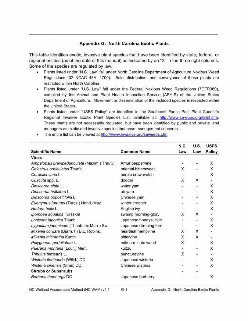
____________________________________________________________________________
____________________________________________________________________________NC Wetland Assessment Method (NC WAM) v4.1 G-1 Appendix G: North Carolina Exotic Plants
Appendix G: North Carolina Exotic Plants
This table identifies exotic, invasive plant species that have been identified by state, federal, or regional entities (as of the date of this manual) as indicated by an “X” in the three right columns. Some of the species are regulated by law.
� Plants listed under “N.C. Law” fall under North Carolina Department of Agriculture Noxious Weed Regulations (02 NCAC 48A. 1700). Sale, distribution, and conveyance of these plants are restricted within North Carolina.
� Plants listed under “U.S. Law” fall under the Federal Noxious Weed Regulations (7CFR360), compiled by the Animal and Plant Health Inspection Service (APHIS) of the United States Department of Agriculture. Movement or dissemination of the included species is restricted within the United States.
� Plants listed under “USFS Policy” are identified in the Southeast Exotic Pest Plant Council's Regional Invasive Exotic Plant Species List, available at: http://www.se-eppc.org/fslist.cfm.These plants are not necessarily regulated, but have been identified by public and private land managers as exotic and invasive species that pose management concerns.
� The entire list can be viewed at http://www.invasive.org/seweeds.cfm.
Scientific Name Common Name N.C.Law
U.S.Law
USFSPolicy
Vines Ampelopsis brevipedunculata (Maxim.) Trautv. Amur peppervine - - X Celastrus orbiculatus Thunb. oriental bittersweet X - X Coronilla varia L. purple crownvetch - - X Cuscuta spp. L. dodder X X -Dioscorea alata L. water yam - - X Dioscorea bulbifera L. air yam - - X Dioscorea oppositifolia L. Chinese yam - - X Euonymus fortunei (Turcz.) Hand.-Maz. winter creeper - - X Hedera helix L. English ivy - - X Ipomoea aquatica Forsskal swamp morning-glory X X - Lonicera japonica Thunb. Japanese honeysuckle - - X Lygodium japonicum (Thunb. ex Murr.) Sw. Japanese climbing fern - - X Mikania cordata (Burm. f.) B.L. Robins. heartleaf hempvine X X - Mikania micrantha Kunth bittervine X X -Polygonum perfoliatum L. mile-a-minute weed X - X Pueraria montana (Lour.) Merr. kudzu - - XTribulus terrestris L. puncturevine X - -Wisteria floribunda (Willd.) DC. Japanese wisteria - - X Wisteria sinensis (Sims) DC. Chinese wisteria - - X Shrubs or Subshrubs - -Berberis thunbergii DC. Japanese barberry - - X
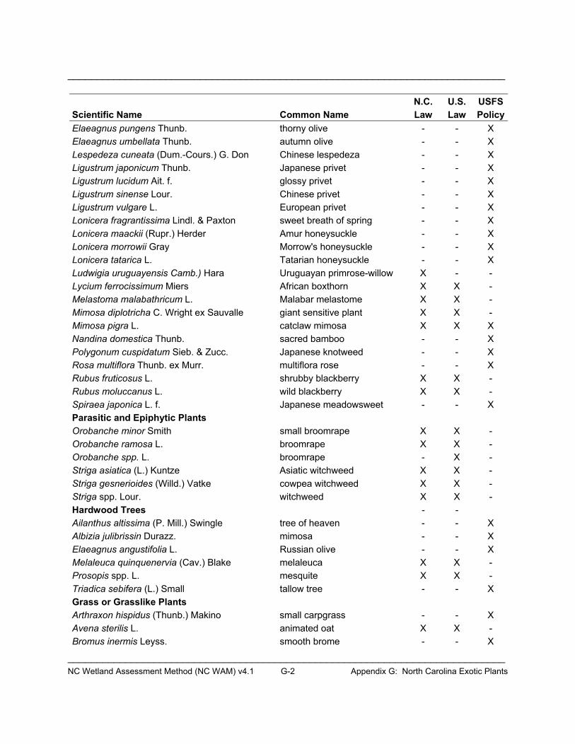
____________________________________________________________________________
____________________________________________________________________________NC Wetland Assessment Method (NC WAM) v4.1 G-2 Appendix G: North Carolina Exotic Plants
Scientific Name Common Name N.C.Law
U.S.Law
USFSPolicy
Elaeagnus pungens Thunb. thorny olive - - X Elaeagnus umbellata Thunb. autumn olive - - X Lespedeza cuneata (Dum.-Cours.) G. Don Chinese lespedeza - - X Ligustrum japonicum Thunb. Japanese privet - - X Ligustrum lucidum Ait. f. glossy privet - - X Ligustrum sinense Lour. Chinese privet - - X Ligustrum vulgare L. European privet - - X Lonicera fragrantissima Lindl. & Paxton sweet breath of spring - - X Lonicera maackii (Rupr.) Herder Amur honeysuckle - - X Lonicera morrowii Gray Morrow's honeysuckle - - X Lonicera tatarica L. Tatarian honeysuckle - - X Ludwigia uruguayensis Camb.) Hara Uruguayan primrose-willow X - - Lycium ferrocissimum Miers African boxthorn X X - Melastoma malabathricum L. Malabar melastome X X - Mimosa diplotricha C. Wright ex Sauvalle giant sensitive plant X X - Mimosa pigra L. catclaw mimosa X X X Nandina domestica Thunb. sacred bamboo - - X Polygonum cuspidatum Sieb. & Zucc. Japanese knotweed - - X Rosa multiflora Thunb. ex Murr. multiflora rose - - X Rubus fruticosus L. shrubby blackberry X X - Rubus moluccanus L. wild blackberry X X - Spiraea japonica L. f. Japanese meadowsweet - - X Parasitic and Epiphytic Plants Orobanche minor Smith small broomrape X X - Orobanche ramosa L. broomrape X X -Orobanche spp. L. broomrape - X -Striga asiatica (L.) Kuntze Asiatic witchweed X X - Striga gesnerioides (Willd.) Vatke cowpea witchweed X X - Striga spp. Lour. witchweed X X -Hardwood Trees - -Ailanthus altissima (P. Mill.) Swingle tree of heaven - - X Albizia julibrissin Durazz. mimosa - - XElaeagnus angustifolia L. Russian olive - - X Melaleuca quinquenervia (Cav.) Blake melaleuca X X -Prosopis spp. L. mesquite X X -Triadica sebifera (L.) Small tallow tree - - X Grass or Grasslike Plants Arthraxon hispidus (Thunb.) Makino small carpgrass - - X Avena sterilis L. animated oat X X - Bromus inermis Leyss. smooth brome - - X
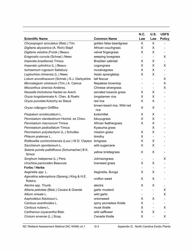
____________________________________________________________________________
____________________________________________________________________________NC Wetland Assessment Method (NC WAM) v4.1 G-3 Appendix G: North Carolina Exotic Plants
Scientific Name Common Name N.C.Law
U.S.Law
USFSPolicy
Chrysopogon aciculatus (Retz.) Trin. golden false beardgrass X X - Digitaria abyssinica (A. Rich) Stapf African couchgrass X X - Digitaria velutina (Forsk.) Beauv. velvet fingergrass X X - Eragrostis curvula (Schrad.) Nees weeping lovegrass - - X Imperata brasiliensis Trinius Brazilian satintail X X - Imperata cylindrica (L.) Beauv. cogongrass X X XIschaemum rugosum Salisbury murainagrass X X - Leptochloa chinensis (L.) Nees Asian sprangletop X X - Lolium arundinaceum (Schreb.) S.J. Darbyshire tall fescue - - X Microstegium vimineum (Trin.) A. Camus Nepalese browntop - - X Miscanthus sinensis Anderss. Chinese silvergrass - - X Nassella trichotoma Hackel ex Arech. serrated tussock grass X X - Oryza longistaminata A. Chev. & Roehr. longstamen rice X X - Oryza punctata Kotzchy ex Steud. red rice X X -
Oryza rufipogon Griffithsbrown-beard rice, Wild red rice
X X -
Paspalum scrobiculatum L. kodomillet X X -Pennisetum clandestinum Hochst. ex Chiov. kikuyugrass X X -Pennisetum macrourum Trinius African feathergrass X X - Pennisetum pedicellatum Trinius Kyasuma grass X - Pennisetum polystachyon (L.) Schultes mission grass X X - Phleum pratense L. timothy X - -Rottboellia cochinchinensis (Lour.) W.D. Clayton itchgrass X X -Saccharum spontaneum L. wild sugarcane X X - Setaria pumila pallidifusca (Schumacher) B.K. Simon
yellow bristlegrass X X -
Sorghum halepense (L.) Pers. Johnsongrass - - XUrochloa panicoides Beauvois liverseed grass X X - Forbs / Herbs - - -Aeginetia spp. L. Aeginetia, Bunga X X - Ageratina adenophora (Spreng.) King & H.E. Robins.
crofton weed X X -
Alectra spp. Thunb. alectra X X -Alliaria petiolata (Bieb.) Cavara & Grande garlic mustard - - X Allium vineale L. wild garlic - - X Asphodelus fistulosus L. onionweed X X -Carduus acanthoides L. spiny plumeless thistle X - - Carduus nutans L. musk thistle X - X Carthamus oxyacantha Bieb. wild safflower X X - Cirsium arvense (L.) Scop. Canada thistle X - X

____________________________________________________________________________
____________________________________________________________________________NC Wetland Assessment Method (NC WAM) v4.1 G-4 Appendix G: North Carolina Exotic Plants
Scientific Name Common Name N.C.Law
U.S.Law
USFSPolicy
Cirsium vulgare (Savi) Ten. bull thistle - - X Commelina benghalensis L. tropical spiderwort X X - Crassula helmsii A. Berger swamp stonecrop X - - Crupina vulgaris Cass. common crupina X X - Drymaria arenarioides Humboldt & Bonpland sandwort drymary X X - Emex australis Steinhall three-cornered jack X X - Emex spinosa (L.) Campdera devil's thorn X X - Galega officinalis L. goat's rue X X - Heracleum mantegazzianum Sommier & Levier giant hogweed X X - Homeria spp. N/A cape tulip X X - Hygrophila polysperma (Roxb.) T. Anders. miramar weed X X - Kummerowia striata (Thunb.) Schindl. Japanese clover - - X Limnophila sessiliflora (Vahl) Blume Asian marshweed X X - Lythrum salicaria L. purple loosestrife X - X Monochoria hastata (L.) Solms arrowleaf false pickerelweed X X Monochoria vaginalis (Burm. f.) K. Presl ex Kunth
heartshape false pickerelweed
X X -
Polygonum caespitosum Blume oriental ladysthumb - - X Rorippa sylvestris (L.) Bess. creeping yellowcress X - - Salsola vermiculata L. shrubby Russian thistle X X - Solanum torvum Swartz turkey berry X X - Solanum viarum Dunal tropical soda apple X X X Spermacoce alata Aublet winged false buttonweed X X - Stachys floridana Shuttlw. ex Benth. Florida hedgenettle X - - Tridax procumbens L. coatbuttons X X -Verbena brasiliensis Vell. Brazilian vervain - - X Cactus - - -
Opuntia aurantiaca LindleyJointed prickly pear, Tiger pear
X X
Aquatic Alternanthera philoxeroides (Mart.) Griseb. alligatorweed - - XAlternanthera sessilis (L.) R. Br. ex DC. sessile joyweed X X - Azolla pinnata R. Brown feathered mosquitofern X X -
Caulerpa taxifolia (Vahl) C. AgardthMediterranean clone of caulerpa
X X -
Egeria densa Planch. Brazilian waterweed - - X Eichhornia azurea (Swartz) Kunth anchored water hyacinth X X - Eichhornia crassipes (Mart.) Solms common water hyacinth X - X Hydrilla verticillata (L. f.) Royle hydrilla X X XLagarosiphon major (Ridley) Moss oxygen weed X X -
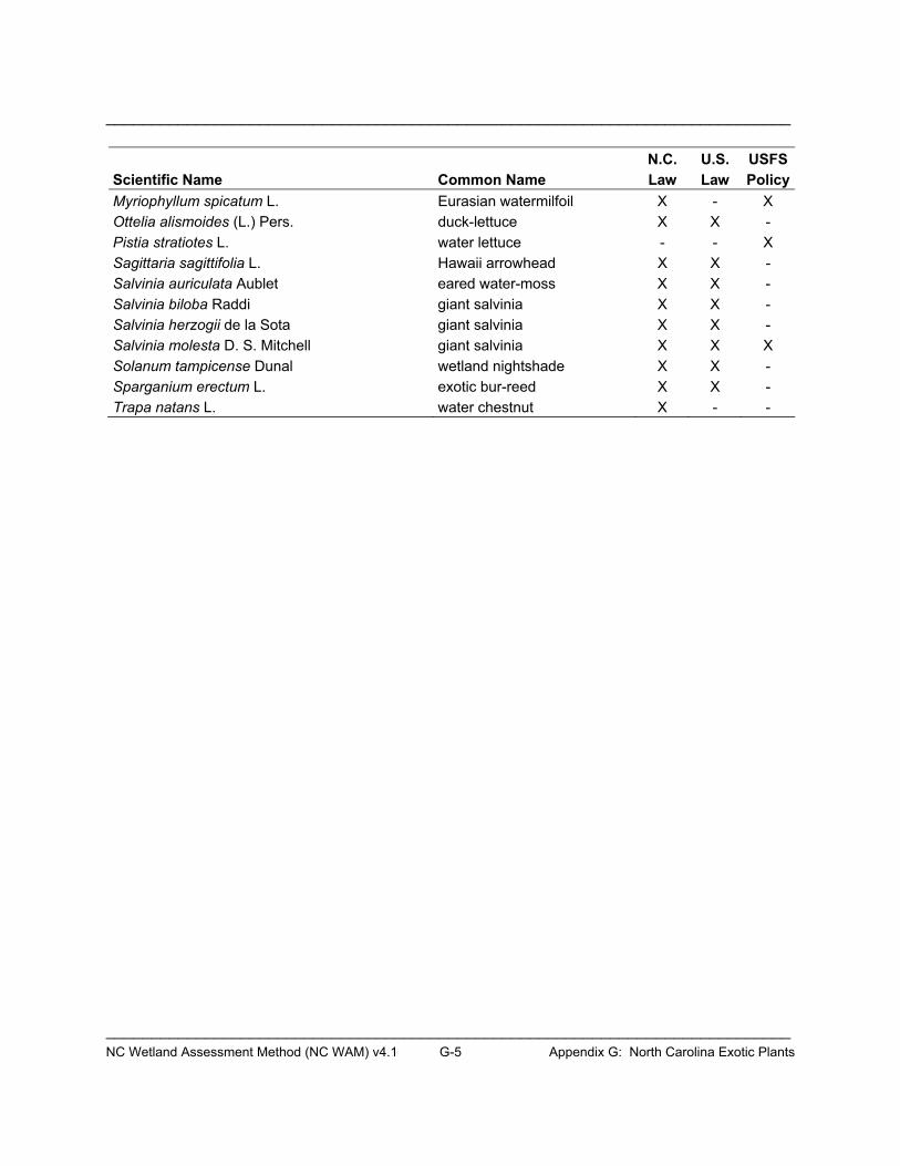
____________________________________________________________________________
____________________________________________________________________________NC Wetland Assessment Method (NC WAM) v4.1 G-5 Appendix G: North Carolina Exotic Plants
Scientific Name Common Name N.C.Law
U.S.Law
USFSPolicy
Myriophyllum spicatum L. Eurasian watermilfoil X - X Ottelia alismoides (L.) Pers. duck-lettuce X X - Pistia stratiotes L. water lettuce - - X Sagittaria sagittifolia L. Hawaii arrowhead X X - Salvinia auriculata Aublet eared water-moss X X - Salvinia biloba Raddi giant salvinia X X - Salvinia herzogii de la Sota giant salvinia X X - Salvinia molesta D. S. Mitchell giant salvinia X X X Solanum tampicense Dunal wetland nightshade X X - Sparganium erectum L. exotic bur-reed X X - Trapa natans L. water chestnut X - -


APPENDIX H
NC WAM Rating Calculator User Guide


NC Wetland Assessment Method (NC WAM) v4.1 H-1 Appendix H: Rating Calculator User Guide
Appendix H: NC WAM Rating Calculator User Guide
H-1.0 Introduction
Wetland functional ratings are generated by processing wetland assessment data collected on the NC WAM Wetland Assessment Form through a Boolean logic sequence. Each of the 16 general wetland types has its own unique and rather extensive Boolean logic sequence. While it is possible to generate functional ratings by manually processing wetland assessment data, the effort would be time consuming and, due to the complicated nature of the Boolean logic, potentially prone to miscalculation. To reduce processing time and ensure proper processing of assessment data, the Wetland Functional Assessment Team (WFAT) directed the development of the NC WAM Rating Calculator.
The NC WAM Rating Calculator consists of a pair of Microsoft Excel worksheets designed to resemble the NC WAM Wetland Assessment Form and the NC WAM Wetland Rating Sheet. The purpose of the Rating Calculator is to automate the wetland rating process. Wetland assessment data collected in the field is input into the Rating Calculator. The computer program imbedded within the Rating Calculator passes the assessment data through the wetland-specific Boolean logic chain to produce functional ratings. Instructions for use of the Rating Calculator with pre-Excel 2007 versions and Excel 2007 follow.
H-2.0 Rating Calculator Instructions
H-2.1 Setting Excel’s Macro Security The Rating Calculator is a Microsoft Excel workbook customized with macros (computer programming code). Excel has a macro security feature that regulates the use of macros within the program. Prior to opening the Rating Calculator, Excel’s macro security needs to be set to allow the operation of macros. The procedure for setting Excel’s macro security differs between pre-Excel 2007 versions and Excel 2007. Please follow the appropriate instructions below.
H-2.1.1 Microsoft Excel prior to 2007 To set the macro security pre-Excel 2007 versions, start the Excel program and access the Security dialog from the Tools menu (Tools > Macros > Security). Select the Medium level of security from the Security Level tab and click OK. Next, select the Trusted Publishers tab and check the Trust access to Visual Basic Project checkbox (Figure H-1). Close the Excel program.

NC Wetland Assessment Method (NC WAM) v4.1 H-2 Appendix H: Rating Calculator User Guide
Figure H-1. Set the Excel macro Security Level to Medium and select Trust access to Visual Basic Project.
H-2.1.2 Microsoft Excel 2007 A security warning is prompted when the NC WAM Rating Calculator is opened in Excel 2007. The warning is displayed on the left side of the Excel window, just below the Ribbon (see Figure H-2). The accompanying text indicates that content within the Rating Calculator workbook – in this case, the Rating Calculator macro – has been disabled. Enable Rating Calculator functionality by selecting the Options button (denoted by a red arrow in Figure H-2). Select the Enable this content option from the Microsoft Office Security Options dialog (see Figure H-2).
Figure H-2. Enable the NC WAM Rating Calculator functionality.
NC Wetland Assessment Method (NC WAM) v4.1 H-3 Appendix H: Rating Calculator User Guide
Next, open the Trust Center dialog by selecting the Open the Trust Center link (denoted by a red arrow) located in the bottom left corner of the Microsoft Office Security Options dialog. Select the Macro Settings tab from the option panel on the left side of the dialog. Two macro settings need to be configured here. First, select the Disable all macros with notification option. Second, place a check in the Trust access to VBA project object model box (see Figure H-3). Close the Trust Center and Microsoft Office Security Options dialogs. Close Excel entirely.
Figure H-3. Additional security settings are configured in the Trust Center dialog.
H-2.2 Opening the Rating Calculator The Rating Calculator is opened like a typical Excel file – by either double-clicking the Rating Calculator file or by using the Open function available in Excel’s File menu (File > Open). Open the Rating Calculator using one of the described methods.
H-2.1.1 Microsoft Excel prior to 2007 Upon opening the Rating Calculator, a dialog appears indicating that the file contains macros. Click Enable Macros to continue opening the file. The Rating Calculator may take a few moments to initialize. The initialization procedures are complete and the form ready to operate when the mouse cursor is no longer an hourglass. This step will need to be repeated each time the Rating Calculator is opened.
H-2.1.2 Microsoft Excel 2007 Open the NC WAM Rating Calculator workbook. Dismiss the security warning by selecting the Options button and selecting the Enable this content option from the Microsoft Office Security Options dialog (Figure H-2). This step will need to be repeated each time the Rating Calculator is opened.
NC Wetland Assessment Method (NC WAM) v4.1 H-4 Appendix H: Rating Calculator User Guide
H-2.2 Rating Calculator Contents The Rating Calculator has two worksheets: the Form worksheet and the Results worksheet. The Form worksheet is a replication of the NC WAM Field Assessment Form and the Results worksheet is a replication of the NC WAM Wetland Rating Sheet. Wetland assessment data collected in the field are transcribed from the NC WAM Wetland Assessment Form onto the Form worksheet. The resulting functional ratings are presented on the Results worksheet.
Use the Form and Results tabs located in the bottom left-hand corner of the Rating Calculator screen to toggle between the two worksheets (Figure H-4). Click the Form tab to display the Form worksheet and the Results tab to display the Results worksheet. The operation of both worksheets is described below.
Figure H-4. Use the Form and Results tabs to toggle between the respective worksheets.
H-2.2.1 Form Worksheet The Form worksheet is displayed when the Rating Calculator opens. The Form worksheet contains all components of the NC WAM Wetland Assessment Form; each metric as well as the general wetland information and notes sections are represented. Several different types of user interfaces are used for inputting the wetland assessment data: text fields, combo boxes, option buttons, and checkboxes.
Text fields provide space for information to be typed in via the keyboard. General wetland information, such as the wetland site name, assessor name, stressor notes, and wetland notes are input into text fields (Figure H-5). Information is input into text fields by clicking on a specific text field with the mouse and then typing with the keyboard. Click in the white space on the form to exit the text field.
Three combo boxes are used in the general wetland information section of the Form worksheet to specify the assessed wetland type, ecoregion of occurrence, river basin. The Wetland Type combo box lists the 16 general wetland types in NC WAM (Figure H-5). The Level III Ecoregion combo box lists the four level III ecoregions that occur in North Carolina (Figure H-5). Lastly, the River Basin combo box lists the 17 river basins of North Carolina. The combo boxes are used by clicking the arrow on the right side of the combo box and selecting the appropriate entry from the dropdown list. Both the wetland type and ecoregion are required information for calculating wetland functional ratings.
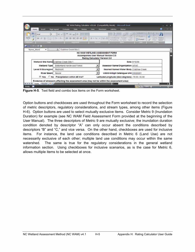
NC Wetland Assessment Method (NC WAM) v4.1 H-5 Appendix H: Rating Calculator User Guide
Figure H-5. Text field and combo box items on the Form worksheet.
Option buttons and checkboxes are used throughout the Form worksheet to record the selection of metric descriptors, regulatory considerations, and stream types, among other items (Figure H-6). Option buttons are used to select mutually exclusive items. Consider Metric 9 (Inundation Duration) for example (see NC WAM Field Assessment Form provided at the beginning of the User Manual). The three descriptors of Metric 9 are mutually exclusive; the inundation duration condition denoted by descriptor “A” can only occur absent the conditions described by descriptors “B” and “C,” and vice versa. On the other hand, checkboxes are used for inclusive items. For instance, the land use conditions described in Metric 6 (Land Use) are not necessarily exclusive of each other; multiple land use conditions may occur within the same watershed. The same is true for the regulatory considerations in the general wetland information section. Using checkboxes for inclusive scenarios, as is the case for Metric 6, allows multiple items to be selected at once.

NC Wetland Assessment Method (NC WAM) v4.1 H-6 Appendix H: Rating Calculator User Guide
Figure H-6. Option buttons are used in metric number 5 for exclusive descriptors and checkboxes in metric number 6 for inclusive descriptors.
H-2.2.2 Results Worksheet The Results worksheet, the second worksheet in the Rating Calculator, displays general wetland information and calculated functional ratings in the same format found on the NC WAM Wetland Rating Sheet. The Results worksheet does not allow for user input, but simply displays the wetland ratings as calculated. The general wetland information, such as wetland site name and wetland type, is automatically transferred from the general wetland information provided on the Form worksheet.
H-2.3 Generating Functional Ratings The process of calculating wetland functional ratings with the Rating Calculator is relatively simple: complete the NC WAM Field Assessment Form depicted in the Form worksheet by selecting the metric descriptors that apply to the assessed wetland. To be thorough, general wetland information, such as the wetland site name and date, should be completed as well. As each metric is completed, the Rating Calculator automatically calculates the functional ratings for the sub-functions and functions that the metric pertains to. The calculated functional ratings are output to the Results worksheet. The rating for a particular sub-function, the Hydrology Surface Storage and Retention sub-function for instance, is displayed after metric descriptors have been provided for all metrics applicable to the sub-function. An overall wetland rating is generated only after metric descriptors have been provided for all metrics applicable to the specified wetland type.

NC Wetland Assessment Method (NC WAM) v4.1 H-7 Appendix H: Rating Calculator User Guide
The Rating Calculator operates dynamically, meaning that wetland functional ratings are automatically calculated after each change in the metric descriptors, wetland type, or ecoregion. For instance, the Rating Calculator could be completed for a Piedmont Bottomland Hardwood Forest – metric descriptors provided for all necessary metrics and all functional ratings calculated. If a metric descriptor is changed for any metric, the Rating Calculator will automatically recalculate the functional ratings. If it were determined, after ratings calculation, that the wetland type should be revised from Bottomland Hardwood Forest to Riverine Swamp Forest, all that would be required to recalculate the functional ratings is to select the new wetland type (Riverine Swamp Forest) from the Wetland Type combo box on the Form worksheet.
The wetland type and ecoregion are required information for all wetland assessments. Functional ratings cannot be generated until a wetland type and ecoregion are selected in the Wetland Type and Level III Ecoregion combo boxes. In fact, the Rating Calculator produces a message with instructions to specify the wetland type and ecoregion if metric descriptors are selected beforehand. In addition, the functional assessments of the Bottomland Hardwood Forest and Riverine Swamp Forest wetland types require a stream type (blackwater or brownwater) to be specified. Again, the Rating Calculator produces a message with instructions to provide a stream type if a Bottomland Hardwood Forest or Riverine Swamp Forest assessment is attempted without first specifying the stream type.
H-2.4 Viewing the Results The Results worksheet can be viewed at any point in completing the Field Assessment Form on the Form worksheet by selecting the Results tab. The Results worksheet displays functional ratings for the sub-functions and functions completed to that point. For instance, if only metrics pertaining to the Habitat Physical Structure sub-function have been completely specified, then only the Habitat Physical Structure sub-function rating will be displayed on the Results worksheet.
As previously stated, the Results worksheet displays functional ratings and general wetland information without allowing any user input. The functional ratings presented are determined by the imbedded macros, while the general wetland information is transferred from the Form worksheet. If no general wetland information is provided on the Form worksheet, then none will be presented on the Results worksheet.
A total of 11 Hydrology, Water Quality, and Habitat sub-functions are presented on the NC WAM Wetland Rating Sheet and, consequently, the Results worksheet. Only a sub-set of the 11 sub-functions will apply to a given general wetland type. For instance, the Water Quality Pollution Change sub-function does not pertain to riverine wetlands such as Bottomland Hardwood Forest or Riverine Swamp Forest. In such cases, “NA” will appear in place of a sub-function rating to indicate that the sub-function is not applicable to the selected general wetland type (see Figure H-7).

NC Wetland Assessment Method (NC WAM) v4.1 H-8 Appendix H: Rating Calculator User Guide
Figure H-7. Sub-functions not applicable to a given general wetland type are indicated by an “NA” on the Results worksheet.
H-2.5 NC WAM Menu Beyond the user interfaces described above for the Field Assessment Form worksheet (Section H-2.2.1), the Rating Calculator also includes an NC WAM dropdown menu. The NC WAM menu is a customized dropdown menu that provides access to the Rating Calculator “Clear” and “Write to Word” functions. In pre-Excel 2007 versions, the NC WAM menu is located in the Menu Bar (Figure H-8). In Excel 2007, the NC WAM dropdown is located on the Add-Ins tab of the Ribbon (Figure H-9).
Figure H-8. In pre-Excel 2007 versions, the NC WAM menu is accessed from the Menu Bar.

NC Wetland Assessment Method (NC WAM) v4.1 H-9 Appendix H: Rating Calculator User Guide
Figure H-9. In Excel 2007, the NC WAM menu is accessed from the Add-Ins tab on the Ribbon.
H-2.5.1 Clear Function The “Clear” function clears all contents of the Form and Results worksheets including general wetland information, metric descriptor selections, and functional ratings. This function allows a new functional rating calculation to be started on clean Form and Results worksheets. To access the Clear function, select Clear from the NC WAM menu (NC WAM > Clear).
H-2.5.2 Write to Word Function The “Write to Word” function (NC WAM > Write to Word) compiles the contents of the Form and Results worksheets into a single Microsoft Word document. Like the Rating Calculator, the resulting Word document is formatted to include both the NC WAM Field Assessment Form and the NC WAM Wetland Rating Sheet. All items from the Form worksheet, such as general wetland information and metric descriptor selections, are transferred to the corresponding locations in the NC WAM Field Assessment Form of the Word document. All items on the Results worksheet are transferred to the corresponding locations in the NC WAM Wetland Rating Sheet of the Word document.
The Rating Calculator Excel file is distributed with the WetlandTemplate.dot file. The Write to Word function requires the WetlandTemplate.dot file to operate. The WetlandTemplate.dot file is a Microsoft Word template file used by the Write to Word function to reconstruct the formatting of the NC WAM Wetland Assessment Form and the NC WAM Wetland Rating Sheet. While not necessary, it is recommended that the WetlandTemplate.dot file reside in the same directory as the Rating Calculator Excel file. If the WetlandTemplate.dot file is not stored in the same directory as the Rating Calculator when the Write to Word function is accessed, a dialog will appear asking for the location of the WetlandTemplate.dot file to be specified.
To initiate the Write to Word function, select Write to Word from the NC WAM menu (NC WAM > Write to Word). The Save As dialog appears. Navigate to the desired directory of the new Word document and provide a file name. Click Save. The Write to Word function transfers the contents of the Form and Results worksheets to the newly created Word document.

NC Wetland Assessment Method (NC WAM) v4.1 H-10 Appendix H: Rating Calculator User Guide
The Word document created by the Write to Word function is a digital record of the wetland assessment. This is in contrast to the Rating Calculator itself, which is designed primarily as wetland functional rating calculator and is not intended to be a storage bin for wetland assessments. Compared to the Rating Calculator, the Word document created by the Write to Word function has a smaller file size and the contents are easier to incorporate into reports or other documents.
H-3.0 Conclusion The extensive Boolean logic developed by the WFAT for each of NC WAM’s 16 general wetland types have conveniently been encoded into the NC WAM Rating Calculator. By linking the Boolean logic to an intuitive user interface that resembles the NC WAM Field Assessment Form, the Rating Calculator expedites the conversion of wetland assessment data to functional ratings by eliminating the arduous and error-prone task of manual processing. The Rating Calculator can export a completed wetland assessment – general wetland information, metric description selections, functional ratings, etc. – to a Word Document for storage or integration into reports. In all, the Rating Calculator provides a quick, user-friendly means of processing wetland assessment data collected using NC WAM, while at the same time ensuring the integrity of the data processing.

APPENDIX I
Glossary of Terms

NC Wetland Assessment Method (NC WAM) v4.1 I-1 Appendix I: Glossary of Terms
Appendix I: Glossary of Terms
50/20 rule (for “dominant” vegetation) – This is the recommended method for selecting dominant species from a plant community when quantitative data are available. “Dominance” refers strictly to the spatial extent of a species that is measurable in the field. Absolute Percent Cover is the preferred abundance measure for all species. Dominant species are chosen independently from each stratum of the community. In general, dominants are the most abundant species that individually or collectively account for more that 50 percent of the total coverage of vegetation in the stratum, plus any other species that, by itself, accounts for at least 20 percent of the total (USFWS et al. 1989).
Agriculture (land use) – Agriculture is considered to be a land use wherein the ground surface is regularly plowed and planted with row crops.
Air space – The space extending upward above an area of the earth’s surface to the lower ionosphere (modified from Webster’s New World Dictionary, Third College Edition, 1988).
Alteration – NC WAM considers an “alteration” to be a change from reference in a wetland. Alterations typically degrade one or more wetland functions. See also “disturbed/disturbance.”
Anadromous fish – According to the NCDWQ, this term refers to fish that spend their adult life at sea, but swim up-river to fresh water spawning grounds to reproduce. Examples include shad, herring, and striped bass (http://www.enr.state.nc.us/html/a_-_terms.html). According to the National Marine Fisheries Service, the term “anadromous” refers only to those fish that spawn in freshwater and live most of their lives in salt water. This term is often used interchangeably with “diadromous.” The term 'diadromous' refers to any fish that migrates between saltwater and freshwater (http://www.nmfs.noaa.gov/habitat/habitatprotection /anadromousfish.htm).
Anastomosing (braided) channels – A multiple channel system in which channels disconnect and reconnect typically found in situations characterized by low slope or depositional fans.
Area of Environmental Concern (AEC) – Within 20 designated coastal counties, an area designated by the Coastal Resources Commission (CRC) as being a particularly fragile or critical resource of state-wide concern. AECs are organized into four categories: the Estuarine and Ocean System, the Ocean Hazard System, Public Water Supplies, and Natural and Cultural Resource Areas. AECs are the foundation of the CRC’s permitting program for coastal development, as administered by the N.C. Division of Coastal Management (NCDCM 2001).
Artificial edge – see Edge effect/artificial edge.
Assessment area – This term, also known as “wetland assessment area,” refers to a defined area of wetland that is subject to functional evaluation using the North Carolina Wetland Assessment Method (NC WAM). Depending on circumstances, assessment area boundaries may be formed by one or more of the following: the limit of a proposed activity, another wetland type, uplands, or the extent of a wetland type with a specific set of wetland characteristics in common (see Section 4.2.1 of the User Manual for examples). Assessment area condition metrics are those concerned only with the portion of wetlands included within the defined assessment area, regardless of the location of general wetland type boundaries. Assessment areas will generally be limited to a minimum size of 0.1 acre.

NC Wetland Assessment Method (NC WAM) v4.1 I-2 Appendix I: Glossary of Terms
Benefit(s) (wetland) – Within NC WAM, a benefit may be one of several wetland functional products provided by identified wetland sub-functions. For instance, the wetland function of Hydrology is considered to comprise two sub-functions: surface storage and retention and sub-surface storage and retention. Benefits of surface storage and retention include energy dissipation, reduction in runoff volume, and reduced flow velocities; and benefits of sub-surface storage and retention include attenuation of peak flows and maintenance of base flow.
Best Professional Judgment (BPJ) – Utilization of accumulated experience in a given field to make a decision appropriate to the specific wetland at hand. NC WAM attempts to be as specific as possible, but the variability of wetlands and limited quantitative knowledge of some metrics make it necessary to rely on BPJ in many instances.
Blackwater streams – Streams that generally originate in the Coastal Plains (Middle Atlantic Coastal Plain and Southeastern Plains ecoregions) and contain negligible amounts to no sediment, are tannic in nature, and often flow through peat-based or sandy areas (NCDWQ 1997a). These streams are often black in color but are not turbid like brownwater streams.
Blue Ridge level III ecoregion – This ecoregion occurs within generally the same footprint as the Blue Ridge physiographic province (see Figure 1 and Appendix E for ecoregion map). The Blue Ridge ecoregion includes the mountainous portion of the old Appalachians Highland and varies in character from narrow ridges to hilly plateaus to more massive mountainous areas with high peaks. This ecoregion occurs on metamorphic rocks with minor areas of igneous and sedimentary geology (Griffith et al. 2002).
Blue Ridge physiographic province –This physiographic province is synonymous with Blue Ridge level III ecoregion (see Figure 1 and Appendix E).
Boolean logic – 1) This is a method of converting logical expressions into mathematical form and is based on a binary approach, processing only two objects at a time. 2) A deductive logical system usually applied to classes in which, under the operations of intersection and symmetric difference, classes are treated as algebraic quantities. Boolean logic is the basis of the algorithms converting the field metrics of NC WAM into functional ratings.
Brackish water – Waters typically found in the upper extent of estuaries and the lower reaches of large rivers. These waters typically have a saline content of greater than 0.5 parts per thousand. This is a term used by NC WAM to refer to estuarine waters at the lower end of the salinity concentration scale.
Braided (anastomosing) channels – See Anastomosing (braided) channels
Brownwater streams – Streams that generally originate in the Piedmont or Blue Ridge ecoregions of North Carolina (NCDWQ 1997a). These streams often contain high amounts of clay and silt and are therefore often turbid and brown in color.
Buffer (see also “riparian buffer” and “wetland buffer”) – A buffer is a vegetated area abutting an open water that reduces runoff and non-point source pollution and attenuates flood flows by decreasing water flow velocity. This facilitates the settling, trapping and uptake of chemical pollutants (such as nitrogen and phosphorus) and sediment (http://www.enr.state.nc.us/html/b_-_terms.html). NC WAM considers optimum wetland buffer widths to be 50 feet (measured perpendicular to a surface water) in the Coastal Plain and Piedmont ecoregions and 30 feet wide (measured perpendicular to a surface water) in the Blue Ridge ecoregion. The wetland
NC Wetland Assessment Method (NC WAM) v4.1 I-3 Appendix I: Glossary of Terms
buffer width measurement referred to in Field Assessment Form Metric 7 requires the assessor to determine if an assessment area is within 50 feet of a tributary or other open water, and if so, how much of the first 50 feet perpendicular to the bank is wetland.
Buttressing – Enlarged trunks developed in tree species (example: bald cypress [Taxodiumdistichum]) in response to frequent inundation (Environmental Laboratory 1987).
Buttswell – Buttswell, or butt swell, is an expansion of the lower end of the tree trunk and beyond the usual stump flare found in all species. Buttswell is a natural development, apparently activated by wetness of the site (http://forest.mtu.edu/research/hwbuck/hardwood _defects/butt_swell.html).
Canopy – The canopy is typically the uppermost layer of vegetation in a plant community; in forested wetland types, the tree stratum composes the canopy. A recently disturbed forested wetland that supports saplings and shrubs but no trees has no canopy.
Carolina bay – NC WAM considers Carolina bays to be elliptical landscape features that range in surface character from concave and supporting interspersed open water and vegetation to convex and supporting vegetation on a bed of accumulated organic matter.
Channel – A channel is a natural water-carrying trough cut vertically into low areas of the land surface by erosive action of concentrated flowing water or a ditch or canal excavated for the flow of water (15A NCAC 02B .0233 (2)(a)).
Chroma – The relative purity or saturation of a color; intensity of distinctive hue as related to grayness; one of the three variables of color (Environmental Laboratory 1987).
Class SA waters – A NCDWQ classification for the highest quality tidal salt waters. These are surface waters that are used for shell fishing for market purposes and meet the current sanitary and bacteriological standards as adopted by the Commission for Health Services (15A NCAC 02B .0221).
Clear-cut – A term which describes a regeneration method of timber harvesting in which all suitable trees within a designated area are removed while leaving ground material in place, along with stumps and usually some woody debris. For the purposes of NC WAM, assessors should consider an area to be clear-cut if a timber harvest has occurred and the regenerating woody vegetation is less than 10 feet tall on average.
Coastal island – An island surrounded by salt, estuarine, or brackish water.
Coastal Plain ecoregions – Term used within the NC WAM User Manual to collectively refer to the Middle Atlantic Coastal Plain and Southeastern Plains level III ecoregions.
Coastal Plain physiographic province – The Coastal Plain is a physiographic province that includes all areas extending eastward from the fall line/fall zone to the ocean. It consists of the areas with surface geology consisting of Cretaceous and younger sedimentary rocks and unconsolidated sediments. This physiographic province includes the Middle Atlantic Coastal Plain and Southeastern Plains level III ecoregions – as well as the Sandhills level IV ecoregion (see Figure 1 and Appendix E).
Coleoptile – The tubular, protective sheath which surrounds the young shoot in the germinating grass seed (Webster’s New World Dictionary, Third Edition 1988).
NC Wetland Assessment Method (NC WAM) v4.1 I-4 Appendix I: Glossary of Terms
Condition metric – This type of metric is a measurement of the extent to which a wetland departs from full wetland functional integrity. In other words, a condition metric is any metric that is based on the inherent capacity of a wetland to perform functions. NC WAM uses condition as a surrogate for function because “condition” can be observed while “function” must be inferred.
Confined animal operations – Facilities associated with production of animal products through raising livestock in large numbers in a limited space, resulting in concentration of animal byproducts in on-site locations. Confined animal operations (CAFOs) are defined by the EPA and Division of Water Quality with respect to a minimal number of livestock in a confined area. The evaluator is not required to actually count the number of animals, but rather has to make a judgment as to whether livestock in a confined space could result in the runoff of animal waste products to surface waters. Precise definitions of CAFOs can be found at http://portal.ncdenr.org/c/document_library/get_file?uuid=980eb3c5-56a7-4f45-bbad-6de12d0acd0f&groupId=38364.
Connectivity to other natural areas – A concept utilized by the Habitat wetland function that refers to the absence or presence and type of fragmentation, and barriers to migration (both biotic [animals and plants] and abiotic [water and nutrients]) into and out of a specific wetland system.
Contiguous – NC WAM considers this term to mean “touching or joining at the edge or border.”
Cotyledon – The first single leaf or one of the first pair of leaves produced by the embryo of a flowering plant or any of various similar structures found in conifers (Webster’s New World Dictionary, Third Edition 1988).
Crenulation – A crenulation is a linear, topographic feature that is less defined than a channel or valley and may be characterized by “v”-shaped contour lines on topographic mapping. Crenulations are typically smaller-scale, localized features as opposed to larger-scale, landscape-wide features. Also see “reentrant.” Field observations and/or detailed mapping are very important in determining the presence or absence of a topographic crenulation. Man-made crenulations are not considered “natural.” Wetlands located within a natural topographic crenulation are considered to be riparian wetlands.
Decimal degrees – This term refers to “decimal degrees” (or “deci-degrees”) the expression of a latitude or longitude in degrees only (not minutes and seconds), typically written to six significant figures (example: 35.123456).
Dendritic channels – A multiple channel system in which the channels do not reconnect. The large-scale drainage pattern in most places in North Carolina is dendritic, with lower-order streams flowing into higher-order streams.
Dense – This term refers to vegetation structure and is used by NC WAM to characterize mid-story/sapling, shrub, and herb strata (Metric 17). Any of these three strata is considered to be dense when that stratum alone is characterized by 70 percent or more areal coverage.
Deposition/sedimentation – This term refers to the settling out and accumulation of eroded soil material (sediment) that has been transported into a wetland or open-water system by moving water. ”Recent deposition” is defined as not supporting new plant growth.
NC Wetland Assessment Method (NC WAM) v4.1 I-5 Appendix I: Glossary of Terms
Depression – NC WAM uses this term to refer to concave landscape features and Carolina bays supporting wetlands.
Descriptor – On the NC WAM field assessment form, each metric is in the form of a multiple-choice question that provides from one to several possible answers. The answer or answers selected by an assessor are referred to as “descriptors.” The descriptors are used by NC WAM to determine functional ratings for a wetland.
Development – Any land disturbing activity that adds to or changes the amount of impervious or partially impervious cover on a land area or that otherwise decreases the infiltration of precipitation into the soil (15A NCAC 02B .0202). Also, development is considered to include a vegetation-disturbing activity resulting in breaks in the natural community structure sufficient to result in creation of an artificial edge (removing natural vegetation for a width of greater than or equal to 40 feet).
Diameter at Breast Height (DBH) – The width of a plant stem as measured at 4.5 feet above the ground surface (Environmental Laboratory 1987).
Discharge – For the purposes of NC WAM, this term refers to a substance that is released into a wetland. A discharge may be liquid or solid and may have a point or a non-point source. Note that this is not the same definition provided by the U.S. Army Corps of Engineers.
Disturbed/disturbance – NC WAM considers an area to be disturbed when it has been altered, or changed from its natural or reference condition. Disturbance typically reduces a wetland’s ability to perform one or more functions. A wetland with little to no apparent disturbance is likely a fully functional wetland
Ditch, deep – A “ditch” or “canal” is a man-made channel, other than a modified natural tributary, constructed for drainage purposes. Ditches are typically dug through interstream divide areas. A ditch or canal may have flows that are perennial, intermittent, or ephemeral and may exhibit hydrological and biological characteristics similar to perennial or intermittent tributaries (15A NCAC 02B .0233(2)(d)). To be effective, a ditch must have an outlet (the ditch must eventually connect to an open water). A “deep” ditch has been excavated at a sufficient depth to potentially affect both surface and sub-subsurface storage and retention. For the purposes of NC WAM, a “deep” ditch typically exceeds 1 foot deep in mineral soils. If a soil has an organic surface layer, a “deep” ditch will extend into the underlying mineral soil layer.
Ditch, shallow – A “ditch” or “canal” is a man-made channel, other than a modified natural tributary, constructed for drainage purposes. Ditches are typically dug through interstream divide areas. A ditch or canal may have flows that are perennial, intermittent, or ephemeral and may exhibit hydrological and biological characteristics similar to perennial or intermittent tributaries (15A NCAC 02B .0233(2)(d)). To be effective, a ditch must have an outlet (the ditch must eventually connect to an open water). A “shallow” ditch has been excavated to a depth sufficient to potentially affect surface water storage and retention, but is not deep enough to affect sub-surface storage and retention. For the purposes of NC WAM, a “shallow” ditch typically does not exceed 1 foot deep in mineral soils. If a soil has an organic surface layer, a “shallow” ditch will not extend into the underlying mineral soil layer.
Dominant/dominated by/predominance – A biological, chemical, or physical feature that exerts a controlling influence on or defines the character of a community (modified from Environmental
NC Wetland Assessment Method (NC WAM) v4.1 I-6 Appendix I: Glossary of Terms
Laboratory 1987). For example: 1) one or a few species of trees may “dominate” a forest canopy, making up the majority of the tree cover; 2) vegetation of the lower Albemarle Sound may be considered to be dominated by salt or brackish water even though the introduction of salt or brackish water occurs on an irregular basis. See the 50/20 rule for an explanation of dominant vegetation. For the purposes of NC WAM, only living vegetation is considered when determining vegetation dominance, and vegetation dominance is considered in terms of areal coverage (or “drip-line” coverage) rather than number of stems. A wetland dominated by herbaceous vegetation is characterized by greater than 50 percent coverage of herbs and less than 50 percent coverage by living woody plants. A wetland dominated by woody vegetation is characterized by greater than 50 percent coverage of living woody vegetation, regardless of the percent coverage of herbs.
Drip-line coverage – The drip line of a plant is the outer edge of foliage when looking down on the plant from above. The drip-line coverage of a plant, or a group of plants, is the areal coverage of the plant or group of plants that is bounded by the drip-line.
Ecological domain – Ecological domain refers to the characteristic group from which reference wetlands are selected. For instance, Pocosins may be found on mineral soils or organic soils. A reference for a mineral soil Pocosin will be drawn only from the ecological domain of mineral soil Pocosins.
Ecoregion – Ecoregions denote areas of general similarity in ecosystems and in the type, quality, and quantity of environmental resources. The delineation of ecoregions is based on the premise that ecological regions are hierarchical and can be identified through the analysis of spatial patterns and compositions of biotic and abiotic phenomena that affect or reflect differences in ecosystem quality and integrity. These phenomena include geology, physiography, vegetation, climate, soils, land use, wildlife, and hydrology. A Roman numeral hierarchical scheme has been adopted for different levels of ecological regions (Griffith et al. 2002). NC WAM primarily uses level III ecoregions (see Figure 1 and Appendix E) because of the ease in translation between these units and the standard physiographic provinces. The Coastal Plain physiographic province contains the Middle Atlantic Coastal Plain and Southeastern Plains level III ecoregions; the Piedmont physiographic province roughly equals the Piedmont level III ecoregion; and the Blue Ridge physiographic province roughly equals the Blue Ridge ecoregion. NC WAM sometimes refers to level IV ecoregions (see Appendix E), subsets of level III ecoregions.
Edge effect/artificial edge – (see Field Assessment Form Metric 14) Edge effect is the alteration of physical environment and ecological function that results from a boundary between two contrasting kinds of vegetation. Of particular concern is the effect of artificial clearings bordering forests. These artificial edges increase weedy plant growth and increase the activity of certain predators and nest parasites for some distance into the forest from the edge. Certain species (forest interior species) are particularly harmed by artificial edges. A maintained corridor less than or equal to the width of a two-lane road is generally not considered to be an artificial edge. A maintained corridor greater than 40 feet wide is usually considered to be an artificial edge. Edge effect is evaluated as a metric for the Habitat wetland function.
Embayed region – A portion of the Middle Atlantic Coastal Plain ecoregion in northeastern North Carolina and adjacent Virginia. The embayed region is characterized by the prominence of
NC Wetland Assessment Method (NC WAM) v4.1 I-7 Appendix I: Glossary of Terms
drowned river valleys that form large sounds and many bays. The land in the embayed region is universally low and flat, and most is partly drained. This region contains the largest acreage and proportion of wetlands in the state (NCDWQ 1997b).
Emergent vegetation/emergent plant – An emergent plant is a rooted herbaceous plant that has parts extending above a water surface (Environmental Laboratory 1987).
Estuarine water – Waters semi-enclosed by land but with at least partial access to the open ocean and in which ocean water is at least occasionally diluted by freshwater runoff from the land. The estuarine system extends landward to where ocean-derived salts measure less than 0.5 parts per thousand during a period of average annual flow and seaward to the ocean (Cowardin et al. 1979). Brackish water, as used by NC WAM, is a subset of estuarine water at the lower end of the salt concentration (the vicinity of just over 0.5 parts per thousand).
Excessive – This modifier refers to sediment deposition in NC WAM Field Assessment Form Metric 10. Sediment deposition is considered to be excessive when it appears to be occurring at more than a natural rate.
Exotic species/exotics – (see Field Assessment Form Metric 15) This designation includes species that are not indigenous to a region – intentionally or accidentally introduced and often persisting (USACE 2006). See Appendix G for a list of species considered to be exotic in North Carolina. While numerous exotic species occur in North Carolina, the emphasis for NC WAM is on those species that are invasive, with the ability to become abundant in natural or disturbed wetlands and displace or prevent recovery of native species.
Exposed areas (with reference to marshes abutting/adjacent to open water) – (see Field Assessment Form Metric 7) Shorelines anticipated to be regularly subject to waves of a height of 1 foot or more are considered to be “exposed.” NC WAM considers an open water width of 2500 feet to provide sufficient fetch for regular development of waves meeting or exceeding this threshold. Also, shorelines abutting open water with regular boat traffic that generates high-energy wakes are considered to be “exposed.” “Sheltered areas” are the opposite of “exposed areas.”
Fall line – The fall line or fall zone is a narrow zone encompassing a change in topography that separates the Piedmont and Coastal Plain physiographic provinces. Within this zone, the uplift of the Piedmont and Blue Ridge physiographic provinces has resulted in accelerated erosion, which, in turn, has resulted in a band of rapids and steep-sided valleys (Beyer 1991).
Few – “Few” is a relative term used in this assessment to indicate an amount less than 25 percent of the total.
Federally protected species – Species with federal classifications of Endangered or Threatened are protected under the Endangered Species Act of 1973, as amended (16 U.S.C. 1531 etseq.). Endangered status refers to “any species that is in danger of extinction throughout all or a significant portion of its range,” and Threatened status refers to “any species that is likely to become an endangered species within the foreseeable future throughout all or a significant portion of its range” (16 U.S.C. 1532).
Floodplain, active – The land beside a river that receives overbank flooding when discharge exceeds channel capacity (USACE 2006).
Floodplain, geomorphic – See “geomorphic floodplain.”

NC Wetland Assessment Method (NC WAM) v4.1 I-8 Appendix I: Glossary of Terms
Flow, groundwater – This term refers to water that flows below the land surface through a porous medium normally under saturated conditions (USACE 2006).
Flow, near-surface – This term refers to flow that occurs just below the surface of a wetland in a layer that is often more permeable than the more consolidated sediments just below. Near-surface flow often occurs in the rhizosphere where hydraulic permeability is high (USACE 2006).
Flow, surface – This term refers to non-channelized flow (unchannelized) that occurs above the surface or overland flow (USACE 2006).
Forest – For the purposes of NC WAM, a forest is a plant community characterized by over 50 percent coverage of (dominated by) woody vegetation that is 10 feet high or taller.
Forested wetland – Forested wetland may consist of one NC WAM general wetland type or an association of two or more contiguous NC WAM general wetland types. NC WAM forested wetland types include Estuarine Woody Wetland (some forms), Riverine Swamp Forest, Seep, Hardwood Flat, Non-Riverine Swamp Forest, Pocosin (some forms), Pine Savanna (some forms), Pine Flat (some forms), Basin Wetlands (some forms), Bog (some forms), Floodplain Pool, Headwater Forest, and Bottomland Hardwood Forest. Forested wetland boundaries typically are formed by natural uplands, open water that extends across the entire width of a floodplain, a man-made berm/causeway the width of a four-lane road or wider, and a forested wetland type that averages less than 10 feet in height and is the width of a four-lane road or wider.
Freshwater – Waters containing less than 0.5 parts per thousand of ocean-derived salts (Cowardin et al. 1979).
Function – The normal activities or actions that occur in wetland ecosystems, or simply, the things that wetlands do. Wetland functions result directly from the characteristics of a wetland ecosystem and the surrounding landscape, and their interaction. The term is used primarily as a distinction from values. The term "values" is associated with society's perception of ecosystem functions. Functions occur in ecosystems regardless of whether or not they have values (definition modified from USACE 2006). According to 33 CFR Part 332, “functions” refers to the physical, chemical, and biological processes that occur in ecosystems.
Functional assessment – The process by which the capacity of a wetland to perform a function is measured or estimated (definition modified from USACE 2006).
Functional rating – See “rating.”
Geographic Information System (GIS) – A computer system for capturing, storing, checking, integrating, manipulating, analyzing and displaying data related to positions on the Earth's surface. Typically, a GIS is used for handling maps of one kind or another. These might be represented as several different layers where each layer holds data about a particular kind of feature (e.g. roads). Each feature is linked to a position on the graphical image of a map.
Geomorphic floodplain – A valley formed in the past by floods that extended to the valley walls. For the purposes of NC WAM, a geomorphic floodplain is a topographic feature and, for any number of reasons, may no longer be subject to periodic flooding. Geomorphic floodplain wetlands are those that occur in the area between the toes of the valley walls, and include
NC Wetland Assessment Method (NC WAM) v4.1 I-9 Appendix I: Glossary of Terms
Bottomland Hardwood Forest, Riverine Swamp Forest, Headwater Forest, Floodplain Pool, Bog, and Non-Tidal Freshwater Marsh.
Gleyed – A soil condition resulting from prolonged soil saturation, which is manifested by the presence of bluish or greenish colors through the soil mass or in mottles (spots or streaks) among other colors. Gleying occurs under reducing soil conditions resulting from soil saturation, by which iron is reduced predominantly to the ferrous state (Environmental Laboratory 1987).
Groundwater – Groundwater is water occurring beneath the ground surface under saturated conditions (modified from 15A NCAC 02L .0102(11) (see also Flow, groundwater).
Groundwater discharge – Water originating from an aquifer that flows to the surface (USACE 2006).
Groundwater inflows – Flow of water received by a wetland or some other area as a result of groundwater discharge via lateral seepage or upward movement (USACE 2006).
Groundwater recharge – Flow of water from an area that contributes to an aquifer. Most upland areas contribute to groundwater recharge (USACE 2006).
Growing season – The growing season has begun on a site in a given year when two or more different non-evergreen vascular plant species growing in the wetland or surrounding areas exhibit one or more of the following indicators of biological activity: a) emergence of herbaceous plants from the ground, b) appearance of new growth from vegetative crowns, c) coleoptile/cotyledon emergence from seed, d) bud burst on woody plants, e) emergence or elongation of leaves of woody plants, and f) emergence or opening of flowers. A one-time observation of biological activity during a single site visit is sufficient. The end of the growing season is indicated when woody deciduous species lose their leaves and/or the last herbaceous plants cease flowering and their leaves become dry or brown, generally in the fall due to cold temperatures or reduced moisture availability (modified from USACE 2008).
Guidance for Rating the Values of Wetlands in North Carolina: Fourth Version – Guidance generated in 1995 by the N.C. Division of Environmental Management (NCDEM 1995) and intended for use with freshwater wetlands to assist regulatory agencies in making determinations concerning the values of wetlands.
Habitat – The environment occupied by individuals of a particular species, population, or community (Environmental Laboratory 1987). The provision of terrestrial and aquatic habitat is considered by NC WAM to be one of the three primary functions of wetlands.
Herb – A non-woody plant, including herbaceous vines, regardless of size (modified from USACE 2008).
Herbaceous/herb layer – A vegetation stratum that consists of all herbaceous (non-woody) plants, including herbaceous vines, regardless of size and woody species less than approximately 3 feet in height (modified from USACE 2008).
High Quality Waters (HQW) – Waters rated by the state as excellent based on biological and physical/chemical characteristics as determined by NCDWQ monitoring or special studies, and are accordingly classified by the Environmental Management Commission (NCDEM 1995).
NC Wetland Assessment Method (NC WAM) v4.1 I-10 Appendix I: Glossary of Terms
Histic epipedon – A thick (8- to 16-inch) soil layer at or near the surface that is saturated for 30 consecutive days or more during the growing season in most years and contains a minimum of 20 percent organic matter when no clay is present or a minimum of 30 percent organic matter when 60 percent or greater clay is present (see “Field Indicators of Hydric Soils in the United States: Guide for Identifying and Delineating Hydric Soils” [most recent guidance from the National Technical Committee for Hydric Soils - http://soils.usda.gov/use/hydric/]).
Histosols – Soils that have organic soil material in more than half of the upper 32 inches or that are of any thickness if overlying rock or fragmental materials have interstices filled with organic soils materials (see “Field Indicators of Hydric Soils in the United States: Guide for Identifying and Delineating Hydric Soils” [most recent guidance from the National Technical Committee for Hydric Soils - http://soils.usda.gov/use/hydric/]).
Hydric soil – A soil that formed under conditions of saturation, flooding, or ponding long enough during the growing season to develop anaerobic conditions in the upper part that favor the growth and regeneration of hydrophytic vegetation (Environmental Laboratory 1987).
Hydrologic regime – The distribution and circulation of water in an area, on average, during a given period including normal fluctuations and periodicity (USACE 2006).
Hydrology – The science dealing with the properties, distribution, and circulation of water (USACE 2006). Also, Hydrology, the provision of surface and near-surface water, is considered by NC WAM to be one of the three primary functions of wetlands.
Hydroperiod – This term refers to the depth, duration, seasonality, and frequency of flooding (USACE 2006).
Hydrophytic (vegetation) – This term refers to plant life growing in water or on a substrate that is at least periodically deficient in oxygen as a result of excessive water content (Environmental Laboratory 1987).
Hypertrophied lenticels – Some plant species produce enlarged lenticels on the stem in response to prolonged inundation or soil saturation. These are thought to increase oxygen uptake through the stem during such periods (Environmental Laboratory 1987). A lenticel is an opening on the root or stem of a woody plant through which air is admitted to underlying tissues (Dictionary of Biology 1971).
Impervious surface – A surface where water infiltration is impeded by impermeable materials on top of the soil (examples: concrete, asphalt, roof tops) (NCDEM 1995).
Inner Coastal Plain – This physiographic area is synonymous with the Southeastern Plains level III ecoregion (see also) (see Figure 1 and Appendix E for ecoregion maps). This area consists of irregular plains with broad interstream areas.
Intensively-managed wetlands – Any wetlands that have been severely altered or unintentionally created by humans and are maintained in a severely altered state. These areas may include, but are not limited to, farmed wetlands and mowed wetlands around development and in utility line corridors.
Intermittently inundated (flooded) – The substrate is usually exposed, but surface water is present for variable periods without detectable seasonal periodicity. Weeks, months, or even years may intervene between periods of inundation (Cowardin et al. 1979).
NC Wetland Assessment Method (NC WAM) v4.1 I-11 Appendix I: Glossary of Terms
Interstream flat/divide – This term refers to the geographic position in the landscape for a wetland that is found between two or more tributaries. Usually the interstream flat or divide does not have natural channels, although ditches may now connect this area to natural tributaries. This term includes ridges and saddles in the Piedmont and Blue Ridge ecoregions.
Interstream wetlands – A term referring to wetland types typically not found in a geomorphic floodplain, not within a natural topographic crenulation, and not associated with an open water greater than or equal to 20 acres in size (see NC WAM wetland type key). Interstream wetlands include the following NC WAM general wetland types: Seep, Hardwood Flat, Non-Riverine Swamp Forest, Pocosin, Pine Savanna, Pine Flat, and Basin Wetland. Assessors should remember that there are exceptions to most rules. For instance, these listed wetland types may occur in geomorphic floodplains within the embayed region of the state.
Inundation – A condition in which water from any source temporarily or permanently covers a land surface (Environmental Laboratory 1987). This term is inclusive of flooding and ponding. See also intermittently inundated, long-duration inundation, seasonally inundated, semi-permanently inundated, and very long-duration inundation. For NC WAM, this term concerns inundation during the growing season.
Landscape patch – The contiguous natural habitat that includes the assessed wetland type regardless of whether the natural habitat is located within the watershed of the assessed wetland type. Landscape patch boundaries are formed by four-lane roads, urban landscapes, pasture and agricultural fields, or open water greater than 300 feet wide.
Landscape position – This term refers to the location of a wetland in the watershed. Headwater wetlands, for example, are in the upper reaches of a watershed abutting/adjacent to zero- to first-order streams as depicted on USGS 7.5-minute topographic quadrangles, while bottomland systems are typically lower in the watershed abutting/adjacent to larger (second- or higher-order) streams and rivers.
Land Use: Agriculture – Agriculture is considered to be a land use wherein the ground surface is regularly plowed and planted with row crops.
Land Use: Pasture – Pasture is considered to be a land use wherein the ground surface is maintained in grasses and herbs to provide forage for livestock. Hay fields, which typically are not plowed, would be considered in this category.
Large woody debris – (see Field Assessment Form Metric 20) This term refers to woody material found on the ground surface. The term “large” typically refers to woody material greater than 12 inches in diameter. Large woody debris serves to slow surface water flows, contain surface inundation, and provide animal habitat. The source of large woody debris (natural debris or man-placed natural debris) is immaterial to NC WAM. The term “man-placed natural debris” excludes large woody debris characterized by modifications that have reduced its value to the natural environment such as paint, creosote, salt treated, pressure treated, etc.
Level III ecoregion – See “ecoregions.”
Level IV ecoregion – See “ecoregions.”
Localized depression – This term refers to a relatively small, concave feature in the ground surface with boundaries that make it distinct from its surroundings. “Localized depression” is used in the NC WAM key to separate Floodplain Pool from Riverine Swamp Forest, Bottomland
NC Wetland Assessment Method (NC WAM) v4.1 I-12 Appendix I: Glossary of Terms
Hardwood Forest, and Headwater Forest. The term “depression” is not size limiting and is used in the NC WAM key to separate Basin Wetlands and some Pocosins from other wetland types.
Long-duration inundation or saturation – (see the User Manual discussion of Field Assessment Form Metric 9 for more details) This term refers to an inundation class in which the period of flooding or ponding for a single event ranges from 7 to 30 consecutive days during the growing season (U.S. Department of Agriculture Natural Resources Conservation Service National Soil Survey Handbook, title 430-VI [Online]. Available: http://soils.usda.gov/technical/handbook).Evidence of long-duration inundation may be provided by recorded data, soil type, vegetation wetland indicator status, presence of emergent vegetation, lack of ground cover in combination with water marks on fixed objects (see User Manual Photos 3-18, 3-21, 3-23, 3-25, 3-27, 3-37, 3-50, 3-52, and 3-83), silt- or water-stained leaves (turned grayish or blackish due to extended inundation), algal mat or crust, presence of aquatic fauna, a sparsely vegetated concave surface, and moss trim lines on trees (partially from USACE 2007).
Long-established, permanent alteration – This term refers to a wetland alteration that has remained on-going, and will likely remain so for the foreseeable future (examples: deliberately constructed, man-made impoundments/excavations and floodplains inundated by beaver activity). A modified wetland is considered to be characterized by a “long-established, permanent alteration” if it is currently in a stable condition. Beaver impoundments are considered to be long-established when in existence for at least 10 years.
Loosely connected – (see Field Assessment Form Metric 13) Wetlands considered to be loosely connected include narrow corridors of natural habitat or broader connections through unnatural habitats through which wildlife may pass, such as pine plantations or mosaics of cropland and woodland.
Mafic depression – For the purposes of NC WAM, “mafic depression” is a sub-type of Basin Wetland. Mafic depression is also a subset of the N.C. Natural Heritage Program community Upland Depression Swamp Forest (Schafale and Weakley 1990). Mafic depressions occur over mafic igneous or metamorphic rock on interstream divides and are surrounded by upland. Characteristic clay soils slow drainage and result in wetland hydrology that ranges from saturation to intermittent to seasonal inundation. Mafic depressions typically support a closed tree canopy, sparse shrubs, and scattered ground cover.
Maintained fields – This term refers to land that is actively maintained (mowed, plowed, sprayed with pesticides and/or herbicides) in a relatively open state (examples: agricultural row crops, pasture, sod farm, orchard, Christmas-tree farm, nursery tree farm).
Majority – “A majority of” is a relative term used in this assessment to indicate an amount greater than or equal to 50 percent of the total.
Many – “Many” is a relative term used in this assessment to indicate an amount between 25 and 50 percent of the total.
Marsh – This term refers to semi-permanently to permanently flooded or saturated wetlands that are dominated by herbaceous vegetation (NCDEM 1995).
Medium-density residential (land use) – This term refers to residential development characterized by between 10 and 30 percent impervious surfaces for the purposes of NC WAM.

NC Wetland Assessment Method (NC WAM) v4.1 I-13 Appendix I: Glossary of Terms
Metric – An environmental variable used as a surrogate indicator in the process of determining the level of function a wetland is currently performing. Field metric ratings may involve direct measurement or best professional judgment.
Microtopographic relief – This term refers to the depressional storage capacity of a wetland that results from to subtle changes (generally less than 1 foot) on the soil surface (NCDEM 1995). For the purposes of this assessment, relatively shallow man-made depressions, such as skidder ruts, are given equal consideration with natural depressions.
Middle Atlantic Coastal Plain level III ecoregion – This ecoregion occurs in the eastern portion of the Coastal Plain physiographic province and includes the tidewater area and the associated bottoms of large rivers (see Figure 1 and Appendix E for ecoregion maps). NC WAM considers this ecoregion to be synonymous with the Outer Coastal Plain. The Middle Atlantic Coastal Plain ecoregion consists of low elevation, flat plains, with many swamps, marshes, and estuaries underlain by unconsolidated sediments. Poorly drained soils are common, and the region has a mix of coarse and finer textured soils compared to the ecoregion to the west (Southeastern Plains) (Griffith et al. 2002).
Mineral soil – A mineral soil consists predominantly of, and has its properties determined predominantly by, mineral matter usually containing less than 20 percent organic matter (Environmental Laboratory 1987).
Moderate – This term refers to vegetation structure and is used by NC WAM to characterize mid-story/sapling, shrub, and herb strata (Metric 17). Any of these three strata is considered to be moderate when that stratum alone is characterized by between 10 and 69 percent areal coverage.
Most – “Most” is a relative term used in this assessment to indicate an amount greater than 50 percent of the total.
Mottles/mottled – These terms refer to spots or blotches of different color or shades of color interspersed within the dominant color in a soil layer, usually resulting from the presence of periodic reducing soil conditions (Environmental Laboratory 1987). See also “redoximorphic features.”
Mountains physiographic province – See Blue Ridge level III ecoregion.
Muck – An organic soil material in which virtually all of the organic material is decomposed, not allowing for identification of plant forms (see “Field Indicators of Hydric Soils in the United States: Guide for Identifying and Delineating Hydric Soils” [most recent guidance from the National Technical Committee for Hydric Soils - http://soils.usda.gov/use/hydric/]).
Mucky mineral soil – Mineral soil with a mucky modified mineral layer 4 inches or more thick starting within the upper 6 inches of the soil (see “Field Indicators of Hydric Soils in the United States: Guide for Identifying and Delineating Hydric Soils” [most recent guidance from the National Technical Committee for Hydric Soils - http://soils.usda.gov/use/hydric/]). Muncell book– A compilation of color charts used to determine the hue, value, and chroma of soils.
National Technical Committee for Hydric Soils (NTCHS) Indicators – Field Indicators of Hydric Soils in the United States: Guide for Identifying and Delineating Hydric Soils is a guide to help identify and delineate hydric soils in the field throughout the country. The most recent version can be found on-line at http://soils.usda.gov/use/hydric/. Field Indicators of Hydric Soils in the

NC Wetland Assessment Method (NC WAM) v4.1 I-14 Appendix I: Glossary of Terms
Mid-Atlantic United States is an attempt to provide a regionalized guide to help identify and delineate hydric soils in the field within the Mid-Atlantic region.
Natural gaps – This term refers to gaps that may form in a forest canopy when trees fall as a result of “natural processes” such as lightning strikes, disease, and storms. Large, widespread canopy gaps, even to the point of canopy loss, due to fire (as in the case of Pine Savannas) or hurricane damage are considered natural gaps.
Natural habitat patch – This term refers to the entire naturally vegetated area around a wetland assessment area.
Natural topographic crenulation (see Crenulation)
Natural tributary – The term “tributary” refers to a natural, man-altered, or man-made open water that carries flowing water (examples: river, stream, ditch, canal, inter-dune swale connected to surface waters). A “natural” tributary excludes man-made features (ditches, canals) outside of a natural topographic crenulation, even when man-made features appear to have “naturalized.”
Non-point source discharge – Pollution sources that do not have a single point of origin or are not introduced to a receiving tributary from a specific outlet. Examples of non-point sources of pollutants include farms, urban areas, residential developments, construction sites and forests. Non-point source pollution is generally carried into the water from the land by stormwater runoff (http://www.enr.state.nc.us/html/n_-_terms.html).
Non-riparian wetlands – For the purposes of NC WAM, a term referring to wetland types typically found in a landscape position meeting the following criteria: not in a geomorphic floodplain and not within a natural topographic crenulation nor associated with an open water greater than or equal to 20 acres in size (see NC WAM wetland type key). Non-riparian wetlands include the following NC WAM general wetland types: Seep, Hardwood Flat, Non-Riverine Swamp Forest, Pocosin, Pine Savanna, Pine Flat, and Basin Wetland.
Normal rainfall conditions – The U.S. Department of Agriculture (USDA), Natural Resources Conservation Service (NRCS), National Water and Climate Center provides, through its WETS tables, a normal range for monthly precipitation based on climate data collected through the National Weather Service Cooperative Network. These tables can be used in conjunction with recent rainfall data to determine if a specific site is characterized as being subject to “normal rainfall conditions” at the time of a functional assessment. WETS tables are provided by the NRCS Water and Climate Center (http://www.wcc.nrcs.usda.gov/climate/wetlands.html).
N.C. Scope and Effect Guide (for ditching in hydric soils) – A guide developed by the USDA to provide fast, uniform, and relatively accurate information on the effects of drainage ditches on soil saturation (the lateral effect of a drain in a given hydric soil) (this information is made available on the USACE Wilmington District web site).
Northern Inner Piedmont level IV ecoregion – Located in the western Piedmont level III ecoregion (Appendix E), the Northern Inner Piedmont level IV ecoregion is rolling to hilly and has higher elevations, more rugged topography, and more monadnocks or mountain outliers than other areas of the Piedmont (Griffith et al. 2002).
Nuisance species – Species of plants that detract from or interfere with a mitigation project, such as most exotic species and those indigenous species whose populations proliferate to abnormal proportions (USACE 2006).
NC Wetland Assessment Method (NC WAM) v4.1 I-15 Appendix I: Glossary of Terms
Open water – This term includes tributaries, natural or man-made ponds, natural or man-made lakes, estuaries, and the ocean (See Field Assessment Form Metric 7).
Opportunity metric – WFAT implemented this type of metric to account for or infer watershed conditions that affect the level of performance of a wetland function. “Opportunity” can increase the amount of pollutant removal or hydrological amelioration a wetland provides by increasing the amount of pollutants or altered hydrology the wetland is exposed to. Opportunity only leads to increased function if the wetland has the capacity for performing additional function. In NC WAM, opportunity is scored as a modification to the score based on condition, with the combination of condition and opportunity metrics used to determine if the wetland has the capacity to respond to the opportunity.
Organic soil – A soil is classified as an organic soil when it is 1) saturated for prolonged periods and has more than 30 percent organic matter if the mineral fraction is more than 50 percent clay, or more than 20 percent organic matter if the mineral fraction has no clay; or 2) never saturated with water for more than a few days and having more than 34 percent organic matter (Environmental Laboratory 1987).
Outer Coastal Plain – This physiographic area is synonymous with the Middle Atlantic Coastal Plain level III ecoregion (see also) (see Figure 1 and Appendix E for ecoregion maps). This area consists of low elevation, flat plains, with many swamps, marshes, and estuaries underlain by unconsolidated sediments.
Outstanding Resource Waters (ORW) – Unique and special waters of exceptional state or national recreational or ecological significance that require special protection to maintain existing uses and are accordingly classified by the Environmental Management Commission (NCDEM 1995).
Overbank flow – Overbank flow occurs when water rises in a tributary until it exceeds bank elevation and spreads across the land surface outside of the banks. Indicators of overbank flow include sedimentation, drainage patterns, debris lines, reclining vegetation, and gauge data. See User Manual Figure 13 for a graphic depiction.
Overland flow – Overland flow is water movement above and parallel with the soil surface (USACE 2006). Overland flow does not assume the existence of a channel; overland flow may include down-valley surface flow and down-slope surface flow from uplands. See User Manual Figure 13 for a graphic depiction.
Particulate Change – A sub-function under the water quality function of wetlands. Particulate change refers to the ability of a wetland to remove sediment and insoluble organic matter from the water column.
Pasture (land use) – Pasture is considered to be a land use wherein the ground surface is maintained in grasses and herbs to provide forage for livestock. Hay fields, which typically are not plowed, would be considered in this category.
Pathogen Change – A sub-function under the water quality function of wetlands. Pathogen change refers to the ability of a wetland to remove undesirable bacteria and viruses from the human environment.
Peat – A fibric organic soil material that has virtually all of the organic material allowing for identification of plant forms (USDA 2005).
NC Wetland Assessment Method (NC WAM) v4.1 I-16 Appendix I: Glossary of Terms
Physiographic province – A physiographic province is a region in which all parts are similar in geologic structure and in which has consequently had a unified geomorphic history; a region whose pattern of relief features or landforms differs significantly from that of contiguous regions (www.webref.org/geology). The Coastal Plain physiographic province contains the Middle Atlantic Coastal Plain and Southeastern Plains level III ecoregions; the Piedmont physiographic province roughly equals the Piedmont level III ecoregion; and the Blue Ridge physiographic province roughly equals the Blue Ridge level III ecoregion.
Physical Change – A sub-function under the water quality function of wetlands. Physical change refers to the ability of a wetland to dissipate the energy of flowing water in order to prevent erosion.
Piedmont level III ecoregion – This ecoregion occurs within generally the same footprint as the Piedmont physiographic province (see Figure 1 and Appendix E for ecoregion maps). The Piedmont ecoregion is considered to be the non-mountainous portion of the old Appalachians Highland by physiographers and comprises a transitional area between the mostly mountainous ecoregions of the Appalachians to the west and the relatively flat Southeastern Plains to the east. The Piedmont is a complex mosaic of Precambrian and Paleozoic metamorphic and igneous rocks with moderately dissected irregular plains and some hills. The soils tend to be finer-textured than in the Coastal Plain ecoregions (Griffith et al. 2002).
Piedmont physiographic province – The Piedmont physiographic province extends westward from the fall line (or fall zone) to the Blue Ridge escarpment. This physiographic province occurs generally within the same footprint as the Piedmont level III ecoregion (see Figure 1 and Appendix E). Pneumatophores – Modified roots that may serve as respiratory organs in plant species subjected to frequent inundation or soil saturation (Environmental Laboratory 1987).
Point source discharge – A stationery location or fixed facility from which pollutants are discharged or emitted. Also, any identifiable source of pollution such as a pipe, ditch, or ship (http://www.enr.state.nc.us/html/p_-_terms.html).
Pollutant – According to the NCDWQ, a pollutant is generally any substance introduced into the environment that adversely affects the usefulness or health of a resource (http://www.enr.state.nc.us/html/p_-_terms.html). According to the USACE, the following items are considered pollutants: dredged spoil, solid waste, incinerator residue, garbage, sewage sludge, munitions, chemical wastes, biological materials, radioactive materials not covered by the Atomic Energy Act, heat, wrecked or discarded equipment, rock, sand, cellar dirt, and industrial, municipal, and agricultural waste discharged into water (Section 404(b)(1) Guidelines, 40 CFR Section 230.3). NC WAM accepts both definitions and adds both point source and non-point source discharges of stormwater. NC WAM considers salt to be a pollutant in freshwater wetlands.
Ponded - A condition in which water stands in a closed depression (no outlet). Water may be removed only by percolation, evaporation, and/or transpiration (USACE 2006).
Prevalent – Abundant, but not necessarily the most abundant.
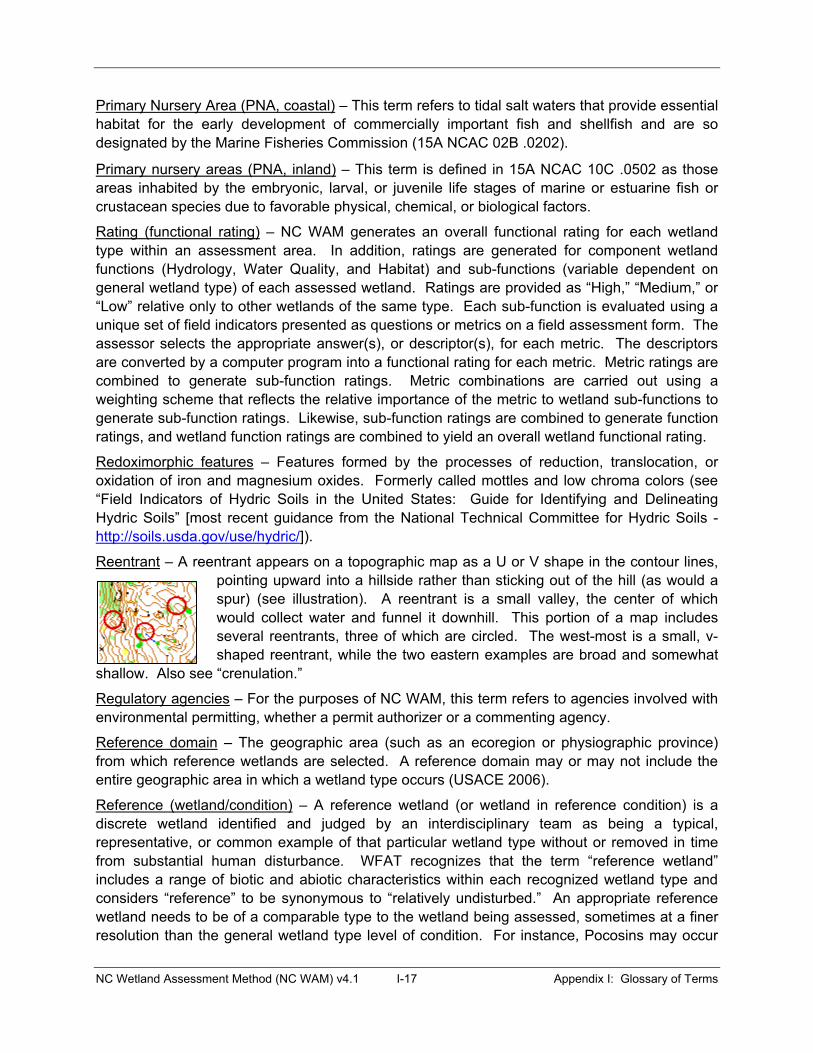
NC Wetland Assessment Method (NC WAM) v4.1 I-17 Appendix I: Glossary of Terms
Primary Nursery Area (PNA, coastal) – This term refers to tidal salt waters that provide essential habitat for the early development of commercially important fish and shellfish and are so designated by the Marine Fisheries Commission (15A NCAC 02B .0202).
Primary nursery areas (PNA, inland) – This term is defined in 15A NCAC 10C .0502 as those areas inhabited by the embryonic, larval, or juvenile life stages of marine or estuarine fish or crustacean species due to favorable physical, chemical, or biological factors.
Rating (functional rating) – NC WAM generates an overall functional rating for each wetland type within an assessment area. In addition, ratings are generated for component wetland functions (Hydrology, Water Quality, and Habitat) and sub-functions (variable dependent on general wetland type) of each assessed wetland. Ratings are provided as “High,” “Medium,” or “Low” relative only to other wetlands of the same type. Each sub-function is evaluated using a unique set of field indicators presented as questions or metrics on a field assessment form. The assessor selects the appropriate answer(s), or descriptor(s), for each metric. The descriptors are converted by a computer program into a functional rating for each metric. Metric ratings are combined to generate sub-function ratings. Metric combinations are carried out using a weighting scheme that reflects the relative importance of the metric to wetland sub-functions to generate sub-function ratings. Likewise, sub-function ratings are combined to generate function ratings, and wetland function ratings are combined to yield an overall wetland functional rating.
Redoximorphic features – Features formed by the processes of reduction, translocation, or oxidation of iron and magnesium oxides. Formerly called mottles and low chroma colors (see “Field Indicators of Hydric Soils in the United States: Guide for Identifying and Delineating Hydric Soils” [most recent guidance from the National Technical Committee for Hydric Soils - http://soils.usda.gov/use/hydric/]).
Reentrant – A reentrant appears on a topographic map as a U or V shape in the contour lines, pointing upward into a hillside rather than sticking out of the hill (as would a spur) (see illustration). A reentrant is a small valley, the center of which would collect water and funnel it downhill. This portion of a map includes several reentrants, three of which are circled. The west-most is a small, v-shaped reentrant, while the two eastern examples are broad and somewhat
shallow. Also see “crenulation.”
Regulatory agencies – For the purposes of NC WAM, this term refers to agencies involved with environmental permitting, whether a permit authorizer or a commenting agency.
Reference domain – The geographic area (such as an ecoregion or physiographic province) from which reference wetlands are selected. A reference domain may or may not include the entire geographic area in which a wetland type occurs (USACE 2006).
Reference (wetland/condition) – A reference wetland (or wetland in reference condition) is a discrete wetland identified and judged by an interdisciplinary team as being a typical, representative, or common example of that particular wetland type without or removed in time from substantial human disturbance. WFAT recognizes that the term “reference wetland” includes a range of biotic and abiotic characteristics within each recognized wetland type and considers “reference” to be synonymous to “relatively undisturbed.” An appropriate reference wetland needs to be of a comparable type to the wetland being assessed, sometimes at a finer resolution than the general wetland type level of condition. For instance, Pocosins may occur
NC Wetland Assessment Method (NC WAM) v4.1 I-18 Appendix I: Glossary of Terms
on mineral soils or organic soils, and an appropriate reference wetland for a mineral soil Pocosin will be one found on mineral soils.
Riparian buffer – A riparian buffer is a vegetated area abutting an open water that reduces runoff and non-point source pollution and attenuates flood flows by decreasing water flow velocity. This facilitates the settling, trapping and uptake of chemical pollutants (such as nitrogen and phosphorus) and sediment (http://www.enr.state.nc.us/html/b_-_terms.html).
Riparian wetlands – Wetland types typically found in one or more of the following landscape positions: in a geomorphic floodplain; in a natural topographic crenulation; contiguous with an open water greater than or equal to 20 acres in size (anticipated to be subject to seasonal fluctuations in water table); or subject to tidal flow regimes, excluding Salt/Brackish Marsh (see NC WAM wetland type key). Riparian wetlands include the following NC WAM general wetland types: Estuarine Woody Wetland, Tidal Freshwater Marsh, Riverine Swamp Forest, Bog, Non-Tidal Freshwater Marsh, Floodplain Pool, Headwater Forest, and Bottomland Hardwood Forest.
RTFM – “Read the flippin’ manual” (when spoken, frequently followed by an emphatic “baby”).
Saline waters – NC WAM considers brackish, estuarine, and salt water to be included in this category; any waters in which ocean-derived salts measure 0.5 parts per thousand or greater.
Salt water (marine system) – Water typically influenced by the ebb and flow of lunar tides in which salinities exceed 30 parts per thousand (Cowardin et al. 1979).
Sandhills – The Sandhills level IV ecoregion is a subset of the Southeastern Plains level III ecoregion. This area occurs in the southwestern portion of the Southeastern Plains and is characterized by unconsolidated, sandy soils deposited by erosional forces during the Pleistocene epoch.
Sandy soil – A soil material that contains 85 percent or more of sand (https://www.soils.org/publications/soils-glossary). This term refers to soils that have a USDA texture of loamy fine sand and coarser (see “Field Indicators of Hydric Soils in the United States: Guide for Identifying and Delineating Hydric Soils” [most recent guidance from the National Technical Committee for Hydric Soils - http://soils.usda.gov/use/hydric/]).
Sapling – A woody plant approximately 20 feet or more in height and less than 3 inches diameter at breast height (DBH) (modified from USACE 2008).
Saturation/saturated soil condition – A condition in which all easily drained voids (pores) between soil particles in the root zone are temporarily or permanently filled with water to the soil surface at pressures greater than atmospheric (USACE 2006). Evidence of saturation without inundation may be provided by presence of facultative or water-tolerant plant species in conjunction with wetland soils and the absence of surface water indicators.
Seasonally inundated (flooded) – Surface water is present for extended periods, especially early in the growing season, but is absent by the end of the growing season in most years. When surface water is absent, the water table is often near the land surface (Cowardin et al. 1979).
Seasonally saturated – The substrate is saturated to the surface for extended periods during the growing season, but surface water is seldom present.
Seep – Seeps are areas semi-permanently to permanently saturated by ground water discharge and are underlain by mineral or organic soils (USACE 2006). For the purposes of NC WAM,
NC Wetland Assessment Method (NC WAM) v4.1 I-19 Appendix I: Glossary of Terms
these areas are typically found on sloping hillsides where impervious layers force ground water to the surface. Groundwater-fed areas in geomorphic floodplains or headwater wetlands are placed in other general wetland types.
Sedimentation/Deposition – This term refers to the deposition or accumulation of eroded soil material (sediment) that has been transported into a wetland or open-water system by moving water.
Semi-permanently inundated (flooded) – Surface water persists throughout the growing season in most years. When surface water is absent, the water table is usually at or very near the land surface (Cowardin et al. 1979).
Semi-permanently saturated – The substrate is saturated to the surface, but surface water is seldom present, throughout the growing season in most years (Cowardin et al. 1979).
Severely – A descriptive term used to emphasize the extent to which an event affects an object or the environment – in this case, having enough substance to make an extreme difference. When this term is used in NC WAM, it is typically followed with descriptive examples.
Sheltered areas (with reference to marshes abutting/adjacent to open water) – (see Field Assessment Form Metric 7) Shorelines anticipated to be regularly subject to waves of less than 1 foot in height are considered to be “sheltered.” NC WAM considers an open water width of less than 2500 feet to provide too little fetch for regular development of waves meeting or exceeding this threshold. Also, shorelines abutting open water without regular boat traffic that generates high-energy wakes are considered to be “sheltered.” “Exposed areas” are the opposite of “sheltered areas.”
Short-duration inundation – (see the User Manual discussion of Field Assessment Form Metric 9 for more details) This term refers to a situation in which the period of inundation for a single event ranges less than 7 consecutive days during the growing season. Evidence of short-duration inundation may be provided by visual observation of inundation (ponding or flooding), recorded data, soil type, and dominant vegetation wetland indicator status (see also long-duration inundation). The NC WAM use of the term “short-duration inundation” encompasses the inundation duration ranges of “extremely brief” (0.1 to 4 hours), “very brief” (4 to 48 hours), and “brief” (2 to 7 days) as defined by the following reference: U.S. Department of Agriculture, Natural Resources Conservation Service. 2007. National Soil Survey Handbook, title 430-VI [Online]. Available: http://soils.usda.gov/technical/handbook.
Shrub – Woody plants approximately 3 to 20 feet in height (modified from USACE 2008).
Snag – A standing dead tree or part of a dead tree from which at least the leaves and smaller branches have fallen; often called stumps if less than 20 feet tall (www.enr.state.nc.us/html/s_-_terms.html). Snags are typically vertical. Dead trees that have fallen over but are not lying on the ground are not considered snags.
Soil ribbon – Ability to form a soil ribbon eliminates sand and loamy sand as soil texture possibilities in a texture-by-feel analysis. To make a soil ribbon, place a ball of soil between thumb and forefinger, gently push the soil with the thumb, and squeeze it upward into a ribbon. The length of a soil ribbon is related to the amount of clay in the soil. Longer ribbons indicate relatively higher clay content, while shorter ribbons indicate relatively lower clay content.
NC Wetland Assessment Method (NC WAM) v4.1 I-20 Appendix I: Glossary of Terms
Soluble Change – A sub-function under the water quality function of wetlands. Soluble change refers to the ability of a wetland to remove and hold dissolved materials from the water column. An example of soluble pollutants is nutrients that are readily water soluble, such as nitrate nitrogen.
Southeastern Plains level III ecoregion – This ecoregion occurs in the western portion of the Coastal Plain physiographic province and includes the Sandhills level IV ecoregion (see Figure 1 and Appendix E for ecoregion maps). This ecoregion, with the exception of the Sandhills, is considered synonymous with the Inner Coastal Plain. The Southeastern Plains ecoregion consists of irregular plains with broad interstream areas. The Cretaceous- or Tertiary-age sands, silts, and clays of the region contrast geologically with the older metamorphic and igneous rocks of the Piedmont to the west. Elevations and relief are greater than in the Middle Atlantic Coastal Plain to the east. Tributaries in this area are relatively low gradient and sandy bottomed (Griffith et al. 2002).
Sparse – This term refers to vegetation structure and is used by NC WAM to characterize mid-story/sapling, shrub, and herb strata (Metric 17). Any of these three strata is considered to be sparse when that stratum alone is characterized by less than 10 percent areal coverage.
Stable condition – A wetland is considered to be in stable condition when the three primary criteria (vegetation, soils, and hydrology) have not recently changed and are not currently in a state of change relative to conditions under which the wetland was established. A wetland in stable condition is one that has the ability to react to a disturbing force by maintaining or reestablishing position or form.
Strahler stream order – A simple method of classifying stream segments based on the number of tributaries upstream. A stream with no tributaries (headwater stream) is considered a first-order stream. A segment downstream of the confluence of two first-order streams is a second-order stream. Thus, an nth-order stream is always located downstream of the confluence of two (n-1)th-order streams (Strahler 1952). See Appendix C for a schematic diagram of stream order.
Stream – A stream can be described as flowing surface water in a channel resulting from storm flow (increased stream flow resulting from the relatively rapid runoff of precipitation from the land as interflow [rapid, unsaturated, subsurface flow], overland flow, or saturated flow from raised near-surface water tables close to the stream), base flow (low flow resulting from delayed discharge of ground water into the stream between rainfall events), or a combination of both storm flow and base flow, and contributions of discharge from upstream tributaries as storm flow or base flow, if present (http://portal.ncdenr.org/web/wq/swp/ws/401/waterresources/streamdeterminations)
Stream order (see also Strahler stream order) – Stream order is generally determined by consulting blue lines on the USGS 7.5-minute (1:24,000) quadrangle and calculating the order number using the Strahler method. See Appendix C for a schematic diagram of stream order. The assessor should consider both intermittent and perennial streams when making a stream order determination (ephemeral channels are not included in the determination). For the purposes of NC WAM, a zero-order stream is a stream that is found on the ground but is not shown on the most recent version of the USGS 7.5-minute (1:24,000) quadrangle. Also for the purposes of NC WAM, an assessor should not necessarily count blue-line ditches in the Middle Atlantic Coastal Plain ecoregion as first-order streams. In this region, only streams within
NC Wetland Assessment Method (NC WAM) v4.1 I-21 Appendix I: Glossary of Terms
topographic crenulations or geomorphic floodplains should be used to determine stream order. In this situation, the best mapping source available (7.5-minute quadrangle, LiDAR) may be used for the determination of stream order.
Stressor – A typically anthropogenic activity that affects one or more wetland functions by altering the wetland from reference condition. The response of a wetland to a stressor depends on wetland type, size, and severity of the stressor. Examples of stressors may include nutrient enrichment/eutrophication, organic loading and reduced dissolved oxygen, contaminant toxicity, acidification, salinization, sedimentation/burial, turbidity/shade, vegetation removal, thermal alteration, dehydration, inundation, fragmentation of habitat (Adamus and Brandt 1990), and soil disturbance. Stressors are anticipated to always degrade the condition of a wetland; but, to some extent, stressors may benefit the opportunity of some water quality functions.
Sub-function – This term refers to the supporting but distinct components of each of the three designated wetland functions as determined by WFAT. Hydrology sub-functions include 1) surface storage and retention and 2) sub-surface storage and retention; Water Quality sub-functions include 1) particulate change, 2) soluble change, 3) pathogen change, 4) physical change, and 5) pollution change; and Habitat sub-functions include 1) habitat physical structure, 2) vegetation composition, 3) landscape patch structure, and 6) uniqueness.
Substantially – This is a descriptive term used to emphasize the extent to which an event affects an object or the environment – in this case, having at least enough substance to make a difference. When this term is used in NC WAM, it is typically followed with descriptive examples.
Surface Water Classifications – Designations applied to surface waterbodies, such as streams, rivers, and lakes, defining the best uses to be protected within the waters (examples: swimming, fishing, drinking water supply) (http://www.enr.state.nc.us/html/s_-_terms.html).
Tidal – This term typically refers to a situation in which the water level periodically fluctuates due to the action of lunar and solar forces upon the rotating earth (Environmental Laboratory 1987). “Wind tides” refer to water table fluctuations due to the action of wind on the water surface. For the purposes of NC WAM, open waters greater in size than 20 acres may be considered to be subject to wind tides.
Toe-of-the-slope – This term refers to the point at the bottom of the outer floodplain slope where the slope meets the floodplain floor.
Topographic crenulation (see Crenulation)
Treatment capacity (of a wetland) – This term refers to a wetland’s ability to treat pollutants, entering the wetland through either surface or sub-surface discharges. For the purposes of NC WAM, the level of capacity is not as important as evidence of a discharge and evidence that the wetland’s treatment capacity is being exceeded by the discharge.
Tree – Any woody plant greater than or equal to 3 inches in diameter at breast height (DBH) and greater than 20 feet in height (modified from USACE 2008).
Tributary – The term “tributary” refers to an open conduit, either naturally or artificially created, that periodically or continuously contains moving water (examples: river, stream, ditch, canal, inter-dune swale connected to surface waters). For the purposes of NC WAM, the term “tributary” implies federal and/or state jurisdictional status. A “natural” tributary excludes man-

NC Wetland Assessment Method (NC WAM) v4.1 I-22 Appendix I: Glossary of Terms
made features (ditches, canals) outside of a natural topographic crenulation, even when man-made features appear to have “naturalized.”
Trout waters (Tr) – This term refers to an NCDWQ supplemental classification intended to protect freshwaters for natural trout propagation and the survival of stocked trout. To receive a Tr classification, the proposed open water must have conditions that will sustain and allow for trout propagation and survival of stocked trout on a year-round basis (15A NCAC 2B .0200).
Underground Storage Tank (UST) - A tank located all or partially underground that is designed to hold chemical solutions, gasoline, or other petroleum products (www.enr.state.nc.us/html/u_-_terms.html).
Upland – This term refers to terrestrial areas not subject to Section 404 jurisdiction and not considered to be isolated wetlands.
Urban landscapes – This term refers to wetlands and uplands in urban/suburban settings characterized by intensive management such as grass lawns and suburban yards.
Value – Value refers to the benefits, goods, and services that result from wetland functions. For example, one function of many wetlands is the storage of surface water; the value of that function is to reduce flood damage. Value may be increased by the location of a wetland within a watershed whereby the wetland has an increased opportunity to provide a particular function.
Very long duration inundation (flooding) – (see the User Manual discussion of Field Assessment Form Metric 9 for more details) A duration class in which the length of a single inundation event is equal to or greater than 30 consecutive days during the growing season (U.S. Department of Agriculture Natural Resources Conservation Service National Soil Survey Handbook, title 430-VI [Online]. Available: http://soils.usda.gov/technical/handbook).
Water quality – Descriptive or quantitative conditions of water, usually in reference to physical, chemical, and biological properties, and usually from the perspective of society's use.
Watershed – The NCDWQ (and NC WAM) considers the watershed to be the entire land area contributing surface drainage to a specific point (15A NCAC 02B .0200). The USACE uses the term “catchment” to refer to this same concept.
Water table – Water table is the surface of the saturated zone below which all interconnected voids are filled with water and at which the pressure is atmospheric (15A NCAC 02L .0102(27).
Well connected (wetland) – (see Field Assessment Form Metric 13) This term generally refers to a wetland surrounded by or adjoining a natural habitat patch along a substantial part of its boundary on at least one side.
Wetland(s) – “Wetlands" are areas that are inundated or saturated by surface or ground water at a frequency and duration sufficient to support, and that under normal circumstances do support, a prevalence of vegetation typically adapted for life in saturated soil conditions. Wetlands generally include swamps, marshes, bogs, and similar areas (33 CFR 328.3(b)).
Wetland assessment area – See Assessment area
Wetland assessment form –This form is used by NC WAM to document conditions within an assessment area during a rapid field assessment. Information recorded on this form is used to generate a functional rating of an assessed wetland.
NC Wetland Assessment Method (NC WAM) v4.1 I-23 Appendix I: Glossary of Terms
Wetland buffer - A buffer is a vegetated area abutting an open water that reduces runoff and non-point source pollution and attenuates flood flows by decreasing water flow velocity. This facilitates the settling, trapping and uptake of chemical pollutants (such as nitrogen and phosphorus) and sediment (http://www.enr.state.nc.us/html/b_-_terms.html). NC WAM considers optimum buffer widths to be 50 feet wide (measured perpendicular to a surface water) in the Coastal Plain and Piedmont ecoregions and 30 feet wide (measured perpendicular to a surface water) in the Blue Ridge ecoregion. The wetland buffer width measurement referred to in Field Assessment Form Metric 7 requires the assessor to determine if an assessment area is within 50 feet of a tributary or other open water, and if so, how much of the first 50 feet perpendicular to the bank is wetland.
Wetland complex – The wetland complex may consist of one NC WAM general wetland type or an association of two or more contiguous NC WAM general wetland types. Wetland complex boundaries typically are formed by natural uplands, open water that extends across the entire width of a floodplain, or a man-made berm/causeway the width of a four-lane road or wider.
Wetland delineation/determination – The U.S. Army Corps of Engineers defines wetland determination as “the process or procedure by which an area is adjudged a wetland or nonwetland” (Environmental Laboratory 1987). For the purposes of NC WAM, both wetland delineation and wetland determination are terms that indicate that a wetland/upland boundary has been identified properly according to guidance provided in the Corps of Engineers Wetland Delineation Manual (Environmental Laboratory 1987).
Wetland Functional Assessment Team (WFAT) – An interagency (federal and state) team sponsored by NCDENR, NCDOT, and USACE and tasked with developing a rapid wetland functional assessment methodology for the state of North Carolina. WFAT was formed in 2003 and released the NC WAM product in mid-2007.
Wetland functional rating – See “rating.”
Wetland Indicator Status – The U.S. Fish and Wildlife Service (USFWS) has compiled a National List of Plant Species that Occur in Wetlands (Reed 1988 or current list). In this list, each species has been given an indicator status that reflects the probability of the species occurring in a wetland versus a non-wetland across the entire distribution of the species and another indicator status that reflects the same probability within a regional range (for example, the U.S. Southeast).
Wetland type – The wetland type is a wetland area comprised of one of the 16 NC WAM general wetland types, irrespective of the limits of any proposed activity. Wetland type boundaries are formed by another wetland type, a wetland/natural upland boundary, and a man-made berm/causeway wider than that needed to support a two-lane road. A wetland type determination may be made based on general wetland type descriptions, with the use of the NC WAM Dichotomous Key to General North Carolina Wetland Types, or following guidelines provided for the identification of unique or problematic wetland types.
Zero-order stream – This term refers to a tributary that is not shown on a USGS 7.5-minute topographic quadrangle.