nbnc ph i implement report rpt - the bucks county ...€¦ · doylestown, pa 18901 doylestown, ......
TRANSCRIPT

FINAL REPORT
North Branch Neshaminy Creek &
Lake Galena Watershed Phase I
Implementation Project
September 30, 2012
Prepared by:
Bucks CountyConservation District
P.O. Box 605 1456 Ferry Road, Suite 704
Doylestown, PA 18901 Doylestown, PA 18901
www.aqualinkinc.com www.bucksccd.org

North Branch Neshaminy Creek & Lake Galena Phase I Implementation Project
Prepared by Bucks County Conservation District & Aqua Link, Inc. i
FINAL REPORT
North Branch Neshaminy Creek &
Lake Galena Watershed Phase One
Implementation Project
PA DEP Document No. 4100053255
Prepared for:
PA DEP US EPAP.O. Box 8555 1200 Pennsylvania Ave, NW
Harrisburg, PA 17105-8555 Washington, DC 20460
Ph: 717.772.5807
Prepared by:
Bucks County
Conservation DistrictP.O. Box 605 1456 Ferry Road, Suite 704
Doylestown, PA 18901 Doylestown, PA 18901
Ph: 215.230.9325 Ph: 215.345.7577
www.aqualinkinc.com www.bucksccd.org

North Branch Neshaminy Creek & Lake Galena Phase I Implementation Project
Prepared by Bucks County Conservation District & Aqua Link, Inc. ii
TABLE OF CONTENTS
Section No. Page
1. PROJECT TITLE & TYPE.....................................................................................................2
2. PROJECT FUNDING & SCHEDULE....................................................................................2
3. PROJECT LOCATION..........................................................................................................2
4. PROJECT OVERVIEW .........................................................................................................2
5. BEST MANAGEMENT PRACTICES & LOAD REDUCTIONS.............................................5
5.1. GAYMAN FARM: BASIN AND WATERWAY REPAIR ........................................................... 5
5.2. MCCAULEY FARM: DIVERSION INSTALLATION ................................................................ 6
5.3. BASKIN FARM: GULLY STABILIZATION ............................................................................ 7
5.4. PENNVIEW FARM: DIVERSION INSTALLATION ................................................................. 8
Cover Photograph
Photograph of completed gully stabilization project at the Baskin Farm within the Lake Galena & North Branch Neshaminy Creek Watershed
Appendices
Appendix A Estimated Sediment & Nutrient Load Reductions
List of Figures
Figure No. Page
FIGURE 1 LAKE GALENA WATERSHED 3
FIGURE 2 LOCATIONS OF PROPOSED AGRICULTURAL BMPS 4
FIGURE 3 PHOTOGRAPHS OF INSTALLED BMPS 9
NBNC Implement Report - Phase I.rpt.doc
North Branch Neshaminy Creek & Lake Galena Phase I Implementation Project
Prepared by the Bucks County Conservation District & Aqua Link, Inc. 2
1. Project Title & Type
Project Title: North Branch Neshaminy Creek & Lake Galena Phase I
Implementation Project
Project Type: Watershed Restoration/Implementation Project
2. Project Funding & Schedule
This project, the North Branch Neshaminy Creek (NBNC) & Lake Galena Watershed Phase I
Implementation Project, was federally funded by PA DEP and U.S. EPA through Section 319
Nonpoint Source Program of the Clean Water Act. The Bucks County Conservation District served
as the Project Sponsor and Applicant for the project and retained Aqua Link to provide technical
assistance in selecting project sites and to prepare the grant application and the final report. Prior to
this Phase I Implementation project, Aqua Link served as the consultant to the District in developing
the Lake Galena & North Branch Neshaminy Creek Watershed Implementation Plan (Aqua Link &
Bucks County Conservation District 2009). The total amount of federal funding that was awarded
for this project was $68,265. The contract between the District and DEP was executed on June 14,
2010 and the project was completed on September 30, 2012.
3. Project Location
The implemented agricultural best management practices (BMPs) for this project were
implemented within the Lake Galena watershed as shown in Figure 1. The watershed is
approximately 15.8 square miles (10,112 acres) in area. The coordinates of the dam of this lake are
40.3171o N and 75.2038o W. The entire watershed is located in New Britain, Plumstead, Doylestown
and Hilltown Townships in Central Bucks County. The lake is fully contained within the boundaries
of New Britain.
4. Project Overview
The primary objective of this project, the North Branch Neshaminy Creek (NBNC) & Lake
Galena Watershed Phase I Implementation Project, was to improve water quality by reducing
sediment and nutrients entering both surface and groundwater within North Branch Neshaminy &
Lake Galena Watershed (Figure 1) via the implementation of agricultural BMPs (best management
practices). Under this grant, agricultural BMPs were implemented on four different farms (Figure 2)

North Branch Neshaminy Creek & Lake Galena Phase I Implementation Project
Prepared by the Bucks County Conservation District & Aqua Link, Inc. 3
Figure 1 Lake Galena Watershed
Lake Galena
North BranchNeshaminy Creek
Doylestown
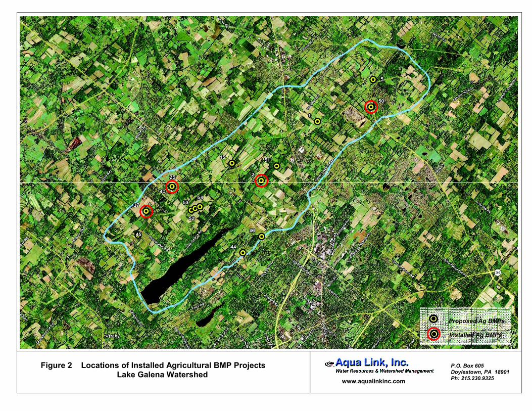
Figure 2 Locations of Installed Agricultural BMP Projects Lake Galena Watershed
www.aqualinkinc.com
P.O. Box 605 Doylestown, PA 18901 Ph: 215.230.9325
Proposed Ag BMPs
Installed Ag BMPs

North Branch Neshaminy Creek & Lake Galena Phase I Implementation Project
Prepared by the Bucks County Conservation District & Aqua Link, Inc. 5
that were identified in Lake Galena & North Branch Neshaminy Creek Watershed Implementation
Plan (Aqua Link & Bucks County Conservation District 2009).
As part of the WIP (watershed implementation plan) report, the District with the assistance of
the USDA NRCS identified a total of twelve farms requiring agricultural BMPs. Based upon
intensive field reconnaissance, the NPS problem areas identified on the aforementioned four farms
have been categorized as top priorities within the Lake Galena watershed by the District and Aqua
Link.
5. Best Management Practices & Load Reductions
The Bucks County Conservation District (District) along with the assistance of the USDA NRCS
implemented agricultural BMPs on four different farms within the Lake Galena watershed (Figures 1
and 2). All BMPs were designed according to NRCS standards and specifications. The installed
BMPs are discussed in the following subsections.
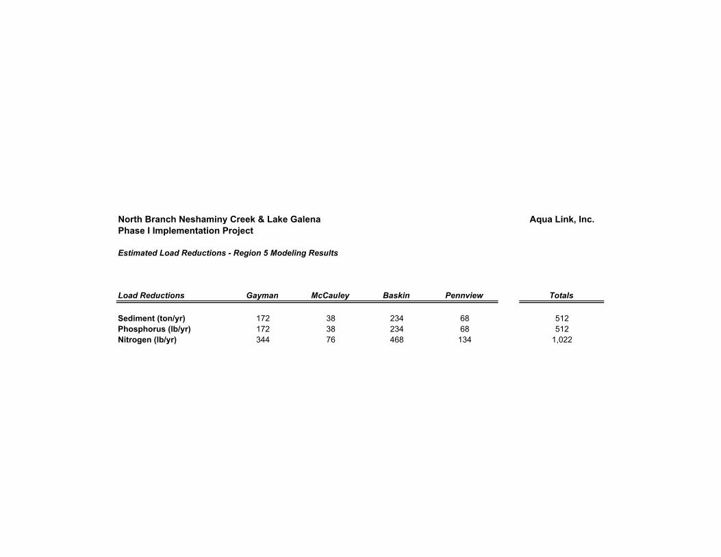
Sediment and nutrient load reductions resulting from BMP implementation for this project were
estimated using EPA’s Region 5 Model for gully stabilization. The results of model are presented in
Appendix A of this report. Overall, the model predicted a total sediment load reduction of 512 tons
per year (Appendix A). In addition, total phosphorus and nitrogen load reductions were estimated
at 512 and 1,022 pounds per year, respectively (Appendix A).
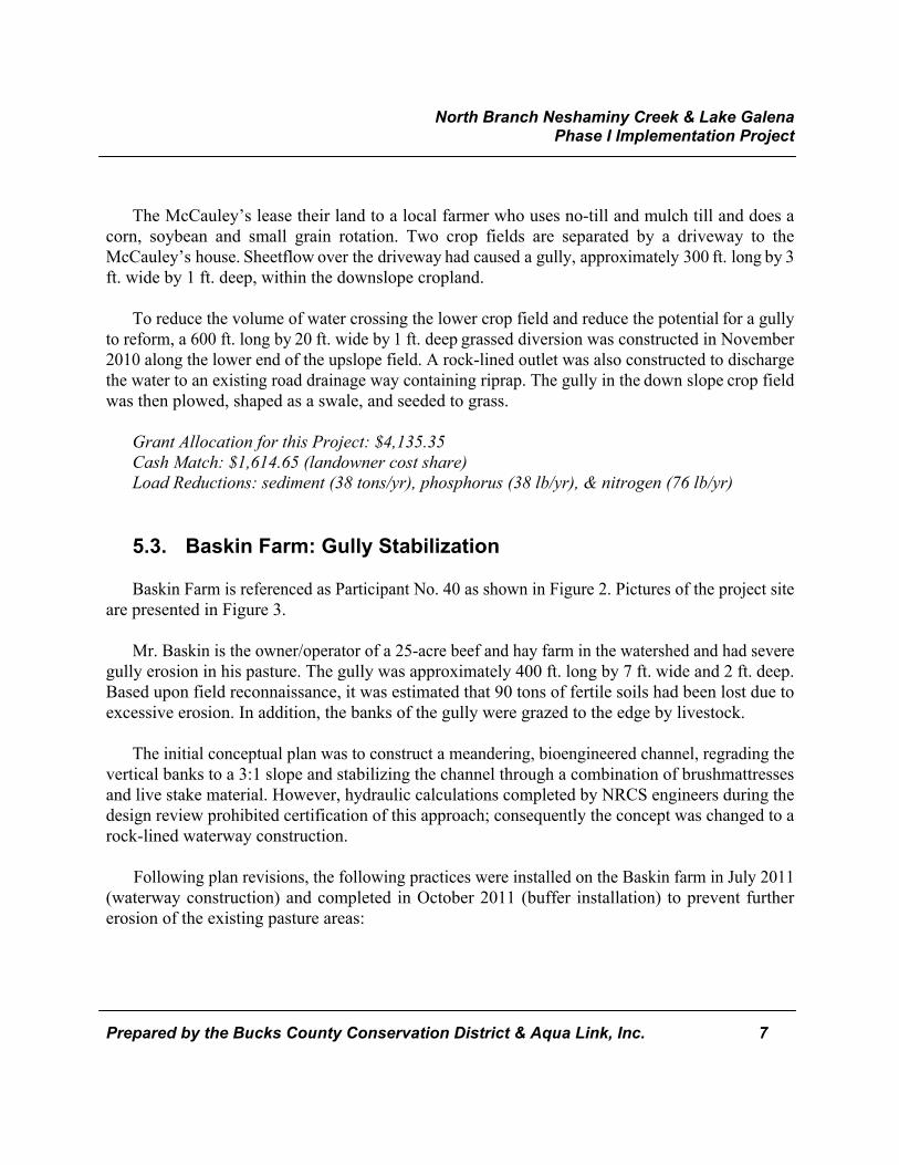
5.1. Gayman Farm: Basin and Waterway Repair
Gayman Farm is referenced as Participant No. 2 as shown in Figure 2. Pictures of the project site
are presented in Figure 3.
Uncontrolled stormwater runoff flows onto the Gayman Property (pasture) via a corrugated
metal pipe (4 by 2.75 ft) into an archie basin. Mr. Gayman installed this basin on his property in the
mid 1990’s to help stop erosion that was being caused by the culvert. Over the years, this basin
routinely had filled will sediment, which resulted in several failures of the auxiliary spillway of the
basin itself. Stormwater from the spillway of the basin discharged onto sloping pasture resulting in
severe gully erosion. Prior to implementation, approximately 900 ft. of gullies with depths up to 2.5
ft. were formed on the Gayman pasture. Based upon field reconnaissance, an NRCS engineer
estimated approximately 170 tons of soil were lost from just the gullied areas.

North Branch Neshaminy Creek & Lake Galena Phase I Implementation Project
Prepared by the Bucks County Conservation District & Aqua Link, Inc. 6
In addition, Mr. Gayman indicated that an outlet pipe from his upstream neighbor’s pond outlets
at the culvert’s inlet resulting in periods of continuous flow during the year. The culvert is not able
to carry the full flow rates and the road overtops during large storm events. One such area was
approximately 230 ft. to the southwest of the culvert pipe. This area often remained saturated after
storms, possibly from the road overtopping and runoff seeping through the roadbed itself. Prior to
any implementation, gully erosion was observed from the saturated area to the main waterway from
the archie basin.
To prevent further erosion and repair the damage to the existing pasture areas, the following
practices were implemented on the Gayman farm in October 2011:
Enlarged the existing basin by 2,425 ft2 to promote settling and provide
additional capacity to handle incoming stormwater and installed trash rack on
outlet pipe to prevent clogging
Reinforced basin auxiliary spillway by installing a rock chute 110 ft. long, 10 ft.
wide and 0.9 ft. deep
Installed a 545 ft. long, 48 ft. wide, and 0.8 ft. deep rock-centered waterway
immediately after the rock chute
Installed a 380 ft. long, 50 ft. wide and 1 ft. deep grassed waterway immediately
after the rock-centered waterway where the pasture starts to flatten out,
Installed a 250 ft. long, 15 ft. wide, and 0.6 ft. high grassed diversion to divert
stormwater when the road overtops and outlet to the rock centered waterway
Grant Allocation for this Project: $43,299.55
Cash Match: n/a (landowner cost share)
Load Reductions: sediment (172 tons/yr), phosphorus (172 lb/yr), & nitrogen (344 lb/yr)
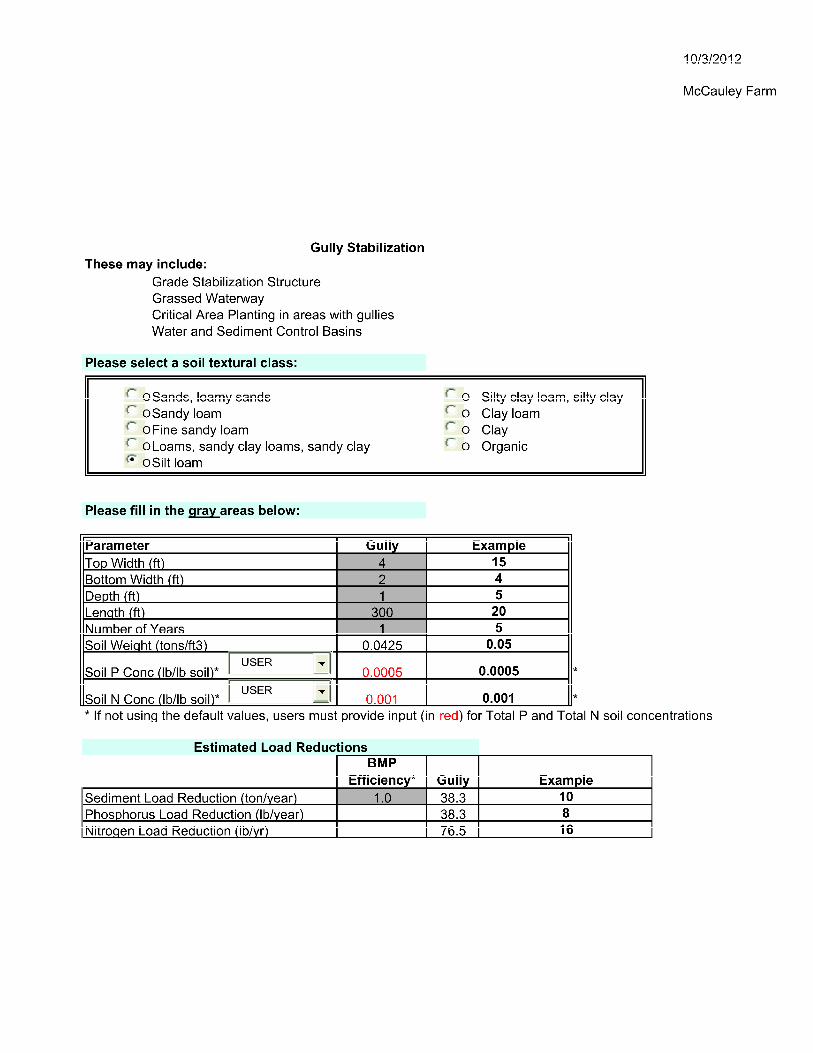
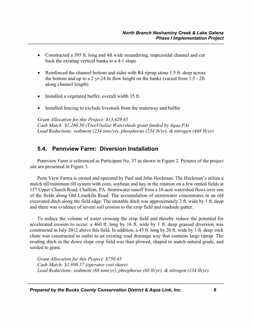
5.2. McCauley Farm: Diversion Installation
McCauley Farm is referenced as Participant No. 50 as shown in Figure 2. Pictures of the project
site are presented in Figure 3.
North Branch Neshaminy Creek & Lake Galena Phase I Implementation Project
Prepared by the Bucks County Conservation District & Aqua Link, Inc. 7
The McCauley’s lease their land to a local farmer who uses no-till and mulch till and does a
corn, soybean and small grain rotation. Two crop fields are separated by a driveway to the
McCauley’s house. Sheetflow over the driveway had caused a gully, approximately 300 ft. long by 3
ft. wide by 1 ft. deep, within the downslope cropland.
To reduce the volume of water crossing the lower crop field and reduce the potential for a gully
to reform, a 600 ft. long by 20 ft. wide by 1 ft. deep grassed diversion was constructed in November
2010 along the lower end of the upslope field. A rock-lined outlet was also constructed to discharge
the water to an existing road drainage way containing riprap. The gully in the down slope crop field
was then plowed, shaped as a swale, and seeded to grass.
Grant Allocation for this Project: $4,135.35
Cash Match: $1,614.65 (landowner cost share)
Load Reductions: sediment (38 tons/yr), phosphorus (38 lb/yr), & nitrogen (76 lb/yr)
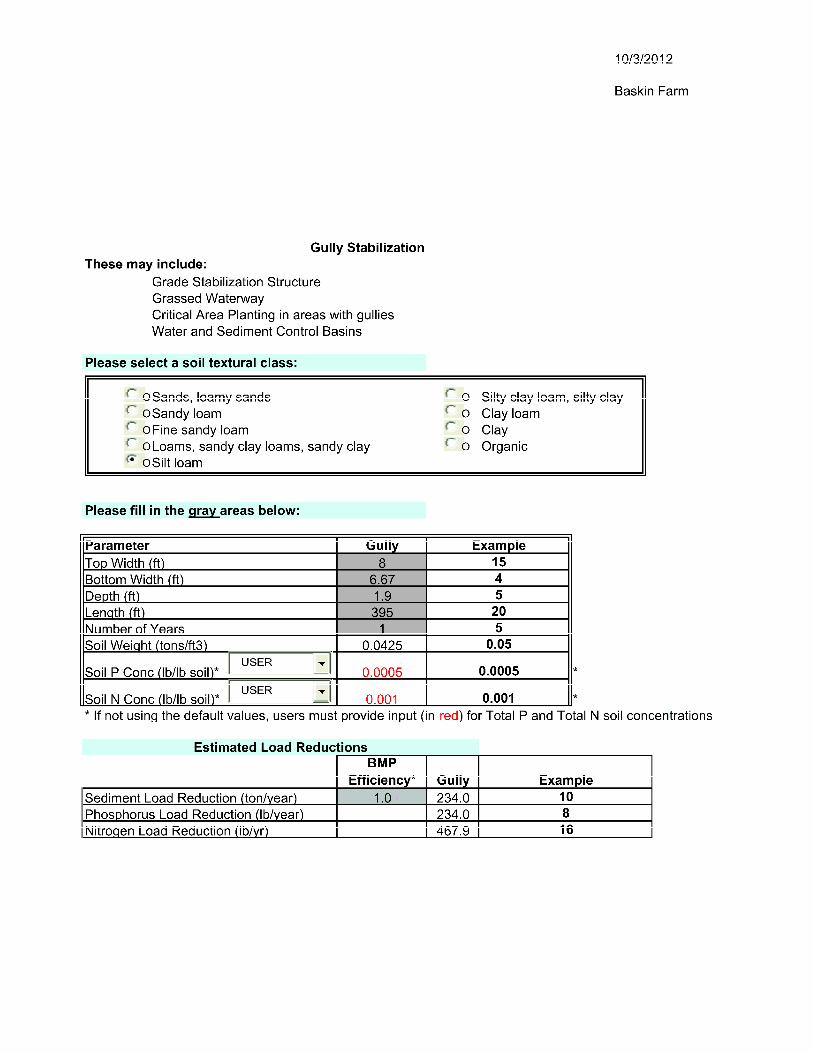
5.3. Baskin Farm: Gully Stabilization
Baskin Farm is referenced as Participant No. 40 as shown in Figure 2. Pictures of the project site
are presented in Figure 3.
Mr. Baskin is the owner/operator of a 25-acre beef and hay farm in the watershed and had severe
gully erosion in his pasture. The gully was approximately 400 ft. long by 7 ft. wide and 2 ft. deep.
Based upon field reconnaissance, it was estimated that 90 tons of fertile soils had been lost due to
excessive erosion. In addition, the banks of the gully were grazed to the edge by livestock.
The initial conceptual plan was to construct a meandering, bioengineered channel, regrading the
vertical banks to a 3:1 slope and stabilizing the channel through a combination of brushmattresses
and live stake material. However, hydraulic calculations completed by NRCS engineers during the
design review prohibited certification of this approach; consequently the concept was changed to a
rock-lined waterway construction.
Following plan revisions, the following practices were installed on the Baskin farm in July 2011
(waterway construction) and completed in October 2011 (buffer installation) to prevent further
erosion of the existing pasture areas:
North Branch Neshaminy Creek & Lake Galena Phase I Implementation Project
Prepared by the Bucks County Conservation District & Aqua Link, Inc. 8
Constructed a 395 ft. long and 4ft wide meandering, trapezoidal channel and cut
back the existing vertical banks to a 4:1 slope
Reinforced the channel bottom and sides with R4 riprap stone 1.5 ft. deep across
the bottom and up to a 2 yr-24 hr flow height on the banks (varied from 1.5 - 2ft.
along channel length)
Installed a vegetated buffer, overall width 35 ft.
Installed fencing to exclude livestock from the waterway and buffer
Grant Allocation for this Project: $13,629.65
Cash Match: $1,260.50 (TreeVitalize Watersheds grant funded by Aqua PA)
Load Reductions: sediment (234 tons/yr), phosphorus (234 lb/yr), & nitrogen (468 lb/yr)
5.4. Pennview Farm: Diversion Installation
Pennview Farm is referenced as Participant No. 37 as shown in Figure 2. Pictures of the project
site are presented in Figure 3.
Penn View Farms is owned and operated by Paul and John Hockman. The Hockman’s utilize a
mulch till/minimum till system with corn, soybean and hay in the rotation on a few rented fields at
157 Upper Church Road, Chalfont, PA. Stormwater runoff from a 16-acre watershed flows over one
of the fields along Old Limekiln Road. The accumulation of stormwater concentrates in an old
excavated ditch along the field edge. The unstable ditch was approximately 2 ft. wide by 1 ft. deep
and there was evidence of severe soil erosion to the crop field and roadside gutter.
To reduce the volume of water crossing the crop field and thereby reduce the potential for
accelerated erosion to occur, a 460 ft. long by 16 ft. wide by 1 ft. deep grassed diversion was
constructed in July 2012 above this field. In addition, a 45 ft. long by 20 ft. wide by 1 ft. deep rock
chute was constructed to outlet to an existing road drainage way that contains large riprap. The
eroding ditch in the down slope crop field was then plowed, shaped to match natural grade, and
seeded to grass.
Grant Allocation for this Project: $750.45
Cash Match: $1,698.57 (operator cost share)
Load Reductions: sediment (68 tons/yr), phosphorus (68 lb/yr), & nitrogen (134 lb/yr)
Figure 3 Photographs of Implemented Best Management Practices
1. Participant No. 2 – Archie Basin Prior to Implementation2. Participant No. 2 – Severe Gully Erosion Prior to
Implementation
3. Participant No. 2 – Stabilized Archie Basin after
Implementation4. Participant No. 2 – Gully Stabilization after Implementation
Figure 3 Photographs of Implemented Best Management Practices
5. Participant No. 50 – Diversion during Construction 6. Participant No. 50 – Diversion after Implementation
7. Participant No. 40 – Gully Erosion prior to Implementation 8. Participant No. 40 – Stabilized Gully after Implementation
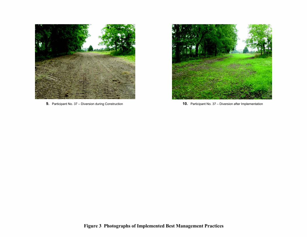
Figure 3 Photographs of Implemented Best Management Practices
9. Participant No. 37 – Diversion during Construction 10. Participant No. 37 – Diversion after Implementation

North Branch Neshaminy Creek & Lake Galena Phase I Implementation Project
Prepared by the Bucks County Conservation District & Aqua Link, Inc.
APPENDIX A
Estimated Sediment &
Nutrient Load Reductions
North Branch Neshaminy Creek & Lake Galena Aqua Link, Inc.
Phase I Implementation Project
Estimated Load Reductions - Region 5 Modeling Results
Load Reductions Gayman McCauley Baskin Pennview Totals
Sediment (ton/yr) 172 38 234 68 512
Phosphorus (lb/yr) 172 38 234 68 512
Nitrogen (lb/yr) 344 76 468 134 1,022