natural landscaping, a comparison of design …
TRANSCRIPT

NATURAL LANDSCAPING, A COMPARISON OF DESIGN TREATMENTS IN A
SURFACE MINE SETTING
By
Lishuang Wang
A THESIS
Submitted to
Michigan State University
in partial fulfillment of the requirements
for the degree of
Environmental Design – Master of Arts
2013

ABSTRACT
NATURAL LANDSCAPING, A COMPARISON OF DESIGN TREATMENTS IN A SURFACE
MINE SETTING
By
Lishuang Wang
Planners, designers, scientists, and citizens are interested in rehabilitation, reclamation and
protection of the post-mining environment. Consequently, a fair amount of research from
scholars is focused on the technical aspects concerning the revegetation of the landscape and the
science of reclamation; while only a small portion of the literature concerns planning and design.
In this thesis, a case study in the Upper Peninsula of Michigan is used to explore post-ming
treatments: abandoned mine, resort development. a super hotel resot, and natural vegetation
communities. The treatments (k=4) were evaluated with an environmental quality measure upon
10 images from each treatment (b=10). The results indicated that the resort and the natural
community were best treatments, significantly better than the abandoned mine treatment
(p<0.05). The super hotel was ranked as the third, which is less preferred than the two best
treatments, but much better than the abandoned mine treatment (p<0.05). By identifying
difference between each treatment, the results shows people have preference for natural
environment and natural landscape is beautiful in their views.
Key words: Environmental Design, Landscape Architecture, Post-mining reclamation,
Sustainable Reclamation, Aesthetics.

iii
ACKNOWLEDGEMENTS
I would like to thank Dr. Burley, my academic advisor, for all of his support and
encouragement he provided in my graduate study.
I also want to thank my committee members, Dr. Schutzki and Dr. Machemer, for the
help and guidance throughout the work of my thesis.
This thesis is dedicated to my parents Hongbin Wang and Ping Lei who are always
behind me.

iv
TABLE OF CONTENTS
LIST OF TABLES ......................................................................................................................... vi
LIST OF FIGURES ...................................................................................................................... vii
Chapter 1: Introduction ................................................................................................................... 1
Chapter 2: Literature Review .......................................................................................................... 3
2.1. Post-mining Land-use Reclamation .............................................................................. 4
2.2. Reclamation with Sustainable View .............................................................................. 7
2.2.1. The conceptual bridges between aesthetics and ecological design ....................... 10
2.3. What Makes Good Reclamation and the Landscape Architecture’s Duty .................. 12
2.4. Landscape Design Aesthetics ...................................................................................... 16
2.5. Environmental Quality Assessment Models ................................................................ 18
2.5.1. Ecological Model .............................................................................................. 19
2.5.2. Formal Aesthetic Model .................................................................................... 20
2.5.3. Psychophysical Model ...................................................................................... 21
2.5.4. Psychological Model and Phenomenological Model ........................................ 21
2.6. Conclusion ................................................................................................................... 22
Chapter 3: Methodology ............................................................................................................... 24
3.1. Study Area .............................................................................................................................. 24
3.2. Four Treatments ..................................................................................................................... 27
3.2.1. Design One: Design in Natural Context with Multiple Functions ........................ 27
3.2.2. Design Two: Natural Community ......................................................................... 28
3.2.3. Design Three: Super Hotel .................................................................................... 30
3.2.4. Abandoned Mining Surface .................................................................................. 30
3.3. Assessment Methods .............................................................................................................. 31
3.3.1. Visual Quality Assessment .................................................................................... 31
3.3.2. The Friedman Analysis of Variance Statistic ........................................................ 34
Chapter 4: Results ......................................................................................................................... 37
4.1. Visual Quality Results ............................................................................................................ 37
4.2. The Results for Friedman Analysis of Variance Statistic ....................................................... 58
Chapter 5: Discussion ................................................................................................................... 61
5.1. Future Research and Limitation ............................................................................................. 67
5.2. Conclusion ............................................................................................................................. 68

v
BIBLIOGRAPHY ......................................................................................................................... 69

vi
LIST OF TABLES
Table 1: Independent Variables......................................................................................................32
Table 2: Environmental Quality Index………………………………………………………….33
Table 3: Visual Quality Score for Each Image………………………………………….............58
Table 4: The Ranks according to Friedman Analysis………………………………………......59
Table 5: The difference for sum of ranks between four the treatments. ……………………….60

vii
LIST OF FIGURES
Figure 1: Site location, Upper Peninsula in Michigan…………………………….……..............24
Figure 2: Variables for Resort…………………………………………………………………...38
Figure 3: Variables for Resort…………………………………………………………………...39
Figure 4: Variables for Resort……………………………………………………………….…..40
Figure 5: Variables for Resort…………………………………………………………………...41
Figure 6: Variables for Resort…………………………………………………………………...42
Figure 7: Variables for Natural Communities……………………………………........................43
Figure 8: Variables for Natural Communities……………………………………........................44
Figure 9: Variables for Natural Communities……………………………………........................45
Figure 10: Variables for Natural Communities……………………………………......................46
Figure 11: Variables for Natural Communities……………………………………......................47
Figure 12: Variables for Super Hotel……………………………………………………………48
Figure 13: Variables for Super Hotel …………………………………………………………...49
Figure 14: Variables for Super Hotel……………………………………………………………50
Figure 15: Variables for Super Hotel ………………………………………………………..….51
Figure 16: Variables for Super Hotel ………………………………………………………..….52
Figure 17: Variables for Abandoned Site …………………………………………......................53
Figure 18: Variables for Abandoned Site ……………………………………………………….54

viii
Figure 19: Variables for Abandoned Site …………………………………………......................55
Figure 20: Variables for Abandoned Site ……………………………………………………….56
Figure 21: Variables for Abandoned Site …………………………………………......................57

1
Chapter 1: Introduction
Both scholars and designers in landscape architecture seek knowledge related to social,
ecological and aesthetic outcomes to create comfortable environments for humans. By
incorporating aspects of the arts, earth sciences, geography, psychology, and ecology, they try to
discover appropriate approaches. Since 1960s, and even much earlier, design sensitive to natural
systems and nature has been evoked sought. Scholars have studied ecology design related to
environmental impact assessment, new community development, brown field restoration, river
corridor planning,, sustainable design and in many other planning and design applications.
Scholars like McHarg (1969) stressed nature associated values in planning and design,
emphasizing that landscape design should work with nature. In addition mimicry of nature is
commonly applied in ecological landscape design, but the mimicry of natural processes is more
important than the mimicry of natural forms. Nature’s context is just one genre to perform
ecologically sensitive design. Natural looking does not equal ecological design. In addition, since
landscape architecture is also a field to serve humans, the aesthetics of the design form cannot be
ignored. The appearance of the design landscape is more than just visual, stylistic, or ornamental
issues. Aesthetic experience can also lead to appreciation, respect, and care for the environment
(Meyer, 2008). Meyer made a claim for the reviving aesthetics in landscape design. It is
commonly understood that nature helps to perform ecological functions. However, what people
may have ignore is whether natural-looking landscape forms look beautiful? Are they more

2
appreciated by people than other landform patterns? To develop a better understanding, this
research is employed in a surface post-mining area for its diverse potential land uses. By
illustrating the importance of aesthetics, this paper assist to integrate science and art in
post-mining reclamation and redefine the landscape architect’s role when applying nature
inspired forms.

3
Chapter 2: Literature Review
Mining can supply the resources for many commodities and items in everyday use across
the globe. Mining activities require digging in the ground, moving and sorting of materials,
transportation of resources, and creating a useful post-mining environment. With the successful
development of the mineral resources industry, along with the deterioration of environment in
these mining areas, post-mining restoration and reclamation has been the source for much public
concern. Many studies have been conducted to investigate ways to mitigate the environmental
impacts that are associated with use of post-mining land. The planning and design context in
mining reclamation has evolved and developed over the 100 years. The first university courses
related to exterior design were offered in the 1860s and 1870s (Burley and Pasquier, 2005), the
focus was upon aesthetics and residential design. Since the Surface Mining Control and
Reclamation Act of 1977, successful rehabilitation of mine lands has been of great importance.
It’s believed that the post-mining land can be more valuable than the pre-mining landscape
(Schellie, 1977), if reclamation plans and designs can ensure that post-mine or sequential lands
uses are identified. The post-mining environment must be arranged to be functionally effect. Also,
reclamation and restoration planning must be science-based, comprehensive in scope. A
comprehensive and sustainable reclamation planning for the environment quality of a context
sensitive site includes functional, cultural, economics, ecological, and aesthetic considerations.
Sometimes it is believed that the post-mining landscape must return to original land-use
(and sometimes by law it must), or must have only one land-use function. However, in modern

4
society, it’s more valuable to access a mine site with a diversity of functions, which accords with
sustainable development. This study attempts to use different design approaches to explore and
discuss the potential treatments of the post-mining area, and to understand the bridges between
aesthetics and ecological design in post-mining reclamation project. Environmental quality
model is used to evaluate and compare each potential design.
2.1. Post-mining Land-use Reclamation
In the past, there was often little concern expressed towards reclaiming the landscape
damaged by surface mines. However, today there is increasing global concerns about
reclamation of surface mining. With the ability and technology to disturb and affect large
portions of the landscape, surface mines can be reclaimed. Mine reclamation work is not a
simple task. It requires the specialists with knowledge, insight, and understanding of planning,
design, management. Essentially, two major focuses in surface mine reclamation have been
discussed (Burley, 2001). The first one addresses the technical aspects relating to the
revegetation of the landscape and the science of reclamation. A large amount of research
discussed the merits of various treatments, procedures, and methods related to this focus. The
second focus is to address abandoned mine site in creating of usable post-mining land through
planning and design methods (Burley, 2001). This body of knowledge is usually reflected
through long-term case studies, and it is common to take decades to complete the
implementation of a reclamation plan and to see the ultimate accumulated effectiveness. In this
sense, it is particularly necessary for planners and designers to study normative theories in

5
creating efficient landscape configurations, and illustrates valuable planning and design
processes to achieve reclamation successes.(Burley, 2001). However, compared to the
revegetation literature, it is relatively less published information that comprises reclamation
planning and design. Ken Schellie is one of the earliest planner and landscape architect who
studied post-mining reclamation. He developed several planning, design and management
principles which are considered as foundation guides in the post-mining operation and
reclamation, any post-mining management and type of mining operation and location today
(Burley and Bauer, 2000).
Principle 1: mining as a transitional land–use. Lands are envisioned as a wide range of
potential. It has various potential across time. The long term perspective for land use should be
kept. For The site of a surface mine, it should be examined by scientists, planners and designers
to gain a perspective land development outlook. The post-mining site can be used for something
else, after the mining operation is complete.
Principle 2: simultaneous excavation and rehabilitation (Schellie and Bauer, 1968). Ken
Schellie thought that the act of mining should be conducted in a sequential order to facilitate
landscape reclamation. It suggested that when mining operation disturbs the lands necessary for
current production and it should at the same time reshape and reclamation where resource
extraction is complete.
Principle 3: mining operation creating post-mining land-uses. Ken Schellie realized that the
natural process of mining operation creates desirable attributes for a designated post-mining

6
land-use. The movement of earth, materials processing, and the placement of overburden and
excess materials offered opportunities to create land suitable for landscape such as ponds, islands,
building sites, and related activities. In other words, surface mining can be seen as potentially
positive activity, if the potential post-mining land use can be identified. In this principle, the
skills and abilities of the planner, landscape architect, and engineer are especially essential
(Bauer, 1965).
Principle 4: the post-mining land can be more valuable than the pre-mining landscape. Ken
believed that new value could be added through the act of surface mining. According to the
example he provided, mined land can be beneficial within urban area while being applied for
wildlife habitat or recreational use beyond urban area. (Burley and Bauer, 2000)
Principle 5: multiple post-mining land-uses. Sometimes people believe that the post-mining
landscape must return to the original land-use (and sometimes by law it must), or must have only
one land-use function. However, Ken believed that the post-mining landscape could be
envisioned many uses. Moreover, as a land designer, Ken thought it’s possible to generate a site
for a diversity of functions according to the site’s attributes, which requires designer with more
experience and more knowledge (Burley and Bauer, 2000).
Principle 6: surface mining planning results in fewer delays, efficient mining, and increased
profits. This was Ken’s most important idea that will attract the attention of the industry. Ken
was not only interested in creating usable land after mining, but also concerning about mining
operators making money. In many ways, Ken was a “post post-modern” planner and designer

7
before Tom Turner (1996) firmly established the idea. Upon modern surface main reclamation,
he certainly influenced the normative ideas (Burley and Bauer, 2000).
In modern society, recreating land that is suitable for housing, commercial, and industrial
lands is extremely valuable (Burley, 2001). Actually, the development cost to re-shape the
landscape into a useable configuration was often no more expensive than developing nearby
undisturbed sites (Bauer, 1965). In order to understand the opportunities to reclaim a surface
mine, it is extremely significant to understand the mining process, methods, and materials.
Georgian Collins, a mining engineer and landscape architect provides an overview of principles
of mining engineering directly related to surface mining reclamation (Burley 2001). Later Other
mining engineers and landscape architects such as Norm Dietrich, explores the pertinent laws
and regulations at federal, state, and local levels that govern mining activities (Burley 2001).
Moreover, to accomplish creating usable lands requires a high level of knowledge and skills,
which includes knowledge and skills across various land-use types including land for housing,
commercial development, industrial lands, agronomic lands, grazing lands, forested lands,
recreational lands, land for wildlife habitat, and knowledge in visual quality (Burley
2001).Compared to the literature base for technical aspects of revegetation, more researches
integrating cross-discipline are needed to explore the planning and design of usable post-mining
areas.
2.2. Reclamation with Sustainable View
How can one make habitable and beautiful reclaimed lands? Environmental reclamation

8
challenges all of us engaged in the field to broaden out constituency and offer the opportunity to
reconnect the sciences and the arts (Comp, 2007). Both scholars and designers in this field have
been seeking for useful approaches to create more comfortable environments for human beings.
In 1987, the Brudtland Commission Report defined sustainable development as “that meets the
needs of the present without compromising the ability of future generations to meet their own
needs (Brundtland Commission, 1987). And in the contemporary time sustainable development
is the foundation upon which all new mines, their expansions, rehabilitations, and reclamation
are evaluated. Sustainable landscape design is generally understood in three
principles—ecological health, social justice and economic prosperity (Meyer, 2008). However,
ecological health is the aspect to be explored much more than the other two. Especially, recently
sustainable design sustainability heavily associated with ecological design. Several critical
benchmarks in landscape architectural theory and practice which have contributed to current
views about sustainability can be considered within three significant “generations”. The first
generation occurred roughly between 1960 and 1975 and it can be characterized as sparking a
general awakening and shift in design approach toward ecological awareness (Dinep and Schwab,
2010); the second generation was between 1975 and 1995 and during this generation, more
scientific and specialized areas of interest were developed; the third/current generation was from
1995 to present, which generated more case study. This generation is regarded as moving toward
integration of sustainability within the more generalized practice of landscape architecture
(Dinep and Schwab, 2010).
9
It is necessary to reinsert the aesthetic into discussions of sustainability, since the
appearance of the design landscape is more than a visual, stylistic or ornamental issue. The
immersive, aesthetic experience can also lead to recognition, empathy, love, respect and care for
the environment (Meyer, 2008). Ecological design is heavily stressed within the three generation,
while beauty is rarely discussed in the discourse of landscape design sustainability (Meyer, 2008).
Is not the beauty of landscape important? In the nineteenth century one of its leading
practitioners, Frederick Law Olmsted noted out that “the urban environmental function was
equaled, if not exceeded, by the function- or in contemporary theoretical terms, of the designed
landscape’s appearance”(Meyer, 2008). He cared about what those landscapes looked like as
well as how they functioned. Based on literature of psychologists, art critics, and philosophers,
many investigators like Olmsted believed that the experience of that appearance—the
combination of physical characteristics and sensory qualities altered one’s mental and
psychological state (Benson and Roe, 2000). In other words, a particular form of appearance, the
character known as beauty, performed. For nineteenth-century American landscape architects
like Olmsted, urban landscapes related sustainable design to environment experience, sustaining
civilization and culture as much as the bio-physical environment (Meyer, 2008). And yet,
contemporary theory and practice of sustainable landscape design have little regard for the
performance of appearance, particularly beauty. Instead, most literature describes and analyses
eco-technologies for constructing environment according to quantifiable ecological and
hydrological processes (Meyer, 2008).

10
Usually sustainability will be discussed from three perspectives without aesthetics: ecology,
social equity and economy. An aesthetic appreciation of the designed landscape emerged in the
eighteenth century through the explorations of landscape gardens which inspires somatic
experiences of humans (Meyer, 2008). During this period, many scholars had considerable
debates concerning whether beauty was an intrinsic form associated with particular emotional
response. Some investigators believed that the appreciation of beauty was not purely optical or
visual (Meyer, 2008). Rather, beauty was “that quality or combination of qualities which affords
keen pleasure to the other senses or which charms the intellectual or moral faculties, through
inherent grace, or fitness to a desired end.” (Oxford English Dictionary, 2008). There is idea that
beauty could perform to intriguing one’s intellectual and moral position. Landscape design is a
field both engaging art and sciences, and the works of landscape architecture are more than
designed ecosystems, more than strategies for open-ended processes. They are cultural products
with distinct forms and experience that evoke attitudes and feeling through space, sequence and
form. The experience of certain kinds of beauty is a necessary component of fostering a
sustainable community, and that beauty is a key component in developing an environmental
ethics. What landscape architects concern is that how can landscape appearance perform in this
way? Can landscape from and space indirectly, but more effectively, increase the sustainability of
the physical environment through the experiences it affords?
2.2.1. The conceptual bridges between aesthetics and ecological design
Sustainable landscape design is not the same as sustainable development or ecological

11
design or restoration ecology or conservation biology (Meyer, 2008). Sustainable reclamation
requires more than designed landscapes that are created using sustainable technologies. It
employs principles of natural ecology but it does more than that. Design is a cultural product
made with the materials of art, nature, and embedded within and inflected by a particular social
formation (Berleant, 1991). It enables social routines and spatial practices, from daily
promenades to commuting to work. It translates cultural values into memorable landscape forms
and spaces that often challenge expand our conceptions of beauty.
Sustainable landscape design must do more than function or perform ecologically; it must
perform socially and culturally. Actually, environmental problems are created and defined not by
science, but by our culture. Now we define and address problems in a more scientific way. While
this “science” is necessary, it is not sufficient to fully address the real landscape in which we live
in. Too often we neglect the cultural side of the solution: the arts. To get a good environment, we
should address these problems with the full range of the arts and humanities, as well as the
science, if we are able to be effective (Berleant, 2012). Ecological mimicry is the common
strategy for sustainable landscape design. It’s a component of sustainable landscape design, but
the mimicry of natural processes is more important than the mimicry of natural forms. Nature
context is just one of the performances. In some conditions, especially in constructed urban
conditions when there are no longer spaces of the scale that might support a natural-looking
landscape. In these conditions, remnant strips between city streets and rivers, on compacted sites
with no organic matter or top soil, along abandoned post-industrial infrastructure, ecology must

12
be obtained in new ways, in different configurations, deploying technological and ecological
knowledge (Howett, 1987). Moreover, natural-looking landscapes are not the only genre to
perform ecologically. And the ecology in sustainable design doesn’t mean natural looking. In
some cases, natural-looking landscapes may not be sustainable in the long term, especially in
metropolitan areas. Most constructed nature in the city especially constructed wetland needs care,
cultivation and gardening. Without good management many urban landscape in natural form
become invisible landscapes and neglected landscapes. In addition to concerning about nature
environment, human beings are at the center of concerns of sustainable development. They are
entitled to beautiful and healthy life in harmony with nature. The recognition of art is believed
the fundamental component of landscape design to please people’s aesthetic requirement. Natural
landscapes don’t surely satisfy people’s aesthetics. The concept of natural environment is not
equal to human aesthetics. There are some misunderstanding between ecological design and
natural design, and between beauty and natural design, and between beauty and ecological
design. A good landscape design with good visual quality can balance environment ecology and
human’s needs well. Looking natural doesn’t mean looking beautiful. The questions are that how
landscape performance can include ecological function and emotional or ethical revelation, and
how a concern for beauty and aesthetics is necessary for sustainable design.
2.3. What Makes Good Reclamation and the Landscape Architecture’s Duty
What makes good reclamation? “Good for what? For whom?” It’s obvious it should be good
for human beings and good for the rest of nature. Is human beings part of nature or not? Most of

13
landscape architects believe that human beings are part of the nature. According to McHarg,
Human is one part of the natural world who lives with different kinds of creatures in the earth
(1969). We are not the ruler of the entire natural world. We have our own character and depend
on each other just like other creatures inhabiting the earth (McHarg, 1969). To survive, grow,
multiply, and develop, all the members in the world should support each other and depend on
each other, so that that the system can keep balance. If humans are as natural as anything else,
how do we examine the claims of one part of nature with respect to those of others? Is a forest of
humans-a suburb- more or less valuable than a forest of conifers? What views of nature and of
human beings will best serve good reclamation? Can Reclamation go beyond remediation? The
term “remediation” is a good one, though, in its sense of healing, of organic process. Broken
bones can heal to become stronger than before (Turner, 2008). Can we heal our landscapes in
such a way as to improve on their original states and at the same time enables us to pass through
one of the maturational metamorphoses that enliven our souls (Turner, 2008)? Can alteration of a
landscape have the same effect, providing the landscape with a destiny and a role that are grander
than its original ones (Turner, 2008)?
Much of our basic thinking about reclamation is to get back something that was gone. It
assumes that nature was perfect before, and its cycles and harmonies are eternal. If we see nature
as essentially dynamic, open-ended, radically evolutionary, and irreversible—and humans as part
of its process—we may begin to have a basis for evaluating our various priorities and satisfying
our various stakeholders. There is growing body of scientific theory and technological

14
application that may take us a good deal of the way toward a conception of reclamation value?
Turner talks about “order” to explain his reclamation value (2002). He thought that the
reclamation goal could combine of all kinds of orders that best serve the highest kinds of order.
We should attempt to maximize the highest kind of order overall, while preserving as much local
integrity and lower order as is consistent with the first goal. How do we identify the highest
kinds of order? We have already posited the need for a perspective that includes change and
evolution and growth. Mere change itself, however, can as well produce a barren and poisonous
world, like those of most of the other planets in our solar system, as one with rich suite of orders
and complexities and information systems. Control systems are needed to guide change, so that it
enriches and harmonizes rather than impoverishes and destroys (Turner, 2008). We are now
beginning to find out what kinds of control systems are best at enriching and harmonizing. To
enforce a desired result without consulting the existing flows and balances of the system in
question can only result in a massive increase of disorder within the system, outside it, or both.
The key to the difference between enforced, coerced control, which is wasteful, and the
persuasive kinds of control that can produce evaluation, growth, and an increase of organized
information, is feedback. The wise controller listens to and responds to the situation, like a lover
rather than a tyrant, and works his or her will by recruiting the will and inclinations of the
beloved. Thus, the “highest kind of order” that we are looking for is one in which there already
exist systems of control; in which those systems are based on feedback rather than coercion or
force; and in which the existing natural controllers welcome humans into the control room when

15
they decide to enter.
What’s Landscape Architecture’s duty in reclamation? Many professions and disciplines
will contribute to our understanding of reclamation. Mining reclamation work created only by
scientist and engineers, is lack of an attractive, interesting, aesthetic consideration. Landscape
architects are who make places that are constructed performing ecosystems and constructed
aesthetic experiences. They have the methods and tools to create a dialogue between science,
mining, and society (Burley, 2001). Designers bring creativity, a different perspective, and
unique skills to a team of scientists, so that we can have a richer, more systematic, and
comprehensive environment (Arbogast, 2008). There are no simple answers to the problems
facing society’s need for minerals, resource development, and mined-land reclamation, land-use
decisions, landscape architects as a creative problem solver should work along with scientist and
engineers. They are not solely artists or horticulturists, basic knowledge of other field are needed
such as the knowledge of topsoil, slope stabilization, grading, soil analysis, revegetation, fugitive
dust and noise, surface and groundwater protection, wildlife habitat, waste disposal, and drainage
control. If the landscape architect is not familiar with basic earth-science facts, concepts, and
vocabulary, how can he or she determine the extent and characteristics of surface disturbance by
a mine site, or recommend design alternatives for post-mining use? As the Canadian Society of
Landscape Architecture states, “landscape architecture must understand the roles of the various
allied professions and develop skills to direct work and participate on a variety of teams to meet
those needs and challenges” (1996). Scientists would discount artistic and cultural issues such as

16
aesthetics, sense of history; landscape architects provide a different perspective and create
interesting and suitable environment for living creatures. In modern society, reclamation work
has a duty to educate in the process of restoring or creating a new landscape. The landscape
architect has an ability to interpret information, be a team player, define problems, evaluate
alternatives, and facilitate stakeholders.
2.4. Landscape Design Aesthetics
Interest in the aesthetics of environment is relatively recent. It dates back to 20 or 30 years
ago, while appreciating the beauty of nature since ancient times. Environment aesthetics goes
beyond just appreciating nature. Many philosophers were attracted to contribute a lot to
environmental aesthetics, but scholars from many other field has also attracted, including art
history, architecture, landscape architecture, city and regional planning, and psychology
(Berleant, 2012). As a result, there are different perspectives to bear on our understanding of
environment, for environment is a prime example of a field of study that cannot be adequately
understood form a single vantage point. The appreciation of natural environment had earlier
origins. The first major philosophical developments in the aesthetics of nature occurred in the
eighteenth century; scholars developed the concept of disinterestedness as the mark of such
experience. The theory of disinterestedness provided groundwork for understanding the aesthetic
dimensions of nature in terms of three distinct experience conceptualizations: beautiful, sublime,
picturesque (Carlson, 2009).
The scope of environmental aesthetics has included not simply natural environments but

17
also human-influence and human-constructed ones. The aesthetic meaning of landscape can be
understood in both natural and artificial approaches. One of the issues that scholars have debated
is that whether it’s the same thing when we talk about the aesthetic appreciation of the natural
environment and of the human environment (Carlson, 2009). As might be expected, scholars
have different answers to this question. This issue also raises the question of where aesthetic
value lies. For what a concern with environment shows is that what is most significant is not the
object of appreciation but the process of appreciation, that is aesthetic experience. Nowhere it is
clearer in landscape appreciation that landscape is both a favorite object for the appreciation of
nature and a favorite subject for painter, poets, and novelists (Carlson, 2009). How do the arts
relate to landscape experience most generally? Is there a similarity or a discontinuity between
appreciating art and appreciating nature? What we can confirm is that we rely on the
environment in which we work, play, and carry on our day-to-day lives. Addressing the question
of how to aesthetically appreciate our human environments requires considering some
assumptions about how we think about such environments. The designer landscape approach for
the aesthetic appreciation of environments is that the aesthetics of human environments becomes
closely aligned with the aesthetics of art. Since human environments are conceived of as
deliberately designed, they are seen as importantly akin to works of art, all of the theories,
conceptions, and assumptions of the aesthetics of art are brought to the question of how to
aesthetically appreciate such environments.

18
2.5. Environmental Quality Assessment Models
Achievement of efficient reclamation and utilization of reclaimed land must be based on
suitable evaluation for land reclamation. The choice of evaluation methods affects the accuracy
and objectivity of evaluation results. Moreover, it influences the decision-making related to land
reclamation. This part reviews landscape quality assessing models, which can be used as helpful
design and planning tools for land reclamation. Thus far, there is no uniform regulation of
evaluation methods for land reclamation in mining areas. Each existing evaluation method has its
own set of advantages and disadvantages.
Reclamation means the process of returning mined land to an agreed landform and land use
in conformity with a prior land-use plan. Reclamation renders a site habitable to indigenous
pre-mining condition organisms, instead of only returning the land to a form and productivity in
conformity with a prior land use plan (National Academy of Science Committee, 1974).
Environmental scientists have been interested in applying research-based models to study the
effects of landscape reclamation.
Landscape quality is defined by the features that make up the landscape, the characteristic
elements and attributes, and the degree of excellence which that landscape possesses (Daniel &
Vining, 1983). Landscape quality is often defined as including a wide array of ecological , social.
cultural, and psychological factors.
Questions pertaining to landscape definition and landscape assessment lead to differing
forms of landscape assessment models. According to Daniel and Vinning’s category (Daniel &

19
Vinning, 1983), there are five classes of landscape quality models: ecological, formal aesthetic,
psychophysical, psychological, and phenomenological.
2.5.1. Ecological Model
Leopold’s “uniqueness ratio” illustrates a landscape assessment methodology based on the
ecological measures of the landscape (Daniel & Vining, 1983). Multiple physical, biological, and
human-use dimensions are considered in this “uniqueness ratio” (Daniel & Vining, 1983).
Leopold’s uniquenss ratio was offered as an example from within the expert appraisal approach.
In public perception-based landscape quality assessments naturalness, indicated either by
human-perceptual judgments or by the observed dominance of plants and/or the absence of
human artifacts or disturbance, has also been found to be associated with higher levels of judged
visual landscape quality (Kaplan and Kaplan, 1989). But this ratio model is not fundamentally
interested in human perceptions or preferences. Human perception of landscape quality should
be consistent with ecological quality. Landscape preferences may be contrary to good ecology.
High ecological quality may or may not be correlated with high visual landscape aesthetic quality.
Later on, Brabyn used GIS to determine uniqueness and variety (Brabyn, 1996). National digital
databases are used to classify vegetation, naturalness, water and landforms in an objective
manner. The classification method not only allows researchers and designers to get a more
sophisticated understanding of nature but also enables these variables to cope with the different
levels of perception that people experience. Although this landscape classification does not
identify quality, it’s possible for this method to evolve to combine both natural character and
20
humans’ preference.
Usually ecological models place a high value on natural functions such as biodiversity,
while placing a low value on artificially visual impacts and cultural values (Keefe and Burley,
1997). A major underlying assumption of the ecological model is that landscape quality is
directly related to naturalness, or ecosystem integrity. The validity of this model depends upon
the assumption that "natural" areas undisturbed by humans are highest in landscape quality
(Daniel & Vining, 1983). The landscape is characterized in terms of species of vegetation variety
and animals present, or other indicators of ecological processes. Within the ecological model, the
environmental features are more relevant to landscape quality. Scientific classification method
offers a potential way to consider natural characters and visual preference at the same time,
though more research is needed. Otherwise, ecological models tend to be designed for specific
areas and are therefore difficult to apply to landscapes in general. These models tend to be
against human interference, and assume that artificial landscape will have negative impact on
environment quality.
2.5.2. Formal Aesthetic Model
Visual Management System (VMS) model developed by the USDA Forest Service
evaluates scenic resources within a land-management framework and assumes the scenic quality
is directly related to landscape diversity or variety (Daniel & Vining, 1983). The basic theory of
the formal aesthetic model is that aesthetic values are inherent in the formal properties of the
landscape. VMS uses character classification (such as gorges, mountains, foothills and plateaus),

21
variety classification (form, line, color and texture) and sensitivity level (referring to the relative
importance of the landscape as a visual or recreational resource). The formal aesthetic model is
very useful and easily applied in landscape visual assessment. This model relies on empirical
observational principles to guide the designer to assess environment quality, so it can only rate
and compare various landscape quality variables in a very rudimentary way.
2.5.3. Psychophysical Model
This model creates stimuli in landscape and develops mathematical models to explain
human’s response to these stimuli. Many investigators have recently explored these types of
models, which offers a quantitative way to measure relationships between environmental stimuli
and perceptual responses (Daniel & Vining, 1983; Hull, Buhyoff & Cordell, 1987; Burley, 1997).
Shafer and Burley’s visual quality equations presents highly detailed measurable variables to
predict the visual quality preference of entire landscape (Burley, 1997). This model is developed
without any theoretical basis. It is lack of any formal, predictive theory to explain the
relationships between the variables measured in the photographs and the preferences of
respondents. However, since this model allows researchers to measure the effect of single-factor
stimulus, it makes comparison of various landscape alternatives possible. Therefore, it can to be
directly applied into the visual quality assessment.
2.5.4. Psychological Model and Phenomenological Model
The psychological approach has been used in many studies where dimensional analyses of
people's preferences for different landscapes are performed. The psychological model attempts to

22
understand the users’ response to the landscape in terms of their feelings and perceptions.
Although the psychological model is strongly based on theory, its use of conceptual variables
makes it difficult to apply in predicting visual quality. The greatest emphasis on individual
subjective feelings, expectations, and interpretations was placed by the phenomenological model
(Kaplan, Kaplan, 1979). The principal methods of assessment are the detailed personal interview
or verbal questionnaire. This model represents many variables at the same time, but is too
complex to be used as a landscape assessment tool.
To conclude, there are four types of models, and commonly used landscape quality models
have two basic forms. The first model is based on strong theories and concerns about natural
functions. They attempt to explain man’s interpretation of his surroundings in terms of biological
value, instead of humans’ preference. Ecological models tend to be designed for specific areas
and are therefore difficult to apply to landscapes in general. The second form emphasizes
people’s perception need more elaborate and theoretical basis. These models should be modified
to clearly show cause and effect relationships in landscape alterations. To get a better assessment
for environments, further study should focus on developing possible method to get a
comprehensive assessment by integrating nature and human variables. In this paper, ecological
model and psychophysical model are combined together to assess treatments in designed site.
2.6. Conclusion
Post-mining reclamation was discussed by scholars including engineers, ecologists, soil
scientists, and so forth, from various perspectives. A large amount of research focused on the

23
technical aspects concerning the revegetation of the landscape and the science of reclamation,
while only small literatures concerns from the planning and design view. To get a better
environment for living creatures in the world, this paper redefined the landscape architecture’s
role for post-mining reclamation in a sustainable view. It also discussed about the
misunderstanding between ecological design and aesthetics in sustainable landscapes and pointed
out that the aesthetics pillar in sustainable design shouldn’t be neglected. So considering the
natural environment and at the same time satisfying human needs, what is the good treatment to
reclaim our damaged mining lands? How the aesthetic could be valued in reclamation projects?
Does the ecological design in natural looking landform more appreciated by people than the
artificial design focused on human recreation? This study attempts to use different design
approaches to explore and discuss the potential treatments of the post-mining area, and to
understand the bridges between aesthetics and ecological design in post-mining reclamation
project. What is the perception of respondents to the sustainable environmental design? In what
way we can create a new environment both having good nature ecology and satisfy human’s
needs?

24
Chapter 3: Methodology
3.1. Study Area
Figure 1: Site location, Upper Peninsula in Michigan. For interpretation of the references to
color in this and all other figures, the reader is referred to the electronic version of
this thesis
The selected study area is located in Michigan’s Upper Peninsula, near the northern shore of
the Upper Peninsula in Marquette County (figure 1). The Upper Peninsula contains 42,610 km²
almost a quarter of the land area of Michigan but just three percent of its total population (Hunt,
M., & Hunt, D, 2001). Iron ore deposits there were found by William Burt by accident in 1884
(Hunt, M., & Hunt, D, 2001). This discovery became the initial wealth for the area and also the
reason that Marquette County is the wealthiest county in Upper Peninsula. As early as in 1890s,

25
the Marquette Iron Range provided the highest quality iron ore, and is known as the richest iron
source in the world (Hunt, M., & Hunt, D, 2001). The mine is located in a relatively low
population density, hilly, and forested landscape, with recreation, forestry for paper production,
watershed conservation, and wildlife habitat being common local nearby land-uses (Koski, 2005).
The mine is extremely important in the economy and supplies a substantial portion of the
nation’s iron for manufacturing.
After World II, the underground mines closed and were replaced by two new open pit mines:
the Empire and the Tilden mines which are operated by Cliffs Natural Resources (Formerly
Cleveland-Cliffs Iron, Hunt, & Hunt, 2001). The geology of the region is largely composed of
sedimentary and igneous rock that is covered by glacial drift (Cleveland-Cliffs Iron, Hunt, &
Hunt, 2001). The mining of iron ore and copper accounted for the majority of the mined surface
area in the region. Mining operation created terraced topography there. The landscape of the
mining site is dominated by steep slope and covered with minimal vegetation. Mining is located
in highland areas. Elevations range from 1,300 to 1,900 feet in elevation (Koski, 2005). This is
an area classified as cool to temperate with an average annual temperature of 40 F degrees
(Koski, 2005). For this investigation, the mining pit is located at the south part of the iron ore
mining area in Marquette County. The landscape of the mine is a series of rock-faced steps
leading into a very large pit. It is approximate 325 acres (Cleveland Cliffs Michigan Operations
Area Map, 2007). The topography of the mines is heavily terraced and sloped so as to create
stable and useable slopes for mining practices. Analyses of the general physical and chemical

26
properties of the waste iron formation stockpiles have revealed that the rocks contain nothing
toxic to plant growth and pH adjustment is not necessary (Koski, 2005). The dramatic
topography created by mining operation actually provides beneficial microclimates for
revegetation and also opportunities for a beautiful landscape. High hills and low valleys can be
useful land for recreational activities.
In my view, natural landscape is made up of landforms such as mountains, hills, plains,
lakes, streams without affection by human activities. Living and non-living features there depend
on each other and work together to construct a self-managed and relatively stable environment.
Natural vegetations of a natural environment is a connection of native plants, including trees,
shrubs, groundcover, and grasses which are indigenous to the geographic area. Without human
interference, the environment is shaped by themselves and develops wide and naturally.
Otherwise, landscape is also considered as a form of art. People also create landscapes to reflect
their cultural, social and aesthetic attitudes about the environment in their time. They make fields,
landscape gardens in different sharps, forms, and patterns in contrast to the natural surroundings,
which are considered as artificial landscape. In creating artificial landscape, people express their
aesthetic, cultural, and social value and try to makes the environment more pleasant to live in. To
understand how people viewed natural and artificial landform visually, four potential treatments
including a resort design, a natural community design, a super hotel design, and an abandoned
site condition will be compared and analyzed. The first treatment is a resort contains hotels and
recreational facilities, and creates multiple uses in the post-mining landscape based on basic

27
ecological. The second design treatment depends on an assortment of indigenous plants
communities to construct a naturalized environment on this site. The third treatment is a
recreational hotel resort design expressed in artificial forms with a naturalized setting.
3.2. Four Treatments
3.2.1. Design One: Design in Natural Context with Multiple Functions
The first design reclaims the abandoned site in a natural context trying to integrate nature
and human needs, both visually and bio-physically. The creating residential and recreational
fields will bring viewers with an experience of human and artificial features. Public space in
geometric shape expressed in contemporary forms and circled with trees. Shaded routes run
through open space, hill, and lake edge allow visitors to jog and stroll in the nature. Testing
images present the view both including human construction features and natural environment.
To establish a stable and harmonious ecological setting, this design weaves forests, grass
land, wetlands, lakes, islands, and creek work together to serve living creatures. The elements
within landscape such as forests, grass land, wetlands, lakes, islands, and creek are categorized
as different patch types. Patches are believed to differ in quality. They have different spatial
structures, which affect different kinds of organisms or different ecological processes in different
ways at different scales. For an ecosystem, the more complex it is with more different elements,
the more likely it is to survive for a long period of time and the less vulnerable it is to damage.
Moreover, these patches have boundaries, and any interactions or exchanges among patches must
be mediated by boundaries. It’s also called edge effect. Boundaries have been thought of creating

28
areas of rapid change in environmental features and, frequently, enhanced biodiversity. The
shape of each patches matters. To increase edges effect and enhance biodiversity, curvilinear and
convoluted boundary is applied to the design of lakefront and lake islands. Vegetative patches are
connected with other patches to facilitate circulation. Vegetative corridors are designed to
connect different patches, which ensure the movement of individuals, materials, nutrients, energy.
Some connection corridors not only provide circulation for animals and plants, also create trail
for visitors. This resort also includes a number of fields such as baseball, softball, climbing,
fishing, boating, skiing, bicycling, camping and diving for recreation. There are picnic areas,
bicycling paths or tracks, a swimming pool, lake, recreation buildings, restaurants, hotels, natural
trails, play lots, parking, and museums. All the fields and facilities are separated by perimeter
planting buffers.
3.2.2. Design Two: Natural Community
Treatment two presents an environment recovered only by natural elements. In this
treatment, hills, lakes, stream, and plants are represented as closed as it is in real natural
environment. It’s a common practice to reclaim surface mined land into forested land, including
horticultural/agronomic land to support trees, and it is the oldest historical precedent to reclaim
surface mines (Plass and Powell, 1988). In this area, according to Koski, the primary vegetation
assemblages include climax hardwood and conifer which are composed of sugar maple, hemlock,
red maple, basswood, red oak, yellow and white birch, trembling aspen, big tooth aspen, red pine,
jack pine, and white pine and balsam fir on well drained upland soils. Northern white cedar,

29
spruce, and ash are supported by poorly drained lowland soil (Sommers, 1978).To make the
revegetation effort a success, plant communities must be matched with the appropriate
environment. A natural community is defined as an assemblage of interacting plants, animals,
and other organisms that repeatedly occurs under similar environmental conditions across the
landscape and is predominantly structured by natural processes rather than modern
anthropogenic disturbances (Kost, M., Albert, D., Cohen, J., Slaughter, B., Schillo, R., Weber, C., &
Chapman, K., 2009). The classifications guide the identification of natural habitats that represent
the range of native ecosystems known to occur in Michigan, both historically and today. Based
on Michigan’s Natural Communities, common natural communities including dry northern forest,
dry-mesic northern forest, emergent marsh, granite bedrock glade, granite cliff,
hardwood-conifer swamp, mesic northern forest, northern shrub thicket, northern wet meadow,
poor conifer swamp, rich conifer swamp, and submergent marsh are selected for reclamation
(Dennis, A., Joshua, G., Michael, A., & Bradford, S., 2008). Northern Dry Forest is arrayed in
low flat area and gentel undulating slopes. Driest are and poorest sites which is away from the
central lake is suitable for this community. Northern mesic forest are mainly designed on the lake
plains. Dry-mesic northern forests in this design are mainly located in the gentle moderate slopes.
It can occur on lake plains, thin glacial drift over bedrock and coarse-textured moraines (Curtis
1959). Northern shrub thicket, northern wet meadow, poor conifer swamp, rich conifer swamp,
and submergent marsh are design by carefully considering their characteristics. By elevation in
governing factors existing topography, regional climate, and common communities in Michigan,

30
design two try to construct and present a perceived natural environment after reclamation
through images.
3.2.3. Design Three: Super Hotel
Reclamation to create landscapes for recreating housing, commercial, and industrial
environment is very common (Burley, 2001). This super hotel treatment mainly offers
commercial and recreational activities for tourists. In this super hotel design, the whole site will
be also considered as a place to make art. Shapes and forms of human structures can be more
geometrical and angled, depending on their own needs. Instead of offering a space both
satisfying nature and humans, Super Hotel creates a space with many opportunities to relax and
to enjoy contemporary form of recreation. The super hotel stands facing the pit wall with
guestrooms and a restaurant. It will feature an extreme sports center for activities like rock
climbing and bungee jumping. The pit will be flooded to become an artificial lake. The other side
of the hotel is platform area providing picnic areas, bicycling paths or tracks, natural trails, play
lots for visitors. There is a bridge over the lake connecting platform area with the hotel. Visitors
can enjoy the beautiful scenery of the lake and hotel. In this design, people’s recreation needs
come first, and ecological requirements come secondary.
3.2.4. Abandoned Mining Surface
This group of pictures represents the characteristics of post-mining abandoned site for
contrast to the other three treatments. In general, the landscape of the mining site is dominated by
steep slope and covered with minimal vegetation. The rock stockpiles with rocky slopes have

31
been exposed to the local climate for over forty years. Open mining activity have resulted in rock
stockpile site conditions that vary widely in characteristics. Site-specific stockpile have specific
condition. This group of pictures includes images of surface mining condition with different
characteristics, which try to present these characteristics as accurate as possible.
3.3. Assessment Methods
3.3.1. Visual Quality Assessment
To assess the environment quality of the four treatments, an equation by Burley, equation
(2011) employed. It can be employed to measure the predicted environmental quality by
interpreting photographs, drawings, and digital models from a design. It explains about 75.04%
of the variance by the respondents. The overall equation has a p-value of less than 0,0001, which
means that it would falsely predict once every 10,000 times. All the predictors are significant
with the p-value less than 0.05 in table 1. The predictors also employed in the equation 1 include
an environmental quality index (table 2), which helps get more accurately evaluation. With this
equation, scores ranging in the 100s indicate poor environmental quality. Low scores below
about 40 are aesthetically pleasing and scores above 70 are less pleasing. In this study, Sketchup
and Photoshop are two software tools used to build up and express each treatment. 40 images (4
treatments × 10 samples) which represent treatments were evaluated. Each image is assessed in a
grid in the same size is divided by 30 rows and 38 columns (Daniel, 1978). Each independent
variable in table 1 is measured and recorded with a score by counting areas or perimeters (Burley,
Deyoung, Partin and Rokos, 2011).

32
Table 1: Independent Variables
Variable
HEALTH = environmental quality index (Table 2)
V1 = perimeter of immediate vegetation
V2 = perimeter of intermediate non-vegetation
V3 = perimeter of distant vegetation
V4 = area of intermediate vegetation
V5 = area of water
V6 = area of distant non-vegetation
V7 = area of pavement
V8 = area of building
V9 = area of vehicle
V10 = area of humans
V11 = area of smoke
V14 = area of wildflowers in foreground
V15 = area of utilities
V16 = area of boats
V17 = area of dead foreground vegetation
V18 = area of exposed foreground substrate
V19 = area of wildlife
V30 = open landscapes: = V2+V4+(2*(V3+V6))
V31 = closed landscapes: = V2+V4+(2*(V1+V17))
V32 = openness: = V30-V31
V34 = mystery: = V30*V1*V7/1140
V52 = noosphericness: = V7+V8+V9+V15+V16

33
Table 2: Environmental Quality Index
Variable Score
A. Purifies Air +1 0 -1
B. Purifies Water +1 0 -1
C. Builds Soil Resources +1 0 -1
D. Promotes Human Cultural Diversity +1 0 -1
E. Preserves Natural Resources +1 0 -1
F. Limits Use of Fossil Fuels +1 0 -1
G. Minimizes Radioactive Contamination +1 0 -1
H. Promotes Biological Diversity +1 0 -1
I. Provides Food +1 0 -1
J. Ameliorates Wind +1 0 -1
K. Prevents Soil Erosion +1 0 -1
L. Provides Shade +1 0 -1
M. Presents Pleasant Smells +1 0 -1
N. Presents Pleasant Sounds +1 0 -1
O. Does not Contribute to Global Warming +1 0 -1
P. Contributes to the World Economy +1 0 -1
Q. Accommodates Recycling +1 0 -1
R. Accommodates Multiple Use +1 0 -1
S. Accommodates Low Maintenance +1 0 -1
T. Visually Pleasing +1 0 -1
Total Score

34
Y=58.98827+ (V2*0.07725) + (V10*0.0377) – (1.18505*CVQ) – (V32*0.01074) +
(V52*0.01161) – (V1*V2*0.00181) – (V1*V5*0.00026) – (V1*V5*0.00026) +
(V1*V10*0.00134) – (0.00071*V2*V14) + (V5*V9*0.00018) – (V7*V18*0.00092) +
(V8*V14*0.00025) + (V8*V15*0.00425) + (V15*V18*0.00023) – (V2*V32*0.00012) +
(V6*V34*0.00000061339) – (V8*V34*0.000000783802)
+ (V11*V52*0.0017)
Equation 1: Visual Quality Equation
3.3.2. The Friedman Analysis of Variance Statistic
Friedman’s analysis is used to mathematically rank and compare the outcomes of each
treatment. The test is an analysis of variance by measuring ranks. In this test, the rows b
represents block of image and columns k represents treatments. The test is based on two
hypotheses:
: The values within a ranking are identical.
: The ranking of each object is significantly different; at least one object has larger values
than at least one other object.

35
The first step is to rank all the original observations ordinal. The second step is to calculate
the sum of ranks in each column, and then used the following formula (equation 2) to
calculate the difference of the sum for each rank:
Where:
= Friedman two-way analysis of variance by ranks
b = Ranking
k = Objects
= Sum of ranks for each column
Equation 2: The formula of Friedman Two-way Analysis of variance by ranks
When the amount of b and k are small, the value should be compared to appropriate critical
values to identify whether it’s significant or not. If the value is smaller than the critical value,
then we can conclude that at least one object has larger values than at least one other object.
Otherwise, if the value is greater than or equal to critical values, then there is no significant
difference between each treatment. For the values are not included in the giving table, the
value can be compared to tabulated values of chi-square for significance with the k-1 degrees of
freedom. If the value is greater than or equal to the value of chi-square for k-1 degrees of
freedom, Hypotheses can be rejected at the α level of significance (Daniel, 1978).
The multiple-comparison procedure can help investigators to determine which treatment are
different (Daniel, 1978). The formula (equation 3) is listed below. Z stands for the standard

36
normal critical value, it is equal to the value of (α / k ( k – 1 )). The value is calculated by
comparing the difference between sums of rank of each treatment. If any difference between sum
of rank is greater than the critical value, then we can confirm that two treatments are showing
significant different.
Where:
= Sum of jth rank
= Sum of j’th rank
z = A value corresponding to α / k ( k – 1 )
b =Ranking
k = Objects
Equation 3: The Multiple-comparison procedure for use with Friedman test

37
Chapter 4: Results
4.1. Visual Quality Results
For each treatment, 10 images were selected which present important views of each design.
According to the score, the average value for resort, natural community, super hotel and original
site in order are 46.29162, 49.07828, 58.00234, 64.9618 (table 3). The Resort and natural
communities treatment have similar score, which indicate relatively better visual quality than
the other two. The abandoned site with the average score 64.9618 rates the poorest. Four Pictures
scored in the 30s from treatment one, the resort design; while only one picture scored in the 30s
from the natural community. None of the rest group had images with score of 30s. However, 4
pictures of the natural community generated the score in 40s. The specific scores for all of the
selected pictures are listed below (table 3).

38
Figure 2: Variables for Resort.
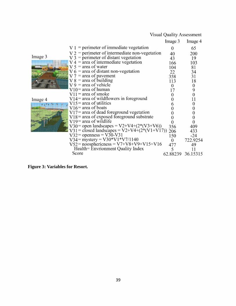
39
Figure 3: Variables for Resort.

40
Figure 4: Variables for Resort.

41
Figure 5: Variables for Resort.

42
Figure 6: Variables for Resort.

43
Figure 7: Variables for Natural Commuities.

44
Figure 8: Variables for Natural Commuities.

45
Figure 9: Variables for Natural Communities.

46
Figure 10: Variables for Natural Commuities.

47
Figure 11: Variables for Natural Commuities.

48
Figure 12: Variables for Super Hotel.

49
Figure 13: Variables for Super Hotel.

50
Figure 14: Variables for Super Hotel.

51
Figure 15: Variables for Super Hotel.

52
Figure 16: Variables for Abadoned Site.
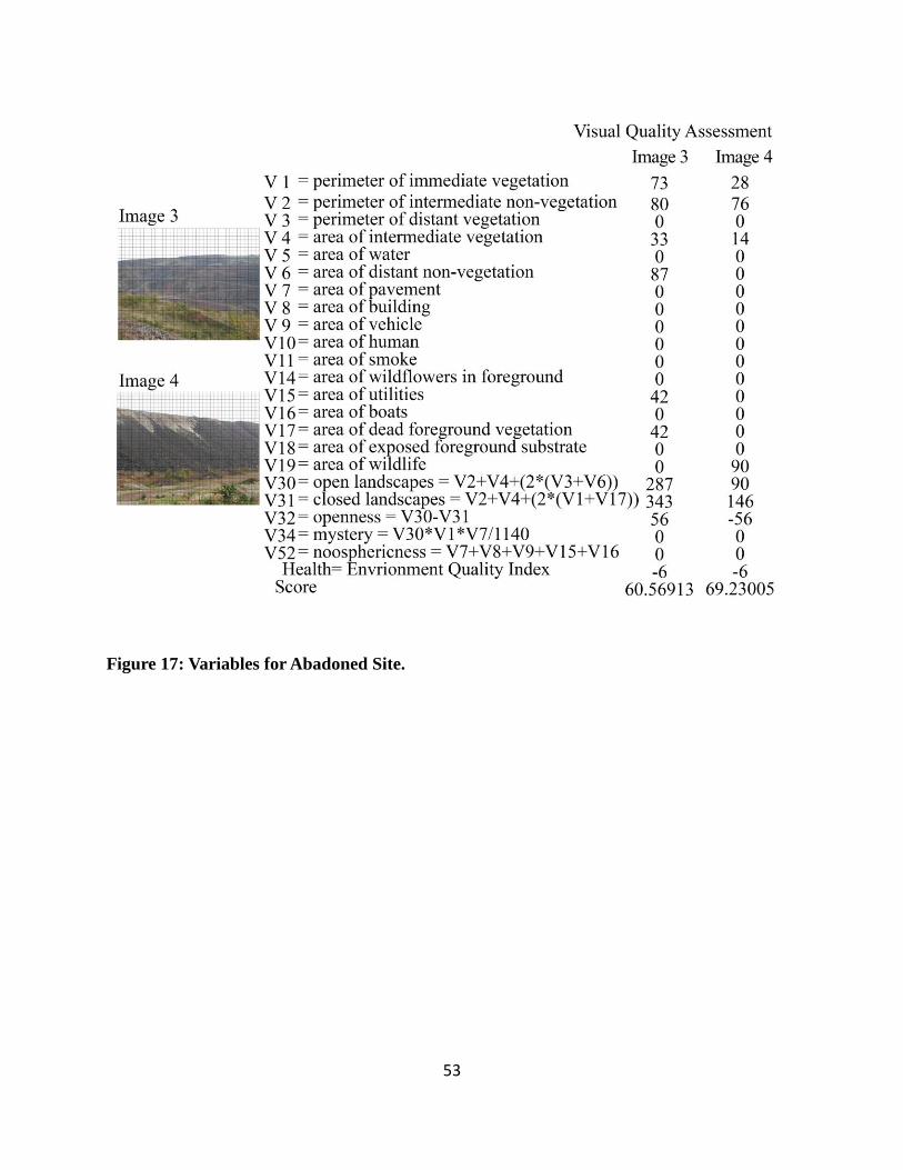
53
Figure 17: Variables for Abadoned Site.

54
Figure 18: Variables for Abadoned Site.

55
Figure 19: Variables for Abadoned Site.

56
Figure 20: Variables for Abadoned Site.

57
Figure 21: Variables for Abadoned Site.

58
Table 3: Visual Quality Score for Each Image
Visual Quality Score Resort Natural
Community Super Hotel
Abandoned
Mining
Image One 36.11186 46.60075 43.40102 71.66561
Image Two 56.73466 44.55967 56.33737 66.45659
Image Three 62.88239 51.09889 53.02567 60.56913
Image Four 32.17891 59.24993 58.44411 69.23005
Image Five 36.15315 54.41625 56.73724 56.3552
Image Six 46.24803 33.27985 57.85015 67.05776
Image Seven 54.38429 53.96066 53.91501 60.38489
Image Eight 39.02059 47.90627 66.97931 70.15817
Image Nine 41.72036 49.17534 64.76273 69.03029
Image Ten 57.48197 50.53519 68.5708 58.71029
4.2. The Results for Friedman Analysis of Variance Statistic
According to Friedman analysis (Daniel, 1978), the original observations (table 3) need be
converted to ranks (table 4). The hypotheses for Friedman two-way analysis of variance by ranks
are:
: The four treatment yield identical results.
: At least one treatment tends to yield larger values than at least one other treatment.

59
Table 4: The ranks according to Friedman analysis
Rank Resort Natural
Community Super Hotel
Abandoned
Mining
Image One 1 3 2 4
Image Two 3 1 2 4
Image Three 3 1 2 4
Image Four 1 3 2 4
Image Five 1 2 4 3
Image Six 2 1 3 4
Image Seven 3 2 1 4
Image Eight 1 2 3 4
Image Nine 1 2 3 4
Image Ten 2 1 4 3
By the equation 4 below, presents the calculations derived from table 4:
=
*( + + + )-3*10*(4+1)
= 16.08
Equation 4: Calculation Results
The value needs to be compared for significance with tabulated values of chi-square
with k-1 degrees of freedom in Daniel (1978). The value of 16.08 with 3 degrees of freedom
is greater than the chi-square value (p ) of 12.838, therefore, the null hypothesis of is
rejected, and it can be concluded that at least one treatment is different than another treatment
(p<0.005).
60
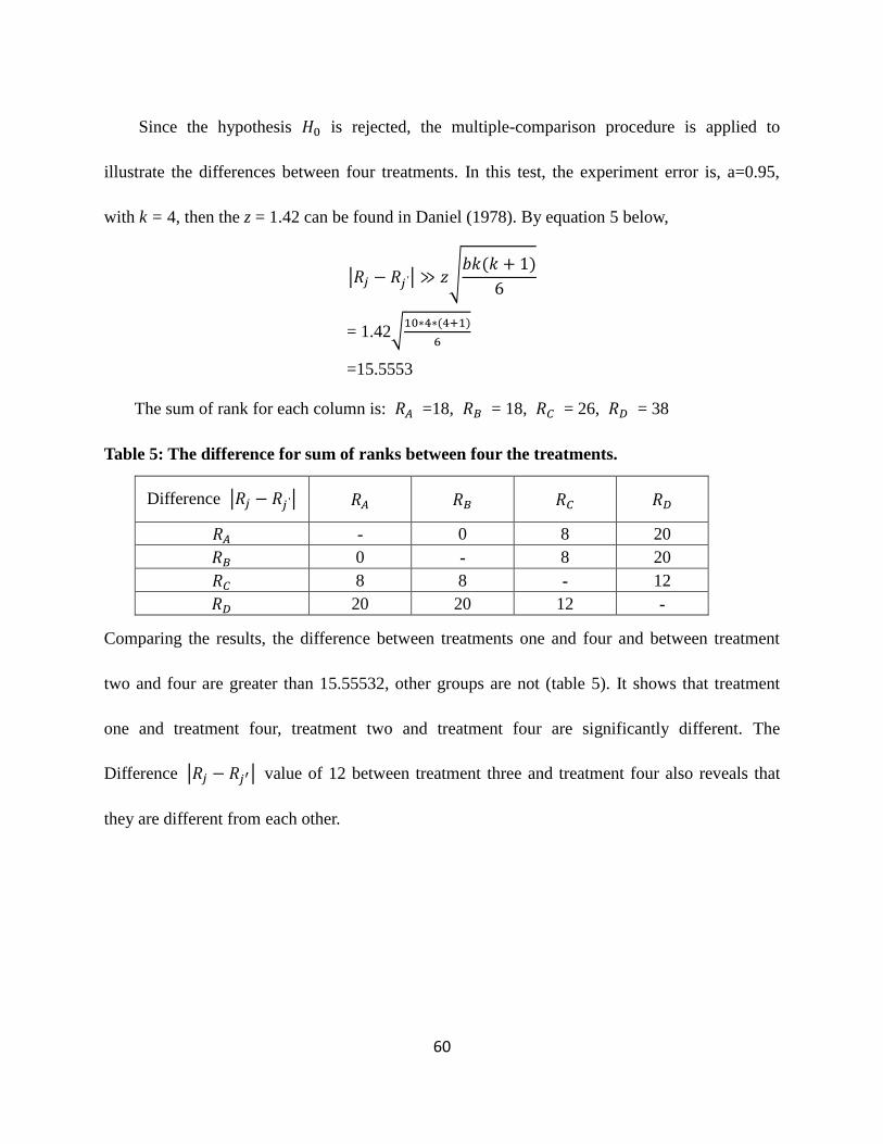
Since the hypothesis is rejected, the multiple-comparison procedure is applied to
illustrate the differences between four treatments. In this test, the experiment error is, a=0.95,
with k = 4, then the z = 1.42 can be found in Daniel (1978). By equation 5 below,
= 1.42
=15.5553
The sum of rank for each column is: =18, = 18, = 26, = 38
Table 5: The difference for sum of ranks between four the treatments.
Difference
- 0 8 20
0 - 8 20
8 8 - 12
20 20 12 -
Comparing the results, the difference between treatments one and four and between treatment
two and four are greater than 15.55532, other groups are not (table 5). It shows that treatment
one and treatment four, treatment two and treatment four are significantly different. The
Difference value of 12 between treatment three and treatment four also reveals that
they are different from each other.

61
Chapter 5: Discussion
In Burley’s equation, low values reveal preferred environments quality while high values
indicate less preferred environments. The results indicate that usually images with good visual
quality contain large areas of vegetation, wildlife, sky and water. The score for such images
range from 30s to 40s. On the contrast, images considered as worse visual quality reach 70s or
above. Both resort design and forest community generate the lowest scores, showing higher
visual quality than the other two. The score of the abandoned treatment is dramatically higher
than the other three. In general, the resort and natural forests communities are ranked as the best
treatments, while the super hotel treatment was ranked as the third one. The abandoned surface
mine site as control group is ranked as the worst. The Friedman Analysis of variance test
provided a statistical comparison approach in this study. Individual ranks and sum of rank for
each assessment can reveal the overall picture of how different each design treatment is between
others. In Friedman Analysis, the chi-square is 16.08 greater than 12.838, which indicates that at
least one treatment is different from the other treatment; The result of the multiple-comparison
procedure shows that resort design and natural community are absolute different from the
abandoned Surface Mine. Also, although the super hotel is not that different from the abandoned
site than difference between resort and natural, the Difference value of 12 shows that
super hotel improves the visual quality of the original site a lot. Both the absolute difference
between resort and super hotel, between natural community and super hotel are 8, which
indicates a relatively smaller different.

62
Since the natural community is one of the treatments with the highest visual quality,
generally speaking, reclamation creating a natural environment is what people preferred.
Creating forested land is a common practice and has the oldest historical precedent to reclaim
surface mines (Plass and Powell 1988). It is commonly known that this kind of reclamation has
much benefits associated with the environment such as soil stabilization, watershed management,
wildlife and so forth. Because the visual quality equation is testing the people’s perception of
best treatment visually and ecologically, the result actually indicates people’s preference for
natural environment. In other words, people would consider natural form with vegetation, wild,
sky and water included, is visually pleasing. To some extent, it can conclude that people really
appreciate natural beauty. Then, since super hotel was ranked behind natural communities and
resort, it reveals that artificial works is not that visually attractive as natural-looking environment.
However, according to the Friedman Analysis, there is almost no absolute difference between
resort and natural communities. That is to say, if working effectively, landscape architects and
planners can find ways to balance human’s desire and natural environment’s needs, and
reclamation design can address problems with full range of human and nature reaching a good
visual balance. The large difference between resort and abandoned site, between natural
communities and abandoned site, between super hotel and abandoned site reveal the significant
benefits of the reuse planning and landscape design to post-mining land. The following
paragraph will thoroughfully discuss results of each treatment.
Among all the pictures presenting natural communities, the best visual quality picture is the

63
sixth one with a large natural waterfall pulling down showing. The second visually pleasing
picture presents a view of constructed wetland there, with people strolling along the trails in. The
reclaimed lake with the xeric forest in the distance is ranked as the third most beautiful. The
fourth and fifth ones show a view northern xeric forest and northern mesic forest from angels
when people are standing in the forest. The lowest visual quality picture is the wet meadow.
When I looked at this group of picture, I would be attracted by Image 6 first, which impresses me
with the magnificent waterfall pouring down. This kind of natural scenery is not common in
people’s daily lives, which offers dramatically different visual experience and refreshes people’s
minds. If the waterfall were taken out from the two images, the visual score would probably
change much. People are more willing to see unusual and splendid scenery. According to
information provided by all the images, it is found that water is a really important landscape
element to satisfy people’s visual needs. Also, green trees would bring people excellent visual
experience. However, grass in natural form is not that attractive for people. Shrub in natural form
is more beautiful than grasses. The fourth and fifth ones presenting a view of northern xeric
forest communities and northern mesic forest communities both offer the public immersing
themselves in the peace of nature. This can help people release themselves from tedious urban
lives. Actually, it has been a long history to reclaim the post-mining abandoned area into a
natural landscape. Natural forest communities can alter the interaction of air, water, soil, sunlight
and organisms, plus improve wildlife and human health (Wolf, 2004). Natural community has a
priority consideration in creating stable and complex environment, which tie to ecological

64
functions. By including the composition of plants, animals, and microbes, and all the living
creatures, it is believed to develop a self-managed and productive environment. In this study, it is
also proved to offer visual benefits for people. Hence, considering all the factors, creating natural
environment is really a good option for reclamation in sustainable view. Nature is not art, and it
is not our creation. Rather, it is our whole natural environment. It surrounds us and confronts us
indeterminately and promiscuously, rich in diversity, suggestion and emotional stimulus (Carlson,
2009). It is not difficult to understand people’s eager to be close to nature, however, from another
perspective, human being as a part of nature should be allowed more opportunity to experience
natural environment. Landscape architect and planners are responsible for creating more
opportunities to bridge the nature and human beings.
The resort design is that kind of exploration searching for potential opportunities to make
people experience nature. For the resort, the lowest quality image is the plaza with a hotel
background in the distance. The first three pictures with good visual quality are Image 1, Image 8,
and Image 9. All of the pictures create routes and spaces accommodating people’s desire to
engage in nature. When people are looking at the pictures, they have a desire to go to such a
place. In my view, to make attractive living places is one of the fundamental duties of Landscape
Architectures. The three pictures showing instinctive scenes implicate opportunities for fresh
experience to connect with nature. Picture 3, 4, 7, present the biggest greenway bridge in this
design from different angles. Picture 3 showing most bridge and building space get the worst
result. In contrast, picture 4 from an angel presenting trees and river under the bridge has the best

65
visual quality among 10 pictures of resort. These results also confirm people visual preference
for nature. In this group, 6 pictures scores below 50. That is to say in this treatment, design
strategies performs effectively to satisfy people needs to engage in nature. The essence of design
is to create or improve spatial sequence to best serve people’s engagement in nature. In this study,
the results reveal that superabundant building and human facilities would break the balanced
order between natural environment and human beings. Therefore to better create spatial sequence,
buffers between recreational facilities and fields are necessary both visually and functionally. In
this study, the aesthetic difference between green trees in natural form and artificial form cannot
be accurately evaluated, but they both well contributed to higher visual quality.
The scores of super hotel range from 40s to 60s. The scores of Natural community range
from 30s to 50s. The visual scores of resort are between 30s to 60s. No picture having the highest
visual quality is from treatment 3, super hotel. Image 1 in this group generates the highest visual
quality. One of the reasons for its good visual quality is good vegetation at different distances.
Another reason is the diverse landforms with multiple functions, which makes it an interesting
place in people’s perception both visually and psychologically. The second picture in high visual
quality is from a view standing on the bridge over the lake. The bridge there offers visitors a
particular route to enjoy views to the lake, hotel or plaza along the lake’s edge, which probably
related to the high ranking. Two images (Image 7, Image 8), present a setting with landscape
embankment only scored in 60s. It indicates that a hardscape embankment is not what people
preferred. When it comes to address the slope in mining site, three different treatments are
66
employed. Compared to the building which stands facing the slope of mine pits, the other two,
natural communities on the slope and decks above the slope with vegetation underneath get
better result. However, addition to ecologically, reclamation work must also perform socially and
culturally. Culture, in fact would shape people’s aesthetics values, however, in this study, it
cannot fully measure the aesthetics of the culture which expressed in constructed landscape
patterns, forms and texture and so forth. Buildings as a crucial carrier of culture play a complex
and relatively distinctive role in people’s perception. A building is not set apart as a massive,
monumental edifice, imposing and overwhelming. Rather, it joins the landscape in some way, its
forms responding to the shapes of the landscape (Berleant, 2012). But the design of these
buildings not only connects them with the landscape. It exercises a magnetic and cultural
attraction on the people who use them and transforms the visitor into an inhabitant (Berleant,
2012). On this condition, it cannot say that evaluation results of group three reveals people’s
perception completely.
The control group, abandoned site scores with a range from 50s to 70s. Mining activities
severely disfigures the surface of the land, and spoils the vital topsoil, disrupts drainage patterns,
destroys the productive capacity of agricultural and forest land. Image characterizes post-mining
pit with a bit surface vegetation recovered received higher visual quality.
Post-mining reclamation is a field which involved in science and arts. Scientists and
engineers mainly focused on offering techniques for revegetation and construction, while
landscape architects provide a different perspective. By applying visual quality equation, this

67
study discusses the four different treatments in planning and design view. It helps to better
understand Landscape Architecture’s role in this issue. By dealing with cultural and aesthetic
issues, they want to create interesting and suitable environment for living creatures. They see the
problem holistically and synthetically rather than analytically. Landscape Architectures can offer
creative ideas and make usable land-use planning, at the same time they need to consult the
possibility of implementing design with scientists and engineers in technical part. Scientists and
engineers make technical recommendations such as maintenance of topsoil, soil analysis,
revegetation and so forth. Scientific information is used to justify design decisions and finally
help to implement design. Landscape Architects create a dialogue between science and art,
interpret and deliver information. They are required to picture the overall issue synthetically and
understand the roles of the various related professions and direct work with other proficient to
make integrated and appropriate decisions.
5.1. Future Research and Limitation
There are other possible treatment options, for instance, abandoned sites can be reclaimed
into agricultural lands, residential lands. Cultivation different types of reclamation should
address different issues. To discuss this topic more comprehensive and thoughtfully, other
potential treatment should be developed and compared. Moreover, although this study provides a
basic guide for this topic, because each treatment design is based on the authors’ own knowledge,
understanding and skills, it is not accurate and general enough.
The results are also limited by numbers of testing samples. Each treatment has 10 pictures

68
to present the design characteristics. If the number of the samples is larger, with 20 to 30 for each
treatment, this study would be more accurate. Also, image quality has influence on the result.
Sample pictures should be expressed in the same styles to minimize other interference. The
design images can be improved. In this study, images try to catch the most significant view of
each treatment instead of viewing the same spot from the same angel. To lead a more scientific
and stronger study, each variable for comparison should be determined. Certain spots should be
selected and pictures of these spots should be from the same angle.
Burley’s visual quality equation has a preference for biospheric environment than
noospheric surroundings, which means the vegetation, wildlife, clean water, and clean air will
greatly improve the visual quality. But, the cultural influence in visual quality has been elusive.
5.2. Conclusion
This study attempts to use different design approaches to explore and discuss the potential
treatments of the post-mining area. By assessing and statistical analyzing each treatment, it’s
concluded that people have preference for natural environment and natural landscape is beautiful
in their views. By identifying difference between each treatment, the findings help to understand
the relationship between nature and human needs and explore reclamation design guide in a
sustainable view.

69
BIBLIOGRAPHY

70
BIBLIOGRAPHY
Arbogast, B. (2008). Interrogating a landscape design agenda in the scientifically based mining
world. In A. Berger (Ed.), Designing the Reclaimed Landscape (1st ed., pp. 52-60). New
York, NY: Taylor & Francis.
Bauer, A. (1965). Simultaneous excavation and rehabilitation of sand and gravel sites:a general
survey and analysis of pre-operational planning factors and procedures. (1st ed., pp.
58-59). Urbana,IL: University of Illinois.
Beauty. (2013). In Oxford English Dictionary (OED). Retrieved from
http://dictionary.oed.com/cgi/entry/50243648/50243648se1?singel=1&query—type=word
&queryword=beauty&first=1&max—to—show=10&hilite=50243648se1
Retrieved May 8, 2011, from http://www.merriam-webster.com/dictionary/hacker
Benson, J., & Roe, M. (2000). Landscape and sustainability. London, England: Spon Press.
Berleant, A. (1991). Art and engagement. (1st ed., pp. 14-16). Philadelphia, PA: Temple
University Press.
Berleant, A. (2012). Aesthetics beyond the arts. (1st ed., pp. 45-46). Surrey, England: Ashgate.
Brabyn, L. (1996). landscape classification using gis and national digital databases. Landscape
Research, 27, 277-300.
Brundtland Commission. (1987). Definition of sustainable development.
Burley, J. B., & Bauer, A. B. (2000). Kenneth l. Schellie, a landscape architectural reclamation
pioneer. In W. Daniels & S. Richardson (Eds.), Proceedings, 2000 Annual Meeting of the
American Society for Surface Mining and Reclamation.. Tampa, FL: American Society
for Surface Mining and Reclamation.
Burley, J. (2001). Environmental design for reclaiming surface mines. (1st ed.). Lewiston,NY:
The Edwin Mellen Press.
Burley, J. B. (1997). Visual and ecological environmental quality model for
transportation planning and design.Transportation Research Record, 1549, 54-60.

71
Burley, J. B., & Pasquier, P. (2005). from beaux arts to post post-modernism: the parallel
educational evolution of two landscape programs from msu and institut national
d. Innovation and Development of Landscape Education. , 503-513.
Burley, J., Deyoung, G., Partin, S., & Rokos., J. (2011). Reinventing detroit: Reclaiming
grayfields—new metrics in evaluating urban environments.Challenges, 2(4), 45-54.
Canadian Society of Landscape Architecture. (1996). The Practice of Landscape Architecture.
Carlson, A. (2009). Nature & landscape an introduction to environmental aesthetics. . (1st ed.).
New York,NY: Columbia University Press.
Comp, T. (2005). Science, art, and environmental reclamation: three projects and a few thoughts.
In A. Berger (Ed.), Designing The Reclaimed Landscape (1st ed., pp. 63-76). New
York,NY: Taylor & Francis.
Curtis, J. (1959). The vegetation of wisconsin. Madison,WI: The University of Wisconsin Press.
Daniel, W. (1978). Applied nonparametric statistics.. (2nd ed.). Boston, MA: Houghton
Mifflin Company.
Daniel, T. C., & Vining, J. (1983). Methodological issues in the assessment of landscape
quality. Human Behavior & Environment: Advances in Theory & Research, 6, 39-84.
Retrieved from
http://ezproxy.msu.edu/login?url=http://search.proquest.com/docview/617006033?accounti
d=12598
Dennis, A., Joshua, G., Michael, A., & Bradford, S. (2008). Distribution maps of michigan's
natural communities. Lansing, MI: Michigan Natural Features Inventory.
Dinep, C., & Schwab, K. (2010). Sustainable site design: Criteria, process, and case studies for
integrating site and region in landscape design. (1st ed.). Hoboken, N.J.: J. Wiley.
Howett, C. (1987). Systems, signs, sensibilities: Sources for a new landscape
aesthetic. Landscape Journal, 6(1), 1-12.
Hunt, M., & Hunt, D. (2001). Hunt's guide to michigan's upper peninsula: The celebrated places
and hidden treasures of a wild and historic region. . (2nd ed.). Albion, MI: Midwestern
Guides.

72
Kaplan, Stephen. (1979). Perception and landscape: conceptions and misconceptions. In Our
National Landscape: A Conference on Applied Techniques for Analysis and Management
of the Visual Resource. Washington, D.C.: U.S. Government Printing Office. , 241-248.
Kaplan, S., & Kaplan, R. (1982). Cognition and environment: functioning in an uncertain world.
New York, NY: Praeger.
Keefe, P. S., & Burley, J. B. (1998). Post-mining predictive visual quality assessment: a
methodology. In D. Throgmorton, J. Nawrot, J. Mead, W. Joseph & J. Burley
(Eds.), Proceedings Fifteenth Annual Meeting American Society for Surface Mining and
Reclamation: Mining--Gateway to the Future!. St. Louis, MO: The American Sociiety for
Surface Mining and Reclamation.
Kost, M., Albert, D., Cohen, J., Slaughter, B., Schillo, R., Weber, C., & Chapman, K.
(2007). Natural communities of michigan classification and description. Lansing, MI:
Michigan Natural Features Inventory.
Koski, A. (2005). Reclamation of waste rock stockpiles utilizing paper mill residuals at cliffs
michigan mining company. In the 2005 National Meeting of the American Society of
Mining and Reclamation. Lexington, KY: American Society of Mining and Reclamation. ,
627-644.
McHarg, I. L. (1969). Design with nature. New York, NY: Natural History Press.
Meyer, E. (2008). Sustaining beauty. the performance of appearance: A manifesto in three
parts. Journal of Landscape Architecture, 6-23.
National Academy of Science (NAS) Committee, (1974). Retrieved from website:
http://www2.nas.edu/arc
Plass, W., & Powell, J. (1988). Trees and shrubs.reclamation of surface-mined lands, II, 175-199.
Schellie, K. (1977). Sand and gravel operations: a transitional land use.
Silver Spring, Md: National Sand and Gravel Association.
Schellie, K., & Bauer, A. (1968). Shaping the land; planned use of industrial sand deposits.
Sliver Spring, Md: National Industrial Sand Association.
Sommer, L. Department of Geography, (1978). Atlas of michigan. Lansing, MI:

73
Michigan State University Press.
Turner, T. (1996). City as landscape: A post-postmodern view of design and planning.. (2nd ed.).
London, England: E & FN Spon.
Turner, F. (2008). Valuing alteration. In A. Berger (Ed.), (1st ed., pp. 3-12). New York, NY:
Taylor & Francis.
Wolf, K. (2004). Trees, parking and green law: Strategies for sustainability.. Stone Mountain,
GA: Urban and Community Forestry.