natural environment study minimal impact
TRANSCRIPT
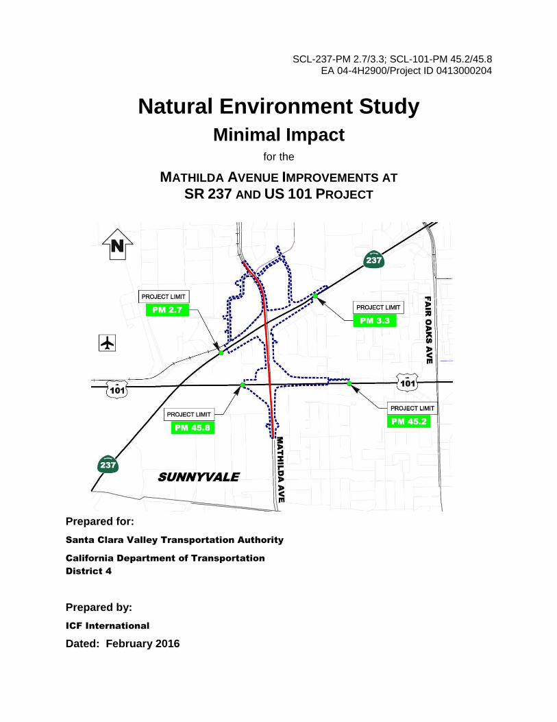
SCL-237-PM 2.7/3.3; SCL-101-PM 45.2/45.8 EA 04-4H2900/Project ID 0413000204
Natural Environment Study
Minimal Impact for the
MATHILDA AVENUE IMPROVEMENTS AT SR 237 AND US 101 PROJECT
Prepared for:
Santa Clara Valley Transportation Authority
California Department of Transportation
District 4
Prepared by:
ICF International
Dated: February 2016

For individuals with sensory disabilities, this document is available in Braille, in large
print, on audiocassette, or on computer disk. To obtain a copy in one of these
alternative formats, please write to Caltrans, Attn: Gregory Pera, Branch Chief, Office of
Biological Sciences and Permits, 111 Grand Avenue, Oakland, CA 94623-0660; or call
(510) 286-5617 (voice); or use the California Relay Service TTY number, (800) 735-
2929.


This page intentionally left blank.

Mathilda Avenue Improvements at SR 237 and US 101 Project Natural Environment Study – Minimal Impacts
i
February 2016
Contents
Page
Summary ........................................................................................................................................... 1
Chapter 1 – Introduction .................................................................................................................... 3
1.1 Project History .................................................................................................................... 3
1.1.1 Mathilda Avenue ................................................................................................................. 3
1.1.2 SR 237 ................................................................................................................................. 3
1.1.3 US 101 ................................................................................................................................. 3
1.1.4 Transit Facilities in the Project Area ................................................................................... 4
1.1.5 Project Purpose and Need .................................................................................................. 4
1.1.6 Project Location .................................................................................................................. 5
1.2 Project Description ............................................................................................................. 5
1.2.1 Roadway Improvements ..................................................................................................... 5
1.2.2 Bicycle and Pedestrian Facilities ......................................................................................... 6
1.2.3 Utility Relocations ............................................................................................................... 6
1.2.4 Stormwater Treatment ....................................................................................................... 7
1.2.5 Enhanced Lighting ............................................................................................................... 7
1.2.6 Ramp Metering ................................................................................................................... 7
1.2.7 Overhead Signage ............................................................................................................... 7
1.2.8 Light-Rail Facilities .............................................................................................................. 7
1.2.9 Construction and Staging Areas .......................................................................................... 7
Chapter 2 – Methods .......................................................................................................................... 9
2.1 Regulatory Requirements ................................................................................................... 9
2.1.1 Federal Regulations ............................................................................................................ 9
2.1.2 State Regulations .............................................................................................................. 11
2.1.3 Local Regulations .............................................................................................................. 12
2.2 Studies Required ............................................................................................................... 13
2.2.1 Literature and Database Review ....................................................................................... 13
2.3 Personnel and Survey Dates ............................................................................................. 14
2.3.1 Botanical Resources .......................................................................................................... 14
2.3.2 Wildlife Resources ............................................................................................................ 14
2.3.3 Delineation of Waters of the United States ...................................................................... 14
2.3.4 Limitations that May Influence Results ............................................................................ 14

Santa Clara Valley Transportation Authority California Department of Transportation
Mathilda Avenue Improvements at SR 237 and US 101 Project Natural Environment Study – Minimal Impacts
ii February 2016
Chapter 3 – Results: Environmental Setting ...................................................................................... 15
3.1 Description of the Existing Biological and Physical Conditions ......................................... 15
3.1.1 Biological Study Area ........................................................................................................ 15
3.1.2 Physical Conditions ........................................................................................................... 15
3.1.3 Biological Conditions ......................................................................................................... 16
Chapter 4 – Results: Biological Resources, Discussion of Impacts and Mitigation ................................ 31
4.1 Habitats and Natural Communities of Special Concern .................................................... 31
4.2 Special-status Species ....................................................................................................... 31
4.3 Other Protected or Managed Biological Resources .......................................................... 31
4.3.1 Nesting Birds ..................................................................................................................... 31
4.3.2 Trees ................................................................................................................................. 33
4.4 Invasive Species ................................................................................................................ 33
4.4.1 Avoidance and Minimization Efforts ................................................................................. 34
Chapter 5 – Conclusions and Regulatory Determination .................................................................... 35
5.1 Federal Endangered Species Act Consultation Summary ................................................. 35
5.2 Wetland and Non-Wetland Waters Summary .................................................................. 35
5.3 Invasive Species ................................................................................................................ 35
5.4 Other Protected or Managed Biological Resources .......................................................... 35
5.4.1 Nesting Birds ..................................................................................................................... 35
5.4.2 Trees ................................................................................................................................. 36
Chapter 6 – References .................................................................................................................... 37
Appendices
Appendix A California Native Plant Society’s Inventory of Rare and Endangered Plants of California
Appendix B California Natural Diversity Database Records Search for the U.S. Geological Survey 7.5-minute Mountain View Quadrangle
Appendix C U.S. Fish and Wildlife Service Official Species List for the Mathilda Avenue Improvements Project
Appendix D Mathilda Avenue Improvements at SR 237 and US 101 Preliminary Jurisdictional Delineation

Santa Clara Valley Transportation Authority California Department of Transportation
Mathilda Avenue Improvements at SR 237 and US 101 Project Natural Environment Study – Minimal Impacts
iii February 2016
List of Tables
Page
Table 1. Trees in the BSA ............................................................................................................................ 17
Table 2. Invasive Plant Species Identified in the BSA .................................................................................. 20
Table 3. Special-Status Plant Species Known or with Potential to Occur in the Project Region ................ 22
Table 4. Special-Status Wildlife Species Known or with Potential to Occur in the Project Region ............ 24
List of Figures
Follows Page
1 Regional Vicinity ............................................................................................................................... 2
2 Biological Study Area ....................................................................................................................... 6
3a Plant Occurrences within 2 Miles of the Project Footprint ........................................................... 14
3b Wildlife Occurrences within 2 Miles of the Project Footprint ....................................................... 14
4 Land Cover Types within the BSA .................................................................................................. 16
5 General Location of Trees within the BSA ..................................................................................... 16

Santa Clara Valley Transportation Authority California Department of Transportation
Mathilda Avenue Improvements at SR 237 and US 101 Project Natural Environment Study – Minimal Impacts
iv February 2016
This Page Intentionally Left Blank

Mathilda Avenue Improvements at SR 237 and US 101 Project Natural Environment Study – Minimal Impacts
1 February 2016
Summary
The Mathilda Avenue Improvements at SR 237 and US 101 Project (Project) is located in Sunnyvale, Santa Clara County, California (Figure 1). The purpose of the Project is to reduce congestion and improve traffic operations on Mathilda Avenue at State Route (SR) 237 and U.S. Highway 101 (US 101) while improving mobility for all travel modes in the area. The scope and scale of the Project is intended to provide locally scaled transportation improvements in the near term that address multiple existing deficiencies.
The purpose of this Natural Environment Study – Minimal Impacts (NES-MI) is to evaluate the potential for the Project to affect sensitive biological resources, including, but not limited to, special-status species and natural habitats.
ICF International (ICF) reviewed online resources on the U.S. Fish and Wildlife Service, California Department of Fish and Wildlife, and California Native Plant Society websites to identify potential special-status botanical and wildlife resources found on the Project site. Based on the results, it was determined that six special-status plant species and 27 special-status wildlife species have the potential to occur in the Project region. Field surveys were conducted on March 6 and July 29, 2015. The purposes of field surveys were to identify vegetation and cover types within the Project site and assess habitat suitability for special-status species. Based on the results of the field surveys, the Project would have no effect on habitats and natural communities of special concern and no effect on special-status plant species because of the high degree of development and routine human activity within the Project footprint.
By causing nesting and reproductive failure from high disturbance levels, construction of the Project could affect nesting birds and/or raptors that are protected by the Migratory Bird Treaty Act. If feasible, trees would be removed during the non-nesting season, September 1 to January 31. Otherwise, preconstruction surveys would be conducted during the nesting season, February 1 to August 31, to ensure that no active bird nests are present prior to tree removal. If active nests are identified, then buffers would be established until nesting is completed.
A wetlands assessment was conducted concurrently with the field surveys described above. The wetlands assessment identified culverted portions of a concrete-lined flood control channel and open stormwater drainage ditches within the Biological Study Area (BSA), which is bounded by the Project limits. The flood control channel (Sunnyvale West Channel) was identified as potentially subject to both federal and state jurisdiction because it drains directly to a navigable water (San Francisco Bay) via Guadalupe Slough. The stormwater drainage ditches are presumed to be non-jurisdictional because they were constructed in uplands and drain runoff from uplands. The Project is not expected to affect the Sunnyvale West Channel and, therefore, would not require a Clean Water Act Section 404 permit or Section 401 water quality certification or waste discharge requirement. Approximately 626 trees occur in the BSA. The California Department of Transportation (Caltrans) and Santa Clara Valley Transportation Authority (VTA) are exempt from local tree protection ordinances. However, the trees provide aesthetic and other benefits to the community and may provide habitat or food sources for local wildlife; therefore, trees impacted by the Project will be replaced at ratios that are commensurate with the size of the tree to be removed, as described in Chapter 4.

Santa Clara Valley Transportation Authority California Department of Transportation
Mathilda Avenue Improvements at SR 237 and US 101 Project Natural Environment Study – Minimal Impacts
2 February 2016
Invasive plant species are present throughout much of the Project work limits. To minimize the introduction and spread of additional invasive plant species within project boundaries as well as lands adjacent to the Project, the City of Sunnyvale or its contractor shall implement best management practices to the greatest extent practicable when disturbing soil and removing or disposing of invasive plant material.

Figure 1Project Vicinity
Mathilda Avenue Improvements at SR 237 and US 101
Path:
K:\Pr
ojects
_3\VT
A\005
22_1
3\map
doc\C
ultura
l\Figu
re_1_
Proje
ct_Vic
inity_
2015
1208
.mxd
; Use
r: 194
02; D
ate: 1
2/8/20
15
_Project
Area
SolanoMarin
SanJoaquin
ContraCosta
AlamedaSanMateo
SantaClara
SantaCruz
SanBenito
Monterey
0 21Miles´
LegendProject Area


Mathilda Avenue Improvements at SR 237 and US 101 Project Natural Environment Study – Minimal Impacts
3 February 2016
Chapter 1 – Introduction
1.1 Project History
The SR 237/Mathilda Avenue and US 101/Mathilda Avenue interchanges are primary access points on the state highway system for the City of Sunnyvale and important local destinations, such as downtown Sunnyvale, the Sunnyvale Caltrain station to the south, and an expanding high-tech business district to the north. The Project is also located within the “Golden Triangle,” an area bordered by US 101, SR 237, and Interstate (I) 880 that includes parts of Sunnyvale, Santa Clara, North San Jose, and Milpitas. The Golden Triangle is named for the high concentration of employment centers within this area. US 101, SR 237, and I-880 are heavily used commute corridors to destinations within and beyond the Golden Triangle.
1.1.1 MATHILDA AVENUE
Within the Project area, Mathilda Avenue is a six-lane divided local roadway. Mathilda Avenue serves as the main access route to residential communities on the east side of Mathilda Avenue and is the only access route to the landlocked area within the US 101/SR 237/Mathilda Avenue triangle via Ross Drive. Mathilda Avenue is also one of City of Sunnyvale’s designated truck routes for trucks over three tons in weight. The speed limit is 45 miles per hour (mph) and on-street parking is prohibited within the Project area. Approximately 45,000 vehicles travel on Mathilda Avenue south of SR 237 on an average weekday.
1.1.2 SR 237
SR 237 is an east-west freeway, starting at SR 82 (El Camino Real) in the City of Mountain View and ending approximately 11 miles to the east at I-680 in the City of Milpitas. Within the Project area, SR 237 provides two mixed-flow lanes in each direction. On eastbound SR 237, a high-occupancy vehicle (HOV) lane is provided east of Mathilda Avenue and becomes an HOV/express lane from east of Zanker Road to the eastbound SR 237/northbound I-880 direct connector ramp. On westbound SR 237, there is an HOV/express lane beginning at the southbound I-880/westbound SR 237 direct connector ramp that becomes an HOV lane from North First Street to just east of Fair Oaks Avenue. Within the Project area, auxiliary lanes are provided in each direction between US 101 and Mathilda Avenue on SR 237. There is also an auxiliary lane on westbound SR 237 between Fair Oaks Avenue and Mathilda Avenue. SR 237 is a link for trucking between the southern part of the San Francisco Peninsula and the East Bay, providing the first connection south of the Dumbarton Bridge. SR 237 east of Mathilda Avenue currently carries approximately 90,000 vehicles daily.
The SR 237/Mathilda Avenue interchange is a full “tight” diamond interchange that accommodates all ramp movements, with access to and from east and westbound SR 237. All ramp termini are signalized. The westbound SR 237 on-ramp has existing ramp metering equipment installed; however, there is no existing ramp metering equipment installed for the eastbound SR 237 on-ramp.
1.1.3 US 101
Within the Project area, US 101 provides three mixed-flow lanes plus one HOV lane in each direction, while an auxiliary lane is also provided in the southbound direction between SR 237
Santa Clara Valley Transportation Authority California Department of Transportation
Mathilda Avenue Improvements at SR 237 and US 101 Project Natural Environment Study – Minimal Impacts
4 February 2016
and Mathilda Avenue. US 101 south of Mathilda Avenue currently carries approximately 154,000 vehicles daily.
The Moffett Park Drive/US 101 northbound on-ramp is a one-lane on-ramp located along Moffett Park Drive west of the Mathilda Avenue/Moffett Park Drive intersection. This on-ramp merges with the westbound SR 237 off-ramp that connects to northbound US 101. The ramp terminus is signalized, and the on-ramp is not metered.
The US 101/Mathilda Avenue interchange is a partial cloverleaf interchange with access to all but two movements: southbound Mathilda Avenue to northbound US 101 and southbound US 101 to northbound Mathilda Avenue. None of the ramp termini are signalized; however, all of the on-ramps are metered.
1.1.4 TRANSIT FACILITIES IN THE PROJECT AREA
Two VTA light-rail transit (LRT) stations, Moffett Park and Lockheed Martin, are located within the Project area and serve the business district north of SR 237. VTA also operates a local bus service with four bus stops on Mathilda Avenue. The Sunnyvale Caltrain Station is located in downtown Sunnyvale, adjacent to West Evelyn Avenue.
1.1.5 PROJECT PURPOSE AND NEED
The primary purpose of the Project is to improve traffic operations on Mathilda Avenue through the US 101 and SR 237 interchanges. Due to the close proximity of the SR 237 and US 101 interchanges (less than one mile), modification of one interchange would affect the other.
Specifically, the purposes of the Project are to:
Reduce congestion and improve traffic operations along Mathilda Avenue and at the SR 237/Mathilda Avenue and US 101/Mathilda Avenue interchanges.
Improve mobility for all travel modes in the area, including motor vehicles, transit, bicycles, and pedestrians.
Provide standard crosswalks and sidewalks along Mathilda Avenue, improving access to local destinations such as Moffett Park, the VTA LRT stations, and downtown Sunnyvale.
The Project is needed for the following reasons:
Regional growth and new local development combined with inefficient roadway operations, have resulted in substantial traffic congestion on Mathilda Avenue.
Efficient access for all travel modes into and out of downtown Sunnyvale and development to the north of SR 237 is critical to a healthy and sustainable economy. Congestion on Mathilda Avenue adversely affects the economic vitality of the City of Sunnyvale.
Overall, the Project is needed to address several issues in the Project area, including roadway deficiencies, lack of or discontinuous bicycle and pedestrian access, local roadway and freeway ramp operations, and current and future economic development.

Santa Clara Valley Transportation Authority California Department of Transportation
Mathilda Avenue Improvements at SR 237 and US 101 Project Natural Environment Study – Minimal Impacts
5 February 2016
1.1.6 PROJECT LOCATION
The Project is located in the City of Sunnyvale in Santa Clara County, California (Figure 1). On SR 237, the Project limits are from 0.3 mile east of the US 101/SR 237 interchange (post mile [PM] 2.7) to 0.3 mile east of the Mathilda Avenue undercrossing (PM 3.3). On US 101, the Project limits are from 0.5 mile south of the Mathilda Avenue overcrossing (PM 45.2) to 0.3 mile south of SR 237/US 101 interchange (PM 45.8) (Figure 2). The Project limits include approximately 0.4-mile of Innovation Way and a new road that would connect Mathilda Avenue to Bordeaux Drive; this new road will be completed by the Moffett Place Project prior to the Mathilda Avenue Improvements at SR 237 and US 101 Project. The Project occurs in a sectionless area within Township 6 South, Ranges 2 and 1 West in the Mountain View U.S. Geological Survey (USGS) 7.5-minute series topographic quadrangle.
The Biological Study Area (BSA) for the project is based on the Project limits (Figure 2).
1.2 Project Description
The Project alternatives that were developed to meet the purpose and need of the Project include Alternative 1, Alternative 2, and the No-Build Alternative. Under the No-Build Alternative, no changes would be made to the existing local roadway or freeway ramps within the Project limits. No construction activities would occur, and there would be no change in the operation of existing facilities.
The design features of the two build alternatives include reconfiguration of the US 101 and SR 237 interchanges at Mathilda Avenue. The build alternatives include design variations for reconfigured roadways and intersections as well as the construction of new signalized intersections. Proposed improvements included in the build alternatives south of Ross Drive along Mathilda Avenue and at the US 101 interchange are identical. These improvements include new bicycle and pedestrian facilities, utility relocations, new stormwater treatment facilities, enhanced lighting, ramp metering modifications, overhead signage modifications, and a new retaining wall. Unique improvements of the build alternatives occur north of Ross Drive along Mathilda Avenue primarily related to construction of a diverging diamond interchange (DDI)1 under Build Alternative 2.
1.2.1 ROADWAY IMPROVEMENTS
The build alternatives would consist of the following roadway improvements:
Provide three continuous through lanes in each direction on Mathilda Avenue.
Remove northbound US 101 loop off-ramp and shift traffic to northbound US 101 diagonal off-ramp.
Realign and widen northbound US 101 ramps and signalize ramp intersection with Mathilda Avenue, and construct left-turn lane on southbound Mathilda Avenue to access northbound US 101 loop on-ramp.
1 A diverging diamond interchange (DDI) , also called a double crossover diamond (DCD) interchange, is a type of diamond interchange where traffic briefly crosses over to the left (opposite) side of the roadway, guided by traffic signals at each crossover. This allows vehicles to turn left onto freeway on-ramps without stopping and without conflicting with through traffic. The signals at ramp terminal intersections can be operated with two signal phases (phases when a traffic signal allows for traffic at an intersection to cycle through specific movements for each direction) instead of three.

Santa Clara Valley Transportation Authority California Department of Transportation
Mathilda Avenue Improvements at SR 237 and US 101 Project Natural Environment Study – Minimal Impacts
6 February 2016
Realign southbound US 101 off-ramp and loop on-ramp and signalize ramp intersection with Mathilda Avenue.
Modify Mathilda Avenue/Ross Drive signal intersection.
Close Moffett Park Drive between Bordeaux Drive and Mathilda Avenue, replace with a Class I bikeway (as described below), and shift traffic to Bordeaux Drive and Innovation Way.2
Remove westbound SR 237 ramp signal intersection. Realign westbound SR 237 off-ramp opposite Moffett Park Drive and modify signal intersection.
Build Alternative 1 would modify westbound SR 237 ramps to provide a diamond configuration.
Build Alternative 2 would modify Mathilda Avenue and SR 237 ramps to provide a diverging diamond configuration. Eastbound Moffett Park Drive between Innovation Way and Mathilda Avenue would be diverted to Innovation Way to access Mathilda Avenue.
1.2.2 BICYCLE AND PEDESTRIAN FACILITIES
Enhanced bicycle and pedestrian facilities would be provided. Bicycle improvements on Mathilda Avenue would consist of both Class II and Class III bikeways3, based on available pavement widths within the Project limits, and connect to the existing Class III bikeway north of Innovation Way and the Class I bikeway on the Sunnyvale West Channel. Bicycle improvements on Moffett Park Drive would consist of a Class I bikeway between Bordeaux Drive and Mathilda Avenue. Between Mathilda Avenue and Innovation Way, Class II and Class III bikeways would be considered, based on available pavement widths within the Project limits. A continuous sidewalk would be provided on the east side of Mathilda Avenue within the Project limits with crosswalks, curb ramps, and pedestrian countdown signals at each intersection. The new crosswalks at the reconfigured ramp intersections would be signalized.
1.2.3 UTILITY RELOCATIONS
The following utility companies have known facilities within the project limits: Pacific Gas & Electric (PG&E) gas and electric service, AT&T telephone service, Comcast cable and internet service, Verizon, San Francisco Public Utilities Commission (SFPUC) Hetch-Hetchy Aqueduct, VTA light rail electric and communication services, and City of Sunnyvale water line, recycled water line, storm drain and sanitary sewer services.
The build alternatives would include utility relocations, as necessary, to construct the above-described improvements. Build Alternative 1 would require relocation of Verizon telecommunication lines and relocation of a City of Sunnyvale recycled water line along the current alignment of Moffett Park Drive east of Mathilda Avenue. Build Alternative 2 would require relocation of a six-foot PG&E underground gas line and a 12kV PG&E underground electrical line along the current alignment of Moffett Park Drive west of Mathilda Avenue. Both Build Alternatives could require adjustments to three PG&E electrical pole wires to accommodate ramp modifications at the Mathilda Avenue/US 101 interchange. Utility covers would be adjusted to grade in areas of pavement rehabilitation.
2 Innovation Way would be extended from Mathilda Avenue to Bordeaux Drive by the Moffett Place Project. 3 Class I bikeway is a bicycle path. Class II bikeway is a bicycle lane. Class III bikeway is bicycle route (Source: Highway Design Manual, Index 1002.1).
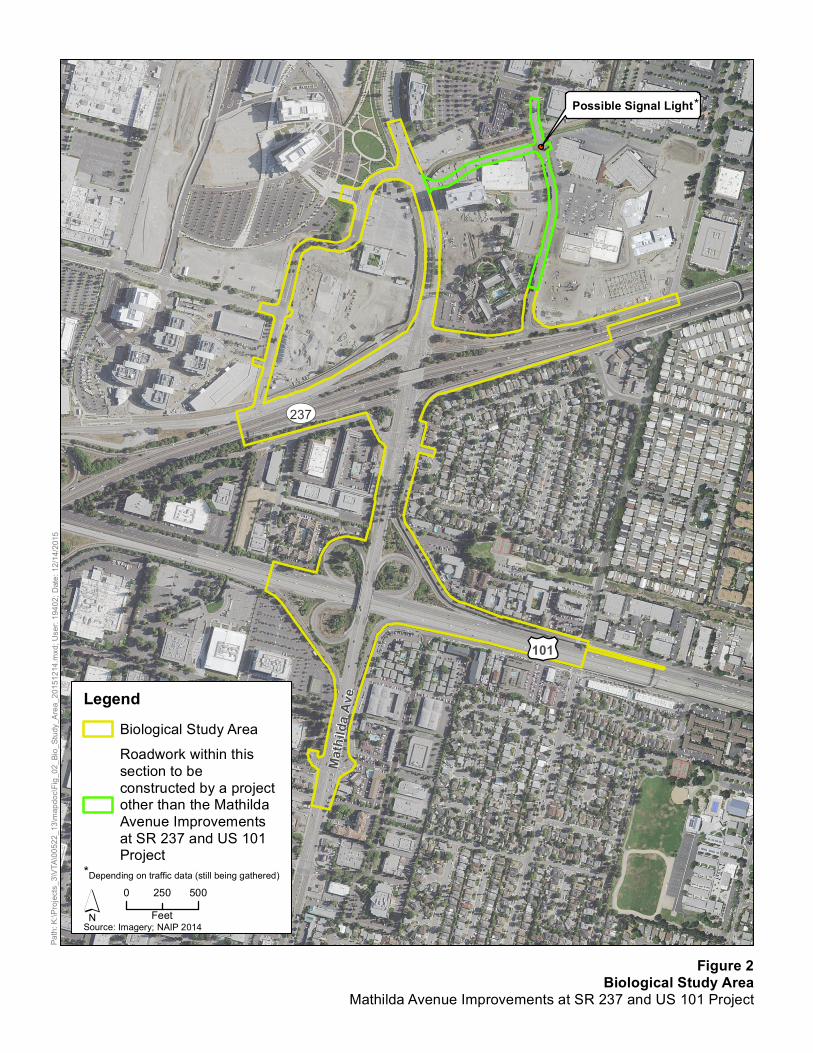
Possible Signal Light
£¤101
UV237
Mathi
lda A
ve
Figure 2Biological Study Area
Mathilda Avenue Improvements at SR 237 and US 101 Project
Path:
K:\Pr
ojects
_3\VT
A\005
22_1
3\map
doc\F
ig_02
_Bio_
Study
_Area
_201
5121
4.mxd
; Use
r: 194
02; D
ate: 1
2/14/2
015
0 500250Feet
Source: Imagery; NAIP 2014
LegendBiological Study AreaRoadwork within thissection to beconstructed by a projectother than the MathildaAvenue Improvementsat SR 237 and US 101Project
*
*Depending on traffic data (still being gathered)


Santa Clara Valley Transportation Authority California Department of Transportation
Mathilda Avenue Improvements at SR 237 and US 101 Project Natural Environment Study – Minimal Impacts
7 February 2016
1.2.4 STORMWATER TREATMENT
The proposed interchange ramp modifications are expected to result in the fill or removal of existing ditches, modification or relocation of existing longitudinal drainage structures, and construction of new drainage structures. The build alternative’s drainage design would maintain existing drainage patterns; however, during construction, temporary drainage facilities may be required to redirect runoff from construction areas.
The stormwater treatment facilities for both build alternatives may include biofiltration strips, biofiltration swales, bioretention basins, and/or detention basins within the state right-of-way near the on- and off-ramps and on city streets.
1.2.5 ENHANCED LIGHTING
The build alternatives would both provide enhanced lighting to improve roadway visibility for drivers during nighttime hours. Overhead lighting would be maintained or installed at all ramps. The lights would either be supported on a cast-in-drilled-hole pile, with a typical diameter of 2.5 feet and depth of five feet, or mounted on a structure above grade.
1.2.6 RAMP METERING
Ramp metering facilities already exist at the northbound US 101 loop on-ramp, southbound US 101 ramps, and the westbound SR 237 on-ramp. Because these ramps would be modified and realigned under both build alternatives, the affected ramp metering equipment would also be modified.
1.2.7 OVERHEAD SIGNAGE
Updated overhead signs in each direction on SR 237 and US 101 would inform motorists of the approaching on- and off- ramps associated with the Project. The overhead sign structure mounted to the Mathilda Avenue overcrossing on northbound US 101 would be removed because it applies to the existing loop off-ramp, which is being relocated and integrated as both a west and east Mathilda Avenue access route from northbound US 101. The northbound US 101 off-ramp sign would be impacted by the off-ramp widening, therefore, it would be removed and replaced just south of the Borregas Pedestrian Overcrossing.
1.2.8 LIGHT-RAIL FACILITIES
VTA LRT facilities that cross the Moffett Park Drive/Innovation Way and Mathilda Avenue/Innovation Way intersections would be coordinated with traffic signal modifications, which would be location specific. The final locations for new traffic signals would be determined during design.
1.2.9 CONSTRUCTION AND STAGING AREAS
Construction of the build alternatives would take approximately 250 working days. A combination of day and night work is anticipated. Weekend work is not anticipated. Short-term lane and ramp closures would be necessary to facilitate construction. A Traffic Management Plan would be implemented during construction to minimize and prevent delay and inconvenience to the traveling public. Staging/laydown areas for equipment and materials would be needed during

Santa Clara Valley Transportation Authority California Department of Transportation
Mathilda Avenue Improvements at SR 237 and US 101 Project Natural Environment Study – Minimal Impacts
8 February 2016
Project construction. Construction staging areas would be located within the state right-of-way adjacent to Mathilda Avenue.
Potential locations include:
Within the northbound US 101 loop off-ramp,
Between the northbound US 101 diagonal off-ramp and northbound loop on-ramp,
Within the southbound US 101 loop on-ramp,
Between the southbound US 101 loop on-ramp and diagonal off-ramp, and
Between the westbound SR 237 ramps and Moffett Park Drive.

Mathilda Avenue Improvements at SR 237 and US 101 Project Natural Environment Study – Minimal Impacts
9 February 2016
Chapter 2 – Methods
2.1 Regulatory Requirements
Potentially applicable federal and state regulations for biological resources are described below.
2.1.1 FEDERAL REGULATIONS
Federal Endangered Species Act
The federal Endangered Species Act (ESA) is administered by U.S. Fish and Wildlife Service (USFWS) and National Marine Fisheries Service (NMFS). In general, NMFS is responsible for protection of ESA-listed marine species and anadromous fishes, whereas other listed species are under USFWS jurisdiction. Endangered refers to species, subspecies, or distinct population segments that are in danger of extinction through all or a significant portion of their range; threatened refers to species, subspecies, or distinct population segments that are likely to become endangered in the near future. Section 9 of the ESA is relevant to the proposed Project and is summarized below.
Endangered Species Act Prohibitions (Section 9)
Section 9 of ESA prohibits the take of any fish or wildlife species that has been listed under the ESA as endangered. Take of threatened species is also prohibited under Section 9, unless otherwise authorized by federal regulations. Take, as defined by ESA, means “to harass, harm, pursue, hunt, shoot, wound, kill, trap, capture, or collect or to attempt to engage in any such conduct.” Harm is defined as “any act that kills or injures the species, including significant habitat modification.” In addition, Section 9 prohibits removing, digging up, cutting, and maliciously damaging or destroying federally listed plants on sites that are under federal jurisdiction. Section 9 does not prohibit take of federally listed plants on sites that are not under federal jurisdiction.
Migratory Bird Treaty Act
The federal Migratory Bird Treaty Act (MBTA) (16 United States Code [USC] 703) enacts the provisions of treaties between the United States, Great Britain, Mexico, Japan, and the Soviet Union (now Russia) and authorizes the U.S. Secretary of the Interior to protect and regulate the taking of migratory birds. It protects migratory birds, their occupied nests, and their eggs (16 USC 703, 50 Code of Federal Regulations [CFR] 21, 50 CFR 10). Most actions that result in taking or in permanent or temporary possession of a protected species constitute violations of the MBTA. Examples of permitted actions that do not violate the MBTA are the possession of a hunting license to pursue specific game birds, legitimate research activities, display in zoological gardens, banding, and other similar activities. USFWS is responsible for overseeing compliance with the MBTA, and the U.S. Department of Agriculture’s (USDA’s) Animal Damage Control Officer makes recommendations on related animal protection issues.
Clean Water Act
The federal Clean Water Act (CWA) was enacted as an amendment to the federal Water Pollution Control Act of 1972, which outlined the basic structure for regulating discharges of pollutants to

Santa Clara Valley Transportation Authority California Department of Transportation
Mathilda Avenue Improvements at SR 237 and US 101 Project Natural Environment Study – Minimal Impacts
10 February 2016
waters of the United States. The CWA serves as the primary federal law to protect the quality of the nation’s surface waters, including lakes, rivers, and coastal wetlands.
The CWA empowers the U.S. Environmental Protection Agency (EPA) to set national water quality standards and effluent limitations. It also includes programs for addressing both point-source and nonpoint-source pollution. Point-source pollution is pollution that originates or enters surface waters at a single, discrete location, such as an outfall structure or an excavation or construction site. Nonpoint-source pollution originates over a broader area and includes urban contaminants in stormwater runoff and sediment loading from upstream areas. The CWA operates on the principle that all discharges into the nation’s waters are unlawful, unless specifically authorized by a permit; permit review is the CWA’s primary regulatory tool.
The sections below provide additional details on specific sections of the CWA.
Permits for Fill Placement in Waters and Wetlands (Section 404)
CWA Section 404 regulates the discharge of dredged and fill materials into waters of the United States. Waters of the United States refers to oceans, bays, rivers, streams, lakes, ponds, and wetlands, including any or all of the following:
Areas within the ordinary high-water mark of a stream, including non-perennial streams with a defined bed and bank and any stream channel that conveys natural runoff, even if it has been realigned; and
Seasonal and perennial wetlands, including coastal wetlands.
In Solid Waste Agency of Northern Cook County v. Army Corps of Engineers, 521 U.S. 159 (2001), the Court held that the provision of the CWA, which requires discharging fill material into navigable waters to obtain a permit from the U.S. Army Corps of Engineers (USACE), does not extend to isolated wetlands. In the consolidated cases Rapanos v. United States and Carabell v. United States, 126 S. Ct. 2208 (2006) (referred to as the Rapanos decision), the Court reviewed the USACE definition of waters of the United States and whether or not it extended out to tributaries of traditional navigable waters (TNW) or wetlands adjacent to those tributaries. Guidance issued by EPA and USACE on the Rapanos decision provides that agencies will assert jurisdiction over non-navigable, not relatively permanent tributaries and their adjacent wetlands where such tributaries and wetlands have a significant nexus to a traditional navigable water.
Applicants must obtain a permit from USACE for all discharges of dredged or fill material into waters of the United States, including adjacent wetlands, before proceeding with a proposed activity. USACE may issue either an individual permit, evaluated on a case-by-case basis, or a general permit, evaluated at a program level for a series of related activities. General permits are preauthorized and issued to cover multiple instances of similar activities that are expected to cause only minimal adverse environmental effects. Nationwide permits (NWPs) are a type of general permit to cover particular fill activities. Each NWP specifies particular conditions that must be met for the NWP to apply to a particular project.
Compliance with CWA Section 404 requires compliance with several other environmental laws and regulations. USACE cannot issue an individual permit or verify the use of a general permit until the requirements of the National Environmental Policy Act (NEPA), the ESA, and the National Historic Preservation Act (NHPA) have been met. In addition, the USACE cannot issue or verify

Santa Clara Valley Transportation Authority California Department of Transportation
Mathilda Avenue Improvements at SR 237 and US 101 Project Natural Environment Study – Minimal Impacts
11 February 2016
any permit until a water quality certification or a waiver of certification has been issued pursuant to CWA Section 401.
Permits for Stormwater Discharge (Section 402)
CWA Section 402 regulates construction-related stormwater discharges to surface waters through the National Pollutant Discharge Elimination System (NPDES) program, administered by EPA. In California, the State Water Resources Control Board is authorized by EPA to oversee the NPDES program through the Regional Water Quality Control Boards (RWQCBs) (see the related discussion under “Porter-Cologne Water Quality Control Act,” below). The project area is under the jurisdiction of the San Francisco Bay RWQCB.
The NPDES Construction General Permit is required for projects that disturb more than one acre of land. The NPDES Construction General Permit process requires the applicant to file a public notice of intent (NOI) to discharge stormwater and prepare and implement a stormwater pollution prevention plan (SWPPP). The SWPPP includes a site map and a description of proposed construction activities. In addition, it describes the best management practices (BMPs) that would be implemented to prevent soil erosion and the discharge of other construction-related pollutants (e.g., petroleum products, solvents, paints, cement) that could contaminate nearby water resources. Permittees are required to conduct before, during, and post-storm monitoring and annual reporting to ensure that BMPs are correctly implemented and effective in controlling the discharge of construction-related stormwater pollutants.
Water Quality Certification (Section 401)
Under CWA Section 401, applicants for a federal license or permit to conduct activities that may result in the discharge of a pollutant into waters of the United States must obtain certification from the state in which the discharge would originate or, if appropriate, from the interstate water pollution control agency with jurisdiction over affected waters at the point where the discharge would originate. Therefore, all projects that have a federal component and may affect state water quality (including projects that require federal agency approval, such as issuance of a Section 404 permit) must also comply with CWA Section 401.
For each of the above sections of the CWA, if the Project would result in impacts on waters of the United States or waters of the state, the Project applicant would obtain and comply with the applicable federal and state permits, and all conditions that are attached to those permits would be implemented as part of the Project. The permit conditions would be clearly identified in the construction plans and specifications and monitored during and after construction to ensure compliance.
2.1.2 STATE REGULATIONS
California Endangered Species Act
The California Endangered Species Act (CESA) prohibits the take of endangered and threatened species; however, habitat destruction is not included in the state’s definition of take. Section 2090 of CESA requires state agencies to comply with endangered species protection and recovery and to promote conservation of these species. The California Department of Fish and Wildlife (CDFW) administers the act and authorizes take through Section 2081 agreements (except for species that are designated as fully protected). CDFW can adopt a federal biological opinion as a state biological opinion under California Fish and Game Code (CFGC) Section 2095. In addition, CDFW

Santa Clara Valley Transportation Authority California Department of Transportation
Mathilda Avenue Improvements at SR 237 and US 101 Project Natural Environment Study – Minimal Impacts
12 February 2016
can write a consistency determination for species that are both federally and state listed if CDFW determines that the avoidance, minimization, and compensation measures will ensure no take of species.
Porter-Cologne Water Quality Control Act
California Water Code Section 13260 requires “any person discharging waste, or proposing to discharge waste, in any region that could affect the waters of the state to file a report of discharge (an application for waste discharge requirements).” Under the Porter-Cologne Act definition, waters of the state are “any surface water or groundwater, including saline waters, within the boundaries of the state.” Although all waters of the United States that are within the borders of California are also waters of the state, the reverse is not true. Therefore, California retains authority to regulate discharges of waste into any waters of the state, regardless of whether USACE has concurrent jurisdiction under CWA Section 404. If USACE determines that a wetland is not subject to regulation under Section 404, CWA Section 401 water quality certification is not required. However, the RWQCB may impose waste discharge requirements (WDRs) if fill material is placed into waters of the state.
California Fish and Game Code
Several sections of the CFGC apply to the proposed Project and are described herein (i.e., CFGC Sections 3503, 3503.5, 3511, and 3513).
CFGC 3503 prohibits the destruction of bird nests. Section 3503.5 prohibits the killing of raptor species and destruction of raptor nests.
The CFGC provides protection from take for a variety of species, referred to as fully protected species. CFGC 3511 lists fully protected birds and prohibits take of these species. The code defines take as “hunt, pursue, catch, capture, or kill, or attempt to hunt, pursue, catch, capture, or kill.” Except for take related to scientific research, all take of fully protected birds is prohibited.
CFGC 3513 prohibits the take or possession of any migratory non-game bird, as designated in the MBTA, or any part of such migratory non-game bird, except as provided by rules and regulations adopted by the Secretary of the Interior under provisions of the MBTA.
California Native Plant Protection Act
The California Native Plant Protection Act (CNPPA) of 1977 prohibits importation of rare and endangered plants into California, take of rare and endangered plants, and the sale of rare and endangered plants. The CESA defers to the CNPPA, which ensures that state-listed plant species are protected when state agencies are involved in projects that are subject to CEQA. In this case, plants that are listed as rare under the CNPPA are not protected under CESA but rather under CEQA.
2.1.3 LOCAL REGULATIONS
City of Sunnyvale Tree Preservation
The City of Sunnyvale regulates the protection, installation, removal and long term management of significantly sized trees on private property within the city and city owned golf courses and
Santa Clara Valley Transportation Authority California Department of Transportation
Mathilda Avenue Improvements at SR 237 and US 101 Project Natural Environment Study – Minimal Impacts
13 February 2016
parks (Sunnyvale Municipal Code 19.94). The City’s Planning Department considers a tree protected if it meets the following specifications:
Any single trunk tree 38 inches or greater in circumference at breast height (4.5 feet above grade) or 12 inches or greater in diameter at breast height (DBH), and
Any multi-trunk tree that has at least one trunk 38 inches or greater in circumference at breast height or multi-trunk measurements added together that equal at least 113 inches.
Water Resources Protection Ordinance (06-1)
The Water Resources Protection Ordinance was adopted by a Water Resources Protection Collaborative, which is made up of representatives from the Santa Clara Valley Water District, cities and towns within Santa Clara County, the Guadalupe-Coyote Resource Conservation District, the RWQCB, and various community stakeholder interests. Its purpose is to protect the water resources managed by the District by providing a set of model guidelines and standards for land uses along stream corridors and regulate access to and use of the District’s facilities and easements.
2.2 Studies Required
Biological resources and potential impacts on such resources due to the Project were identified through a literature and database review, correspondence with USFWS, and reconnaissance field surveys. Based on the information collected, ICF determined that the following studies would be required to document natural resources in the biological study area (BSA; defined in Chapter 3, Results: Environmental Setting):
Botanical field survey to identify plant communities, trees, and suitable habitat for special-status plant species;
General habitat assessment for special-status wildlife species; and
Delineation of waters of the United States.
2.2.1 LITERATURE AND DATABASE REVIEW
To prepare for the field surveys and evaluate whether special-status species or other sensitive biological resources (e.g., wetlands) could occur in the BSA and vicinity, biologists reviewed the following:
California Native Plant Society’s (CNPS’s) Inventory of Rare and Endangered Plants of California (California Native Plant Society 2015) (Appendix A);
California Natural Diversity Database (CNDDB) records search for the U.S. Geological Survey (USGS) 7.5-minute Mountain View quadrangle (CDFW 2015) (Appendix B); and
USFWS list of threatened and endangered species for the Mathilda Avenue Improvements at SR 237 and US 101 Project (USFWS 2016) (Appendix C);
Based on information from the above sources, ICF developed lists of special-status species and natural communities of special concern that could be present in the Project vicinity. Figures 3a and 3b present the results of a 2-mile CNDDB record search around the BSA for special-status

Santa Clara Valley Transportation Authority California Department of Transportation
Mathilda Avenue Improvements at SR 237 and US 101 Project Natural Environment Study – Minimal Impacts
14 February 2016
plants and wildlife. All biological resources are evaluated for their potential to occur within the BSA in Chapter 3 of this NES-MI.
2.3 Personnel and Survey Dates
ICF biologists surveyed the BSA in March and July 2015. Methods for documenting botanical, wildlife, and wetland resources are described below.
2.3.1 BOTANICAL RESOURCES
ICF botanists Amy May and Torrey Edell conducted botanical surveys on March 6 and July 29, 2015, by walking through the accessible portions of the BSA and identifying all plant species encountered. During the botanical field surveys, vegetation communities were identified and mapped, and trees were identified and recorded. Results of these surveys are presented in Chapters 3 and 4.
2.3.2 WILDLIFE RESOURCES
ICF wildlife biologist Eric Christensen conducted a reconnaissance-level survey of the BSA and immediately adjacent areas on March 6, 2015. The survey was conducted on foot with binoculars to ensure thorough visual coverage. Observations of habitat conditions and wildlife species were recorded in field notes. Results of the survey are presented in Chapters 3 and 4.
2.3.3 DELINEATION OF WATERS OF THE UNITED STATES
Concurrently with the botanical and wildlife surveys described above, ICF biologists identified features that could be considered jurisdictional waters of the United States by USACE. Details regarding the methods used in the survey and the results are presented in the wetlands assessment in Appendix D. All waters of the United States identified in the wetlands assessment also are assumed to be subject to state jurisdiction.
2.3.4 LIMITATIONS THAT MAY INFLUENCE RESULTS
Access to the Mathilda Avenue overpass above US 101 was largely limited due to the traffic traveling on US 101. The underside of the overpass was viewed from the side of US 101 with binoculars during the survey, but not all areas of the overpass were able to be visually inspected. At the time of the delineation fieldwork in 2015, California was in a historic drought. However, factors that would be affected, including hydrophytic vegetation and wetland hydrology, were evident and identifiable. Therefore, there were no other limitations with regard to the survey for biological resources, or wetland and non-wetland waters in the BSA.

Figure 3aPlant Occurrences within 2 Miles of the Project Footprint
Path:
K:\Pr
ojects
_3\VT
A\005
22_1
3\map
doc\F
ig_3a
_CND
DB_P
lants_
2015
1230
.mxd
; Use
r: 194
02; D
ate: 1
2/30/2
015
0 0.50.25 Miles
Source: Imagery, NAIP 2014; Plants, CNDDB September 2015
LegendProject Footprint2 Mile BufferCongdon's tarplant


Figure 3bWildlife Occurrences within 2 Miles of the Project Footprint
Path:
K:\Pr
ojects
_3\VT
A\005
22_1
3\map
doc\F
ig_3b
_CND
DB_W
ildlife
_201
5123
0.mxd
; Use
r: 194
02; D
ate: 1
2/30/2
015
0 10.5 Miles´Source: Imagery, NAIP 2014; Wildlife, CNDDB September 2015
LegendProject Footprint2 Mile BufferAmerican peregrine falconCalifornia clapper railburrowing owl
salt-marsh harvest mousesalt-marsh wandering shrewsaltmarsh common yellowthroatwestern snowy plover


Mathilda Avenue Improvements at SR 237 and US 101 Project Natural Environment Study – Minimal Impacts
15 February 2016
Chapter 3 – Results: Environmental Setting
3.1 Description of the Existing Biological and Physical Conditions
This section includes a description of biological and physical conditions present in the Biological Study Area (BSA).
3.1.1 BIOLOGICAL STUDY AREA
The BSA for the Project is approximately 63 acres in size and includes areas that would be directly impacted during construction as well as adjacent areas that could be indirectly impacted (e.g., aquatic features susceptible to construction-related runoff, habitat for nesting birds that could be disturbed) (Figure 2). On SR 237, the BSA, which is equivalent to the Project limits, extends from 0.3 mile east of the US 101/SR 237 interchange (PM 2.7) to 0.3 mile east of the Mathilda Avenue undercrossing (PM 3.3). On US 101, the BSA extends from 0.5 mile south of Mathilda Avenue overcrossing (PM 45.2) to 0.3 mile south of SR 237/US 101 interchange (PM 45.8). The BSA includes approximately 0.4-mile of Innovation Way and a new road that would connect Mathilda Avenue to Bordeaux Drive; this new road will be completed by the Moffett Place Project prior to the Mathilda Avenue Improvements at SR 237 and US 101 Project. The total length of the Project on Mathilda Avenue is approximately one mile.
3.1.2 PHYSICAL CONDITIONS
The BSA is located in the San Francisco Bay Area, which is characterized by warm, dry summers and mild, wet winters, with most of the rainfall occurring between November and March. The BSA has an estimated mean annual temperature of 59 degrees Fahrenheit and an estimated mean annual precipitation of 15.71 inches (USDA, Natural Resources Conservation Service 2015). Vegetation is adapted to this Mediterranean climate, and the landscape is a mosaic of drought-adapted tree, shrub, and grassland communities. Elevations in the BSA range from approximately 15 feet above mean sea level in low-lying areas to 40 feet above mean sea level on raised highway ramps (Google Earth Pro 2015). Topography within the BSA is relatively flat, with a gentle downward slope from US 101 to SR 237.
The Sunnyvale West Channel occurs within the northwestern area of the BSA and provides flood control protection to the surrounding communities. Water flows through the channel to the San Francisco Bay via Guadalupe Slough. The Sunnyvale West Channel is assumed to be subject to USACE jurisdiction under Section 404 of the CWA because of its direct hydrologic connection to the Bay. While the Channel is located within the BSA, the construction of the proposed road that will connect Mathilda Avenue with Bordeaux Drive, which will affect the Channel, is part of the Moffet Place Project. The Mathilda Avenue Improvements at SR 237 and US 101 Project will not affect the Sunnyvale West Channel, as the Project proposes the construction of traffic signals and striping for bicycle lanes within the Mathilda Avenue-Bordeaux Drive connector road after its construction. Stormwater drainage ditches run parallel to Mathilda Avenue and occur along cloverleaves and other ingress/egress ramps to and from US 101 and SR 237 and Mathilda Avenue within the BSA. The ditches drain stormwater runoff during rain events, but flow does not persist after rain events. These ditches were constructed in upland areas to drain the adjacent roads and highway segments, and ultimately drain into the municipal stormwater system. Therefore, the stormwater drainage ditches are not considered to be subject to USACE jurisdiction or state jurisdiction.

Santa Clara Valley Transportation Authority California Department of Transportation
Mathilda Avenue Improvements at SR 237 and US 101 Project Natural Environment Study – Minimal Impacts
16 February 2016
3.1.3 BIOLOGICAL CONDITIONS
Two land cover types occur in the BSA: developed and landscaped (Figure 4). The developed land cover type consists of the existing paved Mathilda Avenue, on- and off-ramps from US 101 and SR 237, other existing roads, parking lots, and residential and commercial development. The landscaped cover type comprises the remainder of the BSA (15 acres) and is described under Vegetation Communities, below.
Vegetation Communities
Landscaped vegetation is typically planted and consists of non-native, ornamental plant species and/or cultivars of native plant species that may or not be regularly maintained or managed. Although not considered a natural vegetation community, landscaped vegetation can provide habitat and food sources for wildlife. Common plant species in the landscaped vegetation in the BSA include purple lantana (Lantana montevidensis), Peruvian pepper (Schinus molle), deodar cedar (Cedrus deodara), gum trees (Eucalyptus sp.), southern magnolia (Magnolia grandiflora), white Lady Banks rose (Rosa banksiae), and olive (Olea europaea), to name a few. Ground cover in the landscaped cover type consists primarily of ruderal species, including oat (Avena sp.), ripgut grass (Bromus diandrus), summer mustard (Hirschfeldia incana), Italian thistle (Carduus pycnocephalus subsp. pycnocephalus), bristly ox-tongue (Helminthotheca echioides), smilo grass (Stipa miliaceae var. miliaceae), and prickly lettuce (Lactuca serriola).
Trees
Trees in the BSA occur within the landscaped cover type and consist mostly of non-native species. Table 1 includes a list of all 626 trees identified within the BSA and their approximate DBH. Refer to Figure 5 for the general locations of the identified trees.

£¤101
UV237
Mathi
lda A
ve
Figure 4Land Cover Types within the BSA
Mathilda Avenue Improvements at SR 237 and US 101 Project
Path:
K:\Pr
ojects
_3\VT
A\005
22_1
3\map
doc\F
ig_04
_Lan
d_Co
ver_i
n_BS
A_20
1512
14.m
xd; U
ser: 1
9402
; Date
: 12/1
4/201
5
0 500250Feet
Source: Imagery; NAIP 2014
LegendBiological Study Area
NameDevelopedLandscaped


Possible Signal Light
£¤101
UV237
Mathi
lda A
ve
1
2
3
Figure 5General Location of Trees within the Biological Study AreaMathilda Avenue Improvements at SR 237 and US 101 Project
Path:
K:\Pr
ojects
_3\VT
A\005
22_1
3\map
doc\F
ig_05
_Loc
ation
_of_T
rees_
in_BS
A_20
1601
28.m
xd; U
ser: 1
9402
; Date
: 1/28
/2016
0 500250Feet
Source: Imagery; NAIP 2014
*
*Depending on traffic data (still being gathered)
LegendBiological Study Area
General Tree LocationSection 1Section 2Section 3
Roadwork within thissection to beconstructed by a projectother than the MathildaAvenue Improvementsat SR 237 and US 101Project


Santa Clara Valley Transportation Authority California Department of Transportation
Mathilda Avenue Improvements at SR 237 and US 101 Project Natural Environment Study – Minimal Impacts
17
February 2016
Table 1. Trees in the BSA
Common Name* Scientific Name Number of Trees DBH General Location
ash Fraxinus sp. 7 2–6
Project limits north of SR 237, including Moffett Park Drive (Figure 5, Section 1)
ash, autumn purple Fraxinus americana 1 8
ash, velvet Fraxinus velutina 1 2–6
blackwood acacia Acacia melanoxylon 2 2–8
Bradford pear Pyrus calleryana 13 8–12
camphor tree Cinnamomum camphora 2 4–8
Chinese elm Ulmus parvifolia 5 2–8
Chinese elm Ulmus parvifolia 3 16
Chinese pistache Pistacia chinesis 1 6–10
coast redwood* Sequoia sempervirens 27 4–12
crape myrtle Lagerstroemia sp. 6 2–6
crape myrtle Lagerstroemia sp. 4 6–8
gum Eucalyptus sp. 1 20–30
gum, blue Eucalyptus globulus 1 14–18
gum, blue Eucalyptus globulus 3 20–30
gum, red Eucalyptus camaldulensis 8 30
gum, silver dollar Eucalyptus polyanthemos 2 30
Italian stone pine Pinus pinea 19 50–100
oak, coast live* Quercus agrifolia 10 6–10
oak, southern live Quercus virginiana 32 4–10
oak, southern live Quercus virginiana 1 30
Peruvian pepper Schinus molle 9 16–30
purple-leaf plum Prunus cerasifera 6 6–10
sheoak Casuarina sp. 1 6–10
sheoak Casuarina sp. 1 30–50
unknown ornamental — 1 6
ash Fraxinus sp. 4 6–12
Adjacent to Mathilda Avenue between SR 237 and US 101 (Figure 5, Section 2)
ash, autumn purple Fraxinus americana 2 8
blackwood acacia Acacia melanoxylon 5 4–10
California black walnut* Juglans californicus 11 8–16
Chinese elm Ulmus parvifolia 5 6–10
Chinese pistache Pistacia chinesis 23 8–12
Chinese pistache Pistacia chinesis 1 20
Chinese privet Ligustrum lucidum 19 6–10

Santa Clara Valley Transportation Authority California Department of Transportation
Mathilda Avenue Improvements at SR 237 and US 101 Project Natural Environment Study – Minimal Impacts
18
February 2016
Common Name* Scientific Name Number of Trees DBH General Location
coast redwood* Sequoia sempervirens 27 20–40
Adjacent to Mathilda Avenue between SR 237 and US 101 (Figure 5, Section 2)
crimson bottlebrush Callistemon citrinus 2 6–10
deodar cedar Cedrus deodara 16 12–20
deodar cedar Cedrus deodara 17 20–30
gum Eucalyptus sp. 7 14–18
gum, blue Eucalyptus globulus 19 12–30
gum, red Eucalyptus camaldulensis 1 20
Italian cypress Cupressus sempervirens 1 8–12
Lombardy poplar Populus nigra 9 16–26
oak, coast live* Quercus agrifolia 5 4–10
oak, southern live Quercus virginiana 34 4–10
Peruvian pepper Schinus molle 15 20–30
Peruvian pepper Schinus molle 28 8–16
pine Pinus sp. 6 6–10
pine, Canary Island Pinus camariensis 9 16–24
purple-leaf plum Prunus cerasifera 8 6–10
silk oak Grevillea robusta 12 12–18
southern magnolia Magnolia grandiflora 3 8–14
unknown ornamental Prunus sp. 5 8–12
wax myrtle Myrica cerifera 7 8–12
western redbud* Cercis occidentalis 1 4–8
blackwood acacia Acacia melanoxylon 2 6–10
camphor tree Cinnamomum camphora 7 10–20
Chinese elm Ulmus parvifolia 10 10–20
Chinese pistache Pistacia chinesis 6 8–12
gum, red Eucalyptus camaldulensis 1 10–20
London plane Platanus acerifolia 4 10–20
purple-leaf plum Prunus cerasifera 7 8–12
red maple Acer rubrum 3 8–12
silver birch Betula pendula 2 16

Santa Clara Valley Transportation Authority California Department of Transportation
Mathilda Avenue Improvements at SR 237 and US 101 Project Natural Environment Study – Minimal Impacts
19
February 2016
Common Name* Scientific Name Number of Trees DBH General Location
ash Fraxinus sp. 1 6–12
Project limits south of US 101 (Figure 5, Section 3)
ash, autumn purple Fraxinus americana 1 10
blackwood acacia Acacia melanoxylon 3 6–10
California black walnut* Juglans californicus 3 8–16
Chinese elm Ulmus parvifolia 8 6–10
Chinese pistache Pistacia chinesis 12 4–8
Chinese privet Ligustrum lucidum 3 6–10
crape myrtle Lagerstroemia sp. 18 4–8
deodar cedar Cedrus deodara 17 12–20
gum Eucalyptus sp. 3 12–20
oak, southern live Quercus virginiana 12 8–14
olive Olea europaea 2 6–10
Peruvian pepper Schinus molle 20 16–30
pine Pinus sp. 1 6–10
southern magnolia Magnolia grandiflora 1 16
unknown ornamental Prunus sp. 10 6–12
Total 626
* Native species

Santa Clara Valley Transportation Authority California Department of Transportation
Mathilda Avenue Improvements at SR 237 and US 101 Project Natural Environment Study – Minimal Impacts
20
February 2016
Invasive Plant Species
Invasive plant species include species that have been designated as federal noxious weeds by USDA, species that have been listed as pests by the California Department of Food and Agriculture (CDFA), and other invasive plants that have been designated by the California Invasive Plant Council (Cal-IPC). Roads, highways, and related construction projects are some of the principal dispersal pathways for invasive plant species. The introduction and spread of invasive plants adversely affect natural plant communities by displacing native plant species that provide shelter and forage for wildlife species. Table 2 identifies invasive plant species identified in the BSA.
Table 2. Invasive Plant Species Identified in the BSA
Species CDFA Cal-IPC
blackwood acacia (Acacia melanoxylon) — Limited
bristly ox-tongue (Helminthotheca echioides) — Limited
California burclover (Medicago polymorpha) — Limited
edible fig (Ficus carica) — Moderate
English ivy (Hedera helix) — High
fennel (Foeniculum vulgare) — High
gum, blue (Eucalyptus globulus) — Limited
gum,red (Eucalyptus camaldulensis) — Limited
Italian thistle (Carduus pycnocephalus) C Moderate
oat (Avena sp.) — Moderate
olive (Olea europaea) — Limited
Peruvian pepper tree (Schinus molle) — Limited
ripgut brome (Bromus diandrus) — Moderate
Russian thistle (Salsola tragus) C Limited
soft chess (Bromus hordeaceus) — Limited
summer mustard (Hirschfeldia incana) — Moderate
Notes: The California Department of Food and Agriculture (CDFA) and California Invasive Plant Council (Cal-IPC) lists assign ratings that reflect CDFA and Cal-IPC views of the statewide importance of the pest, the likelihood that eradication or control efforts would be successful, and the present distribution of the pest in the state. These ratings are guidelines that indicate the most appropriate action to take against a pest under general circumstances. The Cal-IPC species list is more inclusive than the CDFA list.
The CDFA category indicated in the table is defined as follows:
C: State-endorsed holding action and eradication only when found in a nursery; action to retard spread outside nurseries at the discretion of the county agricultural commissioner.
The Cal-IPC categories indicated in the table are defined as follows:
High: Species with severe ecological impacts, high rates of dispersal and establishment, and usually wide distribution.
Moderate: Species with substantial and apparent ecological impacts, moderate to high rates of dispersal, and limited to widespread distribution; establishment dependent on disturbance.
Limited: Species with minor ecological impacts, low to moderate rates of invasion, and limited distribution; locally persistent and problematic.
Santa Clara Valley Transportation Authority California Department of Transportation
Mathilda Avenue Improvements at SR 237 and US 101 Project Natural Environment Study – Minimal Impacts
21
February 2016
Aquatic Resources
No naturally occurring aquatic resources, such as wetlands, streams, or sloughs, are present in the BSA. A concrete-lined flood control channel (the Sunnyvale West Channel) is culverted underneath SR 237 and Mathilda Avenue where it intersects with the BSA and it eventually drains to Guadalupe Slough approximately 2 miles northeast of the BSA. This channel is not identified in Figure 4 of the NES-MI; however, it is identified in Figure 4 of the Project’s wetlands assessment (Appendix D).
Habitat Connectivity
The BSA is largely developed, with undeveloped areas having been landscaped with predominantly non-native species. The BSA does not possess any characteristics (e.g., riparian vegetation, stream/creek) that facilitate habitat connectivity for migratory and/or local wildlife species and is not located within a known wildlife corridor. The presence of US 101 and SR 237, as well as the existing Mathilda Avenue and arterial streets, isolate the BSA from the surrounding landscape.
Regional Species and Habitats and Natural Communities of Concern
Regional species and habitats and natural communities of concern are generally the species, habitats and/or resources that are included in published regional lists maintained by entities such as CDFW, USFWS and CNPS. Tables 3 and 4 list special-status plant and wildlife species, respectively, which are known or have the potential to occur in the general Project vicinity. These species were identified through the CNPS Inventory of Rare and Endangered Plants (2015) (Appendix A), the CNDDB records search (2015) (Appendix B), species lists provided by USFWS (2016) (Appendix C), and habitat observations during the March and July field surveys.

Santa Clara Valley Transportation Authority California Department of Transportation
Mathilda Avenue Improvements at SR 237 and US 101 Project Natural Environment Study – Minimal Impacts
22
February 2016
Table 3. Special-Status Plant Species Known or with Potential to Occur in the Project Region
Scientific and Common Names
Statusa Federal/
State/ CNPS
Geographic Distribution
General Habitat Description
Blooming Period
Habitat Present/ Absent Rationale
Effect Finding for Federally Listed Species
Astragalus tener var. tener Alkali milk-vetch
–/–/1B.2 Southern Sacramento Valley, northern San Joaquin Valley, east San Francisco Bay Area
Playas, on adobe clay in valley and foothill grassland, vernal pools on alkaline soils; 1–200 feet
Mar–June A Playas, valley and foothill grassland, vernal pools, and adobe clay and alkaline soils not present in the BSA. Not observed during March or July 2015 surveys.
Not applicable.
Centromadia parryi ssp. congdonii Congdon’s tarplant
–/–/1B.1 East San Francisco Bay Area, Salinas Valley, Los Osos Valley
Alkaline soils in annual grassland, on lower slopes, flats, and swales (sometimes on saline soils); below 755 feet
May–Oct (Nov)
A Alkaline and saline soils not present in the BSA. Not observed during March or July 2015 surveys.
Not applicable.
Chloropyron maritimum ssp. palustre
Point Reyes bird’s-beak
–/–/1B.2 Coastal Northern California, from Humboldt to Santa Clara County; Oregon
Coastal salt marsh; below 33 feet
June–Oct A Coastal salt marsh not present in the BSA. Not observed during March or July 2015 surveys.
Not applicable.
Eryngium aristulatum var. hooveri
Hoover’s button-celery
–/–/1B.1 South San Francisco Bay Area; South Coast Ranges in Alameda, San Benito, Santa Clara, and San Luis Obispo Counties
Vernal pools; 9–148 feet
July (Aug) A Vernal pools not present in BSA. Not observed during March or July 2015 surveys.
Not applicable.
Stuckenia filiformis ssp. alpina
Slender-leaved pondweed
–/–/2B.2 Scattered locations in California: Contra Costa, El Dorado, Lassen, Merced, Mono, Modoc, Mariposa, Placer, Santa Clara, and Sierra Counties; Arizona, Nevada, Oregon, Washington
Freshwater marsh, shallow emergent wetlands and freshwater lakes, drainage channels; 984–7,054 feet
May–July A Freshwater marsh, shallow emergent wetlands, freshwater lakes not present in BSA. Not observed during March or July 2015 surveys.
Not applicable.

Santa Clara Valley Transportation Authority California Department of Transportation
Mathilda Avenue Improvements at SR 237 and US 101 Project Natural Environment Study – Minimal Impacts
23
February 2016
Scientific and Common Names
Statusa Federal/
State/ CNPS
Geographic Distribution
General Habitat Description
Blooming Period
Habitat Present/ Absent Rationale
Effect Finding for Federally Listed Species
Suaeda californica
California seablite
FE/–/1B.1 Morro Bay, San Luis Obispo County, and San Francisco and Contra Costa Counties; historically found in the south San Francisco Bay
Margins of tidal salt marsh; below 49 feet
July–Oct A Tidal salt marsh not present in BSA. Not observed during March or July 2015 surveys.
No effect – no habitat available within project limits.
a Status explanations:
Federal
FE = listed as endangered under the Endangered Species Act (ESA)
– = no listing
State
– = no listing
California Native Plant Society (CNPS)
1A = List 1A species: presumed extinct in California
1B = List 1B species: rare, threatened, or endangered in California and elsewhere
2 = List 2 species: rare, threatened, or endangered in California but more common elsewhere
CNPS Code Extensions:
0.1 = seriously endangered in California (more than 80 percent of occurrences threatened/high degree and immediacy of threat)
0.2 = fairly endangered in California (20–80 percent of occurrences threatened)

Santa Clara Valley Transportation Authority California Department of Transportation
Mathilda Avenue Improvements at SR 237 and US 101 Project Natural Environment Study – Minimal Impacts
24
February 2016
Table 4. Special-Status Wildlife Species Known or with Potential to Occur in the Project Region
Common Name
Scientific Name
Legal Status (Federal/State
/Other)a General Habitat Description
Habitat Present/ Absent Rationale
Effect finding for Federally Listed Species
Invertebrates
Callophrys mossii bayensis
San Bruno elfin butterfly FE/– North-facing slopes and ridges that face the
Pacific Ocean, from 600 to 1,100 feet that support Sedum spathulifolium, its host plant.
A No suitable slopes or ridges that face the Pacific Ocean present in the BSA. No Sedum spathulifolium observed in the
BSA during March or July 2015 surveys.
No effect – no suitable habitat within the BSA.
Euphydryas editha bayensis Bay checkerspot butterfly
FT/– Native grasslands on outcrops of serpentine soil; California plantain and owl’s clover are host plants
A No suitable native grasslands on outcrops of serpentine soil present in the BSA.
No effect – no suitable habitat within the BSA.
Lepidurus packardi
Vernal pool tadpole shrimp FE/– Found in vernal pools and ephemeral stock
ponds A No suitable vernal pool or
ephemeral stock pond habitat in the BSA.
No effect – no suitable habitat within the BSA.
Amphibians
Ambystoma californiense
California tiger salamander FT/ST Small ponds, lakes, or vernal pools in
grasslands and oak woodlands for larvae; rodent burrows, rock crevices, or fallen logs for cover for adults and for summer dormancy
A No suitable aquatic breeding or upland (rodent burrow complexes within uplands) habitat in the BSA.
No effect – no suitable habitat within the BSA.
Rana draytonii
California red-legged frog FT/SSC Permanent and semipermanent aquatic
habitats, such as creeks and coldwater ponds, with emergent and submergent vegetation; may aestivate in rodent burrows or cracks during dry periods
A No suitable aquatic breeding or upland habitat (rodent burrow complexes) in the BSA.
No effect – no suitable habitat within the BSA.
Birds
Agelaius tricolor (nesting
colony) Tricolored blackbird
—/SSC Nests in dense colonies in emergent marsh vegetation, such as tules and cattails, or upland sites with blackberries, nettles, thistles, and grainfields; habitat must be large enough to support 50 pairs; probably requires water at or near the nesting colony
A No suitable marsh habitat in the BSA.
Not applicable.

Santa Clara Valley Transportation Authority California Department of Transportation
Mathilda Avenue Improvements at SR 237 and US 101 Project Natural Environment Study – Minimal Impacts
25
February 2016
Common Name
Scientific Name
Legal Status (Federal/State
/Other)a General Habitat Description
Habitat Present/ Absent Rationale
Effect finding for Federally Listed Species
Athene cunicularia
burrowing owl —/SSC Level, open, dry, heavily grazed or low-stature
grassland or desert vegetation to forage in with available burrows for refuge and nesting
A No suitable level, open, dry, heavily grazed, or low-stature grassland or desert vegetation with available rodent burrows in the BSA.
Not applicable.
Charadrius alexandrinus nivosus
western snowy plover
FT/SSC Coastal beaches above the normal high-tide limit in flat, open areas with sandy or saline substrates; vegetation and driftwood are usually sparse or absent
A No suitable coastal beach habitat in the BSA.
No effect – no suitable habitat within the BSA.
Circus cyaneus northern harrier
—/SSC Grasslands, meadows, marshes, and seasonal and agricultural wetlands; nests on the ground within a thicket of vegetation
P (foraging
)/ A
(nesting)
No suitable grassland, meadow, marsh, or wetland habitat in the BSA. Known to occur within 2 miles of BSA (CDFW 2015) but not expected to nest because of ongoing disturbance and lack of suitable nesting substrate. Individuals may occasionally forage in undeveloped open areas within BSA.
Not applicable.
Coccyzus americanus occidentalis
western yellow-billed cuckoo
FT/SE Wide, dense riparian forests with a thick understory of willows for nesting; sites with a dominant cottonwood overstory are preferred for foraging; may avoid valley-oak riparian habitats where scrub jays are abundant
A No suitable riparian habitat in the BSA.
No effect – no suitable habitat within the BSA.
Falco peregrinus
American peregrine falcon
—/FP Near wetlands, lakes, rivers, or other water; on cliffs, banks, dunes, mounds; also, human-made structures
A No suitable wetland, lake, riparian, or cliff habitat in the BSA. Unlikely to occur on buildings surrounding Project site because of the high level of human activity/disturbance
Not applicable.
Geothlypis trichas sinuosa
San Francisco (=salt marsh) common yellowthroat
—/SSC Freshwater marshes in summer and salt or brackish marshes in fall and winter; requires tall grasses, tules, and willow thickets for nesting and cover
A No suitable marsh or riparian habitat in the BSA.
Not applicable.

Santa Clara Valley Transportation Authority California Department of Transportation
Mathilda Avenue Improvements at SR 237 and US 101 Project Natural Environment Study – Minimal Impacts
26
February 2016
Common Name
Scientific Name
Legal Status (Federal/State
/Other)a General Habitat Description
Habitat Present/ Absent Rationale
Effect finding for Federally Listed Species
Laterallus jamaicensis coturniculus
California black rail
—/ST Tidal salt marshes associated with dense pickleweed; also occurs in brackish or freshwater marshes at low elevations
A No suitable marsh habitat in the BSA.
Not applicable.
Melospiza melodia pusillula
Alameda song sparrow
—/SSC Tidal marshes dominated by pickleweed; nests in tall vegetation (gumplant) or dense stands of pickleweed
A No suitable tidal salt marsh habitat in the BSA.
Not applicable.
Rallus longirostris obsoletus
California clapper rail
FE/— Restricted to tidal salt marshes; usually associated with dense pickleweed and abundant tidal channels
A No suitable tidal salt marsh habitat in the BSA.
No effect – no suitable habitat within the BSA.
Sternula antillarum (=Sterna, =albifrons) browni
California least tern
FE/SE Nests on sandy, upper ocean beaches, and occasionally uses mudflats; forages on adjacent surf line, estuaries, or the open ocean
A No suitable nesting or foraging habitat in the BSA.
No effect – no suitable habitat within the BSA.
Mammals
Antrozous pallidus
pallid bat
—/SSC/ WBWG-High
Occurs throughout California, primarily at lower and mid-level elevations in a variety of habitats, from desert to coniferous forest; most closely associated with oak, yellow pine, redwood, and giant sequoia habitats in Northern California and oak woodland, grassland, and desert scrub in Southern California. Daytime roosts include rock outcrops, mines, caves, hollow trees, buildings, and bridges. Extremely intolerant of urban development.
A Extirpated from the Santa Clara Valley floor (D. Johnston, pers. comm.)
Not applicable.
Corynorhinus townsendii
Townsend’s big-eared bat
—/SCT, SSC/ WBWG-High
Roosts in caves, tunnels, mines, and dark attics of abandoned buildings; very sensitive to disturbances; may abandon roost after one on-site visit.
A No suitable roosting habitat in the BSA, due to the species’ sensitivity to disturbance and the presence of routine vehicular disturbance.
Not applicable.

Santa Clara Valley Transportation Authority California Department of Transportation
Mathilda Avenue Improvements at SR 237 and US 101 Project Natural Environment Study – Minimal Impacts
27
February 2016
Common Name
Scientific Name
Legal Status (Federal/State
/Other)a General Habitat Description
Habitat Present/ Absent Rationale
Effect finding for Federally Listed Species
Lasiurus cinereus
hoary bat
—/—/WBWG-Medium
Roosts in trees, typically within forests A No suitable native tree habitat in the BSA. Vehicular disturbance reduces the likelihood of the species roosting within the BSA.
Not applicable.
Reithrodontomys raviventris salt marsh harvest mouse
FE/SE, FP Tidal salt marshes with dense pickleweed and fat hen with sufficient high-tide cover in adjacent uplands
A No suitable tidal salt marsh habitat in the BSA.
No effect – no suitable habitat within the BSA.
Sorex vagrans halicoetes
salt marsh wandering shrew
–/SSC Mid-elevation salt marsh habitats with dense pickleweed; requires driftwood and other objects for nesting cover
A No suitable tidal salt marsh habitat in the BSA.
Not applicable.
Fish
Acipenser medirostris
green sturgeon
FT/– Ocean water, bays, and estuaries while not spawning; spawns in the mainstem of freshwater rivers with connections to marine habitat and suitable deep pools
A No suitable ocean, bay, estuary, river, or deep-pool habitat in the BSA.
No effect – no suitable habitat within the BSA.
Hypomesus transpacificus
delta smelt
FT/SE Occurs in estuary habitat in the Delta where fresh and brackish water mix, in the salinity range of 2 to 7 parts per thousand (Moyle 2002)
A No suitable estuary habitat in the BSA.
No effect – no suitable habitat within the BSA.
Oncorhynchus kisutch
Coho salmon – central California coast
FE/– Occurs in coastal streams with water temperatures < 15°C; needs cool, clear water with instream cover; spawns in tributaries to large rivers or streams that are directly connected to the ocean (Moyle 2002)
A No suitable coastal streams or large rivers that are directly connected to the ocean in the BSA.
No effect – no suitable habitat within the BSA.
Oncorrhynchus mykiss Central California Coastal steelhead,
Central Valley steelhead
critical habitat, Central California coastal steelhead
FT/— An anadromous fish that spawns and spends a portion of its life in inland streams, typically maturing in the open ocean
A No suitable stream or ocean habitat in the BSA.
No effect – no suitable habitat within the BSA.
Oncorhynchus tshawytscha
Central Valley Chinook salmon
FT (spring run)
/—
FE (winter run)/—
An anadromous fish that spawns and spends a portion of its life in inland streams, typically maturing in the open ocean
A No suitable stream or ocean habitat in the BSA.
No effect – no suitable habitat within the BSA.

Santa Clara Valley Transportation Authority California Department of Transportation
Mathilda Avenue Improvements at SR 237 and US 101 Project Natural Environment Study – Minimal Impacts
28
February 2016
Common Name
Scientific Name
Legal Status (Federal/State
/Other)a General Habitat Description
Habitat Present/ Absent Rationale
Effect finding for Federally Listed Species
Spirinchus thaleichthys
longfin smelt
Candidate for federal
listing/ST, SSC
Bay, estuary, Humboldt Bay, Gulf of the Farallones, San Francisco Bay, San Pablo Bay, and the Sacramento (from upstream of Rio Vista) and San Joaquin River Delta (from Cache Slough and Medford Island) through Suisun Bay and Suisun Marsh
A No suitable bay, estuary, gulf, river delta, or marsh habitat in the BSA.
No effect – no suitable habitat within the BSA.
Notes: a Status codes
— = no status
FE = listed as endangered under the federal Endangered Species Act
FT = listed as threatened under the federal Endangered Species Act
PD = proposed for delisting under the federal Endangered Species Act
SE = listed as endangered under the California Endangered Species Act
ST = listed as threatened under the California Endangered Species Act
SCT = candidate for listing as threatened under the California Endangered Species Act
SSC = California Species of Special Concern
FP = California fully protected species
WBWG = Western Bat Working Group conservation priority (high or medium)

Mathilda Avenue Improvements at SR 237 and US 101 Project Natural Environment Study – Minimal Impact
29
February 2015
For the purpose of this NES-MI, special-status species include the following:
Species listed or proposed for listing as threatened or endangered under the federal ESA (50 CFR 17.11 [listed animals], 50 CFR 17.12 [listed plants], and various notices in the Federal Register [FR] [proposed species]).
Species that are candidates for possible future listing as threatened or endangered under the federal ESA (73 FR 75176, December 10, 2008).
Species listed or proposed for listing by the state of California as threatened or endangered under CESA (14 California Code of Regulations [CCR] 670.5).
Species that meet the definitions of rare or endangered under CEQA (State CEQA Guidelines Section 15380).
Plants listed as rare under CNPPA (CFGC Section 1900 et seq.).
Plants considered by CNPS to be “rare, threatened, or endangered in California” (2009).
Plants listed by CNPS as plants about which more information is needed to determine their status and plants of limited distribution, which may be included as special-status species on the basis of local significance or recent biological information.
Animals designated as California Species of Special Concern by CDFW.
Animal species that are fully protected in California (CFGC Sections 3511 [birds], 4700 [mammals], 5050 [amphibians and reptiles], and 5515 [fish]).
Special-Status Plant Species
Based on the CNDDB search results (CNDDB 2015), the CNPS inventory (CNPS 2015), and the USFWS list (USFWS 2016) for the Project region, it was determined that six special-status plant species have the potential to occur in the Project region (Table 3). Suitable habitat is not present for any of these plant species in the BSA because of the large proportion of the BSA that is developed or landscaped.
Special-Status Wildlife Species
Based on the CNDDB search results and the USFWS list for the Project region, 27 special-status wildlife species were identified as potentially occurring in the Project region. After completing field surveys and reviewing information on species distribution and habitat requirements, the biologists determined that 26 of the 27 species are not expected to occur in the BSA because it lacks suitable habitat and/or is outside the species’ known range (Table 4). Individual northern harriers (California Species of Special Concern) may occasionally forage over undeveloped portions of the BSA but are not expected to nest due to the lack of habitat (i.e., marsh or grassland with dense ground cover) and high disturbance levels.

Santa Clara Valley Transportation Authority California Department of Transportation
Mathilda Avenue Improvements at SR 237 and US 101 Project Natural Environment Study – Minimal Impacts
30 February 2016
Other Protected or Managed Biological Resources
Other protected or managed biological resources include Western Bat Working Group (WBWG) priority bat species and nesting birds.
Western Bat Working Group Priority Species
The WBWG maintains a regional priority matrix for western bat species (WBWG 2015). The matrix is intended to provide states, provinces, federal land management agencies, and interested organizations and individuals with a better understanding of the overall status of individual bat species throughout their western North American ranges. In light of this information, the importance of a single region or multiple regions to the viability and conservation of each species becomes more apparent. The matrix also provides a means for prioritizing and focusing on population monitoring, research, conservation actions, and the efficient use of the limited funding and resources that are currently devoted to bats.
The WBWG matrix indicates that pallid bat is a high-priority species in California. The high-priority designation indicates that the species is imperiled or at high risk of imperilment (WBWG 2015). This bat is also a California Species of Special Concern (see above). The underside of the overpass was inaccessible during ICF's site visits because of the high volume of traffic on US 101, but pallid bat is not expected to occur under the overpass due to the lack of species’ incompatibility with urban development (Desert Renewable Energy Conservation Plan 2012, Technology Associates 2009), the species having been extirpated from the Santa Clara Valley floor due to extensive development (D. Johnston, pers. comm.), the urban character of the BSA, and the background level of routine vehicular and human disturbance. Further, there was no observation of bat guano and staining under the overpass during the field survey.
Nesting Birds and Raptors
Native migratory birds and raptors have the potential to nest in trees and shrubs in the BSA. Swallows and black phoebes have the potential to nest under the highways in the BSA. Although these species are not considered special-status wildlife species, their occupied nests and eggs are protected by CFGC Sections 3503 and 3503.5 and the MBTA.

Mathilda Avenue Improvements at SR 237 and US 101 Project Natural Environment Study – Minimal Impact
31
February 2015
Chapter 4 – Results: Biological Resources, Discussion of Impacts and Mitigation
4.1 Habitats and Natural Communities of Special Concern
Natural communities of special concern are those that are regulated by federal, state, or local laws, or have limited distributions. Examples include natural communities considered highly imperiled by CDFW and tracked in the CNDDB, jurisdictional waters of the United States and/or state (including wetlands), and riparian habitats.
No natural communities of special concern are identified in the CNDDB (CDFW 2015) as occurring within the BSA. Northern coastal salt marsh is a natural community of special concern that occurs within the 7.5-minute USGS Mountain View quadrangle CNDDB search radius, but this community does not occur within the BSA. The only vegetation community identified in the BSA is landscaped vegetation, which is not considered highly imperiled by CDFW.
The Sunnyvale West Channel is a partially concrete-lined flood control channel occurring within the BSA that ultimately connects to the Guadalupe Slough, which flows into the southern portion of San Francisco Bay. Because it has a direct connection with a TNW of the United States (San Francisco Bay), the Sunnyvale West Channel is a non-wetland water of the United States subject to USACE jurisdiction and also is a water of the state subject to San Francisco Bay RWQCB jurisdiction. However, where this feature occurs in the BSA it is culverted underground and thus would not be considered a sensitive natural community.
The Project will not impact any sensitive natural communities and no mitigation would be necessary.
4.2 Special-status Species
As described above, no special-status plant or wildlife species are expected to occur in the BSA due to a lack of soil types or suitable habitat. The Project will not impact any special-status plant or wildlife species.
4.3 Other Protected or Managed Biological Resources
This section includes a description of nesting birds, trees, and invasive plant species present in the BSA.
4.3.1 NESTING BIRDS
As mentioned in Chapter 2, under Regulatory Requirements, nesting birds and raptors are protected by the MBTA and CFGC (Sections 3503 [bird nests], 3503.5 [raptors], 3511 [fully protected bird species], and 3513 [migratory birds]).
The trees and shrubs within the undeveloped portions of the BSA provide suitable nesting substrate for numerous bird species that are protected by the MBTA and CFGC. No active nests were observed during the March 2015 survey, but an inactive cliff swallow (Petrochiledon

Santa Clara Valley Transportation Authority California Department of Transportation
Mathilda Avenue Improvements at SR 237 and US 101 Project Natural Environment Study – Minimal Impacts
32 February 2016
pyrrhonota) nest was observed under the northern portion of the Mathilda Avenue overpass above US 101. This species could nest under the overpass in the future.
Vegetation clearing, ground disturbance, and construction-generated noise and vibration could result in direct or indirect mortality of nesting birds through crushing, parental abandonment of young, reduced fitness, reduction in number of available prey, and degradation or loss of habitat. Removal of trees or other vegetation could result in the destruction of active bird nests. Birds that nest on existing structures within or near the BSA could be disturbed by the demolition or modification of these structures (particularly the Mathilda Avenue overpass above US 101). As mentioned above, one inactive cliff swallow nest was observed attached to a vertical support column below the Mathilda Avenue overpass above US 101 and the species could nest under the overpass in the future. Implementation of avoidance and minimization measures, described below, would avoid or reduce impacts on nesting migratory birds in the BSA.
Avoidance and Minimization Efforts
To avoid impacts on nesting bird species such as cliff swallow, construction activity within 100 feet of all bridges will be scheduled to avoid the avian nesting season (February 1 through August 31, or earlier than August 31 if surveys determine that swallows have completed nesting for the season). Construction disturbance during the breeding season could result in the incidental loss of eggs or nestlings, either directly through the destruction or disturbance of active nests or indirectly by causing the abandonment of nests. With implementation of avoidance practices for nesting birds, this type of impact would not be considered substantial for either colonial nesters or other bird species that could potentially nest in or adjacent to the Project disturbance area due to the local and regional abundances of these species and/or the low magnitude of the potential impact of the Project to these species. However, the following measures will be implemented to ensure that Project activities comply with the MBTA and California Fish and Game Code.
Avoidance of Nesting Bird Season. To the extent feasible, Project activities should be scheduled outside the avian nesting season to avoid impacts to nesting birds (including raptors) protected under the MBTA and California Fish and Game Code. The nesting season for most birds in Santa Clara County typically extends from February 1 through August 31, although some raptors may nest as early as January 1.
Pre-construction/Pre-disturbance Surveys for Nesting Birds. If it is not possible to schedule Project activities between September 1 and January 1, then pre-construction surveys for nesting birds will be conducted by a qualified biologist to ensure that no nests will be disturbed during Project implementation. These surveys will be conducted no more than 48 hours prior to the initiation of Project activities. During this survey, a qualified biologist will inspect all potential nesting habitats (e.g., trees, shrubs, and overpasses) within 300 feet of impact areas for raptor nests and within 100 feet of impact areas for nests of non-raptors. If an active nest (i.e., a nest with eggs or young, or any completed raptor nest attended by adults) is found sufficiently close to work areas to be disturbed by these activities, the biologist, in consultation with CDFW, will determine the extent of a disturbance-free buffer zone to be established around the nest (typically 300 feet for raptors and 50–100 feet for other species), to ensure that no nests of species protected by the MBTA and California Fish and Game Code will be disturbed during Project implementation.
Nest Deterrence. If Project activities will not be initiated until after the start of the nesting season, potential nesting substrate (e.g., bushes, trees, structures, and other vegetation) that is scheduled to be removed by the Project, if any, may be removed prior to the start of the nesting season (e.g., prior to January 1) to reduce the potential for initiation of nests.

Santa Clara Valley Transportation Authority California Department of Transportation
Mathilda Avenue Improvements at SR 237 and US 101 Project Natural Environment Study – Minimal Impacts
33 February 2016
4.3.2 TREES
Approximately 626 trees were identified in the BSA (Table 1). Many of the trees within the BSA meet the size requirements to be considered protected by the City of Sunnyvale, according to Sunnyvale Municipal Code 19.94; however, VTA and Caltrans are not subject to the City’s tree ordinance or protection policies.
A conservative estimate of the total number of trees in the BSA (626), of which a lesser number could be affected, has been provided in this NES-MI. Damage to or removal of any trees will be avoided to the maximum extent practicable. The majority of these existing trees will be unaffected by the Project’s construction or operation. The intent of the City of Sunnyvale’s tree preservation ordinance is to maintain the benefits to the community provided by trees, including keeping public rights-of-way cooler in the summer, providing aesthetic value, and removing air pollutants, to name a few. Damage to and/or removal of trees reduces these benefits to the community. Additionally, trees provide habitat and food sources to local wildlife.
Avoidance and Minimization Efforts
To the maximum extent practicable, damage to or removal of trees will be avoided by the Project. If trees need to be removed or are damaged as a result of the Project, they will be replaced within the Project corridor, to the extent feasible. Native trees with a DBH of less than 12 inches will be replaced at a 2:1 ratio. Native trees with a DBH of 12 inches or more will be replaced at a 3:1 ratio. If urban trees (nonnatives and ornamentals) are replaced with native trees, a reduced mitigation ratio of 1:1 for all trees smaller than 12 inches DBH, and 2:1 for all trees with a DBH of 12 inches or more, will be implemented. These trees will be irrigated and maintained for a period of not less than 3 years. If trees cannot be replaced at the stated ratios within the Project corridor, in-lieu fees will be paid to an appropriate fund so that trees can be planted elsewhere within the City of Sunnyvale limits.
4.4 Invasive Species
As discussed in Chapter 3, the introduction and spread of invasive plants adversely affect natural plant communities by displacing native plant species that provide shelter and forage for wildlife.
Table 2 names 16 invasive plant species identified in the BSA. Infestation of the BSA by these species is confined to the ruderal ground cover of the landscaped vegetation community because the landscaped vegetation is surrounded by development (Figure 2).
The landscaped vegetation is not considered a sensitive natural community and the BSA is entirely within a developed area; therefore, the Project is not likely to contribute to the spread of invasive species to sensitive natural communities in adjacent lands. Further, numerous invasive species already occur within the BSA; therefore, the BSA itself is not as sensitive to the introduction of other invasive species compared with areas that lack invasive species. The Project does have the potential to spread invasive plant species to uninfested areas outside the Project limits if plants removed during construction are not disposed of or transported correctly.

Santa Clara Valley Transportation Authority California Department of Transportation
Mathilda Avenue Improvements at SR 237 and US 101 Project Natural Environment Study – Minimal Impacts
34 February 2016
4.4.1 AVOIDANCE AND MINIMIZATION EFFORTS
To minimize introduction and spread of non-native invasive plant species, the following avoidance and minimization efforts will be implemented by the Project:
Prior to construction, Project disturbance areas infested with invasive plant species will be identified, mapped and cleared of vegetation. All vegetative material will be incinerated off-site or disposed of in a landfill, taking care to prevent any seed dispersal during the process;
During construction, vehicles and all equipment will be washed (including wheels, undercarriages, and bumpers) before and after entering the Project area. Vehicles will be cleaned at existing construction yards or legally operating car washes. In addition, tools such as chainsaws, hand clippers, pruners, etc., will be washed before and after entering the Project work area; and
Following Project implementation, areas where vegetation was removed within the BSA will be either hydroseeded with native seed from a local source or planted with landscaping vegetation and properly maintained per Caltrans standards to reduce the risk of non-native invasive species establishment. Native species and/or drought-tolerant plants should be used in landscaping to the extent practicable.
Mathilda Avenue Improvements at SR 237 and US 101 Project Natural Environment Study – Minimal Impact
35
February 2015
Chapter 5 – Conclusions and Regulatory Determination
5.1 Federal Endangered Species Act Consultation Summary
ICF biologists obtained a USFWS list of threatened and endangered species potentially occurring in the BSA vicinity on January 6, 2016. In addition, ICF queried the CNDBB and CNPS online inventory for special-status plant and wildlife species occurrences in the BSA vicinity, including federally listed species, prior to field surveys. Based on the results of the database query and the results of the surveys, no federally listed species are expected to occur in the BSA due to its location within a dense urban environment and consequent lack of suitable habitat. As such, consultation with the USFWS and/or NMFS pursuant to the ESA is not required.
5.2 Wetland and Non-Wetland Waters Summary
The Sunnyvale West Channel is culverted underground at two locations in the BSA. This feature is identified in the wetlands assessment (Appendix D) as a water of the United States that is subject to USACE jurisdiction (this determination is subject to verification by the USACE). This feature is also assumed to be a water of the state that is subject to jurisdiction by the San Francisco Bay RWQCB. Because the Project will not impact this channel, no federal or state permits are required and no mitigation is necessary. Cumulative impacts to wetland and non-wetland waters within the BSA are not anticipated.
5.3 Invasive Species
The Project has limited potential to spread invasive plant species. Implementation of avoidance and minimization efforts described in Chapter 4 would reduce the introduction and spread of invasive plant species to or from the Project area. Therefore, the Project is not expected to result in an increase of invasive plant species within and adjacent to the Project’s boundaries. Due to the limited potential of invasive plant species to spread within the BSA and adjacent land, cumulative impacts are not likely.
5.4 Other Protected or Managed Biological Resources
5.4.1 NESTING BIRDS
Project activities and the removal of trees or other vegetation could result in direct or indirect impacts on nesting birds through mortality due to nest destruction, parental abandonment of young, reduced fitness, reduction in number of available prey, and degradation or loss of habitat. Implementation of the avoidance and minimization measures described in Chapter 4 would avoid or reduce impacts on nesting birds in the BSA. Thus, the Project is not likely to impact nesting birds. The BSA is relatively developed, it is subject to routine vehicular and human disturbance, and the majority of trees within it are not native and/or have been planted as landscape cover. Further, implementation of the avoidance and minimization measures described in Chapter 4 would avoid impacts to nesting birds. Similar nesting bird avoidance measures are expected to be implemented by other projects in the surrounding region. For these reasons, the project is not anticipated to have a cumulative impact to nesting birds in the region.

Santa Clara Valley Transportation Authority California Department of Transportation
Mathilda Avenue Improvements at SR 237 and US 101 Project Natural Environment Study – Minimal Impacts
36 February 2016
5.4.2 TREES
The Project will avoid damage to and removal of trees to the greatest extent practicable; however, tree trimming and removal may need to occur within the Project limits. No tree removal permit would be required because VTA and Caltrans are not subject to local tree ordinances or tree removal permit requirements. Nonetheless, if trimming or removal of any trees is determined to be necessary to construct the Project, the loss of trees will be mitigated by replacing trees within the Project corridor at ratios described in Chapter 4. Thus, the Project is not expected to have substantial impact on trees within the BSA. Since, the project is not expected to have a substantial impact on trees in the region, cumulative impacts are not anticipated.

Mathilda Avenue Improvements at SR 237 and US 101 Project Natural Environment Study – Minimal Impact
37
February 2015
Chapter 6 – References
California Department of Fish and Game. 2010. List of Vegetation Alliances and Associations. Vegetation Classification and Mapping Program. Sacramento, CA. September.
California Department of Fish and Wildlife. 2015. California Natural Diversity Database, RareFind 5. Mountain View. March 4. Sacramento, CA.
California Department of Food and Agriculture. 2003. Pest Ratings of Noxious Weed Species and Noxious Weed Seed. Available: http://www.cdfa.ca.gov/phpps/ipc/weedinfo/winfo_list-pestrating.htm. Accessed: October 2015.
California Department of Transportation. 2015. Highway Design Manual. Sixth edition. Available: http://www.dot.ca.gov/hq/oppd/hdm/hdmtoc.htm.
California Invasive Plant Council. 2013. California Invasive Plant Inventory Database. Available: http://www.cal-ipc.org/paf/. Accessed: October 2015.
California Native Plant Society. 2015. Inventory of Rare and Endangered Plants (online edition, v8-02). Rare Plant Program. Sacramento, CA. Available: http://www.rareplants.cnps.org. Accessed: March 4, 2015.
Desert Renewable Energy Conservation Plan. 2012. Pallid Bat (Antrozous pallidus). Accessed: January 27, 2016. Available: http://drecp.org/documents/docs/baseline_biology_report/10_Appendix_B_Species_Profiles/10d_Mammal/Pallid%20Bat.pdf
Environmental Laboratory. 1987. Corps of Engineers Wetlands Delineation Manual. Technical Report Y-87-1. Vicksburg, MS: U.S. Army Waterways Experiment Station.
Google Earth Pro. 2015. Mathilda Avenue improvements at SR 237 and US 101. 37°24’2.31”N and 122°1’38.27”W. Accessed: March 2015.
Johnston, D. Personal communication between Dave Johnston (Associate Wildlife Ecologist and Bat Biologist at H.T. Harvey) and Ann Calnan (Manager of Environmental Programs and Resources Management at Santa Clara Valley Transportation Authority) about pallid bat’s status in the Santa Clara Valley floor on February 12, 2016.
Moyle, Peter B. 2002. Inland Fishes of California. University of California Press.
National Invasive Species Council. 2008. 2008–2012 National Invasive Species Management Plan. 35 pp.
National Invasive Species Council. 2015. National Invasive Species Information Center, Plants, Databases. Available: http://www.invasivespeciesinfo.gov/plants/databases.shtml#invpl. Accessed: October 2015.

Santa Clara Valley Transportation Authority California Department of Transportation
Mathilda Avenue Improvements at SR 237 and US 101 Project Natural Environment Study – Minimal Impacts
38 February 2016
Technology Associates. 2009. Yolo Natural Heritage Program Draft Species Accounts: Pallid Bat (Antrozous pallidus). Accessed: January 27, 2016. Available: http://drecp.org/documents/docs/baseline_biology_report/10_Appendix_B_Species_Profiles/10d_Mammal/Pallid%20Bat.pdf
U.S. Department of Agriculture and Natural Resources Conservation Service. 2015. WETS Table Documentation for the Palo Alto Cooperative Weather Station (Station CA 6646). Available: http://www.wcc.nrcs.usda.gov/climate/navigate_wets.html. Accessed: September 4, 2015.
U.S. Fish and Wildlife Service. 2016. List of Threatened and Endangered Species that May Occur in Your Proposed Project Location, and/or May Be Affected by Your Proposed Project. Available: http://www.fws.gov/sacramento/es_species/Lists/es_species_lists-form.cfm. Accessed on January 6, 2016.
Western Bat Working Group. 2015. Regional Bat Species Priority Matrix. Available: http://wbwg.org/matrices/species-matrix/. Accessed: September 23, 2015.

Appendix A
California Native Plant Society’s Inventory of Rare and Endangered Plants of California

Inventory of Rare and Endangered Plants - 7thedition interfacev7-15aug 8-17-15
Status: search results - Thu, Aug. 20, 2015 15:06 ET c
Tip: +Lathyrus +"coastal dunes" returns only those Lathyrus in coastal dunes. Note the "+" and quotes.[all tips and help.][search history]
Your Quad Selection: Mountain View (428A) 3712241
Hits 1 to 6 of 6Requests that specify topo quads will return only Lists 1-3.
To save selected records for later study, click the ADD button.
Selections will appear in a new window.
open save hits scientific common family CNPS1 Astragalus tener var. tener alkali milk-vetch Fabaceae List 1B.2
1 Centromadia parryi ssp. congdonii Congdon's tarplant Asteraceae List 1B.1
1 Chloropyron maritimum ssp. palustre Point Reyes bird's-beak Orobanchaceae List 1B.2
1 Eryngium aristulatum var. hooveri Hoover's button-celery Apiaceae List 1B.1
1 Stuckenia filiformis ssp. alpina slender-leaved pondweed Potamogetonaceae List 2B.2
1 Suaeda californica California seablite Chenopodiaceae List 1B.1
No more hits.
CNPS Inventory: search results http://cnps.site.aplus.net/cgi-bin/inv/inventory.cgi/Search?f:1=COUNTI...
1 of 1 8/20/2015 12:06 PM

Appendix B
California Natural Diversity Database Records Search for the U.S. Geological Survey 7.5‐minute Mountain View
Quadrangle

Query Summary:Quad IS (Mountain View (3712241))
CNDDB Element Query Results
ScientificName
CommonName
TaxonomicGroup
ElementCode
TotalOccs
ReturnedOccs
FederalStatus
StateStatus
GlobalRank
StateRank
CARarePlantRank
OtherStatus Habitats
Antrozouspallidus pallid bat Mammals AMACC10010 402 1 None None G5 S3 null
BLM_S-Sensitive |CDFW_SSC-Species ofSpecial Concern |IUCN_LC-Least Concern |USFS_S-Sensitive |WBWG_H-High Priority
Chaparral | Coastal scrub |Desert wash | Great Basingrassland | Great Basin scrub |Mojavean desert scrub |Riparian woodland | Sonorandesert scrub | Upper montaneconiferous forest | Valley &foothill grassland
Astragalus tenervar. tener alkali milk-vetch Dicots PDFAB0F8R1 65 1 None None G2T2 S2 1B.2 null Alkali playa | Valley & foothill
grassland | Vernal pool | Wetland
Athenecunicularia burrowing owl Birds ABNSB10010 1870 15 None None G4 S3 null
BLM_S-Sensitive |CDFW_SSC-Species ofSpecial Concern |IUCN_LC-Least Concern |USFWS_BCC-Birds ofConservation Concern
Coastal prairie | Coastal scrub |Great Basin grassland | GreatBasin scrub | Mojavean desertscrub | Sonoran desert scrub |Valley & foothill grassland
Centromadiaparryi ssp.congdonii
Congdon'starplant Dicots PDAST4R0P1 91 1 None None G3T2 S2 1B.1
BLM_S-Sensitive |SB_RSABG-Rancho SantaAna Botanic Garden
Valley & foothill grassland
Charadriusalexandrinusnivosus
western snowyplover Birds ABNNB03031 121 1 Threatened None G3T3 S2 null
CDFW_SSC-Species ofSpecial Concern |NABCI_RWL-Red WatchList | USFWS_BCC-Birds ofConservation Concern
Great Basin standing waters |Sand shore | Wetland
Chloropyronmaritimum ssp.palustre
Point Reyessaltybird's-beak
Dicots PDSCR0J0C3 68 2 None None G4?T2 S2 1B.2 BLM_S-Sensitive Marsh & swamp | Salt marsh |Wetland
Circus cyaneus northern harrier Birds ABNKC11010 44 3 None None G5 S3 nullCDFW_SSC-Species ofSpecial Concern |IUCN_LC-Least Concern
Coastal scrub | Great Basingrassland | Marsh & swamp |Riparian scrub | Valley & foothillgrassland | Wetland
Corynorhinustownsendii
Townsend'sbig-eared bat Mammals AMACC08010 619 1 None Candidate
Threatened G3G4 S2 null
BLM_S-Sensitive |CDFW_SSC-Species ofSpecial Concern |IUCN_LC-Least Concern |USFS_S-Sensitive |WBWG_H-High Priority
Broadleaved upland forest |Chaparral | Chenopod scrub |Great Basin grassland | GreatBasin scrub | Joshua treewoodland | Lower montaneconiferous forest | Meadow &seep | Mojavean desert scrub |Riparian forest | Riparianwoodland | Sonoran desertscrub | Sonoran thorn woodland| Upper montane coniferousforest | Valley & foothillgrassland
Egretta thula snowy egret Birds ABNGA06030 15 1 None None G5 S4 null IUCN_LC-Least ConcernMarsh & swamp | Meadow &seep | Riparian forest | Riparianwoodland | Wetland
Eryngiumaristulatum var.hooveri
Hoover'sbutton-celery Dicots PDAPI0Z043 16 1 None None G5T1 S1 1B.1 SB_RSABG-Rancho Santa
Ana Botanic Garden Vernal pool | Wetland
Geothlypis trichassinuosa
saltmarshcommonyellowthroat
Birds ABPBX1201A 111 6 None None G5T3 S3 null
CDFW_SSC-Species ofSpecial Concern |USFWS_BCC-Birds ofConservation Concern
Marsh & swamp
Lasiurus cinereus hoary bat Mammals AMACC05030 235 1 None None G5 S4 null IUCN_LC-Least Concern |WBWG_M-Medium Priority
Broadleaved upland forest |Cismontane woodland | Lowermontane coniferous forest |North coast coniferous forest
Laterallusjamaicensiscoturniculus
California blackrail Birds ABNME03041 241 3 None Threatened G3G4T1 S1 null
BLM_S-Sensitive |CDFW_FP-Fully Protected |IUCN_NT-Near Threatened |NABCI_RWL-Red WatchList | USFWS_BCC-Birds ofConservation Concern
Brackish marsh | Freshwatermarsh | Marsh & swamp | Saltmarsh | Wetland
Melospizamelodia pusillula
Alameda songsparrow Birds ABPBXA301S 38 6 None None G5T2? S2? null
CDFW_SSC-Species ofSpecial Concern |USFWS_BCC-Birds ofConservation Concern
Salt marsh
Northern CoastalSalt Marsh
NorthernCoastal SaltMarsh
Marsh CTT52110CA 53 2 None None G3 S3.2 null null Marsh & swamp | Wetland
Rallus longirostrisobsoletus
Californiaclapper rail Birds ABNME05016 94 10 Endangered Endangered G5T1 S1 null
CDFW_FP-Fully Protected |NABCI_RWL-Red WatchList
Brackish marsh | Marsh &swamp | Salt marsh | Wetland
Reithrodontomysraviventris
salt-marshharvest mouse Mammals AMAFF02040 141 13 Endangered Endangered G1G2 S1S2 null CDFW_FP-Fully Protected |
IUCN_EN-Endangered Marsh & swamp | Wetland
Print View https://map.dfg.ca.gov/rarefind/view/QuickElementListView.html
1 of 2 8/20/2015 12:03 PM

Sorex vagranshalicoetes
salt-marshwanderingshrew
Mammals AMABA01071 12 3 None None G5T1 S1 null CDFW_SSC-Species ofSpecial Concern Marsh & swamp | Wetland
Spirinchusthaleichthys longfin smelt Fish AFCHB03010 45 1 Candidate Threatened G5 S1 null CDFW_SSC-Species of
Special Concern Aquatic | Estuary
Sternulaantillarum browni
California leasttern Birds ABNNM08103 67 2 Endangered Endangered G4T2T3Q S2 null
CDFW_FP-Fully Protected |NABCI_RWL-Red WatchList
Alkali playa | Wetland
Suaedacalifornica
Californiaseablite Dicots PDCHE0P020 17 1 Endangered None G1 S1 1B.1 null Freshwater marsh | Marsh &
swamp | Wetland
Tryonia imitator
mimic tryonia(=Californiabrackishwatersnail)
Mollusks IMGASJ7040 39 1 None None G2 S2 null IUCN_DD-Data DeficientAquatic | Brackish marsh |Estuary | Lagoon | Marsh &swamp | Salt marsh | Wetland
Print View https://map.dfg.ca.gov/rarefind/view/QuickElementListView.html
2 of 2 8/20/2015 12:03 PM

Appendix C
U.S. Fish and Wildlife Official Species List for the Mathilda Avenue Improvements Project

United States Department of the Interior
FISH AND WILDLIFE SERVICESacramento Fish and Wildlife Office
FEDERAL BUILDING, 2800 COTTAGE WAY, ROOM W-2605SACRAMENTO, CA 95825
PHONE: (916)414-6600 FAX: (916)414-6713
Consultation Code: 08ESMF00-2016-SLI-0591 January 06, 2016Event Code: 08ESMF00-2016-E-01209Project Name: Mathilda Avenue Improvement Project at SR 237 and US 101
Subject: List of threatened and endangered species that may occur in your proposed projectlocation, and/or may be affected by your proposed project
To Whom It May Concern:
The enclosed species list identifies threatened, endangered, proposed and candidate species, aswell as proposed and final designated critical habitat, under the jurisdiction of the U.S. Fish andWildlife Service (Service) that may occur within the boundary of your proposed project and/ormay be affected by your proposed project. The species list fulfills the requirements of theService under section 7(c) of the Endangered Species Act (Act) of 1973, as amended (16 U.S.C.1531 ).et seq.
Please follow the link below to see if your proposed project has the potential to affect otherspecies or their habitats under the jurisdiction of the National Marine Fisheries Service:
http://www.nwr.noaa.gov/protected_species/species_list/species_lists.html
New information based on updated surveys, changes in the abundance and distribution ofspecies, changed habitat conditions, or other factors could change this list. Please feel free tocontact us if you need more current information or assistance regarding the potential impacts tofederally proposed, listed, and candidate species and federally designated and proposed criticalhabitat. Please note that under 50 CFR 402.12(e) of the regulations implementing section 7 ofthe Act, the accuracy of this species list should be verified after 90 days. This verification canbe completed formally or informally as desired. The Service recommends that verification becompleted by visiting the ECOS-IPaC website at regular intervals during project planning andimplementation for updates to species lists and information. An updated list may be requestedthrough the ECOS-IPaC system by completing the same process used to receive the enclosedlist.
The purpose of the Act is to provide a means whereby threatened and endangered species andthe ecosystems upon which they depend may be conserved. Under sections 7(a)(1) and 7(a)(2)

of the Act and its implementing regulations (50 CFR 402 ), Federal agencies are requiredet seq.to utilize their authorities to carry out programs for the conservation of threatened andendangered species and to determine whether projects may affect threatened and endangeredspecies and/or designated critical habitat.
A Biological Assessment is required for construction projects (or other undertakings havingsimilar physical impacts) that are major Federal actions significantly affecting the quality of thehuman environment as defined in the National Environmental Policy Act (42 U.S.C. 4332(2)(c)). For projects other than major construction activities, the Service suggests that a biologicalevaluation similar to a Biological Assessment be prepared to determine whether the project mayaffect listed or proposed species and/or designated or proposed critical habitat. Recommendedcontents of a Biological Assessment are described at 50 CFR 402.12.
If a Federal agency determines, based on the Biological Assessment or biological evaluation,that listed species and/or designated critical habitat may be affected by the proposed project, theagency is required to consult with the Service pursuant to 50 CFR 402. In addition, the Servicerecommends that candidate species, proposed species and proposed critical habitat be addressedwithin the consultation. More information on the regulations and procedures for section 7consultation, including the role of permit or license applicants, can be found in the "EndangeredSpecies Consultation Handbook" at:
http://www.fws.gov/endangered/esa-library/pdf/TOC-GLOS.PDF
Please be aware that bald and golden eagles are protected under the Bald and Golden EagleProtection Act (16 U.S.C. 668 ), and projects affecting these species may requireet seq.development of an eagle conservation plan(http://www.fws.gov/windenergy/eagle_guidance.html). Additionally, wind energy projectsshould follow the wind energy guidelines (http://www.fws.gov/windenergy/) for minimizingimpacts to migratory birds and bats.
Guidance for minimizing impacts to migratory birds for projects including communicationstowers (e.g., cellular, digital television, radio, and emergency broadcast) can be found at:http://www.fws.gov/migratorybirds/CurrentBirdIssues/Hazards/towers/towers.htm;http://www.towerkill.com; andhttp://www.fws.gov/migratorybirds/CurrentBirdIssues/Hazards/towers/comtow.html.
We appreciate your concern for threatened and endangered species. The Service encouragesFederal agencies to include conservation of threatened and endangered species into their projectplanning to further the purposes of the Act. Please include the Consultation Tracking Number inthe header of this letter with any request for consultation or correspondence about your projectthat you submit to our office.
The table below outlines lead FWS field offices by county and land ownership/project type.Please refer to this table when you are ready to coordinate (including requests for section 7consultation) with the field office corresponding to your project, and send any documentationregarding your project to that corresponding office. Therefore, the lead FWS field office maynot be the office listed above in the letterhead. Please visit our office's website(http://www.fws.gov/sacramento) to view a map of office jurisdictions.
2

Lead FWS offices by County and Ownership/Program
County Ownership/Program Species Office Lead*
AlamedaTidal wetlands/marsh adjacent toBays
Salt marshspecies, delta
smeltBDFWO
Alameda All ownerships but tidal/estuarine All SFWO
Alpine Humboldt Toiyabe National Forest All RFWO
Alpine Lake Tahoe Basin ManagementUnit
All RFWO
Alpine Stanislaus National Forest All SFWO
Alpine El Dorado National Forest All SFWO
Colusa Mendocino National Forest All AFWO
Colusa Other All By jurisdiction (seemap)
Contra Costa Legal Delta (Excluding ECCHCP) All BDFWO
Contra Costa Antioch Dunes NWR All BDFWO
Contra CostaTidal wetlands/marsh adjacent to
Bays
Salt marshspecies, delta
smeltBDFWO
Contra Costa All ownerships but tidal/estuarine All SFWO
3

El Dorado El Dorado National Forest All SFWO
El Dorado LakeTahoe Basin Management Unit RFWO
Glenn Mendocino National Forest All AFWO
Glenn Other All By jurisdiction (seemap)
Lake Mendocino National Forest All AFWO
Lake Other All By jurisdiction (seemap)
Lassen Modoc National Forest All KFWO
Lassen Lassen National Forest All SFWO
Lassen Toiyabe National Forest All RFWO
Lassen BLM Surprise and Eagle LakeResource Areas
All RFWO
Lassen BLM Alturas Resource Area All KFWO
Lassen Lassen Volcanic National Park
All (includesEagle Laketrout on allownerships)
SFWO
Lassen All other ownerships All By jurisdiction (seemap)
4

MarinTidal wetlands/marsh adjacent to
Bays
Salt marshspecies, delta
smeltBDFWO
Marin All ownerships but tidal/estuarine All SFWO
Mendocino Russian River watershed All SFWO
Mendocino All except Russian River watershed All AFWO
Napa All ownerships but tidal/estuarine All SFWO
NapaTidal wetlands/marsh adjacent to
San Pablo Bay
Salt marshspecies, delta
smeltBDFWO
Nevada Humboldt Toiyabe National Forest All RFWO
Nevada All other ownerships All By jurisdiction (Seemap)
Placer Lake Tahoe Basin ManagementUnit
All RFWO
Placer All other ownerships All SFWO
Sacramento Legal Delta Delta Smelt BDFWO
Sacramento Other All By jurisdiction (seemap)
San FranciscoTidal wetlands/marsh adjacent to
San Francisco Bay
Salt marshspecies, delta
smeltBDFWO
5

San Francisco All ownerships but tidal/estuarine All SFWO
San MateoTidal wetlands/marsh adjacent to
San Francisco Bay
Salt marshspecies, delta
smeltBDFWO
San Mateo All ownerships but tidal/estuarine All SFWO
San Joaquin Legal Delta excluding San JoaquinHCP
All BDFWO
San Joaquin Other All SFWO
Santa ClaraTidal wetlands/marsh adjacent to
San Francisco Bay
Salt marshspecies, delta
smeltBDFWO
Santa Clara All ownerships but tidal/estuarine All SFWO
Shasta
Shasta Trinity National Forestexcept Hat Creek Ranger District(administered by Lassen National
Forest)
All YFWO
Shasta Hat Creek Ranger District All SFWO
Shasta Bureau of Reclamation (CentralValley Project)
All BDFWO
Shasta Whiskeytown National RecreationArea
All YFWO
Shasta BLM Alturas Resource Area All KFWO
6

Shasta Caltrans By jurisdiction SFWO/AFWO
Shasta Ahjumawi Lava Springs State Park Shasta crayfish SFWO
Shasta All other ownerships All By jurisdiction (seemap)
Shasta Natural Resource DamageAssessment, all lands
All SFWO/BDFWO
Sierra Humboldt Toiyabe National Forest All RFWO
Sierra All other ownerships All SFWO
Solano Suisun Marsh All BDFWO
SolanoTidal wetlands/marsh adjacent to
San Pablo Bay
Salt marshspecies, delta
smeltBDFWO
Solano All ownerships but tidal/estuarine All SFWO
Solano Other All By jurisdiction (seemap)
SonomaTidal wetlands/marsh adjacent to
San Pablo Bay
Salt marshspecies, delta
smeltBDFWO
Sonoma All ownerships but tidal/estuarine All SFWO
Tehama Mendocino National Forest All AFWO
Shasta Trinity National Forest
7

Tehama except Hat Creek Ranger District(administered by Lassen National
Forest)
All YFWO
Tehama All other ownerships All By jurisdiction (seemap)
Yolo Yolo Bypass All BDFWO
Yolo Other All By jurisdiction (seemap)
All FERC-ESA All By jurisdiction (seemap)
All FERC-ESA Shasta crayfish SFWO
All FERC-Relicensing (non-ESA) All BDFWO
*Office Leads:
AFWO=Arcata Fish and Wildlife Office
BDFWO=Bay Delta Fish and Wildlife Office
KFWO=Klamath Falls Fish and Wildlife Office
RFWO=Reno Fish and Wildlife Office
YFWO=Yreka Fish and Wildlife Office
Attachment
8

http://ecos.fws.gov/ipac, 01/06/2016 12:58 PM 1
Official Species List
Provided by: Sacramento Fish and Wildlife Office
FEDERAL BUILDING
2800 COTTAGE WAY, ROOM W-2605
SACRAMENTO, CA 95825
(916) 414-6600 Consultation Code: 08ESMF00-2016-SLI-0591Event Code: 08ESMF00-2016-E-01209 Project Type: TRANSPORTATION Project Name: Mathilda Avenue Improvement Project at SR 237 and US 101 Please Note: The FWS office may have modified the Project Name and/or Project Description, so itmay be different from what was submitted in your previous request. If the Consultation Codematches, the FWS considers this to be the same project. Contact the office in the 'Provided by'section of your previous Official Species list if you have any questions or concerns.
United States Department of InteriorFish and Wildlife Service
Project name: Mathilda Avenue Improvement Project at SR 237 and US 101
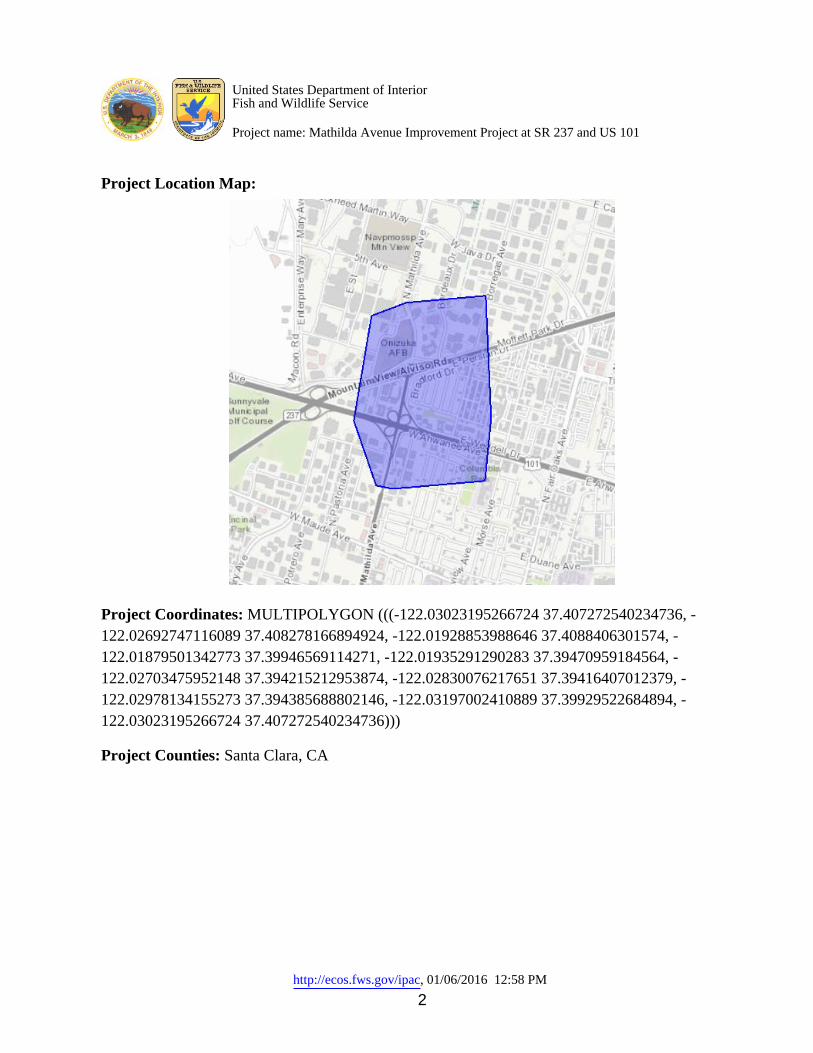
http://ecos.fws.gov/ipac, 01/06/2016 12:58 PM 2
Project Location Map:
Project Coordinates: MULTIPOLYGON (((-122.03023195266724 37.407272540234736, -122.02692747116089 37.408278166894924, -122.01928853988646 37.4088406301574, -122.01879501342773 37.39946569114271, -122.01935291290283 37.39470959184564, -122.02703475952148 37.394215212953874, -122.02830076217651 37.39416407012379, -122.02978134155273 37.394385688802146, -122.03197002410889 37.39929522684894, -122.03023195266724 37.407272540234736))) Project Counties: Santa Clara, CA
United States Department of InteriorFish and Wildlife Service
Project name: Mathilda Avenue Improvement Project at SR 237 and US 101

http://ecos.fws.gov/ipac, 01/06/2016 12:58 PM 3
Endangered Species Act Species List
There are a total of 12 threatened or endangered species on your species list. Species on this list should be considered in
an effects analysis for your project and could include species that exist in another geographic area. For example, certain
fish may appear on the species list because a project could affect downstream species. Critical habitats listed under the
Has Critical Habitat column may or may not lie within your project area. See the Critical habitats within your
project area section further below for critical habitat that lies within your project. Please contact the designated FWS
office if you have questions.
Amphibians Status Has Critical Habitat Condition(s)
California red-legged frog (Rana
draytonii)
Population: Entire
Threatened Final designated
California tiger Salamander
(Ambystoma californiense)
Population: U.S.A. (Central CA DPS)
Threatened Final designated
Birds
California Clapper rail (Rallus
longirostris obsoletus)
Population: Entire
Endangered
California Least tern (Sterna
antillarum browni)
Endangered
western snowy plover (Charadrius
nivosus ssp. nivosus)
Population: Pacific coastal pop.
Threatened Final designated
Crustaceans
Vernal Pool tadpole shrimp
(Lepidurus packardi)
Endangered Final designated
United States Department of InteriorFish and Wildlife Service
Project name: Mathilda Avenue Improvement Project at SR 237 and US 101

http://ecos.fws.gov/ipac, 01/06/2016 12:58 PM 4
Population: Entire
Fishes
Delta smelt (Hypomesus
transpacificus)
Population: Entire
Threatened Final designated
steelhead (Oncorhynchus (=salmo)
mykiss)
Population: Northern California DPS
Threatened Final designated
Flowering Plants
California seablite (Suaeda
californica)
Endangered
Insects
Bay Checkerspot butterfly
(Euphydryas editha bayensis)
Population: Entire
Threatened Final designated
San Bruno Elfin butterfly (Callophrys
mossii bayensis)
Population: Entire
Endangered
Mammals
Salt Marsh Harvest mouse
(Reithrodontomys raviventris)
Population: wherever found
Endangered
United States Department of InteriorFish and Wildlife Service
Project name: Mathilda Avenue Improvement Project at SR 237 and US 101

http://ecos.fws.gov/ipac, 01/06/2016 12:58 PM 5
Critical habitats that lie within your project areaThere are no critical habitats within your project area.
United States Department of InteriorFish and Wildlife Service
Project name: Mathilda Avenue Improvement Project at SR 237 and US 101
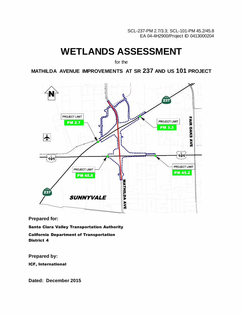
SCL-237-PM 2.7/3.3; SCL-101-PM 45.2/45.8 EA 04-4H2900/Project ID 0413000204
WETLANDS ASSESSMENT for the
MATHILDA AVENUE IMPROVEMENTS AT SR 237 AND US 101 PROJECT
Prepared for:
Santa Clara Valley Transportation Authority
California Department of Transportation
District 4
Prepared by:
ICF, International
Dated: December 2015

For individuals with sensory disabilities, this document is available in Braille, in large print, on audiocassette, or on computer disk. To obtain a copy in one of these alternative formats, please write to Caltrans, Attn: Elizabeth White, Office of Environmental Planning, 111 Grand Avenue, Oakland, CA 94623-0660; or call (510) 286-6233 (voice); or use the California Relay Service TTY number, (800) 735-2929.


Mathilda Avenue Improvements at SR 237 and US 101
This page intentionally left blank.

Project Introduction and Purpose
TheCaliforniaDepartmentofTransportation(Caltrans),incooperationwiththeSantaClaraValleyTransportationAuthority(VTA)andtheCityofSunnyvale,isproposingthe“MathildaAvenueImprovementsatSR237andUS101Project”(Project)toimproveMathildaAvenueintheCityofSunnyvalefromAlmanorAvenuetoInnovationWay,includingon‐andoff‐rampimprovementsatSR237/MathildaAvenueandUS101/MathildaAvenueinterchanges.TheprimarypurposeoftheProjectistoimprovetrafficoperationsonMathildaAvenuethroughtheUS101andSR237interchanges.Figure1(AttachmentA)showsthelocationoftheProject.ICFInternational(ICF)conductedadelineationofwatersoftheUnitedStateswithintheBiologicalStudyArea(BSA)oftheProjectinMarchandJuly2015.
Site Description
TheProjectsiteislocatedwithintheCityofSunnyvaleinSantaClaraCounty,California(Figure1,AttachmentA).ItoccursintheMountainViewU.S.GeologicalSurvey(USGS)7.5‐minutequadrangle.TheBSAfortheProjectisbasedontheProject’slimits(Figure2,AttachmentA).OnSR237,theProjectlimitsarefrom0.3‐mileeastoftheUS101/SR237interchange(postmile[PM]2.7)to0.3‐mileeastoftheMathildaAvenueundercrossing(PM3.3).OnUS101,theProjectlimitsarefrom0.3‐milesouthofMathildaAvenueovercrossing(PM45.4)to0.3‐milesouthofSR237/US101interchange(PM45.8).ThetotallengthoftheProjectonMathildaAvenueisapproximatelyonemile.TheBSAincludesaproposedroadthatwouldconnectMathildaAvenuetoBordeauxDrive;however,thisroadwouldbecompletedbytheMoffettPlaceProjectseparatefromtheMathildaAvenueImprovementsatSR237andUS101Project.TheMathildaAvenueImprovementsatSR237andUS101ProjectproposestoconstructtrafficsignalsandpaintbicyclelanesontheroadafteritisconstructedbytheMoffettPlaceProject.
ElevationsintheBSArangefromapproximately15feetinlow‐lyingareasto40feetonraisedhighwayramps(GoogleEarthPro2015).TopographywithintheBSAisrelativelyflatwithagentleslopedownwardsfromUS101toSR237.TheBSAhasanestimatedmeanannualtemperatureof59degreesFahrenheitandanestimatedmeanannualprecipitationof15.71inches(U.S.DepartmentofAgriculture,NaturalResourcesConservationService2015).
Vegetation
LandcovertypeswithintheBSAincludedevelopedareas(existingroadways,parkinglots,etc.),ornamentallandscaping,andruderalgroundcover.Typicalornamentallandscapingspeciesincludepurplelantana(Lantanamontevidensis),peppertree(Schniusmolle),floweringcherry(Prunusserrulata),deodarcedar(Cedrusdeodara),silver‐dollargum(Eucalyptuspolyanthemos),southernmagnolia(Magnoliagrandiflora),whiteLadyBanksrose(Rosabanksiae),andolive(Oleaeuropaea),tonameafew.Theruderalgroundcoverconsistspredominantlyofwildoat(Avenasp.),ripgutgrass(Bromusdiandrus),summermustard(Hirschfeldiaincana),Italianthistle(Carduuspycnocephalussubsp.pycnocephalus),bristlyox‐tongue(Helminthothecaechioides),smilograss(Stipamiliaceaevar.miliaceae),andpricklylettuce(Lactucaserriola).
Soil
SoilattheProjectsiteiscomposedofUrbanland‐Hangeronecomplexwith0to2percentslopes,drained(Figure3,AttachmentA).TheUrbanland‐HangeronecomplexislistedashydricbytheU.S.

Mathilda Avenue Improvements at SR 237 and US 101 December 2015 Page 2 of 5
DepartmentofAgriculture,NaturalResourcesConservationService(USDANRCS2014).Themajorsoiltypesinthismapunitareurbanland(70%)andHangerone(25%)withinclusionsofBayshore(2%),ClearLake(2%),andEmbarcadero(1%).Themapunitaggregateddataindicatethatthesoilstypicallyoccuronbasinfloorsandarepoorlydrained(NaturalResourcesConservationService2013).
Hydrology
StormwaterdrainageditchesandtheSunnyvaleWestChanneloccurwithintheBSA(Figure4,AttachmentA).Theditchesdrainstormwaterrunoffduringraineventsbutflowdoesnotpersistafterrainevents.TheSunnyvaleWestChannelprovidesfloodcontrolprotectionandwaterflowsthroughthechanneltotheSanFranciscoBayviaGuadalupeSlough(Figure5,AttachmentA).TheSunnyvaleWestChannelwasconstructedinthe1960sinresponsetofloodingcausedbyacombinationofmajorstormevents,landsubsidence,andinadequatedrainagetotheSanFranciscoBay(SantaClaraValleyWaterDistrict2015).
Methods
Priortoconductingfieldwork,ICFreviewedU.S.FishandWildlifeService’sWetlandsMapper(USFWS)(U.S.FishandWildlifeService2015)andGoogleEarthaerialimagery(GoogleEarthPro2015)toidentifyareaswiththepotentialtosupportwatersoftheUnitedStates,basedonapparentsignaturesofhydrology,topography,and/orvegetationcomposition.
ICFwetlandspecialistsconductedthedelineationfieldworkonMarch6andJuly29,2015withintheBSA.Bothsitevisitsoccurredondayswithnoprecipitation.Thedelineationwasconductedusingtheroutineonsitedeterminationmethoddescribedinthe1987U.S.ArmyCorpsofEngineersWetlandsDelineationManual(EnvironmentalLaboratory1987)andthesupplementalproceduresandwetlandindicatorsprovidedintheRegionalSupplementtotheCorpsofEngineersWetlandDelineationManual:AridWestRegion(U.S.ArmyCorpsofEngineers2008a).DelineationdatawerecollectedtosupportapreliminaryjurisdictionaldeterminationfromU.S.ArmyCorpsofEngineers(USACE).
Wetlandboundariesweredeterminedbyestablishingrepresentativesamplingpointstoevaluatethepresenceofpositiveindicatorsofhydrophyticvegetation,hydricsoil,andwetlandhydrology.Theboundariesofnonwetlandwaters(otherwaters)intheBSAwereidentifiedbylocatingtheordinaryhighwatermark(OHWM),whichrepresentsthelaterallimitofUSACEjurisdictionovernon‐tidal,non‐wetlandwatersintheabsenceofadjacentwetlands(33CodeofFederalRegulations[CFR]328.4[c]).TheOHWMofintermittentstreamswasidentifiedusingthefieldindicatorsprovidedin33CFR328.3(e)and329.11(a)(1)andAFieldGuidetotheIdentificationoftheOrdinaryHighWaterMarkintheAridWestRegionoftheWesternUnitedStates(U.S.ArmyCorpsofEngineers2008b).HistoricandcurrentSection10watersdonotoccurwithintheBSAand,therefore,werenotevaluatedduringthedelineation.
ThebasemapusedduringfieldworkconsistedoftheBSAoverlaidon2012aerialimageryobtainedfromMicrosoftBingMapsatascaleof1″=50'.Thedelineatorsusedaresource‐gradeGPS(globalpositioningsystem)unitwithsub‐meteraccuracy,supplementedwithaerialphotographinterpretation,tomapsamplingpoints,theboundariesofwetlandsandotherwaters,andthe

Mathilda Avenue Improvements at SR 237 and US 101 December 2015 Page 3 of 5
locationsofrepresentativephotosintheBSA.AllGPSdatacollectedinthefieldweredownloadedanddifferentiallycorrectedusingthenearestavailablebase‐stationdatatoproducethedelineationmaps.
Results
TheSunnyvaleWestChanneloccurswithinthenorthwesternareaoftheBSA(Figure4,AttachmentA).TheSunnyvaleWestChannelisassumedtobesubjecttoUSACEjurisdictionunderSection404oftheCleanWaterAct(CWA)andthuswasidentifiedbyICFasawateroftheUnitedStates.
NootherpotentialwatersoftheUnitedStates,includingSection404wetlandsandnonwetlandwatersorSection10waters,wereobservedwithintheBSA.NonjurisdictionalstormwaterdrainageditcheswerenotedalongtheeasternboundaryofMathildaAvenueandwithinthetrafficcircles(Photos1‐3,AttachmentB).
Vegetation
Hydrophyticvegetationindicators(1‐DominanceTest,2‐PrevalenceTest,or3‐MorphologicalAdaptations)describedinRegionalSupplementtotheCorpsofEngineersWetlandDelineationManual:AridWestRegion(U.S.ArmyCorpsofEngineers2008a)werenotobservedwithintheBSA.
Soil
HydricsoilindicatorsdescribedintheRegionalSupplement(U.S.ArmyCorpsofEngineers2008a)werenotobservedwithintheBSA.
Hydrology
IndicatorsofwetlandhydrologydescribedintheRegionalSupplement(U.S.ArmyCorpsofEngineers2008a)werenotobservedwithintheBSA.
Discussion
TheSunnyvaleWestChannelisaconcrete‐lined,culvertedchannelthatisassumedtobeajurisdictionalfeatureduetoitsdirecthydrologicconnectiontotheSanFranciscoBay(Figure5,AttachmentA).
TheditchesobservedwithintheBSAdonotmeetthetechnicalcriteriatoqualifyaswatersoftheUnitedStatesbasedontheCleanWaterRule:Definitionof“WatersoftheUnitedStates”;FinalRule(USACE2015,USEPA2015).Theditchesareexcavatedindryland,anddonotdrainwetlandsorrelocatetributaries.Theditchesdrainstormwaterrunoffduringrainevents,butflowdoesnotpersistafterrainevents.Wherethereisvegetationassociatedwiththeditches,insteadofbaregroundorgravel/cobble,thevegetationconsistsofruderalorweedyspeciesincludingwildoat,Italianthistle,andripgutgrass(Photos1‐3,AttachmentB).

Mathilda Avenue Improvements at SR 237 and US 101 December 2015 Page 4 of 5
Conclusions
TheSunnyvaleWestChannelisassumedtobesubjecttoUSACEjurisdictionunderCWASection404.OtherwatersoftheUnitedStatesarenotpresentintheBSAorProjectsite.AportionoftheSunnyvaleWestChanneloccurswithintheBSA(specificallyattheproposedroadconnectingMathildaAvenueandBordeauxDrive);however,asmentionedabove,thisproposedconnectionwouldbeconstructedbytheMoffettPlaceProject,nottheMathildaAvenueImprovementsatSR237andUS101Project.BecausetheMathildaAvenueImprovementsatSR237andUS101ProjectwillnotaffecttheSunnyvaleWestChannel,aSection404permitfromtheUSACEshouldnotberequiredtoauthorizeProjectconstruction.
References
EnvironmentalLaboratory.1987.CorpsofEngineersWetlandsDelineationManual.(TechnicalReportY‐87‐1.)Vicksburg,MS:U.S.ArmyWaterwaysExperimentStation.
GoogleEarthPro.2015.MathildaAvenueImprovementsatSR237andUS101.37°24’2.31”Nand122°1’38.27”W.Accessed:March2015.
NaturalResourcesConservationService.2013.WebSoilSurvey.Available:http://websoilsurvey.sc.egov.usda.gov/App/HomePage.htm.Accessed:August19,2015.
SantaClaraValleyWaterDistrict.2015.SunnyvaleEastandWestChannelsFloodProtectionProject.Available:http://www.valleywater.org/uploadedFiles/Services/FloodProtection/Projects/SunnyvaleEastandWestChannelsFloodProtectionProject/Fact%20Sheet_Sunnyvale%20EW%20Channels%20042115.pdf?n=3115.Accessed:September4,2015.
U.S.ArmyCorpsofEngineers(USACE).2008a.RegionalSupplementtotheCorpsofEngineersWetlandsDelineationManual:AridWestRegion(Version2.0).J.S.Wakeley,R.W.Lichvar,andC.V.Noble(eds.).ERDC/ELTR‐08‐28.Vicksburg,MS:U.S.ArmyEngineerResearchandDevelopmentCenter.
____________.2008b.AFieldGuidetotheIdentificationoftheOrdinaryHighWaterMarkintheAridWestRegionoftheWesternUnitedStates.R.W.LichvarandS.M.McColley.ERDC/CRRELTR‐08‐12.Hanover,NH:U.S.ArmyEngineerResearchandDevelopmentCenter.Available:http://www.spk.usace.army.mil/Portals/12/documents/regulatory/pdf/Ordinary_High_Watermark_Manual_Aug_2008.pdf.Accessed:August19,2015.
____________.2015.CleanWaterRule:Definitionof“WatersoftheUnitedStates”;FinalRule.33CFRPart328.
U.S.DepartmentofAgriculture(USDA),NaturalResourcesConservationService(NRCS).2014.NationalList;allstates.Available:http://www.nrcs.usda.gov/wps/portal/nrcs/main/soils/use/hydric/.Accessed:September8,2015.
U.S.DepartmentofAgriculture(USDA),NaturalResourcesConservationService(NRCS).2015.WETSTabledocumentationforthePaloAltocooperativeweatherstation(stationCA6646),

Mathilda Avenue Improvements at SR 237 and US 101 December 2015 Page 5 of 5
California.Available:http://www.wcc.nrcs.usda.gov/climate/navigate_wets.html.Accessed:September4,2015.
U.S.EnvironmentalProtectionAgency(USEPA).2015.CleanWaterRule:Definitionof“WatersoftheUnitedStates”;FinalRule.40CFRParts110,112,116,117,122,230,232,300,302,and401.
U.S.FishandWildlifeService.2015.WetlandsMapper.Available:http://www.fws.gov/wetlands/data/mapper.HTML.Accessed:March2015.


Attachment A Figures


Figure 1Project Vicinity
Mathilda Avenue Improvements at SR 237 and US 101
Path:
K:\Pr
ojects
_3\VT
A\005
22_1
3\map
doc\C
ultura
l\Figu
re_1_
Proje
ct_Vic
inity_
2015
1208
.mxd
; Use
r: 194
02; D
ate: 1
2/8/20
15
_Project
Area
SolanoMarin
SanJoaquin
ContraCosta
AlamedaSanMateo
SantaClara
SantaCruz
SanBenito
Monterey
0 21Miles´
LegendProject Area

£¤101
UV237
Mathi
lda A
ve
Figure 2Biological Study Area
Mathilda Avenue Improvements at SR 237 and US 101 Project
Path:
K:\Pr
ojects
_3\VT
A\005
22_1
3\map
doc\F
ig_02
_Bio_
Study
_Area
_201
5121
4.mxd
; Use
r: 194
02; D
ate: 1
2/14/2
015
0 500250Feet
Source: Imagery; NAIP 2014
LegendBiological Study AreaRoadwork within thissection to beconstructed by a projectother than the MathildaAvenue Improvementsat SR 237 and US 101Project

£¤101
UV237Ma
thilda
Ave
Figure 3Soils
Mathilda Avenue Improvements at SR 237 and US 101 Project
Path:
K:\Pr
ojects
_3\VT
A\005
22_1
3\map
doc\F
ig_03
_Soil
s_20
1512
14.m
xd; U
ser: 1
9402
; Date
: 12/1
4/201
5
0 1,000500Feet
Source: Soils, SSUGRO 2014
LegendBiological Study Area
Soil TypeUrban Land - Bayshore complex, 0 to 2 percent slopes, drainedUrbanland-Campbell complex, 0 to 2 percent slopes, protectedUrbanland-Hangerone complex, 0 to 2 percent slopes, drained

SunnyvaleWest Channel
ST237
£¤101
Madrone Ct
E EaglewoodAveS FernwoodCir
E PersianDr
Sant
aCo
leta C
t
W Fe
rnwo
odCi
r
EurekaCt
Sant
aCh
ristin
a Ct
D St
W DuaneAve
Persian Dr
Big
Siky
Trl
CapeCod Vlg
E HemlockAve
E FerndaleAve
Del Norte Ave
Plaza Dr
BridgewaterCors
W HemlockAve
Cape
Cod
Cors
A St
Haml
in C
t
W Ferndale Ave
Colto
n Ave
Pine
Ave
E Weddell DrAhwanee Ave
Manz
anita
Ave
Manila Dr
Dunc
an Av
e
G St
Madr
one
Ave
Alturas Ave
Fulto
n Ave
Esse
x Ave
Fall
Rive
r Cor
s
Sand
yHo
ok C
ors
E St
W EaglewoodAve
Garner Dr
9th Ave
N Ma
ry A
ve
Innov
ation
Way
C St
W Persian Dr
San D
iego A
ve
Bord
eaux
Dr
Del Rey Ave
Bradford Dr
Vaqu
eros
Ave Sa
n Ales
o Ave
Palom
ar A
ve
Ross Dr
Almanor Ave
W Weddell Dr
N Pa
stor
ia Av
e
Borre
gas A
veW Ahwanee Ave
8th Ave
Eleventh Ave
W Moffett
Park Dr
N Mathilda Ave
Figure 4Waters of the United States within the Biological Study AreaMa th ilda Ave nu e Im prove m e nts a t SR 237 a nd US 101 Proje ct
Path: K:\Projects_ 3\VTA\00522_ 13\ma pdoc\Fig _04_ Potenita lJu risdWate r_ Stu dyAre a_ 20151214.mxd; User: 19402; Da te: 12/14/2015
0 1,000500Fe e t´
Sou rce : Im a g e ry; NAIP 2014
LegendBiolog ica l Stu dy Are aR oa dwork with in th isse ction to b e constru cte dby a proje ct oth e r th a n th eMa th ilda Ave nu eIm prove m e nts a t SR 237a nd US 101 Proje ct
Waters of the United StatesFlood Control Ch a nne l(Unde rg rou nd)Flood Control Ch a nne l(Ope n)
Su b je ct to ve rifica tion by th e U.S. Arm y Corps of Eng ine e rsNote : Th e b a se m a p u se d du ring fie ldwork consiste d of th e b iolog ica l stu dy a re a ove rla id on 2012 a e ria l im a g e ry ob ta ine d from Microsoft a t a sca le of 1″= 50'.

£¤101
UV237
UV82
Central Expy
Evelyn Ave
Mathi
ldaAv
e
Kifer Rd
Fairo
aks A
ve
La wrence Expy
Arques Ave
Java Dr
C aribbean Dr
Duane Ave
Wolfe
Rd
Middlefield Rd
Mary
Ave
Bern
ardo A
ve
Oakmead Pky
Pasto
ria A
ve
Scott Blvd
Kifer Rd
Wolfe Rd
Figure 5Hydrological Connection of Sunnyvale West Channel and the San Francisco Bay
Mathilda Avenue Improvements at SR 237 and US 101 Project
Path:
K:\Pr
ojects
_3\VT
A\005
22_1
3\map
doc\F
ig_05
_Hyd
roCon
necti
onWS
unny
vale_
2015
1214
.mxd
; Use
r: 194
02; D
ate: 1
2/14/2
015
0 0.50.25Miles´
Source: Imagery; NAIP 2014; Guadalupe Slough and San Francisco Bay, NHD 2014
LegendBiological Study AreaSunnyvale West ChannelGuadalupe SloughSan Francisco Bay

Attachment B Photographs


Photo 1. Drainage parallel to Mathilda Avenue, facing south.

Photo 2. Drainage within the area immediately north of the Mathilda Avenue northbound to US 101 northbound interchange loop ramp, facing north.

Photo 3. Drainage within US 101 northbound to Mathilda Avenue southbound interchange loop ramp, facing southeast.