native vegetation clearance assessment report - … clearance that would be required by a chicane...
TRANSCRIPT

EBS & RCMB Page: 1 of 64
Ferries McDonald Road Redevelopment (From the Chauncey’s Line & Kangaroo Road Intersection to the South Eastern Freeway at
Monarto South)
Native Vegetation Clearance Assessment Report
Version 2 of January 2010
Prepared by:
Environmental & Biodiversity Services (EBS) And
The Rural City of Murray Bridge (RCMB)
EBS & RCMB Page: 2 of 64
Table of Contents
Preface .............................................................................................. 5
1 Introduction ................................................................................ 7 1.1 Project Background ................................................................................ 7 1.2 Project Location .................................................................................... 11
2 Impact Minimisation ................................................................. 13
2.1 Road Alternatives Considered .............................................................. 13 2.1 Vegetation Clearance Minimisation ...................................................... 17
3 Native Vegetation Description ................................................ 21
3.1 Vegetation Condition ............................................................................ 23
4 Vegetation Clearance ............................................................... 25
5 Assessment of Vegetation against the Principles of the Native Vegetation Act, 1991 ........................................................ 27
5.1 Discussion of Clearance Principles ...................................................... 31
6 Significant Environmental Benefit .......................................... 36
6.1 Payment of SEB ................................................................................... 38
7 Management Plan for SEB Revegetation Area ...................... 40
7.1 Methodology ......................................................................................... 40 7.2 Revegetation Species ........................................................................... 40 7.3 Seed Collection .................................................................................... 41 7.4 General Revegetation Principles .......................................................... 41 7.5 Site Preparation and Weed Control ...................................................... 42 7.6 Planting ................................................................................................. 42 7.7 Direct Seeding ...................................................................................... 42 7.8 Ongoing Maintenance ........................................................................... 43
8 Road Construction Environmental Management Plan .......... 45
9 References ................................................................................ 46
Appendix 1 - Scattered Tree Data ................................................... 48
Appendix 2 – Combined flora species recorded during the 2006 / 2010 survey ...................................................................................... 52

EBS & RCMB Page: 3 of 64
Appendix 3 – Vegetation association mapping of the proposed Ferries McDonald Road – Garwood Roads T Junction .................... 60
Appendix 4 – Vegetation condition mapping of the proposed Ferries McDonald Road – Garwood Roads T Junction .................... 61
Appendix 5 – Vegetation association mapping of the proposed Kangaroo Road southern intersection .............................................. 62
Appendix 6 – Vegetation condition mapping of the proposed Kangaroo Road southern intersection .............................................. 63
ATTACHMENT ONE:
RCMB Final Concept Drawing (18 June 2009) – Ferries McDonald Road Upgrade – Proposed Traffic Control Measures – Each End of Ferries McDonald Conservation Park (A3 Size, Separate PDF Colour Attachment).
This Drawing was included as an attachment with Council’s Revised EPBC Act Referral submission (v2 October 2009). This is also currently accessible on Council’s website at the following link:
http://www.murraybridge.sa.gov.au/site/page.cfm?u=371 (Sub link being “Proposed Traffic Control Measures”)

EBS & RCMB Page: 4 of 64
Tables
Table 1 - Vegetation Condition Categories ..................................................................... 23
Table 2 - Amounts of vegetation associations within each condition rating that are to
be cleared ....................................................................................................................... 25
Table 3 - Amounts of vegetation associations that are to be cleared ............................. 26
Table 4 – Summary assessment of native vegetation to Principles of the Native
Vegetation Act, 1991 ....................................................................................................... 28
Table 5 - Vegetation Condition Categories and SEB Ratios .......................................... 36
Table 6 - Calculation of Significant Environmental Benefit ............................................. 37
Table 7 - Description of Revegetation Zones ................................................................. 40
Table 8 - Revegetation Species List and Quantities ....................................................... 40
Table 9 - Program of Works ............................................................................................ 43
Figures
Figure 1 - Diagram extracted from Council’s Document accessible on the website
titled, ‘Ferries McDonald – Garwood Roads T Junction – design rationale’ ................ 9
Figure 2 - Plan showing location of Project – Approx 10 km south-west of Murray
Bridge, SA. ................................................................................................................. 12
Figure 3 – Minimisation of vegetation impact of the road alignment (proposed design
option 2) between the two bends opposite Monarto CP ............................................ 19
Figure 4 – Minimisation of vegetation impact of the Kangaroo Road Southern
intersection proposed options 1 and 2. ...................................................................... 20
Figure 5 - Proposed SEB Revegetation Zones ......................................................... 39
EBS & RCMB Page: 5 of 64
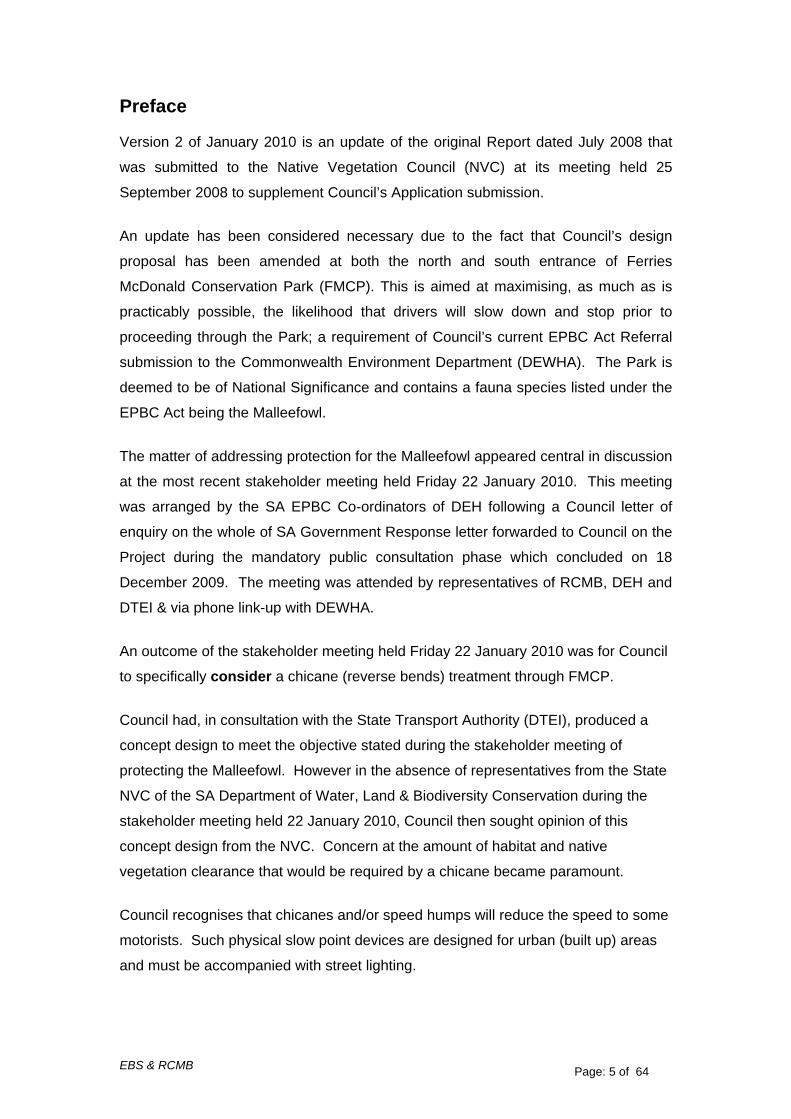
Preface
Version 2 of January 2010 is an update of the original Report dated July 2008 that
was submitted to the Native Vegetation Council (NVC) at its meeting held 25
September 2008 to supplement Council’s Application submission.
An update has been considered necessary due to the fact that Council’s design
proposal has been amended at both the north and south entrance of Ferries
McDonald Conservation Park (FMCP). This is aimed at maximising, as much as is
practicably possible, the likelihood that drivers will slow down and stop prior to
proceeding through the Park; a requirement of Council’s current EPBC Act Referral
submission to the Commonwealth Environment Department (DEWHA). The Park is
deemed to be of National Significance and contains a fauna species listed under the
EPBC Act being the Malleefowl.
The matter of addressing protection for the Malleefowl appeared central in discussion
at the most recent stakeholder meeting held Friday 22 January 2010. This meeting
was arranged by the SA EPBC Co-ordinators of DEH following a Council letter of
enquiry on the whole of SA Government Response letter forwarded to Council on the
Project during the mandatory public consultation phase which concluded on 18
December 2009. The meeting was attended by representatives of RCMB, DEH and
DTEI & via phone link-up with DEWHA.
An outcome of the stakeholder meeting held Friday 22 January 2010 was for Council
to specifically consider a chicane (reverse bends) treatment through FMCP. Council had, in consultation with the State Transport Authority (DTEI), produced a
concept design to meet the objective stated during the stakeholder meeting of
protecting the Malleefowl. However in the absence of representatives from the State
NVC of the SA Department of Water, Land & Biodiversity Conservation during the
stakeholder meeting held 22 January 2010, Council then sought opinion of this
concept design from the NVC. Concern at the amount of habitat and native
vegetation clearance that would be required by a chicane became paramount. Council recognises that chicanes and/or speed humps will reduce the speed to some
motorists. Such physical slow point devices are designed for urban (built up) areas
and must be accompanied with street lighting.

EBS & RCMB Page: 6 of 64
The intent of the Project is to implement the ‘2010 Transport Plan’ and complete a
sealed north-south transport corridor. The use of chicanes and/or speed humps will
act as a disincentive for transport vehicles and will not result in the achievement of
the project purpose. Therefore physical slow point devices are not being considered
for this project.
The RCMB Concept Drawing presented as Attachment One shows a proposed new
‘T-Intersection’ at the northern end of FMCP where currently the road is straight and
unimpeded. At the southern end of FMCP, an existing ‘Staggered T-Intersection’
would need to now be further emphasised to maximise the condition that drivers slow
down and stop prior to proceeding through the Park. This Attachment was also
presented in Council’s EPBC Act Referral submission (v2 October 2009).
As was described in Council’s EPBC Act Referral (v2 October 2009), the proposed
concept design (Attachment One) aims to minimise, as much as is practicably
possible, impact on existing native vegetation with construction of the new road
portion at each end of FMCP (Ferries McDonald Road at the northern end and
Kangaroo Road at the southern end) diverting to avoid native vegetation along the
existing road reserve alignment, within the adjacent private properties and within
FMCP (ie Crown Land) which should not be affected by this design proposal.
Section 1.1 ‘Project Background’, pages 10-11 provides indication on Council’s preference being for diversion of Kangaroo Road to the east of Ferries McDonald Road. This updated Report is intended to present the facts regarding
minimisation of impact on remnant native vegetation clearance which is why an
assumption has been undertaken and progressed in the absence of further detailed
engineering survey and design being required to “explore” all possible “options” for
the Project.
The NVC has adopted an interim policy since Council’s original Report submission in
July 2008. Two new factors of note are that:
(1) Site values per hectare for individual councils have changed. The
calculations in Section 6.1 have therefore been updated to incorporate the
changes; and
(2) Changes to scoring native vegetation condition have also been amended by
the NVC since the July 2008 report. Section 3.1 of this report has therefore
been updated to reflect these changes.

EBS & RCMB Page: 7 of 64
1 Introduction
1.1 Project Background This Project will complete the final section in creating a sealed north–south regional
transport corridor designed to efficiently facilitate local and state vehicular traffic
across regions. The State Transport Authority (DTEI) have indicated support for the
Project based on a number of factors such as travel time, social impacts of heavy
vehicles travelling through populated areas, traffic demand, fitness for purpose
(vertical and horizontal alignment) and cost to upgrade an existing road to B-Double
standard.
The Project’s design aims to provide a safer road alignment; especially by minimising
two potentially dangerous bends along the presently unsealed (ie default 100 kph)
11.7 km stretch of Ferries McDonald Road.
This Project will show how formalising the remaining 11.7 km (approx) of Ferries
McDonald Road as a sealed road would provide opportunity to influence driver
behaviour through regulatory speed environments, physical geometry of
intersections, road surface texture, signage and other visual cues such as narrow
carriageway width, alternate road surface colour and reinforcing the fact to motorists
that they are entering an environmentally sensitive area. Furthermore, a road that is
sealed is without any doubt safer to drive on than a road that is not sealed. It is
highly likely that a driver presented with a sudden braking situation; such as to avoid
collision with a kangaroo or Malleefowl, would more likely succeed in stopping within
time to avoid collision on a sealed road than on an unsealed road.
The sealing of Ferries McDonald Road would allow the opportunity for drivers to be
governed by an appropriately posted speed limit. Discussions with DTEI have been
encouraging but have not been so fruitful as to gain support for lowering the speed
limit to 60 kph through the Ferries McDonald Conservation Park (FMCP). DTEI have
indicated that a speed limit of 80 kph, although also not technically compliant, may
have some justification. This would require “special” Ministerial consent but does
have the “support-in-principle” of relevant DTEI Managers who would advise the
Transport Minister on such matters.

EBS & RCMB Page: 8 of 64
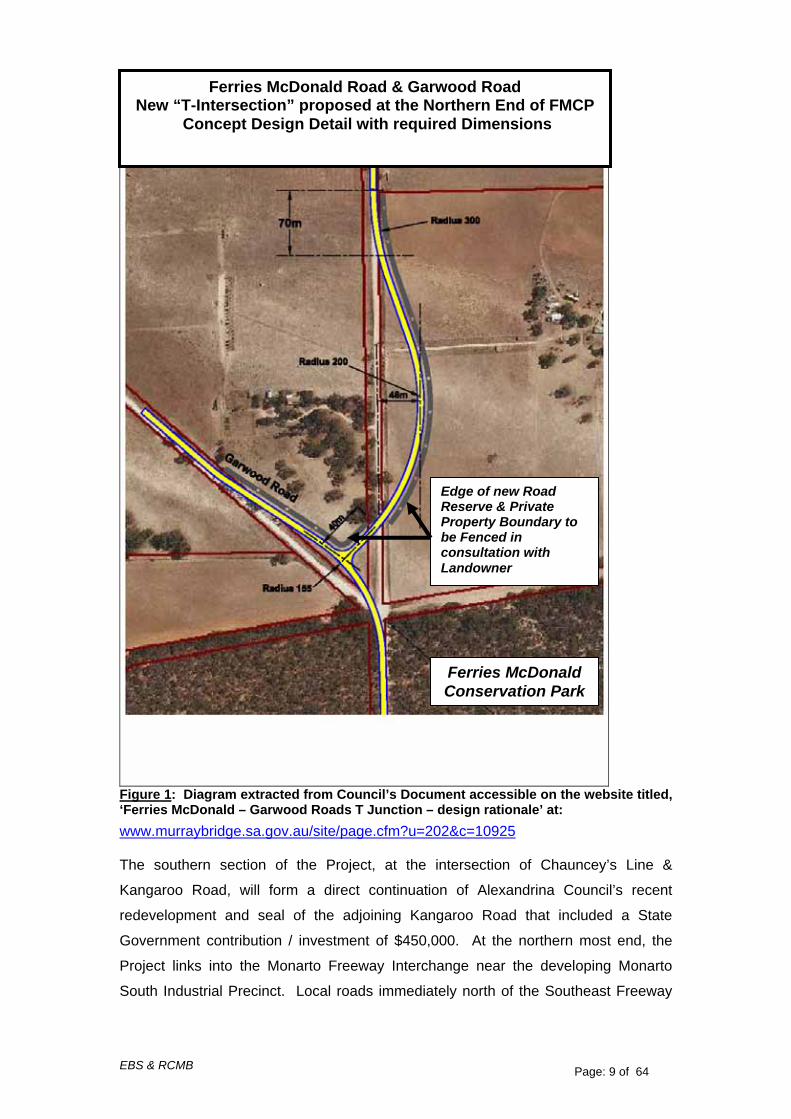
As noted in the Preface of this Version 2 of January 2010 Report, Council’s proposal
includes re-arranging the road alignment at both the north and south entrances of
FMCP to enforce drivers to slow down and stop prior to proceeding through the Park.
A critical design aim for the area will be to minimise impact as much as possible on
existing native vegetation along the existing road reserve alignment, within the
adjacent private properties and within FMCP which should not be affected at all by
this design proposal. This is shown in Council’s concept design rationale provided
overleaf on page 5 as Figure 1 and accessible on Council’s website at:
www.murraybridge.sa.gov.au/site/page.cfm?u=202&c=10925
Two Documents showing the new northern intersection at the above link address are:
Ferries McDonald – Garwood Roads T Junction – design rationale
Ferries McDonald – Garwood Roads T Junction – concept design plans
EBS & RCMB Page: 9 of 64
Figure 1: Diagram extracted from Council’s Document accessible on the website titled, ‘Ferries McDonald – Garwood Roads T Junction – design rationale’ at: www.murraybridge.sa.gov.au/site/page.cfm?u=202&c=10925 The southern section of the Project, at the intersection of Chauncey’s Line &
Kangaroo Road, will form a direct continuation of Alexandrina Council’s recent
redevelopment and seal of the adjoining Kangaroo Road that included a State
Government contribution / investment of $450,000. At the northern most end, the
Project links into the Monarto Freeway Interchange near the developing Monarto
South Industrial Precinct. Local roads immediately north of the Southeast Freeway
Ferries McDonald Road & Garwood Road New “T-Intersection” proposed at the Northern End of FMCP
Concept Design Detail with required Dimensions
Edge of new Road Reserve & Private Property Boundary to be Fenced in consultation with Landowner
Ferries McDonald Conservation Park

EBS & RCMB Page: 10 of 64
at Monarto (Schenscher Road – Pallamana Road – Wagenknecht Road) have also
been upgraded to B-Double standard with Commonwealth funding. Ferries McDonald Road is also indicated as a “major road” in the current draft SA
Government 30 Year Plan for Greater Adelaide (2009: p179 Map F7 - Adelaide
Hills and Murray Bridge Directions).
This updated Report (Version 2) shows that two design alterations can occur at the
southern most point of the project with the design of Kangaroo Road as it
approaches to intersect with Chauncey’s Line Road. The design options are for
Kangaroo Road to be diverted either east or west of Ferries McDonald Road.
Council has been left in a position to weigh up many opinions from various
stakeholders (DEWHA, DEH, NVC, and DTEI); including pros and cons of all
possible options and explaining the intent or rationale of the option while also being
mindful of the time and cost continually being afforded to planning and design
“options”. This leaves Council with the task of deciding how much time and money
should be afforded to “exploring” or “proving” the benefit of each possible “option”.
This process involves weighing up benefit and need of developing a concept design
or progressing further with a detailed survey and design.
The concept plan presented as Attachment One showing diversion of Kangaroo
Road to the east was an outcome of a design meeting held in June 2009 between
Council and DTEI. This meeting was to satisfy requirements being made by the
Commonwealth Environment Department (DEWHA) regarding preservation of
Malleefowl (an EPBC listed fauna species) and Council being asked to prove how
traffic will be slowed; particularly as drivers approach and traverse through the 2 km
stretch of Ferries McDonald Conservation Park (FMCP). This objective must also be
weighed up with considering impact on the surrounding habitat that includes native
vegetation and traffic engineering design “options” that would be workable and
compliant to traffic design standards for a safe freight route intended for B-Double
vehicles which measure at approximately 26 metres in length.
The possible diversion of Kangaroo Road to the west of Ferries McDonald Road Is
diagrammatically presented in this report as Figure 4 (refer Section 2.1 ‘Vegetation
Clearance Minimisation’, page 19).
In the absence of detailed engineering designs, Council’s preference is for diversion of Kangaroo Road to the east of Ferries McDonald Road.

EBS & RCMB Page: 11 of 64
This Report however shows comparisons of each option (east & west diversion of
Kangaroo Road) on the existing native vegetation in the area possible for the new
“exaggerated” southern T-Intersections as is required by the Commonwealth
Environment Department (DEWHA) where Council must “prove” an objective of how
traffic will be slowed prior to entering FMCP.
For this updated NVC Report, Council considered it prudent to present available data
and information on the two possible options to the Native Vegetation Council. It is
hoped that detailed design could better inform Council’s decision and that NVC
clearance may be provided subject to this Condition.
With regard to calculations for the Significant Environmental Benefit (SEB) as per the
Native Vegetation Act 1991 (SA), an assumption in this Report is for diversion of
Kangaroo Road to the west of Ferries McDonald Road as this option appears to
represent a lesser impact on remnant native vegetation clearance. However as
stated above and subject to further detailed engineering design, Council’s preference is for diversion of Kangaroo Road to the east of Ferries McDonald Road.
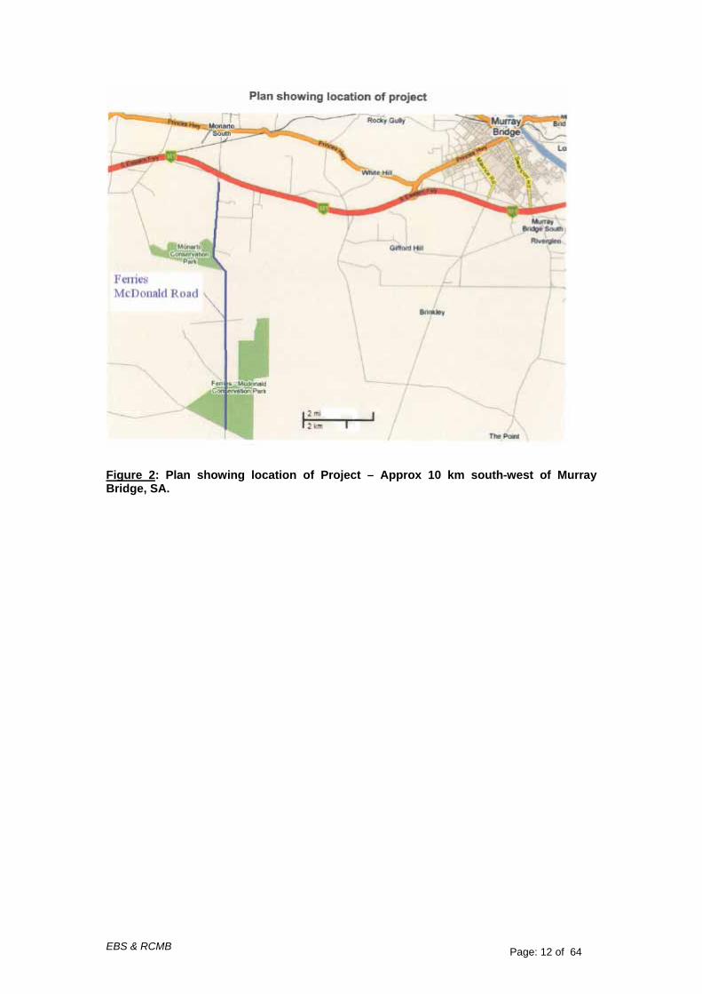
1.2 Project Location The Project, as shown overleaf in Figure 2, will be an upgrade of the existing
strategic network and will provide a transport corridor linking the Langhorne Creek
area to the Barossa Valley. The route has been identified as a significant transport
freight route in a number of studies.
The Project site is located approximately 10 km south-west of the Rural City of
Murray Bridge in South Australia, between the intersection of Bremer Range and
Ferries McDonald Roads (south of the South Eastern Freeway Bridge) and the
Intersection of Chauncey’s Line / Kangaroo / Ferries McDonald Road at the southern
end of Ferries McDonald Conservation Park. The overall length of the project area is
approximately 11.7 km. The majority of the project site occurs within the Local
Government Area of Murray Bridge Council (RC), the proposed Chaunceys Line
Road / Kangaroo Road intersection south of Chaunceys Line Road occurs within the
Local Government Area of Alexandrina.
EBS & RCMB Page: 12 of 64
Figure 2: Plan showing location of Project – Approx 10 km south-west of Murray Bridge, SA.

EBS & RCMB Page: 13 of 64
2 Impact Minimisation
2.1 Road Alternatives Considered Council has received State (Blackspot Program) and Federal (Auslink Program)
funding for the upgrade. Funding from Industry Partners has also been attained.
Federal funding for the upgrade will ensure the continued development of the north-
south corridor which will contribute to the local development of the Monarto
Industrial/Commercial Precinct, the Murraylands and Riverland Regions. In
conjunction with financial support from Project Partners, in-principle-support for the
upgrade has been provided by the State Transport Authority (DTEI), the Local
Government Association and the Office for Local Government, Murray & Mallee LGA
and the Local Government Grants Commission who as mentioned in part 3.2 on
page 12 administer the grant monies.
The state transport authority (DTEI) is “very supportive of the proposed upgrading of
Ferries McDonald Road to form part of a broader north-south freight route between
Langhorne Creek and the Barossa Valley”.
Consideration of route options included:
Travel Time
Social impacts of heavy vehicles travelling through populated
areas
Traffic demand
Fitness for purpose (vertical and horizontal alignment)
Cost (to upgrade to B-Double standard)
It has been noted that “the local roads immediately north of the Southeast Freeway at
Monarto (Schenscher Road – Pallamana Road – Wagenknecht Road) have also
previously been upgraded to B-Double standard utilising Commonwealth funding.
These roads link into the only existing B-Double route between the Southeast
Freeway and the Sturt Highway to the west of the River Murray. A route to the south
of the Freeway that links into these roads was considered to be a highly cost
effective approach to the provision of this important north-south freight route”.

EBS & RCMB Page: 14 of 64
The recent upgrading of Kangaroo Road, situated immediately south of Ferries
McDonald Road, included a State Government contribution / investment of $450,000
which also provides a sealed access for the Peat Soil and Garden Supplies
development (approved under EPBC 2002/874) as well as proposed support for
development of the north-south freight route.
Alternative routes would appear to “result in greater travel time and distance resulting
in increased costs to industry (such as via Callington), and have greater impacts
upon existing communities. Any route to the east would most likely result in heavy
vehicles travelling through Murray Bridge, unlike the proposed route. Routes further
to the west encounter hilly terrain and travel through numerous townships impacting
upon local residents”.
Source: Letter from DTEI Policy and Planning Division, Mr Mark Elford Director, Road Transport Policy and Planning, 7 November 2008, Council Trim Ref 08/29751. Furthermore, Executive Officer of the Southern & Hills Local Government Association
(S&HLGA) notes of the ‘2010 Transport Plan Addendum’ of 2004 that:
“The outcome of consultation on the plan, which involved all Councils and the
State Government over a number of months in 2004-2005 was the adoption
of Option 1B the Eastern North-South freight route from Langhorne Creek to
the Barossa Valley as - Langhorne Creek to Wellington Road, Kangaroo
Road, Ferries McDonald Road, Schenscher Road, Pallamana Road to
Pallamana, to Palmer, to Tungkillo, Tungkillo Road to Mt Pleasant, Mt
Pleasant to Nuriootpa via Eden Valley and a bypass of Angaston. Initial
assessment of the Palmer Tungkillo section of this route has identified that
significant works would be required to improve the alignment to meet a freight
route standard. The default eastern freight route is therefore Option 5 to the
Sturt Highway which does not affect the southern alignment.
Options 2, 3 and 4 were rejected by the stakeholders of the plan during the
consultation process and can not be considered as alternatives.
A significant issue must be that Kangaroo Road – Ferries McDonald Road
was submitted and endorsed by three local government regions, Central
Region, Murray and MalleeRegion and the Southern & Hills Region and the
State Government and approved under Auslink with funding from the State

EBS & RCMB Page: 15 of 64
Government, a developer and the two Councils, Alexandrina and Rural City of
Murray Bridge. The southern section of this project, Kangaroo Road has
been constructed to the Council boundary at the southern boundary of the
Ferries McDonald Conservation Park with work being completed in February
2008 under the approvals for the project”.
Source: Email: Mr Fred Pedler, Executive Officer S&HLGA, 28 October 2008,
Council Trim Ref 08/28811.
Several studies and reports have identified Ferries McDonald Road as requiring an
upgrade:
• Southern and Hills 2010 Transport Plan (2001) and Addendum (2004)
undertaken by engineering consultants QED;
• State Strategic Plan (2004);
• Murray and Mallee Regional Transport Study (2002) undertaken by
engineering consultants Connell Wagner;
• Regional Action Plan – Murraylands (2001) undertaken by engineering
consultants Brown and Root, Mack Consulting;
• SA Development Plan;
• Mt Lofty Ranges Central Regional Industry Strategy (2002) by Planning SA;
• Country Towns Structure Plan Study (2002) undertaken by Planning SA,
Transport SA and Department of Industry and Trade.
Ferries McDonald Road is also indicated as a “major road” in the current (2009:p179)
SA Government 30 Year Plan for Greater Adelaide (Map F7 - Adelaide Hills and
Murray Bridge Directions).
A public meeting held 10 March 2009 included presentation by Mr Kelvin Dobie, local
long-term resident of Monarto South.
Mr Dobie presented to Council a signed petition by forty-two local residents of
Monarto South who use Ferries McDonald Road on a daily basis. Residents were
asked, by the petition organisers, to express a preference from ‘Option 1’, ‘Option 2’
or ‘Option 3’ for the proposed road upgrade.
Each of the forty-two signatories on the petition that was presented to Council in
March 2009 expressed a preference for the road upgrade being ‘Option 1 with
EBS & RCMB Page: 16 of 64
culverts’. That is, the original design route that aims to maximise use of the existing
road alignment as much as possible and continues straight from the adjoining
Kangaroo Road upgrade and directly through Ferries McDonald Conservation Park
(FMCP).
Not one of the forty-two residents who signed the petition expressed a preference for
‘Option 2’; that is, to divert the route west along Chauncey’s Line Road and create a
new road along the western boundary of FMCP through privately owned paddocks.
Not one of the forty-two residents who signed the petition expressed a preference for
‘Option 3’; that is, a diversion proposal presented during the public consultation
meeting held on 17 December 2008 by a select handful of local residents named as
the Monarto Residents Association. This proposal indicates to “keep existing road
line” at each of the two “S” Bends and to seal Ferries McDonald Road for a small
section at the northern end near the SE Freeway. The proposal also heads out
toward Woodchester along Chauncey’s Line Road.
Given the observed incremental increase in heavy vehicle usage of Kangaroo and
Ferries McDonald Roads, Council continues to receive letters of support or
endorsement for the proposed project being the original design ‘Option 1’; that is, to
“hug” the existing road alignment. This is largely viewed as providing the best direct
and safest route of travel for all road users being local residents and commercial
vehicle operators who appear to be growing in number due to the emergence and
growth of the Monarto South Industrial Precinct area immediately north of the
proposed project site.
Other road alignments therefore cannot be created in this general area due to
feedback received from a majority of the local residents who use Ferries McDonald
Road on a daily basis as well as their voiced concerns to Council during the public
consultations which have been against ‘Option 2’ ie around western boundary of
FMCP as this is where the anecdotal sightings of Malleefowl have been and not
along the existing Ferries McDonald Road.
Any proposed option of fencing or culverts along Ferries McDonald Road has been
dismissed based on advice provided to Council by Dr Joe Benshemesh (EPBC Ref
2008/4211, Application Version 2 of October 2009:p8).

EBS & RCMB Page: 17 of 64
2.1 Vegetation Clearance Minimisation
The original ‘Native Vegetation Clearance Assessment Report’ (2008:p8) highlights
two road alignment design options in direct relation to potential vegetation impacts
that would be likely for the approximately one kilometre stretch between the two
bends along Ferries McDonald Road and adjacent to Monarto Conservation Park.
The EBS (April 2008), ‘Design Option 2 Vegetation Survey Report’ concludes for the
specified one kilometre stretch that:
“. . . two main variables have been assessed – the quantity of vegetation to
be cleared and the condition that it is in.
. . . under the original design the amount of native vegetation to be cleared is
0.31 hectares, while under design option 2 it is 0.16 hectares. This
represents a reduction in native vegetation clearance by 0.15 hectares or
approximately 50% under design option 2, and as such is considered to be a
significant reduction in the amount of native vegetation to be cleared.
Due to these facts design option 2 is considered to be the preferred option
that should be adopted by the Rural City of Murray Bridge”.
The above recommendation, in relation to the one kilometre stretch between the two
bends along Ferries McDonald Road and adjacent to Monarto Conservation Park is
what Council has adopted in the design and subsequent land negotiations with
adjoining landowners in order to minimise any vegetation impact (see Figure 3
below).
As noted in the Preface of this Version 2 of January 2010 Report, Council’s proposal
includes re-arranging the road alignment at both the north and south entrances of
FMCP to enforce drivers to slow down and stop prior to proceeding through the Park.
A critical design aim for the area will be to minimise impact as much as possible on
existing native vegetation along the existing road reserve alignment, within the
adjacent private properties and within FMCP which should not be affected at all by
this design proposal. This is shown in Council’s concept design rationale provided
on page 8 as Figure 1 and accessible on Council’s website at:
www.murraybridge.sa.gov.au/site/page.cfm?u=202&c=10925
Two Documents showing the new northern intersection at the above link address are:
EBS & RCMB Page: 18 of 64
Ferries McDonald – Garwood Roads T Junction – design rationale
Ferries McDonald – Garwood Roads T Junction – concept design plans
This Report (Version 2 of January 2010) provides information to the NVC on the two
design options that would be possible for the new Kangaroo Road portion at the
southern most point of the project area being either a diversion to the east of Ferries
McDonald Road (Attachment One) as was indicated in Council’s Revised EPBC Act
Referral Application submission in October 2009 or a diversion to the west of Ferries
McDonald Road (Figure 4). Both these options traverse through private property
and should not impact on DEH Crown Land (ie FMCP) at all.
Diversion of Kangaroo Road at the southern intersection end diverting east of Ferries McDonald Road would impact on 0.03ha of native vegetation in moderate to good condition and would require an SEB offset of 0.23ha.
Diversion of Kangaroo Road at the southern intersection end diverting west of Ferries McDonald Road would impact on 0.017ha of native vegetation in moderate condition and would require an SEB offset of 0.101ha.
From these figures being 0.03ha (east diversion) and 0.017ha (west diversion), a
reduced impact of 0.013ha regarding remnant native vegetation clearance could be
likely with the possible diversion option of Kangaroo Road to the west of Ferries
McDonald Road.
An appropriate Significant Environmental Benefit (SEB) as per the Native Vegetation
Act 1991 (SA) has thus been calculated by EBS at 1.172 hectares. This overall
figure amount is based on the amount of remnant native vegetation clearance with
the road alignment option being based on two comparisons: (i) between the two
bends opposite Monarto CP and (ii) for the southern most intersection at Kangaroo
Road. The latter (ii) comparison was not part of the original NVC Report submitted in
2008. As highlighted in Section 1.1, this Report in its calculations assumed a diversion to the west for Kangaroo Road. The exact SEB calculation for diversion to the east of Kangaroo Road, which is Council’s preference based on the concept design and being subject to a more detailed engineering design, could be provided to the NVC by EBS upon request. It is thought that this relatively minor detail would not necessarily halt possible clearance approval for the Project but more so may become a condition.
EBS & RCMB Page: 19 of 64
Figure 3 – Minimisation of vegetation impact of the road alignment (proposed design option 2) between the two bends opposite Monarto CP

EBS & RCMB Page: 20 of 64
Figure 4 – Minimisation of vegetation impact of the Kangaroo Road Southern intersection proposed options 1 and 2.
Diagrammatic representation of the new Kangaroo Road – east or west diversion option – aimed to “exaggerate” the intersection in an effort to slow down or stop traffic prior to entering FMCP as required by DEWHA for clearance under the commonwealth EPBC Act

EBS & RCMB Page: 21 of 64
3 Native Vegetation Description
In addition to the initial ecological assessment undertaken by Environmental and
Biodiversity Services (EBS) in December 2006, further assessment was undertaken
during January 2010 for (a) the Garwood Road & Ferries McDonald Road proposed
intersection and (b) the Chauncey’s Line Road & Kangaroo Road proposed
intersection.
To assess the flora and fauna in the survey area, government database searches
(e.g. the Commonwealth Protected Matters Search Tool, the Department for
Environment and Heritage (SA DEH) Biological Database and the South Australian
Museum Database), a vegetation survey and a fauna assessment were undertaken.
Following the assessment, a Flora and Fauna Assessment report was produced by
EBS (2008). Some of the findings of that report are provided in this report; however
the report in its entirety is accessible on Council’s website at
http://www.murraybridge.sa.gov.au/site/page.cfm?u=371 as “EBS Final Report”.
Findings from the 2010 EBS field survey will also form the basis of this updated
Report submission to the NVC.
The survey area is defined by a vegetated roadside reserve (Ferries McDonald
Road) approximately 11.7 kilometers long. Overall, the width of the roadside reserve
on either side of Ferries McDonald Road ranges between 5m to 25 m. The majority
of the roadside reserve is surrounded by agricultural land, particularly on the northern
half of the road. Along the southern section of the survey area Ferries McDonald
Conservation Park and other remnants of native vegetation are located adjacent to
certain stretches.
The proposed intersections located at Garwood Road & Ferries McDonald Road
(north of FMCP) and Chauncey’s Line Road & Kangaroo Road (south of FMCP)
occur primarily within agriculture land dominated by exotic grasses and herbaceous
weeds adjacent Ferries McDonald Road Conservation Park. Scattered natives such
as Lomandra leucocephala ssp. robusta (Woolly Mat-rush) and Vittadinia
australasica (Sticky New Holland Daisy) occur within the road reserve along the
northern edge of Garwood Road and are considered to be in poor condition
(Appendix 3 & Appendix 4). Remnants of native vegetation occur at the south east
land parcel of Chauncey’s Line and Kangaroo Road intersection as well as within
road reserves of Chauncey’s Line Road. This vegetation was found to be in varying

EBS & RCMB Page: 22 of 64
conditions (Appendix 5 & Appendix 6) and dominated by Eucalyptus incrassata
(Ridge-fruited Mallee), Melaleuca uncinata (Broombush) and Eucalyptus leptophylla
(Narrow-leaf Red Mallee). Extensive revegetation has been undertaken with the
parcel of land west of Kangaroo Road being approximately 4-5 years old with varying
survival rates. A search of the Significant Environmental Benefit offset datasets
revealed that the revegetation occurring within the proposed southern intersection
has not been undertaken as an NVC SEB Offset.
The vegetation survey was undertaken in accordance with SA NVC assessment
methodology. In the methodology used the roadside was divided into segments, with
the segment changing when the vegetation association or vegetation condition
changes. During the survey each segment was allocated a vegetation association
and a vegetation condition score.
The site consists of patches of remnant native vegetation interspersed with patches
of cleared areas and revegetation areas. Twelve vegetation associations were
recorded, including two non-native vegetation associations. Two of these vegetation
associations; Allocasuarina verticillata (Drooping Sheoak) Low Woodland and
Eucalyptus porosa (Mallee Box) Woodland are considered to have conservation
significance in the region.
A total of nine flora species and 14 fauna species of national significance are listed
under the EPBC Act, 1999 as possibly occurring within the project area. A further 19
flora and 26 fauna species of state conservation significance have been recorded
within close proximity to the survey area. A total of 661 flora and 208 fauna species
have been previously recorded within close proximity to the survey area. These
include 155 flora species of conservation significance and 38 fauna species of
conservation significance (EBS January 2007).
The combined vegetation surveys recorded a total of 143 flora species (Appendix 2)
within the project area, with 114 being native, and 40 being exotic species. Of these
16 were of conservation significance; one being of national conservation significance,
four being of state conservation significance and 11 being of regional conservation
significance. Eighteen fauna species were recorded during the survey, none of which
are of conservation significance.
Most vegetation in the Ferries McDonald road reserve is significant as habitat for a
number of threatened (and non-threatened) flora and fauna, and as a dispersal
corridor for native fauna. Due to the close proximity to Ferries McDonald and

EBS & RCMB Page: 23 of 64
Monarto Conservation Park, and adjacent patches of remnant vegetation, many
native fauna species are considered likely to or are known to utilise this habitat.
Additionally, significant sections of the road reserve contain moderate to high quality
remnant native vegetation within an area that has been significantly over cleared.
3.1 Vegetation Condition
An assessment of vegetation condition along the entire length of Ferries McDonald
Road was made during both the 2007 survey and the 2010 field survey of Garwood
Road / Ferries MacDonald Road and Chauncey’s Line Road / Kangaroo Road
proposed intersections. The condition rating records the extent to which exotic
vegetation has replaced the native understorey species. This was recorded for each
segment of vegetation on both sides of the road and the proposed intersections, and
is a subjective assessment that is based upon and rated relative to the probable “pre-
European” settlement state of the vegetation.
Condition categories used were chosen to match the categories used in the Native
Vegetation Council’s Significant Environmental Benefit interim policy, and also are
consistent with standard condition categories used for many vegetation surveys.
Table 1 below explains the condition categories used.
Table 1 - Vegetation Condition Categories Overview Condition
Rating Condition Description of Understorey
1 Excellent quality native vegetation, containing very few or no exotic species
2 Good quality native vegetation, containing few exotic species
3 Moderate quality native vegetation, containing an even mix of native and exotic species
4 Poor quality, containing little native vegetation, exotic species being more common then natives
5 Very little or no native vegetation, exotic species dominating
Adapted from Stokes et al (1998), Guide to the Roadside Vegetation Survey Methodology for South Australia.
The vegetation inside the roadside reserves adjacent to and within the vicinity of the
Monarto and Ferries McDonald Conservation Parks remains intact and is in good to
excellent condition. These areas are characterised by very low levels of weed
invasion, grazing and human disturbance. Generally, the vegetation inside the
roadside reserves adjacent and within the agricultural land is in a poor to moderate
condition. These sections include highly modified zones and also zones where the
invasion of weed species has degraded an otherwise good area of native species
diversity. The highly modified, more degraded areas (condition rating of 4 and 5)

EBS & RCMB Page: 24 of 64
make up approximately thirty percent of the survey area, whereas the less weedy
and more intact areas (condition rating of 1, 2 and 3) make up approximately seventy
percent of the total area.

EBS & RCMB Page: 25 of 64
4 Vegetation Clearance
The amount of vegetation to be cleared to facilitate the upgrade has been assessed
as per guidelines under the Native Vegetation Act 1991. Road alignment pegs were
placed on site by the RCMB to delineate the proposed new shoulders of the road,
after which EBS measured on the ground with a differential GPS the areas of native
vegetation that would be impacted upon. This information was entered into EBS’s
GIS to work out the area of native vegetation that would need to be cleared.
The area to be cleared consists of 1.172 ha of native vegetation, which consist of
different vegetation associations in varying conditions. The native vegetation to be
cleared consists predominantly of a narrow strip from 0.2m to 1.5m wide that runs
along most of the 11.7km of Ferries McDonald Road and the southern boundary of
Chaunceys Line Road as part of the proposed Southern intersection. Along Ferries
McDonald Road, the side this strip occurs on varies and in some parts also occurs on
both sides of the road, depending on the road width and the lie of the terrain (see
maps for further details).
Table 2 & Table 3 show vegetation clearance amounts in hectares for each condition
rating (refer condition category descriptions in Table 1) for each vegetation
association; yellow highlights indicate changes with this updated Report to the NVC.
Table 2 - Amounts of vegetation associations within each condition rating that are to be cleared
Veg Association Condition Vegetation Clearance (Ha) Eucalyptus incrassata Mallee 1 0.2763 Eucalyptus socialis Mallee 1 0.0242 Melaleuca uncinata Shrubland 1 0.0335
Total Condition 1 0.3340 Eucalyptus fasciculosa Woodland 2 0.0751 Eucalyptus incrassata Mallee 2 0.0606 Eucalyptus phenax Mallee 2 0.0286 Eucalyptus rugosa Mallee 2 0.0094 Melaleuca lanceolata Shrubland 2 0.0013 Melaleuca uncinata Shrubland 2 0.0225
Total Condition 2 0.1975 Eucalyptus calycogona Mallee 3 0.0129 Eucalyptus fasciculosa Woodland 3 0.0117 Eucalyptus incrassata Mallee 3 0.211 Eucalyptus phenax Mallee 3 0.0412 Eucalyptus porosa Woodland 3 0.0032 Eucalyptus rugosa Mallee 3 0.0508 Eucalyptus socialis Mallee 3 0.0174 Melaleuca lanceolata Shrubland 3 0.0142

EBS & RCMB Page: 26 of 64
Veg Association Condition Vegetation Clearance (Ha) Total Condition 3 0.3624
Eucalyptus fasciculosa Woodland 4 0.0035 Eucalyptus incrassata Mallee 4 0.0613 Eucalyptus phenax Mallee 4 0.0128 Eucalyptus socialis Mallee 4 0.0510 Eucalyptus sp. Plantation 4 0.0061
Total Condition 4 0.1347 Eucalyptus incrassata Mallee 5 0.0004 Melaleuca uncinata Shrubland 5 0.0156 Avena barbata / Ehrharta calycina / Scabiosa atropurpurea Exotic Grassland. 5 0.0011 Scattered Trees 5 0.1263
Total Condition 5 0.1434 Total vegetation clearance all conditions 1.172
Table 3 - Amounts of vegetation associations that are to be cleared
Vegetation Association Vegetation Clearance (Ha) Eucalyptus calycogona Mallee 0.0129 Eucalyptus fasciculosa Woodland 0.0903 Eucalyptus incrassata Mallee 0.6096 Eucalyptus phenax Mallee 0.0826 Eucalyptus porosa Woodland 0.0032 Eucalyptus rugosa Mallee 0.0602 Eucalyptus socialis Mallee 0.0926 Eucalyptus sp. Plantation 0.0061 Melaleuca lanceolata Shrubland 0.0155 Melaleuca uncinata Shrubland 0.0716 Avena barbata / Ehrharta calycina / Scabiosa atropurpurea Exotic Grassland. 0.0011 Scattered Trees* 0.1263
Total 1.172 * - for a full breakdown of each scattered tree see Appendix 1

EBS & RCMB Page: 27 of 64
5 Assessment of Vegetation against the Principles of the Native Vegetation Act, 1991
All native vegetation within the survey area is covered by the Native Vegetation Act,
1991 and therefore each relevant Principle of the Act was addressed for the
vegetation occurring within the survey area. This assessment is based on the
vegetation survey that was carried out in November/December 2006 combined with
the additional survey of the proposed intersections conducted in January 2010 by
EBS. Native vegetation should not be cleared if in the opinion of the Native
Vegetation Council the clearance is considered to be seriously at variance with any
of the Clearance Principles.
Table 4 overleaf details the seven applicable Principles of the Native Vegetation Act,
1991 and summarises whether vegetation clearance within the project site would be
seriously at variance with any of the Principles.

EBS & RCMB Page: 28 of 64
Table 4 – A summary of the assessment of native vegetation against the Principles of the Native Vegetation Act, 1991 C
lear
ance
Pr
inci
ple
Details of Principle
Vegetation clearance is found to be seriously at variance with the following Clearance Principles
Vegetation Associations
Al Ef Ep Ec Ei Eph Er Es Ml Mu Ab Euc a It comprises a high
level of diversity of plants
No No No No Yes No Yes Yes Yes Yes No No
b It has significance as a habitat for wildlife
Yes Yes Yes Yes Yes Yes Yes Yes Yes Yes No No
c It includes plants of a rare, vulnerable or endangered species
No Yes Yes Yes Yes No Yes Yes Yes Yes Yes No
d The vegetation comprises the whole, or a part, of a plant community that is rare, vulnerable or endangered
Yes No Yes No No No No No No No No No
e It is significant as a remnant of vegetation in an area which has been extensively cleared
Yes Yes Yes Yes Yes Yes Yes Yes Yes Yes No No
f It is growing in, or in association with, a wetland environment
No No No No No No No No No No No No
g It contributes significantly to the amenity of the area in which it is growing or is situated
Yes Yes Yes Yes Yes Yes Yes Yes Yes Yes No No
h the clearance of the vegetation is likely to contribute to soil erosion or salinity in
No No No No No No No No No No No No
EBS & RCMB Page: 29 of 64
an area in which appreciable erosion or salinisation has already occurred or, where such erosion or salinisation has not yet occurred, the clearance of the vegetation is likely to cause appreciable soil erosion or salinity; or
I the clearance of the vegetation is likely to cause deterioration in the quality of surface or underground water; or
No No No No No No No No No No No No
J the clearance of the vegetation is likely to cause, or exacerbate, the incidence or intensity of flooding; or
No No No No No No No No No No No No
k (i) after clearance the land will be used for a particular purpose; and (ii) the regional NRM board for the NRM region where the land is situated has as part of its NRM plan under the Natural Resources Management Act 2004 , assessed— (A) the capability and preferred uses of the land; and (B) the condition of the
* * * * * * * * * * * *

EBS & RCMB Page: 30 of 64
land; and (iii) according to that assessment the use of the land for that purpose cannot be sustained; or
l the clearance of the vegetation would cause significant harm to the River Murray within the meaning of the River Murray Act 2003 ; or
No No No No No No No No No No No No
m the clearance of vegetation would cause significant harm to the Adelaide Dolphin Sanctuary.
No No No No No No No No No No No No
Total Number of Species
11 26 13 15 79 18 35 41 28 43 44 23
Total Number of Natives
7 22 9 12 66 15 30 31 26 39 15 16
Total Number of Exotics
4 4 4 3 13 3 5 10 2 4 22 7
Total Number of Planted Natives
0 0 0 0 0 0 0 0 0 0 7 0
Yes = seriously at variance with clearance principle, No = not seriously at variance with clearance principle *Not relevant Key to Vegetation Associations Al - Allocasuarina verticillata Low Woodland. Ef - Eucalyptus fasciculosa Low Open Woodland. Ep - Eucalyptus porosa Woodland. Ec - Eucalyptus calycogona ssp. calycogona Mallee. Ei - Eucalyptus incrassata / Eucalyptus phenax ssp. phenax Mallee. Eph - Eucalyptus phenax ssp. phenax / Eucalyptus leptophylla Mallee.
Er - Eucalyptus rugosa Mallee. Es - Eucalyptus socialis Mallee. Ml - Melaleuca lanceolata Tall Shrubland. Mu - Melaleuca uncinata Shrubland. Ab - Avena barbata / Ehrharta calycina / Scabiosa atropurpurea Exotic Grassland. Euc - Eucalyptus sp. / Melaleuca lanceolata Plantation.

EBS & RCMB Page: 31 of 64
5.1 Discussion of Clearance Principles
Please refer to the Key to Vegetation Associations within Table 4 on page 28
when reading the following information. Principles (a, b, c, d, e and g) considered
relevant to the project area are discussed separately below.
Principle (a) it comprises a high level of diversity of plants;
Table 4 - shows the level of plant diversity within each land type. At the time of the
surveys being undertaken, some plant species (eg orchids or lilies) may not have
been visible for easy identification. Thorough identification is not always possible.
Species, such as some of the native grasses which were observed for example,
could not be identified to species level as seeds or flowers were not evident. This is
a common predicament with field vegetation survey work.
Vegetation associations Ei, Er, Es, Ml, and Mu are considered to have relatively high
native species diversity for these vegetation types. Clearance within these
vegetation associations is thus considered to be seriously at variance with Principle
(a).
Vegetation associations Al, Ef, Ep, Ec, Eph, Ab and Euc are considered to have a
low to moderate native species diversity for these vegetation types. Clearance within
these vegetation associations is thus considered to not be seriously at variance with
Principle (a).
Principle (b) it has significance as a habitat for wildlife;
A search of the fauna databases maintained by the SA Department for Environment
and Heritage (DEH) and the South Australian Museum Fauna Databases identified a
total of 38 fauna species of conservation significance previously recorded in the
vicinity of the project site. All of these species were birds. No reptiles, mammals or
amphibians of conservation significance appeared to be recorded. Consultation with
SA ornithologist, Graham Carpenter revealed that in his opinion 35 of the 38 species
were considered likely to use the habitat within the survey area. Of these 35 species,
two were nationally rated, 24 were state rated and nine were regionally rated. A list
of these species is provided in Table 20 - Fauna species observed in the survey area

EBS & RCMB Page: 32 of 64
(Section 6.3 Fauna Survey, EBS 2008 Report, p41). All of the observed species are
considered to be common.
Vegetation associations Al, Ef, Ep, Ec, Eph, Ei, Er, Es, Ml, and Mu are considered to
have significance as a habitat for wildlife. Clearance within these vegetation
associations is thus considered to be seriously at variance with Principle (b).
Vegetation associations Ab and Euc are considered to not have significance as a
habitat for wildlife. Clearance within these vegetation associations is thus considered
to not be seriously at variance with Principle (b).
Principle (c) It includes plants of a rare, vulnerable or endangered plant species;
During the vegetation survey, 16 native flora species of conservation significance
were recorded; one being of national conservation significance, four being of state
conservation significance and 11 being of regional conservation significance (Murray
Botanical Region). Of these 16 species, ten had a rating of rare, vulnerable or
endangered.
A search of the flora databases maintained by the SA Department for Environment
and Heritage (DEH) identified 155 native flora species of conservation significance;
six species of national conservation significance, 19 of state conservation
significance and 130 of regional significance (Murray Botanical Region), which have
been previously recorded within close proximity to the survey area (refer Appendix 4). Of these 155 species, 94 had a rating of rare, vulnerable or endangered.
The following list details vegetation associations that had rare, vulnerable or
endangered flora species occurring within them;
• Ef – 1 state rare
• Ep – 1 regionally rare
• Ec – 1 state rare
• Ei – 1 state rare, 3 regionally rare
• Er – 1 nationally vulnerable, 1 state rare
• Es – 1 nationally vulnerable, 1 state rare, 1 regionally rare
• Ml – 2 state rare
• Mu – 2 state rare
• Ab – 1 regionally rare
EBS & RCMB Page: 33 of 64
Clearance within these vegetation associations is thus considered to be seriously at
variance with Principle (c).
Vegetation associations Al, Eph, and Euc did not have rare, vulnerable or
endangered flora species occurring within them. Clearance within these vegetation
associations is thus considered to not be seriously at variance with Principle (c).
Principle (d) the vegetation comprises the whole, or a part, of a plant community that is rare, vulnerable or endangered:
A vulnerable vegetation community is defined as one in which between 3% and 10%
of its original area remains Croft et al (1999).
Allocasuarina verticillata (Drooping Sheoak) Low Woodland has less than 10%
formal protection in the South Australian Murray Darling Basin (Kahrimanis et al
2001). Eucalyptus porosa (Mallee Box) Woodlands have been identified in Neagle
(1995) as being a Priority 5 vegetation association. This means that it is poorly
conserved in South Australia (numerous moderately large examples still remain in
South Australia but many examples have degraded understoreys and/ or are
currently under threat). According to Kahrimanis et al (2001), Eucalyptus porosa
(Mallee Box) Woodland has only 5% formal protection in the South Australian Murray
Darling Basin.
These two vegetation associations (Al and Ep) are therefore classified as vulnerable
within the South Australian Murray Darling Basin. Clearance within these vegetation
associations is thus considered to be seriously at variance with Principle (d).
Vegetation associations Ef, Ec, Ei, Eph, Er, Es, Ml, Mu, Ab and Euc are not
considered to comprise the whole, or a part, of a plant community that is rare,
vulnerable or endangered. Clearance within these vegetation associations is thus
considered to not be seriously at variance with Principle (d).
Principle (e) it is significant as a remnant of vegetation in an area which has
been extensively cleared;
The survey area is surrounded by patches of remnant native vegetation,
conservation parks and cleared agricultural land. Cleared agricultural land appears
to be the most common adjacent land use; particularly in the northern half of the
EBS & RCMB Page: 34 of 64
survey area. The southern half of the survey area has more patches of native
vegetation and also Ferries McDonald Conservation Park adjacent to the roadside.
The survey area is located within the Hundreds of Monarto and Freeling which
contain approximately 12.7% and 9.7% of their original native vegetation
respectively. The project site is also located within the Environmental Associations of
Wood Hill (2.3.12) and Loydella (2.3.13) which both contain approximately 9% of
their original native vegetation. These figures are considered to be a low level of
remnant native vegetation within the agricultural areas of South Australia.
The vegetation inside the roadside reserves adjacent to and within the vicinity of both
Conservation Parks (Monarto & Ferries - McDonald) and other remnant patches
remains intact and is in good to excellent condition. These areas are characterised
by very low levels of weed invasion, grazing and human disturbance. The vegetation
within the roadside reserves adjacent to the agricultural land generally appears to be
in a poor to moderate condition. These sections include highly modified zones and
also zones where the invasion of weed species has degraded an otherwise good
area of native species diversity.
Where native vegetation associations were recorded in the survey area there was
generally an intact under storey that varied in condition due mainly to weed invasion
and vegetation clearance. Due to the low level of remnant native vegetation within
the area, these vegetation associations are therefore considered to constitute a
significant remnant. Clearance within vegetation associations Al, Ef, Ep, Ec, Eph, Ei,
Er, Es, Ml and Mu is thus considered to be seriously at variance with Principle (e).
The remaining vegetation associations Ab and Euc, are relatively disturbed with
remnant vegetation tending to occur as scattered plants or small patches surrounded
by exotic species. These vegetation associations are not considered to be significant
remnants. Clearance within vegetation associations Ab and Euc is thus considered
not to be seriously at variance with Principle (e).

EBS & RCMB Page: 35 of 64
Principle (g) it contributes significantly to the amenity of the area in which it is growing or is situated;
Remnants of native vegetation; whether individual trees, narrow roadside strips or
remnant blocks are often considered to enhance the visual amenity of landscapes.
Within the survey area, native vegetation growing along the survey area is
considered to provide an attractive buffer to the adjacent agricultural land and
enhance the vegetation within conservation parks and private blocks.
Clearance within vegetation associations Al, Ef, Ep, Ec, Eph, Ei, Er, Es, Ml and Mu is
thus considered to be seriously at variance with Principle (g).
Clearance within vegetation associations Ab and Euc is considered not to be
seriously at variance with Principle (g).

EBS & RCMB Page: 36 of 64
6 Significant Environmental Benefit
The Native Vegetation Council has developed a Significant Environmental Benefit
(SEB) interim policy. This means that a proponent, who proposes to clear native
vegetation in order to proceed with a construction project or development, requires
calculation of a SEB that would be considered suitable to offset the proposed native
vegetation clearance. The native vegetation proposed for clearance can be assessed
in terms of its condition or type and assigned a SEB replacement ratio. Depending
on the condition or type of vegetation, a replacement factor of between 0 and 10
times can be allocated to it. Ratio values are as follows:
Table 5 - Vegetation Condition Categories and SEB Ratios
Vegetation Condition SEB ratio
Clearance consists of lopping of limbs, not affecting the health of the tree/shrub 0 Weed-dominated with only scattered areas or patches of native vegetation Indicated by: Vegetation structure no longer intact (eg. Removal of one or more vegetation strata) Scope for regeneration , but not to a state approaching good condition without intensive management Dominated by very aggressive weeds Partial or extensive clearing (> 50% of area) Evidence of heavy grazing (tracks, browse limes, species changes, no evidence of soil surface crust)
2:1 (area)
Native vegetation with considerable disturbance Indicated by: Vegetation structure substantially altered (e.g. One or more vegetation strata depleted) Retains basic vegetation structure or the ability to regenerate it Very obvious signs of long-term or severe disturbance Weed dominated with some very aggressive weeds Partial clearing (10 – 50% of area) Evidence of moderate grazing (tracks, browse lines, soil surface crust extensively broken)
4:1 (area)
Native vegetation with some disturbance Indicated by: Vegetation structure altered (e.g. One or more vegetation strata depleted) Most seed sources available to regenerate original structure Obvious signs of disturbance (e.g. tracks, bare ground) Minor clearing (<10% of area) Considerable weed infestation with some aggressive weeds Evidence of some grazing (tracks, soil surface crust patchy)
6:1 (area)
Native vegetation with little disturbance Indicated by: Vegetation structure intact (e.g. all strata intact) Disturbance minor, only affecting individual species Only non-aggressive weeds present Some litter build-up
8:1 (area)
EBS & RCMB Page: 37 of 64
Intact vegetation Indicated by: All strata intact and botanical composition close to original Little or no signs of disturbance Little or no weed infestation Soil surface crust intact Substantial litter cover
10:1 (area)
Adapted from ‘Guidelines for a Native Vegetation Significant Environmental Benefit Policy for the clearance of native vegetation associated with the minerals and petroleum industry. DWLBC, 2005.
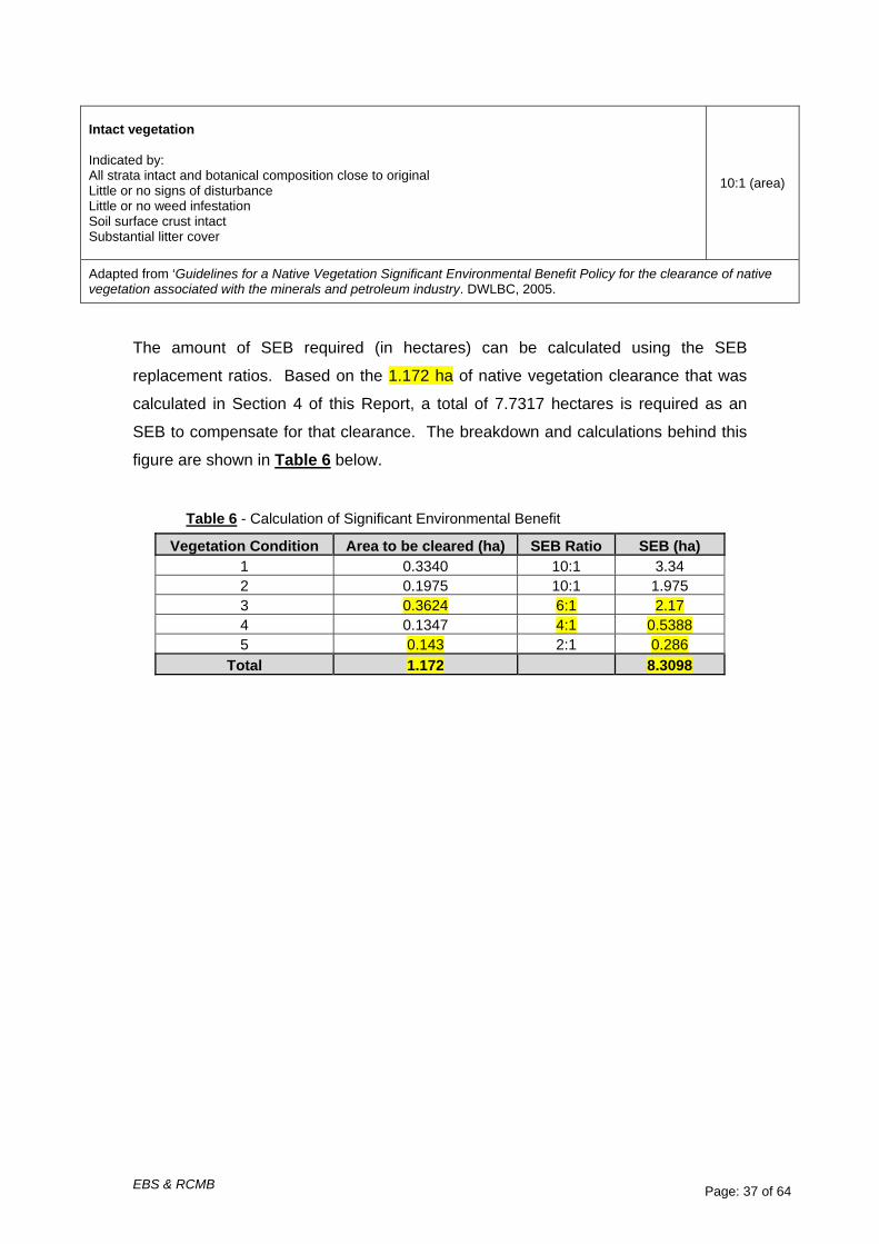
The amount of SEB required (in hectares) can be calculated using the SEB
replacement ratios. Based on the 1.172 ha of native vegetation clearance that was
calculated in Section 4 of this Report, a total of 7.7317 hectares is required as an
SEB to compensate for that clearance. The breakdown and calculations behind this
figure are shown in Table 6 below.
Table 6 - Calculation of Significant Environmental Benefit
Vegetation Condition Area to be cleared (ha) SEB Ratio SEB (ha) 1 0.3340 10:1 3.34 2 0.1975 10:1 1.975 3 0.3624 6:1 2.17 4 0.1347 4:1 0.5388 5 0.143 2:1 0.286
Total 1.172 8.3098

EBS & RCMB Page: 38 of 64
6.1 Payment of SEB
To satisfy their SEB requirements for this project, the Rural City of Murray Bridge
would be willing to consider a combination of payment to the Native Vegetation Fund
and revegetation of cleared land. Site value for the Local Government Area of
Murray Bridge (RC) is $1,551.00 per hectare (as per NVC interim policy described
in the Preface of this Report).
The area of cleared land to be re-vegetated comprises three areas totaling 2.07
hectares (see Figure 3). These areas are as follows:
Zone 1 - 8m wide x 900m long = 0.72 ha
Zone 2 - 10m wide x 900m long = 0.90 ha
Zone 3 - 5m wide x 900m long = 0.45 ha
Therefore the Total Re-vegetation Area = 2.07 ha
Thus based on assumptions as noted in this Report regarding options for the
southern most intersection with Kangaroo Road diversion, the new SEB area is
potentially able to be reduced from 8.3098 ha (Table 6) by 2.07 ha to 6.2398 ha.
The formula for calculating SEB payment into Native Vegetation Fund is as follows:
SEB required (dollar value) = (land value/ha x required set aside in hectares) +
(management fee/ha x area cleared). The required SEB in dollars is therefore:
SEB Payment = ($1,551x 6.2398) + (800x 1.172)
= 9677.93 + 1937.6
= $10,615.55
In summary, the Rural City of Murray Bridge will consider the following to satisfy their
SEB requirement:
• Revegetation of 2.07 hectares of cleared land
• Payment of $10,615.55 into the Native Vegetation Fund

EBS & RCMB Page: 39 of 64
Figure 5 - Proposed SEB Re-vegetation Zones (Zone 1, 2 & 3)
EBS & RCMB Page: 40 of 64
7 Management Plan for SEB Revegetation Area
7.1 Methodology
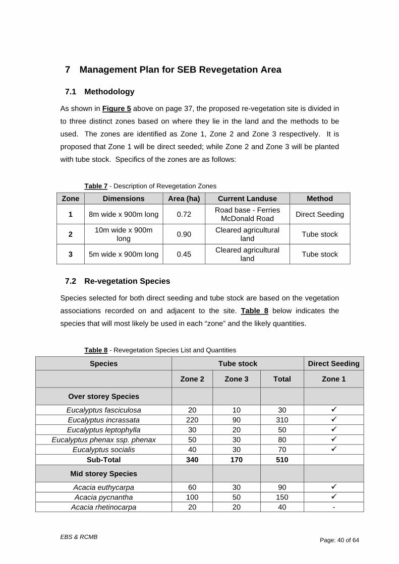
As shown in Figure 5 above on page 37, the proposed re-vegetation site is divided in
to three distinct zones based on where they lie in the land and the methods to be
used. The zones are identified as Zone 1, Zone 2 and Zone 3 respectively. It is
proposed that Zone 1 will be direct seeded; while Zone 2 and Zone 3 will be planted
with tube stock. Specifics of the zones are as follows:
Table 7 - Description of Revegetation Zones
Zone Dimensions Area (ha) Current Landuse Method
1 8m wide x 900m long 0.72 Road base - Ferries McDonald Road Direct Seeding
2 10m wide x 900m long 0.90 Cleared agricultural
land Tube stock
3 5m wide x 900m long 0.45 Cleared agricultural land Tube stock
7.2 Re-vegetation Species
Species selected for both direct seeding and tube stock are based on the vegetation
associations recorded on and adjacent to the site. Table 8 below indicates the
species that will most likely be used in each “zone” and the likely quantities.
Table 8 - Revegetation Species List and Quantities
Species Tube stock Direct Seeding
Zone 2 Zone 3 Total Zone 1
Over storey Species
Eucalyptus fasciculosa 20 10 30 Eucalyptus incrassata 220 90 310 Eucalyptus leptophylla 30 20 50
Eucalyptus phenax ssp. phenax 50 30 80 Eucalyptus socialis 40 30 70
Sub-Total 340 170 510
Mid storey Species
Acacia euthycarpa 60 30 90 Acacia pycnantha 100 50 150
Acacia rhetinocarpa 20 20 40 -

EBS & RCMB Page: 41 of 64
Species Tube stock Direct Seeding
Zone 2 Zone 3 Total Zone 1
Acacia rigens 20 10 30 Callitris canescens 30 20 50
Correa reflexa var. scabridula 20 10 30 - Dodonaea viscosa ssp. angustissima 40 20 60
Leptospermum coriaceum 30 15 45
Melaleuca lanceolata ssp. lanceolata 40 20 60 Melaleuca uncinata 300 150 450 Rhagodia crassifolia 150 75 225
Sub-Total 810 420 1230
Understorey Species
Atriplex semibaccata 30 15 45
Carpobrotus modestus 20 10 30 - Dianella revoluta var. revoluta 30 15 45 -
Dodonaea hexandra 40 20 60 - Enchylaena tomentosa var. tomentosa 50 25 75
Gahnia deusta 30 15 45 - Sub-Total 200 100 300
Total 1350 690 2040
7.3 Seed Collection
All seed used for tube stock or direct seeding will be collected on site, or from seed
collected from remnant vegetation that is as close as possible to the site. Seed will
be collected this summer and be grown for planting in the following winter.
7.4 General Re-vegetation Principles
The management plan for this re-vegetation area is based upon the following
principles:
• Species that grow locally in the area will be used, with the aim of replicating
the pre-European vegetation association’s that naturally occurred in the area.
• Where possible, revegetation will try to replicate the density and form of
nearby intact remnant vegetation.
• An excess of plants has been built in to the numbers to cope with an
anticipated loss of plants due to death.
EBS & RCMB Page: 42 of 64
7.5 Site Preparation and Weed Control
Re-vegetation areas will be well prepared before planting commences. Two weed
control events will occur before planting to effectively control weeds and will occur 4
weeks and 1 week before planting. The area will be blanket sprayed, avoiding any
native species, of which there should be few. Contractor or council staff engaged for
this work will be fully experienced to ensure best practice herbicide use techniques
are followed and appropriate herbicide mixes are used.
7.6 Planting
Tube stock will be planted in the winter months, after the breaking rains have
occurred. It is anticipated that this will occur in June or July, however, timing may
need to change slightly to adapt to the season. The basic methodology that will be
used for planting is detailed below;
• Planting will occur two to three weeks after spraying has occurred once the
weeds are dead.
• A watering bowl will be created around each plant
• All plants will be watered in and have tree guards placed around them.
• The following general planting densities will be used;
∼ overstorey species, 1 plant per 25m2
∼ mid storey and understorey species at, 1 plant per 9m2
7.7 Direct Seeding
Zone 1 is currently the in use Ferries McDonald Road surface, which is intended to
be closed off when the new adjacent section of road is complete. Direct Seeding will
be carried out in Zone 1 on the current road base of Ferries McDonald Rd,
immediately adjacent to the Monarto Conservation Park. To create a soil surface
capable of supporting native plants, the surface will need to be ripped to a depth of
20cm to allow for water and air penetration into the soil. This will create a seed bed
for adjacent and overhanging native plants to drop their seed into and encourage
natural regeneration. Ripping will also enable machine direct seeding to be carried
out.
It is anticipated that both seed sources will allow for a decent amount of native plant
germination. However, if by chance the direct seeding is not successful the Rural City

EBS & RCMB Page: 43 of 64
of Murray Bridge will commit to starting a tube stock planting program within this
zone.
7.8 Ongoing Maintenance
Maintenance and weed control will be ongoing to ensure the success of the
revegetation, and hence weed control will be ongoing for five years. The basic
methodology for follow-up weed control that will be used is as follows;
• Herbicide applications will be carried out twice per year to kill any weeds
growing around the plants.
• One herbicide application will occur in autumn/winter after the initial rains
have germinated weeds, and the second herbicide application will occur in
mid-spring to control weeds that have grown since the first herbicide
application.
• Careful, selective spraying around planted tube stock will occur to ensure no
spray drift and consequent plant death. Where considered necessary spray
guards will be used to prevent spray drift.
• Appropriate herbicide mixes will be determined by qualified staff.
As part of the maintenance program tree guards will be removed after approximately
eighteen months of plant growth. Exact timing will vary between different species and
locations, depending on how much each individual plant has grown. The
maintenance team will therefore determine when tree guards need to be removed on
a plant by plant basis. Program of works for the re-vegetation is proposed in Table 9
below.
Table 9 – Proposed Program of Works
Main Task Associated Task Timing
Seed Collection Seed Collection for tube stock and direct seeding
Summer 2008/09
Tube stock Planting Site Preparation – herbicide application 1 Winter 2009
Site Preparation – herbicide application 2 Winter 2009
Initial Planting, Guarding & Watering In Winter 2009
Maintenance Year 1 - 1 herbicide application Spring 2009
Summer Watering 1 Summer 2009/10
Summer Watering 2 Summer 2009/10
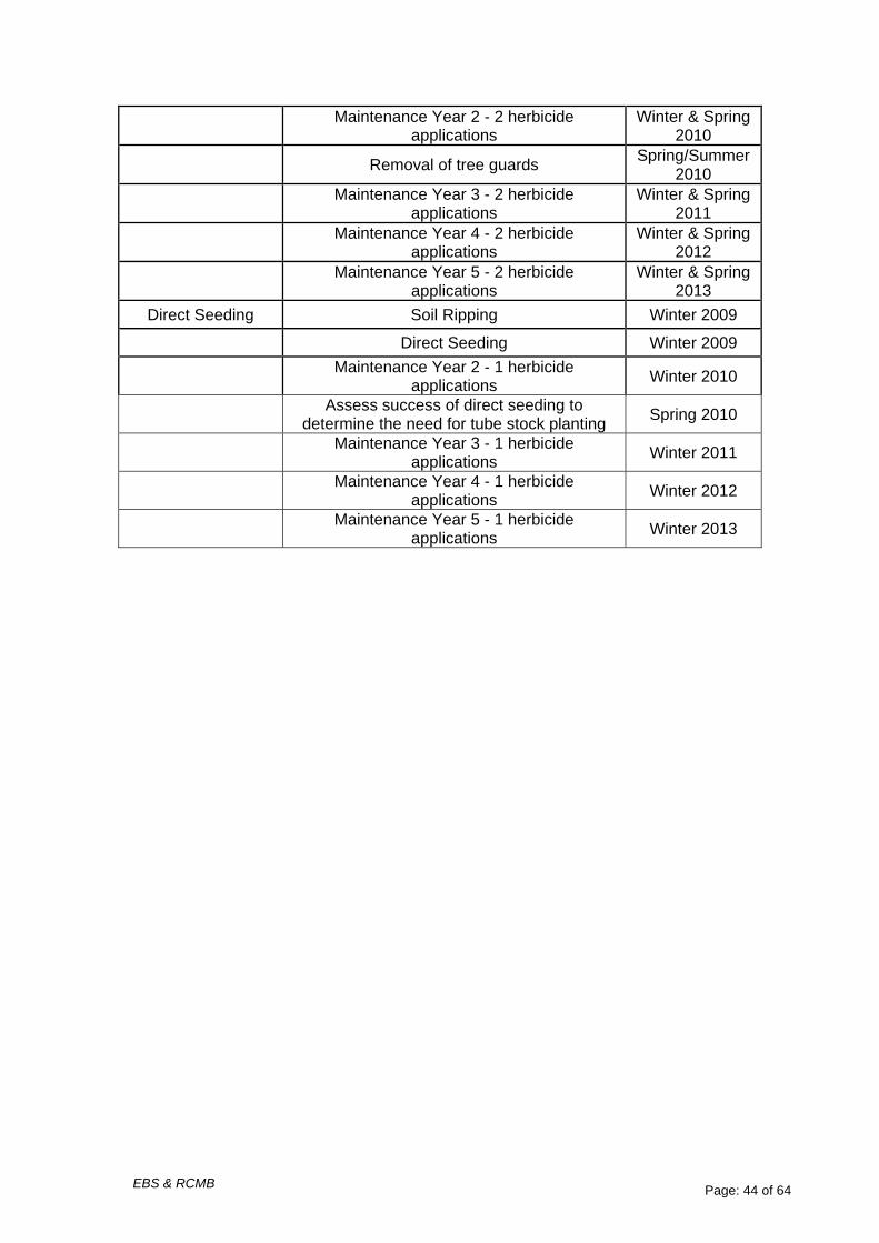
EBS & RCMB Page: 44 of 64
Maintenance Year 2 - 2 herbicide applications
Winter & Spring 2010
Removal of tree guards Spring/Summer 2010
Maintenance Year 3 - 2 herbicide applications
Winter & Spring 2011
Maintenance Year 4 - 2 herbicide applications
Winter & Spring 2012
Maintenance Year 5 - 2 herbicide applications
Winter & Spring 2013
Direct Seeding Soil Ripping Winter 2009
Direct Seeding Winter 2009
Maintenance Year 2 - 1 herbicide applications Winter 2010
Assess success of direct seeding to determine the need for tube stock planting Spring 2010
Maintenance Year 3 - 1 herbicide applications Winter 2011
Maintenance Year 4 - 1 herbicide applications Winter 2012
Maintenance Year 5 - 1 herbicide applications Winter 2013

EBS & RCMB Page: 45 of 64
8 Road Construction Environmental Management Plan
A Road Construction Environmental Management Plan (EMP) has been written to be
used at all stages of construction of the Ferries McDonald Road upgrade. The EMP
is designed to ensure systems and procedures are in place that will maximise
protection of native vegetation before, during and after construction as well as ensure
all staff and contractors who may be working on the project are aware of their
environmental responsibilities.
The Rural City of Murray Bridge (RCMB) is committed to strictly following the
procedures within this EMP and to minimise the impact of this project on the native
vegetation of the project area. This EMP is able to be expanded into a working
Environmental Management Implementation Plan (EMIP) where this document will
detail exact locations of stockpile sites, vehicle turnaround sites, locations of
threatened plants, declared weeds and any other issues of importance. This working
EMIP will be the document used in all training and induction programs.
The EMP was included with the original NVC submission; including Council’s EPBC
Act Referral submission to the Commonwealth Environment Department and is
accessible on Council’s website for perusal.

EBS & RCMB Page: 46 of 64
9 References
Croft, T., S. Carruthers, H. Possingham and B. Inns (1999) Biodiversity Plan for the South East of South Australia, Department for Environment, Heritage and
Aboriginal Affairs.
Department for the Environment & Heritage, South Australia (2006), South Australian Fauna and Flora database
Environmental and Biodiversity Services (July 2008). Ferries McDonald Road Redevelopment Native Vegetation Clearance Assessment Report. Prepared by
Environmental and Biodiversity Services on Behalf of the Rural City for Murray
Bridge.
Environmental and Biodiversity Services (August 2008), Flora and Fauna
Assessment - Ferries McDonald Road Redevelopment Proposal (Available for perusal on Council’s website at
http://www.murraybridge.sa.gov.au/site/page.cfm?u=371 as “EBS Final Report”)
Kahrimanis, M.J., Carruthers, S., Oppermann, A. and Inns, R. (2001) Biodiversity
Plan for the South Australian Murray-Darling Basin. Department for Environment
and Heritage, South Australia
Neagle, N. (1995). An Update of the Conservation Status of the Major Plant Associations of South Australia Native Vegetation Conservation Section,
Department of Environment and Natural Resources, South Australia
South Australian Museum (2005), South Australian Museum fauna database
Southern & Hills Local Government Association (August 2004), 2010 Transport Plan Final Report and Plan
Southern & Hills Local Government Association (October 2004), 2010 Transport Plan Addendum Final Report
Stokes et al (1998). Guide to the Roadside Vegetation Survey Methodology for South Australia. South Australian Government

EBS & RCMB Page: 47 of 64

EBS & RCMB Page: 48 of 64
Appendix 1 - Scattered Tree Data
Tree No. Species Easting Northing Form
Ht. (m)
Spread (m x m)
Area (ha) Hollows
Distance to
nearest native
veg. (m) Dieback
(%)
Fruit / Buds /
Flowers
Stem Diameter (# stems
@ diameter
in m) Comments
Other native plants under
trees
% of tree to
be removed
Branch or Tree
Removal
1 Eucalyptus incrassata 329654 6106025 Tree 6 10 x 9 0.009 None 15 10
Fruiting and
budding 5 @ 0.2m
Stem diameter
measured at 1m above ground level None 100 Tree
2
Dodonaea viscosa ssp. angustissima 329632 6106049
Large Shrub 2 1 x 1 0.0001 None 15 10 None
14 @ 0.01m
Stem diameter
measured at 0.05m
above ground level None 100 Tree
3 Eucalyptus incrassata 329556 6106152 Tree 5 11 x 8 0.0088 None 15 10
Fruiting and
budding 8 @ 0.1m
Stem diameter
measured at 1m above ground level
1 Enchylaena tomentosa, 3
Atriplex semibaccata, 1
Eucalyptus incrassata seedling 100 Tree
4 Eucalyptus fasciculosa 329490 6106206 Tree 10
8 x 5 (branch
only) 0.004 None 0
0 (branch
only) Fruiting 1 @ 0.25m
Stem diameter
measured at 1m above
ground level. Stem diameter is
of the branch to be lopped
only. None 25 Branch

EBS & RCMB Page: 49 of 64
Tree No. Species Easting Northing Form
Ht. (m)
Spread (m x m)
Area (ha) Hollows
Distance to
nearest native
veg. (m) Dieback
(%)
Fruit / Buds /
Flowers
Stem Diameter (# stems
@ diameter
in m) Comments
Other native plants under
trees
% of tree to
be removed
Branch or Tree
Removal
5 Eucalyptus incrassata 329361 6106382 Tree 8 11 x 13 0.0143 None 10 5
Fruiting and
budding 15 @ 0.1m
Stem diameter
measured at 1m above ground level
9 Rhagodia crassifolia, 1
Billardiera cymosa, 1
Lepidosperma congestum, 1
Melaleuca lanceolata seedling 100 Tree
6 Eucalyptus incrassata 329355 6106448 Tree 7 15 x 11 0.0165 None 0 3
Fruiting and
budding 9 @ 0.2m
Stem diameter
measured at 1m above ground level
11 Rhagodia crassifolia, 1
Billardiera cymosa, 2
Olearia passerinoides
ssp. glutescens, 2 Dodonaea viscosa ssp. angustissima 100 Tree
7 Melaleuca uncinata 329330 6106488
Large Shrub 3 5 x 5 0.0025 None 0 0 Fruiting
11 @ 7.5cm
Stem diameter
measured at 0.05m
above ground level
2 Rhagodia crassifolia 100 Tree
8 Eucalyptus incrassata 329328 6106495 Tree 8 13 x 9 0.0117 None 0 3 Fruiting 5 @ 0.15m
Stem diameter
measured at 1m above ground level
3 Rhagodia crassifolia, 1
Olearia passerinoides
ssp. glutescens 100 Tree

EBS & RCMB Page: 50 of 64
Tree No. Species Easting Northing Form
Ht. (m)
Spread (m x m)
Area (ha) Hollows
Distance to
nearest native
veg. (m) Dieback
(%)
Fruit / Buds /
Flowers
Stem Diameter (# stems
@ diameter
in m) Comments
Other native plants under
trees
% of tree to
be removed
Branch or Tree
Removal
9 Eucalyptus incrassata 329326 6106472 Tree 8
2 x 4 (branch
only) 0.0008 None 0
0 (branch
only)
Fruiting and
budding 1 @
0.075m
Stem diameter
measured at 1m above
ground level. Stem diameter is
of the branch to be lopped
only None 20 Branch
10 Eucalyptus incrassata 329987 6098457 Tree 5 5.5 x 3 0.0016 None 30 10
Fruiting and
budding 2 @ 0.20m
Stem diameter
measured at 1m above
ground level.
1 Enchylaena tomentosa 100 Tree
11 Eucalyptus incrassata 329978 6098457 Tree 6 7 x 4.5 0.0031 None 30 30
Fruiting and
budding 6 @ 0.10m
Stem diameter
measured at 1m above
ground level.
1 Rhagodia crassifolia 100 Tree
12 Eucalyptus
porosa 329944 6100659 Tree 12 16 0.0201 None - - - 3 @ 0.2m - - 10 Branch
13 Eucalyptus
porosa 329941 6100793 Tree 5 7 0.0038 None - - - 2 @ 0.2m - - 100 Tree
14 Eucalyptus
porosa 329397 6108818 Tree 1.5 2 0.0003 None - - - 3 @ 0.2m - - 100 Tree
15 Eucalyptus incrassata 329375 6107894 Tree 2.5 2.5 0.0201 None - - - 3 @ 0.2m - - 100 Tree
16 Hakea rugosa 329362 6107529 Shrub 1 2 0.0003 None - - - 1 @ >0.1m - - 5 Branch

EBS & RCMB Page: 51 of 64
Tree No. Species Easting Northing Form
Ht. (m)
Spread (m x m)
Area (ha) Hollows
Distance to
nearest native
veg. (m) Dieback
(%)
Fruit / Buds /
Flowers
Stem Diameter (# stems
@ diameter
in m) Comments
Other native plants under
trees
% of tree to
be removed
Branch or Tree
Removal
17 Allocas
verticilata 329348 6107139 Tree 3 2 0.0003 None - - - 1 @ 0.1m - - 5 Branch
18 Allocas
verticilata 329347 6107115 Tree 3 2 0.0003 None - - - 1 @ 0.1m - - 15 Branch
19 Eucalyptus incrassata 329335 6106774 Tree 3 4 0.0013 None - - - 3 @ 0.20m - - 10 Branch
20 Eucalyptus incrassata 329873 6105405 Tree 3 2.5 0.0005 None - - - 4 @ 0.20m - - 30 Branch
21 Eucalyptus incrassata 329875 6105328 Tree 4 8 0.0050 None - - - 3 @ 0.20m - - 5 Branch
22 Eucalyptus fasciculosa 329899 6103540 Tree 3 3 0.0007 None - - - 1 @ 0.2m - - 20 Branch
23 Eucalyptus fasciculosa 329898 6103534 Tree 2 1.5 0.0002 None - - - 1 @ 0.2m - - 10 Branch
24 Acacia sp. 329934 6101693 Shrub 3 3 0.0007 None - - - - - 50 Branch
25 Eucalyptus
phenax 329935 6101621 Tree 1.5 2 0.0003 None - - - 2 @ 0.2m - - 50 Branch

EBS & RCMB Page: 52 of 64
Appendix 2 – Combined flora species recorded during the 2006 / 2010 field vegetation survey
Scientific Name Common Name Conservation
Rating Vegetation Associations
AUS SA MU Al Ef Ep Ec Ei Eph Er Es Ml Mu Ab Euc Acacia acinacea Wreath Wattle Acacia cupularis Cup Wattle R Acacia euthycarpa Wallowa Acacia ligulata Umbrella Bush Acacia microcarpa Manna Wattle Acacia pycnantha Golden Wattle Acacia rhetinocarpa Resin Wattle V V V Acacia rigens Nealie Acacia rupicola Rock Wattle R Acacia simmonsiana Hall's Wattle R K Acacia spinescens Spiny Wattle Allocasuarina muelleriana ssp. muelleriana
Common Oak-bush
Allocasuarina verticillata Drooping Sheoak Amyema miquelii Box Misteltoe *Asphodelus fistulosus Onion Weed Atriplex semibaccata Berry Saltbush Austrodanthonia caespitosa
Common Wallaby-grass
Austrodanthonia setacea Small-flower Wallaby-grass
Austrostipa elegantissima Feather Spear-grass
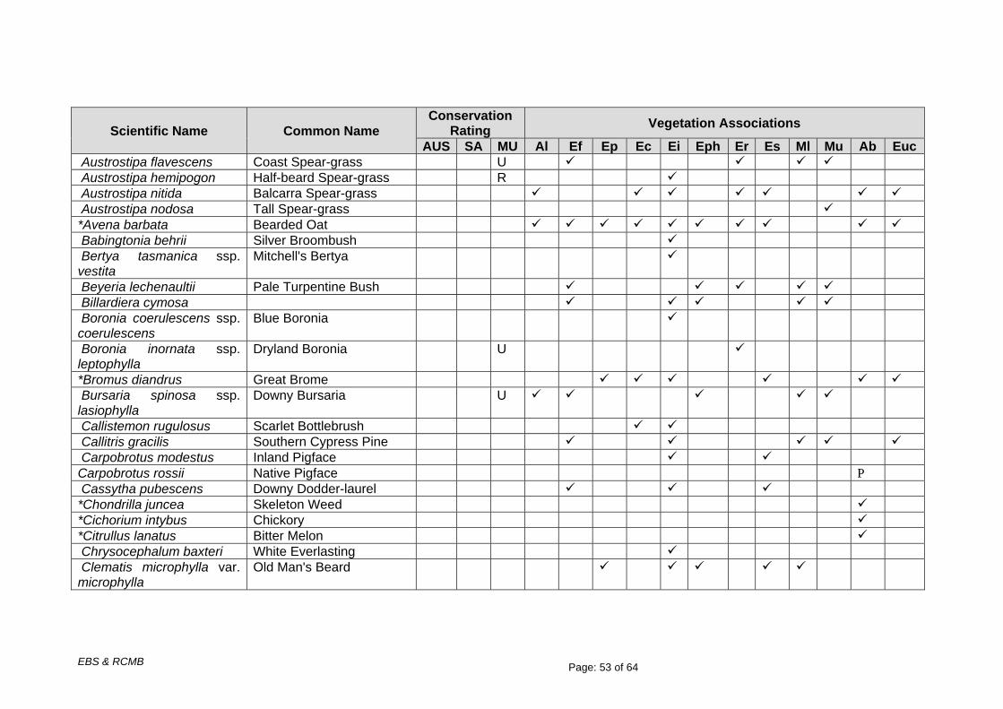
EBS & RCMB Page: 53 of 64
Scientific Name Common Name Conservation
Rating Vegetation Associations
AUS SA MU Al Ef Ep Ec Ei Eph Er Es Ml Mu Ab Euc Austrostipa flavescens Coast Spear-grass U Austrostipa hemipogon Half-beard Spear-grass R Austrostipa nitida Balcarra Spear-grass Austrostipa nodosa Tall Spear-grass *Avena barbata Bearded Oat Babingtonia behrii Silver Broombush Bertya tasmanica ssp. vestita
Mitchell's Bertya
Beyeria lechenaultii Pale Turpentine Bush Billardiera cymosa Boronia coerulescens ssp. coerulescens
Blue Boronia
Boronia inornata ssp. leptophylla
Dryland Boronia U
*Bromus diandrus Great Brome Bursaria spinosa ssp. lasiophylla
Downy Bursaria U
Callistemon rugulosus Scarlet Bottlebrush Callitris gracilis Southern Cypress Pine Carpobrotus modestus Inland Pigface Carpobrotus rossii Native Pigface P Cassytha pubescens Downy Dodder-laurel *Chondrilla juncea Skeleton Weed *Cichorium intybus Chickory *Citrullus lanatus Bitter Melon Chrysocephalum baxteri White Everlasting Clematis microphylla var. microphylla
Old Man's Beard
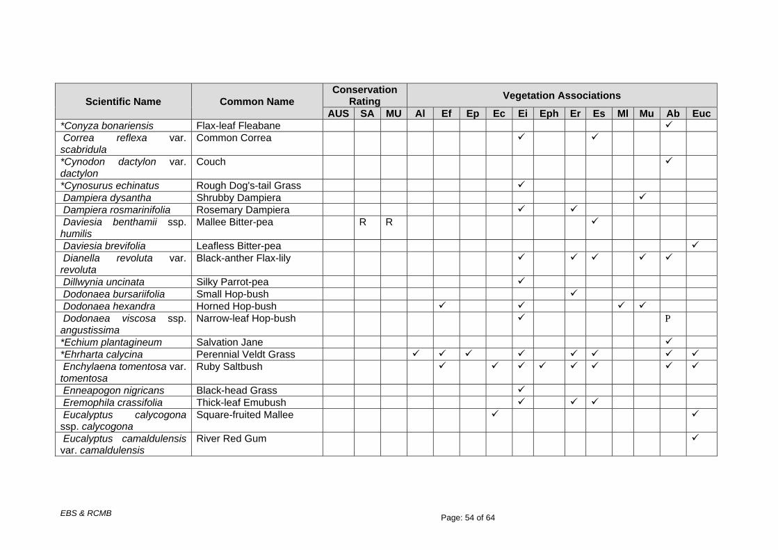
EBS & RCMB Page: 54 of 64
Scientific Name Common Name Conservation
Rating Vegetation Associations
AUS SA MU Al Ef Ep Ec Ei Eph Er Es Ml Mu Ab Euc *Conyza bonariensis Flax-leaf Fleabane Correa reflexa var. scabridula
Common Correa
*Cynodon dactylon var. dactylon
Couch
*Cynosurus echinatus Rough Dog's-tail Grass Dampiera dysantha Shrubby Dampiera Dampiera rosmarinifolia Rosemary Dampiera Daviesia benthamii ssp. humilis
Mallee Bitter-pea R R
Daviesia brevifolia Leafless Bitter-pea Dianella revoluta var. revoluta
Black-anther Flax-lily
Dillwynia uncinata Silky Parrot-pea Dodonaea bursariifolia Small Hop-bush Dodonaea hexandra Horned Hop-bush Dodonaea viscosa ssp. angustissima
Narrow-leaf Hop-bush P
*Echium plantagineum Salvation Jane *Ehrharta calycina Perennial Veldt Grass Enchylaena tomentosa var. tomentosa
Ruby Saltbush
Enneapogon nigricans Black-head Grass Eremophila crassifolia Thick-leaf Emubush Eucalyptus calycogona ssp. calycogona
Square-fruited Mallee
Eucalyptus camaldulensis var. camaldulensis
River Red Gum
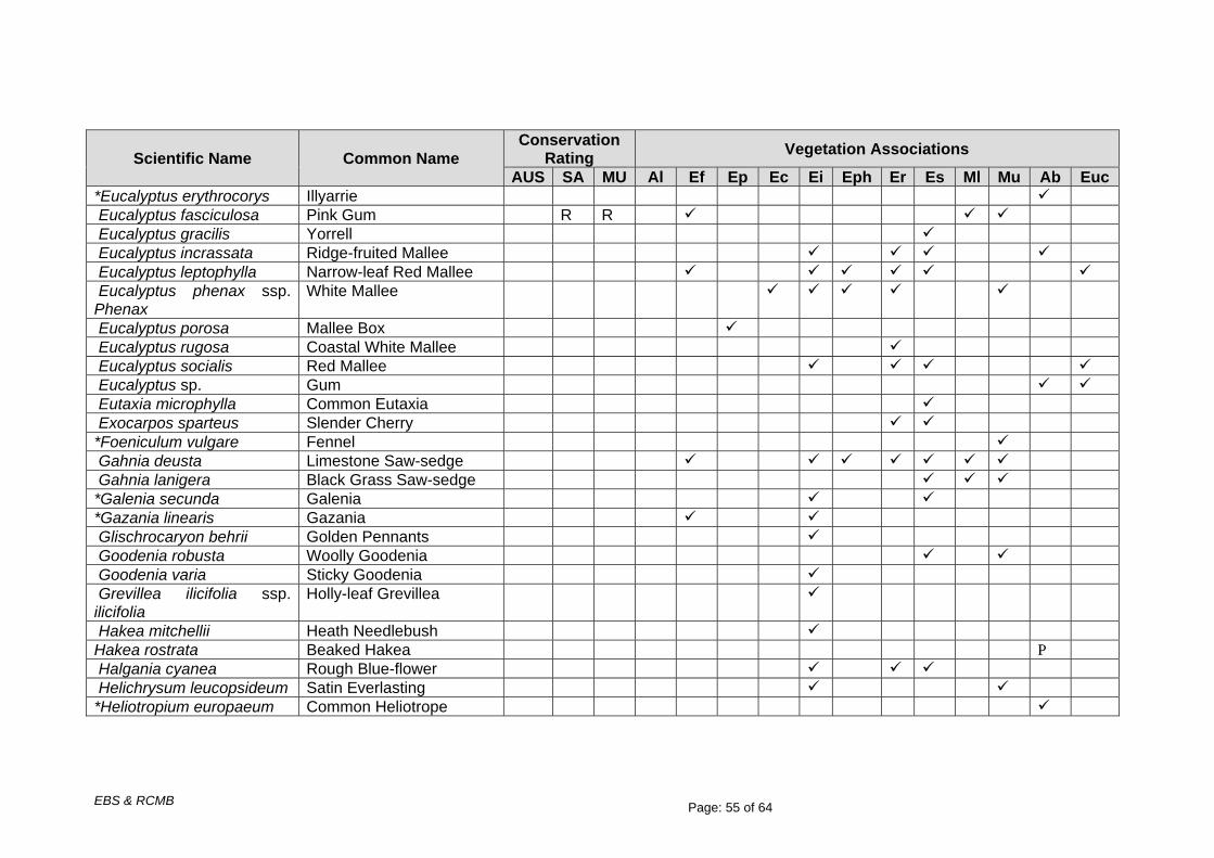
EBS & RCMB Page: 55 of 64
Scientific Name Common Name Conservation
Rating Vegetation Associations
AUS SA MU Al Ef Ep Ec Ei Eph Er Es Ml Mu Ab Euc *Eucalyptus erythrocorys Illyarrie Eucalyptus fasciculosa Pink Gum R R Eucalyptus gracilis Yorrell Eucalyptus incrassata Ridge-fruited Mallee Eucalyptus leptophylla Narrow-leaf Red Mallee Eucalyptus phenax ssp. Phenax
White Mallee
Eucalyptus porosa Mallee Box Eucalyptus rugosa Coastal White Mallee Eucalyptus socialis Red Mallee Eucalyptus sp. Gum Eutaxia microphylla Common Eutaxia Exocarpos sparteus Slender Cherry *Foeniculum vulgare Fennel Gahnia deusta Limestone Saw-sedge Gahnia lanigera Black Grass Saw-sedge *Galenia secunda Galenia *Gazania linearis Gazania Glischrocaryon behrii Golden Pennants Goodenia robusta Woolly Goodenia Goodenia varia Sticky Goodenia Grevillea ilicifolia ssp. ilicifolia
Holly-leaf Grevillea
Hakea mitchellii Heath Needlebush Hakea rostrata Beaked Hakea P Halgania cyanea Rough Blue-flower Helichrysum leucopsideum Satin Everlasting *Heliotropium europaeum Common Heliotrope
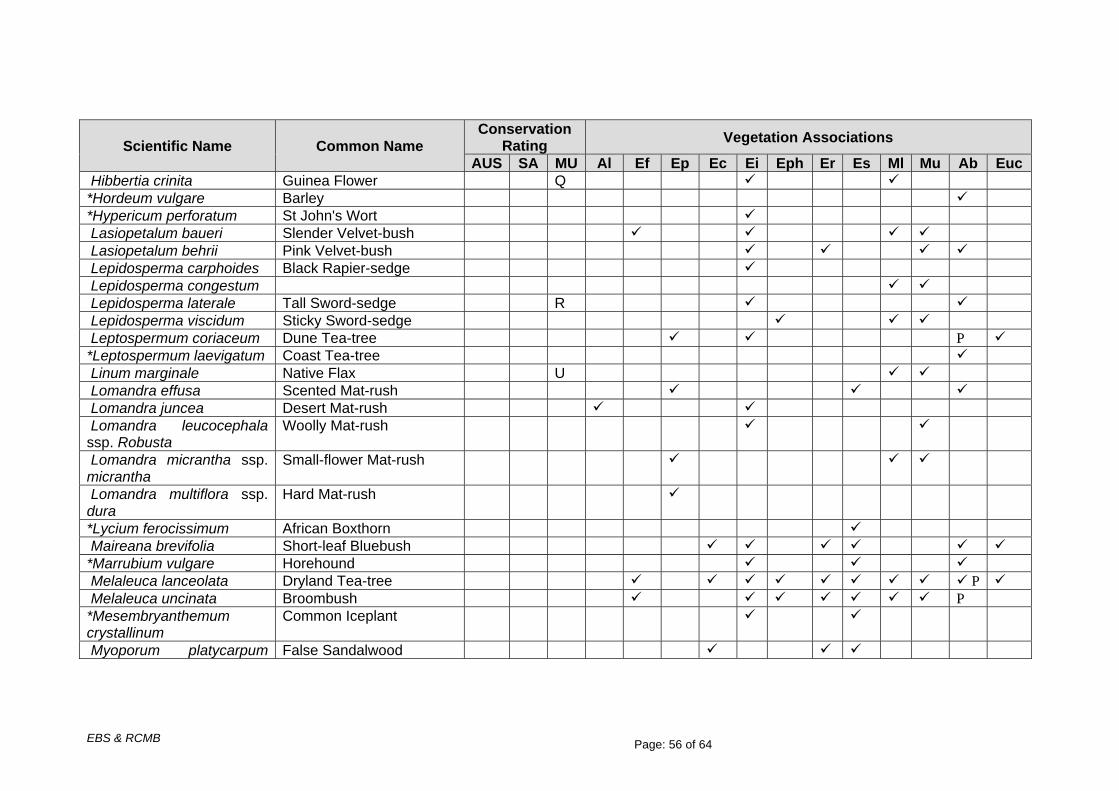
EBS & RCMB Page: 56 of 64
Scientific Name Common Name Conservation
Rating Vegetation Associations
AUS SA MU Al Ef Ep Ec Ei Eph Er Es Ml Mu Ab Euc Hibbertia crinita Guinea Flower Q *Hordeum vulgare Barley *Hypericum perforatum St John's Wort Lasiopetalum baueri Slender Velvet-bush Lasiopetalum behrii Pink Velvet-bush Lepidosperma carphoides Black Rapier-sedge Lepidosperma congestum Lepidosperma laterale Tall Sword-sedge R Lepidosperma viscidum Sticky Sword-sedge Leptospermum coriaceum Dune Tea-tree P *Leptospermum laevigatum Coast Tea-tree Linum marginale Native Flax U Lomandra effusa Scented Mat-rush Lomandra juncea Desert Mat-rush Lomandra leucocephala ssp. Robusta
Woolly Mat-rush
Lomandra micrantha ssp. micrantha
Small-flower Mat-rush
Lomandra multiflora ssp. dura
Hard Mat-rush
*Lycium ferocissimum African Boxthorn Maireana brevifolia Short-leaf Bluebush *Marrubium vulgare Horehound Melaleuca lanceolata Dryland Tea-tree P Melaleuca uncinata Broombush P *Mesembryanthemum crystallinum
Common Iceplant
Myoporum platycarpum False Sandalwood

EBS & RCMB Page: 57 of 64
Scientific Name Common Name Conservation
Rating Vegetation Associations
AUS SA MU Al Ef Ep Ec Ei Eph Er Es Ml Mu Ab Euc ssp. platycarpum *Oenothera stricta ssp. stricta
Common Evening Primrose
*Olea europaea ssp. europaea
Olive
Olearia lanuginosa Woolly Daisy-bush R Olearia passerinoides ssp. glutescens
Sticky Daisy-bush R R
Opercularia turpis Twiggy Stinkweed *Opuntia sp. Prickly Pear Ozothamnus retusus Notched Bush-everlasting Phebalium bullatum Silvery Phebalium Pimelea glauca Smooth Riceflower *Plantago lanceolata var. lanceolata
Ribwort
Podolepis rugata var. rugata
Pleated Copper-wire Daisy
Pomaderris obcordata Wedge-leaf Pomaderris Pultenaea densifolia Dense Bush-pea U Pultenaea tenuifolia Narrow-leaf Bush-pea *Reichardia tingitana False Sowthistle Rhagodia crassifolia Fleshy Saltbush P Salsola kali Buckbush *Salvia verbenaca var. verbenaca
Wild Sage
Santalum acuminatum Quandong *Scabiosa atropurpurea Pincushion *Schismus barbatus Arabian Grass

EBS & RCMB Page: 58 of 64
Scientific Name Common Name Conservation
Rating Vegetation Associations
AUS SA MU Al Ef Ep Ec Ei Eph Er Es Ml Mu Ab Euc Senecio sp. Groundsel *Sisymbrium orientale Wild Mustard *Solanum nigrum Black Nightshade *Sonchus asper Rough Sow-thistle Spyridium eriocephalum var. eriocephalum
Heath Spyridium
Spyridium subochreatum var. subochreatum
Velvet Spyridium
Threlkeldia diffusa Coast Bonefruit *Trifolium arvense var. arvense
Hare's-foot Clover
Vittadinia australasica Sticky New Holland Daisy *Vulpia bromoides Squirrel-tail Fescue Total Numbers per
Assoc. 11 26 13 15 78 18 35 41 28 43 46 23
Total Natives 7 22 9 12 66 15 30 31 26 39 24 16 Total Exotics 4 4 4 3 12 3 5 10 2 4 22 7 E = Endangered; V = Vulnerable; R = Rare; T = Threatened; K = Uncertain – either Threatened or Rare; Q = of possible significance; U = Uncommon AUS = Australia, SA = South Australia, MU = Murray Mallee Region (in SA), * = introduced species (For further explanation of conservation ratings see Appendix 6) Indigenous species: 114 Alien species: 40 Total number of species: 143 P = A species that has been planted as part of a revegetation site

EBS & RCMB Page: 59 of 64
Key to Vegetation Associations Al - Allocasuarina verticillata (Drooping Sheoak) Low Woodland. Ef - Eucalyptus fasciculosa (Pink Gum) Low Open Woodland. Ep - Eucalyptus porosa (Mallee Box) Woodland. Ec - Eucalyptus calycogona ssp. calycogona (Square-fruited Mallee) Mallee. Ei - Eucalyptus incrassata (Ridge-fruited Mallee)/ Eucalyptus phenax ssp. phenax (White Mallee) Mallee. Eph - Eucalyptus phenax ssp. phenax (White Mallee)/ Eucalyptus leptophylla (Narrow-leaf Red Mallee) Mallee. Er - Eucalyptus rugosa (Coastal White Mallee) Mallee. Es - Eucalyptus socialis (Red Mallee) Mallee. Ml - Melaleuca lanceolata (Dryland Tea-tree) Tall Shrubland. Mu - Melaleuca uncinata (Broombush) Shrubland. Ab - Avena barbata (Bearded Oat)/ Ehrharta calycina (Perennial Veldt Grass)/ Scabiosa atropurpurea (Pincushion) Exotic Grassland. Euc - Eucalyptus sp. (Eucalypt)/ Melaleuca lanceolata (Dryland Tea-tree) Plantation.

EBS & RCMB Page: 60 of 64
Appendix 3 – Vegetation association mapping of the proposed new Ferries McDonald Road & Garwood Road Intersection

EBS & RCMB Page: 61 of 64
Appendix 4 – Vegetation condition mapping of the proposed new Ferries McDonald Road & Garwood Road Intersection

EBS & RCMB Page: 62 of 64
Appendix 5 – Vegetation association mapping of the proposed new Kangaroo Road Intersection at the southern end of the project
Diagrammatic Representation of the new Kangaroo Road – East or West Option
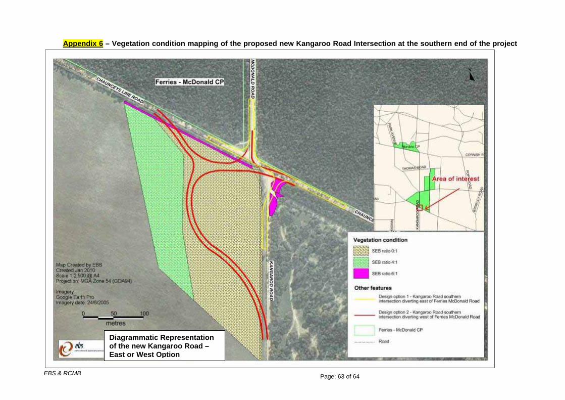
EBS & RCMB Page: 63 of 64
Appendix 6 – Vegetation condition mapping of the proposed new Kangaroo Road Intersection at the southern end of the project
Diagrammatic Representation of the new Kangaroo Road – East or West Option

EBS & RCMB Page: 64 of 64