national weather service dodge city, ks wild west weather · wild west weather inside this issue:...
TRANSCRIPT
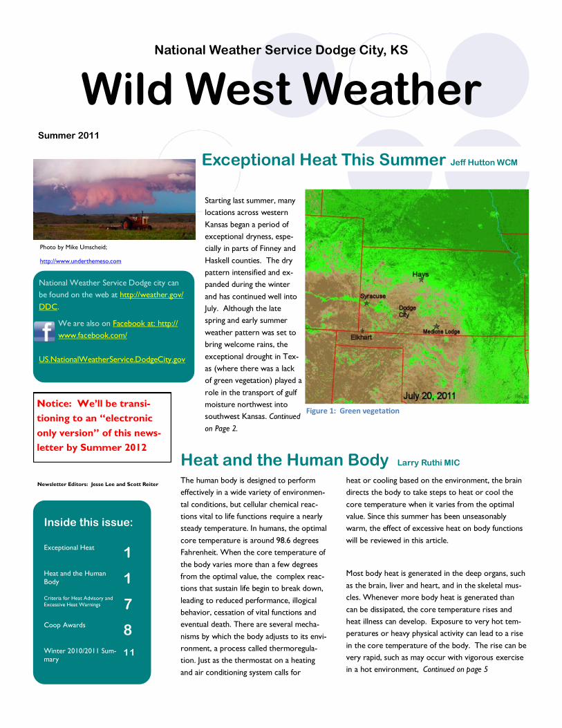
Starting last summer, many
locations across western
Kansas began a period of
exceptional dryness, espe-
cially in parts of Finney and
Haskell counties. The dry
pattern intensified and ex-
panded during the winter
and has continued well into
July. Although the late
spring and early summer
weather pattern was set to
bring welcome rains, the
exceptional drought in Tex-
as (where there was a lack
of green vegetation) played a
role in the transport of gulf
moisture northwest into
southwest Kansas. Continued
on Page 2.
National Weather Service Dodge city can
be found on the web at http://weather.gov/
DDC.
We are also on Facebook at: http://
www.facebook.com/
US.NationalWeatherService.DodgeCity.gov
Exceptional Heat This Summer Jeff Hutton WCM
National Weather Service Dodge City, KS
Summer 2011
Wild West Weather
Inside this issue:
Exceptional Heat 1
Heat and the Human
Body 1 Criteria for Heat Advisory and
Excessive Heat Warnings 7
Coop Awards 8
Winter 2010/2011 Sum-
mary 11
Photo by Mike Umscheid;
http://www.underthemeso.com
Figure 1: Green vegetation
Heat and the Human Body Larry Ruthi MIC The human body is designed to perform
effectively in a wide variety of environmen-
tal conditions, but cellular chemical reac-
tions vital to life functions require a nearly
steady temperature. In humans, the optimal
core temperature is around 98.6 degrees
Fahrenheit. When the core temperature of
the body varies more than a few degrees
from the optimal value, the complex reac-
tions that sustain life begin to break down,
leading to reduced performance, illogical
behavior, cessation of vital functions and
eventual death. There are several mecha-
nisms by which the body adjusts to its envi-
ronment, a process called thermoregula-
tion. Just as the thermostat on a heating
and air conditioning system calls for
heat or cooling based on the environment, the brain
directs the body to take steps to heat or cool the
core temperature when it varies from the optimal
value. Since this summer has been unseasonably
warm, the effect of excessive heat on body functions
will be reviewed in this article.
Most body heat is generated in the deep organs, such
as the brain, liver and heart, and in the skeletal mus-
cles. Whenever more body heat is generated than
can be dissipated, the core temperature rises and
heat illness can develop. Exposure to very hot tem-
peratures or heavy physical activity can lead to a rise
in the core temperature of the body. The rise can be
very rapid, such as may occur with vigorous exercise
in a hot environment, Continued on page 5
Notice: We’ll be transi-
tioning to an “electronic
only version” of this news-
letter by Summer 2012
Newsletter Editors: Jesse Lee and Scott Reiter

2
The driest recording station, especially since the first of the year, was in Haskell County. As of June 30,
the observing station 7 miles west/southwest of Sublette had received only 1.51” of precipitation since
January 1st and only 2.16” in the 10 month period beginning in September of 2010. This is exceptionally
dry. Other locations, even in south central Kansas, were dry as well with the recording station 16 miles
southeast of Wilmore (in Comanche county) receiving only 3.01” from January 1 through June 30.
Going a bit further, at the Dodge City airport ending on July 21st, it was the 2nd driest 12 months on rec-
ord (since 1875) as only 8.55” of precipitation was recorded. The normal amount is 22.35” so it’s definite-
ly an exceptionally dry period!
Exceptional Drought and Heat cont from page 1
“so it’s definitely an
exceptionally dry
period!”
2011 Precipitation vs. Normal (Blue bars).
Driest 12 Months on Record for Dodge City

3
“As of mid-July the
deficit of rainfall
was nearly 25
inches since June
2001!
So, the current drought that many locations are in is pretty anomalous. However, the feeling is
that the drought really started in June of 2001 with a couple of relatively wet periods mixed in.
Look at the deficit of precipitation at Dodge City since 2000! As of mid-July the deficit of rainfall
was nearly 25 inches since June 2001.
Other locations though don't have quite as much of a deficit as Dodge City, but all locations
have a deficit since June 2001.

4
Looking at the graphic above, compared to the previous five years you can see how far behind the rainfall is.
With the drought has come horrid heat! As of July 25th, the average high temperature for July at Ashland was an astonishing 104.6 degrees!
The number of 100 degree days across the area will most likely approach record numbers. At Dodge City for instance, as of July 25th the num-
ber of days was already at 30 which was the 4th greatest number on record! -Jeff Hutton (Warning Coordination Meteorologist.)

5
Heat and the Human Body Continued from Page 1
or it can be more gradual, such as will occur with lengthy exposure to an environment that places slightly more heat load on the body than can
be dissipated through the various body cooling processes.
Heat loss from the body is accomplished primarily by conduction, convection, radiation and evaporation. Conduction can cool the
body if the skin surface is warmer than the surrounding air. Heat will flow from the surface of the skin to the environment, and the skin will cool. Convection, mixing of the warm air in contact with the skin surface with cooler environmental air, enhances the cooling process by mov-
ing heated air away from the skin surface. Wind or air flow from a fan greatly enhances cooling by conduction and convection. The effect of wind on heat loss from the skin surface is the basis for the widely used wind chill index. Radiation also can cool the skin surface if the sur-
rounding environment is cooler than the skin since warmer objects typically radiate more energy than cooler objects. As such, radiation reach-ing the skin is less than that emitted from the skin surface, resulting in a net cooling. Evaporation is a quicker and more efficient means of cool-
ing the body than conduction, convection or radiation, and it is effective even when the surrounding environment is warmer than the surface of
the skin. Evaporation of one gram (about 1/30 ounce) of water consumes more than 550 calories of energy at normal skin temperatures.
When temperatures rise above the upper 90s, the body cooling mechanisms must overcome heat generated from the core organs
and muscle activity, as well as radiation, conduction and convection from the hot surroundings. In addition, radiation from the sun is near its peak during the summer and adds to the heat load on the body. The body attempts to cool itself by raising the temperature of the skin through
increasing blood flow to small vessels near the surface of the skin and by secreting perspiration on the surface of the skin. Evaporative cooling of perspiration from the surface of the skin and moisture from the lungs must be sufficient to dissipate the heat load, or the core body temper-
ature will rise. Anything that interferes with evaporative cooling will reduce the ability of the body to control its internal temperature and may
lead to heat related illness.
Evaporative cooling from the skin surface is most effective when the moisture content of the air above the skin surface is low. The amount of water vapor that air can hold is a function of temperature, and hot air can hold much more moisture before becoming saturated
than cool air. A good measure of the amount of water vapor in the air is the dew point temperature, the temperature to which the air must be cooled at constant pressure to achieve saturation. The air in the shallow layer in contact with the skin’s surface will be saturated at the temper-
ature of the warm skin and will have a dew point temperature in excess of 90 degrees. If the surrounding air is dry with, for example, a dew point temperature of 40 degrees, evaporation will be fast, and the skin will cool rapidly. If, on the other hand, the dew point temperature of the
environment is 75 degrees, evaporation will be much slower and the body will dissipate heat much less efficiently. Wind greatly enhances effi-ciency of evaporative cooling from the skin surface by mixing the hot, saturated air at the skin surface with the drier environmental air. The
heat index attempts to quantify the efficiency of evaporative cooling by combining temperature and moisture content of the air into a single value. Unfortunately, the heat index calculation does not include the very important contribution of wind to the efficiency of evaporative cool-
ing. In areas such as southwest Kansas where strong wind is very common, the heat index often poorly represents the ability of the body to
dissipate heat.
6
During periods of hot weather, it is absolutely essential that sufficient liquids are ingested to keep the body hydrated. Do not wait until you
sense thirst to drink water when working in a hot environment since the sense of thirst develops only after mild dehydration has occurred. If the body is not adequately hydrated, its primary cooling mechanism will be compromised, and heat related illness becomes more likely. The
following guidelines will help your body cope with the heat:
Drink large quantities of water. Heavy exercise in a hot environment may require 16 to 32 ounces of water each hour to keep the body
hydrated. Sports drinks may help to replace salts and minerals lost through heavy perspiration.
Avoid alcohol and caffeine since both act as diuretics and may increase the chance of dehydration.
Wear lightweight, loose fitting clothing. Cotton fabric is good because it allows perspiration to evaporate while insulating the body from the
sun’s radiant heat.
Schedule heavy outdoor work during early morning hours as much as possible.
Pace yourself and slow down. Take frequent breaks to allow the body to cool down.
When heat generated by the body exceeds the ability of the body to dissipate heat, the core temperature will rise, resulting heat
exhaustion or heat stroke. Characteristics of heat exhaustion include the following:
Heavy sweating
Paleness
Muscle cramps
Tiredness
Weakness
Dizziness
Headache
Nausea or vomiting
Fainting
When some or all of these symptoms are experienced, the affected person should take immediate action to cool down. If ignored, heat exhaus-
tion may progress to heat stroke. Take the following steps:
Stop all activity and rest in a cool, shady environment.
Stop all activity and rest in a cool, shady environment.
Take a cool shower or bath.
Try to find an air conditioned area.
If the body core temperature rises to near 104 degrees, heat stroke may occur. Heat stroke is a medical emergency requiring immediate action
to avoid the possibility of permanent disability or death. Symptoms of heat stroke include:
Extremely high core body temper-
ature
Red, hot, dry skin with no sweating
Rapid, strong pulse
Throbbing headache
Dizziness
Nausea or vomiting
Confusion
Unconsciousness
Seizures

7
If these conditions are observed, take the following actions:
Call an ambulance. If emergency personnel are delayed, call an emergency room for instructions.
Move the affected person to a cool, shady area .
Cool the victim by whatever means possible, such as immersing him in a body of water or spraying him with
a garden hose .
Monitor body temperature if possible and continue cooling efforts until the internal temperature is down to
around 101 degrees.
Give the affected person liquids to drink if he is able to ingest them safely.
“The effects of
heat can be
cumulative,”
Persons most at risk for heat related illnesses include young children un-
der the age of four years and senior citizens. Obesity and certain medications
may contribute to heat related illness by interfering with the body’s cooling
mechanisms. Medical conditions such as alcoholism, cardiovascular disease, dis-
eases of the skin or sweat glands, diabetes, malnutrition, infections causing fever,
and some medications for psychiatric illnesses also increase the chance for de-
veloping heat related illness.
The effects of heat can be cumulative, and heat related illnesses increase
with extended periods of hot weather. Be sure to check on elderly neighbors
and relatives who may try to avoid use of air conditioning in an effort to save
money. Pay attention to heat advisories and warnings and take appropriate pre-
cautions to keep cool. Even the young and fit can suffer heat exhaustion or heat stroke without adequate hydration during strenuous physical activity. –Larry Ruthi
(Meteorologist in Charge)
CRITERIA FOR HEAT ADVISORIES AND EXCESSIVE HEAT WARNINGS
HEAT ADVISORIES
Maximum heat index of 105 or
higher
Heat index threshold as high as
107 with strong wind
EXCESSIVE HEAT WARNINGS
Maximum heat index of 110 or higher
AND minimum heat index of 75 or
higher for 48 hours or longer
Maximum heat index of 105 or higher
expected to persist for four or more
consecutive days

8
Meet our Science and Operations Officer (SOO) Aaron Johnson
Aaron was born in Hays, KS and remained there until age 5 when
his family moved farther west to take over the family wheat/milo farm north of Brewster, KS. Aaron spent the remainder of his
childhood and adolescent years living on the farm and attending Brewster Public Schools. During this time, Aaron’s interest in
severe thunderstorms and the damage created from severe con-vection grew from both a farming perspective and a meteorological
perspective. After graduating from Brewster High School, he sub-sequently attended the University of Kansas to pursue a Bachelors
of Science degree in Atmospheric Sciences. While in college, Aa-ron’s passion for forecasting severe convection and storm chasing
grew quickly and included numerous storm chasing trips across the country. He also spent a summer internship at WeatherData In-
corporated in Wichita, KS along with working part-time as an on-air TV meteorologist for Sunflower Cable Vision TV-6 in Law-
rence, KS. However, his passion for joining the NWS was sealed after volunteering at the NWS Weather Forecast Office in Good-
land, KS and Topeka, KS. After graduating from KU in 1998, he rejoined WeatherData Incorporated as a Storm Warning Meteor-
ologist for 8 months before starting his career with the NWS in Goodland, KS. Forecaster promotions within the NWS moved Aaron to the NWS in North Platte, NE by 2001 and the NWS in Hastings,
NE by 2003. In December 2009, he had a chance to move back to the Sunflower state by accepting the Science and Operations Officer position with the NWS in Dodge City, KS where he remains today. Aaron has been married to his wife Amber for 12 years and has 3
children; Gabe, Drew and Luke. Along with his job and family responsibilities, Aaron is actively involved in his church as a Deacon/Finance committee member and when time permits enjoys watching both college and professional basketball along with a model railroading hobby.
Wesley was born in Wichita, KS and grew up a few miles outside of Caldwell, KS, a small farming community along the Kansas/Oklahoma
border. His parents grew certified seed wheat and during his teenage years Wesley
helped out on the farm by cutting wheat, cleaning the wheat, tilling the land, and doing
other farming activities. While working on the farm Wesley became interested in the
different weather patterns and meteorological phenomenona seen throughout the
year, especially when severe weather developed close to his farm. After graduating
from high school Wesley pursued his interest in Meteorology and attended the Univer-
sity of Kansas. In addition to his class schedule, Wesley volunteered at the NWS in
Topeka, KS as well as Weather or Not, Inc in Shawnee, KS. In 2003 he obtained a
Bachelors of Science degree in Atmospheric Science. After graduating from college,
Wesley briefly worked for a hail suppression project in Canada for Weather Modifica-
tion, Inc. During this summer project, Wesley made daily convective forecasts for the
pilots who seeded the clouds between Calgary and Red Deer, Alberta. After the sum-
mer project was over Wesley pursued a full time Meteorologist position and was hired
on at WeatherBank, Inc in Edmond, OK. While working in Edmond, he married his wife Gwendolyn in 2006. She wanted to continue her
education so they moved to Silver Springs, MD where his wife attended graduate school. While living in Maryland Wesley accepted a job at
NOAA headquarters installing the new Radiosonde Replacement System (RRS) upper air system around the United States. He was able to
see what went on at different NWS offices which in turn strengthened his desire to work for the NWS. In 2008, Wesley started to pursue
his goal of working for the National Weather Service. He applied for all available positions around the United States and accepted an intern
position in Key West, FL. There he gained knowledge in tropical weather as well as continuing his education in forecasting across the Plains.
After his initial training was complete, Wesley applied for General Forecasting positions across the Plains. In 2011, he accepted a forecaster
position at the Dodge City National Weather Service. In conclusion, Wesley is very happy to be back in the great state of Kansas and he will
strive to give you accurate forecasts for the years to come.
Meet our newest forecaster Wesley Hovorka

9
Coop Observer Info and Awards
STATION VISITS
Almost all of the station visits have been completed this summer. If you see someone around the rain gage or cleaning the temperature unit that is us. The automated rain gauges were summerized during the first week in May. If you need any supplies or need equipment moved or
worked on give us a call at 1-800-824-9943. Ask for Jesse Lee or Duane Wolfe. If neither one of us is here, you can leave a message and we
will get back to you or email us. [email protected] or [email protected].
A 40 year length of service award was presented to John
and Helen Lehman of Coldwater in May. Congratula-
tions to John and Helen for their continued dedication.
AWARDS
Byron Smith of rural western Morton
County was presented with a 25 year
length of service award in February.
Mike Helmley of Kiowa was presented with a 15
year length of service award in July.

10
More Coop Observer Info and Awards
Lee & Carolyn Musil of Burdett were presented with a
10 year length of service award in January.
Don (left) & Vivian Button of Ulysses were
presented with a 10 year length of service
award in March.
Later this summer, Brenda
& David Van Meter of San-
ford will receive a 25 year
length of service award.
NEW OBSERVERS:
Reuel Foote, Brenda Grabast and Kathy
Figger of the Stafford County Flour Mills
took over the Hudson station. Alvin
Brensing was the previous observer be-
fore retiring..
Rick Dikeman took over the Syracuse
station from Mark Aurand.
We welcome all the new observers to
the Cooperative Weather Observer
Program!
WX Coder:
For those who do not use the weather coder program, you can use it if you have a computer with internet and want to report
your weather data every day. This is a website where you can enter your data and it would allow us to incorporate your station
data in our daily report. If you are interested in using this program please give us a call and we will set you up with an account.
For those who routinely use the program and still mail in their weather forms, you do not have to mail in the form. We can
download the form at our office. At the end of the month when you are done, check over your data to see if you have any missing
temperature, precipitation or snow data entries. If any data are missing, please enter an M.
Envelopes: For those who still mail their forms, we will mail out envelopes in December for 2012.

11
Winter of November 2010 - March 2011 Summary by Aaron Johnson (SOO)
What Patterns Influenced the Average Weather Regime Over Western Kansas?
During the fall of 2010, there was considerable interest in anticipation of the forthcoming winter being generally warm but with near normal precip-itation over the Central and Southern High Plains as a result of a strong La Niña in the equatorial Pacific Ocean. La Niña can increase the odds of a warmer than normal winter in the Central and Southern High Plains, however it is not the only ocean-atmospheric cycle that can influence the
weather regime during a particular season. In terms of the La Niña event, figure 1 shows sea surface temperature (SST) anomalies from 2000 through February 2011 in the Niño 3.4 region of the equatorial Pacific Ocean. Although this La Niña event has now faded with SST anomalies returning to near neutral this summer, the cool SST anomalies stayed at about 1.5°C throughout the winter of 2010/2011. The Niño 3.4 index indicates that this La Niña was a moderate event and SST anomalies are on par with the ones in 2007-08.
Figure 1: SST anomalies from 2000 through February 2011 in the Niño 3.4 Region of the tropical Pacific. Figure created by Todd Mitchell
(JISAO).
Figure 2: The above graphic illustrates a northern shift in the polar jet stream and storm track, which are typical effects of La Nina conditions
through the winter season across North America.
As seen in figure 2, the typical La Niña influence across North America results in the polar jet stream and associated storm track shifting north with
a large upper level high pressure ridge anchored over Alaska. In addition, a deep low pressure trough develops over central/eastern portions of the
United States and Canada. Typically this would leave southwest Kansas with a slight tendency for above average temperatures and below normal
precipitation as the stronger impacts are generally felt over Texas and the Dakotas.

12
However, as figure 3 reveals the polar jet streak shifted only slightly north and was around 1000-1500 miles east of the typical jet stream position during a La Niña event. Further, the deep low pressure trough was positioned more along the east coast of the US and Canada rather than over
central/eastern portions of these countries. This eastward shift in the ridge and trough patterns of the jet stream not only moved the core of the cold air into eastern portions of the country but also brought warmer and drier conditions out of the Desert Southwest into most of the southern plains. This leads to the likely possibility that other ocean-atmospheric cycles were influencing the position of the upper level jet stream and resultant storm track this past winter. Although numerous ocean-atmospheric oscillations exist, the two leading candidates that influenced the weather re-gime this past winter are the Pacific Decadal Oscillation (PDO) and the North Atlantic Oscillation (NAO).
Figure 3: Observed average position of the polar jet stream and precipitation/temperature impacts for November 2010-March 2011 across North
America.

13
The PDO is a long-lived El Nino/ La Niña-like pattern of Pacific climate variability with each having a similar climate fingerprint although they have very different behaviors in time, with the PDO having a longer impact on weather patterns across the globe when compared to El Nino/La Niña. As shown in figure 4, a moderate PDO cool phase existed across the northern Pacific this past winter. A cool phase of the PDO favors an upper level high pressure ridge over the northwest Pacific Ocean while a deep low pressure trough develops over the Gulf of Alaska. Combining
this tendency in the jet stream position during a cool phase of the PDO along with the typical La Niña pattern likely explains a portion of the eastern shift in the polar jet stream to favor a high pressure ridge along the west coast.
Figure 4: The above graphic illustrates a cool phase of the PDO during the winter of 2010/2011

14
Figure 5: The above graphic illustrates the typical influence from the NAO.
The NAO is the dominant mode of winter climate variability in the North Atlantic region ranging from central North America to Europe. The
NAO is a large scale seesaw in atmospheric mass between the subtropi-
cal high over tropical sections of the Atlantic and the polar low over the
north Atlantic to Arctic oceans. This past winter was dominated by a
negative phase of the NAO. As seen in figure 5, a negative NAO shows
a weak subtropical high and a weak Icelandic low. This favors a deep
low pressure trough in the upper level jet stream over eastern sections
of Canada and the United States. Under this setup, the Great Lakes to
US east coast experience more cold air outbreaks and hence snowy
weather conditions. Greenland, however, will have milder winter tem-
peratures. Similar to the PDO, combining this tendency in the jet
stream position during a negative NAO along with the typical La Niña
pattern likely explains the eastward shift in the low pressure trough
along the east coast.
With this explanation of why the polar jet/storm track remained north
of Kansas this past winter, how did the temperature and precipitation anomalies compare with those of past La Niña events?
Figure 6: Composite Nov-Mar temperature anomalies (Fahrenheit) for the past La Niña events.

15
Figure 8: Nov-Mar temperature anomalies from the 1971-
2000 normal for the 2010-2011 winter
Figure 9: Nov-Mar precipitation anomalies from the 1971-
2000 normal for the 2010-2011 winter
However, the temperature anomalies compared to the 1971-2000 normal for
this past winter (Figure 8) were near normal for western Kansas and the Okla-homa panhandle which was cooler than the temperature anomalies in the com-
posite image. The precipitation anomalies for the past winter (Figure 9) were slightly drier in comparison to composite numbers for western Kansas and the
Oklahoma panhandle.
In summary, the fall 2010 forecast for a relatively warm winter across western Kansas but with near normal precipitation, failed to materialize as near normal
temperatures and much drier conditions prevailed. As for next winter, fore-casts made at this point in the season (summer) have very little skill. Once fall
of 2011 rolls around, ENSO predictions become more reliable, but other ocean-atmospheric cycles such as the PDO and NAO are likely to have an
equal impact yet again on driving the position of the polar jet stream and asso-ciated storm track for the winter of 2011/2012.
Figure 7: Composite Nov-Mar precipitation anomalies (inches)
for the past La Niña events

16
104 Airport Rd.
Dodge City, KS 67801
National Weather Service Dodge City
Phone: 620-225-6514
Recorded Forecast 620-227-3311
Fax: 620-227-2288
http://www.weather.gov/ddc
Your National Weather Service provides weather, hydrologic, and climate forecasts and warnings for the United States, its territories, adjacent waters and ocean areas, for the protection of life and property and the enhancement of the national economy. NWS data and products form a national information database and infrastructure which can be used by other governmental agencies, the private sector, the public, and the global community.
Severe Weather and Snowfall
Reporting Only:
1-800-824-9943
Wild West Weather
Photo By Scott M. Reiter 6/8/2011