national solar radiation database 1991–2010 … · the 1991–2010 national solar radiation...
TRANSCRIPT
NREL is a national laboratory of the U.S. Department of Energy, Office of Energy Efficiency & Renewable Energy, operated by the Alliance for Sustainable Energy, LLC.
Contract No. DE-AC36-08GO28308
National Solar Radiation Database 1991–2010 Update: User’s Manual Stephen Wilcox
Technical Report NREL/TP-5500-54824 August 2012

NREL is a national laboratory of the U.S. Department of Energy, Office of Energy Efficiency & Renewable Energy, operated by the Alliance for Sustainable Energy, LLC.
National Renewable Energy Laboratory 15013 Denver West Parkway Golden, Colorado 80401 303-275-3000 • www.nrel.gov
Contract No. DE-AC36-08GO28308
National Solar Radiation Database 1991–2010 Update: User’s Manual Stephen Wilcox
Prepared under Task No. SS12.1630
Technical Report NREL/TP-5500-54824 August 2012
NOTICE
This report was prepared as an account of work sponsored by an agency of the United States government. Neither the United States government nor any agency thereof, nor any of their employees, makes any warranty, express or implied, or assumes any legal liability or responsibility for the accuracy, completeness, or usefulness of any information, apparatus, product, or process disclosed, or represents that its use would not infringe privately owned rights. Reference herein to any specific commercial product, process, or service by trade name, trademark, manufacturer, or otherwise does not necessarily constitute or imply its endorsement, recommendation, or favoring by the United States government or any agency thereof. The views and opinions of authors expressed herein do not necessarily state or reflect those of the United States government or any agency thereof.
Available electronically at http://www.osti.gov/bridge
Available for a processing fee to U.S. Department of Energy and its contractors, in paper, from:
U.S. Department of Energy Office of Scientific and Technical Information P.O. Box 62 Oak Ridge, TN 37831-0062 phone: 865.576.8401 fax: 865.576.5728 email: mailto:[email protected]
Available for sale to the public, in paper, from:
U.S. Department of Commerce National Technical Information Service 5285 Port Royal Road Springfield, VA 22161 phone: 800.553.6847 fax: 703.605.6900 email: [email protected] online ordering: http://www.ntis.gov/help/ordermethods.aspx
Cover Photos: (left to right) PIX 16416, PIX 17423, PIX 16560, PIX 17613, PIX 17436, PIX 17721
Printed on paper containing at least 50% wastepaper, including 10% post consumer waste.

iii
Preface
The 1991–2010 National Solar Radiation Database was produced by the National Renewable Energy Laboratory under the U.S. Department of Energy’s Office of Energy Efficiency and Renewable Energy in collaboration with these partners:
• Atmospheric Sciences Research Center, State University of New York at Albany • Climate Systems Branch, National Aeronautics and Space Administration • Clean Power Research • National Climatic Data Center, U.S. Department of Commerce • Northeast Regional Climate Center, Cornell University • Solar Consulting Services, Colebrook, New Hampshire • Solar Radiation Monitoring Laboratory, University of Oregon.
Most of the modeled solar radiation data were generously provided by Clean Power Research under special arrangement with the National Renewable Energy Laboratory. This arrangement allows release of their satellite-modeled SolarAnywhere® data product (version 2.2) for public use as part of the National Solar Radiation Database. The SolarAnywhere® data set is produced using an updated model from the State University of New York at Albany. All meteorological data were provided by the National Climatic Data Center from its Integrated Surface Database. This work would not have been possible without this extraordinary data set and frequent assistance from experts at the National Climatic Data Center. The measured solar radiation data came from:
• Atmospheric Radiation Measurement Program, Department of Energy
• Florida Solar Energy Center, State of Florida
• Integrated Surface Irradiance Study and Surface Radiation Budget Measurement Networks, National Oceanic and Atmospheric Administration Air Resources Laboratory and Earth System Research Laboratory Global Monitoring Division
• Measurement and Instrumentation Data Center, National Renewable Energy Laboratory
• University of Oregon Solar Radiation Monitoring Laboratory Network
• University of Texas Solar Energy Laboratory. We gratefully acknowledge these organizations and the many individuals involved in the collection and maintenance of these valuable solar data sets. Their dedication and efforts go far beyond description in the short space available here.

iv
We also acknowledge the extensive work and vision of Gene Maxwell, who headed the National Renewable Energy Laboratory project to create the original 1961–1990 National Solar Radiation Database.
v
Acknowledgments
The following people provided technical contributions to the National Solar Radiation Database 1991–2010 update:
• Stephen Wilcox, National Renewable Energy Laboratory (project leader) • Mary Anderberg, National Renewable Energy Laboratory • Christian Gueymard, Solar Consulting Services • Aron Habte, National Renewable Energy Laboratory • Tom Hoff, Clean Power Research • Neal Lott, National Climatic Data Center • William Marion, National Renewable Energy Laboratory • Daryl Myers, National Renewable Energy Laboratory (retired) • Richard Perez, State University of New York at Albany • David Renné, National Renewable Energy Laboratory (retired) • Jeff Ressler, Clean Power Research • Manajit Sengupta, National Renewable Energy Laboratory • Frank Vignola, University of Oregon.

vi
Acronyms
AOD aerosol optical depth ARM Atmospheric Radiation Measurement ASCII American Standard Code for Information Interchange ASOS Automated Surface Observing System BAOD broadband aerosol optical depthDNI direct normal irradiance DQMS Data Quality Management System FSEC Florida Solar Energy Center GHI global horizontal irradiance GMT Greenwich Mean Time GOES Geostationary Operational Environmental Satellite ISD Integrated Surface Database (formerly ISH, Integrated Surface Hourly) ISIS Integrated Surface Irradiance Study MBE mean bias error METSTAT Meteorological-Statistical (solar model) MISR Multi-Angle Imaging SpectroRadiometer MMDT monthly mean daily total MODIS Moderate Resolution Imaging Spectroradiometer NARR North American Regional Reanalysis NASA National Aeronautics and Space Administration NCDC National Climatic Data Center NOAA National Oceanic and Atmospheric Administration NREL National Renewable Energy Laboratory NSRDB National Solar Radiation Database NVAP NASA Water Vapor Project NWS National Weather Service RMS root mean square RMSE root mean square error SAMSON Solar and Meteorological Observation Network SI International System (of Units) SOLRAD Solar Radiation (network) SUNY State University of New York at Albany SURFRAD Surface Radiation Budget Measurement TOMS Total Ozone Mapping Scanner TZ time zone UO University of Oregon Solar Radiation Monitoring Laboratory USAF United States Air Force UT University of Texas Solar Energy Laboratory WBAN Weather Bureau Army Navy

vii
Table of Contents 1 How To Use This Manual ............................................................................................................. 1
1.1 Introduction ............................................................................................................. 1 1.1.1 New Models ................................................................................................ 2 1.1.2 New Gridded Data Product ......................................................................... 3 1.1.3 New Station Identification Numbers .......................................................... 3 1.1.4 New Station Classification Scheme ............................................................ 4 1.1.5 New Data Formats ...................................................................................... 5 1.1.6 Different Meteorological Fields .................................................................. 5 1.1.7 Revised Uncertainty Estimates ................................................................... 6
1.2 How To Use and Interpret Database Products ........................................................ 7 1.3 Database Product Options ....................................................................................... 9
1.3.1 Hourly Data ................................................................................................. 9 1.3.2 Statistical Summaries .................................................................................. 9 1.3.3 Data Availability ....................................................................................... 10
1.4 Reading and Understanding Database Products ................................................... 11 1.4.1 NCDC Format ........................................................................................... 11 1.4.2 NREL Format............................................................................................ 14 1.4.3 SUNY Format ........................................................................................... 18 1.4.4 Statistical Summaries ................................................................................ 21
1.4.4.1 Daily Statistics ........................................................................... 21 1.4.4.2 Hourly Means, Standard Deviations, and Distributions ............ 23 1.4.4.3 Daily Persistence Data ............................................................... 23
1.4.5 Hourly Quality Flags................................................................................. 24 1.4.5.1 Source Flags, Quality Flags, and Estimated Uncertainty for
Solar Radiation Elements ........................................................... 24 1.4.5.2 Quality Flags for Meteorological and Other Elements .............. 28
2 How the 1991–2005 NSRDB Update Was Produced ............................................................... 33
2.1 Update History ...................................................................................................... 33 2.1.1 Update Planning ........................................................................................ 33 2.1.2 Cloud Cover Observations ........................................................................ 33 2.1.3 Aerosol, Water Vapor, and Ozone Estimates ........................................... 38 2.1.4 Solar Measurements and the Evaluation Data Set .................................... 38 2.1.5 Selection of the NSRDB Model ................................................................ 40 2.1.6 Satellite Data Set ....................................................................................... 42
2.2 Sources of Solar Radiation and Meteorological Data ........................................... 44 2.2.1 Data Acquisition ....................................................................................... 44
2.2.1.1 Meteorological Data................................................................... 45 2.2.1.2 Aerosols ..................................................................................... 45 2.2.1.3 Ozone ......................................................................................... 47 2.2.1.4 Precipitable Water ...................................................................... 47
2.2.2 Derived Input Meteorological Data (Data Filling) ................................... 48
viii
2.3 The Production Process......................................................................................... 51 2.3.1 Meteorological Data Ingest ....................................................................... 51 2.3.2 Cloud Derivations ..................................................................................... 52 2.3.3 Aerosols, Water Vapor, and Ozone .......................................................... 52 2.3.4 Data Filling ............................................................................................... 53 2.3.5 Solar Modeling.......................................................................................... 54 2.3.6 Adding Measured Solar Data .................................................................... 54
2.3.6.1 Correcting the Rotating Shadowband Radiometer Data ............ 55 2.3.6.2 Importing to DQMS ................................................................... 55 2.3.6.3 Quality-Assessing the Data ........................................................ 55 2.3.6.4 Integrating and Quality-Assessing the Hourly Data Values ...... 55 2.3.6.5 Exporting Hourly Data for the NSRDB ..................................... 55
2.3.7 Statistical Summaries ................................................................................ 56 2.3.8 Distribution Data Extraction ..................................................................... 57
3 References .................................................................................................................................. 57 Appendix A: Station Quality ............................................................................................................ A-1 Appendix B: Old and New NSRDB Station Equivalencies ........................................................... B-1 Appendix C: Measured Solar Instrumentation .............................................................................. C-1

ix
List of Figures Figure 1. Distribution of NSRDB sites by class and measured solar data Figure 2. Part of the daily statistics file for Albuquerque, New Mexico ............................. 30 Figure 3. Part of the hourly statistics file for Albuquerque, New Mexico ........................... 31 Figure 4. The persistence statistic file for Albuquerque, New Mexico, for September ....... 32 Figure 5. Pictorial description of the cloud derivation method ............................................ 35 Figure 6. ASOS Error vs. ASOS clear sky. Error as ASOS minus Human, multi-year
averages. Each point represents average data for one NSRDB station. ................ 37 Figure 7. Solar radiation data quality/availability by year (12-month moving average) ..... 40 Figure 8. MBE (lines, left scale) and RMSE (bars, right scale) for
modeled hourly total GHI by site and model (Myers 2005) ................................. 41 Figure 9. Modeled versus measured DNI MMDTs, regression fit, and correlation
coefficients by model ............................................................................................ 42 Figure 10. Measured BAOD plotted against elevation for five stations: Maricopa, Rogers
Lake, Desert Rock, Sevilleta, and Flagstaff .......................................................... 46 Figure 11. Pinatubo AOD function for Lihue, Hawaii ........................................................... 47
List of Tables Table 1. NSRDB Data Access Options ............................................................................... 10 Table 2. NSRDB Data Fields Distributed by NCDC .......................................................... 11 Table 3. NSRDB Data Fields Distributed by NREL .......................................................... 15 Table 4. SolarAnywhere®Gridded Data Elements ............................................................. 19 Table 5. SolarAnywhere® Data Flags Added by NREL .................................................... 19 Table 6. Source Codes Solar Radiation Elements ............................................................... 22 Table 7. Uncertainty Ranges for Daily Statistics Files ....................................................... 22 Table 8. Modeled Solar Radiation Source Flags................................................................. 24 Table 9. METSTAT Additional Uncertainties (±%) .......................................................... 26 Table 10. SUNY Additional Uncertainties (±%) .................................................................. 26 Table 11. SERI-QC Flag Descriptions .................................................................................. 27 Table 12. Meteorological Data Flags .................................................................................... 28 Table 13. Aerosol Optical Depth Flags ................................................................................. 29 Table 14. Precipitable Water Flags ....................................................................................... 29 Table 15. Ozone Flags .......................................................................................................... 29 Table 16. GD Field Sky Cover Amounts and Their Representation in
Oktas and Hundredths ........................................................................................... 34 Table 17. Sample Total to Opaque Probability Table for January and February ................. 36 Table 18. Special Site Cloud Pairings for Caribbean Sites ................................................... 37 Table 19. Measurement Sites Used for NSRDB Model Evaluation (by State) .................... 39 Table 20. Filled Parameters and Short-Term Filling Limits ................................................. 53 Table B-1. Old and New Station Equivalencies .................................................................... B.1 Table C-1. Measurement Site Instrumentation by Year, 1991–2005 .................................... C.1
............................ 5

x

1
1 How To Use This Manual
This manual describes how to obtain and interpret the data products from the updated 1991–2010 National Solar Radiation Database (NSRDB). This is an update of the original 1961–1990 NSRDB released in 1992 (NREL 1995) and the 1991–2005 NSRDB released in 2007.
1.1 Introduction In 2003, the National Renewable Energy Laboratory (NREL) investigated the feasibility of updating the NSRDB and began collaborative work with several agencies, including the National Aeronautics and Space Administration (NASA), the National Climatic Data Center (NCDC), the Northeast Regional Climate Center, the State University of New York at Albany (SUNY), the University of Oregon, the University of Wisconsin, and the private firm Solar Consulting Services (Wilcox 2004). The original NSRDB held a serially complete data set for all sun-up hours for 239 stations. Because of expected changes in the roster of National Weather Service (NWS) sites, as well as the potential for adding NSRDB sites, the updated list of stations was not restricted to those same 239. Instead, it included as many stations and as much data as possible to increase the usefulness of the data set. This update therefore provides data for 1,454 stations. In addition to the expanded station list, this update differs from the original NSRDB in several ways. It contains:
• New or modified solar models • New gridded data product • New station identification numbers • New station classification scheme • New data formats • Different meteorological fields • Revised uncertainty estimates.
Important
Nearly all of the solar data in the original and updated versions of the NSRDB are modeled. The intent of the modeled data is to present hourly solar radiation values that, in the aggregate, possess statistical properties (e.g., means, standard deviations, and cumulative frequency distributions) that are as close as possible to the statistical properties of measured solar data over the period of a month or year. These data do not represent each specific hourly value of solar radiation to the same or equivalent accuracy as the long-term statistics. One must read sections 2.1.5, 2.2, and 2.3 to understand the content of the database and its applicability. Users are also encouraged to fully understand the uncertainty of the data in order to gauge the impact on subsequent analyses. See Section 1.4.5.1

2
Each of these topics is discussed later. Users are encouraged to carefully consider the sections on modeled data and data uncertainty to better understand the applicability of the NSRDB for specific work. 1.1.1 New Models Nearly all of the solar data in the original NSRDB and this update were produced using solar radiation models. Less than 1% of the records in this update contain measured data. See the important note at the top of Page 1. The original NSRDB (NREL 1995) was produced using the Meteorological-Statistical (METSTAT) model (Maxwell 1998), which, in turn, was developed using NWS observations of total and opaque cloud cover and measured solar data from the SOLRAD (Solar Radiation) network. In the early 1990s, the NWS began supplementing or replacing its conventional manual weather observations with the Automated Surface Observing System (ASOS). For many aviation applications, the ASOS data are comparable with the manual observations. However, for some climatological applications, including solar radiation modeling, the manual and automatic cloud observations are not comparable, as discussed in this manual. Full sky total and opaque cloud cover observations from trained personnel were replaced with cloud estimates from ceilometers, which rely on a temporal evaluation of clouds passing directly above the instrument. The ceilometer has a 12,000-ft reach in altitude and can neither detect high clouds nor distinguish between total and opaque clouds. In addition, the resolution of the reported sky cover went from tenths or oktas to a coded scheme that at times yields only four values of sky cover (i.e., clear, scattered, broken, and overcast). This compares with eleven values for units of tenths (0–10 tenths) or nine for units of oktas (0–8 oktas). To compensate for this change, NCDC’s ASOS Cloud Data Set (Graumann 2003), also called the ASOS Supplemental Cloud Product, was used to derive cloud cover values compatible with the METSTAT model. The Supplemental Cloud Product uses satellite imagery for total cloud cover estimates that include cloud height information. From this, total and opaque cloud estimates were developed in tenths, with cloud height distinguishing between them (Wilcox 2005). (Opaque clouds predominantly occur at lower heights.) See Section 2.1.2. In addition to the NREL METSTAT model, SUNY developed a model that uses Geostationary Operational Environmental Satellite (GOES) imagery to estimate solar radiation. This model has been regularly updated and produces data for the SolarAnywhere®
data set used for much of the NSRDB. In simple terms, this satellite model uses the inverse relationship between reflected irradiance (that reflected by clouds and atmosphere back to space and the satellite sensor) and ground irradiance (that transmitted through the atmosphere to the Earth’s surface). In model-evaluation work conducted as part of the NSRDB project, this satellite model proved comparable with meteorological-based models. (The project also evaluated a model from the Northeast Regional Climate Center that uses ASOS data. It was also found comparable with other models; however, the METSTAT meteorological-based model was chosen because of its NSRDB legacy.)

3
Based on simplicity and consistency, the SUNY model would have replaced the METSTAT model but for its limited period of record. GOES imagery for the project was archived starting in 1998, leaving the period of 1991–1997 without coverage. Hence, a hybrid production effort that uses both models was designed. (The distribution of model data is explained in Section 1.1.5.) 1.1.2 Gridded Data Product The 2005 and 2010 updates not only contain far more stations than the original NSRDB but also include a 10-km gridded database taken from the SolarAnywhere® version 2.2 data set produced by the SUNY model. One very attractive feature of that model is its ability to create a high-resolution gridded data set (Perez 2002). Whereas the METSTAT model relies on scattered and sometimes sparse point-source ground meteorological observations, the SUNY model runs on the virtually seamless GOES satellite images. Although GOES images provide up to 1-km resolution, in the SUNY model these data are down-sampled to 10-km resolution (0.1˚ x 0.1˚). This resolution is adequate for most solar radiation resource applications and represents a practical trade-off between resolution and processing and data storage considerations. An enhanced SolarAnywhere® product provides some solar data at 1 km resolution, but those data are not used in the NSRDB. The model uses both GOES-East and GOES-West satellites for the best coverage of the United States. The SUNY model produces estimates of global and direct irradiance at hourly intervals on the 10-km grid for all states, excluding Alaska, where the geostationary satellites cannot resolve cloud cover with necessary detail. The hourly NSRDB records hold hour-ending irradiance values that represent an integration of the previous hour’s irradiance. GOES satellite imagery is a snapshot of the earth disk, and, hence, the irradiance values in the SolarAnywhere® grid represent an instant in time rather than an integrated value. Further, the GOES-West satellite images are produced on the hour, and the GOES-East images are produced at 15 minutes past the hour. To make the satellite model data conform to the top-of-hour time convention, the SolarAnywhere® data set includes irradiance values shifted in time to better represent the characteristics of hourly integrated values. This approach also allows the gridded data to be used for existing applications that expect a top-of-hour timestamp. Note: Because the SUNY model derives solar radiation measurements from image brightness data and (averaged) ancillary data, it represents a “snapshot” solar radiation value for a particular hour that may be significantly different from METSTAT data, which is based on estimates from meteorological data and the attendant statistical modifications included in the METSTAT model, particularly under variable atmospheric conditions. Source flags for the solar radiation modeled data indicate the source of the estimated solar radiation data. See sections 2.1.6 and 2.3.5. 1.1.3 Station Identification Numbers Station identification numbers in the 1961–1990 NSRDB were based on the five-digit Weather Bureau Army Navy (WBAN) numbering scheme, which was used by NCDC at the
4
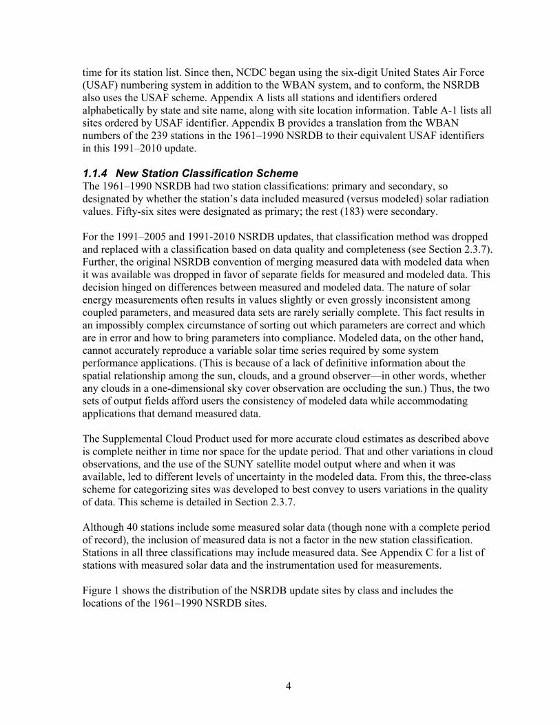
time for its station list. Since then, NCDC began using the six-digit United States Air Force (USAF) numbering system in addition to the WBAN system, and to conform, the NSRDB also uses the USAF scheme. Appendix A lists all stations and identifiers ordered alphabetically by state and site name, along with site location information. Table A-1 lists all sites ordered by USAF identifier. Appendix B provides a translation from the WBAN numbers of the 239 stations in the 1961–1990 NSRDB to their equivalent USAF identifiers in this 1991–2010 update. 1.1.4 New Station Classification Scheme The 1961–1990 NSRDB had two station classifications: primary and secondary, so designated by whether the station’s data included measured (versus modeled) solar radiation values. Fifty-six sites were designated as primary; the rest (183) were secondary. For the 1991–2005 and 1991-2010 NSRDB updates, that classification method was dropped and replaced with a classification based on data quality and completeness (see Section 2.3.7). Further, the original NSRDB convention of merging measured data with modeled data when it was available was dropped in favor of separate fields for measured and modeled data. This decision hinged on differences between measured and modeled data. The nature of solar energy measurements often results in values slightly or even grossly inconsistent among coupled parameters, and measured data sets are rarely serially complete. This fact results in an impossibly complex circumstance of sorting out which parameters are correct and which are in error and how to bring parameters into compliance. Modeled data, on the other hand, cannot accurately reproduce a variable solar time series required by some system performance applications. (This is because of a lack of definitive information about the spatial relationship among the sun, clouds, and a ground observer—in other words, whether any clouds in a one-dimensional sky cover observation are occluding the sun.) Thus, the two sets of output fields afford users the consistency of modeled data while accommodating applications that demand measured data. The Supplemental Cloud Product used for more accurate cloud estimates as described above is complete neither in time nor space for the update period. That and other variations in cloud observations, and the use of the SUNY satellite model output where and when it was available, led to different levels of uncertainty in the modeled data. From this, the three-class scheme for categorizing sites was developed to best convey to users variations in the quality of data. This scheme is detailed in Section 2.3.7. Although 40 stations include some measured solar data (though none with a complete period of record), the inclusion of measured data is not a factor in the new station classification. Stations in all three classifications may include measured data. See Appendix C for a list of stations with measured solar data and the instrumentation used for measurements. Figure 1 shows the distribution of the NSRDB update sites by class and includes the locations of the 1961–1990 NSRDB sites.
5
Figure 1. Distribution of NSRDB sites by class and measured solar data
1.1.5 Data Formats The 1961–1990 NSRDB was distributed in two formats: the NSRDB Synoptic format (used in the NCDC Solar and Meteorological Observation Network, or SAMSON, disks) and the NCDC TD3282 format. Because of immense changes in data distribution methods and efficiencies since the first release in 1992, NCDC distributes the NSRDB via the Internet. The NSRDB is also distributed by NREL without the meteorological fields. Although it doesn’t have meteorological fields, it has many other solar-related fields that are of interest to researchers, such as separate fields for METSTAT and SolarAnywhere® modeled data, clear sky modeled values, and the measured data. The NREL data set also includes some ancillary data fields, such as aerosols, water vapor, and ground albedo. The 10-km gridded product is distributed by NCDC at no cost. (This product does not contain any meteorological data.) See Section 1.3.3 for a summary of the data availability options. 1.1.6 Meteorological Fields Relative to the 1961–1990 NSRDB, one measurement pair was added to NSRDB update records starting with the 1991-2005 update, and three were removed.
6
• A pair of fields for liquid precipitation was added. This measurement was not in the
original NSRDB but was subsequently added to the NCDC SAMSON data set as hourly values. This measurement is included in the updated NSRDB as two fields of magnitude and time, according to the Integrated Surface Database (ISD) convention.
• Snow cover and days since last snowfall were removed from the update because of a lack of consistent snow cover data in the ISD data set. These parameters were used to modify the albedo input to the METSTAT model during periods of snow cover. However, the new ground albedo data sets used for the update include the effects of snow (although based on climatological monthly averages rather than daily resolution).
• The present weather field was removed. This field was originally used by the METSTAT model to modify the multiple-reflectance algorithm. The model has subsequently been modified to use ceiling height for this purpose.
1.1.7 Uncertainty Estimates The uncertainty estimates in the 1961–1990 NSRDB were based on the uncertainties of the input data sets. Starting with the updated 1991–2005 NSRDB, base uncertainty estimates are founded in model evaluation results that use high-quality model input data and compare the model output with measured data. This base uncertainty was then modified for the increased uncertainty of filled or the ASOS data when such input data were used. With the SUNY model, a base uncertainty was similarly determined in the model evaluation and then increased for periods of snow cover or high latitude—circumstances known to degrade model performance. From even the early stages of planning, the uncertainty of the 1991–2005 NSRDB was expected to be greater than that of the 1961–1990 NSRDB because of changes in cloud observations that reduced the accuracy of the cloud estimates. A critical part of the production plan was to conspicuously include realistic estimates of data uncertainty in the data to afford users the opportunity to evaluate the applicability of the database to any application or pass through uncertainties to derivative data sets. Hourly uncertainties for modeled data range from 8% under optimal conditions to more than 25% for less-than-optimal input data. The METSTAT model, and to a lesser extent the SUNY model, can have hourly uncertainties that far exceed even the extreme uncertainties quoted above. This follows from a lack of information about the spatial relation among the sun, clouds, and a target measurement on the ground. For example, a cloud amount of 50% does not convey whether the sun is fully visible between scattered clouds or is entirely blocked by a cloud. Further, the METSTAT model (not the SUNY model) deliberately randomizes cloud cover to better produce long-term statistics. Hence, the uncertainty should be in the context of the model’s design objective of reproducing the statistical characteristics of a solar data set rather than any specific hourly value. As stated in the 1961–1990 NSRDB user’s manual:
Given this objective, the assignment of uncertainties with reference to the true solar radiation for specific hours would not provide the user with useful

7
information. It was decided, therefore, that the uncertainty of individual hourly values estimated by METSTAT should be interpreted to mean that the true mean of measured hourly values under fixed atmospheric conditions lies within the range established by the estimated mean plus or minus the uncertainty, 95% of the time. (NREL 1993)
This observation underscores model evaluation findings that the modeled data may have large root mean square (RMS) errors relative to measured data but much smaller bias errors. This also indicates that NSRDB-modeled data may introduce unexpected errors if used for applications that require accurate hourly tracking of true solar irradiance, such as photovoltaic system performance analyses. This caveat is less critical under cloudless (0% cloud cover) or completely overcast (100% cloud cover) conditions, in which a cloud observation leaves no ambiguity. However, even under these conditions, other atmospheric constituents (particularly aerosols, see Section 2.2.1.2) or varying cloud opacity can have significant effects on the measured irradiance values. 1.1.8 Changes from the 1991-2005 NSRDB Update
• Updated Satellite data—Clean Power Research has implemented several model refinements in SolarAnywhere® since the SUNY data set used in the 1991-2005 update.
• Changed cloud cover input to the METSTAT model—The ASOS cloud algorithm for the METSTAT model was changed after research showed that ASOS tends to overestimate cloud cover at cloudy sites. See Section 2.1.2.
Note that no new measured solar radiation data were added to the database. Future updates are expected to have additional measured data available after 2005. 1.2 How To Use and Interpret Database Products The NSRDB 1991–2010 update is a serially complete collection of hourly values of the three most common measurements of solar radiation (i.e., global horizontal, direct normal, and diffuse horizontal) over a period of time adequate to establish means and extremes and at a sufficient number or locations to represent regional solar radiation climates. Nearly all of the solar data in the NSRDB are modeled, and only 40 sites have measured solar data—none of them with a complete period of record (see Appendix C). The updated NSRDB is distributed in two formats; one format is distributed by NCDC and the other by NREL. (See the discussion under Section 1.1.5). The solar radiation and meteorological elements in the NCDC data sets are listed in Table distributed in the NREL data set are listed in
2. The data elements Table 3.
The 1991–2010 NSRDB contains data for 1,454 sites, which are subdivided into three classes of stations.
• Class I Stations have a complete period of record (all hours 1991–2010) for solar and key meteorological fields and have the highest-quality solar modeled data (242 sites).

8
• Class II Stations have a complete period of record but significant periods of interpolated, filled, or otherwise lower-quality input data for the solar models (618 sites).
• Class III Stations have some gaps in the period of record but have at least 3 years of data that might be useful for some applications (594 sites).
Note: Completeness in period of record for station classification is based on solar, dry-bulb, and dew-point temperatures; humidity; wind and wind direction; aerosol optical depth (AOD); precipitable water; and station pressure. Other fields in Class I and II stations may not be serially complete.
Because of the data-filling methods used to accomplish the goal of serial completeness for the solar data, NSRDB meteorological data may not be suitable for climatological work. The meteorological fields in the NSRDB should be used only as ancillary data for solar deployment and sizing applications. Filled/interpolated meteorological data should not be used for climatic applications. (All such data are flagged.) ISD data are better for such applications and are available at http://cdo.ncdc.noaa.gov. See Section 2.3.7 for the method used to assign station classifications. The stations and their classifications are listed in Appendix A, along with plots that show the proportion of modeled solar data by year and the amount of measured solar data included in a station’s data set. Appendix C lists sites that include measured solar radiation data. International system (SI) units are used for all elements in the database except for atmospheric pressure. Atmospheric pressure is reported in millibars because these units are commonly used in computer models to estimate solar radiation and are consistent with standard NWS reporting practices. However, one millibar is equivalent to one hecto pascal, which is an SI unit. All data are referenced to local standard time according to the United States official time zone descriptions (Shanks 1996). The solar radiation elements represent radiant energy integrated over the hour preceding the designated time. Meteorological elements are values observed at or near the designated time according to meteorological measurement practices. The goal of the updated NSRDB is to provide users with accurate, reliable, and up-to-date solar resource information to support the objective of national energy independence. The need for an update arose from several considerations:
• Most recent resource data may best represent future conditions.
• Interannual and interdecadal variability and trends are of increasing importance to industry, which requires continuous updating of records.
• There were numerous requests for an update.
• Quality and completeness of information needs to grow along with a growing industry.

9
Although growing interest in climate trends also provided impetus for an update, the uncertainties in the modeled solar data likely make the data inadequate to discern the small annual or even decadal changes caused by climate change. The measured solar data, if at sites with sufficient quantity and quality, may offer value for climate change research. (See Appendix C for station instrumentation and period-of-record information.) 1.3 Database Product Options Current products available for the NSRDB 1991–2010 update are described here. These products are intended to meet the needs of most solar resource assessment applications. Product options include:
• Serial hourly data in three formats (one of which is an hourly gridded product) • Hourly, daily, and persistence summary products for solar radiation and several
meteorological elements (Class I and II stations only).
1.3.1 Hourly Data The serially complete hourly data provided in the NSRDB update are distributed in three formats available from two sources:
• NCDC data sets NCDC distributes a ground-based solar and meteorological data set with fields most useful for general solar resource assessment. The 10-km SolarAnywhere® gridded data set produced by the SUNY model for years 1998–2009 is also distributed by NCDC. The solar fields are also included in the NCDC Climate Data Online service, merged with existing meteorological data in the ISD product (but without the data filling).
• NREL data set NREL distributes a research solar radiation data set that includes a superset of fields related to solar radiation (i.e., both ground-based and satellite-based solar radiation estimates) but no meteorological data. (See the discussion under Section 1.1.5.)
Format descriptions are located in sections 1.4.1 to 1.4.3. 1.3.2 Statistical Summaries The NSRDB update contains statistical summaries computed from the hourly data for the entire period of record for Class I and II stations. Gaps in the record for Class III stations make a statistical comparison of those stations inconsistent with the other two classes of stations and prevent the provision of statistical summaries for Class III sites. For the solar radiation data, these statistics include the average and standard deviation of the daily total solar energy (direct normal, diffuse horizontal, and global horizontal) for each station-year-month and each station-year. The 20-year averages and the standard deviations of monthly and annual means from 1991–2010 are also provided. For the meteorological elements, only monthly, annual, and 20-year averages were computed. Future work includes a merging of the old and updated NSRDBs for 30-year statistical summaries (for those sites with an appropriate period of record).
10
The hourly statistical product provides yearly files that include monthly and annual averages and standard deviations for each hour of the day for global horizontal, direct normal, and diffuse horizontal solar radiation. The averages can be used to prepare average diurnal profiles of hourly solar energy. The hourly values have also been binned in 24 50-Wh/m2 bins from 0 to 1,200 Wh/m2. The mean number of hourly values falling into each bin has been determined for each station-month for the period of record from 1991–2010. These statistics can be used to plot histograms and determine cumulative frequency distributions. A solar radiation persistence product exists for each station-month by calculating the number of times the daily total solar radiation energy persisted above or below set thresholds for periods from 1 to 15 days. These calculations were performed for the entire period 1991–2010. The 1961–1990 NSRDB also included quality summary files, which are not reproduced for the 1991–2010 NSRDB update. Instead, a quality summary with additional information for each site in the NSRDB update is included in Appendix A, where plots indicate the relative quality of a site’s data for each year. 1.3.3 Data Availability Data described in sections 1.3.1 and 1.3.2 are accessible from the sources listed in Table 1.
Table 1. NSRDB Data Access Options
Data Set Distributor URL
NSRDB solar and filled meteorological fields
NCDC ftp://ftp.ncdc.noaa.gov/pub/data/nsrdb-solar/ http://www1.ncdc.noaa.gov/pub/data/nsrdb-solar/
NSRDB solar and ISD meteorological fields (no data filling)
NCDC http://cdo.ncdc.noaa.gov http://gis.ncdc.noaa.gov/map/cdo/?thm=themeHourly&select=true
SUNY 10-km gridded data NCDC ftp://ftp.ncdc.noaa.gov/pub/data/nsrdb-solar
http://www1.ncdc.noaa.gov/pub/data/nsrdb-solar/ NSRDB statistical summaries NCDC ftp://ftp.ncdc.noaa.gov/pub/data/nsrdb-solar
http://www1.ncdc.noaa.gov/pub/data/nsrdb-solar/ NSRDB research solar fields; no meteorological
NREL http://rredc.nrel.gov/solar/old_data/nsrdb/1991-2010

11
1.4 Reading and Understanding Database Products This section provides the information necessary to use the products developed for the NSRDB 1991–2010 update. This includes an explanation of the flags and uncertainty fields. 1.4.1 NCDC Format The primary provider for ground-based NSRDB data is NCDC, and data appear in site-year files in comma-separated value American Standard Code for Information Interchange (ASCII) format. Table 2 describes the fields in the NCDC data set. See Section 1.4.3 for the 10-km gridded data sets also distributed by NCDC.
Table 2. NSRDB Data Fields Distributed by NCDC
Field Element Unit Resolution Description
1 Date YYYY-MM-DD -- Date of data record
2 Time HH:MM -- Time of data record (local standard time)
3 Hourly mean zenith angle (for sunup periods)
Decimal degree 0.1˚ Solar zenith angle (angle between sun and the zenith) as the mean of all 1-minute sunup zenith angle values for the 60-minute period ending at the timestamp
4 Hourly mean azimuth angle (for sunup periods)
Decimal degree 0.1˚ Solar azimuth angle (angle between sun and north) as the mean of all 1-minute sunup azimuth angle values for the 60-minute period ending at the timestamp
5 Hourly extraterrestrial radiation on a horizontal surface
Watt-hour per square meter
1 Wh/m2 Amount of solar radiation received on a horizontal surface at the top of the atmosphere during the 60-minute period ending at the timestamp
6 Hourly extraterrestrial radiation normal to the sun
Watt-hour per square meter
1 Wh/m2 Amount of solar radiation received on a surface normal to the sun at the top of the atmosphere during the 60-minute period ending at the timestamp
7 Modeled global horizontal
Watt-hour per square meter
1 Wh/m2 Total amount of direct and diffuse solar radiation (modeled) received on a horizontal surface during the 60-minute period ending at the timestamp
8 Modeled global horizontal uncertainty
±% 1% See Section 1.4.5.1

12
Field Element Unit Resolution Description 9 Modeled global
horizontal source flag
-- See Table 7
10 Modeled direct normal
Watt-hour per square meter
1 Wh/m2 Amount of solar radiation (modeled) received in a collimated beam on a surface normal to the sun during the 60-minute period ending at the timestamp
11 Modeled direct normal uncertainty
±% 1% See Section 1.4.5.1
12 Modeled direct normal source flag
-- See Table 8
13 Modeled diffuse horizontal
Watt-hour per square meter
1 Wh/m2 Amount of solar radiation (modeled) received from the sky (excluding the solar disk) on a horizontal surface during the 60-minute period ending at the timestamp
14 Modeled diffuse horizontal uncertainty
±% 1% See Section 1.4.5.1
15 Modeled diffuse horizontal source flag
-- See Table 8
16 Measured global horizontal
Watt-hour per square meter
1 Wh/m2 Total amount of direct and diffuse solar radiation received on a horizontal surface during the 60-minute period ending at the timestamp
17 Measured global horizontal quality flag
SERI-QC -- See Table 11
18 Measured direct normal
Watt-hour per square meter
1 Wh/m2 Amount of solar radiation received in a collimated beam on a surface normal to the sun during the 60-minute period ending at the timestamp
19 Measured direct normal quality flag
SERI-QC -- See Table 11
20 Measured diffuse horizontal
Watt-hour per square meter
1 Wh/m2 Amount of solar radiation received from the sky (excluding the solar disk) on a horizontal surface during the 60-minute period ending at the timestamp

13
Field Element Unit Resolution Description 21 Measured diffuse
horizontal quality flag
SERI-QC -- See Table 11
22 *Total sky cover Tenth of sky 1 tenth Amount of sky dome covered by clouds or obscuring phenomena at the time indicated
23 *Total sky cover flag
-- See Section 1.4.5.2
24 *Opaque sky cover Tenth of sky 1 tenth Amount of sky dome covered by clouds or obscuring phenomena that prevent observing the sky or higher cloud layers at the time indicated
25 *Opaque sky cover flag
-- See Section 1.4.5.2
26 *Dry-bulb temperature
Degree C 0.1˚ Dry-bulb temperature at the time indicated
27 *Dry-bulb temperature flag
-- See Section 1.4.5.2
28 *Dew-point temperature
Degree C 0.1˚ Dew-point temperature at the time indicated
29 *Dew-point temperature flag
-- See Section 1.4.5.2
30 *Relative humidity Percent 1% Relative humidity at the time indicated
31 *Relative humidity flag
-- See Section 1.4.5.2
32 *Station pressure Millibar 1 mbar Station pressure at the time indicated
33 *Station pressure flag
-- See Section 1.4.5.2
34 *Wind speed Meter/second 0.1 m/s Wind speed at the time indicated
35 *Wind speed flag -- See Section 1.4.5.2
36 *Wind direction Degrees from north (360˚ = north; 0˚ = undefined)
10˚ Wind direction at the time indicated
37 *Wind direction flag -- See S Section 1.4.5.2
38 Horizontal visibility Meter 1 m Distance to discernible remote objects at the time indicated
39 Horizontal visibility flag
-- See Section 1.4.5.2
40 *Ceiling height Meter 1 m Height of the cloud base above local terrain

14
Field Element Unit Resolution Description 41 *Ceiling height flag -- See Section 1.4.5.2
42 Liquid precipitation depth
Millimeter 1 mm The amount of liquid precipitation observed at the indicated time for the period indicated in the liquid precipitation quantity field
43 Liquid precipitation depth flag
-- See Section 1.4.5.2
44 Liquid precipitation quantity
Hour 1 hr The period of accumulation for the liquid precipitation depth field
45 Liquid precipitation quantity flag
-- See Section 1.4.5.2
46 *Precipitable water Centimeter 0.1 cm The total precipitable water contained in a column of unit cross section extending all of the way from the earth's surface to the “top” of the atmosphere. See Section 2.2.1.4
47 *Precipitable water flag
-- See Section 1.4.5.2 and Table 13
48 *Aerosol optical depth, broadband
[Unitless] 0.001 The broadband optical depth per unit of airmass due to extinction by the aerosol component of the atmosphere (randomly perturbed). See Section 2.2.1.2
49 *Aerosol optical depth flag
-- See Section 1.4.5.2 and Table 13
*Asterisks indicate a field is subject to data filling and is used for station classification (see Section 2.3.7). Completeness of these fields is used to determine if a site has a “complete period of record.” Other fields may have gaps even if these fields are complete.
Data are stored on the NCDC server (see Table 1) in .tar files that hold yearly files in a compressed gzip (.gz) format. Files are named according to the station identifier. Several utilities exist to uncompress .tar and .gz files. Among them (with no implied endorsement) are tar and gzip on unix and linux computers, WinZip and 7-Zip on Windows, and WinZip and Stuffit on the Macintosh. Files must be transferred from the server using a binary protocol (not ASCII), or the uncompression step will fail. 1.4.2 NREL Format A secondary source of NSRDB data is NREL, which distributes a full set of solar radiation fields but no meteorological fields (see discussion under Section 1.1.5). Data sets are distributed in comma-separated value ASCII format in site-year files. Table 3 describes the NREL data set.

15
Table 3. NSRDB Data Fields Distributed by NREL
Field Element Unit Resolution Description 1 Date YYYY-MM-
DD -- Date of data record
2 Time HH:MM -- Time of data record (local standard time)
3 Hourly mean zenith angle (for sunup periods)
Decimal degree
0.1˚ Solar zenith angle (angle between sun and the zenith) as the mean of all 1-minute sunup zenith angle values for the 60-minute period ending at the timestamp
4 Hourly mean azimuth angle (for sunup periods)
Decimal degree
0.1˚ Solar azimuth angle (angle between sun and north) as the mean of all 1-minute sunup azimuth angle values for the 60-minute period ending at the timestamp
5 Hourly extraterrestrial radiation on a horizontal surface
Watt-hour per square meter
1 Wh/m2 Amount of solar radiation received on a horizontal surface at the top of the atmosphere during the 60-minute period ending at the timestamp
6 Hourly extraterrestrial radiation normal to the sun
Watt-hour per square meter
1 Wh/m2 Amount of solar radiation received on a surface normal to the sun at the top of the atmosphere during the 60-minute period ending at the timestamp
7 SUNY-modeled global horizontal
Watt-hour per square meter
1 Wh/m2 Total amount of direct and diffuse solar radiation (SUNY-modeled) received on a horizontal surface during the 60-minute period ending at the timestamp
8 SUNY-modeled global horizontal flag
-- -- See Table 5
9 SUNY-modeled global horizontal uncertainty
±% 1% See Section 1.4.5.1
10 SUNY-modeled
direct normal Watt-hour per square meter
1 Wh/m2 Amount of solar radiation (SUNY-modeled) received in a collimated beam on a surface normal to the sun during the 60-minute period ending at the timestamp
11 SUNY -modeled direct horizontal flag
-- -- See Table 5
12 SUNY-modeled direct normal uncertainty
±% 1% See Section 1.4.5.1

16
Field Element Unit Resolution Description 13 SUNY-modeled
diffuse horizontal Watt-hour per square meter
1 Wh/m2 Amount of solar radiation (SUNY-modeled) received from the sky (excluding the solar disk) on a horizontal surface during the 60-minute period ending at the timestamp
14 SUNY -modeled diffuse horizontal flag
-- -- See Table 5
15 SUNY-modeled diffuse horizontal uncertainty
±% 1% See Section 1.4.5.1
16 METSTAT-modeled
global horizontal Watt-hour per square meter
1 Wh/m2 Total amount of direct and diffuse solar radiation (METSTAT-modeled) received on a horizontal surface during the 60-minute period ending at the timestamp
17 METSTAT-modeled global horizontal uncertainty
±% 1% See Section 1.4.5.1
18 METSTAT-modeled direct normal
Watt-hour per square meter
1 Wh/m2 Amount of solar radiation (METSTAT-modeled) received in a collimated beam on a surface normal to the sun during the 60-minute period ending at the timestamp
19 METSTAT-modeled direct normal uncertainty
±% 1% See Section 1.4.5.1
20 METSTAT-modeled diffuse horizontal
Watt-hour per square meter
1 Wh/m2 Amount of solar radiation (METSTAT-modeled) received from the sky (excluding the solar disk) on a horizontal surface during the 60-minute period ending at the timestamp
21 METSTAT-modeled diffuse horizontal uncertainty
±% 1% See Section 1.4.5.1
22 METSTAT-modeled clear sky global horizontal
Watt-hour per square meter
1 Wh/m2 Total amount of direct and diffuse solar radiation (METSTAT-modeled with cloud cover set to zero) received on a horizontal surface during the 60-minute period ending at the timestamp
23 METSTAT-modeled clear sky global horizontal uncertainty
±% 1% See Section 1.4.5.1
24 METSTAT-modeled clear sky direct normal
Watt-hour per square meter
1 Wh/m2 Amount of solar radiation (METSTAT-modeled with cloud cover set to zero) received in a collimated beam on a surface normal to the sun during the 60-minute period ending at the timestamp

17
Field Element Unit Resolution Description 25 METSTAT-modeled
clear sky direct normal uncertainty
±% 1% See Section 1.4.5.1
26 METSTAT-modeled clear sky diffuse horizontal
Watt-hour per square meter
1 Wh/m2 Amount of solar radiation (METSTAT-modeled with cloud cover set to zero) received from the sky (excluding the solar disk) on a horizontal surface during the 60-minute period ending at the timestamp
27 METSTAT-modeled clear sky diffuse horizontal uncertainty
±% 1% See Section 1.4.5.1
28 Measured global horizontal
Watt-hour per square meter
1 Wh/m2 Total amount of measured direct and diffuse solar radiation received on a horizontal surface during the 60-minute period ending at the timestamp
29 Measured global horizontal quality flag
SERI-QC -- See Table 11
30
Measured direct normal
Watt-hour per square meter
1 Wh/m2 Amount of measured solar radiation received in a collimated beam on a surface normal to the sun during the 60-minute period ending at the timestamp
31 Measured direct normal quality flag
SERI-QC -- See Table 11
32 Measured diffuse horizontal
Watt-hour per square meter
1 Wh/m2 Amount of measured solar radiation received from the sky (excluding the solar disk) on a horizontal surface during the 60-minute period ending at the timestamp
33 Measured diffuse horizontal quality flag
SERI-QC -- See Table 11
34 Precipitable water Centimeter 0.1 cm The total precipitable water contained in a column of unit cross section extending from the earth's surface to the top of the atmosphere. See Section 2.2.1.4.
35 Precipitable water flag
-- See Section 1.4.5.2 and Table 13
36 Aerosol optical depth, broadband
[Unitless] 0.001 The broadband aerosol optical depth per unit of air mass due to extinction by the aerosol component of the atmosphere. See Section 2.2.1.4.
37 Aerosol optical depth flag
-- See Section 1.4.5.2 and Table 13
38 Aerosol optical depth broadband randomized (see Section 2.3.5)
[Unitless] 0.001 Broadband aerosol optical depth value randomized by the METSTAT model (see Section 2.3.3)
18
Field Element Unit Resolution Description 39 Aerosol optical depth
broadband randomized flag
-- See Section 1.4.5.2 and Table 13
40 Ozone Centimeter 0.001 cm The total amount of ozone present in a column of unit cross section extending from the earth's surface to the top of the atmosphere. See Section 2.2.1.3.
41 Ozone flag -- See Section 1.4.5.2 and Table 15 42 Albedo [Unitless] 0.01 The ratio of reflected solar irradiance
to global horizontal irradiance (GHI). See Section 2.2.1.5.
43 Albedo flag -- --
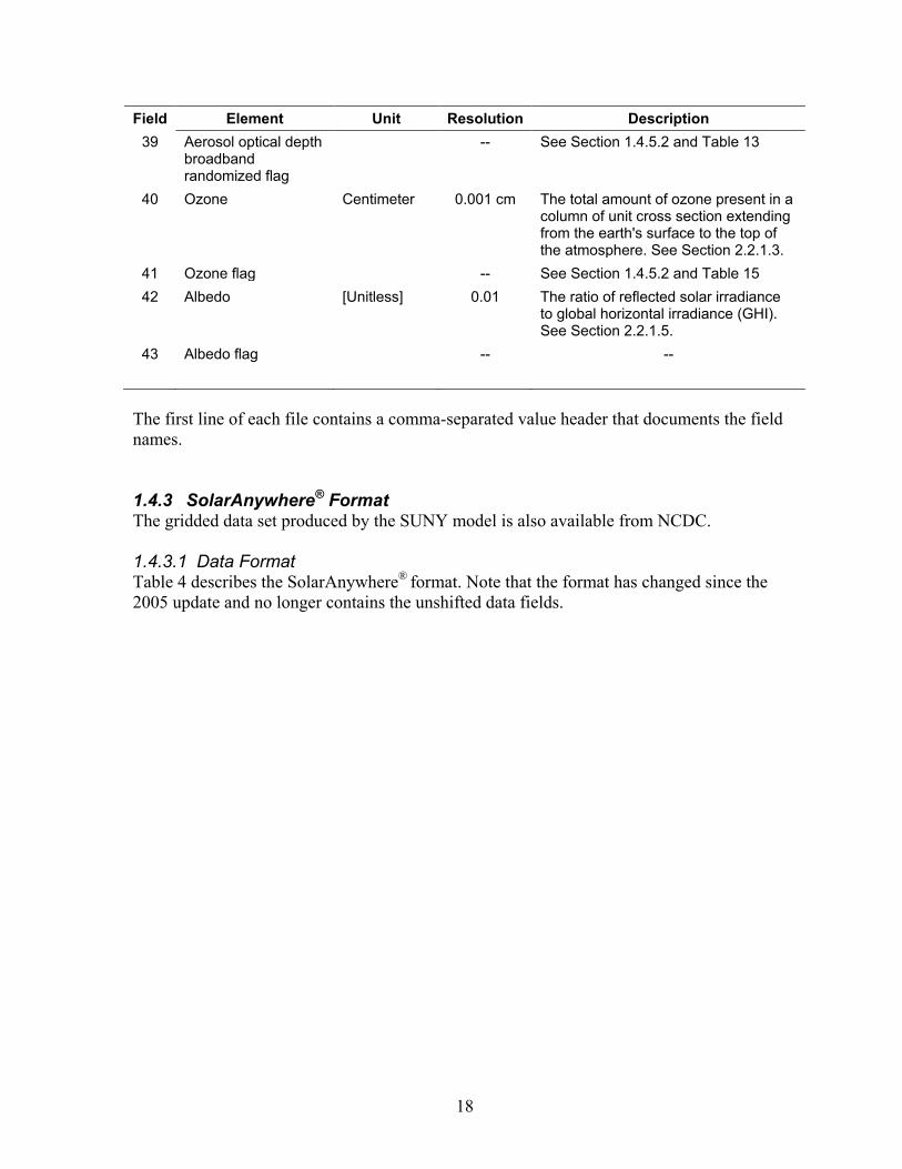
The first line of each file contains a comma-separated value header that documents the field names. 1.4.3 SolarAnywhere® Format The gridded data set produced by the SUNY model is also available from NCDC. 1.4.3.1 Data Format Table 4 describes the SolarAnywhere® format. Note that the format has changed since the 2005 update and no longer contains the unshifted data fields.

19
Table 4. SolarAnywhere® Gridded Data Elements
Field Element Unit Resolution Description 1 Date YYYY-MM-
DD -- Date of data record
2 Time HH:MM -- Time of the data record 3 Hourly mean
zenith angle (for sunup periods)
Decimal degree
0.1˚ Solar zenith angle (angle between sun and the zenith) as the mean of all 1-minute sunup zenith angle values for the 60-minute period ending at the timestamp
4 SUNY-modeled global horizontal
Watt-hour per square meter
1 Wh/m2 Total amount of direct and diffuse solar radiation (modeled) received on a horizontal surface during the 60-minute period ending at the timestamp
5 SUNY-modeled direct normal
Watt-hour per square meter
1 Wh/m2 Amount of solar radiation (modeled) received in a collimated beam on a surface normal to the sun during the 60-minute period ending at the timestamp
6 SUNY-modeled diffuse horizontal
Watt-hour per square meter
1 Wh/m2 Amount of solar radiation (modeled) received from the sky (excluding the solar disk) on a horizontal surface during the 60-minute period ending at the timestamp
7 Data flag -- -- See Table 5.
Data flags have been added to the SolarAnywhere® data by NREL. These flags are documented in Table 5.
Table 5. SolarAnywhere® Data Flags Added by NREL
Flag Description 0 Global and direct unmodified; diffuse calculated by NREL (see Section 2.1.6 1 Data have been added at high zenith angles by NREL (see Section 2.1.6) 2 Diffuse has been set to clear sky minimum and direct recalculated (see Section 2.1.6) 3 Data have been filled (see Section 2.1.6)
1.4.3.2 Finding Data for a Specific Location Data files are accessed from the links in Table 1. To find data for a specific location:
1. Determine the name of the file that holds the desired data. 2. Find the file in the directory structure.
1.4.3.2.1 Determining the File Name Each file is explicitly named with latitude and longitude coordinates. For example:

20
NSRDB_SolarAnyWhere10km_19910101_20091231_lat34.05lon-109.75.csv.gz
These coordinates represent the center of a pixel that is one-tenth of a degree on each side. In the example above, the data therein represent geographical coordinates from latitude 34.00 to 34.10 and longitude -109.70 to -109.80.
The proper file name is constructed by truncating (not rounding) the latitude and longitude values to tenth-of-a-degree resolution and adding (for latitude) or subtracting (for longitude) 0.05. For example, to find data for Lat=34.01 and Lon=-109.79:
1. Truncate 34.01 to 34.00 and add 0.05 degrees for 34.05. 2. Truncate -109.79 to -109.7 and subtract 0.05 degrees for -109.75.
Look for the file with these coordinates in the name.
1.4.3.2.2 Finding Specific Files in the Directory Structure Files are organized in directories with names that are coded and labeled by latitude and longitude in the following five-digit format:
TTNNN (where TT is a two-digit integer latitude and NNN is a three-digit integer longitude).
These latitude and longitude coordinates represent the southwest corner of a 2-by-2 degree box, and all files in that directory fall within the geographical box. The longitude is actually negative, but the negative sign is not used in the directory coding; however, it is used to determine the southwest corner. Another way of stating this is that the directory latitude and longitude numbers are the lowest coordinate values of the 2-by-2 box. The coded directory coordinates are always even numbers. For example, to find the directory holding the file named with latitude 34.05 and longitude -109.75:
1. Take the integer portion of both the latitude (34) and longitude (-109). Determine the next even number less than or equal to the integer latitude and the next even number less than the longitude. In this example, that would be:
34 and -110 (remember that -110 is arithmetically less than -109)
2. Drop the negative sign, put them together in latitude-longitude order, and append to the text "NSRDB_SolarAnywhere10km_19980101_20091231_" to form the directory name:
NSRDB_SolarAnywhere10km_19980101_20091231_34110
3. Open that directory, and you will find the correct file:
NSRDB_SolarAnyWhere10km_19980101_20091231_lat34.05lon-109.75.csv.gz

21
1.4.3.2.3 Extracting the Data Data are in a comma-separated value format and have been compressed using the gzip utility, thus giving them a .gz file extension. Several utilities exist to uncompress a .gz file. Among them (no implied endorsement) are gzip on unix and linux computers, WinZip and 7-Zip on Windows, and WinZip and Stuffit on the Macintosh. Files must be transferred from the server using a binary protocol (not ASCII), or the uncompression step will fail. 1.4.4 Statistical Summaries This section details the information required to view and use the statistical products from the NSRDB. 1.4.4.1 Daily Statistics Figure 2 is an example of a daily statistics file. The header identifies the station using the six-digit USAF identifier, station name (the first 22 characters), and state code. The header identifies the time zone (TZ) for the station as the number of hours by which the local standard time lags (minus) or leads (plus) Universal Time (e.g., Eastern Standard Time is designated as -5). Latitude and longitude for the station are given in degrees and minutes, station elevation is in meters, and the mean atmospheric pressure is given in millibars. The next line in each file identifies the year(s) for which the next section of data applies. In each file, the first group of data provides daily statistics for the 20 years 1991–2010. Statistics for each year for the entire period of record follow. As an example, Figure 2 gives 20-year statistics for Albuquerque, New Mexico. Monthly and annual statistics are given for 1991 to 2010, followed by similar monthly statistics for each year. The Fortran formats for reading the header, year(s), and data records are given at the bottom of Figure 2. The standard deviations of solar radiation elements (e.g., SDGLO) for individual years and for the period of record (1991–2010) are not the same. For individual years, the standard deviations provide a measure of daily variability. For the period of record, the standard deviations provide a measure of the interannual variability of monthly and annual averages. The NSRDB mean values for meteorological elements may not be identical to the means published by NCDC. Small differences are expected as the result of different computational methods and differences in methods to replace missing data, but these differences have not been quantified. Two flags define the quality of each solar radiation element in the daily statistics files. The first flag gives the user information about the source of each hourly value for each solar radiation element, including the methods and input data used to derive model estimates. The flags are based on the hourly data and, in this context, represent the dominant category of source data for the period. Solar radiation source flags are defined in Table 6. The flags are ranked roughly from the highest- to the lowest-quality data. The first eight table entries (flags A–H) pertain to the 1961–1990 NSRDB and do not occur in the 1991–2010 update but are included here for historical completeness. Entries I–K (in bold) were added to denote the improved aerosol estimates used for the NSRDB updates.

22
Table 6. Source Codes Solar Radiation Elements
Flag Definition
A Post-1976 measured solar radiation data as received from NCDC or other sources B Same as ”A” except the global horizontal data underwent a calibration correction C Pre-1976 measured global horizontal data (direct and diffuse were not measured before 1976)
adjusted from solar to local time, usually with a calibration correction D Data derived from the other two elements of solar radiation using the relation Kt = Kn + Kd E Modeled solar radiation data using inputs of observed sky cover (cloud amount) and aerosol
optical depths derived from direct normal data collected at the same location F Modeled solar radiation using interpolated sky cover and aerosol optical depths derived from
direct normal data collected at the same location G Modeled solar radiation data using observed sky cover and aerosol optical depths estimated
from geographical relationships H Modeled solar radiation data using interpolated sky cover and estimated aerosol optical depths I Modeled solar radiation data using ground observed sky cover and revised aerosols J Modeled solar radiation data using filled sky cover and revised aerosols K Modeled solar radiation data using satellite imagery and revised aerosols ? Source does not fit any of the above categories.
The second flag designates the uncertainty attached to the value. Uncertainty, as used here, provides an estimate of the interval around a measured or modeled value within which the true value will fall 95% of the time. The flags are based on the individual hourly data and, in this context, represent the average uncertainty for the period. The uncertainty flags are defined in Table 7.
Table 7. Uncertainty Ranges for Daily Statistics Files
Flag Uncertainty (±%) 1 0–2 2 2–4 3 4–6 4 6–9 5 9–13 6 13–18 7 18–25 8 25–35 9 35–50 0 Not Applicable

23
1.4.4.2 Hourly Means, Standard Deviations, and Distributions The hourly statistics are presented in the form of means and standard deviations of the hourly values for each hour (from which diurnal profiles can be formed) and distributions generated by binning hourly values to determine the number of hours for which the radiation fell within 24 50-Wh/m2 ranges (e.g., 0–50, 50–100, 100–150, … 1100–1150, 1150–1200). The bin data have been normalized to indicate the percentage (in tenths) of all daytime hours for which the radiation fell within each bin. Figure 3 provides an example of these hourly statistics. The header information is the same as that used for the daily statistics, except that the year(s) represented by each file has been added as the last field of the header. Following the header, the next record identifies the solar radiation element (e.g., global horizontal radiation in Wh/m2) and the statistics (e.g., arithmetic means) for which the following data records apply. Each file contains data for all three solar radiation elements and each of the three statistics, as indicated in Figure 3. The first two fields in each data record designate the month (13 indicates annual statistics) and the source and uncertainty flags that apply to each monthly profile and distribution. The data fields for means and standard deviations contain these hourly statistics in Wh/m2 for each of the 24 hours of the day. For example, values for hour 01 represent the mean or standard deviation of the total radiant energy measured from midnight (2400) to 1 a.m. (0100). The data fields for the distributions designate the percentage of hours, in tenths of one percent, for which the average radiation fell within the 50-Wh/m2 bins described above. The Fortran formats for reading the header, statistic identification, and data records are given at the bottom of Figure 3. 1.4.4.3 Daily Persistence Data The persistence of weather events and the effect this has on the availability of solar radiation energy can affect many solar energy applications. In particular, the persistence of solar energy can affect energy storage requirements and the need for backup energy sources. The persistence statistic calculated for the NSRDB is the number of sequential days (runs) in a month during which the daily total energy exceeded or fell below 12 energy thresholds (see Figure 4). The run lengths vary from 1 to 15 or more days. The total number of runs over the entire 20-year period of 1991–2010 was determined for each month. The decision to compute persistence on a monthly (rather than perpetual) basis resulted in the truncation of runs at the end of each month and, possibly, in an underestimation of longer runs. Although this procedure caused some distortion of the statistics, it provided important information about seasonal changes in persistence. An example of the persistence statistic is shown in Figure 4. The thresholds for diffuse horizontal radiation (0–5,000 Wh/m2 in 11 steps) are one-half those used for global horizontal and direct normal radiation (0–10,000 Wh/m2 in 11 steps). The header information gives the USAF number, station name, state code, month, and solar radiation element.

24
Each number in the matrices on the left of Figure 4 is the number of times the daily total solar energy exceeded the threshold indicated for that row for no more or no less than the number of days indicated for that column. Each number in the matrices on the right is the number of times the daily total solar energy was less than the threshold indicated for that row for no more or no less than the number of days indicated for that column. The numbers in these matrices can be used various ways. For example, the sum of all the numbers in the sector enclosed by the dotted line indicates that the daily total global horizontal energy fell below 6,000 Wh/m2 for 4 or more days 27 times (the sum of all numbers in the sector) during 1991–2010. These matrices can be sectored in any manner that produces information useful to specific applications. The Fortran formats for reading the headers, number of days, thresholds, and number of events are given at the bottom of Figure 4. 1.4.5 Hourly Quality Flags Quality flags are attached to each hourly solar radiation and meteorological element. Each solar radiation element has a source flag and an uncertainty value, and each meteorological element has a source flag. These flags provide information about the source and uncertainty of a data element to allow users to evaluate its usefulness. The flags are further described in the following sections. 1.4.5.1 Source Flags, Quality Flags, and Estimated Uncertainty for Solar Radiation
Elements For the modeled solar elements, the source flags are described in Table 8.
Table 8. Modeled Solar Radiation Source Flags
Flag Description 1 Value modeled from the METSTAT model 2 Value from time-shifted SolarAnywhere®; diffuse calculated by NREL (see Section 2.1.6) 3 Value from SolarAnywhere®, adjusted to a minimum low-diffuse envelope (see Section 2.1.6) 4 Value from SolarAnywhere®, filled by NREL (see Section 2.1.6)
99 Missing data (associated data field is filled with -9900)
The uncertainty flags (±%) are based on model type and quality of input data. The uncertainty is calculated based on model evaluation (Myers 2005) that compared predictions with measured ground data that have been averaged to monthly mean daily totals (MMDT). Since the release of the 1991–2005 NSRDB update, Clean Power Research, in partnership with SUNY, updated the SUNY model and released updated data sets, of which Version 2.2 is incorporated in the NSRDB. No independent analysis has been published to quantify the changes and presumed improvements. Until such time, the NSRDB will continue to use the results of Myers 2005 for the uncertainty analysis.

25
The approach is based on the International Bureau of Weights and Measures and ISO GUM (International Bureau of Weights and Measures 1993). From this evaluation, an optimal uncertainty, Uopt, for each parameter was calculated using the best available sky cover or satellite image input data.
Uopt = (Umeas2 + Umod
2 + Ubias2) 1/2 (±%)
where – Umeas is the uncertainty of the measured data (±%) – Umod is the RMSE of the model (±%) – Ubias is the mean bias error of the model (±%). Umeas (±%) is set as follows:
Global Direct Diffuse
6 5 6
These values are approximately double the ideal measurement uncertainty for the instrumentation and include additional uncertainties attributable to common operational problems at even well-maintained sites. Umod and Ubias (±%) for each model and parameter are listed below.
Model Glo/Dif RMS (Umod)
Glo/Dif MBE (Ubias)
Dir RMS (Umod)
Dir MBE (Ubias)
METSTAT 8 2 15 4
SUNY 5 0 14 1
Notes: MBE – mean bias error RMS – root mean square error Finally, the calculated Uopt (±%) for each model is listed below.
Model Glo/Dif Dir
METSTAT 10 16 SUNY 8 15
These optimal uncertainties reflect model performance using the highest quality input cloud data and include the uncertainty of the ground measurements used for validation. For the METSTAT model, optimal cloud cover consists of a set of total and opaque cloud values derived using the NCDC Supplemental Cloud Product. Manual cloud observations, when available, are presumed to be as good or better than those derived from the Supplemental

26
Cloud Product but were not used in the model evaluation. For the SUNY model, optimal inputs are GOES pixels without snow cover and below 50˚ latitude. To these optimal uncertainties, more uncertainty is added for an uncertainty, U, under non-optimal conditions.
U = (Uopt 2 + Uadd12 + Uadd2
2 …)1/2 (±%) where
– Uaddi are additional sources of uncertainty. Additional uncertainties for each model are shown in the tables below.
Table 9. METSTAT Additional Uncertainties (±%)
Condition
Additional Uncertainty
Comments
Short- and medium-term data filling
4 Data derived from close time proximity
Long-term filling 14 Based on interannual variability—data come from like dates in other years
Cloud probability derivation
4 Differences in total and opaque average less than 1 okta
Cloud probability from nearby site
4 Differences in total and opaque average less than 1 okta
ASOS-only 22 Limited okta resolution afforded by the coded ASOS-only data—a cloud measurement value could be in error by two oktas
Data filling is explained in Section 2.2.2.
Table 10. SUNY Additional Uncertainties (±%)
Condition Additional Uncertainty
Comments
Time shifting 2 Shifting from satellite time to hourly local time causes
some error in the hourly values or daily totals. Ground snow cover 5 High ground albedo compresses the dynamic range of
the model. Periods of snow cover were estimated for 5˚ latitude and longitude cells on a monthly basis using snow cover probability contours for the United States (Dickerson 1967). If the probability of snow for a given location was greater than 25%, the additional uncertainty was added to the data.
The source flag for the SolarAnywhere® data are described in Table 5. (See section 2.1.6) For the measured solar radiation fields, the flag fields hold SERI-QC flags (NREL 1993). A brief summary of the SERI-QC flags appears in Table 11.

27
Table 11. SERI-QC Flag Descriptions
Flag Description
00 Untested (raw data) 01 Passed one-component test; data fall within min-max limits of Kt, Kn, or Kd 02 Passed two-component test; data fall within 0.03 of the Gompertz boundaries 03 Passed three-component test; data come within 0.03 of satisfying
Kt = Kn + Kd 04 Passed visual inspection; not used by SERI-QC 05 Failed visual inspection; not used by SERI-QC 06 Value estimated; passes all pertinent SERI-QC test 07 Failed one-component test; lower than allowed minimum 08 Failed one-component test; higher than allowed maximum 09 Passed three-component test but failed two-component test by >0.05
10-93 Failed two- or three-component tests in one of four ways. To determine the test failed and the manner of failure (high or low), examine the remainder of the calculation (flag + 2)/4. REM Failure 0 Parameter too low by three-component test (Kt = Kn + Kd) 1 Parameter too high by three-component test (Kt = Kn + Kd) 2 Parameter too low by two-component test (Gompertz boundaries) 3 Parameter too high by two-component test (Gompertz boundaries) The magnitude of the test failure (distance in K-units) is determined from: d = (INT (flag +2)/4)/100.
94-97 Data fall into a physically impossible region where Kn > Kt by K-space distances of 0.05–0.10 (94), 0.10–0.15 (95), 0.15–0.20 (96), or ±0.20 (97).
98 Not used 99 Missing data (associated data field is filled with -9900)
SERI-QC flags of 6 were used when filling a missing solar value using two other solar components. The quality of these data can be estimated from the SERI-QC flag of either of the other two components. Note: No effort was made to filter the measured data based on quality to allow the user the opportunity to optimize the data set according to quality specifications demanded by a particular application.

28
1.4.5.2 Quality Flags for Meteorological and Other Elements Meteorological data came from NCDC’s ISD data (Lott 2001). The flags that accompanied the ISD data were carried through to the NSRDB data fields (NCDC 2004). If a value was modified or filled, additional flags specific to the NSRDB data set were added. ISD data with flags indicating questionable data were excluded from the NSRDB. An extensive hand inspection of anomalous data in the 2005 update found that many such data points were flagged as questionable. Thus the decision was made to exclude all such data and allow the subsequent data filling routines to populate those fields. Table 12 describes flags on the meteorological data.
Table 12. Meteorological Data Flags
Flag Description
0-9 ISD data flags (unmodified data) 51 Value from short-term data filling or interpolation 52 Value from medium-term data filling 53 Value from long-term data filling 54 Value is calculated:
• Relative humidity calculated from dry-bulb and dew-point temperatures • Station pressure calculated from sea-level pressure, altimeter, and dry-bulb • Data point undefined by convention (e.g., wind direction at zero speed)
55 Value from last-ditch data filling 56 Value statistically derived (cloud amounts based on probability tables) 61 Value modeled (total and opaque cloud derived from Supplemental Cloud Product; ceiling
height as linear function of opaque cloud amount); pressure modeled from elevation 99 Value missing (associated data field is filled with -9900)
The flags attached to the aerosol optical depth data are described in Table 13. See Section 2.2.1.2.

29
Table 13. Aerosol Optical Depth Flags
Flag Description 1 Direct normal irradiance (DNI) measurements used with inverted Climatological Solar
Radiation model (1995) 2 From Southwest United States study by George and Gueymard (2001) using spectral data
from ground-based sun photometers 3 Gridded data from Multi-Angle Imaging SpectroRadiometer spaceborne instrument and
altitude corrections (Gueymard and George 2005) 51 Value from short-term data filling or interpolation 52 Value from medium-term data filling 53 Value from long-term data filling 55 Value from last-ditch data filling
The precipitable water data flags are described in Table 14. See Section 2.2.1.4.
Table 14. Precipitable Water Flags
Flag Description 1 From National Aeronautics and Space Administration Water Vapor Project (NVAP)
once daily from 1˚ x 1˚ grid 2 NVAP twice daily from 0.5˚ x 0.5˚ grid 3 From North American Regional Reanalysis (NARR) eight times daily from 32-km grid 4 From twice daily radiosonde 51 Value from short-term data filling or interpolation 52 Value from medium-term data filling 53 Value from long-term data filling 55 Value from last-ditch data filling
The ozone data flags are described in Table 15. See Section 2.2.1.3.
Table 15. Ozone Flags
Flag Description 1 Total Ozone Mapping Scanner (TOMS) on a grid 1˚ in latitude and 1.25˚ in longitude 2 Ozone Monitoring Instrument (OMI) on a 1º x 1º grid 51 Value from short-term data filling or interpolation 52 Value from medium-term data filling 53 Value from long-term data filling 55 Value from last-ditch data filling

30
USAF CITY STATE TZ LAT LONG ELEV PRES 723650 ALBUQUERQUE INTL ARPT NM -7 N35 2 W106 37 1619 836 1991-2005 MO AVGLO FL SDGLO AVDIR FL SDDIR AVDIF FL SDDIF AVETR AETRN TOT OPQ H2O TAU MAX_T MIN_T AVG_T AVGDT RH HTDD CLDD AVWS 1 3001 K5 305 5119 K7 1123 891 K5 156 5150 14218 4.1 3.4 0.64 0.06 9.20 -2.21 3.21 5.49 51 460 0 3.1 2 3869 K5 385 5482 K7 1304 1199 K5 234 6566 15262 4.8 4.0 0.64 0.08 12.07 -0.22 5.78 7.87 45 351 0 3.6 3 5178 K5 455 6266 K7 1307 1515 K5 282 8386 16499 4.2 3.6 0.65 0.11 16.21 2.40 9.25 11.50 38 280 0 3.9 4 6538 K5 394 7134 K6 1018 1862 K5 264 10053 17704 3.9 3.2 0.73 0.13 20.72 6.48 13.76 15.74 31 147 5 4.4 5 7304 K5 627 7433 K6 1522 2059 K5 399 11142 18664 3.8 3.1 1.03 0.14 26.71 12.09 19.62 21.65 29 30 63 4.2 6 7829 K5 375 8255 K6 920 1962 K5 267 11554 19101 3.3 2.8 1.35 0.13 31.48 16.63 24.23 25.90 29 2 174 4.0 7 7258 K5 400 7210 K6 991 2038 K5 321 11288 18770 4.7 4.1 2.03 0.14 32.71 19.35 25.70 27.63 40 0 239 3.6 8 6453 K5 301 6450 K6 714 2005 K5 181 10359 17837 5.1 4.5 2.18 0.11 31.04 18.48 24.30 26.19 46 0 199 3.3 9 5694 K5 341 6788 K6 823 1529 K5 182 8878 16675 3.8 3.4 1.60 0.09 27.59 14.73 20.98 22.94 43 11 96 3.3 10 4487 K5 283 6300 K7 758 1167 K5 139 7080 15465 3.5 3.0 0.99 0.08 21.08 8.04 14.37 16.72 44 124 7 3.4 11 3337 K5 255 5706 K7 910 894 K5 136 5476 14378 3.5 3.0 0.73 0.05 13.32 1.48 7.12 9.02 46 328 0 3.3 12 2794 K5 321 5269 K7 1220 751 K5 148 4705 13832 3.8 3.3 0.61 0.05 8.51 -2.59 2.67 4.83 50 476 0 3.0 13 5312 K5 225 6451 K7 723 1489 K5 169 8386 16534 4.0 3.4 1.10 0.10 20.89 7.89 14.25 16.29 41 2207 782 3.6 1991 1 2958 I5 958 5063 I6 3018 841 I5 354 5144 14214 4.2 3.3 0.62 0.04 7.41 -3.36 1.39 3.73 54 505 0 3.9 2 4013 I5 832 5720 I6 2451 1207 I5 468 6548 15247 4.6 2.9 0.60 0.06 14.38 -0.40 6.84 9.63 39 317 0 4.1 3 4863 I5 1354 5457 I6 3065 1643 I5 581 8359 16481 5.1 4.0 0.64 0.09 15.10 0.78 7.74 10.29 35 322 0 5.0 4 6935 I5 911 8298 I6 2145 1536 I5 562 10032 17685 2.7 1.7 0.60 0.11 21.56 5.00 13.78 16.24 20 152 0 5.0 5 7370 I5 1492 7914 I6 3027 1874 I5 696 11130 18650 2.7 1.9 0.91 0.12 27.15 10.35 19.24 21.86 22 34 47 5.4 6 7194 I5 1256 6935 I6 2896 2189 I5 732 11553 19099 4.3 3.5 1.56 0.12 30.65 15.04 22.97 24.83 36 7 143 4.3 7 7005 I5 826 6310 I6 2220 2389 I5 677 11297 18781 5.2 4.4 2.36 0.14 31.65 18.06 24.25 26.38 46 0 202 3.7 8 6294 I5 673 5735 I6 1644 2258 I5 549 10378 17856 5.2 4.0 2.53 0.14 30.58 17.50 23.50 25.83 52 0 177 2.8 9 5303 I5 992 5529 I6 2325 1816 I5 509 8903 16694 4.7 3.7 1.82 0.15 26.29 13.48 19.37 21.62 51 13 60 3.3 10 4472 I5 1090 5747 I6 2287 1335 I5 324 7106 15484 2.8 1.9 0.96 0.17 23.21 7.49 14.99 18.26 36 105 13 3.8 11 3002 I5 805 3833 I6 2116 1229 I5 300 5494 14390 4.2 3.3 0.88 0.17 12.25 0.20 5.95 8.14 53 363 0 4.2 12 2216 I5 789 2779 I6 2180 1073 I5 286 4707 13834 5.3 4.2 0.81 0.19 7.97 -2.02 2.40 4.70 63 476 0 3.1 13 5135 I5 1832 5777 I6 1537 1616 I5 499 8388 16535 4.2 3.2 1.19 0.13 20.68 6.84 13.53 15.96 42 2295 642 4.1 1992 1 2648 I5 876 3205 I6 2102 1211 I5 288 5136 14212 3.8 3.0 0.60 0.22 5.74 -4.87 0.09 2.35 62 555 0 2.3 2 3282 I5 1097 2948 I6 2049 1706 I5 381 6563 15259 5.6 4.6 0.76 0.26 11.94 -0.28 5.67 8.03 51 362 0 2.3 3 4407 I5 1212 3567 I6 2529 2218 I5 613 8404 16509 5.0 3.9 0.79 0.28 16.27 2.32 9.19 11.79 44 280 0 2.3 . .
. Notes:
1. BOLD TEXT is not part of the daily statistics file but is included to identify header elements. The third record (line) in the file identifies the MOnth, quality FLag, and data elements (see definitions below).
• AVGLO/DIR/DIF – Average daily total solar radiation for the GLObal horizontal, DlRect normal, and DlFfuse horizontal elements (Wh/m2) • SDGLO/DIR/DIF – Standard deviation of daily total global, direct, and diffuse solar radiation (see Note 2) (Wh/m2) • AVETR & AETRN – Average daily total global horizontal (AVETR) and direct normal (AETRN) extraterrestrial solar radiation (Wh/m2) • TOT, OPQ, H2O, TAU – Average TOTal and OPaQue sky cover (tenths), precipitable water (cm), and broadband aerosol optical depth (unitless) • MAX_T, MIN_T, AVG_T, AVGDT – Average maximum, minimum, 24-hour, and daylight temperatures (oC) • RH, HTDD, CLDD, AVWS – Average relative humidity (%), heating (HTDD) and cooling (CLDD) degree (oC) days (base 18.3ºC), and wind speed (m/s).
2. The standard deviations of solar radiation elements (e.g., SDGLO) for individual years and for the period of record (1991–2009) are not the same.
For individual years, the standard deviation provides a measure of daily variability. For the period of record, the standard deviations provide a measure of the interannual variability of monthly and annual averages. HEADER FORMAT ( I6, 1X, A22, 1X, A2, I4, 2X, A1, I2, I3, 2X, A1, 2I3, 2I6 ) YEAR(S) FORMAT ( 1X, A11 ) DATA FORMAT ( 1X, I2, 3( I6, 1X, A1, I1, I6 ), 2I6, 2F5.1, 2F6.2, 4F7.2, I4, 2I6, F5.1 )
Figure 2. Part of the daily statistics file for Albuquerque, New Mexico

31
USAF CITY STATE TZ LAT LONG ELEV PRES YEAR(S) 723650 ALBUQUERQUE INTL ARPT NM -7 N35 2 W106 37 1619 836 1998 STATISTIC I.D. GLOBAL MEANS MO FL 01 02 03 04 05 06 07 08 09 10 11 12 13 14 15 16 17 18 19 20 21 22 23 24 1 K5 0 0 0 0 0 0 0 7 203 356 466 544 559 513 398 270 105 0 0 0 0 0 0 0 2 K5 0 0 0 0 0 0 0 71 275 417 540 579 584 557 467 320 162 24 0 0 0 0 0 0 3 K4 0 0 0 0 0 0 5 196 370 525 645 691 731 666 571 434 253 84 0 0 0 0 0 0 4 K4 0 0 0 0 0 2 156 359 535 688 782 860 869 826 723 558 362 169 9 0 0 0 0 0 5 K4 0 0 0 0 0 9 242 444 640 812 933 994 936 844 734 582 394 213 51 0 0 0 0 0 6 K4 0 0 0 0 0 73 277 475 661 826 942 992 995 911 787 640 459 261 88 0 0 0 0 0 7 K4 0 0 0 0 0 1 204 359 529 686 819 876 894 825 639 497 316 157 84 0 0 0 0 0 8 K4 0 0 0 0 0 2 160 332 515 708 825 890 907 845 708 516 334 150 32 0 0 0 0 0 9 K4 0 0 0 0 0 0 90 300 500 657 783 821 830 773 622 454 253 78 0 0 0 0 0 0 10 K5 0 0 0 0 0 0 2 187 345 502 554 661 631 564 481 314 134 6 0 0 0 0 0 0 11 K5 0 0 0 0 0 0 0 103 265 406 490 532 515 460 357 219 51 0 0 0 0 0 0 0 12 K5 0 0 0 0 0 0 0 2 204 348 463 512 541 471 353 197 42 0 0 0 0 0 0 0 13 K4 0 0 0 0 0 7 95 236 420 578 687 746 749 688 570 417 239 95 22 0 0 0 0 0 GLOBAL STANDARD DEVIATIONS 1 K5 0 0 0 0 0 0 0 7 52 86 124 119 112 102 93 71 33 0 0 0 0 0 0 0 2 K5 0 0 0 0 0 0 0 65 82 126 142 187 185 169 137 111 75 18 0 0 0 0 0 0 3 K4 0 0 0 0 0 0 11 77 132 178 211 274 251 230 214 162 102 40 0 0 0 0 0 0 4 K4 0 0 0 0 0 3 46 80 130 170 235 229 233 187 142 112 72 38 9 0 0 0 0 0 5 K4 0 0 0 0 0 22 41 50 79 78 99 113 226 232 191 154 133 68 16 0 0 0 0 0 6 K4 0 0 0 0 0 21 15 25 52 48 91 136 128 184 183 132 97 68 14 0 0 0 0 0 7 K4 0 0 0 0 0 2 53 100 164 172 189 227 217 230 264 231 169 97 27 0 0 0 0 0 8 K4 0 0 0 0 0 3 34 68 95 58 105 131 115 98 132 154 124 71 21 0 0 0 0 0 9 K4 0 0 0 0 0 0 47 33 37 52 63 151 108 112 133 117 88 39 0 0 0 0 0 0 10 K5 0 0 0 0 0 0 3 86 144 174 249 202 233 199 148 119 69 9 0 0 0 0 0 0 11 K5 0 0 0 0 0 0 0 46 92 130 150 171 165 154 107 66 20 0 0 0 0 0 0 0 12 K5 0 0 0 0 0 0 0 4 50 98 109 122 75 75 71 54 8 0 0 0 0 0 0 0 13 K4 0 0 0 0 0 21 108 165 163 173 181 181 175 167 155 149 139 93 34 0 0 0 0 0 GLOBAL DISTRIBUTIONS 1 K5 188 53 50 38 103 59 32 85 67 44 94 103 62 23 0 0 0 0 0 0 0 0 0 0 2 K5 172 43 71 58 55 52 58 52 55 77 43 58 74 58 40 28 6 0 0 0 0 0 0 0 3 K4 178 64 67 57 27 57 42 42 32 37 37 42 37 44 57 27 74 47 32 0 0 0 0 0 4 K4 148 7 43 69 50 31 29 45 74 7 29 45 60 31 31 48 57 33 55 57 52 0 0 0 5 K4 153 48 15 13 65 65 9 11 41 87 4 9 35 78 20 11 65 46 35 94 68 28 0 0 6 K4 129 108 19 8 12 92 33 6 10 69 46 4 6 83 29 8 60 50 19 94 92 21 0 0 7 K4 156 60 83 21 77 34 36 23 51 23 21 19 53 30 19 47 32 26 85 45 58 0 0 0 8 K4 152 36 32 84 27 18 32 61 25 25 23 68 27 32 57 57 41 70 84 52 0 0 0 0 9 K4 154 51 78 2 17 59 54 15 20 64 64 22 32 69 54 61 81 69 34 0 0 0 0 0 10 K5 188 40 67 62 59 70 19 46 54 35 27 48 67 51 73 54 32 8 0 0 0 0 0 0 11 K5 190 91 61 47 70 67 47 64 47 53 73 88 58 41 3 0 0 0 0 0 0 0 0 0 12 K5 196 47 19 41 149 9 25 146 32 63 133 139 0 0 0 0 0 0 0 0 0 0 0 0 13 K4 167 54 50 42 59 51 35 50 42 49 49 54 43 45 32 28 37 29 29 28 22 4 0 0
Notes:
1. BOLD TEXT is not part of the hourly statistic file but is included to identify header and data information.
2. For the means and standard deviations blocks, the bold column numbers 1 to 24 represent the hours of the day. For the distributions, these numbers times 50 give the upper value of the bin range in watt-hour per square meter. The lower value of the range for each bin is 50 Wh/m2 less.
3. Each hourly statistic file contains similar statistics for the direct normal and diffuse horizontal elements. HEADER FORMAT ( I6, 1X, A22, 1X, A2, I4, 2X, A1, I2, I3, 2X, A1, 2I3, 2I6, I7 ) STATISTIC I.D. FORMAT ( A30 ) DATA FORMAT ( X, I2, 1X, A1, I1, 24I5 )
Figure 3. Part of the hourly statistics file for Albuquerque, New Mexico

32
MONTHLY PERSISTENCE REPORT, SITE #723650, ALBUQUERQUE INTL ARPT (NM), MONTH 9, GLOBAL Number of runs of days solar energy EXCEEDED threshold Number of runs of days solar energy LESS THAN threshold (Run length in DAYS) (Run length in DAYS) 1 2 3 4 5 6 7 8 9 10 11 12 13 14 15+ Wh/m2 1 2 3 4 5 6 7 8 9 10 11 12 13 14 15+ ------------------------------------------------------------ ----- ------------------------------------------------------------ 0 0 0 0 0 0 0 0 0 0 0 0 0 0 0 10000 0 0 0 0 0 0 0 0 0 0 0 0 0 0 15 0 0 0 0 0 0 0 0 0 0 0 0 0 0 0 9000 0 0 0 0 0 0 0 0 0 0 0 0 0 0 15 0 0 0 0 0 0 0 0 0 0 0 0 0 0 0 8000 0 0 0 0 0 0 0 0 0 0 0 0 0 0 15 13 1 1 1 0 0 0 0 0 0 0 0 0 0 0 7000 3 5 3 2 1 0 0 0 0 0 0 0 0 0 15 22 24 10 6 3 4 1 1 1 0 1 0 1 0 0 6000 31 15 8 6 6 3 3 1 2 0 1 0 0 0 1 13 13 9 6 4 4 6 1 2 2 1 2 2 1 3 5000 39 11 3 3 0 1 0 0 0 0 0 0 0 0 0 4 6 2 1 5 7 4 2 1 4 2 3 1 2 6 4000 28 6 1 0 0 0 0 0 0 0 0 0 0 0 0 2 1 2 1 0 2 1 0 2 0 2 3 1 2 11 3000 13 2 0 0 0 0 0 0 0 0 0 0 0 0 0 0 0 0 0 0 0 0 0 0 0 1 1 0 0 15 2000 2 0 0 0 0 0 0 0 0 0 0 0 0 0 0 0 0 0 0 0 0 0 0 0 0 0 0 0 0 15 1000 0 0 0 0 0 0 0 0 0 0 0 0 0 0 0 0 0 0 0 0 0 0 0 0 0 0 0 0 0 15 500 0 0 0 0 0 0 0 0 0 0 0 0 0 0 0 0 0 0 0 0 0 0 0 0 0 0 0 0 0 15 0 0 0 0 0 0 0 0 0 0 0 0 0 0 0 0 MONTHLY PERSISTENCE REPORT, SITE #723650, ALBUQUERQUE INTL ARPT (NM), MONTH 9, DIRECT Number of runs of days solar energy EXCEEDED threshold Number of runs of days solar energy LESS THAN threshold (Run length in DAYS) (Run length in DAYS) 1 2 3 4 5 6 7 8 9 10 11 12 13 14 15+ Wh/m2 1 2 3 4 5 6 7 8 9 10 11 12 13 14 15+ ------------------------------------------------------------ ----- ------------------------------------------------------------ 6 2 0 0 0 0 0 0 0 0 0 0 0 0 0 10000 0 0 0 0 0 0 0 0 0 0 0 0 0 0 15 32 9 5 4 0 0 0 0 0 0 0 0 0 0 0 9000 12 9 8 3 6 2 2 2 2 5 2 1 2 2 4 41 18 7 9 0 3 1 1 1 0 0 0 0 0 0 8000 27 18 7 8 7 8 4 1 0 0 1 0 0 0 1 27 17 9 9 6 4 4 1 2 0 1 0 1 0 0 7000 38 12 10 5 7 1 2 1 0 0 0 0 0 0 1 22 16 9 7 4 3 4 2 2 2 1 1 2 1 1 6000 41 15 5 4 3 2 2 0 0 0 0 0 0 0 0 17 12 11 7 3 5 5 3 1 1 2 2 2 1 2 5000 37 17 5 3 1 0 0 0 0 0 0 0 0 0 0 10 9 7 5 6 5 4 3 0 5 3 2 0 2 3 4000 36 9 5 0 0 0 0 0 0 0 0 0 0 0 0 3 6 2 2 6 8 4 3 1 2 2 4 1 2 5 3000 29 7 0 0 0 0 0 0 0 0 0 0 0 0 0 2 3 2 0 0 3 1 2 2 1 3 5 1 2 9 2000 19 2 0 0 0 0 0 0 0 0 0 0 0 0 0 1 0 2 0 0 0 0 1 0 2 2 2 1 2 13 1000 11 0 0 0 0 0 0 0 0 0 0 0 0 0 0 1 0 1 0 0 0 0 0 0 1 2 1 0 1 14 500 6 0 0 0 0 0 0 0 0 0 0 0 0 0 0 0 0 0 0 0 0 0 0 0 0 0 0 0 0 15 0 0 0 0 0 0 0 0 0 0 0 0 0 0 0 0 MONTHLY PERSISTENCE REPORT, SITE #723650, ALBUQUERQUE INTL ARPT (NM), MONTH 9, DIFFUSE Number of runs of days solar energy EXCEEDED threshold Number of runs of days solar energy LESS THAN threshold (Run length in DAYS) (Run length in DAYS) 1 2 3 4 5 6 7 8 9 10 11 12 13 14 15+ Wh/m2 1 2 3 4 5 6 7 8 9 10 11 12 13 14 15+ ------------------------------------------------------------ ----- ------------------------------------------------------------ 0 0 0 0 0 0 0 0 0 0 0 0 0 0 0 5000 0 0 0 0 0 0 0 0 0 0 0 0 0 0 15 0 0 0 0 0 0 0 0 0 0 0 0 0 0 0 4500 0 0 0 0 0 0 0 0 0 0 0 0 0 0 15 0 0 0 0 0 0 0 0 0 0 0 0 0 0 0 4000 0 0 0 0 0 0 0 0 0 0 0 0 0 0 15 0 0 0 0 0 0 0 0 0 0 0 0 0 0 0 3500 0 0 0 0 0 0 0 0 0 0 0 0 0 0 15 2 0 0 0 0 0 0 0 0 0 0 0 0 0 0 3000 0 0 1 0 0 0 0 0 0 0 1 0 0 0 15 16 1 0 0 0 0 0 0 0 0 0 0 0 0 0 2500 1 1 1 1 1 2 2 3 0 2 1 2 0 2 12 28 12 6 2 1 0 1 0 0 0 0 0 0 0 0 2000 11 8 8 6 2 7 4 2 0 5 1 0 1 2 5 44 13 10 9 4 2 3 0 0 0 0 0 0 0 1 1500 32 21 10 6 7 4 4 2 0 0 1 0 0 0 0 11 10 4 3 2 4 3 1 1 4 3 1 1 1 8 1000 38 4 2 3 0 0 0 0 0 0 0 0 0 0 0 0 0 0 0 0 0 0 0 0 0 0 0 0 0 15 500 0 0 0 0 0 0 0 0 0 0 0 0 0 0 0 0 0 0 0 0 0 0 0 0 0 0 0 0 0 15 250 0 0 0 0 0 0 0 0 0 0 0 0 0 0 0 0 0 0 0 0 0 0 0 0 0 0 0 0 0 15 0 0 0 0 0 0 0 0 0 0 0 0 0 0 0 0
The boxed data are discussed in Section 1.4.4.3. HEADER FORMAT ( A132 ) Note: For eight lines before the data, including three blank lines. DATA FORMAT ( 1X, 15I4, I7, 2X, 15I4 )
Figure 4. The persistence statistics file for Albuquerque, New Mexico, for September

33
2 How the 1991–2010 NSRDB Update Was Produced
2.1 Update History In 1992, NREL released the 1961–1990 NSRDB, a 30-year data set of measured and modeled solar radiation and accompanying meteorological data with solar estimates based on the METSTAT solar radiation model, also developed at NREL. In recent years, interest has grown in a NSRDB update that includes the decades beyond 1990. In April 2003, NREL convened a meeting of experts to investigate the feasibility and desirability of an NSRDB update. Meeting participants concluded that the greatest challenge was a change in the measurements of cloud cover by the NWS. During the 1990s, the NWS migrated from a manual (human) system of full-sky cloud observations to the ASOS, which derives cloud cover from laser ceilometer observations at the zenith. The ASOS cloud observations are not compatible with the necessary inputs for the METSTAT model, which makes it impossible to create an updated NSRDB by simple METSTAT model runs using currently available meteorological data. Meeting participants agreed that an update was desirable to provide constituents with the most recent climatology and, possibly, a data set with enhanced spatial resolution. Recent advances in satellite-based techniques for modeling solar irradiance and cloud algorithms provided further incentive. A 1991–2005 NSRDB update was released by NREL in 2007, according to the methods listed below. Except as noted, these methods were also used for the 1991–2010 update. 2.1.1 Update Planning From the 2003 meeting of experts came a multi-stage plan, and collaborative work began with several agencies, including the National Aeronautics and Space Administration, the NCDC, the Northeast Regional Climate Center, SUNY, the University of Oregon, the University of Wisconsin, and the private firm Solar Consulting Services. The first stage produced a small-scale evaluation database that enabled the investigation of database production issues, the assessment of input data availability and quality, and the development modeling alternatives. From this evaluation came a full-scale plan for a multi-year update. Among the issues that needed to be resolved were:
• Cloud cover observations • Aerosols, water vapor, and ozone • A ground-measured evaluation data set • Solar model selection • Satellite-based modeled irradiance data.
2.1.2 Cloud Cover Observations The difficulty of changing from manual to automated cloud observations in the 1990s was exacerbated by significant changes in the operation of several solar radiation networks during the same period. This removed a consistent reference for studying the effects of changing

34
inputs to solar models. Although the changes from manual to automated cloud observations were well supported by cost savings and exploitation of new technology, the effect on solar modelers—particularly in this project—has been a large discontinuity in the cloud observation data record and consistency. (In addition, cloud reporting since the ASOS deployment has been found to be inconsistent from station to station because of the use of augmented human-based observation at several sites.) As previously discussed, the recent switch to automatic weather stations eliminated the human-observed total and opaque sky cover amounts used for inputs to the METSTAT model. The approach devised for the NSRDB update derived equivalent sky cover inputs (total and opaque cloud cover) for use with the METSTAT model from a combination of ASOS data and the NCDC ASOS Supplemental Cloud Product. ASOS detects clouds to 12,000 ft, and the ASOS supplemental cloud measurements provide cloud information, including heights more than 12,000 ft, for an area that is 50 km x 50 km centered on the ASOS station. To minimize inconsistencies from station to station because of augmented human-based observations (Perez 2001), the ISD ASOS GD fields were used instead of the GF1 total sky cover field (NCDC 2004) to assign sky cover amounts below 12,000 ft for low clouds. The GD fields are sky cover summation fields that denote the portion of the celestial dome covered by all layers of clouds below a given height. Typically, as many as three GD fields might be present. For this work, the GD field with the greatest cloud-based height not exceeding 12,000 ft (3,657 m) was used for the total sky cover below 12,000 ft. GD fields with cloud base heights that exceeded 12,000 ft were ignored because they were assumed to be from human-based observations. GD sky cover amounts are integer values from 0 to 4 based on the few-scattered-broken reporting methodology. The representation in oktas, and the conversion to hundredths that was used to be consistent with sky cover amounts for heights above 12,000 ft, is shown in Table 16.
Table 16. GD Field Sky Cover Amounts and Their Representation in Oktas and Hundredths
GD Field Value Reported Oktas Hundredths 0 Clear 0 0 1 Few 2 or less 25 2 Scattered 3–4 44 3 Broken 5–7 75 4 Overcast 8 100
For heights above 12,000 ft, the ASOS supplemental cloud data were used to determine sky cover amounts representing middle and high clouds. These data include three five-by-five matrices that provide cloud type (high, middle, or low), cloud top pressure, and effective cloud amount (percent or hundredths). If the cloud top pressure indicated that the cloud top was below 12,000 ft, the sky cover for the matrix element was assumed zero, and the ground measurement was used. Otherwise, cloud amounts were summed and then divided by 25 to give an average total sky cover amount. Opaque sky cover amounts were determined in a similar fashion after applying opacity factors to the individual cloud amounts based on cloud

35
type (low clouds opacity factor = 1.00; middle clouds opacity factor = 0.93; and high clouds opacity factor = 0.44). See Figure 5.
Figure 5. Pictorial description of the cloud derivation method
The low cloud amounts determined from the ASOS data and the middle and high cloud amounts determined from the ASOS supplemental data are combined using a random overlap equation to account for the low clouds overlapping the high and middle clouds. Sky Cover (hundredths) = 100 – [(100 – low amount) x (100 – high and middle
amount)]/100 This procedure appears to work reasonably well to minimize inconsistencies from station to station because of augmented human-based observations. In subsequent NSRDB tasks, we discovered the ASOS Supplemental Cloud Product was not available for several hundred of the candidate NSRDB sites, including all sites in Alaska and most in Hawaii. This placed significant restrictions on the geographical coverage and number of sites in the new NSRDB. To address this situation, a statistical method of estimating cloud cover was developed by computing probability distributions of total cloud cover (oktas) relative to opaque cloud cover amounts for every site where both total and opaque measurements were available from either human observations or the supplemental cloud method. These site-specific monthly distributions derive from the relative number of occurrences of each of the nine total cloud amounts for each of the nine opaque cloud amounts (in oktas as an integer range from 0 to 8). An example of the resulting distributions for the first 2 months of the year is shown in Table 17. For a given value of opaque for each
Derived Total and Opaque Cloud Amounts
Ground
12,000 ft AGL
Amounts from ASOSCeilometer Data
Amounts from GOESSupplemental Data
Low Clouds100% Opaque
Middle Clouds 93% Opaque
High Clouds 44% Opaque

36
month, the resulting probabilities of each okta of total cloud cover are shown in the columns across the table. The total count of samples used to create the table is in the Count column.
Table 17. Sample Total to Opaque Probability Table for January and February
Month Opaque p-tot0
p-tot1
p-tot2
p-tot3
p-tot4
p-tot5
p-tot6
p-tot7
p-tot8
Count
1 0 0.90 0.03 0.06 0.01 0.00 0.00 0.00 0.00 0.00 1005 1 1 0.00 0.36 0.40 0.12 0.04 0.02 0.05 0.00 0.01 282 1 2 0.00 0.00 0.41 0.19 0.06 0.13 0.15 0.01 0.05 767 1 3 0.00 0.00 0.00 0.14 0.15 0.11 0.30 0.15 0.15 313 1 4 0.00 0.00 0.00 0.00 0.18 0.15 0.41 0.08 0.18 158 1 5 0.00 0.00 0.00 0.00 0.00 0.08 0.61 0.12 0.19 252 1 6 0.00 0.00 0.00 0.00 0.00 0.00 0.20 0.27 0.53 603 1 7 0.00 0.00 0.00 0.00 0.00 0.00 0.00 0.14 0.86 288 1 8 0.00 0.00 0.00 0.00 0.00 0.00 0.00 0.00 1.00 819 2 0 0.85 0.05 0.08 0.01 0.00 0.01 0.00 0.00 0.00 1011 2 1 0.00 0.30 0.54 0.08 0.03 0.03 0.02 0.00 0.00 225 2 2 0.00 0.00 0.31 0.19 0.08 0.14 0.18 0.05 0.05 486 2 3 0.00 0.00 0.00 0.09 0.14 0.11 0.28 0.19 0.19 180 2 4 0.00 0.00 0.00 0.00 0.06 0.21 0.41 0.08 0.24 107 2 5 0.00 0.00 0.00 0.00 0.00 0.04 0.52 0.15 0.29 226 2 6 0.00 0.00 0.00 0.00 0.00 0.00 0.21 0.34 0.45 545 2 7 0.00 0.00 0.00 0.00 0.00 0.00 0.00 0.12 0.88 243 2 8 0.00 0.00 0.00 0.00 0.00 0.00 0.00 0.00 1.00 728 … … … … … … … … … … … …
For this method, the ASOS total cloud report was considered primarily as a measurement of opaque clouds for certain sites (see paragraph below) because the ASOS cloud measurement is limited to 12,000 ft and most translucent clouds occur above that altitude. At those times when only ASOS data are available, a total cloud amount for a particular hour is derived by randomly selecting a total cloud cover value based on the probability distribution derived from the ensemble of reported ASOS values. For sites that have neither the ASOS Supplemental Cloud Product nor the manual cloud observations necessary to create the probability distributions, the process uses the distribution table from the geographically nearest site. Better pairings of sites for this purpose could be possible if based on climatology, but project resource restrictions prevented the evaluation of each site based on climate. Further research for the 1991–2010 update revealed that ASOS tends to overestimate clouds at relatively cloudy locations and underestimate clouds at relatively clear locations. This is shows in Figure 6, where ASOS error is plotted against ASOS percent clear sky. The error as ASOS minus the human observation was derived not from concurrent human and ASOS data, but from multi-year averages from each observation type for each station that had significant periods of record for both human and ASOS observations. The physics of these observations was not thoroughly probed but could be related to a possible preponderance of low clouds at sites with abundant clouds and a significant percentage of high cirrus clouds that occur beyond the range of the ASOS ceilometers at clearer locations.

37
Figure 6. ASOS Error vs. ASOS clear sky. Error as ASOS minus Human, multi-year averages.
Each point represents average data for one NSRDB station.
Based on the apparent errors in ASOS data, the method of inserting the total cloud amount into the opaque field was modified for this most recent update to minimize over-correction. The percentage of ASOS clear sky records (zero cloud cover) was determined for each site, and sites with less than 30% clear sky observations were excluded from the method of inserting the total cloud measurement in the opaque field, as described above. For these cloudier sites, an opaque cloud cover was statistically derived from the total measurement, as described for human observations later in this section. Other methods were attempted to correct hourly ASOS cloud cover based on a regression such as that apparent in Figure 6, but were unsuccessful because they imposed unnatural characteristics in the data. For Caribbean sites, no nearby sites with cloud tables exist. Sites in Florida were chosen for the pairings according to Table 18 based on an examination of the geography surrounding the sites using aerial photography.
Table 18. Special Site Cloud Pairings for Caribbean Sites
Caribbean Site ID Site Name Paired Site ID Site Name
785145 Eugenio, PR 722110 Tampa, FL 785260 San Juan, PR 722020 Miami, FL 785263 San Juan, PR 722020 Miami, FL 785350 Roosevelt, PR 722020 Miami, FL 785430 Charlotte Amalie, VI 722010 Key West, FL
A similar process was developed to derive opaque clouds from total cloud data for sites where human cloud observations included total but not opaque cloud observations (a common situation at military sites). This method was also used for ASOS sites with less than 30% clear sky observations, as described above in this section. Although the effectiveness of this technique may be diminished by interannual variability of distributions, the difference between total and opaque clouds is typically less than one okta.
y = -0.0425x + 0.3843R² = 0.7549
-4
-3.5
-3
-2.5
-2
-1.5
-1
-0.5
0
0.5
1
1.5
0 10 20 30 40 50 60 70 80 90 100
Okt
a Er
ror (
ASO
S-Hu
man
)
ASOS % clear

38
Thus, the derivation of total cloud values and possible errors are secondary to the dominant ASOS measurement. 2.1.3 Aerosol, Water Vapor, and Ozone Estimates Both the METSTAT and SUNY models require input aerosols, water vapor, and ozone. The 1961–1990 NSRDB used only DNI measurements to estimate broadband aerosol optical depth (BAOD). Today, much less measured DNI data are available, but much more aerosol data are available from other sources, including sun photometers and satellite-based estimates. The compilation of these data sets is described in sections 2.2.1.2, 2.2.1.3, and 2.2.1.4. 2.1.4 Solar Measurements and the Evaluation Data Set Solar model validation relies on high-quality solar radiation measurements to evaluate model performance. A significant part of the update effort was to find, acquire, and quality-assess surface solar measurements to form an evaluation data set. These data sets would also be used in the measured solar data fields of the completed NSRDB. Thirty-three measurement sites were considered for the evaluation project based on their instrumentation, period of record, and proximity to NWS sites (see Table 19). Most data were available from data distribution websites maintained by network operators. Data were downloaded to NREL computers, imported to a database, and then evaluated with several quality-assessment tools, including SERI-QC (NREL 1993). Because of processing limitations, no additional measured solar radiation was added to the 1991–2010 NSRDB update. NREL expects to include additional available measured solar data in future updates.

39
Table 19. Measurement Sites Used for NSRDB Model Evaluation (by State)
Site Network Site Network Site Network Barrow, AK ARM Albany, NY SUNY Corpus Christi, TX UT Hanford, CA ISIS ARM-SGP, OK ARM Del Rio, TX UT Golden, CO NREL Burns, OR UO Edinburg, TX UT FSEC, FL FSEC Eugene, OR UO El Paso, TX UT Tallahassee, FL ISIS Hermiston, OR UO Laredo, TX UT Bondville, IL SURFRAD Klamath Falls, OR UO Overton, TX UT
Ft. Peck, MT SURFRAD Pennsylvania State College, PA SURFRAD Salt Lake City, UT ISIS
Elizabeth City, NC NREL Abilene, TX UT Sterling, VA ISIS
Bismarck, ND ISIS Austin, TX UT Seattle, WA ISIS Albuquerque, NM ISIS Canyon, TX UT Madison, WI ISIS
Desert Rock, NV SURFRAD Clear Lake, TX UT Bluefield State
College, WV NREL
Notes: ARM – Atmospheric Radiation Measurement FSEC – Florida Solar Energy Center ISIS – Integrated Surface Irradiance Study NREL – National Renewable Energy Laboratory Measurement and Instrumentation Data Center SUNY – State University of New York at Albany SURFRAD – Surface Radiation Budget Measurement UT – University of Texas Solar Energy Laboratory UO – University of Oregon Solar Radiation Monitoring Laboratory A data analyst used a rough scoring technique to evaluate data quality for each station-month, where 0 = missing or unacceptable, 1 = conditionally acceptable, and 2 = acceptable. A monthly mean score across all stations was calculated, and Figure 7 shows the moving 12-month average of these monthly means for the period of available data (1996–2003). A peak in data quality/availability is evident between 1999 and 2000—the 2 years ultimately chosen for the test-case evaluation data set.

40
Figure 7. Solar radiation data quality/availability by year (12-month moving average)
Note: The plot in Figure 7 should not be misinterpreted as indicating the absolute quality of solar measurements in the United States. The scale is arbitrary and mixes missing data with data quality—two distinct and not comparably scaled characteristics of data. Further, not all data from all stations were available at the time of the evaluation. The plot is presented only as an indicator of the best years to consider for the NSRDB model evaluation. 2.1.5 Selection of the NSRDB Model Three models were evaluated for modeling NSRDB data: the NREL METSTAT model; a model developed by the Northeast Regional Climate Center for the American Society of Heating, Refrigerating and Air-Conditioning Engineers (Belcher 2004); and the SUNY-developed satellite model (Perez 2002). Several modifications have been made to the METSTAT model since its use for the original NSRDB.
• The multiple-reflectance algorithm was modified for better performance under overcast skies by using ceiling height as an input rather than present weather (Vignola 1997, Myers 2002).
• A software switch that adjusts for the human perception of cloud amounts nearer the horizon being greater than actual was added for the perspective function. This function was turned off when the model was running on ASOS-based data, which is determined by examining only clouds directly overhead.
• When running the model with the statistics “on,” cloud cover amounts were not randomized if the total sky cover was 0 or opaque sky cover was ten-tenths. (If opaque sky cover is ten-tenths, the opaque sky cover should not be randomized to a value less than 10, which results in direct normal values greater than zero for overcast skies. Similarly, if the total sky cover is zero-tenths, it should not be randomized to a greater value). Also eliminated was the procedure that modifies the random number for consecutive clear or cloudy hours.
• Cloud indexing was changed to allow for fractional cloud amounts.
Data Quality by Year
0.0
0.5
1.0
1.5
2.0
1996
1997
1998
1999
2000
2001
2002
2003
Year
Qua
lity
(Low
---->
Hig
h)

41
The analysis of the MMDT test data sets and the evaluation of the results are treated more thoroughly elsewhere (Myers 2005). The analysis data set included those hours from all sites for which measured and modeled output data for all models were concurrent. This process eliminated two sites from the analysis because there were no overlapping data (Barrow, Alaska, and Hermiston, Oregon). The analysis compares the measured data to the output for each model using the statistical measures of root mean square error (RMSE), MBE, frequency distributions, probability distributions, correlation, and autocorrelation. The analysis reveals few significant differences among the three candidate models (i.e., Northeast Regional Climate Center, SUNY, and METSTAT). The GHI monthly mean daily total MBE for all models ranged from -0.06% to 1.73%, and the RMSE ranged from 5% to 8%. The uncertainty of the validation data is estimated to be about 5%–10%, which easily encompasses these errors. The DNI MMDT RMSE was somewhat larger, but all models were very close and ranged from 13.7% to 15%. Figure 8, which shows errors for hourly global irradiance, illustrates not only the closeness of the model performance but also the similarity of excursions for all models in site-to-site variability. These excursions may indicate a common bias in the models or input data or an error in the ground validation data. Whatever the cause, it is important in this context to note that all models perform similarly. Figure 9 shows measured versus modeled DNI MMDT.
Figure 8. MBE (lines, left scale) and RMSE (bars, right scale) for modeled hourly total GHI by site and model (Myers 2005)

42
Figure 9. Modeled versus measured DNI MMDTs, regression fit, and
correlation coefficients by model
The study concluded that each model performed comparably in comparisons with measured ground data, and the decision for which model to use rested less with technical considerations and more with those of convenience. In that context, the METSTAT model, which is already deployed at NREL and with which NREL has considerable experience, was chosen. Also, because of its use with the original NSRDB, METSTAT may provide greater consistency with the older data set. 2.1.6 Satellite Data Set The high-resolution SolarAnywhere® gridded data set derived from the SUNY model provides a consistency in modeled output data for its period of record that is not available from the METSTAT model during the same period because of the cloud observation issues discussed in Section 2.1.2 and elsewhere. The SUNY model covers only the years from 1998 to the present, the period for which necessary GOES imagery was archived by the project. Acquiring older imagery is beyond the financial resources of the project, and other input data sets (such as snow cover) required by the SUNY model do not exist prior to 1998. The output from the SUNY model is not suited for direct inclusion in the conventional NSRDB ground-based data scheme, yet it is desirable that it be included at those times when METSTAT model input data are not available or are of lesser quality. The satellite data are pixel-oriented and based in a different hourly time realm. The pixels in the gridded data carry latitude-longitude location information, so it is a simple matter of selecting a corresponding pixel using the coordinates of a ground station. (Although more sophisticated methods of selecting pixel values, such as pixel interpolation, could have been used, it was believed that

43
the 10-km resolution of the pixels was high enough that uncertainty in the final product could not be significantly improved for most locations.) The issue of converting the gridded data to the NSRDB time realm was more difficult, but the SolarAnywhere® data set provides as an option a time-shifted product that simulates hour-ending solar data. These time-shifted data are used in the NSRDB. Time shifting can introduce errors primarily because of diurnal cloud patterns, day length, and the temporal magnitude of the shift.
• Day length affects the error because of shifting partial sunrise or sunset hours for which data may be either discarded or fabricated.
• Cloud patterns affect error because they can cause asymmetric profiles. Errors in the morning will be opposite those in the afternoon, and these errors cancel nicely in a symmetrical day. However, if the morning and afternoon profiles are not balanced, an error in the daily total occurs. (These errors are also presumed present in the unshifted satellite data because instantaneously sampling at different times can result in different daily totals, whereas changing the time slices of integrated data will not alter the daily totals.)
• The error because of the magnitude of the shift occurs as an imperfect model increases the distance from its anchor with the measured data point.
Although the errors in hourly values, and even daily totals, can be significant (ranging to more than 600 Wh/m2), they tend to cancel throughout the year leaving small residual bias errors. These residual errors are accounted for in the data uncertainty (see Section 1.4.5.1). The SUNY model produces only values for global and direct solar radiation, and the diffuse radiation is calculated in the SolarAnywhere® data set. NREL added solar zenith angle calculations to the SolarAnywhere® data set for the convenience of NSRDB users, and because of apparent small differences between the NREL and SUNY solar geometry, NREL recalculated diffuse irradiance to maintain consistency with the solar geometry. As with the 2005 update of the NSRDB, NREL checked the diffuse values for reasonable physical limits and occasionally altered some values that fell below minimum values. These data records with identified low diffuse were adjusted to conform to a minimum clear-sky diffuse envelope, DIFmin, based on aerosols and water vapor according to this formula (Ineichen 2004):
DIFmin = GHI • (0.1 • (1 - 2•exp(-(11.2 • AOD + 0.333 • ln(W) + 2.106)))) • (1/(0.1 + 0.9 • 0.98/(exp(-ALT/8000))))
where
– GHI is the modeled global horizontal irradiance (Wh/m2) – AOD is the BAOD – W is the precipitable water vapor (cm) – ALT is the station altitude (m).

44
In cases in which the calculated diffuse irradiance is less than 85% of DIFmin, the calculated diffuse value is set to DIFmin, and the direct beam value, DNI, is replaced with:
DNI = (GHI - DIFmin) / cos(ZEN)
where ZEN is the solar zenith angle. The SUNY model often produces irradiance values of zero within a few minutes after sunrise or a few minutes before sunset. For the NSRDB distributions, NREL added extrapolated data for these records to make them consistent with the solar geometry. Unlike the SUNY data set used for the 2005 NSRDB update, the SolarAnywhere® data set has data gaps when satellite imagery is not available for modeling. To ensure a serially complete data set conforming to NSRDB specifications, NREL filled missing data in a manner similar to the Long Fill method for meteorological data as described in Section 2.2.2. In essence, data were pulled from other years for the same date and time and used to fill the gap. The endpoints of the filled data were adjusted for smooth connection to the existing data on either side of the gap. In all cases, gaps due to missing satellite imagery affected all pixels in either the GOES East or GOES West regions. However, pixels were processed independently rather than as a linked group, and no effort was made to enforce homogeneity in fill data among adjacent pixels. As a result, data filled in this manner may exhibit unusual spatial characteristics (e.g., large irradiance gradients from one pixel to another for the same point in time) because data in the affected cells may have come from different years and likely different sky conditions. These modified model data are flagged in the station-based NSRDB according to Table 8 and in the gridded data set according to Table 5. 2.2 Sources of Solar Radiation and Meteorological Data This section describes the sources of solar radiation and meteorological data that were used to produce the updated NSRDB. No additional measured solar data beyond 2005 were included in the 1991–2010 update. 2.2.1 Data Acquisition NCDC provided all of the surface meteorological data for the entire period of record. Measured solar radiation data were collected from several sources:
• ARM Program Network, run by the Department of Energy • FSEC, run by the State of Florida • Historically Black Colleges and Universities Network, run by NREL • Integrated Surface Irradiance Study (ISIS) Network, run by the National Oceanic and
Atmospheric Administration • SURFRAD Network, run by the National Oceanic and Atmospheric Administration • University of Oregon Solar Radiation Monitoring Laboratory network • University of Texas Solar Energy Laboratory.
45
See Section 2.3.6 for details of how measured solar radiation data were processed for the NSRDB update. 2.2.1.1 Meteorological Data The meteorological data were available from the NCDC ISD data set (Lott 2001), which provided all model input data except for precipitable water, aerosols, ground albedo, and ozone. The sources used for these special inputs are detailed below. 2.2.1.2 Aerosols Cloud cover is the dominant input for solar models (excluding solar geometry). Next are aerosols, which under clear skies are the dominant meteorological input, which makes them a critical factor for estimating the resource for solar power applications. The 1961–1990 NSRDB used only DNI measurements to estimate BAOD, values that were subsequently hand-contoured for the United States and fitted to a seasonal cosine function. Today, much less measured DNI data are available, but aerosol data from other sources, including sun photometers and satellite-based estimates, are more abundant. These sources produce spectral rather than broadband data, so massaging of the data became necessary to make them usable by the METSTAT and SUNY models, both of which use BAOD as inputs. A combination of surface sun photometry, satellite data from the NASA Multi-Angle Imaging SpectroRadiometer (MISR) and Moderate Resolution Imaging Spectroradiometer (MODIS) satellite-based instruments, and legacy DNI estimates of BAOD allowed creation of monthly mean estimates of BAOD for all locations in the United States. Spectral AOD data were converted into BAOD using estimated Ångström Alpha parameters from sun photometry (Gueymard and George 2005). Using monthly mean BAOD values rather than specific daily or hourly values is likely to introduce significant errors in direct and diffuse hourly irradiance predictions under clear skies. Limitations in existing data and budget constraints prevented the derivation of more detailed datasets. Still, it is emphasized that the approach used here is conducive to overall better accuracy than what was done for the 1961–1990 NSRDB. All BAOD data were merged, interpolated, and adjusted to local elevation through use of an exponential function (Figure 10) and regridded if necessary. These monthly values were finally smoothly fit to daily values using a mean-preserving interpolation method (Rymes 2001). Values in the period of July 11, 1991, through Dec. 31, 1994, were adjusted with an additive factor, AODstrat, to represent the effect of additional stratospheric aerosols from the Mount Pinatubo eruption using a double function of date with site-specific latitude parameters. The first is a ramp-up function, starting with July 11, 1991.

46
Figure 10. Measured BAOD plotted against elevation for five stations:
Maricopa, Rogers Lake, Desert Rock, Sevilleta, and Flagstaff
AODstrat = (AODmax / Norm) • (1.0 – exp(-T/T1)) where
– AODmax is the function limit (set to 0.2 for all sites) – Norm is a normalizing parameter – T is the number of days since Jan. 1, 1991 – T1 is the last day of the ramp function (days since Jan 1, 1991).
The second is a decay function that starts at the end of the ramp-up function (T1), a site-specific parameter:
AODstrat = AODmax • exp( -(T-T1) / T2) where
– T2 is a daily decay constant (250 for all sites). A sample plot of the AOD additive functions appears in Figure 11.
y = 0.0718e-0.326x R² = 0.9424
0.000.010.020.030.040.050.060.07
0 1 2 3An
nual
Ave
rage
AO
D
Elevation Above MSL (km)
Annual AOD vs Elevation

47
Figure 11. Pinatubo AOD function for Lihue, Hawaii
2.2.1.3 Ozone Total column ozone is derived from daily satellite observations from the Total Ozone Mapping Scanner (TOMS). Scans occur once per day on a grid with spatial resolution of 1˚ in latitude and 1.25˚ in longitude. The missing data are replaced with long-term mean values for that location. Ozone has only a second-order effect on broadband irradiance; hence, the uncertainty in the TOMS measurements or their replacement is not of concern. These data were used through 2004 in the 1991–2010 NSRDB update. For years 2005–1010, the newer Ozone Monitoring Instrument (OMI) data set was used. This data set also provided once-per-day input on a 1º x 1º grid. 2.2.1.4 Precipitable Water NREL used the NASA Water Vapor Project (NVAP) data set for daily estimates of water vapor on a 1º x 1º grid. NVAP integrates sounding data with satellite measurements of atmospheric water vapor. For the years 1988–1999, NVAP provides once-daily estimates of water vapor on a 1º x 1º worldwide grid. For years 2000 and 2001, NVAP provides the data on a 0.5º x 0.5º grid twice daily. These data were interpolated in space to the location of each of the NSRDB stations and interpolated in time to provide hourly data for all stations for the years 1991–2001. Because of the limited period of record for the NVAP data set, the years 2002–2010 required a new source of data. For this, the recently released North American Regional Reanalysis (NARR) was chosen. This data source provides column water vapor every 3 hours on a nominal 32-km grid. This data product uses a data assimilation model derived from National Center for Environmental Prediction weather prediction models to interpolate weather observations onto a numerical grid. The data observations for precipitable water include
911650 Pinatubo AOD
0.00
0.05
0.10
0.15
0.20
0.25
1 101 201 301 401 501 601 701 801 901 1001 1101 1201 1301 1401
Day after 1/1/91
Stra
tosp
heric
AO
D
48
radiosondes, dropsondes from airplanes, and the infrared radiance data from the Television Infrared Observation Satellite Operational Vertical Sounder-1B satellite (over water). Geographic information system analysis techniques were used to match each of the NSRDB stations with its nearest NARR grid point. Then, data from the NARR grids for each 3-hour period were downloaded and interpolated to hourly data files for each station. 2.2.1.5 Albedo Albedo data are from the Earth Radiation Budget Experiment (ERBE) Monthly Albedo data set, a satellite product delivered on a 1° x 1° grid. Each station was assigned albedo values based on the 1° x 1° pixel that includes the station. Monthly mean albedo values were assembled based on multiple years of data. Those monthly mean values were assigned for each hour of the month. The albedo values include the enhanced effects of snow cover on a monthly interval. Unlike the 1961–1990 NSRDB, snow cover data were not used to estimate a daily enhanced albedo. 2.2.2 Derived Input Meteorological Data (Data Filling) When the 1961–1990 NSRDB was designed, serially complete solar data was a primary goal of the project. Rather than attempting to fill gaps in the measured or modeled solar radiation data, the solar model input parameters were filled and the solar irradiance was modeled based on the filled input parameters. Filling input metrological data for the model is preferred over filling output solar data because of the statistical nature of METSTAT, which imposes pseudo-natural variability on the output data (while still conforming to long-term means). Other meteorological parameters were also filled at the same time in an effort to produce a more complete output data set that is suitable for other applications. Important note: The data-filling methods described here were not designed to maintain climatological characteristics but rather to accomplish the goal of serial completeness with representative and realistic solar data. Thus, NSRDB filled meteorological data are not suitable for climatological work and should be used only as support data for solar technology applications. A criticism of the 1961–1990 NSRDB was that missing nighttime data were not filled (nighttime input data were not necessary for solar model operation). This approach had the benefit of increasing the population of sites in the NSRDB because many NWS sites routinely closed down at night—an operational constraint that would have eliminated them from a serially complete database. However, applications that required serially complete meteorological data were hampered by this approach. In the context of the above discussion, significant value would be derived from an updated NSRDB with both serially complete solar and meteorological data. However, stricter requirements for serially complete data will increase the probability of a site’s exclusion from the data set. (Even at full-time sites, there can be gaps of days, weeks, or months.) To determine if the design goal of serial completeness was reasonable, other data-filling methods were investigated.
49
The following methods were used in the 1961–1990 NSRDB:
• Short-term filling – For gaps of 5 hours or less, linear interpolation
• Medium-term filling – For gaps of 6–23 hours, substitution of data from the same hours of adjacent days
• Long-term filling – For gaps of 1 day to 1 year, substitution of data from the same calendar days from another similar year.
Additional techniques were employed to fill missing data when NREL developed the Typical Meteorological Year 2 data sets (for those data gaps that still existed after NSRDB methods were applied).
• Cloud cover was linearly interpolated over a nighttime-only gap.
• Dry-bulb temperature was linearly interpolated over a nighttime-only gap and modified for expected non-linearities, such as more rapid changes near sunrise or sunset.
• Dew-point temperature (which was not filled by NSRDB methods) was filled using psychrometric relationships with dry-bulb and relative humidity values (which were filled).
• Missing nighttime relative humidity was filled using psychrometric relationships with dry-bulb and dew-point temperatures.
• Wind speed and direction (up to 47 hours) were filled with linear interpolation and (wind speed) adjusted for expected diurnal non-linearities.
• Precipitable water (up to 47 hours) was filled with linear interpolation. Another technique used for other projects is the Linacre method, which characterizes measurements from a nearby station to form a constant relationship with like measurements from the target site (Linacre 1992). Data at the target site are then filled with data from the nearby station and adjusted according to the relationship. This method was investigated but not used for the updated NSRDB because of various constraints. Rather, the method described below was used. Most meteorological data were extracted from the ISD data set. The following parameters were filled in the NSRDB production database:
• Total and opaque cloud cover • Dry-bulb and dew-point temperatures • Relative humidity • Ceiling height • Barometric pressure • Wind speed and direction • Aerosol optical depth

50
• Precipitable water • Ozone.
Relative humidity was not present in the ISD data set and was calculated using psychrometric relations of dry-bulb and dew-point temperatures after the completion of all data filling. A primary goal of the complete hourly data for the period of record is to form the basis for climatological normals and means. Although short gaps of 4 or 5 hours can easily be filled with interpolation, over a multi-year period there may be operational circumstances that create larger gaps, sometimes of several months. Even one gap violates the goal of serial completeness; therefore, by developing methods to fill both large and small gaps, the number of sites included in the updated NSRDB (balanced against the downside of increased uncertainty attributable to the filling processes) was greatly increased. Data-filling methods were categorized in four levels:
1. Short-term interpolation Data gaps of up to 5 hours were filled with linear interpolation or, in the case of temperatures, a site- and month-specific diurnal profile imposed on a linear interpolation. Gaps that extended through the night were also filled with this method.
2. Medium-term filling Gaps of up to 24 hours were filled by building an average profile from the same hours of previous and subsequent days and attaching that profile to the end points of the gap.
3. Long-term filling Gaps of up to 1 year were filled by characterizing the data before and after the gap and then seeking the most similar data from other years to fill the gap. The first and last 12 hours of the fill data were scaled to fit the end points of the gap, and the rest of the fill data were used without modification. When filling dependent parameters (e.g., dry-bulb and dew-point temperature and total and opaque cloud and ceiling height), fill data were pulled from the same source dates when possible. If this could not be accomplished, coupling limits were enforced between the parameters.
4. Last-ditch filling In a few cases, the above methods left gaps because of insufficient data before and after the gap for developing a diurnal profile or characterization. In these cases, data from the same days were examined from other years in random order to find an uninterrupted run of source data to fill the gap. In addition, if barometric pressure could not otherwise be filled, it was modeled from site elevation (resulting in a static value). If ceiling height could not be filled, it was modeled from a simple regression with opaque cloud cover.
The data-filling process creates log files for methods 3 and 4 to document the source year of the fill data. The type and density of data filling are used to determine the uncertainty of the modeled data.

51
These methods created serially complete model input data for more than half of the NSRDB sites. The sites for which the process was not successful typically had several years of missing data. Many were new sites that began operations only in the latter years of the NSRDB update period of record. These sites, in particular, have the potential for an expanded and more significant period of record in the future as data collection continues. Because of the potential use of even incomplete data sets for some applications, the station classification system described in Section 2.3.7 was developed. 2.3 The Production Process In the development of the software for the NSRDB update, most resources were dedicated to data preparation—collecting, organizing, filling, and storing data such that the solar modeling could be completed in a simple input-process-output production run. After completion of the production database, additional work was required to produce summary statistics products, format the data for distribution, and create NSRDB documentation. Data (both measured and modeled) were stored in a flat-file production database that holds one station-year per file and 106 fields, including measurement values and associated flags, per record. For speed of processing, the fixed-length data records were stored in the file as a binary image of the program’s data structure, and all production software included a library of database access routines for reading and writing the production files. An NSRDB extractor tool was developed to convert the binary data to ASCII comma-separated value format to facilitate viewing or ancillary processing of the data by the production and reviewing teams. During processes, backup copies of the database files were kept at each stage to guard against data loss or corruption and support easy modifications to processes. As software was developed, tested, and modified, this scheme allowed the production team to easily revert to a previous step and commence processing with modified software without having to reconstruct the entire database from the first step. The production database was initially created by filling only fields for the date and time, the calculated extraterrestrial solar radiation, and the solar geometry (solar zenith and azimuth angles). The remaining data fields were flagged as missing. Each significant step in the process to complete the database is detailed below. 2.3.1 Meteorological Data Ingest For the 1961–1990 NSRDB, all hourly meteorological data were supplied to the project in the NCDC TD-3280 format (NCDC 1991), which consisted of simple hourly records with a top-of-hour timestamp. This was imminently compatible with the hourly records of the NSRDB. The newer NCDC ISD format (NCDC 2004) has the ability to hold data with minute-resolution timestamps. Many observations with an on-the-hour timestamp in TD-3280 are actually taken at other times of the hour, and these data are represented in ISD at the actual time of observation. Further, some observations are recorded multiple times during an hour in the ISD data set. This required sorting and time-shifting of the meteorological data to conform to the NSRDB top-of-hour realm.

52
During reading of records from the ISD data file, each field of interest was identified, its timestamp recorded, and a validity score assigned based on its proximity to the top of the hour. Values with a timestamp more than 15 minutes before or after the top of the hour were discarded as non-representative of the NSRDB timestamp. From these candidate values for each parameter, the one closest to the top of the hour was chosen to be included in the NSRDB as that hour’s value. Fields for which no value was found were marked as missing. All ISD flags were transferred to the NSRDB flag fields. (When fields were missing and subsequently filled, the ISD flag for missing data was replaced with an NSRDB filled-data flag.) Special consideration was given to these fields:
• Station pressure If station barometric pressure was missing, the field was calculated from sea level pressure, dry-bulb temperature, and ISD altimeter setting if those fields were present.
• Wind direction
With a wind speed of 0, ISD uses a missing value flag for the wind direction field (as the vector value is undefined at magnitude 0). To avoid the appearance of missing data in the NSRDB, a convention was adopted that placed 0 in the NSRDB field when wind speed is 0. To avoid ambiguity with measured vector values, winds from the north are given a direction value of 360º in the NSRDB.
2.3.2 Cloud Derivations The supplemental cloud data from NCDC was processed with the ISD data and converted to values of percent cloud cover for total and opaque cloud cover (see Section 2.1.2). These results were placed in the NSRDB production database. These percent values were converted to the nearest tenths for running the METSTAT model and inclusion in the NSRDB distribution files. A process was run to create the cloud distribution probability tables, which were kept in files external to the NSRDB database for use in the subsequent process to fill total or opaque cloud fields when one of the two observations was missing (see Section 2.1.2). 2.3.3 Aerosols, Albedo, Water Vapor, and Ozone
• Aerosols Using the methods described in Section 2.2.1.2, monthly mean aerosol values for each pixel in the SUNY grid were produced. For each ground station in the NSRDB, the 12 monthly mean values were extracted from the corresponding cell and then duplicated for each of the 20 years in the 1991–2010 NSRDB update period of record. The 20-year time series of monthly mean values were then interpolated using a mean-preserving smoothing algorithm (Rymes 2001) that produced daily values. These values were then adjusted for the effects of the Mount Pinatubo eruption for years 1991–1994. The final daily values were then duplicated for the 24 hours in each day. The smoothed daily values were subsequently randomly perturbed by the METSTAT model.
• Albedo A climatological monthly mean albedo value for each station in the NSRDB was

53
calculated according to the procedure in Section 2.2.1.5. These monthly mean values were then duplicated for each hour in the month to create a complete time series. No daily interpolation was performed.
• Water vapor A time series of hourly water vapor values was produced for the period of record according to the methods described in Section 2.2.1.4 and then added to the production database.
• Ozone A time series of daily ozone values was produced using the methods described in Section 2.2.1.3 and then added to the production database.
2.3.4 Data Filling A single program performed the data-filling methods described in Section 2.2.2. The fields filled are listed in Table 20. For Method 1 (short-term interpolation), the table lists the maximum number of hours for interpolated data.
Table 20. Filled Parameters and Short-Term Filling Limits
Parameter Maximum Interpolation (Hours) Total and opaque cloud cover 5 Dry-bulb and dew-point temperatures, daytime 5 Dry-bulb and dew-point temperatures, nighttime Relative humidity
One night 5
Ceiling height 5 Barometric pressure 47 Wind speed and direction 5 Aerosol optical depth 5 Precipitable water 5 Ozone 23
For the long-term filling process, which filled gaps using a continuous data series from the same dates in other years, a dividing line was determined between automated and manual cloud observations at each site. Mixing of these types of cloud data was prevented during filling. Further, when dependent parameters were subjected to long-term filling, the selection algorithm attempted to pull fill data for the related fields from the same records. Dependent parameters are those for which a change in one can cause a direct change in another. These are:
• Total and opaque clouds and ceiling height • Dry-bulb and dew-point temperatures • Wind speed and wind direction.
In all filling methods for clouds, ceiling height, and temperatures, physical relationships were artificially enforced such that values for opaque cloud cover remain less than or equal to total

54
cloud cover, ceiling height is unlimited with 0 cloud cover, and dew-point temperature remains less than or equal to dry-bulb temperature. 2.3.5 Solar Modeling The SolarAnywhere® data set was transferred to NREL, where data gaps were filled based on methods outlined in Section 2.2.2. When performing short-term data filling, solar data were interpolated along a cosine-zenith angle curve taking into account airmass. Global and DNI were interpolated thusly, and diffuse was then calculated. Additionally, the diffuse was adjusted and flagged in this process according to the diffuse Rayleigh limit described in Section 2.1.6. NREL ran the METSTAT model for each site using model input data drawn from each record in the production database and wrote the resulting solar values back to the database. The process also saved to the database the aerosol values randomized by the model. When the process encountered missing input parameters, the METSTAT solar fields were not filled. The model also was run with cloud cover set unconditionally to zero to produce solar data for the clear sky fields (NREL distribution described in Section 1.4.2). 2.3.6 Adding Measured Solar Data Few solar measurement sites are co-located with meteorological sites. Because of the need for meteorological data to model a complete period of record and the sensitivity of solar geometry to geographic location, all NSRDB sites with measured solar radiation take on the coordinates of the measurement site rather than the meteorological site. However, the site name and identifier remain that of the meteorological site (with a bracketed annotation in the name that refers to the measurement site and network). This is necessary to accommodate accurate solar geometry and existing identifiers for cataloging. All such pairings were within 45 km of each other, and most were much closer. This may lead to some confusion among users who map site coordinates and find a named major international airport located, for example, at a nearby university campus or farm. To mitigate this confusion, NSRDB station metadata list both the meteorological and solar coordinates (see Appendix A), but all solar data are based on the solar site coordinates. The measured solar data were obtained from the sources shown in Section 2.2.1. A variety of formats included measurements with time resolutions of 1, 3, 5, 15, and 60 minutes. Instrumentation included various makes and models of thermopile instruments, silicon-sensor instruments, and rotating shadowband instruments (also silicon-based). Several processes were necessary prior to including the solar data in the NSRDB production database:
• The rotating shadowband radiometer data were corrected for spectral biases.
• The data were imported into the Data Quality Management System (DQMS) (Augustyn + Company 2004) for analysis.
• The data were quality-assessed using SERI-QC software (NREL 1993).

55
• The data were integrated to hourly values (for sub-hourly sampled data sets).
• The hourly data were quality-assessed using SERI-QC.
• The data were exported from DQMS to the NSRDB database. Each step is described below. 2.3.6.1 Correcting the Rotating Shadowband Radiometer Data Several sites employ rotating shadowband radiometers as a low-cost method of collecting data. These instruments have known deficiencies related to a nonlinear spectral sensitivity of the sensor, a silicon-based device with a spectral response significantly different from the absorption characteristics of thermal-based solar technologies (Augustyn 2002). This is more apparent for clear-sky conditions and particularly for the diffuse measurement, under which the sensor sees a deep blue sky, a portion of the spectrum for which the device is less sensitive. Some newer models of the instrument have compensation built in to the data acquisition system, but no data used for the NSRDB had this feature. Using a correction method refined by the University of Oregon (Vignola 2006), all rotating shadowband data were processed and the files created with corrected data to minimize the spectral bias. The original uncorrected data were not used for the NSRDB. 2.3.6.2 Importing to DQMS Each data set was imported to the DQMS software in its native time resolution to provide a common format-independent platform for all solar measurements. This required special reformatting software for each data source to put the data in a form easily ingested by DQMS. 2.3.6.3 Quality-Assessing the Data DQMS includes the SERI-QC quality assessment program, and SERI-QC boundaries of expected values were determined for each site-month of data using the QC-FIT program (a SERI-QC utility). Each data set was then subjected to SERI-QC to determine its overall quality and filter data with egregious errors from the subsequent process to integrate the hourly values. Only measured fields were imported, as some data sets include calculated parameters based on two other components. This excluded all of the rotating shadowband DNI data, as it is a calculated field. The SERI-QC software produces a better analysis of data quality without the use of calculated fields. (The direct component was later calculated for the hourly NSRDB values.) 2.3.6.4 Integrating and Quality-Assessing the Hourly Data Values The sub-hourly resolution data were exported from DQMS, integrated in a separate process, and then re-imported to DQMS as new hourly data sets. New SERI-QC boundaries were determined for each site-month of the hourly data and all data flagged in DQMS. 2.3.6.5 Exporting Hourly Data for the NSRDB Hourly data files with SERI-QC flags were exported from DQMS and prepared for importing to the NSRDB. The process to add the data and flags to the NSRDB included functions to fill missing solar values of global, direct, or diffuse if the other two components were present.

56
This included all of the rotating shadowband radiometer data, other sites that routinely recorded only two components, and occasional fields missing in three-component sites because of operational or data quality problems. All calculated data were specifically flagged in the NSRDB (see Section 1.4.5.1). 2.3.7 Statistical Summaries and Site Classification Software was created to produce the statistics and threshold files (see Section 1.4.4) according to specifications for the 1961–1990 NSRDB, with minor format changes to accommodate different years and a longer station identifier. This process also created tables of percent missing and data quality for each site. These were used for the plots in Appendix A. Based on an analysis of these data, the software also assigned site classifications. A Visual Basic program developed for Microsoft Excel and Word automated the creation of Appendix A. The site classification assignments are an important conformance to specifications that data quality be communicated to users. Classifications were based on the uncertainty of the data and its completeness. Because of plans to create value-added data sets, such as Typical Meteorological Year, Class I and II stations were required to have no missing data in the following fields:
• Solar (global, direct, diffuse) • Temperature (dry-bulb, dew-point) • Humidity • Wind speed • Aerosol optical depth • Precipitable water • Station pressure.
If any data were missing in these fields, the station was designated Class III. If a station had less than 3 years of significant data density, it was not included in the NSRDB. (About half of the approximately 3,000 ISD stations in the United States were excluded for this reason.) The algorithm distinguishes between Class I and II stations by examining the uncertainty for each hourly modeled value in the global field. If less than 25% of the data for the period of record exceeds an uncertainty of 11%, the station receives a Class I designation. Otherwise, it receives a Class II designation. Although the 11% threshold between high and low uncertainty may seem arbitrary, based on the uncertainty calculations in Section 1.4.5.1, this value easily discriminates between the data modeled with good human-observed or satellite-derived cloud cover and the filled or statistically derived cloud cover. It is important to note that because of the changes in NWS cloud observations, all sites had significant periods of high uncertainty data in the middle 1990s. But, in this sense, the user can more easily identify the best available data (not to imply or be confused with perfect data) and be alerted to data with higher uncertainty. The plots of high and low uncertainties in Appendix A allow users to further refine thresholds for station quality based on the requirements of specific applications.

57
2.3.8 Distribution Data Extraction Extraction software was written to create the files to transfer the distribution fields to NCDC. The NCDC data set is a subset of the production database and contains those fields deemed most valuable to a broad range of users. A different version of the production database was created for distribution at NREL. This data set contains all fields except for the meteorological fields, but it adds more solar fields. 3 References
Augustyn + Company (2004). Data Quality Management System Software. ©Augustyn + Company 1995–2004, Berkley, CA.
Augustyn, J.; Geer, T.; Kern, E.; Little, R.; Stoffel, T.; Vignola, F.; Kessler, R. (2002). “Improving the Accuracy of Low-Cost Measurement of Direct Normal Solar Irradiance.” Proceedings Solar 2002, Reno, Nevada. Boulder, CO: American Solar Energy Society, 2002.
Belcher, B.N.; DeGaetano, A.T. (2004). Integration of ASOS Weather Data into Building Energy Calculations with Emphasis on Model Derived Solar Radiation. Ithaca, NY: Northeast Regional Climate Center, American Society of Heating, Refrigerating and Air-Conditioning Engineers 1226-RP, 2004.
International Bureau of Weights and Measures. Guide to the Expression of Uncertainty in Measurement. Published by ISO TAG 4, 1993 (corrected and reprinted, 1995) in the name of the International Bureau of Weights and Measures. It is now often referred to as the GUM, with ISBN number 92-67-10188-9, 1995.
Bird, R.E.; Hulstrom, R.L. (1981). A Simplified Clear Sky Model for Direct and Diffuse Insolation on Horizontal Surfaces. SERI/TR-642-761. Golden, CO: Solar Energy Research Institute.
Dickerson, R.R.; Posey, J. (1966). “Maps of Snow-Cover Probability for the Northern Hemisphere.” Monthly Weather Review, June 1967, pp. 347–353.
Graumann, A. (2003). Data Documentation for Dataset 3701, GOES Data User’s Guide, ver 1.1. Ashville, NC: National Climatic Data Center.
Gueymard, C.A.; George, R. (2005). “Gridded Aerosol Optical Depth Climatological Datasets Over Continents for Solar Radiation Modeling.” Proc. Solar World Congress, ISES, Orlando, FL.
Ineichen, P. (2004). Private communication.
Linacre, E. (1992). Climate Data and Resources – A Reference and Guide. pp. 66–67. Routledge, London.
Lott, N., Baldwin, R.; Jones, P. (2001). The FCC Integrated Surface Hourly Database, A New Resource of Global Climate Data. National Climatic Data Center technical report 2001-01. Asheville, NC: National Climatic Data Center.

58
Maxwell, E.L. (1998). “METSTAT – The Solar Radiation Model Used in the Production of the National Solar Radiation Database (NSRDB).” Solar Energy, 62(4); pp. 263–279.
Myers, D., Wilcox, S.; Marion, W.; George, R.; Anderberg, M. (2005). “Broadband Model Performance for an Updated National Solar Radiation Database in the United States of America.” Proc. Solar World Congress, International Solar Energy Society, 2005.
Myers, D.R.; Wilcox, S.; Marion, W.; Al-Abbadi, N.; bin Mahfoodh, M.; Al-Otaibi, Z. (2002). Final Report for Annex II – Assessment of Solar Radiation Resources in Saudi Arabia 1998–2000. NREL/TP-560-31546. Golden CO: National Renewable Energy Laboratory, April 2002.
NCDC (1991). Surface Airways Hourly TD-3280 and Airways Solar Radiation TD-3281. Asheville, NC: National Climatic Data Center.
NCDC (2004). Federal Climate Complex Data Documentation for Integrated Surface Hourly Data, June 21, 2004. Asheville, NC: National Climatic Data Center.
NREL (1993). Users Manual for SERI QC Software – Assessing the Quality of Solar Radiation Data. NREL/TP-463-5608. Golden, CO: National Renewable Energy Laboratory.
NREL (1995). Final Technical Report, National Solar Radiation Data Base (1961–1990). NREL/TP-463-5784. Golden, CO: National Renewable Energy Laboratory.
Perez, R.; Ineichen, P.; Seals, R.; and Zelenka, A. (1990). “Making Full Use of the Clearness Index for Parameterizing Hourly Insolation Conditions.” Solar Energy, vol. 45, No. 2, pp. 111–114.
Perez, R.; Bonaventura-Sparagna, J.; George, R. (2001). “Cloud Cover Reporting Bias at Major Airports.” 2001 Annual Conference of the American Solar Energy Society, American Solar Energy Society, 2001.
Perez, R.; Ineichen, P.; Moore, K.; Kmiecikm, M.; Chain, C.; George, R.; Vignola, F. (2002). “A New Operational Satellite-to-Irradiance Model.” Solar Energy, 73 5, pp. 307–317.
Rymes, M.; Myers, D. (2001). “Mean Preserving Algorithm for Smoothly Interpolating Averaged Data.” Solar Energy, 71, 4, pp. 225–231.
Shanks, T. (1990). The American Atlas, Expanded 5th Edition. Thomas Shanks: Astro Communications Services.
Vignola, F. (2006). Removing Systematic Errors from Rotating Shadowband Pyranometer Data. Proceedings Solar 2006. Denver, CO: American Solar Energy Society, Boulder CO, 2006
Vignola, F. (1997). “Testing of the METSTAT Model.” Proceedings of the 1997 Annual Conference of the American Solar Energy Society, Boulder, CO, 1997.
Wilcox, S.; Anderberg, M.; Beckman, W.; DeGaetano, A.; George, R.; Gueymard, C.; Marion, W.; Myers, D.; Perez, R.; Plantico, M.; Renne, D.; Stackhouse, P.; Vignola, F. (2004). “Progress on an Updated National Solar Radiation Database.” Proceedings Solar 2004. Portland, OR: American Solar Energy Society.

59
Wilcox, S.; Anderberg, M.; Beckman, W.; DeGaetano, A.; George, R.; Gueymard, C.; Marion, W.; Myers, D.; Perez, R.; Plantico, M.; Renne, D.; Stackhouse, P.; Vignola, F. (2005). “Progress on an Updated National Solar Radiation Database for the United States.” Proc. 2005 Solar World Congress, Orlando, FL, International Solar Energy Society, 2005.
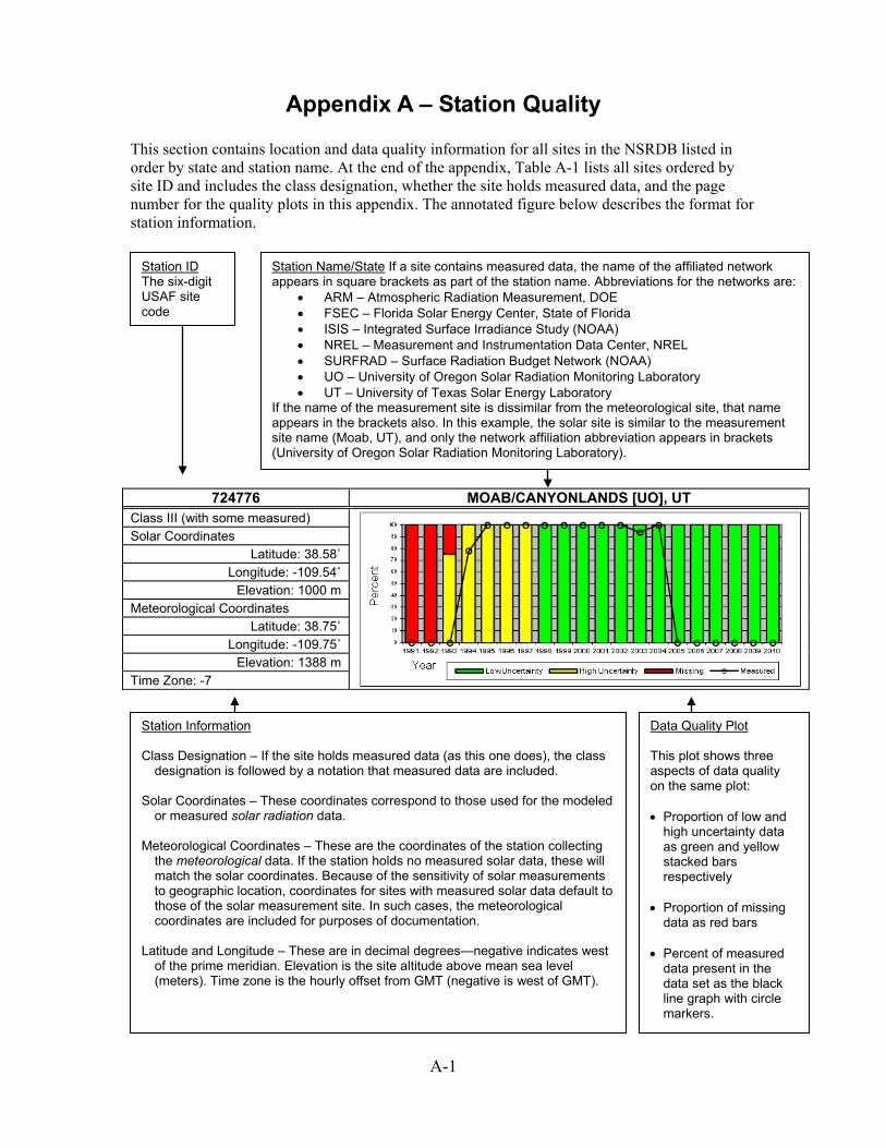
A-1
Appendix A – Station Quality This section contains location and data quality information for all sites in the NSRDB listed in order by state and station name. At the end of the appendix, Table A-1 lists all sites ordered by site ID and includes the class designation, whether the site holds measured data, and the page number for the quality plots in this appendix. The annotated figure below describes the format for station information.
724776 MOAB/CANYONLANDS [UO], UT Class III (with some measured)
Solar Coordinates Latitude: 38.58˚
Longitude: -109.54˚ Elevation: 1000 m
Meteorological Coordinates Latitude: 38.75˚
Longitude: -109.75˚ Elevation: 1388 m
Time Zone: -7
Station ID The six-digit USAF site code
Station Name/State If a site contains measured data, the name of the affiliated network appears in square brackets as part of the station name. Abbreviations for the networks are:
• ARM – Atmospheric Radiation Measurement, DOE • FSEC – Florida Solar Energy Center, State of Florida • ISIS – Integrated Surface Irradiance Study (NOAA) • NREL – Measurement and Instrumentation Data Center, NREL • SURFRAD – Surface Radiation Budget Network (NOAA) • UO – University of Oregon Solar Radiation Monitoring Laboratory • UT – University of Texas Solar Energy Laboratory
If the name of the measurement site is dissimilar from the meteorological site, that name appears in the brackets also. In this example, the solar site is similar to the measurement site name (Moab, UT), and only the network affiliation abbreviation appears in brackets (University of Oregon Solar Radiation Monitoring Laboratory).
Station Information Class Designation – If the site holds measured data (as this one does), the class
designation is followed by a notation that measured data are included. Solar Coordinates – These coordinates correspond to those used for the modeled
or measured solar radiation data. Meteorological Coordinates – These are the coordinates of the station collecting
the meteorological data. If the station holds no measured solar data, these will match the solar coordinates. Because of the sensitivity of solar measurements to geographic location, coordinates for sites with measured solar data default to those of the solar measurement site. In such cases, the meteorological coordinates are included for purposes of documentation.
Latitude and Longitude – These are in decimal degrees—negative indicates west
of the prime meridian. Elevation is the site altitude above mean sea level (meters). Time zone is the hourly offset from GMT (negative is west of GMT).
Data Quality Plot This plot shows three aspects of data quality on the same plot: • Proportion of low and
high uncertainty data as green and yellow stacked bars respectively
• Proportion of missing data as red bars
• Percent of measured
data present in the data set as the black line graph with circle markers.

A-2
704540 ADAK NAS, AK
Class II
Solar Coordinates Latitude: 51.883˚
Longitude: -176.65˚ Elevation: 5 m
Meteorological Coordinates Latitude: 51.883˚
Longitude: -176.65˚ Elevation: 5 m
Time Zone: -10
701718 AMBLER, AK Class II
Solar Coordinates Latitude: 67.1˚
Longitude: -157.85˚ Elevation: 88 m
Meteorological Coordinates Latitude: 67.1˚
Longitude: -157.85˚ Elevation: 88 m
Time Zone: -9
701625 ANAKTUVUK PASS, AK Class III
Solar Coordinates Latitude: 68.133˚
Longitude: -151.733˚ Elevation: 657 m
Meteorological Coordinates Latitude: 68.133˚
Longitude: -151.733˚ Elevation: 657 m
Time Zone: -9
702730 ANCHORAGE INTL AP, AK Class II
Solar Coordinates Latitude: 61.183˚ Longitude: -150˚ Elevation: 35 m
Meteorological Coordinates Latitude: 61.183˚ Longitude: -150˚ Elevation: 35 m
Time Zone: -9

A-3
702735 ANCHORAGE MERRILL FIELD, AK
Class II
Solar Coordinates Latitude: 61.217˚
Longitude: -149.85˚ Elevation: 42 m
Meteorological Coordinates Latitude: 61.217˚
Longitude: -149.85˚ Elevation: 42 m
Time Zone: -9
702720 ANCHORAGE/ELMENDORF, AK Class II
Solar Coordinates Latitude: 61.25˚
Longitude: -149.8˚ Elevation: 59 m
Meteorological Coordinates Latitude: 61.25˚
Longitude: -149.8˚ Elevation: 59 m
Time Zone: -9
702320 ANIAK AIRPORT, AK Class II
Solar Coordinates Latitude: 61.583˚
Longitude: -159.533˚ Elevation: 26 m
Meteorological Coordinates Latitude: 61.583˚
Longitude: -159.533˚ Elevation: 26 m
Time Zone: -9
703980 ANNETTE ISLAND AP, AK Class II
Solar Coordinates Latitude: 55.05˚
Longitude: -131.567˚ Elevation: 33 m
Meteorological Coordinates Latitude: 55.05˚
Longitude: -131.567˚ Elevation: 33 m
Time Zone: -9

A-4
702075 ANVIK, AK
Class III
Solar Coordinates Latitude: 62.65˚
Longitude: -160.183˚ Elevation: 99 m
Meteorological Coordinates Latitude: 62.65˚
Longitude: -160.183˚ Elevation: 99 m
Time Zone: -9
701945 ARCTIC VILLAGE, AK Class III
Solar Coordinates Latitude: 68.117˚
Longitude: -145.567˚ Elevation: 636 m
Meteorological Coordinates Latitude: 68.117˚
Longitude: -145.567˚ Elevation: 636 m
Time Zone: -9
700260 BARROW W POST-W ROGERS ARPT [NSA - ARM], AK Class II (with some measured)
Solar Coordinates Latitude: 71.32˚
Longitude: -156.62˚ Elevation: 10 m
Meteorological Coordinates Latitude: 71.283˚
Longitude: -156.767˚ Elevation: 9 m
Time Zone: -9
700860 BARTER IS WSO AP, AK Class III
Solar Coordinates Latitude: 70.133˚
Longitude: -143.633˚ Elevation: 12 m
Meteorological Coordinates Latitude: 70.133˚
Longitude: -143.633˚ Elevation: 12 m
Time Zone: -9

A-5
702190 BETHEL AIRPORT, AK
Class II
Solar Coordinates Latitude: 60.783˚
Longitude: -161.833˚ Elevation: 38 m
Meteorological Coordinates Latitude: 60.783˚
Longitude: -161.833˚ Elevation: 38 m
Time Zone: -9
701740 BETTLES FIELD, AK Class II
Solar Coordinates Latitude: 66.917˚
Longitude: -151.517˚ Elevation: 196 m
Meteorological Coordinates Latitude: 66.917˚
Longitude: -151.517˚ Elevation: 196 m
Time Zone: -9
702670 BIG DELTA ALLEN AAF, AK Class II
Solar Coordinates Latitude: 64˚
Longitude: -145.717˚ Elevation: 386 m
Meteorological Coordinates Latitude: 64˚
Longitude: -145.717˚ Elevation: 386 m
Time Zone: -9
702986 BIG RIVER LAKE, AK Class II
Solar Coordinates Latitude: 60.817˚
Longitude: -152.3˚ Elevation: 12 m
Meteorological Coordinates Latitude: 60.817˚
Longitude: -152.3˚ Elevation: 12 m
Time Zone: -9

A-6
702746 BIRCHWOOD, AK
Class III
Solar Coordinates Latitude: 61.417˚
Longitude: -149.517˚ Elevation: 30 m
Meteorological Coordinates Latitude: 61.417˚
Longitude: -149.517˚ Elevation: 30 m
Time Zone: -9
702648 CANTWELL, AK Class III
Solar Coordinates Latitude: 63.4˚
Longitude: -148.95˚ Elevation: 668 m
Meteorological Coordinates Latitude: 63.4˚
Longitude: -148.95˚ Elevation: 668 m
Time Zone: -9
701745 CHANDALAR LAKE, AK Class III
Solar Coordinates Latitude: 67.5˚
Longitude: -148.483˚ Elevation: 585 m
Meteorological Coordinates Latitude: 67.5˚
Longitude: -148.483˚ Elevation: 585 m
Time Zone: -9
703333 CHIGNIK, AK Class III
Solar Coordinates Latitude: 56.2˚
Longitude: -158.233˚ Elevation: 15 m
Meteorological Coordinates Latitude: 56.2˚
Longitude: -158.233˚ Elevation: 15 m
Time Zone: -9

A-7
702606 CHULITNA, AK
Class II
Solar Coordinates Latitude: 62.883˚
Longitude: -149.833˚ Elevation: 381 m
Meteorological Coordinates Latitude: 62.883˚
Longitude: -149.833˚ Elevation: 381 m
Time Zone: -9
703160 COLD BAY ARPT, AK Class II
Solar Coordinates Latitude: 55.2˚
Longitude: -162.717˚ Elevation: 29 m
Meteorological Coordinates Latitude: 55.2˚
Longitude: -162.717˚ Elevation: 29 m
Time Zone: -9
702960 CORDOVA, AK Class II
Solar Coordinates Latitude: 60.5˚
Longitude: -145.5˚ Elevation: 12 m
Meteorological Coordinates Latitude: 60.5˚
Longitude: -145.5˚ Elevation: 12 m
Time Zone: -9
700637 DEADHORSE, AK Class II
Solar Coordinates Latitude: 70.2˚
Longitude: -148.483˚ Elevation: 23 m
Meteorological Coordinates Latitude: 70.2˚
Longitude: -148.483˚ Elevation: 23 m
Time Zone: -9
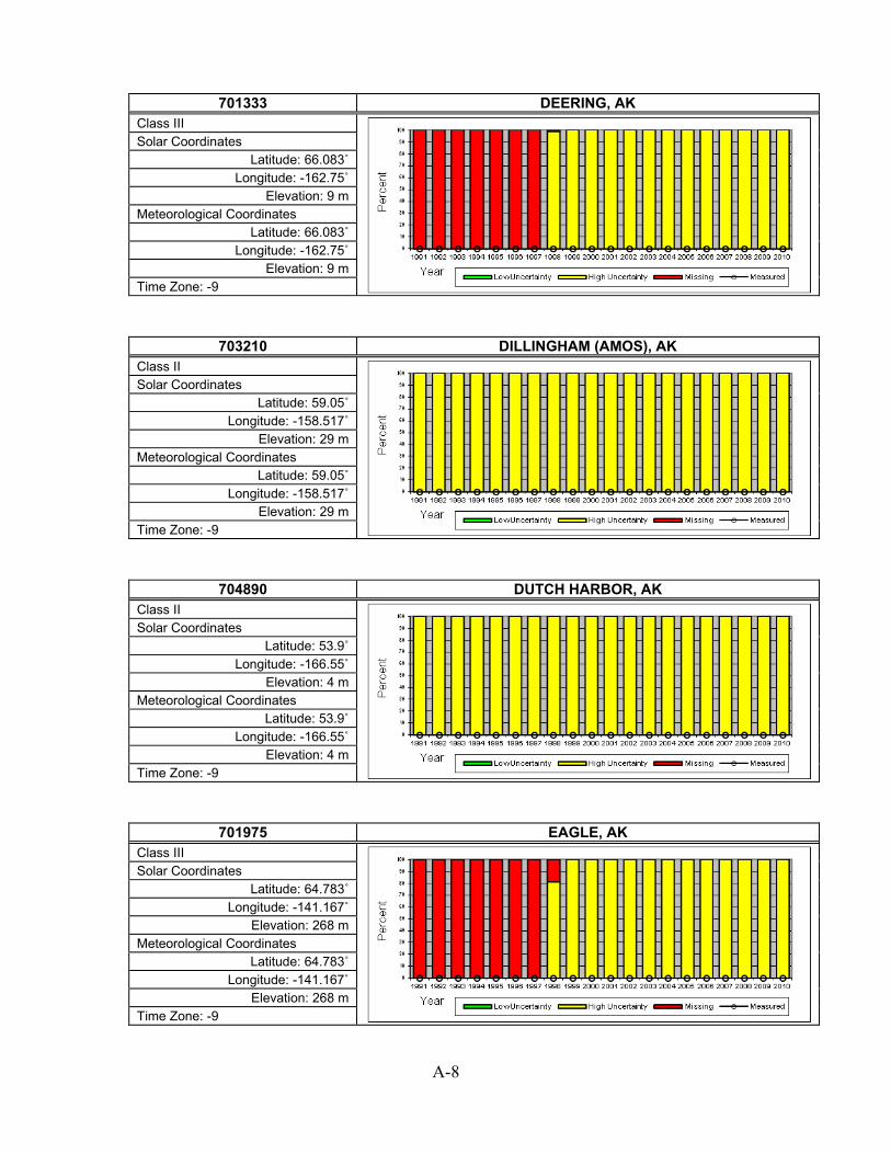
A-8
701333 DEERING, AK
Class III
Solar Coordinates Latitude: 66.083˚
Longitude: -162.75˚ Elevation: 9 m
Meteorological Coordinates Latitude: 66.083˚
Longitude: -162.75˚ Elevation: 9 m
Time Zone: -9
703210 DILLINGHAM (AMOS), AK Class II
Solar Coordinates Latitude: 59.05˚
Longitude: -158.517˚ Elevation: 29 m
Meteorological Coordinates Latitude: 59.05˚
Longitude: -158.517˚ Elevation: 29 m
Time Zone: -9
704890 DUTCH HARBOR, AK Class II
Solar Coordinates Latitude: 53.9˚
Longitude: -166.55˚ Elevation: 4 m
Meteorological Coordinates Latitude: 53.9˚
Longitude: -166.55˚ Elevation: 4 m
Time Zone: -9
701975 EAGLE, AK Class III
Solar Coordinates Latitude: 64.783˚
Longitude: -141.167˚ Elevation: 268 m
Meteorological Coordinates Latitude: 64.783˚
Longitude: -141.167˚ Elevation: 268 m
Time Zone: -9

A-9
703334 EGEGIK(AWOS), AK
Class III
Solar Coordinates Latitude: 58.417˚
Longitude: -157.367˚ Elevation: 119 m
Meteorological Coordinates Latitude: 58.417˚
Longitude: -157.367˚ Elevation: 119 m
Time Zone: -9
703817 ELFIN COVE SEAPLANE, AK Class III
Solar Coordinates Latitude: 58.2˚
Longitude: -136.35˚ Elevation: 0 m
Meteorological Coordinates Latitude: 58.2˚
Longitude: -136.35˚ Elevation: 0 m
Time Zone: -9
702084 EMMONAK, AK Class II
Solar Coordinates Latitude: 62.783˚
Longitude: -164.5˚ Elevation: 4 m
Meteorological Coordinates Latitude: 62.783˚
Longitude: -164.5˚ Elevation: 4 m
Time Zone: -9
702715 EUREKA, AK Class III
Solar Coordinates Latitude: 61.933˚
Longitude: -147.167˚ Elevation: 1002 m
Meteorological Coordinates Latitude: 61.933˚
Longitude: -147.167˚ Elevation: 1002 m
Time Zone: -9

A-10
702610 FAIRBANKS INTL ARPT, AK
Class II
Solar Coordinates Latitude: 64.817˚
Longitude: -147.85˚ Elevation: 133 m
Meteorological Coordinates Latitude: 64.817˚
Longitude: -147.85˚ Elevation: 133 m
Time Zone: -9
702650 FAIRBANKS/EIELSON A, AK Class II
Solar Coordinates Latitude: 64.65˚
Longitude: -147.1˚ Elevation: 167 m
Meteorological Coordinates Latitude: 64.65˚
Longitude: -147.1˚ Elevation: 167 m
Time Zone: -9
702312 FAREWELL FAA AP, AK Class III
Solar Coordinates Latitude: 62.517˚
Longitude: -153.883˚ Elevation: 458 m
Meteorological Coordinates Latitude: 62.517˚
Longitude: -153.883˚ Elevation: 458 m
Time Zone: -9
701940 FORT YUKON, AK Class II
Solar Coordinates Latitude: 66.567˚
Longitude: -145.267˚ Elevation: 136 m
Meteorological Coordinates Latitude: 66.567˚
Longitude: -145.267˚ Elevation: 136 m
Time Zone: -9

A-11
702700 FT. RICHARDSON/BRYA, AK
Class III
Solar Coordinates Latitude: 61.267˚
Longitude: -149.65˚ Elevation: 115 m
Meteorological Coordinates Latitude: 61.267˚
Longitude: -149.65˚ Elevation: 115 m
Time Zone: -9
703816 FUNTER BAY SEAPLANE, AK Class III
Solar Coordinates Latitude: 58.25˚
Longitude: -134.9˚ Elevation: 0 m
Meteorological Coordinates Latitude: 58.25˚
Longitude: -134.9˚ Elevation: 0 m
Time Zone: -9
702040 GAMBELL, AK Class II
Solar Coordinates Latitude: 63.783˚
Longitude: -171.75˚ Elevation: 8 m
Meteorological Coordinates Latitude: 63.783˚
Longitude: -171.75˚ Elevation: 8 m
Time Zone: -9
701995 GOLOVIN, AK Class III
Solar Coordinates Latitude: 64.55˚
Longitude: -163.05˚ Elevation: 8 m
Meteorological Coordinates Latitude: 64.55˚
Longitude: -163.05˚ Elevation: 8 m
Time Zone: -9

A-12
702710 GULKANA INTERMEDIATE FIELD, AK
Class II
Solar Coordinates Latitude: 62.15˚
Longitude: -145.45˚ Elevation: 478 m
Meteorological Coordinates Latitude: 62.15˚
Longitude: -145.45˚ Elevation: 478 m
Time Zone: -9
703670 GUSTAVUS, AK Class II
Solar Coordinates Latitude: 58.417˚
Longitude: -135.7˚ Elevation: 12 m
Meteorological Coordinates Latitude: 58.417˚
Longitude: -135.7˚ Elevation: 12 m
Time Zone: -9
703626 HAINES, AK Class III
Solar Coordinates Latitude: 59.233˚
Longitude: -135.433˚ Elevation: 9 m
Meteorological Coordinates Latitude: 59.233˚
Longitude: -135.433˚ Elevation: 9 m
Time Zone: -9
703625 HAINES BOAT HARBOR, AK Class III
Solar Coordinates Latitude: 59.233˚
Longitude: -135.433˚ Elevation: 10 m
Meteorological Coordinates Latitude: 59.233˚
Longitude: -135.433˚ Elevation: 10 m
Time Zone: -9

A-13
702495 HAYES RIVER, AK
Class II
Solar Coordinates Latitude: 61.983˚
Longitude: -152.083˚ Elevation: 305 m
Meteorological Coordinates Latitude: 61.983˚
Longitude: -152.083˚ Elevation: 305 m
Time Zone: -9
702647 HEALY RIVER AIRPORT, AK Class II
Solar Coordinates Latitude: 63.883˚
Longitude: -149.017˚ Elevation: 396 m
Meteorological Coordinates Latitude: 63.883˚
Longitude: -149.017˚ Elevation: 396 m
Time Zone: -9
703604 HOMER, AK Class III
Solar Coordinates Latitude: 59.633˚
Longitude: -151.483˚ Elevation: 26 m
Meteorological Coordinates Latitude: 59.633˚
Longitude: -151.483˚ Elevation: 26 m
Time Zone: -9
703410 HOMER ARPT, AK Class III
Solar Coordinates Latitude: 59.65˚
Longitude: -151.483˚ Elevation: 27 m
Meteorological Coordinates Latitude: 59.65˚
Longitude: -151.483˚ Elevation: 27 m
Time Zone: -9

A-14
702607 HOONAH, AK
Class II
Solar Coordinates Latitude: 58.083˚
Longitude: -135.45˚ Elevation: 6 m
Meteorological Coordinates Latitude: 58.083˚
Longitude: -135.45˚ Elevation: 6 m
Time Zone: -9
702186 HOOPER BAY, AK Class II
Solar Coordinates Latitude: 61.517˚
Longitude: -166.15˚ Elevation: 6 m
Meteorological Coordinates Latitude: 61.517˚
Longitude: -166.15˚ Elevation: 6 m
Time Zone: -9
702225 HUSLIA, AK Class III
Solar Coordinates Latitude: 65.7˚
Longitude: -156.383˚ Elevation: 55 m
Meteorological Coordinates Latitude: 65.7˚
Longitude: -156.383˚ Elevation: 55 m
Time Zone: -9
703884 HYDABURG SEAPLANE, AK Class III
Solar Coordinates Latitude: 55.2˚
Longitude: -132.833˚ Elevation: 0 m
Meteorological Coordinates Latitude: 55.2˚
Longitude: -132.833˚ Elevation: 0 m
Time Zone: -9

A-15
703400 ILIAMNA ARPT, AK
Class II
Solar Coordinates Latitude: 59.75˚
Longitude: -154.917˚ Elevation: 57 m
Meteorological Coordinates Latitude: 59.75˚
Longitude: -154.917˚ Elevation: 57 m
Time Zone: -9
703810 JUNEAU INT'L ARPT, AK Class II
Solar Coordinates Latitude: 58.35˚
Longitude: -134.583˚ Elevation: 4 m
Meteorological Coordinates Latitude: 58.35˚
Longitude: -134.583˚ Elevation: 4 m
Time Zone: -9
703855 KAKE SEAPLANE BASE, AK Class II
Solar Coordinates Latitude: 56.967˚
Longitude: -133.95˚ Elevation: 0 m
Meteorological Coordinates Latitude: 56.967˚
Longitude: -133.95˚ Elevation: 0 m
Time Zone: -9
702006 KALTAG, AK Class III
Solar Coordinates Latitude: 64.316˚
Longitude: -158.733˚ Elevation: 60 m
Meteorological Coordinates Latitude: 64.316˚
Longitude: -158.733˚ Elevation: 60 m
Time Zone: -9

A-16
702590 KENAI MUNICIPAL AP, AK
Class II
Solar Coordinates Latitude: 60.583˚
Longitude: -151.233˚ Elevation: 26 m
Meteorological Coordinates Latitude: 60.583˚
Longitude: -151.233˚ Elevation: 26 m
Time Zone: -9
703950 KETCHIKAN INTL AP, AK Class II
Solar Coordinates Latitude: 55.367˚
Longitude: -131.717˚ Elevation: 23 m
Meteorological Coordinates Latitude: 55.367˚
Longitude: -131.717˚ Elevation: 23 m
Time Zone: -9
703263 KING SALMON, AK Class III
Solar Coordinates Latitude: 58.683˚
Longitude: -156.683˚ Elevation: 17 m
Meteorological Coordinates Latitude: 58.683˚
Longitude: -156.683˚ Elevation: 17 m
Time Zone: -9
703260 KING SALMON ARPT, AK Class II
Solar Coordinates Latitude: 58.683˚
Longitude: -156.65˚ Elevation: 15 m
Meteorological Coordinates Latitude: 58.683˚
Longitude: -156.65˚ Elevation: 15 m
Time Zone: -9

A-17
703894 KLAWOCK, AK
Class III
Solar Coordinates Latitude: 55.583˚
Longitude: -133.083˚ Elevation: 15 m
Meteorological Coordinates Latitude: 55.583˚
Longitude: -133.083˚ Elevation: 15 m
Time Zone: -9
703500 KODIAK AIRPORT, AK Class II
Solar Coordinates Latitude: 57.75˚
Longitude: -152.5˚ Elevation: 5 m
Meteorological Coordinates Latitude: 57.75˚
Longitude: -152.5˚ Elevation: 5 m
Time Zone: -9
701330 KOTZEBUE RALPH WEIN MEMORIAL, AK Class II
Solar Coordinates Latitude: 66.883˚
Longitude: -162.6˚ Elevation: 3 m
Meteorological Coordinates Latitude: 66.883˚
Longitude: -162.6˚ Elevation: 3 m
Time Zone: -9
702223 KOYUK, AK Class III
Solar Coordinates Latitude: 64.933˚
Longitude: -161.15˚ Elevation: 38 m
Meteorological Coordinates Latitude: 64.933˚
Longitude: -161.15˚ Elevation: 38 m
Time Zone: -9

A-18
700634 KUPARUK AIRPORT, AK
Class III
Solar Coordinates Latitude: 70.317˚
Longitude: -149.583˚ Elevation: 20 m
Meteorological Coordinates Latitude: 70.317˚
Longitude: -149.583˚ Elevation: 20 m
Time Zone: -9
702725 LAKE HOOD SEAPLANE, AK Class III
Solar Coordinates Latitude: 61.183˚
Longitude: -149.967˚ Elevation: 22 m
Meteorological Coordinates Latitude: 61.183˚
Longitude: -149.967˚ Elevation: 22 m
Time Zone: -9
702755 MCCARTHY, AK Class III
Solar Coordinates Latitude: 61.433˚
Longitude: -142.933˚ Elevation: 455 m
Meteorological Coordinates Latitude: 61.433˚
Longitude: -142.933˚ Elevation: 455 m
Time Zone: -9
702310 MCGRATH ARPT, AK Class II
Solar Coordinates Latitude: 62.95˚
Longitude: -155.6˚ Elevation: 105 m
Meteorological Coordinates Latitude: 62.95˚
Longitude: -155.6˚ Elevation: 105 m
Time Zone: -9
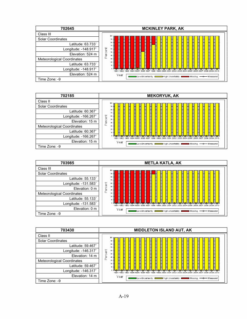
A-19
702645 MCKINLEY PARK, AK
Class III
Solar Coordinates Latitude: 63.733˚
Longitude: -148.917˚ Elevation: 524 m
Meteorological Coordinates Latitude: 63.733˚
Longitude: -148.917˚ Elevation: 524 m
Time Zone: -9
702185 MEKORYUK, AK Class II
Solar Coordinates Latitude: 60.367˚
Longitude: -166.267˚ Elevation: 15 m
Meteorological Coordinates Latitude: 60.367˚
Longitude: -166.267˚ Elevation: 15 m
Time Zone: -9
703985 METLA KATLA, AK Class III
Solar Coordinates Latitude: 55.133˚
Longitude: -131.583˚ Elevation: 0 m
Meteorological Coordinates Latitude: 55.133˚
Longitude: -131.583˚ Elevation: 0 m
Time Zone: -9
703430 MIDDLETON ISLAND AUT, AK Class II
Solar Coordinates Latitude: 59.467˚
Longitude: -146.317˚ Elevation: 14 m
Meteorological Coordinates Latitude: 59.467˚
Longitude: -146.317˚ Elevation: 14 m
Time Zone: -9
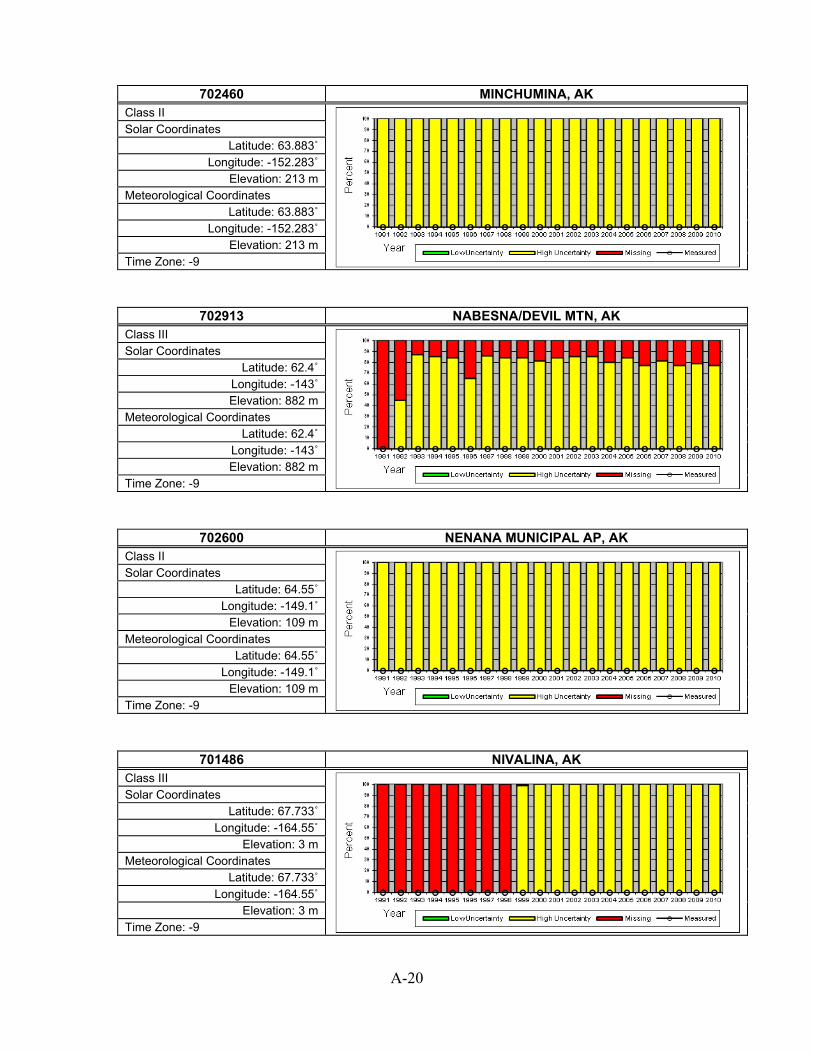
A-20
702460 MINCHUMINA, AK
Class II
Solar Coordinates Latitude: 63.883˚
Longitude: -152.283˚ Elevation: 213 m
Meteorological Coordinates Latitude: 63.883˚
Longitude: -152.283˚ Elevation: 213 m
Time Zone: -9
702913 NABESNA/DEVIL MTN, AK Class III
Solar Coordinates Latitude: 62.4˚
Longitude: -143˚ Elevation: 882 m
Meteorological Coordinates Latitude: 62.4˚
Longitude: -143˚ Elevation: 882 m
Time Zone: -9
702600 NENANA MUNICIPAL AP, AK Class II
Solar Coordinates Latitude: 64.55˚
Longitude: -149.1˚ Elevation: 109 m
Meteorological Coordinates Latitude: 64.55˚
Longitude: -149.1˚ Elevation: 109 m
Time Zone: -9
701486 NIVALINA, AK Class III
Solar Coordinates Latitude: 67.733˚
Longitude: -164.55˚ Elevation: 3 m
Meteorological Coordinates Latitude: 67.733˚
Longitude: -164.55˚ Elevation: 3 m
Time Zone: -9

A-21
701335 NOATAK, AK
Class III
Solar Coordinates Latitude: 67.55˚
Longitude: -162.983˚ Elevation: 28 m
Meteorological Coordinates Latitude: 67.55˚
Longitude: -162.983˚ Elevation: 28 m
Time Zone: -9
702000 NOME MUNICIPAL ARPT, AK Class II
Solar Coordinates Latitude: 64.517˚
Longitude: -165.45˚ Elevation: 4 m
Meteorological Coordinates Latitude: 64.517˚
Longitude: -165.45˚ Elevation: 4 m
Time Zone: -9
702910 NORTHWAY AIRPORT, AK Class II
Solar Coordinates Latitude: 62.967˚
Longitude: -141.933˚ Elevation: 522 m
Meteorological Coordinates Latitude: 62.967˚
Longitude: -141.933˚ Elevation: 522 m
Time Zone: -9
703644 NUIQSUT, AK Class III
Solar Coordinates Latitude: 70.217˚
Longitude: -150.983˚ Elevation: 17 m
Meteorological Coordinates Latitude: 70.217˚
Longitude: -150.983˚ Elevation: 17 m
Time Zone: -9

A-22
702740 PALMER MUNICIPAL, AK
Class II
Solar Coordinates Latitude: 61.6˚
Longitude: -149.083˚ Elevation: 71 m
Meteorological Coordinates Latitude: 61.6˚
Longitude: -149.083˚ Elevation: 71 m
Time Zone: -9
702675 PAXSON, AK Class III
Solar Coordinates Latitude: 63.033˚
Longitude: -145.5˚ Elevation: 809 m
Meteorological Coordinates Latitude: 63.033˚
Longitude: -145.5˚ Elevation: 809 m
Time Zone: -9
703860 PETERSBURG, AK Class II
Solar Coordinates Latitude: 56.8˚
Longitude: -132.95˚ Elevation: 33 m
Meteorological Coordinates Latitude: 56.8˚
Longitude: -132.95˚ Elevation: 33 m
Time Zone: -9
701043 POINT HOPE (AWOS), AK Class II
Solar Coordinates Latitude: 68.35˚
Longitude: -166.8˚ Elevation: 4 m
Meteorological Coordinates Latitude: 68.35˚
Longitude: -166.8˚ Elevation: 4 m
Time Zone: -9

A-23
701210 POINT LAY (DEW), AK
Class III
Solar Coordinates Latitude: 69.817˚
Longitude: -162.917˚ Elevation: 6 m
Meteorological Coordinates Latitude: 69.817˚
Longitude: -162.917˚ Elevation: 6 m
Time Zone: -9
701213 POINT LAY LIZ 2, AK Class III
Solar Coordinates Latitude: 69.733˚
Longitude: -163.017˚ Elevation: 6 m
Meteorological Coordinates Latitude: 69.733˚
Longitude: -163.017˚ Elevation: 6 m
Time Zone: -9
703886 PORT ALEXANDER, AK Class III
Solar Coordinates Latitude: 56.25˚
Longitude: -134.65˚ Elevation: 1 m
Meteorological Coordinates Latitude: 56.25˚
Longitude: -134.65˚ Elevation: 1 m
Time Zone: -9
703406 PORT ALSWORTH, AK Class III
Solar Coordinates Latitude: 60.2˚
Longitude: -154.317˚ Elevation: 85 m
Meteorological Coordinates Latitude: 60.2˚
Longitude: -154.317˚ Elevation: 85 m
Time Zone: -9

A-24
703330 PORT HEIDEN, AK
Class II
Solar Coordinates Latitude: 56.95˚
Longitude: -158.617˚ Elevation: 29 m
Meteorological Coordinates Latitude: 56.95˚
Longitude: -158.617˚ Elevation: 29 m
Time Zone: -9
700636 PRUDHOE BAY, AK Class III
Solar Coordinates Latitude: 70.25˚
Longitude: -148.333˚ Elevation: 14 m
Meteorological Coordinates Latitude: 70.25˚
Longitude: -148.333˚ Elevation: 14 m
Time Zone: -9
702490 PUNTILLA, AK Class III
Solar Coordinates Latitude: 62.1˚
Longitude: -152.75˚ Elevation: 560 m
Meteorological Coordinates Latitude: 62.1˚
Longitude: -152.75˚ Elevation: 560 m
Time Zone: -9
702005 SAINT MARY`S (AWOS), AK Class II
Solar Coordinates Latitude: 62.067˚
Longitude: -163.3˚ Elevation: 95 m
Meteorological Coordinates Latitude: 62.067˚
Longitude: -163.3˚ Elevation: 95 m
Time Zone: -9

A-25
703165 SAND POINT, AK
Class II
Solar Coordinates Latitude: 55.317˚
Longitude: -160.517˚ Elevation: 7 m
Meteorological Coordinates Latitude: 55.317˚
Longitude: -160.517˚ Elevation: 7 m
Time Zone: -9
702035 SAVOONGA, AK Class III
Solar Coordinates Latitude: 63.683˚
Longitude: -170.5˚ Elevation: 17 m
Meteorological Coordinates Latitude: 63.683˚
Longitude: -170.5˚ Elevation: 17 m
Time Zone: -9
700197 SELAWIK, AK Class III
Solar Coordinates Latitude: 66.6˚
Longitude: -160˚ Elevation: 8 m
Meteorological Coordinates Latitude: 66.6˚
Longitude: -160˚ Elevation: 8 m
Time Zone: -9
703621 SELDOVIA ARPT, AK Class III
Solar Coordinates Latitude: 59.45˚
Longitude: -151.7˚ Elevation: 95 m
Meteorological Coordinates Latitude: 59.45˚
Longitude: -151.7˚ Elevation: 95 m
Time Zone: -9

A-26
702770 SEWARD, AK
Class II
Solar Coordinates Latitude: 60.117˚
Longitude: -149.45˚ Elevation: 18 m
Meteorological Coordinates Latitude: 60.117˚
Longitude: -149.45˚ Elevation: 18 m
Time Zone: -9
702711 SHEEP MTN, AK Class III
Solar Coordinates Latitude: 61.817˚
Longitude: -158.383˚ Elevation: 2959 m
Meteorological Coordinates Latitude: 61.817˚
Longitude: -158.383˚ Elevation: 2959 m
Time Zone: -9
704140 SHEMYA AFB, AK Class II
Solar Coordinates Latitude: 52.717˚
Longitude: 174.117˚ Elevation: 31 m
Meteorological Coordinates Latitude: 52.717˚
Longitude: 174.117˚ Elevation: 31 m
Time Zone: -10
701195 SHISHMAREF (AWOS), AK Class II
Solar Coordinates Latitude: 66.267˚
Longitude: -166.05˚ Elevation: 2 m
Meteorological Coordinates Latitude: 66.267˚
Longitude: -166.05˚ Elevation: 2 m
Time Zone: -9

A-27
703710 SITKA JAPONSKI AP, AK
Class II
Solar Coordinates Latitude: 57.05˚
Longitude: -135.367˚ Elevation: 4 m
Meteorological Coordinates Latitude: 57.05˚
Longitude: -135.367˚ Elevation: 4 m
Time Zone: -9
703620 SKAGWAY AIRPORT, AK Class II
Solar Coordinates Latitude: 59.467˚
Longitude: -135.3˚ Elevation: 9 m
Meteorological Coordinates Latitude: 59.467˚
Longitude: -135.3˚ Elevation: 9 m
Time Zone: -9
702915 SLANA AIRPORT, AK Class III
Solar Coordinates Latitude: 62.7˚
Longitude: -143.983˚ Elevation: 730 m
Meteorological Coordinates Latitude: 62.7˚
Longitude: -143.983˚ Elevation: 730 m
Time Zone: -9
703407 SLEETMUTE, AK Class III
Solar Coordinates Latitude: 61.717˚
Longitude: -157.15˚ Elevation: 54 m
Meteorological Coordinates Latitude: 61.717˚
Longitude: -157.15˚ Elevation: 54 m
Time Zone: -9

A-28
702595 SOLDOTNA, AK
Class III
Solar Coordinates Latitude: 60.467˚
Longitude: -151.033˚ Elevation: 34 m
Meteorological Coordinates Latitude: 60.467˚
Longitude: -151.033˚ Elevation: 34 m
Time Zone: -9
703835 ST GEORGE ISLAND, AK Class III
Solar Coordinates Latitude: 56.35˚
Longitude: -169.4˚ Elevation: 38 m
Meteorological Coordinates Latitude: 56.35˚
Longitude: -169.4˚ Elevation: 38 m
Time Zone: -9
703080 ST PAUL ISLAND ARPT, AK Class II
Solar Coordinates Latitude: 57.167˚
Longitude: -170.217˚ Elevation: 7 m
Meteorological Coordinates Latitude: 57.167˚
Longitude: -170.217˚ Elevation: 7 m
Time Zone: -9
702695 SUTTON, AK Class III
Solar Coordinates Latitude: 61.717˚
Longitude: -148.883˚ Elevation: 265 m
Meteorological Coordinates Latitude: 61.717˚
Longitude: -148.883˚ Elevation: 265 m
Time Zone: -9

A-29
702716 TAHNETA PASS, AK
Class III
Solar Coordinates Latitude: 61.817˚
Longitude: -147.55˚ Elevation: 900 m
Meteorological Coordinates Latitude: 61.817˚
Longitude: -147.55˚ Elevation: 900 m
Time Zone: -9
702510 TALKEETNA STATE ARPT, AK Class II
Solar Coordinates Latitude: 62.317˚
Longitude: -150.1˚ Elevation: 105 m
Meteorological Coordinates Latitude: 62.317˚
Longitude: -150.1˚ Elevation: 105 m
Time Zone: -9
701780 TANANA RALPH M CALHOUN MEM AP, AK Class II
Solar Coordinates Latitude: 65.167˚
Longitude: -152.1˚ Elevation: 71 m
Meteorological Coordinates Latitude: 65.167˚
Longitude: -152.1˚ Elevation: 71 m
Time Zone: -9
703606 TOGIAC VILLAGE AWOS, AK Class II
Solar Coordinates Latitude: 59.05˚
Longitude: -160.4˚ Elevation: 6 m
Meteorological Coordinates Latitude: 59.05˚
Longitude: -160.4˚ Elevation: 6 m
Time Zone: -9

A-30
702070 UNALAKLEET FIELD, AK
Class II
Solar Coordinates Latitude: 63.883˚
Longitude: -160.8˚ Elevation: 5 m
Meteorological Coordinates Latitude: 63.883˚
Longitude: -160.8˚ Elevation: 5 m
Time Zone: -9
702756 VALDEZ PIONEER FIEL, AK Class II
Solar Coordinates Latitude: 61.133˚
Longitude: -146.267˚ Elevation: 38 m
Meteorological Coordinates Latitude: 61.133˚
Longitude: -146.267˚ Elevation: 38 m
Time Zone: -9
702750 VALDEZ WSO, AK Class III
Solar Coordinates Latitude: 61.133˚
Longitude: -146.35˚ Elevation: 7 m
Meteorological Coordinates Latitude: 61.133˚
Longitude: -146.35˚ Elevation: 7 m
Time Zone: -9
702615 WAINWRIGHT AAF, AK Class III
Solar Coordinates Latitude: 64.833˚
Longitude: -147.617˚ Elevation: 142 m
Meteorological Coordinates Latitude: 64.833˚
Longitude: -147.617˚ Elevation: 142 m
Time Zone: -9

A-31
700300 WAINWRIGHT LIZ 3, AK
Class III
Solar Coordinates Latitude: 70.617˚
Longitude: -159.85˚ Elevation: 27 m
Meteorological Coordinates Latitude: 70.617˚
Longitude: -159.85˚ Elevation: 27 m
Time Zone: -9
702325 WASILLA, AK Class III
Solar Coordinates Latitude: 61.567˚
Longitude: -149.45˚ Elevation: 111 m
Meteorological Coordinates Latitude: 61.567˚
Longitude: -149.45˚ Elevation: 111 m
Time Zone: -9
702757 WHITTIER, AK Class II
Solar Coordinates Latitude: 60.767˚
Longitude: -148.683˚ Elevation: 9 m
Meteorological Coordinates Latitude: 60.767˚
Longitude: -148.683˚ Elevation: 9 m
Time Zone: -9
703870 WRANGELL, AK Class II
Solar Coordinates Latitude: 56.483˚
Longitude: -132.367˚ Elevation: 13 m
Meteorological Coordinates Latitude: 56.483˚
Longitude: -132.367˚ Elevation: 13 m
Time Zone: -9

A-32
703610 YAKUTAT STATE ARPT, AK
Class II
Solar Coordinates Latitude: 59.517˚
Longitude: -139.633˚ Elevation: 8 m
Meteorological Coordinates Latitude: 59.517˚
Longitude: -139.633˚ Elevation: 8 m
Time Zone: -9
722287 ANNISTON METROPOLITAN AP, AL Class II
Solar Coordinates Latitude: 33.583˚
Longitude: -85.85˚ Elevation: 186 m
Meteorological Coordinates Latitude: 33.583˚
Longitude: -85.85˚ Elevation: 186 m
Time Zone: -6
722284 AUBURN-OPELIKA APT, AL Class III
Solar Coordinates Latitude: 32.616˚
Longitude: -85.433˚ Elevation: 236 m
Meteorological Coordinates Latitude: 32.616˚
Longitude: -85.433˚ Elevation: 236 m
Time Zone: -6
722280 BIRMINGHAM MUNICIPAL AP, AL Class I
Solar Coordinates Latitude: 33.567˚
Longitude: -86.75˚ Elevation: 189 m
Meteorological Coordinates Latitude: 33.567˚
Longitude: -86.75˚ Elevation: 189 m
Time Zone: -6

A-33
722269 CAIRNS FIELD FORT RUCKER, AL
Class II
Solar Coordinates Latitude: 31.267˚
Longitude: -85.717˚ Elevation: 91 m
Meteorological Coordinates Latitude: 31.267˚
Longitude: -85.717˚ Elevation: 91 m
Time Zone: -6
722290 CENTREVILLE WSMO, AL Class III
Solar Coordinates Latitude: 32.9˚
Longitude: -87.25˚ Elevation: 140 m
Meteorological Coordinates Latitude: 32.9˚
Longitude: -87.25˚ Elevation: 140 m
Time Zone: -6
722279 DECATUR, AL Class III
Solar Coordinates Latitude: 34.65˚
Longitude: -86.95˚ Elevation: 180 m
Meteorological Coordinates Latitude: 34.65˚
Longitude: -86.95˚ Elevation: 180 m
Time Zone: -6
722268 DOTHAN MUNICIPAL AP, AL Class II
Solar Coordinates Latitude: 31.233˚
Longitude: -85.433˚ Elevation: 98 m
Meteorological Coordinates Latitude: 31.233˚
Longitude: -85.433˚ Elevation: 98 m
Time Zone: -6

A-34
722285 GADSEN MUNI (AWOS), AL
Class III
Solar Coordinates Latitude: 33.967˚
Longitude: -86.083˚ Elevation: 173 m
Meteorological Coordinates Latitude: 33.967˚
Longitude: -86.083˚ Elevation: 173 m
Time Zone: -6
723230 HUNTSVILLE INTL/JONES FIELD, AL Class I
Solar Coordinates Latitude: 34.65˚
Longitude: -86.783˚ Elevation: 190 m
Meteorological Coordinates Latitude: 34.65˚
Longitude: -86.783˚ Elevation: 190 m
Time Zone: -6
722265 MAXWELL AFB, AL Class II
Solar Coordinates Latitude: 32.383˚
Longitude: -86.35˚ Elevation: 53 m
Meteorological Coordinates Latitude: 32.383˚
Longitude: -86.35˚ Elevation: 53 m
Time Zone: -6
722235 MOBILE DOWNTOWN AP, AL Class II
Solar Coordinates Latitude: 30.633˚
Longitude: -88.067˚ Elevation: 8 m
Meteorological Coordinates Latitude: 30.633˚
Longitude: -88.067˚ Elevation: 8 m
Time Zone: -6

A-35
722230 MOBILE REGIONAL AP, AL
Class I
Solar Coordinates Latitude: 30.683˚
Longitude: -88.25˚ Elevation: 66 m
Meteorological Coordinates Latitude: 30.683˚
Longitude: -88.25˚ Elevation: 66 m
Time Zone: -6
722260 MONTGOMERY DANNELLY FIELD, AL Class I
Solar Coordinates Latitude: 32.3˚
Longitude: -86.4˚ Elevation: 62 m
Meteorological Coordinates Latitude: 32.3˚
Longitude: -86.4˚ Elevation: 62 m
Time Zone: -6
723235 MUSCLE SHOALS REGIONAL AP, AL Class II
Solar Coordinates Latitude: 34.75˚
Longitude: -87.6˚ Elevation: 165 m
Meteorological Coordinates Latitude: 34.75˚
Longitude: -87.6˚ Elevation: 165 m
Time Zone: -6
722300 SHELBY CO ARPT, AL Class III
Solar Coordinates Latitude: 33.167˚
Longitude: -86.767˚ Elevation: 178 m
Meteorological Coordinates Latitude: 33.167˚
Longitude: -86.767˚ Elevation: 178 m
Time Zone: -6

A-36
722267 TROY AF, AL
Class II
Solar Coordinates Latitude: 31.867˚
Longitude: -86.017˚ Elevation: 120 m
Meteorological Coordinates Latitude: 31.867˚
Longitude: -86.017˚ Elevation: 120 m
Time Zone: -6
722286 TUSCALOOSA MUNICIPAL AP, AL Class II
Solar Coordinates Latitude: 33.217˚
Longitude: -87.617˚ Elevation: 51 m
Meteorological Coordinates Latitude: 33.217˚
Longitude: -87.617˚ Elevation: 51 m
Time Zone: -6
723448 BATESVILLE (AWOS), AR Class III
Solar Coordinates Latitude: 35.733˚
Longitude: -91.65˚ Elevation: 141 m
Meteorological Coordinates Latitude: 35.733˚
Longitude: -91.65˚ Elevation: 141 m
Time Zone: -6
723439 BAXTER CO RGNL APT, AR Class III
Solar Coordinates Latitude: 36.367˚
Longitude: -92.467˚ Elevation: 283 m
Meteorological Coordinates Latitude: 36.367˚
Longitude: -92.467˚ Elevation: 283 m
Time Zone: -6

A-37
723444 BENTONVILLE (AWOS), AR
Class III
Solar Coordinates Latitude: 36.35˚
Longitude: -94.217˚ Elevation: 395 m
Meteorological Coordinates Latitude: 36.35˚
Longitude: -94.217˚ Elevation: 395 m
Time Zone: -6
723409 BLYTHEVILLE MUNI, AR Class III
Solar Coordinates Latitude: 35.933˚
Longitude: -89.817˚ Elevation: 78 m
Meteorological Coordinates Latitude: 35.933˚
Longitude: -89.817˚ Elevation: 78 m
Time Zone: -6
743312 DE QUEEN, AR Class III
Solar Coordinates Latitude: 34.05˚
Longitude: -94.4˚ Elevation: 107 m
Meteorological Coordinates Latitude: 34.05˚
Longitude: -94.4˚ Elevation: 107 m
Time Zone: -6
723419 EL DORADO GOODWIN FIELD, AR Class II
Solar Coordinates Latitude: 33.217˚
Longitude: -92.817˚ Elevation: 77 m
Meteorological Coordinates Latitude: 33.217˚
Longitude: -92.817˚ Elevation: 77 m
Time Zone: -6

A-38
723445 FAYETTEVILLE DRAKE FIELD, AR
Class II
Solar Coordinates Latitude: 36˚
Longitude: -94.167˚ Elevation: 381 m
Meteorological Coordinates Latitude: 36˚
Longitude: -94.167˚ Elevation: 381 m
Time Zone: -6
723436 FAYETTEVILLE/SPRING, AR Class III
Solar Coordinates Latitude: 36.267˚ Longitude: -94.3˚ Elevation: 392 m
Meteorological Coordinates Latitude: 36.267˚ Longitude: -94.3˚ Elevation: 392 m
Time Zone: -6
723447 FLIPPIN (AWOS), AR Class III
Solar Coordinates Latitude: 36.3˚
Longitude: -92.467˚ Elevation: 350 m
Meteorological Coordinates Latitude: 36.3˚
Longitude: -92.467˚ Elevation: 350 m
Time Zone: -6
723440 FORT SMITH REGIONAL AP, AR Class I
Solar Coordinates Latitude: 35.333˚
Longitude: -94.367˚ Elevation: 137 m
Meteorological Coordinates Latitude: 35.333˚
Longitude: -94.367˚ Elevation: 137 m
Time Zone: -6

A-39
723446 HARRISON FAA AP, AR
Class II
Solar Coordinates Latitude: 36.267˚
Longitude: -93.15˚ Elevation: 419 m
Meteorological Coordinates Latitude: 36.267˚
Longitude: -93.15˚ Elevation: 419 m
Time Zone: -6
723407 JONESBORO MUNI, AR Class II
Solar Coordinates Latitude: 35.833˚
Longitude: -90.65˚ Elevation: 82 m
Meteorological Coordinates Latitude: 35.833˚
Longitude: -90.65˚ Elevation: 82 m
Time Zone: -6
723403 LITTLE ROCK ADAMS FIELD, AR Class I
Solar Coordinates Latitude: 34.75˚
Longitude: -92.233˚ Elevation: 78 m
Meteorological Coordinates Latitude: 34.75˚
Longitude: -92.233˚ Elevation: 78 m
Time Zone: -6
723405 LITTLE ROCK AFB, AR Class II
Solar Coordinates Latitude: 34.917˚
Longitude: -92.15˚ Elevation: 103 m
Meteorological Coordinates Latitude: 34.917˚
Longitude: -92.15˚ Elevation: 103 m
Time Zone: -6

A-40
723415 MEMORIAL FLD, AR
Class II
Solar Coordinates Latitude: 34.467˚ Longitude: -93.1˚ Elevation: 169 m
Meteorological Coordinates Latitude: 34.467˚ Longitude: -93.1˚ Elevation: 169 m
Time Zone: -6
723435 MENA INTERMTN MUNI, AR Class III
Solar Coordinates Latitude: 34.55˚
Longitude: -94.217˚ Elevation: 325 m
Meteorological Coordinates Latitude: 34.55˚
Longitude: -94.217˚ Elevation: 325 m
Time Zone: -6
723424 MONTICELLO MUNI, AR Class III
Solar Coordinates Latitude: 33.567˚
Longitude: -91.717˚ Elevation: 36 m
Meteorological Coordinates Latitude: 33.567˚
Longitude: -91.717˚ Elevation: 36 m
Time Zone: -6
723417 PINE BLUFF FAA AP, AR Class II
Solar Coordinates Latitude: 34.167˚
Longitude: -91.933˚ Elevation: 63 m
Meteorological Coordinates Latitude: 34.167˚
Longitude: -91.933˚ Elevation: 63 m
Time Zone: -6
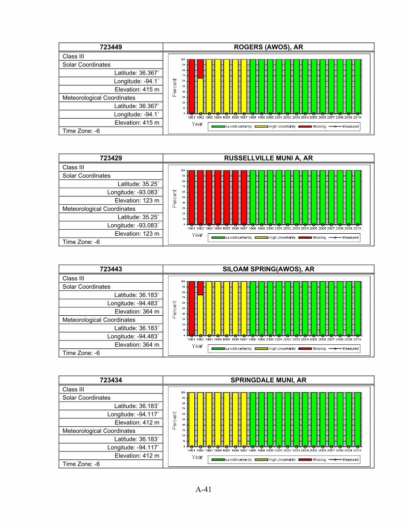
A-41
723449 ROGERS (AWOS), AR
Class III
Solar Coordinates Latitude: 36.367˚ Longitude: -94.1˚ Elevation: 415 m
Meteorological Coordinates Latitude: 36.367˚ Longitude: -94.1˚ Elevation: 415 m
Time Zone: -6
723429 RUSSELLVILLE MUNI A, AR Class III
Solar Coordinates Latitude: 35.25˚
Longitude: -93.083˚ Elevation: 123 m
Meteorological Coordinates Latitude: 35.25˚
Longitude: -93.083˚ Elevation: 123 m
Time Zone: -6
723443 SILOAM SPRING(AWOS), AR Class III
Solar Coordinates Latitude: 36.183˚
Longitude: -94.483˚ Elevation: 364 m
Meteorological Coordinates Latitude: 36.183˚
Longitude: -94.483˚ Elevation: 364 m
Time Zone: -6
723434 SPRINGDALE MUNI, AR Class III
Solar Coordinates Latitude: 36.183˚
Longitude: -94.117˚ Elevation: 412 m
Meteorological Coordinates Latitude: 36.183˚
Longitude: -94.117˚ Elevation: 412 m
Time Zone: -6

A-42
723416 STUTTGART (AWOS), AR
Class II
Solar Coordinates Latitude: 34.6˚
Longitude: -91.567˚ Elevation: 68 m
Meteorological Coordinates Latitude: 34.6˚
Longitude: -91.567˚ Elevation: 68 m
Time Zone: -6
723418 TEXARKANA WEBB FIELD, AR Class II
Solar Coordinates Latitude: 33.45˚ Longitude: -94˚
Elevation: 110 m Meteorological Coordinates
Latitude: 33.45˚ Longitude: -94˚
Elevation: 110 m Time Zone: -6
723406 WALNUT RIDGE (AWOS), AR Class II
Solar Coordinates Latitude: 36.133˚
Longitude: -90.917˚ Elevation: 83 m
Meteorological Coordinates Latitude: 36.133˚
Longitude: -90.917˚ Elevation: 83 m
Time Zone: -6
723788 BULLHEAD CITY, AZ Class III
Solar Coordinates Latitude: 35.167˚
Longitude: -114.567˚ Elevation: 167 m
Meteorological Coordinates Latitude: 35.167˚
Longitude: -114.567˚ Elevation: 167 m
Time Zone: -8

A-43
722748 CASA GRANDA (AWOS), AZ
Class III
Solar Coordinates Latitude: 32.95˚
Longitude: -111.767˚ Elevation: 446 m
Meteorological Coordinates Latitude: 32.95˚
Longitude: -111.767˚ Elevation: 446 m
Time Zone: -7
722786 CHANDLER WILLIAMS AFB, AZ Class III
Solar Coordinates Latitude: 33.3˚
Longitude: -111.667˚ Elevation: 412 m
Meteorological Coordinates Latitude: 33.3˚
Longitude: -111.667˚ Elevation: 412 m
Time Zone: -7
722745 DAVIS MONTHAN AFB, AZ Class II
Solar Coordinates Latitude: 32.167˚
Longitude: -110.883˚ Elevation: 809 m
Meteorological Coordinates Latitude: 32.167˚
Longitude: -110.883˚ Elevation: 809 m
Time Zone: -7
722784 DEER VALLEY/PHOENIX, AZ Class II
Solar Coordinates Latitude: 33.683˚
Longitude: -112.083˚ Elevation: 450 m
Meteorological Coordinates Latitude: 33.683˚
Longitude: -112.083˚ Elevation: 450 m
Time Zone: -7

A-44
722735 DOUGLAS BISBEE-DOUGLAS INTL A, AZ
Class II
Solar Coordinates Latitude: 31.467˚
Longitude: -109.6˚ Elevation: 1249 m
Meteorological Coordinates Latitude: 31.467˚
Longitude: -109.6˚ Elevation: 1249 m
Time Zone: -7
723755 FLAGSTAFF PULLIAM ARPT, AZ Class III
Solar Coordinates Latitude: 35.133˚
Longitude: -111.667˚ Elevation: 2132 m
Meteorological Coordinates Latitude: 35.133˚
Longitude: -111.667˚ Elevation: 2132 m
Time Zone: -7
722730 FORT HUACHUCA, AZ Class II
Solar Coordinates Latitude: 31.567˚
Longitude: -110.333˚ Elevation: 1422 m
Meteorological Coordinates Latitude: 31.567˚
Longitude: -110.333˚ Elevation: 1422 m
Time Zone: -7
747240 GILA BEND AIRPORT, AZ Class III
Solar Coordinates Latitude: 32.883˚
Longitude: -112.717˚ Elevation: 260 m
Meteorological Coordinates Latitude: 32.883˚
Longitude: -112.717˚ Elevation: 260 m
Time Zone: -7

A-45
722787 GLENDALE, AZ
Class III
Solar Coordinates Latitude: 33.533˚
Longitude: -112.3˚ Elevation: 325 m
Meteorological Coordinates Latitude: 33.533˚
Longitude: -112.3˚ Elevation: 325 m
Time Zone: -7
722788 GOODYEAR MUNICIPAL, AZ Class III
Solar Coordinates Latitude: 33.417˚
Longitude: -112.383˚ Elevation: 295 m
Meteorological Coordinates Latitude: 33.417˚
Longitude: -112.383˚ Elevation: 295 m
Time Zone: -7
723783 GRAND CANYON NATL P, AZ Class II
Solar Coordinates Latitude: 35.95˚
Longitude: -112.15˚ Elevation: 2065 m
Meteorological Coordinates Latitude: 35.95˚
Longitude: -112.15˚ Elevation: 2065 m
Time Zone: -7
723700 KINGMAN (AMOS), AZ Class II
Solar Coordinates Latitude: 35.267˚
Longitude: -113.95˚ Elevation: 1033 m
Meteorological Coordinates Latitude: 35.267˚
Longitude: -113.95˚ Elevation: 1033 m
Time Zone: -7
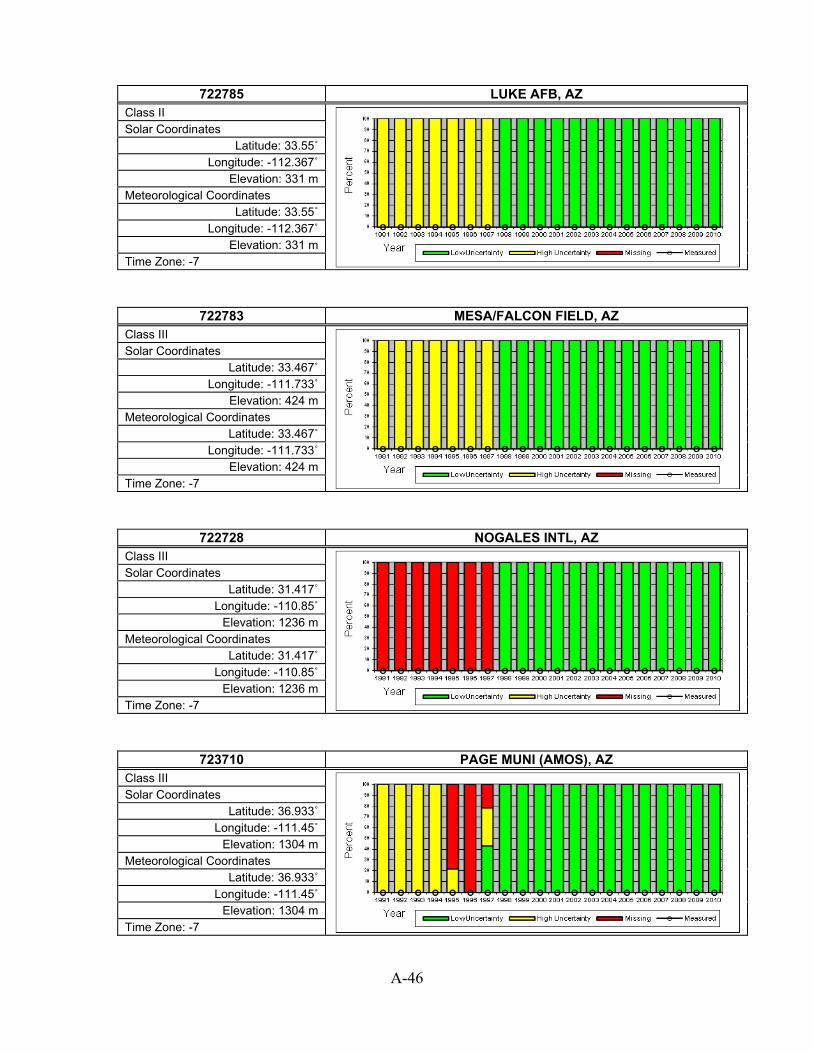
A-46
722785 LUKE AFB, AZ
Class II
Solar Coordinates Latitude: 33.55˚
Longitude: -112.367˚ Elevation: 331 m
Meteorological Coordinates Latitude: 33.55˚
Longitude: -112.367˚ Elevation: 331 m
Time Zone: -7
722783 MESA/FALCON FIELD, AZ Class III
Solar Coordinates Latitude: 33.467˚
Longitude: -111.733˚ Elevation: 424 m
Meteorological Coordinates Latitude: 33.467˚
Longitude: -111.733˚ Elevation: 424 m
Time Zone: -7
722728 NOGALES INTL, AZ Class III
Solar Coordinates Latitude: 31.417˚
Longitude: -110.85˚ Elevation: 1236 m
Meteorological Coordinates Latitude: 31.417˚
Longitude: -110.85˚ Elevation: 1236 m
Time Zone: -7
723710 PAGE MUNI (AMOS), AZ Class III
Solar Coordinates Latitude: 36.933˚
Longitude: -111.45˚ Elevation: 1304 m
Meteorological Coordinates Latitude: 36.933˚
Longitude: -111.45˚ Elevation: 1304 m
Time Zone: -7

A-47
723745 PAYSON, AZ
Class III
Solar Coordinates Latitude: 34.233˚
Longitude: -111.333˚ Elevation: 1498 m
Meteorological Coordinates Latitude: 34.233˚
Longitude: -111.333˚ Elevation: 1498 m
Time Zone: -7
722780 PHOENIX SKY HARBOR INTL AP, AZ Class I
Solar Coordinates Latitude: 33.45˚
Longitude: -111.983˚ Elevation: 337 m
Meteorological Coordinates Latitude: 33.45˚
Longitude: -111.983˚ Elevation: 337 m
Time Zone: -7
723723 PRESCOTT LOVE FIELD, AZ Class I
Solar Coordinates Latitude: 34.65˚
Longitude: -112.417˚ Elevation: 1537 m
Meteorological Coordinates Latitude: 34.65˚
Longitude: -112.417˚ Elevation: 1537 m
Time Zone: -7
722747 SAFFORD (AMOS), AZ Class III
Solar Coordinates Latitude: 32.817˚
Longitude: -109.683˚ Elevation: 950 m
Meteorological Coordinates Latitude: 32.817˚
Longitude: -109.683˚ Elevation: 950 m
Time Zone: -7

A-48
722789 SCOTTSDALE MUNI, AZ
Class II
Solar Coordinates Latitude: 33.617˚
Longitude: -111.917˚ Elevation: 460 m
Meteorological Coordinates Latitude: 33.617˚
Longitude: -111.917˚ Elevation: 460 m
Time Zone: -7
723747 SHOW LOW MUNICIPAL, AZ Class II
Solar Coordinates Latitude: 34.267˚ Longitude: -110˚
Elevation: 1954 m Meteorological Coordinates
Latitude: 34.267˚ Longitude: -110˚
Elevation: 1954 m Time Zone: -7
723754 ST. JOHNS AIR PARK, AZ Class III
Solar Coordinates Latitude: 34.517˚
Longitude: -109.383˚ Elevation: 1747 m
Meteorological Coordinates Latitude: 34.517˚
Longitude: -109.383˚ Elevation: 1747 m
Time Zone: -7
722740 TUCSON INTERNATIONAL AP, AZ Class I
Solar Coordinates Latitude: 32.133˚
Longitude: -110.95˚ Elevation: 777 m
Meteorological Coordinates Latitude: 32.133˚
Longitude: -110.95˚ Elevation: 777 m
Time Zone: -7

A-49
722764 WINDOW ROCK, AZ
Class III
Solar Coordinates Latitude: 35.65˚
Longitude: -109.067˚ Elevation: 2054 m
Meteorological Coordinates Latitude: 35.65˚
Longitude: -109.067˚ Elevation: 2054 m
Time Zone: -7
723740 WINSLOW MUNICIPAL AP, AZ Class II
Solar Coordinates Latitude: 35.033˚
Longitude: -110.717˚ Elevation: 1490 m
Meteorological Coordinates Latitude: 35.033˚
Longitude: -110.717˚ Elevation: 1490 m
Time Zone: -7
722800 YUMA INTL ARPT, AZ Class III
Solar Coordinates Latitude: 32.667˚
Longitude: -114.6˚ Elevation: 63 m
Meteorological Coordinates Latitude: 32.667˚
Longitude: -114.6˚ Elevation: 63 m
Time Zone: -7
699604 YUMA MCAS, AZ Class III
Solar Coordinates Latitude: 32.65˚
Longitude: -114.617˚ Elevation: 65 m
Meteorological Coordinates Latitude: 32.65˚
Longitude: -114.617˚ Elevation: 65 m
Time Zone: -7

A-50
745060 ALAMEDA NAS, CA
Class III
Solar Coordinates Latitude: 37.733˚
Longitude: -122.317˚ Elevation: 5 m
Meteorological Coordinates Latitude: 37.733˚
Longitude: -122.317˚ Elevation: 5 m
Time Zone: -8
725958 ALTURAS, CA Class II
Solar Coordinates Latitude: 41.5˚
Longitude: -120.533˚ Elevation: 1341 m
Meteorological Coordinates Latitude: 41.5˚
Longitude: -120.533˚ Elevation: 1341 m
Time Zone: -8
725945 ARCATA AIRPORT, CA Class I
Solar Coordinates Latitude: 40.983˚
Longitude: -124.1˚ Elevation: 62 m
Meteorological Coordinates Latitude: 40.983˚
Longitude: -124.1˚ Elevation: 62 m
Time Zone: -8
723840 BAKERSFIELD MEADOWS FIELD, CA Class I
Solar Coordinates Latitude: 35.433˚
Longitude: -119.05˚ Elevation: 149 m
Meteorological Coordinates Latitude: 35.433˚
Longitude: -119.05˚ Elevation: 149 m
Time Zone: -8

A-51
724837 BEALE AFB, CA
Class II
Solar Coordinates Latitude: 39.133˚
Longitude: -121.433˚ Elevation: 38 m
Meteorological Coordinates Latitude: 39.133˚
Longitude: -121.433˚ Elevation: 38 m
Time Zone: -8
722867 BEAUMONT 1 E, CA Class III
Solar Coordinates Latitude: 33.933˚
Longitude: -116.967˚ Elevation: 792 m
Meteorological Coordinates Latitude: 33.933˚
Longitude: -116.967˚ Elevation: 792 m
Time Zone: -8
746110 BICYCLE LAKE (AAF), CA Class III
Solar Coordinates Latitude: 35.283˚
Longitude: -116.617˚ Elevation: 716 m
Meteorological Coordinates Latitude: 35.283˚
Longitude: -116.617˚ Elevation: 716 m
Time Zone: -8
724800 BISHOP AIRPORT, CA Class I
Solar Coordinates Latitude: 37.367˚
Longitude: -118.35˚ Elevation: 1250 m
Meteorological Coordinates Latitude: 37.367˚
Longitude: -118.35˚ Elevation: 1250 m
Time Zone: -8

A-52
725845 BLUE CANYON AP, CA
Class II
Solar Coordinates Latitude: 39.3˚
Longitude: -120.717˚ Elevation: 1609 m
Meteorological Coordinates Latitude: 39.3˚
Longitude: -120.717˚ Elevation: 1609 m
Time Zone: -8
747188 BLYTHE RIVERSIDE CO ARPT, CA Class II
Solar Coordinates Latitude: 33.617˚
Longitude: -114.717˚ Elevation: 119 m
Meteorological Coordinates Latitude: 33.617˚
Longitude: -114.717˚ Elevation: 119 m
Time Zone: -8
722880 BURBANK-GLENDALE-PASSADENA AP, CA Class II
Solar Coordinates Latitude: 34.2˚
Longitude: -118.35˚ Elevation: 226 m
Meteorological Coordinates Latitude: 34.2˚
Longitude: -118.35˚ Elevation: 226 m
Time Zone: -8
723926 CAMARILLO (AWOS), CA Class III
Solar Coordinates Latitude: 34.217˚
Longitude: -119.083˚ Elevation: 23 m
Meteorological Coordinates Latitude: 34.217˚
Longitude: -119.083˚ Elevation: 23 m
Time Zone: -8

A-53
722926 CAMP PENDLETON MCAS, CA
Class II
Solar Coordinates Latitude: 33.3˚
Longitude: -117.35˚ Elevation: 23 m
Meteorological Coordinates Latitude: 33.3˚
Longitude: -117.35˚ Elevation: 23 m
Time Zone: -8
722927 CARLSBAD/PALOMAR, CA Class II
Solar Coordinates Latitude: 33.133˚
Longitude: -117.283˚ Elevation: 100 m
Meteorological Coordinates Latitude: 33.133˚
Longitude: -117.283˚ Elevation: 100 m
Time Zone: -8
724810 CASTLE AFB, CA Class III
Solar Coordinates Latitude: 37.383˚
Longitude: -120.567˚ Elevation: 60 m
Meteorological Coordinates Latitude: 37.383˚
Longitude: -120.567˚ Elevation: 60 m
Time Zone: -8
724973 CHICO MUNICIPAL, CA Class III
Solar Coordinates Latitude: 39.8˚
Longitude: -121.85˚ Elevation: 73 m
Meteorological Coordinates Latitude: 39.8˚
Longitude: -121.85˚ Elevation: 73 m
Time Zone: -8

A-54
746120 CHINA LAKE NAF, CA
Class II
Solar Coordinates Latitude: 35.683˚
Longitude: -117.683˚ Elevation: 677 m
Meteorological Coordinates Latitude: 35.683˚
Longitude: -117.683˚ Elevation: 677 m
Time Zone: -8
722899 CHINO AIRPORT, CA Class III
Solar Coordinates Latitude: 33.967˚
Longitude: -117.633˚ Elevation: 198 m
Meteorological Coordinates Latitude: 33.967˚
Longitude: -117.633˚ Elevation: 198 m
Time Zone: -8
722904 CHULA VISTA BROWN FIELD NAAS, CA Class II
Solar Coordinates Latitude: 32.583˚
Longitude: -116.983˚ Elevation: 159 m
Meteorological Coordinates Latitude: 32.583˚
Longitude: -116.983˚ Elevation: 159 m
Time Zone: -8
724936 CONCORD CONCORD-BUCHANAN FIEL, CA Class II
Solar Coordinates Latitude: 38˚
Longitude: -122.05˚ Elevation: 7 m
Meteorological Coordinates Latitude: 38˚
Longitude: -122.05˚ Elevation: 7 m
Time Zone: -8
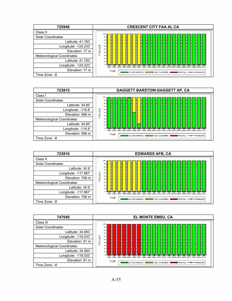
A-55
725946 CRESCENT CITY FAA AI, CA
Class II
Solar Coordinates Latitude: 41.783˚
Longitude: -124.233˚ Elevation: 17 m
Meteorological Coordinates Latitude: 41.783˚
Longitude: -124.233˚ Elevation: 17 m
Time Zone: -8
723815 DAGGETT BARSTOW-DAGGETT AP, CA Class I
Solar Coordinates Latitude: 34.85˚
Longitude: -116.8˚ Elevation: 586 m
Meteorological Coordinates Latitude: 34.85˚
Longitude: -116.8˚ Elevation: 586 m
Time Zone: -8
723810 EDWARDS AFB, CA Class II
Solar Coordinates Latitude: 34.9˚
Longitude: -117.867˚ Elevation: 706 m
Meteorological Coordinates Latitude: 34.9˚
Longitude: -117.867˚ Elevation: 706 m
Time Zone: -8
747040 EL MONTE EMSU, CA Class III
Solar Coordinates Latitude: 34.083˚
Longitude: -118.033˚ Elevation: 91 m
Meteorological Coordinates Latitude: 34.083˚
Longitude: -118.033˚ Elevation: 91 m
Time Zone: -8

A-56
690140 EL TORO MCAS, CA
Class III
Solar Coordinates Latitude: 33.667˚
Longitude: -117.733˚ Elevation: 116 m
Meteorological Coordinates Latitude: 33.667˚
Longitude: -117.733˚ Elevation: 116 m
Time Zone: -8
723890 FRESNO YOSEMITE INTL AP, CA Class I
Solar Coordinates Latitude: 36.783˚
Longitude: -119.717˚ Elevation: 102 m
Meteorological Coordinates Latitude: 36.783˚
Longitude: -119.717˚ Elevation: 102 m
Time Zone: -8
722976 FULLERTON MUNICIPAL, CA Class II
Solar Coordinates Latitude: 33.867˚
Longitude: -117.983˚ Elevation: 29 m
Meteorological Coordinates Latitude: 33.867˚
Longitude: -117.983˚ Elevation: 29 m
Time Zone: -8
723898 HANFORD MUNI ARPT [ISIS], CA Class III (with some measured)
Solar Coordinates Latitude: 36.31˚
Longitude: -119.63˚ Elevation: 73 m
Meteorological Coordinates Latitude: 36.317˚
Longitude: -119.617˚ Elevation: 75 m
Time Zone: -8

A-57
724935 HAYWARD AIR TERM, CA
Class II
Solar Coordinates Latitude: 37.667˚
Longitude: -122.117˚ Elevation: 14 m
Meteorological Coordinates Latitude: 37.667˚
Longitude: -122.117˚ Elevation: 14 m
Time Zone: -8
747185 IMPERIAL, CA Class II
Solar Coordinates Latitude: 32.833˚
Longitude: -115.583˚ Elevation: -17 m
Meteorological Coordinates Latitude: 32.833˚
Longitude: -115.583˚ Elevation: -17 m
Time Zone: -8
722909 IMPERIAL BEACH REAM FIELD NAS, CA Class III
Solar Coordinates Latitude: 32.567˚
Longitude: -117.117˚ Elevation: 6 m
Meteorological Coordinates Latitude: 32.567˚
Longitude: -117.117˚ Elevation: 6 m
Time Zone: -8
723826 INYOKERN, CA Class III
Solar Coordinates Latitude: 35.667˚
Longitude: -117.833˚ Elevation: 749 m
Meteorological Coordinates Latitude: 35.667˚
Longitude: -117.833˚ Elevation: 749 m
Time Zone: -8

A-58
722956 JACK NORTHROP FLD H, CA
Class II
Solar Coordinates Latitude: 33.917˚
Longitude: -118.333˚ Elevation: 21 m
Meteorological Coordinates Latitude: 33.917˚
Longitude: -118.333˚ Elevation: 21 m
Time Zone: -8
723816 LANCASTER GEN WM FOX FIELD, CA Class II
Solar Coordinates Latitude: 34.733˚
Longitude: -118.217˚ Elevation: 713 m
Meteorological Coordinates Latitude: 34.733˚
Longitude: -118.217˚ Elevation: 713 m
Time Zone: -8
747020 LEMOORE REEVES NAS, CA Class II
Solar Coordinates Latitude: 36.333˚
Longitude: -119.95˚ Elevation: 73 m
Meteorological Coordinates Latitude: 36.333˚
Longitude: -119.95˚ Elevation: 73 m
Time Zone: -8
724927 LIVERMORE MUNICIPAL, CA Class II
Solar Coordinates Latitude: 37.7˚
Longitude: -121.817˚ Elevation: 121 m
Meteorological Coordinates Latitude: 37.7˚
Longitude: -121.817˚ Elevation: 121 m
Time Zone: -8

A-59
722895 LOMPOC (AWOS), CA
Class III
Solar Coordinates Latitude: 34.667˚
Longitude: -120.467˚ Elevation: 27 m
Meteorological Coordinates Latitude: 34.667˚
Longitude: -120.467˚ Elevation: 27 m
Time Zone: -8
722970 LONG BEACH DAUGHERTY FLD, CA Class I
Solar Coordinates Latitude: 33.833˚
Longitude: -118.167˚ Elevation: 8 m
Meteorological Coordinates Latitude: 33.833˚
Longitude: -118.167˚ Elevation: 8 m
Time Zone: -8
722975 LOS ALAMITOS, CA Class III
Solar Coordinates Latitude: 33.783˚
Longitude: -118.05˚ Elevation: 11 m
Meteorological Coordinates Latitude: 33.783˚
Longitude: -118.05˚ Elevation: 11 m
Time Zone: -8
722874 LOS ANGELES DOWNTOWN USC CAMP, CA Class III
Solar Coordinates Latitude: 34.05˚
Longitude: -118.233˚ Elevation: 82 m
Meteorological Coordinates Latitude: 34.05˚
Longitude: -118.233˚ Elevation: 82 m
Time Zone: -8

A-60
722950 LOS ANGELES INTL ARPT, CA
Class I
Solar Coordinates Latitude: 33.933˚
Longitude: -118.4˚ Elevation: 30 m
Meteorological Coordinates Latitude: 33.933˚
Longitude: -118.4˚ Elevation: 30 m
Time Zone: -8
745046 MADERA, CA Class III
Solar Coordinates Latitude: 36.983˚
Longitude: -120.117˚ Elevation: 77 m
Meteorological Coordinates Latitude: 36.983˚
Longitude: -120.117˚ Elevation: 77 m
Time Zone: -8
722860 MARCH AFB, CA Class II
Solar Coordinates Latitude: 33.9˚
Longitude: -117.25˚ Elevation: 462 m
Meteorological Coordinates Latitude: 33.9˚
Longitude: -117.25˚ Elevation: 462 m
Time Zone: -8
724833 MATHER FIELD, CA Class III
Solar Coordinates Latitude: 38.55˚
Longitude: -121.3˚ Elevation: 29 m
Meteorological Coordinates Latitude: 38.55˚
Longitude: -121.3˚ Elevation: 29 m
Time Zone: -8

A-61
724836 MCCLELLAN AFB, CA
Class III
Solar Coordinates Latitude: 38.667˚
Longitude: -121.4˚ Elevation: 25 m
Meteorological Coordinates Latitude: 38.667˚
Longitude: -121.4˚ Elevation: 25 m
Time Zone: -8
724815 MERCED/MACREADY FLD, CA Class II
Solar Coordinates Latitude: 37.283˚
Longitude: -120.517˚ Elevation: 47 m
Meteorological Coordinates Latitude: 37.283˚
Longitude: -120.517˚ Elevation: 47 m
Time Zone: -8
724926 MODESTO CITY-COUNTY AP, CA Class II
Solar Coordinates Latitude: 37.633˚
Longitude: -120.95˚ Elevation: 30 m
Meteorological Coordinates Latitude: 37.633˚
Longitude: -120.95˚ Elevation: 30 m
Time Zone: -8
722953 MOJAVE, CA Class III
Solar Coordinates Latitude: 35.067˚
Longitude: -118.15˚ Elevation: 849 m
Meteorological Coordinates Latitude: 35.067˚
Longitude: -118.15˚ Elevation: 849 m
Time Zone: -8

A-62
725955 MONTAGUE SISKIYOU COUNTY AP, CA
Class II
Solar Coordinates Latitude: 41.783˚
Longitude: -122.467˚ Elevation: 803 m
Meteorological Coordinates Latitude: 41.783˚
Longitude: -122.467˚ Elevation: 803 m
Time Zone: -8
724915 MONTEREY NAF, CA Class II
Solar Coordinates Latitude: 36.6˚
Longitude: -121.867˚ Elevation: 50 m
Meteorological Coordinates Latitude: 36.6˚
Longitude: -121.867˚ Elevation: 50 m
Time Zone: -8
725957 MOUNT SHASTA, CA Class III
Solar Coordinates Latitude: 41.333˚
Longitude: -122.333˚ Elevation: 1078 m
Meteorological Coordinates Latitude: 41.333˚
Longitude: -122.333˚ Elevation: 1078 m
Time Zone: -8
745090 MOUNTAIN VIEW MOFFETT FLD NAS, CA Class II
Solar Coordinates Latitude: 37.4˚
Longitude: -122.05˚ Elevation: 12 m
Meteorological Coordinates Latitude: 37.4˚
Longitude: -122.05˚ Elevation: 12 m
Time Zone: -8

A-63
722810 NAF, CA
Class II
Solar Coordinates Latitude: 32.817˚
Longitude: -115.683˚ Elevation: -13 m
Meteorological Coordinates Latitude: 32.817˚
Longitude: -115.683˚ Elevation: -13 m
Time Zone: -8
724955 NAPA CO. AIRPORT, CA Class II
Solar Coordinates Latitude: 38.217˚
Longitude: -122.283˚ Elevation: 10 m
Meteorological Coordinates Latitude: 38.217˚
Longitude: -122.283˚ Elevation: 10 m
Time Zone: -8
723805 NEEDLES AIRPORT, CA Class II
Solar Coordinates Latitude: 34.767˚
Longitude: -114.617˚ Elevation: 279 m
Meteorological Coordinates Latitude: 34.767˚
Longitude: -114.617˚ Elevation: 279 m
Time Zone: -8
722866 NORTON AFB/SAN BERN, CA Class III
Solar Coordinates Latitude: 34.1˚
Longitude: -117.233˚ Elevation: 353 m
Meteorological Coordinates Latitude: 34.1˚
Longitude: -117.233˚ Elevation: 353 m
Time Zone: -8

A-64
724930 OAKLAND METROPOLITAN ARPT, CA
Class II
Solar Coordinates Latitude: 37.717˚
Longitude: -122.217˚ Elevation: 2 m
Meteorological Coordinates Latitude: 37.717˚
Longitude: -122.217˚ Elevation: 2 m
Time Zone: -8
722934 OCEANSIDE MUNICIPAL, CA Class III
Solar Coordinates Latitude: 33.217˚
Longitude: -117.35˚ Elevation: 9 m
Meteorological Coordinates Latitude: 33.217˚
Longitude: -117.35˚ Elevation: 9 m
Time Zone: -8
722865 ONTARIO, CA Class III
Solar Coordinates Latitude: 34.067˚
Longitude: -117.65˚ Elevation: 304 m
Meteorological Coordinates Latitude: 34.067˚
Longitude: -117.65˚ Elevation: 304 m
Time Zone: -8
745048 OROVILLE, CA Class III
Solar Coordinates Latitude: 39.5˚
Longitude: -121.617˚ Elevation: 57 m
Meteorological Coordinates Latitude: 39.5˚
Longitude: -121.617˚ Elevation: 57 m
Time Zone: -8

A-65
723927 OXNARD AIRPORT, CA
Class II
Solar Coordinates Latitude: 34.2˚
Longitude: -119.2˚ Elevation: 11 m
Meteorological Coordinates Latitude: 34.2˚
Longitude: -119.2˚ Elevation: 11 m
Time Zone: -8
722868 PALM SPRINGS INTL, CA Class II
Solar Coordinates Latitude: 33.833˚
Longitude: -116.5˚ Elevation: 145 m
Meteorological Coordinates Latitude: 33.833˚
Longitude: -116.5˚ Elevation: 145 m
Time Zone: -8
747187 PALM SPRINGS THERMAL AP, CA Class II
Solar Coordinates Latitude: 33.633˚
Longitude: -116.167˚ Elevation: -34 m
Meteorological Coordinates Latitude: 33.633˚
Longitude: -116.167˚ Elevation: -34 m
Time Zone: -8
723820 PALMDALE AIRPORT, CA Class II
Solar Coordinates Latitude: 34.633˚
Longitude: -118.083˚ Elevation: 769 m
Meteorological Coordinates Latitude: 34.633˚
Longitude: -118.083˚ Elevation: 769 m
Time Zone: -8

A-66
723965 PASO ROBLES MUNICIPAL ARPT, CA
Class II
Solar Coordinates Latitude: 35.667˚
Longitude: -120.633˚ Elevation: 244 m
Meteorological Coordinates Latitude: 35.667˚
Longitude: -120.633˚ Elevation: 244 m
Time Zone: -8
723910 POINT MUGU NF, CA Class II
Solar Coordinates Latitude: 34.117˚
Longitude: -119.117˚ Elevation: 3 m
Meteorological Coordinates Latitude: 34.117˚
Longitude: -119.117˚ Elevation: 3 m
Time Zone: -8
723895 PORTERVILLE (AWOS), CA Class III
Solar Coordinates Latitude: 36.033˚
Longitude: -119.067˚ Elevation: 135 m
Meteorological Coordinates Latitude: 36.033˚
Longitude: -119.067˚ Elevation: 135 m
Time Zone: -8
745056 RAMONA, CA Class III
Solar Coordinates Latitude: 33.033˚
Longitude: -116.917˚ Elevation: 424 m
Meteorological Coordinates Latitude: 33.033˚
Longitude: -116.917˚ Elevation: 424 m
Time Zone: -8

A-67
725910 RED BLUFF MUNICIPAL ARPT, CA
Class II
Solar Coordinates Latitude: 40.15˚
Longitude: -122.25˚ Elevation: 106 m
Meteorological Coordinates Latitude: 40.15˚
Longitude: -122.25˚ Elevation: 106 m
Time Zone: -8
725920 REDDING MUNICIPAL ARPT, CA Class I
Solar Coordinates Latitude: 40.517˚
Longitude: -122.317˚ Elevation: 153 m
Meteorological Coordinates Latitude: 40.517˚
Longitude: -122.317˚ Elevation: 153 m
Time Zone: -8
722869 RIVERSIDE MUNI, CA Class III
Solar Coordinates Latitude: 33.95˚
Longitude: -117.45˚ Elevation: 256 m
Meteorological Coordinates Latitude: 33.95˚
Longitude: -117.45˚ Elevation: 256 m
Time Zone: -8
724830 SACRAMENTO EXECUTIVE ARPT, CA Class I
Solar Coordinates Latitude: 38.5˚
Longitude: -121.5˚ Elevation: 5 m
Meteorological Coordinates Latitude: 38.5˚
Longitude: -121.5˚ Elevation: 5 m
Time Zone: -8
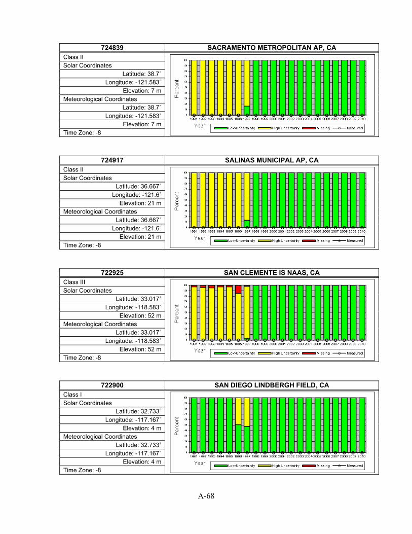
A-68
724839 SACRAMENTO METROPOLITAN AP, CA
Class II
Solar Coordinates Latitude: 38.7˚
Longitude: -121.583˚ Elevation: 7 m
Meteorological Coordinates Latitude: 38.7˚
Longitude: -121.583˚ Elevation: 7 m
Time Zone: -8
724917 SALINAS MUNICIPAL AP, CA Class II
Solar Coordinates Latitude: 36.667˚
Longitude: -121.6˚ Elevation: 21 m
Meteorological Coordinates Latitude: 36.667˚
Longitude: -121.6˚ Elevation: 21 m
Time Zone: -8
722925 SAN CLEMENTE IS NAAS, CA Class III
Solar Coordinates Latitude: 33.017˚
Longitude: -118.583˚ Elevation: 52 m
Meteorological Coordinates Latitude: 33.017˚
Longitude: -118.583˚ Elevation: 52 m
Time Zone: -8
722900 SAN DIEGO LINDBERGH FIELD, CA Class I
Solar Coordinates Latitude: 32.733˚
Longitude: -117.167˚ Elevation: 4 m
Meteorological Coordinates Latitude: 32.733˚
Longitude: -117.167˚ Elevation: 4 m
Time Zone: -8

A-69
722930 SAN DIEGO MIRAMAR NAS, CA
Class III
Solar Coordinates Latitude: 32.867˚
Longitude: -117.133˚ Elevation: 140 m
Meteorological Coordinates Latitude: 32.867˚
Longitude: -117.133˚ Elevation: 140 m
Time Zone: -8
722906 SAN DIEGO NORTH ISLAND NAS, CA Class II
Solar Coordinates Latitude: 32.7˚
Longitude: -117.2˚ Elevation: 15 m
Meteorological Coordinates Latitude: 32.7˚
Longitude: -117.2˚ Elevation: 15 m
Time Zone: -8
722903 SAN DIEGO/MONTGOMER, CA Class II
Solar Coordinates Latitude: 32.817˚
Longitude: -117.133˚ Elevation: 129 m
Meteorological Coordinates Latitude: 32.817˚
Longitude: -117.133˚ Elevation: 129 m
Time Zone: -8
724940 SAN FRANCISCO INTL AP, CA Class I
Solar Coordinates Latitude: 37.617˚
Longitude: -122.4˚ Elevation: 2 m
Meteorological Coordinates Latitude: 37.617˚
Longitude: -122.4˚ Elevation: 2 m
Time Zone: -8

A-70
724945 SAN JOSE INTL AP, CA
Class II
Solar Coordinates Latitude: 37.367˚
Longitude: -121.933˚ Elevation: 16 m
Meteorological Coordinates Latitude: 37.367˚
Longitude: -121.933˚ Elevation: 16 m
Time Zone: -8
722897 SAN LUIS CO RGNL, CA Class II
Solar Coordinates Latitude: 35.233˚
Longitude: -120.633˚ Elevation: 66 m
Meteorological Coordinates Latitude: 35.233˚
Longitude: -120.633˚ Elevation: 66 m
Time Zone: -8
722910 SAN NICHOLAS ISLAND, CA Class III
Solar Coordinates Latitude: 33.25˚
Longitude: -119.45˚ Elevation: 173 m
Meteorological Coordinates Latitude: 33.25˚
Longitude: -119.45˚ Elevation: 173 m
Time Zone: -8
723830 SANDBERG, CA Class III
Solar Coordinates Latitude: 34.75˚
Longitude: -118.717˚ Elevation: 1377 m
Meteorological Coordinates Latitude: 34.75˚
Longitude: -118.717˚ Elevation: 1377 m
Time Zone: -8

A-71
722977 SANTA ANA JOHN WAYNE AP, CA
Class II
Solar Coordinates Latitude: 33.683˚
Longitude: -117.867˚ Elevation: 16 m
Meteorological Coordinates Latitude: 33.683˚
Longitude: -117.867˚ Elevation: 16 m
Time Zone: -8
723925 SANTA BARBARA MUNICIPAL AP, CA Class I
Solar Coordinates Latitude: 34.433˚
Longitude: -119.85˚ Elevation: 3 m
Meteorological Coordinates Latitude: 34.433˚
Longitude: -119.85˚ Elevation: 3 m
Time Zone: -8
722920 SANTA CATALINA CATALINA ARPT, CA Class III
Solar Coordinates Latitude: 33.4˚
Longitude: -118.417˚ Elevation: 482 m
Meteorological Coordinates Latitude: 33.4˚
Longitude: -118.417˚ Elevation: 482 m
Time Zone: -8
723940 SANTA MARIA PUBLIC ARPT, CA Class I
Solar Coordinates Latitude: 34.917˚
Longitude: -120.467˚ Elevation: 77 m
Meteorological Coordinates Latitude: 34.917˚
Longitude: -120.467˚ Elevation: 77 m
Time Zone: -8

A-72
722885 SANTA MONICA MUNI, CA
Class II
Solar Coordinates Latitude: 34.017˚
Longitude: -118.45˚ Elevation: 53 m
Meteorological Coordinates Latitude: 34.017˚
Longitude: -118.45˚ Elevation: 53 m
Time Zone: -8
724957 SANTA ROSA (AWOS), CA Class II
Solar Coordinates Latitude: 38.517˚
Longitude: -122.817˚ Elevation: 38 m
Meteorological Coordinates Latitude: 38.517˚
Longitude: -122.817˚ Elevation: 38 m
Time Zone: -8
725847 SOUTH LAKE TAHOE, CA Class II
Solar Coordinates Latitude: 38.9˚
Longitude: -120˚ Elevation: 1909 m
Meteorological Coordinates Latitude: 38.9˚
Longitude: -120˚ Elevation: 1909 m
Time Zone: -8
724920 STOCKTON METROPOLITAN ARPT, CA Class I
Solar Coordinates Latitude: 37.9˚
Longitude: -121.233˚ Elevation: 7 m
Meteorological Coordinates Latitude: 37.9˚
Longitude: -121.233˚ Elevation: 7 m
Time Zone: -8

A-73
722955 TORRANCE MUNICIPAL ARPT, CA
Class III
Solar Coordinates Latitude: 33.8˚
Longitude: -118.333˚ Elevation: 27 m
Meteorological Coordinates Latitude: 33.8˚
Longitude: -118.333˚ Elevation: 27 m
Time Zone: -8
745160 TRAVIS FIELD AFB, CA Class II
Solar Coordinates Latitude: 38.267˚
Longitude: -121.933˚ Elevation: 18 m
Meteorological Coordinates Latitude: 38.267˚
Longitude: -121.933˚ Elevation: 18 m
Time Zone: -8
725846 TRUCKEE-TAHOE, CA Class II
Solar Coordinates Latitude: 39.317˚
Longitude: -120.133˚ Elevation: 1798 m
Meteorological Coordinates Latitude: 39.317˚
Longitude: -120.133˚ Elevation: 1798 m
Time Zone: -8
690160 TUSTIN MCAF, CA Class III
Solar Coordinates Latitude: 33.7˚
Longitude: -117.833˚ Elevation: 18 m
Meteorological Coordinates Latitude: 33.7˚
Longitude: -117.833˚ Elevation: 18 m
Time Zone: -8

A-74
690150 TWENTYNINE PALMS, CA
Class III
Solar Coordinates Latitude: 34.3˚
Longitude: -116.167˚ Elevation: 626 m
Meteorological Coordinates Latitude: 34.3˚
Longitude: -116.167˚ Elevation: 626 m
Time Zone: -8
725905 UKIAH MUNICIPAL AP, CA Class II
Solar Coordinates Latitude: 39.133˚
Longitude: -123.2˚ Elevation: 189 m
Meteorological Coordinates Latitude: 39.133˚
Longitude: -123.2˚ Elevation: 189 m
Time Zone: -8
724828 VACAVILLE NUT TREE, CA Class III
Solar Coordinates Latitude: 38.367˚
Longitude: -121.95˚ Elevation: 34 m
Meteorological Coordinates Latitude: 38.367˚
Longitude: -121.95˚ Elevation: 34 m
Time Zone: -8
722886 VAN NUYS AIRPORT, CA Class II
Solar Coordinates Latitude: 34.217˚
Longitude: -118.483˚ Elevation: 235 m
Meteorological Coordinates Latitude: 34.217˚
Longitude: -118.483˚ Elevation: 235 m
Time Zone: -8
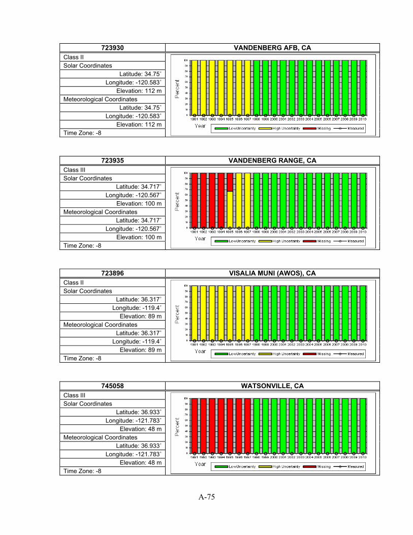
A-75
723930 VANDENBERG AFB, CA
Class II
Solar Coordinates Latitude: 34.75˚
Longitude: -120.583˚ Elevation: 112 m
Meteorological Coordinates Latitude: 34.75˚
Longitude: -120.583˚ Elevation: 112 m
Time Zone: -8
723935 VANDENBERG RANGE, CA Class III
Solar Coordinates Latitude: 34.717˚
Longitude: -120.567˚ Elevation: 100 m
Meteorological Coordinates Latitude: 34.717˚
Longitude: -120.567˚ Elevation: 100 m
Time Zone: -8
723896 VISALIA MUNI (AWOS), CA Class II
Solar Coordinates Latitude: 36.317˚
Longitude: -119.4˚ Elevation: 89 m
Meteorological Coordinates Latitude: 36.317˚
Longitude: -119.4˚ Elevation: 89 m
Time Zone: -8
745058 WATSONVILLE, CA Class III
Solar Coordinates Latitude: 36.933˚
Longitude: -121.783˚ Elevation: 48 m
Meteorological Coordinates Latitude: 36.933˚
Longitude: -121.783˚ Elevation: 48 m
Time Zone: -8

A-76
724838 YUBA CO, CA
Class II
Solar Coordinates Latitude: 39.1˚
Longitude: -121.567˚ Elevation: 19 m
Meteorological Coordinates Latitude: 39.1˚
Longitude: -121.567˚ Elevation: 19 m
Time Zone: -8
724698 AKRON WASHINGTON CO AP, CO Class II
Solar Coordinates Latitude: 40.167˚
Longitude: -103.233˚ Elevation: 1421 m
Meteorological Coordinates Latitude: 40.167˚
Longitude: -103.233˚ Elevation: 1421 m
Time Zone: -7
724620 ALAMOSA SAN LUIS VALLEY RGNL, CO Class I
Solar Coordinates Latitude: 37.433˚
Longitude: -105.867˚ Elevation: 2296 m
Meteorological Coordinates Latitude: 37.433˚
Longitude: -105.867˚ Elevation: 2296 m
Time Zone: -7
724676 ASPEN PITKIN CO SAR, CO Class II
Solar Coordinates Latitude: 39.217˚
Longitude: -106.867˚ Elevation: 2444 m
Meteorological Coordinates Latitude: 39.217˚
Longitude: -106.867˚ Elevation: 2444 m
Time Zone: -7

A-77
724695 AURORA BUCKLEY FIELD ANGB, CO
Class II
Solar Coordinates Latitude: 39.717˚
Longitude: -104.75˚ Elevation: 1726 m
Meteorological Coordinates Latitude: 39.717˚
Longitude: -104.75˚ Elevation: 1726 m
Time Zone: -7
724699 BROOMFIELD/JEFFCO [BOULDER - SURFRAD], CO Class III (with some measured)
Solar Coordinates Latitude: 40.13˚
Longitude: -105.24˚ Elevation: 1689 m
Meteorological Coordinates Latitude: 39.917˚
Longitude: -105.117˚ Elevation: 1724 m
Time Zone: -7
724689 BURLINGTON, CO Class III
Solar Coordinates Latitude: 39.25˚
Longitude: -102.283˚ Elevation: 1285 m
Meteorological Coordinates Latitude: 39.25˚
Longitude: -102.283˚ Elevation: 1285 m
Time Zone: -7
724660 COLORADO SPRINGS MUNI AP, CO Class I
Solar Coordinates Latitude: 38.817˚
Longitude: -104.717˚ Elevation: 1872 m
Meteorological Coordinates Latitude: 38.817˚
Longitude: -104.717˚ Elevation: 1872 m
Time Zone: -7

A-78
724767 CORTEZ/MONTEZUMA CO, CO
Class II
Solar Coordinates Latitude: 37.3˚
Longitude: -108.633˚ Elevation: 1803 m
Meteorological Coordinates Latitude: 37.3˚
Longitude: -108.633˚ Elevation: 1803 m
Time Zone: -7
725700 CRAIG-MOFFAT, CO Class II
Solar Coordinates Latitude: 40.5˚
Longitude: -107.533˚ Elevation: 1915 m
Meteorological Coordinates Latitude: 40.5˚
Longitude: -107.533˚ Elevation: 1915 m
Time Zone: -7
725650 DENVER INTL AP, CO Class I
Solar Coordinates Latitude: 39.833˚
Longitude: -104.65˚ Elevation: 1650 m
Meteorological Coordinates Latitude: 39.833˚
Longitude: -104.65˚ Elevation: 1650 m
Time Zone: -7
724690 DENVER STAPLETON INT'L ARPT, CO Class III
Solar Coordinates Latitude: 39.767˚
Longitude: -104.867˚ Elevation: 1611 m
Meteorological Coordinates Latitude: 39.767˚
Longitude: -104.867˚ Elevation: 1611 m
Time Zone: -7

A-79
724666 DENVER/CENTENNIAL [GOLDEN - NREL], CO
Class II (with some measured)
Solar Coordinates Latitude: 39.742˚
Longitude: -105.179˚ Elevation: 1829 m
Meteorological Coordinates Latitude: 39.567˚
Longitude: -104.85˚ Elevation: 1793 m
Time Zone: -7
724625 DURANGO/LA PLATA CO, CO Class II
Solar Coordinates Latitude: 37.15˚
Longitude: -107.75˚ Elevation: 2038 m
Meteorological Coordinates Latitude: 37.15˚
Longitude: -107.75˚ Elevation: 2038 m
Time Zone: -7
724675 EAGLE COUNTY AP, CO Class II
Solar Coordinates Latitude: 39.65˚
Longitude: -106.917˚ Elevation: 1980 m
Meteorological Coordinates Latitude: 39.65˚
Longitude: -106.917˚ Elevation: 1980 m
Time Zone: -7
724680 FORT CARSON BUTTS AAF, CO Class II
Solar Coordinates Latitude: 38.683˚
Longitude: -104.767˚ Elevation: 1790 m
Meteorological Coordinates Latitude: 38.683˚
Longitude: -104.767˚ Elevation: 1790 m
Time Zone: -7

A-80
724769 FORT COLLINS (AWOS), CO
Class II
Solar Coordinates Latitude: 40.45˚
Longitude: -105.017˚ Elevation: 1529 m
Meteorological Coordinates Latitude: 40.45˚
Longitude: -105.017˚ Elevation: 1529 m
Time Zone: -7
724697 FORT COLLINS(SAWRS), CO Class III
Solar Coordinates Latitude: 40.583˚
Longitude: -105.083˚ Elevation: 1525 m
Meteorological Coordinates Latitude: 40.583˚
Longitude: -105.083˚ Elevation: 1525 m
Time Zone: -7
724760 GRAND JUNCTION WALKER FIELD, CO Class I
Solar Coordinates Latitude: 39.133˚
Longitude: -108.533˚ Elevation: 1475 m
Meteorological Coordinates Latitude: 39.133˚
Longitude: -108.533˚ Elevation: 1475 m
Time Zone: -7
724768 GREELEY/WELD (AWOS), CO Class II
Solar Coordinates Latitude: 40.433˚
Longitude: -104.633˚ Elevation: 1420 m
Meteorological Coordinates Latitude: 40.433˚
Longitude: -104.633˚ Elevation: 1420 m
Time Zone: -7

A-81
724677 GUNNISON CO. (AWOS), CO
Class II
Solar Coordinates Latitude: 38.533˚
Longitude: -106.933˚ Elevation: 2339 m
Meteorological Coordinates Latitude: 38.533˚
Longitude: -106.933˚ Elevation: 2339 m
Time Zone: -7
725715 HAYDEN/YAMPA (AWOS), CO Class II
Solar Coordinates Latitude: 40.483˚
Longitude: -107.217˚ Elevation: 2012 m
Meteorological Coordinates Latitude: 40.483˚
Longitude: -107.217˚ Elevation: 2012 m
Time Zone: -7
724635 LA JUNTA MUNICIPAL AP, CO Class II
Solar Coordinates Latitude: 38.05˚
Longitude: -103.533˚ Elevation: 1281 m
Meteorological Coordinates Latitude: 38.05˚
Longitude: -103.533˚ Elevation: 1281 m
Time Zone: -7
724636 LAMAR MUNICIPAL, CO Class III
Solar Coordinates Latitude: 38.067˚
Longitude: -102.683˚ Elevation: 1129 m
Meteorological Coordinates Latitude: 38.067˚
Longitude: -102.683˚ Elevation: 1129 m
Time Zone: -7

A-82
724673 LEADVILLE/LAKE CO., CO
Class II
Solar Coordinates Latitude: 39.217˚
Longitude: -106.317˚ Elevation: 3026 m
Meteorological Coordinates Latitude: 39.217˚
Longitude: -106.317˚ Elevation: 3026 m
Time Zone: -7
724665 LIMON, CO Class I
Solar Coordinates Latitude: 39.183˚
Longitude: -103.717˚ Elevation: 1695 m
Meteorological Coordinates Latitude: 39.183˚
Longitude: -103.717˚ Elevation: 1695 m
Time Zone: -7
724674 MEEKER, CO Class III
Solar Coordinates Latitude: 40.05˚
Longitude: -107.9˚ Elevation: 1948 m
Meteorological Coordinates Latitude: 40.05˚
Longitude: -107.9˚ Elevation: 1948 m
Time Zone: -7
724765 MONTROSE CO. ARPT, CO Class II
Solar Coordinates Latitude: 38.5˚
Longitude: -107.9˚ Elevation: 1755 m
Meteorological Coordinates Latitude: 38.5˚
Longitude: -107.9˚ Elevation: 1755 m
Time Zone: -7

A-83
724640 PUEBLO MEMORIAL AP, CO
Class I
Solar Coordinates Latitude: 38.283˚
Longitude: -104.5˚ Elevation: 1428 m
Meteorological Coordinates Latitude: 38.283˚
Longitude: -104.5˚ Elevation: 1428 m
Time Zone: -7
725716 RIFLE (AWRS), CO Class III
Solar Coordinates Latitude: 39.533˚
Longitude: -107.8˚ Elevation: 1622 m
Meteorological Coordinates Latitude: 39.533˚
Longitude: -107.8˚ Elevation: 1622 m
Time Zone: -7
725717 RIFLE/GARFIELD RGNL, CO Class III
Solar Coordinates Latitude: 39.533˚
Longitude: -107.717˚ Elevation: 1691 m
Meteorological Coordinates Latitude: 39.533˚
Longitude: -107.717˚ Elevation: 1691 m
Time Zone: -7
724678 STEAMBOAT SPRINGS B, CO Class III
Solar Coordinates Latitude: 40.517˚
Longitude: -106.867˚ Elevation: 2149 m
Meteorological Coordinates Latitude: 40.517˚
Longitude: -106.867˚ Elevation: 2149 m
Time Zone: -7

A-84
724627 TELLURIDE REGIONAL, CO
Class III
Solar Coordinates Latitude: 37.95˚
Longitude: -107.9˚ Elevation: 2769 m
Meteorological Coordinates Latitude: 37.95˚
Longitude: -107.9˚ Elevation: 2769 m
Time Zone: -7
724645 TRINIDAD LAS ANIMAS COUNTY AP, CO Class II
Solar Coordinates Latitude: 37.267˚
Longitude: -104.333˚ Elevation: 1751 m
Meteorological Coordinates Latitude: 37.267˚
Longitude: -104.333˚ Elevation: 1751 m
Time Zone: -7
745310 USAF ACADEMY AF, CO Class II
Solar Coordinates Latitude: 38.967˚
Longitude: -104.817˚ Elevation: 2003 m
Meteorological Coordinates Latitude: 38.967˚
Longitude: -104.817˚ Elevation: 2003 m
Time Zone: -7
725040 BRIDGEPORT SIKORSKY MEMORIAL, CT Class I
Solar Coordinates Latitude: 41.183˚
Longitude: -73.15˚ Elevation: 3 m
Meteorological Coordinates Latitude: 41.183˚
Longitude: -73.15˚ Elevation: 3 m
Time Zone: -5

A-85
725086 DANBURY MUNICIPAL, CT
Class II
Solar Coordinates Latitude: 41.367˚
Longitude: -73.483˚ Elevation: 139 m
Meteorological Coordinates Latitude: 41.367˚
Longitude: -73.483˚ Elevation: 139 m
Time Zone: -5
725046 GROTON NEW LONDON AP, CT Class II
Solar Coordinates Latitude: 41.333˚
Longitude: -72.05˚ Elevation: 3 m
Meteorological Coordinates Latitude: 41.333˚
Longitude: -72.05˚ Elevation: 3 m
Time Zone: -5
725080 HARTFORD BRADLEY INTL AP, CT Class I
Solar Coordinates Latitude: 41.933˚
Longitude: -72.683˚ Elevation: 49 m
Meteorological Coordinates Latitude: 41.933˚
Longitude: -72.683˚ Elevation: 49 m
Time Zone: -5
725087 HARTFORD BRAINARD FD, CT Class II
Solar Coordinates Latitude: 41.733˚
Longitude: -72.65˚ Elevation: 6 m
Meteorological Coordinates Latitude: 41.733˚
Longitude: -72.65˚ Elevation: 6 m
Time Zone: -5

A-86
725027 MERIDEN/MARKHAM MUN, CT
Class III
Solar Coordinates Latitude: 41.5˚
Longitude: -72.817˚ Elevation: 31 m
Meteorological Coordinates Latitude: 41.5˚
Longitude: -72.817˚ Elevation: 31 m
Time Zone: -5
725045 NEW HAVEN TWEED AIRPORT, CT Class II
Solar Coordinates Latitude: 41.267˚
Longitude: -72.883˚ Elevation: 2 m
Meteorological Coordinates Latitude: 41.267˚
Longitude: -72.883˚ Elevation: 2 m
Time Zone: -5
725029 OXFORD (AWOS), CT Class III
Solar Coordinates Latitude: 41.483˚
Longitude: -73.133˚ Elevation: 222 m
Meteorological Coordinates Latitude: 41.483˚
Longitude: -73.133˚ Elevation: 222 m
Time Zone: -5
725084 WILLIMANTIC (ASOS), CT Class III
Solar Coordinates Latitude: 41.733˚
Longitude: -72.183˚ Elevation: 76 m
Meteorological Coordinates Latitude: 41.733˚
Longitude: -72.183˚ Elevation: 76 m
Time Zone: -5

A-87
724088 DOVER AFB, DE
Class II
Solar Coordinates Latitude: 39.133˚
Longitude: -75.467˚ Elevation: 7 m
Meteorological Coordinates Latitude: 39.133˚
Longitude: -75.467˚ Elevation: 7 m
Time Zone: -5
724093 GEORGETOWN/SUSSEX, DE Class III
Solar Coordinates Latitude: 38.683˚
Longitude: -75.367˚ Elevation: 16 m
Meteorological Coordinates Latitude: 38.683˚
Longitude: -75.367˚ Elevation: 16 m
Time Zone: -5
724089 WILMINGTON NEW CASTLE CNTY AP, DE Class I
Solar Coordinates Latitude: 39.667˚ Longitude: -75.6˚
Elevation: 23 m Meteorological Coordinates
Latitude: 39.667˚ Longitude: -75.6˚
Elevation: 23 m Time Zone: -5
722200 APALACHICOLA MUNI AP, FL Class III
Solar Coordinates Latitude: 29.733˚
Longitude: -85.033˚ Elevation: 6 m
Meteorological Coordinates Latitude: 29.733˚
Longitude: -85.033˚ Elevation: 6 m
Time Zone: -5

A-88
747960 AVON PARK GUNNERY RANGE, FL
Class III
Solar Coordinates Latitude: 27.65˚
Longitude: -81.333˚ Elevation: 20 m
Meteorological Coordinates Latitude: 27.65˚
Longitude: -81.333˚ Elevation: 20 m
Time Zone: -5
722123 BARTOW MUNICIPAL, FL Class III
Solar Coordinates Latitude: 27.95˚
Longitude: -81.783˚ Elevation: 39 m
Meteorological Coordinates Latitude: 27.95˚
Longitude: -81.783˚ Elevation: 39 m
Time Zone: -5
722022 BOCA RATON, FL Class III
Solar Coordinates Latitude: 26.367˚ Longitude: -80.1˚
Elevation: 4 m Meteorological Coordinates
Latitude: 26.367˚ Longitude: -80.1˚
Elevation: 4 m Time Zone: -5
722014 BROOKSVILLE, FL Class III
Solar Coordinates Latitude: 28.467˚
Longitude: -82.45˚ Elevation: 23 m
Meteorological Coordinates Latitude: 28.467˚
Longitude: -82.45˚ Elevation: 23 m
Time Zone: -5

A-89
747950 COCOA BEACH PATRICK AFB, FL
Class II
Solar Coordinates Latitude: 28.233˚ Longitude: -80.6˚
Elevation: 3 m Meteorological Coordinates
Latitude: 28.233˚ Longitude: -80.6˚
Elevation: 3 m Time Zone: -5
722215 CRESTVIEW BOB SIKES AP, FL Class II
Solar Coordinates Latitude: 30.783˚
Longitude: -86.517˚ Elevation: 58 m
Meteorological Coordinates Latitude: 30.783˚
Longitude: -86.517˚ Elevation: 58 m
Time Zone: -6
722056 DAYTONA BEACH INTL AP, FL Class I
Solar Coordinates Latitude: 29.183˚
Longitude: -81.067˚ Elevation: 9 m
Meteorological Coordinates Latitude: 29.183˚
Longitude: -81.067˚ Elevation: 9 m
Time Zone: -5
722069 DESTIN FT. WALTON, FL Class III
Solar Coordinates Latitude: 30.4˚
Longitude: -86.467˚ Elevation: 7 m
Meteorological Coordinates Latitude: 30.4˚
Longitude: -86.467˚ Elevation: 7 m
Time Zone: -6

A-90
722246 DUKE FIELD AAFB, FL
Class II
Solar Coordinates Latitude: 30.65˚
Longitude: -86.533˚ Elevation: 58 m
Meteorological Coordinates Latitude: 30.65˚
Longitude: -86.533˚ Elevation: 58 m
Time Zone: -6
722039 FORT LAUDERDALE, FL Class II
Solar Coordinates Latitude: 26.2˚
Longitude: -80.167˚ Elevation: 4 m
Meteorological Coordinates Latitude: 26.2˚
Longitude: -80.167˚ Elevation: 4 m
Time Zone: -5
722025 FORT LAUDERDALE HOLLYWOOD INT, FL Class II
Solar Coordinates Latitude: 26.067˚
Longitude: -80.15˚ Elevation: 3 m
Meteorological Coordinates Latitude: 26.067˚
Longitude: -80.15˚ Elevation: 3 m
Time Zone: -5
722106 FORT MYERS PAGE FIELD, FL Class I
Solar Coordinates Latitude: 26.583˚
Longitude: -81.867˚ Elevation: 5 m
Meteorological Coordinates Latitude: 26.583˚
Longitude: -81.867˚ Elevation: 5 m
Time Zone: -5

A-91
722146 GAINESVILLE REGIONAL AP, FL
Class I
Solar Coordinates Latitude: 29.7˚
Longitude: -82.283˚ Elevation: 41 m
Meteorological Coordinates Latitude: 29.7˚
Longitude: -82.283˚ Elevation: 41 m
Time Zone: -5
722026 HOMESTEAD AFB, FL Class II
Solar Coordinates Latitude: 25.483˚
Longitude: -80.383˚ Elevation: 5 m
Meteorological Coordinates Latitude: 25.483˚
Longitude: -80.383˚ Elevation: 5 m
Time Zone: -5
722067 JACKSONVILLE CECIL FLD NAS, FL Class III
Solar Coordinates Latitude: 30.217˚
Longitude: -81.883˚ Elevation: 27 m
Meteorological Coordinates Latitude: 30.217˚
Longitude: -81.883˚ Elevation: 27 m
Time Zone: -5
722060 JACKSONVILLE INTL ARPT, FL Class I
Solar Coordinates Latitude: 30.5˚
Longitude: -81.7˚ Elevation: 8 m
Meteorological Coordinates Latitude: 30.5˚
Longitude: -81.7˚ Elevation: 8 m
Time Zone: -5

A-92
722065 JACKSONVILLE NAS, FL
Class II
Solar Coordinates Latitude: 30.233˚
Longitude: -81.667˚ Elevation: 9 m
Meteorological Coordinates Latitude: 30.233˚
Longitude: -81.667˚ Elevation: 9 m
Time Zone: -5
722068 JACKSONVILLE/CRAIG, FL Class II
Solar Coordinates Latitude: 30.333˚
Longitude: -81.517˚ Elevation: 12 m
Meteorological Coordinates Latitude: 30.333˚
Longitude: -81.517˚ Elevation: 12 m
Time Zone: -5
722010 KEY WEST INTL ARPT, FL Class I
Solar Coordinates Latitude: 24.55˚
Longitude: -81.75˚ Elevation: 1 m
Meteorological Coordinates Latitude: 24.55˚
Longitude: -81.75˚ Elevation: 1 m
Time Zone: -5
722015 KEY WEST NAS, FL Class II
Solar Coordinates Latitude: 24.583˚
Longitude: -81.683˚ Elevation: 7 m
Meteorological Coordinates Latitude: 24.583˚
Longitude: -81.683˚ Elevation: 7 m
Time Zone: -5

A-93
722119 LAKELAND LINDER RGN, FL
Class II
Solar Coordinates Latitude: 27.983˚
Longitude: -82.017˚ Elevation: 43 m
Meteorological Coordinates Latitude: 27.983˚
Longitude: -82.017˚ Elevation: 43 m
Time Zone: -5
722213 LEESBURG MUNI ARPT, FL Class III
Solar Coordinates Latitude: 28.817˚ Longitude: -81.8˚ Elevation: 125 m
Meteorological Coordinates Latitude: 28.817˚ Longitude: -81.8˚ Elevation: 125 m
Time Zone: -5
747880 MACDILL AFB, FL Class II
Solar Coordinates Latitude: 27.85˚
Longitude: -82.517˚ Elevation: 8 m
Meteorological Coordinates Latitude: 27.85˚
Longitude: -82.517˚ Elevation: 8 m
Time Zone: -5
722016 MARATHON AIRPORT, FL Class II
Solar Coordinates Latitude: 24.733˚
Longitude: -81.05˚ Elevation: 2 m
Meteorological Coordinates Latitude: 24.733˚
Longitude: -81.05˚ Elevation: 2 m
Time Zone: -5

A-94
747760 MARIANNA, FL
Class III
Solar Coordinates Latitude: 30.533˚
Longitude: -85.183˚ Elevation: 34 m
Meteorological Coordinates Latitude: 30.533˚
Longitude: -85.183˚ Elevation: 34 m
Time Zone: -6
722066 MAYPORT NS, FL Class II
Solar Coordinates Latitude: 30.4˚
Longitude: -81.417˚ Elevation: 5 m
Meteorological Coordinates Latitude: 30.4˚
Longitude: -81.417˚ Elevation: 5 m
Time Zone: -5
722040 MELBOURNE REGIONAL AP, FL Class II
Solar Coordinates Latitude: 28.117˚
Longitude: -80.65˚ Elevation: 11 m
Meteorological Coordinates Latitude: 28.117˚
Longitude: -80.65˚ Elevation: 11 m
Time Zone: -5
722020 MIAMI INTL AP, FL Class I
Solar Coordinates Latitude: 25.817˚ Longitude: -80.3˚
Elevation: 11 m Meteorological Coordinates
Latitude: 25.817˚ Longitude: -80.3˚
Elevation: 11 m Time Zone: -5

A-95
722029 MIAMI/KENDALL-TAMIA, FL
Class II
Solar Coordinates Latitude: 25.65˚
Longitude: -80.433˚ Elevation: 3 m
Meteorological Coordinates Latitude: 25.65˚
Longitude: -80.433˚ Elevation: 3 m
Time Zone: -5
722024 MIAMI/OPA LOCKA, FL Class II
Solar Coordinates Latitude: 25.9˚
Longitude: -80.283˚ Elevation: 3 m
Meteorological Coordinates Latitude: 25.9˚
Longitude: -80.283˚ Elevation: 3 m
Time Zone: -5
722038 NAPLES MUNICIPAL, FL Class II
Solar Coordinates Latitude: 26.15˚
Longitude: -81.767˚ Elevation: 3 m
Meteorological Coordinates Latitude: 26.15˚
Longitude: -81.767˚ Elevation: 3 m
Time Zone: -5
747946 NASA SHUTTLE FCLTY, FL Class III
Solar Coordinates Latitude: 28.617˚
Longitude: -80.717˚ Elevation: 3 m
Meteorological Coordinates Latitude: 28.617˚
Longitude: -80.717˚ Elevation: 3 m
Time Zone: -5

A-96
722055 OCALA MUNI (AWOS), FL
Class II
Solar Coordinates Latitude: 29.167˚
Longitude: -82.217˚ Elevation: 27 m
Meteorological Coordinates Latitude: 29.167˚
Longitude: -82.217˚ Elevation: 27 m
Time Zone: -5
722053 ORLANDO EXECUTIVE AP, FL Class II
Solar Coordinates Latitude: 28.55˚
Longitude: -81.333˚ Elevation: 33 m
Meteorological Coordinates Latitude: 28.55˚
Longitude: -81.333˚ Elevation: 33 m
Time Zone: -5
722050 ORLANDO INTL ARPT, FL Class I
Solar Coordinates Latitude: 28.433˚
Longitude: -81.333˚ Elevation: 29 m
Meteorological Coordinates Latitude: 28.433˚
Longitude: -81.333˚ Elevation: 29 m
Time Zone: -5
722057 ORLANDO SANFORD AIRPORT, FL Class II
Solar Coordinates Latitude: 28.783˚
Longitude: -81.25˚ Elevation: 17 m
Meteorological Coordinates Latitude: 28.783˚
Longitude: -81.25˚ Elevation: 17 m
Time Zone: -5

A-97
722011 ORLANDO/KISSIMMEE, FL
Class III
Solar Coordinates Latitude: 28.283˚
Longitude: -81.433˚ Elevation: 25 m
Meteorological Coordinates Latitude: 28.283˚
Longitude: -81.433˚ Elevation: 25 m
Time Zone: -5
722245 PANAMA CITY BAY CO, FL Class II
Solar Coordinates Latitude: 30.2˚
Longitude: -85.683˚ Elevation: 6 m
Meteorological Coordinates Latitude: 30.2˚
Longitude: -85.683˚ Elevation: 6 m
Time Zone: -6
722225 PENSACOLA FOREST SHERMAN NAS, FL Class II
Solar Coordinates Latitude: 30.35˚
Longitude: -87.317˚ Elevation: 10 m
Meteorological Coordinates Latitude: 30.35˚
Longitude: -87.317˚ Elevation: 10 m
Time Zone: -6
722223 PENSACOLA REGIONAL AP, FL Class I
Solar Coordinates Latitude: 30.483˚
Longitude: -87.183˚ Elevation: 34 m
Meteorological Coordinates Latitude: 30.483˚
Longitude: -87.183˚ Elevation: 34 m
Time Zone: -6

A-98
722049 POMPANO BEACH, FL
Class III
Solar Coordinates Latitude: 26.233˚ Longitude: -80.1˚
Elevation: 6 m Meteorological Coordinates
Latitude: 26.233˚ Longitude: -80.1˚
Elevation: 6 m Time Zone: -5
722034 PUNTA GORDA, FL Class III
Solar Coordinates Latitude: 26.917˚
Longitude: -82˚ Elevation: 7 m
Meteorological Coordinates Latitude: 26.917˚
Longitude: -82˚ Elevation: 7 m
Time Zone: -5
722115 SARASOTA BRADENTON, FL Class II
Solar Coordinates Latitude: 27.383˚
Longitude: -82.55˚ Elevation: 10 m
Meteorological Coordinates Latitude: 27.383˚
Longitude: -82.55˚ Elevation: 10 m
Time Zone: -5
722108 SOUTHWEST FLORIDA I, FL Class II
Solar Coordinates Latitude: 26.533˚
Longitude: -81.75˚ Elevation: 9 m
Meteorological Coordinates Latitude: 26.533˚
Longitude: -81.75˚ Elevation: 9 m
Time Zone: -5

A-99
722046 SPACE COAST RGNL [FSEC], FL
Class III (with some measured)
Solar Coordinates Latitude: 28.39˚
Longitude: -80.76˚ Elevation: 18 m
Meteorological Coordinates Latitude: 28.517˚ Longitude: -80.8˚
Elevation: 11 m Time Zone: -5
722103 ST LUCIE CO INTL, FL Class II
Solar Coordinates Latitude: 27.483˚
Longitude: -80.367˚ Elevation: 7 m
Meteorological Coordinates Latitude: 27.483˚
Longitude: -80.367˚ Elevation: 7 m
Time Zone: -5
722104 ST PETERSBURG ALBERT WHITTED, FL Class II
Solar Coordinates Latitude: 27.767˚
Longitude: -82.633˚ Elevation: 2 m
Meteorological Coordinates Latitude: 27.767˚
Longitude: -82.633˚ Elevation: 2 m
Time Zone: -5
722116 ST PETERSBURG CLEAR, FL Class II
Solar Coordinates Latitude: 27.9˚
Longitude: -82.683˚ Elevation: 3 m
Meteorological Coordinates Latitude: 27.9˚
Longitude: -82.683˚ Elevation: 3 m
Time Zone: -5
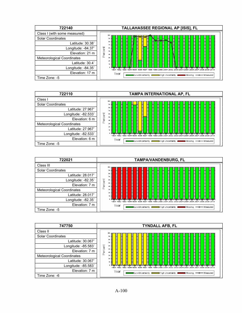
A-100
722140 TALLAHASSEE REGIONAL AP [ISIS], FL
Class I (with some measured)
Solar Coordinates Latitude: 30.38˚
Longitude: -84.37˚ Elevation: 21 m
Meteorological Coordinates Latitude: 30.4˚
Longitude: -84.35˚ Elevation: 17 m
Time Zone: -5
722110 TAMPA INTERNATIONAL AP, FL Class I
Solar Coordinates Latitude: 27.967˚
Longitude: -82.533˚ Elevation: 6 m
Meteorological Coordinates Latitude: 27.967˚
Longitude: -82.533˚ Elevation: 6 m
Time Zone: -5
722021 TAMPA/VANDENBURG, FL Class III
Solar Coordinates Latitude: 28.017˚
Longitude: -82.35˚ Elevation: 7 m
Meteorological Coordinates Latitude: 28.017˚
Longitude: -82.35˚ Elevation: 7 m
Time Zone: -5
747750 TYNDALL AFB, FL Class II
Solar Coordinates Latitude: 30.067˚
Longitude: -85.583˚ Elevation: 7 m
Meteorological Coordinates Latitude: 30.067˚
Longitude: -85.583˚ Elevation: 7 m
Time Zone: -6

A-101
722210 VALPARAISO ELGIN AFB, FL
Class II
Solar Coordinates Latitude: 30.483˚
Longitude: -86.517˚ Elevation: 20 m
Meteorological Coordinates Latitude: 30.483˚
Longitude: -86.517˚ Elevation: 20 m
Time Zone: -6
747770 VALPARAISO HURLBURT, FL Class II
Solar Coordinates Latitude: 30.417˚
Longitude: -86.683˚ Elevation: 12 m
Meteorological Coordinates Latitude: 30.417˚
Longitude: -86.683˚ Elevation: 12 m
Time Zone: -6
722045 VERO BEACH MUNICIPAL ARPT, FL Class I
Solar Coordinates Latitude: 27.65˚
Longitude: -80.417˚ Elevation: 7 m
Meteorological Coordinates Latitude: 27.65˚
Longitude: -80.417˚ Elevation: 7 m
Time Zone: -5
722030 WEST PALM BEACH INTL ARPT, FL Class I
Solar Coordinates Latitude: 26.683˚ Longitude: -80.1˚
Elevation: 6 m Meteorological Coordinates
Latitude: 26.683˚ Longitude: -80.1˚
Elevation: 6 m Time Zone: -5

A-102
722226 WHITING FIELD NAAS, FL
Class II
Solar Coordinates Latitude: 30.717˚
Longitude: -87.017˚ Elevation: 54 m
Meteorological Coordinates Latitude: 30.717˚
Longitude: -87.017˚ Elevation: 54 m
Time Zone: -6
747930 WINTERHAVEN, FL Class III
Solar Coordinates Latitude: 28.05˚
Longitude: -81.75˚ Elevation: 44 m
Meteorological Coordinates Latitude: 28.05˚
Longitude: -81.75˚ Elevation: 44 m
Time Zone: -5
722160 ALBANY DOUGHERTY COUNTY AP, GA Class II
Solar Coordinates Latitude: 31.533˚
Longitude: -84.183˚ Elevation: 58 m
Meteorological Coordinates Latitude: 31.533˚
Longitude: -84.183˚ Elevation: 58 m
Time Zone: -5
722135 ALMA BACON COUNTY AP, GA Class II
Solar Coordinates Latitude: 31.533˚ Longitude: -82.5˚
Elevation: 63 m Meteorological Coordinates
Latitude: 31.533˚ Longitude: -82.5˚
Elevation: 63 m Time Zone: -5

A-103
723110 ATHENS BEN EPPS AP, GA
Class I
Solar Coordinates Latitude: 33.95˚
Longitude: -83.333˚ Elevation: 244 m
Meteorological Coordinates Latitude: 33.95˚
Longitude: -83.333˚ Elevation: 244 m
Time Zone: -5
722197 ATLANTA (NEXRAD), GA Class III
Solar Coordinates Latitude: 33.367˚
Longitude: -84.55˚ Elevation: 296 m
Meteorological Coordinates Latitude: 33.367˚
Longitude: -84.55˚ Elevation: 296 m
Time Zone: -5
722190 ATLANTA HARTSFIELD INTL AP, GA Class I
Solar Coordinates Latitude: 33.633˚
Longitude: -84.433˚ Elevation: 308 m
Meteorological Coordinates Latitude: 33.633˚
Longitude: -84.433˚ Elevation: 308 m
Time Zone: -5
722180 AUGUSTA BUSH FIELD, GA Class I
Solar Coordinates Latitude: 33.367˚
Longitude: -81.967˚ Elevation: 40 m
Meteorological Coordinates Latitude: 33.367˚
Longitude: -81.967˚ Elevation: 40 m
Time Zone: -5

A-104
722136 BRUNSWICK GOLDEN IS, GA
Class II
Solar Coordinates Latitude: 31.25˚
Longitude: -81.467˚ Elevation: 8 m
Meteorological Coordinates Latitude: 31.25˚
Longitude: -81.467˚ Elevation: 8 m
Time Zone: -5
722137 BRUNSWICK MALCOLM MCKINNON AP, GA Class II
Solar Coordinates Latitude: 31.15˚
Longitude: -81.383˚ Elevation: 4 m
Meteorological Coordinates Latitude: 31.15˚
Longitude: -81.383˚ Elevation: 4 m
Time Zone: -5
722156 CARTERSVILLE AIRPRT, GA Class III
Solar Coordinates Latitude: 34.117˚
Longitude: -84.533˚ Elevation: 229 m
Meteorological Coordinates Latitude: 34.117˚
Longitude: -84.533˚ Elevation: 229 m
Time Zone: -5
722255 COLUMBUS METROPOLITAN ARPT, GA Class I
Solar Coordinates Latitude: 32.517˚
Longitude: -84.95˚ Elevation: 120 m
Meteorological Coordinates Latitude: 32.517˚
Longitude: -84.95˚ Elevation: 120 m
Time Zone: -6

A-105
722154 DALTON, GA
Class III
Solar Coordinates Latitude: 34.717˚
Longitude: -84.867˚ Elevation: 216 m
Meteorological Coordinates Latitude: 34.717˚
Longitude: -84.867˚ Elevation: 216 m
Time Zone: -5
722196 DEKALB PEACHTREE, GA Class II
Solar Coordinates Latitude: 33.867˚ Longitude: -84.3˚ Elevation: 313 m
Meteorological Coordinates Latitude: 33.867˚ Longitude: -84.3˚ Elevation: 313 m
Time Zone: -5
722250 FORT BENNING LAWSON, GA Class II
Solar Coordinates Latitude: 32.35˚ Longitude: -85˚ Elevation: 88 m
Meteorological Coordinates Latitude: 32.35˚ Longitude: -85˚ Elevation: 88 m
Time Zone: -6
722090 FT STEWART/WRIGHT, GA Class II
Solar Coordinates Latitude: 31.883˚
Longitude: -81.567˚ Elevation: 14 m
Meteorological Coordinates Latitude: 31.883˚
Longitude: -81.567˚ Elevation: 14 m
Time Zone: -5

A-106
722195 FULTON CO ARPT BROW, GA
Class II
Solar Coordinates Latitude: 33.767˚
Longitude: -84.517˚ Elevation: 263 m
Meteorological Coordinates Latitude: 33.767˚
Longitude: -84.517˚ Elevation: 263 m
Time Zone: -5
722185 GAINESVILLE\LEE GIL, GA Class III
Solar Coordinates Latitude: 34.267˚
Longitude: -83.833˚ Elevation: 389 m
Meteorological Coordinates Latitude: 34.267˚
Longitude: -83.833˚ Elevation: 389 m
Time Zone: -5
747804 HUNTER AAF, GA Class II
Solar Coordinates Latitude: 32˚
Longitude: -81.15˚ Elevation: 13 m
Meteorological Coordinates Latitude: 32˚
Longitude: -81.15˚ Elevation: 13 m
Time Zone: -5
747807 LA GRANGE, GA Class III
Solar Coordinates Latitude: 33.017˚
Longitude: -85.067˚ Elevation: 211 m
Meteorological Coordinates Latitude: 33.017˚
Longitude: -85.067˚ Elevation: 211 m
Time Zone: -5

A-107
747808 LAWRENCEVILLE, GA
Class III
Solar Coordinates Latitude: 33.983˚
Longitude: -83.967˚ Elevation: 323 m
Meteorological Coordinates Latitude: 33.983˚
Longitude: -83.967˚ Elevation: 323 m
Time Zone: -5
722170 MACON MIDDLE GA REGIONAL AP, GA Class I
Solar Coordinates Latitude: 32.683˚
Longitude: -83.65˚ Elevation: 108 m
Meteorological Coordinates Latitude: 32.683˚
Longitude: -83.65˚ Elevation: 108 m
Time Zone: -5
722270 MARIETTA DOBBINS AFB, GA Class II
Solar Coordinates Latitude: 33.917˚
Longitude: -84.517˚ Elevation: 330 m
Meteorological Coordinates Latitude: 33.917˚
Longitude: -84.517˚ Elevation: 330 m
Time Zone: -5
747810 MOODY AFB/VALDOSTA, GA Class II
Solar Coordinates Latitude: 30.967˚ Longitude: -83.2˚
Elevation: 71 m Meteorological Coordinates
Latitude: 30.967˚ Longitude: -83.2˚
Elevation: 71 m Time Zone: -5

A-108
722176 NEWNAN, GA
Class III
Solar Coordinates Latitude: 33.317˚
Longitude: -84.767˚ Elevation: 296 m
Meteorological Coordinates Latitude: 33.317˚
Longitude: -84.767˚ Elevation: 296 m
Time Zone: -5
723200 ROME R B RUSSELL AP, GA Class III
Solar Coordinates Latitude: 34.35˚
Longitude: -85.167˚ Elevation: 195 m
Meteorological Coordinates Latitude: 34.35˚
Longitude: -85.167˚ Elevation: 195 m
Time Zone: -5
722070 SAVANNAH INTL AP, GA Class I
Solar Coordinates Latitude: 32.117˚ Longitude: -81.2˚
Elevation: 14 m Meteorological Coordinates
Latitude: 32.117˚ Longitude: -81.2˚
Elevation: 14 m Time Zone: -5
747805 STATESBORO, GA Class III
Solar Coordinates Latitude: 32.482˚
Longitude: -81.733˚ Elevation: 57 m
Meteorological Coordinates Latitude: 32.482˚
Longitude: -81.733˚ Elevation: 57 m
Time Zone: -5

A-109
747806 THOMASTON, GA
Class III
Solar Coordinates Latitude: 32.95˚
Longitude: -84.267˚ Elevation: 243 m
Meteorological Coordinates Latitude: 32.95˚
Longitude: -84.267˚ Elevation: 243 m
Time Zone: -5
722166 VALDOSTA WB AIRPORT, GA Class II
Solar Coordinates Latitude: 30.783˚
Longitude: -83.283˚ Elevation: 61 m
Meteorological Coordinates Latitude: 30.783˚
Longitude: -83.283˚ Elevation: 61 m
Time Zone: -5
722134 VIDALIA MUNI ARPT, GA Class III
Solar Coordinates Latitude: 32.183˚
Longitude: -82.367˚ Elevation: 84 m
Meteorological Coordinates Latitude: 32.183˚
Longitude: -82.367˚ Elevation: 84 m
Time Zone: -5
722175 WARNER ROBINS AFB, GA Class II
Solar Coordinates Latitude: 32.633˚ Longitude: -83.6˚
Elevation: 92 m Meteorological Coordinates
Latitude: 32.633˚ Longitude: -83.6˚
Elevation: 92 m Time Zone: -5

A-110
722130 WAYCROSS WARE CO AP, GA
Class III
Solar Coordinates Latitude: 31.25˚
Longitude: -82.4˚ Elevation: 43 m
Meteorological Coordinates Latitude: 31.25˚
Longitude: -82.4˚ Elevation: 43 m
Time Zone: -5
747809 WINDER, GA Class III
Solar Coordinates Latitude: 33.983˚
Longitude: -83.667˚ Elevation: 287 m
Meteorological Coordinates Latitude: 33.983˚
Longitude: -83.667˚ Elevation: 287 m
Time Zone: -5
912180 ANDERSEN AFB, GU Class II
Solar Coordinates Latitude: 13.567˚
Longitude: 144.917˚ Elevation: 162 m
Meteorological Coordinates Latitude: 13.567˚
Longitude: 144.917˚ Elevation: 162 m
Time Zone: 10
912170 GUAM MARIANA IS, GU Class III
Solar Coordinates Latitude: 13.55˚
Longitude: 144.833˚ Elevation: 111 m
Meteorological Coordinates Latitude: 13.55˚
Longitude: 144.833˚ Elevation: 111 m
Time Zone: 10

A-111
912120 GUAM WFO, GU
Class II
Solar Coordinates Latitude: 13.483˚
Longitude: 144.8˚ Elevation: 77 m
Meteorological Coordinates Latitude: 13.483˚
Longitude: 144.8˚ Elevation: 77 m
Time Zone: 10
911780 BARBERS POINT NAS, HI Class II
Solar Coordinates Latitude: 21.317˚
Longitude: -158.067˚ Elevation: 15 m
Meteorological Coordinates Latitude: 21.317˚
Longitude: -158.067˚ Elevation: 15 m
Time Zone: -10
911977 BRADSHAW AAF, HI Class III
Solar Coordinates Latitude: 19.75˚
Longitude: -155.55˚ Elevation: 1934 m
Meteorological Coordinates Latitude: 19.75˚
Longitude: -155.55˚ Elevation: 1934 m
Time Zone: -10
912850 HILO INTERNATIONAL AP, HI Class I
Solar Coordinates Latitude: 19.717˚
Longitude: -155.05˚ Elevation: 9 m
Meteorological Coordinates Latitude: 19.717˚
Longitude: -155.05˚ Elevation: 9 m
Time Zone: -10

A-112
911820 HONOLULU INTL ARPT, HI
Class I
Solar Coordinates Latitude: 21.317˚
Longitude: -157.933˚ Elevation: 2 m
Meteorological Coordinates Latitude: 21.317˚
Longitude: -157.933˚ Elevation: 2 m
Time Zone: -10
911900 KAHULUI AIRPORT, HI Class I
Solar Coordinates Latitude: 20.9˚
Longitude: -156.433˚ Elevation: 16 m
Meteorological Coordinates Latitude: 20.9˚
Longitude: -156.433˚ Elevation: 16 m
Time Zone: -10
911760 KANEOHE BAY MCAS, HI Class II
Solar Coordinates Latitude: 21.45˚
Longitude: -157.783˚ Elevation: 3 m
Meteorological Coordinates Latitude: 21.45˚
Longitude: -157.783˚ Elevation: 3 m
Time Zone: -10
911904 KAPALUA, HI Class II
Solar Coordinates Latitude: 20.95˚
Longitude: -156.633˚ Elevation: 80 m
Meteorological Coordinates Latitude: 20.95˚
Longitude: -156.633˚ Elevation: 80 m
Time Zone: -10

A-113
911975 KONA INTL AT KEAHOL, HI
Class III
Solar Coordinates Latitude: 19.733˚
Longitude: -156.05˚ Elevation: 15 m
Meteorological Coordinates Latitude: 19.733˚
Longitude: -156.05˚ Elevation: 15 m
Time Zone: -10
911905 LANAI, HI Class II
Solar Coordinates Latitude: 20.783˚
Longitude: -156.95˚ Elevation: 409 m
Meteorological Coordinates Latitude: 20.783˚
Longitude: -156.95˚ Elevation: 409 m
Time Zone: -10
911650 LIHUE AIRPORT, HI Class I
Solar Coordinates Latitude: 21.983˚
Longitude: -159.333˚ Elevation: 31 m
Meteorological Coordinates Latitude: 21.983˚
Longitude: -159.333˚ Elevation: 31 m
Time Zone: -10
910660 MIDWAY ISLAND NAS, HI Class III
Solar Coordinates Latitude: 28.2˚
Longitude: -177.383˚ Elevation: 7 m
Meteorological Coordinates Latitude: 28.2˚
Longitude: -177.383˚ Elevation: 7 m
Time Zone: -10

A-114
911860 MOLOKAI (AMOS), HI
Class II
Solar Coordinates Latitude: 21.15˚
Longitude: -157.1˚ Elevation: 137 m
Meteorological Coordinates Latitude: 21.15˚
Longitude: -157.1˚ Elevation: 137 m
Time Zone: -10
911700 WHEELER AFB 810.1, HI Class II
Solar Coordinates Latitude: 21.483˚
Longitude: -158.033˚ Elevation: 252 m
Meteorological Coordinates Latitude: 21.483˚
Longitude: -158.033˚ Elevation: 252 m
Time Zone: -10
725457 ALGONA, IA Class III
Solar Coordinates Latitude: 43.083˚
Longitude: -94.267˚ Elevation: 372 m
Meteorological Coordinates Latitude: 43.083˚
Longitude: -94.267˚ Elevation: 372 m
Time Zone: -6
725466 ANKENY REGIONAL ARP, IA Class III
Solar Coordinates Latitude: 41.683˚
Longitude: -93.55˚ Elevation: 275 m
Meteorological Coordinates Latitude: 41.683˚
Longitude: -93.55˚ Elevation: 275 m
Time Zone: -6
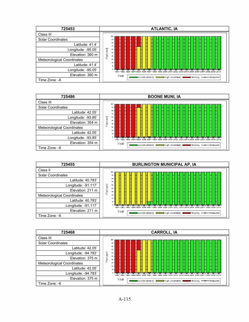
A-115
725453 ATLANTIC, IA
Class III
Solar Coordinates Latitude: 41.4˚
Longitude: -95.05˚ Elevation: 360 m
Meteorological Coordinates Latitude: 41.4˚
Longitude: -95.05˚ Elevation: 360 m
Time Zone: -6
725486 BOONE MUNI, IA Class III
Solar Coordinates Latitude: 42.05˚
Longitude: -93.85˚ Elevation: 354 m
Meteorological Coordinates Latitude: 42.05˚
Longitude: -93.85˚ Elevation: 354 m
Time Zone: -6
725455 BURLINGTON MUNICIPAL AP, IA Class II
Solar Coordinates Latitude: 40.783˚
Longitude: -91.117˚ Elevation: 211 m
Meteorological Coordinates Latitude: 40.783˚
Longitude: -91.117˚ Elevation: 211 m
Time Zone: -6
725468 CARROLL, IA Class III
Solar Coordinates Latitude: 42.05˚
Longitude: -94.783˚ Elevation: 375 m
Meteorological Coordinates Latitude: 42.05˚
Longitude: -94.783˚ Elevation: 375 m
Time Zone: -6

A-116
725450 CEDAR RAPIDS MUNICIPAL AP, IA
Class II
Solar Coordinates Latitude: 41.883˚
Longitude: -91.717˚ Elevation: 256 m
Meteorological Coordinates Latitude: 41.883˚
Longitude: -91.717˚ Elevation: 256 m
Time Zone: -6
725469 CHARITON, IA Class III
Solar Coordinates Latitude: 41.033˚
Longitude: -93.367˚ Elevation: 320 m
Meteorological Coordinates Latitude: 41.033˚
Longitude: -93.367˚ Elevation: 320 m
Time Zone: -6
725463 CHARLES CITY, IA Class III
Solar Coordinates Latitude: 43.067˚
Longitude: -92.617˚ Elevation: 343 m
Meteorological Coordinates Latitude: 43.067˚
Longitude: -92.617˚ Elevation: 343 m
Time Zone: -6
725479 CLARINDA, IA Class III
Solar Coordinates Latitude: 40.717˚
Longitude: -95.033˚ Elevation: 303 m
Meteorological Coordinates Latitude: 40.717˚
Longitude: -95.033˚ Elevation: 303 m
Time Zone: -6

A-117
725458 CLARION, IA
Class III
Solar Coordinates Latitude: 42.75˚
Longitude: -93.767˚ Elevation: 354 m
Meteorological Coordinates Latitude: 42.75˚
Longitude: -93.767˚ Elevation: 354 m
Time Zone: -6
725473 CLINTON MUNI (AWOS), IA Class II
Solar Coordinates Latitude: 41.833˚
Longitude: -90.333˚ Elevation: 216 m
Meteorological Coordinates Latitude: 41.833˚
Longitude: -90.333˚ Elevation: 216 m
Time Zone: -6
725497 COUNCIL BLUFFS, IA Class III
Solar Coordinates Latitude: 41.267˚
Longitude: -95.767˚ Elevation: 382 m
Meteorological Coordinates Latitude: 41.267˚
Longitude: -95.767˚ Elevation: 382 m
Time Zone: -6
725474 CRESTON, IA Class III
Solar Coordinates Latitude: 41.017˚
Longitude: -94.367˚ Elevation: 394 m
Meteorological Coordinates Latitude: 41.017˚
Longitude: -94.367˚ Elevation: 394 m
Time Zone: -6

A-118
725349 DAVENPORT NEXRAD, IA
Class III
Solar Coordinates Latitude: 41.617˚
Longitude: -90.583˚ Elevation: 259 m
Meteorological Coordinates Latitude: 41.617˚
Longitude: -90.583˚ Elevation: 259 m
Time Zone: -6
725476 DECORAH, IA Class III
Solar Coordinates Latitude: 43.283˚
Longitude: -91.733˚ Elevation: 353 m
Meteorological Coordinates Latitude: 43.283˚
Longitude: -91.733˚ Elevation: 353 m
Time Zone: -6
725477 DENISON, IA Class III
Solar Coordinates Latitude: 41.983˚
Longitude: -95.383˚ Elevation: 388 m
Meteorological Coordinates Latitude: 41.983˚
Longitude: -95.383˚ Elevation: 388 m
Time Zone: -6
725460 DES MOINES INTL AP, IA Class I
Solar Coordinates Latitude: 41.533˚
Longitude: -93.667˚ Elevation: 292 m
Meteorological Coordinates Latitude: 41.533˚
Longitude: -93.667˚ Elevation: 292 m
Time Zone: -6

A-119
725470 DUBUQUE REGIONAL AP, IA
Class I
Solar Coordinates Latitude: 42.4˚
Longitude: -90.7˚ Elevation: 322 m
Meteorological Coordinates Latitude: 42.4˚
Longitude: -90.7˚ Elevation: 322 m
Time Zone: -6
726499 ESTHERVILLE MUNI, IA Class II
Solar Coordinates Latitude: 43.4˚
Longitude: -94.75˚ Elevation: 401 m
Meteorological Coordinates Latitude: 43.4˚
Longitude: -94.75˚ Elevation: 401 m
Time Zone: -6
726498 FAIR FIELD, IA Class III
Solar Coordinates Latitude: 41.05˚
Longitude: -91.983˚ Elevation: 244 m
Meteorological Coordinates Latitude: 41.05˚
Longitude: -91.983˚ Elevation: 244 m
Time Zone: -6
725490 FORT DODGE (AWOS), IA Class II
Solar Coordinates Latitude: 42.55˚
Longitude: -94.183˚ Elevation: 355 m
Meteorological Coordinates Latitude: 42.55˚
Longitude: -94.183˚ Elevation: 355 m
Time Zone: -6

A-120
725483 FORT MADISON, IA
Class III
Solar Coordinates Latitude: 40.667˚
Longitude: -91.333˚ Elevation: 221 m
Meteorological Coordinates Latitude: 40.667˚
Longitude: -91.333˚ Elevation: 221 m
Time Zone: -6
725456 KEOKUK MUNI, IA Class III
Solar Coordinates Latitude: 40.467˚
Longitude: -91.433˚ Elevation: 205 m
Meteorological Coordinates Latitude: 40.467˚
Longitude: -91.433˚ Elevation: 205 m
Time Zone: -6
725493 KNOXVILLE, IA Class III
Solar Coordinates Latitude: 41.3˚
Longitude: -93.117˚ Elevation: 283 m
Meteorological Coordinates Latitude: 41.3˚
Longitude: -93.117˚ Elevation: 283 m
Time Zone: -6
725499 LAMONI, IA Class III
Solar Coordinates Latitude: 40.617˚
Longitude: -93.95˚ Elevation: 342 m
Meteorological Coordinates Latitude: 40.617˚
Longitude: -93.95˚ Elevation: 342 m
Time Zone: -6

A-121
725484 LE MARS, IA
Class III
Solar Coordinates Latitude: 42.783˚ Longitude: -96.2˚ Elevation: 365 m
Meteorological Coordinates Latitude: 42.783˚ Longitude: -96.2˚ Elevation: 365 m
Time Zone: -6
725485 MASON CITY MUNICIPAL ARPT, IA Class I
Solar Coordinates Latitude: 43.15˚
Longitude: -93.333˚ Elevation: 364 m
Meteorological Coordinates Latitude: 43.15˚
Longitude: -93.333˚ Elevation: 364 m
Time Zone: -6
725475 MONTICELLO MUNI, IA Class III
Solar Coordinates Latitude: 42.233˚
Longitude: -91.167˚ Elevation: 259 m
Meteorological Coordinates Latitude: 42.233˚
Longitude: -91.167˚ Elevation: 259 m
Time Zone: -6
725487 MUSCATINE, IA Class III
Solar Coordinates Latitude: 41.367˚
Longitude: -91.15˚ Elevation: 167 m
Meteorological Coordinates Latitude: 41.367˚
Longitude: -91.15˚ Elevation: 167 m
Time Zone: -6

A-122
725464 NEWTON MUNI, IA
Class III
Solar Coordinates Latitude: 41.683˚
Longitude: -93.017˚ Elevation: 290 m
Meteorological Coordinates Latitude: 41.683˚
Longitude: -93.017˚ Elevation: 290 m
Time Zone: -6
725488 OELWEN, IA Class III
Solar Coordinates Latitude: 42.683˚
Longitude: -91.967˚ Elevation: 328 m
Meteorological Coordinates Latitude: 42.683˚
Longitude: -91.967˚ Elevation: 328 m
Time Zone: -6
725489 ORANGE CITY, IA Class III
Solar Coordinates Latitude: 42.983˚
Longitude: -96.067˚ Elevation: 431 m
Meteorological Coordinates Latitude: 42.983˚
Longitude: -96.067˚ Elevation: 431 m
Time Zone: -6
725465 OTTUMWA INDUSTRIAL AP, IA Class II
Solar Coordinates Latitude: 41.1˚
Longitude: -92.45˚ Elevation: 257 m
Meteorological Coordinates Latitude: 41.1˚
Longitude: -92.45˚ Elevation: 257 m
Time Zone: -6

A-123
725494 RED OAK, IA
Class III
Solar Coordinates Latitude: 41.017˚
Longitude: -95.267˚ Elevation: 318 m
Meteorological Coordinates Latitude: 41.017˚
Longitude: -95.267˚ Elevation: 318 m
Time Zone: -6
725495 SHELDON, IA Class III
Solar Coordinates Latitude: 43.217˚
Longitude: -95.833˚ Elevation: 432 m
Meteorological Coordinates Latitude: 43.217˚
Longitude: -95.833˚ Elevation: 432 m
Time Zone: -6
725467 SHENANDOAH MUNI, IA Class III
Solar Coordinates Latitude: 40.75˚
Longitude: -95.417˚ Elevation: 296 m
Meteorological Coordinates Latitude: 40.75˚
Longitude: -95.417˚ Elevation: 296 m
Time Zone: -6
725570 SIOUX CITY SIOUX GATEWAY AP, IA Class I
Solar Coordinates Latitude: 42.383˚
Longitude: -96.383˚ Elevation: 333 m
Meteorological Coordinates Latitude: 42.383˚
Longitude: -96.383˚ Elevation: 333 m
Time Zone: -6

A-124
726500 SPENCER, IA
Class II
Solar Coordinates Latitude: 43.167˚
Longitude: -95.15˚ Elevation: 408 m
Meteorological Coordinates Latitude: 43.167˚
Longitude: -95.15˚ Elevation: 408 m
Time Zone: -6
725496 STORM LAKE, IA Class III
Solar Coordinates Latitude: 42.6˚
Longitude: -95.233˚ Elevation: 454 m
Meteorological Coordinates Latitude: 42.6˚
Longitude: -95.233˚ Elevation: 454 m
Time Zone: -6
725454 WASHINGTON, IA Class III
Solar Coordinates Latitude: 41.283˚
Longitude: -91.667˚ Elevation: 230 m
Meteorological Coordinates Latitude: 41.283˚
Longitude: -91.667˚ Elevation: 230 m
Time Zone: -6
725480 WATERLOO MUNICIPAL AP, IA Class I
Solar Coordinates Latitude: 42.55˚
Longitude: -92.4˚ Elevation: 264 m
Meteorological Coordinates Latitude: 42.55˚
Longitude: -92.4˚ Elevation: 264 m
Time Zone: -6

A-125
725478 WEBSTER CITY, IA
Class III
Solar Coordinates Latitude: 42.433˚
Longitude: -93.867˚ Elevation: 342 m
Meteorological Coordinates Latitude: 42.433˚
Longitude: -93.867˚ Elevation: 342 m
Time Zone: -6
726810 BOISE AIR TERMINAL [UO], ID Class I (with some measured)
Solar Coordinates Latitude: 43.62˚
Longitude: -116.21˚ Elevation: 701 m
Meteorological Coordinates Latitude: 43.567˚
Longitude: -116.217˚ Elevation: 865 m
Time Zone: -7
725867 BURLEY MUNICIPAL ARPT, ID Class II
Solar Coordinates Latitude: 42.533˚
Longitude: -113.767˚ Elevation: 1267 m
Meteorological Coordinates Latitude: 42.533˚
Longitude: -113.767˚ Elevation: 1267 m
Time Zone: -7
726813 CALDWELL (AWOS), ID Class III
Solar Coordinates Latitude: 43.633˚
Longitude: -116.633˚ Elevation: 740 m
Meteorological Coordinates Latitude: 43.633˚
Longitude: -116.633˚ Elevation: 740 m
Time Zone: -7

A-126
727834 COEUR D`ALENE(AWOS), ID
Class II
Solar Coordinates Latitude: 47.767˚
Longitude: -116.817˚ Elevation: 707 m
Meteorological Coordinates Latitude: 47.767˚
Longitude: -116.817˚ Elevation: 707 m
Time Zone: -8
726873 GRANGEVILLE, ID Class III
Solar Coordinates Latitude: 45.95˚
Longitude: -116.133˚ Elevation: 1009 m
Meteorological Coordinates Latitude: 45.95˚
Longitude: -116.133˚ Elevation: 1009 m
Time Zone: -8
725865 HAILEY/FRIEDMAN MEM, ID Class II
Solar Coordinates Latitude: 43.5˚
Longitude: -114.3˚ Elevation: 1620 m
Meteorological Coordinates Latitude: 43.5˚
Longitude: -114.3˚ Elevation: 1620 m
Time Zone: -7
725785 IDAHO FALLS FANNING FIELD, ID Class II
Solar Coordinates Latitude: 43.517˚
Longitude: -112.067˚ Elevation: 1441 m
Meteorological Coordinates Latitude: 43.517˚
Longitude: -112.067˚ Elevation: 1441 m
Time Zone: -7

A-127
726816 JEROME, ID
Class III
Solar Coordinates Latitude: 42.733˚
Longitude: -114.45˚ Elevation: 1233 m
Meteorological Coordinates Latitude: 42.733˚
Longitude: -114.45˚ Elevation: 1233 m
Time Zone: -7
725866 JOSLIN FLD MAGIC VA [TWIN FALLS - OU], ID Class II (with some measured)
Solar Coordinates Latitude: 42.55˚
Longitude: -114.35˚ Elevation: 1200 m
Meteorological Coordinates Latitude: 42.483˚
Longitude: -114.483˚ Elevation: 1297 m
Time Zone: -7
727830 LEWISTON NEZ PERCE CNTY AP, ID Class I
Solar Coordinates Latitude: 46.367˚
Longitude: -117.017˚ Elevation: 438 m
Meteorological Coordinates Latitude: 46.367˚
Longitude: -117.017˚ Elevation: 438 m
Time Zone: -8
725786 MALAD CITY, ID Class III
Solar Coordinates Latitude: 42.15˚
Longitude: -112.283˚ Elevation: 1362 m
Meteorological Coordinates Latitude: 42.15˚
Longitude: -112.283˚ Elevation: 1362 m
Time Zone: -7

A-128
725869 MALTA, ID
Class III
Solar Coordinates Latitude: 42.3˚
Longitude: -113.333˚ Elevation: 1384 m
Meteorological Coordinates Latitude: 42.3˚
Longitude: -113.333˚ Elevation: 1384 m
Time Zone: -7
725864 MCCALL ARPT, ID Class III
Solar Coordinates Latitude: 44.883˚
Longitude: -116.1˚ Elevation: 1530 m
Meteorological Coordinates Latitude: 44.883˚
Longitude: -116.1˚ Elevation: 1530 m
Time Zone: -7
726815 MOUNTAIN HOME AFB, ID Class II
Solar Coordinates Latitude: 43.05˚
Longitude: -115.867˚ Elevation: 912 m
Meteorological Coordinates Latitude: 43.05˚
Longitude: -115.867˚ Elevation: 912 m
Time Zone: -7
727836 MULLAN (AWRS), ID Class III
Solar Coordinates Latitude: 47.467˚
Longitude: -115.8˚ Elevation: 1011 m
Meteorological Coordinates Latitude: 47.467˚
Longitude: -115.8˚ Elevation: 1011 m
Time Zone: -8

A-129
726817 MULLAN PASS, ID
Class III
Solar Coordinates Latitude: 47.45˚
Longitude: -115.667˚ Elevation: 1829 m
Meteorological Coordinates Latitude: 47.45˚
Longitude: -115.667˚ Elevation: 1829 m
Time Zone: -8
725780 POCATELLO REGIONAL AP, ID Class I
Solar Coordinates Latitude: 42.917˚
Longitude: -112.567˚ Elevation: 1353 m
Meteorological Coordinates Latitude: 42.917˚
Longitude: -112.567˚ Elevation: 1353 m
Time Zone: -7
726818 REXBURG, ID Class III
Solar Coordinates Latitude: 43.833˚
Longitude: -111.8˚ Elevation: 1481 m
Meteorological Coordinates Latitude: 43.833˚
Longitude: -111.8˚ Elevation: 1481 m
Time Zone: -7
726866 SALMON, ID Class III
Solar Coordinates Latitude: 45.183˚
Longitude: -113.9˚ Elevation: 1210 m
Meteorological Coordinates Latitude: 45.183˚
Longitude: -113.9˚ Elevation: 1210 m
Time Zone: -7

A-130
726865 SALMON/LEMHI (AWOS), ID
Class III
Solar Coordinates Latitude: 45.117˚
Longitude: -113.883˚ Elevation: 1233 m
Meteorological Coordinates Latitude: 45.117˚
Longitude: -113.883˚ Elevation: 1233 m
Time Zone: -7
725868 SODA SPRINGS/TIGERT, ID Class II
Solar Coordinates Latitude: 42.65˚
Longitude: -111.583˚ Elevation: 1780 m
Meteorological Coordinates Latitude: 42.65˚
Longitude: -111.583˚ Elevation: 1780 m
Time Zone: -7
744655 AURORA MUNICIPAL, IL Class II
Solar Coordinates Latitude: 41.767˚
Longitude: -88.467˚ Elevation: 215 m
Meteorological Coordinates Latitude: 41.767˚
Longitude: -88.467˚ Elevation: 215 m
Time Zone: -6
724338 BELLEVILLE SCOTT AFB, IL Class II
Solar Coordinates Latitude: 38.55˚
Longitude: -89.85˚ Elevation: 135 m
Meteorological Coordinates Latitude: 38.55˚
Longitude: -89.85˚ Elevation: 135 m
Time Zone: -6

A-131
725314 CAHOKIA/ST. LOUIS, IL
Class II
Solar Coordinates Latitude: 38.567˚
Longitude: -90.15˚ Elevation: 126 m
Meteorological Coordinates Latitude: 38.567˚
Longitude: -90.15˚ Elevation: 126 m
Time Zone: -6
724397 CENTRAL ILLINOIS RG, IL Class II
Solar Coordinates Latitude: 40.467˚
Longitude: -88.917˚ Elevation: 272 m
Meteorological Coordinates Latitude: 40.467˚
Longitude: -88.917˚ Elevation: 272 m
Time Zone: -6
744657 CENTRALIA, IL Class III
Solar Coordinates Latitude: 38.517˚ Longitude: -89.1˚ Elevation: 163 m
Meteorological Coordinates Latitude: 38.517˚ Longitude: -89.1˚ Elevation: 163 m
Time Zone: -6
725346 CHICAGO MEIGS FIELD, IL Class III
Solar Coordinates Latitude: 41.867˚
Longitude: -87.617˚ Elevation: 180 m
Meteorological Coordinates Latitude: 41.867˚
Longitude: -87.617˚ Elevation: 180 m
Time Zone: -6

A-132
725340 CHICAGO MIDWAY AP, IL
Class II
Solar Coordinates Latitude: 41.783˚
Longitude: -87.75˚ Elevation: 186 m
Meteorological Coordinates Latitude: 41.783˚
Longitude: -87.75˚ Elevation: 186 m
Time Zone: -6
725348 CHICAGO NEXRAD, IL Class III
Solar Coordinates Latitude: 41.6˚
Longitude: -88.083˚ Elevation: 231 m
Meteorological Coordinates Latitude: 41.6˚
Longitude: -88.083˚ Elevation: 231 m
Time Zone: -6
725300 CHICAGO OHARE INTL AP, IL Class I
Solar Coordinates Latitude: 41.983˚
Longitude: -87.917˚ Elevation: 201 m
Meteorological Coordinates Latitude: 41.983˚
Longitude: -87.917˚ Elevation: 201 m
Time Zone: -6
744665 CHICAGO/PALWAUKEE, IL Class III
Solar Coordinates Latitude: 42.117˚ Longitude: -87.9˚ Elevation: 197 m
Meteorological Coordinates Latitude: 42.117˚ Longitude: -87.9˚ Elevation: 197 m
Time Zone: -6

A-133
725347 CHICAGO/WAUKEGAN, IL
Class II
Solar Coordinates Latitude: 42.417˚
Longitude: -87.867˚ Elevation: 222 m
Meteorological Coordinates Latitude: 42.417˚
Longitude: -87.867˚ Elevation: 222 m
Time Zone: -6
724398 DANVILLE/VERMILION, IL Class III
Solar Coordinates Latitude: 40.2˚
Longitude: -87.6˚ Elevation: 212 m
Meteorological Coordinates Latitude: 40.2˚
Longitude: -87.6˚ Elevation: 212 m
Time Zone: -6
725316 DECATUR, IL Class II
Solar Coordinates Latitude: 39.833˚
Longitude: -88.867˚ Elevation: 213 m
Meteorological Coordinates Latitude: 39.833˚
Longitude: -88.867˚ Elevation: 213 m
Time Zone: -6
744661 EFFINGHAM, IL Class III
Solar Coordinates Latitude: 39.067˚
Longitude: -88.533˚ Elevation: 179 m
Meteorological Coordinates Latitude: 39.067˚
Longitude: -88.533˚ Elevation: 179 m
Time Zone: -6

A-134
744656 FAIRFIELD, IL
Class III
Solar Coordinates Latitude: 38.417˚
Longitude: -88.417˚ Elevation: 133 m
Meteorological Coordinates Latitude: 38.417˚
Longitude: -88.417˚ Elevation: 133 m
Time Zone: -6
744658 FLORA, IL Class III
Solar Coordinates Latitude: 38.667˚
Longitude: -88.45˚ Elevation: 144 m
Meteorological Coordinates Latitude: 38.667˚
Longitude: -88.45˚ Elevation: 144 m
Time Zone: -6
725306 GLENVIEW NAS, IL Class III
Solar Coordinates Latitude: 42.083˚
Longitude: -87.833˚ Elevation: 197 m
Meteorological Coordinates Latitude: 42.083˚
Longitude: -87.833˚ Elevation: 197 m
Time Zone: -6
744652 HARRISBURG, IL Class III
Solar Coordinates Latitude: 37.817˚
Longitude: -88.55˚ Elevation: 121 m
Meteorological Coordinates Latitude: 37.817˚
Longitude: -88.55˚ Elevation: 121 m
Time Zone: -6

A-135
744666 JACKSONVILLE, IL
Class III
Solar Coordinates Latitude: 39.767˚
Longitude: -90.233˚ Elevation: 190 m
Meteorological Coordinates Latitude: 39.767˚
Longitude: -90.233˚ Elevation: 190 m
Time Zone: -6
725345 JOLIET PARK DISTRIC, IL Class III
Solar Coordinates Latitude: 41.517˚
Longitude: -88.183˚ Elevation: 177 m
Meteorological Coordinates Latitude: 41.517˚
Longitude: -88.183˚ Elevation: 177 m
Time Zone: -6
744672 LINCOLN, IL Class III
Solar Coordinates Latitude: 40.15˚
Longitude: -89.333˚ Elevation: 178 m
Meteorological Coordinates Latitude: 40.15˚
Longitude: -89.333˚ Elevation: 178 m
Time Zone: -6
724339 MARION REGIONAL, IL Class II
Solar Coordinates Latitude: 37.75˚
Longitude: -89.017˚ Elevation: 144 m
Meteorological Coordinates Latitude: 37.75˚
Longitude: -89.017˚ Elevation: 144 m
Time Zone: -6

A-136
725317 MATTOON/CHARLESTON, IL
Class III
Solar Coordinates Latitude: 39.483˚
Longitude: -88.283˚ Elevation: 220 m
Meteorological Coordinates Latitude: 39.483˚
Longitude: -88.283˚ Elevation: 220 m
Time Zone: -6
725440 MOLINE QUAD CITY INTL AP, IL Class I
Solar Coordinates Latitude: 41.467˚
Longitude: -90.517˚ Elevation: 180 m
Meteorological Coordinates Latitude: 41.467˚
Longitude: -90.517˚ Elevation: 180 m
Time Zone: -6
724335 MOUNT VERNON (AWOS), IL Class II
Solar Coordinates Latitude: 38.317˚
Longitude: -88.867˚ Elevation: 146 m
Meteorological Coordinates Latitude: 38.317˚
Longitude: -88.867˚ Elevation: 146 m
Time Zone: -6
744659 OLNEY-NOBLE, IL Class III
Solar Coordinates Latitude: 38.717˚
Longitude: -88.183˚ Elevation: 147 m
Meteorological Coordinates Latitude: 38.717˚
Longitude: -88.183˚ Elevation: 147 m
Time Zone: -6

A-137
725320 PEORIA GREATER PEORIA AP, IL
Class I
Solar Coordinates Latitude: 40.667˚
Longitude: -89.683˚ Elevation: 199 m
Meteorological Coordinates Latitude: 40.667˚
Longitude: -89.683˚ Elevation: 199 m
Time Zone: -6
744663 PITTSFIELD, IL Class III
Solar Coordinates Latitude: 39.633˚
Longitude: -90.783˚ Elevation: 216 m
Meteorological Coordinates Latitude: 39.633˚
Longitude: -90.783˚ Elevation: 216 m
Time Zone: -6
724396 QUINCY MUNI BALDWIN FLD, IL Class II
Solar Coordinates Latitude: 39.933˚ Longitude: -91.2˚ Elevation: 233 m
Meteorological Coordinates Latitude: 39.933˚ Longitude: -91.2˚ Elevation: 233 m
Time Zone: -6
725430 ROCKFORD GREATER ROCKFORD AP, IL Class I
Solar Coordinates Latitude: 42.2˚
Longitude: -89.1˚ Elevation: 223 m
Meteorological Coordinates Latitude: 42.2˚
Longitude: -89.1˚ Elevation: 223 m
Time Zone: -6

A-138
724336 SOUTHERN ILLINOIS, IL
Class II
Solar Coordinates Latitude: 37.767˚
Longitude: -89.25˚ Elevation: 128 m
Meteorological Coordinates Latitude: 37.767˚
Longitude: -89.25˚ Elevation: 128 m
Time Zone: -6
744653 SPARTA, IL Class III
Solar Coordinates Latitude: 38.15˚
Longitude: -89.7˚ Elevation: 164 m
Meteorological Coordinates Latitude: 38.15˚
Longitude: -89.7˚ Elevation: 164 m
Time Zone: -6
724390 SPRINGFIELD CAPITAL AP, IL Class I
Solar Coordinates Latitude: 39.85˚
Longitude: -89.683˚ Elevation: 179 m
Meteorological Coordinates Latitude: 39.85˚
Longitude: -89.683˚ Elevation: 179 m
Time Zone: -6
725326 STERLING ROCKFALLS, IL Class II
Solar Coordinates Latitude: 41.75˚
Longitude: -89.667˚ Elevation: 197 m
Meteorological Coordinates Latitude: 41.75˚
Longitude: -89.667˚ Elevation: 197 m
Time Zone: -6

A-139
744662 TAYLORSVILLE, IL
Class III
Solar Coordinates Latitude: 39.533˚
Longitude: -89.333˚ Elevation: 190 m
Meteorological Coordinates Latitude: 39.533˚
Longitude: -89.333˚ Elevation: 190 m
Time Zone: -6
725315 UNIV OF ILLINOIS WI [BONDVILLE - SURFRAD], IL Class II (with some measured)
Solar Coordinates Latitude: 40.06˚
Longitude: -88.37˚ Elevation: 213 m
Meteorological Coordinates Latitude: 40.033˚
Longitude: -88.283˚ Elevation: 236 m
Time Zone: -6
725305 W. CHICAGO/DU PAGE, IL Class II
Solar Coordinates Latitude: 41.917˚
Longitude: -88.25˚ Elevation: 231 m
Meteorological Coordinates Latitude: 41.917˚
Longitude: -88.25˚ Elevation: 231 m
Time Zone: -6
724385 ANDERSON MUNICIPAL, IN Class III
Solar Coordinates Latitude: 40.117˚
Longitude: -85.617˚ Elevation: 280 m
Meteorological Coordinates Latitude: 40.117˚
Longitude: -85.617˚ Elevation: 280 m
Time Zone: -5

A-140
725336 DELAWARE CO JOHNSON, IN
Class II
Solar Coordinates Latitude: 40.233˚ Longitude: -85.4˚ Elevation: 293 m
Meteorological Coordinates Latitude: 40.233˚ Longitude: -85.4˚ Elevation: 293 m
Time Zone: -5
724384 EAGLE CREEK, IN Class III
Solar Coordinates Latitude: 39.833˚ Longitude: -86.3˚ Elevation: 250 m
Meteorological Coordinates Latitude: 39.833˚ Longitude: -86.3˚ Elevation: 250 m
Time Zone: -5
725354 ELKHART MUNI, IN Class III
Solar Coordinates Latitude: 41.717˚
Longitude: -86˚ Elevation: 243 m
Meteorological Coordinates Latitude: 41.717˚
Longitude: -86˚ Elevation: 243 m
Time Zone: -5
724320 EVANSVILLE REGIONAL AP, IN Class I
Solar Coordinates Latitude: 38.05˚
Longitude: -87.533˚ Elevation: 116 m
Meteorological Coordinates Latitude: 38.05˚
Longitude: -87.533˚ Elevation: 116 m
Time Zone: -6

A-141
725330 FORT WAYNE INTL AP, IN
Class I
Solar Coordinates Latitude: 41˚
Longitude: -85.2˚ Elevation: 241 m
Meteorological Coordinates Latitude: 41˚
Longitude: -85.2˚ Elevation: 241 m
Time Zone: -5
725337 GARY CHICAGO, IN Class III
Solar Coordinates Latitude: 41.617˚
Longitude: -87.417˚ Elevation: 185 m
Meteorological Coordinates Latitude: 41.617˚
Longitude: -87.417˚ Elevation: 185 m
Time Zone: -6
724388 GOSHEN, IN Class III
Solar Coordinates Latitude: 41.533˚
Longitude: -85.783˚ Elevation: 252 m
Meteorological Coordinates Latitude: 41.533˚
Longitude: -85.783˚ Elevation: 252 m
Time Zone: -5
725335 GRISSOM ARB, IN Class II
Solar Coordinates Latitude: 40.65˚
Longitude: -86.15˚ Elevation: 253 m
Meteorological Coordinates Latitude: 40.65˚
Longitude: -86.15˚ Elevation: 253 m
Time Zone: -5

A-142
724365 HUNTINGBURG, IN
Class III
Solar Coordinates Latitude: 38.25˚
Longitude: -86.95˚ Elevation: 161 m
Meteorological Coordinates Latitude: 38.25˚
Longitude: -86.95˚ Elevation: 161 m
Time Zone: -5
724380 INDIANAPOLIS INTL AP, IN Class I
Solar Coordinates Latitude: 39.717˚
Longitude: -86.267˚ Elevation: 241 m
Meteorological Coordinates Latitude: 39.717˚
Longitude: -86.267˚ Elevation: 241 m
Time Zone: -5
724387 KOKOMO(AWOS), IN Class III
Solar Coordinates Latitude: 40.533˚
Longitude: -86.067˚ Elevation: 253 m
Meteorological Coordinates Latitude: 40.533˚
Longitude: -86.067˚ Elevation: 253 m
Time Zone: -5
724386 LAFAYETTE PURDUE UNIV AP, IN Class II
Solar Coordinates Latitude: 40.417˚
Longitude: -86.933˚ Elevation: 183 m
Meteorological Coordinates Latitude: 40.417˚
Longitude: -86.933˚ Elevation: 183 m
Time Zone: -5

A-143
724375 MONROE CO, IN
Class II
Solar Coordinates Latitude: 39.133˚
Longitude: -86.617˚ Elevation: 264 m
Meteorological Coordinates Latitude: 39.133˚
Longitude: -86.617˚ Elevation: 264 m
Time Zone: -5
725327 PORTER CO MUNI, IN Class III
Solar Coordinates Latitude: 41.45˚ Longitude: -87˚
Elevation: 241 m Meteorological Coordinates
Latitude: 41.45˚ Longitude: -87˚
Elevation: 241 m Time Zone: -6
724356 SHELBYVILLE MUNI, IN Class III
Solar Coordinates Latitude: 39.583˚ Longitude: -85.8˚ Elevation: 245 m
Meteorological Coordinates Latitude: 39.583˚ Longitude: -85.8˚ Elevation: 245 m
Time Zone: -5
725350 SOUTH BEND MICHIANA RGNL AP, IN Class I
Solar Coordinates Latitude: 41.7˚
Longitude: -86.333˚ Elevation: 236 m
Meteorological Coordinates Latitude: 41.7˚
Longitude: -86.333˚ Elevation: 236 m
Time Zone: -5

A-144
724373 TERRE HAUTE HULMAN REGIONAL A, IN
Class II
Solar Coordinates Latitude: 39.45˚
Longitude: -87.3˚ Elevation: 175 m
Meteorological Coordinates Latitude: 39.45˚
Longitude: -87.3˚ Elevation: 175 m
Time Zone: -5
724507 CHANUTE MARTIN JOHNSON AP, KS Class II
Solar Coordinates Latitude: 37.667˚
Longitude: -95.483˚ Elevation: 298 m
Meteorological Coordinates Latitude: 37.667˚
Longitude: -95.483˚ Elevation: 298 m
Time Zone: -6
724580 CONCORDIA BLOSSER MUNI AP, KS Class I
Solar Coordinates Latitude: 39.55˚
Longitude: -97.65˚ Elevation: 448 m
Meteorological Coordinates Latitude: 39.55˚
Longitude: -97.65˚ Elevation: 448 m
Time Zone: -6
724510 DODGE CITY REGIONAL AP, KS Class I
Solar Coordinates Latitude: 37.767˚
Longitude: -99.967˚ Elevation: 785 m
Meteorological Coordinates Latitude: 37.767˚
Longitude: -99.967˚ Elevation: 785 m
Time Zone: -6

A-145
724556 EMPORIA MUNICIPAL AP, KS
Class II
Solar Coordinates Latitude: 38.333˚
Longitude: -96.183˚ Elevation: 368 m
Meteorological Coordinates Latitude: 38.333˚
Longitude: -96.183˚ Elevation: 368 m
Time Zone: -6
724567 FORT LEAVENWORTH SHERMAN AAF, KS Class III
Solar Coordinates Latitude: 39.367˚
Longitude: -94.917˚ Elevation: 0 m
Meteorological Coordinates Latitude: 39.367˚
Longitude: -94.917˚ Elevation: 0 m
Time Zone: -6
724550 FORT RILEY MARSHALL AAF, KS Class III
Solar Coordinates Latitude: 39.05˚
Longitude: -96.767˚ Elevation: 324 m
Meteorological Coordinates Latitude: 39.05˚
Longitude: -96.767˚ Elevation: 324 m
Time Zone: -6
724515 GARDEN CITY MUNICIPAL AP, KS Class II
Solar Coordinates Latitude: 37.933˚
Longitude: -100.717˚ Elevation: 878 m
Meteorological Coordinates Latitude: 37.933˚
Longitude: -100.717˚ Elevation: 878 m
Time Zone: -6
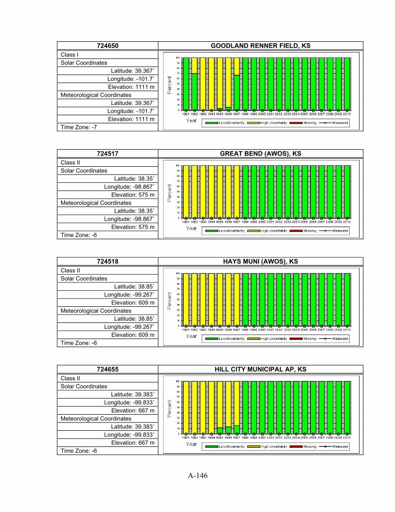
A-146
724650 GOODLAND RENNER FIELD, KS
Class I
Solar Coordinates Latitude: 39.367˚
Longitude: -101.7˚ Elevation: 1111 m
Meteorological Coordinates Latitude: 39.367˚
Longitude: -101.7˚ Elevation: 1111 m
Time Zone: -7
724517 GREAT BEND (AWOS), KS Class II
Solar Coordinates Latitude: 38.35˚
Longitude: -98.867˚ Elevation: 575 m
Meteorological Coordinates Latitude: 38.35˚
Longitude: -98.867˚ Elevation: 575 m
Time Zone: -6
724518 HAYS MUNI (AWOS), KS Class II
Solar Coordinates Latitude: 38.85˚
Longitude: -99.267˚ Elevation: 609 m
Meteorological Coordinates Latitude: 38.85˚
Longitude: -99.267˚ Elevation: 609 m
Time Zone: -6
724655 HILL CITY MUNICIPAL AP, KS Class II
Solar Coordinates Latitude: 39.383˚
Longitude: -99.833˚ Elevation: 667 m
Meteorological Coordinates Latitude: 39.383˚
Longitude: -99.833˚ Elevation: 667 m
Time Zone: -6
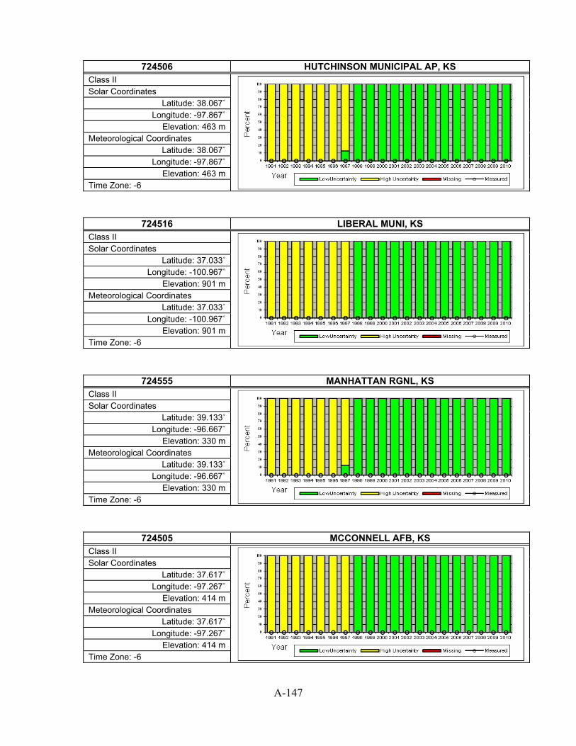
A-147
724506 HUTCHINSON MUNICIPAL AP, KS
Class II
Solar Coordinates Latitude: 38.067˚
Longitude: -97.867˚ Elevation: 463 m
Meteorological Coordinates Latitude: 38.067˚
Longitude: -97.867˚ Elevation: 463 m
Time Zone: -6
724516 LIBERAL MUNI, KS Class II
Solar Coordinates Latitude: 37.033˚
Longitude: -100.967˚ Elevation: 901 m
Meteorological Coordinates Latitude: 37.033˚
Longitude: -100.967˚ Elevation: 901 m
Time Zone: -6
724555 MANHATTAN RGNL, KS Class II
Solar Coordinates Latitude: 39.133˚
Longitude: -96.667˚ Elevation: 330 m
Meteorological Coordinates Latitude: 39.133˚
Longitude: -96.667˚ Elevation: 330 m
Time Zone: -6
724505 MCCONNELL AFB, KS Class II
Solar Coordinates Latitude: 37.617˚
Longitude: -97.267˚ Elevation: 414 m
Meteorological Coordinates Latitude: 37.617˚
Longitude: -97.267˚ Elevation: 414 m
Time Zone: -6

A-148
724509 NEWTON (AWOS), KS
Class III
Solar Coordinates Latitude: 38.05˚
Longitude: -97.283˚ Elevation: 467 m
Meteorological Coordinates Latitude: 38.05˚
Longitude: -97.283˚ Elevation: 467 m
Time Zone: -6
724475 OLATHE JOHNSON CO INDUSTRIAL, KS Class II
Solar Coordinates Latitude: 38.833˚
Longitude: -94.883˚ Elevation: 331 m
Meteorological Coordinates Latitude: 38.833˚
Longitude: -94.883˚ Elevation: 331 m
Time Zone: -6
724468 OLATHE/JOHNSON CO., KS Class II
Solar Coordinates Latitude: 38.85˚
Longitude: -94.733˚ Elevation: 334 m
Meteorological Coordinates Latitude: 38.85˚
Longitude: -94.733˚ Elevation: 334 m
Time Zone: -6
724585 RUSSELL MUNICIPAL AP, KS Class I
Solar Coordinates Latitude: 38.883˚
Longitude: -98.817˚ Elevation: 566 m
Meteorological Coordinates Latitude: 38.883˚
Longitude: -98.817˚ Elevation: 566 m
Time Zone: -6

A-149
724586 SALINA MUNICIPAL AP, KS
Class II
Solar Coordinates Latitude: 38.817˚
Longitude: -97.667˚ Elevation: 385 m
Meteorological Coordinates Latitude: 38.817˚
Longitude: -97.667˚ Elevation: 385 m
Time Zone: -6
724565 TOPEKA FORBES FIELD, KS Class II
Solar Coordinates Latitude: 38.95˚
Longitude: -95.667˚ Elevation: 325 m
Meteorological Coordinates Latitude: 38.95˚
Longitude: -95.667˚ Elevation: 325 m
Time Zone: -6
724560 TOPEKA MUNICIPAL AP, KS Class I
Solar Coordinates Latitude: 39.067˚
Longitude: -95.633˚ Elevation: 269 m
Meteorological Coordinates Latitude: 39.067˚
Longitude: -95.633˚ Elevation: 269 m
Time Zone: -6
724500 WICHITA MID-CONTINENT AP, KS Class I
Solar Coordinates Latitude: 37.65˚
Longitude: -97.433˚ Elevation: 402 m
Meteorological Coordinates Latitude: 37.65˚
Longitude: -97.433˚ Elevation: 402 m
Time Zone: -6

A-150
724504 WICHITA/COL. JABARA, KS
Class III
Solar Coordinates Latitude: 37.75˚
Longitude: -97.217˚ Elevation: 433 m
Meteorological Coordinates Latitude: 37.75˚
Longitude: -97.217˚ Elevation: 433 m
Time Zone: -6
746716 BOWLING GREEN WARREN CO AP, KY Class II
Solar Coordinates Latitude: 36.983˚
Longitude: -86.433˚ Elevation: 161 m
Meteorological Coordinates Latitude: 36.983˚
Longitude: -86.433˚ Elevation: 161 m
Time Zone: -6
724210 CINCINNATI NORTHERN KY AP, KY Class I
Solar Coordinates Latitude: 39.05˚
Longitude: -84.667˚ Elevation: 265 m
Meteorological Coordinates Latitude: 39.05˚
Longitude: -84.667˚ Elevation: 265 m
Time Zone: -5
746710 FORT CAMPBELL AAF, KY Class II
Solar Coordinates Latitude: 36.667˚
Longitude: -87.483˚ Elevation: 173 m
Meteorological Coordinates Latitude: 36.667˚
Longitude: -87.483˚ Elevation: 173 m
Time Zone: -6

A-151
724240 FORT KNOX GODMAN AAF, KY
Class II
Solar Coordinates Latitude: 37.9˚
Longitude: -85.967˚ Elevation: 239 m
Meteorological Coordinates Latitude: 37.9˚
Longitude: -85.967˚ Elevation: 239 m
Time Zone: -5
724238 HENDERSON CITY, KY Class III
Solar Coordinates Latitude: 37.817˚
Longitude: -87.683˚ Elevation: 117 m
Meteorological Coordinates Latitude: 37.817˚
Longitude: -87.683˚ Elevation: 117 m
Time Zone: -6
724236 JACKSON JULIAN CARROLL AP, KY Class I
Solar Coordinates Latitude: 37.583˚
Longitude: -83.317˚ Elevation: 416 m
Meteorological Coordinates Latitude: 37.583˚
Longitude: -83.317˚ Elevation: 416 m
Time Zone: -5
724220 LEXINGTON BLUEGRASS AP, KY Class I
Solar Coordinates Latitude: 38.033˚ Longitude: -84.6˚ Elevation: 294 m
Meteorological Coordinates Latitude: 38.033˚ Longitude: -84.6˚ Elevation: 294 m
Time Zone: -5

A-152
724243 LONDON-CORBIN AP, KY
Class II
Solar Coordinates Latitude: 37.083˚
Longitude: -84.083˚ Elevation: 362 m
Meteorological Coordinates Latitude: 37.083˚
Longitude: -84.083˚ Elevation: 362 m
Time Zone: -5
724235 LOUISVILLE BOWMAN FIELD, KY Class II
Solar Coordinates Latitude: 38.233˚
Longitude: -85.667˚ Elevation: 165 m
Meteorological Coordinates Latitude: 38.233˚
Longitude: -85.667˚ Elevation: 165 m
Time Zone: -5
724230 LOUISVILLE STANDIFORD FIELD, KY Class I
Solar Coordinates Latitude: 38.183˚
Longitude: -85.733˚ Elevation: 147 m
Meteorological Coordinates Latitude: 38.183˚
Longitude: -85.733˚ Elevation: 147 m
Time Zone: -5
724350 PADUCAH BARKLEY REGIONAL AP, KY Class I
Solar Coordinates Latitude: 37.05˚
Longitude: -88.767˚ Elevation: 124 m
Meteorological Coordinates Latitude: 37.05˚
Longitude: -88.767˚ Elevation: 124 m
Time Zone: -6

A-153
724354 SOMERSET(AWOS), KY
Class III
Solar Coordinates Latitude: 38˚
Longitude: -84.6˚ Elevation: 283 m
Meteorological Coordinates Latitude: 38˚
Longitude: -84.6˚ Elevation: 283 m
Time Zone: -5
722487 ALEXANDRIA ESLER REGIONAL AP, LA Class II
Solar Coordinates Latitude: 31.4˚
Longitude: -92.3˚ Elevation: 34 m
Meteorological Coordinates Latitude: 31.4˚
Longitude: -92.3˚ Elevation: 34 m
Time Zone: -6
722485 BARKSDALE AFB, LA Class II
Solar Coordinates Latitude: 32.5˚
Longitude: -93.667˚ Elevation: 54 m
Meteorological Coordinates Latitude: 32.5˚
Longitude: -93.667˚ Elevation: 54 m
Time Zone: -6
722317 BATON ROUGE RYAN ARPT, LA Class I
Solar Coordinates Latitude: 30.533˚
Longitude: -91.15˚ Elevation: 20 m
Meteorological Coordinates Latitude: 30.533˚
Longitude: -91.15˚ Elevation: 20 m
Time Zone: -6

A-154
747540 ENGLAND AFB, LA
Class III
Solar Coordinates Latitude: 31.317˚
Longitude: -92.55˚ Elevation: 27 m
Meteorological Coordinates Latitude: 31.317˚
Longitude: -92.55˚ Elevation: 27 m
Time Zone: -6
722390 FORT POLK AAF, LA Class II
Solar Coordinates Latitude: 31.05˚
Longitude: -93.183˚ Elevation: 102 m
Meteorological Coordinates Latitude: 31.05˚
Longitude: -93.183˚ Elevation: 102 m
Time Zone: -6
722312 HAMMOND, LA Class III
Solar Coordinates Latitude: 30.517˚
Longitude: -90.417˚ Elevation: 13 m
Meteorological Coordinates Latitude: 30.517˚
Longitude: -90.417˚ Elevation: 13 m
Time Zone: -6
722406 HOUMA-TERREBONNE, LA Class II
Solar Coordinates Latitude: 29.567˚
Longitude: -90.667˚ Elevation: 3 m
Meteorological Coordinates Latitude: 29.567˚
Longitude: -90.667˚ Elevation: 3 m
Time Zone: -6

A-155
722405 LAFAYETTE REGIONAL AP, LA
Class II
Solar Coordinates Latitude: 30.2˚
Longitude: -91.983˚ Elevation: 12 m
Meteorological Coordinates Latitude: 30.2˚
Longitude: -91.983˚ Elevation: 12 m
Time Zone: -6
722400 LAKE CHARLES REGIONAL ARPT, LA Class I
Solar Coordinates Latitude: 30.117˚
Longitude: -93.233˚ Elevation: 5 m
Meteorological Coordinates Latitude: 30.117˚
Longitude: -93.233˚ Elevation: 5 m
Time Zone: -6
722404 LAKE CHARLES WB AIRP, LA Class II
Solar Coordinates Latitude: 30.217˚
Longitude: -93.167˚ Elevation: 5 m
Meteorological Coordinates Latitude: 30.217˚
Longitude: -93.167˚ Elevation: 5 m
Time Zone: -6
722486 MONROE REGIONAL AP, LA Class II
Solar Coordinates Latitude: 32.517˚
Longitude: -92.033˚ Elevation: 40 m
Meteorological Coordinates Latitude: 32.517˚
Longitude: -92.033˚ Elevation: 40 m
Time Zone: -6

A-156
722319 NATCHITOCHES, LA
Class III
Solar Coordinates Latitude: 31.733˚ Longitude: -93.1˚
Elevation: 37 m Meteorological Coordinates
Latitude: 31.733˚ Longitude: -93.1˚
Elevation: 37 m Time Zone: -6
722314 NEW IBERIA NAAS, LA Class II
Solar Coordinates Latitude: 30.033˚
Longitude: -91.883˚ Elevation: 8 m
Meteorological Coordinates Latitude: 30.033˚
Longitude: -91.883˚ Elevation: 8 m
Time Zone: -6
722316 NEW ORLEANS ALVIN CALLENDER F, LA Class II
Solar Coordinates Latitude: 29.817˚
Longitude: -90.017˚ Elevation: 2 m
Meteorological Coordinates Latitude: 29.817˚
Longitude: -90.017˚ Elevation: 2 m
Time Zone: -6
722310 NEW ORLEANS INTL ARPT, LA Class I
Solar Coordinates Latitude: 30˚
Longitude: -90.25˚ Elevation: 1 m
Meteorological Coordinates Latitude: 30˚
Longitude: -90.25˚ Elevation: 1 m
Time Zone: -6

A-157
722315 NEW ORLEANS LAKEFRONT AP, LA
Class III
Solar Coordinates Latitude: 30.05˚
Longitude: -90.033˚ Elevation: 3 m
Meteorological Coordinates Latitude: 30.05˚
Longitude: -90.033˚ Elevation: 3 m
Time Zone: -6
722329 PATTERSON MEMORIAL, LA Class II
Solar Coordinates Latitude: 29.717˚
Longitude: -91.333˚ Elevation: 3 m
Meteorological Coordinates Latitude: 29.717˚
Longitude: -91.333˚ Elevation: 3 m
Time Zone: -6
722484 SHREVEPORT DOWNTOWN, LA Class III
Solar Coordinates Latitude: 32.533˚
Longitude: -93.75˚ Elevation: 55 m
Meteorological Coordinates Latitude: 32.533˚
Longitude: -93.75˚ Elevation: 55 m
Time Zone: -6
722480 SHREVEPORT REGIONAL ARPT, LA Class I
Solar Coordinates Latitude: 32.45˚
Longitude: -93.817˚ Elevation: 77 m
Meteorological Coordinates Latitude: 32.45˚
Longitude: -93.817˚ Elevation: 77 m
Time Zone: -6

A-158
722366 SLIDELL, LA
Class III
Solar Coordinates Latitude: 30.35˚
Longitude: -89.817˚ Elevation: 8 m
Meteorological Coordinates Latitude: 30.35˚
Longitude: -89.817˚ Elevation: 8 m
Time Zone: -6
722488 VICKSBURG\TALLULAH, LA Class III
Solar Coordinates Latitude: 32.25˚
Longitude: -91.033˚ Elevation: 23 m
Meteorological Coordinates Latitude: 32.25˚
Longitude: -91.033˚ Elevation: 23 m
Time Zone: -6
725067 BARNSTABLE MUNI BOA, MA Class II
Solar Coordinates Latitude: 41.667˚
Longitude: -70.283˚ Elevation: 17 m
Meteorological Coordinates Latitude: 41.667˚
Longitude: -70.283˚ Elevation: 17 m
Time Zone: -5
725088 BEVERLY MUNI, MA Class II
Solar Coordinates Latitude: 42.583˚
Longitude: -70.917˚ Elevation: 34 m
Meteorological Coordinates Latitude: 42.583˚
Longitude: -70.917˚ Elevation: 34 m
Time Zone: -5

A-159
725090 BOSTON LOGAN INT'L ARPT, MA
Class I
Solar Coordinates Latitude: 42.367˚
Longitude: -71.017˚ Elevation: 6 m
Meteorological Coordinates Latitude: 42.367˚
Longitude: -71.017˚ Elevation: 6 m
Time Zone: -5
725069 CHATHAM MUNI ARPT, MA Class III
Solar Coordinates Latitude: 41.683˚
Longitude: -70˚ Elevation: 19 m
Meteorological Coordinates Latitude: 41.683˚
Longitude: -70˚ Elevation: 19 m
Time Zone: -5
744910 CHICOPEE FALLS WESTO, MA Class II
Solar Coordinates Latitude: 42.2˚
Longitude: -72.533˚ Elevation: 75 m
Meteorological Coordinates Latitude: 42.2˚
Longitude: -72.533˚ Elevation: 75 m
Time Zone: -5
725107 FITCHBURG, MA Class III
Solar Coordinates Latitude: 42.55˚
Longitude: -71.75˚ Elevation: 106 m
Meteorological Coordinates Latitude: 42.55˚
Longitude: -71.75˚ Elevation: 106 m
Time Zone: -5

A-160
725059 HANSCOM FIELD, MA
Class III
Solar Coordinates Latitude: 42.467˚
Longitude: -71.283˚ Elevation: 40 m
Meteorological Coordinates Latitude: 42.467˚
Longitude: -71.283˚ Elevation: 40 m
Time Zone: -5
744904 LAWRENCE MUNI, MA Class II
Solar Coordinates Latitude: 42.717˚
Longitude: -71.117˚ Elevation: 46 m
Meteorological Coordinates Latitude: 42.717˚
Longitude: -71.117˚ Elevation: 46 m
Time Zone: -5
725066 MARTHAS VINEYARD, MA Class II
Solar Coordinates Latitude: 41.4˚
Longitude: -70.617˚ Elevation: 21 m
Meteorological Coordinates Latitude: 41.4˚
Longitude: -70.617˚ Elevation: 21 m
Time Zone: -5
725063 NANTUCKET MEMORIAL AP, MA Class II
Solar Coordinates Latitude: 41.25˚
Longitude: -70.067˚ Elevation: 14 m
Meteorological Coordinates Latitude: 41.25˚
Longitude: -70.067˚ Elevation: 14 m
Time Zone: -5

A-161
725065 NEW BEDFORD RGNL, MA
Class II
Solar Coordinates Latitude: 41.667˚
Longitude: -70.95˚ Elevation: 25 m
Meteorological Coordinates Latitude: 41.667˚
Longitude: -70.95˚ Elevation: 25 m
Time Zone: -5
725075 NORTH ADAMS, MA Class III
Solar Coordinates Latitude: 42.7˚
Longitude: -73.167˚ Elevation: 201 m
Meteorological Coordinates Latitude: 42.7˚
Longitude: -73.167˚ Elevation: 201 m
Time Zone: -5
725098 NORWOOD MEMORIAL, MA Class II
Solar Coordinates Latitude: 42.183˚
Longitude: -71.183˚ Elevation: 15 m
Meteorological Coordinates Latitude: 42.183˚
Longitude: -71.183˚ Elevation: 15 m
Time Zone: -5
725085 ORANGE MUNICIPAL AP, MA Class III
Solar Coordinates Latitude: 42.567˚
Longitude: -72.283˚ Elevation: 169 m
Meteorological Coordinates Latitude: 42.567˚
Longitude: -72.283˚ Elevation: 169 m
Time Zone: -5

A-162
725060 OTIS ANGB, MA
Class II
Solar Coordinates Latitude: 41.65˚
Longitude: -70.517˚ Elevation: 40 m
Meteorological Coordinates Latitude: 41.65˚
Longitude: -70.517˚ Elevation: 40 m
Time Zone: -5
744104 PITTSFIELD MUNI, MA Class III
Solar Coordinates Latitude: 42.417˚
Longitude: -73.283˚ Elevation: 364 m
Meteorological Coordinates Latitude: 42.417˚
Longitude: -73.283˚ Elevation: 364 m
Time Zone: -5
725064 PLYMOUTH MUNICIPAL, MA Class III
Solar Coordinates Latitude: 41.917˚
Longitude: -70.733˚ Elevation: 45 m
Meteorological Coordinates Latitude: 41.917˚
Longitude: -70.733˚ Elevation: 45 m
Time Zone: -5
725073 PROVINCETOWN (AWOS), MA Class II
Solar Coordinates Latitude: 42.067˚
Longitude: -70.217˚ Elevation: 2 m
Meteorological Coordinates Latitude: 42.067˚
Longitude: -70.217˚ Elevation: 2 m
Time Zone: -5

A-163
725097 SOUTH WEYMOUTH NAS, MA
Class III
Solar Coordinates Latitude: 42.15˚
Longitude: -70.933˚ Elevation: 48 m
Meteorological Coordinates Latitude: 42.15˚
Longitude: -70.933˚ Elevation: 48 m
Time Zone: -5
725068 TAUNTON MUNI ARPT, MA Class III
Solar Coordinates Latitude: 41.867˚
Longitude: -71.017˚ Elevation: 13 m
Meteorological Coordinates Latitude: 41.867˚
Longitude: -71.017˚ Elevation: 13 m
Time Zone: -5
744915 WESTFIELD BARNES MUNI AP, MA Class II
Solar Coordinates Latitude: 42.15˚
Longitude: -72.717˚ Elevation: 83 m
Meteorological Coordinates Latitude: 42.15˚
Longitude: -72.717˚ Elevation: 83 m
Time Zone: -5
725095 WORCHESTER REGIONAL ARPT, MA Class I
Solar Coordinates Latitude: 42.267˚
Longitude: -71.883˚ Elevation: 300 m
Meteorological Coordinates Latitude: 42.267˚
Longitude: -71.883˚ Elevation: 300 m
Time Zone: -5

A-164
745940 ANDREWS AFB, MD
Class II
Solar Coordinates Latitude: 38.817˚
Longitude: -76.867˚ Elevation: 86 m
Meteorological Coordinates Latitude: 38.817˚
Longitude: -76.867˚ Elevation: 86 m
Time Zone: -5
724060 BALTIMORE BLT-WASHNGTN INT'L, MD Class I
Solar Coordinates Latitude: 39.167˚
Longitude: -76.683˚ Elevation: 45 m
Meteorological Coordinates Latitude: 39.167˚
Longitude: -76.683˚ Elevation: 45 m
Time Zone: -5
724066 HAGERSTOWN RGNL RIC, MD Class II
Solar Coordinates Latitude: 39.7˚
Longitude: -77.733˚ Elevation: 220 m
Meteorological Coordinates Latitude: 39.7˚
Longitude: -77.733˚ Elevation: 220 m
Time Zone: -5
724067 MARTIN STATE, MD Class II
Solar Coordinates Latitude: 39.317˚
Longitude: -76.417˚ Elevation: 7 m
Meteorological Coordinates Latitude: 39.317˚
Longitude: -76.417˚ Elevation: 7 m
Time Zone: -5

A-165
745946 OCEAN CITY MUNI APT, MD
Class III
Solar Coordinates Latitude: 38.317˚
Longitude: -75.117˚ Elevation: 4 m
Meteorological Coordinates Latitude: 38.317˚
Longitude: -75.117˚ Elevation: 4 m
Time Zone: -5
724040 PATUXENT RIVER NAS, MD Class II
Solar Coordinates Latitude: 38.3˚
Longitude: -76.417˚ Elevation: 14 m
Meteorological Coordinates Latitude: 38.3˚
Longitude: -76.417˚ Elevation: 14 m
Time Zone: -5
724057 PHILLIPS AAF, MD Class III
Solar Coordinates Latitude: 39.467˚
Longitude: -76.167˚ Elevation: 18 m
Meteorological Coordinates Latitude: 39.467˚
Longitude: -76.167˚ Elevation: 18 m
Time Zone: -5
724045 SALISBURY WICOMICO CO AP, MD Class II
Solar Coordinates Latitude: 38.333˚
Longitude: -75.517˚ Elevation: 15 m
Meteorological Coordinates Latitude: 38.333˚
Longitude: -75.517˚ Elevation: 15 m
Time Zone: -5

A-166
726184 AUBURN-LEWISTON, ME
Class II
Solar Coordinates Latitude: 44.05˚
Longitude: -70.283˚ Elevation: 88 m
Meteorological Coordinates Latitude: 44.05˚
Longitude: -70.283˚ Elevation: 88 m
Time Zone: -5
726185 AUGUSTA AIRPORT, ME Class II
Solar Coordinates Latitude: 44.317˚ Longitude: -69.8˚ Elevation: 107 m
Meteorological Coordinates Latitude: 44.317˚ Longitude: -69.8˚ Elevation: 107 m
Time Zone: -5
726088 BANGOR INTERNATIONAL AP, ME Class I
Solar Coordinates Latitude: 44.8˚
Longitude: -68.817˚ Elevation: 56 m
Meteorological Coordinates Latitude: 44.8˚
Longitude: -68.817˚ Elevation: 56 m
Time Zone: -5
726077 BAR HARBOR (AWOS), ME Class II
Solar Coordinates Latitude: 44.45˚
Longitude: -68.367˚ Elevation: 26 m
Meteorological Coordinates Latitude: 44.45˚
Longitude: -68.367˚ Elevation: 26 m
Time Zone: -5

A-167
727120 CARIBOU MUNICIPAL ARPT, ME
Class I
Solar Coordinates Latitude: 46.867˚
Longitude: -68.033˚ Elevation: 190 m
Meteorological Coordinates Latitude: 46.867˚
Longitude: -68.033˚ Elevation: 190 m
Time Zone: -5
727033 HOULTON INTL ARPT, ME Class II
Solar Coordinates Latitude: 46.117˚ Longitude: -67.8˚ Elevation: 150 m
Meteorological Coordinates Latitude: 46.117˚ Longitude: -67.8˚ Elevation: 150 m
Time Zone: -5
727125 LORING AFB/LIMESTON, ME Class III
Solar Coordinates Latitude: 46.95˚
Longitude: -67.883˚ Elevation: 227 m
Meteorological Coordinates Latitude: 46.95˚
Longitude: -67.883˚ Elevation: 227 m
Time Zone: -5
726196 MILLINOCKET MUNICIPAL AP, ME Class III
Solar Coordinates Latitude: 45.65˚
Longitude: -68.683˚ Elevation: 124 m
Meteorological Coordinates Latitude: 45.65˚
Longitude: -68.683˚ Elevation: 124 m
Time Zone: -5

A-168
743920 NAVAL AIR STATION, ME
Class II
Solar Coordinates Latitude: 43.9˚
Longitude: -69.933˚ Elevation: 21 m
Meteorological Coordinates Latitude: 43.9˚
Longitude: -69.933˚ Elevation: 21 m
Time Zone: -5
726083 NORTHERN AROOSTOOK, ME Class III
Solar Coordinates Latitude: 47.283˚
Longitude: -68.317˚ Elevation: 309 m
Meteorological Coordinates Latitude: 47.283˚
Longitude: -68.317˚ Elevation: 309 m
Time Zone: -5
726060 PORTLAND INTL JETPORT, ME Class I
Solar Coordinates Latitude: 43.65˚
Longitude: -70.3˚ Elevation: 14 m
Meteorological Coordinates Latitude: 43.65˚
Longitude: -70.3˚ Elevation: 14 m
Time Zone: -5
727130 PRESQUE ISLE MUNICIP, ME Class II
Solar Coordinates Latitude: 46.683˚
Longitude: -68.05˚ Elevation: 163 m
Meteorological Coordinates Latitude: 46.683˚
Longitude: -68.05˚ Elevation: 163 m
Time Zone: -5

A-169
726079 ROCKLAND/KNOX(AWOS), ME
Class II
Solar Coordinates Latitude: 44.067˚ Longitude: -69.1˚
Elevation: 17 m Meteorological Coordinates
Latitude: 44.067˚ Longitude: -69.1˚
Elevation: 17 m Time Zone: -5
726064 SANFORD MUNI (AWOS), ME Class II
Solar Coordinates Latitude: 43.4˚
Longitude: -70.717˚ Elevation: 74 m
Meteorological Coordinates Latitude: 43.4˚
Longitude: -70.717˚ Elevation: 74 m
Time Zone: -5
726073 WATERVILLE (AWOS), ME Class II
Solar Coordinates Latitude: 44.533˚
Longitude: -69.683˚ Elevation: 101 m
Meteorological Coordinates Latitude: 44.533˚
Longitude: -69.683˚ Elevation: 101 m
Time Zone: -5
727135 WISCASSET, ME Class III
Solar Coordinates Latitude: 43.967˚
Longitude: -69.717˚ Elevation: 21 m
Meteorological Coordinates Latitude: 43.967˚
Longitude: -69.717˚ Elevation: 21 m
Time Zone: -5

A-170
725404 ADRIAN, MI
Class III
Solar Coordinates Latitude: 41.867˚
Longitude: -84.083˚ Elevation: 244 m
Meteorological Coordinates Latitude: 41.867˚
Longitude: -84.083˚ Elevation: 244 m
Time Zone: -5
725405 ALMA, MI Class III
Solar Coordinates Latitude: 43.317˚
Longitude: -84.683˚ Elevation: 230 m
Meteorological Coordinates Latitude: 43.317˚
Longitude: -84.683˚ Elevation: 230 m
Time Zone: -5
726390 ALPENA COUNTY REGIONAL AP, MI Class I
Solar Coordinates Latitude: 45.067˚
Longitude: -83.583˚ Elevation: 210 m
Meteorological Coordinates Latitude: 45.067˚
Longitude: -83.583˚ Elevation: 210 m
Time Zone: -5
725374 ANN ARBOR MUNICIPAL, MI Class II
Solar Coordinates Latitude: 42.217˚
Longitude: -83.75˚ Elevation: 256 m
Meteorological Coordinates Latitude: 42.217˚
Longitude: -83.75˚ Elevation: 256 m
Time Zone: -5

A-171
725406 BAD AXE, MI
Class III
Solar Coordinates Latitude: 43.783˚
Longitude: -82.983˚ Elevation: 234 m
Meteorological Coordinates Latitude: 43.783˚
Longitude: -82.983˚ Elevation: 234 m
Time Zone: -5
725396 BATTLE CREEK KELLOGG AP, MI Class II
Solar Coordinates Latitude: 42.3˚
Longitude: -85.25˚ Elevation: 283 m
Meteorological Coordinates Latitude: 42.3˚
Longitude: -85.25˚ Elevation: 283 m
Time Zone: -5
726355 BENTON HARBOR/ROSS, MI Class II
Solar Coordinates Latitude: 42.133˚
Longitude: -86.433˚ Elevation: 196 m
Meteorological Coordinates Latitude: 42.133˚
Longitude: -86.433˚ Elevation: 196 m
Time Zone: -5
725416 BIG RAPIDS, MI Class III
Solar Coordinates Latitude: 43.717˚ Longitude: -85.5˚ Elevation: 302 m
Meteorological Coordinates Latitude: 43.717˚ Longitude: -85.5˚ Elevation: 302 m
Time Zone: -5

A-172
726384 CADILLAC WEXFORD CO AP, MI
Class III
Solar Coordinates Latitude: 44.283˚
Longitude: -85.417˚ Elevation: 396 m
Meteorological Coordinates Latitude: 44.283˚
Longitude: -85.417˚ Elevation: 396 m
Time Zone: -5
727434 CHARLEVOIX, MI Class III
Solar Coordinates Latitude: 45.3˚
Longitude: -85.267˚ Elevation: 204 m
Meteorological Coordinates Latitude: 45.3˚
Longitude: -85.267˚ Elevation: 204 m
Time Zone: -5
727344 CHIPPEWA CO INTL, MI Class II
Solar Coordinates Latitude: 46.25˚
Longitude: -84.467˚ Elevation: 250 m
Meteorological Coordinates Latitude: 46.25˚
Longitude: -84.467˚ Elevation: 250 m
Time Zone: -5
725414 COLDWATER, MI Class III
Solar Coordinates Latitude: 41.933˚
Longitude: -85.05˚ Elevation: 292 m
Meteorological Coordinates Latitude: 41.933˚
Longitude: -85.05˚ Elevation: 292 m
Time Zone: -5

A-173
725375 DETROIT CITY AIRPORT, MI
Class I
Solar Coordinates Latitude: 42.4˚
Longitude: -83˚ Elevation: 190 m
Meteorological Coordinates Latitude: 42.4˚
Longitude: -83˚ Elevation: 190 m
Time Zone: -5
725370 DETROIT METROPOLITAN ARPT, MI Class I
Solar Coordinates Latitude: 42.217˚
Longitude: -83.35˚ Elevation: 194 m
Meteorological Coordinates Latitude: 42.217˚
Longitude: -83.35˚ Elevation: 194 m
Time Zone: -5
725376 DETROIT WILLOW RUN AP, MI Class II
Solar Coordinates Latitude: 42.233˚
Longitude: -83.533˚ Elevation: 218 m
Meteorological Coordinates Latitude: 42.233˚
Longitude: -83.533˚ Elevation: 218 m
Time Zone: -5
726480 ESCANABA (AWOS), MI Class II
Solar Coordinates Latitude: 45.75˚
Longitude: -87.033˚ Elevation: 187 m
Meteorological Coordinates Latitude: 45.75˚
Longitude: -87.033˚ Elevation: 187 m
Time Zone: -5

A-174
726370 FLINT BISHOP INTL ARPT, MI
Class I
Solar Coordinates Latitude: 42.967˚
Longitude: -83.75˚ Elevation: 234 m
Meteorological Coordinates Latitude: 42.967˚
Longitude: -83.75˚ Elevation: 234 m
Time Zone: -5
725407 GAYLORD, MI Class III
Solar Coordinates Latitude: 45.017˚
Longitude: -84.683˚ Elevation: 404 m
Meteorological Coordinates Latitude: 45.017˚
Longitude: -84.683˚ Elevation: 404 m
Time Zone: -5
726350 GRAND RAPIDS KENT COUNTY INT', MI Class I
Solar Coordinates Latitude: 42.883˚
Longitude: -85.517˚ Elevation: 242 m
Meteorological Coordinates Latitude: 42.883˚
Longitude: -85.517˚ Elevation: 242 m
Time Zone: -5
725373 GROSSE ISLE ARPT, MI Class III
Solar Coordinates Latitude: 42.1˚
Longitude: -83.15˚ Elevation: 176 m
Meteorological Coordinates Latitude: 42.1˚
Longitude: -83.15˚ Elevation: 176 m
Time Zone: -5

A-175
727440 HANCOCK HOUGHTON CO AP, MI
Class II
Solar Coordinates Latitude: 47.167˚ Longitude: -88.5˚ Elevation: 327 m
Meteorological Coordinates Latitude: 47.167˚ Longitude: -88.5˚ Elevation: 327 m
Time Zone: -5
725409 HILLSDALE, MI Class III
Solar Coordinates Latitude: 41.917˚
Longitude: -84.583˚ Elevation: 360 m
Meteorological Coordinates Latitude: 41.917˚
Longitude: -84.583˚ Elevation: 360 m
Time Zone: -5
725394 HOLLAND/TULIP CITY, MI Class III
Solar Coordinates Latitude: 42.75˚
Longitude: -86.1˚ Elevation: 210 m
Meteorological Coordinates Latitude: 42.75˚
Longitude: -86.1˚ Elevation: 210 m
Time Zone: -5
726380 HOUGHTON LAKE ROSCOMMON CO AR, MI Class I
Solar Coordinates Latitude: 44.367˚
Longitude: -84.683˚ Elevation: 351 m
Meteorological Coordinates Latitude: 44.367˚
Longitude: -84.683˚ Elevation: 351 m
Time Zone: -5

A-176
725378 HOWELL, MI
Class III
Solar Coordinates Latitude: 42.633˚
Longitude: -83.983˚ Elevation: 293 m
Meteorological Coordinates Latitude: 42.633˚
Longitude: -83.983˚ Elevation: 293 m
Time Zone: -5
727437 IRON MOUNTAIN/FORD, MI Class II
Solar Coordinates Latitude: 45.817˚
Longitude: -88.117˚ Elevation: 360 m
Meteorological Coordinates Latitude: 45.817˚
Longitude: -88.117˚ Elevation: 360 m
Time Zone: -6
727445 IRONWOOD (AWOS), MI Class II
Solar Coordinates Latitude: 46.533˚
Longitude: -90.133˚ Elevation: 375 m
Meteorological Coordinates Latitude: 46.533˚
Longitude: -90.133˚ Elevation: 375 m
Time Zone: -6
725395 JACKSON REYNOLDS FIELD, MI Class II
Solar Coordinates Latitude: 42.267˚
Longitude: -84.467˚ Elevation: 304 m
Meteorological Coordinates Latitude: 42.267˚
Longitude: -84.467˚ Elevation: 304 m
Time Zone: -5

A-177
726357 KALAMAZOO BATTLE CR, MI
Class II
Solar Coordinates Latitude: 42.233˚
Longitude: -85.55˚ Elevation: 273 m
Meteorological Coordinates Latitude: 42.233˚
Longitude: -85.55˚ Elevation: 273 m
Time Zone: -5
725390 LANSING CAPITAL CITY ARPT, MI Class I
Solar Coordinates Latitude: 42.783˚
Longitude: -84.583˚ Elevation: 256 m
Meteorological Coordinates Latitude: 42.783˚
Longitude: -84.583˚ Elevation: 256 m
Time Zone: -5
726364 LUDINGTON/MASON, MI Class III
Solar Coordinates Latitude: 43.967˚ Longitude: -86.4˚ Elevation: 197 m
Meteorological Coordinates Latitude: 43.967˚ Longitude: -86.4˚ Elevation: 197 m
Time Zone: -5
726385 MANISTEE (AWOS), MI Class II
Solar Coordinates Latitude: 44.267˚
Longitude: -86.25˚ Elevation: 189 m
Meteorological Coordinates Latitude: 44.267˚
Longitude: -86.25˚ Elevation: 189 m
Time Zone: -5
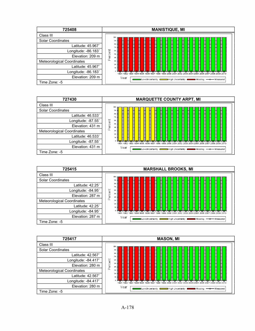
A-178
725408 MANISTIQUE, MI
Class III
Solar Coordinates Latitude: 45.967˚
Longitude: -86.183˚ Elevation: 209 m
Meteorological Coordinates Latitude: 45.967˚
Longitude: -86.183˚ Elevation: 209 m
Time Zone: -5
727430 MARQUETTE COUNTY ARPT, MI Class III
Solar Coordinates Latitude: 46.533˚
Longitude: -87.55˚ Elevation: 431 m
Meteorological Coordinates Latitude: 46.533˚
Longitude: -87.55˚ Elevation: 431 m
Time Zone: -5
725415 MARSHALL BROOKS, MI Class III
Solar Coordinates Latitude: 42.25˚
Longitude: -84.95˚ Elevation: 287 m
Meteorological Coordinates Latitude: 42.25˚
Longitude: -84.95˚ Elevation: 287 m
Time Zone: -5
725417 MASON, MI Class III
Solar Coordinates Latitude: 42.567˚
Longitude: -84.417˚ Elevation: 280 m
Meteorological Coordinates Latitude: 42.567˚
Longitude: -84.417˚ Elevation: 280 m
Time Zone: -5

A-179
726487 MENOMINEE (AWOS), MI
Class II
Solar Coordinates Latitude: 45.133˚
Longitude: -87.633˚ Elevation: 191 m
Meteorological Coordinates Latitude: 45.133˚
Longitude: -87.633˚ Elevation: 191 m
Time Zone: -6
725418 MONROE, MI Class III
Solar Coordinates Latitude: 41.933˚
Longitude: -83.433˚ Elevation: 188 m
Meteorological Coordinates Latitude: 41.933˚
Longitude: -83.433˚ Elevation: 188 m
Time Zone: -5
725377 MOUNT CLEMENS SELFRIDGE FLD, MI Class II
Solar Coordinates Latitude: 42.617˚
Longitude: -82.833˚ Elevation: 177 m
Meteorological Coordinates Latitude: 42.617˚
Longitude: -82.833˚ Elevation: 177 m
Time Zone: -5
725424 MT PLEASANT MUNI, MI Class III
Solar Coordinates Latitude: 43.617˚
Longitude: -84.733˚ Elevation: 230 m
Meteorological Coordinates Latitude: 43.617˚
Longitude: -84.733˚ Elevation: 230 m
Time Zone: -5

A-180
726360 MUSKEGON COUNTY ARPT, MI
Class I
Solar Coordinates Latitude: 43.167˚
Longitude: -86.233˚ Elevation: 190 m
Meteorological Coordinates Latitude: 43.167˚
Longitude: -86.233˚ Elevation: 190 m
Time Zone: -5
726394 NEWBERRY LUCE CO., MI Class III
Solar Coordinates Latitude: 46.317˚
Longitude: -85.467˚ Elevation: 265 m
Meteorological Coordinates Latitude: 46.317˚
Longitude: -85.467˚ Elevation: 265 m
Time Zone: -5
726375 OAKLAND CO INTL, MI Class II
Solar Coordinates Latitude: 42.667˚
Longitude: -83.417˚ Elevation: 306 m
Meteorological Coordinates Latitude: 42.667˚
Longitude: -83.417˚ Elevation: 306 m
Time Zone: -5
726395 OSCODA WURTSMITH AFB, MI Class III
Solar Coordinates Latitude: 44.45˚
Longitude: -83.4˚ Elevation: 188 m
Meteorological Coordinates Latitude: 44.45˚
Longitude: -83.4˚ Elevation: 188 m
Time Zone: -5

A-181
727347 PELLSTON EMMET COUNTY AP, MI
Class II
Solar Coordinates Latitude: 45.567˚
Longitude: -84.783˚ Elevation: 218 m
Meteorological Coordinates Latitude: 45.567˚
Longitude: -84.783˚ Elevation: 218 m
Time Zone: -5
726379 SAGINAW TRI CITY INTL AP, MI Class II
Solar Coordinates Latitude: 43.533˚
Longitude: -84.083˚ Elevation: 201 m
Meteorological Coordinates Latitude: 43.533˚
Longitude: -84.083˚ Elevation: 201 m
Time Zone: -5
727340 SAULT STE MARIE SANDERSON FIE, MI Class I
Solar Coordinates Latitude: 46.467˚
Longitude: -84.35˚ Elevation: 219 m
Meteorological Coordinates Latitude: 46.467˚
Longitude: -84.35˚ Elevation: 219 m
Time Zone: -5
726284 SAWYER INTL, MI Class III
Solar Coordinates Latitude: 46.35˚
Longitude: -87.383˚ Elevation: 382 m
Meteorological Coordinates Latitude: 46.35˚
Longitude: -87.383˚ Elevation: 382 m
Time Zone: -5

A-182
725384 ST.CLAIR COUNTY INT, MI
Class III
Solar Coordinates Latitude: 42.917˚
Longitude: -82.533˚ Elevation: 198 m
Meteorological Coordinates Latitude: 42.917˚
Longitude: -82.533˚ Elevation: 198 m
Time Zone: -5
726387 TRAVERSE CITY CHERRY CAPITAL, MI Class I
Solar Coordinates Latitude: 44.733˚
Longitude: -85.583˚ Elevation: 188 m
Meteorological Coordinates Latitude: 44.733˚
Longitude: -85.583˚ Elevation: 188 m
Time Zone: -5
726573 AIRLAKE, MN Class III
Solar Coordinates Latitude: 44.633˚
Longitude: -93.233˚ Elevation: 292 m
Meteorological Coordinates Latitude: 44.633˚
Longitude: -93.233˚ Elevation: 292 m
Time Zone: -6
727504 AITKIN NDB(AWOS), MN Class III
Solar Coordinates Latitude: 46.55˚
Longitude: -93.683˚ Elevation: 367 m
Meteorological Coordinates Latitude: 46.55˚
Longitude: -93.683˚ Elevation: 367 m
Time Zone: -6

A-183
726589 ALBERT LEA (AWOS), MN
Class II
Solar Coordinates Latitude: 43.683˚
Longitude: -93.367˚ Elevation: 383 m
Meteorological Coordinates Latitude: 43.683˚
Longitude: -93.367˚ Elevation: 383 m
Time Zone: -6
726557 ALEXANDRIA MUNICIPAL AP, MN Class II
Solar Coordinates Latitude: 45.883˚ Longitude: -95.4˚ Elevation: 433 m
Meteorological Coordinates Latitude: 45.883˚ Longitude: -95.4˚ Elevation: 433 m
Time Zone: -6
727566 AUSTIN MUNI, MN Class III
Solar Coordinates Latitude: 43.667˚
Longitude: -92.933˚ Elevation: 375 m
Meteorological Coordinates Latitude: 43.667˚
Longitude: -92.933˚ Elevation: 375 m
Time Zone: -6
727476 BAUDETTE INTERNATIONAL AP, MN Class III
Solar Coordinates Latitude: 48.717˚ Longitude: -94.6˚ Elevation: 330 m
Meteorological Coordinates Latitude: 48.717˚ Longitude: -94.6˚ Elevation: 330 m
Time Zone: -6

A-184
727550 BEMIDJI MUNICIPAL, MN
Class II
Solar Coordinates Latitude: 47.5˚
Longitude: -94.933˚ Elevation: 420 m
Meteorological Coordinates Latitude: 47.5˚
Longitude: -94.933˚ Elevation: 420 m
Time Zone: -6
727507 BENSON MUNI, MN Class III
Solar Coordinates Latitude: 45.317˚
Longitude: -95.65˚ Elevation: 317 m
Meteorological Coordinates Latitude: 45.317˚
Longitude: -95.65˚ Elevation: 317 m
Time Zone: -6
727468 BIGFORK, MN Class III
Solar Coordinates Latitude: 47.783˚
Longitude: -93.65˚ Elevation: 411 m
Meteorological Coordinates Latitude: 47.783˚
Longitude: -93.65˚ Elevation: 411 m
Time Zone: -6
726555 BRAINERD/WIELAND, MN Class II
Solar Coordinates Latitude: 46.4˚
Longitude: -94.133˚ Elevation: 374 m
Meteorological Coordinates Latitude: 46.4˚
Longitude: -94.133˚ Elevation: 374 m
Time Zone: -6

A-185
727503 CAMBRIDGE MUNI, MN
Class III
Solar Coordinates Latitude: 45.567˚
Longitude: -93.267˚ Elevation: 287 m
Meteorological Coordinates Latitude: 45.567˚
Longitude: -93.267˚ Elevation: 287 m
Time Zone: -6
726558 CLOQUET (AWOS), MN Class III
Solar Coordinates Latitude: 46.7˚
Longitude: -92.5˚ Elevation: 390 m
Meteorological Coordinates Latitude: 46.7˚
Longitude: -92.5˚ Elevation: 390 m
Time Zone: -6
726549 COOK MUNI ARPT, MN Class III
Solar Coordinates Latitude: 47.817˚ Longitude: -92.7˚ Elevation: 402 m
Meteorological Coordinates Latitude: 47.817˚ Longitude: -92.7˚ Elevation: 402 m
Time Zone: -6
727473 CRANE LAKE (AWOS), MN Class II
Solar Coordinates Latitude: 46.267˚
Longitude: -92.567˚ Elevation: 350 m
Meteorological Coordinates Latitude: 46.267˚
Longitude: -92.567˚ Elevation: 350 m
Time Zone: -6

A-186
727452 CROOKSTON MUNI FLD, MN
Class III
Solar Coordinates Latitude: 47.85˚
Longitude: -96.617˚ Elevation: 273 m
Meteorological Coordinates Latitude: 47.85˚
Longitude: -96.617˚ Elevation: 273 m
Time Zone: -6
727457 DETROIT LAKES(AWOS), MN Class II
Solar Coordinates Latitude: 46.833˚
Longitude: -95.883˚ Elevation: 426 m
Meteorological Coordinates Latitude: 46.833˚
Longitude: -95.883˚ Elevation: 426 m
Time Zone: -6
726596 DODGE CENTER AIRPOR, MN Class III
Solar Coordinates Latitude: 44.017˚
Longitude: -92.817˚ Elevation: 398 m
Meteorological Coordinates Latitude: 44.017˚
Longitude: -92.817˚ Elevation: 398 m
Time Zone: -6
727456 DULUTH HARBOR (CGS), MN Class III
Solar Coordinates Latitude: 46.767˚
Longitude: -92.083˚ Elevation: 186 m
Meteorological Coordinates Latitude: 46.767˚
Longitude: -92.083˚ Elevation: 186 m
Time Zone: -6

A-187
727450 DULUTH INTERNATIONAL ARPT, MN
Class I
Solar Coordinates Latitude: 46.833˚
Longitude: -92.217˚ Elevation: 433 m
Meteorological Coordinates Latitude: 46.833˚
Longitude: -92.217˚ Elevation: 433 m
Time Zone: -6
727459 ELY MUNI, MN Class II
Solar Coordinates Latitude: 47.817˚
Longitude: -91.833˚ Elevation: 455 m
Meteorological Coordinates Latitude: 47.817˚
Longitude: -91.833˚ Elevation: 455 m
Time Zone: -6
727474 EVELETH MUNI (AWOS), MN Class III
Solar Coordinates Latitude: 47.4˚
Longitude: -92.5˚ Elevation: 421 m
Meteorological Coordinates Latitude: 47.4˚
Longitude: -92.5˚ Elevation: 421 m
Time Zone: -6
726586 FAIRMONT MUNI(AWOS), MN Class II
Solar Coordinates Latitude: 43.65˚
Longitude: -94.417˚ Elevation: 354 m
Meteorological Coordinates Latitude: 43.65˚
Longitude: -94.417˚ Elevation: 354 m
Time Zone: -6

A-188
726563 FARIBAULT MUNI AWOS, MN
Class II
Solar Coordinates Latitude: 44.333˚
Longitude: -93.317˚ Elevation: 322 m
Meteorological Coordinates Latitude: 44.333˚
Longitude: -93.317˚ Elevation: 322 m
Time Zone: -6
726560 FERGUS FALLS(AWOS), MN Class II
Solar Coordinates Latitude: 46.283˚
Longitude: -96.15˚ Elevation: 361 m
Meteorological Coordinates Latitude: 46.283˚
Longitude: -96.15˚ Elevation: 361 m
Time Zone: -6
727467 FLAG ISLAND, MN Class III
Solar Coordinates Latitude: 49.317˚ Longitude: -94.9˚ Elevation: 328 m
Meteorological Coordinates Latitude: 49.317˚ Longitude: -94.9˚ Elevation: 328 m
Time Zone: -6
726579 FLYING CLOUD, MN Class II
Solar Coordinates Latitude: 44.817˚
Longitude: -93.45˚ Elevation: 283 m
Meteorological Coordinates Latitude: 44.817˚
Longitude: -93.45˚ Elevation: 283 m
Time Zone: -6

A-189
727505 FOSSTON(AWOS), MN
Class III
Solar Coordinates Latitude: 47.583˚
Longitude: -95.767˚ Elevation: 388 m
Meteorological Coordinates Latitude: 47.583˚
Longitude: -95.767˚ Elevation: 388 m
Time Zone: -6
726547 GLENWOOD (ASOS), MN Class III
Solar Coordinates Latitude: 45.65˚
Longitude: -95.317˚ Elevation: 425 m
Meteorological Coordinates Latitude: 45.65˚
Longitude: -95.317˚ Elevation: 425 m
Time Zone: -6
727454 GRAND MARAIS MUNI, MN Class III
Solar Coordinates Latitude: 47.833˚
Longitude: -90.383˚ Elevation: 505 m
Meteorological Coordinates Latitude: 47.833˚
Longitude: -90.383˚ Elevation: 505 m
Time Zone: -6
727458 GRAND RAPIDS(AWOS), MN Class II
Solar Coordinates Latitude: 47.217˚
Longitude: -93.517˚ Elevation: 413 m
Meteorological Coordinates Latitude: 47.217˚
Longitude: -93.517˚ Elevation: 413 m
Time Zone: -6
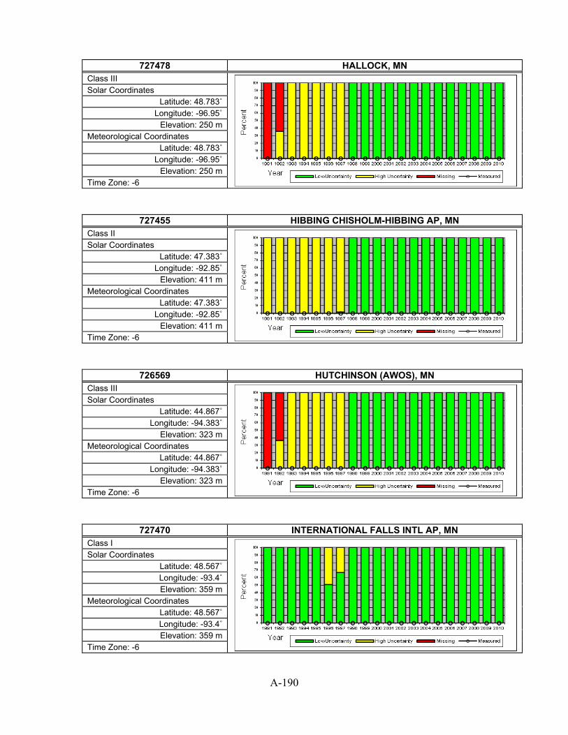
A-190
727478 HALLOCK, MN
Class III
Solar Coordinates Latitude: 48.783˚
Longitude: -96.95˚ Elevation: 250 m
Meteorological Coordinates Latitude: 48.783˚
Longitude: -96.95˚ Elevation: 250 m
Time Zone: -6
727455 HIBBING CHISHOLM-HIBBING AP, MN Class II
Solar Coordinates Latitude: 47.383˚
Longitude: -92.85˚ Elevation: 411 m
Meteorological Coordinates Latitude: 47.383˚
Longitude: -92.85˚ Elevation: 411 m
Time Zone: -6
726569 HUTCHINSON (AWOS), MN Class III
Solar Coordinates Latitude: 44.867˚
Longitude: -94.383˚ Elevation: 323 m
Meteorological Coordinates Latitude: 44.867˚
Longitude: -94.383˚ Elevation: 323 m
Time Zone: -6
727470 INTERNATIONAL FALLS INTL AP, MN Class I
Solar Coordinates Latitude: 48.567˚ Longitude: -93.4˚ Elevation: 359 m
Meteorological Coordinates Latitude: 48.567˚ Longitude: -93.4˚ Elevation: 359 m
Time Zone: -6

A-191
726593 JACKSON MUNI, MN
Class III
Solar Coordinates Latitude: 43.65˚
Longitude: -94.983˚ Elevation: 441 m
Meteorological Coordinates Latitude: 43.65˚
Longitude: -94.983˚ Elevation: 441 m
Time Zone: -6
726583 LITCHFIELD MUNI, MN Class II
Solar Coordinates Latitude: 45.1˚
Longitude: -94.5˚ Elevation: 347 m
Meteorological Coordinates Latitude: 45.1˚
Longitude: -94.5˚ Elevation: 347 m
Time Zone: -6
726578 LITTLE FALLS (AWOS), MN Class III
Solar Coordinates Latitude: 45.95˚
Longitude: -94.35˚ Elevation: 342 m
Meteorological Coordinates Latitude: 45.95˚
Longitude: -94.35˚ Elevation: 342 m
Time Zone: -6
727497 LONGVILLE MUNI AIRP, MN Class III
Solar Coordinates Latitude: 46.983˚ Longitude: -94.2˚ Elevation: 407 m
Meteorological Coordinates Latitude: 46.983˚ Longitude: -94.2˚ Elevation: 407 m
Time Zone: -6

A-192
727466 MADISON, MN
Class III
Solar Coordinates Latitude: 44.983˚
Longitude: -96.183˚ Elevation: 330 m
Meteorological Coordinates Latitude: 44.983˚
Longitude: -96.183˚ Elevation: 330 m
Time Zone: -6
726585 MANKATO(AWOS), MN Class II
Solar Coordinates Latitude: 44.217˚
Longitude: -93.917˚ Elevation: 311 m
Meteorological Coordinates Latitude: 44.217˚
Longitude: -93.917˚ Elevation: 311 m
Time Zone: -6
726559 MARSHALL/RYAN(AWOS), MN Class II
Solar Coordinates Latitude: 44.45˚
Longitude: -95.817˚ Elevation: 359 m
Meteorological Coordinates Latitude: 44.45˚
Longitude: -95.817˚ Elevation: 359 m
Time Zone: -6
726577 MINNEAPOLIS/BLAINE, MN Class III
Solar Coordinates Latitude: 45.15˚
Longitude: -93.217˚ Elevation: 278 m
Meteorological Coordinates Latitude: 45.15˚
Longitude: -93.217˚ Elevation: 278 m
Time Zone: -6

A-193
726575 MINNEAPOLIS/CRYSTAL, MN
Class II
Solar Coordinates Latitude: 45.067˚
Longitude: -93.35˚ Elevation: 265 m
Meteorological Coordinates Latitude: 45.067˚
Longitude: -93.35˚ Elevation: 265 m
Time Zone: -6
726580 MINNEAPOLIS-ST PAUL INT'L ARP, MN Class I
Solar Coordinates Latitude: 44.883˚
Longitude: -93.233˚ Elevation: 254 m
Meteorological Coordinates Latitude: 44.883˚
Longitude: -93.233˚ Elevation: 254 m
Time Zone: -6
727449 MOOSE LAKE CO ARPT, MN Class III
Solar Coordinates Latitude: 46.417˚ Longitude: -92.8˚ Elevation: 328 m
Meteorological Coordinates Latitude: 46.417˚ Longitude: -92.8˚ Elevation: 328 m
Time Zone: -6
727475 MORA MUNI (AWOS), MN Class II
Solar Coordinates Latitude: 45.883˚
Longitude: -93.267˚ Elevation: 309 m
Meteorological Coordinates Latitude: 45.883˚
Longitude: -93.267˚ Elevation: 309 m
Time Zone: -6

A-194
726565 MORRIS MUNI (AWOS), MN
Class II
Solar Coordinates Latitude: 45.567˚
Longitude: -95.967˚ Elevation: 344 m
Meteorological Coordinates Latitude: 45.567˚
Longitude: -95.967˚ Elevation: 344 m
Time Zone: -6
726567 NEW ULM MUNI (AWOS), MN Class III
Solar Coordinates Latitude: 44.317˚ Longitude: -94.5˚ Elevation: 308 m
Meteorological Coordinates Latitude: 44.317˚ Longitude: -94.5˚ Elevation: 308 m
Time Zone: -6
726544 ORR, MN Class III
Solar Coordinates Latitude: 48.017˚
Longitude: -92.867˚ Elevation: 397 m
Meteorological Coordinates Latitude: 48.017˚
Longitude: -92.867˚ Elevation: 397 m
Time Zone: -6
727515 ORTONVILLE, MN Class III
Solar Coordinates Latitude: 45.3˚
Longitude: -96.417˚ Elevation: 335 m
Meteorological Coordinates Latitude: 45.3˚
Longitude: -96.417˚ Elevation: 335 m
Time Zone: -6

A-195
726568 OWATONNA (AWOS), MN
Class III
Solar Coordinates Latitude: 44.117˚
Longitude: -93.25˚ Elevation: 350 m
Meteorological Coordinates Latitude: 44.117˚
Longitude: -93.25˚ Elevation: 350 m
Time Zone: -6
727453 PARK RAPIDS MUNICIPAL AP, MN Class II
Solar Coordinates Latitude: 46.9˚
Longitude: -95.067˚ Elevation: 437 m
Meteorological Coordinates Latitude: 46.9˚
Longitude: -95.067˚ Elevation: 437 m
Time Zone: -6
727508 PINE RIVER, MN Class III
Solar Coordinates Latitude: 46.717˚
Longitude: -94.383˚ Elevation: 395 m
Meteorological Coordinates Latitude: 46.717˚
Longitude: -94.383˚ Elevation: 395 m
Time Zone: -6
726566 PIPESTONE (AWOS), MN Class III
Solar Coordinates Latitude: 43.983˚
Longitude: -96.317˚ Elevation: 529 m
Meteorological Coordinates Latitude: 43.983˚
Longitude: -96.317˚ Elevation: 529 m
Time Zone: -6

A-196
726682 PRINCETON MUNI, MN
Class III
Solar Coordinates Latitude: 45.55˚
Longitude: -93.6˚ Elevation: 306 m
Meteorological Coordinates Latitude: 45.55˚
Longitude: -93.6˚ Elevation: 306 m
Time Zone: -6
726564 RED WING, MN Class III
Solar Coordinates Latitude: 44.583˚
Longitude: -92.483˚ Elevation: 239 m
Meteorological Coordinates Latitude: 44.583˚
Longitude: -92.483˚ Elevation: 239 m
Time Zone: -6
726556 REDWOOD FALLS MUNI, MN Class II
Solar Coordinates Latitude: 44.55˚
Longitude: -95.083˚ Elevation: 312 m
Meteorological Coordinates Latitude: 44.55˚
Longitude: -95.083˚ Elevation: 312 m
Time Zone: -6
726440 ROCHESTER INTERNATIONAL ARPT, MN Class I
Solar Coordinates Latitude: 43.9˚
Longitude: -92.5˚ Elevation: 398 m
Meteorological Coordinates Latitude: 43.9˚
Longitude: -92.5˚ Elevation: 398 m
Time Zone: -6

A-197
727477 ROSEAU MUNI (AWOS), MN
Class II
Solar Coordinates Latitude: 48.85˚
Longitude: -95.7˚ Elevation: 323 m
Meteorological Coordinates Latitude: 48.85˚
Longitude: -95.7˚ Elevation: 323 m
Time Zone: -6
726679 RUSH CITY RGNL ARPT, MN Class III
Solar Coordinates Latitude: 45.683˚
Longitude: -92.95˚ Elevation: 281 m
Meteorological Coordinates Latitude: 45.683˚
Longitude: -92.95˚ Elevation: 281 m
Time Zone: -6
727556 SILVER BAY, MN Class III
Solar Coordinates Latitude: 47.2˚
Longitude: -91.4˚ Elevation: 331 m
Meteorological Coordinates Latitude: 47.2˚
Longitude: -91.4˚ Elevation: 331 m
Time Zone: -6
726603 SOUTH ST PAUL MUNI, MN Class III
Solar Coordinates Latitude: 44.85˚
Longitude: -93.15˚ Elevation: 250 m
Meteorological Coordinates Latitude: 44.85˚
Longitude: -93.15˚ Elevation: 250 m
Time Zone: -6

A-198
726550 ST CLOUD REGIONAL ARPT, MN
Class I
Solar Coordinates Latitude: 45.55˚
Longitude: -94.05˚ Elevation: 311 m
Meteorological Coordinates Latitude: 45.55˚
Longitude: -94.05˚ Elevation: 311 m
Time Zone: -6
726554 ST JAMES MUNI ARPT, MN Class III
Solar Coordinates Latitude: 43.983˚
Longitude: -94.55˚ Elevation: 325 m
Meteorological Coordinates Latitude: 43.983˚
Longitude: -94.55˚ Elevation: 325 m
Time Zone: -6
726584 ST PAUL DOWNTOWN AP, MN Class II
Solar Coordinates Latitude: 44.933˚
Longitude: -93.05˚ Elevation: 220 m
Meteorological Coordinates Latitude: 44.933˚
Longitude: -93.05˚ Elevation: 220 m
Time Zone: -6
727514 STAPLES, MN Class III
Solar Coordinates Latitude: 46.383˚ Longitude: -94.8˚ Elevation: 392 m
Meteorological Coordinates Latitude: 46.383˚ Longitude: -94.8˚ Elevation: 392 m
Time Zone: -6

A-199
727555 THIEF RIVER(AWOS), MN
Class II
Solar Coordinates Latitude: 48.067˚
Longitude: -96.183˚ Elevation: 340 m
Meteorological Coordinates Latitude: 48.067˚
Longitude: -96.183˚ Elevation: 340 m
Time Zone: -6
727444 TWO HARBORS, MN Class III
Solar Coordinates Latitude: 47.05˚
Longitude: -91.75˚ Elevation: 328 m
Meteorological Coordinates Latitude: 47.05˚
Longitude: -91.75˚ Elevation: 328 m
Time Zone: -6
726561 WADENA, MN Class III
Solar Coordinates Latitude: 46.45˚
Longitude: -95.217˚ Elevation: 418 m
Meteorological Coordinates Latitude: 46.45˚
Longitude: -95.217˚ Elevation: 418 m
Time Zone: -6
727564 WARROAD(AWOS), MN Class III
Solar Coordinates Latitude: 48.933˚
Longitude: -95.333˚ Elevation: 325 m
Meteorological Coordinates Latitude: 48.933˚
Longitude: -95.333˚ Elevation: 325 m
Time Zone: -6
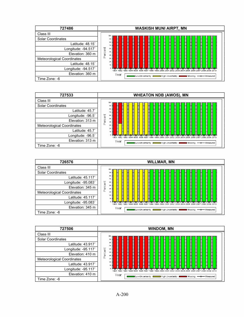
A-200
727486 WASKISH MUNI AIRPT, MN
Class III
Solar Coordinates Latitude: 48.15˚
Longitude: -94.517˚ Elevation: 360 m
Meteorological Coordinates Latitude: 48.15˚
Longitude: -94.517˚ Elevation: 360 m
Time Zone: -6
727533 WHEATON NDB (AWOS), MN Class III
Solar Coordinates Latitude: 45.7˚
Longitude: -96.5˚ Elevation: 313 m
Meteorological Coordinates Latitude: 45.7˚
Longitude: -96.5˚ Elevation: 313 m
Time Zone: -6
726576 WILLMAR, MN Class III
Solar Coordinates Latitude: 45.117˚
Longitude: -95.083˚ Elevation: 345 m
Meteorological Coordinates Latitude: 45.117˚
Longitude: -95.083˚ Elevation: 345 m
Time Zone: -6
727506 WINDOM, MN Class III
Solar Coordinates Latitude: 43.917˚
Longitude: -95.117˚ Elevation: 410 m
Meteorological Coordinates Latitude: 43.917˚
Longitude: -95.117˚ Elevation: 410 m
Time Zone: -6

A-201
726588 WINONA MUNI (AWOS), MN
Class II
Solar Coordinates Latitude: 44.083˚ Longitude: -91.7˚ Elevation: 200 m
Meteorological Coordinates Latitude: 44.083˚ Longitude: -91.7˚ Elevation: 200 m
Time Zone: -6
726587 WORTHINGTON (AWOS), MN Class II
Solar Coordinates Latitude: 43.65˚
Longitude: -95.583˚ Elevation: 480 m
Meteorological Coordinates Latitude: 43.65˚
Longitude: -95.583˚ Elevation: 480 m
Time Zone: -6
723489 CAPE GIRARDEAU MUNICIPAL AP, MO Class II
Solar Coordinates Latitude: 37.233˚
Longitude: -89.567˚ Elevation: 103 m
Meteorological Coordinates Latitude: 37.233˚
Longitude: -89.567˚ Elevation: 103 m
Time Zone: -6
724450 COLUMBIA REGIONAL AIRPORT, MO Class I
Solar Coordinates Latitude: 38.817˚
Longitude: -92.217˚ Elevation: 272 m
Meteorological Coordinates Latitude: 38.817˚
Longitude: -92.217˚ Elevation: 272 m
Time Zone: -6

A-202
724454 FARMINGTON, MO
Class III
Solar Coordinates Latitude: 37.767˚ Longitude: -90.4˚ Elevation: 274 m
Meteorological Coordinates Latitude: 37.767˚ Longitude: -90.4˚ Elevation: 274 m
Time Zone: -6
724457 FT LNRD WD AAF, MO Class II
Solar Coordinates Latitude: 37.75˚
Longitude: -92.15˚ Elevation: 351 m
Meteorological Coordinates Latitude: 37.75˚
Longitude: -92.15˚ Elevation: 351 m
Time Zone: -6
724458 JEFFERSON CITY MEM, MO Class II
Solar Coordinates Latitude: 38.583˚
Longitude: -92.15˚ Elevation: 167 m
Meteorological Coordinates Latitude: 38.583˚
Longitude: -92.15˚ Elevation: 167 m
Time Zone: -6
723495 JOPLIN MUNICIPAL AP, MO Class II
Solar Coordinates Latitude: 37.15˚
Longitude: -94.5˚ Elevation: 297 m
Meteorological Coordinates Latitude: 37.15˚
Longitude: -94.5˚ Elevation: 297 m
Time Zone: -6

A-203
724459 KAISER MEM (AWOS), MO
Class II
Solar Coordinates Latitude: 38.1˚
Longitude: -92.55˚ Elevation: 265 m
Meteorological Coordinates Latitude: 38.1˚
Longitude: -92.55˚ Elevation: 265 m
Time Zone: -6
724463 KANSAS CITY DOWNTOWN AP, MO Class II
Solar Coordinates Latitude: 39.117˚ Longitude: -94.6˚ Elevation: 226 m
Meteorological Coordinates Latitude: 39.117˚ Longitude: -94.6˚ Elevation: 226 m
Time Zone: -6
724460 KANSAS CITY INT'L ARPT, MO Class I
Solar Coordinates Latitude: 39.3˚
Longitude: -94.717˚ Elevation: 298 m
Meteorological Coordinates Latitude: 39.3˚
Longitude: -94.717˚ Elevation: 298 m
Time Zone: -6
724466 KANSAS CITY RICHARDS-GEBAUR A, MO Class III
Solar Coordinates Latitude: 38.85˚
Longitude: -94.567˚ Elevation: 322 m
Meteorological Coordinates Latitude: 38.85˚
Longitude: -94.567˚ Elevation: 322 m
Time Zone: -6

A-204
724455 KIRKSVILLE REGIONAL AP, MO
Class II
Solar Coordinates Latitude: 40.1˚
Longitude: -92.55˚ Elevation: 294 m
Meteorological Coordinates Latitude: 40.1˚
Longitude: -92.55˚ Elevation: 294 m
Time Zone: -6
723300 POPLAR BLUFF(AMOS), MO Class III
Solar Coordinates Latitude: 36.767˚
Longitude: -90.467˚ Elevation: 146 m
Meteorological Coordinates Latitude: 36.767˚
Longitude: -90.467˚ Elevation: 146 m
Time Zone: -6
724400 SPRINGFIELD REGIONAL ARPT, MO Class I
Solar Coordinates Latitude: 37.233˚
Longitude: -93.383˚ Elevation: 384 m
Meteorological Coordinates Latitude: 37.233˚
Longitude: -93.383˚ Elevation: 384 m
Time Zone: -6
724347 ST CHARLES COUNTY A, MO Class III
Solar Coordinates Latitude: 38.917˚
Longitude: -90.417˚ Elevation: 133 m
Meteorological Coordinates Latitude: 38.917˚
Longitude: -90.417˚ Elevation: 133 m
Time Zone: -6

A-205
724490 ST JOSEPH ROSECRANS MEMORIAL, MO
Class II
Solar Coordinates Latitude: 39.767˚ Longitude: -94.9˚ Elevation: 247 m
Meteorological Coordinates Latitude: 39.767˚ Longitude: -94.9˚ Elevation: 247 m
Time Zone: -6
724340 ST LOUIS LAMBERT INT'L ARPT, MO Class I
Solar Coordinates Latitude: 38.75˚
Longitude: -90.367˚ Elevation: 173 m
Meteorological Coordinates Latitude: 38.75˚
Longitude: -90.367˚ Elevation: 173 m
Time Zone: -6
724345 ST LOUIS SPIRIT OF ST LOUIS A, MO Class I
Solar Coordinates Latitude: 38.65˚
Longitude: -90.65˚ Elevation: 141 m
Meteorological Coordinates Latitude: 38.65˚
Longitude: -90.65˚ Elevation: 141 m
Time Zone: -6
724456 VICHY ROLLA NATL ARPT, MO Class II
Solar Coordinates Latitude: 38.133˚
Longitude: -91.767˚ Elevation: 336 m
Meteorological Coordinates Latitude: 38.133˚
Longitude: -91.767˚ Elevation: 336 m
Time Zone: -6

A-206
723484 WEST PLAINS - ASOS, MO
Class III
Solar Coordinates Latitude: 36.883˚ Longitude: -91.9˚ Elevation: 374 m
Meteorological Coordinates Latitude: 36.883˚ Longitude: -91.9˚ Elevation: 374 m
Time Zone: -6
724467 WHITEMAN AFB, MO Class II
Solar Coordinates Latitude: 38.717˚
Longitude: -93.55˚ Elevation: 255 m
Meteorological Coordinates Latitude: 38.717˚
Longitude: -93.55˚ Elevation: 255 m
Time Zone: -6
723306 COLUMBUS AFB, MS Class II
Solar Coordinates Latitude: 33.65˚
Longitude: -88.45˚ Elevation: 68 m
Meteorological Coordinates Latitude: 33.65˚
Longitude: -88.45˚ Elevation: 68 m
Time Zone: -6
723307 GOLDEN TRI(AWOS), MS Class II
Solar Coordinates Latitude: 33.45˚
Longitude: -88.583˚ Elevation: 80 m
Meteorological Coordinates Latitude: 33.45˚
Longitude: -88.583˚ Elevation: 80 m
Time Zone: -6

A-207
722356 GREENVILLE MUNICIPAL, MS
Class II
Solar Coordinates Latitude: 33.483˚
Longitude: -90.983˚ Elevation: 42 m
Meteorological Coordinates Latitude: 33.483˚
Longitude: -90.983˚ Elevation: 42 m
Time Zone: -6
722359 GREENWOOD LEFLORE ARPT, MS Class II
Solar Coordinates Latitude: 33.5˚
Longitude: -90.083˚ Elevation: 47 m
Meteorological Coordinates Latitude: 33.5˚
Longitude: -90.083˚ Elevation: 47 m
Time Zone: -6
747685 GULFPORT BILOXI INT, MS Class II
Solar Coordinates Latitude: 30.4˚
Longitude: -89.067˚ Elevation: 9 m
Meteorological Coordinates Latitude: 30.4˚
Longitude: -89.067˚ Elevation: 9 m
Time Zone: -6
722348 HATTIESBURG LAUREL, MS Class II
Solar Coordinates Latitude: 31.467˚
Longitude: -89.333˚ Elevation: 93 m
Meteorological Coordinates Latitude: 31.467˚
Longitude: -89.333˚ Elevation: 93 m
Time Zone: -6
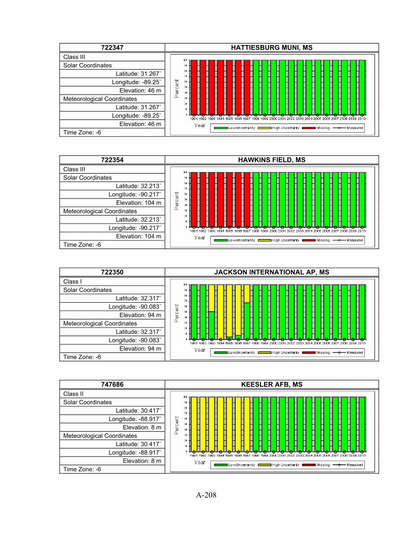
A-208
722347 HATTIESBURG MUNI, MS
Class III
Solar Coordinates Latitude: 31.267˚
Longitude: -89.25˚ Elevation: 46 m
Meteorological Coordinates Latitude: 31.267˚
Longitude: -89.25˚ Elevation: 46 m
Time Zone: -6
722354 HAWKINS FIELD, MS Class III
Solar Coordinates Latitude: 32.213˚
Longitude: -90.217˚ Elevation: 104 m
Meteorological Coordinates Latitude: 32.213˚
Longitude: -90.217˚ Elevation: 104 m
Time Zone: -6
722350 JACKSON INTERNATIONAL AP, MS Class I
Solar Coordinates Latitude: 32.317˚
Longitude: -90.083˚ Elevation: 94 m
Meteorological Coordinates Latitude: 32.317˚
Longitude: -90.083˚ Elevation: 94 m
Time Zone: -6
747686 KEESLER AFB, MS Class II
Solar Coordinates Latitude: 30.417˚
Longitude: -88.917˚ Elevation: 8 m
Meteorological Coordinates Latitude: 30.417˚
Longitude: -88.917˚ Elevation: 8 m
Time Zone: -6

A-209
722358 MCCOMB PIKE COUNTY AP, MS
Class II
Solar Coordinates Latitude: 31.233˚
Longitude: -90.467˚ Elevation: 126 m
Meteorological Coordinates Latitude: 31.233˚
Longitude: -90.467˚ Elevation: 126 m
Time Zone: -6
722340 MERIDIAN KEY FIELD, MS Class I
Solar Coordinates Latitude: 32.333˚
Longitude: -88.75˚ Elevation: 90 m
Meteorological Coordinates Latitude: 32.333˚
Longitude: -88.75˚ Elevation: 90 m
Time Zone: -6
722345 MERIDIAN NAAS, MS Class II
Solar Coordinates Latitude: 32.55˚
Longitude: -88.567˚ Elevation: 83 m
Meteorological Coordinates Latitude: 32.55˚
Longitude: -88.567˚ Elevation: 83 m
Time Zone: -6
722357 NATCHEZ/HARDY(AWOS), MS Class II
Solar Coordinates Latitude: 31.617˚ Longitude: -91.3˚
Elevation: 83 m Meteorological Coordinates
Latitude: 31.617˚ Longitude: -91.3˚
Elevation: 83 m Time Zone: -6

A-210
747688 PASCAGOULA, MS
Class III
Solar Coordinates Latitude: 30.467˚
Longitude: -88.533˚ Elevation: 5 m
Meteorological Coordinates Latitude: 30.467˚
Longitude: -88.533˚ Elevation: 5 m
Time Zone: -6
723320 TUPELO C D LEMONS ARPT, MS Class I
Solar Coordinates Latitude: 34.267˚
Longitude: -88.767˚ Elevation: 110 m
Meteorological Coordinates Latitude: 34.267˚
Longitude: -88.767˚ Elevation: 110 m
Time Zone: -6
726777 BAKER MUNI ARPT, MT Class III
Solar Coordinates Latitude: 46.333˚
Longitude: -104.25˚ Elevation: 902 m
Meteorological Coordinates Latitude: 46.333˚
Longitude: -104.25˚ Elevation: 902 m
Time Zone: -7
726770 BILLINGS LOGAN INT'L ARPT, MT Class I
Solar Coordinates Latitude: 45.8˚
Longitude: -108.55˚ Elevation: 1087 m
Meteorological Coordinates Latitude: 45.8˚
Longitude: -108.55˚ Elevation: 1087 m
Time Zone: -7
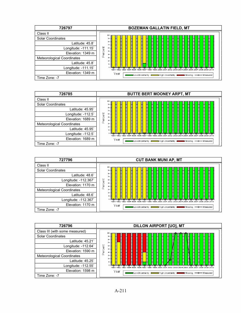
A-211
726797 BOZEMAN GALLATIN FIELD, MT
Class II
Solar Coordinates Latitude: 45.8˚
Longitude: -111.15˚ Elevation: 1349 m
Meteorological Coordinates Latitude: 45.8˚
Longitude: -111.15˚ Elevation: 1349 m
Time Zone: -7
726785 BUTTE BERT MOONEY ARPT, MT Class II
Solar Coordinates Latitude: 45.95˚
Longitude: -112.5˚ Elevation: 1689 m
Meteorological Coordinates Latitude: 45.95˚
Longitude: -112.5˚ Elevation: 1689 m
Time Zone: -7
727796 CUT BANK MUNI AP, MT Class II
Solar Coordinates Latitude: 48.6˚
Longitude: -112.367˚ Elevation: 1170 m
Meteorological Coordinates Latitude: 48.6˚
Longitude: -112.367˚ Elevation: 1170 m
Time Zone: -7
726796 DILLON AIRPORT [UO], MT Class III (with some measured)
Solar Coordinates Latitude: 45.21˚
Longitude: -112.64˚ Elevation: 1590 m
Meteorological Coordinates Latitude: 45.25˚
Longitude: -112.55˚ Elevation: 1598 m
Time Zone: -7
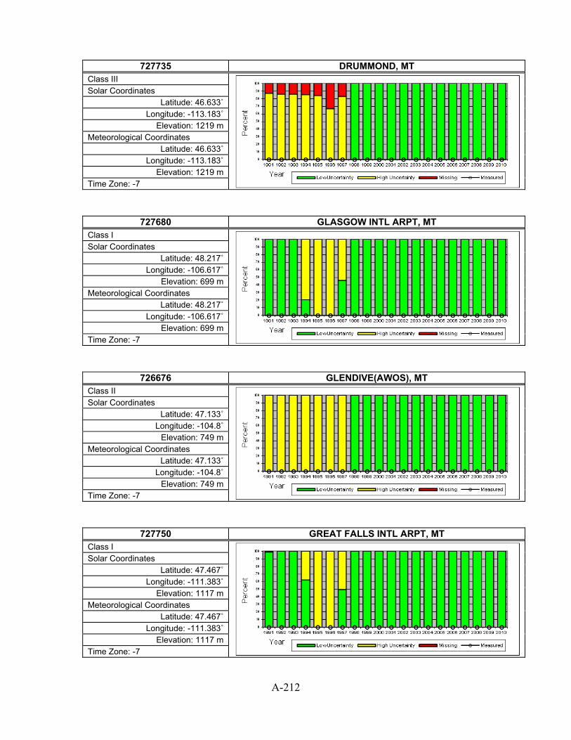
A-212
727735 DRUMMOND, MT
Class III
Solar Coordinates Latitude: 46.633˚
Longitude: -113.183˚ Elevation: 1219 m
Meteorological Coordinates Latitude: 46.633˚
Longitude: -113.183˚ Elevation: 1219 m
Time Zone: -7
727680 GLASGOW INTL ARPT, MT Class I
Solar Coordinates Latitude: 48.217˚
Longitude: -106.617˚ Elevation: 699 m
Meteorological Coordinates Latitude: 48.217˚
Longitude: -106.617˚ Elevation: 699 m
Time Zone: -7
726676 GLENDIVE(AWOS), MT Class II
Solar Coordinates Latitude: 47.133˚
Longitude: -104.8˚ Elevation: 749 m
Meteorological Coordinates Latitude: 47.133˚
Longitude: -104.8˚ Elevation: 749 m
Time Zone: -7
727750 GREAT FALLS INTL ARPT, MT Class I
Solar Coordinates Latitude: 47.467˚
Longitude: -111.383˚ Elevation: 1117 m
Meteorological Coordinates Latitude: 47.467˚
Longitude: -111.383˚ Elevation: 1117 m
Time Zone: -7

A-213
727770 HAVRE CITY-COUNTY AP, MT
Class I
Solar Coordinates Latitude: 48.55˚
Longitude: -109.767˚ Elevation: 788 m
Meteorological Coordinates Latitude: 48.55˚
Longitude: -109.767˚ Elevation: 788 m
Time Zone: -7
727720 HELENA REGIONAL AIRPORT, MT Class I
Solar Coordinates Latitude: 46.6˚
Longitude: -111.967˚ Elevation: 1167 m
Meteorological Coordinates Latitude: 46.6˚
Longitude: -111.967˚ Elevation: 1167 m
Time Zone: -7
727790 KALISPELL GLACIER PK INT'L AR, MT Class I
Solar Coordinates Latitude: 48.317˚
Longitude: -114.25˚ Elevation: 906 m
Meteorological Coordinates Latitude: 48.317˚
Longitude: -114.25˚ Elevation: 906 m
Time Zone: -7
726776 LEWISTOWN MUNICIPAL ARPT, MT Class II
Solar Coordinates Latitude: 47.05˚
Longitude: -109.45˚ Elevation: 1263 m
Meteorological Coordinates Latitude: 47.05˚
Longitude: -109.45˚ Elevation: 1263 m
Time Zone: -7

A-214
726798 LIVINGSTON MISSION FIELD, MT
Class II
Solar Coordinates Latitude: 45.7˚
Longitude: -110.45˚ Elevation: 1418 m
Meteorological Coordinates Latitude: 45.7˚
Longitude: -110.45˚ Elevation: 1418 m
Time Zone: -7
727755 MALMSTROM AFB, MT Class III
Solar Coordinates Latitude: 47.517˚
Longitude: -111.183˚ Elevation: 1056 m
Meteorological Coordinates Latitude: 47.517˚
Longitude: -111.183˚ Elevation: 1056 m
Time Zone: -7
742300 MILES CITY MUNICIPAL ARPT, MT Class II
Solar Coordinates Latitude: 46.433˚
Longitude: -105.883˚ Elevation: 801 m
Meteorological Coordinates Latitude: 46.433˚
Longitude: -105.883˚ Elevation: 801 m
Time Zone: -7
727730 MISSOULA INTERNATIONAL AP, MT Class I
Solar Coordinates Latitude: 46.917˚
Longitude: -114.1˚ Elevation: 973 m
Meteorological Coordinates Latitude: 46.917˚
Longitude: -114.1˚ Elevation: 973 m
Time Zone: -7

A-215
727687 SIDNEY-RICHLAND, MT
Class II
Solar Coordinates Latitude: 47.7˚
Longitude: -104.2˚ Elevation: 605 m
Meteorological Coordinates Latitude: 47.7˚
Longitude: -104.2˚ Elevation: 605 m
Time Zone: -7
727686 WOLF POINT INTL [FORT PECK - SURFRAD], MT Class II (with some measured)
Solar Coordinates Latitude: 48.31˚
Longitude: -105.1˚ Elevation: 634 m
Meteorological Coordinates Latitude: 48.1˚
Longitude: -105.583˚ Elevation: 605 m
Time Zone: -7
723079 AHOSKIE, NC Class III
Solar Coordinates Latitude: 36.3˚
Longitude: -77.167˚ Elevation: 21 m
Meteorological Coordinates Latitude: 36.3˚
Longitude: -77.167˚ Elevation: 21 m
Time Zone: -5
746935 ASHEBORO MUNI, NC Class III
Solar Coordinates Latitude: 35.65˚
Longitude: -79.883˚ Elevation: 205 m
Meteorological Coordinates Latitude: 35.65˚
Longitude: -79.883˚ Elevation: 205 m
Time Zone: -5
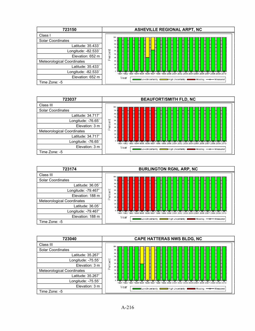
A-216
723150 ASHEVILLE REGIONAL ARPT, NC
Class I
Solar Coordinates Latitude: 35.433˚
Longitude: -82.533˚ Elevation: 652 m
Meteorological Coordinates Latitude: 35.433˚
Longitude: -82.533˚ Elevation: 652 m
Time Zone: -5
723037 BEAUFORT/SMITH FLD, NC Class III
Solar Coordinates Latitude: 34.717˚
Longitude: -76.65˚ Elevation: 3 m
Meteorological Coordinates Latitude: 34.717˚
Longitude: -76.65˚ Elevation: 3 m
Time Zone: -5
723174 BURLINGTON RGNL ARP, NC Class III
Solar Coordinates Latitude: 36.05˚
Longitude: -79.467˚ Elevation: 188 m
Meteorological Coordinates Latitude: 36.05˚
Longitude: -79.467˚ Elevation: 188 m
Time Zone: -5
723040 CAPE HATTERAS NWS BLDG, NC Class III
Solar Coordinates Latitude: 35.267˚
Longitude: -75.55˚ Elevation: 3 m
Meteorological Coordinates Latitude: 35.267˚
Longitude: -75.55˚ Elevation: 3 m
Time Zone: -5

A-217
746939 CHAPEL HILL/WILLIAM, NC
Class III
Solar Coordinates Latitude: 35.767˚
Longitude: -79.05˚ Elevation: 155 m
Meteorological Coordinates Latitude: 35.767˚
Longitude: -79.05˚ Elevation: 155 m
Time Zone: -5
723140 CHARLOTTE DOUGLAS INTL ARPT, NC Class I
Solar Coordinates Latitude: 35.217˚
Longitude: -80.95˚ Elevation: 222 m
Meteorological Coordinates Latitude: 35.217˚
Longitude: -80.95˚ Elevation: 222 m
Time Zone: -5
723090 CHERRY POINT MCAS, NC Class II
Solar Coordinates Latitude: 34.9˚
Longitude: -76.883˚ Elevation: 11 m
Meteorological Coordinates Latitude: 34.9˚
Longitude: -76.883˚ Elevation: 11 m
Time Zone: -5
723098 CULPEPER, NC Class III
Solar Coordinates Latitude: 38.383˚
Longitude: -77.867˚ Elevation: 95 m
Meteorological Coordinates Latitude: 38.383˚
Longitude: -77.867˚ Elevation: 95 m
Time Zone: -5

A-218
723046 DARE CO RGNL, NC
Class II
Solar Coordinates Latitude: 35.917˚ Longitude: -75.7˚
Elevation: 4 m Meteorological Coordinates
Latitude: 35.917˚ Longitude: -75.7˚
Elevation: 4 m Time Zone: -5
746929 DUPLIN CO ARPT, NC Class III
Solar Coordinates Latitude: 35.567˚
Longitude: -77.967˚ Elevation: 42 m
Meteorological Coordinates Latitude: 35.567˚
Longitude: -77.967˚ Elevation: 42 m
Time Zone: -5
746943 ELIZABETH CITY COAST GUARD AI [NREL], NC Class III (with some measured)
Solar Coordinates Latitude: 36.3˚
Longitude: -76.25˚ Elevation: 4 m
Meteorological Coordinates Latitude: 36.267˚
Longitude: -76.183˚ Elevation: 4 m
Time Zone: -5
746936 ERWIN/HARNETT ARPT, NC Class III
Solar Coordinates Latitude: 35.367˚
Longitude: -78.733˚ Elevation: 60 m
Meteorological Coordinates Latitude: 35.367˚
Longitude: -78.733˚ Elevation: 60 m
Time Zone: -5

A-219
723030 FAYETTEVILLE POPE AFB, NC
Class II
Solar Coordinates Latitude: 35.167˚
Longitude: -79.017˚ Elevation: 66 m
Meteorological Coordinates Latitude: 35.167˚
Longitude: -79.017˚ Elevation: 66 m
Time Zone: -5
723035 FAYETTEVILLE RGNL G, NC Class II
Solar Coordinates Latitude: 34.983˚
Longitude: -78.883˚ Elevation: 59 m
Meteorological Coordinates Latitude: 34.983˚
Longitude: -78.883˚ Elevation: 59 m
Time Zone: -5
746930 FORT BRAGG SIMMONS AAF, NC Class II
Solar Coordinates Latitude: 35.133˚
Longitude: -78.933˚ Elevation: 93 m
Meteorological Coordinates Latitude: 35.133˚
Longitude: -78.933˚ Elevation: 93 m
Time Zone: -5
723147 GASTONIA MUNI ARPT, NC Class III
Solar Coordinates Latitude: 35.183˚
Longitude: -81.15˚ Elevation: 243 m
Meteorological Coordinates Latitude: 35.183˚
Longitude: -81.15˚ Elevation: 243 m
Time Zone: -5

A-220
723066 GOLDSBORO SEYMOUR JOHNSON AFB, NC
Class II
Solar Coordinates Latitude: 35.35˚
Longitude: -77.967˚ Elevation: 33 m
Meteorological Coordinates Latitude: 35.35˚
Longitude: -77.967˚ Elevation: 33 m
Time Zone: -5
746940 GOLDSBORO/WAYNE, NC Class III
Solar Coordinates Latitude: 35.467˚
Longitude: -77.967˚ Elevation: 41 m
Meteorological Coordinates Latitude: 35.467˚
Longitude: -77.967˚ Elevation: 41 m
Time Zone: -5
723170 GREENSBORO PIEDMONT TRIAD INT, NC Class I
Solar Coordinates Latitude: 36.1˚
Longitude: -79.95˚ Elevation: 273 m
Meteorological Coordinates Latitude: 36.1˚
Longitude: -79.95˚ Elevation: 273 m
Time Zone: -5
723139 HATTERAS BILLY MITCHELL AP, NC Class III
Solar Coordinates Latitude: 35.233˚
Longitude: -75.617˚ Elevation: 3 m
Meteorological Coordinates Latitude: 35.233˚
Longitude: -75.617˚ Elevation: 3 m
Time Zone: -5

A-221
723145 HICKORY REGIONAL AP, NC
Class II
Solar Coordinates Latitude: 35.733˚
Longitude: -81.383˚ Elevation: 348 m
Meteorological Coordinates Latitude: 35.733˚
Longitude: -81.383˚ Elevation: 348 m
Time Zone: -5
723069 JACKSONVILLE (AWOS), NC Class II
Solar Coordinates Latitude: 34.833˚
Longitude: -77.617˚ Elevation: 29 m
Meteorological Coordinates Latitude: 34.833˚
Longitude: -77.617˚ Elevation: 29 m
Time Zone: -5
723146 JEFFERSON, NC Class III
Solar Coordinates Latitude: 36.433˚
Longitude: -81.417˚ Elevation: 969 m
Meteorological Coordinates Latitude: 36.433˚
Longitude: -81.417˚ Elevation: 969 m
Time Zone: -5
723067 KINSTON STALLINGS AFB, NC Class II
Solar Coordinates Latitude: 35.317˚
Longitude: -77.633˚ Elevation: 29 m
Meteorological Coordinates Latitude: 35.317˚
Longitude: -77.633˚ Elevation: 29 m
Time Zone: -5

A-222
722079 LEXINGTON/DAVIDSON, NC
Class III
Solar Coordinates Latitude: 35.783˚ Longitude: -80.3˚ Elevation: 223 m
Meteorological Coordinates Latitude: 35.783˚ Longitude: -80.3˚ Elevation: 223 m
Time Zone: -5
723108 LUMBERTON, NC Class III
Solar Coordinates Latitude: 34.6˚
Longitude: -79.067˚ Elevation: 38 m
Meteorological Coordinates Latitude: 34.6˚
Longitude: -79.067˚ Elevation: 38 m
Time Zone: -5
723034 MACKALL AAF, NC Class II
Solar Coordinates Latitude: 35.033˚ Longitude: -79.5˚ Elevation: 115 m
Meteorological Coordinates Latitude: 35.033˚ Longitude: -79.5˚ Elevation: 115 m
Time Zone: -5
723109 MAXTON, NC Class III
Solar Coordinates Latitude: 34.783˚
Longitude: -79.367˚ Elevation: 67 m
Meteorological Coordinates Latitude: 34.783˚
Longitude: -79.367˚ Elevation: 67 m
Time Zone: -5

A-223
723194 MONROE AIRPORT, NC
Class III
Solar Coordinates Latitude: 35.017˚
Longitude: -80.617˚ Elevation: 207 m
Meteorological Coordinates Latitude: 35.017˚
Longitude: -80.617˚ Elevation: 207 m
Time Zone: -5
723148 MORGANTON/LENIOR AR, NC Class III
Solar Coordinates Latitude: 35.817˚ Longitude: -81.6˚
Elevation: 4 m Meteorological Coordinates
Latitude: 35.817˚ Longitude: -81.6˚
Elevation: 4 m Time Zone: -5
723177 MOUNT AIRY CO ARPT, NC Class III
Solar Coordinates Latitude: 36.45˚
Longitude: -80.55˚ Elevation: 380 m
Meteorological Coordinates Latitude: 36.45˚
Longitude: -80.55˚ Elevation: 380 m
Time Zone: -5
723095 NEW BERN CRAVEN CO REGL AP, NC Class II
Solar Coordinates Latitude: 35.067˚
Longitude: -77.05˚ Elevation: 5 m
Meteorological Coordinates Latitude: 35.067˚
Longitude: -77.05˚ Elevation: 5 m
Time Zone: -5

A-224
723096 NEW RIVER MCAF, NC
Class II
Solar Coordinates Latitude: 34.7˚
Longitude: -77.383˚ Elevation: 5 m
Meteorological Coordinates Latitude: 34.7˚
Longitude: -77.383˚ Elevation: 5 m
Time Zone: -5
723165 NORTH WILKESBORO, NC Class III
Solar Coordinates Latitude: 36.217˚
Longitude: -81.083˚ Elevation: 396 m
Meteorological Coordinates Latitude: 36.217˚
Longitude: -81.083˚ Elevation: 396 m
Time Zone: -5
723065 PITT GREENVILLE ARP, NC Class III
Solar Coordinates Latitude: 35.633˚ Longitude: -77.4˚
Elevation: 8 m Meteorological Coordinates
Latitude: 35.633˚ Longitude: -77.4˚
Elevation: 8 m Time Zone: -5
723060 RALEIGH DURHAM INTERNATIONAL, NC Class I
Solar Coordinates Latitude: 35.867˚
Longitude: -78.783˚ Elevation: 127 m
Meteorological Coordinates Latitude: 35.867˚
Longitude: -78.783˚ Elevation: 127 m
Time Zone: -5

A-225
723068 ROCKY MOUNT WILSON, NC
Class II
Solar Coordinates Latitude: 35.85˚
Longitude: -77.9˚ Elevation: 50 m
Meteorological Coordinates Latitude: 35.85˚
Longitude: -77.9˚ Elevation: 50 m
Time Zone: -5
723156 ROWAN COUNTY ARPT, NC Class III
Solar Coordinates Latitude: 35.65˚
Longitude: -80.517˚ Elevation: 236 m
Meteorological Coordinates Latitude: 35.65˚
Longitude: -80.517˚ Elevation: 236 m
Time Zone: -5
723144 RUTHERFORDTON, NC Class III
Solar Coordinates Latitude: 35.433˚
Longitude: -81.933˚ Elevation: 329 m
Meteorological Coordinates Latitude: 35.433˚
Longitude: -81.933˚ Elevation: 329 m
Time Zone: -5
723143 SOUTHERN PINES AWOS, NC Class III
Solar Coordinates Latitude: 35.233˚ Longitude: -79.4˚ Elevation: 141 m
Meteorological Coordinates Latitude: 35.233˚ Longitude: -79.4˚ Elevation: 141 m
Time Zone: -5

A-226
723055 STATESVILLE MUNI AI, NC
Class III
Solar Coordinates Latitude: 35.75˚
Longitude: -80.95˚ Elevation: 294 m
Meteorological Coordinates Latitude: 35.75˚
Longitude: -80.95˚ Elevation: 294 m
Time Zone: -5
746925 WARREN FIELD ARPT, NC Class III
Solar Coordinates Latitude: 35.567˚
Longitude: -77.05˚ Elevation: 12 m
Meteorological Coordinates Latitude: 35.567˚
Longitude: -77.05˚ Elevation: 12 m
Time Zone: -5
723013 WILMINGTON INTERNATIONAL ARPT, NC Class I
Solar Coordinates Latitude: 34.267˚ Longitude: -77.9˚
Elevation: 9 m Meteorological Coordinates
Latitude: 34.267˚ Longitude: -77.9˚
Elevation: 9 m Time Zone: -5
723193 WINSTON-SALEM REYNOLDS AP, NC Class II
Solar Coordinates Latitude: 36.133˚
Longitude: -80.217˚ Elevation: 296 m
Meteorological Coordinates Latitude: 36.133˚
Longitude: -80.217˚ Elevation: 296 m
Time Zone: -5

A-227
727640 BISMARCK MUNICIPAL ARPT [ISIS], ND
Class I (with some measured)
Solar Coordinates Latitude: 46.77˚
Longitude: -100.77˚ Elevation: 502 m
Meteorological Coordinates Latitude: 46.767˚
Longitude: -100.75˚ Elevation: 502 m
Time Zone: -7
727573 DEVILS LAKE(AWOS), ND Class II
Solar Coordinates Latitude: 48.117˚
Longitude: -98.917˚ Elevation: 443 m
Meteorological Coordinates Latitude: 48.117˚
Longitude: -98.917˚ Elevation: 443 m
Time Zone: -6
727645 DICKINSON MUNICIPAL AP, ND Class II
Solar Coordinates Latitude: 46.8˚
Longitude: -102.8˚ Elevation: 788 m
Meteorological Coordinates Latitude: 46.8˚
Longitude: -102.8˚ Elevation: 788 m
Time Zone: -7
727530 FARGO HECTOR INTERNATIONAL AP, ND Class I
Solar Coordinates Latitude: 46.933˚
Longitude: -96.817˚ Elevation: 274 m
Meteorological Coordinates Latitude: 46.933˚
Longitude: -96.817˚ Elevation: 274 m
Time Zone: -6

A-228
727575 GRAND FORKS AF, ND
Class II
Solar Coordinates Latitude: 47.967˚ Longitude: -97.4˚ Elevation: 276 m
Meteorological Coordinates Latitude: 47.967˚ Longitude: -97.4˚ Elevation: 276 m
Time Zone: -6
727576 GRAND FORKS INTERNATIONAL AP, ND Class II
Solar Coordinates Latitude: 47.95˚
Longitude: -97.183˚ Elevation: 256 m
Meteorological Coordinates Latitude: 47.95˚
Longitude: -97.183˚ Elevation: 256 m
Time Zone: -6
727584 HETTINGER, ND Class III
Solar Coordinates Latitude: 46.017˚
Longitude: -102.65˚ Elevation: 824 m
Meteorological Coordinates Latitude: 46.017˚
Longitude: -102.65˚ Elevation: 824 m
Time Zone: -7
727535 JAMESTOWN MUNICIPAL ARPT, ND Class II
Solar Coordinates Latitude: 46.917˚
Longitude: -98.683˚ Elevation: 455 m
Meteorological Coordinates Latitude: 46.917˚
Longitude: -98.683˚ Elevation: 455 m
Time Zone: -6

A-229
727675 MINOT AFB, ND
Class II
Solar Coordinates Latitude: 48.417˚
Longitude: -101.35˚ Elevation: 497 m
Meteorological Coordinates Latitude: 48.417˚
Longitude: -101.35˚ Elevation: 497 m
Time Zone: -6
727676 MINOT FAA AP, ND Class I
Solar Coordinates Latitude: 48.267˚
Longitude: -101.283˚ Elevation: 523 m
Meteorological Coordinates Latitude: 48.267˚
Longitude: -101.283˚ Elevation: 523 m
Time Zone: -6
727670 WILLISTON SLOULIN INTL AP, ND Class I
Solar Coordinates Latitude: 48.2˚
Longitude: -103.65˚ Elevation: 580 m
Meteorological Coordinates Latitude: 48.2˚
Longitude: -103.65˚ Elevation: 580 m
Time Zone: -6
725556 AINSWORTH MUNICIPAL, NE Class II
Solar Coordinates Latitude: 42.583˚ Longitude: -100˚ Elevation: 789 m
Meteorological Coordinates Latitude: 42.583˚ Longitude: -100˚ Elevation: 789 m
Time Zone: -6
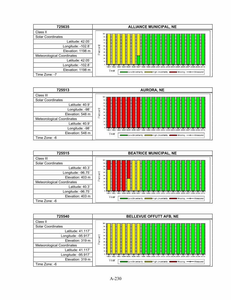
A-230
725635 ALLIANCE MUNICIPAL, NE
Class II
Solar Coordinates Latitude: 42.05˚
Longitude: -102.8˚ Elevation: 1198 m
Meteorological Coordinates Latitude: 42.05˚
Longitude: -102.8˚ Elevation: 1198 m
Time Zone: -7
725513 AURORA, NE Class III
Solar Coordinates Latitude: 40.9˚
Longitude: -98˚ Elevation: 548 m
Meteorological Coordinates Latitude: 40.9˚
Longitude: -98˚ Elevation: 548 m
Time Zone: -6
725515 BEATRICE MUNICIPAL, NE Class III
Solar Coordinates Latitude: 40.3˚
Longitude: -96.75˚ Elevation: 403 m
Meteorological Coordinates Latitude: 40.3˚
Longitude: -96.75˚ Elevation: 403 m
Time Zone: -6
725540 BELLEVUE OFFUTT AFB, NE Class II
Solar Coordinates Latitude: 41.117˚
Longitude: -95.917˚ Elevation: 319 m
Meteorological Coordinates Latitude: 41.117˚
Longitude: -95.917˚ Elevation: 319 m
Time Zone: -6

A-231
725628 BREWSTER FIELD ARPT, NE
Class III
Solar Coordinates Latitude: 40.45˚
Longitude: -99.333˚ Elevation: 704 m
Meteorological Coordinates Latitude: 40.45˚
Longitude: -99.333˚ Elevation: 704 m
Time Zone: -6
725555 BROKEN BOW MUNI, NE Class II
Solar Coordinates Latitude: 41.433˚
Longitude: -99.65˚ Elevation: 776 m
Meteorological Coordinates Latitude: 41.433˚
Longitude: -99.65˚ Elevation: 776 m
Time Zone: -6
725636 CHADRON MUNICIPAL AP, NE Class II
Solar Coordinates Latitude: 42.833˚
Longitude: -103.083˚ Elevation: 1011 m
Meteorological Coordinates Latitude: 42.833˚
Longitude: -103.083˚ Elevation: 1011 m
Time Zone: -7
725565 COLUMBUS MUNI, NE Class II
Solar Coordinates Latitude: 41.45˚
Longitude: -97.333˚ Elevation: 451 m
Meteorological Coordinates Latitude: 41.45˚
Longitude: -97.333˚ Elevation: 451 m
Time Zone: -6

A-232
725533 FALLS CITY/BRENNER, NE
Class II
Solar Coordinates Latitude: 40.083˚ Longitude: -95.6˚ Elevation: 300 m
Meteorological Coordinates Latitude: 40.083˚ Longitude: -95.6˚ Elevation: 300 m
Time Zone: -6
725564 FREMONT MUNI ARPT, NE Class III
Solar Coordinates Latitude: 41.45˚
Longitude: -96.517˚ Elevation: 379 m
Meteorological Coordinates Latitude: 41.45˚
Longitude: -96.517˚ Elevation: 379 m
Time Zone: -6
725520 GRAND ISLAND CENTRAL NE REGIO, NE Class I
Solar Coordinates Latitude: 40.967˚
Longitude: -98.317˚ Elevation: 561 m
Meteorological Coordinates Latitude: 40.967˚
Longitude: -98.317˚ Elevation: 561 m
Time Zone: -6
725525 HASTINGS MUNICIPAL, NE Class II
Solar Coordinates Latitude: 40.6˚
Longitude: -98.433˚ Elevation: 596 m
Meteorological Coordinates Latitude: 40.6˚
Longitude: -98.433˚ Elevation: 596 m
Time Zone: -6

A-233
725626 IMPERIAL FAA AP, NE
Class II
Solar Coordinates Latitude: 40.517˚
Longitude: -101.617˚ Elevation: 998 m
Meteorological Coordinates Latitude: 40.517˚
Longitude: -101.617˚ Elevation: 998 m
Time Zone: -7
725526 KEARNEY MUNI (AWOS), NE Class II
Solar Coordinates Latitude: 40.733˚
Longitude: -99˚ Elevation: 649 m
Meteorological Coordinates Latitude: 40.733˚
Longitude: -99˚ Elevation: 649 m
Time Zone: -6
725665 KIMBALL MUNI APT, NE Class III
Solar Coordinates Latitude: 41.183˚
Longitude: -103.683˚ Elevation: 1501 m
Meteorological Coordinates Latitude: 41.183˚
Longitude: -103.683˚ Elevation: 1501 m
Time Zone: -7
725510 LINCOLN MUNICIPAL ARPT, NE Class I
Solar Coordinates Latitude: 40.833˚
Longitude: -96.767˚ Elevation: 357 m
Meteorological Coordinates Latitude: 40.833˚
Longitude: -96.767˚ Elevation: 357 m
Time Zone: -6

A-234
725625 MCCOOK MUNICIPAL, NE
Class II
Solar Coordinates Latitude: 40.2˚
Longitude: -100.583˚ Elevation: 786 m
Meteorological Coordinates Latitude: 40.2˚
Longitude: -100.583˚ Elevation: 786 m
Time Zone: -6
725627 MULLEN/HOOKER CO., NE Class III
Solar Coordinates Latitude: 42.05˚
Longitude: -101.067˚ Elevation: 994 m
Meteorological Coordinates Latitude: 42.05˚
Longitude: -101.067˚ Elevation: 994 m
Time Zone: -7
725560 NORFOLK KARL STEFAN MEM ARPT, NE Class I
Solar Coordinates Latitude: 41.983˚
Longitude: -97.433˚ Elevation: 472 m
Meteorological Coordinates Latitude: 41.983˚
Longitude: -97.433˚ Elevation: 472 m
Time Zone: -6
725620 NORTH PLATTE REGIONAL AP, NE Class I
Solar Coordinates Latitude: 41.117˚
Longitude: -100.667˚ Elevation: 847 m
Meteorological Coordinates Latitude: 41.117˚
Longitude: -100.667˚ Elevation: 847 m
Time Zone: -6

A-235
725566 O`NEILL/BAKER FIELD, NE
Class III
Solar Coordinates Latitude: 42.467˚
Longitude: -98.683˚ Elevation: 619 m
Meteorological Coordinates Latitude: 42.467˚
Longitude: -98.683˚ Elevation: 619 m
Time Zone: -6
725500 OMAHA EPPLEY AIRFIELD, NE Class I
Solar Coordinates Latitude: 41.317˚ Longitude: -95.9˚ Elevation: 299 m
Meteorological Coordinates Latitude: 41.317˚ Longitude: -95.9˚ Elevation: 299 m
Time Zone: -6
725530 OMAHA WSFO, NE Class III
Solar Coordinates Latitude: 41.367˚
Longitude: -96.017˚ Elevation: 399 m
Meteorological Coordinates Latitude: 41.367˚
Longitude: -96.017˚ Elevation: 399 m
Time Zone: -6
725524 ORD/SHARP FIELD, NE Class II
Solar Coordinates Latitude: 41.617˚
Longitude: -98.95˚ Elevation: 631 m
Meteorological Coordinates Latitude: 41.617˚
Longitude: -98.95˚ Elevation: 631 m
Time Zone: -6

A-236
725660 SCOTTSBLUFF W B HEILIG FIELD, NE
Class I
Solar Coordinates Latitude: 41.867˚
Longitude: -103.6˚ Elevation: 1202 m
Meteorological Coordinates Latitude: 41.867˚
Longitude: -103.6˚ Elevation: 1202 m
Time Zone: -7
725610 SIDNEY MUNICIPAL AP, NE Class II
Solar Coordinates Latitude: 41.1˚
Longitude: -102.983˚ Elevation: 1313 m
Meteorological Coordinates Latitude: 41.1˚
Longitude: -102.983˚ Elevation: 1313 m
Time Zone: -7
725527 TEKAMAH (ASOS), NE Class III
Solar Coordinates Latitude: 41.767˚
Longitude: -96.167˚ Elevation: 312 m
Meteorological Coordinates Latitude: 41.767˚
Longitude: -96.167˚ Elevation: 312 m
Time Zone: -6
725670 VALENTINE MILLER FIELD, NE Class I
Solar Coordinates Latitude: 42.867˚
Longitude: -100.55˚ Elevation: 789 m
Meteorological Coordinates Latitude: 42.867˚
Longitude: -100.55˚ Elevation: 789 m
Time Zone: -6

A-237
726160 BERLIN MUNICIPAL, NH
Class III
Solar Coordinates Latitude: 44.583˚
Longitude: -71.183˚ Elevation: 353 m
Meteorological Coordinates Latitude: 44.583˚
Longitude: -71.183˚ Elevation: 353 m
Time Zone: -5
726050 CONCORD MUNICIPAL ARPT, NH Class I
Solar Coordinates Latitude: 43.2˚
Longitude: -71.5˚ Elevation: 106 m
Meteorological Coordinates Latitude: 43.2˚
Longitude: -71.5˚ Elevation: 106 m
Time Zone: -5
726165 DILLANT HOPKINS, NH Class II
Solar Coordinates Latitude: 42.9˚
Longitude: -72.267˚ Elevation: 153 m
Meteorological Coordinates Latitude: 42.9˚
Longitude: -72.267˚ Elevation: 153 m
Time Zone: -5
726163 JAFFREY MUNICIPAL, NH Class III
Solar Coordinates Latitude: 42.8˚
Longitude: -72˚ Elevation: 317 m
Meteorological Coordinates Latitude: 42.8˚
Longitude: -72˚ Elevation: 317 m
Time Zone: -5

A-238
726155 LACONIA MUNI (AWOS), NH
Class II
Solar Coordinates Latitude: 43.567˚
Longitude: -71.417˚ Elevation: 166 m
Meteorological Coordinates Latitude: 43.567˚
Longitude: -71.417˚ Elevation: 166 m
Time Zone: -5
726116 LEBANON MUNICIPAL, NH Class II
Solar Coordinates Latitude: 43.633˚ Longitude: -72.3˚ Elevation: 182 m
Meteorological Coordinates Latitude: 43.633˚ Longitude: -72.3˚ Elevation: 182 m
Time Zone: -5
743945 MANCHESTER AIRPORT, NH Class II
Solar Coordinates Latitude: 42.933˚
Longitude: -71.433˚ Elevation: 69 m
Meteorological Coordinates Latitude: 42.933˚
Longitude: -71.433˚ Elevation: 69 m
Time Zone: -5
726130 MOUNT WASHINGTON, NH Class III
Solar Coordinates Latitude: 44.267˚ Longitude: -71.3˚
Elevation: 1910 m Meteorological Coordinates
Latitude: 44.267˚ Longitude: -71.3˚
Elevation: 1910 m Time Zone: -5

A-239
726055 PEASE INTL TRADEPOR, NH
Class II
Solar Coordinates Latitude: 43.083˚
Longitude: -70.817˚ Elevation: 31 m
Meteorological Coordinates Latitude: 43.083˚
Longitude: -70.817˚ Elevation: 31 m
Time Zone: -5
726056 SKYHAVEN ARPT ROCHE, NH Class III
Solar Coordinates Latitude: 43.267˚
Longitude: -70.917˚ Elevation: 98 m
Meteorological Coordinates Latitude: 43.267˚
Longitude: -70.917˚ Elevation: 98 m
Time Zone: -5
726164 WHITEFIELD, NH Class III
Solar Coordinates Latitude: 44.367˚
Longitude: -71.55˚ Elevation: 327 m
Meteorological Coordinates Latitude: 44.367˚
Longitude: -71.55˚ Elevation: 327 m
Time Zone: -5
724070 ATLANTIC CITY INTL AP, NJ Class I
Solar Coordinates Latitude: 39.45˚
Longitude: -74.567˚ Elevation: 18 m
Meteorological Coordinates Latitude: 39.45˚
Longitude: -74.567˚ Elevation: 18 m
Time Zone: -5

A-240
724084 BELMAR ASC, NJ
Class III
Solar Coordinates Latitude: 40.183˚
Longitude: -74.067˚ Elevation: 26 m
Meteorological Coordinates Latitude: 40.183˚
Longitude: -74.067˚ Elevation: 26 m
Time Zone: -5
724094 CALDWELL/ESSEX CO., NJ Class II
Solar Coordinates Latitude: 40.883˚
Longitude: -74.283˚ Elevation: 53 m
Meteorological Coordinates Latitude: 40.883˚
Longitude: -74.283˚ Elevation: 53 m
Time Zone: -5
745966 CAPE MAY CO, NJ Class III
Solar Coordinates Latitude: 39˚
Longitude: -74.917˚ Elevation: 7 m
Meteorological Coordinates Latitude: 39˚
Longitude: -74.917˚ Elevation: 7 m
Time Zone: -5
724090 LAKEHURST NAS, NJ Class III
Solar Coordinates Latitude: 40.033˚
Longitude: -74.35˚ Elevation: 34 m
Meteorological Coordinates Latitude: 40.033˚
Longitude: -74.35˚ Elevation: 34 m
Time Zone: -5

A-241
724096 MCGUIRE AFB, NJ
Class II
Solar Coordinates Latitude: 40.017˚ Longitude: -74.6˚
Elevation: 45 m Meteorological Coordinates
Latitude: 40.017˚ Longitude: -74.6˚
Elevation: 45 m Time Zone: -5
724075 MILLVILLE MUNICIPAL AP, NJ Class II
Solar Coordinates Latitude: 39.367˚
Longitude: -75.083˚ Elevation: 21 m
Meteorological Coordinates Latitude: 39.367˚
Longitude: -75.083˚ Elevation: 21 m
Time Zone: -5
725020 NEWARK INTERNATIONAL ARPT, NJ Class I
Solar Coordinates Latitude: 40.717˚
Longitude: -74.183˚ Elevation: 3 m
Meteorological Coordinates Latitude: 40.717˚
Longitude: -74.183˚ Elevation: 3 m
Time Zone: -5
724074 S JERSEY RGNL ARPT, NJ Class III
Solar Coordinates Latitude: 39.933˚
Longitude: -74.833˚ Elevation: 16 m
Meteorological Coordinates Latitude: 39.933˚
Longitude: -74.833˚ Elevation: 16 m
Time Zone: -5

A-242
724104 SOMERSET ARPT ASOS, NJ
Class III
Solar Coordinates Latitude: 40.633˚
Longitude: -74.667˚ Elevation: 32 m
Meteorological Coordinates Latitude: 40.633˚
Longitude: -74.667˚ Elevation: 32 m
Time Zone: -5
725025 TETERBORO AIRPORT, NJ Class II
Solar Coordinates Latitude: 40.85˚
Longitude: -74.067˚ Elevation: 3 m
Meteorological Coordinates Latitude: 40.85˚
Longitude: -74.067˚ Elevation: 3 m
Time Zone: -5
724095 TRENTON MERCER COUNTY AP, NJ Class II
Solar Coordinates Latitude: 40.283˚
Longitude: -74.817˚ Elevation: 65 m
Meteorological Coordinates Latitude: 40.283˚
Longitude: -74.817˚ Elevation: 65 m
Time Zone: -5
722693 ALAMOGORDO WHITE SA, NM Class III
Solar Coordinates Latitude: 32.833˚
Longitude: -105.983˚ Elevation: 1313 m
Meteorological Coordinates Latitude: 32.833˚
Longitude: -105.983˚ Elevation: 1313 m
Time Zone: -7

A-243
723647 ALBUQUERQUE DOUBLE, NM
Class III
Solar Coordinates Latitude: 35.133˚
Longitude: -106.783˚ Elevation: 1779 m
Meteorological Coordinates Latitude: 35.133˚
Longitude: -106.783˚ Elevation: 1779 m
Time Zone: -7
723650 ALBUQUERQUE INTL ARPT [ISIS], NM Class I (with some measured)
Solar Coordinates Latitude: 35.04˚
Longitude: -106.62˚ Elevation: 1619 m
Meteorological Coordinates Latitude: 35.05˚
Longitude: -106.6˚ Elevation: 1618 m
Time Zone: -7
722676 ARTESIA, NM Class III
Solar Coordinates Latitude: 32.85˚
Longitude: -104.467˚ Elevation: 1081 m
Meteorological Coordinates Latitude: 32.85˚
Longitude: -104.467˚ Elevation: 1081 m
Time Zone: -7
722687 CARLSBAD CAVERN CITY AIR TERM, NM Class II
Solar Coordinates Latitude: 32.333˚
Longitude: -104.267˚ Elevation: 985 m
Meteorological Coordinates Latitude: 32.333˚
Longitude: -104.267˚ Elevation: 985 m
Time Zone: -7

A-244
723600 CLAYTON MUNICIPAL AIRPARK, NM
Class II
Solar Coordinates Latitude: 36.45˚
Longitude: -103.15˚ Elevation: 1512 m
Meteorological Coordinates Latitude: 36.45˚
Longitude: -103.15˚ Elevation: 1512 m
Time Zone: -7
722677 CLINES CORNER, NM Class III
Solar Coordinates Latitude: 35˚
Longitude: -105.667˚ Elevation: 2160 m
Meteorological Coordinates Latitude: 35˚
Longitude: -105.667˚ Elevation: 2160 m
Time Zone: -7
722686 CLOVIS CANNON AFB, NM Class II
Solar Coordinates Latitude: 34.383˚
Longitude: -103.317˚ Elevation: 1309 m
Meteorological Coordinates Latitude: 34.383˚
Longitude: -103.317˚ Elevation: 1309 m
Time Zone: -7
722689 CLOVIS MUNI (AWOS), NM Class III
Solar Coordinates Latitude: 34.433˚
Longitude: -103.083˚ Elevation: 1284 m
Meteorological Coordinates Latitude: 34.433˚
Longitude: -103.083˚ Elevation: 1284 m
Time Zone: -7

A-245
722725 DEMING MUNI, NM
Class II
Solar Coordinates Latitude: 32.25˚
Longitude: -107.717˚ Elevation: 1348 m
Meteorological Coordinates Latitude: 32.25˚
Longitude: -107.717˚ Elevation: 1348 m
Time Zone: -7
723658 FARMINGTON FOUR CORNERS REGL, NM Class II
Solar Coordinates Latitude: 36.75˚
Longitude: -108.233˚ Elevation: 1675 m
Meteorological Coordinates Latitude: 36.75˚
Longitude: -108.233˚ Elevation: 1675 m
Time Zone: -7
723627 GALLUP SEN CLARKE FLD, NM Class I
Solar Coordinates Latitude: 35.517˚
Longitude: -108.783˚ Elevation: 1971 m
Meteorological Coordinates Latitude: 35.517˚
Longitude: -108.783˚ Elevation: 1971 m
Time Zone: -7
747320 HOLLOMAN AFB, NM Class II
Solar Coordinates Latitude: 32.85˚
Longitude: -106.1˚ Elevation: 1248 m
Meteorological Coordinates Latitude: 32.85˚
Longitude: -106.1˚ Elevation: 1248 m
Time Zone: -7
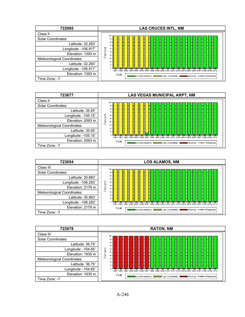
A-246
722695 LAS CRUCES INTL, NM
Class II
Solar Coordinates Latitude: 32.283˚
Longitude: -106.917˚ Elevation: 1393 m
Meteorological Coordinates Latitude: 32.283˚
Longitude: -106.917˚ Elevation: 1393 m
Time Zone: -7
723677 LAS VEGAS MUNICIPAL ARPT, NM Class II
Solar Coordinates Latitude: 35.65˚
Longitude: -105.15˚ Elevation: 2093 m
Meteorological Coordinates Latitude: 35.65˚
Longitude: -105.15˚ Elevation: 2093 m
Time Zone: -7
723654 LOS ALAMOS, NM Class III
Solar Coordinates Latitude: 35.883˚
Longitude: -106.283˚ Elevation: 2179 m
Meteorological Coordinates Latitude: 35.883˚
Longitude: -106.283˚ Elevation: 2179 m
Time Zone: -7
722678 RATON, NM Class III
Solar Coordinates Latitude: 36.75˚
Longitude: -104.65˚ Elevation: 1935 m
Meteorological Coordinates Latitude: 36.75˚
Longitude: -104.65˚ Elevation: 1935 m
Time Zone: -7

A-247
722680 ROSWELL INDUSTRIAL AIR PARK, NM
Class I
Solar Coordinates Latitude: 33.3˚
Longitude: -104.533˚ Elevation: 1112 m
Meteorological Coordinates Latitude: 33.3˚
Longitude: -104.533˚ Elevation: 1112 m
Time Zone: -7
723656 SATA FE COUNTY MUNICIPAL AP, NM Class II
Solar Coordinates Latitude: 35.617˚
Longitude: -106.083˚ Elevation: 1934 m
Meteorological Coordinates Latitude: 35.617˚
Longitude: -106.083˚ Elevation: 1934 m
Time Zone: -7
722683 SIERRA BLANCA RGNL, NM Class III
Solar Coordinates Latitude: 33.467˚
Longitude: -105.533˚ Elevation: 2078 m
Meteorological Coordinates Latitude: 33.467˚
Longitude: -105.533˚ Elevation: 2078 m
Time Zone: -7
722720 SILVER CITY GRANT CO, NM Class III
Solar Coordinates Latitude: 32.633˚
Longitude: -108.167˚ Elevation: 1639 m
Meteorological Coordinates Latitude: 32.633˚
Longitude: -108.167˚ Elevation: 1639 m
Time Zone: -7

A-248
723663 TAOS MUNI APT(AWOS), NM
Class III
Solar Coordinates Latitude: 36.45˚
Longitude: -105.667˚ Elevation: 2161 m
Meteorological Coordinates Latitude: 36.45˚
Longitude: -105.667˚ Elevation: 2161 m
Time Zone: -7
722710 TRUTH OR CONSEQUENCES MUNI AP, NM Class II
Solar Coordinates Latitude: 33.233˚
Longitude: -107.267˚ Elevation: 1478 m
Meteorological Coordinates Latitude: 33.233˚
Longitude: -107.267˚ Elevation: 1478 m
Time Zone: -7
723676 TUCUMCARI FAA AP, NM Class II
Solar Coordinates Latitude: 35.183˚
Longitude: -103.6˚ Elevation: 1235 m
Meteorological Coordinates Latitude: 35.183˚
Longitude: -103.6˚ Elevation: 1235 m
Time Zone: -7
722690 WHITE SANDS TEST RG, NM Class III
Solar Coordinates Latitude: 32.383˚
Longitude: -106.483˚ Elevation: 1244 m
Meteorological Coordinates Latitude: 32.383˚
Longitude: -106.483˚ Elevation: 1244 m
Time Zone: -7

A-249
725826 AUSTIN, NV
Class III
Solar Coordinates Latitude: 39.5˚
Longitude: -117.083˚ Elevation: 2014 m
Meteorological Coordinates Latitude: 39.5˚
Longitude: -117.083˚ Elevation: 2014 m
Time Zone: -8
725825 ELKO MUNICIPAL ARPT, NV Class II
Solar Coordinates Latitude: 40.833˚
Longitude: -115.8˚ Elevation: 1548 m
Meteorological Coordinates Latitude: 40.833˚
Longitude: -115.8˚ Elevation: 1548 m
Time Zone: -8
724860 ELY YELLAND FIELD, NV Class I
Solar Coordinates Latitude: 39.3˚
Longitude: -114.85˚ Elevation: 1909 m
Meteorological Coordinates Latitude: 39.3˚
Longitude: -114.85˚ Elevation: 1909 m
Time Zone: -8
724885 FALLON NAAS, NV Class II
Solar Coordinates Latitude: 39.417˚
Longitude: -118.717˚ Elevation: 1199 m
Meteorological Coordinates Latitude: 39.417˚
Longitude: -118.717˚ Elevation: 1199 m
Time Zone: -8

A-250
723860 LAS VEGAS MCCARRAN INTL AP, NV
Class I
Solar Coordinates Latitude: 36.083˚
Longitude: -115.15˚ Elevation: 648 m
Meteorological Coordinates Latitude: 36.083˚
Longitude: -115.15˚ Elevation: 648 m
Time Zone: -8
725805 LOVELOCK DERBY FIELD, NV Class I
Solar Coordinates Latitude: 40.067˚
Longitude: -118.55˚ Elevation: 1189 m
Meteorological Coordinates Latitude: 40.067˚
Longitude: -118.55˚ Elevation: 1189 m
Time Zone: -8
723870 MERCURY DESERT ROCK AP [SURFRAD], NV Class I (with some measured)
Solar Coordinates Latitude: 36.63˚
Longitude: -116.02˚ Elevation: 935 m
Meteorological Coordinates Latitude: 36.617˚
Longitude: -116.033˚ Elevation: 1006 m
Time Zone: -8
724846 N LAS VEGAS, NV Class III
Solar Coordinates Latitude: 36.217˚
Longitude: -115.2˚ Elevation: 671 m
Meteorological Coordinates Latitude: 36.217˚
Longitude: -115.2˚ Elevation: 671 m
Time Zone: -8

A-251
723865 NELLIS AFB, NV
Class II
Solar Coordinates Latitude: 36.25˚
Longitude: -115.033˚ Elevation: 573 m
Meteorological Coordinates Latitude: 36.25˚
Longitude: -115.033˚ Elevation: 573 m
Time Zone: -8
724880 RENO TAHOE INTERNATIONAL AP, NV Class I
Solar Coordinates Latitude: 39.483˚
Longitude: -119.767˚ Elevation: 1342 m
Meteorological Coordinates Latitude: 39.483˚
Longitude: -119.767˚ Elevation: 1342 m
Time Zone: -8
724855 TONOPAH AIRPORT, NV Class I
Solar Coordinates Latitude: 38.067˚
Longitude: -117.083˚ Elevation: 1655 m
Meteorological Coordinates Latitude: 38.067˚
Longitude: -117.083˚ Elevation: 1655 m
Time Zone: -8
725830 WINNEMUCCA MUNICIPAL ARPT, NV Class I
Solar Coordinates Latitude: 40.9˚
Longitude: -117.8˚ Elevation: 1310 m
Meteorological Coordinates Latitude: 40.9˚
Longitude: -117.8˚ Elevation: 1310 m
Time Zone: -8

A-252
726228 ADIRONDACK RGNL, NY
Class II
Solar Coordinates Latitude: 44.383˚ Longitude: -74.2˚ Elevation: 520 m
Meteorological Coordinates Latitude: 44.383˚ Longitude: -74.2˚ Elevation: 520 m
Time Zone: -5
725180 ALBANY COUNTY AP, NY Class I
Solar Coordinates Latitude: 42.75˚
Longitude: -73.8˚ Elevation: 84 m
Meteorological Coordinates Latitude: 42.75˚
Longitude: -73.8˚ Elevation: 84 m
Time Zone: -5
725150 BINGHAMTON EDWIN A LINK FIELD, NY Class I
Solar Coordinates Latitude: 42.2˚
Longitude: -75.983˚ Elevation: 488 m
Meteorological Coordinates Latitude: 42.2˚
Longitude: -75.983˚ Elevation: 488 m
Time Zone: -5
725280 BUFFALO NIAGARA INTL AP, NY Class I
Solar Coordinates Latitude: 42.933˚
Longitude: -78.733˚ Elevation: 215 m
Meteorological Coordinates Latitude: 42.933˚
Longitude: -78.733˚ Elevation: 215 m
Time Zone: -5

A-253
725187 CLINTON CO, NY
Class III
Solar Coordinates Latitude: 44.683˚
Longitude: -73.533˚ Elevation: 116 m
Meteorological Coordinates Latitude: 44.683˚
Longitude: -73.533˚ Elevation: 116 m
Time Zone: -5
724988 DANSVILLE MUNI ARPT, NY Class III
Solar Coordinates Latitude: 42.567˚
Longitude: -77.717˚ Elevation: 201 m
Meteorological Coordinates Latitude: 42.567˚
Longitude: -77.717˚ Elevation: 201 m
Time Zone: -5
744989 DUNKIRK, NY Class III
Solar Coordinates Latitude: 42.5˚
Longitude: -79.283˚ Elevation: 211 m
Meteorological Coordinates Latitude: 42.5˚
Longitude: -79.283˚ Elevation: 211 m
Time Zone: -5
725156 ELMIRA CORNING REGIONAL AP, NY Class II
Solar Coordinates Latitude: 42.167˚ Longitude: -76.9˚ Elevation: 291 m
Meteorological Coordinates Latitude: 42.167˚ Longitude: -76.9˚ Elevation: 291 m
Time Zone: -5

A-254
743700 FORT DRUM/WHEELER-S, NY
Class II
Solar Coordinates Latitude: 44.05˚
Longitude: -75.717˚ Elevation: 211 m
Meteorological Coordinates Latitude: 44.05˚
Longitude: -75.717˚ Elevation: 211 m
Time Zone: -5
725146 FULTON, NY Class III
Solar Coordinates Latitude: 43.35˚
Longitude: -76.383˚ Elevation: 145 m
Meteorological Coordinates Latitude: 43.35˚
Longitude: -76.383˚ Elevation: 145 m
Time Zone: -5
725185 GLENS FALLS AP, NY Class II
Solar Coordinates Latitude: 43.35˚
Longitude: -73.617˚ Elevation: 98 m
Meteorological Coordinates Latitude: 43.35˚
Longitude: -73.617˚ Elevation: 98 m
Time Zone: -5
725196 GRIFFISS AFB, NY Class III
Solar Coordinates Latitude: 43.233˚ Longitude: -75.4˚ Elevation: 158 m
Meteorological Coordinates Latitude: 43.233˚ Longitude: -75.4˚ Elevation: 158 m
Time Zone: -5

A-255
725035 ISLIP LONG ISL MACARTHUR AP, NY
Class I
Solar Coordinates Latitude: 40.783˚ Longitude: -73.1˚
Elevation: 26 m Meteorological Coordinates
Latitude: 40.783˚ Longitude: -73.1˚
Elevation: 26 m Time Zone: -5
725155 ITHACA/TOMPKINS CO., NY Class II
Solar Coordinates Latitude: 42.483˚
Longitude: -76.45˚ Elevation: 335 m
Meteorological Coordinates Latitude: 42.483˚
Longitude: -76.45˚ Elevation: 335 m
Time Zone: -5
725235 JAMESTOWN (AWOS), NY Class II
Solar Coordinates Latitude: 42.15˚
Longitude: -79.267˚ Elevation: 525 m
Meteorological Coordinates Latitude: 42.15˚
Longitude: -79.267˚ Elevation: 525 m
Time Zone: -5
726223 MASSENA AP, NY Class I
Solar Coordinates Latitude: 44.933˚
Longitude: -74.85˚ Elevation: 65 m
Meteorological Coordinates Latitude: 44.933˚
Longitude: -74.85˚ Elevation: 65 m
Time Zone: -5

A-256
725015 MONTGOMERY, NY
Class III
Solar Coordinates Latitude: 41.517˚
Longitude: -74.267˚ Elevation: 111 m
Meteorological Coordinates Latitude: 41.517˚
Longitude: -74.267˚ Elevation: 111 m
Time Zone: -5
725145 MONTICELLO(AWOS), NY Class II
Solar Coordinates Latitude: 41.7˚
Longitude: -74.8˚ Elevation: 428 m
Meteorological Coordinates Latitude: 41.7˚
Longitude: -74.8˚ Elevation: 428 m
Time Zone: -5
725033 NEW YORK CENTRAL PRK OBS BELV, NY Class III
Solar Coordinates Latitude: 40.783˚
Longitude: -73.967˚ Elevation: 40 m
Meteorological Coordinates Latitude: 40.783˚
Longitude: -73.967˚ Elevation: 40 m
Time Zone: -5
744860 NEW YORK J F KENNEDY INT'L AR, NY Class I
Solar Coordinates Latitude: 40.65˚
Longitude: -73.8˚ Elevation: 5 m
Meteorological Coordinates Latitude: 40.65˚
Longitude: -73.8˚ Elevation: 5 m
Time Zone: -5

A-257
725030 NEW YORK LAGUARDIA ARPT, NY
Class I
Solar Coordinates Latitude: 40.783˚
Longitude: -73.883˚ Elevation: 3 m
Meteorological Coordinates Latitude: 40.783˚
Longitude: -73.883˚ Elevation: 3 m
Time Zone: -5
725287 NIAGARA FALLS AF, NY Class II
Solar Coordinates Latitude: 43.1˚
Longitude: -78.95˚ Elevation: 180 m
Meteorological Coordinates Latitude: 43.1˚
Longitude: -78.95˚ Elevation: 180 m
Time Zone: -5
725186 OGDENSBURG INTL, NY Class III
Solar Coordinates Latitude: 44.683˚
Longitude: -75.467˚ Elevation: 91 m
Meteorological Coordinates Latitude: 44.683˚
Longitude: -75.467˚ Elevation: 91 m
Time Zone: -5
725194 PENN YAN, NY Class III
Solar Coordinates Latitude: 43.483˚
Longitude: -77.05˚ Elevation: 275 m
Meteorological Coordinates Latitude: 43.483˚
Longitude: -77.05˚ Elevation: 275 m
Time Zone: -5

A-258
726225 PLATTSBURGH AFB, NY
Class III
Solar Coordinates Latitude: 44.65˚
Longitude: -73.467˚ Elevation: 72 m
Meteorological Coordinates Latitude: 44.65˚
Longitude: -73.467˚ Elevation: 72 m
Time Zone: -5
725036 POUGHKEEPSIE DUTCHESS CO AP, NY Class II
Solar Coordinates Latitude: 41.633˚
Longitude: -73.883˚ Elevation: 47 m
Meteorological Coordinates Latitude: 41.633˚
Longitude: -73.883˚ Elevation: 47 m
Time Zone: -5
744864 REPUBLIC, NY Class II
Solar Coordinates Latitude: 40.717˚
Longitude: -73.417˚ Elevation: 26 m
Meteorological Coordinates Latitude: 40.717˚
Longitude: -73.417˚ Elevation: 26 m
Time Zone: -5
725290 ROCHESTER GREATER ROCHESTER I, NY Class I
Solar Coordinates Latitude: 43.117˚
Longitude: -77.683˚ Elevation: 183 m
Meteorological Coordinates Latitude: 43.117˚
Longitude: -77.683˚ Elevation: 183 m
Time Zone: -5
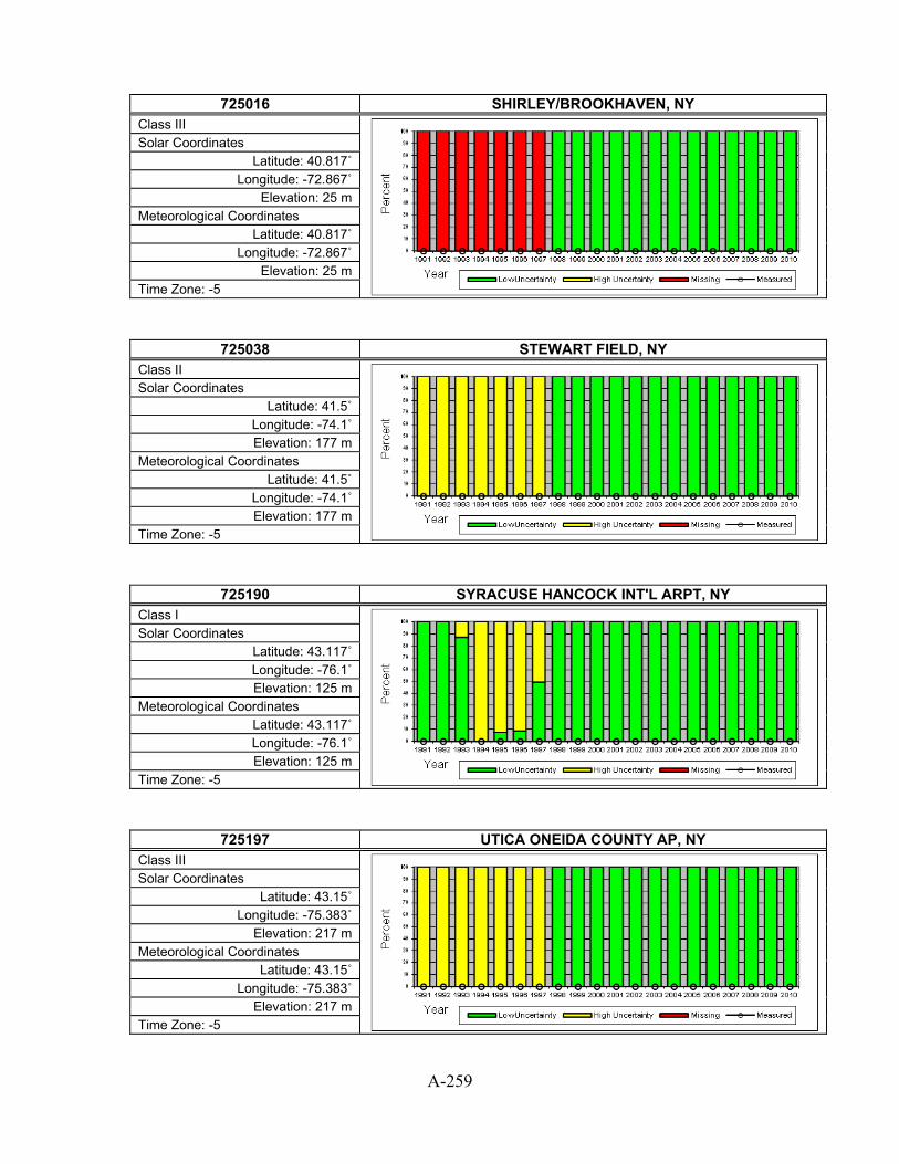
A-259
725016 SHIRLEY/BROOKHAVEN, NY
Class III
Solar Coordinates Latitude: 40.817˚
Longitude: -72.867˚ Elevation: 25 m
Meteorological Coordinates Latitude: 40.817˚
Longitude: -72.867˚ Elevation: 25 m
Time Zone: -5
725038 STEWART FIELD, NY Class II
Solar Coordinates Latitude: 41.5˚
Longitude: -74.1˚ Elevation: 177 m
Meteorological Coordinates Latitude: 41.5˚
Longitude: -74.1˚ Elevation: 177 m
Time Zone: -5
725190 SYRACUSE HANCOCK INT'L ARPT, NY Class I
Solar Coordinates Latitude: 43.117˚ Longitude: -76.1˚ Elevation: 125 m
Meteorological Coordinates Latitude: 43.117˚ Longitude: -76.1˚ Elevation: 125 m
Time Zone: -5
725197 UTICA ONEIDA COUNTY AP, NY Class III
Solar Coordinates Latitude: 43.15˚
Longitude: -75.383˚ Elevation: 217 m
Meteorological Coordinates Latitude: 43.15˚
Longitude: -75.383˚ Elevation: 217 m
Time Zone: -5
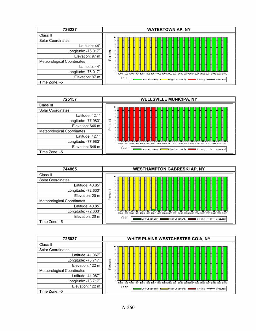
A-260
726227 WATERTOWN AP, NY
Class II
Solar Coordinates Latitude: 44˚
Longitude: -76.017˚ Elevation: 97 m
Meteorological Coordinates Latitude: 44˚
Longitude: -76.017˚ Elevation: 97 m
Time Zone: -5
725157 WELLSVILLE MUNICIPA, NY Class III
Solar Coordinates Latitude: 42.1˚
Longitude: -77.983˚ Elevation: 646 m
Meteorological Coordinates Latitude: 42.1˚
Longitude: -77.983˚ Elevation: 646 m
Time Zone: -5
744865 WESTHAMPTON GABRESKI AP, NY Class II
Solar Coordinates Latitude: 40.85˚
Longitude: -72.633˚ Elevation: 20 m
Meteorological Coordinates Latitude: 40.85˚
Longitude: -72.633˚ Elevation: 20 m
Time Zone: -5
725037 WHITE PLAINS WESTCHESTER CO A, NY Class II
Solar Coordinates Latitude: 41.067˚
Longitude: -73.717˚ Elevation: 122 m
Meteorological Coordinates Latitude: 41.067˚
Longitude: -73.717˚ Elevation: 122 m
Time Zone: -5

A-261
725210 AKRON AKRON-CANTON REG AP, OH
Class I
Solar Coordinates Latitude: 40.917˚
Longitude: -81.433˚ Elevation: 368 m
Meteorological Coordinates Latitude: 40.917˚
Longitude: -81.433˚ Elevation: 368 m
Time Zone: -5
724303 AKRON FULTON ASOS, OH Class III
Solar Coordinates Latitude: 41.033˚
Longitude: -81.467˚ Elevation: 326 m
Meteorological Coordinates Latitude: 41.033˚
Longitude: -81.467˚ Elevation: 326 m
Time Zone: -5
725256 ASHTABULA COUNTY AR, OH Class III
Solar Coordinates Latitude: 41.767˚
Longitude: -80.683˚ Elevation: 281 m
Meteorological Coordinates Latitude: 41.767˚
Longitude: -80.683˚ Elevation: 281 m
Time Zone: -5
725245 BURKE LAKEFRONT, OH Class II
Solar Coordinates Latitude: 41.517˚
Longitude: -81.683˚ Elevation: 182 m
Meteorological Coordinates Latitude: 41.517˚
Longitude: -81.683˚ Elevation: 182 m
Time Zone: -5
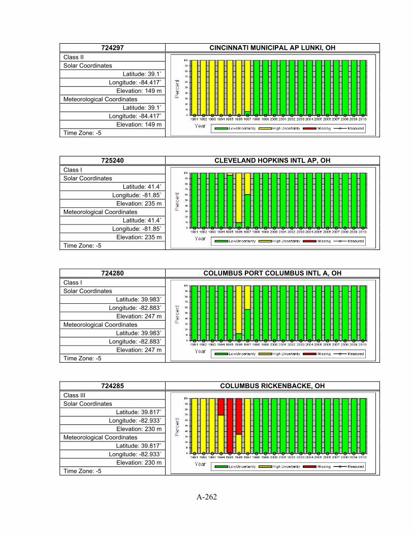
A-262
724297 CINCINNATI MUNICIPAL AP LUNKI, OH
Class II
Solar Coordinates Latitude: 39.1˚
Longitude: -84.417˚ Elevation: 149 m
Meteorological Coordinates Latitude: 39.1˚
Longitude: -84.417˚ Elevation: 149 m
Time Zone: -5
725240 CLEVELAND HOPKINS INTL AP, OH Class I
Solar Coordinates Latitude: 41.4˚
Longitude: -81.85˚ Elevation: 235 m
Meteorological Coordinates Latitude: 41.4˚
Longitude: -81.85˚ Elevation: 235 m
Time Zone: -5
724280 COLUMBUS PORT COLUMBUS INTL A, OH Class I
Solar Coordinates Latitude: 39.983˚
Longitude: -82.883˚ Elevation: 247 m
Meteorological Coordinates Latitude: 39.983˚
Longitude: -82.883˚ Elevation: 247 m
Time Zone: -5
724285 COLUMBUS RICKENBACKE, OH Class III
Solar Coordinates Latitude: 39.817˚
Longitude: -82.933˚ Elevation: 230 m
Meteorological Coordinates Latitude: 39.817˚
Longitude: -82.933˚ Elevation: 230 m
Time Zone: -5

A-263
724284 COLUMBUS/BOLTON FLD, OH
Class III
Solar Coordinates Latitude: 39.9˚
Longitude: -83.133˚ Elevation: 280 m
Meteorological Coordinates Latitude: 39.9˚
Longitude: -83.133˚ Elevation: 280 m
Time Zone: -5
724276 DAYTON GENERL ARPT, OH Class III
Solar Coordinates Latitude: 39.6˚
Longitude: -84.233˚ Elevation: 293 m
Meteorological Coordinates Latitude: 39.6˚
Longitude: -84.233˚ Elevation: 293 m
Time Zone: -5
724290 DAYTON INTERNATIONAL AIRPORT, OH Class I
Solar Coordinates Latitude: 39.9˚
Longitude: -84.217˚ Elevation: 305 m
Meteorological Coordinates Latitude: 39.9˚
Longitude: -84.217˚ Elevation: 305 m
Time Zone: -5
745700 DAYTON WRIGHT PATTERSON AFB, OH Class II
Solar Coordinates Latitude: 39.833˚
Longitude: -84.05˚ Elevation: 250 m
Meteorological Coordinates Latitude: 39.833˚
Longitude: -84.05˚ Elevation: 250 m
Time Zone: -5

A-264
725254 DEFIANCE MEMORIAL, OH
Class III
Solar Coordinates Latitude: 41.333˚
Longitude: -84.417˚ Elevation: 219 m
Meteorological Coordinates Latitude: 41.333˚
Longitude: -84.417˚ Elevation: 219 m
Time Zone: -5
725214 ELYRIA/LORAIN CO., OH Class III
Solar Coordinates Latitude: 41.35˚
Longitude: -82.183˚ Elevation: 242 m
Meteorological Coordinates Latitude: 41.35˚
Longitude: -82.183˚ Elevation: 242 m
Time Zone: -5
725366 FINDLAY AIRPORT, OH Class II
Solar Coordinates Latitude: 41.017˚
Longitude: -83.667˚ Elevation: 244 m
Meteorological Coordinates Latitude: 41.017˚
Longitude: -83.667˚ Elevation: 244 m
Time Zone: -5
725217 HAMILTON, OH Class III
Solar Coordinates Latitude: 39.367˚
Longitude: -84.517˚ Elevation: 193 m
Meteorological Coordinates Latitude: 39.367˚
Longitude: -84.517˚ Elevation: 193 m
Time Zone: -5

A-265
724298 LIMA ALLEN CO ARPT, OH
Class III
Solar Coordinates Latitude: 40.4˚
Longitude: -84.017˚ Elevation: 296 m
Meteorological Coordinates Latitude: 40.4˚
Longitude: -84.017˚ Elevation: 296 m
Time Zone: -5
725246 MANSFIELD LAHM MUNICIPAL ARPT, OH Class I
Solar Coordinates Latitude: 40.817˚
Longitude: -82.517˚ Elevation: 395 m
Meteorological Coordinates Latitude: 40.817˚
Longitude: -82.517˚ Elevation: 395 m
Time Zone: -5
725208 MARION MUNI ARPT, OH Class III
Solar Coordinates Latitude: 40.617˚
Longitude: -83.067˚ Elevation: 303 m
Meteorological Coordinates Latitude: 40.617˚
Longitude: -83.067˚ Elevation: 303 m
Time Zone: -5
724287 METCALF FIELD, OH Class III
Solar Coordinates Latitude: 41.55˚
Longitude: -83.467˚ Elevation: 189 m
Meteorological Coordinates Latitude: 41.55˚
Longitude: -83.467˚ Elevation: 189 m
Time Zone: -5

A-266
725224 NEW PHILADELPHIA, OH
Class III
Solar Coordinates Latitude: 40.467˚
Longitude: -81.417˚ Elevation: 272 m
Meteorological Coordinates Latitude: 40.467˚
Longitude: -81.417˚ Elevation: 272 m
Time Zone: -5
725229 NEWARK/HEATH AIRPRT, OH Class III
Solar Coordinates Latitude: 40.017˚
Longitude: -82.45˚ Elevation: 269 m
Meteorological Coordinates Latitude: 40.017˚
Longitude: -82.45˚ Elevation: 269 m
Time Zone: -5
724288 OHIO STATE UNIVERSI, OH Class II
Solar Coordinates Latitude: 40.067˚
Longitude: -83.067˚ Elevation: 283 m
Meteorological Coordinates Latitude: 40.067˚
Longitude: -83.067˚ Elevation: 283 m
Time Zone: -5
724295 SPRINGFIELD AF, OH Class III
Solar Coordinates Latitude: 39.85˚
Longitude: -83.833˚ Elevation: 323 m
Meteorological Coordinates Latitude: 39.85˚
Longitude: -83.833˚ Elevation: 323 m
Time Zone: -5

A-267
725360 TOLEDO EXPRESS AIRPORT, OH
Class I
Solar Coordinates Latitude: 41.583˚ Longitude: -83.8˚ Elevation: 204 m
Meteorological Coordinates Latitude: 41.583˚ Longitude: -83.8˚ Elevation: 204 m
Time Zone: -5
725244 WILLOUGHBY, OH Class III
Solar Coordinates Latitude: 41.683˚
Longitude: -81.383˚ Elevation: 191 m
Meteorological Coordinates Latitude: 41.683˚
Longitude: -81.383˚ Elevation: 191 m
Time Zone: -5
724296 WILMINGTON AIRBORNE PARK, OH Class III
Solar Coordinates Latitude: 39.417˚
Longitude: -83.817˚ Elevation: 328 m
Meteorological Coordinates Latitude: 39.417˚
Longitude: -83.817˚ Elevation: 328 m
Time Zone: -5
725216 WOOSTER, OH Class III
Solar Coordinates Latitude: 40.867˚
Longitude: -81.883˚ Elevation: 346 m
Meteorological Coordinates Latitude: 40.867˚
Longitude: -81.883˚ Elevation: 346 m
Time Zone: -5

A-268
725250 YOUNGSTOWN REGIONAL AIRPORT, OH
Class I
Solar Coordinates Latitude: 41.25˚
Longitude: -80.667˚ Elevation: 360 m
Meteorological Coordinates Latitude: 41.25˚
Longitude: -80.667˚ Elevation: 360 m
Time Zone: -5
724286 ZANESVILLE MUNICIPAL AP, OH Class II
Solar Coordinates Latitude: 39.95˚
Longitude: -81.9˚ Elevation: 268 m
Meteorological Coordinates Latitude: 39.95˚
Longitude: -81.9˚ Elevation: 268 m
Time Zone: -5
723520 ALTUS AFB, OK Class II
Solar Coordinates Latitude: 34.65˚
Longitude: -99.267˚ Elevation: 414 m
Meteorological Coordinates Latitude: 34.65˚
Longitude: -99.267˚ Elevation: 414 m
Time Zone: -6
723529 ARDMORE, OK Class III
Solar Coordinates Latitude: 34.15˚
Longitude: -97.117˚ Elevation: 257 m
Meteorological Coordinates Latitude: 34.15˚
Longitude: -97.117˚ Elevation: 257 m
Time Zone: -6

A-269
723565 BARTLESVILLE/PHILLI, OK
Class II
Solar Coordinates Latitude: 36.767˚
Longitude: -96.017˚ Elevation: 218 m
Meteorological Coordinates Latitude: 36.767˚
Longitude: -96.017˚ Elevation: 218 m
Time Zone: -6
723526 CLINTON-SHERMAN, OK Class III
Solar Coordinates Latitude: 35.333˚ Longitude: -99.2˚ Elevation: 586 m
Meteorological Coordinates Latitude: 35.333˚ Longitude: -99.2˚ Elevation: 586 m
Time Zone: -6
742513 DURANT, OK Class III
Solar Coordinates Latitude: 33.95˚
Longitude: -96.4˚ Elevation: 213 m
Meteorological Coordinates Latitude: 33.95˚
Longitude: -96.4˚ Elevation: 213 m
Time Zone: -6
723536 ENID WOODRING RGNL, OK Class II
Solar Coordinates Latitude: 36.367˚
Longitude: -97.783˚ Elevation: 365 m
Meteorological Coordinates Latitude: 36.367˚
Longitude: -97.783˚ Elevation: 365 m
Time Zone: -6

A-270
723550 FORT SILL POST FIELD AF, OK
Class II
Solar Coordinates Latitude: 34.65˚
Longitude: -98.4˚ Elevation: 369 m
Meteorological Coordinates Latitude: 34.65˚
Longitude: -98.4˚ Elevation: 369 m
Time Zone: -6
723528 FREDERICK MUNI, OK Class III
Solar Coordinates Latitude: 34.333˚
Longitude: -98.983˚ Elevation: 377 m
Meteorological Coordinates Latitude: 34.333˚
Longitude: -98.983˚ Elevation: 377 m
Time Zone: -6
723527 GAGE AIRPORT, OK Class II
Solar Coordinates Latitude: 36.3˚
Longitude: -99.767˚ Elevation: 668 m
Meteorological Coordinates Latitude: 36.3˚
Longitude: -99.767˚ Elevation: 668 m
Time Zone: -6
723537 GUTHRIE, OK Class III
Solar Coordinates Latitude: 35.85˚
Longitude: -97.4˚ Elevation: 327 m
Meteorological Coordinates Latitude: 35.85˚
Longitude: -97.4˚ Elevation: 327 m
Time Zone: -6

A-271
723525 HOBART MUNICIPAL AP, OK
Class II
Solar Coordinates Latitude: 35˚
Longitude: -99.05˚ Elevation: 478 m
Meteorological Coordinates Latitude: 35˚
Longitude: -99.05˚ Elevation: 478 m
Time Zone: -6
723575 LAWTON MUNICIPAL, OK Class II
Solar Coordinates Latitude: 34.567˚
Longitude: -98.417˚ Elevation: 338 m
Meteorological Coordinates Latitude: 34.567˚
Longitude: -98.417˚ Elevation: 338 m
Time Zone: -6
723566 MCALESTER MUNICIPAL AP, OK Class II
Solar Coordinates Latitude: 34.9˚
Longitude: -95.783˚ Elevation: 232 m
Meteorological Coordinates Latitude: 34.9˚
Longitude: -95.783˚ Elevation: 232 m
Time Zone: -6
723556 MUSKOGEE/DAVIS FLD, OK Class III
Solar Coordinates Latitude: 35.65˚
Longitude: -95.367˚ Elevation: 186 m
Meteorological Coordinates Latitude: 35.65˚
Longitude: -95.367˚ Elevation: 186 m
Time Zone: -6
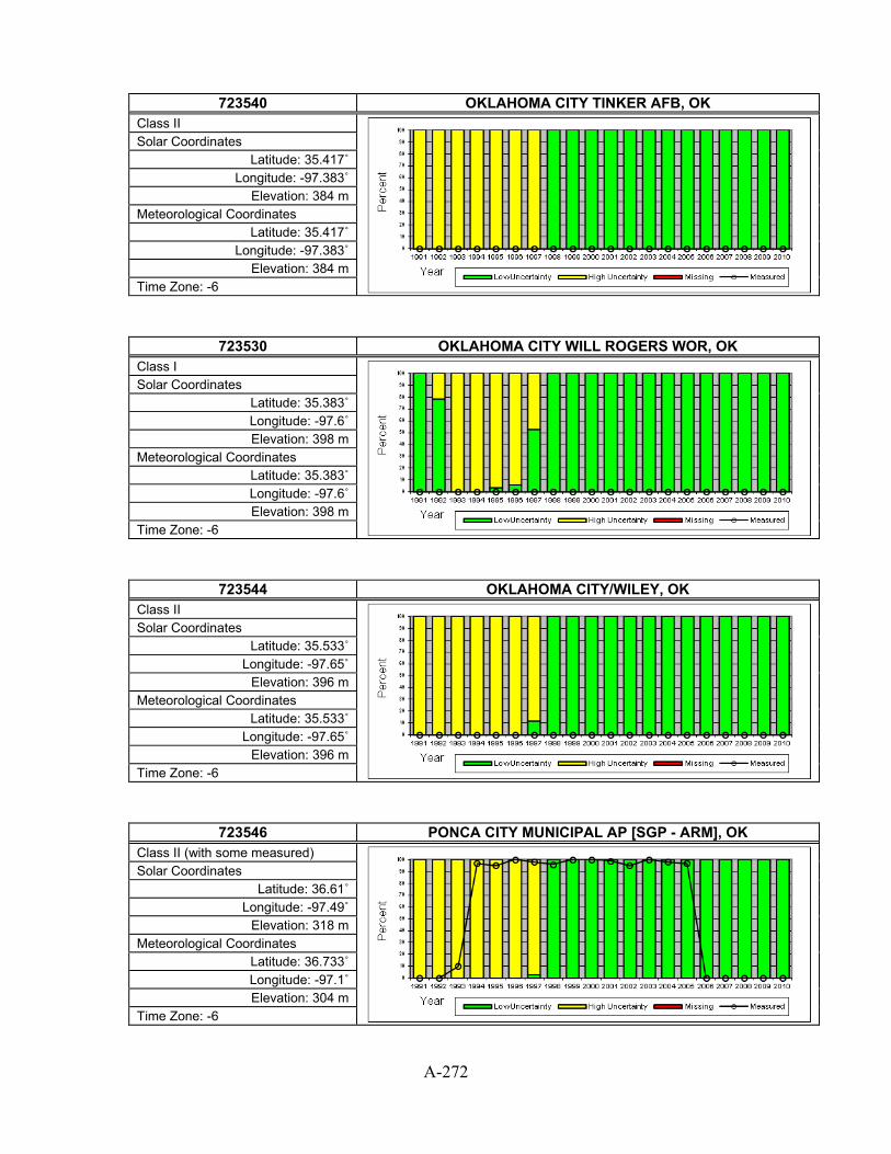
A-272
723540 OKLAHOMA CITY TINKER AFB, OK
Class II
Solar Coordinates Latitude: 35.417˚
Longitude: -97.383˚ Elevation: 384 m
Meteorological Coordinates Latitude: 35.417˚
Longitude: -97.383˚ Elevation: 384 m
Time Zone: -6
723530 OKLAHOMA CITY WILL ROGERS WOR, OK Class I
Solar Coordinates Latitude: 35.383˚ Longitude: -97.6˚ Elevation: 398 m
Meteorological Coordinates Latitude: 35.383˚ Longitude: -97.6˚ Elevation: 398 m
Time Zone: -6
723544 OKLAHOMA CITY/WILEY, OK Class II
Solar Coordinates Latitude: 35.533˚
Longitude: -97.65˚ Elevation: 396 m
Meteorological Coordinates Latitude: 35.533˚
Longitude: -97.65˚ Elevation: 396 m
Time Zone: -6
723546 PONCA CITY MUNICIPAL AP [SGP - ARM], OK Class II (with some measured)
Solar Coordinates Latitude: 36.61˚
Longitude: -97.49˚ Elevation: 318 m
Meteorological Coordinates Latitude: 36.733˚ Longitude: -97.1˚ Elevation: 304 m
Time Zone: -6

A-273
723545 STILLWATER RGNL, OK
Class II
Solar Coordinates Latitude: 36.15˚
Longitude: -97.083˚ Elevation: 308 m
Meteorological Coordinates Latitude: 36.15˚
Longitude: -97.083˚ Elevation: 308 m
Time Zone: -6
723560 TULSA INTERNATIONAL AIRPORT, OK Class I
Solar Coordinates Latitude: 36.2˚
Longitude: -95.883˚ Elevation: 198 m
Meteorological Coordinates Latitude: 36.2˚
Longitude: -95.883˚ Elevation: 198 m
Time Zone: -6
723564 TULSA/LLOYD JONES, OK Class III
Solar Coordinates Latitude: 36.033˚
Longitude: -95.983˚ Elevation: 193 m
Meteorological Coordinates Latitude: 36.033˚
Longitude: -95.983˚ Elevation: 193 m
Time Zone: -6
723535 VANCE AFB, OK Class II
Solar Coordinates Latitude: 36.333˚
Longitude: -97.917˚ Elevation: 408 m
Meteorological Coordinates Latitude: 36.333˚
Longitude: -97.917˚ Elevation: 408 m
Time Zone: -6

A-274
727910 ASTORIA REGIONAL AIRPORT, OR
Class I
Solar Coordinates Latitude: 46.15˚
Longitude: -123.883˚ Elevation: 3 m
Meteorological Coordinates Latitude: 46.15˚
Longitude: -123.883˚ Elevation: 3 m
Time Zone: -8
726959 AURORA STATE, OR Class III
Solar Coordinates Latitude: 45.25˚
Longitude: -122.767˚ Elevation: 60 m
Meteorological Coordinates Latitude: 45.25˚
Longitude: -122.767˚ Elevation: 60 m
Time Zone: -8
726886 BAKER MUNICIPAL AP, OR Class II
Solar Coordinates Latitude: 44.833˚
Longitude: -117.817˚ Elevation: 1027 m
Meteorological Coordinates Latitude: 44.833˚
Longitude: -117.817˚ Elevation: 1027 m
Time Zone: -8
726830 BURNS MUNICIPAL ARPT [UO], OR Class I (with some measured)
Solar Coordinates Latitude: 43.52˚
Longitude: -119.02˚ Elevation: 1271 m
Meteorological Coordinates Latitude: 43.6˚
Longitude: -118.95˚ Elevation: 1262 m
Time Zone: -8

A-275
726945 CORVALLIS MUNI, OR
Class II
Solar Coordinates Latitude: 44.483˚
Longitude: -123.283˚ Elevation: 77 m
Meteorological Coordinates Latitude: 44.483˚
Longitude: -123.283˚ Elevation: 77 m
Time Zone: -8
726930 EUGENE MAHLON SWEET ARPT [UO], OR Class I (with some measured)
Solar Coordinates Latitude: 44.05˚
Longitude: -123.07˚ Elevation: 109 m
Meteorological Coordinates Latitude: 44.117˚
Longitude: -123.217˚ Elevation: 108 m
Time Zone: -8
726883 HERMISTN MUNI ARPT [UO], OR Class III (with some measured)
Solar Coordinates Latitude: 45.82˚
Longitude: -119.28˚ Elevation: 180 m
Meteorological Coordinates Latitude: 45.833˚
Longitude: -119.267˚ Elevation: 195 m
Time Zone: -8
725895 KLAMATH FALLS INTL AP [UO], OR Class II (with some measured)
Solar Coordinates Latitude: 42.22˚
Longitude: -121.74˚ Elevation: 1220 m
Meteorological Coordinates Latitude: 42.15˚
Longitude: -121.717˚ Elevation: 1245 m
Time Zone: -8
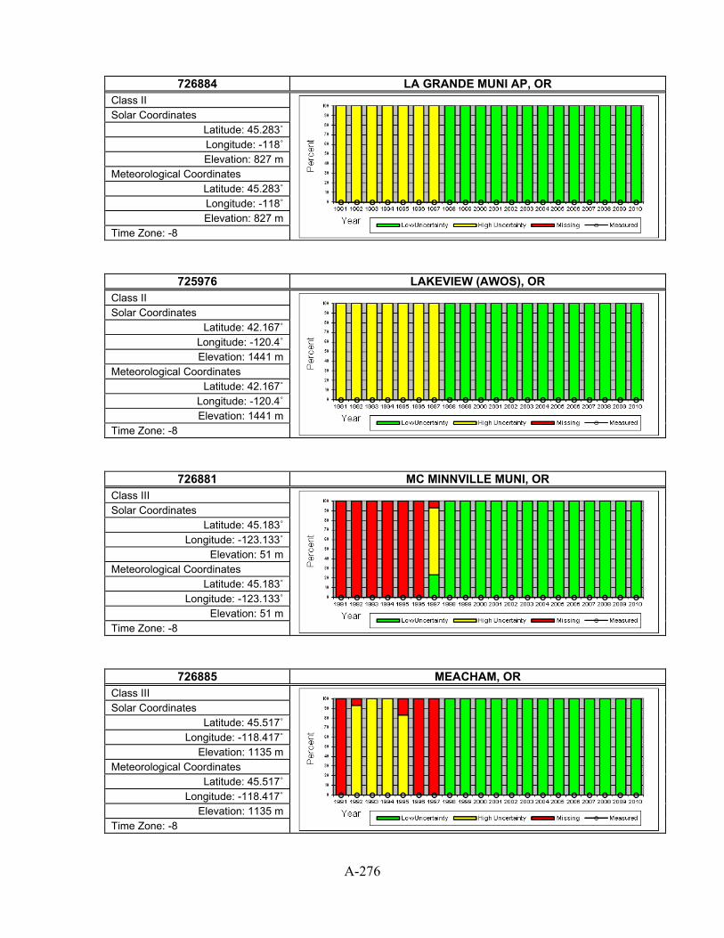
A-276
726884 LA GRANDE MUNI AP, OR
Class II
Solar Coordinates Latitude: 45.283˚ Longitude: -118˚ Elevation: 827 m
Meteorological Coordinates Latitude: 45.283˚ Longitude: -118˚ Elevation: 827 m
Time Zone: -8
725976 LAKEVIEW (AWOS), OR Class II
Solar Coordinates Latitude: 42.167˚
Longitude: -120.4˚ Elevation: 1441 m
Meteorological Coordinates Latitude: 42.167˚
Longitude: -120.4˚ Elevation: 1441 m
Time Zone: -8
726881 MC MINNVILLE MUNI, OR Class III
Solar Coordinates Latitude: 45.183˚
Longitude: -123.133˚ Elevation: 51 m
Meteorological Coordinates Latitude: 45.183˚
Longitude: -123.133˚ Elevation: 51 m
Time Zone: -8
726885 MEACHAM, OR Class III
Solar Coordinates Latitude: 45.517˚
Longitude: -118.417˚ Elevation: 1135 m
Meteorological Coordinates Latitude: 45.517˚
Longitude: -118.417˚ Elevation: 1135 m
Time Zone: -8
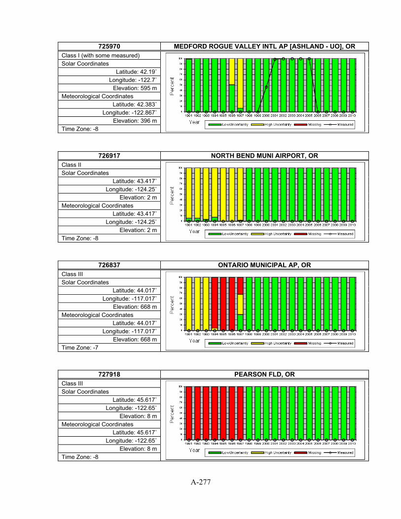
A-277
725970 MEDFORD ROGUE VALLEY INTL AP [ASHLAND - UO], OR
Class I (with some measured)
Solar Coordinates Latitude: 42.19˚
Longitude: -122.7˚ Elevation: 595 m
Meteorological Coordinates Latitude: 42.383˚
Longitude: -122.867˚ Elevation: 396 m
Time Zone: -8
726917 NORTH BEND MUNI AIRPORT, OR Class II
Solar Coordinates Latitude: 43.417˚
Longitude: -124.25˚ Elevation: 2 m
Meteorological Coordinates Latitude: 43.417˚
Longitude: -124.25˚ Elevation: 2 m
Time Zone: -8
726837 ONTARIO MUNICIPAL AP, OR Class III
Solar Coordinates Latitude: 44.017˚
Longitude: -117.017˚ Elevation: 668 m
Meteorological Coordinates Latitude: 44.017˚
Longitude: -117.017˚ Elevation: 668 m
Time Zone: -7
727918 PEARSON FLD, OR Class III
Solar Coordinates Latitude: 45.617˚
Longitude: -122.65˚ Elevation: 8 m
Meteorological Coordinates Latitude: 45.617˚
Longitude: -122.65˚ Elevation: 8 m
Time Zone: -8

A-278
726880 PENDLETON E OR REGIONAL AP, OR
Class I
Solar Coordinates Latitude: 45.7˚
Longitude: -118.833˚ Elevation: 452 m
Meteorological Coordinates Latitude: 45.7˚
Longitude: -118.833˚ Elevation: 452 m
Time Zone: -8
726980 PORTLAND INTERNATIONAL AP, OR Class III
Solar Coordinates Latitude: 45.6˚
Longitude: -122.617˚ Elevation: 6 m
Meteorological Coordinates Latitude: 45.6˚
Longitude: -122.617˚ Elevation: 6 m
Time Zone: -8
726986 PORTLAND/HILLSBORO, OR Class II
Solar Coordinates Latitude: 45.533˚
Longitude: -122.95˚ Elevation: 62 m
Meteorological Coordinates Latitude: 45.533˚
Longitude: -122.95˚ Elevation: 62 m
Time Zone: -8
726985 PORTLAND/TROUTDALE, OR Class II
Solar Coordinates Latitude: 45.55˚
Longitude: -122.4˚ Elevation: 11 m
Meteorological Coordinates Latitude: 45.55˚
Longitude: -122.4˚ Elevation: 11 m
Time Zone: -8

A-279
726835 REDMOND ROBERTS FIELD, OR
Class II
Solar Coordinates Latitude: 44.25˚
Longitude: -121.167˚ Elevation: 933 m
Meteorological Coordinates Latitude: 44.25˚
Longitude: -121.167˚ Elevation: 933 m
Time Zone: -8
726904 ROSEBURG REGIONAL AP, OR Class II
Solar Coordinates Latitude: 43.233˚
Longitude: -123.35˚ Elevation: 160 m
Meteorological Coordinates Latitude: 43.233˚
Longitude: -123.35˚ Elevation: 160 m
Time Zone: -8
726940 SALEM MCNARY FIELD, OR Class I
Solar Coordinates Latitude: 44.9˚
Longitude: -123˚ Elevation: 60 m
Meteorological Coordinates Latitude: 44.9˚
Longitude: -123˚ Elevation: 60 m
Time Zone: -8
726836 SCAPPOOSE INDUSTRIA, OR Class III
Solar Coordinates Latitude: 45.767˚
Longitude: -122.85˚ Elevation: 16 m
Meteorological Coordinates Latitude: 45.767˚
Longitude: -122.85˚ Elevation: 16 m
Time Zone: -8
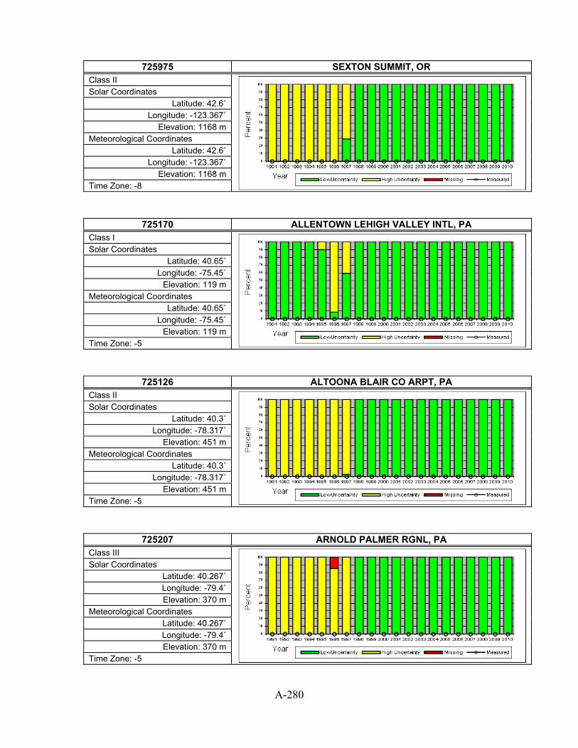
A-280
725975 SEXTON SUMMIT, OR
Class II
Solar Coordinates Latitude: 42.6˚
Longitude: -123.367˚ Elevation: 1168 m
Meteorological Coordinates Latitude: 42.6˚
Longitude: -123.367˚ Elevation: 1168 m
Time Zone: -8
725170 ALLENTOWN LEHIGH VALLEY INTL, PA Class I
Solar Coordinates Latitude: 40.65˚
Longitude: -75.45˚ Elevation: 119 m
Meteorological Coordinates Latitude: 40.65˚
Longitude: -75.45˚ Elevation: 119 m
Time Zone: -5
725126 ALTOONA BLAIR CO ARPT, PA Class II
Solar Coordinates Latitude: 40.3˚
Longitude: -78.317˚ Elevation: 451 m
Meteorological Coordinates Latitude: 40.3˚
Longitude: -78.317˚ Elevation: 451 m
Time Zone: -5
725207 ARNOLD PALMER RGNL, PA Class III
Solar Coordinates Latitude: 40.267˚ Longitude: -79.4˚ Elevation: 370 m
Meteorological Coordinates Latitude: 40.267˚ Longitude: -79.4˚ Elevation: 370 m
Time Zone: -5
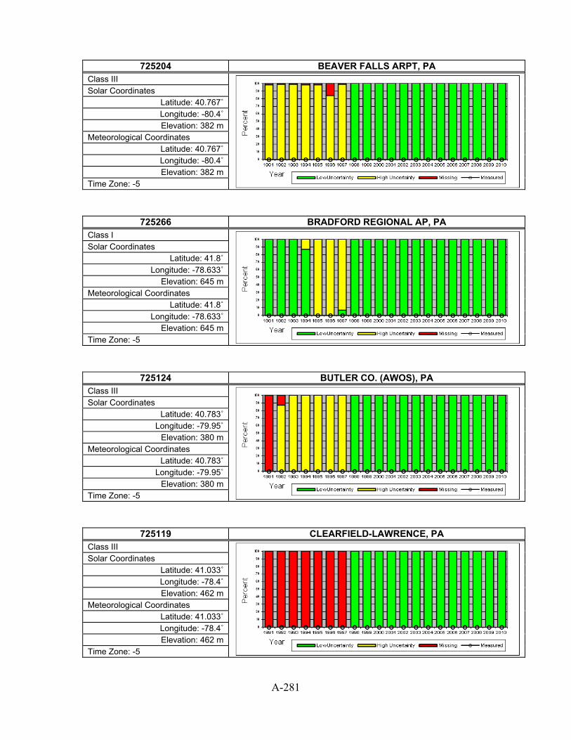
A-281
725204 BEAVER FALLS ARPT, PA
Class III
Solar Coordinates Latitude: 40.767˚ Longitude: -80.4˚ Elevation: 382 m
Meteorological Coordinates Latitude: 40.767˚ Longitude: -80.4˚ Elevation: 382 m
Time Zone: -5
725266 BRADFORD REGIONAL AP, PA Class I
Solar Coordinates Latitude: 41.8˚
Longitude: -78.633˚ Elevation: 645 m
Meteorological Coordinates Latitude: 41.8˚
Longitude: -78.633˚ Elevation: 645 m
Time Zone: -5
725124 BUTLER CO. (AWOS), PA Class III
Solar Coordinates Latitude: 40.783˚
Longitude: -79.95˚ Elevation: 380 m
Meteorological Coordinates Latitude: 40.783˚
Longitude: -79.95˚ Elevation: 380 m
Time Zone: -5
725119 CLEARFIELD-LAWRENCE, PA Class III
Solar Coordinates Latitude: 41.033˚ Longitude: -78.4˚ Elevation: 462 m
Meteorological Coordinates Latitude: 41.033˚ Longitude: -78.4˚ Elevation: 462 m
Time Zone: -5

A-282
725113 DOYLESTOWN, PA
Class III
Solar Coordinates Latitude: 40.333˚
Longitude: -75.117˚ Elevation: 120 m
Meteorological Coordinates Latitude: 40.333˚
Longitude: -75.117˚ Elevation: 120 m
Time Zone: -5
725125 DUBOIS FAA AP, PA Class II
Solar Coordinates Latitude: 41.183˚ Longitude: -78.9˚ Elevation: 553 m
Meteorological Coordinates Latitude: 41.183˚ Longitude: -78.9˚ Elevation: 553 m
Time Zone: -5
725260 ERIE INTERNATIONAL AP, PA Class I
Solar Coordinates Latitude: 42.083˚
Longitude: -80.183˚ Elevation: 222 m
Meteorological Coordinates Latitude: 42.083˚
Longitude: -80.183˚ Elevation: 222 m
Time Zone: -5
725267 FRANKLIN, PA Class II
Solar Coordinates Latitude: 41.383˚
Longitude: -79.867˚ Elevation: 470 m
Meteorological Coordinates Latitude: 41.383˚
Longitude: -79.867˚ Elevation: 470 m
Time Zone: -5

A-283
725118 HARRISBURG CAPITAL CITY ARPT, PA
Class II
Solar Coordinates Latitude: 40.217˚
Longitude: -76.85˚ Elevation: 104 m
Meteorological Coordinates Latitude: 40.217˚
Longitude: -76.85˚ Elevation: 104 m
Time Zone: -5
725175 INDIANA/STEWART FLD, PA Class III
Solar Coordinates Latitude: 40.633˚ Longitude: -79.1˚ Elevation: 429 m
Meteorological Coordinates Latitude: 40.633˚ Longitude: -79.1˚ Elevation: 429 m
Time Zone: -5
725127 JOHNSTOWN CAMBRIA COUNTY AP, PA Class II
Solar Coordinates Latitude: 40.317˚
Longitude: -78.833˚ Elevation: 695 m
Meteorological Coordinates Latitude: 40.317˚
Longitude: -78.833˚ Elevation: 695 m
Time Zone: -5
725116 LANCASTER, PA Class II
Solar Coordinates Latitude: 40.117˚ Longitude: -76.3˚ Elevation: 126 m
Meteorological Coordinates Latitude: 40.117˚ Longitude: -76.3˚ Elevation: 126 m
Time Zone: -5

A-284
725104 MEADVILLE, PA
Class III
Solar Coordinates Latitude: 41.617˚ Longitude: -80.2˚ Elevation: 427 m
Meteorological Coordinates Latitude: 41.617˚ Longitude: -80.2˚ Elevation: 427 m
Time Zone: -5
725115 MIDDLETOWN HARRISBURG INTL AP, PA Class I
Solar Coordinates Latitude: 40.2˚
Longitude: -76.767˚ Elevation: 92 m
Meteorological Coordinates Latitude: 40.2˚
Longitude: -76.767˚ Elevation: 92 m
Time Zone: -5
725434 MT POCONO MUNI, PA Class III
Solar Coordinates Latitude: 41.133˚
Longitude: -75.383˚ Elevation: 584 m
Meteorological Coordinates Latitude: 41.133˚
Longitude: -75.383˚ Elevation: 584 m
Time Zone: -5
725144 MUIR AAF, PA Class II
Solar Coordinates Latitude: 40.433˚
Longitude: -76.567˚ Elevation: 153 m
Meteorological Coordinates Latitude: 40.433˚
Longitude: -76.567˚ Elevation: 153 m
Time Zone: -5

A-285
724080 PHILADELPHIA INTERNATIONAL AP, PA
Class I
Solar Coordinates Latitude: 39.867˚
Longitude: -75.233˚ Elevation: 2 m
Meteorological Coordinates Latitude: 39.867˚
Longitude: -75.233˚ Elevation: 2 m
Time Zone: -5
724085 PHILADELPHIA NE PHILADELPHIA, PA Class II
Solar Coordinates Latitude: 40.083˚
Longitude: -75.017˚ Elevation: 30 m
Meteorological Coordinates Latitude: 40.083˚
Longitude: -75.017˚ Elevation: 30 m
Time Zone: -5
725205 PITTSBURGH ALLEGHENY CO AP, PA Class II
Solar Coordinates Latitude: 40.35˚
Longitude: -79.917˚ Elevation: 380 m
Meteorological Coordinates Latitude: 40.35˚
Longitude: -79.917˚ Elevation: 380 m
Time Zone: -5
725200 PITTSBURGH INTERNATIONAL AP, PA Class I
Solar Coordinates Latitude: 40.5˚
Longitude: -80.233˚ Elevation: 350 m
Meteorological Coordinates Latitude: 40.5˚
Longitude: -80.233˚ Elevation: 350 m
Time Zone: -5

A-286
725109 POTTSTOWN LIMERICK, PA
Class III
Solar Coordinates Latitude: 40.233˚
Longitude: -75.55˚ Elevation: 89 m
Meteorological Coordinates Latitude: 40.233˚
Longitude: -75.55˚ Elevation: 89 m
Time Zone: -5
725103 READING SPAATZ FIELD, PA Class II
Solar Coordinates Latitude: 40.367˚
Longitude: -75.967˚ Elevation: 104 m
Meteorological Coordinates Latitude: 40.367˚
Longitude: -75.967˚ Elevation: 104 m
Time Zone: -5
725105 SELINSGROVE, PA Class III
Solar Coordinates Latitude: 40.817˚
Longitude: -76.867˚ Elevation: 137 m
Meteorological Coordinates Latitude: 40.817˚
Longitude: -76.867˚ Elevation: 137 m
Time Zone: -5
725128 STATE COLLEGE [PENN STATE - SURFRAD], PA Class II (with some measured)
Solar Coordinates Latitude: 40.72˚
Longitude: -77.93˚ Elevation: 376 m
Meteorological Coordinates Latitude: 40.85˚
Longitude: -77.85˚ Elevation: 378 m
Time Zone: -5
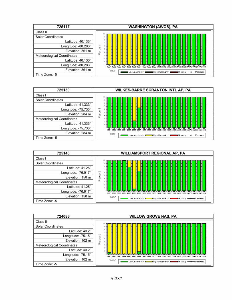
A-287
725117 WASHINGTON (AWOS), PA
Class II
Solar Coordinates Latitude: 40.133˚
Longitude: -80.283˚ Elevation: 361 m
Meteorological Coordinates Latitude: 40.133˚
Longitude: -80.283˚ Elevation: 361 m
Time Zone: -5
725130 WILKES-BARRE SCRANTON INTL AP, PA Class I
Solar Coordinates Latitude: 41.333˚
Longitude: -75.733˚ Elevation: 284 m
Meteorological Coordinates Latitude: 41.333˚
Longitude: -75.733˚ Elevation: 284 m
Time Zone: -5
725140 WILLIAMSPORT REGIONAL AP, PA Class I
Solar Coordinates Latitude: 41.25˚
Longitude: -76.917˚ Elevation: 158 m
Meteorological Coordinates Latitude: 41.25˚
Longitude: -76.917˚ Elevation: 158 m
Time Zone: -5
724086 WILLOW GROVE NAS, PA Class II
Solar Coordinates Latitude: 40.2˚
Longitude: -75.15˚ Elevation: 102 m
Meteorological Coordinates Latitude: 40.2˚
Longitude: -75.15˚ Elevation: 102 m
Time Zone: -5
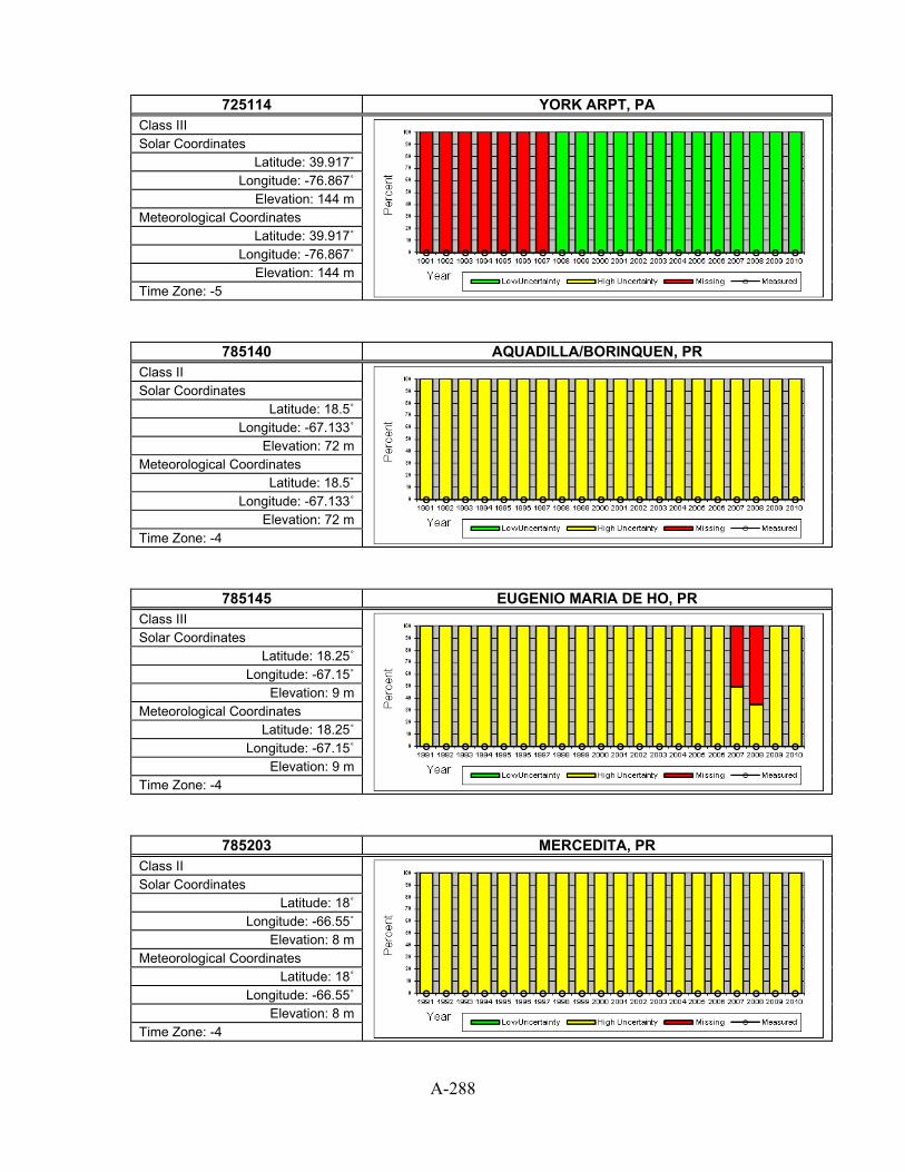
A-288
725114 YORK ARPT, PA
Class III
Solar Coordinates Latitude: 39.917˚
Longitude: -76.867˚ Elevation: 144 m
Meteorological Coordinates Latitude: 39.917˚
Longitude: -76.867˚ Elevation: 144 m
Time Zone: -5
785140 AQUADILLA/BORINQUEN, PR Class II
Solar Coordinates Latitude: 18.5˚
Longitude: -67.133˚ Elevation: 72 m
Meteorological Coordinates Latitude: 18.5˚
Longitude: -67.133˚ Elevation: 72 m
Time Zone: -4
785145 EUGENIO MARIA DE HO, PR Class III
Solar Coordinates Latitude: 18.25˚
Longitude: -67.15˚ Elevation: 9 m
Meteorological Coordinates Latitude: 18.25˚
Longitude: -67.15˚ Elevation: 9 m
Time Zone: -4
785203 MERCEDITA, PR Class II
Solar Coordinates Latitude: 18˚
Longitude: -66.55˚ Elevation: 8 m
Meteorological Coordinates Latitude: 18˚
Longitude: -66.55˚ Elevation: 8 m
Time Zone: -4
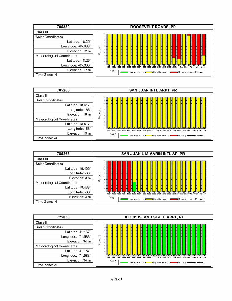
A-289
785350 ROOSEVELT ROADS, PR
Class III
Solar Coordinates Latitude: 18.25˚
Longitude: -65.633˚ Elevation: 12 m
Meteorological Coordinates Latitude: 18.25˚
Longitude: -65.633˚ Elevation: 12 m
Time Zone: -4
785260 SAN JUAN INTL ARPT, PR Class II
Solar Coordinates Latitude: 18.417˚
Longitude: -66˚ Elevation: 19 m
Meteorological Coordinates Latitude: 18.417˚
Longitude: -66˚ Elevation: 19 m
Time Zone: -4
785263 SAN JUAN L M MARIN INTL AP, PR Class III
Solar Coordinates Latitude: 18.433˚
Longitude: -66˚ Elevation: 3 m
Meteorological Coordinates Latitude: 18.433˚
Longitude: -66˚ Elevation: 3 m
Time Zone: -4
725058 BLOCK ISLAND STATE ARPT, RI Class II
Solar Coordinates Latitude: 41.167˚
Longitude: -71.583˚ Elevation: 34 m
Meteorological Coordinates Latitude: 41.167˚
Longitude: -71.583˚ Elevation: 34 m
Time Zone: -5

A-290
725079 NEWPORT, RI
Class III
Solar Coordinates Latitude: 41.533˚
Longitude: -71.283˚ Elevation: 52 m
Meteorological Coordinates Latitude: 41.533˚
Longitude: -71.283˚ Elevation: 52 m
Time Zone: -5
725054 PAWTUCKET (AWOS), RI Class II
Solar Coordinates Latitude: 41.917˚ Longitude: -71.5˚ Elevation: 134 m
Meteorological Coordinates Latitude: 41.917˚ Longitude: -71.5˚ Elevation: 134 m
Time Zone: -5
725070 PROVIDENCE T F GREEN STATE AR, RI Class I
Solar Coordinates Latitude: 41.717˚
Longitude: -71.433˚ Elevation: 16 m
Meteorological Coordinates Latitude: 41.717˚
Longitude: -71.433˚ Elevation: 16 m
Time Zone: -5
723125 ANDERSON COUNTY AP, SC Class II
Solar Coordinates Latitude: 34.5˚
Longitude: -82.717˚ Elevation: 232 m
Meteorological Coordinates Latitude: 34.5˚
Longitude: -82.717˚ Elevation: 232 m
Time Zone: -5

A-291
722085 BEAUFORT MCAS, SC
Class II
Solar Coordinates Latitude: 32.483˚
Longitude: -80.717˚ Elevation: 10 m
Meteorological Coordinates Latitude: 32.483˚
Longitude: -80.717˚ Elevation: 10 m
Time Zone: -5
722080 CHARLESTON INTL ARPT, SC Class I
Solar Coordinates Latitude: 32.9˚
Longitude: -80.033˚ Elevation: 12 m
Meteorological Coordinates Latitude: 32.9˚
Longitude: -80.033˚ Elevation: 12 m
Time Zone: -5
723118 CLEMSON-OCONEE CO A, SC Class III
Solar Coordinates Latitude: 34.667˚
Longitude: -82.867˚ Elevation: 271 m
Meteorological Coordinates Latitude: 34.667˚
Longitude: -82.867˚ Elevation: 271 m
Time Zone: -5
723105 COLUMBIA CONGAREE FLD MCAF, SC Class II
Solar Coordinates Latitude: 33.917˚ Longitude: -80.8˚
Elevation: 74 m Meteorological Coordinates
Latitude: 33.917˚ Longitude: -80.8˚
Elevation: 74 m Time Zone: -5

A-292
723100 COLUMBIA METRO ARPT, SC
Class I
Solar Coordinates Latitude: 33.95˚
Longitude: -81.117˚ Elevation: 65 m
Meteorological Coordinates Latitude: 33.95˚
Longitude: -81.117˚ Elevation: 65 m
Time Zone: -5
723104 COLUMBIA OWENS APT, SC Class III
Solar Coordinates Latitude: 33.967˚
Longitude: -81˚ Elevation: 59 m
Meteorological Coordinates Latitude: 33.967˚
Longitude: -81˚ Elevation: 59 m
Time Zone: -5
723116 DARLINGTON, SC Class III
Solar Coordinates Latitude: 34.45˚
Longitude: -79.883˚ Elevation: 59 m
Meteorological Coordinates Latitude: 34.45˚
Longitude: -79.883˚ Elevation: 59 m
Time Zone: -5
723106 FLORENCE REGIONAL AP, SC Class II
Solar Coordinates Latitude: 34.183˚
Longitude: -79.733˚ Elevation: 44 m
Meteorological Coordinates Latitude: 34.183˚
Longitude: -79.733˚ Elevation: 44 m
Time Zone: -5

A-293
723119 GREENVILLE DOWNTOWN AP, SC
Class II
Solar Coordinates Latitude: 34.85˚
Longitude: -82.35˚ Elevation: 319 m
Meteorological Coordinates Latitude: 34.85˚
Longitude: -82.35˚ Elevation: 319 m
Time Zone: -5
723124 GREENWOOD AIRPORT, SC Class III
Solar Coordinates Latitude: 34.233˚
Longitude: -82.15˚ Elevation: 192 m
Meteorological Coordinates Latitude: 34.233˚
Longitude: -82.15˚ Elevation: 192 m
Time Zone: -5
723120 GREER GREENV'L-SPARTANBRG AP, SC Class I
Solar Coordinates Latitude: 34.9˚
Longitude: -82.217˚ Elevation: 292 m
Meteorological Coordinates Latitude: 34.9˚
Longitude: -82.217˚ Elevation: 292 m
Time Zone: -5
723114 LOUISA, SC Class III
Solar Coordinates Latitude: 38.017˚
Longitude: -77.967˚ Elevation: 150 m
Meteorological Coordinates Latitude: 38.017˚
Longitude: -77.967˚ Elevation: 150 m
Time Zone: -5

A-294
747910 MYRTLE BEACH AFB, SC
Class II
Solar Coordinates Latitude: 33.683˚
Longitude: -78.933˚ Elevation: 8 m
Meteorological Coordinates Latitude: 33.683˚
Longitude: -78.933˚ Elevation: 8 m
Time Zone: -5
747915 NORTH MYRTLE BEACH GRAND STRA, SC Class II
Solar Coordinates Latitude: 33.817˚
Longitude: -78.717˚ Elevation: 10 m
Meteorological Coordinates Latitude: 33.817˚
Longitude: -78.717˚ Elevation: 10 m
Time Zone: -5
723115 ORANGEBURG, SC Class III
Solar Coordinates Latitude: 33.467˚
Longitude: -80.85˚ Elevation: 60 m
Meteorological Coordinates Latitude: 33.467˚
Longitude: -80.85˚ Elevation: 60 m
Time Zone: -5
723117 ROCK HILL/YORK COUN, SC Class III
Solar Coordinates Latitude: 34.983˚
Longitude: -81.05˚ Elevation: 204 m
Meteorological Coordinates Latitude: 34.983˚
Longitude: -81.05˚ Elevation: 204 m
Time Zone: -5

A-295
747900 SUMTER SHAW AFB, SC
Class II
Solar Coordinates Latitude: 33.967˚
Longitude: -80.467˚ Elevation: 74 m
Meteorological Coordinates Latitude: 33.967˚
Longitude: -80.467˚ Elevation: 74 m
Time Zone: -5
726590 ABERDEEN REGIONAL ARPT, SD Class I
Solar Coordinates Latitude: 45.45˚
Longitude: -98.417˚ Elevation: 398 m
Meteorological Coordinates Latitude: 45.45˚
Longitude: -98.417˚ Elevation: 398 m
Time Zone: -6
726515 BROOKINGS (AWOS), SD Class II
Solar Coordinates Latitude: 44.3˚
Longitude: -96.817˚ Elevation: 502 m
Meteorological Coordinates Latitude: 44.3˚
Longitude: -96.817˚ Elevation: 502 m
Time Zone: -6
726525 CHAN GURNEY MUNI, SD Class II
Solar Coordinates Latitude: 42.917˚
Longitude: -97.383˚ Elevation: 408 m
Meteorological Coordinates Latitude: 42.917˚
Longitude: -97.383˚ Elevation: 408 m
Time Zone: -6

A-296
726514 CUSTER (RAMOS), SD
Class III
Solar Coordinates Latitude: 43.733˚
Longitude: -103.617˚ Elevation: 1707 m
Meteorological Coordinates Latitude: 43.733˚
Longitude: -103.617˚ Elevation: 1707 m
Time Zone: -7
726625 ELLSWORTH AFB, SD Class II
Solar Coordinates Latitude: 44.15˚
Longitude: -103.1˚ Elevation: 980 m
Meteorological Coordinates Latitude: 44.15˚
Longitude: -103.1˚ Elevation: 980 m
Time Zone: -7
726540 HURON REGIONAL ARPT, SD Class I
Solar Coordinates Latitude: 44.4˚
Longitude: -98.217˚ Elevation: 390 m
Meteorological Coordinates Latitude: 44.4˚
Longitude: -98.217˚ Elevation: 390 m
Time Zone: -6
726545 MITCHELL (AWOS), SD Class II
Solar Coordinates Latitude: 43.767˚
Longitude: -98.033˚ Elevation: 397 m
Meteorological Coordinates Latitude: 43.767˚
Longitude: -98.033˚ Elevation: 397 m
Time Zone: -6

A-297
726685 MOBRIDGE, SD
Class II
Solar Coordinates Latitude: 45.533˚
Longitude: -100.433˚ Elevation: 508 m
Meteorological Coordinates Latitude: 45.533˚
Longitude: -100.433˚ Elevation: 508 m
Time Zone: -7
726516 PHILIP ARPT, SD Class III
Solar Coordinates Latitude: 44.05˚
Longitude: -101.6˚ Elevation: 673 m
Meteorological Coordinates Latitude: 44.05˚
Longitude: -101.6˚ Elevation: 673 m
Time Zone: -7
726686 PIERRE MUNICIPAL AP, SD Class I
Solar Coordinates Latitude: 44.383˚
Longitude: -100.283˚ Elevation: 528 m
Meteorological Coordinates Latitude: 44.383˚
Longitude: -100.283˚ Elevation: 528 m
Time Zone: -7
726517 PINE RIDGE, SD Class III
Solar Coordinates Latitude: 43.033˚
Longitude: -102.517˚ Elevation: 1015 m
Meteorological Coordinates Latitude: 43.033˚
Longitude: -102.517˚ Elevation: 1015 m
Time Zone: -7

A-298
726620 RAPID CITY REGIONAL ARPT, SD
Class I
Solar Coordinates Latitude: 44.05˚
Longitude: -103.05˚ Elevation: 963 m
Meteorological Coordinates Latitude: 44.05˚
Longitude: -103.05˚ Elevation: 963 m
Time Zone: -7
726510 SIOUX FALLS FOSS FIELD, SD Class I
Solar Coordinates Latitude: 43.583˚
Longitude: -96.75˚ Elevation: 433 m
Meteorological Coordinates Latitude: 43.583˚
Longitude: -96.75˚ Elevation: 433 m
Time Zone: -6
726546 WATERTOWN MUNICIPAL AP, SD Class II
Solar Coordinates Latitude: 44.933˚
Longitude: -97.15˚ Elevation: 532 m
Meteorological Coordinates Latitude: 44.933˚
Longitude: -97.15˚ Elevation: 532 m
Time Zone: -6
726518 WINNER, SD Class III
Solar Coordinates Latitude: 43.383˚
Longitude: -99.85˚ Elevation: 622 m
Meteorological Coordinates Latitude: 43.383˚
Longitude: -99.85˚ Elevation: 622 m
Time Zone: -6
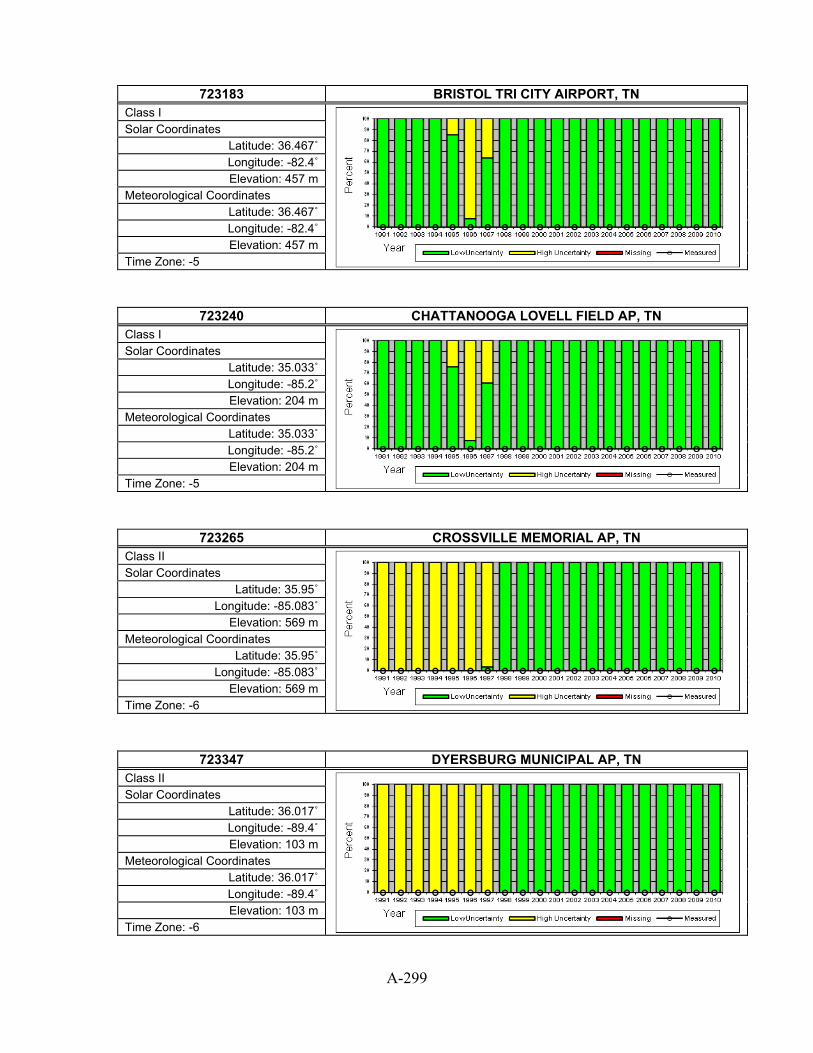
A-299
723183 BRISTOL TRI CITY AIRPORT, TN
Class I
Solar Coordinates Latitude: 36.467˚ Longitude: -82.4˚ Elevation: 457 m
Meteorological Coordinates Latitude: 36.467˚ Longitude: -82.4˚ Elevation: 457 m
Time Zone: -5
723240 CHATTANOOGA LOVELL FIELD AP, TN Class I
Solar Coordinates Latitude: 35.033˚ Longitude: -85.2˚ Elevation: 204 m
Meteorological Coordinates Latitude: 35.033˚ Longitude: -85.2˚ Elevation: 204 m
Time Zone: -5
723265 CROSSVILLE MEMORIAL AP, TN Class II
Solar Coordinates Latitude: 35.95˚
Longitude: -85.083˚ Elevation: 569 m
Meteorological Coordinates Latitude: 35.95˚
Longitude: -85.083˚ Elevation: 569 m
Time Zone: -6
723347 DYERSBURG MUNICIPAL AP, TN Class II
Solar Coordinates Latitude: 36.017˚ Longitude: -89.4˚ Elevation: 103 m
Meteorological Coordinates Latitude: 36.017˚ Longitude: -89.4˚ Elevation: 103 m
Time Zone: -6

A-300
723346 JACKSON MCKELLAR-SIPES REGL A, TN
Class II
Solar Coordinates Latitude: 35.6˚
Longitude: -88.917˚ Elevation: 132 m
Meteorological Coordinates Latitude: 35.6˚
Longitude: -88.917˚ Elevation: 132 m
Time Zone: -6
723260 KNOXVILLE MCGHEE TYSON AP, TN Class I
Solar Coordinates Latitude: 35.817˚
Longitude: -83.983˚ Elevation: 293 m
Meteorological Coordinates Latitude: 35.817˚
Longitude: -83.983˚ Elevation: 293 m
Time Zone: -5
723340 MEMPHIS INTERNATIONAL AP, TN Class I
Solar Coordinates Latitude: 35.067˚
Longitude: -89.983˚ Elevation: 81 m
Meteorological Coordinates Latitude: 35.067˚
Longitude: -89.983˚ Elevation: 81 m
Time Zone: -6
723345 MEMPHIS NAS, TN Class III
Solar Coordinates Latitude: 35.35˚
Longitude: -89.867˚ Elevation: 90 m
Meteorological Coordinates Latitude: 35.35˚
Longitude: -89.867˚ Elevation: 90 m
Time Zone: -6

A-301
723284 MILLINGTON MUNI ARP, TN
Class III
Solar Coordinates Latitude: 35.35˚
Longitude: -89.867˚ Elevation: 98 m
Meteorological Coordinates Latitude: 35.35˚
Longitude: -89.867˚ Elevation: 98 m
Time Zone: -6
723270 NASHVILLE INTERNATIONAL AP, TN Class I
Solar Coordinates Latitude: 36.117˚
Longitude: -86.683˚ Elevation: 177 m
Meteorological Coordinates Latitude: 36.117˚
Longitude: -86.683˚ Elevation: 177 m
Time Zone: -6
723246 OAK RIDGE, TN Class III
Solar Coordinates Latitude: 36.017˚
Longitude: -84.233˚ Elevation: 277 m
Meteorological Coordinates Latitude: 36.017˚
Longitude: -84.233˚ Elevation: 277 m
Time Zone: -5
723273 SMYRNA, TN Class II
Solar Coordinates Latitude: 36˚
Longitude: -86.517˚ Elevation: 170 m
Meteorological Coordinates Latitude: 36˚
Longitude: -86.517˚ Elevation: 170 m
Time Zone: -6

A-302
690190 ABILENE DYESS AFB, TX
Class III
Solar Coordinates Latitude: 32.433˚
Longitude: -99.85˚ Elevation: 545 m
Meteorological Coordinates Latitude: 32.433˚
Longitude: -99.85˚ Elevation: 545 m
Time Zone: -6
722660 ABILENE REGIONAL AP [UT], TX Class I (with some measured)
Solar Coordinates Latitude: 32.47˚
Longitude: -99.71˚ Elevation: 530 m
Meteorological Coordinates Latitude: 32.417˚
Longitude: -99.683˚ Elevation: 546 m
Time Zone: -6
722517 ALICE INTL AP, TX Class II
Solar Coordinates Latitude: 27.733˚
Longitude: -98.033˚ Elevation: 53 m
Meteorological Coordinates Latitude: 27.733˚
Longitude: -98.033˚ Elevation: 53 m
Time Zone: -6
723630 AMARILLO INTERNATIONAL AP [CANYON - UT], TX Class I (with some measured)
Solar Coordinates Latitude: 34.99˚
Longitude: -101.9˚ Elevation: 1068 m
Meteorological Coordinates Latitude: 35.217˚
Longitude: -101.7˚ Elevation: 1093 m
Time Zone: -6

A-303
722527 ANGLETON/LAKE JACKS, TX
Class III
Solar Coordinates Latitude: 29.117˚
Longitude: -95.467˚ Elevation: 8 m
Meteorological Coordinates Latitude: 29.117˚
Longitude: -95.467˚ Elevation: 8 m
Time Zone: -6
722479 ARLINGTON, TX Class III
Solar Coordinates Latitude: 32.667˚ Longitude: -97.1˚ Elevation: 192 m
Meteorological Coordinates Latitude: 32.667˚ Longitude: -97.1˚ Elevation: 192 m
Time Zone: -6
722540 AUSTIN MUELLER MUNICIPAL AP [UT], TX Class I (with some measured)
Solar Coordinates Latitude: 30.29˚
Longitude: -97.74˚ Elevation: 213 m
Meteorological Coordinates Latitude: 30.3˚
Longitude: -97.7˚ Elevation: 189 m
Time Zone: -6
722545 BERGSTROM AFB/AUSTI, TX Class III
Solar Coordinates Latitude: 30.2˚
Longitude: -97.683˚ Elevation: 165 m
Meteorological Coordinates Latitude: 30.2˚
Longitude: -97.683˚ Elevation: 165 m
Time Zone: -6

A-304
723635 BORGER/HUTCHINSON, TX
Class III
Solar Coordinates Latitude: 35.7˚
Longitude: -101.4˚ Elevation: 931 m
Meteorological Coordinates Latitude: 35.7˚
Longitude: -101.4˚ Elevation: 931 m
Time Zone: -6
722553 BRENHAM, TX Class III
Solar Coordinates Latitude: 30.217˚
Longitude: -96.367˚ Elevation: 94 m
Meteorological Coordinates Latitude: 30.217˚
Longitude: -96.367˚ Elevation: 94 m
Time Zone: -6
722500 BROWNSVILLE S PADRE ISL INTL, TX Class I
Solar Coordinates Latitude: 25.9˚
Longitude: -97.433˚ Elevation: 6 m
Meteorological Coordinates Latitude: 25.9˚
Longitude: -97.433˚ Elevation: 6 m
Time Zone: -6
722666 BROWNWOOD MUNICIPAL, TX Class III
Solar Coordinates Latitude: 31.8˚
Longitude: -98.95˚ Elevation: 422 m
Meteorological Coordinates Latitude: 31.8˚
Longitude: -98.95˚ Elevation: 422 m
Time Zone: -6

A-305
722544 CAMP MABRY, TX
Class III
Solar Coordinates Latitude: 30.317˚
Longitude: -97.767˚ Elevation: 198 m
Meteorological Coordinates Latitude: 30.317˚
Longitude: -97.767˚ Elevation: 198 m
Time Zone: -6
723604 CHILDRESS MUNICIPAL AP, TX Class II
Solar Coordinates Latitude: 34.433˚
Longitude: -100.283˚ Elevation: 595 m
Meteorological Coordinates Latitude: 34.433˚
Longitude: -100.283˚ Elevation: 595 m
Time Zone: -6
722445 COLLEGE STATION EASTERWOOD FL, TX Class II
Solar Coordinates Latitude: 30.583˚
Longitude: -96.367˚ Elevation: 96 m
Meteorological Coordinates Latitude: 30.583˚
Longitude: -96.367˚ Elevation: 96 m
Time Zone: -6
722510 CORPUS CHRISTI INTL ARPT [UT], TX Class I (with some measured)
Solar Coordinates Latitude: 27.88˚
Longitude: -97.63˚ Elevation: 6 m
Meteorological Coordinates Latitude: 27.767˚
Longitude: -97.517˚ Elevation: 13 m
Time Zone: -6

A-306
722515 CORPUS CHRISTI NAS, TX
Class II
Solar Coordinates Latitude: 27.683˚
Longitude: -97.283˚ Elevation: 6 m
Meteorological Coordinates Latitude: 27.683˚
Longitude: -97.283˚ Elevation: 6 m
Time Zone: -6
722469 CORSICANA, TX Class III
Solar Coordinates Latitude: 32.033˚ Longitude: -96.4˚ Elevation: 136 m
Meteorological Coordinates Latitude: 32.033˚ Longitude: -96.4˚ Elevation: 136 m
Time Zone: -6
722526 COTULLA FAA AP, TX Class II
Solar Coordinates Latitude: 28.45˚
Longitude: -99.217˚ Elevation: 141 m
Meteorological Coordinates Latitude: 28.45˚
Longitude: -99.217˚ Elevation: 141 m
Time Zone: -6
722587 COX FLD, TX Class III
Solar Coordinates Latitude: 33.633˚
Longitude: -95.45˚ Elevation: 171 m
Meteorological Coordinates Latitude: 33.633˚
Longitude: -95.45˚ Elevation: 171 m
Time Zone: -6
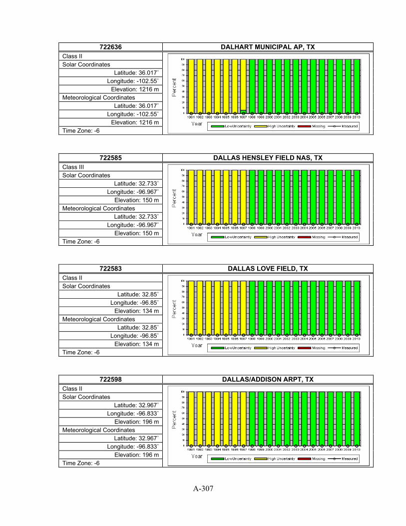
A-307
722636 DALHART MUNICIPAL AP, TX
Class II
Solar Coordinates Latitude: 36.017˚
Longitude: -102.55˚ Elevation: 1216 m
Meteorological Coordinates Latitude: 36.017˚
Longitude: -102.55˚ Elevation: 1216 m
Time Zone: -6
722585 DALLAS HENSLEY FIELD NAS, TX Class III
Solar Coordinates Latitude: 32.733˚
Longitude: -96.967˚ Elevation: 150 m
Meteorological Coordinates Latitude: 32.733˚
Longitude: -96.967˚ Elevation: 150 m
Time Zone: -6
722583 DALLAS LOVE FIELD, TX Class II
Solar Coordinates Latitude: 32.85˚
Longitude: -96.85˚ Elevation: 134 m
Meteorological Coordinates Latitude: 32.85˚
Longitude: -96.85˚ Elevation: 134 m
Time Zone: -6
722598 DALLAS/ADDISON ARPT, TX Class II
Solar Coordinates Latitude: 32.967˚
Longitude: -96.833˚ Elevation: 196 m
Meteorological Coordinates Latitude: 32.967˚
Longitude: -96.833˚ Elevation: 196 m
Time Zone: -6

A-308
722599 DALLAS/REDBIRD ARPT, TX
Class II
Solar Coordinates Latitude: 32.683˚
Longitude: -96.867˚ Elevation: 201 m
Meteorological Coordinates Latitude: 32.683˚
Longitude: -96.867˚ Elevation: 201 m
Time Zone: -6
722590 DALLAS-FORT WORTH INTL AP, TX Class I
Solar Coordinates Latitude: 32.9˚
Longitude: -97.017˚ Elevation: 171 m
Meteorological Coordinates Latitude: 32.9˚
Longitude: -97.017˚ Elevation: 171 m
Time Zone: -6
722610 DEL RIO [UT], TX Class II (with some measured)
Solar Coordinates Latitude: 29.38˚
Longitude: -100.91˚ Elevation: 308 m
Meteorological Coordinates Latitude: 29.367˚
Longitude: -100.9˚ Elevation: 302 m
Time Zone: -6
722615 DEL RIO LAUGHLIN AFB, TX Class II
Solar Coordinates Latitude: 29.367˚
Longitude: -100.783˚ Elevation: 327 m
Meteorological Coordinates Latitude: 29.367˚
Longitude: -100.783˚ Elevation: 327 m
Time Zone: -6
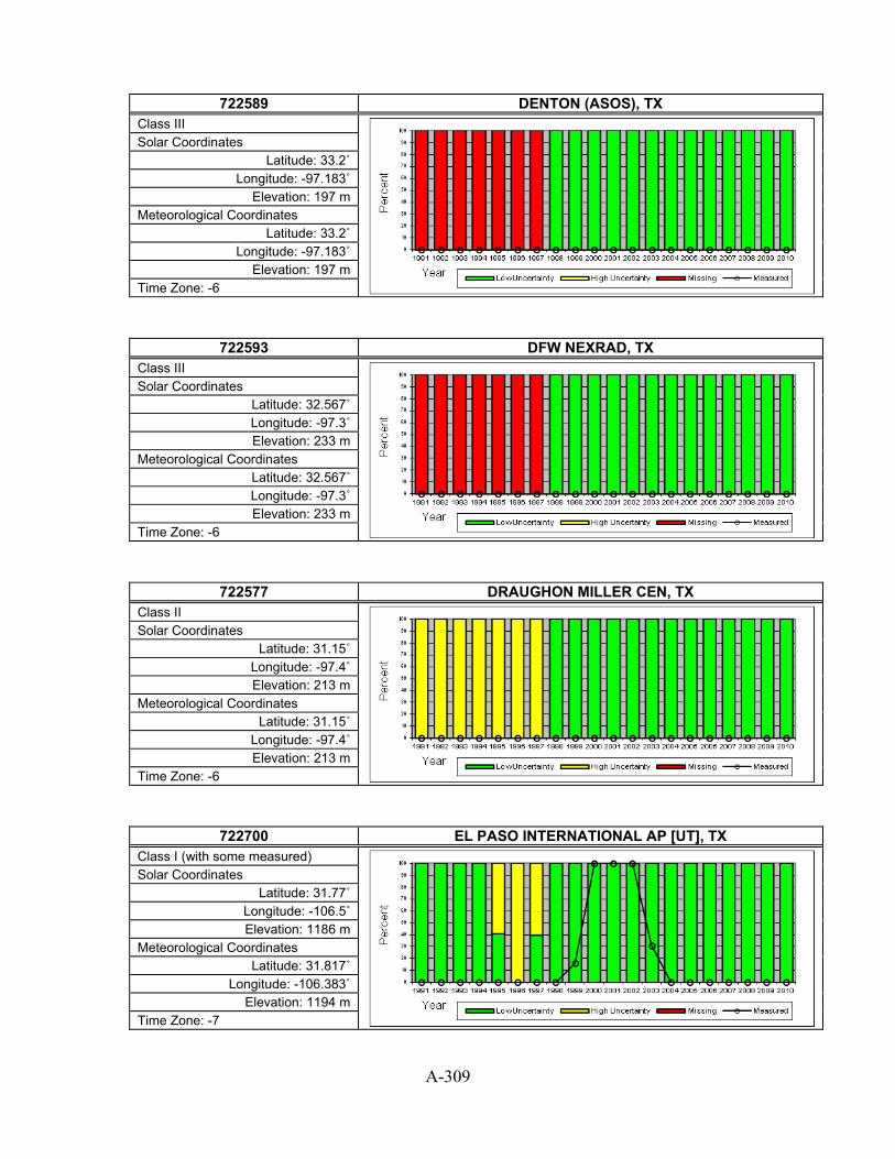
A-309
722589 DENTON (ASOS), TX
Class III
Solar Coordinates Latitude: 33.2˚
Longitude: -97.183˚ Elevation: 197 m
Meteorological Coordinates Latitude: 33.2˚
Longitude: -97.183˚ Elevation: 197 m
Time Zone: -6
722593 DFW NEXRAD, TX Class III
Solar Coordinates Latitude: 32.567˚ Longitude: -97.3˚ Elevation: 233 m
Meteorological Coordinates Latitude: 32.567˚ Longitude: -97.3˚ Elevation: 233 m
Time Zone: -6
722577 DRAUGHON MILLER CEN, TX Class II
Solar Coordinates Latitude: 31.15˚
Longitude: -97.4˚ Elevation: 213 m
Meteorological Coordinates Latitude: 31.15˚
Longitude: -97.4˚ Elevation: 213 m
Time Zone: -6
722700 EL PASO INTERNATIONAL AP [UT], TX Class I (with some measured)
Solar Coordinates Latitude: 31.77˚
Longitude: -106.5˚ Elevation: 1186 m
Meteorological Coordinates Latitude: 31.817˚
Longitude: -106.383˚ Elevation: 1194 m
Time Zone: -7

A-310
722570 FORT HOOD, TX
Class II
Solar Coordinates Latitude: 31.133˚
Longitude: -97.717˚ Elevation: 280 m
Meteorological Coordinates Latitude: 31.133˚
Longitude: -97.717˚ Elevation: 280 m
Time Zone: -6
722618 FORT STOCKTON PECOS, TX Class III
Solar Coordinates Latitude: 30.917˚
Longitude: -102.9˚ Elevation: 941 m
Meteorological Coordinates Latitude: 30.917˚
Longitude: -102.9˚ Elevation: 941 m
Time Zone: -6
722594 FORT WORTH ALLIANCE, TX Class II
Solar Coordinates Latitude: 32.983˚
Longitude: -97.317˚ Elevation: 226 m
Meteorological Coordinates Latitude: 32.983˚
Longitude: -97.317˚ Elevation: 226 m
Time Zone: -6
722596 FORT WORTH MEACHAM, TX Class II
Solar Coordinates Latitude: 32.817˚
Longitude: -97.367˚ Elevation: 209 m
Meteorological Coordinates Latitude: 32.817˚
Longitude: -97.367˚ Elevation: 209 m
Time Zone: -6

A-311
722595 FORT WORTH NAS, TX
Class II
Solar Coordinates Latitude: 32.767˚
Longitude: -97.45˚ Elevation: 185 m
Meteorological Coordinates Latitude: 32.767˚
Longitude: -97.45˚ Elevation: 185 m
Time Zone: -6
722552 GAINESVILLE, TX Class III
Solar Coordinates Latitude: 33.65˚
Longitude: -97.2˚ Elevation: 256 m
Meteorological Coordinates Latitude: 33.65˚
Longitude: -97.2˚ Elevation: 256 m
Time Zone: -6
722420 GALVESTON/SCHOLES, TX Class II
Solar Coordinates Latitude: 29.3˚
Longitude: -94.8˚ Elevation: 16 m
Meteorological Coordinates Latitude: 29.3˚
Longitude: -94.8˚ Elevation: 16 m
Time Zone: -6
722547 GEORGETOWN (AWOS), TX Class III
Solar Coordinates Latitude: 30.683˚
Longitude: -97.683˚ Elevation: 240 m
Meteorological Coordinates Latitude: 30.683˚
Longitude: -97.683˚ Elevation: 240 m
Time Zone: -6

A-312
722588 GREENVILLE/MAJORS, TX
Class II
Solar Coordinates Latitude: 33.067˚
Longitude: -96.067˚ Elevation: 163 m
Meteorological Coordinates Latitude: 33.067˚
Longitude: -96.067˚ Elevation: 163 m
Time Zone: -6
722505 HARLINGEN RIO GRANDE VALLEY I, TX Class II
Solar Coordinates Latitude: 26.233˚
Longitude: -97.65˚ Elevation: 10 m
Meteorological Coordinates Latitude: 26.233˚
Longitude: -97.65˚ Elevation: 10 m
Time Zone: -6
722533 HONDO MUNICIPAL AP, TX Class III
Solar Coordinates Latitude: 29.367˚
Longitude: -99.167˚ Elevation: 280 m
Meteorological Coordinates Latitude: 29.367˚
Longitude: -99.167˚ Elevation: 280 m
Time Zone: -6
722430 HOUSTON BUSH INTERCONTINENTAL, TX Class I
Solar Coordinates Latitude: 30˚
Longitude: -95.367˚ Elevation: 29 m
Meteorological Coordinates Latitude: 30˚
Longitude: -95.367˚ Elevation: 29 m
Time Zone: -6

A-313
722436 HOUSTON ELLINGTON AFB [CLEAR LAKE - UT], TX
Class II (with some measured)
Solar Coordinates Latitude: 29.57˚
Longitude: -95.09˚ Elevation: 6 m
Meteorological Coordinates Latitude: 29.617˚
Longitude: -95.167˚ Elevation: 12 m
Time Zone: -6
722435 HOUSTON WILLIAM P HOBBY AP, TX Class II
Solar Coordinates Latitude: 29.65˚
Longitude: -95.283˚ Elevation: 13 m
Meteorological Coordinates Latitude: 29.65˚
Longitude: -95.283˚ Elevation: 13 m
Time Zone: -6
722427 HOUSTON/CLOVER FLD, TX Class III
Solar Coordinates Latitude: 29.517˚
Longitude: -95.233˚ Elevation: 13 m
Meteorological Coordinates Latitude: 29.517˚
Longitude: -95.233˚ Elevation: 13 m
Time Zone: -6
722429 HOUSTON/D.W. HOOKS, TX Class II
Solar Coordinates Latitude: 30.067˚
Longitude: -95.55˚ Elevation: 46 m
Meteorological Coordinates Latitude: 30.067˚
Longitude: -95.55˚ Elevation: 46 m
Time Zone: -6

A-314
747400 JUNCTION KIMBLE COUNTY AP, TX
Class III
Solar Coordinates Latitude: 30.517˚
Longitude: -99.767˚ Elevation: 533 m
Meteorological Coordinates Latitude: 30.517˚
Longitude: -99.767˚ Elevation: 533 m
Time Zone: -6
722537 KERRVILLE MUNICIPAL, TX Class III
Solar Coordinates Latitude: 29.983˚
Longitude: -99.083˚ Elevation: 493 m
Meteorological Coordinates Latitude: 29.983˚
Longitude: -99.083˚ Elevation: 493 m
Time Zone: -6
722575 KILLEEN MUNI (AWOS), TX Class II
Solar Coordinates Latitude: 31.083˚
Longitude: -97.683˚ Elevation: 258 m
Meteorological Coordinates Latitude: 31.083˚
Longitude: -97.683˚ Elevation: 258 m
Time Zone: -6
722516 KINGSVILLE, TX Class II
Solar Coordinates Latitude: 27.5˚
Longitude: -97.817˚ Elevation: 17 m
Meteorological Coordinates Latitude: 27.5˚
Longitude: -97.817˚ Elevation: 17 m
Time Zone: -6

A-315
722554 LAGRANGE, TX
Class III
Solar Coordinates Latitude: 29.9˚
Longitude: -96.95˚ Elevation: 99 m
Meteorological Coordinates Latitude: 29.9˚
Longitude: -96.95˚ Elevation: 99 m
Time Zone: -6
722520 LAREDO INTL AP [UT], TX Class II (with some measured)
Solar Coordinates Latitude: 27.57˚
Longitude: -99.49˚ Elevation: 142 m
Meteorological Coordinates Latitude: 27.533˚
Longitude: -99.467˚ Elevation: 151 m
Time Zone: -6
722447 LONGVIEW GREGG COUNTY AP, TX Class III
Solar Coordinates Latitude: 32.383˚
Longitude: -94.717˚ Elevation: 109 m
Meteorological Coordinates Latitude: 32.383˚
Longitude: -94.717˚ Elevation: 109 m
Time Zone: -6
722470 LONGVIEW GREGG COUNTY AP [OVERTON - UT], TX Class II (with some measured)
Solar Coordinates Latitude: 32.29˚
Longitude: -94.98˚ Elevation: 146 m
Meteorological Coordinates Latitude: 32.383˚
Longitude: -94.717˚ Elevation: 124 m
Time Zone: -6

A-316
722670 LUBBOCK INTERNATIONAL AP, TX
Class I
Solar Coordinates Latitude: 33.667˚
Longitude: -101.817˚ Elevation: 992 m
Meteorological Coordinates Latitude: 33.667˚
Longitude: -101.817˚ Elevation: 992 m
Time Zone: -6
722446 LUFKIN ANGELINA CO, TX Class I
Solar Coordinates Latitude: 31.233˚
Longitude: -94.75˚ Elevation: 86 m
Meteorological Coordinates Latitude: 31.233˚
Longitude: -94.75˚ Elevation: 86 m
Time Zone: -6
722640 MARFA AP, TX Class III
Solar Coordinates Latitude: 30.367˚
Longitude: -104.017˚ Elevation: 1473 m
Meteorological Coordinates Latitude: 30.367˚
Longitude: -104.017˚ Elevation: 1473 m
Time Zone: -6
722563 MC GREGOR (AWOS), TX Class III
Solar Coordinates Latitude: 31.483˚
Longitude: -97.317˚ Elevation: 180 m
Meteorological Coordinates Latitude: 31.483˚
Longitude: -97.317˚ Elevation: 180 m
Time Zone: -6

A-317
722506 MCALLEN MILLER INTL AP [EDINBURG - UT], TX
Class II (with some measured)
Solar Coordinates Latitude: 26.31˚
Longitude: -98.17˚ Elevation: 30 m
Meteorological Coordinates Latitude: 26.183˚
Longitude: -98.233˚ Elevation: 30 m
Time Zone: -6
722650 MIDLAND INTERNATIONAL AP, TX Class I
Solar Coordinates Latitude: 31.95˚
Longitude: -102.183˚ Elevation: 872 m
Meteorological Coordinates Latitude: 31.95˚
Longitude: -102.183˚ Elevation: 872 m
Time Zone: -6
722597 MINERAL WELLS MUNICIPAL AP, TX Class II
Solar Coordinates Latitude: 32.783˚
Longitude: -98.067˚ Elevation: 284 m
Meteorological Coordinates Latitude: 32.783˚
Longitude: -98.067˚ Elevation: 284 m
Time Zone: -6
722444 MONTGOMERY CO, TX Class III
Solar Coordinates Latitude: 30.35˚
Longitude: -95.417˚ Elevation: 77 m
Meteorological Coordinates Latitude: 30.35˚
Longitude: -95.417˚ Elevation: 77 m
Time Zone: -6

A-318
722499 NACOGDOCHES (AWOS), TX
Class III
Solar Coordinates Latitude: 31.583˚
Longitude: -94.717˚ Elevation: 108 m
Meteorological Coordinates Latitude: 31.583˚
Longitude: -94.717˚ Elevation: 108 m
Time Zone: -6
722416 NEW BRAUNFELS, TX Class III
Solar Coordinates Latitude: 29.717˚
Longitude: -98.05˚ Elevation: 197 m
Meteorological Coordinates Latitude: 29.717˚
Longitude: -98.05˚ Elevation: 197 m
Time Zone: -6
722648 ODESSA-SCHLEMEYER F, TX Class III
Solar Coordinates Latitude: 31.917˚
Longitude: -102.383˚ Elevation: 902 m
Meteorological Coordinates Latitude: 31.917˚
Longitude: -102.383˚ Elevation: 902 m
Time Zone: -6
722555 PALACIOS MUNICIPAL AP, TX Class II
Solar Coordinates Latitude: 28.717˚
Longitude: -96.25˚ Elevation: 5 m
Meteorological Coordinates Latitude: 28.717˚
Longitude: -96.25˚ Elevation: 5 m
Time Zone: -6

A-319
722620 PINE SPRINGS GUADALUPE MOUNTA, TX
Class III
Solar Coordinates Latitude: 31.833˚
Longitude: -104.817˚ Elevation: 1663 m
Meteorological Coordinates Latitude: 31.833˚
Longitude: -104.817˚ Elevation: 1663 m
Time Zone: -7
722410 PORT ARTHUR JEFFERSON COUNTY, TX Class I
Solar Coordinates Latitude: 29.95˚
Longitude: -94.017˚ Elevation: 5 m
Meteorological Coordinates Latitude: 29.95˚
Longitude: -94.017˚ Elevation: 5 m
Time Zone: -6
722508 PORT ISABEL/CAMERON, TX Class III
Solar Coordinates Latitude: 26.15˚
Longitude: -97.213˚ Elevation: 5 m
Meteorological Coordinates Latitude: 26.15˚
Longitude: -97.213˚ Elevation: 5 m
Time Zone: -6
722536 RANDOLPH AFB, TX Class II
Solar Coordinates Latitude: 29.533˚
Longitude: -98.283˚ Elevation: 232 m
Meteorological Coordinates Latitude: 29.533˚
Longitude: -98.283˚ Elevation: 232 m
Time Zone: -6

A-320
722675 REESE AFB, TX
Class III
Solar Coordinates Latitude: 33.6˚
Longitude: -102.05˚ Elevation: 1014 m
Meteorological Coordinates Latitude: 33.6˚
Longitude: -102.05˚ Elevation: 1014 m
Time Zone: -6
722576 ROBERT GRAY AAF, TX Class II
Solar Coordinates Latitude: 31.067˚
Longitude: -97.833˚ Elevation: 312 m
Meteorological Coordinates Latitude: 31.067˚
Longitude: -97.833˚ Elevation: 312 m
Time Zone: -6
722524 ROCKPORT/ARANSAS CO, TX Class II
Solar Coordinates Latitude: 28.083˚
Longitude: -97.05˚ Elevation: 8 m
Meteorological Coordinates Latitude: 28.083˚
Longitude: -97.05˚ Elevation: 8 m
Time Zone: -6
722630 SAN ANGELO MATHIS FIELD, TX Class I
Solar Coordinates Latitude: 31.35˚
Longitude: -100.5˚ Elevation: 584 m
Meteorological Coordinates Latitude: 31.35˚
Longitude: -100.5˚ Elevation: 584 m
Time Zone: -6

A-321
722530 SAN ANTONIO INTL AP, TX
Class I
Solar Coordinates Latitude: 29.533˚
Longitude: -98.467˚ Elevation: 247 m
Meteorological Coordinates Latitude: 29.533˚
Longitude: -98.467˚ Elevation: 247 m
Time Zone: -6
722535 SAN ANTONIO KELLY FIELD AFB, TX Class II
Solar Coordinates Latitude: 29.383˚
Longitude: -98.583˚ Elevation: 208 m
Meteorological Coordinates Latitude: 29.383˚
Longitude: -98.583˚ Elevation: 208 m
Time Zone: -6
722523 SAN ANTONIO/STINSON, TX Class II
Solar Coordinates Latitude: 29.333˚
Longitude: -98.467˚ Elevation: 176 m
Meteorological Coordinates Latitude: 29.333˚
Longitude: -98.467˚ Elevation: 176 m
Time Zone: -6
722546 SAN MARCOS GARY AFB, TX Class III
Solar Coordinates Latitude: 29.883˚
Longitude: -97.867˚ Elevation: 178 m
Meteorological Coordinates Latitude: 29.883˚
Longitude: -97.867˚ Elevation: 178 m
Time Zone: -6

A-322
722539 SAN MARCOS MUNI, TX
Class III
Solar Coordinates Latitude: 29.883˚
Longitude: -97.867˚ Elevation: 182 m
Meteorological Coordinates Latitude: 29.883˚
Longitude: -97.867˚ Elevation: 182 m
Time Zone: -6
722673 SHERMAN-DENISON, TX Class III
Solar Coordinates Latitude: 33.717˚
Longitude: -96.667˚ Elevation: 228 m
Meteorological Coordinates Latitude: 33.717˚
Longitude: -96.667˚ Elevation: 228 m
Time Zone: -6
722600 STEPHENVILLE CLARK FIELD, TX Class III
Solar Coordinates Latitude: 32.217˚
Longitude: -98.183˚ Elevation: 399 m
Meteorological Coordinates Latitude: 32.217˚
Longitude: -98.183˚ Elevation: 399 m
Time Zone: -6
722489 TERRELL, TX Class III
Solar Coordinates Latitude: 32.717˚
Longitude: -96.267˚ Elevation: 144 m
Meteorological Coordinates Latitude: 32.717˚
Longitude: -96.267˚ Elevation: 144 m
Time Zone: -6
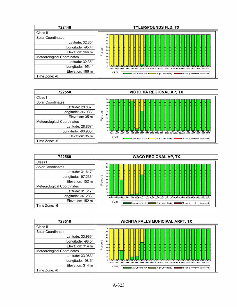
A-323
722448 TYLER/POUNDS FLD, TX
Class II
Solar Coordinates Latitude: 32.35˚
Longitude: -95.4˚ Elevation: 166 m
Meteorological Coordinates Latitude: 32.35˚
Longitude: -95.4˚ Elevation: 166 m
Time Zone: -6
722550 VICTORIA REGIONAL AP, TX Class I
Solar Coordinates Latitude: 28.867˚
Longitude: -96.933˚ Elevation: 35 m
Meteorological Coordinates Latitude: 28.867˚
Longitude: -96.933˚ Elevation: 35 m
Time Zone: -6
722560 WACO REGIONAL AP, TX Class I
Solar Coordinates Latitude: 31.617˚
Longitude: -97.233˚ Elevation: 152 m
Meteorological Coordinates Latitude: 31.617˚
Longitude: -97.233˚ Elevation: 152 m
Time Zone: -6
723510 WICHITA FALLS MUNICIPAL ARPT, TX Class II
Solar Coordinates Latitude: 33.983˚ Longitude: -98.5˚ Elevation: 314 m
Meteorological Coordinates Latitude: 33.983˚ Longitude: -98.5˚ Elevation: 314 m
Time Zone: -6

A-324
722656 WINK WINKLER COUNTY AP, TX
Class II
Solar Coordinates Latitude: 31.783˚
Longitude: -103.2˚ Elevation: 856 m
Meteorological Coordinates Latitude: 31.783˚
Longitude: -103.2˚ Elevation: 856 m
Time Zone: -6
724723 BLANDING, UT Class III
Solar Coordinates Latitude: 37.617˚
Longitude: -109.483˚ Elevation: 1841 m
Meteorological Coordinates Latitude: 37.617˚
Longitude: -109.483˚ Elevation: 1841 m
Time Zone: -7
724756 BRYCE CNYN FAA AP, UT Class II
Solar Coordinates Latitude: 37.7˚
Longitude: -112.15˚ Elevation: 2312 m
Meteorological Coordinates Latitude: 37.7˚
Longitude: -112.15˚ Elevation: 2312 m
Time Zone: -7
724755 CEDAR CITY MUNICIPAL AP, UT Class I
Solar Coordinates Latitude: 37.7˚
Longitude: -113.1˚ Elevation: 1703 m
Meteorological Coordinates Latitude: 37.7˚
Longitude: -113.1˚ Elevation: 1703 m
Time Zone: -7

A-325
724795 DELTA, UT
Class II
Solar Coordinates Latitude: 39.333˚
Longitude: -112.583˚ Elevation: 1414 m
Meteorological Coordinates Latitude: 39.333˚
Longitude: -112.583˚ Elevation: 1414 m
Time Zone: -7
724773 GREEN RIVER RANGE, UT Class III
Solar Coordinates Latitude: 39˚
Longitude: -110.167˚ Elevation: 1241 m
Meteorological Coordinates Latitude: 39˚
Longitude: -110.167˚ Elevation: 1241 m
Time Zone: -7
724735 HANKSVILLE, UT Class II
Solar Coordinates Latitude: 38.367˚
Longitude: -110.717˚ Elevation: 1313 m
Meteorological Coordinates Latitude: 38.367˚
Longitude: -110.717˚ Elevation: 1313 m
Time Zone: -7
724796 LOGAN-CACHE AIRPORT, UT Class III
Solar Coordinates Latitude: 41.783˚
Longitude: -111.85˚ Elevation: 1358 m
Meteorological Coordinates Latitude: 41.783˚
Longitude: -111.85˚ Elevation: 1358 m
Time Zone: -7

A-326
724776 MOAB/CANYONLANDS [UO], UT
Class III (with some measured)
Solar Coordinates Latitude: 38.58˚
Longitude: -109.54˚ Elevation: 1000 m
Meteorological Coordinates Latitude: 38.75˚
Longitude: -109.75˚ Elevation: 1388 m
Time Zone: -7
725755 OGDEN HILL AFB, UT Class II
Solar Coordinates Latitude: 41.117˚
Longitude: -111.967˚ Elevation: 1459 m
Meteorological Coordinates Latitude: 41.117˚
Longitude: -111.967˚ Elevation: 1459 m
Time Zone: -7
725750 OGDEN HINKLEY AIRPORT, UT Class II
Solar Coordinates Latitude: 41.2˚
Longitude: -112.017˚ Elevation: 1362 m
Meteorological Coordinates Latitude: 41.2˚
Longitude: -112.017˚ Elevation: 1362 m
Time Zone: -7
724700 PRICE/CARBON COUNTY, UT Class III
Solar Coordinates Latitude: 39.617˚
Longitude: -110.75˚ Elevation: 1799 m
Meteorological Coordinates Latitude: 39.617˚
Longitude: -110.75˚ Elevation: 1799 m
Time Zone: -7
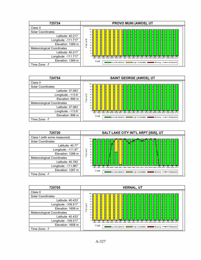
A-327
725724 PROVO MUNI (AWOS), UT
Class II
Solar Coordinates Latitude: 40.217˚
Longitude: -111.717˚ Elevation: 1369 m
Meteorological Coordinates Latitude: 40.217˚
Longitude: -111.717˚ Elevation: 1369 m
Time Zone: -7
724754 SAINT GEORGE (AWOS), UT Class II
Solar Coordinates Latitude: 37.083˚
Longitude: -113.6˚ Elevation: 896 m
Meteorological Coordinates Latitude: 37.083˚
Longitude: -113.6˚ Elevation: 896 m
Time Zone: -7
725720 SALT LAKE CITY INT'L ARPT [ISIS], UT Class I (with some measured)
Solar Coordinates Latitude: 40.77˚
Longitude: -111.97˚ Elevation: 1288 m
Meteorological Coordinates Latitude: 40.783˚
Longitude: -111.967˚ Elevation: 1287 m
Time Zone: -7
725705 VERNAL, UT Class II
Solar Coordinates Latitude: 40.433˚
Longitude: -109.517˚ Elevation: 1608 m
Meteorological Coordinates Latitude: 40.433˚
Longitude: -109.517˚ Elevation: 1608 m
Time Zone: -7

A-328
725810 WENDOVER USAF AUXILIARY FIELD, UT
Class II
Solar Coordinates Latitude: 40.717˚
Longitude: -114.033˚ Elevation: 1291 m
Meteorological Coordinates Latitude: 40.717˚
Longitude: -114.033˚ Elevation: 1291 m
Time Zone: -8
724058 ABINGTON, VA Class III
Solar Coordinates Latitude: 36.683˚
Longitude: -82.033˚ Elevation: 631 m
Meteorological Coordinates Latitude: 36.683˚
Longitude: -82.033˚ Elevation: 631 m
Time Zone: -5
723084 ASHLAND, VA Class III
Solar Coordinates Latitude: 37.7˚
Longitude: -77.433˚ Elevation: 62 m
Meteorological Coordinates Latitude: 37.7˚
Longitude: -77.433˚ Elevation: 62 m
Time Zone: -5
724016 CHARLOTTESVILLE FAA, VA Class II
Solar Coordinates Latitude: 38.133˚
Longitude: -78.45˚ Elevation: 190 m
Meteorological Coordinates Latitude: 38.133˚
Longitude: -78.45˚ Elevation: 190 m
Time Zone: -5

A-329
724006 CHESAPEAKE MUNI ARP, VA
Class III
Solar Coordinates Latitude: 36.667˚
Longitude: -76.317˚ Elevation: 6 m
Meteorological Coordinates Latitude: 36.667˚
Longitude: -76.317˚ Elevation: 6 m
Time Zone: -5
724106 DANVILLE FAA AP, VA Class II
Solar Coordinates Latitude: 36.567˚
Longitude: -79.333˚ Elevation: 176 m
Meteorological Coordinates Latitude: 36.567˚
Longitude: -79.333˚ Elevation: 176 m
Time Zone: -5
724037 DAVISON AAF, VA Class II
Solar Coordinates Latitude: 38.717˚
Longitude: -77.183˚ Elevation: 27 m
Meteorological Coordinates Latitude: 38.717˚
Longitude: -77.183˚ Elevation: 27 m
Time Zone: -5
724014 DINWIDDIE CO, VA Class III
Solar Coordinates Latitude: 37.183˚
Longitude: -77.517˚ Elevation: 60 m
Meteorological Coordinates Latitude: 37.183˚
Longitude: -77.517˚ Elevation: 60 m
Time Zone: -5

A-330
723074 EDENTON, VA
Class III
Solar Coordinates Latitude: 36.033˚
Longitude: -76.567˚ Elevation: 6 m
Meteorological Coordinates Latitude: 36.033˚
Longitude: -76.567˚ Elevation: 6 m
Time Zone: -5
724017 FARMVILLE, VA Class III
Solar Coordinates Latitude: 37.35˚
Longitude: -78.433˚ Elevation: 125 m
Meteorological Coordinates Latitude: 37.35˚
Longitude: -78.433˚ Elevation: 125 m
Time Zone: -5
723087 FORT EUSTIS FELKER AAF, VA Class II
Solar Coordinates Latitude: 37.133˚ Longitude: -76.6˚
Elevation: 7 m Meteorological Coordinates
Latitude: 37.133˚ Longitude: -76.6˚
Elevation: 7 m Time Zone: -5
723083 FRANKLIN NAAS, VA Class III
Solar Coordinates Latitude: 36.7˚
Longitude: -76.9˚ Elevation: 12 m
Meteorological Coordinates Latitude: 36.7˚
Longitude: -76.9˚ Elevation: 12 m
Time Zone: -5

A-331
724107 HILLSVILLE, VA
Class III
Solar Coordinates Latitude: 36.767˚
Longitude: -80.817˚ Elevation: 834 m
Meteorological Coordinates Latitude: 36.767˚
Longitude: -80.817˚ Elevation: 834 m
Time Zone: -5
724115 HOT SPRINGS/INGALLS, VA Class III
Solar Coordinates Latitude: 37.95˚
Longitude: -79.833˚ Elevation: 1156 m
Meteorological Coordinates Latitude: 37.95˚
Longitude: -79.833˚ Elevation: 1156 m
Time Zone: -5
745980 LANGLEY AFB, VA Class II
Solar Coordinates Latitude: 37.083˚
Longitude: -76.35˚ Elevation: 3 m
Meteorological Coordinates Latitude: 37.083˚
Longitude: -76.35˚ Elevation: 3 m
Time Zone: -5
724055 LEESBURG/GODFREY, VA Class III
Solar Coordinates Latitude: 39.083˚
Longitude: -77.567˚ Elevation: 119 m
Meteorological Coordinates Latitude: 39.083˚
Longitude: -77.567˚ Elevation: 119 m
Time Zone: -5
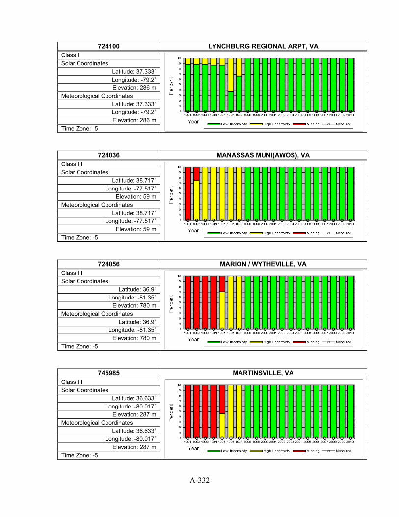
A-332
724100 LYNCHBURG REGIONAL ARPT, VA
Class I
Solar Coordinates Latitude: 37.333˚ Longitude: -79.2˚ Elevation: 286 m
Meteorological Coordinates Latitude: 37.333˚ Longitude: -79.2˚ Elevation: 286 m
Time Zone: -5
724036 MANASSAS MUNI(AWOS), VA Class III
Solar Coordinates Latitude: 38.717˚
Longitude: -77.517˚ Elevation: 59 m
Meteorological Coordinates Latitude: 38.717˚
Longitude: -77.517˚ Elevation: 59 m
Time Zone: -5
724056 MARION / WYTHEVILLE, VA Class III
Solar Coordinates Latitude: 36.9˚
Longitude: -81.35˚ Elevation: 780 m
Meteorological Coordinates Latitude: 36.9˚
Longitude: -81.35˚ Elevation: 780 m
Time Zone: -5
745985 MARTINSVILLE, VA Class III
Solar Coordinates Latitude: 36.633˚
Longitude: -80.017˚ Elevation: 287 m
Meteorological Coordinates Latitude: 36.633˚
Longitude: -80.017˚ Elevation: 287 m
Time Zone: -5

A-333
724118 MECKLENBURG\BRUNS., VA
Class III
Solar Coordinates Latitude: 36.7˚
Longitude: -78.05˚ Elevation: 430 m
Meteorological Coordinates Latitude: 36.7˚
Longitude: -78.05˚ Elevation: 430 m
Time Zone: -5
724026 MELFA/ACCOMACK ARPT, VA Class III
Solar Coordinates Latitude: 37.65˚
Longitude: -75.767˚ Elevation: 15 m
Meteorological Coordinates Latitude: 37.65˚
Longitude: -75.767˚ Elevation: 15 m
Time Zone: -5
723086 NEWPORT NEWS, VA Class II
Solar Coordinates Latitude: 37.133˚ Longitude: -76.5˚
Elevation: 13 m Meteorological Coordinates
Latitude: 37.133˚ Longitude: -76.5˚
Elevation: 13 m Time Zone: -5
724019 NORFOLK (NEXRAD), VA Class III
Solar Coordinates Latitude: 36.983˚
Longitude: -77.017˚ Elevation: 64 m
Meteorological Coordinates Latitude: 36.983˚
Longitude: -77.017˚ Elevation: 64 m
Time Zone: -5
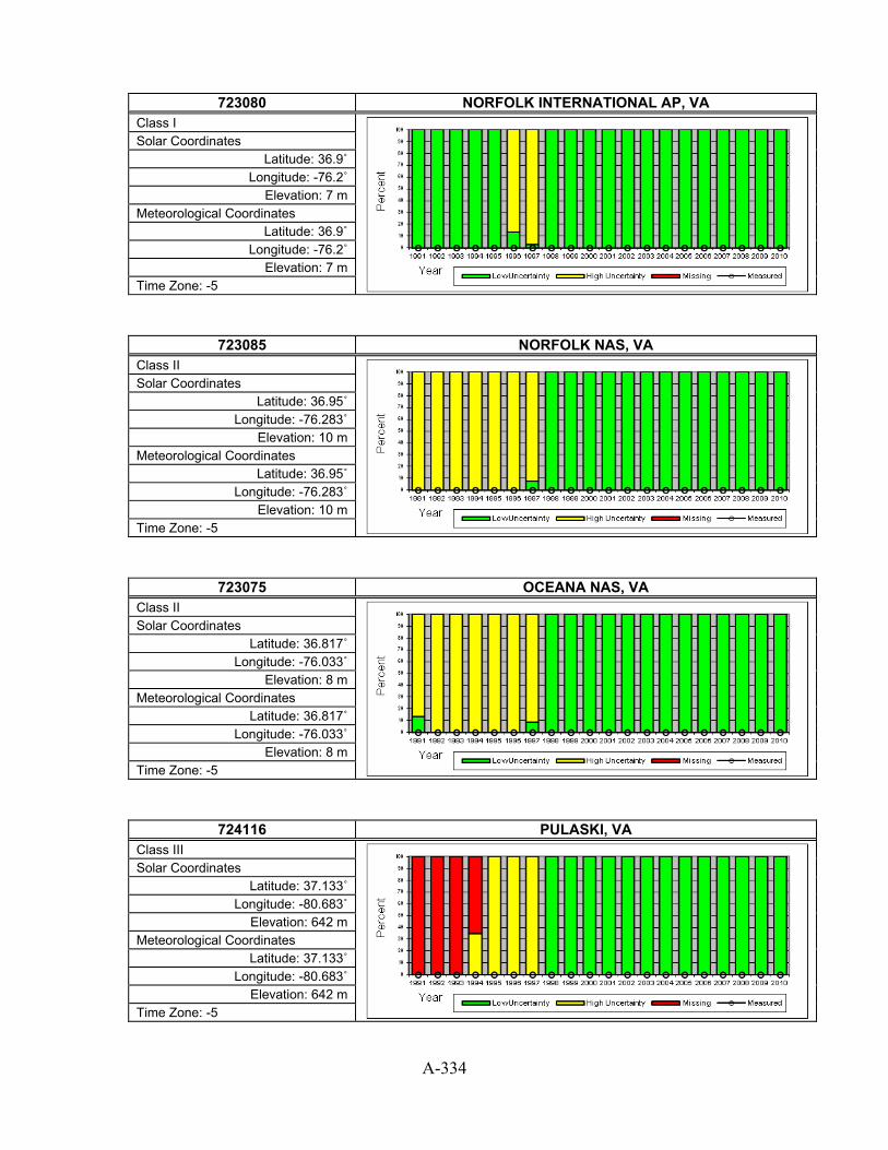
A-334
723080 NORFOLK INTERNATIONAL AP, VA
Class I
Solar Coordinates Latitude: 36.9˚
Longitude: -76.2˚ Elevation: 7 m
Meteorological Coordinates Latitude: 36.9˚
Longitude: -76.2˚ Elevation: 7 m
Time Zone: -5
723085 NORFOLK NAS, VA Class II
Solar Coordinates Latitude: 36.95˚
Longitude: -76.283˚ Elevation: 10 m
Meteorological Coordinates Latitude: 36.95˚
Longitude: -76.283˚ Elevation: 10 m
Time Zone: -5
723075 OCEANA NAS, VA Class II
Solar Coordinates Latitude: 36.817˚
Longitude: -76.033˚ Elevation: 8 m
Meteorological Coordinates Latitude: 36.817˚
Longitude: -76.033˚ Elevation: 8 m
Time Zone: -5
724116 PULASKI, VA Class III
Solar Coordinates Latitude: 37.133˚
Longitude: -80.683˚ Elevation: 642 m
Meteorological Coordinates Latitude: 37.133˚
Longitude: -80.683˚ Elevation: 642 m
Time Zone: -5

A-335
724035 QUANTICO MCAS, VA
Class II
Solar Coordinates Latitude: 38.5˚
Longitude: -77.3˚ Elevation: 4 m
Meteorological Coordinates Latitude: 38.5˚
Longitude: -77.3˚ Elevation: 4 m
Time Zone: -5
724010 RICHMOND INTERNATIONAL AP, VA Class I
Solar Coordinates Latitude: 37.517˚
Longitude: -77.317˚ Elevation: 50 m
Meteorological Coordinates Latitude: 37.517˚
Longitude: -77.317˚ Elevation: 50 m
Time Zone: -5
724008 ROANOKE RAPIDS, VA Class III
Solar Coordinates Latitude: 36.45˚
Longitude: -77.717˚ Elevation: 77 m
Meteorological Coordinates Latitude: 36.45˚
Longitude: -77.717˚ Elevation: 77 m
Time Zone: -5
724110 ROANOKE REGIONAL AP, VA Class I
Solar Coordinates Latitude: 37.317˚
Longitude: -79.967˚ Elevation: 350 m
Meteorological Coordinates Latitude: 37.317˚
Longitude: -79.967˚ Elevation: 350 m
Time Zone: -5

A-336
724033 SHANNON ARPT, VA
Class III
Solar Coordinates Latitude: 38.267˚
Longitude: -77.45˚ Elevation: 26 m
Meteorological Coordinates Latitude: 38.267˚
Longitude: -77.45˚ Elevation: 26 m
Time Zone: -5
724105 STAUNTON/SHENANDOAH, VA Class II
Solar Coordinates Latitude: 38.267˚ Longitude: -78.9˚ Elevation: 366 m
Meteorological Coordinates Latitude: 38.267˚ Longitude: -78.9˚ Elevation: 366 m
Time Zone: -5
724007 SUFFOLK, VA Class III
Solar Coordinates Latitude: 36.683˚ Longitude: -76.6˚
Elevation: 22 m Meteorological Coordinates
Latitude: 36.683˚ Longitude: -76.6˚
Elevation: 22 m Time Zone: -5
724113 VIRGINIA TECH ARPT, VA Class III
Solar Coordinates Latitude: 37.217˚
Longitude: -80.417˚ Elevation: 650 m
Meteorological Coordinates Latitude: 37.217˚
Longitude: -80.417˚ Elevation: 650 m
Time Zone: -5

A-337
724020 WALLOPS ISLAND UAU, VA
Class III
Solar Coordinates Latitude: 37.933˚
Longitude: -75.483˚ Elevation: 12 m
Meteorological Coordinates Latitude: 37.933˚
Longitude: -75.483˚ Elevation: 12 m
Time Zone: -5
724030 WASHINGTON DC DULLES INT'L AR [STERLING - ISIS], VA Class I (with some measured)
Solar Coordinates Latitude: 38.98˚
Longitude: -77.47˚ Elevation: 82 m
Meteorological Coordinates Latitude: 38.933˚
Longitude: -77.45˚ Elevation: 88 m
Time Zone: -5
724050 WASHINGTON DC REAGAN AP, VA Class I
Solar Coordinates Latitude: 38.867˚
Longitude: -77.033˚ Elevation: 3 m
Meteorological Coordinates Latitude: 38.867˚
Longitude: -77.033˚ Elevation: 3 m
Time Zone: -5
724053 WINCHESTER RGNL, VA Class III
Solar Coordinates Latitude: 39.15˚
Longitude: -78.15˚ Elevation: 222 m
Meteorological Coordinates Latitude: 39.15˚
Longitude: -78.15˚ Elevation: 222 m
Time Zone: -5

A-338
724117 WISE/LONESOME PINE, VA
Class III
Solar Coordinates Latitude: 36.983˚
Longitude: -82.533˚ Elevation: 817 m
Meteorological Coordinates Latitude: 36.983˚
Longitude: -82.533˚ Elevation: 817 m
Time Zone: -5
785430 CHARLOTTE AMALIE HARRY S TRUM, VI Class II
Solar Coordinates Latitude: 18.35˚
Longitude: -64.967˚ Elevation: 6 m
Meteorological Coordinates Latitude: 18.35˚
Longitude: -64.967˚ Elevation: 6 m
Time Zone: -4
726166 BENNINGTON MORSE AR, VT Class III
Solar Coordinates Latitude: 42.883˚
Longitude: -73.233˚ Elevation: 252 m
Meteorological Coordinates Latitude: 42.883˚
Longitude: -73.233˚ Elevation: 252 m
Time Zone: -5
726170 BURLINGTON INTERNATIONAL AP, VT Class I
Solar Coordinates Latitude: 44.467˚
Longitude: -73.15˚ Elevation: 101 m
Meteorological Coordinates Latitude: 44.467˚
Longitude: -73.15˚ Elevation: 101 m
Time Zone: -5

A-339
726145 MONTPELIER AP, VT
Class II
Solar Coordinates Latitude: 44.2˚
Longitude: -72.567˚ Elevation: 343 m
Meteorological Coordinates Latitude: 44.2˚
Longitude: -72.567˚ Elevation: 343 m
Time Zone: -5
725165 RUTLAND STATE, VT Class II
Solar Coordinates Latitude: 43.517˚
Longitude: -72.95˚ Elevation: 246 m
Meteorological Coordinates Latitude: 43.517˚
Longitude: -72.95˚ Elevation: 246 m
Time Zone: -5
726115 SPRINGFIELD/HARTNES, VT Class III
Solar Coordinates Latitude: 43.35˚
Longitude: -72.517˚ Elevation: 176 m
Meteorological Coordinates Latitude: 43.35˚
Longitude: -72.517˚ Elevation: 176 m
Time Zone: -5
727945 ARLINGTON MUNI, WA Class III
Solar Coordinates Latitude: 48.167˚
Longitude: -122.167˚ Elevation: 42 m
Meteorological Coordinates Latitude: 48.167˚
Longitude: -122.167˚ Elevation: 42 m
Time Zone: -8

A-340
727976 BELLINGHAM INTL AP, WA
Class II
Solar Coordinates Latitude: 48.8˚
Longitude: -122.533˚ Elevation: 45 m
Meteorological Coordinates Latitude: 48.8˚
Longitude: -122.533˚ Elevation: 45 m
Time Zone: -8
727928 BREMERTON NATIONAL, WA Class II
Solar Coordinates Latitude: 47.483˚
Longitude: -122.75˚ Elevation: 137 m
Meteorological Coordinates Latitude: 47.483˚
Longitude: -122.75˚ Elevation: 137 m
Time Zone: -8
727854 DEER PARK ARPT, WA Class III
Solar Coordinates Latitude: 47.967˚
Longitude: -117.417˚ Elevation: 672 m
Meteorological Coordinates Latitude: 47.967˚
Longitude: -117.417˚ Elevation: 672 m
Time Zone: -8
727883 ELLENSBURG/BOWERS FIELD, WA Class III
Solar Coordinates Latitude: 47.033˚
Longitude: -120.517˚ Elevation: 527 m
Meteorological Coordinates Latitude: 47.033˚
Longitude: -120.517˚ Elevation: 527 m
Time Zone: -8
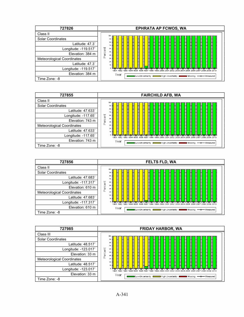
A-341
727826 EPHRATA AP FCWOS, WA
Class II
Solar Coordinates Latitude: 47.3˚
Longitude: -119.517˚ Elevation: 384 m
Meteorological Coordinates Latitude: 47.3˚
Longitude: -119.517˚ Elevation: 384 m
Time Zone: -8
727855 FAIRCHILD AFB, WA Class II
Solar Coordinates Latitude: 47.633˚
Longitude: -117.65˚ Elevation: 743 m
Meteorological Coordinates Latitude: 47.633˚
Longitude: -117.65˚ Elevation: 743 m
Time Zone: -8
727856 FELTS FLD, WA Class II
Solar Coordinates Latitude: 47.683˚
Longitude: -117.317˚ Elevation: 610 m
Meteorological Coordinates Latitude: 47.683˚
Longitude: -117.317˚ Elevation: 610 m
Time Zone: -8
727985 FRIDAY HARBOR, WA Class III
Solar Coordinates Latitude: 48.517˚
Longitude: -123.017˚ Elevation: 33 m
Meteorological Coordinates Latitude: 48.517˚
Longitude: -123.017˚ Elevation: 33 m
Time Zone: -8

A-342
742070 GRAY AAF, WA
Class III
Solar Coordinates Latitude: 47.083˚
Longitude: -122.583˚ Elevation: 90 m
Meteorological Coordinates Latitude: 47.083˚
Longitude: -122.583˚ Elevation: 90 m
Time Zone: -8
727840 HANFORD, WA Class II
Solar Coordinates Latitude: 46.567˚
Longitude: -119.6˚ Elevation: 223 m
Meteorological Coordinates Latitude: 46.567˚
Longitude: -119.6˚ Elevation: 223 m
Time Zone: -8
727923 HOQUIAM AP, WA Class II
Solar Coordinates Latitude: 46.983˚
Longitude: -123.933˚ Elevation: 4 m
Meteorological Coordinates Latitude: 46.983˚
Longitude: -123.933˚ Elevation: 4 m
Time Zone: -8
727924 KELSO WB AP, WA Class II
Solar Coordinates Latitude: 46.133˚
Longitude: -122.9˚ Elevation: 5 m
Meteorological Coordinates Latitude: 46.133˚
Longitude: -122.9˚ Elevation: 5 m
Time Zone: -8

A-343
727827 MOSES LAKE GRANT COUNTY AP, WA
Class II
Solar Coordinates Latitude: 47.2˚
Longitude: -119.317˚ Elevation: 364 m
Meteorological Coordinates Latitude: 47.2˚
Longitude: -119.317˚ Elevation: 364 m
Time Zone: -8
727964 OAK HARBOR AIRPARK, WA Class III
Solar Coordinates Latitude: 48.25˚
Longitude: -122.667˚ Elevation: 58 m
Meteorological Coordinates Latitude: 48.25˚
Longitude: -122.667˚ Elevation: 58 m
Time Zone: -8
727920 OLYMPIA AIRPORT, WA Class I
Solar Coordinates Latitude: 46.967˚
Longitude: -122.9˚ Elevation: 63 m
Meteorological Coordinates Latitude: 46.967˚
Longitude: -122.9˚ Elevation: 63 m
Time Zone: -8
727890 OMAK, WA Class III
Solar Coordinates Latitude: 48.417˚
Longitude: -119.533˚ Elevation: 382 m
Meteorological Coordinates Latitude: 48.417˚
Longitude: -119.533˚ Elevation: 382 m
Time Zone: -8

A-344
727845 PASCO, WA
Class II
Solar Coordinates Latitude: 46.267˚
Longitude: -119.117˚ Elevation: 136 m
Meteorological Coordinates Latitude: 46.267˚
Longitude: -119.117˚ Elevation: 136 m
Time Zone: -8
727857 PULLMAN/MOSCOW RGNL, WA Class II
Solar Coordinates Latitude: 46.75˚
Longitude: -117.117˚ Elevation: 778 m
Meteorological Coordinates Latitude: 46.75˚
Longitude: -117.117˚ Elevation: 778 m
Time Zone: -8
727970 QUILLAYUTE STATE AIRPORT, WA Class I
Solar Coordinates Latitude: 47.933˚
Longitude: -124.567˚ Elevation: 55 m
Meteorological Coordinates Latitude: 47.933˚
Longitude: -124.567˚ Elevation: 55 m
Time Zone: -8
727934 RENTON MUNI, WA Class II
Solar Coordinates Latitude: 47.483˚
Longitude: -122.217˚ Elevation: 10 m
Meteorological Coordinates Latitude: 47.483˚
Longitude: -122.217˚ Elevation: 10 m
Time Zone: -8

A-345
727935 SEATTLE BOEING FIELD [ISIS], WA
Class II (with some measured)
Solar Coordinates Latitude: 47.68˚
Longitude: -122.25˚ Elevation: 20 m
Meteorological Coordinates Latitude: 47.533˚
Longitude: -122.3˚ Elevation: 6 m
Time Zone: -8
727930 SEATTLE SEATTLE-TACOMA INTL A, WA Class I
Solar Coordinates Latitude: 47.467˚
Longitude: -122.317˚ Elevation: 122 m
Meteorological Coordinates Latitude: 47.467˚
Longitude: -122.317˚ Elevation: 122 m
Time Zone: -8
727925 SHELTON/SANDERSON, WA Class III
Solar Coordinates Latitude: 47.233˚
Longitude: -123.15˚ Elevation: 85 m
Meteorological Coordinates Latitude: 47.233˚
Longitude: -123.15˚ Elevation: 85 m
Time Zone: -8
727937 SNOHOMISH CO, WA Class II
Solar Coordinates Latitude: 47.9˚
Longitude: -122.283˚ Elevation: 189 m
Meteorological Coordinates Latitude: 47.9˚
Longitude: -122.283˚ Elevation: 189 m
Time Zone: -8

A-346
727850 SPOKANE INTERNATIONAL AP [CHENEY - UO], WA
Class I (with some measured)
Solar Coordinates Latitude: 47.49˚
Longitude: -117.589˚ Elevation: 777 m
Meteorological Coordinates Latitude: 47.617˚
Longitude: -117.533˚ Elevation: 718 m
Time Zone: -8
727815 STAMPEDE PASS, WA Class I
Solar Coordinates Latitude: 47.283˚
Longitude: -121.333˚ Elevation: 1206 m
Meteorological Coordinates Latitude: 47.283˚
Longitude: -121.333˚ Elevation: 1206 m
Time Zone: -8
742060 TACOMA MCCHORD AFB, WA Class II
Solar Coordinates Latitude: 47.15˚
Longitude: -122.483˚ Elevation: 88 m
Meteorological Coordinates Latitude: 47.15˚
Longitude: -122.483˚ Elevation: 88 m
Time Zone: -8
727938 TACOMA NARROWS, WA Class II
Solar Coordinates Latitude: 47.267˚
Longitude: -122.583˚ Elevation: 91 m
Meteorological Coordinates Latitude: 47.267˚
Longitude: -122.583˚ Elevation: 91 m
Time Zone: -8

A-347
726988 THE DALLES MUNICIPAL ARPT, WA
Class II
Solar Coordinates Latitude: 45.617˚
Longitude: -121.15˚ Elevation: 73 m
Meteorological Coordinates Latitude: 45.617˚
Longitude: -121.15˚ Elevation: 73 m
Time Zone: -8
727926 TOLEDO-WINLOCK MEM, WA Class III
Solar Coordinates Latitude: 46.483˚
Longitude: -122.8˚ Elevation: 113 m
Meteorological Coordinates Latitude: 46.483˚
Longitude: -122.8˚ Elevation: 113 m
Time Zone: -8
727846 WALLA WALLA CITY COUNTY AP, WA Class II
Solar Coordinates Latitude: 46.1˚
Longitude: -118.283˚ Elevation: 355 m
Meteorological Coordinates Latitude: 46.1˚
Longitude: -118.283˚ Elevation: 355 m
Time Zone: -8
727825 WENATCHEE/PANGBORN, WA Class II
Solar Coordinates Latitude: 47.4˚
Longitude: -120.2˚ Elevation: 379 m
Meteorological Coordinates Latitude: 47.4˚
Longitude: -120.2˚ Elevation: 379 m
Time Zone: -8

A-348
690230 WHIDBEY ISLAND NAS, WA
Class III
Solar Coordinates Latitude: 48.35˚
Longitude: -122.667˚ Elevation: 10 m
Meteorological Coordinates Latitude: 48.35˚
Longitude: -122.667˚ Elevation: 10 m
Time Zone: -8
727885 WILLIAM R FAIRCHILD, WA Class III
Solar Coordinates Latitude: 48.117˚
Longitude: -123.5˚ Elevation: 91 m
Meteorological Coordinates Latitude: 48.117˚
Longitude: -123.5˚ Elevation: 91 m
Time Zone: -8
727810 YAKIMA AIR TERMINAL, WA Class I
Solar Coordinates Latitude: 46.567˚
Longitude: -120.55˚ Elevation: 324 m
Meteorological Coordinates Latitude: 46.567˚
Longitude: -120.55˚ Elevation: 324 m
Time Zone: -8
726626 ANTIGO\LANG(AWOS), WI Class III
Solar Coordinates Latitude: 45.15˚
Longitude: -87.15˚ Elevation: 464 m
Meteorological Coordinates Latitude: 45.15˚
Longitude: -87.15˚ Elevation: 464 m
Time Zone: -5

A-349
726457 APPLETON/OUTAGAMIE, WI
Class II
Solar Coordinates Latitude: 44.25˚
Longitude: -88.517˚ Elevation: 280 m
Meteorological Coordinates Latitude: 44.25˚
Longitude: -88.517˚ Elevation: 280 m
Time Zone: -6
726419 ASHLAND KENNEDY ME, WI Class III
Solar Coordinates Latitude: 46.55˚
Longitude: -90.917˚ Elevation: 251 m
Meteorological Coordinates Latitude: 46.55˚
Longitude: -90.917˚ Elevation: 251 m
Time Zone: -6
726438 BOSCOBEL AIRPORT, WI Class III
Solar Coordinates Latitude: 43.15˚
Longitude: -90.667˚ Elevation: 205 m
Meteorological Coordinates Latitude: 43.15˚
Longitude: -90.667˚ Elevation: 205 m
Time Zone: -6
726435 EAU CLAIRE COUNTY AP, WI Class I
Solar Coordinates Latitude: 44.867˚
Longitude: -91.483˚ Elevation: 271 m
Meteorological Coordinates Latitude: 44.867˚
Longitude: -91.483˚ Elevation: 271 m
Time Zone: -6

A-350
726450 GREEN BAY AUSTIN STRAUBEL INT, WI
Class I
Solar Coordinates Latitude: 44.483˚
Longitude: -88.133˚ Elevation: 209 m
Meteorological Coordinates Latitude: 44.483˚
Longitude: -88.133˚ Elevation: 209 m
Time Zone: -6
726415 JANESVILLE/ROCK CO., WI Class III
Solar Coordinates Latitude: 42.617˚
Longitude: -89.033˚ Elevation: 246 m
Meteorological Coordinates Latitude: 42.617˚
Longitude: -89.033˚ Elevation: 246 m
Time Zone: -6
726430 LA CROSSE MUNICIPAL ARPT, WI Class I
Solar Coordinates Latitude: 43.867˚
Longitude: -91.25˚ Elevation: 198 m
Meteorological Coordinates Latitude: 43.867˚
Longitude: -91.25˚ Elevation: 198 m
Time Zone: -6
726416 LONE ROCK FAA AP, WI Class II
Solar Coordinates Latitude: 43.2˚
Longitude: -90.183˚ Elevation: 219 m
Meteorological Coordinates Latitude: 43.2˚
Longitude: -90.183˚ Elevation: 219 m
Time Zone: -6

A-351
726410 MADISON DANE CO REGIONAL ARPT [ISIS], WI
Class I (with some measured)
Solar Coordinates Latitude: 43.13˚
Longitude: -89.33˚ Elevation: 262 m
Meteorological Coordinates Latitude: 43.133˚
Longitude: -89.35˚ Elevation: 262 m
Time Zone: -6
726455 MANITOWAC MUNI AWOS, WI Class II
Solar Coordinates Latitude: 44.133˚
Longitude: -87.683˚ Elevation: 198 m
Meteorological Coordinates Latitude: 44.133˚
Longitude: -87.683˚ Elevation: 198 m
Time Zone: -6
726574 MARSHFIELD MUNI, WI Class III
Solar Coordinates Latitude: 44.633˚
Longitude: -90.183˚ Elevation: 389 m
Meteorological Coordinates Latitude: 44.633˚
Longitude: -90.183˚ Elevation: 389 m
Time Zone: -6
726437 MCCOY (USA-AF), WI Class III
Solar Coordinates Latitude: 43.967˚
Longitude: -90.733˚ Elevation: 256 m
Meteorological Coordinates Latitude: 43.967˚
Longitude: -90.733˚ Elevation: 256 m
Time Zone: -6

A-352
726417 MEDFORD, WI
Class III
Solar Coordinates Latitude: 45.1˚
Longitude: -90.3˚ Elevation: 448 m
Meteorological Coordinates Latitude: 45.1˚
Longitude: -90.3˚ Elevation: 448 m
Time Zone: -6
726449 MERRILL MUNI ARPT, WI Class III
Solar Coordinates Latitude: 45.183˚ Longitude: -89.7˚ Elevation: 401 m
Meteorological Coordinates Latitude: 45.183˚ Longitude: -89.7˚ Elevation: 401 m
Time Zone: -6
726400 MILWAUKEE MITCHELL INTL AP, WI Class I
Solar Coordinates Latitude: 42.95˚
Longitude: -87.9˚ Elevation: 205 m
Meteorological Coordinates Latitude: 42.95˚
Longitude: -87.9˚ Elevation: 205 m
Time Zone: -6
726405 MILWAUKEE TIMMERMAN, WI Class III
Solar Coordinates Latitude: 43.117˚
Longitude: -88.05˚ Elevation: 224 m
Meteorological Coordinates Latitude: 43.117˚
Longitude: -88.05˚ Elevation: 224 m
Time Zone: -6

A-353
726404 MINOCQUA/WOODRUFF, WI
Class II
Solar Coordinates Latitude: 45.933˚
Longitude: -89.733˚ Elevation: 496 m
Meteorological Coordinates Latitude: 45.933˚
Longitude: -89.733˚ Elevation: 496 m
Time Zone: -6
726414 MONROE MUNICIPAL AI, WI Class III
Solar Coordinates Latitude: 42.6˚
Longitude: -89.583˚ Elevation: 331 m
Meteorological Coordinates Latitude: 42.6˚
Longitude: -89.583˚ Elevation: 331 m
Time Zone: -6
726465 MOSINEE/CENTRAL WI, WI Class II
Solar Coordinates Latitude: 44.783˚
Longitude: -89.667˚ Elevation: 389 m
Meteorological Coordinates Latitude: 44.783˚
Longitude: -89.667˚ Elevation: 389 m
Time Zone: -6
726418 OSCEOLA, WI Class III
Solar Coordinates Latitude: 45.317˚
Longitude: -92.683˚ Elevation: 275 m
Meteorological Coordinates Latitude: 45.317˚
Longitude: -92.683˚ Elevation: 275 m
Time Zone: -6

A-354
726468 PHILLIPS/PRICE CO., WI
Class II
Solar Coordinates Latitude: 45.7˚
Longitude: -90.4˚ Elevation: 449 m
Meteorological Coordinates Latitude: 45.7˚
Longitude: -90.4˚ Elevation: 449 m
Time Zone: -6
726444 PRAIRIE DU CHIEN, WI Class III
Solar Coordinates Latitude: 43.017˚
Longitude: -91.117˚ Elevation: 201 m
Meteorological Coordinates Latitude: 43.017˚
Longitude: -91.117˚ Elevation: 201 m
Time Zone: -6
726424 RACINE, WI Class III
Solar Coordinates Latitude: 42.767˚
Longitude: -87.817˚ Elevation: 205 m
Meteorological Coordinates Latitude: 42.767˚
Longitude: -87.817˚ Elevation: 205 m
Time Zone: -6
727415 RHINELANDER ONEIDA, WI Class II
Solar Coordinates Latitude: 45.633˚
Longitude: -89.467˚ Elevation: 507 m
Meteorological Coordinates Latitude: 45.633˚
Longitude: -89.467˚ Elevation: 507 m
Time Zone: -6

A-355
726467 RICE LAKE MUNICIPAL, WI
Class III
Solar Coordinates Latitude: 45.483˚
Longitude: -91.717˚ Elevation: 347 m
Meteorological Coordinates Latitude: 45.483˚
Longitude: -91.717˚ Elevation: 347 m
Time Zone: -6
726425 SHEBOYGAN, WI Class III
Solar Coordinates Latitude: 43.783˚
Longitude: -87.85˚ Elevation: 228 m
Meteorological Coordinates Latitude: 43.783˚
Longitude: -87.85˚ Elevation: 228 m
Time Zone: -6
726426 STEVENS POINT, WI Class III
Solar Coordinates Latitude: 44.55˚
Longitude: -89.533˚ Elevation: 338 m
Meteorological Coordinates Latitude: 44.55˚
Longitude: -89.533˚ Elevation: 338 m
Time Zone: -6
726458 STURGEON BAY, WI Class II
Solar Coordinates Latitude: 44.85˚
Longitude: -87.417˚ Elevation: 221 m
Meteorological Coordinates Latitude: 44.85˚
Longitude: -87.417˚ Elevation: 221 m
Time Zone: -5

A-356
726427 SUPERIOR, WI
Class III
Solar Coordinates Latitude: 46.683˚ Longitude: -92.1˚ Elevation: 206 m
Meteorological Coordinates Latitude: 46.683˚ Longitude: -92.1˚ Elevation: 206 m
Time Zone: -6
726436 VOLK FIELD ANG, WI Class III
Solar Coordinates Latitude: 43.933˚
Longitude: -90.267˚ Elevation: 280 m
Meteorological Coordinates Latitude: 43.933˚
Longitude: -90.267˚ Elevation: 280 m
Time Zone: -6
726464 WATERTOWN, WI Class III
Solar Coordinates Latitude: 43.167˚
Longitude: -88.717˚ Elevation: 254 m
Meteorological Coordinates Latitude: 43.167˚
Longitude: -88.717˚ Elevation: 254 m
Time Zone: -6
726409 WAUKESHA, WI Class III
Solar Coordinates Latitude: 43.033˚
Longitude: -88.233˚ Elevation: 284 m
Meteorological Coordinates Latitude: 43.033˚
Longitude: -88.233˚ Elevation: 284 m
Time Zone: -6

A-357
726463 WAUSAU MUNICIPAL ARPT, WI
Class II
Solar Coordinates Latitude: 44.917˚
Longitude: -89.633˚ Elevation: 366 m
Meteorological Coordinates Latitude: 44.917˚
Longitude: -89.633˚ Elevation: 366 m
Time Zone: -6
726413 WEST BEND MUNI, WI Class III
Solar Coordinates Latitude: 43.417˚
Longitude: -88.117˚ Elevation: 270 m
Meteorological Coordinates Latitude: 43.417˚
Longitude: -88.117˚ Elevation: 270 m
Time Zone: -6
726456 WITTMAN RGNL, WI Class II
Solar Coordinates Latitude: 43.983˚
Longitude: -88.55˚ Elevation: 253 m
Meteorological Coordinates Latitude: 43.983˚
Longitude: -88.55˚ Elevation: 253 m
Time Zone: -6
724120 BECKLEY RALEIGH CO MEM AP, WV Class I
Solar Coordinates Latitude: 37.8˚
Longitude: -81.117˚ Elevation: 763 m
Meteorological Coordinates Latitude: 37.8˚
Longitude: -81.117˚ Elevation: 763 m
Time Zone: -5

A-358
724125 BLUEFIELD/MERCER CO [NREL], WV
Class II (with some measured)
Solar Coordinates Latitude: 37.27˚
Longitude: -81.24˚ Elevation: 803 m
Meteorological Coordinates Latitude: 37.3˚
Longitude: -81.2˚ Elevation: 871 m
Time Zone: -5
724140 CHARLESTON YEAGER ARPT, WV Class I
Solar Coordinates Latitude: 38.383˚
Longitude: -81.583˚ Elevation: 310 m
Meteorological Coordinates Latitude: 38.383˚
Longitude: -81.583˚ Elevation: 310 m
Time Zone: -5
724170 ELKINS ELKINS-RANDOLPH CO ARP, WV Class I
Solar Coordinates Latitude: 38.883˚
Longitude: -79.85˚ Elevation: 594 m
Meteorological Coordinates Latitude: 38.883˚
Longitude: -79.85˚ Elevation: 594 m
Time Zone: -5
724175 HARRISON MARION RGN, WV Class II
Solar Coordinates Latitude: 39.283˚
Longitude: -80.233˚ Elevation: 380 m
Meteorological Coordinates Latitude: 39.283˚
Longitude: -80.233˚ Elevation: 380 m
Time Zone: -5

A-359
724250 HUNTINGTON TRI-STATE ARPT, WV
Class I
Solar Coordinates Latitude: 38.383˚
Longitude: -82.55˚ Elevation: 253 m
Meteorological Coordinates Latitude: 38.383˚
Longitude: -82.55˚ Elevation: 253 m
Time Zone: -5
724127 LEWISBURG/GREENBRIE, WV Class II
Solar Coordinates Latitude: 37.867˚ Longitude: -80.4˚ Elevation: 702 m
Meteorological Coordinates Latitude: 37.867˚ Longitude: -80.4˚ Elevation: 702 m
Time Zone: -5
724177 MARTINSBURG EASTERN WV REG AP, WV Class II
Solar Coordinates Latitude: 39.4˚
Longitude: -77.983˚ Elevation: 162 m
Meteorological Coordinates Latitude: 39.4˚
Longitude: -77.983˚ Elevation: 162 m
Time Zone: -5
724176 MORGANTOWN HART FIELD, WV Class II
Solar Coordinates Latitude: 39.65˚
Longitude: -79.917˚ Elevation: 378 m
Meteorological Coordinates Latitude: 39.65˚
Longitude: -79.917˚ Elevation: 378 m
Time Zone: -5

A-360
724273 PARKERSBURG WOOD COUNTY AP, WV
Class II
Solar Coordinates Latitude: 39.35˚
Longitude: -81.433˚ Elevation: 253 m
Meteorological Coordinates Latitude: 39.35˚
Longitude: -81.433˚ Elevation: 253 m
Time Zone: -5
724165 PETERSBURG/GRANT AI, WV Class III
Solar Coordinates Latitude: 38.983˚
Longitude: -79.133˚ Elevation: 293 m
Meteorological Coordinates Latitude: 38.983˚
Longitude: -79.133˚ Elevation: 293 m
Time Zone: -5
724275 WHEELING OHIO COUNTY AP, WV Class II
Solar Coordinates Latitude: 40.183˚
Longitude: -80.65˚ Elevation: 359 m
Meteorological Coordinates Latitude: 40.183˚
Longitude: -80.65˚ Elevation: 359 m
Time Zone: -5
726710 BIG PINEY (AMOS), WY Class III
Solar Coordinates Latitude: 42.567˚
Longitude: -110.1˚ Elevation: 2124 m
Meteorological Coordinates Latitude: 42.567˚
Longitude: -110.1˚ Elevation: 2124 m
Time Zone: -7

A-361
725690 CASPER NATRONA CO INTL AP, WY
Class I
Solar Coordinates Latitude: 42.9˚
Longitude: -106.467˚ Elevation: 1627 m
Meteorological Coordinates Latitude: 42.9˚
Longitude: -106.467˚ Elevation: 1627 m
Time Zone: -7
725640 CHEYENNE MUNICIPAL ARPT, WY Class I
Solar Coordinates Latitude: 41.15˚
Longitude: -104.8˚ Elevation: 1867 m
Meteorological Coordinates Latitude: 41.15˚
Longitude: -104.8˚ Elevation: 1867 m
Time Zone: -7
726700 CODY MUNI (AWOS), WY Class II
Solar Coordinates Latitude: 44.517˚
Longitude: -109.017˚ Elevation: 1553 m
Meteorological Coordinates Latitude: 44.517˚
Longitude: -109.017˚ Elevation: 1553 m
Time Zone: -7
725685 DOUGLAS, WY Class III
Solar Coordinates Latitude: 42.75˚
Longitude: -105.383˚ Elevation: 1465 m
Meteorological Coordinates Latitude: 42.75˚
Longitude: -105.383˚ Elevation: 1465 m
Time Zone: -7

A-362
725686 DOUGLAS, WY
Class III
Solar Coordinates Latitude: 42.8˚
Longitude: -105.383˚ Elevation: 1502 m
Meteorological Coordinates Latitude: 42.8˚
Longitude: -105.383˚ Elevation: 1502 m
Time Zone: -7
725775 EVANSTON/BURNS FLD, WY Class II
Solar Coordinates Latitude: 41.283˚
Longitude: -111.033˚ Elevation: 2183 m
Meteorological Coordinates Latitude: 41.283˚
Longitude: -111.033˚ Elevation: 2183 m
Time Zone: -7
726650 GILLETTE/GILLETTE-C, WY Class II
Solar Coordinates Latitude: 44.35˚
Longitude: -105.533˚ Elevation: 1230 m
Meteorological Coordinates Latitude: 44.35˚
Longitude: -105.533˚ Elevation: 1230 m
Time Zone: -7
725776 JACKSON HOLE, WY Class II
Solar Coordinates Latitude: 43.6˚
Longitude: -110.733˚ Elevation: 2016 m
Meteorological Coordinates Latitude: 43.6˚
Longitude: -110.733˚ Elevation: 2016 m
Time Zone: -7

A-363
726654 JOHNSON CO ARPT, WY
Class III
Solar Coordinates Latitude: 44.383˚
Longitude: -106.717˚ Elevation: 1514 m
Meteorological Coordinates Latitude: 44.383˚
Longitude: -106.717˚ Elevation: 1514 m
Time Zone: -7
725760 LANDER HUNT FIELD, WY Class I
Solar Coordinates Latitude: 42.817˚
Longitude: -108.733˚ Elevation: 1694 m
Meteorological Coordinates Latitude: 42.817˚
Longitude: -108.733˚ Elevation: 1694 m
Time Zone: -7
725645 LARAMIE GENERAL BREES FIELD, WY Class II
Solar Coordinates Latitude: 41.317˚
Longitude: -105.683˚ Elevation: 2215 m
Meteorological Coordinates Latitude: 41.317˚
Longitude: -105.683˚ Elevation: 2215 m
Time Zone: -7
725745 RAWLINS MUNICIPAL AP, WY Class II
Solar Coordinates Latitude: 41.8˚
Longitude: -107.2˚ Elevation: 2053 m
Meteorological Coordinates Latitude: 41.8˚
Longitude: -107.2˚ Elevation: 2053 m
Time Zone: -7

A-364
725765 RIVERTON MUNICIPL AP, WY
Class III
Solar Coordinates Latitude: 43.05˚
Longitude: -108.45˚ Elevation: 1663 m
Meteorological Coordinates Latitude: 43.05˚
Longitude: -108.45˚ Elevation: 1663 m
Time Zone: -7
725744 ROCK SPRINGS ARPT [GREEN RIVER - UO], WY Class I (with some measured)
Solar Coordinates Latitude: 41.46˚
Longitude: -109.44˚ Elevation: 1000 m
Meteorological Coordinates Latitude: 41.6˚
Longitude: -109.067˚ Elevation: 2055 m
Time Zone: -7
726660 SHERIDAN COUNTY ARPT, WY Class I
Solar Coordinates Latitude: 44.767˚
Longitude: -106.967˚ Elevation: 1208 m
Meteorological Coordinates Latitude: 44.767˚
Longitude: -106.967˚ Elevation: 1208 m
Time Zone: -7
726667 SOUTH BIG HORN CO, WY Class III
Solar Coordinates Latitude: 44.517˚
Longitude: -108.083˚ Elevation: 1201 m
Meteorological Coordinates Latitude: 44.517˚
Longitude: -108.083˚ Elevation: 1201 m
Time Zone: -7

A-365
725763 TORRINGTON MUNICIPA, WY
Class III
Solar Coordinates Latitude: 42.3˚
Longitude: -104.9˚ Elevation: 1281 m
Meteorological Coordinates Latitude: 42.3˚
Longitude: -104.9˚ Elevation: 1281 m
Time Zone: -7
726665 WORLAND MUNICIPAL, WY Class II
Solar Coordinates Latitude: 43.967˚
Longitude: -107.95˚ Elevation: 1294 m
Meteorological Coordinates Latitude: 43.967˚
Longitude: -107.95˚ Elevation: 1294 m
Time Zone: -7

A-366
Table A-1. Index of Sites by ID ID Station State Class Solar Page
690140 EL TORO MCAS CA III
A56
690150 TWENTYNINE PALMS CA III
A74
690160 TUSTIN MCAF CA III
A73
690190 ABILENE DYESS AFB TX III
A302
690230 WHIDBEY ISLAND NAS WA III
A348
699604 YUMA MCAS AZ III
A49
700197 SELAWIK AK III
A25
700260 BARROW W POST-W ROGERS ARPT [NSA - ARM] AK II * A4
700300 WAINWRIGHT LIZ 3 AK III
A31
700634 KUPARUK AIRPORT AK III
A18
700636 PRUDHOE BAY AK III
A24
700637 DEADHORSE AK II
A7
700860 BARTER IS WSO AP AK III
A4
701043 POINT HOPE (AWOS) AK II
A22
701195 SHISHMAREF (AWOS) AK II
A26
701210 POINT LAY (DEW) AK III
A23
701213 POINT LAY LIZ 2 AK III
A23
701330 KOTZEBUE RALPH WEIN MEMORIAL AK II
A17
701333 DEERING AK III
A8
701335 NOATAK AK III
A21
701486 NIVALINA AK III
A20
701625 ANAKTUVUK PASS AK III
A2
701718 AMBLER AK II
A2
701740 BETTLES FIELD AK II
A5
701745 CHANDALAR LAKE AK III
A6
701780 TANANA RALPH M CALHOUN MEM AP AK II
A29
701940 FORT YUKON AK II
A10
701945 ARCTIC VILLAGE AK III
A4
701975 EAGLE AK III
A8
701995 GOLOVIN AK III
A11
702000 NOME MUNICIPAL ARPT AK II
A21
702005 SAINT MARY`S (AWOS) AK II
A24
702006 KALTAG AK III
A15
702035 SAVOONGA AK III
A25
702040 GAMBELL AK II
A11
702070 UNALAKLEET FIELD AK II
A30
702075 ANVIK AK III
A4
702084 EMMONAK AK II
A9
702185 MEKORYUK AK II
A19
702186 HOOPER BAY AK II
A14
702190 BETHEL AIRPORT AK II
A5

A-367
ID Station State Class Solar Page 702223 KOYUK AK III
A17
702225 HUSLIA AK III
A14
702310 MCGRATH ARPT AK II
A18
702312 FAREWELL FAA AP AK III
A10
702320 ANIAK AIRPORT AK II
A3
702325 WASILLA AK III
A31
702460 MINCHUMINA AK II
A20
702490 PUNTILLA AK III
A24
702495 HAYES RIVER AK II
A13
702510 TALKEETNA STATE ARPT AK II
A29
702590 KENAI MUNICIPAL AP AK II
A16
702595 SOLDOTNA AK III
A28
702600 NENANA MUNICIPAL AP AK II
A20
702606 CHULITNA AK II
A7
702607 HOONAH AK II
A14
702610 FAIRBANKS INTL ARPT AK II
A10
702615 WAINWRIGHT AAF AK III
A30
702645 MCKINLEY PARK AK III
A19
702647 HEALY RIVER AIRPORT AK II
A13
702648 CANTWELL AK III
A6
702650 FAIRBANKS/EIELSON A AK II
A10
702670 BIG DELTA ALLEN AAF AK II
A5
702675 PAXSON AK III
A22
702695 SUTTON AK III
A28
702700 FT. RICHARDSON/BRYA AK III
A11
702710 GULKANA INTERMEDIATE FIELD AK II
A12
702711 SHEEP MTN AK III
A26
702715 EUREKA AK III
A9
702716 TAHNETA PASS AK III
A29
702720 ANCHORAGE/ELMENDORF AK II
A3
702725 LAKE HOOD SEAPLANE AK III
A18
702730 ANCHORAGE INTL AP AK II
A2
702735 ANCHORAGE MERRILL FIELD AK II
A3
702740 PALMER MUNICIPAL AK II
A22
702746 BIRCHWOOD AK III
A6
702750 VALDEZ WSO AK III
A30
702755 MCCARTHY AK III
A18
702756 VALDEZ PIONEER FIEL AK II
A30
702757 WHITTIER AK II
A31
702770 SEWARD AK II
A26
702910 NORTHWAY AIRPORT AK II
A21
702913 NABESNA/DEVIL MTN AK III
A20

A-368
ID Station State Class Solar Page 702915 SLANA AIRPORT AK III
A27
702960 CORDOVA AK II
A7
702986 BIG RIVER LAKE AK II
A5
703080 ST PAUL ISLAND ARPT AK II
A28
703160 COLD BAY ARPT AK II
A7
703165 SAND POINT AK II
A25
703210 DILLINGHAM (AMOS) AK II
A8
703260 KING SALMON ARPT AK II
A16
703263 KING SALMON AK III
A16
703330 PORT HEIDEN AK II
A24
703333 CHIGNIK AK III
A6
703334 EGEGIK(AWOS) AK III
A9
703400 ILIAMNA ARPT AK II
A15
703406 PORT ALSWORTH AK III
A23
703407 SLEETMUTE AK III
A27
703410 HOMER ARPT AK III
A13
703430 MIDDLETON ISLAND AUT AK II
A19
703500 KODIAK AIRPORT AK II
A17
703604 HOMER AK III
A13
703606 TOGIAC VILLAGE AWOS AK II
A29
703610 YAKUTAT STATE ARPT AK II
A32
703620 SKAGWAY AIRPORT AK II
A27
703621 SELDOVIA ARPT AK III
A25
703625 HAINES BOAT HARBOR AK III
A12
703626 HAINES AK III
A12
703644 NUIQSUT AK III
A21
703670 GUSTAVUS AK II
A12
703710 SITKA JAPONSKI AP AK II
A27
703810 JUNEAU INT'L ARPT AK II
A15
703816 FUNTER BAY SEAPLANE AK III
A11
703817 ELFIN COVE SEAPLANE AK III
A9
703835 ST GEORGE ISLAND AK III
A28
703855 KAKE SEAPLANE BASE AK II
A15
703860 PETERSBURG AK II
A22
703870 WRANGELL AK II
A31
703884 HYDABURG SEAPLANE AK III
A14
703886 PORT ALEXANDER AK III
A23
703894 KLAWOCK AK III
A17
703950 KETCHIKAN INTL AP AK II
A16
703980 ANNETTE ISLAND AP AK II
A3
703985 METLA KATLA AK III
A19
704140 SHEMYA AFB AK II
A26

A-369
ID Station State Class Solar Page 704540 ADAK NAS AK II
A2
704890 DUTCH HARBOR AK II
A8
722010 KEY WEST INTL ARPT FL I
A92
722011 ORLANDO/KISSIMMEE FL III
A97
722014 BROOKSVILLE FL III
A88
722015 KEY WEST NAS FL II
A92
722016 MARATHON AIRPORT FL II
A93
722020 MIAMI INTL AP FL I
A94
722021 TAMPA/VANDENBURG FL III
A100
722022 BOCA RATON FL III
A88
722024 MIAMI/OPA LOCKA FL II
A95
722025 FORT LAUDERDALE HOLLYWOOD INT FL II
A90
722026 HOMESTEAD AFB FL II
A91
722029 MIAMI/KENDALL-TAMIA FL II
A95
722030 WEST PALM BEACH INTL ARPT FL I
A101
722034 PUNTA GORDA FL III
A98
722038 NAPLES MUNICIPAL FL II
A95
722039 FORT LAUDERDALE FL II
A90
722040 MELBOURNE REGIONAL AP FL II
A94
722045 VERO BEACH MUNICIPAL ARPT FL I
A101
722046 SPACE COAST RGNL [FSEC] FL III * A99
722049 POMPANO BEACH FL III
A98
722050 ORLANDO INTL ARPT FL I
A96
722053 ORLANDO EXECUTIVE AP FL II
A96
722055 OCALA MUNI (AWOS) FL II
A96
722056 DAYTONA BEACH INTL AP FL I
A89
722057 ORLANDO SANFORD AIRPORT FL II
A96
722060 JACKSONVILLE INTL ARPT FL I
A91
722065 JACKSONVILLE NAS FL II
A92
722066 MAYPORT NS FL II
A94
722067 JACKSONVILLE CECIL FLD NAS FL III
A91
722068 JACKSONVILLE/CRAIG FL II
A92
722069 DESTIN FT. WALTON FL III
A89
722070 SAVANNAH INTL AP GA I
A108
722079 LEXINGTON/DAVIDSON NC III
A222
722080 CHARLESTON INTL ARPT SC I
A291
722085 BEAUFORT MCAS SC II
A291
722090 FT STEWART/WRIGHT GA II
A105
722103 ST LUCIE CO INTL FL II
A99
722104 ST PETERSBURG ALBERT WHITTED FL II
A99
722106 FORT MYERS PAGE FIELD FL I
A90
722108 SOUTHWEST FLORIDA I FL II
A98

A-370
ID Station State Class Solar Page 722110 TAMPA INTERNATIONAL AP FL I
A100
722115 SARASOTA BRADENTON FL II
A98
722116 ST PETERSBURG CLEAR FL II
A99
722119 LAKELAND LINDER RGN FL II
A93
722123 BARTOW MUNICIPAL FL III
A88
722130 WAYCROSS WARE CO AP GA III
A110
722134 VIDALIA MUNI ARPT GA III
A109
722135 ALMA BACON COUNTY AP GA II
A102
722136 BRUNSWICK GOLDEN IS GA II
A104
722137 BRUNSWICK MALCOLM MCKINNON AP GA II
A104
722140 TALLAHASSEE REGIONAL AP [ISIS] FL I * A100
722146 GAINESVILLE REGIONAL AP FL I
A91
722154 DALTON GA III
A105
722156 CARTERSVILLE AIRPRT GA III
A104
722160 ALBANY DOUGHERTY COUNTY AP GA II
A102
722166 VALDOSTA WB AIRPORT GA II
A109
722170 MACON MIDDLE GA REGIONAL AP GA I
A107
722175 WARNER ROBINS AFB GA II
A109
722176 NEWNAN GA III
A108
722180 AUGUSTA BUSH FIELD GA I
A103
722185 GAINESVILLE\LEE GIL GA III
A106
722190 ATLANTA HARTSFIELD INTL AP GA I
A103
722195 FULTON CO ARPT BROW GA II
A106
722196 DEKALB PEACHTREE GA II
A105
722197 ATLANTA (NEXRAD) GA III
A103
722200 APALACHICOLA MUNI AP FL III
A87
722210 VALPARAISO ELGIN AFB FL II
A101
722213 LEESBURG MUNI ARPT FL III
A93
722215 CRESTVIEW BOB SIKES AP FL II
A89
722223 PENSACOLA REGIONAL AP FL I
A97
722225 PENSACOLA FOREST SHERMAN NAS FL II
A97
722226 WHITING FIELD NAAS FL II
A102
722230 MOBILE REGIONAL AP AL I
A35
722235 MOBILE DOWNTOWN AP AL II
A34
722245 PANAMA CITY BAY CO FL II
A97
722246 DUKE FIELD AAFB FL II
A90
722250 FORT BENNING LAWSON GA II
A105
722255 COLUMBUS METROPOLITAN ARPT GA I
A104
722260 MONTGOMERY DANNELLY FIELD AL I
A35
722265 MAXWELL AFB AL II
A34
722267 TROY AF AL II
A36
722268 DOTHAN MUNICIPAL AP AL II
A33

A-371
ID Station State Class Solar Page 722269 CAIRNS FIELD FORT RUCKER AL II
A33
722270 MARIETTA DOBBINS AFB GA II
A107
722279 DECATUR AL III
A33
722280 BIRMINGHAM MUNICIPAL AP AL I
A32
722284 AUBURN-OPELIKA APT AL III
A32
722285 GADSEN MUNI (AWOS) AL III
A34
722286 TUSCALOOSA MUNICIPAL AP AL II
A36
722287 ANNISTON METROPOLITAN AP AL II
A32
722290 CENTREVILLE WSMO AL III
A33
722300 SHELBY CO ARPT AL III
A35
722310 NEW ORLEANS INTL ARPT LA I
A156
722312 HAMMOND LA III
A154
722314 NEW IBERIA NAAS LA II
A156
722315 NEW ORLEANS LAKEFRONT AP LA III
A157
722316 NEW ORLEANS ALVIN CALLENDER F LA II
A156
722317 BATON ROUGE RYAN ARPT LA I
A153
722319 NATCHITOCHES LA III
A156
722329 PATTERSON MEMORIAL LA II
A157
722340 MERIDIAN KEY FIELD MS I
A209
722345 MERIDIAN NAAS MS II
A209
722347 HATTIESBURG MUNI MS III
A208
722348 HATTIESBURG LAUREL MS II
A207
722350 JACKSON INTERNATIONAL AP MS I
A208
722354 HAWKINS FIELD MS III
A208
722356 GREENVILLE MUNICIPAL MS II
A207
722357 NATCHEZ/HARDY(AWOS) MS II
A209
722358 MCCOMB PIKE COUNTY AP MS II
A209
722359 GREENWOOD LEFLORE ARPT MS II
A207
722366 SLIDELL LA III
A158
722390 FORT POLK AAF LA II
A154
722400 LAKE CHARLES REGIONAL ARPT LA I
A155
722404 LAKE CHARLES WB AIRP LA II
A155
722405 LAFAYETTE REGIONAL AP LA II
A155
722406 HOUMA-TERREBONNE LA II
A154
722410 PORT ARTHUR JEFFERSON COUNTY TX I
A319
722416 NEW BRAUNFELS TX III
A318
722420 GALVESTON/SCHOLES TX II
A311
722427 HOUSTON/CLOVER FLD TX III
A313
722429 HOUSTON/D.W. HOOKS TX II
A313
722430 HOUSTON BUSH INTERCONTINENTAL TX I
A312
722435 HOUSTON WILLIAM P HOBBY AP TX II
A313
722436 HOUSTON ELLINGTON AFB [CLEAR LAKE - UT] TX II * A313

A-372
ID Station State Class Solar Page 722444 MONTGOMERY CO TX III
A317
722445 COLLEGE STATION EASTERWOOD FL TX II
A305
722446 LUFKIN ANGELINA CO TX I
A316
722447 LONGVIEW GREGG COUNTY AP TX III
A315
722448 TYLER/POUNDS FLD TX II
A323
722469 CORSICANA TX III
A306
722470 LONGVIEW GREGG COUNTY AP [OVERTON - UT] TX II * A315
722479 ARLINGTON TX III
A303
722480 SHREVEPORT REGIONAL ARPT LA I
A157
722484 SHREVEPORT DOWNTOWN LA III
A157
722485 BARKSDALE AFB LA II
A153
722486 MONROE REGIONAL AP LA II
A155
722487 ALEXANDRIA ESLER REGIONAL AP LA II
A153
722488 VICKSBURG\TALLULAH LA III
A158
722489 TERRELL TX III
A322
722499 NACOGDOCHES (AWOS) TX III
A318
722500 BROWNSVILLE S PADRE ISL INTL TX I
A304
722505 HARLINGEN RIO GRANDE VALLEY I TX II
A312
722506 MCALLEN MILLER INTL AP [EDINBURG - UT] TX II * A317
722508 PORT ISABEL/CAMERON TX III
A319
722510 CORPUS CHRISTI INTL ARPT [UT] TX I * A305
722515 CORPUS CHRISTI NAS TX II
A306
722516 KINGSVILLE TX II
A314
722517 ALICE INTL AP TX II
A302
722520 LAREDO INTL AP [UT] TX II * A315
722523 SAN ANTONIO/STINSON TX II
A321
722524 ROCKPORT/ARANSAS CO TX II
A320
722526 COTULLA FAA AP TX II
A306
722527 ANGLETON/LAKE JACKS TX III
A303
722530 SAN ANTONIO INTL AP TX I
A321
722533 HONDO MUNICIPAL AP TX III
A312
722535 SAN ANTONIO KELLY FIELD AFB TX II
A321
722536 RANDOLPH AFB TX II
A319
722537 KERRVILLE MUNICIPAL TX III
A314
722539 SAN MARCOS MUNI TX III
A322
722540 AUSTIN MUELLER MUNICIPAL AP [UT] TX I * A303
722544 CAMP MABRY TX III
A305
722545 BERGSTROM AFB/AUSTI TX III
A303
722546 SAN MARCOS GARY AFB TX III
A321
722547 GEORGETOWN (AWOS) TX III
A311
722550 VICTORIA REGIONAL AP TX I
A323
722552 GAINESVILLE TX III
A311

A-373
ID Station State Class Solar Page 722553 BRENHAM TX III
A304
722554 LAGRANGE TX III
A315
722555 PALACIOS MUNICIPAL AP TX II
A318
722560 WACO REGIONAL AP TX I
A323
722563 MC GREGOR (AWOS) TX III
A316
722570 FORT HOOD TX II
A310
722575 KILLEEN MUNI (AWOS) TX II
A314
722576 ROBERT GRAY AAF TX II
A320
722577 DRAUGHON MILLER CEN TX II
A309
722583 DALLAS LOVE FIELD TX II
A307
722585 DALLAS HENSLEY FIELD NAS TX III
A307
722587 COX FLD TX III
A306
722588 GREENVILLE/MAJORS TX II
A312
722589 DENTON (ASOS) TX III
A309
722590 DALLAS-FORT WORTH INTL AP TX I
A308
722593 DFW NEXRAD TX III
A309
722594 FORT WORTH ALLIANCE TX II
A310
722595 FORT WORTH NAS TX II
A311
722596 FORT WORTH MEACHAM TX II
A310
722597 MINERAL WELLS MUNICIPAL AP TX II
A317
722598 DALLAS/ADDISON ARPT TX II
A307
722599 DALLAS/REDBIRD ARPT TX II
A308
722600 STEPHENVILLE CLARK FIELD TX III
A322
722610 DEL RIO [UT] TX II * A308
722615 DEL RIO LAUGHLIN AFB TX II
A308
722618 FORT STOCKTON PECOS TX III
A310
722620 PINE SPRINGS GUADALUPE MOUNTA TX III
A319
722630 SAN ANGELO MATHIS FIELD TX I
A320
722636 DALHART MUNICIPAL AP TX II
A307
722640 MARFA AP TX III
A316
722648 ODESSA-SCHLEMEYER F TX III
A318
722650 MIDLAND INTERNATIONAL AP TX I
A317
722656 WINK WINKLER COUNTY AP TX II
A324
722660 ABILENE REGIONAL AP [UT] TX I * A302
722666 BROWNWOOD MUNICIPAL TX III
A304
722670 LUBBOCK INTERNATIONAL AP TX I
A316
722673 SHERMAN-DENISON TX III
A322
722675 REESE AFB TX III
A320
722676 ARTESIA NM III
A243
722677 CLINES CORNER NM III
A244
722678 RATON NM III
A246
722680 ROSWELL INDUSTRIAL AIR PARK NM I
A247

A-374
ID Station State Class Solar Page 722683 SIERRA BLANCA RGNL NM III
A247
722686 CLOVIS CANNON AFB NM II
A244
722687 CARLSBAD CAVERN CITY AIR TERM NM II
A243
722689 CLOVIS MUNI (AWOS) NM III
A244
722690 WHITE SANDS TEST RG NM III
A248
722693 ALAMOGORDO WHITE SA NM III
A242
722695 LAS CRUCES INTL NM II
A246
722700 EL PASO INTERNATIONAL AP [UT] TX I * A309
722710 TRUTH OR CONSEQUENCES MUNI AP NM II
A248
722720 SILVER CITY GRANT CO NM III
A247
722725 DEMING MUNI NM II
A245
722728 NOGALES INTL AZ III
A46
722730 FORT HUACHUCA AZ II
A44
722735 DOUGLAS BISBEE-DOUGLAS INTL A AZ II
A44
722740 TUCSON INTERNATIONAL AP AZ I
A48
722745 DAVIS MONTHAN AFB AZ II
A43
722747 SAFFORD (AMOS) AZ III
A47
722748 CASA GRANDA (AWOS) AZ III
A43
722764 WINDOW ROCK AZ III
A49
722780 PHOENIX SKY HARBOR INTL AP AZ I
A47
722783 MESA/FALCON FIELD AZ III
A46
722784 DEER VALLEY/PHOENIX AZ II
A43
722785 LUKE AFB AZ II
A46
722786 CHANDLER WILLIAMS AFB AZ III
A43
722787 GLENDALE AZ III
A45
722788 GOODYEAR MUNICIPAL AZ III
A45
722789 SCOTTSDALE MUNI AZ II
A48
722800 YUMA INTL ARPT AZ III
A49
722810 NAF CA II
A63
722860 MARCH AFB CA II
A60
722865 ONTARIO CA III
A64
722866 NORTON AFB/SAN BERN CA III
A63
722867 BEAUMONT 1 E CA III
A51
722868 PALM SPRINGS INTL CA II
A65
722869 RIVERSIDE MUNI CA III
A67
722874 LOS ANGELES DOWNTOWN USC CAMP CA III
A59
722880 BURBANK-GLENDALE-PASSADENA AP CA II
A52
722885 SANTA MONICA MUNI CA II
A72
722886 VAN NUYS AIRPORT CA II
A74
722895 LOMPOC (AWOS) CA III
A59
722897 SAN LUIS CO RGNL CA II
A70
722899 CHINO AIRPORT CA III
A54

A-375
ID Station State Class Solar Page 722900 SAN DIEGO LINDBERGH FIELD CA I
A68
722903 SAN DIEGO/MONTGOMER CA II
A69
722904 CHULA VISTA BROWN FIELD NAAS CA II
A54
722906 SAN DIEGO NORTH ISLAND NAS CA II
A69
722909 IMPERIAL BEACH REAM FIELD NAS CA III
A57
722910 SAN NICHOLAS ISLAND CA III
A70
722920 SANTA CATALINA CATALINA ARPT CA III
A71
722925 SAN CLEMENTE IS NAAS CA III
A68
722926 CAMP PENDLETON MCAS CA II
A53
722927 CARLSBAD/PALOMAR CA II
A53
722930 SAN DIEGO MIRAMAR NAS CA III
A69
722934 OCEANSIDE MUNICIPAL CA III
A64
722950 LOS ANGELES INTL ARPT CA I
A60
722953 MOJAVE CA III
A61
722955 TORRANCE MUNICIPAL ARPT CA III
A73
722956 JACK NORTHROP FLD H CA II
A58
722970 LONG BEACH DAUGHERTY FLD CA I
A59
722975 LOS ALAMITOS CA III
A59
722976 FULLERTON MUNICIPAL CA II
A56
722977 SANTA ANA JOHN WAYNE AP CA II
A71
723013 WILMINGTON INTERNATIONAL ARPT NC I
A226
723030 FAYETTEVILLE POPE AFB NC II
A219
723034 MACKALL AAF NC II
A222
723035 FAYETTEVILLE RGNL G NC II
A219
723037 BEAUFORT/SMITH FLD NC III
A216
723040 CAPE HATTERAS NWS BLDG NC III
A216
723046 DARE CO RGNL NC II
A218
723055 STATESVILLE MUNI AI NC III
A226
723060 RALEIGH DURHAM INTERNATIONAL NC I
A224
723065 PITT GREENVILLE ARP NC III
A224
723066 GOLDSBORO SEYMOUR JOHNSON AFB NC II
A220
723067 KINSTON STALLINGS AFB NC II
A221
723068 ROCKY MOUNT WILSON NC II
A225
723069 JACKSONVILLE (AWOS) NC II
A221
723074 EDENTON VA III
A330
723075 OCEANA NAS VA II
A334
723079 AHOSKIE NC III
A215
723080 NORFOLK INTERNATIONAL AP VA I
A334
723083 FRANKLIN NAAS VA III
A330
723084 ASHLAND VA III
A328
723085 NORFOLK NAS VA II
A334
723086 NEWPORT NEWS VA II
A333

A-376
ID Station State Class Solar Page 723087 FORT EUSTIS FELKER AAF VA II
A330
723090 CHERRY POINT MCAS NC II
A217
723095 NEW BERN CRAVEN CO REGL AP NC II
A223
723096 NEW RIVER MCAF NC II
A224
723098 CULPEPER NC III
A217
723100 COLUMBIA METRO ARPT SC I
A292
723104 COLUMBIA OWENS APT SC III
A292
723105 COLUMBIA CONGAREE FLD MCAF SC II
A291
723106 FLORENCE REGIONAL AP SC II
A292
723108 LUMBERTON NC III
A222
723109 MAXTON NC III
A222
723110 ATHENS BEN EPPS AP GA I
A103
723114 LOUISA SC III
A293
723115 ORANGEBURG SC III
A294
723116 DARLINGTON SC III
A292
723117 ROCK HILL/YORK COUN SC III
A294
723118 CLEMSON-OCONEE CO A SC III
A291
723119 GREENVILLE DOWNTOWN AP SC II
A293
723120 GREER GREENV'L-SPARTANBRG AP SC I
A293
723124 GREENWOOD AIRPORT SC III
A293
723125 ANDERSON COUNTY AP SC II
A290
723139 HATTERAS BILLY MITCHELL AP NC III
A220
723140 CHARLOTTE DOUGLAS INTL ARPT NC I
A217
723143 SOUTHERN PINES AWOS NC III
A225
723144 RUTHERFORDTON NC III
A225
723145 HICKORY REGIONAL AP NC II
A221
723146 JEFFERSON NC III
A221
723147 GASTONIA MUNI ARPT NC III
A219
723148 MORGANTON/LENIOR AR NC III
A223
723150 ASHEVILLE REGIONAL ARPT NC I
A216
723156 ROWAN COUNTY ARPT NC III
A225
723165 NORTH WILKESBORO NC III
A224
723170 GREENSBORO PIEDMONT TRIAD INT NC I
A220
723174 BURLINGTON RGNL ARP NC III
A216
723177 MOUNT AIRY CO ARPT NC III
A223
723183 BRISTOL TRI CITY AIRPORT TN I
A299
723193 WINSTON-SALEM REYNOLDS AP NC II
A226
723194 MONROE AIRPORT NC III
A223
723200 ROME R B RUSSELL AP GA III
A108
723230 HUNTSVILLE INTL/JONES FIELD AL I
A34
723235 MUSCLE SHOALS REGIONAL AP AL II
A35
723240 CHATTANOOGA LOVELL FIELD AP TN I
A299

A-377
ID Station State Class Solar Page 723246 OAK RIDGE TN III
A301
723260 KNOXVILLE MCGHEE TYSON AP TN I
A300
723265 CROSSVILLE MEMORIAL AP TN II
A299
723270 NASHVILLE INTERNATIONAL AP TN I
A301
723273 SMYRNA TN II
A301
723284 MILLINGTON MUNI ARP TN III
A301
723300 POPLAR BLUFF(AMOS) MO III
A204
723306 COLUMBUS AFB MS II
A206
723307 GOLDEN TRI(AWOS) MS II
A206
723320 TUPELO C D LEMONS ARPT MS I
A210
723340 MEMPHIS INTERNATIONAL AP TN I
A300
723345 MEMPHIS NAS TN III
A300
723346 JACKSON MCKELLAR-SIPES REGL A TN II
A300
723347 DYERSBURG MUNICIPAL AP TN II
A299
723403 LITTLE ROCK ADAMS FIELD AR I
A39
723405 LITTLE ROCK AFB AR II
A39
723406 WALNUT RIDGE (AWOS) AR II
A42
723407 JONESBORO MUNI AR II
A39
723409 BLYTHEVILLE MUNI AR III
A37
723415 MEMORIAL FLD AR II
A40
723416 STUTTGART (AWOS) AR II
A42
723417 PINE BLUFF FAA AP AR II
A40
723418 TEXARKANA WEBB FIELD AR II
A42
723419 EL DORADO GOODWIN FIELD AR II
A37
723424 MONTICELLO MUNI AR III
A40
723429 RUSSELLVILLE MUNI A AR III
A41
723434 SPRINGDALE MUNI AR III
A41
723435 MENA INTERMTN MUNI AR III
A40
723436 FAYETTEVILLE/SPRING AR III
A38
723439 BAXTER CO RGNL APT AR III
A36
723440 FORT SMITH REGIONAL AP AR I
A38
723443 SILOAM SPRING(AWOS) AR III
A41
723444 BENTONVILLE (AWOS) AR III
A37
723445 FAYETTEVILLE DRAKE FIELD AR II
A38
723446 HARRISON FAA AP AR II
A39
723447 FLIPPIN (AWOS) AR III
A38
723448 BATESVILLE (AWOS) AR III
A36
723449 ROGERS (AWOS) AR III
A41
723484 WEST PLAINS - ASOS MO III
A206
723489 CAPE GIRARDEAU MUNICIPAL AP MO II
A201
723495 JOPLIN MUNICIPAL AP MO II
A202
723510 WICHITA FALLS MUNICIPAL ARPT TX II
A323
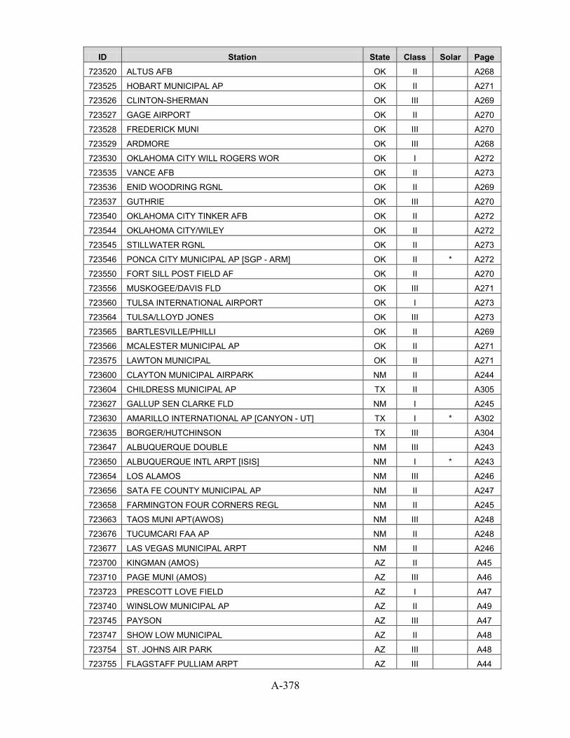
A-378
ID Station State Class Solar Page 723520 ALTUS AFB OK II
A268
723525 HOBART MUNICIPAL AP OK II
A271
723526 CLINTON-SHERMAN OK III
A269
723527 GAGE AIRPORT OK II
A270
723528 FREDERICK MUNI OK III
A270
723529 ARDMORE OK III
A268
723530 OKLAHOMA CITY WILL ROGERS WOR OK I
A272
723535 VANCE AFB OK II
A273
723536 ENID WOODRING RGNL OK II
A269
723537 GUTHRIE OK III
A270
723540 OKLAHOMA CITY TINKER AFB OK II
A272
723544 OKLAHOMA CITY/WILEY OK II
A272
723545 STILLWATER RGNL OK II
A273
723546 PONCA CITY MUNICIPAL AP [SGP - ARM] OK II * A272
723550 FORT SILL POST FIELD AF OK II
A270
723556 MUSKOGEE/DAVIS FLD OK III
A271
723560 TULSA INTERNATIONAL AIRPORT OK I
A273
723564 TULSA/LLOYD JONES OK III
A273
723565 BARTLESVILLE/PHILLI OK II
A269
723566 MCALESTER MUNICIPAL AP OK II
A271
723575 LAWTON MUNICIPAL OK II
A271
723600 CLAYTON MUNICIPAL AIRPARK NM II
A244
723604 CHILDRESS MUNICIPAL AP TX II
A305
723627 GALLUP SEN CLARKE FLD NM I
A245
723630 AMARILLO INTERNATIONAL AP [CANYON - UT] TX I * A302
723635 BORGER/HUTCHINSON TX III
A304
723647 ALBUQUERQUE DOUBLE NM III
A243
723650 ALBUQUERQUE INTL ARPT [ISIS] NM I * A243
723654 LOS ALAMOS NM III
A246
723656 SATA FE COUNTY MUNICIPAL AP NM II
A247
723658 FARMINGTON FOUR CORNERS REGL NM II
A245
723663 TAOS MUNI APT(AWOS) NM III
A248
723676 TUCUMCARI FAA AP NM II
A248
723677 LAS VEGAS MUNICIPAL ARPT NM II
A246
723700 KINGMAN (AMOS) AZ II
A45
723710 PAGE MUNI (AMOS) AZ III
A46
723723 PRESCOTT LOVE FIELD AZ I
A47
723740 WINSLOW MUNICIPAL AP AZ II
A49
723745 PAYSON AZ III
A47
723747 SHOW LOW MUNICIPAL AZ II
A48
723754 ST. JOHNS AIR PARK AZ III
A48
723755 FLAGSTAFF PULLIAM ARPT AZ III
A44

A-379
ID Station State Class Solar Page 723783 GRAND CANYON NATL P AZ II
A45
723788 BULLHEAD CITY AZ III
A42
723805 NEEDLES AIRPORT CA II
A63
723810 EDWARDS AFB CA II
A55
723815 DAGGETT BARSTOW-DAGGETT AP CA I
A55
723816 LANCASTER GEN WM FOX FIELD CA II
A58
723820 PALMDALE AIRPORT CA II
A65
723826 INYOKERN CA III
A57
723830 SANDBERG CA III
A70
723840 BAKERSFIELD MEADOWS FIELD CA I
A50
723860 LAS VEGAS MCCARRAN INTL AP NV I
A250
723865 NELLIS AFB NV II
A251
723870 MERCURY DESERT ROCK AP [SURFRAD] NV I * A250
723890 FRESNO YOSEMITE INTL AP CA I
A56
723895 PORTERVILLE (AWOS) CA III
A66
723896 VISALIA MUNI (AWOS) CA II
A75
723898 HANFORD MUNI ARPT [ISIS] CA III * A56
723910 POINT MUGU NF CA II
A66
723925 SANTA BARBARA MUNICIPAL AP CA I
A71
723926 CAMARILLO (AWOS) CA III
A52
723927 OXNARD AIRPORT CA II
A65
723930 VANDENBERG AFB CA II
A75
723935 VANDENBERG RANGE CA III
A75
723940 SANTA MARIA PUBLIC ARPT CA I
A71
723965 PASO ROBLES MUNICIPAL ARPT CA II
A66
724006 CHESAPEAKE MUNI ARP VA III
A329
724007 SUFFOLK VA III
A336
724008 ROANOKE RAPIDS VA III
A335
724010 RICHMOND INTERNATIONAL AP VA I
A335
724014 DINWIDDIE CO VA III
A329
724016 CHARLOTTESVILLE FAA VA II
A328
724017 FARMVILLE VA III
A330
724019 NORFOLK (NEXRAD) VA III
A333
724020 WALLOPS ISLAND UAU VA III
A337
724026 MELFA/ACCOMACK ARPT VA III
A333
724030 WASHINGTON DC DULLES INT'L AR [STERLING - ISIS] VA I * A337
724033 SHANNON ARPT VA III
A336
724035 QUANTICO MCAS VA II
A335
724036 MANASSAS MUNI(AWOS) VA III
A332
724037 DAVISON AAF VA II
A329
724040 PATUXENT RIVER NAS MD II
A165
724045 SALISBURY WICOMICO CO AP MD II
A165

A-380
ID Station State Class Solar Page 724050 WASHINGTON DC REAGAN AP VA I
A337
724053 WINCHESTER RGNL VA III
A337
724055 LEESBURG/GODFREY VA III
A331
724056 MARION / WYTHEVILLE VA III
A332
724057 PHILLIPS AAF MD III
A165
724058 ABINGTON VA III
A328
724060 BALTIMORE BLT-WASHNGTN INT'L MD I
A164
724066 HAGERSTOWN RGNL RIC MD II
A164
724067 MARTIN STATE MD II
A164
724070 ATLANTIC CITY INTL AP NJ I
A239
724074 S JERSEY RGNL ARPT NJ III
A241
724075 MILLVILLE MUNICIPAL AP NJ II
A241
724080 PHILADELPHIA INTERNATIONAL AP PA I
A285
724084 BELMAR ASC NJ III
A240
724085 PHILADELPHIA NE PHILADELPHIA PA II
A285
724086 WILLOW GROVE NAS PA II
A287
724088 DOVER AFB DE II
A87
724089 WILMINGTON NEW CASTLE CNTY AP DE I
A87
724090 LAKEHURST NAS NJ III
A240
724093 GEORGETOWN/SUSSEX DE III
A87
724094 CALDWELL/ESSEX CO. NJ II
A240
724095 TRENTON MERCER COUNTY AP NJ II
A242
724096 MCGUIRE AFB NJ II
A241
724100 LYNCHBURG REGIONAL ARPT VA I
A332
724104 SOMERSET ARPT ASOS NJ III
A242
724105 STAUNTON/SHENANDOAH VA II
A336
724106 DANVILLE FAA AP VA II
A329
724107 HILLSVILLE VA III
A331
724110 ROANOKE REGIONAL AP VA I
A335
724113 VIRGINIA TECH ARPT VA III
A336
724115 HOT SPRINGS/INGALLS VA III
A331
724116 PULASKI VA III
A334
724117 WISE/LONESOME PINE VA III
A338
724118 MECKLENBURG\BRUNS. VA III
A333
724120 BECKLEY RALEIGH CO MEM AP WV I
A357
724125 BLUEFIELD/MERCER CO [NREL] WV II * A358
724127 LEWISBURG/GREENBRIE WV II
A359
724140 CHARLESTON YEAGER ARPT WV I
A358
724165 PETERSBURG/GRANT AI WV III
A360
724170 ELKINS ELKINS-RANDOLPH CO ARP WV I
A358
724175 HARRISON MARION RGN WV II
A358
724176 MORGANTOWN HART FIELD WV II
A359

A-381
ID Station State Class Solar Page 724177 MARTINSBURG EASTERN WV REG AP WV II
A359
724210 CINCINNATI NORTHERN KY AP KY I
A150
724220 LEXINGTON BLUEGRASS AP KY I
A151
724230 LOUISVILLE STANDIFORD FIELD KY I
A152
724235 LOUISVILLE BOWMAN FIELD KY II
A152
724236 JACKSON JULIAN CARROLL AP KY I
A151
724238 HENDERSON CITY KY III
A151
724240 FORT KNOX GODMAN AAF KY II
A151
724243 LONDON-CORBIN AP KY II
A152
724250 HUNTINGTON TRI-STATE ARPT WV I
A359
724273 PARKERSBURG WOOD COUNTY AP WV II
A360
724275 WHEELING OHIO COUNTY AP WV II
A360
724276 DAYTON GENERL ARPT OH III
A263
724280 COLUMBUS PORT COLUMBUS INTL A OH I
A262
724284 COLUMBUS/BOLTON FLD OH III
A263
724285 COLUMBUS RICKENBACKE OH III
A262
724286 ZANESVILLE MUNICIPAL AP OH II
A268
724287 METCALF FIELD OH III
A265
724288 OHIO STATE UNIVERSI OH II
A266
724290 DAYTON INTERNATIONAL AIRPORT OH I
A263
724295 SPRINGFIELD AF OH III
A266
724296 WILMINGTON AIRBORNE PARK OH III
A267
724297 CINCINNATI MUNICIPAL AP LUNKI OH II
A262
724298 LIMA ALLEN CO ARPT OH III
A265
724303 AKRON FULTON ASOS OH III
A261
724320 EVANSVILLE REGIONAL AP IN I
A140
724335 MOUNT VERNON (AWOS) IL II
A136
724336 SOUTHERN ILLINOIS IL II
A138
724338 BELLEVILLE SCOTT AFB IL II
A130
724339 MARION REGIONAL IL II
A135
724340 ST LOUIS LAMBERT INT'L ARPT MO I
A205
724345 ST LOUIS SPIRIT OF ST LOUIS A MO I
A205
724347 ST CHARLES COUNTY A MO III
A204
724350 PADUCAH BARKLEY REGIONAL AP KY I
A152
724354 SOMERSET(AWOS) KY III
A153
724356 SHELBYVILLE MUNI IN III
A143
724365 HUNTINGBURG IN III
A142
724373 TERRE HAUTE HULMAN REGIONAL A IN II
A144
724375 MONROE CO IN II
A143
724380 INDIANAPOLIS INTL AP IN I
A142
724384 EAGLE CREEK IN III
A140
724385 ANDERSON MUNICIPAL IN III
A139

A-382
ID Station State Class Solar Page 724386 LAFAYETTE PURDUE UNIV AP IN II
A142
724387 KOKOMO(AWOS) IN III
A142
724388 GOSHEN IN III
A141
724390 SPRINGFIELD CAPITAL AP IL I
A138
724396 QUINCY MUNI BALDWIN FLD IL II
A137
724397 CENTRAL ILLINOIS RG IL II
A131
724398 DANVILLE/VERMILION IL III
A133
724400 SPRINGFIELD REGIONAL ARPT MO I
A204
724450 COLUMBIA REGIONAL AIRPORT MO I
A201
724454 FARMINGTON MO III
A202
724455 KIRKSVILLE REGIONAL AP MO II
A204
724456 VICHY ROLLA NATL ARPT MO II
A205
724457 FT LNRD WD AAF MO II
A202
724458 JEFFERSON CITY MEM MO II
A202
724459 KAISER MEM (AWOS) MO II
A203
724460 KANSAS CITY INT'L ARPT MO I
A203
724463 KANSAS CITY DOWNTOWN AP MO II
A203
724466 KANSAS CITY RICHARDS-GEBAUR A MO III
A203
724467 WHITEMAN AFB MO II
A206
724468 OLATHE/JOHNSON CO. KS II
A148
724475 OLATHE JOHNSON CO INDUSTRIAL KS II
A148
724490 ST JOSEPH ROSECRANS MEMORIAL MO II
A205
724500 WICHITA MID-CONTINENT AP KS I
A149
724504 WICHITA/COL. JABARA KS III
A150
724505 MCCONNELL AFB KS II
A147
724506 HUTCHINSON MUNICIPAL AP KS II
A147
724507 CHANUTE MARTIN JOHNSON AP KS II
A144
724509 NEWTON (AWOS) KS III
A148
724510 DODGE CITY REGIONAL AP KS I
A144
724515 GARDEN CITY MUNICIPAL AP KS II
A145
724516 LIBERAL MUNI KS II
A147
724517 GREAT BEND (AWOS) KS II
A146
724518 HAYS MUNI (AWOS) KS II
A146
724550 FORT RILEY MARSHALL AAF KS III
A145
724555 MANHATTAN RGNL KS II
A147
724556 EMPORIA MUNICIPAL AP KS II
A145
724560 TOPEKA MUNICIPAL AP KS I
A149
724565 TOPEKA FORBES FIELD KS II
A149
724567 FORT LEAVENWORTH SHERMAN AAF KS III
A145
724580 CONCORDIA BLOSSER MUNI AP KS I
A144
724585 RUSSELL MUNICIPAL AP KS I
A148
724586 SALINA MUNICIPAL AP KS II
A149

A-383
ID Station State Class Solar Page 724620 ALAMOSA SAN LUIS VALLEY RGNL CO I
A76
724625 DURANGO/LA PLATA CO CO II
A79
724627 TELLURIDE REGIONAL CO III
A84
724635 LA JUNTA MUNICIPAL AP CO II
A81
724636 LAMAR MUNICIPAL CO III
A81
724640 PUEBLO MEMORIAL AP CO I
A83
724645 TRINIDAD LAS ANIMAS COUNTY AP CO II
A84
724650 GOODLAND RENNER FIELD KS I
A146
724655 HILL CITY MUNICIPAL AP KS II
A146
724660 COLORADO SPRINGS MUNI AP CO I
A77
724665 LIMON CO I
A82
724666 DENVER/CENTENNIAL [GOLDEN - NREL] CO II * A79
724673 LEADVILLE/LAKE CO. CO II
A82
724674 MEEKER CO III
A82
724675 EAGLE COUNTY AP CO II
A79
724676 ASPEN PITKIN CO SAR CO II
A76
724677 GUNNISON CO. (AWOS) CO II
A81
724678 STEAMBOAT SPRINGS B CO III
A83
724680 FORT CARSON BUTTS AAF CO II
A79
724689 BURLINGTON CO III
A77
724690 DENVER STAPLETON INT'L ARPT CO III
A78
724695 AURORA BUCKLEY FIELD ANGB CO II
A77
724697 FORT COLLINS(SAWRS) CO III
A80
724698 AKRON WASHINGTON CO AP CO II
A76
724699 BROOMFIELD/JEFFCO [BOULDER - SURFRAD] CO III * A77
724700 PRICE/CARBON COUNTY UT III
A326
724723 BLANDING UT III
A324
724735 HANKSVILLE UT II
A325
724754 SAINT GEORGE (AWOS) UT II
A327
724755 CEDAR CITY MUNICIPAL AP UT I
A324
724756 BRYCE CNYN FAA AP UT II
A324
724760 GRAND JUNCTION WALKER FIELD CO I
A80
724765 MONTROSE CO. ARPT CO II
A82
724767 CORTEZ/MONTEZUMA CO CO II
A78
724768 GREELEY/WELD (AWOS) CO II
A80
724769 FORT COLLINS (AWOS) CO II
A80
724773 GREEN RIVER RANGE UT III
A325
724776 MOAB/CANYONLANDS [UO] UT III * A326
724795 DELTA UT II
A325
724796 LOGAN-CACHE AIRPORT UT III
A325
724800 BISHOP AIRPORT CA I
A51
724810 CASTLE AFB CA III
A53

A-384
ID Station State Class Solar Page 724815 MERCED/MACREADY FLD CA II
A61
724828 VACAVILLE NUT TREE CA III
A74
724830 SACRAMENTO EXECUTIVE ARPT CA I
A67
724833 MATHER FIELD CA III
A60
724836 MCCLELLAN AFB CA III
A61
724837 BEALE AFB CA II
A51
724838 YUBA CO CA II
A76
724839 SACRAMENTO METROPOLITAN AP CA II
A68
724846 N LAS VEGAS NV III
A250
724855 TONOPAH AIRPORT NV I
A251
724860 ELY YELLAND FIELD NV I
A249
724880 RENO TAHOE INTERNATIONAL AP NV I
A251
724885 FALLON NAAS NV II
A249
724915 MONTEREY NAF CA II
A62
724917 SALINAS MUNICIPAL AP CA II
A68
724920 STOCKTON METROPOLITAN ARPT CA I
A72
724926 MODESTO CITY-COUNTY AP CA II
A61
724927 LIVERMORE MUNICIPAL CA II
A58
724930 OAKLAND METROPOLITAN ARPT CA II
A64
724935 HAYWARD AIR TERM CA II
A57
724936 CONCORD CONCORD-BUCHANAN FIEL CA II
A54
724940 SAN FRANCISCO INTL AP CA I
A69
724945 SAN JOSE INTL AP CA II
A70
724955 NAPA CO. AIRPORT CA II
A63
724957 SANTA ROSA (AWOS) CA II
A72
724973 CHICO MUNICIPAL CA III
A53
724988 DANSVILLE MUNI ARPT NY III
A253
725015 MONTGOMERY NY III
A256
725016 SHIRLEY/BROOKHAVEN NY III
A259
725020 NEWARK INTERNATIONAL ARPT NJ I
A241
725025 TETERBORO AIRPORT NJ II
A242
725027 MERIDEN/MARKHAM MUN CT III
A86
725029 OXFORD (AWOS) CT III
A86
725030 NEW YORK LAGUARDIA ARPT NY I
A257
725033 NEW YORK CENTRAL PRK OBS BELV NY III
A256
725035 ISLIP LONG ISL MACARTHUR AP NY I
A255
725036 POUGHKEEPSIE DUTCHESS CO AP NY II
A258
725037 WHITE PLAINS WESTCHESTER CO A NY II
A260
725038 STEWART FIELD NY II
A259
725040 BRIDGEPORT SIKORSKY MEMORIAL CT I
A84
725045 NEW HAVEN TWEED AIRPORT CT II
A86
725046 GROTON NEW LONDON AP CT II
A85
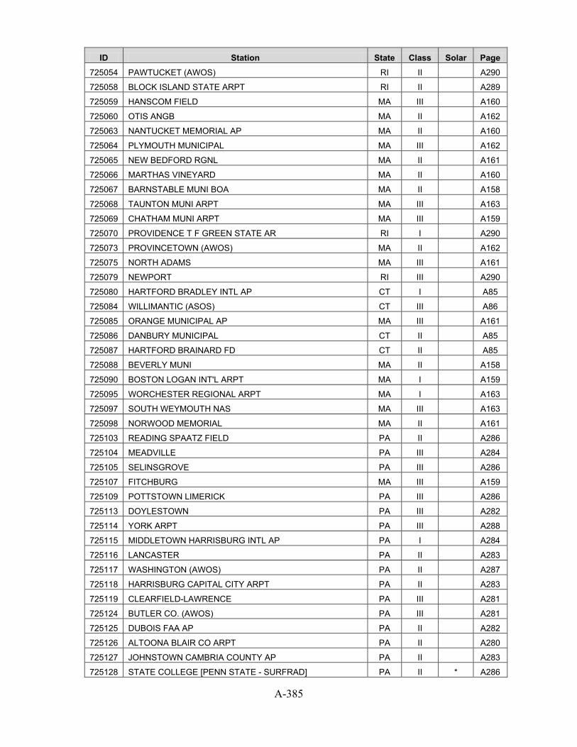
A-385
ID Station State Class Solar Page 725054 PAWTUCKET (AWOS) RI II
A290
725058 BLOCK ISLAND STATE ARPT RI II
A289
725059 HANSCOM FIELD MA III
A160
725060 OTIS ANGB MA II
A162
725063 NANTUCKET MEMORIAL AP MA II
A160
725064 PLYMOUTH MUNICIPAL MA III
A162
725065 NEW BEDFORD RGNL MA II
A161
725066 MARTHAS VINEYARD MA II
A160
725067 BARNSTABLE MUNI BOA MA II
A158
725068 TAUNTON MUNI ARPT MA III
A163
725069 CHATHAM MUNI ARPT MA III
A159
725070 PROVIDENCE T F GREEN STATE AR RI I
A290
725073 PROVINCETOWN (AWOS) MA II
A162
725075 NORTH ADAMS MA III
A161
725079 NEWPORT RI III
A290
725080 HARTFORD BRADLEY INTL AP CT I
A85
725084 WILLIMANTIC (ASOS) CT III
A86
725085 ORANGE MUNICIPAL AP MA III
A161
725086 DANBURY MUNICIPAL CT II
A85
725087 HARTFORD BRAINARD FD CT II
A85
725088 BEVERLY MUNI MA II
A158
725090 BOSTON LOGAN INT'L ARPT MA I
A159
725095 WORCHESTER REGIONAL ARPT MA I
A163
725097 SOUTH WEYMOUTH NAS MA III
A163
725098 NORWOOD MEMORIAL MA II
A161
725103 READING SPAATZ FIELD PA II
A286
725104 MEADVILLE PA III
A284
725105 SELINSGROVE PA III
A286
725107 FITCHBURG MA III
A159
725109 POTTSTOWN LIMERICK PA III
A286
725113 DOYLESTOWN PA III
A282
725114 YORK ARPT PA III
A288
725115 MIDDLETOWN HARRISBURG INTL AP PA I
A284
725116 LANCASTER PA II
A283
725117 WASHINGTON (AWOS) PA II
A287
725118 HARRISBURG CAPITAL CITY ARPT PA II
A283
725119 CLEARFIELD-LAWRENCE PA III
A281
725124 BUTLER CO. (AWOS) PA III
A281
725125 DUBOIS FAA AP PA II
A282
725126 ALTOONA BLAIR CO ARPT PA II
A280
725127 JOHNSTOWN CAMBRIA COUNTY AP PA II
A283
725128 STATE COLLEGE [PENN STATE - SURFRAD] PA II * A286

A-386
ID Station State Class Solar Page 725130 WILKES-BARRE SCRANTON INTL AP PA I
A287
725140 WILLIAMSPORT REGIONAL AP PA I
A287
725144 MUIR AAF PA II
A284
725145 MONTICELLO(AWOS) NY II
A256
725146 FULTON NY III
A254
725150 BINGHAMTON EDWIN A LINK FIELD NY I
A252
725155 ITHACA/TOMPKINS CO. NY II
A255
725156 ELMIRA CORNING REGIONAL AP NY II
A253
725157 WELLSVILLE MUNICIPA NY III
A260
725165 RUTLAND STATE VT II
A339
725170 ALLENTOWN LEHIGH VALLEY INTL PA I
A280
725175 INDIANA/STEWART FLD PA III
A283
725180 ALBANY COUNTY AP NY I
A252
725185 GLENS FALLS AP NY II
A254
725186 OGDENSBURG INTL NY III
A257
725187 CLINTON CO NY III
A253
725190 SYRACUSE HANCOCK INT'L ARPT NY I
A259
725194 PENN YAN NY III
A257
725196 GRIFFISS AFB NY III
A254
725197 UTICA ONEIDA COUNTY AP NY III
A259
725200 PITTSBURGH INTERNATIONAL AP PA I
A285
725204 BEAVER FALLS ARPT PA III
A281
725205 PITTSBURGH ALLEGHENY CO AP PA II
A285
725207 ARNOLD PALMER RGNL PA III
A280
725208 MARION MUNI ARPT OH III
A265
725210 AKRON AKRON-CANTON REG AP OH I
A261
725214 ELYRIA/LORAIN CO. OH III
A264
725216 WOOSTER OH III
A267
725217 HAMILTON OH III
A264
725224 NEW PHILADELPHIA OH III
A266
725229 NEWARK/HEATH AIRPRT OH III
A266
725235 JAMESTOWN (AWOS) NY II
A255
725240 CLEVELAND HOPKINS INTL AP OH I
A262
725244 WILLOUGHBY OH III
A267
725245 BURKE LAKEFRONT OH II
A261
725246 MANSFIELD LAHM MUNICIPAL ARPT OH I
A265
725250 YOUNGSTOWN REGIONAL AIRPORT OH I
A268
725254 DEFIANCE MEMORIAL OH III
A264
725256 ASHTABULA COUNTY AR OH III
A261
725260 ERIE INTERNATIONAL AP PA I
A282
725266 BRADFORD REGIONAL AP PA I
A281
725267 FRANKLIN PA II
A282

A-387
ID Station State Class Solar Page 725280 BUFFALO NIAGARA INTL AP NY I
A252
725287 NIAGARA FALLS AF NY II
A257
725290 ROCHESTER GREATER ROCHESTER I NY I
A258
725300 CHICAGO OHARE INTL AP IL I
A132
725305 W. CHICAGO/DU PAGE IL II
A139
725306 GLENVIEW NAS IL III
A134
725314 CAHOKIA/ST. LOUIS IL II
A131
725315 UNIV OF ILLINOIS WI [BONDVILLE - SURFRAD] IL II * A139
725316 DECATUR IL II
A133
725317 MATTOON/CHARLESTON IL III
A136
725320 PEORIA GREATER PEORIA AP IL I
A137
725326 STERLING ROCKFALLS IL II
A138
725327 PORTER CO MUNI IN III
A143
725330 FORT WAYNE INTL AP IN I
A141
725335 GRISSOM ARB IN II
A141
725336 DELAWARE CO JOHNSON IN II
A140
725337 GARY CHICAGO IN III
A141
725340 CHICAGO MIDWAY AP IL II
A132
725345 JOLIET PARK DISTRIC IL III
A135
725346 CHICAGO MEIGS FIELD IL III
A131
725347 CHICAGO/WAUKEGAN IL II
A133
725348 CHICAGO NEXRAD IL III
A132
725349 DAVENPORT NEXRAD IA III
A118
725350 SOUTH BEND MICHIANA RGNL AP IN I
A143
725354 ELKHART MUNI IN III
A140
725360 TOLEDO EXPRESS AIRPORT OH I
A267
725366 FINDLAY AIRPORT OH II
A264
725370 DETROIT METROPOLITAN ARPT MI I
A173
725373 GROSSE ISLE ARPT MI III
A174
725374 ANN ARBOR MUNICIPAL MI II
A170
725375 DETROIT CITY AIRPORT MI I
A173
725376 DETROIT WILLOW RUN AP MI II
A173
725377 MOUNT CLEMENS SELFRIDGE FLD MI II
A179
725378 HOWELL MI III
A176
725384 ST.CLAIR COUNTY INT MI III
A182
725390 LANSING CAPITAL CITY ARPT MI I
A177
725394 HOLLAND/TULIP CITY MI III
A175
725395 JACKSON REYNOLDS FIELD MI II
A176
725396 BATTLE CREEK KELLOGG AP MI II
A171
725404 ADRIAN MI III
A170
725405 ALMA MI III
A170
725406 BAD AXE MI III
A171
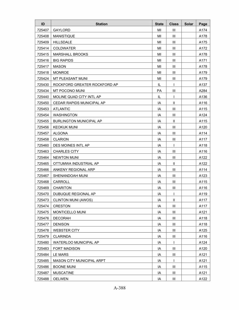
A-388
ID Station State Class Solar Page 725407 GAYLORD MI III
A174
725408 MANISTIQUE MI III
A178
725409 HILLSDALE MI III
A175
725414 COLDWATER MI III
A172
725415 MARSHALL BROOKS MI III
A178
725416 BIG RAPIDS MI III
A171
725417 MASON MI III
A178
725418 MONROE MI III
A179
725424 MT PLEASANT MUNI MI III
A179
725430 ROCKFORD GREATER ROCKFORD AP IL I
A137
725434 MT POCONO MUNI PA III
A284
725440 MOLINE QUAD CITY INTL AP IL I
A136
725450 CEDAR RAPIDS MUNICIPAL AP IA II
A116
725453 ATLANTIC IA III
A115
725454 WASHINGTON IA III
A124
725455 BURLINGTON MUNICIPAL AP IA II
A115
725456 KEOKUK MUNI IA III
A120
725457 ALGONA IA III
A114
725458 CLARION IA III
A117
725460 DES MOINES INTL AP IA I
A118
725463 CHARLES CITY IA III
A116
725464 NEWTON MUNI IA III
A122
725465 OTTUMWA INDUSTRIAL AP IA II
A122
725466 ANKENY REGIONAL ARP IA III
A114
725467 SHENANDOAH MUNI IA III
A123
725468 CARROLL IA III
A115
725469 CHARITON IA III
A116
725470 DUBUQUE REGIONAL AP IA I
A119
725473 CLINTON MUNI (AWOS) IA II
A117
725474 CRESTON IA III
A117
725475 MONTICELLO MUNI IA III
A121
725476 DECORAH IA III
A118
725477 DENISON IA III
A118
725478 WEBSTER CITY IA III
A125
725479 CLARINDA IA III
A116
725480 WATERLOO MUNICIPAL AP IA I
A124
725483 FORT MADISON IA III
A120
725484 LE MARS IA III
A121
725485 MASON CITY MUNICIPAL ARPT IA I
A121
725486 BOONE MUNI IA III
A115
725487 MUSCATINE IA III
A121
725488 OELWEN IA III
A122

A-389
ID Station State Class Solar Page 725489 ORANGE CITY IA III
A122
725490 FORT DODGE (AWOS) IA II
A119
725493 KNOXVILLE IA III
A120
725494 RED OAK IA III
A123
725495 SHELDON IA III
A123
725496 STORM LAKE IA III
A124
725497 COUNCIL BLUFFS IA III
A117
725499 LAMONI IA III
A120
725500 OMAHA EPPLEY AIRFIELD NE I
A235
725510 LINCOLN MUNICIPAL ARPT NE I
A233
725513 AURORA NE III
A230
725515 BEATRICE MUNICIPAL NE III
A230
725520 GRAND ISLAND CENTRAL NE REGIO NE I
A232
725524 ORD/SHARP FIELD NE II
A235
725525 HASTINGS MUNICIPAL NE II
A232
725526 KEARNEY MUNI (AWOS) NE II
A233
725527 TEKAMAH (ASOS) NE III
A236
725530 OMAHA WSFO NE III
A235
725533 FALLS CITY/BRENNER NE II
A232
725540 BELLEVUE OFFUTT AFB NE II
A230
725555 BROKEN BOW MUNI NE II
A231
725556 AINSWORTH MUNICIPAL NE II
A229
725560 NORFOLK KARL STEFAN MEM ARPT NE I
A234
725564 FREMONT MUNI ARPT NE III
A232
725565 COLUMBUS MUNI NE II
A231
725566 O`NEILL/BAKER FIELD NE III
A235
725570 SIOUX CITY SIOUX GATEWAY AP IA I
A123
725610 SIDNEY MUNICIPAL AP NE II
A236
725620 NORTH PLATTE REGIONAL AP NE I
A234
725625 MCCOOK MUNICIPAL NE II
A234
725626 IMPERIAL FAA AP NE II
A233
725627 MULLEN/HOOKER CO. NE III
A234
725628 BREWSTER FIELD ARPT NE III
A231
725635 ALLIANCE MUNICIPAL NE II
A230
725636 CHADRON MUNICIPAL AP NE II
A231
725640 CHEYENNE MUNICIPAL ARPT WY I
A361
725645 LARAMIE GENERAL BREES FIELD WY II
A363
725650 DENVER INTL AP CO I
A78
725660 SCOTTSBLUFF W B HEILIG FIELD NE I
A236
725665 KIMBALL MUNI APT NE III
A233
725670 VALENTINE MILLER FIELD NE I
A236
725685 DOUGLAS WY III
A361
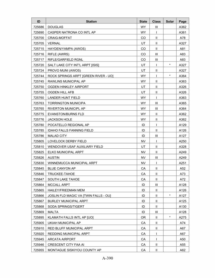
A-390
ID Station State Class Solar Page 725686 DOUGLAS WY III
A362
725690 CASPER NATRONA CO INTL AP WY I
A361
725700 CRAIG-MOFFAT CO II
A78
725705 VERNAL UT II
A327
725715 HAYDEN/YAMPA (AWOS) CO II
A81
725716 RIFLE (AWRS) CO III
A83
725717 RIFLE/GARFIELD RGNL CO III
A83
725720 SALT LAKE CITY INT'L ARPT [ISIS] UT I * A327
725724 PROVO MUNI (AWOS) UT II
A327
725744 ROCK SPRINGS ARPT [GREEN RIVER - UO] WY I * A364
725745 RAWLINS MUNICIPAL AP WY II
A363
725750 OGDEN HINKLEY AIRPORT UT II
A326
725755 OGDEN HILL AFB UT II
A326
725760 LANDER HUNT FIELD WY I
A363
725763 TORRINGTON MUNICIPA WY III
A365
725765 RIVERTON MUNICIPL AP WY III
A364
725775 EVANSTON/BURNS FLD WY II
A362
725776 JACKSON HOLE WY II
A362
725780 POCATELLO REGIONAL AP ID I
A129
725785 IDAHO FALLS FANNING FIELD ID II
A126
725786 MALAD CITY ID III
A127
725805 LOVELOCK DERBY FIELD NV I
A250
725810 WENDOVER USAF AUXILIARY FIELD UT II
A328
725825 ELKO MUNICIPAL ARPT NV II
A249
725826 AUSTIN NV III
A249
725830 WINNEMUCCA MUNICIPAL ARPT NV I
A251
725845 BLUE CANYON AP CA II
A52
725846 TRUCKEE-TAHOE CA II
A73
725847 SOUTH LAKE TAHOE CA II
A72
725864 MCCALL ARPT ID III
A128
725865 HAILEY/FRIEDMAN MEM ID II
A126
725866 JOSLIN FLD MAGIC VA [TWIN FALLS - OU] ID II * A127
725867 BURLEY MUNICIPAL ARPT ID II
A125
725868 SODA SPRINGS/TIGERT ID II
A130
725869 MALTA ID III
A128
725895 KLAMATH FALLS INTL AP [UO] OR II * A275
725905 UKIAH MUNICIPAL AP CA II
A74
725910 RED BLUFF MUNICIPAL ARPT CA II
A67
725920 REDDING MUNICIPAL ARPT CA I
A67
725945 ARCATA AIRPORT CA I
A50
725946 CRESCENT CITY FAA AI CA II
A55
725955 MONTAGUE SISKIYOU COUNTY AP CA II
A62

A-391
ID Station State Class Solar Page 725957 MOUNT SHASTA CA III
A62
725958 ALTURAS CA II
A50
725970 MEDFORD ROGUE VALLEY INTL AP [ASHLAND - UO] OR I * A277
725975 SEXTON SUMMIT OR II
A280
725976 LAKEVIEW (AWOS) OR II
A276
726050 CONCORD MUNICIPAL ARPT NH I
A237
726055 PEASE INTL TRADEPOR NH II
A239
726056 SKYHAVEN ARPT ROCHE NH III
A239
726060 PORTLAND INTL JETPORT ME I
A168
726064 SANFORD MUNI (AWOS) ME II
A169
726073 WATERVILLE (AWOS) ME II
A169
726077 BAR HARBOR (AWOS) ME II
A166
726079 ROCKLAND/KNOX(AWOS) ME II
A169
726083 NORTHERN AROOSTOOK ME III
A168
726088 BANGOR INTERNATIONAL AP ME I
A166
726115 SPRINGFIELD/HARTNES VT III
A339
726116 LEBANON MUNICIPAL NH II
A238
726130 MOUNT WASHINGTON NH III
A238
726145 MONTPELIER AP VT II
A339
726155 LACONIA MUNI (AWOS) NH II
A238
726160 BERLIN MUNICIPAL NH III
A237
726163 JAFFREY MUNICIPAL NH III
A237
726164 WHITEFIELD NH III
A239
726165 DILLANT HOPKINS NH II
A237
726166 BENNINGTON MORSE AR VT III
A338
726170 BURLINGTON INTERNATIONAL AP VT I
A338
726184 AUBURN-LEWISTON ME II
A166
726185 AUGUSTA AIRPORT ME II
A166
726196 MILLINOCKET MUNICIPAL AP ME III
A167
726223 MASSENA AP NY I
A255
726225 PLATTSBURGH AFB NY III
A258
726227 WATERTOWN AP NY II
A260
726228 ADIRONDACK RGNL NY II
A252
726284 SAWYER INTL MI III
A181
726350 GRAND RAPIDS KENT COUNTY INT' MI I
A174
726355 BENTON HARBOR/ROSS MI II
A171
726357 KALAMAZOO BATTLE CR MI II
A177
726360 MUSKEGON COUNTY ARPT MI I
A180
726364 LUDINGTON/MASON MI III
A177
726370 FLINT BISHOP INTL ARPT MI I
A174
726375 OAKLAND CO INTL MI II
A180
726379 SAGINAW TRI CITY INTL AP MI II
A181

A-392
ID Station State Class Solar Page 726380 HOUGHTON LAKE ROSCOMMON CO AR MI I
A175
726384 CADILLAC WEXFORD CO AP MI III
A172
726385 MANISTEE (AWOS) MI II
A177
726387 TRAVERSE CITY CHERRY CAPITAL MI I
A182
726390 ALPENA COUNTY REGIONAL AP MI I
A170
726394 NEWBERRY LUCE CO. MI III
A180
726395 OSCODA WURTSMITH AFB MI III
A180
726400 MILWAUKEE MITCHELL INTL AP WI I
A352
726404 MINOCQUA/WOODRUFF WI II
A353
726405 MILWAUKEE TIMMERMAN WI III
A352
726409 WAUKESHA WI III
A356
726410 MADISON DANE CO REGIONAL ARPT [ISIS] WI I * A351
726413 WEST BEND MUNI WI III
A357
726414 MONROE MUNICIPAL AI WI III
A353
726415 JANESVILLE/ROCK CO. WI III
A350
726416 LONE ROCK FAA AP WI II
A350
726417 MEDFORD WI III
A352
726418 OSCEOLA WI III
A353
726419 ASHLAND KENNEDY ME WI III
A349
726424 RACINE WI III
A354
726425 SHEBOYGAN WI III
A355
726426 STEVENS POINT WI III
A355
726427 SUPERIOR WI III
A356
726430 LA CROSSE MUNICIPAL ARPT WI I
A350
726435 EAU CLAIRE COUNTY AP WI I
A349
726436 VOLK FIELD ANG WI III
A356
726437 MCCOY (USA-AF) WI III
A351
726438 BOSCOBEL AIRPORT WI III
A349
726440 ROCHESTER INTERNATIONAL ARPT MN I
A196
726444 PRAIRIE DU CHIEN WI III
A354
726449 MERRILL MUNI ARPT WI III
A352
726450 GREEN BAY AUSTIN STRAUBEL INT WI I
A350
726455 MANITOWAC MUNI AWOS WI II
A351
726456 WITTMAN RGNL WI II
A357
726457 APPLETON/OUTAGAMIE WI II
A349
726458 STURGEON BAY WI II
A355
726463 WAUSAU MUNICIPAL ARPT WI II
A357
726464 WATERTOWN WI III
A356
726465 MOSINEE/CENTRAL WI WI II
A353
726467 RICE LAKE MUNICIPAL WI III
A355
726468 PHILLIPS/PRICE CO. WI II
A354
726480 ESCANABA (AWOS) MI II
A173

A-393
ID Station State Class Solar Page 726487 MENOMINEE (AWOS) MI II
A179
726498 FAIR FIELD IA III
A119
726499 ESTHERVILLE MUNI IA II
A119
726500 SPENCER IA II
A124
726510 SIOUX FALLS FOSS FIELD SD I
A298
726514 CUSTER (RAMOS) SD III
A296
726515 BROOKINGS (AWOS) SD II
A295
726516 PHILIP ARPT SD III
A297
726517 PINE RIDGE SD III
A297
726518 WINNER SD III
A298
726525 CHAN GURNEY MUNI SD II
A295
726540 HURON REGIONAL ARPT SD I
A296
726544 ORR MN III
A194
726545 MITCHELL (AWOS) SD II
A296
726546 WATERTOWN MUNICIPAL AP SD II
A298
726547 GLENWOOD (ASOS) MN III
A189
726549 COOK MUNI ARPT MN III
A185
726550 ST CLOUD REGIONAL ARPT MN I
A198
726554 ST JAMES MUNI ARPT MN III
A198
726555 BRAINERD/WIELAND MN II
A184
726556 REDWOOD FALLS MUNI MN II
A196
726557 ALEXANDRIA MUNICIPAL AP MN II
A183
726558 CLOQUET (AWOS) MN III
A185
726559 MARSHALL/RYAN(AWOS) MN II
A192
726560 FERGUS FALLS(AWOS) MN II
A188
726561 WADENA MN III
A199
726563 FARIBAULT MUNI AWOS MN II
A188
726564 RED WING MN III
A196
726565 MORRIS MUNI (AWOS) MN II
A194
726566 PIPESTONE (AWOS) MN III
A195
726567 NEW ULM MUNI (AWOS) MN III
A194
726568 OWATONNA (AWOS) MN III
A195
726569 HUTCHINSON (AWOS) MN III
A190
726573 AIRLAKE MN III
A182
726574 MARSHFIELD MUNI WI III
A351
726575 MINNEAPOLIS/CRYSTAL MN II
A193
726576 WILLMAR MN III
A200
726577 MINNEAPOLIS/BLAINE MN III
A192
726578 LITTLE FALLS (AWOS) MN III
A191
726579 FLYING CLOUD MN II
A188
726580 MINNEAPOLIS-ST PAUL INT'L ARP MN I
A193
726583 LITCHFIELD MUNI MN II
A191

A-394
ID Station State Class Solar Page 726584 ST PAUL DOWNTOWN AP MN II
A198
726585 MANKATO(AWOS) MN II
A192
726586 FAIRMONT MUNI(AWOS) MN II
A187
726587 WORTHINGTON (AWOS) MN II
A201
726588 WINONA MUNI (AWOS) MN II
A201
726589 ALBERT LEA (AWOS) MN II
A183
726590 ABERDEEN REGIONAL ARPT SD I
A295
726593 JACKSON MUNI MN III
A191
726596 DODGE CENTER AIRPOR MN III
A186
726603 SOUTH ST PAUL MUNI MN III
A197
726620 RAPID CITY REGIONAL ARPT SD I
A298
726625 ELLSWORTH AFB SD II
A296
726626 ANTIGO\LANG(AWOS) WI III
A348
726650 GILLETTE/GILLETTE-C WY II
A362
726654 JOHNSON CO ARPT WY III
A363
726660 SHERIDAN COUNTY ARPT WY I
A364
726665 WORLAND MUNICIPAL WY II
A365
726667 SOUTH BIG HORN CO WY III
A364
726676 GLENDIVE(AWOS) MT II
A212
726679 RUSH CITY RGNL ARPT MN III
A197
726682 PRINCETON MUNI MN III
A196
726685 MOBRIDGE SD II
A297
726686 PIERRE MUNICIPAL AP SD I
A297
726700 CODY MUNI (AWOS) WY II
A361
726710 BIG PINEY (AMOS) WY III
A360
726770 BILLINGS LOGAN INT'L ARPT MT I
A210
726776 LEWISTOWN MUNICIPAL ARPT MT II
A213
726777 BAKER MUNI ARPT MT III
A210
726785 BUTTE BERT MOONEY ARPT MT II
A211
726796 DILLON AIRPORT [UO] MT III * A211
726797 BOZEMAN GALLATIN FIELD MT II
A211
726798 LIVINGSTON MISSION FIELD MT II
A214
726810 BOISE AIR TERMINAL [UO] ID I * A125
726813 CALDWELL (AWOS) ID III
A125
726815 MOUNTAIN HOME AFB ID II
A128
726816 JEROME ID III
A127
726817 MULLAN PASS ID III
A129
726818 REXBURG ID III
A129
726830 BURNS MUNICIPAL ARPT [UO] OR I * A274
726835 REDMOND ROBERTS FIELD OR II
A279
726836 SCAPPOOSE INDUSTRIA OR III
A279
726837 ONTARIO MUNICIPAL AP OR III
A277

A-395
ID Station State Class Solar Page 726865 SALMON/LEMHI (AWOS) ID III
A130
726866 SALMON ID III
A129
726873 GRANGEVILLE ID III
A126
726880 PENDLETON E OR REGIONAL AP OR I
A278
726881 MC MINNVILLE MUNI OR III
A276
726883 HERMISTN MUNI ARPT [UO] OR III * A275
726884 LA GRANDE MUNI AP OR II
A276
726885 MEACHAM OR III
A276
726886 BAKER MUNICIPAL AP OR II
A274
726904 ROSEBURG REGIONAL AP OR II
A279
726917 NORTH BEND MUNI AIRPORT OR II
A277
726930 EUGENE MAHLON SWEET ARPT [UO] OR I * A275
726940 SALEM MCNARY FIELD OR I
A279
726945 CORVALLIS MUNI OR II
A275
726959 AURORA STATE OR III
A274
726980 PORTLAND INTERNATIONAL AP OR III
A278
726985 PORTLAND/TROUTDALE OR II
A278
726986 PORTLAND/HILLSBORO OR II
A278
726988 THE DALLES MUNICIPAL ARPT WA II
A347
727033 HOULTON INTL ARPT ME II
A167
727120 CARIBOU MUNICIPAL ARPT ME I
A167
727125 LORING AFB/LIMESTON ME III
A167
727130 PRESQUE ISLE MUNICIP ME II
A168
727135 WISCASSET ME III
A169
727340 SAULT STE MARIE SANDERSON FIE MI I
A181
727344 CHIPPEWA CO INTL MI II
A172
727347 PELLSTON EMMET COUNTY AP MI II
A181
727415 RHINELANDER ONEIDA WI II
A354
727430 MARQUETTE COUNTY ARPT MI III
A178
727434 CHARLEVOIX MI III
A172
727437 IRON MOUNTAIN/FORD MI II
A176
727440 HANCOCK HOUGHTON CO AP MI II
A175
727444 TWO HARBORS MN III
A199
727445 IRONWOOD (AWOS) MI II
A176
727449 MOOSE LAKE CO ARPT MN III
A193
727450 DULUTH INTERNATIONAL ARPT MN I
A187
727452 CROOKSTON MUNI FLD MN III
A186
727453 PARK RAPIDS MUNICIPAL AP MN II
A195
727454 GRAND MARAIS MUNI MN III
A189
727455 HIBBING CHISHOLM-HIBBING AP MN II
A190
727456 DULUTH HARBOR (CGS) MN III
A186
727457 DETROIT LAKES(AWOS) MN II
A186

A-396
ID Station State Class Solar Page 727458 GRAND RAPIDS(AWOS) MN II
A189
727459 ELY MUNI MN II
A187
727466 MADISON MN III
A192
727467 FLAG ISLAND MN III
A188
727468 BIGFORK MN III
A184
727470 INTERNATIONAL FALLS INTL AP MN I
A190
727473 CRANE LAKE (AWOS) MN II
A185
727474 EVELETH MUNI (AWOS) MN III
A187
727475 MORA MUNI (AWOS) MN II
A193
727476 BAUDETTE INTERNATIONAL AP MN III
A183
727477 ROSEAU MUNI (AWOS) MN II
A197
727478 HALLOCK MN III
A190
727486 WASKISH MUNI AIRPT MN III
A200
727497 LONGVILLE MUNI AIRP MN III
A191
727503 CAMBRIDGE MUNI MN III
A185
727504 AITKIN NDB(AWOS) MN III
A182
727505 FOSSTON(AWOS) MN III
A189
727506 WINDOM MN III
A200
727507 BENSON MUNI MN III
A184
727508 PINE RIVER MN III
A195
727514 STAPLES MN III
A198
727515 ORTONVILLE MN III
A194
727530 FARGO HECTOR INTERNATIONAL AP ND I
A227
727533 WHEATON NDB (AWOS) MN III
A200
727535 JAMESTOWN MUNICIPAL ARPT ND II
A228
727550 BEMIDJI MUNICIPAL MN II
A184
727555 THIEF RIVER(AWOS) MN II
A199
727556 SILVER BAY MN III
A197
727564 WARROAD(AWOS) MN III
A199
727566 AUSTIN MUNI MN III
A183
727573 DEVILS LAKE(AWOS) ND II
A227
727575 GRAND FORKS AF ND II
A228
727576 GRAND FORKS INTERNATIONAL AP ND II
A228
727584 HETTINGER ND III
A228
727640 BISMARCK MUNICIPAL ARPT [ISIS] ND I * A227
727645 DICKINSON MUNICIPAL AP ND II
A227
727670 WILLISTON SLOULIN INTL AP ND I
A229
727675 MINOT AFB ND II
A229
727676 MINOT FAA AP ND I
A229
727680 GLASGOW INTL ARPT MT I
A212
727686 WOLF POINT INTL [FORT PECK - SURFRAD] MT II * A215
727687 SIDNEY-RICHLAND MT II
A215

A-397
ID Station State Class Solar Page 727720 HELENA REGIONAL AIRPORT MT I
A213
727730 MISSOULA INTERNATIONAL AP MT I
A214
727735 DRUMMOND MT III
A212
727750 GREAT FALLS INTL ARPT MT I
A212
727755 MALMSTROM AFB MT III
A214
727770 HAVRE CITY-COUNTY AP MT I
A213
727790 KALISPELL GLACIER PK INT'L AR MT I
A213
727796 CUT BANK MUNI AP MT II
A211
727810 YAKIMA AIR TERMINAL WA I
A348
727815 STAMPEDE PASS WA I
A346
727825 WENATCHEE/PANGBORN WA II
A347
727826 EPHRATA AP FCWOS WA II
A341
727827 MOSES LAKE GRANT COUNTY AP WA II
A343
727830 LEWISTON NEZ PERCE CNTY AP ID I
A127
727834 COEUR D`ALENE(AWOS) ID II
A126
727836 MULLAN (AWRS) ID III
A128
727840 HANFORD WA II
A342
727845 PASCO WA II
A344
727846 WALLA WALLA CITY COUNTY AP WA II
A347
727850 SPOKANE INTERNATIONAL AP [CHENEY - UO] WA I * A346
727854 DEER PARK ARPT WA III
A340
727855 FAIRCHILD AFB WA II
A341
727856 FELTS FLD WA II
A341
727857 PULLMAN/MOSCOW RGNL WA II
A344
727883 ELLENSBURG/BOWERS FIELD WA III
A340
727885 WILLIAM R FAIRCHILD WA III
A348
727890 OMAK WA III
A343
727910 ASTORIA REGIONAL AIRPORT OR I
A274
727918 PEARSON FLD OR III
A277
727920 OLYMPIA AIRPORT WA I
A343
727923 HOQUIAM AP WA II
A342
727924 KELSO WB AP WA II
A342
727925 SHELTON/SANDERSON WA III
A345
727926 TOLEDO-WINLOCK MEM WA III
A347
727928 BREMERTON NATIONAL WA II
A340
727930 SEATTLE SEATTLE-TACOMA INTL A WA I
A345
727934 RENTON MUNI WA II
A344
727935 SEATTLE BOEING FIELD [ISIS] WA II * A345
727937 SNOHOMISH CO WA II
A345
727938 TACOMA NARROWS WA II
A346
727945 ARLINGTON MUNI WA III
A339
727964 OAK HARBOR AIRPARK WA III
A343

A-398
ID Station State Class Solar Page 727970 QUILLAYUTE STATE AIRPORT WA I
A344
727976 BELLINGHAM INTL AP WA II
A340
727985 FRIDAY HARBOR WA III
A341
742060 TACOMA MCCHORD AFB WA II
A346
742070 GRAY AAF WA III
A342
742300 MILES CITY MUNICIPAL ARPT MT II
A214
742513 DURANT OK III
A269
743312 DE QUEEN AR III
A37
743700 FORT DRUM/WHEELER-S NY II
A254
743920 NAVAL AIR STATION ME II
A168
743945 MANCHESTER AIRPORT NH II
A238
744104 PITTSFIELD MUNI MA III
A162
744652 HARRISBURG IL III
A134
744653 SPARTA IL III
A138
744655 AURORA MUNICIPAL IL II
A130
744656 FAIRFIELD IL III
A134
744657 CENTRALIA IL III
A131
744658 FLORA IL III
A134
744659 OLNEY-NOBLE IL III
A136
744661 EFFINGHAM IL III
A133
744662 TAYLORSVILLE IL III
A139
744663 PITTSFIELD IL III
A137
744665 CHICAGO/PALWAUKEE IL III
A132
744666 JACKSONVILLE IL III
A135
744672 LINCOLN IL III
A135
744860 NEW YORK J F KENNEDY INT'L AR NY I
A256
744864 REPUBLIC NY II
A258
744865 WESTHAMPTON GABRESKI AP NY II
A260
744904 LAWRENCE MUNI MA II
A160
744910 CHICOPEE FALLS WESTO MA II
A159
744915 WESTFIELD BARNES MUNI AP MA II
A163
744989 DUNKIRK NY III
A253
745046 MADERA CA III
A60
745048 OROVILLE CA III
A64
745056 RAMONA CA III
A66
745058 WATSONVILLE CA III
A75
745060 ALAMEDA NAS CA III
A50
745090 MOUNTAIN VIEW MOFFETT FLD NAS CA II
A62
745160 TRAVIS FIELD AFB CA II
A73
745310 USAF ACADEMY AF CO II
A84
745700 DAYTON WRIGHT PATTERSON AFB OH II
A263
745940 ANDREWS AFB MD II
A164

A-399
ID Station State Class Solar Page 745946 OCEAN CITY MUNI APT MD III
A165
745966 CAPE MAY CO NJ III
A240
745980 LANGLEY AFB VA II
A331
745985 MARTINSVILLE VA III
A332
746110 BICYCLE LAKE (AAF) CA III
A51
746120 CHINA LAKE NAF CA II
A54
746710 FORT CAMPBELL AAF KY II
A150
746716 BOWLING GREEN WARREN CO AP KY II
A150
746925 WARREN FIELD ARPT NC III
A226
746929 DUPLIN CO ARPT NC III
A218
746930 FORT BRAGG SIMMONS AAF NC II
A219
746935 ASHEBORO MUNI NC III
A215
746936 ERWIN/HARNETT ARPT NC III
A218
746939 CHAPEL HILL/WILLIAM NC III
A217
746940 GOLDSBORO/WAYNE NC III
A220
746943 ELIZABETH CITY COAST GUARD AI [NREL] NC III * A218
747020 LEMOORE REEVES NAS CA II
A58
747040 EL MONTE EMSU CA III
A55
747185 IMPERIAL CA II
A57
747187 PALM SPRINGS THERMAL AP CA II
A65
747188 BLYTHE RIVERSIDE CO ARPT CA II
A52
747240 GILA BEND AIRPORT AZ III
A44
747320 HOLLOMAN AFB NM II
A245
747400 JUNCTION KIMBLE COUNTY AP TX III
A314
747540 ENGLAND AFB LA III
A154
747685 GULFPORT BILOXI INT MS II
A207
747686 KEESLER AFB MS II
A208
747688 PASCAGOULA MS III
A210
747750 TYNDALL AFB FL II
A100
747760 MARIANNA FL III
A94
747770 VALPARAISO HURLBURT FL II
A101
747804 HUNTER AAF GA II
A106
747805 STATESBORO GA III
A108
747806 THOMASTON GA III
A109
747807 LA GRANGE GA III
A106
747808 LAWRENCEVILLE GA III
A107
747809 WINDER GA III
A110
747810 MOODY AFB/VALDOSTA GA II
A107
747880 MACDILL AFB FL II
A93
747900 SUMTER SHAW AFB SC II
A295
747910 MYRTLE BEACH AFB SC II
A294
747915 NORTH MYRTLE BEACH GRAND STRA SC II
A294

A-400
ID Station State Class Solar Page 747930 WINTERHAVEN FL III
A102
747946 NASA SHUTTLE FCLTY FL III
A95
747950 COCOA BEACH PATRICK AFB FL II
A89
747960 AVON PARK GUNNERY RANGE FL III
A88
785140 AQUADILLA/BORINQUEN PR II
A288
785145 EUGENIO MARIA DE HO PR III
A288
785203 MERCEDITA PR II
A288
785260 SAN JUAN INTL ARPT PR II
A289
785263 SAN JUAN L M MARIN INTL AP PR III
A289
785350 ROOSEVELT ROADS PR III
A289
785430 CHARLOTTE AMALIE HARRY S TRUM VI II
A338
910660 MIDWAY ISLAND NAS HI III
A113
911650 LIHUE AIRPORT HI I
A113
911700 WHEELER AFB 810.1 HI II
A114
911760 KANEOHE BAY MCAS HI II
A112
911780 BARBERS POINT NAS HI II
A111
911820 HONOLULU INTL ARPT HI I
A112
911860 MOLOKAI (AMOS) HI II
A114
911900 KAHULUI AIRPORT HI I
A112
911904 KAPALUA HI II
A112
911905 LANAI HI II
A113
911975 KONA INTL AT KEAHOL HI III
A113
911977 BRADSHAW AAF HI III
A111
912120 GUAM WFO GU II
A111
912170 GUAM MARIANA IS GU III
A110
912180 ANDERSEN AFB GU II
A110
912850 HILO INTERNATIONAL AP HI I
A111

B-1
Appendix B: Old and New NSRDB Station Equivalencies
This section lists the original 239 1961–1990 NSRDB sites (in order by WBAN ID) with their equivalent sites in the 1991–2010 NSRDB update and USAF ID. No changes were made between the 2005 and 2010 NSRDB updates. All of the equivalent sites in the updated NSRDB are either Class I or Class II stations, with the exception of Flagstaff, Arizona, Boulder, Colorado, Portland, Oregon, and Cape Hatteras, North Carolina, which are now Class III. Although some sites have slightly different coordinates because of changes in station location or inclusion of different sites with measured solar data, all pairs of sites listed here should be climatically similar.
Table B-1. Old and New Station Equivalencies WBAN 1961-1990 Site USAF NSRDB Update Site 03103 Flagstaff, Arizona 723755 FLAGSTAFF PULLIAM ARPT, AZ 03812 Asheville, North Carolina 723150 ASHEVILLE REGIONAL ARPT, NC 03813 Macon, Georgia 722170 MACON MIDDLE GA REGIONAL AP, GA 03820 Augusta, Georgia 722180 AUGUSTA BUSH FIELD, GA 03822 Savannah, Georgia 722070 SAVANNAH INTL AP, GA 03856 Huntsville, Alabama 723230 HUNTSVILLE INTL/JONES FIELD, AL 03860 Huntington, West Virginia 724250 HUNTINGTON TRI-STATE ARPT, WV 03870 Greenville, South Carolina 723120 GREER GREENV'L-SPARTANBRG AP, SC 03927 Fort Worth, Texas 722590 DALLAS-FORT WORTH INTL AP, TX 03928 Wichita, Kansas 724500 WICHITA MID-CONTINENT AP, KS 03937 Lake Charles, Louisiana 722400 LAKE CHARLES REGIONAL ARPT, LA 03940 Jackson, Mississippi 722350 JACKSON INTERNATIONAL AP, MS 03945 Columbia, Missouri 724450 COLUMBIA REGIONAL AIRPORT, MO 03947 Kansas City, Missouri 724460 KANSAS CITY INT'L ARPT, MO 04725 Binghamton, New York 725150 BINGHAMTON EDWIN A LINK FIELD, NY 04751 Bradford, Pennsylvania 725266 BRADFORD REGIONAL AP, PA 11641 San Juan, Puerto Rico 785260 SAN JUAN INTL ARPT, PR 12834 Daytona Beach, Florida 722056 DAYTONA BEACH INTL AP, FL 12836 Key West, Florida 722010 KEY WEST INTL ARPT, FL 12839 Miami, Florida 722020 MIAMI INTL AP, FL 12842 Orlando, Florida 722050 ORLANDO INTL ARPT, FL 12844 West Palm Beach, Florida 722030 WEST PALM BEACH INTL ARPT, FL 12912 Victoria, Texas 722550 VICTORIA REGIONAL AP, TX 12916 New Orleans, Louisiana 722310 NEW ORLEANS INTL ARPT, LA 12917 Port Arthur, Texas 722410 PORT ARTHUR JEFFERSON COUNTY, TX 12919 Brownsville, Texas 722500 BROWNSVILLE S PADRE ISL INTL, TX 12921 San Antonio, Texas 722530 SAN ANTONIO INTL AP, TX 12924 Corpus Christi, Texas 722510 CORPUS CHRISTI INTL ARPT [UT], TX 12960 Houston, Texas 722430 HOUSTON BUSH INTERCONTINENTAL, TX
13722 Raleigh/Durham, North Carolina 723060 RALEIGH DURHAM INTERNATIONAL, NC
13723 Greensboro, North Carolina 723170 GREENSBORO PIEDMONT TRIAD INT, NC 13729 Elkins, West Virginia 724170 ELKINS ELKINS-RANDOLPH CO ARP, WV

B-2
WBAN 1961-1990 Site USAF NSRDB Update Site 13733 Lynchburg, Virginia 724100 LYNCHBURG REGIONAL ARPT, VA 13737 Norfolk, Virginia 723080 NORFOLK INTERNATIONAL AP, VA 13739 Philadelphia, Pennsylvania 724080 PHILADELPHIA INTERNATIONAL AP, PA 13740 Richmond, Virginia 724010 RICHMOND INTERNATIONAL AP, VA 13741 Roanoke, Virginia 724110 ROANOKE REGIONAL AP, VA 13748 Wilmington, North Carolina 723013 WILMINGTON INTERNATIONAL ARPT, NC 13781 Wilmington, Delaware 724089 WILMINGTON NEW CASTLE CNTY AP, DE 13865 Meridian, Mississippi 722340 MERIDIAN KEY FIELD, MS 13866 Charleston, West Virginia 724140 CHARLESTON YEAGER ARPT, WV 13873 Athens, Georgia 723110 ATHENS BEN EPPS AP, GA 13874 Atlanta, Georgia 722190 ATLANTA HARTSFIELD INTL AP, GA 13876 Birmingham, Alabama 722280 BIRMINGHAM MUNICIPAL AP, AL 13877 Bristol, Tennessee 723183 BRISTOL TRI CITY AIRPORT, TN 13880 Charleston, South Carolina 722080 CHARLESTON INTL ARPT, SC 13881 Charlotte, North Carolina 723140 CHARLOTTE DOUGLAS INTL ARPT, NC 13882 Chattanooga, Tennessee 723240 CHATTANOOGA LOVELL FIELD AP, TN 13883 Columbia, South Carolina 723100 COLUMBIA METRO ARPT, SC 13889 Jacksonville, Florida 722060 JACKSONVILLE INTL ARPT, FL 13891 Knoxville, Tennessee 723260 KNOXVILLE MCGHEE TYSON AP, TN 13893 Memphis, Tennessee 723340 MEMPHIS INTERNATIONAL AP, TN 13894 Mobile, Alabama 722230 MOBILE REGIONAL AP, AL 13895 Montgomery, Alabama 722260 MONTGOMERY DANNELLY FIELD, AL 13897 Nashville, Tennessee 723270 NASHVILLE INTERNATIONAL AP, TN 13957 Shreveport, Louisiana 722480 SHREVEPORT REGIONAL ARPT, LA 13958 Austin, Texas 722540 AUSTIN MUELLER MUNICIPAL AP [UT], TX 13959 Waco, Texas 722560 WACO REGIONAL AP, TX 13962 Abilene, Texas 722660 ABILENE REGIONAL AP [UT], TX 13963 Little Rock, Arkansas 723403 LITTLE ROCK ADAMS FIELD, AR 13964 Fort Smith, Arkansas 723440 FORT SMITH REGIONAL AP, AR 13966 Wichita Falls, Texas 723510 WICHITA FALLS MUNICIPAL ARPT, TX 13967 Oklahoma City, Oklahoma 723530 OKLAHOMA CITY WILL ROGERS WOR, OK 13968 Tulsa, Oklahoma 723560 TULSA INTERNATIONAL AIRPORT, OK 13970 Baton Rouge, Louisiana 722317 BATON ROUGE RYAN ARPT, LA 13985 Dodge City, Kansas 724510 DODGE CITY REGIONAL AP, KS 13994 St. Louis, Missouri 724340 ST LOUIS LAMBERT INT'L ARPT, MO 13995 Springfield, Missouri 724400 SPRINGFIELD REGIONAL ARPT, MO 13996 Topeka, Kansas 724560 TOPEKA MUNICIPAL AP, KS 14607 Caribou, Maine 727120 CARIBOU MUNICIPAL ARPT, ME 14733 Buffalo, New York 725280 BUFFALO NIAGARA INTL AP, NY 14734 Newark, New Jersey 725020 NEWARK INTERNATIONAL ARPT, NJ 14735 Albany, New York 725180 ALBANY COUNTY AP, NY 14737 Allentown, Pennsylvania 725170 ALLENTOWN LEHIGH VALLEY INTL, PA 14739 Boston, Massachusetts 725090 BOSTON LOGAN INT'L ARPT, MA 14740 Hartford, Connecticut 725080 HARTFORD BRADLEY INTL AP, CT 14742 Burlington, Vermont 726170 BURLINGTON INTERNATIONAL AP, VT 14745 Concord, New Hampshire 726050 CONCORD MUNICIPAL ARPT, NH 14751 Harrisburg, Pennsylvania 725118 HARRISBURG CAPITAL CITY ARPT, PA

B-3
WBAN 1961-1990 Site USAF NSRDB Update Site 14764 Portland, Maine 726060 PORTLAND INTL JETPORT, ME 14765 Providence, Rhode Island 725070 PROVIDENCE T F GREEN STATE AR, RI 14768 Rochester, New York 725290 ROCHESTER GREATER ROCHESTER I, NY 14771 Syracuse, New York 725190 SYRACUSE HANCOCK INT'L ARPT, NY
14777 Wilkes-Barre/Scranton, Pennsylvania 725130 WILKES-BARRE SCRANTON INTL AP, PA
14778 Williamsport, Pennsylvania 725140 WILLIAMSPORT REGIONAL AP, PA 14820 Cleveland, Ohio 725240 CLEVELAND HOPKINS INTL AP, OH 14821 Columbus, Ohio 724280 COLUMBUS PORT COLUMBUS INTL A, OH 14826 Flint, Michigan 726370 FLINT BISHOP INTL ARPT, MI 14827 Fort Wayne, Indiana 725330 FORT WAYNE INTL AP, IN 14836 Lansing, Michigan 725390 LANSING CAPITAL CITY ARPT, MI
14837 Madison, Wisconsin 726410 MADISON DANE CO REGIONAL ARPT [ISIS], WI
14839 Milwaukee, Wisconsin 726400 MILWAUKEE MITCHELL INTL AP, WI 14840 Muskegon, Michigan 726360 MUSKEGON COUNTY ARPT, MI 14842 Peoria, Illinois 725320 PEORIA GREATER PEORIA AP, IL 14847 Sault Ste. Marie, Michigan 727340 SAULT STE MARIE SANDERSON FIE, MI 14848 South Bend, Indiana 725350 SOUTH BEND MICHIANA RGNL AP, IN 14850 Traverse City, Michigan 726387 TRAVERSE CITY CHERRY CAPITAL, MI 14852 Youngstown, Ohio 725250 YOUNGSTOWN REGIONAL AIRPORT, OH 14860 Erie, Pennsylvania 725260 ERIE INTERNATIONAL AP, PA 14891 Mansfield, Ohio 725246 MANSFIELD LAHM MUNICIPAL ARPT, OH 14895 Akron/Canton, Ohio 725210 AKRON AKRON-CANTON REG AP, OH 14898 Green Bay, Wisconsin 726450 GREEN BAY AUSTIN STRAUBEL INT, WI 14913 Duluth, Minnesota 727450 DULUTH INTERNATIONAL ARPT, MN 14914 Fargo, North Dakota 727530 FARGO HECTOR INTERNATIONAL AP, ND 14918 International Falls, Minnesota 727470 INTERNATIONAL FALLS INTL AP, MN 14920 La Crosse, Wisconsin 726430 LA CROSSE MUNICIPAL ARPT, WI
14922 Minneapolis/St. Paul, Minnesota 726580 MINNEAPOLIS-ST PAUL INT'L ARP, MN
14923 Moline, Illinois 725440 MOLINE QUAD CITY INTL AP, IL 14925 Rochester, Minnesota 726440 ROCHESTER INTERNATIONAL ARPT, MN 14926 Saint Cloud, Minnesota 726550 ST CLOUD REGIONAL ARPT, MN 14933 Des Moines, Iowa 725460 DES MOINES INTL AP, IA 14935 Grand Island, Nebraska 725520 GRAND ISLAND CENTRAL NE REGIO, NE 14936 Huron, South Dakota 726540 HURON REGIONAL ARPT, SD 14940 Mason City, Iowa 725485 MASON CITY MUNICIPAL ARPT, IA 14941 Norfolk, Nebraska 725560 NORFOLK KARL STEFAN MEM ARPT, NE 14943 Sioux City, Iowa 725570 SIOUX CITY SIOUX GATEWAY AP, IA 14944 Sioux Falls, South Dakota 726510 SIOUX FALLS FOSS FIELD, SD 14991 Eau Claire, Wisconsin 726435 EAU CLAIRE COUNTY AP, WI 21504 Hilo, Hawaii 912850 HILO INTERNATIONAL AP, HI 22516 Kahului, Hawaii 911900 KAHULUI AIRPORT, HI 22521 Honolulu, Hawaii 911820 HONOLULU INTL ARPT, HI 22536 Lihue, Hawaii 911650 LIHUE AIRPORT, HI 23023 Midland/Odessa, Texas 722650 MIDLAND INTERNATIONAL AP, TX 23034 San Angelo, Texas 722630 SAN ANGELO MATHIS FIELD, TX

B-4
WBAN 1961-1990 Site USAF NSRDB Update Site 23042 Lubbock, Texas 722670 LUBBOCK INTERNATIONAL AP, TX 23044 El Paso, Texas 722700 EL PASO INTERNATIONAL AP [UT], TX
23047 Amarillo, Texas 723630 AMARILLO INTERNATIONAL AP [CANYON - UT], TX
23048 Tucumcari, New Mexico 723676 TUCUMCARI FAA AP, NM 23050 Albuquerque, New Mexico 723650 ALBUQUERQUE INTL ARPT [ISIS], NM 23061 Alamosa, Colorado 724620 ALAMOSA SAN LUIS VALLEY RGNL, CO 23063 Eagle, Colorado 724675 EAGLE COUNTY AP, CO 23065 Goodland, Kansas 724650 GOODLAND RENNER FIELD, KS 23066 Grand Junction, Colorado 724760 GRAND JUNCTION WALKER FIELD, CO 23129 Long Beach, California 722970 LONG BEACH DAUGHERTY FLD, CA 23153 Tonopah, Nevada 724855 TONOPAH AIRPORT, NV 23154 Ely, Nevada 724860 ELY YELLAND FIELD, NV 23155 Bakersfield, California 723840 BAKERSFIELD MEADOWS FIELD, CA 23160 Tucson, Arizona 722740 TUCSON INTERNATIONAL AP, AZ 23161 Daggett, California 723815 DAGGETT BARSTOW-DAGGETT AP, CA 23169 Las Vegas, Nevada 723860 LAS VEGAS MCCARRAN INTL AP, NV 23174 Los Angeles, California 722950 LOS ANGELES INTL ARPT, CA 23183 Phoenix, Arizona 722780 PHOENIX SKY HARBOR INTL AP, AZ 23184 Prescott, Arizona 723723 PRESCOTT LOVE FIELD, AZ 23185 Reno, Nevada 724880 RENO TAHOE INTERNATIONAL AP, NV 23188 San Diego, California 722900 SAN DIEGO LINDBERGH FIELD, CA 23232 Sacramento, California 724830 SACRAMENTO EXECUTIVE ARPT, CA 23234 San Francisco, California 724940 SAN FRANCISCO INTL AP, CA 23273 Santa Maria, California 723940 SANTA MARIA PUBLIC ARPT, CA 24011 Bismarck, North Dakota 727640 BISMARCK MUNICIPAL ARPT [ISIS], ND 24013 Minot, North Dakota 727676 MINOT FAA AP, ND 24018 Cheyenne, Wyoming 725640 CHEYENNE MUNICIPAL ARPT, WY 24021 Lander, Wyoming 725760 LANDER HUNT FIELD, WY 24023 North Platte, Nebraska 725620 NORTH PLATTE REGIONAL AP, NE 24025 Pierre, South Dakota 726686 PIERRE MUNICIPAL AP, SD
24027 Rock Springs, Wyoming 725744 ROCK SPRINGS ARPT [GREEN RIVER - UO], WY
24028 Scottsbluff, Nebraska 725660 SCOTTSBLUFF W B HEILIG FIELD, NE 24029 Sheridan, Wyoming 726660 SHERIDAN COUNTY ARPT, WY 24033 Billings, Montana 726770 BILLINGS LOGAN INT'L ARPT, MT 24036 Lewistown, Montana 726776 LEWISTOWN MUNICIPAL ARPT, MT 24037 Miles City, Montana 742300 MILES CITY MUNICIPAL ARPT, MT 24089 Casper, Wyoming 725690 CASPER NATRONA CO INTL AP, WY 24090 Rapid City, South Dakota 726620 RAPID CITY REGIONAL ARPT, SD 24121 Elko, Nevada 725825 ELKO MUNICIPAL ARPT, NV 24127 Salt Lake City, Utah 725720 SALT LAKE CITY INT'L ARPT [ISIS], UT 24128 Winnemucca, Nevada 725830 WINNEMUCCA MUNICIPAL ARPT, NV 24131 Boise, Idaho 726810 BOISE AIR TERMINAL [UO], ID 24137 Cut Bank, Montana 727796 CUT BANK MUNI AP, MT 24143 Great Falls, Montana 727750 GREAT FALLS INTL ARPT, MT 24144 Helena, Montana 727720 HELENA REGIONAL AIRPORT, MT 24146 Kalispell, Montana 727790 KALISPELL GLACIER PK INT'L AR, MT

B-5
WBAN 1961-1990 Site USAF NSRDB Update Site 24153 Missoula, Montana 727730 MISSOULA INTERNATIONAL AP, MT 24155 Pendleton, Oregon 726880 PENDLETON E OR REGIONAL AP, OR 24156 Pocatello, Idaho 725780 POCATELLO REGIONAL AP, ID
24157 Spokane, Washington 727850 SPOKANE INTERNATIONAL AP [CHENEY - UO], WA
24221 Eugene, Oregon 726930 EUGENE MAHLON SWEET ARPT [UO], OR
24225 Medford, Oregon 725970 MEDFORD ROGUE VALLEY INTL AP [ASHLAND - UO], OR
24227 Olympia, Washington 727920 OLYMPIA AIRPORT, WA 24229 Portland, Oregon 726980 PORTLAND INTERNATIONAL AP, OR 24230 Redmond, Oregon 726835 REDMOND ROBERTS FIELD, OR 24232 Salem, Oregon 726940 SALEM MCNARY FIELD, OR 24233 Seattle/Tacoma, Washington 727930 SEATTLE SEATTLE-TACOMA INTL A, WA 24243 Yakima, Washington 727810 YAKIMA AIR TERMINAL, WA 24283 Arcata, California 725945 ARCATA AIRPORT, CA 24284 North Bend, Oregon 726917 NORTH BEND MUNI AIRPORT, OR 25308 Annette, Alaska 703980 ANNETTE ISLAND AP, AK 25339 Yakutat, Alaska 703610 YAKUTAT STATE ARPT, AK 25501 Kodiak, Alaska 703500 KODIAK AIRPORT, AK 25503 King Salmon, Alaska 703260 KING SALMON ARPT, AK 25624 Cold Bay, Alaska 703160 COLD BAY ARPT, AK 25713 St Paul Is., Alaska 703080 ST PAUL ISLAND ARPT, AK 26411 Fairbanks, Alaska 702610 FAIRBANKS INTL ARPT, AK 26415 Big Delta, Alaska 702670 BIG DELTA ALLEN AAF, AK 26425 Gulkana, Alaska 702710 GULKANA INTERMEDIATE FIELD, AK 26451 Anchorage, Alaska 702730 ANCHORAGE INTL AP, AK 26510 McGrath, Alaska 702310 MCGRATH ARPT, AK 26528 Talkeetna, Alaska 702510 TALKEETNA STATE ARPT, AK 26533 Bettles, Alaska 701740 BETTLES FIELD, AK 26615 Bethel, Alaska 702190 BETHEL AIRPORT, AK 26616 Kotzebue, Alaska 701330 KOTZEBUE RALPH WEIN MEMORIAL, AK 26617 Nome, Alaska 702000 NOME MUNICIPAL ARPT, AK
27502 Barrow, Alaska 700260 BARROW W POST-W ROGERS ARPT [NSA - ARM], AK
41415 Guam, Pacific Islands 912120 GUAM WFO, GU 93037 Colorado Springs, Colorado 724660 COLORADO SPRINGS MUNI AP, CO 93058 Pueblo, Colorado 724640 PUEBLO MEMORIAL AP, CO 93129 Cedar City, Utah 724755 CEDAR CITY MUNICIPAL AP, UT 93193 Fresno, California 723890 FRESNO YOSEMITE INTL AP, CA 93721 Baltimore, Maryland 724060 BALTIMORE BLT-WASHNGTN INT'L, MD 93729 Cape Hatteras, North Carolina 723040 CAPE HATTERAS NWS BLDG, NC 93730 Atlantic City, New Jersey 724070 ATLANTIC CITY INTL AP, NJ
93738 Sterling, Virginia 724030 WASHINGTON DC DULLES INT'L AR [STERLING - ISIS], VA
93805 Tallahassee, Florida 722140 TALLAHASSEE REGIONAL AP [ISIS], FL
93814 Covington (Cincinnati, OH), Kentucky 724210 CINCINNATI NORTHERN KY AP, KY
93815 Dayton, Ohio 724290 DAYTON INTERNATIONAL AIRPORT, OH 93817 Evansville, Indiana 724320 EVANSVILLE REGIONAL AP, IN
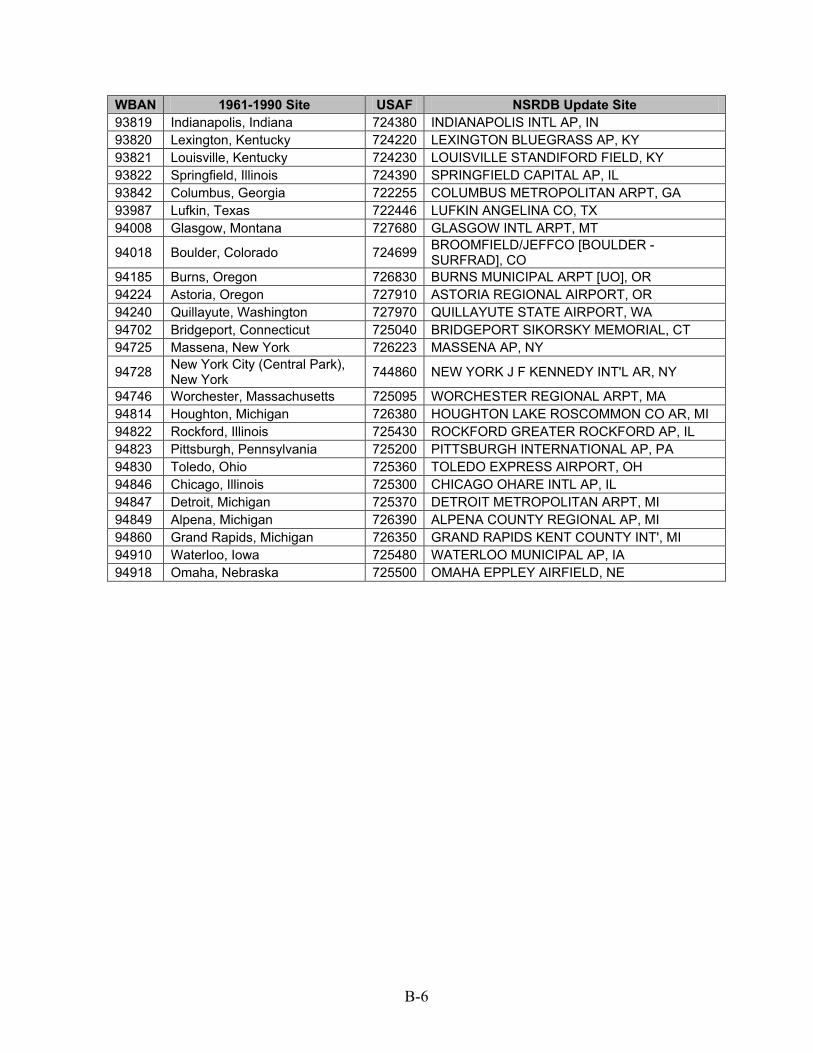
B-6
WBAN 1961-1990 Site USAF NSRDB Update Site 93819 Indianapolis, Indiana 724380 INDIANAPOLIS INTL AP, IN 93820 Lexington, Kentucky 724220 LEXINGTON BLUEGRASS AP, KY 93821 Louisville, Kentucky 724230 LOUISVILLE STANDIFORD FIELD, KY 93822 Springfield, Illinois 724390 SPRINGFIELD CAPITAL AP, IL 93842 Columbus, Georgia 722255 COLUMBUS METROPOLITAN ARPT, GA 93987 Lufkin, Texas 722446 LUFKIN ANGELINA CO, TX 94008 Glasgow, Montana 727680 GLASGOW INTL ARPT, MT
94018 Boulder, Colorado 724699 BROOMFIELD/JEFFCO [BOULDER - SURFRAD], CO
94185 Burns, Oregon 726830 BURNS MUNICIPAL ARPT [UO], OR 94224 Astoria, Oregon 727910 ASTORIA REGIONAL AIRPORT, OR 94240 Quillayute, Washington 727970 QUILLAYUTE STATE AIRPORT, WA 94702 Bridgeport, Connecticut 725040 BRIDGEPORT SIKORSKY MEMORIAL, CT 94725 Massena, New York 726223 MASSENA AP, NY
94728 New York City (Central Park), New York 744860 NEW YORK J F KENNEDY INT'L AR, NY
94746 Worchester, Massachusetts 725095 WORCHESTER REGIONAL ARPT, MA 94814 Houghton, Michigan 726380 HOUGHTON LAKE ROSCOMMON CO AR, MI 94822 Rockford, Illinois 725430 ROCKFORD GREATER ROCKFORD AP, IL 94823 Pittsburgh, Pennsylvania 725200 PITTSBURGH INTERNATIONAL AP, PA 94830 Toledo, Ohio 725360 TOLEDO EXPRESS AIRPORT, OH 94846 Chicago, Illinois 725300 CHICAGO OHARE INTL AP, IL 94847 Detroit, Michigan 725370 DETROIT METROPOLITAN ARPT, MI 94849 Alpena, Michigan 726390 ALPENA COUNTY REGIONAL AP, MI 94860 Grand Rapids, Michigan 726350 GRAND RAPIDS KENT COUNTY INT', MI 94910 Waterloo, Iowa 725480 WATERLOO MUNICIPAL AP, IA 94918 Omaha, Nebraska 725500 OMAHA EPPLEY AIRFIELD, NE

C-1
Appendix C: Measured Solar Instrumentation
This section provides details about the instrumentation used for measured solar radiation in the NSRDB update. Table C-1 shows instrumentation by year for each site with measured data.
Table C-1. Measurement Site Instrumentation by Year, 1991–2005
ID Name 91
92
93
94
95
96
97
98
99
00
01
02
03
04
05
700260 BARROW W POST-W ROGERS ARPT [NSA - ARM]
x x x x x x x a a a a a a a a
722046 SPACE COAST RGNL [FSEC] x x x x x x x a a a a x x x x
722140 TALLAHASSEE REGIONAL AP [ISIS]
x x x x a a a a a a a a x x x
722436 HOUSTON ELLINGTON AFB [CLEAR LAKE - UT]
x x x x x x a a a a a x x x x
722470 LONGVIEW GREGG COUNTY AP [OVERTON - UT]
x x x x x c c c c c c c c x x
722506 MCALLEN MILLER INTL AP [EDINBURG - UT]
x x x x x x a a a a a a a x x
722510 CORPUS CHRISTI INTL ARPT [UT] x x x x x c c c c c c c c x x
722520 LAREDO INTL AP [UT] x x x x x c c c c c c c c x x
722540 AUSTIN MUELLER MUNICIPAL AP [UT] x x x x x a a a a a a a x x x
722610 DEL RIO [UT] x x x x x c c c c c c x x x x
722660 ABILENE REGIONAL AP [UT] x x x x x x c c c c c c c x x
722700 EL PASO INTERNATIONAL AP [UT]
x x x x x x x x a a a a a x x
723546 PONCA CITY MUNICIPAL AP [SGP - ARM]
x x x a a a a a a a a a a a a
723630 AMARILLO INTERNATIONAL AP [CANYON - UT]
x x x x x x a a a a a a a x x
723650 ALBUQUERQUE INTL ARPT [ISIS] x x x x a a a a a a a a a a x
723870 MERCURY DESERT ROCK AP [SURFRAD]
x x x x x x x a a a a a a a a
723898 HANFORD MUNI ARPT [ISIS] x x x x a a a a a a a a a a a

C-2
ID Name 91
92
93
94
95
96
97
98
99
00
01
02
03
04
05
724030 WASHINGTON DC DULLES INT'L AR [STERLING - ISIS]
x x x x x a a a a a a a a a a
724125 BLUEFIELD/MERCER CO [NREL] a a a a a a a a a a a a a a a
724666 DENVER/ CENTENNIAL [GOLDEN - NREL]
a a a a a a a a a a a a a a a
724699 BROOMFIELD/JEFFCO [BOULDER - SURFRAD]
x x x x x a a a a a a a a a a
724776 MOAB/CANYON-LANDS [UO] x x x c c c c c c c c c c c x
725128 STATE COLLEGE [PENN STATE - SURFRAD]
x x x x x x x a a a a a a a a
725315 UNIV OF ILLINOIS WI [BONDVILLE - SURFRAD]
x x x x a a a a a a a a a a a
725720 SALT LAKE CITY INT'L ARPT [ISIS] x x x x a a a a a a a a a a a
725744 ROCK SPRINGS ARPT [GREEN RIVER - UO]
x x x x c c c c c c c c c c c
725895 KLAMATH FALLS INTL AP [UO] x x x x x x x x b b x x x x x
725970 MEDFORD ROGUE VALLEY INTL AP [ASHLAND - UO]
x x x x x x x x x c c c c c c
726410 MADISON DANE CO REGIONAL ARPT [ISIS]
x x x x x a a a a a a a a a a
726796 DILLON AIRPORT [UO] x x x x x x x x x x x a a a a
726810 BOISE AIR TERMINAL [UO] x x x c c c c c c c c x x x x
726830 BURNS MUNICIPAL ARPT [UO] b b b b b b b b b b b b b b b
726883 HERMISTN MUNI ARPT [UO] x x b b b b b b b b b b b b b
726930 EUGENE MAHLON SWEET ARPT [UO] b b b b b a a a a a a a a a a
727640 BISMARCK MUNICIPAL ARPT [ISIS]
x x x x a a a a a a a a a a a
727686 WOLF POINT INTL [FORT PECK - SURFRAD]
x x x x a a a a a a a a a a a
727935 SEATTLE BOEING FIELD [ISIS] x x x x a a a a a a a a a a a
746943 ELIZABETH CITY COAST GUARD AI [NREL]
a a a a a a a a a a a a a a a

C-3
Key
a – Measured global, direct, and diffuse with thermopile instruments b – Measured global and direct with thermopile instruments c – Spectrally corrected measured global and diffuse with rotating shadowband radiometer (see
Section 2.3.6.1) x – No measured data available