national report to regional hydrographic commission … 13-6-1-15... · national report to regional...
TRANSCRIPT


NATIONAL REPORT TO REGIONAL HYDROGRAPHIC COMMISSION REPUBLIC OF INDIA- FEB 2012
1. Hydrographic Office / Service 1.1 The Indian Naval Hydrographic Department (INHD), with the National Hydrographic Office located at Dehradun, is the sole national authority for publication of nautical charts and publications for navigation at sea. As part of its international responsibilities, the department provides coverage for marine safety information in the region NAVAREA VIII comprising of Indian Ocean, Arabian Sea and Bay of Bengal. With a fleet of eight modern ocean-going survey ships and one twin hulled catamaran survey vessel; fully equipped with latest hydrographic and oceanographic sensors and six more ships including a training vessel on the anvil, it is one of the most reckonable hydrographic organisations in the world. 1.2 The National Institute of Hydrography (NIH), Goa, an integral part of the INHD, has the national responsibility for conduct of hydrographic training within India and functions under the overall professional supervision of the Chief Hydrographer to the Govt of India. The Institute conducts courses for hydrographic officers, technicians, civilians as well as personnel from the Indian Ocean littoral states. The courses conducted by the Institute are recognised by the International Hydrographic Organisation. The courses conducted and duration is depicted in the table below:-
Sl No Course CAT Duration (a) Long H Course A 58 Weeks (b) Basic H Course B 29 Weeks (c) PO ‘Q’ SR - 18 Weeks (d) Basic ‘Q’ - 29 Weeks (e) LS SR ‘Q’ Refresher - 11 Weeks
2. Surveys 2.1 Coverage of New Surveys. The INHD has undertaken Hydrographic Surveys both in National and International waters. The Indian coast is dotted with 24 major ports, numerous minor ports and fisheries harbours which are supported by the department as far as navigational surveys and maritime safety information is concerned. Hydrographic surveys are being undertaken towards updation of existing charts of the Indian coast and island territories. The department has conducted three new surveys in foreign waters in the year 2012-13. The department undertook International hydrographic Co-operation survey of Beira Port, Mozambique and two hydrographic surveys off the South-Coast and West-Coast of
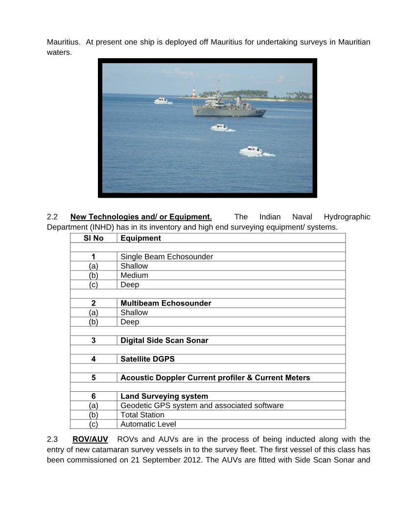
Mauritius. At present one ship is deployed off Mauritius for undertaking surveys in Mauritian waters.
2.2 New Technologies and/ or Equipment. The Indian Naval Hydrographic Department (INHD) has in its inventory and high end surveying equipment/ systems.
2.3 ROV/AUV ROVs and AUVs are in the process of being inducted along with the entry of new catamaran survey vessels in to the survey fleet. The first vessel of this class has been commissioned on 21 September 2012. The AUVs are fitted with Side Scan Sonar and
Sl No Equipment
1 Single Beam Echosounder (a) Shallow (b) Medium (c) Deep
2 Multibeam Echosounder
(a) Shallow (b) Deep
3 Digital Side Scan Sonar
4 Satellite DGPS
5 Acoustic Doppler Current profiler & Current Meters
6 Land Surveying system
(a) Geodetic GPS system and associated software (b) Total Station (c) Automatic Level

multibeam system alongwith associated inertial navigation system and other miscellaneous sensors.
2.4 Processing System/ Softwares.
2.4.1 Bathymetric data collection and post processing. 2.4.2 Geodetic data post processing software. 2.4.3 ENC production software. 2.4.4 ENC validation software. 2.4.5 Digital Side Scan Sonar data post processing software. 2.4.6 Image processing software.
2.4.7 The department has commissioned state of the art automated cartographic system for the production of paper nautical charts and ENCs. 2.4.8 To improve the efficacy of chart production the department is in the process of acquiring a state of the art computer to plate system.
2.5 Miscellaneous Equipment. 2.5.1 Conductivity Temperature Depth and Sound Velocity Profilers. 2.5.2 Automated Motion Sensors. 2.5.3 Water Level Meters (RADAR Type). 2.6 New Ships. The department boasts of a survey fleet of eight ocean going helicopter carrying survey ships and one twin hulled Catamaran survey vessel Five more Catamaran Hull survey vessels are likely to be inducted near future. In addition, one survey training vessel is being planned for induction in 2015, which also will be utilised as a production platform for Hydrographic/Oceanographic Surveys. 2.7 Problems encountered. Nil
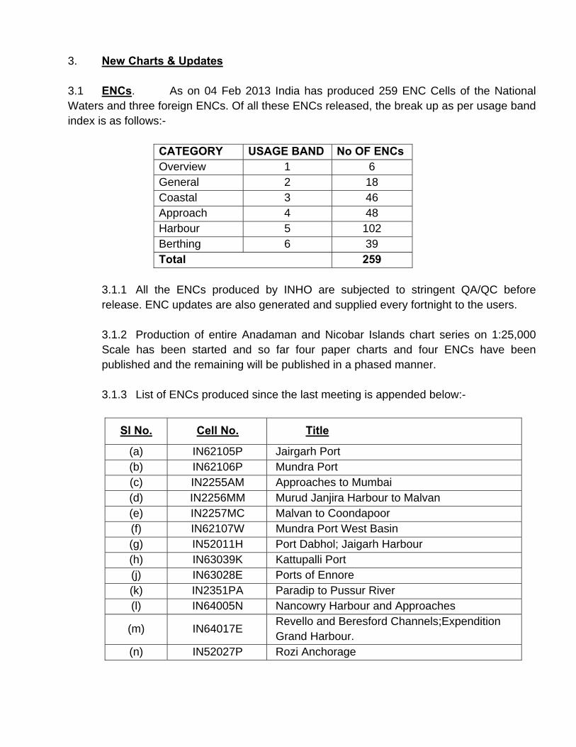
3. New Charts & Updates 3.1 ENCs. As on 04 Feb 2013 India has produced 259 ENC Cells of the National Waters and three foreign ENCs. Of all these ENCs released, the break up as per usage band index is as follows:-
CATEGORY USAGE BAND No OF ENCs Overview 1 6 General 2 18 Coastal 3 46 Approach 4 48 Harbour 5 102 Berthing 6 39 Total 259
3.1.1 All the ENCs produced by INHO are subjected to stringent QA/QC before release. ENC updates are also generated and supplied every fortnight to the users.
3.1.2 Production of entire Anadaman and Nicobar Islands chart series on 1:25,000 Scale has been started and so far four paper charts and four ENCs have been published and the remaining will be published in a phased manner. 3.1.3 List of ENCs produced since the last meeting is appended below:-
Sl No. Cell No. Title
(a) IN62105P Jairgarh Port (b) IN62106P Mundra Port (c) IN2255AM Approaches to Mumbai (d) IN2256MM Murud Janjira Harbour to Malvan (e) IN2257MC Malvan to Coondapoor (f) IN62107W Mundra Port West Basin (g) IN52011H Port Dabhol; Jaigarh Harbour (h) IN63039K Kattupalli Port (j) IN63028E Ports of Ennore (k) IN2351PA Paradip to Pussur River (l) IN64005N Nancowry Harbour and Approaches
(m) IN64017E Revello and Beresford Channels;Expendition Grand Harbour.
(n) IN52027P Rozi Anchorage

(p) IN62074S Pawas Bay-Ranpar Port (q) IN63037D Dhamra Port (r) IN64042C Chowra Island (s) IN54163A Approaches To Chowra Island (t) IN54164T Tarasa Dwip (u) IN54165B Bompoka Island (v) IN54177T Tillanchang Island (w) IN62504T Mathurin Harbour (x) IN42508K Kaashidhoo To North Male Atoll
3.1.4 Foreign Water Charts and ENCs. INHO so far published three ENCs and three paper charts. Twenty paper charts and twenty ENCs are at various stages of production and will be published in due course of time.
3.2 ENC Distribution Method. Indian ENCs are distributed worldwide by VARS like UKHO, M/s Jeppesen Marine and M/s PRIMAR RENC (Norwegian Hydrographic Service). We provide ENCs in S-63 format to the Indian Navy and other national agencies. 3.3 INT Charts. India, as the coordinator of International charting group for the North Indian Ocean (Area J), has responsibility to produce 80 INT (54 allocated +26 proposed) charts on medium and large scale. Out of 80 INT charts, India has produced 53 INT charts and remaining are planned to be produced in due course of time. 3.4 National Paper Charts. Indian National Hydrographic Office (INHO) produces 346 Nautical Charts (including foreign water charts) and 16 publications of the Indian Ocean

Region. These are being distributed through a network of 13 Indian and 07 foreign chart agents/ distributors. New charts produced since Mar 12 is as follows:-
Sl No.
Chart No.
Chart Title
(a) 2106 Mundra Port (b) 2107 Mundra Port West Basin (c) 3038 App. To Dhamra Port (d) 2083 Approaches to Sikka (e) 2034 Hazira Port (f) 2033 Sikka Creek (g) 351 Paradip to Pussur River (h) 2503 Approaches to Cargados Carajos Shoals (j) 2509 Assumption Island (k) 3009 Kakinada Port; Approaches to Kakinada; Kakinada Anchorage (l) 3039 Kattupalli Port (m) 3028 Ports of Ennore (n) 2027 Rozi Anchorage (p) 2508 Kashidhoo to North Male Atoll (q) 2013 Port of Okha (r) 3035 Gangavaram Port (s) 3037 Dhamra Port (t) 2074 Pawas Bay - Ranpar Port (u) 4165 Bompoka Island (v) 4177 Tillanchang Island (w) 2504 Mathurin Harbour (x) 4042 Chowra Island (y) 2003 Badagara Anchorage; Beypore Anchorage (z) 4017 Expedition and Grand harbour (aa) 4163 Approaches to Chowra Island (ab) 4164 Tarasa Dwip (ac) 3036 Chemplast Sanmar-Cuddalore Terminal (ad) 3003 Pondicherry Anchorage; Cuddalore Anch. (ae) 2501 North Male Atoll and Approaches (af) 3004 Chennai Harbour (ag) 2030 Srivardhand and Bankot Anchorages (ah) 4005 Nancowry Harbour and Approaches (aj) 3007 Nagapattinam Anchorage; Nagore Anchorage

4. New Publications & Updates 4.1 New Publications. The following new Books/Publications were published during the last year: -
4.1.1 Indian List of Radio Signals Volume 6 4.1.2 Indian Notices to Mariners – Special Edition 2012 4.1.3 Indian Notices to Mariners – Annual Edition 2013 4.1.4 Nautical Almanac 2013
4.2 Updated Publications. The following Publications were updated during the last year: -
4.2.1 Catalogue for Indian charts, ENCs and publications.
4.3 Means of Delivery e.g. Paper, Digital.. The paper charts and publications are distributed through chart agents and ENCs are distributed through VARs.
4.4 Problems encountered. Nil.
5. Marine Safety Information 5.1 Existing Infrastructure for Transmission. - All Radio Navigational Warnings (NAV WARNINGS) for NAVAREA-VIII are issued by the Chief Hydrographer to the Government of India. The Naval Chart Depot at Mumbai coordinates the broadcasting of all Navigational Warnings. Reports/ Information may be directly sent to Naval Chart Depot by various authorities with a copy of information to National Hydrographic Office, Dehradun. National Hydrographic Office at Dehradun, India closely monitors all broadcasts. Apart from this, information received directly at the office is also communicated to Naval Chart Depot for transmission. The Navigational Warnings are forwarded to the Land Earth Station (LES) located at Pune, for onward dissemination to mariner, which can be received through INMARSAT ‘C’ terminals. The schedule of transmission of Navigational and Met warnings through Safety Net is as follows:-
5.1.1 Navigational Warnings. LES Pune - at 1000 and 2200 UTC
5.1.2 Meteorological Warnings.
5.1.2.1 LES Pune - 0900 & 1800 UTC for area N of Equator
5.1.2.2 Aussaguel - 0130, 1330 UTC and at 0000, 0600, 1200, 1800 UTC in case of cyclone warnings for area S of Equator.

5.1.2.3 Australia – Tropical cyclone warnings, if any are prepared and issued by Australia as unscheduled broadcasts for area South of Equator and East of 90° via Burum.
5.1.3 NAVTEX Coverage.
5.1.3.1 Chennai - Temporarily out of operation 5.1.3.2 Mumbai - Under repair/ replacement. 5.1.3.3 Mauritius - Operational
5.2 Furthermore, all the updated warnings including the Notices to Mariners are available on the INHO website www.hydrobharat.nic.in. 5.3 New Infrastructure in accordance with GMDSS Master Plan.
5.3.1 Seven new NAVTEX stations are planned to be set up in the near future. Three stations on the West Coast of India, three on the East Coast of India and one in the Andaman and Nicobar Islands are planned as follows:-
5.3.1.1 Veraval (Gujarat) 5.3.1.2 Vengrula (Maharashtra) 5.3.1.3 Muttam Point (Tamil Nadu) 5.3.1.4 Porto Novo (Tamil Nadu) 5.3.1.5 Vakalpudi (Andhra Pradesh) 5.3.1.6 Balasore (Orissa) 5.3.1.7 Keating Point (Andaman and Nicobar Islands)
5.3.2 The technical evaluation of bids for award of contract for setting up the NAVTEX chain is in progress. RF modeling for all seven stations has been completed by the prospective bidders.
5.3.3 Provisional B1 Characters for the proposed stations have been allocated by IMO NAVTEX Coordinating panel for both 518 kHz and 490 kHz.
5.4 Problems Encountered. Nil. 6. C-55 (Updated Table). The updated C-55 table is placed at Annexure to the National Report.

7. Capacity Building 7.1 A week long training programme on navigational chart familiarisation was conducted at NHO, Dehradun in May 2012 for personnel from Directorate of light houses and light ships of India. A one day work shop on hydrography and chart production was conducted for officers of the Directorate of light houses and light ships of India at New Delhi in August 2012. The Cat ‘A’ and Cat ‘B’ programmes conducted at the National Institute of Hydrography, continues to be subscribed by a host of nations in the IOR and beyond 7.2 International Co-operation and Training
7.2.1 Indo-Mauritius. Seven years ago India and Mauritius signed a MoU on co-operation in the field of hydrography. INHD has completed twenty hydrographic surveys including a CLCS survey off Rodrigues Island and seven navigational charts have been published as follows:-.
S. No. Area Chart No.
1 Agalega Island 2084
2 Approaches to Port Louis, Port Louis 2086
3 Approaches to Cargados Carajos Shoals 2503
4 Mathurin Harbour 2504
5 Approaches to Mathurin Harbour and Grand Bay, 2505
6 Grand Riviere Noire Bay 2506
7 Grand Port - Southern Entrance 2507
7.2.2 A survey ship is presently deployed to Mauritius for undertaking hydrographic surveys as planned. It is expected that the remaining waters around the main Mauritius Island will be covered during this sortie. This will result in a IN chart of the area being produced with the latest data. 7.2.3 Indo-Seychelles. Post signing of the MoU on Indo-Seychelles Defence Cooperation, a total of seven hydrographic surveys has been completed. Following four important charts have been published:-
Sl No Chart Chart No (a) Coetivy Island 2085 (b) Western Approaches to Mahe Island 2502 (c) Port Victoria 2087 (d) Assumption Island 2509

7.2.4 In addition, personnel from Seychelles People’s Defence Force Seychelles (SPDF) continue to be trained at NIH. So far 13 personnel from SPDF have completed training. Officers and Sailors from SPDF continue to embark Indian Naval survey ships for practical experience. One survey ship visited Port Victoria, Seychelles and participated in the International Carnival held in March 2012.
7.2.5 Indo-Mozambique. During the visit of technical delegation from India to Mozambique in February 2011, Mozambique authorities had indicated survey requirement for four major ports namely Maputo, Beira, Nacala and Pemba in order of priority. An Indian Naval ship carried out a hydrographic survey off Beira in April 2012 and three charts and ENC have been released. Eight officers from the Mozambique Navy were provided on job training onboard during the conduct of survey.
7.2.6 Indo-Kenya. Kenya has evinced interest in co-operation with INHD. Survey of Kenyan Ports on request will be undertaken in coming years.
7.2.7 Indo-South Africa. A survey ship visited Cape Town, South Africa coinciding with the visit of an Indian delegation to explore feasibility of hydrographic co-operation between the two countries.
7.2.8 Indo – UK. As a part of bilateral co-operation between India and UK, the UK National Hydrographer visited New Delhi on 11 June 2012 and called on the Chief Hydrographer. Subsequently a technical working group meeting was held at National Hydrographic Office, Dehradun from 12-14 June 2012. Various issues pertaining to hydrography and chart production under the aegis of the bilateral arrangement were deliberated upon during the meeting. 7.2.9 Antarctica Survey Programme. A delegation from INHD participated in the 31st Indian Antarctica expedition from November 11 to March 2012 and successfully collected hydrographic survey data at newly established Indian Scientific station off

Ingrid Christensen coast (Larsemann hills). One more team has been deputed for the 32nd Indian Antarctic expedition and are expected to return by early April 2013. India has been approached for production of INT chart in the Larsemann Hills area.
7.3. Training. Since inception a total of 539 foreign nationals were trained at National Institute of Hydrography (NIH), Goa. Trainees from Fiji, Indonesia, Maldives, Mozambique, Myanmar, Phillipines, Srilanka and Vietnam attended various courses conducted at the NIH. The number of foreign personnel trained in the year 2012-13 is appended below:
Sl No Course No of Foreign Trainees (a) Long ‘H’ 07 (b) Basic ‘H’ 07 (c) PO ‘Q’ SR 03 (d) Basic ‘Q’ 02 (e) Onboard Training 08 Total 27
7.4 INHD is also shortly embarking on a plan to conduct courses on digital cartography with special emphasis on on job training in ENC production and maintenance.

MISCELLANEOUS
8. International Hydrographic Conference An Indian delegation participated in the XVIIIth International Hydrographic Conference held at Monaco from 20 to 27 April 2012. 9. World Hydrographic Day celebrations. The World Hydrographic Day was celebrated in India at NHO Dehradun, National Institute of Hydrography (NIH), Goa and onboard ships at Vishakapatnam, Kochi and Karwar. Keeping in view the theme “International Hydrographic Co-operation – Supporting Safe Navigation” workshops, lectures, demonstrations and visits by undergraduate and senior school students were organised at these locations.

Annexure 1(refers to Para 6 of National Report)
IHO SPECIAL PUBLICATION C-55
“STATUS OF HYDROGRAPHIC SURVEYING AND NAUTICAL CHARTING WORLD-WIDE” QUESTIONNAIRE
Country : India Date of validity of Information : Feb 2013 Are any amendments required to your entry in the IHO Year Book? If so, enter below. Update is particularly important on your outsourcing strategy and on your ability to provide contract survey or charting support to other states in your RHC area.
INDIA (REPUBLIC OF)
NATIONAL HYDROGRAPHIC OFFICE Post Box No. 75
107 - A Rajpur Road DEHRA DUN – 248 001 (UTTARAKHAND)
Department of which the Hydrographic Office is part – Ministère don’t dépend le Service Hydrographique – Ministerio del que depende el Servicio Hidrográfico
Indian Navy, Ministry of Defence.
Principal functions of the H.O. – Attributions principales du S.H. – Principales funciones del S.H.
Hydrographic surveys, Project surveys, Nautical charts, Electronic Navigational Charts (ENC), Notices to Mariners (Fortnightly), Radio Navigational Warnings, List of Lights, Sailing directions, Nautical Almanac, Tides, Tidal streams and currents, Oceanographic data analysis and publications, Marine and earth sciences, Coastal Zone Regulation Plan Charts, UNCLOS Charts, Fisheries Charts, Procurement & Maintenance of Hydrographic Oceanographic and Cartographic equipment for the department, Consultancy, Hydrographic & Cartographic Training for International Hydrographic Cooperation.
National day day – Fête nationale - Fiesta nacional Independence Day 15 August Republic Day 26 January
Telephone : + 91 (135) 2747 365 Fax : + 91 (135) 2748 373 E-mail : [email protected] WEB site: http://www.hydrobharat.nic.in Date of establishment and Relevant National 1776

Legislation – Date de fondation et législation nationale concernée– Fecha de establecimiento y Leyes nacionales de referencia
Govt. of India. Rules of Business; The Territorial Waters. Continental Shelf. EEZ & Maritime Zones Act 1976.
Name and rank of the Director or Head– Nom et grade du directeur – Apellidos y graduación del Director
Vice Admiral SK Jha, NM Chief Hydrographer to the Government of India
Tonnage– Tonelaje 2011 = 11113181tons Total Budget-Budget total – Presupuesto Total Rs. 1000 millions approx (Annual Revenue
Budget) including survey ship operations Staff employed - Effectifs -Plantilla Rear Admiral KM Nair, NM
Joint Chief Hydrographer Commodore Vinay Badhwar, NM Principal Director Commodore Adhir Arora, NM Principal Director Commodore Ravi Nautiyal Additional Principal Director Commander Peush Pawsey Joint Director of Hydrography-I (Operations) Commander Sajeev K Nair Joint Director of Hydrography (Personnel & Training) Commander Deepak Sharma Joint Director of Hydrography (Chart Sales & Distribution) Commander A Muralidhar Joint Director of Hydrography (Maritime Boundary) Commander A Banerjee Joint Director of Hydrography Staff Officer to Chief Hydrographer Commander RB Menon Joint Director of Hydrography (International Affairs) Commander Anand Narayanan Joint Director of Hydrography (Maritime Safety Services)

Commander Amol Merwade Joint Director of Hydrography - I (Materials) Commander Amit Pant Joint Director of Hydrography-II (Operations) Commander Mahendra Kumar Joint Director of Hydrography – II (Materials) Commander YV Ramakrishna Joint Director of Hydrography (Hydrographic Data Mangement) Mr. SS Chauhan Deputy Chief Civil Hydrographic Officer Mr. Rajesh Kumar Deputy Chief Civil Hydrographic Officer Dr. RB Singh Assistant Chief Civil Hydrographic Officer Dr. RA Prasad Assistant Chief Civil Hydrographic Officer
N° of charts published -Nombres de cartes publiées - N° de cartas publicadas.
346
N° of INT charts published -Nombres de cartes INT publiées - N° de cartas INT publicadas.
(a) Small scale 02 (b) Medium & Large Scale 51
N° of ENC cells published -Nombres de cellules ENC publiées - N° de células ENC publicadas. 259

Type of publications produced (e.g; Tide Tables, Sailing Directions, List of Lights etc.) -Type de publications produites (par ex: Tables des marées, Instructions nautiques, Livres des Feux, etc. -Tipo de publicaciones producidas (por ej: Tablas de mareas, Derroteros, Libros de Faros etc)
1. West Coast of India Pilot. 2. Bay of Bengal Pilot. 3. List of Radio Signals (Vol – I) 4. List of Radio Signals (Vol – II) 5. List of Radio Signals (Vol – V) 6. List of Radio Signals (Vol – VI) 7. List of Light & Fog Signals (Vol D&E). 8. List of Light & Fog Signals (Vol F&K) 9. Notices to Mariners (Special Edition). 10. Notices to Mariners (Annual Edition). 11. Notices to Mariners (FortnightlyEdition). 12. Symbols and Abbreviations 13. Catalogue of Charts & Publications. 14. Nautical Almanac. 15. Tidal Predictions. 16. Wreck List 2012.
Surveying vessels/ Aircraft – Bâtiments hydrographiques/aéronefs - Buques hidro-gráficos/ Aeronaves
Displacement Date Launched
Crew
SANDHAYAK 1820 1981 200
NIRDESHAK 1820 1983 200
NIRUPAK 1820 1985 200
INVESTIGATOR 1820 1990 200
JAMUNA 1820 1991 200
SUTLEJ 1820 1993 200
DARSHAK 1820 2001 200
SARVEKSHAK
MAKAR
1820
594
2002
2012
200
50 Outsourcing strategy -Stratégie en matière de travail exécuté sous contrat à l’extérieur -estrategia de contratación de trabajos.
1. Nil on Survey 2. Nil on ENC Production
Other information of interest -Autres informations utiles - Otra información de interés.
1. National Institute of Hydrography is the Institute for Hydrographic Training. The Long Hydrographic Course and Basic “H” Course conducted by National Institute of Hydrography have been awarded CAT “A”, CAT “B” accreditation by FIG/IHO Advisory Board on Standards of Competence for Hydrographic Surveyors. In April 2006 the accreditation has been renewed for a further period of six years.
2. ENCs of 100 % of National Water have been produced. Regular updates of ENCs are promulgated fortnightly.

3. In 2011 India proposed inclusion of 26 additional INT charts in the region. Therefore, out of 82 INT Charts to be produced by India, 53 have been published.
4. The Hydrographic Department of India has the required resources, Infrastructure and technical expertise to assist littoral states in the following areas:
(i) Conduct of Hydrographic, Oceanographic and Coastal Zone Regulation Plan Surveys.
(ii) Training in Hydrography and Cartography.
(iii) Setting up of hydrographic infra-structure and Hydrographic Office.
(iv) Exchange of personnel.
(v) Production of Electronic Navigational Charts (ENCs).
(vi) EEZ/Continental Shelf Surveys. 1. HYDROGRAPHIC SURVEYING
1.1 Status of Hydrographic survey of all Navigable Waters, including internal waters, out to the limits of the EEZ : (Please refer to the guidance given in the introductory text “Analysis of the Status of Surveys”.)
Survey Coverage, where : A = percentage which is adequately surveyed. B = percentage which requires re-survey at larger scale or to modern standards. C = percentage which has never been systematically surveyed.
A B C Depths<200 m 100 0 0 Depths>200 m 88 12 0
Amplifying Information:
(a) The entire navigational area in depths less than 200 meters has been adequately surveyed. There are few small areas where the charted data is based on old surveys. These areas are well away from the shipping routes and are of no interest to the Mariners.

(b) There are some areas in Indian Waters where the seabed is unstable. A cautionary note to this effect is printed on Navigational Charts.
1.2 Significant shortfalls in sea areas of high priority for maritime traffic:
a. Maritime Shipping Routes: (1) International (i.e. between hub ports): NIL (2) Regional (i.e. between hub ports and feeder ports): NIL (3) Internal (i.e. from feeder ports to other national ports; cruise liner routes): NIL b. Ports and approaches: NIL c. Other (fisheries; offshore industry): NA
1.3 Status of Hydrographic survey of all Navigable Waters, including internal waters, out to the limits of the EEZ of dependent territories: NA 1.4 Status of Hydrographic survey of all Navigable Waters, including internal waters, out to the limits of the EEZ of developing countries where surveys have been, or are being carried out by your hydrographic service:
NA
2. NAUTICAL CHARTING 2.1 Status of Nautical Charting within the limits of the EEZ
Coverage of charts published by your organisation, where: A = percentage covered by INT series, or a paper chart series meeting the standards in M-4. B = percentage covered by Raster Navigational Charts (RNCs) meeting the standards in S-61. C = percentage covered by ENCs meeting the standards in S-57. Purpose/Scale A B C Offshore passage/small 100 0 100 Landfall and Coastal passage/Medium 100 0 100 Approaches and Ports/Large 100 0 100 Percentage of Group A showing depths in meters 100 Percentage of Group A referenced to a satellite datum 50 Amplifying notes : Nil Significant gaps in coverage : Nil

2.2 Status of Nautical Charting within the limits of the EEZ of dependent territories NA 2.3 Status of Nautical Charting produced by mutual agreement within the limits of the EEZ of other coastal states NA
3. MARITIME SAFETY INFORMATION (MSI)
NAVIGATIONAL INFORMATION (S-53)
Service Yes No Partial Notes Local Warnings √ Coastal Warnings √ Navarea Warnings √ Information of Ports and Harbours
√
GMDSS IMPLEMENTATION (IMO Publication 970 - GMDSS Handbook) Service Yes No Partial Notes Master Plan √ A1 Area √ A2 Area √ A3 Area √ NAVTEX √ Safety NET √
4. NATIONAL PRIORITIES FOR INTERNATIONAL AND OR REGIONAL CO-OPERATION OR ASSISTANCE
4.1 If international or regional projects are underway in your waters, please indicate here : NA 4.2 Indicate below any priorities for co-operation or assistance:
(a) Projects meriting IHO liaison with international funding agencies:
(i) Regional co-operative projects : India has provided technical expertise and contributed US $ 1.687 mn for setting up of wind, current and tide sensors in the Straits of Malacca and Singapore (Project IV) under the aegis of the Co-operative Mechanism on the Safety of Navigation and Environmental Protection in the Straits of Malacca and Singapore.