national register of historic places inventory - … · again, john austin was responsible....
TRANSCRIPT
StaM
4
1’
Form No.10-IOU jM.
:.jNjTEDsTAjEs DEPARTMENTOFT HEINTERIOR
NATIONAL PARK SERVICEFOR NPSUSEONLY
. [
NATIONAL REGISTEROF HISTORICPLACES RECEIVED.
.INVENTORY --NOMINATION FORM . DATEENTERED
SEE INSTRUCTIONS IN HOW TO COMPLETENATIONAL REGISTER’FORMSTYPE ALL ENTRIES-- COMPLETE APPLICABLE SECTIONS
.
. HJ2’.
-
..i.fiNAME . . . .. .
HISTORIC The Austin HomesteadFarm The Lewis Place
AND/OR COMMON . . ..
Austin Farm Road Historic District.
fiLOCATION . . . . ..
STREET& NUMBER .
north side Austin Farm Road west of. 1-95.
‘
CITY. TOWN . . .
ExeterCONGRESSIONAL DISTRICT
District # 2 Rep. Beard
STATE CODE ,
Rhode Island .. 44 .
COUNTY C9WasningtOn uuY
fiCLASSIFICATION
CATEGORY OWNERSHIP . STATUS . , PRESENTUSEçDISTRICT .XOCCUPIED .
&BOTH? . IN PROGRESS
‘_COMMERCIAL
, .PRIVATE RESIDENCE
. PUBLIC ACQUISITION ACCESSIBLEIN PROCESS .*YES: RESTRICTED ._SCIENTIFIC.
CONSIDERED . UNRESTRICTED TRANSPORTATION
. . . .
flOWNER OF PROPERTY . .
NAME . . . . .
Multiple ownership. . . ‘.
.
STREET & NUMBER
CIJY, TOWN . STATE
- VIçINITYOF -
flLOCATION 0! LEGAL DESCRIPTIONCOURTHOUSE.REGISTRY OF DEEDS. ETC. Exeter Town Clerk’s OfficeSTREET & NUMBER ‘ ‘ .
Victory Highway . .
‘
CITY, TOWN STATE.
Exeter’ ‘ . Rhode Island .
flREPRESENTATIONIN EXISTING SURVEYS’TITLE ‘ ‘ ‘ . ‘ ‘ .
Preliminary "Broadbrush" Survey of Exeter.DATE - . ‘
- 1975 ‘ %,STATE
DEPOSITORY FORSURVEY RECORDS Rh d ‘ . . . ‘ . ‘ . -0 e ts1gid }-1toric-aJ Pte,sprxnitinn Comnnss-innCITY,TOWN Providence ‘ . - . -
- Rhode Island
:&&‘
V
fl’IflSCRIPTION
CONDITION - . . . - - CHECK ONE . CHECK ONE
_EXCELLENT - . _DETERIORATED - IUNALTERED - LORIGINAL SITE -
X.GOOD . _RUINS ‘ _ALTERED _MOVED DATE________ -
_FAIR _UNEXPOSED
-. DESCRIBE THE PRESENT AND ORIGINAL IF KNOWN PHYSICAL APPEARANCE . -
The Austin Farm Road Historic District comprises some 105acres of.. rolling fields and, woodland in north-central Exeter.The district is bordered by the Exeter-West Greenwich town line onthe north, by Interstate Route 95 on the east, by Austin Farm Roadon the-south and by a. north-outh line west of Austin Lower Pond,commonly known as Austin -Farm Pond see maps. Apardel of landon which a recently. built house stand Map # 17 has been excluded
_____
from the area to be nominated. Despite its proximity to Route 95,the proposed historic district is located in a still sparsely populated rural region. Much of the land in this section of western
_____
Rhode Island was cleared during the mid-eighteenth century forfarm use but:is now densely forested. The Austin ‘Farm Road districtis one of a relatively small number of extant examples of traditional .
open farm landscape. . .
The adjoining Austin and Lewis farms form the core area of thedistrict and date from the mid-eighteenth century. In the late nineeenth century, John Austin acquired both and developed them asa single property which he titled "the Austin HomesteadFarm"-- anexpansive "gentleman’sfarm" and summer retreat for himself and hisfamily. Though the farms aTe again in separate ownership, thecharacter’ they achieved under Austin’s proprietorship remains andis predominant. I ‘ - I
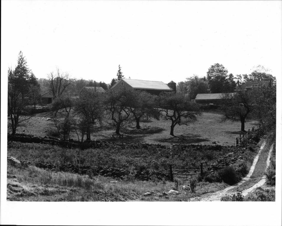
No early, structures survive on the west-sloping Austin farmproperty. The buildings here see sketch map, and photographswere erected by-.John Austin, either to provide new facilitiesor to replace earlier deteriorated or burned-out structures. Asit stands, then, this is a. late nineteenth-century farm complex..
Close to the road stands the -rather nondescript, two-and-a-.half-story, gable-roofed farm house. #1., After being damagedby fire early in the l890s this mid-nineteenth-century cottage wasmuch enlarged and elaborated. ‘Early in the twentieth century, itwas remodelled .again and simplified: ‘ the three interior chimneyswere removed and replaced by exterior chimneys, most nineteenth- ‘
century trim was removed and unpainted wood shingles replaced theoriginal clapboard siding. A carriage shed #4, c. 1890, now -
used as a rabbit hutch, stands to the rear of the farmhouse dl and,just to the north and east-facing the semi-circular entrance drive, ‘
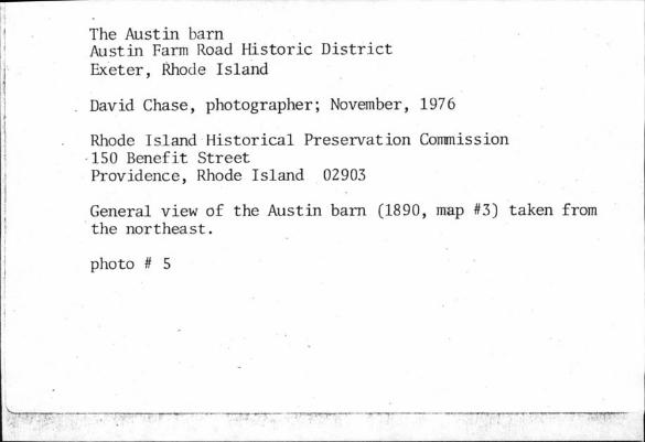
is the gable-roofed; shingle-clad, 36’-by-lOO-foot barn #3, 1890which has wagon entrances at both ends; An early twentieth-centurysilo is attached to its southwest corner. On the lane running pastthe barn north into the ‘pastures. and fields’ is al one-and-a-halfstory bunkhouse #2, c. 1890 set into the hillside; beyond it,‘also set into-the bank, -is a-one-story shed #S c. 1890 which may
see continuation sheet # 1
Form No- O-3OOa - - - .
IROV. 10.74 - - - - - -
.UNITED S rATES DI PARTMI Ni UI I ML IN I LRIOR FOR NPS USE ONLYNATIONAL PARK SERVICE
RECEIVED
NATIONAL REGISTER OF HISTORIC PLACESINVENTORY-- NOMINATION FORM - DATE ENTERED - -.
- - . - --
.
S1 . 7 2 - -
- CONTINUATION SHEET - - - ITEM NUMBER PAGE
- originally have beenan icehouse., At the-southeastern edge of the ‘ , :1- complex is a fenced corral and a small shed # 6, c. 1890 formerly’
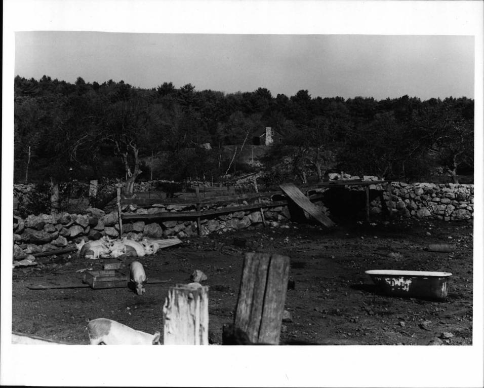
- used as a hen house. North and west of t-he barn are, walled-in pens
_____
for cattle, poultry and- pigs. Surrounding this compact area-are -
planting fields; an orchard, a family cemetery #8 pastures and- woodland. - Roaring Brook runs from ‘north to south across the’ farm
and, in the late nineteenth century, it was dammed in two places,creating two ponds. . Austin upper Pond provided pOwer for a turbine-driven sawmill #7, c. 1890 - a two-story, gable-roofed buildingset into the bank: forming the dam which has been converted into asummer house with the a’ddit ion- of a picture window and a rusticfieldstone fireplace. An unspoiled, stone-walled lane runs from themain ‘complex. to- the mill. Austin Lower Pond,’ with fine cut-stone dam,was probably created to,provide a convenient source of ice.
-‘ The unpretentious buildings in the Austin farm complex are all
of wood frame construction, gable roofed and clad- with clapboard -
and/or wood shingles.. They are either painted’white or are leftunpainted with only the trim in white.’ Jn John Austin’s day all the ‘
buildings were clapboard and painted red with white trim. - Austinerected a small general store-post offièe and ,a blacksmith shop ,
____
along the road at the southeast corner of his semi-circular drive-way; neither of these buildings survives. Excepting these changes, ‘
-
- however, the Austin farm complex remains largely as it was in the -
-late nineteenth century. Though on amuch smaller.scale than in:1 former times, it continues in use as a "hobby" farm producing honey,
eggs, feed gtain and ‘vegetables, as well as hogs and poultry. -
I-- ‘ - ‘ IF:-,.
- The Lewis farmhouse #9 is the only extant structure on the -
"Lewis Place" which predates John Austin’s ownership of the propertyand his consolidation of it with the Austin farm when he created"Austin’Homestead Farm." The Lewis house dates ‘,from the mid-
‘
eighteenth century. It-is a one-and-a-half-story gambrel-roofedstructure with a large, off-center chimney, a lean-to addition across ‘
- the back-and a projecting., latenineteenth--century rear ell. The ,
entrance to the house are in the east or -rear facade and in ,thesouth-facing gable end. A late nineteenth-century porch runs ‘
across t-he altered, frOntal, west elevation, which has, no entrance-at present. The house stands at the top of a rise, from which the
____
land descends westward to the Austin farm complex and Roaring Brook.It is set well’back from the road on .a straight, sandy lane. ‘
The lane makes a’ dogleg turn around the house and leads to the barn.r# 12, c. 1898 and a shed #13; northeast of the barn standsa largehen house and shed #s 14 t 15-; a second hen house has been
-demolished. All the extant outbuildings were erected for John Austin
,see continuation sheet # 2 GPO 092 455

- -
Form No. 1O-300a - - - -
Rev. 10.74-’. -- Ws- -
UNI ltD STATN DLPAR [MLN I OF 1111 IN ILRIUI FOR NPS USE ONLY 1- :. NATIONAL PARK SERVICE ‘ ‘ - - I -‘ ‘
- ‘:‘ ‘:‘ I..::I.:.:. ..: ‘I>.:i:’ - -
RECEIVED
NATIONAL REGISTER OF HISTORIC PLACESINVENTORY-- NOMINATION FORM - ,TEENT. " -
___
- -. -‘ --- - - - - -
CONTINUATION SHEET 2. ITEM NUMBER 7 PAGE 3
-and were once painted to match the red’and white color scheme ofthe Austin farm buildings. - - - - - -
The "Lei4is place" portion of John Austin’s "Homestead Farm"becamp a separate poultry operation in the twentieth century; -
as many as 18,000 birds were raised at a time. Though all farmingactivity has ceased here, th& orchard and meadow are maintained,and a vegetable garden is in use. -
- t’ -.
-- In architectural terms, the most ambitious new building John
Austin jut up was the Christian Union Chapel # 10, 1892 erectedalong the-lane leading to the ld Lewis house. This small, gable- - H’ -
roofed structure has cobblestone walls, a wood belfry now partiallyrenioved and roundheadedwindovjs and main entrance. It was builttb serve- as a chapel, free to all,-maintained by Mr. Austin, with
the regular services of visiting ministers provided by him. It -
_____
has since been converted to use as a dwelling. Behind the chapel -.
-- is a stone-walled, shed-roofed carriage shed # 11, c. 1892 now-altered, which once was used in conjunction with the chapel. -
- District Schoolhouse #5 #18, c. 1860, located just east- of the lane- leading into the Lewis -place, is-also included- in -
-
--the district. The school was essentially obsolete by the late nine--
teenth century, but Austin, who attended school there as a boy, -
,maintained it at his, own expens.e and kept it open as an educational C.- facility. Thougk’abandoned and in very poor condition, -this typicaL-onestory, ‘gable-roofed schoolhouse retains the red and white - .
exterior color scheme favored by Austin s
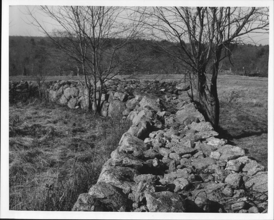
Ke elements, both ‘visually and historically, in the AustIn FarmRoad historic district are the unimproved lanes which traverse the .‘
- area and the stone walls bounding them and the fields between. Dry -
walls, built as much as repositories for rocks removed from plant--‘ ; .
ing fields as for boundaries, typify the Rhode Island rural l’and-scape. The well-preserved walls in the Austin Farm Road district areunusually massive, in places reaching a breadth of sixteen feetAgain, John Austin was responsible. According to a Newspaper accolintpublished in 1899, he had 13,000 boulders taken from his fields and
- added to existing walls. Today, dirt lanes and lichen-covered ‘
- walls’ help to define the pacial complexity and continuity ‘of thedistrict’s, open, rollin-g terrain.. - -
- - --
___
-II.
- 4’__ -
- - ‘ - - ‘ - - -‘ GPO 892 455 -
fl SIGNiFICANCE
* PERIOD . - AREAS OF SIGNIFICANCE --CHECK AND JUSTIFY BELOW ‘
_PREHISTORIC __ARCHEOLOGY-PREHISTORIC _COMMUNITY PLANNING _LANDSCAPE ARCHITECTURE _RELIGION -
.1400-1499 _ARCHEOLOGY-HISTORIC _CONSERVATION . _LAW - L_SCIENCE- _1500-1599 IAGRICULIURE . _ECONOMICS _LITERATUAE _SCULPTURE - I
_1600-1699 .XARCHITECTURE _EDUCATION, _MILITARY _SOCIAL/HUMANITARIANX1700-1799 - ....ART - _ENGINEERING - _MUSIC .....THEATER - -
Xl800-1899 _COMMERCE , LEXPLORATION/SETTLEMENT _PHILOSOPHY TRANSPORTATI0N_1900. - _COMMUNICATIONS ‘ - _INDUSTRY _POLITICS/GOVERNMENT X0IEIER SPECIFY
_INVENTION - ‘ - Historic Geography
SPECIFIC DAtES - - BUILDER/ARCHITECT - ‘ - -
- STATEMENT OF SIGNIFICANCE -- - -
-
- The Austin Farm Road Historic District is primarily-significant -asa well preserved exampleof the- once pervasive ‘rural agrarian landscapeof Rhode’ Island. Seen from the viewpoint of an historic geographer,the area preserves thebasic form dnd to a large extent the functionit achieved- in the eighteenth century as modified and developed inthe nineteenth century. The natural terrain,- the streams-and ponds,the woodlands, fields, meadows and orchards, the meandering lanes andstone walls, the clusters -of simple buildings, the crops and livestockraised here--all, in essence, relatd to lifeways and the physicalembodiments those lifeways took on in the colonial period. Thoughmost of western Rhode Island supported a rural agrarian society in thatera, this social order has largely disappeared. Not only are there I - -
few people still farming the land, but the area has lost it agricultural character visually, for hundreds of abandonedfarms have reverted
- to woodland. - - - -
The town of Exeter was an agrfcultual community in 1742 whenit was set off from North Kingstown, -and, by 1820, Exeter had achievedits most extensive agricultural development. - From that time on, farming began to decline as it did in neighboring towns as well. A numberof factors contributed to this decline: a general shift in the economics
-. of.agriculture from a subsistence to a commercial farming base, the -
competition New England farmers experienced from new and better Western ‘
farms which came to dominate Eastern markets with the help of rail-transportation and the brighter social and financial opportunitiesavailable in industrial cities and villages which drew many ambitiousyoung people. John Austin himself left the family farm for the citywhere he made a fortune, returning later only out of sentiment.When improving- his Exeter farm late in the nineteenth -century, Austindid so with the-knowledge- that the life of the countr’ farmer he knewas a boy was fast disappearing. That trend is now almost complete.Forests cover the land; there are, hut six -farms left in Exeter. TheAustin Farm Road District is the most representative and best presefvedagricultural area in town; and, consequently, protecting it is important -
if the visible evidence of Exeter’s heritage is to be retained. ‘
Architecturally, most buildings in the Austin Farm Road districtrelate- in a very typical fashion to the agricultural character of thearea. They are late nineteenth-century replacements for earlier structures as is true of so many buildings on long-established Rhode Islandfarms. In design-and construction they are representative vernacular
See cont sheet # 1
Form No IO-300a - - - - ‘ -
Rev- 1O;-4V . - - -
UNITEDSTA FL’,, DLI’AR FMENFOI 1111 IN ILRIOR FOR NE’S USE ONLYNATIONAL PARK SERVICE
RECEIVED
NATIONAL REGISTER OF HISTORIC PLACES- INVENTORY-- NOMINATION FORM ‘
- DATE ENTERED -
CONTINUATION SHEET - - 3 ITEM NUMBER 8 PAGE 2 - ‘ - -
farm buildings of the peyiod. This is true of the Austin farm houseas-well as the much-added-to, mideighteenth-century Lewis house -- - -
- the one extant building here which may date back to the beginningsof these farms and which,.with all its alterations, lends a senseof continuity to the area. The only nineteenth-century structuresdeserving special architectural note are the-Austin barn, unusualfor its size and -double entrance plan, and the intentionally rusticcobblestdnewalied church. Built by John Austin in 1890 and 1892,respectively,, they embody the pragmatism and the idealisnt whichcolored Austin’s approach to his Exeter farm. -
-
In the mid-nineteenth century; before development by John Austin,the Austin and Lewis farms were unremarkable. Each was operated by L -
a single family, in the case of the Lewis place with the helpof a hired man. On’ each there were oxen to do the plowing .and. haul-ing; a horse for transportation; two or three cows to produce milk,
- butter and cheese; and a few beef cattle and swine. The Lewis place,the larger of the two, also- supported a small flock of sheep. The
- farms produced corn, oats and hay-, seed grain’, large quantitie.s of- potatoes andsmall amounts of peas and beans. In the late nineteenth
century, John Austin modified this mixed agricultural approach slightlyand expanded it greatly. He made the combined farms more productivethan they had ever been before. -
John Austin grew up-on the Austin Farm which had been acquired- during the Revolution by his grandfather. As a youth he moved-to
Providence, learned the precious metals.smelting and refining.bus-mess important in the city’s-jewelry -industry, established, hisown firm and became a financial Success. His business, John Austin
Son, produced 1¼ million dollars worth of precious metals per yearin the .1890s and was a nationally known concern. Austin also wasinvolved in banking, becoming president of Citizens Savings Bank in1879 After acquiring the family homestead and buying the neighbor-
- ing farm, he set out -to create a highly productive agricultural -
showplace. "Austin HomesteadFarm," as he called it, contained 208acres. The enterprise required the supervison of a boss farmer whodirected the work of several hired hands. The livestock includedfour horses, thirteen cows, pigs, hens, ducks and turkeys. The -
"Homestead Farm" produced as much as 100 tons of hay per year-and1100 bushels of potatoes. Austin introduced pomoculture, plantingone thousand apple trees- o-f.all varieties, and established peach, -
plum and pear orchards. Grapevines were painted, as well as- berry -
bushes of several kmnds,-’and a large vegetable gardeh was kept. -
____
Each week a wagon would take fresh produce from the farm tq Austin’slarge house on Westminster Street in Providence. - - ‘ -
- see cont sheet N 2 GPO 002 455

formNo4O300a I
Rev 1074Y ‘ -‘ .-.
UNITLDSFAIESDI PARIMI NI 01 LIII INU 110k FORNPSUSCONLY F- NATIONAL PARK SERVICE - - - - - -- - --
RECEIVED
NATIONAL REGISTER OF HISTORIC PLACESINVENTORY-- NOMINATION FORM - DATE ENTERED ‘ ‘ ‘ -: -
CONTINUATIONSHEET - - ITEM NUMBER PAGE I
- But beyond creating a showplace-and source of food, Austin - - -
cared deeply about his rural agrarian heritage. He attempted topreserve and’ enhance a way of’ life he knew as a boy. He provided
____
a church, school, post office, general store and blacksmith shop--,
the nucleus of a small village -- *hich he hoped would improvethe -lot of local farmers in this rather inaccessible area andinduce them to stay on their farms. He Thel-ieved that hearingsermons and reading newspaperwere uplifting activities, and-heprovided both church’ services and newspaper subscriptions forhis neighbors. He even tried to improve the econçmic viability r’ ‘i’’of the farm community by attempting -to bring in a railroad spur,but in this effort Austin failed. Much ahead of his time, JohnAustin realized that if anything of Exeter’s agricultural her
_____
itage was to continue ‘to exist, specific positive efforts would ,
have to be made to protect it. That perception is even more true - ‘
today. - -- - - - -‘ - -
- ‘1
I4tck4c- - - - - - -
- . - - ‘-
-
t
- - - ‘ ‘-
--
*‘
- - - - - -
- --
- - - ‘ - --
- -
____
p- -
- - - ‘ ‘ - ct’.’GPO 892 455
4a:
UMAI0R BIBLIOGRAPHICAL REFERENCES - ‘ -
n a , "Austin 1-lomestead", Providence Journal, 11 June, 1899
Beers,’J. H. Co.; Representative Men 0l’d Families of Rhode --
Island.;’V. 2-., p. noB; Chicago, 1908. - -
‘,Beets,,J. -H’. ,-. Cc-.; Rhode Island Atlas, 1870. see cont. sheet # 5
CGEOGRAPHICAL DATAr - - - - - ‘ -
-‘ ACREAGE OF NOMINATED PROPERTY1O ‘ - -
- UTM REFERENCES - --
A11191 1217181312101 4t6tQt814i2jiJJ - 81191 [217181216101 I4,d0171719c1ZONE EASTING NORTHING - ZONE EASTING - NORTHING
C11I9112171R11I4101 14iflflo717t2ifl1 D11191 171717k,giO1 141tlo17!fl7idVERBALBOUNDARYDESCRIPTION
E 19 277600 4608440
See section 7 Description paragraphI. -
LIST ALL STATES AND COUNTIES FOR PROPERTIES OVERLAPPING STATE OR COUNTY BOUNDARIES -
- -STATE ‘ - - - - CODE - COUNTY - ‘ CODE’
STATE - ‘ - CODE COUNTY - - ‘ CODE
FORM PREPARED-BY - - - -
NAME / TITLE - -- - - - ‘ ‘ ‘ -
-David Chase, Chief of Field Services - -
ORGANIZATION ‘ - DATE -
,
,
Rhode Island Historical’Preservation Commissio December 15, 1976- STREET & NUMBER ‘ ‘ TELEPHONE
150 Benefit Street , - - ‘ - 401 277-2678CITY OR TOWN ‘ - STATE,
Providence, ‘ - Rhode Island
WSTATE HISTORIC PRESERVATION OFFICER CERTIFICATION .
- - - THE EVALUATED SIGNIFICANCE OF THIS PF3OPERTY WITHIN THE STATE IS:
-- NATIONAL......... - STATE..L..... - LOcAL.L.
As the designated State Historic Preservation Officer for the National Historic Preservation ACtOf 1966 Public Law 89-665, I
* -r
‘t ‘L
I.’,.
I,.A.’
- . -
A
t-w’-
p-’
DIRECTOR. OFFICE OF ARCHEOLOGY AND HISTORIC PRESERVATION -
ATTEST- - DATE
KEEPER OFTHE NATIONAL REGISTER - - -
GPO 892.453 l -
rc1t -‘ r’- ‘-:--‘- ‘,y r r
STATE HISTORIC PRESERVATION OFFICER SIGNATURE’ - - -
TITLE
State- - DATE
Historic preservation-Officer - - - December 27, 1976
hereby nominate this property for inclusion in the National Register and certify that it has been evaluated according to thecriteria and procedures set forth by the National Park Service. - ‘ - -
FORNPSUSEONLY . - - - -- -
I HEREBY CERTIFY THATTHIS PROPERTY IS INCLUDED IN THE NATIONAL REGISTER
- DATE -

Form No. lo-JOOa - - ‘ - - - ‘ -
Rev, 1O-t14 - ‘ ‘ ‘ - - -
uNi ILD srArI S DI PAR I MLN I DI I IlL IN I LRIDI FOR NPS USE ONLYNATIONAL PARK SERVICE
RECEIVED
NATIONAL REGISTER OF HISTORIC PLACESINVENTORY--NOMINATIONFORM DATEENTERED , ‘ F___
‘ 9 2 - -- :;::.-‘-CONTINUATION SHEET , ITEM NUMBER PAGE -
Bibliography - ‘- -"i_ -
Bidwell, Percy Wells, "The Agricultural Revolution in New England,"fl’
American 1-Listorical Review, volume XXVI 1920-21, ‘pp. 683-702.
Cole, J -R. ed.; History of Washington Kent Counties ‘
W W Preston, New Yoik, fWW9, Vol 1, pp 662-692
Coleman, Pete± J. ; The Transformation, of Rhode Island; -
Brown University, Providence, 1961; passim.‘
Everetts Richards,’ Atlas of Southern Rhode Island, 1895. -
- ‘I - Rhode Island Federal Census Statistics, 1748-1970. ‘ -
Walling, Map of Rhode Island, 185S ‘ -
- - --
-- - - --
__
- - - - ‘ -‘ -
.- ‘
‘
‘ ‘ - ‘
‘ -
- - - ‘
-
‘- - --
- ‘ - - ‘ ‘
i4.i-k--
-
S
1 -- - ‘ ‘I.::"
- - - ,,‘ GPO 092 455- }


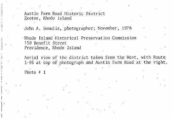
Austin Farm Road Historic DitrictExeter, Rhode Island
-John A. Senulis-, photographer;November, 1976
- Rhode Island l-Iistorical PreservationCommission150 Benefit Street -
Providence,Rhode Island - - ‘ -
Aerial view of the district taken from the West, with Route1-95 at-top of photographand Austin Fat-in Road at the right.
Photo#1 - -


Austin Uanii Road historic DistrictExeter, Rhode Island
Original photographtaken c. 1898property of Ross Aker, Sr.
Rhode Island Historical PreservationCommission150 Benefit StreetProvidence,Rhode Island 02903
Generalview of the district taken from the west in about1898; reading from left to right the buildings are:Austin-Lewis barn map # 12; Lewis House.#9;carriage shed #11; Chapel #10; District School # 5#18; thiee white-paintedstructures, now gone, whichstood on the south side of Austin Farm Road; shed #5;sanill #7; bunkhouse #2; Austin barn #3; threeshedsand the store-post office which are now gone;carriage shed #4; and the Austin House #1.
Photo # 2

//.

The Lewis HouseAustin Farm Road Historic DistrictExeter, Rhode Island
Walter Nebiker, photographer; November, 1976
Rhode Island Historical Preservation Commission150 Benefit StreetProvidence, Rhode Island 02903
General view of the mid-l8th century Lewis Housetaken from the west showing original front facadeand saltbox addition at rear. -
Photo #3
2
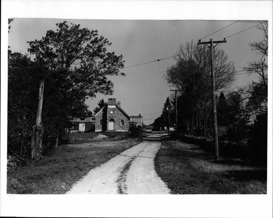
Austin Farm Road Historic DistrictExeter, Rhode Island -
David Chase, photographer;November, 1976
Rhode Island Historical PreservationCommission150 Benefit StreetProvidence,Rhode Island 02903
Generalview looking north up the Lewis farm lane showingfrom left- to right: the chapel carriage shedwhich hasbeen enclosedand partially shingled map # 11; theformer Christian Union Chapel built in 1892 and now aresidence #10; the Lewis House #9; and, to the right,one of the broad dry stone wallswhich typify the district.
photo # 4

I..
‘*.*t:
-- .1 -
k
,