national land use development plan web-gis national...
TRANSCRIPT

18/11/2015
1
Ministry of Lands & Mineral Resources
Geospatial División
National Land use Development Plan Web-GIS
&National Land Register
Project
Ms. Leba Gaunavinaka
• Background on National Land Use Development Plan Web-GIS
• Key phases and themes• Data and custodians• Data Cleaning & Preparations • Development of “Vanua-GIS” product
• Introduction to National Land Register • Updates
Summary
FGIS, LMR

18/11/2015
2
Background on National Land Use Development Web-GIS
• Recommended by the Committee on the Better Utilisation of Land
(CEBUL)
• Cabinet submission by Ministry of Strategic Planning, National
Development & Statistics (Sustainable Land Use Development)
• Building on from Land Use Master Plan
(by LMR from 2012 -2014)
• ITC Services (Server & Infrastructure establishment)
• Core-Logic Consultants, New Zealand
• Lands Department, FGIS (Project Implementation)FGIS, LMR
• Supports Pillar 6 of the PCCPP by “making more land available for productive & social purposes”
• Enables government to monitor major developments on land use activities.
• Modeling and mapping our land use using the integrative collaborative capabilities of a web-GIS, to better plan Fiji’s way forward
National Land Use Development Web-GIS

18/11/2015
3
National Land Use Development Web-GIS
Preparation of data & development of
“Vanua-GIS”
Generation of Suitability Maps
Data updates & maintenance
Data Cleaning/ Enhancements &
Analysis
Prioritization of Suitability Mapping
Training
Manage the design, testing, launch & support of the Web-GIS technology
Desktop Analysis/ Verification with field and subject experts
Operations : updates & applications maintenance
Conceptual Framework : Three phases
Phase 1 Phase 2 Phase 3
Digitizing and data transferRelevance of the datasetsConsistency / Integrity
GIS spatial data
Research / textual data
Project Staff - Lands Department
Land Use DevelopmentCentral Database
Decision making & land use information support system
Collection of maps On national land use
Editors
Quality Controls (QCs)
ITC Database Management
Desktop Analysis
・Provide information to aid decision making on land use developments & potentials・Convenient access to related information・Effective action ・Support for un-utilized orunderutilized areas
Data PreparationsEditing & Improvements,
Geodatabases, Domains & Subtypes
Modeling, Analysis process
EvaluationVerification
VANUA - GIS
Planning
- User requirementsProject Plan
Required ResourcesCached vs. Dynamic
Suitability Mapping
-

18/11/2015
4
WEB-GIS Centralisation of Land use
MLMR ENTERPRISE LICENSE INFRASTRUCTURE (ELA) DESIGN
QA/QC
Other government agencies
EDITOR AND PUBLISHING ENVIRONMENT
Web map product
Credits : Core-Logic
LANDS DEPARTMENT
MIN. OF AGRICULTURE
(LAND USE PLANNING SECTION)
(INFRASTRUCTURE)TFL / WAF / FEA
FIJI ROADS AUTHORITY
DEPT. OF FORESTRY
iTLTB
MIN. OF LOCAL GOVERNMENT,
HOUSING & ENVIRONMENT
FIJI METEOROLOGICAL SERVICES & NIWA,
NZ
SUGAR INDUSTRY
MINERAL RESOURCES DEPARTMENT
MIN. OF EDUCATIONFIJI
MUSEUM
MIN. OF TOURISM
NATIONALDISASTER
MANAGEMENT OFFICE
FIJI POLICE
MIN. OF HEALTH
Data Custodians

18/11/2015
5
Data
9
• Forests• Mining areas• Hotels• Supermarkets
• Sugar Farms• Infrastructure –
Utilities & Roads• Agriculture (LUC)
• Cultural Heritage Sites• Emergency Response• Building Footprints• Land Use Land Cover
Land Use
Boundaries
Biophysical
• Cadastral 2015• Land Tenures• Provinces• Old and New Districts
• Zoning/Schemes • Town Boundaries• Peri-Urban areas• Village boundaries
• Soils• Geology• Elevation
• Climate (Rainfall & Temp)• Hydrography
LAND USE
10
6 Main Classes
Closed Native Forests
Open Native Forests
Mahogany Plantations
Pine Plantations
Coconuts
Mangroves
Forest Cover
Sugar Farms
Growers No; Sector No; Tenures

18/11/2015
6
11
LAND USE (cont..)BOREHOLES
113 Boreholes (MRD)Geothermal ExplorationSpecial Mining LicencesProspective Mining OperationsSites of Oil Exploration
TENEMENT
Licence Holder Licence NumberArea of tenement siteApproval & Expiry DatesLocality (District, Province)Status of the exploration
Source: Mineral Resources Department
LocalityDate (Month, Year)
12
LAND USE (cont..)EDUCATION
812 Registered schools:658 Primary & 154 Secondary Schools
• Name of the School• Locality (District)• Student Roll• Teachers Roll• Sch_Reg No• Grade: ED1A or ED2B• Range: Year x – year y
• 1164 Cultural Heritage Sites (Fiji Museum)• Site’s name• Locality• Site Type (Fortification, Burial Ground, Cave)• Who recorded the site & date
Source: Min. of Education, Heritage and Arts
CULTURAL HERITAGE SITES

18/11/2015
7
13
LAND USE (cont..)
390 Registered Hotels• Name of hotel• Name of Licensees• No. of
Rooms/Dormitories/Bures/Units/Cottages/Villas
• Capacity & number of beds
Source: Dep. of Tourism & Fiji Tourism Board
• 90 Supermarkets
Major Supermarkets
Source: Lands Department
14
LAND USE (cont..)
Source: Min. of Agriculture, Land Use Planning Section
Source: SPC - GSD

18/11/2015
8
Utilities – Water Authority of Fiji
15
WAF Coverage• Dams• Reservoirs• Main Water Pipes• Main Sewer Lines
• Telecom Fiji Limited ( Cables, Ducts Network)• FEA : Power-Stations & HV - Lines
Source: WAF
16
LAND USE (cont..)
81 Police Stations
162 Health Facilities
1910 Fire Hydrants
1850 Evacuation Centres
EMERGENCY RESPONSE

18/11/2015
9
17
ADMINISTRATIVE BOUNDARIES
• Cadastral Layer (GDBs)• Tenures
• Provinces• Old Districts• New Districts• Town Boundaries
LAND TENURES
18
Prepared by Project Team based on DTCP’s Approved Zoning Schemes
Zoning Geodatabase & PDF outputs

18/11/2015
10
SOILS
19
• Soil Series (1 -227)• Land Use
Capability (1 – 8)• Major Landforms
(12 classes)• Internal Drainage• Soil Moisture
Regime• Soil Temperature
Regime• Slope (8 classes)
Soil Temperature Regime
Separates soils of low lands & foothills from soils of up-lands. This differentiation reflects the change in soil temperature regimes (STR) at 600m altitude Isothermic STR above 600m & isohyperthemic STR below 600m
Landform Groups soils into major landform categories
Parent Materials Further differentiates soils on the basis of the parent material from which they develop
Soil Internal drainage Further subdivides soils on the basis of internal drainage classes
Soil Moisture Regime
And a final differentiation is made on the soil moisture regime under which they form: aquic, udic, perudic, ustic
Source: Min. of Agriculture, Land Use Planning Section
20
Source: MRD
Viti Levu & Vanua Levu Geology

18/11/2015
11
21
Temperature & Rainfall
30 Year
baseline(1981-2010
Source: Fiji Met Services & NIWA, NZ
ELEVATION & HYDROLOGY
22Watershed Modelling

18/11/2015
12
State Land _Distribution of Arrears
DISTRIBUTION OF SQUATTERS ON STATE LAND
LEASE ARREARSWESTERN
Distribution of Informal Settlements-Access to main roads, schools-Access to major towns/cities
PROTO TYPESugar –Sector No & Grower No.
18/11/2015
13
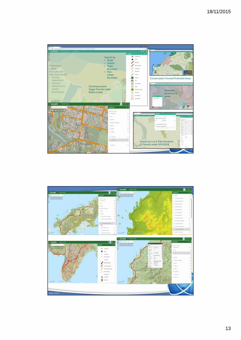
Search by Lot & Plan Numbers[3 Parcels under DP10020]
Measure distances & areas
Zooming around Sugar Parcels under Native Lease
Search by • Road• District• Town
Boundary• Peri-
Urban Boundary Conservation Forests/Protected Areas
Preliminary search: Manually can take days/weeks• Zoning
restrictions• Tenures• Distances to
similar businesses
26

18/11/2015
14
Challenges
• Data sharing – undertaking spatial analysis on certain data is limited (confidential) thus some important information may remain inaccessible.
• Delays in receiving data• Delays in cleaning in-housed data • Procurement process can take months
27
Phase Two
• Suitability Mapping• Upgrade of Vanua-GIS application to
smart phones/gadgets• 3D modelling of key government office
buildings
28

18/11/2015
15
National Land Register
• Project focuses on registering and integrating all surveyed land information in Fiji.
• Search by Titles, then proceed to register information on tenures, leases, boundary definitions, area, land valuation and land ownership.
29
30
Integrated – Fiji Land Information Systems
SurveyPlan Valuation
CrownLeaseRental
CadastralTopo/Aerial
Imagery
ITLC/VKB
Integrated Databases
Titles
Land Register
Data Utilisation by Stakeholder forEfficient use of Land
Internal
External
NativeLeases to
State
Fore-Shore
RoadIndex Data Verification
& Field Check
State Land Register
(State Land GIS)
Geodetic
CG/NGRegister
ITLTB
TCP& Other
FGIC Members

18/11/2015
16
Land register update
State Lease - 19,735 leasesFreehold Leases – 42,792 Certificate of Titles iTaukei Leases – 38,000 Native Leases
How many have been registered?State – 100%Freehold – 100%Native – 8% *
* (awaiting MOU with iTLTB)
Thank you.